LANDFORM REGIONS IN CANADA - Earl Haig
18
LANDFORM REGIONS IN CANADA CGC1D1 - Mr. Wittmann 1
Transcript of LANDFORM REGIONS IN CANADA - Earl Haig

LANDFORM REGIONS IN CANADA
CGC1D1 - Mr. Wittmann
1

Landform Regions in Canada
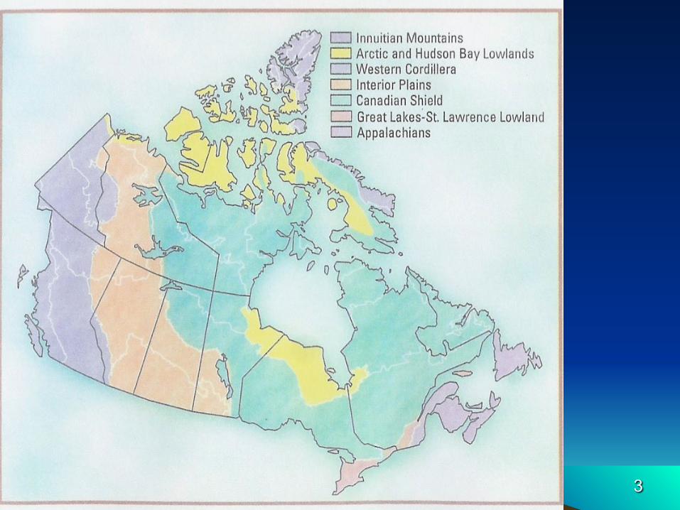
• There are 7 distinct landform regions in Canada: 1.Western Cordillera 2.Interior Plains 3.Canadian Shield 4.Hudson’s Bay & Arctic Lowlands 5.Great Lakes-St. Lawrence Lowlands 6.Appalachian Mountains 7.Innuitian Mountains
2
3

WESTERN CORDILLERA• “Cordillera” means mountain or mountainous
• Covers most of British Columbia and the Yukon
Territory
• Very young mountains
• Collision of the North American and the Pacific
plates uplifted the region into several mountain
range
• Mountains and valleys run in a north-south direction
1. Western Coast Mountains region
2. Central Interior Plateau
3. Easter Rocky Mountains and the Columbia
Mountains
4

5
WESTERN CORDILLERA

INTERIOR PLAINS• Prairies extends from the US border in the south to the
Arctic Ocean in the north • Makes up the southern parts of Manitoba and
Saskatchewan, almost all of Alberta and the western part of the Northwest Territories
• Made up of sedimentary rock since long ago this area was covered by shallow seas
• Most of the oil and gas in Canada is located in this region • Differential erosion has caused the formation of several
escarpments resulting in 3 different levels of elevation on the Prairies…
1. Western Alberta & Saskatchewan Plains
2. Eastern Manitoba Lowlands
3. Northern Mackenzie Lowlands
6

7
INTERIOR PLAINS
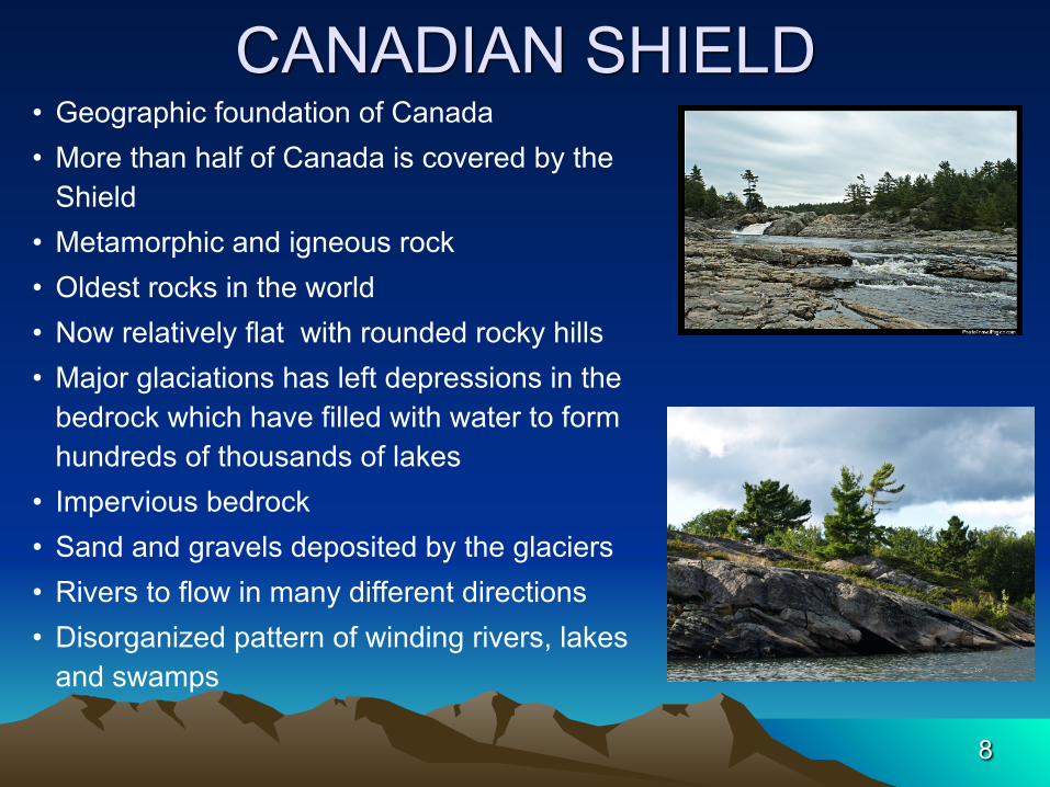
CANADIAN SHIELD• Geographic foundation of Canada • More than half of Canada is covered by the
Shield • Metamorphic and igneous rock • Oldest rocks in the world • Now relatively flat with rounded rocky hills • Major glaciations has left depressions in the
bedrock which have filled with water to form hundreds of thousands of lakes
• Impervious bedrock • Sand and gravels deposited by the glaciers • Rivers to flow in many different directions • Disorganized pattern of winding rivers, lakes
and swamps
8

9
CANADIAN SHIELD

HUDSON BAY & ARCTIC LOWLANDS • Around the southwestern shore of Hudson and
James Bay • Very flat, low area covered by swampy forest called
the Hudson Bay Lowlands • Layers of sedimentary rock resting on top of the
Canadian Shield • Swampy areas are called muskeg Several rivers
meander through the area • Vegetation is mostly bushes and isolated trees • Arctic Lowlands are made up of a series of islands
with similar landscape
Muskeg
Poor Vegetation
10

11
HUDSON BAY-ARCTIC LOWLANDS
GREAT LAKES – ST. LAWRENCE LOWLANDS
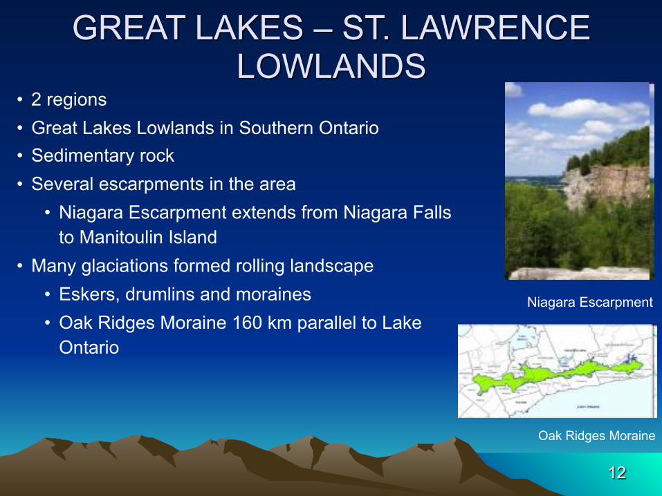
• 2 regions • Great Lakes Lowlands in Southern Ontario • Sedimentary rock • Several escarpments in the area
• Niagara Escarpment extends from Niagara Falls to Manitoulin Island
• Many glaciations formed rolling landscape • Eskers, drumlins and moraines • Oak Ridges Moraine 160 km parallel to Lake
Ontario
Niagara Escarpment
Oak Ridges Moraine
12

GREAT LAKES – ST. LAWRENCE LOWLANDS
• Separated by Frontenac Axis thin wedge of the Canadian Shield that cuts across the St. Lawrence
• 1000 Islands in the St Lawrence River are the remains of the shield after being subjected to the erosive force
• Faulting action formed a rift valley • River flows through valley to the Atlantic Ocean • Monadnocks are volcanic intrusions into the
sedimentary bedrock • Softer sedimentary rocks erode leaving the harder
igneous rocks looking like small mountains growing out of the ground
• Mont Royal in Montreal is a monadnockMonadnocks
Thousand Islands
13

14
GREAT LAKES – ST. LAWRENCE LOWLANDS

APPALACHIAN REGION• Run from Gaspe Peninsula of Quebec, into the
Maritimes provinces and all the way to Newfoundland
• Oldest highland region in Canada
• Formed when North American collided with Europe and North Africa during the formation of Pangaea
• Sedimentary rock with igneous and metamorphic outcrops.
• Millions of years of erosion have reduced the once jagged peaks to rolling mountains and hills
• More recent glaciations have added to the levelling of these mountains
Low Mountains
Wide Eroded Valleys
15

16
APPALACHIAN REGION

INNUITIAN MOUNTAINS• Everything north of the Canadian Shield • Igneous and metamorphic rocks • Some areas of sedimentary bedrock
Innuitian Mountains
17

18
THE END