Land Use Planning Guidelines for Somaliland
109
Land Use Planning Guidelines for Somaliland Project Report No L-13 March 2009 Somalia Water and Land Information Management Ngecha Road, Lake View. P.O Box 30470-00100, Nairobi, Kenya. Tel +254 020 4000300 - Fax +254 020 4000333, Email: [email protected] Website: http//www.faoswalim.org. Funded by the European Union and implemented by the Food and Agriculture Organization of the United Nations
Transcript of Land Use Planning Guidelines for Somaliland

Land Use Planning Guidelines for Somaliland
Project Report No L-13 March 2009
Somalia Water and Land Information Management
Ngecha Road, Lake View. P.O Box 30470-00100, Nairobi, Kenya. Tel +254 020 4000300 - Fax +254 020 4000333,
Email: [email protected] Website: http//www.faoswalim.org.
Funded by the European Union and implemented by the Food and Agriculture Organization of the United Nations

ii
The designations employed and the presentation of material in this information product do not imply the expression of any opinion whatsoever on the part of the Food and Agriculture Organization of the United Nations and the SWALIM Project concerning the legal status of any country, territory, city or area of its authorities, or concerning the delimitation of its frontiers or boundaries.
This document should be cited as follows: Venema, J.H., Alim, M., Vargas, R.R., Oduori, S and Ismail, A. 2009. Land use planning guidelines for Somaliland. Technical Project Report L-13. FAO-SWALIM, Nairobi, Kenya.

iii
TABLE OF CONTENTS List of Acronyms ............................................................................................ v Acknowledgments ..........................................................................................vi ABOUT THE GUIDELINES................................................................................ vii 1 INTRODUCTION ................................................................................... 1 1.1 What is land use planning?................................................................. 1 1.2 Recent history of land use and land use planning in Somaliland ............... 1 1.3 Major land use issues in Somaliland..................................................... 4 1.4 Why land use planning in Somaliland?.................................................. 4 1.5 Conditions for successful land use planning in Somaliland ....................... 6 1.6 Purpose and content of land use planning guidelines for Somaliland ......... 6 1.7 Levels of land use planning ................................................................ 6 1.8 Methods of land use planning ............................................................. 7 1.9 Who should initiate land use planning activities ..................................... 9 2 FAO-UNEP GUIDELINES FOR LAND USE PLANNING ..................................10 2.1 Introduction ....................................................................................10 2.2 Seven key elements in integrated land use planning .............................10 2.3 The planning method........................................................................15 2.3.1 Introduction ....................................................................................15 2.3.2 The nine steps of land use planning ....................................................15 3 LAND USE PLANNING AT NATIONAL LEVEL .............................................36 4 LAND USE PLANNING AT DISTRICT LEVEL ..............................................45 5 LAND USE PLANNING AT LOCAL LEVEL...................................................58 6 RESOURCES AND TOOLS FOR LAND USE PLANNING.................................73 6.1 Pairwise ranking ..............................................................................73 6.2 SWOT analysis ................................................................................76 6.3 Stakeholder Power/Interest Analysis...................................................77 6.4 Decision Support Systems and Spatial Multi-Criteria Evaluation ..............79 6.5 Gross margin budgets ......................................................................81 7 GUIDELINES FOR PROJECT PROPOSALS .................................................83 References...................................................................................................87
LIST OF ANNEXES
Annex 1: FSAU Baseline Profiles......................................................................93 Annex 2: Examples of environmental laws in Botswana ......................................95 Annex 3: Abstract of Master-Plan for Somaliland Agriculture Sector......................96 Annex 4: Priority land use planning activities in Somaliland (2009 – 2012)............98 Annex 5: Projects adopting “Participatory Land Use Management”; examples from
Tanzania (NLUPC, 1998).........................................................................100

iv
LIST OF TABLES
Table 1: Levels of land use planning ................................................................. 8 Table 2: Types of participation ........................................................................12 Table 3: An example of stakeholders and their objectives ...................................17 Table 4: Village-level stakeholders and their interests ........................................19 Table 5: Nature of data and information required for land use planning.................23 Table 6: Literature related to land use options in Somaliland – national/regional level
............................................................................................................26 Table 7: Land use planning incentives ..............................................................31 Table 8: Participatory and Conventional M&E ....................................................33 Table 9: Stakeholders Land Use Planning at National level ..................................39 Table 10: Examples of Institutions working in Land Use Planning .........................40 Table 11: Land resources information Somaliland ..............................................41 Table 12: Laws, policies, strategies and regulations related to land use.................42 Table 13: Overview of selected data available from FSAU....................................50 Table 14: Selected list of references on land resources (district level) ...................50 Table 15: Population estimates by district.........................................................51 Table 16: Land Use Types (Examples)..............................................................53 Table 17: Literature related to land use options in Somaliland – district/village level
............................................................................................................54 Table 18: Land Suitability for Rainfed Agriculture (Example) ...............................55 Table 19: Village land use planning activities check list and tools .........................59 Table 20: Village-level stakeholders and problems .............................................60 Table 21: Participatory Institutional analysis and ranking....................................62 Table 22: Participatory problem analysis ..........................................................66 Table 23: Scoring and ranking of opportunities..................................................67 Table 24: Community Action Plan....................................................................69 Table 25: Community Action Plan (CAP) Diini-Goobaale, Faroweine District ...........70 Table 26: Some techniques used in various stages of land use planning................74 Table 27: Example of SWOT analysis ...............................................................76 Table 28: Power/interest matrix (example) .......................................................77 Table 29: Project Proposal Format ...................................................................86 LIST OF FIGURES
Figure 1: Seven key factors in integrated land use planning ................................11 Figure 2: The planning method .......................................................................16 Figure 3: Effective institutions at various levels .................................................21 Figure 4: Land Evaluation Rationale.................................................................25 Figure 5: Appraisal of sustainability factors of land use options............................28 Figure 6: Identification of the RBU’s.................................................................48 Figure 7: Resource Base Units of SWALIM study area in Somaliland .....................48 Figure 8: Land suitability for sorghum..............................................................56 Figure 9: Community sketch Map ....................................................................63 Figure 10: Sources of Income .........................................................................64 Figure 11: Income expenditure .......................................................................64 Figure 12: Seasonal calendar..........................................................................65 Figure 14: Pairwise ranking ............................................................................75 Figure 15: “Campfire” analysis of stakeholders and power relations......................78 Figure 16: Example of SMCE application ...........................................................80

v
List of Acronyms APD Academy for Peace and Development (LNGO) CAP Community Action Plan CLHE Candle Light for Health and Education (“Candlelight”) (LNGO) CMO Community Mobilization Officer DDC District Development Committee DSS Decision Support System DLUPG District Land Use Planning Group EEZ Economic-Ecological Zoning FAO Food and Agricultural Organization of the United Nations FOPAG Forum for Peace and Governance (INGO) FSAU Food Security Analysis Unit GAA German Agro Action (INGO) GoS Government of Somaliland HAVAYOCO Horn of Africa Voluntary Youth Committee (LNGO) ICDP Integrated Community Development Programme (IFAD) ICRAF World Agroforestry Centre IFAD International Fund for Agricultural Development IMCC Inter-Ministerial Coordination Committee INGO International Non-Governmental Organization IPSMRL Integrated Planning for Sustainable Management of Land Resources IUCN World Conservation Union LGP Length of Growing Period LNGO Local Non-Governmental Organization LRMG Local Resource Management Group LUP Land Use Planning; Land Use Planner LUT Land Utilization Type MoNPC Ministry of National Planning and Coordination MoA Ministry of Agriculture MoI Ministry of Interior MoL Ministry of Livestock MoW&MR Ministry of Water and Mineral Resources MoPD&E Ministry of Pastoral Development and Environment M&E Monitoring and Evaluation NAGAAD Woman groups umbrella organization (LNGO) NERAD National Environment Research and Disaster-preparedness NGO Non-Governmental Organization NRM Natural Resource Management PENHA Pastoral Emergencies Network for the Horn of Africa (INGO) PICD Participatory Integrated Community Development PM&E Participatory Monitoring and Evaluation PRA Participatory Rural Appraisal BVO Barwaago Voluntary Organization (LNGO) RBU Resource Base Units SES Somaliland Ecological Society (INGO) SMCE Spatial Multi-Criteria Evaluation SNRMP Somali Natural Resources Management Programme (IUCN) SOMALES Somalia Automated Land Evaluation System SWALIM Somalia Water and Land Information Management SWIMS Somalia Water Sources Information Management System (SWALIM) SWOT Strengths Weaknesses Opportunities Threats UNDP United Nations Development Programme UNHCR United Nations High Commission for Refugees UNOPS United Nations Office for Project Services VDC Village Development Committee WASH Working group on Water, Sanitation and Hygiene WOCAT World Overview of Conservation Approaches and Technologies WSP War-torn Societies Project (International) (INGO)

vi
Acknowledgments
The authors wish to acknowledge the guidance given by Dr. Hubert George and the experts who participated in the consultative workshop in which the concept paper was outlined.
Land Use Planning principles and their application in Somaliland were discussed with stakeholders from Government, NGOs, Development Agencies, Universities and Parliament at two Workshops in Hargeisa in October 2008 and February 2009 respectively. The comments made by the participants and supporting documents provided by them have made the present Guidelines more relevant for local conditions.
Land use planning is one of many activities of SWALIM, all executed and brought together under the excellent guidance of Dr Zoltan Balint, SWALIM Chief Technical Advisor.
The present document incorporates substantial parts of selected existing Land Use Planning Guidelines and Studies. Full references of these Resources are given elsewhere in this report.

vii
ABOUT THE GUIDELINES Purpose of the guidelines The purpose of the present Guidelines is threefold:
1. to explain the basic principles of land use planning
2. indicate which land use planning activities could be carried out in Somaliland at different levels, and how
3. provide a number of tools and resources which could be of practical use by land use planners in Somaliland
The guidelines are not a manual which has to be followed strictly. Such manuals could be developed at a later stage, particularly for land use planning at village level.
Intended users of the guidelines The guidelines are meant for technicians and administrators involved in land use planning and natural resources management in Somaliland. They could be civil servants from various line ministries, or project staff of national and international NGO’s and consultants. The Guidelines will also be useful at relevant departments of colleges and universities.
Structure and content of the guidelines
Chapter 1 Introduction to land use planning in general Introduction to land use planning in Somaliland
Chapter 2 A summary of the Guidelines for integrated planning for sustainable management of land resources (FAO-UNEP, 1999)
Chapter 3 National level: Land use planning priorities in Somaliland - with special attention to harmonized land policies and legislation
Chapter 4 District level: Guidelines for land use planning - with special attention to SWALIM activities and resources
Chapter 5 Local level: Guidelines for land use planning - with special attention to participatory village land use and natural
resource management planning
Chapter 6 Some tools for various activities within the land use planning process
Chapter 7 Guidelines (Format) for project proposals
An attempt was made to make the various Chapters readable independent of each other, which made it necessary to repeat some practical information

viii
Main resources used and freely quoted in the guidelines
Title Reference This report Guidelines for integrated planning for sustainable management of land resources
FAO-UNEP, 1999 FAO, 1993
Chapter 2
Community based participatory watershed development (in Ethiopia)
Lakew Desta et al, MoARD, 2005
Chapters 4, 5
Guidelines for participatory village land use management in Tanzania
NLUPC, 1998 Chapters 2, 5
Participatory village land use and natural resource management planning in Somaliland
Barrow/IUCN, 1998, 2000 Chapter 5
PRA Case Studies (Somaliland) IFAD/UNOPS, 2003, 2006 Havoyoco/Oxfam, 2007
Chapter 5
Guidelines for Participatory Land Use Development in the Municipalities of Bosnia and Herzegovina
FAO, 2004 Chapters 2, 7
1
1 INTRODUCTION
1.1 What is land use planning?
“Land” refers to earth’s terrestrial surface and includes climate, soil, landform, water, plants, animals, human settlements and infrastructure (FAO/UNEP, 1997). Land use planning (LUP) is a procedure which leads to an optimal and sustainable use of the land and all its attributes. Use of the land may take various forms, from intensive use such as settlements and irrigated agriculture to less intensive use such as livestock production, forestry or nature reserves. The same piece of land can be used for more than one purpose at the same time (e.g. forestry and livestock production) or have different uses during different periods of year (e.g. rainfed cropping during the wet season, followed by grazing during the dry season).
Land use planning is not something new: it has been practiced from the time that man domesticated animals for livestock production and started crop cultivation.
1.2 Recent history of land use and land use planning in Somaliland
During the last 120 years, Somalia and Somaliland have experienced great political and socio-economic changes. The change in land use policies and land use planning activities over those periods is considerable, with new governments often reversing measures taken by previous regimes. More or less continuous developments over all periods include growing population, expansion of agriculture (cropping), increased number of water points, sedentarization, tree cutting and expansion of rangeland enclosures.
Five major historical periods can be distinguished, and their effects on land resources utilization and land use planning are described below:
• before 1887: Pre-colonial
• 1887-1960: Colonial
• 1960-1969: Civilian rule of government after independence
• 1969-1990: Revolutionary Military Socialist regime
• after 1990: Collapse of the revolutionary regime
Pre-colonial time (Before 1887)
Before colonial times the Somali society had an effective system of governance. This traditional system, which is still in use in Somaliland today, managed all societal relations between communities, such as conflicts, resource sharing, and the provision of the rule of law, through the customary laws (Xeer) (see Box 1). The Xeer has rules for sharing of pastures, water and other natural resources. Every member of the clan had the right of access to the rangelands and water resources of the territory inhabited by his/ her clan community.
Land use planning is a procedure for planning the sustainable use of the land considering its potentialities, limitations and the user needs.

2
The rangeland resources were managed on a collective basis. Every person had a property right to anything created by him (e.g. a shallow well). Such property could be inherited according to the regular Islamic Shari’a rules of inheritance. In higher rainfall areas land was sometimes enclosed (fenced) for farming (cropping). In such farming communities everyone had a right to the use of a piece of cultivable land. In urban areas plots of land and other assets were privately owned. Similarly, gum and resin producing trees in the Golis Mountains were divided among clan lineages and privately owned.
Colonial Period (1887-1960)
During the British colonial rule in Somaliland the land tenure system shifted from communal ownership to private ownership and new management procedures, such as land registration, title deeds and land taxation, were introduced in urban centres. Agricultural land could be leased for 50 years, and urban land for an indefinite period.
As many former pastoralist people were settling in the regions of Awdal and Waqooyi Galbeed in the 1900s, the colonial administration allocated some communal grazing land to those who wished to change their livelihood from pastoralism to agro-pastoralism and then demarcated a boundary between grazing and arable land areas against the wishes of the pastoralists.
Other new land management systems were also introduced:
− Grazing reserves were made to increase forage availability during the dry season (Jilaal). Transportation of grass on trucks for export was prohibited. However, grazing controls were not very successful (Samatar, 1989)
− Forest reserves were established in the Golis Mountains
− Rainfed farming was encouraged in the fertile plateau area to produce food for the increasing settled population
− Some public water points including dams, deep wells and boreholes were developed in drier areas; sub-surface concrete water cisterns (berkads) were also introduced
- Extension services and other forms of technical support were provided to the new farmers. An Experimental Farm and Agricultural Demonstration plots were established and new crops introduced.
Box 1: Customary Law (Xeer)
The Xeer consists of a set of contractual agreements reached by the members of the kinship of the same ancestor or groups and used for interactions among members of the same kinship and interactions with other neighbouring groups. Codes and conducts of traditional governance are overseen by respected elders (Odayo). The Xeer is used for administrating common property, such as pasture, grazing lands, forests and water.
Source: CRD Somalia, 2005

3
Civilian Government Rule (1960-1969)
The Civilian Government introduced new land rights, whereby every Somali was allowed to live and farm anywhere, irrespective of his/her clan or area of origin. The traditional free grazing in the rangelands and the colonial land rights were maintained. Commercial livestock production was encouraged. Grazing reserves were used as holding grounds for export animals, and rangelands were increasingly privatized. More public and private water sources, boreholes and berkads, were established. A model farm was established in Waqooyi Galbeed. The civilian era was characterized by rapid population growth, increased urbanization, increased live animal export and increased rangeland degradation.
Revolutionary Period (1969 to 1990)
Scientific socialism was introduced in the 70s and a new land tenure law was adopted, declaring that all the land belonged to the state and would be administered by the government. This effectively nationalized the communal rangelands, agricultural schemes and other properties. They also nullified the customary treaties between pastoralists over rangeland management (Bradbury, 1996). All nationalized irrigated farms were principally operated as public farms by the government. In 1973 the government issued a Law on Agricultural Cooperative Development and more funds were diverted to the agricultural sector.
Despite nationalization, a de-facto land market developed in urban areas, and in the rural areas the traditional land rights of clans were somehow maintained. Though the law made private ownership of rangelands illegal, private enclosures for cooperative ranching and by more powerful pastoralists were already allowed by the end of the 1980s (Bradbury, 1996). Many water points for both humans and livestock were developed and maintained by the government. Private development and usage of water points and other infrastructure was also allowed with permission from authorities.
The government made an attempt to maintain and improve the long-term productivity of livestock production and to raise the living standard of pastoralists. Rotational grazing systems, grazing reserves, improved water supply, marketing facilities and veterinary services were introduced. Reserves were fenced and/or controlled by the National Range Agency.
The Law for Conservation of Flora and Fauna was enacted for the protection of the natural forests. The law differentiates between forest reserves and unreserved land and includes policies for full community participation in proper utilization, conservation, preservation and management of the natural forests.
In the 70s the Northwest Region Agricultural Development Project was established in degraded areas in the Waqooyi Galbeed region. Soil conservation, water harvesting (soil bunding) and improved crop management techniques were implemented.
Land clearing for cultivation was allowed for any farmer after having obtained a permit from the authorities. Charcoal producing cooperatives were established for internal consumption.
Collapse of Somali Central Government Period (after 1991)
After the collapse of the central government of Somalia, the people of the former British protectorate (known as Somaliland) proclaimed their independence from Somalia in May 1991. The administrative regions of the newly formed State of

4
Somaliland include the former Awdal, Waqooyi Galbeed, Togdheer, Sool and Sanaag regions of Somalia.
The collapse of Somali central government in 1991 led to the breakdown of all institutional and social structures and appropriation of land and water resources by illegal means increased. Any positive impact of interventions by previous regimes was reversed.
In recent years many initiatives have been taken by the Government and national and international development agencies to reverse this negative trend. Details of such initiatives are given elsewhere in this document (Table 12, Chapter 3).
From the historical review above, it is clear that different regimes tried various systems of land use planning and had unique rules and regulations concerning the use of land resources. Each regime scored its own success and failures in this respect. Present land use planners can learn from these experiences and build on traditional land use management practices, as well as on successful modern interventions and programmes.
1.3 Major land use issues in Somaliland
Some of the major issues related to land use in Somaliland are listed below1. Land disputes are very common and often lead to violent conflicts.
• Loss of traditional grazing systems
• Lack of control over communal grazing areas, forests reserves and game reserves
• Increased enclosures curtailing the mobility of pastoralists during seasonal migrations
• Increased number of livestock causing more pressure on rangelands
• Illegal occupation and land grabbing in urban areas
• Increasing rural dispute over boundaries of land properties, and ownership and/or access to water points and pasture
• Loss of rich patches of dry season grazing for other uses.(residential, cropping)
• Increased cultivation of marginal lands
• Decreased crop productivity due to insecurity and break-down of infrastructure
• Declining biodiversity and increased land degradation
• Increased charcoal burning for export and decline of forest resources
• Proliferation of water points (mainly berkads) and concomitant multiplication of rural settlements in the previous seasonal controlled grazing zones or other protected areas
• Decimation of wildlife through ruthless hunting and poaching, and loss of habitat.
1.4 Why land use planning in Somaliland?
Somalis have practiced some sort of land use planning since pre-historic times. Pastoralists plan to move their herd from one area to another depending on the seasons and availability of fodder and water. Sedentary farmers often fence in an area and decide to use one part for cropping and another part for livestock. The latter is called farm planning and the main stakeholder is the farming family.
1 This list is based on interviews with land user (SWALIM, 2007) and on literature (ADP, 2006-2007; WSP International, 2005; IUCN, 2006)

5
Coherent communities also plan the use of the area under their control. Certain trees or woodlands may be protected or have restricted use and grazing areas are also subject to many unwritten rules. Also in urban areas there are examples of land use planning by individuals or local communities.
More systematic and institutionalized land use planning is needed when traditional methods of land use control break down or prove to be inadequate because of war, strong outside influences, sudden population increases or other demographic changes, severe droughts or other calamities, or rapidly changing needs and ambitions of the resident population. The people of Somaliland have been subject to many rapid and often traumatic changes and influences and in many instances traditional methods of land use planning are no longer relevant, effective and/or sustainable (see also Section 1.3).
The Government of Somaliland recognizes the importance of land use planning. The Ministry of Agriculture (MoA) mentions integrated land use planning as one of the tools to promote sustainable agricultural resource use and management and LUP is listed as one of the short-term interventions (MoA, 2007). The same Ministry, in its Draft National Agriculture Policy (MoA, 2008), also advocates village land use planning as a tool for implementing policies for better land use and management and a basis for agricultural extension services. The Ministry of Pastoral Development and Environment (MoPD&E) in its Draft Final Strategic Plan 2008-2010 recognizes that land is a primary natural resource that requires wise usage for sustainable development, and land use planning based on accurate and reliable data. And both MoA and MoPD&E in their Somaliland land tenure policy (2nd draft, 2008) give local authorities and district governments the authority to undertake land use planning and enforcement of approved development plans in collaboration with representatives from the respective line ministries.
In a Policy Brief for the European Commission the IUCN recommends the development of the institutional and human resource capacity for environmental and natural resource planning and management at various administrative levels, including integrated land use planning (IUCN, 2006).
Presently, due to the socio-political situation of the country, land resources are mostly used and managed by individual land users, without much consideration for the welfare and future of the wider population. However, the current Government has identified Land Use Planning as a tool that could guide the implementation of policies, programs and projects based on a sound technical framework towards sustainable natural resources management. Land Use Planning is a tool that is successfully used by many countries in the world for natural resources management and the improvement of livelihoods.
A list of issues which require land use planning is given in Box 2.
The present land use planning guidelines for Somaliland respond to the recognized need for institutionalized land use planning in the country. The Guidelines are of a technical nature and are meant to guide relevant institutions and authorities in land use planning activities at village, district and national level.
Driving forces in planning are unsustainable or unproductive land use, land use conflicts or the need for a quite different pattern of land use dictated by changing
circumstances.
6
1.5 Conditions for successful land use planning in Somaliland
Although the need for (institutionalized) land use planning in Somaliland has been recognized, it can only be successful if a number of issues are addressed simultaneously. These include:
Promotion of national peace and reconciliation
Restoration and harmonization of all relevant laws and legal institutions
Law enforcement and restoration and strengthening of public security
Reversely, participatory land use planning if properly conducted, will not only contribute to sustainable land use and improved livelihoods, but also to peace and security at all levels.
1.6 Purpose and content of land use planning guidelines for Somaliland
As stated before, land use planning is a tool for sustainable resource use and contributes to conflict resolution. However it should not be used as a magic word, or a technology that can be acquired and solve all the problems. Land use planning involves a series of procedures and involvement and commitment by all the stakeholders. Although high-tech tools can play a role in some of the LUP procedures, it is mainly about people and their inter-relationships.
The purpose of the Land Use Planning Guidelines for Somaliland is to explain the principles and procedures of land use planning in general, and how it can be applied in Somaliland at various levels in particular.
The guidelines will also highlight some of the challenged faced by land use planners in Somaliland. These include the lack of harmonized land use policies and legislation, weak law enforcement by government authorities and limited capacity in terms of human resources and investment capital.
1.7 Levels of land use planning
The most basic level of land use planning is farm planning. At the same level, even urban households practice some sort of land use planning in their residential plots.
Box 2: Activities and issues requiring land use planning
• Avoid or settle land use disputes
• Secure long-term benefits of sustainable land resources management
• Protection or rehabilitation of natural resources
• Identify unexplored land use potential
• Optimize present land use
• Create environmental awareness
• Harmonize various sectoral development plans related to land use
• Plan new settlement areas

7
Next levels of planning are village or community planning, district or watershed (meso-level)2 planning, national planning and international planning.
Planning is often best based on administrative units or levels of authority, such as villages, districts, provinces or the whole nation. This is because data are often available for administrative units only, and because many stakeholders are organized at administrative levels, which make negotiation and implementation of the land use plan easier. However, if the focus is on the sustainable use of specific natural resources, planning can also be based on natural units (e.g. “land management plan for the Golis Mountains” or “natural resources management plan for the Dur Dur catchment”) or specific types of land cover and use (e.g. “management plan for the montane evergreen thickets of Somaliland” or “soil and water conservation for the rainfed cropping areas). In Somaliland, nomadic pastoralists are usually among the main stakeholders, and care should be taken to consider both their wet season and their dry season grazing areas. The boundaries of a planning area may have to be modified during the planning exercise, when more information becomes available, or during the course of implementation.
The present guidelines mainly deal with the following three levels of planning: village planning, district planning, and national planning. The three levels are strongly linked and interactive, and each level comes with its own policies and institutions (see Table 1 and Figure 3).
1.8 Methods of land use planning
There are many methods of land use planning. Many countries and authorities have experimented with top-down planning, whereby technocrats, politicians and rulers have imposed “plans” and measures on the rural population. Also international development agencies and NGO’s have often designed and executed rural development plans without much involvement of the main stakeholders. Top-down planning has the advantage of speedy implementation, particularly if backed-up by effective controlling (state) agents or by direct financial incentives. A great disadvantage is that many stakeholders may not understand the plan or not agree with it and actively or passively sabotage it.
At the other end of the spectrum are traditional methods of land use planning, as an essential part of local culture, and encapsulated in written and unwritten rules, religion, myths and taboos.
Whereas top-down planning and implementation attempts fail if not supported by local communities, local efforts may collapse without higher level support. A two-way communication assures that village land use plans are in tune with higher level plans, interests and policies, and that planners and decision makers at the district to national level are sufficiently informed about the priorities identified by villagers.
2 Meso-level is somewhere between village level and national level. It could be at district or province level
or encompass a large natural area such as a watershed. In this and the following Chapters meso-level planning is usually referred to as District Planning.

8
Table 1: Levels of land use planning
Level Objectives Responsibilities
NATIONAL
• Land use policy
• Legal framework
• National programmes
• Establishment of national conservation areas
• Facilitating LUP at lower levels
• Ministries and Institutions
• National Task Force
• Inter-ministerial Coordination Committee
DISTRICT
• Regulating land use and checking of procedures
• Establishing technical services
• Promoting dialogue
• Capacity building
• Translating strategies into action
• Facilitating LUP at community level
• Establishing protected areas
• Govt. technical services
• NGOs
• District Development Committee
• Land Boards
• Watershed Management Committees
COMMUNITY
• Participatory Rural Appraisal
• Village land use plan
• Dialogue, negotiation
• Implementation of land use plans
• Land Resource Management Group
• Village Development Committee
Current methods of land use planning involve a systematic evaluation of resources, an active participation of all stakeholders and an interactive partnership between governments and people. Both FAO and the German Technical Cooperation Agency (GTZ) have developed LUP Guidelines along these principles (Box 3).
Box 3: Land Use Planning Methods and Guidelines
GTZ, 1999. Land Use Planning – Methods, Strategies and Tools. Eschborn, Germany
FAO, UNEP, 1999. The future of our land. Facing the challenge. Guidelines for integrated planning for sustainable management of land resources. Rome. (reprinted 2007)
FAO, 2004. Guidelines for Participatory Land Use Development in the Municipalities of Bosnia and Herzegovina

9
1.9 Who should initiate land use planning activities
The initiative for land use planning activities will come from Government authorities at national, regional or district level, or from other authorities and development agencies with approval and support from government. The process should be conducted in accordance with national policies and legislation as related to sustainable land use.
Ideally, the plan formulation process, including formulation of the objective, should come from the people involved, with assistance as needed from government agencies at district and national level, NGOs or private firms. The whole process should be facilitated by a dedicated land use planner. The tasks of a land use planner are given in Box 4.
In the case of community land use planning district authorities will play an important role, as foreseen in the Draft National Agriculture Policy of the Ministry of Agriculture (see Box 5).
The districts themselves may need stimulation and assistance from national government to engage in land use planning activities, both at district and village level.
Box 5: Policy Statements Ministry of Agriculture
Village land use planning will be based on the following criteria:
• Local land use plans will be developed by District Councils in collaboration with village councils.
• Land use planning will be done in a participatory manner to involve beneficiaries. Planning will be proceeded by studies to determined existing land tenure, land use patterns and land capability (land suitability).
• Village land use plans will be used as a tool for implementing policies for better land use and management.
Source: MoA, 2007
Box 4: Tasks of the land use planner
An individual, group, institution or coalition of groups is required to take action to mobilize the stakeholders and create at least the minimum critical mass of interest, expertise and resources required to get the land use planning process to a self sustaining level of operation.
Tasks of the land use planner include
• identifying the stakeholders • collecting the baseline information needed to get the process started • sensitizing the participants to the nature of the process • facilitating the negotiations
• providing logistical support
• coordinating the activities of the various institutions
Source: FAO, 2004

10
2 FAO-UNEP GUIDELINES FOR LAND USE PLANNING
2.1 Introduction
The LUP Guidelines for Somaliland are based on the FAO-UNEP Guidelines for integrated planning for sustainable management of land resources (FAO, UNEP, 1999). Four closely linked factors play a crucial role in land use planning:
• technical solutions in optimizing land use
• institutional aspects
• legal aspects
• socio-economic aspects
Essential is the active participation of the stakeholders in planning and decision making. Decision makers, as well as users of the land should be involved from the beginning.
Planning is both integrated and interactive:
- Integrated
it combines elements of both the bottom-up and top-down approach
it takes into account the complex biophysical and socio-economic variables which determine the land use system
it considers legal and institutional aspects which facilitate the implementation of the plan
- Interactive
it is a negotiation process, in which land users interact among themselves and with specialists
different levels (national, sub-national and local level) interact in the planning process
2.2 Seven key elements in integrated land use planning
There are seven key factors associated with successful land use planning, as shown in Figure 1 and briefly explained in the following paragraphs.
Key factor (a): Problem identification and formulation of the objective
Systematic land use planning is only needed when a problem or an opportunity has been identified. Once the need for LUP has been recognized, all activities should be framed in a clear objective.
Objectives are scale-dependent and will be different at the national, sub-national and local level. Stakeholders at each of the levels (see key factor 2) should be involved in formulating the objective.

11
(d) Effective
institutions at local, sub-national and national level which are linked
(c) An enabling environment
and regulatory policy
(e) A platform
for negotiation
(b) The
recognition of stakeholders
and their differing
objectives
(f) An
accessible and
efficient knowledge
base
(a) The
objective and
problem to be solved
clearly formulated
Integrated planning for sustainable
management of land
resources
(g)
A set of planning
procedures
Figure 1: Seven key factors in integrated land use planning
Key factor (b): Recognition of stakeholders and their differing objectives
- Stakeholders
There are various types of stakeholders, including:
Those having control of a resource
Those needing or seeking control of, or access to, a resource
Those who are affected by the use of resources by others
With very few exceptions, there is always more than one stakeholder or stakeholder group claiming an interest in the use of a particular area of land. This is particular true for land that has a rich variety in resources. Stakeholders include the residents and land “owners”, but also outside groups such as NGO’s and Government.

12
- Participation
Participation can be of various nature, as shown in Table 1. Although there is place for all these types of participation, without interactive participation and/or self-mobilization of the most important stakeholders it will be very difficult to find durable solutions to land use problems and to advance sustainable management of land resources.
Table 2: Types of participation
Type Description
Passive participation people are told what is going to happen or what has happened
Participation by giving information
people participate by answering questions from agents
Participation by consultation people participate by being consulted
Participation for rewards people participate in return for material incentives
Functional participation people participate to meet predetermined objectives related to a project but are still dependent on external initiators
Interactive participation people participate in joint analysis, which leads to action plans and formation of new local institutions or strengthening existing ones
Self-mobilization people participate by taking initiatives to change systems independent of external influences
Source: IIED, 1995
Key factor (c): An enabling environment and regulatory policy
Land use plans and land use planning activities at various levels should be “in tune” with each other and not be contradictory. Village development plans should be in line with district development plans, and district development plans should agree with a national land policy. A number of laws and regulations should be in place, concerning the natural resource management and the environment.
- Land use Policy:
To achieve sustainable development, governments should have a national policy on land use. Such a policy should include strategies for implementation, usually a mixture of incentives, regulations and law enforcement. To be effective, the land use policy should be formulated through a participatory and integrated process, and be endorsed by the majority of the population. Examples of policies in Tanzania are given in Box 6; land policies and (draft) land legislation from Somaliland are discussed in Chapter 3.
A stakeholder is anyone, or any group, or any institution having an interests in, or being affected by, an issue or activity or transaction, and therefore has a natural
right to participate in decisions relating to it.

13
- Land Tenure:
Secure land tenure is an effective incentive to production and conservation. This does not necessarily mean that land users should be the permanent “owners” of land or specific natural resources, but that they are secure enough to invest in the land and want to preserve it and develop it for future use.
Somaliland is in the process of developing a number of policies, strategies and laws related to land use. These will be further discussed in Chapter 3. See also Table 14.
A Land use policy is essentially an expression of the government’s perception of the direction to be taken on major issues related to land use and the proposed allocation of the national land resources over a fixed period of time. It has a
production and a conservation component
Box 6: Examples of policies in Tanzania
• Agricultural Policy of 1997 whose aim is to promote integrated and sustainable use and management of natural resources.
• National Land Policy of 1995 which states inter alia, that land use planning will be done in a participatory manner to involve beneficiaries.
• Tanzania Forest Policy of 1998 aimed at enabling participation of all stakeholders in forest management and conservation.
• The Wildlife Policy of Tanzania of 1998 which emphasizes on involving rural communities and other stakeholders in taking joint responsibility for the sustainable management of wildlife and other natural resources.
• National Environmental Policy of 1997 with the overall objective of raising public awareness and understanding of the essential linkages between environment and development, and to promote individual and community participation in environmental action.
• The National Policy on NGOs in Tanzania, 2nd draft of 1998 which calls for dynamic and working NGOs which will promote peoples participation in the development process of the country.
• The Local Government Reform Agenda 1996 - 2000 which states in part that the local governments will facilitate the participation of the people in planning and executing their development programmes; and foster partnerships with civic groups.
• In the Development Vision 2025 for Tanzania, great emphasis is placed on equal opportunity to all citizens to participate in and contribute to the development of the nation.
Source: NLUPC, 1998
Land tenure is a way of regulating rights, access and control of land for the mutual benefit of the land user and the government

14
Key factor (d): Effective institutions
Land use planning needs consultation, endorsement and decision making at various levels. Implementation of land use plans needs long-term supervision, monitoring and action. For this to happen, effective institutions are needed with a clear mandate. It is not important what these institutions are called, as long as they represent all sectors and most important stakeholder groups and are empowered to make decisions. It is mostly the government at various levels to facilitate and ultimately control these institutions, although membership should include representatives from all stakeholders.
Land use planning institutions and task forces at various levels, and their functions are further discussed in Chapter 2.
Key factor (e): Platform for negotiation
Land use planning usually involves trade-offs between the stakeholders, and negotiations have to take place. These negotiations should also involve stakeholder groups which are traditionally silent, or passive, and these groups may have to be represented by the Government or an NGO. Although in the long run everybody may be a winner, in the short term some privileged groups may have to compromise to some extent. The negotiation stage of land use planning is probably the most important of all stages, and its outcome will determine the success and durability of the whole exercise.
The institutions identified at various levels (see key factor 4) can also serve as platforms for negotiation.
The Local Land Resources Management Groups will be the key institution for negotiation and settlement of disputes at local level. When conflicting objectives of different stakeholders or land disputes cannot be resolved at the lowest level, they can be referred to the sub-national body. The courts are a last resort if negotiation fails to resolve a dispute.
Key factor (f): Efficient and accessible knowledge base
Effective negotiation and decision making on land use cannot take place without a knowledge base that is useful and accessible to all stakeholders.
The type of information needed very much depends on the nature and objectives of the land use plan, and may include the following:
Land Resources: climate, topography, soil, water, vegetation, present land use, etc.
Improved technologies of resource management
Current living conditions, problems, needs and objectives of stakeholders
Institutional and legal framework; land tenure to land, water, trees and wildlife
Further reading:
Land tenure and policy issues in land use planning. With special reference to Eastern and Southern Africa. (DSE, 1998).
Land tenure in development cooperation. Guiding principles. (GTZ, 1998).
FAO, 2007b. Good governance in land tenure and administration. FAO Land Tenure Studies 9. FAO, Rome.
15
Economic conditions such as prices, markets and interest rates
In case of local level planning, much of the information can be collected and analyzed by the resident land users themselves, through Participatory Rural Appraisal (PRA). Experts from outside may give advice, provide options, or facilitate the negotiation process, but the final decisions should always be made by the land users themselves.
Key factor (g): Land use Planning procedures
Land use planning should follow a clear set of procedures. Although procedures may differ at village, district and national level, the overall method is the same at all levels. The following Section (Section 2.3) will set out the “steps” which are essential in land use planning. 2.3 The planning method
2.3.1 Introduction
A schematic overview of the Integrated Approach to Planning for Sustainable Management of Land Resources (IPSMLR) is given in Fig. 2.
The planning process is an iterative and cyclical process with nine essential steps. The ninth step (Monitoring and Evaluation) is an activity that should run during the entire planning procedure, and even after that. The overall planning method is independent of scale, which means that similar steps are needed at village level, district level and national level.
The sequence is iterative and needs constant adjustment as the different elements, especially financial or economic conditions tend to be variable or even unstable. Therefore, a land use plan is never “finished” and is a continuous learning process. By following a clear and well documented procedure, adjustments can be made relatively easily. Generally, the process of trust-building and negotiation between stakeholders is more important than the land use plan itself.
2.3.2 The nine steps of land use planning
STEP 1: Identification of land use problems and stakeholders; formulation of objectives
The overall objectives of land use planning vary at different levels, as follows:
In a national land use policy or a master plan, the long-term development objective is formulated for allocation of the natural resources of the whole country. This objective has a production and an environmental component.
At the sub-national level, a district land use plan will have an objective, which aims at development in the district or other relevant area (e.g. a watershed). Its objective should conform to and serve the objectives in the overall land use policy of the country.
In a community land use plan, people will formulate objectives relevant to their community. The objective should consider short-term and long-term aspects and be focused on sustainable development of the community and its land resources. Such plans will fit into and feed the district or watershed plans thereby creating mutual support.

16
Identify Problem and Objective
1 Identify all stakeholders and define their goals, needs and stakes
9
2
Establish multidisciplinary task force
3
Collect data and information
4
Preliminary identification and screening of options
5
Evaluate Specific Resources to Identify Options
6
Appraise identified Options
7
Negotiate and select options Set up plan
8
Legislate enforcement and initiate implementation of the plan
M O
N I T
O R
I N G
A N
D E
V A
L U A
T I O
N
If not accepted by all stakeholders, or results not satisfactory, or general
conditions change (macro-economy, politics)
Figure 2: The planning method
(after FAO-UNEP, 1999)

17
Land use planning activities at various levels are closely linked. For example, land use plans at village level should be in line with national policies and legislation, whereas national policies should reflect the reality on the ground and the needs and aspirations of the local residents. Stakeholders and formulation of objectives
A land use planning activity can start in two ways:
an individual, group or institution identifies a problem, or a symptom of a problem, and wants to do something about it
a government institution or development agent wants to develop an area and promote sustainable land use in cooperation with the land users
The first task of a land use planner3 is to identify all stakeholders who then formulate the objective of the LUP exercise. This is an iterative process: as more or different stakeholders are identified, the objectives may change and the stakeholders have to be assessed again.
There are different types of stakeholders and different types of participation (see Section 2.2). Different stakeholders have also different objectives. A hypothetical example of various stakeholders and their objectives is given Table 3. Various objectives of village land use planning are given in Box 5.
It is the task of the coordinating institution, or the LUP facilitator, to compile the various goals and objectives of the stakeholder groups. A number of techniques can be used at for this purpose, some of which are indicated and illustrated in Chapter 6.
At this stage it is important that not only the visible, vocal and organized stakeholders are involved, but also stakeholders with “no voice”.
Table 3: An example of stakeholders and their objectives
3 The land use planner (or “planner”) could be an individual, institution, group, or several groups.
Level Stakeholders Objectives
National Min. of Agriculture Min. of PD & E International Livestock Research Institute NERAD (para-statal) UNDP
Increase and stabilize sorghum yields Reverse land degradation Improve marketing; product quality control Prepare for drought Stimulate development
District District Administration UNICEF Agric. Supply companies Local NGO
Settle displaced people Promote nutrition gardening Increase sales and profits on farm inputs Promote forestry plantation; agro-forestry
Local Wealthy livestock owner Poorer farmer Trader Traditional leader Landless peasant
Maximize profits Feed family; avoid risks Increase business opportunities Protect land resources for use by his people Acquire piece of land; find work

18
Box 7
Awareness creation
An essential part of “step 1” is information sharing and the creation of awareness by the affected population about the purpose of land use planning activities and the issues to be addressed. Problems, development and progress are often perceived differently by various stakeholders, e.g. authorities, development agencies, farmers, entrepreneurs, village elders.
An example of village-level stakeholders and their varying interests is given in Table 4.
Stakeholder Analysis
Stakeholder analysis concerns the inventory and scrutiny of:
• Stakeholders characteristics, such as interest, power, control over resources, knowledge and information, how they are organized or represented and limitations for participation
• Their relationships with others
• Their influence and motivation towards decision making, including expectations, likely gains and willingness to participate and invest resources
Further useful information on the stakeholders can be generated through the analysis of their relative power and interest. These two variables are defined as follows: power is the ability of a stakeholder to facilitate or impede the achievement of an activity’s objectives and interest is the degree to which the stakeholder is willing to participate in the process.
The following questions could be useful in assessing the power and interest of the stakeholders:
• Who is dependent on whom?
• Which stakeholders are organized? How can that organization be influenced or built upon?
• Who has control over resources?
• Who has control over information?
Broad objectives of the village based natural resource management planning process
• Map and understand land use, in terms of ecology and natural resources
• Understand who uses what resources, when and where
• Understand the decision-making process
• Understand the different customary and formal institutions, which exist at the community and wider levels, and their role in land use planning
• Identify and locate land degradation and natural resources management problems
• Provide support to communities to identify causes and develop solutions for action
Source: Barrow et al, 2000

19
• Which problems, affecting which stakeholders, are the priorities to address or alleviate?
• Which stakeholders’ needs, interests and expectations should be given priority attention with respect to the process?
A variety of techniques are available to analyze these variables, as detailed in Chapter 6 (power/interest matrix and “Campfire” analysis).
To draw the attention of everybody involved and to encourage their cooperation, the planner should try to demonstrate that there is something to gain for everybody at the end of a successful land use planning exercise.
Table 4: Village-level stakeholders and their interests
Stakeholder Stake/Interest
Farmers - inside Farming/Enclosure for Grass
Contractors from urban - outside Contracting purposes related with farming activities
Relatives displaced person - outside Consumption of farm produce/grazing
Livestock owners- inside Grazing
Grass cutters - inside Grow and pile grass to use or to sell
Grass collectors from outside Buy grass from the community farmers
Surrounding village - outside Get livestock and farm produce to the markets
Milk group - inside/outside Get milk from their livestock
Woodfuel collectors - outside/inside Get woodfuel from the area using the dry/wet trees
Pastoralists – outside Grazing
Stalk buyers – outside Buy stalk from the area
Milk buyers - outside/inside Get milk from Qalloa
INGO – outside Carry out rehabilitation and development activities
Village institutions - inside Village social, economic and development affairs
Commercial activities - inside/outside Have a commercial activity with the villages (qat sellers, tea shop, etc)
LNGOs – outside Undertake rehabilitation of village infrastructure
Qat farm owners – inside Income generation
Regions Administration - outside Same as the Government
Politicians – outside Politics
Stalk produces/sellers – outside Get a market for their stalk (fodder for animals)
Internal religious groups - inside Village region leading and praying
Hawo/Fadumo - inside Focused on women’s religions affairs
Youth (in the community) - inside Be available labour force in the village
Youth – outside Have contractual stakes in the village
Sultan and Aqils - inside Tribal linkage having some property in the village
Women group - inside Overall livelihood stake in Qalloa
example from Qallao village in Somaliland (after IUCN, 2000)

20
STEP 2: Establishment of Multidisciplinary Task Forces and Institutions
Representatives of groups which have a stake in a land use planning exercise form a task force, mandated to formulate and implement a land use plan or land use policy. There could be ad-hoc committees and groups, dealing with LUP activities of limited scope and duration, but ideally they should be institutionalized to be able to deal with long-term implementation and supervision.
Task forces and land use planning institutions at different levels are shown in Figure 3. Land use planning activities can be initiated at each level, depending on the issues to be addressed and/or the size of the planning area. Ideally, the initiative for village land use planning should come from the villagers themselves, thereby immediately creating a sense of ownership.
The main functions of LUP task forces and institutions are summarized below.
NATIONAL LAND USE PLANNING COMMITTEE
At national level central government will play an important role, in the form of various ministries, departments and institutions, together with important development agencies. Land use planning is always multi-disciplinary and inter-active and a National Land Use Planning Committee should be independent of existing sectoral government institutions. Examples of national level institutions are inter-ministerial committees, land boards, and high level land use planning bureaus.
Functions of National Land Use Planning Committees include:
Formulate and update land use policy and related legislative and institutional matters
Coordinate LUP activities at national level
Advise government on issues related to use and management of land resources
Facilitate exchange of information to/from district and village level
Develop and maintain information systems on land resources and land use
Predict and track land use needs and priorities
Coordinate formulation, implementation and monitoring of development plans
Final decision making in cases of conflicting objectives in land use
DISTRICT LAND USE PLANNING GROUPS
Required at sub-national level are District Committees or Land Use Planning Groups. As at national level, District Land Use Planning Groups (DLUPG) should be multi-disciplinary. Various Government institutions will be represented, as well as traditional and elected leaders and local and international development agencies. Depending on the tasks at hand, representatives of the private sector could also be co-opted.
Implement district level land use planning activities
Provide technical support to Local Resource Management Groups
Coordinate village-level land use planning and assist with resolving conflicts
Inform National Land use Planning Committee of district level priorities

21
LOCAL RESOURCE MANAGEMENT GROUPS
At local level Local Land Resource Management Groups (LRMG) should be in place. LRMGs serve as a forum where the views of all interest groups in the community can be represented. These groups could be dealing with all land resources in an area, or specialize in one of the main resources, e.g. Range Management Groups, Sub-catchment Water & Irrigation Management Groups, Forest Management Groups, etc. Some existing local institutions may already play an important role in land resource management and should be involved. In Somaliland these are the Village Committees (VC) or Village Development Committees (VDC). Examples of other relevant institutions are voluntary associations, mutual aid and work groups, religious groups, woman’s group, etc. Government cannot impose LRMGs on the community, but can facilitate them and make sure that all stakeholders have a voice.
Functions of LRMG include:
Addresses and resolves existing or potential resource use conflict within community
Addresses resource degradation or unsustainable use patterns
Deals with external stakeholders, such as central government, entrepreneurs, NGOs
Manages local level LUP activities
Manages funds for development
Figure 3: Effective institutions at various levels
National institution dealing with land use Inter-ministerial coordination committee on
land use Land use planning institute
Sub-national institution dealing with land use District Land Use Planning Group/Committee Land Board
Local formal or informal groups dealing with land use Village Development Committee Local Land Resources Management Group Community Development Group Farmer’s Association
o Information on local resources, needs, current land use o Community management plans and rules for land use o Accepted discussion, negotiation and decision forum o Management of group revolving funds, maintenance, repair

22
STEP 3: Collecting Data and Information
The systematic evaluation and planning of land resources require basic data and information about the land, the people and the organization of administration and services. This is true at any level of detail, but the range and the amount of information, as well as its accuracy, vary greatly according to the scale and objectives of the land use plan. Five basic principles apply to the collection of information for land use planning:
Data and information collection should be objective and meet users’ demands.
Data and information collection should be geared to gaining an understanding of how the land/land use ecosystem functions. What are the processes involved, how do land properties affect land use, and what is the impact of changes in land use on the land resource?
Data and information collection should be efficient, focusing on minimum data sets, and flexible, to allow collection of any additional data if necessary.
Physical data is needed in a spatial format, as maps or geo-referenced observations. The spatial variation in land resources is the main justification for land use planning.
Data and information collection should be part of a continuous process. Rather than being seen as a one-time exercise needed to produce a rigid land use plan, the initial data set should be used to formulate a flexible, rolling land use plan, which can later be modified in the light of new information, or according to changing circumstances (temporal variation).

23
Table 5: Nature of data and information required for land use planning
Land resources data
• Climate • landforms and soils • land cover, vegetation • water resources
Land use related data
• present land use and characteristics • selected physiological characteristics of crops (as determining
ecological requirements) • land utilization types and production systems (present and
potential) • ecological requirements of land utilization types, production
systems, land use Social-economic data
• population (including age and gender distribution, stakeholder) • living conditions (including workload and cultural aspects) • access to markets • costs of production and product prices • socio-economics of communities
Legal data and information
• policy documents, laws and regulations related to land • present system of land allocation • land tenure information • traditional ownership and user rights
Institutional information
• involved institutions and their mandates and resources • links between institutions • support services (extension, etc.)
General data • infrastructure, accessibility

24
Nature of Data and Information
An indication of the types of data and information needed are listed in Table 5. A list of available data, maps and reports on various land resources in Somaliland is given in Chapters 3 and 4 on national and district level land use planning respectively. Chapter 4 also details the information from SWALIM, FSAU and other sources.
STEP 4: Preliminary Identification and Screening of Options
Ideas for improved land use options will emerge through the planning process as stakeholders suggest changes and information becomes progressively available. Review of these options by the task force and land use planner should be a continuous process, which is consistent with the iterative nature of land use planning.
The preliminary identification and screening of options could be a simple process, particularly if the objective of the land use plan addresses a single problem in a limited area. However, usually there are various problems to deal with and a large number of options to be considered. Ideas could come from the appointed task force, collaborating institutions, stakeholders, technicians and also potential donors. Brainstorming may be needed at first, followed by preliminary screening and ranking.
Ideas may also be gained from literature and internet search. Some useful publications in this regard are listed in Table 6.
The review may take the form of a workshop, in which initial objectives are reviewed in the light of the proposed options and the new information that has been collected. Its first task is to formulate possible improved land use options (e.g. modified or new production systems). Secondly these options are screened for consistency with all the stakeholder objectives, for acceptability within the framework of government policy and legislation, and for broad feasibility according to the resources needed for their implementation. One option to include in all planning exercises is “to do nothing”. The result of such non-activity can then serve as a benchmark against which the result of various “active” options can be measured.
If there are constraints identified, related to the existing general conditions (policies, regulations, etc.), potential solutions or alternatives have to be sought. Changes to some of the general conditions, if possible, might be considered. Those land use options which pass this screening process are subjected to land evaluation.
STEP 5: Evaluating Resources for the Identified Options
In step 4, a number of options have been identified which could help to fulfill the stated objectives of a specific land use planning exercise. If new or modified land uses are suggested, a study is needed to determine the suitability of the land for those uses. Depending on the complexity and scope of the land use planning exercise, such a study could be a simple examination based on “common sense”, or a more elaborate and systematic analysis.
Basic Principles
Land resources must satisfy certain requirements if the land is to be successfully used. Many of these requirements are specific to the type of land use, and they include both the ecological requirements of the crop or other biological product, and the requirements of the management system used to produce it. Evaluation of land

25
resources therefore involves a comparison of the properties of the land with the requirements of possible types of land use. Defined planning areas or “land units” are rated according to how well these land use requirements are satisfied.
The principles of land evaluation are presented in the Framework for Land Evaluation (FAO, 1976) and are illustrated in Figure 4. Land evaluation consists of physical and socio-economic evaluations.
LAND
Resource Base Units
LAND USE
Production Systems
Characteristics Requirements
MATCHING
LAND SUITABILITY
Figure 4: Land Evaluation Rationale
Land Evaluation Procedure
The main activities in a land evaluation are as follows:
• initial consultation, concerned with the objective of the evaluation, and the data and assumptions on which it is to be based
• description of the kinds of land use to be considered, and establishment of their requirements
• description of resource base units or “land units”
• comparison of kinds of land use with the types of land present (“matching”)
• economic and social analysis
• land suitability classification (qualitative or quantitative)
• presentation of the results of the evaluation
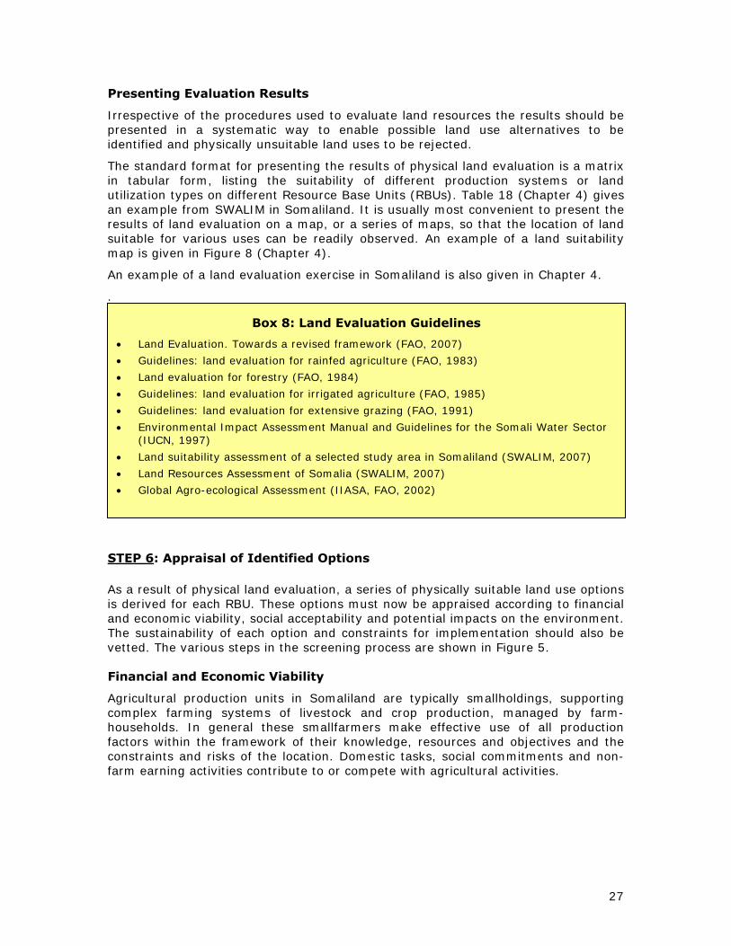
Various practical guidelines for land evaluation for different land uses are listed in Box 8

26
Table 6: Literature related to land use options in Somaliland – national/regional level
Land use Type Resources Reference
Rebuilding Somaliland. Issues and possibilities WSP Int., 2005
Managing dryland resources. A manual for eastern and southern Africa. IIRR, 2002
Land-based conflict project (Institute for Peace and Development) ADP, 2007, 2008 General
Dialogue for Peace ADP, 2006
Technical assistance for soil erosion and land reclamation in Borama and Baki Districts Schaap, O., 1996
Soil & Water Conservation. North-west Region Agricultural Development Project. SOGREAH, 1982
Pilot watershed management for soil & water conservation and small garden development. Geed Abeerah Pilot Project.
TAMS, 1986
Natural resources management; soil & water conservation Soil and Water Conservation Techniques WOCAT-online*
Range and Livestock. North-west Region Agricultural Development Project. SOGREAH, 1982
Securing pastoralism in East and West Africa: protecting and promoting livestock mobility. Somaliland/Somali Region desk review.
Birch, Izzy, 2008
Regulating the livestock economy of Somaliland. ADP, (2007 ??)
Agricultural and Water Survey. Livestock Development Survey. FAO, UNDP, 1967
Pastoral / Livestock
Access to water, pastoral resource management and pastoralists’ livelihoods. Lessons learned from water development in selected areas of Eastern Africa (Kenya, Ethiopia, Somalia).
Gomes, N., 2006
Rainfed Agric. Rainfed Agriculture. North-west Region Agricultural Development Project.
Land suitability assessment of a selected study area in Somaliland
SOGREAH, 1982b
SWALIM, 2007
Irrigated Agriculture. North-west Region Agricultural Development Project. SOGREAH, 1983 Irrigated Agriculture Pilot watershed management for soil & water conservation and small garden development. Geed Abeerah
Pilot Project. TAMS, 1986
Forestry and Woodland management in Somaliland Herzog, M., undated
Forestry Arid zone forestry. FAO Conservation Guide No. 20. Forestry Dept. Rome
Land suitability assessment of a selected study area in Somaliland
FAO, 1989
SWALIM, 2007
Agro-forestry Dryland Agroforestry Strategy for Ethiopia. ICRAF Drylands Agroforestry Workshop, Nairobi, Sept 2004. Kindeya Gebrehiwot, 2004.
Nature reserves An Outline of the Status of the Somali Fauna and of its Conservation and Management Problems. Simonetta, 1983
Tourism Forests, Fauna, National Parks and Relative Prospects for Tourism in Somalia. Chauser, F. et al, 1969
Somali Joint Needs Assessment. Livelihoods and solutions for the displaced. UNDP, WB, 2006 Urban
Introducing (optional) planning in post-conflict contexts. The Case of the Somali cities. UN-Habitat (undated).
* http://www.wocat.net or www.wocat.org for WOCAT technologies, approaches. WOCAT inventory (for first step to identify existing solutions). www.wocat.org/inven.asp. WOCAT-DESIRE: stakeholder participation and negotiation: appraising and selecting SLM strategies. three parts: identification, assessment and selection. www.wocat.org/decision.asp
27
Presenting Evaluation Results
Irrespective of the procedures used to evaluate land resources the results should be presented in a systematic way to enable possible land use alternatives to be identified and physically unsuitable land uses to be rejected.
The standard format for presenting the results of physical land evaluation is a matrix in tabular form, listing the suitability of different production systems or land utilization types on different Resource Base Units (RBUs). Table 18 (Chapter 4) gives an example from SWALIM in Somaliland. It is usually most convenient to present the results of land evaluation on a map, or a series of maps, so that the location of land suitable for various uses can be readily observed. An example of a land suitability map is given in Figure 8 (Chapter 4).
An example of a land evaluation exercise in Somaliland is also given in Chapter 4.
.
STEP 6: Appraisal of Identified Options
As a result of physical land evaluation, a series of physically suitable land use options is derived for each RBU. These options must now be appraised according to financial and economic viability, social acceptability and potential impacts on the environment. The sustainability of each option and constraints for implementation should also be vetted. The various steps in the screening process are shown in Figure 5. Financial and Economic Viability
Agricultural production units in Somaliland are typically smallholdings, supporting complex farming systems of livestock and crop production, managed by farm-households. In general these smallfarmers make effective use of all production factors within the framework of their knowledge, resources and objectives and the constraints and risks of the location. Domestic tasks, social commitments and non-farm earning activities contribute to or compete with agricultural activities.
Box 8: Land Evaluation Guidelines
• Land Evaluation. Towards a revised framework (FAO, 2007)
• Guidelines: land evaluation for rainfed agriculture (FAO, 1983)
• Land evaluation for forestry (FAO, 1984)
• Guidelines: land evaluation for irrigated agriculture (FAO, 1985)
• Guidelines: land evaluation for extensive grazing (FAO, 1991)
• Environmental Impact Assessment Manual and Guidelines for the Somali Water Sector (IUCN, 1997)
• Land suitability assessment of a selected study area in Somaliland (SWALIM, 2007)
• Land Resources Assessment of Somalia (SWALIM, 2007)
• Global Agro-ecological Assessment (IIASA, FAO, 2002)

28
Socially acceptable Environmentally
sustainable
Economically viable
Land use Option
Physically suitable
RECOMMENDED
PLANNING OPTION
Figure 5: Appraisal of sustainability factors of land use options
Possible land use options are subjected to financial or economic analysis, depending on the aims of the land use plan4. Financial viability can be assessed with reference to the following parameters:
• Gross margins (see explanation in Chapter 6) • Benefit : Cost ratio • Net present value • Internal rate of return
Both quantitative types of analyses, such as gross margin analyses, and the qualitative information from participatory rural appraisal, will be needed for assessment of benefits and impacts. Above all, land use options must be evaluated so that satisfactory trade-offs can be identified between the different, multiple objectives of farmers and the local community and those of the nation.
Social Impact
The active participation of all stakeholders and their representatives in the formulation of land use objectives, and a continued dialogue through the procedures of land resource evaluation, should ensure that the proposed land uses are socially acceptable to these groups. At this critical stage in the planning process, intensive consultations should be held with these groups to discuss the implications of possible land use changes. Such changes may have implications for issues such as rights of access, or impose responsibilities for management and conservation. Particular care should be taken to include groups who are not land users in the target area but who may be affected by proposed land use changes. For example, communities living further downstream in a catchment may be affected by developments involving increased water use or changes in land cover upstream. If they have not been involved previously, such groups should be involved in the discussions at this stage.
4 Financial analysis is based on market prices and costs. Economic analysis takes into account shadow prices and opportunity costs. Whereas a land use plan of a large farm or group of commercial enterprises may rely on financial analysis to determine feasibility, a land use plan covering a broader range of activities within a nation, a district or a community would normally use the more complex procedures of economic analysis to evaluate alternatives.

29
It may be necessary to conduct a focused Rapid Rural Appraisal (RRA) at community level with stakeholder groups or key informants to elucidate what exactly might happen when land use changes take place.
Environmental Impact
Sustainable land management is, by definition, dependent on maintaining the productive potential of natural resources. In addition to protecting the resources on which a specified production system depends, operation of the production system may have effects on other attributes of the environment, either at the site of production or elsewhere.
The method chosen depends on the availability of data, the knowledge of cause-effect relationships of the factors concerned, the availability of models and the requirement for quantitative results. Often a combination of the above methods is appropriate. In addition to direct effects on land resources resulting from changes in inputs or husbandry practices, likely effects on valuable or rare plants or animals should be considered. Changes in land use may have off-site impacts, such as reduced downstream flows, concentration of livestock on limited grazing areas, or interruption of wildlife migration corridors.
STEP 7: Negotiating and Deciding upon Options
Negotiation
Step 7 is arguably the most difficult part of the land use planning procedure. The previous steps are mainly technical, but now individuals and groups are going to defend their own interests.
The essence of negotiation among stakeholders is that all the people affected should be fairly represented in the discussions. Negotiation can only be effective if all stakeholders accept the forum as legitimate, or if the process and the institutional structure (task force) which supports it is legitimized by them collectively, or by law or custom. This implies that management structures may either be established by the stakeholders themselves, or by government, even if it is not a stakeholder.
At this stage of the planning cycle the stakeholders will actively participate in the negotiation process, which can be done in the form of a workshop. It is the duty of the task force and the land use planner to guide the discussion or to engage a neutral facilitator to help reach a consensus among the stakeholder representatives and ultimately a decision. If no decision can be reached, another meeting has to be arranged to allow time for the representatives to discuss relevant issues with their groups and, if required, to improve the quality and quantity of the information on which the decision will finally be based.
Sometimes it is physically impossible for all stakeholders to participate personally in all aspects of the negotiating process and negotiations have to be conducted by representation of stakeholders.
Resource:
Environmental Impact Assessment Manual and Guidelines for the Somali Water Sector. Somali Natural Resources Programme. (IUCN, 1997).

30
Conflict
Conflict is natural and will always exist. It is not possible to eliminate conflict once and for all so conflict resolution mechanisms are an essential ingredient in the management of land resources. An awareness of the nature, causes and potential results of conflicts must be a part of effective development planning.
In rural Somaliland conflicts between various land user groups are common. Examples of such confrontations are:
agriculturalists <−> pastoralists charcoal producers (from outside) <−> local communities
miners (from outside) <−> local communities land grabbers (local or from outside) <−> local communities
References to some attempts the address conflict resolution in Somaliland are given in Box 9.
Box 9: Projects dealing with conflict resolutions
Dialogue for Peace, Somali Programme:
WSP International (recently renamed International Peacebuilding Alliance) established its “Dialogue for Peace” programme in Somaliland in 1999 in cooperation with a local NGO, called Academy for Peace and Development (ADP)
• Dialogue for peace. From plunder to prosperity. Resolving resource-based conflict in Somaliland. (ADP, 2006)
Land-based Conflict Project (Somaliland)
ADP is also involved in the implementation of the “Land-based Conflicts Project” of the Institute for Peace and Development (INEF) of the University Duisburg-Essen.
• Land-based conflicts project. Somaliland Report. No more “grass grown by the spear” (ADP, INEF, 2008).
• Land-based conflicts project. Working Note (ADP, INEF).
• Land-based conflicts project. Research Concept Note. (ADP, 2008)
• Land-based conflicts Research Project. Working Note on Urban Land Conflicts (ADP, 2008)
Conflict Management: Natural Resources (FAO) The FAO Forestry Department has developed tools, methods and human capacity for the improved management of conflicts that arise over the use of natural resources. FAO supports a participatory approach through partnerships that aim to engage all stakeholders, from policy-makers to local communities, in creating an environment where all participants can negotiate as equal partners. http://www.fao.org/forestry/conflict/en/
Conflict Management: Land Tenure (FAO, 2006)
The FAO Land Tenure Service has developed a manual on the management and resolution of conflicts over land tenure rights, security of tenure and land access. Conflicts dealt with
include those that arise over:
• boundaries between neighbouring families or communities
• disagreements between pastoralists and farmers over access to land and water
• disagreements between a community and government over access to state land
• overlapping customary and legal frameworks in the recognition of land rights

31
STEP 8. Implementation, Promotion and Enforcement of the Plan
The implementation of the plan may need both incentives and enforcement
Incentives
Various types of incentives are given in Table 7
Table 7: Land use planning incentives
Direct incentives Indirect incentives Immaterial rewards
Compensation (land, money)
Payment, salaries for service
Subsidies
Credit, revolving funds
Improved food security
Higher productivity, income
Peace
Improved of the quality of life
Legislation & Enforcement
Conflicts related to land and water resources are negotiated by a meeting of elders (Shir), and the application of customary law (Xeer). (see also Chapter 3) They concern issues such as tree ownership and management, access to pastures and water, allocation and boundaries of agricultural land, etc. Issues are discussed until consensus is reached. Issues which can not be solved at local level can be taken to court. Somaliland’s judiciary consists of District Courts, Regional Courts, the Court of Appeals and the Supreme Court.
Although more oriented towards moral and family matters, Islamic law may also play a role in land use conflicts.
Existing land protection laws need to be identified; additional laws, rules, codes may be proposed (see also Chapter 3).
Resources and mechanisms needed to prevent misuse of land are:
• law enforcement
• prosecution of offenders
• arbitration
Policing the use and management of land should be seen as a last resort.
Setting up the Plan
The main output of a participatory land use planning exercise is more than a document with (or without) maps. The interactive planning process enables the stakeholders to reflect on important issues and come up with a number of agreed activities. The process of discussion and negotiation, and of empowerment, is more important than the resulting documents.
The completion of the successful negotiation process will result in one or more of the following products:
• Plan for achieving the agreed objective and for related activities by task force in collaboration with other institutions concerned
• Maps & Report (see for example Map of Kurikuri, Fig 13 in Chapter 5)
o recommended land use options for the various land mapping units
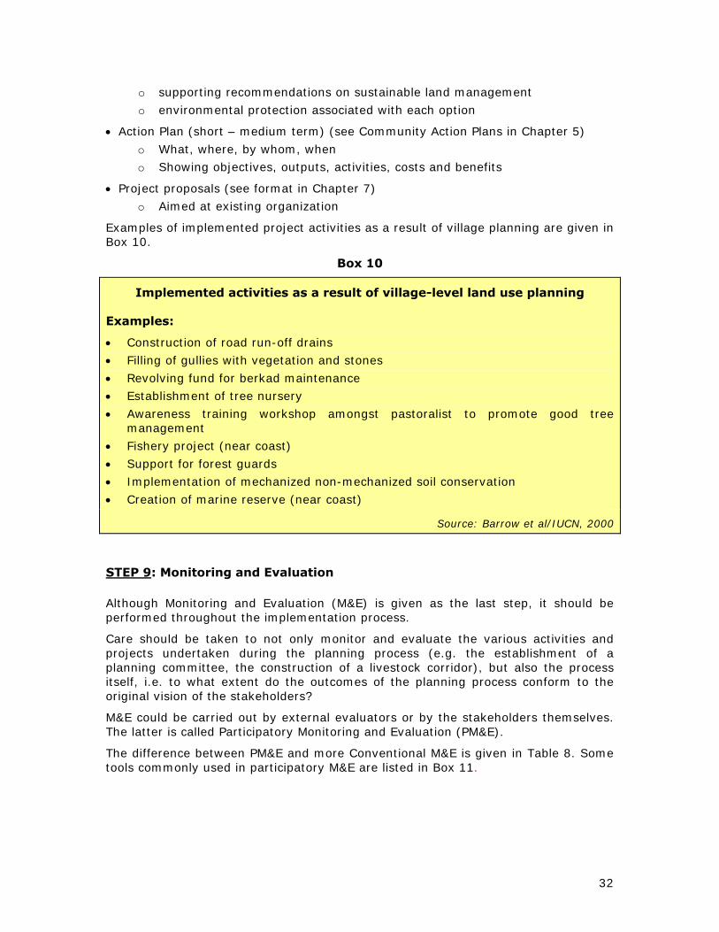
32
o supporting recommendations on sustainable land management
o environmental protection associated with each option
• Action Plan (short – medium term) (see Community Action Plans in Chapter 5)
o What, where, by whom, when
o Showing objectives, outputs, activities, costs and benefits
• Project proposals (see format in Chapter 7)
o Aimed at existing organization
Examples of implemented project activities as a result of village planning are given in Box 10.
Box 10
Implemented activities as a result of village-level land use planning
Examples:
• Construction of road run-off drains
• Filling of gullies with vegetation and stones
• Revolving fund for berkad maintenance
• Establishment of tree nursery
• Awareness training workshop amongst pastoralist to promote good tree management
• Fishery project (near coast)
• Support for forest guards
• Implementation of mechanized non-mechanized soil conservation
• Creation of marine reserve (near coast)
Source: Barrow et al/IUCN, 2000
STEP 9: Monitoring and Evaluation
Although Monitoring and Evaluation (M&E) is given as the last step, it should be performed throughout the implementation process.
Care should be taken to not only monitor and evaluate the various activities and projects undertaken during the planning process (e.g. the establishment of a planning committee, the construction of a livestock corridor), but also the process itself, i.e. to what extent do the outcomes of the planning process conform to the original vision of the stakeholders?
M&E could be carried out by external evaluators or by the stakeholders themselves. The latter is called Participatory Monitoring and Evaluation (PM&E).
The difference between PM&E and more Conventional M&E is given in Table 8. Some tools commonly used in participatory M&E are listed in Box 11.

33
Table 8: Participatory and Conventional M&E
Participatory Monitoring and Evaluation
Conventional Monitoring and Evaluation
Broad range of stakeholders participate Stakeholders often don't participate Focus is on learning Focus is on accountability Flexible design Predetermined design Rapid appraisal methods Formal methods Outsiders are facilitators Outsiders are evaluators Evaluation owned by participants Evaluation often controlled by funding
agencies Source: FAO, 2004
A somewhat “neutral” approach to Monitoring and Evaluation is given in the Guidelines for LUP of the Tanzania National Land Use Planning Commission as follows (NLUPC, 1998):
Monitoring
Monitoring is gathering data on the progress and impact of the development activities, in order to know if the objectives are being met. For that purpose verifiable indicators should be identified before monitoring is carried out.
The progress of activities is monitored against the work-plans, whereby those responsible for the activities often provide the information. It may be practical to prepare a table format which combines the work-plan with the monitoring of its progress by adding columns for information such as: achievements; rate of achievement; reasons for deviation; corrective measure (if required); and, where to verify the data (documentation). The impact of each activity is monitored against the expected results (targets, objectives) of that activity. For each objective, specific indicators are identified to measure the impact of the development effort.
The impact of land use planning on the physical environment, such as the increase in crop production or application of soil and water conservation measures, are in general easier to monitor than its impact on the activities, attitude and socio-economic environment of villagers. The physical impact can easily be assessed by measuring: yields; number and quality of soil conservation measures applied; the regeneration of formerly degrading forest, grazing and other areas; the improvement of settlements, etc.
The impact on the activities, attitude and socio-economic environment of people has to be measured in a more indirect way. For instance, the degree to which minority groups have improved their participation in decision-making may be measured by the extent to which they have participated in the various village meetings.
Monitoring can take place during the activity itself, e.g. preparation of minutes from village meetings, or as a separate activity afterwards, e.g. recording progress of implementing soil and water conservation measures.
Evaluation
Evaluation is the process of assessing the impact of activities carried out with a view to possible measures for improvement. Evaluation is based on the results of monitoring.
Simple baseline-studies are needed at the start of the land use planning process so that the impact of activities can be assessed during implementation and afterwards (long term impact). (For Indicators see Appendices Tanzania Guidelines)
Since the environment in a district and village is subject to continuous change, evaluation of the effects of a specific land use planning exercise after some years should not only use, as reference, the data of baseline studies, but also compare it with the 'without-

34
project situation'. The latter is the situation where prevailing trends (concerning land use, production, etc.) continued without land use planning.
Documentation
Proper documentation of work-plans, monitoring and evaluation exercises may enhance the flow of information and maintain the involvement of the various stakeholders in the land use planning process. This documentation can be in standard forms, progress reports, minutes of meetings, etc.
Participatory Project Monitoring and Evaluation (FAO, 2004)
Guidelines for Participatory Project Monitoring and Evaluation (PM&E) are given by FAO (2004). PM&E has the following characteristics:
• M&E as an integral part of the development or change process
• M&E as an empowering process, rather than control by an external body
• a recognition of subjectivity in M&E • a recognition that different groups of men and women have different
perceptions, which are equally valid
• a need for negotiation during the process to reach consensus about conclusions and recommendations
• a tendency to use less formal techniques such as unstructured interviews and participant observation
• an emphasis on sociological enquiry rather than economic measurements
• the evaluator taking on the role of facilitator
The following steps are frequently included in PM&E:
1) Identify who will participate in the process. (refer to stakeholder analysis)
2) Determine what the participants want from the process and how.
3) Define the priorities for monitoring and evaluating.
4) Identify the indicators to be measured.
5) Agree on how, when and by whom the information is to be collected.
6) Collect the information
7) Analyze the information.
a. Is the implementation keeping to the time schedule? b. Do adjustments have to be made? c. Are the activities proceeding successfully? d. What is proving to be less than successful? e. Is there new information that needs to be taken into account? f. Are the assumptions realistic? g. What actions and strategies need to be taken to address the new conditions?
8) Agree on how the findings are to be used. a. How are the results transmitted to the stakeholders? b. What needs to be changed?
9) Determine if there is a need for another round of monitoring and evaluation. However, it is essential to recognize that each situation is unique, with different circumstances, problems and participants. No single set of techniques or methodologies is appropriate in every case. Much depends, therefore, on the skills of the land use planner whose ability to facilitate the process is critical.

35
Box 11: Tools commonly used in participatory monitoring and evaluation
• maps: to show the location and types of changes in the area being monitored.
• Venn diagrams: to show changes in relationships between groups, institutions and individuals.
• flow diagrams: to show direct and indirect impacts of changes and to relate them to causes.
• diaries: to describe changes in the lives of individuals or groups
• photographs: to depict changes through a sequence of images
• matrix scoring: to compare people's preferences for a set of options or outcomes.
• network diagrams: to show changes in the type and degree of contact between people and services.

36
3 LAND USE PLANNING AT NATIONAL LEVEL
Introduction
In a national land use policy or a master plan, the long-term development objective is formulated for allocation of the natural resources of the whole country. This objective has a production and an environmental component.
Current Land Use Management and Planning Initiatives
Somaliland has introduced a number of laws and institutions to regulate the management of land. However, government institutions are too weak to deal with all issues related to land and traditional institutions remain involved in land issues. Three systems of law are presently applied: the secular, customary (Xeer) and Shari’a Law. However, land ownership remains controversial in many urban and rural settlements.
Recently Somaliland introduced a programme of land allocation, registration, and issuance of title deeds, mapping and record keeping.
Various Ministries have produced a number of land and water policies, many of which are still in draft form or have not yet been approved by the legislative authority (parliament and House of Elders). The pastoral and agricultural lands are managed jointly by the Ministry of Agriculture and the Ministry of Pastoral Development and Environment and the two ministries have produced a number of Land Laws. Some important initiatives are listed below. A complete overview of policies and (draft) legislation related to land is given in Table 12.
• Agricultural Master plan (see Annex 3 for details)
• Land tenure legislation and land policies
• Land registration, allocation and Legal title deeds for urban dwellers in all regions, and Agro-pastoralists in northwest Somaliland
• Agricultural Land Ownership Law (Law No. 8/99)
• Urban Land Management Law (Law 17/2001)
The MoA and MoPD&E have the authority for allocating and demarcating land for grazing and for crop production. They issue permits for the construction of berkads and other water reserves in rural areas. For example, one of the regulations is that there should be no more than 30 berkads in one locality. Land enclosures are banned under Law No 8/99. However the state is not yet able to enforce its own legislation. Common rights continue to be undermined, as more and more land in traditional pasturelands is fenced in. Urban planning falls under the Ministry of Public Works and is regulated by the Urban Land Management Law.
As described in Chapter 1, some land use planning activities were carried out in Somaliland during previous regimes, but recent planning activities at national level are limited to the development of sectoral policies and laws. Such efforts are very significant and should be the starting point for further planning.
Considering the present status of land use planning in Somaliland and priorities, the present Guidelines will focus on the subjects of institutions, policies and legislation as far as planning at national level is concerned.

37
Identification of problem and stakeholders; formulation of objective
As mentioned in the Introduction of this Chapter, the first priority for land use planning at national level is the harmonization of existing legislation with respect to land use.
Objectives:
1. Harmonization (and completion) of policies and legislation dealing with land tenure and land use
2. Dissemination of harmonized and completed policies and legislation to stakeholders
3. Strengthen capacity in terms of finance and human resources in relevant institutions
Once land policies and legislation is in place, other land use planning activities at national level follow from there. Such follow-up could include land registration, land use zoning, establishment of grazing reserves, forest reserves and national parks, establishment of livestock corridors, etc.
Institutions which have a stake in the formulation and harmonization of national land use policies and laws are listed in Table 9. An (incomplete) list of institutions recently active in land use planning in Somaliland are given in Table 10.
Establishment of Multidisciplinary Task Forces and Institutions
National land use planning committee
At national level central government will play an important role, in the form of various ministries, departments and institutions, together with important development agencies. Land use planning is always multi-disciplinary and inter-active and a National Land use Planning Committee should be independent of existing sectoral government institutions.
Functions of the National Land use Planning Committee include the following:
Formulate and update land use policy and related legislative and institutional matters
Coordinate LUP activities at national level
Advise government on issues related to use and management of land resources
Facilitate exchange of information to/from district and village level
Develop and maintain information systems on land resources and land use
Predict and track land use needs and priorities
Coordinate formulation, implementation and monitoring of development plans
Final decision making in cases of conflicting objectives in land use
Presently there is no functional Inter-disciplinary Task Force relating land resources in Somaliland. However, there are a number of Working Groups which could function as a starting point for a full-fledged National Land Use Planning Committee, such as:
- the Inter-Ministerial Coordination Committee (IMCC), which presently coordinates SWALIM activities. This Committee could be re-constituted into a National Land Use Task Force, by including other stakeholders, such as interest groups and associations dealing livestock, agriculture, water and forests.

38
- the Somaliland National Committee for Drought, with representatives of the Office of the President, NERAD, Ministry of Interior, Ministry of Planning, Ministry of Water & Mineral Resources, Ministry of Pastoral Development & Environment, Ministry of Livestock, and Ministry of Agriculture. This committee formulates responses to drought affected people in Somaliland. It makes drought appeals to international agencies and to the Somaliland public, and manages and distributes collected funds to those affected by drought. The National Committee for Drought is chaired by the Vice President. NERAD is in the process of establishing Regional and District Disaster Management Committees. A few Regional Disaster Management Committees are already in place.
- the Somaliland Natural Resource Management Task Force. This task force was established by SWALIM and partners during a workshop on Land Degradation and Rain Water Harvesting (Hargeisa, 2007). This task force has never become functional, but could be revived.
- the Sectoral Working Group on Water, Sanitation and Hygiene (WASH). WASH coordination meetings are held once a month at the Ministry of Water and Mineral Resources, co-chaired by the Ministry of Water and Mineral Resources and UNICEF Hargeisa. This is a very active working group. All agencies and line ministries working in the water sector share information and coordinate their activities.

39
Table 9: Stakeholders Land Use Planning at National level
Name of institution Role
Various Ministries, including:
• Min of Rehabilitation, Resettlement & Reintegration
• Min of Interior (includes Traditional Authorities)
• Min. of Agriculture
• Min. of Pastoral Dev. & Environment
• Min. of Planning & Coordination
• Min. of Livestock
• Water & Mineral Resources
• Min. of Justice
• Min of Public Works
Policies, Strategies
Rules, Regulations, Bylaws
M&E
Implementation
Conflict resolution
Assessments, research, surveys
Budgeting, Auditing, Management
Representation
Land Conservation, Environ. Protection
Empowering social and economic services
Planning
Traditional leaders:
(Sultans, Garads, Ugases)
(see also Ministry of Interior)
Policies, Strategies
Customary Law (Xeer)
Advocacy
Conflict resolution
Representation
National Environment Research and Disaster-preparedness (NERAD)
Policies, Strategies, Implementation
National Committee for Drought Drought emergency response
Parliamentary sub-committee on environment and natural resources
Networking
Analyze draft Acts, policies, regulations passed by House of Ministries
Submission of acts to the House of Representatives
Municipalities Survey & Engineering
Social, Communal Services
Local NGOs, e.g.
Candlelight, ADO, HAVOYOCO, SES
Implementation
Expertise
Advocacy
Universities:
Hargeisa, Amoud, Golis, Burao
Training, Research, Production of Technical Professionals (elites)
Religious leaders
(see also Min of Justice)
Advocacy
Conflict resolution
Interest Groups, e.g.:
Woman’s Groups, producer groups
Implementation
Advocacy
International NGOs, UN organizations Training, Consultancy, Survey & Research, Financial Assistance, Advocacy

40
Table 10: Examples of Institutions working in Land Use Planning
Name of institution/organization
Type of institution
Remark
X Ministry of Agriculture Government Direct involvement in LUP X Ministry of Pastoral Development &
Environment Government Direct involvement in LUP
Ministry of Interior (includes Traditional Authorities)
Government Direct involvement in LUP
X Ministry of National Planning and Coordination
Government Indirect involvement in LUP
X Ministry of Livestock Government Indirect involvement in LUP X Ministry of Water & Mineral Resources Government Direct involvement in LUP X Parliamentary sub-committee on
Natural Resources & Environment Government Direct involvement in LUP
X NERAD (Environmental research & disaster preparedness agency)
Parastatal /government
Direct involvement in LUP
X UNDP UN Agency Implement or fund environmental projects
X UNHCR UN Agency Implement or fund environmental projects
X FAO UN Agency Farmer field schools, FSAU, SWALIM WFP UN Agency Fund environmental projects IFAD/UNOPS INGO/UN Integrated Community Dev. Program:
PRA at community level (2002-2008) IUCN INGO Various projects (SNRMP, 1990s) X Vetaid INGO Somaliland land tenure law proposal ? GAA (German Agro-Action) INGO Community-based NRM Dur-Dur
Planning Tuuyo grazing reserve X PENHA (Pastoral & Environmental
Network in the Horn of Africa) INGO Funded Somaliland land tenure law
proposal X Oxfam INGO Pastoral programmes; emergency ECHO (European Community
Humanitarian Aid Organization) INGO Funding pastoral programmes;
emergency programmes, SWC CINS INGO (Italian) Seed projects (Gabiley 1999 – 2005) X Golis University (Hargeisa) private Training, Education X Amoud University (Borama) LNGO Training, Education X University of Hargeisa LNGO Training, Education University of Burao LNGO Training, Education X BVO (Barwaago Voluntary Org.) LNGO Tree nurseries, etc X NAGAAD LNGO umbrella Various, incl. gender rights Candlelight LNGO Implementing environmental projects X HAVOYOCO(Horn of Africa Voluntary
Youth Committee) LNGO Implement Drought Preparedness
Project ADO (Agriculture Development
Organisation) LNGO Implement agriculture &
environmental projects APD ( Academy of Peace &
Development) LNGO Implement land conflict research in
Somaliland X SES (Somaliland Ecological Society) LNGO Environment, Agriculture X represented at SWALIM Land Use Planning Workshops (October 2008 and/or Feb 2009)
NOTE: This is not a complete list, but serves to give an impression of types of organizations and institutions involved in land use planning.

41
Collecting Data and Information
A list of references related land resources Somaliland at national level is given in Table 11. SWALIM already made an inventory of existing (draft) policies and laws (see Table 12). There are more data in the SWALIM database, including data on water resources (SWIMS), documents, aerial photographs, and satellite imagery.
Table 11: Land resources information Somaliland
(with focus on nation-wide data)
Theme Reports, maps, data Reference Environmental profile Somalia IUCN, 2006
Land Resources Assessment of Somalia SWALIM, 2007 General Impact of Civil War on Natural Resources: Somaliland FAO/Candlelight, 2006
Environmental study of degradation in the Sool plateau and Gebi valley
Horn Relief, 2006 Land degradation Land degradation assessment of a selected study area
in Somaliland SWALIM, 2007
Climate Climatology NW Region Agric. Development project Agroclimatology of Somalia Climate of Somalia
SOGREAH. 1982 Hutchinson, 1989 SWALIM, 2007
Landforms Landform of selected study area in Somaliland SWALIM, 2007
Soils of Northern Rangeland Development project Sir William Halcrow & Partners. 1982
Soil survey NW Region Agric. Development project SOGREAH. 1982 Soils
Soil survey of a selected study area in Somaliland SWALIM, 2007
Groundwater survey Dur Dur Watershed German Agro Action Somaliland, 2005 Water
Water resources database (SWIMS) SWALIM
Vegetation of the Northern Regions of the Somali Republic
Hemming, C.F., 1966
Land cover of selected study area in Somaliland SWALIM, 2007
An ecological assessment of the Coastal plains of North Western Somalia (Somaliland)
IUCN, 2000
An ecological and resource utilization assessment of Gacaan Libaax, Somaliland
IUCN, 2000
Vegetation & Rangeland
Range and Livestock. NW Region Agric. Dev. Project. SOGREAH, 1982
Land use characterization of a selected study area in Somaliland
SWALIM, 2007
Land use Impact of charcoal production on both the environment and the socio economy of pastoral communities in Somaliland
MoPD&E, 2004
Various statistics, maps, analyses of Somaliland FSAU
Somaliland in Figures MoNPC, 2008
Somali Joint Needs Assessment. Livelihoods and solutions for the displaced
UNDP, WB, 2006 Socio-economy
Regulating the Livestock economy of Somaliland APD, 2002

42
Table 12: Laws, policies, strategies and regulations related to land use5
Title Author, date, Authority
Status
General
*Constitution of the Government of Somaliland GoS, 2000 Referendum 2001
updated 2005
National Environment Research and Disaster-preparedness (NERAD) Agency Law (in Somali)
GoS, 2006. Law No. 35/2006 (passed 2008)
The Food Security Act
The Food Security Act (Somaliland)
MoA, 1991
MoA, 2008
Law No 10/1991
draft
*Master proposal for operationalizing of revised strategic plan (2008-2012)
NERAD, 2008 Acacia Consult.
proposal
The land legal framework. Somaliland & Puntland State of Somalia
UN-Habitat, 2006 Situation Analysis
Urban
(Urban) Land Management Law GoS, 2001 Law No. 17 (draft)
Agriculture (crops)
*Agricultural land ownership law (Somali) GoS, 1999. Law No. 8/99
*Agricultural Land Registration Act MoA, 2008 Act, draft 1.1
*Agricultural Production and Certification Act MoA, 2006
# Master-plan for reconstruction and development of the Somaliland agriculture sector
MoA, 2007, ECSALI Project
Master plan
*National Agriculture Policy MoA, 2008, ECSALI Project
Policy, 2nd draft, June 2008
Somaliland land tenure policy MoPD&E, MoA, 2008
Policy, 2nd draft
Grazing, Pastoralism, Environment
National Environmental Action Plan and Strategy to combat desertification
MoPD&E, 1999 draft
*Prevention of Deforestation and Desertification Law (Environment Conservation Act and Proclamation) (in Somali)
GoS, 1998 Law No. 04/1998
*Law on Fauna (Hunting) and Forest Conservation
GoS, 1969 Law No. 15/1969 (reference doc.)
*Environmental Policy of Somaliland
(Policy on Environmental Management)
MoPD&E, 1999 Policy
*Somaliland land tenure policy MoPD&E, MoA, 2008
Policy, 2nd draft
*Strategic plan for 2008/2010 MoPD&E, 2008 Plan, Final draft
*Rangeland management policy of Somaliland (incl the 14 statements of Somaliland range policy)
MoPD&E, 1999 Policy, draft
#National Livestock Policy 2007-2016 MoL, 2007 Policy
5 This list does not include (unwritten) customary laws (Xeer)

43
Table 12 (cont.)
Water
?Water Development Agency MoW&MR, 1971 Law No. 28/1971
*Somaliland national water strategy MoW&MR, 2004 Strategy, approved by Council of Min.
*Somaliland national water policy MoW&MR, 2004 Policy, approved
*Water Act (Somali) MoW&MR, 2008? Act No. ?? (At Parliament in 2009)
*Regulations in the Water sector MoW&MR, 2006, Hydroconseil
Regulations (At Parliament in 2009)
Ministerial programme on marine reserves and conservation
MoW&MR, 2004? Programme (in Somali)
Fisheries regulations
See also http://www.somalilandlaw.com
* digital copies available from SWALIM # hard-copy or scanned copy only
Formulation of draft policies and laws
After inventorying all existing policies and laws related to land use, various proposals for comprehensive and harmonized land laws covering all land uses should be drafted. Such proposals could be based on existing legislation in other countries (see examples from Tanzania in Chapter 2 - Box 6, and from Botswana in Annex 2), and may need assistance from outside specialists (land legal specialists).
Proposed land laws should relate to the actual land resources of Somaliland, and prevailing land use types and socio-economic conditions. Considerable information already exists in this regard (see Table 11), but additional data may have to be collected.
Negotiation, discussion and approval of land use policies and legislation
Once draft policies and legislation are available and distributed there will be a long process of education, discussion and negotiation according to constitutional and traditional processes prevailing in the country.
Opinions should be sought from many representative institutions, organizations and authorities. Forms of dialogue will include workshops, public debates, media coverage, followed by debates in the Houses of Parliament.
Implementation, Promotion and Enforcement of land use policies and legislation
The implementation of approved land use policies and legislation requires both incentives and enforcement. Various types of incentives are listed in Chapter 2 (Table 7). For most of the land users the benefits of implementation of rational land use policies and regulations will be indirect, through improved food security. higher productivity and sustainable land use.
Obviously, laws and regulations on land use will come with clauses on arbitration and prosecution of offenders. Somaliland’s formal judiciary system, as well as its customary law (Xeer) and Islamic law will have a role to play.

44
Monitoring and Evaluation
M&E should be performed throughout the implementation process. Firstly, the effectiveness and compatibility of all sectoral land policies and legislation should be monitored and evaluated. Amendments should be proposed and effected where necessary. Secondly, the whole process of government interference with land use practices through policy formulation and legislation should also be evaluated. The question should be asked if the overall objectives of the stakeholders have been wholly or partly reached, or have caused more confusion, conflict and inequality.

45
4 LAND USE PLANNING AT DISTRICT LEVEL
There are no good examples of district level land use planning in Somaliland, although some land resource management studies have been carried out which cover large parts of the country, e.g. the “Environmental study of degradation in the Sool plateau and Gebi valley: Sanaag region of northern Somalia” (Horn Relief, 2006). This Chapter is partly based on the guidelines developed for Participatory Land Use Development in the Municipalities of Bosnia and Herzegovina (FAO, 2004). An overview of the SWALIM land and water resources inventory is also included, as well as method and results of the SWALIM land suitability evaluation in Somaliland.
The land use planner
The land use planning process is facilitated by the land use planner, which could be an individual, group, institution or coalition of groups. The land use planner mobilizes the stakeholders and creates at least the minimum critical mass of interest, expertise and resources required to get the land use planning process to a self sustaining level of operation (see also Chapter 2).
Objectives
A district land use plan will have an objective, which aims at development in the district or other relevant area of similar size (e.g. a watershed). Its objective should conform to and serve the objectives in the overall land use policy of the country. At the same time, the land use planning exercise should deal with outstanding land use issues and conflicts.
Selection of planning area
Land use planning at meso-level could cover one or more districts or a natural area such as a water catchment. Selection of a planning area could be based factors including the following:
• urgency of issues (e.g. conflicts, land degradation)
• initiatives and interest from local authorities (District Councils) and local NGOs
• interest from donors
• human resources within the district administration
• effectiveness of administration and security
• available data
Most important are the presence of a genuine desire within the planning area for sustainable natural resource management and an equitable distribution of resources.
Stakeholders
The district administration has a very prominent position in the list of stakeholders of the land use planning process. All further activities of the planner must be undertaken in partnership with the responsible person or people in the district administration.
In addition to the district administration, the planner must attempt to identify other stakeholders who must be involved in the process. Not all stakeholders are readily apparent. Finding them is an ongoing and open task, and there is always a risk that some will be missed (see Chapters 2 and 5 for more on stakeholder analysis).
46
Task Forces
The land use planner or facilitator makes contact with external partners, or service providers. These are people or institutions that can provide the technical expertise that the stakeholders will need or find useful as they work their way through the process. Examples of service providers include research and academic institutions, private consultancy firms, government agencies, international organizations and NGOs. Such service providers have to be identified, contacted and linked to the stakeholders.
A multi-disciplinary District Land Use Planning Group (DLUPG) will be established. Various Government institutions will be represented, as well as senior clan leaders (Sultans, Ugases and Garads), elected leaders (e.g. District Councilors) and local development agencies. Depending on the tasks at hand, representatives of the private sector could also be co-opted. Tasks of the DLUPG include:
Formulate objectives of district land use planning activities
Implement district level land use planning activities
Provide technical support to Local Resource Management Groups (see Ch. 5)
Coordinate village-level land use planning and assist with resolving conflicts
Inform National Land use Planning Committee of district level priorities
In Somaliland, all districts have elected councilors, first elected by popular vote in 2003 for a 5-year term. Councilors elect a district mayor from council members. Gabiley and Borama Districts established District Development Committees (DDC) in 1999 with the support of UNOPS. These Committees are made up of district councilors, prominent community elders, and representatives of district-based ministries, such as the Ministries of Agriculture, Health, Education and Pastoral Development & Environment. The DDC is mandated to develop a district development plan6, but these have not yet materialized.
Collecting Data and Information
The nature of data needed for land use planning is discussed in Chapter 2. In this Chapter available data which could be of use for land use planning at district level is explained in more detail. Most of these data only cover a limited number of districts and additional data will be needed, depending on the objectives of the land use planning exercise and the area covered.
- SWALIM land resources data Somaliland
The most complete and recent data on land resources at meso-level have been collected by SWALIM of an area between the Ethiopian border and the Red Sea, covering the districts of Dila, Gebiley, Faraweyne and Allaybaday, and parts of the districts of Hargeisa, Borama, Baki and Lughaya7. Natural resource surveys form the basis for physical land evaluation and include inventories of agro-climate, landform, soils, landcover and present land use. Such surveys were carried out by SWALIM in the study area (SWALIM, 2007).
6 The Ministry of Interior is in the process of establishing Regional Development Committees in all regions, which will develop Regional Development Plans.
7 The districts of Dila, Faraweyne and Allaybaday were recently formed

47
The basic units of evaluation are Resource Base Units (RBU), which are defined as land areas, generally smaller than a region but considerably larger than a farm, with a definable combination of characteristics of climate, relief, altitude, soil and natural vegetation. The RBUs are generated by combining different spatial baseline data layers, including Length of Growing Period (LGP), landscape, vegetation, soil groups and altitude (Figure 6).
Forty-five RBUs have been defined for study area (see Figure 7) and described in terms of more than 20 distinct land characteristics (SWALIM, 2007, report L-06).

48
Figure 6: Identification of the RBU’s
Figure 7: Resource Base Units of SWALIM study area in Somaliland
Resources Base Units Map
Landscape
LGP
Altitude
Vegetation
Soils
Spatialoverlay

49
- SWALIM water resources data (SWIMS)
The Somalia Water Sources Information Management System (SWIMS) stores and manages a variety of data for the five principle types of water sources in Somalia: boreholes, dams, berkads, dug-wells and springs. It allows multiple agencies to collect and manage water sources information and contribute to a national inventory of water sources in Somalia while maintaining data integrity. SWIMS incorporates three modules into one application. These are: location, records and interventions modules. The location module consists of the spatial data (name and geographic coordinates) used to map the water sources. The records module is used to track changes in the functional status, users, management, physical parameters and water quality of a particular source over time. The interventions module provides a means of recording past, present and future project activities on a particular water source. The module allows the user to store information on the planned activities for a source, and update each intervention record throughout the project cycle.
- Socio-economic data
Socio-economic data are collected systematically by the FAO Food Security and Analysis Unit (FSAU). Some relevant information is summarized in Table 13. Some relevant FSAU baseline profiles are given in Annex 1.
The Ministry of National Planning & Coordination (MoNPC) also collects and publicizes socio-economic data on a regular basis: Somaliland in Figures (MoNPC, 2008).
Population data have been compiled by both WHO (2001) and UNDP (2004). These data are not based on a census, but derived from secondary data and projections. Population by district summarized in Table 15.
Box 12: SWIMS Water Resources Data
As of 2008, SWALIM has identified over 1000 strategic water points (boreholes, dug wells, springs and dams) in Somalia. The parameters monitored include the physical parameters of the water sources (depth, yield, static water level, etc), users of the source, basic water quality (EC, pH, taste, smell, etc), ownership, supply and distribution among others. All these data have been entered into SWIMS and posted to SWALIM’s website, together with the various products generated from it.
Website: http://www.faoswalim.org/theme_groups/water/page.php?id=14
The data can also be requested for from: [email protected]

50
Table 13: Overview of selected data available from FSAU
Livelihood Zone Baseline Profile
Seasonal Calendar
Economic Data
(food, income, expenditure,
wealth)
Golis-Guban Pastoral
goats, camels draft 2002? See Annex 1
√
Hawd & Sool
Pastoral
camels, goats, sheep, cattle
draft Aug 2002 See Annex 1
√ √ (1999)
Somaliland Agro-Pastoral
sorghum, cattle draft Aug 2002 √ √ (2001)
Nugal Valley
Lowland Pastoral
goats, camels draft 2002? √ √ (1998)
Togdheer
√ √ (2002)
Table 14: Selected list of references on land resources (district level)
Theme Reports, maps, data Reference Environmental study of degradation in the Sool plateau and Gebi valley
Horn Relief, 2006 Land degradation Land degradation assessment of a selected study area
in Somaliland SWALIM, 2007
Climate Climatology NW Region Agric. Development project SOGREAH. 1982
Landforms Landform of selected study area in Somaliland SWALIM, 2007
Soils of Northern Rangeland Development project Sir William Halcrow & Partners. 1982
Soil survey NW Region Agric. Development project SOGREAH. 1982 Soils
Soil survey of a selected study area in Somaliland SWALIM, 2007
Groundwater survey Dur Dur Watershed German Agro Action Somaliland, 2005 Water
Water resources database (SWIMS) SWALIM
Vegetation of the Northern Regions of the Somali Republic
Hemming, C.F., 1966
Land cover of selected study area in Somaliland SWALIM, 2007
An ecological assessment of the Coastal plains of North Western Somalia (Somaliland)
IUCN, 2000 Vegetation
An ecological and resource utilization assessment of Gacaan Libaax, Somaliland
IUCN, 2000
Land use characterization of a selected study area in Somaliland
SWALIM, 2007
Land use Impact of charcoal production on both the environment and the socio economy of pastoral communities in Somaliland
MoPD&E, 2004
Various statistics, maps, analyses of Somaliland FSAU
Somaliland in Figures MoNPC, 2008 Socio-economy
Regulating the Livestock economy of Somaliland APD, 2002

51
Table 15: Population estimates by district
Region District Total Population Non-urban Population
Borama 215616 132695 Baki 25500 16923
Lughaye 36104 22094 Zeylac 28235 22801
Awdal
Hargeysa 560028 137513 Berbera 60753 18683 Gebiley 79564 53717
Woqooyi Galbeed
Burco 288211 191748
Buuhoodle 38428 28821 Owdweyne 42031 30924
Sheikh 33625 27400 Togdheer
Laas Caanood 75436 50606
Caynabo 30702 24026 Taleex 25354 20983 Xudun 18785 15528
Sool
Ceerigaabo 114846 83748 Ceel Afweyn 65797 53638
Laasqoray/Badhan 89724 76902 Sanaag
TOTAL 1828739 1008750
Source: UNDP, 2005
Information on Somaliland laws and recent policies related to land resources
Land use planning at any level should conform to the national laws and adopted government policies. An overview of recent policies, strategies and laws is given in Chapter 3 (Table 12).
Preliminary Identification and Screening of Options
Ideas for improved land use options will emerge through the planning process as stakeholders suggest changes and information becomes progressively available. The nature and scope of these options very much depend on the planning objectives. Review of these options by the task force and land use planner should be a continuous process, which is consistent with the iterative nature of land use planning.

52
The preliminary identification and screening of options could be a simple process, particularly if the objective of the land use plan addresses a single problem in a limited area. However, usually there are various problems to deal with and a large number of options to be considered. Ideas could come from the appointed task force, collaborating institutions, stakeholders, technicians and also potential donors. Brainstorming may be needed at first (see Box 14), followed by preliminary screening and ranking.
Ideas may also be gained from literature and internet search. Some useful publications in this regard are listed in Table 17.
The review may take the form of a workshop, in which initial objectives are reviewed in the light of the proposed options and the new information that has been collected. Its first task is to formulate possible improved land use options (e.g. modified or new production systems). Secondly these options are screened for consistency with all the stakeholder objectives, for acceptability within the framework of government policy and legislation, and for broad feasibility according to the resources needed for their implementation. One option to include in all planning exercises is “to do nothing”: the result of non-activity can then serve as a benchmark against which the result of various options can be measured.
If there are constraints identified, related to the existing general conditions (policies, regulations, etc.), potential solutions or alternatives have to be sought. Changes to some of the general conditions, if possible, might be considered. Those land use options which pass this screening process are subjected to land evaluation.
Evaluating Resources for the Identified Options
The basic principles of land evaluation have been explained in Chapter 2. In the following Sections some of the land evaluation results from SWALIM are summarized.
- SWALIM land suitability evaluation Somaliland
SWALIM carried out a land suitability evaluation for a study area between the Ethiopian border and the Red Sea, covering the districts of Dila, Gebiley, Faraweyne and Allaybaday, and parts of the districts of Hargeisa, Borama, Baki and Lughaya For the purpose of physical land suitability evaluation SWALIM developed a tool called Somalia Automated Land Evaluation System (SOMALES). SOMALES is the application of the FAO Framework for Land Evaluation with the use of computer
Box 13: Brainstorming land use options
• Follow up on national policies and plan (e.g. Master Plan for Agriculture Sector)
• Identify promising crops/varieties
• Seek solutions for challenges faced by pastoralists (e.g. enclosures; poor access to grazing resources)
• Identify opportunities with respect to forestry and agro-forestry
• Seek for equitable distribution and use of water resources
• Rehabilitation of degraded, but potentially productive land
• Control of invasive plants (e.g. Prosopis and Parthenium spp)
• Comprehensive watershed management
• Conservation of biodiversity (e.g. protected forest areas)

53
software called the Automated Land Evaluation System (ALES). Details of SOMALES, and how it was applied for the study area, are given in FAO-SWALIM Technical report no. L-06 (SWALIM, 2007a).
As explained earlier, the basic units of evaluation are Resource Base Units (RBU). Forty-five RBUs have been defined for study area (see Figure 7).
Land suitability is determined for specific land use, which can be defined at two levels of detail. A major kind of land use is a major subdivision of rural land use such as rainfed agriculture, irrigated agriculture, forestry, etc. A land utilization type (LUT) is a kind of land use defined in more detail, according to a set of technical specifications in a given socio-economic setting. Major kinds of land use and LUTs which were included in the land suitability assessment of the study area (FAO-SWALIM Technical Report L-06) are given in Table 16. This Table does not give a complete list of LUTs or land use options, but only serves as an example.
Table 16: Land Use Types (Examples)
Major Kind of Land Use
Land Use Type (LUT)
Rs1 Rainfed sorghum; short GP (90-100 days); medium input
Rs2 Rainfed “Traditional sorghum”; total GP 180 days (including “dormant” period of 50 days; low input
Rc Rainfed cowpea; short GP (80 days); low-medium input
R Rainfed Agriculture
(crops)
Rm1 Rainfed maize; short GP (80-90 days); medium input
Pc Extensive grazing of cattle; low input Pd Extensive grazing of camels; low input Pg Extensive grazing of goats; low input
P Pastoralism
(extensive grazing) Ps Extensive grazing of sheep; low input Fai Azadirachta indica (neem) Fan Acacia nilotica (maraa) Fat Acacia tortilis (qurac) Fba Balanites aegyptiaca (quud) Fce Casuariana equisetifolia (shawri) Fcl Conocarpus lancifolius (damas, ghalab) Fdg Dobera glabra (garas) Ffa Faidherbia albida (garabi)
F Forestry
(tree plantation)
Fti Tamarindus inidica (raqai)

54
Table 17: Literature related to land use options in Somaliland – district/village level
Land use Type Resources Reference
Rebuilding Somaliland. Issues and possibilities WSP Int., 2005
Managing dryland resources. A manual for eastern and southern Africa. IIRR, 2002 General Land-based conflict project & Dialogue for Peace Programme ADP, 2006, 2007, 2008
Technical assistance for soil erosion and land reclamation in Borama and Baki Districts Schaap, O., 1996
Soil & Water Conservation. North-west Region Agricultural Development Project. SOGREAH, 1982
Pilot watershed management for soil & water conservation and small garden development. Geed Abeerah TAMS, 1986
Natural resources management; soil & water conservation WOCAT Soil and Water Conservation Techniques http://www.WOCAT.net
Grazing capacity estimates for Tuuyo Seasonal Reserve. Heemstra, H.H., 1981b
Securing pastoralism in East and West Africa: protecting and promoting livestock mobility Somaliland/Somali Region desk review.
Birch, Izzy, 2008
Regulating the livestock economy of Somaliland. ADP, (2007 ??)
Agricultural and Water Survey. Livestock Development Survey. FAO, UNDP, 1967 Pastoral
Access to water, pastoral resource management and pastoralists’ livelihoods. Lessons learned from water development in selected areas of Eastern Africa (Kenya, Ethiopia, Somalia).
Gomes, N., 2006
Rainfed Agric. Rainfed Agriculture. North-west Region Agricultural Development Project.
Land suitability assessment of a selected study area in Somaliland
SOGREAH, 1982b
SWALIM, 2007
Irrigated Agriculture. North-west Region Agricultural Development Project. SOGREAH, 1983 Irrigated Agriculture Pilot watershed management for soil & water conservation and small garden development. Geed Abeerah TAMS, 1986
Forestry and Woodland management in Somaliland Herzog, M., undated
Land suitability assessment of a selected study area in Somaliland SWALIM, 2007 Forestry
Sustainable Management and Restoration of Dalloo and Surod Juniper Forest Ranges by Local Communities. Erigavo, Somaliland
GAA/Laubmeier, 2007
Agro-forestry Dryland Agroforestry Strategy for Ethiopia. ICRAF Drylands Agroforestry Workshop, Nairobi, Sept 2004. Kindeya Gebrehiwot, 2004.
Nature reserves An Outline of the Status of the Somali Fauna and of its Conservation and Management Problems. Simonetta, 1983
Tourism Forests, Fauna, National Parks and Relative Prospects for Tourism in Somalia. Chauser, F. et al, 1969
Somali Joint Needs Assessment. Livelihoods and solutions for the displaced. UNDP, WB, 2006
Berbera, first steps towards strategic planning UN-Habitat, 2008 Urban Introducing (optional) planning in post-conflict contexts. The Case of the Somali cities. UN-Habitat (undated).

55
SOMALES has four Suitability Classes:
S1 = Highly Suitable
S2 = Moderately Suitable
S3 = Marginally Suitable
N = Not Suitable
A number of Suitability Sub-Classes is distinguished, reflecting kinds of limitation, e.g. subclass S3m means “Marginally suitable due to low moisture availability”.
Parts of the results of the SWALIM land evaluation exercise in Somaliland is shown in Table 18. This matrix gives the suitability of a number of Resource Base Units for four land use types (crops). The result of land evaluation for sorghum is also shown in Figure 8.
Table 18: Land Suitability for Rainfed Agriculture (Example)
Area
RBU
ha %
Rc cowpea short GP
Rm1 maize
short GP
Rs1 sorghum short GP
Rs2 sorghum long GP
“Elmi Jama”
17 7198 0.6 N N N N 18 9786 0.8 S2em S2em S2em S2em 19 61977 5.0 S3mn S3emn S3emn S3emn 20 11112 0.9 S2efmn S2efmw S2efmw S2efmw 21 36235 2.8 S3m S3mn S3m S3m 22 46251 3.6 S3mn N S3mn S3mn 22a 23089 1.8 S3mn N S3mn S3mn 23 163997 12.7 S2em S2em S2em S2em 24 61666 4.8 S3m N S3m S3m 24a 34463 2.7 S3m S3m S3m S3m 25 12576 1.0 N N N N 26 73305 5.7 S3m N S3m S3m 27 9641 0.7 S3m N S3m S3m 28 2547 0.2 N N S3mnw S3mnw 29 66109 5.1 N N N N 30 4322 0.3 N N N N 31 28488 2.2 S3m N S3m S3m
Suitability classes: S2=moderately suitable; S3=marginally suitable; N=Not Suitable Sub-classes (limitations): e=erosion hazard; f=flooding hazard; m=(low) moisture availability; n=(low) nutrient availability; w=(poor) drainage
from SWALIM, 2007, Report L-06

56
Figure 8: Land suitability for sorghum

57
58
5 LAND USE PLANNING AT LOCAL LEVEL
Examples of planning at village level are drawn from the IUCN Somaliland Natural Resource Management Project (Barrow, 1998 & 1999; IUCN, 2000) and from PRA Case studies by IFAD (Integrated Community Development Programme) and HAVOYOCO/Oxfam (Somaliland Pastoral Development Programme). A check-list of some activities and tools in village level land use planning is given in Table 19).
STEP 1: Identification of problem and stakeholders; formulation of objective
In a community land use plan, people will formulate objectives relevant to their community. The objective should consider short-term and long-term aspects and be focused on sustainable development of the community and its land resources. Such plans will fit into and feed the district or watershed plans thereby creating mutual support. Most communities will need outside assistance with the formulation of a community land use plan or Community Action Plan (CAP). In Somaliland such assistance has been given locally by development agencies such as IUCN, OxfamGB and GAA (see Box 14).
An example of village-level stakeholders and problems identified by them is given in Table 20. Apart from identifying the stakeholders, it is also important to establish how they relate to each other and who has the power to influence the access and use of land resources. An example of a “Campfire” analysis of stakeholder and power relations is given in Chapter 6. The stakeholder groups closest to the “fire” (centre) are “warm” and close to the cooking pot, and have inside knowledge and power; groups far away from the centre are left in the cold and cannot make decisions.
To involve all stakeholders in the process, the land use planner or facilitator should try to demonstrate that there is something to gain for everybody.
Box 14: Literature on village-level land use planning
• Participatory village land use and NRM planning in Somaliland. (Barrow, 1998)
• The use of participatory mapping tools. Training Workshop. Somali Natural Resource Management Project. (Barrow, 1999)
• Community based participatory natural resource and land management planning. Lessons and guidelines developed from practice in Somaliland from the Somaliland NRM programme. (IUCN, 2000).
• Community Based NRM in the Dur-Dur Watershed, Awdal Region, Somaliland (German Agro Action Somaliland, 2006)
• Community-based Participatory Watershed Development. Part 1: Guidelines. Part 2: Annex. (Lakew Desta et al, 2005) (Ethiopia)
• PRA Case Studies (IFAD, 2002-2006)
• PRA Case Studies (HAVOYOCO/OxfamGB, 2007)

59
Table 19: Village land use planning activities check list and tools
phase Activities By whom Tools 1 • Introduction: why village land use plans; village planning as a process,
not an end in itself • Initial village resource mapping • Men’s and Woman’s resource mapping • Critical resources within village (wet/dry/famine) • Transects walks to create forum for discussion • Initial identification of problems and solutions • Agree on further action
Villagers and Facilitator (Community Mobilization Officer)
Focused village group meetings Maps List and rank critical resources
(Matrix) Brainstorming on problems and
issues; agree on some short-term action
2 Villagers take time to digest information from phase 1. Decide what further (external) information is needed and who is doing what
3 • Follow-up and revisit by CMO • Larger resource mapping (outside village): access to resources, uses • External stakeholder analysis • Resource ranking • Agree on further action
Villagers & CMO • Mapping of wider area (outside village)
• Matrix rank, listings • Group discussions, brainstorm
4 Villagers digest information from phase 3. Decide what further (external) information or assistance is needed and who is doing what
5 • More detailed analysis of stakeholders. Who makes decisions about resource access and use. Institutional arrangements for NRM
• Seasonal and labour mapping • Discuss village problems and issues
Villagers & CMO • Stakeholder analysis • Focused group discussion • Listings, rankings • Seasonal and labour analysis
6 Villagers take time to digest information from phase 3. Decide what further (external) information or assistance is needed and who is doing what
7 • Resource Map fine tuning; overlay social responsibilities, stakeholder and institutional issues
• Structural analysis of problems, issues and opportunities (e.g. SWOT) • Discuss and decide on Monitoring and Evaluation (M&E) system • Action plan: who will do what and when • Decide on external input needed
Villagers & CMO • Revisit maps, matrix rankings • SWOT analysis on issues • Discussions on action plan
8 Villagers discuss land use plan in their own time
9 Endorsement of land use plan Villagers & CMO
10 • Initiate implementation of plan • Agree on work plan: who will do what, when and resources needed • Links to donors for some of implementation
Villagers & CMO
11 Participatory monitoring of progress Fine-tune, revise plan
Villagers & CMO
Source: Barrow, 1998

60
Table 20: Village-level stakeholders and problems
STEP 2: Establishment of Multidisciplinary Task Forces and Institutions
LOCAL RESOURCE MANAGEMENT GROUPS
At local level Local Resource Management Groups (LRMG) should be in place. In Somaliland, most communities have a Village Committee (VC) and/or a Village Development Committee (VDC). In some villages, there may be a more traditional group of “Elders” in addition to the VDC. These existing village institutions should be the starting point of any land use planning activity. Additional and more specialized LRMGs could be formed if necessary. These groups could be dealing with all land resources in an area, or specialize in one of the main resources, e.g. Range Management Groups, Sub-catchment Water & Irrigation Management Groups, Forest Management Groups, etc. Some existing local institutions may already play an important role in land resource management and should be involved. Examples of such institutions are voluntary associations, mutual aid and work groups, religious groups, woman’s group, etc. Government cannot impose LRMGs on the community, but can facilitate them and make sure that all stakeholders have a voice.
Village Stakeholder analysis Identification of problems by villagers
Elder men
Woman, Woman groups
Youth (male + female)
Ex-Government staff
Religious leaders
Farmers (crops); Pastoralists
Poor people; Rich people
Milk group
Teachers (Koran, Education)
Tea shop owners
gullies in the forest areas
unfenced berkads
erosion around bailey water dug outs
water scarcity
lack of functional health facilities
lack of farm inputs
lack of trees
deforestation in communal forest area
lack of business opportunities
erosion on cropping land and range lands
example from Qalao village (after Barrow, 1998)
Box 15: Suggested composition of a LRMG
• Religious Leader (Sheikh)
• Member(s) of Pastoral Association; Pastoral Leader
• Member(s) of Farmers Association; Influential crop producer
• Teacher(s)
• Representatives of active local civil society organizations
• Member of VDC and/or VC
• Technical Officer from the District Office (Facilitator)
61
Functions and activities of the LRMG include:
Address and resolve existing or potential resource use conflict within community
Address resource degradation or unsustainable use pattern
Deal with external stakeholders, such as central government, entrepreneurs, NGOs
Manage Community Action Plan and other local LUP activities
Monitor and evaluate any Land Use Plans under implementation
Develop and maintain local level database and records (resource centre)
Share information with internal and external stakeholders
STEP 3: Collecting Data and Information
Examples of participatory data gathering at village level are taken from PRA Case studies (IFAD, 2002-2006; HAVOYOCO/OxfamGB, 2007). Community Sketch Map
A community sketch map shows the community the boundaries and characteristics of its territory. It indicates where resources, activities and opportunities are located.
The community members gather in an area of bare soil and draw a map with their fingers and sticks. Many discussions and arguments will take place, but with the help of the facilitator a consensus will always be reached regarding a specific feature or resource location. The map is then copied on a sheet of paper (see Fig 9). If the necessary expertise is available, a more professional map can also be produced with similar information.
Socio-economic data
Various socio-economic data should be collected by the community and the facilitator. Such data include population, number of families, number of refuges, number of returnees, minority groups, community workers and services, average farm size, number of farms, crops, livestock, etc.
Institutional Analysis
The purpose of an institutional analysis is to help the community to learn about the activities of the various groups and organizations within the community and how to work with them. It also helps to understand how the community views these groups.
The community members list the various institutions working with them and their activities. They then make comments on the activities of these institutions and rank them according to their importance and effectiveness. An example of institution ranking is shown in Table 21. The ranking of institutions by the community also gives feedback to the agencies about the way the community sees them.

62
Table 21: Participatory Institutional analysis and ranking
Institution Activities Remarks Rank International Development Bank
Provided 100 tractor hours Food demonstrations Community health worker training Trained two animal health assistants
Provision of tractor hours were late 4
International NGO
Rehabilitated 22 berkads Desilted one balley Restocked 50 shoats Provided cash credit Constructed 21 latrines Provided hand tools Provided training
Did good job
2
Village Committee
Maintain peace and stability Mobilize community Coordinate with INGO and UN agencies Coordinate with government authorities
The closest institution to the community 1
Local NGO (1)
Provided veterinary drugs Trained two animal health assistants Provided medical material
Good monitors 3
Local NGO (2)
Provided training in bee keeping Provided bee keeping materials
45 beneficiaries 6
Outside sponsor
Built the school Did good job 5

63
Figure 9: Community sketch Map
example from PRA Dhimbilriyaale Community (Havoyoco/OxfamGB, 2007)

64
Source of income and income expenditure
The community discusses their main sources of income, such as livestock and its by-products, agriculture, trade and remittances. The results can be shown in a pie chart (see example, Figure 10). Similarly, income expenditure can be discussed and presented (Figure 11).
Figure 10: Sources of Income
example from PRA Dhimbilriyaale Community (Havoyoco/OxfamGB, 2007)
Income Expenditure
70%
18%
6%
6%
FoodClothesSchool feeOthers
Figure 11: Income expenditure
example from PRA Dhimbilriyaale Community (Havoyoco/OxfamGB, 2007)
Wealth Ranking
The community is asked to classify their households into three wealth categories: poor, middle and rich. The identified categories and its percentage can be shown in a pie chart.
Gender daily activity calendar
Men, women and children have different roles in traditional communities. It is important to establish these roles so as not to overburden an already overworked
Source of Income
15%
10%
10%
10%5%
50%
Livestock
CropproductionMilk
Petyy trade
Remmittance
Others

65
group with new programmes, or to assign tasks to which they are not used. One method to discuss gender roles is to ask men and women separately to list their mainly daily activities. In a plenary discussion the men can then comment on the calendar presented by the woman and visa versa.
Seasonal calendar
A seasonal calendar attempts to establish patterns of activities throughout the year and to determine whether there are common periods of excessive workload or environmental problems or opportunities, and to time project activities. An example of a seasonal calendar as perceived by an agro-pastoral community is shown in Figure 12. JAN FEB MAR APR MAY JUN JUL AUG SEP OCT NOV DEC Rainfall
Land preparation
Planting
Harvesting
Weeding
Animal watering
Migration
Human disease
Animal disease
Festivals/ Marriages
example from PRA Dhimbilriyaale Community (Havoyoco/OxfamGB, 2007)
Figure 12: Seasonal calendar
Problem listing, analysis and ranking
There are a number of techniques to help the community to become aware of their problems and possible solutions. One way is to list all the problems they have encountered and then analyze each of them with respect to causes, coping strategy and opportunities. The result of such a problem analysis is shown in Table 22.
STEP 4/5/6: Identification, Screening and Appraisal of Options
Options assessment matrix
The creation of an options assessment matrix can help the community to identify sustainable and realistic solutions to their problems and formulate projects. In this exercise, the options identified earlier (step 3) are assessed against criteria such as sustainability, production, equity, social/cultural acceptability, technical feasibility, cost and time. In the example below (Table 23) the community members give each option a score of I (low) to III (high) against each criterion. The total score
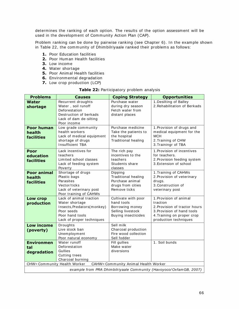
66
determines the ranking of each option. The results of the option assessment will be used in the development of Community Action Plan (CAP).
Problem ranking can be done by pairwise ranking (see Chapter 6). In the example shown in Table 22, the community of Dhimbilriyaale ranked their problems as follows:
1. Poor Education facilities 2. Poor Human Health facilities 3. Low income 4. Water shortage 5. Poor Animal Health facilities 6. Environmental degradation 7. Low crop production (LCP)
Table 22: Participatory problem analysis
Problems Causes Coping Strategy Opportunities Water shortage
Recurrent droughts Water , soil runoff Deforestation Destruction of berkads Lack of dam de-silting Poor income
Purchase water during dry season Fetch water from distant places
1.Desilting of Balley 2.Rehabilitation of Berkads
Poor human health facilities
Low grade community health workers Lack of medical equipment shortage of drugs Insufficient TBA
Purchase medicine Take the patients to the hospital Traditional healing
1.Provision of drugs and medical equipment for the MCH 2.Training of CHW 3.Trainingr of TBA
Poor education facilities
Lack incentives for teachers Limited school classes Lack of feeding system Poverty
The rich pay incentives to the teachers Students share classes
1.Provision of incentives for teachers. 2.Provision feeding system 3.Extension of school
Poor animal health facilities
Shortage of drugs Plastic bags Parasites Vector/ticks Lack of veterinary post Poor training of CAHWs
Dipping Traditional healing Purchase animal drugs from cities Remove ticks
1.Training of CAHWs 2.Provision of veterinary drugs. 3.Construction of veterinary post
Low crop production
Lack of animal traction Water shortage Insects,Predators(monkey) Poor seeds Poor hand tools Lack of proper techniques
Cultivate with poor hand tools Borrowing money Selling livestock Buying insecticides
1.Provision of animal traction 2.Provision of tractor hours 3.Provision of hand tools 4.Training on proper crop production techniques
Low income (poverty)
Droughts Live stock ban Unemployment Poor natural economy
Sell milk Charcoal production Fire wood collection Sell fodder
Environmental degradation
Water runoff Deforestation Gullies Cutting trees Charcoal burning
Fill gullies Make water diversions
1. Soil bunds
CHW=Community Health Worker CAHW=Community Animal Health Worker
example from PRA Dhimbilriyaale Community (Havoyoco/OxfamGB, 2007)

67
Table 23: Scoring and ranking of opportunities
Opportunities
Su
stain
ab
ilit
y
Pro
du
ctiv
ity
Eq
uit
y
So
cio
- cu
ltu
ral
Acc
ep
tab
ilit
y
Tech
nic
al
Feasi
bil
ity
Co
st
Tim
e
Sco
re
Ran
k
Poor education facilities
1.Provision of incentives for teachers
III III III III II II III 19 1
2.Provision of feeding system III III III III II II III 19 2
3.Extension of school classes III III III III II II III 19 3
Poor human health facilities
1.provision of drugs and medical equipment for MCH
III III III II III I III 18 3
2.Training of TBA III III III II III II III 19 1
3.Training of CHWs III III III II III II III 19 2
Low income
1.Restocking III III III III II II III 19 1
2.Income generation II III III III II II II 17 2
Water shortage
1.Dam de-silting III III III III II II III 19 2
2.Rehabilitation of berkads III III III III II II III 19 1
Poor Animal Health
1.Construction of Veterinary Post
II III III II III II III 1 3
2. Training of CAHWs III III III II III II III 19 1
3.Provision of drugs and medical equipment of MCH
III III III II III II III 19 2
Environmental degradation
1.Construction of soil bunds III III II I II III I III 18 1
2.Gully control III III II I II III II III 19 2
Low crop production 1.Provision of hand tools II III III III II III III 19 1
2.Training of proper crop production techniques
III III III III II II III 19 2
3 Provision of tractor hours II III III III II II III 18 4
4.Provision animal traction 3
example from PRA Dhimbilriyaale Community (Havoyoco/OxfamGB, 2007)

68
Technical expertise
The assessment of the options is an important stage in land use planning and requires good facilitation. The community may not be aware of all long-term implications of certain interventions. For example, the provision of “tractor hours” as a solution for “low crop productivity” may aggravate one of the other problems, which is environmental degradation. It is advisable that either community representatives or the facilitator discuss the outcome of the option assessment with specialists. The result of such a consultation could then be brought back to community for further discussion and revision.
STEP 7/8: Negotiating and Deciding upon Options; Project Implementation
The Community Action Plan (CAP) The final end product of the PRA exercise is the community action plan (CAP) and it includes all the community’s development priorities. The CAP can be used to obtain funding from government, national and international development agencies, well-wishers, and the private sector. The CAP is a comprehensive document that covers the following:
• Development priorities as identified by the community
• Proposed actions and requirements
• Duties and responsibilities of individuals and groups
• Work schedule
• Identification of need for external assistance
The matrices, which rank the problems and opportunities of the community (see previous Section) form the basis of the CAP. The technical officers who facilitate the CAP formulation assist with advice on material inputs and cost estimation. The community indicates which type of resources they will provide. A time frame is set for each activity. Usually the Village Committee (VC) or Village Development Committee (VDC) oversees the implementation of project activities.
In the example of the community of Dhimbilriyaale (see previous Sections), the main problems related to land use are “Water Shortage”, Poor Animal Health Facilities”, “Environmental Degradation”, and “Low Crop Production”. Examples of a CAP, addressing these problems is given in Table 24. The problems and the identified opportunities (columns 1 and 2) are listed in order of priority (see ranking in Tables 22 and 23).
A similar CAP for Diini-Goobaale community in Faroweine District is given in Table 25.
Development plan (map)
Depending on the type of action decided upon by the community, a map could be produced, showing land use management zones, sites of various infrastructure, etc. An example from Kenya of such a development plan is shown in Figure 14.

69
Table 24: Community Action Plan
Problem Opportunity Action Resources needed Community Contribution
External Contribut.
Time Follow up
1.Rehabilitation of berkads
Survey Construction
Cement, sand, stone, water, unskilled labour, Funds
Sand Stone Unskilled labour
Funds Nov 2008
VDC Donor
Shortage of Water 2.De-silting of
balleys Survey Cost estimate Work plan
Tractor, unskilled labour, engineer, funds
Unskilled labour Fencing
Funds Sept 2008
VDC Donor
1.Training of Community Animal Health Workers
Identify trainees Training
Facilitation, venue Training material Funds
Selection of beneficiaries
Training cost Aug 2008
VC Donor
2.Provision of drugs and medical equipment
Purchase of drugs Distribution
Drugs Drugstore Medical personnel
Drug management Funds June 2008
VC Donor
Poor Animal Health Facilities
3.Construction veterinary post
Site selection Cost estimate
Unskilled labour Engineer Building materials,
Land, sand, stone Funds July 2008
VC Donor
1.Construction of soil bunds
Survey Community mobilization Cost estimate Work plan
Hand tools Unskilled labour
Unskilled labour Funds Sept 2008
VC Donor
Environmental Degradation 2.Gully control Survey
Community mobilization Cost estimate Work plan
Hand tools Unskilled labour
Unskilled labour Funds Sept 2008
VC Donor
1.Provision of hand tools
Identify tools Select beneficiaries Purchase Distribute
Hoe, axe, wheelbarrow, fork, spade, hammer Funds
Selection of beneficiaries
Funds for handtools
July 2008
VC Donor
2.Training on crop production techniques
Identify trainees Mobilization
Facilitation Training material Venue Funds
Selection of trainees
Training cost Aug 2008
VC Donor
Low crop production
3.Provision of tractor hours
Community mobilization Identify beneficiaries
Funds Tractor
Funds March 2008
VC Donor
This community has both Village Committee (VC) and Village Development Committee (VDC) Extracted from Dhimbilriyaale CAP (Havoyoco/OxfamGB, 2007)
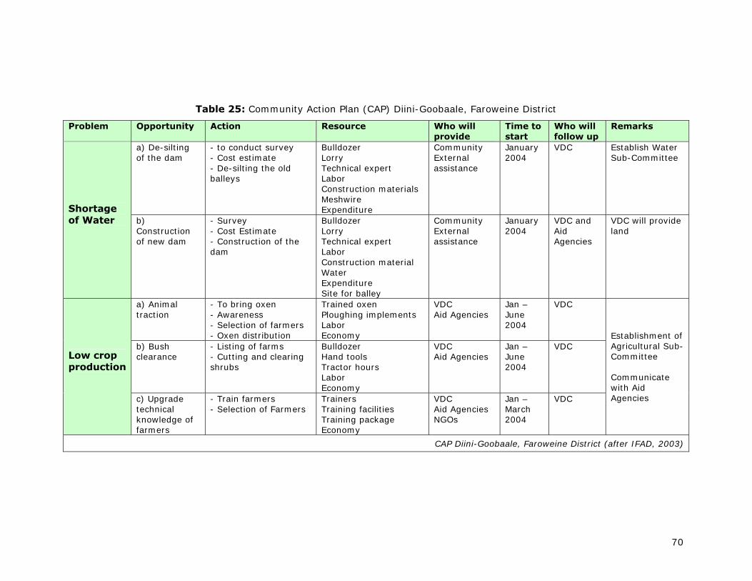
70
Table 25: Community Action Plan (CAP) Diini-Goobaale, Faroweine District
Problem Opportunity Action Resource Who will provide
Time to start
Who will follow up
Remarks
a) De-silting of the dam
- to conduct survey - Cost estimate - De-silting the old balleys
Bulldozer Lorry Technical expert Labor Construction materials Meshwire Expenditure
Community External assistance
January 2004
VDC Establish Water Sub-Committee
Shortage of Water
b) Construction of new dam
- Survey - Cost Estimate - Construction of the dam
Bulldozer Lorry Technical expert Labor Construction material Water Expenditure Site for balley
Community External assistance
January 2004
VDC and Aid Agencies
VDC will provide land
a) Animal traction
- To bring oxen - Awareness - Selection of farmers - Oxen distribution
Trained oxen Ploughing implements Labor Economy
VDC Aid Agencies
Jan – June 2004
VDC
b) Bush clearance
- Listing of farms - Cutting and clearing shrubs
Bulldozer Hand tools Tractor hours Labor Economy
VDC Aid Agencies
Jan – June 2004
VDC Low crop production
c) Upgrade technical knowledge of farmers
- Train farmers - Selection of Farmers
Trainers Training facilities Training package Economy
VDC Aid Agencies NGOs
Jan – March 2004
VDC
Establishment of Agricultural Sub-Committee Communicate with Aid Agencies
CAP Diini-Goobaale, Faroweine District (after IFAD, 2003)

71
Figure 13: Development Plan for Kurikuri Group Ranch from the GPS field observations

72
STEP 9: Monitoring and Evaluation
Usually the VC or VDC oversees the implementation of project activities, as formulated in the CAP. Methods of participatory monitoring and evaluation are explained in Chapter 2. Usually, when donor funds are involved, the donor agencies also carry out their own external project evaluation.
The IUCN, under the Somali Natural Resource Management Programme (SNRMP), produced village environmental management plans in Somaliland for Qalloa, Saila Bari, Geed Deeble and Zeyla (Barrow et al, 2000). Some keys lessons from this process are listed in Box 16.
Box 16
Some key lessons from the SNRMP village planning process
• Positive and constructive village level response
• Importance of capacity building and local ownership of the product
• Linking planning with implementation of some agreed activities
• Plans are useful tools to present to agencies for funding of some activities
• Length of the process took longer than people expected, but this helped to build ownership and a means for implementation
• Gender differences were managed and integrated, and the process was not overly dominated by the leaders as many people from the village were involved
• The planning process demonstrated the importance of the greater landscape, and being able to integrate pastoralist livestock movements
• Power issues were discussed in a reasonably open manner, based on power analysis
• Government showed interest in the process, as part of potentially larger scale land use planning
Source: IUCN, 2006

73
6 RESOURCES AND TOOLS FOR LAND USE PLANNING
Land use planning can be a very demanding process that may require the aid of different tools for completing the various stages. One of the most difficult steps is the one related to negotiating and selecting the land use options. To facilitate these tasks, various tools are available. These could be simple and only require pen & paper (e.g. “pairwise ranking”), or be more technologically demanding, such as computer-based Decision Support Systems (DSS) and Multi-Criteria Evaluation (MCE). A large number of techniques and tools are listed in Table 26, together with some references. A few selected techniques are described and illustrated in more detail.
6.1 Pairwise ranking
Pairwise ranking is a structured method for ranking a small list of items in priority order. It can help to make decisions in a consensus-oriented manner. Follow the following steps:
a. Construct a pairwise matrix. Each box in the matrix represents the intersection (or pairing) of two items. If the list has five items, the pairwise matrix would have a total of ten cells (see Figure 14), with the top cell representing idea 1 paired with idea 2. If the list has ten items, the total number of cells in the matrix would be 45.
b. For each pair, determine which of the two ideas is preferred, and write the number of the preferred idea in the appropriate box. Repeat this process until the matrix is filled.
c. Count the number of times each alternative appears in the matrix.
d. Rank all items. Rank the alternatives by the total number of times they appear in the matrix. To break a tie (where two ideas appear the same number of times), look at the box in which those two ideas are compared. The idea appearing in that box receives the higher ranking.

74
Table 266: Some techniques used in various stages of land use planning
Technique Village level
District level
National level
Reference (examples)
- Non-participatory
Literature study x x
- Passive participation stakeholders
Questionnaire x x x
Structured interview key informants x x x
Semi-structured interview key informants x x x (a)
Rapid Rural Appraisal (RRA) x x
- Participatory or non-participatory
Pairwise ranking x x x (e)
Livelihood analysis x x x (f)
Stakeholder analysis (c)
Food preference ranking x (d)
Wealth ranking x x (a) (f)
Problem identification; ranking and scoring x x x (a) (c) (d) (e) (f)
Organizational analysis; Venn diagram x x x (d) (f)
“Campfire” analysis; power & decisions x x x (b) (c)
Local history and trend analysis x (c)
Time-lines; listing events x x
Seasonal activity analysis; diagram x x x (c) (d) (f)
Soils, vegetation, topographic surveys x x x (a) (b) (d)
Seasonal livestock movements x x x
- Participatory
Participatory Rural Appraisal (PRA) x (e) (f)
Group discussions and activities x x x (a) (c) (e) (f)
Participatory diagramming x x
Village resource mapping x (c) (e) (f)
Transect walks x (a) (d)
Participatory mapping and modeling x x x (d)
Brainstorming x x x (a)
Gender sensitization x x x (a) (c) (d) (e) (f)
Watershed & community area delineation x (a) (c)
Action planning x x x (a) (d) (e) (f)
Participatory and result-based monitoring x x (a)
Participatory Integrated Community Dev. x
See also: The use of Participatory mapping Tools (IUCN,Barrow, 1999)
(a) Examples from Ethiopia (Lakew Desta et al, 2005) (b) Examples from Somaliland (Barrow, 1998) (c) Examples from Somaliland (Barrow, 2000) (d) Examples from Ethiopia (GTZ, 1999) (e) Examples from Somaliland (IFAD, 2003) (f) Examples from Somaliland (HAVOYOCO/Oxfam, 2007)

75
1 and 2 compared:
2 is better
1 and 3 compared:
1 is better
4 and 5 compared:
5 is better, etc. (fill all squares)
1 1 1
2 2 2 2 2 2 2 2 2
3 3 3 1 3 3 1 2 3
4 4 4 4 4 1 2 3 4
5 5 5 5 5 5 5
Option 5 appears 4 times in the matrix and is therefore ranked as first
Option 4 appears 0 times in the matrix and is therefore ranked as last
Option 1 2 3 4 5
Count 2 3 1 0 4
Rank 3rd 2nd 4th 5th 1st
Figure 14: Pairwise ranking
Example
Objective: solve conflict between (outside) pastoralists and resident agro-pastoralists caused by blocking of old livestock corridors by recent crop enclosures
Options
1. Remove enclosures and restore old routes 1
2. Establish new (but longer) routes 2 2 2
3. Prohibit large seasonal livestock movements through village
3 3 2 3
4. Do nothing 4 1 2 4 4
5. Allow and facilitate crossings during specific times outside cropping season
5 5 2 5 5 5
6. Passing Pastoralist pay Farmers compensation for damage to crops and fences
6 6 6 6 6 5 6
7. Resident Farmers pay compensation to Pastoralist for blocking their route
7 7 2 7 7 5 6 7
8. Take the dispute to higher authorities 8 1 2 8 8 5 8 8
Ranking:
Options 2 and 6 score first; option 6 goes on top
Option 3 and 4 score last; option 3 goes to the bottom

76
6.2 SWOT analysis
In a SWOT analysis the Strengths, Weaknesses, Opportunities and Threats associated with a number of possibilities are analyzed and presented in a matrix. Table 27 gives an example of a SWOT analysis of various energy sources as an alternative to charcoal. The SWOT analysis does not give a final answer or score, but provides an overview of all the positive and negative sides of each option.
Table 27: Example of SWOT analysis
Strengths Weaknesses Opportunities Threats Coal most appropriate
alternative to wood or charcoal
reserves available in several regions of Somaliland (Sahil, Sanag, Awdal)
lack of adequate information on extent of deposits
lack of infrastructure to access deposits
lack of government policy governing coal
lack of coordination among various stakeholders
can reduce forest destruction
suitable for long-term development
cheap once developed
can replace established charcoal networks
affordable to rural/urban people
can generate electricity for household and industry
earns foreign currency
large-scale production encourages industrialization
harmful gases must be removed before combustion
without proper care and knowledge, mining may have negative environmental impact
Solar energy
an abundant resource
solar panels can be locally assembled, creating jobs
increases in demand will eventually reduce costs
environmentally friendly
few trained, skilled technicians
equipment is fragile
limited consumer awareness and confidence in technology
no policies governing use
economic development
immediately accessible
25% of urban people could afford solar technology
none
Kerosine kerosene and stoves available in the market
no need for research
no health hazard
cheaper than LPG
portable
can be used in rural and urban areas
imported
no policy and regulations
no controlled prices during supply shortages
socially acceptable
tax exempted
funded by community internally
no appropriate training
fire hazard
no constant and reliable supply
high prices during shortages
low awareness of its uses
high potential trade with neighboring countries
Source: ADP (undated)

77
6.3 Stakeholder Power/Interest Analysis
Power/Interest Matrix
A useful tool to analyze power and interests of stakeholders is a procedure which subjectively assigns a score of 1 (low) to 5 (high) to each stakeholder’s power and interest with respect to a specific land-related issue. Table 28 shows an example of this technique, where the first column lists the stakeholders and the second and third columns are their scores for power and interest, respectively.
Table 28: Power/interest matrix (example)
Stakeholder Power Interest Poor farmers 2 5 Rich farmers 3 4
Elders 5 4 Formal Teachers 3 2 External elites 4 3
Woman 2 5 Poor Pastoralists 1 4 Religious leaders 5 2
Refugees; displaced people 1 3
1 (low)
Poor Pastoralists
Refugees
2 Poor Farmers Woman
3 Rich Farmers Formal Teachers
4 External Elites
5 (high)
Elders Religious Leaders
Po
wer
5 (high) 4 3 2 1 (low) Interest

78
“Campfire” analysis of stakeholders and power relations
The importance and power of various stakeholder groups can also be shown through a so-called Campfire analysis (Barrow, 1998). In this analysis stakeholder groups are represented by circles, with the size of the circle proportionate to the size of the group. The groups (circles) are then positioned relative to a central point (Campfire), which is the seat of power and decision-making. The closer the group (circle) is to the central point, the more power and influence it has on decision-making. An example from Qualo village on decision-making with respect to natural resources is shown in Figure 15.
Figure 15: “Campfire” analysis of stakeholders and power relations
Poor Farmers
Woman
Children
Woman
Milk Group
Poor Farmers
Pastoralists
Rich farmers
Elites (external)
Tea shop owners
Literate people
Elders
Aqil
Formal teachers
Religious groups
The power and decision making arena
Notes:
• Size of circle = relative importance of that group’s stake in natural resources • Proximity to campfire = relative power in decision making
fire
example from Qalao village (after Barrow, 1998)

79
6.4 Decision Support Systems and Spatial Multi-Criteria Evaluation
Decision Support System
A Decision Support System (DSS) is a computerized system that helps managers and planners in the process of decision making. DSS can help to make any kind of decision, from buying a new car, choosing a job, hiring a new staff member, to evaluating a project proposal, identifying a building site and selecting the most suitable land use.
Examples of activities and procedures in which DSS are frequently used are:
• Land use planning
• Forest certification
• Forest monitoring
• Development programs
• Resource allocation
• Transport networks and connections
Spatial Multi-Criteria Evaluation
Multi-Criteria Evaluation is a procedure that involves the evaluation of several criteria to meet a specific objective. Spatial Multi-Criteria Evaluation (SMCE) is a process that combines and transforms geographical data (the input) into a decision (the output). The basic elements of SMCE are:
• input of relevant geographical data (e.g. digitized maps)
• formulation of the decision maker’s preferences
• manipulation of the data and preferences according to specified decision rules
SMCE is a means of simplifying complex decision-making tasks involving many stakeholders and/or many variables and it helps to achieve compromise in decision making. With SMCE, structure and transparency can be imposed upon the decision-making process. SMCE is frequently used for planning activities such as the siting of residential areas, demarcation of parks, and the delineation of water catchments and irrigation sites. It is a process in which multiple layers (“themes”) are aggregated to yield a single output map. SMCE identifies alternatives or options to be investigated to reach a decision. It also identifies a set of criteria by which to rank these alternatives. SMCE identifies the preferences or weights the stakeholders assign to the various criteria (through pair-wise ranking) and also identifies the aggregation procedure by which the criteria-specific rank orders are aggregated into a single ‘compromise’ rank order. The result of SMCE is a preferred option or set of options based on a rigorous definition of priorities and preferences decided upon by the decision-maker.
The following steps can be identified in SMCE:
• Choosing the stakeholders to be involved in the process
• Formulating the objectives
• Identifying the options
• Selecting the criteria
• Weighting the criteria
• Assessing the options
• Sensitivity analysis
• Interaction and iteration

80
Example of SMCE application: selection of the best land use in a agro-pastoral
Problem definition: The Agro-pastoral area in western Somaliland (commonly know as the sorghum belt of the north) is a land use system that recently has increased in area because crop producers (previously pastoralist) are encroaching on grazing land. This process has caused land use conflicts between pastoralists and agro-pastoralists. A land suitability assessment was performed in order to identify the potential of the land for different rural land uses. A negotiation process is needed among the various land users and relevant institutions in order to select the proper land use in the area concerned. SMCE can be of help in this process.
Criteria: Bio-physical land suitability for various uses, including crop production, pastoralism and conservation activities (re-vegetation).
Input Maps: Suitability maps for: crops (short and long term varieties of sorghum, maize, cowpea), livestock (goats, sheep, camels, cattle), and various forestry species.
Figure 16: Example of SMCE application
Users assign “weights”
Map 1
land suitability
crop X
Map 2
land suitability
crop Y
Map 3
land suitability
pastoralism
Map 4
land suitability forestry
species Z
Evaluation matrix
SMCE routine
Output Map: Compromise scenario, optimizing
demands from all stakeholders
Negotiation process

81
6.5 Gross margin budgets8
A 'gross margin' is the gross income from an enterprise less the variable costs incurred in achieving it. It does not include fixed or overhead costs such as depreciation, interest payments, rates, or permanent labour. Gross margin budgets are intended to provide a guide to the relative profitability of similar enterprises and an indication of management operations involved in different enterprises.
Budgets are calculated using:
• crop yields for the region, animal weights, etc. that are consistent with the operations given
• forecast commodity price
• current input costs
• technical information provided by agronomists
The aim of gross margin budgets is to provide producers with an additional planning tool to help evaluate options.
The degree to which these budgets reflect actual returns will be influenced not only by general factors common to all farms, such as prices and seasonal conditions, but also by the individual farm characteristics, such as soil type, crop rotation, pasture quality and management.
Variable costs are those costs directly attributable to an enterprise and which vary in proportion to the size of an enterprise. For example, if the area of sorghum sown doubles, then the variable costs associated with growing it, such as seed, chemicals and fertilisers, will roughly double.
A gross margin is not profit because it does not include fixed or overhead costs such as depreciation, interest payments, rates and permanent labour, which have to be met regardless of enterprise size.
Gross margins are generally quoted per unit of the most limiting resource, for example, land, labour, capital or irrigation water. Crop gross margins are provided on a per hectare basis and also per megalitre of water in the case of irrigated crops. Livestock budgets express outcomes in terms of gross margin per animal (e.g. per breeding cow) or gross margin per hectare.
The calculation of a gross margin is the essential first step in farm budgeting and planning. It enables a direct comparison of the relative profitability of similar enterprises, and consequently provides a starting point to deciding or altering the farm’s enterprise.
Gross margins need to be applied carefully when used to decide a farm’s overall enterprise mix. Because overhead costs are excluded, it is advisable to only make comparisons of gross margins between enterprises which use similar resources. For example, sorghum and maize are considered to be similar enterprises.
Caution should be taken when comparing gross margin returns from livestock and cropping enterprises due to different land, labour and equipment requirements.
8 derived from website Australia New South Wales Dept. of Primary Industries

82
Other budgeting techniques
Whole farm budget: Generally includes a summary of farm assets and liabilities and estimates various profit measures by taking into account total gross margins for each of the enterprises considered, as well as the farm overhead costs (such as rates, interest payments, depreciation, administration, employed labour, insurance) and an allowance for family labour. Profitability from different enterprise mixes can be compared on a whole farm basis using this type of budget.

83
7 GUIDELINES FOR PROJECT PROPOSALS
Introduction
Project proposals related to land use planning can vary greatly in scope and content. They could have varying objectives, such as the construction of a few water points related to a Community Action Plan (see Chapter 5), the training of resource personnel, the formulation of land use laws, or the demarcation and mapping of land for specific uses. A number of land use planning priorities were identified during a SWALIM Land Use Planning Workshop in Hargeisa in February 2009 (see Annex 4).
Identification of development partners
Because of the limited technical and financial resources of the Government and most of the rural population, land use planning often needs the facilitation or financial support from national and international development agencies. Table 10 (Chapter 3) gives a list of institutions and organizations recently involved in land use planning in Somaliland. This list is by no means complete, but gives an indication of the type of stakeholders involved. As priorities of development agencies change continuously, both with respect to geographical area covered and with respect to development priorities and activities, no definite list of partners can be made for Somaliland. In the case of Somaliland it is probably not so difficult to find out who the main development partners are at a given time. Most of them have representatives in Hargeisa and a simple internet search can help to identify others.
Resources, tools, formats
A valuable resource for project identification is a publication with the title ”Project Identification and Design: Support to Marginal Rural Areas in Somalia.’ Workshop proceedings presented to the EC in Kenya, May 2005. GFA Terra Systems, 2005.
Formats for substantial project proposals have been compiled by FAO (2004) (Box 17 and Table 29).
Examples
Annex 5 gives some examples of participatory land use management projects in Tanzania. Other examples can be found in the List of References at the end of this report.

84
Box 17: Project Proposal Format (after FAO, 2004)
1. Cover page The cover page includes the area concerned (photo), project title, Working Group’s name, etc. Make it brief, simple and pleasant. 2. Executive Summary • Provide a short summary of the goal, purposes and principal expected results of the project. • List the partners and organizations involved. • State the estimated duration of the project. • State the total funding requested from public or private investments, together with the financial contributions expected from partner organizations and other sources. 3. Background • Provide relevant social, political, economic and/or other information to describe the local context and the development challenges being addressed, i.e., what are the problems or issues to be addressed, and why are they important in the municipality? • If it is the case, describe how other government and/or donor programmes may support the proposed project. 4. Justification • Describe the link between the proposed project and the development challenges defined above. How does the project respond to local developmental needs and priorities? • Describe how the project is in line with the territorial pact, how aware the local population is as to their rights and responsibilities as citizens, their empowerment as citizens (includes power-sharing, participation and influence in decisions) and their satisfaction with local organizations that could assist in improving their lives. 5. Project Description • Table 9, below illustrates a framework or for presenting your project. Describe each element in narrative form in a project proposal framework. It provides an overview of the project, summarizing and integrating many of the key issues, including the project goal, purposes, resources, results at three levels and risks. • Benefits to the entire municipality. What positive effects will the project have in the municipality: political, scientific, institutional, commercial, or other? • Technology Use: Define the "technology" (model or approach) that the project will use or need. Assess the relevance of this technology to the local developmental context. 6. Environmental sustainability Using the services of a technical expert if necessary, describe the environmental effects of the project, including the environmental effects of malfunctions or accidents that may occur in connection with the project and any cumulative environmental effects that are likely to result from the project in combination with other projects or activities that have been or will be carried out.

85
Include: •.The significance of the effects; • Comments received from the public, if any; • Measures that are technically and economically feasible and that would mitigate any significant adverse environmental effects; • Any other relevant matter such as the need for and alternatives to the project; • Describe how the project will respect the local environment and promote sustainable development. 7. Management Strategy and Structure • Outline how the project will be managed, including planning (i.e. the preparation of annual work plans), collecting baseline data, monitoring and reporting functions. • Indicate how the partner organizations and other participants will work together and foster equitable participation in the management of the project 8. Communications Strategy Describe your strategy in promoting the project to key stakeholders and to a wider audience in the municipality. The strategy should include: • Goals and objectives • Audiences and key messages • Media of communication (print, website, events, radio or television broadcasts, etc.) • Schedule of events/broadcasts/distribution • Initiatives for both municipal and external audiences 9. Partners Briefly describe the origins of the proposal: how the partner organizations came together and how the proposal was developed. Public Partners: • Provide a brief profile of the public partners (including addresses, names of the key contact person) and their potential roles. • Explain why the leading public partner is the most appropriate to implement the proposed project, based on his technical and managerial experience and capacity. • Explain how the proposed project fits with the mandates, priorities and existing programmes of the leading public partner. Private Partners: • Provide a brief profile of the private partners (including addresses and names of the key contact person) and their potential roles. • Explain why the leading private partner is the most appropriate to implement the proposed project, based on his technical and managerial experience and capacity. • Explain how the proposed project fits with the mandates, priorities and existing activities of the leading private partner. 10. Future funding needs If the project will be implemented or will require maintenance beyond the funding requested, explain how the project proposal plans to cover future financial needs. If partial funds are requested from a funding source, explain how and where the project proposal can obtain the remaining funds. 11. Supporting documents Maps, blueprints, photos, visual aids, etc.
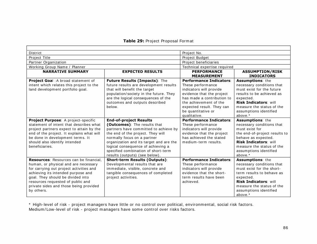
86
Table 29: Project Proposal Format
District Project No. Project Title Project Budget Partner Organization Project beneficiaries Working Group Name / Planner Technical expertise required
NARRATIVE SUMMARY EXPECTED RESULTS PERFORMANCE MEASUREMENT
ASSUMPTION/RISK INDICATORS
Project Goal :A broad statement of intent which relates this project to the land development portfolio goal.
Future Results (Impacts): The future results are development results that will benefit the target population/society in the future. They are the logical consequences of the outcomes and outputs described below.
Performance Indicators: These performance indicators will provide evidence that the project has made a contribution to the achievement of the expected result. They can be quantitative or qualitative.
Assumptions: the necessary conditions that must exist for the future results to be achieved as expected. Risk Indicators: will measure the status of the assumptions identified above.*
Project Purpose: A project-specific statement of intent that describes what project partners expect to attain by the end of the project. It explains what will be done in development terms. It should also identify intended beneficiaries.
End-of-project Results (Outcomes): The results that partners have committed to achieve by the end of the project. They will normally focus on a partner organization and its target and are the logical consequence of achieving a specified combination of short-term results (outputs) (see below).
Performance Indicators: These performance indicators will provide evidence that the project has achieved the stated medium-term results.
Assumptions: the necessary conditions that must exist for the end-of-project results to behave as expected. Risk Indicators: will measure the status of the assumptions identified above.*
Resources: Resources can be financial, human, or physical and are necessary for carrying out project activities and achieving its intended purpose and goal. They should be divided into resources requested of public and private sides and those being provided by others.
Short-term Results (Outputs): Developmental results that are immediate, visible, concrete and tangible consequences of completed project activities.
Performance Indicators: These performance indicators will provide evidence that the short-term results have been achieved.
Assumptions: the necessary conditions that must exist for the short-term results to behave as expected. Risk Indicators: will measure the status of the assumptions identified above.*
* High-level of risk - project managers have little or no control over political, environmental, social risk factors. Medium/Low-level of risk - project managers have some control over risks factors.

87
References
Alim, Musse Shaie, 1997. Inventory report Somalia. FAO, GCP/RAF/287/ITA
Anon, undated. Forestry in Somaliland.
APD, 2002 (draft). Regulating the livestock economy of Somaliland. Draft.
ADP, undated (2006). Dialogue for peace. From plunder to prosperity. Resolving resource-based conflict in Somaliland.
ADP, 2006 ??. Land-based conflict projects. Somaliland Report. Institute for Peace and Development (INEF)
APD, 2007. Land-based conflict project. Working Note. Institute for Peace and Development (INEF)
ADP, 2008. Land-based conflict project. No more “Grass grown by the Spear”.
APD, 2008. Land-based conflict project. Research Concept Note. Institute for Peace and Development (INEF)
ADP, 2008. Land-based Conflicts Research Project. Working Note on urban land conflicts.
Barrow, E.G.C., 1998. Participatory village land use and NRM planning in Somaliland. Consultancy Report of the IUCN Somaliland NRM project. IUCN, Nairobi.
Barrow, E.G.C., 1999. The use of participatory mapping tools. Training Workshop. Somali Natural Resource Management Project. IUCN, Nairobi
Birch, Izzy, 2008. Securing pastoralism in East and West Africa: protecting and promoting livestock mobility. Somaliland/Somali Region desk review. Draft 5 April 2008
Bouma, J., 1999. New tools and approaches for land evaluation. In: The Land, Vol 3-1. pp 3-10. Journal of the International Land Use Society.
Bradbury, Mark, 1997. Somaliland country report, ‘Ciir’, Government of Somaliland
CDE, 1999. Sustainable land management. Guidelines for impact monitoring. Toolkit module. A selection of practical tools and cost-effective methods. CDE, GTZ. Centre for Development and Environment. Bern, Switzerland.
Chauser, F. et al, 1969. Forests, Fauna, National Parks and Relative Prospects for Tourism in Somalia.
CRD Somalia, 2005. Traditional Governance in Somalia, South Central Somalia. Brief Report for the World Bank. (draft).
DSE, 1998. Land tenure and policy issues in land use planning. With special reference to Eastern and Southern Africa. Seminar Proceedings. Zschortau, Germany.
Fanlayson, et al, 1972. Natural Resources Management Report.
FAO, UNDP, 1967. Agricultural and Water Survey. Livestock Development Survey. FAO, Rome.
FAO, 1976. A framework for land evaluation. Soils bulletin No 32. Rome.
FAO, 1983. Guidelines: land evaluation for rainfed agriculture. Soils Bulletin No 52. Rome.
FAO, 1984. Land evaluation for forestry. Forestry Paper 48. Rome
FAO, 1985. Guidelines: land evaluation for irrigated agriculture. Soils Bulletin No 55. Rome.
FAO, 1989. Arid zone forestry. FAO Conservation Guide No. 20. Forestry Dept. Rome

88
FAO, 1991. Guidelines: land evaluation for extensive grazing. Soils Bulletin No 58. Rome.
FAO, 1993. Guidelines for land use planning. FAO Development Series No.1. Rome (reprinted 1996)
FAO, UNEP, 1997. Negotiating a sustainable future for land. Structural and institutional guidelines for land resources management in the 21st century
FAO, 1999. Planning sustainable management of land resources: The Sri Lankan example. AGL/MISC/22/99. FAO, Rome.
FAO, UNEP, 1999. The future of our land. Facing the challenge. Guidelines for integrated planning for sustainable management of land resources. Rome. (reprinted 2007)
FAO, 2004. Participatory land use development in the municipalities of Bosnia and Herzegovina. Guidelines. Project GCP/BIH/002/ITA
FAO, 2005. Participatory and Negotiated Territorial Development (PNTD). An approach to rural development. FAO, Rural Development Division.
FAO, Candlelight, 2006. Impact of Civil War on Natural Resources: A case study for Somaliland. Consultant’s Report by Candlelight for FAO Regional Office for the Near East.
FAO, 2007. Land evaluation. Towards a revised framework. Land and Water Discussion Paper 6. FAO, Rome.
FSAU, 2002. Baseline profiles of Hawd/Sool and Gollis Guban. Nairobi, Kenya.
German Agro Action Somaliland, 2005. Groundwater Survey (K). Inception report of the Integrated Water Resources Management Plan. Community Based NRM in the Dur-Dur Watershed, Awdal Region, Somaliland
German Agro Action Somaliland, 2006. Community Based NRM in the Dur-Dur Watershed, Awdal Region, Somaliland
German Agro Action, 2007. Report on Sustainable Management and Restoration of Dalloo and Surod Juniper Forest Ranges by Local Communities. Consultant’s Report by Peter Laubmeier. Ministry of Pastoral Development and Environment. Somaliland.
Gomes, Nathalie, 2006. Access to water, pastoral resource management and pastoralists’ livelihoods. Lessons learned from water development in selected areas of Eastern Africa (Kenya, Ethiopia, Somalia). LSP Working Paper 26. FAO
GFA Terra Systems, 2005. Project Identification and Design: Support to Marginal Rural Areas in Somalia.’ Workshop proceedings presented to the EC in Kenya, May 2005.
GoS, 1969. Law on fauna (hunting) and forest conservation. Law No. 15/1969
GoS, 1998. Prevention of deforestation and desertification law. Law No. 04/1998 (in Somali)
GoS, 2000. Constitution of the Government of Somaliland (updated 2005)
GoS, 2001. Land Management Law (National Urban Land/Planning Proclamation). Law No. 17. (Draft).
GoS, 2006. National Environment Research and Disaster-preparedness (NERAD) Agency Law – Law No. 35/2006
GTZ, 1996. Experiences of land use planning in Asian projects. Selected insights. Colombo
GTZ, 1998. Land tenure in development cooperation. Guiding principles. Summary – Working paper. Eschborn, Germany
GTZ, 1999. Participatory rural appraisal for resource management in Oromia, Ethiopia. Applied in: Boda Bosoqa PA, Dandi woreda, West Shewa zone, Oromia. Land Use Planning and Resource Management Project in Oromia Region (LUPO)

89
GTZ, 1999. Land Use Planning – Methods, Strategies and Tools. Eschborn, Germany
HAVOYOCO, 2007. PRA Case study. Eil-la-helay, Darasalam District. Somaliland Pastoral Development Programme. Oxfam.
HAVOYOCO, 2007. PRA Case study. Dalow, Mandheere District. Somaliland Pastoral Development Programme. Oxfam.
HAVOYOCO, 2007. PRA Case study. Dhebihagoog, Laasgeel District. Somaliland Pastoral Development Programme. Oxfam.
HAVOYOCO, 2007. PRA Case study. Dhimbilriyaale, Salahley District. Somaliland Pastoral Development Programme. Oxfam.
HAVOYOCO, 2007. PRA Case study. Heeryo, Allaybaday District. Somaliland Pastoral Development Programme. Oxfam.
Heemstra, H.H., 1981a. Recommendations for the use of Jaleelo Demonstration Reserve. Northern Rangeland Project. Somali Democratic Republic. FAO.
Heemstra, H.H., 1981b. Grazing capacity estimates for Tuuyo Seasonal Reserve. Northern Rangeland Project. Somali Democratic Republic. FAO.
Heemstra, H.H., 1981c. Management Plan for the Gacan Libah / Bokh Reserve. Northern Rangeland Project. Somali Democratic Republic. FAO.
Hemming, C.F., 1966. The vegetation of the Northern Regions of the Somali Republic.
Herzog, Martin, 1996. Forestry and Woodland Management in Somaliland. Problems, Background, Development Potentials. Caritas Switzerland, Lucerne
Horn Relief, 2006. Environmental study of degradation in the Sool plateau and Gebi valley: Sanaag region of northern Somalia. Final Report.
Huizing, H. and K. Bronsveld, 1994. Interactive multiple-goal analysis for land use planning. In: ITC Journal 1994-4, pp 366-373
Hutchinson, P. and O. Polishchouk, 1989. The agroclimatology of Somalia.
Hydroconseil, 2006. Technical assistance for the development of regulations in the water sector. Final report, March 2006
ICRAF, online. Agro Forestry Tree Database. www.worldagroforestry.com
IFAD, 2003. PRA Case Study, Diini-Goobaale Community, Faroweine District. Integrated Community Development Programme. IFAD, Gabiley
IFAD, 2003. PRA Case Study, Awbarkhadle Community, Hargeisa District. Integrated Community Development Programme. IFAD, Gabiley
IFAD, 2006. PRA Case Study, Guguh Community, Sheikh District. Integrated Community Development Programme. IFAD, Gabiley
IIASA, FAO, 2002. Global Agro-ecological Assessment for Agriculture in the 21st century.
IIED, 1995. A trainers guide for participatory learning and action
Inglis, A.S., 1997. Innovative participatory methodologies for environmental interventions at the community level. Somali Natural Resources Management Programme. IUCN, Eastern Africa Regional Office, Nairobi.
IIRR, 2002. Managing dryland resources. A manual for eastern and southern Africa. Nairobi
IUCN, 1997. Environmental Impact Assessment Manual and Guidelines for the Somali Water Sector. Somali Natural Resources Programme.
IUCN, 1997b. Workshop proceedings on priorities for Natural Resource Management and Dependent Productions Systems. IUCN Eastern African Programme. Somali Natural Resources Management Project. November 1997

90
IUCN, 2000. An ecological assessment of the Coastal Plains of North Western Somalia (Somaliland). Somali Natural Resources Management Programme. Malte Sommerlatte and Abdi Umar
IUCN, 2000. An ecological and resource utilization assessment of Gacaan Libaax, Somaliland. An ecological resource assessment by John Miskell
IUCN, 2000. Community Based Participatory Natural Resources and Land Management Planning. Lessons and Guidelines developed from practice in Somaliland. SNRDP
IUCN, 2006. Country environmental profile for Somalia. Produced for EC.
IUCN, 2007a. Sound natural resource management. The foundation for achieving the MDGs in Somalia. Policy brief produced for the European Commission.
IUCN, 2007b. Managing risk in Somalia. Adapting to Climate Change. Policy Brief prepared for the European Commission Somalia Operations Office.
Kaminjo, Y., 2001. Kurikuri RMA Participatory Rural Appraisal (PRA) Findings. “For Today, the World Would Change by Our Hands”. SARDEP Report Nanyuki-Kenya
Kindeya Gebrehiwot, 2004. Dryland Agroforestry Strategy for Ethiopia. ICRAF Drylands Agroforestry Workshop, Nairobi, Sept 2004.
Lakew Desta et al (ed), 2005. Community-based Participatory Watershed Development. Part 1: Guidelines. Part 2: Annex. Ministry of Agriculture and Rural Development. Ethiopia
Mbwambo, L., 2004. Status of Arid and Semi-arid Lands of Tanzania. ICRAF Drylands Agroforestry Workshop, Nairobi, Sept 2004.
NERAD, 2008. Master proposal for operationalizing of revised strategic plan (2008-2012). Acacia Consultants.
MoA, 1991. The Food Security Act (No. 10/1991)
MoA, 2008. The Food Security Act (Somaliland) (No ????)
MoA. 1999. Agricultural land ownership law. Law No. 8/99 (in Somali)
MoA, 2008. Agricultural Land Registration Act of Somaliland (draft 1.1)
MoA, 2006. Agricultural Production and Certification Act of Somaliland
MoA, 2007. Master-plan for reconstruction and development of the Somaliland agriculture sector. Developed by the Ministry of Agriculture Somaliland with the Enhancement of Capacity of Somali Agriculture and Livestock (ECSALI) Project
MoA, 2008. Somaliland agriculture sector human resource assessment and intervention plan. MoA in collaboration with ESCALI.
MoA, 2008. Draft National Agriculture Policy. MoA in collaboration with ESCALI (2nd draft, June 2008)
MoNPC, 2003. Somaliland in Figures, Edition 4, 2003.
http://siteresources.worldbank.org/SOMALIAEXT/Resources/Somaliland_in_Figures.pdf
MoNPC, 2008. Somaliland in Figures. Edition 6, 2008. Dept of Statistics.
MoPD&E, 2004. Impact of charcoal production on both the environment and the socio economy of pastoral communities in Somaliland. Case Study. Final draft report. (Candlelight, Oxfam)
MoPD&E, undated. Environment Policy of Somaliland (Policy on Environmental Management)
MoPD&E, undated. National Environmental Action Plan and Strategy to combat desertification
MoPD&E, 2002??. Strategic Plan for sustainable natural resource management 2002-2004

91
MoPD&E, undated. Range management policy of Somaliland
MoPD&E, 1998. Environment Conservation and Proclamation Act. Act No 4/98
MoPD&E, MoA, 2008. Somaliland land tenure policy (2nd draft)
MoPD&E, 2008. Strategic plan for 2008/2010. Final draft
MoPD&E, 2008. The 14 statements of Somaliland range policy
MoW&MR, 2004. The Somaliland national water strategy (Sept. 2004)
MoW&MR, 2004. The Somaliland national water policy (June 2004)
MoW&MR, 2008??? Water Act. (in Somali)
Muthui, V.W., 1997. Local level natural resources monitoring and evaluation: tools and methods. Somali Natural Resources Management Programme. IUCN, Eastern Africa Regional Office, Nairobi.
NERAD, 2008. Master proposal for operationalizing of revised strategic plan (2008-2012). Acacia Consultants Pvt Ltd
NERAD, 2008. A workshop report on the review of the disaster preparedness and management strategic plan (2005-2009). Acacia Consultants Pvt Ltd
NERAD, 2008. Summary report on the review of strategic plan (2008-2012). Acacia Consultants Pvt Ltd
NLUPC, 1998. Guidelines for participatory village land use management in Tanzania. National Land Use Planning Commission. Tanzania.
Norton, Gregory, 2008 (draft). Land, property and housing in Somalia. NRC, UN-Habitat, UNHCR
PENHA, 2005?? Tackling Somaliland Pastoralists poverty and Environmental Degradation. Evaluation of the PENHA Somaliland Project Nov 2001-Nov 2004 by Desmond Frederick
Samatar, Abdi Ismail, 1989. The State and Rural transformation of Northern Somalia, 1886-1986. University of Wisconsin Press.
Schaap, O., 1996. Technical assistance for soil erosion and land reclamation in Borama and Baki Districts (NW Somalia). Somali Rehabilitation Programme. Erosion control. Draft report, February 1996
Simonetta, A.M. and J. Simonetta, 1983. An Outline of the Status of the Somali Fauna and of its Conservation and Management Problems.
Sir William Halcrow & Partners. 1982. Northern Rangeland Development Project. Report on soils in the project area. Somali Democratic Republic. National Range Agency. London.
SOGREAH Consulting Engineers. 1982. Climatology. Technical Report N 2. North-West Region Agricultural Development Project. Feasibility Study and Technical Assistance. Somali Democratic Republic. Ministry of Agriculture.
SOGREAH Consulting Engineers. 1982. Soil Survey. North-West Region Agricultural Development Project. Feasibility Study and Technical Assistance. Somali Democratic Republic. Ministry of Agriculture.
SOGREAH Consulting Engineers, 1982a. Soil & Water Conservation. North-west Region Agricultural Development Project. Technical Report No. 8. Somali Democratic Republic, Ministry of Agriculture
SOGREAH Consulting Engineers, 1982b. Agricultural Development Programme. A – Rainfed Agriculture. North-west Region Agricultural Development Project. Somali Democratic Republic, Ministry of Agriculture

92
SOGREAH Consulting Engineers, 1983. Agricultural Development Programme. B – Irrigated Agriculture. Main Report and Annexes. North-west Region Agricultural Development Project. Somali Democratic Republic, Ministry of Agriculture
SWALIM, FAO-SWALIM, 2007 Technical Reports. Nairobi
L-01 Field Survey Manual
L-02 Landform of selected study areas in Somaliland and Southern Somalia
L-03 Land cover of selected study areas in Somaliland and Southern Somalia
L-04 Land use characterization of a selected study area in Somaliland
L-05 Soil survey of a selected study area in Somaliland
L-06 Land suitability assessment of a selected study area in Somaliland
L-10 Land degradation assessment of a selected study area in Somaliland
L-11 Application of remote sensing techniques for the assessment of pastoral resources in Puntland
L-12 Land Resources Assessment of Somalia
W-01 Climate of Somalia
TAMS. 1986. Background and Watershed Management, Final Report. Volume I. Pilot Watershed Management for Soil and Water Conservation and Small Garden Development. North West Region Agricultural Development Project. New York, USA- Hargeisa, Somali Democratic Republic.
TAMS, 1986. Pilot watershed management for soil & water conservation and small garden development. Final Report. Volume III. Geed Abeerah Pilot Project. North-west Region Agricultural Development Project. Somali Democratic Republic, Ministry of Agriculture
UNDP, WB, 2006. Somali Joint Needs Assessment. Livelihoods and solutions for the displaced. Cluster Report. Draft June 2006
UNEP, 2005. The state of the environment in Somalia. A desk study.
UN-Habitat, 2006. The land legal framework. Somaliland & Puntland State of Somalia. Situation Analysis.
UN-Habitat, 2008. Berbera, first steps towards strategic planning
UN-Habitat (undated). Introducing (optional) planning in post-conflict contexts. The Case of the Somali cities. Urban Planning in a State of Flux Series.
WardheerNews, 2006. A Road Map to Land Disputes in Somalia: Lessons from “Somaliland”. WardheerNews Editorial October 30, 2006
WOCAT inventory (for first step to identify existing solutions). www.wocat.org/inven.asp
WOCAT-DESIRE: stakeholder participation and negotiation: appraising and selecting SLM strategies. 3 parts: identification, assessment, selection. www.wocat.org/decision.asp
WSP International, 2005. Rebuilding Somaliland. Issues and possibilities. The Red Sea Press. Asmara.

93
Annex 1: FSAU Baseline Profiles

94

95
Annex 2: Examples of environmental laws in Botswana
Source: Department of Environmental Affairs Ministry of Environment, Wildlife and Tourism, Botswana There are laws to cover land use and land use rights, abiotic and biotic resources, and the use and management of the resources for all areas in Botswana • Agricultural Resources (Conservation) Act (1973): Provides for the conservation of
Botswana’s agricultural resources. The Act defines agricultural resources as animals, birds, plants, waters, soils, vegetation, etc.
• Environmental Impact Assessment Act (2005). Provides for the EIA to be used to assess the potential effects of planned developmental activities; to determine and to provide mitigation measures for effects of such activities as may have a significant adverse impact on the environment; to put in place a monitoring process.
• Fish protection (1975): Allows for the protection and sustainable management of fish resources.
• Forest Act (1976): Deals with forest reserves, protected trees and the control of forest products.
• Herbage Preservation (Prevention of Fires) (1978): All persons require permission from the Herbage Preservation Committee to set fire to any vegetation on land of which one is not the owner or lawful occupier.
• Mines and Minerals (1977): Prohibits wasteful mining and processing.
• National Monuments and Relics Act (date ?): Provides for better preservation and protection of ancient monuments, ancient workings, relics, etc.
• Noxious Weeds (1916): Allows for the control of arable and aquatic weeds by making land owners or occupiers responsible for destruction of weeds.
• Public Health (1981): Protects the quality of water used by the public, by controlling the disposal of polluted water and control of mosquito larvae
• State Land (1966): Controls use of state land and its resources.
• Town and Country Planning (1980): Requires development plans for all areas declared as planning areas.
• Tribal Land (Amendment) Act (1993): Allows for determination of land use zones. Land grants must not conflict with the zoned land use. Land Boards may determine management plans for use and development of the zones
• Tribal Land Act (1970): In areas of tribal land, the act controls land use rights and makes provision for the imposition of restrictions.
• Waste Management Act (1999: Management of hazardous waste.
• Water (1968): Defines ownership, rights and use of public water. It also prohibits the pollution, fouling or poisoning of, interference with, or flow alteration of public water.
• Wildlife Conservation and National Parks Act (1992): Enables gazettement of national parks, game reserves and Wildlife Management Areas (WMA) in which wildlife conservation and use is the primary land use. The WMA Regulations could be a useful tool for managing wetlands in WMAs.

96
Annex 3: Abstract of Master-Plan for Somaliland Agriculture Sector
Reference: Master Plan for Reconstruction and development of the Somaliland agriculture sector (MoA & ESCALI, 2007) Types of Agric. systems:
1. Agro-pastoral rainfed Agriculture 2. Pump-fed Irrigated Agriculture 3. Spate Irrigated Agriculture
Constraints
1. Inadequate rainfall 2. High cost of farm inputs 3. Poor agronomic and cultural practices 4. Lack of appropriate technology 5. Land degradation (soil erosion) 6. Lack of farm labour through rural-urban migration 7. Inadequate capital for rehabilitation of infrastructure and procurement of
appropriate technology 8. Poor marketing infrastructure and services 9. High cost of irrigation 10. Inadequate extension services 11. Lack of credit
Opportunities
1. existence of appropriate technologies (e.g. irrigation) 2. soil and water conservation 3. improved 4. etc …………
Structure of Ministry of Agriculture Minister, vice-minister, director general Regional Coordinators, District Coordinators Departments (4): 1 Crop Production
o Crop Production Section o Crop Protection and Quarantine o Extension, Research & Credit: Community mobilization for planning and
implementation of agric. projects o Marketing
2 Admin & Finance o Admin o Finance o Personnel
3 Land & Water Development o SWC & Irrigation: Planning of SWC measures o Land Registration: Land use surveys and land suitability classification o Agro-meteorology
4 Planning and Information management

97
o Planning, Coordination & M&E: strategic planning; projects planning; M&E o Information Management
Strategic Objectives
Institutional Capacity Building • Dev. of sector policy and regulations: incl. land tenure, agric. dev. plans
Improve coordination of sector activities Increase Agric. production Improve agric support services Promote sustainable agric. use and management • Community participatory approaches to catchment planning
o protection and rehabilitation of catchments o re-afforestation (social forestry programmes) o Nat resource utilization and management o Community tree nurseries o Controlled grazing through fencing off catchments o SWC o Integrated land use Planning o Agro-forestry o Adaptive research

98
Annex 4: Priority land use planning activities in Somaliland (2009 – 2012)
Summary result of group discussions
Hargeisa LUP Workshop (3-5 Feb 2009)
Activities: • Create uniform land use policy
Objectives: • Rational use of Land Resources • Make land use planning possible • Avoid contradictions and overlapping documents Stakeholders: Relevant Ministries, Traditional Authorities, UN Agencies (SWALIM, FAO), INGOs, NGOs, Houses of Parliament, Civil Society, Local Councils, Youth, Woman, Pastoralists, Farmers
Harmonize policies and laws related to land use
Initiative: • Inter-Ministerial Coordination Committee (IMCC) • Parliamentary Sub-Committee for Natural Resources and
Environment • UN, INGO, SWALIM Activities: Establish LUP Task Force Objective: Coordinate Land Use Planning activities
Land Use Planning Task Force
Initiative: • Inter-Ministerial Coordination Committee (IMCC) • Parliamentary Sub-Committee for Natural Resources and
Environment Activities: • Publicize of (draft) policies and Land Use Systems information • Nation-wide campaign • Establish regional Natural Resource Information Centers Objectives: • To create awareness needed for efficient land use • Community empowerment Stakeholders: Government, UN, INGO, LNGO. Community (elders, religious groups, woman groups, etc.)
Create awareness
Initiative: Government, civil society organizations, UN, NGOs, Community groups
cont
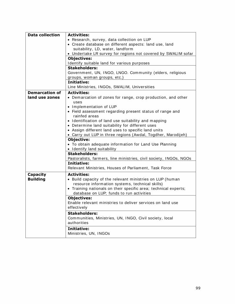
99
Activities: • Research, survey, data collection on LUP • Create database on different aspects: land use, land
suitability, LD, water, landform • Undertake LR survey for regions not covered by SWALIM sofar Objectives: Identify suitable land for various purposes Stakeholders: Government, UN, INGO, LNGO. Community (elders, religious groups, woman groups, etc.)
Data collection
Initiative: Line Ministries, INGOs, SWALIM, Universities
Activities: • Demarcation of zones for range, crop production, and other
uses • Implementation of LUP • Field assessment regarding present status of range and
rainfed areas • Identification of land use suitability and mapping • Determine land suitability for different uses • Assign different land uses to specific land units • Carry out LUP in three regions (Awdal, Togdher, Marodijeh) Objective: • To obtain adequate information for Land Use Planning • Identify land suitability Stakeholders: Pastoralists, farmers, line ministries, civil society, INGOs, NGOs
Demarcation of land use zones
Initiative: Relevant Ministries, Houses of Parliament, Task Force
Activities: • Build capacity of the relevant ministries on LUP (human
resource information systems, technical skills) • Training nationals on their specific area; technical experts;
database on LUP; funds to run activities Objectives: Enable relevant ministries to deliver services on land use effectively
Stakeholders: Communities, Ministries, UN, INGO, Civil society, local authorities
Capacity Building
Initiative: Ministries, UN, INGOs

100
Annex 5: Projects adopting “Participatory Land Use Management”; examples from Tanzania (NLUPC, 1998)
Various projects dealing with natural resource management in a rather sectoral manner during early stages, have adopted the participatory village land use management approach in order to facilitate co-ordination of sectoral efforts.
The Handeni Agroforestry Project started in 1992 with an orientation phase, aiming at developing an agroforestry concept to be integrated in the extension approaches and to test it in four pilot villages in Handeni District. Based on that experience, the project extended its scope during its second phase (1994 - 1997) to:
• Further develop the agroforestry concept and to introduce it in more villages;
• Develop the concept of participatory land use planning as the main tool to address land use conflicts and to plan the sustainable use of the available resources. This concept was introduced in 13 villages and resulted in the final establishment of 4 land use plans.
In its third phase (1998 - 2000) the project aims to extend its scope to:
• Facilitate appraisals in 52 villages;
• Introduce participatory village land use planning as a basis for all activities carried out jointly by the villagers and the' project;
• Support co-ordination of all actors (sectors) active in natural resource management and community mobilization.
The Tanzania Forestry Action Plan - North Pare Project started in 1992 with a focus on participatory forest management in the North Pare Mountains of Mwanga District. With the help of a three-dimensional village model, villagers were encouraged to identify areas for village afforestation or village forests which require appropriate management techniques. The scope of the project has been widened and for its third phase (1998 - 2002) it has been recommended that:
• The development and implementation of participatory village land management is supported;
• The introduction and implementation of Joint Forest Management of territorial and local authority (catchment) forest reserves is supported;
• The capacity at District, Divisional and Ward level to fulfil steering and management tasks required to support communities is strengthened.
The environmental conservation (Hifadhi ya Mazingira) project operating in Iringa Rural District started in 1990 with the focus on soil and water conservation as part of land husbandry and farming systems The project expanded its activities to 40 villages in 1997, and applies participatory village land use planning after having experienced that the adoption of proper land husbandry practices depends much on this planning process.
The Natural Resources Management and Bufferzone Development Programme initiated the provisional establishment of Wildlife Management Areas in 60 villages which border Selous Game Reserve, Serengeti National Park and Ruaha National Park. This is in accordance with the new wildlife policy of 1998 which puts much emphasis on community based conservation. These wildlife areas are regarded as village reserves, exclusively set aside for the benefit of the people and the wildlife, whereby village institutions are given responsibility for its management and protection.
Also in this sector, there is an increasing interest to integrate the planning and management of wildlife areas with that of other land uses in the villages through participatory village land use management. This will enable balanced development. Wildlife may affect, through its mobile nature, other land uses the village, while villagers depend on other land uses (such as for agriculture and settlement). As a result, some of the villages involved in the bufferzone

101
programme are revisiting their plans to integrate wildlife management with that of other natural resources.
The Dodoma Land Use Management Project was started in 1992 to develop a methodology for participatory village land use management that addresses the needs of the rural population in Tanzania better than those which are currently used. Also this project tended to be rather sectoral during its first phase and during the second phase, the project focused more on the integrated concept of land resource management. Experiences show that efforts to deal with settlement issues, to minimize land conflicts and to improve land security become more effective when they are integrated with other aspects of land management.