Land Use / Land Cover Mapping using Remote Sensing Data … · essential to understand the...
6
International Research Journal of Environment Sciences________________________________ ISSN 2319–1414 Vol. 4(9), 53-58, September (2015) Int. Res. J. Environment Sci. International Science Congress Association 53 Land Use / Land Cover Mapping using Remote Sensing Data in Pravara River Basin, Akole, Maharashtra, India Wawale Surindar G. 1 and Aher Aankush B. 2 1 Post Graduate Research Centre in Geography, Agasti Arts, Commerce and Dadasaheb Rupwate Science College, Akole, Ahmednagar, MS, INDIA 2 University of Pune, Principal, Savitribai college of Arts, Pimpalgaon Pisa, Tal: Srigonda, Ahemadnagar, MS, INDIA Available online at: www.isca.in, www.isca.me Received 20 th June 2015, revised 23 rd July 2015, accepted 18 th August 2015 Abstract The land use/land cover pattern of a region is consequence of natural and socio-economic factors and their application by man in time and space. Land use/land cover is a significant part in understanding the connections of the human being doings with the situation and thus it is necessary to be able to simulate changes. Land is used for the motivations such as crops, forests, mining, transport, housing, entertaining, manufacturing and cost-effective. The unused lands are unproductive waste and i.e. barren and fallow land. To record the land use/land cover information from surveying and data collection is not always possible in view of time and cost involved in data collection. In view of this the objective of present paper is to mapping the general land use/land cover pattern of Akole Tahsil. For completion of objective secondary data were obtained from the images LISS 3 and LANDSAT 8 remote sensing satellite for the period 2011 and 2015 respectively. There is observed the changes in land use/land cover pattern in the study area. From the analysis it can be conclude, there is much scope is in the field of utilization in barren and open scrub and replacing by agriculture. Keyword: Land use/ land cover, remote sensing, change detection. Introduction Land is necessary for human survival, because it’s available for human with living space 1 to fulfill all mandatory needs of human kind like food and other raw materials which are used in the satisfaction of his wants. Land factor is essential for human development; therefore role of man is become very important in education and development of his physical environment. Land utilities like climate, water, soil, topography are not equal on the earth; therefore various agricultural activities of human kind are restricted. It is essential to shift from generalities to particularities in country like India or even in study region where agriculture is the only means of livelihood for majority of people 2 . Such studies are fundamental for future planning. The main objective is to highlight the spatio-temporal pattern of land use in the study region. The Tehsil is considered as a study unit and land use categories are based on the census classification. The idea of depicting the use of land in a map was first conceived by Saucer in 1919. Stamp in Britain is given a contribution regarding land use mapping study. The concept of land use has been defined by Stamp in 1962. The land should fulfill all the necessary and legitimate needs of nation 3 Land is used for the purposes such as crops, forests, pastures, mining, and transportation, residential, recreational, industrial and commercial. The unused lands are uncultivable waste and i.e. barren and fallow land. According to Nanavati conservation of land is also connected with land use 4 . The land use and land cover classification were carried out in Sangamner area, a part of Pravara basin by Deshmukh et al 5 . Likewise, Freeman given the idea about surface utilization of all developed and available lands for a specific point at a given time and space is described as land use 6 . Multiple advance digital database are supporting for digital land cover mapping after the Geo-referencing 7 of satellite data. Strategies role of land use study is very important in the settlement of economic, social and cultural progress of human kind. Day by day pressure of population is making impact on land because growing population needs more food and other necessary materials. Therefore we need to use each and every piece of available land. This needs strong scientific, rational and economic preparation to use available resource of land, on another side we have to maintain ecological and socio-economic balance 8 . The development in the remote sensing environment now a day support for change detection and monitoring of earth surface resources 9 . The land use study in its spatial context is essential to understand the regionalization of the area of optimum land use, degraded areas etc. The land use is the result of a combination of both natural genesis and human influences which have been brought to bear on it in the past and of those which are still active in the present 10 . Satellite remote sensing imagery and it’s coupled in GIS environment for land use/land cover analysis is a key to many diverse applications such as environment, forestry, hydrology and agriculture 11 . Any areas natural resource management watershed management 12 planning and monitoring depend on accurate information about the land cover in a region. Methods for land use change detection from
Transcript of Land Use / Land Cover Mapping using Remote Sensing Data … · essential to understand the...

International Research Journal of Environment Sciences________________________________ ISSN 2319–1414
Vol. 4(9), 53-58, September (2015) Int. Res. J. Environment Sci.
International Science Congress Association 53
Land Use / Land Cover Mapping using Remote Sensing Data in Pravara
River Basin, Akole, Maharashtra, India
Wawale Surindar G.1 and Aher Aankush B.
2
1Post Graduate Research Centre in Geography, Agasti Arts, Commerce and Dadasaheb Rupwate Science College, Akole, Ahmednagar, MS,
INDIA 2University of Pune, Principal, Savitribai college of Arts, Pimpalgaon Pisa, Tal: Srigonda, Ahemadnagar, MS, INDIA
Available online at: www.isca.in, www.isca.me Received 20th June 2015, revised 23rd July 2015, accepted 18th August 2015
Abstract
The land use/land cover pattern of a region is consequence of natural and socio-economic factors and their application by
man in time and space. Land use/land cover is a significant part in understanding the connections of the human being doings
with the situation and thus it is necessary to be able to simulate changes. Land is used for the motivations such as crops,
forests, mining, transport, housing, entertaining, manufacturing and cost-effective. The unused lands are unproductive waste
and i.e. barren and fallow land. To record the land use/land cover information from surveying and data collection is not
always possible in view of time and cost involved in data collection. In view of this the objective of present paper is to
mapping the general land use/land cover pattern of Akole Tahsil. For completion of objective secondary data were obtained
from the images LISS 3 and LANDSAT 8 remote sensing satellite for the period 2011 and 2015 respectively. There is
observed the changes in land use/land cover pattern in the study area. From the analysis it can be conclude, there is much
scope is in the field of utilization in barren and open scrub and replacing by agriculture.
Keyword: Land use/ land cover, remote sensing, change detection.
Introduction
Land is necessary for human survival, because it’s available for
human with living space1 to fulfill all mandatory needs of
human kind like food and other raw materials which are used in
the satisfaction of his wants. Land factor is essential for human
development; therefore role of man is become very important in
education and development of his physical environment. Land
utilities like climate, water, soil, topography are not equal on the
earth; therefore various agricultural activities of human kind are
restricted. It is essential to shift from generalities to
particularities in country like India or even in study region
where agriculture is the only means of livelihood for majority of
people2. Such studies are fundamental for future planning. The
main objective is to highlight the spatio-temporal pattern of land
use in the study region. The Tehsil is considered as a study unit
and land use categories are based on the census classification.
The idea of depicting the use of land in a map was first
conceived by Saucer in 1919. Stamp in Britain is given a
contribution regarding land use mapping study. The concept of
land use has been defined by Stamp in 1962. The land should
fulfill all the necessary and legitimate needs of nation3 Land is
used for the purposes such as crops, forests, pastures, mining,
and transportation, residential, recreational, industrial and
commercial. The unused lands are uncultivable waste and i.e.
barren and fallow land. According to Nanavati conservation of
land is also connected with land use4. The land use and land
cover classification were carried out in Sangamner area, a part
of Pravara basin by Deshmukh et al5. Likewise, Freeman given
the idea about surface utilization of all developed and available
lands for a specific point at a given time and space is described
as land use6. Multiple advance digital database are supporting
for digital land cover mapping after the Geo-referencing7 of
satellite data.
Strategies role of land use study is very important in the
settlement of economic, social and cultural progress of human
kind. Day by day pressure of population is making impact on
land because growing population needs more food and other
necessary materials. Therefore we need to use each and every
piece of available land. This needs strong scientific, rational
and economic preparation to use available resource of land, on
another side we have to maintain ecological and socio-economic
balance8. The development in the remote sensing environment
now a day support for change detection and monitoring of earth
surface resources9. The land use study in its spatial context is
essential to understand the regionalization of the area of
optimum land use, degraded areas etc. The land use is the result
of a combination of both natural genesis and human influences
which have been brought to bear on it in the past and of those
which are still active in the present10
. Satellite remote sensing
imagery and it’s coupled in GIS environment for land use/land
cover analysis is a key to many diverse applications such as
environment, forestry, hydrology and agriculture11
. Any areas
natural resource management watershed management12
planning
and monitoring depend on accurate information about the land
cover in a region. Methods for land use change detection from
International Research Journal of Environment Sciences _____________________________________________ ISSN 2319–1414
Vol. 4(9), 53-58, September (2015) Int. Res. J. Environment Sci.
International Science Congress Association 54
intensive field sampling with plot inventories is a complex.
However, the extensive analysis using the remotely sensed data
has proven to be more cost effective for large regions land use /
land cover analysis. In view of this the general land use / land
cover pattern of Akole area were identified using remote
sensing database.
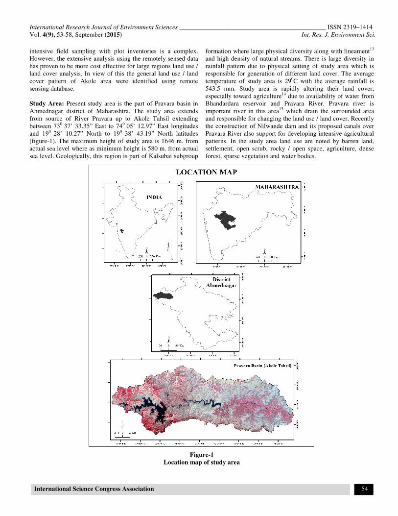
Study Area: Present study area is the part of Pravara basin in
Ahmednagar district of Maharashtra. The study area extends
from source of River Pravara up to Akole Tahsil extending
between 730
37’ 33.35” East to 740
05’ 12.97” East longitudes
and 190
28’ 10.27” North to 190
38’ 43.19” North latitudes
(figure-1). The maximum height of study area is 1646 m. from
actual sea level where as minimum height is 580 m. from actual
sea level. Geologically, this region is part of Kalsubai subgroup
formation where large physical diversity along with lineament13
and high density of natural streams. There is large diversity in
rainfall pattern due to physical setting of study area which is
responsible for generation of different land cover. The average
temperature of study area is 290C with the average rainfall is
543.5 mm. Study area is rapidly altering their land cover,
especially toward agriculture14
due to availability of water from
Bhandardara reservoir and Pravara River. Pravara river is
important river in this area15
which drain the surrounded area
and responsible for changing the land use / land cover. Recently
the construction of Nilwande dam and its proposed canals over
Pravara River also support for developing intensive agricultural
patterns. In the study area land use are noted by barren land,
settlement, open scrub, rocky / open space, agriculture, dense
forest, sparse vegetation and water bodies.
Figure-1
Location map of study area

International Research Journal of Environment Sciences _____________________________________________ ISSN 2319–1414
Vol. 4(9), 53-58, September (2015) Int. Res. J. Environment Sci.
International Science Congress Association 55
Methodology
Secondary data were collected from remote sensing imageries
such as LISS 3 and LANDSAT 8 for the period 2011 and 2015
respectively. The selected image from 2011 and 2015
respectively for assessment of land use and land cover pattern.
These images were classified in the Erdas image processing
software by supervise and unsupervised classification
techniques for land use/land cover classification. The study area
boundary was superimposed over satellite imagery and cropped
the study area. After those administrative boundaries of selected
villages were also superimposed on classified satellite images
known as the village wise land use/ land cover analysis.
Obtained results were converted in percentage of area from
hectors unit by mathematical calculation for to know the areas
under various sectors. Final land use/ land cover maps were
prepared from LISS 3 and LANDSAT 8 satellite images.
Results and Discussion
General Land Use/ land Cover Pattern in 2011: In the 2011
the massive land were covered by Sparse Vegetation which is
mainly observed at bottom hilly area. The western part of study
area dominated by Sparse Vegetation cover. Similarly eastern
area covered by Sparse Vegetation around the Pravara River.
The percentage of Sparse Vegetation area shown is the 47.62 %
area.
After that the second dominated area by Barren land. It covers
approximately 26.34% of area under barren land. This and cover
mainly dominated in the north east direction of study area. The
settlement in the study area only covered the 307.5318 hector
area which is in the 0.53% area. It may be due to undulating
topography and tribal small hamlets population. Similarly open
Scrub occupied the 2.08 % area and rocky / open space covered
the 1.59% of area under land use (figure-2).
Table-1
Land use /Land cover pattern in 2011 (from LISS 3 data)
Land use Area_ha Area %
Barren land 15327.06 26.34%
Settlement 307.5318 0.53%
Open Scrub 1210.753 2.08%
Rocky / Open Space 922.579 1.59%
Agriculture 6298.037 10.82%
Dense forest 3562.216 6.12%
Sparse Vegetation 27712.36 47.62%
Water bodies 2851.486 4.90%
Total 58192.02 100%
Figure-2
General land use / land cover

International Research Journal of Environment Sciences _____________________________________________ ISSN 2319–1414
Vol. 4(9), 53-58, September (2015) Int. Res. J. Environment Sci.
International Science Congress Association 56
General Land Use/ Land Cover Pattern in 2015: The land
use/ land cover area are rapidly chanced during 2011 to 2015.
Here is main area covered by barren land which is 30.41%.
Then the open scrub covered the 20.84% of area under land
cover area. Remains portion where covered by another land
use/land cover features in study area. The settlement in the
study area is covered only 1.13% area. Similarly, the dense
forest covered minimum land cover area with 2.89% of area. In
case of water bodies, area occupied by water bodies is around
3.53 %. In the study area the right canal and left canal also
occurring the land use, which construction process in ongoing.
These canals are located in eastern part of study area. The land
use pattern in the study area, especially in the eastern direction
of the study area is altering due to Nilwande canals in future.
Table-3
Land use / Land cover pattern in 2015 (from Landsat 8
data)
LISS3_LUClass Area_ha Area %
Barren land 17695.08 30.41%
Settlement 655.9049 1.13%
Open Scrub 12127.36 20.84%
Rocky / Open Space 4478.077 7.70%
Agriculture 5486.499 9.43%
Dense forest 1684.635 2.89%
Sparse Vegetation 14007.46 24.07%
Water bodies 2057 3.53%
Total 58192.02 100%
Assessment of Land Use/ Land Cover Changes: From the
image processing results and acquired land use/ land cover data
its reveled that, the land use/ land cover pattern in the study area
are changed. Table 3 is showing the comparative changes in
general land use/ land cover pattern during 2011 and 2015.
Change is observed in various categories viz. Area under sparse
vegetation (-23.55%), barren land (+ 4.07%), dense forest – (-
3.23 %), agricultural land (-1.39) and water bodies (-1.37).
Barren land, open scrub, settlement, open space etc. land use
and land cover were increased from 2011 to 2015. Agriculture,
forest, water bodies, sparse vegetation reduced from 2011 to
2015 in the study area. In the study region as a whole area under
forest, land for cultivation, decreased and area under barren land
has been increasing. Alarming negative changes in sparse
vegetation is the subject of environmental degradation. In the
study area it is observed that the water bodies also decreasing. It
may be the result of excessive water transformation from dams
to the lower sections of dams. Over all scenario of general land
use/ land cover are detected as changeable and prone to
environmental degradation. These acquired results are unsafe
for future planning of the agriculture in study region. These
problems are mainly due to increasing population, over
utilization of water, lack of wise utilization of resources etc.
Conclusion
The land use/ land cover change detection is the supportive
techniques for any further planning. Remote sensing data has
wide range of application in land use/ land cover mapping and
change detection also. The total geographical area of study area
is 58192.02 hector. Land utilization is classified in eight
categories like barren land, area under forest, sparse vegetation
etc. in study area. Table 3 clearly shows the changed pattern of
land use and land cover in study area of 2011 – 2015sparse
vegetation area is most precious category of land among other
land use category. These changes occurred may be due to
changing population, and related socioeconomic environment
alteration. The remote sensing data such as LISS 3 and Landsat
8 are the potential data for identification of land use and land
cover in any diverse area. Spectral reflection structures of plains
have helped to know of landforms17
. Identification of land
use/land cover from remote sensing data can be help for the
further land planning and decision support system.
References
1. Bhagawat R., Application of Remote Sensing and GIS:
Land Use/Land Cover Change In Kathmandu
Metropolitan City, Nepal, Journal of Theoretical and
Applied Information Technology, 72-80, (2011)
2. Gajbhiye S. and Sharma S.K., Land Use and Land Cover
change detection of Indra river watershed through
Remote Sensing using Multi-Temporal satellite data,
International Journal of Geomatics and Geosciences,
3(1), 89-90, (2012)
3. Stamp L.D., Applied Geography, Penguin Books,
Suffolk, 105-107 (1930)
4. Nanavati M.B. and Anjaria J. J., The Indian Rural
Problem, Vora and Co. Bombay, (1951)
5. Deshmukh K.K. and Aher S.P., Particle size analysis of
soils and its interpolation using GIS technique from
Sangamner area, Maharashtra, India, Int. J. of Env. Sci.,
3(10), 32-37 (2014)
6. Freeman T.W., Geography and Planning, Hutchinson,
University Library, London (1968)
7. Aher S., Parande A. and Deshmukh P., A Geomatics of
the Image Processing: Image Georeferancing,
Proceedings published by Int. J. of Computer
Applications, 20-23 (2011)
8. Mohammad N., Investigating Land Use and Land Cover
Change in Bahrain: 1987-2013, Geospatial Technologies
project, (1980)

International Research Journal of Environment Sciences _____________________________________________ ISSN 2319–1414
Vol. 4(9), 53-58, September (2015) Int. Res. J. Environment Sci.
International Science Congress Association 57
Figure-3
General land use/ land cover
Figure-4
Land use/ land cover cahnges from 2011 to 2015

International Research Journal of Environment Sciences _____________________________________________ ISSN 2319–1414
Vol. 4(9), 53-58, September (2015) Int. Res. J. Environment Sci.
International Science Congress Association 58
Table-3
Changes in General Land Use/ Land Cover Pattern during 2011-2015
Land Use
Category
2011 2015 Volume
change Area (hect.) Area (%) Area (hect.) Area (%)
Barren land 15327.06 26.34 17695.082 30.41 04.07
Settlement 307.5318 0.53 655.90494 1.13 00.60
Open scrub 1210.753 2.08 12127.36 20.84 18.76
Rocky/Open space 922.579 1.59 4478.78 7.70 06.11
Agriculture 6298.037 10.82 5486.4991 9.43 -01.39
Dense forest 3562.216 06.12 1684.6348 2.89 -03.23
Sparse vegetation 27712.36 47.62 14007.459 24.07 -23.55
Water bodies 2851.486 04.90 2056.9996 3.53 -01.37
Total 58192.02 100 58192.02
100
--
Source: Socio-Economic Review & District Statistical abstract –Ahmednagar District
9. Aher S.P. and Dalvi S.N., Remote Sensing Technique for
Monitoring the Glacier Retreating Process and Climatic
Changes Study, Indian Streams Research J., 2(8), 2-6
(2012)
10. Vink A.P.A., Land Use in Advancing Agriculture,
Springer Velag., 3, 3-17 (1975)
11. Pralhad Y.V. and Deore R.S., Population Growth and
Changing Land use Profile in Girna River Basin in
Nashik District (MS), Shodh, Samiksha Aur Mulyankan,
2, 11-12, (2010)
12. Deshmukh P., Wawale S., Aher S. and Thorat S.,
Demarcation of Drainage Network for Watershed
Management of Sangamner Tahsil using Topographical
and Remote Sensing Database, Indian Stream Research
Journal, 2(1), 1-4 (2012)
13. Aher S.P., Shinde S.D., Jarag A.P. and Gawali P.B.,
Identification of Lineaments in the Pravara Basin from
ASTER-DEM Data and Satellite Images for their
Geotectonic Implication, International Journal of Earth
Sciences, 2(7), 1-5 (2014)
14. Thorat S., Deshmukh P., Wavale S. and Aher S., Scope
and Opportunities of Agro-Tourism in Akole Tehsil of
Ahmednagar District, Golden Res. Thoughts, 1(12), 1-4
(2012)
15. Aher S.P., Bairagi S.I., Deshmukh P.P. and Gaikwad
R.D., River change detection and bank erosion
identification using topographical and remote sensing
data, Int. J. of Appl. Information Sys., 2, 1-7 (2012)
16. Gatade D.G. and Pol N.S., Changes in general land use
pattern in Sangli district: A geographical analysis,
Golden Research Thoughts, 2, 1-8 (2013)
17. Wawale S.G., Geomorphologic analysis of Pravara River
using Topographical and Remote Sensing database: a
case study of Pravara River in Ahemadnagar district of
Maharashtra, Online International Interdisciplinary
Research Journal, 2(4), 55-63 (2012)