Land Use Designations - Town of Comoxcomox.ca/modx/assets/maps/Bylaw 1685 - OCP - Land Use Maps...
9
0 1 2 3 0.5 Kilometers (1:30,000) MAP 1 Land Use Designations Powell River Ferry K'omoks IR1 Lazo North Electoral Area B City of Courtenay Comox Harbour Strait of Georgia Kye Bay Baynes Sound ANDERTON ROAD PRITCHARD ROAD MILITARY ROW RYAN ROAD COMOX ROAD COMOX AVENUE MCDONALD ROAD BALMORAL AVENUE Kye Bay Road KNIGHT ROAD Dryden Road Noel Avenue Robb Avenue Filberg Road ANDERTON ROAD PRITCHARD ROAD LAZO ROAD Torrence Road Church Street Rodello Street Aitken Street GUTHRIE ROAD Lazo Road Stewart Street Torrence Road 19 Wing Comox / Comox Valley Airport Curtis Road LERWICK ROAD KNIGHT ROAD City of Courtenay Lazo North Electoral Area B Highridge Drive Beach Drive Salish Street Denman Street Bolt Avenue McLeod Street Aspen Road Butchers Road Kye Bay Road Hudson Road Highwood Drive Noel Avenue COMOX AVENUE GUTHRIE ROAD MAP 1: LAND USE DESIGNATIONS Lazo North Electoral Area B Land Use Designations Agricultural Residential: Detached Residential: Ground Oriented Infill Residential: Townhouses & Ground Oriented Infill Residential: Low Rise Apartments, Townhouses & Ground Oriented Infill Mixed Use: Commercial-Residential Downtown Comox Commercial: Neighbourhood Commercial: Tourist Light Industrial Public Open Space Institutional Comox Harbour & Marinas Marine Foreshore 19 Wing Comox Airport Runway Approach Surface Boundary Airport Runway Approach Surface Boundary map created by the Arlington Group for the Town of Comox data provided by: Town of Comox, Comox Valley Regional District, Province of British Columbia, Department of Natural Resources Canada © All rights reserved June 2011, Bylaw #1685, May 12, 2011 Bylaw #1771, May 7, 2014 Goose Spit IR3 N
Transcript of Land Use Designations - Town of Comoxcomox.ca/modx/assets/maps/Bylaw 1685 - OCP - Land Use Maps...

0 1 2 30.5 Kilometers(1:30,000)
MAP 1Land Use Designations
Powell River Ferry
K'omoksIR1
Lazo North Electoral Area B
City ofCourtenay
Comox Harbour
Strait o
f Geor
gia
Kye Bay
Baynes Sound
ANDE
RTON
ROAD
PRITC
HARD
ROAD
MILIT
ARY R
OW
RYAN ROAD
COMOX ROAD
COMOX AVENUE
MCDONALD ROAD
BALMORAL AVENUE
Kye Bay RoadKNIGHT ROAD
Dryden Road
Noel Avenue
Robb Avenue
Filber
g Roa
d
ANDE
RTON
ROAD
PRITC
HARD
ROAD
LAZO
ROAD
Torre
nce R
oad
Churc
h Stre
etRode
llo St
reet
Aitke
n Stre
et
GUTHRIE ROAD
Lazo Road
Stewa
rt Stre
et
Torre
nce R
oad
19 Wing Comox /
Comox Valley Airport
Curtis R
oad
LERWICK ROAD
KNIGHT ROAD
City ofCourtenay
City ofCourtenay
Lazo North Electoral Area B
Highridge Drive
Beac
h Driv
e
Salish
Stre
et
Denm
an St
reet
Bolt Avenue
McLe
od St
reet
Aspen Road
Butch
ers R
oad
Kye B
ay Ro
ad
Huds
on Ro
ad
Highw
ood D
rive
Noel Avenue
COMOX AVENUE
GUTHRIE ROAD
MAP 1
: LAN
D US
E DES
IGNA
TIONS
Lazo North Electoral Area B
Land Use DesignationsAgriculturalResidential: DetachedResidential: Ground Oriented InfillResidential: Townhouses & Ground Oriented InfillResidential: Low Rise Apartments, Townhouses & Ground Oriented InfillMixed Use: Commercial-ResidentialDowntown ComoxCommercial: NeighbourhoodCommercial: TouristLight IndustrialPublic Open SpaceInstitutionalComox Harbour & MarinasMarine Foreshore19 Wing ComoxAirport Runway Approach Surface Boundary
Airport Runway Approach Surface Boundary
map created by the Arlington Group for the Town of Comoxdata provided by:Town of Comox, Comox Valley Regional District, Province of British Columbia, Department of Natural Resources Canada © All rights reserved
June 2011,Bylaw #1685, May 12, 2011Bylaw #1771, May 7, 2014
Goose SpitIR3
N
Guthrie Road
Comox Avenue
Pritc
hard
Road
Noel Avenue
Bolt Avenue
Robb Avenue
Ande
rton R
oad
Beaufort Avenue
Aitke
n Stre
et
Quar
ry Ro
ad
Torre
nce
Road
Salish
Stree
t
Rode
llo St
reet
No ot ka St reet
Gull Avenue
Elm Avenue
Churc
h Stre
et
Aspen Road
Haida
Stre
et
Stewa
rt Stre
et
Balmoral Avenue
Denm
an St
reet
McKenzie Avenue
Dogwood AvenueBe
ach D
rive
Murre
let D
rive
Skeena
Drive
Buena Vista Avenue
Spitfi
re D
rive
Back Road
Tutor Drive
Glacier View Drive
Balsam Avenue
Woodland Drive
Cor te
z Cr e
sce n
t
Corm
oran
t Stre
et
Port A
ugus
ta St
reet
Fairbairn Avenue
Mano
r Driv
e Park Drive
Meadowlark Drive
Cedar Avenue
Crot
eau R
oad
Hillside Avenue
Ridgemount Drive
Comox Road
Some
nos D
rive
Cooke Avenue
Redwood Street
Strathcona Crescent
Doug
las St
reet
Davis
Stre
et
Dono
van D
rive
Birch Avenue
Alpine
Stre
et
Glad
stone
Stre
et
Yew Court
Ellis S
treet
Queens Avenue
Heron Crescent
High w
o od
Dri ve
McLe
od St
reet
Carth
ew St
reet
Downey Avenue
Lancaster Way
Ascot Avenue
Horne
t Way
Holly Place
Bunt
ing Pl
ace
Olym
pic D
rive
Tote
m Cr
esce
nt
Linden Avenue
Filber
g Ro
ad
Cypress Avenue
Nimpk
ish St
reet
Chinook Drive
Maquinna Avenue
Jubil
ee C
ourt
Cond
or St
reet
McDonald Road
Wallace Avenue
Crestvie
w Drive
April Place
Stadacona Drive
Centennial Avenue
Willo
w W
ay
Beaton Avenue
Murphy Avenue
Spruce Way
East Centennial Avenue
Tiger Moth P la ce
Sable
Plac
e
Cougar Crescent
Junipe r Place
Orchard Park Drive
Megin
Way
Jane P lace
Baybrook Drive
Chestnut Avenue
Tsimshian Avenue
Kwakiutl AvenueTofino Place
Mora
lee D
rive
Linsh
art R
oad
Expe
ditor
Plac
e
Avro Arrow Drive
Manor
Pla
ce
Alder Avenue
Ivy Pl
ace
Bryant P lace
Harvard Street
Richardson Avenue
Fir Avenue
Savary Place
Sonora Place
Bamb
rick P
lace
Canso Avenue
Taylor Avenue
Elm Place
Lazo Road
Quad
r a P l
ace
Wilcox S
treet
Arbutus Avenue
Jane
Stree
t
Plover Court
Albatross Avenue
Broo k
ly n Pl
ace
Short Street
Cardinal Place
Nordi
n Stre
et
Thistl
e Cou
rt
Quatsino Place
Heather Court
Chilcotin C rescent
St Joseph Hospital
Towhee Court
Marten Avenue
Mahtmof Place
Texad
a Plac
e
Hemlock Avenue
Stellar Court
Orca Place
Walnut Avenue
Capilano Avenue
Buxton Place
Sham
rock
Plac
e
Argus Place
Aurora Place
Pemberton PlaceBeaconsfield Court
Noel Avenue
Linsh
art R
oad
McKenzie Avenue
Stewa
rt Stre
et
Dogwood Avenue
Skee
na D
rive
Rode
llo St
r eet
Cooke Avenue
0 1 20.5 Kilometers
K'omoksIR1
Comox Harbour
map created by the Arlington Group for the Town of Comox
data provided by:Town of Comox, Comox Valley Regional District, Province of British Columbia, Department of Natural Resources Canada © All rights reserved
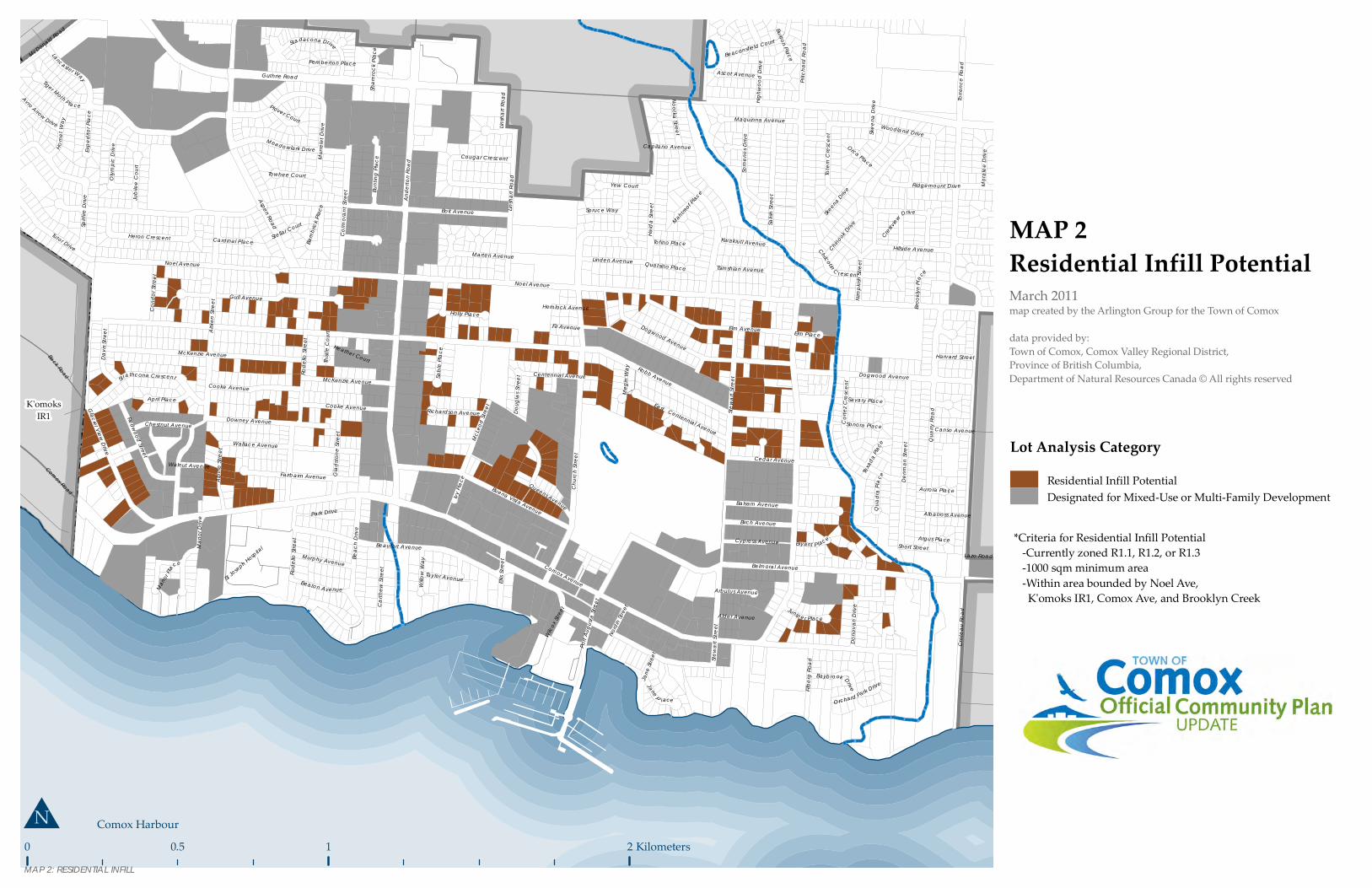
March 2011
MAP 2Residential Infill Potential
Lot Analysis CategoryResidential Infill PotentialDesignated for Mixed-Use or Multi-Family Development
*Criteria for Residential Infill Potential -Currently zoned R1.1, R1.2, or R1.3 -1000 sqm minimum area -Within area bounded by Noel Ave, K'omoks IR1, Comox Ave, and Brooklyn Creek
MAP 2: RESIDENTIAL INFILL

!!
!!
!!
!!
!!
!!
!!!
!!
!
!!
!!
!!
!!!!
!!
!
!!
!!
!!
!!!
!
!
!
!!
!!!!
!!
!!!
!
!
!!!!!!
!!
!
!
!
!
!!
!!
!! !
!
!
!!
!!
!!
!!
!!
!!
!!
!
!!
!!
!!
!!
!
!
!
!
!
!!
!!
!
!
!
!
! !
!
!
!
!
!
!!
!!
!!
!!
!
!
!!
! !
!
!!
!!
!!
!!
!!
!
!!
!
!!
!!
!
! ! !
! !
!!
!!
!
!
!
!
!
!
!!
!!
!
!!
!!
!!
!!
!
!
!
!!
!
!!
!
!!
!
!
!
!!
!
!
!
!!
!
!
!!
!!
!!
!!
!!
!!
!!
!!
!!
!!
! ! !
!
!
!
!
!
!
!
! ! ! !!
!! ! !
!!
!!
!!
!!
!!
!! !
! ! !
! ! ! ! ! ! ! ! ! ! ! ! ! !
!!
!!
!!
!!
!!
!!
!!
!
!!
!! !
!!
!!
!!
!
!
!!
!!
!!
!!
!! ! ! !
!
! ! ! ! ! ! !
!!
!
!
!
!! !
!
!!
!
!
!
!
!
!
!
!! ! ! ! !
!!
!
!!
!!
!!
!
!!!!!!!!!!!!!!!!!!!!!
!
!
!
!!
0 1 2 30.5 Kilometers(1:30,000)
MAP 3Parks, Trails, and Open Space
Powell River Ferry
K'omoksIR1
Goose SpitIR3
Lazo North Electoral Area B
City ofCourtenay
Comox Harbour
Strait o
f Geor
gia
Kye Bay
Baynes Sound
ANDE
RTON
ROAD
PRITC
HARD
ROAD
MILIT
ARY R
OW
RYAN ROAD
COMOX ROAD
COMOX AVENUE
MCDONALD ROAD
BALMORAL AVENUE
Kye Bay Road
KNIGHT ROAD
Dryden Road
Noel Avenue
Robb Avenue
Filber
g Roa
d
ANDE
RTON
ROAD
PRITC
HARD
ROAD
LAZO
ROAD
Churc
h Stre
etRode
llo St
reet
Aitke
n Stre
et
GUTHRIE ROAD
Lazo Road
Stewa
rt Stre
et
Torre
nce R
oad
19 Wing Comox /
Comox Valley Airport
Curtis R
oad
LERWICK ROAD
KNIGHT ROAD
City ofCourtenay
City ofCourtenay
Lazo North Electoral Area B
Beac
h Driv
e
Salish
Stre
et
Denm
an St
reet
Bolt Avenue
McLe
od St
reet
Aspen Road
Butch
ers R
oad
Kye B
ay Ro
ad
Huds
on Ro
ad
Highw
ood D
rive
Noel Avenue
COMOX AVENUE
GUTHRIE ROAD
MAP 3
: PAR
KS, T
RAILS
, AND
OPE
N SP
ACE
Lazo North Electoral Area B
Existing trail network within this area not shown.
note: Features outside of Town of Comox boundary are shown for reference purposes only.
map created by the Arlington Group for the Town of Comoxdata provided by:Town of Comox, Comox Valley Regional District, Province of British Columbia, Department of Natural Resources Canada © All rights reservedWiTS (Wildlife Tree Stewardship Program) 2009,BC Nature and Community Mapping Network.
June 2011,Bylaw #1685, May 12, 2011Bylaw #1771, May 7, 2014
N
Parks, Trails, or Open Space Features! ! ! ! ! Off-St reet Tr ai ls (Exi sting and Pr oposed)
Designated Public Open SpaceRegional or Provincial Parks
Off-street Trails (existing and proposed)
20 m
40 m
60 m
80 m
20 m
60 m
60 m
40 m
60 m60 m
40 m
40 m
60 m
60 m
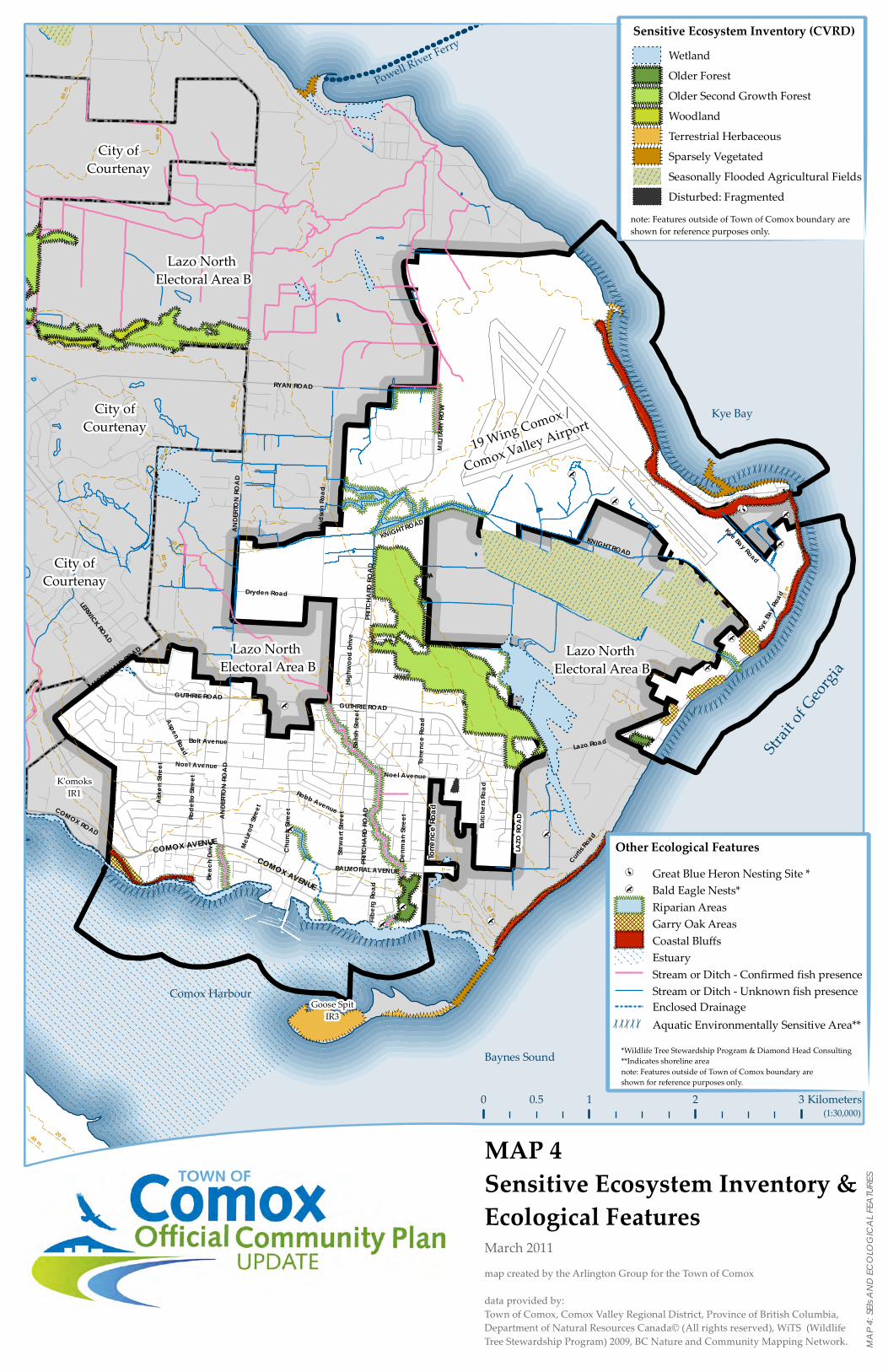
0 1 2 30.5 Kilometers(1:30,000)
map created by the Arlington Group for the Town of Comox
data provided by:Town of Comox, Comox Valley Regional District, Province of British Columbia, Department of Natural Resources Canada© (All rights reserved), WiTS (Wildlife Tree Stewardship Program) 2009, BC Nature and Community Mapping Network.
MAP 4Sensitive Ecosystem Inventory &Ecological Features
Powell River Ferry
K'omoksIR1
Goose SpitIR3
Lazo North Electoral Area B
City ofCourtenay
Comox Harbour
Strait o
f Geor
gia
Kye Bay
Baynes Sound
ANDE
RTON
ROAD
PRITC
HARD
ROAD
MILIT
ARY R
OW
RYAN ROAD
COMOX ROAD
COMOX AVENUE
MCDONALD ROAD
BALMORAL AVENUE
Kye Bay Road
KNIGHT ROAD
Dryden Road
Noel Avenue
Robb Avenue
Filbe
rg Ro
ad
ANDE
RTON
ROAD
PRITC
HARD
ROAD
LAZO
ROAD
Torre
nce R
oad
Churc
h Stre
etRode
llo St
reet
Aitke
n Stre
et
GUTHRIE ROAD
Lazo Road
Stewa
rt Stre
et
Torre
nce R
oad
19 Wing Comox /
Comox Valley Airport
Curtis R
oad
LERWICK ROAD
KNIGHT ROAD
City ofCourtenay
City ofCourtenay
Lazo North Electoral Area B
Beac
h Driv
e
Salish
Stre
et
Denm
an St
reet
Bolt Avenue
McLe
od St
reet
Aspen Road
Butc
hers
Road
Kye B
ay Ro
ad
Huds
on Ro
ad
Highw
ood
Drive
Noel Avenue
COMOX AVENUE
GUTHRIE ROAD
March 2011
MAP 4
: SEIs
AND
ECOL
OGIC
AL FE
ATUR
ES
Lazo North Electoral Area B
Other Ecological FeaturesGreat Blue Heron Nesting Site *Bald Eagle Nests*Riparian AreasGarry Oak AreasCoastal BluffsEstuaryStream or Ditch - Confirmed fish presenceStream or Ditch - Unknown fish presenceEnclosed DrainageAquatic Environmentally Sensitive Area**
*Wildlife Tree Stewardship Program & Diamond Head Consulting**Indicates shoreline areanote: Features outside of Town of Comox boundary are shown for reference purposes only.
Sensitive Ecosystem Inventory (CVRD)WetlandOlder ForestOlder Second Growth ForestWoodlandTerrestrial HerbaceousSparsely VegetatedSeasonally Flooded Agricultural FieldsDisturbed: Fragmented
note: Features outside of Town of Comox boundary are shown for reference purposes only.

0 1 2 30.5 Kilometers(1:30,000)
map created by the Arlington Group for the Town of Comox
data provided by:Town of Comox, Comox Valley Regional District, Province of British Columbia, Department of Natural Resources Canada© (All rights reserved),WiTS (Wildlife Tree Stewardship Program) 2009,BC Nature and Community Mapping Network.
MAP 5Road Network
Powell River Ferry
K'omoksIR1
Goose SpitIR3
Lazo North Electoral Area B
Comox Harbour
Strait o
f Geor
gia
Kye Bay
Baynes Sound
ANDE
RTON
ROAD
PRITC
HARD
ROAD
MILIT
ARY R
OW
RYAN ROAD
COMOX AVENUE
MCDONALD ROAD
BALMORAL AVENUE
Kye Bay Road
KNIGHT ROAD
Dryden Road
Noel AvenueRobb Avenue
Filbe
rg Ro
ad
ANDE
RTON
ROAD
PRITC
HARD
ROAD
LAZO
ROAD
Churc
h Stre
et
Rode
llo St
reet
Aitke
n Stre
et
GUTHRIE ROAD
Lazo Road
Stewa
rt
Stree
t
Torre
nce R
oad
19 Wing Comox /
Comox Valley Airport
Curtis R
oad
LERWICK ROAD
KNIGHT ROAD
City ofCourtenay
City ofCourtenay
Lazo North Electoral Area B
Beac
h Driv
e
Salish
Stre
et
Denm
an St
reet
McLe
od St
reet
Aspen Road
Butc
hers
Road
Kye B
ay Ro
ad
Huds
on Ro
ad
Highw
ood
Drive
Noel Avenue
COMOX AVENUE
GUTHRIE ROAD
February 2011
MAP 5
: ROA
D NE
TWOR
K
Lazo North Electoral Area B
Road Network Classifications
DowntownArterialMajor CollectorMinor CollectorFuture Minor CollectorLocal or Private RoadMinistry of Transportation Responsibility

0 1 2 30.5 Kilometers(1:30,000)
map created by the Arlington Group for the Town of Comox
data provided by:Town of Comox, Comox Valley Regional District, Province of British Columbia, Department of Natural Resources Canada© (All rights reserved),WiTS (Wildlife Tree Stewardship Program) 2009,BC Nature and Community Mapping Network.
MAP 6Bus Routes
Powell River Ferry
K'omoksIR1
Goose SpitIR3
Lazo North Electoral Area B
Comox Harbour
Strait o
f Geor
gia
Kye Bay
Baynes Sound
ANDE
RTON
ROAD
PRITC
HARD
ROAD
MILIT
ARY R
OW
RYAN ROAD
COMOX AVENUE
MCDONALD ROAD
BALMORAL AVENUE
Kye Bay Road
KNIGHT ROAD
Dryden Road
Noel AvenueRobb Avenue
Filbe
rg Ro
ad
ANDE
RTON
ROAD
PRITC
HARD
ROAD
LAZO
ROAD
Churc
h Stre
et
Rode
llo St
reet
Aitke
n Stre
et
GUTHRIE ROAD
Lazo Road
Stewa
rt
Stree
t
Torre
nce R
oad
19 Wing Comox /
Comox Valley Airport
Curtis R
oad
LERWICK ROAD
KNIGHT ROAD
City ofCourtenay
City ofCourtenay
Lazo North Electoral Area B
Beac
h Driv
e
Salish
Stre
et
Denm
an St
reet
McLe
od St
reet
Aspen Road
Butc
hers
Road
Kye B
ay Ro
ad
Huds
on Ro
ad
Highw
ood
Drive
Noel Avenue
COMOX AVENUE
GUTHRIE ROAD
February 2011
MAP 6
: BUS
ROUT
ES
Lazo North Electoral Area B
Bus RoutesAreas within 400 metres of a Bus Route

0 1 2 30.5 Kilometers(1:30,000)
map created by the Arlington Group for the Town of Comox
data provided by:Town of Comox, Comox Valley Regional District, Province of British Columbia, Department of Natural Resources Canada© (All rights reserved),Boulevard Transportation Group
MAP 7Bicycle Network
Powell River Ferry
K'omoksIR1
Goose SpitIR3
Lazo North Electoral Area B
Comox Harbour
Strait o
f Geor
gia
Kye Bay
Baynes Sound
ANDE
RTON
ROAD
PRITC
HARD
ROAD
MILIT
ARY R
OW
RYAN ROAD
COMOX AVENUE
MCDONALD ROAD
BALMORAL AVENUE
Kye Bay Road
KNIGHT ROAD
Dryden Road
Noel AvenueRobb Avenue
Filbe
rg Ro
ad
ANDE
RTON
ROA
D
PRITC
HARD
ROAD
LAZO
ROAD
Churc
h Stre
et
Rode
llo St
reet
Aitke
n Stre
et
GUTHRIE ROAD
Lazo Road
Stewa
rt
Stree
t
Torre
nce R
oad
19 Wing Comox /
Comox Valley Airport
Curtis R
oad
LERWICK ROAD
KNIGHT ROAD
City ofCourtenay
City ofCourtenay
Lazo North Electoral Area B
Beac
h Driv
e
Salish
Stre
et
Denm
an St
reet
Aspen Road
Butc
hers
Road
Kye B
ay Ro
ad
Huds
on Ro
ad
Highw
ood
Drive
Noel Avenue
COMOX AVENUE
GUTHRIE ROAD
May 2011
MAP 7
: BIC
YCLE
NETW
ORK
Lazo North Electoral Area B
Bicycle FacilitiesProposed Major Bike RouteProposed Minor Bike RouteProposed Bike LaneExisting Bike LaneBike Lane (MoT)
0 1 2 30.5 Kilometers(1:30,000)
map created by the Arlington Group for the Town of Comox
data provided by:Town of Comox, Comox Valley Regional District, Province of British Columbia, Department of Natural Resources Canada© (All rights reserved),WiTS (Wildlife Tree Stewardship Program) 2009,BC Nature and Community Mapping Network.
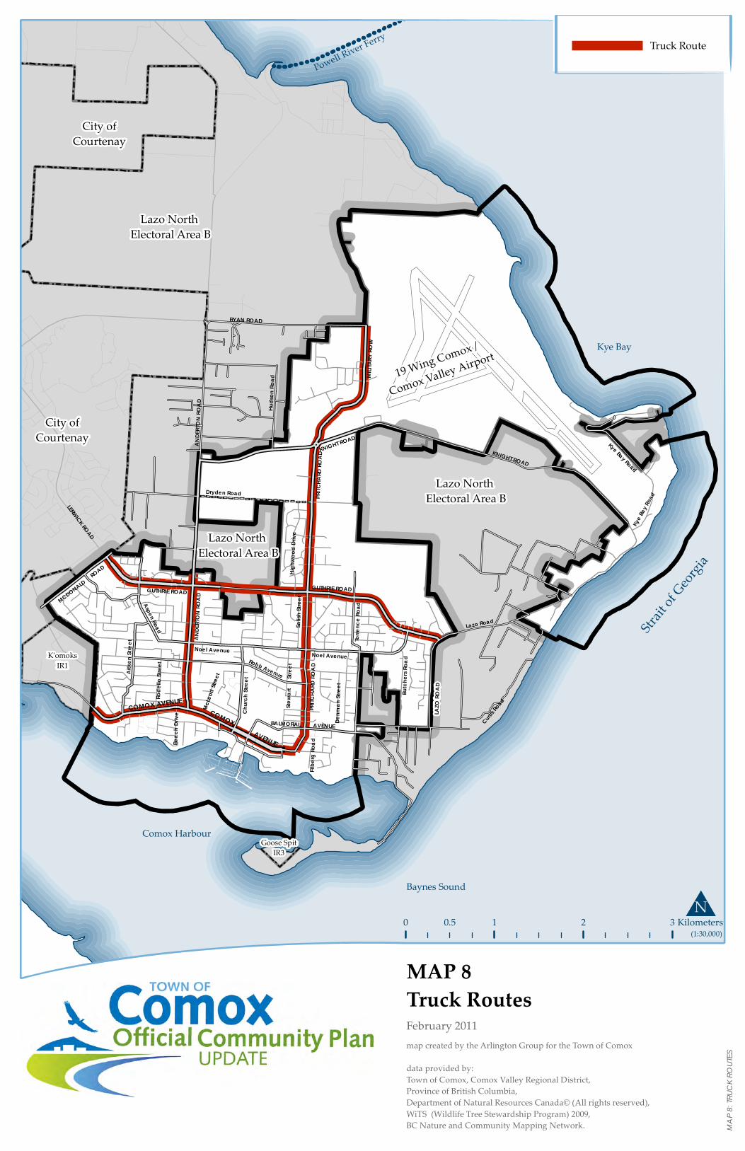
MAP 8Truck Routes
Powell River Ferry
K'omoksIR1
Goose SpitIR3
Lazo North Electoral Area B
Comox Harbour
Strait o
f Geor
gia
Kye Bay
Baynes Sound
ANDE
RTON
ROAD
PRITC
HARD
ROAD
MILIT
ARY R
OW
RYAN ROAD
COMOX AVENUE
MCDONALD ROAD
BALMORAL AVENUE
Kye Bay Road
KNIGHT ROAD
Dryden Road
Noel AvenueRobb Avenue
Filbe
rg Ro
ad
ANDE
RTON
ROAD
PRITC
HARD
ROAD
LAZO
ROAD
Churc
h Stre
et
Rode
llo St
reet
Aitke
n Stre
et
GUTHRIE ROAD
Lazo Road
Stewa
rt
Stree
t
Torre
nce R
oad
19 Wing Comox /
Comox Valley Airport
Curtis R
oad
LERWICK ROAD
KNIGHT ROAD
City ofCourtenay
City ofCourtenay
Lazo North Electoral Area B
Beac
h Driv
e
Salish
Stre
et
Denm
an St
reet
McLe
od St
reet
Aspen Road
Butc
hers
Road
Kye B
ay Ro
ad
Huds
on Ro
ad
Highw
ood
Drive
Noel Avenue
COMOX AVENUE
GUTHRIE ROAD
February 2011
MAP 8
: TRU
CK RO
UTES
Lazo North Electoral Area B
Truck Route

0 1 2 30.5 Kilometers(1:30,000)
Powell River Ferry
K'omoksIR1
Goose SpitIR3
Lazo North Electoral Area B
Lazo North Electoral Area B
City ofCourtenay
Comox Harbour
Strait o
f Geor
gia
Kye Bay
Baynes Sound
ANDE
RTON
ROAD
PRITC
HARD
ROAD
MILIT
ARY R
OW
RYAN ROAD
COMOX ROAD
COMOX AVENUE
MCDONALD ROAD
BALMORAL AVENUE
Kye Bay RoadKNIGHT ROAD
Dryden Road
Noel Avenue
Robb Avenue
Filber
g Roa
d
ANDE
RTON
ROAD
PRITC
HARD
ROAD
LAZO
ROAD
Torre
nce R
oad
Churc
h Stre
etRode
llo St
reet
Aitke
n Stre
et
GUTHRIE ROAD
Lazo Road
Stewa
rt Stre
et
Torre
nce R
oad
19 Wing Comox /
Comox Valley Airport
Curtis R
oad
LERWICK ROAD
KNIGHT ROAD
City ofCourtenay
City ofCourtenay
Highridge Drive
Beac
h Driv
e
Salish
Stre
et
Denm
an St
reet
Bolt Avenue
McLe
od St
reet
Aspen Road
Butch
ers R
oad
Kye B
ay Ro
ad
Huds
on Ro
ad
Highw
ood D
rive
Noel Avenue
Public LandsTown of ComoxTown of Comox (leased)CVRDSchool District No.71School District No.93Crown ProvincialCrown FederalCanada Post19 Wing Comox19 Wing Comox (leased to School District No. 71)19 Wing Comox (leased to Airport Commission)Airport CommissionRCAF AssociationNatureTrust
Lazo North Electoral Area B
GUTHRIE ROAD
notes: 1. Not all public properties are shown or visible due to limitations of scale. 2. Some rights-of-way are not shown due to incomplete property data.
MAP 9
: PUB
LIC LA
NDS I
NVEN
TORY
Map 9Public Lands InventoryFebruary 2011Bylaw #1685, May 12, 2011Bylaw #1771, May 7, 2014
N
map created by the Arlington Group for the Town of Comoxdata provided by:Town of Comox, Comox Valley Regional District, Province of British Columbia, Department of Natural Resources Canada © All rights reservedWiTS (Wildlife Tree Stewardship Program) 2009,BC Nature and Community Mapping Network.