Land Use Control Plan for Quarry Pit Landfill (MCB Hawaii ... · Land Use Control Plan for Quarry...
120
FINAL Land Use Control Plan for Quarry Pit Landfill (MCB Hawaii Site 0002) Marine Corps Base Hawaii, Kaneohe, Oahu, Hawaii July 2015 Department of the Navy Naval Facilities Engineering Command, Hawaii 400 Marshall Road JBPHH HI 96860-3139 Architect and Engineering Services Contract Number N62742-11-D-1821, CTO 0021
-
Upload
duongtuyen -
Category
Documents
-
view
219 -
download
2
Transcript of Land Use Control Plan for Quarry Pit Landfill (MCB Hawaii ... · Land Use Control Plan for Quarry...

FINAL
Land Use Control Plan for Quarry Pit Landfill (MCB Hawaii Site 0002) Marine Corps Base Hawaii, Kaneohe, Oahu, Hawaii July 2015
Department of the Navy Naval Facilities Engineering Command, Hawaii 400 Marshall Road JBPHH HI 96860-3139
Architect and Engineering Services Contract Number N62742-11-D-1821, CTO 0021


FINAL
Land Use Control Plan for Quarry Pit Landfill (MCB Hawaii Site 0002) Marine Corps Base Hawaii, Kaneohe, Oahu, Hawaii July 2015 Prepared for:
Department of the Navy Naval Facilities Engineering Command, Hawaii 400 Marshall Road JBPHH HI 96860-3139
Prepared by:
98-030 Hekaha Street, Unit 9 Aiea, HI 96701
Prepared under:
Architect and Engineering Services Contract Number N62742-11-D-1821, CTO 0021


Final Land Use Control Plan Quarry Pit Landfill (MCB Hawaii Site 0002) Marine Corps Base Hawaii, Kaneohe, Oahu, Hawaii
Table of Contents
July 2015
i
TABLE OF CONTENTS List of Acronyms and Abbreviations ............................................................................................. iii
Section 1 Introduction .............................................................................................................. 1
Section 2 Background Information .......................................................................................... 3
2.1 Site Locations and Description ........................................................................ 3
2.2 Site History ...................................................................................................... 3
2.3 Previous Investigations and Removal Actions ................................................. 4
2.4 Current and Potential Future Site Land Use .................................................. 11
2.5 Remedy in Place ........................................................................................... 12
Section 3 Land Use Control Performance Objectives ........................................................... 13
3.1 Land Use Restrictions ................................................................................... 13
3.2 Notice ............................................................................................................ 13
3.3 Land Use Control Maintenance and Reporting ............................................. 13
Section 4 Land Use Controls ................................................................................................. 15
4.1 Restricted Use Areas ..................................................................................... 15
4.2 Engineering Controls ..................................................................................... 15
4.3 Institutional Controls ...................................................................................... 16
4.3.1 Construction Permit Process ............................................................. 16
Section 5 Responsibilities for Implementing and Maintaining LUCs ..................................... 17
5.1 Notice Requirements ..................................................................................... 17
5.1.1 Landowner Responsibilities ............................................................... 17
5.1.2 Navy Responsibilities ......................................................................... 17
5.1.3 DOH Responsibilities ......................................................................... 18
5.2 Inspection and Monitoring Requirements ...................................................... 18
5.2.1 Landowner Responsibilities ............................................................... 18
5.2.2 Navy Responsibilities ......................................................................... 18
5.2.3 DOH Responsibilities ......................................................................... 18
5.3 Compliance Reporting Requirements ............................................................ 18
5.3.1 Landowner Responsibilities ............................................................... 18
5.3.2 Navy Responsibilities ......................................................................... 19
5.3.3 DOH Responsibilities ......................................................................... 19
5.4 Mitigation and Enforcement Requirements ................................................... 19
5.4.1 Landowner Responsibilities ............................................................... 19
5.4.2 Navy Responsibilities ......................................................................... 20
Final Land Use Control Plan Quarry Pit Landfill (MCB Hawaii Site 0002) Marine Corps Base Hawaii, Kaneohe, Oahu, Hawaii
Table of Contents
July 2015
ii
5.4.3 DOH Responsibilities ......................................................................... 20
Section 6 Termination of LUCs ............................................................................................. 21
Section 7 LUCP Distribution .................................................................................................. 23
Section 8 Points of Contact ................................................................................................... 25
Section 9 References ............................................................................................................ 27
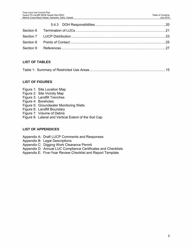
LIST OF TABLES Table 1: Summary of Restricted Use Areas ............................................................................... 15 LIST OF FIGURES Figure 1: Site Location Map Figure 2: Site Vicinity Map Figure 3: Landfill Trenches Figure 4: Boreholes Figure 5: Groundwater Monitoring Wells Figure 6: Landfill Boundary Figure 7: Volume of Debris Figure 8: Lateral and Vertical Extent of the Soil Cap LIST OF APPENDICES Appendix A: Draft LUCP Comments and Responses Appendix B: Legal Descriptions Appendix C: Digging Work Clearance Permit Appendix D: Annual LUC Compliance Certificates and Checklists Appendix E: Five-Year Review Checklist and Report Template

Final Land Use Control Plan Quarry Pit Landfill (MCB Hawaii Site 0002) Marine Corps Base Hawaii, Kaneohe, Oahu, Hawaii
List of Acronyms
July 2015
iii
LIST OF ACRONYMS AND ABBREVIATIONS AAV Amphibious Assault Vehicle ASTM American Society for Testing and Materials BEQ Bachelor Enlisted Quarters BRAC Base Realignment and Closure CERCLA Comprehensive Environmental Response, Compensation, and
Liability Act CFR Code of Federal Regulations CLB Combat Logistics Battalion COPC chemical of potential concern CSRS Confirmation Study Ranking System CTO Contract Task Order CWA Clean Water Act DCE 1,1-dichloroethene DD Decision Document DL detection limit DLA Defense Logistics Agency DoD Department of Defense, United States DOE Department of Energy, United States DOH Department of Health, State of Hawaii DON Department of the Navy, United States DRO diesel range organic DU Decision Unit E2 Element Environmental, LLC EAL Environmental Action Level EC engineering control EPA Environmental Protection Agency, United States ETI Earth Tech, Inc. FAI Fukunaga & Associates, Inc. GIS Geographic Information System HEER Hazard Evaluation and Emergency Response Office HLA Harding Lawson Associates HMMWV High Mobility Multipurpose Wheeled Vehicle HOCC Hawaii One Call Center IAS Initial Assessment Study IC institutional control LRO lube oil range organic LUC Land Use Control LUCP Land Use Control Plan MCAS Marine Corps Air Station MCB Hawaii Marine Corps Base Hawaii MCON Military Construction μg/L microgram per liter mg/kg milligram per kilogram MI multi-increment MLI McDaniel Lambert, Inc. MW monitoring well MWASR Monitoring Well Abandonment Summary Report
Final Land Use Control Plan Quarry Pit Landfill (MCB Hawaii Site 0002) Marine Corps Base Hawaii, Kaneohe, Oahu, Hawaii
List of Acronyms
July 2015
iv
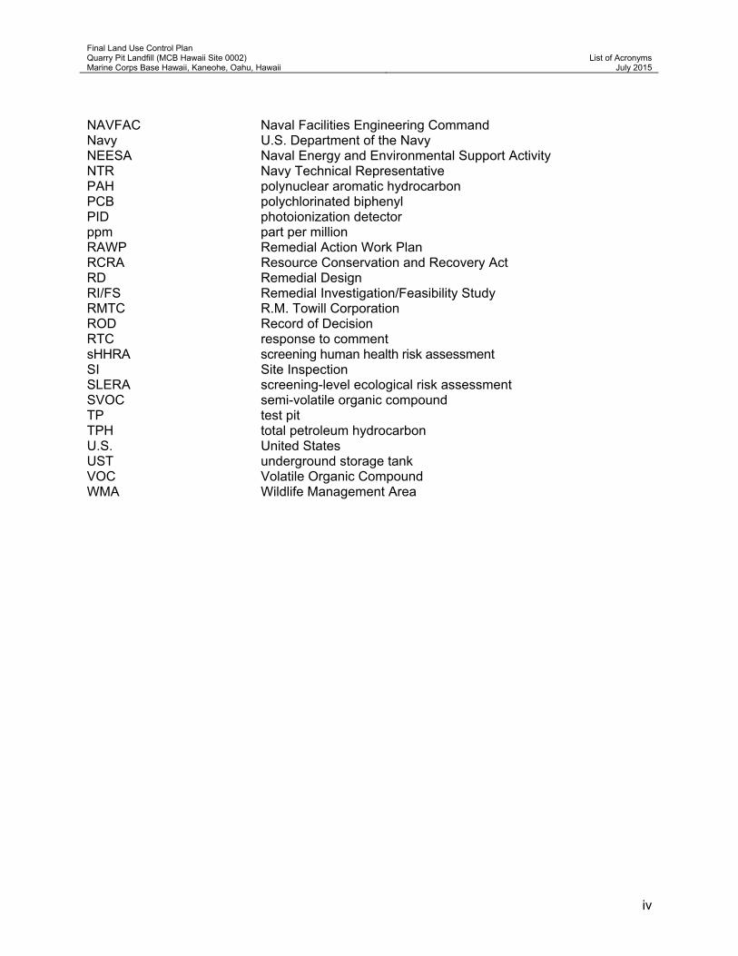
NAVFAC Naval Facilities Engineering Command Navy U.S. Department of the Navy NEESA Naval Energy and Environmental Support Activity NTR Navy Technical Representative PAH polynuclear aromatic hydrocarbon PCB polychlorinated biphenyl PID photoionization detector ppm part per million RAWP Remedial Action Work Plan RCRA Resource Conservation and Recovery Act RD Remedial Design RI/FS Remedial Investigation/Feasibility Study RMTC R.M. Towill Corporation ROD Record of Decision RTC response to comment sHHRA screening human health risk assessment SI Site Inspection SLERA screening-level ecological risk assessment SVOC semi-volatile organic compound TP test pit TPH total petroleum hydrocarbon U.S. United States UST underground storage tank VOC Volatile Organic Compound WMA Wildlife Management Area

Final Land Use Control Plan Quarry Pit Landfill (MCB Hawaii Site 0002) Marine Corps Base Hawaii, Kaneohe, Oahu, Hawaii
Section 1 Introduction
July 2015
1
Section 1 Introduction This Land Use Control Plan (LUCP) has been prepared to identify and discuss Land Use Controls (LUCs) required to protect human health and the environment at the former Quarry Pit Landfill (Site 0002), Marine Corps Base Hawaii (MCB Hawaii), Kaneohe, located on Oahu, Hawaii (Figure 1).
Soil and groundwater at the site contains residual levels of chemicals at concentrations that do not pose an immediate risk to human health, but do exceed levels that allow for unrestricted land use. The Navy will use this LUCP to implement the LUCs needed to ensure the long-term integrity of LUCs at the site, protect human health, and complete the final remedy.
The purpose of this LUCP is to recommend notice, monitoring, and enforcement mechanisms needed to ensure long-term effectiveness of the LUCs at the site, and to clearly identify the roles and responsibilities of the Navy, State of Hawaii Department of Health (DOH), MCB Hawaii, and subsequent property owners tasked with maintaining the LUCs.
This LUCP was prepared by Element Environmental, LLC (E2) for the United States (U.S.) Department of the Navy (DON), Naval Facilities Engineering Command, Hawaii (NAVFAC Hawaii), under the Architect and Engineering Services, Contract N62742-11-D-1821, Contract Task Order (CTO) 0021. This LUCP has been developed in cooperation with and with the agreement of all responsible parties. This LUCP was submitted for review to the DOH. Responses to comments on the Draft LUCP are included in Appendix A.
The LUCs are being implemented as part of the final remedy selected for the site pursuant to the Comprehensive Environmental Response, Compensation and Liability Act (CERCLA) and the National Oil and Hazardous Substances Pollution Contingency Plan (40 Code of Federal Regulations [CFR] 300).
The following LUCs are required for the Quarry Pit Landfill:
Restriction of future land use to recreation use (e.g., park/playfield, etc.), training (non-ground disturbing), or industrial/commercial use with land use restrictions;
Monitor the institutional (legal) controls with geographic information systems (GIS) applications and project reviews;
Maintenance of a two-foot cap to prevent exposure of debris buried in the landfill;
Land use restrictions/concerns through the Base dig permit process;
Prohibition of unauthorized disturbance, excavation, removal, or use of site soil;
CERCLA five-year reviews of LUC effectiveness with compliance reporting; and
Decommissioning of monitoring wells (see the Final Monitoring Well Abandonment Summary Report (MWASR) dated June 2014 and Addendum to the Final MWASR dated September 2014 [E2 2014b and 2014c, respectively]).
The overall objective of these LUCs is to protect human health by preventing exposure to debris and/or contaminated soils left in place at the site. The selection of these LUCs was based on a Decision Document (DD) (E2 2014a) prepared for the site. The DOH has provided regulatory

Final Land Use Control Plan Quarry Pit Landfill (MCB Hawaii Site 0002) Marine Corps Base Hawaii, Kaneohe, Oahu, Hawaii
Section 1 Introduction
July 2015
2
oversight during the development and evaluation of remedial alternatives, and has concurred with the selection of LUCs as part of the final remedy for the site.
The implementation of LUCs, as detailed in this LUCP, is being conducted in accordance with the following policy and guidance issued by the Department of Defense (DoD), DON, and the U.S. Environmental Protection Agency (EPA):
Policy on Land Use Controls Associated with Environmental Restoration Activities [includes DoD Guidance on Land Use Controls Associated with Environmental Restoration Activities for Property Planned for Transfer out of Federal Control] (DoD 2001a).
Guidance on Land Use Control Agreements with Environmental Regulatory Agencies (DoD 2001b).
Monitoring and Enforcement of Land Use Controls (DON 2003). Includes Principles and Procedures for Specifying, Monitoring and Enforcement of Land Use Controls and Other post-Record of Decision (ROD) Actions (EPA and DON 2003).
Land Use Controls. Policy Memorandum 99-02 (DON 1999).
Sample Federal Facility Land Use Control ROD Checklist with Suggested Language [includes Navy/Army/Defense Logistics Agency [DLA] Remedial Design [RD] or Remedial Action Work Plan [RAWP] Checklist] (EPA 2006).
A Guide to Establishing Institutional Controls at Closing Military Installations (DoD 1998).
Land Use Controls at DOD Transferring Properties. Base Realignment and Closure (BRAC) Environmental Program Fact Sheet. Draft (DoD 2002).
Institutional Controls: A Guide to Implementing, Monitoring, and Enforcing Institutional Controls at Superfund, Brownfields, Federal Facility, Underground Storage Tank (UST) and Resource Conservation and Recovery Act (RCRA) Corrective Action Cleanups. Draft (EPA 2002).
Additional guidance regarding the effective use, monitoring, and enforcement of LUCs were also consulted during the preparation of this LUCP (American Society for Testing and Materials [ASTM] 2005; Borak and Wagner 2005; Connell and Pickett 2000; DoD 1997; U.S. Department of Energy [DOE] 2000; and EPA 2000a, 2000b, and 2004).

Final Land Use Control Plan Quarry Pit Landfill (MCB Hawaii Site 0002) Marine Corps Base Hawaii, Kaneohe, Oahu, Hawaii
Section 2 Background Information
July 2015
3
Section 2 Background Information 2.1 Site Locations and Description MCB Hawaii is located on the windward side of Oahu, and occupies the entire 2,951-acre Mokapu Peninsula. MCB Hawaii is bordered to the west by Kaneohe Bay, to the north by the Pacific Ocean, to the east by Kailua Bay, and to the south by the Nu’upia Ponds Wildlife Management Area (WMA) (Figure 2).
The Quarry Pit Landfill Site is located in the south-central portion of MCB Hawaii and is approximately 12.65 acres and is bounded by Mokapu Road on the north, the 3rd Marine Motor Pool (“motor pool” or “Marine Motor Pool”) (Building 6030) and a small wetland area on the east, Querulous Street to the south, and Harris Avenue on the west.
The nearest occupied buildings are: a Sprung instant structure, which is located on the southern portion of the landfill; the Combat Logistics Battalion 3/CLB-3 Medical Platoon Navy Personnel Unit Medical Logistics building (“Medical Warehouse”) (Building 4088), which lies to the west of the site; and Area 6755C3, High Mobility Multipurpose Wheeled Vehicle (HMMWV) Egress Assistance Trainer, consisting of one Sprung instant structure and one small wood structure, which lies to the southwest of the site.
The central portion of the landfill is currently vacant, but was used by Paintball Hawaii & Pacific AirSoft, a commercial paintball and airsoft facility that operated onsite from 2000 until January 2012. The grass and shrubs within a large section of the former paintball field were maintained by mowing or weed whacking. The remainder of the site, with the exception of a grassy area adjacent to Mokapu Road to the north, is overgrown with vegetation.
2.2 Site History The site was first excavated for construction material of Fort Hase and Naval Air Station Kaneohe Bay in the 1940s. In the 1950s the two bases were merged to form the Marine Corps Air Station (MCAS) Kaneohe Bay. The site was used intermittently between the 1940s and 1972 for storage and/or disposal. Documents indicate that the landfill was open for solid waste disposal between the years from 1972 to 1976 when it was the primary on-base landfill. During that period most solid waste was accepted except for residential waste. Approximately 165,379 cubic yards of waste was disposed at the landfill. Wastes included petroleum, oil, lubricants, solvents, paints, thinners, batteries, mercury, and transformer oils. Borehole logs for the construction of the adjacent Medical Warehouse showed general trash, such as, cans, paper, wood, and unidentified organic debris.
Some time prior to 1959, two buildings were constructed adjacent to, or partially on, the southwest corner of the landfill. Building 1020, the building located furthest to the south, was a theater, and Building 116 was a self-serve laundromat (DON 1967). The Medical Warehouse, located on the west side of the site, was built in 1989. The motor pool was constructed on the east side of the adjacent wetland in 1990 (R.M. Towill Corporation [RMTC]).
Final Land Use Control Plan Quarry Pit Landfill (MCB Hawaii Site 0002) Marine Corps Base Hawaii, Kaneohe, Oahu, Hawaii
Section 2 Background Information
July 2015
4
2.3 Previous Investigations and Removal Actions This section provides an overview of previous investigations, studies, and site reconnaissance conducted between 1984 and 2010. There have been four prior studies for the site:
the Initial Assessment Study (IAS) of Marine Corps Air Station (MCAS) Kaneohe Bay, Hawaii (Naval Energy and Environmental Support Activity [NEESA] April 1984);
Site Inspection (SI) Quarry Pit Landfill, Marine Corps Air Station (MCAS), Kaneohe Bay, Hawaii (Harding Lawson Associates [HLA] September 20, 1989);
Focused Site Inspection Report, Site 2, Quarry Pit Landfill, Marine Corps Base Hawaii, Kaneohe Bay, Oahu, Hawaii (DON March 2007a); and
the Remedial Investigation/Feasibility Study (RI/FS) for the Quarry Pit Landfill (MCB Hawaii Site 2), Marine Corps Base Hawaii, Kaneohe, Hawaii (E2 September 2012).
The 2012 RI/FS recommended LUCs be implemented at the site through the development of a LUCP.
Initial Assessment Study (NEESA 1984). The NEESA performed an IAS at MCB Hawaii to identify and assess sites posing potential threats to human health or the environment caused by past hazardous substance storage, handling, or disposal practices at naval activities (NEESA 1984). The IAS, which is similar to a preliminary assessment under the CERCLA, used information from historical records, aerial photographs, surface and aerial surveys, and personnel interviews to identify 18 sites at MCB Hawaii, including the Quarry Pit Landfill. Each site was then evaluated for contamination characteristics, migration pathways, and pollutant receptors. The evaluation used the two-step Confirmation Study Ranking System (CSRS) to systematically evaluate the relative severity of potential problems. The CSRS determines whether a confirmation study, which is similar to the SI under CERCLA, should be recommended for a site. The IAS recommended no confirmation studies for the Quarry Pit Landfill (Site 0002) provided it be left undisturbed, and listed the site as a construction hazard area. The EPA Region 9 representatives, however, reviewed the findings of the IAS, and after discussions with NAVFAC Field Division Pacific representatives, requested that further investigation be performed at the site (DON 2007).
Test Borings – BEQ Parking Lot Northeast of Building 4088 (1977). On June 15, 1977, Soils International completed a report entitled “Report, Foundation Investigation, Modernization of Bachelor Enlisted Quarters, Kaneohe Marine Corps Air Station, Kaneohe, Oahu, Construction Contract No. N62471-77-C-1351”. According to Fukunaga and Associates, Inc. (FAI) (2011) who reviewed the document, borings and test pits were installed for a Bachelor Enlisted Quarters (BEQ) parking lot located northeast of Building 4088 (currently referred to as the “Lemon Lot”, see Figure 2). Subsurface conditions encountered in the borings and test pits generally consisted of approximately 15 to 17.5 feet of fill mixed with “sanitary landfill” material consisting of lumber, metal debris, plastic, and cloth.
The landfill materials in some borings extended to depths of about four to eight feet below the water table. The fill was classified as “moderately firm” clayey silty sand and was underlain by dense coral limestone to the bottom of the borings at depths ranging from 15 to 20 feet below existing grades.

Final Land Use Control Plan Quarry Pit Landfill (MCB Hawaii Site 0002) Marine Corps Base Hawaii, Kaneohe, Oahu, Hawaii
Section 2 Background Information
July 2015
5
The test pits encountered similar fill material underlain by sanitary landfill material to the bottom of the excavations at 0.5 to 7.5 feet below existing grades at the time of their investigation.
Test Borings – Medical Warehouse (Building 4088) (1984). A series of test borings, drilled in 1984 prior to construction of the Medical Warehouse (Building 4088), indicated the presence of refuse in some locations in the future warehouse site. Building 4088 is located adjacent to the west side of the landfill (Figure 2).
According to FAI (2011), who reviewed the August 16, 1985, “Record Drawing FY 86 Military Construction (MCON) Project P-502 Medical Warehouse, MCAS Kaneohe Bay, NAVFAC Drawing No. 7064263 – 7064266,” subsurface conditions encountered in available borings generally consisted of 0.5 to 9 feet of fill underlain by stiff silt and clay or medium dense sandy coral gravel and sand, and/or moderately hard coral. “Rubbish fill” was encountered in some of the borings drilled at the southeastern side of the warehouse. The logs described the rubbish fill as miscellaneous debris, broken cans, wood, plastic, paper, organic matter, wire, and papers. Below the fill and underlying rubbish fill, coral reef deposits consisting of medium dense coralline sand and gravel and moderately hard coral were generally encountered to the bottom of the borings to depths of 11.5 to 65 feet below existing grades.
Based on the 1985 record drawing, this warehouse consists of a pre-engineered building supported on shallow foundations founded on compacted granular fill. Foundation notes called for an allowable soil bearing pressure of 2,500 pounds per square foot for footings founded on compacted granular fill. Structural details on the drawings called for removal of trash to depths of about 9 to 16 feet below existing grades at the time of construction. The details also called for backfilling the excavations, approximately 6 to 13 feet below the footing, with compacted granular fill (FAI 2011).
Test Borings – Miles Equipment Facility and Rations Warehouse (Building 3098) (1986). According to FAI (2011), who reviewed the January 17, 1986, “Record Drawing, Miles Equipment Facility and Rations Warehouse (Building 3098), Marine Corps Air Station, Kaneohe Bay, Hawaii, NAVFAC Drawing No. 7056608,” borings drilled for Building 3098, Miles Equipment Facility and Rations Warehouse, located near the southeastern corner of the landfill site, generally consisted of coralline gravel to depths of 25 feet below existing grades. Rubbish fill was not indicated in the boring logs for this building. This structure is now identified as HMMWV Egress Assistance Trainer (see Figure 2).
Test Borings – Marine Motor Pool (Building 6030) (1987). According to FAI (2011), who reviewed the June 3, 1987, “Record Drawing, FY87 MCON Project P-530, Combat Vehicle & Field Maintenance Shops (Building 6030), Part A, Marine Corps Air Station, Kaneohe Bay, Hawaii, NAVFAC Drawing No. 7069545, 7069546,” subsurface conditions encountered in the borings for this facility generally consisted of several feet of clayey silt at the surface underlain by “calcareous rubblestone” to the bottom of the borings at 5 to 21.5 feet below existing grades (see Figure 2).
Site Inspection (HLA 1989). In response to regulatory comments on the IAS, a SI was conducted at the Quarry Pit Landfill by HLA in 1989. The purpose of the SI was to evaluate whether the wastes disposed of at the landfill posed a threat to human health or the environment. The scope of the investigation included collection and analysis of groundwater samples, and performance of a water level assessment.

Final Land Use Control Plan Quarry Pit Landfill (MCB Hawaii Site 0002) Marine Corps Base Hawaii, Kaneohe, Oahu, Hawaii
Section 2 Background Information
July 2015
6
The target analytes in the groundwater were volatile organic compounds (VOCs), polynuclear aromatic hydrocarbons (PAHs), lead, and mercury. Fuel-related hydrocarbons were detected in the groundwater sample collected from monitoring well (MW) MW-05, which is located cross-gradient from the landfill and 250 feet directly downgradient from the exchange service station (Figure 2). The report concluded that leaking fuel tanks at the service station, not the Quarry Pit Landfill, were the source of the fuel-related hydrocarbons in the groundwater at MW-05.
The compound 1,1-dichloroethene (DCE) was detected in the groundwater sample from cross-gradient well MW-06 at its detection limit (DL) of 1.0 microgram per liter (μg/L), which was below the National Primary Drinking Water Standard maximum concentration level of 7 μg/L for 1,1-DCE. No other target analytes were detected in the groundwater samples collected from the other MWs.
Although the SI report concluded that the public health risks at the time due to the landfill were likely minimal, it recommended that more comprehensive investigations and risk assessments be considered should land-use changes be planned for the landfill (HLA 1989).
Wetland Boundary Delineations (USACE 2002). Ground-based wetland boundary delineations were determined at MCB Hawaii during 2001 to 2002 by a qualified wetland ecologist with the USACE (2002), assisted by MCB Hawaii natural resources staff. The wetland located between the Quarry Pit Landfill and the motor pool was one of seven wetland areas identified and mapped as jurisdictional under the criteria of the Clean Water Act (CWA) administered by the USACE. The wetland was described in the report as follows:
The wetland is part of a large swale that runs along the west side of the motor pool and includes a drainage sump that collects runoff from the adjacent motor pool parking lot;
In addition to overland runoff, there are four 36-inch-diameter reinforced concrete pipe culverts (all integrated into a grouted rock apron), which terminate in this area;
The west side of the wetland, adjacent to the landfill, has a berm that is four to six feet higher than the wetland bottom and two to three feet higher than the landfill surface;
An overflow swale appears to exit out of this wetland area towards Nu’upia Ponds to the south; however, a gradual upland slope precludes this from happening except under very large flow conditions;
The edges of the pond were dominated by Christmas berry that blended into sourbush in the wetland. Other vegetation included milo, koa haole, and kamani. A lone wiliwili tree (Erythina sandwicensis) was observed at the south end of the wetland. Aquatic species observed included toads and mosquito fish.
The wetland was opportunistically plowed (not cleared) on July 11, 2001 using amphibious assault vehicles (AAVs). The AAVs helped to take the vegetation all the way down to the ground surface. Indian fleabane, California grass, and Christmas berry were removed from the centers of the wetland, but were still dominant at the edges. Prior to the AAV clearing, the center of the wetland was dominated by California grass. In December 2001, the large open area was recolonized primarily with sedges. Clearing with the AAVs enhances the amount of available habitat for waterbirds.

Final Land Use Control Plan Quarry Pit Landfill (MCB Hawaii Site 0002) Marine Corps Base Hawaii, Kaneohe, Oahu, Hawaii
Section 2 Background Information
July 2015
7
The USACE report (2002) stated that the primary function of this wetland is to filter pollutants from runoff. The wetland also provides habitat to aquatic species. MCB Hawaii has annually operated the AAVs in the area to keep it open for drainage, control invasive grasses, and provide foraging for endangered waterbirds.
Focused Site Inspection (ETI in DON 2007). In 2007, Earth Tech, Inc. (ETI) conducted a focused SI at the Quarry Pit Landfill (Site 0002) (DON 2007) to determine whether COPCs from the landfill pose a threat to human health or the environment at the former Paintball/AirSoft facility and to evaluate the lateral and vertical extent of refuse and the thickness of the landfill cover. The scope of the investigation included a geophysical survey, six test pit excavations, soil sampling, sampling of soil-filled drums, and soil gas sampling.
The geophysical survey did not conclusively define the lateral and vertical extent of the landfill; however, test pits confirmed the thickness of the landfill cap, which was found to vary between two- and five-feet thick.
According to ETI (ETI in DON 2007), subsurface conditions encountered in test pits generally consisted of several feet of sandy silt and clayey gravel fill at the surface underlain by rubbish to the bottom of the test pits at depths of 2 to 5.5 feet below existing grades. Rubbish encountered in these pits generally included plastic sheeting, electrical wire fragments, plastic, wood, particle board debris, a metal wheel, 55-gallon drum fragments, Styrofoam, paper, a bicycle, glass, concrete, metal tubing, plastic cartons, glass bottles, glass panes, textiles, plastic bags, fast food wrappers, and electrical wire insulation. Excavation of the test pits were stopped in rubbish. Groundwater was not encountered in the test pits due to their relatively shallow depths.
Target analytes for the surface and subsurface soil samples included total petroleum hydrocarbon (TPH) as diesel range organics (DRO) and lubrication range organics (LRO), VOCs, semi-volatile organic compounds (SVOCs), polychlorinated biphenyls (PCBs), mercury, other metals and elements. Only three analytes (acetone, benzo[a]pyrene, and TPH [carbon C10 to C40]) were detected in the surface soil samples (collected from two of the six test pits) at concentrations exceeding the DOH Environmental Action Levels (EALs). An informal risk assessment, conducted by the Navy Environmental Health Center, indicated that there was no unacceptable risk to potential users and workers from soils at the former Paintball/AirSoft facility.
Detailed findings from the six exploratory test pits that were excavated at the west side of the landfill (Test Pit [TP]-1 through TP-6) are as follows:
TP-1, located in the northwest corner of the landfill, had a three-foot layer of cover soil. Rubbish encountered in TP-1 included plastic sheeting, electrical wire fragments, miscellaneous plastic debris, and wood and particle board debris. Target analytes detected in the soil cover included the VOCs 2-butanone and acetone and the metals antimony, cobalt, and nickel; however, only acetone exceeded its EAL.
TP-2, located southwest of TP-1 in an area that had been graded by the tenant, had a 2.25-foot layer of cover soil. Rubbish encountered in TP-2 included a metal wheel, 55-gallon drum fragments, Styrofoam, plastic debris, plastic sheeting, and oxidized steel debris. Target analytes detected in the soil cover included the VOC methylene chloride, TPH (C10 to C40), and the metal zinc; however, only TPH exceeded its EAL.

Final Land Use Control Plan Quarry Pit Landfill (MCB Hawaii Site 0002) Marine Corps Base Hawaii, Kaneohe, Oahu, Hawaii
Section 2 Background Information
July 2015
8
TP-3, located southeast of TP-2, had a two-foot layer of cover soil. Rubbish encountered in TP-3 included cinder block and concrete rubble. Target analytes detected in the soil cover included the VOCs ethylbenzene, m,p-xylene, o-xylene, and toluene; and the metals cadmium and mercury; however, none of the analytes were detected at concentrations that exceeded EALs.
TP-4, located south of TP-2, had a five-foot layer of cover soil. Rubbish encountered in TP-4 included plastic bags with plastic, paper, Styrofoam, and some wood chips. Target analytes detected in the soil cover included the metals aluminum, antimony, chromium, copper, iron, manganese, and silver; however, none of the metals were detected at concentrations that exceeded EALs.
TP-5, located southeast of TP-4, had a three-foot layer of cover soil. Rubbish encountered in TP-5 included plastic liners, paper, plastic trash, and wood debris. Target analytes detected in the soil cover included 11 of the 16 PAHs monitored by DOH and the metals lead and tin; however, only the PAH benzo(a)pyrene exceeded its EAL.
TP-6, located south of TP-4 and TP-5, had a 3.5-foot layer of cover soil. Rubbish encountered in TP-6 included plastic sheeting, metal tubing, a bicycle, broken glass, paper, and concrete. Target analytes detected in the soil cover included the PCB Aroclor-1260 and the metals arsenic and selenium; however, none of the analytes were detected at concentrations that exceeded EALs.
Three permanent soil gas wells and six temporary soil gas wells were installed at the site. The three permanent wells were located adjacent to the east side of the Medical Warehouse (Wells GP #1, #2, and #3). The six temporary wells were located within the landfill (Wells TP-1 thru TP-6). All nine of the wells were monitored for VOCs, using a MiniRae 2000 photoionization detector (PID). The soil gas well with the highest concentration of VOCs, Well GP #3, was sampled and analyzed for site COPCs including VOCs in air, using EPA Method TO-14A, and Permanent Gases, using ASTM D1946-90. Chemicals of potential concern (COPCs) were not detected in the gas sample at concentrations exceeding screening criteria (DOH’s 2005 shallow soil gas action levels for evaluation of vapor intrusion for residential land use); however, acetone, 2-butanone, benzene, toluene, ethylbenzene, m,p-xylene, o-xylene, 4-ethyltoluene, 1,2,4-trimethylbenzene, and 2-propanol were detected in the sample at concentrations above laboratory DLs. Methane was not detected in any of the three well samples.
Six temporary soil gas probes, installed at the bottom of each of the six test pits, were monitored for VOCs (using a PID) and the landfill gases methane, carbon dioxide, and oxygen, using a GA-90 landfill gas analyzer. PID readings in the temporary wells ranged from a low of 1.6 parts per million (ppm) in TP-6 to a high of 33.5 ppm in TP-1. Methane was not detected in any of the temporary gas wells. All of the wells had elevated concentrations of carbon dioxide and decreased concentrations of oxygen.
The soil contained within the drums on the east side of the landfill outside of the former Paintball/AirSoft facility was similar to that used for the landfill cover. Arsenic and nickel concentrations were detected at concentrations slightly above background concentrations and EALs. It was not known if the presence of arsenic and nickel was from the deteriorating metal drums or from the soils used to fill the drums. ETI concluded that the soils within the drums be considered non-hazardous for the purposes of disposal according to the criteria in 40 CFR §261.24.
Final Land Use Control Plan Quarry Pit Landfill (MCB Hawaii Site 0002) Marine Corps Base Hawaii, Kaneohe, Oahu, Hawaii
Section 2 Background Information
July 2015
9
The report recommended the following:
Excavations be performed at each of the geophysical transect locations to better define the landfill boundary;
At least one additional round of landfill gas monitoring be conducted at the Medical Warehouse perimeter gas probes for methane and carbon dioxide using field instrumentation;
All of the soil-filled barrier drums present on the east side of the landfill be excavated and removed from the site and disposed of at an approved landfill before they deteriorate further;
An additional round of groundwater samples be collected and analyzed; and
An ecological risk assessment be performed to more fully assess any impacts the COPCs at the Quarry Pit Landfill may have on the environment, including the adjacent wetland.
Site Reconnaissance (E2 2010). A site reconnaissance of the subject property was conducted on May 7, 2010, during the proposal development phase of the RI/FS. E2 personnel met with Mr. Joel Narusawa, the NAVFAC Hawaii Navy Technical Representative (NTR) for the project, and Project Manager Mr. Brett Chambers and Natural Resource Manager Mr. Lance Bookless of the Environmental Compliance and Protection Department of MCB Hawaii. Mr. Bookless walked the field crew through portions of the project site to familiarize the project team members with the location of the wetland and the vegetation that would need to be cleared for the field work. Mr. Bookless requested that a 30-meter/100-foot vegetative buffer be left in place for dust and silt control at the northern half of the site (north along Mokapu Road, west along the Lemon Lot, and east along the boundary of the adjacent wetland). If the area needed to be cleared to permit freedom of movement of construction equipment, this buffer could be removed; however, new vegetation would need to be planted in its place, preferably native.
Observations of general site conditions were made that could affect sampling procedures, sampling locations, and health and safety requirements. The following observations were documented during the reconnaissance:
The presence of one Sprung instant structure was observed on the southern portion of the landfill.
The locations of adjacent structures (i.e., Medical Warehouse [Building 4088], 3rd Marine Motor Pool [Building 6030], and Area 6755C3 HMMWV Egress Assistance Trainer) were verified.
The middle of the site was relatively clear of vegetation and contained various small obstacles/barriers utilized in the former Paintball/AirSoft operations.
The northern end of the site was heavily vegetated with California grass and koa haole trees.
A small soil berm approximately two to three feet in height was observed along the eastern boundary of the landfill adjacent to the wetland. A portion of the wetland was observed in the northern half of the site during the reconnaissance. The wetland bottom appeared to be four to six feet below the top of the berm. The wetland appeared to be relatively dry with some areas of standing water; however, MCB Hawaii personnel have observed a fair amount of standing water in the area as noted by the presence of various
Final Land Use Control Plan Quarry Pit Landfill (MCB Hawaii Site 0002) Marine Corps Base Hawaii, Kaneohe, Oahu, Hawaii
Section 2 Background Information
July 2015
10
birdlife. A stone revetment wall was observed along the eastern bank of the wetland near the edge of the motor pool parking lot.
The three gas probe wells adjacent to the Medical Warehouse were observed to be intact and finished flush to grade.
The existing monitoring wells surrounding the landfill were located. Seven of the eight wells were finished aboveground with traffic bollards. The aboveground outer well casings were intact, but all were rusted and several of the outer well covers were damaged or missing. It appeared that one of the wells located along Mokapu Road was damaged with the aboveground outer well casing and the inner well cover both missing. The well appeared to still be intact below the existing ground surface.
RI/FS (E2 2012). In 2011, a RI/FS was prepared for the site. The project area was divided into a total of seven decision units (DUs) - the Quarry Pit Landfill was divided into DU-1 through DU-5, and the adjacent wetland area was divided into DU-6 and DU-7. The nature and extent of solid waste in the Quarry Pit Landfill were evaluated by conducting a geophysical survey, excavating trenches (20 total, Figure 3), drilling boreholes (210 total, Figure 4), and installing/sampling groundwater monitoring wells (16 total, Figure 5) throughout the landfill area. Trenching and drilling were not conducted in either of the adjacent wetland DUs; however, multi-increment MI) surface sediment and surface water samples were collected from the wetland DUs. The magnitude and extent of COPCs in soil and groundwater in the landfill, and in surface sediment and surface water in the adjacent wetland were evaluated by collecting and analyzing the appropriate samples. Landfill soil gases were evaluated in several locations within and along the perimeter of the landfill using hand-held meters. The landfill boundary was confirmed by various investigation surveys (i.e., geophysical survey, topographic survey, soil borings, trenching, and review of previous investigations and historical documents) (Figure 6).
The volume of debris (Figure 7) within the Quarry Pit Landfill was estimated to be approximately 90,400 cubic yards, with an average debris thickness of 5 feet, a maximum debris thickness of 8.5 feet, and a minimum debris thickness of zero feet. The debris layer at the Quarry Pit Landfill was predominately composed of a wide array of household debris with small amounts of industrial and medical / debris mixed with sandy to silty clay.
The lateral and vertical extent of the soil cap (Figure 8) was evaluated by excavating trenches and installing soil borings throughout the landfill. Debris was not observed in about 25 of the 150 individual soil borings. In the soil borings where debris was encountered, a relatively thin soil cap thickness (as thin as 13 inches) was measured and recorded in 27 boreholes, most of which were located in DU-1 and DU-2. Figure 4 shows the variations of the thickness of the soil cap based on stratigraphic data collected from the soil borings. Areas of the landfill colored red indicate a soil cover thickness that is less than 2 feet (an estimated area of 2.72 acres). The nature of the soil cap material consists primarily of dry to moist, brown to dark brown clays, sandy or silty clays, and clayey sands.
Screening Human Health Risk Assessment: The risks presented in the screening human health risk assessment (sHHRA) (McDaniel Lambert, Inc. [MLI] in E2 2012) are based on soil and sediment MI samples that are representative of each DU, assuming that potential receptors will not be spending a large amount of time in any specific area. The sHHRA results for the two use scenarios evaluated under Concept #1 (Physical Training Area and Recreational Area - Park or Playfield), which MCB Hawaii has indicated are the most likely future uses, are summarized here.

Final Land Use Control Plan Quarry Pit Landfill (MCB Hawaii Site 0002) Marine Corps Base Hawaii, Kaneohe, Oahu, Hawaii
Section 2 Background Information
July 2015
11
The physical training use (adult) cancer risks are within the EPA risk management range for the landfill DU-1 through DU-5.
The park/playfield recreational use (adult and child) cancer risks are within the EPA risk management range for the main portion of the landfill, which are DU-1 through DU-4. The cancer risks for DU-5, which is the berm area between the landfill and the adjacent wetlands, exceed the upper end of the risk management range (1x10⁻⁴). However, the exposure risk calculation for DU-5 is considered conservative because it assumes that receptors would only be spending time within DU-5, which is unlikely since it is a bermed area that will likely not be used. Due to elevated levels of PCBs in discrete trench locations in DU-1 through DU-4, future use as a playground area or any other type of recreational use concentrated in small portions of the landfill would require further characterization.
The sHHRA also evaluated risks to potential receptors within DU-6 and DU-7. The conceptual site model determined that the exposure pathways from soil and surface water (contaminants found in wetland sediment/surface water via runoff/erosion) were incomplete for onsite users and construction workers, but potentially complete for wetland maintenance workers. The exposure risks to maintenance workers were determined to be within acceptable risk levels and no further action for the wetland area was recommended.
Screening Level Ecological Risk Assessment: The screening-level ecological risk assessment (SLERA) (MLI in E2 2012) incorporated site-specific information from the biological survey and provided an evaluation of potential ecological risks from contamination in the wetland area, which serves as a filter for pollutants in runoff from the Motor Pool parking lot and the surrounding areas. Results for ecological receptors are varied; complete pathways exist for plants and invertebrates (via dermal contact/uptake), and birds (via ingestion/biotic uptake). Based on the RI findings and risk assessment, no further action for the Quarry Pit Landfill is required at this time due to ecological risk concerns.
2.4 Current and Potential Future Site Land Use The central portion of the landfill was left undeveloped from 1976 to 2000. Starting in 2000, Paintball Hawaii & Pacific AirSoft, a commercial paintball operation, used the southern two-thirds of the area as a paintball recreational facility (FAI 2011). Paintball operations closed in January 2012, and this area is now vacant.
There is one temporary structure (a Sprung) located in the southern portion of the landfill, which is reportedly used for storage. The floor of the Sprung consists of impermeable, interlocking rubber tiles.
A parking structure has recently been constructed over a small portion of the landfill (west-central side) near the former lemon lot.
The remainder of the landfill is currently unused and is overgrown with vegetation; however, the site has potential for use by the Hawaiian Stilt for foraging. Potential future land uses include: recreational uses as a park/playfield; multi-purpose troop training area; or industrial/commercial uses; and maintaining as an open green space in its natural state.

Final Land Use Control Plan Quarry Pit Landfill (MCB Hawaii Site 0002) Marine Corps Base Hawaii, Kaneohe, Oahu, Hawaii
Section 2 Background Information
July 2015
12
2.5 Remedy in Place The areas where LUCs will be implemented at the site are shown on Figure 2, and legal descriptions of these LUC boundaries are provided in Appendix B. Implementation of LUCs will require the performance of CERCLA five-year reviews to evaluate the continued effectiveness of the remedy; reporting of the inspection and evaluation results; and notification to regulators of any changes in risk, remedy, or land use. The inspections and reporting requirements described herein will be effective immediately upon concurrence with this LUCP by the Navy and DOH. Once put into effect, the requirements set forth in this document will remain applicable to the current landowner and all subsequent landowners until the LUCs are no longer needed and are terminated.

Final Land Use Control Plan Quarry Pit Landfill (MCB Hawaii Site 0002) Marine Corps Base Hawaii, Kaneohe, Oahu, Hawaii
Section 3 Land Use Control Performance Objectives
July 2015
13
Section 3 Land Use Control Performance Objectives Generally stated, the LUC performance objectives for the site are to: 1) protect human health; 2) prevent the disturbance of debris and/or contaminated soil remaining on-site, and; 3) restrict land use to activities compatible with the final remedy at the areas where LUCs apply. Specific LUC performance objectives are described below.
3.1 Land Use Restrictions Protect human health by reducing rates of exposure to debris and/or contaminated soils
left in place at the LUC area.
Ensure that site soil is not disturbed, excavated, or removed unless done in accordance with special handling procedures and with the prior consent of the Navy, MCB Hawaii, and DOH.
Ensure no unauthorized development and use of the LUC area for residential housing, elementary or secondary schools, and child care facilities.
Ensure that land use restrictions are maintained until the concentrations of hazardous substances in the soil are at such levels to allow for unrestricted use and exposure, or until LUCs are no longer needed due to changes in site conditions.
3.2 Notice Ensure that all future site users and environmental regulators are aware that
contamination is present in certain areas at the site at concentrations that may pose a risk under certain exposure scenarios.
Ensure that all future site users and environmental regulators are aware that land use restrictions are imposed at the site to protect human health.
Ensure that legal notice of site contamination and LUCs is provided in multiple documents where a person would normally look for such notice.
Ensure that legal notices of LUCs are maintained in perpetuity or until they are no longer needed due to changes in site conditions.
3.3 Land Use Control Maintenance and Reporting Monitoring and Maintenance
- Ensure that the two-foot vegetated soil cap remains functional and is maintained in good condition and that the debris and/or contaminated soil left in place have not been disturbed.
- Ensure that LUCs remain in place, effective, and protective of human health and site conditions through five-year reviews.

Final Land Use Control Plan Quarry Pit Landfill (MCB Hawaii Site 0002) Marine Corps Base Hawaii, Kaneohe, Oahu, Hawaii
Section 3 Land Use Control Performance Objectives
July 2015
14
Compliance Reporting
- Ensure that LUC monitoring is being conducted.
- Facilitate Navy and DOH oversight and response action, if required.
- Ensure that specific points of contact for reporting are designated.
Mitigation and Enforcement
- Ensure landowner compliance with LUCs.
- Ensure well-defined enforcement processes and measures that can be conducted without long delays.
- Ensure that costs associated with LUC enforcement is covered by the party in breach.
Lastly, the responsibilities of interested parties to maintain, provide notice of, monitor, report on, and enforce LUCs are designated in Section 5.
Final Land Use Control Plan Quarry Pit Landfill (MCB Hawaii Site 0002) Marine Corps Base Hawaii, Kaneohe, Oahu, Hawaii
Section 4 Land Use Controls
July 2015
15
Section 4 Land Use Controls LUCs can consist of Engineering Controls (ECs) and/or Institutional Controls (ICs). The following section identifies the areas intended for LUCs and the ECs and ICs that have been or will be implemented to meet the LUC performance objectives. LUCs will remain in effect at the LUC area at the site until site conditions allow unrestricted land use and unlimited exposure. The use of several mechanisms provides a layering strategy that significantly increases the likelihood that site users and regulatory agencies will receive notice of the site contamination, LUCs, their associated rights, and responsibilities for maintaining the LUCs.
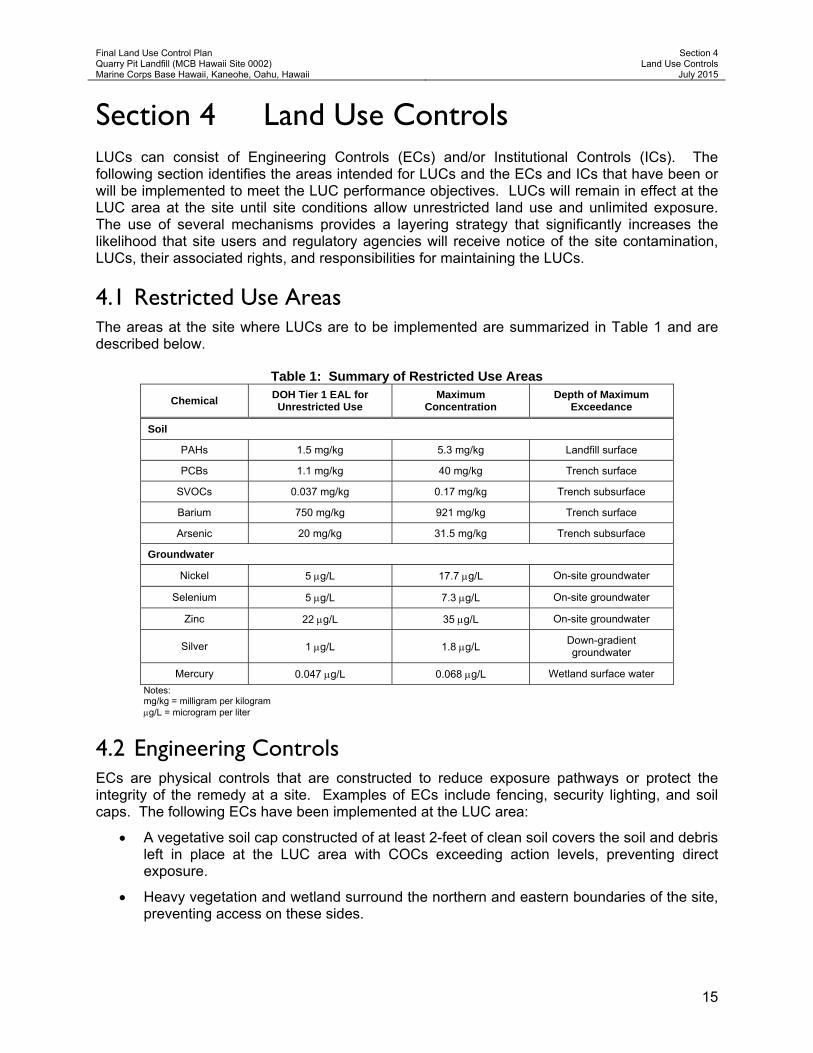
4.1 Restricted Use Areas The areas at the site where LUCs are to be implemented are summarized in Table 1 and are described below.
Table 1: Summary of Restricted Use Areas
Chemical DOH Tier 1 EAL for Unrestricted Use
Maximum Concentration
Depth of Maximum Exceedance
Soil
PAHs 1.5 mg/kg 5.3 mg/kg Landfill surface
PCBs 1.1 mg/kg 40 mg/kg Trench surface
SVOCs 0.037 mg/kg 0.17 mg/kg Trench subsurface
Barium 750 mg/kg 921 mg/kg Trench surface
Arsenic 20 mg/kg 31.5 mg/kg Trench subsurface
Groundwater
Nickel 5 g/L 17.7 g/L On-site groundwater
Selenium 5 g/L 7.3 g/L On-site groundwater
Zinc 22 g/L 35 g/L On-site groundwater
Silver 1 g/L 1.8 g/L Down-gradient groundwater
Mercury 0.047 g/L 0.068 g/L Wetland surface water
Notes: mg/kg = milligram per kilogram g/L = microgram per liter
4.2 Engineering Controls ECs are physical controls that are constructed to reduce exposure pathways or protect the integrity of the remedy at a site. Examples of ECs include fencing, security lighting, and soil caps. The following ECs have been implemented at the LUC area:
A vegetative soil cap constructed of at least 2-feet of clean soil covers the soil and debris left in place at the LUC area with COCs exceeding action levels, preventing direct exposure.
Heavy vegetation and wetland surround the northern and eastern boundaries of the site, preventing access on these sides.

Final Land Use Control Plan Quarry Pit Landfill (MCB Hawaii Site 0002) Marine Corps Base Hawaii, Kaneohe, Oahu, Hawaii
Section 4 Land Use Controls
July 2015
16
Buildings surround the western and southern boundaries of the site, restricting access on these sides.
4.3 Institutional Controls ICs are administrative and/or legal controls that provide notice of contamination, limit land uses, and/or require actions to be taken to protect human health at a site. Examples of ICs include deed notices and restrictions (easements and covenants), government LUC registries, zoning restrictions, and permits. The following ICs will be implemented at the LUC area:
MCB Hawaii permit review and approval processes
Monitor the institutional (legal) controls with geographic information systems (GIS) applications and project reviews
4.3.1 Construction Permit Process
To preclude the excavation and removal of soils with contamination from the LUC area to any other location, MCB Hawaii will add the coordinates of the LUC area into their GIS database. The MCB Hawaii will review all civil plans prepared for a project and will query the database to determine if potential construction will impact a LUC-restricted parcel. Land use at the site is restricted to recreational, training, and industrial/commercial use only. No residential use is allowed. If playgrounds are to be constructed, additional surface soil sampling at the specific playground location will be required to determine if additional protection measures will be required. In the event a plan is reviewed and determined to potentially impact a site, the MCB Hawaii will notify the builder and/or utility company of the LUC restrictions associated with the site and refer the builder to DOH for review and approval. The MCB Hawaii will coordinate with the builder, Navy, and DOH on any actions to be taken and either deny or permit the work to be conducted. This process will be reviewed during the five-year review to determine if any changes need to be implemented.
Excavation Permit. A copy of the MCB Hawaii excavation permit is provided in Appendix C. Prior to conducting intrusive activities, all Contractors are required to contact the Contracting Officer 30 calendar days in advance so the Facilities Department can implement and process permits for excavation activities. The Facilities Department will review CAD/GIS files of the construction site to identify existing utilities within the vicinity, but the contractor will be responsible for toning and locating all existing underground utilities or utilities encased in pier structures prior to intrusive activities.
In addition, effective July 2004, the Hawaii One Call Center (HOCC) was put into operation, requiring mandatory participation by excavators (contractors) and operators (public utilities). The One Call Center system will provide advanced warning to excavators of the location of underground lines before they begin digging. This mandatory "Call Before You Dig" program will provide excavators with a single phone number to call for locating and marking underground lines, including lines for electric, gas, telecommunications, cable, water and sewer facilities. The HOCC can be reached at (866) 423-7287.

Final Land Use Control Plan Quarry Pit Landfill (MCB Hawaii Site 0002) Marine Corps Base Hawaii, Kaneohe, Oahu, Hawaii
Section 5 Responsibilities for Implementing and Maintaining LUCs
July 2015
17
Section 5 Responsibilities for Implementing and Maintaining LUCs The MCB Hawaii will retain the “Landowner Responsibilities”.
5.1 Notice Requirements 5.1.1 Landowner Responsibilities
Notice of Existing Contamination. The landowner shall provide notice to all regular site users (e.g., lessees, permanent occupants, etc.) of the LUC area with site contamination, human health risks associated with this contamination, land use restrictions, and LUC boundaries.
Notice of Changes to Site Conditions. The landowner shall be required to notify the Navy and DOH of any construction work that is planned to take place within the LUC area or that may impact soil and/or debris within the LUC area at least 60 days prior to commencing such construction activities. The landowner shall be required to immediately notify the Navy and DOH of any disturbance or removal of soils and/or debris from within the LUC area, and of any suspected or known new release of chemicals on the site.
The landowner will notify the Navy and DOH as soon as practicable after discovery of any activity that is inconsistent with the IC objectives or use restrictions, or any other action that may interfere with the effectiveness of the ICs. The landowner shall provide documentation of notification of the breach, and of how the activity that was inconsistent with the IC objectives or use restrictions was or will be addressed. Lessees of the site should be required to notify the landowner of any disturbance or removal of soils and/or debris from within the LUC area and any suspected or known new release of chemicals to the environment at the site.
Prior to seeking approval from DOH, the recipient of the property must notify and obtain approval from the Navy of any proposals for a land use change at the site inconsistent with the use restrictions and assumptions described in this LUCP.
5.1.2 Navy Responsibilities
Notice of Existing Contamination. The Navy will provide notice of site contamination and associated risks to the DOH in various environmental documents.
Notice of Changes to Site Conditions. Should the Navy discover any activity on the site that is inconsistent with the IC objectives or use restrictions or any other action that may interfere with the effectiveness of the ICs, the Navy shall notify DOH of the discovery. The Navy will then work with DOH and the MCB Hawaii to correct the problem(s) discovered. This notice requirement does not preclude the Navy from taking immediate action pursuant to its CERCLA authorities to prevent any actual or perceived risk(s) to human health at any of the LUC area or adjacent property. The Navy will also review advances in scientific knowledge associated with contaminants that remain at the site during the five-year review process as required by CERCLA. The Navy will notify DOH and the MCB Hawaii if calculated site risks to human health change due to changes

Final Land Use Control Plan Quarry Pit Landfill (MCB Hawaii Site 0002) Marine Corps Base Hawaii, Kaneohe, Oahu, Hawaii
Section 5 Responsibilities for Implementing and Maintaining LUCs
July 2015
18
in scientific knowledge (i.e., toxicity values, EALs). This notification can be made by providing the landowner a copy of the five-year CERCLA report (discussed below).
5.1.3 DOH Responsibilities
Notice of Changes to Site Conditions. DOH is encouraged to provide the Navy prompt notice of any known or suspected changes in site conditions, releases of chemicals to the site, or off-site contaminant migration that it learns of independently (e.g., through DOH site inspections, landowner reports, anonymous tips, permit reviews, etc.).
5.2 Inspection and Monitoring Requirements 5.2.1 Landowner Responsibilities
Frequent Inspections. The landowner shall be required to frequent and continually inspect the site to ensure that LUCs are being maintained and remain effective, unless and until LUCs are terminated. The landowner shall also note any evidence of site soil migrating off-site or new releases of chemicals that have occurred after transfer of the property. Any transfer deed containing LUCs should also impose on the subsequent landowners a duty to notify the Navy immediately (i.e., within 5 days) of the following:
(1) any known or suspected releases of the identified substances, and/or
(2) any known or anticipated violation of any land use control.
Right of Access. The landowner shall also provide unencumbered rights of access to the DOH, or their designated agents, to: (1) inspect the property for environmental conditions and compliance with land use restrictions; (2) mitigate site conditions that present a risk to human health (if the landowner has failed to take appropriate action), and; (3) enforce land use restrictions if necessary.
5.2.2 Navy Responsibilities
Five-year Inspections. The Navy shall physically inspect the property at a minimum of every five years to ensure that LUCs are being maintained and remain effective, unless and until LUCs are terminated. Data will be collected during these inspections to meet the CERCLA five-year reporting requirements (discussed below).
5.2.3 DOH Responsibilities
Conditional Inspections. DOH may inspect the property in the event LUCs are breached or if releases of chemicals occur or are suspected to have occurred at any of the LUC area. The purpose of this inspection is to aid in formulating an appropriate response action.
5.3 Compliance Reporting Requirements 5.3.1 Landowner Responsibilities
Annual Reporting. The landowner shall submit LUC inspection and monitoring information and a signed compliance certification (Appendix D) to the Navy and DOH on an annual basis. If applicable, the landowner will identify any LUC compliance deficiency(ies) and the mitigating measures that have or will be taken to address those deficiencies. The annual report should also discuss any permitted land modifications and the manner in which debris and/or
Final Land Use Control Plan Quarry Pit Landfill (MCB Hawaii Site 0002) Marine Corps Base Hawaii, Kaneohe, Oahu, Hawaii
Section 5 Responsibilities for Implementing and Maintaining LUCs
July 2015
19
contaminated soil was handled and/or disposed of to protect human health and the environment and comply with all applicable laws. The need and requirements for annual site inspections and certification will be re-evaluated every five years by the Navy and DOH.
Monitoring of the environmental use restrictions and controls will be conducted annually by the landowner. The monitoring results will be included in a separate report or as a section of another environmental report, if appropriate, and provided to the Navy and DOH. The annual monitoring reports will be used in preparation for the Navy’s five-year review to evaluate the effectiveness of the remedy.
The annual monitoring report, submitted to the Navy and DOH by the landowner, will evaluate the status of the ICs and how any IC deficiencies or inconsistent uses have been addressed. The annual evaluation will address whether the use restrictions and controls referenced above were communicated in the deed(s), whether the owners and state and local agencies were notified of the use restrictions and controls affecting the property, and whether use of the property has conformed to such restrictions and controls.
5.3.2 Navy Responsibilities
CERCLA Five-year Compliance Reporting. The Navy will provide DOH and the landowner with five-year review reports for the site as required by CERCLA Section 120(c) and in accordance with EPA’s “Comprehensive Five-Year Review Guidance” (EPA 2001). This report shall review site conditions; site uses and users (i.e., lessees); compliance with LUC restrictions and objectives; any mitigating and/or enforcement measures taken or required at the site; advances in scientific knowledge or changes in law that require re-evaluation of the remediation goals and final remedy identified in the DD; and any conveyance of the property interests. The Five-Year Review Checklist and Report Template are provided in Appendix E.
The five-year review period will begin with the approval of the DD, which selects the final remedy for the site. The Final DD for the site was approved on June 3, 2014. Five-year reviews will be conducted until LUCs are no longer needed because the contaminant concentrations have been reduced to levels that allow unrestricted land use or site conditions have changed.
5.3.3 DOH Responsibilities
Compliance Reporting. DOH will be responsible for project oversight, reviewing all submittals, including compliance reports and providing comments, and where appropriate, approval or denial to requests and proposals in a timely manner. DOH has no compliance reporting responsibilities, but is encouraged to report to the Navy any enforcement actions taken or contemplated to ensure landowner compliance with applicable LUCs.
5.4 Mitigation and Enforcement Requirements 5.4.1 Landowner Responsibilities
Mitigation Measures. Upon discovery, the landowner will be required to promptly take any mitigation measures necessary to address non-compliance with LUCs or releases of potentially harmful chemicals at the site. Any activity that is inconsistent with the IC objectives or use restrictions, or any other action that may interfere with the effectiveness of the ICs will be

Final Land Use Control Plan Quarry Pit Landfill (MCB Hawaii Site 0002) Marine Corps Base Hawaii, Kaneohe, Oahu, Hawaii
Section 5 Responsibilities for Implementing and Maintaining LUCs
July 2015
20
addressed by the landowner as soon as practicable after the landowner has become aware of the breach.
5.4.2 Navy Responsibilities
Mitigation Measures. Although the landowner is directly responsible for mitigating non-compliance issues for the LUC area at the site, the Navy remains ultimately responsible for ensuring that the landowner promptly takes all required actions necessary to address LUC non-compliance issues and that the LUCs remain effective. Any activity that is inconsistent with the IC objectives or use restrictions or any other action that may interfere with the effectiveness of the ICs will be addressed by the landowner as soon as practicable after the landowner becomes aware of the breach.
Additional Response Action. The Navy will remain responsible for addressing unacceptable risks to human health associated with contamination left in the LUC area in accordance with CERCLA section 120(h)3. For example, future Navy response action may be required if the selected remedy, as designed, is no longer protective of site receptors (e.g., based on new toxicity information) or if new contamination is discovered at the site that is attributed to past Navy operations. The Navy is not required to address increases in site risks resulting in actions of the landowner, lessees, site users, or trespassers. Enforcement Action. Should the LUC portion of the remedy reflected in this LUCP fail to protect human health and the environment, the Navy will coordinate with DOH to ensure that appropriate actions are taken to reestablish its protectiveness. These actions may range from informal resolutions with the landowner or violator of a LUC provision(s) as described in this LUCP, to the institution of judicial action under the auspices of Hawaii property law or CERCLA. Should the Navy become aware that any owner or use of the property has violated any LUC requirement over which a local agency may have independent jurisdiction, the Navy will notify these agencies of such violation(s) and work cooperatively with them to re-achieve owner/user compliance with the LUCs.
5.4.3 DOH Responsibilities
Enforcement Action. The DOH as authorized by CERCLA, is responsible for implementing regulatory enforcement actions required to ensure compliance with LUCs at the site. Enforcement measures that may be taken include, but are limited to, notices of non-compliance, court orders, or fines.
Final Land Use Control Plan Quarry Pit Landfill (MCB Hawaii Site 0002) Marine Corps Base Hawaii, Kaneohe, Oahu, Hawaii
Section 6 Termination of LUCs
July 2015
21
Section 6 Termination of LUCs Based on the results of the CERCLA five-year reviews, the Navy may determine, with DOH concurrence, that one or more of the LUCs are no longer needed for protection of human health and the environment at the LUC area at the site (i.e., site conditions are appropriate for unrestricted reuse and unlimited exposure). At that time, the Navy may recommend to MCB Hawaii that the LUC boundaries in their GIS database be amended or file another appropriate legal instrument to add the CERCLA section 120(h)3 covenant and to remove the LUC provisions. In addition, annual and CERCLA five-year reviews will no longer be required once the site can be used for unrestricted reuse. However, the MCB Hawaii should periodically review EPA health criteria (e.g., current DOH EALs, etc.) to ensure that the property remains safe. The MCB Hawaii shall not modify or terminate LUCs or implementation actions, nor modify land use without approval by the Navy and DOH. The MCB Hawaii shall seek prior concurrence before any anticipated action that may disrupt the effectiveness of the LUCs or any action that may alter or negate the need for LUCs.
The MCB Hawaii, Navy, and DOH should also update their land registries to reflect changes to the future status of LUCs on the site.

Final Land Use Control Plan Quarry Pit Landfill (MCB Hawaii Site 0002) Marine Corps Base Hawaii, Kaneohe, Oahu, Hawaii
Section 6 Termination of LUCs
July 2015
22
This page intentionally left blank.

Final Land Use Control Plan Quarry Pit Landfill (MCB Hawaii Site 0002) Marine Corps Base Hawaii, Kaneohe, Oahu, Hawaii
Section 7 LUCP Distribution
July 2015
23
Section 7 LUCP Distribution Within 30 days of receiving DOH approval and MCB Hawaii Environmental Branch agreement of this LUCP, the Navy will undertake the following specific actions:
1. Send a copy of the LUCP to the DOH, the recipient of the subject parcels, at the following address:
State of Hawaii, Department of Health, HEER Office 919 Ala Moana Boulevard, Suite 206 Honolulu, Hawaii 96814 Telephone: (808) 586-0955 Fax: (808) 586-7537
2. Send a copy of the LUCP to the MCB Hawaii Environmental Branch at the following
address:
MCB Hawaii Environmental Branch P.O. Box 2977 Kaneohe, Hawaii 96744 Telephone: (808) 257-7001
A letter should be sent with the LUCP requesting that: (1) MCB Hawaii not re-zone the site for residential use without prior concurrence from the Navy, and; (2) the Navy and DOH be notified if construction activities are planned that will impact the subject site.
3. Place a copy of the LUCP to the Navy Administrative Record File located at:
Naval Facilities Engineering Command, Hawaii 400 Marshall Road JBPHH Hawaii 96860-3139
4. Place a copy of the LUCP to the Navy information repository located at the following
university and public libraries:
University of Hawaii’s Hamilton Library 2550 McCarthy Mall Honolulu, Hawaii 96822
Telephone: (808) 956-7203
Kailua Public Library 239 Kuulei Road Kailua, Hawaii 96734 Telephone: (808) 266-9911
Kaneohe Public Library 45-829 Kamehameha Highway
Kaneohe, Hawaii 96744 Telephone: (808) 233-5676

Final Land Use Control Plan Quarry Pit Landfill (MCB Hawaii Site 0002) Marine Corps Base Hawaii, Kaneohe, Oahu, Hawaii
Section 7 LUCP Distribution
July 2015
24
This page intentionally left blank.

Final Land Use Control Plan Quarry Pit Landfill (MCB Hawaii Site 0002) Marine Corps Base Hawaii, Kaneohe, Oahu, Hawaii
Section 8 Points of Contact
July 2015
25
Section 8 Points of Contact Correspondence, inquiries, and LUC monitoring reports should be sent to the following points of contact:
Navy: Department of the Navy NAVFAC Hawaii 400 Marshall Road JBPHH Hawaii 96860-3139 Telephone: (808) 471-1171 MCB Hawaii: Marine Corps Base Hawaii Environmental Branch P.O. Box 2977 Kaneohe, Hawaii 96744 Telephone: (808) 257-7001
DOH: State of Hawaii Department of Health HEER Office 919 Ala Moana Boulevard, Suite 206 Honolulu, Hawaii 96814 Telephone: (808) 586-0955

Final Land Use Control Plan Quarry Pit Landfill (MCB Hawaii Site 0002) Marine Corps Base Hawaii, Kaneohe, Oahu, Hawaii
Section 8 Points of Contact
July 2015
26
This page intentionally left blank.
Final Land Use Control Plan Quarry Pit Landfill (MCB Hawaii Site 0002) Marine Corps Base Hawaii, Kaneohe, Oahu, Hawaii
Section 9 References
July 2015
27
Section 9 References 40 Code of Federal Regulations (CFR) 300. National Oil and Hazardous Substances Pollution
Contingency Plan. Available: http://ecfr.gpoaccess.gov.
American Society for Testing and Materials (ASTM). 2005. Standard Guide for Use of Activity and Use limitations, Including Institutional and Engineering Controls. E2091-05.
Borak, D. and D.M. Wagner. 2005. Land Use Control Implementation Plan Model Framework. Washington: International City/County Management Association (ICMA). June.
Connell, J. and D. Pickett. 2000. Land Use Controls on BRAC Bases: A special Report from ICMA’s Base Reuse Consortium. Washington: International City/County Management Association (ICMA). February.
Department of Defense (DoD). 1997. Institutional Controls: What They Are and How They Are Used. BRAC Environmental Program Fact Sheet. Spring.
———. 1998. A Guide to Establishing Institutional Controls at Closing Military Installations. February.
———. 2001a. Policy on Land Use Controls Associated with Environmental Restoration Activities. Memorandum from Sherri W. Goodman, Deputy Under Secretary of Defense (Environmental Security). Washington: Office of the Under Secretary of Defense. 17 January.
———. 2001b. Guidance on Land Use Control Agreements with Environmental Regulatory Agencies. Memorandum from Gary D. Vest, Principal Assistant Deputy Under Secretary of Defense (Environmental Security). Washington, DC: Office of the Under Secretary of Defense. 2 March.
———. 2002. Land Use Controls at DOD Transferring Properties. BRAC Environmental Program Fact Sheet. Draft. February.
Department of Energy (DOE), United States. 2000. Institutional Controls in RCRA and CERCLA Response Actions. DOE/EH-413-0004. August.
Department of Navy, United States (DON). 1999. Department of the Navy Environmental Policy Memorandum 99-02; Land Use Controls (Interim Final). Memorandum for the Chief of Naval Operations (N4), Commandant of the Marine Corps (L). 25 May.
———. 2003. Monitoring and Enforcement of Land Use Controls [includes Principles and Procedures for Specifying, Monitoring and Enforcement of Land use Controls and Other post-ROD Actions. Version 8.1. (EPA and DON Mar 2003)]. April.
———. 2007a. Focused Site Investigation Report Site 2, Quarry Pit Landfill, MCB Hawaii, Kaneohe Bay, Oahu, Hawaii. Pearl Harbor, HI. Pacific Division, Naval Facilities Engineering Command, Hawaii. March.

Final Land Use Control Plan Quarry Pit Landfill (MCB Hawaii Site 0002) Marine Corps Base Hawaii, Kaneohe, Oahu, Hawaii
Section 9 References
July 2015
28
Element Environmental, LLC (E2). 2012. Final Remedial Investigation/Feasibility Study for Quarry Pit Landfill (MCB Hawaii Site 0002), Marine Corps Base Hawaii, Kaneohe, Hawaii. September.
———. 2014a. Final Decision Document (DD) for Quarry Pit Landfill (MCB Hawaii Site 0002), MCB Hawaii, Kaneohe, Oahu, Hawaii. June.
———. 2014b. Final Monitoring Well Abandonment Summary Report, Quarry Pit Landfill (MCB Hawaii Site 0002), MCB Hawaii, Kaneohe, Oahu, Hawaii. June.
———. 2014c. Final Addendum to the Final Monitoring Well Abandonment Summary Report, Quarry Pit Landfill (MCB Hawaii Site 0002), MCB Hawaii, Kaneohe, Oahu, Hawaii. September.
Environmental Protection Agency, United States (EPA). 2000a. Institutional Controls and Transfer of Real Property under CERCLA Section 120(h)(3)(A), (B) or (C). February.
———. 2000b. Institutional Controls: A Site Manager’s Guide to Identifying, Evaluating and Selecting Institutional Controls at Superfund and RCRA Corrective Action Cleanups. OSWER fact sheet 9355.0-74FS-P. EPA 540-F-00-005. Office of Solid Waste and Emergency Response. September.
———. 2001. Comprehensive Five-Year Review Guidance. EPA 540-R-01-007. Office of Emergency and Remedial Response (5204G). June.
———. 2002. Institutional Controls: A Guide to Implementing, Monitoring, and Enforcing Institutional Controls at Superfund, Brownfields, Federal Facility, UST and RCRA Corrective Action Cleanups. Draft. December.
———. 2004. Institutional Controls: Third-party Beneficiary Rights in Proprietary Controls. April.
———. 2006. Sample Federal Facility Land Use Control ROD Checklist with Suggested Language [includes Navy/Army/DLA RD or RAWP Checklist]. October.
Fukunaga & Associates, Inc. (FAI). 2011. Feasibility Study for Reuse of Former Quarry Pit Landfill, MCB Hawaii, Kaneohe. April.
Harding Lawson Associates (HLA). 1989. Site Inspection Quarry Pit Landfill, Marine Corps Air Station, Kaneohe Bay, Hawaii. Prepared for Pacific Division, Naval Facilities Engineering Command, Pearl Harbor, Hawaii. September.
Naval Energy and Environmental Support Activity (NEESA). 1984. Initial Assessment Study of Marine Corps Air Station Kaneohe Bay, Hawaii. April.

Figures


FIGURE NO.:
1
PROJECT TITLE:
FIGURE TITLE:
PROJECT SITE LOCATION MAP
QUARRY PIT LANDFILL
DATE:
LUCP, RACR, AND WELL DECOMMISSIONING FOR
QUARRY PIT LANDFILL (SITE 0002), MCBH HAWAII
JULY 2015

FIGURE NO.:
2
PROJECT TITLE:
FIGURE TITLE:
SITE VICINITY MAP
QUARRY PIT LANDFILL
DATE:
LUCP, RACR, AND WELL DECOMMISSIONING FOR
QUARRY PIT LANDFILL (SITE 0002), MCBH HAWAII
JULY 2015
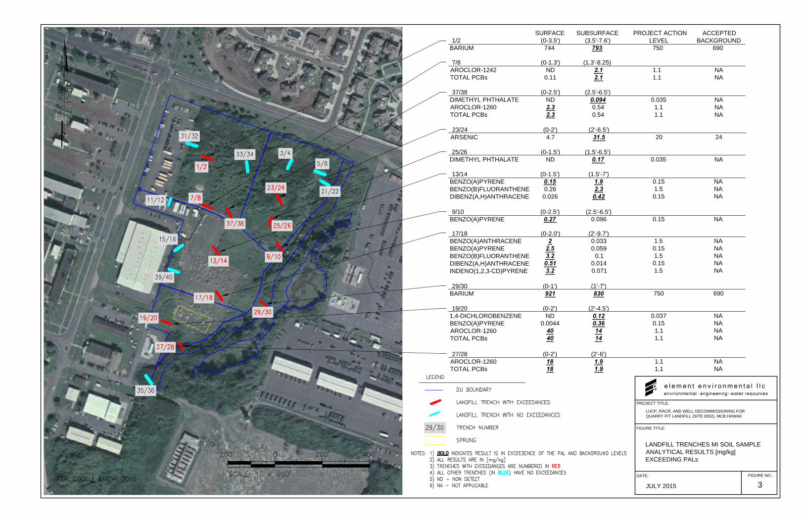
PROJECT TITLE:
LUCP, RACR, AND WELL DECOMMISSIONING FOR
QUARRY PIT LANDFILL (SITE 0002), MCB HAWAII
FIGURE TITLE:
LANDFILL TRENCHES MI SOIL SAMPLE
ANALYTICAL RESULTS [mg/kg]
EXCEEDING PALs
FIGURE NO.:
3
DATE:
JULY 2015
13/14
BENZO(A)PYRENE
BENZO(B)FLUORANTHENE
DIBENZ(A,H)ANTHRACENE
(0-1.5')
0.15
0.26
0.026
(1.5'-7')
1.9
2.3
0.42
0.15
1.5
0.15
NA
NA
NA
29/30
BARIUM
(0-1')
921
(1'-7')
830 750 690
7/8 (0-1.3') (1.3'-8.25)
AROCLOR-1242 ND 2.1 1.1 NA
TOTAL PCBs 0.11 2.1 1.1 NA
37/38 (0-2.5') (2.5'-6.5')
DIMETHYL PHTHALATE ND 0.094 0.035 NA
AROCLOR-1260 2.3 0.54 1.1 NA
TOTAL PCBs 2.3 0.54 1.1 NA
9/10
BENZO(A)PYRENE
(0-2.5')
0.27
(2.5'-6.5')
0.096 0.15 NA
17/18
BENZO(A)ANTHRACENE
BENZO(A)PYRENE
BENZO(B)FLUORANTHENE
DIBENZ(A,H)ANTHRACENE
INDENO(1,2,3-CD)PYRENE
(0-2.0')
2
2.5
3.2
0.51
3.2
(2'-9.7')
0.033
0.059
0.1
0.014
0.071
1.5
0.15
1.5
0.15
1.5
NA
NA
NA
NA
NA
19/20
1,4-DICHLOROBENZENE
BENZO(A)PYRENE
AROCLOR-1260
TOTAL PCBs
(0-2')
ND
0.0044
40
40
(2'-4.5')
0.12
0.36
14
14
0.037
0.15
1.1
1.1
NA
NA
NA
NA
27/28
AROCLOR-1260
TOTAL PCBs
(0-2')
18
18
(2'-6')
1.9
1.9
1.1
1.1
NA
NA
SURFACE SUBSURFACE PROJECT ACTION ACCEPTED
1/2 (0-3.5') (3.5'-7.6') LEVEL BACKGROUND
BARIUM 744 793 750 690
23/24
ARSENIC
(0-2')
4.7
(2'-6.5')
31.5 20 24
25/26 (0-1.5') (1.5'-6.5')
DIMETHYL PHTHALATE ND 0.17 0.035 NA

FIGURE NO.:
4
PROJECT TITLE:
FIGURE TITLE:
DECISION UNITS AND MI SAMPLE
LOCATIONS, QUARRY PIT LANDFILL
DATE:
LUCP, RACR, AND WELL DECOMMISSIONING FOR
QUARRY PIT LANDFILL (SITE 0002), MCBASE HAWAII
JULY 2015
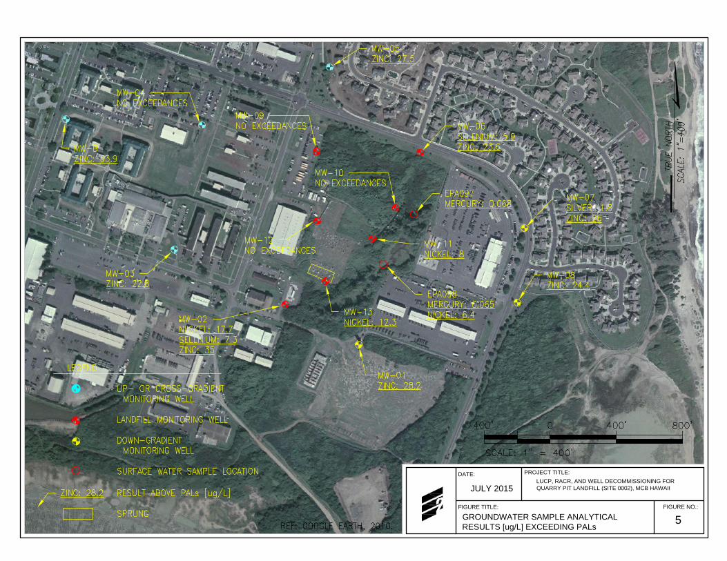
FIGURE NO.:
5
PROJECT TITLE:
FIGURE TITLE:
GROUNDWATER SAMPLE ANALYTICAL
RESULTS [ug/L] EXCEEDING PALs
DATE:
LUCP, RACR, AND WELL DECOMMISSIONING FOR
QUARRY PIT LANDFILL (SITE 0002), MCB HAWAII
JULY 2015

FIGURE NO.:
6
PROJECT TITLE:
LUCP, RACR, AND WELL DECOMMISSIONING FOR
QUARRY PIT LANDFILL (SITE 0002), MCB HAWAII
FIGURE TITLE:
LANDFILL BOUNDARY CONFIRMED BY
INVESTIGATION SURVEYS
DATE:
JULY 2015
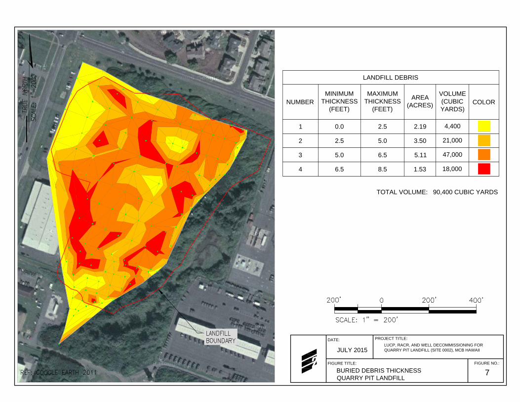
FIGURE NO.:
7
PROJECT TITLE:
LUCP, RACR, AND WELL DECOMMISSIONING FOR
QUARRY PIT LANDFILL (SITE 0002), MCB HAWAII
FIGURE TITLE:
BURIED DEBRIS THICKNESS
QUARRY PIT LANDFILL
DATE:
JULY 2015
LANDFILL DEBRIS
NUMBER
MINIMUM
THICKNESS
(FEET)
MAXIMUM
THICKNESS
(FEET)
AREA
(ACRES)
VOLUME
(CUBIC
YARDS)
COLOR
1 0.0 2.5 2.194,400
2 2.5 5.0 3.5021,000
3 5.0 6.5 5.1147,000
4 6.5 8.5 1.5318,000
TOTAL VOLUME: 90,400 CUBIC YARDS

FIGURE NO.:
8
PROJECT TITLE:
LUCP, RACR, AND WELL DECOMMISSIONING FOR
QUARRY PIT LANDFILL (SITE 0002), MCB HAWAII
FIGURE TITLE:
LANDFILL CAP THICKNESS
QUARRY PIT LANDFILL
DATE:
JULY 2015
LANDFILL CAP THICKNESS
NUMBER
MINIMUM
THICKNESS
(FEET)
MAXIMUM
THICKNESS
(FEET)
AREA
(ACRES)
COLOR
1 0.0 2.0 2.72
2 2.0 4.0 5.96
3 4.0 10.0 3.67

Appendix A Draft LUCP Comments and Responses


Page 1 of 8
Document Name DRAFT Land Use Control Plan for Quarry Pit Landfill (MCBH Site 0002), Marine Corps Base Hawaii, Kaneohe, Oahu, Hawaii, August 2014
Requestor: Ms. Kelly Akamine, NAVFAC HI, Environmental Restoration, Remedial Project Manager
Review Completion Date: December 12, 2014 (provided to E2 on December 16, 2014)
Reviewer: Mr. Eric Sadoyama, State of Hawaii Department of Health
E2 Response: Ryan Yamauchi and Bernice Balete
Comment Number
Section Number
Rating1 (High or Low)
Issue Comment Response
COMMENTS
1. No comments. E2 Response: Comment noted.
END OF COMMENTS
1 H = High Rating: Issue identified must be addressed in order to facilitate a clearer document and understanding L= Low Rating: Issue identified has limited impact, and resolution is at project personnel discretion.

Page 2 of 8
Document Name DRAFT Land Use Control Plan for Quarry Pit Landfill (MCBH Site 0002), Marine Corps Base Hawaii, Kaneohe, Oahu, Hawaii, August 2014
Requestor: Ms. Kelly Akamine, NAVFAC HI, Environmental Restoration, Remedial Project Manager
Review Completion Date:
September 30, 2014 (provided to E2 on October 8, 2014) January 12, 2015 (provided to E2 on January 12, 2015)
Reviewer: Mr. Lance Bookless, Senior Natural Resources Manager, MCB Hawaii, Environmental Department
E2 Response: Mr. Ryan Yamauchi and Ms. Bernice Balete
Comment Number
Section Number
Rating2 (High or Low)
Issue Comment Response
COMMENTS
1.
Page 1, Section 1, 6th paragraph, 1st bullet
Multi-purpose training is not a Recreational activity, I recommend stating " . . . Recreation use, e.g. park/playfield, Training (non-ground disturbing), or Industrial/commercial use with lands use restrictions".
E2 Response: The requested change was made.
2.
Page 6, Wetland Boundary Delineations, last paragraph
We have annually operated the AAVs in the "Motor Pool wetland" area to keep it open for drainage, control invasive grasses, and provide foraging area for endangered waterbirds.
E2 Response: This clarification will be made.
2 H = High Rating: Issue identified must be addressed in order to facilitate a clearer document and understanding L= Low Rating: Issue identified has limited impact, and resolution is at project personnel discretion.

Page 3 of 8
Document Name DRAFT Land Use Control Plan for Quarry Pit Landfill (MCBH Site 0002), Marine Corps Base Hawaii, Kaneohe, Oahu, Hawaii, August 2014
Requestor: Ms. Kelly Akamine, NAVFAC HI, Environmental Restoration, Remedial Project Manager
Review Completion Date:
September 30, 2014 (provided to E2 on October 8, 2014) January 12, 2015 (provided to E2 on January 12, 2015)
Reviewer: Mr. Lance Bookless, Senior Natural Resources Manager, MCB Hawaii, Environmental Department
E2 Response: Mr. Ryan Yamauchi and Ms. Bernice Balete
Comment Number
Section Number
Rating2 (High or Low)
Issue Comment Response
3. Page 9, Site Reconnaissance
Regarding the 20-ft buffer, if the area needs to be cleared to permit freedom of movement of construction equipment, this buffer can be removed; however, new vegetation would need to be planted in its place, preferably native. I have one change that I missed the first time around. . . on Page 9, Site Reconnaissance, please change the wetland stand-off distance from 20-ft to "30m/100ft" to keep it consistent with other projects we have reviewed for proposed construction projects near our wetlands. The stand-off as stated would virtually allow construction to occur right on the edge of the wetland.
E2 Response: This requirement will be added. The requested change was made.
4.
Page 10, 1st paragraph, 1st sentence (carried over from Page 9)
It is stated that the Motor Pool wetland "appeared to be relatively dry with some areas of standing water"; appearances are deceiving. Every year when we run the AAVs through this area, a fair amount of standing water appears that attracts birdlife.
E2 Response: This clarification will be made.

Page 4 of 8
Document Name DRAFT Land Use Control Plan for Quarry Pit Landfill (MCBH Site 0002), Marine Corps Base Hawaii, Kaneohe, Oahu, Hawaii, August 2014
Requestor: Ms. Kelly Akamine, NAVFAC HI, Environmental Restoration, Remedial Project Manager
Review Completion Date:
September 30, 2014 (provided to E2 on October 8, 2014) January 12, 2015 (provided to E2 on January 12, 2015)
Reviewer: Mr. Lance Bookless, Senior Natural Resources Manager, MCB Hawaii, Environmental Department
E2 Response: Mr. Ryan Yamauchi and Ms. Bernice Balete
Comment Number
Section Number
Rating2 (High or Low)
Issue Comment Response
5.
Page 10, RI/FS and Page 11, Screening Level Ecological Risk Assessment
Page 10, RI/FS: This paragraph indicates that no drilling was "conducted in the either of the adjacent wetland DUs"; this is something that should be performed to determine if any contaminants/hazardous material is leaching into the wetlands that support foraging by T&E and other migratory waterbirds.
On Page 11, Screening Level Ecological Risk Assessment, it states that "Based on RI findings, no further action is required due to ecological risks. This is important as we annually operate AAVs in this wetland to maintain its viability. This is a big concern because of RI findings at the Salvage Yard wetland, AAVs can no longer operate in a portion of the wetland due to hazardous materials. If the wetland was never tested, there is an absence of information to base taking no further action. This needs to be discussed.
E2 Response: No drilling in the wetland was conducted; however, sediment and surface water sampling from the wetland were completed to determine if runoff and/or leaching from the Quarry Pit Landfill has impacted the wetland. The sample results indicate that the wetland sediments and surface water have not been impacted by the Quarry Pit Landfill. Groundwater sampling was also completed throughout the project area and the results do not indicate that leaching to the wetland is occurring. The screening level ecological risk assessment determined that the risk to ecological receptors at the site were within acceptable risk ranges. Therefore, AAVs can operate in the wetland. However, the AAVs should not be allowed to damage the existing soil cap on the Quarry Pit Landfill and the berm separating the landfill from the wetland.
6. Page 16, Section 4.3.1, Construction
It is stated that "Land use at the site is restricted to recreational and industrial/commercial use only. No residential
E2 Response: The sentence will be changed to read “Land use at the site is restricted to recreational, training, and
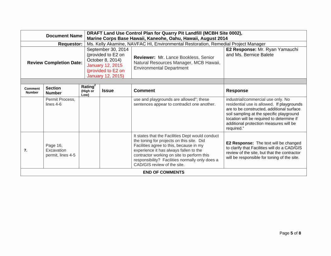
Page 5 of 8
Document Name DRAFT Land Use Control Plan for Quarry Pit Landfill (MCBH Site 0002), Marine Corps Base Hawaii, Kaneohe, Oahu, Hawaii, August 2014
Requestor: Ms. Kelly Akamine, NAVFAC HI, Environmental Restoration, Remedial Project Manager
Review Completion Date:
September 30, 2014 (provided to E2 on October 8, 2014) January 12, 2015 (provided to E2 on January 12, 2015)
Reviewer: Mr. Lance Bookless, Senior Natural Resources Manager, MCB Hawaii, Environmental Department
E2 Response: Mr. Ryan Yamauchi and Ms. Bernice Balete
Comment Number
Section Number
Rating2 (High or Low)
Issue Comment Response
Permit Process, lines 4-6
use and playgrounds are allowed"; these sentences appear to contradict one another.
industrial/commercial use only. No residential use is allowed. If playgrounds are to be constructed, additional surface soil sampling at the specific playground location will be required to determine if additional protection measures will be required.”
7. Page 16, Excavation permit, lines 4-5
It states that the Facilities Dept would conduct the toning for projects on this site. Did Facilities agree to this, because in my experience it has always fallen to the contractor working on site to perform this responsibility? Facilities normally only does a CAD/GIS review of the site.
E2 Response: The text will be changed to clarify that Facilities will do a CAD/GIS review of the site, but that the contractor will be responsible for toning of the site.
END OF COMMENTS

Page 6 of 8
Document Name DRAFT Land Use Control Plan for Quarry Pit Landfill (MCBH Site 0002) Marine Corps Base Hawaii, Kaneohe, Oahu, Hawaii, August 2014
Requestor: Ms. Kelly Akamine, NAVFAC HI, Environmental Restoration, Remedial Project Manager
Review Completion Date: October 15, 2014 Reviewer(s): MCB Hawaii Mr. Brett Chambers (BC) and Mr. Randall Hu (RH)
E2 Response: Mr. Ryan Yamauchi and Ms. Bernice Balete
Comment Number
Section Number
Rating3 (High or Low)
Issue Comment Response
GENERAL COMMENTS
1. General Comment
The base is referred to as “MCBH Hawaii” in some sections of the LUCP. Change to “MCB Hawaii” and make sure it is consistent throughout the document.
E2 Response: The requested global change will be made throughout the LUCP.
SPECIFIC COMMENTS
1. Section 1 (Page 1)
LUC Monitoring
It states “Periodic monitoring of LUC effectiveness and compliance reporting” is required. How often is “periodic”? Is it consistent with frequency for the H-3 Landfill LUCP?
E2 Response: The LUCP will be made consistent with the H-3 Landfill LUCP, requiring only “periodic inspections”, i.e., five-year reviews. Annual inspections
2. Section 2.3 (Page 11)
Screening Human Health Risk Assessment
The park/playfield recreational use scenario has an exceedence in DU-5 (the bermed area). Do there need to be additional controls on the berm (i.e., vegetating the berm)?
E2 Response: Although the exposure risk calculation exceeds the upper end of the risk management range, no additional controls are recommended because the bermed area will likely not be used.
3 H = High Rating: Issue identified must be addressed in order to facilitate a clearer document and understanding L= Low Rating: Issue identified has limited impact, and resolution is at project personnel discretion.

Page 7 of 8
Document Name DRAFT Land Use Control Plan for Quarry Pit Landfill (MCBH Site 0002) Marine Corps Base Hawaii, Kaneohe, Oahu, Hawaii, August 2014
Requestor: Ms. Kelly Akamine, NAVFAC HI, Environmental Restoration, Remedial Project Manager
Review Completion Date: October 15, 2014 Reviewer(s): MCB Hawaii Mr. Brett Chambers (BC) and Mr. Randall Hu (RH)
E2 Response: Mr. Ryan Yamauchi and Ms. Bernice Balete
Comment Number
Section Number
Rating3 (High or Low)
Issue Comment Response
3. Section 3.2 (Page 13)
Notice
This section seems to indicate that putting signs (legal notice of site contamination, LUC boundary delineation, etc.) around the site is required. I thought we agreed there would not be signs posted. Please clarify.
E2 Response: To clarify that there are no physical signage posted at the site, the section was revised as follows: 1) delete “at multiple locations and/or” from the 3rd bullet; 2) delete the 4th bullet; and 3) delete “and physical” from the 5th bullet.
4.
Section 4.3 (Page 16)
Institutional
Controls
Check with the MCBH Facilities Department to see if the paragraph that begins with “In addition, effective July 2004, the Hawaii One Call Center….” should still be included in this report. Contact person is Phil Lum: 257-6900
E2 Response: Mr. Phil Lum was contacted. The Hawaii One Call process is accepted on MCB Hawaii. The paragraph was left in.
5. Section 5.1.2
(Page 17) Notice of Changes to Site Conditions
“…the Navy shall notify DOH within ten days of the discovery.” Is this a regulatory requirement?
E2 Response: The time requirement “within ten days” was deleted.

Page 8 of 8
Document Name DRAFT Land Use Control Plan for Quarry Pit Landfill (MCBH Site 0002) Marine Corps Base Hawaii, Kaneohe, Oahu, Hawaii, August 2014
Requestor: Ms. Kelly Akamine, NAVFAC HI, Environmental Restoration, Remedial Project Manager
Review Completion Date: October 15, 2014 Reviewer(s): MCB Hawaii Mr. Brett Chambers (BC) and Mr. Randall Hu (RH)
E2 Response: Mr. Ryan Yamauchi and Ms. Bernice Balete
Comment Number
Section Number
Rating3 (High or Low)
Issue Comment Response
6. Section 5.2.2
(Page 18)
Conditional Inspections and Compliance Reporting Requirements
Is there a regulatory requirement to conduct ANNUAL inspections and submit the monitoring reports to the DOH? The recent Draft H-3 Landfill LUCP only requires “periodic inspections” and we would prefer to make the two LUCPs consistent with each other. Would NAVFAC be funding these inspections/reports? There is also mention of inspecting the site “every six months” in an earlier paragraph – is this consistent with the Draft H-3 Landfill LUCP?
E2 Response: The LUCP (this section and Section 5.2.1) will be made consistent with the H-3 Landfill LUCP, requiring only “periodic inspections”, i.e., five-year reviews. Therefore the section in question was deleted.
7. Section 5.4.3
(Page 20) DOH
Responsibilities
This section and others seem to be written with the assumption that the public has easy access to the base.
E2 Response: The section will be re-written.
END OF COMMENTS

Appendix B Legal Descriptions


Appendix C Digging Work Clearance Permit


bbalete
Rectangle

bbalete
Rectangle

bbalete
Rectangle


Appendix D Annual LUC Compliance Certificates and Checklists


Final Land Use Control Plan Quarry Pit Landfill (MCB Hawaii Site 0002) Marine Corps Base Hawaii, Kaneohe, Oahu, Hawaii
Appendix D Annual LUC Compliance Certificates and Checklists
July 2015
Annual LUC Compliance Certificate
Quarry Pit Landfill, Hawaii
The purpose of this compliance certificate is to ensure that Land Use Controls (LUCs) are properly maintained at the Quarry Pit Landfill property (hereinafter referred to as the “site”). LUCs are necessary to protect human health due to the presence of low concentrations of contaminants in surface and subsurface soil at the site. LUCs implemented at the site are discussed in the Land Use Control Plan (August 2014).
The landowner is required to ensure and annually certify that LUCs continue to be maintained at the site. The landowner is encouraged to inspect the property frequently to fulfill this duty.
The questionnaire that follows the certification statement is designed to help ensure that LUCs remain protective and that site conditions have not changed such that they adversely impact the integrity of the selected remedy for the site. This certification and questionnaire form shall be completed on an annual basis and submitted to the Navy and DOH (contact information is provided below). To properly certify LUC compliance on the property, the landowner should:
• Review relevant LUC documentation
• Review property records (e.g., construction permits, etc.)
• Physically inspect the site
• Interview tenants and regular site users
• Photograph site conditions
Following submittal of this form, the landowner may be asked to meet with the Navy and DOH representatives to discuss and clarify the inspection results. It is the intent of the Navy and DOH that the annual review process be a cordial and cooperative effort to ensure that site conditions remain protective of human health and the environment.
Property Owner:
Property Address:
This evaluation covers the period from 1 January through 31 December _____________ (year).
Site Inspection Date:

Final Land Use Control Plan Quarry Pit Landfill (MCB Hawaii Site 0002) Marine Corps Base Hawaii, Kaneohe, Oahu, Hawaii
Appendix D Annual LUC Compliance Certificates and Checklists
July 2015
Annual LUC Compliance Certificate
Quarry Pit Landfill, Hawaii
Property Owner: ____________________________
Property Address: ___________________________
Is the evaluation for all or a portion of the Quarry Pit Landfill? ___________
If evaluating only a portion of the site, attach a figure identifying the portion being evaluated.
This evaluation covers the period from 1 January through 31 December ______________(year)
Certification Checklist
In Compliance Non-Compliance See Comment
1. Vegetative soil cap is in-place and in good condition.
2. Site development is restricted to recreational training and industrial/commercial uses only.
3. Construction is limited to those projects that have been reviewed and approved.
4. No excavation and uncontrolled removal of soil and debris from the Site.
I, the undersigned, hereby certify that I am an authorized representative of the U.S. Navy and that the above-described Land Use Controls have been complied with for the period noted.
___________________________ ___________________________ _________________
Signature Title Date
Representing: ___________________________
Mail completed form(s) to: State of Hawaii Department of Health HEER Office 919 Ala Moana Boulevard, Suite 206 Honolulu, Hawaii 96818
Department of the Navy Naval Facilities Engineering Command, Hawaii 400 Marshall Road JBPHH Hawaii 96860-3139
OSWER No. 9355.7-03B-P
D-3
Five-Year Review Site Inspection Checklist
Purpose of the Checklist
The site inspection checklist provides a useful method for collecting important informationduring the site inspection portion of the five-year review. The checklist serves as a reminder ofwhat information should to be gathered and provides the means of checking off informationobtained and reviewed, or information not available or applicable. The checklist is divided intosections as follows:
I. Site InformationII. InterviewsIII. On-site Documents & Records VerifiedIV. O&M CostsV. Access and Institutional ControlsVI. General Site ConditionsVII. Landfill CoversVIII. Vertical Barrier WallsIX. Groundwater/Surface Water RemediesX. Other RemediesXI. Overall Observations
Some data and information identified in the checklist may or may not be available at thesite depending on how the site is managed. Sampling results, costs, and maintenance reports maybe kept on site or may be kept in the offices of the contractor or at State offices. In cases where theinformation is not kept at the site, the item should not be checked as “not applicable,” but rather itshould be obtained from the office or agency where it is maintained. If this is known in advance, itmay be possible to obtain the information before the site inspection.
This checklist was developed by EPA and the U.S. Army Corps of Engineers (USACE). Itfocuses on the two most common types of remedies that are subject to five-year reviews: landfillcovers, and groundwater pump and treat remedies. Sections of the checklist are also provided forsome other remedies. The sections on general site conditions would be applicable to a widervariety of remedies. The checklist should be modified to suit your needs when inspecting othertypes of remedies, as appropriate.
The checklist may be completed and attached to the Five-Year Review report to documentsite status. Please note that the checklist is not meant to be completely definitive or restrictive;additional information may be supplemented if the reviewer deems necessary. Also note thatactual site conditions should be documented with photographs whenever possible.

OSWER No. 9355.7-03B-P
D-4
Using the Checklist for Types of Remedies
The checklist has sections designed to capture information concerning the main types ofremedies which are found at sites requiring five-year reviews. These remedies are landfill covers(Section VII of the checklist) and groundwater and surface water remedies (Section IX of thechecklist). The primary elements and appurtenances for these remedies are listed in sections whichcan be checked off as the facility is inspected. The opportunity is also provided to note siteconditions, write comments on the facilities, and attach any additional pertinent information. If asite includes remedies beyond these, such as soil vapor extraction or soil landfarming, theinformation should be gathered in a similar manner and attached to the checklist.
Considering Operation and Maintenance Costs
Unexpectedly widely varying or unexpectedly high O&M costs may be early indicators ofremedy problems. For this reason, it is important to obtain a record of the original O&M costestimate and of annual O&M costs during the years for which costs incurred are available. Section IV of the checklist provides a place for documenting annual costs and for commenting onunanticipated or unusually high O&M costs. A more detailed categorization of costs may beattached to the checklist if available. Examples of categories of O&M costs are listed below.
Operating Labor - This includes all wages, salaries, training, overhead, and fringe benefitsassociated with the labor needed for operation of the facilities and equipment associated with theremedial actions.
Maintenance Equipment and Materials - This includes the costs for equipment, parts, and othermaterials required to perform routine maintenance of facilities and equipment associated with aremedial action.
Maintenance Labor - This includes the costs for labor required to perform routine maintenance offacilities and for equipment associated with a remedial action.
Auxiliary Materials and Energy - This includes items such as chemicals and utilities which caninclude electricity, telephone, natural gas, water, and fuel. Auxiliary materials include otherexpendable materials such as chemicals used during plant operations.
Purchased Services - This includes items such as sampling costs, laboratory fees, and otherprofessional services for which the need can be predicted.
Administrative Costs - This includes all costs associated with administration of O&M not includedunder other categories, such as labor overhead.

OSWER No. 9355.7-03B-P
D-5
Insurance, Taxes and Licenses - This includes items such as liability and sudden and accidentalinsurance, real estate taxes on purchased land or right-of-way, licensing fees for certaintechnologies, and permit renewal and reporting costs.
Other Costs - This includes all other items which do not fit into any of the above categories.

OSWER No. 9355.7-03B-P
D-6
[This page intentionally left blank.]

OSWER No. 9355.7-03B-P
D-7
Please note that “O&M” is referred to throughout this checklist. At sites where Long-TermResponse Actions are in progress, O&M activities may be referred to as “system operations” sincethese sites are not considered to be in the O&M phase while being remediated under the Superfundprogram.
Five-Year Review Site Inspection Checklist (Template)
(Working document for site inspection. Information may be completed by hand and attached to theFive-Year Review report as supporting documentation of site status. “N/A” refers to “not applicable.”)
I. SITE INFORMATION
Site name: Date of inspection:
Location and Region: EPA ID:
Agency, office, or company leading the five-yearreview:
Weather/temperature:
Remedy Includes: (Check all that apply)G Landfill cover/containment G Monitored natural attenuationG Access controls G Groundwater containmentG Institutional controls G Vertical barrier wallsG Groundwater pump and treatmentG Surface water collection and treatmentG Other___________________________________________________________________________________________________________________________________________________
Attachments: G Inspection team roster attached G Site map attached
II. INTERVIEWS (Check all that apply)
1. O&M site manager ____________________________ ______________________ ____________Name Title Date
Interviewed G at site G at office G by phone Phone no. ______________ Problems, suggestions; G Report attached ________________________________________________ __________________________________________________________________________________
2. O&M staff ____________________________ ______________________ ____________Name Title Date
Interviewed G at site G at office G by phone Phone no. ______________ Problems, suggestions; G Report attached _______________________________________________ __________________________________________________________________________________

OSWER No. 9355.7-03B-P
D-8
3. Local regulatory authorities and response agencies (i.e., State and Tribal offices, emergencyresponse office, police department, office of public health or environmental health, zoning office,recorder of deeds, or other city and county offices, etc.) Fill in all that apply.
Agency ____________________________Contact ____________________________ __________________ ________ ____________
Name Title Date Phone no.Problems; suggestions; G Report attached _________________________________________________________________________________________________________________________________
4. Other interviews (optional) G Report attached.

OSWER No. 9355.7-03B-P
D-9
III. ON-SITE DOCUMENTS & RECORDS VERIFIED (Check all that apply)
1. O&M DocumentsG O&M manual G Readily available G Up to date G N/AG As-built drawings G Readily available G Up to date G N/AG Maintenance logs G Readily available G Up to date G N/ARemarks______________________________________________________________________________________________________________________________________________
2. Site-Specific Health and Safety Plan G Readily available G Up to date G N/AG Contingency plan/emergency response plan G Readily available G Up to date G N/ARemarks___________________________________________________________________________________________________________________________________________________________
3. O&M and OSHA Training Records G Readily available G Up to date G N/ARemarks___________________________________________________________________________________________________________________________________________________________
4. Permits and Service AgreementsG Air discharge permit G Readily available G Up to date G N/AG Effluent discharge G Readily available G Up to date G N/AG Waste disposal, POTW G Readily available G Up to date G N/AG Other permits______________________ G Readily available G Up to date G N/ARemarks___________________________________________________________________________________________________________________________________________________________
5. Gas Generation Records G Readily available G Up to date G N/ARemarks___________________________________________________________________________________________________________________________________________________________
6. Settlement Monument Records G Readily available G Up to date G N/ARemarks___________________________________________________________________________________________________________________________________________________________
7. Groundwater Monitoring Records G Readily available G Up to date G N/ARemarks___________________________________________________________________________________________________________________________________________________________
8. Leachate Extraction Records G Readily available G Up to date G N/ARemarks___________________________________________________________________________________________________________________________________________________________
9. Discharge Compliance Records G Air G Readily available G Up to date G N/AG Water (effluent) G Readily available G Up to date G N/ARemarks___________________________________________________________________________________________________________________________________________________________
10. Daily Access/Security Logs G Readily available G Up to date G N/ARemarks___________________________________________________________________________________________________________________________________________________________

OSWER No. 9355.7-03B-P
D-10
IV. O&M COSTS
1. O&M OrganizationG State in-house G Contractor for StateG PRP in-house G Contractor for PRPG Federal Facility in-house G Contractor for Federal FacilityG Other___________________________________________________________________________________________________________________________________________________________
2. O&M Cost Records G Readily available G Up to dateG Funding mechanism/agreement in placeOriginal O&M cost estimate____________________G Breakdown attached
Total annual cost by year for review period if available
From__________ To__________ __________________ G Breakdown attachedDate Date Total cost
From__________ To__________ __________________ G Breakdown attachedDate Date Total cost
From__________ To__________ __________________ G Breakdown attachedDate Date Total cost
From__________ To__________ __________________ G Breakdown attachedDate Date Total cost
From__________ To__________ __________________ G Breakdown attachedDate Date Total cost
3. Unanticipated or Unusually High O&M Costs During Review PeriodDescribe costs and reasons: _______________________________________________________________________________________________________________________________________________________________________________________________________________________________________________________________________________________________________________________________________________________________________________________________________________________________________________________________________________
V. ACCESS AND INSTITUTIONAL CONTROLS G Applicable G N/A
A. Fencing
1. Fencing damaged G Location shown on site map G Gates secured G N/ARemarks___________________________________________________________________________________________________________________________________________________________
B. Other Access Restrictions
1. Signs and other security measures G Location shown on site map G N/ARemarks___________________________________________________________________________________________________________________________________________________________

OSWER No. 9355.7-03B-P
D-11
C. Institutional Controls (ICs)
1. Implementation and enforcementSite conditions imply ICs not properly implemented G Yes G No G N/ASite conditions imply ICs not being fully enforced G Yes G No G N/A
Type of monitoring (e.g., self-reporting, drive by) _________________________________________Frequency ________________________________________________________________________Responsible party/agency ____________________________________________________________Contact ____________________________ __________________ ________ ____________
Name Title Date Phone no.
Reporting is up-to-date G Yes G No G N/AReports are verified by the lead agency G Yes G No G N/A
Specific requirements in deed or decision documents have been met G Yes G No G N/AViolations have been reported G Yes G No G N/AOther problems or suggestions: G Report attached ____________________________________________________________________________________________________________________________________________________________________________________________________________________________________________________________________________________________________________________________________
2. Adequacy G ICs are adequate G ICs are inadequate G N/ARemarks____________________________________________________________________________________________________________________________________________________________________________________________________________________________________________
D. General
1. Vandalism/trespassing G Location shown on site map G No vandalism evidentRemarks___________________________________________________________________________________________________________________________________________________________
2. Land use changes on siteG N/ARemarks___________________________________________________________________________________________________________________________________________________________
3. Land use changes off siteG N/ARemarks___________________________________________________________________________________________________________________________________________________________
VI. GENERAL SITE CONDITIONS
A. Roads G Applicable G N/A
1. Roads damaged G Location shown on site map G Roads adequate G N/ARemarks___________________________________________________________________________________________________________________________________________________________

OSWER No. 9355.7-03B-P
D-12
B. Other Site Conditions
Remarks
VII. LANDFILL COVERS G Applicable G N/A
A. Landfill Surface
1. Settlement (Low spots) G Location shown on site map G Settlement not evidentAreal extent______________ Depth____________Remarks______________________________________________________________________________________________________________________________
2. Cracks G Location shown on site map G Cracking not evidentLengths____________ Widths___________ Depths__________Remarks______________________________________________________________________________________________________________________________
3. Erosion G Location shown on site map G Erosion not evidentAreal extent______________ Depth____________Remarks___________________________________________________________________________________________________________________________________________________________
4. Holes G Location shown on site map G Holes not evidentAreal extent______________ Depth____________Remarks___________________________________________________________________________________________________________________________________________________________
5. Vegetative Cover G Grass G Cover properly established G No signs of stressG Trees/Shrubs (indicate size and locations on a diagram)Remarks___________________________________________________________________________________________________________________________________________________________
6. Alternative Cover (armored rock, concrete, etc.) G N/ARemarks___________________________________________________________________________________________________________________________________________________________
7. Bulges G Location shown on site map G Bulges not evidentAreal extent______________ Height____________Remarks___________________________________________________________________________________________________________________________________________________________

OSWER No. 9355.7-03B-P
D-13
8. Wet Areas/Water Damage G Wet areas/water damage not evidentG Wet areas G Location shown on site map Areal extent______________G Ponding G Location shown on site map Areal extent______________G Seeps G Location shown on site map Areal extent______________G Soft subgrade G Location shown on site map Areal extent______________Remarks___________________________________________________________________________________________________________________________________________________________
9. Slope Instability G Slides G Location shown on site map G No evidence of slope instabilityAreal extent______________Remarks___________________________________________________________________________________________________________________________________________________________
B. Benches G Applicable G N/A(Horizontally constructed mounds of earth placed across a steep landfill side slope to interrupt the slopein order to slow down the velocity of surface runoff and intercept and convey the runoff to a linedchannel.)
1. Flows Bypass Bench G Location shown on site map G N/A or okayRemarks___________________________________________________________________________________________________________________________________________________________
2. Bench Breached G Location shown on site map G N/A or okayRemarks___________________________________________________________________________________________________________________________________________________________
3. Bench Overtopped G Location shown on site map G N/A or okayRemarks___________________________________________________________________________________________________________________________________________________________
C. Letdown Channels G Applicable G N/A(Channel lined with erosion control mats, riprap, grout bags, or gabions that descend down the steepside slope of the cover and will allow the runoff water collected by the benches to move off of thelandfill cover without creating erosion gullies.)
1. Settlement G Location shown on site map G No evidence of settlementAreal extent______________ Depth____________Remarks___________________________________________________________________________________________________________________________________________________________
2. Material Degradation G Location shown on site map G No evidence of degradationMaterial type_______________ Areal extent_____________Remarks___________________________________________________________________________________________________________________________________________________________
3. Erosion G Location shown on site map G No evidence of erosionAreal extent______________ Depth____________Remarks___________________________________________________________________________________________________________________________________________________________

OSWER No. 9355.7-03B-P
D-14
4. Undercutting G Location shown on site map G No evidence of undercuttingAreal extent______________ Depth____________Remarks___________________________________________________________________________________________________________________________________________________________
5. Obstructions Type_____________________ G No obstructionsG Location shown on site map Areal extent______________ Size____________Remarks___________________________________________________________________________________________________________________________________________________________
6. Excessive Vegetative Growth Type____________________G No evidence of excessive growthG Vegetation in channels does not obstruct flowG Location shown on site map Areal extent______________Remarks___________________________________________________________________________________________________________________________________________________________
D. Cover Penetrations G Applicable G N/A
1. Gas Vents G Active G PassiveG Properly secured/lockedG Functioning G Routinely sampled G Good conditionG Evidence of leakage at penetration G Needs MaintenanceG N/ARemarks___________________________________________________________________________________________________________________________________________________________
2. Gas Monitoring ProbesG Properly secured/lockedG Functioning G Routinely sampled G Good conditionG Evidence of leakage at penetration G Needs Maintenance G N/ARemarks___________________________________________________________________________________________________________________________________________________________
3. Monitoring Wells (within surface area of landfill)G Properly secured/lockedG Functioning G Routinely sampled G Good conditionG Evidence of leakage at penetration G Needs Maintenance G N/ARemarks____________________________________________________________________________________________________________________________
4. Leachate Extraction WellsG Properly secured/lockedG Functioning G Routinely sampled G Good conditionG Evidence of leakage at penetration G Needs Maintenance G N/ARemarks___________________________________________________________________________________________________________________________________________________________
5. Settlement Monuments G Located G Routinely surveyed G N/ARemarks___________________________________________________________________________________________________________________________________________________________

OSWER No. 9355.7-03B-P
D-15
E. Gas Collection and Treatment G Applicable G N/A
1. Gas Treatment FacilitiesG Flaring G Thermal destruction G Collection for reuseG Good condition G Needs Maintenance Remarks___________________________________________________________________________________________________________________________________________________________
2. Gas Collection Wells, Manifolds and PipingG Good condition G Needs Maintenance Remarks___________________________________________________________________________________________________________________________________________________________
3. Gas Monitoring Facilities (e.g., gas monitoring of adjacent homes or buildings)G Good condition G Needs Maintenance G N/ARemarks___________________________________________________________________________________________________________________________________________________________
F. Cover Drainage Layer G Applicable G N/A
1. Outlet Pipes Inspected G Functioning G N/ARemarks___________________________________________________________________________________________________________________________________________________________
2. Outlet Rock Inspected G Functioning G N/ARemarks___________________________________________________________________________________________________________________________________________________________
G. Detention/Sedimentation Ponds G Applicable G N/A
1. SiltationAreal extent______________ Depth____________ G N/AG Siltation not evidentRemarks___________________________________________________________________________________________________________________________________________________________
2. Erosion Areal extent______________ Depth____________G Erosion not evidentRemarks___________________________________________________________________________________________________________________________________________________________
3. Outlet Works G Functioning G N/ARemarks___________________________________________________________________________________________________________________________________________________________
4. Dam G Functioning G N/ARemarks___________________________________________________________________________________________________________________________________________________________

OSWER No. 9355.7-03B-P
D-16
H. Retaining Walls G Applicable G N/A
1. Deformations G Location shown on site map G Deformation not evidentHorizontal displacement____________ Vertical displacement_______________Rotational displacement____________Remarks___________________________________________________________________________________________________________________________________________________________
2. Degradation G Location shown on site map G Degradation not evidentRemarks___________________________________________________________________________________________________________________________________________________________
I. Perimeter Ditches/Off-Site Discharge G Applicable G N/A
1. Siltation G Location shown on site map G Siltation not evidentAreal extent______________ Depth____________Remarks___________________________________________________________________________________________________________________________________________________________
2. Vegetative Growth G Location shown on site map G N/AG Vegetation does not impede flowAreal extent______________ Type____________Remarks___________________________________________________________________________________________________________________________________________________________
3. Erosion G Location shown on site map G Erosion not evidentAreal extent______________ Depth____________Remarks___________________________________________________________________________________________________________________________________________________________
4. Discharge Structure G Functioning G N/ARemarks___________________________________________________________________________________________________________________________________________________________
VIII. VERTICAL BARRIER WALLS G Applicable G N/A
1. Settlement G Location shown on site map G Settlement not evidentAreal extent______________ Depth____________Remarks___________________________________________________________________________________________________________________________________________________________
2. Performance MonitoringType of monitoring__________________________G Performance not monitoredFrequency_______________________________ G Evidence of breachingHead differential__________________________Remarks___________________________________________________________________________________________________________________________________________________________
OSWER No. 9355.7-03B-P
D-17
IX. GROUNDWATER/SURFACE WATER REMEDIES G Applicable G N/A
A. Groundwater Extraction Wells, Pumps, and Pipelines G Applicable G N/A
1. Pumps, Wellhead Plumbing, and ElectricalG Good condition G All required wells properly operating G Needs Maintenance G N/ARemarks____________________________________________________________________________________________________________________________________________________________________________________________________________________________________________
2. Extraction System Pipelines, Valves, Valve Boxes, and Other AppurtenancesG Good condition G Needs MaintenanceRemarks___________________________________________________________________________________________________________________________________________________________
3. Spare Parts and EquipmentG Readily available G Good condition G Requires upgrade G Needs to be providedRemarks___________________________________________________________________________________________________________________________________________________________
B. Surface Water Collection Structures, Pumps, and Pipelines G Applicable G N/A
1. Collection Structures, Pumps, and ElectricalG Good condition G Needs Maintenance Remarks___________________________________________________________________________________________________________________________________________________________
2. Surface Water Collection System Pipelines, Valves, Valve Boxes, and Other AppurtenancesG Good condition G Needs MaintenanceRemarks___________________________________________________________________________________________________________________________________________________________
3. Spare Parts and EquipmentG Readily available G Good condition G Requires upgrade G Needs to be providedRemarks___________________________________________________________________________________________________________________________________________________________
OSWER No. 9355.7-03B-P
D-18
C. Treatment System G Applicable G N/A
1. Treatment Train (Check components that apply)G Metals removal G Oil/water separation G BioremediationG Air stripping G Carbon adsorbersG Filters_________________________________________________________________________G Additive (e.g., chelation agent, flocculent)_____________________________________________G Others_________________________________________________________________________G Good condition G Needs Maintenance G Sampling ports properly marked and functionalG Sampling/maintenance log displayed and up to dateG Equipment properly identifiedG Quantity of groundwater treated annually________________________G Quantity of surface water treated annually________________________Remarks___________________________________________________________________________________________________________________________________________________________
2. Electrical Enclosures and Panels (properly rated and functional)G N/A G Good condition G Needs Maintenance Remarks___________________________________________________________________________________________________________________________________________________________
3. Tanks, Vaults, Storage VesselsG N/A G Good condition G Proper secondary containment G Needs MaintenanceRemarks___________________________________________________________________________________________________________________________________________________________
4. Discharge Structure and AppurtenancesG N/A G Good condition G Needs Maintenance Remarks___________________________________________________________________________________________________________________________________________________________
5. Treatment Building(s)G N/A G Good condition (esp. roof and doorways) G Needs repairG Chemicals and equipment properly storedRemarks___________________________________________________________________________________________________________________________________________________________
6. Monitoring Wells (pump and treatment remedy)G Properly secured/lockedG Functioning G Routinely sampled G Good conditionG All required wells located G Needs Maintenance G N/ARemarks___________________________________________________________________________________________________________________________________________________________
D. Monitoring Data
1. Monitoring DataG Is routinely submitted on time G Is of acceptable quality
2. Monitoring data suggests:G Groundwater plume is effectively contained G Contaminant concentrations are declining
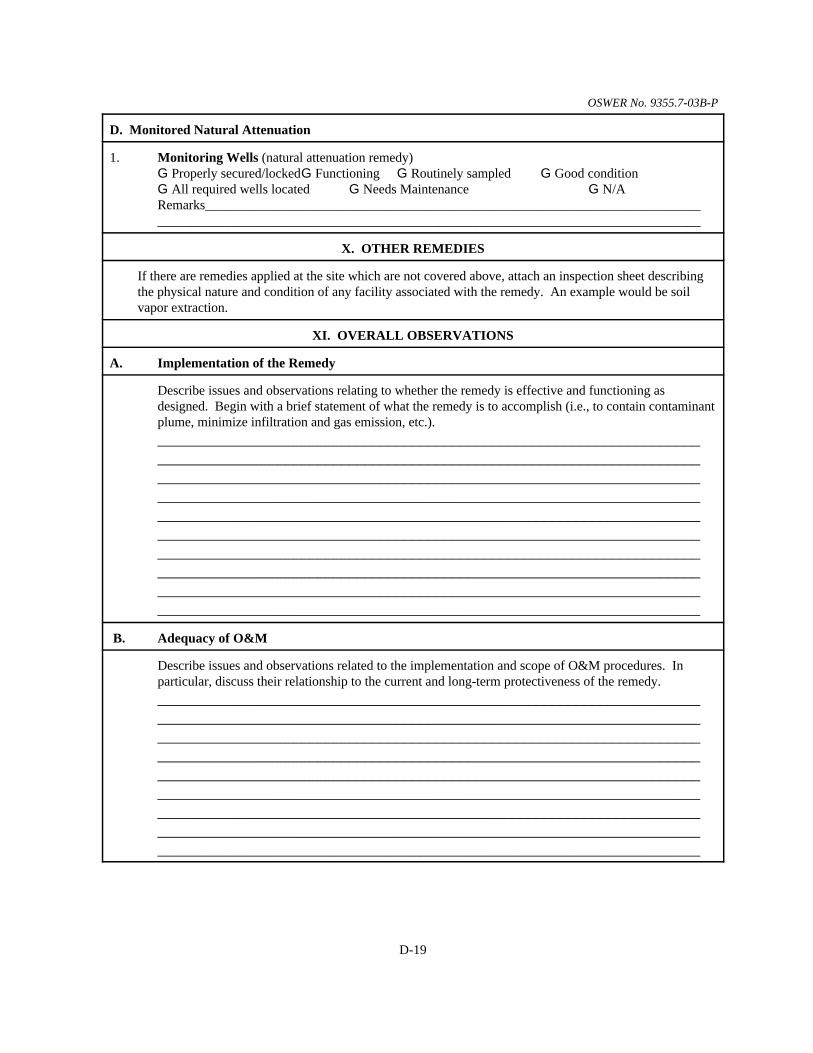
OSWER No. 9355.7-03B-P
D-19
D. Monitored Natural Attenuation
1. Monitoring Wells (natural attenuation remedy)G Properly secured/lockedG Functioning G Routinely sampled G Good conditionG All required wells located G Needs Maintenance G N/ARemarks___________________________________________________________________________________________________________________________________________________________
X. OTHER REMEDIES
If there are remedies applied at the site which are not covered above, attach an inspection sheet describingthe physical nature and condition of any facility associated with the remedy. An example would be soilvapor extraction.
XI. OVERALL OBSERVATIONS
A. Implementation of the Remedy
Describe issues and observations relating to whether the remedy is effective and functioning asdesigned. Begin with a brief statement of what the remedy is to accomplish (i.e., to contain contaminantplume, minimize infiltration and gas emission, etc.).________________________________________________________________________________________________________________________________________________________________________________________________________________________________________________________________________________________________________________________________________________________________________________________________________________________________________________________________________________________________________________________________________________________________________________________________________________________________________________________________________________________________________
B. Adequacy of O&M
Describe issues and observations related to the implementation and scope of O&M procedures. Inparticular, discuss their relationship to the current and long-term protectiveness of the remedy.____________________________________________________________________________________________________________________________________________________________________________________________________________________________________________________________________________________________________________________________________________________________________________________________________________________________________________________________________________________________________________________________________________________________________________________________________________________________________

OSWER No. 9355.7-03B-P
D-20
C. Early Indicators of Potential Remedy Problems
Describe issues and observations such as unexpected changes in the cost or scope of O&M or a highfrequency of unscheduled repairs, that suggest that the protectiveness of the remedy may becompromised in the future. ____________________________________________________________________________________________________________________________________________________________________________________________________________________________________________________________________________________________________________________________________________________________________________________________________________________________________________________________________________________________________________________________________________________________________________________________________________________________________
D. Opportunities for Optimization
Describe possible opportunities for optimization in monitoring tasks or the operation of the remedy.____________________________________________________________________________________________________________________________________________________________________________________________________________________________________________________________________________________________________________________________________________________________________________________________________________________________________________________________________________________________________________________________________________________________________________________________________________________________________

Appendix E Five-Year Review Checklist and Report Template


OSWER No. 9355.7-03B-P
E-3
Five-Year Review Report Template
This appendix provides a suggested checklist and a format for Five-Year Review reports. The checklist appears first, followed by the report template. You are encouraged to follow thetemplate to ensure national consistency in the structure of Five-Year Review reports. However,each report should take into account site-specific circumstances, and you should modify the reportformat and content accordingly. For example, in some cases the report may be clearer if organizedby operable unit (OU), or you may need to include site-specific questions that do not appear in thisappendix.
The suggested format for Five-Year Review reports includes three main components: cover material, summary information, and the report body. Templates for each of thesecomponents follow. These templates provide suggested standard formats, boilerplate text,subheadings, checklists, example tables, and protectiveness statements. Suggested boilerplate textis presented in text boxes. Within the boilerplate section, text enclosed in brackets (“[ ]”) shouldbe added as appropriate, and italicized text denotes discussions that the reviewer should add.
You should use both the checklist and report template as guides for the types of informationthat should appear in the different sections of your Five-Year Review report. You should includeinformation that is relevant to your site and needed to ensure that the rationale behind theprotectiveness determination is adequately documented.

OSWER No. 9355.7-03B-P
E-4
[This page intentionally left blank.]

OSWER No. 9355.7-03B-P
E-5
Content Checklist ForFive-Year Review Reports
This checklist may be used by you, your managers, etc., to verify that you have included all of theappropriate information in your Five-Year Review report. Depending on site-specificcircumstances, some items may not be applicable. For example, a report for a site just beginningconstruction will generally contain less data than for a site that has reached constructioncompletion.
General Report Format9 Signed concurrence memorandum (as appropriate)9 Title page with signature and date9 Completed five-year review summary form (page E-15)9 List of documents reviewed9 Site maps (as appropriate)9 List of tables and figures9 Interview report (as appropriate)9 Site inspection checklist 9 Photos documenting site conditions (as appropriate)
Introduction9 The purpose of the five-year review9 Authority for conducting the five-year review9 Who conducted the five-year review (lead agency) and when
9 Organizations providing analyses in support of the review (e.g., the contractorsupporting the lead agency )
9 Other review participants or support agencies9 Review number (e.g., first, second)9 Trigger action and date 9 Number, description, and status of all operable units at the site9 If review covers only part of a site, explain approach
9 Define which areas are covered in the five-year review9 Summarize the status of other areas of the site that are not covered in the present five-
year
Site Chronology9 List all important site events and relevant dates (e.g., date of initial discovery of problem,
dates of pre-NPL responses, date of NPL listing, etc.)
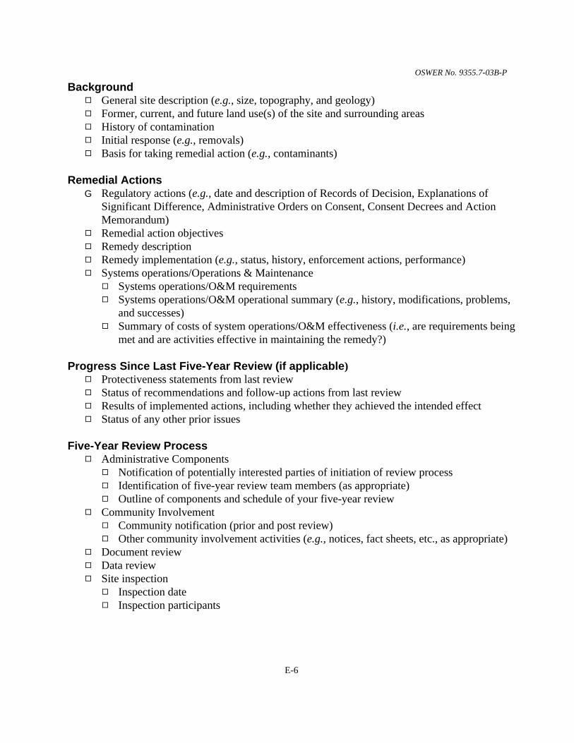
OSWER No. 9355.7-03B-P
E-6
Background9 General site description (e.g., size, topography, and geology) 9 Former, current, and future land use(s) of the site and surrounding areas9 History of contamination9 Initial response (e.g., removals)9 Basis for taking remedial action (e.g., contaminants)
Remedial ActionsG Regulatory actions (e.g., date and description of Records of Decision, Explanations of
Significant Difference, Administrative Orders on Consent, Consent Decrees and ActionMemorandum)
9 Remedial action objectives9 Remedy description9 Remedy implementation (e.g., status, history, enforcement actions, performance)9 Systems operations/Operations & Maintenance
9 Systems operations/O&M requirements9 Systems operations/O&M operational summary (e.g., history, modifications, problems,
and successes)9 Summary of costs of system operations/O&M effectiveness (i.e., are requirements being
met and are activities effective in maintaining the remedy?)
Progress Since Last Five-Year Review (if applicable)9 Protectiveness statements from last review9 Status of recommendations and follow-up actions from last review9 Results of implemented actions, including whether they achieved the intended effect9 Status of any other prior issues
Five-Year Review Process 9 Administrative Components
9 Notification of potentially interested parties of initiation of review process9 Identification of five-year review team members (as appropriate)9 Outline of components and schedule of your five-year review
9 Community Involvement9 Community notification (prior and post review)9 Other community involvement activities (e.g., notices, fact sheets, etc., as appropriate)
9 Document review 9 Data review9 Site inspection
9 Inspection date9 Inspection participants

OSWER No. 9355.7-03B-P
E-7
Five-Year Review Process, cont’d.
9 Site inspection scope and procedures9 Site inspection results, conclusions9 Inspection checklist
9 Interviews9 Interview date(s) and location(s)9 Interview participants (name, title, etc.)9 Interview documentation 9 Interview summary
Technical Assessment9 Answer Question A: Is the remedy functioning as intended by the decision documents?
9 remedial action performance (i.e., is the remedy operating as designed?)9 system operations/O&M9 cost of system operations/O&M9 opportunities for optimization9 early indicators of potential issues9 implementation of institutional controls and other measures
9 Answer Question B: Are the exposure assumptions, toxicity data, cleanup levels, andremedial action objectives (RAOs) used at the time of the remedy selection still valid?9 changes in standards, newly promulgated standards, TBCs9 expected progress towards meeting RAOs9 changes in exposure pathways9 changes in land use9 new contaminants and/or contaminant sources9 remedy byproducts9 changes in toxicity and other contaminant characteristics9 risk recalculation/assessment (as applicable)
9 Answer Question C: Has any other information come to light that could call into questionthe protectiveness of the remedy?9 new or previously unidentified ecological risks9 natural disaster impacts9 any other information that could call into question the protectiveness of the remedy
9 Technical Assessment Summary
Issues9 Issues identified during the technical assessment and other five-year review activities9 Determination of whether issues affect current or future protectiveness
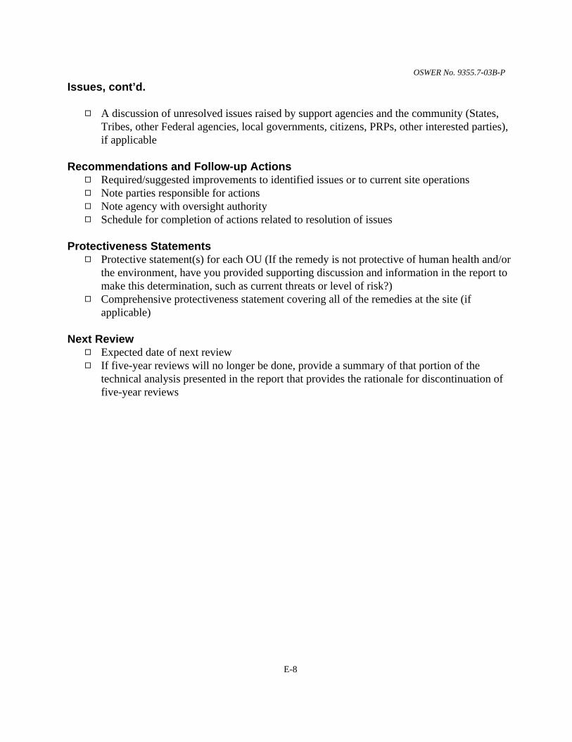
OSWER No. 9355.7-03B-P
E-8
Issues, cont’d.
9 A discussion of unresolved issues raised by support agencies and the community (States,Tribes, other Federal agencies, local governments, citizens, PRPs, other interested parties),if applicable
Recommendations and Follow-up Actions9 Required/suggested improvements to identified issues or to current site operations9 Note parties responsible for actions9 Note agency with oversight authority9 Schedule for completion of actions related to resolution of issues
Protectiveness Statements9 Protective statement(s) for each OU (If the remedy is not protective of human health and/or
the environment, have you provided supporting discussion and information in the report tomake this determination, such as current threats or level of risk?)
9 Comprehensive protectiveness statement covering all of the remedies at the site (ifapplicable)
Next Review9 Expected date of next review9 If five-year reviews will no longer be done, provide a summary of that portion of the
technical analysis presented in the report that provides the rationale for discontinuation offive-year reviews

OSWER No. 9355.7-03B-P
E-9
Five-Year Review Report
(First, Second, etc.) Five-Year Review Report
for
Site Name
City
County, State
Month, Year
PREPARED BY:
Lead AgencyName andLocation
Approved by: Date:
[Name][Title][Affiliation]

OSWER No. 9355.7-03B-P
E-10
[This page intentionally left blank.]

OSWER No. 9355.7-03B-P
E-11
Five-Year Review Report
The following Table of Contents notes typical major divisions and subheadings for Five-YearReview reports. Subheadings can be included as appropriate for a given review report. This isonly a general example.
Table of Contents
List of Acronyms . . . . . . . . . . . . . . . . . . . . . . . . . . . . . . . . . . . . . . . . . . . . . . . . . . . . . . . . . . . . E-13
Executive Summary . . . . . . . . . . . . . . . . . . . . . . . . . . . . . . . . . . . . . . . . . . . . . . . . . . . . . . . . . E-15
Five-Year Review Summary Form . . . . . . . . . . . . . . . . . . . . . . . . . . . . . . . . . . . . . . . . . . . . . . E-17
I. Introduction . . . . . . . . . . . . . . . . . . . . . . . . . . . . . . . . . . . . . . . . . . . . . . . . . . . . . . . . E-19
II. Site Chronology . . . . . . . . . . . . . . . . . . . . . . . . . . . . . . . . . . . . . . . . . . . . . . . . . . . . . E-21
III. Background . . . . . . . . . . . . . . . . . . . . . . . . . . . . . . . . . . . . . . . . . . . . . . . . . . . . . . . . E-22Physical Characteristics . . . . . . . . . . . . . . . . . . . . . . . . . . . . . . . . . . . . . . . . . . . . . . . . . E-22Land and Resource Use . . . . . . . . . . . . . . . . . . . . . . . . . . . . . . . . . . . . . . . . . . . . . . . . . E-22History of Contamination . . . . . . . . . . . . . . . . . . . . . . . . . . . . . . . . . . . . . . . . . . . . . . . . E-23Initial Response . . . . . . . . . . . . . . . . . . . . . . . . . . . . . . . . . . . . . . . . . . . . . . . . . . . . . . . E-23Basis for Taking Action . . . . . . . . . . . . . . . . . . . . . . . . . . . . . . . . . . . . . . . . . . . . . . . . . E-23
IV. Remedial Actions . . . . . . . . . . . . . . . . . . . . . . . . . . . . . . . . . . . . . . . . . . . . . . . . . . . E-23Remedy Selection . . . . . . . . . . . . . . . . . . . . . . . . . . . . . . . . . . . . . . . . . . . . . . . . . . . . . E-23Remedy Implementation . . . . . . . . . . . . . . . . . . . . . . . . . . . . . . . . . . . . . . . . . . . . . . . . E-23System Operations/Operation and Maintenance (O&M) . . . . . . . . . . . . . . . . . . . . . . . . E-23
V. Progress Since the Last Five-Year Review . . . . . . . . . . . . . . . . . . . . . . . . . . . . E-25
VI. Five-Year Review Process . . . . . . . . . . . . . . . . . . . . . . . . . . . . . . . . . . . . . . E-25Administrative Components . . . . . . . . . . . . . . . . . . . . . . . . . . . . . . . . . . . . . . . . . . . . . E-25Community Notification and Involvement . . . . . . . . . . . . . . . . . . . . . . . . . . . . . . . . . . E-26Document Review . . . . . . . . . . . . . . . . . . . . . . . . . . . . . . . . . . . . . . . . . . . . . . . . . . . . . E-26Data Review . . . . . . . . . . . . . . . . . . . . . . . . . . . . . . . . . . . . . . . . . . . . . . . . . . . . . . . . . . E-26Site Inspection . . . . . . . . . . . . . . . . . . . . . . . . . . . . . . . . . . . . . . . . . . . . . . . . . . . . . . . . E-26Interviews . . . . . . . . . . . . . . . . . . . . . . . . . . . . . . . . . . . . . . . . . . . . . . . . . . . . . . . . . . . . E-26

OSWER No. 9355.7-03B-P
E-12
VII. Technical Assessment . . . . . . . . . . . . . . . . . . . . . . . . . . . . . . . . . . . . . . . . . E-26Question A: Is the remedy functioning as intended by the decision documents? . . . . . E-27Question B: Are the exposure assumptions, toxicity data, cleanup levels, and remedialaction objectives (RAOs) used at the time of the remedy selection still valid? . . . . . . . E-28Question C: Has any other information come to light that could call into questionthe protectiveness of the remedy? . . . . . . . . . . . . . . . . . . . . . . . . . . . . . . . . . . . . . . . . . E-29Technical Assessment Summary . . . . . . . . . . . . . . . . . . . . . . . . . . . . . . . . . . . . . . . . . . E-29
VIII. Issues . . . . . . . . . . . . . . . . . . . . . . . . . . . . . . . . . . . . . . . . . . . . . . . . . . . . . . . E-30
IX. Recommendations and Follow-up Actions . . . . . . . . . . . . . . . . . . . . . . . . . E-30
X. Protectiveness Statement(s) . . . . . . . . . . . . . . . . . . . . . . . . . . . . . . . . . . . . . E-30
XI. Next Review . . . . . . . . . . . . . . . . . . . . . . . . . . . . . . . . . . . . . . . . . . . . . . . . . . . . . . . . E-32
TablesTable 1 - Chronology of Site EventsTable 2 - Annual System Operations/O&M CostsTable 3 - Actions Taken Since the Last Five-Year ReviewTable 4 - Changes in Chemical-Specific StandardsTable 5 - Changes in Action-Specific RequirementsTable 6 - Changes in Location-Specific RequirementsTable 7 - IssuesTable 8 - Recommendations and Follow-up Actions
AttachmentsSite Maps (if not included in the body of the report)List of Documents ReviewedTables and Figures documenting Remedy Performance and Changes in Standards (if notincluded in the body of the report)Interview Report (as appropriate)Photos Documenting Site Conditions
AppendixComments received from Support Agencies and/or the Community

OSWER No. 9355.7-03B-P
E-13
List of Acronyms
You should include a list of acronyms used in the report here.

OSWER No. 9355.7-03B-P
E-14
[This page intentionally left blank.]

OSWER No. 9355.7-03B-P
E-15
Executive Summary
You should include an Executive Summary at the beginning of the report. The Executive Summaryshould be brief, and should include a reiteration of the protectiveness statements included inSection X of the Five-Year Review report.

OSWER No. 9355.7-03B-P
E-16
[This page intentionally left blank.]

OSWER No. 9355.7-03B-P
E-17
Five-Year Review Summary Form
SITE IDENTIFICATION
Site name (from WasteLAN):
EPA ID (from WasteLAN):
Region: State: City/County:
SITE STATUS
NPL status: G Final G Deleted G Other (specify)
Remediation status (choose all that apply): G Under Construction G Operating G Complete
Multiple OUs?* G YES G NO Construction completion date: ___ / ___ / ______
Has site been put into reuse? G YES G NO
REVIEW STATUS
Lead agency: G EPA G State G Tribe G Other Federal Agency
Author name:
Author title: Author affiliation:
Review period:** ___ / ___ / ______ to ___ / ___ / ______
Date(s) of site inspection: ___ / ___ / ______
Type of review:G Post-SARA G Pre-SARA G NPL-Removal onlyG Non-NPL Remedial Action Site G NPL State/Tribe-leadG Regional Discretion
Review number: G 1 (first) G 2 (second) G 3 (third) G Other (specify)
Triggering action:G Actual RA Onsite Construction at OU #____ G Actual RA Start at OU#____G Construction Completion G Previous Five-Year Review ReportG Other (specify)
Triggering action date (from WasteLAN): ___ / ___ / ______
Due date (five years after triggering action date): ___ / ___ / ______
* [“OU” refers to operable unit.]** [Review period should correspond to the actual start and end dates of the Five-Year Review in WasteLAN.]

OSWER No. 9355.7-03B-P
E-18
Five-Year Review Summary Form, cont’d.
Issues:
Summarize issues (see Chapter 3).
Recommendations and Follow-up Actions:
Summarize recommendations and follow-up actions (see Chapter 3).
Protectiveness Statement(s):
Include individual operable unit protectiveness statements. For sites that have reached construction completionand have more than one OU, include an additional and comprehensive protectiveness statement covering all ofthe remedies at the site (see Chapter 4).
Other Comments:
Make any other comments here.

OSWER No. 9355.7-03B-P
E-19
Five-Year Review Report
I. Introduction
Provide a synopsis of “who, what, where, when, and why.” Detail the following:
• The purpose of the review;
• The authority for conducting the five-year review;
• Who conducted the review, when, and for what site or portion of the site;
• Whether it is the first review or a subsequent review at the site;
• What action triggered the review; and
• A brief status of areas of a site not addressed in the current review and/or the status of five-year reviews for other areas of the entire site.
Further explanation and boilerplate text are provided below. Additional explanation on thefollowing topics is provided in Chapter 1.
The Purpose of the Review
State the purpose of the five-year review specific to the site or portion of the site addressedin the review.
The purpose of five-year reviews is to determine whether the remedy at a site [is/is expected to be]protective of human health and the environment. The methods, findings, and conclusions of reviewsare documented in Five-Year Review reports. In addition, Five-Year Review reports identify issuesfound during the review, if any, and recommendations to address them.
Authority for Conducting the Five-Year Review
The Agency is preparing this five-year review pursuant to CERCLA §121 and the NationalContingency Plan (NCP). CERCLA §121 states:
If the President selects a remedial action that results in any hazardous substances,pollutants, or contaminants remaining at the site, the President shall review suchremedial action no less often than each five years after the initiation of such remedialaction to assure that human health and the environment are being protected by theremedial action being implemented. In addition, if upon such review it is the judgmentof the President that action is appropriate at such site in accordance with section [104]

OSWER No. 9355.7-03B-P
E-20
or [106], the President shall take or require such action. The President shall report tothe Congress a list of facilities for which such review is required, the results of all suchreviews, and any actions taken as a result of such reviews.
The agency interpreted this requirement further in the National Contingency Plan (NCP); 40CFR §300.430(f)(4)(ii) states:
If a remedial action is selected that results in hazardous substances, pollutants, or contaminantsremaining at the site above levels that allow for unlimited use and unrestricted exposure, thelead agency shall review such action no less often than every five years after the initiation of theselected remedial action.
Who Conducted the Five-Year Review
If the U.S. Army Corps of Engineers (USACE) or a contractor has conducted an analysis insupport of a five-year review, you should include their name and the date of the analysis. When acontractor for a potentially responsible party (PRP) conducts analyses or provides information insupport of a five-year review, you should identify the a contractor and their affiliation with thePRP in the Five-Year Review report. You should also identify who conducted the site inspection.
Boilerplate text for the explanation of who conducted the review is provided in the boxbelow. This text is written as though EPA is the lead agency and should be adapted when anotheragency or department serves as the lead agency.
The United States Environmental Protection Agency (EPA) Region [number] has conducted a five-yearreview of the remedial actions implemented at the [name] site in [location]. This review was conductedfrom [month, year] through [month, year]. This report documents the results of the review. [Pleaseidentify any party providing an analysis in support of the five-year review; also indicate the contractualarrangements under which this was done.]
Other Review Characteristics
State whether the review is the first or a subsequent five-year review for the site, whataction or event “triggered” the review, and the date of this action. See Chapter 1, Section 1.2 ofthis guidance for a discussion of triggering events for the five-year review and indicate in yourreport whether the trigger for the current five-year review has been met.
Boilerplate text for the explanation of other review characteristics is provided in the boxbelow. Select text from brackets as appropriate.

OSWER No. 9355.7-03B-P
E-21
This is the [first/second/etc.] five-year review for the [name] site. The triggering action for this reviewis the date of the [triggering action], as shown in EPA’s WasteLAN database: [date]. [This discussionshould also mention what is specifically activating the review, i.e., that hazardous substances,pollutants, or contaminants are or will be left on site above levels that allow for unlimited use andunrestricted exposure.]
In addition, if separate five-year reviews are conducted for different areas of a site, youshould include the following in this section:
• An explanation of this approach;
• A description of which areas are covered by this five-year review; and
• A brief synopsis of the remedial activities and the status of remedial measures and/or five-year reviews for other areas.
II. Site Chronology
List all important site events and relevant dates in the site chronology, such as those shown in Table 1. The identified events are illustrative, not comprehensive.
Table 1: Chronology of Site Events
Event Date
Initial discovery of problem or contamination
Pre-NPL responses
NPL listing
Removal actions
Remedial Investigation/Feasibility Study complete
ROD signature
ROD Amendments or ESDs
Enforcement documents (CD, AOC, UnilateralAdministrative Order)
Remedial design start
Remedial design complete

OSWER No. 9355.7-03B-P
Table 1: Chronology of Site Events
Event Date
E-22
Superfund State Contract, Cooperative Agreement, orFederal Facility Agreement signature
Actual remedial action start
Construction dates (start, finish)
Construction completion date
Final Close-out Report
Deletion from NPL
Previous five-year reviews
III. Background
Describe the fundamental aspects of the site, providing a clear, succinct description of sitecharacteristics. The purpose of this section is to identify the threat posed to the public andenvironment at the time of the ROD, so that the performance of the remedy can be easily comparedwith the site conditions the remedy was intended to address. Include all major site activities priorto the signing of the ROD. In addition to text, you may use site maps to help clarify the discussion. The following checklist may assist you in developing the text for this section.
UU Background Checklist
Physical Characteristics Present the site’s location and characteristics, including the following:
Area of site, relation to parcel(s), extent and location of sources
Whether site is located in a populated area or is near populated areas
Whether site is located in an environmentally sensitive area or is near environmentally sensitive areas,where applicable
Land and Resource Use Discuss the following:
Former, current and projected land uses for the site, as identified in the ROD or other decision document
Current and projected land uses for the area surrounding the site, at the time of the five-year review
Human and ecological past, present and known future use of resources (e.g., groundwater or surfacewater as a drinking water supply) and any other current uses of the site not already addressed, asapplicable

OSWER No. 9355.7-03B-P
UU Background Checklist
E-23
History of Contamination Discuss the following:
The historical activities that caused contamination, including the type of activity or process, when it tookplace, the specific type of hazardous substances, and their volumes/proportions, if known
How contamination was discovered and problems resulting from contamination
Initial Response Describe any pre-ROD cleanup activities at the site:
CERCLA removal actions, non-CERCLA removals/responses, closures, the ceasing of operations, aswell as governing agreements and parties involved in these activities
Basis for Taking Action Describe the contaminants found at the site by appropriate media type (soil,groundwater, surface water, air). Note the effect or potential effect of the contamination on people, resourcesthey use, or the environment. Examples of elements of this discussion include the following:
Contaminated media and structures (summary of remedial investigation)
Resources/targets that have been or could potentially be affected, results of risk assessments,determination of primary health threat
IV. Remedial Actions
Discuss initial plans, implementation history, and current status of the remedy. Explainevents identified in the chronology, and generally include discussions of remedy selection, remedyimplementation, remedy performance, and system operations/O&M. Present – accurately,adequately, and concisely – relevant site activities from the signing of the ROD to the present. Youshould delineate all remedial measures, for instance, include monitoring, fencing, and institutionalcontrols. Discuss any changes to or problems with remedial components. The following checklistmay assist you in developing the text for this section.
UU Remedial Actions Checklist
Remedy Selection Describe the remedial action objectives and the selected remedy. This discussion shouldexplain the following:
Scope and role of actions including definition of OUs related to each ROD and how they relate to eachother
Source documents listing remedial action objectives and the remedy (e.g., RODs, ESDs), includingsignature/filing date
Statement of remedial action objectives, related to each OU or ROD
Description of remedial actions/remedy, related to each OU or ROD, noting media addressed; allcomponents of the remedy, including engineering controls, access controls, institutional controls,cleanup measures, treatment types, and required monitoring should be described
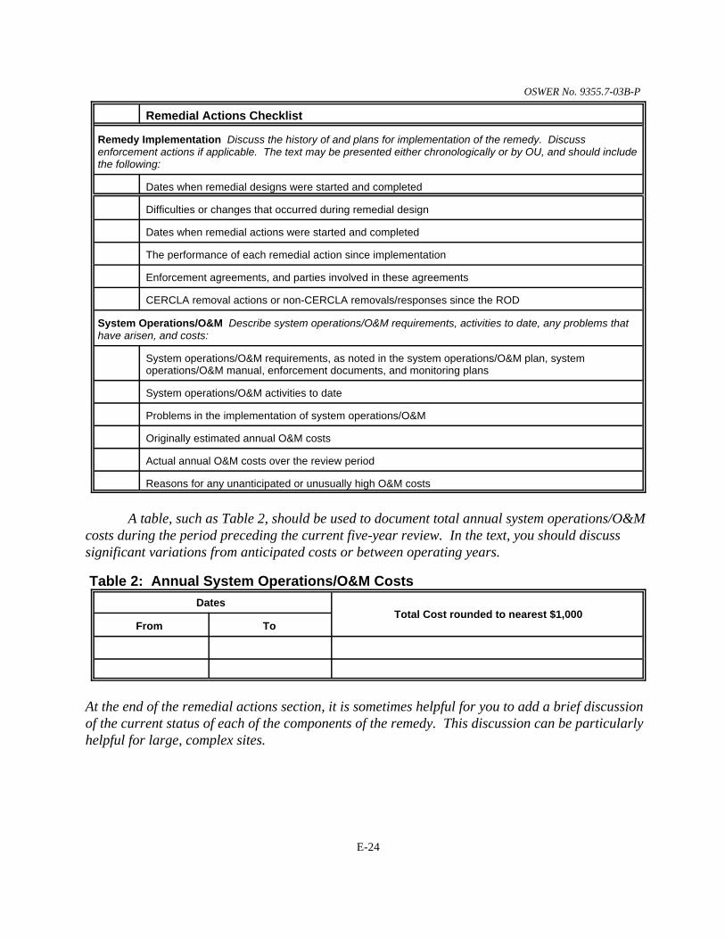
OSWER No. 9355.7-03B-P
UU Remedial Actions Checklist
E-24
Remedy Implementation Discuss the history of and plans for implementation of the remedy. Discussenforcement actions if applicable. The text may be presented either chronologically or by OU, and should includethe following:
Dates when remedial designs were started and completed
Difficulties or changes that occurred during remedial design
Dates when remedial actions were started and completed
The performance of each remedial action since implementation
Enforcement agreements, and parties involved in these agreements
CERCLA removal actions or non-CERCLA removals/responses since the ROD
System Operations/O&M Describe system operations/O&M requirements, activities to date, any problems thathave arisen, and costs:
System operations/O&M requirements, as noted in the system operations/O&M plan, systemoperations/O&M manual, enforcement documents, and monitoring plans
System operations/O&M activities to date
Problems in the implementation of system operations/O&M
Originally estimated annual O&M costs
Actual annual O&M costs over the review period
Reasons for any unanticipated or unusually high O&M costs
A table, such as Table 2, should be used to document total annual system operations/O&Mcosts during the period preceding the current five-year review. In the text, you should discusssignificant variations from anticipated costs or between operating years.
Table 2: Annual System Operations/O&M CostsDates
Total Cost rounded to nearest $1,000From To
At the end of the remedial actions section, it is sometimes helpful for you to add a brief discussionof the current status of each of the components of the remedy. This discussion can be particularlyhelpful for large, complex sites.

OSWER No. 9355.7-03B-P
E-25
V. Progress Since the Last Review
Progress since the last review should be discussed when follow-up actions which impactprotectiveness were noted in the previous Five-Year Review report. The following checklist mayassist you in developing the text for this section.
U Progress Since the Last Review Checklist
Describe progress toward accomplishing recommendations and follow-up actions since the last five-yearreview was completed. Include the following:
Protectiveness statements from the last review
Status of recommendations and follow-up actions from last review
Results of implemented actions, including whether they achieved the intended effect
Status of any other prior issues
Table 3 below presents one approach for providing information on the recommendations andfollow-up actions stated in the past review and subsequent actions. The accompanying text shouldalso discuss why any recommendations and follow-up actions have not been implemented if that isthe case, and whether implemented actions achieved desired results.
Table 3: Actions Taken Since the Last Five-Year ReviewIssues from
PreviousReview
Recommendations/Follow-up Actions
PartyResponsible
MilestoneDate
Action Taken andOutcome
Date ofAction
VI. Five-Year Review Process
Describe activities performed during the five-year review process and provide a summaryof findings when appropriate. The following checklist may assist you in developing the text forthis section.
UU Five-Year Review Process Checklist
Administrative Components of the Five-Year Review Process
Notify potentially interested parties of start of five-year review
Identify members of the review team
Develop a review schedule

OSWER No. 9355.7-03B-P
UU Five-Year Review Process Checklist
E-26
Community Notification and Involvement
Community notification
Other community involvement activities
Document Review See Appendix B for a full discussion of the document review
What documents were reviewed
Identify document source of RAOs, ARARs and cleanup levels
Data Review Discuss and present the following:
What data were reviewed
Relevant trends and levels, noting levels which are not currently compliant and whether future compliancecan be expected without additional action
Tables summarizing monitoring and sampling data
Increase and/or decrease or non-presence of specific chemical compounds and recommended changesfor future monitoring programs
Site Inspection Summarize the site inspection and site conditions:
Date of site inspection (if more than one inspection was conducted to allow for monitoring or furtherinspection, list all inspections and activities conducted, and the reasons for conducting each inspection)
Who conducted and/or attended the inspection
Activities conducted (scope and procedures)
Summary of site conditions, inspection results, conclusions
Interviews Discuss the following:
Interviews conducted (name, title, organization, date, location(S))
Interview documentation
Interview summary
Successes/problems in the implementation of access and institutional controls
Successes/problems with the construction of the remedy
Successes/problems with system operations/O&M
Unusual situations or problems at the site
VII. Technical Assessment
Discuss how each of the three questions asked in the technical assessment were answered(e.g., yes, yes, no or a variation of this) and provide the information that presents the basis foreach answer as a framework for your protectiveness determination(s). Explain the conclusions of

OSWER No. 9355.7-03B-P
E-27
your review, based on the information presented in the previous section. As explained in Chapter4, the assessment should focus on answering three key questions:
• Question A: Is the remedy functioning as intended by the decision documents?
• Question B: Are the exposure assumptions, toxicity data, cleanup levels, and remedialaction objectives (RAOs) used at the time of remedy selection still valid?
• Question C: Has any other information come to light that could call into question theprotectiveness of the remedy?
Each question, and the associated information to be discussed, is presented in its ownchecklist which may assist you in developing the text for this section. Checklist items shown maybe supplemented or modified based on site-specific circumstances.
UU Checklist for Question A: Is the remedy functioning as intended by the decisiondocuments?
Remedial Action Performance Discuss the following:
Whether the remedial action continues to be operating and functioning as designed
Whether the remedial action is performing as expected and cleanup levels are being achieved
Whether containment is effective
System Operations/O&M Discuss the following:
Whether operating procedures, as implemented, will maintain the effectiveness of response actions
Whether large variances in O&M costs could indicate a potential remedy problems or remedy issues
Opportunities for Optimization Discuss the following:
Whether opportunities exist to improve the performance and/or reduce costs of monitoring, sampling, andtreatment systems
Early Indicators of Potential Issues Discuss the following:
Whether frequent equipment breakdowns or changes indicate a potential issue
Whether issues or problems could place protectiveness at risk
Implementation of Institutional Controls and Other Measures Discuss the following:
Whether access controls are in place and prevent exposure (e.g., fencing and warning signs)
Whether institutional controls are in place and prevent exposure
Whether other actions (e.g., removals) necessary to ensure that immediate threats have been addressedare complete

OSWER No. 9355.7-03B-P
E-28
UU Checklist for Question B: Are the exposure assumptions, toxicity data, cleanuplevels, and remedial action objectives (RAOs) used at the time of remedy selectionstill valid?
Changes in Standards and TBCs Discuss the following:
Whether standards identified in the ROD have been revised and call into question the protectivenessof the remedy
Whether newly promulgated standards call into question the protectiveness of the remedy
Whether TBCs used in selecting cleanup levels at the site have changed and could affect theprotectiveness of the remedy
Changes in Exposure Pathways Discuss the following:
Whether land use or expected land use on or near the site changed
Whether human health or ecological routes of exposure or receptors have been newly identified orchanged in a way that could affect the protectiveness of the remedy
Whether there are newly identified contaminants or contaminant sources
Whether there are unanticipated toxic byproducts of the remedy not previously addressed by thedecision documents
Whether physical site conditions or the understanding of these conditions have changed in a way thatcould affect the protectiveness of the remedy
Changes in Toxicity and Other Contaminant Characteristics Discuss the following:
Whether toxicity factors for contaminants of concern at the site have changed in a way that couldaffect the protectiveness of the remedy
Whether other contaminant characteristics have changed in a way that could affect the protectivenessof the remedy
Changes in Risk Assessment Methods Discuss the following:
Whether standardized risk assessment methodologies have changed in a way that could affect theprotectiveness of the remedy
Expected Progress Towards Meeting RAOs
Whether the remedy is progressing as expected
When a standard or requirement has changed, a table can be used to record the nature ofthe change. Tables 4, 5, and 6 below demonstrate potential ways for you to note changes inchemical-specific, action-specific, or location-specific requirements, respectively.

OSWER No. 9355.7-03B-P
E-29
Table 4: Changes in Chemical-Specific StandardsContaminant Media Cleanup Level Standard Citation/Year
Chemical A e.g.,groundwater
e.g., 0.XX mg/L Previous e.g., 0.XXmg/L
e.g., SDWA 1988
New e.g., 0.YYmg/L
e.g., SDWA 1995
Chemical B Previous
New
Table 5: Changes in Action-Specific RequirementsAction Requirement Prerequisite Citation/Year
Action A(e.g., landfill)
Previous Include original ARAR here; if noneapplies, state “None”
New
Table 6: Changes in Location-Specific Requirements
Location Requirement Prerequisite Citation/Year
Location A(e.g., criticalhabitat uponwhichendangered orthreatenedspeciesdepend)
Previous Include original ARAR here; if noneapplies, state “None”
New
UU Checklist for Question C: Has any other information come to light that could call intoquestion the protectiveness of the remedy?
Other Information Discuss the following:
Whether newly identified ecological risks been found
Whether there are impacts from natural disasters
Whether any other information has come to light which could affect the protectiveness of the remedy
Technical Assessment Summary
Discuss how each of the three questions were answered and provide the information that presentsthe basis for each answer as a framework for your protectiveness determination(s).

OSWER No. 9355.7-03B-P
E-30
VIII. Issues
Detail issues related to current site operations, conditions, or activities, noting which issue,if any, currently prevent the remedy from being protective. You may use a table such as Table 7 tonote the issues identified.
Table 7: Issues
Issues Affects CurrentProtectiveness
(Y/N)
Affects FutureProtectiveness
(Y/N)
IX. Recommendations and Follow-up Actions
Specify the required and suggested improvements to current site operations, activities,remedy, or conditions. Note the parties responsible for actions, milestone dates, and whichagencies have oversight authority. At a minimum, address all issues that currently affect currentand/or future protectiveness. Table 8 illustrates one way to include the necessary information.
Table 8: Recommendations and Follow-up Actions
Issue
Recommendationsand
Follow-up Actions
PartyResponsible
OversightAgency
MilestoneDate
AffectsProtectiveness (Y/N)
Current Future
X. Protectiveness Statement(s)
Include a protectiveness statement for each OU at which a remedial action has begun. Forsites that have reached construction completion and have more than one OU, you should developand include an additional comprehensive site-wide protectiveness statement covering all of theremedies at the site. You should not include this additional protectiveness statement untilconstruction completion because, until then, all remedies at the site have not necessarily beenselected and constructed.
In order to promote consistency, you are strongly encouraged to model your protectivenessstatements on the sample protectiveness statements provided in Chapter 4, Exhibits 4-6 and 4-7. Your Five-Year Review report should present the protectiveness statements at the beginning of a

OSWER No. 9355.7-03B-P
E-31
discussion that should explain and provide the supporting rationale of the protectivenessdetermination.
Suggested statements are as follows:
If the remedial action at the OU is under construction, then use this statement:
Protective or will be protective:
“The remedy at OU X is expected to be protective of human health and the environmentupon completion, and in the interim, exposure pathways that could result in unacceptable risks arebeing controlled.”
Not protective:
“The remedy at OU X is not protective because of the following issues [describe theissue(s)]. The following actions need to be taken [describe the actions needed to ensureprotectiveness].”
Protectiveness deferred:
“A protectiveness determination of the remedy at OU X cannot be made at this time untilfurther information is obtained. Further information will be obtained by taking the followingactions [describe the actions]. It is expected that these actions will take approximately [insert timeframe] to complete, at which time a protectiveness determination will be made.”
If the remedial action at the OU is operating or completed:
Protective:
“The remedy at OU X is expected to be or is protective of human health and theenvironment, and in the interim, exposure pathways that could result in unacceptable risks arebeing controlled.”
Protective in the short-term:
“The remedy at OU X currently protects human health and the environment because[describe the elements of the remedy that protect human health and the environment in the shortterm]. However, in order for the remedy to be protective in the long-term, the following actionsneed to be taken [describe the actions needed to ensure long-term protectiveness].”

OSWER No. 9355.7-03B-P
E-32
Not protective:
“The remedy at OU X is not protective because of the following issue(s) [describe theissue(s)]. The following actions need to be taken [describe the actions needed to ensureprotectiveness].
Protectiveness deferred:
“A protectiveness determination of the remedy at OU X cannot be made at this time untilfurther information is obtained. Further information will be obtained by taking the followingactions [describe the actions]. It is expected that these actions will take approximately [insert timeframe] to complete, at which time a protectiveness determination will be made.”
For Sites That Have Reached Construction Completion:
If the remedy(s) is/are protective then use:
“Because the remedial actions at all OUs are protective, the site is protective of humanhealth and the environment.”
If the remedy is not protective then use:
“The remedial actions at OUs X and Y are protective. However, because the remedialaction at OU Z is not protective, the site is not protective of human health and the environment atthis time. The remedial action at OU Z is not protective because of the following issue(s) [describethe issue(s)]. The following actions need to be taken [describe the actions needed to ensureprotectiveness].”
XI. Next Review
Discuss whether another five-year review will be conducted and the date on which thatreport will be due. If no additional five-year reviews are to be conducted, explain why and providea justification for discontinuation of reviews.
AttachmentsSite Maps (if not included in the body of the report)List of Documents ReviewedTables and Figures Documenting Remedy Performance and Changes in Standards(If not included in the body of the report)Interview Report (as appropriate)Photos Documenting Site Conditions
AppendixComments received from Support Agencies and/or the community