Land Use - City of Irvine
35
Land Use
Transcript of Land Use - City of Irvine
Land Use

City of Irvine A-1 Land Use Element
General Plan
ELEMENT A
LAND USE
GOAL: Promote land use patterns which maintain safe residential neighborhoods, bolster economic prosperity, preserve open space, and enhance the overall quality of
life in Irvine.
Description of the Land Use Element
The City of Irvine is a thriving master-planned community with active citizen involvement. Irvine
strives to enhance the quality of life for its residents through the provision of ample recreational,
cultural and social activities, housing, and employment opportunities. Figure A-3, Land Use
Diagram, graphically portrays the land uses in the City.
The Land Use Element seeks to protect and enhance the quality of life in the community. Land use
policies determine how land is developed in the community, ranging from an office building or a
single-family home, to the number of parks and open space areas in the City. Land Use policies
also guide and resolve many land use issues and constraints in order to define the quality of life in
the City.

_______________________
Supplement No. 7 March 2009
City of Irvine A-2 Land Use Element
General Plan
The Irvine Community:
Existing Conditions
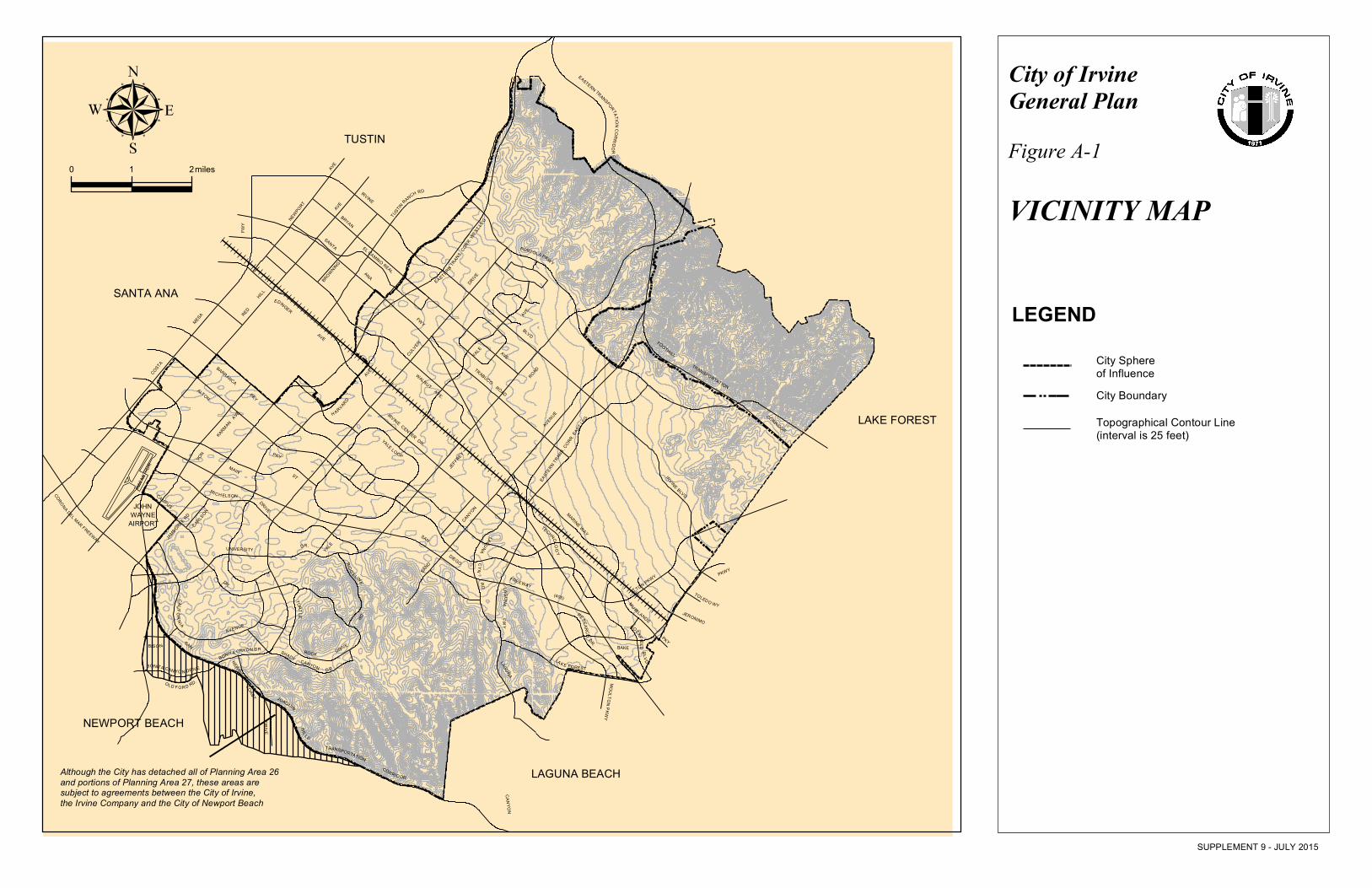
The City of Irvine and its sphere of
influence are located within the coastal and
foothill region of central Orange County.
Irvine is adjacent to the cities of Newport
Beach, Lake Forest, Tustin, Santa Ana,
Laguna Hills, Laguna Woods, and Laguna
Beach, as depicted on Figure A-1, Vicinity
Map.
The prominent landform areas in the City,
Lomas de Santiago Hills, northern flatlands,
central flatlands, and San Joaquin Hills
(Figure A-1), influence the way residential
and business development occurs in the
City. The development portions of the City
are located in the northern and central
flatlands, and along the westerly portion of
the San Joaquin Hills.
Spectrum Entertainment Center
The City is divided into distinct
neighborhoods called planning areas (Figure
A-2), with each planning area having its own
character. Each planning area is designed to
serve a diversity of lifestyles. Through
creative planning, each neighborhood is
unified to create a sense of community
identity.
Residential growth has been concentrated
within the central portions of the City
(Planning Areas 5, 8, 10, 11, 12, 14, 15, 19,
20, 21, 24, 36, 38, and 50). Each planning
area has a unique theme which provides a
sense of identity through its design and
connection with surrounding retail and other
amenities. Existing neighborhoods includes
conveniently located retail, office, and public
facilities to support residential development.
The convenient location of community
facilities, in relation to the residential areas,
promotes their viability and vitality.
"Irvine is like a necklace, each
village is a gem of that necklace,
so you'll find a difference between
each gem, not like a set of pearls
looking the same. Each village is
its own gem, it doesn't become a
community until you string it
together and hold it together; and
it's a necklace.''
Ray Watson, Vice Chairman of
The Irvine Company
Employment growth has been concentrated
adjacent to regional transportation facilities
(i.e., airport, freeways, and train station) on
the western and eastern edges of the City
(Planning Areas 12, 13, 31, 32, 33, 35 - Irvine
Spectrum, 36 -Irvine Business Complex , and
50-University of California, Irvine). Planning
Area 50 has grown rapidly and is a major

City of Irvine A-3 Land Use Element
General Plan
employment generator. Planning Areas 13, 31,
32, 33, 34, 35, and 36 are important regional
employment centers with a variety of
industrial uses and office complexes.
The northern and southern hillside areas of
the City are largely undeveloped lands.
These areas provide an extraordinary view of
the surrounding mountains and the ocean.
Portions of these hills will eventually be
developed with residential units, while other
portions will remain as permanent open
space. The County of Orange has proposed
a commercial airport in the northern flatland
area.
Irvine Business Complex
Both the residential and employment
populations have experienced a tremendous
amount of growth and change since
incorporation in 1971. Land use policies
have been developed to help shape the
community's growing diverse population and
to continue providing high quality amenities
and infrastructure to make Irvine a safe and
exciting place to live. The physical
development of the City is the result of
deliberate choices regarding what to build,
create, and experience within the City.
Land Use Element policies, as identified in
Objectives A-1 through A-6, provide for
short-term and long-range management of
the City's natural and built environments, and
monitoring of development.
The Irvine Ranch was formed in
1864 from three large
Spanish-Mexican grants. During
the early years, the ranch was
devoted to sheep grazing. In 1893,
ranch operations began shifting to
field crops such as olives and citrus
orchards. In 1910, Irvine was the
world's leading producer of lima
beans.
Trends
Development of the balance of the City
represents a transition from a new town to a
mature City. When Irvine was incorporated
in 1971, it encompassed 28.3 square miles
and had a population of 20,156. In 1997, the
City encompassed 45 square miles and
contained a population of 125,000.
As the City continues to develop and move
toward ultimate build out, additional
applications for boundary changes will
occur, consisting of either annexation or
detachment of land. For example, the
northern sphere of influence will begin to
develop over the next ten years, and the City
anticipates annexing the areas. Any
proposals to modify the City boundaries
should be reviewed carefully to ensure
continued consistency with the General Plan.

City of Irvine A-4 Land Use Element
General Plan
Irvine promotes the well being of all people
through quality schools, comprehensive
childcare programs, effective law
enforcement, a variety of housing
opportunities, and an expansive open space
system.
Shady Canyon grading
Irvine's philosophy is to create and maintain
a community where people can live, work,
and play in an environment that is safe,
vibrant, and aesthetically pleasing.
In 1991, Irvine was twenty years old and had
reached the halfway point of its projected
growth and development. Build-out is
estimated in the year 2040. In the transition
to a mature city, Irvine will need to manage
a defined and established urban area, while
accommodating the expected development of
what amounts to the doubling of the
residential population and tripling of its
employment population. Commercial and
industrial development will likely continue to
out-pace residential development. The City
faces the challenge of ensuring that the City's
investment in its quality of life is protected
while planning for the future needs of the
community.
Land Use Categories
The General Plan designates the general
distribution and location of land to be used
for residential, business, industry, open
space, and other categories of land use. The
land use categories and diagram (Figure A-3)
guide future development and growth in a
way that promotes the health, safety, and
welfare of the community. The Land Use
diagram identifies historical resources,
resources in the City that may have historical
significance, and a waste facility, which may
involve activities related to processing,
treatment, handling, transfer, or disposal of
hazardous waste.
Each land use category is described on the
following page, with corresponding land use
intensities and densities presented in the
statistical table (Table A-1). In addition, the
non-regulatory statistical table (Table A-2) is
used to establish service level demands and
infrastructure needs for each category.
The following categories are described
below: Residential, Institutional,
Commercial, Business/Industrial, Multi-Use,
Military, and Conservation/Open Space.
Residential
Definition: Land designated for varying
intensities of housing. The five residential
subcategories below define the number of
dwelling units per acre and identify the
desired product type to be built. However,
development is not limited to the stated
product types in each subcategory. Other
uses such as schools, parks and churches
may be found in the residential category,
as appropriate.
Estate Density (0 - 1 units/acre). This level
of density is intended for the development of
large detached single-family homes in the
hillside areas of the City.
Low Density (0 - 5 units/acre). This level of
density is intended for the development of
attached and conventional detached housing
and other appropriate uses, such as schools
and parks, compatible with single-family
neighborhoods.

City of Irvine A-5 Land Use Element
General Plan
Supplement No. 8 June 2012
Medium Density (0 - 10 units/acre). This
level of density is intended for the
development of attached and conventional
detached housing and other types of
residential uses that have open space
characteristics similar to single-family
neighborhoods.
Medium-High Density (0 - 25 units/acre).
This level of density is intended for the
development of multifamily housing with
on-site recreation areas for common use.
High Density (0 - 40 units/acre). This level
of density is intended for the development of
multifamily housing with on-site recreation
areas for common use.
High Density Residential
Density averaging within a General Plan
residential category may be permitted at the
time of zoning or concept plan in order to
provide a mix of housing types and
opportunities through lower and higher
densities. The total may not exceed the
category's maximum number of dwelling
units for the planning area (i.e., Table A-1)
and may not affect the phased dedication
requirements (see Objective A-3).
Institutional
Definition: A variety of publicly or
privately owned and operated facilities
(hospitals, schools, religious facilities) and
other nonprofit land uses.
Some institutional land uses (e.g., schools,
utilities, and public facilities) are allowed in
all Land Use Element categories consistent
with established City ordinances and
policies.
Educational Facilities. This land use
category includes public and private
schools and support facilities from
kindergarten through college/university
levels. Dormitory uses associated with
college/university facilities are allowed
under this designation. Any conversion
ratio of residential dwelling units to
dormitory units shall be determined in
conjunction with the review and approval
of required discretionary development
cases. In such cases, the projected
population associated with the conversion
of dwelling units shall not exceed the
projected population associated with the
maximum intensity of residential dwelling
units allocated for the institutional land use
as defined in Table A-1. While the
location and size of public educational
facilities are the responsibility of the
various school districts, the City
cooperates in reserving the necessary land
to accommodate future facilities. Most of
the City is within the Irvine Unified School
District, however some areas in the City
are under the jurisdiction of the Tustin and
Santa Ana School Districts.

City of Irvine A-6 Land Use Element
General Plan
Supplement No. 8 June 2012
Public Facilities. This land use category
includes government, public, quasi-public,
and community owned facilities. Also
includes uses that may be privately owned,
but are nonprofit and generally open to the
public. Typical uses would be post offices,
libraries, museums, places of worship, child
care centers, fire facilities, police stations,
government buildings, non-profit housing,
utilities and other related uses.
Commercial
Definition: A variety of facilities for
the sale and purchase of commodities
and services.
Neighborhood Commercial. This land
use category provides convenience
shopping opportunities such as dry
cleaners, grocery stores, barber shops,
restaurants and similar types of uses for
the surrounding planning area.
Community Commercial. This land
use category includes uses intended to
serve the needs of the community at
large, including the industrial and
business areas. Automobile service,
retail, professional/administrative
offices, commercial recreation facilities,
service businesses, and similar types of
uses are allowed under this designation.
Research and development uses are
conditionally permissible if compatible
with surrounding land uses.
Regional Commercial. This land use
category includes uses intended to serve a
broad population base. Businesses in this
designation provide a wider array of services
such as major department stores, specialty
shops, professional offices, hotels and motels,
and institutional and government uses. This
mix of uses, combined with convenient access
to many modes of transportation, also can
accommodate the inclusion of high-density
residential development.
Commercial Recreation. This land use
category includes recreational and leisure
time activities such as amusement parks and
miniature golf courses.
Old Town Irvine
Industrial
Definition: The manufacture, production,
and processing of goods.
Research/Industrial. This land use
category includes uses intended for the
manufacturing, research and development,
storage, and distribution of materials or
products; administrative, professional, and
business offices associated with
manufacturing uses; and employee-oriented
retail services.

City of Irvine A-7 Land Use Element
General Plan
Supplement No. 8 June 2012
Urban/Industrial. (Irvine Business
Complex) This land use category provides
for offices, industry, and support
commercial, mixed with high-density
housing, and a variety of activities.
Typical uses are professional/medical
offices, industrial manufacturing, research
and development, support service retail,
restaurants, multifamily housing and
hotel/motels. The IBC Element of the
General Plan outlines the framework for
future development of the IBC as a
mixed-use community.
Multi-use
Definition: The integration of a variety
of land uses and intensities.
Multi-use. This land use category
includes uses which are high intensity and
urban in character. Typical uses include
medium to high density residential,
commercial, institutional, and offices.
Orange County Great Park
Definition: The development of regionally
significant conservation and open space,
parks and recreation, educational
facilities, and other public-oriented land
uses, integrated with privately developed
multi-use, residential, commercial, and
industrial properties, at the former
MCAS El Toro site.
The Orange County Great Park land use
category ensures the development of a
Great Park and other cultural and
institutional uses at the former MCAS El
Toro site. The site will serve as a
countywide asset consistent with the intent
of the citizens of Orange County, who
adopted Measure W, the “Orange County
Central Park and Nature Preserve
Initiative,” in March 2002. This land use
category includes habitat preservation,
conservation and open space, parks and
recreation, education, institutional, and
other public-oriented land uses as well as
opportunities for the private development
of agriculture, research and development,
commercial, transit-oriented, and
residential development. The property
owners entered into a development
agreement with the City on July 12, 2005;
therefore allowing development to occur at
maximum intensities referred to as the
“Overlay Plan”. These intensities are
identified in Table A-1.
Military Definition: Land under the
jurisdiction of the United States.
The Military land use category currently
shown on the Land Use Element map
shall be retained within the General Plan
until such time as the City’s planning
efforts establish new and compatible land
uses for MCAS Tustin.
Conservation and Open Space
Definition: Land or water that is
essentially unimproved for the
purposes of management and natural
resources, production of preservation
or enhancement of resources, outdoor
recreation, or public health and safety.

City of Irvine A-8 Land Use Element
General Plan
Agriculture. This designation identifies
land utilized for commercial nurseries
and for the production of food, including
the growing of crops or grazing of
animals on natural prime or improved
pasture land.
Preservation Area. This designation
identifies lands that contain visually
significant ridgelines, biotic communities
of high significance, geologic
constraints, and cultural resources.
Quail Hill
These lands have been judged desirable
for permanent preservation in a natural
state with little or no modification. They
have also been amassed in a manner,
which, overall has been judged to be
more protective of natural resources than
could be achieved on an incremental
basis with individual development
projects. Passive, noncommercial public
recreation, utilities, cattle grazing,
scientific research, transition zones, and
flood control facilities and other similar
uses are allowed in this category.
Irvine adopted a plan in 1989 to
permanently preserve approximately
9,500 acres of open space in the City
and its sphere of influence. The plan
created the largest publicly owned open
space system of any city of comparable
size in California. Areas to be
preserved as a result of the plan are
Bommer Canyon, portions of Shady
Canyon, Quail Hill, the San Joaquin
Marsh, and the Santiago Hills.
Recreation Area. This designation
contains uses primarily for active public
recreational activities that are enjoyed by
the immediate and the surrounding
communities. City-owned parks,
regional parks, golf courses, and other
similar uses are allowed in this category.
Water Bodies. This designation
identifies public and privately owned
reservoirs and lakes which will provide
the City with water resources and
opportunities to develop water-related
recreation activities.
NCCP/HCP Reserve Areas (Natural
Communities Conservation
Program/Habitat Conservation Plan).
This designation identifies land areas set
aside to protect and manage habitat
supporting a broad range of plant and
animal populations that are found within the
central and coastal subregions.
_________________
Supplement No. 7 March 2009

City of Irvine A-9 Land Use Element
General Plan
Identification of Issues
1. How can the City maintain a mix of land
uses in order to provide adequate housing
and employment opportunities?
2. How can the City balance employment,
population growth and fiscal constraints?
3. How can the City address the cumulative
effects of employment and population
increases on the City’s infrastructure and
financial base?
4. How can the City identify and
consolidate conservation and open space
areas into large contiguous areas?

City of Irvine A-10 Land Use Element
General Plan
Response to Issues
The following objectives, and policies have
been formulated to respond to land use
issues. Please refer to the Natural
Communities Conservation Program for
more information.
OBJECTIVE A-1
CITY IDENTITY Preserve and strengthen Irvine's
identity as a diverse and innovative
community.
The following policies support
Objective A-1:
Policy (a): Develop identifiable City edges,
pathways, entry points, and landmarks, and
conserve visual resources along the scenic
corridors which characterize Irvine.
Historic Street Sign
Policy (b): Use building masses and
landscaping to create a sense of unity for
the various components throughout the
City.
Policy (c): Ensure energy efficiency and low
maintenance needs through the following
methods:
Land use planning.
Building design.
Landscaping design.
Policy (d): Maintain and enhance the
physical appearance of the City as the
infrastructure ages and the growth rate
declines.
Policy (e): Enhance civic pride by
maintaining high quality and attractive
facilities.
Policy (f): Promote sustainable
development through energy and water
conservation, reduced reliance on
non-renewable resources, and the use of
native trees, shrubs, and grasses with low
maintenance costs.
Policy (g): Distinguish individual
planning areas in character and physical
appearance by considering the following
characteristics during design and
development:
Physical and visual separation.
Architectural style.
Planning area edge.
Woodbridge

City of Irvine A-11 Land Use Element
General Plan
Policy (h): Incorporate the following
components in each residential planning
area:
A mixture of housing types and
densities.
A variety of public and private
facilities.
Activity nodes.
Open space areas.
Policy (i): Promote creative and diverse
methods of incorporating City identity in
the development of City infrastructure.
Methods may include, but are not limited
to, the following:
Concrete hardscape with impressions
of people, flora, fauna or historical
scenes.
Unique building materials.
Wall murals.
Signs.
Streetscape designs including street
furniture, period light poles, statuary,
fountains or unique landscaping such
as topiary or native plants.
Festive or seasonal banners.
OBJECTIVE A-2 ECONOMIC DEVELOPMENT Promote viable commercial
centers, successful
manufacturing areas, and
dynamic employment centers.
The following policies support
Objective A-2:
Policy (a): Retain and attract manufacturing
and industrial uses within designated
business centers.
Policy (b): Provide neighborhood retail and
service centers within walking or biking
distance of residential communities and
employment centers.
Irvine Business Complex
Irvine aspires to strengthen the City's
economic base and create a climate in
which businesses can prosper by
promoting Irvine as the "City of choice,”
retaining our existing business base,
creating quality employment
opportunities, and reducing regulations
and the cost of doing business.
Although industry is a major segment of
Irvine's economy, the City also boasts
many thriving retail centers and service
firms. Irvine is the location of many of
the nation's most successful companies,
from medical and the biosciences to
high-technology firms.
Policy (c): Provide community commercial
centers to serve more than one planning
area.
Policy (d): Combine day and night uses in
commercial centers by permitting shared
use parking for off-peak activities
(churches, movie theaters, etc.).

City of Irvine A-12 Land Use Element
General Plan
Policy (e): Designate commercial centers in
each planning area consistent with the size
of the planning areas being served.
Policy (f): Promote support and service
retail uses within the business/industrial
land use designations.
Policy (g): Promote Irvine as a city of
choice for business through development
of the following:
A proactive marketing plan.
Public/private partnerships to
promote business relations.
Business outreach programs.
Business assistance programs.
Affordable housing opportunities for
Irvine employees.
Business incentives.
Policy (h): Retain and attract businesses
that meet the shopping and service needs
of the community as well as create
quality employment opportunities.
OBJECTIVE A-3
OPEN SPACE AREAS
Encourage land use development that
preserves the beauty of the natural
environment.
The following policies support Objective A-3:
Policy (a): Preserve the City's open space
areas through implementation of the
Phased Dedication and Compensating
Development Program.
On June 7, 1988, the residents of the
City approved the Open Space Initiative.
The objectives of the Open Space
Initiative are: Consolidate important
conservation and open space areas into
large contiguous areas that may be
integrated into local and regional open
space areas.
Establish a network of open space spines
linking the consolidated conservation
and open space areas.
Assure the preservation of conservation
and open space areas through a Phased
Dedication and Compensating
Development Opportunities Program,
which transfers development
opportunities from conservation and
open space areas and consolidates them
in appropriate development areas. The
program links the dedication of
conservation and open space areas to the
development entitlement process. The
purpose of the program is to provide
permanent protection of open space by
means of public ownership. With
completion of the program, which is
described in Appendix A of the General
Plan, all major open space preservation
areas that are required to assure a
balance of development and open space
will be secured.
Policy (b): Ensure development in the
hillside areas retains the character and
aesthetic value of the natural landform
through use of the Hillside Development
Ordinance.
Policy (c): Design roadways to preserve
the natural topography and minimize
their impact on any environmentally
sensitive areas through the following
efforts:

City of Irvine A-13 Land Use Element
General Plan
Designing alignments to pass around
rather than through sensitive areas.
Designing grade separation of
roadways when applicable.
Permitting flexibility in grading
standards in roadway design, when
applicable.
Bommer Canyon
Policy (d): Ensure developments occurring in
close proximity to NCCP/HCP
implementation areas are consistent with the
NCCP plan and/or implementing agreement.
OBJECTIVE A-4
BALANCED LAND USES
Manage growth to ensure balanced
residential and nonresidential
development throughout the City. The following policies support Objective A-4:
Policy (a): Ensure that land uses enable the
City to provide necessary municipal
services by:
Implementing and monitoring Statistical
Tables A-1-and A-2.
Establishing development intensity for
the institutional designation in addition
to the development intensity allowed in
the adopted land use category.
This policy applies to those institutional
uses which support the surrounding land
uses. Included institutional uses are
public schools, libraries, museums,
places of worship, day care and child
care centers, police and fire stations,
institution-related housing and
not-for-profit housing.
Adjustments to square footage will be
included in the development monitoring
program and reflected in the statistical
tables through annual technical updates.
Institutional uses will be considered
consistent with the General Plan if the
following criteria are met:
a. All significant environmental
impacts are mitigated to a level of
insignificance; and
b. Infrastructure capacity under
existing and future (build out)
conditions can accommodate
additional development in the areas
of circulation, fire, police, water, and
flood control services; or
c. Development intensity under the
adopted land use category is
exchanged for intensity to
accommodate institutional
development in the areas of
circulation, fire, police, water, and
flood control services within the
same planning area.
Policy (b): Prepare an annual monitoring
report regarding the development trends in
the City to ensure that phasing of future
development provides adequate housing
and employment opportunities.

City of Irvine A-14 Land Use Element
General Plan
Policy (c): Achieve a land-use balance
through the following methods:
Coordination of land use and
circulation patterns to ensure adequate
circulation capacity and infrastructure.
Promotion of a diversity of housing
types and affordability to meet the
development objectives of the Housing
Element.
Designation of sufficient institutional
land to meet the needs of each
planning area.
Provision of adequate housing
opportunities to support employment
growth.
Preservation of open space areas.
Policy (d): Reduce expenditures for public
services and facilities by clustering
residential development.
Policy (e): Coordinate strategies with the
County of Orange to meet housing and
employment needs.
San Diego Creek Trail
Policy (f): Attract land uses that generate
revenue to the City, while maintaining a
balance of other community needs such as
housing, open space, and public facilities.
“We wanted to make Irvine a place
where people would say, „This is
my home. ‟ A balanced community
with jobs, housing, schools, parks,
retail, and a university.”
Ray Watson, Vice Chairman of
The Irvine Company
Policy (g): Maintain accurate statistical
information and intensity ceilings in the
General Plan through the following efforts:
Considering the land use impacts of
any decision to modify the City’s
boundaries, including required
modifications to Tables A-1 and A-2.
Reducing the allowed intensity of
development in conjunction with any
action to detach lands from the City’s
boundaries or sphere of influence,
consistent with any existing
agreements between the City and the
property owner that regulate
development intensity. When intensity
is reduced, the intensity in Table A-1
shall be reduced in proportion to the
amount of acreage detached in each
land use category.
Evaluating land use intensities in
conjunction with the review of any
zone change to permit development or
modify intensity. Factors to be
considered include, but are not limited
to, the following: the maximum
intensity allowed pursuant to Table A-1
of the General Plan; large infrastructure
improvements planned or built in the
project area that have reduced land
available for development; circulation
patterns; environmental constraints;
and compatibility with surrounding
land

City of Irvine A-15 Land Use Element
General Plan
uses. If the amount of land available
for development is significantly lower
than the gross acreage identified in the
General Plan, the City shall consider
reducing intensity.
Allocating intensity to a specific
planning area(s) in lieu of banking
intensity when it is the City’s desire to
transfer intensity between planning
areas.
Requiring a General Plan Amendment
and zone change to allocate units
banked pursuant to the NCCP
Facilitation Agreement as depicted in
Table A-1.
Policy (h): The City Council shall consider
the concurrent processing of a General Plan
amendment (and/or zone change) with
proposals to reorganize its municipal
boundaries, including any request to annex
or detach land, or adjust the City
boundaries or the sphere of influence
(municipal boundary reorganization). The
review of the proposal shall make the
following determinations:
Consistency with the General Plan,
specifically to reconcile the land use
diagram and the regulatory and
non-regulatory intensity tables
Consistency with the Zoning
Ordinance.
Consistency with all applicable
agreements (including, but not limited
to the Open Space Memorandum of
Understanding, the Planning Area 26
detachment agreements, the NCCP
Facilitation Agreement, and other
development agreements).
Whether to depict the detached areas on
the City’s land use diagram.
Proposals which consist only of minor
right-of-way exchanges and do not
affect land use acreages or intensity are
not subject to this provision.
OBJECTIVE A-5
FISCAL PROGRAM Promote economic prosperity by
ensuring City revenues meet
expenditures and provide quality
services without burdensome levels of
fees or taxes.
The following policies support
Objective A-5:
Policy (a): Maintain or improve existing
service levels while extending services to
newly developed areas.
Policy (b): Pursue cost-saving measures
while maintaining the quality of city
services.
Policy (c): Maintain a fiscally balanced
General Plan that will generate revenue in
excess of costs by a margin of 15 percent
(5 percent for long-term projection error;
5 percent for economic uncertainty, such
as inflation or recession; and 5 percent for
funding for rehabilitation).
Policy (d): Ensure that funding is available
for the City's long-term capital
improvement and maintenance needs.
Policy (e): Encourage maintenance of
common areas by community
associations and/or maintenance districts
rather than the City.
Policy (f): Develop and maintain a diverse
economic base with a variety of business
types, sizes, and markets.

City of Irvine A-16 Land Use Element
General Plan
Policy (g): Pursue industrial and
commercial uses which provide a
municipal revenue surplus for capital
investment and rehabilitation of facilities.
University Town Center
Policy (h): Require the preparation of a
fiscal analysis for boundary adjustments
and General Plan amendments, if
necessary, to evaluate the long-term
fiscal impact to the City.
Policy (i): Evaluate the relationship
between projected City revenues and
expenditures in conjunction with
proposed land use changes.
OBJECTIVE A-6
LAND USE COMPATIBILITY Achieve harmonious land use
patterns throughout the City.
The following policies support Objective A-6:
Policy (a): Ensure, through the discretionary
review process, the public health, safety,
and welfare of sensitive receptors/land uses
when locating such uses in close proximity
to the following land uses:
Uses which handle, generate, and/or
transport hazardous substances (as
defined by federal and state
regulations).
Uses which create excessive noise.
Uses which create excessive dust.
Uses which create other land use
conflicts.
At the same time, ensure that the proposed
sensitive receptors/land uses will not have an
impact on the continued operation and/or
expansion of the following land uses:
Airports.
Surface utilities.
Off-Site hazardous waste facilities.
Solid waste facilities.
Manufacturing uses.
Research and development uses.
Mining and processing uses.
Any land use which handles,
generates, and/or transports
hazardous substances as defined by
federal and state regulations.

City of Irvine A-17 Land Use Element
General Plan
Policy (b): When a sensitive receptor land
use is proposed to be established in a zoning
district other than residential that allows
businesses that use, store, or generate
hazardous substances (i.e., most
non-residential districts in the city), the
project proponent of the sensitive land use
shall be responsible for promoting the
safety of the occupants of the site as set
forth in the Zoning Ordinance.
Sensitive Receptors:
Land uses considered to be sensitive
receptors include residential, schools,
childcare centers, acute care hospitals,
and long-term health care facilities.
Sensitive receptors are determined based
upon special factors, which may include
the age of the users, or occupants (e.g.,
children or elderly), the frequency and
duration of the use or occupancy,
continued exposure to hazardous
substances as defined by federal and
state regulations, and the user's ability to
evacuate a specific site in the event of a
hazardous incident.
Policy (c): Ensure, through the discretionary
review process, that the siting of any land
use which handles, generates, and/or
transports hazardous substances, as defined
by federal and state regulations, will not
have a negative impact on existing
sensitive receptors/land uses.
Policy (d): Work with UCI in planning its
for-profit developments and University
environs to ensure compatible land uses.
Policy (e): Work closely with operator(s) of
existing landfill sites to minimize
deleterious effects on surrounding land
uses including possible impacts generated
by rodent and insect populations, odors,
and ground water conditions.
Policy (f): Coordinate with the county,
landowners, and other cities and agencies
in developing compatible land uses for
areas adjacent to the City boundary.
Policy (g): In coordination with other
agencies, require all significant impacts
associated with the closure and reuse of
former MCAS El Toro and former MCAS
Tustin to be mitigated to a level acceptable
to the City.
Irvine Business Complex
Policy (h): Ensure residential development
proposed in the Irvine Business Complex
is located in areas where adequate
supporting uses and public services and
facilities can be provided. Housing
designed for senior citizens should be
located only in areas that are within
reasonable walking distance or accessible
by public transportation to such facilities.

City of Irvine A-18 Land Use Element General Plan Supplement No. 9 July 2015
Policy (i ): Ensure that sensitive uses are allowed in areas with identified hazards only if the hazard has been adequately analyzed and mitigated.
Policy ( j): Residential areas and sensitive uses shall be protected from the encroachment of incompatible activities or land uses which would cause a hazard or substantial nuisance or otherwise create a negative impact upon sensitive uses or the residential living environment.
Correlation of General Plan Land Use Categories with Zoning Ordinance Districts.
The General Plan Land Use Element objectives and policies strive to obtain a balance of land uses and a high quality of development. The General Plan focuses on the long-term development of the City. Land use policies are defined and implemented through Irvine's Zoning Ordinance. The Zoning Ordinance regulates the location, type of use, and character of development. The following table illustrates the Zoning Ordinance district which correlates with each General Plan Land Use category.
General Plan/Zoning Correlation
General Plan Category Zoning District
Conservation & Open Space
Agriculture 1.1 Exclusive Agriculture Preservation Area 1.4 Preservation Area Recreation Area 1.5 Recreation Area Water Bodies 1.6 Water Bodies Landfill Overlay 1.7 Landfill Overlay Golf Course Overlay 1.8 Golf Course Overlay
Residential (du/acre) (gross acres)
(net acres)
Estate (0 - 1) 2.1 Estate (0 - 1) Low (0 - 5) 2.2 Low (0 - 6.5) Medium (0 - 10) 2.3 Medium (0 - 12.5) Med.-High (0 - 25) 2.4 Med.-High (0 - 31) High (0 - 40) 2.5 High (0 - 50)
Multi-use
Multi-use 3.1 Multi-use 8.1A Trails and Transit Oriented Development
Commercial
Neighborhood 4.1 Neighborhood Commercial Community 4.2 Community Commercial
4.3 Vehicle Related Commercial Commercial Rec. 4.4 Commercial Recreation Regional Commercial 4.5 Regional Commercial
4.6 Retail Office 4.7 Urban Commercial 4.8 Garden Commercial 4.9 Lower Peters Canyon Regional Commercial
Business/Industrial
Urban/Industrial 5.0 IBC Mixed-use 5.1 IBC Multi-use 5.2 IBC Industrial Research/Industrial 5.3 IBC Residential 5.4 General Industrial 5.5 Medical & Science
5.6 Business Park
Institutional
Educational Facility 6.1 Institutional Public Facilities 6.1 Institutional
Military
Military 7.1 Military Orange County Great Park
Orange County Great Park 1.1 Exclusive Agriculture 1.4 Preservation 6.1 Institutional 8.1 Trails and Transit Oriented Development

_________________
Supplement No. 7 March 2009
City of Irvine A-19 Land Use Element General Plan
OBJECTIVE A-7: URBAN DESIGN
Create a visually attractive and efficiently organized City. The following policies support Objective A-7:
Policy (a): Conduct a comprehensive concept planning process for each planning area to prevent piecemeal and inefficient community development and to resolve area wide planning issues prior to development approval.
Policy (b): Emphasize planning areas as
important community elements with diverse characteristics within a cohesive and unified city framework.
Policy (c): Implement the concept of a multiple focal point City designed to minimize congestion by conveniently locating facilities and services in each planning area.
Policy (d): Ensure that each planning area contains an internal system of trails linking schools, shopping centers, and other public facilities with residences.
Policy (e): Distinguish planning areas in character and physical appearance from each other, considering the following during design and development:
• Physical, visual separation, and differentiation.
• Physical compatibility with the local environment including topography.
• Mixture of housing types and densities.
• Range of age and income groups. • Variety of public and private facilities. • Activity nodes. • Varied “skyline.” • Functional relationship among the
components of the community. • Interface with adjacent planning areas.
Public Art
Regulatory Statistical Table
According to state law, general plans must contain standards for building intensity. The regulatory statistical table, Table A-1 meets this requirement and relates to the amount of physical development that will be allowed in each land use category. The table defines the concentration of use for each category and provides a statement of Irvine’s long-range potential for development.
Nonregulatory Statistical Table
Table A-2 is a nonregulatory table which assigns acreage to each land use category identified by the Land Use Element. Table 14 contains nonregulatory population standards for each use. The terms “nonregulatory” and “gross” are defined below.
Nonregulatory: The Nonregulatory statistical tables establishes service level demands, public facility needs, and infrastructure sizing requirements based on

City of Irvine A-20 Land Use Element General Plan
land use intensity and population density, in relation to the projected need for land. This statistical table represents a historical baseline for growth monitoring and identification of trends. The nonregulatory statistical table provides the foundation for monitoring reports on the implementation of the General Plan and is not considered part of the General Plan. Gross Acreage: Acreage totals for the non-regulatory tables are estimates originally derived from the Land Use Element diagram using a computerized planimeter. Currently, the acreage figures are refined through the use of the Geographic Information System. As such, the acreage estimates reflect gross acre figures. The gross acre figures include rights of way, easements, and flood control rights of way, etc. Therefore, the acreage figures are not intended to be a regulatory minimum or maximum with respect to land use designations. The gross acre figure may be revised as more accurate information is obtained from subsequent development applications. The acre figure will be adjusted to conform to precise City boundaries, road alignments, slope conditions and other general plan policies and guidelines through the development monitoring program.
“The earth is given as a common for men to labor and live in.”
Thomas Jefferson
“I have an affection for a great city. I feel safe in the neighborhood of man, and enjoy the sweet security of streets.”
Longfellow
RELATED OBJECTIVE NUMBERS
The following objectives are related to the Land Use Element: Circulation Element - B-1 through B-7 Housing Element - C-1, C-2, C-4, C-5, C-7 Seismic Element - D-1, D-2 Cultural Resources Element - E-1, E-2 Noise Element - F-1, F-2 Public Facilities Element - G-1 Integrated Waste Management Element - H-1, H-2, H-3 Energy Element - I-1 Safety Element - J-1, J-2 Parks and Recreation Element - K-1, K-2, K-3 Conservation and Open Space Element - L-1 through L-5, L-7 through L-12 Growth Management Element - M-2, M-6, M-7
__________________
Supplement No. 7 March 2009
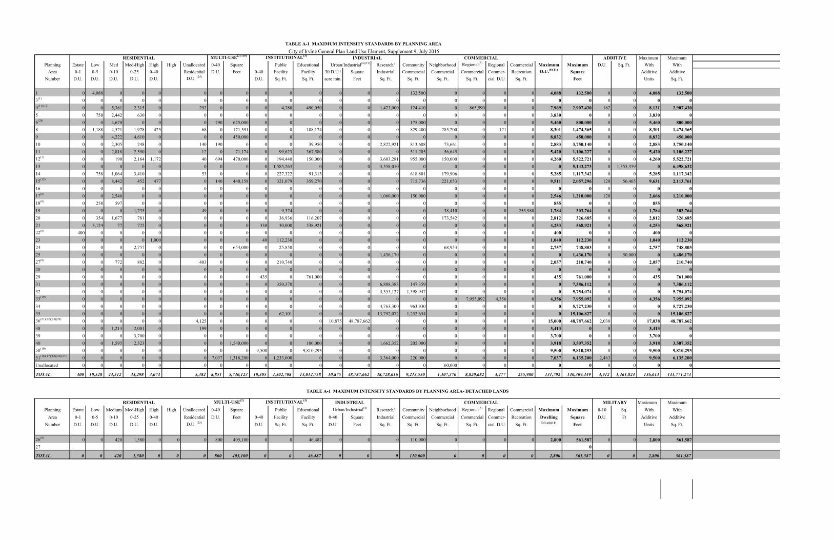
RESIDENTIAL MULTI-USE(2) (15) INSTITUTIONAL(3)COMMERCIAL ADDITIVE Maximum Maximum
Planning Estate Low Med Med-High High High Unallocated 0-40 Square Public Educational Research/ Community Neighborhood Regional(5)Regional Commercial Maximum Maximum D.U. Sq. Ft. With With
Area 0-1 0-5 0-10 0-25 0-40 Residential D.U. Feet 0-40 Facility Facility 30 D.U./ Square Industrial Commercial Commercial Commercial Commer- Recreation D.U.(6)(11)Square Additive Additive
Number D.U. D.U. D.U. D.U. D.U. D.U. (25)D.U. Sq. Ft. Sq. Ft. acre min. Feet Sq. Ft. Sq. Ft. Sq. Ft. Sq. Ft. cial D.U. Sq. Ft. Feet Units Sq. Ft.
1 0 4,088 0 0 0 0 0 0 0 0 0 0 0 0 132,500 0 0 0 0 4,088 132,500 0 0 4,088 132,500
3(1)0 0 0 0 0 0 0 0 0 0 0 0 0 0 0 0 0 0 0 0 0 0 0 0 0
4(11)(12)0 0 5,361 2,315 0 293 0 0 0 4,380 490,050 0 0 1,423,000 124,410 0 865,590 0 0 7,969 2,907,430 162 0 8,131 2,907,430
5 0 758 2,442 630 0 0 0 0 0 0 0 0 0 0 0 0 0 0 0 3,830 0 0 0 3,830 0
6(28)0 0 4,670 0 0 0 790 625,000 0 0 0 0 0 0 175,000 0 0 0 0 5,460 800,000 0 0 5,460 800,000
8 0 1,188 4,521 1,978 425 68 0 171,591 0 0 188,174 0 0 0 829,400 285,200 0 121 0 8,301 1,474,365 0 0 8,301 1,474,365
9 0 0 4,222 4,610 0 0 0 450,000 0 0 0 0 0 0 0 0 0 0 0 8,832 450,000 0 0 8,832 450,000
10 0 0 2,305 248 0 140 190 0 0 0 39,950 0 0 2,822,921 813,608 73,661 0 0 0 2,883 3,750,140 0 0 2,883 3,750,140
11 0 0 2,818 2,590 0 12 0 71,174 0 99,623 367,580 0 0 0 511,205 56,645 0 0 0 5,420 1,106,227 0 0 5,420 1,106,227
12(7)0 0 190 2,164 1,172 40 694 470,000 0 194,440 150,000 0 0 3,603,281 955,000 150,000 0 0 0 4,260 5,522,721 0 0 4,260 5,522,721
13 0 0 0 0 0 0 0 0 0 1,585,263 0 0 0 3,558,010 0 0 0 0 0 0 5,143,273 0 1,355,359 0 6,498,632
14 0 758 1,064 3,410 0 53 0 0 0 227,322 91,313 0 0 0 618,801 179,906 0 0 0 5,285 1,117,342 0 0 5,285 1,117,342
15(15)0 0 8,442 452 477 0 140 440,158 0 321,079 359,270 0 0 0 715,736 221,053 0 0 0 9,511 2,057,296 120 56,465 9,631 2,113,761
16 0 0 0 0 0 0 0 0 0 0 0 0 0 0 0 0 0 0 0 0 0 0 0 0 0
17(8)0 0 2,546 0 0 0 0 0 0 0 0 0 0 1,060,000 150,000 0 0 0 0 2,546 1,210,000 120 0 2,666 1,210,000
18(8)0 258 597 0 0 0 0 0 0 0 0 0 0 0 0 0 0 0 0 855 0 0 0 855 0
19 0 0 0 1,735 0 49 0 0 0 9,374 0 0 0 0 0 38,410 0 0 255,980 1,784 303,764 0 0 1,784 303,764
20 0 354 1,677 781 0 0 0 0 0 36,936 116,207 0 0 0 0 173,542 0 0 0 2,812 326,685 0 0 2,812 326,685
21 0 3,124 77 722 0 0 0 0 330 30,000 538,921 0 0 0 0 0 0 0 0 4,253 568,921 0 0 4,253 568,921
22(8)400 0 0 0 0 0 0 0 0 0 0 0 0 0 0 0 0 0 0 400 0 0 0 400 0
23 0 0 0 0 1,000 0 0 0 40 112,230 0 0 0 0 0 0 0 0 0 1,040 112,230 0 0 1,040 112,230
24 0 0 0 2,757 0 0 0 654,000 0 25,850 0 0 0 0 0 68,953 0 0 0 2,757 748,803 0 0 2,757 748,803
25 0 0 0 0 0 0 0 0 0 0 0 0 0 1,436,170 0 0 0 0 0 0 1,436,170 0 50,000 0 1,486,170
27(8)0 0 772 882 0 403 0 0 0 210,740 0 0 0 0 0 0 0 0 0 2,057 210,740 0 0 2,057 210,740
28 0 0 0 0 0 0 0 0 0 0 0 0 0 0 0 0 0 0 0 0 0 0 0 0 0
29 0 0 0 0 0 0 0 0 435 0 761,000 0 0 0 0 0 0 0 0 435 761,000 0 0 435 761,000
31 0 0 0 0 0 0 0 0 0 350,370 0 0 0 6,888,383 147,359 0 0 0 0 0 7,386,112 0 0 0 7,386,112
32 0 0 0 0 0 0 0 0 0 0 0 0 0 4,355,127 1,398,947 0 0 0 0 0 5,754,074 0 0 0 5,754,074
33(19)0 0 0 0 0 0 0 0 0 0 0 0 0 0 0 0 7,955,092 4,356 0 4,356 7,955,092 0 0 4,356 7,955,092
34 0 0 0 0 0 0 0 0 0 0 0 0 0 4,763,300 963,930 0 0 0 0 0 5,727,230 0 0 0 5,727,230
35 0 0 0 0 0 0 0 0 0 62,101 0 0 0 13,792,072 1,252,654 0 0 0 0 0 15,106,827 0 0 0 15,106,827
36(21)(22)(23)(29)0 0 0 0 0 4,125 0 0 0 0 0 10,875 48,787,662 0 0 0 0 0 0 15,000 48,787,662 2,038 0 17,038 48,787,662
38 0 0 1,213 2,001 0 199 0 0 0 0 0 0 0 0 0 0 0 0 0 3,413 0 0 0 3,413 0
39 0 0 0 3,700 0 0 0 0 0 0 0 0 0 0 0 0 0 0 0 3,700 0 0 0 3,700 0
40 0 0 1,595 2,323 0 0 0 1,540,000 0 0 100,000 0 0 1,662,352 205,000 0 0 0 0 3,918 3,507,352 0 0 3,918 3,507,352
50(10)0 0 0 0 0 0 0 0 9,500 0 9,810,293 0 0 0 0 0 0 0 0 9,500 9,810,293 0 0 9,500 9,810,293
51(16)(17)(18)(26)(27)0 0 0 0 0 0 7,037 1,318,200 0 1,233,000 0 0 0 3,364,000 220,000 0 0 0 0 7,037 6,135,200 2,463 0 9,500 6,135,200
Unallocated 0 0 0 0 0 0 0 0 0 0 0 0 0 0 0 60,000 0 0 0 0 0 0 0 0 0
TOTAL 400 10,528 44,512 33,298 3,074 5,382 8,851 5,740,123 10,305 4,502,708 13,012,758 10,875 48,787,662 48,728,616 9,213,550 1,307,370 8,820,682 4,477 255,980 131,702 140,309,449 4,912 1,461,824 136,613 141,771,273
TABLE A-1 MAXIMUM INTENSITY STANDARDS BY PLANNING AREA- DETACHED LANDS
RESIDENTIAL MULTI-USE(2) INSTITUTIONAL(3) INDUSTRIAL COMMERCIAL MILITARY Maximum Maximum
Planning Estate Low Medium Med-High High High Unallocated 0-40 Square Public Educational Urban/Industrial(4)Research/ Community Neighborhood Regional(5)
Regional Commercial Maximum Maximum 0-10 Sq. With With
Area 0-1 0-5 0-10 0-25 0-40 Residential D.U. Feet 0-40 Facility Facility 0-40 Square Industrial Commercial Commercial Commercial Commer- Recreation Dwelling Square D.U. Ft Additive Additive
Number D.U. D.U. D.U. D.U. D.U. D.U. (25)D.U. Sq. Ft. Sq. Ft. D.U. Feet Sq. Ft. Sq. Ft. Sq. Ft. Sq. Ft. cial D.U. Sq. Ft. D.U.(6)(11) Feet Units Sq. Ft.
26(8)0 0 420 1,580 0 0 0 800 405,100 0 0 46,487 0 0 0 110,000 0 0 0 0 2,800 561,587 0 0 2,800 561,587
27 0
TOTAL 0 0 420 1,580 0 0 0 800 405,100 0 0 46,487 0 0 0 110,000 0 0 0 0 2,800 561,587 0 0 2,800 561,587
TABLE A-1 MAXIMUM INTENSITY STANDARDS BY PLANNING AREA
INDUSTRIAL
Urban/Industrial(4)(21)
City of Irvine General Plan Land Use Element, Supplement 9, July 2015

City of Irvine A-23 Land Use Element General Plan Supplement 9, July 2015
TABLE A-1 MAXIMUM INTENSITY STANDARDS BY PLANNING AREA
GENERAL PLAN FOOTNOTES
1. For planning areas not yet annexed, the County of Orange maintains land use authority and controls related regulatory activities. Dwelling units and square footage totals may not reflect the Orange County General Plan.
2. This designation allows a variety of land uses, including the high-
density residential category.
3. Refer to Objective A-4, Policy (a) for additional institutional category requirements. Within each planning area, actual intensity is regulated by the appropriate agencies involved. The development intensity for institutional uses is in addition to the development intensity allowed in the adopted land use category.
4. This designation provides for a variety of land uses and is based
upon 63,476 AM (peak hour), 76,173 PM (peak hour) and 812,673 ADT as the maximum intensity regulating factor (refer to the IBC database), with the exception of Planning Area 4.
5. This designation provides for a variety of land uses, which are
regulated by the Irvine Center Development Agreement for PA 33. The development intensity is derived from the Irvine Center Development Agreement adopted August, 1993. The development intensity for PA 33 was determined by converting the allowable points (6,300) to gross leaseable square feet and then multiplying by 1.15 to achieve a gross floor area. As such, the Irvine Center Development Agreement is estimated to allow approximately 8,388,980 square feet of gross floor area. An additional 1,514,000 square feet of gross floor area is permitted subject to the Zoning Ordinance, for a planning area total of 9,902,980 square feet. With the approval of General Plan Amendment 41359-GA (CC Reso. 03-115) in August 2003, residential units were introduced into Planning Area 33 and accompanied by a footnote indicating that non-residential intensity must be reduced by a set amount for every residential unit built so as to avoid any increase in total traffic in Planning Area 33. Based on the approval 3,150 units, the maximum gross floor area is approximately 7,955,092 square feet. In addition, the footnote allows adjustments to the residential and non-residential intensity figures, pursuant to this footnote, without a requirement to file a subsequent General Plan amendment for those adjustments. The actual development intensity within PA 33 may exceed these estimates subject to the traffic provisions

City of Irvine A-24 Land Use Element General Plan Supplement 9, July 2015
contained in the Development Agreement. Within Planning Area 4, this designation provides for a variety of land uses as provided by the Lower Peters Canyon Development Agreement.
6. The permitted range of dwelling units (low-high) may be less than
that allowed by the available acreage. The residential intensity ranges are based on estimated gross figures and may be adjusted through technical refinements to reflect more accurate information at subsequent planning levels.
7. Within Planning Area 12, the multi-use designation allows medium
high or high density residential use.
8. On September 26, 1988, the "Memorandum of Understanding Implementing Initiative Resolution 88-1" was approved, establishing a 10,600 dwelling unit cap for Planning Areas 17, 18, 22, 26 and 27. In addition, the Memorandum permits up to 800 dwelling units in lieu of commercial in Planning Area 26, for an overall cap of up to 11,400 dwelling units.
9. Reserved.
10. The University of California controls land use authority and related
regulatory activities. Dwelling unit totals are based on the University's Long-Range Development Plan.
11. Total residential Dwelling Units within Planning Area 4 shall not
exceed 7,969.
12. Residential uses within Sector 11 of Planning Area 4 shall not exceed 2,830 ADT unless additional environmental documentation ensures traffic mitigation.
13. Reserved.
14. Derived from Planning Area 22 Zone Change [16868-ZC, CC Reso
95-79)].
15. In Planning Area 15, a total of 50,526 square feet of Institutional Uses are located on a site have been allocated equally to two sites designated as High Density Residential and located at 4445 Alton Parkway and 23 Lake Street designated as High Density Residential. Additionally, 5,939 square feet of Institutional Uses have been allocated to a site designated as Multi-Use and located at 5010 Barranca Parkway. This square footage is considered
City of Irvine A-25 Land Use Element General Plan Supplement 9, July 2015
additive and is not included in the Planning Area 15 total intensity caps.
16. Maximum Square Footages for Multi-Use Non-Residential Conversions: The “Heritage Fields Project 2012
General Plan Amendment and Zone Change Traffic Analysis, approved November 26, 2013, or subsequent traffic analysis amending those assumptions, analyzed 1,318,200 square feet of Multi-Use (Office) in Planning Area 51. If any other non-residential land uses within 8.1 TTOD zoning district are proposed in-lieu of Multi-Use (Office), the square footage may be adjusted accordingly within the General Plan Table A-1 without the need for a General Plan Amendment.
17. The 1,233,000 square feet in Institutional/Public Facilities in
Planning Area 51 includes 122,500 square feet for Orange County Transit Authority facilities; 300,000 square feet for County of Orange facilities; 263,000 square feet for warehousing for homeless providers; 468,000 square feet of institutional uses; 26,000 square feet of sports park; and 53,500 square feet of remote airport terminal.
18. In order to develop at the maximum intensities for Planning Area51,
the property owner has entered into a development agreement, (recorded on July 12, 2005), which requires the dedication of land and the development or funding of infrastructure improvements in excess of the City’s standard requirements, and the commitment to long-term maintenance of public facilities. This agreement was amended by the Amended and Restated Development Agreement adopted pursuant to City Council Ordinance 09-09.
19. To the extent that residential units are built in PA 33, within the
4.7C Urban Commercial District, a corresponding reduction in the allowable non-residential intensity shall occur in terms of equivalent traffic generated. The actual amount of reduction in non-residential intensity will be based upon a conversion rate of 648 square feet of non-residential intensity per dwelling unit (as established in the traffic analysis “City of Irvine Spectrum 1 Traffic Analysis” July 2003). Revisions to the non-residential and residential intensity figures for PA 33 (consistent with this note) are authorized without the need for a subsequent general plan amendment
20. Reserved
21. Reserved

City of Irvine A-26 Land Use Element General Plan Supplement 9, July 2015
22. Reserved 23. Development Agreement 00310468-PDA vested certain
entitlements for the Park Place development (collectively, the “Vested Park Place Entitlements”). The Vested Park Place Entitlements include the right to allocate the maximum permitted intensity of development within Park Place among the various permitted and conditionally permitted uses utilizing the development points system set forth in Section V.E.-736.5 of the 1989 Zoning Code (the “1989 Point System”). The maximum intensity limits for Planning Area 36 allow for up to 3,450 dwelling units within Park Place subject to an overall intensity limit 8,567,880 total points under the 1989 Point System which have been allocated to Park Place under the Vested Park Place Entitlements. To the extent that the 3,450 maximum unit entitlement is not developed at Park Place, non-residential uses may be developed at Park Place by utilizing unused points under the 1989 Point System. Total construction within Park Place shall not exceed any of the following intensity limits: 3,450 residential dwelling units and 8,567,880 points under the 1989 Point System.
24. Reserved
25. Unallocated dwelling units represent those units remaining in a
Planning Area that may be built anywhere in the same Planning Area. These units are within the maximum development intensity for the Planning Area; and, therefore placement of unallocated units into any residential category within the planning area for purposes of development is determined to be consistent with the General Plan and Zoning Code with regard to intensity allocation only, provided that placement is otherwise consistent with site specific zoning regulations and that any potential environmental impacts are adequately addressed, including traffic impacts, pursuant to CEQA. Additionally, unallocated units in Planning Area 4 cannot be transferred between sectors per an existing development agreement.
26. On July 12, 2005, the City and Heritage Fields LLC executed the
Great Park Development Agreement that vested Heritage Fields’ right to develop 3,625 base units in Planning Areas 30 and 51(now referred to as Planning Area 51 with the 2012 General Plan Amendment and Zone Change). The November 6, 2008 Planning Commission approval of the Master Affordable Housing Plan and the Density Bonus Application granted the right to develop 1,269 density bonus units in Planning Areas 30 and 51 (now referred to

City of Irvine A-27 Land Use Element General Plan Supplement 9, July 2015
as Planning Area 51 with the 2012 General Plan Amendment and Zone Change). The City Council later approved the Density Bonus Agreement on August 9, 2009 regarding the implementation of the 1,269 density bonus units. The 2012 General Plan Amendment and Zone Change increase the maximum number of base units to 7,037 (3,625 plus 3,412) and the maximum number of density bonus units to 2,463 (1,269 plus 1,194) for a maximum of 9,500 units.
27. Density Bonus units granted pursuant to state law.
28. The development intensity allocated to 8.1A equates to 175,000
square feet of office use and 325,000 square feet of Research and Development use with a post-2030 trip limit of 5,115 average daily trips, 506 am peak hour trips and 509 pm peak hour trips based on NITM land use rates. To the degree residential units, up to a maximum of 790 dwelling units, or other uses are built in 8.1A, a corresponding reduction in the allowable Office and/or Research and Development intensity shall occur in terms of equivalent traffic generation based on a.m. peak, p.m. peak, and average daily trips. The actual amount of reduction will be based on land use based traffic generation rates, and using an average trip generation rate (10.73 ADT, 0.98 am peak hour trips and 0.94 pm peak hour trips per 1,000 square feet of office use and 9.96 ADT, 1.03 am peak hour trips and 1.06 pm peak hour trips per 1,000 square feet of research and development use) for Office and/or Research and Development intensity and the applicable rates for any proposed non-office use, as determined by the Director of Community Development.
29. The IBC Vision Plan, adopted by City Council in July 2010,
assumed a theoretical total of 2,038 density bonus units. This total is based on 655 total density bonus units existing, under construction, approved, or in process at the time of Vision Plan adoption, plus an additional 1,383 potential density bonus units based on the maximum allowed pursuant to state law for the 3,950 potential base units identified to reach the 15,000 base unit cap at the time of Vision Plan approval. The minimum required density is 30 units per acre.
The Maximum Allowable Square Footage within Planning Area 36 can adjust upward or downward based upon the mix of land uses and is not considered a development cap as is the case in other planning areas. This estimated number can be adjusted as needed by City Staff as long as the resulting Planning Area development intensity is within the Planning Area Development Intensity Value budget. Land uses may be changed to any permitted or

City of Irvine A-28 Land Use Element General Plan Supplement 9, July 2015
conditionally permitted use within the corresponding zoning district, with the established development intensity values.
Unallocated dwelling units represent those units remaining in a Planning Area that may be built anywhere in the same Planning Area. These units are within the maximum development intensity for the Planning Area; and, therefore placement of Unallocated dwelling units into any residential category within the planning area for purposes of development is determined to be consistent with the General Plan and Zoning Code with regard to intensity allocation only, provided that placement is otherwise consistent with site specific zoning regulations and that any potential environmental impacts are adequately addressed, including traffic impacts, pursuant to CEQA.

TABLE A-2 NON-REGULATORY MAXIMUM INTENSITY STANDARDS: LAND USE ACREAGE BY PLANNING AREA
CONSERVATION/OPEN SPACE RESIDENTIAL MULTI-USE COMMERCIAL INDUSTRIAL INSTITUTIONAL MILITARY GREAT
Planning Agri- Preser- Rec- Water Estate Low Med. Med.- High Neighbor- Com- Com- Regional Urban Research/ Educa- PARK Total Planning
Area culture vation reation Bodies Res. Res. Res. High Res. hood munity mercial Industrial Industrial tional Public Acres Area
Number Res. Recreation Facilities Facilities Number
1 498 1,925 0 75 1,331 0 0 0 0 0 18 0 0 0 0 45 19 0 0 3,911 1
3(2)0 3,035 725 0 0 0 0 0 0 0 0 0 0 0 0 0 0 0 0 0 3,760 3(2)
4(1)(6)
0 0 8 0 0 0 920 195 0 48 0 23 0 106 0 109 0 0 0 0 1,409 4(1)(6)
5(1)
0 0 21 0 0 201 433 62 0 0 0 0 0 0 0 0 11 0 0 0 728 5(1)
6 205 1,178 172 22 0 0 1,137 0 0 78 0 15 0 0 0 0 0 0 0 0 2,807 6
8 6 0 33 0 0 245 846 162 41 6 40 86 0 0 0 0 52 0 0 0 1,517 8
9 0 0 52 0 0 0 883 191 0 62 0 0 38 0 0 0 0 0 0 0 1,226 9
10(1)
0 0 70 0 0 0 413 18 0 24 9 66 0 0 0 168 9 0 0 0 777 10(1)
11 0 0 113 0 0 0 570 303 0 7 7 56 0 0 0 0 96 7 0 0 1,159 11
12 0 179 154 0 0 0 60 227 101 36 17 78 0 0 0 244 110 23 0 0 1,229 12
13 0 0 77 0 0 0 0 0 0 0 0 0 0 0 0 253 0 0 0 0 330 13
14 0 0 126 0 0 168 188 246 0 0 20 76 0 0 0 0 18 16 0 0 858 14
15 0 0 128 56 0 0 1,228 54 39 41 22 63 0 0 0 0 92 22 0 0 1,745 15
16 0 594 18 0 0 0 0 0 0 0 0 0 0 0 0 0 0 0 0 0 612 16
17 0 225 44 0 0 0 394 0 0 0 0 39 0 0 0 139 0 0 0 0 841 17
18 0 447 0 0 0 155 150 0 0 0 0 0 0 0 0 0 0 0 0 0 752 18
19 0 0 167 0 0 0 0 157 0 0 0 18 22 0 0 0 0 0 0 0 364 19
20 0 0 19 0 0 93 298 114 0 0 22 0 0 0 0 0 48 0 0 0 594 20
21 0 0 691 53 0 916 11 60 0 0 0 0 0 0 0 0 140 0 0 0 1,871 21
22(3)
0 0 0 0 1,046 0 0 0 0 0 0 0 0 0 0 0 0 0 0 0 1,046 22(3)
23 0 214 62 0 0 0 0 0 27 0 0 0 0 0 0 0 16 97 0 0 416 23
24 0 0 112 0 0 0 0 204 0 30 13 0 0 0 0 0 0 0 0 0 359 24
25 0 0 0 0 0 0 0 0 0 0 0 0 0 0 0 131 0 0 0 0 131 25
27(4)0 459 0 0 0 0 455 95 0 0 0 0 0 0 0 0 2 13 0 0 1,024 27(4)
28 0 2,395 0 0 0 0 0 0 0 0 0 0 0 0 0 0 0 0 0 0 2,395 28
29(5)0 221 102 0 0 0 0 0 0 0 0 0 0 0 0 0 73 0 0 0 396 29(5)
31 0 0 0 0 0 0 0 0 0 0 0 12 0 0 0 364 0 35 0 0 411 31
32 0 0 0 0 0 0 0 0 0 0 0 83 0 0 0 354 0 0 0 0 437 32
33 0 6 0 0 0 0 0 0 0 0 0 0 0 439 0 0 0 0 0 0 445 33
34 0 0 0 0 0 0 0 0 0 0 0 96 0 0 0 402 0 0 0 0 498 34
35 0 0 0 0 0 0 0 0 0 0 0 114 0 0 0 930 0 110 0 0 1,154 35
36 0 0 0 0 0 0 0 0 0 0 0 0 0 0 2,764 0 0 0 0 0 2,764 36
38(1)0 0 48 0 0 0 234 152 0 0 0 0 0 0 0 0 0 0 36 0 470 38(1)
39 0 144 0 0 0 0 0 252 0 0 0 0 0 0 0 0 0 0 0 0 396 39
40 0 0 17 0 0 0 209 183 0 149 0 24 0 0 0 60 0 24 0 0 666 4050 0 0 0 0 0 0 0 0 0 0 0 0 0 0 0 0 1,371 0 0 0 1,371 50
51(7)(8)0 0 0 0 0 0 0 0 0 0 0 0 0 0 0 0 0 0 0 4,519 4,519 51(7)(8)
TOTAL 709 11,022 2,959 206 1,046 3,109 8,429 2,675 208 481 150 867 60 545 2,764 3,154 2,083 366 36 4,519 45,388
TABLE A-2 MAXIMUM INTENSITY STANDARDS: LAND USE ACREAGE BY PLANNING AREA - DETACHED LANDS
CONSERVATION/OPEN SPACE RESIDENTIAL MULTI-USE COMMERCIAL INDUSTRIAL INSTITUTIONAL MILITARY
Planning Agri- Preser- Rec- Water Estate Low Med. Med.- High Neighbor- Com- Com- Regional Urban Research/ Educa- Total Planning
Area culture vation reation Bodies Res. Res. Res. High Res. hood munity mercial Industrial Industrial tional Public Acres Area
Number Res. Recreation Facilities Facilities Number
26 0 155 400 43 0 0 186 280 0 37 0 23 0 0 0 0 0 0 0 1,124 26
27(4)0 85 58 0 0 75 6 61 0 0 0 0 0 0 0 0 0 5 0 290 27(4)
TOTAL 0 240 458 43 0 75 192 341 0 37 0 23 0 0 0 0 0 5 0 1,414
City of Irvine General Plan Land Use Element, Supplement 9, July 2015
A-27

City of Irvine A-29 Land Use Element General Plan Supplement 9, July 2015
TABLE A-2 MAXIMUM INTENSITY STANDARDS:
LAND USE ACREAGE BY PLANNING AREA GENERAL PLAN FOOTNOTES
1. Community Parks and some open space spines located within Recreation land use category in
Planning Areas 4, 5, 10, and 38 are conceptual. Unless specified in the Conservation and Open Space Element or the park code, the size of the open space spines or Community Parks will be determined concurrent with subsequent development applications.
2. Planning Area 3 includes a 730 acre Landfill overlay on the Recreational land use
designation. 3. Planning Area 22 includes a 620 acre Golf Course overlay on the Residential land use
designation. 4. Planning Area 27 includes a 58 acre Landfill overlay on the Recreational land use
designation. 5. Planning Area 29 includes a 33 acre Landfill overlay on the Recreational land use
designation. 6. Institutional acreage within Planning Area 4 represents a goal, not a requirement. Per the
Lower Peters Canyon Development Agreement, institutional uses for Planning Area 4 include: public & private schools; churches; libraries; post offices; police stations; fire facilities; day care centers; utilities; public facilities; hospitals; government offices; eductional facilities; non-profit housing, and institutional residential.
7. The Planning Area 51 total acreage figures include all General Plan Land Use categories as
well as railroad and roadway rights-of-way. The railroad and roadway rights-of-way acreage have not been divided into individual General Plan Land Use categories. Therefore, the total acreage in Planning Area51, although correct, is greater than the sum of the individual General Plan Land Use categories in the planning area.
8. In order to develop at the maximum intensities for Planning Area 51, the property owner has
entered into a development agreement (recorded on July 12, 2005), which requires the dedication of land and the development or funding of infrastructure improvements in excess of the City’s standard requirments, and the long-term maintenance of public facilities. This agreement was amended by the Amended and Restated Development Agreement adopted pursuant to City Council Ordinance 09-09.

City of Irvine Land Use Element General Plan A-30 Supplement No. 9 – July 2015
TABLE A-3 CITY OF IRVINE GENERAL PLAN
NON-REGULATORY POPULATION STANDARDS BY LAND USE ELEMENT CATEGORY
LAND USE CATEGORY EMPLOYEES PER EMPLOYEES PER
THOUSAND SQUARE FEET STUDENT
Multi-Use 1, 2 2.0 0 Industrial 1, 2
Research Industrial 1.9 0 Urban/Industrial 1.9 0
Commercial 1 Neighborhood 2.0 0 Community 2.0 0 Regional 2.0 0 Commercial Recreation 2.0 0 Educational Facilities 2.0 .05 Public Facilities 2.0 0 Residential 2 Residents per D.U. Estate 3.10 Low 2.90 Medium 2.75 Medium-High 2.25 High 1.46 Multi-Use 1.46 Private College 1.46 1 Employment ratios for Land Use Element categories allowing non-residential uses are correlated to Land Use Element non-residential building intensity standards (square feet). Employment ratios are consistent with the 1992 Trip Reduction Ordinance (TRO). 2 Population ratios for Land Use Element categories allowing residential uses are correlated to Land Use Element residential building intensity standards (du/ac). The population counts are based on the 2010 Federal Census.
TUSTIN
SANTA ANA
LAGUNA BEACH
LAKE FOREST
NEWPORT BEACH
JOHNWAYNE
AIRPORTROAD
NEWPORT
AVEAVE
ALTON
MAIN ST
AVE.
H ARVARD
DRIVEROCK
TURTLE
RIDG ELINEDR
MOULTON PKWY
LAGUNA
BAKE BLVD
PKWY
TRABUCO ROAD
FWY
EDINGER
AVEBLVD
TOLEDO WYJERONIMO
PKY
PKY
AVE.
BARRANCA
CAMPUS
MICH ELSON
DRIVE
CARLSON
DR.
CANYON
CANYON
AVENUE
AVE
TUSTIN RANCH RDIRVINE
BRYAN
SANTA
ANA
FWY
DRIVE
PORTOLA PKWY
MESA
CULVER
WALNUT AVE.
IRVINE CENTER DR.
KARMAN AVE.
VON
COSTA
YALE LOOPJEFFR
EY
SAN
YALEUNIVERSITY
CORONA DEL MAR FREEWAY
DIEGO
FREEWAY(405)
DR
CALIFORN IA
AVENUE
BIS O N
MU IRLANDS
LA K E FOREST
JAMBOREE RD
PKY
TECHNOLO GY
YALE
SAND
EASTERN TRANSPORTA TI ON CORRIDOR E A ST LEG
NEWPORTCOAST
DRIVE
SAN
RESEARCH DR.
EL CAMINO REAL
BROWNINGFOOTHILL
TRANSPORTATION
CORRIDOR
JOAQUIN H IL LS TRANSPORTATION CORRIDOR
OLD F O R D RD.
BONITA CAN YO N DRIVE
EASTERN TRAN
S. CORR. W
EST LEG
EAST
ERN TRAN
S. CORR. E
AST LE
G
IRVINE BLVD
ALTON PKWY
BONITA CNYON D R SHADY CANYON D R
MARINE WAY
RED
HILL
LAG UNAFW
Y
LAGUNACYN
RD
ROCKFIELD
MACA
RTHU
R
City of IrvineGeneral PlanFigure A-1
VICINITY MAP0 1 2miles
LEGENDCity Sphereof Influence
SUPPLEMENT 9 - JULY 2015
City Boundary
Topographical Contour Line(interval is 25 feet)
Although the City has detached all of Planning Area 26and portions of Planning Area 27, these areas aresubject to agreements between the City of Irvine,the Irvine Company and the City of Newport Beach

TUSTIN
SANTA ANA
LAGUNA BEACH
LAKE FOREST
NEWPORT BEACH
JOHNWAYNE
AIRPORT
ROAD
NEWPORT
AVE
AVE
ALTON
MAIN ST
AVE.HARVARD
DRIVEROCK
TURT LE
RIDG ELINEDR
MOULTON PKWY
LAGUNA
BAKE BLVD
PKWY
ROAD
TRABUCO ROAD
FWY
EDINGER
AVEBLVD
TOLEDO WYJERONIMO
PKY
PKY
AVE.
BARRANCA
CAMPUS
MICHELSON
DRIVE
CARLSON
DR.
CANYON
CANYON
AVENUE
AVE
TUSTIN RANCH RDIRVINE
BRYAN
SANTA
ANA
FWY
DRIVE
PORTOLA PKWY
MESA
CULVER
WALNUT AVE.
IRVINE CENTER DR.
KARMAN A
VE.
VON
COSTA
YALE LOOP
JEFFR
EY
SAN
YALEUNIVERSITY
CORONA DEL MAR FREEWAY
DIEGO
FREEWAY(405)
DR
CALIFOR N IA
AVENUE
BISON
MUIRLANDS
LAK E FOREST
JAMBO
REE RD
PKY
TECHNOLO GY
YALE
SAND
EASTERN TRANSPORTATI ON CORRIDOR E A ST LEG
NEWPORTCOAST
DRIVE
SAN
RESEARCH DR.
EL CAMINO REAL
BROWNING
FOOTHILL
TRANSPORTATION
CORRIDOR
JOAQUIN H IL LS TRANSPORTATION CORRIDOR
OLD FO R D RD.
BONITA CANYON DRIVE
EASTERN TR
ANS. C
ORR. WES
T LEG
EAST
ERN TR
ANS.
CORR. EAS
T LEG
IRVINE BLVD
ALTON PKWY
BONITA CNYON DR SHADY CANYON DR
MARINE WAY
RED
HILL
LAG UNAFW Y
LAGUNACYN
RD
ROCKFIELD
MACA
RTHU
R
1
3
6
51
8
4
36
9
28
21
15
5
50
12
11
35
2722
17
14
10
40
18
1620
34
33 32
38
31
39
232919
1324
25
36
City of IrvineGeneral PlanFigure A-2
PLANNINGAREAS
0 1 2miles
LEGENDCity BoundaryPlanning AreaBoundary
NOTE: Unshaded area is City & Sphere of Influence
SUPPLEMENT 9 - JULY 2015
Although the City has detached all of Planning Area 26and portions of Planning Area 27, these areas aresubject to agreements between the City of Irvine,the Irvine Company and the City of Newport Beach
PA1 Orchard HillsPA3 Limestone Canyon - Open SpacePA4 Lower Peters CanyonPA5 Northwood PointPA6 Portola SpringsPA8 NorthwoodPA9 PA9A Woodbury PA9B & C2 Stonegate PA9C1 Woodbury EastPA10 Walnut PA11 El Camino RealPA12 OakcreekPA13 Irvine Spectrum 4PA14 WestparkPA15 WoodbridgePA16 Quail Hill - Open Space
PA17 Quail HillPA18 N: Laguna Altura S: Hidden CanyonPA19 Rancho San JoaquinPA20 University ParkPA21 Turtle RockPA22 Shady CanyonPA23 San Joaquin MarshPA24 University Town CenterPA25 University Research CenterPA27 Turtle RidgePA28 Bommer Canyon - Open SpacePA29 UCI - North CampusPA31 Irvine Spectrum 6PA32 Irvine Spectrum 3PA33 Irvine Spectrum CenterPA34 Irvine Spectrum 5PA35 Irvine Spectrum 2PA36 Irvine Business ComplexPA38 Westpark IIPA39 Los OlivosPA40 Cypress VillagePA50 University of California, IrvinePA51 Orange County Great Park
A
B
C1
C2

DR
CALIFORNIA
PKY
AVE
SANTA
ANA
FWY
DRIVE
PORTOLA PKWY
AVE.
NEWPORT
AVE
FWY
YALE
COSTA
VON
DRIVE
HA RVARD
AVE.
MAINST
AVENUE
DRIVEROCK
DR
MOULTON PKWY
LAGUNA
SAN
DIEGO
LAGU
NARD
BLVD
TRABUCO ROAD
TOLEDO WY
PKWY
CORONA DELMAR FWY
YALE
BISON
TURTLE
CARLSO
N
MICHELSON
EDINGER
AVE
JEFFREY
WALNUT AVE.
LAGU
N AF W
Y
(405)
BAKE
MUIRLANDS
JERONIMO
FREEWAY
TECHNOLOGY
C ANY
ON
LOOP
YALE
ROAD
ALTON
KARMAN AVE.
LAKE FOREST
UNIVERSITY DR.
JAMBOREE RD
CAMPUS
PARKW A Y
BARRANCA
PKY
MESA
IRVINE CENTER DR.
AVENUE
CANYON
SAND
CULVER
BRYAN AVE
TUST
IN RAN
CH RD
IRVINE BLVD.
RIDGELINE
ROADCA NYON
EASTERN TRANSPORTATION CORRIDOR EAST LEG
NEWPORTCOAST
DRIVE
RESEARCH DR.
FOOTHILL
TRANSPORTATION
CORRIDOR
OLD FORD RD.
SAN
JOAQUIN H ILLS TRANSPORTATION CORRIDOR
BONITA CANYON DRIVE
EAST
ERN TR
ANS. C
ORR. W
EST L
EG
EAST
ERN TR
ANS. C
ORR. E
AST L
EG
IRVINE BLVD
ALTON PKWY
BONITA CANYON DR SHADY CANYON DR
MARINE WAY
RED
HILL
ROCKFIELD
MACA
RTHU
RMA
CART
HUR
JOHNWAYNE
AIRPORT
CC
RCCR
E EECC
E NPP
CCCCN CCEE
NEP
ECC
CCCCEE CCCCEPPF
P
PF PFCC E E ECC N CCP NE CCE ENCC P PFE CC
EPF PCR E CCCR CCE E N
CC CCN PFPF CC EUCI E RP CC
RNCC
RRPPCCE RE
CCRN N PE
UCI
CC
CCE PPF CC
CC
CR
PF
CR
PF
PF
E
E
CR
TUSTIN
SANTA ANA
LAGUNA BEACH
LAKE FOREST
NEWPORT BEACH
0 0.8 1.6miles
The General Plan land use acreage dwelling units andsquare footage data are contained within the text.
SUPPLEMENT 9 - JULY 2015
Although the City has detached all of Planning Area 26and portions of Planning Area 27, these areas aresubject to agreements between the City of Irvine,the Irvine Company and the City of Newport Beach
City of IrvineGeneral PlanFigure A-3
LAND USE
NOTES TO LAND USES(1) Land Use authority and corresponding regulatory activities are theresponsibilities of the government agencies which own this land.(2) These governmental agencies are subject to the General Plan reqiurementscontained within the California Government Code sections 65401 and 65402.(3) These Land Use categories also allow residential developments notedin the General Plan text.(4) The Land Use Element Table A-1 establishes and regulates land usebuilding intesity standards. Building intensity standards are allocatedby Planning Area.
LEGENDCONSERVATIONOPEN SPACE
RecreationPreservation
Water Bodies
Agriculture
Golf Course Overlay
Landfill Overlay
NCCP Reserve
NCCP Special Linkage
COMMERCIAL
Neighborhood Commercial(4)
Community Commercial(4)
Regional Commercial(4)
Commercial Recreation(4)
Historic Resources
Waste Facility
InterchangeFreeway
Transportation Corridor
ExpresswayMajor Highway 8-LanesMajor Highway 6-Lanes
RESIDENTIAL BUSINESS/INDUSTRIALEstate(4)
Low Density(4)
Medium Density(4)
Medium High Density(4)
High Density(4)
INSTITUTIONAL
Research and Industrial(4)
Urban and Industrial(3)(4)
Educational Facilities(1)(2)(3)(4)
Public Facilities(4)
Primary Highway
Secondary Highway
Commuter
Railroads
E
PF
NCC
R
CR
MILITARY(1)(3)(4)
MULTI USE(3)(4)
Lifelong Learning Dist.
Orange CountyGreat Park

City of IrvineGeneral PlanFigure A-4
SCENICHIGHWAYS
0 1 2miles
LEGEND
Urban Character
SUPPLEMENT 9 - JULY 2015
Rural or NaturalCharacter
Major View
Although the City has detached all of Planning Area 26and portions of Planning Area 27, these areas aresubject to agreements between the City of Irvine,the Irvine Company and the City of Newport Beach
TUSTIN
SANTA ANA
LAGUNA BEACH
LAKE FOREST
NEWPORT BEACH
ROAD
NEWPORT
AVE
AVE
ALTON
MAIN ST
AVE.
HA RVARD
DRIVEROCK
TURTLE
RIDG ELINEDR
MOULTON PKWY
LAGUNA
BAKE BL VD
PKWY
ROAD
TRABUCO ROAD
FWY
EDINGER
AVEBLVD
TOLEDO WYJERONIMO
PKY
PKY
AVE.
BARRANCA
CAMPUS
MICHELSON
DRIVE
CARLSON
DR.
CANYON
CANYON
AVENUE
AVE
TUSTIN
RANCH RDIRVINE
BRYAN
SANTA
ANA
FWY
DRIVE
PORTOLA PKWY
MESA
CULVER
WALNUT AVE.
IRVINE CENTER DR.
KARMAN
AVE
.
VON
COSTA
YALE LOOP
JEFFR
EY
SAN
YALEUNIVERSITY
CORONA DEL MAR FREEWAY
DIEGO
FREEWAY(405)
DR
CALIFOR N IA
AVENUE
BIS ON
MUIRLANDS
LAK E FOREST
JAMBOREE RD
PKY
TECHNOLO GY
YALE
SAND
EASTERN TRANSPORTATI ON CORRIDOR E A ST LEG
NEWPORTCOAST
DRIVE
SAN
RESEARCH DR.
EL CAMINO REAL
BROWNING
FOOTHILL
TRANSPORTATION
CORRIDOR
JOAQUIN H IL LS TRANSPORTATION CORRIDOR
OLD FO R D RD.
BONITA CANYON DRIVE
EASTERN TRAN
S. CORR. W
EST L
EG
EASTE
RN TR
ANS.
CORR
. EAS
T LEG
IRVINE BLVD
ALTON PKWY
BONITA CNYON DR SHADY CANYON D R
MARINE WAY
RED
HILL
LAGUNAFW Y
LAGUNACYN
RD
ROCKFIELD
MACA
RTHU
R
JOHNWAYNE
AIRPORT
Although the City has detached all of Planning Area 26and portions of Planning Area 27, these areas aresubject to agreements between the City of Irvine,the Irvine Company and the City of Newport Beach
0 1 2miles