Land-Sea Interactions in the Coastal Zone · INOC-CNRS, International Conference on “Land-Sea...
227
INOC-CNRS, International Conference on “Land-Sea Interactions in the Coastal Zone” Jounieh - LEBANON, 06-08 November – 2012 0 International Conference - ﺣﻮل اﻟﺪوﻟﻲ اﻟﻤﺆﺗﻤﺮLand-Sea Interactions in the Coastal Zone ا اﻟﻴﺎﺑﺴﺔ ﺑﻴﻦ اﻟﻤﺘﺒﺎدﻟﺔ ﻟﺘﺄﺛﻴﺮات اﻟﺴﺎﺣﻠﻴﺔ اﻟﻤﻨﻄﻘﺔ ﻓﻲ واﻟﺒﺤﺮ"Les Interactions Terre- Mer dans la zone côtière" Jounieh - LEBANON, November 06 - 08, 2012 Organized by CNRS /National Centre for Marine Sciences Inter Islamic Science & Technology Batroun – LEBANON Network on Oceanography Izmir – TURKEY Co-sponsored by: Islamic Development Bank AUF LOICZ Prepared by: A. CHOUIKHI, G. KHALAF & M. ABBOUD – ABI SAAB CNRS- INOC / November 2012
Transcript of Land-Sea Interactions in the Coastal Zone · INOC-CNRS, International Conference on “Land-Sea...

INOC-CNRS, International Conference on “Land-Sea Interactions in the Coastal Zone” Jounieh - LEBANON, 06-08 November – 2012
0
International Conference - المؤتمر الدولي حول
Land-Sea Interactions in the Coastal Zone
والبحر في المنطقة الساحليةلتأثيرات المتبادلة بين اليابسةا
"Les Interactions Terre- Mer dans la zone côtière"
Jounieh - LEBANON, November 06 - 08, 2012
Organized by
CNRS /National Centre for Marine Sciences Inter Islamic Science & Technology Batroun – LEBANON Network on Oceanography Izmir – TURKEY
Co-sponsored by:
Islamic Development Bank AUF LOICZ
Prepared by: A. CHOUIKHI, G. KHALAF & M. ABBOUD – ABI SAAB
CNRS- INOC / November 2012

INOC-CNRS, International Conference on “Land-Sea Interactions in the Coastal Zone” Jounieh - LEBANON, 06-08 November – 2012
1
International Conference - المؤتمر الدولي حول
Land-Sea Interactions in the Coastal Zone
لتأثيرات المتبادلة بين اليابسة والبحر في المنطقة الساحليةا
"Les Interactions Terre- Mer dans la zone côtière "
Jounieh - LEBANON, November 06 - 08, 2012
Table of Contents Page
List of articles/ Liste des articles
1-15
Provisional program/ Programme provisoire
16-30
Khalaf G., Abboud- Abi Saab M., Fakhri M., Lelli S., and Hamze M. Environmental Monitoring and Sustainable Development of the Lebanese Sea, CANA Project.
31
H.H. Kremer LOICZ-Global Coastal Change and Human Dimensions: the next 10 years of Earth system science in context of the FUTURE EARTH Research for Global Sustainability Programme
32
ABSTRACTS / RESUMES
Theme 1: Coastal habitats and ecosystem services
Mohammed S., Ammar A., Obuid- Allah Ahmed H., Montaser A. & Al-Hammady M. Coral growth and skeletal densities in relation to environmental impacts.
34
Salah H. & Aloui - Bejaoui N. Inventaire des espèces de mollusques Polyplacophores et première mention de la présence d’Acanthochitona crinita (Pennant, 1777) suite aux aménagements hydrauliques réalisés dans le lac Nord de Tunis.
35
Awad M. Successful application of hyperspectral images to retrieve Lebanese sea water parameters.
36
Tazerouti F. & Kechemir –Issad N. Biodıversité des Monogenea plathelminthes parasites des sélaciens batoides (Torpedinidae, Rajidae, Dasyatidae et Myliobatidae) des côtes d’Algérie.
37
Zarshenas G. A.
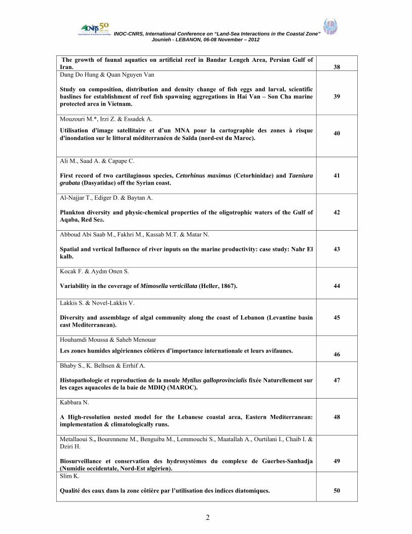
INOC-CNRS, International Conference on “Land-Sea Interactions in the Coastal Zone” Jounieh - LEBANON, 06-08 November – 2012
2
The growth of faunal aquatics on artificial reef in Bandar Lengeh Area, Persian Gulf of Iran.
38
Dang Do Hung & Quan Nguyen Van Study on composition, distribution and density change of fish eggs and larval, scientific baslines for establishment of reef fish spawning aggregations in Hai Van – Son Cha marine protected area in Vietnam.
39
Mouzouri M.*, Irzi Z. & Essadek A.
Utilisation d'image satellitaire et d’un MNA pour la cartographie des zones à risque d'inondation sur le littoral méditerranéen de Saïda (nord-est du Maroc).
40
Ali M., Saad A. & Capape C. First record of two cartilaginous species, Cetorhinus maximus (Cetorhinidae) and Taeniura grabata (Dasyatidae) off the Syrian coast.
41
Al-Najjar T., Ediger D. & Baytan A.
Plankton diversity and physic-chemical properties of the oligotrophic waters of the Gulf of Aqaba, Red Sea.
42
Abboud Abi Saab M., Fakhri M., Kassab M.T. & Matar N. Spatial and vertical Influence of river inputs on the marine productivity: case study: Nahr El kalb.
43
Kocak F. & Aydın Onen S. Variability in the coverage of Mimosella verticillata (Heller, 1867).
44
Lakkis S. & Novel-Lakkis V. Diversity and assemblage of algal community along the coast of Lebanon (Levantine basin east Mediterranean).
45
Houhamdi Moussa & Saheb Menouar
Les zones humides algériennes côtières d’importance internationale et leurs avifaunes.
46
Bhaby S., K. Belhsen & Errhif A. Histopathologie et reproduction de la moule Mytilus galloprovincialis fixée Naturellement sur les cages aquacoles de la baie de MDIQ (MAROC).
47
Kabbara N. A High-resolution nested model for the Lebanese coastal area, Eastern Mediterranean: implementation & climatologically runs.
48
Metallaoui S., Bourennene M., Benguiba M., Lemmouchi S., Maatallah A., Ourtilani I., Chaib I. & Dziri H. Biosurveillance et conservation des hydrosystèmes du complexe de Guerbes-Sanhadja (Numidie occidentale, Nord-Est algérien).
49
Slim K. Qualité des eaux dans la zone côtière par l’utilisation des indices diatomiques.
50

INOC-CNRS, International Conference on “Land-Sea Interactions in the Coastal Zone” Jounieh - LEBANON, 06-08 November – 2012
3
Sharareh Savari, Stephane Aris-Brosou and Thomas Moon Expression and function of 5’-AMP activated protein kinase (AMPK) in response to physiological and pharmalagical changes in rainbow trout, Oncorhynchus mykiss.
51
Kanaan H., Yassine F., Sebaaly C. & Karaki N. Influence of seasons on the composition of brown and red algae growing on the Lebanese coast and the pharmaceutical, medical and agro-food applications of their isolated polysaccharides.
52
Savari A. , Platt T., Bishop H. Eco-Sensing of the Persain Gulf and the Gulf of Oman environment by compound remote sensing.
53
Zebboudj A., Djouad S., Sayad A. & Ait Meziane H.
Lagune Tamelaht : une zone humide très vulnérable.
54
Mouawad R., Daou C. & Hage K. Evaluation of water quality and the study of meiofaunal communities on Lebanese sandy beaches.
55
Mohammad Ali Salari-Aliabadi, Ali Reza Shamoradi, Seyed Mohammad Bagher Nabavi & Yaqoub Parsa
Identification and ecological assessment of intertidal ecosystems in Khark Island (Persian Gulf).
56
Saad A., Sabour W., Soulaiman A. & Gnaidi C. Importance of Lattakia beach (Syria) as nesting area for marine turtles: results of seven years of field survey.
57
Moulai R., Kebbi M., Lazib M. & Oudihat K. Biologie de la reproduction du petit Gravelot, Charadrius dubius et du Gravelot à collier interrompu Charadrius alexandrinus sur le littoral de Béjaia (Algérie) et facteurs de vulnérabilités.
58
Rabbaniha M., Izadpanahi G., Mohsenizadeh F. & Owfi F. Comparing of phytoplankton assemblage in inshore and offshore waters of the Persian Gulf (Southern Bushehr waters).
59
Yekta F. A., Izadi S. & Asgari M.
Distribution of rocky intertidal mollusks in Qeshm Island, the Persian Gulf.
60
Pour F. A. & Reza Shokri M.
Efficacy of different taxonomic resolutions and surrogates in rapid environmental impact assessment.
61
Jaferian A., Zolgharnein H. , Mohammadi M., Mohamad-Ali Salari-Aliabadi M-A, Hossini S.-J.,
Zomorodipour A. and Shokofeh Farhadi
Study of Eleutheronema tetradactylum populations in the Persian Gulf using microsatellite
62

INOC-CNRS, International Conference on “Land-Sea Interactions in the Coastal Zone” Jounieh - LEBANON, 06-08 November – 2012
4
markers. Pourjomeh F., Shokri M.R. & Kiabi B. Conservation value of natural and artificial boulders in southern coast of the Caspian Sea.
63
Theme 2: Adaptation/mitigation to change in coastal systems
Darwish T.M., Zdruli P., Saliba R., Awad M., Shaban A., & Faour G. Assessment of sensitivity to desertification in Lebanon.
65
Benmalek Y. & Fardeau M. L. Bioaccumulation of lead and zinc ions by a Gram-negative bacteria.
66
Ediger D., Beken Ç., Tüfekçi V., Hüsrevoğlu S. & Atabay H. Monitoring of water quality in the Izmit Bay.
67
Emara H. I. Spatiotemporal changes of Hexachlorocyclohexane compounds in Mediterranean Seawater West of Alexandria.
68
Rastgar S., Movahedinia A., Savari A. & Yarahmadi Z. Central dopaminergic, serotonergic, & noradrenergic neurotransmission induced by benzo(a)pyrene in short-term and long-term exposure in Acanthopagrus latus.
69
Sidoumou Z., Ould Senhoury A. & Ould Yarba l. La côte mauritanienne face aux effets des changements climatiques.
70
Taleb H. Menace des efflorescences d’algues nuisibles en Afrique du Nord : Gestion et Surveillance.
71
Muhammad Faiz M.H., Shahbudin S., Yukinori M. & Mohammad-Noor N. Suspended sediment effects on coral distribution at marine protected areas in east Coast of Malaysia.
72
Hamzeh M., Ouddanea B., Halwanib J., Baroudib M. & Cachotc J. Trace metals in superficial sediments of the Seine estuary: concentration levels and toxicity risk.
73
Bellassoued K., Hamza A., Van Pelt J. & Elfeki A. Effet de phytoplanctons toxiques et des métaux dans la réponse antioxydant chez la saupe de l’île de Kerkennah.
74
Paimpillil J. Subterraneous ground water flux to coastal zones and seasonal productivity blooms along with Mudbank formations.
75

INOC-CNRS, International Conference on “Land-Sea Interactions in the Coastal Zone” Jounieh - LEBANON, 06-08 November – 2012
5
Faour G. & El Hage M.
Coastal vulnerability assessment of Lebanon to Sea level rise.
76
Said M. A., El-Geziry T.M. & Radwan A. A. Long-term trends of extreme climate events over Alexandria region, Egypt.
77
El-Moujabber M., Bou Samra B., Atallah T. & Darwish T. Groundwater contamination by seawater intrusion in the southern Lebanese Coast.
78
EL-Saharty A. A. Radioactive survey of costal water and sediments across Alexandria and Rashid coasts.
79
Eless F. & Awad M. Rainfall evolution and its consequences on Lebanon’s water resources in the coastal region.
80
Abdallah C., Houdaib R. Seawater Intrusion in Lebanon, Khalde-Jiyeh stretch as a case study.
81
Al-Zibdah M.
Health assessment of coastal environment through monitoring of coral fish parasites and diseases in Gulf of Aqaba- Red Sea
82
Lakkis S., Novel-Lakkis V. & Zeidane R. Biological invasion of indo-pacific species in eastern Mediterranean: is it a sequence of global warming inducing tropicalization of the marine environment?
83
Mohd Zaini Mustapa, Shahbudin Saad and Noraisyah Sapon Beach-face dynamics and sediment grain-size along the coast of Pahang, Malaysia
84
Abbas H.H., Authman M. M. & Mohamed G. F. Effect of seasonal temperature changes on thyroid structure and hormones secretion of white grouper (Epinephelus aeneus) in Suez Gulf, Egypt.
85
Bourenane Bouhafs N., Devaux A., Zouainia S. & Djebbar Berrebbah H. La pollution aquatique et le déclin des amphibiens: effets d'un pesticide récemment introduit en Algérie sur la survie et le développement larvaire de la grenouille verte Saharica rana.
86
Khalaf G., Mina R., Fakhri M., Abi Ghanem C. & Matar N. Corrélation des paramètres bactériologiques et physico-chimiques de certains points chauds de la région côtière libanaise.
87
Aliakbar Hedayati, Hamed Kolangi Miandare Acute toxicity test of Mercury, Lead and Zinc in Roach (Rutilus rutilus).
88

INOC-CNRS, International Conference on “Land-Sea Interactions in the Coastal Zone” Jounieh - LEBANON, 06-08 November – 2012
6
Daas T., Hamdi L., Maamcha O. & Scaps P.
Biosurveillance du littoral Est d’Algérie : Pollution et Biodiversité.
89
Fereidoon Owfi, Mahnaz Rabbaniha , Khosrow Aeinjamshid Determination of point pollution sources in Iranian side of the Persian Gulf coastal zone base on indicator and sentinel species, using by GIS.
90
Razaghi M., Shokri M. R., Savari A. & Pazooki J.
Efficacy benthic community versus sediment quality indices as indicator of petrochemical development impact.
91
Daas-Maaamcha O., Snani M., Daas T. & Scaps P. Effets de la pollution marine sur la reproduction et détoxification chez Perinereis cultrifera (Annélide, Polychète) dans le littoral Est Algérien.
92
Fakhri M., Ouba A., Abboud-Abi Saab M. & Khalaf G. Impact of domestic waste water on the sediment of Ramlet-el-Bayda-Beirut public beach.
93
El Jisr N., Nader M.R., ; El Indary Sh., Obeid P., Younes M. & Nakat H. Heavy metals detection in shellfish in an area in front of Selaata.
94
Oryan S. Heavy metal contamination in Liza Abu in a stretch of Karun river tributaries entering the Persian Gulf.
95
Boualem Chebira Les divers impacts du tourisme sur la zone côtière d’El-Kala.
96
Zare-maivan H. & Sabzghabayee G.
Benthic fauna in a stretch of Karun river tributaries entering the Persian Gulf.
97
Belhadi Y., Bouchareb N. & Ounissi M. Estimation des Flux des nutriments et des sédiments à l'embouchure des Oueds Soummam, Isser et Sebaou (centre algérois).
98
Homayoun Khoshravan & Seidmasoumeh Banihashemi Temporal and spatial variation of sand dunes erosion, Caspian Sea.
99
Bensalah f., Slimane N. & Guermouche A. Contribution à l’élaboration de consortiums bactériens impliqués dans la biodégradation des hydrocarbures (pétrole, rejet industriel).
100
Mooraki N., Moghadasi B., Manoochehry H. & Changizy R.
Spatial distribution and assemblage structure of Foraminifera in Nayband Estuary, North-West of the Persian Gulf, in relation to industrial activities.
101

INOC-CNRS, International Conference on “Land-Sea Interactions in the Coastal Zone” Jounieh - LEBANON, 06-08 November – 2012
7
Abi Ghanem C., Najjar E. & Adam N.
Pb and Cd contamination and mobility in marine sediments of two ports in Lebanon.
102
Abboud Abi Saab M., Fakhri M., Kassab M. T., Matar N. & Hassoun A. R. Effect of continental input on marine environment in Lebanese coastal waters.
103
Ali Rashid Tabrez & Asif Inam The issue of coastal erosion and accretion along Makran coast of Pakistan.
104
Theme 3: Coastal Management
Chillasse L.
The Sebou river basin in Morocco -A new approach to integrated management of water resources, coastal included.
106
Darwis M. & Toha T. Sustainable Seaweed culture in small area: Water quality environment and socio-economical effect “Case Study in Tarakan Island, East Kalimantan – Indonesia”.
107
Mehanna S., Zaki S., Al-kiuymi F., Al-Kharusi L., Al-Bimani S.
Biology and fisheries management of spangled emperor Lethrinus nebulosus from the Arabian Sea Coast of Oman.
108
Al-Thukair A. A. A Case study on the Impact of Coastal Development along the East Coast of Saudi Arabia.
109
Riyad Manasrah Spatial and Seasonal Variations of Sea Level in the Red Sea, 1958-2001.
110
Samina Kidwai, Mohsin Tabrez, Waqar Ahmed Biodiversity as part of the ICZM– A case study of Karachi, Pakistan (North Arabian Sea).
111
Grimes S., Liman A. & Bazairi H. Rôle des aires marines et côtières protégées dans la gestion intégrée des zones côtières en Méditerranée occidentale.
112
Lelli S., Colloca F., Jouma S. & Khalaf G. Fishing survey in South Lebanese waters: a pilot testing unit for alternative fishing métiers (CANA- Naqoura Project).
113
Yucel-Gier Guzel, Rad Ferit, Deniz Hayri
Indicators for the sustainable development of Finfish Mediterranean aquaculture; The pilot study in Turkey.
114
INOC-CNRS, International Conference on “Land-Sea Interactions in the Coastal Zone” Jounieh - LEBANON, 06-08 November – 2012
8
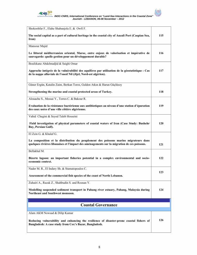
Shokoohfar F., Elahe Shabanjola E. & Owfi F. The social capital as a part of cultural heritage in the coastal city of Anzali Port (Caspian Sea, Iran)
115
Mansour Majid Le littoral méditerranéen oriental, Maroc, entre enjeux de valorisation et impérative de sauvegarde: quelle gestion pour un développement durable?
116
Boufekane Abdelmadjid & Saighi Omar Approche intégrée de la vulnérabilité des aquifères par utilisation de la géostatistique : Cas de la nappe alluviale de l’oued Nil (Jijel, Nord-est algérien).
117
Güner Ergün, Katalin Zaim, Berkan Toros, Gulden Atkın & Harun Güçlüsoy
Strengthening the marine and coastal protected areas of Turkey.
118
Alouache S., Messai Y., Torres C. & Bakour R.
Evaluation de la résistance bactérienne aux antibiotiques au niveau d’une station d’épuration des eaux usées d’une ville côtière algérienne.
119
Vahid Chegini & Seyed Taleb Hosseini Field investigation of physical parameters of coastal waters of Iran (Case Study: Bushehr Bay, Persian Gulf).
120
El Zein G. & Khalaf G.
La composition et la distribution du peuplement des poissons marins migrateurs dans quelques rivières libanaises et l’impact des aménagements sur la migration de ces poissons.
121
Bellakhal M. Bizerte lagoon: an important fisheries potential in a complex environmental and socio-economic context.
122
Nader M. R., El Indary Sh. & Stamatopoulos C. Assessment of the commercial fish species of the coast of North Lebanon.
123
Zuhairi A., Razak Z., Shahbudin S. and Rosnan Y. Modelling suspended sediment transport in Pahang river estuary, Pahang, Malaysia during Northeast and Southwest monsoon.
124
Coastal Governance
Alam AKM Nowsad & Dilip Kumar
Reducing vulnerability and enhancing the resilience of disaster-prone coastal fishers of Bangladesh: A case study from Cox’s Bazar, Bangladesh.
126

INOC-CNRS, International Conference on “Land-Sea Interactions in the Coastal Zone” Jounieh - LEBANON, 06-08 November – 2012
9
Melhaoui M. Les aires protégées de la côte méditerranéenne du Maroc : De la connaissance à la gouvernance.
127
Madani S. & Hamidi F. How we should estimate the economic impact of marine hazards?
128
Mostari Abbassia & Benabdeli Khéloufi Impact de l’urbanisation et du tourisme sur le littoral de Mostaganem (Nord-ouest Algérien).
129
Mouhiddine Mohamed & Belouarda Youssef Gestion Intégrée des zones côtières entre les contraintes et le développement durable: Cas la zone atlantique centrale.
130
Al Daïa R., Nader M.R. & Saab G. Environmental value of the North Lebanon coastline.
131
Mbarek M. Vers l’établissement d’une aire marine protégée dans les îles Kuriat à Monastir : quelle réaction pour les pêcheurs ?
132
Seyhan K., İlhan S., Kizilgök A.B. & Karakuş M. Effect of quota Arrangements and daytime ban for fishing on pelagic fish stocks in the Black Sea.
133
POSTERS Theme 1. Coastal habitats and ecosystem services
Mehanna S.F., Zaki S., Al-Kharusi I., Al-Habsi S. & Al-Kiuymi F. Stock assessment of the thinspine sea catfish Tachysurus tenuispinis (Day, 1877) in the Arabian Sea, Oman.
135
Hadj Taıeb A., Ghorbel M. & Jarbouı O. Evaluation des stocks de la daurade royale Sparus aurata des côtes sud tunisiennes.
136
Hhalassi I., elafri A., Amor Abda W., Maezoug S. & Houhamdi M. L’autoepuration au niveau des écosystèmes aquatiques de l’Est algérien : utilisation de Bdellovibrio bacteriovorus.
137
Yasaman Gandomi & Ahmad Shadi Gomishan lagoon ecological mapping using Geographic Information System (South East Caspian Sea), Iran. .
138

INOC-CNRS, International Conference on “Land-Sea Interactions in the Coastal Zone” Jounieh - LEBANON, 06-08 November – 2012
10
.M.Khairy H
Variations in phytoplankton carbon biomass, community assemblages and species succession along Lake Burullus, Northern Egypt.
139
Karaa S., Jribi I., Bouain A. & Bradai M. N. La mortalité des tortues marines en Tunisie : résumé des cas d’échouage dans le Golfe de Gabès entre 2004 et 2008.
140
Tazerouti F., Kechemir-Issad N. & Euzet L.
A New specıes of the genus Acanthobothrıum Van Beneden (Cestoda, Onchobothrııdae) parasıte of the intestıne of Dasyatıs Pastınaca (Elasmobranchıı, Dasyatıdae) in Algerıa.
141
Khennouf H. Evaluation de la richesse floristique des dunes littorales De Sidi Abd El Aziz (Jijel, Algérie).
142
Ahmad Shadi*, Simin Dehghan Mediseh & Yasaman Gandomi Khuzestan coastal waters as nursery ground for north Persian Gulf fishes.
143
Madani S., Khaleghi S. & Hamidi F. Estimating the existence value of mangrove forest in Iran (case study: Nay Band Bay National Park).
144
Nuzhat Khan Nutrient Dynamics in selected creek of Indus River Delta, Pakistan.
145
Moufaddal W., Lavender S. & Pradhan Y.
Driving factors for fall and rise of the coastal fisheries in the Levantine Sea off Egypt, as examined by satellite ocean-colour and fish landings data.
146
Trea S. & Bensouilah M. La magnoliophyte marine Posidonia oceanica indicatrice du niveau de contamination métallique des eaux du golfe d’Annaba (Algérie).
147
Dermeche Saliha, Boukhelf K., Belkhedim L., Chahrour F. & Boutiba Z. Etude allométrique de deux populations d’oursins comestibles Paracentrotus lividus (lmck, 1816) de l’ouest Algérien.
148
Kallouche M & Bouras D. Evaluation de la qualité faunistique benthique mediolittoral de la zone côtière oranaise (littoral algérien occidental).
149
Ramdane Z , Ichalal K., Ider D., Messaoudi K. , Amara R. & Trilles J-P.
Caractérisation physico-chimique, parasitologie et microbiologie du milieu d’élevage de la ferme aquacole d’Azzeffoune (Algérie).
150
Bouchareb N., Belhadı Y., Harıdı H., Bougadah M. & Ounıssı M. Apport des nutriments dans les bassins versants Kebir-Rhumel, Kebir Ouest et Safsaf au littoral récepteur (N-E Algérie).
151

INOC-CNRS, International Conference on “Land-Sea Interactions in the Coastal Zone” Jounieh - LEBANON, 06-08 November – 2012
11
Bagheri T., Imanpoor M. R. & Jafari, V. Effects of diets containing genistein and diadzein in a long-term study on sex steroid dynamics of goldfish (Carassius auratus).
152
Draredja B., Beldi H. & Melouah K. Caractéristiques sédimentologiques actuelles de la lagune Mellah (littoral nord-est algérien) : effets de colmatage du chenal de communication avec la mer.
153
Shokrolahi L., Mooraki N. & Moiny S. Amino acid and fatty acid profile of Silver Pomfret, Pampus argenteus (Euphrasen, 1788), from Persian Gulf.
154
Owfi F., Kamrani E., Rabbaniha M. & Toosi M. Ecological standard category and environmental assessment of Iranian Islands and Islets habitats of the Persian Gulf and Oman Sea.
155
El Haouatı H., Guechaouı M., Chaabat Dıs C. & Arab A. Distribution spatio-temporelle de la flore planctonique en fonction du degré de pollution dans le barrage de Boukourdane (Tipaza Algérie).
156
Meghlaoui Z., Daas T., Maamcha O. & Scaps P. Evaluation de l’activité d’un biomarqueur chez un bioindicateur de pollution : Perinereis cultrifera (Annélides, Polychètes) dans le Littoral Est d’Algérie.
157
Elahi M. H. , Amin ,S. & Motlagh T., Ghodrati M.G. & Vahabnezhad A. Histology of ovarian development and feeding biology of Sillago sihama, in the Coastal waters of Persian Gulf, Iran
158
Elahi M. H. , Amin ,S. & Motlagh T. & Vahabnezhad A. Studies on the Population dynamic and biology of Klunzinger's Mullet (Liza klunzingeri) in Persian Gulf and Oman Sea
159
Khaksar F., Savari A., Safaeian S., Arebi I. & Abdi E.
Investigation of macrobenthic assemblages in Ouli, Boushehr(Persian Gulf).
160
Sabour W. & Saad A. Reproduction and spawning period for Chub Mackerel Scomber japonicus (Houttuyn, 1782) off the Syrian marine waters.
161
Al-Tawaha M. S, Al-Najjar T. & Abu-Hilal A. Sea Urchin Diadema setosum as bioindicator for trace metal pollution in the Gulf of Aqaba, Red Sea.
162
Kaboğlu G., Can Bizsel K., Avni Benli H. & Güçlüsoy H.
Fisheries area use characteristics in the Turkish Republic of Northern Cyprus: A spatial overview.
163

INOC-CNRS, International Conference on “Land-Sea Interactions in the Coastal Zone” Jounieh - LEBANON, 06-08 November – 2012
12
Amir Jaferian Isolation and Characterization of DNA Microsatellite Markers in the Fourfinger Threadfin (Eleutheronema tetradactylum).
164
Mohamed El Houssein Ould Mohamed Baie de l’étoile, un sanctuaire de biodiversité à préserver
165
POSTERS Theme 2. Adaptation/mitigation to change in coastal systems
Nziambou J. M. Cas de l’érosion côtière sur la baie de Loango a Pointe-Noire au Congo-Brazzaville : causes, évolution, mesures de lutte.
167
Hocini N. Détermination de la pollution radioactive dans les sédiments de la baie d’Alger.
168
Maha Ahmed Mohamed Abdallah Heavy metals distribution in coastal zone of an estuary southeastern Mediterranean Sea, Egypt.
169
Yarahmadi Z., Movahedinia A., Savari A. & Rastgar S. Can naphthalene exposure stress alter brain biogenic amine levels before and during vitellogenesis in fish?
170
Hedayati A. & Jahanbakhshi A. Hematotoxic effects of direct infusion of crude diesel oil on juvenile great Sturgeon Huso huso.
171
Khennouf H. Evaluation de la richesse floristique des dunes littorales de Sidi Abd El Aziz (Jijel, Algérie).
172
Sidi Malainine Malainine, Abdelghani Chafik, Abderrahman Bernoussi Surveillance de la qualité microbiologique du milieu littoral région de Laayoune et Boujdour.
173
Lechekhab S., Lechekhab H., Belaze A. Etude de la pollution des eaux résiduaires d'oued Méboudja (Annaba, Nord-est Algérien) affectant la mer Méditerranée.
174
Alpar B., Unlu S., Vardar D. & Koprulu K. Stratigraphy and dynamics of the Ahirkapi sand Bar, Istanbul, Turkey.
175
Borsalı .S, Badsi A.H. & Lamri D. Evaluation de la contamination métallique du Rouget (Mullus surmuletus, L., 1758) de la baie d’Oran.
176

INOC-CNRS, International Conference on “Land-Sea Interactions in the Coastal Zone” Jounieh - LEBANON, 06-08 November – 2012
13
Morsi Feki Fluctuation of harmful algae in tidal area during the spring days of lunar cycle in Kerkennah (South of Tunisia).
177
Bouchelouche D. & Arab A. Quality of water of wadi el Harrach (Algeria).
178
Bourenane Bouhafs N., Zouainia S. & Bouaziz M. Réponse biochimique de deux biomarqueurs de stress environnemental chez un poisson d’eau douce Gambusia affinis.
179
Madiseh S. D., Mayahi Y. & Koochaknejad E. Jellyfish occurrence and abundance in Khuzestan coastal waters (Northwestern part of the Persian Gulf).
180
Unlu S., Alpar B., Altınok Y. & Ozer N. Rapid coastal changes and tsunami impacts at the Patara Harbor (Turkey).
181
Bouras D. & Kallouche M. M. Impact de l’anthropisation sur la biodiversité algale de la côte oranaise (Algérie Nord Occidentale).
182
Nasr-Eddine Taibi Système dunes-plage- érosion naturelle et impacts anthropiques: Méditerranée.
183
Aichouri I. Les Interactions Terre-Mer dans la zone côtière d’Annaba, Algérie.
184
Slimane N. & Bensalah f. Caractérisation de micro-organismes isolés de la flore tellurique et marine ayant un potentiel de biodégradation de polluants hydrocarbures.
185
Dali Youcef N. & Benguedda W. Recherche de quelques métaux lourds chez l’anchois (Engraulis encrasicolus, l. 1758) du littoral extrême ouest algérien (Ghazaouet et Beni-Saf).
186
Bougdah M., Bouchareb N. & Ounissi M. Fluxes and retention of silicates in the Kebir-Rhumel coastal River (Algeria) under exceptional heavy rainfall season.
187
Jabeur C., Belhoula F., Mani Y., Khoufi W., Fdhila K. & Bakhrouf A. Rôle de quelques paramètres climatiques sur la fluctuation de la production de quelques poissons pélagiques en Tunisie.
188
Jabeur C., Khoufi W. & Bakhrouf A. Role of sea surface temperature and rainfall in the fluctuation of production and abundance
189

INOC-CNRS, International Conference on “Land-Sea Interactions in the Coastal Zone” Jounieh - LEBANON, 06-08 November – 2012
14
of the stock of the common octopus in the East of Tunisia. Bouabdallah M., Massai K, Saad hellal R, Sebihi H., Djirar N & Tedjar L. Tourisme et urbanisation côtiers.
190
Sebihi Hadda, Bouabdallah Mohamed akram, Tedjar Lamri, Djirar Nacer, Saad hellal Rofaida & Messai Khadidja.
Impacts des changements climatiques sur les zones côtières algériennes.
191
El Haouati H. & Arab A. Impact de la pollution sur le fonctionnement d’un écosystème lacustre, lac de Réghaia (Algérie).
192
Rahmanpoor S., Ghafourian H., Hashtroudi S. M. & Aghajanpour F. The study of Polycyclic Aromatic Hydrocarbons (PAHs) contamination in sediments of Hormoz straight - Persian Gulf.
193
Safahieh A., Sarmadyan S., Zolgharnein H., Tabar M. H. & Archangi B. Cadmium, Copper, Zinc and Lead levels in Crassostrea gigas, sediment and water, Musa estuary (Persian Gulf).
194
Bacharı F. H., Belkessa R., Koroghli A., Bachouche S.
The impact of the ports of Algiers and Bouharoun on the littoral zone: granulometric analysis and sediment concentrations of heavy metals.
195
Belkessa R. & Bachari F. H. Caractérisation de la pollution par les métaux lourds (Hg, Pb, Cu, Zn,Cd) et de la granulométrie des sédiments de Dragage du port de Mostaganem (Ouest Algérien).
196
Matallah-Boutiba A., Benmessaoud N., Messaoui N., Benmansour Z. & Boutiba Z. Microbiological sandy beach quality in western Algeria.
197 POSTERS
Themes 3- 4: Coastal Management & Governance
The Nguyen Duc, Chu The Cuong, Nguyen Truong Giang Some biological indices of Green turtles (Chelonia mydas) in the Con Dao island, Vietnam.
199 Halassi I., Elafri A., Abda W. A., Maezoug S. & Houhamdi M. L’autoepuration au niveau des écosystèmes aquatiques de l’Est algérien : utilisation de Bdellovibrio bacteriovorus.
200
Mouna Fartouna Bellakhal Shellfish culture in Bizerte Lagoon: current state and prospects.
201 Khosrow A. Jamshid, F. Mohsenizadeh, S. Omidi & F. Owfi Interactions between Industrial Activity and Marine Environment in the northern part of the Persian Gulf.
202
Shabanjola E., Shokoohfar F. & Owfi F.

INOC-CNRS, International Conference on “Land-Sea Interactions in the Coastal Zone” Jounieh - LEBANON, 06-08 November – 2012
15
Evaluation of involving stakeholders in coastal city of Anzali Port management (Caspian Sea, Iran).
203
Akdim Abdelghani, Madani Khodir Etude du pouvoir fertilisant de la plante marine posidonie « Posidonia oceanica », sur la croissance et le rendement de l’ haricot commun « Phaseolus vulgaris ».
204
Nemati H., Shokri M. R. & J. Pazooki
The effect of beach seine fishing on some substrate characteristics in coastal zone of Caspian Sea.
205
Eidyzadeh M., Savari A., Safahie A. R., Nasirian R. & Zakeri M. A comparative study about potential of biological treatment wastewater between two species microalgae.
206
Ayadı A., Ghorbel M. & Bradaı M. N. Contribution à l’étude de la pêche de « l’Ouzef » à Gabès (Sud Tunisien) : Aspects technologique, biologique et environnemental.
207
Bacharı N., Nacef L., Mezıanı H. & Houma F. Apport des facteurs météorologiques et hydrodynamique pour expliquer la variabilité des statistiques de pêche des petits pélagiques de la côte Algéroise.
208
Bachari N., Meziani H. & Mennad M.
Analyse de la distribution spatiale des espèces pélagiques le long de la côte algérienne à base des résultats des campagnes de pêche.
209
List of participants
210-226

INOC-CNRS, International Conference on “Land-Sea Interactions in the Coastal Zone” Jounieh - LEBANON, 06-08 November – 2012
16
National Centre for Marine Sciences
Batroun LEBANON
Inter‐Islamic Science & Technology Network on
Oceanography ‐Izmir‐ TURKEY
Land-Sea Interactions in the Coastal Zone - LANDSI- 2012
Jounieh-LEBANON, November 06-08, 2012
Provisional Programme / Programme Provisoire
Tuesday 06,November 2012
Madisson Hotel **** - Jounieh
Time Title
08:30 09:15 Conference Registration / Inscription à la conférence
09:15
10:00
Opening Session Welcome speeches by :
• Prof. Dr Gaby Khalaf, Director of National Centre for Marine Research,
• Prof. Dr Orhan Uslu, President of INOC, • Prof. Mouïn Hamze, General Secretary of CNRS-Lebanon, • Mr Nazem El Khoury, Ministry of Environment of Lebanon
Keynotes by:
• Prof. Dr Gaby Khalaf Environmental Monitoring and Sustainable Development of the Lebanese Sea, CANA Project
• Dr Hartwig H. Kremer - Chief Executive Officer of LOICZ " LOICZ‐ Global Coastal Change and Human Dimensions: the next 10 years of Earth system science in context of the FUTURE EARTH Research for Global Sustainability Programme "
10:00 10:20 Coffee Break

INOC-CNRS, International Conference on “Land-Sea Interactions in the Coastal Zone” Jounieh - LEBANON, 06-08 November – 2012
17
Tuesday 06,November 2012
Sessions 1. Coastal habitats and
ecosystem services Room 1
President: Prof. Kadir Seyhan Rapporteurs :Dr. Samir Grimes
2. Adaptation / mitigation to change in coastal systems
Room 2 President: Prof. Mamdouh A. Fahmy Rapporteurs: Prof. Shahrbanoo Oryan
10 :20
10 :40 Ammar Mohammed S. A. - Egypt
Coral growth and skeletal densities in relation to environmental impacts
Darwish Talal M. - Lebanon Assessment of sensitivity to desertification in Lebanon
10 :40
11 :00 Aloui - Bejaoui Nejla - Tunisie
Inventaire des espèces de mollusques Polyplacophores et première mention de la présence d’Acanthochitona crinita (Pennant, 1777) suite aux aménagements hydrauliques réalisés dans le lac Nord de Tunis.
Benmalek Y. Algeria Bioaccumulation of lead and zinc ions by a Gram-negative bacteria
11:00 11:20 Awad Mohamad - Lebanon
Successful application of hyperspectral images to retrieve Lebanese sea water parameters
Ediger Dilek – Turkey Monitoring of water quality in the Izmit Bay.
11:20 11:40 Tazerouti Fadila – Algérie
Biodiversité des monogenea plathelminthes parasites des sélaciens batoides (Torpedinidae, Rajidae, Dasyatidae et Myliobatidae) des côtes d’Algérie.
Emara Hosny I. - Egypt Spatiotemporal changes of Hexachlorocyclohexane compounds in Mediterranean Seawater West of Alexandria.
11:40 12:00 Zarshenas Gholam Abbas - Iran
The growth of faunal aquatics on artificial reef in Bandar Lengeh Area, Persian Gulf of Iran.
Movahedinia Abdolali – Iran Central dopaminergic, serotonergic & noradrenergic neurotransmission induced by benzo (a) pyrene in short-term and long-term exposure in Acanthopagrus latus.

INOC-CNRS, International Conference on “Land-Sea Interactions in the Coastal Zone” Jounieh - LEBANON, 06-08 November – 2012
18
12:00 12:20 Dang Do Hung – Vietnam Study on composition, distribution and density change of fish eggs and larval, scientific baslines for establishment of reef fish spawning aggregations in Hai Van – Son Cha marine protected area in Vietnam.
Sidoumou Zeinebou M. – Mauritanie La cote mauritanienne face aux effets des changements climatiques.
12:20
12:40 Mouzouri Mounia - Maroc
Utilisation d'image satellitaire et d’un MNA pour la cartographie des zones à risque d'inondation sur le littoral méditerranéen de Saïda (nord-est du Maroc).
Taleb Hamid - Maroc Menace des efflorescences d’algues nuisibles en Afrique du Nord : Gestion et Surveillance.
12:40 13:00 LUNCH 14:30 14:50 Ali Malek - Syria
First record of two cartilaginous species, Cetorhinus maximus (Cetorhinidae) and Taeniura grabata (Dasyatidae) of the Syrian coast.
Faiz M.H Muhammad - Malaysia
Suspended Sediment Effects on Coral Distribution at Marine Protected Areas in East Coast of Malaysia
14:50 15:10 Al-Najjar Tariq – Jordan
Plankton diversity and physic-chemical properties of the oligotrophic waters of the Gulf of Aqaba, Red Sea.
Hamzeh Mariam – France Trace metals in superficial sediments of the Seine estuary: concentration levels and toxicity risk.
15:10 15:30 Abboud -Abi Saab Marie - Lebanon
Spatial and vertical Influence of river inputs on the marine productivity: case study: Nahr El kalb.
Bellassoued Khaled – Tunisie Effet de phytoplanctons toxiques et des métaux dans la réponse antioxydante chez la saupe de l’île de Kerkennah.
15:30 15:50 Kocak Ferah – Turkey
Variability in the coverage of Mimosella verticillata (Heller, 1867).
Paimpillil Joseph – India Subterraneous ground water flux to coastal zones and seasonal productivity blooms along with Mudbank formations.
15:50 16:10 COFFEE BREAK
INOC-CNRS, International Conference on “Land-Sea Interactions in the Coastal Zone” Jounieh - LEBANON, 06-08 November – 2012
19
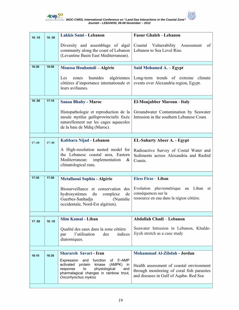
16 :10
16 :30
Lakkis Sami - Lebanon Diversity and assemblage of algal community along the coast of Lebanon (Levantine Basin East Mediterranean).
Faour Ghaleb - Lebanon Coastal Vulnerability Assessment of Lebanon to Sea Level Rise.
16:30 16:50 Moussa Houhamdi – Algérie
Les zones humides algériennes côtières d’importance internationale et leurs avifaunes.
Said Mohamed A. – Egypt Long-term trends of extreme climate events over Alexandria region, Egypt.
16 :50 17:10 Sanaa Bhaby - Maroc
Histopathologie et reproduction de la moule mytilus galloprovincialis fixée naturellement sur les cages aquacoles de la baie de Mdiq (Maroc).
El-Moujabber Maroun - Italy Groundwater Contamination by Seawater Intrusion in the southern Lebanese Coast.
17 :10
17 :30
Kabbara Nijad - Lebanon A High-resolution nested model for the Lebanese coastal area, Eastern Mediterranean: implementation & climatological runs.
EL-Saharty Abeer A. - Egypt Radioactive Survey of Costal Water and Sediments across Alexandria and Rashid Coasts.
17:30 17:50 Metallaoui Sophia - Algérie
Biosurveillance et conservation des hydrosystèmes du complexe de Guerbes-Sanhadja (Numidie occidentale, Nord-Est algérien).
Eless Firas – Liban Evolution pluviométrique au Liban et conséquences sur la ressource en eau dans la région côtière.
17 :50
18 :10
Slim Kamal - Liban Qualité des eaux dans la zone côtière par l’utilisation des indices diatomiques.
Abdallah Chadi – Lebanon Seawater Intrusion in Lebanon, Khalde-Jiyeh stretch as a case study
18:10
18:30
Sharareh Savari - Iran Expression and function of 5’-AMP activated protein kinase (AMPK) in response to physiological and pharmalagical changes in rainbow trout, Oncorhynchus mykiss
Mohammad Al-Zibdah - Jordan
Health assessment of coastal environment through monitoring of coral fish parasites and diseases in Gulf of Aqaba- Red Sea

INOC-CNRS, International Conference on “Land-Sea Interactions in the Coastal Zone” Jounieh - LEBANON, 06-08 November – 2012
20
18 :30
19 :30
PRESENTATİON POSTERS
20:00
DINNER
Wednesday 07, November 2012
Sessions 3. Coastal habitats and ecosystem services
Room 1
President: Prof. Adib SAAD Rapporteurs : Dr. N. ALOUI-BEJAOUI
4. Adaptation / mitigation to change in coastal systems
Room 2
President : Prof. M. Abboud Abi Saab Rapporteurs Tariq AL-NAJJAR
09:00 09:30 Kanaan Hussein - Lebanon
Influence of seasons on the composition of brown and red algae growing on the Lebanese coast and the pharmaceutical, medical and agro-food applications of their isolated polysaccharides.
Lakkis Sami - Lebanon Biological invasion of indo-pacific species in eastern Mediterranean: is it a sequence of global warming inducing tropicalization of the marine environment?
09:30 09:50 Ahmad Savari - Iran
Eco-Sensing of the Persain Gulf and the Gulf of Oman environment by compound remote sensing
Mohd Zaini Mustapa - Malaysia Beach-face dynamics and sediment grain-size along the coast of Pahang, Malaysia.
09:50 10:10 Zebboudj Aicha - Algérie
Lagune Tamelaht : une zone humide très vulnérable.
Abbas Hossam H. – Egypt Effect of seasonal temperature changes on thyroid structure and hormones secretion of white grouper (Epinephelus aeneus) in Suez Gulf, Egypt.
10:10 10 :30 Mouawad Rita - Lebanon
Evaluation of water quality and the study of meiofaunal communities on Lebanese sandy beaches.
Bourenane Bouhafs. N - Algérie La pollution aquatique et le declin des amphibiens : effets d’un pesticide récemment introduit en Algérie sur la survie et le developpement larvaire de la grenouille verte Saharica rana.

INOC-CNRS, International Conference on “Land-Sea Interactions in the Coastal Zone” Jounieh - LEBANON, 06-08 November – 2012
21
10 :30 10 :50 M. Ali Salari –Aliabadi - Iran Identification and Ecological Assessment of Intertidal Ecosystems in Khark Island (Persian Gulf).
Khalaf Gaby - Liban Corrélation des paramètres bactériologiques et physico-chimiques de certains points chauds de la région côtière libanaise.
10 :50
11 :10
Coffee Break
11 :10 11 :30 Saad Adib - Syria
Importance of Lattakia beach (Syria) as nesting area for marine turtles: results of seven years of field survey.
Aliakbar Hedayati – Iran Acute Toxicity Test of Mercury, Lead and Zinc in Roach (Rutilus rutilus)
11 :30 11 :50 Moulaï Riadh - Algérie
Biologie de la reproduction du Petit Gravelot, Charadrius dubius et du Gravelot à collier interrompu Charadrius alexandrinus sur le littoral de Béjaia (Algérie) et facteurs de vulnérabilités.
Daas Tarek - Algérie Biosurveillance du Littoral Est d’Algérie : Pollution et Biodiversité.
11 :50 12 :10
Mahnaz Rabbaniha - Iran Comparing of phytoplankton assemblage in inshore and offshore waters of the Persian Gulf (Southern Boushehr waters).
Fereidoon Owfi – Iran Determination of point pollution sources in Iranian side of the Persian Gulf coastal zone base on indicator and sentinel species, using by GIS.
12 :10 12 :30
Yekta Fatemeh Amini - Iran
Distribution of Rocky Intertidal Mollusks in Qeshm Island, the Persian Gulf.
Marizeh Razaghi - Iran
Efficacy Benthic community versus sediment quality indices as indicator of petrochemical development impact.
12 :30 12 :50
Pour Fatemeh Aghajan - Iran
Efficacy of different taxonomic resolutions and surrogates in rapid environmental impact assessment.
Daas Ouided - Algérie Effets de la pollution marine sur la reproduction et détoxification chez Perinereis cultrifera (Annélide, Polychète) dans le littoral Est Algérien.
INOC-CNRS, International Conference on “Land-Sea Interactions in the Coastal Zone” Jounieh - LEBANON, 06-08 November – 2012
22
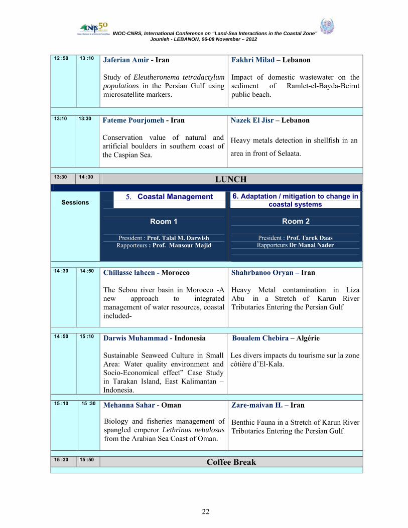
12 :50 13 :10 Jaferian Amir - Iran Study of Eleutheronema tetradactylum populations in the Persian Gulf using microsatellite markers.
Fakhri Milad – Lebanon Impact of domestic wastewater on the sediment of Ramlet-el-Bayda-Beirut public beach.
13:10 13:30
Fateme Pourjomeh - Iran Conservation value of natural and artificial boulders in southern coast of the Caspian Sea.
Nazek El Jisr – Lebanon Heavy metals detection in shellfish in an
area in front of Selaata.
13:30 14 :30 LUNCH
Sessions 5. Coastal Management
6.
Room 1
President : Prof. Talal M. Darwish Rapporteurs : Prof. Mansour Majid
6. Adaptation / mitigation to change in coastal systems
Room 2
President : Prof. Tarek Daas Rapporteurs Dr Manal Nader
14 :30 14 :50 Chillasse lahcen - Morocco
The Sebou river basin in Morocco -A new approach to integrated management of water resources, coastal included-
Shahrbanoo Oryan – Iran Heavy Metal contamination in Liza Abu in a Stretch of Karun River Tributaries Entering the Persian Gulf
14 :50 15 :10 Darwis Muhammad - Indonesia
Sustainable Seaweed Culture in Small Area: Water quality environment and Socio-Economical effect” Case Study in Tarakan Island, East Kalimantan – Indonesia.
Boualem Chebira – Algérie Les divers impacts du tourisme sur la zone côtière d’El-Kala.
15 :10
15 :30 Mehanna Sahar - Oman
Biology and fisheries management of spangled emperor Lethrinus nebulosus from the Arabian Sea Coast of Oman.
Zare-maivan H. – Iran
Benthic Fauna in a Stretch of Karun River Tributaries Entering the Persian Gulf.
15 :30 15 :50 Coffee Break

INOC-CNRS, International Conference on “Land-Sea Interactions in the Coastal Zone” Jounieh - LEBANON, 06-08 November – 2012
23
15 :50 16 :10 Assad A. Al-Thukair – Saudi Arabia A Case study on the Impact of Coastal Development along the East Coast of Saudi Arabia
Belhadi Y. –Algérie Estimation des Flux des nutriments et des sédiments à l'embouchure des Oueds Soummam, Isser et Sebaou (centre algérois)
16 :10 16 :30 Riyad Manasrah - Jordan
Spatial and Seasonal Variations of Sea Level in the Red Sea, 1958-2001
Homayoun Khoshravan – Iran Temporal and spatial variation of sand dunes erosion, Caspian Sea.
16 :30 16 :50 Kidwai Samina – Pakistan
Biodiversity as part of the ICZM– A Case Study of Karachi, Pakistan (North Arabian Sea).
Bensalah Farid – Algérie Contribution à l’élaboration de consortiums bactériens impliqués dans la biodégradation des hydrocarbures (pétrole, rejet industriel).
16 :50 17 :10 Grimes Samir- Algérie
Rôle des aires marines et côtières protégées dans la gestion intégrée des zones côtières en Méditerranée occidentale.
Mooraki Nargess – Iran
Spatial distribution and assemblage structure of Foraminifera in Nayband Estuary, North-West of the Persian Gulf, in relation to industrial activities.
17 :10 17 :30 Lelli Stefano - Lebanon
Fishing survey in South Lebanese waters: a pilot testing unit for alternative fishing métiers
Abi Ghanem Carine – Lebanon Pb and Cd contamination and mobility in marine sediments of two ports in Lebanon.
17:30 17:50
Yücel-Gier Güzel - Turkey Indicators for the Sustainable Development of Fınfish Mediterranean Aquaculture; The Pilot Study in Turkey.
Abboud Abi Saab Marie - Lebanon Effect of continental input on marine environment in Lebanese coastal waters.
17:50 18:10 Fahimeh Shokoohfar - Iran
The social capital as a part of cultural heritage in the coastal city of Anzali Port (Caspian Sea, Iran).
Ali Rashid Tabrez- Pakistan The issue of coastal erosion and accretion along Makran coast of PAKISTAN
18:10
19:00
PRESENTATİON POSTERS
20:00 DINNER

INOC-CNRS, International Conference on “Land-Sea Interactions in the Coastal Zone” Jounieh - LEBANON, 06-08 November – 2012
24
Thursday 08, November 2012
Sessions 7. Coastal Management
Room 1 President : Dr Mohd Zaini Mustapa Rapporteurs: Dr Sidoumou Zeinebou
8. Coastal Governance Room 2
President : Dr Samina Kidwai
Rapporteurs Prof. Rabah Bakour
09:10 09:30 Mansour majid – Maroc Le littoral méditerranéen oriental, Maroc, entre enjeux de valorisation et impérative de sauvegarde: quelle gestion pour un développement durable?
Alam AKM Nowsad – Bangladesh
Reducing vulnerability and enhancing the resilience of disaster-prone coastal fishers of Bangladesh: A case study from Cox’s Bazar, Bangladesh.
9:30 9:50 Boufekane Abdelmadjid- Algérie
Approche intégrée de la vulnérabilité des aquifères par utilisation de la géostatistique – Cas de la nappe alluviale de l’oued Nil (Jijel, Nord-Est algérien).
Melhaoui Mohammed – Maroc
Les aires protégées de la côte méditerranéenne du Maroc : De la connaissance à la gouvernance.
9:50 10:10 Harun Güçlüsoy - Turkey
Strengthening the Marine and Coastal Protected Areas of Turkey.
Madani Shima – Iran How we should estimate the Economic Impact of marine hazards?
10:10 10:30 Bakour Rabah - Algérie
Evaluation de la résistance bactérienne aux antibiotiques au niveau d’une station d’épuration des eaux usées d’une ville côtière algérienne.
Mostari Abbassia – Algérie Impact de l’urbanisation et du tourisme sur le littoral de Mostaganem (Nord-ouest Algérien).
10:30 10:50 Coffee Break
10:50 11:10 Vahid Chegini - Iran Field Investigation of Physical Parameters of Coastal Waters of Iran (Case Study: Boushehr Bay, Persian Gulf).
Mouhiddine Mohamed – Maroc Gestion Intégrée des zones côtières entre les contraintes et le développement durable: Cas la zone atlantique centrale.

INOC-CNRS, International Conference on “Land-Sea Interactions in the Coastal Zone” Jounieh - LEBANON, 06-08 November – 2012
25
11:10 11:30 El Zein Ghassan - Lebanon
La composition et la distribution du peuplement des poissons marins migrateurs dans quelques rivières libanaises et l’impact des aménagements sur la migration de ces poissons.
Al Daïa Roula –Lebanon Environmental value of the North Lebanon Coastline
11:30 11:50 BELLAKHAL Meher - Tunisie
Bizerte Lagoon: an important fisheries potential in a complex environmental and socio-economic context.
Mbarek Marouan- Tunisie Vers l’établissement d’une Aire Marine Protégée dans les îles Kuriat à Monastir : quelle réaction pour les pêcheurs.
11 :50 12 :10 Nader Manal R. - Lebanon
Assessment of the commercial fish species of the coast of North Lebanon
Seyhan Kadir –Turkey Effect of Quota Arrangements and daytime ban for fishing on Pelagic fish stocks in the Black Sea
12:10 12:30 Zuhairi A – Malaysia
Modelling suspended sediment transport in Pahang River estuary, Pahang, Malaysia during Northeast and Southwest Monsoon.
12:10 12:30 Session 9: Recommendations
Chairperson: Dr. H. Kouyoumjian
Rapporteurs: Prof. Marie Abboud – Abi Saab, Dr Ali Trabez
Presidents et rapporteurs des differentes sessions
12:30 13:00 Closing Ceremony: • Prof. Dr Gaby Khalaf • Prof. Dr Abdelouahab Chouikhi
Appreciation: Jury President : Prof. Dr Gaby Khalaf Rapporteurs: Prof. Dr Ahmad Savari ; Prof. Dr Mouhiddine Mohamed
Prof. Dr Mohamed A. Said ; Dr Assad A. Al -Thukair
13:00 LUNCH

INOC-CNRS, International Conference on “Land-Sea Interactions in the Coastal Zone” Jounieh - LEBANON, 06-08 November – 2012
26
14:00
20:00
Cultural Visit Dinner at Byblos
POSTERS First session President: Prof. Dr Melhaoui Mohammed ; Rapporteur: Dr Riyad Manasrah
Second session President : Dr. Samina Kidwai; Rapporteur: Dr Fereridoon Owfi
Name Country Title
Coastal habitats and ecosystem services
Fatma Al-Kiyumi Oman Stock assessment of the thinspine sea catfish Tachysurus tenuispinis (Day, 1877) in the Arabian Sea, Oman.
Aymen Had Taieb Tunisia Evaluation des stocks de la daurade royale sparus aurata des côtes sud tunisiennes.
Ismahan Hhalassi
Algerie
L’autoepuration au niveau des écosystèmes aquatiques de l’Est algérien : utilisation de Bdellovibrio bacteriovorus.
Yasaman Gandomi Iran
Gomishan Lagoon ecological mapping using Geographic Information System (South East Caspian Sea), Iran.
Hanan Mohamed Khairy
Egypt
Community , assVariations in Phytoplankton Carbon biom ,Assemblages and Species Succession along Lake Burullus
.Northern Egypt
Karaa Sami Tunisia
La mortalité des tortues marines en Tunisie: résumé des cas d’échouage dans le Golfe de Gabès entre 2004 et 2008.
Fadila Tazerouti Algeria A New specıes of the genus Acanthobothrıum Van Beneden (Cestoda, Onchobothrııdae) parasıte of the intestıne of Dasyatıs Pastınaca (Elasmobranchıı, Dasyatıdae) in Algerıa.
Ahmad Shadi Iran Khuzestan Coastal waters as nursery ground for north Persian Gulf fishes.
Shima Madani Iran Estimating the existence value of Mangrove forest in Iran (case study: Nay Band bay National Park).
Nuzhat Khan Pakistan Nutrient Dynamics in selected creek of Indus River
Delta, Pakistan.
Wahid Moufaddal
Egypt
Driving factors for fall and rise of the coastal fisheries in the Levantine Sea off Egypt, as examined by satellite ocean-colour and fish landings data.
Saliha Trea
Algeria
La magnoliophyte marine Posidonia oceanica indicatrice du niveau de contamination métallique des eaux du golfe d’Annaba (Algérie).
INOC-CNRS, International Conference on “Land-Sea Interactions in the Coastal Zone” Jounieh - LEBANON, 06-08 November – 2012
27
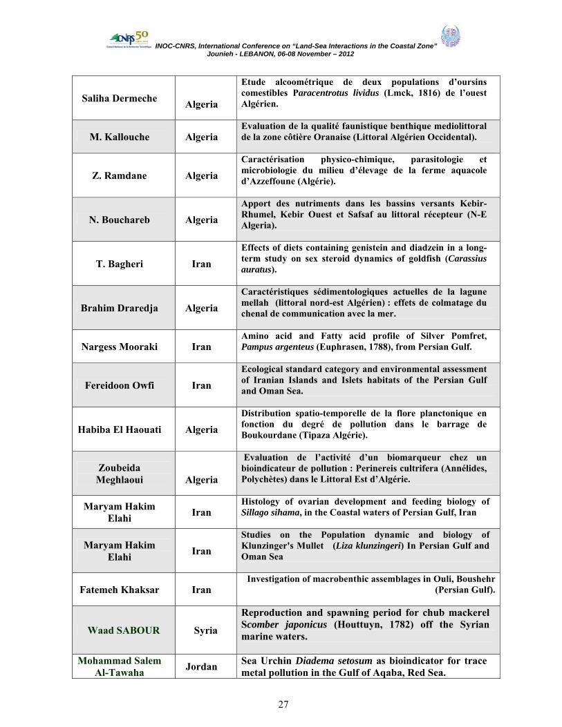
Saliha Dermeche
Algeria
Etude alcoométrique de deux populations d’oursins comestibles Paracentrotus lividus (Lmck, 1816) de l’ouest Algérien.
M. Kallouche Algeria Evaluation de la qualité faunistique benthique mediolittoral de la zone côtière Oranaise (Littoral Algérien Occidental).
Z. Ramdane Algeria Caractérisation physico-chimique, parasitologie et microbiologie du milieu d’élevage de la ferme aquacole d’Azzeffoune (Algérie).
N. Bouchareb Algeria Apport des nutriments dans les bassins versants Kebir-Rhumel, Kebir Ouest et Safsaf au littoral récepteur (N-E Algeria).
T. Bagheri Iran Effects of diets containing genistein and diadzein in a long-term study on sex steroid dynamics of goldfish (Carassius auratus).
Brahim Draredja Algeria Caractéristiques sédimentologiques actuelles de la lagune mellah (littoral nord-est Algérien) : effets de colmatage du chenal de communication avec la mer.
Nargess Mooraki Iran Amino acid and Fatty acid profile of Silver Pomfret, Pampus argenteus (Euphrasen, 1788), from Persian Gulf.
Fereidoon Owfi Iran Ecological standard category and environmental assessment of Iranian Islands and Islets habitats of the Persian Gulf and Oman Sea.
Habiba El Haouati Algeria Distribution spatio-temporelle de la flore planctonique en fonction du degré de pollution dans le barrage de Boukourdane (Tipaza Algérie).
Zoubeida Meghlaoui
Algeria
Evaluation de l’activité d’un biomarqueur chez un bioindicateur de pollution : Perinereis cultrifera (Annélides, Polychètes) dans le Littoral Est d’Algérie.
Maryam Hakim Elahi Iran
Histology of ovarian development and feeding biology of Sillago sihama, in the Coastal waters of Persian Gulf, Iran
Maryam Hakim Elahi Iran
Studies on the Population dynamic and biology of Klunzinger's Mullet (Liza klunzingeri) In Persian Gulf and Oman Sea
Fatemeh Khaksar Iran Investigation of macrobenthic assemblages in Ouli, Boushehr
(Persian Gulf).
Waad SABOUR Syria
Reproduction and spawning period for chub mackerel Scomber japonicus (Houttuyn, 1782) off the Syrian marine waters.
Mohammad Salem Al-Tawaha Jordan Sea Urchin Diadema setosum as bioindicator for trace
metal pollution in the Gulf of Aqaba, Red Sea.

INOC-CNRS, International Conference on “Land-Sea Interactions in the Coastal Zone” Jounieh - LEBANON, 06-08 November – 2012
28
Gökhan Kaboğlu Turkey Fisheries area use characteristics in the Turkish Republic of Northern Cyprus: A spatial overview
Amir Jaferian Iran
Isolation and Characterization of DNA Microsatellite Markers in the Fourfinger Threadfin (Eleutheronema tetradactylum)
Med El Houssein Ould Mohamed
Mauritania
Baie de l’étoile, un sanctuaire de biodiversité à préserver
Adaptation / mitigation to change in coastal systems
Jean Médard Nziambou Congo L’érosion côtière sur le littoral congolais
Hocini Nadia Algérie Détermination de la pollution radioactive dans les sédiments de la baie d’Alger
Maha Ahmed Mohamed Abdallah
Egypt
Heavy Metals Distribution in Coastal Zone of an Estuary Southeastern Mediterranean Sea, Egypt.
Zuhairi, A Malaysia
Modelling suspended sediment transport in Pahang River estuary, Pahang, Malaysia during Northeast and Southwest Monsoon.
Abdolali Movahedinia Iran
Can naphthalene exposure stress alter brain biogenic amine levels before and during vitellogenesis in fish?
Aliakbar Hedayati Iran Hematotoxic effects of direct infusion of crude Diesel Oil on juvenile Great Sturgeon Huso huso.
Hanan Khennouf Algeria Evaluation de la richesse floristique des dunes littorales de Sidi Abd el Aziz (Jijel, Algérie).
Sidi Malainine Malainine Morocco
Surveillance de la qualité microbiologique du milieu littoral région de Laayoune et Boujdour.
Lechekhab Shahnaz Algeria
Etude de la pollution des eaux résiduaires d'oued Méboudja (Annaba, Nord-Est Algérien) affectant la mer Méditerranée.
Bedri Alpar Turkey Stratigraphy and dynamics of the Ahirkapi sand Bar, Istanbul, Turkey.
Borsali S. Algeria Evaluation de la contamination métallique du Rouget (Mullus surmuletus, L., 1758) de la baie d’Oran.
Morsi Feki Tunisia Fluctuation of Harmful Algae in tidal area during the spring days of lunar cy nah (South of Tunisia).cle in Kerken
Arab A. Algeria Quality of water of Wade El Harrach – (Algeria).
Bourenane Bouhafs Naziha
Algeria
Réponse biochimique de deux biomarqueurs de stress environnemental chez un poisson d’eau douce gambusia affinis.

INOC-CNRS, International Conference on “Land-Sea Interactions in the Coastal Zone” Jounieh - LEBANON, 06-08 November – 2012
29
Simin Dehghan Mediseh Iran
Jellyfish occurrence and abundance in Khuzestan coastal waters (Northwestern part of the Persian Gulf).
Selma Unlu Turkey Rapid coastal changes and tsunami impacts at the Patara Harbor (Turkey).
Bouras D. Algeria impact de l’anthropisation sur la biodiversité algale de la côte oranaise (Algérie Nord Occidentale).
Nasr-Eddine Taibi
Algeria
Système Dunes-Plage – Érosion naturelle et impacts anthropiques (Méditerranée).
Imen Aichouri Algeria Les interactions terre-mer dans la zone côtière d’Annaba, Algérie.
Slimane Nachida Algeria
Caractérisation de micro-organismes isolés de la flore tellurique et marine ayant un potentiel de biodégradation de polluants hydrocarbures.
Dali Youcef Algeria
Recherche de quelques métaux lourds chez l’anchois (engraulis encrasicolus, l. 1758) du littoral extrême ouest algérien (Ghazaouet et Beni-saf)
Bougdah Mounira
Algeria Fluxes and retention of silicates in the Kebir-Rhumel coastal River (Algeria) under exceptional heavy rainfall season.
Amina Bakhrouf
Tunisia Rôle de quelques paramètres climatiques sur la fluctuation de la production de quelques poissons pélagiques en Tunisie.
Chédia Jabeur Tunisia
Role of sea surface temperature and rainfall in the fluctuation of production and abundance of the stock of the common octopus in the East of Tunisia.
Bouabdallah M. Algeria Tourisme et urbanisation côtiers.
Sebihi Hadda Algeria Impacts des changements climatiques sur les zones côtières.
El Haouati Habiba Algeria Impact de la pollution sur le fonctionnement d’un écosystème lacustre, lac de Réghaia (Algérie).
Shirin Rahmanpoor Iran
The study of Polycyclic Aromatic Hydrocarbons (PAHs) contamination in sediments of Hormoz straight - Persian Gulf.
Sima Sarmadyan Iran Cadmium, Copper, Zinc and Lead levels in Crassostrea gigas, sediment and water, Musa estuary (Persian Gulf).
Fouzia Houma Bachari
Algeria
The impact of the ports of Algiers and Bouharoun on the littoral zone: granulometric analysis and sediment concentrations of heavy metals.
Rabah Belkessa Algeria Caractérisation de la pollution par les métaux lourds (Hg, Pb, Cu, Zn, Cd) et de la granulométrie des sédiments de Dragage du port de Mostaganem (Ouest Algérien).

INOC-CNRS, International Conference on “Land-Sea Interactions in the Coastal Zone” Jounieh - LEBANON, 06-08 November – 2012
30
Amaria Matallah-Boutiba Algeria Microbiological sandy beach quality in western Algeria.
Coastal Management & Governance
The Nguyen Duc Vietnam
Some biological indices of Green turtles (Chelonia mydas) in the Con Dao island, Vietnam.
Ismahan Halassi Algeria L’autoepuration au niveau des écosystèmes aquatiques de
l’Est algérien : utilisation de Bdellovibrio bacteriovorus.
Mouna Fartouna Bellakhal Tunisia
Shellfish culture in Bizerte Lagoon: current state and prospects.
Khosrow Aein Jamshid Iran
Interactions between Industrial Activity and Marine Environment in the northern part of the Persian Gulf.
Elahe Shabanjola Iran Evaluation of involving stakeholders in coastal city of Anzali
Port management (Caspian Sea, Iran).
AKDIM Abdelghani Algeria
Etude du pouvoir fertilisant de la plante marine posidonie « Posidonia oceanica », sur la croissance et le rendement de
l’haricot commun « Phaseolus vulgaris ».
Haniyeh Nemati Iran The effect of beach seine fishing on some substrate
characteristics in coastal zone of Caspian Sea.
Maryam Eidyzadeh Iran A comparative study about potential of biological treatment
wastewater between two species microalgae
Amani AYADI Tunisia
Contribution à l’étude de la pêche de « l’Ouzef » à Gabès (Sud Tunisien) : Aspects technologique, biologique et
environnemental.
Bachari Nouri Algeria
Apport des facteurs météorologiques et hydrodynamique pour expliquer la variabilité des statistiques de pêche des
petits pélagiques de la côte Algéroise.

INOC-CNRS, International Conference on “Land-Sea Interactions in the Coastal Zone” Jounieh - LEBANON, 06-08 November – 2012
31
Environmental Monitoring and Sustainable Development of the Lebanese Sea, CANA Project
Khalaf G., Abboud- Abi Saab M., Fakhri M., Lelli S., and Hamze M. CNRS- National Center for Marine Sciences
Batroun, Lebanon
E-mail: [email protected]
ABSTRACT
The acquisition of the scientific vessel CANA and the signing of a research project entitled "CANA: Environment Monitoring and Sustainable Development of the Lebanese Sea", both concluded with the Italian Government, allowed to expand the range of research activities in the marine environment and to execute studies which, so far, were unreachable to the Lebanese researchers. CANA Project is divided into 5 tasks:
- Coastal Bathymetry : The task consists of the implementation of specific campaigns for data collection regarding coastal bathymetry to cover the sea territory where the depth is less than 100 m,
- Hydrobiology and Biodiversity : This task aims to develop a seasonal studies on the vertical and horizontal variations of the physical and chemical parameters, to evaluate the primary and secondary production and to survey the benthic and pelagic biodiversity,
- Marines Resources and Mammalian Protection: A technical survey on the fishery sector will be executed, with the aim of obtaining a comprehensive list of the biodiversity and the status of fish stock. The task aims also to detect the existence of cetacean habitat, the areas of distribution and the density,
- Coastal Pollution: The task concerned with human activities causing pollution and performs measurements of chemical contamination levels along the Lebanese coast, in addition to bacteriological, organic and metallic contaminants,
- Scientific Dissemination: The project developed mechanisms for the distribution of relevant information within the Lebanese community and stakeholders. The activities aim to promote research, to improve the awareness of civil society and gave sustainability to the project actions.
The preliminary results of the various activities helped to monitor spatial and temporal variability of the physico-chemical and biological parameters of the sea water and also to obtain an exhaustive list of benthic organisms. They also allowed creating a map of the pollution along the Lebanese coastal region with the identification of the main hot spots. A program for the development and the monitoring of fishing and fisheries sector was developed in collaboration with the Ministry of agriculture. Awareness campaigns, for the general public and stakeholders were conducted aboard the CANA vessel. Keywords: marine environment, bathymetry, biodiversity, pollution, awareness

INOC-CNRS, International Conference on “Land-Sea Interactions in the Coastal Zone” Jounieh - LEBANON, 06-08 November – 2012
32
LOICZ-Global Coastal Change and Human Dimensions: the next 10 years of Earth system science in context of the FUTURE EARTH Research for Global
Sustainability Programme
H.H. Kremer (LOICZ – CEO) Helholtz-Zentrum Geesthacht
Centre for Materials and Coastal Research Institute of Coastal Research
LOICZ International Project Office Max-Planck Str.1, 21502 Geesthacht, Germany
ABSTRACT
Coastal zones worldwide are central to global socio economic development and are estimated to provide more than half of all global ecosystem goods and services to mankind. Being subject to highest demographic pressure and running high risk of natural hazards and extreme events they also reflect a substantial scope of impact driven by global and climate change. LOICZ, the Land–Ocean Interaction in the Coastal Zone core project of the International Geosphere-Biosphere programme, IGBP (Stockholm) and the International Human Dimensions Programme on Global Environmental Change, IHDP (Bonn) has been focussing for almost 20 years on the land and ocean-based drivers of biogeochemical and geophysical change affecting coastal zones. Since the early 2000s LOICZ has expanded its focus and brought on board the social sciences and humanities to research global phenomena of changing coasts in the context of social – ecological systems. Thus central to LOICZ is the interaction of humans with nature and feedbacks along the whole water cascade from source to sea where coastal change and risk originate. With its network of globally over 2000 scientists and currently over 30 affiliated projects worldwide which contribute voluntarily to its research portfolio LOICZ has recently revised its agenda and set new priorities for the years to come. Those are i) urbanization in coastal zones ii) Arctic coasts iii) River-mouth systems including deltas and estuaries and iv) Islands at risk. Complementary are cross cutting efforts including regional studies, modelling, coastal governance, ecological economics and capacity building and training (see www.loicz.org). In the current reorganization of the Earth system research framework LOICZ will in the next few years transition into the context of the new FUTURE EARTH PROGRAMME FOR GLOBAL SUSTAINABILITY. This is a new 10-year international research initiative that will develop the knowledge for responding effectively to the risks and opportunities of global environmental change and for supporting transformation towards global sustainability in the coming decades. Besides mobilizing thousands of scientists globally partnerships with policy-makers and other stakeholders are envisioned aimed to provide sustainability options and solutions in the wake of Rio+20. Key to FUTURE EARTH which is being established by a unique alliance of scientific, UN and funding agencies (see: http://www.icsu.org/future-earth) is the notion of co designing research agendas in a truly transdisciplinary way. The presentation will provide an introduction to both the LOICZ and FUTURE EARTH initiatives and their scientific relation and highlight some of the scientific key issues and recent findings of LOICZ in its hotspot areas. It will invite a discussion and review around the regional implications of coastal change embedded in these broader framework contexts and explore mutual agendas with the regional experts.

INOC-CNRS, International Conference on “Land-Sea Interactions in the Coastal Zone” Jounieh - LEBANON, 06-08 November – 2012
33
Coastal habitats and ecosystem services
Oral presentations

INOC-CNRS, International Conference on “Land-Sea Interactions in the Coastal Zone” Jounieh - LEBANON, 06-08 November – 2012
34
Coral growth and skeletal densities in relation to environmental impacts
Mohammed S. A. Ammar1, Ahmed H. Obuid- Allah2
Montaser A. M. Al-Hammady3
1National Institute of Oceanography and Fisheries, Suez, P.O. Box 182, Egypt
2Assiut University, Faculty of Science, Department of Zoology 3National Institute of Oceanography and Fisheries, Hurghada, Egypt
E-mail: [email protected]
ABSTRACT
The two corals Stylophora pistillata and Acropora humilis were studied for coral growth and skeletal densities in relation to environmental impacts. Four sites along the Egyptian Red Sea coast were chosen for the study. These sites are Ras El-Behar (impacted with oil pollution), Middle reef (impacted with land-filling), Kalawy Bay (control site) and El-Hamraween Harbour (impacted with phosphate enrichment). Concerning the role of coral growth rate and skeletal densities as an environmental biomarker, results obtained have shown that Both growth rate, skeletal density and reproduction of Acropora humilis react positively with phosphate enrichment while they react negatively in case of Stylophora pistillata in the same condition. Oil pollution foster space monopolization by Stylophora pistillata through asexual reproduction but leads to a reduced biodiversity through destroying the gonads. While Acropora humilis react negatively with respect to growth rate, skeletal density and reproduction in the same condition. Correlations were significant between each of zooxanthellae density & chlorophyll concentration and the growth rate for each of Acropora humilis and Stylophora pistillata at all the studied sites except at site 3 where the correlation for Acropora humilis was no significant. The non significant correlation between zooxanthellae density and growth rate of Acropora humilis at site 3 indicates that the amount & mechanism of energy utilization by corals may be both species and site specific.
INOC-CNRS, International Conference on “Land-Sea Interactions in the Coastal Zone” Jounieh - LEBANON, 06-08 November – 2012
35
Inventaire des espèces de mollusques polyplacophores et première mention de la présence d’Acanthochitona crinita (Pennant, 1777) suite aux aménagements
hydrauliques réalisés dans le lac Nord de Tunis
Hedi SALAH et Nejla ALOUI – BEJAOUI
Institut National Agronomique de Tunisie- 43, Avenue Charles Nicolle-1082 Tunis, Tunisie E-mail: [email protected]
RESUME Les Polyplacophores ont suscité l’intérêt de plusieurs chercheurs dans le monde mais les travaux en Tunisie sur cette classe de Mollusques sont limités aux signalisations des diverses espèces sur le littoral. Ce travail rentre dans le cadre de la connaissance plus approfondie de la diversité des peuplements de Polyplacophores suite à l’amélioration de la biodiversité animale et végétale observée après les aménagements hydrauliques réalisés en 1988 dans le Lac. L’étude a été réalisée sur deux périodes, la première s’étend d’octobre 2007 à juillet 2008 et la seconde durant l’été et l’automne 2009. Les prospections et les échantillonnages ont été réalisés au niveau de la digue centrale du lac qui s’étend sur 8.5 km et sépare ce plan d’eau en deux parties permettant ainsi une circulation lévogyre pour remédier à la stagnation des eaux lagunaires. Les Polyplacophores ont été prélevés jusqu’à une profondeur de 50 cm. Leur identification systématique a été effectuée au laboratoire et a été confirmée au moyen de visualisations fines en microscopie photonique ou électronique à balayage sur la base des travaux de Dell’Angello et Smriglio (2001). La présente étude a révélé que les chitons sont abondants au niveau de la digue centrale du lac nord de Tunis à de faibles profondeurs. Au total, quatre espèces de Polyplacophores ont été identifiées : Lepidochitona caprearum, Lepidochitona cinerea, Chiton olivaceus et Acanthochitona crinita, la plus abondante étant L. caprearum. L’espèce Acanthochitona crinita est identifiée pour la première fois en automne 2009. Cette première mention est une confirmation de l’amélioration de la biodiversité dans ce milieu comme cela a été observé pour de nombreux autres groupes zoologiques. Cette espèce herbivore est installée sur le substrat rocheux couvert par les Zostères et les Cymodocées à une profondeur maximale de 0,5 m. Sur le reste du littoral tunisien, elle n’a été signalée que dans la région sud de Tunisie (Djerba). Son apparition actuelle dans le Lac nord de Tunis et sa faible densité (4 ind / m²) témoignent d’une adaptation lente aux nouvelles conditions hydrodynamiques créées dans le lac. Les améliorations de la qualité des eaux et des conditions hydrodynamiques du lac ont été à l’origine de l’amélioration de la diversité biologique à l’instar des peuplements des Mollusques Polyplacophores. Cette première signalisation d’Acanthochitona crinita confirme l’évolution positive de la biodiversité des peuplements benthiques dans ce plan d’eau.

INOC-CNRS, International Conference on “Land-Sea Interactions in the Coastal Zone” Jounieh - LEBANON, 06-08 November – 2012
36
Successful application of hyperspectral images to retrieve Lebanese sea water
parameters
Mohamad Awad
National Center for Remote Sensing National Council for Scientific Research
E-mail: [email protected]
ABSTRACT
The successful use of satellite mid resolution hyperspectral images has bridged the gap between the high, mid, and the lower resolution multispectral satellite and airborne remote sensing. Although designed as a technical demonstration for land applications, satellite mid resolution hyperspectral images are tested for its capabilities over a range of sea water in the Lebanese coastal area. A combination of turbid and humic river inputs, as well as the open sea flushing, determines the water quality of the many Lebanese bays. The field campaigns provided by implemented projects were coincident with mid resolution satellite overpasses retrieved inherent sea water parameters. A robust method was applied to retrieve concentrations of chlorophyll, and other parameters were comparable to those estimated in the field on the days of the overpass. Keywords: Hyperspectral, Chlorophyll-a, Turbidity, NASA, Water quality.

INOC-CNRS, International Conference on “Land-Sea Interactions in the Coastal Zone” Jounieh - LEBANON, 06-08 November – 2012
37
Biodiversité des Monogenea plathelminthes parasites des Sélaciens Batoides (Torpedinidae, Rajidae, Dasyatidae et Myliobatidae) des côtes d’Algérie.
Fadila Tazerouti & Nadia Kechemir –Issad
Laboratoire de Parasitologie, Faculté des Sciences biologiques, Université des Sciences et de la Technologie Houari Boumédiene,
BP32, El Alia, 16111 Bab Ezzouar, Alger, Algérie.
E-mail : [email protected]
RESUME
Une étude de la biodiversité des Plathelminthes Monogenea parasites des Batoides Torpedinidae, Rajidae, Dasyatidae et Myliobatidae pêchés le long de la côte algérienne a permis de récolter 23 espèces différentes dont 9 Amphibdellatidae Bychowsky, 10 Monocotylidae Tashenberg et 4 Hexabothriidae Price toutes nouvelles pour l’Algérie.
Ce travail a aboutit, chez les Torpedinidae à la découverte de 5 espèces nouvelles pour la science. Il s’agit de 4 Amphibdellatidae du genre Amphibdelloides Price : Amphibdelloides kechemirae Tazerouti, Neifar et Euzet, 2006 ; A. benhassinae Tazerouti, Neifar et Euzet, 2006 ; A. valleoides Tazerouti, 2007 et A. pusillus Tazerouti, 2007 et d’un Monocotylidae du genre Calicotyle Diesing : Calicotyle torpedinis Tazerouti, 2007. Il a permis de retrouver et de redécrire Monocotyle myliobatis Tashenberg, espèce type du genre non revue depuis sa description original par Tashenberg en 1878 (Tazerouti et al., 2011) et de signaler pour la première fois en Méditerranée Mycteronastes undulatae et Rajonchocotyle prenanti. Par ailleurs, cette étude a permis d’inventorier pour la première fois en Algérie, ces Plathelminthes chez ce groupe d’Elasmobranches Batoides. Mots clés : biodiversité, parasites, Monogènes, Sélaciens Batoides, Torpedinidae, Rajidae,
Dasyatidae, Myliobatidae, Amphibdellatidae, Monocotylidae, Hexabothriidae, Algérie.

INOC-CNRS, International Conference on “Land-Sea Interactions in the Coastal Zone” Jounieh - LEBANON, 06-08 November – 2012
38
The growth of faunal aquatics on artificial reef in Bandar Lengeh Area, Persian
Gulf of Iran
Gholam abbas Zarshenas
Iranian Fisheries Research Organization, Iran
E-mail: [email protected]
ABSTRACT The growth of organisms on seven different artificial reef structures was surveyed from 2004-2006 in Hormozgan offshore waters (Bandar Lengeh area).The organisms consisted of12 groups the main of whitch included Barnacle (Megabalanus tintinnabulum), Sponge with five families and Tunicate. The highest density was observed in 2005. Some organisms such as crab, polychaets, Bivalves and Fish Larvae showed an increasing in size hnthe first year. Bivalves showed a decreasing trend in density but otherwise an increasing in size over time.Artificial shape of reefs was not effective on the total density of the organisms living on the structures.Total density of live organisms on different parts of the artificial reefs (surface, middle and bottom) was not statistically significant (p>0.05) numbers of crabs on mixed artificial reefs were higher than the other artificial reefs. This was also the same for barnacles.
Keywords: Artificial reef, Invertebrate, Density, Growth rate, Persian Gulf, Bandar lengeh, IRAN

INOC-CNRS, International Conference on “Land-Sea Interactions in the Coastal Zone” Jounieh - LEBANON, 06-08 November – 2012
39
Study on composition, distribution and density change of fish eggs and larval, scientific baslines for establishment of reef fish spawning aggregations in Hai
Van – Son Cha marine protected area in Vietnam.
Quan Nguyen Van & Quan Nguyen Van
Department of Marine Conservation and Biodiversity .Institute of Marine Environment and Resources (IMER)
Vietnam Academy of Science and Technology (VAST) 246 Danang Street- Haiphong City -VIETNAM
Tel :(84)313.760601 - (84)982.772404
E-mail: [email protected]
ABSTRACT Results of this study based on three field surveys have been carried out during rainy, transition and dry season from 2009 to 2010 in Hai Van – Son Cha area, Thua Thien Hue province. A total number of 4296 fish eggs and 628 larvae were collected in 13 stations. Initially identified 10 genuses, 39 families and 6 orders. The density of fish egg and larval fluctuate seasonally, in dry season; the density per 100m3 is higher than that in rainy season. The density of fish egg and larvae also distribute unequally among the survey stations. Some coral reef in the Northwest of Son Cha Island, Hon Mieu, Sung Rong Cau and Bai Chuoi can be seen as spawning and breeding grounds, that is the basis of proposals set core areas of marine protected areas to manage spawning of reef fish to sustainable development of coral reef fish resources in Hai Van - Son Cha are.

INOC-CNRS, International Conference on “Land-Sea Interactions in the Coastal Zone” Jounieh - LEBANON, 06-08 November – 2012
40
Utilisation d'image satellitaire et d’un MNA pour la cartographie des zones à risque d'inondation sur le littoral méditerranéen de Saïdia (Nord-est du
Maroc).
Mounia Mouzouri1 ; Zoulikha Irzi2 et Abdelhak Essaddek3
1. Université Mohammed Premier, Faculté des Sciences, Département de Biologie, Laboratoire
d’Hydrobiologie et d’Écologie Générale, Boulevard Sidi Maafa, BP 524, Oujda, Maroc. 2. Université Mohammed Premier, Faculté des Sciences, Département de Géologie, Laboratoire des
Géosciences Appliquées, 3. Université Mohammed Premier, Faculté des Lettres, Département de Géographie,
E-mail : [email protected]
RESUME
Cette étude vise à établir une carte du risque inondation sur la plaine côtière de Saïdia située sur le littoral méditerranéen du Nord Est du Maroc. Cette plaine est limitée au Sud par les plateaux des Ouled Mansour aux formes vigoureuses et incisés par des ravins dont les eaux temporaires se jettent directement dans la plaine. Elle est enserrée entre deux oueds : la Moulouya à l’Ouest et le Kiss à l’Est. Ce littoral est caractérisé par un climat Méditerranéen semi-aride à saisons contrastées où les pluies torrentielles engendrent d’importantes inondations accentuées par la faible profondeur de la nappe phréatique. Ce contexte géomorphologique et climatique couplé aux aménagements actuels a aggravé le risque d’inondation. Dans cette étude, la méthodologie adoptée est fondée sur la structuration dans un système d’information géographique (SIG) des données de la télédétection spatiale, des produits dérivés d’un modèle numérique d’altitude (MNA) et des données exogènes (lithologie, niveau piézométrique de la nappe phréatique, etc.). L’approche analytique comporte 1) une phase de traitement numérique d’une image satellitaire GeoEye prise le 20/04/2009 et des photographies aériennes de 2006 pour cartographier l’occupation des sols ; 2) une phase d’extraction des attributs topographiques et la morphométrie du terrain, représentés par le modèle numérique d’altitude (MNA) et 3) une phase de structuration de l’information par analyse spatiale dans un SIG. Ces informations ont permis la réalisation de deux cartes : la carte de l’aléa inondation et la carte de vulnérabilité. La carte de l’aléa inondation montre que les zones de fort à très fort aléa, représente 57% du site ; elles sont caractérisées par de faibles altitudes (0-4m) et des profondeurs de la nappe variant entre 0 et 4m. La carte de vulnérabilité fait référence aux différentes classes d’occupation de sol. La superposition de ces deux cartes a permis d’établir la carte du risque inondation. Cette carte thématique montre que les niveaux de risque fort affectent 50 % de l’ensemble du territoire étudié, et correspondent aux abords d’Oued Moulouya, à quelques points des quartiers de la ville de Saïdia et en grande partie à une vaste surface occupée par la nouvelle station balnéaire "Mediterranea Saïdia", située sur les dépressions inter dunaires. Mots clés : risque d’inondation, aléas, vulnérabilité, MNA, image satellitaire, Saïdia.

INOC-CNRS, International Conference on “Land-Sea Interactions in the Coastal Zone” Jounieh - LEBANON, 06-08 November – 2012
41
First record of two cartilaginous species, Cetorhinus maximus (Cetorhinidae)
and Taeniura grabata (Dasyatidae) off the Syrian coast
Malek Ali 1, Adib Saad 1, and Christian Capapé 2
1 Marine Sciences Laboratory, Faculty of Agriculture, Tishreen university, Lattakia, Syria. E-mail: [email protected]
2 Laboratoire d'Ichtyologie, case 104, Université Montpellier II, Sciences et Techniques du Languedoc, 34 095 Montpellier cedex 5, France. [email protected]
ABSTRACT
The authors report in this paper the first record of basking shark Cetorhinus maximus (Gunnerus 1765) and Round fantail stingray Taeniura grabata (E. Geoffroy Saint-Hilaire 1817) from the coast of Syria (eastern Mediterranean). For the Cetorhinus maximus the specimen was an adult female having 690 cm total length and weighing 2.5- 3 tons approximately. It was a pregnant female at the beginning of the gestation and contained 34 egg cases , it was caught by fixed net at depth 10 m (as by catch) during the night of 20-21 April 2012 on Rass Albassit coast north of Lattakia 35º 39’ 47’’ E and 35º 53’ 17’’ N . An egg case is described and short comments on the reproductive biology of the species are given. On the other hand, three specimens of Taeniura grabata were identified following Capapé (1983) and McEachran & Capapé (1984). The first specimen was a juvenile male caught on 8-9 April 2012 using a bottom long line of strong nylon rope, with hook n°14, baited with cuttlefish, at depth 32 m approximately, on sandy-muddy bottom; the capture site was between Lattakia and Jableh ,35º 52’ 11”E and 35º 26’ 34’’ N. The second and third specimens was an adult males captured on 22-23 April 2012 using a bottom long line strong nylon rope, with hook n°13, baited with little shrimp at depth 40 m approximately on sandy rocky bottom; the capture site was 12 km off Raas Albassit, city located in the central area of the Syrian coast, 35 km north Lattakia, 35º 39’ 47’’ E and 35º 53’ 17’’ N. Disk width and total length were measured to the nearest mm, while they were weighed to the nearest gramm. Morphometric measurement and meristic counts were recorded at the Marine Sciences Laboratory of Tishreen University. Keywords: Chondrichthyes, Cetorhinidae, Cetorhinus maximus, Dasyatidae, Taeniura grabata,
firs record, egg case, Syrian coast, Mediterranean

INOC-CNRS, International Conference on “Land-Sea Interactions in the Coastal Zone” Jounieh - LEBANON, 06-08 November – 2012
42
Plankton diversity and physic-chemical properties of the oligotrophic waters of
the Gulf of Aqaba, Red Sea
Al-Najjar Tariq1*, Dilek Ediger2, Adina Baytan3
Corresponding Author: *1Marine Science Station, Aqaba, Jordan, PO. Box 195, [email protected]
2Dr. Dilek EDİGER, TÜBİTAK Marmara Araştırma Merkezi, Çevre ENSTİTÜSÜ, P.K. 21, 41470 Gebze Kocaeli, [email protected]
3Institute of Marine Sciences, Earth & Marine Sciences Building
University of California Santa Cruz, 1156 High St, Santa Cruz, CA 95064 [email protected]
ABSTRACT Monthly variations in abundance and composition of the surface mesozooplankton were studied along the Jordanian waters of the northern Gulf of Aqaba over a period of one year between January and December 2007. Surface water was collected at different sampling sites and a total of 82 species of different mesozooplankton groups and larval stages of various other organisms were identified. The standing crop of the total mesozooplankton was relatively low ranging between 620 and 3821 organisms m-3. The maximum mesozooplankton abundance was recorded at Tala bay (average 2956 organisms m-3) while minimum of was observed at the offshore site (average 774 organisms m-3). Copepods by far were the most abundant and ubiquitous mesozooplankton organisms comprising 84.3% of the total mesozooplankton (62 species, 2125 organisms/ m3 in June). Copepod abundance decreased gradually over the sampling period to exhibit its minimal abundance of 620 organisms/ m3 during late summer. The seasonal and spatial distribution of mesozooplankton in the Gulf of Aqaba has implications for fishing, ecosystem health, and bases liner to see impacts for future developments along the Jordanian coast. Also, to predict the most polluted site within the coastal stations.

INOC-CNRS, International Conference on “Land-Sea Interactions in the Coastal Zone” Jounieh - LEBANON, 06-08 November – 2012
43
Spatial and vertical influence of river inputs on the marine primary production
in Lebanese coastal waters: a case study
Marie Abboud Abi Saab*, Milad Fakhri, Marie-Thérèse Kassab & Nada Matar
*National Council for Scientific Research/National Centre for Marines Sciences, P.O. Box 534, Batroun, Lebanon.
*Corresponding author: mabisaab@ cnrs.edu.lb
ABSTRACT The coastal rivers in Lebanon are a source of untreated effluents carried to the coastal waters. To measure the influence of river inputs on primary production in the marine environment, a seasonal study was conducted, between January 2005- August 2007 in the coastal area of central Lebanon at the discharge point of Nahr El Kaleb river. Environmental parameters such as temperature, salinity and nutrients were collected along with samples for chlorophyll-a and phytoplanktonic studies from surface waters and 20m depth. Results have shown high values of nutrients; whereas, salinity, chlorophyll-a, phytoplankton numbers and density decreased from the coast towards the offshore area. Very high densities of phytoplankton populations reaching 39.5 X 10⁶ were noted in surface waters from Zouk-Dbayeh region situated in the vivinity of the mouth of Nahr El Kalb River. Also, exceptionally high values of chlorophyll-a were observed at the surface in spring 2007 (31.89 mg/m3). In periods of low flood, stations located near the river reflect a relatively better utilization of nutrients by autotrophic populations but in period of high flood the turbidity produce an inhibitory effect on the primary productivity. In conclusion, the favorable effect of Nahr El Kalb is limited to the spring season and the surface water layer. In other seasons, it is mainly the effect of industrial and urban waste which are felt in many coastal stations creating conditions of eutrophication. Keywords: Eastern Mediterranean, Lebanese coast, Nahr el Kalb river, phytoplanktonic
populations, chlorophyll- a
INOC-CNRS, International Conference on “Land-Sea Interactions in the Coastal Zone” Jounieh - LEBANON, 06-08 November – 2012
44
Variability in the coverage of Mimosella verticillata (Heller, 1867)
Ferah Kocak and Sinem Aydın Onen
E-mail: [email protected]
ABSTRACT
The study has been carried out in shallow water Posidonia oceanica communities in Engeceli Bay (Aegean Sea). This study aimed to compare Mimosella verticillata coverage on Posidonia oceanica leaves collected near the suspended cages of a fish farm and to a reference site. The species was not observed on the leaves collected from the control station at depths between 5 and 10 m. However, it was found commonly or frequently on the outside surfaces of leaves at both locations. Variations in coverage of M. verticillata were investigated between stations (impact and control), depth ranges (0-5; 5-10; 10-15) and leaf sides (outside and inside surfaces). Results showed significant differences between stations and depths (p<0.05). At the impact stations, coverage of M. verticillata was higher than at the control stations. The values also showed significant differences between depths and the highest value was determined in the 0-5 m depth range. Although coverage values on the outside surfaces of the leaves were higher than on inside surfaces there were no significant differences between surfaces. According to the results, the present study indicates that the spatial variability of the mean coverage of the species can be a useful indicator of changing environmental conditions. Keywords: Posidonia oceanica, Mimosella verticillata, epiphytic organism, fish farm, Aegean Sea

INOC-CNRS, International Conference on “Land-Sea Interactions in the Coastal Zone” Jounieh - LEBANON, 06-08 November – 2012
45
Diversity and Assemblage of Algal Community along the Coast of Lebanon (Levantine Basin East Mediterranean)
Sami Lakkis1,2* and Vanda Novel-Lakkis2
1Section Oceanography, Biology Dept., Lebanese University, Beirut, Lebanon.
2Laboratory of Marine Ecology & Planktonology, NCMS/NCSR, Batroun, Lebanon
E-mail*: [email protected]
ABSTRACT
Several series of macroalgae samples collected at six sites along the coast of Lebanon during 2005-2007 were subject to ecological study. The samples collected in soft and hard substrates covering the supralittoral, mediolittoral, infralittoral and circalittoral zones. Physico-chemical and hydrological data, including temperature, salinity, dissolved oxygen, nitrates and phosphates were measured simultaneously with the algae collections. A total of 240 species were identified including 22 Cyanophytes, 53 Chlorophytes, 24 Phaeophytes and 107 Rhodophytes. Multivariate analysis, namely clustering and ordination methods were used to classify the species according to their spatio-temporal distribution and in relation to environmental factors. Several sources of pollution including chemical, urban and industrial wastes and pollutants resulted in reduced diversity, a decrease in total algal biomass in the Phaeophyta species group, and increase in Chlorophyta at polluted sites. Several species from genera Cystoseira, Sargassum, Corallina, Laurencia and Padina pavonica, are considered as indicators of clean water, while, Ulva spp, Enteromorpha spp., Colpomenia sinuosa and Pterocladia pinnata showed cases of eutrophication and appeared to thrive in nutrient- enriched waters. Hydro-climatic conditions are the most important factors affecting the distribution of algae species; the high richness and biomass for the majority of groups occurred in spring and summer (March-October); while most of the algae are poor during the cold winter: December- March, either in species diversity as well as in biomass. Several Indo-Pacific species were found within the different phytocoenoses of the area, most of them were introduced into the Eastern Mediterranean formed permanent populations; some of them were highly spread and dominated over other endemic species or even they replaced them. Keywords: Eastern Mediterranean. Lebanon, Macroalgae. Distribution. Diversity. Assemblages.

INOC-CNRS, International Conference on “Land-Sea Interactions in the Coastal Zone” Jounieh - LEBANON, 06-08 November – 2012
46
Les zones humides algériennes côtières d’importance internationale et leurs avifaunes
Houhamdi Moussa et Saheb Menouar
Département Sciences de la Nature et de la Vie, Faculté SNV-STU, Université 8 mai 1945 de
Guelma.
E-mail : [email protected]
RESUME L’Algérie de part sa situation géographique renferme un potentiel de zones humides très diversifié. Les plus connues sont sous-jacentes au littoral long de plus de 1000km, tels les lacs et les marais d’eau douce des éco-complexes d’El-Kala, de Guerbes-Sanhadja et ceux de l’Oranie. De nombreux autres hydrosystèmes souvent plus spacieux, peu profond, salés et dépourvues de végétation hélophytes caractérisent les régions semi-arides et arides du pays. Les plus connues sont celles intercalées entre l’Atlas tellien et l’Atlas saharien et perché à une hauteur pouvant aller jusqu’à 1200m tels les chotts et les sebkhas des hauts plateaux (Oum El-Bouaghi, Batna, Sétif, Khenchela et M’sila): les plus importants sont Garaet Tarf (25500ha), Garaet Guellif (7800ha), Chott El-Hodna (67000ha) et Garaet Timerganine (200ha)….etc. Le sud du pays héberge aussi des oueds intermittents et des plans d’eau temporaires souvent très salés tels l’éco-complexe de la Vallée de Oued Righ (wilayas d’El-Oued, Biskra et Ouargla), les chotts de Naama… Ces milieux sahariens jouent aussi pendant la saison hivernale des lieux propices pour de nombreuses espèces d’oiseaux d’eau. D’une manière générale, nous dénombrons facilement 79 espèces appartenant à 17 familles dont certains sont très rares et même menacées d’extinction à l’échelle internationale. Une grande majorité arrive à nicher régulièrement dans ces milieux. Nous proposons dans cette étude réalisée sur quinze années consécutives (de 1996 a 2011), d’exposer les résultats concernant la diversité des biotopes (lacs, lagunes, marais, salines, chotts, sebkhas, garaets et dayas) qui accueillent une avifaune très diversifiée ainsi que la structure des espèces aviennes phares de ces hydrosystèmes, soit: un inventaire de la diversité des oiseaux d’eau, leur phénologie, leur structure ainsi que les techniques et les méthodes de dénombrement utilisées, les modalité de distribution et d’occupation spatiotemporelle, l’étude des rythmes d’activités diurnes et les bilans des budgets temps. Mots clés: diversité, avifaune aquatique, zone humide, structure, hautes plaines, littoral, Sahara,
équilibre des populations, hivernage, nidification.
INOC-CNRS, International Conference on “Land-Sea Interactions in the Coastal Zone” Jounieh - LEBANON, 06-08 November – 2012
47
Histopathologie et reproduction de la moule mytilus galloprovincialis fixée
naturellement sur les cages aquacoles de la Baie de Mdiq (Maroc)
Bhaby S.(1,2), O. K. Belhsen(2) & A. Errhif(1)
(1) Université Hassan II, Casablanca, Laboratoire d’Ecologie Aquatique et Environnement, Maroc.
(2) Institut National de Recherches Halieutique, Laboratoire de pathologie des coquillages, Casablanca, Maroc
E-mail: [email protected]
RESUME
Le site de cette étude est un ensemble de cages aquacoles des poissons sur lesquels se fixent naturellement des juvéniles de la moule Mytilus galloprovincialis. Afin de déterminer le cycle de reproduction et la pathologie chez cette population, un échantillonnage mensuel de 30 individus a été réalisé de mars 2009 à mars 2011. L’étude histologique et pondérale, a révélé une activité gamétogénétique bien développée durant toute l’année avec un sex - ratio équilibré. Des observations répétées ont montré au sein de la même coupe histologique, un développement de la gonade continu et rapide dans le temps. Une grande variété d’endoparasites et d’intraparasites a été détectée dans les différents organes de ces moules. Parmi ceux-ci Marteilia refringens qui constitue un parasite à déclaration obligatoire, et Steinhausia mytilovum qui été présent durant toute la période de l’étude avec une intensité et une prévalence corrélée avec les stades de la gamétogénèse et la température de la surface mesurée. Les conséquences de cette étude, est que l’intensité et la prévalence des parasites détectés restent n’ont associé à aucun épisode de mortalité massive, et ils ne présentent pas de risques pour le consommateur. Par contre il est recommandé de faire un suivi régulier de santé de la population des poissons cultivés dans les cages. Mots clés : Mytilus galloprovincialis, reproduction, histopathologie, Steinhausia mytilovum,
Marteilia refringens.

INOC-CNRS, International Conference on “Land-Sea Interactions in the Coastal Zone” Jounieh - LEBANON, 06-08 November – 2012
48
A High-resolution nested model for the Lebanese coastal area, Eastern Mediterranean: implementation and climatological runs
N. Kabbara
Marine Research Centre/National Council for Scientific Research
E-mail: [email protected]
ABSTRACT
A high resolution nested hydrodynamic model (1/40_ horizontal grid, 16 sigma levels) was implemented for the coastal, shelf and open sea areas off the Lebanese coast, East Levantine Basin of the Eastern Mediterranean Sea. The Lebanese Coastal Shelf Model (LSM) is a version of the Princeton Ocean Model (POM). It is nested in a coarse resolution model the Aegean Levantine Eddy Resolving Model (1/20_ horizontal grid, 25 sigma levels), ALERMO, that covers the Eastern Mediterranean. The nesting is one way so that velocity, temperature, and salinity along the open boundaries are interpolated from the relevant coarse model variables. Numerical simulations have been carried out under climatological surface and lateral forcing. Due to the relatively small domain, the results closely follow the simulation of the intermediate model with more details especially over the narrow shelf region. Simulations reproduce main circulation features and coastal circulation characteristics over the eastern Levantine shelf. This paper describes the modeling system setup, compares the simulations with the corresponding results of the coarse model ALERMO, and with the observed climatological circulation characteristics in the Levantine Basin off the Lebanese coast. Keywords: Regional climate model; Hydrodynamic model; Climate change; Lebanese coastal area

INOC-CNRS, International Conference on “Land-Sea Interactions in the Coastal Zone” Jounieh - LEBANON, 06-08 November – 2012
49
Biosurveillance et conservation des hydrosystèmes du complexe de Guerbes-Sanhadja (Numidie occidentale, Nord-est algérien) :
Metallaoui Sophia*, Bourennene Meriem, Benguiba Meriem, Lemmouchi Soumeya,
Maatallah Assia, Ourtilani Ibtissem, Chaib Imen et Dziri Hamdi
Département SNV, Faculté Des Sciences, Université du 20 août 1955 Skikda
E-mail : [email protected]
RESUME
Les principales zones humides algériennes qui se situent sur les 2 grandes voies de migration du Fly-Way international de l’atlantique Est et de l’Algérie du Nord, jouent un important rôle de relais entre les deux obstacles constitués par la Mer Méditerranée d’une part et le Sahara d’autre part pour la faune migratrice. Parmi ces milieux, les plus connus à l’heure actuelle, sont ceux des complexes d’El Kala et de Guerbes-Sanhadja, considérés comme exceptionnels, formé de lagunes salées comme Garaet Dahria, des lacs d’eau douce (Garaet Sidi Makhlouf) des étangs d’eau douce (Garaet Hadj Tahar) présentent une valeur particulière pour le maintien de la biodiversité en raison de la richesse et de la diversité de sa faune et de sa flore. Des sorties hebdomadaires sont réalisées pendant les saisons d’hivernage 2006/2012 nous ont permis de dénombrer 63 espèces appartenant à 17 familles. Nous proposons, dans cette étude d’exposer les résultats concernant la diversité des biotopes (lacs, lagunes, marais et Garaets) et de mettre en exergue la structure des espèces aviennes de cet éco complexe, leur phénologie, leur structure et les techniques utilisées pour le dénombrement et les modalités de distribution et d’occupation spatiotemporelle. Mots clés : Biosurveillance, zones humides, hivernage, avifaune aquatique, éco complexe de
Guerbes-Sanhadja.
INOC-CNRS, International Conference on “Land-Sea Interactions in the Coastal Zone” Jounieh - LEBANON, 06-08 November – 2012
50
Qualité des eaux douces dans la zone côtière libanaise par l’utilisation des indices diatomiques.
Kamal Slim
Commission libanaise de l’Energie Atomique Conseil National de la Recherche Scientifique Beyrouth-Liban
E-mail: [email protected]
RESUME
Pour fournir une estimation fiable de la qualité des eaux tout au long de la cote libanaise, les diatomées benthiques ont été utilisées parallèlement aux analyses physico-chimiques ; ces organismes sont des bioindicateurs testés par leur pouvoir de répondre aux variations des facteurs du milieu notamment les facteurs de pollution organique. Huit rivières ont été prospectées durant la saison estivale et les résultats physico-chimiques et algologiques ont révélé une situation très sévère due principalement aux rejets urbains non traités. La dégradation de la qualité des eaux au niveau des embouchures a fait disparaitre les taxons non tolérants et les espèces résistantes appartiennent surtout aux genres Nitzschia spp et Synedra sp. Mots-clés : eutrophisation, indice diatomique, polysaprobe, pollution organique

INOC-CNRS, International Conference on “Land-Sea Interactions in the Coastal Zone” Jounieh - LEBANON, 06-08 November – 2012
51
Expression and function of 5’-AMP activated protein kinase (AMPK) in response to physiological and pharmalagical changes in rainbow trout,
Oncorhynchus mykiss
Sharareh Savari, Stephane Aris-Brosou and Thomas Moon
Biology department, University of Ottawa, Ottawa, ON, K1N 6N5
ABSTRACT
AMPK is an energy/nutrient sensor involved in energy homeostasis. AMPK is known as a low-fuel warning system being switched on by increases in AMP meaning depletion of ATP. Functional AMPK is a heterotrimeric protein composed of three different subunits, α, β and γ. Mammalian AMPK is allosterically activated by 5’-AMP; however, phosphorylation of AMPK at Thr172 on the α-subunit is required for full activation. The presence and role of AMPK in rainbow trout Oncorhynchus mykiss has not been studied. As carnivores trout are considered to be glucose intolerant, does AMPK contribute to this intolerance? We have identified 7 different subunits of AMPK (2α, 2β, 3γ) and found that these subunits are homologous to their mammalian counterparts. AMPK is expressed more in tissues isolated from fish fed low compared with high carbohydrate diets. This study demonstrates that the rainbow trout (Oncorhynchus mykiss) has paralogs of the three known AMPK subunits that co-diversified, that the AMPK protein is present in the liver and hepatocytes and changes in response to physiological (fasting-re-feeding cycle) and pharmacological (AICAR and metformin administration and incubations) manipulations. Moreover, we show that the phosphorylation of AMPK induces changes in the main mammalian down-stream target, the phosphorylation of acetyl-CoA carboxylase.

INOC-CNRS, International Conference on “Land-Sea Interactions in the Coastal Zone” Jounieh - LEBANON, 06-08 November – 2012
52
Influence of seasons on the composition of brown and red algae growing on the Lebanese coast and the pharmaceutical, medical and agro-food applications of
their isolated polysaccharides
Hussein Kanaan*; yassine F; Sebaaly C; Karaki N
Lebanese University- Faculty of pharmacy. E-mail : [email protected]
ABSTRACT
After extraction and purification of polysaccharides by means of hydrophobic chromatography on polychrome-1, we determined their percentage in the algae “Padina pavonica” in 2 stages: first during its growth in April, the results showing 5% for alginate and 2.25% for F.L.M. (fucoidans, laminarans, mannuronans) and second at the end of the season in July, the results showing 10.5% for alginate and 3.35% for F.L.M. It should be noted that the percentages of alginate and FLM were higher in July. In order to elucidate their structures, H¹ NMR spectroscopy was performed as well as Infra-Red spectroscopy. The above algae also exhibit antitumor action against RPMI-7951 human melanoma cells. We have shown by electrolysis that Fucoidan has antioxidant activity and that the effect of the complex FL is much higher than that of Fucoidan alone. The fatty acid composition has been determined (25 and14 fatty acids obtained in April and July respectively); the palmitic acid presenting a high percentage, for both seasons, whereas the percentage of oleic and myristic acids showing to be higher in July. The analysis of minerals and trace elements by means of atomic spectroscopy (15 were obtained in each season, April and July) showed larger amounts in Minerals, Silicium, Calcium and Iron in April, whereas Mg and K in July. We have also studied the antitumor activity of Fucoidan isolated from “Sargassum.sp” against RPMI-7951 human melanoma cells. After the extraction of polysaccharides of the brown algae: “dictyopteris polypodioides” we have determined the yield of alginate. The result was 4.6% in May and 6.25%in July and so we have obtained 3.75% FLM in May and 5.8% in July. Then, from 0.6g of FLM we have obtained 0,38% Mannuronan in May and 0.67% in July. In order to elucidate the structure of alginate and Mannuronan, H¹ NMR spectroscopy was performed as well as Infra-Red spectroscopy. The mentioned algae also exhibit antitumor action against RPMI-7951 human melanoma cells and an anticoagulant and antioxidant activities. We have determined that it also contains 15 trace elements and 8 fatty acids. Furthermore, we have studied one of the species of the red algae growing on the Lebanese coast “Pterocladia”. We determined 15 trace elements, 6 fatty acids, sulfated galactans and water-soluble polysaccharidees of the phycocolloids family (agar and carrageenans). The extraction yields were 2.7% for sulfated galactans, 11.5% for carrageenan and 10% for agar. In order to elucidate their structures, H¹ NMR spectroscopy was performed as well as Infra-Red spectroscopy. A study of the antioxidant effect by the electrolysis method and the anticoagulant effect by aPTT test showed a greater effect for sulfated galactans.
INOC-CNRS, International Conference on “Land-Sea Interactions in the Coastal Zone” Jounieh - LEBANON, 06-08 November – 2012
53
Eco-Sensing of the Persain Gulf and the Gulf of Oman environment by compound remote sensing
Ahmad Savari 1, Trevor Platt 2, Heidi Bishop2
1 Khoramshahr Marine Science and Technology University, Khoramshahr, Iran 2 Biological Oceanography Division, Bedford Institute of Oceano
ABSTRACT
An attempt has been made to relate the phot.osynthetic-light parameters to environmental variables in the Persian Gulf and the Gulf of Oman. Both field and satellite data were used to carry on the calculations and establish the relationships. The biomass and primary production of the area has been computed from monthly mean near-surface chlorophyll fields for September 1997-March 1998 by the SeaWIFS radiometer. A synoptic thermal coverage of the area was obtained from AVHRR SST data for the same period. The results inidacte spatial and temporal variability in biomass and primary production of the area with higher amounts for the western and eastern sides of the Persian Gulf and lower ones for the middle part of the Persian Gulf and the Gulf of Oman. The depth-temprature (r2 = 0.79) related significantly while the relationship between alpha B and depth, alpha B and temperature and alpha B and nutrients was not significant.

INOC-CNRS, International Conference on “Land-Sea Interactions in the Coastal Zone” Jounieh - LEBANON, 06-08 November – 2012
54
Lagune Tamelaht : une zone humide très vulnérable
Zebboudj A., Djouad S, Sayad A., Ait Meziane H.
Université A. Mira, Bejaïa (Algérie)
E-mail : [email protected]
RESUME
Les zones humides sont des milieux de transition entre les écosystèmes aquatiques et les écosystèmes terrestres. La lagune Tamelaht est l’une des rares zones humides de Bejaia (Nord-est algérien) aux rôles multiples. Elle abrite une flore et une faune considérables et constitue et une zone de transition pour de nombreuses espèces d’oiseaux aquatiques qui viennent se nourrir et se reposer avant de poursuivre leur migration vers le sud. Située à proximité de l’aéroport et à 80 m de la Méditerranée, elle est en permanence soumise à des perturbations diverses dues aux activités anthropiques croissantes. Ce travail est une contribution à la caractérisation physico-chimique des eaux de cette lagune pour cerner son évolution en matière de pollution et actualiser sa flore algale déjà entamée auparavant. Les analyses des échantillons d’eau provenant de cette lagune ont permis d’identifier une trentaine de genres appartenant à quatre classes systématiques, Cyanophyceae (Cyanobactéries), Chlorophyceae, Diatomophyceae et Euglenophyceae. Ces algues se développent dans des eaux alcalines, assez oxygénées et assez fournies en nutriments. Malgré sa petite surface, la lagune Tamelaht est un écosystème d’un grand intérêt écologique. Cependant, elle est menacée par différents facteurs perturbateurs (bruit, déchets solides, pâturage,…) ce qui la qui le fragilise de plus en plus fort tous les jours. Mots clés : lagune Tamelaht, Bejaïa, algues, pollution.

INOC-CNRS, International Conference on “Land-Sea Interactions in the Coastal Zone” Jounieh - LEBANON, 06-08 November – 2012
55
Evaluation of water quality and the study of meiofaunal communities on Lebanese sandy beaches
R. Mouawad1, C. Daou2 & K. Hage1
1Centre National des Sciences Marines, CNRS, Liban 2Université Saint Esprit de Kaslik, USEK, Liban
E-mail: [email protected]
ABSTRACT
Four sandy beaches located along the Lebanese coast were studied during seven months, from November 2010 to June 2011, to evaluate water quality and analyze major taxa of meiofauna communities in patterns of abundance. Sediment samples were collected during all months using plexiglass cores having an area of 10 cm2 at equally two spaced shore levels. The meiofauna was primarily represented by Nematoda in Antelias and Ramleh Elbayda and by Turbellaria and Oligochaeta in Sidon. A greater diversity of dominant taxa was detected in Tyr with high percentages of Nematoda, Turbellaria and Tardigrada. The results of this study show a significant difference in the number and the diversity of meiofauna taxa when polluted stations like Antelias were compared to unpolluted stations like Tyr. Specifically, the most significant differences were with the densities of nematodes that greatly fluctuated in the polluted sites along with the fluctuations of the numbers of bacterial colonies and the amounts of phosphates and nitrates in water. At the different studied stations, the highest numbers were found in the polluted station of Antelias in June, where the density of meiofauna surpassed 10,000 individuals/10 cm2. Low densities (1240 individuals/10 cm2) were observed in Ramleh Elbayda compared to the other stations where meiofauna densities at Tyr and Sidon fluctuated from 3837 to 5800 individuals/10 cm2.
Keywords: Lebanese Sandy beaches, meiofauna, nematodes, water quality, sewage pollution

INOC-CNRS, International Conference on “Land-Sea Interactions in the Coastal Zone” Jounieh - LEBANON, 06-08 November – 2012
56
Identification and Ecological Assessment of Intertidal Ecosystems, survey on macrobenthic and variety and frequency of Ascidians in Khark Island (Persian
Gulf)
Mohammad Ali Salari-Aliabadi1*, Ali Reza Shamoradi1, Seyed Mohammad Bagher Nabavi2, Yaqoub Parsa1 & Ali Reza Shamoradi1
1 Khorramshahr University of Marine Science and Technology, P.O. Box 669, Khorramshahr, Khuzestan, Iran. www.kmsu.ac.ir, Tel. 00989133555872,
2 Assistant professor, Khorramshahr University of Marine Science and Technology,
E-mail*: [email protected]
ABSTRACT
The main goals of this study were identification and ecological survey on macrobenthic bivalves in the Khark Island. This study has been done during four seasons through 2010-2011 in five stations around the Khark Island, in each of which three separated transects including supralittoral, eulittoral and sublittoral zones were selected. At each sampling time and site environmental factors such as temperature, salinity and total organic maters (TOM) have been measured. Collected samples were analyzed and according to the results, twelve bivalve species belonging to seven families were identified. The maximum and minimum density and distribution have been found in spring and summer respectively. In our study the most frequent bivalve species in all seasons was Barbatia lacerate. Maximum and minimum water temperatures have recorded in summer (35.94 ± 0.28) and in winter (18.34 ± 0.39) and the Maximum and minimum rates of salinity have recorded in winter (44.6 ± 0.14) and spring (37 ± 0.18) respectively. Maximum and minimum percentages of total organic maters (TOM) have observed in summer (9.63 ± 0.71) and autumn (3.39 ± 0.15) respectively.
Keywords: Bivalves, Khark Island, Intertidal zone, Macrobenthos, Mollusks, Persian Gulf

INOC-CNRS, International Conference on “Land-Sea Interactions in the Coastal Zone” Jounieh - LEBANON, 06-08 November – 2012
57
Importance of Lattakia beach (Syria) as nesting area for marine turtles: Results of seven years of field survey.
Adib SAAD1,2 ; Waad Sabour2,3; Ahmad Soulaiman2, Chadi Gnaidi2
1- Tishreen University, P.O. Box 1408 Lattakia, Syria
2- Syrian society for Aquatic environment protection (SSAEP) 3- Department of of Biology animal, faculty of Sciences, Tishreen University
E-mail: [email protected]
ABSTRACT
In this work we present results of nesting turtle’s survey during Seven years: 2004 – 2010, which were conducted around the coast. We found that there is sparse nesting along the coast between Shkaifat and Snawbar (south of Lattakia city). Along a 12.5 km stretch of coast. During 2004, 2006, 2008 , 2009 and 2010 we noticed 8, 15 ,21,19 and 18.7 nests per Km ( respectively) for the green turtle Chelonia mydas, as for Caretta caretta, we recorded many nests and spawning sites in the same beach, but in less number. During 2005 and 2007, the number of green turtle nests was much lower ( 3 and 2 nest per km of beach). Overall, these results indicate that this surveyed area is among the best sixth coastal zones suitable for the reproduction of the green sea turtles along the Mediterranean coast, and confirm that the Shkaifat- Snawbar beach near Lattakia in Syria was an important nesting site for green turtles in the Mediterranean Keywords: marine turtles, nesting, Lattakia beach, Syria, Mediterranean sea

INOC-CNRS, International Conference on “Land-Sea Interactions in the Coastal Zone” Jounieh - LEBANON, 06-08 November – 2012
58
Biologie de la reproduction du Petit Gravelot, Charadrius dubius et du Gravelot à collier interrompu Charadrius alexandrinus sur le littoral de Bejaïa
(Algérie) et facteurs de vulnérabilités
Riadh Moulaï, Melaaz Kebbi, Mokhtar Lazib et Karima Oudihat
Laboratoire de Zoologie Appliquée et d’Ecophysiologie Animale, Faculté des sciences de la nature et de la
vie, Université de Béjaia-06000 Béjaia, Algérie.
E-mail : [email protected]
RESUME Les Gravelots sont connus pour être des espèces vulnérables, notamment à cause de leurs modes de nidification. Peu de données existent sur la biologie de reproduction des Petits Gravelots et des Gravelots à collier interrompu en Afrique du nord. La présente étude vise à déterminer le succès de reproduction de ces deux espèces de charadriidés sur la côte de Bejaïa et aux abords du marais de Tamelaht qui est située dans la région de Bejaïa sur la côte Nord Est de l’Algérie (36°43 N, 5°4 E). Sur l’étendue sableuse qui sépare le marais de la mer on a dénombré 16 couples nicheurs, 5 pour le Petit Gravelot et 11 pour le Gravelot à collier interrompu. L’étude des paramètres reproducteurs est basée sur le suivie de 12 nichées. Les premiers résultats indiquent que la taille moyenne des pontes est de 3 œufs par nid pour le Gravelot à collier interrompu, et de 4 œufs par nids pour le Petit Gravelot ; Le succès de la reproduction est de 28,57 % pour le Petit Gravelot et de 51,85 % pour le Gravelot a collier interrompu. La mortalité au stade œuf est essentiellement liée à des prédateurs (7,40%) et au piétinement (33.33%). Le faible succès de la reproduction des deux espèces est lié essentiellement à la destruction des nichées provoquée par les humains, le bétail et les engins de travaux publics. Mots clés : Petit Gravelot, Gravelot à collier interrompu, biologie de la reproduction, menaces, Algérie
INOC-CNRS, International Conference on “Land-Sea Interactions in the Coastal Zone” Jounieh - LEBANON, 06-08 November – 2012
59
Comparing of phytoplankton assemblage in inshore and offshore waters of the
Persian Gulf (Southern Bushehr waters)
Mahnaz Rabbaniha 1*, Gholamreza Izadpanahi 2, Fatemeh Mohsenizadeh 2 , Fereidoon Owfi 1
1) Iranian Fisheries Research Organization (IFRO), Tehran, Iran
2) Iran Shrimp Research Center (ISRC), Bushehr, Iran
* Corresponding author: [email protected], [email protected]
ABSTRACT
Study of phytoplankton assemblages was done seasonally on 2010 in southern Bushehr waters, and samples were collected in inshore region from 5 coastal stations with maximum 10m in two surface and depth layers and in offshore waters was done in 10 stations with different depths: (0-10), (10-20) and 20-50 and more than 50 meters by Niskin bottle sampler. The result was shown some differences between the phytoplankton assemblages in two region inshore and offshore in each hydrological condition, Nitzchia was dominant at inshore water in cold period but in warm period Osillatora was dominant whereas in offshore waters in cold period Pleurosigma and in warm period Osillatora were dominant. In two subareas; the Shanoon index and number of genera were reduced in warm period while the phytoplankton density was opposite. Spearman correlation between hydrological conditions in two subareas in each hydrological condition were included different results; at far stations in cold period only oxygen and pH had moderate correlation (0.32 and 0.33) while in coastal waters more factors such as temperature (0.5), conductivity (0.32), oxygen (-0.466) and from nutrients, sio4 and po4 signed more correlation (-0.50,-0.35) that the rule of the nutrients in warm period were higher than cold period especially in offshore waters. The result of nmds analysis on non-normal data, was shown difference; in coastal waters two surface and deeper layers was shown different demonstrate in each hydrological period whereas in offshore waters in warm period; Phytoplankton assemblages in two layers 0-10m and 10-20m were same and together were differ from deeper waters that the main reason was the forming thermocline between surface and deeper layers in warm period that was broken with change the season.
Keywords: Plankton assemblage, Hydrological condition, Diversity, Persian Gulf, Bushehr
Waters

INOC-CNRS, International Conference on “Land-Sea Interactions in the Coastal Zone” Jounieh - LEBANON, 06-08 November – 2012
60
Distribution of Rocky Intertidal Molluscs in Qeshm Island, the Persian Gulf
Fatemeh Amini Yekta1*, Sahar Izadi2, Mitra Asgari3
1 Iranian National Institute for Oceanography (INIO), Tehran, I. R. Iran 2,3 Persian Gulf Biotechnology Park and Research Centre, Qeshm Island, Persian Gulf, I. R. Iran
* E-mail address: [email protected]
ABSTRACT
Mollusc community was investigated along 9 intertidal rocky sites around Qeshm Island in August 2010 and January 2011. This survey is a part of a comprehensive study on intertidal invertebrates of Qeshm Island carried out in Persian Gulf Biotechnology Research Centre. In total, 69 taxa belonging to 37 families and 3 classes (gastropoda, bivalvia and polyplacophora) were identified in sampling sites. Differences in mollusc biodiversity among sites were studied by depicting dissimilarities of sampling sites according to presence and absence of mollusc species. The results of MDS and cluster analysis displayed clear groups which can be explained by specific characters of sampling sites such as distance to residential area or situation of locations in island. The results of cluster analysis confirmed this grouping as well. In 0.48 similarities, MDS plot showed two distinct groups that separated location 16 and location 24 from other sites. In contrast to other sampling sites, these two sites are located in northern part of the island. Location 5, which is a pristine site, with 35 species showed the most mollusc diversity, while location 16, which is exposed to fisheries activities by locals, was the least diverse site with 19 species. Clypeomorus bifasciatus was found in all sampling sites, while Engina mendicaria, conus sp., Mauritia grayana, Diodora sp., Medusofissurella sp., Littoraria intermedia, Thais tissoti, Nerita adenensis, Cellana rota, Gryneum sp., Barbatia obliquata, Vasticardium lacunosum, Plicatula plicata, Codakia tigerina, Asaphis violascens, Neotrapezium sublaevigatum, Irus macrophylla, Chiton lamyi, Chiton salihafui and Tonicella sp. was sampled just in one of these 9 sites. Keywords: Mollusca, Qeshm Island, Persian Gulf, Biodiversity
INOC-CNRS, International Conference on “Land-Sea Interactions in the Coastal Zone” Jounieh - LEBANON, 06-08 November – 2012
61
Efficacy of different taxonomic resolutions and surrogates in rapid
environmental impact assessment
Fatemeh Aghajan Pour1* and Mohammad Reza Shokri2
1 Iranian National Institute for Oceanography (INIO), Tehran, I. R. Iran 2 Faculty of Biological Sciences, Shahid Beheshti University, G.C., Evin, Tehran 1983963113, IR Iran
1Corresponding author: [email protected]
ABSTRACT
Macroinvertebrates assemblages are widely used for ecological assessments and monitoring of the intertidal areas. At the species level, these studies require a lot of specimen collecting for identification that can disturb the habitats of the study area. Additionally, identification at the species level and for entire species assemblage is time-consuming and expensive. The present study tested the efficiency of using different levels of taxonomic resolution (i.e. genus, family, order, and class) and surrogate taxon for detecting visitor impact on rocky shore communities of Qeshm Island, the Persian Gulf, Iran. The result revealed that taxonomic richness and density of Macroinvertebrates were significantly reduced by humans’ recreations at the species level and for entire species assemblage. Univariate and multivariate statistical analyses on different levels of taxonomic resolution showed that the level of family maintained sufficient information to detect the visitor impacts. Moreover, analytical analyses for Mollusca, Arthropods and Cnidarians yielded the same results as well as entire species assemblages. Therefore, it is concluded that Mollusca, Arthropods and Cnidarians as surrogate groups and higher taxa can be an effective proxy in rapid environmental impact assessment. Keywords: High taxonomic resolution, Surrogate, Mollusca, Arthropods, Cnidarians, Persian Gulf.

INOC-CNRS, International Conference on “Land-Sea Interactions in the Coastal Zone” Jounieh - LEBANON, 06-08 November – 2012
62
Study of Eleutheronema tetradactylum populations in the Persian Gulf using
microsatellite markers
Amir Jaferian1, Hossein Zolgharnein2, Mehdi Mohammadi 1,3, Mohamad-Ali Salari-
Aliabadi2, Seyed-Javad Hossini3, Alireza Zomorodipour4 and Shokofeh Farhadi4
1- Faculty of Animal Science & Food Technology, Ramin Agriculture & Natural Resource University of Khuzestan, 63614-73637, Mollasany, Iran.
2- Marine Science Dep., Marine Science and Technology of Khoramshahr University, Khoramshahr,
6153435, Iran 3- Biotechnology Department of Persian Gulf Research and Study Center, Persian Gulf University, Bushehr,
5983241, Iran 4- National Institute of Genetic Engineering and Biotechnology
ABSTRACT
Fourfinger Threadfin in shallow coastal waters with sandy or muddy bottom and into the lives of the rivers. The fish in the coastal areas of tropical and subtropical areas of the environment. The family of 7 genera and 35 species has been identified in the warm waters. Persian Gulf fish are apart from the economic elite. A sampled using boat equipped with fishing hooks gill net and sometimes in the Persian Gulf was. And was amplified using the number six position. The highest number of alleles observed in the samples and place Eletet2 Bushehr (5 alleles) and the lowest in the province is the place Eletet16.0 and the samples (one allele). Ho Eletet16.0 samples collected in the range of the lowest position of the province and the province is the highest position Eletet16.0. Shannon index Eletet2 highest position in the province) 1.494 (and its lowest position in the province Eletet17 (0.637) is. AMOVA tests based on risk level 0.01 differences between samples (%76), the difference between the groups (regions) (%0), and differences between regions (% 24) was calculated. Similar genetic criteria Nei, (1972) the province of Khuzestan and Bushehr specimens (0.486) and genetic distance between samples of Khuzestan and Bushehr (0.615) exists. In the present study, heterozygosity at the highest position in the province of Bushehr is Eletet2. The highest observed heterozygosity (Ho), 0.923 is the position Eletet16.0 and Bushehr specimens. The amount of heterozygosity observed in this study is more indicative of the amount expected heterozygosity genetic variability due to fish migration in the near and far and free access to water (high gene flow) is. The results suggest that it is probably a fish population in the areas of Fourfinger Threadfin conventional fisheries management perspective there is any, is the same.
Keywords: Fourfinger Threadfin, Eleutheronema tetradactylum, Persian Gulf, Microsatellite

INOC-CNRS, International Conference on “Land-Sea Interactions in the Coastal Zone” Jounieh - LEBANON, 06-08 November – 2012
63
Efficacy of different taxonomic resolutions and surrogates in rapid environmental impact assessment
Fatemeh Aghajan Pour1* and Mohammad Reza Shokri2
1 Iranian National Institute for Oceanography (INIO), Tehran, I. R. Iran 2 Faculty of Biological Sciences, Shahid Beheshti University, G.C., Evin, Tehran 1983963113, IR Iran
1Corresponding author: [email protected]
ABSTRACT
Macroinvertebrates assemblages are widely used for ecological assessments and monitoring of the intertidal areas. At the species level, these studies require a lot of specimen collecting for identification that can disturb the habitats of the study area. Additionally, identification at the species level and for entire species assemblage is time-consuming and expensive. The present study tested the efficiency of using different levels of taxonomic resolution (i.e. genus, family, order, and class) and surrogate taxon for detecting visitor impact on rocky shore communities of Qeshm Island, the Persian Gulf, Iran. The result revealed that taxonomic richness and density of Macroinvertebrates were significantly reduced by humans’ recreations at the species level and for entire species assemblage. Univariate and multivariate statistical analyses on different levels of taxonomic resolution showed that the level of family maintained sufficient information to detect the visitor impacts. Moreover, analytical analyses for Mollusca, Arthropods and Cnidarians yielded the same results as well as entire species assemblages. Therefore, it is concluded that Mollusca, Arthropods and Cnidarians as surrogate groups and higher taxa can be an effective proxy in rapid environmental impact assessment. Keywords: High taxonomic resolution, Surrogate, Mollusca, Arthropods, Cnidarians, Persian Gulf.
INOC-CNRS, International Conference on “Land-Sea Interactions in the Coastal Zone” Jounieh - LEBANON, 06-08 November – 2012
64
Adaptation / mitigation to change in coastal systems
Oral presentations

INOC-CNRS, International Conference on “Land-Sea Interactions in the Coastal Zone” Jounieh - LEBANON, 06-08 November – 2012
65
Assessment of sensitivity to desertification in Lebanon
T.M. Darwish1*, P. Zdruli2, R. Saliba2, M. Awad1, A. Shaban1, and G. Faour1 1. National Council for Scientific Research, National Center for Remote Sensing. Beirut, Lebanon.
P.O. Box: 11-8281. 2. Istituto Agronomico Mediterraneo di Bari, Italy.
Email*: [email protected]
ABSTRACT
Desertification is threatening the majority of the Lebanese territory witnessing signs of land degradation and overexploitation of natural resources. The actual state of desertification sensitivity and implication of climate change were assessed for Lebanon in 2011 in a Master thesis between CNRS and IAM-Bari in agreement with the objectives of the INCAM, EU-ERAWIDE Project. The model was based on the European Environmental Agency (EEA) methodology which adapts site specific environmental biophysical indicators and socio-economic parameters. While considering the living conditions at Governorate level, the new detailed soil map at 1:50.000 scale, the historical data of 15 climatic stations spread over Lebanon, the land cover map at 1:20.000 derived from IKONOS 2005 were used as input GIS data to assign scores to different sensitivity range and exposure. The potential sensitivity to desertification was estimated for the near and far future, considering the predicted changes in climate (temperature and precipitation), assuming a stable scenario for the present state of soil, vegetation and socio-economic conditions. Results showed that, even under good quality soils; vegetation and socio-economic conditions, climate impact is paramount on settling the vulnerability of the land to degradation. The actual extent of desertification covers 66% of the total national territory, much of which occurs under the dominant semi-arid climate. The predicted climate change scenarios would worsen the situation throughout the century. In the near future (2030), climate change will aggravate the process, through an increase in aridity of about 10% meaning that more land will be vulnerable to desertification. By the end of the century, the sensitivity to desertification becomes less rapid and intense; however an additional of 4% of sensitive areas within the country will be subjected to the process. Overall, results showed the spatial distribution of zones with very low and low sensitivity decreasing from 16% at present to 6% in 2090. The areas with moderate, high and very high sensitivity increase from 37% to 42% and from 34% to 39% respectively. While predicting climate change impact on desertification, we assumed only the changes in climatic conditions; however, it is advisable to develop future scenarios also for soil, vegetation and socio-economics, especially for the latter inquiring for more detailed data on larger scales. The resulting outcomes would be a multi-dynamic comprehensive sensitivity to desertification work allowing more realistic, policy oriented, assessment to be used for responsive land use planning and proactive sustainable land management. Keywords: Desertification, Climate Change, Land degradation, East Mediterranean, sensitivity modeling.

INOC-CNRS, International Conference on “Land-Sea Interactions in the Coastal Zone” Jounieh - LEBANON, 06-08 November – 2012
66
Bioaccumulation of lead and zinc ions by a Gram-negative bacteria
Benmalek1 Y *& Fardeau2 M-L 1 Laboratoire de Microbiologie, Département de BCM, Faculté des sciences biologiques,
Université des Sciences et de Technologie Houari Boumediene, Bab Ezzouar, Alger, Algérie.
2 Laboratoire de Microbiologie IRD, UMR D180, Microbiologie et Biotechnologie des Environnements Chauds, Universités de Provence et de la Méditerranée, ESIL, Case 925, 163
Avenue de Luminy, 13288 Marseille Cedex 09, France
Corresponding author: [email protected]
ABSTRACT
Contamination of the aquatic environment by toxic pollutants is a serious pollution problem. During the last years, some plants of new industries has been installed in Algeria. Due to unplanned industrial growth, much of the land and nearly water bodies are polluted by indiscriminate dumping of solid and liquid wastes generated by these units, increasing levels of organic and inorganic pollutants. Beside that, the direct discharge of municipal, agricultural and industrial wastewater in the sea and other watercourses has permanent toxic effects to human and aquatic life. Among the pollutants, the presence of such toxic metals was harmful and cause severe damage to aquatic organisms. Moreover, these metal ions have also exacting consequences on human health such as brain damage, reproductive failures, nervous system perturbation and tumor formation. Removal of these pollutants using conventional technologies such as reverse osmosis or ion exchange is very expensive. Though, the bioremediation of metal ions using microorganisms is considered as the efficacious method. In the present work, we have studied the capacity of Gram-negative bacteria (new species) to accumulate lead and zinc. Results obtained from this study, indicated that the bacterial strain was able to accumulate more than 90% of lead and zinc during the active growth cycle. Effect of pH and time on heavy metal removal was also studied properly. Keywords: heavy metals, bioaccumulation, Gram-negative bacteria

INOC-CNRS, International Conference on “Land-Sea Interactions in the Coastal Zone” Jounieh - LEBANON, 06-08 November – 2012
67
Monitoring of Water Quality in the Izmit Bay
D. Ediger, Ç. Beken, V. Tüfekçi, S. Hüsrevoğlu and H. Atabay
TÜBİTAK Marmata Research Centre Environment Institute,
41470, Gebze, Kocaeli, Turkey
E-mail: [email protected]
ABSTRACT The Izmit Bay is a zonally elongated semi-enclosed bay forming the northeastern extension of the Marmara Sea. The bay area has increasingly been polluted by both domestic and industrial wastewater discharges since the 1970s. A monthly monitoring program was conducted between 2008 and 2011 to document the state of pollution in the Izmit Bay. Six stations along the zonal midsection of the bay, deemed to represent the whole bay area (i.e., western, central and eastern basins), are regularly sampled in order to monitor water quality and its evolution in time. It is clear that there are two distinct water masses separated vertically. Whereas the upper layer is occupied by lower salinity (22-26 ppt) waters of the Black Sea origin, the lower layer is comprised of saline (38.5 ppt) Mediterranean waters. Therefore, the principal biochemical characteristics of the bay are governed by the two-layer exchange flow system over the basin. Dissolved oxygen (DO) is generally at saturated levels in the surface layer, but it is depleted to less than 1-2 mg/l in the lower layer, exhibiting a steep gradient along the sharp halocline. The distribution of Secchi Disk (SD) transparency is observed to decrease from west (outer bay) to east (inner bay). Meantime, the concentrations of biogeochemical parameters measured (i.e., Total phosphorus-TP, dissolved inorganic nitrate-DIN, and chlorophyll-a-Chl-a) increase from the outer bay towards the inner bay. DO, DIN, TP and Chl-a values of surface waters permit us to calculate the TRIX index (Trophic Index; Vollenweider et al.,1998) for the İzmit Bay. The eutrophication indicator TRIX index values vary between 3,8 and 7,0 in the area studied. According to the TRIX index calculated using surface samples from all six stations, the eutrophication risk of Izmit Bay is assessed as in “high category”. Keywords: Izmit Bay, nutrients, TRIX index, eutrophication, physical parameters, chlorophyll-a

INOC-CNRS, International Conference on “Land-Sea Interactions in the Coastal Zone” Jounieh - LEBANON, 06-08 November – 2012
68
Spatiotemporal changes of Hexachlorocyclohexane compounds in
Mediterranean seawater West of Alexandria
Hosny I. Emara National Institute of Oceanography and Fisheries (NIOF), Alexandria- Egypt
E-mail: [email protected]
ABSTRACT
Spatiotemporal variations and composition of Hexachlorocyclohexane α, β, and γ-HCHs isomers which are fully chlorinated alicyclic compounds were studied in Mediterranean Seawater west of Alexandria during the four seasons of 2005. Concentration of total HCH (α, β, γ) isomers showed temporal trend with a minimum concentrations (0.0 – 0.143, mean 0.04±0.01 ng/l) recorded in autumn, and maximum in summer (5.4 – 277.2, mean 58.7±35 ng/l), reflecting the effects of touristic activities on increasing the level of these compounds. The ratio of α HCH: β HCH: γ HCH was found to be 1 : 1.45 : 2.34 in winter, while in summer, the ratio is 1 : 0.96 : 2.53. The highest concentration of total HCH compounds were found at St. 5 (388.2 ng/l) and St. 7 (288.5 ng/l) of Mex Bay during summer season of which 71.4% and 58.7% belongs to lindane compound only. Concentration of lindane (γ HCH), which is normally used as an agricultural pesticides showed values ranging from 48.8% to 56.4% of total HCH compounds. In winter season HCHs showed good correlations with both dissolved oxygen (DO) and oxidizabile organic matter (OOM) according to the equations:
OOM = 0.14 HCH – 0.312, r=0.78, P<0.01, DO=-0.105 HCH +14.66, r=-0.75, P<0.01,
while in summer, no correlation was found. The ratio α-HCH/γ HCH showed spatial changes from 0.2 –4.2 in winters to 0.21 – 1.84 in summers, indicating that lindane could not be the source of HCHs in the area of study. Contribution of HCHs from the area of study to the Mediterranean Sea was found to be 3.07 kg and 8.8 kg during winter and summer seasons respectively, while other seasons the contribution does not exceed 161 g.

INOC-CNRS, International Conference on “Land-Sea Interactions in the Coastal Zone” Jounieh - LEBANON, 06-08 November – 2012
69
Central dopaminergic, serotonergic, and noradrenergic neurotransmission induced by benzo(a)pyrene in short and long-term exposure in Acanthopagrus
latus.
Sara Rastgar, Abdolali Movahedinia*, Ahmad Savari and Zahra Yarahmadi Khorramshahr University of Marine Science and Technology, , IRAN
E.mail*: [email protected]
ABSTRACT
Polycyclic Aromatic Hydrocarbons (PAHs) are ubiquitous and toxicant contaminants in aquatic environments. These compounds may accumulate in the brain of organisms according to their hydrophobic nature, so they may alter the monoaminergic systems at the CNS and disturb endocrine regulation. In this study, effects of Benzo(a)pyrene (BaP) exposure on the levels of neurotransmitters in the different regions of brain and plasma levels of cortisol in the Yellowfin Seabream (Acanthopagrus latus) were examined. Two experimental protocols were carried out. In the first protocols for assessing the acute stress responses BaP was injected to a group of fish (50mg/kg BaP in 2µl/g vegetal oil according to the body weight). The control group for this procedure was injected with 2µl/g body weight. A group of fish was not injected to assess the basic levels of respective variables. Blood and brain samples from different groups collected 3 hours after injection. To study the long-term effects and slow-releasing of pollutant in the body, a group of fish was implanted with 50mg/kg BaP in 10µl/g coconut oil in respect to each fish body weight. As the previous protocol a control group was implanted with the same amount of oil without the BaP. Samples were collected from both implanted groups (treatment and control) after 72 hours. In the collected samples, plasma levels of cortisol and amounts levels of noradrenalin (NA), serotonin (5-HT), dopamine (DA), and oxidized amine metabolites 3,4-dihydroxyphenylacetic acid (DOPAC) and 5-hydroxy-3-indoleacetic acid (5HIAA) in the telencephalon, preoptic region, optic tectum, hypothalamus and pituitary were assayed. Plasma levels of cortisol in Yellowfin Seabream increased during both short time and long time exposure to the BaP. In the acute stress of BaP, serotonin decreased whereas its metabolite (DOPAC) increased. Dopamine showed a decrease only in pituitary and an increase of its metabolite (5HIAA) in the same region. In the implanted fishes with BaP amount of the serotonin in the preoptic region, hypothalamus and pituitary were higher than the controls and its metabolites decreased. Noradrenalin only in the preoptic region during the acute stress showed a significant increase in comparison to the controls that were injected with oil without BaP. According to the results, BaP exposure may affect the synthesis, storage, uptake/release and degradation of the neurotransmitters in the different regions of the brain, specially the pituitary gland. Serotonin showed more distinct responses under the BaP exposure stress than the other monoamines. It seems that PAHs cause changes in activity of neurotransmitters with activation of the aryl hydrocarbon receptors. In the other hand this pollutants can disrupt the homeostasis of the neurotransmitters with effects on enzymes that synthesize or oxidize different monoamines such as monoamine oxidase (MAO). These changes may cause endocrine disruptions.

INOC-CNRS, International Conference on “Land-Sea Interactions in the Coastal Zone” Jounieh - LEBANON, 06-08 November – 2012
70
La côte mauritanienne face aux effets des changements climatiques
Sidoumou Z.1*, Ould Senhoury A. 1 & Ould Yarba L. 2 1Université de Nouakchott, BP : 798, Nouakchott, Mauritanie 2Parc National du Banc d’Arguin, BP 5355, Nouakchott, Mauritanie
E-mail* : [email protected]
RESUME
Plus d’un tiers de la population mauritanienne habite dans les villes côtières (Nouakchott et Nouadhibou).La Mauritanie dispose d’environ 700 km de côtes sur l’Océan Atlantique et une zone économique exclusive de 153300 km2 de superficie. Ces côtes occupent au niveau mondial, une position géographique particulière. Elles constituent une zone de transition où se superposent des espèces tempérées, méditerranéennes et tropicales. Une tendance de réchauffement des eaux de cette zone, a été constatée au cours de ces dernières années. La zone Nord de ce littoral est caractérisée par un ensemble de baies notamment la baie du Lévrier qui renferme plusieurs Ports et qui est entourée par la deuxième agglomération de Mauritanie (la ville de Nouadhibou). Le Parc National du Banc d’Arguin (patrimoine mondial), localisé dans cette bande, est une zone protégée à large plateau continental où migrent des millions d’oiseaux nordiques. C’est aussi un milieu propice à la reproduction de poissons. Dans la bande du Banc d’Arguin, l’amplitude des marées favorise l’existence d’une vaste zone intertidale de vasières (500 à 800 km2) couverte en grande partie d’herbiers de phanérogames. L’imagerie satellitaire, pour le monitoring de ces herbiers a montré :
- une diminution des cordons dunaires, extension des Sebkha et des zones immergés en marrée haute,
- une érosion des sebkhas permettant à la marée d’atteindre des zones auparavant inaccessibles,
- une progression de la marée, due à l’augmentation du niveau marin et/ou de la houle et des vents maritimes,
Ce qui menace la biodiversité notamment la diminution des ressources halieutiques, dégradation des zones de reproduction de certaines espèces, raréfaction de certaines espèces et la disparition d’autres espèces. En effet, cette accélération de l’érosion côtière a été aussi constatée dans la zone sud de la côte mauritanienne qui est par essence fragile. Il a été remarqué un désensablement du cordon du littoral et l’apparition de points bas. Ces brèches dans le cordon dunaire ont été des passages privilégiés de plusieurs incursions marines. D’après certaines projections, vers la fin du XXIe siècle, l’élévation du niveau des mers et océans affectera les côtes littorales basses à forte population comme celle de la Mauritanie. Le coût d’adaptation pourrait atteindre 5 à 10% du produit intérieur brut (PIB). Des études sont nécessaires pour analyser ces changements, leurs origines et les stratégies d’adaptation notamment en ce qui concerne l’élévation du niveau de la mer, le régime des marées et des vents, la courantologie et l’augmentation des températures.

INOC-CNRS, International Conference on “Land-Sea Interactions in the Coastal Zone” Jounieh - LEBANON, 06-08 November – 2012
71
MENACE DES EFFLORESCENCES D’ALGUES NUISIBLES EN AFRIQUE DU NORD :
GESTION ET SURVEILLANCE
Hamid Taleb
Institut National de Recherches Halieutiques 2, Rue de Tiznit – Casablanca- MAROC
E-mail : [email protected]
RESUME Ces dernières décennies, les efflorescences d’algues nuisibles ont pris de l’ampleur en Afrique du Nord et leurs apparitions ont augmenté en fréquence et intensité. L’impact de ce phénomène a envahi tous les pays de la région par des proliférations récurrentes de nombreuses espèces d'algues nuisibles produisant différents types de biotoxines marines, notamment les toxines paralysantes (PSP), lipophiles (LSP), amnésiantes (ASP) et probablement la ciguatera (CFP) qui commence à faire son apparition dans les pays voisins. Les souches de phytoplancton d’Alxandrium, Dinophysis, Gymnodinium, linguidinium et ostreopsis sont censés être les principaux producteurs de toxines en Afrique du Nord. En raison de la floraison récurrente de ces espèces nuisibles, presque tous les pays ont établi des réseaux de surveillance pour l'alerte précoce au moment de l'apparition de ce phénomène. La prolifération des espèces est souvent accompagnée de la détection de toxines dépassant le seuil de sécurité, conduisant à l'interdiction de la pêche des organismes marins pendant de longue période ce qui engendre des pertes économiques substantielles. Plus encore, ces pays se sont regroupés en réseau régionale nommé HANA (Harmful Algae in North Africa) sous l’égide de la Commission Océanographique Internationale (COI), pour faire face à ce phénomène et d’essayer de comprendre les causes en vue d’atténuer ses effets néfastes. Lors de cette communication, il sera procédé une présentation relative à l’évolution spatio-temporelle des épisodes d’efflorescences d’algues nuisibles en Afrique du nord, les organismes responsables, les types de biotoxines marines ainsi que les profils toxiniques dans les coquillages. Il sera également question de présenter le réseau Nord Africain des Algues Nuisibles (HANA), ses missions, objectifs ainsi que ses perspectives. Mots clés: Afrique du Nord, Méditerranée, Efflorescence d’algue nuisibles, biotoxines marines,
HANA

INOC-CNRS, International Conference on “Land-Sea Interactions in the Coastal Zone” Jounieh - LEBANON, 06-08 November – 2012
72
Suspended Sediment Effects on Coral Distribution at Marine Protected Areas
in East Coast of Malaysia
Muhammad Faiz, M.H.1*, Shahbudin, S.1, Yukinori Mukai1, and Mohammad-Noor, N1
1Institute of Oceanography and Maritime Studies, International Islamic University Malaysia, Jalan Sultan Ahmad Shah, Bandar Indera Mahkota, 25200 Kuantan, Pahang, Malaysia.
com.gmail@faizhanapiahesponding authorCorr*:
ABSTRACT
This study evaluated the suspended sediment effects on coral reefs near Redang Island. Four study sites were chosen namely Pulau Redang Marine Park Centre, Marine Park Jetty, Pasir Akar and Teluk Kalong. Sedimentation rates was measured with sediment traps that were fixed in each reef location within two sampling interval; between May until June 2010 and between June until October 2010 respectively. Suspended sediments collected were analyzed using Malvern Hydro 2000MU. Coral percent coverage and coral biodiversity were determined by analyzing data from line intercept transects assessment. Results obtained indicated that Marine Park Centre recorded the highest sedimentation rate (3.4 mg.cm-2.day-1) while Teluk Kalong recorded the lowest (0.6).Sedimentation rates seem to vary between depths with shallower depth tends to exhibit higher sedimentation rates. In addition, Teluk Kalong demonstrated the highest coral percent coverage of 97.17% and the majority of coral life form was Zoanthids with 56.63% coverage. Marine Park Centre demonstrated lowest percent coverage of 65.16% and the majority of coral life form was Coral branching with 30.05%. A total of 15 types biotic coral life form were observed throughout the study. Pasir Akar showed the highest coral diversity with 2.36 diversity index while Teluk Kalong showed the lowest coral diversity with only 1.78 diversity index. Study indicated that suspended sediment indeed influences the coral distribution at Pulau Redang Marine Park Centre, Marine Park Jetty, Pasir Akar and Teluk Kalong.

INOC-CNRS, International Conference on “Land-Sea Interactions in the Coastal Zone” Jounieh - LEBANON, 06-08 November – 2012
73
Trace metals in superficial sediments of the Seine estuary: concentration levels and toxicity risk.
M. Hamzeha*, B. Ouddanea, J. Halwanib, M. Baroudib, J. cachotc
a UMR CNRS 8217 Géosystèmes, Analytical Chemistry and Marine team, University Lille1,
59655 Villeneuve d’Ascq, France. b Lebanese University-FSP3, Water & Environment Sciences Laboratory, Tripoli, Lebanon
c UMR CNRS 5805 EPOC, LPTC group, University Bordeaux 1, 33405Talence, France
E-mail*: [email protected]
ABSTRACT The Seine River is located in a sedimentary basin in the north of France flowing through the Greater Paris Region. Due to very high anthropogenic pressures and urban waste discharge, the Seine estuary is still among the world’s most contaminated estuaries. As a result of all this, both the water and sediment quality of the seine estuary have been seriously affected and characterized by high levels of metals. Therefore, this solid fraction plays an important role in metal contamination as it may release heavy metal to the water column, as well as scavenging them. To understand the distribution and the behavior of trace metals in sediments we evaluate the sediment pollution and the bioavailability of these contaminants along the gradient of salinity. Surface sediment (0-2cm) samples were collected from 7 different points throughout the Seine estuary in February, May, August and December 2009. All samples were subjected to a total digestion technique and cold extraction and analyzed for Hg, Cd, Cr, Pb, Ni, Cu, and Zn by ICP-AES and/or ICP-MS to study the contamination level and the mobility of metals. After that we assess the ecological risks posed by this metal pollution by Microtox Bioassay using Vibrio fisheri. Results showed that these sediments were high polluted with mercury, cadmium, zinc and lead. Most of the pollution sources are situated upstream particularly in Poses and Oissel sites, and the contamination levels decreasing from Poses to north mudflat site. Positive values of toxicity index were observed in the upstream sediments indicating a potential bioavailability of trace metals in the sediments. This result was correlated with ecotoxicological information obtained by Microtox test (R=0.88). The present study is supported by a national Seine Aval IV programme.

INOC-CNRS, International Conference on “Land-Sea Interactions in the Coastal Zone” Jounieh - LEBANON, 06-08 November – 2012
74
Effet de phytoplanctons toxiques et des métaux dans la réponse antioxydante chez la saupe de l’île de kerkennah
Khaled Bellassoued (1, 2*; Asma Hamza (2); Jos Van Pelt (3) & Abdelfattah Elfeki (1)
(1) Sciences Faculty of Sfax, BP 1171, 3000 Sfax, Tunisia (2) National institute of Sciences and Technologies of the Sea. Sfax, Tunisia
(3) Liver Research Facility / Labo Hepatology, Gebouw Onderwijs en Navorsing 1, bus 703, Herestraat 49, University Hospital Gasthuisberg, Leuven, Belgium
E-mail*: [email protected]
RESUME Dans le cadre d’une biosurveillance des espèces marines sur les côtes Tunisiennes, nous avons étudié le cas de la saupe « Sarpa salpa », poisson hallucinogène. L’objectif de notre travail est de savoir si les phytoplanctons toxiques « saison dépendants » ingérés par ce poisson, et l’accumulation des métaux lourds provoquent l’activité des enzymes antioxydant chez la saupe. La saupe de l'île de Kerkennah est un poisson herbivore. Nous avons observé une augmentation significative de l’activité des enzymes antioxydantes comme la catalase (CAT) et la glutathion peroxydase (GPx) dans les organes de S. salpa en comparant avec les poissons témoins : D.annularis. Les activités des enzymes antioxydantes dans les organes de la saupe commençant par le foie ensuite le cerveau et enfin la chair. Et aussi cet effet augmente avec la taille de l’animal donc avec la quantité des aliments ingérés par ce poisson. En plus, nous avons observé une augmentation significative des concentrations de cuivre, nickel et le plomb dans les organes de la saupe en comparant avec celle du sparaillon. Nous avons observé une corrélation significative (p<0,05) entre les dinoflagellés toxiques dans les contenus stomacaux et les activités des enzymes antioxydantes dans les organes de la saupe. Au terme de ce travail, on conclut que les phytoplanctons toxiques et l’accumulation des métaux lourds sont responsables de l’augmentation des activités des enzymes antioxydantes dans les organes de S. salpa.

INOC-CNRS, International Conference on “Land-Sea Interactions in the Coastal Zone” Jounieh - LEBANON, 06-08 November – 2012
75
Subterraneous ground water flux to coastal zones and seasonal productivity
blooms along with Mudbank formations
Paimpillil Joseph
Center for Earth Research & Environment Management, Cochin 17, India, E-mail: [email protected]
ABSTRACT
Southwest Indian coastal waters (Arabian Sea) have a unique coastal phenomenon – mudbanks, during southwest monsoon season. The mudbank formation is a complex process with physical, chemical and geological forcing. The subterraneous ground water flux to the coastal belt seems to trigger the formation. The recent investigations in coastal region showed nutrient rich water of ‘external sources’ spreading offshore from localized coastal pockets. These had changed the oligotrophic coastal ecosystem into productive one with approximately 3 times (14 mg/m3 for chlorophyll a) greater primary productivity than the average values. The decadal trend of chlorophyll had shown a “greening” of the near-shore waters. Even after the mudbank season, the vicinity of the narrow coastal strip had nutrient enrichment with nitrite (0.5 – 2.0 µM), phosphate (0.4 – 2.8 µM), ammonia (1 – 7 µM) and nitrate (1 – 6 µM) and band of N/P > 15 funneling out from coastal region. One of the major factors influencing the inter-annual variations in the formation of mudbanks seems to be the nutrient rich low saline ground water fluxes. The ground water flux is controlled by water level difference between the Vembandu Lake and sea. The water level in the lake depends on the monsoon floods, and the variability in monsoon precipitation and the sea level linked with climate change. The present challenges are to predict the mudbank formation and it’s inter annual variations, integrated management of mudbank areas taking into account of coastal protection and socio-economic development.

INOC-CNRS, International Conference on “Land-Sea Interactions in the Coastal Zone” Jounieh - LEBANON, 06-08 November – 2012
76
Coastal Vulnerability Assessment of Lebanon to Sea Level Rise
FAOUR Ghaleb, EL HAGE Mhamad
CNRS Liban, centre de la télédétection, Mansourieh, Metn, Liban, P.O. Box 11-8281, Riad El-Solh 1107 2260, Beyrouth, Liban,
Tel: + 961.4. 409 845 ou 846, Fax: + 961.4. 409 847
E-mail : [email protected]
ABSTRACT
One of the most critical and important natural phenomenon of the 21st century is the sea level rise resulting from global warming. The aim of this study is to evaluate the coastal vulnerability and to estimate the impact of the Mediterranean sea level rise on the Lebanese coast. A Digital Elevation Model (DEM) is crucial to evaluate the impact of the sea level rise. A DEM would allow us to detect the zones which are most likely to be inundated as foreseen in the earlier scenarii. Once these zones are determinate, we can evaluate the sea level rise on the population, on the land use and on the underground layers.
The coastal vulnerability index is used to evaluate the vulnerability degree of the coast. According to the computed values of this index, we concluded that approximately 1/3 of the Lebanese coast has a very weak vulnerability and 1/3 has a moderate vulnerability. Then, while being based on studies carried out on the sea level rise, an average rise of 0,6 m is envisaged in the east of the Mediterranean sea on 2100. This value constitutes the minimal scenario of rise corresponding to a permanent flood. Thus, by adding the other temporary conditions of rise (tide, waves…) the water rise increases to reach a maximum of 7,5 m. As results, the surface of the floodplains lies between a minimum of 3,7 and a maximum of 73,3 km2 and the most threatened grounds are the sandy beaches and the agricultural lands. Moreover, between 0,3% and 13,2% of the study area population live in floodplains. Lastly, the influence on the underground layers is weak. This study was carried out by using the remote sensing and the GIS and is intended to help decision makers spot the most vulnerable regions and remedy to the problem by taking the appropriate decisions to reduce the impact of this phenomenon.
Keywords: sea level rise, coastal vulnerability, impact, floodplains, Lebanese coast

INOC-CNRS, International Conference on “Land-Sea Interactions in the Coastal Zone” Jounieh - LEBANON, 06-08 November – 2012
77
Long-term trends of extreme climate events over Alexandria region, Egypt
Mohamed A. Said*, Tarek M. El-Geziry and Ahmed A. Radwan
National Institute of Oceanography and Fisheries (NIOF), Alexandria, Egypt
E-mail: [email protected]
ABSTRACT
The climate of the Mediterranean is mild and wet during the winter and hot and dry during the summer. Extreme weather and climate events have received increased attention in the last few years; due to the often large loss of human life and exponentially increasing costs associated with them. The present work focuses on changes in extreme temperature, precipitation and sea level events over Alexandria region during the period 1979-2011. The results indicated that the mean annual air temperature over the studied region increased by about 2.24°C during the period of investigation, with a rate of about 0.6°C/decade. The yearly precipitation over Alexandria region varied between a minimum of 24.37 mm in 1999 and a maximum of 368.80 mm in 2004, with an average annual precipitation of about 183 mm. The mean precipitation rate over the study period was 5 mm/rainy day. The historical sea level data indicated that, the hourly values of water level at Alexandria during the study period varied between 5cm and 86cm above the zero level of the tide gauge with a mean water level of 47.9 cm. Three extreme events have been recorded during the study period; scarce precipitation (2.71 mm/rainy day) in 1999, extreme high precipitation (23 mm/rainy day) in 2004, and extreme surge (> 1 m elevation) in winter 2010. Climate variability during these events has been discussed in the present work in details.

INOC-CNRS, International Conference on “Land-Sea Interactions in the Coastal Zone” Jounieh - LEBANON, 06-08 November – 2012
78
Groundwater Contamination by Seawater Intrusion in the southern Lebanese Coast
M. El-Moujabber1, B. Bou Samra, T. Atallah�2 & T. Darwish3
1. CIHEAM – Istituto Agronomico Mediterraneo di Bari – Italy. 2. Faculty of Agricultural Sciences, Lebanese University.
3. National Council for Scientific Research, National Center for Remote Sensing, Mansourieh, Lebanon.
*Corresponding author [email protected]
ABSTRACT
In Lebanon, 59% of the population is concentrated on the coastal regions representing 8% of the territory. There the competition between agriculture and the domestic water demands is direct, and groundwater resources become a more pressing issue. In these areas, protected cultures represent one of the predominant agricultural systems. In order to evaluate the status of groundwater the study covered the Lebanese coastal strip of Choueifat, Jieh and Rmeileh. For this, six wells used for the irrigation of protected crops and positioned on alluvial deposits or on Cenomanian formations were studied. Sampling was done on a monthly basis for ten months per year, from July till April, during three successive years. Perforated initially between -20 m and -56 m, the piezometric levels recorded monthly showed minor variations (2.5 to 3 m) except for one well that had been abandoned for a certain period. The changes in the piezometric levels could not be linked to the rainfall, suggesting the impact of another factor such as the pumping rates. Values of the salinity of the groundwater oscillated between 0.7 dS m-1 and 5.5 dS m-1 with the majority above 2 dS m-1. Current agricultural practice4s and pumping rates lead to intolerable levels of water and soil salinity, inadequate for the cultivation of many protected crops. In some of these cases, water pumping had to be interrupted. The establishment of Simpson index (Cl/HCO3), sodium adsorption ratios {Na/(Ca+Mg/2)}1/2 and sodium/chloride ratios showed that these wells were subject to seawater intrusion. This intrusion was directly and simultaneously related to the pumping period and intensity but weakly linked to the quantity of rainfall. Furthermore, the actual intrusion in the study zone increases the already existing soil salinity problems and points out to the unsustainable use of the well waters. Keywords: groundwater, soil, agriculture, salinity, water management

INOC-CNRS, International Conference on “Land-Sea Interactions in the Coastal Zone” Jounieh - LEBANON, 06-08 November – 2012
79
Radioactive Survey of Costal Water and Sediments across Alexandria and
Rashid Coasts
Abeer A. EL-Saharty
National Institute of Oceanography & Fisheries (NIOF), Kayet Bay, El-Anfoushy, Alexandria, Egypt
E-mail: [email protected]
ABSTRACT
Alexandria and Rashid being part of the Mediterranean Sea basin cities are concerned with the protection of the marine environment of their territorial waters and coasts. One of the major sources of pollution in the surface water and sediments is the radionuclides. The present study is devoted to reliable detection, identification and classification of the radionuclides using the gamma ray spectrometer to measure the density of the radionuclides (i.e. 238U, 232Th, K) along the Alexandria and Rashid beaches and try to know the sources of these radionuclides. Surface sediments and sea water samples were collected from Alexandria and Rashid coastal beaches located in the southern Mediterranean Sea. The results demonstrate that the main source of radiation along the Alexandria and Rashid beaches is the black sands, which are rich with the radionuclides, supplied by the River Nile during the flooding period during the last 5000 years of recent period through the Rashid branch of the Nile. These black sands accumulate mostly on Rashid beach. The sea waves carries part of these black sands to Alexandria beaches westward. The concentration of the radionuclides is mostly high on Rashid coast and decreases westward along Alexandria beaches. The distribution of 40K along the Alexandria coast revealed that, the western area of the Al-Max coast was poor in 40K. On the other hand, the eastern area of Alexandria was rich in 40K, there was wide relationship between the presence of 40K in sediments and the biological density of fauna and flora in the coast. The behavior of 40K in sediments along the Alexandria coast has been detected as non-uniform. Correlations between the data at different stations reveal significant differences between their radiometric properties. The measured values for 238U and 232Th for seawater are very low. The lower 40K values for seawater have been detected at stations received low saline water discharged from inland sources The salinity affects the behavior of 40K in surface seawater. This is due to the solubility of 40K in seawater. The continuous monitoring of the radionuclides is recommended to assure good environment of these beaches, because they are bathing beaches of Alexandria, an important resource as summer resort

INOC-CNRS, International Conference on “Land-Sea Interactions in the Coastal Zone” Jounieh - LEBANON, 06-08 November – 2012
80
Rainfall evolution and its consequences on Lebanon’s water resources in the
coastal region.
Firas Eless1*; Mohamad Awad2
1 Ministry of Ed ucation/2National Council for Scientific Research E-mail: [email protected]
ABSTRACT
Lebanon is considered the richest country in water compared to other countries surrounding it. This is the only Arab country devoid of the deserts. However in recent years, climatic and anthropogenic factors inflict increasingly hydrological advantage. The water regime is intertwined with more rainfall such that the more rain during the rainy season more water is abundant. The more variable the rainfall the more the hydrological regime is capricious. Climate change is a global phenomenon whose existence is no longer questionable in the scientific community because it has a direct influence on the elements of climate, especially precipitation and temperature. On the one hand, we may experience a reduction in rainfall and a large variability in the beginning and end of the rainy season and a change in the duration of this season. This climate crisis and its consequences on the rainfall and human activities have an influence on water resources. The societal problem, which arises already very acute (water rationing, quality degradation of the resource ) may become more severe in the future years if this trend which is observed today continues on increasing. The variation of water resources also affects agricultural production that is insufficient to meet the country or even nourishment of the rural population. Farming occupies is very modest, and horticulture prevails widely on crops and annual water demand arises. Our paper is devoted to the study of rainfall variability. We emphasize the degree of variability, such that an analysis of structural characteristics of the variability is conducted first and then the spatiotemporal patterns of variation is defined using multivariate analysis, which should help to identify coherent regional groupings. Water rationing becomes the rule in bad years, and all human activities are affected. The development of living standards and population growth also leads to a sharp increase in water demand that is growing continuously. Full management of national water level became necessary. Good management is both a development and sustainable protection of water. Because water is not a resource, it is also an environment in interaction with its surroundings. Implement solutions to deal with scarcity of water resources while finding solutions to reduce the effect of climate change which man plays an important role.

INOC-CNRS, International Conference on “Land-Sea Interactions in the Coastal Zone” Jounieh - LEBANON, 06-08 November – 2012
81
Seawater Intrusion in Lebanon, Khalde-Jiyeh stretch as a case study
C. Abdallah*, R. Houdaib**
*National Council for Scientific Research, Remote sensing Center **Lebanese University
ABSTRACT Water is a precious and valuable natural resource, it is vital for socio-economic growth and environmental sustainability. The development of groundwater resources in coastal areas is a sensitive issue, and careful management is required if water quality degradation, due to the encroachment of seawater, is to be avoided. In many cases, difficulties arise when aquifers are pumped at rates exceeding their natural capacity to transmit water, thus inducing seawater to be drawn into the system to maintain the regional groundwater balance. Problems can also occur when excessive pumping at individual wells lowers the potentiometric surface locally and causes up-coning of the natural interface between fresh water and saline water. Thereof, a study was carried out to investigate the status of seawater intrusion along the Khalde-Jiyeh stretch. It aims to define the hydrodynamics and hydrochemical behavior and propagation of seawater intrusion in the region. Field survey was conducted on 200 wells where in situ tests were performed using a Waterproof MultiParameter PCSTestr 35 from OAKTON. This portable tester is capable of measuring EC, TDS, salinity, temperature and ph. Geostatistical spatial interpolators was used to define seawater intrusion areas along the studied stretch. A comprehensive integrated groundwater modeling utilizing MODFLOW was conducted to indicate critical zones and predict sweater intrusion behavior in response to several pumping scenarios. Field investigations and chemical results showed that 95% of the investigated wells tap Sannine aquifer out of which 22% exceeded 5% mixing with seawater. Geostatistical surface interpolators revealed that horizontal seawater encroachment is much developed in Khalde, Bchamoun El Maderes, Dawha, Jiyeh, and Saadiyet. While groundwater of Der Kobel, Qoubeh, Baasir, Marj Barja, Dahr el Mghara, Baaouerta, and Haret Naame area is still not affected by seawater intrusion. However, up-coning is obvious behind the Damour plain in Mar Mkhayel area. Moreover, the steady natural and development groundwater flow pumping scenarios revealed that excessive pumping of public wells in Mar Mkhayel area induced a drawdowns in groundwater heads exceeding 30m. Detailed pumping scenarios for Saadiyet area deduced that pumping should be prohibited in the first 400 m whereas it should be limited to a maximum of 3 l/s in regions up to 1300 m away from the coastline and resolved that artificial recharge well is a successful countermeasure. Keywords: Seawater Intrusion, Modeling, Coastal aquifers

INOC-CNRS, International Conference on “Land-Sea Interactions in the Coastal Zone” Jounieh - LEBANON, 06-08 November – 2012
82
Health assessment of coastal environment through monitoring of coral fish
parasites and diseases in Gulf of Aqaba- Red Sea
Mohammad Al-Zibdah
Marine Biology Department, Faculty of Marine Science, University of Jordan-Aqaba Branch, Jordan
ABSTRACT The condition of the coastal marine ecosystem determines the organization of inherent parasite species communities by permitting heteroxenous parasites with complex, multiple host life cycles to persist only in established, stable and diverse habitats. When environmental conditions are degraded, as in characteristically polluted environments, biotic diversity declines and the number of species dominating each trophic level is reduced. At the same time, monoxenous parasite communities tend to remain stable or even increase. Thus, the ratio between heteroxenous and monoxenous parasite species can be employed as a measurable indicator of habitat quality. In this study, the parasite diversity indices of coral reef fish species were analyzed using data obtained from the rabbitfish (Siganidae) those captured at designated sites with varying degrees of anthropogenic impacts along the coast of the Gulf of Aqaba, Red Sea. In addition, the incidence of such parasites and other protistan and microbial infections were also monitored in fish belonging to other species collected at the rabbitfish sampling sites. Our results suggested that the occurrence of certain infections in wild fish populations (e.g. the pathogenic bacterium Mycobacterium marinum and ectoparasitic ciliate Trichodina sp.) may be linked with environmental stress and habitat degradation.
Keywords: anthropogenic, monoxenous parasite, heteroxenous parasite, rabbitfish, Gulf of Aqaba

INOC-CNRS, International Conference on “Land-Sea Interactions in the Coastal Zone” Jounieh - LEBANON, 06-08 November – 2012
83
Biological invasion of indo-pacific species in eastern Mediterranean: is it a sequence of global warming inducing tropicalization of the marine
environment?
Sami Lakkis1,2*, Vanda Novel-Lakkis2 and Raymonde Zeidane2
1Section Oceanography, Biology Dept., Lebanese University, Beirut, Lebanon. 2Laboratory of Marine Ecology & Planktonology, NCMS/NCSR, Batroun, Lebanon
E-mail*: [email protected]
ABSTRACT The Eastern Mediterranean, especially the Levantine Basin, including the Lebanese seawater is the most impoverished and oligotrophic water body in terms of nutrient concentration. Heavy evaporation and shortage of freshwater input make the East Mediterranean hyper-saline basin with relative warm water, where temperature and salinity are the highest in the whole Mediterranean. During the last four decades of survey on the hydrology of the area, we noted an average increase of temperature and salinity and a slightly decrease of primary production, biomass and fisheries. Inversely marine biodiversity index showed a noticed increase. Hundreds of Indo-Pacific and Eritrean species have been introduced into the Levantine Basin since the opening of the Suez Canal, where many of them succeed to establish permanent populations along the Lebanese coastal water. Out of 400 phytoplankton species so far found in Lebanese seawater, 15% are newly introduced. From 1200 zooplankton taxa recorded in the Lebanese sector, 30% are in common with the Red Sea fauna and 20 % invaders have established permanent populations. Out of 650 fish species so far recorded in the Mediterranean, 350 inhabit the Levantine Basin, and 90 species representing 56 families were introduced in the Mediterranea, from which, 57 are of Indo-pacific origin. They adapted to the ecological conditions of new marine environment and established permanent populations in the Levantine waters. 25-30% of the benthic species, either from zoobenthos or phytobenthos are considered as tropical invaders colonizing the Eastern Mediterranean. Few of those Lessepsian migrants have succeeded to reach the western Basin. The migration process through the Suez Canal has increased during the last four decades, due mainly to the hydrological changes inducing ecological evolution occurring in the Levantine Basin. This is due not only to the man-made activity traduced by the opening of the Canal and the building of Aswan High Dam, but also to the climate change inducing global warming resulting with certain “Tropicalization” of the Levantine marine environment.
Keywords: Lessepsian migration, Biological invasion, Levantine Basin, Tropicalization.

INOC-CNRS, International Conference on “Land-Sea Interactions in the Coastal Zone” Jounieh - LEBANON, 06-08 November – 2012
84
Beach-face dynamics and sediment grain-size along the coast of Pahang,
Malaysia
Mohd Zaini Mustapa*, Shahbudin Saad and Noraisyah Sapon
Institute of Oceanography and Maritime Studies (INOCEM) International Islamic University Malaysia,
Jalan Ahmad Shah, Bandar Indera Mahkota, 25200 Kuantan, Pahang, Malaysia
E-mail: [email protected]
ABSTRACT
The dynamic of sandy coastal profile of Pahang during post-monsoon season was studied in order to describe its morphological evolution. A series of surveys together with samples collection were carried out for determining the modification evolved and sediment constituent of the study area. Several location were selected comprising 12 different station comprehended from Cherating at the northern-side down to Nenasi. Samplings and data collection were conducted bi-monthly from February 2008 till February 2009. Results indicate that most of the beach profiles were found to be simple, following either convex or slightly concave shapes. It can be noted that it took approximately 6 – 10 months for the beach surfaces of Pahang to recover or complete their cycle. In general, the study was successful in order to prove that the morphodynamic of the beach are different from a place to another. The normal changes of the beach thus create a periodic cycle that could be attained based on the temporal profile surveys. However, the study was only conducted at the natural environments as to avoid the influence of any related coastal structures that could interrupt the process of sediment transportation. There might be no noticeable cycle could be obtained if such study is conducted at the non-natural beach environments. Keywords: Beach profile changes, Beach slope, deposition & erosion
INOC-CNRS, International Conference on “Land-Sea Interactions in the Coastal Zone” Jounieh - LEBANON, 06-08 November – 2012
85
Effect of seasonal temperature changes on thyroid structure and hormones
secretion of white grouper (Epinephelus aeneus) in Suez Gulf, Egypt
Hossam H. Abbas1, Mohammed M. Authman1 and Gamal F. Mohamed2
1 Hydrobiology department, National Research Centre, Cairo, Egypt 2 Food processing department, National Research Centre, Cairo, Egypt
E-mail: [email protected]
ABSTRACT
The thyroid is the largest and one of the phylogenetically oldest endocrine glands in vertebrate species. It is the first endocrine structure to become recognizable during an animal’s development. Although the thyroid gland is structurally conserved in all vertebrate species, exhibiting a similar follicular structure and function. Seasonal changes of the thyroid gland structure and hormones secretion was examined in white grouper; Epinephelus aeneus in Suez Gulf, Egypt. Thyroid gland composed of follicles scattered around the ventral aorta, near the gills. Follicular cells varied according to secretion of the gland during warm and cold seasons. Thyroid hormones (Triidothyronine [T3] and Thyroxine [T4]) were detected in the fish serum in levels ranged from 4.08-1.28 ng/mL for T3 and 1.11-0.22 ng/mL for (T4) in the warm and cold seasons, respectively. The results showed that the height of thyroid epithelium and plasma concentration of thyroid hormones (thyroid activity) in Acanthopagrus latus increased significantly during spring and summer. The peak of these factors occurred in midsummer (August). Then, the thyroid activity decreased significantly during autumn and early winter from October to December according to the decreasing of temperatures. T3 and T4 increased significantly from January to April. Keywords: White grouper, Epinephelus aeneus, Thyroid Gland, Triidothyronine, Thyroxine,
Histology, Plasma.

INOC-CNRS, International Conference on “Land-Sea Interactions in the Coastal Zone” Jounieh - LEBANON, 06-08 November – 2012
86
La pollution aquatique et le déclin des amphibiens: effets d'un pesticide récemment introduit en Algérie sur la survie et le développement
larvaire de la grenouille verte Rana saharica
Bourenane Bouhafs.N¹*, Devaux.Alain², ,³zouainia.S³ Djebbar Berrebbah.H
¹ Faculté de Médecine, University Badji Mokhtar Annaba, Algerie. ²laboratoire des sciences de l’environnement(LSE) ENTPE lyon France.
³ Laboratoire de toxicologie cellulaire, faculté des sciences, Département of Biologie Université Badji Mokhtar Annaba, Algeria.
E-mail*: [email protected]
RESUME
Over the last 30 years, there have been mass declines in different geographic locations among amphibian populations. Multiple causes have been suggested to explain this decline. Among these, environmental pollution is gaining attention. Amphibians are frequently exposed to agricultural pesticides which are known to be present on water surface. We undertook work to examine the possible effects of an agent of stress; a systemic fungicide widely used to combat cereals parasites on the tadpoles of a species of Amphibians; the green frog Rana saharica. We centered our study on the study of certain physical parameters in artificial medium creates in laboratory (pH and T°) and biometric (ponderal and linear evolution and coefficient of condition). In this study genotoxic potential of this fungicide, was evaluated using a test of genotoxicity the MNT (micronucleus test). Tadpoles of the green frog Rana saharica were exposed to different concentrations (50, 75, 100,150ppm) of the fungicide and (methyl methane sulfonate) was used as a positive control at a concentration of 1,56mg/L. Our results highlight a reduction at the same time weight and size of the tadpoles subjected to a range of concentrations of fungicide, as well as the index of condition which reveals a delay of growth which can affect the sexual maturation of the treated animals. The results of toxic conditions showed high mitotic indices in erythrocytes and few cells with nuclear morphological aberrations, like binucleated cells. About micronucleus frequencies, there were significant differences between the positive control (MMS) and the groups treated with fungicide concentrations, whatever the time of exposure. Our results revealed genotoxic effects of the fungicide on R. saharica tadpoles only at the highest concentrations (100 and 150ppm) and the longest time exposure (12days). Pollution of the Environment to the use of pesticides causes disruption to development of tadpoles and even at the cellular level. Keywords: Decline; Amphibians; Pesticide; Toxicity; Development; Tadpoles.

INOC-CNRS, International Conference on “Land-Sea Interactions in the Coastal Zone” Jounieh - LEBANON, 06-08 November – 2012
87
Corrélation des paramètres bactériologiques et physico-chimiques de certains points chauds de la région côtière libanaise
Khalaf G.*, Mina R., Fakhri M., Mordaa C. et Matar N.
Conseil National de la Recherche Scientifique/Centre National des Sciences Marines. Batroun- Liban
E-mail*: [email protected]
RESUME Le développement des activités anthropiques tout le long de la région côtière libanaise a eu pour conséquence un rejet intensif des eaux usées, domestiques et industrielles, qui dégradent la qualité des eaux. En effet 90% des rejets continentaux qui arrivent à la mer ne subissent aucun traitement préalable, ce qui entraine une modification des caractéristiques biotiques et abiotiques de l’eau. Dans le cadre du projet CANA nous suivons, dans cette étude, l’évolution de certains paramètres bactériologiques et physico-chimiques durant 12 mois et nous essayons par la suite de corréler ces paramètres afin comprendre les phénomènes qui régissent la variabilité des caractéristiques de l’eau. Six sites sont choisis le long de la côte libanaise, dont trois sont de plages publiques, un site d’une zone industrielle, un site interface rivière eau de mer et un site de référence. Les résultats montrent une forte contamination bactériologique (coliformes totaux, coliformes fécaux et streptocoques fécaux) avec des concentrations relativement élevées des nitrates et orthophosphates dans les eaux des plages publiques. Les eaux de la zone industrialisée sont exemptes de charge bactérienne alors que la concentration des orthophosphates est relativement assez élevée (1.8 mMoles/l). Pour le site interface la moyenne annuelle de la température des eaux est inférieure de 4o C que celle des eaux marines côtières libanaises du site de référence alors que la concentration moyenne des nitrites (1.6 mMoles/l) et nitrates (15.6 mMoles/l) est beaucoup plus élevée. L’étude corrélative montre aussi : - une forte corrélation positive entre les coliformes et les streptocoques et entre les coliformes et les streptocoques d’un côté et les nitrites, nitrates et phosphates de l’autre, dans les eaux de trois plages publiques, - pas de corrélation entre les orthophasphates et la présence de certaines bactéries fécales dans les eaux du site industrialisé, - une corrélation positive entre la température et la salinité et elle est négative entre ces deux paramètres et les nitrites et nitrates dans le site interface. Ces résultats mettent en évidence, la présence des rejets domestiques, donc une pollution organique et bactériologique, dans les trois plages publiques, la présence des rejets chimiques industriels dans le site de la région industrialisée et l’effet des eaux douces continentales sur la variabilité des caractéristiques de l’eau de mer. Mots clés : Liban, eaux côtières, contamination, bactériologie, physico-chimie.

INOC-CNRS, International Conference on “Land-Sea Interactions in the Coastal Zone” Jounieh - LEBANON, 06-08 November – 2012
88
Acute Toxicity Test of Mercury, Lead and Zinc in Roach (Rutilus rutilus)
Aliakbar Hedayati*, Hamed Kolangi Miandare
Department of Fishery, Faculty of Fisheries and Environment,
Gorgan University of Agricultural Science and Natural Resources, Gorgan, Iran
*Corresponding Author: [email protected]
ABSTRACT
Heavy metals are of primary concern as they persist in the ecosystems move up the food chain and cause several disasters. Cadmium is toxic to aquatic animals at very low concentrations and is never beneficial to living beings. The primary aim of current research was to have some information on different sensitivities of some freshwater fish to cadmium in order to use them in the toxicity test programs. All fishes were exposed to the wide range of cadmium chloride (0, 0.2, 1, 2, 6, 10 and 15 ppm). Toxicity tests were determined with probit analysis in Spss software. As there can found LC50 of cadmium in goldfish was higher than other species, however roach had the lowest one. The 96h LC50 were 6.58 ± 1.4, 9.77± 8.42, 11.2 ± 1.2 and 5.26± 0.63 for the Silver Carp, Common Carp, Goldfish and Roach respectively. LC50 values indicated that cadmium is more toxic these species, especially roach. Keywords: Freshwater Fish, Heavy metal, LC50, Toxicity test.

INOC-CNRS, International Conference on “Land-Sea Interactions in the Coastal Zone” Jounieh - LEBANON, 06-08 November – 2012
89
Biosurveillance du Littoral Est d’Algérie : Pollution et Biodiversité
Tarek DAAS1, Leila Hamdi1, Ouided Maamcha1 & Patrick SCAPS2
1Laboratoire de Biologie Animale Appliquée-Faculté des Sciences - Université Badji Mokhtar- Annaba - Algérie
2Laboratoire d’Ecotoxicologie et d’Ecologie Numérique-UST de Lille - France
E-mail: [email protected] RESUME
Durant ces dernières années l’Algérie a connu un développement urbain, agricole, industriel et touristique important, ce qui menace la qualité de son milieu marin. La ville de Skikda et l’un des exemples de la pollution du pays. Le but de cette étude est d’une part d’établir un inventaire de la faune benthique des macroinvertébrés durant les années 2009,2010 et 2011 et de faire une comparaison de la diversité des espèces entre un site pollué (Skikda) et un autre considéré comme site de référence (EL-Kala) ; d’autre part on a pu évaluer l’impact de la pollution sur l’activité enzymatique d’un biomarqueur durant une année d’étude. L’observation des invertébrés associés à Perineries cultrifera a permis d’identifier plusieurs espèces d’annélides (Neries falsa, Platyneries dumerillii, Perineries marionii, Lepidonotus clava), des arthropodes( Eriphia verrucosa, Amphipoda sp) et des mollusques (Diodora graeca, Polyplacophore, Gastéropode) au niveau de deux sites d’étude, à l’exception des espèces Platyneries dumerilli quasi absente au niveau du site de Skikda ,alors que Lepidonotus clava et perineries marionii sont abondantes au niveau du site de Skikda . Deux espèces d’algues ont été également identifiées Corollina elongata et Ulva lactuva. L’analyse de l’activité spécifique de l’AchE révèle une forte inhibition de cette enzyme, qui témoigne d’une neurotoxicité chez les individus récoltés au niveau du site Skikda. Mot clés : Biodiversité, Stress environnemental, Perineries cultrifera, AchE, Littoral Est d’Algérie

INOC-CNRS, International Conference on “Land-Sea Interactions in the Coastal Zone” Jounieh - LEBANON, 06-08 November – 2012
90
Determination of point pollution sources in Iranian side of the Persian Gulf coastal zone base on indicator and sentinel species, using by GIS
Fereidoon Owfi 1*, Mahnaz Rabbaniha 1, Khosrow Aeinjamshid 2,
1) Iranian Fisheries Research Organization (IFRO), Tehran, Iran
2) Iran Shrimp Research Center (ISRC), Bushehr, Iran * Corresponding author: [email protected]
ABSTRACT
This research was executed under cover of national project for environment assessment of Iranian coastal zone (Persian Gulf and Oman Sea) which was a part of "Integrated Coastal Zone Management Plan" during three years (2007–2010). This study contains a series of information which prepared according to the work plan: A-Prepare maps and tables of coastal zone species, B-Study and stratification of indicator and sentinel species in coastal zone, C-Study and classification of point pollution resources base on divers and different types of pollution. The scopes of frameworks are base on two main groups as chart which including:
1- Environment, ecology and natural resources, 2- Pollutions and pollutants resources.
Subjects of first group including: a-Check list of fauna & flora species, b-Geographical distribution of fauna and flora species, c-Endangered and threatened species (CITES, IUCN), d-Introduce of marine/coastal ecosystems and landscapes. Second group including: a-Assessment of pollutant source (industrial, agriculture, urban-village), and point or non point sources, b-Category of pollutant factors based on probability effect on ecosystem (water, soil, sediment, air), c-Survey on effluent quality of pollutant units and probability effect on coastal line. In pollution sources ranking those industry that had most negative environmental effect were consider in group A, and those of with least negative effect in group D. In the next step, the type and grade of each province industry were shown in a graph. Dispersion and map of each industry were also considered in the coast line. Urban hysteresis, pathogens hysteresis and their type (dangerous or no dangerous), air and soil pollutant were also collected if were present. Regarding to sentinel and indicator species, it should be mentioned that according to the method of work plan; fauna species list of species for both Southern & Northern coastal zone including provincial classification were issued. The fauna in different vertebrate groups of mammals, birds, reptiles, amphibian and fishes were studied by using consolidate and valid key identification books, results of research studies and projects and any other available publications in field of geographical fauna. In addition to present the results in form of text, it has been tried to have a better illustration; these results were shown as GIS maps. Keywords: Coastal zone, Indicator and sentinel species, Point pollutions, Persian Gulf and Oman Sea.

INOC-CNRS, International Conference on “Land-Sea Interactions in the Coastal Zone” Jounieh - LEBANON, 06-08 November – 2012
91
Efficacy Benthic community versus sediment quality indices as indicator of petrochemical development impact
Marizeh Razaghi*1, Mohammad Reza Shokri1, Ahmad Savari2and Jamileh Pazooki1
1Marine Biology Department, Faculty of Biological Sciences, Shahid Beheshti University, G.C.,
Evin, Tehran 1983963113, IR Iran 2Facultyof Marine Sciences, Khoramshahr Marine Science & Technology University,
Khoramshahr, Iran
*Corresponding author: [email protected]
ABSTRACT
This study explored the extent to which the variation in benthic community characteristics (i.e. density, species richness, and assemblage structure) could mirror the sediment quality in an area subjected to petrochemical development. Three stations were selected with different levels of exposure to petrochemical development in South Pars Special Economic Energy Zone (SPSEEZ) in northern Persian Gulf, Nay Band Bay, Iran. The status of benthic community was assessed using data on spatial variation in density, species richness and assemblage structure. Subtidal sediment quality was determined based on contamination factor (Cf) and contamination degree (Cd) by using data on concentration of typical heavy metals including Ni, Cd, Hg, Pb, Zn and Cu. Further, ecological risk index was calculated in order to determine ecological risk assessment for the study area. Results showed no significant difference in benthic density and species richness between stations with different degrees of exposure to petrochemical developments. A significant difference was detected in benthic assemblage structure of the station with high degree of exposure to development with other stations (i.e. station2 with moderate degree of exposure, station 1 with no exposure to development).The Cf value for all heavy metals except mercury was low. The Cf value for mercury in stations 3 with high degrees of exposure to development was considerably larger than that for station 2 and 1 with moderate and no exposure to development. The Cd value in all stations was low. The low values for Cd indicates acceptable quality for sediments in the study area. Likewise, potential ecological risk for all heavy metals except mercury was in the range of low-risk, but was in the range of very high-risk for mercury. Current study indicates that only changes in benthic assemblage structure could be a reliable measure as indicator of petrochemical development impact. Keywords: Ecological risk assessment, Heavy metals, Risk index, benthic ecology

INOC-CNRS, International Conference on “Land-Sea Interactions in the Coastal Zone” Jounieh - LEBANON, 06-08 November – 2012
92
Effets de la pollution marine sur la reproduction et détoxification chez Perinereis cultrifera (Annélide, Polychète) dans le littoral Est Algérien
Ouided Daas-Maaamcha1, Meriem Snani1, Tarek Daas1 & Patrick Scaps2
1Laboratoire de Biologie Animale Appliquée-Université Badji Mokhtar-Annaba- Algérie 2Laboratoire d’Ecotoxicologie et d’Ecologie Numérique-UST de Lille– France
E-mail: [email protected] RESUME
Les Annélides Polychètes sont connus pour leur rôle majeur dans le fonctionnement des communautés benthiques en exerçant une action sur l’environnement sédimentaire marin. Ces vers marins rencontrés dans les écosystèmes côtiers sont souvent en contact avec des substances toxiques. Notre littoral est quotidiennement exposé à une dégradation qualitative mais aussi quantitative de ses ressources à cause des rejets urbains et industriels non contrôlés. Les régions côtières choisies comme sites d’étude ont été soumises à une évaluation de cette pollution par l’utilisation de certains biomarqueurs, à savoir, l’acétylcholinestérase (AChE) et la Glutathion S-transférase (GST). Le dosage de l’AChE est réalisé selon la méthode d’Ellman et al., (1961) et celui de la GST est déterminé selon la méthode de Habig et al., (1974) chez les femelles de Perinereis cultrifera au niveau de trois sites d’étude, Skikda et Annaba affectés par la pollution, et El-Kala considéré comme site référence, et ce, durant la période s’étalant de Janvier à Décembre 2011 coïncidant avec le cycle de reproducteur de cette espèce. Par ailleurs, un suivi mensuel de la maturité sexuelle par les mensurations du diamètre ovocytaire moyen (µm) d’une trentaine d’ovocytes a été effectué à partir de huit femelles parmi les vers les plus grands. Les résultats montrent une activité de l’AChE plus importante chez les individus d’El-Kala que ceux de Annaba et Skikda. par contre l’activité de la GST à Annaba et Skikda est importante par rapport à celle d’El-Kala, et ce, durant toute la période d’étude. La présence de polluants dans les sites d‘Annaba et de Skikda explique bien l’activité élevée de la GST (enzyme de détoxification) par rapport à El Kala. L’étude biométrique de la croissance ovocytaire des trois populations nous a permis de constater des fluctuations remarquables du diamètre où les plus grandes valeurs sont enregistrées au cours des mois d’Avril et de mai, correspondant à la période de reproduction qui se déroule pendant ces deux mois de l’année, il est à signaler tout de même que la taille des ovocytes matures est différente qui est de 411,8µm chez les femelles d’El-kala contre 359,23µm chez celles de Skikda; en outre, le diamètre enregistré chez les femelles d’ Annaba et de Skikda a été nettement inférieur à celui des femelles d’El-Kala, qui se traduit par le stockage des réserves énergétiques au cours du processus de la vitellogenèse qui semble être perturbé chez ces populations. Mots clés : Perinereis cultrifera, écosystème marin, Pollution, Acetylcholinestérase, Glutathion S-transférase, Reproduction, Croissance.

INOC-CNRS, International Conference on “Land-Sea Interactions in the Coastal Zone” Jounieh - LEBANON, 06-08 November – 2012
93
Impact of domestic wastewater on the sediment of Ramlet-el-Bayda-Beirut
public beach
Milad Fakhri*, Anthony Ouba, Marie Abboud-Abi Saab, Gaby Khalaf
*CNRS / National Centre for Marine Sciences P.O.Box 534, Batroun, Lebanon [email protected]
ABSTRACT
The untreated domestic wastewaters are the major sources of contamination of the Lebanese coastal water and they are affecting the whole marine activities like fishing, swimming and sunbathing. Ramlet-el-Bayda, one of the few public sandy beaches in Lebanon, is receiving all year around the discharges of 2 municipal sewages that are flanking its northern and southern edges. In the context of the Lebanese-Italian project "CANA" and in the aim to analyze and evaluate the level of contamination of coastal hot spots, samples of sediment from Ramlet-el-Bayda beach were collected at multiple depths according to a grid sampling design from surface down till 20 m. The sediment was analyzed for its geomorphological, chemical and microbiological characteristics. The obtained results showed that fine sand dominated with more than 50 % the other fractions. The sediment was not loaded neither with phosphate, which was composed of 25 to 50% of organic phosphate nor with organic matters that were ranging between 0.29 and 0.36 %. The concentrations of chlorophyll-a and pheopigments were low, they fluctuated between 1.6 and 11.75 μg/g and between 0.03 and 0.48 μg/g respectively. The density of fecal coliforms varied between <1 UFC/g in the deep sediment and <104 UFC/g in the coastal one. The concentrations of Pb, Cd and Cu were below toxic levels, they ranged between 5.9 - 10.1 μg/g for Pb, 0.059 - 0.097 μg/g for Cd and 4.18 - 6.78 μg/g for Cu. The sediment of deeper points showed slightly higher level of contamination then that of surface ones. In contrary to what was expected this preliminary study showed that the sediment of Ramlet-el-Bayda is exempt of serious organic or chemical contamination and it is not affected by the loads of contaminants contained in sewage water. The active hydrodynamism, waves and currents, to which Beirut marine area is subjected and the absence of sludge wastes played a major role in the flush and dispersion of fine and contaminated particles away from the coast, so less accumulation and adsorption of organic matters. Keywords: Eastern Mediterranean, Beirut, domestic pollution, sediment

INOC-CNRS, International Conference on “Land-Sea Interactions in the Coastal Zone” Jounieh - LEBANON, 06-08 November – 2012
94
Heavy metals detection in shellfish in an area in front of Selaata
Nazek El Jisr 1*; Manal R. Nader *; Shadi El Indary *; Pierre Obeid**; Mira Younes**;
Hanna Nakat **
*Marine Resources and Coastal Zone Management Program, Institute of the Environment, University of Balamand.
**Department of Chemistry, Faculty of Science, University of Balamand
1E-mail: [email protected]
ABSTRACT
The bivalves, Spondylus Gaederopus, harvested from the marine environment in front Selaata in North Lebanon at a depth ranging between 10 and 20 m depth, have been tested for their contamination by four heavy metals, mercury, lead, cadmium and chromium.
Samples were also harvested from Al-Barbara 11.5 km distanced south of Selaata and analyzed for their heavy metal contamination. This region was considered a control area due to the absence of industrial activity. The relationship between heavy metal content and the bivalve weight was also investigated. A negative correlation between the weight and the amount of heavy metal, ie mercury, lead and chromium, concentrated in tissues was detected in shellfish harvested from Selaata. Cadmium level, however, did not show any significant relationship with the weight of the organisms. The result of the analysis showed no significant difference in the means of heavy metal contamination in shellfish between the two regions.
In Selaata, the mean levels of heavy metal concentration in shellfish tissues were 0.113, 0.424, 0.485 and 1.058 mg/kg for Hg, Pb, Cd and Cr respectively. On the other hand, Hg, Pb, Cd and Cr content in shellfish from Al-Barbara was 0.081, 0.282, 1.336 and 0.690 mg/kg, respectively. The average content of heavy metals in shellfish harvested from Selaata was below the standard limit of the FAO/WHO. For the shellfish collected from Al-Barbara, the mean heavy metal content was within the permissible limit of FAO/WHO, for all metals tested except for Cd. This might be due to construction works taking place on the fishermen port in Al-Barbara during the sampling period.
Keywords: Marine pollution, bivalves, heavy metals, bioaccumulation
INOC-CNRS, International Conference on “Land-Sea Interactions in the Coastal Zone” Jounieh - LEBANON, 06-08 November – 2012
95
Heavy Metal Contamination in Liza abu in a Stretch of Karun River Tributaries Entering the Persian Gulf
S. Oryan1 and H. Zare-maivan2
1College of Biology, Kharazmi University, Tehran, Iran
2Department of Plant Sciences, College of Biological Sciences, Tarbiat Modares University, Tehran, Iran
E-mail :[email protected]; [email protected]
ABSTRACT
Reports have indicated the contamination of sediments and biota from all rivers dischrging
into the Persian Gulf. The chronic pollution of the river basin provides the basis for transfer of contamination (organic and inorganic) in the food chain and thus, pre-exposes the biota and ecosystem to damage from agricultural runoffs and industrial wastewater. In this investigation, heavy metal contamination in tissues of 50 samples of resident fish species, Liza abu, collected from 15 stations, 2 Km apart, in the Karun River tributaries was studied. Heavy metal contamination was measured following MOOPAM standard method for atomic absrption spectroscopy. Contamination of Al, Cd, Co, Cr, Fe, Zn, Ni, V, Pb, Hg, and As occurred in tissue of L.abu. In all fish samples, degree of heavy metal contamination was lower than that in sediments. In majority of stations, degree of contamination of fish species was lower than the standard limit of contamination set by the Department of Environment of Iran. Contamination of L. abu to heavy metals such as Zn, Cu, Cd, Hg and Pb has also been reported by other investigators. L.abu is not sediment dewler and perhaps is less affected by sediment contamination. Further research to determine the contamination of sediment dewler migrating fish species, particulary commercial species, is suggested.
Keywords: Persian Gulf, Heavy Metal Contamination, L.abu, Coastal Water Pollution,

INOC-CNRS, International Conference on “Land-Sea Interactions in the Coastal Zone” Jounieh - LEBANON, 06-08 November – 2012
96
Les divers impacts du tourisme sur la zone côtière d’El-Kala
Boualem Chebira
Université Badji Mokhtar Annaba Algérie Institut de Recherche pour le Développement France
E-mail: [email protected]
RESUME
Les divers écosystèmes qui caractérisent la région d’El-Kala, ville côtière située au Nord-Est de l’Algérie, en font une zone unique dans le monde. Les divers lacs présents dans la région, tels que le Lac Tonga, Oubeira, El Mellah…, en font une zone humide d’importance internationale.
Le Parc National d’El-Kala, créé en 1983 assure la protection de la zone terrestre sur une superficie de plus de 80.000 ha, et a été classé réserve de la Biosphère par l’UNESCO en 1990.
La région se caractérise aussi par un littoral qui s’étend sur quelques 90 kms de long, comportant une douzaine de plages exceptionnelles.
La beauté du paysage, et la situation géographique de la région avec son patrimoine balnéaire sont des atouts d’attrait très forts pour le tourisme balnéaire. Durant la période estivale, un véritable rush de touristes principalement nationaux, est enregistré. Cette activité génère des revenus importants sur la population locale, représentant, dans la majorité des cas, la part la plus importante du revenu global. Il n’est donc plus question de remettre en cause ce processus et les autorités locales prévoient même plusieurs projets d’extension des activités touristiques, à travers le développement de nouvelles zones balnéaires.
Les impacts de cette activité touristique peuvent être irréversibles. En effet, la zone est caractérisée par un équilibre fragile entre l’ensemble des écosystèmes, et les agressions subies, sur divers plans, par le développement de cette activité, ne peuvent aller dans le sens d’un équilibre entre protection de l’environnement d’un côté et intérêt économique de l’autre.
Aussi le problème de l’intégration des populations locales dans un processus de développement local devrait tenir compte de l’adéquation entre exigences de développement et préservation de l’environnement.

INOC-CNRS, International Conference on “Land-Sea Interactions in the Coastal Zone” Jounieh - LEBANON, 06-08 November – 2012
97
Benthic Fauna in a Stretch of Karun River Tributaries Entering the Persian Gulf
H. Zare-maivan¹* and G. Sabzghabayee2
1Department of Plant Sciences, College of Biology, Tarbiat Modares University, Tehran. 2Shahid Chamran University, Faculty of Marine Science and Technology, Ahwaz, Iran
E-mail*: [email protected]; [email protected]
ABSTRACT
Contamination of sediments and biota from Karun River in general, and its tributaries discharging into the Persian Gulf (Arvand Rood, Hafar and Bahmanshir), in particular has been reported over the past decade. Contamination of sediments to heavy metals in the river basin provides the basis for chronic transfer of inorganic and organic contamination up the food chain and thus, vulnerable biota and ecosystems sustain damage from agricultural runoffs and industrial wastewater discharges. In this investigation, community structure and changes in indices of the macro- and meio-fauna and heavy metal contamination of sediments in a 30 Km stretch of the Karun River tributaries (15 stations 2 km apart in both Arvand Rood and Bahmanshir Rivers) were studied. Sediment texture analysis revealed the soil type was mostly silty – clay. Eighteen species of macrobenthos and two species of resident fish were identified. Macrobenthos were the most frequent population. Gastropods, aquatic insects, crustaceans, polychaetes and Acaris were other dominant macrobenthos, respectively. Meiobenthos, primarily, Ostracodes, Nematods and Foraminifera displayed higher biodiversity than macrobenthos. ANOVA results showed significant variation (P < 0.05) between sampling stations. Heavy metal contamination of Al, Cd, Co, Cr, Fe, Zn, Ni, V, Pb, Hg, and As occurred in sediment samples from all stations. Benthos ecological community indices correlated well with heavy metal pollution in stations. Indices indicated moderate to high pollution in majority of stations, but in many stations degree of contamination was lower than the standard limit set by the Department of Environment, Iran. Keywords: Benthic Fauna, Macrobenthos, Meiobenthos, Persian Gulf, Heavy Metal pollution

INOC-CNRS, International Conference on “Land-Sea Interactions in the Coastal Zone” Jounieh - LEBANON, 06-08 November – 2012
98
Estimation des flux des nutriments et des sédiments à l'embouchure des Oueds
Soummam, Isser et Sebaou (centre algérois)
Belhadi Y.*, Bouchareb N., Ounissi M. Département des Sciences de la Mer, Faculté des Sciences, Université d’Annaba, B.P. 12, Sidi-
Ammar, 23000 Annaba, Alegria
Email: [email protected]
RÉSUMÉ
Les bassins versants des rivières Soummam, Isser et Sebaou sont parmi les bassins les plus peuplés d’Algérie et sont ainsi fortement soumis aux impacts d’activités domestiques et agricoles. Ces activités humaines et agricoles génèrent d’importantes masses d’azote (N) et de phosphore (P) drainées dans les réseaux hydrographiques et ensuite la mer. La pollution par ces fertilisants est bien connue mais les données de flux à la mer manquent cruellement en Afrique du Nord. De plus, la diminution du silicium Si dans les rivières mondiales est déjà généralisé et s’aggrave d’avantage par suite de la construction de barrages. Afin d’évaluer les flux (exprimé en tonne par an t.an-1) de N, P, Si et des sédiments à la mer, nous avons suivi mensuellement durant un cycle annuel (mars 2010-Février 2011) une station fixe à l’embouchure de chaque rivière. Le flux de l’azote inorganique dissous (NID) est de l’ordre de 330 t.an-1 pour Soummam et 434 t.an-1 pour l’Isser et seulement 228 t.an-1 est rencontré à Sebaou. L’intrusion à la mer de d’azote organique dissous (NOD) représente environ 40 % du NID. L’introduction à la mer des phosphates (PO4
-3) varie entre 25 et 62 t.an-1 selon la rivière. Paradoxalement le flux du phosphore organique dissous (POD) représente 50 à 200 % des PO4
-3 et souligne comme pour le NOD la prépondérance de la pollution organique dans nos bassins de rivières côtières. Le flux des silicates Si(OH)4 à l’embouchure de Sebaou est de 275 t.an-1 Paradoxalement dans les embouchures de Soummam et Isser il est sensiblement comparables et est seulement de l’ordre de 100 t.an-1, suit a sa rétention dans les barrages. Le rapport Si(OH)4/NID qui traduit à la fois le niveau d’anthropisation des bassins de rivières et du littoral récepteur, est très faible (0,4 à 1) et souligne un fort déséquilibre ayant des répercussions multiples sur le fonctionnement de l’écosystèmes côtiers récepteur. D’autres part, les masses des sédiments en suspension introduites à la mer sont faibles et comparables (de l’ordre de 10 000 t.an-1) dans l’ensemble des embouchures des rivières et indiquent une forte rétention dans les barrages, ce qui perturbe la sédimentation littorale et accentue l’ensablement des barrages. D’autres part, les masses des sédiments en suspension introduites à la mer sont de l’ordre de 10 567 t.an-1 pour la Soummam et 8 853 t.an-1 pour l’Isser et sont de l’ordre de 12 214 t.an-1 dans le Sebaou. Mots-clés : flux du phosphore, d’azote, et de silicium, oued Soummam, oued Isser, oued Sebaou, littoral.

INOC-CNRS, International Conference on “Land-Sea Interactions in the Coastal Zone” Jounieh - LEBANON, 06-08 November – 2012
99
Temporal and spatial variation of sand dunes erosion, Caspian Sea
Homayoun Khoshravan1, Seidmasoumeh Banihashemi2
1Head of Coastal management group, Caspian Sea research center, water research institute 2Senior expert of GIS, coastal management group, Caspian Sea research center, water research
institute
E-mail: [email protected]
ABSTRACT
Control of construction and development of coastal areas for a variety of devastating human and environmental factors such as rising sea level and storm water, are the most important goals of coastal management programs. Today, the focus of human societies in the natural environment of coastal area, lakes and wetlands has created a hazardous condition. Construction for various land development varied with the loss of pristine coastal sand dunes and coastal dike area was under the operating conditions for the crisis caused by rising sea levels and storm waves to penetrate dry coastal areas has been provided. Annually frequent sediments which have vital role to coastal protection were eroded by erosion processes associated to human activities and environmental impact. These processes were not excluded from the Caspian Sea coast and in areas prone to above mentioned symptoms, it is quite visible. Construction and commercial fishing jetties in the port areas, construction of protective walls to prevent sea water intrusion into coastal dry land, removal of sand from the river estuaries and coastline for construction work, building hydroelectric dams on the rivers leading to the southern coasts of the Caspian Sea, development for residential and tourist town, the beach deposits in order to corrosion and poor conditions for growth and development of sand dunes and berm is created. Therefore, the evaluating of temporal and spatial changing of sand dunes erosion intensity degree of the southern coasts of the Caspian Sea is the main target in this research. So with periodic satellite images interpretation and field monitoring on beach zone, the physical condition of sand dunes was examined. Summarized the results of this study revealed the vulnerability of coastal erosion sand dunes in the south central part of the Caspian Sea region is very high due to several construction of land use(fig 1). West of Mazandaran, West of Gilan and Coast areas overlooking Gomishan due to lack of sand dunes conditions are affected by environmental forces and erosion vulnerability is high degree on there (fig 2). At least now less vulnerable to erosion in the study area is designated Miankaleh territory. In total, more than 75 percent of the coastal region in the study area lacks natural protection associated to sand dunes and if not more attention to other areas of sand dunes over the coming years they will destroyed perfectly. Keywords: sand dune, Coast, Caspian Sea, Vulnerability, erosion, GIS

INOC-CNRS, International Conference on “Land-Sea Interactions in the Coastal Zone” Jounieh - LEBANON, 06-08 November – 2012
100
Contribution à l’élaboration de consortiums bactériens impliqués dans la
biodégradation des hydrocarbures (pétrole, rejet industriel)
Bensalah farid, Slimane Nachida, Guermouche Amel
Laboratoire de Génétique Microbienne, Université Es-Sénia Oran, Algérie.
E-mail : [email protected]
RESUME
L’échouage du pétrole et les rejets industriels non correctement traités représentent une source de pollution des environnements marins et continentaux qui peuvent largement influencer les équilibres écologiques et par extension les activités économiques des régions sinistrées. The "National Research Council., 2002" a estimé la quantité de pétrole introduite annuellement dans les mers et les océans par les diverses voies à 1,3 millions de tonnes. L’élimination du pétrole de l'environnement marin ainsi que le traitement biologique au niveau des stations d’épuration de rejets industriels des différentes raffineries nécessitent l'intervention de différents facteurs biotiques et abiotiques. Parmi ces facteurs, la biodégradation par les microorganismes et en particulier les bactéries est le processus naturel le plus important dans la dépollution de l'environnement des systèmes aquatiques. La présente étude vise à l’isolement et la caractérisation d’une collection de souches bactériennes à partir de biotopes pollués dans la raffinerie d’Arzew afin de parachever nos connaissances sur la diversité microbienne ainsi que sur la structure des différentes communautés et populations de microorganismes adaptés à ce type d’environnement. Des méthodes de diagnostic à base d’ADN ont été utilisées pour sélectionner des souches du genre Pseudomonas. Les résultats obtenus dans des conditions d’aérobiose et anaérobiose nous ont permis d’isoler 68 souches au total. Au niveau de cette collection de souches, 121 interactions bactéries/polluants ont été menées lors de cette étude. Des cultures simples (monoculture), mixtes (double, triple et quadruple) qui, par le jeu de différentes combinaisons ont été mises au point dans l’élaboration de consortiums. Au total 24 interactions ont donné une réaction positive en présence de pétrole (P) et rejet industriels (RI) utilisés comme seuls sources de carbone et d’énergie dans le milieu minéral salt medium (MSM). Les consortiums utilisés en culture mixte ont montré des interactions plus efficaces par rapport aux tests des monocultures. Par ailleurs, certains consortiums se sont développés plus rapidement en comparaison à d’autres qui ont exigé un temps d’adaptation plus long. Le présent travail pourrait contribuer à apporter des solutions concernant le traitement biologique des stations d’épuration des différentes raffineries au niveau du territoire national.
Mots clés : pétrole, rejet industriel, Pseudomonas, Biodégradation, pollution.

INOC-CNRS, International Conference on “Land-Sea Interactions in the Coastal Zone” Jounieh - LEBANON, 06-08 November – 2012
101
Spatial distribution and assemblage structure of Foraminifera in Nayband Estuary, North-West of the Persian Gulf, in relation to industrial activities
Nargess Mooraki1†, Babak Moghadasi2, Hamed Manoochehry3, Reza Changizy3
1Faculty of Marine Science and Technology, North Tehran Branch, Islamic Azad University
(IAU),Tehran, Iran.
2Faculty of Marine Science and Technology, Savadkooh Branch, Islamic Azad University (IAU), Mazandaran, Iran.
3Faculty of Marine Science and Technology, Babol Branch, Islamic Azad University (IAU), Babol, Iran.
† Corresponding author, Email: [email protected]
ABSTRACT
The impact of Petrochemical activities on the health status of Nayband Estuary was studied by assessing the changes in Foraminifera assemblages in six sites during May 2011- March 2012. The relationship between spatial pattern of Foraminifera assemblages and ambient factors (i.e. water temperature, salinity, pH, dissolved oxygen, sediment grain size distribution, sediment organic content, heavy metals contents) was measured. Background Enrichment indices, Contamination factor and Contamination degree, were used to assess the health status in the study area based on Nickel, Lead, Cadmium, Aluminum and Mercury contents of the sediments. The Foraminifera communities had a low diversity. The BIO-ENV analysis identified salinity, dissolved oxygen, pH, and silt/clay content of sediments as the major environmental variables influencing the infaunal pattern. This suggests that management should attempt to ensure minimal disturbance to environmental variables underlying the spatial variation in Foraminifera assemblages. Background Enrichment indices showed that the health of Nayband Estuary has declined over time due to the constant discharge of heavy metals to the system. These indices also identified a significant degree of pollution in the studied area. The decrease in the ecological potential of Nayband Estuary was best highlighted by the alteration in Foraminifera assemblages. Keywords: Variation of Foraminifera communities; Anthropogenic activities; Pollution
detection; Environmental Variables; Background Enrichment indices; Heavy metals

INOC-CNRS, International Conference on “Land-Sea Interactions in the Coastal Zone” Jounieh - LEBANON, 06-08 November – 2012
102
Pb and Cd contamination and mobility in marine sediments of two ports in Lebanon.
Carine Abi Ghanem1*, Elie Najjar1, Nelly Adam1.
1National Centre for Marine Sciences-CNRS P.O.Box 534, Batroun, Lebanon.
T: +961.6.741580/1/2/3 F: +961.6.741584
E-mail: carineabighanem@ cnrs.edu.lb
ABSTRACT
Ports activities are very harmful to the marine environment; they play an important role in increasing trace metal levels in marine water, biota and especially in marine sediments. In the present study, we measure Pb and Cd distributions and mobility in sediments collected from two ports in Lebanon: Beirut army navel Port and ATCL yacht harbor located in Jounieh-Lebanon. This trace metal study is carried out for the first time in Lebanon ports sediments and results obtained constitute the only data related to trace metal contamination in these sites. Pb and Cd analysis were conducted at different levels of three sediment cores collected at ATCL port. Results showed that total concentrations of lead in these sediments varied between 17 and 45.7 µg g-1 and those of cadmium between 0.17 and 0.285 µg g-1. On the other hand, these analyses conducted on superficial sediments collected at 12 sampling points in Beirut military Port, revealed much higher Pb concentrations (128-414 µg g-1) and also much higher Cd concentrations (0.74-6.7 µg g-1). The extractability of Cd and Pb from the sediments of Beirut port was studied by applying EDTA extractions at two extraction times 1h and 24 h. These extractions permitted us to kinetically fractionate Pb and Cd in the studied sediments into three fractions (readily extractable, less extractable and non-extractable). Keywords: marine sediment, trace elements, contamination, port, Lebanon

INOC-CNRS, International Conference on “Land-Sea Interactions in the Coastal Zone” Jounieh - LEBANON, 06-08 November – 2012
103
Effect of continental input on marine environment in Lebanese coastal waters
Marie Abboud Abi Saab*, Milad Fakhri, Marie-Thérèse Kassab & Nada Matar, Abed El
Rahman Hassoun
*National Council for Scientific Research/National Centre for Marines Sciences, P.O. Box 534, Batroun, Lebanon.
*Corresponding author: mabisaab@ cnrs.edu.lb
ABSTRACT
The effect of river inputs on environmental conditions and chlorophyll-a have been studied monthly in surface water samples from 5 littoral stations in central Lebanese coastal waters for a period of 3 years from September 2009 to June 2012. Three stations show different levels of impact as a result of river inputs and sewage discharges. The other 2 stations were taken as reference. There were concomitant analyses on water temperature, salinity, nutrients and chlorophyll-a. During the study period, temperature followed its normal annual cycle whereas salinity varied spatially and temporarily sometimes with low values due to the continental inputs (range = 1.3psu - 39.65 psu). Significant nutrients fluctuations were also recorded (range N-NO3= 0.34-40.8µM/L; range P-PO4= 0.11-5.8µM/L). Chl-a concentrations (range= 0.01- 8.9 mg/m3) were also measured throughout the study period.. High levels of nitrate were observed at stations located near rivers and sewag discharge points, High levels of orthophosphates were detected in the stations affected by sewage waters. These inputs however, cause an increase in primary productivity as evidenced by chlorophyll-a levels; the result of which could be a dystrophic situation. The outcome of the one way analysis of variance (ANOVA) showed significant differences within the stations for all the considered environmental variables except temperature. The intermittent discharge of river- effluent and the deteriorated average conditions observed near the shoreline created a clear difference in the levels of the parameters studied. According to the results and comparing to the reference values of Lebanese coastal waters, the area of Antelias River shows signs of eutrophication as a direct result of river inputs.

INOC-CNRS, International Conference on “Land-Sea Interactions in the Coastal Zone” Jounieh - LEBANON, 06-08 November – 2012
104
THE ISSUE OF COASTAL EROSION AND ACCRETION ALONG
MAKRAN COAST OF PAKISTAN
Ali Rashid Tabrez, Asif Inam NATIONAL INSTITUTE OF OCEANOGRAPHY
ST 47 CLIFTON BLOCK 1, KARACHI PAKISTAN [email protected]
ABSTRACT
Pakistan has a coastline about 990km long. The arid coastline of Makran/Balochistan coast stretches from the Iranian border at the mouth of River Dasht eastward 670 km towards the Hub River, while the Sindh coast is about 320km long. The Makran coast is along the tectonically active zone where the Arabian Plate is being subducted under the Eurasian Plate. The Sindh coast is tectonically passive and has one of the major river and delta systems in the world. The Southwest monsoon in this area is known to have one of the highest wave energy. The continuous pounding by these high energy waves, on one hand has created spectacular coastal land forms and on the other hand influenced the massive longshore sand deposition along the Makran Coast. Any man made structural development along the Makran coast has resulted in a swift response both in terms of accretion and erosion. This presentation is based on the case study about a fishing harbor constructed in 1989. After serving the fishermen of the area for around twenty years the harbour has totally been silted up. For the last couple of years, fishermen of the area are facing severe hardships due to ineffectiveness of the harbour due to heavy silting as fishing trawlers that bring large catch are not able to dock at the harbour. Just after the construction of the harbour, the beach south of Pasni Harbour has grown fast. On average, the beach surface increased by 43,000 m2/y. When considering a profile height (the layer thickness of the accumulated sediment) of 3 m, this yields an accretion volume of approximately 130,000 m3/y. The accretion rate has reduced to approximately 12,000 m2/y (or 36,000 m3/y) since 2006. This reduction is due to the change in coastline orientation, which is getting more in an equilibrium state with the prevailing hydraulic conditions. This means that the gradients in longshore sediment transport capacity are reducing resulting in less accumulation. After 2006 more sediment is transported from the south of the harbour to the north side of the harbor (bypassing the harbour) (Figure 1).
Figure 1: Changes in the coastline due to accretion of sediments since 1988. When comparing the satellite images from 2003 till 2011 (Figure 1), it can be seen that a spit has developed strongly in the last decade. All the changes in the coastline and deposition of sand that took place since the construction of the harbour in late 80’s and the severe erosion in the north is expected to have changed the hydrodynamic condition along the Pasni coast. This paper would attempt to present a potential solution to tackle the issue of rapid erosion and deposition in this area.

INOC-CNRS, International Conference on “Land-Sea Interactions in the Coastal Zone” Jounieh - LEBANON, 06-08 November – 2012
105
Coastal Management
Oral presentations 7.

INOC-CNRS, International Conference on “Land-Sea Interactions in the Coastal Zone” Jounieh - LEBANON, 06-08 November – 2012
106
The Sebou river basin in Morocco: A new approach to integrated management
of water resources, coastal included.
Chillasse lhacen
Moulay Ismail University Meknès Morocco E-mail: [email protected]
ABSTRACT
The dynamic economic growth that is taking place in the Sebou river basin in Morocco has led to increasing pressure on surface and underground water resources and to the poor ecological status of these resources. Poor surface water quality is a common problem in the basin. Wetlands are also under threat from unsustainable water withdrawal, intense human use and the geographical expansion of agricultural and urban areas. This has a direct impact on the hosting capacities of these areas, particularly in terms of endemic species and habitats. Over-abstraction of some underground or surface waters also explains the periodic ecological dysfunction of some of the wetlands of the Sebou basin. Poor surface water quality is caused by domestic untreated sewage and industrial emissions. The 5 main cities of the watershed are responsible for more than 70% of urban pollution. In many places, where river flows are kept below minimum, there is an almost complete loss of the river’s ecological functioning Along “oueds” (streams) natural vegetation is disappearing resulting in bank erosion and sedimentation in river beds and dams. Ecol’Eau Sebou project ran from September 2009 to December 2011, also screened the ecological monitoring techniques developed in other parts of the Mediterranean and selected those most suitable to the Morocco context. A team of experts led by ACTeon and supported by the NGOs platform(WWF and Wetlands international) developed a set of indicators—Biological Diatoms Index (BDI), Global Biological Index- monitoring and control network (GBI - MCN), daphnia and macrophytes —which were then tested in the field, collecting samples to be analyzed by the Moroccan laboratory LPEE. The selection of indicators was facilitated by a visit to France (to the Agence de l’Eau Adour Garonne) where Moroccan officers and experts studied the methodology adopted by the French authority. The process involved various capacity building occasions targeting the experts from the Sebou basin agency as well as the NGOs of the Green Platform.

INOC-CNRS, International Conference on “Land-Sea Interactions in the Coastal Zone” Jounieh - LEBANON, 06-08 November – 2012
107
Sustainable Seaweed Culture in Small Area: Water quality environment and Socio-Economical effect
“Case Study in Tarakan Island, East Kalimantan – Indonesia”
Muhammad Darwis1) and Tamrin Toha1)
1) Marine and Fisheries Affair, Tarakan Government, East Kalimantan – Indonesia Jl. Jenderal Sudirman No. 76, Gadis II Build, 4th floor
Tel: +62-551 2027728, Fax.: +62-551 21572,
E-mail: [email protected]
ABSTRACT
Tarakan island occupies an area of 657.33 km2 in which 406.53 km2 (61.5%) consist of sea areas and 250.80 km2 (38.5%) of mind land. However, only around 100 ha are used by the community for seaweed culture. Seaweed cultivation (Eucheuma cottonii) has been growing fast since 2008 in Tarakan as making around 70% fishermen change their works to be seaweed farmers. Main problem in seaweed culture is without concerning suitability principles and regional capacity in limited area. The seaweed culture did not pollute the water quality environment. Meanwhile, during and after the seaweed culture, some parameters of water quality were better compared those before the culture. The socio-economic impact also was significantly positive with production reached 250 tones monthly. To enhance the sustainable seaweed culture, the Tarakan government through Marine and Fisheries Affair and NGOs made regulation for culture zone, technical culture training, and nutrient enrichment to environment and cooperation group. However, to improve the sustainability production and environment, re-zoning and new regulation are necessary to consider. Keywords: sustainable culture, seaweed, small area, water quality, socio-economic, government regulation .
INOC-CNRS, International Conference on “Land-Sea Interactions in the Coastal Zone” Jounieh - LEBANON, 06-08 November – 2012
108
Biology and fisheries management of spangled emperor Lethrinus nebulosus from the Arabian Sea Coast of Oman
Sahar Mehanna, Shamaa Zaki, Fatma Al-kiuymi, Lubna Al-Kharusi, Suad Al-Bimani
Marine Science and Fisheries Centre, Muscat, Oman
E-mail: [email protected]
ABSTRACT
The fishery sector plays an important role in the Omani economy as a source of cheap protein, foreign exchange earnings and employment. Emperors, family Lethrinidae, are one of the most abundant demersal fishes inhabiting the Arabian Sea Coast of Oman. They constitute about 22% of the total demersals’ catch in the Area earning more than seven million Omani Riyal (OR= 2.6 $). Population dynamics of spangled emperor Lethrinus nebulosus were studied from samples collected during the fish resources survey of the Arabian Sea Coast of Oman between August 2007 and September 2008 using RV “Al Mustaqila I”. A total of 2731 specimens of length range 16.3 to 74 cm total length were used in this study. Age and growth, von Bertalanffy growth parameters (L∞, K and to), sex ratio, mortality and exploitation rates, length and age at first sexual maturity, biomass and yield per recruit were determined. It is found that the current exploitation level is higher than the optimum one reflecting the intensive exploitation of L. nebulosus in the Arabian Sea. The results of the present study indicate that spangled emperor continues to be over-exploited, and a new management strategy is necessary to improve the status of the population. Keywords: Oman; Arabian Sea; Lethrinidae; Lethrinus nebulosus; age and growth; biology; stock assessment; management.
INOC-CNRS, International Conference on “Land-Sea Interactions in the Coastal Zone” Jounieh - LEBANON, 06-08 November – 2012
109
A Case study on the Impact of Coastal Development along the East Coast of Saudi Arabia
Assad A. Al-Thukair
King Fahd University of Petroleum and Minerals, Chemistry Department
Dhahran 31261, Saudi Arabia
E-mail: [email protected]
ABSTRACT Most of the Gulfs counties (GCC) including Saudi Arabia have undergone major and rapid developments in infra-structure following the oil discovery in the Eastern Province of Saudi Arabia in 1930's. Major urban development projects have led to the expansion of cities resulting in land reclamation and coastal changes. Landsat images of 1973, 1985, 1990, and 2006 were used to detect coast line and habitat changes along the west coast of Saudi Arabia, including Tarut Bay and adjoining coastal areas, North of Dammam city. The analysis of temporal satellite images reveals that more than 5415.9 and 2000 hectares of coastal habitat comprising of coral reefs, seagrass, and mangroves has been reclaimed between 1973-1985, and 1985-2006 respectively. The reclaimed lands were used mainly for urbanization, construction of new port and recreational facilities along the coast. This paper will focus of the important of coastal zone management in habitat preservation during rapid coastal development.

INOC-CNRS, International Conference on “Land-Sea Interactions in the Coastal Zone” Jounieh - LEBANON, 06-08 November – 2012
110
Spatial and Seasonal Variations of Sea Level in the Red Sea, 1958-2001
Riyad Manasrah
Marine Science Station P.O. Box: 195, Aqaba 77110 - JORDAN
E-mail: [email protected]
ABSTRACT
The present study investigated the variability of monthly mean sea level data and discussed its relation with climatic events in the Red Sea during 1958-2001. The data were obtained from Simple Ocean Data Assimilation (SODA), for three different locations (north, central and south) in the Red Sea. Spatial and temporal variability as well as trends and periodicity of sea level time series records in the three locations was investigated using One-way ANOVA test, weighted running mean filter and autocorrelation spectral analysis. Results revealed that mean sea level in the northern Red Sea was permanently lower than its central and southern parts. Moreover, the mean sea level during winter and spring in the three locations was significantly higher than summer and autumn seasons. Increasing and decreasing of sea level trends with respect to time were also observed. Inter-decadal variations in sea level including a fairly regular quasi 2.5-2.7 year oscillation in all seasons were detected, although its amplitude varied among different cycles. Studying the cyclic in the hydroclimatic record can resolve some of the complexities of the hydroclimate system. The sign of Quasi Biennial Oscillation, El Niño Southern Oscillation and sunspots events may have an important influence in sea level variations of the Red Sea .

INOC-CNRS, International Conference on “Land-Sea Interactions in the Coastal Zone” Jounieh - LEBANON, 06-08 November – 2012
111
Biodiversity as part of the ICZM – A case study of Karachi, Pakistan (North
Arabian Sea)
Samina Kidwai, Mohsin Tabrez, Waqar Ahmed
National Institute of Oceanography, ST 47 Block 1, Clifton Karachi-75600, Pakistan
Email: [email protected]
ABSTRACT
The estuarine waters in the Indus delta traditionally support over sixty percent of the coastal fishery of Pakistan. Of late the anthropogenic and natural conditions upstream have greatly altered the Indus delta ecology. It is expected that it may have also influenced the biological productivity and diversity in the coastal waters. This paper provides an overview of the contribution of the Indus delta over the last two decades in terms of secondary production, its transgression into the fish productivity in the estuary as well as coastal shelf waters. There was collected from the fragility of the coastal ecosystems and their inter-connectedness makes it more relevant to view it with a wholistic approach to manage these complex ecosystems. Experiences gained in the past show that traditionally isolated and fragmentary approach (mono-sectoral and single resource based) has not been successful. Instead, cross-sectoral approach with a well co-ordinate and integrated vertical and horizontal effort is the only way to cope with the special nature of the coastal systems. In January 2007, the National Institute of Oceanography, Pakistan conducted a study along the 80 km coastal line of Karachi, in which the Integrated Coastal Zone Management (ICZM) and its applications was a key component. This paper briefly discusses how the initiative explained the ICZM in the context of Pakistan. It also includes a demonstration in which the biological production and diversity data generated using conventional scientific methodology can help establish national natural resource baselines, create maps using GIS and serve as useful conservation, management and planning tools. Keywords: ICZM, Pakistan, Biological production and diversity, baseline data, GIS.

INOC-CNRS, International Conference on “Land-Sea Interactions in the Coastal Zone” Jounieh - LEBANON, 06-08 November – 2012
112
Rôle des aires marines et côtières protégées dans la gestion intégrée des zones côtières en Méditerranée occidentale
Grimes Samir1*, Limam Atef 2, Bazairi Hocein3
1 Commissariat National du Littoral– Alger, ALGERIE 2 CAR/ASP, B.P. 337 - 1080 Tunis Cedex - TUNISIE
3 Faculté des Sciences de Rabat, Université Mohammed V–Agdal, Rabat, MAROC E-mail*: [email protected]
RESUME
Mettre en œuvre un processus GIZC exige l’identification d’une échelle de territoire maîtrisable et des problématiques pertinentes, souvent variées et souvent complexes. Ces dernières années les aires marines et côtières protégées se sont révélées dans la région méditerranéenne comme un excellent outil pour l’exercice de la GIZC. Les expériences récentes menées dans le bassin sud occidental de la Méditerranée concernant la mise en place de d’AMP et d’AMCP serviront d’exemple pour mettre en évidence l’importance des sites protégées en tant qu’instrument de mise en œuvre de la GIZC. Afin d’illustrer ce constat 5 sites serviront de terrain d’analyse : les îles Habibas et la zone naturelle des Anses de Kouali en Algérie, l’archipel de la Galite et les îles Zembra et Zembretta en Tunisie ainsi que le Parc National d’Al Hoceima au Maroc. Les expériences menées dans ces espaces sont autant d’enseignements sur leur capacité à traduire un processus GIZC sur une échelle réduite. Cette échelle est aujourd’hui considérée comme la plus pertinente pour la GIZC car elle met en jeux des enjeux de territoires relativement maîtrisables où le concept de la GIZC peut prendre un sens opérationnel au quotidien. L’intérêt des AMP pour la GIZC se manifeste à différentes phases ; notamment lors de la planification mais également et surtout lors des concertations avec les acteurs, en particulier des acteurs institutionnelles et/ou socio-professionnels. Les enquêtes Commodo-Incommodo constituent également une opportunité de choix pour des concertations –négociations entre les usages et les utilisations de l’espace et de ses ressources. Quatre points essentiels semblent faire la jonction entre les AMP et la GIZC : (i) L’AMP comme outil de planification de l’espace et de réglementation spécifique. En effet, la
délimitation de zones où des restrictions sont imposées dans l’espace et/ou dans le temps comme la pêche, le mouillage, la récolte des organismes vivants, la fréquentation du site, la gestion des flux sont autant d’éléments des qui nécessitent une planification spatiale. Cette planification vise aussi la régulation des usages et recherche la conciliation entre la nécessité de maintenir et de développer les activités humaines et l’impératif de préserver la naturalité du site.
(ii) Cette planification spatio-temporelle nécessite l’adhésion des acteurs locaux (population,
usagers, professionnels, acteurs institutionnels, corporations socio-professionnelles) et l’AMP devient un outil de concertation et de participation des populations locales et des acteurs du littoral et de la mer.
(iii) L’utilisation de l’AMP comme outil de suivi scientifique et de veille environnementale
(changements climatiques et interaction du milieu avec les activités anthropiques) démontré également son apport comme système expert indispensable à la mise en œuvre de la GIZC.
(iv) L’utilisation des AMP comme outil de communication et de sensibilisation /éducation à
l’environnement à travers des programmes ciblés et réfléchis par rapport à la vocation des sites permet également à ces espaces de participer au processus GIZC au niveau local.

INOC-CNRS, International Conference on “Land-Sea Interactions in the Coastal Zone” Jounieh - LEBANON, 06-08 November – 2012
113
Fishing survey in South Lebanese waters: a pilot testing unit for alternative fishing métiers (CANA‐ Naqoura Project) Lelli S., Colloca F., Jouma S. & Khalaf G.
National Council for Scientific Research, Beirut- Lebanon
E-mail: bihar@ cnrs.edu.lb
ABSTRACT
In the framework of the project “Assistance to the artisanal fishery in the port of Naqoura” financed by the Italian Government, the Lebanese CNRS established in Naqoura a pilot testing unit for the use of new fishing techniques in Lebanon.
Lebanese coastal habitats are suffering from a well-proven over-pressure from fishing activities being exposed at the same time to different sources of pollution. In order to evaluate the potentiality of offshore fishing grounds for local artisanal fishery, an experimental survey had been implemented using monofilament gillnets to target European hake and Spanish traps for catching Pandalid shrimps. A total of 11 hauls, 7 with gillnets and 4 with traps were carried out in spring 2012, between 8 and 420 m depth in South Lebanese waters.
The fish specimens caught were measured (total length TL) sexed and weighted. The maturity stage was recorded following the 4 stage scale for fish adopted in the Medits survey until 2009. Carapace length (CL) of each shrimp collected was measured to the nearest 0.5 mm. The sex was determined, and the maturity stage of females was verified by macroscopic examination of gonads and embryos using the Ceccaldi maturity scale based on color, aspect, and dimension both of gonads and embryos.
A total of 34 species were caught in the gillnet hauls. The most abundant species resulted Sargocentron rubrum, the European hake, and the gulper shark, Centrophorus granulosus. The traps for shrimps returned mean CPUEs of the soldier shrimp Plesionika edwardsii in the same range of the CPUEs obtained in other traps surveys carried out in the Western Mediterranean.
The present work clearly shows the occurrence of potentially exploitable resources on the upper slope however the results obtained have to be considered as preliminary given the low number of hauls carried out. A longer survey with an appropriate number of hauls appears to be necessary to identify the fishing periods and areas to exploit hake and Pandalid shrimps offshore the South Lebanese coasts.
Keywords: artisanal fisheries; Lebanon; gillnets; traps; Merluccius; Plesionika

INOC-CNRS, International Conference on “Land-Sea Interactions in the Coastal Zone” Jounieh - LEBANON, 06-08 November – 2012
114
Indicators for the sustainable development of Finfish Mediterranean aquaculture; the pilot study in Turkey.
Guzel YUCEL-GIER
Dokuz Eylül University
Institute of Marine Sciences and Technology
E-mail: [email protected]
ABSTRACT
Mediterranean and Black Sea aquaculture plays an important regional social and economic role. It is supports regional food sustainability with 1.700.000 metric tons overall production. In 2008 about 19 countries had significant production levels. The acceptability of the sector in its economic, social, environmental and governance dimensions, calls for short, medium and long term measures to address the challenges which the industry is currently facing. Competition for space among users of the coastal zone has generated a negative image. Matters such as environment, quality of products, lack of a legislation framework, and market competition are among the most urgent challenges to be addressed. InDAM’s Turkish pilot studies examined the advantages to finfish marine aquaculture of a multi-stakeholder, multi-disciplinary and participatory methodology. This was to become a comprehensive set of indicators providing a decision support tool. The idea was to create a set of practical indicators for the sustainable development of finfish farming. The key reference points, standards, and guidelines would be adapted to local East Mediterranean conditions. An additional objective of InDAM was to establish a regional reference system which would integrate the economic, social, environmental and governance dimensions. Such a widely negotiated, integrated coastal zone management framework, using the Ecosystem Approach to Aquaculture (EAA) in the selection of indicators seemed to be the most sustainable way forward.

INOC-CNRS, International Conference on “Land-Sea Interactions in the Coastal Zone” Jounieh - LEBANON, 06-08 November – 2012
115
The social capital as a part of cultural heritage in the coastal city of Anzali Port (Caspian Sea, Iran)
Fahimeh Shokoohfar 1*, Elahe Shabanjola 2, Fereidoon Owfi 3
1) Islamic Azad University, Young Researchers Club, Qazvin Branch, Qazvin, Iran
2) Tehran university, College of Fine Arts, Department of Urban Planning, Tehran, Iran 3) Iranian Fisheries Research Organization (IFRO), Tehran, Iran
* Corresponding author: [email protected]
ABSTRACT Since the coastal cities have valuable cultural heritages and in the reason of now a day urban planning views which tends to sustainable urbanization, it seems so essential to preserve these heritages. The social capital is a resource, a propensity for mutually beneficial collective action that communities possess to different extents. Communities with high levels of social capital are able to act together collectively for achieving diverse common objectives. The social capital as a social association criterion is one of the most crucial social characteristics of a city. This paper investigates the social capital criteria in the coastal city of Anzali Port, Iran (Caspian Sea) as a case study. According to the urban planning literature, three criteria of social integrity trust and social participation has been defined in the research model using check list approach. The research results show a moderate level of social capital potential for the case study. However, its values are not the same in all criteria and in some cases are lower than expected. Finally, the strategies for maintaining and increasing social capital in the coastal city of Anzali are presented. Keywords: Cultural heritage, Social capital, Anzali Port, Caspian Sea, Iran

INOC-CNRS, International Conference on “Land-Sea Interactions in the Coastal Zone” Jounieh - LEBANON, 06-08 November – 2012
116
Le littoral méditerranéen oriental, Maroc, entre enjeux de valorisation et
impérative de sauvegarde: quelle gestion pour un développement durable?
Mansour Majid
Ecole Nationale d’Architecture, Rabat, Maroc.
E-mail: [email protected]
RESUME
Le littoral méditerranéen oriental entre Saïdia et Cap des trois Fourches (Maroc), s’individualise par de nombreuses originalités morphologiques, paysagères et écologiques qui confèrent à sa biodiversité une valeur patrimoniale d’intérêt mondial ; cette région abrite des sites d’intérêts biologiques et écologiques d'importance internationale au titre de la Convention Ramsar sur les zones humides. Actuellement, une forte pression touristique et urbaine, s’exerce sur le foncier en bordure du littoral; l’utilisation de ses ressources pour des usages multiples, est facteur de conflits d’usage de sols entre différents collectifs d’acteurs; la puissance publique peine à trouver des moyens d’actions et de régulation qui prennent en considération la composante environnementale dans un milieu à évolution rapide. Pour éviter que l’occupation des espaces fragiles, menacés ou remarquables, ne dégénère en dommage irréparable, des mesures spécifiques et urgentes doivent être prises, au niveau des dispositions législatives, réglementaires et administratives ; cela passe évidement par la recherche de nouveaux modes de gouvernances et outils de gestion des territoires littoraux.

INOC-CNRS, International Conference on “Land-Sea Interactions in the Coastal Zone” Jounieh - LEBANON, 06-08 November – 2012
117
Approche intégrée de la vulnérabilité des aquifères par utilisation de la géostatistique – Cas de la nappe alluviale de l’oued Nil (Jijel, Nord-Est algérien)
(1) Boufekane Abdelmadjid* ; (2) Saighi Omar
(1) Ecole Nationale Supérieure de l’Hydraulique, BP 31 Blida. LGEE.
(2) Université des Sciences et de la Technologie Houari Boumediene, BP 32 El Alia,Bab Ezzouar, Alger. LGE.
E-mail* : [email protected]
RESUME
L’aquifère alluvionnaire de l’oued Nil recèle d’importantes potentialités en eaux souterraines dans la région de Jijel (nord-est algérien). Cette ressource naturelle, vitale pour le développement socioéconomique de cette région, se doit d’être protégée et exploitée de façon rationnelle. Le principal risque encouru par cette ressource est la pollution engendrée soit naturellement soit par l’activité anthropique et agricole. Dans ce contexte, ce travail a pour objectif d’évaluer et de cartographier le degré de vulnérabilité à la pollution de cette aquifère. Cette évaluation est basée sur les différents critères concernant les caractéristiques du sol, des zones non saturée et saturée. Cette recherche s’est voulue méthodologique, faisant intervenir l’utilisation de techniques de cartographie modernes en impliquant par ailleurs les méthodes géostatistiques d’interpolation. L’approche adoptée combine plusieurs techniques d’investigation et d’interprétation, ayant conduit à une meilleure connaissance des aquifères : - définition rigoureuse de la nature des aquifères et de leurs zones non saturées, - estimation empirique des paramètres hydroclimatologiques, - identification du comportement hydrodynamique basée sur les données expérimentales, enfin étude hydrochimique pour la détermination de l’interrelation entre l’eau et la roche encaissante. L’approche probabiliste se traduit par l’utilisation de la variographie et du krigeage pour l’interpolation des variables. Les résultats de l’application de cette étude à la nappe alluviale de l’oued Nil, plaine exposée à une pollution naturelle (eau saline) dans la partie littorale, agricole (nitrates dans les périmètres irrigués) et anthropiques (eaux usées des agglomérations) donne une carte de vulnérabilité caractérisée dans son ensemble, par une vulnérabilité à la pollution moyenne à élevée. En définitif, cette carte de vulnérabilité permette d’orienter les décideurs sur les actions à entreprendre pour préserver la qualité de la ressource et prévenir efficacement tout risque de contamination de l’eau souterraine dans cette région. Mots clés : Pollution agricole et urbaine, vulnérabilité, Géostatistique.

INOC-CNRS, International Conference on “Land-Sea Interactions in the Coastal Zone” Jounieh - LEBANON, 06-08 November – 2012
118
Strengthening the marine and coastal protected areas of Turkey
Güner Ergün1, Katalin Zaim2, Berkan Toros2, Gulden Atkın2 and Harun Güçlüsoy2*
1Ministry of Environ. & Urbanization Gen. Dir. for P. Natural Assets, Ankara, Turkey 2UNDP-Turkey, Ankara, Turkey
E-mail*:[email protected]
ABSTRACT
Within the marine areas bordering Turkey’s lengthy coastline is found an abundant, highly diverse and globally significant biodiversity endowment. As a baseline about 2.8% of Turkey’s territorial waters were protected. Turkey’s system of MPAs consists of 10 Special Environmental Protection Areas (SEPA), 3 National Parks, 1 Nature Park, about 40 fisheries restricted areas. The proposed long-term solution for marine biodiversity conservation in Turkey’s marine areas is a reconfigured Marine and Coastal Protected Areas (MCPA) network designed to protect biodiversity while optimizing its ecological service functions – under effective and sustainable adaptive management. Working together with its partners, the GEF project, started in 2009, is supporting the development of responsible institutions able to prioritize the establishment of new MCPAs and more effectively manage existing MCPAs. The project is also facilitating adequate levels of revenue generation and cost-effective management through the development of MCPA management systems. Finally the project promotes Inter-agency coordination mechanisms to regulate and manage economic activities within multiple use areas of the MCPAs. To date there are major achievements under capacity building, financial sustainability and coordination outcomes. To maintain the sustainability MCPA Training and Implementation Centre was established, and the curriculum for the centre is under preparation together with NOAA and WWF Mediterranean Program Office. The cabinet decree, which declares Gulf of Saros-covering approximately 75.000 ha.-as SEPA, entered into force. With the same legislation, the Gökova SEPA’s borders are also extended (50.000 ha.) in December 2010. Gökova and Foça SEPA Management Plans were prepared. National MCPA Strategy and Action Plan is prepared awaiting final inputs from relevant stakeholders. The Business Development Unit of General Directorate for Protection of Natural Assets was established and income generated from respective MCPAs reached to 16% of total institutional budget from 10% baseline figure. The valuation of eco-system services for six project sites were calculated and shared with public, this was the first national level initiative for marine eco-system services. Six No Fishing Areas covering 1,914 ha were established in the Gökova SEPA on 10th July 2010. The preparation and development phase for the establishment of these NTZs were achieved under GEF-SGP funded project by the Underwater Research Society - Ecology Group. The current project PMU contributed at the final meetings prior to establishment and monitors the fish stocks within these NTZs. Although it takes minimum 5 years to measure the real impact, since its establishment line transect counts reveal 40% increase for juvenile groupers and 20% for adults. Groupers contribute main catch for the fishing community in Gökova SEPA.

INOC-CNRS, International Conference on “Land-Sea Interactions in the Coastal Zone” Jounieh - LEBANON, 06-08 November – 2012
119
Evaluation de la résistance bactérienne aux antibiotiques au niveau d’une station d’épuration des eaux usées d’une ville côtière algérienne.
Souhila Alouache1,2 , Yamina Messai1, Carmen Torres3, Rabah Bakour1*
1-Laboratoire de Biologie Cellulaire et Moléculaire, Faculté des Sciences Biologiques, USTHB, B.P. 32 El-Alia, Bab-Ezzouar 16111, Alger, Algeria
2-Ecole Nationale Supérieure des Sciences de la Mer et de l’Aménagement du Littoral, BP19 Campus Universitaire de Dély-Ibrahim, Alger, Algeria.
3-Área de Bioquímica y Bio. Molecular, Universidad de La Rioja, 26006 Logrono, Spain
E-mail*: [email protected]
RESUME
L’environnement marin côtier est le réceptacle final majeur des rejets des activités humaines, qui constituent la source principale de gènes de résistance aux antibiotiques. Des études ont montré que les procédés de traitement ne diminuent pas cette résistance, ils ont même tendance à l’augmenter. L'évaluation de la résistance aux antibiotiques au niveau des stations d’épuration des eaux usées (STEP) est une donnée importante qui permettrait d’estimer objectivement les risques sanitaires liés aux rejets dans l’environnement. Le but de cette étude était d'évaluer l'effet du traitement des eaux résiduaires par les boues activées sur la résistance aux antibiotiques, au niveau de la STEP de la ville côtière de Boumerdes en Algérie. Les analyses microbiologiques ont été effectuées par la méthode de filtration sur membrane, et les souches bactériennes productrices de β-lactamases à spectre élargi (BLSE) ont été détectées par le test de synergie et par PCR, identifiées par API 20 E et génotypées par ERIC-PCR. Les résultats ont montré que bien que la charge microbienne ait été réduite de 100 à 1000 fois après traitement, les taux de bactéries résistantes aux antibiotiques rapportés à la flore totale et aux coliformes ont été statistiquement significativement plus élevés dans les eaux traitées à la sortie de la STEP en comparaison avec les eaux usées à l’entrée de la STEP, et ce, pour tous les antibiotiques testés (amoxicilline, ticarcilline, céftazidime, céfotaxime, imipénème et ciprofloxacine). La détection des BLSE chez 48 souches de coliformes résistantes au céfotaxime, réparties en 24 souches avant et après le traitement, a montré la production de BLSE du groupe CTX-M-1 par 40 souches (83.3%), 19 souches provenant de l'eau non traitée (Klebsiella pneumoniae, n=11, et Escherichia coli, n=8) et 21 de l'eau traitée (K. pneumoniae, n=20 et E. coli, n=1). L'analyse de la traçabilité de ces souches productrices de BLSE par ERIC-PCR a montré un nombre plus important de génotypes dans les eaux brutes non traitées (n=11) par rapport à l'eau traitée (n=3), avec la persistance d'un génotype et l'apparition de deux nouveaux dans l'eau traitée. Cette étude a montré que le traitement biologique des eaux usées peut conduire à une concentration de la résistance aux antibiotiques dans l'eau traitée et les boues activées semblent constituer un point chaud pour les échanges génétiques horizontaux entre les bactéries ; ceci nous amène à recommander un traitement tertiaire systématique des effluents avant leur rejet dans l’environnement. Mots clés : antibiotiques, résistance, bactéries, environnement, station d’épuration

INOC-CNRS, International Conference on “Land-Sea Interactions in the Coastal Zone” Jounieh - LEBANON, 06-08 November – 2012
120
Field investigation of physical parameters of coastal waters of Iran: Case study:
Bushehr Bay, Persian Gulf
Vahid Chegini & Seyed Taleb Hosseini,
Iranian National Institute for Oceanography, Tehran, I.R. IRAN
Email: [email protected]
ABSTRACT
A Considerable percent of people around the world are living in coastal areas. These areas are subjected to different oceanic and environmental hazards. The high degree of complexity of coastal zones requires the preparation of Integrated Coastal Zone Management (ICZM) plans as control mechanisms for different human activities and various management policies in these zones. Physical parameters of coastal waters are important in the study of beach processes and shoreline management plans. Moreover, these parameters are needed to carry out a comprehensive ICZM study. In this paper, firstly, the recordings of physical parameters of waters in 10 stations of the Bushehr Bay in the Persian Gulf, from July 2011 to July 2012 have been stated. Subsequently, the seasonal variations of these parameters have been plotted as the corresponding graphs. Finally the results have been analyzed and discussed.

INOC-CNRS, International Conference on “Land-Sea Interactions in the Coastal Zone” Jounieh - LEBANON, 06-08 November – 2012
121
La composition et la distribution du peuplement des poissons marins migrateurs dans quelques rivières libanaises et l’impact des aménagements sur
la migration de ces poissons
Ghassan El Zein (1*), Gaby Khalaf (2)
1 Université Libanaise, Faculté des Sciences, Section IV, Ksara-Zahlé, Liban 2 Centre National des Sciences Marines - CNRS, Batroun - LIBAN
Email *: [email protected]
RESUME
Trois espèces de poissons d’origine marine ou estuarienne ont été pêchées dans plusieurs localités des rivières libanaises qui se jettent dans la Méditerranée, Anguilla anguilla (Linné, 1758), Mugil cephalus (Linné, 1758) et Chelon labrosus (Risso, 1826). Ces trois espèces sont des poissons euryhalins répandues dans la Méditerranée orientale, vivant généralement dans les eaux côtières et pénétrant dans les estuaires, les lagunes saumâtres et les eaux douces des rivières côtières libanaises pour se nourrir. Les résultats de l’inventaire et la distribution des poissons dans ces différentes rivières sont présentés et quelques données biologiques de ces espèces sont dressées. Cette étude est menée dans le but d’estimer un éventuel impact des activités humaines sur ces poissons marins migrateurs. Les aménagements de différents types (construction des ponts, des barrages, assèchement dû au pompage intensif….) dans ces rivières côtières avec une urbanisation incontrôlée, sont très marquées. L’effet de ces aménagements a entraîné des perturbations du fonctionnement naturel du biotope de ces poissons migrateurs. Des constructions ont gêné et même arrêté la migration des poissons vers l’amont des rivières. Mots clés : poissons migrateurs, biologie, aménagement, activités anthropiques

INOC-CNRS, International Conference on “Land-Sea Interactions in the Coastal Zone” Jounieh - LEBANON, 06-08 November – 2012
122
Bizerte Lagoon: an important fisheries potential in a complex environmental
and socio-economic context
Meher Bellakhal Institut Supérieur de Pêche et d’Aquaculture de Bizerte
E-mail: [email protected]
ABSTRACT
Bizerte lagoon located in north of the Tunisia (37 ° 12´ 14´´ N, 9 ° 55´ 79´´ E) is one of the most important lagoon ecosystems in the Mediterranean basin. With its 150 km2, it is the double of the surface of the Thau Lake in France. However, the fisheries production of the latter exceeds by far that of Bizerte lagoon estimated about only 120 tones/year of cultured bivalve and about 100 tons / year of wild fish. This production is considered negligible compared to the potential of this ecosystem valued at several thousand tons principally for cultured mussels and oysters. Nevertheless, the development of this activity is hampered by an urban and industrial pollution witch, at important and extended elevation of water temperature, led to mass mortality incidents of bivalves and fish during the summer season. Conflicts begin to appear between fishermen, shellfish farmers and industrialists operating at the level of this ecosystem. The scientist’s opinion has a high importance to clarify the problem and to allow the cohabitation of these various communities. Keywords: Bizerte lagoon, fishing, shellfish culture, bivalve molluscs, pollution

INOC-CNRS, International Conference on “Land-Sea Interactions in the Coastal Zone” Jounieh - LEBANON, 06-08 November – 2012
123
Assessment of the commercial fish species of the coast of North Lebanon
Manal R. Nader1*-; Shadi El Indary 2; Constantine Stamatopoulos3
1Institute of Environment, University of Balamand. 2Marine Resources and Coastal Zone Management program, Institute of Environment, University
of Balamand. 3International fisheries consutlatnt
E-mail*: [email protected]
ABSTRACT
Commercial fisheries data including landings and effort in the Mohafaza of North Lebanon and Akkar were collected on a regular basis since January 2006. Data collection was undertaken twice per week all year round from the four main fishing harbors and main fish markets, while fishing effort was obtained from the records of the Lebanese Army. Data was then entered into FLOUCA application (Fish Landing Operational Utility for Catch Assessment) for analysis and the generation of results. The total fish catch in North Lebanon experienced a drop from 2006 (estimated at 3,457 Tons) until 2009 (estimated at 1,704 Tons) and started to increase again in 2010 (estimated at 2,544 Tons) to reach close to 2006 levels by 2011 (estimated at 3,228 Tons). Fishing effort fluctuated between 142,222 and 184,390 between 2006 and 2011. The minimum effort was recorded in 2006 at 142,222 fishing days due to the naval blockade during the Israeli War on Lebanon in July 2006 while the maximum effort was recorded at 184,390 fishing days in 2008. The Catch per Unit Effort (CPUE) in 2006 was the highest with a value 24.3 Kg/day and lowest in 2009 with a value of 9.8 Kg/day while fluctuating between these two values for the remaining years. The lowest overall price was recorded in 2006 at 4650 L.L./Kg of fish to gradually reach a maximum of 9105 L.L./Kg in 2009 and to drop again to 5730 L.L./Kg in 2011. Keywords: Artisanal Fisheries, Data Collection, Monitoring, North Lebanon

INOC-CNRS, International Conference on “Land-Sea Interactions in the Coastal Zone” Jounieh - LEBANON, 06-08 November – 2012
124
Modelling Suspended Sediment Transport in Pahang River Estuary, Pahang, Malaysia during Northeast and Southwest Monsoon.
Zuhairi, A.*, Razak, Z.**, Shahbudin, S.*, and Rosnan, Y.**
*Institute of Oceanography and Maritime Studies (INOCEM), Kulliyyah of Science, International
Islamic University Malaysia, Jalan Istana, Bandar Indera Mahkota, 25200, Kuantan, Pahang, Malaysia.
**Faculty of Maritime and Marine Science, University Malaysia Terengganu, 21300, Kuala Terengganu, Terengganu, Malaysia.
Corresponding author: [email protected]
ABSTRACT
Suspended sediment transport modelling and calibration of Pahang River Estuary are described and interpretations of the result have been carried out. The model development included MIKE21 2-D hydrodynamic module (HD) and cohesive sediment transport module (ST) which covered erosion, transport and deposition of suspended materials. Period of modelling was during highest high tide and lowest low tide in Northeast Monsoon (December 2010) and Southwest Monsoon (July2011). Simulation of hydrodynamic patterns found to be very reliable based on field data and calibration measures. Simulated current profiles showed that it tends to slow down and circular at the middle of the estuary. High river discharge increased the suspended sediment supply and concentration within the system. Ebb and flood dominant characteristic of the estuary affect the distributions of suspended sediment, thus promoting erosion and deposition. High suspended sediment concentration at given site were modelled during Northeast Monsoon, while high deposition activities occurred during Southwest Monsoon. Based on the model, sediment supply from discharge and monsoon influences found to be major key affecting suspended sediment transport in Pahang River Estuary. Keywords: Pahang River Estuary, hydrodynamic, sediment transport, MIKE21 ST

INOC-CNRS, International Conference on “Land-Sea Interactions in the Coastal Zone” Jounieh - LEBANON, 06-08 November – 2012
125
Coastal Governance
Oral presentations

INOC-CNRS, International Conference on “Land-Sea Interactions in the Coastal Zone” Jounieh - LEBANON, 06-08 November – 2012
126
Reducing vulnerability and enhancing the resilience of disaster-prone coastal fishers of Bangladesh: A case study from Cox’s Bazar, Bangladesh
Alam AKM Nowsad and Dilip Kumar*1
Department of Fisheries Technology
Bangladesh Agricultural University, Mymensingh 2202, Bangladesh *1 Rural Livelihood / Small-scale Aquaculture and Fisheries Development Adviser
C-9 / 9698, Vasant Kunj, New Delhi-110070, India
E-mail: [email protected]
ABSTRACT
Livelihoods of small-scale artisanal fishers of Bangladesh are threatened by the degrading coastal zones and resources as well as man-made and natural disasters. Geographical isolation of the coastal communities from the main stream society and culture, lack of educational facilities, administrative and legal support, political justice, health services, potable water and sanitation further exacerbates their situation.
For survival, they resort to highly destructive fishing practices thus adding further pressure on the already fragile coastal ecosystems disturbing the delicate relationship among various stakeholders causing conflicts. The entire operation of fishing, which was traditionally managed by fisher-folks, has now gone beyond their control. They are concerned for the future of their children in their traditional vocation. The challenge of the day, therefore, is how to maintain their livelihood by conserving and ensuring sustainability of coastal resources and reducing risks of man-made and natural disasters.
An initiative along a coastal district of Cox’s Bazar to address such issues, have revealed hidden strengths of the coastal fishers that are enabling them to bring about changes in their livelihoods. The results show that measures to empower such communities by organization, practice of democratic norms in managing organization and functionally involving them in planning and management of resources allow them better handle many adversities. Utilization of own skills and opportunities have reduced the risks of vulnerability caused by natural disasters like cyclone and flood as well as by man-made conflicts such as sea piracy, financial debts and several other social conflicts.
INOC-CNRS, International Conference on “Land-Sea Interactions in the Coastal Zone” Jounieh - LEBANON, 06-08 November – 2012
127
Les aires protégées de la côte méditerranéenne du Maroc : De la connaissance à la gouvernance
Melhaoui Mohammed
Université Mohamed 1er
Faculté des Sciences Oujda – Maroc
E-mail: [email protected]
RESUME
Le littoral méditerranéen du Maroc est une zone de concentration humaine et réservoir d’activités économiques qui abrite également des aires protégées avec un patrimoine environnemental riche et vulnérable comprenant faune et flore, paysages et sites naturels tels que forets, dunes et zones humides. Ces aires protégées constituent des espaces complexes et assujettis à une pression démographique, économique et écologique de plus en plus accrue. Elles nécessitent plus que d’autres milieux une réflexion particulière et multidisciplinaire sur la problématique du développement durable et local. Dans cette communication, nous présenterons les caractéristiques des principales aires protégées de la côte méditerranéenne : l’embouchure de la Moulouya, la Lagune de Nador, le Cap des Trois fourches, le Parc National d’Al Hoceima et la Réserve Biologique intercontinentale entre le Maroc et l’Espagne (RBIM). Entre le cadre juridique, la pluralité des acteurs de gestion et le manque parfois de coordination et de concertation, Ces aires protégées connaissent des dysfonctionnements et des phénomènes de dégradation parfois alarmantes qui nécessitent de les comprendre, de les nommer, de les analyser et de s’organiser pour tenter de faire partager une vision du territoire littoral. En particulier les priorités que l’on y met et l’avenir que l’on y projette. Une bonne gouvernance de ces aires protégées nécessite également la mise en place d’un SIG et d’un model de gestion qui vise rapprocher les diverses politiques sectorielles pour concilier la conservation de la biodiversité et les impératifs du développement sur des zones sensibles du littoral.
INOC-CNRS, International Conference on “Land-Sea Interactions in the Coastal Zone” Jounieh - LEBANON, 06-08 November – 2012
128
How we should estimate the Economic Impact of marine hazards?
Shima Madani* & Farshad Hamidi Iranian National Institute for Oceanography, Tehran, Iran
E-mail : [email protected]
ABSTRACT
After each natural hazard, the most important question is how much costs have been creating of damage? Costs damages of coastal hazards provide useful information for decision makers and managers in ICZM to predict for the future and could conserve and prevent of another costs in development process. For answering this question, economists have applied different methods to calculate total cost. This paper would like to overview the main methods for estimating the economic impacts of marine hazards like tsunami, hurricane, storms and flood. The methodologies for evaluating the costs of coastal hazards have been applied in case studies. Each method has some characteristics for applying in studies, so it is important to get more familiar with them. These costs are divided to three categories include direct costs, indirect costs and intangible costs. Each method has some advantages and disadvantages. These methods consist of: multivariate model, damage function approach, zone based damage estimation, probable maximum loss, Input-Output model, contingent valuation method, hedonic pricing method. In the full paper, each method will introduce with details. Advantages and disadvantages of them will provide and the situation that could apply them will consider precisely.

INOC-CNRS, International Conference on “Land-Sea Interactions in the Coastal Zone” Jounieh - LEBANON, 06-08 November – 2012
129
Impact de l’urbanisation et du tourisme sur le littoral Mostaganémois (Nord
ouest Algérien
Mostari Abbassia* & Benabdeli khéloufi
Université Abdel Hamid Ibn Badis, Mostaganem Algérie
E-mail*:[email protected]
RESUME
Le littoral Mostaganémois s’étend sur 124,5 km de l’embouchure de la Macta à l’ouest et celle du Cheliff vers l’est, une zone de pêche très grande, une diversité de ressources marines et une infrastructure portuaire face à une population très élevée comme toute région méditerranéenne . L’intervention sur les tissus existants en vue de recycler le cadre bâti et de récupérer du foncier pour la ville de Mostaganem s’avère problématique à cause du statut juridique, les projets d’aménagement du territoire proposent dans leur études des secteurs à urbaniser et des secteurs non urbanisables tout en prenant en considération le milieu, le relief et la végétation. Mais en réalité toute la zone subit la croissance urbaine en terme non seulement d’espace occupé, de fragmentation mais dans sa propre cohérence, le littoral est exposé à une pression foncière ; donc les préoccupations et stratégies des acteurs de l’aménagement et du développement se focalisent sur l’urbain. Les transformations intervenues ces dernières années au plan économique et social sont à l’origine des nouvelles dynamiques urbaines impliquant l’émergence de nouveaux besoins qui se sont traduits par une utilisation de plus en plus croissante de l’occupation du sol le long du littoral ou le béton et le bitume n’épargne pas la bande inconstructible.

INOC-CNRS, International Conference on “Land-Sea Interactions in the Coastal Zone” Jounieh - LEBANON, 06-08 November – 2012
130
Gestion Intégrée des zones côtières entre les contraintes et le développement durable: Cas la zone atlantique centrale
Mouhiddine Mohamed2 & Belouarda Youssef3
1Université Hassan II, FLSH, Ben M’sick, Casablanca 2 Université Mohamed V-Agdal, FLSH, Rabat. Maroc
E-mail: [email protected]
RESUME
Le littoral de la zone atlantique centrale est un espace complexe, très diversifié, en profonde mutation et en perpétuelle transformation. Il occupe une place privilégiée à partir de sa position entre Casablanca et El Jadida ainsi que par son ouverture sur l’Océan Atlantique et ses ressources naturelles considérables et diversifiées. Les dommages générés dans ce littoral sont très considérables : des mutations socio-économiques très profondes, des destructions des potentiels environnementales. Face à cette pression accrue, le littoral de la zone étudiée représente aujourd’hui un milieu physique instable, dont l’écosystème repose sur un équilibre fragile. L’objectif préopératoire est la résolution des impacts négatifs en prenant compte la complexité du littoral, tant au plan physique (interface terre-mer) qu’au plan de la gouvernance et de la Gestion Intégrée des zones côtières (Fig. 1). Mots clés : G.I.Z.C, Atlantique central, Développement durable, mutation, impact, environnement,
gouvernance.

INOC-CNRS, International Conference on “Land-Sea Interactions in the Coastal Zone” Jounieh - LEBANON, 06-08 November – 2012
131
Environmental value of the North Lebanon Coastline
Roula Al Daïa1*; Manal R. Nader2; Gretta Saab3
1Environmental Economics Program, Institute of Environment, University of Balamand.
2Institute of Environment, University of Balamand. 3Faculty of Business and Management, University of Balamand.
E-mail: [email protected]
ABSTRACT A contingent valuation survey was conducted in 2006 on the Northern Coastline of Lebanon as part of an attempt to put an economic value on this essential feature of the country’s environment. The results of the questionnaire showed that a substantial fraction of individuals were willing to contribute financially to protect the northern coastal zone of Lebanon. This is a surprisingly positive result, especially when one considers the popular belief that the environment is not a priority in Lebanon. Statistically, the main determinants of the willingness to pay (WTP) were the place of residence, previous knowledge of coastal zone management, income, position of respondent in respect to financial responsibility vis-à-vis the household, marital status and the municipal fee. The educational level was not statistically significant, showing the importance of increasing environmental awareness. Other variables, including age, gender and household size were also found to be non-significant at the statistical level. Building on these results can be very productive when it comes to implementing appropriate policy measures and educating people on the importance of environmental protection and management of natural resources, emphasizing the role of municipal actors and local stakeholders in inducing a change which will contribute to an improvement in the public’s value of environmental public goods. Keywords: North Lebanon, coastal zone, contingent valuation, willingness to pay.

INOC-CNRS, International Conference on “Land-Sea Interactions in the Coastal Zone” Jounieh - LEBANON, 06-08 November – 2012
132
Vers l’établissement d’une Aire Marine Protégée dans les îles Kuriat à Monastir : quelle réaction pour les pêcheurs ?
Mbarek Marouan
Faculté des sciences économiques et de gestion de Tunis (Université Tunis El Manar -Tunisie)
E-mail : [email protected]
RESUME
L’aire marine protégée a une mission complexe puisqu’elle vise à établir des politiques de conservation des écosystèmes et de la biodiversité tout en promouvant le développement des activités économiques exercées par les acteurs et la communauté locale dans le milieu marin et côtier. Or, plus de deux tiers des aires marines protégées ont connu des échecs par rapport aux objectifs fixés au départ (Jentoft et al. 2007). Elles ont souvent échoué à harmoniser entre les objectifs de conservation de la biodiversité et des écosystèmes et les objectifs de développement des activités économiques (Dahou et Chakour, 2009). La réussite de la gouvernance des aires marines protégées est dépendante de deux principaux défis. Le premier défi n’est autre que la réussite de la politique de conservation des écosystèmes et la protection de la biodiversité. Par ailleurs, le deuxième défi se résume à la résolution des conflits d’intérêts intersectoriels et intra-sectoriels entre les acteurs impliqués, et l’assainissement des externalités - affectant négativement l’état environnemental du milieu marin et côtier - générées par les usagers et la population locale. Dans ce sens, il parait nécessaire que les autorités publiques intègrent les acteurs impliqués et la population locale dans la gestion des aires marines protégées et acceptent de partager avec eux le pouvoir. Ceci nous ramène à avoir une cogestion des aires marines protégées qui exige, l’existence d’un consensus sur les modalités d’aménagement (Dahou et Chakour, 2009). L’établissement des aires marines protégées se focalisait principalement sur des objectifs écologiques, alors que les objectifs socioéconomiques ont plus tardivement été pris en considération (Lubchenco et al, 2003). En effet, le fonctionnement d’une aire marine protégée est déterminé par les facteurs écologiques et sociaux. On peut observer la réussite d’une aire marine protégée sur le plan écologique, mais un échec pourra survenir sur le plan social à cause du manque de participation, dans certaines mesures, des acteurs locaux dans sa gestion. La divergence d’intérêts des acteurs impliqués affectent beaucoup les résultats de la mise en place d’une telle AMP. Cette divergence crée divers conflits intra et intersectoriels qui conduisent l’AMP à l’échec si les décideurs et les gestionnaires n’en tiennent pas en compte. Pour éviter cette situation, il parait nécessaire la détermination des conflits d’acteurs et leur réaction à son établissement.
A ce niveau, l’objectif de notre travail sera la détermination de la réaction [consentement à recevoir (CAR)] déclarée par les pêcheurs et la distinction des variables qui peuvent influencer leurs réponses à la question suivante : Etes vous d’accord pour l’établissement d’une AMP dans les îles Kuriat à Monastir (Tunisie)?

INOC-CNRS, International Conference on “Land-Sea Interactions in the Coastal Zone” Jounieh - LEBANON, 06-08 November – 2012
133
Effect of Quota Arrangements and daytime ban for fishing on pelagic fish stocks in the Black Sea
K SEYHAN 1,a,, S İLHAN1,b, A.B KIZILGÖK2,d and M KARAKUŞ1,c
1 Karadeniz Technical University, Faculty of Marine Sciences, Department of
Fisheries and Technology 61530 Camburnu-Trabzon/Turkey 2d Ziraat Bankasi Manisa Tarimsal Bankacilik Subesi, 45010 Turkey
[email protected], [email protected], [email protected], dkızı[email protected]
ABSTRACT
The United Nations Food and Agriculture Organization (FAO), which monitors the statworld fisheries, has estimated that since 1990 approximately one-quarter of fish stocks have boverexploited, depleted, or are recovering from depletion (17%, 7%, and 1%, respectively), wthe Northeast and Northwest Atlantic, the Mediterranean, and the Black Sea being the areas wthe largest number of depleted stocks. In order to avoid over fishing, however, In the Black of Turkish anchovy fishery recently new regulations were implemented. Fishing effortreduced with allowing only night time fishing and TAC application was enforced accordinvessel length. But the management of commercial fisheries clearly requires a good scienunderstanding of the behavior of the exploited stocks. It has been assumed that reducing fcatching capacity and limiting fishing effort will reduce fishing mortality, but the scientific bfor this assumption is not fully established, particularly for pelagic fisheries as it is the caseanchovy (Beddington et al., 2007). For the future of healthy fish stocks, the interaction betwthese factors (fishing effort and Mortality) needs urgent study. Here that is what we htherefore aimed to study. This paper reports the effect of decrease in fishing effort and catchcapacity on anchovy as well as economy of the Turkish pure seine fleets in the Black Sea.

INOC-CNRS, International Conference on “Land-Sea Interactions in the Coastal Zone” Jounieh - LEBANON, 06-08 November – 2012
134
Posters presentations
Coastal habitats and ecosystem services

INOC-CNRS, International Conference on “Land-Sea Interactions in the Coastal Zone” Jounieh - LEBANON, 06-08 November – 2012
135
Stock assessment of the thinspine sea catfish Tachysurus tenuispinis (Day, 1877) in the Arabian Sea, Oman
Sahar F. Mehanna, Shamaa Zaki, Iman Al-Kharusi, Saoud Al-Habsi, Fatma Al-Kiuymi*
Marine Science and Fisheries Centre, P.O. Box 427, P.C. 100, Muscat, Oman
E-mail*: [email protected]
ABSTRACT In the past, marine catfish (family Ariidae) was not has any economic importance and not acceptable as food fish from Omani people, but in recent years, the interest in these species is increased where the majority of the catfish catch is exported earning more than half million Omani Riyal. With the increasing of economic importance of the catfish, it is needed to evaluate its fishery status and to detect the main challenges which may be face the development of this resource. Based on the data collected during the RV ”Al Mostaqila” I survey of the Arabian Sea Coast of Oman between August 2007 and September 2008, age and growth, mortality and exploitation rates, biomass and yield per recruit of Tachysurus (Arius) tenuispinis were studied. In conclusion, for such economically important species additional detailed studies on its biology and life history as well as detecting and conserving the nursery ground are recommended. Also, fish biology, the population dynamics and fishery characteristics of all trophic levels in the Arabian Sea Coast of Oman should be studied for setting-up an effective management strategy. Keywords: Arabian Sea; Tachysurus tenuispinis; Ariidae; age and growth; mortality; exploitation
level; yield per recruit; management.
INOC-CNRS, International Conference on “Land-Sea Interactions in the Coastal Zone” Jounieh - LEBANON, 06-08 November – 2012
136
Evaluation des stocks de la daurade royale Sparus aurata des côtes sud tunisiennes
Aymen HADJ TAIEB*, Mohamed GHORBEL & Othman JARBOUI
Institut National des Sciences et Technologies de la Mer (Centre de Sfax) BP 1035 – 3018 Sfax E-mail*: [email protected]
RESUME
La daurade royale, Sparus aurata (Linnaeus, 1758) est considérée comme une espèce benthique des côtes tunisiennes. Elle est répartie du nord au sud avec une abondance variable. C’est une espèce abondante dans les débarquements des unités de pêche qui contribue en grande partie à la production halieutique nationale des pêcheries tunisiennes. Le présent travail comporte une étude de l’état du stock de la daurade royale exploité dans la région Sud tunisienne durant la période 2008. Une base de donnés de 2008 a été structurée de telle sorte qu’elle soit accessible par les techniques d’analyse des pseudo-cohortes, conformément au programme VIT. L’effort de pêche ne concerne essentiellement que les individus dont la taille est comprise entre 20 et 30 cm, les classes de taille comprises entre 25 et 30 cm sont les plus exploitées. Les résultats de l’analyse de la pseudo-cohorte de cette espèce nous donnent une première estimation de sa biomasse exploitée: elle est de l’ordre de 850 tonnes. En effet Le stock est en état d’exploitation optimale. Une augmentation de l’effort de pêche ne peut pas engendrer une augmentation de la production halieutique.

INOC-CNRS, International Conference on “Land-Sea Interactions in the Coastal Zone” Jounieh - LEBANON, 06-08 November – 2012
137
L’autoepuration au niveau des écosystèmes aquatiques de l’Est algérien :
utilisation de Bdellovibrio bacteriovorus
Ismahan Halassi, Ali elafri, Wahiba amor abda, Seyfeddine maezoug et Moussa houhamdi Département de Biologie, Université du 08 Mai 1945, Guelma.
RESUME
Ceux qui ont étudiés le problème de l’auto-épuration des eaux polluées ont été inévitablement amenés à reconnaître à l’eau un pouvoir très bactéricide. En effet les germes pathogènes disparaissent rapidement des eaux souillées, quelle que soit leurs origines: mers, rivières, lacs…etc. Ce phénomène de l’auto-épuration apparaît comme une défense naturelle contre la pollution démesurée des nappes d’eau par l’homme et par les animaux sans laquelle les épidémies d’origine hydrique seraient très fréquentes.
Ce pouvoir bactéricide des eaux a été révélé pour la première fois en 1889 par De Gaixa. Cet auteur supposait la présence dans l’eau d’un facteur bactéricide hypothétique jamais mis en évidence. En 1960, Guelin a associé ce phénomène à l’antagonisme bactérien. Et enfin Stolp et Petzold en 1962 qui en voulant isoler les bactériophages de l’eau ont réussi à mettre en évidence la présence dans l’eau polluée de bactéries appartenant à la famille des Vibrionnacées «Bdellovibrio bacteriovorus» et qui sont de véritables bactéries rapaces car elles sont capables de se fixer sur les bactéries vivant dans l’eau et les parasitant en se multipliant dans leurs cytoplasmes causant ainsi leur mort. Ces bactéries représentent les plus petites cellules connues jusqu’à ce jour. Nous projetons dans ce travail d’étudier ce pouvoir auto-épurateur de l’eau du Lac des Oiseaux (wilaya d’El-Tarf) tout en suivant le plan suivant:
Détermination du degré de pollution de l’eau du Lac des Oiseaux Dénombrement des micro-organismes peuplant l’eau du marais (germes totaux, coliformes,
coliformes fécaux et streptocoques fécaux). Isolement, dénombrement et caractérisation du pouvoir auto-épurateur de l’eau du Lac des
Oiseaux. Enfin, étude du rôle de ce micro-prédateur (Bdellovibrio bacteriovorus Vibrionnacées) vis-
à-vis des coliformes les plus rencontrés dans les eaux souillées. Mots Clés: Lac des Oiseaux, autoépuration, Bdellovibrio bacteriovorus, contamination biologique.

INOC-CNRS, International Conference on “Land-Sea Interactions in the Coastal Zone” Jounieh - LEBANON, 06-08 November – 2012
138
Gomishan Lagoon ecological mapping using Geographic Information System (South East Caspian Sea), Iran
Yasaman Gandomi* & Ahmad shadi
Khoramshahr University of marine science and technology, Iran
E-mail*: [email protected]
ABSTRACT
Due to resource management and habitat conservation goals, there is an increasing need for classification of coastal and marine systems. This study was performed to apply CMECS (Coastal Marine Ecological Classification Standard) for ecologically classification of Gomishan wetland located in the south east of Caspian Sea. Using existing data sources, coastal survey, PAN image from HRVIR sensor of SPOT satellite, surface sediment sampling and GIS approach, habitats of the study area was identified and classified according to CMECS classifiers and modifiers .The habitat maps of the study area was procured for three components of CMECS (surface geology component (SGC), biotic cover component (BCC), and geoform component (GFC)). Appropriate codes for each unit were allocated according to CMECS ІІІ. Due to simple format of CMECS and compatibility with a variety of sampling methods and observational tools in addition to standardized, yet flexible classification lexicon it is appropriate to be used for identification of marine protected areas, essential fish habitat, and areas of special concern for biodiversity throughout the Caspian Sea. Keywords: Coastal Classification, CMECS, habitat mapping, Gomishan, Caspian Sea, GIS.

INOC-CNRS, International Conference on “Land-Sea Interactions in the Coastal Zone” Jounieh - LEBANON, 06-08 November – 2012
139
Variations in Phytoplankton Carbon biomass, Community Assemblages and Species Succession along Lake Burullus, Northern Egypt
Hanan Mohamed Khairy
National Institute of Oceanography and Fisheries (NIOF), Alexandria, Egypt
E-mail: [email protected]
ABSTRACT Phytoplankton assemblages and species succession along Lake Burullus (Southern Mediterranean) is expressed as carbon biomass (mgCm-3) using a standard spreadsheet based on the species cell volume/cell carbon relationship. High Chl-a levels were measured (maximum 85-126 mgm-3) reflecting a dense phytoplankton population (up to 8.3 x 10³ cellml-1 and 5.5 x 10³ mgCm-3) throughout the lake body with maximum concentrations at the western sector of the lake (S1). A diverse phytoplankton community was determined. Cell count data revealed the dominance of a mixed phytoplankton taxa, however biomass data indicates over-dominance of Bacilariophyceae (up to 98%). Good correlation (r=0.73, p<0.05) has been found between Chl-a and carbon biomass with various cell carbon/Chl-a ratio according to variations in community structure. Bacilariophyceae were the most dominant, particularly at the middle (S2) and the western parts (S1) during periods of high nutrient (silicate) and good weather conditions (during spring/summer months). Chlorophyceae were abundant with Scenedesmus sp. mostly dominant, particularly at P-rich site. Dinoflagellates peaked only during calm and high light summer months (May – July) being at a maximum level at S1. Euglenophyceae were less contributed to total phytoplankton abundance and peaked only; as a transition stage; at S1 during January and March (winter months). Cyanophyceae were numerous along with maximum peak at S2 affected by the southern drains. Excessive nutrient enrichment into the lake alters the existent structure of phytoplankton community. The water quality index indicated that a poor water quality status for the lake. This may led to increase the possibility of toxic algal blooms to invade the lake ecosystem and, in turn, affect the lake fish yield.

INOC-CNRS, International Conference on “Land-Sea Interactions in the Coastal Zone” Jounieh - LEBANON, 06-08 November – 2012
140
La mortalité des tortues marines en Tunisie: résumé des cas d’échouage dans le
Golfe de Gabès entre 2004 et 2008
Karaa Sami*, Jribi Imed, Bouain Abderrahmen et Bradai Mohamed Nejmledinne
Université de Sfax- Faculté des Sciences de Sfax, Tunisie E-mail*: [email protected]
RESUME
L’échouage des tortues marines représente une mine d’information concernant leurs biologies et leurs écologies. Depuis le lancement, en 2004, du réseau national des échouages des tortues marines et des cétacés, 452 tortues échouées dans le golfe de Gabès ont été examinées. Les résultats montrent que ces tortues sont pour la plupart des juvéniles et que l’interaction avec la pêche est la majeure cause de leur mortalité. Mots clés : Golfe de Gabès, tortues échouées, pêche.
ABSTRACT
Stranded sea turtles represent a mine of information concerning their biology and ecology. Since the lunching of the National Stranding Network on marine turtles and cetacean in 2004, a batch 452 stranded turtles were examined in the Gulf of Gabes. Results show that stranded turtles were mainly juveniles and the interaction with fisheries is the major cause of their death. Keywords: Gulf of Gabes, stranding turtles, fisheries.
ملخص
.ان شحوط السالحف البحرية يمثل مصدرا هاما لدراسة بيولوجيا وايكولوجيا هذه الكائنات حالة شحوط 452 تمت دراسة2004منذ بداية عمل الشبكة الوطنية لدارسة شحوط السالحف والثدييات البحرية في غضون سنة
أن معظم السالحف التي تمت دراستها تعد من صغار الحجم االمتحصل عليهتدل النتائج .سالحف بحرية في سواحل خليج قابس .وأن التداخل مع طرق الصيد يمثل السبب األساسي في موتها
الكلمات المفاتيح
طرق الصيد- شحوط– السالحف البحرية -خليج قابس

INOC-CNRS, International Conference on “Land-Sea Interactions in the Coastal Zone” Jounieh - LEBANON, 06-08 November – 2012
141
A new species of the genus Acanthobothrium Van Beneden (Cestoda, Onchobothriidae) parasite of the Intestine of Dasyatis Pastinaca
(Elasmobranchii, Dasyatidae) in Algeria
Fadila Tazerouti1*; Nadia Kechemir-Issad1& Louis Euzet2
1 Laboratoire de Parasitologie, Faculté des Sciences biologiques, Université des Sciences et de la Technologie Houari Boumédiene, BP32, El Alia, 16111 Bab Ezzouar, Alger, Algérie.
E-mail* : [email protected]
2 Station méditerranéenne de l’Environnement littoral, Université de Montpellier II, 2, rue des Chantiers, 34200 Sète, France. euzet@ univ- montp2.fr
ABSTRACT
Among tetraphyllidean Cestodes, parasitic in intestine of Dasyatis pastinaca (Linnaeus), collected from Algerian coasts, we obtained an onchobothriid of the genus Acanthobothrium, different from all Acanthobothrium previously reported from Dasyatidae from Mediterranean and European Atlantic coasts. This Cestode is characterized by its size (3900-5070/150-250µm), its number of segments of the strobila (4-15), the morphology and size of hooks, the number of testes (28-42) and ovarian morphology. The hooks, whose measurements answer the formula in µm:
Lateral hook: 49 (42-55) 102 (90-115) 100 (75-110)
144(130-155) Median hook: 50 (43-57) 100 (80-115) 95 (80-110)
144 (130-150) have a side point and an axial point equal. These features isolate this species among all Acanthobothrium parasites of Dasyatidae currently known. This species belongs to the parasite of Dasyatis pasinaca included by Euzet (1959) in Acanthobothrium filicolle variety paulum. We consider this Cestode as a new species which we propose to name Acanthobothrium undopaulum n.sp. Keywords: Cestodes, Acanthobothrium, Acanthobothrium undopaulum n. sp., Tetraphyllidean, Onchobothriid, parasite, intestine, Dasyatidae, Dasyatis pastinaca, Algeria.

INOC-CNRS, International Conference on “Land-Sea Interactions in the Coastal Zone” Jounieh - LEBANON, 06-08 November – 2012
142
Evaluation de la richesse floristique des dunes littorales de Sidi Abd El Aziz (Jijel, Algerie)
Mme. Hanan KHENNOUF. Département de Biologie Végétale et Animale.
Université de Jijel, Algérie. [email protected]
RESUME
La wilaya de Jijel située sur le littoral est de l’Algérie, fait partie des zones refuges méditerranéennes de la flore du Quaternaire. Elle joui d’un climat des plus doux et plus pluvieux du Nord d’Afrique, ce qui lui permet d’héberger une biodiversité de valeur. Parmi les 120 km du littoral jijelien, plus de 36 km à l’est de la wilaya forment une bande continue de dunes millénaires. Afin d’évaluer la richesse floristique des différents étages de ces dunes, nous avons mené une étude écologique et taxonomique dans la commune de Sidi Abdelaziz. Plus de 80 relevés floristiques ont été réalisés sur les différentes bandes de végétation qui se succèdent parallèlement à la côte, suivant une quinzaine de transects qui avaient pour objectif de toucher à tous les groupements végétaux et décrire les différents habitats de l’écosystème dunaire. Le nombre d’espèces végétales inventoriées augmente au fur et à mesure qu’on s’éloigne de la mer, et le total dépasse les 220 unités. Certaines sont rares à très rares, à différentes échelles. D’autres se font de plus en plus rares sur le site (comparées à d’anciens travaux), et plusieurs espèces sont caractéristiques des dunes littorales, à large distribution. Cette étude a permis de déceler certains facteurs écologiques qui agissent sur la répartition naturelle de ces espèces végétales. Néanmoins, le facteur anthropique laisse ses traces remarquables. Mots clés : Jijel, dunes littorales, zone refuge, richesse floristique, facteur écologique

INOC-CNRS, International Conference on “Land-Sea Interactions in the Coastal Zone” Jounieh - LEBANON, 06-08 November – 2012
143
Khuzestan Coastal waters as nursery ground for north Persian Gulf fishes
Ahmad Shadi¹²*, Simin Dehghan Mediseh³, Yasaman Gandomi¹
¹ Khoramshahr University of Marine Science and Technology, Iran ² Persian Gulf University, Bushehr, Iran
³ South of Iran Aquaculture Research Centre, Iran
E-mail*: [email protected]
ABSTRACT
Shallow waters provide an essential habitat for many marine fishes many of them are from basis of commercial fisheries and are an important source of food in Persian Gulf region. The purpose of this paper is to contribute to the knowledge on the fish fauna and species composition, abundance and distribution of fishes especially juvenile forms in the North-western Persian Gulf (Iranian Waters of North West Persian Gulf) as well as evaluating, biomass, and ecological condition in the context of diversity indices through trawl sampling. Through one year sampling 10 hauls was carried out each month using 24mm mesh size experimental bottom trawl. A total of 27800 individuals belonging to 64 taxa, representatives of 40 families, were collected and identified. Juveniles of commercial fishes comprise about 49% of total abundance. None commercial and minimum commercially importance fish juveniles comprise 47% and 4% of total abundance respectively. Five species (Thryssa vitrirostris, Leiognathus bindus, Ilisha compressa, Pennahia macrophthalmus, Johnius belangerii) accounted for approximately 80% of the total abundance caught throughout the study, although this number varied between seasons. Diversity values showed an ascending trend during April to July .High diversity value (Shannon index) was observed during July as well as Margalef index. Minimum Shannon and Evenness values were estimated at April and minimum Margalef value was calculated in August. The fish community of north west Persian gulf was found to be similar in structure to other shallow inshore waters in that was dominated by a small number of fish species. The number of fish species was high (64) compared with other studies of inshore waters of the Persian Gulf. We found that larval stage of most of fishes coincides with high density of production and zooplankton density in spring and they grow to juvenile forms in the summer. Seasonal pattern of juvenile fish community structure such as arrival of many juveniles during summer, resulting in an assemblage dominated by larger number of species. In contrast in winter Khuzestan waters dominated by few resident species. The presence of juveniles both commercially important and non-commercially species in all seasons suggests the nursery function of Khuzestan coastal waters, and its role in recruitment of fishes. Keywords: coastal waters, nursery function, species composition, Khuzestan, Persian Gulf

INOC-CNRS, International Conference on “Land-Sea Interactions in the Coastal Zone” Jounieh - LEBANON, 06-08 November – 2012
144
Estimating the existence value of Mangrove forest in Iran (case study: Nay Band bay National Park)
Shima Madani, Saideh Khaleghi & Farshad Hamidi
Iranian National Institute for Oceanography, Tehran, Iran
E-mail : [email protected]
ABSTRACT Mangrove forest ecosystem is one of the most important one that belongs to coast and sea. This ecosystem provides environmental, local and global benefits. For example some of the environmental benefits are habitat, nutrient and protection from sedimentation. The benefits for local communities are sustainable fisheries, sustainable flow of forest products, recreation and the preservation of other natural environment. Estimating the total economic value of natural resources is one of the most popular and common way to protect them. Economists believe that economic valuation information can play an important role in encouraging conservation of natural resources in coastal development process. In the south coasts of Iran, there are many valuable ecosystems that mangrove forest is one of them. Some area with high biodiversity in Persian Gulf and Gulf of Oman are protected area. The Nayband bay in Boushehr with 400 km2 of mangrove forest is one of the protected areas. In this paper we are going to estimate existence value which is one of the components of indirect values. This part is expected to be the biggest value among them. Indirect values are included existence value, bequest value and option value. Here our aim is to estimate existence value of this unique ecosystem. For doing this, we have applied the contingent valuation model (CVM) which is the only method for indirect value assessment. The households live in Boushehr are target and randomly the sample about 250 households are chosen for completing the questionnaire. The results will analyze with econometric software, Eviews. Mean willingness to pay for conserving mangrove forest according to existence value will provide.

INOC-CNRS, International Conference on “Land-Sea Interactions in the Coastal Zone” Jounieh - LEBANON, 06-08 November – 2012
145
Nutrient dynamics in selected creek of Indus River Delta, Pakistan
Nuzhat Khan
National Institute of Oceanography, Karachi, Pakistan
E mail: [email protected]
ABSTRACT
The Indus delta is located at the head of the Arabian Sea, between Korangi Creek and the Runn of Kutch. The Indus River is the world sixth largest river; it drains into the north-eastern Arabian Sea forming a large delta. A network of creeks is spread over the entire coast southeast of Karachi. Water column dynamics of nutrients were examined in the selected Indus Deltaic Creek. The nutrients concentration measured in creeks showed a clear seasonal cycle. The observed concentration for the nutrients was, Nitrate (1.34 to 9.33 µM); Nitrite (0.65 to 2.81 µM); Phosphate (0.189 to 1.78 µM); and Silicate (4.03 to 17.66 µM). It was observed that nutrients are rarely limiting, there is an export of nutrients from the creeks to the coastal area which may support primary productivity. It was observed that primary productivity appeared to be light-limited throughout the year, light depth (>1 to 4.5 meters). It may be due to the high suspended load (120 to 210 mg 1-1) due to the fine sediments were remain suspended by high tidal currents.
INOC-CNRS, International Conference on “Land-Sea Interactions in the Coastal Zone” Jounieh - LEBANON, 06-08 November – 2012
146
Driving factors for fall and rise of the coastal fisheries in the Levantine Sea off
Egypt, as examined by satellite ocean-colour and fish landings data
Wahid Moufaddal 1*, Samantha Lavender 2 and Yaswant Pradhan 3
1 National Institute of Oceanography & Fisheries (NIOF), 21556 Alexandria, Egypt
2 Samantha. Lavender, ARGANS Ltd, Tamar Science Park, Plymouth, PL6 8BY, UK. 3 Meteorological Office, FitzRoy Road, Exeter, Devon, EX1 3PB, UK.
E-mail*: [email protected]
ABSTRACT
Marine and coastal fisheries off the Egyptian Mediterranean coast showed some apparent and rapid downward and upward shifts in the mid 1960s and early 1980s, respectively. Despite all research efforts, debate is still ongoing as to the reasons and main driving factors for these shifts. A lack of long-term monitoring data and research studies on the variability and trends of chlorophyll (chl-a) concentration and primary productivity has constrained previous research efforts and didn't allow to provide conclusive facts on key driving factors behind these changes. This paper attempts to fill this gap through weighting of the possible key reasons and driving factors responsible for these changes and reviewing the impacts that nutrient enrichment and fishing effort may have had on the coastal fishery through trend analysis of long-term ocean colour remote sensing and fish landing data. A time series analysis of total fish catch, pelagic to demersal (P/D) ratio and satellite-derived Chl-a concentrations from the Nile delta shelf and coastal lakes of the delta, provided qualitative evidence for the responsibility of nutrient enrichment for recovery of the Egyptian marine fisheries since the early 1980s. The study results show the potential role and utility of ocean colour satellite data for monitoring changes in marine productivity and hence proper management of the coastal and marine fisheries. Keywords: Nile delta shelf, coastal and marine fisheries, nutrient enrichment, fishing effort, P/D
ratio, satellite-derived chlorophyll.

INOC-CNRS, International Conference on “Land-Sea Interactions in the Coastal Zone” Jounieh - LEBANON, 06-08 November – 2012
147
La magnoliophyte marine Posidonia oceanica indicatrice du niveau de contamination métallique des eaux du golfe d’Annaba (Algérie)
Saliha Trea* et Mourad Bensouilah
Laboratoire d'Ecobiologie des Milieux Marins et Littoraux
Université Badji Mokhtar-Annaba; BP12, 23000 Annaba (Algérie)
E-Mail*: [email protected]
RESUME
L'objectif visé dans cette étude est l'évaluation du niveau de contamination des eaux du golfe d’Annaba par le dosage, durant tout un cycle, de certains métaux lourds (cuivre, zinc, nickel et chrome) dans la magnoliophyte marine Posidonia oceanica. La récolte de ce végétal a été réalisée à partir de stations choisies selon leur proximité des rejets d'eaux usées domestiques et industrielles dont le golfe est le réceptacle. Les métaux lourds sont dosés, à l'aide de spectrophotomètre à absorption atomique, à partir de divers compartiments de la plante. Les résultats du dosage montrent que les teneurs en cuivre, zinc, nickel et chrome contenues dans cette plante sont moins élevées que celles rapportées dans la littérature. Nous notons, par ailleurs, que les teneurs obtenues dans le cadre de cette étude montrent des différences significatives selon les différents compartiments de la plante, selon les stations et selon les saisons. Les herbiers de posidonie du golfe d’Annaba présentent des niveaux de contamination métallique relativement faibles attestant ainsi de leur assez bon état de santé et de l'assez bonne qualité des eaux du golfe. Mots clés : Métaux lourds ; Posidonia oceanica ; golfe d’Annaba ; Algérie

INOC-CNRS, International Conference on “Land-Sea Interactions in the Coastal Zone” Jounieh - LEBANON, 06-08 November – 2012
148
Etude allométrique de deux populations d’oursins comestibles Paracentrotus lividus (Lmck, 1816) de l’ouest algérien.
Dermeche Saliha*, Karima Boukhelf, Leila Belkhedim, Fayçal Chahrour et Zitouni
Boutiba
Universite Oran Algerie E-mail*: [email protected]
RESUME L’intérêt porté à l’oursin comestible Paracentrotus lividus (Lmck, 1816) est due à son abondance le long du littoral ouest algérien et de son importante position et sa relation avec le phytobenthos marin, d’où une étude des relations biométriques entre les différents paramètres morphologiques est entreprise. L’objectif étant de nous conduire à une appréciation des dissemblances qui pourraient exister au niveau de ces caractères morphologiques et concernant deux populations d’oursins provenant de deux biotopes de position géographique, d’apports anthropiques et de structure différents. Mots clés : Paracentrotus lividus, relations biométriques, paramètres morphologiques, deux populations d’oursins, littoral ouest algérien.

INOC-CNRS, International Conference on “Land-Sea Interactions in the Coastal Zone” Jounieh - LEBANON, 06-08 November – 2012
149
Evaluation de la qualité faunistique benthique Mediolittoral de la zone côtière
Oranaise (Littoral Algérien Occidental)
Kallouche M.*, Bouras D.
Département de biologie, Université d'Oran, Es Senia, BP 1524 El Mnaouar, Oran, Algérie.
E-mail*: [email protected]
RESUME La diversité biologique des côtes algériennes, particulièrement oranaise demeure très méconnue. En effet, à ce jour, il n’existe aucun inventaire traitant la biodiversité de la côte oranaise. Cette étude est basée sur l’inventaire des peuplements de la communauté faunistique benthique côtière au niveau de 10 sites côtiers répartis sur la côte oranaise de Sidi Medjdoub (Mostaganem) jusqu’à Sébiate (Ain Témouchent).
L'évolution déterminée sur la base de l’équilibre/déséquilibre d'espèces montre une différence entre les différents systèmes (naturel, artificiel, pollué, fréquenté, habité). Cette dernière apparaît clairement sur le système côtier artificiel de la digue du port d’Oran, dont l'indice de richesse spécifique S enregistré est de 25 au total, avec une densité de populations très importante par rapport au deuxième système côtier : Ain Defla-Kristel, qui reste éloigné de la pression anthropique, et dont l'indice total de la richesse spécifique est de 36. Ce constat explique à l’évidence l’influence du fonctionnement hydrodynamique et l’importance de l’action de l’homme à diverses échelles.
Mots clés : biodiversité faunistique, littoral oranais, indice de richesse, inventaire.

INOC-CNRS, International Conference on “Land-Sea Interactions in the Coastal Zone” Jounieh - LEBANON, 06-08 November – 2012
150
Caractérisation physico-chimique, parasitologie et microbiologie du milieu d’élevage de la ferme aquacole d’Azzeffoune (Algérie).
Ramdane Z.(1,2)*, Ichalal K.(1), Ider D.(1), Messaoudi K.(1),Amara R.(3) et Trilles J-P.(4)
(1) Université A/Mira - Faculté des Sciences, Département de Biologie TCSN, Targa Ouzemour,
Béjaïa (06000), Algérie. (2) Laboratoire de biochimie appliquée, Université A/Mira - Faculté des Sciences, Béjaïa (06000),
Algérie. (3) CNRS, UMR 8187, F-62930 Wimereux, France.
(4) UMR 5119 (CNRS-UM2-IFREMER-IRD), Equipe Adaptation Ecophysiologique et Ontogenèse, Université de Montpellier 2, CC. 092, Place E. Bataillon, 34095 Montpellier Cedex
05, France.
E- mail* : [email protected]
RESUME
Notre étude a été réalisée au niveau de la ferme aquacole (élevage dans les cages flottantes en semi-extensif) d’Azzeffoune de Tizi-Ouzou (Algérie). Plusieurs sorties sur terrains ont réalisées au niveau des cages flottantes de la ferme. L’étude physico-chimique a été réalisée in situ. Plusieurs paramètres physico-chimiques ont été mesurés (température, salinité, pH, oxygène dissous) et suivis durant toute notre période d’étude (entre Juillet et Décembre 2012). L’étude parasitologie a été réalisée sur 120 spécimens rattachées aux deux espèces, Dicentrarchus labrax et Sparus aurata (des spécimens sauvages de ces deux espèces ont examinés en parallèle). Une vingtaine de spécimens de mollusques de l’espèce Mithyllus galoprovencialis ont été également examinés au niveau de la ferme (hôte intermédiaire pour de Digènes parasites de poissons). L’étude microbiologique a été réalisé aussi bien sur l’eau d’élevage que sur les spécimens de poissons échantillonnées. Nos résultats révèlent que les eaux d’élevage sont de bonne qualité. Les résultats de l’étude parasitologie montrent l’absence catégorique de parasites chez les individus d’élevage et la présence d’une faune parasitaire assez diversifiée chez les spécimens sauvages. Chez les moules aucune forme larvaire de Digène n’a été enregistrée. Quant aux résultats bactériologiques beaucoup de souches ont été identifiées. Pour certaines, il s’agit d’une flore naturelle du milieu marin, pour d’autre, le caractère pathogène est bien connu en élevage. La caractérisation physico-chimique, parasitologie et microbiologique du milieu d’élevage de la ferme aquacole d’Azzeffoune reflète généralement un bon milieu d’élevage pour le poisson, sauf, qu’il faut prêter une attention particulière à certaines formes pathogènes d’origine bactérienne. Mots-clés: Aquiculture, Dicentrarchus labrax, Sparus aurata, parasitologie microbiologique,
Algérie.

INOC-CNRS, International Conference on “Land-Sea Interactions in the Coastal Zone” Jounieh - LEBANON, 06-08 November – 2012
151
Apport des nutriments dans les bassins versants Kebir-Rhumel, Kebir Ouest et Safsaf au littoral récepteur (N-E Alegria)
Bouchareb N., Belhadi Y., Haridi H., Bougadah M., Ounissi M
Département des sciences de la mer, Université Annaba Badji Mokhtar, PO Box 12, Annaba
23000, Algérie
E-mail: [email protected]
RESUME Les rivières sont des sources importantes d'eau douce et des nutriments pour l'enrichissement de la zone côtières. Les données sur les flux de nutriments dans les eaux côtières encore inexistant dans la région Nord Est algérien. Notre étude s’attache à évaluer le flux des nutriments (azote N, phosphore P et le Silicium Si) à partir de trois rivières côtières (environ 14% des bassins versants côtiers algériens). L'azote inorganique dissous NID (NH4
+, NO3- et NO2
-), azote organique dissous (NOD), phosphore inorganique dissous (DIP), les phosphates (PO4
-3), phosphore organique dissous (POD) et les silicates Si(OH)4 ont été mesurées à l’embouchure de chaque rivière. Les rivières sont caractérisées par des valeurs élevées en NH4
+ et PO4-3 qui révèlent la prédominance d’une
pollution organique. En revanche, les valeurs de Si(OH)4 reste très faibles et sera en relation avec la rétention dans les barrages. Le flux d'azote dissous varient entre 43 à 227 kg/km²/an, la forme organique de sous forme de l’azote organique dissous NOD représente 20 à 40%. Le flux de phosphore total dissous (PTD) a fluctué entre 20-80 kg/km²/an dans lequel la fraction organique est largement dominée (51 à 74%). A l’embouchure des rivières, le rapport Si:N:P ont été modifiées. Si:N varié entre 3 à 6 et N:P varié entre 10 à 20. Ces conditions biogéochimiques auront des impacts profonds sur l'écologie et la productivité des eaux côtières adjacentes. Mots clés: Azote; Phosphore ; Silicium ; River; Méditerranée.

INOC-CNRS, International Conference on “Land-Sea Interactions in the Coastal Zone” Jounieh - LEBANON, 06-08 November – 2012
152
Effects of diets containing Genistein and Diadzein in a long-term study on sex steroid dynamics of goldfish (Carassius auratus)
Bagheri, T.*, Imanpoor, M. R., Jafari, V.
Fisheries department, Gorgan University of Agricultural Sciences and Natural Resources, IRAN
*Corresponding author email: [email protected].
ABSTRACT
The effect of long-term exposure of goldfish to dietary genistein and diadzein on the concentrations of plasma sex steroids (testosterone (T), 17β-estradiol (E2)) and the gonado-somatic index (GSI) was assessed. The study was conducted on four groups for the period of 2 years, from the age of 20 weeks to first spawning. Four doses of genistein and diadzein were applied in the feed: Genistein:0 µg/g; diadzein:0 µg/g (control group), Genistein:24.26 µg/g; diadzein: 21.7µg/g (diet1), Genistein:51.55 µg/g; diadzein: 46.13µg/g (diet2) and Genistein:75.83 µg/g; diadzein: 67.82µg/g (diet3). Throughout the experiment, there were no significant dose- or time-related effects of genistein and diadzein contents on T level in both sexes. Furthermore, at the highest genistein and diadzein contents, there was an elevating plasma concentration of E2 at all sampling points (P < 0.05) and a time-related effect occurred (P < 0.05). Although, E2 concentrations in female’s plasma, throughout the experiment, were higher than in males, at the last sampling, Plasma concentrations of E2 reduced among females and became lower than males. Isoflavone contents effects were found on GSI of females at the fourth and fifth sampling among the treatments. Isoflavone contents also affects GSI of males at the second, fourth and the last sampling. Our findings suggest that overall genistein and diadzein exposure in early life stages can cause alterations in the reproductive organs and influence sex steroidogenesis. Keywords: Genistein; Diadzein; Goldfish; Sex steroid, Toxicology.

INOC-CNRS, International Conference on “Land-Sea Interactions in the Coastal Zone” Jounieh - LEBANON, 06-08 November – 2012
153
Caractéristiques sédimentologiques actuelles de la lagune Mellah (littoral nord-est Algérien) : effets de colmatage du chenal de communication avec la mer
Draredja Brahim (1), Beldi Hayet (2) & Melouah Khalil (1)
(1) Département des Sciences de la Mer. Université d’Annaba – Algérie.
(2) Laboratoire de Biologie Animale Appliquée. Université d’Annaba – Algérie.
E-mail : [email protected]
RESUME
La présente investigation est une contribution à l’étude de quelques caractéristiques sédimentologiques d’un milieu lagunaire méditerranéen : lagune Mellah. Cette étendue d’eaux saumâtres est l’unique milieu lagunaire en Algérie. Elle est située à l’extrême Est du pays près de la frontière tunisienne (8°20’ E et 36°54’ N) et totalise une superficie d’environ 865 hectares, avec une profondeur maximale qui ne dépasse pas 5,2 m. Elle communique avec la mer par un chenal long (900 m) et étroit (10 à 20 m), l’apport en eaux douces est assuré par le biais de trois rivières saisonnières. Le prélèvement des sédiments a été effectué en mars 2010 à partir de 33 stations, échantillonnées d’une manière systématique. Une analyse granulométrique a été réalisée après une séparation entre les fractions fines et grossières à une limite de 63 µm. Par ailleurs, les teneurs en matières organiques sédimentaires ont été calculées.
Les résultats obtenus montrent que la fraction pélitique est présente dans la quasi-totalité des prélèvements avec une répartition spatiale très inégale. En effet, les teneurs les plus élevées (> 90%) de cette fraction sont enregistrées dans la zone centrale profonde. Toutefois, on constate que l’aire de répartition des pélites a accusé une légère augmentation comparativement à la situation des années 1980. Cette situation peut être expliquée par la diminution de l’intensité hydrodynamique liée à l’état de colmatage du chenal de communication avec la mer qui n’a pas été aménagé depuis 1988. D’autre part, les résultats de l’analyse granulométrique montrent que la fraction grossière des stations prospectées est constituée de sable moyen. Enfin, cette étude nous a permis de dégager quatre zones lithologiques réparties de la rive vers le centre de la lagune comme suit : sables purs, sables envasés, vases sableuses et vases pures. On enregistre également une certaine similarité entre la distribution des taux en pélites et la teneur en matières organiques dans les sédiments (r = 0,92). Mots clés: sédimentologie, granulométrie, pélites, sables, lagune Mellah, Algérie.
INOC-CNRS, International Conference on “Land-Sea Interactions in the Coastal Zone” Jounieh - LEBANON, 06-08 November – 2012
154
Amino acid and Fatty acid profile of Silver Pomfret, Pampus argenteus (Euphrasen, 1788), from Persian Gulf
Leili Shokrolahi1; Nargess Mooraki1*; Sohrab Moiny1
1Faculty of Marine Science & Technology, North Tehran Branch, Islamic Azad University (IAU), Tehran, Iran.
* Corresponding author, Email: [email protected]
ABSTRACT
This study was evaluated the nutritive value of Silver Pomfret's fillet, (Pampus argenteus), as one of the valuable constituents in man’s diet, caught from coastal waters of Bushehr Province, North West of the Persian Gulf. Crude protein, Crude Lipid and Mositure content of tested specimens were found 19±0.2755% and 5.1±0.11% and 74.8±0.44% (wet weight), respectively. The results of this study have shown that Silver pomfret is a good source of essential amino acids and essential fatty acids. The major amino acid detected were Glutamic acid, Lysine, Aspartic acid, Valine and Lucine with the percentages 14.72±0.03, 10.87±0.13, 10.44±0.20, 9.62±0.07 and 9.23±0.11, respectively. Total saturated fatty acids were determined as the major constituent (50.4 %) of the whole lipid content. The dominant fatty acid detected was Palmitic acid fallowed by Leinoleic acid, Oleic acid, Docosahexanoic acid and Meristic acid with the percentages 12.76±0.52, 10.61±0.36, 7.7±0.17 and 5.3±0.36, respectively. The content of unsaturated fatty acids belongs to ω3 (11.69%), ω6 (12.76%) and ω9 (10.61) were measured. Thus, Silver Pomfret fillet could be considered and introduced as a valuable source of food for consumers and fishing industry and dieticians. Keywords: Pampus argenteus, Silver Pomfret, Amino Acid Profile, Fatty Acid Profile, Nutritional
value

INOC-CNRS, International Conference on “Land-Sea Interactions in the Coastal Zone” Jounieh - LEBANON, 06-08 November – 2012
155
Ecological standard category and environmental assessment of Iranian Islands
and Islets habitats of the Persian Gulf and Oman Sea
Fereidoon Owfi 1*, Ehsan Kamrani 2, Mahnaz Rabbaniha 1, Meisam Toosi3
1) Iranian Fisheries Research Organization (IFRO), Tehran, Iran 2) Hormozgan University, Bandar Abbas, Iran 3) FZS Engineering Consultant, Tehran, Iran * Corresponding author: [email protected]
ABSTRACT
Marine-Coastal ecosystems contain a high biodiversity of fauna and flora comminutes and forms of basis for valuable tourism industries, with potential for ecotourism activities and discovery of new products. The present outlook for many of these valuable living and non-living resources is of great concern. Their status is declining through over-exploitation and over-fishing, many kinds of pollution and conversion to other uses. The current rates of use of marine – coastal resources are unsustainable. Iranian coasts have various and diverse ecosystems along the 1800 km of southern marine region border of the Persian Gulf and Oman Sea. Base on field activities of this project which carried out during 2005 – 2010, among the results was showed that the 40 Islands and Islets are categorized in environment management and protection system, as protected area, wildlife refuge, biosphere reserve, marine national park and international wetlands (Ramsar sites list of wetlands international convention). Due to tow different type of special geo-morphological and hydrological position of the Persian Gulf (Tide dominant Sea) and Oman Sea (Wave dominant Sea) in southern territorial waters, all of them are very important for Integrated Coastal Zone Management (ICZM), Coastal Sustainable Index (CSI), Environmental Management System (EMS) and Ecosystem Based Fisheries Management (EBFM).
Generally, 26 types of different marine–coastal ecosystems and 49 biotopes identified and classified in coastal lines of Iranian marine borders. More important habitats of Islands and Islets with specific standard ecological codes including coral reefs, mangrove marine forests, salt marshes and marshlands, coastal lagoons and wetlands, creeks, estuaries, tidal pools, back barriers, cliffs and sabkha (semi-dry mud flats) which all of those are sensitive and vulnerable ecosystems and habitats.
The basic design of this recommendation and method is base on criterions of the international and global standard methods including 15 criteria for coastal classification and 10 criteria for SSAs & MPAs selection. All of the variants and criteria categorized in 17 main classes and 29 subclasses. Selected parameters evaluated by numerical system from 0 to 10, and analyzed by GIS software. Interpret of obtained indexes, to provide information of the distribution, abundance and diversity of animal and plant communities. All of the obtained information can be used for environmental status assessment of ecosystem and for comparisons at regional or global scales.

INOC-CNRS, International Conference on “Land-Sea Interactions in the Coastal Zone” Jounieh - LEBANON, 06-08 November – 2012
156
Distribution spatio-temporelle de la flore planctonique en fonction du degré de
pollution dans le barrage de Boukourdane (Tipaza-Algérie)
El Haouati Habiba 1.2*, Guechaoui Merzouk 1, Chaabat Dis Chalabia 1 & Arab Abdeslam 2
1Centre national de recherche et de développement de la pêche et de l’aquaculture
(C.N.R.D.P.A), Bou Ismail, Tipaza.
2 Laboratoire de Biodiversité et Ecologie évolutive. Faculté des sciences biologiques, Université des sciences et de la technologie Houari Boumediene, USTHB, Algérie.
E- mail* : [email protected]
RESUME Cette étude porte sur un écosystème aquatique profond, le lac du barrage de Boukourdane (Wilaya de Tipaza) où est prélevée une bonne partie de l’eau pour l’irrigation de la Mitidja ouest et l’alimentation en eau potable (AEP) de la wilaya de Tipaza. Elle vise à identifier les facteurs susceptibles de provoquer et/ou de contrôler le développement des espèces phytoplanctoniques. Le phytoplancton a été échantillonné, au cours d’un cycle saisonnier durant l’année 2010, dans quatre stations représentatives du lac. Une approche spatiale a permis d’appréhender l’hétérogénéité du lac. L’évolution de la communauté phytoplanctonique (taxonomie, richesses spécifique, indice de diversité, abondance) ainsi que ses interactions avec les autres composantes de l’écosystème, 4 variables environnementales dont la température et la pluviométrie, 05 paramètres physicochimiques (dont l’oxygène et le pH) ont été étudiées par analyses multivariées. Parmi les 92 espèces recensées au cours de l’étude et qui se regroupent en 6 classes fonctionnelles selon la classification de Bourrelly 1972, 1981 et 1985; deux espèces uniquement forment toute l’année le cortège dominant de la communauté: une Diatomophycée (Cyclotella meneghiana) et l’autre Chlorophycée (Monoraphidium griffithii) Mots clés : Phytoplancton, Diatomophycée, Chlorophycée, degré de pollution, barrage de
Boukourdane.

INOC-CNRS, International Conference on “Land-Sea Interactions in the Coastal Zone” Jounieh - LEBANON, 06-08 November – 2012
157
Evaluation de l’activité d’un biomarqueur chez un bioindicateur de pollution :
Perinereis cultrifera (Annélides, Polychètes) dans le littoral Est d’Algérie
Zoubeida Meghlaoui1*, Tarek Daas1, Ouided Maaamcha1 & Patrick Scaps2
1Laboratoire de Biologie Animale Appliquée-Faculté des Sciences-Université Badji Mokhtar-Annaba- Algérie
2Laboratoire d’Ecotoxicologie et d’Ecologie Numérique-UST de Lille– France E-mail* :[email protected]
RESUME
Les vers marins sont un groupe zoologique fortement dominant et occupent une place prépondérante dans les chaînes alimentaires, car ils servent de proies à une grande variété d’espèces animales, pélagiques ou présentes dans les sédiments, mais aussi, en milieu intertidal, aux oiseaux limicoles. Les Annélides Polychètes sont utilisés comme espèces bioindicatrices de pollution de l’environnement marin. Nos sites d’études ont été soumis à une évaluation de l’activité de l’Acétylcholinestérase (AChE) selon la méthode d’Ellman et al., (1961). Ce travail s’intéresse aux femelles de Perinereis cultrifera et de Nereis falsa récoltées dans deux sites du littoral Est Algérien: Skikda se situe à l’Est du littoral Algérien entre les latitudes : 36°5 et 36°30 N et les longitudes : 7°15 et 7°30 E, et le site d’El-Kala situé à l’extrême Nord Est de l’Algérie (wilaya d’El-tarf) entre les latitudes 36°43 et 36°57N et longitudes 7°43 et 8°37 E. Ce dernier étant loin de toute source de pollution. Une évaluation mensuelle de l’activité de l’AchE, a été éffectuée durant la période de reproduction chez les deux espéces. La comparaison des résultats entre les deux espèces montrent une augmentation de l‘activité de l’AchE chez Perineireis cultrifera au mois de mai avec 110,48±7,56 µM/mn/mg de protéines chez les femelles d’El Kala et 41,70±4.63 µM/mn/mg de protéines chez celles de Skikda, contrairement à celles de Nereis falsa où on note au mois de mai 57,47±3,45 µM/mn/mg de protéines chez les femelles d’El Kala et de 48,44±0,72 µM/mn/mg de protéines chez celles de Skikda. L’inhibition de l’activité de l’AChE dans le site de Skikda est due à la présence de polluants tels que les hydrocarbures à cause de la localisation de la raffinerie en comparaison avec le site d‘ El-Kala qui est considéré comme un site de référence. Mots clés: Perinereis cultrifera, Nereis falsa, Ecotoxicologie, Bioindicateur, Biomarqueur,
Acetylcholineestérase.

INOC-CNRS, International Conference on “Land-Sea Interactions in the Coastal Zone” Jounieh - LEBANON, 06-08 November – 2012
158
Histology of ovarian development and feeding biology of Sillago sihama in the Coastal waters of Persian Gulf, Iran
Maryam Hakim Elahi1*, Seyyed Amin Taghavi Motlagh2, Mehdi Ghodrati Shojaei3, Arezoo
Vahabnezhad4
1 Iranian Fisheries Research Organization, IFRO, Tehran, Iran. 2Iranian National Institute for Oceanography, INIO, Tehran, Iran.
3,4Iranian Fisheries Research Organization, IFRO, Tehran, Iran.
* Corresponding author's email: [email protected]
ABSTRACT
Investigation on some of the biological parameters of Sillago sihama was carried out from October 2009 to March 2010. The maturity stages of female S. sihama are Virgin, Developing Virgin, Developing, Developed, Gravid and Spent. Histological analyses indicated that they are multiple spawners. In the current study, the feeding activity of the Sillago sihama in the Persian Gulf was strongly reduced during the summer months. The maximum number of empty stomach was recorded during summer (53.30%). The abdominal cavity is fully occupied by the ripe gonads and so stomachs were always empty during summer. The stomach contents varied with size. The S. sihama was grouped into three size groups. The smallest size was 5.00–10.90 cm, medium size 11.00–16.90 cm and largest size was 17.00–23.90 cm in total length. Food items were absent in the stomach of small size groups (5.00–10.90 cm). There were no differences in food habits of the medium and large size groups as copepod, diatoms and dinoflagellates were present in their stomachs, irrespective of size. It was, however, observed that diatoms were the most consumed food item in the medium size groups (11.00–16.90 cm), accounting for 83.30% by occurrence and 94.7% by number, while it accounted for 40.5% by occurrence and 39.90% by number in large size group (17.00–23.90 cm). In this study, dominant of planktonic food is replaced by benthic food items in large size groups (copepods, crabs, shrimps, molluscs, nematodes and animal derivatives), who showed that Sillago sihama is planktonivorous. Keywords: Sillago sihama, Reproduction, Stomach contents, Hormozgan Province, Persian Gulf, Iran

INOC-CNRS, International Conference on “Land-Sea Interactions in the Coastal Zone” Jounieh - LEBANON, 06-08 November – 2012
159
Studies on the Population dynamic and biology of Klunzinger's Mullet (Liza klunzingeri) In Persian Gulf and Oman Sea
Maryam Hakim Elahi1*, Seyyed Amin Taghavi Motlagh2, Arezoo Vahabnezhad3
1 Iranian National Institute for Oceanography, INIO, Tehran, Iran. 2 Iranian Fisheries Research Organization, IFRO, Tehran, Iran. 3 Iranian Fisheries Research Organization, IFRO, Tehran, Iran.
E-mail: [email protected]
ABSTRACT Some biological characteristics and population dynamic of Liza klunzingeri landed Between October 2007 to September 2008 along the Persian Gulf and Oman Sea were used to estimate the weight-length relationship, maturity length and spawning season of the stock. The weight-length relationship was estimated with a= 0.021 and b= 2.823, indicates that Liza klunzingeri has isometric growth. The study found that the age at zero length (t0) was -0.52 indicating that juveniles grow more quickly than the predicted growth curve for adults. Total mortality was estimated as 2.31 (year-1) with applying length converted catch curve. Natural mortality was estimated as 1.09 (year-1) using Pauly empirical formula. Fishing mortality was calculated as 1.22 (year-1). The monthly calculated mean values of gonadosomatic index (GSI) of females were indicate to reach the highest in Desember and decline in May. So, the peak spawning season of L. klunzingeri occurred in Desember. More than 50% of species were mature at the size of 15.4 cm. The sex ratio was M: F = 1:3 which was significantly (P<0.05) different among samples. Keywords: Liza klunzingeri, Gonad, Growth parameters, Length at First Maturity, Persian Gulf & Oman Sea

INOC-CNRS, International Conference on “Land-Sea Interactions in the Coastal Zone” Jounieh - LEBANON, 06-08 November – 2012
160
Investigation of macrobenthic assemblages in Ouli, Bushehr )Persian Gulf(
Fatemeh Khaksar1*, Ahmad Savari2 Shila Safaeian3 Iman Arebi4 Ehsan Abdi5
1,3 Islamic Azad University, Tehran- shomal branch. 2 Khoramshahr Marine Science and Technology University.
4,5 Iranian National Institute for Oceanography.
E-mail*: [email protected]
ABSTRACT Coastal ecosystems are the valuable habitats for various living organisms. Such issues as Industrial and urban development, oil pollutants and ports and harbor establishments could have got influence on these ecosystems. In order to assess the ecological status of intertidal ecosystems in intertidal area of Ouli (Bushehr), sediment samples (to measure total organic matter, grain size analysis and identification of infaunal macroinvertebrates) and also epifaunal organisms per unit of 50×50 cm quadrate were collected. Sampling was performed during three seasons of warm (summer 2009), temperate (autumn 2009) and cold (winter 2009 -10) from three tidal levels including high, mid and lowtide of Harbor, Residential and Methanol transects. Environmental variables (e.g. temperature, salinity and pH) were simultaneously recorded. In the laboratory, Rose Bengal vital staining, dry sieving and burning methods were applied for infaunal organism identification, grain size analysis and TOM calculation, respectively. Ecological indices including species diversity, dominance, richness and evenness in two size levels of infauna and epifauna were also measured. Although temperature and salinity didn’t show any significant seasonal differences (p<0.05) in each station, pH values did not differ significantly (p<0.05) in that spatiotemporal scale. One of the most important variables influencing on ecological characteristics especially on infaunal assemblages of the study area was grain size. Generally, 27 animal taxa were identified in the present study. 14 out of them( including 3 phyla, 5 classes, 5 orders, 11 families, 12 genera and 13species) were identified as epifaunal assemblages and 13 of them( 2 phylla, 4 classes, 6 orders, 12 families, 11 genera and 11 species) belong to infaunal ones. Even though in comparative investigation of ecological indices, station in front of residential part of the study area indicated a relatively more appropriate ecological status rather than two other stations, decision making based on environmental considerations in the study area is so indispensable. In addition to introduce these valuable ecosystems, application of ecological indices for assessing the ecosystem health and investigation of biotope and biocenose characteristics of them subjected to the effects of industrial and human activities were the main objective of this study. Keywords: Intertidal ecosystems, Macrofauna, Ecological indices, Ouli, Persian Gulf

INOC-CNRS, International Conference on “Land-Sea Interactions in the Coastal Zone” Jounieh - LEBANON, 06-08 November – 2012
161
Reproduction & spawning period for Chub Mackerel Scomber japonicus
(Houttuyn, 1782) off the Syrian marine waters
Waad SABOUR (1)* & Adib SAAD (2)
1Faculty of Sciences, Tishreen University, P.O, Box 1408 Latakia, 2Marine Sciences Laboratory, Fac.of Agriculture. Tishreen University, P.O Box 1408 Lattakia,
Syria
E.mail*: [email protected]
ABSTRACT
This study was carried out along the coast of Lattakia Governorate (north- east of Levantine basin ) from February 2010 to April 2011, to identify some aspects of the reproductive cycle of the chub mackerel Scomber japonicus( Houttuyn, 1782) which is an important economic species. A total of 865 individuals have been analyzed, the overall sex ratio female to male was 0.91:1. Reproductive period in the coast of Syria took place between early march to mid may , with greatest intensity in April , the top of gonado-soamatic index ( GSI) for the males was 12.46 ± 1.52 and 13.21 ± 3.9 for females and took place during the month of March. The estimated mean length at first maturity (LT50) was 21.5 cm for males and 23.5 cm for females. In order to take full reproductive cycle stages we carried out a histological study of the gonads throughout the year, and the outcome of this work was to determine the 6 histologicals stages of the gonads associated with the morphological variation of the gonad during the year. Keywords: Scomber japonicus, scombredae, Reproductive cycle, Histology, Mediterranean,
Syria.

INOC-CNRS, International Conference on “Land-Sea Interactions in the Coastal Zone” Jounieh - LEBANON, 06-08 November – 2012
162
Sea Urchin Diadema setosum as bioindicator for trace metal pollution in the
Gulf of Aqaba, Red Sea
Mohammad Salem Al-Tawaha, Tariq Al-Najjar and Ahmad Abu-Hilal
Environmental Researcher The Royal Marine Conservation Society of Jordan (JREDS), JORDAN
E-mail: [email protected]
ABSTRACT
Concentrations of trace (Cd, Cr, Cu, Mn, Pb and Zn) and major (Fe, Ca and Mg) metals were measured in the body compartments of the two sizes (small and large) of the echinoid Diadema setosum from three sites Phosphate Loading Berth (PLB), Marine Science Station (MSS) and Industrial Complex Area (ICA) along the Jordanian Coast of the Gulf of Aqaba during August 2006 and April 2007. Higher concentrations of Zn, Fe, Cr and Mg were observed in MSS. Relatively high Cd, Cu and Pb concentrations were found in sea urchin samples from ICA and PLB. Higher concentrations of Mn and Ca were recorded in PLB. The soft organs showed high ability to accumulate Zn and Fe compared to calcified parts which showed ability to accumulate other trace metals (such as Cd, Cr, Mn and Pb), in addition to the major metals Ca and Mg. Trace metals in D. setosum showed a general pattern of seasonal variation with maximum concentrations of Cd, Cr, Cu, Fe, Pb and Zn during April 2007, whereas Ca and Mn accumulate more during August 2006. Trace metal concentrations in D. setosum were affected by physiological factors, which increase Mn and decrease Cd, Cr, Cu, Fe, Pb and Zn within the spawning during reproduction cycle (summer), whereas an increase in the concentration of all metals occur during the period of high productivity of al

INOC-CNRS, International Conference on “Land-Sea Interactions in the Coastal Zone” Jounieh - LEBANON, 06-08 November – 2012
163
Fisheries area use characteristics in the Turkish Republic of Northern Cyprus: A spatial overview
Gökhan KABOĞLU
Dokuz Eylül Üniversitesi / Dokuz Eylül Üniversity Deniz Bilimleri ve Teknolojisi Enstitüsü / Institute of Marine Sciences and Technology
E-mail: [email protected]
ABSTRACT
Fisheries in the Turkish Republic of Northern Cyprus has artisanal character with a number of 325 fishing vessels registered in 2012 whose size mostly not exceed 11m in length. These vessels are able to use 16 available small fishing ports, all of which are located along the coasts of the country. All these properties simply define the patterns of area exploitation in the region by fishing fleet.
The overview presents the results of a questionnaire survey performed in 2009. A survey was applied to 120 vessel owners in the region, which constitutes to the 41% of the total (registered number of vessels in 2009 was 295). The data representing area exploitation patterns were plotted in a 10x10 km of grid system in order to be able to create thematic maps in Geographic Information System (GIS) to analyze the patterns.
The results have showed that the methodology is capable of setting forth a set of significant outputs for spatial planning. They are not only for fisheries management but also for detecting interactions between fisheries and coastal-marine environments. With additional sets of data and/or information, it will be possible to define interactions and pressures, leading to integrated coastal 22zone management (ICZM) in the country.
Keywords: fisheries, Northern Cyprus, GIS, spatial analysis, ICZM

INOC-CNRS, International Conference on “Land-Sea Interactions in the Coastal Zone” Jounieh - LEBANON, 06-08 November – 2012
164
Isolation and Characterization of DNA Microsatellite Markers in the Fourfinger Threadfin (Eleutheronema tetradactylum)
A. JAFERIAN*, H. ZOLGHARNEIN**, M. MOHAMMADI**, M.A. SALARI-ALIABADI**, S.J.
HOSSINI**, A. ZOMORODIPOUR*** and S. Farhadi***
*Faculty of Animal Science & Food Technology, Ramin Agriculture & Natural Resource University of Khuzestan,
63614-73637,Mollasany, Iran. [email protected]
**Khorramshahr University of Marine Science and Technology ††Persian Gulf Research and Study Center ***National Institute of Genetic Engineering and Biotechnology
ABSTRACT
The Fourfinger threadfin (Eleutheronema tetradactylum), an important food fish in South Iran. Microsatellites have proved to be very useful as genetic markers, as they seem to be ubiquitous and randomly distributed throughout most eukaryote genomes. Random clones from genomic DNA fragments by BamHI. Primers design for DNA amplification by TG1 (E. coli). By PCR were designed and synthesized for 6 loci. Three loci were polymorphic, with the number of alleles ranging from 4 to 5 alleles per locus. They were obtained by using a rapid method namely direct sequencing protocol. The specific primers were designed to flank the repeat sequences. Developed microsatellite primers should prove useful for population studies and genetic mapping of Fourfinger threadfin.
Keywords: Fourfinger threadfin, Eleutheronema tetradactylum, heterozygosity, microsatellites

INOC-CNRS, International Conference on “Land-Sea Interactions in the Coastal Zone” Jounieh - LEBANON, 06-08 November – 2012
165
Baie de l’étoile, un sanctuaire de biodiversité à préserver
Mohamed El Houssein Ould Mohamed,
IMROP- Nouadhibou (Mauritanie) E-mail : [email protected]
RESUME La baie de l’Etoile a été identifiée par les autorités mauritaniennes comme une zone à fort potentiel pour la préservation de la biodiversité, le développement touristique et de bien être pour la ville de Nouadhibou appelée à une croissance rapide. À ce titre, elle fait actuellement l’objet de diverses réflexions visant à définir les modalités de mise en place d’une gestion intégrée du site. C’est ainsi que le gouvernement mauritanien a décidé en septembre 2010 de créer une commission d’orientation et de suivi de la Directive d’Aménagement du Littoral de la Baie de l’Etoile (COS-DAL). La création de ladite commission s’est traduit par un arrêté conjoint n2346/MDEDD/MPEM. La COS-DAL a été créé afin de contribuer au développement durable de la Baie, d’en orienter la gestion et de favoriser les démarches et décisions visant l’adoption d’un statut privilégié pour la baie de l’Étoile. Ces dernières années, force est de constater que les activités économiques et sociales et l’ojccupation de l’espace se sont développées dans la baie de l’étoile de façon non coordonnées avec des pressions de plus en plus importantes sur une zone relativement restreinte et présentant des intérêts sociaux, écologiques, économiques et récréatifs certains. Au moins 10 espèces emblématiques et/ou endémiques voient leurs conditions de vie se dégrader rapidement (courbine, périophtalme, crabes, benthos et spartine, bivalves). Il semble donc que l’équilibre de cette baie est en train de basculer pour diverses causes : ensablement inéluctable, activités économiques et sociales grandissant, mal contrôlées qui déséquilibraient l’écosystème et entraîneraient l’appauvrissement de la zone. Ce lieu peut aussi servir comme un laboratoire naturel de proximité (site pilote) pour la recherche. Il y a maintenant une volonté de la part de tous les acteurs intéressés par cette zone de faire évoluer cette situation. Ces acteurs affirment leur intérêt pour une démarche de gestion concertée et coordonnée pour un développement durable des activités (pêche, aquaculture, tourisme), respectueux des milieux et des ressources naturelles et solidaire des usagers et de leur économie. Ce présent travail constitue la première phase de l’étude qui cherchera à brosser un tableau succinct de la situation de la zone pour cconnaître et comprendre l’histoire de ce que nous voulons gérer et documenter les changements de portée historique liés à la dégradation des écosystèmes et à la perte de biodiversité. Ce qui permet d’avoir une bonne connaissance du point de départ. Cette première phase, à l’origine de ce travail, a mobilisé différents scientifiques ayant des profils complémentaires (hydrologue, benthologue ; sédimentologue, écologue, économiste, sociologue, halieute et un géomaticien).

INOC-CNRS, International Conference on “Land-Sea Interactions in the Coastal Zone” Jounieh - LEBANON, 06-08 November – 2012
166
Adaptation / mitigation to change in coastal
systems
Posters presentations

INOC-CNRS, International Conference on “Land-Sea Interactions in the Coastal Zone” Jounieh - LEBANON, 06-08 November – 2012
167
Cas de l’érosion côtière sur la baie de Loango a Pointe-Noire au Congo-Brazzaville : causes, évolution, mesures de lutte
Jean Medard NZIAMBOU
CLUB-PAYSAN, Congo
E-mail: [email protected]
RESUME
Le littoral Congolais se caractérise par la présence d’importantes ressources naturelles. Cette situation fait de la zone côtière Congolaise un grand pole de développement des activités économiques, sociales et culturelles ou s’érigent diverses infrastructures. Cependant, fort de ces multiples atouts naturels, ces différentes activités qui y sont menées associées à l’urbanisation accélérée de la ville de Pointe-Noire posent de plus en plus de problèmes environnementaux au niveau du littoral Congolais parmi lesquels figure l’épineuse question d’érosion côtière. Des études récentes y relatives montrent d’une part ses causes, son évolution rapide, de l’autre les impacts néfastes engendres et les mesures de lutte. Parmi les autres causes identifiées, on peut citer les causes : - anthropiques , - naturelles traduit par d’importants courants marin de direction Sud-Nord en provenance de Benguela en Angola et qui se déferlent sur la cote Congolaise , accentuant ainsi d’avantage le phénomène d’érosion côtière avec des impacts très significatifs dans la baie de Loango tels la destruction des écosystèmes côtiers, des sites touristiques, des villages riverains, des cimentières et du patrimoine historique et touristique a l exemple de l’ancien port negrier de Loango, le recul du trait de cote, etc. L’ évolution de la vitesse de l’érosion a montre une variation allant de 5 et 12 mètres en moyenne par endroit et par an , malgré les différentes études , mesures envisagées et actions de lutte entreprises en matière de vulnérabilité dans le cadre du profil côtier , des évaluations d’impacts traduits par l’ emplacement des épis , voire des sacs de farine remplis de sable pour atténuer la houle par quelques acteurs économiques prives y installes , et l’ interdiction par voie légale et réglementaire d’exploiter le sable , de couper le bois des zones sensibles du littoral ,etc., les actions de lutte reste très peu efficaces et le phénomène d’érosion côtière dans la baie de Loango reste presque entier sur la baie de Loango et exige d’ avantage des moyens de lutte importants par l’Etat vue l’inefficacité des acteurs prives dont les moyens sembles très réduits. En somme, la lutte contre l’érosion côtière sur le littoral Congolais pourrait aboutir en appliquant les mesures de prévention et de précaution suivantes :
- respect et bonne application des conventions internationales, - action d’éducation environnementale, des campagnes d’information, de communication
du public - emplacement par l’Etat des épis en matériaux durables - respect des principes de développement durable par exemple la coopération multilatérale
et bilatérale entre Etats Mots clés : Erosion côtière, littoral congolais.

INOC-CNRS, International Conference on “Land-Sea Interactions in the Coastal Zone” Jounieh - LEBANON, 06-08 November – 2012
168
Détermination de la pollution radioactive dans les sédiments de la baie d’Alger
Hocini Nadia
Centre de Recherche Nucléaire d’Alger (CRNA), Alger, Algeria 02, Bd Frantz-Fanon P.O 399, Algiers
E-mail: [email protected]
RESUME
La présence des radionucléides dans les milieux aquatiques a une double origine : une origine naturelle et une origine artificielle liée aux activités humaines. La radioactivité artificielle est apparue juste après la 2 nde guerre mondiale et depuis cette époque un apport continu et important de matières radioactives ne cesse de contaminer les différents compartiments de l’environnement. Par ailleurs, les sources les plus importantes de radioactivité artificielle sont : Les tests d’armes nucléaires, les installations nucléaires et enfin les accidents nucléaires. Le transfert de radionucléides d’un milieu à un autre ainsi que leur comportement dépend d’une part des propriétés du milieu récepteur et d’autre part de leurs caractéristiques propres. Le devenir des radionucléides dans le milieu marin est essentiellement lié à la forme physico-chimique sous laquelle ils se trouvent. En effet, les formes solubles sont beaucoup plus favorables à la dispersion que les formes particulaires ; celles-ci présentent de meilleures conditions à la fixation. La dispersion des radionucléides dans l’eau de mer est générée par une action physico-chimique et une action hydrodynamique. D’une façon générale, les radionucléides se fixent sur les sédiments fins, et offrent une plus grande surface d’adsorption. Cette fixation souvent préférentielle sur la fraction fine des sédiments explique que les dépôts de radionucléides artificiels soient en général plus importants dans les régions avec une hydrodynamique calme comme les baies et estuaires, ou les vases ont tendance à s’accumuler. L’objectif de ce projet est d’aborder l’évolution de la pollution radioactive, d’une part, dans le sédiment superficiel en fonction de la bathymétrie et, d’autre part dans les couches profondes du sédiment de la baie d’Alger. Les radioéléments permettront d’estimer la vitesse de sédimentation et d’accéder à l’historique et à la chronologie des contaminants du sédiment.

INOC-CNRS, International Conference on “Land-Sea Interactions in the Coastal Zone” Jounieh - LEBANON, 06-08 November – 2012
169
Heavy Metals Distribution in Coastal Zone of an Estuary Southeastern Mediterranean Sea, Egypt
Maha Ahmed Mohamed Abdallah
National Institute of Oceanography and Fisheries, Qait Bey, Alexandria, Egypt
E-mail: [email protected]
ABSTRACT Water, Sediments and biota of El-Mex Bay estuary, on the southern Mediterranean Sea northern Egypt, have been analyzed for heavy metals (Cd, Co, Cu, Zn, Mn and Fe). The Bay present’s higher metal concentrations in aqueous Cd and Co are above the chronic freshwater quality criteria for aquatic life. The levels of Cu, Co, Zn, Mn and Fe in the macroalgae, Ulva lactuca, Enteromorpha leza (green algae) and Pterocladia capillacea (red algae), recorded high concentrations except for Cd. Similarly, Cd, Co and Mn represent high concentrations in both two fish species (S. sphyraena and S. rivulatus). Moreover, Fe was the most predominant metal in the seaweed. El-Mex Bay having the high metals concentration in sediments as their order of abundance were Fe> Zn> Mn> Cu> Cd> Co. Nevertheless, a high variability in the metal levels occurs among the studied algae. Keywords: Heavy metals; Sediments; Water; macroalgae; El-Mex Bay.

INOC-CNRS, International Conference on “Land-Sea Interactions in the Coastal Zone” Jounieh - LEBANON, 06-08 November – 2012
170
Can naphthalene exposure stress alter brain biogenic amine levels before and during vitellogenesis in fish?
Zahra Yarahmadi, Abdolali Movahedinia*, Ahmad Savari and Sara Rastgar
Department of Marine Biology, Faculty of Marine Sciences, Khorramshahr University of Marine
Science and Technology, Khoozestan, P.O.Box:669, IRAN
E-mail*: [email protected]
ABSTRACT
Polycyclic Aromatic Hydrocarbons (PAHs) are widely distributed in marine environment. These pollutants may negatively affect the successful reproduction and survive of the aquatic organisms. One of the most important subjects related to these chemicals are their effects in the key processes such as vitellogenesis in the female fish. In this study, effects of naphthalene exposure on plasma levels of 17-β estradiol and concentrations of neurotransmitters in the different regions of the brain in female Klunzinger's mullet, Liza Klunzingeri at the previtellogenesis and vitellogenesis stages were examined. Studied neurotransmitters were noradrenalin (NA), serotonin (5-HT), dopamine (DA), and oxidized amine metabolites 3,4-dihydroxyphenylacetic acid (DOPAC) and 5-hydroxy-3-indoleacetic acid (5HIAA) in telencephalon, preoptic region, hypothalamus and pituitary. After long-term exposure (72 hours after implanting the dissolved naphthalene in coconut oil), 17-β estradiol in the plasma showed decreased levels in both previtellogenesis and vitellogenesis stages which were more distinct in previtellogenic fish. Monoamines analyses showed that after short-term exposure (3 hours after injecting the dissolved naphthalene in vegetal oil), dopamine and serotonin increased in all dissected regions of brain at the previtellogenesis stage whereas at the vitellogenesis stage serotonin increased in telencephalon but decreased in pituitary. In fishes at the previtellogenesis stage dopamine and serotonin decreased in the brain except in the hypothalamus. Changes in concentrations of the noradrenalin were observed only during previtellogenesis in the hypothalamus and pituitary in both acute and chronic naphthalene exposure stresses. According to the results naphthalene had more disturbing effects at the previtellogenesis than the vitellogenesis fishes. Serotonergic system responded to the naphthalene exposure rapidly whereas dopaminergic system changed during the chronic naphthalene stress. The mentioned disturbing effects of naphthalene on the brain monoaminergic systems may cause some endocrine disruptions especially in the hypothalamus-pituitary-gonad axis and finally affect the vitellogenesis process and final oocyte maturation. Changes in the plasma levels of 17-β estradiol during the naphthalene exposure stresses probably are related to positive or negative biological feedbacks of neurotransmitters on the pituitary. Keywords: Polycyclic Aromatic Hydrocarbon, serotonin, dopamine, noradrenalin, Klunzinger mullet.

INOC-CNRS, International Conference on “Land-Sea Interactions in the Coastal Zone” Jounieh - LEBANON, 06-08 November – 2012
171
Hematotoxic Effects of Direct Infusion of Crude Diesel Oil on Juvenile Great Sturgeon Huso huso
Aliakbar Hedayati* and Abdolreza Jahanbakhshi
Department of Fishery, Faculty of Fisheries and Environment, Gorgan University of Agricultural Science and Natural Resources, Gorgan, Iran
E-mail*: [email protected]
ABSTRACT
Changes in the hematological and immunological parameters of fish due to anthropological pollutants, may lead to Hematotoxic and Immunotoxic effects. The objectives of current study were to determine the experimental effects of direct infusion of crude diesel oil on hematological and immunological features of juvenile Great sturgeon Huso huso. During this toxicity test juveniles of beluga were exposed to the acute doses (5, 10, 20, 40, 100, 500 and 1000 ppm) of direct infusion crude diesel oil for 0, 48 h and 7 Day. W.B.C, M.C.H, M.C.H.C and Neutrophil in fish exposed to crude diesel oil for 48 h were significantly greater compared to the respective control groups and R.B.C, Hb, Ht M.C.V. and Lymphocyte were significantly lower than control groups (P≤ 0.05). Eosinophils did not vary significantly in the groups exposed to 48 h crude diesel oil compared to the respective control groups (P> 0.05). Furthermore, 7 day exposures showed that W.B.C. and Neutrophil were significantly greater compared to the respective control groups (P≤ 0.05) and M.C.V. was depleted within the crude diesel oil adjacency. Keywords: Biomarker; Diesel oil; Hematology; Immunology; Pollution; Sturgeon.
INOC-CNRS, International Conference on “Land-Sea Interactions in the Coastal Zone” Jounieh - LEBANON, 06-08 November – 2012
172
Evaluation de la richesse floristique des dunes littorales de Sidi Abd El Aziz (Jijel, Algérie)
Hanan KHENNOUF
Département de Biologie Végétale et Animale, Université de Jijel, Algérie.
E-mail: [email protected]
RESUME
La wilaya de Jijel située sur le littoral est de l’Algérie, fait partie des zones refuges méditerranéennes de la flore du Quaternaire. Elle joui d’un climat des plus doux et plus pluvieux du Nord d’Afrique, ce qui lui permet d’héberger une biodiversité de valeur. Parmi les 120 km du littoral jijelien, plus de 36 km à l’est de la wilaya forment une bande continue de dunes millénaires. Afin d’évaluer la richesse floristique des différents étages de ces dunes, nous avons mené une étude écologique et taxonomique dans la commune de Sidi Abdelaziz. Plus de 80 relevés floristiques ont été réalisés sur les différentes bandes de végétation qui se succèdent parallèlement à la côte, suivant une quinzaine de transects qui avaient pour objectif de toucher à tous les groupements végétaux et décrire les différents habitats de l’écosystème dunaire. Le nombre d’espèces végétales inventoriées augmente au fur et à mesure qu’on s’éloigne de la mer, et le total dépasse les 220 unités. Certaines sont rares à très rares, à différentes échelles. D’autres se font de plus en plus rares sur le site (comparées à d’anciens travaux), et plusieurs espèces sont caractéristiques des dunes littorales, à large distribution. Cette étude a permis de déceler certains facteurs écologiques qui agissent sur la répartition naturelle de ces espèces végétales. Néanmoins, le facteur anthropique laisse ses traces remarquables. Mots clés : Jijel, dunes littorales, zone refuge, richesse floristique, facteur écologique.

INOC-CNRS, International Conference on “Land-Sea Interactions in the Coastal Zone” Jounieh - LEBANON, 06-08 November – 2012
173
Surveillance de la qualité microbiologique du milieu littoral Région de Laâyoune et Boujdour
Sidi Malainine Malainine1*, Abdelghani Chafik 2, Abderrahman Bernoussi 2
1Institut National de Recherche Halieutique, B.P 75, Laâyoune, Maroc
2Institut National de Recherche Halieutique, 2, rue Tiznit, Casablanca, Maroc
E-mail*: [email protected]
RESUME
Durant le programme de Surveillance des paramètres bactériologiques le long du littoral de la région de Laâyoune et Boujdour, quatre zones de production conchylicole ont fait l’objet d’une surveillance régulière durant les quatre dernières années. Les résultats obtenus au niveau de ces zones conchylicoles classées ne montrent, en dehors de quelques pics de contamination en périodes automnales, aucun problème particulier. De même, ces résultats n’indiquent aucune variation significative entre les points de suivi attestant de l’homogénéité de ces zones, ainsi que de leur statut sanitaire de catégorie A. Cependant, la préservation de leurs écosystèmes reste tributaire des mesures d’urgence à entreprendre par les chercheurs, les scientifiques et les pouvoirs publics tout en procédant à un aménagement intégré de ces zones, prenant en compte leur fragilité et leur importance écologique et biologique, et définissant les différentes activités humaines pouvant être supportées par ces zones, sans mettre en péril leur équilibre écologique. Mots clés : Surveillance, zones conchylicoles, paramètres bactériologiques.

INOC-CNRS, International Conference on “Land-Sea Interactions in the Coastal Zone” Jounieh - LEBANON, 06-08 November – 2012
174
Etude de la pollution des eaux résiduaires d'oued Méboudja (Annaba, Nord-est
Algérien) affectant la mer méditerranée
Lechekhab Shahnaz*, Lechekhab Hanene**, Belaze Abdelhakim**
*Département de Médecine, Faculté de Médecine. **Département de Biologie, Faculté des sciences, Université Badji Mokhtar BP. 15 Annaba 23000,
Algérie.
E-mail*: [email protected]
RESUME
L’impact des éléments polluants des eaux résiduaires de la région d'Annaba est catastrophique par le fait que ces surfaces hydriques se situent dans une zone urbaine et agricole surmontant une nappe phréatique sub-affleurante. De plus, ses eaux se déversent directement dans la mer méditerranée par le biais d'oued Seybouse sans traitement préalable, en infectant le biotope marin et constituant une menace sur la biologie et la physiologie des espèces aquatiques notamment animales. La pollution des milieux hydriques ne peut se restreindre à une simple constatation de la dégradation de la qualité de l'eau mais exige une analyse des principaux polluants, leurs sources, leurs cheminements et leurs effets sur les milieux aquatiques. Dans ce contexte, un intérêt essentiel est porté sur le contrôle de la pollution engendrée par les rejets industriels, agricoles et urbains au niveau de l’oued Méboudja, un des effluant d'oued Seybouse (Nord-est Algérien). Des prélèvements et des analyses, selon les normes AFNOR, ont été effectués à l’aval des principales sources potentielles de pollution qui se développent dans la région. Les résultats obtenus, comparés aux normes des eaux de rejets dans les sites naturels, ont révélé que les eaux superficielles d’oued Méboudja sont polluées par des éléments considérés d'origines ménagères, agricoles et surtout industrielles. Parmi les paramètres physico-chimiques analysés, la température, le pH, la demande chimique en oxygène (DCO), la demande biologique en oxygène (DBO), le Nitrate et le Phosphore total, se situent dans les normes, alors que les taux des matières en suspension (MES), la conductivité, la salinité, le Nitrite, l'Orthophosphates, le Phosphate total et les métaux lourds principalement le Fer sont supérieurs à la norme au niveau de l'ensemble des sites de prélèvement. Mots-clés : Pollution aquatique, eaux résiduaires, paramètres physico-chimiques, oued Méboudja, Annaba, Algérie.

INOC-CNRS, International Conference on “Land-Sea Interactions in the Coastal Zone” Jounieh - LEBANON, 06-08 November – 2012
175
Stratigraphy and dynamics of the Ahirkapi sand bar, Istanbul, Turkey
Bedri Alpar*, Selma Unlu, Denizhan Vardar, Kerem Koprulu
Istanbul University, Institute of Marine Sciences and Management, Vefa-Istanbul, Turkey
E-mail*: [email protected]
ABSTRACT
The Sea of Marmara approaches of the Strait of Istanbul, Turkey was controlled by both tectonic activities and global sea level changes occurred during the Late Quaternary. A wedge-shaped ridge extending from the Ahirkapi district on which the historical city of Istanbul was established can be differentiated easily from the natural morphology of the inner shelf. On the west the shelf is relatively narrow and forming the natural prolongation of the historical peninsula. On the east the ridge is cut by the N-S oriented narrow and asymmetrical channel of the Strait of Istanbul. This junction area between the western innermost shelf and the Bosphorus channel was mapped using oceanographic measurements, seismic-reflection profiles and surface sediment samples to define the stratigraphic and dynamic characteristics of the sand ridge.
The clastic materials filling the buried channel of Bosphorus represent the early and late stages of the last glacial age. Relatively transparent stratification at the lower levels indicates an energetic paleo-environment. On the other hand, divergent and locally folded layers at the upper levels indicate characteristic accumulation patterns accompanied by a rapid sea-level rise and a dominant current regime. Higher amplitude, discontinuous and undulating reflectors represent a series of coarse and finer grained sediments placed on the flanks of the top surface of the lower-level units. These layers are made up of various compositions of clay, silt and sand mixed with shell fragments. Within such a sedimentary framework, the Ahirkapi ridge extends in the direction of NNE-SSW with a length of 2 km, width of 600 m and mean depth of 10 m. This ridge has a shallow trough on the land side which disappears gradually westward. Contrary to that in the channel, the acoustical basement becomes shallow under the ridge, which is 25-30 m below the mean sea level. The sedimentary layers below the ridge can be distinguished by variable frequency and chaotic internal reflection configuration. They should be composed of relict sediments related to past conditions such as Quaternary low-stands of sea level. Stratigraphically, the sand ridge is separated from the underlying strata by a weak and chaotic ravinement surface. Such a configuration, accompanied by beach deposits including abundant shell fragments which disperse reflectivity within the upper sedimentary units, indicates an energetic depositional environment. The prevailing wave and current regime controls progressively the texture, bathymetric profile and sand volume. In addition, manmade fills scattered near the coast and some possible biologic accumulations affect the sea bottom from place to place.
INOC-CNRS, International Conference on “Land-Sea Interactions in the Coastal Zone” Jounieh - LEBANON, 06-08 November – 2012
176
Evaluation de la contamination métallique du Rouget (Mullus surmuletus, L., 1758) de la baie d’Oran.
Borsali S.*¹· ², Badsi A.H. ², Lamri D. ²
¹Laboratoire Réseau de Surveillance Environnementale, Département de Biologie Faculté des
Sciences, BP 1524 El Mnaouer Oran, Algérie
²Université de Mostaganem, Département des Sciences de la mer et des Ressources Halieutiques, 27 000 Mostaganem, Algérie
*Correspondance courriel: sofiaborsali@ yahoo.com
RESUME Notre étude a porté sur l’évaluation de la contamination par trois métaux lourds (Cd, Cu, et Zn) d’un poisson osseux Mullus surmuletus (L., 1758) pêché dans la baie d’Oran. Ce poisson reflète la qualité de son habitat en tant qu’espèce commune des eaux côtières algériennes et bien apprécié par une forte population ichtyophage. L’échantillonnage mensuel s’est étalé sur une période de six mois de Décembre 2011 à Mai 2012. Vu leur importance, le muscle, le foie et les gonades ont été ciblés. Les concentrations en métaux ont été déterminées par Spectrophotométrie d’Absorption Atomique à flamme en fonction de trois paramètres (sexe, taille et mois). Il ressort de cette étude, que le Rouget (M. surmuletus) renferme les trois polluants métalliques recherchés. Les plus fortes valeurs sont celles du zinc, le cuivre et le cadmium sont a des concentrations plus au moins importantes. Les résultats, traités statistiquement, n’ont révélé aucune différence significative entre les concentrations en métaux traces tout sexes confondus et au niveau des trois organes considérés. Les doses moyennes des métaux lourds relevées dans le rouget comparées à celles fournies par la littérature relatifs aux D.M.A., ne sont pas inquiétantes. Les niveaux de concentrations des métaux toxiques traduisent une pollution certaine de la baie d’Oran. Mots clés : Rouget, Mullus surmuletus, métaux lourds (Cd, Cu, Zn), concentration, contamination, D.M.A, baie d’Oran, Méditerranée, pollution marine.

INOC-CNRS, International Conference on “Land-Sea Interactions in the Coastal Zone” Jounieh - LEBANON, 06-08 November – 2012
177
Fluctuation of Harmful Algae in tidal area during the spring days of lunar cycle
in Kerkennah (South of Tunisia)
Morsi Feki
Faculté des Sciences de Sfax,Tunisie
E-mail: [email protected]
ABSTRACT
Variation in phytoplankton species in tidal area situated in Kerkennah coasts has been based on the quantitative and qualitative analysis of 120 samples of water. Two inshore stations (S1 and S2) with different amplitude of the water column in tide cycle are choice for this study. The sampling has done in 3 times every 2 hours in the flood and ebb tide in April and May during 20 days. A specific inventory permitted to identify 9 harmful dinoflagellates, with dominance of Alexandrium minutum in S1 and of Coolia monotis in S2. Water depth and movement of tide seem to be affected abundance of species, their shape and their status. The curve of the abundance of the harmful dinoflagellates according to the cycle of tide showed this species proliferates in the end of days of lunar cycle. Keywords: Fluctuation, Harmful Dinoflagellate, tidal area, Kerkennah

INOC-CNRS, International Conference on “Land-Sea Interactions in the Coastal Zone” Jounieh - LEBANON, 06-08 November – 2012
178
Quality of water of Wadi El Harrach (Algeria). Bouchelouche D. & Arab A.*
USTHB, FSB, Laboratory of Dynamics and Biodiversity, LP 32, El Alia, Algiers, Algeria.E-mail:
ABSTRACT
This work consists of a study of the quality of water of the wadi El Harrach. This last is regarded as one of the largest wadis which traverse the plain of Mitidja. It is located in north centers Algeria. It occurs in the Blidéen Atlas; it crosses the plain of Mitidja and is thrown in bay of Algiers (Mediterranean) after a course of approximately 67 km.The mineralization of the water of the wadi is very high, water is well oxygenated with the upstream on the other hand the oxygenation of water is weak in the part swallows with the mouth of the Mediterranean where the current velocity is slow and pollution is remarkable.The study of the quality of water of the wadi El Harrach by four heavy metals (Zn, Cu, Pb and Hg) shows that pollution varies according to the site of taking away and the seasons. The contents of heavy metals in water generally increase spring at the summer, and then they decrease with the autumn, except for mercury where the strongest contents are detected in spring. According to the gradient altitudinal, pollution by heavy metals increases upstream towards the downstream, pollution is significant in the stations of the downstream to the mouth of the Mediterranean characterized by discharges of domestic and industrial worn water.For the biological study we used the standardized total biological index (IBGN) and the system of scores "The biological monitoring working party (B.M.W.P ')".The two indices show sensitivity to the variations of the medium and reflect well the level of deterioration of the water of the wadi. Keywords: River, pollution waters, metals heavy, biological indices

INOC-CNRS, International Conference on “Land-Sea Interactions in the Coastal Zone” Jounieh - LEBANON, 06-08 November – 2012
179
Réponse biochimique de deux biomarqueurs de stress environnemental chez un poisson d’eau douce Gambusia affinis
BOURENANE BOUHAFS Naziha1*, ZOUAINIA Sabrina,2 BOUAZIZ Manel2
1Faculté de Médecine, Université Badji Mokhtar, Algérie.
2Laboratoire de Toxicologie cellulaire, Université de Annaba, Algérie
Email* : [email protected]
RESUME
L’évaluation des risques environnementaux des fongicides a été évaluée sur une espèce aquatique non ciblée Gambusia affinis. Le mancozèbe est un produit phytosanitaire largement utilisé pour lutter contre de nombreuses maladies foliaires des arbres fruitiers et cultures légumières. La problématique des produits phytosanitaires à travers leur rémanence dans le milieu naturel et leurs impacts potentiels est aujourd’hui une des préoccupations majeures en matière d’environnement. L’eau en particulier constitue un vecteur majeur de tous ces contaminants. Ce travail vise à évaluer l’impact d’un fongicide le mancozébe sur les adultes de Gambusia affinis par le dosage de certains bio marqueurs indicateurs de pollution : taux de glutathion(GSH), activités acétylcholinestérase (AchE) et glutathion S- transférase (GSTs). Quatre doses ont été choisies après des essais préliminaires (25, 50,75 et 100µl/L) Nos résultats montrent que les teneurs en bio marqueurs varient en fonction de la dose et de la durée d’exposition au xénobiobique ; on note une activation du système de détoxification qui se traduit par une diminution du taux de GSH et une augmentation de l’activité GST. Parallèlement, on assiste à une baisse de l’activité AchE traduisant un effet neurotoxique du fongicide utilisé. Les activités Acétylcholinéstérase et Glutathion S- transférase peuvent être considérées comme des biomarqueurs de toxicité de ce fongicide chez Gambusia affinis. Mots clés. Mosquitofish, Gambusia Affinis, Fongicide, Mancozèbe, Biomarqueurs, GSH, GST, AchE,

INOC-CNRS, International Conference on “Land-Sea Interactions in the Coastal Zone” Jounieh - LEBANON, 06-08 November – 2012
180
Jellyfish occurrence and abundance in Khuzestan coastal waters (Northwestern
part of the Persian Gulf)
Simin Dehghan Madiseh* - Yousef Mayahi - Emad Koochaknejad
South of Iran Aquaculture Resaerch Center-Ahvaz Correspondence author: [email protected]
ABSTRACT Recently, we have been encountered to increasing jellyfish biomass in the world tropical coastal waters and due to their role in ecosystem food web, can be made direct and indirect effects on marine stocks and causing problems for fisherman’s communities. Now, the number of studies on this animal groups and factors which caused to jellyfish bloom has been increased. Present study was carried out for identification and density estimation of jellyfishes in the East and West coasts of Khure-Musa canal in Khuzestan coastal waters in North-West of Persian Gulf. Monthly samples were collected by two sampling methods from randomly sites in studied area in day light during February 2007 to January 2008. Small jellyfishes were collected by using 500 micron mesh net and density was calculated as number per 10 square meters. Large jellies were collected by using shrimp trawl net and quantity measurements were done by swept area methods. Totally, 15 species including 9 hydromedusae, 2 Scyphomedusae, 2 Siphonophorae and two Ctenophores were identified. Generally from 5357 separated small jellyfish, 56.6 % was from East and 43.4 % was from west coasts. Ctenophore, Pleurobranchia (31%) and then the Hydromedusa Eiren hexanemalis (22%) were the most abundant taxa. The maximum number of jellyfish (1080 per 10m2) was observed in western coasts in July and then decrease in summer and autumn. In contrast to Eastern coasts, the highest frequency (655 per 10 m2) was observed in western coasts in September. Two peaks of frequency in May-June and in summer to fall were observed in this area. The highest frequency of macro jellyfishes were in July and mostly in East coasts (2811 per km2). During February 2007 to February 2008 Catostylos tagi and Chrysoara hysocello were dominated. Monthly jellyfish abundance variation showed inverse relation between Eastern and Western coasts. The maximum diversity was in August in Eastern coast and July in Western coasts. The minimum values were calculated in winter months in two areas. Obviously, with increasing jellyfish abundance, in summer months, fish larvae population decreased. Jellyfish explosion can be caused by several factors, fishing pressure and removing top predators from food web, climate change, global warming and eutrophication phenomena are defined as the major factors in jellyfish bloom in worldwide tropical coastal waters. Therefore human activities enhance the occurrence of this phenomenon. Recent drought, decreasing freshwater input, increasing waste discharge and overfishing are probable causes for jelly blooms in Khuzestan coastal waters. Keywords: Jellyfish- Eiren hexanemalis- Catostylos tagi-Khuzestan coastal waters-Persian Gulf

INOC-CNRS, International Conference on “Land-Sea Interactions in the Coastal Zone” Jounieh - LEBANON, 06-08 November – 2012
181
Rapid coastal changes and tsunami impacts at the Patara Harbor (Turkey)
Selma Unlu*, Bedri Alpar, Yildiz Altinok, Naside Ozer
Istanbul University, Institute of Marine Sciences and Management, Vefa-Istanbul, Turkey
E-mail*: [email protected]
ABSTRACT
The marsh-filled depositional sedimentary basins and low-lying coastal areas along the Patara Lagoon beach, where sandy shore is very sensitive to erosion, may hide some fingerprints of the historical tsunami impacts especially behind the sand dunes along the coastline. Even it is not clear, it is also believed that this area is influenced by some historical tsunamis, e.g. A.D. 365, 1303, 1481 and 1741. The interpretation of sedimentary features, accurate paleo-environmental assessments might be possible by distinctive biogeochemical researches on marine-sourced organic matters, geochemical properties, quantitative amounts of marine-sourced biomarkers and deterministic ratios. Tsunami deposits occur typically in low-energy depositional environments such as coastal wetlands, lagoons and places protected from the sea by onshore natural barriers. In fact, such places protect the deposit from post-depositional erosion.
Under an EU project TRANSFER, an engine core (160 cm) was recovered from the marsh area to provide biogeochemical evidences for the possible paleotsunami deposits in the study area. The core has been described lithologically and then scanned by multi-sensor core logger. One of the important characteristics of tsunami deposits is the fossil content. A few pelagic foraminifera were observed at between 93 and 104 cm. Fatty acid biomarkers can be used to assess the degree of marine-terrestrial mixture and their distributions indicate if most of the organic matter in the samples is marine in origin. In the present study, for discrimination of marine and freshwater sub-environments; we concentrate on smaller molecules (e.g. fatty acids and high-branched isoprenoids) that are determined using standard chromatographic techniques (GC/MS-SIM). Different types of fatty acids were found in the analyzed sediments and present a distribution ranging from C10 to C24 with strong predominance of even chain carbon atoms. The top 93 cm represents a sulphate-poor lacustrine environment with variable conditions. For deeper parts of the core, which are made up of coarse-grained sands, the evidence of diatoms also produce larger proportions of C20:5ω3 at the levels of 134cm and 144 cm, and dinoflagellates at the levels of 124, 144 and 154 cm may imply marine influence. Due to zooplankton feeding predominantly on phytoplankton, the amount of long-chain monounsaturated fatty acids (C20:1 and C22:1) increases within the wax ester lipid fraction, and therefore, fatty acid biomarkers, e.g., sum of the fatty acids C20:1 and C22:1, can be employed in the determination of the importance of zooplankton sources. This marker was dominant in the core samples below 104cm. The biomarkers of C18:2ω6 and C18:3ω3, which predominate in most of the green algae, were also abundant in the lower part of the core (104 to 154 cm). All these results indicate some influxes of marine water in a freshwater environment.

INOC-CNRS, International Conference on “Land-Sea Interactions in the Coastal Zone” Jounieh - LEBANON, 06-08 November – 2012
182
Impact de l’anthropisation sur la biodiversité algale de la côte oranaise (Algérie nord occidentale)
Bouras D.* & Kallouche M. M.
BP. 1524 El Mnaouar, Université d’Oran, Dép. Biologie, Fac. Sciences, Oran Es Sénia Algérie.
Mail : [email protected]
RESUME
L’extension de l’anthropisation combiné au phénomène de littoralisation, que subit la côte oranaise, prend de plus en plus d’ampleur et menace la biodiversité sur le court et le long terme. Cette étude est basée sur l’inventaire de la communauté benthique, particulièrement algale, côtière au niveau de plusieurs sites différents sur la côte oranaise, en prenant en compte les différents paramètres qui peuvent influencer sur la richesse biodiversitaire.
L'évolution déterminée sur la base de l’équilibre/déséquilibre d'espèces montre une différence entre les différents systèmes. Cette dernière apparaît clairement sur les systèmes côtiers artificiels tels que la digue du port d’Oran, ainsi que sur les sites où il est exercé un fort mouvement de littoralisation (Bousfer, Ain Turk) avec ses multitudes de rejets urbains et autres désagréments. D’autre part, on constate une densité biodiversitaire plus importante, par rapport aux précédents systèmes côtiers, et c’est sans aucun doute dû à la faible fréquentation (Ain Defla-Kristel, Madagh).
Mots Clés : biodiversité algale, littoral, côte oranaise.

INOC-CNRS, International Conference on “Land-Sea Interactions in the Coastal Zone” Jounieh - LEBANON, 06-08 November – 2012
183
Système Dunes-Plage–Érosion naturelle et impacts anthropiques (Méditerranée)
Nasr-Eddine TAIBI
Dépt. des Sciences de la Mer & des Ressources Halieutiques, Faculté des Sciences de la Nature &
de la Vie, Université Abdelhamid Ibn Badis de Mostaganem - ALGERIE
E-mail: [email protected]
RESUME
Les plages sablonneuses sont les plus attrayantes pour le tourisme balnéaire. L'Espagne, pays dont l'essentiel de l'économie est basée sur l'offre «plages et soleil», est confrontée régulièrement aux impacts causés par la perte massive de sable côtier suite aux tempêtes violentes d'Automne et d'Hiver. Ce phénomène s'est accentué avec l'urbanisation de la première ligne qui a contribué à la dégradation du système dunaire. Celle-ci se traduit par une perturbation de l'équilibre sédimentaire des plages et la perte de leur sable. Pour « réparer » les plages endommagées (économie oblige), l'Espagne a souvent opté pour le rechargement de sable, solution onéreuse et avérée inefficace à moyen et à long terme. Ce constat met en évidence la fragilité du Système Dunes-Plage et l'énorme difficulté que représente le rétablissement de son équilibre. L'Algérie dispose de plus de 1200 km de côte; ses plages sont utilisées principalement par la population locale. De ce fait, le tourisme en tant que source de devises n'est pas encore à l'ordre du jour. Vu que les grandes villes côtières algériennes sont en plein boum urbanistique, le sable côtier et celui des dunes littorales sont très convoités par le secteur du bâtiment. Bien que l'extraction de ce matériau soit prohibée par la législation en vigueur (Loi 02/2002), les actions de pillage de sable, en partie organisées en réseaux, se sont multipliées durant la dernière décennie. Seulement pour l'Ouest algérien et la période 2009-2011, plus de 400 affaires impliquant un volume impressionnant de sable pillé ont été comptabilisées par le regroupement de la Gendarmerie Nationale. Le tourisme balnéaire est une réelle opportunité pour diversifier l'économie d'un pays. La base de ce secteur d'activités est les plages présentant un bon état de conservation, à savoir la disponibilité de sable et l'équilibre sédimentaire assuré par l'existence d'un système dunaire. La dégradation de l'un des éléments du système Dunes-Plage favoriserait la régression de tout le système et compromettrait le développement du tourisme balnéaire.
Mots clés: Plages, Tourisme balnéaire, Erosion, Urbanisation, Extraction illicite, Impacts.

INOC-CNRS, International Conference on “Land-Sea Interactions in the Coastal Zone” Jounieh - LEBANON, 06-08 November – 2012
184
Les interactions terre-mer dans la zone côtière d’Annaba, Algérie.
Imen Aichouri
Laboratoire de Géologie, Faculté des Sciences de la Terre, Université Badji Mokhtar Annaba, BP 12, 23000 Annaba, Algérie.
E-mail: [email protected]
RESUME
Dans la zone côtière d’Annaba, la nappe des graviers constitue la principale ressource à laquelle on fait appel tant pour l’irrigation que pour les besoins industriels et d’adduction publique. Par suite des exploitations excessives, la nappe de cette zone côtière pourrait être ainsi atteinte par le phénomène d’intrusion marine , une étude hydrochimique a été effectuée à l’aide de l’analyse statistique (analyses en composantes principales) et de la méthode des rapports caractéristiques des données obtenues sur les réseaux de mesure de la qualité de l’eau pendant la période allant de 1982 à 2008 à montrer que les principaux facteurs responsables de l’évolution de la qualité chimique de l’eau sont la minéralisation dus à l’évaporation et à la concentration par dissolution et par les nitrates d’origine agricole , aussi la pollution par les eaux marines localisées surtout sur les zones littorales . Une modélisation des écoulements souterrains a été effectuée sur un domaine couvrant une superficie de 383 km2 est discrétisé horizontalement en 1532 mailles carrées de 500 m de coté et verticalement en trois couches à permis de vérifier les hypothèses émises sur l’hétérogénéité du système et d’étudier le comportement hydrodynamique des nappes. Par ailleurs, la simulation des écoulements souterrains entre 1982 et 2001 montres une chute très marquée des niveaux piézométriques dans les deux nappes (la nappe superficielle et la nappe des graviers). Elle serait due essentiellement à l’exploitation intensive surtout dans la nappe des graviers. La simulation des écoulements montre un déséquilibre important des échanges entre les différents horizons aquifères et un abaissement significatif des niveaux de près de 5 m dans les deux nappes. Cette baisse se traduit par des appels d’eau de plus en plus importants à partir de la mer. En effet, l’utilisation d’un modèle de transport de masse met en évidence une augmentation très nette des teneurs en chlorures surtout dans les secteurs côtiers où la nappe profonde est fortement sollicitée. Mots clés : Nappe profonde, Intrusion marine, Minéralisation, Chlorure, Transport de masse.

INOC-CNRS, International Conference on “Land-Sea Interactions in the Coastal Zone” Jounieh - LEBANON, 06-08 November – 2012
185
Caractérisation de micro-organismes isolés de la flore tellurique et marine ayant un potentiel de biodégradation de polluants hydrocarbures
Slimane Nachida*, Bensalah farid
Laboratoire de Génétique Microbienne, Université Es-Sénia Oran, Algérie.
E-mail *: [email protected]
RESUME
L’exploitation des hydrocarbures est souvent synonyme de désastre écologique lorsqu’elle a lieu dans des milieux fragiles tels que marins et continentaux. Elle peut se traduire par une pollution durable des sols et des cours d’eau. La biodépollution également appelée bioremédiation consiste à décontaminer un milieu en faisant appel à des systèmes biologiques c'est-à-dire des micro-organismes ou des plantes capables de dégrader naturellement les résidus polluants. Malheureusement, notre environnement n’a pas aujourd’hui la faculté de traiter naturellement la masse de déchets générés par la production industrielle. Le but de notre travail est de caractériser les propriétés bio-dépolluantes de certains micro-organismes isolées à partir de notre biosphère, notamment des souches telluriques et marines. Au total 13 échantillons ont été traités (10 échantillons) à partir du site de la raffinerie d’Arzew (Sonatrach) et (3échantillons) à partir de l’eau de mer pollué (port d’Oran). A ce titre, une trentaine de souches ont été isolées, les analyses microbiologiques phénotypiques et génotypiques à base de PCR nous ont permis d’affecter certaines d’entre elles aux genres Pseudomonas et Kocuria. L’aptitude de ces micro-organismes a biodégrader les hydrocarbures (pétrole et rejet industriel) a été démontré grâce a deux tests, à savoir le test respiratoire aux sels de tétrazolim (INT) indicateur de croissance sur milieu à hydrocarbures, et le test d’ensemencement direct sur milieu solide en présence de polluant afin d’estimer la croissance cellulaire. Les résultats obtenus relatent un fort potentiel de biodégradation d’hydrocarbures des souches isolées. Englobant les divers aspects de la biotechnologie industrielle, cette recherche d’actualité dans le domaine de l’écologie microbienne aux enjeux scientifiques et économiques forts intéressants, suivra cours avec comme perspective d’avenir la caractérisation de gènes d’intérêt impliqués dans la biodégradation particulièrement des alcanes. Ces travaux menés à terme contribueront certainement à apporter des solutions au niveau dépollution des rejets industrielles déversés notamment dans les systèmes aquatiques.
Mots clés : Biodégradation, Hydrocarbures, Bio dépollution, INT, PCR, Pseudomonas.

INOC-CNRS, International Conference on “Land-Sea Interactions in the Coastal Zone” Jounieh - LEBANON, 06-08 November – 2012
186
Recherche de quelques métaux lourds chez l’anchois (engraulis encrasicolus, l.
1758) du littoral extrême ouest algérien (Ghazaouet et Beni-Saf)
Dali Youcef* N. & Benguedda W.
Laboratoire de valorisation des actions de l’homme pour la protection de l’environnement et application en santé publique. Département d’Ecologie et Environnement. Faculté des SNV et
STU. Université de Tlemcen
E-mail*: [email protected]
RESUME
Dans cette contribution nous avons choisi l’anchois Engraulis encrasicolus (Linné, 1758) comme matrice d’étude pour évaluer la pollution métallique sur le littoral extrême ouest algérien (Ghazaouet et Béni-Saf). Engraulis encrasicolus (Linné, 1758) est l’une des espèces pélagiques les plus péchées sur cette zone. Les échantillons nous ont été procurés à la pêcherie de Ghazaouet et de Béni-Saf sur une période de six mois (juillet à décembre 2008). Les organes prélevés sont les filets et les branchies. Ils ont été minéralisés par voie sèche et analysés par spectrophotométrie d’absorption atomique (SAA). Les polluants recherchés sont le zinc, le plomb, le cadmium, le cuivre, le fer, le chrome et le nickel. L’étude porte sur l’évolution spatio-temporelle de la pollution. Les résultats obtenus ont montré une forte accumulation en fer et en zinc par rapport aux autres métaux étudiés. Les teneurs en plomb et en chrome dépassent les normes admises par l’AIEA. L’accumulation par les branchies est importante quelque soit le métal ou la région. Mots Clés : Métaux, Engraulis encrasicolus, Spectrophotométrie d’absorption atomique, Ghazaouet, Béni-Saf, Algérie.

INOC-CNRS, International Conference on “Land-Sea Interactions in the Coastal Zone” Jounieh - LEBANON, 06-08 November – 2012
187
Fluxes and retention of silicates in the Kebir-Rhumel coastal river (Algeria) under exceptional heavy rainfall season
BOUGDAH Mounira*, Noureddine BOUCHAREB, Makhlouf OUNISSI,
Faculty of Sciences, University of Annaba, PO Box 12, Annaba 23000, Algeria
Email*: [email protected]
ABSTRACT
The silica plays a key role in earth systems by sustaining phytoplankton (diatoms) productivity and by the trapping atmospheric carbon dioxide. The worldwide decrease of silica (Si) in coastal Rivers is attributed to its sink reservoirs. By contrast, the increase in anthropogenic inputs of dissolved inorganic nitrogen (N) and phosphorus (P) with to the decrease in Si:N and Si:P ratios can result in Si limitation and may induce severe impacts on phytoplankton composition and coastal waters productivity and functioning. The objectives of this work were to estimate silicates budgets for the Beni-Haroun reservoir and to determine the amounts in carbon dioxide eliminated in parallel. The Beni-Haroun reservoir is the largest of its kind in Algeria which holds about 1 Billion m3. During the exceptional heavy rainfall season (October 2011-April 2012), water samplings and discharges measurements were done twice a month at the respective entrances and exits of the reservoirs and at Rivers mouths. The levels of Si were found low even upstream the dam, not exceeding in average 91 µM and decreased to 73 at the dam exit and 75µM at River mouth. The dam incoming flux was about 50t Si-SiO4/d while at its exit this flux was strongly reduced to 1.9t/d, indicating large rate retention (96%). The flux entering the coastal waters was about 5.5t Si-SiO4/d. Despite its low levels the fluxes of Si can be considered as exceptional high masses. When applying the Redfield ratio (C:Si = 7), the amounts of equivalent atmospheric carbon trapped within the dam as phytoplankton biomass, could reach 330t C-CO2/d. Also, the Si fluxes delivered into the sea will induce an elimination of about 40t C-CO2/d as phytoplankton production. These modifications in levels and in fluxes of Si behind dams, will have deep impacts of the coastal ecosystem functioning and productivity beyond the carbon cycle changes. Keywords: Silicates; Carbon; retention; River; dams; Mediterranean

INOC-CNRS, International Conference on “Land-Sea Interactions in the Coastal Zone” Jounieh - LEBANON, 06-08 November – 2012
188
Rôle de quelques paramètres climatiques sur la fluctuation de la production de
quelques poissons pélagiques en Tunisie.
Chédia Jabeur1, Fatma Belhoula1, Yosra Mani1, Widien Khoufi2, Kais Fdhila And Amina Bakhrouf3*
1.Institut Supérieur de Biotechnologie de Monastir. Laboratoire d’analyse, traitement et
valorisation des polluants de l’environnement et des produits, Faculté de Pharmacie. Avenue Avicenne, 5000 Monastir, Tunisie.
E-mail: [email protected]
RESUME Les poissons pélagiques qui représentent 48% des produits de la pêche ont un intérêt socio-économique considérable en Tunisie. La production dans la région de Sahel tunisien (situé au centre Est du pays) pendant les 12 dernières années a connu des fluctuations d’une année à une autre avec une tendance générale à une diminution pour les maquereaux et la sardinelle et une tendance d’augmentation pour la sardine et l’anchois. La région de Monastir est la plus productive en poissons bleus dans le Sahel tunisien par rapport à Mahdia et à Sousse. Les pêcheurs de la région de Sahel se plaignent de la diminution du rendement bien que l’état a fait des encouragements par amélioration des engins de pêche au feu et par augmentation des flottilles. Cet encouragement et ses améliorations ont commencés vers 2005 suite aux quels un état de surexploitation a été constaté. En étudiant le rôle des paramètres environnementaux dans la fluctuation de l’abondance de ces espèces de petits pélagiques et en se basant sur le logiciel CLIMPROD, nous ne pouvons pas négliger l’effet significatif et indirect de la température et des précipitations sur la prise par unité d’effort (PUE) et par la suite sur l’abondance. Ainsi ;
*Pour la sardine il y a un effet positif de la température (explique 83% de la variabilité da la PUE) et un effet négatif de la précipitation (qui explique 93% de la variabilité da la PUE (
*Pour la sardinelle de la région de Sahel il ya également un effet mais positif pour les deux paramètres.
Ces résultats obtenus à la suite de ce travail peuvent être utilisé afin de gérer les stocks de ces espèces en réduisant par exemple l’effort de pêche. Toutefois il est très important de signaler qu’un intérêt majeur doit être porté pour la correction des données de la pêche.

INOC-CNRS, International Conference on “Land-Sea Interactions in the Coastal Zone” Jounieh - LEBANON, 06-08 November – 2012
189
Role of sea surface temperature and rainfall in the fluctuation of production and abundance of the stock of the common octopus in the East of Tunisia
Chédia Jabeur 1,3*, Widien Khoufi2, Amina Bakhrouf3
1High Institute of Biotechnology of Monastir, ISBM, BP 74, Monastir, 5000, Tunisia. 2National Institute of Sciences and Technologies of the Sea, 2025 Salambôo, Tunisia.
3Laboratory of Analyze, Treatment and Valorization of the Pollutants of the Environment and Products. Faculty of pharmacy of Monastir. Tunisia
com.yahoo@sirsinamail- E*
ABSTRACT
Common octopus (Octopus vulgaris, Mollusca) is an important fishery resource on the eastern and southern coasts of Tunisia. Its annual landings are highly variable. The effect of fishing on the stock and the effects of environmental variation on octopus catch per unit effort (CPUE) were studied over a 12-year period. Correlation analyses and an incorporation into surplus production models of sea surface temperature (SST) and rainfall data collected during cold (January-May) and hot (August-October) seasons were used. CLIMPROD software was used to select the appropriate model and fit it to the fishery and environment data. In both seasons, SST significantly contributed to CPUE variability; fishery production was influenced positively by cold season SST but negatively by hot season SST. Due to a poor fit with cold season data, the impact of rainfall was analyzed only for the hot season, during which it has a positive effect on production

INOC-CNRS, International Conference on “Land-Sea Interactions in the Coastal Zone” Jounieh - LEBANON, 06-08 November – 2012
190
Tourisme et urbanisation côtiers en Algérie
Bouabdallah M.*, Massai K, Saad hellal R, Sebihi H., Djirar N., Tedjar L.
Université de Sétif, Faculté SNV, Département de Biologie végétale et environnement, Algérie.
E-mail* : [email protected]
RESUME
Pays à façade maritime, l’Algérie n’a pas échappé au phénomène séculaire, constaté au niveau mondial en général et en Méditerranée en particulier, de concentration des hommes et des activités sur les régions littorales. Ce phénomène se manifeste à travers l’importance des établissements humains et des infrastructures du tourisme sur la frange littorale mais aussi et surtout à travers les dommages qui en résultent sur le milieu et ses ressources. La côte algérienne est considérée aujourd’hui comme l’une des plus peuplée du bassin méditerranéen, reste à savoir que le littoral algérien proprement dit se caractérise par une population qui avoisine les 12.000.000 d’habitants (avec une densité de 245 hab/Km2), soit près de 40% environ de la population nationale sur un territoire représentant à peine 1,9% de la superficie totale du pays. Bien que les estimations et les projections effectuées sur les taux d’accroissement moyen au niveau du bassin méditerranéen soient à la baisse, les tendances à la concentration littorale persistent. Une situation qui accentue la pression sur le milieu et ses ressources. Aujourd’hui, quelques 160 agglomérations urbaines dont 3 des 4 grandes métropoles se situent sur le littoral.
Mots clés : Algérie, frange littorale, dommages, tourisme, agglomérations urbaines

INOC-CNRS, International Conference on “Land-Sea Interactions in the Coastal Zone” Jounieh - LEBANON, 06-08 November – 2012
191
Impacts des changements climatiques sur les zones côtières algériennes
Sebihi Hadda.1* Bouabdallah Mohamed akram.1, Tedjar Lamri2, Djirar Nacer3,
Saad hellal Rofaida4, Messai Khadidja1.
1Département de Biologie végétale et environnement, Faculté SNV, Université de Sétif, Algérie. 2Département d’écologie et pathologie des écosystèmes Faculté de biologie et sciences de la vie,
Université de Sétif, Algérie. 3laboratoire de l’environnement et de plantes médicinales, Faculté de biologie et sciences de la vie,
Université de Sétif, Algérie. 4Université des sciences technologiques, faculté de biologie, USTHB Alger, Algérie.
E-mail* : [email protected]
RESUME
Les changements climatiques ont une influence grandissante sur l’ensemble des composantes du système terrestre. Cette contribution présente l’évolution des températures globales et montre que ces changements affectent les systèmes biologiques et écologiques de la planète, en particulier ceux de la méditerranée et de ses mers adjacentes. Les changements biologiques attribués au changement climatique affectent le phytoplancton, le zooplancton, les poissons et modifient la dominance de nombreuses espèces ainsi que la structure, le fonctionnement et la diversité des écosystèmes. Les changements sont aussi perçus sur la biogéographie et la phénologie des espèces et ont impliqué, dans certaines régions, des changements écosystémiques abrupts appelés aussi changements de régime. Ces altérations reflètent un ajustement des systèmes biologiques et écologiques face au réchauffement des températures. Les mécanismes impliqués sont complexes, présentant des points de bifurcation et variant dans le temps et l’espace. La sensibilité des organismes vis-à-vis du réchauffement est forte et de faibles fluctuations des températures peuvent avoir des effets prononcés sur les systèmes biologiques et écologiques. Il est urgent de placer ces systèmes sous surveillance et de développer des indicateurs ainsi des bio marqueurs couplés à des outils statistico-mathématiques adaptés afin de détecter, mieux comprendre et anticiper les modifications des systèmes biologiques et écologiques face au changement climatique g Mots clés : bio marqueurs, changements climatiques, systèmes biologiques et écologiques.
INOC-CNRS, International Conference on “Land-Sea Interactions in the Coastal Zone” Jounieh - LEBANON, 06-08 November – 2012
192
Impact de la pollution sur le fonctionnement d’un écosystème lacustre, lac de
Réghaia (Algérie)
El Haouati Habiba* et Arab Abdeslam Laboratoire de Biodiversité et Ecologie évolutive. Faculté des sciences biologiques, Université des sciences et de la technologie Houari Boumediene, USTHB, Algérie.
E- mail : [email protected]
RESUME
La biodiversité algérienne est considérée parmi les plus élevées du bassin méditerranéen. L'Algérie est riche de 254 zones humides naturelles importantes, dont une soixantaine d’importance international. Le lac de Réghaia qui déverse directement dans la mer méditerranée, représente l’une de ces zones, c’est un véritable réservoir de la biodiversité. Localisé dans une zone industrielle, cet écosystème est réputé fragile, sensible à la fois aux impacts direct des activités humaines (pollutions industrielles et agricoles) et aux modifications globales de l’environnement (réchauffement). Ce déséquilibre touche les différentes communautés qui se développent dans le plan d’eau en particulier les producteurs primaires, le phytoplancton qui est le premier maillon de la chaîne trophique. Des prélèvements mensuels ont été effectué durant une période allant du mois d’octobre 2007 jusqu’au mois de septembre 2008, les résultats des analyses physico-chimiques présentent des fluctuations importantes pour tous les paramètres étudiés. Un déficit en oxygène est enregistré dans la période estivale (mai, juillet et août avec respectivement 0.07mg/l (soit un taux de 0.8%), 0.13 mg/l (1.2%) et 0.7 mg/l (9.18%)) avec des variations verticales importantes. Les teneurs des phosphates sont généralement grandes (soit 2,26 à 8,23 mg/l), cette élévation est liée aux apports exogènes provenant des activités agricoles dans la région. Cet élément cause l’accélération du phénomène d’eutrophisation qui marque un stade avancé dans ce site. Généralement, l’étude des autres paramètres abiotiques montre que les eaux du lac sont excessivement minéralisées et dures, cela est dû aux teneurs élevées en sels minéraux, qui font que la conductivité électrique augmente. Ces différents facteurs semblent avoir été à l’origine des variations du développement des groupes phytoplanctoniques. En effet, les classes des Chlorophycées et les Bacillariophycées résistantes représentent la majorité des espèces phytoplanctoniques.

INOC-CNRS, International Conference on “Land-Sea Interactions in the Coastal Zone” Jounieh - LEBANON, 06-08 November – 2012
193
The study of Polycyclic Aromatic Hydrocarbons (PAHs) contamination in sediments of Hormoz straight - Persian Gulf
Shirin Rahmanpoor*1, Hosein Ghafourian2, Seyed Mehri Hashtroudi1 ,
fatemeh Aghajanpour1
1Iranian national institute for oceanography (INIO), Tehran Province, Tehran.
2Azad university
Email*: [email protected]
ABSTRACT Polycyclic aromatic hydrocarbons (PAHs) are one of the most important environmental pollutants which are originated from various sources. The major sources of PAHs could be both natural and anthropogenic. They are stable in seawater and especially in sediments and their degradation occur slowly. In this study, the contents of 16 PAHs compounds were determined in the sediments of Hormoz straight-Persian gulf. The sampling was performed by Van Veen grab from 11 sites of Iranian waters of Hormoz straight. Determination of PAHs were performed by high performance liquid chromatography equipped with fluoresce detector. The results showed that the total concentration of PAHs varied between 72.17- 191.70 ng g_1 dry weight of sediments. Maximum individual concentration of PAHs was 19.72 ng g-1 belonged to flouranthene. Dibenzo (a,h) anthracene and flourene were not detected in all of the sampling sites. According to Baumard et al. classification, site1, 7, 10 and 11 were detected as low polluted areas and the other sites were determined as moderate polluted areas. The ratio of FLU/PY in all sites were higher than 1. These results show that the source of PAHs pollutants can be attributed to the pyrolitic sources. Keywords: Polycyclic aromatic hydrocarbons (PAHs), High performance liquid chromatography (HPLC), Hormoz straight, Persian Gulf.

INOC-CNRS, International Conference on “Land-Sea Interactions in the Coastal Zone” Jounieh - LEBANON, 06-08 November – 2012
194
Cadmium, Copper, Zinc and Lead levels in Crassostrea gigas, sediment and water, Musa estuary (Persian Gulf)
1Alireza Safahieh, 1Sima Sarmadyan*, 1Hossein Zolgharnein, 3Mahmood Hashemi Tabar and
1Bita Archangi
1Department of Marine Biology, Faculty of Marine Science, Marine Science and Technology University, Khorramshahr, Iran.
2Department of Medical Science, Jondishapour University of Medical Sciences, Ahwaz, Iran.
E-mail*: [email protected]
ABSTRACT
Bivalve in Musa estuary, especially those live near petrochemical areas, may be exposed to various amounts of heavy metals from both sediment and water. Current study was to investigate the concentration of Cd, Cu, Zn and Pb in Crassostrea gigas and its habit from six stations in Musa estuary. C. gigas, sediment and water samples were obtained from six different Stations. The biota samples were dissected into muscle. All the samples were acid digested and their heavy metals level were analyzed. The results showed that the concentration of Cd, Cu, Zn and Pb in muscle ranged 12.21-17.5, 207.2-403.52, 90.43-104.12 and 0.07-0.95 (µg/g) respectively. Their concentrations in sediment were 0.15-0.85, 1.99-141.42, 60.42-122.1 and 2- 7.2 (µg/g) respectively. The concentration of these metals in water was ND- 0.7, ND-3.1, 9.12- 23.03 and 0.15-2.27 (µg/g) respectively. Generally, the level of heavy metals in muscle tissue of C. gigas was higher than the general standard. Keywords: Crassostrea gigas, Musa estuary, Heavy metal, Sediment, Water, Persian Gulf

INOC-CNRS, International Conference on “Land-Sea Interactions in the Coastal Zone” Jounieh - LEBANON, 06-08 November – 2012
195
The impact of the ports of Algiers and Bouharoun on the littoral zone: granulometric analysis and sediment concentrations of heavy metals.
Fouzia Houma Bachari 1* , Rabah Belkessa 1, Akila Koroghli2, Samir Bachouche2
1. Ecole Nationale Supérieure des Sciences de la Mer et de l’Aménagement du Littoral. Campus
Universitaire de Dely Ibrahim Bois des Cars, 16320 Alger, Algérie.
2. Centre National de Recherche et Développement de la Pêche et de l’Aquaculture. CNRDPA. 11 Colonel Amirouche. Bou-Ismaïl. 42420. Tipaza. Algérie
E-mail*:[email protected]
ABSTRACT The silting of the ports became a very alarming situation. Different studies have showed the reduction of depth in the great majority of the Algerian ports in particular on the level of the entries and the existence of organic pollutants as well as metal in the harbour sediments. It is quite obvious that this situation generates a very significant problem from the economic point of view because of the reduction in the capacity of reception and especially of the reduction in the tonnage of the ships (port of Bouharoun and port of Algiers). The principal causes are the proximity of the rivers and the rejections made directly in the harbour-basins. The entries to the ports were studied in such manner so that the significant swells will not be an obstacle to the accosting of the ships. However, this criterion supports the silting up of the port, since the entries are directed then towards the arrival of the sediments. The ports receiving waste water directly without beforehand treatment constitute closed areas which support the sedimentation of the fine particles. The fine fraction, as the organic matter intervenes then in the fixing of heavy metals. It must add to that, the inexistence of a programming studied for each port concerning the dredging itself. It can occur more than two decades and only when the problem of dredging becomes imminent, for that the decisions are made. The solutions provided to slow down the arrival of sands by carrying out ears (on the East coast of Bouharoun) were not effective, since in spite of their establishment, the silting up of the port is always increased. The impact of the port on the littoral area is expressed by a very great accumulation of an enormous quantity of sediments to the upstream of the contributions (eastern zone of the port) which can be a source of supply for building materials. The upholding at least the initial depth by repeated dredging of maintenance allows keeping the reception planned initially for the ships (port of Bouharoun and port of Algiers Keywords: silting up, sedimentary transit, pollution, granulometry, dredging.

INOC-CNRS, International Conference on “Land-Sea Interactions in the Coastal Zone” Jounieh - LEBANON, 06-08 November – 2012
196
Caractérisation de la pollution par les métaux lourds (Hg, Pb, Cu, Zn, Cd) et de
la granulométrie des sédiments de Dragage du port de Mostaganem (Ouest Algérien).
Rabah Belkessa* & Fouzia Houma Bachari
E-mail*: [email protected]
RESUME
Le littoral algérien connaît un recul très important de son linéaire côtier ces dix dernières années, dû essentiellement à l’urbanisation qui s’est concentrée et amplifiée autour des grandes villes qui se situent principalement sur le littoral. Cette anthropisation accentuée déforme et dégrade la côte par rapport à son état initiale. Le recule de trait de côte a connu un élan brutal par les différentes actions des houles et vient accentuer ce déséquilibre côtier. Plus les côtes sont exploitées, plus le problème de l’érosion prend de l’ampleur et de l’importance. L’extraction abusive du sable, la mauvaise occupation du rivage, le piégeage des sédiments par les barrages et les ports mal placés, ainsi que la pollution sous toutes ses formes, contribuent et accélèrent le rythme de l’érosion. La lutte contre l’érosion exige une compréhension adéquate des processus fondamentaux qui entrent en jeu, tels que l’hydrodynamisme, la morphologie côtière et les facteurs anthropiques. Ceci pour aboutir à des solutions adéquates. C’est aussi l’objectif principal de notre étude qui va porter sur la protection des deux sites se situent l’un à l’Est et l’autre à l’Ouest du port de Cherchell, après avoir identifié les causes et les conséquences de l’érosion sur ce site. consiste à faire un diagnostic sur notre zone d’étude, en évaluant les paramètres physiques et hydrodynamiques ainsi identifier les causes et les conséquences de cette érosion dans un premier temps, ensuite la présentation des ouvrages de protection et leurs rôle dans la stabilisation et le ralentissement du recul du tracé de côte dans un deuxième temps. Abstract: The Algerian coastline is diminishing very important to its coastline over the past decade, mainly due to the urbanization that has concentrated and amplified around the major cities which are mainly located on the coast. This increased human impact deforms and degrades the coast from its original state. The back of the coastline has experienced a sudden impetus by the different actions of waves and coastal accentuates this imbalance. More ribs are exploited; the more erosion problem is growing and importance. The extraction of sand abuse, poor occupancy of the shore, sediment trapping by dams and ports in the wrong place, and pollution in all its forms, and help accelerate the pace of erosion. The fight against erosion requires an adequate understanding of fundamental processes at play, such as hydrodynamics, coastal morphology and anthropogenic factors. This is to achieve appropriate solutions. It is also the main objective of our study will focus on the protection of two sites are one in the east and one west of the port of Cherchell, after identifying the causes and consequences of erosion on this site. To make a diagnosis in our study area, assessing the physical and hydrodynamic parameters and identify the causes and consequences of this erosion in the first place, then the presentation of protective structures and their role in stabilizing and slowing back side of the track in a second time.

INOC-CNRS, International Conference on “Land-Sea Interactions in the Coastal Zone” Jounieh - LEBANON, 06-08 November – 2012
197
Microbiological sandy beach quality in western Algeria
Amaria Matallah-Boutiba 1, Nadjet Benmessaoud 1, Naima Messaoui 1, Zakaria
Benmansour 2 & Zitouni Boutiba 1
1 Laboratoire Réseau de Surveillance Environnementale LRSE, Département de Biologie Faculté des Sciences, Université d’Oran, Algérie
2 Laboratoire de parasitologie- mycologie, CHU d’Oran, Algérie
E-mail: [email protected]
ABSTRACT
Whilst the potential impact on beach users from microorganisms in water has received considerable attention, there has been relatively little investigation into microbial contaminants in sand. From a recreational point of view, the sandy beaches are the busiest because they represent a space of relaxation and leisure. Following the large attendance, a possible Microbiological contamination of the sand could be a source of pathogenic transmission. Four beaches across western Algeria (Oran) were analyzed during two years period (2009–2011) for determine the presence of yeasts, fungi, total coliforms, fecal coliforms, E. coli, Staphylococcus and Pseudomonas in sand. A total of 233 fungi isolates was discerned in the four study areas and an enumeration of 13 genera of non-dermatophytiques filamentous fungi and five yeast- species belonging to four genera were identified. The fungal species identified in order of importance: Penicillium spp. Aspergillus, Cladosporium, Fusarium, Rhodoturula, Alternaria spp. Mucor, Candida zeylanoïdes Phialophora sp. Cryptococcus albidus Rhizopus spp. Scopulariopsis spp. Chrysosporium sp. Geotrichum sp. Acremonium sp. Rhizomucor sp, Saccharomyces cerevisiae Candida albicans. Beach sand ( dry and humid) and sea water of Beau Séjour, Eden, Andalouses and Madagh were analyzed during the rainy season and dry season, from December 2010 to June 2011 using bioindicators of fecal contamination . The results showed that the distribution of different bacterial flora, was not regular at the various studied sites , the concentration observed in the sand seems to be related to the bacterial concentration in water and increases in highly polluted sites. A large difference appeared in the concentration of fecal indicators between seawater and beach sand. This study demonstrates that the dry sand contains a germ rate much higher than the wet sand and seawater; this can be explained by the self-cleaning of seawater where the seeds are released and are subject the phenomena of dilution and dispersion. Among this biodiversity, some species are highly pathogenic to humans, and represent a real danger for public health. Keywords: Fungi, bacteria, Beaches, sand, western Algeria.
INOC-CNRS, International Conference on “Land-Sea Interactions in the Coastal Zone” Jounieh - LEBANON, 06-08 November – 2012
198
Coastal Management & Governance
Posters presentations

INOC-CNRS, International Conference on “Land-Sea Interactions in the Coastal Zone” Jounieh - LEBANON, 06-08 November – 2012
199
Some Biological indices of Green turtles (Chelonia mydas) in the Con Dao Island, Vietnam
The Nğuyen Duc, Chu The Cuong, Nguyen Truong Giang
Institute of Marine Environment and Resources – Vietnam Academy of Science and Technology
[email protected]; [email protected]
ABSTRACT
There are now sea turtle only in Con Dao island, which are composed mainly of Green turtles (Chelonia mydas) breed on the beach with a number of about 350 individuals, accounting for more than 80% of the total Green turtles breed in Vietnam. The Green turtles are breed usually from March and to December, but concentrated from June to September, accounting for 83.12% of the annual laying. The size of Green turtles layers in Con Dao island is indexed by CCL (96,50 ± 5,73 cm) and CCW (86,30 ± 5,54 cm) with a number of 90,2 ± 14,92 eggs a nest. The size and weight of Green turtles eggs are indexed by DAV (41.57 ± 1.41 mm) and WE (38.76 ± 3.74 g) and are in a close interrelation according to the equation of DAV = 2,5852 DAv - 68,709 (R = 0.97 for n = 400). The size and weight of newly hatched individuals are indexed by SCW (38,05 ± 1,49 mm), SCL (46,38 ± 1,75 mm) and WH (20,69 ± 1,86 g); Moving speed of the Green turtle on the sand beach is in arange of 0,3 ± 0,07 (m/s), The size and weigh of Green turtle in Con Dao island have almost no difference from the others in the World. The area of shells (S ) and weight are in a low innterrelation with the regression equation of WH = -1,22 + 0,0124.S – 1,2172 with R = 0.8 and n = 334. The average hatching rate was 77.7 ± 13,2 % , the hatching rate of nests on the beach is higher than in the tank. The hatching time is 56.83 ± 3.19 days, defined as a duraion from the point of hatching an egg to the point when a baby can climb up on the beach. This time is longer than that of other Green turtles population in several areas of the world. The knowledge of these indices is important for the recovery and conservation of Sea turtle in Con Dao in particular and Vietnam in general

INOC-CNRS, International Conference on “Land-Sea Interactions in the Coastal Zone” Jounieh - LEBANON, 06-08 November – 2012
200
L’autoepuration au niveau des écosystèmes aquatiques de l’Est algérien :
utilisation de Bdellovibrio bacteriovorus
Ismahan Halassi, Ali elafri, Wahiba Aamor Abda, Seyfeddine Maezoug et Moussa Houhamdi
Département de Biologie, Université du 08 Mai 1945, Guelma.
E-mail: [email protected]
RESUME
Ceux qui ont étudiés le problème de l’autoépuration des eaux polluées ont été inévitablement amenés à reconnaître à l’eau un pouvoir très bactéricide. En effet les germes pathogènes disparaissent rapidement des eaux souillées, quelle que soit leurs origines: mers, rivières, lacs…etc. Ce phénomène de l’autoépuration apparaît comme une défense naturelle contre la pollution démesurée des nappes d’eau par l’homme et par les animaux sans laquelle les épidémies d’origine hydrique seraient très fréquentes. Ce pouvoir bactéricide des eaux a été révélé pour la première fois en 1889 par De Gaixa. Cet auteur supposait la présence dans l’eau d’un facteur bactéricide hypothétique jamais mis en évidence. En 1960, Guelin a associé ce phénomène à l’antagonisme bactérien. Et enfin Stolp et Petzold en 1962 qui en voulant isoler les bactériophages de l’eau ont réussi à mettre en évidence la présence dans l’eau polluée de bactéries appartenant à la famille des Vibrionnacées «Bdellovibrio bacteriovorus» et qui sont de véritables bactéries rapaces car elles sont capables de se fixer sur les bactéries vivant dans l’eau et les parasitant en se multipliant dans leurs cytoplasmes causant ainsi leur mort. Ces bactéries représentent les plus petites cellules connues jusqu’à ce jour. Nous projetons dans ce travail d’étudier ce pouvoir auto-épurateur de l’eau du Lac des Oiseaux (wilaya d’El-Tarf) tout en suivant le plan suivant:
Détermination du degré de pollution de l’eau du Lac des Oiseaux Dénombrement des micro-organismes peuplant l’eau du marais (germes totaux, coliformes,
coliformes fécaux et streptocoques fécaux). Isolement, dénombrement et caractérisation du pouvoir auto-épurateur de l’eau du Lac des
Oiseaux. Enfin, étude du rôle de ce micro-prédateur (Bdellovibrio bacteriovorus Vibrionnacées) vis-
à-vis des coliformes les plus rencontrés dans les eaux souillées. Mots Clés: Lac des Oiseaux, autoépuration, Bdellovibrio bacteriovorus, contamination biologique.

INOC-CNRS, International Conference on “Land-Sea Interactions in the Coastal Zone” Jounieh - LEBANON, 06-08 November – 2012
201
Shellfish culture in Bizerte Lagoon: current state and prospects Mouna Fartouna Bellakhal
Institut Supérieur de Pêche et d’Aquaculture de Bizerte
E-mail: [email protected]
ABSTRACT
Shellfish culture activity in Bizerte Lagoon in north of Tunisia is based on the farming of mussels (Mytilus galloprovincialis) and oysters (Crassostrea gigas). It was created in the 1960s with reduced state experience which continued for 40 years. Privatization in the 2000s allowed more rapid development of this activity including the adoption of new techniques namely floating long lines that allow a larger choice for farm sites. Nevertheless, the lack of natural oyster spats, the presence of biotoxins from toxic algae, organic and chemical pollution and the obstruction of the export market are serious problems hampering the development of this activity. Installing hatchery to produce oyster spat, limitation of the contamination, opening the market to export and a good strategic vision aiming the organization of this sector, are solutions to be adopted for the development of shellfish culture in Bizerte. Keywords: shellfish culture, long line, Mytilus galloprovincialis, Crassostrea gigas, spat, hatchery, biotoxins.

INOC-CNRS, International Conference on “Land-Sea Interactions in the Coastal Zone” Jounieh - LEBANON, 06-08 November – 2012
202
Interactions between industrial activity and marine environment in the northern part of the Persian Gulf.
Khosrow Aein Jamshid1, Fatemeh Mohsenizadeh2, Soheila Omidi2 and
Feridoon Owfi4
1,2,3 Iranian National Shrimp Research Institute
4 Iranian Fisheries Research Organization
E-mail: [email protected]
ABSTRACT
The industries based on the South Pars Economical Energy Zone (SPEEZ), which are located in the south of Iran, are a part of ecosystem that has interaction with the marine environment. Any changes in the ecosystem will have influence on the energy production in SPEEZ and can be a major obstacle for sustainable development in this area. Climate change and the El Nino Southern Oscillation phenomenon (ENSO) which the last one has occurred in 2010 summer are some of the most significant challenges that impacted the ecosystem components. Activities in oil and gas industries are one of the most important factors that cause problems and safety hazards in both the marine environment and the industries. The high biomass bloomer species of Cochlodinium.sp was spread in a large part of Bushehr province waters from Nayband bay to Genaveh in the Iranian part of Persian Gulf in 2008 and 2009. This phenomenon is a part of changes in ecosystems that are influenced by effluent discharge of the SPEEZ oil and gas industries. After the Cochlodinium.sp bloom a huge amount of mucus like masses and an oxidizing agent of H2O2 as are produced that have impacts on industrial installations. The above phenomena are only some part of industry and environment interactions that affect each other. To attain the sustainable development in our area, we need to make a new systematic and common approach on environmental issues.

INOC-CNRS, International Conference on “Land-Sea Interactions in the Coastal Zone” Jounieh - LEBANON, 06-08 November – 2012
203
Evaluation of involving stakeholders in coastal city of Anzali Port
management (Caspian Sea, Iran)
Elahe Shabanjola 1*, Fahimeh Shokoohfar 2, Fereidoon Owfi 3
1) Tehran university, College of Fine Arts, Department of Urban Planning, Tehran, Iran
2) Islamic Azad University, Young Researchers Club, Qazvin Branch, Qazvin, Iran 3) Iranian Fisheries Research Organization (IFRO), Tehran, Iran
* Corresponding author: [email protected]
ABSTRACT Urban good management is nowadays, one of the most important issues in urban planning. Citizen participation has an important role to succeed in this field. As different research and experience has shown, management and city administration would be more successful if the participation and cooperation of citizens and residents was attention during planning and making decisions. This factor especially in coastal cities is more important due to their special features; because good management and governance of coastal cities can help to preserve valuable natural and social resources. This article is trying to evaluate participation in Anzali Port, Iran and finally has developed some strategies for promoting the involving stakeholders in city management. Method of Check list of criteria is used for this survey. The results show slightly lower than expected level of participation in Anzali and the city must be undergoing some changes to achieve good urban management. Keywords: Participation, Urban good management, Anzali Port, Caspian Sea, Iran
INOC-CNRS, International Conference on “Land-Sea Interactions in the Coastal Zone” Jounieh - LEBANON, 06-08 November – 2012
204
Etude du pouvoir fertilisant de la plante marine posidonie, Posidonia oceanica, sur la croissance et le rendement de l’haricot commun, Phaseolus vulgaris.
AKDIM Abdelghani*, Madani Khodir*
*Laboratoire de Biochimie, Biophysique, Biomathématique et de Scientométrie.
Université Abderrahmane Mira de Bejaia.
E-mail*: [email protected]
RESUME
Les fertilisants chimiques et les engrais, augmentent le rendement des productions végétales, mais cependant ils constituent un danger potentiel en matière de pollutions des sols et des nappes d’eau sous jacentes. Notre expérimentation vise à valoriser les feuilles mortes de posidonie, Posidonia oceanica, déposées sur les plages côtières de la région de Jijel, zone Nord Est de l’Algérie. Le travail effectué a eu comme but la mise en évidence de l’apport en azote N2, et en phosphore P2O5, en utilisant la poudre de posidonie comme fertilisant biologique sans additifs chimiques, tout en comparant les résultats obtenus à ceux d’une fertilisation chimique. Le Haricot commun, phaseolus vulgaris, représente le matériel végétal ayant servis de supports d’étude. L’évaluation des rendements des haricots, démontrent que les rendements sont autant important en utilisant les engrais chimiques ou la poudre de posidonie, les résultats obtenus suite à notre démarche expérimentale, révèlent un important intérêt agronomique de la posidonie, de part son pouvoir fertilisant mais aussi sa contribution à garder les agro-systèmes hors pollutions. Mots-clés: posidonie, pouvoir fertilisant, azote, phosphore

INOC-CNRS, International Conference on “Land-Sea Interactions in the Coastal Zone” Jounieh - LEBANON, 06-08 November – 2012
205
The effect of beach seine fishing on some substrate characteristics in coastal
zone of Caspian Sea
Haniyeh Nemati*1, Mohammad Reza Shokri1 and Jamileh Pazooki1
1 Faculty of Biological Sciences, Shahid Beheshti University, G.C., Evin, Tehran 1983963113, IR
Iran
*Correspondence: [email protected]
ABSTRACT
Since 1998 the beach seine fishery has replaced gill net in order to minimize the capture of juvenile sturgeon fish in southern Caspian Sea. The beach seining is now performed regularly in shallow areas of southern Caspian Sea. The impact of beach seine fishery on sediment characteristics was investigated in a beach seine area at south-east Caspian Sea. One site was sampled in a portion which was actively beach seine operated (impact site), and two further sites were selected outside fishing area (control sites). Samplings from benthic sediment s were conducted on four occasions including: (1) six months prior to the opening beach seine fishery, (2) one day immediately after closing beach seining, (3) one week after closing, and (4) one month after closing. No significant differences were detected in sediment grain size distribution, total organic matter and pheo or non-photosynthetic pigments between impact and control sites. Unlike control sites, sedimentary chlorophyll in impact site significantly decreased in impact site. The conclusion from present study is that beach seine fishery is likely a reliable replacement for gill net fishery for bony fishes capture in southern Caspian Sea with no harm to benthic sediments. The closed season did also seem to allow recovery to sediment characteristics. Keywords: Benthic sediments; Environmental factors; Beach seine fishery; Fishing impact
assessment.

INOC-CNRS, International Conference on “Land-Sea Interactions in the Coastal Zone” Jounieh - LEBANON, 06-08 November – 2012
206
A comparative study about potential of biological treatment wastewater
between two species microalgae
Maryam Eidyzadeh*, Ahmad Savari, Alireza Safahie, Reza Nasirian, Mohammad Zakeri
E-mail*: [email protected]
ABSTRACT
The release of industrial and municipal wastewater poses serious environmental challenges to the receiving water bodies. The major effect of releasing wastewater is rich in organic compounds and inorganic chemicals. The wastewater must receive suitable treatment before being discharged into water bodies. Several type of unit processes exist for the removal of contaminant from wastewater but these are costly and produce high sludge content. Application of bioremediation using microorganisms such as microalgae for decontamination of the industrial effluents polluted with organic contaminants and heavy metals provides a viable and sustainable approach for environmental resources. The main objective of the present study was to investigate the remediation capacity of some potential microalgae species toward different contaminants polluting industrial effluents of oil wastewater. In the present study, two microalgae species (Chlorella vulgaris and Nannochloropsis oculata) were investigated for bioremediation of wastewater. Samples were collected from the effluents of Abadan oil refinery before discharge into environment. Wastewater parameters; BOD5, COD and heavy metals (Ni, Pb, Cd) were characterized before and after treatment to determine the effectiveness of the remediation process. The selected species were incubating at environmental temperature 25 �C and 1000 lux for one week till heavy growth was obtained. Wastewater was dispensed (2000ml) in 9 flasks; each culture (600ml) was separately seeded into the 6 flasks and incubated the previously mentioned conditions for 24 hours. Another three flasks were supplied wastewater without seeding with microalgae to serve as control for the bioassay. They were incubated under the same conditions, sampled and characterized at the same intervals as the treated wastewater. Removal efficiencies (RE) of the different contaminants were evaluated and compared. Results confirmed the highest RE of BOD5, COD and Ni, Pb, Cd recorded 78.1%, 75.6% , 93.7%, 77.4% and 76.7% respectively achieved by Chlorella vulgaris. The differences in removal between C.vulgaris and N. oculata may be due to the differences in structure, functional group and surface area. Keywords: Microalgae, Chlorella vulgaris, Nannochloropsis oculata, Abadan oil refinery, BOD5, COD, Heavy metals

INOC-CNRS, International Conference on “Land-Sea Interactions in the Coastal Zone” Jounieh - LEBANON, 06-08 November – 2012
207
Contribution à l’étude de la pêche de « l’Ouzef » à Gabès (Sud Tunisien) : Aspects technologique, biologique et environnemental
Amani Ayadi*, Mohamed Ghorbel & Mohamed Nejmeddine Bradai
Institut National des Sciences et Technologies de la Mer (Centre de Sfax), BP 1035, 3018 Sfax,
Tunisie. Fax: +21674497989.
E-mail*: [email protected]
RESUME
La « Tilla » ou senne de plage avec sac, technique de pêche artisanale utilisée dans le gouvernorat de Gabès suite aux habitudes alimentaires des habitants du Sud tunisien qui consomment les petits poissons séchés ou dits localement « Ouzef ». Cet engin est utilisé à des faibles profondeurs inférieures à 3 mètres. Dans ce travail, nous essayons d’évaluer l’impact de cette technique sur le milieu marin et la biodiversité ichtyque. Afin d’atteindre cet objectif, nous avons adopté une méthode qui consiste à réaliser des enquêtes auprès des marins pêcheurs à terre et en mer tout en observant et notant les principales données relatives aux opérations de pêche sur des fiches spécialisées. Le matériel biologique traité provient des opérations d’échantillonnage au niveau des points de débarquement de « l’Ouzef ». Au cours de nos échantillonnages, nous avons observé et inventorié 48 espèces de poissons appartenant à 26 familles. Les principales espèces débarquées sont : Engraulis encrasicolus, Lithognathus mormyrus, Belone belone et Hyporhamphus picarti. L’élaboration de la structure démographique des espèces capturées par la senne de plage « Tilla », a montré que la majorité des individus pêchés n’ont pas encore atteint la taille de la première maturité sexuelle.

INOC-CNRS, International Conference on “Land-Sea Interactions in the Coastal Zone” Jounieh - LEBANON, 06-08 November – 2012
208
Apport des facteurs météorologiques et hydrodynamique pour expliquer la
variabilité des statistiques de pêche des petits pélagiques de la côte Algéroise
Bachari.N*, L. Nacef, H. Meziani, F.Houma Faculté des Sciences Biologiques U.S.T.H.B Alger-Algerie /C.N.R.D.B.A, Alger /
O.N.M, Alger E-mail : [email protected]
RESUME
Plusieurs variables météorologiques ont une action directe sur la distribution des petits pélagiques. Les variables les plus importants sont : Insolation, Pluviométrie, Vitesse du vent et la température d’air. Nous avons utilisés les données météorologiques de toutes les stations côtières. Pour comprendre l’effet et l’action de ces facteurs nous avons complétés la base de données par des variables telles que le poids pêchés par espèce, les caractéristiques du jour (Mauvais temps, Sortie Sans Pêche, Pas de Sortie et Sortie avec pêche) et le nombre de sortie par jour pour les quatre années 2009-2012. Les requêtes appliquées pour les différentes variables nous a montré que : 1- Une forte vitesse du vent se traduit par un rendement nul par contre un vent calme est
fortement corrélée à la pêcherie. Cela explique que l’activité de pêche est pratiquée par des petits engins.
2- L’Insolation influence la pêche puisque la durée longue d’insolation implique une forte évaporation par conséquent la salinité de surface augmente. La température de surface aussi augmente et par conséquent la barrière thermocline augmente.
3- Les jours couverts par les nuages aussi présentent un résultat important. Ces jours sont caractérisées par une pluviométrie ce qui fait augmenter les ruissellements et un apport anthropique et de nourriture ce qui fait augmenter l’abondance.
Le croisement des variables nous montrent que les facteurs météorologiques jouent un rôle important sur l’activité de pêche. En comparant les états de pêche (Sortie Sans Pêche) pour les quatre années nous avons enregistrées une forte valeur enregistrée pour l’année 2009 et pour tant les conditions météorologiques sont presque similaires pour les quatre années. Ce résultat nous a poussés à intégrer les facteurs abiotiques dans notre étude. Pour cette partie nous avons fait appel aux images du satellite MODIS ACQUA pour développer des cartes esthétiques de chlorophylle. L’analyse de la moyenne côtière nous a révélé que l’année 2009 présente une abondance faible en chlorophylle le long de la côte Algérienne. Les cartes SST et SSS sont aussi analysé pour toute la côte Algérienne et nous observons une variabilité importante de ces deux facteurs ce qui explique l’hydrodynamisme. En observant ces deux facteurs nous avons observé présence d’une forte variabilité de l’année 2009 par rapport aux autres années.

INOC-CNRS, International Conference on “Land-Sea Interactions in the Coastal Zone” Jounieh - LEBANON, 06-08 November – 2012
209
Analyse de la distribution spatiale des espèces pélagique le long de la côte Algérienne à base des résultats des campagnes de pêche
Bachari N., H.Meziani, M. Mennad
Faculté des Sciences Biologiques U.S.T.H.B Alger-Algerie/C.N.R.D.B.A, Alger / O.N.M, Alger
E-mail: [email protected]
RESUME L’utilisation des SIG est conditionnée par la présence des données localisées géographiquement. Nous avons développé un SIG halieutique en se basant sur les données des deux campagnes Thalassa et Viscode De Eza. Le SIG a comme finalité principale de générer des cartes thématiques qui permettent la visualisation et la présentation des rendements, ce qui facilite l'interprétation des résultats pour l’utilisateur. Dans notre étude nous avons obtenu des cartes qui traitent de la variation spatiale des rendements des trois espèces étudiées le long de la côte algérienne. Les cartes ci-dessous détaillent la répartition spatiale des variables des rendements moyens des trois espèces étudiées au niveau des trois secteurs. Le rendement moyen élevé, qui a été enregistré par Trachurus trachurus, à l'ouest peut s'expliqué par les conditions de milieu dans ce secteur. Il est caractérisé par une intensité de l'upwelling, d'où une richesse de milieu aux éléments nutritifs qui le rendent un milieu favorable pour cette espèce. Pour La distribution d'Engraulis encrasicolus dans la campagne Thalassa est également homogène aux niveaux des secteurs ouest et est, avec un nombre comparable de station de capture pour ces deux régions. Alors qu'elle est totalement absente au centre. Cette absence de capture de l'anchois dans la région centre, coïncide avec la période de reproduction de cette espèce, et nous pouvons clairement l'explique par le type d'engin utilise dans la région, il s'agit du chalut LOFOTEN qui est, comme nous avons déjà expliqué, un engin de pêche adapté au chalutage des espèces démersales.
Dans la campagne Joamy (1983) la répartition spatiale de Trachurus trachurus varie d'un secteur à l'autre, on remarque un rendement moyen élevé à l'ouest (31.71 kg/h), suivie par un rendement moyen au centre (7.34 kg/h), et enfin un rendement moyen très faible à l’est (1.096 kg/h). Cette différence des rendements moyens dans la campagne Joamy peut s'expliquer par les variabilités des conditions des milieux notamment l’hydrologie et la structure hydrodynamique de l'ouest à l'Est, on peut également ajouter les conditions trophiques (concentration en chlorophylle, distribution et abondance des proies) dans les trois secteurs qui peuvent influencer d’une façon ou d’une autre sur l'abondance le l'espèce.
Pour l’Engraulis encrasicolus malgré le nombre faible de stations ayant ramenés l'anchois au centre et à l’ouest (2 stations par chaque secteur ), et une seule station à l'est, le rendement moyen enregistré au centre est nettement supérieur à celui enregistré à l’ouest et l'est, sachant que pour cette campagne les profondeurs de prospection sont comparables pour les trois régions nous pouvons expliqué ce-ci soit par le fait que la zone centre est sujette à des mouvements de masses d’eaux plus importantes qu’à l’ouest comme le montre la carte de circulation des eaux de Millot ( 1987) par conséquent ces zones sont plus riches en éléments nutritifs et en phytoplancton, ce qui constitue des zones de choix pour les espèces pélagiques. Ou bien ceci est dû à une pêche accidentelle où de banc d’Engraulis encrasicolus ont été capturé.
Concernant l'anchois le nombre de stations ayant ramenés cette espèce est représenté par un nombre très faible au centre avec une station, à l’ouest 7 stations, et une station aussi à l'est, malgré cela le rendement moyen enregistré au centre est nettement supérieur (50,20 Kg/h) par rapport à celui enregistré à l'Est (14.40Kg/h) et a l’ouest (3.98Kg/h), nous pouvons expliquer ceci par le fait que la zone Centre est sujette à des mouvements de masses d’eaux plus importantes qu’à l’Ouest comme le montre la carte de circulation des eaux de Millot ( 1987) , par conséquent ces zones sont plus riches en éléments nutritifs et en phytoplancton, ce qui constitue des zones de choix pour les espèces pélagiques.

INOC-CNRS, International Conference on “Land-Sea Interactions in the Coastal Zone” Jounieh - LEBANON, 06-08 November – 2012
210
International Conference - المؤتمر الدولي حول
Land-Sea Interactions in the Coastal Zone لتأثيرات المتبادلة بين اليابسة والبحر في المنطقة الساحلية
"Les Interactions Terre- Mer dans la zone côtière " Jounieh-LEBANON, November 06-08, 2012
LİST OF PARTICIPANTS
ALGERIA AICHOURI Imen Doctorante Laboratoire de Géologie, Faculté des sciences de la terre, Université Badji Mokhtar, Annaba, Algérie. Annaba, Algérie. Tél : 0770941136 ; Fax : 038883049 E.Mail : [email protected] AKDIM Abdelghani Laboratoire de Biochimie, Biophysique, Biomathématique et de Scientométrie. Université Abderrahmane Mira de Bejaia. E-mail : [email protected] ARAB Abdeslem USTHB / FSB , BP 32 EL Alia Alger Tel : 00 213 772585617 ; Fax: 00 213 21 24 72 17 E-mail : [email protected] BACHARI Fouzia Ecole Nationale Supérieure des Sciences de la Mer et de l’Aménagement du Littoral. Campus Universitaire de Dely Ibrahim Bois des Cars, 16320 Alger. E-mail : [email protected] BACHARI Nour el islam, Faculté des Sciences Biologiques, Université Houari Boumediene (USTHB), Alger. E-mail : [email protected] BAKOUR Rabah Laboratoire de Biologie Cellulaire et Moléculaire, Faculté des Sciences Biologiques, Université des Sciences et de la Technologie Houari-Boumediene, B.P. 32 El-Alia, Bab-Ezzouar 16111, Alger, Tel : 0021321247913 ; Fax: 0021321247217 E-mail : [email protected] BELHADI Youcef Département des Sciences de la Mer, Faculté des Sciences, Université d’Annaba, B.P. 12, Sidi-Ammar, 23000 Annaba, Alegria Email : [email protected] BELKESSA Rabah Ecole Nationale Supérieure des Sciences de la Mer et de l’Aménagement du Littoral. Campus Universitaire de Dely Ibrahim Bois des Cars, 16320 Alger, Algérie. Email :[email protected]
INOC-CNRS, International Conference on “Land-Sea Interactions in the Coastal Zone” Jounieh - LEBANON, 06-08 November – 2012
211
BENMALEK Yamina Université des Sciences et de la Technologie Houari Boumediene, Laboratoire de Microbiologie, Département BCM, BP 32, El Alia, BAB EZZOUAR- Alger Tel : 00213 72 38 19 19 ; Fax : 00 213 21247017 E-mail: [email protected] BENSALAH Farid Enseignant Université Es-Sénia, Oran Algérie. E-mail : [email protected] BORSALI Safia ¹Laboratoire Réseau de Surveillance Environnementale, Département de Biologie Faculté des Sciences, BP 1524 El Mnaouer Oran, Algérie Tél.: (+213) 797807529; E-mail : [email protected] BOUABDALLAH Mohammed Akram Université de Sétif, Faculté SNV, Département de Biologie végétale et environnement, Algérie. E-mail : [email protected] BOUCHAREB Noureddine Doctorant Département des sciences de la mer, Université Annaba Badji Mokhtar, PO Box 12, Annaba 23000, Algeria E-mail: [email protected] BOUFEKANE Abdelmadjid Ecole Nationale Supérieure de l’Hydraulique, BP 31 Blida. LGEE. E-mail: [email protected] BOUGDAH Mounira, Faculty of Sciences, University of Annaba, PO Box 12, Annaba 23000, Algeria Email: [email protected] BOURAS Djilali Université d’Oran E-mail: [email protected] BOURENANE BOUHAFS Naziha Université Annaba Algérie Tel : 00213 661326612. Fax: 00 213 38883894. E-mail : [email protected] CHAKOUR Said Chaouki Maitre de conferences HDR Université de Jijel ( Algérie) et Chercheur associé IRD France. E-mail: [email protected] CHEBIRA Boualem Faculté des Sciences Economiques et de Gestion Université Badji Mokhtar ANNABA Tel : 0559321300 E-mail: [email protected]

INOC-CNRS, International Conference on “Land-Sea Interactions in the Coastal Zone” Jounieh - LEBANON, 06-08 November – 2012
212
DALI YOUCEF Nacéra Université de Tlemcen Faculté des SNV et STU BP 119 Tlemcen E :mail : [email protected] DAAS-MAAAMCHA Ouided Laboratoire de Biologie Animale Appliquée-Université Badji Mokhtar-Annaba- Algérie E-mail: [email protected] DAAS Tarek Université de Annaba-Algérie E-mail: [email protected] DERMECHE Saliha UNIVERSITE ORAN ALGERIE E-mail: [email protected] DRAREDJA Brahim Département des Sciences de la Mer, Université Badji Mokhtar, B.P. 12, Annaba, Algérie Tel. 00 (213) 38 87 10 62 ; Fax. 00 (213) 38 87 53 96 E-mail: [email protected] EL HAOUATI Habiba Laboratoire de la dynamique et la biodiversité. Faculté des sciences biologiques. Université des sciences et de la technologie Houari Boumediene, USTHB, BP 32 El Alia, Bab Ezzouar, Alger Tel. :(213-2) 247951; Fax (213-2) 51.50.19. E-mail : [email protected] KHENNOUF Hanan Département de Biologie Végétale et Animale. Université de Jijel, Algérie. E-mail: [email protected] HALASSİ Ismahan Département de Biologie, Université du 08 Mai 1945, Guelma. E-mail : [email protected] HOCINI Nadia Centre de Recherche Nucléaire d’Alger. (CRNA) Tel : +213 21 31 11 75 E-mail : [email protected] HOUHAMDI Moussa Département Sciences de la Nature et de la Vie, Faculté SNV-STU, Université 8 mai 1945 de Guelma. Algérie E-mail : [email protected] GRIMES Samir Commissariat National du Littoral –30 Avenue Mohamed Fellah, Kouba – Alger, ALGERIE E-mail : [email protected]

INOC-CNRS, International Conference on “Land-Sea Interactions in the Coastal Zone” Jounieh - LEBANON, 06-08 November – 2012
213
KALLOUCHE Mohammed El Mustapha Université d’Oran (Algérie) E-mail: [email protected]/ ; [email protected] LECHEKHAB Shahnaz Département de Médecine, Faculté de Médecine. Université Badji Mokhtar BP. 15 Annaba 23000, Algérie. E-mail : [email protected] MATALLAH-BOUTIBA Amaria Laboratoire Réseau de Surveillance Environnementale LRSE, Département de Biologie Faculté des Sciences, Université d’Oran, Algérie E-mail : [email protected] MEGHLAOUI Zoubeida Laboratoire de Biologie Animale Appliquée-Faculté des Sciences-Université Badji Mokhtar-Annaba- Algérie E-mail : [email protected] METALLAOUI Sophia Maître De Conférences, Ecologie et Environnement Laboratoire de Biologie, Eau et Environnement. Université du 20 août 1955 Skikda (Algérie) E-mail: [email protected] MOSTARI Abbassia Université Abdel Hamid Ibn Badis Mostaganem Algérie E-mail : [email protected] RAMDANE Zouhir Enseignant chercheur Université de Béjaïa- Algerie E-mail : [email protected] RIADH Moulaï Laboratoire de Zoologie Appliquée et d’Ecophysiologie Animale, Faculté des sciences de la nature et de la vie, Université de Béjaia-06000 Béjaia, Algérie. E-mail : [email protected] SEBİHİ Hadda. Département de Biologie végétale et environnement, Faculté SNV, Université de Sétif, Algérie. Email :[email protected] SLIMANE Nachida Doctorante N.Slimane Département de Biologie Université Es-Sénia, Oran Algérie E-mail : [email protected]

INOC-CNRS, International Conference on “Land-Sea Interactions in the Coastal Zone” Jounieh - LEBANON, 06-08 November – 2012
214
TAIBI Nasr-Eddine Maître de Conférences Dépt. des Sciences de la Mer & des Ressources Halieutiques Faculté des Sciences de la Nature & la Vie Université de Mostaganem - ALGERIE Email: [email protected] TAZEROUTI Fadila Université Des Sciences Et De La Technologie Houari Boumediene (U.S.T.H.B), Faculté Des Sciences Biologiques. Bp 32 El-Alia 16111 Bab Ezzouar Alger, Algérie. Tel: 00213 771337932; Fax: 00213 21247217. E-mail: [email protected] TREA Saliha Laboratoire d'Ecobiologie des Milieux Marins et Littoraux Université Badji Mokhtar Annaba- Algérie E-mail : [email protected] ZEBBOUDJ AICHA Maître de Conférence Université A.MIRA, BEJAIA(ALGERIE) Email :[email protected]
BANGLADESH AKM. A. NOWSAD, Department of Fisheries Technology Bangladesh Agricultural University, Mymensingh 2202, E-mail: [email protected] ; [email protected]
CONGO Jean Medard NZIAMBOU CLUB-PAYSAN,Congo E-mail : [email protected]
EGYPT Abeer EL_SAHARTY National Institute of Oceanography & Fisheries (NIOF), Kayet Bay, El-Anfoushy, Alexandria, Egypt E-mail :[email protected] Hanan Mohamed KHAIRY
National Institute of Oceanography and Fisheries )NIOF), Alexandria, Egypt
E-Mail: [email protected] Hossam ABBAS Professor Doctor (Hydrobiology Department) National Research Centre- Egypt E-mail : [email protected] Hosny Ibrahim EMARA National Institute of Oceanography & Fisheries, Kayet-Bey, Al-Anfoushi, Alexandria, Egypt Tel: 002 0105246982,Fax : 002 03 4801553 E-mail: [email protected]

INOC-CNRS, International Conference on “Land-Sea Interactions in the Coastal Zone” Jounieh - LEBANON, 06-08 November – 2012
215
Maha ABDALLAH National Institute of Oceanography & Fisheries, Alexandria- Egypt E-mail : [email protected] Mamdouh A. FAHMY Director of NIOF Alexandria ,EGYPT Email : [email protected] Mohamed SAID Prof., Head of Physical Oceanography Laboratory National Institute of Oceanography and Fisheries (NIOF) Alexandria, Egypt. Mobile : +201223779117 E‐mail : [email protected] Mohammed S. A. AMMAR, National Institute of Oceanography and Fisheries, Suez, P.O. Box 182, Egypt E-mail : [email protected] Mona EL-NAGAR National Institute of Oceanography and Fisheries, Alexandria , Egypt E-Mail: [email protected] Wahid M. MOUFADDAL Coastal and Marine Remote Sensing National Institute of Oceanography & Fisheries Qayet-Bey, Al-Anfoushy, 21556 Alexandria, Egypt Tel. (office): +2 03 4801189, Fax: +203 4801553 (mobile):+2 0141411602 E-mail: [email protected]
INDIA
Paimpillil Sebastian JOSEPH Center for Earth Research and Environment Management Address: Near to Parkland Apartment ,Kaloor Kdavanthara Road, Cochin 17, India, 682017 Tel: 0091 484 2203035 E-mail: [email protected]
INDONESIA Bambang EDHI LEKSONO Head of Master Program in Land Administration Faculty of Earth Science and Technology Institute of Technology Bandung, Labtek IX-C Building 3rd floor, Jl. Ganesha 10, BANDUNG-40132, INDONESIA. Phone +62 22 2530701 Fax +62 22 2530702 E-mail : [email protected] Muhammad DARWIS Marine and Fisheries Affair, Tarakan Government, East Kalimantan – Indonesia Jl. Jenderal Sudirman No. 76, Gadis II Build, 4th floor Tel.: +62-551 2027728, Fax.: +62-551 21572, E-mail : [email protected]
IRAN Abdolali MOVAHEDINIA Department of Marine Biology, Faculty of Marine Sciences, Khorramshahr University of Marine Science and Technology, Khoozestan, P.O.Box:669, IRAN

INOC-CNRS, International Conference on “Land-Sea Interactions in the Coastal Zone” Jounieh - LEBANON, 06-08 November – 2012
216
E-mail: [email protected] Ahmad SAVARI KMSU (Khorramshahr marine science and technology University) Khorramchahr, Iran, Tel:0098-916-118-4857 E-mail: [email protected] Ahmed Kolangi MIANDAR Gorgan University of Agricultural Sciences & Natural Resources,Iran E-mail : [email protected] Ahmad SHADI Ph.D. Student in Marine Biology Department of Marine Biology, University of Marine Science & Technology Khoramshahr, PoBox: 669. IRAN E-mail : [email protected] Amir JAFERIAN. Marine Biotechnology Faculty of Animal Science & Food Technology Ramin Agriculture & Natural Resource University of Khuzestan, 63614-73637,Ahvaz Iran E-mail : [email protected] Aliakbar HEDAYATI Gorgan University of Agricultural Science & Natural Resources 5th azar street, azar 1, ataei 1 allay, Mojtamae Mahdi, Plak 7, 4th floor Tel:+ 989131528572 Fax : + 981712229721 E-mail: [email protected] Khosrow AEIN JAMSHID Iranian National Shrimp Research Institute,IRAN E-mail: [email protected]
Hassan ZAREMAIVAN College of Biological Sciences, Tarbiat Modares University, Tehran, Iran Tel : ++98 21 88\2883484 ; Fax : ++98 21 82884717 E-mail: [email protected] Haniyeh NEMATI MASSOLEH Shahid Satari St., Nilofar4. Ave.Rezvanshahr, Guilan, Iran. Zip code: 4384169653 Tel: +989113811184 E-mail: [email protected] Homayoun KHOSHRAVAN Head of Coastal management group, Caspian Sea research center, water research institute Iran E-mail : [email protected] Elaheh SHABANJOOLA Master of Urban & Regional Planning Tehran University, College of Fine Arts, Department of Urban Planning E-mail : [email protected]

INOC-CNRS, International Conference on “Land-Sea Interactions in the Coastal Zone” Jounieh - LEBANON, 06-08 November – 2012
217
Fahimeh SHOKOOHFAR Master of Urban Planning Islamic Azad University, Young Researchers E-mail : [email protected] Fatemeh AGHAJAN POUR Unit 2, No. 1, Shiraz Alley, Alihoseiny St., Ejazi St., Shahid Falhi (Zaferaniyeh) St., Valiasr Ave., Tehran, Iran. Zip code: 1988745454 Tel : +989122139949 E-mail: [email protected] Fatemeh AMINI YEKTA Shahid Beheshti University, Evin, Tehran, Iran Unit 34, No. 19, Shahid Hamidreza Noorian St., Pasdaran Ave., Tehran, Iran Tel : +989123237270 E-mail: [email protected] Fatemeh KHAKSAR Iranian National Institute for Oceanography E-mail: [email protected] Fatemeh POURJOMEH Faculty of Biological Sciences, Shahid Beheshti University, G.C., Evin, Tehran 1983963113, IR Iran Tel.: +98 21 2990 2723; Fax: +98 21 2243 1664. E-mail: [email protected], [email protected] Fereidoon OWFI Iranian Fisheries Research Organization, Tehran, Iran, P. O. B ox 14155-6116 Tel: + 98 21 44580580 / +98 912 3098072 Fax: + 98 21 44580584 E-mail: [email protected] Gholam abbas ZARSHENAS Iranian Fisheries Research Organization,Iran E-mail : [email protected] Mahnaz RABBANIHA Iranian Fisheries Research Organization, Tehran, Iran, P. O. B ox 14155-6116 Tel: + 98 21 44580580 / +98 912 5790377 ; Fax: + 98 21 44580584 E-mail: [email protected] Maryam EIDYZADEH khoramshahr university of marine science & technology E-mail : [email protected] Maryam Hakim ELAHI Hormozgan/Iranian National Institute for Oceanography E-mail: [email protected] Marzieh RAZAGHI Shahid Beheshti University, G.C. E-mail: [email protected] Mohammad A. SALARI-ALIABADI Department of Marine Biology, Faculty of Marine Sciences, Khoramshahr Marine Science and Technology University, P. O. BOX: 669, Khoramshahr, Khuzestan, Iran.

INOC-CNRS, International Conference on “Land-Sea Interactions in the Coastal Zone” Jounieh - LEBANON, 06-08 November – 2012
218
Tel: +98 913 355 5872 Fax: +98 632 423 3322 E-mail: [email protected] Nargess MOORAKI Ph.D of fisheries and aquatic science, Izlamic Azad University, North Tehran Branch. Izlamic Azad University, North Tehran Branch E-mail: [email protected] Mohsen NOORINEZHAD Iran, Bushehr, Taleghani highway, Shrimp Research Center, P.O.B. 1374. Tel : +987714549267 ; Fax: +987714549268 E-mail: [email protected] Shima MADANI Iranian National Institute for Oceanography,Tehran-IRAN E-mail : [email protected] Shahrbanoo ORYAN Tarbiat Moalem University, Biology Department ,49 Dr. Mofateh Ave,Tehran-Iran,PC:1571914911 Tel: 0098 9121262723 ; Fax : 009821 22705836 E-mail: [email protected] Sharareh SAVARI KMSU -Khorramshahr marine science and technology University- Khorramchahr, Iran, Tel:0098-916-118-4857 E-mail: [email protected] Sima SARMADYAN Department of Marine Biology, Faculty of Marine Science, Marine Science and Technology University, Khorramshahr, Iran. E-mail: [email protected] Simin DEHGHAN MADISEH South of Iran Aquaculture Research Center,IRAN E-mail: [email protected] Shirin RAHMANPOUR researcher Iranian National Institute for Oceanography (INIO) E-mail: [email protected] Tahere BAGHERI Gorgan University of Agricultural Science & Natural Resources 5th azar street, azar 1, ataei 1 allay, Mojtamae Mahdi, Plak 7, 4th floor. Tel: +989378322339 ; Fax: …+981712229721. E-mail: [email protected]
Vahid CHEGINI Iranian National Institute for Oceanography, 3, Etemadzade Street Fatemi Ave. Tehran Iran. Ministry of Science, Research and Technology E-mail: [email protected] Yasaman GANDOMI

INOC-CNRS, International Conference on “Land-Sea Interactions in the Coastal Zone” Jounieh - LEBANON, 06-08 November – 2012
219
Khoramshahr university of marine science and technology,Iran E-mail : [email protected]
JORDAN Riyad MANASRAH Physical Oceanography Marine Science Station P.O. Box: 195 ; Aqaba 77110 Phone: +962 (3) 2015 144 Fax: +962 (3) 2013 674 E-mail : [email protected] Mohammad AL-ZIBDAH Associate professor of Marine Bio Resources and Aquatic Environment The University of Jordan Marine Science Station, P.O.Pox 195 , Aqaba-Jordan Tel. (+962) 3 2015145 ; Fax. (+962) 3 2013674 ; Mobile (+962) 777 358657 E-mail [email protected] Mohammad AL-TAWAHA Environmental Researcher The Royal Marine Conservation Society of Jordan (JREDS) E-mail : [email protected] Tariq AL-NAJJAR Jordan university/Aqaba, Marine Science Station JORDAN E-mail: [email protected]
FRANCE HAMZEH Mariam, Université des Sciences et Technologies Lille1, Laboratoire Géosystèmes FRE - CNRS 3298, C8 Bureau 205 Equipe chimie marine 59655 Villeneuve d'Ascq Cedex - FRANCE Tél: +33 3 28778523 ; Fax: +33 3 20434822 E-mail : [email protected]
TABET Hafid SOCOTEC International - DTP ,Pôle Maritime et Fluvial 14 Avenue Gustave Eiffel CS20732 78182 Saint-Quentin-en-Yvelines Tél.: 33 (0)1 30 12 05 46 / Mob: 33 (0)6 22 63 32 68 E-mail : [email protected]
ITALIE M. EL-MOUJABBER CIHEAM – Istituto Agronomico Mediterraneo di Bari – Italy E-mail :[email protected]
GERMANY Venugopalan ITTEKKOT Berner Chaussee 114 22175 Hamburg Tel: + 49406411875

INOC-CNRS, International Conference on “Land-Sea Interactions in the Coastal Zone” Jounieh - LEBANON, 06-08 November – 2012
220
Fax : + 4940 6411875 E-mail : [email protected] Hartwig H. KREMER Helmholtz-Zentrum Geesthacht. Centre for Materials and Coastal Research LOICZ IPO (International Project Office) Max-Planck-Strasse 1. D-21502 Geesthacht, Germany p:+49-(0)4152 87 - 2009 (direct - 1530) f:+49-(0)4152 87 - 2040 E-mail: [email protected] ; www.loicz.org
LEBANON C. ABDALLAH National Council for Scientific Research, Remote sensing Center E-mail: Carine ABI GHANEM National Council for Scientific Research/National Center for Marines Sciences, P.O. Box 534, Batroun, Lebanon. E-mail: carineabighanem@ cnrs.edu.lb Ghaleb FAOUR
CNRS Liban, centre de la télédétection, Mansourieh, Metn, Liban, P.O. Box 11-8281, Riad El-Solh 1107 2260, Beyrouth, Liban, Tel: + 961.4. 409 845 ou 846, Fax: + 961.4. 409 847, E-mail : [email protected] Firas ELESS Ministry of Education National Council for Scientific Research E-mail: [email protected] Kamal SLIM Lebanese University E-mail: [email protected] Gaby KHALAF National Council for Scientific Research/National Center for Marines Sciences, P.O. Box 534, Batroun, Lebanon. E-mail: bihar@ cnrs.edu.lb Ghassan EL ZEIN Université Libanaise-Faculté des Sciences, Section IV, Ksar-Zahlé, Liban- téléphone : 961 3 801714, fax : 961 814607-(www.ul.edu.lb)- E-mail: [email protected] Hamzé MOUİN Secretary General National Council for Scientific Research P.O. Box :11-8281,Beirut Fax: + 9611822842 E-mail: [email protected] Hratch H. KOUYOUMJIAN Flat 2, 140 Goldhurst Terrace London NW6 3HP T. +44 (0)20 7372 3386 ; M. +44 (0)775 691 2711, 0775 230 4898

INOC-CNRS, International Conference on “Land-Sea Interactions in the Coastal Zone” Jounieh - LEBANON, 06-08 November – 2012
221
E-mail : [email protected] Hussein KANAAN Lebanese University- faculty of pharmacy E-mail : [email protected] Sami LAKKIS Biology Department, Faculty of Sciences, Lebanese University, Beirut, Lebanon Tel : +961 9 540121 Fax : +961 9 540121 E-mail: [email protected] Stephano LELLI National Council for Scientific Research E-mail: [email protected] Manal R. NADER Institute of Environment, University of Balamand. E-mail: [email protected] Marie ABBOUD ABI SAAB, Milad Fakhri, Marie-Thérèse Kassab & Nada Matar National Council for Scientific Research/National Center for Marines Sciences, P.O. Box 534, Batroun, Lebanon. E-mail: mabisaab@ cnrs.edu.lb Milad FAKHRI CNRS / National Centre for Marine Sciences P.O.Box 534, Batroun, Lebanon E-mail : [email protected] Mohamad AWAD National Center for Remote Sensing National Council for Scientific Research E-mail: [email protected] N. KABBARA Marine Research Centre/National Council for Scientific Research E-mail: [email protected] Nazek EL JISR Marine Resources and Coastal Zone Management Program, Institute of the Environment, University of Balamand-Lebanon E-mail: Rita MOUAWAD Lebanese University Faculty of Sciences II, Biology department , Fanar, Lebanon Tel.: 70 500058- 01 686981 E-mail: [email protected]
Roula AL DAÏA Environmental Economics Program, Institute of Environment, University of Balamand. E-mail: [email protected] T.M. DARWISH National Council for Scientific Research, National Center for Remote Sensing. Beirut, Lebanon.

INOC-CNRS, International Conference on “Land-Sea Interactions in the Coastal Zone” Jounieh - LEBANON, 06-08 November – 2012
222
P.O. Box: 11-8281. Email: [email protected]
MALAYSIA Mohd ZAINI MUSTAPA Institute of Oceanography and Maritime Studies (INOCEM) International Islamic University Malaysia, Jalan Ahmad Shah, Bandar Indera Mahkota, 25200 Kuantan, Pahang, Malaysia E-mail : [email protected] Muhammad FAIZ MOHD HANAPIAH Institute Of Oceanography And Maritime Studies, International Islamic University Malaysia E-mail : [email protected] Ahmed ZUHAIRI Institute of Oceanography and Maritime Studies (INOCEM), Kulliyyah of Science, International Islamic University Malaysia, Jalan Istana, Bandar Indera Mahkota, 25200, Kuantan, Pahang, Malaysia E-mail : [email protected]
MAURITANIE Mohamed EL HOUSSEIN OULD MOHAMED IMROP-Bp 22-Nouadhibou-Mauritanie Tel : +222 22017745/ +222 22306856. ; Fax : +222 5745081/ +222 5745379 E-mail: [email protected] Zeinebou SIDOUMOU FST / Université de Nouakchott Mauritanie E-mail : [email protected] ou [email protected]
MOROCCO CHILLASSE Lahcen Moulay Ismail University Meknès Morocco E-mail : [email protected]
MALAININE Sidi Malainine Institut National de Recherche Halieutique, BP 316 ville d’El-Marsa Port de Laayoune, Sakia el Hamra, Tel : 00 212 661266967 ; Fax: 00212 5 28890304. E-mail: [email protected] MANSOUR Majid Prof. Ecole Nationale d'Architecture; Rabat, Maroc E-mail : [email protected] MELHAOUI Mohammed Faculté des Sciences – BP 717 60000 Oujda - Maroc Tel :+ 212 661539228 E-mail: [email protected] MOUHIDDINE Mohamed Université Hassan II/Mohammedia Laboratoire de Géomorphologie et Environnement Tel. bureau + 212 (0) 22 70 50 97 / poste 248 ; Fax : + 212 (0) 22 70 51 00 Tél. W: + 212 (0) 22 33 57 98 ; Mobile : + 212 (0) 63 68 68 93
INOC-CNRS, International Conference on “Land-Sea Interactions in the Coastal Zone” Jounieh - LEBANON, 06-08 November – 2012
223
E. mail : [email protected] MOUZOURI Mounia Université Mohammed 1er Oujda, Maroc E-mail : [email protected] SANAA Bhaby Université Hassan II Casablanca, faculté des Sciences,Maroc E-mail: [email protected] TALEB Hamid Institut National de Recherche Halieutique (INRH) Casablanca- Maroc E-mail : [email protected]
OMAN Fatma KIYUMI Marine Science and Fisheries Centre P.O.Box 427, P.C. 100, Muscat, Oman E-mail : [email protected] Sahar MEHANNA. Assoc. Professor Marine Science and Fisheries Centre, Muscat, Oman E-mail : [email protected]
PAKISTAN Ali TABREZ National Institute of Oceanography, ST 47 Block 1, Clifton Karachi-75600, Pakistan. E-mail : [email protected] Samina KIDWAI National Institute of Oceanography, ST 47 Block 1, Clifton Karachi-75600, Pakistan. Email: [email protected] Nuzhat KHAN. National Institute Of Oceanography St#47 Block-1 Clifton, Karachi Pakistan Tel : +92-21-99251172-8 ; Fax : +92-21-99251179 E-mail: [email protected]
SAUDI ARABIA Assad Ahmed AL-THUKAIR King Fahd University of Petroleum & Minerals, Dhahran 31261, Saudi Arabia. Tel : +966505820490 Fax : +96638604277 E-mail: [email protected]
SYRIA Adib SAAD Tishreen University, P.O.Box 1408 Lattakia, Syria; E-mail : [email protected] ; [email protected] Ali MALEK

INOC-CNRS, International Conference on “Land-Sea Interactions in the Coastal Zone” Jounieh - LEBANON, 06-08 November – 2012
224
Laboratory of Marine Sciences and Aquatic Environment Agriculture Faculty - Tishreen University Lattakia - Syria. Mob: +963-933-990370 ; Tel: +963-41-428448 ; Tel-Fax: +963-41-416401 E-mail: [email protected] Waad SABOUR ZOOLOGY DEPARTMENT, FACULTY OF SCIENCES, TISHREEN UNIVERSITY, LATTAKIA SYRIA Tel : +963 955 731536 ; Fax : +963 41 465788 E-mail: [email protected]
TUNISIA ALOUI – BEJAOUI Nejla Institut National Agronomique de Tunisie- 43, Avenue Charles Nicolle-1082 Tunis, Tunisie E-mail : [email protected] AYADI Amani Institut National des Sciences et Technologies de la Mer (Centre de Sfax), BP 1035, 3018 Sfax, Tunisie. Fax: +21674497989. E-mail: [email protected] BAKHROUF Amina Laboratoire d’Analyse, Traitement et Valorisation des Polluants de l’Environnement et des Produits. Faculté de Pharmacie de Monastir. Tunisie. Tel : (+216) 73 466 244 ; Fax : (+216) 73 461 830 E-mail: [email protected] ; [email protected] BELLAKHAL Meher Institut Supérieur de Pêche et d’Aquaculture de Bizerte,Tunisie E-mail : [email protected] BELLASSOUED Khaled Sciences Faculty of Sfax, BP 1171, 3000 Sfax, Tunisia E-mail : [email protected] Chédia JABEUR University of Monastir, Tunisia. E- mail : [email protected] FARTOUNA BELLAKHAL Mouna Institut Supérieur de Pêche et d’Aquaculture de Bizerte,Tunisie E-mail : [email protected] FEKI Morsi Faculté des Sciences de Sfax,Tunisie E-mail : [email protected] KARAA Sami Université de Sfax- Faculté des Sciences de Sfax,Tunisie E-mail : [email protected] HADJ TAIEB Aymen Institut National des Sciences et Technologies de La Mer (Centre de Sfax) BP 1035 – 3018 SFAX Tel: 216 74 497 117 ; Fax: +216 74 497 989

INOC-CNRS, International Conference on “Land-Sea Interactions in the Coastal Zone” Jounieh - LEBANON, 06-08 November – 2012
225
E-mail: [email protected] MBAREK Marouan Doctorant (Phd student) Faculté des sciences économiques et de gestion de Tunis (Université Tunis El Manar -Tunisie) E-mail : [email protected]
TURKEY Bedri ALPAR Istanbul University, Institute of Marine Sciences and Management, Vefa-Istanbul, Turkey E-mail : [email protected] Dilek EDİGER TÜBİTAK MRC E-mail : [email protected] Ferah KOCAK Prof.Dr.,Dokuz Eylul University Institute of Marine Science and Technology,Izmir E-mail : [email protected] Harun GÜÇLÜSOY Project Manager UNDP,Ankara E-mail : [email protected] Kadir SEYHAN KTU Faculty Of Marine Sciences, Trabzon ,Turkey E-mail : [email protected] Gökhan KABOĞLU KBY ve CBS Uzmanı / CZM and GIS Expert Dokuz Eylül Üniversitesi / Dokuz Eylül Üniversity Deniz Bilimleri ve Teknolojisi Enstitüsü / Institute of Marine Sciences and Technology,Izmir E-mail : [email protected] Selma UNLU Istanbul University, Institute of Marine Sciences and Management, Vefa-Istanbul, Turkey E-mail: [email protected]
VIETNAM Quan NGUYEN VAN Department of Marine Conservation and Biodiversity Institute of Marine Environment and Resources (IMER) Vietnam Academy of Science and Technology (VAST) Address: 246 Danang Street- Haiphong City -VIETNAM Tel :(84)313.760601 - (84)982.772404 E-mail: [email protected] THE NGUYEN DUC Marine Biology Researcher Institute of Marine Environment and Resources – Vietnam Academy of Science and Technology- Vietnam E-mail : [email protected]; [email protected]

INOC-CNRS, International Conference on “Land-Sea Interactions in the Coastal Zone” Jounieh - LEBANON, 06-08 November – 2012
226
INOC Abdelouahab CHOUIKHI Executive Director INOC Dokuz Eylul University- Institute of Marine Sciences & Technology Baku Bulvari no 100 Inciralti- Izmir- Turkey Tel : 00 90 232 279 15 22 ; Fax:0090 232 2785082 E-mail : [email protected] Orhan USLU President INOC Baku Bulvari no 100 Inciralti- Izmir- Turkey Tel : 00 90 232 279 15 22 ; Fax:0090 232 2785082 E-mail : [email protected]

![Coastal zone [autosaved]](https://static.fdocuments.net/doc/165x107/58ab9f8c1a28abdf3c8b46b5/coastal-zone-autosaved.jpg)