LAND NORTH OF CHERRY HINTON - cambridge.gov.uk · LAND NORTH OF CHERRY HINTON SUPPLEMENTARY...
13
LAND NORTH OF CHERRY HINTON SUPPLEMENTARY PLANNING DOCUMENT March 2018 Approved for adoption with the Local Plan
-
Upload
truongtuong -
Category
Documents
-
view
221 -
download
2
Transcript of LAND NORTH OF CHERRY HINTON - cambridge.gov.uk · LAND NORTH OF CHERRY HINTON SUPPLEMENTARY...

LAND NORTH OF CHERRY HINTON
SUPPLEMENTARY PLANNING DOCUMENT
March 2018Approved for adoption with the Local Plan

2
© Terence O’Rourke Ltd 2018. All rights reserved. No part of this document may be reproduced in any form or stored in a retrieval system without the prior written consent of the copyright holder.
All figures (unless otherwise stated) © Terence O’Rourke Ltd 2018.
Based upon the 2017 Ordnance Survey mapping with the permission of the Ordnance Survey on behalf of Her Majesty’s Stationery Office © Crown Copyright Terence O’Rourke Ltd Licence number 100019980.

LAND NORTH OF CHERRY HINTON SUPPLEMENTARY PLANNING DOCUMENT
1
SUPPLEMENTARY PLANNING DOCUMENT
LAND NORTH OF CHERRY HINTONSUPPLEMENTARY PLANNING DOCUMENT01 INTRODUCTION Overview of the Site Purpose of the development framework Structure of the development brief Achieving a high quality development
02 PLANNING POLICY CONTEXT Introduction Local plan policies Green belt
03 THE SITE AND SURROUNDING AREA Surrounding areas and adjacent uses Transport and movement Services and facilities in Cambridge Local facilities Green infrastructure Open spaces and recreation Ecology Local statutory and non-statutory designations Historic growth and urban grain Neighbourhood context analysis The Site Summary of site constraints
04 VISION AND KEY PRINCIPLES Concept
05 FRAMEWORK PRINCIPLES AND MASTERPLAN Overview Summary of consultation Movement Environmental considerations & sustainability site-wide sustainability Surface water drainage strategy Landscape and OS Land uses Character and form Development and principles Planning obligations
APPENDIX 1: GLOSSARY OF KEY TERMS APPENDIX 2: LIST OF FIGURES
22226
12141617202122232425
30–4041
444546
56586267697274
89 11
12 44
77
79
42
8

LAND NORTH OF CHERRY HINTON SUPPLEMENTARY PLANNING DOCUMENT
2
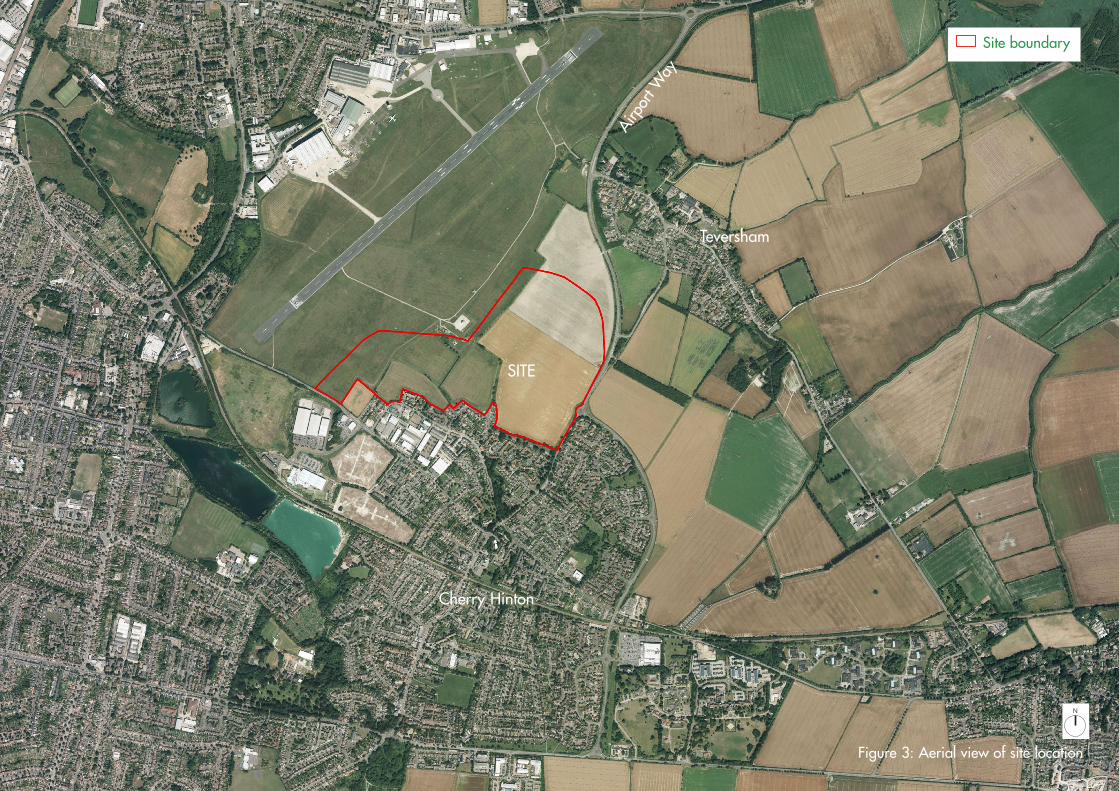
01 INTRODUCTIONOverview of the Site 1.1 The Land North of Cherry Hinton (LNCH) is located between Airport Way and Cambridge Airport, north of Coldhams Lane (see figure 1).
1.2 LNCH comprises 47ha in area. The largest part of the site is currently in agricultural use with the western-most areas comprising part of the airport land. The site has been allocated for new housing supported by the emerging Local Plans and the Cambridge East Area Action Plan (AAP). LNCH presents an opportunity to assist in meeting the demand for housing in South Cambridgeshire and Cambridge.
1.3 The surrounding area is predominately characterised by residential neighbourhoods of Cherry Hinton to the south, Teversham to the north and Cambridge to the west. The remaining land of Cambridge Airport borders the western boundary, with agricultural land to the immediate north. An industrial estate lies to the south of the site within Cherry Hinton. It is recognised, in principle, that residential-led development of the land adjoining the airport can now come forward without prejudicing Marshall’s Aerospace business operations at Cambridge Airport. Where necessary, appropriate mitigation of environmental and health impacts will be required within any proposal to ensure future residents are provided with a satisfactory living environment.
Purpose of the development framework1.4 This Supplementary Planning Document (SPD) is a planning guidance document which will support policy in both the draft Cambridge City Local Plan and the draft South Cambridgeshire District Local Plan. SPDs fall within one of two categories: the first relates to guidance supporting a city or district-wide objective; the second is guidance for a specific site or area development brief including framework master plans. This SPD falls within the second category.
1.5 This document will form a material consideration to be taken into account by Cambridge City Council and South Cambridgeshire District Council who, together with Cambridgeshire County Council, appoint members of the Joint Development Control Committee (JDCC) to determine major applications on the fringes of the City. The JDCC will determine the eventual planning application for LNCH.
1.6 The progress of the SPD document preparation is shown in figure 2.
1.7 This SPD has been prepared in line with the requirements of the Town and Country Planning (Local Planning) (England) Regulations 2012.
Structure of the development brief1.8 The SPD is structured as follows:
• Chapter 1 provides an introduction to the document and illustrates the process for achieving a high quality development.
• Chapter 2 provides an overview of the planning policy context.
• Chapter 3 provides an analysis of the site and the wider area.
• Chapter 4 sets out the vision for the site.
• Chapter 5 sets out the framework principles for achieving the vision and masterplan.

LAND NORTH OF CHERRY HINTON SUPPLEMENTARY PLANNING DOCUMENT
3
A14
SITE
Figure 1: Site location
A1303
AirportA113
4
Coldhams Lane
Airp
ort W
ay
Cambridge
Cambridge City Council
South Cambridgeshire District Council
Teversham
Fulbourn
Cambridge Railway Station
Cambridge North Railway Station
Cherry Hinton
N
Site boundaryAdministrative boundary

LAND NORTH OF CHERRY HINTON SUPPLEMENTARY PLANNING DOCUMENT
4
Progress of the document preparation
Figure 2: Progress of document preparation
BACKGROUND
Consultation 1: Fact finding and key issuesWorkshop and outline consultationOpportunity for team to learn more about the siteConsultation 2: Development principles and framework planWorkshop and outline consultationStakeholder engagement
Prepare draft SPD
Report to council committee
Formal eight week consultation
Report to council portfolio holders and relevant committees Committee approval of final SPD for adoption, subject to final adoption of the new Local Plans
PLANNING & DEVELOPMENT BRIEF
March - June 2017
July 2017
Review representations and prepare responsesOct-Dec 2017
February 2018
March -April 2017
Summer 2016
Aug-Oct 2017
Cambridge City Local Plan 2006 & South Cambridgeshire District Local Plan 2007 Site allocation for housingCambridge East AAPSite allocationEmerging draft Cambridge City Local Plan and draft South Cambridgeshire Local PlanSite allocation
Cambridge City Council (CCC), South Cambs District Council (SCDC) & Joint LandownersAgreement to jointly prepare a planning and development brief in response to emerging policy R47 (CCC) and policy SS/3 (SCDC)
LAND NORTH OF CHERRY HINTON SUPPLEMENTARY PLANNING DOCUMENT
5
Cherry Hinton
Teversham
SITE
Airp
ort W
ay
Figure 3: Aerial view of site location
Site boundary
N
LAND NORTH OF CHERRY HINTON SUPPLEMENTARY PLANNING DOCUMENT
6
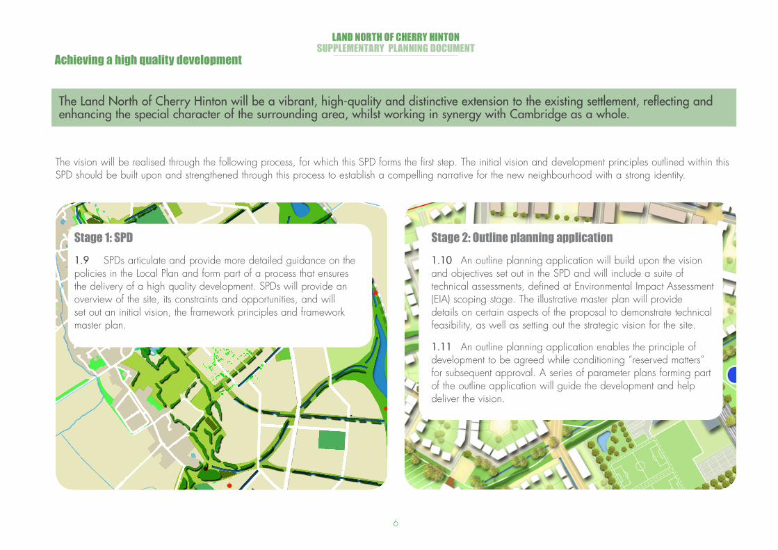
The vision will be realised through the following process, for which this SPD forms the first step. The initial vision and development principles outlined within this SPD should be built upon and strengthened through this process to establish a compelling narrative for the new neighbourhood with a strong identity.
Achieving a high quality development
Stage 1: SPD 1.9 SPDs articulate and provide more detailed guidance on the policies in the Local Plan and form part of a process that ensures the delivery of a high quality development. SPDs will provide an overview of the site, its constraints and opportunities, and will set out an initial vision, the framework principles and framework master plan.
Stage 2: Outline planning application1.10 An outline planning application will build upon the vision and objectives set out in the SPD and will include a suite of technical assessments, defined at Environmental Impact Assessment (EIA) scoping stage. The illustrative master plan will provide details on certain aspects of the proposal to demonstrate technical feasibility, as well as setting out the strategic vision for the site.
1.11 An outline planning application enables the principle of development to be agreed while conditioning “reserved matters” for subsequent approval. A series of parameter plans forming part of the outline application will guide the development and help deliver the vision.
The Land North of Cherry Hinton will be a vibrant, high-quality and distinctive extension to the existing settlement, reflecting and enhancing the special character of the surrounding area, whilst working in synergy with Cambridge as a whole.

LAND NORTH OF CHERRY HINTON SUPPLEMENTARY PLANNING DOCUMENT
7
Stage 3: Design code1.12 A design code will set rules for the design of the new development and will provide a tool to achieve the objectives and characters set out in the outline proposals. Design codes will typically follow an outline planning application and require approval prior to submission of the reserved matters. Design codes will typically comprise the following:
• The nature and purpose of the document and the planning context
• Summary of the local context, and the characteristics and constraints that have influenced the master plan and design code
• Comprehensive design guidelines and coding for the master plan area including, among others, density and building heights, spatial arrangement and block types, building types and materials palette.
Stage 4: Reserved matters1.13 Detailed design development proposals at reserved matters stage will deal with some or all of the outstanding details of the outline application proposal, focusing on compliance with design code and outline parameters in respect to layout, scale, appearance, access and landscaping.

LAND NORTH OF CHERRY HINTON SUPPLEMENTARY PLANNING DOCUMENT
8
02PLANNING POLICY CONTEXTIntroduction
2.1 The land included within this SPD falls within two local authorities: Cambridge City and South Cambridgeshire District.
2.2 The Cambridge East Area Action Plan (AAP) was adopted in February 2008 with an objective to “create a new and distinctive sustainable community on the eastern edge of Cambridge which will enhance the special character of the city and its setting and is connected to the rest of the city by high quality public transport and non-motorised modes of transport.” (Objective B/a, page 5). This plan was based on the assumption that the airport would relocate operations away from the area in the medium term. The document identified three areas that form Cambridge East:
• Cambridge Airport• Land North of Newmarket Road, and• Land North of Cherry Hinton.
2.3 The document sets out aspirations for the area and objectives in terms of creating district and local centres, housing, employment, leisure and community facilities, and guiding principles relating to landscape, biodiversity, water strategy and sustainability. The overall AAP concept diagram is included in figure 4.
2.4 The document represents a long term vision for the area, however since its publication there have been a number of changes in circumstance, both local and national, including an announcement from Marshall’s of its intentions to remain in Cambridge for the foreseeable future.
2.5 In November 2016 planning permission was granted at Land North of Newmarket Road for up to 1,300 homes, primary school, food store, community facilities, open space, landscaping and associated infrastructure and other development (S/2682/13/OL and 13/1837/OUT and identified as Phase 1 in the AAP). To the south of this site, Marshall as operators of Cambridge Airport, has committed to continuing airport operations for the foreseeable future.
2.6 In addition, national and local policy has evolved, and new local plans are currently being prepared for both Cambridge City Council and South Cambridgeshire District Council. The plans were submitted jointly to the Secretary of State in March 2014 for independent examination. As part of the examination, a number of hearing sessions have taken place from 2014 to 2017.
2.7 Regard will be had to the Minerals and Waste Core Strategy and Minerals and Waste Site Specific Proposals Plan for development at the site.
2.8 Except as superseded by the emerging new Local Plans of both Council’s, the AAP remains an important consideration in regard to the development of Land North of Cherry Hinton.

LAND NORTH OF CHERRY HINTON SUPPLEMENTARY PLANNING DOCUMENT
9
Local plan policies
2.9 In the emerging Cambridge Local Plan Proposed Modifications (2016) consultation, Land North of Cherry Hinton (R47) is allocated for approximately 780 dwellings during the plan period, along with adjoining land allocated in policy SS/3 of the emerging South Cambridgeshire Local Plan (2016) for approximately 420 dwellings. Figure 5 illustrates Cambridge East which includes allocation R57.
2.10 Proposals for residential development will be supported if:
• “acceptable mitigation of environmental and health impacts (including noise) from the airport can be provided; and
• A masterplan is submitted for the development of site R47 and adjoining land in South Cambridgeshire which safeguards the appropriate future development of the wider safeguarded land; and
• the continued authorised use of Cambridge Airport does not pose a safety risk”.
2.11 The master plan should make “provision for a primary and secondary school, a local centre with a community hub, open space and a spine road connecting Coldham’s Lane with Cherry Hinton Road.”
2.12 In addition, “the rest of the Cambridge East site is safeguarded for longer term development beyond 2031. Development on safeguarded land will only occur once the site becomes available and following a review of both this plan and the Cambridge East Area Action Plan.
2.13 The policy replaces Policies CE/3 and CE/35 of the Cambridge East AAP. All other policies in the Cambridge East AAP are retained.” (Modifications PM/SC/3/A PM/CC/3/A from South Cambs DC and Cambridge CC Schedule of proposed modifications, March 2016 respectively).
2.14 This SPD is a planning guidance document which will support policy in the draft Cambridge City Local Plan and make reference to the South Cambridgeshire District Council. This SPD provides guidance for a specific site through the evolution of the associated framework master plan, referring to modified proposed policies within the emerging local plans.
Long term transport strategy (LTTS)
2.15 Cambridgeshire County Council adopted the Long Term Transport Statement (LTTS) in July 2015. It was prepared collaboratively with district and neighbouring authorities.
2.16 The LTTS supports sustainable growth across Cambridgeshire to 2031, encourages sustainable transport modes and efficient use of the network, and seeks to reduce the need to travel and the impact of transport on the environment.

LAND NORTH OF CHERRY HINTON SUPPLEMENTARY PLANNING DOCUMENT
10
Figure 5: Cambridge Local Plan Modifications (March 2016)
Cambridge Local Plan Proposed Modifications (March 2016)
45
Proposed Modifications to Figure 3.2: Illustration of Cambridge East (PM/CC/3/E) of the Cambridge Local Plan 2014: Proposed Submission
Figure 4: Cambridge East AAP (2008) concept diagram

LAND NORTH OF CHERRY HINTON SUPPLEMENTARY PLANNING DOCUMENT
11
Green Belt
2.17 The area to the north of the site is Green Belt.
2.18 Both the Cambridge and South Cambridgeshire Local Plan (respective submission drafts), state that the established purposes of the Cambridge Green Belt are to:
• Preserve the unique character of Cambridge as a compact, dynamic city with a thriving historic centre;
• Maintain and enhance the quality of this setting; and
• Prevent communities in the environs of Cambridge from merging into one another and with the city. (para 2.29) (policy 12 (R47)).
2.19 The policy for Land East of Cambridge notes that the land has been taken out of the green belt, but reiterates that “the corridor of Green Belt running from Coldham’s Common to Teversham will remain as Green Belt” (modification PM/SL/3/B).
2.20 The SPD does not include land in the Green Belt for built development. However there may be a requirement for the playing fields associated with the school to be located in Green Belt land. As per the modification proposed to the
Cambridge Local Plan, development in the Green Belt will only be approved in accordance with green belt Policy in the National Planning Policy Framework (CLP policy 4). The school playing fields may be accessible to the general public, subject to a Community Use Agreement.
2.21 As stated in the proposed modification to CLP policy 12 (Cambridge East) “As an exception to policy CE/6 of the Cambridge East AAP, the secondary school need not be included in the local centre” (para 3.18). In common with practice elsewhere around Cambridge and in line with national policy on Green Belt, it will be acceptable for school playing fields to be located in the retained Green Belt” (para 3.18).


![Monstrous Compendium & Dragons [multi]/2nd... · 2019. 7. 7. · Monstrous Compendium Appendix TSR, Inc. POB 756 Lake Geneva WI 53147 TSR, Ltd. 120 Church End, Cherry Hinton Cambridge](https://static.fdocuments.net/doc/165x107/60b036e7b2c43b2fce30e562/monstrous-compendium-dragons-multi2nd-2019-7-7-monstrous-compendium.jpg)