Guidelines for land-use planning, FAO - SWALIM Digital Library
Upload
lelo-barakaCategory
view
218download
0
8/16/2019 Land Evaluation at Fao
http://slidepdf.com/reader/full/land-evaluation-at-fao 1/16
An overview of land evaluation and land use planning at FAO H. GeorgeLand and Plant Nutrition Management Service, AGLL, FAO
Abstract
This paper presents an overvie o! land evaluation and land use planning approaches used "#FAO, and the contri"uting role pla#ed "# spatial in!ormation s#stems. The rationale and
principles o! land evaluation and land$use planning as ell as %e# steps in the FAOapproaches are outlined. Plans !or enhancing the current land$evaluation !rame or% and&ore'isting land$use planning approaches that ould allo "etter incorporation o! a ider rangeo! goods and services in selecting land$use options are outlined.
Introduction
Land evaluation is !ormall# de!ined as (the assessment o! land per!ormance hen used !or aspeci!ied purpose, involving the e'ecution and interpretation o! surve#s and studies o! land!orms, soils, vegetation, climate and other aspects o! land in order to identi!# and ma%e acomparison o! promising %inds o! land use in terms applica"le to the o")ectives o! theevaluation( *FAO, + - /.
0onceptuall#, land evaluation re1uires matching o! the ecological and management
1 i ! l %i d ! l d i h l d 1 li i+
hil %i l l i
+

8/16/2019 Land Evaluation at Fao
http://slidepdf.com/reader/full/land-evaluation-at-fao 2/16
1 i t ! l t %i d ! l d ith l d 1 liti hil t t %i l l i
8/16/2019 Land Evaluation at Fao
http://slidepdf.com/reader/full/land-evaluation-at-fao 3/16
de!ined at this stage ?. The outcome o! these consultations determines the scope and intensit#o! surve#s that ma# later "e re1uired in order to !ill data gaps.
Step 2: etermination o! the re"uirements o! relevant land-use options
Land$use options and their corresponding re1uirements ma# "e descri"ed ith var#ing levelso! detail. 7n reconnaissance studies, the descriptions correspond to ma)or divisions o! ruralland use, e.g. rain$!ed or irrigated agriculture, grassland or !orestr#. Ho ever, !or detailedstudies, more in!ormation on the management conditions is re1uired since, in practice, thesestrongl# in!luence the attaina"le levels o! production. 7n these studies, a land use option isdescri"ed using the !ollo ing set o! management$related *or 2input2/ attri"utes *re!lectingsocio$economic setting/ that together de!ine a 2land utili6ation t#pe2 *L:T/ ,• produce, including goods and services• mar%et orientation• capital intensit#• la"our intensit#•
po er sources• technolog#• in!rastructure• si6e and con!iguration o! land holdings• income level.
A large num"er o! agricultural L:Ts is theoreticall# possi"le *as a conse1uence o! the
i"l "i i ! d d& i $$$ li % d ! #
<

8/16/2019 Land Evaluation at Fao
http://slidepdf.com/reader/full/land-evaluation-at-fao 4/16
commonl# re!erred to as (agro$ecological units( hen the original core data sets that are usedin the overla# process consist o! climate, soils and land!orm *terrain/ data. The set o!
parameters used !or assessing land 1ualit# o! each land mapping *or agro$ecological/ unit arethe same as those retained !or characteri6ing the re1uirements o! each L:T *see Ta"le 9/. Ane'tract !rom an FAO case stud# in Ben#a illustrating this stage o! land evaluation is presentedin Anne' 7.
Step &: Interim matchin% o! land-use re"uirements with actual land "ualities
At its simplest level, matching *i.e. suita"ilit# assessment/ !or each land$mapping unit can "emade ta%ing into consideration onl# the ph#siological re1uirements o! a speci!ic crop*s/ andthe e'isting "ioph#sical land conditions *e.g. climate, soils and land!orm/. These sets o!in!ormation allo prediction o! theoretical crop per!ormance *#ields/ ' Ho ever, suchtheoretical ma'imum levels o! per!ormance are strongl# attenuated "# a range o! landmanagement !actors *as re!lected in the list o! parameters used to de!ine L:Ts $$$ see previoussection on 2 etermination o! the re"uirements o! relevant land use options( /. Thus, estimatesare made o! production per!ormance under di!!erent operational land$management settings as
speci!ied !or the L:Ts. These (ad)usted( estimates then !orm the "asis !or assigning land$suita"ilit# ratings !or each land$mapping unit.
7n earlier non$automated C1ualitativeD approaches to matching, estimates o! crop per!ormanceere "ased on previous e'perience or scienti!ic %no ledge. 7n contrast, in more recent
automated approaches, estimates are "ased on computer modeling o! crop or animal gro th.For non$automated C1ualitativeD approaches to matching, land suita"ilit# as descri"ed usinga hierarchic classi!ication structure *ranging !rom orders, classes, su"$classes to units/ thatll h i i ! ! d il i!i l d$ li i i * T "l
>

8/16/2019 Land Evaluation at Fao
http://slidepdf.com/reader/full/land-evaluation-at-fao 5/16
8conomic and social anal#ses help to identi!# pro"lems *e.g. la"our shortages, adverse tenureconditions, poor access to mar%ets, etc/ in relation to potential land uses. These anal#sesconse1uentl# !ocus on government development o")ectives, macro$economic tools and data,the rural econom#, in!rastructure, demographics, land tenure, la"our availa"ilit# andeducational level, etc.
7t is orth noting that a preliminar# selection o! accepta"le land$use options to considerduring land evaluation *see Section on (Initial consultation on the objectives( / is o!ten madeas part o! the land$use planning process. This helps to reduce the num"er o! land$use optionsthat ma# have signi!icant adverse environmental and&or socio$economic impacts.
Automated land evaluation tools and databases
Since the FAO Land 8valuation Frame or% as pu"lished in + - , a num"er o!technological developments have !acilitated the implementation o! its principles. One o! themost signi!icant developments has "een the advent o! a!!orda"le P0$"ased *vs. main!rames/geographic in!ormation s#stems *G7S/. G7S !acilitate the storage and anal#sis o! a ide range
o! spatial data. 0omputeri6ed data"ases and modeling programs are no inter$!aced ith G7Sin order to !acilitate the computational intensive aspects o! land evaluation *e.g the stage o!matching potential L:T re1uirements ith land 1ualities/. 7n particular, rather than 1ualitativematching, comple' computer models o! crop gro th and development can no "e used to
provide estimates o! #ields corresponding to the soil, climate and land!orm characteristics o!each land mapping *agro$ecological/ unit under the three di!!erent land$managementscenarios o! lo , intermediate and high input levels. Moreover, the !easi"ilit# and the impacto! di!!erent cropping patterns on productivit# can "e anal#6ed.
?

8/16/2019 Land Evaluation at Fao
http://slidepdf.com/reader/full/land-evaluation-at-fao 6/16
FAO has also developed a so!t are& data"ase pac%age, 80O0 OP ++, that allo s users toidenti!# plant species hose most important climate and soil re1uirements match thein!ormation on climate and soil entered "# the user.
Since + ; , FAO in colla"oration ith e'ternal partners has also "een spearheading aninternational e!!ort aimed at creating, using a standardi6ed methodolog#, national to regionaldata"ases on soil and terrain *SOT8 / +9. These data"ases contain in!ormation, among others,on land!orm, morpholog#, slope, parent material and soils. The# are thus use!ul !or the
purposes o! land evaluation.
The AL8S +< *the Automated Land 8valuation S#stem/ developed at 0ornell :niversit# !ollothe principles o! the + - Frame or%. 7n AL8S, e'pert users can descri"e proposed land usesas ell as the geographical areas to "e evaluated, using their o n set o! criteria "ased on theirlocal %no ledge, and su"se1uentl# allo the program to automaticall# do the matching.
Land use planning
Land$use planning has "een de!ined as 2the s#stematic assessment o! land and ater potential,alternative patterns o! land use and other ph#sical, social and economic conditions, !or the
purpose o! selecting and adopting land$use options hich are most "ene!icial to land usersithout degrading the resources or the environment, together ith the selection o! measures
most li%el# to encourage such land uses2 *FAO, + $"/.
This su")ect that has "een addressed in several recent FAO pu"lications *e.g. FAO, + <$a, $"=+ ?= + -, FAO&:N8P, + ?= + -= + $a/. These pu"lications emphasi6e the appraisal
! l i h i i "l l d$ ! h

8/16/2019 Land Evaluation at Fao
http://slidepdf.com/reader/full/land-evaluation-at-fao 7/16
o! !actors related to sustaina"ilit# *vi6. social acceptance, economic via"ilit#, ph#sicalsuita"ilit# and environmental sustaina"ilit#/, as ell as social impact *access to landresources, nutritional status, health status, and education/ in the appraisal o! land use options.
Seven %e# !actors are associated ith success!ul integrated planning !or sustaina"lemanagement o! land resources *FAO&:N8P, + $a/.• clear !ormulation o! the o")ective and pro"lem to "e solved *i.e. it should "e a demand$
driven process/• the recognition o! sta%eholders and their di!!ering o")ectives *e.g. competition !or
resources and land uses/• an ena"ling environment and regulator# polic# *e.g. consistent policies and plans at all
levels o! decision ma%ing/• e!!ective institutions at local, su"$national, and national level hich are lin%ed *i.e. the
devolution o! decision ma%ing to the lo est possi"le level that is consistent ith thea"ilit# o! implementation,/
• a plat!orm !or negotiation *i.e. !air representation and e!!ective participation o!
sta%eholders in negotiations/.• an accessi"le and e!!icient %no ledge "ase, and• a set o! planning procedures that are applica"le at di!!erent scales *e.g. land evaluation,
participator# techni1ues, anal#sis o! sta%eholder o")ectives, monitoring and evaluation./
Follo ing land evaluation, sta%eholders usuall# have to select one or more land$use options!rom those that meet the minimum recommended selection criteria, namel#, ph#sicalsuita"ilit#, economic via"ilit#, sociall# accepta"ilit#, !reedom !rom signi!icant adverse
i l i "l i l i i / A l i i ! i hi h
-

8/16/2019 Land Evaluation at Fao
http://slidepdf.com/reader/full/land-evaluation-at-fao 8/16
agricultural production, minimising costs o! production and environmental damages !romerosion + .
Ade1uate in!ormation on present land uses, including management aspects, is a necessar# pre$re1uisite !or ela"orating policies and plans that ould help "ring a"out speci!ic desira"lechanges in the environment *e.g. alleviation o! land degradation/. A so!t are pac%age, theL:5J *Land :se 5ata Jase/ +- that allo s the structured storage and retrieval o! in!ormationon actual land use data *including land management/ as developed several #ear ago "# FAOin colla"oration ith e'ternal partners. 3or% is currentl# in progress at FAO on thedevelopment o! a simpli!ied, more user$!riendl#, update to L:5J. This update, provisionall#termed Agri$L:0S *Agricultural Land :se 0orrelation S#stem/ allo s description o! landuses using a parametric, hierarchic approach using com"inations o! selected land$use
parameters that are amena"le to G7S processing. The parameters selected !or characteri6ingagricultural land use are the nature o! the product*s/ !rom the land use under consideration,and the nature o! the inputs, including land management actions. Parametric description2strings2 can "e interactivel# reclassi!ied allo ing one to map *and hence, correlate/ areas o!similar products and land management.
As outlined earlier, land evaluation assesses the suita"ilit# o! land !or one or more speci!ied(sustaina"le( land uses, ta%ing into account, among others, aspects o! the associated landmanagement *see parameters used in de!ining L:Ts $ ($ains steps in land evaluation( / that
ould prevent land degradation. :se!ul insights could there!ore "e gained i! data on actualland use management could "e compared to the results !rom land evaluation +; . 7n particular,di!!erences in land management practices could help pinpoint areas here such practices ma#
"e considered inappropriate i! the# lead to land degradation. 7n order to !acilitate suchl# FAO i ll " i i h 7FP 7 *7 i l F d P li # h 7 i / d
;

8/16/2019 Land Evaluation at Fao
http://slidepdf.com/reader/full/land-evaluation-at-fao 9/16
agreements 9 . Mismanagement o! agricultural land resources, o!ten lin%ed to increasingdemographic pressure, contri"utes signi!icantl# to environmental degradation 9+. 7t has
there!ore "ecome increasingl# appropriate that decisions concerning the potential uses o! landinclude e'plicit consideration o! environmental impacts and o! sustaina"ilit# 99.
Nota"l#, ho ever, hile the latest FAO guidelines on integrated planning !or sustaina"lemanagement o! land resources *FAO&:N8P, + / cite the importance o! includingenvironmental and social consideration in !inal land use choices, operational details o! there1uired approaches& methodologies are largel# missing. Several internal meetings held in9 at FAO on this su")ect indicate that revised land evaluation and land$use planning toolsand approaches should include methodologies that e'plicitl# allo consideration o! the!ollo ing issues in screening land$use options@• 8nvironmental impacts, including goods and services, in relation to "oth land and ater
*e.g. soil and ater degradation= "io$diversit#= car"on se1uestration= greenhouse gases=sustaina"le development/
• 8!!ective participation "# multiple sta%eholders 9< and the incorporation o! genderconsiderations 9>
• Mar%et and other driving !orces *e.g. !ood, population, income, ur"an e'pansion/• 8conomic and polic# issues *e.g. glo"ali6ation, li"erali6ation, polic# harmoni6ation,../
8'plicit consideration o! some o! these issues is alread# possi"le using the M05A anal#ticaltool mentioned a"ove in hich plausi"le comple' alternate scenarios o! land use can "e!ormulated. Not ithstanding, a commissioned stud# is currentl# under a# *Octo"er, 9 9/ toe'amine the !easi"ilit# o! having the !ull range o! issues "etter (integrated( into the land$
l i & l d

8/16/2019 Land Evaluation at Fao
http://slidepdf.com/reader/full/land-evaluation-at-fao 10/16
'eferences
Land evaluationFAO, + - . A !rame or% !or land evaluation. FAO Soils Julletin <9FAO, + -;$;+. eport on the Agro$ecological Iones pro)ect. ol. +. Methodolog# and results!or A!rica. ol.9. esults !or south est Asia= ol.<. Methodolog# and results !or South and0entral America= ol. >, esults !or Southeast Asia. FAO 3orld Soil esources eport, >;&+,>FAO, + ;<. Guidelines@ Land evaluation !or rain!ed agriculture, FAO Soils Julletin ?9FAO, + ;>. Land evaluation !or !orestr#. FAO Forestr# Paper >;FAO, + ;?. Guidelines@ Land evaluation !or irrigated agriculture, FAO Soils Julletin ??FAO, + +. Guidelines@ land evaluation !or e'tensive gra6ing. FAO Soils Julletin ?;FAO&:N8P, + <. Agro$ecological assessments !or national planning@ the e'ample o! Ben#a.FAO Soils Julletin, -, +?>p.FAO, + . Agro$ecological 6oning guidelines. FAO Soils Julletin -<
Land use planning
FAO, + <$a. Guidelines !or land use planning. FAO 5evelopment Series +.FAO, + <$". F8SLM@ An international !rame or% !or evaluating sustaina"le landmanagement. 3orld Soil esources eport -<, ->p.FAO, + ?. Planning !or sustaina"le use o! land resources. To ards a ne approach. FAOLand and 3ater Julletin 9, p.FAO&:N8P, + ?. Our land our !uture $ A ne approach to land use planning andmanagement.FAO, + -. Land 1ualit# indicators and their use in sustaina"le agriculture and rurald l d d ll
+

8/16/2019 Land Evaluation at Fao
http://slidepdf.com/reader/full/land-evaluation-at-fao 11/16
&able ( 0lassi!ication o! attri"utes o! land utili6ation t#pes *L:Ts/ !or crop production $ Ben#a. *a!ter FAO, + </
Attri"uteLevel o! input
Lo 7ntermediate HighProduce production ain!ed cultivation o! "arle#, mai6e, oat, pearl millet, dr#land rice, etland rice, sorghum, heat, ....
Sole and multiple cropping o! crops in appropriate cropping patterns and rotations.Mar%et orientation Su"sistence production Su"sistence production plus
commercial sale o! surplus0ommercial production
0apital intensit# Lo 7ntermediate ith credit onaccessi"le terms
High
La"our intensit# High, including uncosted !amil#la"our
Medium, including uncosted!amil# la"our
Lo , !amil# la"our costed i! used
Po er source Manual la"our ith hand tools Manual la"our ith hand toolsand&or animal traction ithimproved implements= somemechani6ation
0omplete mechani6ationincluding harvesting.
Technolog# Traditional cultivars= no !ertili6eror chemical pest, disease and
eed control. Fallo periods.Minimum conservation measures
7mproved cultivars as availa"le.Appropriate e'tension pac%agesincluding some !ertili6erapplication and some chemical
pest, disease and eed control.Some !allo periods and someconservation measures
High #ielding cultivars includingh#"rids. Optimum !ertili6erapplication. 0hemical pest,disease and eed control. Fullconservation measures.
7n!rastructure mar%et accessi"ilit# not necessar#=inade1uate advisor# services
some mar%et accessi"ilit#necessar# ith access to
demonstration plots services
Mar%et accessi"ilit# essential.High level o! advisor# services
and application o! research!indings.Land holding small, !ragmented small, sometimes !ragmented large, consolidated7ncome level lo moderate high
++
8/16/2019 Land Evaluation at Fao
http://slidepdf.com/reader/full/land-evaluation-at-fao 12/16
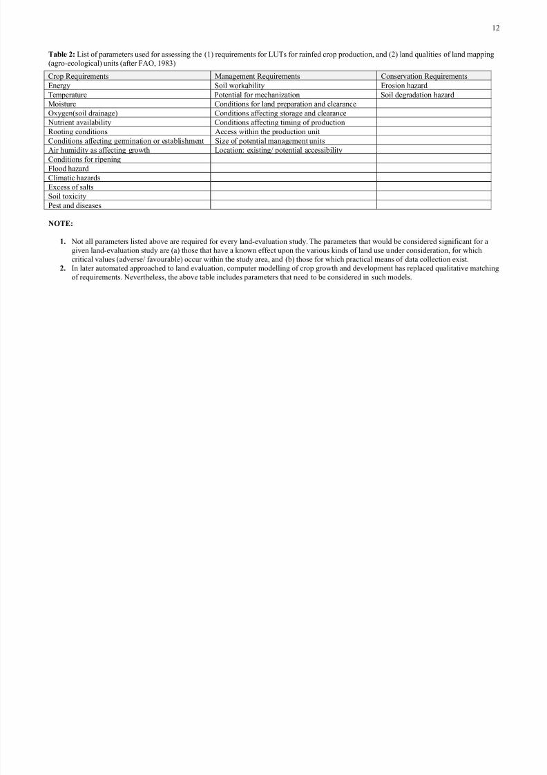
&able * List o! parameters used !or assessing the *+/ re1uirements !or L:Ts !or rain!ed crop production, and *9/ land 1ualities o! land mapping*agro$ecological/ units *a!ter FAO, + ;</
0rop e1uirements Management e1uirements 0onservation e1uirements8nerg# Soil or%a"ilit# 8rosion ha6ard
Temperature Potential !or mechani6ation Soil degradation ha6ardMoisture 0onditions !or land preparation and clearanceO'#gen*soil drainage/ 0onditions a!!ecting storage and clearance
Nutrient availa"ilit# 0onditions a!!ecting timing o! productionooting conditions Access ithin the production unit
0onditions a!!ecting germination or esta"lishment Si6e o! potential management unitsAir humidit# as a!!ecting gro th Location@ e'isting& potential accessi"ilit#0onditions !or ripeningFlood ha6ard0limatic ha6ards8'cess o! saltsSoil to'icit#Pest and diseases
!O&#
(+ Not all parameters listed a"ove are re1uired !or ever# land$evaluation stud#. The parameters that ould "e considered signi!icant !or agiven land$evaluation stud# are *a/ those that have a %no n e!!ect upon the various %inds o! land use under consideration, !or hichcritical values *adverse& !avoura"le/ occur ithin the stud# area, and *"/ those !or hich practical means o! data collection e'ist.
*+ 7n later automated approached to land evaluation, computer modelling o! crop gro th and development has replaced 1ualitative matchingo! re1uirements. Nevertheless, the a"ove ta"le includes parameters that need to "e considered in such models.
+9
8/16/2019 Land Evaluation at Fao
http://slidepdf.com/reader/full/land-evaluation-at-fao 13/16
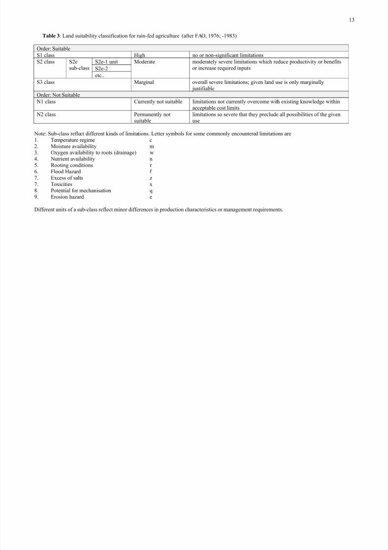
&able , @ Land suita"ilit# classi!ication !or rain$!ed agriculture *a!ter FAO, + - = $+ ;</
Order@ Suita"leS+ class High no or non$signi!icant limitationsS9 class S9e
su"$class
S9e$+ unit Moderate moderatel# severe limitations hich reduce productivit# or "ene!its
or increase re1uired inputsS9e$9etc..
S< class Marginal overall severe limitations= given land use is onl# marginall# )usti!ia"le
Order@ Not Suita"le N+ class 0urrentl# not suita"le limitations not currentl# overcome ith e'isting %no ledge ithin
accepta"le cost limits N9 class Permanentl# not
suita"lelimitations so severe that the# preclude all possi"ilities o! the givenuse
Note@ Su"$class re!lect di!!erent %inds o! limitations. Letter s#m"ols !or some commonl# encountered limitations are+. Temperature regime c9. Moisture availa"ilit# m<. O'#gen availa"ilit# to roots *drainage/>. Nutrient availa"ilit# n?. ooting conditions r
. Flood Ha6ard ! -. 8'cess o! salts 6-. To'icities ';. Potential !or mechanisation 1
. 8rosion ha6ard e
5i!!erent units o! a su"$class re!lect minor di!!erences in production characteristics or management re1uirements.
+<

8/16/2019 Land Evaluation at Fao
http://slidepdf.com/reader/full/land-evaluation-at-fao 14/16
A!!# I @
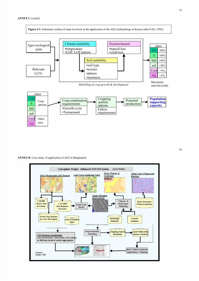
8'tracts !rom selected stages o! land evaluation in Ben#a *!rom FAO, + </
Step 2: etermination o! the re"uirements o! relevant land-use options
L:Ts ere di!!erentiated on the "asis o! level o! inputs& management, into three "road input categories, namel#, lo , intermediate and high. Landevaluation !ocussed on crop, livestoc% as ell as !uel ood production. 0onsideration o! crop production alone, #ielded a total o! +-> L:Ts dueto ?; di!!erent crop t#pes *di!!erent cultivars, crop phenolog# and gro th c#cles/ at the < di!!erent input levels. The ecological re1uirements o!the various crop L:TS related speci!icall# to climate, soils and land!orm@• The temperature and radiation *needed !or plant gro th/• The length o! the gro th c#cle, *related to plant phenological development/, and• Soil and land!orm 1ualities *e.g. moisture availa"ilit#= nutrient availa"ilit#= o'#gen availa"ilit#= !oothold !or roots= salinit#= to'icit#=
accessi"ilit# or%a"ilit#= tilth= micro¯o relie!= soil erosion resistance/.
Step #: $appin% land "ualities
A ma)or o")ective o! land evaluation as to identi!# areas that, under rain$!ed conditions, ould produce the largest or most desired 1uantitiesand 1ualities o! edi"le calories and protein. The (suita"ilit# assessment( procedure consisted !irst o! comparing the land 1ualities o! each agro$ecological unit ith the ecological re1uirements o! all relevant L:Ts. Suita"ilit# as assessed se1uentiall# on the "asis o! climate suita"ilit#,soil$t#pe suita"ilit# and erosion ha6ard. The output o! this assessment as a ran%ing given to each L:T "ased on the estimated percentage o!ma'imum crop #ield. All L:Ts !or hich the e'pected crop #ields ere greater than a pre$selected threshold o! 9 percent ere considered as
possi"le options and retained !or !urther consideration. Finall#, the potential #ields !or di!!erent crop com"inations ere calculated, ta%ing intoaccount the !easi"ilit# o! cropping patterns as ell as associated !allo re1uirements. The in!ormation as su"se1uentl# used to estimate the
present and !uture potential supporting capacit#, ta%ing actual and predicted population levels into account *see Figure 7$+/.
+>
8/16/2019 Land Evaluation at Fao
http://slidepdf.com/reader/full/land-evaluation-at-fao 15/16
A!!# I @ *cont(d/
Agro$ecological units
Agro$ecological units Qtemperature
QLGP, LGP pattern
0limate suita"ilit#
Qsoil t#pe
Qte'tureQphasesQstoniness
Soil suita"ilit#
Qtopsoil lossQ#ield loss
8rosion ha6ard
elevantL:TselevantL:Ts
S ; E
S E
MS > E
mS 9 E
mS ?E
NS R?E
class
Ma'imumrain$!ed #ields $odellin% o! crop %rowth * development
S
SMS
mS
mS
NS
class
0ropoptions
Other uses
QGro th c#cleQTurnaround
0rop com"ination
re1uirements
0ropping patternoptionsFallore1uirements
Potential
production
.opulationsupportingcapacity
Figure I-( Schematic outline o! steps involved in the application o! the A8I methodolog# in Ben#a *a!ter FAO, + </
+?

8/16/2019 Land Evaluation at Fao
http://slidepdf.com/reader/full/land-evaluation-at-fao 16/16
A!!# II @ 0ase stud# o! application o! A8I in Jangladesh
+