
Lake Winnipeg - State of the Science files/LWRC 2011 Sci WS... · 2017-07-17 · Lake Winnipeg -...
188
Lake Winnipeg Research Consortium Inc. Science Workshop 2011 Lake Winnipeg - State of the Science What is the Scientific Basis for Understanding and Protecting Lake Winnipeg? Siobhan Field Station Fort Whyte Nature Centre 1961 McCreary Road, Winnipeg April 26 th and 27 th , 2011 By: K.J. Scott 1 , G. McCullough 2 , M. Stainton 3 , B. Ayles 4 , B. Hann 2 1 Lake Winnipeg Research Consortium Inc. 2 University of Manitoba 3 Fisheries and Oceans Canada 4 Independent
Transcript of Lake Winnipeg - State of the Science files/LWRC 2011 Sci WS... · 2017-07-17 · Lake Winnipeg -...

Lake Winnipeg Research Consortium Inc. Science Workshop 2011
Lake Winnipeg - State of the Science
What is the Scientific Basis for Understanding and Protecting Lake Winnipeg?
Siobhan Field Station Fort Whyte Nature Centre
1961 McCreary Road, Winnipeg April 26th and 27th, 2011
By: K.J. Scott1, G. McCullough2, M. Stainton3, B. Ayles4, B. Hann2
1Lake Winnipeg Research Consortium Inc. 2University of Manitoba
3Fisheries and Oceans Canada 4Independent


i
EXECUTIVE SUMMARY
The purpose of the 2011 LWRC Science Workshop was to evaluate the progress made on the science priorities and research needs identified in the 2004 Federal-Provincial Science Workshop, with an emphasis on synthesizing and evaluating existing knowledge about the lake ecosystem. In essence, this report describes the state of the science on Lake Winnipeg.
The 2004 proposals and recommendations were intended to aid the discussions between Manitoba and Canada to identify the individual and joint roles of these governments concerning Lake Winnipeg. Acting on those proposals was expected to be the first step in the development of an ongoing comprehensive science program for Lake Winnipeg. Much has been accomplished, especially in terms of nutrient loading estimates and model development. It is apparent, however, that research and monitoring activities remain loosely organized and a comprehensive science program on Lake Winnipeg was never fully realized. Consequently, much knowledge remains dispersed among agencies and until very recently, unpublished. A regular, comprehensive synthesis of information would aid in defining new research that is based on addressing the knowledge gaps that meet management needs.
Below is a brief summary of the salient scientific findings in recent years and research gaps that were identified during Discussions at the 2011 Science Workshop.
Nutrient Loading
Nutrient loading estimates to Lake Winnipeg have improved through an increased and coordinated monitoring effort between Manitoba Water Stewardship and Environment Canada, as well as independent research. Among the more important research findings were:
• The onset of large cyanobacterial blooms in Lake Winnipeg was driven almost entirely by an abrupt increase of 70% (compared to the 1970s) in phosphorus loading to the lake in the mid-1990s;
• This abrupt increase in loading is explained by a doubling in the flow of the Red River in the last 20 years relative to its previous history (1971 to 1980), which mobilize nutrients from land enriched by a growing population and ever more intensive land use practices;
• Annual runoff and the frequency and extent of flooding within the Red River Basin is a major determinant of the magnitude of this phosphorus loading;
• Other tributaries had either comparatively little (Winnipeg and Dauphin rivers) or a negative (Saskatchewan River) effect on this loading.
Thus, contrary to previous assumptions, most of Lake Winnipeg’s enormous watershed is currently not an important contributor of nutrients to the lake, and phosphorus abatement

ii
efforts should be aimed largely at the Red River Basin. Furthermore, future climate scenarios determining the amount of rain (and run-off) occurring in the Red River Basin will have very important implications for the remediation of Lake Winnipeg. Water quantity, therefore, is as critical as water quality to the management of productivity in the lake.
Internal Nutrient Cycling
Within the lake, the contribution of a number of processes to the nutrient budgets remains largely unknown. For the nitrogen cycle, nitrogen fixation rates require further refinement. Moreover, no measures of denitrification have been made, despite the possibility that this microbial process could represent an important loss of nitrogen from the system. Phosphorus retention estimates in the sediment of the lake range from 60 to 70%. Due to the increased nutrient load, the net sedimentation (loading – outflow flux) is estimated to have nearly doubled (from roughly 3,200 to 5,500 Mg P/a). Consequently, there is potentially an enormous reservoir of phosphorus being stored in the lake that could significantly prolong remediation efforts. This will in part depend on the extent to which this phosphorus is remobilized by various means (internal loading, re-suspension) into the water column, and on its bioavailability, two very important unknowns for Lake Winnipeg.
Oxygen Dynamics – Water Column and Sediment-Water Interface
The oxygen dynamics in Lake Winnipeg are key to understanding a number of these in-lake processes. Effort thus far has been directed at understanding water column oxygen levels only. Since 2002, low oxygen in bottom waters has been measured in 2003, 2006 and 2007 in the central north basin. The south basin had no hypoxic events in any year with the exception of one station, and no dissolved oxygen concentrations below 5.5 mg/L were recorded in either basin between 2008 and 2010. Due to the size of the lake, the spatial and temporal extent of low oxygen events remains poorly understood; however, based on the current findings, it appears that Lake Winnipeg does not experience persistent and frequent low oxygen events. Thus, the tendency of the popular press and others who describe “dead zones” in Lake Winnipeg, or that the lake is “dying”, is scientifically unfounded to date. Given the seemingly fleeting episodes of hypoxia in the central north basin, mortality of fishes due to low oxygen is likely extremely rare.
Whereas stratification is a pre-condition for hypoxia and anoxia in the water column, the amount of organic material is critical for sustaining bacterial respiration and fermentation at and within the sediments. Given the shallow depth of the lake, which limits the probability of stratification, as well as the development of extensive algal blooms, which often descend to the bottom of the lake to decompose, it is at the sediment/water interface that oxygen studies should also be aimed. Within the microzone of the sediment/water interface, anoxic conditions could promote the mobilization of phosphorus from the

iii
sediment to the water column (internal loading) and enhance rates of denitrification. Low oxygen levels in the sediment also impact the benthic community, even without water column oxygen depletion. As nothing is currently known about oxygen dynamics at the sediment/water interface, it remains an extremely important knowledge gap for Lake Winnipeg.
Food Web Dynamics
Food web dynamics, especially who is eating whom, remains an important information gap with potential economic consequences. Ultimately, knowledge of the quantity, nutritional quality, and spatial distribution of dietary resources is necessary to understand the flow of energy from nutrients to fish and how that flow is being redirected or disrupted in response to changing nutrient regimes (including abatement), climate change, and exotic species. The importance of the microbial loop in this energy transfer must not be overlooked, nor should the potential disruption to the synchronies of life stages and dietary resources. Some salient studies could include:
• The role of temperature and ice transparency on the early succession of diatom to cyanobacterial dominance;
• Nutritional value of cyanobacteria to benthos and zooplankton and of Bythotrephes to forage fishes;
• The relative importance of heterotrophs, notably protozoa, in the transfer of energy to consumers;
• Tagging studies to establish movement and feeding patterns of fishes; and
• Sentinel whitefish data (diet, length, weight and age) as a means to evaluate the potential impacts of zebra mussels.
Clearly, this effort will require a very broad interrogation and collaborative effort in terms of how these dynamics are examined.
Commercial Fishery
The impacts of eutrophication, whether negative or positive, on the productivity of the commercial fishery have not been established. Thus, conclusions by the media and others describing a thriving or threatened fishery due to eutrophication are currently not supported by scientific data. As the highest priced commercial species, most emphasis has thus far been placed on walleye. Results from the index-netting program describe a walleye fishery that is supported by a very large 2001-year class, which is providing a massive peak, followed by a smaller 2006-year class. Moreover, most of the increased yield in walleye has occurred in the channel and the south basin, not in the north basin. The estimated rate of mortality of walleye is high; unheard of in most walleye fisheries, and it is not known if it is sustainable. No mortality estimates have been made for sauger or whitefish. Indeed, lake whitefish is not sampled in the index-netting program and,

iv
therefore, very little is known in terms of its population dynamics. This is most unfortunate because as a bottom feeder, it might be among the first species to be affected by changes in the benthic community. Moreover, lake whitefish is one of the species that exotics like zebra mussels and Bythotrephes will occur in large numbers in their gut contents. As a sentinel species of sorts, good pre-invasion lake whitefish diet and condition data would help discern changes resulting from a seemingly increasing number of stressors. It is critical at this juncture, when potentially aggressive phosphorus abatement measures will be undertaken, that a more adequate understanding of the relationship between phosphorus loading, the surge in algal production and the impacts on the fishery be sought to ensure that the productive capacity of the fishery is not compromised. Sustainable management targets and end points will be difficult to define without this knowledge.
Contaminants
It is apparent that the research and monitoring effort for contaminants in Lake Winnipeg is not receiving the same level of attention as other initiatives on the lake. The monitoring efforts of the provincial and federal governments are limited both spatially and in terms of the range of contaminants being monitored. Furthermore, datasets remain dispersed as does the interpretation and discussion of results. Of the little research conducted to date, there appear to be important differences in the magnitude and sources of some contaminants between basins: the south basin has experienced higher loadings largely from riverine sources, whereas the north basin had lower total loadings with a higher fraction derived from atmospheric deposition. The importance of the Red River Basin as a source of contaminants derived from agricultural and urban activities should be actively investigated, especially given the extent to which phosphorus has been mobilized in the last decades. To improve upon the current situation, future State of the Lake reports should include the status of contaminant monitoring in Lake Winnipeg. Furthermore, the inclusion of contaminants data collected by the Province of Manitoba and EC (FCMSP) in the Lake Winnipeg Basin Information Portal would be of value in increasing the visibility and accessibility of such data, and in acknowledging the importance of contaminants as a potentially serious water quality concern.
Algal Toxins
Microcystin-LR is the only algal toxin that is routinely monitored in Lake Winnipeg. Results indicate that this toxin is more frequently detected in samples collected from the near-shore areas of the lake and has been elevated above recreational water quality guidelines on occasion. However, it has remained low or undetectable in most algal bloom samples collected from the offshore areas. The tendency of the popular press and others to describe all algal blooms as toxic is unfortunate, as that assumption is not supported by the available data. That said, much remains to be understood in the area of algal toxin production, notably which toxins are being produced and what species are producing them. Moreover, few studies have been carried out to evaluate the

v
accumulation of algal toxins in fish or other biota in Lake Winnipeg, and it is not known whether any toxins are impacting higher organisms. To manage this potential water quality issue more effectively, a comprehensive, coordinated analysis of a broad spectrum of toxins, as well as a thorough, consistent approach to assessing the threat of algal toxins in Lake Winnipeg to humans and other biota would be of value.
Suggested Additions to Field Programs - Near-Shore and Under Ice
Most of the data on Lake Winnipeg were acquired using the M.V. Namao as a research platform, and are representative of the pelagic area of the lake. Consequently, knowledge of the near-shore area is lacking, despite its importance in the lake’s metabolism. Furthermore, in the Great Lakes, the predominant effects of zebra mussels were near-shore, yet that was where the least historical sampling effort took place. Given the proximity of zebra mussels to Lake Winnipeg, characterizing the near-shore areas of the north basin of Lake Winnipeg is of utmost importance. In an effort to address this need, the LWRC will introduce a North Basin Near-Shore Sampling Program in 2012 to facilitate access to the near-shore for the various science agencies working on the lake. The M.V. Namao will serve as the staging and launch platform for this work using smaller vessels to access the shallows.
Knowledge of the under ice environment is also lacking. Winter conditions, such as low snow cover, are believed to have an important effect on the timing of the under ice diatom growth, which in turn can have consequences on the algal succession, notably to cyanobacteria, and subsequent energy transfer to lower level consumers up to fish. A sampling program that includes both the open water season and entire winter period for at least one year would be necessary to adequately understand food web and oxygen dynamics in Lake Winnipeg.
Modeling Efforts
Much progress has been made in the development of models that can be used for various purposes including in the refinement of nutrient targets for Lake Winnipeg. All models require data inputs, and the process itself of building models is a valuable exercise in identifying data deficiencies and in helping guide future research and monitoring. Addressing the above research gaps would greatly benefit the development, refinement, and predictive capacity of a Lake Winnipeg whole ecosystem model. The development of models has a unifying function in that it can serve as a common goal among agencies with differing mandates, priorities, levels of funding, and commitment to Lake Winnipeg.

vi
TABLE OF CONTENTS
EXECUTIVE SUMMARY i
TABLE OF CONTENTS vi
LIST OF FIGURES AND TABLES vii
STEERING COMMITTEE viii
ACKNOWLEDGEMENTS viii
ACRONYMS viii
INTRODUCTION
2004 Federal-Provincial Science Workshop 1
2011 LWRC Science Workshop 2
METHODS
Pre-workshop Preparation 3
Workshop Structure 4
Report Discussion Structure 4
DISCUSSIONS
1. Abiotic Factors and Primary Productivity 6
2. Food Webs and Near-shore 27
3. Other Stressors 57
4. Models 76
5. Science within a Management Framework 82
LITERATURE CITED 85
APPENDICES
Appendix A. Proposal Summaries 2004 Federal-Provincial Science Workshop 88
Appendix B. Pre-Workshop Research Synopsis Request Template 93
Appendix C. Research Summary Table 96
Appendix D. Workshop Agenda 116
Appendix E. Guest Speaker Presentations 118
Appendix F. List of Workshop Participants 178

vii
LIST OF FIGURES AND TABLES
Figures Figure 1 Nutrient loads to Lake Winnipeg, 1994 to 2007. 8
Figure 2 Variability in phosphorus load. 9
Figure 3 Lake Winnipeg Regulation Project. 10 Figure 4 Total phosphorus concentration at Jenpeg, Norway House and NE Lake Wpg
11
Figure 5 Wind eliminated water levels. 14
Figure 6 Chlorophyll-a concentrations (1999 to 2007) in the north and south basins. 15 Figure 7 Seasonal and spatial variability in chlorophyll-a in 2006 and 2007. 16
Figure 8 Major phytoplankton groups, 1969 - 2007. 17
Figure 9 Annual and seasonal mean total phosphorus concentrations in surface and euphotic zone, 1999 to 2007.
20
Figure 10 Zoobenthos density, 1969 to 2009. 30 Figure 11 Seasonal and spatial differences in zoobenthos density, 2002. 30
Figure 12 Landings of quota species since 1887. 36
Figure 13 Mean biomass density (g/1000m3) of the six most commonly captured species in mid-water trawls, 2002 to 2004 and 2006 to 2008.
41
Figure 14 Factors affecting biomass estimates (g/1000 m3) of the six most commonly captured species in trawls, 2002 to 2004 and 2006 to 2008.
42
Figure 15 Lakewide mean biomass density (g/1000 m3) of the most commonly captured species in trawls, 2002 to 2004 and 2006 to 2008.
42
Figure 16 Precipitation (left) and runoff (right) change in the upper Nelson watershed, 1996 to 2005 compared to 1946 to 1995.
59
Figure 17 Historic floods on the Red River at Emerson where discharge exceeded bankfull stage (1000 m3/s).
60
Figure 18 Geometric means of E. coli in sand and bathing water, Gimli Beach, 2004 to 2009.
77
Tables Table 1 Relationship between the proposals developed during the 2004 Federal-
Provincial Science Workshop and the 2011 LWRC Science Workshop. 3
Table 2 Evaluation of knowledge related to abiotic factors and primary productivity. 25
Table 3 Evaluation of knowledge related to food webs and the near-shore environment. 55 Table 4 Evaluation of knowledge related to other stressors. 75

viii
STEERING COMMITTEE
Dr. Karen J. Scott (Chair) – Lake Winnipeg Research Consortium Inc. Dr. Greg McCullough – University of Manitoba Mr. Michael Stainton – Fisheries and Oceans Canada Dr. Burton Ayles – Independent Dr. Brenda Hann – University of Manitoba
ACKNOWLEDGEMENTS
The Steering Committee would like to thank our guest speakers, Drs. Gertrud Nurnberg and Robert Hecky for sharing their insight and expertise at this workshop. We also thank participants whose contributions were essential to the success of the Workshop and to the value of this document. We are thankful to Mary Jane Easton of Mary Jane’s Cooking School for catering the event with such a diverse menu, to Zander Howard-Scott for the audio recording, and to Dana Forrester for her assistance with the venue.
ACRONYMS
CCIW – Canada Centre for Inland Waters CFIA – Canadian Food Inspection Agency DFO – Fisheries and Oceans Canada EC – Environment Canada ELA – Experimental Lakes Area FCMSP – Fish Contaminants Monitoring and Surveillance Program FFMC – Freshwater Fish Marketing Corporation FWIN - Fall Walleye Index Netting LWQRTF – Lake Winnipeg Quota Review Task Force LWRC – Lake Winnipeg Research Consortium MWS – Manitoba Water Stewardship NABSB – National Aquatic Biological Specimen Bank SAR – Species at Risk SOTL – State of the Lake SRP – Soluble Reactive Phosphorus TDP – Total Dissolved Phosphorus TP – Total Phosphorus UM – University of Manitoba YOY – Young-of-the-Year

1
INTRODUCTION
Lake Winnipeg is among the largest lakes in the world and ranks as the third largest hydroelectric reservoir. It is a double basin lake, with a total length of 430 km covering over three degrees of latitude. The north basin comprises nearly 75% of the lake’s area, while the south basin makes up roughly 11%. Separating these two basins is a river-like area known as the narrows or channel, which has numerous islands and constricted passages of only a few km wide. The eastern and northern shores are underlain by Precambrian rock (Canadian Shield), and the western and southern shores are composed of much younger Paleozoic carbonate rock and sandstone (Interior Plains). The boundary between these two distinct geologic features runs down the centre of the lake.
Lake Winnipeg’s watershed is the second largest in North America, measuring 953,000 km2 in area, and extending from the Canadian Rockies to within 20 km of Lake Superior. There are three major river systems within the watershed, the Saskatchewan, Red, and Winnipeg rivers, and one controlled outflow, the Nelson River, which flows into southwest Hudson Bay.
In the last ten years, there has been increasing scientific evidence and growing concern that Lake Winnipeg is undergoing considerable change, the most prominent being cultural eutrophication. In response, various agencies have worked toward addressing this issue. One of the initial efforts was the 2004 Federal-Provincial Science Workshop.
2004 Federal-Provincial Science Workshop On November 29th and 30th, 2004, Manitoba Water Stewardship (MWS), Fisheries and Oceans Canada (DFO), and Environment Canada (EC) held the Federal-Provincial Lake Winnipeg Science Workshop with representatives from Federal and Provincial departments, numerous universities and other organizations in attendance.
The objective of that workshop was to:
Identify science priorities and research needs for Water Quality and Nutrients, Fish Communities and Fish Habitat in Lake Winnipeg in support of current and emerging management issues as identified by the agencies directly responsible for the lake’s aquatic resources.
The deliverable of the workshop was a report that included descriptions of priority science proposals (Appendix A) and general recommendations to improve scientific support for the management of Lake Winnipeg (Ayles and Rosenberg, 2005). The proposals and recommendations therein would also aid the discussions between Manitoba and Canada to identify the individual and joint roles of these governments concerning Lake Winnipeg. Acting on those proposals was expected to be the first step in the development of an ongoing comprehensive science program for Lake Winnipeg. Since the 2004 Federal-Provincial Science Workshop, research on Lake Winnipeg has gained

2
momentum, especially with the participation of EC. In its role as facilitator of on-lake science, the Lake Winnipeg Research Consortium (LWRC) Inc. Science Program deemed it timely to evaluate progress made, and re-evaluate science priorities, since the 2004 Federal-Provincial Science Workshop.
2011 LWRC Science Workshop On April 27th and 28th, 2011, the LWRC held a Science Workshop that aimed to evaluate and describe the status of the science on Lake Winnipeg conducted since the 2004 Federal-Provincial Workshop.
The 2011 Science Workshop was organized by an ad hoc Steering Committee, which was chaired by Karen Scott, LWRC Science Program Coordinator, and consisted of the following members: Burton Ayles (Independent); Brenda Hann (University of Manitoba), Greg McCullough (University of Manitoba), and Michael Stainton (Fisheries and Oceans Canada). Burton Ayles also moderated discussions during the workshop.
The objective of the 2011 Science Workshop was to:
Evaluate the progress made on the science priorities and research needs identified in the 2004 Science Workshop (Ayles and Rosenberg, 2005) with an emphasis on synthesizing and evaluating existing knowledge in support of current and emerging management issues as identified by the agencies directly responsible for the lake’s aquatic resources.
In essence, the workshop aimed to answer the following questions:
• What has been done?
• What do we understand?
• What remains to be understood?
• Why is it important?
This report presents the workshop findings.

3
METHODS
Pre-Workshop Preparation - Development of the Research Summary Table The Steering Committee met periodically throughout the winter of 2010 and spring of 2011 in preparation for the Science Workshop. The overall intention of the Workshop was to generate discussions pertaining to the state of the science on Lake Winnipeg using the 2004 Federal-Provincial Science Workshop proposals for future science (Appendix A) as a starting point for those discussions. To that end, considerable effort was invested in preparing a summary of the main findings of ongoing or completed research since 2004. Some of this information was gathered by means of a questionnaire entitled “Research Synopsis Request” (Appendix B) that was developed by the Steering Committee and sent to participants prior to the Workshop. The information received, as well as additional information acquired through various publications and reports, was then summarized and collated into the Research Summary Table (Appendix C). In lieu of oral presentations, which characterized previous LWRC Science Workshops, discussions centered on the contents of the Research Summary Table.
The structure of the Research Summary Table was based on the 2004 Science Workshop proposals (Appendix A), which were re-grouped to better represent components of the whole ecosystem and multiple stressors impacting it (Table 1). Proposals that dealt with the watershed were not included since the emphasis was on the evaluation of on-lake science.
Table 1. Relationship between the proposals developed during the 2004 Federal-Provincial Science Workshop and the 2011 LWRC Science Workshop.
Science Workshop
Theme (2004) or Discussion Session (2011)
Proposals (developed during the 2004 workshop)
2004 Water Quality & Nutrients W1 to W7
Fish Communities F1 to F8
Fish Habitat H1 to H9
2011 Abiotic Factors & Primary Productivity W5, H7, W2
Food Webs & Near-Shore H8, F1 to F3, H9, F5, H2 to H4, H6
Other Stressors F6, F7, F4
Models W1, W6, W8, W7

4
The Research Summary Table (Appendix C) also included questions that focused on possible “research gaps” or “additional information” needed to contribute to a better understanding of the ecosystem or to management decision-making. These questions were developed by the members of the Steering Committee and were intended to stimulate discussions, not constrain them.
The Research Summary Table was provided to participants prior to the Workshop and formed the backbone of the workshop discussions. It is important to note that the evaluation of the progress made on the 2004 Science Workshop proposals was not intended to be a dissection of those proposals, but rather, to serve as a starting point for discussions that would help clarify the status of the science on Lake Winnipeg.
Workshop Structure The Science Workshop took place over two days (see Appendix D for the Agenda). Day 1 focused on the state of the science and included Discussion Sessions 1 to 3, as well as presentations by the two guest speakers, Drs. Gertrud Nurnberg and Robert Hecky (Appendix E). Day 2 included Discussion Sessions 4 (Models) and 5 (Science within a Management Framework). This last Session was intended to generate discussion on management objectives by revisiting the science from a modeling and management perspective.
In general, the moderator directed the discussions for Sessions 1 through 4 using the following questions:
1. Does the Research Summary Table accurately reflect all ongoing or completed projects and results that bear on the proposals?
2. What additional information is needed to answer the questions implied in the proposal?
3. How will addressing these gaps contribute to a better understanding of the ecosystem or to management decision-making?
4. Additional comments on the original proposal.
Figures provided by participants, and relevant supplemental data, were projected during the discussions, and the workshop was audio recorded.
Report Discussion Structure The Discussions section of this report is made up of five discussions, each of which represents a workshop session, described above. The ideas and contributions made by the Workshop participants were synthesized with the information summarized in the Research Summary Table (Appendix C), as well as supplemental information and data obtained after the Workshop. Although effort was made to cite information contained in this report, it was not always possible given the discussion-based nature of the workshop.

5
As part of the evaluation process, the major discussion points, which often represented “information or knowledge gaps”, were summarized and assigned a knowledge ranking of sorts according to our current level of understanding (Tables 2 to 4). This evaluation was intended to focus on the scientific understanding of a given topic, not on the importance of the topic from a management perspective. The following groupings were used:
- The issue or topic is well understood;
- Adequate knowledge has been obtained to understand the issue reasonably well;
- A non-critical information gap remains in our understanding; and
- A critical information gap remains in our understanding;
Given the diversity of topics that were discussed, not all of them fell cleanly within these groups, and other metrics such as “effort required to fill the gap” might better reflect the evaluation. Furthermore, “well understood” does not necessarily mean that monitoring should cease. For example, since 2004 the effort invested in monitoring inflows may merit “well understood” but should nevertheless continue.

6
DISCUSSIONS
Discussion 1: Abiotic Factors and Primary Productivity This Session focused on the abiotic factors that influence the growth of phytoplankton, such as nutrients, light, and temperature. Three proposals from the 2004 Science Workshop comprised Discussion Session 1.
Proposal W5 - Improvement of Nutrient Loading Estimates for the Lake Winnipeg Basin. This proposal focused on developing nutrient budgets with improved precision and accuracy because the current understanding of nutrient loading at the time was not considered precise enough to allow effective management.
Proposal H7 - Develop a Better Understanding of the Relative Importance of Nutrients, Light, and Temperature to the Algal Community of Lake Winnipeg. This proposal emphasized that a better understanding of factors influencing the algal community would be necessary to evaluate the effectiveness of nutrient management decisions.
Proposal W2 - Carbon Cycling / Carbon Sequestering. This proposal focused on estimating the relationship between nutrient loading and carbon deposition/sequestration.

7
Proposal W5 - Improvement of Nutrient Loading Estimates for the Lake Winnipeg Basin
To facilitate discussions on this proposal, the Steering Committee developed the following question: Are nutrient balance terms adequately known and monitored? This question covers inputs to and outputs from the lake, as well as in-lake processes that can impact the cycling of nutrients.
Fluvial Influxes
In terms of sampling effort, MWS and EC have been working closely to coordinate monitoring efforts and ensure that they are complimentary. EC has improved nutrient monitoring up the east side of Lake Winnipeg by initiating sampling of the Pigeon, Berens, Bloodvein, and Poplar rivers, and reinstating a monitoring station on the Manigotagan River. In 2010, EC collected a small number of samples from the actual outlet of the lake (discussed below under “outflow”) and had plans to continue that into 2011. EC has also implemented the continuous monitoring of nutrient concentrations in the Red River at Emerson, and was in the final phase of a sequestration study looking at nutrient trapping in lakes and reservoirs coming off various drainage basins within the Lake Winnipeg watershed.
The field work of MWS over the last couple of years has focused on improved estimates of nutrient export from southern Manitoba watersheds and of loading to Lake Winnipeg by its major tributaries. Specifically, the Winnipeg River sampling has been expanded to include a full suite of parameters on a monthly basis. Sampling of the Red River at Selkirk was increased from once per month to twice a month. Sampling of the LaSalle and Seine rivers was augmented from quarterly to weekly during the freshet and once every two weeks in the summer since 2007. Spring freshet has been monitored at increased frequencies in the Red and Assiniboine watersheds since 2009. The MWS long-term monitoring network of 70 stations was expanded in cooperation with several Conservation Districts.
Provincial nutrient data from 1994 to 2007 provide the basis for nutrient loading estimates to Lake Winnipeg (Figure 1) from various sources including riverine, atmospheric deposition and nitrogen fixation, which will be discussed in more detail below. The Red River is the major contributor of phosphorus to Lake Winnipeg. More specifically, recent research has shown that the hydrology (including annual runoff and frequency and extent of basin flooding) in the Red River Basin is a major determinant of phosphorus loading to Lake Winnipeg (McCullough et al., 2012). This is discussed in more detail in the Multiple Stressors Discussion (Proposal F6 Climate Change).
The sudden onset of frequent, large cyanobacterial blooms in the mid-1990s is believed to be in response to the dramatically increasing phosphorus loading associated with increased discharge of the Red River acting on a gradual increase in total phosphorus

8
(TP) concentration as observed in the tributary water quality records (McCullough et al., 2012). The evidence for this includes a change in bloom frequency and magnitude observed in the satellite image record and a doubling of the phosphorus concentration in the lake (observed and modeled) in the mid-1990s. Tributaries other than the Red River had either little (Winnipeg and Dauphin rivers) or a negative (Saskatchewan River) effect on this loading. Indeed, recent work by EC (Parker) has shown that only a very small amount of the phosphorus entering the Saskatchewan River in Alberta and Saskatchewan makes it as far as Lake Winnipeg. This is due to the reservoirs on the Saskatchewan River system, particularly Lake Diefenbaker (SK) and Cedar Lake (MB), which are extremely efficient at removing nutrients – within the 70 to 85% range. Phosphorus loading via the Winnipeg River has increased by 33% since the 1970s, but this is a small contribution compared to the rise in loading via the Red River (McCullough et al., 2012). Contrary to previous assumptions, therefore, most of Lake Winnipeg’s enormous watershed is not an important contributor of nutrients to the lake, and phosphorus abatement efforts must be aimed largely at the Red River Basin.
Figure 2 shows the relative importance of point sources of phosphorus in dry years (purple) and non-point sources in wet years (yellow). The blue is the average for the 1994-2007 period. The non-point “watershed” sources of nutrients to the lake include two broad categories: agricultural and natural background. The other non-point source is the atmosphere, which is discussed below. To distinguish these watershed sources, MWS used export rates for different types of land use derived from the literature. The proportion of land that was historically forested or grasslands within a given basin was estimated and compared to what has since been converted to agriculture. The difference in nutrient loading between then and now represents natural background levels versus agricultural contributions. It is recognized that this is a very rough division between the two sources, and that the export rates may not necessarily be applicable to Manitoba soils and climate. Nevertheless, it does provide some idea of their respective contributions.
Figure 1. Nutrient loads to Lake Winnipeg, 1994 to 2007. Blue bar is total phosphorus and red bar is total nitrogen. (MWS)

9
From an understanding of nutrient loading and dynamics, this is important to fleshing out our understanding of how loading changes and where it comes from. But from the perspective of nutrient concentrations being too high in the lake, the fact that certain sources contribute proportionally more in low flow years is of much less consequence because the low flow years contribute little to total loading.
Other Inputs - Wetfall and Dryfall
Due to the large surface area of Lake Winnipeg, wet and dry deposition can be important sources of nutrients and accurate estimates are deemed important for nutrient mass balances. However, since the 2004 Science Workshop, no work has been done to improve estimates of wetfall and dryfall specific to Lake Winnipeg. The current value being used was derived from the Experimental Lakes Area (ELA) in northwestern Ontario. There are also two values from Alberta, one higher and one lower than the ELA, and one from an imprecise study done in Riding Mountain National Park. Without local data from lake Winnipeg, the value for wet and dry deposition will remain uncertain.
Although it was recognized that this measurement is important, it is also complex and would have to be made over several years. In other words, it is no small task to improve upon the current estimates. Furthermore, as far as the phosphorus balance goes, concentrations in the lake have been predicted from 1969 through to recent surveys with only small errors (McCullough et al., 2012). Thus, despite not knowing the wetfall/dryfall component of the budget as well as one would like, it is known well enough to model the concentration in the lake, which is among the more important things to accomplish. Wetfall/dryfall also defy management and would not be part of any mitigation efforts.
Other Inputs - Nitrogen Fixation
Cyanobacteria are a group of photosynthetic bacteria, some of which are able to carry out nitrogen fixation, a process by which atmospheric nitrogen (a gas) is converted directly into ammonium, a form of nitrogen that can be used by cells.
Figure 2. Variability in phosphorus load. (MWS)

10
Nitrogen fixation rates have been estimated for Lake Winnipeg between 1999 and 2001 using the acetylene reduction method (Hendzel unpublished). Roughly 9,300 t/yr of nitrogen was introduced into Lake Winnipeg via this process. Additional work (Kling unpublished) compared heterocyst numbers to the amount of nitrogen fixation and found a strong correlation between the two. The ultimate goal of this work is to develop a model for Lake Winnipeg that will predict how much nitrogen is fixed using heterocyst counts in water samples, rather than direct measurements of nitrogen fixation.
There was some concern with the acetylene reduction method used to generate the Lake Winnipeg data. Studies have shown that the ratio of acetylene reduction to nitrogen fixation as measured by N15 or some other nitrogen tracer approach, varies between 2-3 up to a factor of 8. To validate the Lake Winnipeg data set, it would be useful to do some N15 analyses in conjunction with acetylene reduction to look at how widely this ratio might range in Lake Winnipeg.
In addition, denitrification was identified as another process within the nitrogen cycle that is not understood for Lake Winnipeg. This microbial process involves the reduction of nitrate to form molecular nitrogen (N2) or nitrous oxide (N2O), both of which are gases, and could therefore represent a loss of nitrogen from the lake.
Outflow
The “outflow” refers to water leaving Lake Winnipeg via the Nelson River. In 1976, Manitoba Hydro began regulating Lake Winnipeg with the completion of the Lake Winnipeg Regulation Project, which included construction of the Jenpeg Generating Station and Control Structure on the west channel of the Nelson River, three excavated channels (2-mile, 8-mile and Ominawin Bypass), and a dam at the outlet of Kiskitto Lake (Figure 3). The primary role of Jenpeg is to regulate the water outflow from Lake Winnipeg into the Nelson River with additional channels being built to increase the volume of winter flow toward Jenpeg via the west channel. Indeed, 80% of the flow now goes through 2-mile channel instead of the natural outlet at Warren’s Landing. The secondary role of Jenpeg is to produce electricity.
Figure 3. Lake Winnipeg Regulation Project. (MB Hydro website)
Warrens Landing (natural outlet)

11
Although EC has recently begun sampling at Warren’s Landing, the original outlet of the lake, the Provincial long-term data set uses a sampling site at Jenpeg, which is over 80 km downstream of Warren’s Landing. Between these two sites, numerous factors can impact the chemistry of the water, such as the flooding of forest and peatland. Considerable sediment is also generated from erosion of the north shore of Lake Winnipeg, which flows through 2-mile Channel to Playgreen Lake. Beyond that, 8-mile Channel was constructed in permafrost and has experienced very severe erosion. Consequently, there remains some uncertainty as to what the actual concentrations of nutrients going out of Lake Winnipeg are.
As Figure 4 shows, yearly outflow (red circles) phosphorus concentration data from the lake surface are consistently lower in the spring and summer than phosphorus measured in the river at Jenpeg 80 km downstream (yellow triangles). In the fall, this difference is not as apparent. A good all season record of phosphorus concentrations in the outflow is essential as uncertainty in the outflow nutrient concentrations has important implications for other calculations such as that for phosphorus retention in the sediment, discussed below.
Phosphorus Retention
Two recent estimates of phosphorus retention have been made for Lake Winnipeg. MWS estimated that roughly 60% of the TP entering Lake Winnipeg (1994 to 2007) was retained in the lake (SOTL Report, 2011), compared with 70% by McCullough et al. (2012). It is interesting to note that both estimates are high compared with the 25% retention estimate made by Brunskill (1973) for the pre-impoundment period 1968 to 1970. While this may suggest to some that regulation by Manitoba Hydro has increased the retention of phosphorus in Lake Winnipeg by two- to three-fold, an alternative
Figure 4. Total phosphorus concentration at Jenpeg and Norway House compared to the concentration in NE Lake Winnipeg. (McCullough unpublished)

12
explanation is available. Both authors (Brunskill and McCullough) used a mass balance approach to determine the amount of phosphorus entering the lake and exported from the lake: the difference being, that which is retained in the lake. An examination of the methods used for the mass balance terms points to important differences in the fall phosphorus flux out of the lake, which was estimated by McCullough to be less than half that estimated by Brunskill for the same period (1968 to 1970). In brief, the main reason for this is believed to be due to the outflow sampling location: Brunskill’s data were derived from a station in the outlet of the lake, which is influenced by high turbidity plumes (see outflow discussion above), while McCullough used an offshore site near Warren’s Landing that is more characteristic of the north basin. With comparable inflows, a lower outflux results in greater retention. Considering this difference, McCullough et al. (2012) concluded that there has been no change in retention since the 1970s, and that it remains at about 70%. That said, the net sedimentation (loading – outflow flux) is estimated to have nearly doubled from roughly 3,200 to 5,500 Mg P/a due to the increased nutrient load.
These estimates would benefit from field data that include annual sampling at the true outlet of the lake, winter included and sedimentation rates under different flow regimes. An accurate estimate of phosphorus retention is important since this store of phosphorus could be recycled within the lake and potentially prolong remediation efforts if it were to become available for uptake by organisms.
Internal Recycling of Phosphorus
A potentially important source of phosphorus to Lake Winnipeg is that which is retained in the sediment and re-released back into the water column. The release of sediment phosphorus may occur in different ways: physical re-suspension of sediments; changes in redox potential caused by low oxygen at the sediment-water interface (internal loading); and biotic activity such as bioturbation and phosphorus remineralization from benthos.
Lake Winnipeg is a very shallow, large, polymictic lake with a very long fetch, and the physical re-suspension of sediment often occurs in both basins. There is anecdotal observation from remote sensing that when a severe storm event occurs in the north basin, it produces an area of turbidity followed by a cyanobacterial bloom with the same pattern of distribution. This re-suspension may impact the lake in two ways. First, it may release phosphorus back into the water column providing a potential source of nutrients to biota. Second, it may seed algal bloom formation by re-suspending cells that were in their resting state. Additional work is needed to elucidate the importance of re-suspension in both the re-cycling of phosphorus and seeding bloom formation. EC examined sedimentation/re-suspension at a couple of sites under different mixing conditions using automated sediment traps. The results, however, showed very high variability and additional studies are needed. Another approach would be to use remote sensing and correlation analyses to establish relationships between suspended sediments and consequent algal blooms.

13
The internal phosphorus load derives from the dissolution and release of phosphorus (generally orthophosphate) adsorbed to oxyhydroxides in anoxic sediments. In shallow, polymictic lakes like Lake Winnipeg, it is challenging to distinguish internal from external loads because the water is usually well mixed both vertically and horizontally. Invited speaker, Dr. Gertrud Nurnberg, was asked to present on internal loading (Appendix E) and provided much insight into how to move forward in estimating the internal phosphorus load in Lake Winnipeg. As a first step, some of the currently available phosphorus data for Lake Winnipeg could be used to methodologically look for indications of internal loading. In terms of experimental work, Nurnberg recommended looking at release rates. Hydrologic data are needed to predict phosphorus concentration in the lake that originated from the sediments (i.e. internal load dependent TP concentration increase). With that and phosphorus budgets for several years, one could model lake phosphorus and compare results for wet and dry years. Previously collected sediment cores could also be analyzed for TP, although reductant soluble phosphorus is a better measure of the fraction that can be released under reduced (anoxic) conditions. Annual retention and sedimentation could also be estimated from sedimentation data collected with traps for use in the sedimentation portion of the equation.
Bioavailable Phosphorus
Bioavailable phosphorus is the phosphorus that can be taken up by an organism and used to grow. This is an important distinction because not all phosphorus is bioavailable, and that which is not bioavailable is by definition of no consequence in the development of algal blooms. Whether phosphorus is bioavailable or not depends on its speciation, which can be influenced by its sorption to particles, chemical constituents in the water, and oxygen levels in the water or sediment. Thus, the bioavailability of phosphorus can change with changing conditions in the lake, such as sediment re-suspension events in a high wind, or changes in redox at the sediment-water interface. The bioavailability of phosphorus may also change temporally depending on the sources of phosphorus and the chemical composition of the sediment. For example, the phosphorus in manure and sewage is more readily bioavailable than that bound to clays, aluminum and iron. As the relative proportion of these sources changes over the long-term, so will the bioavailability. Moreover, the ability of sediment to bind phosphorus and serve as a sink of sorts, may decrease over time as its binding capacity is exceeded. This will depend on the physical and chemical composition of the sediment, which varies spatially throughout the lake, as well as the amount of phosphorus entering the system.
Few measures of bioavailable phosphorus have been made on Lake Winnipeg. Preliminary studies of bioavailable phosphorus in surface sediments (Watson, EC) indicate that the proportion of the TP pool that is bioavailable is greater in the south basin than in the north basin. Additional studies are needed to determine what factors control the bioavailability of phosphorus in the water column.

14
Water Balance
The water balance was not included in the pre-workshop Research Summary Table but is important because underlying nutrient balances are water balances. An important gap in the water budget for Lake Winnipeg is evaporation, which is believed to be comparable to precipitation. Evaporation must be estimated for modeling purposes because it has never been determined by either mass transfer or energy balance methods. In one study, evaporation off the lake was based on evaporation as a residual term in the water balance (McCullough et al., 2012). In another, the evaporation data was scaled from the estimation of monthly evaporation off Dauphin Lake (Zhang and Rao 2011). To improve upon the current water balance for Lake Winnipeg, direct measurements of evaporation should be estimated independently. Knowledge of evaporation will become increasingly important in understanding the impacts of climate change on the lake ecosystem.
Role of Regulation on Lake Levels
There was little discussion on the effects of regulation on the ecosystem as a whole, including how much flow is shifted from summer to winter and how this affects the export of nutrients. However, the role of regulation on lake levels was briefly discussed. Figure 5 shows the wind eliminated average daily lake levels for Lake Winnipeg prior to and after regulation. It is noteworthy that the average lake level has changed no more than a few inches since regulation. In addition, the magnitude of the fluctuation in lake level was considerably greater prior to regulation than it was after regulation. As a result, the high lake levels are not as high now as they were before regulation, and lows are not as low. This change is believed to have negative consequences on coastal wetlands as they require periodic drought conditions. On the other hand, the risk of flooding coastal communities (e.g. Gimli 1960) has diminished because the construction of the outflow channels has increased the outflow capacity.
Figure 5. Wind eliminated water levels. (Manitoba Hydro)

15
Proposal H7 - Develop a Better Understanding of the Relative Importance of Nutrients, Light, and Temperature to the Algal Community of Lake Winnipeg
The following questions were developed to facilitate discussions for this proposal. Do we understand the interactive effects of nutrients, light, and temperature on phytoplankton succession and biomass? On cyanobacterial blooms? Do we understand toxin production by cyanobacteria and its fate in the food web? What are the factors regulating energy at the base of the food web? Some questions have already been addressed in the above discussion.
Characteristics of the Phytoplankton Community
It is apparent that there is considerable annual and seasonal variability in the lake’s response to changing conditions. The year 2003 provides a good general example of this variability and complexity. It was characterized as a dry year with very low flows (most importantly the Red River), which resulted in low lake levels, although it did follow a number of high flow years. The south basin was much clearer than usual, the lake was warm and it was a relatively calm summer. In the spring of that year, the south basin had six or seven different taxa of nitrogen-fixers with high numbers of heterocysts (a measure of nitrogen fixation potential and an inferred condition of nitrogen limitation). This was uncommon as normally the south basin would be too turbid at that time of year to develop any kind of bloom. These unusual growth conditions existed lake wide in 2003 with one of the largest algal blooms to date occurring as determined by satellite imagery.
Provincial data show that chlorophyll-a concentrations in the north basin, south basin and narrows for the period 1999-2007 (Figure 6) increased over time with the highest levels occurring in 2006, a warm, low run-off year, and following after the year with the highest TP load to the lake. Spatial maps for 2006 and 2007 (Figure 7) illustrate important differences in the seasonal variability and distribution of chlorophyll-a concentrations (at the surface or in the euphotic zone). There is a strong seasonal progression of increasing concentrations from spring through summer and fall, particularly along the eastern shore of the north basin, that is, along the path followed by nutrient-rich flow from the south basin towards
Figure 6. Chlorophyll-a concentrations (1999 to 2007) in the north and south basins. (MWS)

16
the outlet and where concentrations of chlorophyll are consequently nearly twice as high as those in the south.
Data from Kling et al. (2011) show the algal community has experienced an increase in biomass and a shift from diverse, meso-eutrophic species to primarily eutrophic species. Seasonal shifts in the community composition are also apparent. In some years, spring diatom blooms are of shorter duration. For example, in 1969 the diatom bloom lasted well into July, whereas in recent years cyanobacterial blooms have supplanted diatom blooms as early as June, especially in the north basin. In addition, spring diatoms have become dominated by eutrophic taxa, and the summer algal community has become less diverse with a predominance of nitrogen-fixing cyanobacteria. Figure 8 is a summary of the biomass of the major groups of algae in the August period over the whole lake.
MWS has conducted a number of experiments using nutrient bioassays to look at the factors that are important in regulating algal biomass in different seasons in Lake Winnipeg. Samples were collected from the network of 14 stations and bottled lake water was incubated in the laboratory for five days, testing four treatments: a control, nitrogen, phosphorus and combined treatments. Light and temperature were based on natural seasonal variation. The results that were available at the time of the Workshop showed how light plays into the algal response in the lake. At the two stations nearest the inflow at the mouth of the Red River (W12 and W10) where turbidity was very high, the low response suggested light limitation. At the much less turbid station W9, which is possibly influenced by clear water from the Winnipeg River, there was a response in the nitrogen treatment suggesting
Figure 7. Seasonal and spatial variability in chlorophyll-a in 2006 and 2007. (MWS)

17
nitrogen limitation. Preliminary conclusions from this work indicate that light, nitrogen, or nitrogen and phosphorus appear to be important factors regulating phytoplankton biomass in the south basin bioassays depending on season and location.
Light
Factors that contribute to increasing water clarity such as low flow from the Red River, which is a major source of clay and silt entering the lake, calm weather, the location of the plume of the Winnipeg River, or protected bays, will promote the development of blooms in the south basin. Interestingly, the primary environmental determinant of suspended sediment concentrations and patterns in Lake Winnipeg is wind, which stirs up the sediment in the bottom of the lake. The contributions by tributaries of sediment (Red River) or clearer water (Winnipeg and Saskatchewan rivers) are secondary determinants of suspended sediments (McCullough et al., 2012).
There are also factors that affect light penetration and algal growth in the winter. It appears that very low snow cover on lake ice or melting and refreezing of the ice surface can greatly increase light penetration and contribute to the early formation of diatom blooms under the ice. In some years, these blooms occur as early as the middle of February (Kling, unpublished). There is a large gap in our understanding of factors influencing algal community succession and the role of ice transparency on early diatom growth, silica depletion and the subsequent shift from diatom to cyanobacterial dominance. This succession will ultimately impact on secondary productivity and the remainder of the food web.
Figure 8. Major phytoplankton groups, 1969 - 2007. (Kling et al., 2011)

18
Silica
Silica has been measured on an ad hoc basis in Lake Winnipeg since 2003 by DFO (dissolved) and EC (particulate). Data from 2002 are for whole water samples only, not partitioned. Data are also available for silica debt (Hendzel unpublished and EC).
Fishers on Lake Winnipeg have experienced extensive algal blooms in the late winter that cover their nets under the ice. The predominant diatom comprising these blooms is Aulacosira, the frustules of which are known to cut the hands of fishers when they remove fish from an algae-clogged net. As previously mentioned, in years of low snow cover, light conditions appear to be adequate to allow the growth of diatoms under the ice. It is believed that this early and extensive diatom growth could deplete silica levels, which in turn may allow for an earlier succession to cyanobacteria. This hypothesis needs to be tested empirically.
Aulacosira is a coldwater species, and therefore does not thrive as temperatures increase in the spring, regardless of silica concentrations. Furthermore, there is recent evidence to suggest that cyanobacterial blooms (south basin) are not completely decomposing over the winter leaving whole filaments of Aphanizomenon that appear to be viable and which may more quickly seed a new population in the spring than if they had to germinate from akinetes (Kling, unpublished). With climate warming and earlier spring break-up, such overwintering of viable Aphanizomenon filaments could have a profound impact on the algal succession as well.
The spring diatom pulse is important in terms of grazing activity by primary consumers, like protozoa and zooplankton. There is some evidence that a reasonable community of zooplankton overwinters under the ice, including calanoids, cyclopoids and cladocerans (Hann unpublished). Those that do overwinter may be able to get a jump-start in the spring once food becomes more readily available. The impact of an earlier transfer of energy from primary producers to primary and secondary consumers on the rest of the food web, such as forage fishes, is not known. Nor is it understood how changes in the quality of their food, diatoms versus cyanobacteria, can impact the community, and vice versa, how grazing by protozoa and zooplankton impacts algal succession.
MWS conducts winter sampling, including algae and a full suite of chemistry, once per year at 14 stations usually as close to ice-out as possible to capture the potentially low oxygen events that might occur. Based on the workshop discussion, it was clear that sampling must include the entire winter and spring, at least once, in order to achieve enough fine scale resolution to fully understand the effects of under-ice phytoplankton production and succession on whole-year productivity and succession in general. Winter sampling will also help to address issues associated with monitoring in a changing climate. For example, the time to ice out in many lakes is becoming earlier and the summer season longer. If changes in the biota are observed, are they due to sampling at a different time in their seasonal cycle or to changes within the community itself due to

19
other factors? Should sampling be adjusted to reflect an earlier ice out? These are big issues that are currently being discussed by scientists working on the Laurentian Great Lakes. Without knowledge of what happens under the ice, discussions of this nature take place in greater ignorance.
Carbon
Carbon data provide further evidence of under ice productivity with very low partial pressures of CO2 in the Nelson coming down out of the lake when it was still ice covered (Hesslein unpublished). The algal community at that time was not dominated by Aulacosira but rather by small centric diatoms, which also bloom in the spring.
In addition, ongoing open water season CO2 measurements by DFO in surface waters show important differences between the north and south basins (Stainton unpublished). The south basin was dominated by respiration with CO2 production above atmospheric equilibrium all of the time. This result is not surprising since the south basin is typically light limited and one would expect heterotrophy to dominate over autotrophy. The north basin is generally not light limited (with the exception of self shading in algal blooms) and has had substantial CO2 depletions with respect to atmospheric equilibrium. There was also some net production, at least during the summer. Depleted CO2 may not limit growth but it could potentially favour those species that are able to adjust buoyancy and float to depths of higher CO2. These data are available to explore this issue as a desk analysis.
Another desk analysis that has not yet been carried out is the photosynthetic uptake rates of carbon, which represent a direct measure of production in the lake. Ultimately, it is the amount of carbon that is fixed that is important, not phosphorus, as it is fixed carbon that drives productive capacity and it is the extreme accumulation of fixed carbon in the form of algal blooms that is the most obvious symptom of concern in eutrophic lakes. The continuous diurnal CO2 data taken by DFO recorded along the M.V. Namao’s track during whole lake surveys by the LWRC is available for this analysis.
Nitrogen and Phosphorus
Most of the discussion about nitrogen and phosphorus occurred in the previous section dealing with nutrient budgets. The State of the Lake Report (2011) provides a detailed description of the distribution and seasonality of nitrogen and phosphorus concentrations. In brief, MWS has been monitoring these two nutrients in the lake three times a year since 2002 at the 65 monitoring stations established by the LWRC. MWS has also conducted winter sampling, including algae and a full suite of chemistry, once per year at as many of their 14 stations as can safely be sampled. That chemistry includes full profiles of dissolved oxygen taken at a one metre resolution down to 0.5 metres from the bottom. Under ice dissolved oxygen levels as low as 2.7 mg/L have been measured at some sites in the north basin.

20
To give an indication of how nutrient concentrations are changing in the lake, seasonal data from 1999 to 2007 are summarized in Figure 9. Although some seasons are missing from the figure, it appears that TP in particular was highest in 2003, even though 2005 was the year with the highest TP loading in recent years. Also, TP concentrations in the south basin were twice as high as those in the north basin. The increase in TP concentration from spring to summer to fall may be an indication of internal loading and the subsequent concentration of phosphorus by phytoplankton in the photic zone over the course of the summer. Phosphate release as internal loading can increase or “feed” algal biomass, especially cyanobacteria. Consequently, TP and cyanobacteria increase simultaneously in the fall in lakes with internal loading. This latter possibility might be especially true for 2005 when two thirds of the TP was particulate. The internal loading versus higher algae explanation of higher autumn TP may be resolved by looking at seasonal trypton (non-organic particles) in the DFO chemistry lab database.
Figure 9. Annual and seasonal mean total phosphorus concentrations in surface and euphotic zone, 1999 to 2007. (MWS)

21
Algal Toxins
Many cyanobacteria are capable of producing toxins, which may target the liver or nervous system when consumed in drinking water. In addition to human health issues that may result from exposure to toxins, there is further concern that these toxins may bioaccumulate in the aquatic food web affecting both the organism and possibly those that consume it. Microcystin-LR is most often measured on a routine basis by MWS in Lake Winnipeg. It appears to be more frequently detected in samples collected from the near-shore areas of the lake and has been measured at levels above recreational water quality guidelines on occasion. However, it has remained low or undetectable in most algal bloom samples collected from the offshore areas. This is consistent with the common observation that it is the dead and/or lysing cells that release their toxins. If so, the benthic community may be especially susceptible to exposure or may represent an important pathway of toxin transfer to fish. Although many other algal toxins exist, they are not routinely monitored on Lake Winnipeg. Indeed, many of the cyanobacteria found in the lake have not yet been identified to species level.
Lake Winnipeg has roughly a dozen different identified species of cyanobacteria with varying requirements. For example, some prefer cold water and high light while others are turbid water species, and are more common in the south basin. Interestingly, the Aphanizomenon flos aquae that is often found in prairie potholes is not common in Lake Winnipeg, although it does occur from time to time. Instead, there appear to be three or four other variants that are not yet identified. Furthermore, it is not known if any of these organisms can produce microcystin. In the Lake of the Woods, upstream of Lake Winnipeg, an algal bloom with extremely high levels of microcystin was made up of 99% Aphanizomenon but not the typical A. flos aqua (Kling, unpublished). Knowing what species of Aphanizomenon are present remains an important information gap if their requirements and characteristics are to be determined.
There are many Anabaena species, some of which can produce either microcystin or anatoxin, or both. Some of the ones that produce anatoxin are known to be within the Lake Winnipeg watershed, including Lake Winnipeg, and significant levels of anatoxin have been measured in some of the lakes near Kenora and at Delta Marsh (Kling, unpublished). Anatoxin is more common in oligo-mesotrophic water bodies. There are other toxins that are known to be produced by these algae in other systems, such as paralytic shellfish poison (PSP), but they have not been detected in the few samples that have been analyzed. The analysis for PSP is extremely costly. Other algal species like Planktothrix prolifica and P. ogardiae produce microcystins. They have been found in the ponds at Fort Whyte, Winnipeg, Manitoba (Kling, unpublished). A red-coloured Planktothrix grows in a couple of places in Shist Lake and Round Lake near Kenora, where they turn the lake red from time to time under the ice in the spring. Very high levels of microcystin were detected in those blooms. Although Planktothrix occurs in Lake Winnipeg, at present it is not very abundant.

22
Few studies have been carried out to evaluate the accumulation of algal toxins in fish or other biota in Lake Winnipeg. As a result, it is not known what or whether toxins are impacting higher organisms. An anecdotal study in 2000 and 2001 looked at microcystin in burbot and long-nosed sucker (Kling unpublished). The toxin was detected but the study was not continued due to a lack of funding. Another study carried out by Health Canada showed that no microcystins or anatoxins were detected in fish fillets, liver or lake water samples while most (10 of 12) plankton samples collected at the fish sampling sites had detectable microcystin (MC-LR most common). There were some analytical challenges with this study, notably the effect of filtration on recoveries. In addition, the samples were not collected from within an algal bloom and an organism would likely need to spend time in a bloom to accumulate toxins. Additional studies on toxin accumulation in biota are warranted.
At this point, there is not enough data to be able to model and predict toxin production in Lake Winnipeg, although there is considerable data showing good correlations between total chlorophyll, which is highly correlated with TP, and cyanobacterial abundance and toxin levels in other lakes. Overall, there has been no comprehensive, coordinated analysis of a broad spectrum of toxins or a thorough, consistent approach to assessing the threat of algal toxins in Lake Winnipeg to humans or biota.

23
Proposal W2 - Carbon Cycling / Carbon Sequestering
The steering committee used the following general question to facilitate the discussion. Do we understand carbon dynamics in the lake?
To start to broach this topic, it is useful to look at where carbon comes from. There are two general categories of organic carbon in a lake: allochthonous and autochthonous. Allochthonous carbon originates from outside of the lake and is derived from plant material. Autochthonous carbon is derived from dissolved atmospheric carbon by algal production within the lake and the major component of algal cells, dissolved metabolites and decomposition products from the food web. Consequently, increased nutrient loading that supports increased primary productivity in the absence of light-limiting turbidity, directly supports creation of autochthonous or algae-derived carbon. Increased nutrient loading could also be associated with higher carbon fluxes from the watershed (allochthonous) as is in the Red River. This is not related dynamically in a biological sense, as autochthonous carbon would be, unless this allochthonous carbon is labile and supports productivity in the lake.
An important question regarding carbon is whether more or less carbon is being buried in the sediment now than in the past. Is this sequestration affected by eutrophication, reservoir management or other factors? One argument is that carbon sequestration rates are unlikely to change as a result of increased nutrient loading because (some) algae-derived carbon is easier to break down than terrestrial carbon. If so, it would more likely be consumed by bacteria and recycled in the food web than stored in the sediment. Terrestrially derived carbon, on the other hand, would tend to accumulate over the long-term, because it is not mineralized as readily, and its long-term accumulation would be of value in carbon audits associated with the Kyoto Accord. Thus, if sequestration rates were changing, it would be in response to higher carbon loading from the watershed due to changes in hydrology, and the fixed algal carbon would represent a minor fraction of the total buried carbon. Recent research suggests otherwise. A study of the sedimentary record from three cores in the south basin of Lake Winnipeg showed that carbon content (~1.5%) was very stable from about 1800 to 1900, then increased, first gradually (by 50%), then rose rapidly to 2006 (Bunting et al., 2011). Further, concentrations of most algal pigments increased 300 to 500%, and the C:N mass ratios (~10:1) were characteristic of algal-derived material. That is, it appears that considerable autochthonous carbon is being buried.
Examination of spatial and temporal patterns of dissolved oxygen and its 18∂O from 2006 to 2010 showed that, despite the high nutrient loadings and large algal bloom formation, Lake Winnipeg was under-saturated in dissolved oxygen and largely heterotrophic with a respiration to photosynthesis (R:P) ratio greater than 1.1 (Wassenaar, 2011). One partial explanation for this result was that lake heterotrophy is largely driven by allochthonous carbon subsidy from the watershed (which implies that this carbon is not recalcitrant). In

24
further support of this, the mean 13∂C value of –27.2 +/- 2.1 for Lake Winnipeg is highly indicative of allochthonous terrestrial carbon inputs (Wassenaar, 2011).
This finding leads to questions concerning the importance of dissolved and particulate organic carbon, and its origin, to the energy flow via heterotrophs. What is the relative importance of allochthonous versus autochthonous carbon to this energy transfer? How important are bacteria and protozoa, relative to phytoplankton, in the transfer of food to higher trophic levels? Protozoa are heterotrophs and feed on bacteria as well as particulate nutrients, algae and phytoflagellates. They can occupy a significant, sometimes dominant, position among the consumers within a community, and their contribution to the metabolism of aquatic (and terrestrial) ecosystems can be substantial. The analyses of Lake Winnipeg algal samples by Algal Ecology and Taxonomy Inc. include a general biomass of protozoa, but no taxonomy. Nevertheless, based on these biomass estimates, protozoa are considered to be abundant in Lake Winnipeg. Further characterization of the protozoan community and microbial loop in general would provide valuable information on heterotrophic activity and its possible contribution to secondary productivity.
Carbon dynamics remains an important area that warrants further attention. Of particular importance is the relative contribution of heterotrophy (microbial loop) to Lake Winnipeg productivity and the potential role of allochthonous carbon in this energy transfer.

25
Summary for Discussion 1
Table 2 provides a summary of the main discussion points for Discussion 1 and an evaluation of each with regard to the current level of understanding of the topic. Details of the ranking system are described in the Methods section.
Table 2: Evaluation of knowledge related to abiotic factors and primary productivity.
2011 Evaluation Topic Rank Comments
W5 – Nutrient Balance Estimates
Fluvial influxes Quite well understood
- East side stream monitoring improved - Spring freshet and rain event sampling - Sequestration study in watershed
Wetfall/dryfall Non-critical info gap
- No work has been done - Complex task
Nitrogen Fixation Critical info gap - Additional measures required
Denitrification Critical info gap
- No work has been done - Required to balance nitrogen budget
Outflow Critical info gap
- Long-term data set does not sample at true lake outlet - Outflow sampling initiated - Necessary for nutrient budgets and other estimates
Phosphorus Retention Critical info gap
- Outflow data required - Necessary for phosphorus budget
Internal Recycling Critical info gap
- Largely unknown - Critical for estimates of long-term remediation
Bioavailable Phosphorus Critical info gap - Poorly understood
Water balance Non-critical info gap
- Evaporation term not yet determined - Also important for climate-related changes - Groundwater input not known
H7 – Relative Importance of Nutrients, Light and Temperature to Algal Community
Light Non-critical info gap
- Importance of snow cover on ice transparency, algal succession and secondary productivity
- Winter sampling is critical
Silica Critical info gap
- Role of silica and temperature on diatom growth and cyanobacterial succession
Carbon Non-critical gap
- Interpretation of exiting diurnal CO2 data for productivity estimates needed

26
Cyanobacteria Non-critical info gap
- Species level identification of some cyanobacteria would be beneficial
Cyanobacterial toxins Critical info gap
- Range of toxins unknown - Fate in food web unknown
W2 – Carbon Cycling & Sequestration
Sources Non-critical info gap
- Importance of terrestrial carbon subsidy (to heterotrophy)
Fate of carbon Non-critical info gap
- Role of microbial loop, especially protozoa, unknown (relative importance of heterotrophy)
- Sequestration of algal carbon - Effect of reservoir management unknown

27
Discussion 2: Food Webs and the Near-Shore Environment Discussion session 1 focused primarily on the primary producers and factors that influence their growth and accumulation in the lake, including nutrient inputs from the watershed. Discussion session 2 deals with the rest of the food web, with an emphasis on fish and their habitat, including the near-shore environment. We start with the benthic community followed by various aspects of the fish community and then their habitat. In some instances, very little work had been carried out since 2004 and, for this reason, little was discussed.
Proposal H8 - Causes and Consequences of Decline in Zoobenthos Communities. The interest in this topic was largely related to the extent to which fish in Lake Winnipeg rely on zoobenthos and to the impact a decline may have on fish productivity. It should be noted that at the time of the 2004 Science Workshop, early benthic data analyses suggested a decline in the abundance of benthos, which was not consistent with later analyses.
Proposal F1 - Fish Community Index Sampling Programs. This proposal aimed to gain knowledge about fish populations, community structure and dynamics (growth, maturity, and mortality regime, predator-prey interactions), considered to be required information to support effective fisheries management decisions and to allow evaluation of those decisions.
Proposal F2 - Partitioning Sources of Fish Mortality other than the Commercial Harvest. This estimate would include all sources of mortality such as total harvest of fish (i.e. domestic, recreational), predation, harmful algal blooms, toxins, oxygen depletion, starvation, food web interactions and others.
Proposal F3 - Subpopulation Structure of Commercial Species. Effective fisheries management cannot assume that all fish of a given species are part of a single stock as it may lead to overharvesting of stocks adapted to specific geographic areas or environmental conditions. This proposal focused on determining if there are separate stocks of the commercial species and if the presumptive discrete stocks return to spawn in the same area from year to year (show fidelity of spawning).
Proposal F5 - Traditional and Local Knowledge. This proposal aimed to collect local and traditional ecological knowledge from fishers and elders on what is known about the fishery and the lake to help develop a more holistic understanding of the ecosystem, focus scientific studies, identify management issues and assist with management decisions. Much knowledge of the lake and fishery resides outside of the scientific community yet it has not been adequately used.
Proposal H2 - Fish Habitat Classification for the South Basin. This dealt with collecting the necessary data to apply existing fish habitat models developed for the Great Lakes in support of a fish-habitat management plan. Protecting fish habitat requires an

28
understanding of its geographical extent, including the near-shore environment, its use by fishes and other aquatic organisms, as well as an understanding of the impacts of watershed activities and shoreline development.
Proposal H3 - Assessment of the Use of Tributaries and Reefs by Fish emphasized the development of a habitat-use inventory as a water and land management tool for protecting tributaries and reef fish habitats. To that end, it would be necessary to determine which tributaries and reefs are important habitats for Lake Winnipeg fishes, including species at risk (SAR).
Proposal H4 - Decline in Wetland Habitat focused on the identification of the most important factors responsible for wetland decline such as water regulation, nutrients and turbidity or invading species. Protection, mitigation or possible restoration of wetland habitats depends on understanding the causes of their decline.
Proposal H6 – Define and Describe Critical Habitat for SARA Species. Locating and describing existing critical habitat for SAR is the necessary first step to their restoration or to the creation of new areas of critical habitat, which are necessary for their survival.

29
Proposal H8 - Causes and Consequences of Decline in Zoobenthos Communities
The Steering Committee developed the following three broad questions to direct the discussions on zoobenthos. Do we understand how the zoobenthic community is changing? Do we understand why the zoobenthic community is changing? Do we understand the consequences of these changes on the fish community?
Changes in Zoobenthos
Annual seasonal sampling since 2002 has been undertaken from aboard the M.V. Namao (Hann unpublished). MWS has also collected additional benthic data from 2000 onwards for the spring period only (SOTL report 2011). These data were collected from the 14 long-term sampling stations and used a different methodology, notably a larger mesh size, than the benthic sampling from the 1969 survey and more recent surveys.
As a whole, the benthic data collected in the last decade has some important limitations that should be taken into consideration. The data are generally representative of the pelagic area of the lake. The lack of near-shore benthic data will become all the more critical if zebra mussels are able to establish themselves, as it is the near-shore area that will most likely be directly impacted by their presence. In addition, the taxonomic resolution of the benthic data is generally at the Family level, if not lower. This is not considered a fine enough resolution to establish species replacements in terms of those that are tolerant versus intolerant of low oxygen levels, although some generalizations can be made. Lastly, biomass estimates have not been made. This is an important limitation since the size distribution of organisms may change as well as abundance, which could translate into changes of biomass. Recent work on Lake Simcoe where deepwater oxygen concentrations have improved revealed a decline in benthic abundance but little change in biomass, believed to be due to a change in size distribution in some of the taxa. This response to changes in water quality may not have been observed with just abundance data.
The available data indicate that the benthic community is changing in a number of ways. There has been an overall increase in the density of zoobenthos since 1969, especially in the north basin (Figure 10). There also appears to be considerable annual variability in densities with the highest whole lake densities occurring in 2006 and the most notable declines occurring in 2008. The available mapped data (2002 only) also reveal considerable seasonal and spatial variability in the density of the benthos, especially in the north basin where the highest densities in 2002 occurred in the fall (Figure 11). Other years of data have not yet been similarly mapped for comparison.

30
Figure 10. Zoobenthos density, 1969 to 2009 (Hann, UM)
Figure 11. Seasonal and spatial differences in zoobenthos density, 2002. (Hann, UM)

31
Within this basin, there was a hotspot in benthos density in the area north of Long Point, moving from Grand Rapids to Warren’s Landing. There was also a substantial increase in the density of oligochaetes and chironomids in the north basin and a decrease in the density of Diporeia.
Causes of Change
The discussion of the zoobenthic community, notably why it is changing and the consequences of these changes, was naturally constrained by the limitations of the available data. Nevertheless, it provided an opportunity to identify information gaps and discuss methodologies that could be used to improve upon the current data. One explanation that has been put forward to explain the increase in benthic densities in the last decade is nutrient stimulus; they have more food given the increase in algal productivity. Brilliantly green chironomids have been observed, in almost all seasons, suggesting that they are feeding on settling algae, including cyanobacteria. If so, settling to the bottom of the lake is likely not a dead-end for cyanobacteria, but rather, could represent a very important energetic bi-way in the flow of energy in the system. Unfortunately, the actual diet of the various benthic organisms is not known and remains an important information gap that requires further investigation.
A suitable study would include clarifying the role (edibility and nutritionally) of cyanobacteria versus phytoplankton in the diet of zoobenthos, as well as determining the relative importance of heterotrophs versus autotrophs as a food source. For example, the role of ciliates and flagellates in the diet of benthos is an unknown, as is the importance of bacteria as a food source during the winter or when other food sources are not available.
Another characteristic of the benthic community in the last decade is its annual variability (Figure 10). Again, the first or easiest explanation that one might use to explain declines is extreme hypoxic events that decreased all populations, including the tolerant ones. The answer of greater hypoxia in turn warrants the question of how well hypoxia is characterized in Lake Winnipeg. MWS has measured dissolved oxygen concentrations from 1999 to 2007 at 14 stations on Lake Winnipeg (SOTL 2011), and EC has carried out more intensive work to characterize oxygen dynamics in Lake Winnipeg between 2006 and 2010 (Wassenaar, 2011). Of note were 2003, 2006, and 2007 when very low dissolved oxygen levels were measured in bottom waters in the central north basin in either the summer or winter. The south basin had no hypoxic events in any year with the exception of one station. Between 2008 and 2010, no dissolved oxygen concentrations below 5.5 mg/L were recorded in either basin. The spatial and temporal extent of these low oxygen events remains poorly understood. Nevertheless, with the available data, these observations are not consistent with the inter-annual variations in benthic densities and lead one to query how useful water column oxygen levels are in explaining changes in the benthic community.

32
Perhaps of more importance, especially to the infauna, is the extent to which bacterial respiration is impacting oxygen levels at the sediment/water interface, as opposed to in the water column. Whereas stratification is a pre-condition for hypoxia in the water column, the amount of organic material is critical for sustaining respiration and fermentation at and within the sediments. Lake Winnipeg has been described as two basins with a nutrient rich river that flows north up the east side of the lake with little mixing between the east and west. Distinct spatial patterns have been observed for turbidity and consequent bloom formation. In a lake as shallow and turbid as Lake Winnipeg, a more careful examination of these patterns as they pertain to algal growth and decomposition might be of more relevance in understanding the benthic response to eutrophication than episodic hypoxia.
A better understanding of oxygen levels at the sediment/water interface would also provide insight into the issue of nutrient recycling. Phosphorus, for example, may be released from anoxic sediments into the water column. Nitrogen, on the other hand, may be lost from the system as N2 or N20 gases through the process of denitrification, which is highly sensitive to carbon loading. Although the spatial extent of low oxygen events in Lake Winnipeg remains an important information gap, perhaps of more importance and value, is an examination of oxygen at the sediment/water interface.
The benthic community may respond favorably to greater primary productivity in the lake, yet, the decomposition of this organic material, which consumes oxygen, may adversely impact the community. Depending on the degree of oxygen consumption, the response of the community may range from species replacements to the extreme of more dramatic declines in the entire community. As previously mentioned, the Lake Winnipeg benthic dataset is of low taxonomic resolution, not adequate to examine species replacements. Furthermore, oxygen dynamics in Lake Winnipeg is poorly understood. Although greater taxonomic resolution of the benthos is desirable, the increase in oligochaetes since 1969 is noteworthy and likely indicative of sediment hypoxia. If a higher level of identification was pursued to perhaps the species or even genus level, focusing on groups like the chironimids and oligochaetes as indicators could provide some valuable insight into the changing environmental conditions in the lake. For example, indices for oligochaetes and chironimids specific to Lake Winnipeg could be developed to characterize the ecological requirements of each species with respect to its tolerance of organic pollution or eutrophic conditions. Implementation of these indices would rely on intensive and frequent sampling in addition to the ability to identify oligochaetes and chironimids to genus and/or species level. These indices could then be used to produce better spatial maps for a given time period. In addition, sediment cores could be used to determine more accurate historical spatial and temporal patterns such as when and where changes started to occur.
The benthic indices could also provide information on oxygen conditions that would be difficult to acquire in any other way. Another means to spatially characterize the oxygen levels in the lake is by running robot gliders with optical sensors under the ice to map the

33
degree and extent of hypoxia. Two important limitations to this approach are that it would be a snapshot of oxygen concentrations, and it would be of bottom waters, not sediment, the importance of which was described above.
In addition to oxygen/hypoxia, benthic organisms can also be used as indicators of deteriorating water quality due to contaminants. For example, chironimids show tooth deformities and issues with their mouthparts that are correlated with particular contaminants. Much can be inferred from benthic organisms but existing collections have not yet been used to their full advantage for Lake Winnipeg.
Physical and chemical characterization of the sediment could also provide useful information for the interpretation of the benthic datasets. Such data may include particle size analysis and a suite of contaminants. MWS routinely samples sediment at the 14 long-term monitoring stations during the annual research cruises of the LWRC. Analyses include nutrients, particle size, and metals. Greater spatial resolution may be needed for mapping purposes, and a wider range of contaminants should be considered as a form of reconnaissance investigation.
Consequences of Change
The consequences of the changes in the benthic community are not well understood. Benthic organisms serve as an important food source for some fish, at least during part of their life cycle. Changes in the benthic community could, therefore, impact dietary resources available to fish (food quality and quantity), fish behaviour (where they eat) and productivity. Of utmost interest is if the apparent changes in benthos are impacting the commercial species in Lake Winnipeg, notably lake whitefish, sauger and walleye.
The work of Fisheries Branch is described in more detail in the next Session. Based on data derived from the index-netting program, walleye is the only one of the three commercial species that has increased dramatically in yield. Both walleye and sauger are typically piscivorous and tend to feed on benthos for a comparatively short period of time. Lake whitefish, on the other hand, is typically a bottom feeder and one would therefore expect to see increases in benthos reflected primarily in this species, not the piscivores. Taken together, these observations do not support a direct role of benthos in the increased yield of walleye.
Among the forage fishes, which may serve as food for piscivores, freshwater drum and white suckers are typically bottom feeders. Changes in this community may not show up in the population data if predators are imposing top down control. Ultimately, knowledge of the diets of the commercial species and forage fish is key to evaluating the contribution of benthos to fish productivity. There is some historic diet data from the surveys of Bajkov (Neave 1932) that described pickerel (walleye) subsisting to a large extent on small fishes, and whitefish on a variety of benthic organisms including the amphipod Pontoporeia, Hexagenia, Chironominae and certain trichopterous larvae. More

34
recently, the invasive rainbow smelt has become an important food item for not only north basin walleye but also whitefish. Additional work has begun on the diet of walleye and sauger (Sheppard, UM) and rainbow smelt (Olynyk, UM).
Some fish such as nile perch in Lake Victoria are very adaptable and will switch food resources to make use of what is available. With the imminent arrival of zebra mussels, the diet of lake whitefish is especially important. However, the effect of zebra mussels on water clarity may have important consequences on walleye feeding behaviour, among other things, as they move to areas of darker water. This is discussed further in Session 3 Multiple Stressors. Who is eating whom in Lake Winnipeg remains an important information gap with potential economic consequences that will require a very broad interrogation in terms of how dynamics in the system are examined.
Zooplankton
There has been little interpretation of the existing zooplankton data. No proposals related to zooplankton were included in the 2004 Federal-Provincial Science Workshop, nor was anything submitted as part of the Research Synopsis request prior to this workshop. Nevertheless, a brief summary of some of the work that has recently begun at the UM is included below.
Consistent with the algal and benthic communities, the initial analysis of the zooplankton community of Lake Winnipeg shows that this community is also changing. A study conducted at the UM (Kamada) is comparing data from the 1969 and 2002 surveys with a focus on the predominant zooplankton species only (i.e. those that comprise greater that 10 to 15% of the overall density). Calanoids, cyclopods and cladocerans have all increased in density since 1969. Furthermore, their distributions have changed significantly especially in the north basin. In 1969, these organisms were fairly spread out over the whole basin, whereas in 2002, they were more localized in four or five areas even though their densities were higher. In the south basin, they are concentrated more in the area near the inflow of the Red River. Another aspect of this study concerns the relative proportion of copepods to cladocerans, which may affect nutrient recycling. These two groups of zooplankton sequester nutrients differently: cladocerans hold onto phosphorus more strongly than copepods. A preliminary comparison of the 1969 and 2002 survey data show significant differences in those ratios. This study will also examine the changes in size distribution and species diversity since 1969, as well as seasonal relationships.
Why the zooplankton distribution has changed is not known, nor are the consequences. It could be related to predation by rainbow smelt (top-down control) or to changes in environmental variables lower on the trophic scale (bottom-up control). Although zooplankton serve as an important food source for pelagic fishes, increasing zooplankton densities and changes in distribution can also result in higher grazing rates on edible phytoplankton in some areas of the lake, which could favour cyanobacteria, which are

35
presumed less palatable. Concurrent studies on the diet of rainbow smelt at the UM and a more thorough examination of existing zooplankton data may help to elucidate these unknowns.
EC has been carrying out zooplankton sampling at a number of near-shore sites in the south basin since 2010. The shoreline and littoral sites show higher diversity than the offshore sites since both littoral and pelagic species are found there.

36
Proposal F1 - Fish Community Index Sampling Programs
In spite of its value, the longest dataset for fish harvested from Lake Winnipeg (Figure 12), developed by the Freshwater Fish Marketing Corporation (FFMC), was not originally discussed during the 2004 Science Workshop. The data on effort are not complete as it is limited to deliveries and does not include the number of nets set or for how long they were set. Nevertheless, with a modified reporting system and close cooperation by the FFMC, Fisheries Branch, and fishers, these data could be among the more useful and inexpensive measures of the fish stocks in Lake Winnipeg.
The Fisheries Branch is the agency that carries out both the index-netting and trawling programs on Lake Winnipeg, hence is the main source of information underlying the discussion below. This includes a brief history of the index-netting program followed by a description of the other programs and studies carried out by Fisheries Branch as well as other agencies.
Provincial Index-Netting Program Background
In the mid-2000s, there was a distinct change in the purpose of and, therefore, methods used for the provincial index-netting program on Lake Winnipeg. Consequently, there now exist two datasets, one from 1979 to 2003 and the other from 2008 onwards. The gap
Figure 12. Landings of quota species since 1887. (FFMC)
37
between the old and new programs is due to two reasons: 1) there was no sampling in 2004; and 2) the first few years of the new program were used to establish sampling sites and select the appropriate gear. These two datasets are somewhat incompatible because the purpose and methods of the index-netting program changed, thus establishing benchmarks from the earlier data was not possible for the most part. Although the continuity of a long dataset has been lost, the datasets do hold value as separate entities.
The new index-netting program is run post-spawn and targets walleye and sauger. The new index netting dataset for Lake Winnipeg essentially begins in 2008, when Fisheries Branch staff ran 2”, 3”, 3¾”, 4 ¼”, 5” mesh and used otoliths to age the fish. Because this was the first year of data that could be used, the earliest year class that could be seen was five to six years old. In 2009, in an effort to sample the earlier year classes, Fisheries Branch added in smaller mesh sizes starting at 1½” and up. At the time of writing, the four year olds could be seen clearly. The data acquired in the last two years now allow some level of analysis of the indices that a manager would need, such as recruitment dynamics, growth, and mortality. One of the goals of Fisheries Branch is to be able to start evaluating the walleye and sauger populations for these three functions with different biological performance indicators. Lake whitefish is not sampled in the index-netting program and whitefish population dynamics remains an important information gap.
Index-Netting Program – 1979 to 2003
A recent paper comparing walleye and sauger traits was published using data from the old index-netting dataset (Johnston et al., 2010). In brief, walleye abundance (gill net CPUE) increased relative to sauger, in the north and south basins. The sauger decline in the north basin was much more dramatic on the western side than the eastern side, possibly due to differences in turbidity. The ages and sizes of the sampled fish exhibited greater spatial and temporal variability in sauger than in walleye. Walleye of the south basin and channel region exhibit a bimodal growth pattern (dwarf and normal forms), previously unreported for walleye populations. Between 1979 and 2003, growth rates of both walleye and sauger increased, and ages and sizes of maturity generally decreased. However, walleye showed much greater flexibility in these traits, both spatially and temporally. They grew much faster than sauger in all regions of the lake and their growth rate declined significantly from south to north. Sauger growth rate did not show this regional trend.
Sauger use a reproductive strategy of younger age and smaller size at maturity and higher relative fecundity with smaller, more lipid-rich eggs relative to walleye. Recent environmental and/or harvesting conditions on the lake appeared to favour walleye over sauger over the period of study, and the authors felt that differences in life histories could make sauger more vulnerable to the impacts of commercial harvest than walleye.

38
Index-Netting Program – 2008 to present
Due to the short period of monitoring, little can be discerned about year-class strength and determinants of year-class strength from the recent data and it remains a critical issue for management.
Most of the walleye fishery is supported by a very large 2001-year class, which is providing a massive peak. This 2001 driving year class is also waning from the walleye fishery, and is followed by a smaller 2006-year class. Due to the size of the 2001 year class, some of these fish are able to age beyond what one would normally observe, given the high mortality rates (see below), and as a result, the actual lifespan for the normal form can be determined. In addition, the pricing scheme at the FFMC has changed and these older fish are now the lowest valued walleyes because they are too big to market, which also favours their survival since fishers can target the smaller more valuable fish. Interestingly, only five year olds and younger walleye are caught in the north basin, never the older 2001-year class walleye. The reason for this is not known but may be related to the timing of the index sampling, post spawn, and possible migrations out of the area being sampled.
Dwarf and normal growth forms of walleye coexist in the south basin of Lake Winnipeg: the dwarf form is slower growing than the normal form. About 20% of the walleye caught in index nets in the south basin are dwarf form, while very few occur in the north basin. The dwarf form of walleye dominates the older age classes. The index-netting starts to catch them at about five to six years old in the smaller meshes up to about 15 year old fish. They are not susceptible to 3” mesh fishing, which is why they can live so long. The normal form walleye are typically not caught after 10 years old. Further, it appears that numbers of the dwarf form are increasing; however, this may be due to the method of ageing. In the last three years, otoliths have been used to age fish and this change in protocol has made a big difference in distinguishing between the two forms.
Recent work by Moles et al. (2010) showed that these two growth forms share common juvenile habitat but the normal form shifts into an alternate adult niche. The same study suggested that selective fishing by the gill net fishery might be an important mechanism favouring the dwarf form and thereby contributing to polymorphism in Lake Winnipeg walleye. More accurate estimates of size and age-specific mortality for both forms are needed to support this hypothesis.
Due to the limited number of years of data, it will be awhile before anything definitive can be said about mortality. Nevertheless, preliminary calculations for the south basin indicated that walleye mortality (for the normal form, not dwarf) was on the order of 58%. Mortality for the first three years is not known but typically mortality is highest in the first year, going from egg to fry. Once the fish enter the commercial fishery, mortality is quite steady with each year class suffering comparable mortality. This rate of mortality

39
is almost unheard of in walleye fisheries and it is not known if it is sustainable. No mortality estimates have been made for sauger or whitefish.
The spring fishery is opened when the walleye spawn is 80% complete, and an ongoing concern for managers is that sauger spawn roughly 10 to 14 days after walleye. As described below, opening the season before completion of walleye spawning may have repercussions for walleye, but is perhaps of greater consequence for sauger as their spawn is later. Before the Lake Winnipeg fishery could become eco-certified as sustainable, this issue would need to be addressed. One approach would be to impose limits on the use of 3” mesh size for the first two weeks to open the season, as sauger are less susceptible to larger mesh sizes.
Based on the few years of data that are available from the index-netting program in the south basin, it appears that sauger are plentiful. In one index net, there may be 15-20 walleye, but 70 sauger. It is believed that in this basin, sauger has had the opportunity to rest as fishers have increased mesh sizes, which are less likely to catch sauger. The only time they are impacted is for the private sales where fishers use 3¼” or 3” mesh. Similarly, high littoral zone sauger abundances were revealed by ECs near-shore gill-netting component of the littoral zone study. Conversely, the commercial data indicate a consistent decline in the yield of sauger since the mid-1980s (Figure 12). This has largely been attributed to pricing - as a lower priced fish than walleye, they are not sought as aggressively by fishers. However, this has not been quantitatively demonstrated.
Whitefish Index-Netting Program (new initiative)
Since the index-netting program targets only walleye and sauger, there is a need for whitefish data, especially as markets increase for this species. To meet that need, Fisheries Branch, in collaboration with the FFMC and north basin fishers, initiated a Whitefish Index-Netting Program in 2011. The success of this program will depend on the collaborative effort of the FFMC, Fisheries Branch and north basin fishers, as well as continued financial support by the FFMC.
The motivation behind this initiative was in response to fishers’ requests to market whitefish off quota instead of either throwing it away, a practice known as “bushing”, or partially filling their quotas with a very low valued fish, thereby reducing profits. North basin fishers were given an additional 500 kg off quota, and south basin fishers 200 kg of whitefish off quota. The FFMC could market even more whitefish and requested even higher off quota limits, but without data to demonstrate that the stock is stable, the off quota limits cannot be raised further. This program, therefore, is intended to acquire the necessary data to support decision-making efforts.
Shannon Diversity Index (new initiative)
Beginning in the spring 2011 during the spawn test, multi-mesh nets will be used, instead

40
of the usual 5¼“ mesh, to determine if walleye year classes arrive on the spawning reefs at different times. Haddock are known to do this, where the second year spawners show up first and progressively the older fish show up, and then finally the first year spawners show up at the end. From this information, a diversity index can be determined.
One of the parameters correlated to stock strength is the number of spawning age classes of females and the distribution of the biomass among those year classes. The more broadly the spawning stock is spread, the better it is for the population. Each spring the fishing season is opened based on 80% of the female walleye being spawned out on one specific reef. This wisdom is questionable to some because the time of spawning is a heritable characteristic that can be changed artificially, as is done in hatcheries. Spring spawners do not lay their eggs under ice so they naturally have a limit on the front end, ice-out. The 80% spawn imposes the backend limit. It has been suggested that if the last 20% continue to be chopped off, the spawning peak may become compressed and survival may decrease. Especially critical are the conditions the fry are exposed to in the water column, such as high zooplankton densities, during the three weeks following the egg hatch. A broader spawning peak, which would be reflected by something like age diversity, would provide more chances at getting those favorable conditions.
In addition, and perhaps more importantly, a diversity index cannot increase by having more young spawners because there is a lower size limit on when female walleye will begin to spawn. Thus, a high diversity index would indicate that older, larger fish are in the population. These fish typically offer a greater investment in egg size and the number of eggs deposited, which can translate into higher survival and an important contribution to the population as a whole. Moreover, eco-certification of the fishery will be beneficial, if not necessary, for future markets and the diversity of spawning females could potentially be put forward as an indicator to a certifier.
Trawling Program
The Lake Winnipeg trawling program aims to characterize spatial and temporal patterns of the forage fish community in different regions of the lake. In addition, ageing of the walleye caught in trawls is being conducted to determine if there is a point where the dwarf walleye are identifiable. The trawling program began in 2002 and is run off the M.V. Namao during the scheduled LWRC research cruises. Data collected includes the spring, summer, and fall cruises between 2002 and 2008, with the exception of 2005. Annual funding is derived from the Fisheries Enhancement Fund and is determined on an annual basis.
The greatest biomass of forage fish (roughly < 200 mm length) in trawls was caught in the south basin (Figure 13). Lakewide, emerald shiner biomass was significantly greater than the biomass of other species in the offshore pelagic fish assemblage, which was composed mainly of rainbow smelt, cisco, white bass, yellow perch and walleye.

41
Species composition varied within the lake. Emerald shiner and cisco biomass generally decreased and rainbow smelt biomass generally increased from south to north.
Season (Figure 14) and location (Figure 15) had an effect on some biomass estimates. Emerald shiner, cisco, white bass, yellow perch and walleye, five of the six most commonly caught species in trawls, were significantly affected by season. Rainbow smelt distribution varied by basin but not by season. In all seasons, walleye biomass was greatest in the south basin followed by the channel and least in the north basin. Biomass of white bass and yellow perch was greatest in the summer in the south basin. Biomass of some species also varied with depth. Biomass of emerald shiner was greatest in surface trawls and biomass of walleye in the north basin was greater in mid-water trawls
Trawl data could be used as a means to better understand recruitment dynamics of at least walleye, as it is among the six most commonly caught species in the trawling program. In Lake of the Woods, for example, summer sampling of young-of-the-year (YOY) walleye and sauger has proven to be an effective way to predict year class strength by the end of the first summer. A similar such recruitment index could be developed for Lake Winnipeg walleye. Further comparisons with when fish are recruiting to the index-netting program could establish if there is a good translation between strong YOY classes and
Figure 13. Mean biomass density (g/1000m3) of the six most commonly captured species in mid-water trawls, 2002 to 2004 and 2006 to 2008. (Lumb, Fisheries Branch, MWS)

42
what is showing up in the gillnets, thus provide another predictive tool. Unfortunately, the trawling program began after the 2001-year class that is currently driving the walleye fishery.
Figure 15. Lakewide mean biomass density (g/1000 m3) of the most commonly captured species in trawls, 2002 to 2004 and 2006 to 2008. (Lumb, MWS)
Figure 14. Factors affecting biomass estimates (g/1000 m3) of the six most commonly captured species in trawls, 2002 to 2004 and 2006 to 2008. (Lumb, MWS)

43
Fish Community Characteristics
Another critical issue for management is knowledge on the population structure, ecology and life history traits of other fish species in the lake. Numerous efforts are being made to characterize the fish community as a whole; however, for modeling needs, it remains an area that requires additional attention. The studies that include some level of characterization of the fish community, including diet, are briefly described below, with an emphasis on their status and how they may be improved.
The littoral sampling program lead by EC over the last two years uses beach seines on the near-shore and gillnets on five sites in the south basin. Length frequency and age are determined for the entire catch as well as for bottom trawls. This program does not include the north basin near-shore area and formally ended in 2011. To continue, it will have to be included in the 2012 EC budget, which was not available at the time of writing.
All species caught as part of the Provincial index-netting program are counted and weighed. Gillnets, however, do not collect each species with equal efficiency and some species may not be adequately represented. Acoustic surveys have been discussed as an extremely useful tool to determine species-specific biomass, abundance, and distribution. Of particular interest to managers is knowledge of the distribution of adult fish, especially walleye and sauger. In the south basin, where water clarity is low, fishers float their nets to avoid the rough fish, resulting in a very clean catch of walleye in the upper strata. Side-looking sonar would help to quantify those fish. Down-looking surveys would include all of the species as well as their size, which is not possible with side-looking sonar since the orientation of the fish is difficult to discern.
Offshore bottom trawls, although limited, showed a distinctly different deepwater pelagic fish community made up primarily of freshwater drum and troutperch. With the pelagic trawling program, there is a potential issue of trawl avoidance in the north basin due to water clarity and the bias that this might introduce to biomass estimates. In some of the Great Lakes, trawls and acoustic work are conducted at night to estimate biomass because rainbow smelt are believed to be off the bottom or more active at night. Similarly, perch trawl surveys are run at night in Lake Erie because of changes in catchability during the daytime with the increase in water clarity since Dreissinids moved into the system. Day/night trawling comparisons took place during the 2011 summer research cruise on board the M.V. Namao, The data were unavailable at this writing but will be discussed at the 2012 Science Workshop.
Fish Diets
Knowledge of what fish eat is important in understanding the specific interactions between them and other trophic levels, key components of ecological models (Discussion session 4). Studies examining the spatial and seasonal differences in gut contents for both walleye and sauger are ongoing at the UM (Sheppard). Preliminary results indicate that in

44
the north basin, walleye consume predominantly mayfly larvae in the spring and rainbow smelt in the summer and to a lesser extent in the fall. The south basin walleye diet appears to be more diverse in the summer consisting of troutperch, cisco, shiner, drum, walleye and sauger YOY. From the same study, emerald shiner appear to comprise a large part of the diet of walleye (>200 mm in length) caught in the trawls but not in the gillnets. This research is ongoing at the time of writing and will include the diets of walleye and sauger for all seasons including winter. Size and age comparisons will also be made with aged fish.
Fisheries staff have observed a difference in the condition of walleye between basins. The relative weights of walleye in the north basin are around 100, which is the 75th percentile and represents a very fat fish. In the south basin, they are much skinnier with relative weights around 84-85, the 50th percentile, which is considered average. This is not consistent with recent work by EC showing that walleye in the north basin are enriched in 15N over south basin walleye (Hobson et al., 2011). A possible reason for this discrepancy could be that the walleye in the EC study were from the trawling program and therefore not fully grown (<350 mm fork length). Feeding preferences change at different life stages and may be reflected in the isotopic signature. Indeed, Moles et al. (2010) detected trophic differences between small and large (>350 mm) walleye with a greater degree of specialization in the latter group. Moreover, if resources are coming from profundal organisms, the nitrogen isotopes are often more enriched than they are in the near-shore. This may explain the enrichment of north basin walleye, especially if the baseline correction is based on open water samples and there is a significant amount of energy coming out of the deeper water in the north basin.
The diet of rainbow smelt, an exotic invader, in Lake Winnipeg is also being investigated at the UM (Olynyk). Preliminary results from 2008 indicate that smelt exhibit seasonal dietary preferences and spatial differences in feeding. Among stations in the north basin, smelt appeared to have greater dietary specialization in areas of greater water clarity than in the more turbid areas where they exhibited a more generalist foraging strategy. In the spring, smelt showed a greater dietary preference for copepods than in the summer. Furthermore, in the summer, smelt <120 mm total length displayed an apparent dietary preference for cladocerans like Daphnia and against copepods and Bosmina species. Smelt >120 mm total length displayed strong dietary preference for Daphnia species and against copepods, Bosmina species and Eubosmina species. This preference for larger species may be altering the size ratio of zooplankton in the north basin, ultimately leaving the small zooplankton, which turn over phosphorus more rapidly and potentially promote the growth of blue-green algae. Still underway is a project to expand upon these initial findings to examine the seasonal changes (spring, summer, and fall) in the diet of both smelt and ciscoe, a native zooplanktivore, and whether there is dietary overlap.
Changes in the zooplankton community are being studied in parallel. A quantitative estimate of prey biomass would be a valuable addition to this project and could be

45
achieved by measuring the volume of prey items or estimate volumes from average weights and counts.
To date, there is no evidence that smelt are consuming benthic organisms, and it is not known yet if they consume the eggs or larvae of other fishes, especially coregonid larvae, as is common in other lakes. In the Great Lakes smelt consume the eggs and larvae of ciscoe, and as a result, have severely reduced the ciscoe population. Since whitefish eggs incubate over the winter, winter sampling is necessary to establish whether Lake Winnipeg smelt also consume whitefish eggs. The effects of rainbow smelt are discussed further under Exotic Species in Discussion Session 3 (Multiple Stressors).
There are no recent diet studies on whitefish although observations by fishers and Fisheries Branch biologists indicate that whitefish are also eating smelt in the north basin. The aforementioned Whitefish Index-Netting Program could provide an opportunity for the collection of whitefish stomachs since the fish caught will be left round and will be on ice from the time they are caught to their arrival at the FFMC. Degradation of gut contents would likely be small. Invasive species like zebra mussels and Bythotrephes can be expected show up in large numbers in the gut contents of lake whitefish. Bythotrephes is in the early stages of invasion, having arrived only in 2011. Given the imminent arrival and possible/probable establishment of zebra mussels in Lake Winnipeg, it would be worthwhile to acquire baseline information on whitefish diets before these organisms become firmly established. Whitefish gut content analysis is a valuable tool for monitoring and early warning of the arrival and distribution of these two invasive species.
Spatial Considerations
As the tenth largest freshwater lake in the world, Lake Winnipeg is difficult to sample with adequate spatial resolution for management purposes. On the other hand, Lake Winnipeg is typically well mixed and generally not thermally stratified and perhaps may not need the same resolution as other lakes. How best, then, to sample the fish community given the heterogeneous characteristics of Lake Winnipeg?
On Lake Winnipeg, the sampling effort of roughly 75 nets is considered light for the size of the lake. An estimated 400 nets would be needed for coverage and change detection comparable to the Ontario Fall Walleye Index Netting protocols or FWIN (Lake Winnipeg Quota Review Task Force Report 2011). However, FWIN is based on small lakes, not large, shallow lakes like Lake Winnipeg. Furthermore, despite this seemingly large discrepancy, the power analyses of what is currently being done on Lake Winnipeg in the index nets suggests that the power is better than the protocols from Ontario might suggest, at least for the south basin and narrows. For the entire lake, there is roughly 63% certainty in estimates; however, the north basin is only 34%. To increase the power for the lake to 80%, which would detect a 20% decline in a single year, about 93 samples would be required. Better predictive power is needed: however, funding constraints impose limitations on increasing sampling effort. One means to improve upon issues of

46
spatial resolution is to use commercial fishers and commercial fisheries data more to advantage. The Whitefish Index-Netting Program mentioned above is an example of fishers, government and industry working together, to not only acquire data for management purposes, but to also seize market opportunities for the sale of whitefish. A similar such program, Sentinel Fishers Index Program, was proposed by the Lake Winnipeg Quota Review Task Force (LWQRTF) for walleye and sauger in both basins of the lake. In addition, as previously mentioned, the FFMC collects data on the total harvest per delivery and has developed a dataset that goes back to the 1800s. However, the effort data collected is for deliveries only, which limits the value of these for management purposes. The implementation of a fishers’ log book system to acquire better effort data would increase the value of these data for management purposes.
Another spatial consideration is that related to fish movement, especially between basins. Fishers have observed what they consider to be long distance annual migrations. For example, observed whitefish movements included travelling down the east side, off Reindeer Island, and back up to Long Point. This was believed to be a quest for food, which ended in the fall, inshore where they spawned. Fishers also believe that there is a migration of walleye from the north basin south. Whitefish tagging studies dating back from the 1950s to 1970s show evidence of discrete populations of whitefish driven by fidelity to a spawning area. In another study, tagged whitefish were recaptured together a few years later, indicating that they stick together. Many of these studies were conducted over 40 years ago, are not published, and the data are not readily available. Additional tagging studies would provide valuable information on a number of parameters that will help assess the Lake Winnipeg fish populations including where fish are feeding and where the energy to sustain them is coming from.
An alternate way of addressing the issue is to consider some sort of risk assessment to evaluate what the economic value of the fishery really is against the resources dedicated to ensure that it does not collapse.

47
Proposal F2 - Partitioning Sources of Fish Mortality other than the Commercial Harvest
It is recognized that knowledge of mortality is an important issue for the eco-certification of the walleye fishery. The constitutional order of management is: 1) conservation; 2) domestic use; and lastly, 3) recreational and commercial fisheries. Thus, certifiers of the fishery must have information on these priorities as well as on natural mortality associated with, for example, predation, oxygen depletion and toxins. On the other hand, the serious financial and staffing constraints of Fisheries Branch make the collection of additional data problematic.
The domestic or subsistence use of fish is not documented and is, therefore, difficult to estimate. Furthermore, the few studies that exist are difficult to compare due to differences in data collected, such as fish harvested versus fish consumed. Nevertheless, a rough estimate for the Lake Winnipeg subsistence harvest has been calculated to be between 10 and 28 kg per capita, or 3.2% to 9.3% of the average total commercial harvest between 2000 and 2007 (LWQRTF, 2011).
Recreational harvest data can be obtained in a number of ways including through creel surveys and the Survey of Recreational Fishing in Canada carried out by DFO every five years. The estimates obtained from such surveys are often rough because they are based on information reported by anglers without much validation, and they need to be repeated on a regular basis. Nevertheless, they provide valuable information on angler profiles, effort and harvest within the recreational fishery.
Given the seemingly rare and fleeting episodes of hypoxia in the north basin, mortality due to low oxygen is likely rare. Typically, winterkills do not occur but there are occasional summer kills. The last one occurred in 2009 south of Poplar River immediately following a large algal bloom and an on-shore wind. It was widespread and affected all species of fish. The frequency of such occurrences is not known, nor is the exact cause.

48
Proposal F3 -- Sub-population Structure of Commercial Species (Walleye, Sauger, Whitefish)
In many of the Laurentian Great Lakes, there are significant stocks that are being managed separately in some areas. However, recent research using a coordinated tagging effort on whitefish in lakes Michigan and Huron, is showing that some of these stocks mix during the commercial fishing period, and it is believed that the weaker stocks could be more vulnerable to overharvesting.
Two recent studies shed some light on the issue of stock status in Lake Winnipeg. Unfortunately, no one from either study was in attendance at the Science Workshop to discuss more fully the results.
The first study (Backhouse et al., 2011) used mitochondrial and microsatellite DNA variation to investigate the degree of genetic differentiation present among 13 spawning sites in Lake Winnipeg, and compared these to walleye collected from two hatchery locations, other locations in northern and eastern Manitoba, Lake of the Woods and the Laurentian Great Lakes. The results from this study indicated that very little population structure was detected possibly indicating a low degree of natal homing, migrations or historical and current stocking, all of which could obscure genetic structure.
Another study (Hobson et al., 2011) using stable isotopes of nitrogen and carbon showed that small bodied fishes (<350 mm) in Lake Winnipeg exhibited fidelity to the lake basins, and possibly even to regions within each basin. The study did not include adult fish, which will be in another publication. It is important to recognize that the species, size, and how far the fish moves will influence what effect movement will have on the isotopic signatures. Smaller fish turn over their tissues faster and will reflect what they have been in recently, whereas larger fish may have turnover rates of several months. The type of tissue one measures is also important: flesh versus scales for instance.
Interestingly, the Community Licensing Areas system that is used as part of the Quota Entitlement system on Lake Winnipeg imposes limits on the area a fisher can set nets, and has, in effect, created restrictions in fishers’ movements on a much finer scale than any stock specific management system would. This is with the exception of Dauphin River, which would be fishing a single stock.

49
Proposal F5 - Traditional and Local Knowledge
Local knowledge is an important source of information that has not been routinely and formally used to further our understanding of the fishery and changes in the lake. This proposal emphasized the collection of local knowledge through informal interviews in communities, not in academic or heavily structured settings, to increase participation.
Fisheries Branch visits roughly 12 to 15 communities per year in conjunction with the FFMC community visits. At that time, biologists and fishers are able to interact and discuss concerns, observations and expectations. This has proven effective in building a rapport with communities. One drawback, however, is that information is not formally recorded, and therefore does not become widely known or available for future consideration or follow-up. In addition, fishers do not know if their input or concerns are being acted upon or forgotten as soon as the meeting ends.
One framework within which the collection of local knowledge could be standardized is through a co-management board where information is managed within the co-management framework. This process is described in the LWQRTF (2011), and includes how the collection of local knowledge could be built into a reference indicator system that would be used to adjust quotas on an annual basis.
In terms of recent written reports pertaining to local knowledge, three studies were identified. As part of the evaluation of the sustainability of the Lake Winnipeg fishery, the LWQRTF sought input from fishers other than those on the Task Force by developing a fishers’ survey that was administered in various communities around the lake in 2009. The survey questions were diverse encompassing subjects related to catch effort, exotic species and climate change, among others. The LWQRTF recommended that an expanded study be carried out in cooperation with fishers.
In 2006, the Centre for Indigenous Environmental Resources carried out a study in Fisher River Cree Nation that involved the collection of indigenous knowledge related to climate change, the health of Lake Winnipeg and changes in the fishery, as well as the social, cultural and economic impacts of these changes (Maclean 2007). In addition, a constrained domestic fish consumption survey was carried out. Interviews were conducted with 13 fishers and community input was also sought.
The third project involving local knowledge of fishers was undertaken by a graduate student at the UM (Mclean 2010). This study addressed how successful government was at establishing a level of trust and interaction with commercial fishers. The thesis included a lot of verbatim information from fishers about attempts that were made in the past and that had failed.

50
Proposal H2 - Fish Habitat Classification for the South Basin
Based on the pre-workshop input for the development of the Research Summary Table (Appendix C), there appeared to be very little progress in this area and seemingly less interest. Therefore, the question posed by the Steering Committee related to whether a better understanding of fish habitat remains an important area to pursue. The ensuing discussion clearly indicated that it remains important, especially with the imminent arrival and possible colonization of zebra mussels in the lake, which of course was not considered in the 2004 Science Workshop.
Bathymetry and substrate mapping as a means to classify fish habitat both near-shore and offshore, remains an important task that has not been accomplished for Lake Winnipeg. Hydrographic Services and Geological Services (Dalhousie) have the equipment and expertise to carry out such an initiative. However, much of this equipment is currently being used in the arctic to meet the requirements of the International Laws of the Sea to determine how far Canada extends out into the Beaufort Sea; a project scheduled to finish in 2013.
In the arctic, two different multi-beam sonar set-ups are used; one on the large ice-breakers, usually the Amundsen, and the other identical set-up that is used on a smaller barge-like vessel. It is this second set-up, barge included, that would be suitable for Lake Winnipeg, both inshore and offshore. Bathymetric surveys by Hydrographic Services must be user-driven; that is, the request to have the surveys carried out must come from all users of the bathymetric maps, such as fishers, sailing associations, recreational boaters and others. While the equipment is unavailable, the LWRC is well positioned to initiate the request process by approaching its membership and other user groups.
It is important to recognize that numerous factors affect fish habitat, including nutrients, light, water clarity and temperature. Walleye are highly adapted to specific light regimes and light intensity has been considered an actual ecological constraint. Recent work by Lester et al. (2004) used optimum light and temperature conditions for walleye to predict how water clarity, temperature and bathymetry affect walleye habitat availability. Interestingly, the model could account for differences in walleye yields in Ontario Lakes. Increases in water clarity due to phosphorus abatement measures and Dreissenids have reduced the thermal-optical walleye habitat area, which is believed to have had negative effects on walleye productivity.
Scientists from DFO and Fisheries Branch are seeking funding to determine how this work might translate in Lake Winnipeg given how shallow and turbid the lake is. This would be an important advance in understanding the effects of thermal-optical habitat on walleye yield, as well as the potential impacts of zebra mussels on changes in walleye habitat and, in turn, productivity. The potential effects of zebra mussels is discussed in more detail under Exotic Species in Discussion Session 3 (Multiple Stressors).

51
A recent initiative carried out by the Lake Winnipeg Foundation aims to identify and map sensitive habitats along Lake Winnipeg's southern shoreline using Sensitive Habitat Inventory Mapping. The project did not include tributaries. Data analyses are underway and the final report will be completed in March 2012. The ultimate intention of this initiative is to offer a set of shoreline management guidelines to government and regulators to guide development decisions.

52
Proposal H3 - Assessment of Use of Tributaries and Reefs by Fish
Many fish spawn in river mouths and reefs often returning to the same spawning location each year. Since the 2004 Science Workshop, no monitoring has been carried out to assess the specific use of tributaries and reefs by fishes in Lake Winnipeg. EC scientists did commence a near-shore lake sampling program as mentioned above; however, this was not intended to define habitat use in rivers and reefs. In addition, the aforementioned Fishers’ Survey conducted by the LWQRTF (2011) included a map question on the location of important spawning sites for the three commercial species in both basins. Response to the question was high and included concerns expressed by Norway House fishers over a number of spawning habitats in the north basin that have become degraded due to build-up of sand, which either blocks fish passage or covers spawning habitat.
The question posed by the Steering Committee for this proposal - Does “scientific understanding” agree with fisher understanding? - is not possible to answer due to lack of information. It is perhaps not the most pressing question either. Of more importance is that Fisheries Branch will continue to manage the fishery based on mortality, growth and recruitment. Thus, the value of this information was deemed greater to Federal fisheries habitat managers (DFO) and how it relates to land management decisions. From this perspective, it was considered incredibly valuable, although it does still tie in with the spatial ecology of the lake: what factors drive the seasonal movement patterns and habitat use by fishes as previously discussed. In Lake Erie, much of the walleye spawning takes place in just a few reefs, particularly Sunken Chicken Reef. In Lake Winnipeg, early trawling data carried out by Fisheries Branch as well as responses to the Fishers’ Survey suggest that there are many usable spawning reefs. However, with continued and seemingly poorly regulated near-shore and watershed development, as well as the perception of greater frequency of erosional events due to high water, the need to evaluate the importance of reefs and tributaries becomes increasingly important, as would be the need to ultimately protect those most at risk, possibly through the establishment of sanctuaries.

53
Proposal H4 - Decline in Wetland Habitat
Wetlands are diverse and productive ecosystems. Across the Prairies, it is estimated that at least 70% of the wetlands have been lost, and Manitoba continues to experience one of the highest rates of wetland loss of any province. Retaining and restoring wetlands is critically important as a major component of aquatic ecosystem health in general. Although there is considerable concern that upland and mid-basin wetland loss in Lake Winnipeg’s watershed has contributed to higher runoff and more frequent flooding in recent years, Proposal H4 in the 2004 Science Workshop was concerned solely with wetland habitat “on the margins of Lake Winnipeg”, and the discussion at the 2011 LWRC Science Workshop was limited to habitat considerations in those marginal wetlands.
Netley-Libau Marsh is a 26,000 hectare marsh at the mouth of the Red River in the south basin of Lake Winnipeg. It is the largest single coastal marsh in North America made up of a complex of shallow lakes, channels, and lagoons. The two marshes that comprise this complex are Netley Marsh, located west of the river channel, and Libau Marsh lying east of the channel. In 1913, a channel known as the Netley Cut was dredged between the river and Netley Marsh. Due to gradual erosion, it is estimated that roughly one third of the volume of the Red River now flows directly into the marsh instead of through river channels to Lake Winnipeg. Further, many of the marsh bays and ponds merged and expanded increasing the open water area from 35% to 51% and decreasing the coverage of emergent macrophytes.
The degradation of Netley Marsh has been attributed to the Netley Cut as well as to regulation of lake levels for hydro generation, which has dampened the range of high and low water levels (SOTL report 2011). The potential effect of seiches and the resulting variations in lake level, as well as isostatic rebound ought also to be considered as factors. EC (Parker) conducted surveys of Netley-Libau Marsh in 2009 and 2010 and found that the greatest fish species richness was on the east side, which is not affected by diversion of Red River waters. Full remediation of Netley Marsh may require an extended period of low lake levels associated with a multi-year drought in the watershed to help re-establish the emergent plant communities lost in repeated high water years. However, given the predicted increases in precipitation and run-off in the Red and Winnipeg river basins over the 21st century, low water years will likely be few. At the other end of the spectrum, because engineered outflow channels have increased the maximum outflow capacity of the lake, regulation will reduce peak levels due to more frequent high runoff years.
MWS has established a Wetland Restoration Working Group, which is coordinating a number of studies on fisheries, water quality, vegetation, and nutrient harvest related to the restoration of both Netley-Libau Marsh on Lake Winnipeg and Delta Marsh on Lake Manitoba.

54
Proposal H6 - Define, Describe Critical Habitat for SARA Species
Within the context of SAR, critical habitat is an area that is essential for the survival of a specific organism deemed to be at risk under the Species at Risk Act. Such areas may include those used for breeding, feeding, spawning or activities in other life stages. This proposal focused on locating and describing existing critical habitat for SAR and restoring or creating new areas of critical habitat.
There are a number of SAR that reside in Lake Winnipeg, perhaps best known is the lake sturgeon in designated unit 4 (DU4), the Red-Assiniboine rivers/Lake Winnipeg. Within this DU, lake sturgeon was assessed as Endangered by the Committee on the Status of Endangered Wildlife in Canada, and it is currently being considered for listing under the Species at Risk Act. If listed, a recovery strategy will need to be completed within two years of listing, and should contain a classification of the critical habitat if possible. Although there is a Sturgeon Working Group in place, no sampling for critical habitat is underway for lake sturgeon or any other SAR in Lake Winnipeg.

55
Summary for Discussion 2 Table 3 provides a summary of the main discussion points for Discussion 2 and an evaluation of each with regard to the current level of understanding of the topic. Details of the ranking system are described in the Methods section.
Table 3: Evaluation of knowledge related to food webs and the near-shore environment.
2011 Evaluation Topic Rank Comments
H8 – Zoobenthos
Changes Non-critical gap
- Inconsistent methods MWS and others - Low taxonomic resolution - Biomass estimates recommended - Emphasis on pelagic area only; near-shore required - Early interpretation of data
Causes Critical info gap
- Interpretation limited by above - Oxygen dynamics at sediment/water interface unknown
Consequences Critical info gap
- Unknown - Piscivore and forage fish diets recommended
Zooplankton Critical info gap - Interpretation of existing data limited
F1 – Fish Communities
Index-netting Critical info gap
- Continuity of data interrupted resulting in very few years of data
- Interpretation and use of data for management decision making is not evident
- Whitefish population data needed - Acoustic surveys would be beneficial (species-specific
biomass, abundance, distribution) - FFMC data could be better used to advantage
Trawling Adequate
knowledge available
- Data from 2002 onward only - Recruitment indices could be developed - Importance of trawl avoidance and possible night
trawls added to program - Uncertain annual funding
Near-shore Non-critical gap
- Limited to south basin only; north basin required - Two years only, future uncertain
Fish Diets Critical gap - Whitefish diet needed; sauger, walleye under
investigation - Forage fishes needed; smelt diet under investigation

56
Spatial Considerations Critical gap - Sentinel fishers programs (Whitefish-Index Netting
Program and possibly walleye and sauger) - Tagging studies needed for all commercial species
F2 – Sources of Mortality
Domestic/Subsistence Critical info gap - No consistent studies undertaken
Recreational Critical info gap
- Useful information but cost prohibitive given funding limitations
Toxins, Hypoxia Critical info gap - Unknown
Remaining Proposals – F3, F5, H2, H3, H4, H6
Sub-Population Structure (F3) Critical gap - Tagging studies required - Evaluation of management on a stock delineation basis
warranted
Traditional and Local Knowledge (F5)
Non-critical gap
- Collection of local knowledge remains random - Role of Co-Management Board
Fish Habitat Classification (South Basin) (H2)
Critical info gap
- Bathymetry and substrate mapping required and should include both north and south basins
Use of Tributaries and Reefs by Fish (H3)
Critical info gap - Valuable information but no work carried out to date
Decline in Wetland Habitat (H4)
Non-critical gap - Wetland Restoration Group formed
Critical Habitat for SAR (H6) Non-critical gap
- Sturgeon Working Group formed; no studies on critical habitat

57
Discussion 3: Other Stressors Most of the recent attention that has been directed toward Lake Winnipeg focuses on eutrophication. However, based on the experience of other Great Lakes, eutrophication is but one of many stressors that can impact a water body. Indeed, eutrophication could be considered benign compared to other stressors. These stressors are generally less visible, and may include chemical or biological contaminants that draw no public outcry like a large algal bloom does when it washes up on the beach. If there is one lesson to be learned from Lake Erie, it is that multiple stressors, like eutrophication, climate change, exotic species, contaminants, habitat degradation and others, are occurring concurrently. Session 3 focused on our understanding of some of these stressors notably climate change, contaminants, and exotic species.
Proposal F6 -- Effect of Climate and Climate Change on the Aquatic Ecosystem: Monitoring and Analysis emphasized the thermal habitat of Lake Winnipeg and the effects of altered thermal regimes on biota, including fish, and overall lake productivity.
Proposal F7 -- Contaminant Levels in Lake Winnipeg Biota suggested the establishment of a routine reporting structure to track changes in contaminant levels in fish, water and sediments to assist in proactive management and protection of the ecosystem and resource users from the effects of contaminants.
Proposal H9 and H4 -- Invasion of Exotics and Consequences on the Fish Community (H9) and the Lake Winnipeg Ecosystem (F4) focused on developing a risk assessment model to serve as a management tool for invasive species by providing some predictive capacity of the existing and potential impact of exotics on the ecosystem. Predictive capacity could provide proactive preventive or mitigative options for management.
58
Proposal F6 - Effect of Climate and Climate Change on the Aquatic Ecosystem: Monitoring and Analysis
The questions developed by the Steering Committee focused on the two main drivers associated with climate change, notably changes in precipitation in the watershed and increased water temperatures. How will changes in precipitation over the watershed affect the lake? How will warming affect the lake? Do we understand the fundamental process well enough to determine to what extent they are being altered?
Changing Precipitation
In the Winnipeg River Basin, long-term gauge records indicate that stream-flow increased significantly during the last 80 years (St. George, 2007). Records from both regulated and unregulated portions of the watershed show changes in annual and winter stream-flow, suggesting that the underlying cause is climate related. Model projections predict an increase of 20 to 30% in runoff in the Winnipeg River region by the middle of the 21st century.
Of greater concern in terms of nutrient loading to Lake Winnipeg is the Red River. As mentioned in Discussion Session 1, the increased phosphorus concentrations in Lake Winnipeg starting in the mid-1990s was driven almost entirely by increased phosphorus loading from the Red River, while other tributaries had either a small or negative effect. Recent work by McCullough et al. (2012) describes further how the hydrology in the Red River Basin, notably annual runoff and the frequency and extent of flooding, is a major determinant of the magnitude of phosphorus loading to the lake. Figure 16 shows that in the Red River Basin, there have been small increases in precipitation over time, roughly 7 to 10% except for a couple of stations, which are higher. This figure also shows run-off based on stream flow measurements throughout the Lake Winnipeg watershed as a percent ratio of the last decade of flow data to the last 50 years. The Red River Basin is the only region with consistently positive and large changes in both precipitation and run-off. Throughout the Saskatchewan River Basin, the change in runoff is variable, with either no change or even a decrease. Similarly, the Winnipeg River Basin shows mostly insignificant changes in run-off with a few exceptions.
Part of the reason this change in run-off is so dramatic in the Red River Basin is because it is a very non-linear system that is extremely sensitive to changes in precipitation. The precipitation to evaporation (P:E) ratio is close to one and typically, very little run-off occurs, roughly 3 to 5%. However, if precipitation increases by, for example 5% (from 500 mm to 525 mm), and evaporation stays the same, there will be a doubling of the run-off. Conversely, the response of the Winnipeg River Basin to more precipitation is more linear. The long-term mean run-off is 35% of precipitation. In a dry year, it may go down to 25% of the water off the basin, while in a wet year it may increase to 40%, much less extreme than the Red River Basin.

59
The recent increase in precipitation within the Red River Basin has occurred primarily in the spring and summer, while winter precipitation and the mid-winter snowpack have changed little. There have been more late winter snow and early spring rain events, and summer high water events and floods have become more frequent. Summer and autumn rains leave the soil saturated and unable to absorb melt-water the following spring. The Prairie landscape has been described as a big flat sponge, that readily absorbs water from small rainfall events, but once saturated with water can retain no more.
Due to this greater run-off and low relief of its basin, the Red River has begun to flood the surrounding agricultural landscape more widely and more frequently than in the past (Figure 17) (McCullough et al., 2012). Beyond 1,000 cu m/sec at Emerson, the Red River overflows its banks and starts to flow into its valley. Using this value as a benchmark, the Red River flooded twice during the first half of the 20th century. Between 1950 and 1990 it flooded 7-8 times and from 1995 to present it has flooded 13 times. Simply put, increased precipitation, and more intense precipitation, has produced more runoff, higher discharge and more flooding. One might assume that increased discharge would dilute phosphorus concentrations. However, in the Red River and most of its tributaries, data from MWS, USGS, North Dakota, and Minnesota show that concentrations are positively correlated with flow.
The historic record for wet/dry periods and predictions from climate models for North America support and extend these observations. The historic record is very clear: there is a 30-year wet/dry cycle evident in most of the tributary stream data as well as the Red River itself. In addition, for the last 100 years of record, every wet phase of the cycle is wetter than the previous one. Within the broader context of global climate change, models for Canada predict greater precipitation and run-off in the Canadian and U.S. west. The locally observed changes in climate indicated in Figure 16 are, therefore, consistent with changes predicted by global models.
Figure 16. Precipitation (left) and runoff (right) change in the upper Nelson watershed, 1996 to 2005 compared to 1946 to 1995 - red indicates an increase, blue a decrease. (McCullough, unpublished)

60
Another important characteristic of the Red River Basin is the change in the form of phosphorus that is mobilized from the landscape into the tributaries and Red River. Throughout at least the Lake Agassiz plain south of Lake Winnipeg, the dissolved fraction, notably SRP and TDP concentrations, increased with increasing discharge. This relationship appears to depend on the extent and duration of flooding when this water is broadly exposed to a large, flat surface area over a few days or weeks resulting in mobilization largely of dissolved phosphorus. During a spring flood, in the upper half of the La Salle Basin in 2009, for example, 88% of the phosphorus in the drains was TDP, 90% of which was SRP. Closer to the mouth of the tributary, the dissolved fraction was reduced to on average 64% (1999 to 2006 spring run-off data; McCullough and Stainton unpublished). The high proportion of dissolved phosphorus has been observed in other tributaries as well. In the Red River itself, the particulate fraction is increased, possibly by bank erosion, so that roughly half of the phosphorus carried from the watershed into Lake Winnipeg is in dissolved form, and half particulate (McCullough et al., 2012).
In addition to the characteristics of the Red River Basin, it is important to recognize that phosphorus must be present on the landscape to be mobilized by increased precipitation and flooding. Thus, underlying the increased load of phosphorus to Lake Winnipeg are land use practices that add nutrients to soils. A recent study using stable isotopes shows enrichment of ∂15N levels in the south basin of Lake Winnipeg that is clearly related to manure and animal husbandry (Hobson and Wassenaar, EC). Manitoba has experienced considerable changes in livestock agriculture, most notable being the growth of the hog industry since the 1990s; however, cattle production has also increased. Some important distinctions between these groups of animals include the amount of manure produced. Cattle produce between 12 and 62 kg/day (calves and dairy cows, respectively), whereas hogs produce 1 to 4 kg/day (weaners and market hogs, respectively). In addition, cattle manure is solid whereas swine manure is liquid, which may influence the relative proportions of the various species of phosphorus as well as runoff and leaching losses. Regardless of these considerations, a tremendous amount of manure has been applied to
Figure 17. Historic floods on the Red River at Emerson where discharge exceeded bankfull stage (1000 m3/s). (McCullough et al. 2012)
.

61
Manitoba soils, especially in some areas of the Red River Basin, and this pool of nutrients is becoming mobilized.
Another factor that may affect run-off is the extensive network of drains in the Red River Basin. In the 1960s and 1970s, American and Canadian governments subsidized the agricultural industry through extensive drainage projects. Their importance in terms of enhancing run-off is not well understood. There is a high correlation between rainfall and run-off in every Red River sub-basin, including during the time of extensive drainage projects suggesting that drainage works are perhaps not as significant as precipitation. The effect of drainage ditches on increasing run-off and potentially causing downstream flooding is an important gap in our understanding of how the engineered hydrology of the Red River Basin may have contributed to increased nutrient loading to Lake Winnipeg.
The City of Winnipeg contributes about 400 tonnes/year TP to the Red River. The amount is fairly constant from year to year, so that the relative contribution from the City changes with varying Red River discharge. During flood periods, the contribution from Winnipeg is minor. At a typical summer discharge of 100 m3/sec, the City contributes around 10% of the phosphorus in the Red River. In a particularly dry summer year it may contribute about 80%. However, these low flow periods contribute very little of the total annual TP load to Lake Winnipeg: only 5% of the almost 8,000 tonnes in an average year.
Although high runoff and flooding is implicated in the recent increase in nutrient loading to Lake Winnipeg, a return to drought conditions consistent with a drier phase of the local hydrological cycle, and the reduced nutrient loading that may bring about, will not necessarily reverse the eutrophication process in Lake Winnipeg. Given that the net sedimentation is estimated to have nearly doubled from roughly 3,200 to 5,500 Mg P/a (see Phosphorus Retention section), the internal recycling of sediment-stored phosphorus may prolong the lake’s response to decreased loading from rivers. Moreover, Paerl and Huisman (2008) describe a scenario of elevated winter-spring rainfall and flushing events followed by a protracted period of summer drought and therefore longer residence times, that triggered and enhanced massive algal blooms dominated by cyanobacteria. The authors stressed the need for managers to accommodate the effects of climate change in remedial strategies against cyanobacteria.
Changing Thermal Regime
A general effect of climate change on freshwater lakes is predicted to be increased water temperature and earlier and longer stratification in lakes that stratify. In modeled water temperature data for Lake Winnipeg over the last century (1909-2004), McCullough (2005) observed two significant long-term trends: September north basin water temperatures increased 1.0°C through the century; and August south basin temperatures increased 1.9°C.

62
Global and regional climate models predict that air temperature in the Lake Winnipeg region will probably increase 2 to 2.5 ºC over the next 80 years (LWSOL Report 2011). Historically, there is a roughly 1:1 relationship between atmospheric and lake surface temperatures, that has been demonstrated both from historical air and water temperatures recorded at Gimli in the south basin, and using satellite data (which can be used to measure the surface temperature of the lake). Thus, predicted increases in air temperature will force similar increases in the surface temperature of the lake, and because it is relatively well mixed, the average temperature of the lake will also likely increase a couple of degrees over the next 80 years (McCullough 2005). Global climate warming is also predicted to cause earlier ice break-up and later freeze-up, increasing the length of the open water seasons by several weeks over the next century.
Earlier and longer stratification may be associated with higher water temperature, expected to occur as a result of climate warming. In deeper lakes, this may lead to potentially more severe oxygen depletion. As discussed in Discussion Session 2, oxygen dynamics have not been well characterized for Lake Winnipeg but, thus far, it appears that stratification and hypoxic conditions are not common occurrences. However, stratification and hypoxia did occur in 2003, a low water year characterized by calm weather and extensive algal blooms in the north basin. The water that was isolated in mid-June by the thermocline was warm and the hypolimnion very thin. In years that permit these conditions, warmer water may lead to deeper stratification and a thinner and/or warmer hypolimnion (as observed in 2003), which may increase the possibility of hypoxia occurring more quickly.
Temperature directly affects biological processes in lakes, and earlier ice-out and a longer, warmer ice-free season can have profound implications for biota. A recent study of 143 lakes along a latitudinal transect showed that the phytoplankton biovolume was only weakly related to climatic conditions, but the percentage of cyanobacteria in the phytoplankton community increased steeply with temperature. Further, the percent cyanobacteria was greater in lakes with high rates of light absorption, presumably as a result of high phytoplankton biovolume, suggesting a synergistic effect of nutrients and climate (Kosten et al., 2012). Respiration rates are also affected by temperature, which in turn impacts net productivity.
Fish are especially susceptible to thermal changes since they cannot regulate their own body temperature and each species has an optimum temperature at which it thrives in terms of habitat, reproduction and survival. Potential climate warming effects on the fish community were predicted to be greater in the south basin than the north due to the smaller volume of water and lower heat storage capacity of the former (Franzin et al., 2003). Warm water species, like walleye, may respond favourably by producing larger YOY that would likely have greater survival through a short winter. Changes in optimal thermal habitat of walleye due to increased water clarity are discussed below under exotic species. The effects of increasing water temperatures on cold water species, such as lake whitefish and cisco, may be less favourable. In addition to the loss of thermal habitat, the

63
development of their eggs is dependent on a cold-water incubation period, which will certainly be shorter in a warmer climate. Furthermore, whitefish larvae depend on the synchronous development of zooplankton, which in turn may rely on phytoplankton. Desynchronization of these events may affect survival. It has been predicted that under a warming scenario, lake whitefish, cisco and smelt, another cold-water species, will likely be lost from Lake Winnipeg (Franzin et al., 2003).
Biota can serve as indicators because they provide a response that is a function of some stimulus over time. A recent study in Minnesota looking at the timing of walleye spawning showed that overall, ice-out and walleye spawning are getting earlier, and the timing of walleye spawning may be a good biological indicator of climate change (Schneider et al., 2010). Similar such studies would be worth pursuing for Lake Winnipeg.

64
Proposal F7 - Contaminant Levels in Lake Winnipeg Biota
The question posed by the Steering Committee focused on the monitoring effort. Is it adequate in terms of: the major classes of contaminants that are being monitored; the types of samples; detection limits; and detecting change in contaminant transfer associated with changes in energy flow (due to eutrophication, exotics etc.)
Contaminants Monitoring Effort
At the Provincial level, MWS Water Science Branch routinely analyzes mercury in fish tissue that is collected by Fisheries Branch staff throughout the province, including Lake Winnipeg. Based on these data, fish consumption guidelines have been developed and are updated as needed, and posted on the MWS website. North South Consultants maintains a fish mercury database that includes all of the Provincial mercury data and possibly other sources. MWS also samples sediments in Lake Winnipeg at their 14 long-term monitoring stations for metals only.
Federally, a few agencies sample for contaminants for different purposes. Monitoring for mercury in various fish species has been carried out on Lake Winnipeg since the 1970s. Initially, DFO’s Fish Inspection Program ran the program until the 1990s when it was transferred to the Canadian Food Inspection Agency (CFIA). At present, the CFIA monitors mercury in northern pike, pickerel, sauger and perch (muscle tissue only) as part of the CFIA National Fish Sampling Program from lakes throughout DFO’s Central and Arctic Region, including Lake Winnipeg. These lakes are sampled to verify compliance with the required mercury levels for fish for Canadian and foreign markets. To gain access to the data, a formal request must be submitted to the CFIA.
In 1977, Environment Canada initiated the Fish Contaminants Monitoring and Surveillance Program (FCMSP) to survey the concentration of contaminants in predatory fish, notably lake trout or walleye, and other biota, such as forage fishes, benthic invertebrates and plankton. The aim of the program is to determine trends in contaminant levels that could be related to sources, remedial effectiveness, and risk to higher organisms. Until recently, the focus of the FCMSP was on the Great Lakes; however, in 2006, it was expanded under the Chemicals Management Plan to include water bodies across Canada, including Lake Winnipeg.
Lake Winnipeg has been sampled as part of the FCMSP since 2007 at a station several miles off the community of Riverton in the south basin. Walleye is sampled every year, while other species like cisco, goldeye, sauger, white bass, yellow perch and lake whitefish have also been included depending on the year. Polybrominated diphenyl ethers (PBDEs), organobromine compounds used as flame-retardants in a variety of polymer resins and plastics, are being measured in walleye annually. Metals, including mercury, were measured in walleye and sauger (2008, 2009, 2010), and stable isotopes (C&N) are measured on most specimens. Perfluorinated compounds (PFCs) were measured as part

65
of a specific research project. PFCs are considered persistent organic pollutants as they do not degrade by natural processes.
In general, all fish collected as part of the FCMSP are identified to species, measured, weighed and aged (when possible) and then frozen until they can be processed in the laboratory. Large predatory fish are homogenized whole, while smaller forage fishes are grouped by length, then homogenized whole to form composite samples. The use of whole body homogenates provides a measure of total body burden and overall environmental contamination and differentiates the FCMSP from the Provincial and CFIA programs that provide guidance on the consumption of fish by measuring contaminants in the muscle only.
All biological, physical and chemical data generated by the FCMSP are maintained in a database at the Canada Centre for Inland Waters (CCIW) in Burlington, Ontario. Raw data from the FCMSP is available upon request and interpreted data for Lake Winnipeg is currently only available through peer-reviewed papers since a formalized reporting structure has not been established yet for lakes outside of the Great Lakes Basin. All data are shared with the Risk Assessment Group in Ottawa and they also produce factsheets and other publications that contain summaries of the data as well.
Sub-samples of all biota collected in the FCMSP are kept and stored at -80°C for future use as part of the National Aquatic Biological Specimen Bank (NABSB), located in a dedicated facility at the CCIW. The NABSB holds more than 37,000 samples of Great Lakes fish and invertebrates collected over the last 30 years. Lake Winnipeg sub-samples of each fish are stored in the NABSB and are available upon request. The purpose of the NABSB is to archive samples for future analyses of chemical contaminants that have not yet been recognized as contaminants and, therefore, are not being monitored or measured. Archived samples can help in determining when contaminants appeared in the environment and their concentration trends. They also permit future analysis using improved analytical methodologies.
Research Studies
As previously described, the Red River Basin is the greatest contributor of nutrients to Lake Winnipeg due to increased run-off and flooding in the last 20 years. There is great potential, therefore, for this river to also transport chemical contaminants, derived from both non-point sources as run-off from the landscape, and point sources like the City of Winnipeg wastewater treatment plants and municipal lagoons that discharge into receiving waters. Contaminants from these sources are wide ranging from pharmaceuticals, pesticides, hydrocarbons, legacy contaminants like polychlorinated biphenyls (PCBs), and new chemicals of emerging concern, like flame retardants. The atmosphere can also be a source of some contaminants, depending on their physico-chemical properties.

66
Of the few contaminants studies that have been conducted on Lake Winnipeg, some interesting patterns are emerging in terms of contaminant sources and food web transfer. The bioaccumulation of PCBs was examined in the food webs of both basins of Lake Winnipeg using measured contaminant concentrations, stable isotopes of nitrogen, and a food web model (Gerwurtz et al., 2006). Interestingly, there was no significant difference between basins in terms of the trophic positions of the top predators and the extent of biomagnification of PCBs per unit trophic level. However, the south basin had higher concentrations of the sum of 103 PCB congeners in water, sediment and biota than the north basin. The authors attributed this difference to the magnitude and sources of loadings rather than to food web processes. The primary source for the south basin was riverine, whereas the north basin had lower total loadings with a higher fraction derived from atmospheric deposition.
Similarly, in a study examining the depositional history of two persistent organic pollutants, notably PCBs and organochlorine (OC) insecticides, in Lake Winnipeg, Rawn et al. (2000) found that north basin sediment loadings reflected atmospheric sources and south basin loadings more agricultural, industrial and urban activities. Furthermore, during periods of high flow, erosion and transport of contaminated sediments in the Red and Winnipeg rivers and subsequent increase in sedimentation rates may increase PCB and OC loadings released from old sources.
Rainbow smelt is an exotic invader that entered Lake Winnipeg in 1990. One concern with the arrival of rainbow smelt is that it is often more piscivorous than other forage fishes, which can result in increased food chain length and greater biomagnifications of some contaminants in top predators. Interestingly, rainbow smelt were not associated with increasing the exposure of PCBs to top predators (Gerwurtz et al., 2006). The likely reason for this was because they do not appear to feed at a higher trophic level than other forage fishes based on stable isotopes (Gerwurtz et al., 2006; Hobson et al., 2011) and diet studies (Sheppard et al., 2011). Furthermore, Lake Winnipeg smelt have very low lipid concentrations (0.55+/- 20%), significantly lower than the other forage fish in the north basin and much lower than the lipid contents of Lake Erie and Lake Ontario smelt, at 4% and 7% respectively (Gerwurtz et al., 2006). This suggests that rainbow smelt are functioning with reduced fitness possibly due to stress induced by less than optimal thermal habitat, which results in a shortened life span and high mortality, thus preventing them from reaching the life stage where they become piscivorous (Gerwurtz et al., 2006). Smelt also prefer oligotrophic systems and increasing eutrophy in the north basin may be imposing an additional stressor on them.
Mercury is another contaminant that biomagnifies in food webs, reaching high levels in predators. In a recent study examining the body burden of mercury in double-crested cormorants on Lake Winnipeg, Okufany et al. (2011) found that adult cormorants nesting on Lake Winnipeg were accumulating higher levels of total mercury from their summer diet (Lake Winnipeg), than their winter diet (Gulf of Mexico and Lower Mississippi

67
Valley). In addition, mercury concentrations were not significantly different between the north and south basins even though cormorants in the north basin occupy a significantly higher trophic position.
Overall, it is apparent that the research and monitoring effort for contaminants in Lake Winnipeg is not receiving the same level of attention as other initiatives on the lake. Furthermore, there has been little effort to identify and collate existing data collected by various agencies. The inclusion of contaminants data collected by the Province of Manitoba and by EC through the FCMSP in the Lake Winnipeg Basin Information Portal would be of value in increasing the visibility and accessibility of such data, and in recognizing the importance of contaminants as a water quality concern.

68
Proposals H4 and H9 - Effects of Exotic Species on the Lake Winnipeg Ecosystem and Invasion of Exotics and Consequences on the Fish Community
Invasive exotic species are organisms that are not native to an ecosystem. Numerous exotic species are already established in Lake Winnipeg, but for the most part, their impacts have received little scientific attention. Eubosmina coregoni, a zooplankter, was first discovered in 1999 and has become well established in the north basin. The Asian carp tapeworm was found in emerald shiners in 2006. Numerous exotic fish species have also entered the Lake Winnipeg ecosystem, including bigmouth buffalo, white bass, carp, and rainbow smelt. Most recently, Bythotrephes was found in 2011, and zebra mussels are expected to arrive via the Red River in the near future.
The steering committee developed two general questions for discussion. The first dealt with rainbow smelt since, among the already established organisms, it has garnered the most attention. How well do we understand the impact of smelt on the food web and on nutrient re-cycling? The second general question focused on zebra mussels, an imminent invader. Do we have adequate data to assess the impact of zebra mussels on the ecosystem? Additional discussion topics stemmed from these questions as well.
Federal and Provincial Efforts Against Invasives
DFO has developed the National Aquatic Invasive Species Database, an online repository for aquatic invasive species data. The purpose of this database is to facilitate the sharing of data across Canada and to improve the ability to evaluate threats associated with aquatic invasives. The database includes data from federal, provincial, non‐government agencies and academia in Alberta, Saskatchewan, Manitoba and northwestern Ontario. In addition, georeferenced locations, publications, reports and photographs can be uploaded to the database and species distribution maps can be created through a portal to DFO’s GeoBrowser. The database has been open to the public since April 2010 to capture not only research but also sightings and opportunistic monitoring on Lake Winnipeg and its surrounding watershed.
Provincial efforts have focused on public awareness aimed at prevention, regulatory tools, and working with other jurisdictions on measures that have been implemented. MWS also does some monitoring, some of which is in coordination with EC, such as drift sampling for Bythotrephes, commonly known as spiny water flea. This organism has been found at most downstream sampling stations on the Winnipeg River at Pine Falls and in 2011, was detected in the lake itself. Ecological preferences of Bythotrephes for regions of the Lake of the Woods, and lakes in the Whiteshell and Nopiming Provincial Parks have been identified using available models; similar models should be applicable to Lake Winnipeg.

69
Rainbow Smelt
Rainbow smelt entered Lake Winnipeg in 1990 via the Winnipeg River system. This fish prefers oligotrophic waters and is, therefore, found primarily in the north basin of Lake Winnipeg. Some of the recent findings regarding rainbow smelt have been described in previous Discussions. To recap, preliminary results from 2008 indicate that smelt exhibit seasonal dietary preferences and spatial differences in feeding. Moreover, rainbow smelt do not appear to be feeding at a trophic position higher than other forage fishes and are likely functioning with reduced fitness, which may result in early mortality before reaching the life stage where they become piscivorous.
In Lake Winnipeg, fishers from Norway House have observed large die-offs of rainbow smelt following the spring spawn. They have also observed that smelt used to be bigger and fewer, but now they are small and more abundant. Indeed, there has been a large increase in rainbow smelt over the years, including down the Nelson River system. Based on fishers’ observations, the increase was particularly noteworthy on the west side of the Lake since about 2000 (LWQRTF, 2011). The stability of the smelt population in Lake Winnipeg could be impacted by eutrophication and climate-related changes. If eutrophication progresses in the north basin, the range of rainbow smelt may contract as they prefer more oligotrophic conditions. Similarly, increasing water temperatures may result in fewer suitable cool-water refugia and ultimately, a range contraction.
Rainbow smelt often become a preferred prey for predators such as walleye. In Lake Winnipeg, preliminary diet work suggests that walleye rely heavily on rainbow smelt in the summer in the north basin. Smelt are also consumed by whitefish, which is typically a bottom-feeder. In becoming an important food item, rainbow smelt may have redirected the energy flow of the ecosystem from the native prey species that formally occupied the niche. A study at the UM (Olynyk) is exploring possible dietary overlap of rainbow smelt with other native fish (i.e. cisco). Moreover, fluctuating populations of rainbow smelt may result in an unstable and perhaps unsustainable food source for their predators, the consequences of which are unknown but could be especially serious if they have also displaced native species.
If walleye, and possibly sauger and whitefish, are relying more heavily on smelt as a food source in the north basin, would a collapse in the smelt population impact the north basin fishery? This is difficult to evaluate without collectively considering a number of factors. For example, further study is needed on the diet of all of the commercial species, including seasonal changes in preferred food items, to determine the extent of their reliance on smelt. In addition, the impact of increasing nutrient loads on the productivity of the lake and ultimately the fishery has not yet been determined. Regulatory changes must also be considered. Commercial fishing takes place during three seasons; however, there has been a trend toward more spring season fishing, when almost all of the walleye harvest occurs. A predominantly post-spawn harvest may result in a lower density of fish
70
throughout the rest of the season, which may in turn, reduce competition for resources. In addition, fish might be growing faster because they are obtaining more energy all season than when they had to compete with each other all year round. The role of smelt in density-dependent growth may be minimal, in which case a crash would have little impact. Lastly, consideration of the distribution of the commercial harvest species is important since most of the increased yield in walleye has occurred in the channel and the south basin, not in the north basin where smelt are typically found.
Zebra Mussels
Effects on the Food Web
Zebra mussels are globally renowned for their adverse ecological and economic impacts. They were first reported in Lake Erie in 1988 and spread rapidly throughout the Great Lakes region and southern Ontario. The arrival of zebra mussels to Lake Winnipeg is imminent since its presence in the Red River Basin (Minnesota) was detected in the fall of 2009 and within less than a year was documented in the Red River in North Dakota. If zebra mussels are able to successfully establish themselves in Lake Winnipeg, their presence will likely not go unnoticed by most users of the lake, as was the case with rainbow smelt.
The establishment of zebra mussels in most other lakes has been described as a game-changer because of the profound effects they have on the entire ecosystem. Lake Winnipeg will likely be no exception if zebra mussels become established. It was suggested that the highest densities and, therefore greatest impacts, would likely occur in the north basin, where substrates are generally more suitable and turbidity low. In the south basin, the high turbidity and potentially less suitable substrates, at least on the west shore, may prevent high-density growth.
Zebra mussels are extremely effective and selective filter feeders. Consequently, this diverts phytoplankton production away from zooplankters, an important food source for planktivorous fishes, and the water becomes clearer. Moreover, a typical adult zebra mussel infestation can reach densities in the thousands per square metre (Zoltac and Brown, 2008). The debris that collects on their gills and the feces generated by the mussels themselves build up on the lake bottom. As a result of these general characteristics, energy flow is redirected generally from pelagic to benthic food webs resulting in a substantial decline in the pelagic food web.
The impacts of zebra mussels on the benthic food web will depend if it is profundal or littoral. In the profundal zone, there is usually a decline in benthic species concomitant with a decrease in phytoplankton because their food is no longer settling out. The zebra mussel has been linked to serious declines in Diporeia (freshwater shrimp), an important food source for many fish species, especially those that feed on the bottom, such as whitefish. Conversely, littoral benthic species tend to respond quite favourably to a

71
mussel invasion, presumably because of the increased organic material that settles near-shore.
Generalizing the impacts of zebra mussels on the fish community is challenging, in part because the fish community is measured in many different ways depending on the study, and a systematic synthesis across different lakes and studies is difficult. Nevertheless, Higgins (DFO) has made a few generalities. Species that tend to be able to focus on littoral pathways tend to do really well whereas profundal species tend to be more affected. Furthermore, the magnitude of the effect tends to depend on the filtration capacity of the mussels; in effect, their population size. In Oneida Lake, a eutrophic lake, there have not only been changes in the fish communities but in their behaviour as well. After the arrival of zebra mussels, some pelagic fish species appeared to have collapsed because catches in the offshore region, where management efforts tended to focus, had declined. Interestingly, these fish had actually moved into the near-shore areas. In effect, the population size changed little but the behavioural changes were considerable. Work by Rennie (DFO) in Lake Huron showed that whitefish started moving to the shallows, out of their optimal thermal habitat, to feed on littoral benthic invertebrates because the profundal species had declined. Declines in growth rates were attributed to increased activity rates associated with greater foraging activity.
Increased water clarity and deeper light penetration in lakes due to the invasion of zebra mussels can also reduce optimal thermal habitat for light sensitive fish like walleye. Consequently, walleye may be forced to relocate to darker, deeper, and possibly cooler than optimal water, resulting in reduced metabolic rates, and therefore growth rates, which may lead to reduced productivity and yield of walleye, possibly sauger. Research exploring the hypothesis that the invasion of zebra mussels may lead to a reduction in walleye production and yield in Manitoba lakes, including Lake Winnipeg, is being initiated by scientists at the DFO and Fisheries Branch, and is described further in the Discussion on models.
Pre-Invasion Data
Good pre-invasion data are necessary to evaluate the extent of change caused by zebra mussels. In general, the impacts on the phytoplankton and zooplankton community will often determine that of fish. In other systems, if the effects of the zebra mussels were large on the phytoplankton, the effects on the zooplankton were proportional, and the fish would most likely also be impacted. Understanding changes at the base of the food web, therefore, is key in terms of pre-invasion baseline data.
Whitefish is one of the fish species with the largest amount of accumulated information from the Great Lakes, as well as lakes Champlain and Simcoe, with regards to the effects of Dreissinids. Important changes in condition and growth have been detected in whitefish in response to Dreissinids, thus, pre-invasion length and weight data for whitefish, as well as otoliths would be needed to make any kind of reasonable evaluation.

72
In the Great Lakes, the predominant effects of zebra mussels have been near-shore, yet that was where the least historical sampling effort took place - an important lesson that Lake Winnipeg research can learn from. Characterizing the near-shore areas, especially in the north basin, will be critical in the near future. These areas are not easily accessible as the north basin in large and dangerous and the M.V. Namao typically cannot directly access the shallows. However, the Namao can be used as a staging and launch platform for work using smaller vessels required for sampling river mouths and other shallow areas. With well coordinated planning, a near-shore study could be incorporated into the scheduled research cruises on the lake or if resources permit.
In terms of physical parameters, Secchi depth or other measures of water clarity are important. Secchi depths in mixed lakes have increased anywhere between 0 and 15 standard deviations of their pre-zebra mussel effects, which is an enormous change and completely outside their normal distribution. In large lakes, there is a spatial context to increased clarity, with the near-shore areas often experiencing the greatest change. Lake Winnipeg is shallow and energetic so zebra mussels would likely be working against major re-suspension events. Nevertheless, if they were to impact the near-shore areas, it would be missed with only a pelagic sampling program. Remote sensing would also be an effective means to map water clarity as well.
Other important pre-invasion baseline data relates to the structural composition/character of the lake bottom, which may prove critical especially if hindcasting were used to determine temporal correlations. Bathymetric surveys and habitat mapping were discussed in Session 2.
Defining the Littoral Zone
An important point raised during the workshop is what defines the littoral zone within the context of zebra mussels: depth, nearness to shore or something else. Interestingly, Great Lakes science has been struggling with the same question. The littoral zone has been described in different ways and as yet without consensus. Due to its shallow depth, Lake Winnipeg has been described as mostly littoral when compared to lakes Erie and Ontario. Most of the south basin is <11 m deep. Of the 17,500 km2 in the north basin, over 12,000 km2 are <12 m deep, including an extensive area near Dauphin Bay and Reindeer Island that is <5 to 10 m in depth. Near Poplar River there are shallow bedrock reefs that stretch several km into the lake, and there is a chain of glacial deposit that runs from Long Point to Poplar River with high points forming islands along the way.
In the case of zebra mussels, how the littoral is defined could relate to where and how deep their habitat is. Zebra mussels are strategists with extremely high reproductive outputs. Thus they are typically not limited by reproduction, but rather by space. Although they can grow on softer substrates, for example in the western basin of Lake Erie and in Lake Simcoe, their densities tend to be higher on hard rocky substrates. Moreover, their effects on near-shore habitats are strongest closest to shore where there is

73
little water over top of them and their filtration capacity has more effect. These habitats would be subject to annual ice scour. Surprisingly, in Lake Erie where ice scouring likely also exists, zebra mussels were able to re-establish themselves fairly quickly. Ice scouring may not be an effective natural means to control their densities in Lake Winnipeg.
Quagga Mussels
In the Great Lakes, the quagga mussel has moved in and nearly completely replaced the zebra mussel. Their habitat preferences are a little different in that the quagga mussel does well on soft substrates. Although not an immediate concern to Lake Winnipeg, if they were to invade, they have greater potential to occupy the soft substrates in the south basin at extremely high densities.
Bythotrephes - Spiny Water Flea
Bythotrephes is a predaceous zooplankter that prefers clear, deep, cool, water. It was first reported in the Lake of the Woods in 2007; however, it is not in great abundance even in seemingly optimal conditions. It is, however, widely dispersed throughout the lake and down river. They follow the currents and attach to fishers nets with the tail spine: the primary vehicle for distribution is anchor ropes, a ready means of distribution and dispersal. This invader was first detected in Lake Winnipeg in the fall of 2011.
There appears to be conflicting data on the impacts of Bythotrephes. They have a voracious appetite, consuming native zooplankton such as Daphnia and other important food items for juvenile fish, forage fish and native predatory zooplankters. This can result in a reduced transfer of energy from zooplankton to small fishes. There is some suggestion from the work of Rennie (DFO) that Bythotrephes increase the trophic position of the zooplankton community, in part by reducing the proportion of herbivorous cladoceran biomass and increasing the predatory copepod biomass. Furthermore, Bythotrephes is only present in large abundance for a relatively brief window over the growing season, typically turning on in the fall. In response, some fish feed heavily on them during this period, but otherwise, they eat other food items. There is, therefore, the potential to impact fish feeding preferences.
The long barbed tail spine makes up over three quarters of its length and renders it somewhat unappealing to predators, at least at first. Over time, however, it appears that some predators learn to eat them or perhaps have no choice but to eat them due to their increased predation on zooplankton. In Lake Superior, predators took a few years before they started to consume Bythotrephes. On the Minnesota side of LOTW, the guts of cisco were packed with spiny water flea, something that had not been observed before 2010 despite having been in the lake a number of years. In a study examining the effect of Bythotrephes on rainbow smelt in Lake Erie, Parker Stetter et al. (2005) found that the indigestible spines reduced growth rates by occupying space in smelt stomach but providing little nutritional value.

74
Critical baseline information would be a characterization of the diet of pelagic forage fishes like cisco and emerald shiner, in addition to the work currently being done on rainbow smelt diets. The collection of this baseline diet information is all the more critical given that Bythotrephes has already been detected in Lake Winnipeg.

75
Summary of Discussion 3 Table 4 provides a summary of the main discussion points for Discussion 3 and an evaluation of each with regard to the current level of understanding of the topic. Details of the ranking system are described in the Methods section.
Table 4: Evaluation of knowledge related to other stressors.
2011 Evaluation Topic Rank Comments
F6 – Climate Change
Precipitation and Run-Off Quite well understood - Additional modeling on land use would prove valuable
Thermal Regime Non-critical gap
- No studies underway - Good temperature record available - Development of biological indicators of climate change
would be useful
F7 – Contaminants
Monitoring and Research Critical info gap
- Seemingly disparate and uncoordinated - Recommend housing all data in Data Portal - Paucity of research studies - Pharmaceuticals poorly represented - Importance of Red River should be pursued
H9 and H4 – Invasive Exotics
Rainbow Smelt Adequate
knowledge available
- Commercial species diet studies recommended as well as rainbow smelt diet
Zebra Mussels (pre-invasion) Critical info gap
- Whitefish data needed (diet, length, weight etc) - Better knowledge of base of food web for littoral and
pelagic areas
Bythotrephes Critical info gap - Pelagic forage fish diet and nutrition data needed

76
Discussion 4: Models Session 4 included discussions on four proposals that emphasized the development of models for various purposes. Models provide a necessary framework for water quality management. Nutrient mass balance models help establish the amount of nutrients entering the lake, leaving the lake, and remaining stored in the lake. How water moves in the lake, as determined by a physical model, is an important factor determining the distribution and fate of not only chemical constituents like nutrients and contaminants, but also biological ones, especially organisms with limited locomotion. Eutrophication models can assist in the long-term management of nutrients by predicting the necessary nutrient load reductions required to achieve a given target over time, such as reducing the severity of algal blooms. A greater understanding of the entire ecosystem and how it may respond to change or stressors imposed upon it can be achieved with the development of whole ecosystem models.
All models require data inputs, and the process itself of building models is a valuable exercise in identifying data deficiencies. Thus, building models helps guide future research and monitoring efforts required to refine the predictive capacity of models. As well, the development of models has a unifying function in that it can serve as a common goal among agencies with differing mandates, priorities, levels of funding, and commitment to the lake.
Proposal W1 -- Bacteria Levels at Recreational Beaches described the development of a predictive model relating exposure/risk (source-dependent) with wind/water and changing bacterial counts to improve options for beach management. This proposal would require identifying sources of bacteria, developing a DNA reference bank, determining the size of the bacterial reservoir in sand and its characteristics. Knowledge of bacterial levels at recreational beaches is critical for the public and the recreational service industry.
Proposals W6 and F8 -- Physical Model for Lake Winnipeg and An Ecosystem Model to Understand the Impact of Changes in Food-Web Structure on Fisheries Productivity. A physical model would help to better understand how water circulates in the lake, a requisite for understanding the relationship between various components of the ecosystem and ultimately, for the development of long-term management objectives. The ecosystem model proposal emphasized the collection of necessary data to develop an ecosystem model, such as ECOPATH, for use by managers.
Proposal W7 -- Relating Nutrients and Biological Endpoints for Setting Ecological Objectives for Lake Winnipeg dealt with identifying key biological endpoints and acceptable levels of change for key components of the ecosystem.

77
Proposal W1 - Bacteria Levels at Recreational Beaches
On occasion, the densities of Escherichia coli, an enteric bacterium, exceed the recreational water quality objective of 200 E. coli per 100 mL of sample. These elevated densities are an in-shore phenomenon in wet beach sand rather than in the corresponding bathing water (Figure 18). There is evidence that during low water when the swash zone is exposed, shorebirds gather on the dry sand. With higher water levels, such as occurs during a persistent north wind, the sand is inundated and E. coli and other bacteria are transferred from sand to the bathing water. DNA sampling of the near-shore area, beach sand, sediment and bathing water conducted by MWS in 2003 showed that the most likely source of the majority of E. coli in bathing water was from gulls, terns and other shorebirds. Although present, E. coli derived from human and other animal sources, was less significant.
A current challenge for managers is that it takes roughly 48 hours to get E. coli test results back form the lab. Of course, by that time, water and wind conditions may have changed considerably and the results may no longer be relevant to beach users. Ultimately, MWS aims to develop a predictive model that integrates bather risk with wind speed and lake levels so the delay of 48 hours can be overcome. Although some simple relationships have been established, the model is yet to be developed.
In terms of human pathogens, MWS considers the risk of bather-related illness to be low. Sand, sand water, and bathing water from Gimli Beach (2005 and 2006) were analyzed for five human pathogens: Campylobacter jejeuni; Shigella sp.; Salmonella sp.; Pseudamonas aerugenosa; and Vibrio parahaemolyticus. No bacterial isolates were measured in any of the samples with the exception of P. aerugenosa, which was detected in sand and sand water in both years.
Figure 18. Geometric means of E. coli in sand and bathing water, Gimli Beach, 2004 to 2009. Red dashed line represents the recreationsal water quality guideline of 200 colonies per 100 mL. (MWS)
.
78
Proposals W6 and F8 - Modeling Efforts (Physical Model for Lake Winnipeg and An Ecosystem Model to Understand the Impact of Changes in Food-Web Structure on Fisheries Productivity)
A considerable amount of progress has been made by various agencies since 2004 in the development of models for Lake Winnipeg. The modeling effort by EC scientists (Zhang, Rao) will come to an end in March 2012; however, MWS intends to continue to use them, especially the eutrophication model, to help define nutrient objectives for the lake. Further, these models will be available on the Lake Winnipeg Basin Information Portal so there will be some capacity for other groups to use them in the future. In addition to the EC models, there are other modeling initiatives that are either underway or in the funding stage.
Physical Model
The Estuary Lake Coastal Ocean Model (ELCOM), a 3-D hydrodynamic model, was used to simulate the thermal structure, large-scale circulation patterns, and water levels in 2007 (Zhao et al., 2011). The performance of the model was generally satisfactory as verified against field data including surface currents, water temperature, wind, solar radiation, waves and other parameters. However, sub-surface currents were not predicted well, possibly due to the complex morphometry and bottom topography of the lake, which may not have been adequately resolved by the coarse horizontal resolution of the model, or indeed, by the coarse resolution of available bathymetric data itself.
This model has so far been used to study the impact of the 1997 Red River flood on the circulation and dispersion of contaminants in Lake Winnipeg (Rao and Zhao, 2010). During the flood event, the wind-driven currents primarily controlled the Red River plume movement, notably the north winds confined the plume to a small area near the river mouth. Overall, the accuracy of the simulations suggested that the model is capable of describing flow and transport of material required for detailed water quality simulations during the flood.
Eutrophication model
A eutrophication model was developed for Lake Winnipeg by applying the Water Analysis Simulation Program to simulate the nitrogen and phosphorus cycles and the dynamics of three phytoplankton groups, using nutrient loadings to the south and north basins (Zhang and Rao, 2011). The model was run for the period from January 1, 2002 to December 31, 2007, and used multiple nutrient loading scenarios to assess the potential influence of different nutrient reduction scenarios, two of which broadly represented the nutrient-reduction goals identified in the Lake Winnipeg Action Plan. They included: reduction of 10% of TP loading; and 2) reduction of both external phosphorus and nitrogen loadings by 10%. The results are described briefly in Proposal W7.

79
The authors consider that despite the limited number of observations used to calibrate the lake Winnipeg WASP model, it does provide a reasonable calibration. Some notable omissions to the model include the silica balance and the seasonal variability of zooplankton. Further, the model used uniform sediment re-suspension velocities throughout the simulation period due to a lack of information relating to their inter/intra-annual variability. The nitrogen and phosphorus sediment flux rate was also set to zero for the dissolved nutrient fraction released from sediment. Both approximations need to be validated by field research. A contribution from the sediment could prolong phosphorus abatement efforts considerably. Moreover, running the model for longer than a six year scenario is recommended since, as the authors caution, a longer period may be required to reach a new phosphorus equilibrium (Zhang and Rao, 2011).
Ecopath Model
DFO (Janjua and Tallman) is leading the development of an Ecopath model. The status of this work is at the stage of assembling, integrating and summarizing all the available biological information and converting it into model input. Modeling will also take into account the climate and hydrology time series data.
A model of this nature requires considerable data input, derived from numerous sources. Some will be difficult to acquire, or inevitably unavailable. The basic data requirements include biomass, production, consumption ratios, diet matrix and harvest of all the major functional groups in the lake ecosystem including phytoplankton, benthos, zooplankton, and fishes. At present, the main issue in terms of data are with the fish functional groups, thus, this will be a priority area for data acquisition. Currently, 12-14 fish functional groups have been identified as necessary. The available data from provincial fish monitoring are likely sufficient for 6-7 functional groups but for the remaining groups, additional sampling will be required. Converting the existing diet data from percent frequency of abundance to percent volume should be possible with models.
The available phytoplankton biomass data should be adequate for modeling purposes, and primary productivity data from 2002 onwards should allow conversion to a carbon-based currency for modeling purposes. There is also some 14C primary production data from the 1969 survey that was never published but that is available. Another data requirement is the annual mean water temperature. Between the various agencies working on the lake, there appears to be ample temperature data: surface/euphotic and 0.5 m above the bottom temperatures are collected by MWS at each station; 1 m temperature profiles are sampled by EC at each station; and continuous surface temperature measurements at each of the three EC weather buoys are also available for the open water season (since 1991). There is also some temperature data for winter from the 14 provincial stations. With the available information and data, it is estimated that a framework model could be developed within the next year or two, and a more complete model within 4 to 5 years.

80
Bioenergetics Model
A bioenergetics model is being developed at the UM (Hann) and will integrate food web dynamics and energy transfer from benthos to fish in Lake Winnipeg. This model will be based on field studies of zooplankton (Kamada, UM), zooplankton/smelt (Olynyk, UM), and smelt/walleye and sauger (Sheppard, UM), and will also include parameters such as calorie content of all of the prey species, length/weight data and some age data. Simulation of "what if" scenarios will include changes in energy flow due to temperature increases (climate warming), nutrient reduction projections (and/or flow reductions), invasion of zebra mussels or decline in rainbow smelt. This project is in the early stages of development.
Thermal and Optical Habitat Model
Scientists from DFO (Rennie) and Fisheries Branch (Lumb) are seeking funding to explore the thermal and optical habitat of walleye and how changes in water clarity and temperature may affect walleye yield in Lake Winnipeg and other lakes in Manitoba. This work would include the development of an ecological model that is based on existing models of thermal and optical habitat of walleye. The project is timely given the imminent arrival of zebra mussels. In Lake Ontario, increased water clarity due to phosphorus abatement measures and Dreissenids has reduced the thermal-optical walleye habitat area, which may have resulted in decreased walleye productivity.
Mass Balance Phosphorus Model
This mass balance model was developed to examine the history of phosphorus concentration in Lake Winnipeg in the last 100 years (McCullough et al., 2012). It is based on discharge records of the main tributaries since 1913 and on phosphorus measurements since the 1970s. The results of this model were previously discussed in Discussion Session 3 (Climate Change) and have recently been published (McCullough et al., 2012).

81
Proposal W7 - Relating Nutrients and Biological Endpoints for Setting Ecological Objectives for Lake Winnipeg
There are a number of ongoing projects derived from the November 2010 Nutrients Workshop that will lend themselves to the development of long-term ecologically relevant nutrient targets for Lake Winnipeg. In addition, two important studies, briefly described below, will also contribute significantly to the development of these objectives. The principal investigators of these studies were not in attendance at the 2011 Science Workshop, and the discussion was, therefore, limited.
The first study was based on the aforementioned WASP water quality model that took into account nutrient loading into the lake (Zhang and Rao, 2011). In the conclusions of this paper, the authors state that reducing phosphorus alone by at least 12% would be an effective management approach for the improvement of ecological status of Lake Winnipeg. If nitrogen is also controlled, the nitrogen reduction rate should be kept low (< 7%) and the phosphorus reduction percentage should increase accordingly.
The second study was based on the paleolimnological record in the south basin (Bunting et al., 2011) and estimated that at least a 50% reduction in phosphorus influx would be needed to eliminate the extensive algal blooms characterized by nitrogen fixing cyanobacteria, that began in the 1990s. Interestingly, a 50% reduction in phosphorus loading was recommended, and accomplished through the phosphorus abatement program, for Lake Erie in the 1970s. Of course the source of those nutrients differed, with Lake Erie’s phosphorus originating primarily from point sources; nevertheless, the phosphorus reduction required to improve water quality was comparable to the estimates now being made for Lake Winnipeg. Furthermore, Bunting et al.’s 50% reduction in phosphorus to eliminate extensive surface blooms is comparable to the needed reduction one can infer from results reported by McCullough et al. (2012). Using a mass balance approach, this study reported a 70% increase in total loading to the lake, from 4,600 tonnes/yr in the 1970s to an average of 7,900 tonnes/yr from 1996 to 2005. To return to 1970s levels, the load to the lake would have to be reduced by 3,300 tonnes/yr. That is, roughly 40% of the current annual load. Most of the increase was attributable to the doubling in the flow of the Red River. Only one quarter to a third was due to increased anthropogenic effects of various sorts. By itself, a 40-50% sounds daunting; it is perhaps more so when one considers that much of the change was due to increased runoff. This was discussed from the perspective of climate change in the previous Discussion. It is becoming apparent that future climate projections for precipitation and runoff in the Red River Basin will have very important implications for remediation or management of the lake.

82
Discussion 5: Science Within a Management Framework The purpose of the final Discussion was to re-examine/revisit the research being done on the lake from a management perspective and vice-versa. In other words, is the pursuit of a given level of understanding necessary to the management decision-making process? From a scientific perspective, how reasonable are the objectives and the principles guiding them? To that end, the discussion was structured around the draft principles prepared by the Lake Winnipeg Stewardship Board (LWSB) Science Committee in 2006, which were intended to help guide development of ecologically relevant long-term nutrient objectives for Lake Winnipeg. The LWSB acknowledged that more work and consultation would be required to refine these principles.
These draft principles emphasize that to improve Lake Winnipeg ecosystem health it will be important to:
(1) Preserve or restore the important ratio between phosphorus and nitrogen, and be reflective of both in-lake concentrations and watershed loadings;
(2) Reflect but not necessarily restore the historical regime of phosphorus and nitrogen concentrations in Lake Winnipeg;
(3) Ensure the healthy functioning of the Lake Winnipeg ecosystem;
(4) Minimize the duration, frequency, and intensity of blue-green algal blooms including the need to minimize the production of algal toxins harmful to aquatic life, recreation and drinking water;
(5) Minimize the duration, frequency, and intensity of blooms or other forms of algae including those leading to fouling of commercial and subsistence fishing nets or that otherwise interfere with the successful harvest of fish;
6) Ensure that an optimum balance is achieved between nutrient enrichment, productivity of the commercial and subsistence fishery and subsequent economic return to communities, while protecting the lake’s ecosystem health and recreational uses;
(7) Be protective of the downstream environment in the Nelson River and Hudson Bay;
(8) Recognize water quality objectives established for the contributing watersheds, and that water quality objectives for nutrients established in the contributing watersheds need to recognize Lake Winnipeg; and
(9) Consider the social and economic implications of implementation and compliance.

83
The ensuing discussion did not unfold as intended by the Steering Committee and the goal of developing a table that encapsulates on-lake research activities and needs within a management framework was not achieved. Nevertheless, some of the thoughts expressed are noteworthy and could perhaps be considered in the refinement of the draft principles if such an exercise were to take place.
An emphasis was made on the fact that the discussion was centered on principles; that is, vaguely worded broad statements intended to guide specific objective development, notably long-term nutrient objectives, targets and indicators. Given this fact, some questioned the purpose of the whole exercise.
There were also some general concerns about the language used to describe the lake and the remediation process, which tends toward the medical metaphor – health, death, dying, healing, and restoring. This language is not appropriate for the current reality, which is that Lake Winnipeg is a managed reservoir and its watershed is highly developed. Further, rainbow smelt and other exotic species will not be removed from the lake, and the imminent arrival of zebra mussels guarantees that there is no going back to/restoration to historical conditions. Instead, one must recognize that there are undesirable aspects to Lake Winnipeg, most notable being the large algal blooms and associated toxins, that are in need of management intervention. There are also desirable aspects such as a productive fishery that require on-going management. It is important to acknowledge that we are working from a human-centric perspective in terms of the “health” of the lake, and that it is from this perspective that targets and end points must be developed for the future, not from an historical ecological condition that is impossible to recreate.
Further to this sentiment, the lake is very different now than 30 years ago and a lot of that change is driven by hydrology. In terms of management, one must at some point think about whether or not we can return to the historical regime within reason. If we are working towards a 50 to 70% reduction in loading, this must occur primarily by altering the hydrology in the Red River Basin, which would require either diverting the Red River or changing the climate, both extremely difficult tasks. Is this realistic?
“Preserve or restore” in terms of N:P ratios was also problematic for some in attendance because the perfect ratio is not appropriate at excessive amounts of nutrients. The dominant cyanobacteria may shift from nitrogen-fixers to non-fixers, but blooms will still occur. It was recognized that including the N:P concept in the principles was intended to help resolve some of the contentious debate around the issue. However, some participants felt that to separate ratios from loading was not appropriate and that Principles 1 and 2 should have been expressed together.
Additional comments were expressed on the fishery. Of particular concern was the apparent contradiction between maintaining a strong fishery while reducing lake productivity, especially diatoms, which are an important food source for invertebrates

84
and small fishes but also foul fishers’ nets. Without a more complete understanding of what exactly is driving the high yields of at least walleye, this becomes even more problematic. Further, the paucity of population data on whitefish adds to the difficulty of “ensuring an optimum balance” between lake productivity and managing the fishery. Targets will be difficult to define without more fisheries data.
Lastly, some comments were made on the downstream environment. There was general consensus that it is important to protect the downstream environment, and having the Nelson River and Hudson Bay contained within a principle reminds us of potential consequences of our actions to these environments, and that Lake Winnipeg is not the end point. From a scientific perspective, however, the Nelson River is not a major supplier of nutrients to the Hudson Bay Estuary. Indeed, the concentration of nitrogen and phosphorus coming out of Lake Winnipeg is about three times greater than in the Nelson River near the Bay due to the numerous lakes and reservoirs within which nutrients are heavily processed. The upwelling in the Bay contributes far more nutrients than the Nelson River does.

85
LITERATURE CITED
Ayles, G.B., and Rosenberg, D.M. eds. (2005). Lake Winnipeg Science Workshop, November 29–30, 2004. Canadian Manuscript Report of Fisheries and Aquatic Sciences 2732. 123 p.
Backhouse-James, S.M., Docker, M.F. (2011). Microsatellite and mitochondrial DNA markers show no evidence of population structure in walleye (Sander vitreus) in Lake Winnipeg. J. Great Lakes Res. In Press.
Brunskill, G.J. (1973). Rates of supply of nitrogen and phosphorus to Lake Winnipeg, Manitoba, Canada. Internationale Vereinigung fur Theoretische und Angewandte Limnologie. 18(3): 1755–1759.
Bunting, L., Leavitt, P.R., Wissel, B., Laird, K.R., Cumming, B.F., St. Amand, A., Engstrome, D.R. (2011). Sudden ecosystem state change in Lake Winnipeg, Canada, caused by eutrophication arising from crop and livestock production during the 20th century. Report to the Manitoba Department of Water Stewardship. 72 pp. http://www.gov.mb.ca/waterstewardship/water_quality/lake_winnipeg/pdf/report_lake_wpg_paleolimnology_2011.pdf.
Franzin, W.G., Stewart, K.W., Hanke, G.F., and Heuring, L. (2003). The fish and fisheries of Lake Winnipeg; the first 100 years. Can. Tech. Rep. Fish. Aquat. Sci. No. 2398. 53 p.
Gerwurtz, S.B., Gandha, N., Stern, G.A., Franzin, W.G., Rosenberg, B., and Diamond, M.L. (2006). Dynamics of PCBs in the Food Web of Lake Winnipeg. J. Great Lakes Res. 32:712–727.
Hobson, K.A., Okufany, A., Soto, D.X., and Wassenaar, L.I. (2011). An isotopic baseline (δ13C, δ15N) for fishes of Lake Winnipeg: Implications for investigating impacts of eutrophication and invasive species. J. of Great Lakes Res. In Press
Johnston, T.A., Lysack, W., and Leggett, W.C. (2010). Abundance, growth and life history characteristics of sympatric walleye (Sander vitreus) and sauger (Sander canadensis) in Lake Winnipeg, Manitoba. J. of Great Lakes Res. In Press
Kling, H.J., Watson, S.B., McCullough, G.K., and Stainton, M.P. (2011). Bloom development and phytoplankton succession in Lake Winnipeg: a comparison of historical records with recent data. Aq. Ecosys. Health & Man., 14: 2, 219–224
Kosten, S. and many others (2012). Warmer climates boost cyanobacterial dominance in shallow lakes. Glob. Change Biol. 18:118–126.
Lake Winnipeg Quota Review Task Force (2011). Technical Assessment of the Status, Health and Sustainable Harvest levels of the Lake Winnipeg Fisheries Resource. Prepared for the Manitoba Minister of Water Stewardship. http://www.gov.mb.ca/waterstewardship/fisheries/commercial/pdf/lwtf2011.pdf

86
Lester, N.P., Dextrase, A.J., Kushneriuk, R.S., Rawson, M.R., and Ryan, P.A. (2004). Light and temperature: Key factors affecting walleye abundance and production. Trans. of the Am. Fish. Soc. 133:588–605.
McCullough, G. (2005). Surface water temperature and break-up and freeze-up of the ice cover on Lake Winnipeg. Final project report prepared for the Canadian Department of Fisheries and Oceans, Winnipeg, Manitoba.
McCullough, G.K., Page, S.J., Hesslein, R.H., Stainton, M.P., Kling, H.J., Salki, A.G., and Barber, D.G. (2012) Hydrological forcing of a recent trophic surge in Lake Winnipeg. J. of Great Lakes Res. In Press
MacLean, J. (2010). Fathoming Lake Winnipeg:The role of commercial fishers and their local knowledge in decision-making. Master of Natural Resources Management,. University of Manitoba. 164 p.
Maclean, B. (2007). Climate change impacts on biological, social, cultural, and economic sustainability of freshwater fisheries in Fisher River Cree Nation (FRCN). Fish and fisheries notes from 13 interviews, January 23–26, 2007. Unpublished manuscript. Centre for Indigenous Environmental Resources, Winnipeg, Manitoba.
Moles, M.D., Robinson, B.W., Johnston, T.A., Canjuk, R.A., Jardine, T.D., Casselman, J.M., and Leggett, W.C. (2010). Morphological and trophic differentiation of growth morphotypes of walleye (Sander vitreus) from Lake Winnipeg, Canada. Can. J. Zool. 88:950–960.
Neave, F. (1932). A study of the mayflies (Hexagenia) of Lake Winnipeg. Contr. Can. Biol. And Fish. 7(15):177–201.
Okufany, A., Hobson, K., and Wassenaar, L. (2011). Primary feathers as indicators as indicators of diet and differential mercury exposure in double-crested cormorants (Phalacrocorax auritus) nesting on Lake Winnipeg. The 10th International Conference on Mercury as a Global Pollutant, Halifax, Nova Scotia, Canada.
Paerl, H.W. and Huisman, J. (2008). Blooms like it hot. Science. 320:57–58.
Parker Stetter, S.L., Witzel, L.D., Rudstam, L.G., Einhouse, D.W., and Mills, E.L. (2005). Energetic consequences of diet shifts in lake Erie rainbow smelt (Osmerus mordax). Can. J. Fish Sci. 62: 145–152.
Rao, Y.R. and Zhao, J. (2010). Numerical simulation of the influence of a Red River flood on circulation and contaminant dispersion in Lake Winnipeg. Nat. Hazards, 55:51–62.
Rawn, D.F.K., Muir, D.C.G., Savoie, D.A., Rosenberg, G.B., Lockhart, W.L., and Wilkinson, P. (2000). Historical Deposition of PCBs and Organochlorine Pesticides to Lake Winnipeg (Canada). J. Great Lakes Res. 26(1):3–17.

87
Schneider, K.N., Newman, R.M., Card, V., Weisberg, S., and Pereira, D.L. (2010). Timing of walleye spawning as an indicator of climate change. Trans. Amer. Fish. Soc. 139(4):1198–1210.
Sheppard, K.T., Olynyk, A.J., Davoren, G.K., and Hann, B.J. (2011). Summer diet analysis of the invasive rainbow smelt (Osmerus mordax) in Lake Winnipeg, Manitoba. J. Great Lakes Res. In Press
St. George (2007). Streamflow in the Winnipeg River basin, Canada: Trends, extremes and climate linkages. Journal of Hydrology 332:396–411.
State of Lake Winnipeg: 1999 to 2007. (2011) Environment Canada / Manitoba Water Stewardship June 2011. 209 p
Wassenaar, L.I. (2011). Dissolved oxygen status of Lake Winnipeg: spatio-temporal and isotopic (δ18O–O2) patterns. J. Great Lakes Res. In Press
Zhang, W. and Rao, Y.R., (2011). Application of a eutrophication model for assessing water quality in Lake Winnipeg. J. Great Lakes Res. In Press
Zhao, J., Rao, Y.R., and Wassenaar, L.I. (2011). Numerical modeling of hydrodynamics and tracer dispersion during ice-free period in Lake Winnipeg. J. Great Lakes Res. In Press
Zoltac, J., and Brown, A. (2008). Invading Species Watch Program Annual Report. Ontario Federation of Anglers and Hunters and Ontario Ministry of Natural Resources, Toronto, Ontario. 30 p.

88
APPENDIX A
Summary of Proposals Developed During the 2004 Federal-Provincial Science Workshop
Theme 1. Water Quality and Nutrients Water 1: Bacteria Levels at Recreational Beaches
This proposal would develop a predictive model relating exposure/risk (source dependent) with wind/water and changing bacterial counts. It would necessitate identification of unknown sources of bacteria development of a DNA reference bank, understanding the ecology of pathogens in sand (replication/survival) through in lab culturing and field experiments to determine the size of the reservoir and whether or not it is expanding. The result would be best management practices and options for beach management. Water 2: Carbon Cycling/Carbon Sequestering
This proposal would provide an estimate of the relationship between nutrient loading and carbon deposition and an economic evaluation of changes in carbon sequestration. The hypothesis to be addressed is whether decreased nutrient inputs will change carbon sequestration rates. Specific issues to be addressed would be: sedimentation rates; carbon fixation and respiration rates; the carbon budget for Lake Winnipeg; and deposition and suspension zones. The study would involve taking core samples and determining sedimentation rates in Lake Winnipeg. Desk analysis would involve a review/analysis of historical data, and analysis of satellite imaging to determine areas of intense blooms of phytoplankton.
Water 3: Land Use: Lake Winnipeg Sustainability This project would address the relationship between land use and soil type and their contributions to N and P enrichment of Lake Winnipeg. A model would be developed using existing databases (APF linkages). The model would be linked to nutrient mass balance models and hydrologic/hydraulic models. The model could also be used to analyze future land use and climate change scenarios.
Water 4: Watershed Hydrology Model This proposal would develop a model for the understanding the quantity and timing of water flows into Lake Winnipeg. It would involve an understanding of basin-wide inputs and outputs including: seasonal variability and transport of flow; spring runoff/snow melt, groundwater inflow, withdrawals for irrigation; runoff characteristics/farm practices; travel time due to instream controls (e.g. Lockport, Winnipeg floodway, other controls on the Winnipeg River and Saskatchewan River). The proposal would have to consider issues of scale, for example large basin-wide vs. reach specific accuracy, and the monitoring required for calibration of available model. Water 5: Improvement of Nutrient Loading Estimates for the Lake Winnipeg Basin
The objective of this idea would be to develop a nutrient budget with known precision and accuracy. Current understandings of nutrient loading are not considered precise

89
enough to allow effective management. There should be an analysis of existing data and identification of gaps then the development of a more comprehensive monitoring of flow and water quality so that more precise annual averages with confidence limits can be determined.
Water 6: Physical Model for Lake Winnipeg The basic question is to determine how water moves within the lake. It will be necessary to consider a wide range of components including wind velocity, temperature, bathymetry, currents, and water velocity. The project would depend on a buoy network, and make optimum use of existing resources (ferries, fishermen, freighters, Namao). The timeline of the project would be 3-5 years but some information would be available after the first year. Water 7: Relating Nutrients and Biological Endpoints for Setting Ecological Objectives
This idea requires desk analysis, research and monitoring to determine the relationships between critical biological endpoints of Lake Winnipeg viz., algae, benthic invertebrates, fish, etc. and N and P concentrations. The question is whether the biological endpoints are a predictable function of N and P concentration?
Theme 2. Fish Communities
Fish 1: Fish Community Index Sampling Programs Relative abundance indices using standard bottom set multi-mesh gillnets to allow understanding of community structure and dynamics. The surveys need to be standardized, to include all species and should be extensive not intensive. These studies should be supplemented with trawls, and a small inshore program, e.g. electrofishing. There also should be spring and fall spawn stock surveys.
Fish 2: Partitioning Sources of Fish Mortality other than the Commercial Harvest This project would address all sources of mortality including total harvest of fish and other sources of mortality including harmful algal blooms, toxins, oxygen depletion, starvation, foodweb interactions among others. A number of specific projects would be necessary. Specific issues would include: domestic fishery harvesting; unrecorded commercial harvest (special permits, bushing/discarding); impacts of cormorants on survival of commercial species; any effect of algal blooms on young-of-the-year or adult fishes; impact of water regulation on survival of fishes.
Fish 3: Subpopulation Structure of Commercial Species (Walleye, Sauger, Whitefish) The question to be addressed by this proposal is whether there separate stocks of commercial species and if the presumptive discrete stocks show fidelity of spawning. That is, do they return to spawn in the same area year after year? Mitochondrial DNA analyses would be used to determine whether different spawning areas are genetically different.
Fish 4: Effects of Exotic Species on the Lake Winnipeg Ecosystem This proposal would address a number of critical questions regarding exotic species (fish,

90
invertebrates, plants, viruses, etc.) that have or could potentially invade Lake Winnipeg. Specific issues include the following: routes and modes of transfer; the effects of exotic species on the Lake Winnipeg biological community structure and function (nutrient cycling , food web structure); the impacts of exotic species on contaminant/toxin transfer through the food chain; the effect of exotic species on quality taste and texture, disease and condition of fish flesh among others.
Fish 5: Traditional and Local Knowledge TEK is the first step to a better understanding of the ecosystem. This proposal is to collect local and traditional ecological knowledge from fishers and local elders on what is known about the fisheries and the ecosystem of Lake Winnipeg. It would be carried out through non-structured visits and interviews. It is important that the information be collected in the field in a non-academic/scientific setting in order for there to be full participation by the interviewees. This project could also be designed to contribute significant local information to several of the other water, habitat and fish assessment and classification studies. Fish 6: Effect of Climate and Climate Change on the Aquatic Ecosystem: Monitoring and Analysis Understanding the thermal regime is essential to understanding of population abundance and community dynamics and structure at all trophic levels and critical to understanding problems related to Species at Risk and aquatic invasive species. This idea would involve integrating historic data sets [water buoys Gimli Pier, Grand Rapids Reservoir, cruise survey (data includes profiles)] and air temperatures in the lake and basin. Temperature profiles would be measured at multiple stations in three seasons. Equipment needed would include the establishment of standardized long-term stations for surface and water column temperature monitoring (utilizing at least three buoys) or continuous flow pump on shore. Remote sensing would be used to calibrate AVHRR surface temperatures locally and develop historical SST maps for the whole lake. Fish 7: Contaminant Levels in Lake Winnipeg Biota
It is proposed that a routine reporting structure be established to track changes in contaminant levels in fish, water and sediments as an early warning system for potential problems. This reporting structure would depend on ongoing programs such as those operated for the commercial fishery by the Canadian Food Inspection Agency, other ongoing and periodic monitoring by other Canadian and US agencies and by additional contaminants surveys and monitoring in Lake Winnipeg as required.
Fish 8: An Ecosystem Model to Understand the Impact of Changes in Foodweb Structure on Fisheries Productivity
Current discussions on Lake Winnipeg involve potential management of nutrients, fish harvest, and exotic species. The combined and separate effects of various management strategies can be assessed using an ecosystem model. It is proposed to accumulate the necessary data and develop and ecosystem model (e.g. ECOPATH) of the Lake Winnipeg food web. Relevant questions that would be addressed by the use of the model include the following: How will changes in nutrient loading affect fisheries productivity? How will changes in food web structure caused by exotic species affect fisheries productivity?

91
Which management strategies will be most effective for minimizing detrimental effects on the fisheries? This model would also be used to identify knowledge gaps and guide future research on the lake.
Theme 3. Fish Habitat Habitat 1: Aerial Inventory of North Basin and Channel Areas
This proposal would involve a current and historical (satellite imagery and air photos) of the North Basin and the channel areas. It would provide physical descriptions of various habitat types and classification and measurements of same. It would also provide baseline indication of habitat status for critical areas (spawning, rearing, food supply). It would involve fixed wing collection of digital GPS photos at optimal altitude, seasons and water levels based on stratified sampling regime as determined from suitable sources (e.g. orthos, satellite imagery). Habitat 2: Fish Habitat Classification for South Basin
This proposal would collect the necessary data to apply existing fish habitat models developed for the Great Lakes (Randall, Minns et. al.). Data required will include the following: bathymetry (will require support from Hydrographic services using ROXANN to determine substrate types); fetch (from GIS-based maps); and cover (from aerial photos, sonar, and stratified field surveys). The proposal would also involve the development of a good fish habitat suitability database. A database that is based on the current literature and includes: depth preferences by life stage of critical species; thermal preferences; and habitat structures, among others.
Habitat 3: Assessment of Use of Tributaries and Reefs by Fish This proposal would determine which tributaries and reefs are important habitats for Lake Winnipeg fishes, especially species at risk. It would involve extensive surveys by boat using boat and hand electrofishers, mark and recapture techniques, egg sampling devices and larval fish emergent traps. Data collected could rest with Manitoba Water Stewardship, Fisheries and Oceans or the University of Manitoba. This would be a long-term study but it should be completed by 2010. Habitat 4: Decline in Wetland Habitat
This proposal is to determine whether wetland decline is related to water regulation, nutrients and turbidity or invading species. The provinces and DFO would participate in monitoring and support ongoing research by the University of Manitoba and Ducks Unlimited to address the above hypothesis. The proposal would conduct research in existing marshes in Lake Winnipeg to identify potential adverse effects such as turbidity, carp biomass, and water level regulation (timing, magnitude, duration, frequency, annual cycles). The proposal would also determine whether fish passage past Hydro facilities is a major factor affecting the fish community of Lake Winnipeg. It would involve sampling below Hydro facilities to identify potential fish movement. Habitat 5: Correlation of Land Use and Watershed Nutrient Databases
This proposal would assemble existing land use information and river nutrient

92
concentrations and load information into an integrated GIS database. The proposal would test for correlation between land use and nutrient concentrations, loads in downstream runoff. In this context, land use refers to all aspects of land cover, physiography, soils geology, etc.
Habitat 6: Define, Describe Critical Habitat for SARA Species This proposal would provide the support necessary for experts to peer review known information regarding critical habitat descriptions as developed under National or Zonal Action Plans and develop a schedule and timetable of studies required to identify basic habitat requirements. Critical habitat for SARA species would be described and located. Habitat 7: Develop a Better Understanding of Relevant Importance of Nutrients, Light, and Temperature to Algal Community of Lake Winnipeg This proposal would provide a description of the current state of knowledge of nutrients, sediment load, and temperature to the algal community of the Lake Winnipeg ecosystem. It is a desk analysis to complete the analysis of existing data on Lake Winnipeg sufficiently that practitioners can bring their own understanding of the lake ecosystem up to date in terms of data already collected. The analyses would be enhanced by adding a modeler to the team to develop models of algal productivity and use models to test sensitivity of algal community to significant factors.
Habitat 8: Causes and Consequences of Decline in Zoobenthos Communities The hypotheses for this proposal are that potential causes of zoobenthic decline are 1) hypoxia in the North Basin related to changes in thermal stratification and eutrophication, 2) sedimentation, and 3) nutrients and contaminants. The approach will be to 1) examine relationship between spatial and temporal distribution of zoobenthic taxa relative to oxygen and water quality and sediment conditions, 2) collect sediment cores to reconstruct short and long-term changes in benthic community structure and geo chemical indicators of anoxia and sedimentation rates, 3) assess gut contents, utilize stable isotopes of fish, and 4) expand sampling of zoobenthos to shallow waters. The results should demonstrate the extent to which fish in Lake Winnipeg rely on zoobenthos as a food resource. Habitat 9: Invasion of Exotics and Consequences on the Fish Community
This proposal would be directed towards predicting the role potential invasive species would have on the Lake Winnipeg ecosystem (the null hypothesis is that invading species will not have an effect on the food web). This would be a risk assessment of potential invading species. Ecological requirements of potential invaders (fish, invertebrates, plants or viruses) would be matched with existing conditions in Lake Winnipeg.

93
APPENDIX B
Pre-workshop Research Request Template
Lake Winnipeg Research Consortium Science Workshop 2011 Research Synopsis Request
The objective of this request is to summarize the key research projects and findings from the respective agencies working on Lake Winnipeg in relation to the proposals identified in Ayles and Rosenberg (2005). The resulting summary will be sent to all participants prior to the Science Workshop, and will serve as the basis for workshop discussions. Please complete all three parts of this request.
PART 1. Your Research Project Title(s): Principal Investigator(s): Other Collaborators (and affiliations): Status: Ongoing Completed List of publications or reports resulting from this research: (Also, please attach relevant manuscripts and reports if available.)
Will you be doing research or monitoring that is relevant to Lake Winnipeg in 2011? YES NO If so, will you require assistance from the LWRC ? YES NO (i.e. use of the Namao, sample collection, other)
PART 2. Synopsis of Your Research This section requests a brief synopsis of your research based on specific questions. Please use point form to answer the questions.
What have you learned from this research? Please include a PowerPoint slide or two that could be used during the workshop to illustrate and summarize your main findings. How does your work contribute to our understanding of Lake Winnipeg?
94
What remains to be examined to further our understanding of this ecosystem? Are there linkages between your work and other research being conducted on the lake? Please describe. PART 3. Linkages to Ayles and Rosenberg (2005) Please check all boxes that apply to the research or monitoring that you are doing on Lake Winnipeg. (See APPENDIX A for details of each proposal.)
Theme 1. Water Quality and Nutrients Water 1: Bacteria Levels at Recreational Beaches Water 2: Carbon Cycling/Carbon Sequestering
Water 3: Land Use: Lake Winnipeg Sustainability Water 4: Watershed Hydrology Model
Water 5: Improvement of Nutrient Loading Estimates for the Lake Winnipeg Basin Water 6: Physical Model for Lake Winnipeg
Water 7: Relating Nutrients and Biological Endpoints for Setting Ecological Objectives Theme 2. Fish Communities Fish 1: Fish Community Index Sampling Programs
Fish 2: Partitioning Sources of Fish Mortality other than the Commercial Harvest Fish 3: Subpopulation Structure of Commercial Species (Walleye, Sauger, Whitefish)
Fish 4: Effects of Exotic Species on the Lake Winnipeg Ecosystem Fish 5: Traditional and Local Knowledge
Fish 6: Effect of Climate and Climate Change on the Aquatic Ecosystem: Monitoring and Analysis
Fish 7: Contaminant Levels in Lake Winnipeg Biota Fish 8: An Ecosystem Model to Understand the Impact of Changes in Foodweb Structure on Fisheries Productivity Theme 3. Fish Habitat Habitat 1: Aerial Inventory of North Basin and Channel Areas
Habitat 2: Fish Habitat Classification for South Basin Habitat 3: Assessment of Use of Tributaries and Reefs by Fish

95
Habitat 4: Decline in Wetland Habitat Habitat 5: Correlation of Land Use and Watershed Nutrient Databases
Habitat 6: Define, Describe Critical Habitat for SARA Species Habitat 7: Develop a Better Understanding of Relevant Importance of Nutrients, Light, and Temperature to Algal Community of Lake Winnipeg Habitat 8: Causes and Consequences of Decline in Zoobenthos Communities
Habitat 9: Invasion of Exotics and Consequences on the Fish Community None of the above:
Additional comments:

96
APPENDIX C Table 1: Evaluation of Proposals from 2004 Science Workshop. This Table forms the basis for discussions on Day 1 (Sessions 1, 2 and 3). Discussions will be directed by the following questions:
1. Does Table 1 accurately reflect all ongoing or completed projects and results that bear on the proposals? (Column 3) 2. What additional information is needed to answer the questions implied in the proposal? (Column 4) 3. How will addressing these gaps contribute to a better understanding of the ecosystem or to management decision-making? 4. Additional comments on the original proposal
Session 1 -- Abiotic factors and primary productivity
Proposal Why it matters
Approach/Deliverable Description
Proposal Evaluation What has been done / What have we learned?
Additional information required
W5
Improvement of Nutrient Loading Estimates for the Lake Winnipeg Basin
Current understanding of nutrient loading is not considered precise enough to allow effective management of tributary inputs of P. How will lake respond to changes in external and internal loading?
Develop nutrient budgets with improved precision and accuracy. (10 year precise annual average with confidence limits.)
1) Analysis of existing data and identification of gaps
2) Development of a more comprehensive monitoring of flow and water quality so that more precise annual averages with confidence limits can be determined.
Loading characteristics • Onset of frequent, large cyano blooms was not gradual over decades of incr nutrient loading
observed in tributary WQ records, but rather was sudden beginning in the mid-1990s in response to dramatically incr TP loading associated with incr discharge of the Red R; other tributaries had either nil or negative effect (evidence: change in bloom frequency and magnitude observed in satellite image record, doubling in mid-1990s of P concentration in lake observed and modeled)
• Hydrology (climate) in the RRB (annual runoff, frequency and extent of flooding) is a major determinant of the magnitude of P loading to LW. Throughout (at least) the L. Agassiz plain south of LW, SRP and TDP concentrations incr with increasing discharge; the relationship appears to depend on extent and duration of flooding
• Considerable P sequestration occurs in reservoirs on the SK R • Phosphorus retention (1994 – 2007)
- Estimated to be ~60% (MWS) to 70% (UM) Sampling efforts
1. MWS is 1) obtaining more representative nutrient samples from tributaries during spring runoff and rain events and 2) establishing or re-establishing gauging stations at water quality monitoring stations. - Long-term monitoring network (70 stns) expanded in cooperation with several
Conservation Districts - Wpg R sampling expanded to incl full suite of parameters, monthly - RR at Selkirk incr from 1x/mo to 2x/mo - LaSalle & Seine rivers augmented from quarterly to weekly (freshet) and 1x/2 wks
(summer) – since ‘07
Nutrient Budget – are nutrient balance terms adequately known and monitored? • Fluvial influxes • Wetfall/dryfall • N fixation • Internal recycling
(sedimentation, re-suspension, remobilization)
• Outflow • Proportion of bio-
available P in each source

97
H7
Develop a Better
Provide a description of the current state of knowledge of nutrients,
Primary productivity • Lake production is >five-fold greater at present than during the 18th and 19th centuries. There
Nutrient dynamics – Do we understand the interactive effects of
- Spring freshet WQ monitoring in Red and Assin watersheds – ‘09
Nutrient sources • The 18O-phosphate signature of a tributary and wastewater effluent samples averaged +22‰
and +26‰, respectively suggests that there must be at least an additional source of phosphate to LW with a low 18O-phosphate value. An additional source may include phosphate released from anoxic sediments.
• Small wastewater lagoons on the prairie landscape can deliver significant pulses of nutrients to receiving waters, sometimes in excess of Manitoba Water Stewardship guideline values.

98
Understanding of Relative Importance of Nutrients, Light, and Temperature to Algal Community of Lake Winnipeg
An understanding of factors influencing the algal community is necessary to evaluate the effectiveness of nutrient management decisions.
sediment load, and temperature to the algal community of the LW ecosystem.
It is a desk analysis to complete the analysis of existing data on Lake Winnipeg sufficiently that practitioners can bring their own understanding of the lake ecosystem up to date in terms of data already collected.
The analyses would be enhanced by adding a modeler to the team to develop models of algal productivity and use models to test sensitivity of algal community to significant factors.N, P, Si seasonal dynamics
is little evidence of substantial changes in N sources, based on stable N isotopes. • Shift from a meso-eutrophic biomass of a diverse algal community to a community dominated
by a high biomass of primarily inedible poor quality food algae. • Seasonal shifts in community composition include
- spring diatom blooms of shorter duration - spring diatoms dominated by eutrophic taxa - summer algae less diverse with predominance of N2-fixers
Factors impacting primary productivity • Nutrient bioassays - of the data that has been analyzed, light, N, or N+P appear to be important
factors regulating phytoplankton biomass in the SB bioassays depending on season and location.
• Antecedent winds are the primary environmental determinant of susp sediments concentrations (SSC) & SSC patterns; sediments (Red R) or clearer water (Sask & Wpg R) delivered in tributaries are secondary determinants
Nutrient data (1999-2007) • P concs were greatest in 2005 when flows and P loading were highest • P concs in the SB were twice as high as concs in the NB • Chl-a was nearly twice as high in the NB and blooms have been prevalent along the east shore
of the NB and through the narrows • Highest chl-a concs occurred in 2006, a year after the highest TP load was transported to the
lake • The liver toxin microcystin-LR has remained low or undetectable in most algal bloom samples
collected from the offshore areas • Microcystin appears to be more frequently detected in samples collected from the near-shore
areas of the lake and has been elevated above recreational WQ guidelines on occasion.
Microcystins (MC)& anatoxins in fish (tissue & liver), plankton and water • No microcystins or anatoxins detected in fish fillet, liver or lake water samples • 10 of 12 plankton samples had detectable MC (MC-LR most common) • Question of filtration on recoveries. Bound MCs?
nutrients, light, and temperature on phytoplankton succession and biomass? On cyanobacterial blooms? • N, P, Si seasonal
dynamics • Significance of N2
fixation • Importance of internal
nutrient recycling • Basin differences
(warmer, turbid SB vs. cooler, clearer NB)
• Controlling factors on cyanobacterial distribution
• Importance of biota on the re-cycling of nutrients (smelt, zooplankton grazing etc)
Algal toxins – Do we understand toxin production by cyanobacteria and its fate in the food web? • Which toxins are being
produced? • Concentrations of toxins • What triggers toxin
production? • Is there a relationship
b/t algal productivity and toxin production?
• Is MC-LR or other

99
toxins transferred to higher trophic levels? What are the effects?
Autotrophy vs heterotrophy - What are the factors regulating energy at the base of the food web?
W2
Carbon Cycling / Carbon Sequestering
Will decreased nutrient inputs change carbon sequestration rates? Are there implications for carbon credits under the Kyoto Agreement?
Estimate the relationship between nutrient loading and carbon deposition. Provide an economic evaluation of changes in carbon sequestration.
Specific issues to be addressed would be: direct measure of sedimentation rates; carbon fixation and respiration rates; the carbon budget for Lake Winnipeg; and carbon deposition and suspension zones.
The study would involve taking core samples and determining sedimentation rates in LW. Desk analysis would involve a review /analysis of historical data, and analysis of satellite imaging to determine areas of intense blooms of phytoplankton.
O2 data (2006 – 2010) • Spatial patterns of dissolved oxygen and 18O modeling showed that Lake Winnipeg is largely
net heterotrophic (R:P >1.1) and under-saturated in oxygen despite high nutrient loading and recurring phytoplankton blooms.
• Core data (1994 – 2003) - C deposition has increased a factor of 3-4x in two NB coarse since 1950s
Carbon dynamics – Do we understand carbon dynamics in the lake? • Have we quantified
sources and sinks? • Have sequestration rates
changed? When? • Is sequestration related
to nutrient loading? • What is the importance
of dissolved organic carbon to energy flow via heterotrophs?
• What is the impact of reservoir management?

100
Session 2: Food webs and the near-shore environment
Proposal Why it matters
Approach/Deliverable Description
Proposal Evaluation What has been done / learned?
Additional information required
H8
Causes and Consequences of Decline in Zoobenthos Communities
The causes and consequences of declining zoobenthic abundance and production for future fish productivity are unclear. The extent to which fish in Lake Winnipeg rely on zoobenthos is not well understood.
Determine potential causes of zoobenthic decline such as: 1) hypoxia in the NB related to eutrophication and thermal stratification; 2) sedimentation changes; 3) nutrients and contaminants; and 4) fish predation. Develop predictive model relating benthos to changes in environmental conditions.
The approach will be to: 1) examine relationship between spatial and temporal distribution of zoobenthic taxa relative to oxygen, water quality and sediment conditions; 2) collect sediment cores to reconstruct short and long-term changes in benthic community structure and geochemical indicators of anoxia and sedimentation rates; 3) assess fish feeding through gut contents and stable isotope analysis, and; 4) expand sampling of zoobenthos to shallow waters. The results should demonstrate the extent to which fish in Lake
Changes in zoobenthos • Overall increase in density of zoobenthos, especially in NB, between 1969 and 2002;
subsequent decline in 2003 and 2008 coincident with hypoxic conditions in the NB in late summer. Stabilization of zoobenthos density throughout 2002-2009 in entire lake.
• Substantial increase in the density of tubificids and chironomids in the NB but a decrease in the density of Diporeia.
O2 data (2006 – 2010) • Spatial patterns of dissolved oxygen and 18O modeling showed that Lake Winnipeg is largely
net heterotrophic (R:P >1.1) and under-saturated in oxygen despite high nutrient loading and recurring phytoplankton blooms.
• Surface water oxygen super-saturation and bottom water hypoxia were tempered due to the shallow, well-mixed, and highly turbid nature of the lake.
• Transient bottom water dissolved oxygen depressions occurred within a <1 m thick hypolimnion in the NB in summer and winter. Only the deeper parts of the NB may be particularly vulnerable in summer under specific conditions, and in the wintertime.
Zoobenthos productivity - Do we understand how the zoobenthic community is changing? • Do we need species level
identification to understand processes?
Do we understand why the zoobenthic community is changing? • Relative importance of
heterotrophs vs autotrophs in energy transfer to benthos, zooplankton. Cyanobacteria vs phytoplankton?
• How well have we characterized hypoxia?
‐ Frequency, spatial extent, intensity
‐ Water column or sediments only
‐ Driving processes and necessary preconditions
Do we understand the consequences of these changes on the fish community? • What effect is the change
in benthic community having on fish nutrition? (food quality and

101
Winnipeg rely on zoobenthos as a food resource.
quantity) and fish behaviour (where they eat).
F1
Fish Community Index Sampling Programs
Supports management decision-making and allows evaluation of implemented decisions. Effective fisheries management decisions require knowledge about the fish populations (e.g. relative abundance, growth rates, year-class strength etc).
Relative abundance indices (using standard bottom set multi-mesh gillnets) to allow understanding of community structure and dynamics (growth, maturity, and mortality regime, predator-prey interactions).
The surveys need to be standardized, to include all species and should be extensive not intensive. These studies should be supplemented with trawls, and a small inshore program, e.g. electrofishing. There also should be spring and fall spawn stock surveys. Could include contaminant sampling.
Small fishes -- Biomass • Greater pelagic fish biomass density of small fishes (roughly < 200 mm length) was found in the
shallower, more turbid, SB of the lake, compared to the NB. • While the offshore pelagic fish assemblage was composed mainly of emerald shiner, rainbow
smelt, cisco, white bass, yellow perch and walleye in all years of the survey, species composition varied within the lake. Emerald shiner and cisco biomass generally decreased and rainbow smelt biomass generally increased from south to north.
• Lakewide, emerald shiner biomass was significantly greater than biomass of other species caught in trawls in LW
Small fishes -- Season (spring, summer, fall) • Season affected estimates of the density of five of the six species included in the analysis,
emerald shiner, cisco, white bass, yellow perch, and walleye. • Biomass estimates of non-native rainbow smelt was significantly affected by region of the lake
sampled (SB, channel or NB) but not by season. • Biomass of white bass and yellow perch was greatest in summer in the SB. • Average biomass of walleye captured in all seasons was greater in the SB compared to the
channel, and in the channel compared to the NB.
Small fishes -- Trawl depth • Depth affected biomass of emerald shiner in the south and NB as well as walleye in the NB. • Biomass of emerald shiner was greater in surface trawls compared to deeper trawls (midwater or
deepwater) • Biomass of walleye in the NB was greater in midwater trawls compared to surface trawls.
Commercial species • Lake Winnipeg quota species are subject to very high mortality rates. • Driving year-class waning from the walleye fishery. • Dwarf form of walleye dominates older age classes. • Preliminary diet work suggests walleye rely heavily on rainbow smelt in the summer in the NB
of Lake Winnipeg • Walleye in the NB were more enriched in 15N over SB walleye (Smelt, however, did not differ
isotopically from other forage fish)
Fish community structure and dynamics – What indices remain to be understood?
• Recruitment dynamics ‐ walleye and sauger
year class strength ‐ factors influencing
year class strength (growth polymorphism in walleye)
• Population structure, ecology and life history traits of fish species (lake whitefish, cicso)
• Diet studies for all species to understand the specific interactions between them
• Species-specific biomass and abundance of commercial and forage fish functional groups (using acoustic surveys)
• Does being managed as a reservoir influence fish assemblages or populations?
Temporal & spatial considerations

102
Commercial species (1979 – 2003) • Walleye abundance (gill net CPUE) increased relative to sauger, particularly in the north and
south basins, • The sauger decline in the NB was much more dramatic on the western side than the eastern side
(turbidity?) • The ages and sizes of the sampled fish exhibited greater spatial and temporal variability in
sauger than in walleye • Walleye of the south basin and channel region exhibit a bimodal growth pattern, previously
unreported for walleye populations. • Growth rates of both walleye and sauger increased, and ages and sizes of maturity generally
decreased from 1979 to 2003. However, walleye showed much greater flexibility in these traits, both spatially and temporally
• Walleye grew much faster than sauger in all regions of the lake. Walleye growth rate declined significantly from south to north whereas sauger growth rate did not show this regional trend
• Sauger utilize a reproductive strategy of younger age and smaller size at maturity and higher fecundity with smaller, more lipid-rich eggs relative to walleye.
• Recent environmental and/or harvesting conditions on the lake appear to favour walleye over sauger, and differences in their life histories could make the sauger population more vulnerable to the impacts of commercial harvest than the walleye population.
• How does short-term (gut contents) and long-term (stable isotopes) diet affect the condition & growth of walleye and sauger spatially & seasonally?
• How does the energy flow to walleye and sauger differ b/t basins and across seasons?
• How best to sample fish community in large, shallow lakes that are generally well mixed and don't typically thermally stratify. What can be learned from similar systems like the Great Lakes?
• More near-shore work to better understand littoral zone and nearshore-offshore linkages and vulnerabilities.
F2
Partitioning Sources of Fish Mortality other than the Commercial Harvest
Effective management of the fisheries depends on knowledge of 1) the total commercial harvest, and 2) other
Estimate all sources of mortality including total harvest of fish, predation, harmful algal blooms, toxins, oxygen depletion, starvation, foodweb interactions among others.
A number of specific projects would be necessary. Specific issues include: domestic fishery harvesting; unrecorded
What is our level of understanding of fish mortality? • Harvest
‐ Commercial ‐ Subsistence ‐ Recreational
• Predation • Oxygen depletion • Harmful algal blooms
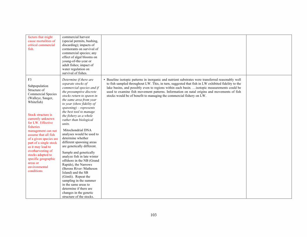
103
factors that might cause mortalities of critical commercial fish.
commercial harvest (special permits, bushing, discarding); impacts of cormorants on survival of commercial species; any effect of algal blooms on young-of-the-year or adult fishes; impact of water regulation on survival of fishes.
F3
Subpopulation Structure of Commercial Species (Walleye, Sauger, Whitefish)
Stock structure is currently unknown for LW. Effective fisheries management can not assume that all fish of a given species are part of a single stock as it may lead to overharvesting of stocks adapted to specific geographic areas or environmental conditions
Determine if there are separate stocks of commercial species and if the presumptive discrete stocks return to spawn in the same area from year to year (show fidelity of spawning) – represents the best tool to manage the fishery as a whole rather than biological units.
Mitochondrial DNA analyses would be used to determine whether different spawning areas are genetically different.
Sample and genetically analyze fish in late winter offshore in the NB (Grand Rapids), the Narrows (Berens River /Matheson Island) and the SB (Gimli). Repeat the sampling in the summer in the same areas to determine if there are changes in the genetic structure of the stocks.
• Baseline isotopic patterns in inorganic and nutrient substrates were transferred reasonably well to fish sampled throughout LW. This, in turn, suggested that fish in LW exhibited fidelity to the lake basins, and possibly even to regions within each basin. …isotopic measurements could be used to examine fish movement patterns. Information on natal origins and movements of fish stocks would be of benefit to managing the commercial fishery on LW.

104
Sampling of spring spawning percids would be carried out in rivers around the Lake (large and small systems, east and west shores, NB and SB).
F5
Traditional and Local Knowledge
Source of knowledge that is not adequately used to further an understanding of the Lake, focus scientific studies, identify management issues and assist with management decisions.
Collect local and traditional ecological knowledge from fishers and elders on what is known about the fisheries and Lake to help develop a more holistic understanding of the ecosystem.
It would be carried out through non-structured visits and interviews. It is important that the information be collected in the field in a non-academic /scientific setting in order for there to be full participation by the interviewees. This project could also be designed to contribute significant local information to several of the other water, habitat and fish assessment and classification studies.
• The Lake Winnipeg Quota Review Task Force (LWQRTF) carried out a fishers’ survey in 2009 and has recommended that similar surveys be carried out on a regular basis as part of the fisheries adaptive co-management process.
• CIER
H2
Fish Habitat Classification for SB
Protecting fish
Collect the necessary data to apply existing fish habitat models developed for the Great Lakes in support of a fish-habitat management plan.
Should we reconsider whether this is an important question?
Important re: zebra mussel impact on fish requiring pelagic vs littoral habitat.

105
habitat requires an understanding of its geographical extent and its use by fishes and other aquatic organisms. At present, there is little understanding of watershed impacts and shoreline developments on the near-shore environment.
Data required will include the following: bathymetry (will require support from Hydrographic services using ROXANN to determine substrate types); fetch (from GIS-based maps); and cover (from aerial photos, sonar, and stratified field surveys). The proposal would also involve the development of a good fish habitat suitability database. A database that is based on the current literature and includes: depth preferences by life stage of critical species; thermal preferences; and habitat structures, among others.
H3
Assessment of Use of Tributaries and Reefs by Fish
There is little knowledge of the specific use of tributaries and reefs by fishes in L Winnipeg.
Determine which tributaries and reefs are important habitats for Lake Winnipeg fishes, especially species at risk – to develop a habitat-use inventory as a water and land management tool for protecting tribs and reef fish habitats
It would involve extensive surveys by boat using boat and hand electrofishers, mark and recapture techniques, egg sampling devices and larval fish emergent traps.
Local fishers knowledge (LWQRTF) • Fishers identified important spawning sites for the three commercial species in both basins.
Norway House fishers expressed concerns over a number of spawning habitats in the north basin that have become degraded due to build-up of sand, which either blocks fish passage or covers spawning habitat.
Does “scientific understanding” agree with fisher understanding?

106
This would be a long-term study but it should be completed by 2010.
H4
Decline in Wetland Habitat
Protection, mitigation or possible restoration of wetland habitats depends on understanding the causes of their decline.
Identify the most important factors responsible for wetland decline (water regulation, nutrients and turbidity or invading species) and identify potential mitigation options to recover wetlands.
The provinces and DFO would participate in monitoring and support ongoing research by the University of Manitoba and Ducks Unlimited to address the above causes. The proposal would conduct research in existing marshes connected to Lake Winnipeg to identify potential adverse effects such as turbidity, carp biomass, and water level regulation (timing, magnitude, duration, frequency, annual cycles). The proposal would also determine whether fish passage past Hydro facilities is a major factor affecting the fish community of Lake Winnipeg. It would involve sampling below Hydro facilities to

107
identify potential fish movement.
H6
Define, Describe Critical Habitat for SARA Species
Critical habitat is essential for the survival of species at risk.
Locate and describe existing critical habitat for SAR and restore or create new areas of critical habitat.
Methods to include geo-referenced digital aerial photos and vessel surveys (sampling of nearshore /offshore sites). Studies to provide the support necessary for experts to peer review known information regarding critical habitat descriptions as developed under National or Zonal Action Plans and develop a schedule and timetable of studies required to identify basic habitat requirements.
• Sampling on the Birch River (trib of the Whitemouth R) only. No L Wpg SAR sampling • Lake Sturgeon in DU-4 (Red-Assiniboine rivers/L Wpg) assessed by COSEWIC as Endangered
• Following consultations,
a Recovery Strategy (RS) will need to be completed within 2 yrs of listing (if listed). If not listed, info gathered during RS process can be used for management purposes

108
Session 3: Other stressors
Proposal Why it matters
Approach/Deliverable Description
Proposal Evaluation What has been done / What have we learned?
Additional information required
F6
Effect of Climate and Climate Change on the Aquatic Ecosystem: Monitoring and Analysis
Climate and climate change impacts runoff, nutrient and sediment supply from the watershed, as well as productivity of fish and other biota.
Description of the thermal habitat of LW and understanding of effects of altered thermal regime on biota, including fish, and on overall lake productivity.
Integrate historic data sets [water buoys, Gimli Pier, Grand Rapids Reservoir, cruise surveys and air temp. Temperature profiles would be measured at multiple stations in three seasons. Equipment needed would include the establishment of standardized long-term stations for surface and water column temperature monitoring (utilizing at least three buoys) or continuous flow pump on shore. Remote sensing would be used to calibrate AVHRR surface temperatures locally and develop historical SST maps for the whole lake.
Climate and nutrients • Hydrology (climate) in the RRB (annual runoff, frequency and extent of flooding) is a major
determinant of the magnitude of P loading • Measured increases in lake temperature advantageous to cyanos • Onset of frequent, large cyano blooms was not gradual over decades of increasing nutr loading
observed in tributary WQ records, but rather was sudden beginning in the mid-1990s in response to dramatically increased TP loading assoc with increased discharge of the RR (evidence: change in bloom frequency and magnitude observed in satellite image record, doubling in mid-1990s of P conc in lake observed and modeled)
• Increased P conc in LW in the mid-1990s was driven almost entirely by incr P loading from the RR; other tributaries had either nil or negative effect
• Throughout (at least) the L. Agassiz plain south of Lake Winnipeg, SRP and TDP concs increase with increasing discharge; the relationship appears to depend on extent and duration of flooding
• SWAT model employed to simulate a 21-yr baseline (1980-2000) and future (2042-2062) climate based on climate forcings derived from 3 RCMs. most significant changes include higher total runoff, and earlier snowmelt and discharge peaks
Climate & contaminants (Rawn et al 2000) • During periods of high flow, erosion and transport of contaminated sediments in the Red and
Wpg rivers and subsequent incr in sedimentation rates may result in greater PCB / OC loadings (released from old sources).
Fundamental processes – do we understand them well enough to determine to what extent they are being altered? How will warming affect the lake?
‐ Thermal stratification
‐ Cyanobacterial blooms
‐ Thermal tolerances of fishes
How will changing precipitation over the watershed affect the lake? • What is the relative
significance of increasing population and land use-related nutrient supply vs increasing runoff to nutrient loading?
• What will be the consequences of a reduction of nutrient loading on the productive capacity of the lake with a return to “normal” or drought conditions?
• What will be the effect

109
on reservoir management
F7
Contaminant Levels in Lake Winnipeg Biota
To assist in proactive management and protection of the ecosystem and resource users from the effects of contaminants.
Establish a routine reporting structure to track changes in contaminant levels in fish, water and sediments as an early warning system for potential problems.
This reporting structure would depend on ongoing programs such as those operated for the commercial fishery by the Canadian Food Inspection Agency, other ongoing and periodic monitoring by other Canadian and US agencies and by additional contaminants surveys and monitoring in Lake Winnipeg as required.
• The North and SBs are significantly different in terms of isotopic food web structure and tissue metal concentrations
• Mercury concentrations in fish muscle are correlated with trophic position, size and feeding location
• Introduction of smelt does not seem to have increased Hg conc in walleye apparently due to increased growth rate
• Although cormorants in the NB occupy significantly higher trophic positions, mercury concentrations are not significantly different between the two Basins.
• Accumulated mercury body burden in cormorants is largely influenced by exposure on L Wpg, rather than the wintering grounds.
Canadian Food Inspection Agency • Monitors mercury in Northern Pike, Pickerel, Sauger and Perch (muscle tissue only) as part of
the CFIA National Fish Sampling Program. • From lakes throughout DFOs Central and Arctic Region, including L Wpg • Lakes are sampled to verify compliance with the required Mercury levels for fish for Canadian
and foreign markets • DFO maintains large data bank conducted on Lake Winnipeg from the early 1970’s to the late
1990's PCBs and OC pesticides • NB sediment loadings largely atmospheric sources. SB loadings from agricultural, industrial
and urban activities (Rawn 2000) • Concs of the sum of 103 PCB congeners are higher in SB water, sedt and biota compared to NB
(except for LWF). Data from NB suggest lower total loadings of which a higher fraction is from atm depn (Gerwurtz et al 2006)
• Trophic positions of the top predators as well as the extent of biomagnifn of PCBs/unit trophic level do not differ b/t basins. No diff in trophic level for any of the fish b/t basins
• Conclude that the higher PCBs concns in the SB are due primarily to higher PCB loadings via riverine sources rather than food web processes
• Hypothesize that high nutrient assoc DOC decreased PCB bioavailability to lower trophic level organisms and hence the food web. DOC in this nutrient rich lake greatly reduces bioaccumulation of the most hydrophobic congeners by influencing bioavailability at the base of the food web.
Contaminant monitoring effort – Is it adequate in terms of: • major classes of
contaminants that are being monitored
• food web components being analyzed
• detection limits • detecting change in
contaminant transfer associated with changes in energy flow due to eutrophication or exotic species

110
• Analysis of specific congener patterns over time suggest that the major changes in fish OC levels pre- and post-flood were not linked to transport of new compounds during the flood, but to within-system processes (changes in plankton community structure, species shifts) short-term variation (~2 months) in OC distributions within biota may be equal to or greater than those resulting from episodic events such as spring floods (Stewart et al 2003)
H9
Invasion of Exotics and Consequences on the Fish Community
Some predictive capacity of the potential impact of exotics on the ecosystem could provide preventive or mitigative options/actions for management.
Predict the role potential invasive species would have on the Lake Winnipeg ecosystem through the development of a risk assessment model for invasives.
This would be a risk assessment of potential invading species. Ecological requirements of potential invaders (fish, invertebrates, plants or viruses) would be matched with existing conditions in Lake Winnipeg.
Smelt characteristics • Smelt did not differ isotopically from other forage fish (they are not feeding at a trophic
position higher than other prey fish) while smelt-consuming walleye in the NB were more enriched in 15N over SB walleye. This suggests that
- smelt differ nutritionally (higher protein?) from native forage species resulting in a higher diet-walleye δ15N discrimination factor
- SB walleye feed more on zooplankton. - Reduced fitness may also prevent smelt from feeding at an elevated trophic level compared
with other forage fishes (15N data) • LW smelt have very low lipid concentrations (0.55+/- 20%) – significantly lower than the other
forage fish in the NB and much lower than the lipid contents of L Erie and L Ont smelt, at 4% and 7% respectively.
Smelt feeding preferences • Preliminary results indicate in spring, smelt exhibit a greater dietary preference for copepods
than in summer 2008. (ongoing - gut contents currently being analyzed). • Smelt <120 mm total length displayed apparent dietary preference for Daphnia spp. and against
copepods and Bosmina sp. in summer 2008 • Smelt >120 mm total length displayed strong dietary preference for Daphnia spp. and against
copepods, Bosmina sp. and Eubosmina sp. in summer 2008 • Among stations in the NB, a general trend of increased dietary specialization towards the higher
clarity, northerly stations to a more generalist foraging strategy in the more turbid southerly stations
Predation on smelt • Preliminary diet work suggests walleye rely heavily on rainbow smelt in the summer in the NB
of Lake Winnipeg • Two fishers from Norway House remarked that whitefish eat smelt. It was also noted that smelt
cause both pickerel and whitefish to become greasy and more yellow in colour. Contaminant transfer • Smelt were not associated with elevated exposure of contaminants to top predators of the NB.
(Attributed to reduced fitness, which may prevent them from feeding at an elevated trophic level compared with other forage fish. (15N data) or piscivores eating smelt have higher growth
Smelt – How well to we understand the impact of smelt on the food web and on nutrient re-cycling?
• How would a collapse in the smelt population impact the NB fishery?
• What food resources support invasive rainbow smelt seasonally?
• Is there dietary overlap with other native fish (i.e. cisco)?

111
rates compared with other top predators.
Local knowledge on smelt - LWQRTF (mainly NH Cree Nation) • A huge increase in rainbow smelt over the years, including up the Nelson River system. The
increase was particularly noteworthy on the west side of the Lake since about 2000. The east side of the Lake generally had fewer smelt until about five years ago, when they started to become more abundant. One fisher noted fewer smelt in 2009.
• Smelt used to be bigger and fewer, but now they are small and more abundant. • In the spring, large numbers of smelt have been seen in “some areas just like a blanket of them
floating” and covered in a white fungus. One fisher observed increased numbers of smelt floating around after a strong wind. They smell bad and seagulls and other birds do not eat them. By June, they start to pile up on the shoreline to depths of eight inches in some areas.
• South of Berens River, smelt have either not increased in abundance or have decreased
F4
Effects of Exotic Species on the Lake Winnipeg Ecosystem
Need to define impacts of existing and potential impacts of imminent exotics species on LW ecosystem structure and function. Some predictive capacity could provide proactive preventive or mitigative options /actions for management.
Develop a risk assessment model to serve as a management tool to reduce risk of further invasive species and to improve understanding and ability to predict productive capacity.
Address some critical questions including: routes and modes of transfer; the effects of exotic species on the Lake Winnipeg biological community structure and function (nutrient cycling, food web structure); the impacts of exotic species on contaminant/toxin transfer through the food chain; the effect of exotic species on quality taste and
• Provincial efforts focus on monitoring and public awareness (prevention) of aquatic invaders into Manitoba
• Ecological preferences for regions of LOW, and lakes in Whiteshell and Nopiming Provincial Parks by Bythotrephes have been identified using available models; similar models should be applicable to Lake Winnipeg.
Zebra mussels – Do we have adequate data to assess the impact of zebra mussels on: • Primary producers • Energy flow and
consequences on benthic and fish communities
• Contaminant transfer • Fish habitat

112
texture, disease and condition of fish flesh among others.
Would involve surveys to assess current and emerging exotic species; monitoring to assess establishment and growth of exotic species; and desk analysis to evaluate existing databases and develop an historical perspective on exotic species.

113
Session 4. Modeling efforts
Proposal Why it matters
Approach/Deliverable Description
Proposal Evaluation What has been done
What is the status of the models?
W1
Bacteria Levels at Recreational Beaches
Knowledge of bacterial levels at recreational beaches is critical for the public and the recreational service industry. Present management practices would be improved by the development of best management practices and options for beach management.
Develop a predictive model relating exposure/risk (sourcedependent) with wind/water and changing bacterial counts.
It would necessitate identification of unknown sources of bacteria, development of a DNA reference bank, understanding the ecology of pathogens in sand through laboratory culturing and field experiments to determine the size of the bacterial reservoir and whether or not it is expanding.
• Occasionally, the densities of Escherichia coli exceed the recreational water quality objective of 200 E. coli
• Sampling has indicated that the occasional elevated densities are an in-shore phenomenon with greater densities of bacteria occurring in wet beach sand than in corresponding bathing water. (There is evidence that increased lake levels due to strong north winds temporarily inundate beach sand and that bacteria are transferred from sand to the bathing water).
• DNA sampling indicated that the most likely source of E. coli at Lake Winnipeg beaches is from shorebirds. May be influenced by local wastewater effluent.
• Limited data on human pathogens in wet sand suggest that the risk of bather related illness should be low.
W6
Physical Model for Lake Winnipeg
Development of long-term objectives for the management of Lake Winnipeg depends on understanding the relationship between sediments, nutrients, carbon
Develop a model of water movements in Lake Winnipeg.
Must consider a wide range of components including wind velocity, temperature, bathymetry, currents, and water velocity. The project would depend on a buoy network, and make optimum use of
• In general, the north and south basins have distinct circulations driven by surface wind stress. Winds from the NB are different from the winds over the SB.
• 6-yr avgs of hydraulic ret time in modeling system are 4.4 yrs (whole lake), 1.4 y (SB) and 3.6 yr (NB). (Brunskill = 3.3 yrs; in 2003 = 2.2 yr (SB) and 5.8 y (NB)
3-D hydrodynamic modeling system – circulation and thermal structure. • The model showed considerable skill in reproducing the thermal structure, currents and water
levels. • Also used to study the impact of the flood on the circulation and contaminant dispersion in LW
(simulate temperature, currents, and water levels) • The accuracy of these simulations suggests that the model is capable of describing flow and
transport of material required for detailed water quality simulations during the flood (1997). • During the flood event, Red River plume movement was primarily controlled by the wind-
• Physical Limnology - ongoing
• Pending: Hydrodynamic model (some applications like coastal erosion, river plumes, floods and causeway effects etc)
• Relative contribution of groundwater discharge to water budget

114
and algae. Key to this understanding is knowledge of how water circulates within the lake.
existing resources (ferries, fishermen, freighters, Namao).
driven currents. The winds from the north confined the plume to a small area near the river mouth.
• The mean circulation in the lake is one of the important factors responsible for the transport and distribution of contaminants within LW.
F8
An Ecosystem Model to Understand the Impact of Changes in Foodweb Structure on Fisheries Productivity
Provides a structural framework for the integration of monitoring data and science research for management purposes. The process of building models will help ID where the data are deficient to answer the pressing questions.
Accumulate the necessary data and develop an ecosystem model (e.g. ECOPATH) of the Lake Winnipeg food web that managers can use to: explore various scenarios; ID data and knowledge gaps to guide future research; and help synthesize data collected form different projects.
Relevant questions that would be addressed by the use of the model include the following: How will changes in nutrient loading affect fisheries productivity? How will changes in food web structure caused by exotic species affect fisheries productivity? Which management strategies will be most effective for minimizing detrimental effects on the fisheries?
Eutrophication model - simulated 2 essential elemental cycles (N & P) and the dynamics of 3 functional phyto groups (non-cyano, N-fixing cyanos, and non-N-fixing cyanos) using nutrient loadings to the SB and NBs for the period 2002-2007. • Simulation of temperature structure is good, the model also reproduces the stratification
development well and the distribution of natural water isotopic tracers. • Hydrodynamic model simulations of water levels and surface currents are good • The predictions of NO3 and PO4 showed weak correspondence with limited observations in
validation period.
Other modeling efforts • Some preliminary testing with ecosystem model (CAEDYM) was done before, more
applications of ELCOM/CAEDYM are being carried out. • Graduate student projects on walleye (K. Sheppard), rainbow smelt (A. Olynyk), and
zooplankton (D. Kamada) are all intertwined. We will integrate food web dynamics and energy transfer from benthos to fish in Lake Winnipeg using bioenergetics models and simulation of "what if" scenarios that include temperature increases (climate warming), nutrient reduction projections (and/or flow reductions), invasion of zebra mussels.
• Monte-Carlo Uncertainty analysis of WASP predictions & assessment of climate scenarios from CRCM output (ongoing/future work)
• Ecopath – in the process of assembling, integrating and summarizing all the available biological information and convert it into model input. The basic data includes biomass, production, consumption ratios, diet matrix and harvest of all the major functional groups in the lake ecosystem including, phytoplankton, benthic production, zooplankton, zoobenthos and fishes. Modeling will also take into account the climate and hydrology time series data (ongoing)
W7
Relating Nutrients
ID key biological endpoints, benchmarks
Nutrient targets • Reducing P alone with relatively higher percentage (>12%) is an effective management
• Has there been demonstrable ecological

115
and Biological Endpoints for Setting Ecological Objectives for Lake Winnipeg
Management of water quality depends on broad management objectives, protection goals and management / monitoring of biological-indicator endpoints.
and acceptable levels of change for key components of the ecosystem. Determine relationship between nutrients and endpoints.
In essence, this proposal would determine whether the biological endpoints (viz. algae, benthos, inverts, fish etc) are a predictable function of nutrient concentrations and, thus, what changes might be required in nitrogen and phosphorous inputs to maintain the ecological integrity of the Lake.
This would be primarily a desk analysis with some specific experimental research requirements, long-term monitoring as a follow-up.
approach for the improvement of ecological status of L Wpg. If N is also controlled, then the N reduction rate should be comparatively kept low (< 7%) and increase the P reduction percentage accordingly.
• TP must be reduced by at least 50% to eliminate blooms. If the lake were to return to its baseline condition, TP would have to be reduced by 300%.
damage to Lake Winnipeg that is in need of remedial management?

116
APPENDIX D
Workshop Agenda
What is the Scientific Basis for Understanding and Protecting Lake Winnipeg?
Lake Winnipeg Research Consortium - Science Workshop
Siobhan Field Station Fort Whyte Nature Centre
1961 McCreary Road, Winnipeg
April 26th & 27th, 2011
AGENDA
Steering Committee: Dr. Burton Ayles, Dr. Brenda Hann, Dr. Greg McCullough, Dr. Karen Scott (Chair), Mr. Mike Stainton Moderator: Dr. Burton Ayles
Workshop Objective: Evaluate the progress that has been made on the science priorities and research needs identified in the 2004 Science Workshop (Ayles and Rosenberg, 2005) with an emphasis on synthesizing and evaluating existing knowledge in support of current and emerging management issues as identified by the agencies directly responsible for the Lake’s aquatic resources.
DAY 1 – STATE OF THE SCIENCE
11:00 AM Registration & lunch
12:30 PM Welcome & Workshop Overview – Dr. Karen Scott
12:45 PM Session 1 – Abiotic Factors Influencing Primary Productivity
Speaker – Dr. Gertrud Nurnberg (Internal Phosphorus Loading)
Moderated Discussion – Based on Proposals W5, H7, W2
• Does Table 1 accurately reflect all ongoing or completed projects and results that bear on the proposals?
• What additional information is needed to answer the questions implied in the proposal?
• How will addressing these gaps contribute to a better understanding of the ecosystem or to management decision-making?
• Additional comments on the original proposal
3:00 PM Coffee

117
3:15 PM Session 2 – Food Webs & Near-shore
Moderated Discussion – Based on P H8, F1-3, F5, H2-4, H6
• Questions as per previous session
5:00 PM Aperitif, dinner
6:15 PM Session 3 – Other Stressors
Speaker – Dr. Bob Hecky (Multiple Stressors and Large Lakes)
Discussion – Based on Proposals W7, F6, F7, F4 & H9
• Questions as per previous sessions
~9:00 PM Wrap up Day 1
DAY 2 – SCIENCE WITHIN A MANAGEMENT FRAMEWORK
9:00 AM Review of previous day’s activities and overview of Day 2
9:15 AM Session 4 – Status of Lake Winnipeg Modeling Efforts
• What is the status of the proposed models W1, W6, F8 (W7) and others that are in development?
10:00 AM Session 5 – Management Objectives
• Discussion of priority management objectives
10:30 AM Coffee
10:45 AM Session 6 – Science Within a Management Framework
• Discussion and evaluation of management objectives from a scientific perspective
12:30 PM Lunch
1:15 PM Session 6 – Continued. Workshop wrap up
3:00 PM Coffee & farewells
The Science Workshop will be immediately followed by a Field Season planning meeting – for anyone working on the Motor Vessel Namao or requiring LWRC on-lake science support.

118
APPENDIX E
Guest Speaker Presentations – Dr. Robert Hecky

119

120

121

122

123

124

125

126

127

128

129
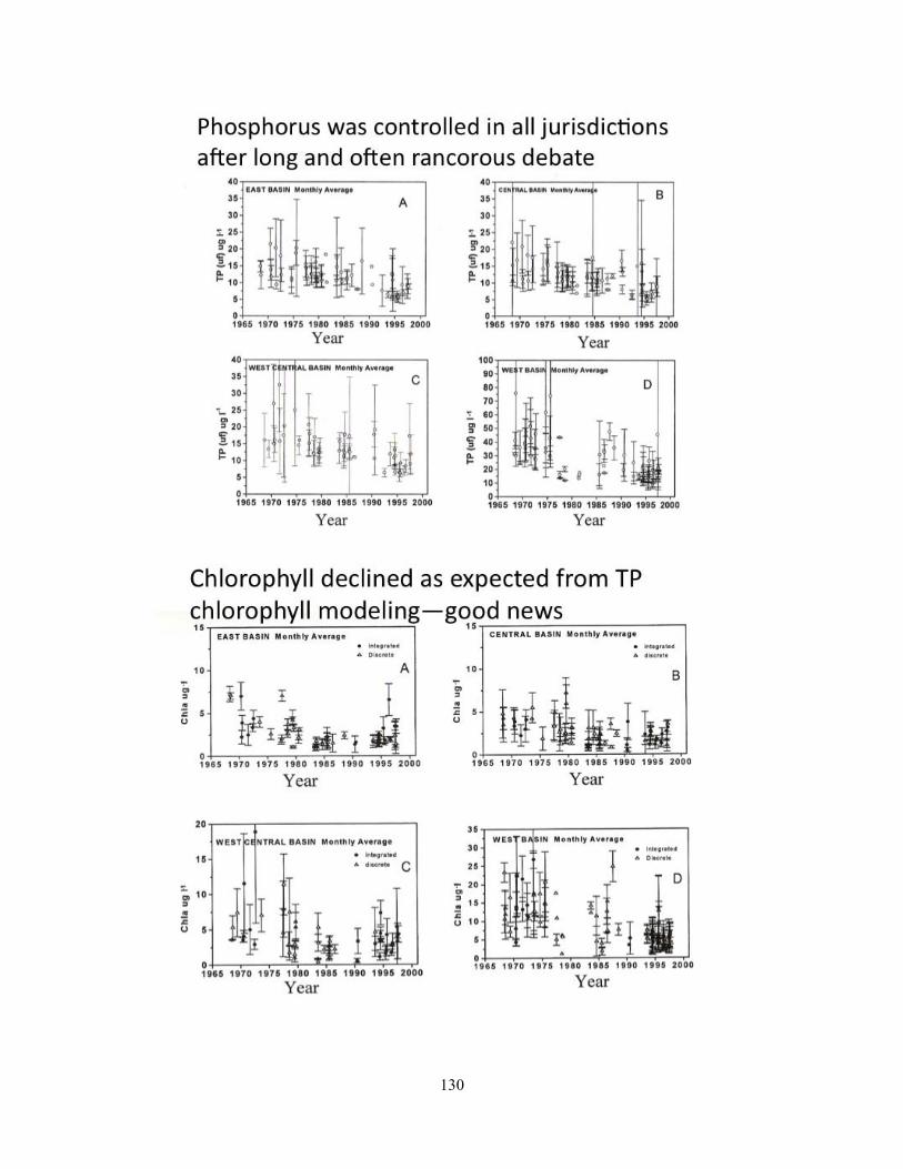
130

131
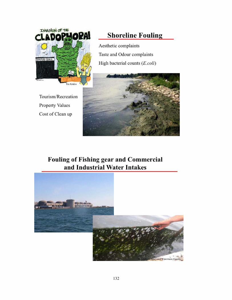
132

133

134

135
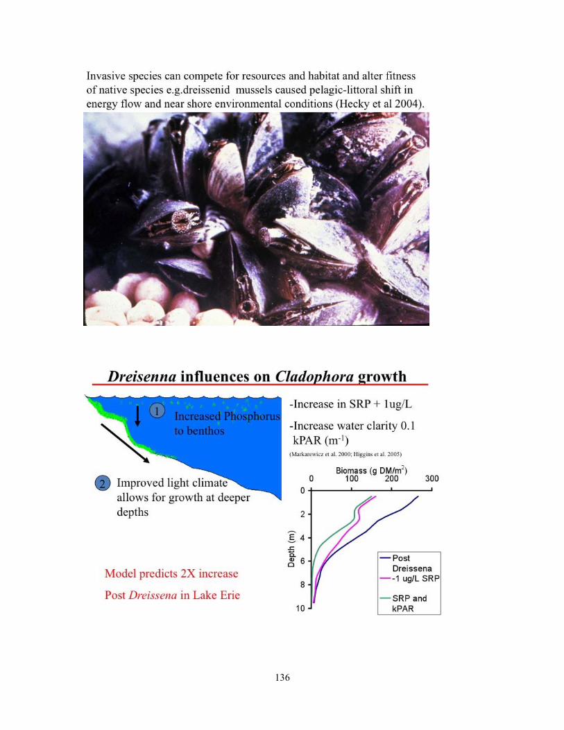
136

137

138

139

140

141

142
Guest Speaker Presentations – Dr. Gertrud Nurnberg

143

144
145

146

147

148

149

150

151

152

153

154

155

156

157

158

159

160

161

162

163

164

165

166

167

168

169

170

171

172

173

174

175

176

177

178
APPENDIX F
List of Workshop Participants
Armstrong, Nicole – Manitoba Water Stewardship Ayles, Burton – Independent Guildford, Steffany – University of Minnesota, Duluth Hann, Brenda – University of Manitoba Hecky, Robert – University of Minnesota, Duluth Hesslein, Ray – Lake Winnipeg Foundation Heuring, Laura – Manitoba Water Stewardship, Fisheries Branch Higgins, Scott – Fisheries and Oceans Canada Hnatiuk, Nancy – Environment Canada Janjua, Yamin – Fisheries and Oceans Canada Kamada, Daigo – University of Manitoba Kline, Geoff – Manitoba Water Stewardship, Fisheries Branch Kling, Hedy – Algal Ecology and Taxonomy Inc. Kristofferson, Al – Lake Winnipeg Research Consortium Inc. Kroekker, Derek – Manitoba Water Stewardship, Fisheries Branch Lawler, Herb – Lake Winnipeg Research Consortium Inc. (Board) Lobb, David – University of Manitoba Lumb, Chelsey – Manitoba Water Stewardship, Fisheries Branch McCullough, Greg – University of Manitoba Nurnberg, Gertrud – Freshwater Research, Baysville, Ontario Olynyk, Andrew – University of Manitoba Page, Elaine – Manitoba Water Stewardship Parker, Brian – Environment Canada Rennie, Mike – Fisheries and Oceans Canada Scott, Karen – Lake Winnipeg Research Consortium Inc. Sheppard, Katie – University of Manitoba Stainton, Mike – Fisheries and Oceans Canada Swanson, Gary – Manitoba Hydro Tipples, Mo – Lake Winnipeg Research Consortium Inc. (Board) Watchorn, Elise – Environment Canada Wong, Charles – University of Manitoba


