![Fireworks FestivalPackages - DMC Japan · 2019-06-12 · Senjojiki Cirque and enjoy the spectacular natural scenery. - 3 - PK0180FA511 2019/03/15 [Shiga] Lake Biwa Fireworks (1 day)](https://static.fdocuments.net/doc/165x107/5f24549eeca1f141e46e7d51/fireworks-festivalpackages-dmc-2019-06-12-senjojiki-cirque-and-enjoy-the-spectacular.jpg)
Lake Biwa Comprehensive Preservation Initiatives - … · Lake Biwa Comprehensive Preservation...
36
Bequeathing a Clean Lake Biwa to Future Generations Lake Biwa Comprehensive Preservation Initiatives ― Seeking Harmonious Coexistence with the Lake's Ecosystem ― Lake Biwa Comprehensive Preservation Liaison Coordination Council Lake Biwa Comprehensive Preservation Promotion Council
-
Upload
vuongquynh -
Category
Documents
-
view
219 -
download
0
Transcript of Lake Biwa Comprehensive Preservation Initiatives - … · Lake Biwa Comprehensive Preservation...
Bequeathing a Clean Lake Biwa to Future Generations
Lake Biwa ComprehensivePreservation Initiatives
― Seeking Harmonious Coexistence with the Lake's Ecosystem ―
Lake Biwa Comprehensive Preservation Liaison Coordination CouncilLake Biwa Comprehensive Preservation Promotion Council

○ Overview of the Yodo River Basin ○ Water Use in Lake Biwa and the Yodo River Basin ○ Land Use in Lake Biwa and the Yodo River Basin
1
○ Lake Biwa, an Ancient Lake ○ Dimensions of Lake Biwa
2
○ Early History ○ Expanded Farmlands, Increased Rice Production and Subsequent Development of Commerce
○ A Political Center and Cradle of Culture and Tradition ○ Industrial and Economic Development after the Meiji Restoration ○ Changing Lifestyles
3
○ Farmland Development and Flooding in the Edo Period (1603 - 1868) ○ Flood Control During the Meiji Period (1868 - 1912) ○ Modern Projects for Using Water of Lake Biwa ○ Increasing Demand for Water in the Showa Period (1926 - 1989)
5
○ Program System ○ Breakdown of the Program Expenses ○ Environmental Preservation ○ Flood Control ○ Promotion Effective Water Use
7
○ Effects of Flood Control Projects ○ Effects of Projects Promoting Effective Use of Water ○ Effects of Environmental Preservation Projects
9
○ Land Use around the Lake ○ Water Quality of Lake Biwa ○ Lake Biwa Water Quality Map ○ Eutrophication of Lake Biwa ○ Reed Colonies ○ Attached Lakes (naikos) ○ Lake's Ecosystems
11
○ Freshwater Red Tides ○ Water Quality Conservation Campaigns Initiated by Local Residents
○ Shiga Prefectural Ordinance Concerning the Prevention of the Eutrophication in Lake Biwa (Eutrophication Prevention Ordinance)
○ International Conference on the Conservation and Management of Lakes (World Lake Conferences)
○ Establishment of Lake Biwa - Yodo River Water Quality Preservation Organization
15
○ Background ○ Guiding Principle and Key Concepts of the Comprehensive Conservation Plan
○ Objectives and Period of the Comprehensive Conservation Plan ○ Promoting Partnerships
17
○ Protecting Water Quality ○ Increasing Soil's Recharge Capacity ○ Preserving the Natural Environment and Scenic Landscapes ○ Citizen Participation and Activities ○ Information Sharing and Staff Exchange Promotion ○ Research and Survey ○ 9th International Conference on the Conservation and Management of Lake (World Lake Conferences)
19
○ Continuous Improvement ○ Coordinating System
30
31
1 Overview of Lake Biwa and the Yodo River Basin
2 Overview of Lake Biwa
3 Development of Lake Biwa and the Yodo River Basin
4 Background of Lake Biwa ComprehensiveDevelopment Program
5 Lake Biwa Comprehensive Development Program
6 Outcomes of the Lake BiwaComprehensive Development Program
7 Current Situation of Lake Biwa
8 History of Lake Conservation Efforts
9 Survey for Preparing Lake BiwaComprehensive Conservation Plan
10 Comprehensive Environmental PreservationEfforts and Specific Measures
Future Progress of ComprehensiveLake Preservation Initiatives
12 Chronological Table of Lake Biwa
Contents
11
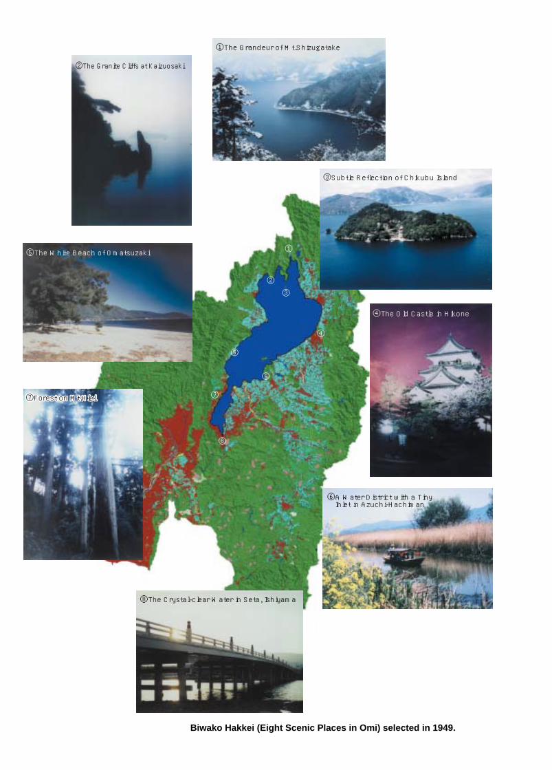
Biwako Hakkei (Eight Scenic Places in Omi) selected in 1949.
①The Grandeur of Mt.Shizugatake
②The Granite Cliffs at Kaizuosaki
③Subtle Reflection of Chikubu Island
④The Old Castle in Hikone
⑤The White Beach of Omatsuzaki
⑥A Water District with a Tiny Inlet in Azuchi-Hachiman
⑧The Crystal-clear Water in Seta, Ishiyama
⑦Forest on Mt.Hiei⑦Forest on Mt.Hiei
①
②
③
④
⑤
⑥
⑦
⑧

ShigaPrefectureKyotoPrefectureOsakaPrefectureHyogo Prefecture
0 100[million people]
80604020
10.1
17.9
85.3
26.1
1 Overview of Lake Biwa and the Yodo River Basin
The Yodo River, flowing into Osaka Bay, originates in mountains in and around Shiga Prefecture. After flowing out of Lake Biwa, the river travels southward down to the Osaka Plain, combining several branches of various sizes including the Kizu and the Katsura rivers. The Yodo River changes names during its long travel: the upper and middle reaches are called the Seta and the Uji rivers, respectively. The Yodo River basin constitutes an extensive area of approximately 8,240 km2, covering the six prefectures Mie, Shiga, Kyoto, Osaka, Hyogo and Nara.
Lake Biwa supplies water for various uses: domestic, industrial and agricultural uses, and for power generation. Water of Lake Biwa and the Yodo River supports social and economic activities not only in their respective basins, but also in extensive areas in the Kinki region. Notably, tap water from the lake/river serves some 14 million people, the largest population in Japan benefiting from a single water source.
The water is taken and used throughout the water source. In the upper reaches, water taken from Lake Biwa and dams is mainly used in Shiga Prefecture; in the middle reaches, water is taken from Biwako Canals and the Uji River primarily for use in Kyoto City; in the lower reaches, water from the Yodo River serves the huge population of Osaka and other cities on the Osaka Plain.
Overview of the Yodo River Basin
Water Use in Lake Biwa and the Yodo River Basin
Land Use in Lake Biwa and the Yodo River Basin
Population Using Tap Water from Lake Biwa/Yodo River (Water service in fiscal 1994)
Since ancient times, many cities have been developed on the flat lands in Lake Biwa and the Yodo River Basin. During Japan's high economic growth period after World War II, industrialization and urbanization progressed remarkably, particularly in Kyoto, Osaka, Kobe and their suburbs; many forests and farmlands around large cities were converted into residential zones during that period. Today, the Lake Biwa Basin and the upper reaches of the Yodo River have a relatively greater proportion of farmland; the lower reaches contain more residential, commercial and industrial districts.
19921955
1895
Changes in Land Use in Lake Biwa and Yodo River Basin
(Source: Lake Biwa Museum)
0 10 20 30 40km
LegendMunicipality
Forests
Farm Land
Urban Areas
Unidentified Areas
Water Areas
1
Overview of Lake Biwa and the Yodo River Basin1
Lake Biwa Basin
Yodo River Basin
River
Urban Area
Lake Yogo
Okinoshima Island
Otsu City
Kyoto City
Osaka Bay
Yodo River
Old Yodo River
Kanzaki River
Uji River
SonobeRiver
HitokuraorojiRiver
Nunom
e Rive
r
Uda River
Taka
toki
Rive
r
Ane River
Ado River
Katsura River
Seri RiverUso River
Echi River
Shorenji RiverNabari River
Ina River
Kizu RiverKam
o River
Hino River
Yasu River
Kusatsu River
Daito River
Shiga
Kyoto
Nara
Hyogo
Mie
Gifu
Fukui
Osaka
Seta River Araizeki Weir
Osaka City
Yodo RiverOzeki Weir
Lake Biwa
Lake Biwa and Yodo River Basin
Legend

2 Overview of Lake Biwa
Overview of Lake Biwa
The surface area of Lake Biwa, Japan's largest lake, is 674 km2, 17,000 times the area of Koshien Ball Park one of the largest baseball fields in Japan and one-sixth the total area of Shiga Prefecture where the lake lies. At the lake's narrowest point, it is spanned by Biwako Ohashi Bridge. The lake's section north of the bridge is called "Hokko" (northern lake) and that south of the bridge is called
"Nanko" (southern lake); Hokko and Nanko differ in character in various aspects.
There are approximately 460 rivers of various sizes flowing into the lake. There is, however, only one outflow from the lake (the Seta River), apart from canals constructed during early modern times. It is estimated that approximately 19 years are required to change all water in the lake.
Lake Biwa is the only ancient lake in Japan. In terms of surface area, despite being the largest lake in Japan, Lake Biwa is ranked 130th among the world's freshwater lakes. In terms of age, however, the lake is the world's third oldest, with a history of some four million years. The term "ancient lake" is generally defined as an extant lake that was created more than 100,000 years ago. Because they have such long histories, ancient lakes feature a great many endemic species that have evolved within the respective lake. Lake Biwa possesses abundant biodiversity, offering habitats to over 1,000 species, including at least 50 endemic species, such as Biwa trout (onchorhynchus masou rhodurus) and Seta corbiculid clam (corbicular sandai).
Lake Biwa, an Ancient Lake
Dimensions of Lake Biwa
(Source: "Ancient Lakes" in Lake Biwa Museum)
Lake Baikal
31,500km2
1,637m
740m
23,000km3
Approx. 2,500
Approx. 50%
32,600km2
1,471m
572m
18,880km3
Approx. 1,300
Approx. 50%
674km2
104m
41m
27.3km3
Approx. 600
Approx. 10%
Lake Tanganyika Lake Biwa
Approx. 30 million years old
Approx. 20 millionyears old
Approx. 4 millionyears old
Age
Lake Surface Area
Maximum Depth
Average Depth
Water Storage Capacity
No. of SpeciesLiving in Lake
Rate of EndemicSpecies
Location and Characteristics of Three Oldest Lakes in the World
The Equator
Lake Baikal
Lake Tanganyika
Lake Malawi
Lake Biwa
Ibuki Mountains
Mt. Kanekuso1,271m
Mt. Ibuki1,377m
Mt. Ryosen1,084m
Mt. Buna1,214m
Ado River
Mt. Mikuni815m
Mt. Gozaisho1,210m
Mt. Hiei848m
Hira
Mou
ntain
s
Suzuka Mountains
Ane River
Amano River
Inukami RiverEchi River
Hino River
Yasu River
Daito River
Seta River Araizeki Weir
Lake Biwa
Mountain
Hill
Flatland
Shiga Prefecture Land Area
Lake Biwa Catchment AreaLake Surface Area
ShorelineStorage CapacityAverage DepthMaximum DepthLength (North - South)Maximum WidthMinimum Width
3,174km2
674km2 (Northern Lake:Southern Lake = 11:1) 235km 27.3km3 41.2m 103.6m 63.5km 22.8km 1.35km
4,017km2
Osaka Bay
Amagase DamSeta River Araizeki Weir
Biwako Ohashi Bridge
Lake Biwa
(Source: The House of Water Benevolence “Aqua-BIWA”)
Ground Plan
Cross Section
2
2
Omi Hakkei (eight scenic places in Omi)
Sails Returning toYabase Port
Sails Returning toYabase Port
Sunset Glowover Seta
Sunset Glowover Seta
Autumn Moon overIshiyama Temple
Autumn Moon over Ishiyama Temple
Clearing Mist atAwazu
Clearing Mist at Awazu
Evening Rain at Karasaki
Evening Rain at Karasaki
Descending Geeseat Katata
Descending Geeseat Katata
Evening Snowon Mt. Hira
Evening Snowon Mt. Hira
Evening Bell fromMiidera Temple
Evening Bell from Miidera Temple
3 Development of Lake Biwa and the Yodo River Basin
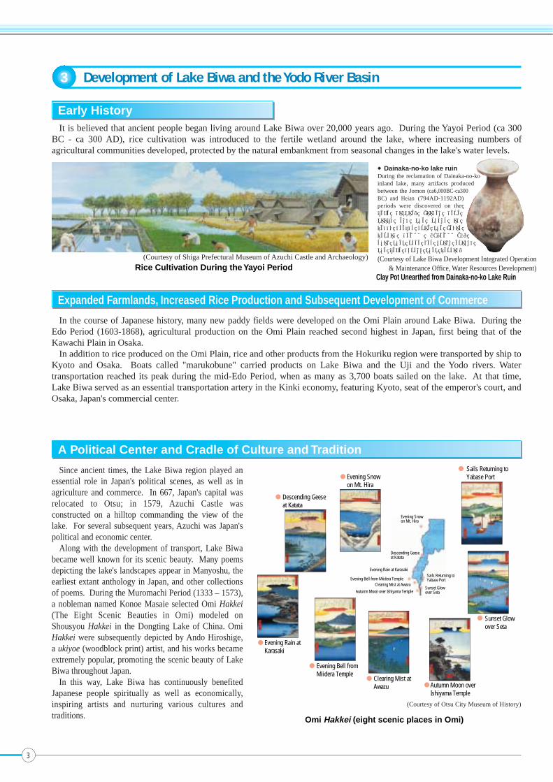
It is believed that ancient people began living around Lake Biwa over 20,000 years ago. During the Yayoi Period (ca 300 BC - ca 300 AD), rice cultivation was introduced to the fertile wetland around the lake, where increasing numbers of agricultural communities developed, protected by the natural embankment from seasonal changes in the lake's water levels.
Early History
A Political Center and Cradle of Culture and Tradition
In the course of Japanese history, many new paddy fields were developed on the Omi Plain around Lake Biwa. During the Edo Period (1603-1868), agricultural production on the Omi Plain reached second highest in Japan, first being that of the Kawachi Plain in Osaka.
In addition to rice produced on the Omi Plain, rice and other products from the Hokuriku region were transported by ship to Kyoto and Osaka. Boats called "marukobune" carried products on Lake Biwa and the Uji and the Yodo rivers. Water transportation reached its peak during the mid-Edo Period, when as many as 3,700 boats sailed on the lake. At that time, Lake Biwa served as an essential transportation artery in the Kinki economy, featuring Kyoto, seat of the emperor's court, and Osaka, Japan's commercial center.
Since ancient times, the Lake Biwa region played an essential role in Japan's political scenes, as well as in agriculture and commerce. In 667, Japan's capital was relocated to Otsu; in 1579, Azuchi Castle was constructed on a hilltop commanding the view of the lake. For several subsequent years, Azuchi was Japan's political and economic center.
Along with the development of transport, Lake Biwa became well known for its scenic beauty. Many poems depicting the lake's landscapes appear in Manyoshu, the earliest extant anthology in Japan, and other collections of poems. During the Muromachi Period (1333 – 1573), a nobleman named Konoe Masaie selected Omi Hakkei (The Eight Scenic Beauties in Omi) modeled on Shousyou Hakkei in the Dongting Lake of China. Omi Hakkei were subsequently depicted by Ando Hiroshige, a ukiyoe (woodblock print) artist, and his works became extremely popular, promoting the scenic beauty of Lake Biwa throughout Japan.
In this way, Lake Biwa has continuously benefited Japanese people spiritually as well as economically, inspiring artists and nurturing various cultures and traditions.
Expanded Farmlands, Increased Rice Production and Subsequent Development of Commerce
Clay Pot Unearthed from Dainaka-no-ko Lake Ruin
(Courtesy of Lake Biwa Development Integrated Operation& Maintenance Office, Water Resources Development)Rice Cultivation During the Yayoi Period
(Courtesy of Shiga Prefectural Museum of Azuchi Castle and Archaeology)
●Dainaka-no-ko lake ruinDuring the reclamation of Dainaka-no-ko inland lake, many artifacts produced between the Jomon (ca6,000BC-ca300 BC) and Heian (794AD-1192AD) periods were discovered on the lake bottom. Wooden farm tools and the ruins of paddy fields from the Yayoi period (ca300 BC-ca300AD) show that rice was grown around the lake during that period.
(Courtesy of Otsu City Museum of History)
3

Steamboat on the Yodo River
(Courtesy of Otsu City Museum of History) (Courtesy of Yodogawa Construction Office,Kinki Regional Development Bureau,
Ministry of Land, Infrastructure and Transport)Lake Biwa Steamship
After the Meiji Restoration (1868), Lake Biwa and the Yodo River Basin experienced outstanding industrial and economic
development. Osaka in particular prospered as Japan's industrial center. On Lake Biwa, steamship services were used for
transport between Nagahama and Otsu, and for sightseeing tours of the lake. Prior to full-scale introduction of railways,
steamships on rivers played the leading role in transporting both passengers and cargo between Kyoto and Osaka.
During the Meiji Period (1868 - 1912), Osaka citizens bought water-filled barrels from vendors, who drew water from the
Yodo River. In 1905, however, Osaka City commenced tap water supply service, whose source also was the Yodo River.
Industrial and Economic Development after the Meiji Restoration
For centuries, people living in the basin of Lake Biwa and the Yodo River used water from the lake and river in various ways:
they drew water for irrigation, fished on the lake, and washed clothes and vegetables in the lake/river. Thus, the lake and river
were familiar to local residents. During Japan's high economic growth period (1955 - 1974), landscapes in the basin changed
dramatically: farmland disappeared due to rapid urbanization and industrialization. Increasing numbers of people began to live in
cities, where tap water service was available. Instead of going to lakeside/riverside, people began washing rice and vegetables in
their kitchens, even using washing machines for laundry. While such changes made daily life of citizens much more convenient,
permitting them to use more and more water, opportunities to access the lake/river began to decrease.
Changing Lifestyles
Development of Lake Biwa and the Yodo River Basin
4
3

Seta River Seta River
Senjyo River Senjyo River
4 Background of Lake Biwa Comprehensive Development Program
Flood Damage in the Edo Period (1603 - 1868)
Flood Control During the Meiji Period (1868 - 1912)
Extensive Flooding of September 1896(Courtesy of Otsu City Museum of History)
(Courtesy of The House of Water Benevolence “Aqua-BIWA”)
(Courtesy of Yodogawa Construction Office,Kinki Regional Development Bureau,
Ministry of Land, Infrastructure and Transport)
Civil Engineer Johannis de RijkeNango Araizeki Weir(Courtesy of The House of Water Benevolence “Aqua-BIWA”)
Even after the Meiji Restoration, Lake Biwa occasionally flooded, causing extensive damage to farmlands around the lake. The great flood of 1896 caused particularly serious damage, including 111 casualties and 7,885 collapsed houses. Following this disaster, a large-scale disaster prevention program was initiated, targeting the entire Lake Biwa and the Yodo River Basin. The program mainly comprised widening and dredging of the shallow fort of the Seta River, construction of Nango Araizeki Weir, and improvement works of the lower reaches, the Uji River and the Yodo River. As a result, Seta River flow capacity increased four times, and water level of Lake Biwa and flow of the Seta River control became possible by operating weir gates. The gates, however, were manually operated, requiring one full day to open and two days to close.
Land erosion prevention and afforestation projects were also commenced in the beginning of the Meiji Period. Prior to project implementation, Mt. Tanakami by the Seta River had no vegetation; sand and soil eroded from the mountain flowed down with rainwater into the river and were deposited on the riverbed. In the afforestation of this mountain, the Japanese government asked the help of a Dutch civil engineer, Johannis de Rijke, who played a leading role in the project. Subsequently, he committed himself to many river improvement and erosion prevention projects in various parts of Japan, including improvement of the Yodo River and Osaka Bay. For these commitments, he is remembered as the father of flood control in Japan.
Although Lake Biwa generally benefited people living on the Omi Plain, the lake sometimes flooded farmlands, causing great damage to farmers. The major factor of flooding was evident: despite the size of the lake, it had only one outflow, the Seta River, which was shallow and narrow. Well aware of the need to dredge the riverbed, farmers of the Edo Period filed petitions for dredging with the Shogunate government, thereby risking their lives, since such actions were strictly banned under the feudalistic system of that period. The desperate attempts of those brave farmers, however, were seldom rewarded, since villagers on the lower reaches of the river thought that dredging the Seta River would cause flooding in the lower basin. From the militaristic perspective, the Shogunate government regarded the shallow ford of the Seta River as a strategic point for transporting an army across the river, and was naturally reluctant to dredge the riverbed. The Shogunate government allowed dredging only 5 times for 200 years of Edo Period. Accordingly, the farmers around the lake occasionally dredged the riverbed themselves, pretending that they were collecting clams.
Map of the Seta RiverBefore Tenpo Dredging
Map of the Seta RiverAfter Tenpo Dredging
Daido R
iver
Koyama River
Daido R
iver
Koyama River
Mt.dainichi Mt.dainichi
Current AraizekiWeir
Current AraizekiWeir
5

(million people)
20
15
10
5
01955 19891960 1965 1970 1975 1980 1985 1994
Users of Water Service from the Yodo River System(Lake Biwa and the Yodo, Katsura and Kizu rivers)
Keage Power Plan
Land Subsidence
Japan’s First Streetcar
The first modern project for using the water of Lake Biwa was the Lake Biwa Canal Project (the first canal), inaugurated in 1885. This project, aimed at supplying agricultural and domestic water to Kyoto, developing a water transportation route, providing energy through construction of hydroelectric power plants and controlling the water level of Lake Biwa, paved the way for subsequent multi-purpose regional development programs. Also, this was the first large-scale project undertaken solely by the Japanese people without the assistance of foreign engineers. In 1890, along with the canal a power plant was completed, which began supplying electricity to Kyoto City, enabling the City to operate Japan's first street car services. In 1912 a second canal was constructed, which contributed to the further growth of Kyoto City.
Modern Projects for Using Water of Lake Biwa
In the decades after World War II, the Japanese economy began enjoying soaring growth. Under the economic boom, the lower basin of the Yodo River began demanding more and more water from Lake Biwa, urged by increasing population, progress of industrialization, and worsening land subsidence caused by overuse of underground water.
Meanwhile, Shiga Prefecture had its own demands for resolving age-old problems of flooding and drought, as well as for preserving the water quality and ecosystems of Lake Biwa, and using the water for developing local industries.
Given such diverse demands of the various parties concerned, it became essential to prepare a comprehensive program involving all stakeholders. The objectives of such a comprehensive program included promoting effective use of water to develop Shiga and the Kansai economy and controlling flooding, while at the same time conserving the lake's water quality and ecosystems.
Increasing Demand for Water in the Showa Period (1926 - 1989)
Background of Lake Biwa Comprehensive Development Program
6
4
(Courtesy of the Yomiuri Shimbun) (Courtesy of the Yomiuri Shimbun)
(Courtesy of Osaka Municipal Waterworks Bureau)
Lake Biwa Canal(Courtesy of Otsu City Museum of History)

As stated earlier, since ancient times Lake Biwa has continuously benefited people in Shiga Prefecture and the Kinki region, contributing greatly to regional development and prosperity. On the other hand, there have been various challenges related to the lake: residents of the lake area experienced occasional floods and droughts. In addition, progress of urbanization and industrialization aggravated the lake's natural environment and residents' living environment. Ever since the post-World War II high economic growth period, demand for water has increased in the Yodo River basin, imposing a still greater burden on Lake Biwa as an essential water source.
With this backdrop, the Lake Biwa Comprehensive Development Program was initiated in 1972 as a national project in compliance with the Special Law for Developing the Lake Biwa Region. To resolve various problems in a holistic manner and seek economic development of both the upper and lower reaches of the Yodo River, this Program encompasses projects to promote effective use of water, control flooding and drought, and create amenity-rich waterfront areas. At the same time, the Program incorporates measures for addressing environmental challenges, including deterioration of water quality. The Special Law for Developing the Lake Biwa Region was extended twice (for 10 years in 1982 and for additional five years in 1992); in total, the Program was in operation for 25 calendar years from 1972 to 1997.
The major objectives of the Lake Biwa Comprehensive Development Program were conservation and restoration of the lake's environment, including water quality; flood control of Lake Biwa and the Yodo River; and promotion of effective use of water.
5 Lake Biwa Comprehensive Development Program
*
*
*
*
Lake BiwaComprehensive
DevelopmentProgram
Environmental Preservation
Promotion of Effective Water Use
Flood Control
Water Quality Conservation
Project Name
Sewage Systems
Night Soil Treatment
Waste Treatment Facilities
Water Quality Monitoring Stations
City Parks
Natural Park Facilities
Acquisition of Nature Conservation Areas
Road Improvement
Port Improvement
Rivers
Dams
Erosion Control
Forest Conservation
Lake Biwa Flood Control and Water Resource Development
Domestic Water Supply
Industrial Water Supply
Land Improvement
Fisheries
Fishery Ports
Afforestation and Forestry Roads
Livestock Waste Treatment
Agricultural Community Drainage Facilities
Natural Environment Conservation
Flood Control of Inflowing Rivers
Flood Control of Lake
Downstream Water Use
Water Use in Shiga Prefecture
Fisheries
Enhancement of Soil's Recharge Capacity
Original plan(1972)
Revised plan(1982)
Revised plan(1992)
Actual expenses(1972 - 1996)
2,500
2,000
1,500
1,000
500
0
(Billion yen)
427
1,524
260
325
340
599
1,863
351
333
408
771
1,905
351
321
384
8497287125143
Lake Biwa Flood Control and Water Resource DevelopmentPromotion of Effective Water Use
Flood ControlEnvironmental Preservation
Transition of ExpensesBreakdown of Expenses
Sewage Systems26.6%
Night Soil Treatment 0.6%
Agricultural Community Drainage Facilities 3.5%Livestock Waste Treatment 0.1%Waste Treatment Facilities 1.1%Water Quality Monitoring Stations 0.1%City Parks 0.6%
Natural Park Facilities 0.1%Acquisition of Nature Conservation Areas 0.1%
Roads11.3%
Ports 0.4%
Rivers9%
Dams3.2%
Erosion Control 3.1%
Afforestation and Forestry Roads 2.8%
Forest Conservation 2.1%
Domestic Water Supply4.0%
Industrial Water Supply 0.8%
Land Improvement11.5%
Fishery Ports 0.1%
Fisheries 0.4%
Lake Biwa Flood Control and Water Resource Development 18.5%
<Total expenses:1,905 billion yen>
Program System
44.5%
20.2%
16.8% Flood Control
Promotion of EffectiveWater Use
*: Projects added at the time of revision of the appropriate law in 1982Systems of Lake Biwa Comprehensive Development Program
7
The Program encompassed various projects in 22 categories, all contributing to sound development of the Kinki region. The total budget amounted to approx. 1,863 billion yen; when the Program was fully completed, actual expenditures reached 1,905 billion yen.
EnvironmentalPreservation
Breakdown of the Program Expenses

This bypass canal was Japan's first large-scale facility for controlling water flow. A hydroelectric power plant was constructed by the canal, for effective water use.
Improvement of the Seta River Araizeki Weir (Bypass Canal) for Promoting Water Use in Lower BasinImprovement of the Seta River Araizeki Weir (Bypass Canal) for Promoting Water Use in Lower Basin
For communities around Lake Biwa, an extensive water supply system was launched by purifying water from the lake. This new system was effective in supplying water particularly in times of drought, as well as in improving public hygiene and the living environment.
Effective Use of Water in Shiga Prefecture: Mabuchi Purification Plant
The Lake Biwa Comprehensive Development Program was implemented in compliance with the Special Law for Developing the Lake Biwa Region, providing legal grounds for allocating special funds from the national government. This legal system paved the way for many subsequent water source development programs throughout Japan.
○Special Funds from National GovernmentThe national government endowed special funds (by raising the share of the national government) to many projects
implemented as part of the Lake Biwa Comprehensive Development Program.
○Share of Municipalities in Lower BasinThe municipalities in the lower basin that would benefit from the lake development projects shared the expenses of the
lake development and conservation projects implemented by Shiga Prefecture and municipalities within the Prefecture. The share ratio was determined in accordance with the water volume to be supplied from the newly developed resources (40 tons in total). The share paid by the municipalities concerned totaled approximately 60.2 billion yen. In addition, Osaka and Hyogo prefectures furnished Shiga Prefecture with funds totaling 5 billion yen.
○Lake Biwa Management FundTo finance construction and operation of various maintenance facilities in Lake Biwa, Shiga Prefecture established the
Lake Biwa Management Fund of approximately 10 billion yen in Fiscal 1996, when the Lake Biwa Comprehensive Development Program was completed.
Lake Biwa Comprehensive Development Program
Environmental Preservation
Promotion of Effective Water Use
The sewage treatment plant was constructed to restore the water quality of Lake Biwa and improve the regional living environment. The plant was the first to introduce an advanced treatment system effective in removing nitrogen and phosphorus from wastewater, so as to prevent the lake's eutrophication.
Konan-chubu SewageTreatment Plant
To control occasional flooding of the Yasu River, which previously diverged into two branches at Shinjo, Moriyama City, a drainage canal was constructed that combines the previously diverging water flow and discharges water directly into Lake Biwa.Yasu River Drainage Canal
To prevent flooding, the lake’s shoreline was embanked and an administrative road was constructed on the embankment. At the beach inside the embankment, reeds were planted to restore the reed colony that once characterized the lake’s landscape. In addition to administrative purposes, the administrative road is used by local residents and tourists.
To enable continuous monitoring of water quality, an automatic monitoring station was constructed inside the lake. This station is linked with a central station on land, equipped with a telemeter receiver and an information processing system.Water Quality Monitoring Station
[Kusatsu District]Lakeshore Embankment, AdministrativeRoad and Artificially Planted Reeds
Special Financial Measures
Effective Use of Water in Shiga Prefecture: Mabuchi Purification Plant
[Kusatsu District]Lakeshore Embankment, AdministrativeRoad and Artificially Planted Reeds
8
5
Flood Control

Flooding in July 1972Factors
PrecipitationMax. precipitationLocation of max. precipitationAverage precipitation in basin
Max. water level
Area flooded by Lake water
Number of houses inundated above/below floor level (Shiga Prefecture)
424 mmYanagase, Yogo Town
320 mm/5 days
+92cm
3,377ha
755 houses
Flooding in May 1995
435 mmTochu, Kutsuki Village
297 mm/13 days
+93cm
742ha
7 houses
200
180
160
140
120
100
80
60
40
HyogoPrefecture
OsakaPrefecture
KyotoPrefecture
ShigaPrefecture
20
0
Tap Water IndustrialWater
AgriculturalWater
Other
Approx. 210 m3/s
Total Increase by Development Program
1942 1960 1972Before Lake BiwaComprehensive
Development Program
1992After Lake Biwa Comprehensive
Development Program
Water Taken from Lake Biwa
Houses
Num
ber
of H
ouse
s In
unda
ted
abov
e/be
low
Flo
or L
evel
1965 - 1974
1975 -1984
1985 - today(July 1972)
(May 1995)
1965 - 19741975 -198421) 1985 - today
Effects of Projects to Promote Effective Use of Water
(Source: data from Lake Biwa Development Integrated Operation & Maintenance Office,Water Resources Development Public Corporation)
6 Outcomes of the Lake Biwa Comprehensive Development Program
As a result of projects implemented as part of the Lake Biwa Comprehensive Development Program, Lake Biwa and the Yodo River basin obtained improved infrastructures. Construction of embankments and drainage facilities resolved flood problems; various measures taken against drought enabled a steady supply of water. Of the 22 major projects incorporated in the Program, 11 concerned environmental conservation, which aimed to improve living and natural environment.
As a result of the Lake Biwa Comprehensive Development Program, daily supplied water volume increased significantly, securing a steady water supply for domestic and industrial uses throughout the basin.
When dry weather continued from July to September 1994, for instance, the lake's water level fell to -123 cm, the lowest record in the history of the lake's observation. However, the water intake control period was extremely short compared with the period prior to Program implementation.
Effects of Projects Promoting Effective Use of Water
As a result of the Lake Biwa Comprehensive Development Program, control of the lake's water level has become much easier, in turn enabling flood control.
For instance, the Program has significantly mitigated damage from flooding in terms of both flooded area and number of houses inundated above and below floor level.
Effects of Flood Control Projects
Precipitation and Number of Houses Inundated above/below Floor Level in Shiga Prefecture
Max. precipitation
Comparison of Damage from Flooding
m3/s
9

5.0 4.5 4.0 3.5 3.0 2.5 2.0 1.5 1.0 0.5 0.0
50 45 40 35 30 25 20 15 10 5 0
(%) (mg/l)
1979 1980 1981 1982 1983 1984 1985 1986 1987 1988 1989 1990 1991 1992 1993 1994 1995 1996
1979 1980 1981 1982 1983 1984 1985 1986 1987 1988 1989 1990 1991 1992 1993 1994 1995 1996
1979 1980 1981 1982 1983 1984 1985 1986 1987 1988 1989 1990 1991 1992 1993 1994 1995 1996
Sewage service coverage rateRivers flowing into Southern Lake and Seta RiverRivers flowing into east section of Northern Lake Rivers flowing into west section of Northern Lake
Sewage service coverage rateRivers flowing into Southern Lake and Seta RiverRivers flowing into east section of Northern Lake Rivers flowing into west section of Northern Lake
Sewage service coverage rateRivers flowing into Southern Lake and Seta RiverRivers flowing into east section of Northern Lake Rivers flowing into west section of Northern Lake
BOD
4.0
3.5
3.0
2.5
2.0
1.5
1.0
0.5
0.0
50 45 40 35 30 25 20 15 10 5 0
(%) (mg/l) T-N
450
400
350
300
250
200
150
100
50
0
50 45 40 35 30 25 20 15 10 5 0
(%) ( g/l ) T-P
700
600
500
400
300
200
100
0
6.00
5.00
4.00
3.00
2.00
1.00
(ha)
Shiga PrefectureLake Biwa Comprehensive Development Program ParksPer capita park area
(m2/person)
0.00
130.7
2.51
0
273.4
Fiscal 1971 Fiscal 1981 Fiscal 1991 Fiscal 1995
2.58
25
573.8
4.75
92
695.0
173.3
5.51
1 2 3 4 5 6 7 7 9 10 11 12
02040
60
80100
50
0
–50
–100
–150
Precipitation(mm)
(month)
Average precipitation in Lake Biwa basin
Standard maximumwater level
Standard maximumwater level
Water level(cm)
Maximum water levelbetween June 16 and
October 15
1st phase water intake control(Jul. 31, 1973: -36 cm)
2nd phase waterintake control
Mitigation of control to2nd phase level(Sep. 27, 1994: -88 cm)
Lowest water level(Sept. 15, 1994: -123 cm)
3rd phase water intake control(Sept. 10, 1994: -116 cm)
2nd phase water intake control(Sept. 3, 1994: -108 cm)
1st phase water intake control(Aug. 22, 1994: -94 cm)
Temporary lifting of control: 3:00 P.M., Sept. 16,1994 - 3:00 P.M., Sept 19, 1994
Lifting ofcontrol(Oct. 4, 1994: -48 cm)
(Sept. 4, 1973: -53 cm)
Temporary lifting of control from 5:00 P.M.,Sept. 29, 1994
Lege
nd 193918731994
Sew
age
Serv
ice
Cove
rage
Rat
eSe
wag
e Se
rvic
e Co
vera
ge R
ate
Sew
age
Serv
ice
Cove
rage
Rat
e
Fiscalyear
Fiscalyear
Fiscalyear
Despite increase in the population of Lake Biwa's catchment, its water quality has significantly improved as a result of water quality conservation projects, including construction/improvement of sewage treatment plants, livestock waste treatment facilities, agricultural community drainage facilities and waste treatment plants. These projects were particularly effective in improving water in rivers into the Southern Lake, thereby mitigating eutrophication.
To enable citizen access to the lake, city parks and natural parks were constructed along the shoreline. In addition, governments of various levels purchased strategic lakefront areas to preserve outstanding scenic beauty, as well as the lake's indigenous natural environment.
Effects of Environmental Preservation Projects
City Park Area in Shiga Prefecture
Comparison of Lake Water Level
River Water Quality and Sewage Service Coverage Rate
(Note) Per capita park area = city park area / population in urban district
Outcomes of the Lake Biwa Comprehensive Development Program
10
6
4.0
3.0
2.0
1.0
0.0
(mg/L)
Environmental Standard
0.04
0.03
0.02
0.01
0.00
(mg/L)
Environmental Standard
Southern Lake
Northern Lake
8.0
6.0
4.0
2.0
0.0
(m)
1979 1981 1983 1985 1987 1989 1991 1993 1995 1997 1999 2001 1979 1981 1983 1985 1987 1989 1991 1993 1995 1997 1999 2001
1979 1981 1983 1985 1987 1989 1991 1993 1995 1997 1999 2001 1979 1981 1983 1985 1987 1989 1991 1993 1995 1997 1999 2001
(Fiscal year) (Fiscal year)
(Fiscal year) (Fiscal year)
Northern Lake
Southern Lake
Northern Lake
Southern Lake
0.5 0.4 0.3 0.2 0.1 0.0
(mg/L)
Environmental Standard
Southern Lake
Northern Lake
7 Current Situation of Lake Biwa
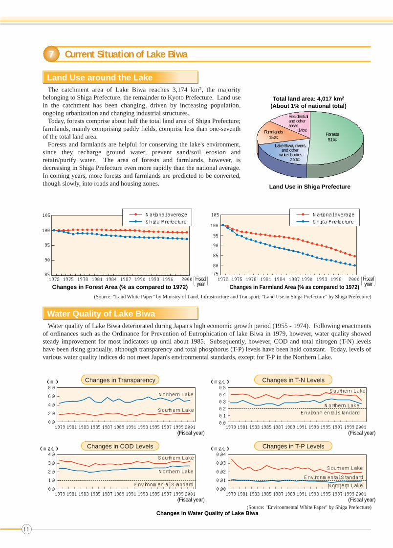
The catchment area of Lake Biwa reaches 3,174 km2, the majority belonging to Shiga Prefecture, the remainder to Kyoto Prefecture. Land use in the catchment has been changing, driven by increasing population, ongoing urbanization and changing industrial structures.
Today, forests comprise about half the total land area of Shiga Prefecture; farmlands, mainly comprising paddy fields, comprise less than one-seventh of the total land area.
Forests and farmlands are helpful for conserving the lake's environment, since they recharge ground water, prevent sand/soil erosion and retain/purify water. The area of forests and farmlands, however, is decreasing in Shiga Prefecture even more rapidly than the national average. In coming years, more forests and farmlands are predicted to be converted, though slowly, into roads and housing zones.
Land Use around the Lake
Water quality of Lake Biwa deteriorated during Japan's high economic growth period (1955 - 1974). Following enactments of ordinances such as the Ordinance for Prevention of Eutrophication of lake Biwa in 1979, however, water quality showed steady improvement for most indicators up until about 1985. Subsequently, however, COD and total nitrogen (T-N) levels have been rising gradually, although transparency and total phosphorus (T-P) levels have been held constant. Today, levels of various water quality indices do not meet Japan's environmental standards, except for T-P in the Northern Lake.
Water Quality of Lake Biwa
Land Use in Shiga Prefecture
Changes in Forest Area (% as compared to 1972) Changes in Farmland Area (% as compared to 1972)
(Source: "Land White Paper" by Ministry of Land, Infrastructure and Transport; "Land Use in Shiga Prefecture" by Shiga Prefecture)
Changes in Water Quality of Lake Biwa(Source: "Environmental White Paper" by Shiga Prefecture)
Changes in Transparency Changes in T-N Levels
Changes in COD Levels Changes in T-P Levels
Total land area: 4,017 km2
(About 1% of national total)
Forests51%
Residential and otherareas 14%Farmlands
15%
Lake Biwa, rivers,and other
water bodies20%
105 National average Shiga Prefecture
National average Shiga Prefecture
100
95
90
85
105
100
95
90
85
7580
1972 1975 1978 1981 1984 1987 1990 1993 1996 2000 1972 1975 1978 1981 1984 1987 1990 1993 1996 2000Fiscalyear
Fiscalyear
11

Transparency COD Total Nitrogen (T-N)
Total Phosphorus (T-P)
Below 22~33~44~55~6Over 6(m)
Over 3.53.5~3.03.0~2.82.8~2.52.5~2.3(mg/R)
Over 0.50.5~0.40.4~0.350.35~0.30.3~0.25(mg/R)
Over 0.0250.025~0.0200.020~0.0150.015~0.0120.012~0.008Below 0.008(mg/R)
The lake's water quality is not uniform. Influenced by differences in populations and industries of lakeside areas, as well as by lake topography, water quality is worse in the Southern Lake than in the Northern Lake, and in the eastern section than in the western section. The eastern section of the Southern Lake has the worst water quality.
Lake Biwa Water Quality Map
Lake Biwa experiences annual occurrences of freshwater red tide and blue-green algae bloom, both caused by eutrophication - the over-enrichment of a body of water due to excess loading of nutrients such as nitrogen and phosphorus, leading to excessive proliferation of plankton and aquatic plants. Eutrophication deteriorates water quality, alters ecosystems and discolors the water surface. Eutrophication sometimes even makes tap water malodorous.
Eutrophication of Lake Biwa
Freshwater Red Tide
Lake Biwa Water Quality Map (Annual Average Values of Fiscal 2001)(Source: "Environmental White Paper" by Shiga Prefecture)
Blue-green Algae Blooms
Freshwater Red Tides
A similar abnormal growth of blue-green algae blooms, including microsystis spp. and anabaena spp. turns the water surface green. In Lake Biwa, outbreaks of blue-green algae bloom have occurred annually from August to September, since the phenomenon was first observed in 1983 in the Southern Lake. Although only the Southern Lake had such blue-green algae blooms up to 1993, subsequent years have seen them in the Northern Lake as well.
From late April to early June, when the water temperature is between 15 - 20˚C, abnormal growth of the phytoplankton uroglena americana turns the water surface reddish-brown and the water malodorous. Since it was first observed in 1977, this phenomenon, called red tide, has occurred annually, excepting 1986, 1997, 1998, and 2001.
Blue-green Algae Blooms
Num
ber o
f Day
sN
umbe
r of D
ays
Current Situation of Lake Biwa
Fiscalyear
Fiscalyear
(Source: "Environmental White Paper" by Shiga Prefecture)
(Source: "Environmental White Paper" by Shiga Prefecture)
20
15
10
5
01969 1974 1979 1984 1989 1994
1969 1974 1979 1984 1989 1994
2001
Occurrence of Freshwater Red Tide (Days)
35
30
25
20
15
10
5
02001
Occurrence of Blue-green Algae Blooms (Days)
12
7
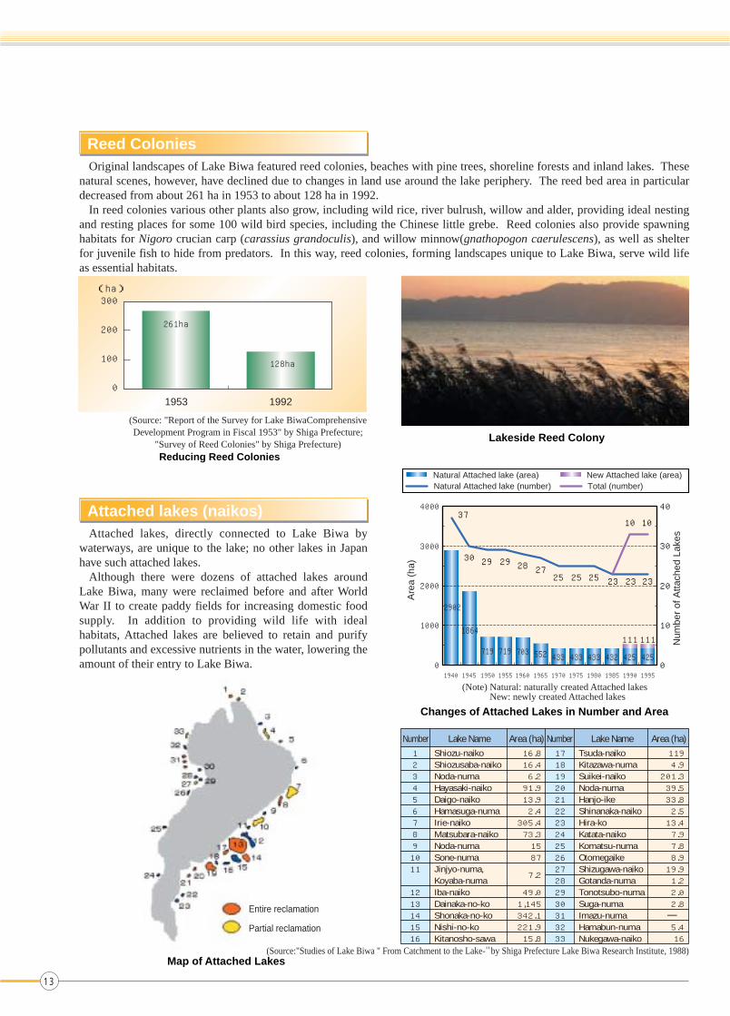
Original landscapes of Lake Biwa featured reed colonies, beaches with pine trees, shoreline forests and inland lakes. These natural scenes, however, have declined due to changes in land use around the lake periphery. The reed bed area in particular decreased from about 261 ha in 1953 to about 128 ha in 1992.
In reed colonies various other plants also grow, including wild rice, river bulrush, willow and alder, providing ideal nesting and resting places for some 100 wild bird species, including the Chinese little grebe. Reed colonies also provide spawning habitats for Nigoro crucian carp (carassius grandoculis), and willow minnow(gnathopogon caerulescens), as well as shelter for juvenile fish to hide from predators. In this way, reed colonies, forming landscapes unique to Lake Biwa, serve wild life as essential habitats.
Reed Colonies
Attached lakes, directly connected to Lake Biwa by waterways, are unique to the lake; no other lakes in Japan have such attached lakes.
Although there were dozens of attached lakes around Lake Biwa, many were reclaimed before and after World War II to create paddy fields for increasing domestic food supply. In addition to providing wild life with ideal habitats, Attached lakes are believed to retain and purify pollutants and excessive nutrients in the water, lowering the amount of their entry to Lake Biwa.
Attached lakes (naikos)
Reducing Reed Colonies
(Source: "Report of the Survey for Lake BiwaComprehensiveDevelopment Program in Fiscal 1953" by Shiga Prefecture;
"Survey of Reed Colonies" by Shiga Prefecture)
Map of Attached Lakes
Lakeside Reed Colony
Changes of Attached Lakes in Number and Area
4000
Are
a (h
a)
Num
ber
of A
ttach
ed L
akes
3000
2000
1000
1940 1945 1950 1955 1960 1965 1970 1975 1980 1985 1990 1995
111
425425432433433433552703719719
1864
2902
111
0
37
30 29 29 28 2725 25 25 23 23 23
10 10
40
30
20
10
0
Natural Attached lake (area) New Attached lake (area)Natural Attached lake (number) Total (number)
Number1 2 3 4 5 6 7 8 9 10 11 12 13 14 15 16
Shiozu-naikoShiozusaba-naikoNoda-numaHayasaki-naikoDaigo-naikoHamasuga-numaIrie-naikoMatsubara-naikoNoda-numaSone-numaJinjyo-numa,Koyaba-numaIba-naiko Dainaka-no-koShonaka-no-koNishi-no-koKitanosho-sawa
Tsuda-naikoKitazawa-numaSuikei-naikoNoda-numaHanjo-ikeShinanaka-naikoHira-koKatata-naikoKomatsu-numaOtomegaike Shizugawa-naikoGotanda-numaTonotsubo-numaSuga-numaImazu-numaHamabun-numaNukegawa-naiko
16.8 16.4 6.2 91.9 13.9 2.4
305.4 73.3 15 87
7.2
49.0 1,145 342.1 221.9 15.8
119 4.9
201.3 39.5 33.8 2.5 13.4 7.9 7.8 8.9 19.9 1.2 2.0 2.8
5.4 16
17 18 19 20 21 22 23 24 25 26 27 28 29 30 31 32 33
Lake Name Number Lake NameArea (ha) Area (ha)
—Entire reclamation
Partial reclamation
(Note) Natural: naturally created Attached lakesNew: newly created Attached lakes
(Source:"Studies of Lake Biwa " From Catchment to the Lake-" by Shiga Prefecture Lake Biwa Research Institute, 1988)
1953 1992
300
200
100
0
(ha)
13
261ha
128ha

Each winter Lake Biwa is visited by various migratory bird species, including bean goose, whistling swan and large bean goose, the latter designated a protected bird by the national government. Many bird watchers gather around the lake to enjoy first-hand contact with nature and various forms of wild life.
In 1971, the entire Lake Biwa region was designated a wildlife sanctuary; in 1993, Lake Biwa was registered with the Ramsar Convention on Wetlands.
The Chinese little grebe (Shiga Prefecture bird), also known as “nio,” was a familiar bird on the lake, which local residents called “nio-no-umi” (lake of nio). During the first half of the 1980's, the bird population was around 2,000; today, however, it has almost halved.
Changes in Number of Wild Birds(Changes in Number of Wild Birds)
(Courtesy of Shiga Prefectural Museum of Lake Biwa)
Swan Wild goose
Wild duck Grebe
Lake's Ecosystems
Changes in Fishery Catches by Fish Species
Nigoro Crucian Carp (Carassius grandoculis)
(endemic species)
Biwa Trout (onchorhynchus masou rhodrurus)
(endemic species)
Chinese Little Grebe (Shiga Prefecture bird)
(Source: "Fishery Production Survey" by Shiga Statistics Office, Kinki Regional Agricultural Administration Office)
Fishery catches in Lake Biwa show that catches of shellfish, particularly cobiculid clam, have been decreasing sharply since 1955. In addition, catches of endemic fish species are rapidly declining, particularly Nigoro crucian carp (carassius grandoculis), which is used for a local traditional food called Funazushi, as well as willow minnow (gnathopogon caerulescens) and white fish (leucopsarion petersi hilgendorf). The decrease of endemic species is attributable to reduced reed colonies and loss of other habitats for reproduction and spawning, and the invasion of non-native species, such as large-mouth bass (micropterus salmoides) and bluegill sunfish (lepomis macrochirus).
Current Situation of Lake Biwa
7,000
6,000
5,000
4,000
3,000
2,000
1,000
0
(ton)
Fiscalyear
Fiscalyear
Fiscalyear
Fiscalyear
Fiscalyear
Fiscalyear
1974 1979 1984 1989 1994 1999 1974 1979 1984 1989 1994 1999
1974 1979 1984 1989 1994 1999 1974 1979 1984 1989 1994 1999
400
300
200
100
0
(Number)
100,000
80,000
60,000
40,000
20,000
0
(Number)3,000
2,500
2,000
1,500
1,000
0
(Number)
800
600
400
200
0
(Number)
Sweetfish
Shrimp and other animals taken by fishery
Other shellfish
Other fish species
Cobiculid clam
600
500
400
300
200
100
0
(ton)
1955 1960 1965 1970 1975 1980 1985 1990 1995 2000 1955 1960 1965 1970 1975 1980 1985 1990 1995 2000
TroutNigoro crucian carpWillow minnowCarpWhite fish(leucopsarion petersi hilgendorf)Largemouth bass
14
7

8 History of Lake Conservation Efforts
In May 27, 1977, the first occurrence of red tide was confirmed offshore of Otsu City and Shiga and Imazu towns. The lake surface turned the reddish brown associated with the fishy smell hanging in the air. Furthermore, a large quantity of fish died, causing great damage to fishery. The red tides were caused by abnormal growth of phytoplankton resulting from eutrophication - the over-enrichment of water due to excessive loading of nutrients such as nitrogen and phosphorus.
Freshwater Red Tides
The red tides had a significant and lasting impact on the residents of Shiga Prefecture. The outbreak of red tide motivated residents to take action to prevent further eutrophication. Increasing numbers of citizens were involved in the environmental action, resulting in a prefecture-wide campaign to stop using synthetic household detergents containing phosphorus, one of the major causes of eutrophication. Instead of synthetic detergents, the residents began using powdered soap to wash clothing. As a result, use of powdered soap, which accounted for only 26% of use of detergent in 1979, soared to at least 70% in 1980. Driven by the residents' campaign, the Shiga prefectural government, ahead of other prefectures in Japan, decided to enact an ordinance to control wastewater containing nitrogen and phosphorus. This ordinance, enacted in 1979, is titled the Shiga Prefectural Ordinance Concerning the Prevention of the Eutrophication in Lake Biwa (Eutrophication Prevention Ordinance).
Water Quality Conservation Campaigns Initiated by Local Residents
In 1979, Shiga Prefecture enacted the Eutrophication Prevention Ordinance to prevent eutrophication of Lake Biwa by controlling inflow of nitrogen and phosphorus. The Ordinance was the first in Japan to ban the marketing, use, and gifting of phosphorus-containing synthetic detergent, whose use was widespread throughout Japan at that time. The Ordinance also encompassed regulations on industrial wastewater, together with guidelines for reducing nitrogen and phosphorus from domestic and agricultural wastewater.
Shiga Prefectural Ordinance Concerning the Prevention of the Eutrophication in Lake Biwa (Eutrophication Prevention Ordinance)
Phytoplankton (uroglena americana)
Changes in Use of Powdered Soap
(Source: "Environmental White Paper" by Shiga Prefecture)Campaign Immediately after the Lake BiwaEutrophication Prevention Ordinance Took Effect
Using only powdered soap
Using only powdered soap
Using both powdered soap and synthetic detergent
Using both powdered soap and synthetic detergent not containing phosphorus
Using synthetic detergent not containing phosphorus
Other
Using synthetic detergent only
Don't know
(%) April 1979 12th survey in Shiga Prefecture(July 1980: Enactment of Eutrophication Prevention Ordinance)
August 1980(Survey of Shiga citizens)
26.0 28.1 37.5 8.4
70.6 17.9 7.3 4.2
15
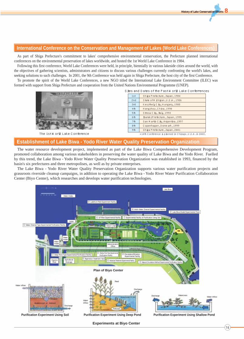
As part of Shiga Prefecture's commitment to lakes' comprehensive environmental conservation, the Prefecture planned international conferences on the environmental preservation of lakes worldwide, and hosted the 1st World Lake Conference in 1984.
Following this first conference, World Lake Conferences were held, in principle, biennially in various lakeside cities around the world, with the objectives of gathering scientists, administrators and citizens to discuss various challenges currently confronting the world's lakes, and seeking solutions to such challenges. In 2001, the 9th Conference was held again in Shiga Prefecture, the host city of the first Conference.
To promote the spirit of the World Lake Conferences, a new NGO titled the International Lake Environment Committee (ILEC) was formed with support from Shiga Prefecture and cooperation from the United Nations Environmental Programme (UNEP).
The water resource development project, implemented as part of the Lake Biwa Comprehensive Development Program, promoted collaboration among various stakeholders in preserving the water quality of Lake Biwa and the Yodo River. Fuelled by this trend, the Lake Biwa - Yodo River Water Quality Preservation Organization was established in 1993, financed by the basin's six prefectures and three metropolises, as well as by private enterprises.
The Lake Biwa - Yodo River Water Quality Preservation Organization supports various water purification projects and grassroots riverside cleanup campaigns, in addition to operating the Lake Biwa - Yodo River Water Purification Collaboration Center (Biyo Center), which researches and develops water purification technologies.
Establishment of Lake Biwa - Yodo River Water Quality Preservation Organization
The 1st World Lake Conference
Sites and Dates of the Past World Lake Conferrences
① Water Channel Type Experimental Purification Facility
② Deep Pond Type Experimental Purification Facility ③ Shallow Pond Type Experimental
Purification Facility
④ Byproduct Treatment Yard⑤ Advanced Treatment Experimental Facility
⑧ Percolation/filtrationExperimental Facility
⑨ Natural Circulation Method Experimental Purification Facility
⑥ UF Filter Experimental Facility ⑦ Experimental Facility of Purification Using Soil
⑩ Lake Biwa Model Experimental Pond⑪ Multi-Water Channel Experimental Facility
⑫ Lakefront Field Experiment Facility
Water Intake
Outlet
WaterIntake
WaterIntakeTo Otsu
HayamaRiver
AgriculturalDrainage
Visitor's Hall
AdministrationOffice
Lake Biwa
To Moriyam
a
Plan of Biyo Center
Lakeside Road (Prefectural Road Omihachiman - Otsu L
Experiments at Biyo Center
Purification Experiment Using Shallow Pond
Water inflowWatercressDischarge
Purification Experiment Using Deep Pond
Waterinflow
Reed
Biological decomposition
Absorption Absorption
Elodea nuttallii St. john
Discharge
Filtration
Pollutant
Purification Experiment Using Soil
DischargeAndosolAkadama soil
Filtration
Water inflow
or
History of Lake Conservation Efforts
1st
2nd
3rd
4th
5th
6th
7th
8th
9th
Shiga Prefecture, Japan, 1984
State of Michigan, U.S.A., 1986
Keszthely City, Hungary, 1988
Hangzhou, China, 1990
Stresa City, Italy, 1993
Ibaraki Prefecture, Japan, 1995
San Martin City, Argentina, 1997
Copenhagen, Denmark, 1999
Shiga Prefecture, Japan, 2001* 10th Conference is planned in Chicago, U.S.A. in 2003.
International Conference on the Conservation and Management of Lakes (World Lake Conferences)
16
8

9 Survey for Preparing Lake Biwa Comprehensive Conservation Plan
Lake Biwa is currently confronted with various challenges, including deteriorating water quality and loss of habitats for endemic species, resulting primarily from changes in lifestyles and land use, both driven by recent socioeconomic development. To address these challenges, various ministries and agencies concerned (National Land Agency and Ministry of Construction [now Ministry of Land, Infrastructure and Transport]; Environmental Agency [now Ministry of Environment]; Ministry of Health and Welfare [now Ministry of Health, Labour and Welfare]; Ministry of Agriculture, Forestry and Fisheries; and Forestry Agency) decided to develop a comprehensive lake conservation plan, as a model plan encompassing Lake Biwa and its peripheral regions, by coordinating and integrating various initiatives taken by respective ministries/agencies. To this end, the governmental bodies concerned jointly established a committee comprising specialists from a wide spectrum of academic fields. In the two years from fiscal 1997 to fiscal 1998, the committee conducted a comprehensive survey, studying and discussing diverse aspects, including improvement of water quality and soil recharge capacity, along with preservation of natural environment and landscapes. The survey outcome was compiled in a report titled
"Survey for Preparing Lake Biwa Comprehensive Conservation Plan".
Background
To implement comprehensive preservation initiatives of Lake Biwa by involving all stakeholders, it is essential to establish a common recognition about the lake's situation and to have common goals for all stakeholders.
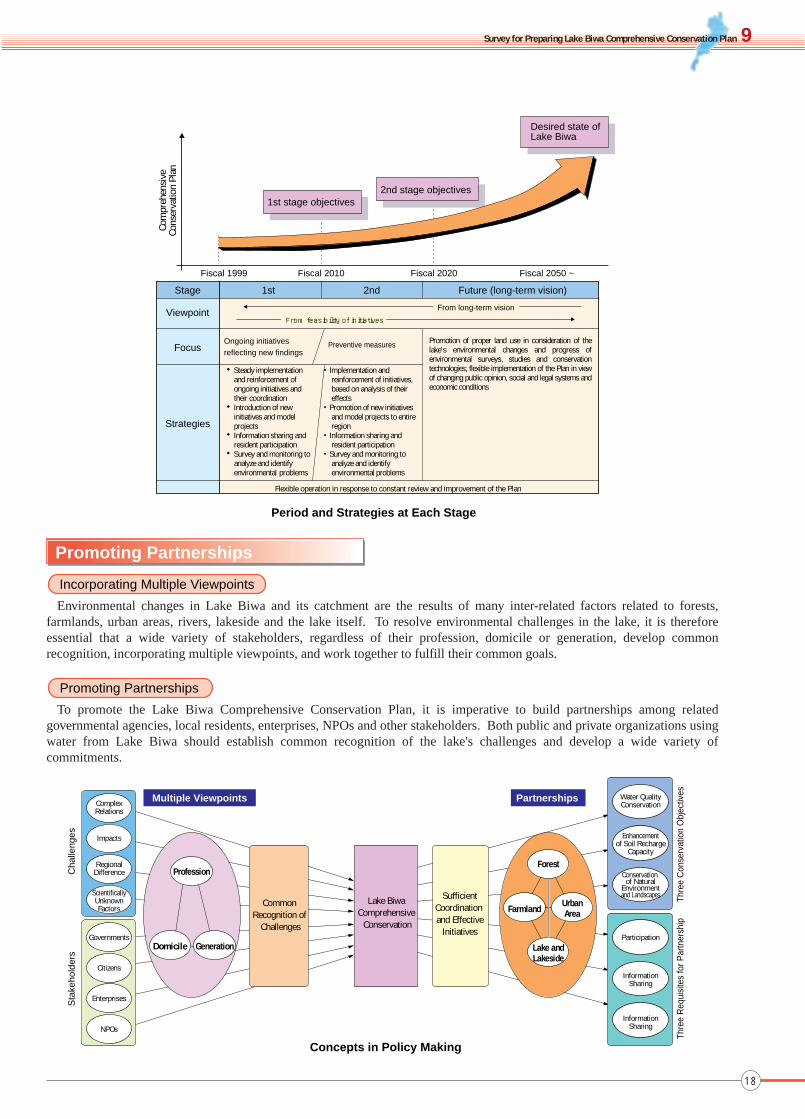
Based on the view that we should seek harmonious coexistence with the lake's ecosystem, and bequeath a clean Lake Biwa, the special lake of strategic importance, to future generations, the guiding principle was decided as follows:
Guiding Principle and Key Concepts of the Comprehensive Conservation Plan
The Plan period has been set at 20 years, since in 20 years (around 2020), children born at the time of the Plan's initiation will reach adulthood. Furthermore, the Plan encompasses a longer-term vision, envisaging the state of Lake Biwa fifty years from now (around 2050), when the children will become most influential in the future society.
This long-term Plan must enable flexible operation and, if necessary, revisions in response to social changes, since unexpected changes can occur.
The plan has been set for the 1st stage (up to 2010) and 2nd stage (up to 2020). The objective for the 1st stage is to promote environmental conservation through steady yet flexible implementation of ongoing initiatives, based on constant review of their effectiveness; coordination among various initiatives, introduction of new initiatives and model projects, and continuous surveying and monitoring. The 2nd stage objective is to further promote conservation initiatives in response to new findings in the 1st stage, with particular focus on preventive measures.
Objectives and Period of the Comprehensive Conservation Plan
Our CommonGoals
Our CommonProperty
Our CommonFeeling
Seeking SustainableDevelopment
Bequeathing Lake Biwa to Future Generations
Loving the Lake and Nature
Harmonious CoexistenceHarmonious Coexistence with the Lake's Ecosystem
Bequeathing a clean Lake Biwa to Future Generations―Seeking Harmonious Coexistence with the Lake's Ecosystem―
Guiding Principle
Key Concepts
Our CommonGoals
Our CommonProperty
Our CommonFeeling
17
Concepts in Policy Making
Multiple Viewpoints PartnershipsComplexRelations
Water QualityConservation
Enhancementof Soil Recharge
Capacity
Conservation of Natural
Environmentand Landscapes
Participation
InformationSharing
InformationSharing
Impacts
RegionalDifference
ScientificallyUnknownFactors
Governments
Citizens
Enterprises
NPOs
Cha
lleng
es
Thre
e C
onse
rvat
ion
Obj
ectiv
es
SufficientCoordination and Effective
Initiatives
Lake Biwa Comprehensive
Conservation
Common Recognition of
Challenges
Thre
e R
equi
site
s fo
r Par
tner
ship
Sta
keho
lder
s
Domicile Generation
Profession
FarmlandUrbanArea
Lake andLakeside
Forest
Promoting Partnerships
Environmental changes in Lake Biwa and its catchment are the results of many inter-related factors related to forests, farmlands, urban areas, rivers, lakeside and the lake itself. To resolve environmental challenges in the lake, it is therefore essential that a wide variety of stakeholders, regardless of their profession, domicile or generation, develop common recognition, incorporating multiple viewpoints, and work together to fulfill their common goals.
Incorporating Multiple Viewpoints
To promote the Lake Biwa Comprehensive Conservation Plan, it is imperative to build partnerships among related governmental agencies, local residents, enterprises, NPOs and other stakeholders. Both public and private organizations using water from Lake Biwa should establish common recognition of the lake's challenges and develop a wide variety of commitments.
Promoting Partnerships
Survey for Preparing Lake Biwa Comprehensive Conservation Plan
18
9
Period and Strategies at Each Stage
Viewpoint
Focus
Strategies
Flexible operation in response to constant review and improvement of the Plan
Stage
Fiscal 1999 Fiscal 2010 Fiscal 2020 Fiscal 2050 ~
Com
preh
ensi
veCo
nser
vatio
n Pl
an
1st 2nd Future (long-term vision)
From feasibility of initiatives
From long-term vision
Ongoing initiatives reflecting new findings
Preventive measures
・Steady implementation and reinforcement of ongoing initiatives and their coordination
・Introduction of new initiatives and model projects ・Information sharing and
resident participation・Survey and monitoring to
analyze and identify environmental problems
・Implementation and reinforcement of initiatives, based on analysis of their effects
・Promotion of new initiatives and model projects to entire region
・Information sharing and resident participation
・Survey and monitoring to analyze and identify environmental problems
Promotion of proper land use in consideration of the lake's environmental changes and progress of environmental surveys, studies and conservation technologies; flexible implementation of the Plan in view of changing public opinion, social and legal systems and economic conditions
1st stage objectives2nd stage objectives
Desired state of Lake Biwa

Aerated tank
Distribution tank Organic compounds(Methanol, etc.) PAC
PAC
Finalsedimentationtank
Biological treatment (step-feed biological nitrogen removal process + post-denitrification)
Physiochemical treatment (sand filtration + ozonation + bio-activated carbon filtration)
Excess sludgeSludge return
Anaerobic tank
Treatedwater
Sewage from primarysedimentation tank
Oxygen gas
Sand filtrationtower
Ozone reactiontower
Bio-activatedcarbon filtration tower
Ozone generator
Granular activatedcarbon
Ozone
Followings show major tasks, objectives, and measure examples of comprehensive environmental preservation efforts (Protecting Water Quality, Increasing Soil Recharge Capacity, and Preserving the Natural Environment and Scenic Landscape) and common foundations (Citizen Participation and Activities, Information Sharing and Staff Exchange Promotion, Research and Survey).
【Three categories of Comprehensive Environmental Preservation Efforts】
10 Comprehensive Environmental Preservation Efforts and Specific Measures
① Reducing chemical oxygen demand (COD), total nitrogen and total phosphorus② Resolving problems of musty odor, freshwater red tides and blue-green algae blooms③ Reducing influent load from non-point (unspecified) sources④ Investing and analyzing adequate measures against low biodegradable organics⑤ Minimizing impact of trace chemicals
Reducing influent load to level of latter half of 1960 sTo reduce COD level by approximately 31%, total nitrogen by
approximately 17%, and total phosphorus by approximately 36% from 1995 levels
Protecting Water Quality
■Reducing Environmental Impact of Domestic Wastewater(Sewage Systems)
Major Tasks
First Stage Objectives
○ Measures addressing pollution sources○ Measures addressing runoff processes○ Measures to be taken in the lake itself○ Regulations on wastewater etc.○ Research and field studies
Major Initiatives
Restoring water quality to level of latter half of 1960 s To restore water quality to the level prior to the emergence of
musty odor, freshwater red tides and blue-green algae blooms (level of latter half of 1960's)
Second Stage Objectives
○ Continual enforcement of wastewater regulations○ Reinforcement of measures to reduce influent load
from non-point (unspecified) sources ○ Reinforcement of measures to enhance the lake’s
natural water purification functions○ Introduction of new initiatives in response to
environmental changes○ Lifestyle reforms to reduce environmental impact
Priorities
In Shiga Prefecture, the sewage service coverage rate is rising sharply, reaching 69.5% at the end of fiscal 2001, seventh highest among Japan's 47 prefectures. To prevent eutrophication of Lake Biwa (a closed water system), all sewage treatment plants in Shiga Prefecture have already introduced advanced treatment systems, which are effective in removing various substances such as nitrogen or phosphorus from sewage. Moreover, the sewage treatment plants are currently preparing for the introduction of ultra-advanced sewage treatment systems effective in removing still more biodegradable organics.
Ultra-Advanced Sewage Treatment Process
Changes in Sewage Service Coverage Rates
Advanced Sewage Treatment ServiceCoverage Rate (End of Fiscal 2001)
《Specific Measures》
80
70
60
50
40
30
20
10
0
National averageShiga Prefecture
(%)
45 50 55 56 57 58 59 60 61 62 63 元 2 3 4 5 6 7 8 9 10 11 12 13Year end
16
2330 31 32
33 3436 37
39 4042 44 45
47 495154 55 56
58 6064.569.5
1.73.2 4.6 4.8
7.8 8.91112.9
15.217.120.423.528.230.5
33.936.139.34346.750.55558.862 64
69
32
32
9.7
0 10 20 30 40 50 60 70(%)
Shiga Prefecture(highest in Japan)
Osaka Prefecture(second highest)
Kyoto Prefecture(second highest)
National average
19
54.5%
8.5%
8.8%
71.8%
End of Fiscal 1998
69.5%
8.8%
9.5%
87.8%
Approximately 74%
End of Fiscal 2001
Sanitary Sewage Treatment Facilities in Shiga Prefecture
Sanitary Sewage Treatment Facilities (national average)
Sewage Service
Sewage Treatment Systems for Agricultural Communities
Domestic Wastewater Treatment Tanks
Sanitary Sewage Treatment Facilities (Total)
Comprehensive Environmental Preservation Efforts and Specific Measures
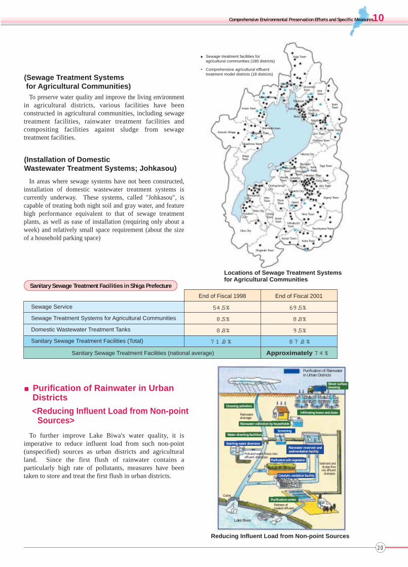
In areas where sewage systems have not been constructed, installation of domestic wastewater treatment systems is currently underway. These systems, called "Johkasou", is capable of treating both night soil and gray water, and feature high performance equivalent to that of sewage treatment plants, as well as ease of installation (requiring only about a week) and relatively small space requirement (about the size of a household parking space)
To further improve Lake Biwa's water quality, it is imperative to reduce influent load from such non-point (unspecified) sources as urban districts and agricultural land. Since the first flush of rainwater contains a particularly high rate of pollutants, measures have been taken to store and treat the first flush in urban districts.
To preserve water quality and improve the living environment in agricultural districts, various facilities have been constructed in agricultural communities, including sewage treatment facilities, rainwater treatment facilities and compositing facilities against sludge from sewage treatment facilities.
(Installation of DomesticWastewater Treatment Systems; Johkasou)
■Purification of Rainwater in UrbanDistricts
<Reducing Influent Load from Non-pointSources>
(Sewage Treatment Systems for Agricultural Communities)
Yogo Town
KinomotoTown
Takatsuki TownIbukiTown
TorahimeTown
Kohoku Town
AzaiTown
Biwa TownNagahamaCity
Omi TownSanto Town
Maibara Town
Hikone City
ToyosatoTown Kora
TownTaga Town
EchigawaTown Hatasho Town
Koto Town
Aito Town
NotogawaTown
GokashoTown
AzuchiTown
OmihachimanCity
Yokaichi City
Eigenji Town
ChuzuTown
MoriyamaCity Yasu
Town RyuoTown Gamo
Town
Hino TownKusatsuCity
Ritto CityIshibeTown Kosei
Town MinakuchiTown
Tsuchiyama TownOtsu City
Shigaraki Town
Konan TownKoka Town
ShigaTown
Takashima Town
Kutsuki Village Adogawa Town
ShinAsahi town
Imazu Town
Makino Town
NishiazaiTown
Locations of Sewage Treatment Systemsfor Agricultural Communities
Purification of Rainwaterin Urban Districts
Street surfacecleaning
Cleaning activities
Infiltrating boxes and ducts
Rainwater collection by households
Rainwaterdrainage
ScreeningWater diverting facilities
Swirling water diversion
Polluted water flows intoeffluent drainpipe.
Rainwater reservoir andsedimentation facility
Purification with vegetationSediment and
sludge flowinto effluent
drainpipe.Catalytic oxidation facility
OutletPurification center
Release oftreated effluent
Lake Biwa
Reducing Influent Load from Non-point Sources
Sewage treatment facilities for agricultural communities (189 districts)
Comprehensive agricultural effluenttreatment model districts (18 districts)
▲
●
20
10

Effluent ductClean water
Conglomerate
Conglomerate
Akadamasoil
Flowdirection
nfluent ductContaminated water
Soil filtrates impurities, while iron in the soil adsorbs phosphorus from water. Concurrently, microorganisms in soil decompose nitrogen and phosphorus, thereby purifying the water.
■Water Purification Mechanism (Upward flow system)
■Improvement of River Environment
■Measures against Low Biodegradable Organics
(Water Quality of Inflowing Rivers)
Various studies have been conducted in quest of adequate measures to address low biodegradable organics, which are believed to be responsible for the lake's high COD level. The studies have shown that a system using soil's functions to decompose and adsorb organics is effective in treating high COD level effluent from roads, particularly in the first flush (approximately 2 mm).
Water quality is monitored and analyzed in rivers and inland lakes flowing into Lake Biwa, as well as in sections of Lake Biwa where water contamination is particularly serious. In addition, various measures are taken to improve the lake's water quality, including dredging of the lake bottom and water purification by means of vegetation.
In the Kusatsu River, for instance, a water purification facility has been constructed using soil's water purification function. In this facility, soil removes nitrogen and phosphorus from contaminated river water, thus reducing influent load. In the Moriyama River, which flows into Akanoi Bay, river water is fed to reservoirs (either flooding prevention reservoir or ordinary treatment reservoir) and purified before discharge into the lake.
(Measures against Sediment Contamination)In the areas of advanced eutrophication, dredging and
other measures are taken to address lake bottom contamination and hinder nutrient dissolution into lake water.
0First time Second time Third time Fourth time
20
40
60
80
100
(g)0
20
40
60
80
100
(%)
Total loadTotal load in treated waterRemoval rate (%)
COD
Kusatsu River Water Purification Facility
Dredging of Lake Bottom
Removal of Low Biodegradable OrganicsLow Biodegradable Organics Treatment System
Effluent from roads
Parshall flume
Effluent from roads (first flush, post-first flush)
Horizontal treatmentequipment
Slit
Void
reatment chamber
Tank
Treated water
Excessive water
Triangle weir
21

① Securing sufficient forest area
② Ensuring proper management of planted forests
③ Improving forest maintenance/management systems
④ Securing sufficient agricultural land area
⑤ Increasing soil's rainfall infiltration and holding capacity in urban districts
⑥ Promoting efficient water use
Securing sufficient land area for rainfall infiltrationTo secure sufficient land area for rainfall infiltration in forests,
agricultural land and urban districts by preventing forest erosion and through other efforts
To protect forest soil layers on a sustainable basis by promoting adequate plant growth and management, particularly in planted forests
Major Tasks
First Stage Objectives
○ Measures to secure sufficient forest and agricultural land area
○ Stabilization of forest soil layers○ Efficient use of reservoirs and other artificial water
storage facilities○ Construction and improvement of water recycling
facilities○ Research and field studies
Improving soil’s recharge capacity and promoting adequate water use
To improve and sustain soil's rainfall filtration and holding capacity in forests, farmlands and urban districts
To promote adequate water use in artificial water circulation systems
Second Stage Objectives
○ Proper management of planted forests to stabilize soil layers
○ Development of human resources for forest maintenance
○ Researches to seek various adequate measures for the lake's respective sub-basins in accordance with their water quality and local ecosystems
■Forest MaintenanceProper forest maintenance is essential for sustaining soil's recharge capacity. To promote forest maintenance, various
measures taken include periodic thinning and the creation of mixed forests with multiple canopies and long harvest cycles.
Increasing Soil’s Recharge Capacity
Forest of Long Harvest Cycle
Major Initiatives Priorities
Comprehensive Environmental Preservation Efforts and Specific Measures
《Specific Measures》
22
10

■Permeable Pavement andUrban Green Zones
To improve rainfall filtration and holding capacity in urban area, increasing numbers of streets have permeable pavements and roadside trees.
■Improving Rainfall Filtration andHolding Capacity of Farmlands
To improve rainfall filtration and holding capacity of farmlands, agricultural communities in Shiga Prefecture have introduced agricultural water management systems featuring irrigation water circulation and water recycling systems, together with efficient use of reservoirs.
Permeable Pavement
Circulatory Irrigation System
■AfforestationTo stabilize mountain soil layers and promote ground infiltration of surface water, various measures taken include
restoration of forest areas damaged by a disaster, creation of disaster-prevention forests and improvement of their functions.
Immediately after Disaster Immediately after Restoration
Restoration of Damaged Forest
1 Year Later
23

Withoutriparian forest
Withriparian forest
■Restoration of Rivers and Lakeshore
Preserving the Natural Environment and Scenic Landscapes
①Preserving wild life habitats
②Preserving biodiversity
③Preserving the lake's indigenous scenic beauty
④Controlling lakeside land use
Securing strategic points for the creation of biotope networks
To preserve biotopes in the transition zone (called "ecotone") between water and land
To preserve biotopes along rivers flowing into the lake so as to sustain the functions of those biotopes as ecological corridors linking the lake to the mountains and forests on the edges of the catchment area
○ Securing sufficient area of wild life habitats by creating biotope networks
○ Improving habitat environment by creating biotope networks
○ Cultivating public awareness and establishing rules for the sensible use and protection of the natural environment
○ Involving local residents in conservation activities and field studies
Establishing a framework of biotope networksTo create a framework of biotope networks and restore natural
ecosystem using it.
○ Monitoring and assessment of wild life habitats○ Establishment of a system to involve local residents and
other users of the lake in environmental conservation activities
In the past, Lake Biwa shoreline was mainly comprised of sand beaches and reed colonies. Today, however, many sections of the lakeshore have concrete or sheet pile embankments. Of those sections, those that suffer particular environmental degradation have been selected for restoration of the lake's original landscape, thereby to regain the lakeshore's functions of flood prevention, ecosystem preservation and providing access to the water.
■Yasu Riparian Forest Project
Riparian Forest Zones
An afforestation project is under way along the Yasu River, a major river flowing into Lake Biwa. In addition to preserving natural ecosystems, riparian forests are effective in augmenting riverbank flood-prevention functions.
The revised River Law (1997) introduces the riparian forest zone system, under which river authorities can create and preserve riparian forest zones as a means of promoting flood prevention and efficient use of river water.
Reproduced Reed Colony(Moriyama District)
Before Restoration
Major Tasks
First Stage Objectives
Major Initiatives
Second Stage Objectives
Priorities
Large quantityof floodwater
High flow velocity = Extensive bank damage
High flow velocity = deep erosion
Water overflowing the bank is likely to cause extensive damage.
Water overflowing the bank is blocked by trees, eventuallyminimizing flood damage
Low flow velocity = Minor bank damageSmall quantity of floodwater
Low flow velocity = minor erosion
Comprehensive Environmental Preservation Efforts and Specific Measures
《Specific Measures》
24
10
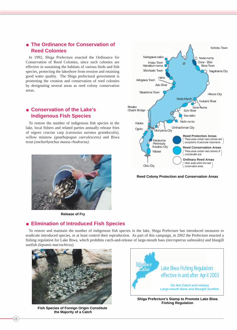
■The Ordinance for Conservation ofReed Colonies
■Conservation of the Lake'sIndigenous Fish Species
To restore the number of indigenous fish species in the lake, local fishers and related parties annually release fries of nigoro crucian carp (carassius auratus grandoculis), willow minnow (gnathopogon caerulescens) and Biwa trout (onchorhynchus masou rhodrurus).
■Elimination of Introduced Fish SpeciesTo restore and maintain the number of indigenous fish species in the lake, Shiga Prefecture has introduced measures to
eradicate introduced species, or at least control their reproduction. As part of this campaign, in 2002 the Prefecture enacted a fishing regulation for Lake Biwa, which prohibits catch-and-release of large-mouth bass (micropterus salmoides) and bluegill sunfish (lepomis macrochirus).
In 1992, Shiga Prefecture enacted the Ordinance for Conservation of Reed Colonies, since such colonies are effective in sustaining the habitats of various birds and fish species, protecting the lakeshore from erosion and retaining good water quality. The Shiga prefectural government is promoting the creation and conservation of reed colonies by designating several areas as reed colony conservation areas.
Reed Colony Protection and Conservation Areas
Release of Fry
Fish Species of Foreign Origin Constitute the Majority of a Catch
Shiga Prefecture's Stamp to Promote Lake BiwaFishing Regulation
Lake Biwa Fishing Regulation:effective in and after April 2003
Kohoku Town
Noda-numaOnoe - Ebie
Biwa Town
Nagahama City
Hikone CityNoda Marsh
Inukami River
Sone-numaEchi River
Iba-naiko
Nishi-no-ko
Omihachiman CityMoriyama City
KarasumaPeninsulaKusatsu CityYabase
Otsu City
Ogoto
Katata
BiwakoOhashi Bridge
Takashima Town
Ado River
Adogawa TownHarie
ShinAsahi Town
Hamabun-numaImazu Town
Nukegawa-naiko
Reed Protection AreasThese areas contain reed colonies and ecosystems of particular importance.
Reed Conservation AreasThese areas contain reed colonies of considerable size.
Ordinary Reed AreasOther areas within the reed conservation areas
Do Not Catch-and-releaseLarge-mouth Bass and Bluegill Sunfish.
25
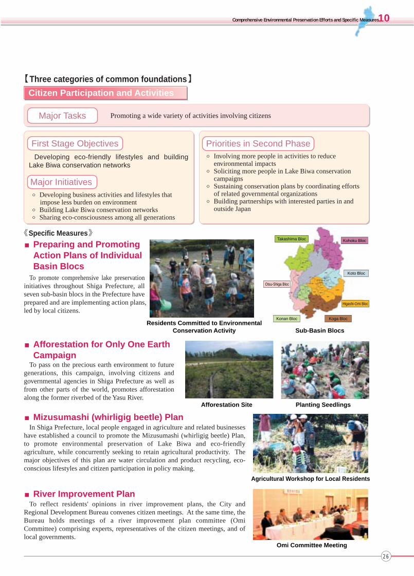
■Preparing and PromotingAction Plans of IndividualBasin Blocs
Citizen Participation and Activities
Residents Committed to EnvironmentalConservation Activity Sub-Basin Blocs
Afforestation Site Planting Seedlings
Agricultural Workshop for Local Residents
Omi Committee Meeting
To promote comprehensive lake preservation initiatives throughout Shiga Prefecture, all seven sub-basin blocs in the Prefecture have prepared and are implementing action plans, led by local citizens.
■Afforestation for Only One EarthCampaign
To pass on the precious earth environment to future generations, this campaign, involving citizens and governmental agencies in Shiga Prefecture as well as from other parts of the world, promotes afforestation along the former riverbed of the Yasu River.
■Mizusumashi (whirligig beetle) PlanIn Shiga Prefecture, local people engaged in agriculture and related businesses
have established a council to promote the Mizusumashi (whirligig beetle) Plan, to promote environmental preservation of Lake Biwa and eco-friendly agriculture, while concurrently seeking to retain agricultural productivity. The major objectives of this plan are water circulation and product recycling, eco-conscious lifestyles and citizen participation in policy making.
■River Improvement PlanTo reflect residents' opinions in river improvement plans, the City and
Regional Development Bureau convenes citizen meetings. At the same time, the Bureau holds meetings of a river improvement plan committee (Omi Committee) comprising experts, representatives of the citizen meetings, and of local governments.
Promoting a wide variety of activities involving citizens
Developing eco-friendly lifestyles and building Lake Biwa conservation networks
○ Developing business activities and lifestyles that impose less burden on environment
○ Building Lake Biwa conservation networks○ Sharing eco-consciousness among all generations
○ Involving more people in activities to reduce environmental impacts
○ Soliciting more people in Lake Biwa conservation campaigns
○ Sustaining conservation plans by coordinating efforts of related governmental organizations
○ Building partnerships with interested parties in and outside Japan
Major Tasks
First Stage Objectives
Major Initiatives
Priorities in Second Phase
Takashima Bloc Kohoku Bloc
Koto Bloc
Higashi-Omi Bloc
Koga BlocKonan Bloc
Otsu-Shiga Bloc
Comprehensive Environmental Preservation Efforts and Specific Measures
【Three categories of common foundations】
《Specific Measures》
26
10

《Specific Measures》
Increasing friendly exchange opportunities and establishing easy-to-access networks
Sharing information and promoting friendly exchanges
○ Increasing staff exchange opportunities○ Sharing basic information○ Establishing easy-to-access networks
○ Creating extensive networks for Lake Biwa environmental preservation, involving individual citizens, enterprises and governmental agencies
Information Sharing and Staff Exchange Promotion
Citizens Participating in Dandelion Survey
■Shiga Environmental Business ExhibitionThe Shiga Environmental Business Exhibition, a trade
fair of environmental business, displays eco-friendly products and technologies developed through partnerships between industry, universities and governments so as to develop new industries in the 21st century. The Exhibition is held annually in November. The fifth event, held in 2002, featured over 200 booths of Japanese and overseas enterprises, organizations, universities, and research institutes, all attracting over 40,000 visitors, including the general public.
Omi Citizen Activities
Shiga Environmental Business Exhibition
■Omi Network CenterAmid the worldwide trend of surging citizen activities,
including volunteer activities and NPO projects, citizens of Shiga Prefecture are becoming more and more active in environmental and community development campaigns.
The Omi Network Center, established in 1997, supports such citizen and NPO activities by offering information and opportunities to exchange staff and members, develop leaders and invigorate various activities.
The Lake Biwa Museum, opened in 1996, provides opportunities to exchange and share information. To fulfill its founding mission as a meeting place of people and information, the Museum holds various events, including workshops and field surveys for the general public.
■Friendly Exchanges and InformationSharing by the Lake Biwa Museum
Lake Biwa Museum holds observation and survey workshops on specific themes, recruiting citizens as field reporters.
Major Tasks
First Stage Objectives
Major Initiatives
Priorities in Second Phase
27

Program DetailsFiscal Year
○Problems related to the monitoring of water quality were identified and solutions were sought.
○Indices were selected for evaluating efforts to preserve natural ecosystems and landscapes; studies of monitoring techniqueswere conducted.
○A symposium was held on the theme "Lake Biwa comprehensive conservation program involving all citizens."
○Problems related to the monitoring of soil recharge capacity were identified. Solutions were sought regardingpromotion of comprehensive conservation of the lake, particularly in terms of organizational structures and practical measures.
○The comprehensive lake conservation program was reported at the 9th World Lake Conference.
1999
2000
2001
《Specific Measures》
Research and Survey
Promoting systematic monitoring and survey activities
Promotion of systematic research and survey ○ Promotion of monitoring surveys and establishment of comprehensive water quality control systems
○ Establishment of survey and research systems○ Promotion of the "Environmental Information Center"
plan○ International collaboration on the theme of ancient lakes
■Survey to Promote Comprehensive Preservation of Lake BiwaIn 1997 and 1998, six governmental agencies responsible for Lake Biwa conservation jointly conducted a comprehensive survey
of the lake. Based on the survey result, a further survey program was developed and initiated in fiscal 1999.
■Research and Survey by the Lake Biwa Research Institute
The International Lake Environment Committee (ILEC) established a science committee comprising the world's leading scientists. On the basis of the committee's suggestions the ILEC develops various activities worldwide, including collection and dissemination of lake related information, and environmental education and training. The ILEC is establishing and promoting sound management systems for lakes worldwide, incorporating the outcomes of World Lake Conferences, held nine times to date, including first and ninth meetings in Shiga Prefecture.
■International Survey and Research by theInternational Lake Environment Committee (ILEC)
Committee Meeting
Autonomous Underwater Vehicle “tantan”
○ Promotion of monitoring survey○ Establishment of collaboration networks
The Lake Biwa Research Institute, a center of scientific and managerial research on Lake Biwa established by Shiga Prefecture, is committed to studies of various environmental challenges in Lake Biwa and its catchment. The Institute's activities include:
Estimating the impact of unsteady influent load on lake water qualityThe Institute has prepared a simulation model to estimate the impact of unsteady
(especially at time of rain) influent from the land on the lake's water quality, to seek ideal measures for addressing influent load from non-point sources, thereby to improve water quality.
Long-term estimation of the lake's environmentUsing an autonomous underwater vehicle “tantan”, the Institute is monitoring
environmental changes in the lake’s northern section to prepare a long-term environmental change prediction model.
Studies of biodiversity in Attached lakesThe Institute conducts fieldwork concerning aquatic organisms and vegetations in
Attached lakes, to prepare Attached lake preservation measures with the aim of preserving Lake Biwa's indigenous biodiversity.
Major Tasks
First Stage Objectives
Major Initiatives
Priorities in Second Phase
Comprehensive Environmental Preservation Efforts and Specific Measures
28
10
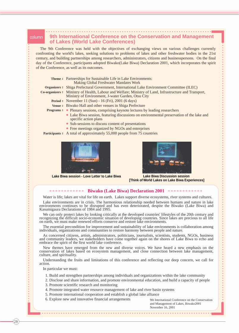
The 9th Conference was held with the objectives of exchanging views on various challenges currently confronting the world's lakes, seeking solutions to problems of lakes and other freshwater bodies in the 21st century, and building partnerships among researchers, administrators, citizens and businesspersons. On the final day of the Conference, participants adopted Biwako(Lake Biwa) Declaration 2001, which incorporates the spirit of the Conference, as well as its outcomes.
Partnerships for Sustainable Life in Lake Environments: Making Global Freshwater Mandates WorkShiga Prefectural Government, International Lake Environment Committee (ILEC)Ministry of Health, Labour and Welfare; Ministry of Land, Infrastructure and Transport, Ministry of Environment, J-water Garden, Otsu CityNovember 11 (Sun) - 16 (Fri), 2001 (6 days)Biwako Hall and other venues in Shiga Prefecture●Plenary sessions, comprising keynote lectures by leading researchers●Lake Biwa session, featuring discussions on environmental preservation of the lake and
specific action plans●Sub-sessions to discuss content of presentations●Free meetings organized by NGOs and enterprisesA total of approximately 55,000 people from 75 countries
Water is life; lakes are vital for life on earth. Lakes support diverse ecosystems, river systems and cultures.Lake environments are in crisis. The harmonious relationship needed between humans and nature in lake
environments continues to be disrupted and has even deteriorated, despite the Biwako (Lake Biwa) and Kasumigaura Declarations of 1984 and 1995.
We can only protect lakes by looking critically at the developed countries' lifestyles of the 20th century and recognizing the difficult socio-economic situation of developing countries. Since lakes are precious to all life on earth, we must make renewed efforts conserve and restore lake environments.
The essential precondition for improvement and sustainability of lake environments is collaboration among individuals, organizations and communities to restore harmony between people and nature.
As concerned citizens, artists, administrators, politicians, journalists, scientists, students, NGOs, business and community leaders, we stakeholders have come together again on the shores of Lake Biwa to echo and embrace the spirit of the first world lake conference.
New themes have emerged from the new and diverse voices. We have heard a new emphasis on the conservation of lakes based on ecosystem management, and close connection between lake management, culture, and spirituality.
Understanding the fruits and limitations of this conference and reflecting our deep concern, we call for action.
In particular we must:
1. Build and strengthen partnerships among individuals and organizations within the lake community2. Disclose and share information, and promote environmental education, and build a capacity of people3. Promote scientific research and monitoring4. Promote integrated water resource management of lake and river basin systems 5. Promote international cooperation and establish a global lake alliance 6. Explore new and innovative financial arrangements
9th International Conference on the Conservation and Managementof Lakes (World Lake Conferences)
9th International Conference on the Conservationand Management of Lakes, Biwako2001November 16, 2001
Biwako (Lake Biwa) Declaration 2001
column
Theme:
Organizers: Co-organizers:
Period: Venue:
Programs:
Participants:
29
Lake Biwa session - Love Letter to Lake Biwa Lake Biwa Discussion session [Think of World Lakes on Lake Biwa Experiences]

①Lake Biwa Comprehensive Preservation Liaison Coordination Council(Ministry of Health, Labour and Welfare; Ministry of Agriculture, Forestry and Fisheries; Forestry Agency; Fisheries Agency [joined in fiscal 2002]; Ministry of Land, Infrastructure and Transport; and Ministry of Environment)
Coordinating System
Continuous improvement
The Council was established in July 1999, with the aim of facilitating implementation of Lake Biwa preservation programs by coordinating related regional bureaus of the national government, as well as local governments.
The Council's first meeting was held on July 21, 1999, to determine Council rules, introduce ongoing commitments of respective members, and confirm resolutions to strengthen partnerships among members to facilitate the comprehensive preservation of Lake Biwa.
Implementation of comprehensive lake preservation initiatives calls for constant review and improvement in response to social trends, progress in conservation measures, and changes in public opinions. Such a flexible approach is essential since there are many uncertain elements involved in current conservation initiatives. For one thing, the lake's ecological mechanism is not fully understood; for another, citizens' views regarding environmental preservation can change. Accordingly, responsible bodies regarding lake preservation should continue their commitment to making initiatives more effective and rewarding.
Operation Mechanism
Coordination System
Cooperative Structure of Prefectures in the Lake Biwa Catchment
Cooperative Structure of Municipalitiesin the Lake Biwa Catchment
Cooperative Structure in the Lake Biwa - Yodo River Watershed
(Lake Biwa Comprehensive Preservation Promotion Council)
Cooperative Structure for Ministries and Agencies
(Lake Biwa Comprehensive Preservation Liaison Coordination Council)
●Flexible Operation of Conservation Plans
Research institutions must collaborate to determine the lake's environmental situations and mechanisms in the most effective manner. At the same time, results of observations, surveys, researches and technological development should be reflected in conservation plans in a timely manner.
●Changing Plans to Reflect Results of Observations,Surveys, Researches and Technological Development
Progress and effects of conservation plans should be constantly evaluated. If necessary, the plans should be reviewed in terms of project composition and approaches to specific measures.
Implementing authorities should share information in advance, to promote mutual understanding and support.
In response to the progress of conservation projects and changes in the lake's environment, plans must be constantly reviewed and if necessary revised, together with their targets.
●Reviews Based on Plan Evaluation
●Coordination among Implementing Authorities and Projects
11 Future Progress of Comprehensive Lake Preservation Initiatives
Partnerships andrespect to autonomyof respective members
Citizens/Enterprises SpecialistsGovernments Citizens/Enterprises SpecialistsGovernments
The Council was established in June 1999 with the objective of facilitating implementation of Lake Biwa preservation programs by coordinating related governmental bodies.
The Council's first meeting was held on June 28, 1999, to determine the Council's rules and confirm resolutions for strengthening partnerships among members to facilitate the comprehensive preservation of Lake Biwa.
②Lake Biwa Comprehensive Preservation Promotion Council (Kinki Regional Agricultural Administration Office, Ministry of Agriculture, Forestry and Fisheries, Kinki Chugoku Forest Office, Forestry Agency; Kinki Regional Development Bureau, Ministry of Land, Infrastructure and Transport; Osaka Prefecture, Hyogo Prefecture, Kyoto Prefecture, Shiga Prefecture, Osaka City, Kobe City, and Kyoto City)
Bequeathing a Clean Lake Biwato Future Generations
Implementation (Implementing programs and initiatives)
Management (Evaluating progress and effects
of programs and initiatives)
Evaluation (By implementing authorities
and third parties)
Review (By reflecting views of specialists
and general public)
Knops
(Autonomousimplementation)
Enterprises
Citizens
Governments
(Continuousimprovement)
Specialists
Collaboration
Lake Biwa - Yodo River basin
(Extensive partnerships)
Nationwide, worldwide citizens
Lake Biwa catchments(Key area of continuous improvement)
Preservation of naturalenvironment
and landscapes
Improvement of soil'srecharge capacity
Improvement ofwater quality Participation
Survey andresearch
Informationsharing
Future Progress of Comprehensive Lake Preservation Initiatives
30
11

12 Chronological Table of Lake Biwa
B.C.10000
8000
6000
3000
2000
200
A.D.28
250
646
667
672
710
742
794
905
1065
1192
1428
1455
1467
1500
1575
1576
1582
1587
1600
1603
1672
1802
1846
1868
1869
1872
1874
1878
1890
1893
1896
1905
1912
1913
1914
1919
1921
19251941
1944
1949
Year Major Incidents in Japan Major Incidents in Lake Biwa Basin
Old Stone Age
Jomon
Yayoi
Asuka
Nara
Heian
Kamakura
Muromachi
Azuchi-Momoyama
Edo
Meiji
Taisho
An ancient lake was formed in the Iga Ueno region in Mie Prefecture.
Stone spear points and tools discovered around Lake Biwa
Various Jomon period ruins discovered around Lake Biwa
Yayoi Period ruins discovered around Lake Biwa
The capital was relocated to Omi.
Bronze bell-shaped vessels unearthed from ruins in Yasu
The ice age with several intervals
The Japanese Archipelago becameseparated from the Eurasian Continent.
Taika coup
Jinshin civil war
The capital was relocated to Omi (Otsu capital) for a short period.
The capital was relocated to Nara.
A new capital was constructed in Shigaraki (Shigaraki capital).
The capital was relocated to Kyoto.
Issuance of Engishiki
A port in Omi was renamed Otsu.
Rice was transported to the capital from northern countries via the lake.
Taira-no-Kiyomori planned to construct a canal between Shiozu and Tsuruga, in vain.
Kamakura Shogunategovernment was established.
Onin civil war
Farmers' riots
Shogunate government collected tax from ships sailing on the lake.
Omi hakkei (eight scenic landscapes of Omi) were selected.
Honnoji incident
Sekigahara battle
Oda Nobunaga constructed a bridge across the Seta River.
Oda Nobunaga began constructing Azuchi castle.
Asano Nagayoshi approved free navigation on the lake.
Edo Shogunate government was established.
Westward navigation route opened.
Construction of Hikone castle began. Tokugawa Ieyasu surveyed farmland in Omi.
Water transport on the lake declined due to development of the westward navigation route.
Extensive flooding of Lake Biwa
Extensive flooding of Lake Biwa
Meiji Restoration
Issuance of the former River Law
Extensive flooding in Shiga Prefecture (+3.3 m)
A steamship began service on the lake.
Shiga Prefecture was established.
A water gauge was installed at the Torii River.
Disaster prevention project began in the Seta River basin.
The first Lake Biwa Canal incline was completed.
Hikone meteorological observation station opened.
Extensive flooding of Lake Biwa (+3.76 m)
The Yodo River improvement project began.
Nango Araizeki weir was completed.
The second Lake Biwa Canal was completed.
Outbreak of World War I
Issuance of Public Waters Reclamation Law
Outbreak of World War II (Pacific War)
Uji River power plant was completed.
Kyoto University opened lakeside observation station in Otsu.
Mt. Ibuki meteorological observation station began operation.
The first public beach opened in Otsu.
Shiga Prefecture decided upon reclamation of several inland lakes.
Biwako hakkei (eight scenic landscapes of Lake Biwa) were selected.
Approximately4 million years agoApproximately1 million years agoApproximately400,000 years ago10,000 - 15,000 years ago
Showa
Lake Katata was formed around Katata.
Lake Biwa was formed at the present lake site.
31

1950
1952
1958
1960
1961
1962
1964
1967
1968
1969
1970
1971
1972
1973
1974
1977
1979
1981
1982
1983
1984
1985
1986
1987
1990
1992
1993
1994
1995
1996
1997
1998
1999
2000
2001
2002
2003
Partial revision of Special Law for Developing Lake Biwa
Region (5-year extension)
The Earth Summit
Enactment of Basic Environmental Law
Serious water shortage throughout Japan
Great Hanshin-Awaji Earthquake
Termination of Special Law for Developing Lake Biwa Region
Revision of River Law
Lake Biwa was designated first quasi-national park in Japan.
Yodo River water control project first-phase completed (water level: -1 m)
Establishment of Liaison Council to Prevent Water Contamination of the Yodo River
Fish in Lake Biwa were contaminated by PCP from agricultural chemicals.
Seta River Araizeki weir completed.
Bio-resource survey began in Lake Biwa.
Biwako Ohashi Bridge and Amagase Dam were completed.
Reclamation of Dainaka-no-ko Lake was completed.
Biwako Fair was held.
Shiga Prefecture enacted Anti-pollution Ordinance.
Complaints of musty odor in tap water were filed in Kyoto City.
Complaints of odor in tap water were filed by about 400 citizens in Kyoto, Otsu and Osaka.
Lake Biwa Comprehensive Development Promotion Council was established.
Entire Lake Biwa region was designated a wildlife sanctuary.
Environmental standard was introduced to Lake Biwa.
Shiga Prefecture enacted Natural Environment Preservation Ordinance.
Omi Ohashi Bridge opened.
Uroglena (vegetable plankton) spread over the lake.
Shiga Prefecture enacted Lake Biwa Eutrophication Prevention Ordinance
Yasu River Drainage Canal opened.
Shiga Prefecture adopted environmental impact assessment guidelines.
Shiga Prefecture established Lake Biwa Research Institute.
Shiga Prefecture school ship “Uminoko” began operation.
Blue-green algae blooms spread over southern lake for the first time.
Shiga Prefecture enacted Landscape Preservation Ordinance.
Shiga Prefecture held the first World Lake Conference.
Lake Biwa was designated a target of the Special Law for Preserving Lake Water Quality.
International Lake Environment Committee (ILEC) was established.
Lake Biwa Water Quality Conservation Plan was finalized.
Showa
Heisei
Year
Comprehensive National Land Development Act
Enactment of the Sewage Law, Public Water Quality Preservation
Law, and Industrial Effluent Water Law
Enactment of two laws concerning water source development
Enactment of New River Law
Tokyo Olympic Games
Enactment of Basic Law for Environmental Pollution Control
Enactment of Water Pollution Control Law
EXPO'70 was held in Osaka.
Enactment of Special Law for Developing Lake Biwa Region
The 1st oil shock
The 2nd oil shock
Partial revision of Special Law for Developing Lake
Biwa Region (10-year extension)
Enactment of Special Law for Preserving Lake Water
Quality
Master Plan for Environmental Management of Yodo River System was finalized.
The 2nd Water Quality Conservation Plan for Lake Biwa was finalized;
Shiga Prefecture enacted Reed Colony Conservation Ordinance.
Lake Biwa was registered with the Ramsar Convention on Wetlands.
Lake Biwa - Yodo River Water Quality Preservation Organization was established.
Blue-green algae blooms spread over northern lake for the first time; water
level declined to -123 cm on September 15, 1994.
UNEP established the International Environmental Technology Center.
Shiga Prefecture enacted the Basic Ordinance Concerning the Environment and the
Ordinance to Promote Domestic Wastewater Measures. Lake Biwa Museum opened.
The 3rd Water Quality Conservation Plan for Lake Biwa was established.
Surveys initiated to introduce Lake Biwa Comprehensive Conservation Plan.
World Ancient Lake Conference.
Lake Biwa Comprehensive Development Program was terminated.
Action Plans for Conserving Water Quality of Lake Biwa were finalized.
Shiga Prefecture enacted Environmental Impact Assessment Ordinance.
Surveys to introduce Lake Biwa Comprehensive Conservation Plan were completed.
Establishment of Lake Biwa Comprehensive Preservation Liaison Coordination and
Lake Biwa Comprehensive Preservation Promotion Council
G8 Summit of Environmental Ministers was held in Otsu.
Shiga Prefecture finalized Mother Lake 21 Plan.
The 9th World Lake Conference was held.
The 4th Water Quality Conservation Plan for Lake Biwa was finalized.
Shiga Prefecture enacted Lake Biwa Sport Activities Control Ordinance.
The 3rd World Water Forum was held.
Major Incidents in Japan Major Incidents in Lake Biwa Basin
Chronological Table of Lake Biwa
32
12

Lake Biwa Comprehensive Preservation Initiatives― Seeking Harmonious Coexistence with the Lake's Ecosystem ―�
(March 2003)
2-1-3 Kasumigaseki, Chiyoda-ku, Tokyo 100-8918TEL :03-5253-8111 (ex. 32-323)E-mail : [email protected] : http://www.mlit.go.jp
Lake Biwa Comprehensive Preservation Liaison Coordination Council
Office/ Metropolitan Areas Development Division, City and Regional Development Bureau, Ministry of Land,
Infrastructure and Transport
This brochure is printed on recycled papercontaining 100% waste paper.