Lacey Creek Watershed Appendix 2A: Detailed … Creek Watershed Stormwater Infrastructure...
123
Lacey Creek Watershed Appendix 2A: Detailed Problem Areas
Transcript of Lacey Creek Watershed Appendix 2A: Detailed … Creek Watershed Stormwater Infrastructure...
Lacey Creek Watershed
Appendix 2A: Detailed Problem Areas
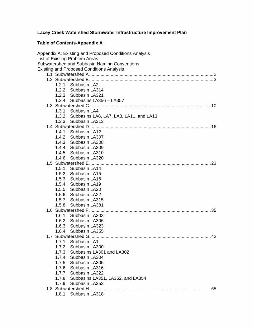
Lacey Creek Watershed Stormwater Infrastructure Improvement Plan
Table of Contents-Appendix A
Appendix A: Existing and Proposed Conditions Analysis List of Existing Problem Areas Subwatershed and Subbasin Naming Conventions Existing and Proposed Conditions Analysis
1.1 Subwatershed A..................................................................................................2 1.2 Subwatershed B..................................................................................................3
1.2.1. Subbasin LA2 1.2.2. Subbasin LA314 1.2.3. Subbasin LA321 1.2.4. Subbasins LA356
LA357 1.3 Subwatershed C................................................................................................10
1.3.1. Subbasin LA4 1.3.2. Subbasins LA6, LA7, LA8, LA11, and LA13 1.3.3. Subbasin LA313
1.4 Subwatershed D................................................................................................16 1.4.1. Subbasin LA12 1.4.2. Subbasin LA307 1.4.3. Subbasin LA308 1.4.4. Subbasin LA309 1.4.5. Subbasin LA310 1.4.6. Subbasin LA320
1.5 Subwatershed E................................................................................................23 1.5.1. Subbasin LA14 1.5.2. Subbasin LA15 1.5.3. Subbasin LA16 1.5.4. Subbasin LA19 1.5.5. Subbasin LA20 1.5.6. Subbasin LA22 1.5.7. Subbasin LA315 1.5.8. Subbasin LA381
1.6 Subwatershed F ................................................................................................35 1.6.1. Subbasin LA303 1.6.2. Subbasin LA306 1.6.3. Subbasin LA323 1.6.4. Subbasin LA355
1.7 Subwatershed G................................................................................................42 1.7.1. Subbasin LA1 1.7.2. Subbasin LA300 1.7.3. Subbasins LA301 and LA302 1.7.4. Subbasin LA304 1.7.5. Subbasin LA305 1.7.6. Subbasin LA316 1.7.7. Subbasin LA322 1.7.8. Subbasins LA351, LA352, and LA354 1.7.9. Subbasin LA353
1.8 Subwatershed H................................................................................................65 1.8.1. Subbasin LA318
1.8.2. Subbasins LA379, LA380, LA382 1.9 List of Data Sources Reviewed .........................................................................66 1.10 Conceptual Engineer s Estimated Opinion of Probable Construction Cost.......69 1.11 Subbasin Exhibits..............................................................................................70
Village of Downers Grove
Lacey Creek Watershed July 31, 2007 Conceptual Stormwater Infrastructure Improvement Plan FINAL DRAFT Page 1
Appendix A: Existing and Proposed Conditions Analysis
This Appendix provides additional details regarding each subwatershed, subbasin, and problem area in the Lacey Creek Watershed, including a description of the existing problem, results of existing analysis, description of modeling assumptions and deviations from standard modeling methods described in Section 3.0 of Chapter 2, description of proposed improvements, and identification of potential regulatory issues, required easements, and the engineer s estimated opinion of probable cost.
List of Existing Problem Areas
Table A.1 of Chapter 2 presents additional details of the reported problems within the Lacey Creek Subwatershed, including resident comments.
Table A.1 follows.
Village of Downers Grove
Lacey Creek Watershed July 31, 2007 Conceptual Stormwater Infrastructure Improvement Plan FINAL DRAFT Page 2
Subwatershed and Subbasin Naming Conventions
The Subwatersheds were named LA-A through LA-H.
Subbasins within the subwatersheds were named as follows:
Subbasins LA1
LA22 are numbered to follow the identification number
of the depressional area located within the subbasin. For example, Subbasin LA1 contains depressional area LA1 (as numbered by the Village.)
Subbasins LA300
LA323 are numbered to follow the identification number of the Problem Area located within the watershed. For example, Subbasin LA300 contains Problem Area LA300.
Subbasins LA351
LA382 are numbered in sequence and represent areas without Village-designated depressional areas or identified problem areas.
Some subbasin numbers have been skipped, for example due to multiple problem areas located within a single subbasin. Drainage areas are smaller divisions of subbasins and are numbered in sequence with the subbasin number as a prefix to the drainage area ID. For example, drainage areas LA7-01 through LA7-07 are all located within subbasin LA7. Drainage areas are only delineated in subbasins where detailed analysis and modeling has been performed.
Existing and Proposed Conditions Analysis
1.1 Subwatershed A
Subwatershed A is located west of the Tollways. The subwatershed contains subbasins LA355
LA378.
Subbasins LA355
LA357 are located along and within the south and east right-of-ways of I-355, from Finley Road to Highland Avenue. Subbasins LA358 to LA360 include I-355 and I-88 roadways. The subbasins are drained by short sewers, swales and ditches which convey flow to and across I-355 and I-88, eventually outletting to Lacey Creek. These subbasin are largely open space or highway.
Subbasins LA361
LA378 are located west of I-355. Subbasins LA361
LA376 include primarily Forest Preserve and the Morton Arboretum and extend to the confluence of Lacey Creek with the East Branch DuPage River. (Subbasins LA361 through LA367 and LA373 through LA374 are located wholly or partially outside of the municipal boundary of the Village of Downers Grove.) Subbasins LA376 through LA378 include open space and forest preserve as well as business and commercial areas along Butterfield Road. The subbasins are drained by sewers, swales and ditches which convey flow to Lacey Creek.
A review of Village records shows no reports of flood problems in these areas. No analysis was performed.
Village of Downers Grove
Lacey Creek Watershed July 31, 2007 Conceptual Stormwater Infrastructure Improvement Plan FINAL DRAFT Page 3
1.2 Subwatershed B
Subwatershed B is generally located south of the Tollways and west of Downers Drive and Morton Rd. The subwatershed contains subbasins LA2, LA3, LA314, LA321, LA356 and LA357.
1.2.1 Subbasin LA2
Description
Subbasin LA2 is generally located south of Ogden Avenue and is roughly bounded by Wilson Avenue to the west, Downers Drive to the east, and the Lacey Creek watershed boundary to the south. The subbasin includes Problem Area LA2, which is located along Lee Avenue between Ogden Avenue and Grant Street. Village records indicate that two depressional storage areas (LA2 and LA3) are located within this problem area. The 1996 Flood Information indicates that street flooding occurred at the intersection of Ogden Avenue and Lee Avenue as reported by one resident. The Village s Storm Sewer Buffer Map shows the area tributary to LA3 as one of the larger unsewered areas in the Village.
Existing Conditions Analysis
An Engineering Resources Associates, Inc (ERA) report titled Stormwater Permit Submittal for Lee & Ogden Storm Sewer
Improvement Project with a revision date of May, 2004 describes residential flooding on Lee Street south of Ogden Avenue in this problem area. The report and email correspondence from ERA staff describe the flooding as a result of an undersized private drain tile that had collapsed. The ERA report recommended replacing the existing drain tile with a proposed 15-inch sewer in the right-of-way. Due to the presence of wetland in the depressional storage area, a 15-inch sewer was the maximum permittable size. A larger sewer may have provided additional flood relief but would have altered hydrology to the wetland complex and would not have been permittable under the current wetland regulations (email from Kerry Behr of ERA to Jennifer Maercklein of V3, 3/27/07.) The recommended project has been constructed by the Village.
The existing conditions analysis for this subbasin was limited to review of the ERA report. Depressional storage elevations were established based on the report. No additional analysis has been performed. It is assumed that the constructed project has provided sufficient flood relief to the maximum extent practicable and permittable, and projects to provide additional relief would not
Village of Downers Grove
Lacey Creek Watershed July 31, 2007 Conceptual Stormwater Infrastructure Improvement Plan FINAL DRAFT Page 4
be permittable under the current DuPage County Stormwater and Flood Plain Ordinance due to expected wetland impacts.
1.2.2 Subbasin LA314
Description
Subbasin LA314 is generally located south of Ogden, north of the watershed divide near Grant, east of the watershed divide near Wilson and west of Cornell. Subbasin LA314 contains two problem areas: Problem Area LA314 and Problem Area LA324.
Problem Area LA314 is located on Woodward Avenue between Ogden Avenue and Grant Street in the Lacey Creek Watershed. The Property Owner Survey indicates significant yard flooding has occurred in this area as reported by one resident.
Problem Area LA324 is located throughout the subbasin and represents an area that is not served by Village storm sewers based on a review of the Storm Sewer Buffer Map.
Existing Conditions Analysis
Qualitative analysis and a field site inspection were performed on Problem Area LA314. Based on field visit, neighboring properties and the street drains to a low spot on the property, resulting in flooding. No additional analysis was performed.
A review of Village records showed no other apparent flood complaints in the unsewered Problem Area 324. The existing condition analysis of this area is limited to identification of the area as an unsewered area. No additional analysis was performed for the existing condition.
Proposed Alternative Description
The installation of storm sewer in conjunction with a roadway improvement project is recommended for this area. The roadway improvement project will necessitate stormwater detention in this area due to the increased impervious area.
Based on HydraFlow design, a network of storm sewer pipes ranging from 18 to 42-inches have capacity to convey the 10-year storm via gravity flow and the 25-year storm without surcharging and flooding at the inlet.
A total of 0.97 acre-feet of detention is required for this project. It appears that vacant land exists south of Ogden Avenue between Stonewall and Lee Avenues adjacent to the wetland in LA2. This area could be considered for detention storage by excavating
Village of Downers Grove
Lacey Creek Watershed July 31, 2007 Conceptual Stormwater Infrastructure Improvement Plan FINAL DRAFT Page 5
adjacent or near to the wetland area. This area is associated with Subbasin LA2 and due to its proximity to Ogden Avenue, has the possibility to act as a regional detention facility. If the vacant area cannot be acquired through the voluntary buyout program, the detention volume will need to be provided for in oversized pipes ranging in diameter form 48-inch to 60-inch.
Existing and Proposed Hydrology Calculations
Model Used: TR-20 87
Data Reviewed: 2-ft topography for drainage area delineation, 2-ft topo spot elevations to establish overland flow path directions, 2-ft topo for Tc flowpath definition, Village of Downers Grove Zoning Map for CN.
Hydrologic Model Assumptions: Drainage area line locations were determined using 2-ft topography with an assumption that roadways serve as minor drainage divides. TR-20 87 was used to determine the critical duration storm of the storm sewer subbasins and then entered as a known flow in HydraFlow.
The hydrologic model and input calculations (Tc and CN) are provided on the included CD.
Proposed Alternative Hydraulic Calculations
Hydraulics Model Used: HydraFlow Storm Sewers 2005
Data Reviewed: 2-ft topography for rim elevations, outlet invert, and length of storm sewer.
Hydraulic Model Assumptions: Two-foot topography was used as the best available information for this area for this planning-level study. Field survey should be performed prior to preliminary or final design.
Design assumptions and goals include: no street flooding during the 25-year critical duration event, pipes flow full with a minimum velocity of 2 feet per second during the 10-year critical duration event, and the slope of the pipe was set as the ground slope between two end points with a minimum of 2 feet of cover. A minimum and maximum pipe slope of 0.2% and 0.5% respectively was used.
Pipes were modeled with a conceptual, planning-level of detail. Storm sewers are typically designed with manholes or inlets every 300-350 feet; this conceptual storm sewer system was modeled with segments as long as 665 feet and does not represent actual field layout conditions on an inlet-to-inlet basis.
Village of Downers Grove
Lacey Creek Watershed July 31, 2007 Conceptual Stormwater Infrastructure Improvement Plan FINAL DRAFT Page 6
The hydraulic model is provided on the included CD.
Proposed Stormwater Detention Modeling
It is assumed that proposed storm sewers on new alignments will be constructed in conjunction with a roadway improvement project using Downer Grove s 30-foot cross section with curb and gutter and a 5-foot sidewalk, necessitating stormwater detention. Detention was calculated using DuPage County Division of Transportation (DuDOT) methodology. It is assumed that the existing cross section is 24 feet wide and has a two foot gravel shoulder on each side; it is also assumed that ten feet of pervious area on each side will be disturbed, necessitating stormwater detention.
The required stormwater detention volume was computed using DuDOT methodology and the stormwater detention nomograph for a 0.10 cfs/acre release rate. Estimated pipe sizes for stormwater detention were computed by hand. Computer modeling for stormwater detention was not performed for this conceptual planning-level study. Restrictor outlets were not sized for this study.
Required Permits
The DuPage County Wetland Map shows a wetland at the potential outfall of the storm sewer system for Subbasin 314. A wetland permit is required through the U.S. Army Corps of Engineers, which may delegate to the local authority.
Village of Downers Grove stormwater permits for soil erosion and sediment control, stormwater detention and wetland impacts will be required.
IEPA permits will be required for water quality.
Kane/DuPage Soil and Water Conservation District approval is required.
Required Easements
Village stormwater and maintenance easements should be reviewed for the sewers extending east from Woodward Ave. Permanent easements should be acquired if they do not already exist.
Easements/agreements should be acquired for any above ground detention not on Village property.
Engineer s Estimated Opinion of Probable Cost
The estimated opinion of probable cost is shown in Table 5.1. Supporting details can be found on the enclosed CD.
Village of Downers Grove
Lacey Creek Watershed July 31, 2007 Conceptual Stormwater Infrastructure Improvement Plan FINAL DRAFT Page 7
Results
The results from both the hydrologic and hydraulic modeling is provided on the included CD.
1.2.3 Subbasin LA321
Description
Problem Area LA321 represents an area that is not well serviced by storm sewers, based on a review of the Village s Storm Sewer Buffer Map. The area is generally located north of Ogden, east of Lacey and I-355, west of Seeley, and south of Herbert. Portions of this unsewered area are tributary to Problem Areas 4, 6, 7, 8 or 11 which are located in Subwatershed C.
Existing Conditions Analysis
A review of Village records showed no apparent flood complaints in this area. The storm sewer atlas indicates a 60 sewer along Lacey Rd. This sewer is assumed to convey flows from Ogden Avenue to a system that ultimately discharges to Lacey Creek. This sewer does not appear to convey runoff from Subbasin LA321. The existing condition analysis of this area is limited to identification of the area as an unsewered area. No additional analysis was performed for the existing condition.
Proposed Alternative Description
The installation of storm sewer in conjunction with a roadway improvement project is recommended for this area. The roadway improvement project will necessitate stormwater detention in this area due to increased imperviousness.
Based on HydraFlow design a network of storm sewer pipes ranging from 12 to 36-inches have capacity to convey the 10-year storm via gravity flow and the 25-year storm without surcharging and flooding at the inlet.
A total of 1.38 acre-feet of detention is required for this project. A vacant lot exists west of Lacey Rd. between Carol and Janet Streets, which should provide adequate area for the detention volume. If the vacant area or other area cannot be acquired through the voluntary buyout program, the detention volume will need to be provided for in oversized pipes ranging in diameter form 42-inch to 54-inch.
Existing and Proposed Hydrology Calculations
Village of Downers Grove
Lacey Creek Watershed July 31, 2007 Conceptual Stormwater Infrastructure Improvement Plan FINAL DRAFT Page 8
Model Used: TR-20 87
Data Reviewed: 2-ft topography for drainage area delineation, 2-ft topo spot elevations to establish overland flow path directions, 2-ft topo for Tc flowpath definition, Village of Downers Grove Zoning Map for CN.
Hydrologic Model Assumptions: Drainage area line locations were determined using 2-ft topography with an assumption that roadways serve as minor drainage divides.
The 2-ft topography suggests that the drainage area along Northcott Avenue is tributary to LA6. However, it is recommended that Northcott Avenue be drained through the storm sewer system for LA321 to reduce the total flow tributary to LA6, as discussed elsewhere in this Appendix. This modification is feasible due to the close proximity of the two areas, which could also be designed together as a single roadway project. The existing conditions analysis for LA6 includes Northcott Avenue; the existing conditions analysis for LA321 does not. Because construction sequencing and project phasing is unknown, both LA6 and LA321 include Northcott Avenue in the analyses and cost estimates, but it is recommended that Northcott be included with LA321.
TR-20 87 was used to determine the critical duration storm of the storm sewer subbasins and then entered as a known flow in HydraFlow.
The hydrologic model and input calculations (Tc and CN) are provided on the included CD.
Proposed Alternative Hydraulic Calculations
Hydraulics Model Used: HydraFlow Storm Sewers 2005
Data Reviewed: 2-ft topography for rim elevations, outlet invert, and length of storm sewer.
Hydraulic Model Assumptions: Two-foot topography was used as the best available information for this area for this planning-level study. Field survey should be performed prior to preliminary or final design.
Though a 60 sewer appears on the Storm Sewer Atlas, it is assumed that the pipes serves the IDOT right-of-way and does not contain excess capacity. For this reason, the proposed 36 storm sewer along Lacey Rd. was assumed to run parallel to, rather than connecting with or upsizing the 60 existing pipe.
Village of Downers Grove
Lacey Creek Watershed July 31, 2007 Conceptual Stormwater Infrastructure Improvement Plan FINAL DRAFT Page 9
Design assumptions and goals include: no street flooding during the 25-year critical duration event, pipes flow full with a minimum velocity of 2 feet per second during the 10-year critical duration event, and the slope of the pipe was set as the ground slope between two end points with a minimum of 2 feet of cover. A minimum and maximum pipe slope of 0.2% and 0.5% respectively was used.
Pipes were modeled with a conceptual, planning-level of detail. Storm sewers are typically designed with manholes or inlets every 300-350 feet; this conceptual storm sewer system was modeled with segments as long as 1,100 feet and does not represent actual field layout conditions on an inlet-to-inlet basis.
The hydraulic model is provided on the included CD.
Proposed Stormwater Detention Modeling
It is assumed that proposed storm sewers on new alignments will be constructed in conjunction with a roadway improvement project using Downer Grove s 30-foot cross section with curb and gutter and a 5-foot sidewalk on each roadside, necessitating stormwater detention. Detention was calculated using DuPage County Division of Transportation (DuDOT) methodology. The road width was measured to have an average 22-foot width and has a two foot gravel shoulder on each side; it is also assumed that ten feet of pervious area on each side will be disturbed, necessitating stormwater detention.
The required stormwater detention volume was computed using DuDOT methodology and the stormwater detention nomograph for a 0.10 cfs/acre release rate. Estimated pipe sizes for stormwater detention were computed by hand. Computer modeling for stormwater detention was not performed for this conceptual planning-level study. Restrictor outlets were not sized for this study.
Required Permits
Village of Downers Grove stormwater permits for soil erosion and sediment control, stormwater detention and wetland impacts will be required.
IEPA permits will be required for water quality.
Kane/DuPage Soil and Water Conservation District approval is required.
Required Easements
No drainage easements are required if work is contained within the Village Right of Way.
Village of Downers Grove
Lacey Creek Watershed July 31, 2007 Conceptual Stormwater Infrastructure Improvement Plan FINAL DRAFT Page 10
Engineer s Estimated Opinion of Probable Cost
The estimated opinion of probable cost is shown in Table 5.1. Supporting details can be found on the enclosed CD.
Results
The results from both the hydrologic and hydraulic modeling is provided on the included CD.
1.2.4 Subbasins LA356
LA357
Subbasins LA356
LA357 are located along and within the south and east right-of-ways of I-355, from Finley Road to Highland Avenue. The subbasins are drained by short sewers, swales and ditches which convey flow to and across I-355, eventually outletting to Lacey Creek. These subbasin are largely open space or highway.
A review of Village records shows no reports of flood problems in these areas. No analysis was performed.
1.3 Subwatershed C
Subwatershed C is generally located south of Herbert, east of Downers, and west of Saratoga. It contains subbasins LA4, LA6, LA7, LA8, LA11, LA13, and LA313.
1.3.1 Subbasin LA4
Problem Area LA4 is located along Morton Avenue between Herbert Street and 40th Street in the Lacey Creek Watershed. Village records indicate that this is a depressional storage area. A review of Village flood records showed no apparent flood complaints adjacent to this area. No analysis has been performed.
1.3.2 Subbasins LA6, LA7, LA8, LA11 and LA13
Description
Subbasins LA6, LA7, LA8, LA11, and LA13 are bound approximately by Herbert St. on the north, Ogden Avenue on the south, Saratoga Ave. on the east, and Morton Ave. on the west in the Lacey Creek Watershed. The subbasins contain Problem Areas 6, 7, 8, 11, and 13. The area includes depressional storage areas and is generally poorly drained through culverts and roadside ditches to a storm sewer which outlets to an unnamed tributary to Lacey Creek.
Subbasin LA6 is located East of Downers Drive between Herbert Street and 40th Street. Village records indicate that this is a
Village of Downers Grove
Lacey Creek Watershed July 31, 2007 Conceptual Stormwater Infrastructure Improvement Plan FINAL DRAFT Page 11
depressional storage area. A review of Village flood records and a field investigation (April 2007) indicated that the area is adjacent to a culvert conveying an unnamed tributary to Lacey creek.
Based on DuPage County 2-foot topography and County storm sewer atlas and the V3 Storm Sewer Survey (3-24-07) the unnamed tributary at the outlet from Problem Area LA6 also conveys runoff from the area tributary to Problem Area LA7 (located at 40th St. between Downers Dr. and Belle Aire Ln.), LA8 (located at Virginia St. between Seeley Ave. and Belle Aire Ln.), LA11 (located at Seeley Ave. between Virginia St and Janet St, and LA13 (located at Venard Rd. between Ogden and Doerhoefer Park). Village records indicate that these areas are depressional storage areas. The 1996 Flood Information indicates street flooding at Downers Drive between Herbert and 40th Streets, and at Venard Road, corresponding to LA6 and LA13 respectively. The Property Owner Survey indicates that street and yard flooding occurred in LA11 as reported by 5 residents. A review of flood records shows no apparent drainage complaints related to LA7 and LA8.
Existing Conditions Analysis
` Based on XPSWMM analysis, with all areas modeled together, the system is severely undersized. Though portions of the system have capacity to convey larger storms, sewers though designated depressional storage areas only have the capacity to convey the 2-year storm via gravity flow. The system surcharges during the 5-year storm, and storage areas are flooded during the 10-year storm.
Existing Hydrologic Calculations
Model Used: XPSWMM Runoff Module
Data Reviewed: 2-ft topography for drainage area delineation, 2-ft topo spot elevations to establish overflow elevations (where available), 2-ft topo for Tc flowpath definition, Village of Downers Grove zoning map for CN.
Hydrologic Model Assumptions: Based on DuPage County 2-foot topography LA13 consists of two depressional areas which have no low-flow outlet. LA13 receives the large storm overflow from the Doerhoefer Park detention basin built in conjunction with a soccer field, which is designed to detain the 100-yr flood. The soccer field outlets to a storm sewer, but the direction of that sewer is unclear. The Storm Sewer Atlas suggests the soccer field detention may release to a 21 storm sewer which conveys flow to Saratoga Avenue and out of the Lacey Creek watershed. Surveyed storm structures on Venard suggest the sewer may flow
Village of Downers Grove
Lacey Creek Watershed July 31, 2007 Conceptual Stormwater Infrastructure Improvement Plan FINAL DRAFT Page 12
west into the LA13 drainage area. To model conservatively, the detention outlet was modeled tributary to the LA13 system.
An overflow elevation of 735.6 allows the southern depression of LA13 to flow into the northern portion, which then overflows at 735.4 (elevations based on spot elevations from Dupage County 2-foot topography) to an inlet west of the Doerhoefer Park baseball fields. An 18 RCP conveys flow from LA13 and Doerhoefer Park north to a 15 culvert at Drove Ave and Venard Rd. which then conveys flow west, along Drove Ave. to the Unnamed tributary. Flow that exceeds the capacity of the 18 pipe leaving LA13 overflows Venard Rd. and is conveyed via a swale west to LA8. See CD for a sketch of the drainage system routing.
LA8 is drained by an 18-inch RCP, which also conveys flow from LA11 to the unnamed tributary. Though topography indicates that runoff from areas south of Ogden Avenue could contribute to the LA11 subbasin, the presence of a large diameter system along Ogden Avenue as noted in the Storm Sewer Atlas as well as the presence of a 48 sewer leading away from the subbasin as surveyed by V3 suggests that runoff from south of Ogden and runoff from the businesses on the north side of Odgen Ave would flow out of the basin.
The unknown tributary is a small ditch which conveys flow from this subbasin through LA7 and LA6 ultimately discharging to Lacey Creek.
Existing Hydraulic Calculations
Hydraulics Model Used: XPSWMM Hydraulics Module
Data Reviewed: V3 storm sewer survey (3-24-07) was used for storm sewer system layout, sizes, and elevations on Janet Street and Seeley Avenue. Existing utility information from Doerhoefer Park Parking Lot Renovation 2005/2006 (3-06-06) was used for storm sewer system layout, sizes, and elevations along Venard Road. Proposed Field Improvement Plans were used to size detention and outlet controls for Doerhoefer Park Soccer/Football field.
Hydraulic Model Assumptions: The V3 Storm Sewer Survey was used as the best available information where available, with the exception of a sewer line running north along Seeley Ave. The Seeley Avenue sewer was surveyed as a 20 clay pipe. It is assumed that this is an 18 pipe, which matches the data shown in the Storm Sewer Atlas. An 18 pipe was used in the model.
The model was simulated using normal depth as the downstream boundary condition. Based on a field visit and review of
Village of Downers Grove
Lacey Creek Watershed July 31, 2007 Conceptual Stormwater Infrastructure Improvement Plan FINAL DRAFT Page 13
topography, the channel downstream of the modeled tributary is wider with a larger conveyance area, and is assumed to not create backwater on the system.
The hydraulic model is provided on the included CD.
Existing Conditions Model Calibration
Model output was compared Village records as Existing Conditions Model Calibration.
Subbasin LA6: 2006 Flood information from Village records indicate street flooding of Downers Drive in subbasin LA6 during the Oct. 2, 2006 storm event. The crown of the road at that location was estimated to be 708.5 based on 2-ft topography. At that location the model output indicates a maximum flood elevation of 708.36, suggesting flooding of the roadway edges. The model corroborates flood records.
Subbasin LA11: Village records indicate flooding during the October 2001 storm which may approximately equivalent to a 25-year storm event based on a review of USGS precipitation gages. Model output suggests the sewer through this location surcharges during the 5-year event and flooding to a depth of over two feet during the 25-year storm event. The model corroborates flood records.
Subbasin LA13: Village records indicate street flooding for the Oct. 2, 2006 storm event. The model suggests 0.4 feet of water over the roadway at a location north of the complainant s residence. The model corroborates flood records.
Proposed Alternative Description
The installation and/or upsizing of existing storm sewer in conjunction with roadway improvement projects are recommended for these areas. The roadway improvement projects will necessitate stormwater detention in these areas.
Based on XPSWMM analysis, a network of storm sewer pipes ranging from 12 to 30-inches in unsewered areas and upsizing the existing 12 to 24-inches storm sewer network to 15 to 36-inch has the capacity to convey the 10-year storm via gravity flow and the 25-year storm without surcharging and flooding at the inlet.
The proposed changes to the existing storm sewer network in conjunction with the addition of new storm sewer improves the efficiencies of the system and increases the peak flows at Downers Drive, north of 40th Street (LA6). To attenuate the peak flow, 1.48 acre-feet of detention storage should be provided upstream. However, a total of 3.19 acre-feet of stormwater
Village of Downers Grove
Lacey Creek Watershed July 31, 2007 Conceptual Stormwater Infrastructure Improvement Plan FINAL DRAFT Page 14
detention will be required for the roadway and storm sewer portion of this project to meet the stormwater ordinance, which should be sufficient to attenuate proposed flows to the pre-developed flow rate. Possible locations for detention storage include Doerhoefer Park, or a regional facility at the upstream end of the unnamed tributary (which would require purchase of 6 lots through the voluntary buyout program.) If surface area cannot be acquired, the detention volume will need to be provided for in oversized pipes ranging in diameter from 42-inch to 54-inch in diameter.
Maintenance of the unnamed tributary is also required to improve conveyance. Brush and sediment removal should be performed, followed by regular maintenance.
Proposed Alternative Modeling
The existing condition models were used as the basis for proposed conditions modeling.
Several methods were considered to attenuate the increased flows through Subbasin LA6 when the efficiency of upstream subbasins is increased. The proposed model maintains LA13 as an existing, natural depressional area, which overtops into the system rather than being drained via pipe. If LA13 is pipe drained, additional attenuation volume will be required. To model conservatively, Northcott Ave is maintained within the LA6 subbasin. However, to attenuate flows to Subbasin LA6, Northcott Ave can be drained toward Subbasin LA321. This modification is feasible due to the close proximity of the two areas, which could be designed together as a single roadway project. Additional detention could be provided adjacent to the unnamed tributary at the 40th St, Downers Dr, or Morton Ave crossings by constructing detention basins in residential lots purchased through the voluntary buyout program, or in Doerhoefer Park.
Design assumptions and goals include: no street flooding during the 25-year critical duration event, pipes flow full with a minimum velocity of 2 feet per second during the 10-year critical duration event, and the slope of the pipe was set as the ground slope between two end points with a minimum of 2 feet of cover. Where available, the existing pipe slopes were used. A minimum and maximum pipe slope of 0.2% and 0.5% respectively were used where new pipes are proposed.
Pipes were modeled with a conceptual, planning-level of detail. Storm sewers are typically designed with manholes or inlets every 300-350 feet; this conceptual storm sewer system was modeled with segments as long as 1,352 feet and does not represent actual field layout conditions on an inlet-to-inlet basis.
Village of Downers Grove
Lacey Creek Watershed July 31, 2007 Conceptual Stormwater Infrastructure Improvement Plan FINAL DRAFT Page 15
The hydraulic model is provided on the included CD.
Proposed Stormwater Detention Modeling
It is assumed that proposed storm sewers on new alignments will be constructed in conjunction with a roadway improvement project using Downer Grove s 30-foot cross section with curb and gutter and a 5-foot sidewalk on each roadside, necessitating stormwater detention. Detention was calculated using DuPage County Division of Transportation (DuDOT) methodology. The road width was measured to have an average 22-foot width and has a two foot gravel shoulder on each side; it is also assumed that ten feet of pervious area on each side will be disturbed, necessitating stormwater detention.
The required stormwater detention volume was computed using DuDOT methodology and the stormwater detention nomograph for a 0.10 cfs/acre release rate. Estimated pipe sizes for stormwater detention were computed by hand. Computer modeling for stormwater detention was not performed for this conceptual planning-level study. Restrictor outlets were not sized for this study.
Required Permits
The unknown tributary is considered Waters of the U.S. A wetland permit is required through the U.S. Army Corps of Engineers, which may delegate to the local authority.
Village of Downers Grove stormwater permits for soil erosion and sediment control, stormwater detention, riparian area impacts, and/or wetland impacts may be required.
IEPA permits will be required for water quality.
Kane/DuPage Soil and Water Conservation District approval.
Approvals/permits from IDOT may be required if Roadway improvements extend near to Ogden Avenue right-of-way.
Required Easements
Village stormwater and maintenance easements should be reviewed for the unnamed tributary and the sewers extending west from Drove Ave and north from Seeley. Permanent easements should be acquired if they do not already exist.
Easements/agreements should be acquired for any above ground detention not on Village property, such as within the park.
Engineer s Estimated Opinion of Probable Cost
The estimated opinion of probable cost is shown in Table 5.1. Supporting details can be found on the enclosed CD.
Village of Downers Grove
Lacey Creek Watershed July 31, 2007 Conceptual Stormwater Infrastructure Improvement Plan FINAL DRAFT Page 16
Results
The results from both the hydrologic and hydraulic modeling is provided on the included CD.
1.3.3 Subbasin LA313
Description
Subbasin 313 is generally located along Ogden Avenue from Downers Drive to Middaugh. The subbasin extends a short distance north of Ogden and extends south to the St. Joseph Creek Watershed divide near Grant Street. The subbasin is drained by an IDOT storm sewer system along Ogden Avenue; a review of Village storm sewer atlas appears to show local Village sewers connecting to the IDOT sewer. The subbasin includes Problem Area LA313, which is located on Ogden Avenue between Downers Drive and Belle Aire Lane in the Lacey Creek Watershed. 2006 Flood Information indicates street flooding occurred in this Problem Area as reported by one property owner.
Existing Conditions Analysis
Problem Area LA313 is located on Ogden Avenue itself. As this is within the IDOT right-of-way, this was assumed to be under the jurisdiction of IDOT and no analysis was performed. Based on a review of the storm sewer atlas, the area south of Ogden drains via a local sewer to Ogden; the area appears to be free of drainage complaints based on a review of Village records. Therefore, no analysis was performed. IDOT should be notified of this problem for possible mitigation in a future Ogden Avenue project.
1.4 Subwatershed D
Subwatershed D is generally located south of Lacey Creek and Black Oak, north of Herbert, east of Tollway, and west of Highland. It contains subbasins 12, 307, 308, 309, 310, and 320.
1.4.1 Subbasin LA12
Description
Subbasin LA12 is generally located west of Doerhoeffer Park, east of Belle Aire Lane, and north of Drove Avenue. The subbasin includes Problem Area LA12, which is located along Lee Avenue between Ogden Avenue and Grant Street in the Lacey Creek Watershed. Village records indicate that this is a depressional storage area. A review of Village flood records showed no flood
Village of Downers Grove
Lacey Creek Watershed July 31, 2007 Conceptual Stormwater Infrastructure Improvement Plan FINAL DRAFT Page 17
complaints adjacent to this area, with the exception of one property owner who reported septic field flooding.
Existing Conditions Analysis
A qualitative analysis was performed to establish an approximate 100-year Base Flood Elevation (BFE) for this depressional storage area. The Fact Sheet for this area (including a description of the qualitative analysis methods and resulting BFE) can be found in Section 1.11 of this Appendix. No additional analysis was performed.
1.4.2 Subbasin LA307
Description
Subbasin LA307 is generally located in the Orchard Brook subdivision. It is roughly bound by Herbert Street (extended) to the South, Belle Aire to the west, Lacey Creek to the north and Venard to the east. It is drained by storm sewers and overland overflow paths and eventually outlets to Lacey Creek. The subbasin includes Problem Area LA307, which is located on the cul-de-sac of Parrish Court in the Lacey Creek Watershed. The Property Owner Survey indicates street, yard, and house flooding has occurred along Parrish Court as reported by one resident.
Existing Conditions Analysis
A review of Village records showed primarily nuisance flooding in this area, with the exception of one possible critical problem at Problem Area LA307. The area is generally well served by a series of storm sewers and overland overflow paths which all outlet to Lacey Creek. A major overland flow path is located in the rear yard at the location of reported flooding. It is possible that the reported flooding resulted from blocked inlets, or, obstructions in the overland flow path to the creek. The field site inspection revealed no other apparent cause for the flooding problems. No additional analysis was performed.
Proposed Alternative Description
Regular maintenance of the inlets and flow path to remove debris and repair any problems is recommended. The Village may wish to consider the development of an Adopt an Inlet program or other such program that incorporates homeowner awareness and community involvement in the upkeep of the storm sewer inlets, as well as overland flow routes.
Type 1 inlet grates are susceptible to frequent debris clogging. It is recommended that the existing inlets be replaced with an inlet
Village of Downers Grove
Lacey Creek Watershed July 31, 2007 Conceptual Stormwater Infrastructure Improvement Plan FINAL DRAFT Page 18
that will allow the flow of storm water even if a buildup of debris is present such as Type 11 inlets.
Required Permits
It is assumed that maintenance and inlet grate replacement can be performed as maintenance projects and therefore do not require permits.
Required Easements
No drainage easements are required for inlet grate replacement or maintenance of the storm sewer system within the Village Right-of-Way. It is recommended that the Village review existing drainage easements to determine whether a maintenance and/or drainage easement is needed along the existing major overland flow paths.
Engineer s Estimated Opinion of Probable Cost
The estimated opinion of probable cost is shown in Table 5.1. Supporting details can be found on the enclosed CD.
1.4.3 Subbasin LA308
Description
Subbasin LA308 is generally located between Doerhoefer Park at the south and Lacey Creek at the north, between Venard and Saratoga. It includes parts of Doerhoefer Park. It is served by a storm sewer that outlets to Lacey Creek. The subbasin includes Problem Area LA308, which is located on the cul-de-sac of 39th
Street and the cul-de-sac of Candlewood Court in the Lacey Creek Watershed. The Property Owner Survey and 2006 Flood Information indicate street and basement flooding has occurred in this area as reported by four residents.
Existing Conditions Analysis
A review of Village records showed nuisance and chronic flooding in this area. Qualitative analysis and a field site inspection were performed on Problem Area LA308. Property owner comments suggested that after a Village street improvement project, the top of the curb was higher than the parkway, blocking the overland flow path from the front yard to the street causing drainage problems. A field site inspection observed that the top of curb is higher than the sidewalk; it appears that the parkway is poorly drained. Maintenance of the storm sewer inlets was also identified by the property owner comments as a possible cause of the flooding issues. Resident comments suggest a private yard drain connected to the storm sewer was blocked or disconnected during a roadway improvement project; the field inspection was
Village of Downers Grove
Lacey Creek Watershed July 31, 2007 Conceptual Stormwater Infrastructure Improvement Plan FINAL DRAFT Page 19
unable to confirm or refute this comment. No analysis was performed.
Proposed Alternative Description
Regular maintenance of the inlets and flow path to remove debris and repair any problems is recommended. The Village may want to consider the development of an Adopt an Inlet program or other such program that incorporates homeowner awareness and community involvement in the upkeep of the storm sewer inlets, as well as overland flow routes.
Based on resident comments, a previous street improvement project has resulted in drainage issues within the parkway. It is recommended that the Village regrade the parkway or install an inlet within the parkway to provide a positive drainage path to the street and/or storm sewer system. Private drain connections that were functioning prior to the street improvement project should also be re-established, if it is confirmed that the drain was disconnected.
Required Permits
It is assumed that maintenance and re-establishing existing drain connections do not require permits. The installation of inlets within the parkway may require a Village of Downers Grove stormwater permit.
Required Easements
No drainage easements are required for maintenance of the storm sewer system within the Village Right-of-Way. If the Village reestablishes the private drain connection, a temporary easement will be needed for construction access.
Engineer s Estimated Opinion of Probable Cost
The estimated opinion of probable cost is shown in Table 5.1. Supporting details can be found on the enclosed CD.
1.4.4 Subbasin LA309
Description
Subbasin 309 is generally located along Saratoga between Doerhoefer Park and Lacey Creek. It is served by a storm sewer that outlets to Lacey Creek. The subbasin includes Problem Area LA309, which is located east of the intersection of 39th Street and Saratoga Avenue in the Lacey Creek Watershed. The Property Owner Survey indicates street and basement flooding has occurred in this area as reported by two residents.
Village of Downers Grove
Lacey Creek Watershed July 31, 2007 Conceptual Stormwater Infrastructure Improvement Plan FINAL DRAFT Page 20
Existing Conditions Analysis
A review of Village records showed nuisance and chronic flooding in this area. Qualitative analysis and a field site inspection were performed on the problem area. The area is well served with storm sewers, but the field site inspection showed one inlet located in a steep, deep depression that would result in several inches of flooding if blocked with debris. No additional analysis was performed.
Proposed Alternative Description
Regular maintenance of the inlets to remove debris and repair any problems is recommended. The Village may want to consider the development of an Adopt an Inlet program or other such program that incorporates homeowner awareness and community involvement in the upkeep of the storm sewer inlets.
Type 1 inlet grates are susceptible to frequent debris clogging. It is recommended that existing Type 1 inlet grates be replaced with an inlet that will allow the flow of storm water even if a buildup of debris is present such as Type 11 inlet grates.
Required Permits
It is assumed that maintenance and inlet grate replacement can be performed as maintenance projects and therefore do not require permits.
Required Easements
No drainage easements are required for inlet grate replacement or maintenance of the storm sewer system within the Village Right-of-Way.
Engineer s Estimated Opinion of Probable Cost
The estimated opinion of probable cost is shown in Table 5.1. Supporting details can be found on the enclosed CD.
1.4.5 Subbasin LA310
Description
Subbasin 310 is generally located south of Black Oak Drive, north of Herbert Street, east of Forest Avenue and Saratoga Street, and extends across Highland Avenue to include portions of Good Samaritan Hospital. The subbasin includes a number of chronic and nuisance problems, including Problem Areas 310 and 311. Problem Area 316 is attributed to the Hospital but is likely related to Subbasin LA304. Based on a review of the sewer atlas, the
Village of Downers Grove
Lacey Creek Watershed July 31, 2007 Conceptual Stormwater Infrastructure Improvement Plan FINAL DRAFT Page 21
area is drained by a storm sewer that connects to a system on Saratoga Avenue and directs flow to Lacey Creek.
Problem Area LA310 is located on Candlewood Drive, south of Black Oak Drive in the Lacey Creek Watershed. The 2006 Flood Information indicates street flooding occurred in this area as reported by one resident.
Problem Area LA311 is located at the intersection of Forest Avenue and 39th Street in the Lacey Creek Watershed. The Property Owner Survey indicates street flooding has occurred in this area as reported by one resident.
Existing Conditions Analysis
A review of Village records showed nuisance and chronic flooding in this area. Refer to Problem Areas 310 and 311 for additional information on the chronic problems. No additional analysis has been performed.
Qualitative analysis and a field site inspection were performed on Problem Area 310. A review of the 2-foot topographic mapping and field visit suggests an overland swale directs flow to an inlet on the street. The area appears to be well drained and is served by storm sewers. The problems were reported after the October 2001 storm event. It is possible that the reported flooding resulted from debris collecting on the inlet grates. Debris blocking approximately 1/2 of the inlet was noted during the field visit. The street appeared to be newer and may be more recent than the storms which caused the reported flooding; the inlets have Type 11 inlets to facilitate drainage during a blocked inlet condition. The field site inspection revealed no other apparent cause for the flooding problems. No additional analysis was performed.
Qualitative analysis and a field site inspection were performed on Problem Area 311. A review of the 2-foot topographic mapping and the field site inspection revealed no apparent cause for the flooding problems. The resident was contacted to verify the flooding report and does not recall this area having any flooding problems. No additional analysis was performed.
Proposed Alternative Description
Regular maintenance of the inlets to remove debris and repair any problems is recommended. The Village may want to consider the development of an Adopt an Inlet program or other such program that incorporates homeowner awareness and community involvement in the upkeep of the storm sewer inlets.
Required Permits
Village of Downers Grove
Lacey Creek Watershed July 31, 2007 Conceptual Stormwater Infrastructure Improvement Plan FINAL DRAFT Page 22
It is assumed that maintenance does not require permits.
Required Easements
No drainage easements are required for maintenance of the storm sewer system within the Village Right-of-Way.
Engineer s Estimated Opinion of Probable Cost
The estimated opinion of probable cost is shown in Table 5.1. Supporting details can be found on the enclosed CD.
1.4.6 Subbasin LA320
Description
Subbasin 320 is generally located in the Orchard Brook subdivision. It is bound by Herbert Street to the South, Belle Aire to the east, Lacey Creek to the north and I-355 to the west. It is drained by storm sewers and overland overflow paths and eventually outlets to Lacey Creek. Subbasin 320 contains Problem Area 320, which is located at a residence on the cul-de-sac of Almond Court in the Lacey Creek Watershed. Village Records indicate house flooding has occurred in this area as reported by one resident.
Existing Conditions Analysis
A review of Village records showed primarily nuisance flooding in this area, with the exception of one critical problem at Problem Area 320. The area is generally well served by a series of storm sewers and overland overflow paths which all outlet to Lacey Creek.
Qualitative analysis and a field site inspection were performed on Problem Area 320. A review of the 2-foot topographic mapping and the field site investigation indicated that private property grading issues may be the source of the flooding problem. Village reports suggest the adjacent property may have revised their grading to direct flow towards the complainant, or, the top of foundation at the complainant s residence may be set too low. This appears to be a private property grading issue; no additional analysis was performed.
Proposed Alternative Description
The Village may wish to consider developing a program that provides homeowners with financial and/or technical assistance in private property drainage issues. The resident may wish to consider private property regrading, a backyard swale, or private
Village of Downers Grove
Lacey Creek Watershed July 31, 2007 Conceptual Stormwater Infrastructure Improvement Plan FINAL DRAFT Page 23
drain tile connection to the storm sewer system which may alleviate the drainage problems in this location.
1.5 Subwatershed E
Subwatershed E is generally located south of Lacey Creek, east of Highland, and west of Fairview. The subwatershed contains subbasins LA14, LA15, LA16, LA17, LA19, LA20, LA22, LA315, LA381.
1.5.1 Subbasin LA14
Description
Subbasin LA14 is located along Washington Street, just north of 40th Street in the Lacey Creek watershed. The subbasin contains Problem Area LA14, which is a depressional area located on Washington north of 40th. A review of flood records show street flooding and yard flooding. Subbasin LA14 drains via a storm sewer into Subbasin LA16.
Existing Conditions Analysis
Based on XPSWMM analysis, with no tailwater condition, the storm sewer pipes have the capacity to convey the 5-year storm without surcharging and the 50-year storm without flooding, with one exception: the depressional area at Problem Area LA14 begins flooding during the 10-year flood event. When tailwater conditions were introduced (based on elevations established during the Downers Grove Wetland Restoration Project in Subbasin LA16), street flooding occurred during the 5-year event.
Existing Hydrologic Calculations
Model Used: XPSWMM Runoff Module
Data Reviewed: 2-ft topography for drainage area delineation, 2-ft topo spot elevations to establish overflow elevations (where available), 2-ft topo for Tc flowpath definition, Village of Downers Grove zoning map for CN.
Hydrologic Model Assumptions: Drainage areas were delineated using 2-foot topography with the assumption that pipe flow in peripheral drainage areas did not take flow out of the subbasin LA14. (The storm sewer atlas and Downers Grove Wetland Restoration Project exhibits both show sewers on Lindley Street and Main Street which convey flow south into the St. Joseph Creek watershed.) This conservative approach assumes that during flood situations, flows will follow the slope of the land and enter the drainage system for subbasin LA14.
Village of Downers Grove
Lacey Creek Watershed July 31, 2007 Conceptual Stormwater Infrastructure Improvement Plan FINAL DRAFT Page 24
A critical duration analysis of the 10-year storm event yielded a critical duration of the 2-hr storm; it was assumed that his duration was the critical duration for all storm events including the 100-year.
Existing Hydraulic Calculations
Hydraulics Model Used: XPSWMM Hydraulics Module
Data Reviewed: Storm Sewer Survey from Downers Grove Wetland Restoration Project (rev. 10-01-01) was used for storm sewer system layout, sizes, and elevations, supplemented with data from the Washington-40th-Elm Sewer Improvement Plan (5-25-88). Tailwater conditions were taken from the Downers Grove Wetland Restoration Project FEQ output as presented in the August 30, 2001 report titled Wetland Mitigation Restoration Plan: Technical Support Documentation for Appendix VI: FEQ Hydrology & Hydraulics .
Hydraulic Model Assumptions: It is assumed that the tailwater conditions shown as proposed elevations in the Downers Grove Wetland Restoration Project plans are reflective of the as-built conditions for the wetland project.
It is assumed that existing flared end sections are properly sized to deliver flow to the storm sewer system and do not restrict flow to main lines of the storm sewer system.
The hydraulic model is provided on the included CD.
Existing Conditions Model Calibration
All reported flooding in the LA14 subbasin was the result of storms approaching a 100-year runoff event (October 2, 2006 and the 1987 storms). The model simulation results in flooding at Problem Area 14 during a 25-year event, which appears to corroborate resident reports.
Proposed Alternative Description
The installation and/or upsizing of existing storm sewer in conjunction with roadway improvement projects are recommended for these areas. The roadway improvement projects will necessitate stormwater detention in these areas.
Based on XPSWMM analysis, a network of storm sewer pipes ranging form 18 to 30-inches in unsewered areas and upsizing the existing 24 to 30-inches storm sewer network to 30 to 42-inch has the capacity to convey the 10-year storm via gravity flow and the 25-year storm without surcharging and flooding at the inlet.
Village of Downers Grove
Lacey Creek Watershed July 31, 2007 Conceptual Stormwater Infrastructure Improvement Plan FINAL DRAFT Page 25
A total of 1.14 acre-feet of detention will be required for the roadway and storm sewer portion of this project. A small park on the east of Elm St., south of 40th St. may provide sufficient storage, or land could be purchased through the voluntary buyout program. If an area cannot be acquired, the detention volume will need to be provided for in oversized pipes ranging in diameter form 42-inch to 60-inch.
Proposed Alternative Modeling
The existing condition models were used as the basis for proposed conditions modeling.
Design assumptions and goals include: no street flooding during the 25-year critical duration event, pipes flow full with a minimum velocity of 2 feet per second during the 10-year critical duration event, and the slope of the pipe was set as the ground slope between two end points with a minimum of 2 feet of cover. Where available, the existing pipe slopes were used. A minimum and maximum pipe slope of 0.2% and 0.5% respectively were used where new pipes are proposed.
Pipes were modeled with a conceptual, planning-level of detail. Storm sewers are typically designed with manholes or inlets every 300-350 feet; this conceptual storm sewer system was modeled with segments as long as 1,000 feet and does not represent actual field layout conditions on an inlet-to-inlet basis.
The hydraulic model is provided on the included CD.
Proposed Stormwater Detention Modeling
It is assumed that proposed storm sewers on new alignments will be constructed in conjunction with a roadway improvement project using Downer Grove s 30-foot cross section with curb and gutter and a 5-foot sidewalk on each roadside, necessitating stormwater detention. Detention was calculated using DuPage County Division of Transportation (DuDOT) methodology. The road width was measured to have an average 20-foot width and has a two foot gravel shoulder on each side; it is also assumed that ten feet of pervious area on each side will be disturbed, necessitating stormwater detention.
The required stormwater detention volume was computed using DuDOT methodology and the stormwater detention nomograph for a 0.10 cfs/acre release rate. Estimated pipe sizes for stormwater detention were computed by hand. Computer modeling for stormwater detention was not performed for this conceptual planning-level study. Restrictor outlets were not sized for this study.
Village of Downers Grove
Lacey Creek Watershed July 31, 2007 Conceptual Stormwater Infrastructure Improvement Plan FINAL DRAFT Page 26
Required Permits
The DuPage County Wetland Map shows a wetland at the outfall of the storm sewer system for Subbasin 14. A wetland permit is required through the U.S. Army Corps of Engineers, which may delegate to the local authority.
Village of Downers Grove stormwater permits for soil erosion and sediment control, stormwater detention, riparian area impacts, and/or wetland impacts may be required.
IEPA permits will be required for water quality.
Kane/DuPage Soil and Water Conservation District approval.
Required Easements
No drainage easements are required if work is contained within the Village Right of Way.
Engineer s Estimated Opinion of Probable Cost
The estimated opinion of probable cost is shown in Table 5.1. Supporting details can be found on the enclosed CD.
Results
The results from both the hydrologic and hydraulic modeling is provided on the included CD.
1.5.2 Subbasin LA15
Description
Subbasin LA15 is roughly bounded by Highland Avenue to the west, Washington Street to the east, and the Lacey Creek watershed boundary to the south. The subbasin includes Problem Area LA15, which is located south of 40th Street between Lindley Street and Washington Street in the Lacey Creek Watershed. Village records indicate that this is a depressional storage area. A review of Village flood records showed no apparent flood complaints adjacent to this area.
Existing Conditions Analysis
A qualitative analysis was performed to establish an approximate 100-year Base Flood Elevation (BFE) for this depressional storage area. The Fact Sheet for this area (including a description of the qualitative analysis methods and resulting BFE) can be found in Section 1.11 of this Appendix. No additional analysis was performed.
Village of Downers Grove
Lacey Creek Watershed July 31, 2007 Conceptual Stormwater Infrastructure Improvement Plan FINAL DRAFT Page 27
1.5.3 Subbasin LA16
Description
Subbasin LA16 is located north of 41st Street, east of Highland Avenue, west of Fairview, and south of 36th Street. The northern end of the subbasin is partially located outside of the Village s corporate limits. The Subbasin includes Problem Areas 16, 18, and 317. The subbasin is very poorly drained. The southern drainage areas within the subbasin drain to a large Wetland Mitigation Bank located southwest of the intersection of Earlston and 40th and at all four corners of the intersection of Glendenning and 40th. The subbasin drains to a tributary of Lacey Creek via a storm sewer on Sterling Road.
Problem Area LA16 is located at the corner of 40th and Glendenning and is a depressional area and Wetland Bank that covers several blocks.
Problem Area LA18 is located along Douglas Road between 39th
Street and 40th Street in the Lacey Creek Watershed. Village records indicate that this is a depressional storage area. The Property Owner Survey indicates that yard flooding has occurred in this area as reported by one resident.
Problem Area LA317 is located west of the intersection of 39th
Street and Glendenning Road in the Lacey Creek Watershed. The Property Owner Survey indicates significant yard flooding has occurred in this area as reported by one resident.
Subbasin LA16 also represents one of the larger unsewered areas of the watershed.
Existing Conditions Analysis
The report titled Wetland Mitigation Restoration Plan: Technical Support Documentation for Appendix VI: FEQ Hydrology & Hydraulic prepared by V3 Consultants (now named V3 Companies of Illinois) dated August 30, 2001, describes the existing hydrologic and hydraulic condition for this subbasin and particularly Problem Area 16. The southern drainage areas within the subbasin drain to a series of wetlands which are interconnected by low flow outlets. The series of wetlands drain to the downstream-most wetland at the northeast corner of Glendenning Road and 40th Street. This downstream-most wetland is drained by a storm sewer that flows north on Sterling and eventually outlets to a tributary to Lacey Creek. Based on the V3 report and FEQ modeling performed by V3 for the 2001 report, the storm sewer is severely restrictive and the area outlets through a 6-inch restrictor and a 15-inch pipe. In the 10-year
Village of Downers Grove
Lacey Creek Watershed July 31, 2007 Conceptual Stormwater Infrastructure Improvement Plan FINAL DRAFT Page 28
storm event, the water surface elevation at LA16 varies from 733.9 to 733.3. The intersection of Glendenning and 40th has a low spot of 730.6 based on a review of the DuPage County 2-ft topography. No additional analysis was performed for the existing condition for Problem Area LA16.
A qualitative analysis was performed to establish an approximate 100-year Base Flood Elevation (BFE) for the depressional storage area at Problem Area LA18. The Fact Sheet for this area (including a description of the qualitative analysis methods and resulting BFE) can be found in Section 1.11 of this Appendix. No additional analysis was performed.
Qualitative analysis and a field site inspection were performed for Problem Area 317. A review of the 2-foot topographic mapping indicated the presence of a small depression located in the rear of a private property with a tributary area of several lots. The field site inspection revealed no other apparent cause for the yard flooding problems. No additional analysis was performed.
The existing condition analysis of the unsewered area is limited to identification of the area as such. Existing conditions hydrology will be established in the proposed conditions after identification of an appropriate trunk sewer route.
Proposed Alternative Description
Several project alternatives were evaluated to reduce the existing drainage problems in Subbasin LA16, particularly at Problem Area LA16. A separate project was evaluated to provide a sewer system in the unsewered area.
Project 1: Alternatives to Reduce Drainage Complaints at Glendenning and 40th
The wetland bank area at Glendenning and 40th is severely restricted by a 6-inch and 15-inch pipe. In large storm events, insufficient storage and insufficient pipe capacity result in water on roadways, yards, and possibly residential structures. Two alternatives were evaluated: improve downstream conveyance, or increase storage volume at low elevations adjacent to the wetland bank.
Any proposed projects that would impact the wetland bank or its hydrology would likely require highly complex permitting and avoidance analysis, may require significant mitigation or creation of a new and larger bank elsewhere, or may be un-permittable. As such, the proposed analyses focused on areas adjacent to but not directly within the designated bank.
Village of Downers Grove
Lacey Creek Watershed July 31, 2007 Conceptual Stormwater Infrastructure Improvement Plan FINAL DRAFT Page 29
Alternative 1: Improve Downstream Conveyance
The first alternative included increasing downstream conveyance. Because the wetland bank is designed to receive waters from a large tributary area and slowly release them through the restrictive pipe network, a complete replacement of the restrictive downstream pipe network would constitute a hydrologic impact to the wetland and be extremely difficult to permit. Therefore, it was determined that improving downstream conveyance during the smaller storm events was not practical. Improving downstream conveyance during larger storm events, however, would provide some relief to some homeowners who experience drainage problems during larger storm events.
The proposed conveyance system improvement includes a large 8-ft by 7-ft inlet box with a rim elevation equal to the wetland s 5-year flood elevation, capable of passing the expected peak 100-yr inflow rate with less than 6-inches of head. A 42-inch sewer downstream of the inlet box will convey flow to an unnamed headwater tributary of Lacey Creek. This alternative will maintain existing hydrology to the wetland during smaller storm events, and will provide a conveyance route out of the depressional area during larger events.
This alternative lowers the 100-year flood elevation at the northeast corner of Glendenning and 40th from 735.4 to 733.3. The corresponding reduction in flood storage volume at the intersection of 40th and Glendenning is 12.7 ac-ft. This storage volume should be provided elsewhere in the system to prevent an increase in flow rate to Lacey Creek and prevent downstream impacts from this project. The volume could be provided at the downstream end (prior to releasing to Lacey Creek) on Forest Preserve/Park District property, or on private property purchased through the voluntary buyout program. The storage could also be provided on private property adjacent to the wetland bank if purchased through the voluntary buyout program.
This alternative assumes the road reconstruction associated with the relief sewer construction will be a rural cross section and will not require stormwater detention. Project 2, discussed below, recommends an urban cross section and includes stormwater detention; if Project 1 is constructed without Project 2, then a rural cross section is recommended.
Second Alternative: Increased Storage
The second alternative is a storage-only alternative and would require significant public participation in the voluntary buyout program. Increasing the storage volume adjacent to the wetland complex would result in a lowering of flood stages. Depending on
Village of Downers Grove
Lacey Creek Watershed July 31, 2007 Conceptual Stormwater Infrastructure Improvement Plan FINAL DRAFT Page 30
the level of protection desired, the additional required storage volume ranges from 19.1 ac-ft to 36.2 ac-ft. Providing 19.1 ac-ft would lower the 100-year water elevation to the 25-year water elevation (from 735.4 to 734.0) and would require participation of approximately 20 homeowners in the voluntary buyout program. Providing 29.3 ac-ft would lower the 100-year water elevation to the 10-year water elevation (from 735.4 to 733.3) and require the participation of about 30 homeowners in the voluntary buyout program. Providing 36.2 ac-ft would lower the 100-year water elevation to the 5-year water elevation (from 735.4 to 732.84) and require participation of more than 30 homeowners in the voluntary buyout program.
At an average cost of $500,000 per lot purchased through the voluntary buyout program, plus significant earthwork and haul-off costs, the cost of this alternative is significantly higher than the cost of Alternative 1. Therefore, Alternative 1 appears to be the preferred alternative and is the alternative presented in the main body of this report.
Alternative Add-On: Raise Roadway
An add-on to each of the two alternatives described above is raising the roadway profile through the project area to reduce roadway flooding. This requires compensatory storage to mitigate for the reduction in flood storage volume resulting from roadway fill. This would also require cross-road culverts to allow flood waters to equalize across each side of the road, as is currently done by overtopping. Raising the roadway by approximately 3.5 feet to a minimum elevation of 733.3, in conjunction with the first alternative (which lowers the 100-year flood elevation to 733.3) would reduce or eliminate roadway flooding during storm events up to the 100-year event, and would require approximately 2.8 acre-feet of compensatory storage to offset the resultant fill. Participation by four adjacent homeowners in the voluntary buyout program south of 40th Street would provide the required compensatory storage volume.
This add-on alternative assumes the road will be maintained as a rural cross section and will not require stormwater detention. Project 2 (discussed below) recommends a curb and gutter cross section and provides stormwater detention for this segment of roadway.
Project 2: Roadway Reconstruction with Curb and Gutter and Storm Sewer throughout Subbasin LA16
The installation of storm sewer in conjunction with a roadway improvement project is recommended for this area. The roadway
Village of Downers Grove
Lacey Creek Watershed July 31, 2007 Conceptual Stormwater Infrastructure Improvement Plan FINAL DRAFT Page 31
improvement project will necessitate stormwater detention in this area.
Based on HydraFlow design, with a 10-year tailwater condition, a network of storm sewer pipes ranging from 12 to 30-inches have capacity to convey the 10-year storm via gravity flow and the 25-year storm without surcharging and flooding at the inlet. The existing roadway ditch system ultimately conveys runoff to the wetland bank; the proposed storm sewer system would also outlet to the wetland bank. Although storm sewers would convey the stormwater runoff to the wetland bank more efficiently, in this specific instance, it is our opinion that this would not be considered a hydrologic impact to the wetland bank. The wetland bank has been observed over the past few years and it has been noted that the wetland has not held as much water as anticipated. Therefore, bringing water to the wetland bank in a more efficient manner is considered to be viewed as a benefit to wetland hydrology.
A total of 3.04 acre-feet of stormwater detention is required for this project, due to the increase in imperviousness. This detention could be provided in surface lots through the voluntary buyout program, or by oversizing the storm sewers. If oversized storm sewers are desired, a network of 42- to 54-inch pipes will provide the necessary conveyance and detention requirements.
At Problem Areas LA18 and LA317, no alternatives are recommended as these are primarily private property issues. However, construction of the storm sewer network as described in Project 2 above will provide a storm sewer for the residents to connect a private yard drain to, if desired.
Proposed Alternative Modeling: Project 1
No modeling was performed for the analysis for Project 1. The stage and flow hydrographs developed as the proposed condition for the wetland bank project were used as the existing condition for this analysis. Proposed alternatives were computed by doing simple hydraulic calculations by hand, by comparing storage volumes at various elevations as presented in the stage-storage tables from the wetland bank report, and by computing the volume of runoff under the proposed hydrographs for various storm events. See enclosed CD for detailed calculations. The Wetland Mitigation Restoration Plan: Technical Support Documentation for Appendix VI: FEQ Hydrology & Hydraulic report prepared by V3 dated August 30, 2001 was used as the basis for the computations.
Compensatory storage for roadway fill was computed by using the average end area method, with fill ranging from 0 ft at the termini
Village of Downers Grove
Lacey Creek Watershed July 31, 2007 Conceptual Stormwater Infrastructure Improvement Plan FINAL DRAFT Page 32
of the project to 3.5 feet at the maximum depth, for a total of 1,300 feet of roadway length.
Proposed Alternative Hydrologic Calculations: Project 2
Hydraulics Model Used: HydraFlow Storm Sewers 2005
Data Reviewed: 2-ft topography for rim elevations, outlet invert, and length of storm sewer.
Hydraulic Model Assumptions: Two-foot topography was used as the best available information for this area for this planning-level study. Field survey should be performed prior to preliminary or final design.
For the design of the storm sewer system, a 10-year tailwater was assumed as obtained from the Wetland Mitigation Restoration Plan Technical Support Documentation for Appendix VI FEQ Hydrology & Hydraulic report. Other design assumptions and goals include: no street flooding during the 25-year critical duration event, pipes flow full with a minimum velocity of 2 feet per second during the 10-year critical duration event. The slope of the pipe varies with a maximum 0.5% slope.
Pipes were modeled with a conceptual, planning-level of detail. Storm sewers are typically designed with manholes or inlets every 300-350 feet; this conceptual storm sewer system was modeled with longer segments and does not represent actual field layout conditions on an inlet-to-inlet basis.
The hydraulic model is provided on the included CD.
Proposed Stormwater Detention Modeling: Project 2
It is assumed that proposed storm sewers on new alignments will be constructed in conjunction with a roadway improvement project using Downer Grove s 30-foot cross section with curb and gutter and a 5-foot sidewalk, necessitating stormwater detention. Detention was calculated using DuPage County Division of Transportation methodology. It is assumed that the existing cross section is 24 feet wide and has a two foot gravel shoulder on each side; it is also assumed that ten feet of pervious area on each side will be disturbed, necessitating stormwater detention.
The required stormwater detention volume was computed using DuDOT methodology and the stormwater detention nomograph for a 0.10 cfs/acre release rate. Estimated pipe sizes for stormwater detention were computed by hand. Computer modeling for stormwater detention was not performed for this conceptual
Village of Downers Grove
Lacey Creek Watershed July 31, 2007 Conceptual Stormwater Infrastructure Improvement Plan FINAL DRAFT Page 33
planning-level study. Restrictor outlets were not sized for this study.
Required Permits
A wetland permit is required through the U.S. Army Corps of Engineers, which may delegate to the local authority.
Village of Downers Grove stormwater permits for soil erosion and sediment control, stormwater detention, riparian area impacts, wetland impacts, and depressional area fill may be required.
IEPA permits will be required for water quality.
Kane/DuPage Soil and Water Conservation District approval.
Required Easements
Easements may be required for temporary construction access. An agreement is needed with York Township to construct the outfall relief sewer, as much of the sewer alignment is outside the Downers Grove municipal limits. An agreement or easement is also needed with the downstream property owners to construct and maintain the proposed stormwater detention storage basin.
Engineer s Estimated Opinion of Probable Cost
The estimated opinion of probable cost is shown in Table 5.1. Supporting details can be found on the enclosed CD.
Results
The results from both the hydrologic and hydraulic modeling is provided on the included CD.
1.5.4 Subbasin LA19
Description
Subbasin LA19 is generally located in McIntosh, Arthur T., and Company s Fairview Avenue Subdivision and is roughly bounded by Fairview Avenue to the east and Douglas Road to the west. The subbasin includes Problem Area LA19, which is located west of the intersection of Fairview Avenue and 40th Street in the Lacey Creek Watershed. Village records indicate that this is a depressional storage area. A review of Village flood records showed no apparent flood complaints adjacent to this area.
Existing Conditions Analysis
A qualitative analysis was performed to establish an approximate 100-year Base Flood Elevation (BFE) for this depressional storage area. The Fact Sheet for this area (including a description of the qualitative analysis methods and resulting BFE) can be found in
Village of Downers Grove
Lacey Creek Watershed July 31, 2007 Conceptual Stormwater Infrastructure Improvement Plan FINAL DRAFT Page 34
Section 1.11 of this Appendix. No additional analysis was performed.
1.5.5 Subbasin LA20
Description
Subbasin LA20 is generally located in Hegenderfer s Subdivision and is roughly bounded by Fairview Avenue to the west, Florence Avenue (extended) to the east, and Brentwood Place to the north. The subbasin includes Problem Area LA20, which is located south of Brentwood Place and east of Fairview Avenue in the Lacey Creek Watershed. Village records indicate that this is a depressional storage area. A review of Village flood records showed no apparent flood complaints adjacent to this area.
Existing Conditions Analysis
A qualitative analysis was performed to establish an approximate 100-year Base Flood Elevation (BFE) for this depressional storage area. The Fact Sheet for this area (including a description of the qualitative analysis methods and resulting BFE) can be found in Section 1.11 of this Appendix. No additional analysis was performed.
1.5.6 Subbasin LA22
Description
Subbasin LA22 is roughly bounded by Florence Avenue (extended) to the west and the Lacey Creek watershed boundary to the south and east. The subbasin includes Problem Area LA22, which is located south of the intersection of Herbert Street and School Street in the Lacey Creek Watershed. Village records indicate that this is a depressional storage area. A review of Village flood records showed no apparent flood complaints adjacent to this area.
Existing Conditions Analysis
A qualitative analysis was performed to establish an approximate 100-year Base Flood Elevation (BFE) for this depressional storage area. The Fact Sheet for this area (including a description of the qualitative analysis methods and resulting BFE) can be found in Section 1.11 of this Appendix. No additional analysis was performed.
1.5.7 Subbasin LA315
Description
Village of Downers Grove
Lacey Creek Watershed July 31, 2007 Conceptual Stormwater Infrastructure Improvement Plan FINAL DRAFT Page 35
Subbasin LA315 is generally located south of Herbert Street, east of Forest Avenue and west of Highland Avenue. The subbasin includes Problem Area LA315, which is located along Main Street between Herbert Street and 41st Street in the Lacey Creek Watershed. The area is just north of the watershed divide between Lacey Creek and St. Joseph Creek. The Property Owner Survey and 2006 Flood Information indicate yard, street, and basement flooding has occurred in this area as reported by three residents.
Existing Conditions Analysis
A field site inspection and review of available data indicate that this problem area is related to Main Street drainage issues likely caused by undersized storm sewers that convey runoff south into the St. Joseph Creek watershed. Main Street is under the jurisdiction of DuPage DOT (DuDOT), therefore no additional analysis was performed in this area. DuDOT should be notified of this problem for mitigation in a future Main Street reconstruction project.
1.5.8 Subbasin 381
Subbasin 381 is located north of 38th and east of Woodland and drains directly to Lacey Creek. A review of Village records shows no reports of flood problems in these areas. No analysis was performed.
1.6 Subwatershed F
Subwatershed F is generally located north of Lacey Creek, east of the Tollway, and east of Saratoga and Holly Ct. The subwatershed includes subbasins LA303, LA306, LA323 and LA355.
1.6.1 Subbasin LA303
Description
Subbasin LA303 is generally located within the Orchard Brook North Subdivision and roughly bounded by Holly Court to the east and Venard Road to the west. The subbasin includes Problem Area LA303, which is located near the intersection of Venard Road and Barneswood Drive in the Lacey Creek Watershed. The Property Owner Survey indicates that street, yard, and basement flooding occurred in the area as reported by five residents. The area is drained by an 18-inch storm sewer that outlets to a detention area. The detention area is picked up by 24-inch storm
Village of Downers Grove
Lacey Creek Watershed July 31, 2007 Conceptual Stormwater Infrastructure Improvement Plan FINAL DRAFT Page 36
sewer that flows through the Innisbrook subdivision and eventually outlets to Lacey Creek.
Existing Conditions Analysis
Based on HydraFlow analysis, with no tailwater condition, the storm sewer pipes have capacity to convey the 25-year storm via gravity flow and the 50-year storm without surcharging and flooding at the inlet. With a tailwater elevation equal to 6 above the crown of the pipe (as noted in the 4-26-07 field investigation) on the pipe outlet, the modeling indicates that the system has the capacity to convey the 50-year storm event without surcharging and flooding at the inlet. The reported flooding problems were unable to be duplicated through modeling.
Deviations from Typical Modeling Methods
HydraFlow Storm Sewers 2005 (using the energy based standard step method for hydraulic computations) was used to model the storm sewer systems in this area. Typical modeling methods suggest that XPSWMM would be used, however due to the simplicity of this system it was determined that XPSWMM was not necessary.
Existing Hydrologic Calculations
Model Used: WIN TR-20
Data Reviewed: 2-ft topography for drainage area delineation, 2-ft topo spot elevations to establish overland flow path directions, 2-ft topo for Tc flowpath definition, Village of Downers Grove Zoning Map for CN.
Hydrologic Model Assumptions: Drainage area line locations were determined using 2-ft topography with an assumption that roadways serve as minor drainage divides. WIN TR-20 was used to determine the critical duration storm and then entered as a known flow in HydraFlow.
The hydrologic model and input calculations (Tc and CN) are provided on the included CD.
Existing Hydraulic Calculations
Hydraulics Model Used: HydraFlow Storm Sewers 2005
Data Reviewed: The Sanitary Sewer, Water Main, Street and Storm Sewer Improvement Plans for Orchard Brook North (11-15-66) were used for the storm sewer system layout, sizes, and elevations.
Village of Downers Grove
Lacey Creek Watershed July 31, 2007 Conceptual Stormwater Infrastructure Improvement Plan FINAL DRAFT Page 37
Hydraulic Model Assumptions: Plan sets from 1966 were used as the best available information for this area for this planning-level study. Field survey should be performed to verify the storm sewer system prior to preliminary or final design.
The hydraulic model is provided on the included CD.
Existing Conditions Model Calibration
The Property Owner Survey indicated street flooding during the 2001 and 2004 storm events, which were both approximately 10-25 year storm events. The modeling results indicate that the storm sewers have the capacity to convey the 25-year storm via gravity flow and the 50-year storm without surcharging with flooding of the inlets. The modeling results do not appear to corroborate the resident reports.
A field site investigation was performed on April 26, 2007, following a rainfall event of approximately 0.5 inches on April 25, 2007. During the field visit, the outfall pipe was completely submerged and the downstream swale was inundated. It is possible that debris or leaf accumulation at the inlets may have prevented water from entering the storm sewer system. It is also possible that blockage in the storm sewer system could have contributed to drainage problems. Furthermore, the field visit suggests that downstream conditions in the outlet swale may have raised the tailwater condition on the outlet pipe and contributed to flooding at this location.
Proposed Alternative Description
Regular maintenance of the inlets to remove debris and repair any problems is recommended. The Village may want to consider the development of an Adopt an Inlet program or other such program that incorporates homeowner awareness and community involvement in the upkeep of the storm sewer inlets.
Maintenance of the downstream drainage swale and storm sewer system to remove debris and accumulated sediment is also recommended to alleviate standing water in the swale that may be contributing to the drainage problems at this location.
Type 1 inlet grates are susceptible to frequent debris clogging. It is recommended that the existing inlets be replaced with an inlet that will allow the flow of storm water even if a buildup of debris is present such as Type 11 inlets.
Required Permits
Village of Downers Grove
Lacey Creek Watershed July 31, 2007 Conceptual Stormwater Infrastructure Improvement Plan FINAL DRAFT Page 38
It is assumed that maintenance and inlet grate replacement can be performed as maintenance projects and therefore do not require permits.
Required Easements
No drainage easements are required for inlet grate replacement or maintenance of the storm sewer system within the Village Right-of-Way. It is recommended that the Village review existing drainage easements to determine whether a maintenance and/or drainage easement is needed along the existing drainage ditch downstream of the existing storm sewer system.
Engineer s Estimated Opinion of Probable Cost
The estimated opinion of probable cost is shown in Table 5.1. Supporting details can be found on the enclosed CD.
Results
The results from both the hydrologic and hydraulic modeling is provided on the included CD.
1.6.2 Subbasin LA306
Description
Subbasin LA306 is generally located in the Orchard Brook Subdivision and is roughly bounded by Brookside Lane to the south, Saratoga Avenue to the east, and Venard Road to the west. The subbasin includes Problem Area LA306, which is located on Brookside Lane near the intersection with Duchess Court in the Lacey Creek Watershed. 2006 Flood Information indicates street flooding occurred along Brookside Lane as reported by two residents. The area is drained by a 24-inch storm sewer that outlets directly to Lacey Creek.
Existing Conditions Analysis
Based on HydraFlow analysis, with no tailwater condition, the storm sewer pipes have capacity to convey the 25-year storm via gravity flow and the 100-year storm without surcharging. The rim elevations are lower than the 10-year expected tailwater condition; as such, with a 10-year tailwater elevation, surcharging of the storm sewer system will occur regardless of the flow rate entering the system.
Deviations from Typical Modeling Methods
HydraFlow Storm Sewers 2005 was used to model the storm sewer systems in this area. Typical modeling methods suggest that XPSWMM would be used, however due to the simplicity of this system it was determined that XPSWMM was not necessary.
Village of Downers Grove
Lacey Creek Watershed July 31, 2007 Conceptual Stormwater Infrastructure Improvement Plan FINAL DRAFT Page 39
Existing Hydrologic Calculations
Model Used: WIN TR-20
Data Reviewed: 2-ft topography for drainage area delineation, 2-ft topo spot elevations to establish overland flow path directions, 2-ft topo for Tc flowpath definition, Village of Downers Grove Zoning Map for CN.
Hydrologic Model Assumptions: Drainage area line locations were determined using 2-ft topography with an assumption that roadways serve as minor drainage divides. WIN TR-20 was used to determine the critical duration storm and then entered as a known flow in HydraFlow.
The hydrologic model and input calculations (Tc and CN) are provided on the included CD.
Existing Hydraulic Calculations
Hydraulics Model Used: Hyraflow Storm Sewers 2005
Data Reviewed: The Sanitary Sewer, Water Main, Street and Storm Sewer Improvement Plans for Orchard Brook (8-28-65) were used for the storm sewer system layout, sizes, and elevations.
Hydraulic Model Assumptions: Plan sets from 1965 were used as the best available information for this area. Field survey should be performed to verify the storm sewer system prior to preliminary or final design.
The hydraulic model is provided on the included CD.
Existing Conditions Model Calibration
2006 Flood Information from the Village records indicate street flooding during October 2, 2006 storm event which was approximately a 25-year event. Review of the USGS stream gage on the East Branch DuPage River near Downers Grove, Illinois (Station 05540160) indicated that the peak stage of the river corresponded to approximately the 10-year base flood elevation occurred during the October 2, 2006 storm event. Based on the USGS Gage data, a 10-year tailwater elevation on the storm sewer system was assumed. (Gage/stage information from Lacey Creek was not available. A comparison of the time of the peak flow from the storm sewer system versus the time of the peak flow from the river was not evaluated.)
Village of Downers Grove
Lacey Creek Watershed July 31, 2007 Conceptual Stormwater Infrastructure Improvement Plan FINAL DRAFT Page 40
The modeling results indicate that with a 10-year tailwater elevation, surcharging of the storm sewer system will occur and cause flooding in the street. The modeling results appear to corroborate the resident reports. Additional calibration cannot be performed without measured high water marks.
Proposed Alternative Description
Based on review of the FIS profile, the expected 10-year flood plain elevation in this area is 694.5. The lowest rims of the storm sewer system are at 693.0, 1.5 feet below the 10-year flood plain elevation. The storm sewer system has capacity to meet the design goals of no street flooding during the 25-year critical duration event and pipes flow full with a minimum velocity of 2 feet per second during the 10-year critical duration event when no tailwater is present, suggesting the flood issues result from flood plain and not the local drainage system.
Two alternatives were considered. The first is raising the road profile and rim elevations above the 10-year flood plain elevation to prevent the flood plain from backing up in the storm sewer system and flooding the inlets and also to prevent overland flood plain backwater from reaching the street. This alternative would require flood plain fill and therefore compensatory storage. Approximately 0.9 acre-feet of compensatory storage (based on 2-foot topography) would be required. The compensatory storage could be provided in underground storage or possibly re-grading of the banks along Lacey Creek if the project recommended for LA305 is not constructed. Detailed topographic survey is needed in preliminary design to confirm volumes and feasibility of the project.
The second alternative is the installation of a backflow preventer on the outlet of the storm sewer system. This will prevent the flood plain from backing up in the storm sewer system and flooding the inlets. An overland connection will still allow the flood plain to enter the street when Lacey Creek is at the 10-year flood stage, but it is anticipated that the backflow preventer will help reduce street flooding in smaller storm events. This alternative would not likely require compensatory storage.
The cost of underground storage or bank re-grading in conjunction with a road reconstruction project (for alternative one) is significantly higher than placing a backflow preventer (for alternative two.) Therefore, the second alternative is recommended for its lower cost and easier permitting scenario, although it will not prevent street flooding when Lacey Creek is at flood stage, because the overland connection for Lacey Creek flood plain is maintained.
Village of Downers Grove
Lacey Creek Watershed July 31, 2007 Conceptual Stormwater Infrastructure Improvement Plan FINAL DRAFT Page 41
Required Permits
Reconstruction of the road and flood plain impacts will require a stormwater permit. Because the road would be replaced with a road of similar width, it is assumed that stormwater detention will not be required. A Village of Downers Grove stormwater permit may be required for the installation of a backflow preventer, however if this project is deemed maintenance, it is assumed that a stormwater permit would not be required.
Required Easements
No drainage easements are required if work is contained within the Village Right of Way. If the Village provides compensatory storage in underground storage between residential lots, a maintenance and/or drainage easement would likely be needed; a temporary construction easement may also be required for access to the site. If the Village installs a backflow preventer on the outlet of the storm sewer system, it is assumed that a drainage easement exists in the area and no new easement will be required. It is recommended that the Village review existing drainage easements to verify whether a maintenance and/or drainage easement is needed in these areas.
Engineer s Estimated Opinion of Probable Cost
The estimated opinion of probable cost is shown in Table 5.1. Supporting details can be found on the enclosed CD.
Results
The results from both the hydrologic and hydraulic modeling is provided on the included CD.
1.6.3 Subbasin LA323
Description
Subbasin LA323 is generally located west of Venard, east of I-355, north of Lacey Creek and south of 35th Street. The subbasin is drained by several storm sewers that convey flow to Lacey Creek. The subbasin includes Problem Area 323 which is located on Coral Berry Lane between Downers Drive and Buckthorn Lane.
Existing Conditions Analysis
Several nuisance problems such as yard flooding are located within this drainage area. Problem Area 323 is also located in the subbasin. A resident report indicates that the street gutter is insufficient to convey flow across the driveway, resulting in runoff from the street flowing down the driveway. A field visit confirmed this scenario as plausible. No analysis was performed.
Proposed Alternative Description
Village of Downers Grove
Lacey Creek Watershed July 31, 2007 Conceptual Stormwater Infrastructure Improvement Plan FINAL DRAFT Page 42
Regular maintenance of the inlets to remove debris and repair any problems is recommended. The Village may want to consider the development of an Adopt an Inlet program or other such program that incorporates homeowner awareness and community involvement in the upkeep of the storm sewer inlets.
Type 1 inlet grates are susceptible to frequent debris clogging. It is recommended that the existing inlets be replaced with an inlet that will allow the flow of storm water even if a buildup of debris is present such as Type 11 inlets.
Based on resident comments, street re-pavement projects have resulted in drainage issues in this area. It is recommended that the Village re-establish the curb and gutter capacity that has been diminished by previous re-pavement efforts through a street improvement project. The Village should also provide additional storm sewer inlets to decrease the amount of water flowing through the curb and gutter and decrease flow depth at the roadway sag point.
Required Permits
It is assumed that maintenance and inlet grate replacement can be performed as maintenance projects that do not require stormwater permits. Reconstruction of the road may require a stormwater permit, depending on the extent of proposed construction. Because the road would be replaced with a road of similar width, it is assumed that stormwater detention will not be required.
Required Easements
The project and maintenance will occur within the Village Right-of-Way. It is assumed that no easements are needed.
Engineer s Estimated Opinion of Probable Cost
The estimated opinion of probable cost is shown in Table 5.1. Supporting details can be found on the enclosed CD.
1.6.4 Subbasin LA355
Subbasin LA355 is located along and within the south and east right-of-ways of I-355. The subbasin is drained by short sewers, swales and ditches which convey flow to and across I-355, eventually outletting to Lacey Creek.
A review of Village records shows no reports of flood problems in these areas. No analysis was performed.
1.7 Subwatershed G
Village of Downers Grove
Lacey Creek Watershed July 31, 2007 Conceptual Stormwater Infrastructure Improvement Plan FINAL DRAFT Page 43
Subwatershed G is generally located north of Lacey Creek, south and west of Tollway, and east of Lyman Woods. The subwatershed includes subbasins LA1, LA300, LA301, LA302, LA304, LA305, LA316, LA322, LA351
LA354.
1.7.1 Subbasin LA1
Description
Subbasin LA1 is generally located south and east of I-355 and north of 35th Street. The subbasin includes Problem Area LA1, which is located west of the intersection of Pomeroy Road and 35th Street in the Lacey Creek Watershed. Village records indicate that this is a depressional storage area. A review of Village flood records showed no apparent flood complaints adjacent to this area.
Existing Condition Analysis
A qualitative analysis was performed to establish an approximate 100-year Base Flood Elevation (BFE) for this depressional storage area. The Fact Sheet for this area (including a description of the qualitative analysis methods and resulting BFE) can be found in Section 1.11 of this Appendix. No additional analysis was performed.
1.7.2 Subbasin LA300
Description
Subbasin LA300 is generally located south and east of I-355, north of Oak Hill Road, and west of Highland Avenue. The area is drained by a 12-inch storm sewer that outlets to the Lacey Creek tributary. The subbasin includes Problem Area LA300, which is located near the intersection of Venard Road and Drew Street in the Lacey Creek Watershed. The Property Owner Survey indicates that street, yard, and basement flooding occurred in the Problem Area as reported by five residents.
Existing Conditions Analysis
The Problem Area within the Subbasin was analyzed. Based on HydraFlow analysis, with no tailwater condition, the storm sewer pipes have capacity to convey the 2-year storm via gravity flow and the 5-year storm without surcharging and flooding at the inlet. With a 10-year tailwater elevation on the pipe outlet, the system will surcharge causing flooding at the inlets during a 25-year storm event. The modeling results appear to corroborate the resident reports.
Village of Downers Grove
Lacey Creek Watershed July 31, 2007 Conceptual Stormwater Infrastructure Improvement Plan FINAL DRAFT Page 44
Deviations from Typical Modeling Methods
HydraFlow Storm Sewers 2005 was used to model the storm sewer systems in this area. Typical modeling methods suggest that XPSWMM would be used, however due to the simplicity of this system it was determined that XPSWMM was not necessary.
Existing Hydrologic Calculations
Model Used: WIN TR-20, TR-20 92
Data Reviewed: 2-ft topography for drainage area delineation, 2-ft topo spot elevations to establish overland flow path directions, 2-ft topo for Tc flowpath definition, 2-ft topo for stage-storage relationship, Innisbrook Unit II As-Built Plans for stage-discharge relationship, Village of Downers Grove Zoning Map for CN.
Hydrologic Model Assumptions: Drainage area line locations were determined using 2-ft topography with an assumption that roadways serve as minor drainage divides. TR-20 92 was used to determine the high water level of the detention pond. An assumed flow of 0.15 cfs/acre was used for the tributary area within Subbasin 040. This assumption was made since no information on the detention ponds in this area was available and the subdivision was built during the time that the ordinance required a release rate of 0.15 cfs/acre. WIN TR-20 was used to determine the critical duration storm of the storm sewer subbasins and then entered as a known flow in HydraFlow.
The hydrologic model and input calculations (Tc, CN, and stage-discharge-storage tables) are provided on the included CD.
Existing Hydraulic Calculations
Hydraulics Model Used: HydraFlow Storm Sewers 2005
Data Reviewed: The Innisbrook Unit II As-Built Plans were used for the storm sewer system layout, sizes, and elevations.
Hydraulic Model Assumptions: Plan sets from 1976 were used as the best available information for this area for this planning-level study. Field survey should be performed to verify the storm sewer system prior to preliminary or final design.
The hydraulic model is provided on the included CD.
Existing Conditions Model Calibration
The Property Owner Survey indicated street flooding during the 2001 and 2004 storm events, which were both approximately 10-
Village of Downers Grove
Lacey Creek Watershed July 31, 2007 Conceptual Stormwater Infrastructure Improvement Plan FINAL DRAFT Page 45
25 year storm events (as well as the 1996 event which was approximately a 100-year event).
A comparison of the design high water level of the detention pond from the Innisbrook Unit II Subdivision plans (740.00) and the calculated high water level for the 100-year, 24-hour storm event 740.06 showed similar high water level results.
The modeling results indicate that during a 25-year storm, surcharging of the storm sewer system will occur and cause flooding in the street. The modeling results appear to corroborate the resident reports. Additional calibration cannot be performed without measured high water marks.
Proposed Alternative Description
The design and installation of correctly sized storm sewer is recommended in this area. The system contained undersized storm sewers along Venard Road and apparent settling or incorrect installation resulting in a negative slope in other sections of storm sewer. The entire system appears to require modifications to correct these problems.
Based on HydraFlow design, with a 10-year tailwater condition, a network of storm sewer pipes ranging from 12 to 30-inches have the capacity to convey the 25-year storm without surcharging and flooding at the inlets.
This area is tributary to a detention pond designed for the 100-year event, and roadway replacement will not increase impervious area; therefore no additional storage is needed.
Proposed Alternative Modeling
The existing condition models were used as the basis for proposed conditions modeling.
For the design of the storm sewer system, a 10-year tailwater of 737.74 (from the TR-20 92 existing conditions model) was assumed. Other design assumptions and goals include: no street flooding during the 25-year critical duration event and pipes flow full with a minimum velocity of 2 feet per second during the 10-year critical duration event. The slope of the proposed pipe was assumed equal to the existing slope. In cases where cover requirements were not being met, or existing slopes provide insufficient capacity, proposed slopes were assumed based on keeping the downstream invert equal to existing conditions.
Some design goals were not met for this design. The minimum velocity of 2 feet per second was not achieved in one segment
Village of Downers Grove
Lacey Creek Watershed July 31, 2007 Conceptual Stormwater Infrastructure Improvement Plan FINAL DRAFT Page 46
due to the assumption that the minimum pipe size used should be 12-inch. The assumption that the pipes should flow full during the 10-year event was not met in all pipe segments. In order to meet cover and invert restrictions, some laterals flow under pressure during the 10-year event.
Pipes were modeled with a conceptual, planning-level detail. Field survey should be performed to verify the storm sewer system and project feasibility prior to preliminary or final design.
Required Permits
A Village of Downers Grove stormwater permit may be required for the installation/reconstruction of the storm sewer system, however if this project is deemed maintenance, it is assumed that a stormwater permit would not be required.
Required Easements
No drainage easements are required if work is contained within the Village Right of Way. A temporary construction easement may be required for access to the site.
Engineer s Estimated Opinion of Probable Cost
The estimated opinion of probable cost is shown in Table 5.1. Supporting details can be found on the enclosed CD.
Results
The results from both the hydrologic and hydraulic modeling is provided on the included CD.
1.7.3 Subbasins LA301 and 302
Description
Subbasin LA301 is generally located north of 35th Street, west of Saratoga Avenue, and east of Pomeroy Road. The subbasin includes Problem Area LA301 and LA302. The area is drained by a network of storm sewer and open channel that create the headwaters of the Lacey Creek tributary.
Problem Area LA301 is located near the intersection of Venard Road and Acorn Avenue in the Lacey Creek Watershed. The Property Owner Survey indicates that street and house flooding occurred in the Problem Area as reported by two residents.
Problem Area LA302 is located along 35th Street between Saratoga Avenue and Venard Road. The Property Owner Survey and 2006 Flood Information indicate that street flooding has occurred in the Problem Area as reported by three residents.
Village of Downers Grove
Lacey Creek Watershed July 31, 2007 Conceptual Stormwater Infrastructure Improvement Plan FINAL DRAFT Page 47
Existing Conditions Analysis
Subbasin LA301: Based on XPSWMM analysis, the system appears to be undersized in the upstream sections. Based on the V3 storm sewer survey (3-24-07), the profiles of some of the storm sewers show apparent settling or incorrect installation resulting in a negative slope. With a no tailwater condition, the system surcharges during the 5-year storm.
Subbasin LA302: Based on HydraFlow analysis, with no tailwater condition, the storm sewer pipes have capacity to convey the 2-year storm without surcharging and flooding at the inlet.
Deviations from Typical Modeling Methods
HydraFlow Storm Sewers 2005 was used to model the lateral storm sewer system along 35th Street. Typical modeling methods suggest that XPSWMM would be used, however due to the simplicity of the local drainage system it was determined that XPSWMM was not necessary.
Existing Hydrologic Calculations
Model Used: WIN TR-20, XPSWMM
Data Reviewed: 2-ft topography for drainage area delineation, 2-ft topo spot elevations to establish overland flow path directions, 2-ft topo for Tc flowpath definition, 2-ft topo for stage-storage relationship, Village of Downers Grove Zoning Map for CN.
Hydrologic Model Assumptions: Drainage area line locations were determined using 2-ft topography and road location.
Subbasin LA301: WIN TR-20 was used to determine the critical duration storm and then the critical duration storm was computed in XPSWMM. Tributary area from Subbasin LA300 was entered as known flow in XPSWMM based on the TR-20 model completed for Subbasin 300 based on a flow rate of 0.15 cfs/acre, which was the Downers Grove regulatory flow rate at the time of the development.
Subbasin LA302: WIN TR-20 was used to determine the critical duration storm and then entered as known flow in HydraFlow.
The hydrologic model and input calculations (Tc and CN) are provided on the included CD.
Existing Hydraulic Calculations
Hydraulics Model Used: XPSWMM, HydraFlow Storm Sewers 2005

Village of Downers Grove
Lacey Creek Watershed July 31, 2007 Conceptual Stormwater Infrastructure Improvement Plan FINAL DRAFT Page 48
Data Reviewed: V3 storm sewer survey (3/24/07) was used for the storm sewer system layout, sizes, and elevations. DuPage County 2-ft topography was used for the natural channel cross sections.
Hydraulic Model Assumptions: The V3 storm sewer survey was used as the best available information for this area.
The hydraulic model is provided on the included CD.
Existing Conditions Model Calibration
Model output was compared to the Property Owner Survey and 2006 Flood Information as Existing Conditions Model Calibration.
Subbasin LA301: The Property Owner Survey indicates street flooding and house flooding during the 2001 storm event. The model indicates that during the 5-year storm event with no tailwater, the storm sewer system will cause surcharging and subsequent flooding at the inlets. The 2001 storm corresponded to a frequency larger than a 5-year storm event; as such, the model appears to corroborate the resident reports.
Subbasin LA302: 2006 Flood information indicates street flooding in this Problem Area. The modeling results indicate that with no tailwater, surcharging of the storm sewer system will occur and cause flooding in the street during the 5-year storm event. The 2006 storm corresponded to a frequency larger than a 5-year event; as such, the modeling results appear to corroborate the resident reports.
Proposed Alternative Description
The design and installation of correctly sized storm sewer is recommended in this area. It is assumed that no stormwater detention is required for these improvements.
Subbasin LA301: Based on XPSWMM analysis, it appears that the system upstream of Hickory Court is undersized and needs to be replaced. Downstream of Hickory Court the system has adequate capacity and no changes were investigated.
With a 10-year tailwater condition, a network of storm sewer pipes ranging from 24 to 48-inches has the capacity to convey the 25-year storm without surcharging and causing flooding at the inlets in the section of the system north of Hickory Court. At Hickory Court, a proposed 48 pipe has the capacity required; however the depth of cover appears insufficient. This could be corrected with a 60x38-inch elliptical pipe or multiple 30 or 36-ich sewers, depending on the exact depth of cover required at the road crossing.
Village of Downers Grove
Lacey Creek Watershed July 31, 2007 Conceptual Stormwater Infrastructure Improvement Plan FINAL DRAFT Page 49
Subbasin LA302: Based on XPSWMM analysis, it appears that the culvert under 35th Street is correctly sized. The culvert does not cause flooding of the street during the 25-year storm event with tailwater conditions. However, a local drainage problem is apparent in the lateral storm sewer system along 35th Street.
Based on HydraFlow design, with a 10-year tailwater condition, a network of storm sewer pipes ranging from 21 to 24-inches have the capacity to convey the 10-year storm via gravity flow and the 25-year storm without surcharging and flooding at the inlet for the system on 35th Street.
Proposed Alternative Modeling
The existing condition models were used as the basis for proposed conditions modeling.
For the design of the system, a 10-year tailwater of 696.2 (from the Lacey Creek FIS profile at the confluence) was assumed. Other design assumptions include: no street flooding during the 25-year critical duration event and pipes flow full with a minimum velocity of 2 feet per second during the 10-year critical duration event. The slope of the proposed pipe was assumed equal to the existing slope. In cases where cover requirements were not being met, or existing slopes provide insufficient capacity, proposed slopes were assumed based on keeping the downstream invert equal to existing conditions.
Pipes were modeled with a conceptual, planning-level detail. Field survey should be performed to verify the storm sewer system and project feasibility prior to preliminary or final design.
In Subbasin LA301, the assumption that the pipes should flow full during the 10-year event was not met in all pipe segments. In order to meet cover and invert restrictions, some pipes flow under pressure during the 10-year event.
Required Permits
A Village of Downers Grove stormwater permit may be required for the installation/reconstruction of the storm sewer system, however if this project is deemed maintenance, it is assumed that a stormwater permit would not be required.
Required Easements
No drainage easements are required for storm sewer replacement within the Village Right-of-Way. It is assumed that a drainage easement exists along the major overland flow path; it is recommended that the Village review existing drainage easements to verify whether a maintenance and/or drainage
Village of Downers Grove
Lacey Creek Watershed July 31, 2007 Conceptual Stormwater Infrastructure Improvement Plan FINAL DRAFT Page 50
easement exists in these areas. Temporary construction easement may also be necessary for site access.
Engineer s Estimated Opinion of Probable Cost
The estimated opinion of probable cost is shown on Table 5.1. Supporting details can be found on the enclosed CD.
Results
The results from both the hydrologic and hydraulic modeling is provided on the included CD.
1.7.4 Subbasin LA304
Description
Subbasin 304 is generally located within Orchard Brook East Subdivision and is roughly bounded by Lacey Creek and Lacey Creek Tributary to the north, Saratoga Avenue to the west, and Highland Avenue to the east. The subbasin includes Problem Area LA304, which is located along Barneswood Drive between Saratoga Avenue and Highland Avenue in the Lacey Creek Watershed. The Property Owner Survey, 1996 Flood Information, and 2006 Flood Information indicate that street, yard, garage, and basement flooding occurred in the area as reported by 13 residents. The area is drained by several storm sewers, ranging in size from 10-inch to 24-inch, that each outlet directly to Lacey Creek. A review of the FEMA Flood Insurance Study (FIS) shows the area is entirely contained within the 10-year flood plain elevation of Lacey Creek.
Existing Conditions Analysis
A review of the FIS and topographic mapping suggests that the 10-year flood plain is approximately 2.2 feet higher than the low point on Barneswood, and the 100-year flood plain is approximately 2.7 feet higher than the low point on Barneswood Drive. As such, reported drainage problems in this area are not unexpected.
A review of the FEMA Flood Insurance Study profile and hydraulic model for Lacey Creek suggests that the culverts at Saratoga and Venard downstream of the problem areas are restrictive. These structures are both overtopped by the 10-year storm event and result in significant backwater through the problem areas and across Highland Avenue.
HydraFlow modeling of the local drainage system on Barneswood indicates that with a 10-year tailwater elevation on the storm sewer outlets, surcharging of the storm sewer system will occur causing flooding in the street during all storm events. With a free
Village of Downers Grove
Lacey Creek Watershed July 31, 2007 Conceptual Stormwater Infrastructure Improvement Plan FINAL DRAFT Page 51
outlet condition, the storm sewers will surcharge and cause street flooding beginning in the 25-year event. The profiles of some of the storm sewers show apparent settling or incorrect installation resulting in a negative slope. A field site investigation and resident comments suggest minimal longitudinal and transverse roadway slopes may lead to poor local drainage and ponding during small storm events not affected by flood plain issues.
Deviations from Typical Modeling Methods
HydraFlow Storm Sewers 2005 was used to model the storm sewer systems in this area. Typical modeling methods suggest that XPSWMM would be used, however due to the simplicity of the local drainage system it was determined that XPSWMM was not necessary.
Existing Hydrologic Calculations
Model Used: WIN TR-20
Data Reviewed: 2-ft topography for drainage area delineation, 2-ft topo spot elevations to establish overland flow path directions, 2-ft topo for Tc flowpath definition, Village of Downers Grove Zoning Map for CN.
Hydrologic Model Assumptions: Drainage area line locations were determined using 2-ft topography and road location. WIN TR-20 was used to determine the critical duration storm and then entered as a known flow in HydraFlow.
The hydrologic model and input calculations (Tc and CN) are provided on the included CD.
Existing Hydraulic Calculations
Hydraulics Model Used: HydraFlow Storm Sewers 2005
Data Reviewed: The Sanitary Sewer, Water Main, Street and Storm Sewer Improvement Plans for Orchard Brook East (11-7-64) were available, however a V3 storm sewer survey (3-24-07) was used for the storm sewer system layout, sizes, and elevations on Barneswood Drive.
Hydraulic Model Assumptions: The V3 topographic survey was used as the best available information for this area.
The hydraulic model is provided on the included CD.
Existing Conditions Model Calibration
Village of Downers Grove
Lacey Creek Watershed July 31, 2007 Conceptual Stormwater Infrastructure Improvement Plan FINAL DRAFT Page 52
2006 Flood Information from the Village records indicate street flooding during October 2, 2006 storm event which was approximately a 25-year event. Review of the USGS stream gage on the East Branch DuPage River near Downers Grove, Illinois (Station 05540160) indicated that the peak stage of the river corresponded to approximately the 10-year base flood elevation occurred during the October 2, 2006 storm event. Based on the USGS Gage data, a 10-year tailwater elevation on the storm sewer system was assumed. (Gage/stage information from Lacey Creek was not available. A comparison of the time of the peak flow from the storm sewer system versus the time of the peak flow from the river was not evaluated.)
The modeling results indicate that with a 10-year tailwater elevation, surcharging of the storm sewer system will occur and cause flooding in the street. The modeling results appear to corroborate the resident reports. Additional storm sewer model calibration cannot be performed without measured high water marks.
Proposed Alternative Description
The design and installation of correctly sized storm sewer is recommended in this area. It is assumed that no stormwater detention is required for these improvements.
Four separate storm sewer systems that outlet directly to Lacey Creek drain this area. Two of these systems have inadequate capacity with a no tailwater condition. The systems that appear to need replacement are located just east of Highland Avenue along Barneswood Drive and along Barneswood Drive between Creekwood Court and Quince Court.
Based on HydraFlow design, with no tailwater, a network of 15-inch storm sewer pipes have the capacity to convey the 10-year storm via gravity flow and the 25-year storm without surcharging and flooding at the inlet.
Proposed Alternative Modeling
The existing condition models were used as the basis for proposed conditions modeling.
For the design of the systems, no tailwater was assumed due to the fact that the rims of the system and the road profile are below the 10-year flood plain elevation. Alternatives to lower the flood plain elevation through this area are discussed in Subbasin LA305. Other design assumptions include: no street flooding during the 25-year critical duration event (with a free outlet condition), pipes flow full with a minimum velocity of 2 feet per
Village of Downers Grove
Lacey Creek Watershed July 31, 2007 Conceptual Stormwater Infrastructure Improvement Plan FINAL DRAFT Page 53
second during the 10-year critical duration event, and the slope of the pipe is equal to 0.5%. (It may be possible to use steeper pipes. However, a maximum slope of 0.5% was used as a conservative assumption.)
Pipes were modeled with a conceptual, planning-level detail. Field survey should be performed to verify the storm sewer system and project feasibility prior to preliminary or final design.
Required Permits
A Village of Downers Grove stormwater permit may be required for the installation/reconstruction of the storm sewer system, however if this project is deemed maintenance, it is assumed that a stormwater permit would not be required.
Required Easements
No drainage easements are required if work is contained within the Village Right of Way.
Engineer s Estimated Opinion of Probable Cost
The estimated opinion of probable cost is shown in Table 5.1. Supporting details can be found on the enclosed CD.
Results
The results from both the hydrologic and hydraulic modeling is provided on the included CD.
1.7.5 Subbasin LA305
Description
Subbasin LA305 is generally located in Orchard Brook East Subdivision and is roughly bounded by Barneswood Drive to the south, Highland Avenue to the east, and Lacey Creek to the north and west. The subbasin includes Problem Area LA305, which is located along Highland Avenue between Barneswood Drive and Oak Hill Road in the Lacey Creek Watershed. 2006 and 1996 Flood Information indicates street flooding occurred along Highland Avenue. Based on the FEMA Flood Insurance Study, the area is entirely within the 10-year flood plain elevation of Lacey Creek.
Existing Conditions Analysis
A review of the FIS and topographic mapping suggests that the 10-year flood plain is 3.25 feet higher than the low point on Highland Avenue and the 100-year flood plain is 3.75 feet higher than the low point on Highland Avenue. As such, reported drainage problems in this area are not unexpected.
Village of Downers Grove
Lacey Creek Watershed July 31, 2007 Conceptual Stormwater Infrastructure Improvement Plan FINAL DRAFT Page 54
A review of the FEMA Flood Insurance Study profile and hydraulic model for Lacey Creek suggests that the culverts at Saratoga and Venard downstream of the problem areas are restrictive. These structures are both overtopped by the 10-year storm event and result in significant backwater extending across Highland Avenue.
Deviations from Typical Modeling Methods
The existing condition analysis is based on a review of the FEMA Flood Insurance Study and existing regulatory model as obtained from FEMA. The Lacey Creek FEQ model was not analyzed for this planning-level study. FEQ modeling will be required preliminary and final engineering.
Existing Hydrologic Calculations
The flow information from the Lacey Creek FEMA Flood Insurance Study HEC2 model was used as-is for the existing conditions analysis. A detailed hydrologic model to re-establish flows in Lacey Creek is beyond the scope of the current project.
Existing Hydraulic Calculations
A hard copy of the Lacey Creek regulatory HEC-2 model was obtained from FEMA. The model was recreated in HEC-2 and then imported into HEC-RAS for use in this analysis. The FEQ model for Lacey Creek was obtained from Nika Engineering on behalf of DuPage County. FEQ modeling was not performed, but some of the model input was used to supplement the HEC-RAS model.
The HEC-RAS model contained a limited number of cross sections through the stream reach, primarily located at structures. Additional cross sections were needed to facilitate a comparison of existing and proposed alternatives. Therefore, the cross section locations in the FEQ model were reviewed, and some FEQ cross sections were added to the HEC-RAS model to create a modified existing model and provide a better geometric representation of the stream system. The FEQ cross sections were developed by others from a 1995 survey and review of topographic mapping. FEQ cross sections were primarily used as-is without adjustment, with the exception of adjusting Manning s roughness coefficients for a few cross sections where the FEQ Manning s values seemed high and FEQ model notes suggested the values should be revised. In a few locations, FEQ cross sections were not available so new cross sections were added based on the topographic mapping for overbanks and the adjacent modeled cross sections for channel shape.
Village of Downers Grove
Lacey Creek Watershed July 31, 2007 Conceptual Stormwater Infrastructure Improvement Plan FINAL DRAFT Page 55
A comparison was made between the HEC-RAS existing and modified existing models. The comparison shows that the modified existing model results in higher water surface elevations between Venard Avenue and Downers Drive. The modified existing results generally match the existing results within 0.1 feet for the remainder of the watershed, including at Highland Avenue and Barneswood Drive.
The hydraulic model is provided on the included CD.
Proposed Alternative Description
A number of proposed alternatives were analyzed in an effort to meet the design goals in this area. The goals for the proposed alternatives include reducing the water surface elevation (WSE) of the flood plain in order to reduce flooding problems throughout the watershed and a more local goal of reducing or eliminating the water on the street at Highland Avenue and Barneswood Drive.
Because the FIS profile suggests that bridges are undersized, a sensitivity test was conducted. All the structures within the Village limits were removed as a test model to measure the impact of the structures on system backwater. All roadway crossings (and the restrictive cross sections immediately upstream and downstream) were removed from the model. Other elements of the model remained unchanged. This sensitivity test resulted in reducing the WSE up to 2 feet in the 10-year event and 3 feet in the 100-year event in some parts of the watershed. However, at Barneswood Drive and Highland Avenue it only reduced the WSE approximately 1.7 feet in the 10-year event and 0.85 feet in the 100-year event, which still results in water on pavement during these storms. With all of the structures removed, Highland Avenue would still be within both the 10-year and the 100-year flood plain. This suggests that flooding of Highland Avenue results from a combination of backwater from undersized bridge openings downstream, plus insufficient stream conveyance capacity. A summary of the results for this sensitivity test is included on the enclosed CD.
A number of different alternatives were considered, either alone or in conjunction with other alternatives, in an attempt to lower the flood plain elevation sufficiently to remove Highland Avenue and Barneswood Drive from the flood plain. These alternatives are described as follows:
Alternative 1: Regrading Streambanks and Creating Storage
Alternative 1 included removing timber retaining walls where present, regrading the streambanks to a 3:1 slope in apparent common areas along Lacey Creek between Downers Drive and
Village of Downers Grove
Lacey Creek Watershed July 31, 2007 Conceptual Stormwater Infrastructure Improvement Plan FINAL DRAFT Page 56
Barneswood Drive, and regrading the wetland area between Barneswood Drive and Highland Avenue to create more storage in the system. Apparent common areas were identified using aerial photographs and the Village of Downers Grove Parcels GIS layer. Storage provided by regrading the wetland area could also be provided upstream of Highland Avenue in Lyman Woods. If regrading the wetland area or Lyman Woods is not desirable, regrading several residential lots located in the flood plain and purchased through the voluntary buyout program could provide the additional storage.
Alternative 1 resulted in 3.3 acre-feet of created storage between Downers Drive and Venard Road, 1.0 acre-feet of created storage between Venard Road and Saratoga Avenue, 3.7 acre-feet of created storage between Saratoga Avenue and Barneswood Drive, and 15.4 acre-feet of created storage at the wetland area between Barneswood Drive and Highland Avenue during the 100-year event, for a total of 23.4 acre-feet of additional flood plain storage between Downers Drive and Highland Avenue .
This alternative resulted in reducing the WSE approximately 0.30 feet in the 10-year event and 0.20 feet in the 100-year event in some parts of the watershed; however, at Barneswood Drive and Highland Avenue it only reduced the WSE approximately 0.02 feet in the 10-year event and 0.06 feet in the 100-year event. This alternative also results in a safety improvement. A summary of the results for Alternative 1 is included on the enclosed CD.
Alternative 2: Increase Culvert Openings
In Alternative 2, the openings of the structures at Venard Road and Saratoga Avenue were increased in an attempt to reduce apparent backwater effects upstream. A 16 foot wide x 7 foot high box culvert at Saratoga Avenue and a 16 foot wide x 8 foot high box culvert at Venard Road were proposed to replace the smaller existing circular culverts. This alternative resulted in reducing the WSE approximately 1.7 feet in the 10-year event and 0.5 feet in the 100-year event in some parts of the watershed. At Barneswood Drive and Highland Avenue, it reduced the WSE approximately 1.6 feet in the 10-year event and 0.48 feet in the 100-year event. The placement of a 16-foot box culvert may adversely impact three private parcels at Saratoga and 4 private parcels at Venard as grading on private property to transition to these culverts would likely be required, although it is assumed that an existing easement is in place to facilitate this project. A summary of the results for Alternative 2 is included on the enclosed CD.
Alternative 3: Regrade Streambanks, Create Storage, and Increase Culvert Size
Village of Downers Grove
Lacey Creek Watershed July 31, 2007 Conceptual Stormwater Infrastructure Improvement Plan FINAL DRAFT Page 57
Alternative 3 combined Alternatives 1 and 2 to measure the effects of both regrading the streambanks throughout the watershed and enlarging the structures at Venard Road and Saratoga Avenue. This alternative resulted in reducing the WSE approximately 1.9 feet in the 10-year event and 0.6 feet in the 100-year event in some parts of the watershed. At Barneswood Drive and Highland Avenue, it reduced the WSE approximately 1.7 feet in the 10-year event and 0.58 feet in the 100-year event. A summary of the results for Alternative 3 is included on the enclosed CD.
Alternative 4: Bypass Pipe
In Alternative 4, a bypass pipe was simulated by reducing flow rates to determine the maximum amount of flow allowed in the system in order to reduce the WSE at Highland Avenue to less than 692.95 feet (the lowest point on the Highland Avenue profile). Flow rates through Lacey Creek need to be reduced by 285 cfs in the 10-year event to prevent the flood plain from overtopping Highland Avenue. The flow reduction could be achieved by either providing significant storage with an appropriately sized restrictor, or by bypassing the flow in a pipe parallel to the stream corridor. Because of the close proximity of homes to the creek, there is limited space for the alignment of the bypass pipe and therefore may require significant participation in the voluntary buyout program.
100-year flows were not able to be reduced enough in order to remove Highland Avenue from the flood plain. Reducing the flow rate by 346 cfs throughout the system resulted in 0 cfs at Highland. Backwater from downstream was still significant enough to result in overtopping of Highland Avenue during the 100-year storm event. A summary of the results for Alternative 4 is included on the enclosed CD.
Constructing Alternative 4 would also require a significant amount of compensatory storage to mitigate for the increased efficiency of the system. Due to the cost associated with constructing the bypass (including property buyouts), this alternative is not recommended.
Alternative 5: Regrade Streambanks, Create Storage, Increase Culvert Size, and Bypass Pipe
Alternative 5 combined Alternatives 3 and 4 in order to see the effects of both reducing the flow to achieve a WSE less than 692.95 feet at Highland Avenue in conjunction with all other proposed improvements (regrading the streambanks throughout the watershed, enlarging the structures at Venard Road and
Village of Downers Grove
Lacey Creek Watershed July 31, 2007 Conceptual Stormwater Infrastructure Improvement Plan FINAL DRAFT Page 58
Saratoga Avenue, etc.). Flow rates through Lacey Creek need to be reduced by 195 cfs to prevent the flood plain from overtopping Highland Avenue in the 10-year event. The flow reduction could be achieved by either providing significant storage with an appropriately sized restrictor, or by bypassing the flow in a pipe parallel to the stream corridor. Because of the close proximity of homes to the creek, there is limited space for the alignment of the bypass pipe and therefore may require significant participation in the voluntary buyout program.
As with Alternative 4, flows could not be reduced enough to remove Highland Avenue from the 100-year flood plain. A summary of the results for Alternative 5 is included on the enclosed CD.
Alternative 6: Raise Roadway Profile at Highland and Barneswood
Alternative 6 investigated raising Highland Avenue and Barneswood Drive to an elevation above the desired level of protection. Raising grades on Barneswood Drive may result in a road profile higher than the homes to the south. Cross-road culverts under Barneswood could serve to drain runoff from these properties to the creek. This project would not reduce flood elevations at the homes but would provide a level of protection to traffic.
Compensatory storage is required for this alternative. This alternative was not modeled in HEC-RAS, but it is assumed that providing the necessary compensatory storage at a ratio 1.5:1 cut:fill in conjunction with the project would not result in an increase in water surface elevation downstream of Highland. Because Highland is overtopped, the water surface elevation may increase upstream in the Forest Preserve (Park District property) so Park District approval of the elevations would be required.
In order to remove Highland Avenue from the 100-year flood plain, it is assumed that 3.75 feet of fill (maximum, transitioning to zero fill) over 1200 feet of length will be required, resulting in 6.5 acre-feet of required compensatory storage. In order to remove Barneswood Drive from the 100-year flood plain, it is assumed that 2.7 feet of fill (maximum, transitioning to zero fill) over 1,200 feet of length will be required, resulting in 2.6 acre-feet of required compensatory storage. A total of 9.1 acre-feet of compensatory storage would be required for this alternative.
If this project is constructed in conjunction with Alternative 3, the compensatory storage requirement would be reduced to 6.9 acre-feet.
Village of Downers Grove
Lacey Creek Watershed July 31, 2007 Conceptual Stormwater Infrastructure Improvement Plan FINAL DRAFT Page 59
Alternative 3 (re-grading of creek and wetland area in conjunction with new culverts) resulted in approximately 4.5 acre-feet of created storage between Barneswood Drive and Highland Avenue, which appears to be sufficient for use compensatory storage. Additional areas for compensatory storage could be Lyman Woods if the Park District is willing, or in existing residential lots if homeowners are willing to participate in the voluntary buyout program. Compensatory storage was only calculated for the 0-100 year increment. Incremental fill and compensatory storage should be evaluated for the 0-10 and 10-100 year increments during preliminary engineering.
Alternative 3 also resulted in 3.3 acre-feet of created storage between Downers Drive and Venard Road, 1.0 acre-feet of created storage between Venard Road and Saratoga Avenue, and a net loss of 0.7 acre-feet of storage between Saratoga Avenue and Barneswood Drive during the 100-year event. Although not adjacent to the roadway project, it may be possible to demonstrate to the permitting authorities that the storage between Downers and Saratoga is sufficient for additional compensatory storage if the FEQ model demonstrates no downstream impacts.
Alternative 7: Re-Establish Streambed Profile
A review of the FIS profile and the modified-existing model streambank profile shows that the stream profile is steeper at the downstream end and flatter towards the upstream end; the profile also shows several high points between structures. Two variations of the same alternative were considered to create a more uniform streambed profile, in an attempt to improve overall system conveyance.
The first variation of this alternative was to smooth the profile between structures, eliminating high points and filling in lower areas. This was modeled by taking the modified existing model and adjusting the stream thalweg elevations to achieve a uniform slope between structures. The results showed a slight reduction in water surface elevation between Downers Drive and Venard (less than 0.20 feet) but no change upstream of Venard Road, when compared to the modified existing alternative.
The second variation was to regrade the entire stream profile, including structures, from Venard to Highland. The streambed slope from Venard to Saratoga is steeper than from Saratoga to Highland; this variation sought to increase the overall slope through this reach. This was modeled by using the Alternative 3 model and lowering the streambed throughout the reach to achieve a constant slope, as well as increasing the height of the culverts at Saratoga and Barneswood (to maintain the low chord but match the new lowered stream thalweg.) The model results
Village of Downers Grove
Lacey Creek Watershed July 31, 2007 Conceptual Stormwater Infrastructure Improvement Plan FINAL DRAFT Page 60
show a slight decrease in water surface elevation (less than 0.20 feet) when compared to the results for Alternative 3 but still results in a 10-year flood plain elevation that is higher than Barneswood Drive and Highland Avenue.
Recommendations
In summary, there are many different alternatives that could be performed towards achieving the Village goals in this area. Most alternatives will require significant cooperation by the Downers Grove Park District (for impacts to Lyman Woods), DuPage County Department of Transportation (as the jurisdictional agency for Highland Avenue), the Orchard Brook Homeowners Association (for regrading in the creek and wetland area), and may require a number of homeowners willing to participate in the voluntary buyout program.
The recommended project for this area is a combination of Alternatives 1, 2, and 6. Alternative 2 (new culverts) provides the greatest reduction in water surface elevation, but does not eliminate the 10-year flood plain from Highland or Barneswood. Alternative 6 (raise roadways to 100-year flood elevation) would raise the roadway profiles and reduce traffic impacts during the 100-year storm event, which is especially important due to the roadway s location adjacent to Good Samaritan Hospital. Alternative 1 (streambank regrading and wetland regrading) does not significantly reduce water surface elevation, either by itself, or in conjunction with Alternative 2 as described in Alternative 3. However, Alternative 1 provides a safety benefit by removing the timber retaining walls and replacing with a bioengineered streambank. It also provides significant storage in the stream system to offset storage lost by lowering the water surface in Alternative 2, and may be used as compensatory storage for Alternative 6.
Proposed Alternative Modeling
The existing condition models were used as the basis for proposed conditions modeling.
Additional cross sections were added based on the DuPage County FEQ model of Lacey Creek and DuPage County 2-foot topographic mapping.
Required Permits
Reconstruction of the road and flood plain impacts will require a Village of Downers Grove stormwater permit. Because the road would be replaced with a road of similar width, it is assumed that stormwater detention will not be required. Grading of the streambanks and wetland area will likely require an IDNR flood way permit, ACOE approval, Kane/DuPage Soil and Water
Village of Downers Grove
Lacey Creek Watershed July 31, 2007 Conceptual Stormwater Infrastructure Improvement Plan FINAL DRAFT Page 61
Conservation District approval, IEPA permits for water quality, and CLOMR/LOMR from FEMA.
Required Easements
It is assumed that a drainage easement exists along Lacey Creek; it is recommended that the Village review existing drainage easements to verify the maintenance and/or drainage easement extents in these areas. Additional easements may be required along Lacey Creek for the streambank grading and temporary construction easements may be necessary. No easement is needed for the road reconstruction if work is contained to the Village Right of Way.
Significant cooperation for the recommended project is required by the Downers Grove Park District (for impacts to Lyman Woods), DuPage County Department of Transportation (as the jurisdictional agency for Highland Avenue), the Orchard Brook Homeowners Association (for regrading in the creek and wetland area), and the project may require a number of homeowners willing to participate in the voluntary buyout program.
Engineer s Estimated Opinion of Probable Cost
The estimated opinion of probable cost is shown in Table 5.1. Supporting details can be found on the enclosed CD.
Results
The results from both the hydrologic and hydraulic modeling is provided on the included CD.
1.7.6 Subbasin LA316
Subbasin LA316 includes the northern part of Good Samaritan Hospital and is roughly bound on the south, east and west sides by the Hospital property and is bound on the north by Lacey Creek. The subbasin is generally drained by a private stormwater system that outlets to Lacey Creek. Problem Area LA316 is located at or near the Advocate Good Samaritan Hospital 2006 Flood Information indicates drainage problems at this location. Follow-up telephone calls made by the Village to the Hospital were unable to determine the exact location or type of flooding; the Village suggested the report may have been related to flooding on Highland Avenue just north of the hospital.
Problem Area LA316 is attributed to the Hospital but is likely related to the problems identified in Subbasin LA305. No analysis was performed for this subbasin.
1.7.7 Subbasin LA322
Description
Village of Downers Grove
Lacey Creek Watershed July 31, 2007 Conceptual Stormwater Infrastructure Improvement Plan FINAL DRAFT Page 62
Subbasin LA322 is generally located in the Johnson William Subdivision west of Highland, north of 35th Street, south of the Mistwood Condo subdivision. The area is an area without storm sewers and generally drains via overland flow to Highland Avenue and eventually outlets to Lacey Creek.
Existing Conditions Analysis
A review of Village records showed no apparent flood complaints in this area. The existing condition analysis of this area is limited to identification of the area as an unsewered area. Existing conditions hydrology will be established in the proposed conditions after identification of an appropriate trunk sewer route.
Proposed Alternative Description
The installation of storm sewer in conjunction with a roadway improvement project is recommended for this area. The roadway improvement project will necessitate stormwater detention in this area.
Based on HydraFlow design, with a 10-year tailwater condition, a network of storm sewer pipes ranging from 18 to 30-inches have capacity to convey the 10-year storm via gravity flow and the 25-year storm without surcharging and flooding at the inlet.
No vacant lots are within the area to be used for stormwater detention, as such it is assumed that the required detention will be provided for in oversized pipes. A total of 0.82 acre-feet of detention is required for this project. A network of 60-inch pipes will provide the necessary conveyance and detention requirements.
Existing and Proposed Hydrology Calculations
Model Used: WIN TR-20
Data Reviewed: 2-ft topography for drainage area delineation, 2-ft topo spot elevations to establish overland flow path directions, 2-ft topo for Tc flowpath definition, Village of Downers Grove Zoning Map for CN.
Hydrologic Model Assumptions: Drainage area line locations were determined using 2-ft topography with an assumption that roadways serve as minor drainage divides. WIN TR-20 was used to determine the critical duration storm of the storm sewer subbasins and then entered as a known flow in HydraFlow.
Village of Downers Grove
Lacey Creek Watershed July 31, 2007 Conceptual Stormwater Infrastructure Improvement Plan FINAL DRAFT Page 63
The hydrologic model and input calculations (Tc and CN) are provided on the included CD.
Proposed Alternative Hydrologic Calculations
Hydraulics Model Used: HydraFlow Storm Sewers 2005
Data Reviewed: 2-ft topography for rim elevations, outlet invert, and length of storm sewer.
Hydraulic Model Assumptions: Two-foot topography was used as the best available information for this area for this planning-level study. Field survey should be performed prior to preliminary or final design.
For the design of the storm sewer system, a 10-year tailwater of 696.20 (from the FIS profile of Lacey Creek at Highland Avenue) was assumed. Other design assumptions and goals include: no street flooding during the 25-year critical duration event, pipes flow full with a minimum velocity of 2 feet per second during the 10-year critical duration event, and the slope of the pipe is equal to 0.5%. (Typical roadway grades in this neighborhood range from 0.5% to 5.5%, so it may be possible to use steeper pipes. However, a maximum slope of 0.5% was used as a conservative assumption.)
Pipes were modeled with a conceptual, planning-level of detail. Storm sewers are typically designed with manholes or inlets every 300-350 feet; this conceptual storm sewer system was modeled with segments as long as 1,085 feet and does not represent actual field layout conditions on an inlet-to-inlet basis. Due to significant topographic relief in this area and the long lengths of the conceptually modeled sewers, the proposed conceptual calculations show significant cover over the pipes at the upstream end. It is assumed that the design will reflect a stair-step layout to avoid excavating deep trenches at the upstream end. In order to determine if a pipe causes flooding at rims during the 25-year event, the hydraulic grade line (HGL) at the junctions was compared to the crown of the pipe at the junction. If the HGL was less than 3 feet above the crown of the pipe, it was assumed that flooding does not occur. As there appears to be sufficient topographic relief in this area, it was assumed that three feet of cover is feasible on each pipe segment.
The hydraulic model is provided on the included CD.
Proposed Stormwater Detention Modeling
It is assumed that proposed storm sewers on new alignments will be constructed in conjunction with a roadway improvement project
Village of Downers Grove
Lacey Creek Watershed July 31, 2007 Conceptual Stormwater Infrastructure Improvement Plan FINAL DRAFT Page 64
using Downer Grove s 30-foot cross section with curb and gutter and a 5-foot sidewalk, necessitating stormwater detention. Detention was calculated using DuPage County Division of Transportation methodology. It is assumed that the existing cross section is 24 feet wide and has a two foot gravel shoulder on each side; it is also assumed that ten feet of pervious area on each side will be disturbed, necessitating stormwater detention.
The required stormwater detention volume was computed using DuDOT methodology and the stormwater detention nomograph for a 0.10 cfs/acre release rate. Estimated pipe sizes for stormwater detention were computed by hand. Computer modeling for stormwater detention was not performed for this conceptual planning-level study. Restrictor outlets were not sized for this study.
Required Permits
A Village of Downers Grove stormwater permit will be required for the installation of the storm sewer system and road reconstruction.
Required Easements
No drainage easements are required if work is contained within the Village Right of Way. Temporary construction easements may be required for site access.
Engineer s Estimated Opinion of Probable Cost
The estimated opinion of probable cost is shown in Table 5.1. Supporting details can be found on the enclosed CD.
Results
The results from both the hydrologic and hydraulic modeling are provided on the included CD.
1.7.8 Subbasins LA351, LA352, LA354
Subbasin LA351 is roughly located north of Red Silver, south of Barneswood, east of Holly Court and extends east across Saratoga. The subbasin is generally drained by a storm sewer on Saratoga and Barneswood that outlets to Lacey Creek.
Subbasin LA352 is roughly located south of Red Silver and Creekwood Ct, north of Lacey Creek, extends west across Saratoga and extends northeast to Barneswood. The subbasin is generally drained by overland flow to Lacey Creek.
Subbasin LA354 is generally located east of Saratoga, north of Oak Hill, south of I-355, and extends east across Highland Avenue. The subbasin is drained by several storm sewers that convey flow to Lacey Creek.

Village of Downers Grove
Lacey Creek Watershed July 31, 2007 Conceptual Stormwater Infrastructure Improvement Plan FINAL DRAFT Page 65
There are no chronic or critical problems identified in this subbasin. The area is served by storm sewers. No analysis was performed for this subbasin.
1.7.9 Subbasin LA353
Subbasin LA353 is roughly located south of Hickory Trail, north of Lacey Creek, west of Highland Avenue and east of Saratoga. The subbasin is generally drained by overland flow and cross-road culverts to Lacey Creek.
This subbasin includes flood plain of Lacey Creek, which is a source of flood problems in other subbasins. This is discussed in Subbasin LA304. There are no chronic or critical problems identified in this specific subbasin. No additional analysis was performed for this subbasin.
1.8 Subwatershed H
Subwatershed H is located in the easternmost part of the watershed and contains Subbasins LA318, LA379, LA380, and LA382.
1.8.1 Subbasin LA318
Description
Subbasin LA318 is generally located in Longmeadow Subdivision and is roughly bounded by 39th Street to the north and the Lacey Creek watershed boundary to the east and south. The subbasin includes Problem Area LA318, which is located at the intersection of 39th Street and Cumnor Road in the Lacey Creek Watershed. 2006 Flood Information indicates street flooding occurred in this area as reported by one resident.
Existing Conditions Analysis
Qualitative analysis and a field site inspection were performed on this problem area. A review to the 2-foot topographic mapping and the field site inspection revealed no apparent cause for the flooding problems. The resident was contacted to verify flooding report and does not recall this area having any flooding problems. No additional analysis was performed.
1.8.2 Subbasins LA379, LA380, LA382
Subbasins LA379, LA380 and LA382 are located at the headwaters of the Lacey Creek Watershed, generally east of Highland Avenue, south of Butterfield Road and north of 39th
Street. The subbasins are partially located outside the Downers
Village of Downers Grove
Lacey Creek Watershed July 31, 2007 Conceptual Stormwater Infrastructure Improvement Plan FINAL DRAFT Page 66
Grove corporate limits. The subbasins are drained to a series of unnamed tributaries which convey flow to Lacey Creek.
A review of Village records shows no reports of flood problems in these areas. No analysis was performed.
1.9 List of Data Sources Reviewed
A detailed list of all as-built plans, record drawings, stormwater permit applications, and other documents not already described in Section 2.1 of Chapter 2 is presented here.
Storm Water Permit Applications:
734 41st Street Original Date: 01/07/05 Latest Revision: 11/16/05 For Patrick Carmody By Intech Consultants, Inc.
Doerhoefer Park Football/Soccer Field Improvements Original Date: 01/27/06 Latest Revision: 03/27/06 For Downers Grove Park District By Bollinger, Lach & Associates, Inc.
Plan Sets:
35th St. Improvements (Vernard Rd. to Saratoga Ave.) Original Date: 02/22/82 Latest Revision: 02/01/83 For Village of Downers Grove By Village of Downers Grove
40th Street Original Date: 11/29/00 Latest Revision: 11/29/00 For Village of Downers Grove By SDI Consultants Ltd.
Doerhoeffer Park: Proposed Field Improvements Original Date: 01/03/06 Latest Revision: 05/24/06 For Downers Grove Park District By Bollinger, Lasch & Associates
Village of Downers Grove
Lacey Creek Watershed July 31, 2007 Conceptual Stormwater Infrastructure Improvement Plan FINAL DRAFT Page 67
Downers Dr. @ 40th St Original Date: 10/11/93 Latest Revision: 10/14/93 For Village of Downers Grove By Village of Downers Grove
Downers Grove 2000/2001 Capital Improvement Project Original Date: 12/11/00 Latest Revision: 03/21/01 For Village of Downers Grove By SDI Consultants Ltd.
Forward Realty Development Corporation Subdivision Original Date: 07/25/66 Latest Revision: 5/23/67 For Village of Downers Grove By Mark Lovejoy & Associates, Inc. As built 01/10/72
Good Samaritan Hospital: 39th St. Improvements Original Date: 07/13/89 Latest Revision: 06/27/90 For Good Samaritan Hospital By Wight & Company
Good Samaritan Hospital: Highland Ave. Improvements Original Date: 07/13/89 Latest Revision: 10/26/90 For Good Samaritan Hospital By Wight & Company
Good Samaritan Hospital: Site Improvement-East Service Road and Southwest Detention Original Date: 06/05/89 Latest Revision: 08/14/90 For Good Samaritan Hospital By Wight & Company
Hegenderfer s Subdivision: Improvement Plans Original Date: 06/86 Latest Revision: 02/02/87 For Jonita Hegenderfer By the Balsamo/Olson Engineering Company As built 12/16/88
Highland Avenue-Paving & Drainage Plans Original Date: 07/03/96 Latest Revision: 07/03/96 For DuPage County Division of Transportation By Alfred Benesch & Company
Village of Downers Grove
Lacey Creek Watershed July 31, 2007 Conceptual Stormwater Infrastructure Improvement Plan FINAL DRAFT Page 68
Innisbrook: Roadway, Storm Sewer, Sanitary Sewer and Water Main Original Date: 05/30/73 Latest Revision: 12/11/73 For D Abar Builders By Wight and Company Incorporated
Innisbrook Unit II Original Date: 11/12/76 Latest Revision: 03/01/77 For D Abar Builders Inc. Developers By Wight and Company Incorporated As built microfilmed 12/92
Longmeadow Subdivision: Grading and Paving Plans Original Date: 08/20/68 Latest Revision: 08/20/68 For Village of Downers Grove By Frank Novotny & Associates As built 01/05/72
Mistwood Site Preparation Plans Original Date: 10/22/85 Latest Revision: 01/08/86 For Burnside Construction By Advance Consulting Engineers, Inc As built 01/10/91
Orchard Brook: Sanitary Sewer, Water Main, Street and Storm Sewer Improvement Original Date: 08/23/65 Latest Revision: 10/10/66 For Orchard Brook By Wight Consulting Engineers
Orchard Brook East: Sanitary Sewer, Water Main, Street and Storm Sewer Improvement Original Date: 11/07/64 Latest Revision: 11/16/66 For Village of Downers Grove By Wight Consulting Engineers
Orchard Brook North: Sanitary Sewer, Water Main, Street and Storm Sewer Improvement Original Date: 11/15/66 Latest Revision: 07/24/67 For Village of Downers Grove By Wight Consulting Engineers
Village of Downers Grove
Lacey Creek Watershed July 31, 2007 Conceptual Stormwater Infrastructure Improvement Plan FINAL DRAFT Page 69
Orchard Creek: Engineering Improvement Plans Original Date: 10/17/80 Latest Revision: 10/23/80 For Steven Devick By Lovejoy, Smith, Ribando & Associates, Inc.
Orchard Hill Subdivision Original Date: 10/77 Latest Revision: 08/29/79 For Richard Marker Associates By Bollinger, Lach and Assoc., Inc.
Sterling Road Storm Sewer Improvement Original Date: 04/30/91 Latest Revision: 09/21/94 For Village of Downers Grove By Village of Downers Grove
Venard Road Storm Sewer (North of Drove Ave): Plan and Profile Original Date: 07/16/83 Latest Revision: 07/16/83 For Village of Downers Grove By Village of Downers Grove
Washington St. - 40th St.
Elm St. Storm Sewer Improvements Original Date: 04/25/88 Latest Revision: 04/25/88 For Village of Downers Grove By Village of Downers Grove
1.10 Conceptual Engineer s Estimated Opinion of Probable Construction Cost
Detailed conceptual engineer s estimated opinions of probable construction cost for Village planning purposes follow. Cost opinions are summarized in Table 5.1 of Chapter 2.
Village of Downers Grove
Lacey Creek Watershed July 31, 2007 Conceptual Stormwater Infrastructure Improvement Plan FINAL DRAFT Page 70
1.11 Subbasin Exhibits
Detailed exhibits showing the proposed alternative in each subbasin follows.
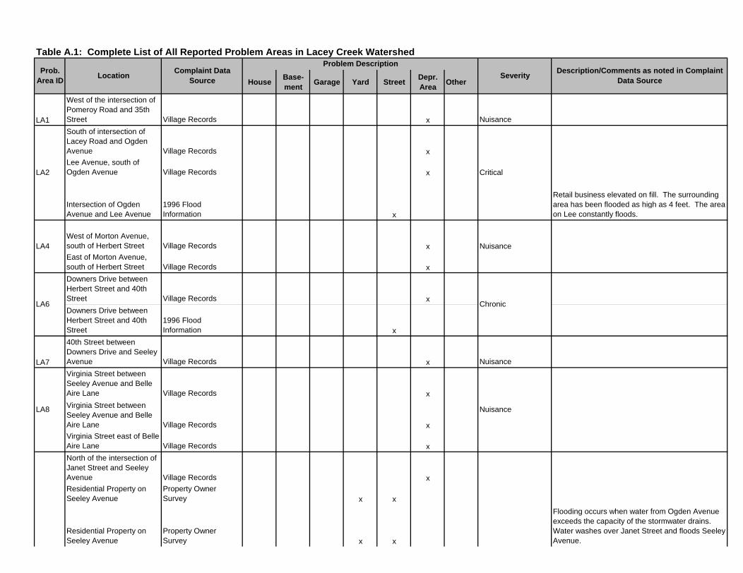
Table A.1: Complete List of All Reported Problem Areas in Lacey Creek Watershed
HouseBase- ment
Garage Yard StreetDepr. Area
Other
LA1
West of the intersection of Pomeroy Road and 35th Street Village Records x Nuisance
South of intersection of Lacey Road and Ogden Avenue Village Records xLee Avenue, south of Ogden Avenue Village Records x
Intersection of Ogden Avenue and Lee Avenue
1996 Flood Information x
Retail business elevated on fill. The surrounding area has been flooded as high as 4 feet. The area on Lee constantly floods.
West of Morton Avenue, south of Herbert Street Village Records xEast of Morton Avenue, south of Herbert Street Village Records x
Downers Drive between Herbert Street and 40th Street Village Records x
Downers Drive between Herbert Street and 40th Street
1996 Flood Information x
LA7
40th Street between Downers Drive and Seeley Avenue Village Records x Nuisance
Virginia Street between Seeley Avenue and Belle Aire Lane Village Records x
Virginia Street between Seeley Avenue and Belle Aire Lane Village Records xVirginia Street east of Belle Aire Lane Village Records x
North of the intersection of Janet Street and Seeley Avenue Village Records xResidential Property on Seeley Avenue
Property Owner Survey x x
Residential Property on Seeley Avenue
Property Owner Survey x x
Flooding occurs when water from Ogden Avenue exceeds the capacity of the stormwater drains. Water washes over Janet Street and floods Seeley Avenue.
Description/Comments as noted in Complaint Data Source
Prob. Area ID
Complaint Data Source
Location
Problem Description
Severity
LA2 Critical
LA4 Nuisance
ChronicLA6
LA8 Nuisance
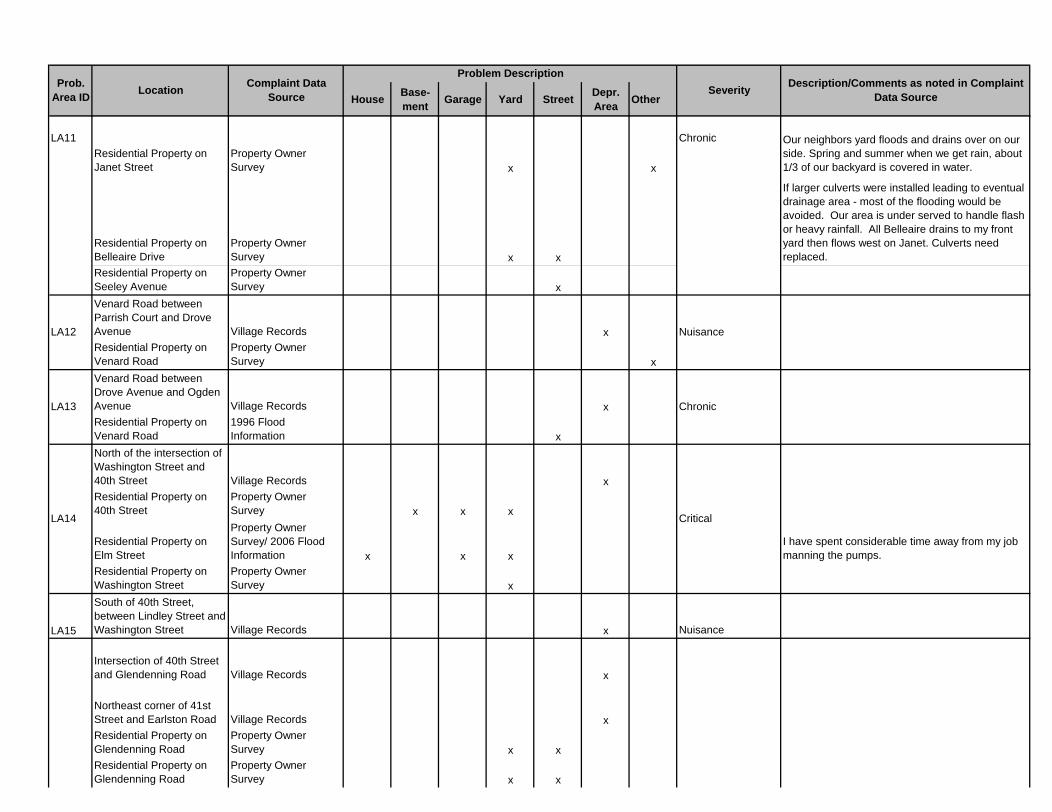
HouseBase- ment
Garage Yard StreetDepr. Area
Other
Description/Comments as noted in Complaint Data Source
Prob. Area ID
Complaint Data Source
Location
Problem Description
Severity
Residential Property on Janet Street
Property Owner Survey x x
Our neighbors yard floods and drains over on our side. Spring and summer when we get rain, about 1/3 of our backyard is covered in water.
Residential Property on Belleaire Drive
Property Owner Survey x x
If larger culverts were installed leading to eventual drainage area - most of the flooding would be avoided. Our area is under served to handle flash or heavy rainfall. All Belleaire drains to my front yard then flows west on Janet. Culverts need replaced.
Residential Property on Seeley Avenue
Property Owner Survey x
Venard Road between Parrish Court and Drove Avenue Village Records xResidential Property on Venard Road
Property Owner Survey x
Venard Road between Drove Avenue and Ogden Avenue Village Records xResidential Property on Venard Road
1996 Flood Information x
North of the intersection of Washington Street and 40th Street Village Records xResidential Property on 40th Street
Property Owner Survey x x x
Residential Property on Elm Street
Property Owner Survey/ 2006 Flood Information x x x
I have spent considerable time away from my job manning the pumps.
Residential Property on Washington Street
Property Owner Survey x
LA15
South of 40th Street, between Lindley Street and Washington Street Village Records x Nuisance
Intersection of 40th Street and Glendenning Road Village Records x
Northeast corner of 41st Street and Earlston Road Village Records xResidential Property on Glendenning Road
Property Owner Survey x x
Residential Property on Glendenning Road
Property Owner Survey x x
ChronicLA11
NuisanceLA12
ChronicLA13
CriticalLA14
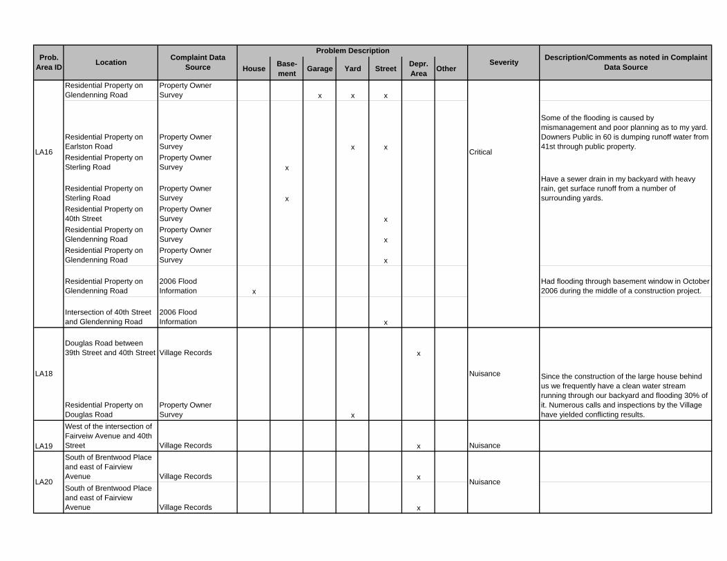
HouseBase- ment
Garage Yard StreetDepr. Area
Other
Description/Comments as noted in Complaint Data Source
Prob. Area ID
Complaint Data Source
Location
Problem Description
Severity
Residential Property on Glendenning Road
Property Owner Survey x x x
Residential Property on Earlston Road
Property Owner Survey x x
Some of the flooding is caused by mismanagement and poor planning as to my yard. Downers Public in 60 is dumping runoff water from 41st through public property.
Residential Property on Sterling Road
Property Owner Survey x
Residential Property on Sterling Road
Property Owner Survey x
Have a sewer drain in my backyard with heavy rain, get surface runoff from a number of surrounding yards.
Residential Property on 40th Street
Property Owner Survey x
Residential Property on Glendenning Road
Property Owner Survey x
Residential Property on Glendenning Road
Property Owner Survey x
Residential Property on Glendenning Road
2006 Flood Information x
Had flooding through basement window in October 2006 during the middle of a construction project.
Intersection of 40th Street and Glendenning Road
2006 Flood Information x
Douglas Road between 39th Street and 40th Street Village Records x
Residential Property on Douglas Road
Property Owner Survey x
Since the construction of the large house behind us we frequently have a clean water stream running through our backyard and flooding 30% of it. Numerous calls and inspections by the Village have yielded conflicting results.
LA19
West of the intersection of Fairveiw Avenue and 40th Street Village Records x Nuisance
South of Brentwood Place and east of Fairview Avenue Village Records x
South of Brentwood Place and east of Fairview Avenue Village Records x
LA16 Critical
NuisanceLA18
NuisanceLA20
HouseBase- ment
Garage Yard StreetDepr. Area
Other
Description/Comments as noted in Complaint Data Source
Prob. Area ID
Complaint Data Source
Location
Problem Description
Severity
LA22
South of the intersection of Herbert Street and School Street Village Records x Nuisance
Residential Property on Drew Street
Property Owner Survey x x
Our entire subdivision (Innisbrook II) was poorly graded and should be looked at when time and funds allow.
Residential Property on Venard Road
Property Owner Survey x x
Most of the street flooding would be minimized by regular cleaning of the streets and drains. The street cleaner should be used more often to clean debris.
Residential Property on Venard Road
Property Owner Survey x
Residential Property on Venard Road
Property Owner Survey x
Residential Property on Bryce Place
Property Owner Survey x
Residential Property on Acorn Avenue
Property Owner Survey x x
Residential Property on Hickory Court
Property Owner Survey x
Residential Property on Pomeroy Road
Property Owner Survey x
35th Street between Venard Road and Saratoga Avenue
2006 Flood Information x
Residential Property on Saratoga Avenue
2006 Flood Information x
Residential Property on Venard Road
Property Owner Survey x
Residential Property on Venard Road
Property Owner Survey x
Residential Property on Venard Road
Property Owner Survey x
The stormwater swale behind my house needs to be graded so the water drains into the storm sewer system. The area behind my house floods each time it rains. The grade of the land has not been maintained over many years.
Residential Property on Venard Road
Property Owner Survey x
Residential Property on Barneswood Drive
Property Owner Survey x
LA300 Chronic
LA301 Critical
LA302 Chronic
LA303 Chronic
HouseBase- ment
Garage Yard StreetDepr. Area
Other
Description/Comments as noted in Complaint Data Source
Prob. Area ID
Complaint Data Source
Location
Problem Description
Severity
Residential Property on Barneswood Drive
Property Owner Survey/ 2006 Flood Information x
Our largest concern is the poor drainage of water after rains in front of our house in our driveway. Our street has been paved so many times that our curbs ar non existent and the street is not pitched towards our sewers, so it just accumulates in front
Barneswood Drive from Saratoga Avenue to Highland Avenue
2006 Flood Information x
Intersection of Barneswood Drive and Saratoga Avenue
1996 Flood Information x
Residential Property on Creekwood Court
Property Owner Survey x x
There needs to be better coordination between stormwater management and other public works projects. At my home, previous overlay repaving of the street raised the elevation above my garage floor causing flooding. I had to replace the garage floor.
Residential Property on Barberry Court
Property Owner Survey x x
Residential Property on Barneswood Drive
Property Owner Survey x x x
Sewer backup from leaves/twigs in street floating and clogging
Residential Property on Barneswood Drive
Property Owner Survey x
Near the corner of Barneswood and Highland, the Barneswood street does not drain properly - often a puddle in the street.
Residential Property on Barneswood Drive
Property Owner Survey x
Residential Property on Creekwood Court
Property Owner Survey x x x
Residential Property on Barneswood Drive
Property Owner Survey x
At my location, if the street were pitched properly and had corrected curbs and drains the flooding would not happen.
Residential Property on Barneswood Drive
Property Owner Survey x x
Water sits in front of our driveway. Water has dissolved the curb, parkway driveway and 10 feet of our private drive
Residential Property on Quince Court
Property Owner Survey x Water control project under way in Orchard Brook
Residential Property on Barneswood Drive
Property Owner Survey x
Highland Avenue between Barneswood Drive and Oak Hill Road
2006 Flood Information x
35th Street from Hickory Trail to Highland Avenue
2006 Flood Information x
LA304 Critical
LA305 Critical
HouseBase- ment
Garage Yard StreetDepr. Area
Other
Description/Comments as noted in Complaint Data Source
Prob. Area ID
Complaint Data Source
Location
Problem Description
Severity
Intersection of Highland Avenue and 35th Street
1996 Flood Information x
Residential Property on Brookside Lane
2006 Flood Information x
Residential Property on Brookside Lane
2006 Flood Information x
LA307Residential Property on Parrish Court
Property Owner Survey x x x Critical
Residential Property on Candlewood Court
2006 Flood Information x
We are at the low end of the cul de sac near creek. Keep curb and gutters clean so water flows freely to existing drains. Note - gutters are currently filled with debris and curb/street repair is needed.
Residential Property on 39th Street
2006 Flood Information x
After street improvement project - higher curbs block flow path; also drain from back of house no longer connected to storm sewer system after curbs put in
Residential Property on 39th Street
2006 Flood Information x
Residential Property on 39th Street
Property Owner Survey x
Residential Property on Saratoga Avenue
Property Owner Survey x
Residential Property on 39th Street
Property Owner Survey x
LA310Residential Property on Candlewood Court
2006 Flood Information x Chronic
LA311Residential Property on Forest Avenue
Property Owner Survey x Chronic Resident does not recall any flooding problems
LA313Commercial Property on Ogden Avenue
2006 Flood Information x Critical
LA314Residential Property on Woodward Avenue
Property Owner Survey x Chronic
Residential Property on Main Street
2006 Flood Information x
Residential Property on Main Street
Property Owner Survey x
Residential Property on Main Street
Property Owner Survey x x
LA316Commercial Property on Highland Avenue
2006 Flood Information x Critical
LA317Residential Property on 39th Street
Property Owner Survey x Chronic
LA306 Chronic
LA315 Critical
LA308 Chronic
LA309 Chronic
HouseBase- ment
Garage Yard StreetDepr. Area
Other
Description/Comments as noted in Complaint Data Source
Prob. Area ID
Complaint Data Source
Location
Problem Description
Severity
LA318Residential Property on Cumnor Road
2006 Flood Information x Chronic
Resident is not aware of any flooding problems since 1972 storm - then flooding across 39th Street in front of house.
LA320Residential Property on Almond Court Village Records x Critical
Backyard flooding accumulating from neighbors, water directly entered house (stairwell.) Per Village, this issue is more than likely caused by poor grading on the residents private property. It seems like either the T/F grade was set too low or the resident's neighbors did not swale correctly.
LA321
Unsewered Area north of Ogden, east of Lacey and I-355, south of Herbert, west of Seeley Sewer Buffer Map x Nuisance
Area is not within 200 feet of storm sewer, however, review of Village Records shows no complaints of flooding.
LA322
Unsewered area west of Highland and north of 35th Street. Sewer Buffer Map x Nuisance
Area is not within 200 feet of storm sewer, however, review of Village Records shows no complaints of flooding.
LA323Residential Property on Coral Berry Village Records x Chronic
Resident reports that gutters do not have sufficient capacity to convey roadway runoff. Gutter overtopping directs flow down the driveway into garage.
LA324Unsewered area south of Ogden and west of Cornell Sewer Buffer Map x Nuisance
Area is not within 200 feet of storm sewer, however, review of Village Records shows just one complaint of flooding (Problem Area LA314).
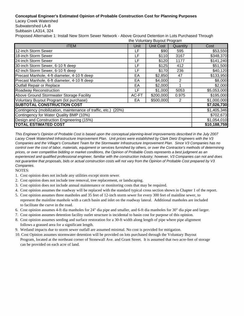
Conceptual Engineer's Estimated Opinion of Probable Construction Cost for Planning PurposesLacey Creek WatershedSubwatershed LA-BSubbasin LA314, 324Proposed Alternative 1: Install New Storm Sewer Network - Above Ground Detention in Lots Purchased Through
the Voluntary Buyout ProgramITEM Unit Unit Cost Quantity Cost
12-inch Storm Sewer LF $90 595 $53,55018-inch Storm Sewer LF $110 3167 $348,37024-inch Storm Sewer LF $120 1177 $141,24030-inch Storm Sewer, 6-10 ft deep LF $125 412 $51,50042-inch Storm Sewer, 6-10 ft deep LF $170 236 $40,120Precast Manhole, 4-ft diameter, 4-10 ft deep EA $2,850 47 $133,950Precast Manhole, 6-ft diameter, 4-10 ft deep EA $4,000 2 $8,000Outfall Repair or Replace EA $2,000 1 $2,000Roadway Reconstruction LF $1,000 5053 $5,053,000Above Ground Stormwater Storage Facility AC-FT $200,000 0.975 $195,000Voluntary Buyout Program (lot purchase) EA $500,000 2 $1,000,000
$7,026,730$1,405,346
$702,673$1,054,010
$10,188,759
NOTES:1. Cost opinion does not include any utilities except storm sewer.2. Cost opinion does not include tree removal, tree replacement, or landscaping.3. Cost opinion does not include annual maintenance or monitoring costs that may be required.4. Cost opinion assumes the roadway will be replaced with the standard typical cross section shown in Chapter 1 of the report. 5. Cost opinion assumes three manholes and 35 feet of 12-inch storm sewer for every 300 feet of mainline sewer, to represent the mainline manhole with a catch basin and inlet on the roadway lateral. Additional manholes are included to facilitate the curve in the road.6. Cost opinion assumes 4-ft dia manholes for 24" dia pipe and smaller, and 6-ft dia manholes for 30" dia pipe and larger.7. Cost opinion assumes detention facility outlet structure is incidental to basin cost for purpose of this opinion.8. Cost opinion assumes seeding and surface restoration for a 30-ft width along length of pipe where pipe alignment follows a grassed area for a significant length.9. Wetland impacts due to storm sewer outfall are assumed minimal. No cost is provided for mitigation.10. Cost Opinion assumes stormwater detention will be provided on lots purchased through the Voluntary Buyout Program, located at the northeast corner of Stonewall Ave. and Grant Street. It is assumed that two acre-feet of storage can be provided on each acre of land.
TOTAL ESTIMATED COST
This Engineer's Opinion of Probable Cost is based upon the conceptual planning-level improvements described in the July 2007 Lacey Creek Watershed Infrastructure Improvement Plan. Unit prices were established by Clark Dietz Engineers with the V3 Companies and the Village's Consultant Team for the Stormwater Infrastructure Improvement Plan. Since V3 Companies has no control over the cost of labor, materials, equipment or services furnished by others, or over the Contractor's methods of determining prices, or over competitive bidding or market conditions, the Opinion of Probable Costs represents a best judgment as an experienced and qualified professional engineer, familiar with the construction industry; however, V3 Companies can not and does not guarantee that proposals, bids or actual construction costs will not vary from the Opinion of Probable Cost prepared by V3 Companies.
SUBTOTAL CONSTRUCTION COSTContingency (mobilization, maintenance of traffic, etc.) (20%)Contingency for Water Quality BMP (10%)Design and Construction Engineering (15%)

Conceptual Engineer's Estimated Opinion of Probable Construction Cost for Planning PurposesLacey Creek WatershedSubwatershed LA-BSubbasin LA314, 324Proposed Alternative 2: Install New Storm Sewer Network - In-Pipe Detention
ITEM Unit Unit Cost Quantity Cost12-inch Storm Sewer LF $90 595 $53,55048-inch Storm Sewer, 6-10 ft deep LF $190 4344 $825,36054-inch Storm Sewer, 6-10 ft deep LF $200 412 $82,40060-inch Storm Sewer, 6-10 ft deep LF $200 236 $47,200Precast Manhole, 4-ft diameter, 4-10 ft deep EA $2,850 34 $96,900Precast Manhole, 6-ft diameter, 4-10 ft deep EA $4,000 17 $68,000Outfall Repair or Replace EA $2,000 1 $2,000Roadway Reconstruction LF $1,000 5053 $5,053,000
$6,228,410$1,245,682
$622,841$934,262
$9,031,195
NOTES:1. Cost opinion does not include any utilities except storm sewer.2. Cost opinion does not include tree removal, tree replacement, or landscaping.3. Cost opinion does not include annual maintenance or monitoring costs that may be required.4. Cost opinion assumes the roadway will be replaced with the standard typical cross section shown in Chapter 1 of the repor5. Cost opinion assumes three manholes and 35 feet of 12-inch storm sewer for every 300 feet of mainline sewer, to represent the mainline manhole with a catch basin and inlet on the roadway lateral. Additional manholes are included to facilitate the curve in the road.6. Cost opinion assumes 4-ft dia manholes for 24" dia pipe and smaller, and 6-ft dia manholes for 30" dia pipe and larger.7. Cost opinion assumes detention facility outlet structure is incidental to basin cost for purpose of this opinion.8. Cost opinion assumes seeding and surface restoration for a 30-ft width along length of pipe where pipe alignment follows a grassed area for a significant length.9. Wetland impacts due to storm sewer outfall are assumed minimal. No cost is provided for mitigation.10. Cost Opinion assumes stormwater detention will be provided on lots purchased through the Voluntary Buyout Program, located at the northwest corner of 40th and Elm Streets. It is assumed that two acre-feet of storage can be provided on each acre of land.
TOTAL ESTIMATED COST
This Engineer's Opinion of Probable Cost is based upon the conceptual planning-level improvements described in the July 2007 Lacey Creek Watershed Infrastructure Improvement Plan. Unit prices were established by Clark Dietz Engineers with the V3 Companies and the Village's Consultant Team for the Stormwater Infrastructure Improvement Plan. Since V3 Companies has no control over the cost of labor, materials, equipment or services furnished by others, or over the Contractor's methods of determining prices, or over competitive bidding or market conditions, the Opinion of Probable Costs represents a best judgment as an experienced and qualified professional engineer, familiar with the construction industry; however, V3 Companies can not and does not guarantee that proposals, bids or actual construction costs will not vary from the Opinion of Probable Cost prepared by V3 Companies.
SUBTOTAL CONSTRUCTION COSTContingency (mobilization, maintenance of traffic, etc.) (20%)Contingency for Water Quality BMP (10%)Design and Construction Engineering (15%)
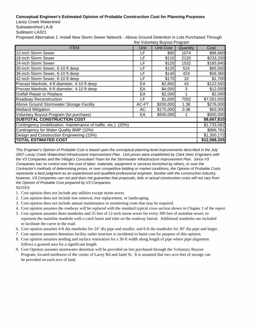
Conceptual Engineer's Estimated Opinion of Probable Construction Cost for Planning PurposesLacey Creek WatershedSubwatershed LA-BSubbasin LA321Proposed Alternative 1: Install New Storm Sewer Network - Above Ground Detention in Lots Purchased Through
the Voluntary Buyout ProgramITEM Unit Unit Cost Quantity Cost
12-inch Storm Sewer LF $90 1074 $96,66018-inch Storm Sewer LF $110 2120 $233,20024-inch Storm Sewer LF $120 1532 $183,84030-inch Storm Sewer, 6-10 ft deep LF $125 524 $65,50036-inch Storm Sewer, 6-10 ft deep LF $140 424 $59,36042-inch Storm Sewer, 6-10 ft deep LF $170 10 $1,700Precast Manhole, 4-ft diameter, 4-10 ft deep EA $2,850 43 $122,550Precast Manhole, 6-ft diameter, 4-10 ft deep EA $4,000 3 $12,000Outfall Repair or Replace EA $2,000 1 $2,000Roadway Reconstruction LF $1,000 7052 $7,052,000Above Ground Stormwater Storage Facility AC-FT $200,000 1.38 $276,000Wetland Mitigation AC $175,000 0.36 $63,000Voluntary Buyout Program (lot purchase) EA $500,000 1 $500,000
$8,667,810$1,733,562
$866,781$1,300,172
$12,568,325
NOTES:1. Cost opinion does not include any utilities except storm sewer.2. Cost opinion does not include tree removal, tree replacement, or landscaping.3. Cost opinion does not include annual maintenance or monitoring costs that may be required.4. Cost opinion assumes the roadway will be replaced with the standard typical cross section shown in Chapter 1 of the report.5. Cost opinion assumes three manholes and 35 feet of 12-inch storm sewer for every 300 feet of mainline sewer, to represent the mainline manhole with a catch basin and inlet on the roadway lateral. Additional manholes are included to facilitate the curve in the road.6. Cost opinion assumes 4-ft dia manholes for 24" dia pipe and smaller, and 6-ft dia manholes for 30" dia pipe and larger.7. Cost opinion assumes detention facility outlet structure is incidental to basin cost for purpose of this opinion.8. Cost opinion assumes seeding and surface restoration for a 30-ft width along length of pipe where pipe alignment follows a grassed area for a significant length.9. Cost Opinion assumes stormwater detention will be provided on lots purchased through the Voluntary Buyout Program, located northwest of the corner of Lacey Rd and Janet St. It is assumed that two acre-feet of storage can be provided on each acre of land.
TOTAL ESTIMATED COST
This Engineer's Opinion of Probable Cost is based upon the conceptual planning-level improvements described in the July 2007 Lacey Creek Watershed Infrastructure Improvement Plan. Unit prices were established by Clark Dietz Engineers with the V3 Companies and the Village's Consultant Team for the Stormwater Infrastructure Improvement Plan. Since V3 Companies has no control over the cost of labor, materials, equipment or services furnished by others, or over the Contractor's methods of determining prices, or over competitive bidding or market conditions, the Opinion of Probable Costs represents a best judgment as an experienced and qualified professional engineer, familiar with the construction industry; however, V3 Companies can not and does not guarantee that proposals, bids or actual construction costs will not vary from the Opinion of Probable Cost prepared by V3 Companies.
SUBTOTAL CONSTRUCTION COSTContingency (mobilization, maintenance of traffic, etc.) (20%)Contingency for Water Quality BMP (10%)Design and Construction Engineering (15%)

Conceptual Engineer's Estimated Opinion of Probable Construction Cost for Planning PurposesLacey Creek WatershedSubwatershed LA-BSubbasin LA321Proposed Alternative 2: Install New Storm Sewer Network - In-Pipe Detention
ITEM Unit Unit Cost Quantity Cost12-inch Storm Sewer LF $90 594 $53,46042-inch Storm Sewer, 6-10 ft deep LF $170 480 $81,60048-inch Storm Sewer, 6-10 ft deep LF $190 3652 $693,88054-inch Storm Sewer, 6-10 ft deep LF $200 524 $104,80060-inch Storm Sewer, 6-10 ft deep LF $200 434 $86,800Precast Manhole, 4-ft diameter, 4-10 ft deep EA $2,850 28 $79,800Precast Manhole, 6-ft diameter, 4-10 ft deep EA $4,000 14 $56,000Outfall Repair or Replace EA $2,000 1 $2,000Roadway Reconstruction LF $1,000 7052 $7,052,000
$8,210,340$1,642,068
$821,034$1,231,551
$11,904,993
NOTES:1. Cost opinion does not include any utilities except storm sewer.2. Cost opinion does not include tree removal, tree replacement, or landscaping.3. Cost opinion does not include annual maintenance or monitoring costs that may be required.4. Cost opinion assumes the roadway will be replaced with the standard typical cross section shown in Chapter 1 of the report5. Cost opinion assumes three manholes and 35 feet of 12-inch storm sewer for every 300 feet of mainline sewer, to represent the mainline manhole with a catch basin and inlet on the roadway lateral. Additional manholes are included to facilitate the curve in the road.6. Cost opinion assumes 4-ft dia manholes for 24" dia pipe and smaller, and 6-ft dia manholes for 30" dia pipe and larger.7. Cost opinion assumes detention facility outlet structure is incidental to basin cost for purpose of this opinion.8. Cost opinion assumes seeding and surface restoration for a 30-ft width along length of pipe where pipe alignment follows a grassed area for a significant length.9. Cost Opinion assumes stormwater detention will be provided on Park District land in Doerhoefer Park with no cost for land acquisition. It is assumed that two acre-feet of storage can be provided on each acre of land.
TOTAL ESTIMATED COST
This Engineer's Opinion of Probable Cost is based upon the conceptual planning-level improvements described in the July 2007 Lacey Creek Watershed Infrastructure Improvement Plan. Unit prices were established by Clark Dietz Engineers with the V3 Companies and the Village's Consultant Team for the Stormwater Infrastructure Improvement Plan. Since V3 Companies has no control over the cost of labor, materials, equipment or services furnished by others, or over the Contractor's methods of determining prices, or over competitive bidding or market conditions, the Opinion of Probable Costs represents a best judgment as an experienced and qualified professional engineer, familiar with the construction industry; however, V3 Companies can not and does not guarantee that proposals, bids or actual construction costs will not vary from the Opinion of Probable Cost prepared by V3 Companies.
SUBTOTAL CONSTRUCTION COSTContingency (mobilization, maintenance of traffic, etc.) (20%)Contingency for Water Quality BMP (10%)Design and Construction Engineering (15%)

Conceptual Engineer's Estimated Opinion of Probable Construction Cost for Planning PurposesLacey Creek WatershedSubwatershed LA-CProposed Alternative: Replace Type 1 Inlets with Type 11 or similar
ITEM Unit Unit Cost Quantity CostStorm Sewer Inlet Repair or Replace EA $2,000 62 $124,000Pavement Patching SY $45 186 $8,370
$132,370$26,474$13,237$19,856
$191,937
NOTES:1. Cost opinion does not include annual maintenance or monitoring costs that may be required.2. Storm sewer inlet quantity based on total length of storm sewer in subwatershed not scheduled for replacement. Cost opinion assumes two type 1 inlets for every 300 feet of storm sewer. Storm sewer length obtained from Village of Downers Grove GIS database. Cost opinion assumes 3 SY of pavement patching for each inlet.
TOTAL ESTIMATED COST
This Engineer's Opinion of Probable Cost is based upon the conceptual planning-level improvements described in the July2007 Lacey Creek Watershed Infrastructure Improvement Plan. Unit prices were established by Clark Dietz Engineers withthe V3 Companies and the Village's Consultant Team for the Stormwater Infrastructure Improvement Plan. Since V3Companies has no control over the cost of labor, materials, equipment or services furnished by others, or over theContractor's methods of determining prices, or over competitive bidding or market conditions, the Opinion of Probable Costsrepresents a best judgment as an experienced and qualified professional engineer, familiar with the construction industry;however, V3 Companies can not and does not guarantee that proposals, bids or actual construction costs will not vary fromthe Opinion of Probable Cost prepared by V3 Companies.
SUBTOTAL CONSTRUCTION COSTContingency (mobilization, maintenance of traffic, etc.) (20%)Contingency for Water Quality BMP (10%)Design and Construction Engineering (15%)
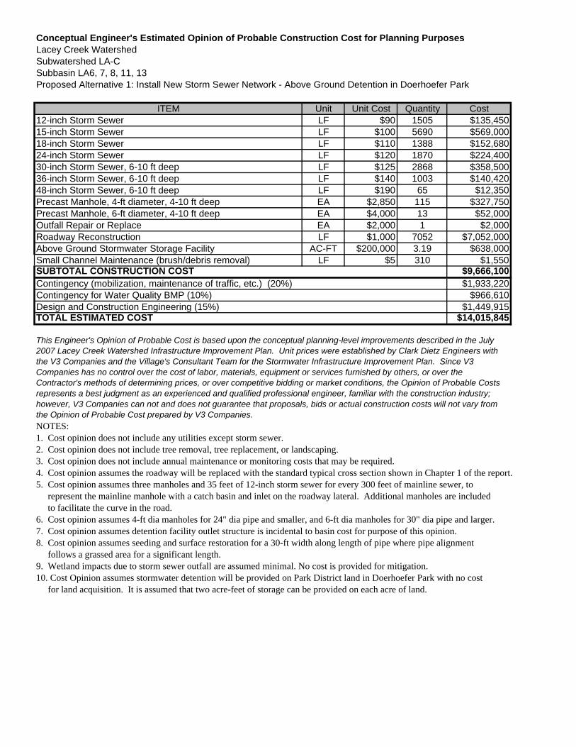
Conceptual Engineer's Estimated Opinion of Probable Construction Cost for Planning PurposesLacey Creek WatershedSubwatershed LA-CSubbasin LA6, 7, 8, 11, 13Proposed Alternative 1: Install New Storm Sewer Network - Above Ground Detention in Doerhoefer Park
ITEM Unit Unit Cost Quantity Cost12-inch Storm Sewer LF $90 1505 $135,45015-inch Storm Sewer LF $100 5690 $569,00018-inch Storm Sewer LF $110 1388 $152,68024-inch Storm Sewer LF $120 1870 $224,40030-inch Storm Sewer, 6-10 ft deep LF $125 2868 $358,50036-inch Storm Sewer, 6-10 ft deep LF $140 1003 $140,42048-inch Storm Sewer, 6-10 ft deep LF $190 65 $12,350Precast Manhole, 4-ft diameter, 4-10 ft deep EA $2,850 115 $327,750Precast Manhole, 6-ft diameter, 4-10 ft deep EA $4,000 13 $52,000Outfall Repair or Replace EA $2,000 1 $2,000Roadway Reconstruction LF $1,000 7052 $7,052,000Above Ground Stormwater Storage Facility AC-FT $200,000 3.19 $638,000Small Channel Maintenance (brush/debris removal) LF $5 310 $1,550
$9,666,100$1,933,220
$966,610$1,449,915
$14,015,845
NOTES:1. Cost opinion does not include any utilities except storm sewer.2. Cost opinion does not include tree removal, tree replacement, or landscaping.3. Cost opinion does not include annual maintenance or monitoring costs that may be required.4. Cost opinion assumes the roadway will be replaced with the standard typical cross section shown in Chapter 1 of the report.5. Cost opinion assumes three manholes and 35 feet of 12-inch storm sewer for every 300 feet of mainline sewer, to represent the mainline manhole with a catch basin and inlet on the roadway lateral. Additional manholes are included to facilitate the curve in the road.6. Cost opinion assumes 4-ft dia manholes for 24" dia pipe and smaller, and 6-ft dia manholes for 30" dia pipe and larger.7. Cost opinion assumes detention facility outlet structure is incidental to basin cost for purpose of this opinion.8. Cost opinion assumes seeding and surface restoration for a 30-ft width along length of pipe where pipe alignment follows a grassed area for a significant length.9. Wetland impacts due to storm sewer outfall are assumed minimal. No cost is provided for mitigation.10. Cost Opinion assumes stormwater detention will be provided on Park District land in Doerhoefer Park with no cost for land acquisition. It is assumed that two acre-feet of storage can be provided on each acre of land.
TOTAL ESTIMATED COST
This Engineer's Opinion of Probable Cost is based upon the conceptual planning-level improvements described in the July 2007 Lacey Creek Watershed Infrastructure Improvement Plan. Unit prices were established by Clark Dietz Engineers with the V3 Companies and the Village's Consultant Team for the Stormwater Infrastructure Improvement Plan. Since V3 Companies has no control over the cost of labor, materials, equipment or services furnished by others, or over the Contractor's methods of determining prices, or over competitive bidding or market conditions, the Opinion of Probable Costs represents a best judgment as an experienced and qualified professional engineer, familiar with the construction industry; however, V3 Companies can not and does not guarantee that proposals, bids or actual construction costs will not vary from the Opinion of Probable Cost prepared by V3 Companies.
SUBTOTAL CONSTRUCTION COSTContingency (mobilization, maintenance of traffic, etc.) (20%)Contingency for Water Quality BMP (10%)Design and Construction Engineering (15%)
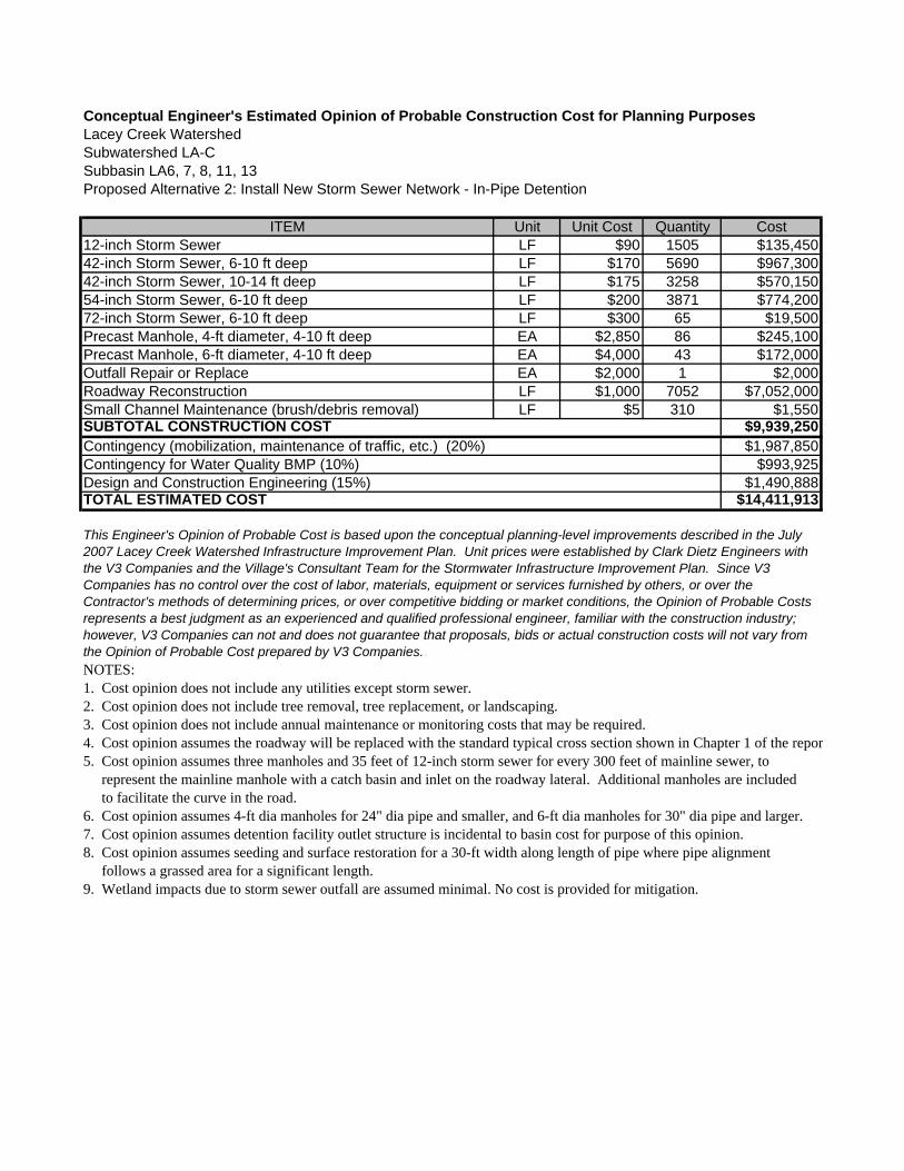
Conceptual Engineer's Estimated Opinion of Probable Construction Cost for Planning PurposesLacey Creek WatershedSubwatershed LA-CSubbasin LA6, 7, 8, 11, 13Proposed Alternative 2: Install New Storm Sewer Network - In-Pipe Detention
ITEM Unit Unit Cost Quantity Cost12-inch Storm Sewer LF $90 1505 $135,45042-inch Storm Sewer, 6-10 ft deep LF $170 5690 $967,30042-inch Storm Sewer, 10-14 ft deep LF $175 3258 $570,15054-inch Storm Sewer, 6-10 ft deep LF $200 3871 $774,20072-inch Storm Sewer, 6-10 ft deep LF $300 65 $19,500Precast Manhole, 4-ft diameter, 4-10 ft deep EA $2,850 86 $245,100Precast Manhole, 6-ft diameter, 4-10 ft deep EA $4,000 43 $172,000Outfall Repair or Replace EA $2,000 1 $2,000Roadway Reconstruction LF $1,000 7052 $7,052,000Small Channel Maintenance (brush/debris removal) LF $5 310 $1,550
$9,939,250$1,987,850
$993,925$1,490,888
$14,411,913
NOTES:1. Cost opinion does not include any utilities except storm sewer.2. Cost opinion does not include tree removal, tree replacement, or landscaping.3. Cost opinion does not include annual maintenance or monitoring costs that may be required.4. Cost opinion assumes the roadway will be replaced with the standard typical cross section shown in Chapter 1 of the repor5. Cost opinion assumes three manholes and 35 feet of 12-inch storm sewer for every 300 feet of mainline sewer, to represent the mainline manhole with a catch basin and inlet on the roadway lateral. Additional manholes are included to facilitate the curve in the road.6. Cost opinion assumes 4-ft dia manholes for 24" dia pipe and smaller, and 6-ft dia manholes for 30" dia pipe and larger.7. Cost opinion assumes detention facility outlet structure is incidental to basin cost for purpose of this opinion.8. Cost opinion assumes seeding and surface restoration for a 30-ft width along length of pipe where pipe alignment follows a grassed area for a significant length.9. Wetland impacts due to storm sewer outfall are assumed minimal. No cost is provided for mitigation.
TOTAL ESTIMATED COST
This Engineer's Opinion of Probable Cost is based upon the conceptual planning-level improvements described in the July 2007 Lacey Creek Watershed Infrastructure Improvement Plan. Unit prices were established by Clark Dietz Engineers with the V3 Companies and the Village's Consultant Team for the Stormwater Infrastructure Improvement Plan. Since V3 Companies has no control over the cost of labor, materials, equipment or services furnished by others, or over the Contractor's methods of determining prices, or over competitive bidding or market conditions, the Opinion of Probable Costs represents a best judgment as an experienced and qualified professional engineer, familiar with the construction industry; however, V3 Companies can not and does not guarantee that proposals, bids or actual construction costs will not vary from the Opinion of Probable Cost prepared by V3 Companies.
SUBTOTAL CONSTRUCTION COSTContingency (mobilization, maintenance of traffic, etc.) (20%)Contingency for Water Quality BMP (10%)Design and Construction Engineering (15%)
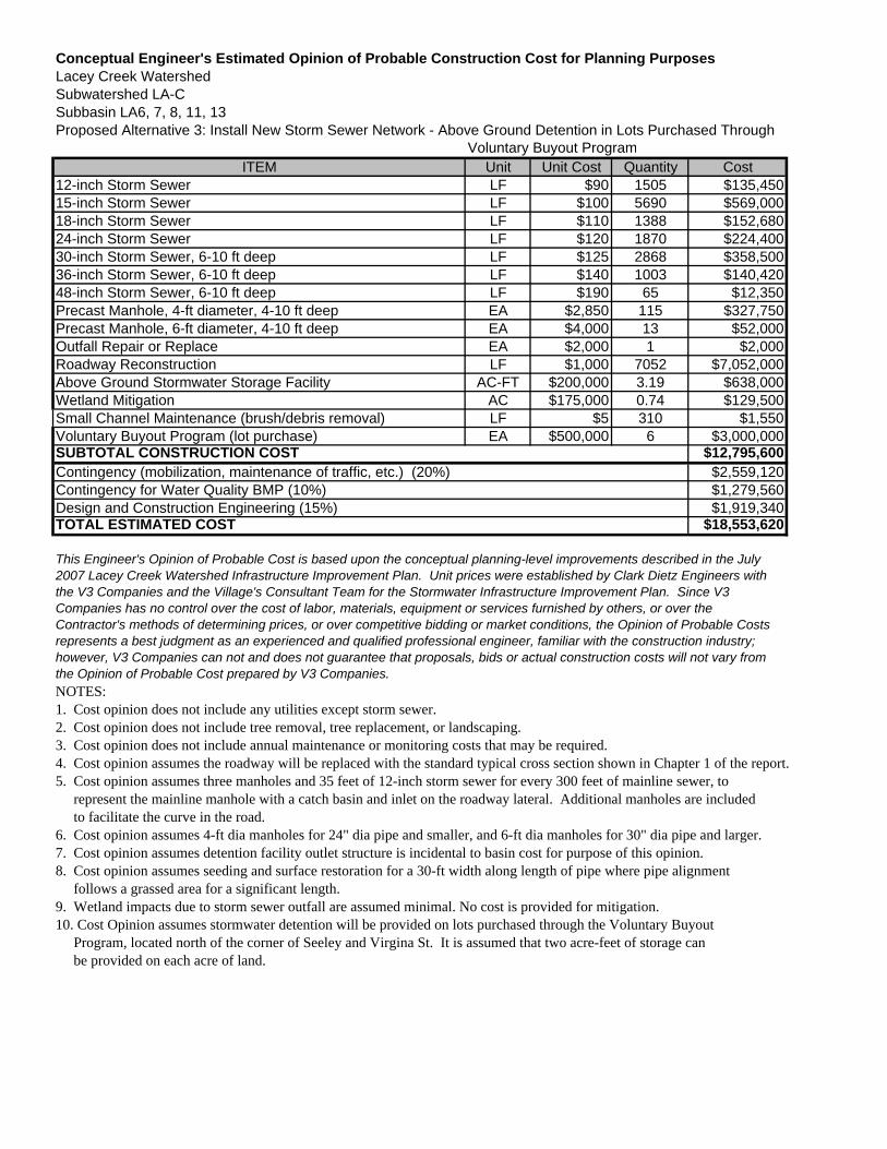
Conceptual Engineer's Estimated Opinion of Probable Construction Cost for Planning PurposesLacey Creek WatershedSubwatershed LA-CSubbasin LA6, 7, 8, 11, 13Proposed Alternative 3: Install New Storm Sewer Network - Above Ground Detention in Lots Purchased Through
Voluntary Buyout ProgramITEM Unit Unit Cost Quantity Cost
12-inch Storm Sewer LF $90 1505 $135,45015-inch Storm Sewer LF $100 5690 $569,00018-inch Storm Sewer LF $110 1388 $152,68024-inch Storm Sewer LF $120 1870 $224,40030-inch Storm Sewer, 6-10 ft deep LF $125 2868 $358,50036-inch Storm Sewer, 6-10 ft deep LF $140 1003 $140,42048-inch Storm Sewer, 6-10 ft deep LF $190 65 $12,350Precast Manhole, 4-ft diameter, 4-10 ft deep EA $2,850 115 $327,750Precast Manhole, 6-ft diameter, 4-10 ft deep EA $4,000 13 $52,000Outfall Repair or Replace EA $2,000 1 $2,000Roadway Reconstruction LF $1,000 7052 $7,052,000Above Ground Stormwater Storage Facility AC-FT $200,000 3.19 $638,000Wetland Mitigation AC $175,000 0.74 $129,500Small Channel Maintenance (brush/debris removal) LF $5 310 $1,550Voluntary Buyout Program (lot purchase) EA $500,000 6 $3,000,000
$12,795,600$2,559,120$1,279,560$1,919,340
$18,553,620
NOTES:1. Cost opinion does not include any utilities except storm sewer.2. Cost opinion does not include tree removal, tree replacement, or landscaping.3. Cost opinion does not include annual maintenance or monitoring costs that may be required.4. Cost opinion assumes the roadway will be replaced with the standard typical cross section shown in Chapter 1 of the report.5. Cost opinion assumes three manholes and 35 feet of 12-inch storm sewer for every 300 feet of mainline sewer, to represent the mainline manhole with a catch basin and inlet on the roadway lateral. Additional manholes are included to facilitate the curve in the road.6. Cost opinion assumes 4-ft dia manholes for 24" dia pipe and smaller, and 6-ft dia manholes for 30" dia pipe and larger.7. Cost opinion assumes detention facility outlet structure is incidental to basin cost for purpose of this opinion.8. Cost opinion assumes seeding and surface restoration for a 30-ft width along length of pipe where pipe alignment follows a grassed area for a significant length.9. Wetland impacts due to storm sewer outfall are assumed minimal. No cost is provided for mitigation.10. Cost Opinion assumes stormwater detention will be provided on lots purchased through the Voluntary Buyout Program, located north of the corner of Seeley and Virgina St. It is assumed that two acre-feet of storage can be provided on each acre of land.
TOTAL ESTIMATED COST
This Engineer's Opinion of Probable Cost is based upon the conceptual planning-level improvements described in the July 2007 Lacey Creek Watershed Infrastructure Improvement Plan. Unit prices were established by Clark Dietz Engineers with the V3 Companies and the Village's Consultant Team for the Stormwater Infrastructure Improvement Plan. Since V3 Companies has no control over the cost of labor, materials, equipment or services furnished by others, or over the Contractor's methods of determining prices, or over competitive bidding or market conditions, the Opinion of Probable Costs represents a best judgment as an experienced and qualified professional engineer, familiar with the construction industry; however, V3 Companies can not and does not guarantee that proposals, bids or actual construction costs will not vary from the Opinion of Probable Cost prepared by V3 Companies.
SUBTOTAL CONSTRUCTION COSTContingency (mobilization, maintenance of traffic, etc.) (20%)Contingency for Water Quality BMP (10%)Design and Construction Engineering (15%)

Conceptual Engineer's Estimated Opinion of Probable Construction Cost for Planning PurposesLacey Creek WatershedSubwatershed LA-DProposed Alternative: Replace Type 1 Inlets with Type 11 or similar
ITEM Unit Unit Cost Quantity CostStorm Sewer Inlet Repair or Replace EA $2,000 74 $148,000Pavement Patching SY $45 222 $9,990
$157,990$31,598$15,799$23,699
$229,086
NOTES:1. Cost opinion does not include annual maintenance or monitoring costs that may be required.2. Storm sewer inlet quantity based on total length of storm sewer in subwatershed not scheduled for replacement. Cost opinion assumes two type 1 inlets for every 300 feet of storm sewer. Storm sewer length obtained from Village of Downers Grove GIS database. Cost opinion assumes 3 SY of pavement patching for each inlet.
TOTAL ESTIMATED COST
This Engineer's Opinion of Probable Cost is based upon the conceptual planning-level improvements described in the July2007 Lacey Creek Watershed Infrastructure Improvement Plan. Unit prices were established by Clark Dietz Engineers withthe V3 Companies and the Village's Consultant Team for the Stormwater Infrastructure Improvement Plan. Since V3Companies has no control over the cost of labor, materials, equipment or services furnished by others, or over theContractor's methods of determining prices, or over competitive bidding or market conditions, the Opinion of Probable Costsrepresents a best judgment as an experienced and qualified professional engineer, familiar with the construction industry;however, V3 Companies can not and does not guarantee that proposals, bids or actual construction costs will not vary fromthe Opinion of Probable Cost prepared by V3 Companies.
SUBTOTAL CONSTRUCTION COSTContingency (mobilization, maintenance of traffic, etc.) (20%)Contingency for Water Quality BMP (10%)Design and Construction Engineering (15%)
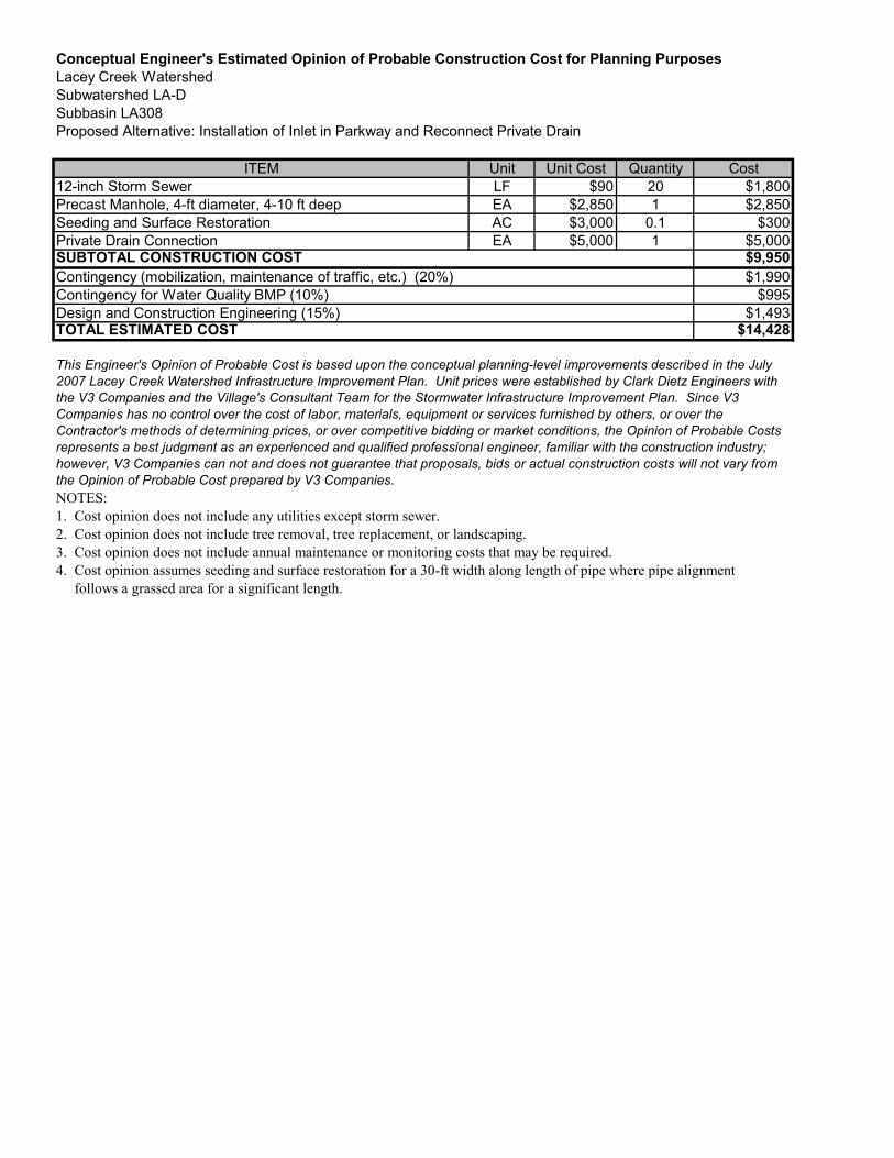
Conceptual Engineer's Estimated Opinion of Probable Construction Cost for Planning PurposesLacey Creek WatershedSubwatershed LA-DSubbasin LA308Proposed Alternative: Installation of Inlet in Parkway and Reconnect Private Drain
ITEM Unit Unit Cost Quantity Cost12-inch Storm Sewer LF $90 20 $1,800Precast Manhole, 4-ft diameter, 4-10 ft deep EA $2,850 1 $2,850Seeding and Surface Restoration AC $3,000 0.1 $300Private Drain Connection EA $5,000 1 $5,000
$9,950$1,990
$995$1,493
$14,428
NOTES:1. Cost opinion does not include any utilities except storm sewer.2. Cost opinion does not include tree removal, tree replacement, or landscaping.3. Cost opinion does not include annual maintenance or monitoring costs that may be required.4. Cost opinion assumes seeding and surface restoration for a 30-ft width along length of pipe where pipe alignment follows a grassed area for a significant length.
TOTAL ESTIMATED COST
This Engineer's Opinion of Probable Cost is based upon the conceptual planning-level improvements described in the July2007 Lacey Creek Watershed Infrastructure Improvement Plan. Unit prices were established by Clark Dietz Engineers withthe V3 Companies and the Village's Consultant Team for the Stormwater Infrastructure Improvement Plan. Since V3Companies has no control over the cost of labor, materials, equipment or services furnished by others, or over theContractor's methods of determining prices, or over competitive bidding or market conditions, the Opinion of Probable Costsrepresents a best judgment as an experienced and qualified professional engineer, familiar with the construction industry;however, V3 Companies can not and does not guarantee that proposals, bids or actual construction costs will not vary fromthe Opinion of Probable Cost prepared by V3 Companies.
SUBTOTAL CONSTRUCTION COSTContingency (mobilization, maintenance of traffic, etc.) (20%)Contingency for Water Quality BMP (10%)Design and Construction Engineering (15%)
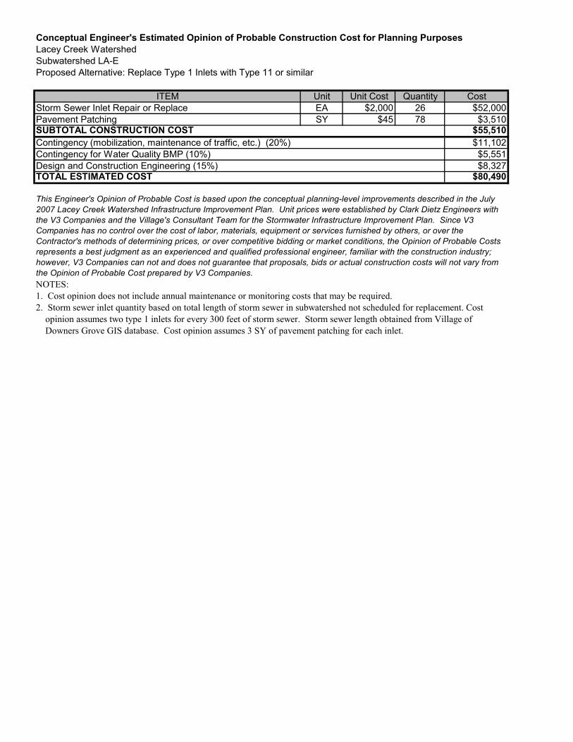
Conceptual Engineer's Estimated Opinion of Probable Construction Cost for Planning PurposesLacey Creek WatershedSubwatershed LA-EProposed Alternative: Replace Type 1 Inlets with Type 11 or similar
ITEM Unit Unit Cost Quantity CostStorm Sewer Inlet Repair or Replace EA $2,000 26 $52,000Pavement Patching SY $45 78 $3,510
$55,510$11,102$5,551$8,327
$80,490
NOTES:1. Cost opinion does not include annual maintenance or monitoring costs that may be required.2. Storm sewer inlet quantity based on total length of storm sewer in subwatershed not scheduled for replacement. Cost opinion assumes two type 1 inlets for every 300 feet of storm sewer. Storm sewer length obtained from Village of Downers Grove GIS database. Cost opinion assumes 3 SY of pavement patching for each inlet.
TOTAL ESTIMATED COST
This Engineer's Opinion of Probable Cost is based upon the conceptual planning-level improvements described in the July2007 Lacey Creek Watershed Infrastructure Improvement Plan. Unit prices were established by Clark Dietz Engineers withthe V3 Companies and the Village's Consultant Team for the Stormwater Infrastructure Improvement Plan. Since V3Companies has no control over the cost of labor, materials, equipment or services furnished by others, or over theContractor's methods of determining prices, or over competitive bidding or market conditions, the Opinion of Probable Costsrepresents a best judgment as an experienced and qualified professional engineer, familiar with the construction industry;however, V3 Companies can not and does not guarantee that proposals, bids or actual construction costs will not vary fromthe Opinion of Probable Cost prepared by V3 Companies.
SUBTOTAL CONSTRUCTION COSTContingency (mobilization, maintenance of traffic, etc.) (20%)Contingency for Water Quality BMP (10%)Design and Construction Engineering (15%)
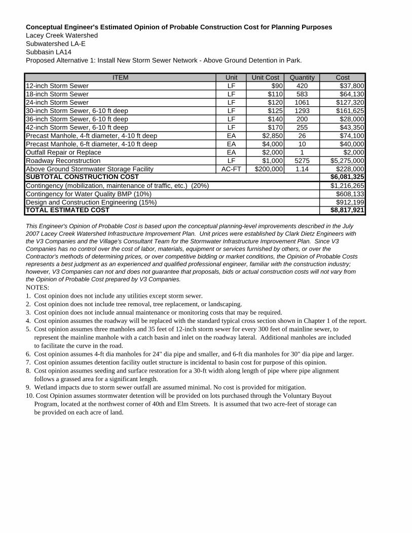
Conceptual Engineer's Estimated Opinion of Probable Construction Cost for Planning PurposesLacey Creek WatershedSubwatershed LA-ESubbasin LA14Proposed Alternative 1: Install New Storm Sewer Network - Above Ground Detention in Park.
ITEM Unit Unit Cost Quantity Cost12-inch Storm Sewer LF $90 420 $37,80018-inch Storm Sewer LF $110 583 $64,13024-inch Storm Sewer LF $120 1061 $127,32030-inch Storm Sewer, 6-10 ft deep LF $125 1293 $161,62536-inch Storm Sewer, 6-10 ft deep LF $140 200 $28,00042-inch Storm Sewer, 6-10 ft deep LF $170 255 $43,350Precast Manhole, 4-ft diameter, 4-10 ft deep EA $2,850 26 $74,100Precast Manhole, 6-ft diameter, 4-10 ft deep EA $4,000 10 $40,000Outfall Repair or Replace EA $2,000 1 $2,000Roadway Reconstruction LF $1,000 5275 $5,275,000Above Ground Stormwater Storage Facility AC-FT $200,000 1.14 $228,000
$6,081,325$1,216,265
$608,133$912,199
$8,817,921
NOTES:1. Cost opinion does not include any utilities except storm sewer.2. Cost opinion does not include tree removal, tree replacement, or landscaping.3. Cost opinion does not include annual maintenance or monitoring costs that may be required.4. Cost opinion assumes the roadway will be replaced with the standard typical cross section shown in Chapter 1 of the report.5. Cost opinion assumes three manholes and 35 feet of 12-inch storm sewer for every 300 feet of mainline sewer, to represent the mainline manhole with a catch basin and inlet on the roadway lateral. Additional manholes are included to facilitate the curve in the road.6. Cost opinion assumes 4-ft dia manholes for 24" dia pipe and smaller, and 6-ft dia manholes for 30" dia pipe and larger.7. Cost opinion assumes detention facility outlet structure is incidental to basin cost for purpose of this opinion.8. Cost opinion assumes seeding and surface restoration for a 30-ft width along length of pipe where pipe alignment follows a grassed area for a significant length.9. Wetland impacts due to storm sewer outfall are assumed minimal. No cost is provided for mitigation.10. Cost Opinion assumes stormwater detention will be provided on lots purchased through the Voluntary Buyout Program, located at the northwest corner of 40th and Elm Streets. It is assumed that two acre-feet of storage can be provided on each acre of land.
TOTAL ESTIMATED COST
This Engineer's Opinion of Probable Cost is based upon the conceptual planning-level improvements described in the July 2007 Lacey Creek Watershed Infrastructure Improvement Plan. Unit prices were established by Clark Dietz Engineers with the V3 Companies and the Village's Consultant Team for the Stormwater Infrastructure Improvement Plan. Since V3 Companies has no control over the cost of labor, materials, equipment or services furnished by others, or over the Contractor's methods of determining prices, or over competitive bidding or market conditions, the Opinion of Probable Costs represents a best judgment as an experienced and qualified professional engineer, familiar with the construction industry; however, V3 Companies can not and does not guarantee that proposals, bids or actual construction costs will not vary from the Opinion of Probable Cost prepared by V3 Companies.
SUBTOTAL CONSTRUCTION COSTContingency (mobilization, maintenance of traffic, etc.) (20%)Contingency for Water Quality BMP (10%)Design and Construction Engineering (15%)
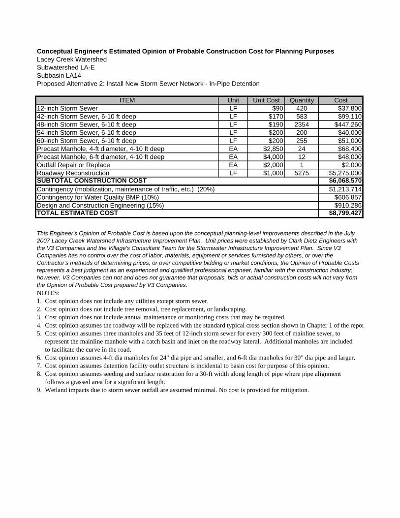
Conceptual Engineer's Estimated Opinion of Probable Construction Cost for Planning PurposesLacey Creek WatershedSubwatershed LA-ESubbasin LA14Proposed Alternative 2: Install New Storm Sewer Network - In-Pipe Detention
ITEM Unit Unit Cost Quantity Cost12-inch Storm Sewer LF $90 420 $37,80042-inch Storm Sewer, 6-10 ft deep LF $170 583 $99,11048-inch Storm Sewer, 6-10 ft deep LF $190 2354 $447,26054-inch Storm Sewer, 6-10 ft deep LF $200 200 $40,00060-inch Storm Sewer, 6-10 ft deep LF $200 255 $51,000Precast Manhole, 4-ft diameter, 4-10 ft deep EA $2,850 24 $68,400Precast Manhole, 6-ft diameter, 4-10 ft deep EA $4,000 12 $48,000Outfall Repair or Replace EA $2,000 1 $2,000Roadway Reconstruction LF $1,000 5275 $5,275,000
$6,068,570$1,213,714
$606,857$910,286
$8,799,427
NOTES:1. Cost opinion does not include any utilities except storm sewer.2. Cost opinion does not include tree removal, tree replacement, or landscaping.3. Cost opinion does not include annual maintenance or monitoring costs that may be required.4. Cost opinion assumes the roadway will be replaced with the standard typical cross section shown in Chapter 1 of the repor5. Cost opinion assumes three manholes and 35 feet of 12-inch storm sewer for every 300 feet of mainline sewer, to represent the mainline manhole with a catch basin and inlet on the roadway lateral. Additional manholes are included to facilitate the curve in the road.6. Cost opinion assumes 4-ft dia manholes for 24" dia pipe and smaller, and 6-ft dia manholes for 30" dia pipe and larger.7. Cost opinion assumes detention facility outlet structure is incidental to basin cost for purpose of this opinion.8. Cost opinion assumes seeding and surface restoration for a 30-ft width along length of pipe where pipe alignment follows a grassed area for a significant length.9. Wetland impacts due to storm sewer outfall are assumed minimal. No cost is provided for mitigation.
TOTAL ESTIMATED COST
This Engineer's Opinion of Probable Cost is based upon the conceptual planning-level improvements described in the July 2007 Lacey Creek Watershed Infrastructure Improvement Plan. Unit prices were established by Clark Dietz Engineers with the V3 Companies and the Village's Consultant Team for the Stormwater Infrastructure Improvement Plan. Since V3 Companies has no control over the cost of labor, materials, equipment or services furnished by others, or over the Contractor's methods of determining prices, or over competitive bidding or market conditions, the Opinion of Probable Costs represents a best judgment as an experienced and qualified professional engineer, familiar with the construction industry; however, V3 Companies can not and does not guarantee that proposals, bids or actual construction costs will not vary from the Opinion of Probable Cost prepared by V3 Companies.
SUBTOTAL CONSTRUCTION COSTContingency (mobilization, maintenance of traffic, etc.) (20%)Contingency for Water Quality BMP (10%)Design and Construction Engineering (15%)

Conceptual Engineer's Estimated Opinion of Probable Construction Cost for Planning PurposesLacey Creek WatershedSubwatershed LA-ESubbasin LA14Proposed Alternative 3: Install New Storm Sewer Network - Above Ground Detention in Lots Purchased Through
Voluntary Buyout Program
ITEM Unit Unit Cost Quantity Cost12-inch Storm Sewer LF $90 910 $81,90018-inch Storm Sewer LF $110 583 $64,13024-inch Storm Sewer LF $120 1061 $127,32030-inch Storm Sewer, 6-10 ft deep LF $125 1293 $161,62536-inch Storm Sewer, 6-10 ft deep LF $140 200 $28,00042-inch Storm Sewer, 6-10 ft deep LF $170 255 $43,350Precast Manhole, 4-ft diameter, 4-10 ft deep EA $2,850 26 $74,100Precast Manhole, 6-ft diameter, 4-10 ft deep EA $4,000 10 $40,000Outfall Repair or Replace EA $2,000 1 $2,000Roadway Reconstruction LF $1,000 5275 $5,275,000Above Ground Stormwater Storage Facility AC-FT $200,000 1.14 $228,000Voluntary Buyout Program (lot purchase) EA $500,000 2 $1,000,000
$7,125,425$1,425,085
$712,543$1,068,814
$10,331,866
NOTES:1. Cost opinion does not include any utilities except storm sewer.2. Cost opinion does not include tree removal, tree replacement, or landscaping.3. Cost opinion does not include annual maintenance or monitoring costs that may be required.4. Cost opinion assumes the roadway will be replaced with the standard typical cross section shown in Chapter 1 of the report.5. Cost opinion assumes three manholes and 35 feet of 12-inch storm sewer for every 300 feet of mainline sewer, to represent the mainline manhole with a catch basin and inlet on the roadway lateral. Additional manholes are included to facilitate the curve in the road.6. Cost opinion assumes 4-ft dia manholes for 24" dia pipe and smaller, and 6-ft dia manholes for 30" dia pipe and larger.7. Cost opinion assumes detention facility outlet structure is incidental to basin cost for purpose of this opinion.8. Cost opinion assumes seeding and surface restoration for a 30-ft width along length of pipe where pipe alignment follows a grassed area for a significant length.9. Wetland impacts due to storm sewer outfall are assumed minimal. No cost is provided for mitigation.10. Cost Opinion assumes stormwater detention will be provided on lots purchased through the Voluntary Buyout Program, located at the northwest corner of 40th and Elm Streets. It is assumed that two acre-feet of storage can be provided on each acre of land.
TOTAL ESTIMATED COST
This Engineer's Opinion of Probable Cost is based upon the conceptual planning-level improvements described in the July 2007 Lacey Creek Watershed Infrastructure Improvement Plan. Unit prices were established by Clark Dietz Engineers with the V3 Companies and the Village's Consultant Team for the Stormwater Infrastructure Improvement Plan. Since V3 Companies has no control over the cost of labor, materials, equipment or services furnished by others, or over the Contractor's methods of determining prices, or over competitive bidding or market conditions, the Opinion of Probable Costs represents a best judgment as an experienced and qualified professional engineer, familiar with the construction industry; however, V3 Companies can not and does not guarantee that proposals, bids or actual construction costs will not vary from the Opinion of Probable Cost prepared by V3 Companies.
SUBTOTAL CONSTRUCTION COSTContingency (mobilization, maintenance of traffic, etc.) (20%)Contingency for Water Quality BMP (10%)Design and Construction Engineering (15%)
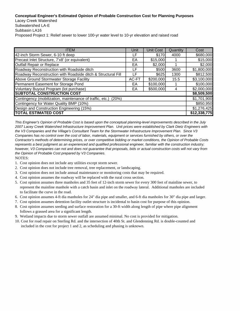
Conceptual Engineer's Estimated Opinion of Probable Construction Cost for Planning PurposesLacey Creek WatershedSubwatershed LA-ESubbasin LA16Proposed Project 1: Relief sewer to lower 100-yr water level to 10-yr elevation and raised road
ITEM Unit Unit Cost Quantity Cost42-inch Storm Sewer, 6-10 ft deep LF $170 4000 $680,000Precast Inlet Structure, 7'x8' (or equivalent) EA $15,000 1 $15,000Outfall Repair or Replace EA $2,000 1 $2,000Roadway Reconstruction with Roadside ditch LF $500 3600 $1,800,000Roadway Reconstruction with Roadside ditch & Structural Fill LF $625 1300 $812,500Above Ground Stormwater Storage Facility AC-FT $200,000 15.5 $3,100,000Permanent Easement for Storage Pond EA $100,000 1 $100,000Voluntary Buyout Program (lot purchase) EA $500,000 4 $2,000,000
$8,509,500$1,701,900
$850,950$1,276,425
$12,338,775
NOTES:1. Cost opinion does not include any utilities except storm sewer.2. Cost opinion does not include tree removal, tree replacement, or landscaping.3. Cost opinion does not include annual maintenance or monitoring costs that may be required.4. Cost opinion assumes the roadway will be replaced with the rural cross section.5. Cost opinion assumes three manholes and 35 feet of 12-inch storm sewer for every 300 feet of mainline sewer, to represent the mainline manhole with a catch basin and inlet on the roadway lateral. Additional manholes are included to facilitate the curve in the road.6. Cost opinion assumes 4-ft dia manholes for 24" dia pipe and smaller, and 6-ft dia manholes for 30" dia pipe and larger.7. Cost opinion assumes detention facility outlet structure is incidental to basin cost for purpose of this opinion.8. Cost opinion assumes seeding and surface restoration for a 30-ft width along length of pipe where pipe alignment follows a grassed area for a significant length.9. Wetland impacts due to storm sewer outfall are assumed minimal. No cost is provided for mitigation.10. Cost for road repair on Sterling Rd. and the intersection of 40th St. and Glendenning Rd. is double-counted and included in the cost for project 1 and 2, as scheduling and phasing is unknown.
TOTAL ESTIMATED COST
This Engineer's Opinion of Probable Cost is based upon the conceptual planning-level improvements described in the July 2007 Lacey Creek Watershed Infrastructure Improvement Plan. Unit prices were established by Clark Dietz Engineers with the V3 Companies and the Village's Consultant Team for the Stormwater Infrastructure Improvement Plan. Since V3 Companies has no control over the cost of labor, materials, equipment or services furnished by others, or over the Contractor's methods of determining prices, or over competitive bidding or market conditions, the Opinion of Probable Costs represents a best judgment as an experienced and qualified professional engineer, familiar with the construction industry; however, V3 Companies can not and does not guarantee that proposals, bids or actual construction costs will not vary from the Opinion of Probable Cost prepared by V3 Companies.
SUBTOTAL CONSTRUCTION COSTContingency (mobilization, maintenance of traffic, etc.) (20%)Contingency for Water Quality BMP (10%)Design and Construction Engineering (15%)
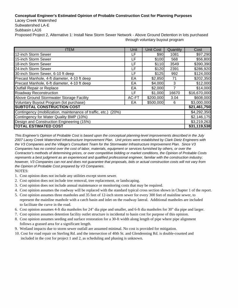
Conceptual Engineer's Estimated Opinion of Probable Construction Cost for Planning PurposesLacey Creek WatershedSubwatershed LA-ESubbasin LA16Proposed Project 2, Alternative 1: Install New Storm Sewer Network - Above Ground Detention in lots purchased
through voluntary buyout program
ITEM Unit Unit Cost Quantity Cost12-inch Storm Sewer LF $90 1081 $97,29015-inch Storm Sewer LF $100 568 $56,80018-inch Storm Sewer LF $110 3549 $390,39024-inch Storm Sewer LF $120 2391 $286,92030-inch Storm Sewer, 6-10 ft deep LF $125 992 $124,000Precast Manhole, 4-ft diameter, 4-10 ft deep EA $2,850 71 $202,350Precast Manhole, 6-ft diameter, 4-10 ft deep EA $4,000 3 $12,000Outfall Repair or Replace EA $2,000 7 $14,000Roadway Reconstruction LF $1,000 16670 $16,670,000Above Ground Stormwater Storage Facility AC-FT $200,000 3.04 $608,000Voluntary Buyout Program (lot purchase) EA $500,000 6 $3,000,000
$21,461,750$4,292,350$2,146,175$3,219,263
$31,119,538
NOTES:1. Cost opinion does not include any utilities except storm sewer.2. Cost opinion does not include tree removal, tree replacement, or landscaping.3. Cost opinion does not include annual maintenance or monitoring costs that may be required.4. Cost opinion assumes the roadway will be replaced with the standard typical cross section shown in Chapter 1 of the report.5. Cost opinion assumes three manholes and 35 feet of 12-inch storm sewer for every 300 feet of mainline sewer, to represent the mainline manhole with a catch basin and inlet on the roadway lateral. Additional manholes are included to facilitate the curve in the road.6. Cost opinion assumes 4-ft dia manholes for 24" dia pipe and smaller, and 6-ft dia manholes for 30" dia pipe and larger.7. Cost opinion assumes detention facility outlet structure is incidental to basin cost for purpose of this opinion.8. Cost opinion assumes seeding and surface restoration for a 30-ft width along length of pipe where pipe alignment follows a grassed area for a significant length.9. Wetland impacts due to storm sewer outfall are assumed minimal. No cost is provided for mitigation.10. Cost for road repair on Sterling Rd. and the intersection of 40th St. and Glendenning Rd. is double-counted and included in the cost for project 1 and 2, as scheduling and phasing is unknown.
TOTAL ESTIMATED COST
This Engineer's Opinion of Probable Cost is based upon the conceptual planning-level improvements described in the July 2007 Lacey Creek Watershed Infrastructure Improvement Plan. Unit prices were established by Clark Dietz Engineers with the V3 Companies and the Village's Consultant Team for the Stormwater Infrastructure Improvement Plan. Since V3 Companies has no control over the cost of labor, materials, equipment or services furnished by others, or over the Contractor's methods of determining prices, or over competitive bidding or market conditions, the Opinion of Probable Costs represents a best judgment as an experienced and qualified professional engineer, familiar with the construction industry; however, V3 Companies can not and does not guarantee that proposals, bids or actual construction costs will not vary from the Opinion of Probable Cost prepared by V3 Companies.
SUBTOTAL CONSTRUCTION COSTContingency (mobilization, maintenance of traffic, etc.) (20%)Contingency for Water Quality BMP (10%)Design and Construction Engineering (15%)
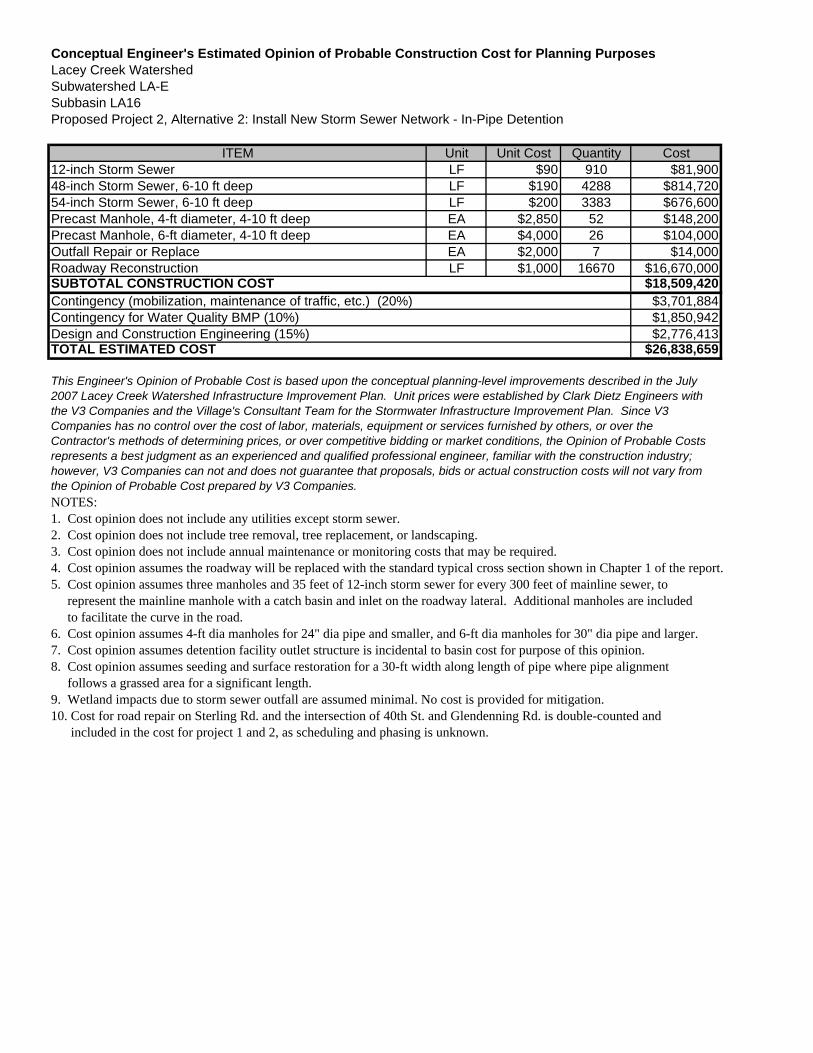
Conceptual Engineer's Estimated Opinion of Probable Construction Cost for Planning PurposesLacey Creek WatershedSubwatershed LA-ESubbasin LA16Proposed Project 2, Alternative 2: Install New Storm Sewer Network - In-Pipe Detention
ITEM Unit Unit Cost Quantity Cost12-inch Storm Sewer LF $90 910 $81,90048-inch Storm Sewer, 6-10 ft deep LF $190 4288 $814,72054-inch Storm Sewer, 6-10 ft deep LF $200 3383 $676,600Precast Manhole, 4-ft diameter, 4-10 ft deep EA $2,850 52 $148,200Precast Manhole, 6-ft diameter, 4-10 ft deep EA $4,000 26 $104,000Outfall Repair or Replace EA $2,000 7 $14,000Roadway Reconstruction LF $1,000 16670 $16,670,000
$18,509,420$3,701,884$1,850,942$2,776,413
$26,838,659
NOTES:1. Cost opinion does not include any utilities except storm sewer.2. Cost opinion does not include tree removal, tree replacement, or landscaping.3. Cost opinion does not include annual maintenance or monitoring costs that may be required.4. Cost opinion assumes the roadway will be replaced with the standard typical cross section shown in Chapter 1 of the report.5. Cost opinion assumes three manholes and 35 feet of 12-inch storm sewer for every 300 feet of mainline sewer, to represent the mainline manhole with a catch basin and inlet on the roadway lateral. Additional manholes are included to facilitate the curve in the road.6. Cost opinion assumes 4-ft dia manholes for 24" dia pipe and smaller, and 6-ft dia manholes for 30" dia pipe and larger.7. Cost opinion assumes detention facility outlet structure is incidental to basin cost for purpose of this opinion.8. Cost opinion assumes seeding and surface restoration for a 30-ft width along length of pipe where pipe alignment follows a grassed area for a significant length.9. Wetland impacts due to storm sewer outfall are assumed minimal. No cost is provided for mitigation.10. Cost for road repair on Sterling Rd. and the intersection of 40th St. and Glendenning Rd. is double-counted and included in the cost for project 1 and 2, as scheduling and phasing is unknown.
TOTAL ESTIMATED COST
This Engineer's Opinion of Probable Cost is based upon the conceptual planning-level improvements described in the July 2007 Lacey Creek Watershed Infrastructure Improvement Plan. Unit prices were established by Clark Dietz Engineers with the V3 Companies and the Village's Consultant Team for the Stormwater Infrastructure Improvement Plan. Since V3 Companies has no control over the cost of labor, materials, equipment or services furnished by others, or over the Contractor's methods of determining prices, or over competitive bidding or market conditions, the Opinion of Probable Costs represents a best judgment as an experienced and qualified professional engineer, familiar with the construction industry; however, V3 Companies can not and does not guarantee that proposals, bids or actual construction costs will not vary from the Opinion of Probable Cost prepared by V3 Companies.
SUBTOTAL CONSTRUCTION COSTContingency (mobilization, maintenance of traffic, etc.) (20%)Contingency for Water Quality BMP (10%)Design and Construction Engineering (15%)

Conceptual Engineer's Estimated Opinion of Probable Construction Cost for Planning PurposesLacey Creek WatershedSubwatershed LA-FProposed Alternative: Replace Type 1 Inlets with Type 11 or similar
ITEM Unit Unit Cost Quantity CostStorm Sewer Inlet Repair or Replace EA $2,000 28 $56,000Pavement Patching SY $45 84 $3,780
$59,780$11,956$5,978$8,967
$86,681
NOTES:1. Cost opinion does not include annual maintenance or monitoring costs that may be required.2. Storm sewer inlet quantity based on total length of storm sewer in subwatershed not scheduled for replacement. Cost opinion assumes two type 1 inlets for every 300 feet of storm sewer. Storm sewer length obtained from Village of Downers Grove GIS database. Cost opinion assumes 3 SY of pavement patching for each inlet.
TOTAL ESTIMATED COST
This Engineer's Opinion of Probable Cost is based upon the conceptual planning-level improvements described in the July2007 Lacey Creek Watershed Infrastructure Improvement Plan. Unit prices were established by Clark Dietz Engineers withthe V3 Companies and the Village's Consultant Team for the Stormwater Infrastructure Improvement Plan. Since V3Companies has no control over the cost of labor, materials, equipment or services furnished by others, or over theContractor's methods of determining prices, or over competitive bidding or market conditions, the Opinion of Probable Costsrepresents a best judgment as an experienced and qualified professional engineer, familiar with the construction industry;however, V3 Companies can not and does not guarantee that proposals, bids or actual construction costs will not vary fromthe Opinion of Probable Cost prepared by V3 Companies.
SUBTOTAL CONSTRUCTION COSTContingency (mobilization, maintenance of traffic, etc.) (20%)Contingency for Water Quality BMP (10%)Design and Construction Engineering (15%)

Conceptual Engineer's Estimated Opinion of Probable Construction Cost for Planning PurposesLacey Creek WatershedSubwatershed LA-GProposed Alternative: Replace Type 1 Inlets with Type 11 or similar
ITEM Unit Unit Cost Quantity CostStorm Sewer Inlet Repair or Replace EA $2,000 100 $200,000Pavement Patching SY $45 300 $13,500
$213,500$42,700$21,350$32,025
$309,575
NOTES:1. Cost opinion does not include annual maintenance or monitoring costs that may be required.2. Storm sewer inlet quantity based on total length of storm sewer in subwatershed not scheduled for replacement. Cost opinion assumes two type 1 inlets for every 300 feet of storm sewer. Storm sewer length obtained from Village of Downers Grove GIS database. Cost opinion assumes 3 SY of pavement patching for each inlet.
TOTAL ESTIMATED COST
This Engineer's Opinion of Probable Cost is based upon the conceptual planning-level improvements described in the July2007 Lacey Creek Watershed Infrastructure Improvement Plan. Unit prices were established by Clark Dietz Engineers withthe V3 Companies and the Village's Consultant Team for the Stormwater Infrastructure Improvement Plan. Since V3Companies has no control over the cost of labor, materials, equipment or services furnished by others, or over theContractor's methods of determining prices, or over competitive bidding or market conditions, the Opinion of Probable Costsrepresents a best judgment as an experienced and qualified professional engineer, familiar with the construction industry;however, V3 Companies can not and does not guarantee that proposals, bids or actual construction costs will not vary fromthe Opinion of Probable Cost prepared by V3 Companies.
SUBTOTAL CONSTRUCTION COSTContingency (mobilization, maintenance of traffic, etc.) (20%)Contingency for Water Quality BMP (10%)Design and Construction Engineering (15%)
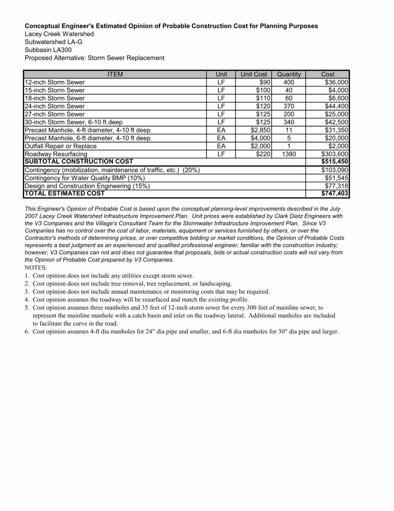
Conceptual Engineer's Estimated Opinion of Probable Construction Cost for Planning PurposesLacey Creek WatershedSubwatershed LA-GSubbasin LA300Proposed Alternative: Storm Sewer Replacement
ITEM Unit Unit Cost Quantity Cost12-inch Storm Sewer LF $90 400 $36,00015-inch Storm Sewer LF $100 40 $4,00018-inch Storm Sewer LF $110 60 $6,60024-inch Storm Sewer LF $120 370 $44,40027-inch Storm Sewer LF $125 200 $25,00030-inch Storm Sewer, 6-10 ft deep LF $125 340 $42,500Precast Manhole, 4-ft diameter, 4-10 ft deep EA $2,850 11 $31,350Precast Manhole, 6-ft diameter, 4-10 ft deep EA $4,000 5 $20,000Outfall Repair or Replace EA $2,000 1 $2,000Roadway Resurfacing LF $220 1380 $303,600
$515,450$103,090$51,545$77,318
$747,403
NOTES:1. Cost opinion does not include any utilities except storm sewer.2. Cost opinion does not include tree removal, tree replacement, or landscaping.3. Cost opinion does not include annual maintenance or monitoring costs that may be required.4. Cost opinion assumes the roadway will be resurfaced and match the existing profile.5. Cost opinion assumes three manholes and 35 feet of 12-inch storm sewer for every 300 feet of mainline sewer, to represent the mainline manhole with a catch basin and inlet on the roadway lateral. Additional manholes are included to facilitate the curve in the road.6. Cost opinion assumes 4-ft dia manholes for 24" dia pipe and smaller, and 6-ft dia manholes for 30" dia pipe and larger.
TOTAL ESTIMATED COST
This Engineer's Opinion of Probable Cost is based upon the conceptual planning-level improvements described in the July2007 Lacey Creek Watershed Infrastructure Improvement Plan. Unit prices were established by Clark Dietz Engineers withthe V3 Companies and the Village's Consultant Team for the Stormwater Infrastructure Improvement Plan. Since V3Companies has no control over the cost of labor, materials, equipment or services furnished by others, or over theContractor's methods of determining prices, or over competitive bidding or market conditions, the Opinion of Probable Costsrepresents a best judgment as an experienced and qualified professional engineer, familiar with the construction industry;however, V3 Companies can not and does not guarantee that proposals, bids or actual construction costs will not vary fromthe Opinion of Probable Cost prepared by V3 Companies.
SUBTOTAL CONSTRUCTION COSTContingency (mobilization, maintenance of traffic, etc.) (20%)Contingency for Water Quality BMP (10%)Design and Construction Engineering (15%)
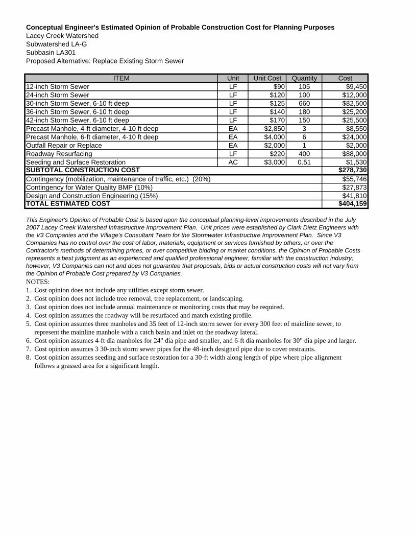
Conceptual Engineer's Estimated Opinion of Probable Construction Cost for Planning PurposesLacey Creek WatershedSubwatershed LA-GSubbasin LA301Proposed Alternative: Replace Existing Storm Sewer
ITEM Unit Unit Cost Quantity Cost12-inch Storm Sewer LF $90 105 $9,45024-inch Storm Sewer LF $120 100 $12,00030-inch Storm Sewer, 6-10 ft deep LF $125 660 $82,50036-inch Storm Sewer, 6-10 ft deep LF $140 180 $25,20042-inch Storm Sewer, 6-10 ft deep LF $170 150 $25,500Precast Manhole, 4-ft diameter, 4-10 ft deep EA $2,850 3 $8,550Precast Manhole, 6-ft diameter, 4-10 ft deep EA $4,000 6 $24,000Outfall Repair or Replace EA $2,000 1 $2,000Roadway Resurfacing LF $220 400 $88,000Seeding and Surface Restoration AC $3,000 0.51 $1,530
$278,730$55,746$27,873$41,810
$404,159
NOTES:1. Cost opinion does not include any utilities except storm sewer.2. Cost opinion does not include tree removal, tree replacement, or landscaping.3. Cost opinion does not include annual maintenance or monitoring costs that may be required.4. Cost opinion assumes the roadway will be resurfaced and match existing profile.5. Cost opinion assumes three manholes and 35 feet of 12-inch storm sewer for every 300 feet of mainline sewer, to represent the mainline manhole with a catch basin and inlet on the roadway lateral.6. Cost opinion assumes 4-ft dia manholes for 24" dia pipe and smaller, and 6-ft dia manholes for 30" dia pipe and larger.7. Cost opinion assumes 3 30-inch storm sewer pipes for the 48-inch designed pipe due to cover restraints.8. Cost opinion assumes seeding and surface restoration for a 30-ft width along length of pipe where pipe alignment follows a grassed area for a significant length.
TOTAL ESTIMATED COST
This Engineer's Opinion of Probable Cost is based upon the conceptual planning-level improvements described in the July 2007 Lacey Creek Watershed Infrastructure Improvement Plan. Unit prices were established by Clark Dietz Engineers with the V3 Companies and the Village's Consultant Team for the Stormwater Infrastructure Improvement Plan. Since V3 Companies has no control over the cost of labor, materials, equipment or services furnished by others, or over the Contractor's methods of determining prices, or over competitive bidding or market conditions, the Opinion of Probable Costs represents a best judgment as an experienced and qualified professional engineer, familiar with the construction industry; however, V3 Companies can not and does not guarantee that proposals, bids or actual construction costs will not vary from the Opinion of Probable Cost prepared by V3 Companies.
SUBTOTAL CONSTRUCTION COSTContingency (mobilization, maintenance of traffic, etc.) (20%)Contingency for Water Quality BMP (10%)Design and Construction Engineering (15%)
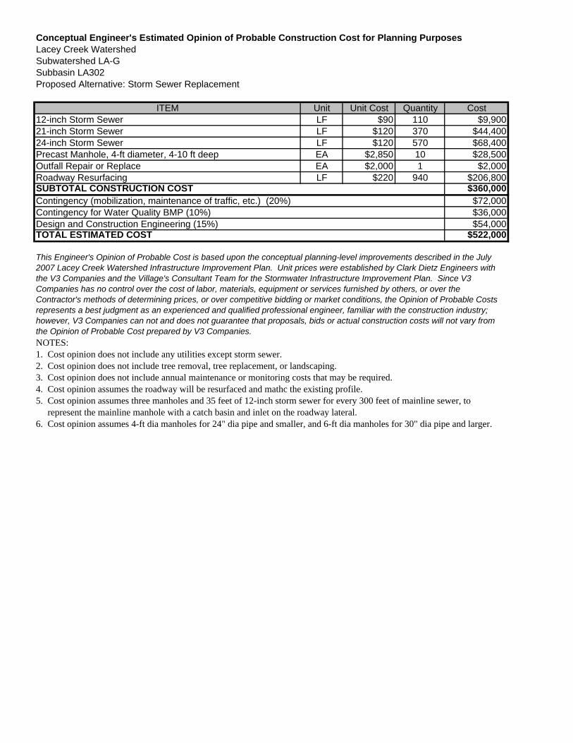
Conceptual Engineer's Estimated Opinion of Probable Construction Cost for Planning PurposesLacey Creek WatershedSubwatershed LA-GSubbasin LA302Proposed Alternative: Storm Sewer Replacement
ITEM Unit Unit Cost Quantity Cost12-inch Storm Sewer LF $90 110 $9,90021-inch Storm Sewer LF $120 370 $44,40024-inch Storm Sewer LF $120 570 $68,400Precast Manhole, 4-ft diameter, 4-10 ft deep EA $2,850 10 $28,500Outfall Repair or Replace EA $2,000 1 $2,000Roadway Resurfacing LF $220 940 $206,800
$360,000$72,000$36,000$54,000
$522,000
NOTES:1. Cost opinion does not include any utilities except storm sewer.2. Cost opinion does not include tree removal, tree replacement, or landscaping.3. Cost opinion does not include annual maintenance or monitoring costs that may be required.4. Cost opinion assumes the roadway will be resurfaced and mathc the existing profile.5. Cost opinion assumes three manholes and 35 feet of 12-inch storm sewer for every 300 feet of mainline sewer, to represent the mainline manhole with a catch basin and inlet on the roadway lateral.6. Cost opinion assumes 4-ft dia manholes for 24" dia pipe and smaller, and 6-ft dia manholes for 30" dia pipe and larger.
TOTAL ESTIMATED COST
This Engineer's Opinion of Probable Cost is based upon the conceptual planning-level improvements described in the July 2007 Lacey Creek Watershed Infrastructure Improvement Plan. Unit prices were established by Clark Dietz Engineers with the V3 Companies and the Village's Consultant Team for the Stormwater Infrastructure Improvement Plan. Since V3 Companies has no control over the cost of labor, materials, equipment or services furnished by others, or over the Contractor's methods of determining prices, or over competitive bidding or market conditions, the Opinion of Probable Costs represents a best judgment as an experienced and qualified professional engineer, familiar with the construction industry; however, V3 Companies can not and does not guarantee that proposals, bids or actual construction costs will not vary from the Opinion of Probable Cost prepared by V3 Companies.
SUBTOTAL CONSTRUCTION COSTContingency (mobilization, maintenance of traffic, etc.) (20%)Contingency for Water Quality BMP (10%)Design and Construction Engineering (15%)
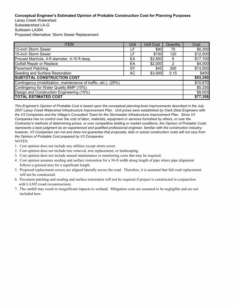
Conceptual Engineer's Estimated Opinion of Probable Construction Cost for Planning PurposesLacey Creek WatershedSubwatershed LA-GSubbasin LA304Proposed Alternative: Storm Sewer Replacement
ITEM Unit Unit Cost Quantity Cost12-inch Storm Sewer LF $90 70 $6,30015-inch Storm Sewer LF $100 120 $12,000Precast Manhole, 4-ft diameter, 4-10 ft deep EA $2,850 6 $17,100Outfall Repair or Replace EA $2,000 2 $4,000Pavement Patching SY $45 300 $13,500Seeding and Surface Restoration AC $3,000 0.15 $450
$53,350$10,670$5,335$8,003
$77,358
NOTES:1. Cost opinion does not include any utilities except storm sewer.2. Cost opinion does not include tree removal, tree replacement, or landscaping.3. Cost opinion does not include annual maintenance or monitoring costs that may be required.4. Cost opinion assumes seeding and surface restoration for a 30-ft width along length of pipe where pipe alignment follows a grassed area for a significant length.5. Proposed replacement sewers are aligned laterally across the road. Therefore, it is assumed that full road replacement will not be constructed.6. Pavement patching and seeding and surface restoration will not be required if project is constructed in conjunction with LA305 (road reconstruction).7. The outfall may result in insignificant impacts to wetland. Mitigation costs are assumed to be negligible and are not included here.
TOTAL ESTIMATED COST
This Engineer's Opinion of Probable Cost is based upon the conceptual planning-level improvements described in the July2007 Lacey Creek Watershed Infrastructure Improvement Plan. Unit prices were established by Clark Dietz Engineers withthe V3 Companies and the Village's Consultant Team for the Stormwater Infrastructure Improvement Plan. Since V3Companies has no control over the cost of labor, materials, equipment or services furnished by others, or over theContractor's methods of determining prices, or over competitive bidding or market conditions, the Opinion of Probable Costsrepresents a best judgment as an experienced and qualified professional engineer, familiar with the construction industry;however, V3 Companies can not and does not guarantee that proposals, bids or actual construction costs will not vary fromthe Opinion of Probable Cost prepared by V3 Companies.
SUBTOTAL CONSTRUCTION COSTContingency (mobilization, maintenance of traffic, etc.) (20%)Contingency for Water Quality BMP (10%)Design and Construction Engineering (15%)
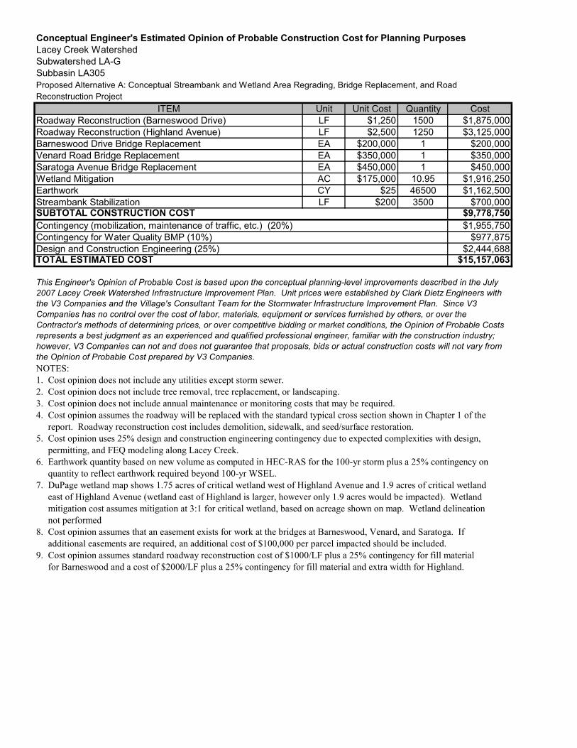
Conceptual Engineer's Estimated Opinion of Probable Construction Cost for Planning PurposesLacey Creek WatershedSubwatershed LA-GSubbasin LA305Proposed Alternative A: Conceptual Streambank and Wetland Area Regrading, Bridge Replacement, and RoadReconstruction Project
ITEM Unit Unit Cost Quantity CostRoadway Reconstruction (Barneswood Drive) LF $1,250 1500 $1,875,000Roadway Reconstruction (Highland Avenue) LF $2,500 1250 $3,125,000Barneswood Drive Bridge Replacement EA $200,000 1 $200,000Venard Road Bridge Replacement EA $350,000 1 $350,000Saratoga Avenue Bridge Replacement EA $450,000 1 $450,000Wetland Mitigation AC $175,000 10.95 $1,916,250Earthwork CY $25 46500 $1,162,500Streambank Stabilization LF $200 3500 $700,000
$9,778,750$1,955,750
$977,875$2,444,688
$15,157,063
NOTES:1. Cost opinion does not include any utilities except storm sewer.2. Cost opinion does not include tree removal, tree replacement, or landscaping.3. Cost opinion does not include annual maintenance or monitoring costs that may be required.4. Cost opinion assumes the roadway will be replaced with the standard typical cross section shown in Chapter 1 of the report. Roadway reconstruction cost includes demolition, sidewalk, and seed/surface restoration.5. Cost opinion uses 25% design and construction engineering contingency due to expected complexities with design, permitting, and FEQ modeling along Lacey Creek.6. Earthwork quantity based on new volume as computed in HEC-RAS for the 100-yr storm plus a 25% contingency on quantity to reflect earthwork required beyond 100-yr WSEL.7. DuPage wetland map shows 1.75 acres of critical wetland west of Highland Avenue and 1.9 acres of critical wetland east of Highland Avenue (wetland east of Highland is larger, however only 1.9 acres would be impacted). Wetland mitigation cost assumes mitigation at 3:1 for critical wetland, based on acreage shown on map. Wetland delineation not performed8. Cost opinion assumes that an easement exists for work at the bridges at Barneswood, Venard, and Saratoga. If additional easements are required, an additional cost of $100,000 per parcel impacted should be included.9. Cost opinion assumes standard roadway reconstruction cost of $1000/LF plus a 25% contingency for fill material for Barneswood and a cost of $2000/LF plus a 25% contingency for fill material and extra width for Highland.
TOTAL ESTIMATED COST
This Engineer's Opinion of Probable Cost is based upon the conceptual planning-level improvements described in the July2007 Lacey Creek Watershed Infrastructure Improvement Plan. Unit prices were established by Clark Dietz Engineers withthe V3 Companies and the Village's Consultant Team for the Stormwater Infrastructure Improvement Plan. Since V3Companies has no control over the cost of labor, materials, equipment or services furnished by others, or over theContractor's methods of determining prices, or over competitive bidding or market conditions, the Opinion of Probable Costsrepresents a best judgment as an experienced and qualified professional engineer, familiar with the construction industry;however, V3 Companies can not and does not guarantee that proposals, bids or actual construction costs will not vary fromthe Opinion of Probable Cost prepared by V3 Companies.
SUBTOTAL CONSTRUCTION COSTContingency (mobilization, maintenance of traffic, etc.) (20%)Contingency for Water Quality BMP (10%)Design and Construction Engineering (25%)
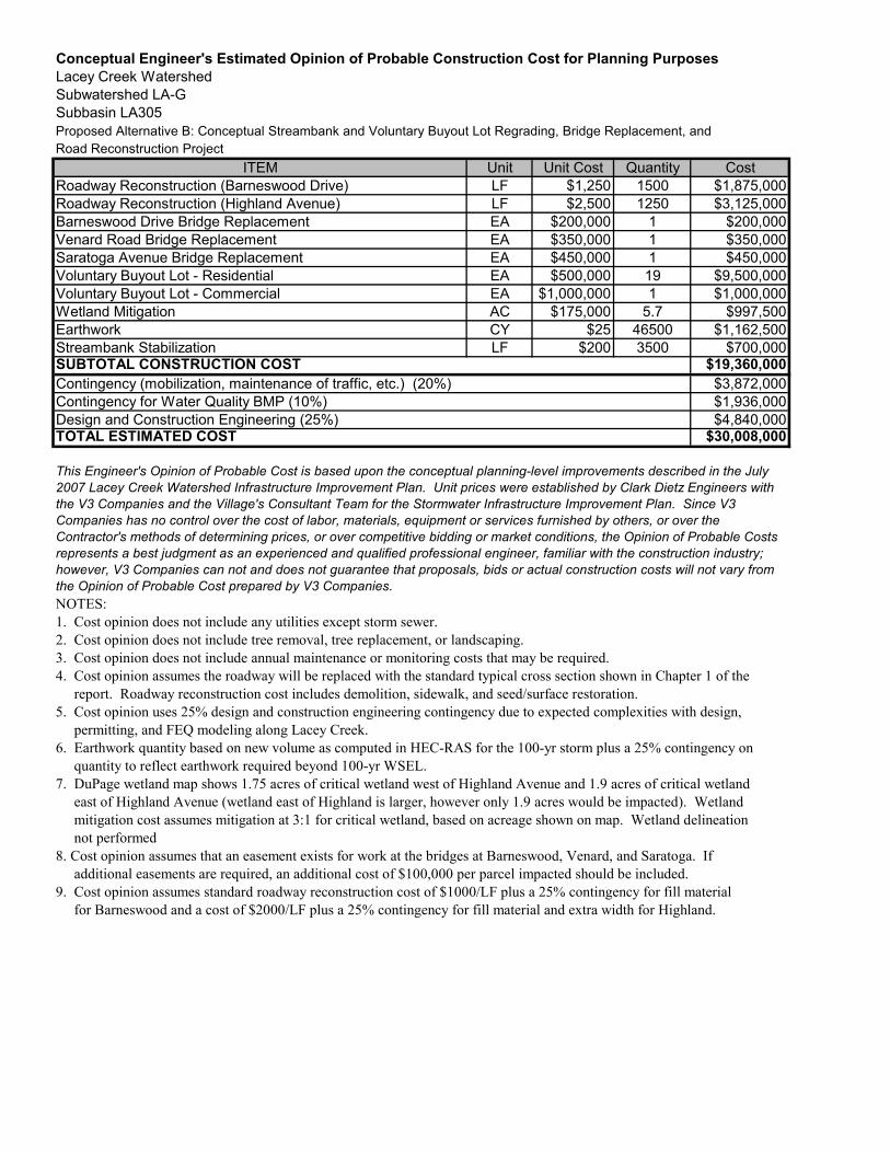
Conceptual Engineer's Estimated Opinion of Probable Construction Cost for Planning PurposesLacey Creek WatershedSubwatershed LA-GSubbasin LA305Proposed Alternative B: Conceptual Streambank and Voluntary Buyout Lot Regrading, Bridge Replacement, andRoad Reconstruction Project
ITEM Unit Unit Cost Quantity CostRoadway Reconstruction (Barneswood Drive) LF $1,250 1500 $1,875,000Roadway Reconstruction (Highland Avenue) LF $2,500 1250 $3,125,000Barneswood Drive Bridge Replacement EA $200,000 1 $200,000Venard Road Bridge Replacement EA $350,000 1 $350,000Saratoga Avenue Bridge Replacement EA $450,000 1 $450,000Voluntary Buyout Lot - Residential EA $500,000 19 $9,500,000Voluntary Buyout Lot - Commercial EA $1,000,000 1 $1,000,000Wetland Mitigation AC $175,000 5.7 $997,500Earthwork CY $25 46500 $1,162,500Streambank Stabilization LF $200 3500 $700,000
$19,360,000$3,872,000$1,936,000$4,840,000
$30,008,000
NOTES:1. Cost opinion does not include any utilities except storm sewer.2. Cost opinion does not include tree removal, tree replacement, or landscaping.3. Cost opinion does not include annual maintenance or monitoring costs that may be required.4. Cost opinion assumes the roadway will be replaced with the standard typical cross section shown in Chapter 1 of the report. Roadway reconstruction cost includes demolition, sidewalk, and seed/surface restoration.5. Cost opinion uses 25% design and construction engineering contingency due to expected complexities with design, permitting, and FEQ modeling along Lacey Creek.6. Earthwork quantity based on new volume as computed in HEC-RAS for the 100-yr storm plus a 25% contingency on quantity to reflect earthwork required beyond 100-yr WSEL.7. DuPage wetland map shows 1.75 acres of critical wetland west of Highland Avenue and 1.9 acres of critical wetland east of Highland Avenue (wetland east of Highland is larger, however only 1.9 acres would be impacted). Wetland mitigation cost assumes mitigation at 3:1 for critical wetland, based on acreage shown on map. Wetland delineation not performed8. Cost opinion assumes that an easement exists for work at the bridges at Barneswood, Venard, and Saratoga. If additional easements are required, an additional cost of $100,000 per parcel impacted should be included.9. Cost opinion assumes standard roadway reconstruction cost of $1000/LF plus a 25% contingency for fill material for Barneswood and a cost of $2000/LF plus a 25% contingency for fill material and extra width for Highland.
TOTAL ESTIMATED COST
This Engineer's Opinion of Probable Cost is based upon the conceptual planning-level improvements described in the July2007 Lacey Creek Watershed Infrastructure Improvement Plan. Unit prices were established by Clark Dietz Engineers withthe V3 Companies and the Village's Consultant Team for the Stormwater Infrastructure Improvement Plan. Since V3Companies has no control over the cost of labor, materials, equipment or services furnished by others, or over theContractor's methods of determining prices, or over competitive bidding or market conditions, the Opinion of Probable Costsrepresents a best judgment as an experienced and qualified professional engineer, familiar with the construction industry;however, V3 Companies can not and does not guarantee that proposals, bids or actual construction costs will not vary fromthe Opinion of Probable Cost prepared by V3 Companies.
SUBTOTAL CONSTRUCTION COSTContingency (mobilization, maintenance of traffic, etc.) (20%)Contingency for Water Quality BMP (10%)Design and Construction Engineering (25%)
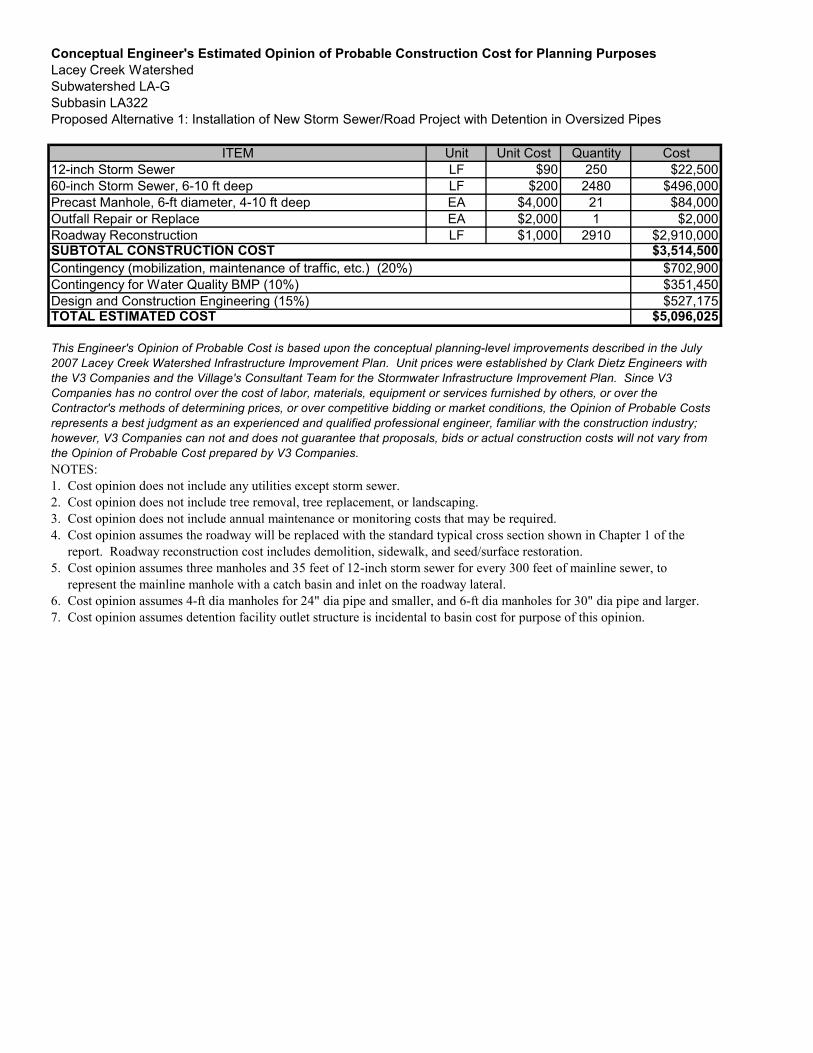
Conceptual Engineer's Estimated Opinion of Probable Construction Cost for Planning PurposesLacey Creek WatershedSubwatershed LA-GSubbasin LA322Proposed Alternative 1: Installation of New Storm Sewer/Road Project with Detention in Oversized Pipes
ITEM Unit Unit Cost Quantity Cost12-inch Storm Sewer LF $90 250 $22,50060-inch Storm Sewer, 6-10 ft deep LF $200 2480 $496,000Precast Manhole, 6-ft diameter, 4-10 ft deep EA $4,000 21 $84,000Outfall Repair or Replace EA $2,000 1 $2,000Roadway Reconstruction LF $1,000 2910 $2,910,000
$3,514,500$702,900$351,450$527,175
$5,096,025
NOTES:1. Cost opinion does not include any utilities except storm sewer.2. Cost opinion does not include tree removal, tree replacement, or landscaping.3. Cost opinion does not include annual maintenance or monitoring costs that may be required.4. Cost opinion assumes the roadway will be replaced with the standard typical cross section shown in Chapter 1 of the report. Roadway reconstruction cost includes demolition, sidewalk, and seed/surface restoration.5. Cost opinion assumes three manholes and 35 feet of 12-inch storm sewer for every 300 feet of mainline sewer, to represent the mainline manhole with a catch basin and inlet on the roadway lateral.6. Cost opinion assumes 4-ft dia manholes for 24" dia pipe and smaller, and 6-ft dia manholes for 30" dia pipe and larger.7. Cost opinion assumes detention facility outlet structure is incidental to basin cost for purpose of this opinion.
TOTAL ESTIMATED COST
This Engineer's Opinion of Probable Cost is based upon the conceptual planning-level improvements described in the July2007 Lacey Creek Watershed Infrastructure Improvement Plan. Unit prices were established by Clark Dietz Engineers withthe V3 Companies and the Village's Consultant Team for the Stormwater Infrastructure Improvement Plan. Since V3Companies has no control over the cost of labor, materials, equipment or services furnished by others, or over theContractor's methods of determining prices, or over competitive bidding or market conditions, the Opinion of Probable Costsrepresents a best judgment as an experienced and qualified professional engineer, familiar with the construction industry;however, V3 Companies can not and does not guarantee that proposals, bids or actual construction costs will not vary fromthe Opinion of Probable Cost prepared by V3 Companies.
SUBTOTAL CONSTRUCTION COSTContingency (mobilization, maintenance of traffic, etc.) (20%)Contingency for Water Quality BMP (10%)Design and Construction Engineering (15%)
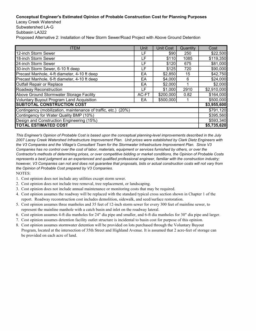
Conceptual Engineer's Estimated Opinion of Probable Construction Cost for Planning PurposesLacey Creek WatershedSubwatershed LA-GSubbasin LA322Proposed Alternative 2: Installation of New Storm Sewer/Road Project with Above Ground Detention
ITEM Unit Unit Cost Quantity Cost12-inch Storm Sewer LF $90 250 $22,50018-inch Storm Sewer LF $110 1085 $119,35024-inch Storm Sewer LF $120 675 $81,00030-inch Storm Sewer, 6-10 ft deep LF $125 720 $90,000Precast Manhole, 4-ft diameter, 4-10 ft deep EA $2,850 15 $42,750Precast Manhole, 6-ft diameter, 4-10 ft deep EA $4,000 6 $24,000Outfall Repair or Replace EA $2,000 1 $2,000Roadway Reconstruction LF $1,000 2910 $2,910,000Above Ground Stormwater Storage Facility AC-FT $200,000 0.82 $164,000Voluntary Buyout Program Land Acquisition EA $500,000 1 $500,000
$3,955,600$791,120$395,560$593,340
$5,735,620
NOTES:1. Cost opinion does not include any utilities except storm sewer.2. Cost opinion does not include tree removal, tree replacement, or landscaping.3. Cost opinion does not include annual maintenance or monitoring costs that may be required.4. Cost opinion assumes the roadway will be replaced with the standard typical cross section shown in Chapter 1 of the report. Roadway reconstruction cost includes demolition, sidewalk, and seed/surface restoration.5. Cost opinion assumes three manholes and 35 feet of 12-inch storm sewer for every 300 feet of mainline sewer, to represent the mainline manhole with a catch basin and inlet on the roadway lateral.6. Cost opinion assumes 4-ft dia manholes for 24" dia pipe and smaller, and 6-ft dia manholes for 30" dia pipe and larger.7. Cost opinion assumes detention facility outlet structure is incidental to basin cost for purpose of this opinion.8. Cost opinion assumes stormwater detention will be provided on lots purchased through the Voluntary Buyout Program, located at the intersection of 35th Street and Highland Avenue. It is assumed that 2 acre-feet of storage can be provided on each acre of land.
TOTAL ESTIMATED COST
This Engineer's Opinion of Probable Cost is based upon the conceptual planning-level improvements described in the July2007 Lacey Creek Watershed Infrastructure Improvement Plan. Unit prices were established by Clark Dietz Engineers withthe V3 Companies and the Village's Consultant Team for the Stormwater Infrastructure Improvement Plan. Since V3Companies has no control over the cost of labor, materials, equipment or services furnished by others, or over theContractor's methods of determining prices, or over competitive bidding or market conditions, the Opinion of Probable Costsrepresents a best judgment as an experienced and qualified professional engineer, familiar with the construction industry;however, V3 Companies can not and does not guarantee that proposals, bids or actual construction costs will not vary fromthe Opinion of Probable Cost prepared by V3 Companies.
SUBTOTAL CONSTRUCTION COSTContingency (mobilization, maintenance of traffic, etc.) (20%)Contingency for Water Quality BMP (10%)Design and Construction Engineering (15%)
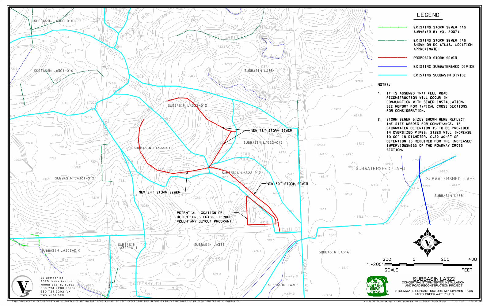
737.0
743.1727.0
758.6757.4
715.8
741.3742.9744.4
697.8735.3
758.5
745.1 695.4741.1 731.2 701.3737.4
695.1758.8 733.3
711.0
701.7
698.9
729.9 703.4727.4
719.5746.6 728.6 694.1
728.6751.2
699.8
749.8 712.5 695.2695.1
719.8
750.5696.3728.8
724.9
692.2
703.0749.0
746.6
697.2
695.7
694.8
738.5
695.7 692.9
692.2
694.4696.7
692.5693.7
692.5692.3
697.6717.2 712.5 692.7 693.0
711.4712.4 693.1
731.0
695.1710.7707.4
691.7
692.5
693.7706.5 691.9709.4
722.1
692.4 692.7695.9 692.6
691.6692.5 694.5
697.1 691.6703.4724.4
703.0 700.2
709.2
723.6 693.4694.2700.6
692.4695.2694.3
691.6
707.3707.7715.7 693.2
692.1691.6
706.3692.3695.8 689.7
695.2
716.3
693.0 697.1
695.2704.3
704.5
691.7
694.1705.3 695.2691.5
694.5699.3 692.1692.4703.1
693.9
742.1743.0744.5
735.1
742.6
739.4 747.3743.3
742.7
746.7731.0
738.9
735.0
750.5741.6733.5
734.9749.5
734.9
737.0
736.4
735.1726.8
735.6
735.5
722.8735.5
727.0
706.6
705.1
702.8700.6
703.5718.3 701.9
696.5
711.4
710
LEGEND
EXISTING STORM SEWER (AS
SURVEYED BY V3, 2007)
EXISTING STORM SEWER (AS
SHOWN ON DG ATLAS, LOCATION
APPROXIMATE)
PROPOSED STORM SEWER
EXISTING SUBWATERSHED DIVIDE
EXISTING SUBBASIN DIVIDE
0
FEETSCALE
400
1"=200’
200 200
SUBBASIN LA354
SUBWATERSHED LA-E
V3 Companies
7325 Janes Avenue
Woodridge, IL 60517
630.724.9200 phone
630.724.9202 fax
www.v3co.com
STORMWATER INFRASTRUCTURE IMPROVEMENT PLAN
LACEY CREEK WATERSHED
SUBBASIN LA322CONCEPTUAL STORM SEWER INSTALLATION
AND ROAD RECONSTRUCTION PROJECT
SUBWATERSHED LA-G
SUBBASIN LA322-010
SUBBASIN LA322-011
SUBBASIN LA322-013
SUBBASIN LA322-012
SUBBASIN LA353
SUBBASIN LA305
SUBBASIN LA316
SUBBASIN LA381
SUBBASIN LA300-010
SUBBASIN LA301-010
SUBBASIN LA301-012
SUBBASIN LA302-010
SUBBASIN
LA302-011
NOTES:
1. IT IS ASSUMED THAT FULL ROAD
RECONSTRUCTION WILL OCCUR IN
CONJUNCTION WITH SEWER INSTALLATION.
SEE REPORT FOR TYPICAL CROSS SECTIONS
FOR CONSIDERATION.
2. STORM SEWER SIZES SHOWN HERE REFLECT
THE SIZE NEEDED FOR CONVEYANCE. IF
STORMWATER DETENTION IS TO BE PROVIDED
IN OVERSIZED PIPES, SIZES WILL INCREASE
TO 60" IN DIAMETER. 0.82 AC-FT OF
DETENTION IS REQUIRED FOR THE INCREASED
IMPERVIOUSNESS OF THE ROADWAY CROSS
SECTION.
NEW 18" STORM SEWER
NEW 24" STORM SEWER
NEW 30" STORM SEWER
POTENTIAL LOCATION OF
DETENTION STORAGE (THROUGH
VOLUNTARY BUYOUT PROGRAM)
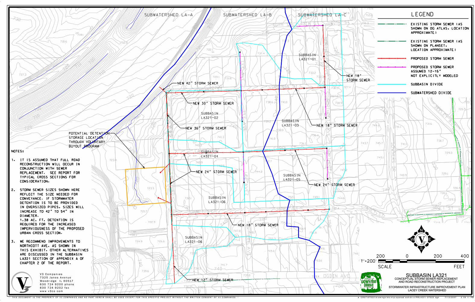
712.6
729.3
720.8730.9
718.1
719.0737.3718.6
702.8
722.1
737.4
733.2737.3
732.3740.1729.1731.6
731.5 727.4730.5741.4717.8 732.1
727.0
741.0738.6 730.9734.7
727.7
739.2
738.9
736.4741.3
741.0740.4
736.1740.3
739.1742.5
741.7
732.9
723.4742.7
740.9
742.9
743.4 745.2744.2
723.5741.7
748.1
749.1752.1744.6732.1
719.2
719.4
747.4754.1
721.7 749.6
725.9 752.7
722.5
722.9 754.4750.7
751.7754.9
747.8749.5748.7 752.8
730.3748.5
753.3
726.6724.9
742.3
760.7
711.6
722.7
712.6 711.6724.7
717.9715.3
711.8 724.4710.9
723.2712.8
715.1
722.3
725.5
726.1725.5726.4
726.5 725.1725.7
726.5
723.1727.7
727.7728.3
723.7
726.5
731.6744.6
741.1
730.7
745.7743.7 741.1
729.3
745.1
723.5
729.1740.9
726.4
730.6
729.3
730.1
729.6
728.9
731.8 730.6731.0
732.4 729.6
730.7
754.6
745.0733.0 740.9
753.0760.7
767.3741.7
765.3 734.3
739.6768.5
739.0749.4
766.9
732.5 728.9
738.8
731.1
737.0
740.9738.1
734.9735.6
739.4
743.7
743.2
768.6
0
FEETSCALE
400
1"=200’
200 200
SUBBASIN
LA321-04
SUBBASIN
LA321-02
SUBBASIN
LA321-03
SUBBASIN
LA321-01
SUBBASIN
LA321-05
SUBBASIN
LA321-06
SUBBASIN
LA321-06
SUBWATERSHED LA-A SUBWATERSHED LA-B SUBWATERSHED LA-C LEGEND
NEW 18" STORM SEWER
NEW 24" STORM SEWER
NEW 12" STORM SEWER
NEW 24" STORM SEWER
NEW 18" STORM SEWER
NEW 30" STORM SEWER
NEW 36" STORM SEWER
NEW 42" STORM SEWER
NEW 18"
STORM SEWER
V3 Companies
7325 Janes Avenue
Woodridge, IL 60517
630.724.9200 phone
630.724.9202 fax
www.v3co.com
STORMWATER INFRASTRUCTURE IMPROVEMENT PLAN
LACEY CREEK WATERSHED
SUBBASIN LA321CONCEPTUAL STORM SEWER REPLACEMENT
AND ROAD RECONSTRUCTION PROJECT
NOTES:
1. IT IS ASSUMED THAT FULL ROAD
RECONSTRUCTION WILL OCCUR IN
CONJUNCTION WITH SEWER
REPLACEMENT. SEE REPORT FOR
TYPICAL CROSS SECTIONS FOR
CONSIDERATION.
2. STORM SEWER SIZES SHOWN HERE
REFLECT THE SIZE NEEDED FOR
CONVEYANCE. IF STORMWATER
DETENTION IS TO BE PROVIDED
IN OVERSIZED PIPES, SIZES WILL
INCREASE TO 42" TO 54" IN
DIAMETER.
1.38 AC. FT. DETENTION IS
REQUIRED FOR THE INCREASED
IMPERVIOUSNESS OF THE PROPOSED
URBAN CROSS SECTION.
3. WE RECOMMEND IMPROVEMENTS TO
NORTHCOTT AVE. AS SHOWN IN
THIS EXHIBIT. OTHER ALTERNATIVES
ARE DISCUSSED IN THE SUBBASIN
LA321 SECTION OF APPENDIX A OF
CHAPTER 2 OF THE REPORT.
POTENTIAL DETENTION
STORAGE LOCATION
THROUGH VOLUNTARY
BUYOUT PROGRAM
EXISTING STORM SEWER (AS
SHOWN ON DG ATLAS, LOCATION
APPROXIMATE)
EXISTING STORM SEWER (AS
SHOWN ON PLANSET,
LOCATION APPROXIMATE)
PROPOSED STORM SEWER
PROPOSED STORM SEWER
ASSUMED 12-15"
NOT EXPLICITLY MODELED
SUBBASIN DIVIDE
SUBWATERSHED DIVIDE
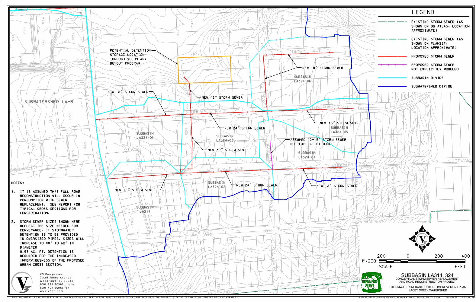
LEGEND
NOTES:
1. IT IS ASSUMED THAT FULL ROAD
RECONSTRUCTION WILL OCCUR IN
CONJUNCTION WITH SEWER
REPLACEMENT. SEE REPORT FOR
TYPICAL CROSS SECTIONS FOR
CONSIDERATION.
2. STORM SEWER SIZES SHOWN HERE
REFLECT THE SIZE NEEDED FOR
CONVEYANCE. IF STORMWATER
DETENTION IS TO BE PROVIDED
IN OVERSIZED PIPES, SIZES WILL
INCREASE TO 48" TO 60" IN
DIAMETER.
0.97 AC. FT. DETENTION IS
REQUIRED FOR THE INCREASED
IMPERVIOUSNESS OF THE PROPOSED
URBAN CROSS SECTION.
SUBWATERSHED LA-B
SUBBASIN
LA314
SUBBASIN
LA324-01
SUBBASIN
LA324-02
SUBBASIN
LA324-03
SUBBASIN
LA324-04
SUBBASIN
LA324-05
SUBBASIN
LA324-06
NEW 18" STORM SEWER
NEW 18" STORM SEWER
NEW 18" STORM SEWER
NEW 18" STORM SEWER
NEW 18" STORM SEWER
NEW 24" STORM SEWER
NEW 24" STORM SEWER
NEW 30" STORM SEWER
NEW 42" STORM SEWER
ASSUMED 12-15" STORM SEWER
NOT EXPLICITLY MODELED
POTENTIAL DETENTION
STORAGE LOCATION
THROUGH VOLUNTARY
BUYOUT PROGRAM
EXISTING STORM SEWER (AS
SHOWN ON DG ATLAS, LOCATION
APPROXIMATE)
EXISTING STORM SEWER (AS
SHOWN ON PLANSET,
LOCATION APPROXIMATE)
PROPOSED STORM SEWER
PROPOSED STORM SEWER
NOT EXPLICITLY MODELED
SUBBASIN DIVIDE
SUBWATERSHED DIVIDE
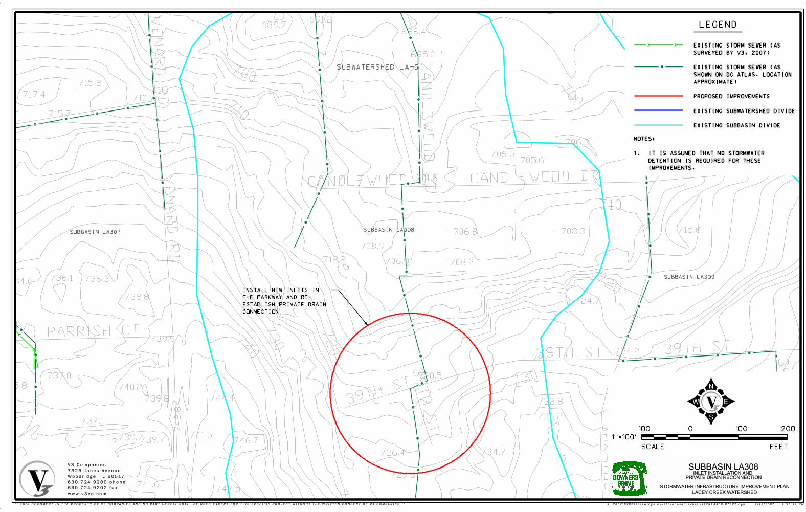
715.8
694.5
691.2689.7
696.4
695.0
715.2
717.4710.7
715.7
706.3
706.5705.6
701.8
708.3706.8
708.9
712.2 706.9 708.2
736.1 736.3734.6
738.8724.7
739.9
724.2727.1
736.5
720.5737.0
735.8 740.2
744.4739.8 732.8
736.2737.1
741.5739.7739.7 746.7
710
734.4
740.9
739.5
734.7726.4
741.2 729.3
741.6747.5
743.9 742.1
0
FEETSCALE
1"=100’
100 100 200
LEGEND
SUBWATERSHED LA-D
SUBBASIN LA307SUBBASIN LA308
SUBBASIN LA309
V3 Companies
7325 Janes Avenue
Woodridge, IL 60517
630.724.9200 phone
630.724.9202 fax
www.v3co.com
STORMWATER INFRASTRUCTURE IMPROVEMENT PLAN
LACEY CREEK WATERSHED
SUBBASIN LA308INLET INSTALLATION AND
PRIVATE DRAIN RECONNECTION
NOTES:
1. IT IS ASSUMED THAT NO STORMWATER
DETENTION IS REQUIRED FOR THESE
IMPROVEMENTS.
EXISTING STORM SEWER (AS
SURVEYED BY V3, 2007)
EXISTING STORM SEWER (AS
SHOWN ON DG ATLAS, LOCATION
APPROXIMATE)
PROPOSED IMPROVEMENTS
EXISTING SUBWATERSHED DIVIDE
EXISTING SUBBASIN DIVIDE
INSTALL NEW INLETS IN
THE PARKWAY AND RE-
ESTABLISH PRIVATE DRAIN
CONNECTION
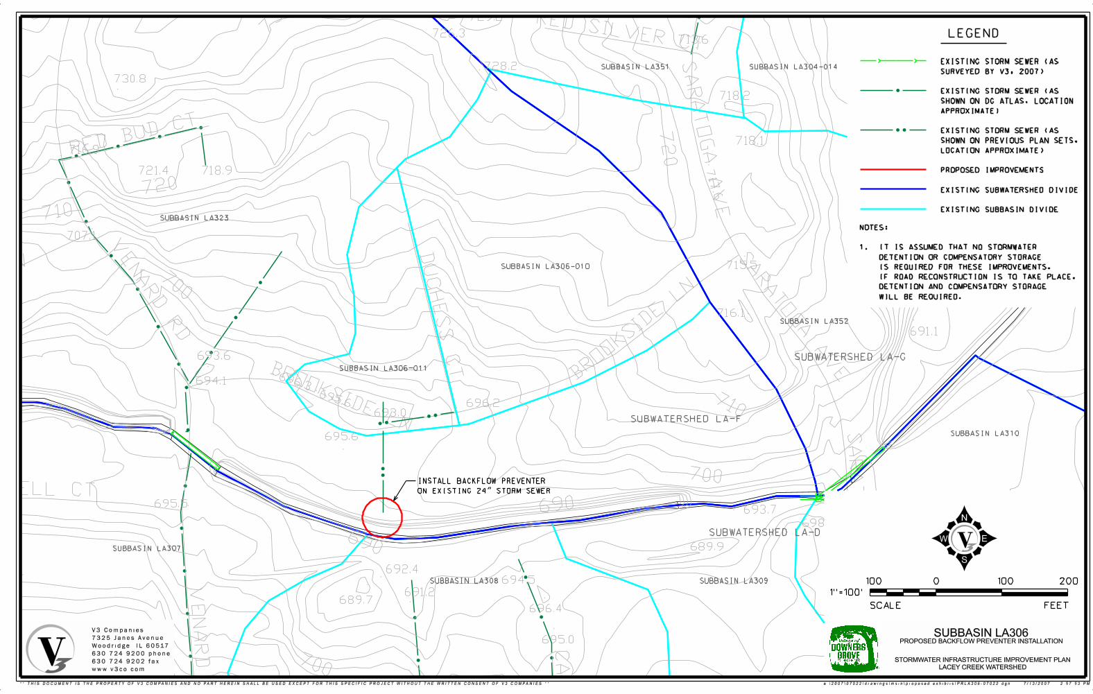
699.4
691.1
697.2
729.2
726.3713.6
728.2
730.8
718.2
718.1716.9
721.4 718.9
707.1
715.5
716.1
693.6
694.1
696.2693.0
695.6
695.5693.7
698.6
689.9
692.4694.5
691.2689.7
696.4
695.0
715.2
0
FEETSCALE
1"=100’
100 100 200
LEGEND
SUBWATERSHED LA-F
SUBBASIN LA306-010
SUBBASIN LA306-011
V3 Companies
7325 Janes Avenue
Woodridge, IL 60517
630.724.9200 phone
630.724.9202 fax
www.v3co.com
STORMWATER INFRASTRUCTURE IMPROVEMENT PLAN
LACEY CREEK WATERSHED
SUBBASIN LA306PROPOSED BACKFLOW PREVENTER INSTALLATION
SUBBASIN LA323
SUBBASIN LA307
SUBBASIN LA308 SUBBASIN LA309
SUBBASIN LA310
SUBBASIN LA352
SUBBASIN LA351 SUBBASIN LA304-014
SUBWATERSHED LA-G
SUBWATERSHED LA-D
INSTALL BACKFLOW PREVENTER
ON EXISTING 24" STORM SEWER
NOTES:
1. IT IS ASSUMED THAT NO STORMWATER
DETENTION OR COMPENSATORY STORAGE
IS REQUIRED FOR THESE IMPROVEMENTS.
IF ROAD RECONSTRUCTION IS TO TAKE PLACE,
DETENTION AND COMPENSATORY STORAGE
WILL BE REQUIRED.
EXISTING STORM SEWER (AS
SURVEYED BY V3, 2007)
EXISTING STORM SEWER (AS
SHOWN ON DG ATLAS, LOCATION
APPROXIMATE)
EXISTING STORM SEWER (AS
SHOWN ON PREVIOUS PLAN SETS,
LOCATION APPROXIMATE)
PROPOSED IMPROVEMENTS
EXISTING SUBWATERSHED DIVIDE
EXISTING SUBBASIN DIVIDE
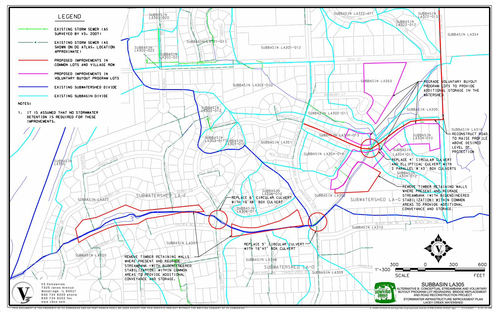
LEGEND
SUBBASIN LA1
0
FEETSCALE
1"=300
300 300 600
SUBWATERSHED LA-G
SUBWATERSHED LA-D
SUBWATERSHED LA-F
SUBBASIN LA320
SUBBASIN LA307
SUBBASIN LA308
SUBBASIN LA309
SUBBASIN LA310
SUBBASIN LA323
SUBBASIN LA355
SUBBASIN LA306-010
SUBBASIN LA306-011
SUBBASIN LA303-012
SUBBASIN LA303-011 SUBBASIN
LA303-010SUBBASIN LA351
SUBBASIN LA352
SUBBASIN LA304-010
SUBBASIN LA304-013
SUBBASIN LA304-014
SUBBASIN LA304-012
SUBBASIN LA316
SUBBASIN LA305
SUBBASIN LA302-010
SUBBASIN LA302-011
SUBBASIN LA353
SUBBASIN LA354
SUBBASIN LA301-011
SUBBASIN LA301-012
SUBBASIN LA302-020
SUBBASIN LA302-022
SUBBASIN LA302-021
SUBBASIN LA322-011
SUBBASIN LA322-012
SUBBASIN LA322-013
RECONSTRUCT ROAD
TO RAISE PROFILE
ABOVE DESIRED
LEVEL OF
PROTECTION
REPLACE 4’ CIRCULAR CULVERT
AND ELLIPTICAL CULVERT WITH
2 PARALLEL 8’X3’ BOX CULVERTS
REPLACE 6’ CIRCULAR CULVERT
WITH 16’X8’ BOX CULVERT
REPLACE 5’ CIRCULAR CULVERT
WITH 16’X7’ BOX CULVERT
REGRADE VOLUNTARY BUYOUT
PROGRAM LOTS TO PROVIDE
ADDITIONAL STORAGE IN THE
WATERSHED
EXISTING STORM SEWER (AS
SURVEYED BY V3, 2007)
EXISTING STORM SEWER (AS
SHOWN ON DG ATLAS, LOCATION
APPROXIMATE)
PROPOSED IMPROVEMENTS IN
COMMON LOTS AND VILLAGE ROW
PROPOSED IMPROVEMENTS IN
VOLUNTARY BUYOUT PROGRAM LOTS
EXISTING SUBWATERSHED DIVIDE
EXISTING SUBBASIN DIVIDE
V3 Companies
7325 Janes Avenue
Woodridge, IL 60517
630.724.9200 phone
630.724.9202 fax
www.v3co.comSTORMWATER INFRASTRUCTURE IMPROVEMENT PLAN
LACEY CREEK WATERSHED
SUBBASIN LA305ALTERNATIVE B: CONCEPTUAL STREAMBANK AND VOLUNTARY
BUYOUT PROGRAM LOT REGRADING, BRIDGE REPLACEMENT
AND ROAD RECONSTRUCTION PROJECT
NOTES:
1. IT IS ASSUMED THAT NO STORMWATER
DETENTION IS REQUIRED FOR THESE
IMPROVEMENTS.
REMOVE TIMBER RETAINING WALLS
WHERE PRESENT AND REGRADE
STREAMBANK (WITH BIOENGINEERED
STABILIZATION) WITHIN COMMON
AREAS TO PROVIDE ADDITIONAL
CONVEYANCE AND STORAGE.
SUBBASIN
LA304-011
REMOVE TIMBER RETAINING WALLS
WHERE PRESENT AND REGRADE
STREAMBANK (WITH BIOENGINEERED
STABILIZATION) WITHIN COMMON
AREAS TO PROVIDE ADDITIONAL
CONVEYANCE AND STORAGE.
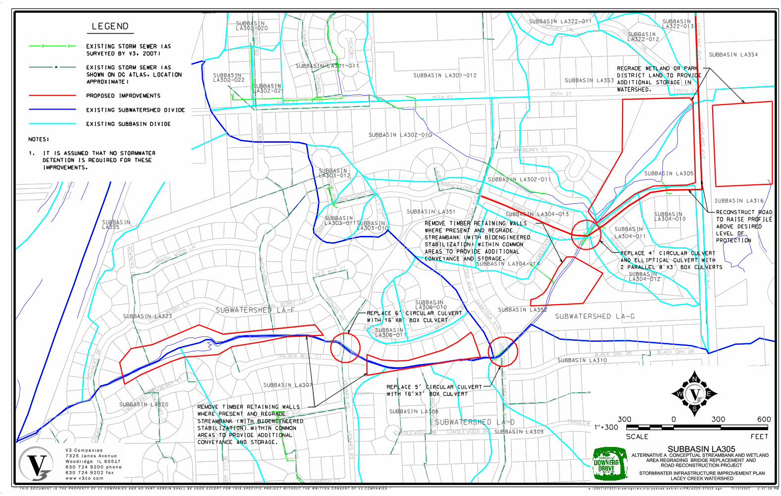
LEGEND
SUBBASIN LA1
0
FEETSCALE
1"=300
300 300 600
SUBWATERSHED LA-G
SUBWATERSHED LA-D
SUBWATERSHED LA-F
SUBBASIN LA320
SUBBASIN LA307
SUBBASIN LA308
SUBBASIN LA309
SUBBASIN LA310
SUBBASIN LA323
SUBBASIN LA355
SUBBASIN LA306-010
SUBBASIN LA306-011
SUBBASIN LA303-012
SUBBASIN LA303-011 SUBBASIN
LA303-010
SUBBASIN LA351
SUBBASIN LA352
SUBBASIN LA304-010
SUBBASIN LA304-013
SUBBASIN LA304-014
SUBBASIN LA304-012
SUBBASIN LA316
SUBBASIN LA305
SUBBASIN LA302-010
SUBBASIN LA302-011
SUBBASIN LA353
SUBBASIN LA354
SUBBASIN LA301-011
SUBBASIN LA301-012
SUBBASIN LA302-020
SUBBASIN LA302-022
SUBBASIN LA302-021
SUBBASIN LA322-011
SUBBASIN LA322-012
SUBBASIN LA322-013
EXISTING STORM SEWER (AS
SURVEYED BY V3, 2007)
EXISTING STORM SEWER (AS
SHOWN ON DG ATLAS, LOCATION
APPROXIMATE)
PROPOSED IMPROVEMENTS
EXISTING SUBWATERSHED DIVIDE
EXISTING SUBBASIN DIVIDE
REPLACE 6’ CIRCULAR CULVERT
WITH 16’X8’ BOX CULVERT
REPLACE 5’ CIRCULAR CULVERT
WITH 16’X7’ BOX CULVERT
REPLACE 4’ CIRCULAR CULVERT
AND ELLIPTICAL CULVERT WITH
2 PARALLEL 8’X3’ BOX CULVERTS
RECONSTRUCT ROAD
TO RAISE PROFILE
ABOVE DESIRED
LEVEL OF
PROTECTION
V3 Companies
7325 Janes Avenue
Woodridge, IL 60517
630.724.9200 phone
630.724.9202 fax
www.v3co.com
STORMWATER INFRASTRUCTURE IMPROVEMENT PLAN
LACEY CREEK WATERSHED
SUBBASIN LA305ALTERNATIVE A: CONCEPTUAL STREAMBANK AND WETLAND
AREA REGRADING, BRIDGE REPLACEMENT, AND
ROAD RECONSTRUCTION PROJECT
NOTES:
1. IT IS ASSUMED THAT NO STORMWATER
DETENTION IS REQUIRED FOR THESE
IMPROVEMENTS.
REMOVE TIMBER RETAINING WALLS
WHERE PRESENT AND REGRADE
STREAMBANK (WITH BIOENGINEERED
STABILIZATION) WITHIN COMMON
AREAS TO PROVIDE ADDITIONAL
CONVEYANCE AND STORAGE.
REMOVE TIMBER RETAINING WALLS
WHERE PRESENT AND REGRADE
STREAMBANK (WITH BIOENGINEERED
STABILIZATION) WITHIN COMMON
AREAS TO PROVIDE ADDITIONAL
CONVEYANCE AND STORAGE.
SUBBASIN
LA304-011
REGRADE WETLAND OR PARK
DISTRICT LAND TO PROVIDE
ADDITIONAL STORAGE IN
WATERSHED.
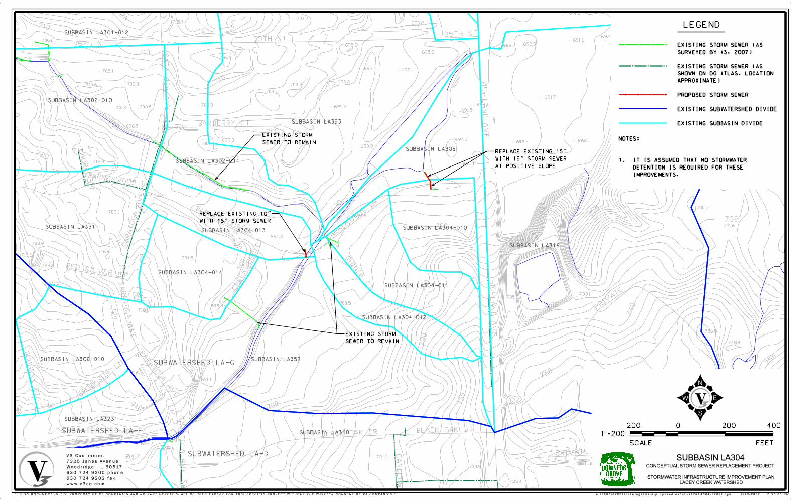
691.6
707.3707.7715.7 693.2
696.5
692.1691.6
706.3692.3695.8 689.7
695.2
716.3
693.0 697.1
695.2704.3
704.5
691.7
718.4694.1705.3 695.2691.5
694.5699.3 692.1692.4703.1
693.9
695.1
729.4
703.4
730.5
694.8
731.6
694.3
704.8
733.1735.3
700.5699.4
756.5
748.4
691.1 751.0
754.3
752.5
752.6697.2
721.6
730.9
747.3735.4
730
706.6
705.1
702.8700.6
703.5718.3 701.9
696.5
711.4
712.9
711.1
702.5
709.0
723.9
716.2719.6
729.2
726.3713.6
728.2
718.2
718.1
715.5
716.1
696.2693.0
693.7
698.6
689.9
692.4694.5
691.2
696.4
695.0
710
LEGEND
EXISTING STORM SEWER (AS
SURVEYED BY V3, 2007)
EXISTING STORM SEWER (AS
SHOWN ON DG ATLAS, LOCATION
APPROXIMATE)
PROPOSED STORM SEWER
EXISTING SUBWATERSHED DIVIDE
EXISTING SUBBASIN DIVIDE
SUBWATERSHED LA-D
0
FEETSCALE
400
1"=200’
200 200
SUBBASIN LA316
SUBBASIN LA304-010
SUBBASIN LA304-011
SUBBASIN LA304-012
SUBBASIN LA304-013
SUBBASIN LA304-014
SUBBASIN LA351
SUBBASIN LA302-010
SUBBASIN LA301-012
SUBBASIN LA302-011
SUBBASIN LA353
SUBBASIN LA305
SUBBASIN LA352
SUBBASIN LA323
SUBBASIN LA310
SUBBASIN LA306-010SUBWATERSHED LA-G
SUBWATERSHED LA-F
EXISTING STORM
SEWER TO REMAIN
REPLACE EXISTING 15"
WITH 15" STORM SEWER
AT POSITIVE SLOPE
REPLACE EXISTING 10"
WITH 15" STORM SEWER
EXISTING STORM
SEWER TO REMAIN
V3 Companies
7325 Janes Avenue
Woodridge, IL 60517
630.724.9200 phone
630.724.9202 fax
www.v3co.com
STORMWATER INFRASTRUCTURE IMPROVEMENT PLAN
LACEY CREEK WATERSHED
SUBBASIN LA304CONCEPTUAL STORM SEWER REPLACEMENT PROJECT
NOTES:
1. IT IS ASSUMED THAT NO STORMWATER
DETENTION IS REQUIRED FOR THESE
IMPROVEMENTS.

728.7728.1
734.9728.6
737.0727.1
727.9 736.4721.1 725.4
728.4718.6
723.5
735.1726.5726.8728.6
722.8
722.8725.3 722.8720.9
735.5726.7 721.3
724.7
720.9
722.7725.7
721.7
726.1727.2
728.9731.0
713.6720.8
714.8
724.9727.7 715.1
726.7
715.3725.5
725.5722.1 717.3 706.6727.4
713.3718.1721.5
722.5728.2 708.7
709.5
706.7
718.9726.4731.0
732.1726.8
730.8 728.9729.8 724.5 718.3730.2
730
0
FEETSCALE
1"=100’
100 100 200
LEGEND
SUBWATERSHED LA-GSUBWATERSHED LA-F
SUBBASIN LA1
SUBBASIN LA302-020
SUBBASIN LA301-011
SUBBASIN LA302-022 SUBBASIN LA302-021
SUBBASIN LA301-012
SUBBASIN LA301-010
SUBBASIN LA302-010
REPLACE EXISTING 15"
WITH 21" STORM SEWER
REPLACE EXISTING 15"
WITH 24" STORM SEWER
REPLACE EXISTING 18"
WITH 24" STORM SEWER
EXISTING STORM SEWER (AS
SURVEYED BY V3, 2007)
EXISTING STORM SEWER (AS
SHOWN ON DG ATLAS, LOCATION
APPROXIMATE)
PROPOSED STORM SEWER
EXISTING SUBWATERSHED DIVIDE
EXISTING SUBBASIN DIVIDE
EXISTING STORM
SEWER TO REMAIN
SEE SUBBASIN LA301
EXHIBIT FOR IMPROVEMENT
PROJECT HERE
V3 Companies
7325 Janes Avenue
Woodridge, IL 60517
630.724.9200 phone
630.724.9202 fax
www.v3co.com
STORMWATER INFRASTRUCTURE IMPROVEMENT PLAN
LACEY CREEK WATERSHED
SUBBASIN LA302CONCEPTUAL STORM SEWER REPLACEMENT PROJECT
NOTES:
1. IT IS ASSUMED THAT ROAD RESURFACING
WILL OCCUR IN CONJUNCTION WITH SEWER
REPLACEMENT.
2. IT IS ASSUMED THAT NO STORMWATER
DETENTION IS REQUIRED FOR THESE
IMPROVEMENTS.
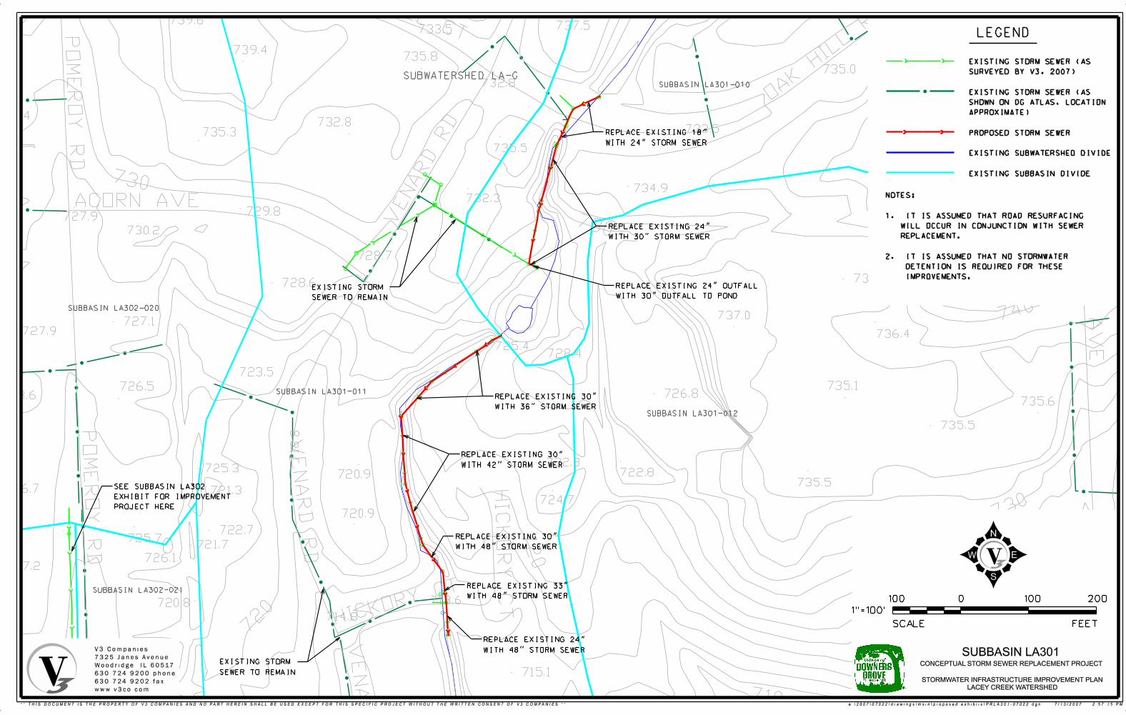
749.8
735.3739.6
737.5733.5
739.4735.8
735.0
732.8
730.4732.8 750.5741.6733.5735.3
735.5
734.9749.5732.3
729.8727.9
730.2
728.7
734.9728.6
737.0727.1
727.9 736.4
725.4728.4
723.5
735.1726.5726.8728.6
735.6
735.5
722.8725.3 722.8720.9
735.5726.7 721.3
724.7
720.9
722.7725.7
721.7
726.1727.2 727.0
713.6720.8
714.8
724.9
715.1
715.3
0
FEETSCALE
1"=100’
100 100 200
LEGEND
SUBWATERSHED LA-GSUBBASIN LA301-010
REPLACE EXISTING 18"
WITH 24" STORM SEWER
EXISTING STORM SEWER (AS
SURVEYED BY V3, 2007)
EXISTING STORM SEWER (AS
SHOWN ON DG ATLAS, LOCATION
APPROXIMATE)
PROPOSED STORM SEWER
EXISTING SUBWATERSHED DIVIDE
EXISTING SUBBASIN DIVIDE
EXISTING STORM
SEWER TO REMAIN
SUBBASIN LA301-012
SUBBASIN LA301-011
SUBBASIN LA302-020
SUBBASIN LA302-021
EXISTING STORM
SEWER TO REMAIN
SEE SUBBASIN LA302
EXHIBIT FOR IMPROVEMENT
PROJECT HERE
REPLACE EXISTING 24"
WITH 30" STORM SEWER
REPLACE EXISTING 30"
WITH 36" STORM SEWER
REPLACE EXISTING 30"
WITH 42" STORM SEWER
REPLACE EXISTING 30"
WITH 48" STORM SEWER
REPLACE EXISTING 33"
WITH 48" STORM SEWER
REPLACE EXISTING 24"
WITH 48" STORM SEWER
NOTES:
1. IT IS ASSUMED THAT ROAD RESURFACING
WILL OCCUR IN CONJUNCTION WITH SEWER
REPLACEMENT.
2. IT IS ASSUMED THAT NO STORMWATER
DETENTION IS REQUIRED FOR THESE
IMPROVEMENTS.
REPLACE EXISTING 24" OUTFALL
WITH 30" OUTFALL TO POND
V3 Companies
7325 Janes Avenue
Woodridge, IL 60517
630.724.9200 phone
630.724.9202 fax
www.v3co.com
STORMWATER INFRASTRUCTURE IMPROVEMENT PLAN
LACEY CREEK WATERSHED
SUBBASIN LA301CONCEPTUAL STORM SEWER REPLACEMENT PROJECT
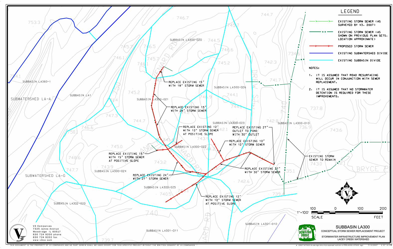
746.2
744.7 745.4746.7
753.3 746.4745.7
742.2
744.5
746.5745.7746.6
734.6
746.1 741.8745.7742.3745.2746.1
743.0754.1741.7743.0
745.2748.9744.1
746.9751.4
744.1737.8
744.2747.3
744.7 742.8743.4
736.9746.6742.1 743.6
750.1
743.9741.4
745.0744.2
748.6
743.2 742.1743.0743.9 744.5
747.7 735.1742.5
743.7742.6
743.1739.4740.5 747.3743.3
742.7
739.7
737.2
0
FEETSCALE
1"=100’
100 100 200
LEGEND
SUBWATERSHED LA-G
SUBBASIN LA300-020
REPLACE EXISTING 15"
WITH 24" STORM SEWER
EXISTING STORM
SEWER TO REMAIN
EXISTING STORM SEWER (AS
SURVEYED BY V3, 2007)
EXISTING STORM SEWER (AS
SHOWN ON PREVIOUS PLAN SETS,
LOCATION APPROXIMATE)
PROPOSED STORM SEWER
EXISTING SUBWATERSHED DIVIDE
EXISTING SUBBASIN DIVIDE
SUBBASIN LA300-021
SUBBASIN LA300-024
SUBBASIN LA300-025
SUBBASIN LA300-023
SUBBASIN LA300-022
SUBBASIN LA300-026
SUBBASIN LA300-010
SUBBASIN LA301-010
SUBBASIN LA301-011
SUBBASIN LA302-020
SUBWATERSHED LA-A
SUBBASIN LA1
SUBBASIN LA360-1
REPLACE EXISTING 27"
WITH 30" STORM SEWER
REPLACE EXISTING 10"
WITH 12" STORM SEWER
REPLACE EXISTING 24"
WITH 27" STORM SEWER
REPLACE EXISTING 15"
WITH 18" STORM SEWER
REPLACE EXISTING 12"
WITH 12" STORM SEWER
AT POSITIVE SLOPE
REPLACE EXISTING 15"
WITH 15" STORM SEWER
AT POSITIVE SLOPE
REPLACE EXISTING 12"
WITH 12" STORM SEWER
AT POSITIVE SLOPE
REPLACE EXISTING 27"
OUTLET TO POND
WITH 30" OUTLET
V3 Companies
7325 Janes Avenue
Woodridge, IL 60517
630.724.9200 phone
630.724.9202 fax
www.v3co.com
STORMWATER INFRASTRUCTURE IMPROVEMENT PLAN
LACEY CREEK WATERSHED
SUBBASIN LA300CONCEPTUAL STORM SEWER REPLACEMENT PROJECT
NOTES:
1. IT IS ASSUMED THAT ROAD RESURFACING
WILL OCCUR IN CONJUNCTION WITH SEWER
REPLACEMENT.
2. IT IS ASSUMED THAT NO STORMWATER
DETENTION IS REQUIRED FOR THESE
IMPROVEMENTS.
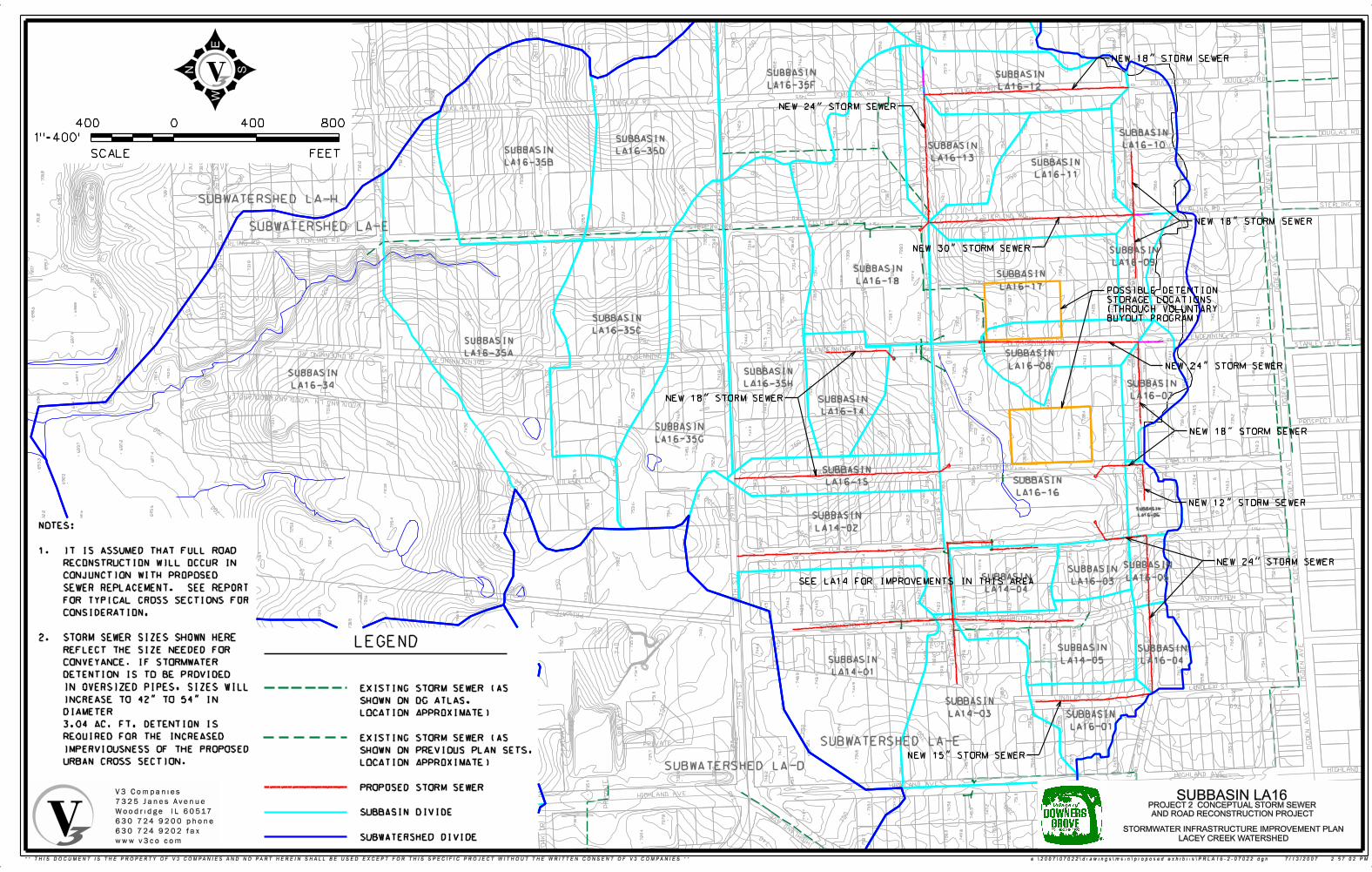
LEGEND
SUBWATERSHED LA-D
SUBWATERSHED LA-E
SUBBASIN
LA14-01
SUBBASIN
LA14-02
SUBBASIN
LA14-03
SUBBASIN
LA14-04
SUBBASIN
LA14-05
SUBBASIN
LA16-01
SUBBASIN
LA16-03
SUBBASIN
LA16-04
SUBBASIN
LA16-05
SUBBASIN
LA16-06
SUBBASIN
LA16-15
0
FEETSCALE
1"=400’
400 400 800
SUBBASIN
LA16-35A
SUBBASIN
LA16-35B
SUBBASIN
LA16-34
SUBBASIN
LA16-35C
SUBWATERSHED LA-E
SUBWATERSHED LA-H
SUBBASIN
LA16-35D
SUBBASIN
LA16-09
SUBBASIN
LA16-10
SUBBASIN
LA16-11
SUBBASIN
LA16-12
SUBBASIN
LA16-13
SUBBASIN
LA16-17
SUBBASIN
LA16-18
SUBBASIN
LA16-14
SUBBASIN
LA16-16
SUBBASIN
LA16-08
SUBBASIN
LA16-07
SUBBASIN
LA16-35G
SUBBASIN
LA16-35H
SUBBASIN
LA16-35F
NEW 12" STORM SEWER
NEW 18" STORM SEWER
NEW 18" STORM SEWER
NEW 18" STORM SEWER
NEW 18" STORM SEWER
NEW 24" STORM SEWER
NEW 24" STORM SEWER
NEW 24" STORM SEWER
NEW 15" STORM SEWER
NEW 30" STORM SEWER
NOTES:
1. IT IS ASSUMED THAT FULL ROAD
RECONSTRUCTION WILL OCCUR IN
CONJUNCTION WITH PROPOSED
SEWER REPLACEMENT. SEE REPORT
FOR TYPICAL CROSS SECTIONS FOR
CONSIDERATION.
2. STORM SEWER SIZES SHOWN HERE
REFLECT THE SIZE NEEDED FOR
CONVEYANCE. IF STORMWATER
DETENTION IS TO BE PROVIDED
IN OVERSIZED PIPES, SIZES WILL
INCREASE TO 42" TO 54" IN
DIAMETER
3.04 AC. FT. DETENTION IS
REQUIRED FOR THE INCREASED
IMPERVIOUSNESS OF THE PROPOSED
URBAN CROSS SECTION.
POSSIBLE DETENTION
STORAGE LOCATIONS
(THROUGH VOLUNTARY
BUYOUT PROGRAM)
SEE LA14 FOR IMPROVEMENTS IN THIS AREA
EXISTING STORM SEWER (AS
SHOWN ON DG ATLAS,
LOCATION APPROXIMATE)
EXISTING STORM SEWER (AS
SHOWN ON PREVIOUS PLAN SETS,
LOCATION APPROXIMATE)
PROPOSED STORM SEWER
SUBBASIN DIVIDE
SUBWATERSHED DIVIDE
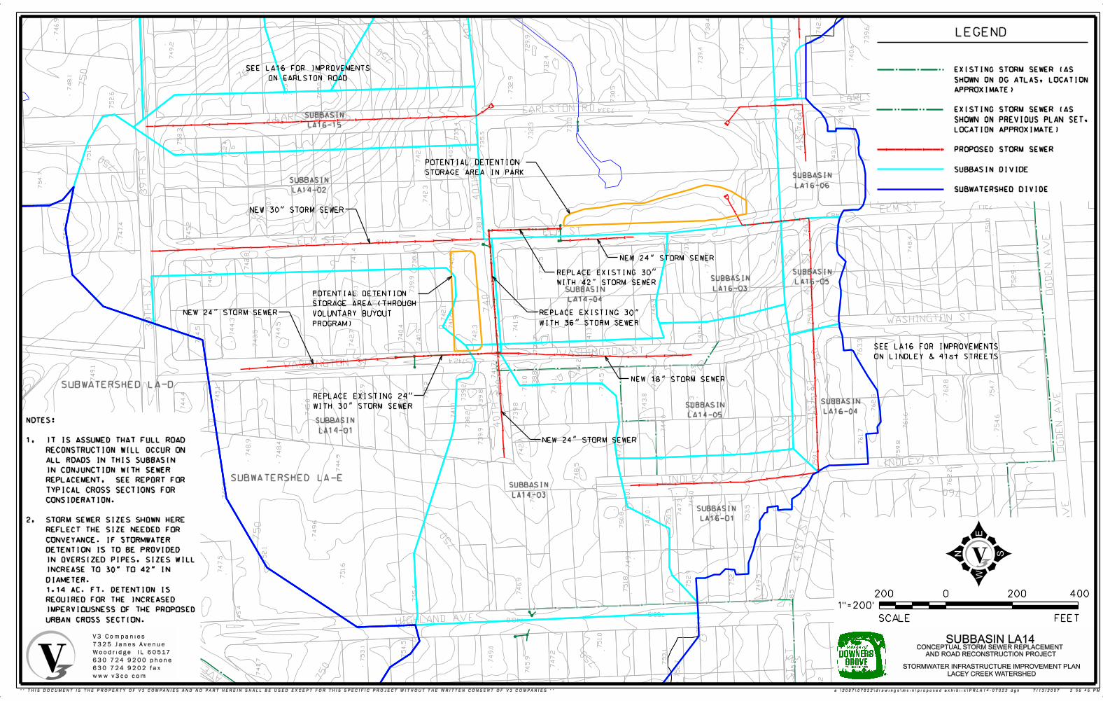
LEGEND
SUBWATERSHED LA-D
SUBWATERSHED LA-E
REPLACE EXISTING 24"
WITH 30" STORM SEWER
REPLACE EXISTING 30"
WITH 36" STORM SEWER
REPLACE EXISTING 30"
WITH 42" STORM SEWER
NEW 24" STORM SEWER
NEW 24" STORM SEWER
NEW 18" STORM SEWER
NEW 24" STORM SEWER
NEW 30" STORM SEWER
SUBBASIN
LA14-01
SUBBASIN
LA14-02
SUBBASIN
LA14-03
SUBBASIN
LA14-04
SUBBASIN
LA14-05
SUBBASIN
LA16-01
SUBBASIN
LA16-03
SUBBASIN
LA16-04
SUBBASIN
LA16-05
SUBBASIN
LA16-06
SUBBASIN
LA16-15
POTENTIAL DETENTION
STORAGE AREA IN PARK
POTENTIAL DETENTION
STORAGE AREA (THROUGH
VOLUNTARY BUYOUT
PROGRAM)
SEE LA16 FOR IMPROVEMENTS
ON LINDLEY & 41st STREETS
SEE LA16 FOR IMPROVEMENTS
ON EARLSTON ROAD
NOTES:
1. IT IS ASSUMED THAT FULL ROAD
RECONSTRUCTION WILL OCCUR ON
ALL ROADS IN THIS SUBBASIN
IN CONJUNCTION WITH SEWER
REPLACEMENT. SEE REPORT FOR
TYPICAL CROSS SECTIONS FOR
CONSIDERATION.
2. STORM SEWER SIZES SHOWN HERE
REFLECT THE SIZE NEEDED FOR
CONVEYANCE. IF STORMWATER
DETENTION IS TO BE PROVIDED
IN OVERSIZED PIPES, SIZES WILL
INCREASE TO 30" TO 42" IN
DIAMETER.
1.14 AC. FT. DETENTION IS
REQUIRED FOR THE INCREASED
IMPERVIOUSNESS OF THE PROPOSED
URBAN CROSS SECTION.
EXISTING STORM SEWER (AS
SHOWN ON DG ATLAS, LOCATION
APPROXIMATE)
EXISTING STORM SEWER (AS
SHOWN ON PREVIOUS PLAN SET,
LOCATION APPROXIMATE)
PROPOSED STORM SEWER
SUBBASIN DIVIDE
SUBWATERSHED DIVIDE
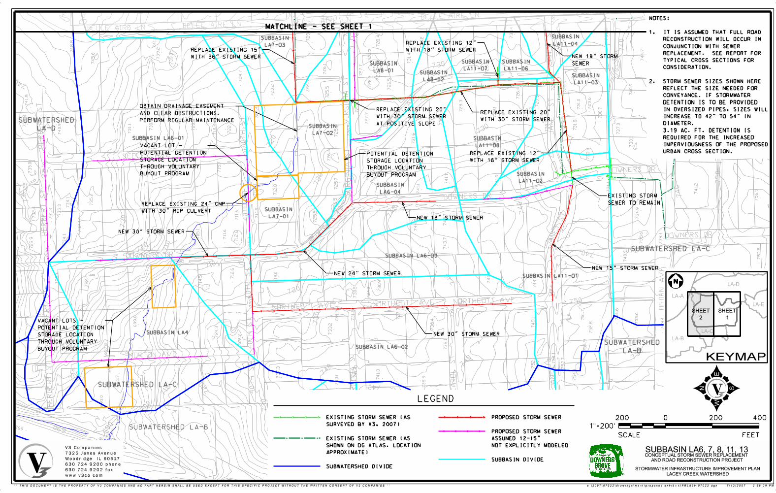
LEGEND
SUBBASIN LA6-01
SUBBASIN
LA7-01
SUBBASIN
LA7-03
SUBBASIN
LA8-01SUBBASIN
LA8-02
SUBBASIN
LA11-08
SUBBASIN
LA11-07
SUBBASIN
LA11-06
SUBBASIN
LA11-03
SUBBASIN
LA11-04
SUBBASIN
LA7-02
PROPOSED STORM SEWER
PROPOSED STORM SEWER
ASSUMED 12-15"
NOT EXPLICITLY MODELED
SUBBASIN DIVIDE
SUBBASIN LA6-02
SUBBASIN LA6-03
SUBBASIN
LA6-04
SUBBASIN
LA11-02
NOTES:
1. IT IS ASSUMED THAT FULL ROAD
RECONSTRUCTION WILL OCCUR IN
CONJUNCTION WITH SEWER
REPLACEMENT. SEE REPORT FOR
TYPICAL CROSS SECTIONS FOR
CONSIDERATION.
2. STORM SEWER SIZES SHOWN HERE
REFLECT THE SIZE NEEDED FOR
CONVEYANCE. IF STORMWATER
DETENTION IS TO BE PROVIDED
IN OVERSIZED PIPES, SIZES WILL
INCREASE TO 42" TO 54" IN
DIAMETER.
3.19 AC. FT. DETENTION IS
REQUIRED FOR THE INCREASED
IMPERVIOUSNESS OF THE PROPOSED
URBAN CROSS SECTION.
SUBBASIN LA11-01
REPLACE EXISTING 12"
WITH 18" STORM SEWER
REPLACE EXISTING 12"
WITH 18" STORM SEWER
REPLACE EXISTING 20"
WITH 30" STORM SEWER
REPLACE EXISTING 20"
WITH 30" STORM SEWER
AT POSITIVE SLOPE
NEW 30" STORM SEWER
NEW 24" STORM SEWER
NEW 18" STORM SEWER
NEW 15" STORM SEWER
EXISTING STORM
SEWER TO REMAIN
NEW 30" STORM SEWER
NEW 18" STORM
SEWER
REPLACE EXISTING 24" CMP
WITH 30" RCP CULVERT
REPLACE EXISTING 15"
WITH 36" STORM SEWER
MATCHLINE - SEE SHEET 1
OBTAIN DRAINAGE EASEMENT
AND CLEAR OBSTRUCTIONS.
PERFORM REGULAR MAINTENANCE
VACANT LOT -
POTENTIAL DETENTION
STORAGE LOCATION
THROUGH VOLUNTARY
BUYOUT PROGRAM
POTENTIAL DETENTION
STORAGE LOCATION
THROUGH VOLUNTARY
BUYOUT PROGRAM
VACANT LOTS -
POTENTIAL DETENTION
STORAGE LOCATION
THROUGH VOLUNTARY
BUYOUT PROGRAM
N
LA-A
LA-B
LA-C
LA-D
LA-E
KEYMAP
SHEET
1
SHEET
2
EXISTING STORM SEWER (AS
SURVEYED BY V3, 2007)
EXISTING STORM SEWER (AS
SHOWN ON DG ATLAS, LOCATION
APPROXIMATE)
SUBWATERSHED DIVIDE
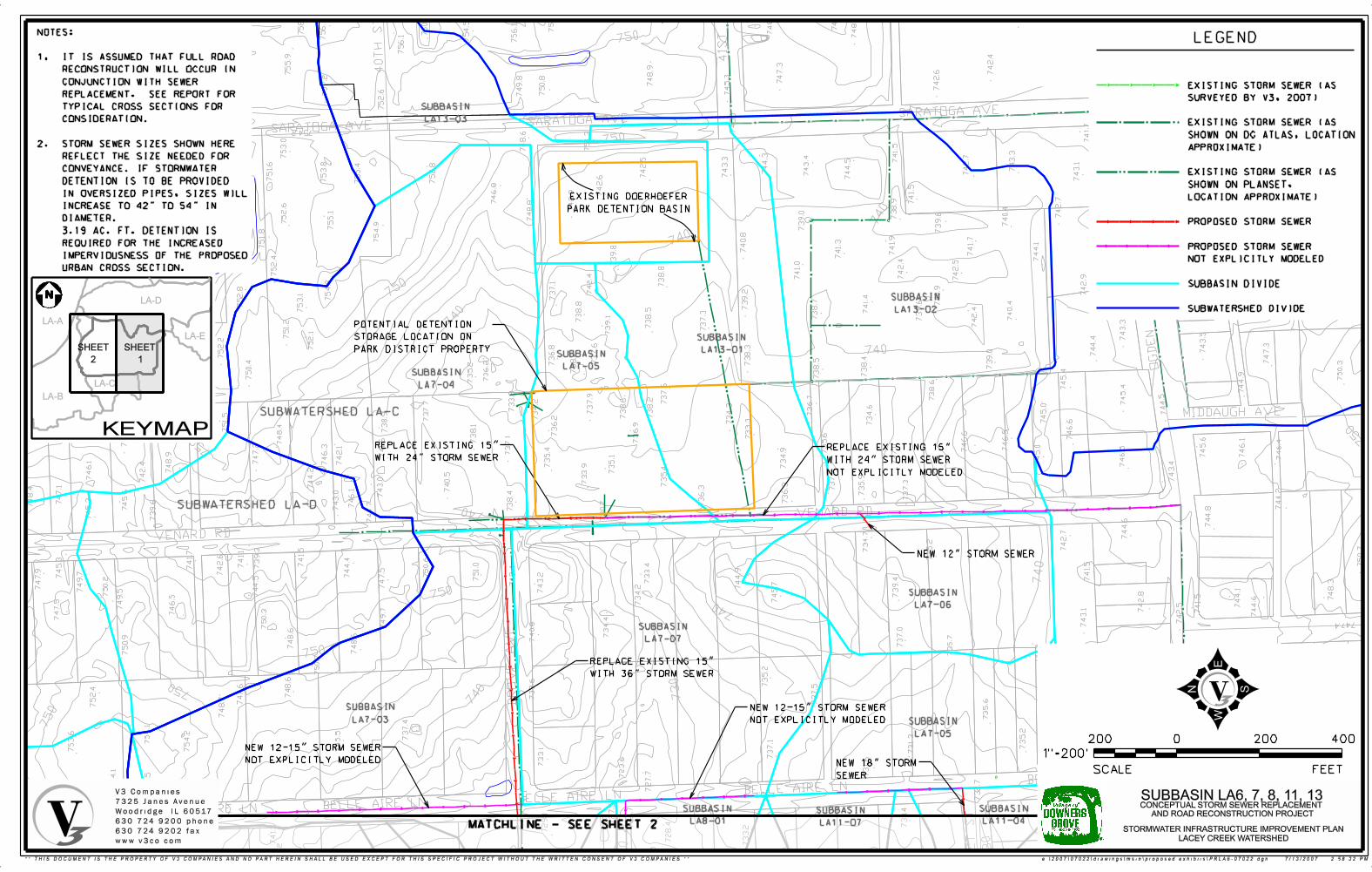
LEGEND
SUBBASIN
LA8-01
SUBBASIN
LA11-07
SUBBASIN
LA11-04
NOTES:
1. IT IS ASSUMED THAT FULL ROAD
RECONSTRUCTION WILL OCCUR IN
CONJUNCTION WITH SEWER
REPLACEMENT. SEE REPORT FOR
TYPICAL CROSS SECTIONS FOR
CONSIDERATION.
2. STORM SEWER SIZES SHOWN HERE
REFLECT THE SIZE NEEDED FOR
CONVEYANCE. IF STORMWATER
DETENTION IS TO BE PROVIDED
IN OVERSIZED PIPES, SIZES WILL
INCREASE TO 42" TO 54" IN
DIAMETER.
3.19 AC. FT. DETENTION IS
REQUIRED FOR THE INCREASED
IMPERVIOUSNESS OF THE PROPOSED
URBAN CROSS SECTION.
NEW 18" STORM
SEWER
REPLACE EXISTING 15"
WITH 24" STORM SEWER
REPLACE EXISTING 15"
WITH 36" STORM SEWER
REPLACE EXISTING 15"
WITH 24" STORM SEWER
NOT EXPLICITLY MODELED
NEW 12-15" STORM SEWER
NOT EXPLICITLY MODELED
NEW 12-15" STORM SEWER
NOT EXPLICITLY MODELED
NEW 12" STORM SEWER
EXISTING DOERHOEFER
PARK DETENTION BASIN
SUBBASIN
LA7-07
SUBBASIN
LA7-03 SUBBASIN
LA7-05
SUBBASIN
LA7-06
SUBBASIN
LA7-04
SUBBASIN
LA7-05
SUBBASIN
LA13-01
SUBBASIN
LA13-02
SUBBASIN
LA13-03
SUBWATERSHED LA-D
SUBWATERSHED LA-C
POTENTIAL DETENTION
STORAGE LOCATION ON
PARK DISTRICT PROPERTY
MATCHLINE - SEE SHEET 2
N
LA-A
LA-B
LA-C
LA-D
KEYMAP
SHEET
1
SHEET
2
LA-E
EXISTING STORM SEWER (AS
SURVEYED BY V3, 2007)
EXISTING STORM SEWER (AS
SHOWN ON DG ATLAS, LOCATION
APPROXIMATE)
EXISTING STORM SEWER (AS
SHOWN ON PLANSET,
LOCATION APPROXIMATE)
PROPOSED STORM SEWER
PROPOSED STORM SEWER
NOT EXPLICITLY MODELED
SUBBASIN DIVIDE
SUBWATERSHED DIVIDE
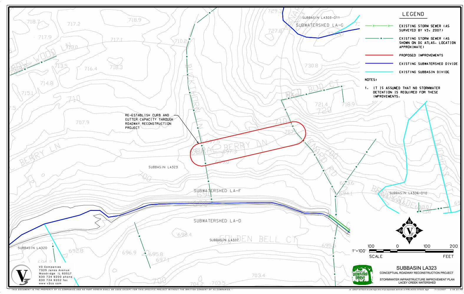
715.6713.6
729.3723.9
732.7718.9718.7
732.7717.2719.6
727.8734.4
717.9729.2717.1 710.2
726.3713.0720.6
730.8713.5 718.3716.4
714.8
715.1716.9
721.4 718.9717.5
707.9
707.1
697.5
697.3698.2
699.0
693.6
694.1
696.2693.0
695.6
698.4
697.6695.5
692.8696.9 695.8
697.1694.2
692.4703.4
694.1691.2703.5704.2692.9 689.7
690
0
FEETSCALE
1"=100’
100 100 200
LEGEND
SUBWATERSHED LA-G
NOTES:
1. IT IS ASSUMED THAT NO STORMWATER
DETENTION IS REQUIRED FOR THESE
IMPROVEMENTS.
EXISTING STORM SEWER (AS
SURVEYED BY V3, 2007)
EXISTING STORM SEWER (AS
SHOWN ON DG ATLAS, LOCATION
APPROXIMATE)
PROPOSED IMPROVEMENTS
EXISTING SUBWATERSHED DIVIDE
EXISTING SUBBASIN DIVIDE
SUBWATERSHED LA-F
SUBWATERSHED LA-D
SUBBASIN LA320
SUBBASIN LA307
SUBBASIN LA323
SUBBASIN LA303-011
SUBBASIN LA306-010
V3 Companies
7325 Janes Avenue
Woodridge, IL 60517
630.724.9200 phone
630.724.9202 fax
www.v3co.com
STORMWATER INFRASTRUCTURE IMPROVEMENT PLAN
LACEY CREEK WATERSHED
SUBBASIN LA323CONCEPTUAL ROADWAY RECONSTRUCTION PROJECT
RE-ESTABLISH CURB AND
GUTTER CAPACITY THROUGH
ROADWAY RECONSTRUCTION
PROJECT