L1 T T TAKEOFF MINIMUMS, (OBSTACLE ... - download · PDF fileclimb direct BAM VORTAC and BAM...
22
18144 L1 L1 T T T T TAKEOFF MINIMUMS, (OBSTACLE) DEPARTURE PROCEDURES, AND DIVERSE VECTOR AREA (RADAR VECTORS) TAKEOFF MINIMUMS, (OBSTACLE) DEPARTURE PROCEDURES, AND DIVERSE VECTOR AREA (RADAR VECTORS) 18144 SW-4 BATTLE MOUNTAIN, NV BATTLE MOUNTAIN (BAM) TAKEOFF MINIMUMS AND (OBSTACLE) DEPARTURE PROCEDURES AMDT 3 09127 (FAA) TAKEOFF MINIMUMS: Rwy 3, std. w/ a min climb of 282' per NM to 7300 or 4700-3 for climb in visual conditions. Rwy 12, std. w/ a min climb of 386' per NM to 7600 or 4700-3 for climb in visual conditions. DEPARTURE PROCEDURE: Rwy 3, climb heading 032° to 8200 before proceeding on course or climb in visual conditions to cross Battle Mountain Airport at or above 9100 before proceeding on course. Rwy 12, climb heading 122° and BAM R-076 to 10000 before proceeding on course or climb in visual conditions to cross Battle Mountain Airport at or above 9100 before proceeding on course. Rwy 21, climb direct BAM VORTAC and BAM R-205 to 10100 before proceeding on course. Rwy 30, climb heading 302° and BAM R-324 to 9100 before proceeding on course. INSTRUMENT APPROACH PROCEDURE CHARTS IFR TAKEOFF MINIMUMS AND (OBSTACLE) DEPARTURE PROCEDURES Civil Airports and Selected Military Airports ALL USERS: Airports that have Departure Procedures (DPs) designed specifically to assist pilots in avoiding obstacles during the climb to the minimum enroute altitude, and/or airports that have civil IFR takeoff minimums other than standard, are listed below. Takeoff Minimums and Departure Procedures apply to all runways unless otherwise specified. An entry may also be listed that contains only Takeoff Obstacle Notes. Altitudes, unless otherwise indicated, are minimum altitudes in MSL. DPs specifically designed for obstacle avoidance are referred to as Obstacle Departure Procedures (ODPs) and are textually described below, or published separately as a graphic procedure. If the ODP is published as a graphic procedure, its name will be listed below, and it can be found in either this volume (civil), or the applicable military volume, as appropriate. Users will recognize graphic obstacle DPs by the term "(OBSTACLE)" included in the procedure title; e.g., TETON TWO (OBSTACLE). If not specifically assigned an ODP, SID, or radar vector as part of an IFR clearance, an ODP may be required to be flown for obstacle clearance, even though not specifically stated in the IFR clearance. When doing so in this manner, ATC should be informed when the ODP being used contains a specified route to be flown, restrictions before turning, and/or altitude restrictions. Some ODPs, which are established solely for obstacle avoidance, require a climb in visual conditions to cross the airport, a fix, or a NAVAID in a specified direction, at or above a specified altitude. These procedures are called Visual Climb Over Airport (VCOA). To ensure safe and efficient operations, the pilot must verbally request approval from ATC to fly the VCOA when requesting their IFR clearance. At some locations where an ODP has been established, a diverse vector area (DVA) may be created to allow radar vectors to be used in lieu of an ODP. DVA information will state that headings will be as assigned by ATC and climb gradients, when applicable, will be published immediately following the specified departure procedure. Graphic DPs designed by ATC to standardize traffic flows, ensure aircraft separation and enhance capacity are referred to as "Standard Instrument Departures (SIDs)". SIDs also provide obstacle clearance and are published under the appropriate airport section. ATC clearance must be received prior to flying a SID. CIVIL USERS NOTE: Title 14 Code of Federal Regulations Part 91 prescribes standard takeoff rules and establishes takeoff minimums for certain operators as follows: (1) For aircraft, other than helicopters, having two engines or less – one statute mile visibility. (2) For aircraft having more than two engines – one-half statute mile visibility. (3) For helicopters – one-half statute mile visibility. These standard minima apply in the absence of any different minima listed below. MILITARY USERS NOTE: Civil (nonstandard) takeoff minima are published below. For military takeoff minima, refer to appropriate service directives. NAME TAKEOFF MINIMUMS NAME TAKEOFF MINIMUMS BEAVER, UT BEAVER MUNI (U52) TAKEOFF MINIMUMS AND (OBSTACLE) DEPARTURE PROCEDURES ORIG 07242 (FAA) TAKEOFF MINIMUMS: Rwys 7, 25, NA-obstacles. Rwys 13, 31, 2600-2¾ for climb in visual conditions. DEPARTURE PROCEDURE: Rwys 13, 31, climb in visual conditions to cross Beaver Muni Airport Northwest bound at or above 8300 then climb to 10100 via MLF VORTAC R-102 to MLF VORTAC. Do not exceed 210 KIAS until established on MLF VORTAC R-102. BLANDING, UT BLANDING MUNI (BDG) TAKEOFF MINIMUMS AND (OBSTACLE) DEPARTURE PROCEDURES AMDT 1A 14037 (FAA) TAKEOFF MINIMUMS: Rwy 35, 800-1 or std. with a min. climb of 350 feet per NM to 6700. DEPARTURE PROCEDURE: Rwy 17, turn left, thence... Rwy 21, turn right, thence… ...climb to 9000 on heading 090° and DVC R-223 to DVC VORTAC, then continue climb on course to MEA. Rwy 35, turn right climb to 9000 via heading 090° and DVC R-223 to DVC VORTAC, then continue climb on course to MEA. T 24 MAY 2018 to 21 JUN 2018 24 MAY 2018 to 21 JUN 2018
-
Upload
nguyenkhanh -
Category
Documents
-
view
220 -
download
1
Transcript of L1 T T TAKEOFF MINIMUMS, (OBSTACLE ... - download · PDF fileclimb direct BAM VORTAC and BAM...

18144
L1
L1
T T
T T
TAKEOFF MINIMUMS, (OBSTACLE) DEPARTURE PROCEDURES, AND DIVERSE VECTOR AREA (RADAR VECTORS)
TAKEOFF MINIMUMS, (OBSTACLE) DEPARTURE PROCEDURES, AND DIVERSE VECTOR AREA (RADAR VECTORS)
18144 SW-4
BATTLE MOUNTAIN, NV BATTLE MOUNTAIN (BAM) TAKEOFF MINIMUMS AND (OBSTACLE) DEPARTURE PROCEDURES AMDT 3 09127 (FAA)
TAKEOFF MINIMUMS: Rwy 3, std. w/ a min climb of 282' per NM to 7300 or 4700-3 for climb in visual conditions. Rwy 12, std. w/ a min climb of 386' per NM to 7600 or 4700-3 for climb in visual conditions.
DEPARTURE PROCEDURE: Rwy 3, climb heading 032° to 8200 before proceeding on course or climb in visual conditions to cross Battle Mountain Airport at or above 9100 before proceeding on course. Rwy 12, climb heading 122° and BAM R-076 to 10000 before proceeding on course or climb in visual conditions to cross Battle Mountain Airport at or above 9100 before proceeding on course. Rwy 21, climb direct BAM VORTAC and BAM R-205 to 10100 before proceeding on course. Rwy 30, climb heading 302° and BAM R-324 to 9100 before proceeding on course.
INSTRUMENT APPROACH PROCEDURE CHARTS
IFR TAKEOFF MINIMUMS AND (OBSTACLE) DEPARTURE PROCEDURES
Civil Airports and Selected Military Airports
ALL USERS: Airports that have Departure Procedures (DPs) designed specifically to assist pilots in avoiding obstacles during the climb to the minimum enroute altitude, and/or airports that have civil IFR takeoff minimums other than standard, are listed below. Takeoff Minimums and Departure Procedures apply to all runways unless otherwise specified. An entry may also be listed that contains only Takeoff Obstacle Notes. Altitudes, unless otherwise indicated, are minimum altitudes in MSL.
DPs specifically designed for obstacle avoidance are referred to as Obstacle Departure Procedures (ODPs) and are textually described below, or published separately as a graphic procedure. If the ODP is published as a graphic procedure, its name will be listed below, and it can be found in either this volume (civil), or the applicable military volume, as appropriate. Users will recognize graphic obstacle DPs by the term "(OBSTACLE)" included in the procedure title; e.g., TETON TWO (OBSTACLE). If not specifically assigned an ODP, SID, or radar vector as part of an IFR clearance, an ODP may be required to be flown for obstacle clearance, even though not specifically stated in the IFR clearance. When doing so in this manner, ATC should be informed when the ODP being used contains a specified route to be flown, restrictions before turning, and/or altitude restrictions.
Some ODPs, which are established solely for obstacle avoidance, require a climb in visual conditions to cross the airport, a fix, or a NAVAID in a specified direction, at or above a specified altitude. These procedures are called Visual Climb Over Airport (VCOA). To ensure safe and efficient operations, the pilot must verbally request approval from ATC to fly the VCOA when requesting their IFR clearance.
At some locations where an ODP has been established, a diverse vector area (DVA) may be created to allow radar vectors to be used in lieu of an ODP. DVA information will state that headings will be as assigned by ATC and climb gradients, when applicable, will be published immediately following the specified departure procedure.
Graphic DPs designed by ATC to standardize traffic flows, ensure aircraft separation and enhance capacity are referred to as "Standard Instrument Departures (SIDs)". SIDs also provide obstacle clearance and are published under the appropriate airport section. ATC clearance must be received prior to flying a SID.
CIVIL USERS NOTE: Title 14 Code of Federal Regulations Part 91 prescribes standard takeoff rules and establishes takeoff minimums for certain operators as follows: (1) For aircraft, other than helicopters, having two engines or less – one statute mile visibility. (2) For aircraft having more than two engines – one-half statute mile visibility. (3) For helicopters – one-half statute mile visibility. These standard minima apply in the absence of any different minima listed below.
MILITARY USERS NOTE: Civil (nonstandard) takeoff minima are published below. For military takeoff minima, refer to appropriate service directives.
NAME TAKEOFF MINIMUMS NAME TAKEOFF MINIMUMS
BEAVER, UT BEAVER MUNI (U52) TAKEOFF MINIMUMS AND (OBSTACLE) DEPARTURE PROCEDURES ORIG 07242 (FAA)
TAKEOFF MINIMUMS: Rwys 7, 25, NA-obstacles. Rwys 13, 31, 2600-2¾ for climb in visual conditions.
DEPARTURE PROCEDURE: Rwys 13, 31, climb in visual conditions to cross Beaver Muni Airport Northwest bound at or above 8300 then climb to 10100 via MLF VORTAC R-102 to MLF VORTAC. Do not exceed 210 KIAS until established on MLF VORTAC R-102.
BLANDING, UT BLANDING MUNI (BDG) TAKEOFF MINIMUMS AND (OBSTACLE) DEPARTURE PROCEDURES AMDT 1A 14037 (FAA)
TAKEOFF MINIMUMS: Rwy 35, 800-1 or std. with a min. climb of 350 feet per NM to 6700.
DEPARTURE PROCEDURE: Rwy 17, turn left, thence... Rwy 21, turn right, thence… ...climb to 9000 on heading 090° and DVC R-223 to
DVC VORTAC, then continue climb on course to MEA. Rwy 35, turn right climb to 9000 via heading 090° and DVC R-223 to DVC VORTAC, then continue climb on course to MEA.
T
24 MA
Y 2018 to 21 JU
N 2018 24
MA
Y 2
018
to 2
1 JU
N 2
018

18144
L2
L2
T T
T T
TAKEOFF MINIMUMS, (OBSTACLE) DEPARTURE PROCEDURES, AND DIVERSE VECTOR AREA (RADAR VECTORS)
TAKEOFF MINIMUMS, (OBSTACLE) DEPARTURE PROCEDURES, AND DIVERSE VECTOR AREA (RADAR VECTORS)
18144 SW-4
BRIGHAM CITY, UT BRIGHAM CITY RGNL (BMC) TAKEOFF MINIMUMS AND (OBSTACLE) DEPARTURE PROCEDURES AMDT 6B 18088 (FAA)
TAKEOFF MINIMUMS: Rwy 35, NA DEPARTURE PROCEDURE: Rwy 17, climbing right
turn heading 207° and OGD R-331 to OGD VORTAC before proceeding on course.
TAKEOFF OBSTACLE NOTES: Rwy 17, poles 266' from DER, 558' right of centerline, 30' AGL/4258' MSL.
BRYCE CANYON, UT BRYCE CANYON (BCE) TAKEOFF MINIMUMS AND (OBSTACLE) DEPARTURE PROCEDURES AMDT 1 11069 (FAA)
DEPARTURE PROCEDURE: use BRYCE DEPARTURE.
BULLHEAD CITY, AZ LAUGHLIN/BULLHEAD INTL (IFP) TAKEOFF MINIMUMS AND (OBSTACLE) DEPARTURE PROCEDURES AMDT 2 17061 (FAA)
TAKEOFF MINIMUMS: Rwy 16, standard w/min. climb of 285’ per NM to 1700, or 1700-3 for VCOA. Rwy 34, standard w/min. climb of 500’ per NM to 5500, or 1700-3 for VCOA.
DEPARTURE PROCEDURE: Rwy 16, climb on heading 164° and EED VORTAC R-331 to EED VORTAC. Rwy 34, climb on heading 344° to 2200, then climbing right turn direct EED VORTAC. All aircraft climb in EED VORTAC holding pattern (E, right turns, 257° inbound) to cross EED VORTAC at or above MEA for direction of flight before proceeding on course.
VCOA: Rwy 16, obtain ATC approval for VCOA when requesting IFR clearance. Climb in visual conditions to cross Laughlin/Bullhead Intl airport at or above 2300, then continue climbing on heading 155 and EED VORTAC R-335 to EED VORTAC. Rwy 34, obtain ATC approval for VCOA when requesting IFR clearance. Climb in visual conditions to cross Laughlin/ Bullhead Intl airport at or above 2300, then continue climbing on heading 155 and EED VORTAC R-335 to EED VORTAC.
BULLHEAD CITY, AZ (CON’T) TAKEOFF OBSTACLE NOTES: Rwy 16, grd 188’ from
DER, 83’ left of centerline, 715’ MSL. Bush 349’ from DER, 516’ right of centerline, 722’ MSL. Grd 390’ from DER, 528’ left of centerline, 719’ MSL. Grd beginning 484’ from DER, 481’ left of centerline, up to 723’ MSL. Bush 532’ from DER, 642’ right of centerline, 727’ MSL. Grd beginning 568’ from DER, 490’ left of centerline, up to 727’ MSL. Bush 700’ from DER, 663’ right of centerline, 728’ MSL. Grd 798’ from DER, 466’ left of centerline, 729’ MSL. Bush, grd beginning 801’ from DER, 541’ left of centerline, up to 734’ MSL. Tree, bush, grd beginning 910’ from DER, 557’ left of centerline, up to 745’ MSL. Bush, grd beginning 1103’ from DER, from 204’ right to 1008’ left of centerline, up to 777’ MSL. Grd, bush beginning 2134’ from DER, 731’ left of centerline, up to 778’ MSL. Grd, bush beginning 2214’ from DER, 870’ left of centerline, up to 786’ MSL. Grd beginning 2288’ from DER, 801’ left of centerline, up to 792’ MSL. Grd, tree beginning 2328’ from DER, 724’ left of centerline, up to 797’ MSL. Grd beginning 2811’ from DER, 1128’ left of centerline, up to 798’ MSL. Grd beginning 2915’ from DER, 1166’ left of centerline, up to 800’ MSL. Grd beginning 3022’ from DER, 1185’ left of centerline, up to 804’ MSL. Grd beginning 3123‘ from DER, 1221’ left of centerline, up to 809’ MSL. Grd beginning 3219’ from DER, 1257’ left of centerline, up to 814‘ MSL. Grd beginning 3325’ from DER, 1284’ left of centerline, up to 818’ MSL. Grd beginning 3428’ from DER, 1210’ left of centerline, up to 821’ MSL. Grd beginning 3528’ from DER, 1241’ left of centerline, up to 824’ MSL. Grd, bush, tank beginning 3632’ from DER, 1157’ left of centerline, up to 825’ MSL. Tank 4810’ from DER, 1528’ left of centerline, 848’ MSL. Grd 5412’ from DER, 1872’ left of centerline, 852’ MSL. Grd, bushes beginning 5511’ from DER, 926’ left of centerline, up to 865’ MSL. Bushes beginning 5742’ from DER, 1483’ left of centerline, up to 883’ MSL. Grd, bushes beginning 5774’ from DER, 793’ left of centerline, up to 891’ MSL. Bush 5852’ from DER, 1933’ left of centerline, 904’ MSL. Grd, pole, bushes beginning 5856’ from DER, 24’ left of centerline, up to 920’ MSL. Trees, bushes, grd, tank beginning 1.2 NM from DER, left and right of centerline, up to 962’ MSL. Trees, bushes, grd beginning 1.3 NM from DER, 1’ left of centerline, up to 985’ MSL. Bush 1.4 NM from DER, 1941’ left of centerline, 993’ MSL. Bushes, grd, tank, pole beginning 1.5 NM from DER, 1919’ left of centerline, up to 1036’ MSL. Bushes, vehicles on road, trees, pole beginning 1.9 NM from DER, 2218’ left of centerline, up to 1086’ MSL. Tanks, bushes, pole beginning 2.2 NM from DER, 3103’ left of centerline, up to 1121’ MSL. Rwy 34, airfield light 40’ from DER, 148’ right of centerline, 627’ MSL. T-l twr, tree beginning 1818’ from DER, 620‘ right of centerline, up to 65’ AGL/687’ MSL. Pole, tree beginning 2214’ from DER, 629’ right of centerline, up to 709‘ MSL. Pole, tree beginning 2638’ from DER, 646’ right of centerline, up to 719’ MSL. Pole, bushes, grd beginning 3054‘ from DER, 663’ right of centerline, up to 741’ MSL. Pole, bush, bldg, grd, vehicles on road beginning 3661’ from DER, 691’ right of centerline, up to 773’ MSL. Poles, bushes, grd, vehicles on road, trees, bldgs, flagpole beginning 4024’ from DER, 705’ right of centerline, up to 796’ MSL. Comm twr 5197’ from DER, 1015’ right of centerline, 816’ MSL. Comm twr 5278’ from DER, 1149’ right of centerline, 821’ MSL. T-l twr 1.6 NM from DER, 719’ left of centerline, 894’ MSL. Grd beginning 1.8 NM from DER, 3419’ right of centerline, up to 963’ MSL. Grd 2.1 NM from DER, 3212’ right of centerline, 1018’ MSL. Grd, tree beginning 2.2 NM from DER, 1351’ right of centerline, up to 1079’ MSL. Grd 2.6 NM from DER 3025’ right of centerline, 2010’ MSL.
24 MA
Y 2018 to 21 JU
N 2018 24
MA
Y 2
018
to 2
1 JU
N 2
018

18144
L3
L3
T T
T T
TAKEOFF MINIMUMS, (OBSTACLE) DEPARTURE PROCEDURES, AND DIVERSE VECTOR AREA (RADAR VECTORS)
TAKEOFF MINIMUMS, (OBSTACLE) DEPARTURE PROCEDURES, AND DIVERSE VECTOR AREA (RADAR VECTORS)
18144 SW-4
CARSON CITY, NV CARSON (CXP) TAKEOFF MINIMUMS AND (OBSTACLE) DEPARTURE PROCEDURES ORIG 08325 (FAA)
TAKEOFF MINIMUMS: Rwy 27, NA-obstacles. DEPARTURE PROCEDURE: Rwy 9, use
JIMPA DEPARTURE.
CASA GRANDE, AZ CASA GRANDE MUNI (CGZ) TAKEOFF MINIMUMS AND (OBSTACLE) DEPARTURE PROCEDURES AMDT 1B 14037 (FAA)
TAKEOFF MINIMUMS: Rwy 5, 300-1 or std. w/ min. climb of 354' per NM to 1700.
DEPARTURE PROCEDURE: Rwy 5, climbing right turn direct TFD VORTAC, thence...
Rwy 23, climb direct TFD VORTAC, thence...
...continue climb in holding pattern (SW, right turns, 048° inbound) to MEA for direction of flight.
TAKEOFF OBSTACLE NOTES: Rwy 5, pole 4034' from DER, 805' left of centerline, 109' AGL/1593' MSL.
CEDAR CITY, UT CEDAR CITY RGNL (CDC) TAKEOFF MINIMUMS AND (OBSTACLE) DEPARTURE PROCEDURES AMDT 3A 17229 (FAA)
TAKEOFF MINIMUMS: Rwy 8, 4200-3 for VCOA. Rwy 20, std. w/min. climb of 290’ per NM to 7300 or 4200-3 for VCOA. Rwy 26, std. w/min. climb of 255’ per NM to 7000 or 4200-3 for VCOA.
DEPARTURE PROCEDURE: Rwys 2, 8, climbing left turn direct EHK VOR/DME, thence... Rwys 20, 26, climbing right turn direct EHK VOR/DME, thence... ...continue climb on EHK VOR/DME R-278 until reaching the MEA/MCA for direction of flight.
VCOA: Rwys 8, 20, 26, obtain ATC approval for VCOA when requesting IFR clearance. Climb in visual conditions to cross Cedar City Rgnl airport at or above 9700, then proceed on EHK VOR/DME R-180 direct EHK VOR/DME, then on EHK VOR/DME R-278 until reaching the MEA/MCA for direction of flight.
TAKEOFF OBSTACLE NOTES: Rwy 2, sign abeam DER, 313’ right of centerline, 3’ AGL/5604’ MSL. Terrain and bush beginning 145’ from DER, 420’ right of centerline, up to 5608’ MSL. Rwy 8, terrain 3’ from DER, 112’ right of centerline, 5622’ MSL. Terrain 18’ from DER, 221’ right of centerline, 5623’ MSL. Terrain beginning 30’ from DER, 178’ right of centerline, up to 5624’ MSL. Terrain 122’ from DER, 473’ right of centerline, 5626’ MSL. Bush 125’ from DER, 234’ left of centerline, 5628’ MSL. Terrain 193’ from DER, 491’ right of centerline, 5627’ MSL. Fence and vehicles on road beginning 638’ from DER, 33’ right of centerline, up to 10’ AGL/5639’ MSL. Vehicles on road 686’ from DER, 136’ right of centerline, 5640’ MSL. Vehicles on road 701’ from DER, 242’ right of centerline, 5641’ MSL. Transmission tower 2865’ from DER, 369’ right of centerline, 51’ AGL/5707’ MSL. Transmission tower 2902’ from DER, 260’ right of centerline, 53’ AGL/5710’ MSL. Pole and transmission towers beginning 2918’ from DER, 70’ right of centerline, up to 62’ AGL/5719’ MSL. Transmission towers beginning 3004’ from DER, 39’ left of centerline, up to 49’ AGL/5705’ MSL. Pole 3175’ from DER, 564’ left of centerline, 56’ AGL/5710’ MSL. Rwy 20, runway light 10’ from DER, 54’ right of centerline, 2’ AGL/5579’ MSL. Terrain 12’ from DER, 98’ left of centerline, 5579’ MSL. Runway light and sign beginning 31’ from DER, 275’ left of centerline, up to 3’ AGL/5583’ MSL. Pole 941’ from DER, 446’ right of centerline, 34’ AGL/5604’ MSL. Pole 1066’ from DER, 363’ right of centerline, 38’ AGL/5608’ MSL. Elevator and tank beginning 2081’ from DER, 1051’ left of centerline, up to 105’ AGL/5690’ MSL. Tree 3789’ from DER, 1512’ left of centerline, 5692’ MSL. Tree 4004’ from DER, 1526’ left of centerline, 5693’ MSL. Tree 4265’ from DER, 1530’ left of centerline, 5718’ MSL. Trees beginning 4278’ from DER, 1546’ left of centerline, up to 5721’ MSL. Trees beginning 4526’ from DER, 1533’ left of centerline, up to 5733’ MSL. Trees beginning 4858’ from DER, 1520’ left of centerline, up to 5737’ MSL. Tree 5456’ from DER, 1835’ left of centerline, 5748’ MSL. Building and tree beginning 5497’ from DER, 1518’ left of centerline, up to 21’ AGL/5759’ MSL. Pole and tree beginning 5737’ from DER, 1543’ left of centerline, up to 20’ AGL/5769’ MSL. Pole and tree beginning 5964’ from DER, 1545’ left of centerline, up to 20’ AGL/5779’ MSL. Trees beginning 1 NM from DER, 1665’ left of centerline, up to 5783’ MSL. Tree 1.2 NM from DER, 2080’ left of centerline, 5800’ MSL. Trees beginning 1.2 NM from DER, 2049’ left of centerline, up to 5814’ MSL. Trees beginning 1.3 NM from DER, 2107’ left of centerline, up to 5836’ MSL. Trees beginning 1.3 NM from DER, 2244’ left of centerline, up to 5840’ MSL. Trees beginning 1.3 NM from DER, 2048’ left of centerline, up to 5849’ MSL. Trees beginning 1.3 NM from DER, 2283’ left of centerline, up to 5852’ MSL. Trees beginning 1.4 NM from DER, 2301’ left of centerline, up to 5871’ MSL. Tree 1.4 NM from DER, 2599’ left of centerline, 5874’ MSL. Trees beginning 1.4 NM from DER, 2436’ left of centerline, up to 5895’ MSL. Pole and tree beginning 1.6 NM from DER, 2822’ left of centerline, up to 50’ AGL/5944’ MSL. Pole 2.3 NM from DER, 3922’ left of centerline, 34’ AGL/5952’ MSL. Rwy 26, sign 71’ from DER, 167’ right of centerline, 6’ AGL/5584’ MSL. Pole 1375’ from DER, 319’ left of centerline, 44’ AGL/5614’ MSL.
24 MA
Y 2018 to 21 JU
N 2018 24
MA
Y 2
018
to 2
1 JU
N 2
018

18144
L4
L4
T T
T T
TAKEOFF MINIMUMS, (OBSTACLE) DEPARTURE PROCEDURES, AND DIVERSE VECTOR AREA (RADAR VECTORS)
TAKEOFF MINIMUMS, (OBSTACLE) DEPARTURE PROCEDURES, AND DIVERSE VECTOR AREA (RADAR VECTORS)
18144 SW-4
CHANDLER, AZ CHANDLER MUNI (CHD) TAKEOFF MINIMUMS AND (OBSTACLE) DEPARTURE PROCEDURES AMDT 1 14261 (FAA)
DEPARTURE PROCEDURE: Rwys 4L, 4R, climbing left turn heading 220° to intercept TFD VORTAC R-350 southbound to TFD VORTAC. Rwys 22L, 22R, climbing left turn heading 190° to intercept TFD VORTAC R-350 southbound to TFD VORTAC.
TAKEOFF OBSTACLE NOTES: Rwy 4L, antenna on building 69’ from DER, 515’ left of centerline, 25’ AGL/1281’ MSL. Tower 981’ from DER, 615’ left of centerline, 80’ AGL/1319’ MSL. Trees and poles beginning 1100’ from DER, 458’ left of centerline, up to 30’ AGL/1272’ MSL. Rwy 4R, poles beginning 1298’ from DER, 56’ left of centerline, up to 36’ AGL/1283’ MSL. Rwy 22L, tree 336’ from DER, 511’ right of centerline, 15’ AGL/1250’ MSL. Tree 988’ from DER, 756’ left of centerline, 30’ AGL/1266’ MSL. Rwy 22R, building 30’ from DER, 441’ right of centerline, 24’ AGL/1254’ MSL. Vehicles beginning 199’ from DER, 271’ right of centerline, up to 15’ AGL/1246’ MSL. Poles and trees beginning 471’ from DER, 45’ left of centerline, up to 36’ AGL/1290’ MSL. Trees and poles beginning 1088’ from DER, 50’ right of centerline, up to 36’ AGL/1274’ MSL.
DIVERSE VECTOR AREA (RADAR VECTORS) AMDT 1 15232 (FAA)
Rwys 4L, 4R, 22L, 22R, heading as assigned by ATC.
STELLAR AIRPARK (P19) TAKEOFF MINIMUMS AND (OBSTACLE) DEPARTURE PROCEDURES
DEPARTURE PROCEDURE: Rwy 17, turn left, climb via heading 150°. Rwy 35, turn right. All aircraft climb via TFD R-350 direct TFD VORTAC.
TAKEOFF OBSTACLE NOTES: Rwy 17, tower and signs beginning 574' from DER, 183' right of centerline, up to 50' AGL/1124' MSL. Sign 611' from DER, 365' left of centerline, 42' AGL/1214' MSL.
CLIFTON/MORENCI, AZ GREENLEE COUNTY (CFT) TAKEOFF MINIMUMS AND (OBSTACLE) DEPARTURE PROCEDURES ORIG 10210 (FAA)
DEPARTURE PROCEDURE: Use SAN SIMON DEPARTURE.
COLORADO CITY, AZ COLORADO CITY MUNI (AZC) TAKEOFF MINIMUMS AND (OBSTACLE) DEPARTURE PROCEDURES ORIG 95089 (FAA)
TAKEOFF MINIMUMS: Rwy 2, NA. DEPARTURE PROCEDURE: Rwy 11, turn right.
Rwys 20, 29, turn left. All aircraft climb to 7400 via the 160° bearing from AZC NDB then continue climb on course.
COOLIDGE, AZ COOLIDGE MUNI (P08) TAKEOFF MINIMUMS AND (OBSTACLE) DEPARTURE PROCEDURES ORIG 96284 (FAA)
DEPARTURE PROCEDURE: Rwys 5,35, climbing left turn heading 280° to intercept TFD R-063, then via
R-063 to TFD VORTAC before proceeding on course. Rwy 17, climbing right turn heading 240° to intercept TFD R-090, then via R-090 to TFD VORTAC before proceeding on course. Rwy 23, climb runway heading to intercept TFD R-090, then via R-090 to TFD VORTAC before proceeding on course.
COTTONWOOD, AZ COTTONWOOD (P52) TAKEOFF MINIMUMS AND (OBSTACLE) DEPARTURE PROCEDURES ORIG 16147 (FAA)
DEPARTURE PROCEDURE: Use MINGY DEPARTURE.
DAVIS-MONTHAN AFB (KDMA), TUCSON, AZ TAKEOFF MINIMUMS AND (OBSTACLE) DEPARTURE PROCEDURES AMDT 1 14205
TAKEOFF MINIMUMS: Rwy 12, 5300-3, or standard with minimum climb of 234 ft/NM to 9700.
DEPARTURE PROCEDURE: Rwy 12, climb to 10,000 on track 125°, intercept DMA R-120 for RADAR vectors. Rwy 30, climb to 6500 on track 305°, intercept DMA R-312 for RADAR vectors.
TAKEOFF OBSTACLE NOTES: Rwy 12: Terrain 2707' MSL, 37' from DER, 415' left of centerline. Terrain 2707' MSL, 8' from DER, 424' left of centerline. Terrain 2707' MSL, 0' from DER, 500' left of centerline. Pole 45’ AGL/2776’ MSL, 3511’ from DER, 1052’ left of centerline. Vehicle 10’ AGL/2727’ MSL, 1710’ from DER, 195’ right of centerline. Vehicle 10’ AGL/2727’ MSL, 1498’ from DER, 787’ left of centerline. Aircraft tail 39’ AGL/2748’ MSL, 81’ from DER, 572’ left of centerline. Rwy 30: Terrain 2590' MSL, 34' from DER, 220' left of centerline. Terrain 2592' MSL, 0' from DER, 500' right of centerline. Terrain 2592' MSL, 13' from DER, 493' right of centerline. Pylon 86’ AGL/ 2645’ MSL, 3601’ from DER, 1209’ left of centerline. Pylon 98’ AGL/2672’ MSL, 4455’ from DER, 332’ left of centerline. Pylon 98’ AGL/2665’ MSL, 3771’ from DER, 882’ left of centerline. Pylon 98’ AGL/2664’ MSL, 4112’ from DER, 606’ left of centerline. Pylon 98’ AGL/2665’ MSL, 3416’ from DER, 1169’ left of centerline. Pylon 86’ AGL/2658’ MSL, 3296’ from DER, 1373’ left of centerline. Terrain 2591’ MSL, 0’ from DER, 500’ left of centerline. Aircraft tail 39’ AGL/2635’ MSL, 34’ inward of DER, 510’ right of centerline.
24 MA
Y 2018 to 21 JU
N 2018 24
MA
Y 2
018
to 2
1 JU
N 2
018

18144
L5
L5
T T
T T
TAKEOFF MINIMUMS, (OBSTACLE) DEPARTURE PROCEDURES, AND DIVERSE VECTOR AREA (RADAR VECTORS)
TAKEOFF MINIMUMS, (OBSTACLE) DEPARTURE PROCEDURES, AND DIVERSE VECTOR AREA (RADAR VECTORS)
18144 SW-4
DELTA, UT DELTA MUNI (DTA) TAKEOFF MINIMUMS AND (OBSTACLE) DEPARTURE PROCEDURES ORIG-A 16203 (FAA)
TAKEOFF MINIMUMS: Rwy 17, std. with a min. climb of 412' per NM to 6600, or 1800-3 for climb in visual conditions. VCOA procedure NA at night.
DEPARTURE PROCEDURE: Rwy 35, Climb heading 346 to 5800, then climbing left turn heading 180 and DTA VORTAC R-310 to DTA VORTAC, thence… Rwy 17, Climb on DTA VORTAC R-347 to DTA VORTAC, thence… ...continue climb in DTA VORTAC holding pattern (hold s, lt, 004.00 inbound) to cross DTA VORTAC at or above MEA/MCA for route of flight.
VCOA: Rwy 17, obtain ATC approval for climb in visual conditions when requesting IFR clearance. Climb in visual conditions to cross Delta Municipal airport southbound at or above 6400, then on DTA VORTAC R-347 to DTA VORTAC, thence… ...continue climb in DTA VORTAC holding pattern (hold s, lt, 004° inbound) to cross DTA VORTAC at or above MEA/MCA for route of flight.
TAKEOFF OBSTACLE NOTES: Rwy 35, terrain 17’ from DER, 66’ left of centerline 4760’ MSL. Vehicle on road 227’ from DER, 457’ right of centerline, 15’ AGL/4771’ MSL. Rwy 17, terrain 12’ from DER, 462’ left of centerline 4757’ MSL. Bush 105’ from DER, 446’ left of centerline 4759’ MSL.
DOUGLAS BISBEE, AZ BISBEE- DOUGLAS INTL (DUG) TAKEOFF MINIMUMS AND (OBSTACLE) DEPARTURE PROCEDURES AMDT 1 12040 (FAA)
DEPARTURE PROCEDURE: Rwys 8,17, climbing right turn on heading 330° to intercept DUG VORTAC R-286 to 9500. Rwy 26, climbing right turn to intercept DUG VORTAC R-286 to 9500. Rwy 35, climbing left turn to intercept DUG VORTAC R-286 to 9600.
TAKEOFF OBSTACLE NOTES: Rwy 8, trees and terrain beginning 145' from DER, 51' left of centerline, up to 8' AGL/4220' MSL. Trees and terrain beginning 22' from DER, 247' right of centerline, up to 13' AGL/4197' MSL. Rwy 17, trees and terrain beginning 91' from DER, 76' left of centerline, up to 5' AGL/4118' MSL. Trees and terrain beginning 12' from DER, 146' right of centerline, up to 5' AGL/4115' MSL. Rwy 26, tree and terrain beginning 16' from DER, 233' left of centerline, up to 5' AGL/4167' MSL. Trees and terrain beginning 17' from DER, 32' right of centerline, up to 7' AGL/4167' MSL. Rwy 35, trees and terrain beginning 118' from DER, 15' left of centerline, up to 6' AGL/4190' MSL. Tree and terrain beginning 75' from DER, 100' right of centerline, up to 11' AGL/4200' MSL.
DUCHESNE, UT DUCHESNE MUNI (U69) TAKEOFF MINIMUMS AND (OBSTACLE) DEPARTURE PROCEDURES ORIG-A 16091 (FAA)
DEPARTURE PROCEDURE: Climb direct to MTU VOR/DME to depart at or above 7200 eastbound or 10000 westbound.
ELKO, NV ELKO RGNL (EKO) TAKEOFF MINIMUMS AND (OBSTACLE) DEPARTURE PROCEDURES AMDT 6 16147 (FAA)
TAKEOFF MINIMUMS: Rwys 12,30, NA-ATC. Rwy 6, std. w/min. climb of 500' per NM to 7200, or 2000-3 for climb in visual conditions. Rwy 24, std. w/min. climb of 390' per NM to 8400, or 2000-3 for climb in visual conditions.
DEPARTURE PROCEDURE: Rwy 6, climb heading 057° to 6500, then climbing right turn direct BQU VOR/DME, thence. . . Rwy 24, climb heading 237° to 6100, then climbing left turn direct BQU VOR/DME, thence. . . . . . . .Continue climb in BQU VOR/DME holding pattern (hold south, left turns, 340° inbound) to cross BQU VOR/DME at or above MEA/MCA for route of flight.
VCOA: Rwy 6, 24, obtain ATC approval for climb in visual conditions when requesting IFR clearance. Climb in visual conditions to cross Elko Rgnl airport at or above 7000, then proceed to BQU VOR/DME and continue climb in BQU VOR/DME holding pattern (hold south, left turns, 340° inbound) to cross BQU VOR/DME at or above MEA/MCA for route of flight.
TAKEOFF OBSTACLE NOTES: Rwy 6, OL on ltd wsk 253’ from DER, 155’ right of centerline, 5095’ MSL. Lt poles, beginning 277’ from DER, 332’ right of centerline, up to 5097’ MSL. Trees, buildings, and ants on ol buildings, beginning 676’ from DER, 209’ right of centerline, up to 5111’ MSL. Pole 765’ from DER, 422’ left of centerline, 5110’ MSL. Ols on poles, beginning 903’ from DER, 435’ left of centerline, up to 5130’ MSL. Trees, poles, and ols on poles, beginning 961’ from DER, 130’ left of centerline, up to 5207’ MSL. Ant 3007’ from DER, 84’ right of centerline, 5165’ MSL. Tree 3676’ from DER, 251’ right of centerline, 5191’ MSL. Rwy 24, vehicles on road, beginning 672’ from DER, 315’ right of centerline, up to 5075’ MSL. Poles, trees beginning 1179’ from DER, 171’ right of centerline, up to 36’ AGL/5100’ MSL. Poles, beginning 1243’ from DER, 663’ left of centerline, up to 39’ AGL/5085’ MSL. Signs, beginning 1566’ from DER, 714’ right of centerline, up to 5128’ MSL. Signs, elevators, silos beginning 2155’ from DER, 437’ right of centerline, up to 44’ AGL/5132’ MSL.
ELY, NV ELY AIRPORT-YELLAND FIELD (ELY) TAKEOFF MINIMUMS AND (OBSTACLE) DEPARTURE PROCEDURES AMDT 2 11181 (FAA)
DEPARTURE PROCEDURE: Use ELY DEPARTURE.
24 MA
Y 2018 to 21 JU
N 2018 24
MA
Y 2
018
to 2
1 JU
N 2
018

18144
L6
L6
T T
T T
TAKEOFF MINIMUMS, (OBSTACLE) DEPARTURE PROCEDURES, AND DIVERSE VECTOR AREA (RADAR VECTORS)
TAKEOFF MINIMUMS, (OBSTACLE) DEPARTURE PROCEDURES, AND DIVERSE VECTOR AREA (RADAR VECTORS)
18144 SW-4
EUREKA, NV EUREKA (05U) TAKEOFF MINIMUMS AND (OBSTACLE) DEPARTURE PROCEDURES ORIG 13234 (FAA)
TAKEOFF MINIMUMS: Rwy 18, NA-Terrain. DEPARTURE PROCEDURE: use MINES (RNAV)
DEPARTURE.
FALLON, NV FALLON MUNI (FLX) TAKEOFF MINIMUMS AND (OBSTACLE) DEPARTURE PROCEDURES AMDT 1 10154 (FAA)
DEPARTURE PROCEDURE: Rwy 21, climbing right turn...Rwys 3, 13, 31, climbing left turn...
...to 9300 direct HZN VORTAC, continue climb in HZN VORTAC holding pattern (West, left turns, 075° inbound) cross HZN VORTAC at or above 9300 before proceeding on course, continue climb to MEA or assigned altitude.
TAKEOFF OBSTACLE NOTES: Rwy 3, vehicle on road 39' from DER, 306' right of centerline, 15' AGL/3971' MSL. Tree 111' from DER, 424' left of centerline 25' AGL/3988' MSL. Tree 364' from DER, 272' right of centerline, 25' AGL/3988' MSL. Rwy 13, trees beginning 3' from DER, 494' right of centerline, up to 25' AGL/4021' MSL. Vehicle on road beginning 22' from DER, 80' left of centerline, up to 15' AGL/3978' MSL. Rwy 21, vehicle on road 477' from DER, 241' left of centerline, 15' AGL/3984' MSL. Tree 710' from DER, 75' left of centerline, 25' AGL/3994' MSL. Rwy 31, trees beginning 52' from DER, 159' right of centerline, up to 25' AGL/3975' MSL. Trees beginning 111' from DER, 140' left of centerline, up to 25' AGL/3981' MSL.
FALLON NAS(VAN VOORHIS FLD)(KNFL) FALLON, NV TAKEOFF MINIMUMS AND (OBSTACLE) DEPARTURE PROCEDURES
15008 TAKEOFF MINIMUMS: Rwy 13L/R, Diverse departures
authorized 131° CW 311°, standard with minimum climb rate of 245 ft/NM to 7200. Rwy 31L/R, Diverse departures authorized 131° CW 083°, standard with minimum climb rate of 252 ft/NM to 9800. Rwy 7, Diverse departures authorized, standard with minimum climb rate of 295 ft/NM to 12,200. Rwy 25, Diverse departures authorized 132° CW 073°, standard with minimum climb rate of 250 ft/NM to 12,200.
TAKEOFF OBSTACLE NOTES: Rwy 31R, tower 766’ from DER, 459’ left of centerline, 18’ AGL/3950’ MSL.
FILLMORE, UT FILLMORE MUNI (FOM) TAKEOFF MINIMUMS AND (OBSTACLE) DEPARTURE PROCEDURES ORIG 10322 (FAA)
TAKEOFF MINIMUMS: Rwy 4, std. w/ min. climb of 250' per NM to 6200, or 1800-3 for climb in visual conditions.
DEPARTURE PROCEDURE: Rwy 4, climbing left turn to 9600 on DTA R-141 to DTA VORTAC, climb in DTA VORTAC holding pattern (South, left turns, 004° inbound) to cross DTA VORTAC at or above MEA for route of flight or for climb in visual conditions cross Fillmore Muni airport Northwest bound at or above 6600, then climb to 9600 on DTA R-146 to DTA VORTAC. Continue climb in DTA VORTAC holding pattern (South, left turns, 004° inbound) to cross DTA VORTAC at or above MEA for route of flight. Rwy 22, climbing right turn to 9600 on DTA
R-152 to DTA VORTAC, climb in DTA VORTAC holding pattern (South, left turns, 004° inbound) to cross DTA VORTAC at or above MEA for route of flight.
TAKEOFF OBSTACLE NOTES: Rwy 4, light 60' from DER, 393' left of centerline, 8' AGL/4987' MSL. Windsock 129' from DER, 301' left of centerline, 21' AGL/5000' MSL. Rising terrain 132' from DER, 385' right of centerline, 4989' MSL. Fence beginning 138' from DER, 174' right of centerline, up to 15' AGL/4996' MSL. Buildings beginning 259' from DER, 455' right of centerline, up to 13' AGL/5012' MSL. Beacon 311' from DER, 505' left of centerline, 52' AGL/5031' MSL. Trees beginning 333' from DER, 242' left of centerline, up to 37' AGL/5034' MSL. Vehicle on road beginning 472' from DER, 608' left to 1093' right of centerline, up to 35' AGL/5073' MSL. Pole 488' from DER, 620' left of centerline, 38' AGL/5037' MSL. Windmeter, 623' from DER, 342' left of centerline, 9' AGL/5008' MSL. Building 873' from DER, 196' left of centerline, 17' AGL/5016' MSL. Rwy 22, fence 97' from DER, 302' left of centerline, 15' AGL/4916' MSL. Vehicle on road beginning 228' from DER, 398' left of centerline, up to 9' AGL/4928' MSL.
FLAGSTAFF, AZ FLAGSTAFF PULLIAM (FLG) TAKEOFF MINIMUMS AND (OBSTACLE) DEPARTURE PROCEDURES AMDT 2A 14037 (FAA)
DEPARTURE PROCEDURE: Rwy 3, turn right. Rwy 21, turn left. Aircraft departing FLG R-160 CW R
-175 climb on course. All others climb southbound on FLG R-172 to 9000, then climbing left turn direct FLG VOR/DME.
TAKEOFF OBSTACLE NOTES: Rwy 21, trees beginning 73’ from DER, left and right of centerline, up to 85’ AGL/7065’ MSL.
24 MA
Y 2018 to 21 JU
N 2018 24
MA
Y 2
018
to 2
1 JU
N 2
018

18144
L7
L7
T T
T T
TAKEOFF MINIMUMS, (OBSTACLE) DEPARTURE PROCEDURES, AND DIVERSE VECTOR AREA (RADAR VECTORS)
TAKEOFF MINIMUMS, (OBSTACLE) DEPARTURE PROCEDURES, AND DIVERSE VECTOR AREA (RADAR VECTORS)
18144 SW-4
FORT HUACHUCA-SIERRA VISTA, AZ SIERRA VISTA MUNI-LIBBY AAF (FHU) TAKEOFF MINIMUMS AND (OBSTACLE) DEPARTURE PROCEDURES AMDT 3 16343 (FAA)
TAKEOFF MINIMUMS: Rwy 21, NA - Terrain. Rwy 26, std. w/min. climb of 330’ per NM to 7300.
DEPARTURE PROCEDURE: Rwys 3,8,12, climbing left turn, thence...
Rwys 26,30, climbing right turn, thence… … All aircraft, intercept FHU VOR/DME R-021 or
bearing 018° from DAO NDB to TOMBS INT, continue climb in TOMBS holding pattern (hold N, left turns, 201° inbound to FHU VOR/DME or 198° inbound to DAO NDB) to 9500 before proceeding on course.
TAKEOFF OBSTACLE NOTES: Rwy 3, trees 253’ from DER, 130’ left of centerline, 10’ AGL/4595’ MSL. Tree 199’ from DER, 271’ right of centerline, 10’ AGL/4595’ MSL. Rwy 8, reflector 121’ from DER, 174’ right of centerline, 4’ AGL/4603’ MSL. Rwy 12, terrain beginning 22’ from DER, 93’ right of centerline, up to 4639’ MSL. Rwy 26, reflector and terrain beginning 102’ from DER, 173’ left of centerline, up to 4’ AGL/4747’ MSL. Reflector 101’ from DER 173’ right of centerline, 4’ AGL/4723’ MSL. Rwy 30, multiple bushes beginning 334’ from DER, 112’ left of centerline, up to 15’ AGL/4626’ MSL. Bush 132’ from DER, 198’ right of centerline, 16’ AGL/4627’ MSL.
DIVERSE VECTOR AREA (RADAR VECTORS) ORIG 14317 (FAA)
Rwys 3,12, heading as assigned by ATC. Rwy 8, heading as assigned by ATC. Requires minimum climb of 300’ per NM to 8600. Rwy 26, heading as assigned by ATC. Requires minimum climb of 330’ per NM to 8100. Rwy 30, heading as assigned by ATC. Requires minimum climb of 330’ per NM to 8700.
GLENDALE, AZ GLENDALE MUNI (GEU) TAKEOFF MINIMUMS AND (OBSTACLE) DEPARTURE PROCEDURES AMDT 2 18144 (FAA)
DEPARTURE PROCEDURE: Use DRAKE (RNAV) DEPARTURE.
TAKEOFF OBSTACLE NOTES: Rwy 1, light on blast fence 4’ from DER, 130’ left of centerline, up to 10’ AGL/1,088’ MSL. Trees beginning 124’ from DER, left and right of centerline, up to 30’ AGL/1,104’ MSL. Vehicles beginning 299’ from DER, 80’ right of centerline, up to 15’ AGL/1,091’ MSL. Poles and trees beginning 400’ from DER, 197’ right of centerline, up to 75’ AGL/1,144’ MSL. Rwy 19, trees beginning 281’ from DER, 331’ left of centerline, up to 33’ AGL/1,060’ MSL.
GLOBE, AZ SAN CARLOS APACHE (P13) TAKEOFF MINIMUMS AND (OBSTACLE) DEPARTURE PROCEDURES AMDT 2 08101 (FAA)
DEPARTURE PROCEDURE: Use IZTIR DEPARTURE.
GOODYEAR, AZ PHOENIX GOODYEAR (GYR) TAKEOFF MINIMUMS AND (OBSTACLE) DEPARTURE PROCEDURES AMDT 2 18144 (FAA)
DEPARTURE PROCEDURE: Use POTER (RNAV) DEPARTURE.
TAKEOFF OBSTACLE NOTES: Rwy 3, poles beginning 159’ from DER, 267’ right of centerline, up to 47’ AGL/1,015’ MSL. Building 1512’ from DER, 828’ right of centerline, 48’ AGL/1,014’ MSL. Tree 1,957’ from DER, 551’ right of centerline, up to 49’ AGL/1,019’ MSL. Rwy 21, transmission tower 2610’ from DER, 1,078’ left of centerline, 125’ AGL/1,047’ MSL. Transmission tower 3,190’ from DER, 311’ left of centerline, 112’ AGL/1,031’ MSL. Pole 3,193’ from DER, 308’ left of centerline, 112’ AGL/1,030’ MSL.
DIVERSE VECTOR AREA (RADAR VECTORS) AMDT 1 16203 (FAA)
Rwy 3, 21, heading as assigned by ATC.
GRAND CANYON, AZ GRAND CANYON NATIONAL PARK (GCN) TAKEOFF MINIMUMS AND (OBSTACLE) DEPARTURE PROCEDURES ORIG 07242 (FAA)
TAKEOFF MINIMUMS: Rwy 3, NA-environmental. DEPARTURE PROCEDURE: Rwy 21, use GRAND
DEPARTURE.
VALLE (40G) TAKEOFF MINIMUMS AND (OBSTACLE) DEPARTURE PROCEDURES ORIG 14621 (FAA)
DEPARTURE PROCEDURE: Rwy 1, Climb on a heading between 188° CW to 091° from DER. Rwy 19, climb on a heading between 170° CW to 008° from DER.
HAWTHORNE, NV HAWTHORNE INDUSTRIAL (HTH) TAKEOFF MINIMUMS AND (OBSTACLE) DEPARTURE PROCEDURES ORIG 17257
TAKEOFF MINIMUMS: Rwy 15, 33, NA – ATC. Rwy 10, 28, 4200 - 3 for VCOA.
VCOA: Rwy 10, 28, obtain ATC approval for VCOA when requesting IFR clearance. climb in visual conditions to cross Hawthorne Industrial airport at or above 8300 then climb to 11500 on MVA R-251 to MVA VORTAC before proceeding on course.
TAKEOFF OBSTACLE NOTES: Rwy 10, ground beginning at DER, 53’ right of centerline, up to 4232’ MSL. Ground 139’ from DER, 39’ right of centerline, 4234’ MSL. Ground 145’ from DER, 387’ right of centerline, 4236’ MSL. Bush 193’ from DER, 480’ right of centerline, 2’ AGL/4238’ MSL. Bush 363’ from DER, 576’ right of centerline, 3’ AGL/4242’ MSL. Bush 557’ from DER, 555’ right of centerline, 1’ AGL/4245’ MSL. Rwy 28, ground 1’ from DER, 388’ left of centerline, 4183’ MSL. Bush 10’ from DER, 488’ left of centerline, 2’ AGL/4185’ MSL.
24 MA
Y 2018 to 21 JU
N 2018 24
MA
Y 2
018
to 2
1 JU
N 2
018

18144
L8
L8
T T
T T
TAKEOFF MINIMUMS, (OBSTACLE) DEPARTURE PROCEDURES, AND DIVERSE VECTOR AREA (RADAR VECTORS)
TAKEOFF MINIMUMS, (OBSTACLE) DEPARTURE PROCEDURES, AND DIVERSE VECTOR AREA (RADAR VECTORS)
18144 SW-4
HEBER, UT HEBER CITY MUNI-RUSS MCDONALD FIELD (HCR) TAKEOFF MINIMUMS AND (OBSTACLE)DEPARTURE PROCEDURES AMDT 4 17313
TAKEOFF MINIMUMS: Rwys 4, 22, 5800-3 for climb in visual conditions. Climb in visual conditions not authorized at night.
VCOA: Rwys 4, 22, obtain ATC approval for VCOA when requesting IFR clearance. Climb in visual conditions to cross Heber City Muni - Russ McDonald Field at or above 11300 MSL before proceeding on course.
TAKEOFF OBSTACLE NOTES: Rwy 4, fence abeam DER, 301’ left of centerline, 16’ AGL/5647’ MSL. Pole 24’ from DER, 404’ left of centerline, up to 33’ AGL/5659’ MSL. Bush 23’ from DER, 61’ left of centerline, up to 5639’ MSL. Terrain 109’ from DER, 428’ right of centerline, 5642’ MSL. Multiple poles, tree, beginning 200’ from DER, 269’ left of centerline, up to 36’ AGL/5666’ MSL. Tree, fence beginning 252’ from DER, 249’ right of centerline, up to 5659’ MSL. Pole 319’ from DER, 404’ left of centerline, up to 5670’ MSL. Tree, pole beginning 662’ from DER, 404’ left of centerline, up to 5681’ MSL. Tree, sign, pole beginning 710’ from DER, 281’ left of centerline, up to 5682’ MSL. Building beginning 1066’ from DER, 42’ right of centerline, up to 5674’ MSL. Tree, pole beginning 1120’ from DER, 181’ right of centerline, up to 5689’ MSL. Tree, pole beginning 1281’ from DER, 278’ right of centerline, up to 5690’ MSL. Trees beginning 1773’ from DER, 238’ left of centerline, up to 5689’ MSL. Tree, pole beginning 1901’ from DER, 399’ right of centerline, up to 5708’ MSL. Tree 1909’ from DER, 498’ left of centerline, 5692’ MSL. Rwy 22, pole abeam DER, 292’ right of centerline, 16’ AGL/5592’ MSL. Fence, vegetation, terrain 13’ from DER, 225’ left of centerline, up to 9’ AGL/5597’ MSL. Trees beginning 608’ from DER, 384’ right of centerline, up to 5611’ MSL. Pole 829’ from DER, 474’ left of centerline, 22’ AGL/5605’ MSL. Pole 988’ from DER, 634’ left of centerline, up to 33’ AGL/5617’ MSL. Tree 1672’ from DER, 777’ left of centerline, 5628’ MSL. Terrain beginning 1.1 NM from DER, 1752’ left of centerline, up to 5964’ MSL. Tree 1.3 NM from DER, 2420’ left of centerline, 5821’ MSL. Terrain, trees beginning 1.4 NM from DER, 1124’ left of centerline, up to 6128’ MSL. Terrain, trees beginning 1.5 NM from DER, 372’ left of centerline, up to 6411’ MSL.
HILL AFB (KHIF) OGDEN, UT TAKEOFF MINIMUMS AND (OBSTACLE) DEPARTURE PROCEDURES
Diverse departures not authorized, use radar vectors or published Departure Procedures (DP) for obstacle avoidance.
HUNTINGTON, UT HUNTINGTON MUNI (69V) TAKEOFF MINIMUMS AND (OBSTACLE) DEPARTURE PROCEDURES AMDT 2A 09295 (FAA)
TAKEOFF MINIMUMS: Rwys 18, 26, 36, NA. Rwy 30, 1700-3 or std. with a min. climb of 300' per NM to 8100.
DEPARTURE PROCEDURE: Rwys 8, 12, climbing left turn direct PUC VOR/DME...
Rwy 30, climbing right turn direct PUC VOR/DME.... ...continue climb in PUC VOR/DME holding pattern (hold
S, right turns, 009° inbound) to MEA for direction of flight. TAKEOFF OBSTACLE NOTES: Rwy 8, tree 2663' from
DER, 922' left of centerline, 40' AGL/5979' MSL. Rwy 12, tree 333' from DER, 132' right of centerline, 40' AGL/5919' MSL. Rwy 30, tree 2065' from DER, 875' left of centerline, 40' AGL/5999' MSL.
KANAB, UT KANAB MUNI (KNB) TAKEOFF MINIMUMS AND (OBSTACLE) DEPARTURE PROCEDURES AMDT 3 10042 (FAA)
TAKEOFF MINIMUMS: Rwy 1, std. with min. climb of 742' per NM to 6600, or 1100-3 with min. climb of 535' per NM to 6900, or 2400-3 for climb in visual conditions.
DEPARTURE PROCEDURE: Rwy 19, climb heading 171° to 6800 before turning. Rwy 1, climb heading 006° to 6100 before turning, or for climb in visual conditions, cross Kanab Muni airport at or above 7100 before proceeding on course.
TAKEOFF OBSTACLE NOTES: Rwy 1, vent on building 554' from DER, 370' left of centerline, 16' AGL/4884' MSL. Trees beginning 1138' from DER, 302' left of centerline, up to 100' AGL/5939' MSL. Rising terrain and trees beginning 1.68 NM from DER, 247' right of centerline, up to 100' AGL/5239' MSL. Rising terrain and trees beginning 1.76 NM from DER, 766' left of centerline, up to 100' AGL/5599' MSL. Rising terrain beginning 3.5 NM from DER, left and right of centerline, up to 6359' MSL. Rwy 19, trees beginning 271' from DER, 506' right of centerline, up to 100' AGL/4899' MSL.
KINGMAN, AZ KINGMAN (IGM) TAKEOFF MINIMUMS AND (OBSTACLE) DEPARTURE PROCEDURES
TAKEOFF MINIMUMS: Rwys 3,17,21,35, 800-1 or std. with a min. climb of 210' per NM to 7000.
DEPARTURE PROCEDURE: Climb northbound on IGM R-010 until reaching 6000; reverse course to the left and continue climb to 9000 direct to IGM. If unable to cross IGM at 9000 continue climb in IGM holding pattern (SW, left turns, 027° inbound).
LAGUNA AAF (LGF) YUMA PROVING GROUND, AZ (03247)
Rwy 6, 18, 36, turn right, climb to 3600 direct BZA VORTAC. Rwy 24, climb to 3600 direct to BZA VORTAC. TAKEOFF OBSTACLE NOTES: Rwy 18, 386’ (6’ AGL)
windsock, 818’ from DER, 194’ left of centerline.
24 MA
Y 2018 to 21 JU
N 2018 24
MA
Y 2
018
to 2
1 JU
N 2
018

18144
L9
L9
T T
T T
TAKEOFF MINIMUMS, (OBSTACLE) DEPARTURE PROCEDURES, AND DIVERSE VECTOR AREA (RADAR VECTORS)
TAKEOFF MINIMUMS, (OBSTACLE) DEPARTURE PROCEDURES, AND DIVERSE VECTOR AREA (RADAR VECTORS)
18144 SW-4
LAKE HAVASU CITY, AZ LAKE HAVASU CITY (HII) TAKEOFF MINIMUMS AND (OBSTACLE) DEPARTURE PROCEDURES AMDT 2 12152 (FAA)
TAKEOFF MINIMUMS: Rwy 14, std. w/min. climb of 465' per NM to 4800, or 1500-3 for climb in visual conditions. Rwy 32, 600-1¾ w/min. climb of 492' per NM to 1100, or 1500-3 for climb in visual conditions.
DEPARTURE PROCEDURE: Rwy 14, climbing right turn heading 300° to intercept EED VORTAC R-155 to EED VORTAC, continue climb in EED VORTAC holding pattern (East, right turns, 257° inbound) to cross EED VORTAC at or above 6100 before proceeding on course or ...
Rwy 32, climbing left turn heading 290° to intercept EED VORTAC R-155 to EED VORTAC, continue climb in EED VORTAC holding pattern (East, right turns, 257° inbound) to cross EED VORTAC at or above 6100 before proceeding on course or. ..
Rwys 14, 32, ... For climb in visual conditions: cross Lake Havasu City airport northwest bound at or above 2300, then Intercept EED VORTAC R-138 to EED VORTAC, continue climb in EED VORTAC holding pattern (East, right turns, 257° inbound) to cross EED VORTAC at or above 6100 before proceeding on course. When executing VCOA, notify ATC prior to departure.
TAKEOFF OBSTACLE NOTES: Rwy 14, pole 3327' from DER, 46' right of centerline, 107' AGL/868' MSL. Poles 3468' from DER, 195' left of centerline, up to 107' AGL/890' MSL. Trees/bushes 976' from DER, 380' left of centerline, up to 46' AGL/829' MSL. Terrain 143' from DER, 346' left of centerline, up to 804' MSL. Rwy 32, trees 1544' from DER, 416' right of centerline, up to 44' AGL/793' MSL.
LAS VEGAS, NV HENDERSON EXECUTIVE (HND) TAKEOFF MINIMUMS AND (OBSTACLE) DEPARTURE PROCEDURES AMDT 1 17173 (FAA)
TAKEOFF MINIMUMS: Rwys 17L/R, standard with minimum climb of 491’ per NM to 6000 or 2800-2¾ for VCOA. Rwys 35L/R, standard with minimum climb of 312’ per NM to 4700 or 2800-2¾ for VCOA.
DEPARTURE PROCEDURE: Rwys 17L/R, climbing right turn on LAS R-157 to LAS VORTAC before proceeding on course. Rwys 35 L/R, climbing right turn on BLD R-257 to BLD VORTAC before proceeding on course.
VCOA: All Runways, obtain ATC approval for VCOA when requesting IFR clearance. Climb in visual conditions to cross Henderson Executive airport eastbound at or above 5100, then proceed on BLD R-249 TO BLD VORTAC before proceeding on course.
TAKEOFF OBSTACLE NOTES: Rwy 17L, terrain beginning 2427’ from DER, 18’ left of centerline, 2552’ MSL. Poles beginning 4256’ from DER, 678’ right of centerline, up to 2598’ MSL. Rwy 17R, bush 134’ from DER, 314’ right of centerline, 2498’ MSL. Fence 629’ from DER, 75’ right of centerline, 2510’ MSL. Terrain 928’ from DER, 717’ left of centerline, 2552’ MSL. Tank 1096’ from DER, 311’ right of centerline, 2533’ MSL. Vehicles on road beginning 1149’ from DER, crossing centerline, up to 1159’ MSL. Poles beginning 2756’ from DER, from 400’ left to 698’ right of centerline, up to 2764’ MSL.
LAS VEGAS, NV (CON’T) MCCARRAN INTL (LAS) TAKEOFF MINIMUMS AND (OBSTACLE) DEPARTURE PROCEDURES AMDT 8 17229 (FAA)
TAKEOFF MINIMUMS: Rwy 1L, 300-1 or std. w/min. climb of 269’ per NM to 2300. Rwy 19L, std. w/min. climb of 256’ per NM to 3400. Rwy 19R, std. w/min. climb of 242’ per NM to 3400. Rwy 26L, 300-2¼ or std. w/min. climb of 214’ per NM to 2400. Rwy 26R, 400-2½ or std. w/min. climb of 270’ per NM to 2400.
DEPARTURE PROCEDURE: Rwys 1L/R, Climbing right turn direct BLD VORTAC before proceeding on course. Rwys 8L/R, Climb heading 079° to 3700, then climbing right turn direct BLD VORTAC before proceeding on course. Rwys 19L/R, Climb heading 194° to 2800, then climbing left turn heading 120° and BLD R-257 to BLD VORTAC before proceeding on course. Rwys 26L/R, Climb heading 259° to 2800, then climbing right turn direct BLD VORTAC before proceeding on course.
TAKEOFF OBSTACLE NOTES: Rwy 1L, REIL 23’ from DER, 153’ left of centerline, 3’ AGL/2090’ MSL. Sign 1037’ from DER, 695’ left of centerline, 41’ AGL/2125’ MSL. Building 1556’ from DER, 552’ left of centerline, 2129’ MSL. Building 1779’ from DER, 649’ left of centerline, 2147’ MSL. Buildings beginning 1907’ from DER, 186’ left of centerline, up to 2150’ MSL. Buildings beginning 1977’ from DER, 214’ left of centerline, up to 2150’ MSL. Buildings beginning 2095’ from DER, 275’ left of centerline, up to 83’ AGL/2153’ MSL. Buildings beginning 3953’ from DER, 1397’ left of centerline, up to 162’ AGL/2226’ MSL. Building 4126’ from DER, 1090’ left of centerline, 2229’ MSL. Building 4542’ from DER, 1400’ left of centerline, 183’ AGL/2240’ MSL. Building 4604’ from DER, 1367’ left of centerline, 186’ AGL/2243’ MSL. Rwy 1R, building 609’ from DER, 538’ right of centerline, 28’ AGL/2095’ MSL. Sign 1336 from DER, 447’ right of centerline, 60’ AGL/2122’ MSL. Rwy 8L, pole 744’ from DER, 442’ right of centerline, 30’ AGL/2057’ MSL. Tree 758’ from DER, 168’ right of centerline, 2068’ MSL. Tree 767’ from DER, 589’ left of centerline, 2060’ MSL. Tree 850’ from DER, 184’ left of centerline, 2067’ MSL. Trees beginning 886’ from DER, 371’ right of centerline, up to 2074’ MSL. Rwy 8R, tower 1457’ from DER, 848’ right of centerline, 64’ AGL/2097’ MSL. Rwy 19L, railroad, pole beginning 952’ from DER, 322’ left of centerline, up to 2215’ MSL. Railroad 1043’ from DER, 178’ left of centerline, 2218’ MSL. Railroad, pole beginning 1122’ from DER, 19’ left of centerline, up to 2219’ MSL. Railroad 1166’ from DER, 75’ right of centerline, 2220’ MSL. Railroad 1219’ from DER, 235’ right of centerline, 2222’ MSL. Railroad 1230’ from DER, 281’ right of centerline, 2223’ MSL. Pole 1234’ from DER, 178’ left of centerline, 2221’ MSL. Railroad 1241’ from DER, 351’ right of centerline, 2224’ MSL. Railroad 1246’ from DER, 489’ right of centerline, 2225’ MSL. Railroad, pole beginning 1247’ from DER, 11’ right of centerline, up to 2226’ MSL. Poles, tree, vehicles on road, sign, parking lot beginning 1392’ from DER, 115’ right of centerline, up to 36’ AGL/2238’ MSL. Tree, pole beginning 1410’ from DER, 9’ left of centerline, up to 2232’ MSL. Tree 1819’ from DER, 124’ left of centerline, 2236’ MSL. Pole, tree, vehicles on road beginning 1824’ from DER, 9’ right of centerline, up to 34’ AGL/2242’ MSL. Pole 1933’ from DER, 623’ right of centerline, 34’ AGL/2243’ MSL. Pole, tree beginning 1936’ from DER, 55’ right of centerline, up to 36’ AGL/2245’ MSL.
24 MA
Y 2018 to 21 JU
N 2018 24
MA
Y 2
018
to 2
1 JU
N 2
018

18144
L10
L10
T T
T T
TAKEOFF MINIMUMS, (OBSTACLE) DEPARTURE PROCEDURES, AND DIVERSE VECTOR AREA (RADAR VECTORS)
TAKEOFF MINIMUMS, (OBSTACLE) DEPARTURE PROCEDURES, AND DIVERSE VECTOR AREA (RADAR VECTORS)
18144 SW-4
LAS VEGAS, NV (CON’T) MCCARRAN INTL (LAS) (CON’T)
Rwy 19L (CON’T), Pole, tree, parking lot beginning 2036’ from DER, 386’ right of centerline, up to 35’ AGL/2246’ MSL. Pole, parking lot, tree, vehicles on road beginning 2133’ from DER, 183’ right of centerline, up to 36’ AGL/2247’ MSL. Sign, tree, parking lot, vehicles on road, pole, building beginning 2179’ from DER, 27’ right of centerline, up to 2256’ MSL. Pole 2229’ from DER, 578’ left of centerline, 2238’ MSL. Poles beginning 2332’ from DER, 583’ left of centerline, up to 2240’ MSL. Sign, tree, pole, parking lot, building beginning 2381’ from DER, 53’ right of centerline, up to 41’ AGL/2257’ MSL. Building, tree, pole beginning 2466’ from DER, 591’ right of centerline, up to 38’ AGL/2258’ MSL. Building, tree, poles, utility box beginning 2505’ from DER, 157’ right of centerline, up to 38’ AGL/2259’ MSL. Pole, building beginning 2738’ from DER, 20’ left of centerline, up to 2251’ MSL. Building, tree beginning 2739’ from DER, 1134’ right of centerline, up to 57’ AGL/2279’ MSL. Building, tree beginning 2766’ from DER, 869’ right of centerline, up to 57’ AGL/2280’ MSL. Building, tree beginning 2822’ from DER, 1006’ right of centerline, up to 58’ AGL/2281’ MSL. Buildings, tree, poles beginning 2861’ from DER, 665’ right of centerline, up to 59’ AGL/2282’ MSL. Buildings, pole beginning 3418’ from DER, 884’ right of centerline, up to 61’ AGL/2284’ MSL. Building, pole beginning 3515’ from DER, 424’ right of centerline, up to 59’ AGL/2287’ M`SL. Sign 5292’ from DER, 1688’ right of centerline, 55’ AGL/2309’ MSL. Building, pole beginning 5596’ from DER, 1758’ left of centerline, up to 110’ AGL/2334’ MSL. Communication tower 5717’ from DER, 781’ right of centerline, 80’ AGL/2327’ MSL. Building 2 nm from DER, 2897’ left of centerline, 236’ AGL/2491’ MSL. Buildings beginning 2 NM from DER, 2936’ left of centerline, up to 241’ AGL/2494’ MSL. Rwy 19R, ground 60’ from DER, 475’ right of centerline, 2186’ MSL. Ground 151’ from DER, 529’ right of centerline, 2190’ MSL. Building 194’ from DER, 444’ right of centerline, 9’ AGL/2199’ MSL. NAVAID 262’ from DER, 408’ right of centerline, 14’ AGL/2206’ MSL. Vehicles on road, ground, control box beginning 348’ from DER, 42’ right of centerline, up to 2208’ MSL. Pole, vehicles on road beginning 503’ from DER, 434’ right of centerline, up to 2218’ MSL. Pole, sign, vehicles on road, flag pole, fence beginning 592’ from DER, 277’ right of centerline, up to 37’ AGL/2234’ MSL. Signs, parking lot, vehicles on road, building, pole, tree beginning 844’ from DER, 266’ right of centerline, up to 41’ AGL/2240’ MSL. Tower, fence, vehicles on road, sign beginning 961’ from DER, 175’ right of centerline, up to 41’ AGL/2243’ MSL. T-L tower, vehicles on road, railroad, pole, railroad crossing signal control box, parking lot beginning 1132’ from DER, 8’ right of centerline, up to 47’ AGL/2249’ MSL. Railroad 1219’ from DER, 701’ left of centerline, 2222’ MSL. Railroad 1230’ from DER, 656’ left of centerline, 2223’ MSL. Railroad 1240’ from DER, 585’ left of centerline, 2224’ MSL. Railroad 1246’ from DER, 448’ left of centerline, 2225’ MSL. Railroad, pole beginning 1247’ from DER, 76’ left of centerline, up to 2226’ MSL. Poles, tree, vehicles on road, sign beginning 1392’ from DER, 15’ left of centerline, up to 36’ AGL/2238’ MSL. Poles, tree, parking lot, building beginning 1726’ from DER, 11’ right of centerline, up to 2254’ MSL. Pole, tree beginning 1823’ from DER, 78’ left of centerline, up to 34’ AGL/2242’ MSL. Pole 1933’ from DER, 313’ left of centerline, 34’ AGL/2243’ MSL. Pole, tree beginning 1935’ from DER, 12’ left of centerline, up to 36’ AGL/2245’ MSL.
LAS VEGAS, NV (CON’T) MCCARRAN INTL (LAS) (CON’T)
Rwy 19R (CON’T), Pole, tree beginning 2036’ from DER, 5’ left of centerline, up to 35’ AGL/2246’ MSL. Poles, building, tree beginning 2043’ from DER, 221’ right of centerline, up to 2255’ MSL. Pole, tree beginning 2133’ from DER, 19’ left of centerline, up to 36’ AGL/2247’ MSL. Tree, poles, sign, building beginning 2146’ from DER, 14’ right of centerline, up to 2259’ MSL. Pole, building, tree beginning 2234’ from DER, 12’ left of centerline, up to 35’ AGL/2249’ MSL. Pole, tree beginning 2335’ from DER, 88’ left of centerline, up to 36’ AGL/2250’ MSL. Sign, tree, poles, building beginning 2381’ from DER, 37’ left of centerline, up to 41’ AGL/2257’ MSL. Pole, buildings, tree beginning 2496’ from DER, 5’ right of centerline, up to 2274’ MSL. Building beginning 2739’ from DER, 196’ right of centerline, up to 57’ AGL/2279’ MSL. Building, tree beginning 2766’ from DER, 73’ right of centerline, up to 57’ AGL/2280’ MSL. Building beginning 2767’ from DER, 44’ left of centerline, up to 36’ AGL/2258’ MSL. Building, tree beginning 2822’ from DER, 68’ right of centerline, up to 58’ AGL/2281’ MSL. Building, tree beginning 2861’ from DER, 126’ right of centerline, up to 59’ AGL/2282’ MSL. Buildings, tree beginning 2893’ from DER, 6’ right of centerline, up to 2288’ MSL. Building beginning 2895’ from DER, 2’ left of centerline, up to 39’ AGL/2262’ MSL. Buildings, tree building beginning 3032’ from DER, 301’ right of centerline, up to 61’ AGL/2290’ MSL. Buildings, tree, pole beginning 3076’ from DER, 58’ right of centerline, up to 61’ AGL/2291’ MSL. Buildings, sign, poles beginning 3459’ from DER, 287’ right of centerline, up to 74’ AGL/2302’ MSL. Building 3495’ from DER, 53’ left of centerline, 52’ AGL/2278’ MSL. Communication tower 5717’ from DER, 156’ left of centerline, 80’ AGL/2327’ MSL. Rwy 26L, building 1002’ from DER, 250’ left of centerline, 6’ AGL/2183’ MSL. Railroad, pole beginning 1857’ from DER, 793’ left of centerline, up to 2215’ MSL. Railroad 2068’ from DER, 796’ left of centerline, 2218’ MSL. Pole, railroad beginning 2148’ from DER, 800’ left of centerline, up to 2221’ MSL. Tree, railroad beginning 2376’ from DER, 780’ left of centerline, up to 2232’ MSL. Tree, railroad beginning 2528’ from DER, 751’ left of centerline, up to 2233’ MSL. Pole 2861’ from DER, 811’ left of centerline, 36’ AGL/2238’ MSL. Pole 3167’ from DER, 1144’ left of centerline, 34’ AGL/2242’ MSL. Pole 3171’ from DER, 1091’ left of centerline, 34’ AGL/2243’ MSL. Pole 3313’ from DER, 1200’ left of centerline, 35’ AGL/2246’ MSL. Sign, T-L tower beginning 3672’ from DER, 145’ left of centerline, up to 2256’ MSL. Pole, building beginning 4223’ from DER, 1389’ left of centerline, up to 2274’ MSL. Building 4554’ from DER, 1593’ left of centerline, 2277’ MSL. Building 4687’ from DER, 1685’ left of centerline, 53’ AGL/2279’ MSL. Building 4719’ from DER, 1754’ left of centerline, 61’ AGL/2290’ MSL. Building 4954’ from DER, 1694’ left of centerline, 61’ AGL/2291’ MSL. Transmission tower 5469’ from DER, 1056’ left of centerline, 2297’ MSL. Pole 5879’ from DER, 1519’ left of centerline, 2309’ MSL. Pole 6019’ from DER, 2022’ right of centerline, 101’ AGL/2309’ MSL. Pole 1 NM from DER, 1720’ left of centerline, 46’ AGL/2311’ MSL. Pole 1 NM from DER, 1922’ left of centerline, 45’ AGL/2311’ MSL. Tower 1.1 NM from DER, 1843’ left of centerline, 80’ AGL/2332’ MSL. Pole 1.8 NM from DER, 1817’ left of centerline, 131’ AGL/2435’ MSL.
24 MA
Y 2018 to 21 JU
N 2018 24
MA
Y 2
018
to 2
1 JU
N 2
018

18144
L11
L11
T T
T T
TAKEOFF MINIMUMS, (OBSTACLE) DEPARTURE PROCEDURES, AND DIVERSE VECTOR AREA (RADAR VECTORS)
TAKEOFF MINIMUMS, (OBSTACLE) DEPARTURE PROCEDURES, AND DIVERSE VECTOR AREA (RADAR VECTORS)
18144 SW-4
LAS VEGAS, NV (CON’T) MCCARRAN INTL (LAS) (CON’T)
Rwy 26R, NAVAIDs, building beginning 533’ from DER, 367’ left of centerline, up to 14’ AGL/2206’ MSL. NAVAIDs beginning 533’ from DER, on centerline, up to 5’ AGL/2195’ MSL. Vehicles on road beginning 666’ from DER, crossing left and right of centerline, up to 2208’ MSL. Pole 785’ from DER, 592’ left of centerline, 2218’ MSL. Pole, tree beginning 786’ from DER, 8’ left of centerline, up to 2220’ MSL. Trees beginning 821’ from DER, 49’ right of centerline, up to 25’ AGL/2214’ MSL. Pole, sign, tree, building beginning 873’ from DER, 347’ left of centerline, up to 37’ AGL/2234’ MSL. Trees beginning 952’ from DER, 48’ right of centerline, up to 2233’ MSL. Pole, tree, railroad beginning 1093’ from DER, 531’ left of centerline, up to 38’ AGL/2237’ MSL. Trees beginning 1559’ from DER, 555’ right of centerline, up to 2259’ MSL. Tree, building, railroad beginning 1812’ from DER, 191’ left of centerline, up to 2246’ MSL. Building 2501’ from DER, 881’ left of centerline, 2254’ MSL. Poles beginning 3002’ from DER, 543’ left of centerline, up to 44’ AGL/2271’ MSL. Poles beginning 3005’ from DER, 743’ left of centerline, up to 48’ AGL/2277’ MSL. Pole 3116’ from DER, 1022’ right of centerline, 101’ AGL/2309’ MSL. Sign 3339’ from DER, 278’ left of centerline, up to 2286’ MSL. Communication tower 4521’ from DER, 704’ right of centerline, 2332’ MSL. Sign 1.3 NM from DER, 2649’ left of centerline, 80’ AGL/2384’ MSL. Pole 1.5 NM from DER, 2801’ left of centerline, 100’ AGL/2444’ MSL. Pole 1.6 NM from DER, 2832’ left of centerline, up to 100’ AGL/2455’ MSL. Pole, communication tower beginning 1.7 NM from DER, 2068’ left of centerline, up to 100’ AGL/2463’ MSL. Pole 1.7 NM from DER, 2845’ left of centerline, 135’ AGL/2469’ MSL. Transmission tower 2.1 NM from DER, 3453’ left of centerline, 134’ AGL/2490’ MSL.
NORTH LAS VEGAS (VGT) TAKEOFF MINIMUMS AND (OBSTACLE) DEPARTURE PROCEDURES AMDT 3 08045 (FAA)
DEPARTURE PROCEDURE: Use BOULDER CITY DEPARTURE.
LOGAN, UT LOGAN-CACHE (LGU) TAKEOFF MINIMUMS AND (OBSTACLE) DEPARTURE PROCEDURES AMDT 8 09351 (FAA)
TAKEOFF MINIMUMS: Rwys 10, 28, NA-obstacles. DEPARTURE PROCEDURE: Rwys 17, 35, use ORNEY
DEPARTURE.
LOVELOCK, NV DERBY FIELD (LOL) TAKEOFF MINIMUMS AND (OBSTACLE) DEPARTURE PROCEDURES ORIG-C 16231 (FAA)
TAKEOFF MINIMUMS: Rwy 2, 2300-2 or std. with a min. climb of 300' per NM to 6200. Rwy 8, 1100-1 or std. with a min. climb of 250' per NM to 5000. Rwys 20, 26, 2300-2 or std. with a min. climb of 260' per NM to 6200.
DEPARTURE PROCEDURE: Rwy 2, turn right. Rwys 8,20,26, turn left, climb direct LLC VORTAC.
Aircraft departing 330° CW 359° climb via LLC R-333 to ROBUD INT; 360° CW 089° climb in LLC VORTAC holding pattern (hold NW, left turns, 153° inbound) to depart LLC VORTAC at or above 8600; 090° CW 219° climb on course; 220° CW 329° climb in LLC VORTAC holding pattern to depart LLC VORTAC at or above 8600. Continue climb on course to MEA or assigned altitude.
TAKEOFF OBSTACLE NOTES: Rwy 2, sign 17’ from DER, 199’ left of centerline, 2’ AGL/3909’ MSL. Bushes and tree beginning 13’ from DER, 140’ right of centerline, up to 3912’ MSL. Rwy 8, bushes beginning 56’ from DER, 172’ left of centerline, up to 3911 MSL. Rwy 20, bushes beginning 47’ from DER, 112’ left of centerline, up to 3910’ MSL. Rwy 26, bush 67’ from DER, 239’ left of centerline, 3906’ MSL. Tree 258’ from DER, 531’ left of centerline, 3917’ MSL. Terrain 15’ from DER, 170’ right of centerline, 3905’ MSL.
LUKE AFB (KLUF), GLENDALE, AZ TAKEOFF MINIMUMS AND (OBSTACLE) DEPARTURE PROCEDURES
AMDT 4 14009 DEPARTURE PROCEDURE: Rwy 3L, 3R, Climb heading
030° to LUF 4 DME, then climbing left turn on a heading between 320° CW to 360° from DER. Expect RADAR vectors on course from Luke RAPCON. Rwy 21L, 21R, Climb heading 210° to LUF 8 DME, then climb on a heading between 180° CW to 222° from DER. Expect RADAR vectors on course from Luke RAPCON.
TAKEOFF OBSTACLE NOTES: Rwy 3L, Taxiing aircraft, 19' AGL/1123' MSL, 1221' from DER, 782' left of centerline. Taxiing aircraft, 19' AGL/1123' MSL, 1407' from DER, 609' left of centerline. Rwy 21L, Taxiing aircraft, 38' AGL/1117' MSL, 1428' from DER, 774' left of centerline.
MANTI, UT MANTI-EPHRAIM (41U) TAKEOFF MINIMUMS AND (OBSTACLE) DEPARTURE PROCEDURES ORIG 17173 (FAA)
DEPARTURE PROCEDURE: Rwy 3, Use YMONT DEPARTURE. Rwy 21, Use WUXOT DEPARTURE.
24 MA
Y 2018 to 21 JU
N 2018 24
MA
Y 2
018
to 2
1 JU
N 2
018

18144
L12
L12
T T
T T
TAKEOFF MINIMUMS, (OBSTACLE) DEPARTURE PROCEDURES, AND DIVERSE VECTOR AREA (RADAR VECTORS)
TAKEOFF MINIMUMS, (OBSTACLE) DEPARTURE PROCEDURES, AND DIVERSE VECTOR AREA (RADAR VECTORS)
18144 SW-4
MARANA, AZ MARANA RGNL(AVQ) TAKEOFF MINIMUMS AND (OBSTACLE) DEPARTURE PROCEDURES ORIG-A 13234 (FAA)
TAKEOFF MINIMUMS: Rwys 3, 12, N/A-Obstacles DEPARTURE PROCEDURE: Rwy 21, climb to 6500 via
heading 360° and TUS R-308 to TOTEC INT/TUS 57 DME, then as filed. Rwy 30, climb to 6500 via heading 303° intercept TUS R-308 above 3500, to TOTEC INT/TUS 57 DME, then as filed.
TAKEOFF OBSTACLE NOTES: Rwy 21, road 53’ from DER, 413’ left of centerline, 15’ AGL/2035’ MSL. Tree 800’ from DER, 695’ left of centerline, 32’ AGL/2043’ MSL. Multiple trees and poles beginning 518’ from DER, 190’ right of centerline, up to 38’ AGL/2049’ MSL. Rwy 30, multiple trees beginning 148’ from DER, 275’ right of centerline, up to 19’ AGL/2020’ MSL.
MESA, AZ FALCON FIELD (FFZ) TAKEOFF MINIMUMS AND (OBSTACLE) DEPARTURE PROCEDURES AMDT 4 10210 (FAA)
DEPARTURE PROCEDURE: use MESA DEPARTURE.
DIVERSE VECTOR AREA (RADAR VECTORS) AMDT 1 16007 (FAA)
Rwy 4L, Heading as assigned by ATC; requires minimum climb of 480’ per NM to 3800. Rwy 4R, Heading as assigned by ATC; requires minimum climb of 500’ per NM to 3700. Rwy 22L/R, Heading as assigned by ATC.
MICHAEL AAF (KDPG), DUGWAY PROVING GROUND, UT TAKEOFF MINIMUMS AND (OBSTACLE) DEPARTURE PROCEDURES
AMDT 2 12236 DEPARTURE PROCEDURES: Rwy 12, Climb heading 122° to 5700, then climbing right turn on a heading between 202° CW to 302° to 10,000 before proceeding on course. Rwy 30, Climbing left turn on a heading between 267° CW to 300° to 10,000 before proceeding on course.
MILFORD, UT MILFORD MUNI/BEN AND JUDY BRISCOE FIELD (MLF) TAKEOFF MINIMUMS AND (OBSTACLE) DEPARTURE PROCEDURES AMDT 2 12096 (FAA)
TAKEOFF MINIMUMS: Rwy 34, std. w/min. climb of 487' per NM to 6500 or 1500-3 for climb in visual conditions.
DEPARTURE PROCEDURE: Rwy 16, climb direct MLF VORTAC, thence ...
... Aircraft departing on V235 or V21 southbound proceed on course.
... All other aircraft climb to 11000 on MLF VORTAC R-168, then right turn direct MLF VORTAC. Continue climb-in-hold, right turns, 348° inbound to cross MLF VORTAC at or above MEA/MCA for route of flight. Rwy 34, climbing left turn to intercept MLF VORTAC R-310 to MLF VORTAC, thence...
... Aircraft departing on V235 or V21 southbound; proceed on course .
... All other aircraft, climb-in-hold, MLF VORTAC, right turns, 348° inbound to cross MLF VORTAC at or above MEA/MCA for Route of flight.
... or climb in visual conditions to cross Milford Muni/Ben and Judy Briscoe Field airport southbound at or above 6400, then climb on MLF VORTAC R-345 to MLF VORTAC. Aircraft departing on V235 and V21 southbound; proceed on course. All other aircraft climb to 11000 on MLF VORTAC R-168, then, right turn direct MLF VORTAC. Continue climb in- hold, right turns, 348° inbound to cross MLF VORTAC at or above MEA/MCA for route of flight.
TAKEOFF OBSTACLE NOTES: Rwy 16, trees beginning 440' from DER, 332' right of centerline, up to 100' AGL/5159' MSL. Trees beginning 4912' from DER, 1451' right of centerline, up to 100' AGL/5179' MSL. Rwy 34, vehicles on roadway 231' from DER, across centerline, up to 15' AGL/5054' MSL. Trees beginning 3177' from DER, 508' left of centerline, up to 100' AGL/5119' MSL.
MINDEN, NV MINDEN-TAHOE (MEV) TAKEOFF MINIMUMS AND (OBSTACLE) DEPARTURE PROCEDURES AMDT 2 11349 (FAA)
TAKEOFF MINIMUMS: Rwys 12,16,30, NA - Obstacles. DEPARTURE PROCEDURE: Rwy 34, use MINDEN
(RNAV) DEPARTURE.
24 MA
Y 2018 to 21 JU
N 2018 24
MA
Y 2
018
to 2
1 JU
N 2
018

18144
L13
L13
T T
T T
TAKEOFF MINIMUMS, (OBSTACLE) DEPARTURE PROCEDURES, AND DIVERSE VECTOR AREA (RADAR VECTORS)
TAKEOFF MINIMUMS, (OBSTACLE) DEPARTURE PROCEDURES, AND DIVERSE VECTOR AREA (RADAR VECTORS)
18144 SW-4
MOAB, UT CANYONLANDS FIELD (CNY) TAKEOFF MINIMUMS AND (OBSTACLE) DEPARTURE PROCEDURES AMDT 3A 14037 (FAA)
TAKEOFF MINIMUMS: Rwy 3, std. with a min. climb of 320' per NM to 5800. Rwy 21, std. with a min. climb of 330' per NM to 5400.
DEPARTURE PROCEDURE: Rwy 3, turn left, thence… Rwy 21, turn right, thence…
...climb to 6700 on OAB R-293, then climbing right turn direct OAB VOR/DME. Climb in OAB holding pattern (NW, left turns, 113° inbound) to 10000 then proceed on course.
TAKEOFF OBSTACLE NOTES: Rwy 3, tree 4383' from DER, 1507' right of centerline, 50' AGL/4729' MSL. Road 1749' from DER, 905' left of centerline, 15' AGL/4635' MSL. Tree 3914' from DER, 1166' right of centerline, 50' AGL/4690' MSL. Tree 1.25 NM from DER, 400' right of centerline, 50' AGL/4758' MSL. Rwy 21, pole 2026' from DER, 78' right of centerline, 80' AGL/4625' MSL. Pole 2061' from DER, 40' right of centerline, 80' AGL/4625' MSL. Pole 2095' from DER, 857' right of centerline, 80' AGL/4623' MSL. Pole 1980' from DER, 344' right of centerline, 80' AGL/4602' MSL.
NELLIS AFB (KLSV) LAS VEGAS, NV TAKEOFF MINIMUMS AND (OBSTACLE) DEPARTURE PROCEDURES AMDT 2 18088
TAKEOFF MINIMUMS: Rwy 3L/R, 3600-3 SR-SS or std with min climb of 285’/NM (Mil) to 6200/325’/NM (Civ) to 6600. Rwy 21L/R, 10,100-3 SR-SS.
DEPARTURE PROCEDURE: Rwy 3L/R, climb hdg 050°. Rwy 21L/R, diverse departure NA.
TAKEOFF OBSTACLE NOTES: Rwy 3L, potential C-5 on taxiway 215’ inward of DER, 390’ right of centerline, 65’ AGL/1934’ MSL. Rwy 3R, potential C-5 on taxiway 147’ inward of DER, 610’ left of centerline, 65’ AGL/1934’ MSL. Rwy 21L, potential C-5 on taxiway 38’ inward of DER, 580’ left of centerline, 65’ AGL/ 1890’ MSL. Potential C-5 on taxiway 89’ inward of DER, 521’ right of centerline, 65’ AGL/1895’ MSL. Trees 1387’ from DER, 744’ left of centerline, 49’ AGL/1871’ MSL. Trees 2138’ from DER, 478’ left of centerline, 44’ AGL/1866’ MSL. Trees 1022’ from DER, 800’ left of centerline, 46’ AGL/1868’ MSL. Rwy 21R, tower 1465’ from DER, 1137’ right of centerline, 101’ AGL/1938’ MSL. Potential C-5 on taxiway 89’ inward of DER, 454’ left of centerline, 65’ AGL/1896’ MSL. Potential C-130 on taxiway 39’ inward of DER, 384’ right of centerline, 39’ AGL/1877’ MSL.
DIVERSE VECTOR AREA (RADAR VECTORS) ORIG, 17061
Rwy 3L/R, N/A-terrain. Rwy 21L/R, hdg as assigned by ATC; requires min climb of 290 (Mil)/300 (Civ) ft/NM until 14,000.
NEPHI, UT NEPHI MUNI (U14) TAKEOFF MINIMUMS AND (OBSTACLE) DEPARTURE PROCEDURES ORIG 11293 (FAA)
DEPARTURE PROCEDURE: Use NEPHI DEPARTURE.
NOGALES, AZ NOGALES INTL (OLS) TAKEOFF MINIMUMS AND (OBSTACLE) DEPARTURE PROCEDURES AMDT 2 09351 (FAA)
TAKEOFF MINIMUMS: Use NOGALES DEPARTURE.
OGDEN, UT OGDEN-HINCKLEY (OGD) TAKEOFF MINIMUMS AND (OBSTACLE) DEPARTURE PROCEDURES AMDT 2A 18032 (FAA)
DEPARTURE PROCEDURE: Use EMONT DEPARTURE.
PAGE, AZ PAGE MUNI (PGA) TAKEOFF MINIMUMS AND (OBSTACLE) DEPARTURE PROCEDURES AMDT 2A 16203 (FAA)
TAKEOFF MINIMUMS: Rwys 7, 25, NA – obstacles. Rwy 15, std. w/ min. climb of 285' per NM to 6500, or 3100-3 for climb in visual conditions.
DEPARTURE PROCEDURE: Rwy 33, Climb heading 336° to 6000, then climbing left turn direct PGA VOR/DME, thence… Rwy 15, Climb heading 156° to 6200, then climbing right turn direct PGA VOR/DME, thence… …cross PGA VOR/DME at or above 7700. Continue climb in PGA VOR/DME holding pattern (hold nw, right turns 147° Inbound) to cross PGA VOR/DME at or above MEA/MCA for direction of flight.
VCOA: Rwy 15, obtain ATC approval for climb in visual conditions when requesting IFR clearance. Climb in visual conditions to cross Page Muni airport at or above 7300 before proceeding on course.
TAKEOFF OBSTACLE NOTES: Rwy 15, rising terrain 192’ from DER, 272’ right of centerline, 4323’ MSL.
PANGUITCH, UT PANGUITCH MUNI (U55) TAKEOFF MINIMUMS AND (OBSTACLE) DEPARTURE PROCEDURES ORIG 11153 (FAA)
TAKEOFF MINIMUMS: Rwy 18, std. w/min. climb of 350' per NM to 9200 or 2200-3 for climb in visual conditions. Rwy 36, std. w/min. climb of 450' per NM to 9500 or 2200-3 for climb in visual conditions.
DEPARTURE PROCEDURE: Rwy 18, climb heading 185° to 9200 then left turn to intercept BCE VORTAC R-274, continue climb to 12000 to BCE VORTAC, or for climb in visual conditions: cross Panguitch Muni Airport southeast bound at or above 8800’ MSL then via BCE R-320 to BCE VORTAC thence … Rwy 36, climb heading 005° to 9500 then left turn to intercept BCE VORTAC R-323 (V257), continue climb to 12000 to BCE VORTAC, or for climb in visual conditions: cross Panguitch Muni Airport southeast bound at or above 8800’ MSL then via BCE R-320 to BCE VORTAC thence…
…continue climb in BCE VORTAC holding pattern (hold southwest, right turn, 045° inbound) to cross BCE VORTAC at or above MEA for route of flight.
TAKEOFF OBSTACLE NOTES: Rwy 36, terrain 64' from DER, 426' right of centerline, 6775' MSL. Terrain 426' from DER, 565' right of centerline, 6779' MSL. Rwy 18, terrain beginning 114' from DER, 306' left of centerline, 6758' MSL. Terrain 26' from DER, 229’ left of centerline 6756' MSL. Terrain 388' from DER, 91' left of centerline 6766' MSL. Terrain 316' from DER, 321' left of centerline 6766' MSL.
24 MA
Y 2018 to 21 JU
N 2018 24
MA
Y 2
018
to 2
1 JU
N 2
018
18144
L14
L14
T T
T T
TAKEOFF MINIMUMS, (OBSTACLE) DEPARTURE PROCEDURES, AND DIVERSE VECTOR AREA (RADAR VECTORS)
TAKEOFF MINIMUMS, (OBSTACLE) DEPARTURE PROCEDURES, AND DIVERSE VECTOR AREA (RADAR VECTORS)
18144 SW-4
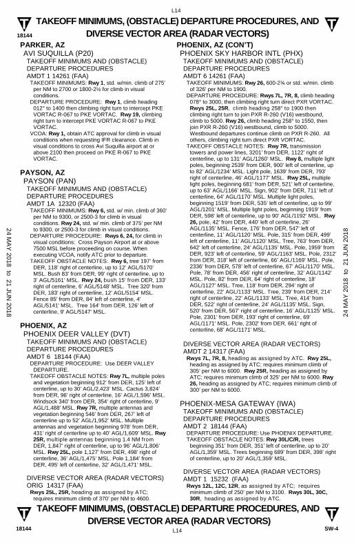
PARKER, AZ AVI SUQUILLA (P20) TAKEOFF MINIMUMS AND (OBSTACLE) DEPARTURE PROCEDURES AMDT 1 14261 (FAA)
TAKEOFF MINIMUMS: Rwy 1, std. w/min. climb of 275’ per NM to 2700 or 1800-2½ for climb in visual conditions.
DEPARTURE PROCEDURE: Rwy 1, climb heading 012° to 1400 then climbing right turn to intercept PKE VORTAC R-067 to PKE VORTAC. Rwy 19, climbing right turn to intercept PKE VORTAC R-067 to PKE VORTAC.
VCOA: Rwy 1, obtain ATC approval for climb in visual conditions when requesting IFR clearance. Climb in visual conditions to cross Avi Suquilla airport at or above 2100 then proceed on PKE R-067 to PKE VORTAC.
PAYSON, AZ PAYSON (PAN) TAKEOFF MINIMUMS AND (OBSTACLE) DEPARTURE PROCEDURES AMDT 1A 12320 (FAA)
TAKEOFF MINIMUMS: Rwy 6, std. w/ min. climb of 360' per NM to 9300, or 2500-3 for climb in visual conditions. Rwy 24, std. w/ min. climb of 375' per NM to 9300, or 2500-3 for climb in visual conditions.
DEPARTURE PROCEDURE: Rwys 6, 24, for climb in visual conditions: Cross Payson Airport at or above 7500 MSL before proceeding on course. When executing VCOA, notify ATC prior to departure.
TAKEOFF OBSTACLE NOTES: Rwy 6, tree 197’ from DER, 118’ right of centerline, up to 12’ AGL/5170’ MSL. Bush 83’ from DER, 99’ right of centerline, up to 3’ AGL/5161’ MSL. Rwy 24, bush 15' from DER, 133' right of centerline, 6' AGL/5148' MSL. Tree 320' from DER, 183' right of centerline, 12' AGL/5154' MSL. Fence 85' from DER, 84' left of centerline, 4' AGL/5141' MSL. Tree 164' from DER, 126' left of centerline, 9' AGL/5147' MSL.
PHOENIX, AZ PHOENIX DEER VALLEY (DVT) TAKEOFF MINIMUMS AND (OBSTACLE) DEPARTURE PROCEDURES AMDT 6 18144 (FAA)
DEPARTURE PROCEDURE: Use DEER VALLEY DEPARTURE.
TAKEOFF OBSTACLE NOTES: Rwy 7L, multiple poles and vegetation beginning 912’ from DER, 125’ left of centerline, up to 30’ AGL/2,423‘ MSL. Cactus 3,824’ from DER, 96’ right of centerline, 16’ AGL/1,596’ MSL. Windsock 340’ from DER, 354‘ right of centerline, 9’ AGL/1,488’ MSL. Rwy 7R, multiple antennas and vegetation beginning 546’ from DER, 267’ left of centerline up to 52’ AGL/1,952’ MSL. Multiple antennas and vegetation beginning 978’ from DER, 431’ right of centerline up to 40’ AGL/1,609’ MSL. Rwy 25R, multiple antennas beginning 1.4 NM from DER, 1,847’ right of centerline, up to 96’ AGL/1,806’ MSL. Rwy 25L, pole 1,127’ from DER, 498’ right of centerline, 36’ AGL/1,475’ MSL. Pole 1,184’ from DER, 495‘ left of centerline, 32’ AGL/1,471’ MSL.
DIVERSE VECTOR AREA (RADAR VECTORS) ORIG 14317 (FAA)
Rwys 25L, 25R, heading as assigned by ATC; requires minimum climb of 370’ per NM to 4600.
PHOENIX, AZ (CON’T) PHOENIX SKY HARBOR INTL (PHX) TAKEOFF MINIMUMS AND (OBSTACLE) DEPARTURE PROCEDURES AMDT 6 14261 (FAA)
TAKEOFF MINIMUMS: Rwy 26, 600-2¾ or std. w/min. climb of 326' per NM to 1900.
DEPARTURE PROCEDURE: Rwys 7L, 7R, 8, climb heading 078° to 3000, then climbing right turn direct PXR VORTAC. Rwys 25L, 25R, climb heading 258° to 1900 then climbing right turn to join PXR R-260 (V16) westbound, climb to 5000. Rwy 26, climb heading 258° to 1550, then join PXR R-260 (V16) westbound, climb to 5000. Westbound departures continue climb on PXR R-260. All others, climbing right turn direct PXR VORTAC.
TAKEOFF OBSTACLE NOTES: Rwy 7R, transmission towers and power lines, 3201’ from DER, 1122’ right of centerline, up to 131’ AGL/1260’ MSL. Rwy 8, multiple light poles, beginning 2539’ from DER, 900’ left of centerline, up to 82’ AGL/1234’ MSL. Light pole, 1639’ from DER, 793’ right of centerline, 46’ AGL/1177’ MSL. Rwy 25L, multiple light poles, beginning 681’ from DER, 521’ left of centerline, up to 63’ AGL/1166’ MSL. Sign, 902’ from DER, 711’ left of centerline, 64’ AGL/1170’ MSL. Multiple light poles, beginning 1519’ from DER, 535’ left of centerline, up to 99’ AGL/1201’ MSL. Multiple light poles, beginning 1919’ from DER, 598’ left of centerline, up to 90’ AGL/1192’ MSL. Rwy 26, pole, 42’ from DER, 440’ left of centerline, 26’ AGL/1135’ MSL. Fence, 176’ from DER, 547’ left of centerline, 11’ AGL/1120’ MSL. Pole, 315’ from DER, 499’ left of centerline, 11’ AGL/1120’ MSL. Tree, 763’ from DER, 642’ left of centerline, 24’ AGL/1135’ MSL. Pole, 1959’ from DER, 923’ left of centerline, 59’ AGL/1163’ MSL. Pole, 2312’ from DER, 318’ left of centerline, 66’ AGL/1169’ MSL. Pole, 2336’ from DER, 578’ left of centerline, 67’ AGL/1170’ MSL. Pole, 78’ from DER, 456’ right of centerline, 32’ AGL/1142’ MSL. Pole, 82’ from DER, 64’ right of centerline, 18’ AGL/1127’ MSL. Tree, 118’ from DER, 294’ right of centerline, 22’ AGL/1133’ MSL. Tree, 239’ from DER, 214’ right of centerline, 22’ AGL/1133’ MSL. Tree, 414’ from DER, 522’ right of centerline, 24’ AGL/1135’ MSL. Sign, 520’ from DER, 567’ right of centerline, 16’ AGL/1125’ MSL. Pole, 2301’ from DER, 193’ right of centerline, 69’ AGL/1171’ MSL. Pole, 2302’ from DER, 661’ right of centerline, 68’ AGL/1171’ MSL.
DIVERSE VECTOR AREA (RADAR VECTORS) AMDT 2 14317 (FAA)
Rwys 7L, 7R, 8, heading as assigned by ATC. Rwy 25L, heading as assigned by ATC; requires minimum climb of 305’ per NM to 6000. Rwy 25R, heading as assigned by ATC; requires minimum climb of 325’ per NM to 6000. Rwy 26, heading as assigned by ATC; requires minimum climb of 300’ per NM to 6000.
PHOENIX-MESA GATEWAY (IWA) TAKEOFF MINIMUMS AND (OBSTACLE) DEPARTURE PROCEDURES AMDT 2 18144 (FAA)
DEPARTURE PROCEDURE: Use PHOENIX DEPARTURE. TAKEOFF OBSTACLE NOTES: Rwy 30L/C/R, trees
beginning 351’ from DER, 351’ left of centerline, up to 20’ AGL/1,359’ MSL. Trees beginning 689’ from DER, 398’ right of centerline, up to 20’ AGL/1,359’ MSL.
DIVERSE VECTOR AREA (RADAR VECTORS) AMDT 1 15232 (FAA)
Rwys 12L, 12C, 12R, as assigned by ATC; requires minimum climb of 250’ per NM to 3100. Rwys 30L, 30C, 30R, heading as assigned by ATC.
24 MA
Y 2018 to 21 JU
N 2018 24
MA
Y 2
018
to 2
1 JU
N 2
018

18144
L15
L15
T T
T T
TAKEOFF MINIMUMS, (OBSTACLE) DEPARTURE PROCEDURES, AND DIVERSE VECTOR AREA (RADAR VECTORS)
TAKEOFF MINIMUMS, (OBSTACLE) DEPARTURE PROCEDURES, AND DIVERSE VECTOR AREA (RADAR VECTORS)
18144 SW-4
PRESCOTT, AZ ERNEST A LOVE FIELD (PRC) TAKEOFF MINIMUMS AND (OBSTACLE) DEPARTURE PROCEDURES AMDT 4 14093 (FAA)
DEPARTURE PROCEDURE: Use PRESCOTT DEPARTURE.
DIVERSE VECTOR AREA (RADAR VECTORS) ORIG 16007 (FAA)
Rwy 3L/R, Heading as assigned by ATC. Rwy 12, Heading as assigned by ATC; requires minimum climb of 370’ per NM to 7700. Rwy 21L/R Heading as assigned by ATC; requires minimum climb of 390’ per NM to 8300. Rwy 30, Heading as assigned by ATC.
PRICE, UT CARBON COUNTY RGNL/BUCK DAVIS FIELD (PUC) TAKEOFF MINIMUMS AND (OBSTACLE) DEPARTURE PROCEDURES AMDT 5 15064 (FAA)
TAKEOFF MINIMUMS: Rwy 1, std. w/min. climb of 400’ per NM to 6800 or 3300-3 for climb in visual conditions. Rwy 8, NA - obstacles. Rwy 33, std. w/min. climb of 370’ per NM to 6700 or 3300-3 for climb in visual conditions.
DEPARTURE PROCEDURE: Rwy 1, climb to 6400 then climbing right turn on a heading between 144° CW to 187°, maintain 210 KIAS until completion of turn, thence . . . Rwy 15, climb on a heading between 129° CW to 196°, thence . . . Rwy 19, climb on a heading between 195° CCW to 128°, thence . . . Rwy 26, climb on a heading between 179° CCW to 127°, thence . . . Rwy 33, climb to 6300 then climbing left turn on a heading between 178° CCW to 148°, thence . . . . . . continue climb to assigned altitude for direction of flight.
VCOA: Rwys 1, 33, obtain ATC approval for climb in visual conditions when requesting IFR clearance. Climb in visual conditions to cross Carbon County RGNL airport/Buck Davis Field at or above 9100 before proceeding on course.
TAKEOFF OBSTACLE NOTES: Rwy 1, multiple trees and poles beginning 164’ from DER, left and right of centerline, up to 64’ AGL/6207’ MSL.
PROVO, UT PROVO MUNI (PVU)
DEPARTURE PROCEDURE: Use PROVO DEPARTURE.
RENO, NV RENO/STEAD (RTS) TAKEOFF MINIMUMS AND (OBSTACLE) DEPARTURE PROCEDURES AMDT 3A 09183 (FAA)
TAKEOFF MINIMUMS: CAT A,B only, CAT C,D NA. Rwys 8, 14, 1300-2 or std. with a min. climb of 400' per NM to 6500. Rwy 26, 1900-2 or std. with a min. climb of 410' per NM to 7200. Rwy 32, 2300-2 or std. with a min. climb of 420' per NM to 7200.
DEPARTURE PROCEDURE: Rwys 8, 32, climbing right turn heading 100° and FMG VORTAC R-314 to FMG VORTAC. Rwy 14, left turn climb direct FMG VORTAC. Rwy 26, climbing right turn heading 050° and FMG VORTAC R-314 to FMG VORTAC. All aircraft climb in FMG VORTAC holding pattern (NE, right turns, 221° inbound) to depart FMG VORTAC; R-260 CW R-170 at or above 10000; R-171 CW R-195 at or above 10500; R-196 CW R-259 at or above 12000.
24 MA
Y 2018 to 21 JU
N 2018 24
MA
Y 2
018
to 2
1 JU
N 2
018

18144
L16
L16
T T
T T
TAKEOFF MINIMUMS, (OBSTACLE) DEPARTURE PROCEDURES, AND DIVERSE VECTOR AREA (RADAR VECTORS)
TAKEOFF MINIMUMS, (OBSTACLE) DEPARTURE PROCEDURES, AND DIVERSE VECTOR AREA (RADAR VECTORS)
18144 SW-4
RENO, NV (CON’T) RENO/TAHOE INTL (RNO) TAKEOFF MINIMUMS AND (OBSTACLE) DEPARTURE PROCEDURES AMDT 4 07354 (FAA)
TAKEOFF MINIMUMS: Rwy 7, NA-terrain. Rwy 16L, std. w/ min. climb of 730' per NM to 8000, or 600-1¼ w/ min. climb of 480' per NM to 8000, or 2700-3 for climb in visual conditions. Rwy 16R, std. w/ the following minimum climb requirements: 210 knots or less, 385' per NM to 8000; more than 210 knots, 420' per NM to 8900, or 2700-3 for climb in visual conditions. Resume normal speed after passing FMG VORTAC. Rwy 25, std. w/ min. climb of 470' per NM to 7800, or 2700-3 for climb in visual conditions. Rwy 34L, std. w/ min. climb of 320' per NM to 7000, or 2700-3 for climb in visual conditions. Rwy 34R, std. w/ min. climb of 480' per NM to 7000, or 500-1½ w/ min. climb of 320' per NM to 7000, or 2700-3 for climb in visual conditions.
DEPARTURE PROCEDURE: Rwys 16L/R, climb heading 164° to 6600 then climbing left turn direct FMG VORTAC, thence. . . or for climb in visual conditions: cross Reno/Tahoe Intl Airport at or above 7000 via heading 054° and FMG R-234 to FMG VORTAC, thence. . .Rwy 25, climb heading 254° to 5000 then climbing right turn direct FMG VORTAC, thence. . . or for climb in visual conditions: cross Reno/Tahoe Intl Airport at or above 7000 via heading 054° and FMG R-234 to FMG VORTAC, thence. . . Rwys 34L/R, climb heading 344° to 7000 then climbing right turn direct FMG VORTAC, thence. . . or for climb in visual conditions: cross Reno/Tahoe Intl Airport at or above 7000 via heading 054° and FMG R-234 to FMG VORTAC, thence. . .
. . .All aircraft: continue climb in FMG VORTAC holding pattern (northeast, left turn, 221° inbound) to cross FMG VORTAC at or above MEA/MCA for route of flight.
TAKEOFF OBSTACLE NOTES: Rwy 16L, multiple poles, trees, bushes and terrain beginning 618' from DER, 133' left of centerline, up to 20' AGL/4961' MSL Rwy 16R, multiple trees 2784' from DER, 171' right of centerline, up to 20' AGL/4510' MSL. Multiple trees and terrain beginning 746' from DER, 380' left of centerline, up to 20' AGL/4703' MSL. Rwy 25, multiple trees and poles beginning 829' from DER, 201' right of centerline, up to 103' AGL/4523' MSL. Building 6023' from DER, 456' right of centerline, 152' AGL/4608' MSL. Fence 222' from DER, 270' right of centerline, up to 5' AGL/4415' MSL. Multiple trees and poles beginning 500' from DER, 31' left of centerline, up to 20' AGL/4506' MSL. Rwy 34L, multiple trees and poles beginning 1229' from DER, 180' right of centerline, up to 20' AGL/4498' MSL. Multiple trees beginning 1193' from DER, 331' left of centerline, up to 20' AGL/4489' MSL. Rwy 34R, multiple trees and poles beginning 1067' from DER, 172' right of centerline, up to 20' AGL/4497' MSL. Multiple trees and poles beginning 1230' from DER, 350' left of centerline, up to 20' AGL/4498' MSL. Building 1.2 NM from DER, 1730' right of centerline, 363' AGL/4780' MSL.
DIVERSE VECTOR AREA (RADAR VECTORS) ORIG 15008 (FAA)
Rwy 25, heading as assigned by ATC; requires minimum climb of 500’ per NM to 8100. Rwy 34L, heading as assigned by ATC; requires minimum climb of 460’ per NM to 7700. Rwy 34R, heading as assigned by ATC; requires minimum climb of 410’ per NM to 8100.
RICHFIELD, UT RICHFIELD MUNI (RIF) TAKEOFF MINIMUMS AND (OBSTACLE) DEPARTURE PROCEDURES AMDT 1 08157 (FAA)
DEPARTURE PROCEDURE: Rwy 1, use RICHFIELD (RNAV) DEPARTURE. Rwy 19, use HAMET (RNAV) DEPARTURE.
ROOSEVELT, UT ROOSEVELT MUNI (74V) TAKEOFF MINIMUMS AND (OBSTACLE) DEPARTURE PROCEDURES AMDT 2 16315 (FAA)
TAKEOFF MINIMUMS: Rwy 7, std. Rwy 25, std. w/min. climb of 300’ per NM to 6100 or 1300-3 for VCOA.
DEPARTURE PROCEDURE: Rwy 7, turn right. Rwy 25, turn left. All aircraft, climb direct MTU VOR/DME. Aircraft departing MTU VOR/DME R-040 CW R-150, Climb on course. All others continue climb in MTU holding pattern (NE, right turns, 213° inbound) to cross MTU VOR/DME; R-151 CW R-290 at or above 8000; R-291 CW R-039 at or above 10000. Then climb on course.
VCOA: Rwy 25, obtain ATC approval for VCOA when requesting IFR clearance. Climb in visual conditions to cross Roosevelt Muni airport southbound at or above 6300 on MTU R-010 to MTU VOR/DME, continue climb in hold (NE, right turns, 213° inbound) to MEA for direction of flight.
TAKEOFF OBSTACLE NOTES: Rwy 7, NAVAID 38’ from DER, 110’ left of centerline, 5’ AGL/5111’ MSL. Vehicles on road beginning 76’ from DER, 250’ left of centerline, up to 15’ AGL/5122’ MSL. Rwy 25, NAVAID 39’ from DER, 112’ left of centerline, 2’ AGL/5177’ MSL. Tree 95’ from DER, 384’ left of centerline, 9’ AGL/5179’ MSL. Trees beginning 180’ from DER, 403’ left and right of centerline, up to 22’ AGL/5192’ MSL. Tree, building, vehicle on road, pole beginning 5668’ from DER, 1461’ right of centerline, up to 45’ AGL/5345’ MSL. Trees, poles, buildings, vehicle on road beginning 1 NM from DER, 1031’ right of centerline, up to 100’ AGL/5410’ MSL. Tree, vehicle on road, terrain beginning 1.2 NM from DER, 1904’ right of centerline, up to 16’ AGL/5416’ MSL. Poles, tree, vehicle on road beginning 1.3 NM from DER, 1915’ right of centerline, up to 56’ AGL/5426’ MSL. Trees beginning 1.5 NM from DER, 1553’ right of centerline, up to 55’ AGL/5485’ MSL. Trees beginning 1.8 NM from DER, 1871’ right of centerline, up to 53’ AGL/5493’ MSL. Tre 1.9 NM from DER, 1987’ right of centerline, 20’ AGL/5483’ MSL.
SAFFORD, AZ SAFFORD RGNL (SAD) TAKEOFF MINIMUMS AND (OBSTACLE) DEPARTURE PROCEDURES AMDT 1 10210 (FAA)
TAKEOFF MINIMUMS: Rwys 8, 26, NA - Airspace. DEPARTURE PROCEDURE: Rwys 12, 30, use
SAFFORD RNAV DEPARTURE.
24 MA
Y 2018 to 21 JU
N 2018 24
MA
Y 2
018
to 2
1 JU
N 2
018

18144
L17
L17
T T
T T
TAKEOFF MINIMUMS, (OBSTACLE) DEPARTURE PROCEDURES, AND DIVERSE VECTOR AREA (RADAR VECTORS)
TAKEOFF MINIMUMS, (OBSTACLE) DEPARTURE PROCEDURES, AND DIVERSE VECTOR AREA (RADAR VECTORS)
18144 SW-4
ST. GEORGE, UT ST. GEORGE RGNL (SGU) TAKEOFF MINIMUMS AND (OBSTACLE) DEPARTURE PROCEDURES ORIG-A 16147 (FAA)
DEPARTURE PROCEDURE: Use JITKA DEPARTURE.
ST. JOHNS, AZ ST. JOHNS INDUSTRIAL AIR PARK (SJN) TAKEOFF MINIMUMS AND (OBSTACLE) DEPARTURE PROCEDURES AMDT 1B 16315 (FAA)
TAKEOFF MINIMUMS: Rwys 3, 32, 14, std. Rwy 21, 700-2¾ or standard w/min. climb of 378’ per NM to 6600.
DEPARTURE PROCEDURE: Rwys 3, 32, climbing right turn. Rwys 14, 21, climbing left turn. All aircraft, climb direct SJN VORTAC. Aircraft departing SJN VORTAC R-240 CW to R-080 Climb on course. All others continue climb in SIN VORTAC holding pattern (hold NE, right turns, 239° inbound) to cross SJN VORTAC at or above 9000.
TAKEOFF OBSTACLE NOTES: Rwy 3, sign 15’ from DER, 125’ left of centerline, 3’ AGL/5736’ MSL. Rwy 14, vehicle on road 1’ from DER, 113’ right of centerline, up to 15’ AGL/5750’ MSL. Tree, fence, post, obstruction light on building, ant on building and transmission line tower beginning 27’ from DER, 94’ left of centerline, up to 5780’ MSL. Airport beacon lighted, tower, pole, windsock, building, obstruction light on building, light pole, transmission light tower and tree, beginning 58’ from DER, 88’ right of centerline, up to 57’ AGL/5793’ MSL. Vehicle on road 67’ from DER, crossing centerline, 15’ AGL/5752’ MSL. Trees and poles beginning 515’ from DER, 73’ left of centerline, up to 76’ AGL/5784’ MSL. Vehicle on road 559’ from DER, crossing centerline, 15’ AGL/5762’ MSL. Rwy 32, vehicle on road and generator utility beginning 34’ from DER, 3’ right of centerline, up to 15’ AGL/5745’ MSL. Generator utility 40’ from DER, 79’ left of centerline, 10’ AGL/5736’ MSL. Vehicle on road 102’ from DER, crossing centerline, 15’ AGL/5741’ MSL. Buildings beginning 201’ from DER, 327’ left of centerline up to 5743’ MSL. Pole 307’ from DER, 570’ left of centerline, up to 30’ AGL/5757’ MSL. Rwy 21, tree and fence 15’ from DER, 248’ left of centerline, 5767’ MSL. Trees and buildings beginning 23’ from DER, 276’ right of centerline, up to 5798’ MSL. Trees beginning 92’ from DER, 27’ left of centerline, up to 5778’ MSL. Fence beginning 208’ from DER, crossing centerline, up to 5738’ MSL. Vehicles on road 265’ from DER, crossing centerline, 15’ AGL/5756’ MSL. Trees, buildings, signs and poles beginning 285’ from DER, 2’ right of centerline, up to 5781’ MSL. Trees, buildings, signs and poles beginning 597’ from DER, 3’ left of centerline, up to 5780’ MSL. Trees, buildings and poles beginning 808’ from DER, 10’ right of centerline, up to 5833’ MSL. Trees, buildings and poles beginning 867’ from DER, 3’ left of centerline, up to 5788’ MSL. Trees beginning 1257’ from DER, 20’ left of centerline, up to 5816’ MSL. Buildings, poles and trees beginning 3704’ from DER, 662’ right of centerline, up to 5914’ MSL. Poles beginning 3491’ from DER, 1293’ left of centerline, up to 5872’ MSL. Communications tower 2.2 NM from DER, 1415’ left of centerline, 199’ AGL/6356’ MSL. Pole 2.2 NM from DER, 1467’ left of centerline, 31’ AGL/6133’ MSL.
SALT LAKE CITY, UT SALT LAKE CITY INTL (SLC) TAKEOFF MINIMUMS AND (OBSTACLE) DEPARTURE PROCEDURES AMDT 11A 17229 (FAA)
TAKEOFF MINIMUMS: Rwy 32, 400-1 or std. w/ min. climb of 498’ per NM to 4700.
DEPARTURE PROCEDURE: Rwy 14, climb to 10000 on heading 192° and FFU R-341 to FFU VORTAC before proceeding on course. Rwy 16R, climb to 10000 on heading 164° and FFU R-341 to FFU VORTAC before proceeding on course. Rwy 16L, climb to 10000 on heading 164° and FFU R-341 to FFU VORTAC before proceeding on course. Rwy 17, climb to 10000 on heading 169° and FFU R-341 to FFU VORTAC before proceeding on course. Rwy 32, climb to 9000 on heading 002° and OGD R-153 to OGD VORTAC before proceeding on course. Rwy 34L, climb to 9000 on heading 344° and OGD R-153 to OGD VORTAC before proceeding on course. Rwy 34R, climb to 9000 on heading 344° and OGD R-153 to OGD VORTAC before proceeding on course. Rwy 35, climb to 9000 on heading 339° and OGD R-153 to OGD VORTAC before proceeding on course.
TAKEOFF OBSTACLE NOTES: Rwy 14, antenna 1349’ from DER, 544’ left of centerline, 42’ AGL/4263’ MSL. Rwy 16L, vehicle on road 124’ from DER, 14’ right of centerline, 15’ AGL/4239’ MSL. Light pole 988’ from DER, 726’ right of centerline, 34’ AGL/4254’ MSL. Pole 1024’ from DER, 689’ right of centerline, 34’ AGL/4254’ MSL. Rwy 17, vehicles on road beginning 335’ from DER, on centerline, up to 17’ AGL/4241’ MSL. Rwy 32, ATC tower 5,266’ from DER, 1767 left of centerline, 335’ AGL/4549’ MSL. Crane 5196’ from DER, 1630’ left of centerline, 240’ AGL/4463’ MSL. Flag on OL 5,153’ from DER, 1619’ left of centerline, 249’ AGL/4463’ MSL. Aircraft beginning 969’ from DER, 722’ left of centerline, up to 79’ AGL/4306’ MSL. Rwy 34R, post 13’ from DER, 349’ right of centerline, 3’ AGL/4227’ MSL. Rwy 35, post 56’ from DER, 249’ left of centerline, 2’ AGL/4220’ MSL.
DIVERSE VECTOR AREA (RADAR VECTORS) AMDT 1 17257
Rwy 14, heading as assigned by ATC. Rwy 16L, heading as assigned by ATC. Rwy 16R, heading as assigned by ATC. Rwy 17, heading as assigned by ATC. Rwy 34L, heading as assigned by ATC. Rwy 34R, heading as assigned by ATC. Rwy 35, heading as assigned by ATC.
24 MA
Y 2018 to 21 JU
N 2018 24
MA
Y 2
018
to 2
1 JU
N 2
018

18144
L18
L18
T T
T T
TAKEOFF MINIMUMS, (OBSTACLE) DEPARTURE PROCEDURES, AND DIVERSE VECTOR AREA (RADAR VECTORS)
TAKEOFF MINIMUMS, (OBSTACLE) DEPARTURE PROCEDURES, AND DIVERSE VECTOR AREA (RADAR VECTORS)
18144 SW-4
SALT LAKE CITY, UT (CON’T) SOUTH VALLEY RGNL (U42)
TAKEOFF MINIMUMS AND (OBSTACLE) DEPARTURE PROCEDURES AMDT 6 18032 (FAA)
TAKEOFF MINIMUMS: Rwy 16, std. w/ min. climb of 300’ per NM to 10700. Rwy 34, std. w/ min. climb of 330’ per NM to 9000.
DEPARTURE PROCEDURE: Rwy 16, climbing left turn to 10700 on FFU VORTAC R-341 to FFU VORTAC, continue climb in FFU VORTAC holding pattern (hold S, right turn, 008° inbound) to cross FFU VORTAC at or above MEA/MCA for route of flight. Rwy 34, climbing right turn to 9000 on TCH VORTAC R-161 to TCH VORTAC, continue climb in TCH VORTAC holding pattern (hold NW, right turn, 120° inbound) to cross TCH VORTAC at or above MEA/MCA for route of flight.
TAKEOFF OBSTACLE NOTES: Rwy 16, NAVAID abeam DER, 99’ right of centerline, 4602’ MSL. Terrain, sign beginning 34’ from DER, 207’ right of centerline, up to 4606’ MSL. Vehicle on road 83’ from DER, 252’ left of centerline, 4611’ MSL. Vehicle on road 171’ from DER, 132’ left of centerline, 4614’ MSL. Pole 551’ from DER, 631’ right of centerline, 15’ AGL/4626’ MSL. Vehicle on road, vegetation beginning 672’ from DER, 490’ right of centerline, up to 4629’ MSL. Pole 1000’ from DER, 638’ right of centerline, 4638’ MSL. Pole 1008’ from DER, 466’ right of centerline, 31’ AGL/4640’ MSL. Pole beginning 1092’ from DER, 687’ right of centerline, up to 31’ AGL/4644’ MSL. Rwy 34, NAVAID 10’ from DER, 96’ left of centerline, 4606’ MSL. NAVAID 10’ from DER, 94’ right of centerline, 4604‘ MSL. Terrain 58’ from DER, 424’ left of centerline, 4608’ MSL.
SCOTTSDALE, AZ SCOTTSDALE (SDL) TAKEOFF MINIMUMS AND (OBSTACLE) DEPARTURE PROCEDURES AMDT 9 18144 (FAA)
DEPARTURE PROCEDURE: Use MARICOPA DEPARTURE.
TAKEOFF OBSTACLE NOTES: Rwy 3, multiple light standards beginning 63’ from DER, 445’ left of centerline, up to 44’ AGL/1,554 MSL. Hoist on dike 878’ from DER, 735’ left of centerline, 51’ AGL/1,561’ MSL. Dike beginning 1,066’ from DER, 316‘ left of centerline, 38’ AGL/1548’ MSL. Day marker on dike, 1,230’ from DER, 5’ left of centerline, 39’ AGL/1,549’ MSL. Tree 765’ from DER,115’ left of centerline, 22’ AGL/1,532’ MSL. Road beginning 647’ from DER, 296’ left of centerline, 19’ AGL/1,529’ MSL. Fence beginning 5’ from DER, 338’ right of centerline, 6’ AGL/1,511’ MSL. Light standard 1,013’ from DER, 430’ right of centerline, 44’ AGL/1,552’ MSL. Rwy 21, trees 1,072’ from DER, 426’ right of centerline, 53’ AGL/1,497’ MSL. Building 316’ from DER, 537’ right of centerline, 23’ AGL/1,467’ MSL. Tree 2,087’ from DER, 418’ left of centerline, 61’ AGL/1,505‘ MSL. Tree 1,432’ from DER, 438’ right of centerline, 38’ AGL/1,482’ MSL. Tree 2,234’ from DER, 559’ left of centerline, 58’ AGL/1,502’ MSL.
DIVERSE VECTOR AREA (RADAR VECTORS) AMDT 1 14317 (FAA)
Rwy 3, heading as assigned by ATC; requires minimum climb of 445’ per NM to 4600. Rwy 21, heading as assigned by ATC; do not exceed 210 KTS until established on assigned heading.
SEDONA, AZ SEDONA (SEZ) TAKEOFF MINIMUMS AND (OBSTACLE) DEPARTURE PROCEDURES AMDT 1 08101 (FAA)
TAKEOFF MINIMUMS: Rwy 3, NA- Obstacles. DEPARTURE PROCEDURE: Rwy 21, Use OATES RNAV
DEPARTURE.
SHOW LOW, AZ SHOW LOW RGNL (SOW) TAKEOFF MINIMUMS AND (OBSTACLE) DEPARTURE PROCEDURES AMDT 1 11013 (FAA)
DEPARTURE PROCEDURE: Rwy 3, climb on heading 360° to 7800 before proceeding on course. Rwy 6, climb on heading 360° to 8100 before proceeding on course. Rwy 21, climb on heading 255° to 7700 before proceeding on course. Rwy 24, climb on heading 243° to 7600 before proceeding on course.
TAKEOFF OBSTACLE NOTES: Rwy 3, trees beginning 89' from DER, 429' left of centerline, up to 33' AGL/6413' MSL. Rwy 21, trees, tank, terrain, poles and buildings beginning 94' from DER, 5' left of centerline, up to 76' AGL/6519' MSL. Trees and terrain beginning 124' from DER, 25' right of centerline, up to 20' AGL/6431' MSL. Rwy 24, poles and catenary beginning 704' from DER, 4' left of centerline, up to 59' AGL/6439' MSL. Poles, catenary, electrical system, and terrain beginning 53' from DER, 78' right of centerline, up to 58' AGL/6438' MSL.
SILVER SPRINGS, NV SILVER SPRINGS (SPZ) TAKEOFF MINIMUMS AND (OBSTACLE) DEPARTURE PROCEDURES ORIG 17117 (FAA)
TAKEOFF MINIMUMS: Rwy 24, 2800-3 for VCOA. DEPARTURE PROCEDURE: Rwy 6, climb heading 056°
to intercept HZN R-220 to 8000. Continue climb in HZN VORTAC holding pattern (hold NE, RT, 211° inbound) to cross HZN VORTAC at or above MEA for route of flight.
VCOA: Rwy 24, obtain ATC approval for VCOA when requesting IFR clearance. Climb in visual conditions to cross Silver Springs Airport at or above 6900, then proceed on HZN VORTAC R-220 to 8000 to HZN VORTAC.
TAKEOFF OBSTACLE NOTES: Rwy 6, windsock and sign beginning 29’ from DER, 204’ left of centerline, up to 23’ AGL/4235’ MSL. Rwy 24, terrain 52’ from DER, 495’ right of centerline, 4267’ MSL. Pole 2258’ from DER, 938’ right of centerline, 33’ AGL/4324’ MSL. Pole 2277’ from DER, 883’ right of centerline, 38’ AGL/4328’ MSL.
SPRINGERVILLE, AZ SPRINGERVILLE MUNI (JTC) TAKEOFF MINIMUMS AND (OBSTACLE) DEPARTURE PROCEDURES ORIG 96228 (FAA)
TAKEOFF MINIMUMS: Rwy 21, 1000-2 or std. with a min. climb of 360' per NM to 8400.
DEPARTURE PROCEDURE: Rwys 3, 11, climbing left turn to 8400 via heading 360° before proceeding on course. Rwys 21, 29, climbing right turn to 8400 via 360° before proceeding on course.
24 MA
Y 2018 to 21 JU
N 2018 24
MA
Y 2
018
to 2
1 JU
N 2
018

18144
L19
L19
T T
T T
TAKEOFF MINIMUMS, (OBSTACLE) DEPARTURE PROCEDURES, AND DIVERSE VECTOR AREA (RADAR VECTORS)
TAKEOFF MINIMUMS, (OBSTACLE) DEPARTURE PROCEDURES, AND DIVERSE VECTOR AREA (RADAR VECTORS)
18144 SW-4
TAYLOR, AZ TAYLOR (TYL) TAKEOFF MINIMUMS AND (OBSTACLE) DEPARTURE PROCEDURES AMDT 1 11125 (FAA)
TAKEOFF MINIMUMS: Rwy 21, 300-1 or std. w/min. climb of 290' per NM to 6100.
DEPARTURE PROCEDURE: Rwy 3, climb heading 030° to 8000 before turning on course. Rwy 21, climb heading 210° to 8000 before turning on course.
TAKEOFF OBSTACLE NOTES: Rwy 3, vehicles on road beginning 1823' from DER, 698' right of centerline, up to 17' AGL/5726' MSL. Power lines crossing departure course 1000' from DER. Rwy 21, trees beginning 1132' from DER, 316' right of centerline, up to 12' AGL/5871' MSL.
TONOPAH, NV TONOPAH (TPH) TAKEOFF MINIMUMS AND (OBSTACLE) DEPARTURE PROCEDURES AMDT 2 17229 (FAA)
TAKEOFF MINIMUMS: Rwys 11, 29, NA - ATC. Rwy 15, std. with a min. climb of 320' per NM to 9100 or 2500-3 for VCOA. Rwy 33, std. with a min. climb of 352' per NM to 9100 or 2500-3 for VCOA.
DEPARTURE PROCEDURE: Rwy 15, climbing left turn direct TONOPAH (TPH) VORTAC thence... Rwy 33, climbing right turn direct TONOPAH (TPH) VORTAC thence...
...continue climb in TPH holding pattern (NE, RT, 246° inbound) to cross TPH VORTAC at or above 9300 before proceeding on course.
VCOA: Rwy 15, 33, obtain ATC approval for VCOA when requesting IFR clearance. Climb in visual conditions to cross Tonopah airport at or above 7800 direct TONOPAH VORTAC, continue climb in TPH holding pattern (NE, RT, 246° inbound) to cross TPH VORTAC at or above 9300 before proceeding on course.
TAKEOFF OBSTACLE NOTES: Rwy 15, transmission line tower 515’ from DER, 473’ left of centerline, 23’ AGL/5418’ MSL. Rwy 33, fence beginning 173’ from DER, 401’ right of centerline, 6’ AGL/5438’ MSL.
TONOPAH TEST RANGE (KTNX) TONOPAH , NV TAKEOFF MINIMUMS AND (OBSTACLE) DEPARTURE PROCEDURES
AMDT 1 18144 DEPARTURE PROCEDURE: Rwy 14, 1000-3 w/ min.
climb of 320’ per NM to 10,700 or 2700-3 for climb in visual conditions. Climb on a heading between 325° CW to 155° from DER or climb in visual conditions to cross KZ-KTNX Airport at or above 8100 MSL before proceeding on course. Rwy 32, 1000-3 w/ min. climb of 260’ per NM to 5900 or 2700-3 for climb in visual conditions. Climb on a heading between 295° CW to 005° from DER or climb in visual conditions to cross KZ-KTNX Airport at or above 8100 MSL before proceeding on course.
TAKEOFF OBSTACLE NOTES: Rwy 14, terrain 1204’ from DER, 823’ right of centerline, 5582’ MSL. Terrain 63’ from DER, 517’ right of centerline, 5565’ MSL. Terrain 46’ from DER, 480’ right of centerline, 5564’ MSL. Terrain 0’ from DER, 353’ right of centerline, 5561’ MSL. Terrain 62’ from DER, 200’ right of centerline, 5558’ MSL. Terrain 14’ from DER, 292’ right of centerline, 5561’ MSL. Terrain 0’ from DER, 287’ right of centerline, 5561’ MSL. Terrain 0’ from DER, 222’ right of centerline, 5559’ MSL. Surveyed terrain 215’ from DER, 427’ right of centerline, 5560’ MSL. Rwy 32, terrain 0’ from DER, 500’ left of centerline, 5476’ MSL. Terrain 19’ from DER, 465’ left of centerline, 5476’ MSL. Terrain 110’ from DER, 529’ left of centerline, 5476’ MSL.
TOOELE, UT BOLINDER FIELD-TOOELE VALLEY (TVY) TAKEOFF MINIMUMS AND (OBSTACLE) DEPARTURE PROCEDURES AMDT 3 13234 (FAA)
TAKEOFF MINIMUMS: Rwy 17, std. w/min. climb of 348’ per NM to 9000 or 5600-3 for climb in visual conditions. Rwy 35, std. w/min. climb of 380’ per NM to 9000 or 5600-3 for climb in visual conditions.
DEPARTURE PROCEDURE: Rwy 17, climbing right turn to 9000 on heading 337° and OGD VORTAC R-197 to STACO INT, or for climb in visual conditions: cross Bolinder Field-Tooele Valley airport at or above 9800’ MSL before proceeding on course. When executing VCOA, notify ATC prior to departure. Rwy 35, climbing left turn to 9000 on heading 300° and OGD VORTAC R-197 to STACO INT, or for climb in visual conditions: cross Bolinder Field-Tooele Valley airport at or above 9800’ MSL before proceeding on course. When executing VCOA, notify ATC prior to departure.
TAKEOFF OBSTACLE NOTES: Rwy 17, tree 230’ from DER, 255’ right of centerline, 35’ AGL/4335’ MSL. Tree 342’ from DER, 363’ right of centerline, 35’ AGL/4360’ MSL. Trees beginning 601’ from DER, 486’ right of centerline, up to 35’ AGL/4399’ MSL. Pole 1000’ from DER, 409’ left of centerline, 42’ AGL/4363’ MSL. Pole 1092’ from DER, 118’ right of centerline, 42’ AGL/4363’ MSL. Tree 1369’ from DER, 393’ right of centerline, 35’ AGL/4381’ MSL. Tree 2018’ from DER, 257’ right of centerline, 35’ AGL/4384’ MSL.
24 MA
Y 2018 to 21 JU
N 2018 24
MA
Y 2
018
to 2
1 JU
N 2
018

18144
L20
L20
T T
T T
TAKEOFF MINIMUMS, (OBSTACLE) DEPARTURE PROCEDURES, AND DIVERSE VECTOR AREA (RADAR VECTORS)
TAKEOFF MINIMUMS, (OBSTACLE) DEPARTURE PROCEDURES, AND DIVERSE VECTOR AREA (RADAR VECTORS)
18144 SW-4
TUCSON, AZ RYAN FIELD (RYN) TAKEOFF MINIMUMS AND (OBSTACLE) DEPARTURE PROCEDURES AMDT 3 10210 (FAA)
TAKEOFF MINIMUMS: Rwys 6L, 15, 24R, 33, NA, ATC.
DEPARTURE PROCEDURE: Rwys 6R, 24L, use ALMON DEPARTURE.
TUCSON INTL (TUS) TAKEOFF MINIMUMS AND (OBSTACLE) DEPARTURE PROCEDURES AMDT 5 12208 (FAA)
TAKEOFF MINIMUMS: Rwy 3, 300-2 or std. w/min. climb of 228’ per NM to 3000.
DEPARTURE PROCEDURE: Rwys 3, 29L/R, climbing right turn direct to TUS VORTAC…
Rwy 21, climbing left turn direct to TUS VORTAC … Rwys 11L/R, climb heading 123° to 4000 then climbing left turn direct TUS VORTAC …
... Climb in TUS VORTAC holding pattern (hold NW, right turns, 128° inbound) to 9000 before proceeding on course.
TAKEOFF OBSTACLE NOTES: Rwy 3, multiple trees and sign beginning 1385’ from DER, 127’ left of centerline, up to 41’ AGL/2611’ MSL. Tree 2062’ from DER, 332’ right of centerline, 46’ AGL/2626’ MSL. Rwy 11L, vents 115’ from DER, 147’ left and right of centerline, 6’ AGL/2646’ MSL. Multiple bushes beginning 449’ from DER, 395’ left of centerline, up to 24’ AGL/2674’ MSL. Multiple bushes beginning 188’ from DER, 328’ right of centerline, up to 13’ AGL/2663’ MSL. Rwy 11R, tree 584’ from DER, 176’ right of centerline, 25’ AGL/2645’ MSL. Rwy 21, bush 104’ from DER, 256’ left of centerline, 12’ AGL/2572’ MSL. RR 248’ from DER, right to left of centerline, 23’ AGL/2582’ MSL. Bush 549’ from DER, 384’ left of centerline, 33’ AGL/2583’ MSL. Tree 701’ from DER, 144’ left of centerline, 37’ AGL/2587’ MSL. Pole 950’ from DER, 166’ left of centerline, 38’ AGL/2588’ MSL. Pole 1028’ from DER, 89’ left of centerline, 46’ AGL/2599’ MSL. Pole 1298’ from DER, 594’ left of centerline, 66’ AGL/2616’ MSL. Electrical system 1445’ from DER, 319’ left of centerline, 55’ AGL/2605’ MSL. Bush 141’ from DER, 330’ right of centerline, 24’ AGL/2574’ MSL. Bush 454’ from DER, 138’ right of centerline, 26’ AGL/2576’ MSL. Electrical system 1176’ from DER, 37’ right of centerline, 48’ AGL/2598’ MSL. Rwy 29L, aircraft on ramp 2723’ from DER, 348’ left of centerline, up to 30’ AGL/2680’ MSL. Rwy 29R, aircraft on ramp 2779’ from DER, 1056’ left of centerline, up to 30’ AGL/2680’ MSL.
VERNAL, UT VERNAL RGNL (VEL) TAKEOFF MINIMUMS AND (OBSTACLE) DEPARTURE PROCEDURES AMDT 2 17341 (FAA)
TAKEOFF MINIMUMS: Rwy 17, std. w /min. climb of 210’ per NM to 6000, or alternatively with std. takeoff minimums and a normal 200’ per NM climb gradient, takeoff must occur no later than 1800’ prior to DER or 2200-3 for VCOA. Rwy 35, std. w/ min. climb of 410’ per NM to 7700 or 2200-3 for VCOA.
DEPARTURE PROCEDURE: Rwy 17, climbing left turn direct VEL VOR/DME, thence . . . Rwy 35, climbing right turn direct VEL VOR/DME, thence . . .
. . . on VEL VOR/DME R-142 to ENSEN INT/VEL 9.7 DME and hold (hold SE, right turn, 322° inbound). Continue Climb-in-hold to the MEA/MCA for route of flight.
VCOA: Rwys 17, 35, obtain ATC approval for VCOA when requesting IFR clearance: Climb in visual conditions to cross Vernal RGNL Airport at or above 7300, then continue climb on VEL VOR/DME R-142 until reaching the MEA/MCA for route of flight.
TAKEOFF OBSTACLE NOTES: Rwy 17, terrain beginning 19’ from DER, 140’ right of centerline, up to 5290’ MSL. Terrain and agricultural equipment beginning 118’ from DER, 15’ left of centerline, up to 6’ AGL/5284’ MSL. Tree 1333’ from DER, 295’ left of centerline, 5315’ MSL. Tree 1378’ from DER, 221’ left of centerline, 5317’ MSL. Tree 1456’ from DER, 112’ left of centerline, 5318’ MSL. Tree 1498’ from DER, 32’ left of centerline, 5320’ MSL. Poles beginning 1948’ from DER, 46’ right of centerline, up to 35’ AGL/5334’ MSL. Trees beginning 2411’ from DER, 19’ left of centerline, up to 5370’ MSL. Tree 2439’ from DER, 296’ right of centerline, 5339’ MSL. Tree 2468’ from DER, 288’ right of centerline, 5341’ MSL. Trees beginning 2497’ from DER, 290’ right of centerline, up to 5344’ MSL. Trees beginning 2511’ from DER, 105’ left of centerline, up to 5374’ MSL. Tree 2534’ from DER, 361’ right of centerline, 5355’ MSL. Tree 2553’ from DER, 355’right of centerline, 5362’ MSL. Trees beginning 2573’ from DER, 323’ right of centerline, up to 5370’ MSL. Trees beginning 4620’ from DER, 71’ left of centerline, up to 5397’ MSL. Tree 4749’ from DER, 184’ right of centerline, 5401‘ MSL. Tree 4895’ from DER, 65’ left of centerline, 5403’ MSL. Rwy 35, pole 178’ from DER, 153’ left of centerline, 5290’ MSL. Tree and pole beginning 934’ from DER, 625’ right of centerline, up to 5302’ MSL.
WENDOVER, UT WENDOVER (ENV) TAKEOFF MINIMUMS AND (OBSTACLE) DEPARTURE PROCEDURES AMDT 7 16091 (FAA)
TAKEOFF MINIMUMS: Rwy 26, std. w/min. climb of 300’ per NM to 5900. Rwy 30, NA-ATC.
DEPARTURE PROCEDURE: Rwys 8,12, 26, climbing left turn direct BVL VORTAC, thence…
...continue climb in holding pattern (hold NE, right turns, 253° inbound) to cross BVL VORTAC at/above MEA for route of flight.
TAKEOFF OBSTACLE NOTES: Rwy 12, bush 92’ from DER, 258’ left of centerline, 4’ AGL/4227’ MSL. Rwy 26, tree 100’ from DER, 500’ right of centerline, 11’ AGL/4240’ MSL. Bush 90’ from DER, 278’ left of centerline, 4’ AGL/4233’ MSL.
24 MA
Y 2018 to 21 JU
N 2018 24
MA
Y 2
018
to 2
1 JU
N 2
018

18144
L21
L21
T T
T T
TAKEOFF MINIMUMS, (OBSTACLE) DEPARTURE PROCEDURES, AND DIVERSE VECTOR AREA (RADAR VECTORS)
TAKEOFF MINIMUMS, (OBSTACLE) DEPARTURE PROCEDURES, AND DIVERSE VECTOR AREA (RADAR VECTORS)
18144 SW-4
WILLCOX, AZ COCHISE COUNTY (P33) TAKEOFF MINIMUMS AND (OBSTACLE) DEPARTURE PROCEDURES AMDT 1 13122 (FAA)
TAKEOFF MINIMUMS: Use COCHISE DEPARTURE.
WINDOW ROCK, AZ WINDOW ROCK (RQE) TAKEOFF MINIMUMS AND (OBSTACLE) DEPARTURE PROCEDURES AMDT 1 03191 (FAA)
TAKEOFF MINIMUMS: Rwy 2, 700-2 or std. with a min. climb of 500' per NM to 8000. Rwy 20, 600-2 or std. with a min. climb of 260' per NM to 8200.
DEPARTURE PROCEDURE: Rwy 2, turn right. Rwy 20, turn left direct to GUP VORTAC before proceeding on course.
TAKEOFF OBSTACLE NOTES: Rwy 2, terrain 3832' from DER, 1025' right of centerline, 6926' MSL. Poles 5220' from DER, 245' right of centerline, 180' AGL/6922' MSL. Tower 7067' from DER, 3072' left of centerline, 71' AGL/7316' MSL. Terrain 7449' from DER, 1612' left of centerline, 6991' MSL. Terrain 8776' from DER, 1851' left of centerline, 7109' MSL. Tree 9665' from DER, 1326' right of centerline, 7340' MSL. Tree 11326' from DER, 355' left of centerline, 7351' MSL. Rwy 20, trees 1018' from DER, 620' left of centerline, 30' AGL/6768' MSL.
WINNEMUCCA, NV WINNEMUCCA MUNI (WMC) TAKEOFF MINIMUMS AND (OBSTACLE) DEPARTURE PROCEDURES AMDT 1 87295 (FAA)
TAKEOFF MINIMUMS: Rwy 2, 2500-2 or std. with a min. climb of 450' per NM to 6800. Rwys 14, 20, 3200-2 or std. with a min. climb of 520' per NM to 7500.
DEPARTURE PROCEDURE: Rwys 14, 20, turn right. Rwy 2, turn left. Rwy 32, climb straight ahead. All aircraft climb via INA R-326 to 6700 or above within 12 NM, then climbing left turn return to INA VOR/DME via R-326. Continue climb in INA VOR/DME holding pattern (hold NW, right turns, 146° inbound) to depart INA VOR/DME at or above 11000. Southbound aircraft continue via INA R-146 direct Fesko Int. Northbound aircraft continue via INA R-326 and SDO R-144 direct SDO VORTAC.
WINSLOW, AZ WINSLOW-LINDBERGH RGNL (INW) TAKEOFF MINIMUMS AND (OBSTACLE) DEPARTURE PROCEDURES ORIG 14345 (FAA)
DEPARTURE PROCEDURE: Rwy 22, climb to 6000, then right turn direct INW VORTAC and hold, thence . . . Rwy 4, climb to 6000, then left turn direct INW VORTAC and hold, thence . . .
Rwys 11, 29, climb to 6000, then direct INW VORTAC and hold, thence . . .
. . . continue climb-in-hold (hold West, right turns, 068° inbound) to 8900 before proceeding on course.
TAKEOFF OBSTACLE NOTES: Rwy 11, vehicle on road beginning 389’ from DER, 329’ right of centerline, 15’ AGL/4894’ MSL. Trees beginning 120’ from DER, 398’ right of centerline, 100’ AGL/4901’ MSL. Tank 3681’ from DER, 1304’ right of centerline, 129’ AGL/5014’ MSL. Grain silo 2901’ from DER, 25’ right of centerline, up to 4957’ MSL. Obstruction light on hopper 2908’ from DER, 27’ right of centerline, up to 4955’ MSL. Chimney 2899’ from DER, 28’ right of centerline, up to 4953’ MSL. Light support structure 13’ from DER, 55’ left of centerline, up to 4871’ MSL. Light support structure 13’ from DER, 56’ right of centerline, up to 4871’ MSL. Vertical point 234’ from DER, 14’ left of centerline, up to 4876’ MSL. Rwy 29, tree 332’ from DER, 589’ left of centerline 100’ AGL/4915’ MSL. Trees beginning 385’ from DER, 124’ right of centerline, 100’ AGL/4923’ MSL. Vehicle on road beginning 31’ from DER, 389’ right of centerline 15’ AGL/4920’ MSL. REIL abeam DER, 139’ left of centerline, up to 4904’ MSL. Bush 38’ from DER, 179’ right of centerline, up to 4903’ MSL. Pole 2132’ from DER, 1052’ right of centerline, up to 4956’ MSL. Vertical point 241’ from DER, 318’ right of centerline, up to 4907’ MSL. Ground 71’ from DER, 456’ left of centerline, up to 4902’ MSL. Rwy 4, light 4’ from DER, 425’ left of centerline, up to 4920’ MSL. Obstruction light on lighted windsock 12’ from DER, 424’ left of centerline, up to 4918’ MSL. Tree 34’ from DER, 263’ left of centerline, 100’ AGL/4901’ MSL. Tower 2740’ from DER, 1086’ left of centerline, up to 4968’ MSL. Ground 42’ from DER, 455’ left of centerline, up to 4892’ MSL. Rwy 22, poles beginning 1575’ from DER, 360’ right of centerline, up to 5010’ MSL. Antenna 1867’ from DER 360’ right of centerline up to 5019’ MSL. Vehicle on road beginning 198’ from DER, 12’ right of centerline, 15’ AGL/4994’ MSL. Vehicle on road beginning 499’ from DER, 93’ left of centerline, 15’ AGL/4962’ MSL. Tree 1746’ from DER, 581’ right of centerline, 100’ AGL/4993’ MSL. Vertical point 31’ from DER, 479’ left of centerline, up to 4946’ MSL. Building 525’ from DER, 528’ right of centerline, up to 4956’ MSL. Light support structures 10’ from DER, 54’ right of centerline, up to 4942’ MSL.
24 MA
Y 2018 to 21 JU
N 2018 24
MA
Y 2
018
to 2
1 JU
N 2
018

18144
L22
L22
T T
T T
TAKEOFF MINIMUMS, (OBSTACLE) DEPARTURE PROCEDURES, AND DIVERSE VECTOR AREA (RADAR VECTORS)
TAKEOFF MINIMUMS, (OBSTACLE) DEPARTURE PROCEDURES, AND DIVERSE VECTOR AREA (RADAR VECTORS)
18144 SW-4
YUMA MCAS/ YUMA INTL (KNYL) YUMA, AZ TAKEOFF MINIMUMS AND (OBSTACLE) DEPARTURE PROCEDURES 18144
DEPARTURE PROCEDURE: Rwys 3L, 3R, 17, 21L, 21R, 26, 35, diverse departures authorized. Rwy 8, diverse departures authorized between 258° CW 058°.
TAKEOFF OBSTACLE NOTES: Rwy 3L, tower 5273’ from DER, 1539’ left of centerline, 335’ MSL. Tower 2689’ from DER, 1232’ left of centerline, 62’ AGL/299’ MSL. Terrain 500’ right of DER, 197’ MSL. Terrain 500’ left of DER, 194’ MSL. Rwy 3R, terrain 500’ right of DER, 208’ MSL. Rwy 17, antenna 303’ from DER, 403’ right of centerline, 190’ MSL. Terrain 500’ left of DER, 184’ MSL. Rwy 21L, TACAN antenna 705’ from DER, 286’ left of centerline, 220’ MSL. Par antenna 661’ from DER, 295’ right of centerline, 214’ MSL. Rwy 26, pole 74’ from DER, 244’ right of centerline, 199’ MSL. Rwy 35, sign 710’ from DER, 491’ right of centerline, 54’ AGL/244’ MSL. Pole 714’ from DER, 544’ right of centerline, 119’ AGL/231’ MSL. Billboard 747’ from DER, 562’ right of centerline, 225’ MSL. Terrain 500’ right of DER, 197’ MSL.
24 MA
Y 2018 to 21 JU
N 2018 24
MA
Y 2
018
to 2
1 JU
N 2
018