Kuebler Boulevard Interchange Area Management...
192
Kuebler Boulevard Interchange Area Management Plan Prepared for Oregon Department of Transportation January 2009 Prepared by
Transcript of Kuebler Boulevard Interchange Area Management...
Kuebler Boulevard Interchange Area
Management Plan
Prepared for
Oregon Department of Transportation
January 2009
Prepared by

KUEBLER BOULEVARD INTERCHANGE AREA MANAGEMENT PLAN
Kuebler Boulevard Interchange Area Management Plan
KUEBLER BOULEVARD INTERCHANGE AREA MANAGEMENT PLAN iii
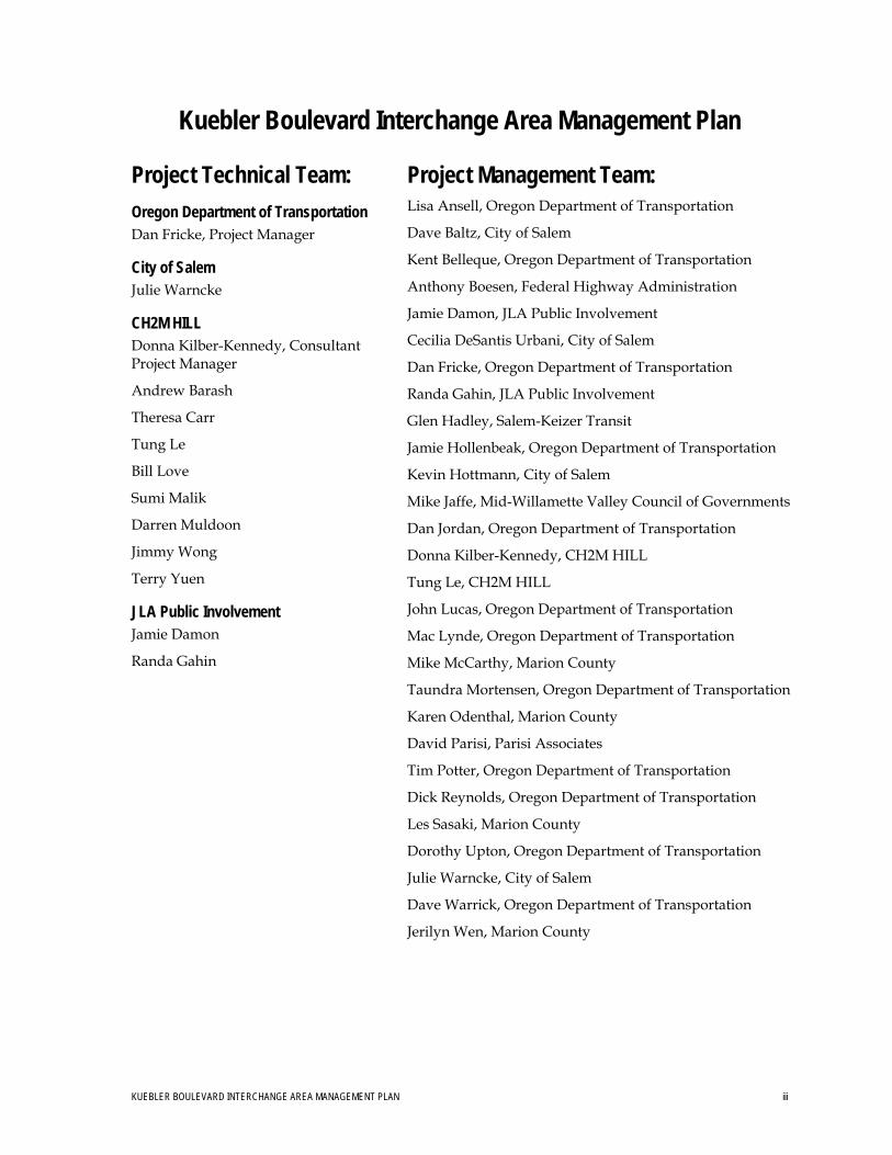
Project Technical Team: Oregon Department of Transportation Dan Fricke, Project Manager
City of Salem Julie Warncke
CH2M HILL Donna Kilber-Kennedy, Consultant Project Manager
Andrew Barash
Theresa Carr
Tung Le
Bill Love
Sumi Malik
Darren Muldoon
Jimmy Wong
Terry Yuen
JLA Public Involvement Jamie Damon
Randa Gahin
Project Management Team: Lisa Ansell, Oregon Department of Transportation
Dave Baltz, City of Salem
Kent Belleque, Oregon Department of Transportation
Anthony Boesen, Federal Highway Administration
Jamie Damon, JLA Public Involvement
Cecilia DeSantis Urbani, City of Salem
Dan Fricke, Oregon Department of Transportation
Randa Gahin, JLA Public Involvement
Glen Hadley, Salem-Keizer Transit
Jamie Hollenbeak, Oregon Department of Transportation
Kevin Hottmann, City of Salem
Mike Jaffe, Mid-Willamette Valley Council of Governments
Dan Jordan, Oregon Department of Transportation
Donna Kilber-Kennedy, CH2M HILL
Tung Le, CH2M HILL
John Lucas, Oregon Department of Transportation
Mac Lynde, Oregon Department of Transportation
Mike McCarthy, Marion County
Taundra Mortensen, Oregon Department of Transportation
Karen Odenthal, Marion County
David Parisi, Parisi Associates
Tim Potter, Oregon Department of Transportation
Dick Reynolds, Oregon Department of Transportation
Les Sasaki, Marion County
Dorothy Upton, Oregon Department of Transportation
Julie Warncke, City of Salem
Dave Warrick, Oregon Department of Transportation
Jerilyn Wen, Marion County

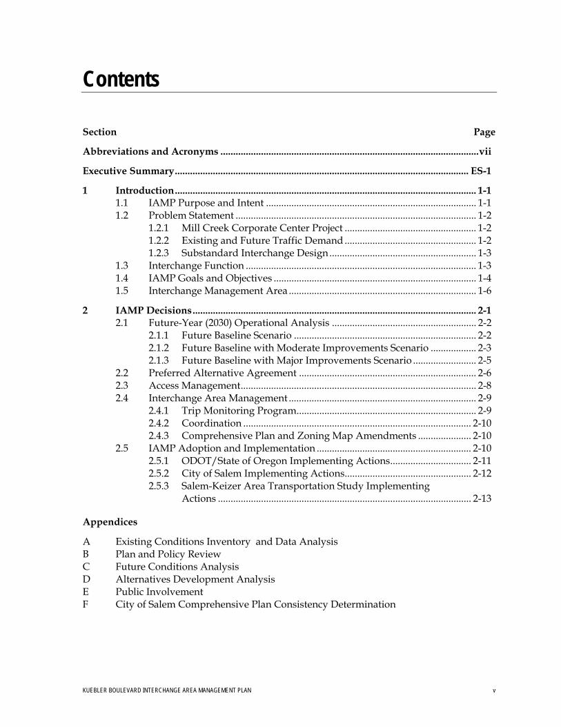
Contents
Section Page
Abbreviations and Acronyms ......................................................................................................vii
Executive Summary.................................................................................................................... ES-1
1 Introduction....................................................................................................................... 1-1 1.1 IAMP Purpose and Intent ................................................................................... 1-1 1.2 Problem Statement ............................................................................................... 1-2
1.2.1 Mill Creek Corporate Center Project .................................................... 1-2 1.2.2 Existing and Future Traffic Demand .................................................... 1-2 1.2.3 Substandard Interchange Design .......................................................... 1-3
1.3 Interchange Function ........................................................................................... 1-3 1.4 IAMP Goals and Objectives ................................................................................ 1-4 1.5 Interchange Management Area .......................................................................... 1-6
2 IAMP Decisions................................................................................................................ 2-1 2.1 Future-Year (2030) Operational Analysis ......................................................... 2-2
2.1.1 Future Baseline Scenario ........................................................................ 2-2 2.1.2 Future Baseline with Moderate Improvements Scenario .................. 2-3 2.1.3 Future Baseline with Major Improvements Scenario ......................... 2-5
2.2 Preferred Alternative Agreement ...................................................................... 2-6 2.3 Access Management............................................................................................. 2-8 2.4 Interchange Area Management .......................................................................... 2-9
2.4.1 Trip Monitoring Program....................................................................... 2-9 2.4.2 Coordination .......................................................................................... 2-10 2.4.3 Comprehensive Plan and Zoning Map Amendments ..................... 2-10
2.5 IAMP Adoption and Implementation ............................................................. 2-10 2.5.1 ODOT/State of Oregon Implementing Actions................................ 2-11 2.5.2 City of Salem Implementing Actions.................................................. 2-12 2.5.3 Salem-Keizer Area Transportation Study Implementing
Actions .................................................................................................... 2-13
Appendices
A Existing Conditions Inventory and Data Analysis B Plan and Policy Review C Future Conditions Analysis D Alternatives Development Analysis E Public Involvement F City of Salem Comprehensive Plan Consistency Determination
KUEBLER BOULEVARD INTERCHANGE AREA MANAGEMENT PLAN v
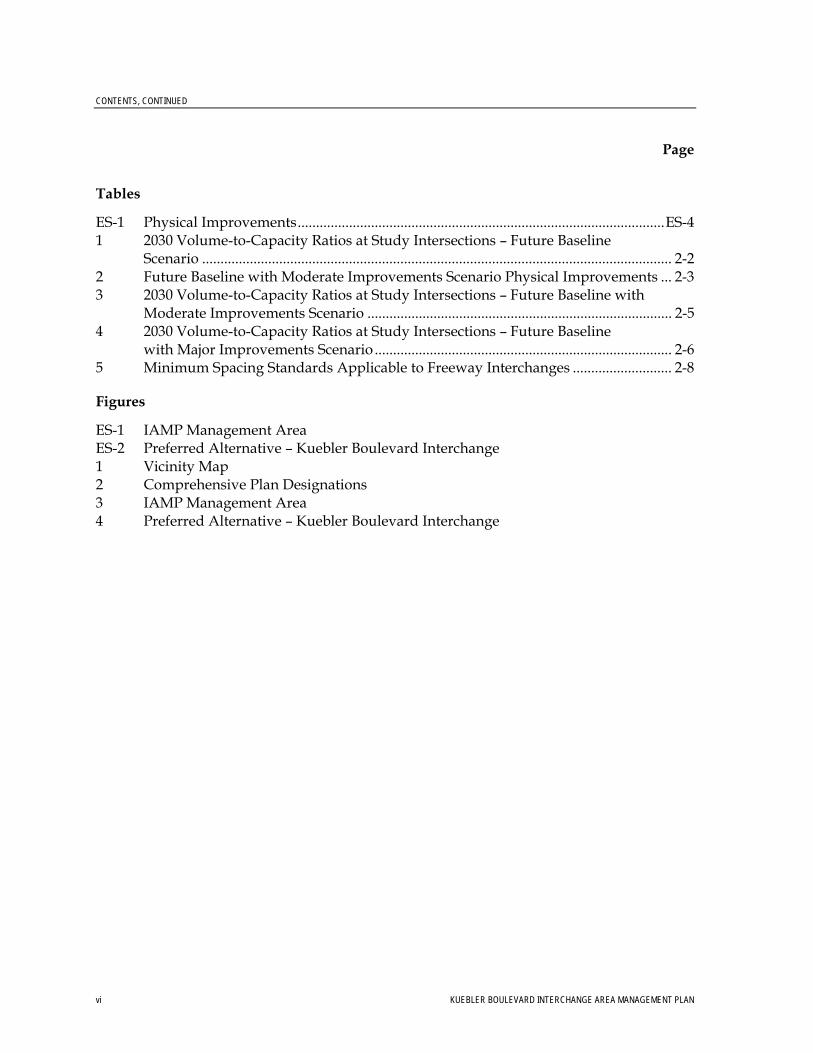
CONTENTS, CONTINUED
Page
vi KUEBLER BOULEVARD INTERCHANGE AREA MANAGEMENT PLAN
Tables
ES-1 Physical Improvements....................................................................................................ES-4 1 2030 Volume-to-Capacity Ratios at Study Intersections – Future Baseline
Scenario ................................................................................................................................ 2-2 2 Future Baseline with Moderate Improvements Scenario Physical Improvements ... 2-3 3 2030 Volume-to-Capacity Ratios at Study Intersections – Future Baseline with
Moderate Improvements Scenario ................................................................................... 2-5 4 2030 Volume-to-Capacity Ratios at Study Intersections – Future Baseline
with Major Improvements Scenario ................................................................................. 2-6 5 Minimum Spacing Standards Applicable to Freeway Interchanges ........................... 2-8
Figures
ES-1 IAMP Management Area ES-2 Preferred Alternative – Kuebler Boulevard Interchange 1 Vicinity Map 2 Comprehensive Plan Designations 3 IAMP Management Area 4 Preferred Alternative – Kuebler Boulevard Interchange
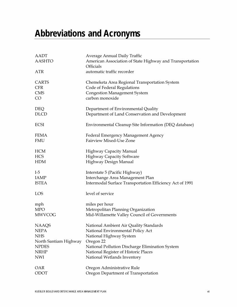
Abbreviations and Acronyms
AADT Average Annual Daily Traffic AASHTO American Association of State Highway and Transportation
Officials ATR automatic traffic recorder CARTS Chemeketa Area Regional Transportation System CFR Code of Federal Regulations CMS Congestion Management System CO carbon monoxide DEQ Department of Environmental Quality DLCD Department of Land Conservation and Development ECSI Environmental Cleanup Site Information (DEQ database) FEMA Federal Emergency Management Agency FMU Fairview Mixed-Use Zone HCM Highway Capacity Manual HCS Highway Capacity Software HDM Highway Design Manual I-5 Interstate 5 (Pacific Highway) IAMP Interchange Area Management Plan ISTEA Intermodal Surface Transportation Efficiency Act of 1991 LOS level of service mph miles per hour MPO Metropolitan Planning Organization MWVCOG Mid-Willamette Valley Council of Governments NAAQS National Ambient Air Quality Standards NEPA National Environmental Policy Act NHS National Highway System North Santiam Highway Oregon 22 NPDES National Pollution Discharge Elimination System NRHP National Register of Historic Places NWI National Wetlands Inventory OAR Oregon Administrative Rule ODOT Oregon Department of Transportation
KUEBLER BOULEVARD INTERCHANGE AREA MANAGEMENT PLAN vii
ABBREVIATIONS AND ACRONYMS
viii KUEBLER BOULEVARD INTERCHANGE AREA MANAGEMENT PLAN
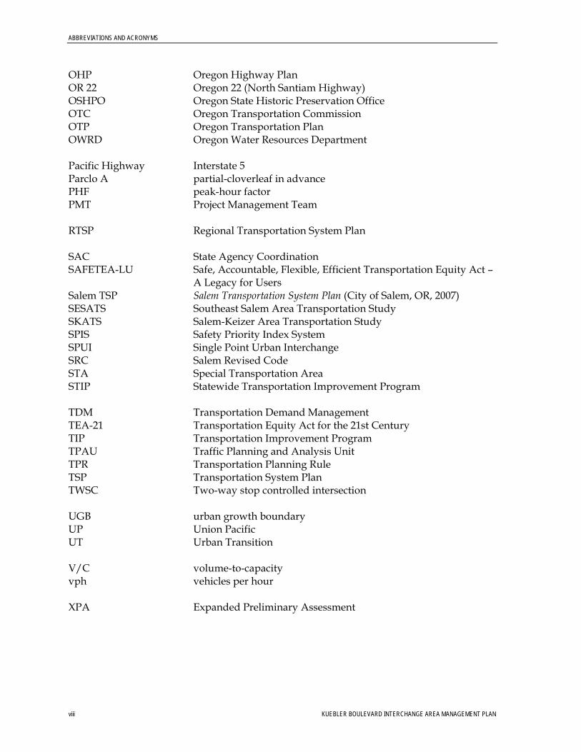
OHP Oregon Highway Plan OR 22 Oregon 22 (North Santiam Highway) OSHPO Oregon State Historic Preservation Office OTC Oregon Transportation Commission OTP Oregon Transportation Plan OWRD Oregon Water Resources Department Pacific Highway Interstate 5 Parclo A partial-cloverleaf in advance PHF peak-hour factor PMT Project Management Team RTSP Regional Transportation System Plan SAC State Agency Coordination SAFETEA-LU Safe, Accountable, Flexible, Efficient Transportation Equity Act –
A Legacy for Users Salem TSP Salem Transportation System Plan (City of Salem, OR, 2007) SESATS Southeast Salem Area Transportation Study SKATS Salem-Keizer Area Transportation Study SPIS Safety Priority Index System SPUI Single Point Urban Interchange SRC Salem Revised Code STA Special Transportation Area STIP Statewide Transportation Improvement Program TDM Transportation Demand Management TEA-21 Transportation Equity Act for the 21st Century TIP Transportation Improvement Program TPAU Traffic Planning and Analysis Unit TPR Transportation Planning Rule TSP Transportation System Plan TWSC Two-way stop controlled intersection UGB urban growth boundary UP Union Pacific UT Urban Transition V/C volume-to-capacity vph vehicles per hour XPA Expanded Preliminary Assessment
Executive Summary
The Kuebler Boulevard Interchange Area Management Plan (IAMP) has been prepared for the proposed interchange modification on Interstate 5 (I-5) (Pacific Highway) at Kuebler Boulevard (milepost 251.53), approximately 2.3 miles south of the I-5/Oregon 22 (OR 22) (North Santiam Highway) interchange in the City of Salem and unincorporated Marion County, Oregon. The IAMP was prepared in collaboration with the Oregon Department of Transportation (ODOT), the Oregon Department of Land Conservation and Development (DLCD), the City of Salem, Marion County, and the Mid-Willamette Valley Council of Governments (MWVCOG).
Currently, some limited modifications and improvements are planned for the Kuebler Boulevard interchange. Oregon’s 2008-2011 Statewide Transportation Improvement Program includes a project, “I-5 @ Kuebler Boulevard Interchange Improvements.” That project will modernize the Kuebler Boulevard interchange between mileposts 251.46 and 252.06 to improve mobility and facilitate development for the proposed Mill Creek Corporate Center, which is northeast of the Kuebler Boulevard interchange. To improve operations to acceptable Oregon Highway Plan (OHP) mobility standards, additional modifications will be necessary over the next 20 years. While not yet planned or scheduled, these modifications are identified in the IAMP.
Oregon Administrative Rule (OAR) 734-051-0155(6) requires that an IAMP be prepared for any new or significantly reconstructed interchange. The purposes of an IAMP are to:
• Ensure safe and efficient operations between connecting roadways to protect the function of the interchange and to minimize the need for future major interchange improvements
• Protect the function of the interchange over time and, consequently, the state’s investment in the facility
This IAMP documents the process and decisions that were made to create a long-range (20-plus-year) strategy to protect the function and operations of the Kuebler Boulevard interchange.
Interchange Function An interchange function differs from its operations. Interchange operations refers to how an interchange will work relative to adopted or agreed to mobility or performance standards. An interchange’s function refers to the role that the interchange serves in the broader state and local transportation system and the role that it is expected to play in the future.
The Kuebler Boulevard interchange serves the following functions:
• Access for commercial and industrial land uses. As the undeveloped commercial- and industrial-zoned land in the area develops, the Kuebler Boulevard interchange will increasingly function as an integral economic development asset.
KUEBLER BOULEVARD INTERCHANGE AREA MANAGEMENT PLAN ES-1
EXECUTIVE SUMMARY
• Access for South Salem residential land uses. South Salem residents west of I-5 use the interchange for access to and from I-5, and to access the Salem-Keizer urban area.
• Access to resource extraction sites. The interchange is the main access point for truck traffic to and from I-5 for several resource-extraction operations east of I-5.
• Local traffic and I-5 alternative route. Kuebler Boulevard is the primary east-west route in south Salem. East of I-5, Kuebler Boulevard curves to the north and becomes Cordon Road north of the Lancaster Drive/Aumsville Highway intersection. The Kuebler Boulevard and Cordon Road corridor serves as an alternative route to I-5 during periods of congestion on or temporary closures of I-5.
Interchange Modification Need Three main issues generate the need for Kuebler Boulevard interchange modifications:
• Mill Creek Corporate Center project. This is a “shovel-ready” site in southeast Salem for job creation and economic stimulus that fronts Kuebler Boulevard northeast of the Kuebler Boulevard interchange. Appropriate comprehensive plan and zoning designations have been approved on the property, and the City of Salem and the Oregon Department of Administrative Services are actively pursuing future developers.
• Existing and future traffic demand. The interchange is the most convenient access to I-5 for northbound traffic originating from, and southbound I-5 traffic destined for, the residential land uses west of I-5 and south of OR 22. The interchange also is the southern access to I-5 of an eastern loop around Salem that is formed by Kuebler Boulevard south of OR 22 and Cordon Road, Hazel Green Road, and Chemawa Road north of OR 22.
• Substandard interchange design. The northbound on-ramp acceleration length and merge distances are substandard, meaning that the existing design does not meet ODOT Highway Design Manual (HDM) standards.
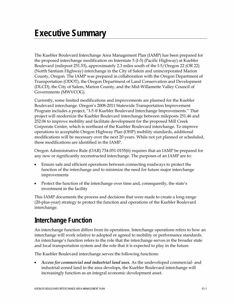
IAMP Development The Kuebler Boulevard IAMP Project Management Team (PMT) evaluated the existing land uses within a defined IAMP management area (Figure ES-1), as well as possible uses that could develop based on existing land use designations. Evaluation of expected traffic volumes from the future mix of possible uses showed that traffic operations exceed mobility standards adopted in the OHP. The IAMP recommends physical improvements to the interchange and intersections in its vicinity to improve operations to acceptable mobility standards. The IAMP also establishes a number of implementation measures that are designed to monitor land use and traffic growth in the area and to provide for future improvement of the interchange as the need occurs.
ES-2 KUEBLER BOULEVARD INTERCHANGE AREA MANAGEMENT PLAN
EXECUTIVE SUMMARY
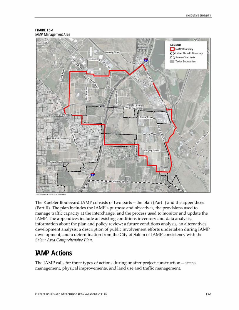
FIGURE ES-1 IAMP Management Area
The Kuebler Boulevard IAMP consists of two parts—the plan (Part I) and the appendices (Part II). The plan includes the IAMP’s purpose and objectives, the provisions used to manage traffic capacity at the interchange, and the process used to monitor and update the IAMP. The appendices include an existing conditions inventory and data analysis; information about the plan and policy review; a future conditions analysis; an alternatives development analysis; a description of public involvement efforts undertaken during IAMP development; and a determination from the City of Salem of IAMP consistency with the Salem Area Comprehensive Plan.
IAMP Actions The IAMP calls for three types of actions during or after project construction—access management, physical improvements, and land use and traffic management.
KUEBLER BOULEVARD INTERCHANGE AREA MANAGEMENT PLAN ES-3
EXECUTIVE SUMMARY
Access Management • OAR 734-051 establishes the state’s role in managing access to highway facilities in order
to maintain functional use and safety, and to preserve public investment.
• ODOT owns access rights on Kuebler Boulevard within the IAMP management area (to 27th Avenue west of the interchange and 36th Avenue east of the interchange). Both intersections currently meet adopted ODOT access spacing standards and ODOT will not allow any access within this area. Because no access points exist between these intersections, no additional access management actions are needed for the IAMP.
• Realigning the southbound I-5 off-ramp will decrease the distance between the off-ramp and 27th Avenue to less than the 1,320-foot standard in the OHP. Therefore, an access deviation from ODOT will be required if and when this change is implemented.
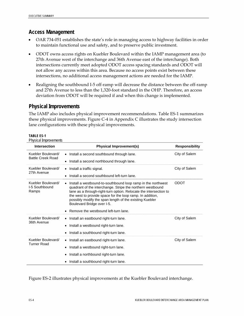
Physical Improvements The IAMP also includes physical improvement recommendations. Table ES-1 summarizes these physical improvements. Figure C-4 in Appendix C illustrates the study intersection lane configurations with these physical improvements.
TABLE ES-1 Physical Improvements
Intersection Physical Improvement(s) Responsibility
City of Salem Kuebler Boulevard/ Battle Creek Road
• Install a second southbound through lane.
• Install a second northbound through lane.
City of Salem Kuebler Boulevard/ 27th Avenue
• Install a traffic signal.
• Install a second southbound left-turn lane.
ODOT Kuebler Boulevard/ I-5 Southbound Ramps
• Install a westbound-to-southbound loop ramp in the northwest quadrant of the interchange. Stripe the northern westbound lane as a through-right-turn option. Relocate the intersection to the west to provide space for the loop ramp. In addition, possibly modify the span length of the existing Kuebler Boulevard Bridge over I-5.
• Remove the westbound left-turn lane.
City of Salem Kuebler Boulevard/ 36th Avenue
• Install an eastbound right-turn lane.
• Install a westbound right-turn lane.
• Install a southbound right-turn lane.
City of Salem Kuebler Boulevard/ Turner Road
• Install an eastbound right-turn lane.
• Install a westbound right-turn lane.
• Install a northbound right-turn lane.
• Install a southbound right-turn lane.
Figure ES-2 illustrates physical improvements at the Kuebler Boulevard interchange.
ES-4 KUEBLER BOULEVARD INTERCHANGE AREA MANAGEMENT PLAN
EXECUTIVE SUMMARY
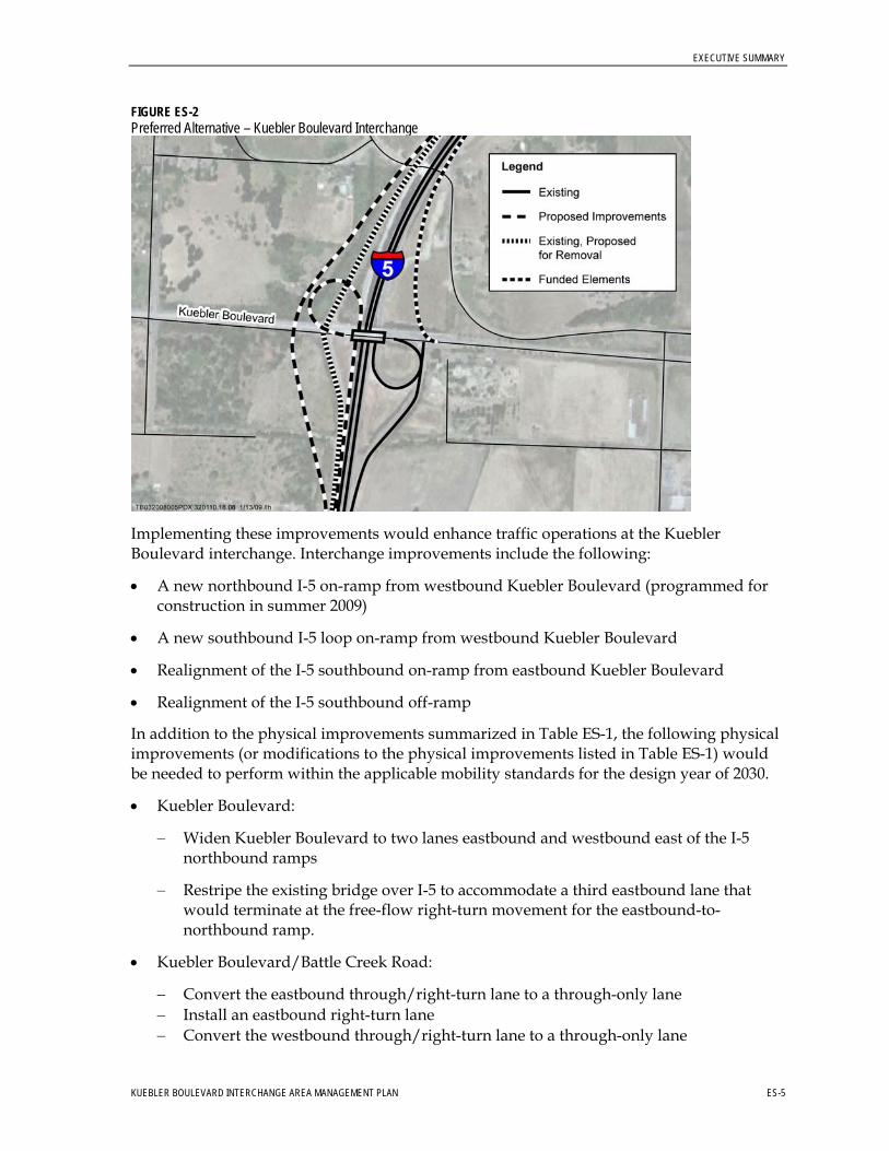
FIGURE ES-2 Preferred Alternative – Kuebler Boulevard Interchange
Implementing these improvements would enhance traffic operations at the Kuebler Boulevard interchange. Interchange improvements include the following:
• A new northbound I-5 on-ramp from westbound Kuebler Boulevard (programmed for construction in summer 2009)
• A new southbound I-5 loop on-ramp from westbound Kuebler Boulevard
• Realignment of the I-5 southbound on-ramp from eastbound Kuebler Boulevard
• Realignment of the I-5 southbound off-ramp
In addition to the physical improvements summarized in Table ES-1, the following physical improvements (or modifications to the physical improvements listed in Table ES-1) would be needed to perform within the applicable mobility standards for the design year of 2030.
• Kuebler Boulevard:
− Widen Kuebler Boulevard to two lanes eastbound and westbound east of the I-5 northbound ramps
− Restripe the existing bridge over I-5 to accommodate a third eastbound lane that would terminate at the free-flow right-turn movement for the eastbound-to-northbound ramp.
• Kuebler Boulevard/Battle Creek Road:
− Convert the eastbound through/right-turn lane to a through-only lane − Install an eastbound right-turn lane − Convert the westbound through/right-turn lane to a through-only lane
KUEBLER BOULEVARD INTERCHANGE AREA MANAGEMENT PLAN ES-5
EXECUTIVE SUMMARY
− Install a westbound right-turn lane − Convert the southbound through/right-turn lane to a through-only lane − Install a southbound right-turn lane
• Kuebler Boulevard/27th Avenue:
− Install a second westbound left-turn lane
• Kuebler Boulevard/I-5 Southbound Ramps:
− Install a third eastbound through-lane − Convert the southbound right-turn lane to a shared through/left-turn lane − Convert the southbound through/left-turn lane to a left-turn-only lane − Install a free southbound right-turn lane
• Kuebler Boulevard/I-5 Northbound Ramps:
− Stripe the third eastbound lane as a right-turn lane to the northbound I-5 loop ramp
• Kuebler Boulevard/36th Avenue:
− Install a second eastbound through lane − Install a second westbound through lane
• Kuebler Boulevard/Turner Road:
− Install a second eastbound through lane
− Install a second westbound through lane
− Install a second eastbound left-turn lane
− Convert the northbound right-turn lane to a shared through/right-turn lane and add a second northbound receiving lane
− Install a second northbound left-turn lane
Land Use and Traffic Management • The land around the Kuebler Boulevard interchange is designated for residential and
industrial uses. ODOT acknowledges this and understands that build-out of the existing Salem Area Comprehensive Plan (amended in 2005) will cause the OHP mobility policy standards to be exceeded at the ramp terminals if no additional improvements are made beyond those currently programmed in the Statewide Transportation Improvement Program (STIP).
• The IAMP establishes an interchange management area within which ODOT will monitor proposed land use changes.
• ODOT will ensure that proposed land use changes in the management area comply with OAR 660-012-0060 (Transportation Planning Rule [TPR]). ODOT will require that the land use changes mitigate to the OHP mobility policy standard at the ramp terminals for
ES-6 KUEBLER BOULEVARD INTERCHANGE AREA MANAGEMENT PLAN
EXECUTIVE SUMMARY
KUEBLER BOULEVARD INTERCHANGE AREA MANAGEMENT PLAN ES-7
the planning horizon (where the mobility standard has not been exceeded) or for the day of opening (when mobility standards are exceeded).
• ODOT will establish a biennial ramp operations monitoring program with the intent of initiating discussions about possible improvement and management approaches when a volume-to-capacity ratio (V/C) ratio of 0.95 is reached, if this threshold is reached before the City of Salem and the Salem-Keizer Area Transportation Study (SKATS) can identify funding for the interchange improvements identified in the IAMP.


KUEBLER BOULEVARD INTERCHANGE AREA MANAGEMENT PLAN
PART I
Interchange Area Management Plan

SECTION 1
Introduction
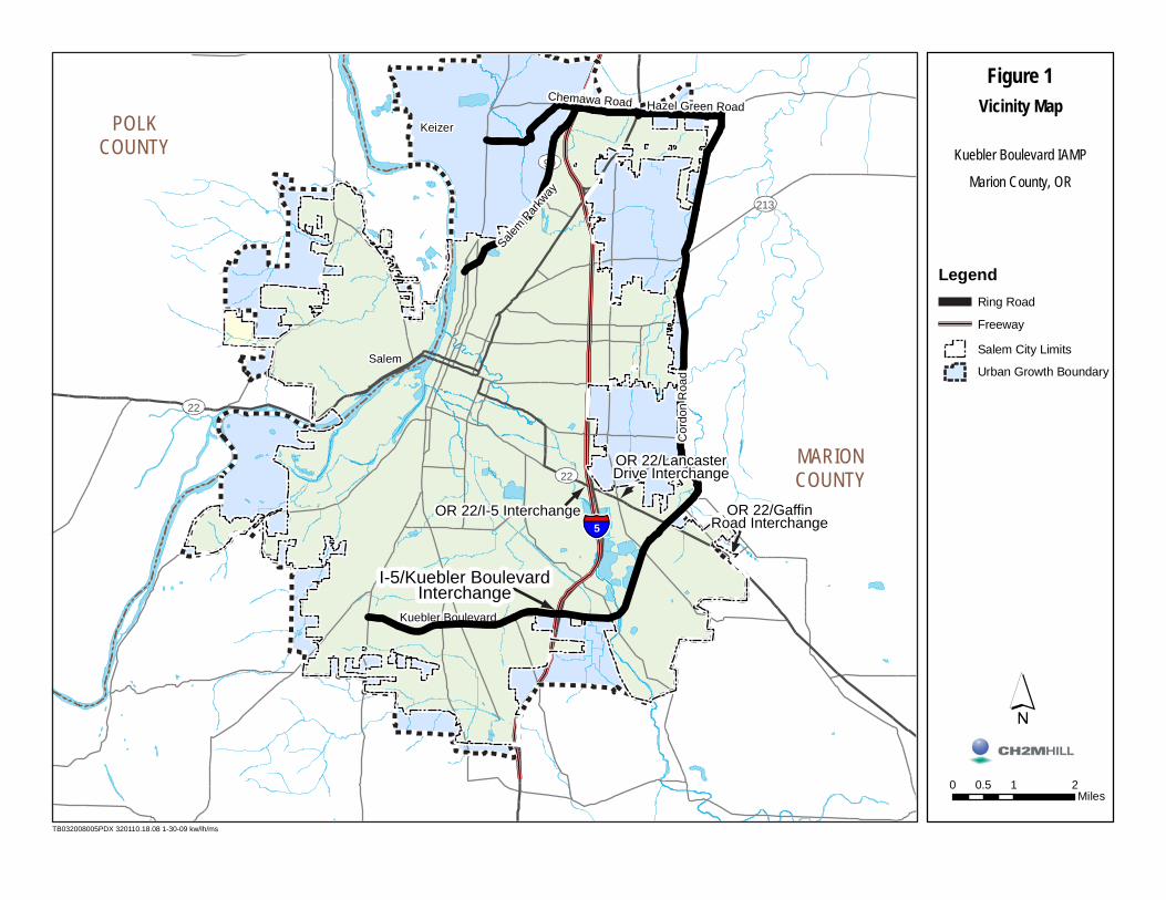
The Kuebler Boulevard Interchange Area Management Plan (IAMP) has been prepared for the proposed interchange modification on Interstate-5 (I-5) (Pacific Highway) at Kuebler Boulevard (milepost 251.53), approximately 2.3 miles south of the I-5/Oregon 22 (OR 22) (North Santiam Highway) interchange in the City of Salem and unincorporated Marion County, Oregon. The IAMP was prepared in collaboration with the Oregon Department of Transportation (ODOT), the Oregon Department of Land Conservation and Development (DLCD), the City of Salem, Marion County, and the Mid-Willamette Valley Council of Governments (MWVCOG). Figure 1 (at the end of this section) illustrates the project area.
1.1 IAMP Purpose and Intent Modifications to the I-5 northbound on-ramp at the Kuebler Boulevard interchange are being addressed as a National Environmental Policy Act (NEPA) Class 2 Categorical Exclusion. Oregon Administrative Rule (OAR) 734-051-0155(6) requires that an IAMP be prepared for any new or significantly reconstructed interchange. The purposes of an IAMP are to:
• Ensure safe and efficient operations between connecting roadways to protect the function of the interchange and to minimize the need for future major interchange improvements.
• Protect the function of the interchange over time and, consequently, the state’s investment in the facility. Because new and modified interchanges are very costly, state and local governments and citizens have an interest in ensuring that they function as intended and for as long a period as possible, while still supporting planned land use.
For NEPA Class 2 projects, the IAMP must be completed before the start of construction of the interchange and must be developed in accordance with the Oregon Highway Plan (OHP) Policy 3C (Interchange Access Management Areas).
An IAMP is required for the Kuebler Boulevard interchange because of planned interchange modifications and reconstruction. As described in Section 1.2, future commercial, industrial, and residential developments are expected, which will influence traffic operations at the interchange. The IAMP recommends access management, physical improvements, and land use and traffic management strategies to maximize the operation of the interchange to accommodate future growth.
KUEBLER BOULEVARD INTERCHANGE AREA MANAGEMENT PLAN 1-1
SECTION 1: INTRODUCTION
1.2 Problem Statement Three main issues generate the need for the Kuebler Boulevard IAMP:
• Mill Creek Corporate Center project • Existing and future traffic demand • Substandard interchange design
Subsection 1.3 describes the interchange’s function.
1.2.1 Mill Creek Corporate Center Project In 2003, the Oregon State legislature designated for development a 700-acre parcel of farmland in southeast Salem that the Oregon Department of Corrections owns. The proposed project, previously called the Mill Creek Industrial Park and Salem Regional Employment Center and now called the Mill Creek Corporate Center, will be a premiere “shovel ready” site for job creation and economic stimulus. The Mill Creek Corporate Center project fronts Kuebler Boulevard northeast of the Kuebler Boulevard interchange.
The I-5/OR 22 interchange is the interchange to the north of the Kuebler Boulevard interchange. While this interchange can provide access to the proposed Mill Creek Corporate Center and other industrial land uses in the area, it requires traffic to travel through the already congested OR 22/Lancaster Drive interchange to access I-5. For this reason, the Kuebler Boulevard interchange is expected to serve the Mill Creek Corporate Center project as the primary access to and from I-5.
North of the Aumsville Highway/Lancaster Drive intersection, Kuebler Boulevard becomes Cordon Road. The City of Salem and ODOT are exploring the potential for improvements along OR 22, which may include an interchange at Cordon Road on OR 22. However, an interchange at Cordon Road is problematic because the spacing between the OR 22/Lancaster Drive and OR 22/Gaffin Road interchanges would not meet OHP spacing standards. Because access to OR 22 at Cordon Road will require significant study and may require major modifications to the I-5/OR 22, OR 22/Lancaster Drive, and OR 22/Gaffin Road interchanges, the Kuebler Boulevard interchange is the most immediate access to and from I-5 for the proposed Mill Creek Corporate Center.
1.2.2 Existing and Future Traffic Demand Kuebler Boulevard is the primary east-west road in South Salem, as it provides access between the eastern and western city limits of Salem. The Kuebler Boulevard interchange provides access to residential land uses in South Salem west of I-5 and south of OR 22 (Figure 2, at the end of this section). The interchange is the most convenient access to I-5 for northbound traffic originating from, and southbound I-5 traffic destined for, the residential land uses west of I-5 and south of OR 22. As traffic demand at the interchange has increased, interest in developing the vacant land at the Kuebler Boulevard interchange area has also increased. However, the vacant land in the interchange area is located outside the sewer and water service areas. In addition, people have been opposed to recent commercial development proposals at the interchange area because of unresolved traffic flow issues related to the Kuebler Boulevard/Battle Creek Road intersection. (Note that, in July 2008, the Land Use Board of Appeals upheld the City of Salem’s approval of a Salem Area
1-2 KUEBLER BOULEVARD INTERCHANGE AREA MANAGEMENT PLAN
SECTION 1: INTRODUCTION
Comprehensive Plan amendment and zone change for a commercial development on the southeast corner of Kuebler Boulevard and Battle Creek Road.)
Other industrial and commercial land uses in the vicinity use the interchange to access I-5. As undeveloped commercial- and industrial-zoned land in the area develops, the Kuebler Boulevard interchange will increasingly function as their primary access to and from I-5.
The Kuebler Boulevard interchange also provides interstate access for an eastern loop around Salem that is formed by Kuebler Boulevard south of OR 22 and Cordon Road, Hazel Green Road, and Chemawa Road north of OR 22. This loop is used as an emergency bypass route in the event that I-5 is closed for any reason.
1.2.3 Substandard Interchange Design The present configuration of the Kuebler Boulevard interchange is a diamond on the southbound ramps and a “partial-cloverleaf in advance” (“Parclo A”) configuration on the northbound ramps (that is, the northbound on-ramp is configured as a loop within the northbound off-ramp and in advance of the Kuebler Boulevard overpass). The acceleration length and merge distances for the northbound on-ramp are currently substandard, meaning that the existing design does not meet the most recent ODOT Highway Design Manual (HDM) standards. ODOT is currently in the design phase of a project that will improve this deficiency as well as adding a second northbound I-5 on-ramp located in the northeast quadrant of the interchange for west to northbound traffic That project is programmed for construction in summer 2009.
1.3 Interchange Function An interchange’s function refers to the role that the interchange serves in the broader state and local transportation system and the role that it is expected to play in the future. The Kuebler Boulevard interchange is an important facility to the City of Salem, the Salem-Keizer urban area, and Marion County. The interchange serves the following functions:
• Access for commercial and industrial land uses. The interchange directly serves many commercial and industrial land uses east of I-5. As the undeveloped commercial- and industrial-zoned land in the area develops, the Kuebler Boulevard interchange will increasingly function as an integral economic development asset.
• Access for South Salem residential land uses. South Salem residents west of I-5 use the interchange for access to and from I-5, and to access the Salem-Keizer urban area.
• Access to resource extraction sites. The interchange is the main access point for truck traffic to and from I-5 for several resource-extraction operations east of I-5.
• Local traffic and I-5 alternative route. Kuebler Boulevard is the primary east-west route in south Salem. East of I-5, Kuebler Boulevard curves to the north and becomes Cordon Road north of the Lancaster Drive/Aumsville Highway intersection. The Kuebler Boulevard and Cordon Road corridor serves as an alternative route to I-5 during periods of congestion on or temporary closures of I-5.
KUEBLER BOULEVARD INTERCHANGE AREA MANAGEMENT PLAN 1-3
SECTION 1: INTRODUCTION
Appendix A provides a more detailed description of existing land uses and existing traffic operations.
The OHP classifies I-5 as an Interstate Highway of statewide significance and part of the National Highway System (NHS). According to the OHP, the primary function of a designated Interstate Highway is to, “provide connections to major cities, regions of the state, and other states. A secondary function in urban areas is to provide connections for regional trips within the metropolitan area. The Interstate Highways are major freight routes and their objective is to provide mobility. The management objective is to provide for safe and efficient high-speed continuous-flow operation in urban and rural areas” (OHP, page 41).
I-5 is also a designated freight route. Freight routes are: “intended to facilitate interstate, intrastate, and regional movements of trucks” “and include routes that carry significant tonnage of freight by truck and serve as the primary interstate and intrastate highway freight connection to ports, intermodal terminals, and urban areas” (OHP, page 63).
The Salem Transportation System Plan (Salem TSP; City of Salem, OR, 2007) designates Kuebler Boulevard as a Parkway. According to the Salem TSP, the function of a designated Parkway is as a “high capacity, high speed roadway that primarily serves regional and intra-city travel.” Other roads in the vicinity of the Kuebler Boulevard interchange include the following:
• Roads designated as Minor Arterials in the Salem TSP:
− 36th Avenue and its connections to Trelstad and 32nd avenues − Battle Creek Road − Fairview Industrial Drive − Turner Road
• Roads designated as Collectors in the Salem TSP:
− 27th Avenue − Marietta Street − Strong Street
According to the Salem TSP, the function of Minor Arterials is to serve intra-city and inter-neighborhood traffic, and the function of Collectors is to distribute traffic between neighborhoods, activity centers, and the arterial street system.
1.4 IAMP Goals and Objectives Federal, state, regional, and local documents were reviewed for the IAMP. Appendix B identifies the objectives of each document and provides a brief identification of the document’s relevance to the IAMP.
The Kuebler Boulevard IAMP addresses several goals related to interchange area management. As stated in Policy 3C of the 1999 OHP, “it is the policy of the State of Oregon to plan for and manage grade-separated interchange areas to ensure safe and efficient operation between connecting roadways.” From this definition and a consideration of
1-4 KUEBLER BOULEVARD INTERCHANGE AREA MANAGEMENT PLAN
SECTION 1: INTRODUCTION
project-specific local transportation issues, the generalized objectives of the Kuebler Boulevard IAMP are as follows:
• Protect the function and operation of the Kuebler Boulevard interchange and the local street network within the IAMP management area, which is illustrated on Figure 3 and defined in Section 1.5. The local planned road network is incorporated into this plan and maintaining the local road network’s function and operation is integral to the success of the IAMP.
• Prolong the useful life of the state’s investment in the IAMP management area.
• Through access management measures, limit the number of conflict points on Kuebler Boulevard in the vicinity of the Kuebler Boulevard interchange.
• Balance the need for the interchange to support economic development interests with the need for safe and efficient operation within the IAMP management area.
• Establish agreements with local governments on how to effectively manage the long-term function of the interchange.
• Ensure that changes to the planned land uses are consistent with protecting the long-term function of the interchange and local street system.
• Monitor how the interchange capacity is managed through cooperation with local governments.
• Provide certainty for property and business owners and local governments.
The IAMP provides land use and traffic management actions to ensure future demand on the interchange will be consistent with planned uses and will not outpace improvements that have been designed. The interchange will not be used to induce growth that has not been authorized by adopted comprehensive plans.
KUEBLER BOULEVARD INTERCHANGE AREA MANAGEMENT PLAN 1-5
SECTION 1: INTRODUCTION
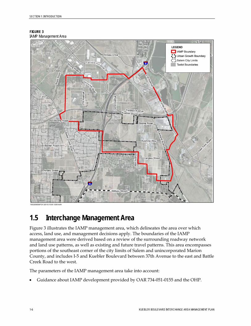
FIGURE 3 IAMP Management Area
1.5 Interchange Management Area Figure 3 illustrates the IAMP management area, which delineates the area over which access, land use, and management decisions apply. The boundaries of the IAMP management area were derived based on a review of the surrounding roadway network and land use patterns, as well as existing and future travel patterns. This area encompasses portions of the southeast corner of the city limits of Salem and unincorporated Marion County, and includes I-5 and Kuebler Boulevard between 37th Avenue to the east and Battle Creek Road to the west.
The parameters of the IAMP management area take into account:
• Guidance about IAMP development provided by OAR 734-051-0155 and the OHP.
1-6 KUEBLER BOULEVARD INTERCHANGE AREA MANAGEMENT PLAN
SECTION 1: INTRODUCTION
KUEBLER BOULEVARD INTERCHANGE AREA MANAGEMENT PLAN 1-7
• Required state access management spacing standards. (The IAMP management area includes all land uses and roadways located within 1,320 feet of the existing Kuebler Boulevard interchange. This distance corresponds to the spacing standard outlined in the OAR 734-051 rules for interchange ramps.)
• Surrounding transportation facilities and area traffic operations.
• The mutual impact of existing natural and cultural resources, and existing and planned land uses.

Keizer
Salem
5
213
22
99
22
POLKCOUNTY
MARIONCOUNTY
OR 22/I-5 Interchange
I-5/Kuebler Boulevard I-5/Kuebler Boulevard InterchangeInterchange
I-5/Kuebler Boulevard Interchange
Kuebler Boulevard
Chemawa Road Hazel Green Road
OR 22/Lancaster Drive Interchange
Cor
don
Roa
d
OR 22/Gaffin Road Interchange
Salem P
arkway
TB032008005PDX 320110.18.08 1-30-09 kw/lh/ms
0 1 20.5Miles
LegendRing Road
Freeway
Salem City Limits
Urban Growth Boundary
Figure 1Vicinity Map
Kuebler Boulevard IAMP
Marion County, OR

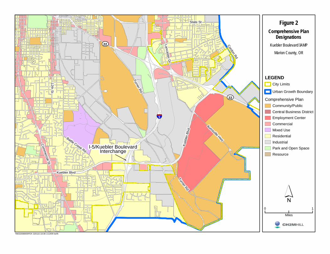
Figure 2Comprehensive Plan
Designations
LEGENDCity Limits
Urban Growth Boundary
Comprehensive PlanCommunity/PublicCentral Business DistrictEmployment CenterCommercialMixed UseResidentialIndustrialPark and Open SpaceResource
´0 1
Miles
Kuebler Boulevard IAMP
Marion County, OR
TB032008005PDX 320110.18.08 1/13/09 kw/lh
§̈¦5
Kuebler Blvd
Kueb
ler B
lvd
Com
mercial St
Battle Creek Rd
12th St
Turner Rd
Aumsville Hwy
Cordon Rd
State St
Lancaster Dr
Turner Rd
22
22
I-5/Kuebler Boulevard I-5/Kuebler Boulevard InterchangeInterchange
I-5/Kuebler Boulevard Interchange

SECTION 2
IAMP Decisions
This section presents land use and traffic management decisions to maximize the operational life of the Kuebler Boulevard interchange while supporting adopted local land use controls, addressing future traffic demand, and preserving capacity. It describes the transportation improvements for the interchange, identifies land use policy actions, and reviews the process for state and local authorities to adopt the Kuebler Boulevard IAMP. The decisions presented in this section will serve as the basis for an agreement between ODOT and the City of Salem on the direction and principles that will guide the process for gaining approval of the IAMP. The City of Salem will find the IAMP consistent with its Salem Area Comprehensive Plan (2005). In addition, the Salem-Keizer Area Transportation Study (SKATS) will endorse the IAMP before the Oregon Transportation Commission (OTC) adopts the IAMP and incorporate the recommendations of the IAMP into the Regional Transportation System Plan (RTSP) during its next amendment cycle.
The Kuebler Boulevard IAMP includes the following components:
• Physical improvements • Access management • Interchange area management
This section describes each of these elements and outlines adoption and implementation steps after summarizing future-year (2030) traffic operations. The IAMP actions described in these components apply to the previously described interchange management area illustrated on Figure 3. Project stakeholders and other members of the public have provided input on each of the project elements through public involvement activities. Information about public involvement activities is included as Appendix E.
It is important to note that the recommended improvements on the State of Oregon transportation system that are in the Kuebler Boulevard IAMP are not guaranteed funding and implementation through inclusion in the IAMP. These improvements cannot be considered reasonably likely to be constructed during the planning horizon. Consequently, these projects cannot be relied upon to support plan amendments or zone changes to achieve compliance with OAR 660-012-0060 unless or until:
• The projects are included in the adopted SKATS RTSP “Financially Constrained Committed or Included Projects” lists or
• The projects are included in the Statewide Transportation Improvement Program (STIP; a project scheduling and funding document) and SKATS Transportation Improvement Program (TIP)
• A specific funding source for the projects is identified and ODOT supports that funding source in writing or
• A funding plan for the projects is developed that ODOT supports in writing
KUEBLER BOULEVARD INTERCHANGE AREA MANAGEMENT PLAN 2-1
SECTION 2: IAMP DECISIONS
The projects recommended in the IAMP simply represent state and local agreement about transportation facility needs in the project area that have been identified through extensive analysis.
2.1 Future-Year (2030) Operational Analysis Future-year (2030) traffic analyses for the IAMP used the same land use assumptions and forecasts as the Year 2031 SKATS RTSP. These assumptions and forecasts are consistent with the land use designations in the Salem Area Comprehensive Plan.
2.1.1 Future Baseline Scenario The Future Baseline scenario was analyzed to determine how the I-5/ Kuebler Boulevard interchange roadways and intersections would operate in 2030 if population and employment projections were realized but no improvements were made beyond those planned and funded in the SKATS RTSP. These findings would help to identify future deficiencies and provide a Future Baseline for comparison to other Year 2030 scenarios. The assumed Year 2030 roadway network is consistent with the network provided in the SKATS RTSP 2030 model.
ODOT’s HDM volume-to-capacity (V/C) ratios and queue lengths were used to evaluate the performance at study intersections. The maximum acceptable ODOT HDM V/C ratio for I-5 and ramp terminals at Kuebler Boulevard is 0.85. The maximum acceptable V/C ratio for all other intersections is 0.90.
Table 1 shows the 2030 Future Baseline scenario V/C ratios for the study intersections. In the table, intersections that exceed the applicable mobility standards are in bold type and highlighted.
TABLE 1 2030 Volume-to-Capacity Ratios at Study Intersections – Future Baseline Scenario
Study Intersection ODOT Mobility
Standard
Salem TSP Mobility
Standard
2030 Future Baseline Scenario
1.16 Kuebler Boulevard and Battle Creek Road -- 0.90
1.15 Kuebler Boulevard and 27th Avenue -- 0.90
1.44 Kuebler Boulevard and I-5 Southbound Ramps 0.85 --
Kuebler Boulevard and I-5 Northbound Ramps 0.85 -- 0.65
>1.5 Kuebler Boulevard and 36th Avenue -- 0.90
>1.5 Kuebler Boulevard and Turner Road -- 0.90
Highlighted cells indicate intersections that exceed the applicable mobility standards.
Based on the level of traffic demand associated with the proposed developments in southeast Salem, specific improvements to the Kuebler Boulevard interchange are required by design year 2030. The intersection analysis concluded that all but one study intersection (Kuebler Boulevard and I-5 Northbound Ramps) would operate beyond the mobility standard set for the facility in the year 2030.
2-2 KUEBLER BOULEVARD INTERCHANGE AREA MANAGEMENT PLAN
SECTION 2: IAMP DECISIONS
2.1.2 Future Baseline with Moderate Improvements Scenario A Future Baseline with Moderate Improvements Scenario was analyzed to identify moderate improvements that could be implemented to improve traffic operations within the IAMP management area. Table 3 identifies the physical improvements that are part of the Future Baseline with Moderate Improvements scenario. Figure 4 illustrates Kuebler Boulevard interchange modifications. Appendix D provides detailed documentation of the interchange concepts developed for the Kuebler Boulevard interchange.
TABLE 2 Future Baseline with Moderate Improvements Scenario Physical Improvements
Intersection Physical Improvement(s) Responsibility
Kuebler Boulevard/ Battle Creek Road
• Install a second southbound through lane. • Install a second northbound through lane.
City of Salem
Kuebler Boulevard/ 27th Avenue
• Install a traffic signal.
• Install a second southbound left-turn lane. City of Salem
Kuebler Boulevard/ I-5 Southbound Ramps
• Install a westbound-to-southbound loop ramp in the northwest quadrant of the interchange. Stripe the northern westbound lane as a through-right turn option. Relocate the intersection to the west to provide space for the loop ramp. In addition, possibly modify the span length of the existing Kuebler Boulevard Bridge over I-5.
• Remove the westbound left-turn lane.
ODOT
Kuebler Boulevard/ 36th Avenue
• Install an eastbound right-turn lane. • Install a westbound right-turn lane.
• Install a southbound right-turn lane.
City of Salem
Kuebler Boulevard/ Turner Road
• Install an eastbound right-turn lane. • Install a westbound right-turn lane. • Install a northbound right-turn lane. • Install a southbound right-turn lane.
City of Salem
KUEBLER BOULEVARD INTERCHANGE AREA MANAGEMENT PLAN 2-3
SECTION 2: IAMP DECISIONS
FIGURE 4 Preferred Alternative – Kuebler Boulevard Interchange
Implementing these improvements would enhance traffic operations at the Kuebler Boulevard interchange. Interchange improvements include the following:
• A new northbound I-5 on-ramp from westbound Kuebler Boulevard (programmed for construction in summer 2009)
• A new southbound I-5 loop on-ramp from westbound Kuebler Boulevard
• Realignment of the I-5 southbound on-ramp from eastbound Kuebler Boulevard
• Realignment of the I-5 southbound off-ramp
Table 3 shows the 2030 Future Baseline with Moderate Improvements scenario V/C ratios for the study intersections. In the table, intersections that exceed the applicable mobility standards are in bold type and highlighted.
2-4 KUEBLER BOULEVARD INTERCHANGE AREA MANAGEMENT PLAN
SECTION 2: IAMP DECISIONS
TABLE 3 2030 Volume-to-Capacity Ratios at Study Intersections – Future Baseline with Moderate Improvements Scenario
Study Intersection
ODOT Mobility
Standard
Salem TSP Mobility
Standard
2030 Future Baseline with Moderate
Improvements Scenario
0.95 Kuebler Boulevard and Battle Creek Road -- 0.90
1.01 Kuebler Boulevard and 27th Avenue -- 0.90
1.35 Kuebler Boulevard and I-5 Southbound Ramps 0.85 --
Kuebler Boulevard and I-5 Northbound Ramps 0.85 -- 0.65
1.21 Kuebler Boulevard and 36th Avenue -- 0.90
1.38 Kuebler Boulevard and Turner Road -- 0.90
Highlighted cells indicate intersections that exceed the applicable mobility standards.
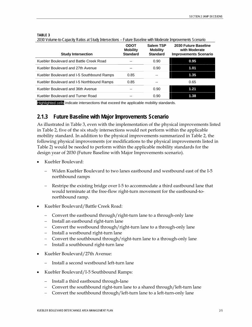
2.1.3 Future Baseline with Major Improvements Scenario As illustrated in Table 3, even with the implementation of the physical improvements listed in Table 2, five of the six study intersections would not perform within the applicable mobility standard. In addition to the physical improvements summarized in Table 2, the following physical improvements (or modifications to the physical improvements listed in Table 2) would be needed to perform within the applicable mobility standards for the design year of 2030 (Future Baseline with Major Improvements scenario).
• Kuebler Boulevard:
− Widen Kuebler Boulevard to two lanes eastbound and westbound east of the I-5 northbound ramps
− Restripe the existing bridge over I-5 to accommodate a third eastbound lane that would terminate at the free-flow right-turn movement for the eastbound-to-northbound ramp.
• Kuebler Boulevard/Battle Creek Road:
− Convert the eastbound through/right-turn lane to a through-only lane − Install an eastbound right-turn lane − Convert the westbound through/right-turn lane to a through-only lane − Install a westbound right-turn lane − Convert the southbound through/right-turn lane to a through-only lane − Install a southbound right-turn lane
• Kuebler Boulevard/27th Avenue:
− Install a second westbound left-turn lane
• Kuebler Boulevard/I-5 Southbound Ramps:
− Install a third eastbound through-lane − Convert the southbound right-turn lane to a shared through/left-turn lane − Convert the southbound through/left-turn lane to a left-turn-only lane
KUEBLER BOULEVARD INTERCHANGE AREA MANAGEMENT PLAN 2-5
SECTION 2: IAMP DECISIONS
− Install a free southbound right-turn lane
• Kuebler Boulevard/I-5 Northbound Ramps:
− Stripe the third eastbound lane as a right-turn lane to the northbound I-5 loop ramp
• Kuebler Boulevard/36th Avenue:
− Install a second eastbound through lane − Install a second westbound through lane
• Kuebler Boulevard/Turner Road:
− Install a second eastbound through lane
− Install a second westbound through lane
− Install a second eastbound left-turn lane
− Convert the northbound right-turn lane to a shared through/right-turn lane and add a second northbound receiving lane
− Install a second northbound left-turn lane
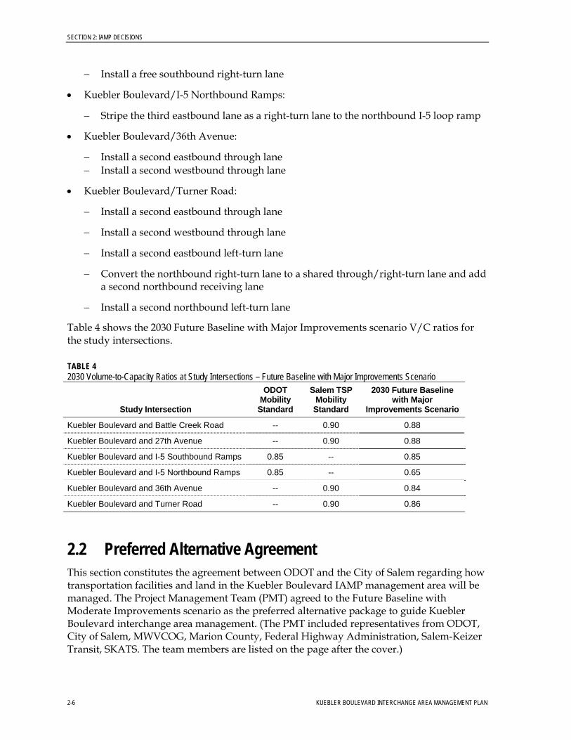
Table 4 shows the 2030 Future Baseline with Major Improvements scenario V/C ratios for the study intersections.
TABLE 4 2030 Volume-to-Capacity Ratios at Study Intersections – Future Baseline with Major Improvements Scenario
Study Intersection
ODOT Mobility
Standard
Salem TSP Mobility
Standard
2030 Future Baseline with Major
Improvements Scenario
Kuebler Boulevard and Battle Creek Road -- 0.90 0.88
Kuebler Boulevard and 27th Avenue -- 0.90 0.88
Kuebler Boulevard and I-5 Southbound Ramps 0.85 -- 0.85
Kuebler Boulevard and I-5 Northbound Ramps 0.85 -- 0.65
Kuebler Boulevard and 36th Avenue -- 0.90 0.84
Kuebler Boulevard and Turner Road -- 0.90 0.86
2.2 Preferred Alternative Agreement This section constitutes the agreement between ODOT and the City of Salem regarding how transportation facilities and land in the Kuebler Boulevard IAMP management area will be managed. The Project Management Team (PMT) agreed to the Future Baseline with Moderate Improvements scenario as the preferred alternative package to guide Kuebler Boulevard interchange area management. (The PMT included representatives from ODOT, City of Salem, MWVCOG, Marion County, Federal Highway Administration, Salem-Keizer Transit, SKATS. The team members are listed on the page after the cover.)
2-6 KUEBLER BOULEVARD INTERCHANGE AREA MANAGEMENT PLAN
SECTION 2: IAMP DECISIONS
As noted in the introduction to Section 2, the listed improvements are not guaranteed future funding and cannot be considered reasonably likely to be funded during the identified planning horizon for purposes of addressing OAR 660-012-0060. For recommended projects to be considered reasonably likely to be funded during the identified planning horizon, they must be:
• In the adopted SKATS RTSP “Financially Constrained Committed or Included Projects” lists
• Selected for inclusion in the Statewide Transportation Improvement Program (STIP; a project scheduling and funding document) and SKATS Transportation Improvement Program (TIP)
• Associated with a specific funding source that ODOT supports in writing or
• Identified in a funding plan that ODOT supports in writing
Unlike project lists contained in the STIP and SKATS TIP, federal and state laws do not require the IAMP project list to be “fiscally constrained.” Fiscal constraint is defined as:
“A demonstration of sufficient funds (Federal, State, local, and private) to implement proposed transportation system improvements, as well as to operate and maintain the entire system, through the comparison of revenues and costs.”1
This means that the IAMP can provide a single comprehensive list of regional transportation improvement needs and associated costs without having to provide a fiscal rationale as to how the respective projects will be funded. However, with this rationale, the projects cannot be used to support local land use changes.
The Kuebler Boulevard IAMP recommendations, therefore, act only as a reference for regional and local officials in the City of Salem and SKATS to consult when:
1. Considering projects to propose to the state for inclusion in the STIP
2. Developing priorities for local funding
3. Determining project needs associated with private development proposals
4. Establishing project needs to support publicly initiated plan amendments and zone changes
The cost of needed transportation improvements across the state far exceeds available funds. Therefore, state officials must decide what projects on the state system to fund through inclusion in the STIP, basing their decisions on a thorough evaluation of all projects proposed statewide. This process is detailed in the STIP User’s Guide (ODOT, 2003).2
1 Federal Highway Administration’s “Fiscal Constraint Definitions” web page at http://www.fhwa.dot.gov/planning/fcdef62805.htm. 2 STIP User’s Guide available online at http://www.oregon.gov/ODOT/TD/TP/stipGuide.shtml.
KUEBLER BOULEVARD INTERCHANGE AREA MANAGEMENT PLAN 2-7
SECTION 2: IAMP DECISIONS
2.3 Access Management ODOT access management and spacing standards provide a safe and efficient transportation system by protecting highway traffic from the hazards of unrestricted and unregulated movements from adjacent properties. OAR 734-051 outlines ODOT standards. Table 5 summarizes the access management standards applicable to freeway interchanges.
TABLE 5 Minimum Spacing Standards Applicable to Freeway Interchanges
Spacing Dimension
I-5 Configuration A X Y Z
Multi-lane 1 mile 1,320 feet 1,320 feet 1,320 feet
Source: Tables 5 and 6 in OAR 734-051-0125
A = The distance between the start and end of tapers of adjacent interchanges along I-5 X = The distance to the first approach on the right; right in/right out only Y = The distance to the first intersections where left-turns are allowed Z = The distance between the last right in/right out approach road and the start of the taper
for the entrance ramp
The existing ramp configurations on I-5 meet the ODOT access-management spacing standards shown in Table 5. The ramps for the OR 22 interchange to the north and the Commercial Street interchange to the south are beyond the one-mile spacing requirement.
ODOT access management standards also define interchange spacing standards between freeway interchanges. The distance between Kuebler Boulevard and the OR 22 and Commercial Street crossroads are approximately 2.3 and 3.1 miles, respectively. The applicable interchange spacing standard between crossroads is 3 miles. Therefore, the I-5 distance between Kuebler Boulevard and OR 22 (2.3 miles) is less than the applicable ODOT access management interchange spacing standard (3.0 miles).
The Salem TSP designates Kuebler Boulevard as a Parkway. An access control table (“City of Salem Street Classification System and Basic Design Guidelines”) in the Salem TSP states the following:
• Function. “High capacity, high speed roadway that primarily serves regional and intra-city travel.”
2-8 KUEBLER BOULEVARD INTERCHANGE AREA MANAGEMENT PLAN
SECTION 2: IAMP DECISIONS
• Access Control. “Limited access available through at-grade intersections or grade-separated interchanges with selected arterial and collector streets.”
Currently, no public or private approaches exist on Kuebler Boulevard within the minimum access management spacing requirements of the I-5 ramp terminals. ODOT owns over 0.25 mile of access rights between 27th Avenue west of I-5 and 36th Avenue east of I-5. ODOT also owns access rights on 27th Avenue 100 feet north and south of Kuebler Boulevard. Because ODOT owns access rights on Kuebler Boulevard between 27th Avenue and 36th Avenue, and because no access points exist between these intersections, no access management plan is required for the IAMP. However, 27th Avenue will continue to access Kuebler Boulevard at its existing location. Realigning the southbound I-5 off-ramp would decrease the distance to less than 1,320 feet. Therefore, an access deviation from ODOT will be required because the 27th Avenue approach at Kuebler Boulevard is less than the standard of 1,320 feet.
2.4 Interchange Area Management A long-term interchange management strategy that improves interchange operations and safety and preserves capacity was developed in support and protection of the major investment improvements being planned for the Kuebler Boulevard interchange. The management strategy balances the traffic generated by future development in the interchange area with the function and capacity of the interchange.
Monitoring trip generation provides ODOT and the City of Salem with a tool to manage development at planned levels to protect the function and preserve the capacity of the interchange consistent with the Salem Area Comprehensive Plan (2005). The provisions apply to all land use applications within the interchange management area. Development standards and permitted uses in the overlay zone are the development standards and permitted uses of the applicable base zone.
This section is divided into three subsections:
• Trip Monitoring Program • Coordination • Comprehensive Plan and Zoning Map Amendments
2.4.1 Trip Monitoring Program The Salem Area Comprehensive Plan (2005) designates property in the interchange management area for residential and industrial uses. It is acknowledged that build-out of the property in the management area that is already planned and zoned for development will result in traffic levels at the interchange that exceed the OHP mobility policy standards. Therefore, ODOT will establish a trip monitoring program.
• Related to monitoring coordination responsibilities, ODOT will establish a biennial ramp operations monitoring program with the intent of initiating discussions about possible improvement and management approaches when a V/C ratio of 0.95 is reached, if this threshold is reached before the City of Salem and SKATS can identify funding for the interchange improvements identified in the IAMP.
KUEBLER BOULEVARD INTERCHANGE AREA MANAGEMENT PLAN 2-9
SECTION 2: IAMP DECISIONS
2.4.2 Coordination The responsibilities of the City of Salem and ODOT to monitor and evaluate vehicle trip-generation impacts are delineated as follows:
• The City of Salem will provide notice to ODOT of any land use actions proposed within the IAMP management area.
• The City of Salem shall not deem the land use application complete unless it includes a traffic impact analysis prepared in accordance with applicable requirements of Salem Development Bulletin #19.
• The City of Salem shall provide written notification to ODOT when the land use application is deemed complete. This notice shall include an invitation to ODOT to participate in any pre-application or facilities meeting, if held.
2.4.3 Comprehensive Plan and Zoning Map Amendments The following requirements apply to Comprehensive Plan and Zoning Map amendments within the overlay zone:
• Transportation Planning Rule Requirements. Applications for Comprehensive Plan Map amendments shall determine whether the proposed change will significantly affect a collector or arterial transportation facility, and must meet the requirements of OAR 660-012-0060.
• Findings on Comprehensive Plan Amendments. To ensure that the remaining capacity of the interchange is reserved primarily for highway-related uses, Comprehensive Plan Map amendments or Zoning Map amendments must include findings that demonstrate compliance with all applicable provisions of the TPR.
2.5 IAMP Adoption and Implementation Adoption and implementation of the Kuebler Boulevard IAMP will occur at several levels of government. After the City of Salem makes a finding of consistency with the Salem Area Comprehensive Plan (2005), the Kuebler Boulevard IAMP will be presented to the OTC for review and approval. ODOT will adopt the IAMP when the OTC formally adopts the plan as an ODOT facility plan. The City of Salem’s consistency finding will precede OTC adoption. The OTC requires formal approval of the IAMP prior to starting project construction.
Regulatory authority determines implementation of this IAMP. Local agency authority comes from and through state statutes, city and county comprehensive plans, and development codes. State of Oregon authority comes in the form of policy and administrative rules governing authority over federal and state systems, as granted through the following:
• State Agency Coordination (SAC) Rule and Agreement (SAC 1990—OAR 731-015). The purpose of this rule is to define which ODOT actions are land use actions and how ODOT will meet its responsibilities for coordinating these activities with the statewide land use planning program, other state agencies, and local government.
2-10 KUEBLER BOULEVARD INTERCHANGE AREA MANAGEMENT PLAN
SECTION 2: IAMP DECISIONS
• Transportation Planning Rule (OAR 660-012). The TPR is one of several statewide planning rules that protect the long-term livability of Oregon’s communities for future generations. The rule requires multi-modal transportation plans to be coordinated with land use plans. In satisfying the goal, state and local governments must satisfy requirements that lead to implementation of a transportation system that functions consistent with the planned land uses.
• Access Management Administrative Rule (OAR 734-051). This rule applies to the location, construction, maintenance, and use of approaches onto the state highway rights-of-way and properties under the jurisdiction of ODOT. These rules also govern the closure of existing approaches, spacing standards, medians, deviations, the appeal process, grants of access, and indentures of access.
2.5.1 ODOT/State of Oregon Implementing Actions ODOT/State of Oregon will perform the following actions:
• Establish an interchange management area within which ODOT will monitor proposed land use changes.
• Retain the OHP mobility policy standard of a V/C ratio of 0.85 at the ramp terminals.
• Acknowledge that the westbound-to-southbound loop ramp and associated modifications to the interchange described in Section 2.2 is the only remaining fix that will meet OHP mobility policy standards for the interchange once that standard is exceeded.
• Acknowledge the land uses in the interchange management area as designated in the Salem Area Comprehensive Plan (2005) at the time of adoption of the IAMP and accept that these land uses will cause the OHP mobility policy standards to be exceeded at the ramp terminals if the unfunded improvements identified in this IAMP are not constructed.
• Adopt the existing and planned local street network, as defined in the City of Salem’s TSP, as integral to the success of the IAMP.
• Work with the City of Salem to secure funding for and construct applicable IAMP-identified transportation system physical improvements to state facilities.
• Adopt the IAMP.
• Ensure that proposed land use changes comply with OAR 660-012-0060 of the TPR within the management area and require that the land use changes mitigate to the OHP mobility policy standard at the ramps for the planning horizon (while mobility policy standards are being met) or for the day of opening (where mobility policy standards are exceeded).
• If future circumstances in the IAMP management area result in the need for changes to the IAMP, jointly work with the City of Salem to prepare amendments to the IAMP management actions and a funding plan to implement those actions.
KUEBLER BOULEVARD INTERCHANGE AREA MANAGEMENT PLAN 2-11

SECTION 2: IAMP DECISIONS
2.5.2 City of Salem Implementing Actions The City of Salem will perform the following actions:
• Work to secure funding and construct applicable IAMP-identified transportation system physical improvements on City of Salem facilities.
• Support ODOT OTC adoption of the IAMP.
• Find that the IAMP is consistent with all applicable elements of Salem Area Comprehensive Plan (2005), including the TSP.
• Provide notice to ODOT for any land-use actions proposed within the IAMP management area. Provide written notification to ODOT when the application is deemed complete, and include an invitation to ODOT to participate in any pre-application or facilities meeting.
• Coordinate with ODOT prior to amending the Salem Area Comprehensive Plan (2005), land development ordinances, or prior to proposing transportation improvements that could affect the function of the interchange.
• If future circumstances in the IAMP management area result in the need for changes to the IAMP, prepare, jointly with ODOT, amendments to the IAMP management actions and an accompanying funding plan to implement those actions.
• Work with ODOT and other regional partners (such as Mid-Valley Rideshare) to increase transportation choices and promote transportation demand management. The City of Salem’s commitment to promoting transportation choices and transportation demand management is reflected in the City of Salem’s policies and regulations. As part of complying with the TPR (OAR 660-012-0035), the City of Salem has developed a series of standards and benchmarks, including one that measures progress in promoting use of alternative modes. The success of these efforts will be monitored using the adopted standard at regular intervals, as required by the TPR. Other policy and regulatory commitments include the following:
− City of Salem TSP Chapter 10 – Transportation Demand Management (TDM) Element – establishes the policy framework and goals and objectives for TDM
− Salem Revised Code (SRC) 41.160(c) – transportation systems development charge credit of 15 percent for an approved transportation demand management plan
− SRC 133.100(b) – establishes parking maximums
− SRC 133.110 – bicycle parking requirements
− SRC 133.150 – satisfaction of off-street parking requirements through alternative modes of transportation
− SRC 133.165 – carpool/vanpool parking requirements
• Manage the operation of the interchange traffic signals consistent with Intergovernmental Agreement No. 21,345, approved December 22, 2005 (and any future
2-12 KUEBLER BOULEVARD INTERCHANGE AREA MANAGEMENT PLAN
SECTION 2: IAMP DECISIONS
KUEBLER BOULEVARD INTERCHANGE AREA MANAGEMENT PLAN 2-13
amendments thereto, except to the paragraph referenced below). Said agreement states, in part:
“City shall develop and make available to State’s Region Traffic office an Interchange system timing plan, the sole purpose of which shall be to clear out the I-5 ramps if queued vehicles on the ramps begin to interfere with I-5 traffic. Such timing plans shall immediately be put into effect by City upon receipt of notification from ODOT of an existing or potential queuing problem….” (City Obligations, Paragraph 4)
2.5.3 Salem-Keizer Area Transportation Study Implementing Actions SKATS will perform the following actions:
• Include applicable IAMP-identified transportation system physical improvements on regional facilities initially in the SKATS RTSP “Illustrative Projects List” and then move them to the “Financially Constrained Committed or Included Projects” lists when funding is assured.
• Support ODOT OTC adoption of the IAMP.
• Adopt the IAMP, as a refinement element to the SKATS RTSP.


KUEBLER BOULEVARD INTERCHANGE AREA MANAGEMENT PLAN
PART II
Appendices

KUEBLER BOULEVARD INTERCHANGE AREA MANAGEMENT PLAN
APPENDIX A
Existing Conditions Inventory and Data Analysis

APPENDIX A
Existing Conditions Inventory and Data Analysis
This section provides a description of the regulatory framework near the Kuebler Boulevard interchange and current land uses, traffic conditions, and environmental constraints.
A.1 Existing Land Use The Kuebler Boulevard IAMP management area lies entirely within the City of Salem’s urban growth boundary (UGB). The portion of the IAMP management area north of Kuebler Boulevard is entirely within Salem’s city limits. South of Kuebler Boulevard, portions of the interchange management area are in unincorporated Marion County. The following describes existing land use by interchange quadrant:
• Northwest Quadrant. Existing uses in this quadrant consist of scattered residences and farm-related buildings. Most parcels in this quadrant are over 5 acres; three parcels in the area are over 15 acres and are undeveloped. With the possible exception of three parcels owned by a church, which encompasses a little over 20 acres, most of the land area in this quadrant is vacant or underdeveloped.1
• Northeast Quadrant. This quadrant is sparsely developed with single-family residential, industrial, and agricultural uses. It is approximately 270 acres in size. This quadrant is traversed by the Southern Pacific Railroad. Larger, undeveloped industrial parcels south of the railroad tracks are vacant.
• Southwest Quadrant. At approximately 74 acres, the southwest quadrant is the smallest of the four quadrants. This quadrant is largely undeveloped with the exception of a few residences.
• Southeast Quadrant. The southeast quadrant is approximately 340 acres and is mostly undeveloped. The largest parcels in this area lie close to Kuebler Boulevard and I-5, east of 36th Avenue. The uses in the southeast quadrant can be characterized as predominantly agricultural with interspersed single-family residences. Most parcels are larger than 5 acres.
The IAMP management area currently lies outside of the City of Salem’s Urban Service Area. The Salem Urban Service Area identifies those locations where the City of Salem has committed to construct public works infrastructure necessary to enable urban development. The City of Salem must issue an Urban Growth Area Permit or expand the Salem Urban Service Area before an area outside of the Urban Service Area can receive services. No Urban Service Area expansion is proposed in the City of Salem’s adopted Capital Improvement Program (fiscal years 2004-2005 through 2008-2009).
1 “Underdeveloped” indicates that improvements exist on some parcels in the quadrant, but do not preclude land subdivision or more intense development in the future.
KUEBLER BOULEVARD INTERCHANGE AREA MANAGEMENT PLAN A-1
APPENDIX A: EXISTING CONDITIONS INVENTORY AND DATA ANALYSIS
A.1.1 Comprehensive Plan Designations Comprehensive Plan land use designations in Marion County coincide with the zoning designations. Relevant Marion County zoning district designations are addressed below.
Salem Area Comprehensive Plan (2005) designations in the IAMP management area are as follows:
• Developing Residential (DR) • Multi-Family Residential (MF) • Single-Family Residential (SF) • Industrial (IND) • Industrial/Commercial (IC) • Commercial (COM)
Figure A-1 (at the end of this appendix) depicts comprehensive plan zoning designations.
A.1.2 Zoning Designations The IAMP management area is located within two jurisdictional boundaries: Marion County and the City of Salem. Planned interchange improvements will occur within both of these jurisdictions.
Marion County Zoning Existing Marion County zoning districts in the IAMP management area are as follows:
• Urban Transition (UT-5, UT-10, UT-20) • General Industrial (IG) • Industrial Commercial (IC) • Residential Single Family (RS)
Public road improvements are permitted outright in all Marion County zones providing that such improvements are in conformance with the “applicable comprehensive plan and the standards of the Department of Public Works” (per Marion County Zoning Ordinance 25.10[b]). Therefore, Marion County zoning regulations do not constrain planned Kuebler Boulevard interchange improvements.
City of Salem Zoning Existing City of Salem zoning districts in the IAMP management area are as follows:
• Residential Agriculture (AG) • General Industrial (IG) • Industrial Commercial (IC) • Public Health (PH) • Single-Family Residential (RS) • Commercial Office (CO) • Industrial Business Campus (IBC)
Public road improvements are permitted outright in all zoning districts in the IAMP management area. Therefore, City of Salem and Marion County zoning regulations do not constrain planned Kuebler Boulevard interchange improvements.
A-2 KUEBLER BOULEVARD INTERCHANGE AREA MANAGEMENT PLAN
APPENDIX A: EXISTING SYSTEMS INVENTORY AND DATA ANALYSIS
A.2 Transportation Facilities and Traffic Operations This section summarizes the assumptions and methodologies used in the traffic operational analyses, summarizes the existing transportation conditions within the IAMP management area, and catalogues existing transportation system facilities and services.
A.2.1 Methodology This section describes the data collected the methodology employed for traffic forecasting and operational analysis.
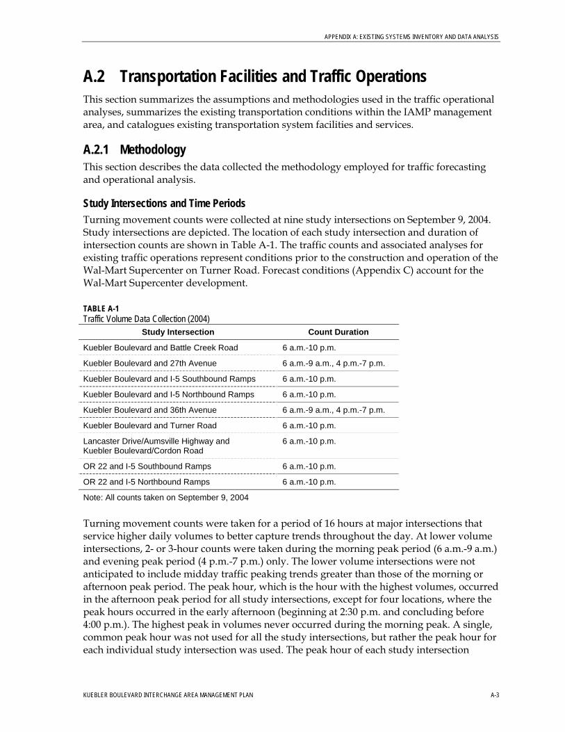
Study Intersections and Time Periods Turning movement counts were collected at nine study intersections on September 9, 2004. Study intersections are depicted. The location of each study intersection and duration of intersection counts are shown in Table A-1. The traffic counts and associated analyses for existing traffic operations represent conditions prior to the construction and operation of the Wal-Mart Supercenter on Turner Road. Forecast conditions (Appendix C) account for the Wal-Mart Supercenter development.
TABLE A-1 Traffic Volume Data Collection (2004)
Study Intersection Count Duration
Kuebler Boulevard and Battle Creek Road 6 a.m.-10 p.m.
Kuebler Boulevard and 27th Avenue 6 a.m.-9 a.m., 4 p.m.-7 p.m.
Kuebler Boulevard and I-5 Southbound Ramps 6 a.m.-10 p.m.
Kuebler Boulevard and I-5 Northbound Ramps 6 a.m.-10 p.m.
Kuebler Boulevard and 36th Avenue 6 a.m.-9 a.m., 4 p.m.-7 p.m.
Kuebler Boulevard and Turner Road 6 a.m.-10 p.m.
Lancaster Drive/Aumsville Highway and Kuebler Boulevard/Cordon Road
6 a.m.-10 p.m.
OR 22 and I-5 Southbound Ramps 6 a.m.-10 p.m.
OR 22 and I-5 Northbound Ramps 6 a.m.-10 p.m.
Note: All counts taken on September 9, 2004
Turning movement counts were taken for a period of 16 hours at major intersections that service higher daily volumes to better capture trends throughout the day. At lower volume intersections, 2- or 3-hour counts were taken during the morning peak period (6 a.m.-9 a.m.) and evening peak period (4 p.m.-7 p.m.) only. The lower volume intersections were not anticipated to include midday traffic peaking trends greater than those of the morning or afternoon peak period. The peak hour, which is the hour with the highest volumes, occurred in the afternoon peak period for all study intersections, except for four locations, where the peak hours occurred in the early afternoon (beginning at 2:30 p.m. and concluding before 4:00 p.m.). The highest peak in volumes never occurred during the morning peak. A single, common peak hour was not used for all the study intersections, but rather the peak hour for each individual study intersection was used. The peak hour of each study intersection
KUEBLER BOULEVARD INTERCHANGE AREA MANAGEMENT PLAN A-3
APPENDIX A: EXISTING CONDITIONS INVENTORY AND DATA ANALYSIS
location was used to derive the 30th highest hourly base volume, and these volumes were then rounded and balanced between adjacent intersections.
Seasonal Adjustments The peak hour turning movement counts were adjusted to account for seasonal effects using the 2003 Oregon Department of Transportation (ODOT) Seasonal Factor Table. This table includes adjustment factors that represent the variation in 30th highest peak-hour traffic volumes2 by month. Seasonal factors are applied to traffic counts to account for differences in traffic trends throughout the year, and are reported at the beginning and middle of each month at various automatic traffic recorder (ATR) locations (Stations 15014, 18018, and 24004).
A single seasonal adjustment factor of 1.05 was applied to volumes on OR 22 and Kuebler Boulevard. This factor was developed by averaging factors from two different ATR station locations. Station 15014 (on OR 99) and Station 18018 (on OR 39) are both located in southern Oregon on roadways that have similar characteristics to OR 22 and Kuebler Boulevard. Similarly, a seasonal factor of 1.09 was applied to volumes on Lancaster Drive, Cordon Road, and Deer Park Drive. This factor was developed from factors reported at Station 24004, located on OR 22 near the Deer Park Drive interchange.
The derived 30th highest hour design volumes were then balanced between adjacent study intersections as outlined in ODOT’s Traffic Planning and Analysis Unit (TPAU) Analysis Procedures Manual (2006). Volumes between study intersections are balanced to smooth out differences between counts that may have different peaking characteristics and to ensure that vehicles are not lost or gained between intersections.
Intersection Operational Analysis Intersection operations were analyzed for the year 2007 existing conditions and the future year 2030 scenarios: Future Baseline, Future Baseline with Moderate Improvements, and Future Baseline with Major Improvements. The following subsections describe the models used to analyze intersection operations.
A Synchro computer traffic-operations model was constructed for the study area based on the collected traffic turning movement counts, peak-hour factors, truck percentages, and field observations, all of which were balanced for the 30th highest hour design volumes. This model was used to assess existing traffic operations within the study area.
The Synchro model uses methodology in the 2000 Highway Capacity Manual (HCM) to analyze both signalized and stop-controlled intersections. The model also computes the V/C ratio to determine whether the intersection meets the applicable mobility standards from the OHP.
Freeway Operational Analysis Operations were analyzed using the Highway Capacity Software (HCS) 2000, which is consistent with methods outlined in the HCM. HCS assumptions for I-5 are listed in Table A-2.
2 The 30th highest peak hour traffic volume is the volume for which roadways are designed.
A-4 KUEBLER BOULEVARD INTERCHANGE AREA MANAGEMENT PLAN
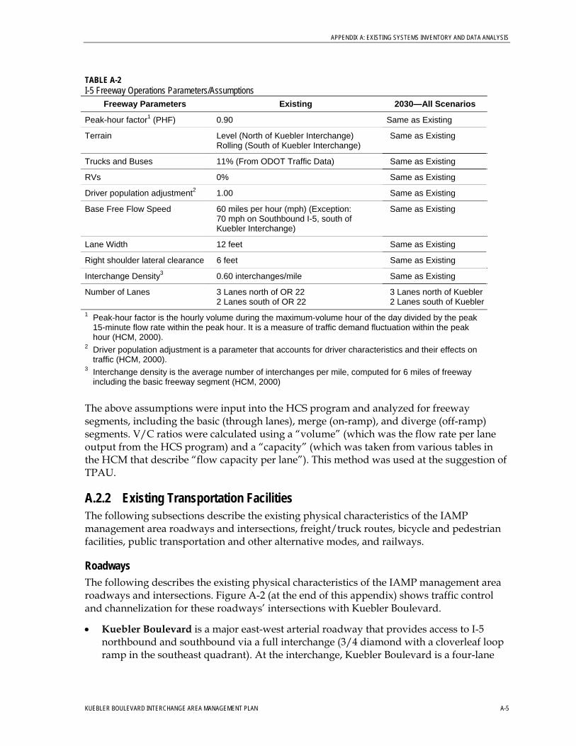
APPENDIX A: EXISTING SYSTEMS INVENTORY AND DATA ANALYSIS
TABLE A-2 I-5 Freeway Operations Parameters/Assumptions
Freeway Parameters Existing 2030—All Scenarios
Peak-hour factor1 (PHF) 0.90 Same as Existing
Terrain Level (North of Kuebler Interchange) Rolling (South of Kuebler Interchange)
Same as Existing
Trucks and Buses 11% (From ODOT Traffic Data) Same as Existing
RVs 0% Same as Existing
Driver population adjustment2 1.00 Same as Existing
Base Free Flow Speed 60 miles per hour (mph) (Exception: 70 mph on Southbound I-5, south of Kuebler Interchange)
Same as Existing
Lane Width 12 feet Same as Existing
Right shoulder lateral clearance 6 feet Same as Existing
Interchange Density3 0.60 interchanges/mile Same as Existing
Number of Lanes 3 Lanes north of OR 22 2 Lanes south of OR 22
3 Lanes north of Kuebler2 Lanes south of Kuebler
1 Peak-hour factor is the hourly volume during the maximum-volume hour of the day divided by the peak 15-minute flow rate within the peak hour. It is a measure of traffic demand fluctuation within the peak hour (HCM, 2000).
2 Driver population adjustment is a parameter that accounts for driver characteristics and their effects on traffic (HCM, 2000).
3 Interchange density is the average number of interchanges per mile, computed for 6 miles of freeway including the basic freeway segment (HCM, 2000)
The above assumptions were input into the HCS program and analyzed for freeway segments, including the basic (through lanes), merge (on-ramp), and diverge (off-ramp) segments. V/C ratios were calculated using a “volume” (which was the flow rate per lane output from the HCS program) and a “capacity” (which was taken from various tables in the HCM that describe “flow capacity per lane”). This method was used at the suggestion of TPAU.
A.2.2 Existing Transportation Facilities The following subsections describe the existing physical characteristics of the IAMP management area roadways and intersections, freight/truck routes, bicycle and pedestrian facilities, public transportation and other alternative modes, and railways.
Roadways The following describes the existing physical characteristics of the IAMP management area roadways and intersections. Figure A-2 (at the end of this appendix) shows traffic control and channelization for these roadways’ intersections with Kuebler Boulevard.
• Kuebler Boulevard is a major east-west arterial roadway that provides access to I-5 northbound and southbound via a full interchange (3/4 diamond with a cloverleaf loop ramp in the southeast quadrant). At the interchange, Kuebler Boulevard is a four-lane
KUEBLER BOULEVARD INTERCHANGE AREA MANAGEMENT PLAN A-5
APPENDIX A: EXISTING CONDITIONS INVENTORY AND DATA ANALYSIS
undivided roadway with left-turn pockets at the two signalized ramp termini intersections. The posted speed limit is 45 miles per hour (mph).
Outside of the interchange management area, Kuebler Boulevard is a two-lane, undivided roadway with paved, marked bicycle lanes in both directions. Kuebler Boulevard does not have a sidewalk, curb, or gutter, beyond the pedestrian facilities at signalized intersections (including pedestrian push buttons and crosswalks). The posted speed limit is 45 mph on this roadway.
East of Turner Road, the posted speed limit of Kuebler Boulevard increases to 55 mph and the roadway begins to head north. The roadway geometry remains similar; an undivided two-lane roadway with paved bicycle lanes in both directions.
The Kuebler Boulevard interchange is located approximately 2 miles south of the I-5/ Oregon 22 interchange. The southbound ramp terminus is signalized and includes a two-lane southbound off-ramp approach (a through/left-turn lane and a right-turn lane) and a single-lane on-ramp. Westbound traffic on Kuebler Boulevard destined for southbound I-5 must make a left-turn at this intersection. The northbound ramp terminus is a signalized “T” intersection. Traffic exiting I-5 may head either east or west on Kuebler Boulevard, while traffic destined for northbound I-5 must utilize a one-lane loop on-ramp from either direction.
• Battle Creek Road intersects Kuebler Boulevard and is located approximately half a mile to the west of I-5. This two-lane north-south minor arterial roadway provides access mainly to residential areas on either side of Kuebler Boulevard. Bicycle lanes are provided in both directions on this roadway, which has a posted speed limit of 40 mph. This intersection is signalized, and includes crosswalks in all directions. Approaches include left-turn pockets and a shared through/right-turn lane.
• Turner Road is a north-south minor arterial roadway that crosses Kuebler Boulevard and provides access to residential and industrial areas. This roadway carries a greater amount of traffic than 27th Avenue or 36th Avenue, and extends north to OR 22 west of I-5. It is a two-lane roadway with wide paved shoulders (that also serve as bicycle facilities) and a posted speed limit of 45 mph. Its approaches to the signalized intersection with Kuebler Boulevard include dedicated left-turn pockets and shared through/right-turn lanes. Crosswalks and pedestrian push buttons are located on each leg of the intersection.
• 27th Avenue is a north-south collector roadway that intersects with Kuebler Boulevard approximately ¼ mile west of I-5. This intersection is unsignalized, with free movements for traffic on Kuebler Boulevard, and stop-controlled approaches on 27th Avenue. Each of the approaches includes a dedicated left-turn pocket and a shared through/right-turn lane. 27th Avenue is a two-lane roadway that provides access to a large church on the north side of Kuebler Boulevard, and to areas to the south side that are mainly residential. Wide shoulders, which also serve as bicycle facilities, are provided on both legs of 27th Avenue. No sidewalks exist on 27th Avenue. This roadway has a posted speed limit of 35 mph.
• 36th Avenue is a north-south roadway that services low traffic volumes. It intersects Kuebler Boulevard and is located approximately ¼ mile east of I-5. This roadway,
A-6 KUEBLER BOULEVARD INTERCHANGE AREA MANAGEMENT PLAN
APPENDIX A: EXISTING SYSTEMS INVENTORY AND DATA ANALYSIS
designated as a minor arterial, provides access to some residential areas, but is mostly used for business or industrial purposes. 36th Avenue is similar to 27th Avenue in that it is a two-lane roadway with wide shoulders and no pedestrian facilities beyond the crosswalks at the signalized intersection. Each approach includes a dedicated left-turn pocket and a shared through/right-turn lane. The posted speed limit is 35 mph.
Freight/Truck Routes The OHP designates I-5 as a freight route as it travels through the IAMP management area. The City of Salem does not regulate truck or freight routes. Instead, the City of Salem encourages the use of arterials and the State highway system for truck movements, and discourages the use of local residential streets for truck movements. The following are “High Priority Freight Related Street Improvements” in the IAMP management area, as identified in the City of Salem TSP:
• Kuebler Boulevard SE (Commercial Street SE to Interstate 5) • Kuebler Boulevard SE (I-5 to new interchange needed at Highway 22) • Traffic Signal Interconnects and Coordination (Citywide)
Pedestrian and Bicycle Facilities Outside of the I-5 interchange area in the IAMP management area, Kuebler Boulevard is a two-lane, undivided roadway with paved, marked bicycle lanes in both directions. Kuebler Boulevard does not have sidewalks, curbs, or gutters beyond pedestrian push buttons and crosswalks at signalized intersections. On 27th Avenue, wide shoulders, which serve as bike lanes, are provided on both legs, but pedestrian amenities are not. 36th Avenue is similar to 27th Avenue in that it is a two-lane roadway with wide shoulders and no pedestrian amenities beyond the crosswalks at the signalized intersection. Designated bicycle lanes are provided on Battle Creek Road.
No roadways in the IAMP management area are designated as a pedestrian route of regional significance (i.e., major activity centers are not directly along the study roadways) in the City of Salem TSP. Bicycle lanes are also proposed for the sections of 32nd Avenue SE, Trelstad Avenue SE, and 36th Avenue SE that connect the existing bicycle lanes on Fairview Industrial Drive SE to Kuebler Boulevard SE.
Public Transportation & Other Alternative Modes Salem-Keizer Transit District provides public transportation to the Salem-Keizer urban area. The public transit system is called Cherriots. It operates in a radial pulse structure in which 19 routes converge in a timed fashion at the central transit station located in downtown Salem. The remaining routes provide circulation service for west Salem, or cross-town service between Keizer and east Salem. There are also three park-and-ride routes within the system.
Accessible public transportation service is provided via the Cherriots’ fixed route lift-equipped buses and Cherrylift dial-a-ride service. Ninety percent of the fixed route fleet is equipped with accessible lifts. Elderly and handicap persons that are not able to utilize fixed-route transit have the Cherrylift dial-a-ride option. The IAMP management area is directly serviced by two Cherriots routes—21-Turner, which travels along Turner Road (eastern boundary of the IAMP management area) and 22-Battle Creek, which travels along
KUEBLER BOULEVARD INTERCHANGE AREA MANAGEMENT PLAN A-7
APPENDIX A: EXISTING CONDITIONS INVENTORY AND DATA ANALYSIS
Battle Creek Road (western boundary of the IAMP management area). There is a bus stop at the Kuebler Boulevard/Turner Road intersection.
Other public transportation options include:
• “Wheels” – a dial-a-ride program offered by the Oregon Housing and Associated Services Inc. providing paratransit service within the Salem-Keizer area
• “TripLink” – a tri-county brokerage of service providers providing transportation for medical related needs of Medicaid recipients
• Catholic Community Services and Shangri La–provide transportation and housing services to physically and mentally challenged clients
• Other non-profit groups associated with retirement centers, Boys & Girls Clubs and hospitals
Several public agencies also provide regularly scheduled intercity transit service within the Salem-Keizer area, including the Chemeketa Area Regional Transportation System (CARTS). CARTS provides weekday public transit within Marion and Polk counties. The “Santiam Canyon” route serves the IAMP management area roadways and includes service to the airport and AMTRAK station. CARTS provides point-deviated fixed-route service, allowing a bus to deviate up to 3/4 of a mile from its fixed route to service disabled persons. CARTS also maintains a dial-a-ride service option.
Railways A Union Pacific (UP) classified Major Class I railroad traverses the IAMP management area. Railroad classification is defined in the 2001 Oregon Rail Plan. Classifications as defined by the Interstate Commerce Commission (now the Surface Transportation Board), and are based on average annual operating income.
The UP’s “Valley Mainline” runs from Portland to Eugene as a portion of the main west coast rail line that links Mexico to Canada. In the Kuebler Boulevard interchange IAMP management area, it runs roughly parallel to and on the east side of I-5. AMTRAK also provides passenger rail service along the UP rail line.
A.2.3 Existing Traffic Conditions This section documents the applicable traffic performance measures (mobility standards) and existing traffic conditions for the IAMP management area.
Traffic Performance Measures Various performance measures are outlined below for the three jurisdictions within the IAMP management area—ODOT, Marion County, and the City of Salem. Because the IAMP management area is also located within the planning boundary of the Salem-Keizer Area Transportation Study (SKATS), the Metropolitan Planning Organization (MPO) for the Salem/Keizer area, MPO traffic performance measures apply.
ODOT The I-5 off-ramp and onramp approaches and the Kuebler Boulevard approaches at the Kuebler Boulevard interchange are under ODOT jurisdiction.
A-8 KUEBLER BOULEVARD INTERCHANGE AREA MANAGEMENT PLAN
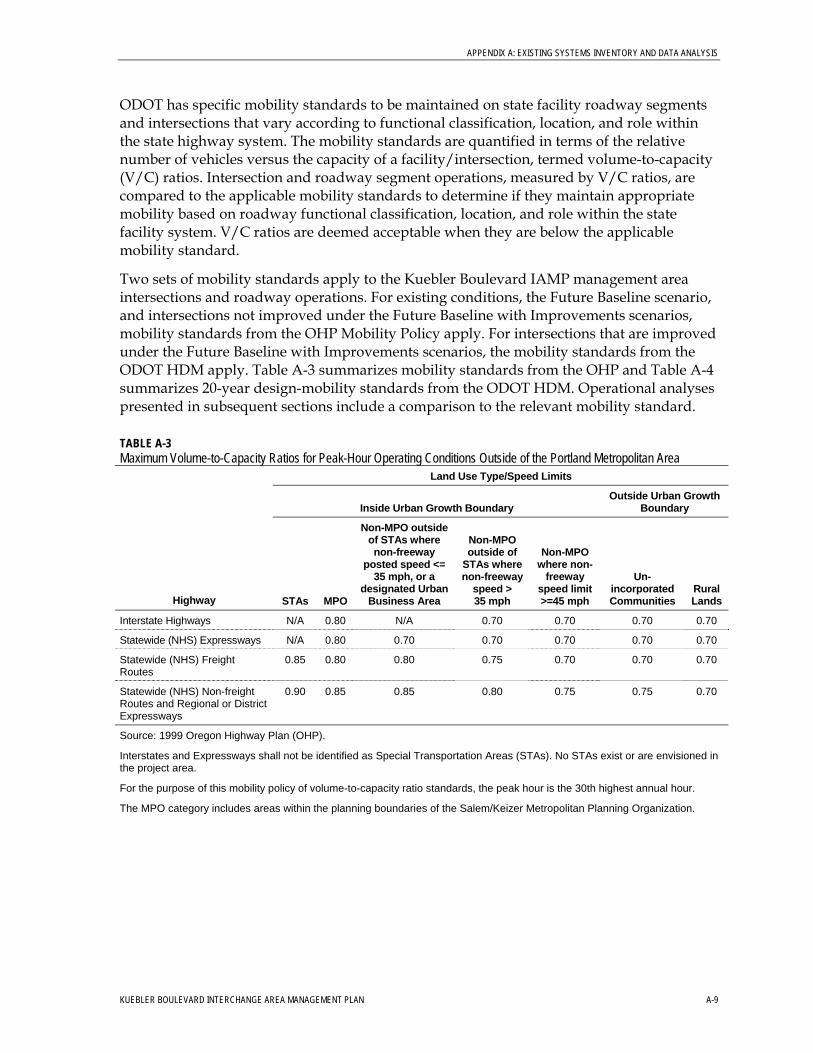
APPENDIX A: EXISTING SYSTEMS INVENTORY AND DATA ANALYSIS
ODOT has specific mobility standards to be maintained on state facility roadway segments and intersections that vary according to functional classification, location, and role within the state highway system. The mobility standards are quantified in terms of the relative number of vehicles versus the capacity of a facility/intersection, termed volume-to-capacity (V/C) ratios. Intersection and roadway segment operations, measured by V/C ratios, are compared to the applicable mobility standards to determine if they maintain appropriate mobility based on roadway functional classification, location, and role within the state facility system. V/C ratios are deemed acceptable when they are below the applicable mobility standard.
Two sets of mobility standards apply to the Kuebler Boulevard IAMP management area intersections and roadway operations. For existing conditions, the Future Baseline scenario, and intersections not improved under the Future Baseline with Improvements scenarios, mobility standards from the OHP Mobility Policy apply. For intersections that are improved under the Future Baseline with Improvements scenarios, the mobility standards from the ODOT HDM apply. Table A-3 summarizes mobility standards from the OHP and Table A-4 summarizes 20-year design-mobility standards from the ODOT HDM. Operational analyses presented in subsequent sections include a comparison to the relevant mobility standard.
TABLE A-3 Maximum Volume-to-Capacity Ratios for Peak-Hour Operating Conditions Outside of the Portland Metropolitan Area
Land Use Type/Speed Limits
Outside Urban Growth Boundary Inside Urban Growth Boundary
Highway STAs MPO
Non-MPO outside of STAs where non-freeway
posted speed <= 35 mph, or a
designated Urban Business Area
Non-MPO outside of
STAs where non-freeway
speed > 35 mph
Non-MPO where non-
freeway speed limit >=45 mph
Un-incorporated Communities
Rural Lands
Interstate Highways N/A 0.80 N/A 0.70 0.70 0.70 0.70
Statewide (NHS) Expressways N/A 0.80 0.70 0.70 0.70 0.70 0.70
Statewide (NHS) Freight Routes
0.85 0.80 0.80 0.75 0.70 0.70 0.70
Statewide (NHS) Non-freight Routes and Regional or District Expressways
0.90 0.85 0.85 0.80 0.75 0.75 0.70
Source: 1999 Oregon Highway Plan (OHP).
Interstates and Expressways shall not be identified as Special Transportation Areas (STAs). No STAs exist or are envisioned in the project area.
For the purpose of this mobility policy of volume-to-capacity ratio standards, the peak hour is the 30th highest annual hour.
The MPO category includes areas within the planning boundaries of the Salem/Keizer Metropolitan Planning Organization.
KUEBLER BOULEVARD INTERCHANGE AREA MANAGEMENT PLAN A-9
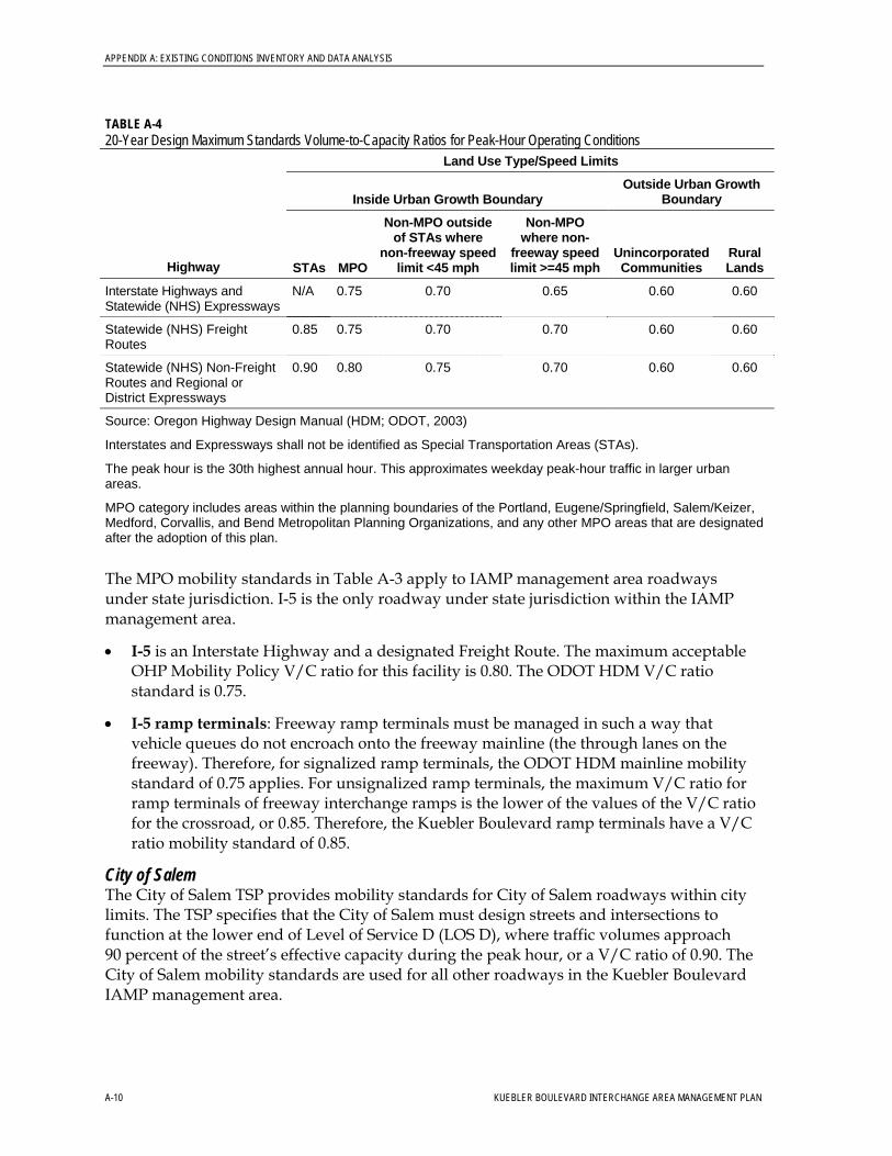
APPENDIX A: EXISTING CONDITIONS INVENTORY AND DATA ANALYSIS
TABLE A-4 20-Year Design Maximum Standards Volume-to-Capacity Ratios for Peak-Hour Operating Conditions
Land Use Type/Speed Limits
Outside Urban Growth Boundary Inside Urban Growth Boundary
Highway STAs MPO
Non-MPO outside of STAs where
non-freeway speed limit <45 mph
Non-MPO where non-
freeway speed limit >=45 mph
Unincorporated Communities
Rural Lands
Interstate Highways and Statewide (NHS) Expressways
N/A 0.75 0.70 0.65 0.60 0.60
Statewide (NHS) Freight Routes
0.85 0.75 0.70 0.70 0.60 0.60
Statewide (NHS) Non-Freight Routes and Regional or District Expressways
0.90 0.80 0.75 0.70 0.60 0.60
Source: Oregon Highway Design Manual (HDM; ODOT, 2003)
Interstates and Expressways shall not be identified as Special Transportation Areas (STAs).
The peak hour is the 30th highest annual hour. This approximates weekday peak-hour traffic in larger urban areas.
MPO category includes areas within the planning boundaries of the Portland, Eugene/Springfield, Salem/Keizer, Medford, Corvallis, and Bend Metropolitan Planning Organizations, and any other MPO areas that are designated after the adoption of this plan.
The MPO mobility standards in Table A-3 apply to IAMP management area roadways under state jurisdiction. I-5 is the only roadway under state jurisdiction within the IAMP management area.
• I-5 is an Interstate Highway and a designated Freight Route. The maximum acceptable OHP Mobility Policy V/C ratio for this facility is 0.80. The ODOT HDM V/C ratio standard is 0.75.
• I-5 ramp terminals: Freeway ramp terminals must be managed in such a way that vehicle queues do not encroach onto the freeway mainline (the through lanes on the freeway). Therefore, for signalized ramp terminals, the ODOT HDM mainline mobility standard of 0.75 applies. For unsignalized ramp terminals, the maximum V/C ratio for ramp terminals of freeway interchange ramps is the lower of the values of the V/C ratio for the crossroad, or 0.85. Therefore, the Kuebler Boulevard ramp terminals have a V/C ratio mobility standard of 0.85.
City of Salem The City of Salem TSP provides mobility standards for City of Salem roadways within city limits. The TSP specifies that the City of Salem must design streets and intersections to function at the lower end of Level of Service D (LOS D), where traffic volumes approach 90 percent of the street’s effective capacity during the peak hour, or a V/C ratio of 0.90. The City of Salem mobility standards are used for all other roadways in the Kuebler Boulevard IAMP management area.
A-10 KUEBLER BOULEVARD INTERCHANGE AREA MANAGEMENT PLAN
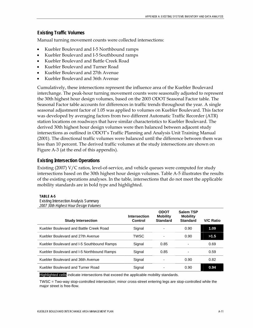
APPENDIX A: EXISTING SYSTEMS INVENTORY AND DATA ANALYSIS
Existing Traffic Volumes Manual turning movement counts were collected intersections:
• Kuebler Boulevard and I-5 Northbound ramps • Kuebler Boulevard and I-5 Southbound ramps • Kuebler Boulevard and Battle Creek Road • Kuebler Boulevard and Turner Road • Kuebler Boulevard and 27th Avenue • Kuebler Boulevard and 36th Avenue
Cumulatively, these intersections represent the influence area of the Kuebler Boulevard interchange. The peak-hour turning movement counts were seasonally adjusted to represent the 30th highest hour design volumes, based on the 2003 ODOT Seasonal Factor table. The Seasonal Factor table accounts for differences in traffic trends throughout the year. A single seasonal adjustment factor of 1.05 was applied to volumes on Kuebler Boulevard. This factor was developed by averaging factors from two different Automatic Traffic Recorder (ATR) station locations on roadways that have similar characteristics to Kuebler Boulevard. The derived 30th highest hour design volumes were then balanced between adjacent study intersections as outlined in ODOT’s Traffic Planning and Analysis Unit Training Manual (2001). The directional traffic volumes were balanced until the difference between them was less than 10 percent. The derived traffic volumes at the study intersections are shown on Figure A-3 (at the end of this appendix).
Existing Intersection Operations Existing (2007) V/C ratios, level-of-service, and vehicle queues were computed for study intersections based on the 30th highest hour design volumes. Table A-5 illustrates the results of the existing operations analyses. In the table, intersections that do not meet the applicable mobility standards are in bold type and highlighted.
TABLE A-5 Existing Intersection Analysis Summary 2007 30th Highest Hour Design Volumes
Study Intersection Intersection
Control
ODOT Mobility
Standard
Salem TSP Mobility
Standard V/C Ratio
1.09 Kuebler Boulevard and Battle Creek Road Signal - 0.90
>1.5 Kuebler Boulevard and 27th Avenue TWSC - 0.90
Kuebler Boulevard and I-5 Southbound Ramps Signal 0.85 - 0.69
Kuebler Boulevard and I-5 Northbound Ramps Signal 0.85 - 0.59
Kuebler Boulevard and 36th Avenue Signal - 0.90 0.82
0.94 Kuebler Boulevard and Turner Road Signal - 0.90
Highlighted cells indicate intersections that exceed the applicable mobility standards.
TWSC = Two-way stop-controlled intersection; minor cross-street entering legs are stop-controlled while the major street is free-flow.
KUEBLER BOULEVARD INTERCHANGE AREA MANAGEMENT PLAN A-11
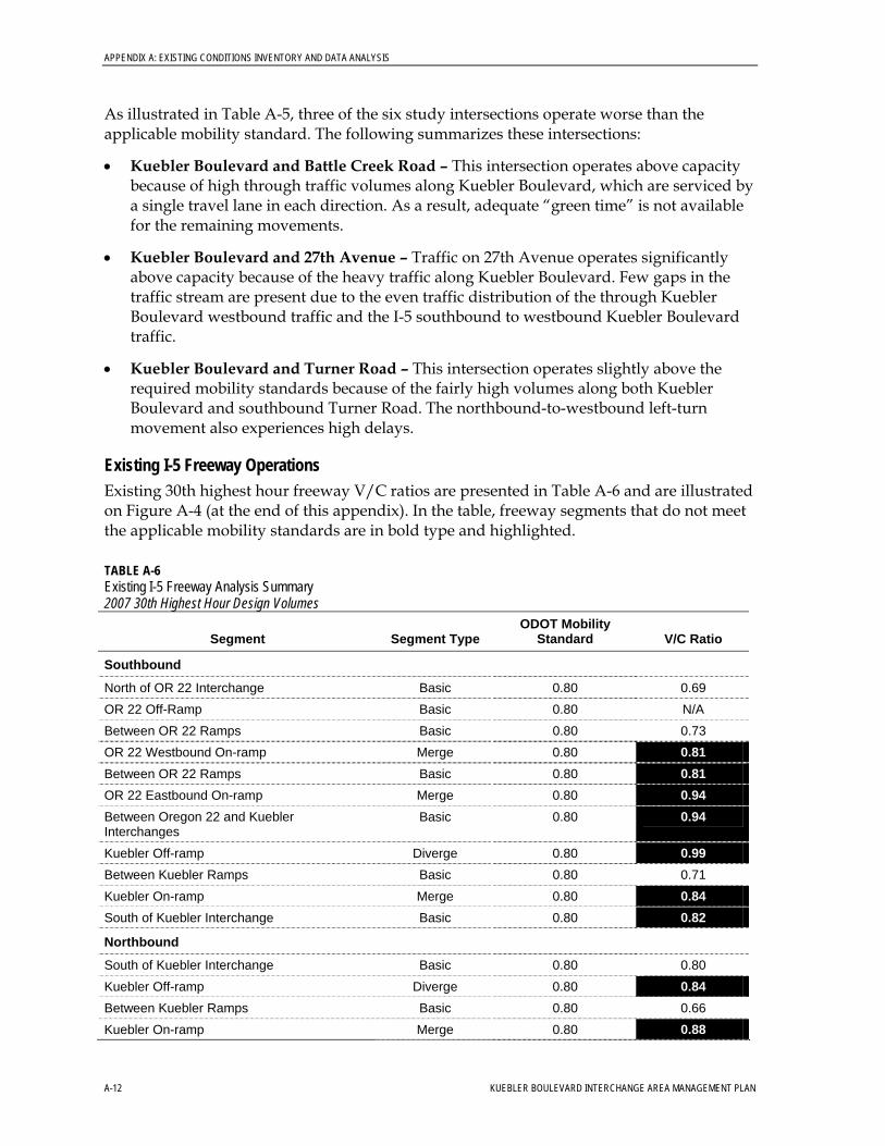
APPENDIX A: EXISTING CONDITIONS INVENTORY AND DATA ANALYSIS
As illustrated in Table A-5, three of the six study intersections operate worse than the applicable mobility standard. The following summarizes these intersections:
• Kuebler Boulevard and Battle Creek Road – This intersection operates above capacity because of high through traffic volumes along Kuebler Boulevard, which are serviced by a single travel lane in each direction. As a result, adequate “green time” is not available for the remaining movements.
• Kuebler Boulevard and 27th Avenue – Traffic on 27th Avenue operates significantly above capacity because of the heavy traffic along Kuebler Boulevard. Few gaps in the traffic stream are present due to the even traffic distribution of the through Kuebler Boulevard westbound traffic and the I-5 southbound to westbound Kuebler Boulevard traffic.
• Kuebler Boulevard and Turner Road – This intersection operates slightly above the required mobility standards because of the fairly high volumes along both Kuebler Boulevard and southbound Turner Road. The northbound-to-westbound left-turn movement also experiences high delays.
Existing I-5 Freeway Operations Existing 30th highest hour freeway V/C ratios are presented in Table A-6 and are illustrated on Figure A-4 (at the end of this appendix). In the table, freeway segments that do not meet the applicable mobility standards are in bold type and highlighted.
TABLE A-6 Existing I-5 Freeway Analysis Summary 2007 30th Highest Hour Design Volumes
Segment Segment Type ODOT Mobility
Standard V/C Ratio
Southbound
North of OR 22 Interchange Basic 0.80 0.69 OR 22 Off-Ramp Basic 0.80 N/A Between OR 22 Ramps Basic 0.80 0.73
0.81 OR 22 Westbound On-ramp Merge 0.80 0.81 Between OR 22 Ramps Basic 0.80 0.94 OR 22 Eastbound On-ramp Merge 0.80 0.94 Between Oregon 22 and Kuebler
Interchanges Basic 0.80
0.99 Kuebler Off-ramp Diverge 0.80
Between Kuebler Ramps Basic 0.80 0.71 0.84 Kuebler On-ramp Merge 0.80 0.82 South of Kuebler Interchange Basic 0.80
Northbound
South of Kuebler Interchange Basic 0.80 0.80 0.84 Kuebler Off-ramp Diverge 0.80
Between Kuebler Ramps Basic 0.80 0.66 Kuebler On-ramp Merge 0.80 0.88
A-12 KUEBLER BOULEVARD INTERCHANGE AREA MANAGEMENT PLAN
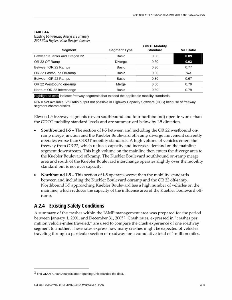
APPENDIX A: EXISTING SYSTEMS INVENTORY AND DATA ANALYSIS
TABLE A-6 Existing I-5 Freeway Analysis Summary 2007 30th Highest Hour Design Volumes
Segment Segment Type ODOT Mobility
Standard V/C Ratio
0.89 Between Kuebler and Oregon 22 Basic 0.80
0.93 OR 22 Off-Ramp Diverge 0.80 Between OR 22 Ramps Basic 0.80 0.77 OR 22 Eastbound On-ramp Basic 0.80 N/A Between OR 22 Ramps Basic 0.80 0.67 OR 22 Westbound on-ramp Merge 0.80 0.79 North of OR 22 Interchange Basic 0.80 0.79
Highlighted cells indicate freeway segments that exceed the applicable mobility standards.
N/A = Not available. V/C ratio output not possible in Highway Capacity Software (HCS) because of freeway segment characteristics.
Eleven I-5 freeway segments (seven southbound and four northbound) operate worse than the ODOT mobility standard levels and are summarized below by I-5 direction.
• Southbound I-5 – The section of I-5 between and including the OR 22 westbound on-ramp merge junction and the Kuebler Boulevard off-ramp diverge movement currently operates worse than ODOT mobility standards. A high volume of vehicles enters the freeway from OR 22, which reduces capacity and increases demand on the mainline segment downstream. This high volume on the mainline then enters the diverge area to the Kuebler Boulevard off-ramp. The Kuebler Boulevard southbound on-ramp merge area and south of the Kuebler Boulevard interchange operates slightly over the mobility standard but is not over capacity.
• Northbound I-5 – This section of I-5 operates worse than the mobility standards between and including the Kuebler Boulevard onramp and the OR 22 off-ramp. Northbound I-5 approaching Kuebler Boulevard has a high number of vehicles on the mainline, which reduces the capacity of the influence area of the Kuebler Boulevard off-ramp.
A.2.4 Existing Safety Conditions A summary of the crashes within the IAMP management area was prepared for the period between January 1, 2001, and December 31, 20053. Crash rates, expressed in “crashes per million vehicle-miles traveled,” are used to compare the crash experience of one roadway segment to another. These rates express how many crashes might be expected of vehicles traveling through a particular section of roadway for a cumulative total of 1 million miles.
3 The ODOT Crash Analysis and Reporting Unit provided the data.
KUEBLER BOULEVARD INTERCHANGE AREA MANAGEMENT PLAN A-13
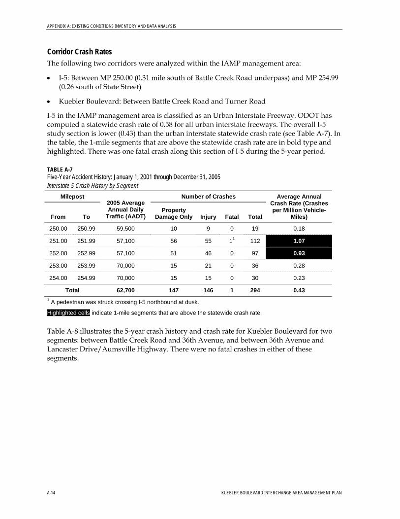
APPENDIX A: EXISTING CONDITIONS INVENTORY AND DATA ANALYSIS
Corridor Crash Rates The following two corridors were analyzed within the IAMP management area:
• I-5: Between MP 250.00 (0.31 mile south of Battle Creek Road underpass) and MP 254.99 (0.26 south of State Street)
• Kuebler Boulevard: Between Battle Creek Road and Turner Road
I-5 in the IAMP management area is classified as an Urban Interstate Freeway. ODOT has computed a statewide crash rate of 0.58 for all urban interstate freeways. The overall I-5 study section is lower (0.43) than the urban interstate statewide crash rate (see Table A-7). In the table, the 1-mile segments that are above the statewide crash rate are in bold type and highlighted. There was one fatal crash along this section of I-5 during the 5-year period.
TABLE A-7 Five-Year Accident History: January 1, 2001 through December 31, 2005 Interstate 5 Crash History by Segment
Milepost Number of Crashes
From To
2005 Average Annual Daily
Traffic (AADT) Property
Damage Only Injury Fatal Total
Average Annual Crash Rate (Crashes per Million Vehicle-
Miles)
250.00 250.99 59,500 10 9 0 19 0.18
251.00 251.99 57,100 56 55 11 112 1.07
252.00 252.99 57,100 51 46 0 97 0.93
253.00 253.99 70,000 15 21 0 36 0.28
254.00 254.99 70,000 15 15 0 30 0.23
Total 62,700 147 146 1 294 0.43 1 A pedestrian was struck crossing I-5 northbound at dusk.
Highlighted cells indicate 1-mile segments that are above the statewide crash rate.
Table A-8 illustrates the 5-year crash history and crash rate for Kuebler Boulevard for two segments: between Battle Creek Road and 36th Avenue, and between 36th Avenue and Lancaster Drive/Aumsville Highway. There were no fatal crashes in either of these segments.
A-14 KUEBLER BOULEVARD INTERCHANGE AREA MANAGEMENT PLAN
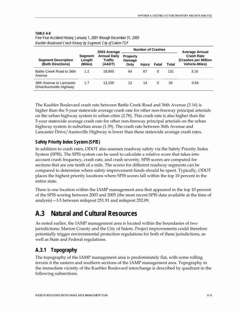
APPENDIX A: EXISTING SYSTEMS INVENTORY AND DATA ANALYSIS
TABLE A-8 Five-Year Accident History: January 1, 2001 through December 31, 2005 Kuebler Boulevard Crash History by Segment: City of Salem TSP
Number of Crashes
Segment Description (Both Directions)
Segment Length (Miles)
2003 Average Annual Daily
Traffic (AADT)
Property Damage
Only Injury Fatal Total
Average Annual Crash Rate
(Crashes per Million Vehicle-Miles)
Battle Creek Road to 36th Avenue
1.2 18,900 64 67 0 131 3.16
36th Avenue to Lancaster Drive/Aumsville Highway
1.7 13,100 12 14 0 26 0.64
The Kuebler Boulevard crash rate between Battle Creek Road and 36th Avenue (3.16) is higher than the 5-year statewide average crash rate for other non-freeway principal arterials on the urban highway system in urban cities (2.78). This crash rate is also higher than the 5-year statewide average crash rate for other non-freeway principal arterials on the urban highway system in suburban areas (1.39). The crash rate between 36th Avenue and Lancaster Drive/Aumsville Highway is lower than these statewide average crash rates.
Safety Priority Index System (SPIS) In addition to crash rates, ODOT also assesses roadway safety via the Safety Priority Index System (SPIS). The SPIS system can be used to calculate a relative score that takes into account crash frequency, crash rate, and crash severity. SPIS scores are computed for sections that are one tenth of a mile. The scores for different roadway segments can be compared to determine where safety improvement funds should be spent. Typically, ODOT places the highest priority locations where SPIS scores fall within the top 10 percent in the entire state.
There is one location within the IAMP management area that appeared in the top 10 percent of the SPIS scoring between 2003 and 2005 (the most recent SPIS data available at the time of analysis)—I-5 between milepost 251.91 and milepost 252.09.
A.3 Natural and Cultural Resources As noted earlier, the IAMP management area is located within the boundaries of two jurisdictions: Marion County and the City of Salem. Project improvements could therefore potentially trigger environmental protection regulations for both of these jurisdictions, as well as State and Federal regulations.
A.3.1 Topography The topography of the IAMP management area is predominately flat, with some rolling terrain it the eastern and southern sections of the IAMP management area. Topography in the immediate vicinity of the Kuebler Boulevard interchange is described by quadrant in the following subsections.
KUEBLER BOULEVARD INTERCHANGE AREA MANAGEMENT PLAN A-15
APPENDIX A: EXISTING CONDITIONS INVENTORY AND DATA ANALYSIS
NE Quadrant of Interchange At the northeast corner of the Kuebler Boulevard interchange, Kuebler Boulevard is approximately 50 feet higher than the I-5. The land directly east of the freeway is level with I-5 to Trelstad Avenue, which runs parallel to Kuebler Boulevard east of the interchange, changes to 32nd Avenue SE which runs parallel with I-5 immediately east of the interchange. Northeast of Trelstad Avenue, the land slopes gradually upward approximately 1,320 feet (0.25 mile), with a sharp drop-off to the south to Trelstad Avenue. A dry channel exists between Trelstad Avenue and Kuebler Boulevard west of the intersection with 36th Avenue.
SE Quadrant of Interchange The southeast quadrant is relatively flat, and contains the one leg of the cloverleaf interchange. This leg accommodates Kuebler Boulevard west and east to northbound I-5 traffic movements. A cluster of homes are located immediately east of the I-5 off-ramp.
SW Quadrant of Interchange At Kuebler Boulevard, the ground slopes downward at a steep grade approximately 40 feet between the southbound on-ramp and the freeway mainline. West of the freeway on-ramp, the land slopes downwards approximately 30 feet and then slopes gradually upwards to a peak approximately 1,320 feet (0.25 mile) to the southwest of the connection between the I-5 on-ramp and Kuebler Boulevard.
NW Quadrant Interchange Kuebler Boulevard is approximately 50 feet higher than the freeway mainline at the northwest quadrant of the interchange. Between the mainline and the freeway off-ramp, the area slopes downwards slightly approximately 70 feet and then slopes dramatically upwards to the off-ramp. West of the off-ramp, there exists a deep ravine approximately 150 feet in depth. The ravine is characterized by trees and grasses.
Project-Relevant Issues • Substantial slope variation in the northeast and northwest quadrants will require more
earthwork during construction, and may require additional stabilization. Recent earthwork in the Kuebler Boulevard interchange area has encountered copper.
A.3.2 Hydrology The IAMP management area lies within the Willamette River watershed basin and almost entirely within the Pringle Creek sub-basin, although the eastern portion is within the Mill Creek sub-basin.
Both Mill Creek and Pringle Creek flow into the Willamette River in northwest Salem. Within the IAMP management area, I-5 is parallel to Mill Creek from the north end of the IAMP management area until north of 34th Avenue. Mill Creek traverses under I-5 at this location, staying to the NE of 37th Avenue until south of Kuebler Boulevard. Mill Creek turns westward south of Kuebler Boulevard and is crossed by Turner Road south of Boone Road. Mill Creek flows to the south of Turner Road at the southern edge of the IAMP management area.
A-16 KUEBLER BOULEVARD INTERCHANGE AREA MANAGEMENT PLAN
APPENDIX A: EXISTING SYSTEMS INVENTORY AND DATA ANALYSIS
The main bodies of both Pringle Creek and Mill Creek are included on the Department of Environmental Quality’s (DEQ’s) federal Clean Water Act Section 303(d) list of water quality-limited streams. The DEQ 2003 303(d) list identifies sections of Mill Creek in the IAMP management area as water quality limited for fecal coliform, and Pringle Creek for various parameters, including E Coli, dieldrin, temperature (summer only), copper, lead, and zinc.
Project-Relevant Issues • Highway runoff can be a source of fecal coliform. Improvements related to the Kuebler
Boulevard interchange improvements will need to avoid or mitigate stormwater impacts to Mill Creek to meet the requirements of DEQ’s National Pollutant Discharge Elimination System (NPDES) 1200-CA. No improvements will be in the footprint of Pringle Creek.
A.3.3 Riparian Corridors The Mill Creek riparian corridor located inside the IAMP management area includes the perennially flowing Mill Creek. The section of Mill Creek running through the IAMP management area is included on the DEQ’s 303(d) list of water quality-limited streams. The DEQ 2003 303(d) list identifies the section of Mill Creek in the IAMP management area as water quality limited for fecal coliform.
Project-Relevant Issues • Kuebler Boulevard IAMP actions are subject to State Department of Land Conservation
and Development (DLCD) Goal 5 ordinance regulations concerning land use actions inside the Mill Creek riparian corridor. The proposed Kuebler Boulevard IAMP improvements are allowed in riparian corridors (according to OAR 660-023-0090[8][a]), provided that these actions “are designed and constructed to minimize intrusion into the riparian area.”
• Highway runoff can be a source of fecal coliform. Improvements related to the Kuebler Boulevard project will need to avoid or mitigate stormwater impacts to Mill Creek to meet the requirements of DEQ NPDES 1200-CA.
A.3.4 Floodplains Much of the IAMP management area is within the 100-year floodplain. The eastern section of the IAMP management area (east of 36th Avenue) is located within the Federal Emergency Management Agency (FEMA) 100-year floodplain. The area adjacent to 37th Avenue is located in the regulated floodway. Much of the IAMP management area northeast of the interchange, east of Airway Drive, is within the 100-year floodplain for Mill Creek.
Project-Relevant Issues • The Kuebler Boulevard IAMP project will attempt to avoid impacts to the floodplain. If
the Kuebler Boulevard IAMP project improvements enter the footprint of the 100-year floodplain, and if a NEPA process is followed, environmental documentation would be required to explain specific impacts of the project and the resources within the
KUEBLER BOULEVARD INTERCHANGE AREA MANAGEMENT PLAN A-17
APPENDIX A: EXISTING CONDITIONS INVENTORY AND DATA ANALYSIS
floodplain. State and local floodplain development permits are also likely to be needed. Development is prohibited within the regulated floodway. Road features are allowed but must cause no net rise in flood elevation.
A.3.5 Floodway The floodway is located in the extreme eastern portion of the IAMP management area immediately west of 37th Avenue in the IAMP management area. The area east of 37th Avenue is also within the floodway but is located outside the IAMP management area.
Project-Relevant Issues • Any project-related development improvements (including fill, new construction, and
substantial improvements) in the floodway are prohibited unless a certified technical evaluation is submitted to FEMA demonstrating that such improvements will not result in an increase in flood levels during the occurrence of the base flood discharge. Upon FEMA approval, such improvements are then subject to applicable flood-hazard-reduction provisions in Chapter 140 of the City of Salem’s Revised Code.
A.3.6 Wetlands The National Wetlands Inventory (NWI) system identifies two wetland areas in the IAMP management area. The first identified wetland area is an emergent freshwater wetland approximately 4.1 acres in size located east of 32nd Avenue and immediately south of Boone Road. The second wetland is also an emergent freshwater wetland, 0.3 acre in size, located north of Marietta Street and west of I-5.
Project-Relevant Issues • The Kuebler Boulevard IAMP project will attempt to avoid actions that impact identified
wetlands. If impacts are unavoidable, ODOT will need to identify mitigation opportunities. Mitigation will need to be performed following the land-development-application requirements of the jurisdiction within which the wetland alteration is occurring. A wetland delineation and functional assessment needs to be performed to determine the type and full extent of the potential wetland impacts.
A.3.7 Wildlife Habitat The Kuebler Boulevard IAMP does not impact a documented wildlife habitat area, as defined by OAR 660-023-0110.
A.3.8 Federal Wild and Scenic Rivers Mill Creek is the only river flowing through the IAMP management area. Mill Creek is not a designated Federal Wild and Scenic river.
A.3.9 Oregon Scenic Waterways Mill Creek, the only waterway flowing through the IAMP management area, is not listed on the Oregon Department of State Lands list of designated scenic waterways.
A-18 KUEBLER BOULEVARD INTERCHANGE AREA MANAGEMENT PLAN
APPENDIX A: EXISTING SYSTEMS INVENTORY AND DATA ANALYSIS
A.3.10 Groundwater Resources Most of the IAMP management area (approximately 36th Avenue and west) lies within an area designated as a “groundwater restricted” zone (South Salem Hills Groundwater Restricted) by the Oregon Water Resources Department (OWRD). OAR 660-023-0030(5) states that local governments with jurisdiction in OWRD groundwater restricted areas must declare those areas as Significant Natural Resource Areas. Per OAR requirements, these local governments must subsequently develop programs to protect the designated significant groundwater resources.
Project-Relevant Issues • Kuebler Boulevard IAMP project actions must comply with existing Marion County and
City of Salem local ordinances regulating development in a groundwater-restricted area.
A.3.11 Approved Oregon Recreation Trails The Kuebler Boulevard IAMP does not impact an Oregon State Park Department-designated recreational trail.
A.3.12 Natural Areas The Kuebler Boulevard IAMP does not impact an area listed on the U.S. Bureau of Land Management’s Established Natural Areas of Oregon.
A.3.13 Wilderness Areas The Kuebler Boulevard IAMP is not located in a designated federal or local wilderness area.
A.3.14 Mineral and Aggregate Resources There are no existing quarries or gravel sites in the IAMP management area.
A.3.15 Energy Sources There are no existing energy sources, as defined by OAR 660-023-0190(1)(a), in the IAMP management area.
A.3.16 Open Space There are no designated existing open spaces, as defined by OAR 660-023-0220(1), in the IAMP management area.
A.3.17 Scenic Views and Sites There are no publicly designated scenic views or sites in the IAMP management area.
A.3.18 Natural Hazards According to the City of Salem Landslides Hazards map, the IAMP management area is classified as a “Zone D” (low hazard risk) area. There are some areas within the IAMP management area registering a low landslide-hazard-assessment rating. Landslide hazards are present in the northwest and southwest quadrants of the IAMP management area.
KUEBLER BOULEVARD INTERCHANGE AREA MANAGEMENT PLAN A-19
APPENDIX A: EXISTING CONDITIONS INVENTORY AND DATA ANALYSIS
A-20 KUEBLER BOULEVARD INTERCHANGE AREA MANAGEMENT PLAN
Project-Relevant Issues • Project improvements are likely to include earthwork. Cuts and fills located in areas of
landslide or earthquake hazards can be unstable. Further analysis of natural hazards would need to be conducted during project design, as would the development of applicable avoidance and mitigation techniques.
A.3.19 Hazardous Substances According to DEQ’s Environmental Cleanup Site Information (ECSI) database, two sites within the IAMP management area have existing or past known or potential contamination from hazardous substances. The sites are Coleman Metals at 4705 Turner Rd SE and Hydro Tech at 4030 Turner Road. Both of these sites are recommended for a State Expanded Preliminary Assessment (XPA).
Project-Relevant Issues • Although it is unlikely that improvements related to this project would directly affect
sites containing potentially hazardous materials, such an impact could occur. Improvements affecting hazardous material sites could require excavation, removal, or cleanup, all of which could have schedule and budgetary impacts.
A.3.20 Air Quality The project area is located within the SKATS boundary. The SKATS area is a designated non-attainment area for carbon monoxide, meaning that the area has not consistently met the clean air levels set by the U.S. Environmental Protection Agency in the National Ambient Air Quality Standards (NAAQS). Monitoring for over 10 years has shown that carbon monoxide (CO) levels have steadily declined and continue to be far below the national standards. The Oregon DEQ has developed a Carbon Monoxide Limited Maintenance plan for the SKATS region that is currently being reviewed by the U.S. Environmental Protection Agency. Until the SKATS region is designated as “attainment” for CO, the region will need to demonstrate that the RTSP and TIP conform to the State’s air quality implementation plan.
Project-Relevant Issues • SKATS adopted the RTSP in May 2007. The plan identifies projects that result in an
improvement to the area’s air quality. Several transportation improvements in the vicinity of the Kuebler Boulevard interchange are included in the updated RTSP. This indicates that area agencies acknowledge improvements in the project IAMP management area as improving air quality.
A.3.21 Historic and Cultural Resources There are no properties listed on the National Register of Historic Places (NRHP), the Oregon State Historic Preservation Office (OSHPO), or the Salem Historic Landmarks Division as “Local Historic Landmarks” in the IAMP management area. The IAMP management area is not part of a National Historic District.

Figure A-1Comprehensive Plan
Designations
LEGENDCity Limits
Urban Growth Boundary
Comprehensive PlanCommunity/PublicCentral Business DistrictEmployment CenterCommercialMixed UseResidentialIndustrialPark and Open SpaceResource
´0 1
Miles
Kuebler Boulevard IAMP
Marion County, OR
TB032008005PDX 320110.18.08 1/13/09 kw/lh
§̈¦5
Kuebler Blvd
Kueb
ler B
lvd
Com
mercial St
Battle Creek Rd
12th St
Turner Rd
Aumsville Hwy
Cordon Rd
State St
Lancaster Dr
Turner Rd
22
22
I-5/Kuebler Boulevard I-5/Kuebler Boulevard InterchangeInterchange
I-5/Kuebler Boulevard Interchange

Figure A-2
Existing Conditions (2007)Study Intersection
Lane Configuration and Signal Control
Kuebler Boulevard IAMP
Marion County, OR
Legend
Major Roads and
Highways
Freeway
Railroad
Urban Growth Boundary
City Limits
Study Intersection
Turning Movement
Direction
Stop Sign
Traffic Signal
Kuebler Boulevard
and 36th Avenue
Kuebler Boulevard
and Turner Road
Kuebler Boulevard
and I-5 Northbound Ramps
Kuebler Boulevard
and I-5 Southbound Ramps
Kuebler Boulevard
and Battle Creek Road
Kuebler Boulevard
and 27th Avenue
1 inch equals 2,000 feet
N
0 1,000 2,000 4,000
Feet
Photo source: USGS 2001
Movement is FreeFREE

Figure A-3
Existing Conditions (2007)30th Highest Hour
Turning Movement Volumes
Kuebler Boulevard IAMP
Marion County, OR
0.940.820.590.69>1.5
1.09
Kuebler Boulevard
and 36th Avenue
Kuebler Boulevard
and Turner Road
Kuebler Boulevard
and I-5 Northbound Ramps
Kuebler Boulevard
and I-5 Southbound Ramps
Kuebler Boulevard
and Battle Creek Road
Kuebler Boulevard
and 27th Avenue
1 inch equals 2,000 feet
N
0 1,000 2,000 4,000
Feet
Legend
Major Roads and
Highways
Freeway
Railroad
Urban Growth Boundary
City Limits
Turning Movement
Direction and Volume290
800 30 120760
190
1290
50
75 85 75
140 260 12090
1050
70
45
1055
45
0 0 110
20 10 10 45
1190
325
30
1220
0105 140
0
845
210
715
695
70 20 50
185 50 9040
800
60
45
745
65
145 100 90
215 225 135 40
540
60
85
645
155
Study Intersection
Volume to Capacity Ratio
> 10% below mobility
standard threshold
Wthin 10% of threshold
At or beyond mobility
standard threshold
0.61
0.79
0.95
NOTE: V/C mobility standard
thresholds vary by intersection
0.85 - Kuebler Blvd & I-5 Ramps
0.90 - All other intersectionsPhoto Source: USGS 2001

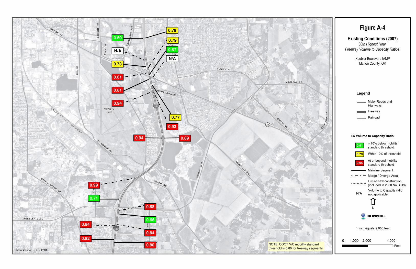
Figure A-4
Existing Conditions (2007)30th Highest Hour
Freeway Volume to Capacity Ratios
Marion County, OR
1 inch equals 2,000 feet
N
0 1,000 2,000 4,000
Feet
Legend
Major Roads and
Highways
Freeway
Railroad
I-5 Volume to Capacity Ratio0.94
Mainline Segment
Merge / Diverge Area
NOTE: ODOT V/C mobility standard
threshold is 0.80 for freeway segments
Future new construction
(included in 2030 No Build)0.99
0.71
0.84
0.82
0.88
0.66
0.84
0.80
0.81
0.81
0.94
0.69
N/A
0.73
0.77
0.93
0.89
N/A
0.67
0.79
0.79
Volume to Capacity ratio
not applicableN/A
> 10% below mobility
standard threshold
At or beyond mobility
standard threshold
Wthin 10% of threshold
0.61
0.79
0.95
Photo source: USGS 2001
Figure A-4
Existing Conditions (2007)30th Highest Hour
Freeway Volume to Capacity Ratios
Kuebler Boulevard IAMP
Marion County, OR


KUEBLER BOULEVARD INTERCHANGE AREA MANAGEMENT PLAN
APPENDIX B
Plan and Policy Review

APPENDIX B
Plan and Policy Review
The following describes relevant federal, state, regional, and local plans and policies as they relate to the Kuebler Boulevard Interchange Area Management Plan (IAMP). Although each document contains many plans or policies, only those most directly relevant to this project are discussed. Through this process, any provisions of state, regional, or local policies that may influence the project are identified.
The Kuebler Boulevard IAMP Area, as defined in the I-5/Kuebler Boulevard Interchange Management Plan Final Report (DKS Associates, May 1999), is the location to which specific access management and land use controls associated with the IAMP apply (Figure B-1, at the end of this appendix). This area lies within the City of Salem’s Urban Growth Boundary (UGB), and those sections north of Kuebler Boulevard are within Salem’s city limits. Much of the Study Area is located within the Mill Creek floodplain. Most of the area south of Kuebler Boulevard and west of 36th Avenue is within the Salem UGB but outside Salem’s City Limits. The City and County have a growth management agreement governing land in the UGB, outside of Salem’s city limits, and the County retains legal authority over land use actions in this area.
Documents Reviewed The following federal, state, regional, and local documents were reviewed. This memorandum summarizes the objectives of each document, and provides a brief identification of relevance to the project.
• Safe, Accountable, Flexible, Efficient Transportation Equity Act – A Legacy for Users (SAFETEA-LU)
• 23 CFR 450
• 49 CFR 613
• Oregon Transportation Plan
• Oregon Highway Plan
• Statewide Planning Goals
• Transportation Planning Rule
• Oregon Administrative Rule 734-051 (Access Management)
• 2003 Oregon Highway Design Manual
• Final Report Phase II Western Transportation Trade Network
• Willamette Valley Transportation Strategy – Phase One Report
KUEBLER BOULEVARD INTERCHANGE AREA MANAGEMENT PLAN B-1
APPENDIX B: PLAN AND POLICY REVIEW
• Salem-Keizer Area Transportation Study Regional Transportation Systems Plan
• Marion County Rural Transportation System Plan
• City of Salem Transportation System Plan
• Salem Area Comprehensive Plan
• City of Salem Revised Codes
• Marion County Comprehensive Plan
• Marion County Urban Zoning Ordinance
• Morningside Neighborhood Plan
Federal Plans and Policies Potentially applicable federal transportation planning policies are the Safe, Accountable, Flexible, Efficient Transportation Equity Act – A Legacy for Users (SAFETEA-LU), 23 Code of Federal Regulations (CFR) 450, and 49 CFR 613. The predecessor to SAFETEA-LU, the Transportation Equity Act for the 21st Century (TEA-21), changed transportation planning activities for states and metropolitan planning organizations (MPOs) originally instituted by the Intermodal Surface Transportation Efficiency Act of 1991 (ISTEA). The regulations for these state and MPO planning activities are specified in 23 CFR 450 and 49 CFR 613. The project study area is included within the Salem-Keizer Area Transportation Study (SKATS), the designated MPO for the Salem-Keizer region. SKATS demonstrates compliance with federal transportation planning regulations through the Regional Transportation Systems Plan (RTSP). The SKATS RTSP is discussed in a subsequent section of this memorandum. Because the federal policies are implemented through local plans, the federal plans themselves are not reviewed in this memorandum.
State Plans and Policies Oregon Transportation Plan The 2006 Oregon Transportation Plan (OTP) is the state’s long-range multi-modal transportation plan. The OTP is the overarching policy document among a series of plans that together form the state transportation system plan (TSP). The OTP considers all modes of Oregon’s transportation system as a single system and addresses the future needs of Oregon’s airports, bicycle and pedestrian facilities, highways and roadways, pipelines, ports and waterway facilities, public transportation, and railroads through 2030. The OTP establishes goals, policies, strategies, and initiatives that address the core challenges and opportunities facing Oregon. The plan provides the framework for prioritizing transportation improvements base don varied future revenue conditions, but does not identify specific projects for development. Those goals and policies most directly applicable to the Kuebler Boulevard IAMP are as follows:
B-2 KUEBLER BOULEVARD INTERCHANGE AREA MANAGEMENT PLAN
APPENDIX B: PLAN AND POLICY REVIEW
Goal 1: Mobility and Accessibility Policy 1.1 – Development of an Integrated Multimodal System • Strategy 1.1.1 –plan and develop a multimodal transportation system that increases the
efficient movement of people and goods for commerce and production of goods and services.
• Strategy 1.1.4 – in developing transportation plans, use the most cost-effective modes and solutions over the long term.
Goal 2: Management of the System Policy 2.1 – Capacity and Operational Efficiency • Strategy 2.1.1 – promote transportation demand management and system operations
techniques that reduce peak period travel, help shift traffic volumes away from the peak period and improve traffic flow.
• Strategy 2.1.2 – protect the integrity of statewide transportation corridors and facilities from encroachment by managing state highways, limiting interchanges, creating safe rail crossings and controlling incompatible land use around airports, ports, pipelines and other intermodal passenger and freight facilities.
Goal 3: Economic Vitality Policy 3.1 – An Integrated and Efficient Freight System • Strategy 3.1.5 – improve system efficiency and reduce conflicts by developing grade
separations at rail and highway or roadway crossings.
• Strategy 3.1.7 – give priority to freight mobility projects that are located on identified freight routes of statewide or regional significance
Goal 4: Sustainability Policy 4.3 – Creating Communities • Strategy 4.3.1 – support sustainable development of land with a mix of uses and ranges
of densities, land use intensities, and transportation options in order to increase efficiency
Oregon Highway Plan The 1999 Oregon Highway Plan (as amended) is a modal element of the 2006 OTP and defines policies and investment strategies for Oregon’s state highway system over the next 20 years. The plan contains three elements—a vision element that describes the broad goal for how the highway system should look in 20 years; a policy element that contains goals, policies, and actions to be followed by state, regional, and local jurisdictions; and a system element that includes an analysis of needs, revenues, and performance measures.
The policy element contains several policies and actions, described below, that are relevant to the Kuebler Boulevard IAMP.
Policy 1A: State Highway Classification System Policy 1A develops a state highway classification system to guide ODOT priorities for system investment and management.
KUEBLER BOULEVARD INTERCHANGE AREA MANAGEMENT PLAN B-3
APPENDIX B: PLAN AND POLICY REVIEW
Action 1A.1 defines five categories of state highway facilities – interstate highways, statewide highways, regional highways, district highways, and local interest roads. Two of these (interstate and statewide highways) are part of the national highway system.
Interstate highways provide connections to major cities and regions within the state and facilitate movement to and from other states. The management objective for interstate highways is to provide safe and efficient high-speed travel in urban and rural areas.
Statewide highways provide inter-urban and inter-regional mobility and connections to larger urban areas, ports, and major recreation areas not directly served by Interstate Highways. Statewide highways also provide connections for intra-urban and intra-regional trips. The management objective for statewide highways is to provide safe and efficient, high-speed, continuous-flow operation along the corridor, with minimal interruptions to flow in constrained or urban areas.
Action 1A.2 defines and classifies expressways as a subset of statewide, regional, and district highways. The function of expressways is to provide safe and efficient high speed and high volume traffic movements with minimal interruptions, for interurban travel and connections to ports and major recreation areas. Along expressways, private access is discouraged, connections to public roads are highly controlled, traffic signals (rural areas only) are discouraged, and nontraversable medians are encouraged.
Project Relevance: Appendix D of the OHP classifies I-5 as an interstate highway. Kuebler Boulevard is owned and maintained by the City of Salem, and is not a state facility.
Policy 1B: Land Use and Transportation Policy 1B directs the state to work with regional agencies and local jurisdictions to consider land use when planning transportation systems and projects. Action 1B.7 gives special designations for certain land use patterns off the freeway to foster compact development patterns in communities. The three designations provided are special transportation area, commercial center, and urban business area.
Project Relevance: The project study area is not considered a special transportation area, commercial center, or urban business area. The project team includes representatives from the City and County as well as ODOT.
Policy 1C: State Highway Freight System Policy 1C states that the timeliness of freight movements should be considered when developing and implementing plans and projects on freight routes.
Project Relevance: The entire length of I-5 within Oregon is a designated freight route.
Policy 1F: Highway Mobility Standards Action 1F.1 requires that highways operate at a certain level of mobility, depending on their location and classification. Part of this action requires that freeway interchanges be managed to maintain safe and efficient operation of the freeway through the interchange area.
B-4 KUEBLER BOULEVARD INTERCHANGE AREA MANAGEMENT PLAN
APPENDIX B: PLAN AND POLICY REVIEW
Project Relevance: According to Table 6 of the OHP, the relevant maximum V/C ratio for I-5 within the study area is 0.80. Within the study area, Kuebler Boulevard is considered a district/local interest road inside an MPO, with a maximum acceptable V/C ratio of 0.90.
Policy 1G: Major Improvements Action 1G.1 directs agencies to make the fewest number of structural changes to a roadway system to address its identified needs and deficiencies, and to protect the existing highway system before adding new facilities to it. The action ranks four priorities of projects, as follows:
1. Preserving the functionality of the existing system
2. Making minor improvements to improve the efficiency and capacity of the existing system
3. Adding capacity to the existing system
4. Building new transportation systems
Project Relevance: The Kuebler Boulevard IAMP will analyze current and forecasted future conditions in the study area with the intent of identifying improvements needed to preserve the function of the Kuebler Boulevard interchange. The underlying objective in identifying improvements is to construct only those improvements that will be most effective and have the least amount of impact, striving to contain recommended improvements within the upper priorities listed above, while attempting to avoid the need for improvements ranked within the lower priorities listed above.
Policy 2F: Traffic Safety Policy 2F identifies the need for projects in the state to improve safety for all users of the state highway system.
Project Relevance: The Kuebler Boulevard IAMP will analyze current and forecasted future conditions in the study area to identify safety concerns. The IAMP will address safety at the Kuebler Boulevard interchange. North of Kuebler Boulevard within the study area, I-5 is designated as a Truck Safety Corridor. Truck Safety Corridors are segments with both a higher than typical amount of trucks and a higher than typical amount of crashes involving trucks.
Policy 3A: Classification and Spacing Standards Policy 3A addresses the location, spacing, and type of road and street intersections and approach roads on state highways. It includes spacing standards for each highway classification. Appendix C of the OHP provides tables of access management spacing standards.
Project Relevance: Interchange spacing standards for interstates in urban areas is 3 miles (Table 12). The spacing between the Kuebler Boulevard interchange and the OR 22 interchange is only 1 mile. However, the interchanges directly to the north and south of these two interchanges (Market and Commercial, respectively) are each 3 miles apart.
KUEBLER BOULEVARD INTERCHANGE AREA MANAGEMENT PLAN B-5
APPENDIX B: PLAN AND POLICY REVIEW
The distance between the I-5 off ramps at Kuebler Boulevard and the first at-grade cross streets (27th Avenue to the west, 36th Avenue to the east) are approximately 1,400 feet and 2,010 feet respectively. These distances also meet the minimum spacing standard of 1,320 feet.
Policy 3C: Interchange Access Management Areas Policy 3C calls for the planning and management of grade-separated interchange areas to ensure safe and efficient operation between connecting roadways. Action 3C.1 requires agencies to develop Interchange Area Management Plans to protect the function of interchanges over the long-term. The intention of an Interchange Area Management Plan is to minimize the need for major interchange improvements.
Project Relevance: The primary purpose of this project is to develop an IAMP for the I-5/ Kuebler Boulevard interchange, to protect the functionality of this interchange through the 20-year planning horizon. This IAMP will be developed in compliance with Policy 3C.
Oregon’s Statewide Planning Goals The State of Oregon has established 19 statewide planning goals to guide local and regional land use planning. The goals express the state’s policies on land use and related topics. The Oregon Department of Land Conservation and Development has acknowledged that the Marion County Comprehensive Land Use Plan and the Salem Area Comprehensive Plan are in compliance with the statewide planning goals. The Marion County Comprehensive Land Use Plan and the Salem Area Comprehensive Plan are reviewed as part of this memorandum.
Transportation Planning Rule The Transportation Planning Rule (TPR) implements Oregon Statewide Planning Goal 12, which encourages construction of transportation facilities that are safe and efficient and designed to reduce automobile reliance. The objective of the TPR is to reduce air pollution, congestion, and other livability problems found in urban areas.
The TPR requires the preparation of regional transportation system plans (TSPs) by MPOs or counties and local TSPs by counties and cities. Through TSPs, the TPR provides a means for regional and local jurisdictions to identify long-range (20-year) strategies for the development of local transportation facilities and services for all modes, to integrate transportation and land use, to provide a basis for land use and transportation decision-making, and to identify projects for the State Transportation Improvement Program. TSPs need to be consistent with the State Transportation Plan and its modal and multimodal elements.
Project Relevance: The Marion County Rural Transportation Systems Plan, the Salem Transportation System Plan, and the SKATS RTSP were developed to address the requirements of the TPR. These three plans are reviewed as part of this memorandum.
ODOT Access Management Rules OAR 734-051 The intention of ODOT’s Access Management Rules is to balance the safety and mobility needs of travelers along state highways with the access needs of property and business owners. ODOT’s rules manage access to the state’s highway facilities to the degree
B-6 KUEBLER BOULEVARD INTERCHANGE AREA MANAGEMENT PLAN
APPENDIX B: PLAN AND POLICY REVIEW
necessary to maintain functional use, highway safety, and the preservation of public investment consistent with the 1999 OHP and local comprehensive plans.
OAR 734-051-0125, Access Management Spacing Standards for Approaches in an Interchange Area (1) Access management spacing standards for approaches in an interchange area:
(c) Do not apply to approaches in existence prior to April 1, 2000 except where any of the following occur:
(C) For a highway or interchange construction or modernization project or other roadway or interchange project determined by the Region Manager, the project will improve spacing and safety factors by moving in the direction of the access management spacing standards, with the goal of meeting or improving compliance with the access management spacing standards.
Project Relevance: Modernization improvements to the I-5/Kuebler Boulevard interchange will trigger Division 51 access management standards, and improvement recommendations will need to meet or improve compliance with access management spacing standards. Specific access management spacing standards are found in the Division 51 Tables, included in the OHP and available on ODOT’s website.
OAR 734-051-0155, Access Management Plans, Access Management Plans for Interchanges, and Interchange Area Management Plans (1) The Department encourages the development of Access Management Plans, Access Management
Plans for Interchanges, and Interchange Area Management Plans to maintain highway performance and improve safety by improving system efficiency and management before adding capacity consistent with the 1999 Oregon Highway Plan.
(5) The Department encourages the development of Interchange Area Management Plans to plan for and manage grade-separated interchange areas to ensure safe and efficient operation between connecting roadways:
(a) Interchange Area Management Plans are developed by the Department and local governmental agencies to protect the function of interchanges by maximizing the capacity of the interchanges for safe movement from the mainline facility, to provide safe and efficient operations between connecting roadways, and to minimize the need for major improvements of existing interchanges;
(c) Priority should be placed on those facilities on the Interstate system with cross roads carrying high volumes or providing important statewide or regional connectivity.
(6) Interchange Area Management Plans are required for new interchanges and should be developed for significant modifications to existing interchanges consistent with the following:
(a) Should be developed no later than the time an interchange is designed or is being redesigned;
(b) Should identify opportunities to improve operations and safety in conjunction with roadway projects and property development or redevelopment and adopt strategies and development standards to capture those opportunities;
KUEBLER BOULEVARD INTERCHANGE AREA MANAGEMENT PLAN B-7
APPENDIX B: PLAN AND POLICY REVIEW
(c) Should include short, medium, and long-range actions to improve operations and safety in the interchange area;
(d) Should consider current and future traffic volumes and flows, roadway geometry, traffic control devices, current and planned land uses and zoning, and the location of all current and planned approaches;
(e) Should provide adequate assurance of the safe operation of the facility through the design traffic forecast period, typically 20 years;
(f) Should consider existing and proposed uses of the all property in the interchange area consistent with its comprehensive plan designations and zoning;
(g) Are consistent with any adopted Transportation System Plan, Corridor Plan, Local Comprehensive Plan, or Special Transportation Area or Urban Business Area designation, or amendments to the Transportation System Plan unless the jurisdiction is exempt from transportation system planning requirements under OAR 660-012-0055;
(h) Are consistent with the 1999 Oregon Highway Plan; and
(i) Are approved by the Department through an intergovernmental agreement and adopted by the local government, and adopted into a Transportation System Plan unless the jurisdiction is exempt from transportation system planning requirements under OAR 660-012-0055.
Project Relevance: The Kuebler Boulevard IAMP will be developed to address the requirements listed in OAR 734-051-0155. These will be developed concurrently with a recommendation for interchange improvements. The Kuebler Boulevard IAMP will:
• Identify potential opportunities to improve operations and safety in conjunction with roadway projects and property development or redevelopment
• Contain short, medium, and long-range actions to improve operations and safety
• Rely on current and forecasted future traffic volumes and flows, roadway geometry, traffic control devices, roadway functional classification, current and planned land uses and zoning, and the location of all current and planned approaches
• Address the safe operation of the facility through the 20-year design traffic forecast period
• Consider existing and proposed uses of the all property in the interchange area consistent with its comprehensive plan designations and zoning.
734-051-0295, Grants of Access (2) The Department shall not approve an Application for a Grant of Access for a private approach:
(d) In an Interchange Management Area.
Project Relevance: Future applications for access for a private approach within the Kuebler Boulevard interchange management area will be disallowed according to OAR 734-051-0295.
B-8 KUEBLER BOULEVARD INTERCHANGE AREA MANAGEMENT PLAN
APPENDIX B: PLAN AND POLICY REVIEW
2003 Oregon Highway Design Manual General The ODOT Highway Design Manual (HDM) outlines the design standards, policies, and processes to be applied on state highways. The HDM is closely aligned with the American Association of State Highway and Transportation Officials’ (AASHTO’s) A Policy on Geometric Design of Highways and Streets—2001. The HDM also identifies modifications to AASHTO for certain specific design elements. Overall, the applicable design criteria are presented in one of four references for the design of state highways:
• 2003 ODOT Highway Design Manual • A Policy on Geometric Design of Highways and Streets—2001 (AASHTO, 2001) • A Policy on Design Standards- Interstate System (AASHTO, 1991) • Transportation Research Board (TRB) Special Report #214—Designing Safer Roads
Policies and standards to be applied are based on the jurisdiction (state and local), the functional classification, and the project type.
Project Relevance: The functional classification for I-5 is an Interstate and the functional classification of Kuebler Boulevard is a Major Arterial (the City of Salem designates Kuebler Boulevard as a Parkway in the Salem TSP). The project type(s) will be determined as part of the IAMP. Typically, interstate mainline and interchange modifications will be controlled by the policies and standards of Chapters 6 and 9 of the HDM.
Interstates and Interchanges Chapter 6 of the HDM identifies the design criteria for each of the elements of freeway design.
Project Relevance: Particular design elements of interest for the Kuebler Boulevard IAMP include interchange spacing, design speed, alignment and profile, shoulders, medians, lane widths, cross slope, curbs, grades, vertical clearances, clear zones, superelevation, ramp terminals, traffic operations, and access control.
Final Report Phase II Western Transportation Trade Network The Western Transportation Trade Network is a multistate agency network addressing surface freight transportation issues with the goal of enhancing the economic prosperity of the 17 western U.S. states. The Phase II report identifies deficiencies in freight corridors around the study area and offers a set of possible solutions.
Project Relevance: I-5 between Canada and Mexico is listed as one of 20 freight corridors in the Western Transportation Trade Network. The I-5 corridor has the highest percentage of pavement deficiencies and the second highest share of capacity deficiencies for the forecast year of 2016. The segment of I-5 between Eugene and Portland (which includes the Project Study Area) has a deficiency level of 22 percent, with an increase to 100 percent deficiency expected by 2016. One of the supplemental solutions recommended by the network is to construct new or rehabilitate existing interchanges along I-5.
KUEBLER BOULEVARD INTERCHANGE AREA MANAGEMENT PLAN B-9
APPENDIX B: PLAN AND POLICY REVIEW
Regional Plans and Policies Willamette Valley Transportation Strategy – Phase One Report The Willamette Valley Transportation Strategy is a modal element of the Oregon Transportation Plan (discussed below under State Plans and Policies). The goal of the Willamette Valley Transportation Strategy is to improve mobility, industrial growth, and livability for communities in the Willamette Valley and promote an understanding of the extent and significance of the transportation interdependence among these various communities. Those elements of the recommended transportation strategy most relevant to this project are as follows:
Highways/Roadways • Select highway projects that maximize the net benefits to the Valley’s transportation
system as a whole.
• Coordinate highway projects with land use policies and other transportation improvements.
• Improve north-south and east-west links to the existing state highway system.
Freight • Improve local and state highway networks that provide direct connections to industrial
areas and intermodal facilities such as rail/truck reload centers and air and marine ports.
Bicycles and Pedestrians • Include provisions for bicycle and pedestrian use in all new facilities and major
construction.
Interchange Development • Encourage local governments to adopt land use policies and implement transportation
strategies that help achieve planned interchange utilization.
Regional Transportation Systems Plan (2007) The SKATS Policy Committee adopted the Regional Transportation Systems Plan (RTSP) in May 2007. The RTSP identifies, evaluates, and proposes recommended improvements to address current and expected problems associated with transportation systems in the Salem-Keizer urban area.
The Goals and Policies and Recommended Improvements from the RTSP are organized by separate transportation system elements. Those elements most relevant to the project are identified below:
• Regional Goods Movement System
– Goal 1: Efficient and coordinated transport of goods into, out of, within, and through the SKATS area
B-10 KUEBLER BOULEVARD INTERCHANGE AREA MANAGEMENT PLAN
APPENDIX B: PLAN AND POLICY REVIEW
Objective: Provide a system of efficient and coordinated transport of goods into, out of, within, and through the system
• Policy: Support continued public and private efforts to develop and enhance the efficiency of the SKATS area’s goods movement transportation systems
Project Relevance: Recommended freight enhancement roadway projects in the Project Study Area are listed below (those ranked in the top eight are listed in parentheses):
• Lancaster Drive from North Santiam Highway to Kuebler Boulevard • Kuebler Boulevard from Commercial Street to I-5 (ranked 3rd) • Kuebler Boulevard from I-5 to Highway 22 (ranked 5th) • 25th Street from Mission to McGilchrist • Fairview Industrial Drive Extension (for access to I-5)
Three of the above five recommended freight enhancement roadway projects (Lancaster Drive from North Santiam Highway to Kuebler Boulevard, Kuebler Boulevard from Commercial Street to I-5, and 25th Street from Mission to McGilchrist) were included in the final TSP.
The Regional Goods Movement System section discusses the urban transitional sites along Cordon Road and their relatively poor access to the regional and national freight transportation network. The RTSP stated that these sites would benefit from a highway interchange at Cordon Road and OR 22, though stated that this should be considered a long-term improvement.
• Transportation System Efficiency Management
– Goal 2: A regional transportation system that maximizes the safe and efficient utilization of existing and planned transportation capacity and infrastructure
Objective 1: Maximize the efficient use of existing and planned regional transportation capacity and infrastructure
• Policy 4: Support the efforts of implementing jurisdictions to adequately maintain and maximize the useful service life of the existing regional transportation infrastructure
Project Relevance: Three corridors within the Project Study Area were selected in the RTSP as Regional Congestion Management System (CMS) Corridors, a designation that involves monitoring and analysis of traffic congestion. These three corridors are:
• Cordon Road from Kuebler to Chemawa • Kuebler Boulevard from Skyline to Cordon • Lancaster Boulevard from Kuebler to Portland Road
Although this designation does not directly affect the Kuebler Boulevard IAMP, it is an indicator of current and/or potential future mobility issues. The Project Team will need to coordinate with SKATS to ensure consistency between recommendations resulting from any CMS plans and recommended improvements resulting from the Kuebler Boulevard IAMP.
KUEBLER BOULEVARD INTERCHANGE AREA MANAGEMENT PLAN B-11
APPENDIX B: PLAN AND POLICY REVIEW
• Roads and Highways
– Goal 1: An adequate system of regional highway facilities to serve the vehicular movements of people and goods into, out of, across, and through the Salem-Keizer urban area
Objective 1: Establish a system of regional highway facilities within the Salem-Keizer urban area the Regional Road System that adequately serves the “regional” vehicular movements of people and goods.
• Policy 1: Identify, designate, and adopt as part of the RTSP the facilities that comprise the highway system of regional significance for the Salem-Keizer Urban area
– Goal 2: An adequate level of mobility on the regional highway system for all users
Objective 1: Ensure adequate levels of service on the Regional Road System for the “regional” movement of people and goods
• Policy 1: Capacity deficiency shall be considered to exist where the Level of Service (LOS) in the peak periods on a regional highway facility exceeds the E/F boundary (volume to capacity ratio > 1.0). Regional highway facilities approaching capacity deficiency shall be defined as those facilities operating within the LOS E range (volume to capacity ratio from 0.88 to 0.99) in the peak periods.
• Policy 2: Recognize that the mobility standard for State operated facilities will be held to ODOT standards, as defined in the current Oregon Transportation Plan. As such, these may be different from the standards for the rest of the regional road system.
• Policy 3: The RTSP shall identify prudent investments necessary to improve capacity deficient segments of the Regional Road System. Capacity deficient segments for which a preferred solution cannot be identified at this time shall be considered an “outstanding issue” location or area requiring further study. Improvements on facilities that are approaching capacity deficiency that add capacity, improve the safety and/or operation of a facility, or otherwise meet the goals, objectives, and policies of the RTSP may also be recommended in the RTSP.
– Goal 4: Preserve the existing facilities that comprise the regional highway system.
Objective 1: The preservation of the existing Regional Road System should be given priority over building new facilities.
• Policy 2: The costs associated with maintaining the existing Regional Road System at an acceptable condition shall be determined and addressed prior to the allocation of funds for new construction in the RTSP.
– Goal 7: An integrated system of regional highway facilities in the Salem-Keizer-Turner area.
Objective 2: Integrate the Regional Road System with current and projected land uses.
• Policy 1: Regional Road System facilities and the land uses they provide access to should be functionally compatible, both currently and in the future.
Project Relevance: The Roads and Highways plan element lists committed and recommended projects within the project study area. These projects are listed below:
B-12 KUEBLER BOULEVARD INTERCHANGE AREA MANAGEMENT PLAN
APPENDIX B: PLAN AND POLICY REVIEW
• Committed Projects:
− I-5 and Kuebler Ramp – Replace bridge (complete) − Kuebler Boulevard at 36th Street – Traffic signal interconnect with Turner and I-5
• Recommended Projects:
− I-5 between Highway 22 and Kuebler Boulevard Interchange – Widen to 6 lanes (complete)
− Marietta SE: 27th to 36th: Kuebler Boulevard – Realign curve under I-5 and add bike lanes (complete)
− Kuebler from Commercial to I-5 – Traffic signal interconnect
− Battle Creek from Hillrose to Eastlake – Two lanes plus center-turn lane, bike lanes
− Kuebler Blvd from Commercial St to I-5 – Widen to 4 lanes
− Cordon Road and Hwy 22 – Reconstruct the overpass and evaluate the interchange to determine if it is necessary and beneficial to construct
Marion County Rural Transportation System Plan (2005) The published mission statement for the Marion County Rural Transportation System Plan is to develop a balanced, multi-modal transportation system to accommodate planned growth, facilitate economic development, and maintain a high standard of livability. Early in the TSP, goals and objectives are defined for the County. Those relevant to this project include:
• Goal 1: Improve Transportation System Safety
– Objective 1.1: Improve system safety for all modes
• Goal 2: Provide an Accessible, Efficient and Practical Transportation System
– Objective 2.1: Increase mobility and access options to transportation facilities for Marion County system users
– Objective 2.2: Facilitate goods movement into and out of the area; increase freight (truck, rail, air and water) mobility and inter-modal transfer
– Objective 2.4: Address changing characteristics of trucking, aviation, agriculture and rail industries.
• Goal 3: Provide Sufficient Transportation Capacity
– Objective 3.4: Encourage and support actions that maximize value of existing system
• Goal 7: Consider Land Use and Transportation Relationships
– Objective 7.1: Integrate land use planning and transportation planning to manage and plan the transportation system.
KUEBLER BOULEVARD INTERCHANGE AREA MANAGEMENT PLAN B-13
APPENDIX B: PLAN AND POLICY REVIEW
• Goal 8: Address Transportation Policy Issues and Intergovernmental Coordination
– Objective 8.1: Improve coordination with all affected jurisdictions to meet future transportation needs.
Salem Transportation System Plan The Salem Transportation System Plan, originally adopted in 1998 provides a framework of goals, objectives, and policies to achieve and maintain acceptable mobility standards and meet anticipated travel demands. Several of the plan’s guiding principles apply to the Kuebler Boulevard IAMP.
Relevant Guiding Principles • Transportation: To provide a balanced, multimodal transportation system for the Salem Urban
Area that supports the safe and efficient movement of goods and people.
– Policy 3 (Regional Mobility) – A balanced system of transportation facilities and services shall be designed to meet the regional travel patterns and mobility needs of residents, businesses, and industries.
– Policy 6 (Supportive of Land Use Plan Designations and Development Patterns) – The provision of transportation facilities and services shall reflect and support land use designations and development patterns as identified in the Salem Area Comprehensive Plan. The design and implementation of transportation facilities and services shall be based on serving current and future travel demand, residential densities, retail, and employment centers.
– Policy 9 (Growth Management) – The construction of transportation facilities shall be timed to coincide with community needs, and shall be implemented in such a way as to minimize impacts on existing development.
• Street System: Provide a comprehensive system of streets and highways that serves the mobility and multimodal travel needs of the Salem Urban Area.
– Policy 1.5 (System of Collector Streets) – The City’s street system shall contain a network of collector streets that serve to connect local traffic to and from the arterial street system.
– Policy 2.9 (Access Management) – To maintain the utility of the public right-of-way for the mobility of all users, access location and spacing to arterial and collector streets shall be controlled.
• Freight Movement: The City of Salem shall encourage accessibility to a range of viable and competitive transport modes that fulfill the needs of Salem area shippers
– Policy 1.1 (Access to Streets and Highways) The City of Salem shall create a street and highway system that provides direct and efficient access to and between Salem Urban Area industrial and commercial centers, regional intermodal freight facilities, and statewide transport corridors.
B-14 KUEBLER BOULEVARD INTERCHANGE AREA MANAGEMENT PLAN
APPENDIX B: PLAN AND POLICY REVIEW
Relevant Committed and Recommended Projects • Improvements to the Salem Highway and Street System
– Widen I-5 from State Street to Highway 22, with partial reconstruction of the Santiam interchange ramps and overcrossing (completed).
– Widen I-5 from Santiam interchange to Kuebler Boulevard SE (completed).
– Widen I-5 from Kuebler Boulevard SE to Delaney Road SE (funding not included in current STIP).
• Recommended Highway and Arterial Street System Improvements
– Widen Pringle Road SE between Madrona and Tiburon Court to three lanes, curb, sidewalk (completed)
– Bridge replacements over I-5 between OR 22 and Kuebler Boulevard (completed)
– Refinement studies to address interchanges and intersections along Highway 22
• City of Salem Street System – Northeast Salem
– Hawthorne Avenue (Mission to Market) widen to four lanes
• City of Salem Street System – Southeast Salem
– Kuebler Boulevard (Cordon to Sunnyside) widen to four lanes
– Kuebler Boulevard (Commercial to I-5) widen to four lanes
– Lancaster Drive (OR 22 to Kuebler Boulevard) widen to two lanes plus center turn lane
– McGilchrist (12th to 25th) widen to two lanes plus center turn lane, bicycle lanes and sidewalks
– Madrona at 25th Street realignment
– Turner Road (Mission to Cascade Gateway) shoulders tiled, bicycle lanes, and sidewalk(s) (completed)
– 25th at McGilchrist add left turn lane
– Marietta Street/36th Avenue SE (Fairview Industrial to Kuebler) soften right angle alignment, upgrade to Minor Arterial standards
– Cordon Road at OR 22 construction of a grade-separated interchange
– 25th Street (Mission to McGilchrist) widen to add a center turn lane, bicycle lanes and sidewalks
– Commercial Street (Baxter to I-5) increase to four travel lanes, median treatment, bicycle lanes, and sidewalks
– Battle Creek (Kuebler to Wiltsey) add a center turn lane, bicycle lanes, and sidewalks
– Pringle Road/Battle Creek Road (McGilchrist to Kuebler) add center turn lane and left-turn pockets, portions of segment add bicycle lanes and sidewalks
KUEBLER BOULEVARD INTERCHANGE AREA MANAGEMENT PLAN B-15
APPENDIX B: PLAN AND POLICY REVIEW
• Transportation System Management
– Kuebler Boulevard (I-5 to Turner) coordinated signals – Kuebler Boulevard (Commercial to I-5) coordinated signals
• Bicycle System – recommended for bicycle facilities
– 25th Street (Mission to Madrona) – Lancaster Drive (Kuebler to OR 22) – Turner Road (Cascade Gateway to Kuebler) – Airport Road (Mission to State) – McGilchrist (12th to 25th) – Battle Creek Road (Kuebler to I-5) – 25th Street/Airway Drive (Madrona to Turner) – Turner Road (Kuebler to UGB) – 36th Avenue (Kuebler to Wiltsey)
• Freight Movement
– Kuebler Boulevard (Commercial to I-5) street improvements – Hawthorne Avenue (Access to/from I-5 and Mission) street improvements – McGilchrist Street (12th to 25th) street improvements – Kuebler Boulevard (I-5 to OR 22) street improvements – Lancaster Drive (OR 22 to Kuebler) street improvements – Madrona Avenue at 25th Street street improvements – 25th Street (Mission to McGilchrist) street improvements – Madrona Avenue (25th to UP Rail Line) street improvements) – 25th Street (McGilchrist to Madrona) street improvements
• Long-Range Transportation Strategy
– OR 22 Corridor, limited access facility – Kuebler Boulevard (I-5 to Liberty), upgraded to parkway design
• Future Study
– OR 22 Urban Corridor Study – Lancaster Drive Access Management Design Study
Salem Area Comprehensive Plan Land Use Designations The Salem Area Comprehensive Plan is a long-range plan for guiding development in the Salem/Keizer urban area. The jurisdictions of the City of Salem, Marion and Polk counties, and the City of Keizer have adopted this regional plan. The Comprehensive Plan provides a general framework for urban elements and issues including natural resources, growth management, and jurisdictional authority. The Salem Area Comprehensive Plan Map (May 1993), an element of the Comprehensive Plan, illustrates “the most desirable pattern of land use in the Salem area (II. Definitions and Intent Statements, A.1.).” The land use designation in the northwest and southwest quadrant of the Plan Area is Developing Residential, as is a
B-16 KUEBLER BOULEVARD INTERCHANGE AREA MANAGEMENT PLAN
APPENDIX B: PLAN AND POLICY REVIEW
portion of the northeast quadrant, north of Kuebler Boulevard.1 The remainder of the Plan Area is Industrial, with a small amount of land designated Commercial and Community Service.
The Study Area Boundary, extending further in all directions from the IAMP Plan Area, includes large areas of Community Service (notably, the prison property in the east and the airport in the northwest). Other land use designations in the north, around the Highway 22 Interchange, include Commercial, Multi-Family Residential, and Parks, Open Space & Outdoor Recreation. Commercial and Multi-Family designations also exist along Commercial Street, the western boundary of the Study Area. Figure B-2 (at the end of this appendix) provides an aggregated view of the Comprehensive Plan designations within the Study Area.
Project Relevance: The land use patterns indicated on the Comprehensive Plan map imply the types of land uses that exist on lands that are committed to development and the type of development and growth that can be expected on vacant or underdeveloped land. Existing and future land uses imply trips on the transportation system. These trips need to be anticipated and included in assumptions for transportation analysis to ensure a balance between land use and the transportation system, as required by Statewide Planning Goal 12.”
Residential. The Developing Residential designation is defined as lands lying outside of the city limits and not served by public water and sewer. Section II.A.3 (Plan Map Designations) of the Comprehensive Plan states:
3) Developing Residential
The Developing Residential designation applies to most urbanizable lands lying outside of the city limits and East Salem Service Districts and unserved by public water and sewer. Currently, the predominant uses within these areas are agriculture and residential on acreage parcels.
The future use of these areas will be primarily for single family and multi-family residential with schools, parks, and churches. A comprehensive plan and zone change would be required for commercial and other types of more intensive development.
The intent of this designation is to hold the properties needed to accommodate future urban development during the next 20 years.
The designation recognizes that:
(a) Full urban services are not immediately available to these lands.
(b) The City and Counties have agreed through Plan policies in the Salem Area Comprehensive Plan that (a) no new service districts will be created within the Urban Growth Boundary to provide sewer, water or fire protection facilities and services, and (b) that, as a prerequisite of urban development, areas must be annexed to the City of Salem before urban facilities and services will be provided.
1 City of Salem staff members have indicated that, because of recent land use activity in the area, there may be inconsistencies with existing land use designations and what is shown on the adopted Salem Area Comprehensive Plan Map. Existing land uses will be discussed in the Existing Land Use Analysis (Task 3.2 of the Kuebler Boulevard IAMP).
KUEBLER BOULEVARD INTERCHANGE AREA MANAGEMENT PLAN B-17
APPENDIX B: PLAN AND POLICY REVIEW
(c) The urban growth boundary was defined to include land necessary for Salem and Keizer’s growth needs for the next 20 years.
(d) Developing Residential areas within the urban growth boundary will be considered as available over time for urban development.
(e) Residential development occurring prior to urban facilities must account for future development at urban densities. Measures to identify and protect access points, street locations and development opportunities will be scaled to the size of the parcel.
(f) Interim agricultural uses of these lands will be permitted pending urban development.
(g) Exceptions to those definitions and intent statements and to the Residential Development, Urban Growth, and Growth Management provisions of the Comprehensive Plan, including related goals and policies, and to the application of the Urban Growth Management Program will be made when the City or County finds that because of existing sewer and water facilities as of May 20, 1982, there is adequate service capacity to accommodate new growth.
The Comprehensive Plan assumes that full urban services are not immediately available to most urbanizable lands, including most land in the IAMP area, as they generally lie outside the city limits and county service districts. The City must issue an Urban Growth Area Permit or expand the Urban Service Area before an area can receive services. By Comprehensive Plan policy, the City and Counties have agreed on the conditions under which residential development may occur in areas not served by sewer. This entails date of lot of record, size, septic suitability, redevelopment plan, and agreement to annexation and future facility assessments.
Residential Development policies are found in Section IV.E of the Comprehensive Plan. Policies E.1 lists factors that must be considered with determining the location and density of residential uses, including the capacity of public facilities, utilities and services, the proximity to services, and the character of existing neighborhoods.
The following is a General Development policy (Section IV.B.) relevant to developing residential areas:
7. Structures and their siting in all residential, commercial, and industrial developments shall optimize the use of land. The cumulative effect of all new residential development in the Salem urban area should average 6.5 dwelling units per gross acre of residential development. Development should minimize adverse alteration of the natural terrain and watercourses, the potential for erosion and adverse effects upon the existing topography and soil conditions.
Industrial and Community Service Lands. The definition of the Industrial designation states that this land use requires consideration of potentially heavier demands on public facilities, significant impacts on the environment, and vehicular traffic. Industrial policies include maintaining a 20-year industrial land inventory and the conditions under which redesignation of land to or from industrial will be allowed. Also included in IV.I.12 is the policy that division of parcels 40 acres and larger in size will be subject to a special review process.
The Community Services designation “includes sites and facilities for uses such as health and medicine, religion, education, culture, government, including cemeteries, airports, and
B-18 KUEBLER BOULEVARD INTERCHANGE AREA MANAGEMENT PLAN
APPENDIX B: PLAN AND POLICY REVIEW
waste disposal (Section II.A.3.h.).” There are few policies relevant to Study Area under “Public and Semi-Public Buildings and Land,” with the possible exception of requiring major public and semi-public buildings be located on or near arterials and have well-planned access and parking (IV.M.4.).” Policies that require land uses around McNary Airport to be compatible with the airport and its operations are under Section J., Transportation.
Commercial. The Commercial land use designation includes five “types”: Regional Shopping Facilities, Community and Neighborhood Shopping and Service Facilities, Convenience Stores, Commercial Offices, and Specialized Shopping Areas (including automobile center and freeway interchange service area). Policies found in Section IV.G, Commercial Development, relevant to the IAMP include the following:
4. Community shopping and service facilities shall be located adjacent to major arterials and shall provide adequate parking and service areas. Land use regulations shall include provisions for siting and development which discourage major customer traffic from outside the immediate neighborhoods from filtering through residential streets.
5. Unless the existing development pattern along arterials and collectors commits an area to strip development, new commercial development shall be clustered and located to provide convenience goods and services for neighborhood residents or a wide variety of goods and services for a market area of several neighborhoods.
6. Commercial office uses shall have convenient access to collector and arterial streets.
7. Mixed use developments shall be provided for in land use regulations.
Multi-Family Residential. Multi-Family Residential is intended to encompass all types of housing, with the predominant land use being multifamily dwelling units, but other service-related uses, such as parks, schools, and churches, also are compatible with the designation. Multi-Family is described in the Comprehensive Plan in Section II.A.3 (Plan Map Designations). The intent of the residential designations is:
(a) To retain and conserve the existing sound housing stock;
(b) To provide for the systematic conversion of sites to more intensive residential uses in accord with development policies and standards;
(c) To provide and maintain an overall land use pattern in the urban area that is consistent with the service capabilities of the jurisdictions;
(d) To ensure a compatible transition between various types of housing;
(e) To provide and maintain a supply of serviced, developable land throughout the urban area for residential and other urban uses, as demand warrants and service capabilities permit;
(f) To stabilize and protect the essential characteristics of residential environments, including natural features;
(g) To encourage locating residential development where full urban services, public facilities, and routes of public transportation are avail-able;
KUEBLER BOULEVARD INTERCHANGE AREA MANAGEMENT PLAN B-19
APPENDIX B: PLAN AND POLICY REVIEW
(h) To permit multifamily housing developments which are consistent with development standards and growth policies to blend into the overall fabric of the Salem urban area.
Policies specific to multi- family housing are under Section IV.E, Residential Development:
6. Multi-family housing shall be located in areas proximate to existing or planned transportation corridors, public facilities and services:
a. To encourage the efficient use of residential land and public facilities, development regulations shall require minimum densities for multiple family development zones;
b. Development regulations shall promote a range of densities that encourage a variety of housing types;
c. Multiple family developments should be located in areas that provide walking, auto or transit connections to:
(1) Employment centers;
(2) Shopping areas;
(3) Transit service;
(4) Parks;
(5) Public buildings.
Other Relevant Comprehensive Plan Policies Other Comprehensive Plan policies relevant to the development of land in the Kuebler Boulevard IAMP include those governing general development, urban growth, growth management, scenic and natural resources, economic development and transportation. Policies that are most relevant to urbanizing areas of the Study Area are described below.
Policies under IV.C., Urban Growth, address orderly annexation of land to the City of Salem, coordinating services between Marion County and the City, and encouraging the development of land with existing urban services before converting more urbanizable land to urban uses. Growth Management policies (IV.D.) state that the City of Salem is responsible for the formulation of a growth management program and outline the elements of this program. Policy 3 contains the criteria for the programming of development, including the City’s financial capability provide services and facilities, the need for sufficient amounts of buildable land, and the willingness of the development community to assume the cost of providing certain facilities. Growth management program requirements and procedures apply to undeveloped properties “beyond that part of the urban areas which is already developed for urban uses (Policy 14.)” and the extension of sewer, water, storm drainage, and transportation facilities within the Salem urban area must conform to this program. Other policies address coordinating services with the Public Facilities Plan, partition requirements, and “targeted annexation areas” (areas that can reasonably be expected to be annexed to the City of Salem within 10 years).
Section IV.J., Transportation, includes policies that seek to achieve a balanced system of transportation facilities in the region, addressing non-motorized modes of transportation,
B-20 KUEBLER BOULEVARD INTERCHANGE AREA MANAGEMENT PLAN
APPENDIX B: PLAN AND POLICY REVIEW
connectivity, and balance with the planned land uses. Transportation policies related to growth management are as follows:
8. The construction of transportation facilities shall be timed to coincide with community needs, and shall be implemented in such a way as to minimize impacts on existing development.
9. Improvements to the transportation system, in addition to those in or abutting a development, may be required as a condition of approval of subdivisions and other intensifications of land use.
10. To mitigate traffic impacts placed on areawide transportation facilities by new development, Transportation System Development Charges, as defined by Oregon Revised Statutes and local government ordinances, may be collected.
Transportation policies pertaining to employment and residential areas within the IAMP Study Area include:
17. Supportive of the mobility needs of businesses and industries, the transportation system shall consist of the infrastructure necessary for the safe and efficient movement of goods, services, and people throughout the Salem Urban Area. The Salem Transportation System Plan shall include consideration of the area’s rail, aviation, inland marine, pipeline, and truck movement network. The Plan shall include ways to facilitate the intermodal transfer of freight in the area.
18. The Salem Transportation System Plan shall identify methods that employers can use to better facilitate the commute of their employees, encourage employees to use alternative travel modes other than the SOV, and decrease their needs for off-street parking.
19. Transportation facilities shall be designed and constructed to: minimize noise; energy consumption; neighborhood disruption; economic losses to the private or public economy, and social, environmental, and institutional disruptions; and to encourage the use of public transit, bikeways, and walkways.
City of Salem Revised Codes Zoning Districts and Land Use Regulations Title 10 of the City of Salem’s Revised Codes defines the basic land use districts. The predominant City zoning in the IAMP Plan Area is Residential Agriculture. The larger Study Area is comprised of several different zoning districts including Industrial Business Campus, Public Amusement, Retail Commercial, Public Health, Public/Private Education, General Commercial, Industrial Business Campus, Public Service, Industrial Park, Multifamily Residential 2, and Single Family Residential. Figure B-3 (at the end of this appendix) gives an aggregated view of the City zoning within the Study Area.
Areas zoned Residential Agriculture lie directly adjacent to, and to the north of the Kuebler Boulevard/I-5 interchange, as well as south of the interchange, interspersed with existing County and City residential areas. A large section of Residential Agriculture zone is also found between Kuebler Boulevard and North Santiam Highway 22, east of I-5. The Residential Agriculture zone is limited to single-family, duplex, and agricultural-related uses and is considered a “holding zone” until urban services are available. The minimum lot size for single-family dwellings in the RA zone is 4,000 square feet; for all nonresidential
KUEBLER BOULEVARD INTERCHANGE AREA MANAGEMENT PLAN B-21
APPENDIX B: PLAN AND POLICY REVIEW
uses the minimum lot size is 6,000 square feet. Minimum lot dimensions for single-family dwellings and duplexes are 40 feet (width) by 70 feet (average lot depth). Special Uses, subject to restrictions and development requirements include sports and recreation clubs, golf courses, veterinarian specialty services, and bed and breakfast establishments. Conditional uses include livestock-related uses, beauty and barbershops, and fraternal organizations.
Areas west of I-5 in the Study Area are dominated by the Public Service zone over the municipal airport. Flanking the Southern Pacific Railroad in this area is Industrial Business Campus (IBC) and General Industrial (IG). Land within the city limits north of Highway 22, between Cordon Road and Gaffin Road, also carries this zoning, and there is some IBC-zoned land east of the Lancaster Drive exit. These two industrial zones allow a variety of agricultural, forestry manufacturing, and assembly/fabrication-related uses. Both zones allow certain types of wholesale and retail trade, as well as finance, insurance and real estate services. The IBC does have locational standards that require direct access onto an arterial or collector street. Both zones have a 70-foot height limitation; the IBC has additional height requirements when abutting a different zoning district. These zones do not have minimum lot size criteria, but do have zone-specific yard area requirements. While including similar agricultural, forestry, and manufacturing-related uses, the IC zone allows more retail uses. The uses allowed in this zone are similar to those allowed in the IBC zone, but the allowed height is 45-feet and the setback requirement from streets is reduced (20 feet in the IP zone, versus 40 feet in the IBC).
Retail Commercial (CR) uses in the Study Area can be found along Commercial Street and allowed uses are predominantly retail, with some finance, insurance, real estate, and services listed. Some small areas of General Commercial (CG) are found in the Study Area off of Commercial Street, Lancaster and Turner Road, near the airport. Agricultural and forestry-related uses are permitted in CG, as are wholesale trade establishments. Uses allowed under “retail trade” in the CG include automotive service stations, retail bakeries, furniture, home furnishings, and equipment stores, and fruit and vegetable stores. Special Uses include entertainment establishments, wildlife rehabilitation facilities, and used merchandise stores. Conditional Uses include crude petroleum and natural gas extraction, racing (including track operations) and solid waste transfer stations. There is not a minimum lot size requirement for the CG zone, but height is limited to 70 feet.
Other residential zones in the Study Area, in the northeast and southwest sections, are Single Family Residential and Multifamily Residential 2.
East of Kuebler is a large area zoned Public Health and Public/Private Education. This is the Mill Creek industrial area, the Western Baptist Bible College and the state prison.
Project Relevance: The City’s land use (zoning) districts regulate the allowable land uses and development standards within the City of Salem. This information can be used to calculate the intensity and type of development allowed within particular zoning districts, which, in turn, informs the number, types, and modes of trips and the transportation facilities necessary to support them. Conversely, knowing the allowed land uses, one can anticipate the impact a proposed transportation facility can have on existing and future development.
B-22 KUEBLER BOULEVARD INTERCHANGE AREA MANAGEMENT PLAN
APPENDIX B: PLAN AND POLICY REVIEW
City of Salem Overlay Districts Fairview Mixed Use Zone The Fairview Training Center is zoned “Fairview Mixed-Use” and the more specific Fairview Mixed-Use Overlay Plan designates the allowed land use types in the area. Development in the area is subject to the requirements of Chapter 143C, Fairview Mixed-Use Zone (FMU), of the City’s Zoning Code. The intent of the zone is to implement a mixed-use land use designation and encourage innovative development that results in improved protection of open spaces and natural features and provides greater opportunities for housing and transportation options. Within the FMU Zone, the “Overlay Areas,” per the aforementioned Plan, govern future development. These include Low-Intensity Residential (LI), Mixed-Intensity (MI), Adaptive Use (AU), and Village Center (VC). Residential densities are not specified, with the exception of the VC area where the requirement is no less than sixteen (16) dwelling units per net acre. General Development Standards (143C.070) require that a minimum of 20 acres be reserved as natural open space and that the maximum number of dwelling units permitted in the zone is 2000 units. A variety of uses are allowed in the FMU zone, including some manufacturing (most uses could be considered “light manufacturing”) and wholesale trade.
Chapter 143C includes Fairview Plan amendment procedures, and specifies that approval of a Refinement Plan can be either a “major” or “minor” amendment and must include an area of at least forty (40) acres. Review and approval of a Refinement Plan may occur concurrently with the review and adoption of the Fairview Plan. This chapter also specifies that development within the FMU zone must include the adaptive reuse or renovation of significant buildings or structures, as designated in the Fairview Plan or in the Historic Preservation Chapter 120A.
Flood Plain/Way Overlay Zone Much of the Study Area is covered with a Flood Plain/Way Overlay Zone. These areas are subject to Chapter 140, Flood Plain Overlay Zones. A floodplain development permit must be obtained prior to any development or change in use in these areas. Allowed uses vary depending on whether or not areas are in the floodway or floodway fringe or floodplain.
Airport Overlay Zone While not shown on the Zoning Map, portions of the Study Area are subject to the Airport Overlay Zone, Chapter 125. This chapter establishes several zones that include all of the land lying beneath the approach surfaces, transitional surfaces, horizontal surfaces, and conical surfaces as they apply to McNary Field Airport. These zones are shown on the McNary Field Approach and Clear Zone Map adopted as part of the McNary Field Airport Plan (June 25, 1979). The principal limitations to development as outlined in this chapter are height restrictions, calculated for each zone, based on an aircraft’s approach slope. The McNary Field Overlay Zone is established through Chapter 143G. Provisions in this chapter include uses permitted in the Public Service zone of the McNary Field Overlay Zone. These include manufacturing of motor vehicles and aircraft/aircraft parts, petroleum and related products wholesalers, finance, insurance and real estate-related uses, and services (including hotels/motels, membership organization, and legal services).
KUEBLER BOULEVARD INTERCHANGE AREA MANAGEMENT PLAN B-23
APPENDIX B: PLAN AND POLICY REVIEW
Marion County Comprehensive Plan The County completed a multi-year urban growth management project in 2002 in an effort to address the County’s basic planning goals and coordinate planning activities with its cities regarding urban growth and expansion issues. This planning project resulted in adoption of an Urban Growth Management Framework and Implementation Strategy as an amendment to the Urbanization Element of the Marion County Comprehensive Plan. The Framework provides a growth management policy guide for use by the County and cities to help ensure that future growth and expansion issues are coordinated, and that growth can be accommodated in a manner that integrates the planning interests of both the County and cities.
Marion County and the City of Salem have jointly agreed upon and adopted an urban growth boundary as part of the Salem Area Comprehensive Plan (2005). The County and City have adopted intergovernmental agreements in the form of Urban Growth Boundary and Policy Agreements for establishment of the urban growth boundaries, to address coordination requirements regarding Plan amendments and changes to the boundaries, and for identification of areas of special mutual concern.
The Urbanization Goal of Marion County is to provide for an orderly and efficient transition from rural to urban land use. Numerous sub-goals specify that it is the County’s intent to direct urban uses to areas within urban growth boundaries and away from agricultural uses, provide for an orderly transition from rural to urban uses, and develop stable and attractive residential areas containing a wide variety of housing types and densities. Sub-goals specific to land uses in the County are found under “Urban Land Use Goals” and include:
f. Development of a commercial land use pattern which assures a convenient and adequate supply of goods and services to the resident, transient and trade area population.
g. Development of commercial areas and employment centers that favor being located in relation to the urban transportation system.
h. Development of industrial land use within urbanized areas unless an industry specifically is best suited to a rural site.
i. Provision of sufficient areas for future industrial land use.
The Marion County Comprehensive Land Use Plan also contains a section on Urban Area Planning. This section addresses how the County and the Cities within the County can achieve orderly, efficient development of urban areas. Each community should develop management programs in conformance with Statewide Planning Goal 14, Urbanization, and each program should consist of an urban growth boundary, urban development policies or ordinances to achieve the desired purpose, and joint city-county agreements to coordinate land use planning activities.
Marion County Urban Zoning Ordinance The following Marion County zoning designations are found within the IAMP Plan Area:
• Single Family Residential – RS Zone • Urban Transition – UT Zone • General Industrial – IG Zone
B-24 KUEBLER BOULEVARD INTERCHANGE AREA MANAGEMENT PLAN
APPENDIX B: PLAN AND POLICY REVIEW
The predominant zoning is Urban Transition, which is essentially an urban “holding zone” intended to protect undeveloped or underdeveloped properties that do not have available urban facilities for future development. Development regulations are found in Chapter 13 of the Marion County Urban Zoning Ordinance. In the area of the Kuebler Boulevard interchange, the UT zoning is designated for future single-family residential development at 5, 10, and 20-acre minimum lot sizes. Conditional uses include commercial activities in conjunction with farm or forest use, public golf courses, schools, civic organizations, kennels, and public parks and playgrounds.
The Zoning Ordinance states that the UT zone anticipates future city annexation and extension of public facilities and services. The County regulations governing the division of land are intended to facilitate an orderly transition to efficient urban development (see Section 13.31, Division of Land). These standards include: division of one lot into four (4) or more residential lots is not permitted; the location of lots lines may not reduce the feasible options for the future location of urban streets or utility services, or preclude development options on the property or adjacent property; created lots should be as small as possible and may not be larger than 1 acre, and; new residential lots may not have any dimensions less than 100 feet.
There is an existing County subdivision east of I-5 in the Study Area Boundary, just to the south of the IAMP Plan Area boundary, within the Study Area. This residential subdivision is zoned Single Family Residential, with a minimum lot area of 6,000 square feet.
East of the I-5 interchange, south of Kuebler Boulevard, the County land uses are predominantly General Industrial (IG). The stated purpose of this zone is to provide areas suitable for warehousing, secondary processing and packaging and fabricating of finished goods and equipment with related outdoor storage and sales. Permitted manufacturing and assembly uses are extensive and include textile products and apparel, rubber and miscellaneous plastic products, printing/publishing, research and development laboratories, automotive repair, welding repair, millwork, wood buildings and mobile homes, and various other wood product-related uses. Conditional uses include wrecking yards, solid waste transfer station, and lumber and wood products (those not allowed outright include pulp, paper and paper board mills). There are no minimum lot area or dimension requirements for the IG Zone; the maximum height allowed is 70 feet. Regarding other development standards, the Zoning Ordinance states that, “in the event of a conflict between provisions in this chapter and a more restrictive provision of this ordinance, … the more restrictive provision shall apply.”
The following Marion County zoning designations are found within the IAMP Study Area:
• Single Family Residential – RS Zone • Multiple Family Residential – RM Zone • Urban Transition – UT Zone • Urban Development – UD Zone • Commercial Retail – CR Zone • Commercial Office – CO Zone • Commercial General – CG Zone
KUEBLER BOULEVARD INTERCHANGE AREA MANAGEMENT PLAN B-25
APPENDIX B: PLAN AND POLICY REVIEW
Airport Overlay Zone With the exception of a residential area east of 36th Avenue, south of the interchange, the entire IAMP Plan Area is within the Airport Overlay Zone. Most of the Study Area also lies within this overlay. This designation is intended to minimize the potential dangers from, and conflicts with, the use of aircraft at public use airports. Three airport development districts make up the Airport Overlay Zone; the outermost boundary of these combined districts is shown on the Zoning Map and includes most of the larger Study Area Boundary. The Airport Development District consists of land, water, and airspace above or below the primary, transitional and approach surfaces. The other two districts have similar definitions, with the Horizontal Surface District pertaining to the horizontal plane 150 feet above the established airport elevation and the Conical Surface District pertaining to a surface extending outward and upward from the periphery of the horizontal surface at a slope of 20 to 1 for a horizontal distance of 4,000 feet (definitions are found in, Section 21.02). Any uses otherwise allowed in the underlying zone(s) are permitted, with the exception that there be no obstruction of the described surfaces and with the addition of restrictions placed on illumination, game preserve or reservation, and the distance for siting sanitary landfills, sewage lagoons, or sewage sludge disposal.
Morningside Neighborhood Plan The Morningside Neighborhood encompasses a western portion of the Study Area, west of Reed Road and between Boone Road (Kuebler Boulevard) and the Southern Pacific Railroad tracks. The Morningside Land Use Plan Map is consistent with the Salem Area Comprehensive Plan Map, showing predominantly single-family residential uses, with a substantial area of Community Service (Mill Creek) and industrial (along the railway). The neighborhood’s western boundary is Commercial Street. Morningside’s “Commercial Retail” land use designations are found along Commercial and in the northern part of the neighborhood, along 12th Street.
While the Morningside Neighborhood Plan predates the construction of Kuebler Boulevard and its intersection with I-5, the intent of some of the plan policies are relevant as they pertain to future development in this part of the Study Area. Residential policies include protecting developed residential areas from major through traffic and designing multi-family areas so that they have access to arterial and collector streets and are compatible with single-family areas. Commercial policies state that commercial uses within the neighborhood should be located along 12th and Commercial streets, commercial uses serving the Fairview industrial area should be located near the intersection of 25th Street and McGilchrist Street, and land in the vicinity of the Kuebler Boulevard/I-5 Interchange should be restricted to freeway-oriented commercial. The Fairview site is included in industrial policies as they pertain to buffering and screening and including a variety of transportation facilities when that site is developed. Transportation policies emphasize prioritizing the construction of Kuebler Boulevard and the I-5 interchange and concurrently developing transportation improvements with the development of the Fairview Industrial area.
B-26 KUEBLER BOULEVARD INTERCHANGE AREA MANAGEMENT PLAN
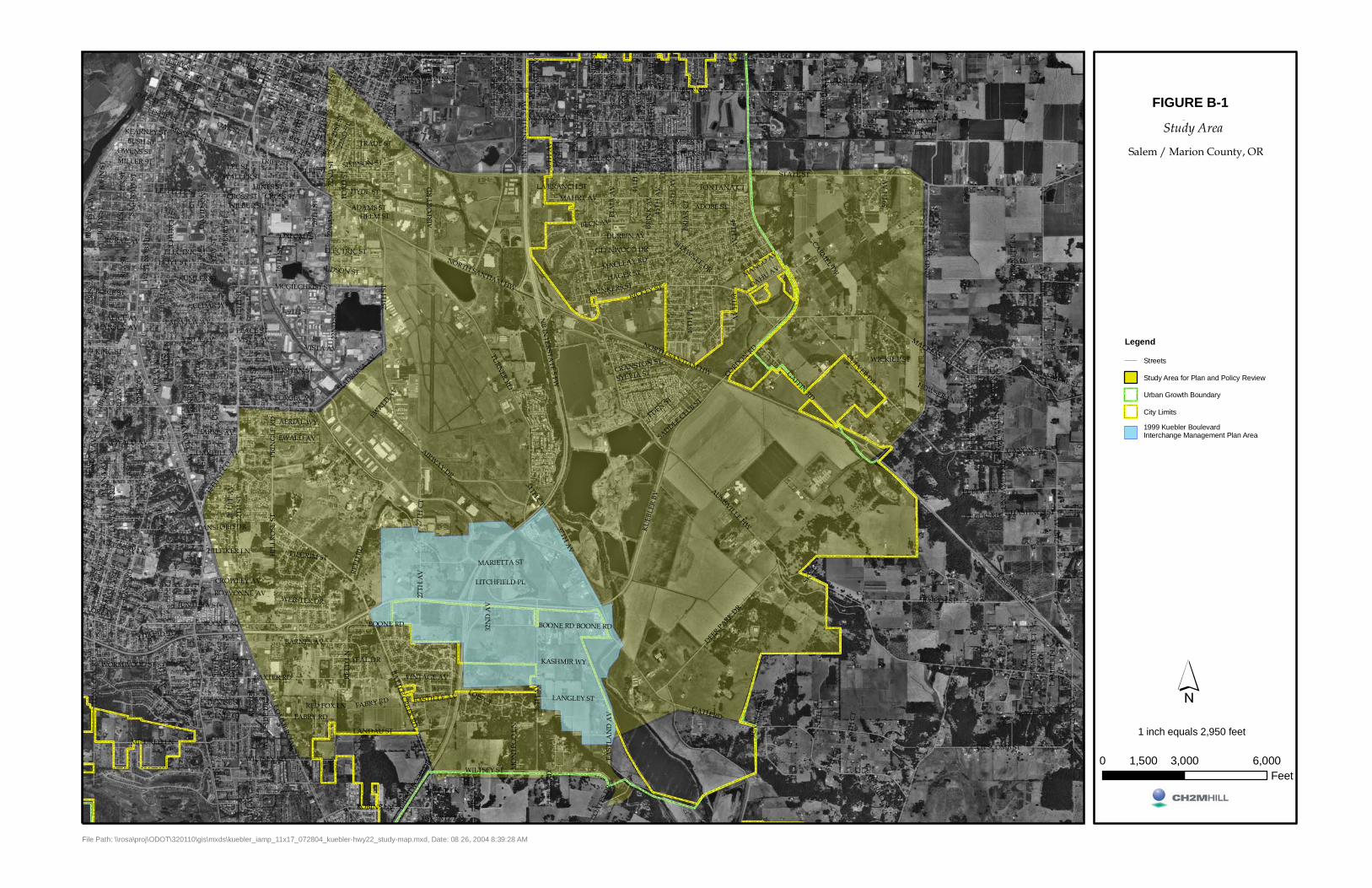
STATE ST
KU
EBLE
R BV
TURNER RD
12TH
ST
CENTER ST
COM
MERCIA
L ST
SB IN
TER
STA
TE 5
FW
25TH
ST
NB IN
TERSTATE 5 FW
MACLEAY RD
NORTH SANTIAM HW
AUMSVILLE HW
GATH RD
MISSION ST
HIG
H S
T
JOSEPH ST
62N
D A
V
CORDON RD
14TH
ST
BOONE RD
70TH
AV
AUBURN RD
71ST
AV
MADRONA AV
PRIN
GLE
RD
36TH
AV
HOYT ST
BATTLE CREEK RD
63RD
ST
RURAL AV
LIBE
RTY
ST
ELM
A A
V
REED
LN
17TH
ST
BAXTER RD
GAFFIN RD
GANON ST
72N
D A
V
MILDRED LN
AIRWAY DR
EWALD AV
CULVER DR
REED
RD
DEER PARK DR
LIBE
RTY
RD
WILTSEY ST
MAHRT AV
JON
ES R
D
LAN
CA
STER
DR
27TH
AV
LIPSCOMB ST
EAST
LAN
D A
V
22N
D S
T
24TH
ST
44TH
AV
SAG
INA
W S
T
HINES ST
FAIRVIEW AV
46TH
PL
21ST
ST
MCGILCHRIST ST
BARNES AV
HAGER ST
RICKEY ST15
TH S
T ASPEN WY
DURBIN AV
COURT ST
AIR
POR
T R
D
BLU
FF A
VBE
RR
Y ST
FIR
DEL
L D
R
CHU
RCH
ST
MUNKERS ST
FIR
ST
ROBINS LN
FABRY RD
HUDSON AV
LANDAU ST
WIN
TER
ST
FOR
D S
T
37TH AV
16TH
ST
HYDE ST
45TH
AV
18TH
ST
BOICE ST
HA
MPD
EN L
N
PEC
K A
V
BUSH ST
PIO
NEE
R D
R
HARRIS AV
OAKHILL AV
MILLER ST
LON
E O
AK
RD
20TH
ST
OXFORD ST
23RD
ST
LANGLEY ST
GLENWOOD DR
FERRY ST
SIMPSON ST
31ST
AV
7TH A
V
OAK ST
12TH
ST C
O
65TH
AV
ILLI
NO
IS A
V
ASH
AV
JOH
N S
T
10TH
ST
LESLIE ST
LEFFELLE STH
ULS
EY A
V
MILL ST
44TH
PL
LORI AV
BASIL ST
UN
NA
MED
RD
WILTSEY RD
59TH
AV
GREENWAY DR
WO
OD
SID
E D
R
KING ST
46TH
AV
45TH
PL
49TH A
V
OR
EGO
N A
V
OWENS ST
DUNSMERE ST
AERIAL WY
HASTINGS ST
VINTAGE AV
KASHMIR WY
COA
TES
DR
PUBLIC RD
CARVER CT
ADOBE ST
NEE
F A
V
MONROE AV
LEE ST
BECK AV
HILFIKER LN
ALP
HA
ST
SADDLE CLUB ST
YEW
ST
54TH
CT
CROSS ST
13TH
AV
CRANSTON ST
MO
NTE
GO
LN
SYLVIA ST
27TH
CT
J DAVID ST
JUNTURA ST
TRIPP ST
BELL RD
PUM
MEL
CT
KEARNEY ST
ALA
NA
AV
DR
APE
R ST
BREN
TWO
OD D
R
WES
T N
OB
HIL
L ST BR
INK
AV
WEBSTER DR
BELLEVUE ST
ALICE AV
13TH
ST
TIER
RA
DR
SHIP
MA
N L
N
WORMWOOD ST
VISTA AV
WALLER ST
GEORGIA AV
PEACE ST
19TH ST
MANGO AV
SALISHAN ST
SPARKY LN
HANSEN AV
WICKIUP ST
AMBER ST
SEN
ECA
AV
HIL
LRO
SE S
T
BREN
NER
ST
JOSEPH ST RP
ELECTRIC ST
BASTILLE AV
BILLIE LN
ADAMS ST
34TH CT
LANSFORD DR
SHAWNEE DR
CROWLEY AV
CEDAR WY
DA
KO
TA R
D
GENIE CT
MARIETTA ST
SNO
OPY
LN
PEAR TREE LN
ELF AV
WILBUR ST
JUDSON ST
OAHU AV
DENISE ST
RIO
VIS
TA W
Y
BLAZER LN
HOWSER LN
32N
D A
V
DA
VID
SON
ST
JEN
NIC
HES
LN
SUN
RIS
E A
V
GEARTZ LN
3RD
AV
PILGRIM ST
HA
RVEY A
V
55TH
CT
ROYVONNE AV
SKY LN
45TH
CT
CO
LT L
N
53RD
PL
MA
UI C
T
KUMLER ST
ROSS
CT
EDEN ST
WIL
LA L
N
LA BRANCH ST
RED FOX LN
GREGORY LN
LITCHFIELD PL
8TH A
V
BOW
ER C
T
CARMEL DR
MEL
OW
RD
HELM ST
56TH
CT
LAM
BERT
LN
VIE
W D
R
TRADE ST
REG
AN
CT
ANTLER ST
REX
ST
LOR
IAN
LN
BUR
NET
T LN
TEAL DR
FONTANA CT
LOIS CT
AA
RO
N C
T
BRIA
R C
T
FIR
ST
PUBL
IC R
D
BOONE RD
13TH
ST
JOH
N S
T
VISTA AV
NORTH SANTIAM HW
VISTA AV
13TH
ST
LEE ST
PUBLIC RD
12TH
ST
BOONE RD
19TH
ST
CROSS ST
EWALD AV
EWALD A
V
OAK ST
OAK ST
37TH
AV
BOONE RD
15TH
ST
HIG
H S
TC
HU
RCH
ST
16TH
ST
46TH
AV
22N
D S
T
21ST
ST
MACLEAY RD
45TH
AV
PUBL
IC R
D
22N
D S
T22
ND
ST
FABRY RD
36TH
AV
12TH
ST
ELECTRIC ST
LON
E O
AK
RD
49TH A
V
25TH
ST
20TH
ST
Kuebler Rd. IAMP /HWY. 22 Traffic Study
Legend
Streets
Study Area for Plan and Policy Review
Urban Growth Boundary
City Limits
1999 Kuebler BoulevardInterchange Management Plan Area
Figure 1Study Area
Salem / Marion County, OR
0 3,000 6,0001,500Feet
1 inch equals 2,950 feet
File Path: \\rosa\proj\ODOT\320110\gis\mxds\kuebler_iamp_11x17_072804_kuebler-hwy22_study-map.mxd, Date: 08 26, 2004 8:39:28 AM
FIGURE B-1

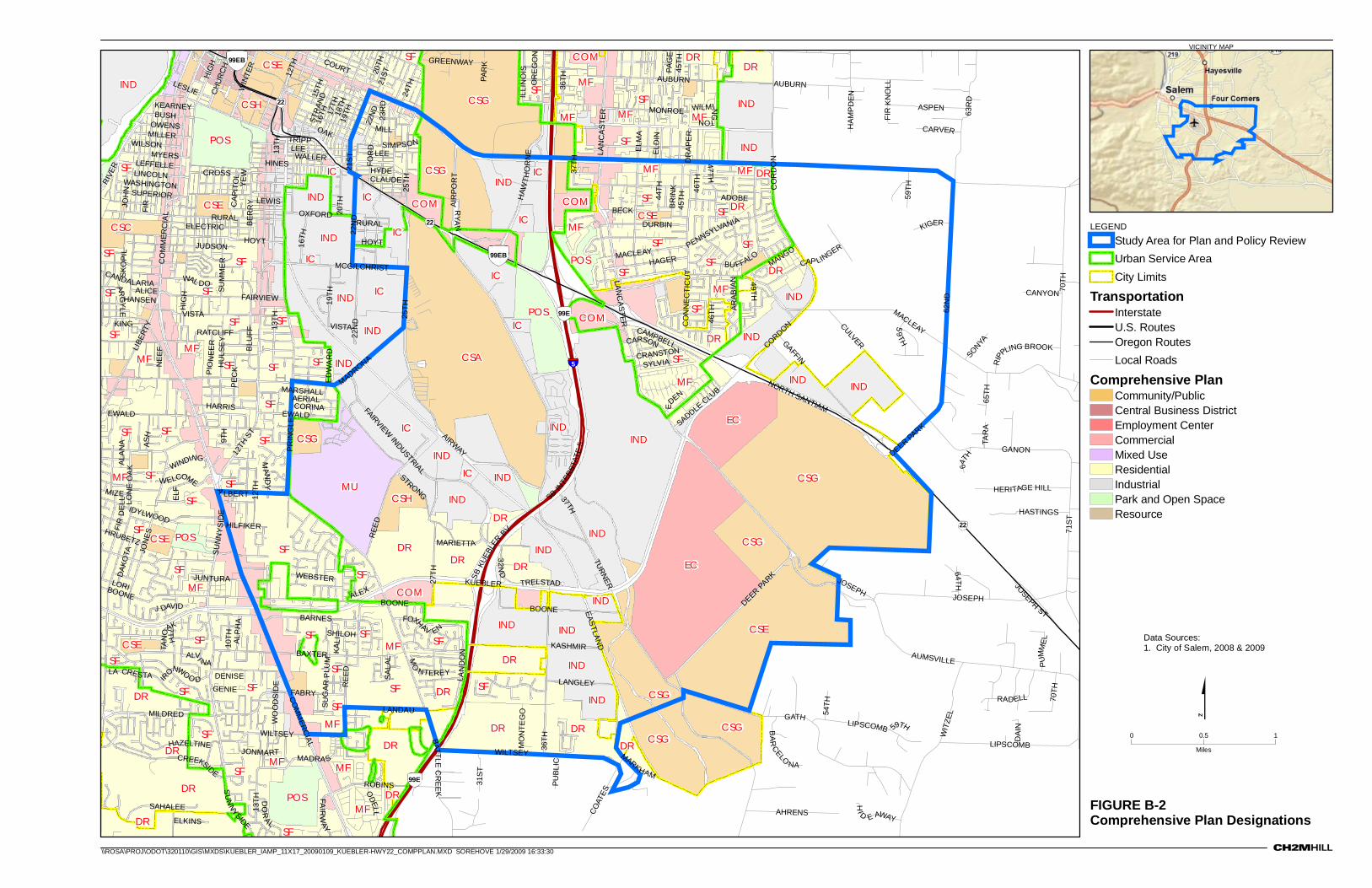
FIGURE B-2Comprehensive Plan Designations
VICINITY MAP
Data Sources:1. City of Salem, 2008 & 2009
COM
COM
COMCOM
COM
CSA
CSC
CSECSE
CSE
CSECSE
CSE
CSG
CSG
CSG
CSG
CSG
CSG
CSG
CSG
CSH
CSH
DR
DRDR
DR DRDR
DRDR
DR
DR
DR
DRDR
DR
DR
DR
DR
DR
DR
DRDR
EC
ECIC
IC
IC
ICIC
ICIC
IC IC
IND
IND
IND
INDIND
IND
IND
IND
IND
IND
IND
INDIND
IND
IND
IND IND
IND
IND
IND
INDIND
IND
INDIND
MF
MFMF
MF
MF
MF
MF
MFMF
MF
MF
MF
MFMF
MFMF MF
MF
MU
POS
POS
POS
POS
POS
SF
SF
SF
SFSFSF SF
SFSF
SFSFSF SFSF
SF SF
SFSF
SFSFSF
SFSFSF
SF
SFSF SF SF
SFSFSF
SFSF SF
SFSF
SFSFSF SF
SFSF
SF
SF
SF SF
SF
IC
IC
5
22
22
22
99E
99E
AIR
POR
T
SAHALEE
ODELL
AUBURN
12TH
EWALD
KUEBLERGAFFIN
AUBURN
AUMSVILLE
LORI
LIBE
RTY
MILL
HOYT
MADRONA
WIN
TER
24TH
MILDRED
MONROE
FAIRVIEW INDUSTRIAL
CH
UR
CH
BER
RY
VISTA
17TH
20TH
FIR
NORTH SANTIAM
JOSEPH
KING
PAR
K
JUDSON
RURAL
WILTSEY
MYERS
BECK
IDYLWOOD
MANGO
ARAB
IAN
CANDALARIA
HIG
H
13TH
ROBINS
SUPERIOR
WINDING
HIG
H
MACLEAY
SADDLE CLU
B
MAND
Y
MACLEAY
PENNSYLVANIA
BOONE
DEER PARK
CRANSTON
MIZE
HILFIKER
PRIN
GLE
SUM
ME
R
JONMART
RADELL
WILMI NG
TON
JOH
N
FAIRVIEW
EDEN
IRONWOO D SA
LAL
FAIR
WAY
HU
LSE
Y
MARSHALL
SB IN
TERS
TATE
5
HAW
THO
RN
E
FOXHAV EN
ARGY
LE
CREEKSIDE
BARNES
WEBSTER
EWALD
YEW
32ND
AERIAL
DURBIN
45TH
CAP
ITO
L
MADRA S MARKHAM
21ST
SHILOH
13TH
MCGILCHRIST
REE
D
64TH
GATH
SIMPSON
OAK
WELCOME
WALLER
22N
D
WASHINGTON
LA CRESTA
19TH
CORINA
STRONG
TAN
OAK
HRUBETZ
MO
NTE
GO
BOONE
BAXTER
12TH
HANSEN
EDW
AR
D
LEE
CARSON
TRIPP
21STHINES
RATCLIFF
CROSS
GANON
GREENWAY
LESLIE
BOONE
BUSH
ASH
HARRIS
63R
D
ALA
NA
HOYT
MILLER
FABRY
LEWIS
JUNTURA
36TH
ELECTRICPE
CK
HAGER
BR
INK
BU FFALO
DAK
OTA
COURT
REE
D
20TH
A
LBERT
DENISE
KEARNEY
15TH
LEFFELLE
OWENS
WILSON
PAG
E
65TH
STR
AND
22N
D18TH
ALEX
EASTLAND
16TH
59TH
WAL DO
62N
D
LIPSCOMB
LANDAU
LEE
HYDECLAUDE
SUG
AR PL
UM
RURALAL
PH
A
J DAVID
70TH
LIPSCOMB
JOSEPH
FIR
DE
LL
59TH
OR
EG
ON
DEER PA
RK
GENIE
TRELSTAD
NEE
F
OXFORD
ELF
ADOBE
ELD
IN
WO
OD
SID
E
SYLVIA
DR
APE
R
WIT
ZEL
ALVI NA
LANGLEY
RIPP
LING BROOK
HAZELTINE
COAT
ES
MARIETTA
12TH
ST
59TH
SB KU
EBLE
R BV
CAMPBELL
VISTA
64TH
54TH
ALICE
45TH
AHRENS
SONYA
PUBL
IC
ELKINS
CULVER
KIGER
CANYON
70TH
PUM
ME
L
CARVER
16TH
KASHMIR
37TH
HI D E AWAY
RIVE
RASPEN
HASTINGS
RYA
N
HERITAGE HILL
AIRWAY
49TH
ELM
A
CORDONC
OR
DO
N
BATTLE C
REE
K
4 7TH
25TH
25TH
CO
MM
ERC
IAL
CO
MM
ERC
IAL
LANC
ASTER
LAN
CA
STER
LINCOLN
TURNER
13TH
BLU
FF
36TH
37TH
LAN
DO
N
SU
NN
YSIDE
SUN
NY
SID
E
27TH
71ST
HAM
PD
EN
LON
E O
AK
FOR
D
MO
NTEREY
19TH
46TH
WILTSEY
7TH
CO
NN
EC
TIC
UT
9TH
JON
ES
46TH
23R
D
PIO
NEE
R
KALI
SKO
PIL
CAP LINGER
10TH
ILLI
NO
IS
22N
D
44TH
BA
RCELO
NA
DO
RAL
FIR
KN
OLL
JOSEPH
ST
DAI
N
31ST
TAR
A
99EB
99EB
0 10.5
Miles
LEGEND
Study Area for Plan and Policy ReviewUrban Service AreaCity Limits
TransportationInterstateU.S. RoutesOregon RoutesLocal Roads
Comprehensive PlanCommunity/PublicCentral Business DistrictEmployment CenterCommercialMixed UseResidentialIndustrialPark and Open SpaceResource
\\ROSA\PROJ\ODOT\320110\GIS\MXDS\KUEBLER_IAMP_11X17_20090109_KUEBLER-HWY22_COMPPLAN.MXD SOREHOVE 1/29/2009 16:33:30

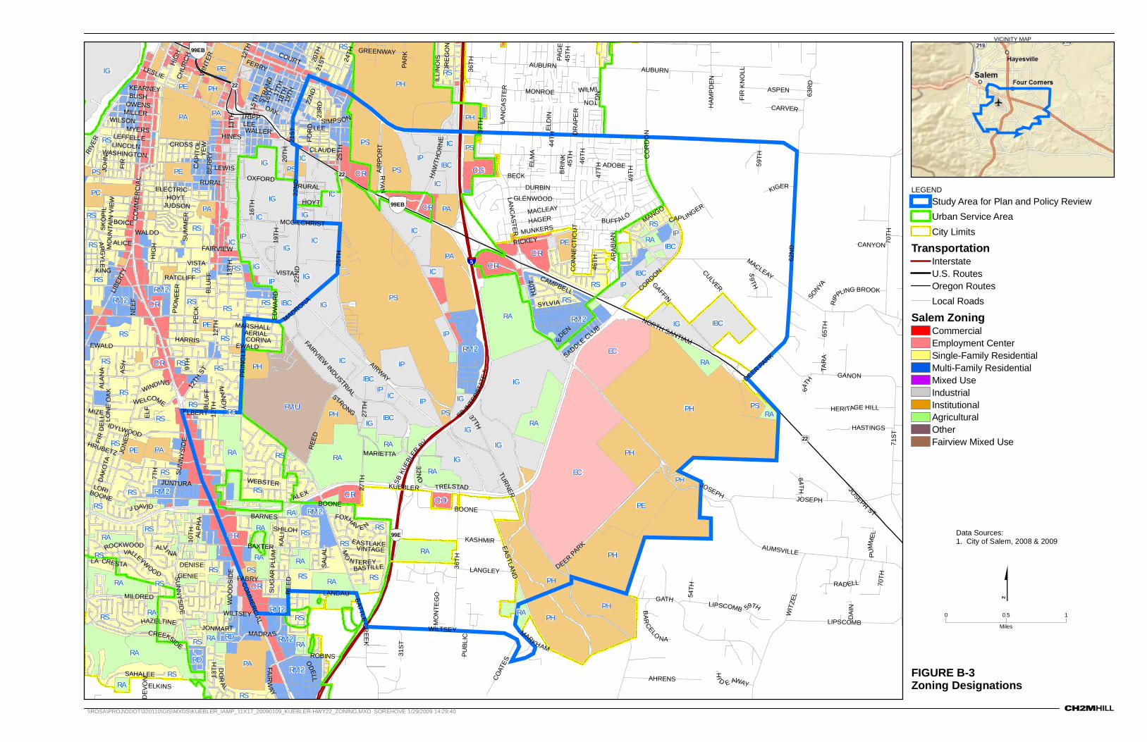
FIGURE B-3Zoning Designations
\\ROSA\PROJ\ODOT\320110\GIS\MXDS\KUEBLER_IAMP_11X17_20090109_KUEBLER-HWY22_ZONING.MXD SOREHOVE 1/29/2009 14:29:40
VICINITY MAP
Data Sources:1. City of Salem, 2008 & 2009
5
99E
22
22
22
99EB
99EB
BARNES
SAHALEE
ODELL
12TH
AUBURN
12TH
EWALD
KUEBLERGAFFIN
AUBURN
AUMSVILLE
LORI
LIBE
RTY
HOYT
MADRONA
WIN
TER
24TH
MILDRED
MONROE
FAIRVIEW INDUSTRIAL
CH
UR
CH
BER
RY
VISTA
17TH
20TH
FIR
NORTH SANTIAM
FERRY
JOSEPH
KING
PAR
K
JUDSON
RURAL
WILTSEY
MYERS
BECK
IDYLWOOD
MANGO
AR
ABIA
N
GLENWOOD
HIG
H
13TH
ROBINS
WINDING
HIG
H
MACLEAY
SADDLE CLUB
MAND
Y
MACLEAY
BOONE
DEER PARK
MIZE
PRIN
GLE
SUM
ME
R
JONMART
RADELL
WILMI NG
TON
JOH
N
FAIRVIEW
EDEN
SALA
L
FAIR
WAY
MARSHALL
RICKEY
BOICE
VALLEYWOOD
SB IN
TERS
TATE
5
HAW
THO
RN
E
FOXHAV E N
EASTLAKE
ARG
YLE
CREEKSIDE
WEBSTER
EWALD
YEW
32ND
AERIAL
DURBIN
45TH
CAP
ITO
L
MADRA S MARKHAM
21ST
DEV
ON
SHILOH
13TH
MCGILCHRIST
REE
D
64TH
GATH
SIMPSON
MUNKERS
OAK
BASTILLE
MO
UN
TAIN
VI E
W
WELCOME
WALLER
22N
D
WASHINGTON
LA CRESTA
19TH
CORINA
STR
ONG
HRUBETZ
MO
NTE
GO
BOONE
BAXTER
12TH
EDW
AR
D
LEETRIPP
21STHINES
VINTAGE
RATCLIFF
CROSS
GANON
GREENWAY
LESLIE
BOONE
BUSH
ASH
HARRIS
63R
D
ALA
NA
HOYT
MILLER
FABRY
LEWIS
JUNTURA
36TH
ELECTRICPE
CK
HAGER
BR
INK
BUFFALO
DAK
OTA
COURT
REE
D
20TH
A
LBERT
DENISE
KEARNEY
15TH
BLU
FF
LEFFELLE
OWENS
WILSON
PAG
E
65TH
STR
AND
22N
D
18TH
ALEX
EASTLAND
16TH
59TH
WALDO
62N
D
LIPSCOMB
LANDAU
ROCKWOOD
LEE
CLAUDE
SU
GAR
PLU
M
RURALAL
PH
A
J DAVID
70TH
LIPSCOMB
JOSEPH
FIR
DE
LL
59TH
OR
EG
ON
DEER PA
RKGENIE
TRELSTAD
NEE
F
OXFORD
ELF
ADOBE
ELD
IN
WO
OD
SID
E
SYLVIA
DR
APE
R
WIT
ZEL
ALVI NA
LANGLEY
RIPP
LING BROOK
HAZELTINE
COAT
ES
MARIETTA
12TH
ST
59TH
SB KU
EBLE
R BV
CAMPBELL
VISTA
27TH
64TH
54TH
ALICE
45TH
AHRENS
SONYA
PUBL
IC
ELKINS
CULVER
KIGER
CANYON
70TH
PUM
ME
L
CARVER
16TH
KASHMIR
37TH
HI D E AWAY
RIVE
RASPEN
HASTINGS
RYA
N
HERITAGE HILL
AIRWAY
ELM
A
CORDONC
OR
DO
N
BATTLE CR
EEK
47TH
25TH
25TH
CO
MM
ERC
IAL
CO
MM
ERC
IAL
LANC
ASTER
LAN
CA
STER
LINCOLN
TURNER
13TH
BLU
FF
36TH
37TH
SU
NN
YSIDE
SUN
NYS
IDE
27TH
71ST
HAM
PD
EN
LON
E O
AK
FOR
D
MO
NTEREY
49T H
19TH
46TH
WILTSEY
CO
NN
EC
TIC
UT
9TH
40TH
JON
ES
46TH
23R
D
PIO
NEE
R
KALI
SKO
PIL
CAP LINGER
10TH
ILLI
NO
IS
7TH
22N
D
44TH
BA
RCELO
NA
DO
RAL
FIR
KN
OLL
JOSEPH
ST
DAI
N
31ST
TAR
A
AIR
POR
T
RS
IC
ICCG
CR
CR
CR
CR
CRCR
CR
CR
EC
EC
FMUIBC
IBC
IBC
IBC
IBC
IBC
IBC
IC
IC
ICIC
ICIC
ICIC
IC
IG
IG IGIG
IGIG
IG
IG
IG
IG
IG
IGIG
IG
IG
IPIP
IP
IP
IP IP
IP IP
IP
PA
PA
PA
PA PA
PAPA
PC
PE
PE
PE
PE
PE
PEPE
PH
PH
PH
PH
PH
PH
PH
PH
PH
PH
PH PH
PS
PS PS
PS
PS PS
PS
PS
PS
RA
RARARA
RA RA
RARA
RARA RARA
RARA
COCR
RA
RARARA
RARA
RA
RA
RA
RD
RD
RM2
RM2
RM2
RM2
RM2
RM2
RM2
RM2RM2
RS
RS
RS
RSRS
RSRSRS RS
RSRS
RSRS RS
RSRS RS
RSRS
RS
RSRSRS
RS
RSRSRS
RSRS
RSRS RSRS
RSRSRS RS
RS
RSRSRS
RS
RS
0 10.5
Miles
LEGEND
Study Area for Plan and Policy ReviewUrban Service AreaCity Limits
TransportationInterstateU.S. RoutesOregon RoutesLocal Roads
Salem ZoningCommercialEmployment CenterSingle-Family ResidentialMulti-Family ResidentialMixed UseIndustrialInstitutionalAgriculturalOtherFairview Mixed Use


KUEBLER BOULEVARD INTERCHANGE AREA MANAGEMENT PLAN
APPENDIX C
Future Conditions Analysis


APPENDIX C
Future Conditions Analysis
This section describes potential future development of the land in the Kuebler Boulevard IAMP management area and presents predicted future (2030) traffic conditions under the Future Baseline, Future Baseline with Moderate Improvements, and Future Baseline with Major Improvements scenarios.
C.1 Land Use Analysis C.1.1 Planned Land Development According to City of Salem staff, the known large-scale planned land developments in the IAMP management area include a commercial development on the southeast corner of Kuebler Boulevard and Battle Creek Road that was upheld on appeal by the Land Use Board of Appeals in July 2008 and a proposed comprehensive plan amendment and zone change on property south of Kuebler Boulevard between the southbound interchange ramp terminal and 36th Avenue.
C.1.2 Land Development Forecast Two separate Year 2030 land use options (called Option 1 and Option 2) were modeled for the future land development forecast. Option 1 represents the level of growth shown in the SKATS RTSP. Year 2030 forecasts (SKATS 2030 Forecasts), which is a modest level of build-out consistent with the land use designations of the Salem Area Comprehensive Plan (2005). Option 2 represents a full Comprehensive Plan build-out of the 4,000-square-foot lot sizes, including development or redevelopment of all the vacant or underutilized parcels in the area surrounding the Kuebler Boulevard interchange (approximately ¼ mile from interchange ramps). Option 2 assumes that the Mill Creek Corporate Center will create opportunities for secondary investment in the IAMP area (offsite from Mill Creek Corporate Center). Table C-1 summarizes the estimated employment and household data used in each of the land use options, and includes Year 2000 values for comparative purposes.
TABLE C-1 Land Use Assumptions Within the IAMP Management Area
Scenario Retail
(employees) Service
(employees)Government(employees)
Other (employees)
Non-Retail(employees)
Total Employment
Total Households
2000 (Base Year)
9 72 - 306 379 388 31
2030 Land Use Option 1
97 853 438 - - 1,388 1,291
2030 Land Use Option 2
97 1,006 - 3,580 4,586 4,683 1,692
KUEBLER BOULEVARD INTERCHANGE AREA MANAGEMENT PLAN C-1
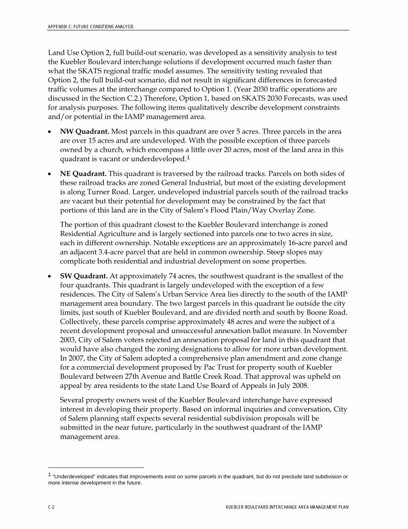
APPENDIX C: FUTURE CONDITIONS ANALYSIS
Land Use Option 2, full build-out scenario, was developed as a sensitivity analysis to test the Kuebler Boulevard interchange solutions if development occurred much faster than what the SKATS regional traffic model assumes. The sensitivity testing revealed that Option 2, the full build-out scenario, did not result in significant differences in forecasted traffic volumes at the interchange compared to Option 1. (Year 2030 traffic operations are discussed in the Section C.2.) Therefore, Option 1, based on SKATS 2030 Forecasts, was used for analysis purposes. The following items qualitatively describe development constraints and/or potential in the IAMP management area.
• NW Quadrant. Most parcels in this quadrant are over 5 acres. Three parcels in the area are over 15 acres and are undeveloped. With the possible exception of three parcels owned by a church, which encompass a little over 20 acres, most of the land area in this quadrant is vacant or underdeveloped.1
• NE Quadrant. This quadrant is traversed by the railroad tracks. Parcels on both sides of these railroad tracks are zoned General Industrial, but most of the existing development is along Turner Road. Larger, undeveloped industrial parcels south of the railroad tracks are vacant but their potential for development may be constrained by the fact that portions of this land are in the City of Salem’s Flood Plain/Way Overlay Zone.
The portion of this quadrant closest to the Kuebler Boulevard interchange is zoned Residential Agriculture and is largely sectioned into parcels one to two acres in size, each in different ownership. Notable exceptions are an approximately 16-acre parcel and an adjacent 3.4-acre parcel that are held in common ownership. Steep slopes may complicate both residential and industrial development on some properties.
• SW Quadrant. At approximately 74 acres, the southwest quadrant is the smallest of the four quadrants. This quadrant is largely undeveloped with the exception of a few residences. The City of Salem’s Urban Service Area lies directly to the south of the IAMP management area boundary. The two largest parcels in this quadrant lie outside the city limits, just south of Kuebler Boulevard, and are divided north and south by Boone Road. Collectively, these parcels comprise approximately 48 acres and were the subject of a recent development proposal and unsuccessful annexation ballot measure. In November 2003, City of Salem voters rejected an annexation proposal for land in this quadrant that would have also changed the zoning designations to allow for more urban development. In 2007, the City of Salem adopted a comprehensive plan amendment and zone change for a commercial development proposed by Pac Trust for property south of Kuebler Boulevard between 27th Avenue and Battle Creek Road. That approval was upheld on appeal by area residents to the state Land Use Board of Appeals in July 2008.
Several property owners west of the Kuebler Boulevard interchange have expressed interest in developing their property. Based on informal inquiries and conversation, City of Salem planning staff expects several residential subdivision proposals will be submitted in the near future, particularly in the southwest quadrant of the IAMP management area.
1 “Underdeveloped” indicates that improvements exist on some parcels in the quadrant, but do not preclude land subdivision or more intense development in the future.
C-2 KUEBLER BOULEVARD INTERCHANGE AREA MANAGEMENT PLAN
APPENDIX C: FUTURE CONDITIONS ANALYSIS
• SE Quadrant. Two parcels are within the city limits and are zoned Residential Agriculture. The remainder of the quadrant is in Marion County. Much of the area is zoned County Urban Transition (UT), which allows single-family residential development at 5-, 10-, and 20-acre minimum lot sizes (UT-5, UT-10, and UT-20, respectively). Conditional uses include commercial activities in conjunction with farm or forest use, public golf courses, schools, civic organizations, kennels, and public parks and playgrounds. Parcels closest to I-5 have a UT-20 designation; parcels in the County farther east, directly south of Kuebler Boulevard, are predominantly zoned General Industrial and UT-10. Parcels southwest of the Southern Pacific Railroad tracks are zoned UT-10.
C.2 Forecasted Traffic Operations The Kuebler Boulevard IAMP must address future transportation demands. For this reason, traffic conditions were modeled for at least 20 years in the future, in this case, to year 2030.
C.2.1 Traffic Forecasting Methodology Future Baseline Scenario The Future Baseline (2030) scenario was analyzed to determine how the I-5/ Kuebler Boulevard interchange roadways and intersections would operate in 2030 if population and employment projections were realized but no improvements were made beyond those planned and funded in the SKATS RTSP (Land Use Option 1, as previously described). The findings from this analysis would help to identify future deficiencies and provide a future baseline for comparison for subsequent Year 2030 scenarios. The assumed Year 2030 roadway network is consistent with the network provided in the SKATS 2030 model.
Future Baseline with Improvements Scenarios The 2030 Future Baseline with Improvements scenarios (two scenarios – with Moderate Improvements, and with Major Improvements) were developed with guidance from OHP Policy 1G: Major Improvements, because adding capacity to the existing Kuebler Boulevard interchange is a proposed action. Under Policy 1G: Action 1G1, the following hierarchy of actions is to be considered:
1. Protect the existing system. 2. Improve efficiency and capacity of existing highway facilities. 3. Add capacity to the existing system. 4. Add new facilities to the system.
Policy 1G1, 2 states, “The second priority is to make minor improvement to existing highway facilities such as widening highway shoulders or adding auxiliary lanes, providing better access for alternative modes (e.g., bike lanes, sidewalks, bus shelters), extending or connecting local streets, and making other off-system improvements.” Therefore, the 2030 Future Baseline with Improvements scenario forecasts are also based on 2030 Forecast with Committed/ Recommended SKATS RTSP projects (Table C-2).
KUEBLER BOULEVARD INTERCHANGE AREA MANAGEMENT PLAN C-3
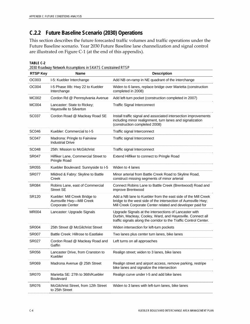
APPENDIX C: FUTURE CONDITIONS ANALYSIS
C.2.2 Future Baseline Scenario (2030) Operations This section describes the future forecasted traffic volumes and traffic operations under the Future Baseline scenario. Year 2030 Future Baseline lane channelization and signal control are illustrated on Figure C-1 (at the end of this appendix).
TABLE C-2 2030 Roadway Network Assumptions in SKATS Constrained RTSP RTSP Key Name Description
OC003 I-5: Kuebler Interchange Add NB on-ramp in NE quadrant of the interchange
OC004 I-5 Phase IIIb: Hwy 22 to Kuebler Interchange
Widen to 6 lanes, replace bridge over Marietta (construction completed in 2008)
MC002 Cordon Rd @ Pennsylvania Avenue Add left-turn pocket (construction completed in 2007)
MC004 Lancaster: State to Rickey; Hayesville to Silverton
Traffic Signal Interconnect
SC037 Cordon Road @ Macleay Road SE Install traffic signal and associated intersection improvements including minor realignment, turn lanes and signalization (construction completed 2008)
SC046 Kuebler: Commercial to I-5 Traffic signal Interconnect
SC047 Madrona: Pringle to Fairview Industrial Drive
Traffic signal Interconnect
SC048 25th: Mission to McGilchrist Traffic signal Interconnect
SR047 Hilfiker Lane, Commercial Street to Pringle Road
Extend Hilfiker to connect to Pringle Road
SR055 Kuebler Boulevard: Sunnyside to I-5 Widen to 4 lanes
SR077 Mildred & Fabry: Skyline to Battle Creek
Minor arterial from Battle Creek Road to Skyline Road, construct missing segments of minor arterial
SR084 Robins Lane, east of Commercial Street SE
Connect Robins Lane to Battle Creek (Brentwood) Road and improve Brentwood
SR120 Kuebler: Mill Creek Bridge to Aumsville Hwy—Mill Creek Corporate Center
Add a NB lane to Kuebler from the east side of the Mill Creek bridge to the west side of the intersection of Aumsville Hwy; Mill Creek Corporate Center related and developer paid for
MR004 Lancaster: Upgrade Signals Upgrade Signals at the intersections of Lancaster with Durbin, Macleay, Cooley, Ward, and Hayesville. Connect all traffic signals along the corridor to the Traffic Control Center.
SR004 25th Street @ McGilchrist Street Widen intersection for left-turn pockets
SR007 Battle Creek: Hillrose to Eastlake Two lanes plus center turn lanes, bike lanes
SR027 Cordon Road @ Macleay Road and Gaffin
Left turns on all approaches
SR056 Lancaster Drive, from Cranston to Kuebler
Realign street; widen to 3 lanes, bike lanes
SR069 Madrona Avenue @ 25th Street Realign street and airport access, remove parking, restripe bike lanes and signalize the intersection
SR070 Marietta SE: 27th to 36th/ Kuebler Boulevard
Realign curve under I-5 and add bike lanes
SR076 McGilchrist Street, from 12th Street to 25th Street
Widen to 3 lanes with left-turn lanes, bike lanes
C-4 KUEBLER BOULEVARD INTERCHANGE AREA MANAGEMENT PLAN
APPENDIX C: FUTURE CONDITIONS ANALYSIS
TABLE C-2 2030 Roadway Network Assumptions in SKATS Constrained RTSP RTSP Key Name Description
SR121 Kuebler @ Lancaster—Mill Creek Corporate Center
Improve the intersection of Kuebler/Cordon and Lancaster/ Aumsville Hwy to 5 lanes
SR096 Turner Road: Airway Drive to South UGB
Upgrade to meet minor arterial standards, bike lanes
Intersection Traffic Operations Year 2030 Future Baseline intersection operations were analyzed. The V/C ratios resulting from the analysis are shown in Table C-3 and illustrated on Figure C-2 (at the end of this appendix). In the table, locations that exceed the required mobility standards are in bold type and highlighted.
TABLE C-3 Future Baseline Intersection Analysis Summary 2030 30th Highest Hour Design Volumes
Study Intersection Intersection
Control
ODOT Mobility
Standard
Salem TSP Mobility
Standard
2030 Future Baseline V/C
Ratio
1.16 Kuebler Boulevard and Battle Creek Road Signal - 0.90
1.15 Kuebler Boulevard and 27th Avenue Signal - 0.90
1.44 Kuebler Boulevard and I-5 Southbound Ramps Signal 0.85 -
Kuebler Boulevard and I-5 Northbound Ramps Signal 0.85 - 0.65
>1.5 Kuebler Boulevard and 36th Avenue Signal - 0.90
>1.5 Kuebler Boulevard and Turner Road Signal - 0.90
Highlighted cells indicate locations that exceed the required mobility standards.
The Future Baseline intersection analysis shows that five of six study intersections would operate beyond the mobility standards set for the facilities in the Year 2030. These five intersections are also projected to have vehicle demand that exceeds intersection capacity (V/C ratio equal to or higher than 1.0).
1. Kuebler Boulevard and Battle Creek Road—Despite additional capacity on Kuebler Boulevard, growth exceeds available capacity. This intersection operates above capacity because of high through traffic volumes along Kuebler Boulevard. As a result, adequate “green time” is not available for the remaining movements.
2. Kuebler Boulevard and 27th Avenue—Despite additional capacity on Kuebler Boulevard, growth exceeds available capacity. This intersection operates above capacity because of high through traffic volumes along Kuebler Boulevard and westbound left-turn volumes from Kuebler Boulevard to 27th Avenue.
3. Kuebler Boulevard and I-5 Southbound Ramps—This intersection operates above capacity on the eastbound and westbound approaches because of high through traffic
KUEBLER BOULEVARD INTERCHANGE AREA MANAGEMENT PLAN C-5
APPENDIX C: FUTURE CONDITIONS ANALYSIS
volumes along Kuebler Boulevard. The westbound left turns, destined for southbound I-5, have long delay times.
4. Kuebler Boulevard and 36th Avenue—Volumes are anticipated to increase on Kuebler Boulevard and 36th Avenue, causing long delays in each direction. V/C ratios are high because the lane geometry remains the same as the existing condition with single lane approaches only.
5. Kuebler Boulevard and Turner Road—This intersection operation exceeds the required mobility standard as a result of the fairly high volumes along both Kuebler Boulevard and southbound Turner Road. The northbound-to-westbound left-turn movement also experiences high delays2.
Freeway Traffic Operations V/C ratios on freeway segments were analyzed between north of the OR 22 interchange and south of the Kuebler Boulevard interchange on I-5. The results are shown in Table C-4 and on Figure C-3 (at the end of this appendix). In the table, freeway segments operating in excess of the applicable standard are in bold type and highlighted.
TABLE C-4 Future Baseline Freeway Analysis Summary 2030 30th Highest Hour Design Volumes
Segment Segment
Type
ODOT Mobility
Standard
2030 Future Baseline V/C Ratio
Southbound
1.01 North of OR 22 Interchange Basic 0.80
OR 22 Off-Ramp Basic 0.80 N/A
1.20 Between OR 22 Ramps Basic 0.80
OR 22 Westbound On-Ramp Merge 0.80 N/A
0.88 Between OR 22 Ramps Basic 0.80
0.96 OR 22 Eastbound On-Ramp Merge 0.80
1.01 Between OR 22 and Kuebler Interchanges Basic 0.80
0.97 Kuebler Off-Ramp Diverge 0.80
1.22 Between Kuebler Ramps Basic 0.80
1.42 Kuebler On-Ramp Merge 0.80
1.37 South of Kuebler Interchange Basic 0.80
Northbound
1.21 South of Kuebler Interchange Basic 0.80
1.26 Kuebler Off-Ramp Diverge 0.80
0.95 Between Kuebler Ramps Basic 0.80
0.85 Between Kuebler Ramps Merge 0.80
0.88 Kuebler Westbound On-Ramp Basic 0.80
0.94 Between Kuebler and OR 22 Diverge 0.80
2 Delay is the additional travel time experienced by a driver (HCM, 2000).
C-6 KUEBLER BOULEVARD INTERCHANGE AREA MANAGEMENT PLAN
APPENDIX C: FUTURE CONDITIONS ANALYSIS
TABLE C-4 Future Baseline Freeway Analysis Summary 2030 30th Highest Hour Design Volumes
Segment Segment
Type
ODOT Mobility
Standard
2030 Future Baseline V/C Ratio
0.90 OR 22 Off-Ramp Basic 0.80
0.83 Between OR 22 Ramps Basic 0.80
0.81 OR 22 Eastbound On-Ramp Basic 0.80
0.88 Between OR 22 Ramps Merge 0.80
1.05 OR 22 Westbound On-Ramp Basic 0.80
1.05 North of OR 22 Interchange Basic 0.80
Highlighted cells indicate freeway segments that exceed the applicable mobility standards. N/A = Not available. V/C ratio output not possible in Highway Capacity Software (HCS) because of freeway segment characteristics.
All I-5 freeway segments analyzed will be at or exceeding the Oregon Department of Transportation (ODOT) mobility standard in the 2030 Future Baseline scenario. Each basic segment will exceed the standard because of volume increases, even with lane widening to three lanes in each direction on I-5 between OR 22 and Kuebler Boulevard. I-5 south of the Kuebler Boulevard interchange remains a four-lane freeway (two lanes in each direction), and traffic growth causes this segment to operate over capacity.
Crash Analysis Overall, crash rates are expected to increase under the Future Baseline scenario, owing to increased congestion and lack of roadway safety improvements. The exception would be where projects identified in the Future Baseline scenario address safety deficiencies.
Under existing conditions, the crash rate for the Kuebler Boulevard interchange southbound interchange ramps was the highest in the study area, although well below the statewide average. Traffic signals on Kuebler Boulevard will be interconnected. Improvements also will be made to the northbound ramps. These improvements will improve traffic flow upstream of the interchange ramps. I-5 and Kuebler Boulevard are projected to operate with V/C ratios in 2030 that exceed V/C ratios for the same locations in 2007. Therefore, despite capacity improvements, congestion-related crashes such as rear-end crashes could potentially increase.
The fatality rate at the intersection of Kuebler Boulevard and Battle Creek Road is higher than other study intersections. Improvements to Battle Creek Road, the creation of two lanes and a central turn lane, and signal safety improvements will improve traffic flow up and downstream of the Kuebler Boulevard and Battle Creek Road intersections.
C.2.3 Future Baseline with Moderate Improvements Scenario Operations This section describes the projects included in the 2030 Future Baseline with Moderate Improvements scenario, the future forecasted traffic operations, and crash analysis under the Future Baseline with Moderate Improvements scenario.
KUEBLER BOULEVARD INTERCHANGE AREA MANAGEMENT PLAN C-7
APPENDIX C: FUTURE CONDITIONS ANALYSIS
Roadway Network The Future Baseline with Moderate Improvements scenario forecasts are based on SKATS 2030 Forecast with Committed/ Recommended SKATS RTSP projects. Individual growth rates along roadway links within the SKATS 2030 regional model were applied to 2004 base volumes to calculate the 2030 30th highest hourly volumes.
A Future Baseline with Moderate Improvements Scenario was analyzed to identify moderate improvements that could be implemented to improve traffic operations within the IAMP management area. Table C-5 identifies the physical improvements that are part of the Future Baseline with Moderate Improvements scenario. Appendix D provides detailed documentation of the interchange concepts developed for the Kuebler Boulevard interchange.
TABLE C-5 Future Baseline with Moderate Improvements Scenario Physical Improvements
Intersection Physical Improvement(s) Responsibility
City of Salem Kuebler Boulevard/ Battle Creek Road
• Install a second southbound through lane.
• Install a second northbound through lane.
City of Salem Kuebler Boulevard/ 27th Avenue
• Install a traffic signal.
• Install a second southbound left-turn lane.
Kuebler Boulevard/ I-5 Southbound Ramps
• Install a westbound-to-southbound loop ramp in the northwest quadrant of the interchange. Stripe the northern westbound lane as a through-right turn option. Relocate the intersection to the west to provide space for the loop ramp. In addition, possibly modify the span length of the existing Kuebler Boulevard Bridge over I-5.
• Remove the westbound left-turn lane.
ODOT
City of Salem Kuebler Boulevard/ 36th Avenue
• Install an eastbound right-turn lane.
• Install a westbound right-turn lane.
• Install a southbound right-turn lane.
City of Salem Kuebler Boulevard/ Turner Road
• Install an eastbound right-turn lane.
• Install a westbound right-turn lane.
• Install a northbound right-turn lane.
• Install a southbound right-turn lane.
The study intersection lane configurations are illustrated on Figure C-4 (at the end of this appendix). The 2030 Future Baseline with Moderate Improvements scenario forecast volumes are provided on Figure C-5 (at the end of this appendix). As shown on the figure, significant growth is projected to occur within the study area between 2007 and 2030, with expected growth rates between one and four percent per year.
Implementing the physical improvements outlined in Table C-5 would enhance traffic operations at the Kuebler Boulevard interchange. Interchange improvements include the following:
• A new northbound I-5 on-ramp from westbound Kuebler Boulevard (programmed for construction in summer 2009)
C-8 KUEBLER BOULEVARD INTERCHANGE AREA MANAGEMENT PLAN
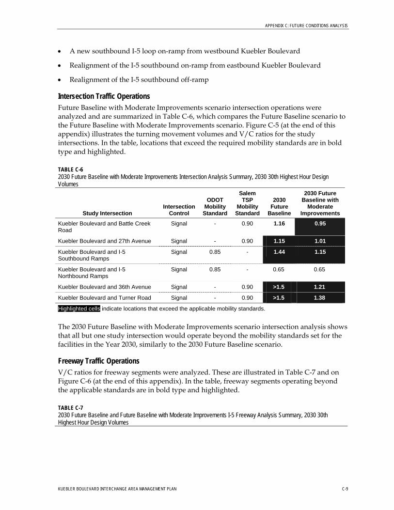
APPENDIX C: FUTURE CONDITIONS ANALYSIS
• A new southbound I-5 loop on-ramp from westbound Kuebler Boulevard
• Realignment of the I-5 southbound on-ramp from eastbound Kuebler Boulevard
• Realignment of the I-5 southbound off-ramp
Intersection Traffic Operations Future Baseline with Moderate Improvements scenario intersection operations were analyzed and are summarized in Table C-6, which compares the Future Baseline scenario to the Future Baseline with Moderate Improvements scenario. Figure C-5 (at the end of this appendix) illustrates the turning movement volumes and V/C ratios for the study intersections. In the table, locations that exceed the required mobility standards are in bold type and highlighted.
TABLE C-6 2030 Future Baseline with Moderate Improvements Intersection Analysis Summary, 2030 30th Highest Hour Design Volumes
Study Intersection Intersection
Control
ODOT Mobility
Standard
Salem TSP
Mobility Standard
2030 Future
Baseline
2030 Future Baseline with
Moderate Improvements
Kuebler Boulevard and Battle Creek Road
Signal - 0.90 1.16 0.95
Kuebler Boulevard and 27th Avenue Signal - 0.90 1.15 1.01
Kuebler Boulevard and I-5 Southbound Ramps
Signal 0.85 - 1.44 1.15
Kuebler Boulevard and I-5 Northbound Ramps
Signal 0.85 - 0.65 0.65
Kuebler Boulevard and 36th Avenue Signal - 0.90 >1.5 1.21
Kuebler Boulevard and Turner Road Signal - 0.90 >1.5 1.38
Highlighted cells indicate locations that exceed the applicable mobility standards.
The 2030 Future Baseline with Moderate Improvements scenario intersection analysis shows that all but one study intersection would operate beyond the mobility standards set for the facilities in the Year 2030, similarly to the 2030 Future Baseline scenario.
Freeway Traffic Operations V/C ratios for freeway segments were analyzed. These are illustrated in Table C-7 and on Figure C-6 (at the end of this appendix). In the table, freeway segments operating beyond the applicable standards are in bold type and highlighted.
TABLE C-7 2030 Future Baseline and Future Baseline with Moderate Improvements I-5 Freeway Analysis Summary, 2030 30th Highest Hour Design Volumes
KUEBLER BOULEVARD INTERCHANGE AREA MANAGEMENT PLAN C-9
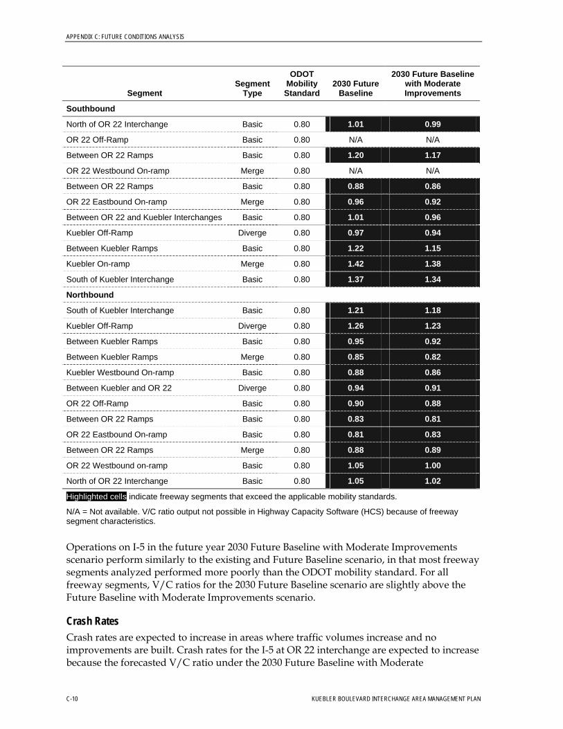
APPENDIX C: FUTURE CONDITIONS ANALYSIS
Segment Segment
Type
ODOT Mobility
Standard 2030 Future
Baseline
2030 Future Baseline with Moderate Improvements
Southbound
North of OR 22 Interchange Basic 0.80 1.01 0.99
OR 22 Off-Ramp Basic 0.80 N/A N/A
Between OR 22 Ramps Basic 0.80 1.20 1.17
OR 22 Westbound On-ramp Merge 0.80 N/A N/A
Between OR 22 Ramps Basic 0.80 0.88 0.86
OR 22 Eastbound On-ramp Merge 0.80 0.96 0.92
Between OR 22 and Kuebler Interchanges Basic 0.80 1.01 0.96
Kuebler Off-Ramp Diverge 0.80 0.97 0.94
Between Kuebler Ramps Basic 0.80 1.22 1.15
Kuebler On-ramp Merge 0.80 1.42 1.38
South of Kuebler Interchange Basic 0.80 1.37 1.34
Northbound
South of Kuebler Interchange Basic 0.80 1.21 1.18
Kuebler Off-Ramp Diverge 0.80 1.26 1.23
Between Kuebler Ramps Basic 0.80 0.95 0.92
Between Kuebler Ramps Merge 0.80 0.85 0.82
Kuebler Westbound On-ramp Basic 0.80 0.88 0.86
Between Kuebler and OR 22 Diverge 0.80 0.94 0.91
OR 22 Off-Ramp Basic 0.80 0.90 0.88
Between OR 22 Ramps Basic 0.80 0.83 0.81
OR 22 Eastbound On-ramp Basic 0.80 0.81 0.83
Between OR 22 Ramps Merge 0.80 0.88 0.89
OR 22 Westbound on-ramp Basic 0.80 1.05 1.00
North of OR 22 Interchange Basic 0.80 1.05 1.02
Highlighted cells indicate freeway segments that exceed the applicable mobility standards.
N/A = Not available. V/C ratio output not possible in Highway Capacity Software (HCS) because of freeway segment characteristics.
Operations on I-5 in the future year 2030 Future Baseline with Moderate Improvements scenario perform similarly to the existing and Future Baseline scenario, in that most freeway segments analyzed performed more poorly than the ODOT mobility standard. For all freeway segments, V/C ratios for the 2030 Future Baseline scenario are slightly above the Future Baseline with Moderate Improvements scenario.
Crash Rates Crash rates are expected to increase in areas where traffic volumes increase and no improvements are built. Crash rates for the I-5 at OR 22 interchange are expected to increase because the forecasted V/C ratio under the 2030 Future Baseline with Moderate
C-10 KUEBLER BOULEVARD INTERCHANGE AREA MANAGEMENT PLAN
APPENDIX C: FUTURE CONDITIONS ANALYSIS
Improvements scenario exceeds ODOT standards. Crash rates are also expected to increase at the I-5 and Kuebler Boulevard interchange because forecasted V/C ratios exceed ODOT mobility standards.
C.2.4 Future Baseline with Major Improvements Scenario Operations The 2030 Future Baseline with Major Improvements scenario was developed with the same OHP guidance as the Future Baseline with Moderate Improvements scenario. This section describes the projects included in the Future Baseline with Major Improvements scenario, the future forecasted traffic volumes and traffic operations, and crash analysis under the 2030 Future Baseline with Major Improvements scenario.
As illustrated in Table C-6, even with the implementation of the physical improvements listed in Table C-5, five of the six study intersections would not perform within the applicable mobility standard. In addition to the physical improvements summarized in Table C-5, the following physical improvements (or modifications to the physical improvements listed in Table C-5) would be needed to perform within the applicable mobility standards for the design year of 2030.
• Kuebler Boulevard:
− Widen Kuebler Boulevard to two lanes eastbound and westbound east of the I-5 northbound ramps
− Restripe the existing bridge over I-5 to accommodate a third eastbound lane that would terminate at the free-flow right-turn movement for the eastbound-to-northbound ramp.
• Kuebler Boulevard/Battle Creek Road:
− Convert the eastbound through/right-turn lane to a through-only lane − Install an eastbound right-turn lane − Convert the westbound through/right-turn lane to a through-only lane − Install a westbound right-turn lane − Convert the southbound through/right-turn lane to a through-only lane − Install a southbound right-turn lane
• Kuebler Boulevard/27th Avenue:
− Install a second westbound left-turn lane
• Kuebler Boulevard/I-5 Southbound Ramps:
− Install a third eastbound through-lane − Convert the southbound right-turn lane to a shared through/left-turn lane − Convert the southbound through/left-turn lane to a left-turn-only lane − Install a free southbound right-turn lane
• Kuebler Boulevard/I-5 Northbound Ramps:
− Stripe the third eastbound lane as a right-turn lane to the northbound I-5 loop ramp
• Kuebler Boulevard/36th Avenue:
KUEBLER BOULEVARD INTERCHANGE AREA MANAGEMENT PLAN C-11
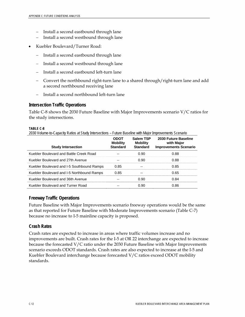
APPENDIX C: FUTURE CONDITIONS ANALYSIS
C-12 KUEBLER BOULEVARD INTERCHANGE AREA MANAGEMENT PLAN
− Install a second eastbound through lane − Install a second westbound through lane
• Kuebler Boulevard/Turner Road:
− Install a second eastbound through lane
− Install a second westbound through lane
− Install a second eastbound left-turn lane
− Convert the northbound right-turn lane to a shared through/right-turn lane and add a second northbound receiving lane
− Install a second northbound left-turn lane
Intersection Traffic Operations Table C-8 shows the 2030 Future Baseline with Major Improvements scenario V/C ratios for the study intersections.
TABLE C-8 2030 Volume-to-Capacity Ratios at Study Intersections – Future Baseline with Major Improvements Scenario
Study Intersection
ODOT Mobility
Standard
Salem TSP Mobility
Standard
2030 Future Baseline with Major
Improvements Scenario
Kuebler Boulevard and Battle Creek Road -- 0.90 0.88
Kuebler Boulevard and 27th Avenue -- 0.90 0.88
Kuebler Boulevard and I-5 Southbound Ramps 0.85 -- 0.85
Kuebler Boulevard and I-5 Northbound Ramps 0.85 -- 0.65
Kuebler Boulevard and 36th Avenue -- 0.90 0.84
Kuebler Boulevard and Turner Road -- 0.90 0.86
Freeway Traffic Operations Future Baseline with Major Improvements scenario freeway operations would be the same as that reported for Future Baseline with Moderate Improvements scenario (Table C-7) because no increase to I-5 mainline capacity is proposed.
Crash Rates Crash rates are expected to increase in areas where traffic volumes increase and no improvements are built. Crash rates for the I-5 at OR 22 interchange are expected to increase because the forecasted V/C ratio under the 2030 Future Baseline with Major Improvements scenario exceeds ODOT standards. Crash rates are also expected to increase at the I-5 and Kuebler Boulevard interchange because forecasted V/C ratios exceed ODOT mobility standards.
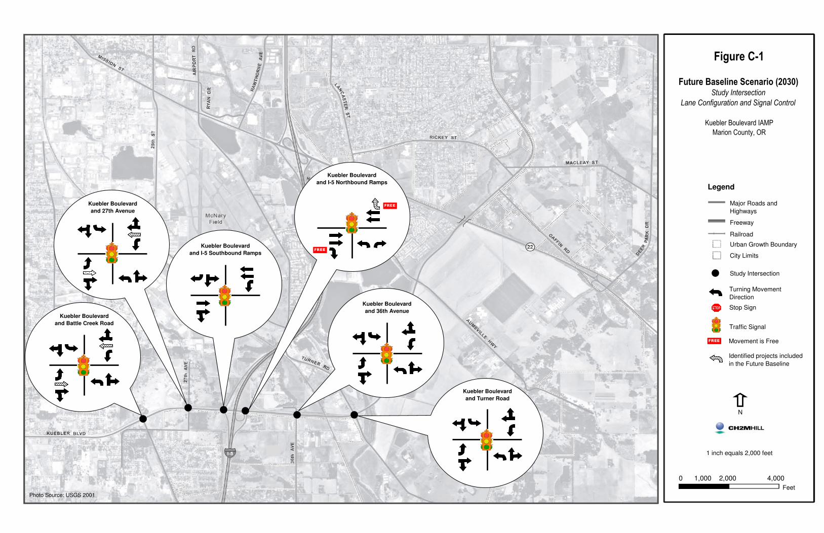
Figure C-1
Future Baseline Scenario (2030)Study Intersection
Lane Configuration and Signal Control
Kuebler Boulevard IAMP
Marion County, OR
Legend
Major Roads and
Highways
Freeway
Railroad
Urban Growth Boundary
City Limits
Study Intersection
Turning Movement
Direction
Stop Sign
Traffic Signal
Identified projects included
in the Future Baseline
Kuebler Boulevard
and 36th Avenue
Kuebler Boulevard
and Turner Road
Kuebler Boulevard
and I-5 Northbound Ramps
Kuebler Boulevard
and I-5 Southbound Ramps
Kuebler Boulevard
and Battle Creek Road
Kuebler Boulevard
and 27th Avenue
1 inch equals 2,000 feet
N
0 1,000 2,000 4,000
FeetPhoto Source: USGS 2001
FREE
FREE
Movement is FreeFREE

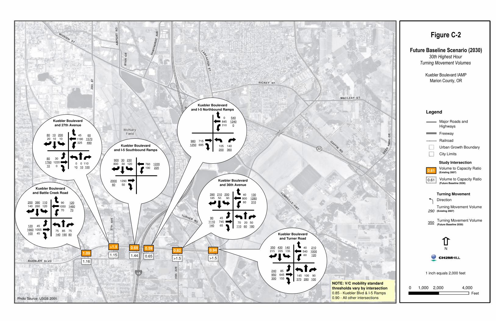
Figure C-2
Future Baseline Scenario (2030)30th Highest Hour
Turning Movement Volumes
Kuebler Boulevard IAMP
Marion County, OR
0.94
>1.5
0.82
>1.5
0.59
0.65
0.69
1.44
>1.5
1.151.09
1.16
Kuebler Boulevard
and 36th Avenue
Kuebler Boulevard
and Turner Road
Kuebler Boulevard
and I-5 Northbound Ramps
Kuebler Boulevard
and I-5 Southbound Ramps
Kuebler Boulevard
and Battle Creek Road
Kuebler Boulevard
and 27th Avenue
1 inch equals 2,000 feet
N
0 1,000 2,000 4,000
Feet
Legend
Major Roads and
Highways
Freeway
Railroad
Urban Growth Boundary
City Limits
Study Intersection
Volume to Capacity Ratio (Existing 2007)
Turning Movement
Direction
Turning Movement Volume(Existing 2007)
Volume to Capacity Ratio(Future Baseline 2030)
0.61
0.61
290
Turning Movement Volume(Future Baseline 2030)
350
900 30 230
800 30 120 760
190
1220
220
1290
50
2000
60
75 85 75
140 190 80
200 390 110
140 260 120
90
1050
70
120
1460
70
45
1055
45
120
1660
100
0 0 110
10 10 100
80 10 200
20 10 10
45
1190
325
60
1570
490
30
1220
0
80
1760
10
105 140
200 360
0
845
210
540
1240
0
715
695
980
1250
70 20 50
110 60 180
390 210 200
185 50 90
40
800
60
130
1280
310
45
745
65
90
1110
140
145 100 90
370 280 100
350 430 140
215 225 135
40
540
60
210
1000
120
85
645
155
240
950
300
NOTE: V/C mobility standard
thresholds vary by intersection
0.85 - Kuebler Blvd & I-5 Ramps
0.90 - All other intersectionsPhoto Source: USGS 2001

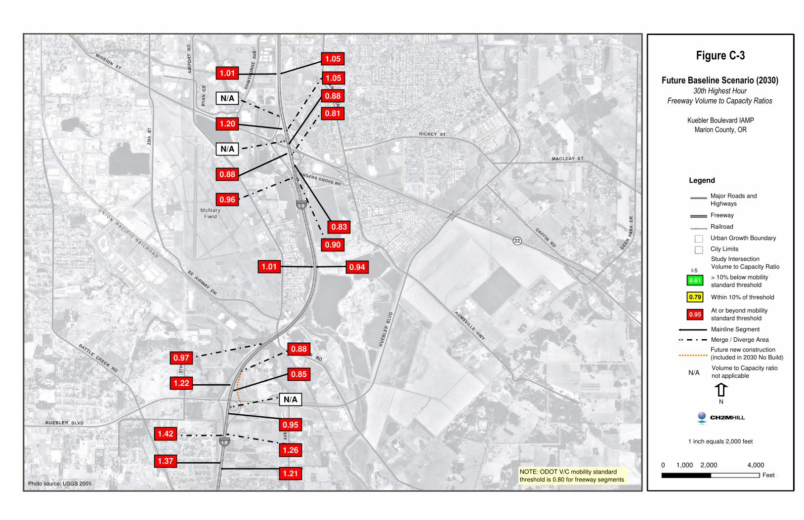
Figure C-3
Future Baseline Scenario (2030)30th Highest Hour
Freeway Volume to Capacity Ratios
Kuebler Boulevard IAMP
Marion County, OR
1 inch equals 2,000 feet
N
0 1,000 2,000 4,000
Feet
Legend
Major Roads and
Highways
Freeway
Railroad
Urban Growth Boundary
City Limits
Study Intersection
Volume to Capacity Ratio1.01
Mainline Segment
Merge / Diverge Area
NOTE: ODOT V/C mobility standard
threshold is 0.80 for freeway segments
Future new construction
(included in 2030 No Build)0.97
1.22
1.42
1.37
0.88
0.85
N/A
0.95
1.26
1.21
N/A
0.88
0.96
1.01
N/A
1.20
0.83
0.90
0.94
0.81
0.88
1.05
1.05
Volume to Capacity ratio
not applicableN/A
> 10% below mobility
standard threshold
At or beyond mobility
standard threshold
Wthin 10% of threshold
0.61
0.79
0.95
0.49
I-5
Photo source: USGS 2001

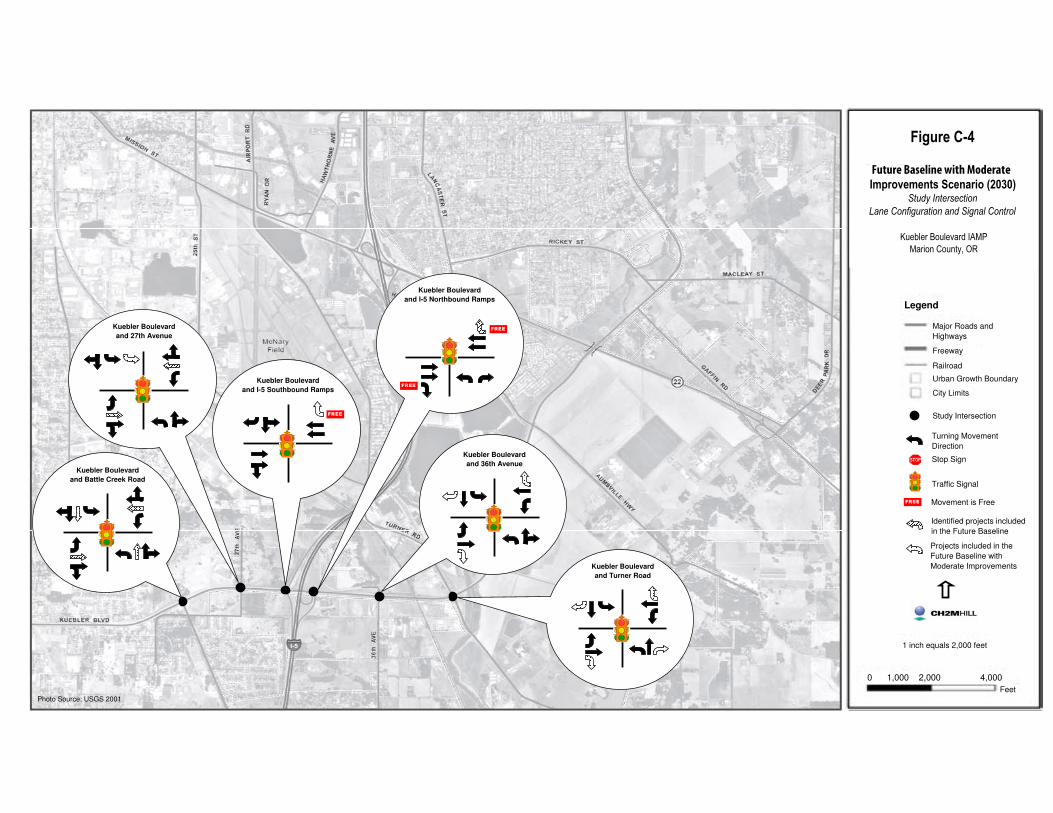
��������
������� ������������������������������������������������� �!
���������� ���������������������������������
�������������� ��������������������
Legend
Major Roads and Highways
Freeway
Railroad
Urban Growth Boundary
City Limits
Study Intersection
Turning Movement Direction
Stop Sign
Traffic Signal
Identified projects includedin the Future Baseline
Kuebler Boulevard and 36th Avenue
Kuebler Boulevard and Turner Road
Kuebler Boulevard and I-5 Northbound Ramps
Kuebler Boulevard and I-5 Southbound Ramps
Kuebler Boulevard and Battle Creek Road
Kuebler Boulevard and 27th Avenue
1 inch equals 2,000 feet
N
0 1,000 2,000 4,000Feet
Photo Source: USGS 2001
����
����
Movement is Free����
Projects included in theFuture Baseline with Moderate Improvements
����
Future Baseline with Moderate

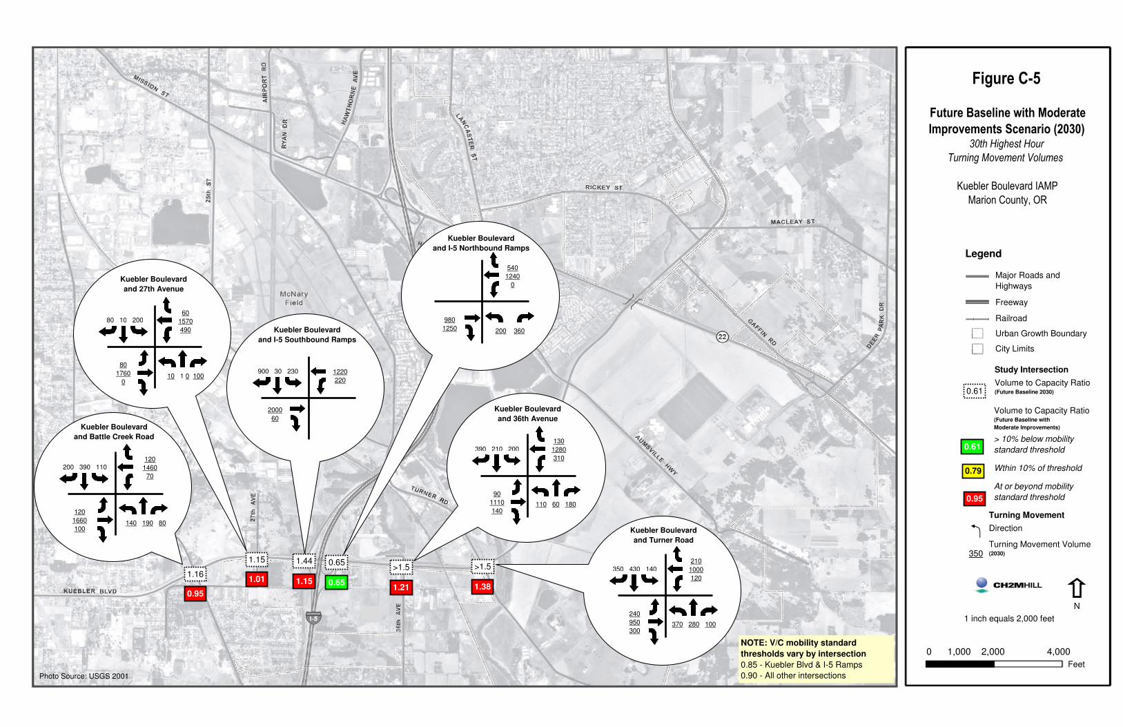
Figure C-5
Future Baseline with Moderate
Improvements Scenario (2030)30th Highest Hour
Turning Movement Volumes
Kuebler Boulevard IAMP
Marion County, OR
1.38
>1.5
1.21
>1.5
0.65
0.65
1.15
1.44
1.01
1.15
0.95
1.16
Kuebler Boulevard
and 36th Avenue
Kuebler Boulevard
and Turner Road
Kuebler Boulevard
and I-5 Northbound Ramps
Kuebler Boulevard
and I-5 Southbound Ramps
Kuebler Boulevard
and Battle Creek Road
Kuebler Boulevard
and 27th Avenue
1 inch equals 2,000 feet
0 1,000 2,000 4,000
Feet
Legend
Major Roads and
Highways
Freeway
Railroad
Urban Growth Boundary
City Limits
900 30 230 1220
220
2000
60
140 190 80
200 390 110
120
1460
70
120
1660
100
10 1 0 100
80 10 20060
1570
490
80
1760
0
200 360
540
1240
0
980
1250
110 60 180
390 210 200
130
1280
310
90
1110
140
370 280 100
350 430 140
210
1000
120
240
950
300
NOTE: V/C mobility standard
thresholds vary by intersection
0.85 - Kuebler Blvd & I-5 Ramps
0.90 - All other intersectionsPhoto Source: USGS 2001
N
Volume to Capacity Ratio(Future Baseline with
Moderate Improvements)
> 10% below mobility
standard threshold
Wthin 10% of threshold
At or beyond mobility
standard threshold
0.61
0.79
0.95
0.61
Turning Movement
Direction
Turning Movement Volume(2030)
Study Intersection
Volume to Capacity Ratio(Future Baseline 2030)
350

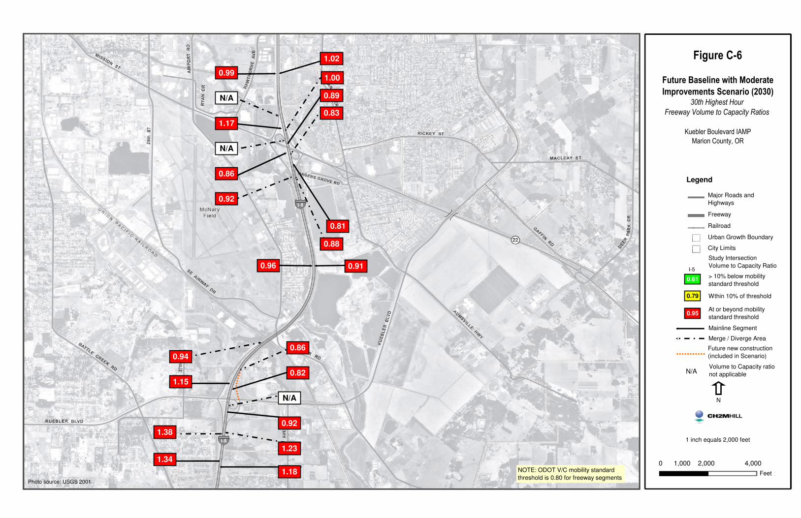
Figure C-6
Future Baseline with Moderate
Improvements Scenario (2030)30th Highest Hour
Freeway Volume to Capacity Ratios
Kuebler Boulevard IAMP
Marion County, OR
1 inch equals 2,000 feet
N
0 1,000 2,000 4,000
Feet
Legend
Major Roads and
Highways
Freeway
Railroad
Urban Growth Boundary
City Limits
Study Intersection
Volume to Capacity Ratio0.96
Mainline Segment
Merge / Diverge Area
NOTE: ODOT V/C mobility standard
threshold is 0.80 for freeway segments
Future new construction
(included in Scenario)0.94
1.15
1.38
1.34
0.86
0.82
N/A
0.92
1.23
1.18
N/A
0.86
0.92
0.99
N/A
1.17
0.81
0.88
0.91
0.83
0.89
1.00
1.02
Volume to Capacity ratio
not applicableN/A
> 10% below mobility
standard threshold
At or beyond mobility
standard threshold
Wthin 10% of threshold
0.61
0.79
0.95
I-5
Photo source: USGS 2001


KUEBLER BOULEVARD INTERCHANGE AREA MANAGEMENT PLAN
APPENDIX D
Alternatives Development Analysis

APPENDIX D
Alternatives Development Analysis
The purpose of this section of the Kuebler Boulevard Interchange Area Management Plan (IAMP) is to document the alternatives development and analysis process. This section describes how alternative solutions were developed and analyzed to remedy IAMP-identified deficiencies.
D.1 Kuebler Boulevard Interchange Improvements This section describes interchange improvement alternatives (concepts) considered by the Project Management Team (PMT) for the Kuebler Boulevard interchange, and the qualitative and operational analysis used to determine the preferred alternative for the Kuebler Boulevard interchange. The following topics are addressed:
• Kuebler Boulevard interchange concepts considered
• Initial and revised screening criteria and evaluation methods
• Selection of a preferred alternative
• Alternatives for mitigating the performance of the ramp terminals at the interchange (developed to meet the relevant ODOT mobility standards)
D.2 Kuebler Boulevard Interchange Concepts The following describes 10 alternatives (concepts) that were developed during a PMT workshop in the spring of 2005 to improve the Kuebler Boulevard interchange. The following key terms were used to identify and describe interchange concepts:
• Parclo—A partial cloverleaf interchange.
• Parclo A—A partial cloverleaf interchange that features loops in advance of the crossroad (as viewed by the driver on the freeway)
• Parclo B—A partial cloverleaf interchange that features loops beyond the crossroad (as viewed by the driver on the freeway).
• Direct Ramp—A ramp connection that does not deviate greatly from the intended direction of travel. Directional information of the ramp is provided in parentheses (From - To).
• Semidirect Ramp—A ramp connection that first deviates from its intended direction, but ultimately turns towards its desired direction of travel. Directional information of the ramp is provided in parentheses (From - To).
KUEBLER BOULEVARD INTERCHANGE AREA MANAGEMENT PLAN D-1
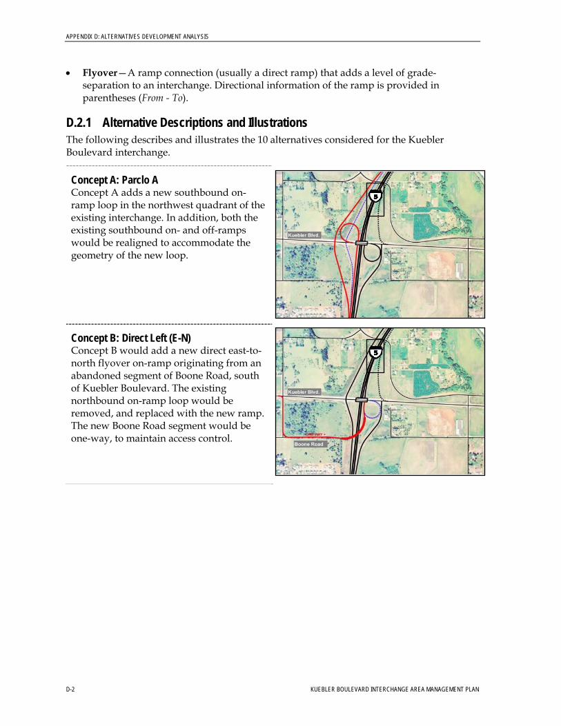
APPENDIX D: ALTERNATIVES DEVELOPMENT ANALYSIS
• Flyover—A ramp connection (usually a direct ramp) that adds a level of grade-separation to an interchange. Directional information of the ramp is provided in parentheses (From - To).
D.2.1 Alternative Descriptions and Illustrations The following describes and illustrates the 10 alternatives considered for the Kuebler Boulevard interchange.
Concept A: Parclo A Concept A adds a new southbound on-ramp loop in the northwest quadrant of the existing interchange. In addition, both the existing southbound on- and off-ramps would be realigned to accommodate the geometry of the new loop.
Concept B: Direct Left (E-N) Concept B would add a new direct east-to-north flyover on-ramp originating from an abandoned segment of Boone Road, south of Kuebler Boulevard. The existing northbound on-ramp loop would be removed, and replaced with the new ramp. The new Boone Road segment would be one-way, to maintain access control.
D-2 KUEBLER BOULEVARD INTERCHANGE AREA MANAGEMENT PLAN
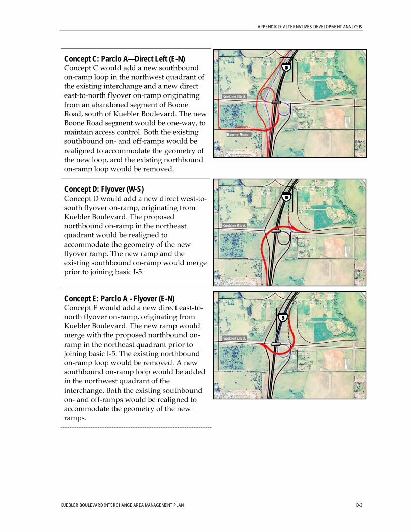
APPENDIX D: ALTERNATIVES DEVELOPMENT ANALYSIS
Concept C: Parclo A—Direct Left (E-N) Concept C would add a new southbound on-ramp loop in the northwest quadrant of the existing interchange and a new direct east-to-north flyover on-ramp originating from an abandoned segment of Boone Road, south of Kuebler Boulevard. The new Boone Road segment would be one-way, to maintain access control. Both the existing southbound on- and off-ramps would be realigned to accommodate the geometry of the new loop, and the existing northbound on-ramp loop would be removed.
Concept D: Flyover (W-S) Concept D would add a new direct west-to-south flyover on-ramp, originating from Kuebler Boulevard. The proposed northbound on-ramp in the northeast quadrant would be realigned to accommodate the geometry of the new flyover ramp. The new ramp and the existing southbound on-ramp would merge prior to joining basic I-5.
Concept E: Parclo A - Flyover (E-N) Concept E would add a new direct east-to-north flyover on-ramp, originating from Kuebler Boulevard. The new ramp would merge with the proposed northbound on-ramp in the northeast quadrant prior to joining basic I-5. The existing northbound on-ramp loop would be removed. A new southbound on-ramp loop would be added in the northwest quadrant of the interchange. Both the existing southbound on- and off-ramps would be realigned to accommodate the geometry of the new ramps.
KUEBLER BOULEVARD INTERCHANGE AREA MANAGEMENT PLAN D-3
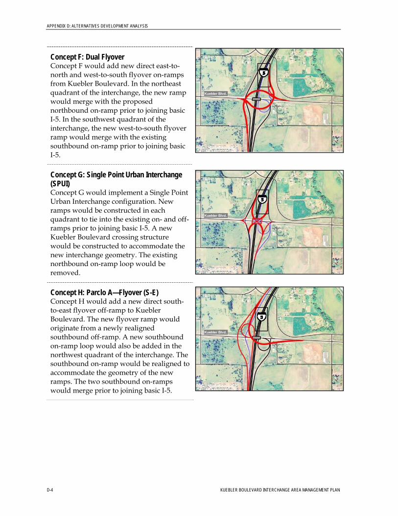
APPENDIX D: ALTERNATIVES DEVELOPMENT ANALYSIS
Concept F: Dual Flyover Concept F would add new direct east-to-north and west-to-south flyover on-ramps from Kuebler Boulevard. In the northeast quadrant of the interchange, the new ramp would merge with the proposed northbound on-ramp prior to joining basic I-5. In the southwest quadrant of the interchange, the new west-to-south flyover ramp would merge with the existing southbound on-ramp prior to joining basic I-5.
Concept G: Single Point Urban Interchange (SPUI) Concept G would implement a Single Point Urban Interchange configuration. New ramps would be constructed in each quadrant to tie into the existing on- and off-ramps prior to joining basic I-5. A new Kuebler Boulevard crossing structure would be constructed to accommodate the new interchange geometry. The existing northbound on-ramp loop would be removed.
Concept H: Parclo A—Flyover (S-E) Concept H would add a new direct south-to-east flyover off-ramp to Kuebler Boulevard. The new flyover ramp would originate from a newly realigned southbound off-ramp. A new southbound on-ramp loop would also be added in the northwest quadrant of the interchange. The southbound on-ramp would be realigned to accommodate the geometry of the new ramps. The two southbound on-ramps would merge prior to joining basic I-5.
D-4 KUEBLER BOULEVARD INTERCHANGE AREA MANAGEMENT PLAN
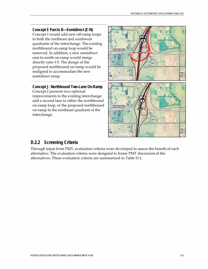
APPENDIX D: ALTERNATIVES DEVELOPMENT ANALYSIS
Concept I: Parclo B—Semidirect (E-N) Concept I would add new off-ramp loops in both the northeast and southwest quadrants of the interchange. The existing northbound on-ramp loop would be removed. In addition, a new semidirect east-to-north on-ramp would merge directly onto I-5. The design of the proposed northbound on-ramp would be realigned to accommodate the new semidirect ramp.
Concept J: Northbound Two-Lane On-Ramp Concept J presents two optional improvements to the existing interchange: add a second lane to either the northbound on-ramp loop, or the proposed northbound on-ramp in the northeast quadrant of the interchange.
D.2.2 Screening Criteria Through input from PMT, evaluation criteria were developed to assess the benefit of each alternative. The evaluation criteria were designed to frame PMT discussion of the alternatives. These evaluation criteria are summarized in Table D-1.
KUEBLER BOULEVARD INTERCHANGE AREA MANAGEMENT PLAN D-5
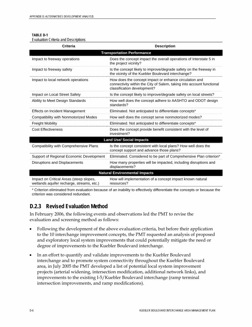
APPENDIX D: ALTERNATIVES DEVELOPMENT ANALYSIS
TABLE D-1 Evaluation Criteria and Descriptions
Criteria Description
Transportation Performance Does the concept impact the overall operations of Interstate 5 in the project vicinity?
Impact to freeway operations
Is the concept likely to improve/degrade safety on the freeway in the vicinity of the Kuebler Boulevard interchange?
Impact to freeway safety
How does the concept impact or enhance circulation and connectivity within the City of Salem, taking into account functional classification development?
Impact to local network operations
Impact on Local Street Safety Is the concept likely to improve/degrade safety on local streets? How well does the concept adhere to AASHTO and ODOT design standards?
Ability to Meet Design Standards
Effects on Incident Management Eliminated. Not anticipated to differentiate concepts* Compatibility with Nonmotorized Modes How well does the concept serve nonmotorized modes? Freight Mobility Eliminated. Not anticipated to differentiate concepts*
Does the concept provide benefit consistent with the level of investment?
Cost Effectiveness
Land Use/ Social Impacts Is the concept consistent with local plans? How well does the concept support and advance those plans?
Compatibility with Comprehensive Plans
Support of Regional Economic Development Eliminated. Considered to be part of Comprehensive Plan criterion* How many properties will be impacted, including disruptions and displacements?
Disruptions and Displacements
Natural Environmental Impacts Impact on Critical Areas (steep slopes, wetlands aquifer recharge, streams, etc.)
How will implementation of a concept impact known natural resources?
* Criterion eliminated from evaluation because of an inability to effectively differentiate the concepts or because the criterion was considered redundant.
D.2.3 Revised Evaluation Method In February 2006, the following events and observations led the PMT to revise the evaluation and screening method as follows:
• Following the development of the above evaluation criteria, but before their application to the 10 interchange improvement concepts, the PMT requested an analysis of proposed and exploratory local system improvements that could potentially mitigate the need or degree of improvements to the Kuebler Boulevard interchange.
• In an effort to quantify and validate improvements to the Kuebler Boulevard interchange and to promote system connectivity throughout the Kuebler Boulevard area, in July 2005 the PMT developed a list of potential local system improvement projects (arterial widening, intersection modification, additional network links), and improvements to the existing I-5/Kuebler Boulevard interchange (ramp terminal intersection improvements, and ramp modifications).
D-6 KUEBLER BOULEVARD INTERCHANGE AREA MANAGEMENT PLAN
APPENDIX D: ALTERNATIVES DEVELOPMENT ANALYSIS
• The PMT developed two mitigation alternatives for the Kuebler Boulevard interchange in an effort to make the 2030 Future Baseline with Major Improvements scenario ramp terminal intersections meet ODOT mobility standards. The two mitigation scenarios were identified as a “Low Level Alternative” and a “Westbound-to-Southbound Loop Ramp Alternative.” The second mitigation alternative was based on Concept A, developed at the spring 2005 workshop.
• The decision to include Concept A in the mitigation alternative was based on guidelines outlined in the American Association of State and Highway Transportation Officials’ (AASHTO’s) A Policy on Geometric Design of Highways and Streets—2001 and industry experience where interchange improvements of the type shown in Concept A historically have been used to successfully mitigate mobility issues at interchanges similar to the existing Kuebler Boulevard interchange.
• The existing Kuebler Boulevard interchange features a single loop ramp in the southeast quadrant of the interchange. Conventional practice to maximize capacity in an interchange of this type consists of placing a second loop ramp in the opposite (northwest) quadrant of the interchange area. Typically, a diamond interchange with loop ramps in opposite quadrants (such as Concept A) represents the highest capacity two-level (structure) interchange.
To expedite the screening process of the concepts developed for the Kuebler Boulevard interchange, the PMT proposed that many of the initial design concepts could be eliminated because of the traffic analysis performed through the 2030 Future Baseline with Moderate Improvements scenario. Operational analyses concluded that Concept A, a two-level interchange, would meet the ODOT mobility standard, making interchange concepts designed to accommodate greater capacities (interchanges with direct “flyover” ramps or three bridge levels) unnecessary.
The following concepts were designed to accommodate greater capacities than Concept A and were removed from consideration as improvements to the Kuebler Boulevard interchange:
• Concept C: Parclo A—Direct Left (E-N) • Concept D: Flyover (W-S) • Concept E: Parclo A—Flyover (E-N) • Concept F: Dual Flyover • Concept H: Parclo A—Flyover (S-E) • Concept I: Parclo B—Semidirect (E-N)
The remaining concepts were as follows:
• Concept A: Parclo A • Concept B: Direct Left (E-N) • Concept G: Single Point Urban Interchange (SPUI) • Concept J: NB two-lane on-ramp
KUEBLER BOULEVARD INTERCHANGE AREA MANAGEMENT PLAN D-7
APPENDIX D: ALTERNATIVES DEVELOPMENT ANALYSIS
D-8 KUEBLER BOULEVARD INTERCHANGE AREA MANAGEMENT PLAN
D.2.4 Concept Assessment and Recommendation This section discusses the relative benefits and challenges of each of the remaining concepts (A, B, G, and J), and the conclusion reached by the PMT.
• Concept A: Parclo A was the highest-capacity two-level interchange, and would retain many elements of the existing interchange. Land acquisition would be required in the northwest and southwest quadrants.
• Concept B: Direct Left (E-N) featured an unconventional design that is counter to driver expectations, and would conflict with ODOT design standards. Benefits would result from lack of impact to the northwest quadrant of the interchange, but would be offset by impacts to the southwest quadrant, and high-structure costs associated with the direct flyover ramp.
• Concept G: Single Point Urban Interchange (SPUI) would be comparable to Concept A in terms of performance benefits, but at a much higher cost. One of the main benefits of a SPUI is its tight footprint—an ideal feature in a dense, urban setting. The reduced size of the SPUI’s footprint is offset by its increased cost to construct. SPUI interchanges have high-structure costs to allow all ramps to meet at a central point above the freeway.
• Concept J: Northbound Two-lane On-Ramp would not provide adequate operational benefit, because the western ramp terminals would not be improved. Advantages would be related to the low cost of the improvements and limited property impacts.
Based on the above assessment and the operational analyses, the PMT recommended Concept A as the preferred concept for the Kuebler Boulevard interchange. Concept A stood out from the remaining concepts considered (B, G, and J) because the Parclo A interchange design could make use of the existing interchange configuration, with the least amount of cost and disruption during construction. While further evaluation of each of the concepts could provide additional data to consider, the PMT concluded that the fundamental questions concerning the selection of a preferred concept had been sufficiently addressed to support the recommendation.
The preferred alternative (Concept A) adds a new southbound onramp loop in the northwest quadrant of the existing interchange. In addition, both the existing on and off-ramps would be realigned to accommodate the geometry of the new loop ramp.

APPENDIX E
Public Involvement
KUEBLER BOULEVARD INTERCHANGE AREA MANAGEMENT PLAN

SESATS Stakeholder Interview Summary Page 1 of 14
September 2005
Southeast Salem Area Transportation Study
STAKEHOLDER INTERVIEWS SUMMARY September 2005
OVERVIEW
Between August 25 and September 20, 2005, Randa Gahin of Jeanne Lawson Associates
conducted 17 interviews with 29 individuals representing stakeholder interests in the
project area. Ten of the interviews were conducted through in-person meetings in Salem.
The remaining seven interviews were conducted over the phone. The in-person meetings
were combined into small group meetings when appropriate, and scheduled into as few
days as possible to minimize trips between Salem and Portland. Interviews ranged from
10 minutes for some of the phone interviews to up to 75 minutes for in-person meetings.
For the in-person meetings, participants received a project fact sheet and list of questions
prior to the interview. Many of the phone interviewees also received a fact sheet via
email. For the in-person meetings, a large table-size map was provided for participants to
draw on to indicate their property or jurisdiction and as a reference for the discussion.
The individuals contacted represented neighborhoods, businesses, agencies, and
institutions in the project area. The purpose of the interviews was to provide information
about the project to key stakeholders and gather their input on issues of concern related to
the project. This interview effort builds on the information obtained through interviews
conducted by Jamie Damon of Jeanne Lawson Associates in November 2004 for the
Kuebler Interchange project.
QUESTIONS
Interviewees were given a brief description of the project, and then asked the following
questions (phone interviews were typically limited to questions 1 and 2).
1. How do you or your organization use the transportation facilities in the study area
(Hwy 22 between 25th
Street and Gaffin Road, the Hwy 22 (North Santiam)
Interchange, and the Kuebler Interchange)?
2. What do you perceive to be the problems or issues with these transportation
facilities? How does the use or limitation of use of these facilities affect you and
your organization? What about in the future?
3. What do you believe could or should be the primary opportunities and benefits
that come out of this project/study? (What are your hopes for this project?)
4. Do you have any thoughts about how we engage the public in this study? For
example, are there any stakeholders, individuals or groups, we should make sure
to engage? What methods can we use to inform people and get information out to
your community?
5. How would you like to be involved in this project?
6. Do you have any final messages or suggestions for the project management team?
SESATS Stakeholder Interview Summary Page 2 of 14
September 2005
STAKEHOLDER LIST
The following is the list of stakeholders that were interviewed. The list was developed
based on recommendations from the Project Management Team and further research in
the area. The interviewees included were not meant to be a comprehensive group of
affected interests. Rather, they were selected to represent key interests in the study area.
Interest Represented Organization Name
Oregon State Department
of Corrections
Joe DeCamp, Operations Manager
SCI/MCCF (for Ken Robertson,
Physical Plant Manager)
Department of Public
Safety Standards and
Training (DPSST)
Daniel Dowell, CH2M Hill (for Eriks
Gabliks, Deputy Director)
Corban College Tom Samek, Director of Campus Care
Holly Cozby, Assistant
Large Institutions East
of Kuebler/Cordon
(two meetings)
Also Invited:
• Jeff Bickford, Salem Area Transfer Station (Recycling Center)
• Raul Ramirez ,Sheriff, Marion County Correctional Facility
East Salem Suburban
Neighborhood Association
(ESSNA)
Corky Brown, Chairperson
Jack Thornton, Secretary-Treasurer
South East Salem
Neighborhood Association
(SESNA)
Mark Weiprecht, Land Use Chair
Neighborhood
Associations
(two meetings)
Also Invited:
• SE Mill Creek Neighborhood Association
Mill Creek Industrial
Park
Urban Development
Department
Rick Scott, Director
Agricultural Producers Marion County Farm
Bureau
Larry Wells, President
Salem Keizer Transit
(Cherriots)
John Whittington, Transit
Development Director
Transit
Oregon Housing and
Associated Services
(OHAS)
Mary Renneke, Training & Road
Supervisor
A.C. Nielsen Land Use and
Development Services
Tony Nielson
Mission Properties Lester Green
Sustainable Fairview
and Other Development
in SE Salem
Also Invited:
• Mike Coontz, Interim Airport Administrator, Salem Airport
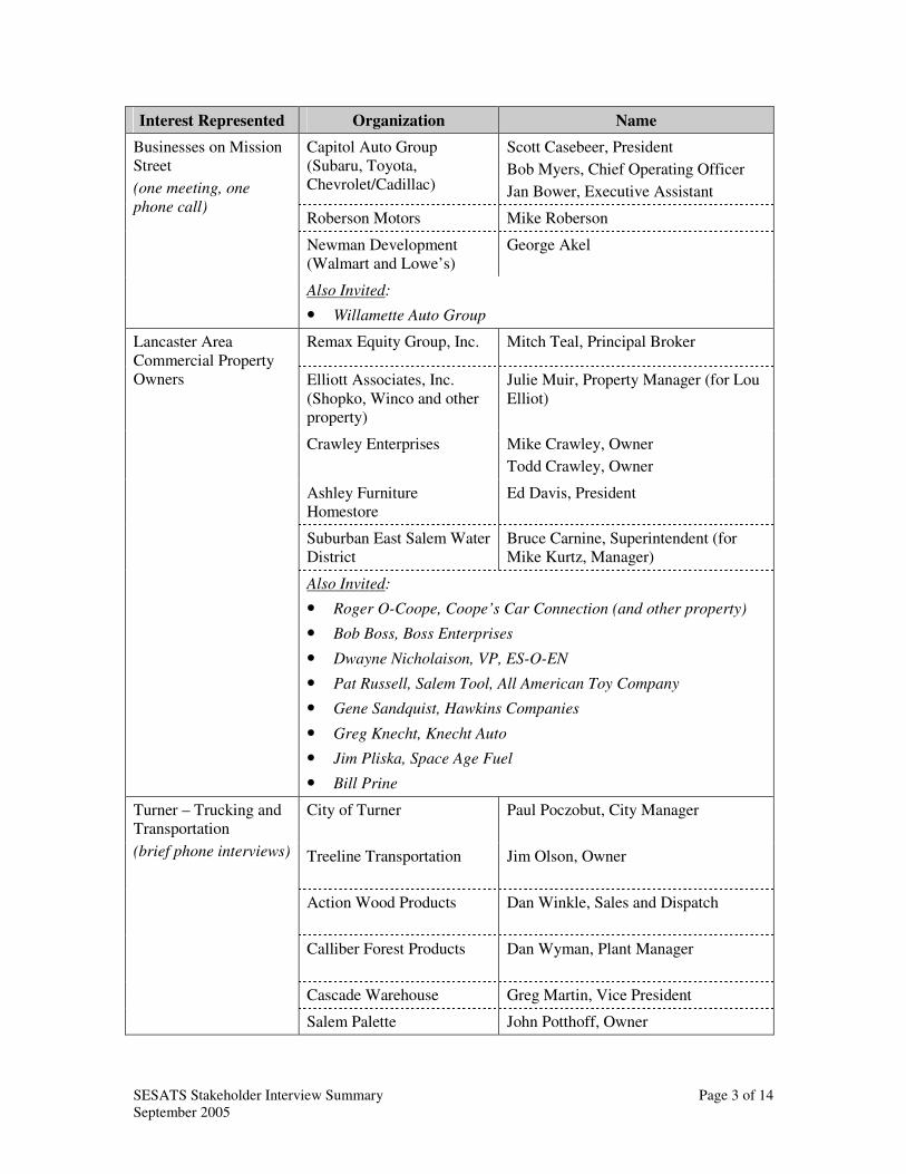
SESATS Stakeholder Interview Summary Page 3 of 14
September 2005
Interest Represented Organization Name
Capitol Auto Group
(Subaru, Toyota,
Chevrolet/Cadillac)
Scott Casebeer, President
Bob Myers, Chief Operating Officer
Jan Bower, Executive Assistant
Roberson Motors Mike Roberson
Newman Development
(Walmart and Lowe’s)
George Akel
Businesses on Mission
Street
(one meeting, one
phone call)
Also Invited:
• Willamette Auto Group
Remax Equity Group, Inc. Mitch Teal, Principal Broker
Elliott Associates, Inc.
(Shopko, Winco and other
property)
Julie Muir, Property Manager (for Lou
Elliot)
Crawley Enterprises Mike Crawley, Owner
Todd Crawley, Owner
Ashley Furniture
Homestore
Ed Davis, President
Suburban East Salem Water
District
Bruce Carnine, Superintendent (for
Mike Kurtz, Manager)
Lancaster Area
Commercial Property
Owners
Also Invited:
• Roger O-Coope, Coope’s Car Connection (and other property)
• Bob Boss, Boss Enterprises
• Dwayne Nicholaison, VP, ES-O-EN
• Pat Russell, Salem Tool, All American Toy Company
• Gene Sandquist, Hawkins Companies
• Greg Knecht, Knecht Auto
• Jim Pliska, Space Age Fuel
• Bill Prine
City of Turner Paul Poczobut, City Manager
Treeline Transportation Jim Olson, Owner
Action Wood Products Dan Winkle, Sales and Dispatch
Calliber Forest Products Dan Wyman, Plant Manager
Cascade Warehouse Greg Martin, Vice President
Turner – Trucking and
Transportation
(brief phone interviews)
Salem Palette John Potthoff, Owner
SESATS Stakeholder Interview Summary Page 4 of 14
September 2005
INTERVIEW HIGHLIGHTS
Several themes emerged from the interviews:
• Most, if not all, interviewees were strongly in favor of adding an interchange at
Cordon Road both to accommodate current and future traffic on Cordon-Kuebler,
and to alleviate traffic at the Lancaster Interchange.
• Many interviewees stated that Kuebler Boulevard needs to be widened to four
lanes, both to the west of I-5 (at least as far as Commercial Street) and to the east
of I-5 (to Hwy 22) to accommodate current and future traffic.
• Many interviewees noted that the Lancaster Interchange is extremely congested.
Traffic on the eastbound Hwy 22 off-ramp at Lancaster sometimes backs up onto
Hwy 22, due to the large number of vehicles waiting to turn left at the signal onto
Lancaster.
• Many interviewees said that Hwy 22/Mission Street is extremely congested at the
Airport Road and 25th
Street signals. These are major bottleneck points.
• Many interviewees commented on deficiencies at the Kuebler Interchange,
including that the I-5 southbound off-ramp gets backed up and the northbound on-
ramp is too short for safe merging, especially for trucks.
• Several interviewees expressed concerns about the expected growth in the area
and the need to do more to address transportation problems.
INTERVIEW RESPONSES
Question #1: How do you or your organization use the transportation facilities in the
study area?
Agricultural Producers
• Some farms have property on the other side of Salem (Polk County) and move
equipment back and forth. Hwy 22 is a major artery. Widening Hwy 22 several
years ago between Gaffin Road and Stayton helped a lot. It is more an issue of
moving equipment, not goods. Getting across bridges in town is a nightmare.
• Produce used to go to the cannery in west Salem. Now the canneries are at Brooks
and Stayton (for farms as far as Dayton), and also Norpac on Airport Way. The
main crops are sweet corn, beans, and beets. Grass seed is another big crop. That
is mostly processed on site, but they move lots of equipment to different holdings.
• The I-5/Hwy 22 connection is important. Coming from the south to downtown,
trucks used to use Commercial Street, but more and more lights have been added
on Commercial, so they have to choose between Commercial and Mission Street.
Businesses on West Hwy 22
• The car dealerships have hundreds of thousands of customers each year.
• Capitol Auto Group has two driveways and an access road off of 25th
. The
driveways are critical. One allows vehicles to turn right only because of medians
SESATS Stakeholder Interview Summary Page 5 of 14
September 2005
that were recently installed. The other allows vehicles to turn either right or left.
For customers leaving the property who need to go east on Mission Street, the
driveway is often easier to use than the 25th
Street exit because this access is so
close to the Mission/25th
Street intersection and it is very difficult to get a break in
traffic to turn left, particularly during the peak hour. The driveways are also
critical for car carrier trucks, which cannot use the 25th
Street access.
• Capitol Auto Group is very skeptical of this process because they did not have a
positive experience with the recent negotiations they participated in with ODOT,
the City of Salem, and the Governor’s Office about the medians and accesses on
Mission Street. Their impression is that they spent a year participating in these
negotiations and ODOT ended up doing what they were going to do anyway. It
did not seem like a good faith effort to them.
• One of the factors that has made the issue of access at Capitol Auto Group so
challenging is that they were originally promised that they would be able to have
access to the north through the federal property on Military Way to Airport Road.
Because of heightened security in the aftermath of 9-11, this access was denied.
This access would have solved a lot of the problems.
• Roberson Motors does not have driveways on Mission Street. Ryan Drive is the
only access in and out. This seems to be working OK.
• Willamette Auto Group has one driveway on Mission Street.
• Lowe’s and Walmart: The most important thing is an at-grade access. The current
access is on Turner Road. They would like an access on Hwy 22.
Corban College
• Corban houses 460 out of the total of 850 students, but approximately 430 of
those living on site have cars. The other half of the student body commutes. The
college is projected to have 1,000 students by 2010, and 2,000 by 2020. Housing
will expand as well. A new dorm is being built next year. The sports program is
also growing. They rent out fields in the summer. Use is increasing.
• Students use Kuebler a lot. They also go up Aumsville Hwy to Lancaster.
Delivery trucks also come in.
Department of Public Safety Standards and Training (DPSST) – New Training Facility
• The new DPSST facility is scheduled to be completed in July 2006.
• The facility will have 125 employees and dorms to accommodate 300 students,
with a dining facility on-site. However, it is likely that many will travel off-site
for meals, etc. Instructors could be commuting from any direction.
• The main entry is on Aumsville. Most commuters will probably use Lancaster.
This will increase traffic at that intersection.
Lancaster Area Businesses
• Customers use Lancaster Drive, the Lancaster Interchange, Mission Street,
Cordon-Kuebler, and the Kuebler Interchange.
SESATS Stakeholder Interview Summary Page 6 of 14
September 2005
Mill Creek Industrial Park
• Mill Creek will generate both employee commute traffic and truck traffic. The
facility will have an estimated 4,000 to 5,000 employees at build-out. For north-
south travel, it makes the most sense to use the Kuebler interchange. For east-west
travel, vehicles will be forced to use Lancaster.
Southeast Salem Neighborhood
• The neighborhood is split. It is industrial to the south and residential to the north.
They are trying to keep commercial uses from encroaching on residential areas.
25th
Street has lots of residential traffic and some industrial (for Fairview
Industrial Park).
State Correctional Facilities
• Mill Creek Facility: Visitors from out of town mostly use the Kuebler
Interchange, and also Turner north to Hwy 22 and Cordon Road.
• Santiam Correctional Institute: Lancaster interchange.
Suburban East Salem Residents
• The Suburban East Salem Water District has been in existence since 1956.
Residences in the area were built in the 1950’s. The district serves the area west
of Cordon Road roughly within the boundaries of the East Salem Suburban
Neighborhood Association.
• The East Salem Suburban Neighborhood Association has been in existence for
approximately 8 or 9 years.
• For east-west movement, residents use both the Lancaster and Gaffin Road
interchanges to access Hwy 22.
• To go south, residents will avoid the Lancaster interchange and the I-5/Hwy 22
interchange and go south on Lancaster Drive to the Kuebler interchange.
• Residents avoid Lancaster and the Lancaster interchange if they can.
• Cordon Road is very well traveled from 4 to 6 pm at least to Silverton.
Sustainable Fairview
• They did a $60,000 Transportation Impact Analysis (Kittelson). The facility is
projected to generate 15,000 trips per day. Previously the site had 6,000 to 7,000
trips per day (a school for the developmentally disabled was located there). They
studied 15 intersections. The facility will be primarily residential. It is 10 years
until build-out.
• The area already has “growth with deferred improvements.” The impacts of
Sustainable Fairview will be incremental. The Mill Creek Industrial Facility and
Sustainable Fairview created a development district. The system development
charges (SDCs) will go to the broader neighborhood (mostly transportation, and
some water, wastewater, parks, etc.)
SESATS Stakeholder Interview Summary Page 7 of 14
September 2005
• They see Sustainable Fairview as part of the jobs/housing balance for Mill Creek.
There will be about 1600 homes (middle-high income level).
• They have suggested a Special Transportation Area (STA). They want to be
integrated into the surrounding community and are really trying to reduce single-
occupancy vehicle trips. The neighborhood has been supportive.
Transit
• Cherriots has a route on Lancaster Drive that goes to the mobile home parks and
out to the jail (very frequent service on Lancaster). They do not go through the I-
5/Hwy 22 interchange and do not have service as far as Cordon Road (see transit
route map). For north-south, they prefer Hawthorne to I-5.
• OHAS provides curbside, on-demand service (no fixed route). They try to avoid
the I-5/Hwy 22 interchange and Mission Street, which is considered a “schedule-
killer.” They use Kuebler Blvd.
Turner – Trucking and Transportation
• A lot of trucks use Turner Road and go to the Kuebler interchange. The route on
Delaney to I-5 is too narrow.
• Treeline Transportation: Use the Kuebler interchange when going north or
coming from the north. Use Delaney Road if going or coming from the south.
Have approximately 5 trucks (inbound and outbound) per day on Delaney and 12
per day on Kuebler.
• Calliber Forest Products: Generally use Delaney, not Kuebler. Trucks going or
coming from the south use Delaney.
• Action Wood Products: Have about 20 outbound trucks and 5 inbound trucks per
day. About 95 percent of them use Turner to Kuebler. Some trucks use Delaney
(especially southbound), but most don’t go that way twice because of the speed
limits and the narrow road. Most use Kuebler.
• Cascade Warehouse: Use Delaney interchange. Have no more than 3 trucks per
day (6 on a big day). Trucks southbound on I-5 might get off at Kuebler. They
also might go out on Hwy 22 or maybe Cherry Avenue west of I-5 on Salem
Parkway.
• Salem Palette (located in southeast Salem next to the prison off of Kuebler Blvd.):
Use Kuebler interchange. Have 10 to 15 trucks per day (full semis) going through
Kuebler.
Question #2: What do you perceive to be the problems or issues with these
transportation facilities? How does the use or limitation of use of these facilities affect
you and your organization? What about in the future?
SESATS Stakeholder Interview Summary Page 8 of 14
September 2005
Cordon Road at Hwy 22
• Need an interchange at Cordon Road before the Mill Creek Industrial Facility
opens. This is a “gimmee.” It HAS to happen. It is mind-boggling not to have it
with DPSST there and Mill Creek. ODOT already owns the property for the
interchange. This would alleviate pressure on Lancaster.
• The overpass on Cordon Road is very dangerous because of limited sight distance
(the hill on the overpass restricts view).
• The Gaffin Road interchange is not important (if it is a choice between a Cordon
interchange and a Gaffin interchange).
• A Cordon interchange would help traffic bypass Lancaster. Residents on Gaffin
would appreciate a Cordon interchange. It would reduce traffic on Gaffin.
• Need an interchange at Cordon Road.
• A Cordon Road interchange would take a lot of pressure off of the Lancaster
interchange.
• A Cordon Road interchange is a natural. Cordon can be a very busy road and
definitely will be in the future. It would be better to close the Gaffin interchange.
• Would love to see a full interchange at Cordon Road. (If this is done, the Gaffin
Road interchange could possibly be eliminated.) It would help us to sell Mill
Creek property. At build-out, we will definitely need to have it.
• A Cordon interchange is important.
• Gravel trucks and other trucks use Deer Park Drive as a cut-across to the Joseph
Interchange. This adds to the safety issues on that road between pedestrians/
bicyclists and vehicles because the road is narrow and has no shoulder. A Cordon
Road interchange would help alleviate this problem.
• A Cordon interchange would help travel to the east.
• The interchange at Cordon and Hwy 22 would be needed if Mill Creek developed.
Cordon-Kuebler
• Kuebler is very congested and needs to be four lanes from Hwy 22 to Commercial
Street.
• Kuebler is working well.
• Improve Kuebler – put in overpasses at Aumsville Hwy and Turner Road.
• Cordon-Kuebler needs to be four lanes.
• Kuebler probably needs to be widened west of I-5. Not concerned about Cordon
Road.
• Kuebler is very congested.
• Kuebler-Cordon needs to be widened to four lanes from the Kuebler interchange
to Hwy 22.
SESATS Stakeholder Interview Summary Page 9 of 14
September 2005
• Kuebler needs to be four lanes from I-5 to at least Commercial, if not beyond.
• Two lanes eventually won’t be enough.
• Kuebler is very jammed right now. If it is widened, it will fill up again right away,
but it needs to happen.
• Whoever designed Kuebler was out to lunch. There’s been a traffic back-up from
the day it was completed. Kuebler should be four lanes from Turner Road to
Commercial.
• Kuebler is very congested.
I-5 Kuebler Interchange
• The southbound off-ramp should have double lanes.
• The northbound on-ramp is very problematic – the hill, the signal, the jug handle.
It’s hard to merge. Need to build a better on-ramp.
• The interchange works well.
• Why not have a merge lane to westbound Kuebler Boulevard from I-5 south?
• The I-5 southbound off-ramp at Kuebler gets very backed up. The narrowing of
Kuebler westbound to two lanes is a bottleneck.
• The interchange needs improvements.
• The interchange is working OK.
• Concerned about land use at the Kuebler interchange. It needs to be well planned
(not a lot of commercial). A very high number of Fairview Industrial Park
employees commute from the south (Jefferson, etc.) and use the Kuebler
interchange. Lots of new development in southwest Salem also uses the Kuebler
interchange. It was disappointing to see the Walmart and Lowe’s going in when
25th
and Mission Street is already jammed. It just makes things worse.
• The northbound on-ramp is a problem. Also, vehicles coming eastbound on
Kuebler don’t yield to get on the ramp.
• The study should focus on the Kuebler interchange.
Lancaster/Hwy 22 Interchange
• The off-ramp at Lancaster backs up onto Hwy 22 – have seen accidents at the
intersection at the end of the ramp.
• Would prefer a yield sign to a stop sign in front of Ashley Furniture. The stop
sign doesn’t seem necessary and causes traffic to back up.
• Should widen eastbound Hwy 22 from I-5 to Lancaster Drive. There is plenty of
room and this would help address problems at the Lancaster interchange.
• Residents northeast of I-5/Hwy 22 have to use Lancaster. Traffic backs up on
Lancaster Drive at the signal to go east on Hwy 22.
SESATS Stakeholder Interview Summary Page 10 of 14
September 2005
• At the Hwy 22 eastbound off-ramp at Lancaster Drive, cars have to turn left at the
signal to go north on Lancaster. Traffic backs up even onto Hwy 22.
• This interchange is a mess and a hassle for local residents.
• It would be better to have a merge lane on Hwy 22 from the I-5 northbound off-
ramp to route vehicles to Lancaster Drive. Most vehicles (about 80 percent) are
getting off at Lancaster Drive anyway.
Lancaster Drive
• Lancaster south of Hwy 22 is deficient. There are no shoulders to Turner Road
and the road is poorly lit and narrow.
• Lancaster has safety hazards. Kids are often standing, waiting for the school bus.
Need sidewalks.
• North-south on Lancaster Drive is very congested. Need to wide Lancaster Drive.
• Lancaster needs to be widened. (This is part of the Urban Renewal Plan for Mill
Creek.)
• Lancaster is dangerous where the gravel trucks come out.
• On Lancaster north of Hwy 22 the lights are too close together. Northbound
traffic backs up onto the overpass.
Mission Street
• Mission Street is ugly. Access to I-5 is awkward.
• 25th
Street is a major back-up point both eastbound and westbound. The light is
too slow. Need to close off 25th
Street north of Mission to eliminate cross-traffic
on Mission at 25th
Street.
• The congestion on Mission Street between I-5 and 25th
Street is horrible, and the
25th
Street intersection is one of the worst intersections for safety in the state.
• Problems with Mission Street start past the park. A west Salem bridge is needed.
Also need to widen Hwy 22 to the west. Traffic backs up on 12th
Street.
• For the recent issue of medians on Mission Street, the neighborhood (SESNA)
acted as a mediator between ODOT and businesses. Some businesses didn’t want
to have anything put in. Others think that the medians increased efficiency and
would have liked to see more aggressive treatments, but the businesses opposed it.
• 20th
is a bad intersection. 20th
is over capacity. The neighborhood would support a
right turn only there.
• From 17th
east on Mission, traffic is bad and has worsened. The third lane added
to the freeway helps, but we don’t have the option to add a lane everywhere.
• The 25th
and Mission intersection is among the top 10 most dangerous in the state.
People run lights. I thought the Kuebler interchange would help 25th
Street, but it
didn’t.
SESATS Stakeholder Interview Summary Page 11 of 14
September 2005
• There is some concern about emergency vehicles on Mission Street. This is their
main route. Some of them were against medians for this reason.
• Traffic needs to be subordinated to business on Hwy 22.
• Traffic counts drop dramatically after 25th
Street on Mission.
I-5/Hwy 22 Interchange
• Why not allow a right turn on red at the light on westbound Hwy 22 to the I-5
northbound on-ramp?
• There is a huge bottleneck on the I-5 southbound off-ramp at Hwy 22, merging
with westbound Hwy 22.
Other Areas
• The corner on Marietta Street underneath I-5 does not accommodate tractor
trailers.
• Turner Road is not sufficient from Hwy 22 to Kuebler.
• The light at Kuebler and Battle Creek is a mess.
• It is hard to turn left (north) on Cordon Road from local streets (e.g. Caplinger).
The planned signal at Macleay will help.
• The speed limit of 55 mph on Cordon Road is too fast.
• Widening I-5 to three lanes through this area would help.
• Need improvements north of Hwy 22 around Macleay.
• Corban College is concerned about losing parking if Deer Park Drive is widened;
however, they would like to see a bike path or at least a shoulder added. Already
people are speeding on Deer Park and the road is too narrow and has no shoulder.
This is dangerous for the many joggers and bicyclists that use the road.
• The triangle at Turner/Gath/Deer Park is dangerous and will only get worse with
future traffic. It has very poor visibility. A left-hand turn lane is needed on
southbound Turner to Deer Park. It is easy to get rear-ended there waiting to turn
left.
• It would be great to see bicycle/pedestrian and transit connections between Mill
Creek and Sustainable Fairview.
• We need another east-west thoroughfare, like a beltway or an artery. Hwy 22 is
the only major east-west route through Salem.
• The stoplight at Turner/Kuebler to get on I-5 north is on a hill. This has torn out a
lot of drive trains on trucks.
• Delaney Road has more problems than Kuebler Blvd.
• We need a better east-west route across the city.
SESATS Stakeholder Interview Summary Page 12 of 14
September 2005
Concerns/Comments About Future Growth
• The transportation system is playing catch-up to developments.
• The gravel pits might be ready for development soon. This is prime real estate,
especially if the lake is not filled in.
• Effort is being made to rezone to commercial some residential properties on
Lancaster between Rickey Street and Durbin Avenue.
• DPSST will increase traffic.
• The Humane Society facility is under construction.
• Lancaster is going to get A LOT more traffic.
• The residential area on Lancaster is a bad place for a neighborhood (traffic
concerns, especially truck traffic).
• The Mill Creek Industrial Park is a big wild card. It could have lots of truck
traffic.
• Southeast Salem is the only area the city has to grow.
• A big development is going in on the SE corner of the Kuebler interchange.
• Future development will impact the Kuebler interchange.
• The southeast quadrant at the Kuebler interchange will be developed industrial.
• Fairview Industrial Park – sold last parcel this summer.
• Chemeketa Community College is interested in developing the property adjacent
to Corban College (currently farmland owned by the State Department of
Corrections).
• Concern that people will “discover” State Street, which has been widened.
• Development of the new police academy will increase traffic.
Other Comments
• The recent work on Aumsville Highway have improved the sight distance
(lowered the hill and smoothed the corner at Joseph Street and Deer Park Drive).
Aumsville Highway is now working well.
• The Aumsville Hwy improvements will be good.
• The location of a new bridge over the Willamette River in Salem can impact
transportation in the area.
• Would love to see assistance from the state for widening Kuebler and other local
improvements.
• The bridge near Hyde Street (Sheldon Ditch) will be closed for four months for
repair of the 1996 damage.
• Would like to see good design and planning for bike paths.
SESATS Stakeholder Interview Summary Page 13 of 14
September 2005
Question #3: What do you believe could or should be the primary opportunities and
benefits that come out of this project/study? (What are your hopes for this project?)
• A Cordon Road interchange.
• Improvements to the Kuebler Interchange and a new northbound on-ramp.
• Widen Kuebler Blvd.
• Need to coordinate with utilities. Transportation improvements are an opportunity
to add high speed internet, fiber optics, etc.
• Improve safety on Lancaster.
• Need to accommodate growth from the Mill Creek Industrial Park.
• Be on top of congestion issues before we get another Woodburn interchange. The
city didn’t do anything about the traffic there. They let lots of businesses develop.
The (farm) processing plant in Woodburn lost all of their business from growers
to the west because they can’t get across the interchange.
• Better flow of traffic on Lancaster Drive (a Cordon interchange would relieve
traffic).
• Some way to ease pressure.
• Improved traffic flow on Mission Street between I-5 and 17th
Street.
• A good plan that has user-friendly roads with good accessibility for commercial
and schools that doesn’t cause back-ups, and also accommodates bicyclists and
pedestrians.
Question #4: Do you have any thoughts about how we engage the public in this study?
For example, are there any stakeholders, individuals or groups, we should make sure
to engage? What methods can we use to inform people and get information out to your
community?
• Follow up with Ken Robertson, Physical Plant Manager for the Department of
Corrections
• Follow up with Eriks Gabliks, Deputy Director of DPSST
• Need to get input from the agencies (different people) and the public.
• Include the Chamber.
• Talk to Jay Compton (gravel pit owner)
• Contact Michael Rose at the Statesman Journal (writes for the business section).
• Put an insert in the Statesman Journal.
• Put an article in the newsletter of the institute of Real Estate Management.
• Public Works.
• Residents in the area.
SESATS Stakeholder Interview Summary Page 14 of 14
September 2005
• DAS.
• The Fisher Implement Company (Fisher-Ernst) – closed a store in west Salem and
opened one on the east side.
• Put an article in the Marion County Farm Bureau newsletter – goes to all voting
members.
• The manager of Winnco is sharp (i.e. a good person to talk to).
• Houck Middle School is a good place for a public meeting.
• The East Salem Suburban Neighborhood Association would like a speaker on this
topic at their monthly meeting.
• Jeff Kelly
• Cameron Healy, owner of Kettle Foods (Jim Green does PR)
• The Mill Creek Industrial Facility had several open houses. There was not much
interest, except from Friends of Marion County, an environmental group
concerned about the wetlands.
• City Water. They have a tank next to Corban. They have been talking about
developing the property.
• City police (or state) – shooting range.
• Gravel operators.
• Corban has an electronic newsletter.
• Mike Truax – owns a gas station at 25th
and Mission.
Question #5: How would you like to be involved in this project?
All respondents said they would like to be kept informed and added to the mailing list, or
they indicated the appropriate person from their organization to be in contact with. Some
mentioned they would like to be given the opportunity to comment on and/or review
preliminary plans. Most said they would be interested in participating on a committee if
we were to form one or said someone from their organization would participate. Several
said they would be too busy for a committee.
Question #6: Do you have any final messages or suggestions for the project
management team?
• ODOT is very hard to deal with.
• Keep buses in mind.
• Thanks for including us so early in the process.
• Our past experience was very negative. ODOT needs to listen better.
• Glad to see advanced planning.
Southeast Salem Area Transportation Study Page 1 of 8 Summary of Open House 10/13/05
Southeast Salem Area Transportation Study
SUMMARY OF OPEN HOUSE– OCTOBER 13, 2005
OVERVIEW
Two open house sessions were held on Thursday, October 13, 2005 for the Southeast Salem Area Transportation Study. This was the first public event for the project. The sessions ran from 11:00 am to 1:00 pm at the Residence Inn (640 Hawthorne Avenue SE) and from 4:00 pm to 6:30 pm at the Morning Star Church (4775 27th Avenue SE) in Salem, Oregon. The purpose of the open house was to introduce the study to the public, obtain community feedback on issues of concern related to the transportation system in southeast Salem, and answer any questions.
ATTENDANCE
Project team attendees included: Dan Fricke, Project Manager, ODOT Lisa Ansell, Project Leader, ODOT Julie Warncke, City of Salem Public Works Donna Kilber-Kennedy, CH2M Hill Randa Gahin, Jeanne Lawson Associates
The sign-in sheet recorded 47 attendees from the public (24 in the morning session and 23 in the afternoon session).
NOTIFICATION AND PUBLICITY
The meeting was advertised by the following methods: • A two page, color newsletter (Attachment 1) was mailed to 1,315 addressees on the
Chamber of Commerce mailing list for the three zip codes in the study area, as well as 140 addressees on a stakeholder mailing list compiled for the project.
• Articles were printed in the SE Salem Neighborhood Association annual newsletter, the East Salem Suburban Neighborhood Association monthly newsletter, the Institute of Real Estate Management Oregon Chapter newsletter, and the Corban College weekly electronic newsletter to students, staff, and faculty.
• An email announcement was distributed through the Southeast Salem Neighborhood Association listserve.
• A local radio station, KSM Radio, made announcements on the air. • Newspaper display ads were published in the Statesman Journal on Friday, October 7,
2005 and Sunday, October 9, 2005 (Attachment 2). • An article appeared on the front page of the Local section of the Statesman Journal on
Wednesday, October 12, 2005 (Attachment 3). A press release was issued the week of October 6, 2005, and a reporter interviewed project staff in the week prior to the article.
Southeast Salem Area Transportation Study Page 2 of 8 Summary of Open House 10/13/05
A television news reporter from Salem-News.com attended the morning session, and a newspaper reporter from the Statesman Journal attended the afternoon session and interviewed staff and participants. The reporter’s article about the open house appeared in the Statesman Journal on Friday, October 14, 2005, (Attachment 4).
MEETING FORMAT
The format of the open house was drop-in style, with no formal presentation. Several stations were set up around the room. These are listed below. Copies of the display boards (except the aerial photo) are included in Attachment 5. Agency and consultant staff were available throughout the meeting to explain the display boards, listen to comments, and answer questions about the study.
1. Sign-in Table – including a welcome sign display board, sign-in sheets, a comment box, clip boards and pens, comment forms, and newsletters
2. Study Overview and Introduction – a display board providing a brief overview of the study, a schedule, and list of study objectives.
3. Aerial Photo – large display board
4. Maps Showing Freeway and Intersection Volume to Capacity Ratios – a series of four displays showing projected 2030 levels of service
5. Maps Showing Committed/Recommended Projects and Unfunded Projects – two display boards showing local projects in the Regional Transportation System Plan (RTSP)
6. Issues We Have Heard So Far – a series of 3 display boards listing the issues and suggestions that have been identified so far through stakeholder interviews, categorized by location
7. Comment Area – a flip chart for recording ideas
Participants were each requested to sign-in and were handed a clip board and comment form to fill out before the end of the meeting. Participants who live or own property in the area were also given small red sticker dots to place on the aerial photo to identify the location of their property or residence. Participants were invited to record additional ideas and suggestions on the Issues We Have Heard So Far boards, and to place a check mark next to the items they agree are of particular concern. Two directional signs were placed at each meeting location to direct participants to the forum. Refreshments were provided. Handouts included comment forms and extra copies of the newsletter that was distributed prior to the meetings (Attachment 6).
Southeast Salem Area Transportation Study Page 3 of 8 Summary of Open House 10/13/05
COMMENT FORMS
Thirteen (13) completed comment forms and one letter were received at the open house or mailed subsequent to the open house. The responses on the comment forms are summarized below. The letter is included as Attachment 7. Nothing was recorded on the flip chart. What do you think are the most important transportation issues in the study area?
• School crossing on Mission St. @ 17th for the poorly sited Bush School (new). 200 kids. Purposeless traffic in the Richmond School neighborhood for Mission St. traffic looking for through streets and not finding them. Keep ‘em on 17th, 22nd St., and 25th. Airport Road needs pedestrian and bicycle improvements to complement Turner and Hawthorne facilities.
• Widen Kuebler; improve all intersections.
• The most important improvement is to widen Kuebler Blvd. from I-5 to Liberty Rd. SE. It needs to be 2 lanes in each direction with turning lanes all the way down. Kuebler eastbound to Hwy 22 would be next. An interchange from Cordon Rd. to Hwy 22 must be included.
• Improve movement from Hwy 22 westbound to Lancaster southbound Interchange at Hwy 22 and Cordon Rd. Remove 55 mph at RR overcrossing(?) on Kuebler. Why? Limited sight distance with traffic signal at end of downgrade at Turner Rd. Increase speed east of Turner Rd.
• Widen Kuebler and Cordon Rd.
• Work at funding the interchange at Hwy 22 and Cordon Rd.
• Indicated on map: 1) intersection of Hwy 22 and Cordon Rd.; 2) Kuebler interchange; 3) N. Santiam interchange; 4) Lancaster interchange
• Widen Kuebler. Fix interchange at Kuebler and I-5. Put in interchange at Kuebler and Cordon Rd. with Hwy 22.
• Encouraging alternate modes. Assuring that new transportation projects do not serve to encourage sprawl and dispersed commercial development.
• Widening Kuebler. Interchange at Hwy 22 and Cordon.
• I-5 – Kuebler. Northbound on-ramp too short. Kuebler not wide enough.
Other comments:
• I’m disappointed that Airport Rd. facilities improvements aren’t being planned for. The state has an obligation to provide sidewalks for its properties.
• SR007 needs to be extended past Eastlake to Fabry(?) in Landau. SR007 needs to be one lane in each direction with a turning lane down the middle.
• I think a good deal more information could have been provided – assumptions about land use and mode split.
Southeast Salem Area Transportation Study Page 4 of 8 Summary of Open House 10/13/05
• Provide adequate traffic flow in the Kuebler I-5 interchange area where business development will be occurring. Salem’s interchange areas along I-5 demand development but lack the proper traffic infrastructure to accommodate the traffic, frankly, with or without development.
Tell us about yourself (check all that apply):
I live in the study area. (6)
I work in the study area. (1)
I own property in the study area. (3)
I own a business in the study area. (0)
I drive through the study area. (8)
Other: I walk and ride bicycles. (1)
Other: Thinking of moving. (1)
Other: Have lived here for 30 years. Too much traffic for 2 lanes. (1)
Other: Use Kuebler every day. (1)
Other: Represent owners in the study area. (1)
ISSUES WE HAVE HEARD SO FAR
The following are the responses recorded on the three display boards showing issues heard so far through interviews with stakeholders. Participants were invited to place check marks next to items they agreed were of particular importance and to add ideas and suggestions to the list. Responses are shown in italics. Mission Street
• Very congested between I-5 and 25th Street 6 check marks
Comment: all the way to 12th St.
• Intersection at 25th Street is very congested and dangerous
4 check marks
• More medians would help
• Concern about access for emergency vehicles 1 check mark
• Traffic should be a lower priority than the needs of businesses
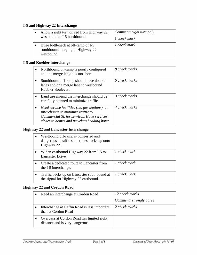
Southeast Salem Area Transportation Study Page 5 of 8 Summary of Open House 10/13/05
I-5 and Highway 22 Interchange
• Allow a right turn on red from Highway 22 westbound to I-5 northbound
Comment: right turn only
1 check mark
• Huge bottleneck at off-ramp of I-5 southbound merging to Highway 22 westbound
1 check mark
I-5 and Kuebler interchange
• Northbound on-ramp is poorly configured and the merge length is too short
8 check marks
• Southbound off-ramp should have double lanes and/or a merge lane to westbound Kuebler Boulevard
6 check marks
• Land use around the interchange should be carefully planned to minimize traffic
3 check marks
• Need service facilities (i.e. gas stations) at interchange to minimize traffic to Commercial St. for services. Have services closer to homes and travelers heading home.
4 check marks
Highway 22 and Lancaster Interchange
• Westbound off-ramp is congested and dangerous – traffic sometimes backs up onto Highway 22.
• Widen eastbound Highway 22 from I-5 to Lancaster Drive.
1 check mark
• Create a dedicated route to Lancaster from the I-5 interchange.
1 check mark
• Traffic backs up on Lancaster southbound at the signal for Highway 22 eastbound.
1 check mark
Highway 22 and Cordon Road
• Need an interchange at Cordon Road 12 check marks
Comment: strongly agree
• Interchange at Gaffin Road is less important than at Cordon Road
2 check marks
• Overpass at Cordon Road has limited sight distance and is very dangerous
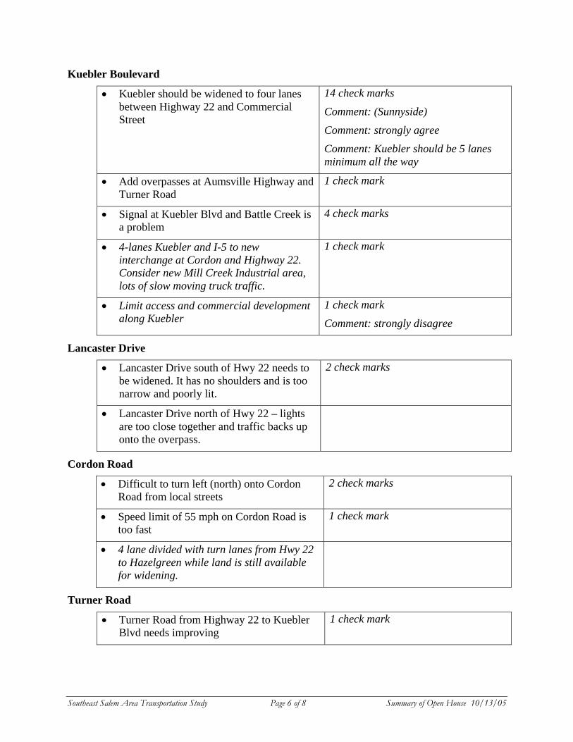
Southeast Salem Area Transportation Study Page 6 of 8 Summary of Open House 10/13/05
Kuebler Boulevard
• Kuebler should be widened to four lanes between Highway 22 and Commercial Street
14 check marks
Comment: (Sunnyside)
Comment: strongly agree
Comment: Kuebler should be 5 lanes minimum all the way
• Add overpasses at Aumsville Highway and Turner Road
1 check mark
• Signal at Kuebler Blvd and Battle Creek is a problem
4 check marks
• 4-lanes Kuebler and I-5 to new interchange at Cordon and Highway 22. Consider new Mill Creek Industrial area, lots of slow moving truck traffic.
1 check mark
• Limit access and commercial development along Kuebler
1 check mark
Comment: strongly disagree
Lancaster Drive
• Lancaster Drive south of Hwy 22 needs to be widened. It has no shoulders and is too narrow and poorly lit.
2 check marks
• Lancaster Drive north of Hwy 22 – lights are too close together and traffic backs up onto the overpass.
Cordon Road
• Difficult to turn left (north) onto Cordon Road from local streets
2 check marks
• Speed limit of 55 mph on Cordon Road is too fast
1 check mark
• 4 lane divided with turn lanes from Hwy 22 to Hazelgreen while land is still available for widening.
Turner Road
• Turner Road from Highway 22 to Kuebler Blvd needs improving
1 check mark
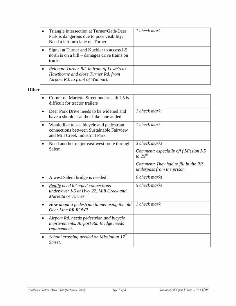
Southeast Salem Area Transportation Study Page 7 of 8 Summary of Open House 10/13/05
• Triangle intersection at Turner/Gath/Deer Park is dangerous due to poor visibility. Need a left turn lane on Turner.
1 check mark
• Signal at Turner and Kuebler to access I-5 north is on a hill – damages drive trains on trucks
• Relocate Turner Rd. in front of Lowe’s to Hawthorne and close Turner Rd. from Airport Rd. to front of Walmart.
Other
• Corner on Marietta Street underneath I-5 is difficult for tractor trailers
• Deer Park Drive needs to be widened and have a shoulder and/or bike lane added
1 check mark
• Would like to see bicycle and pedestrian connections between Sustainable Fairview and Mill Creek Industrial Park
1 check mark
• Need another major east-west route through Salem
3 check marks
Comment: especially off f Mission I-5 to 25th
Comment: They had to fill in the RR underpass from the prison
• A west Salem bridge is needed 6 check marks
• Really need bike/ped connections under/over I-5 at Hwy 22, Mill Creek and Marietta or Turner.
5 check marks
• How about a pedestrian tunnel using the old Geer Line RR ROW?
1 check mark
• Airport Rd. needs pedestrian and bicycle improvements. Airport Rd. Bridge needs replacement.
• School crossing needed on Mission at 17th Street.
Southeast Salem Area Transportation Study Page 8 of 8 Summary of Open House 10/13/05
LIST OF ATTACHMENTS
Attachment 1 – Newsletter, September 2005 Attachment 2 – Newspaper display ads in the Statesman Journal, 10/7/05 and 10/9/05 Attachment 3 – Article in the Statesman Journal, October 12, 2005 Attachment 4 – Article in the Statesman Journal, October 14, 2005 Attachment 5 – Open House display boards Attachment 6 – Comment Form Attachment 7 – Letter submitted at open house
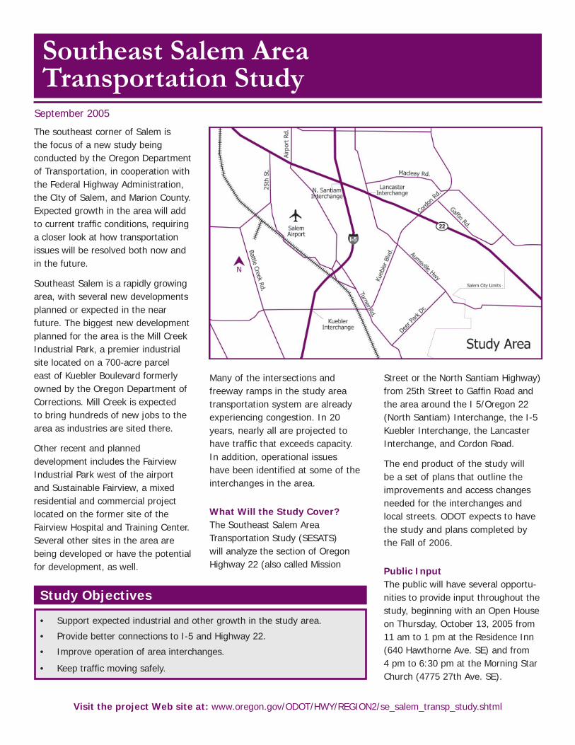
Southeast Salem Area Transportation Study
The southeast corner of Salem is the focus of a new study being conducted by the Oregon Department of Transportation, in cooperation with the Federal Highway Administration, the City of Salem, and Marion County. Expected growth in the area will add to current traffi c conditions, requiring a closer look at how transportation issues will be resolved both now and in the future.
Southeast Salem is a rapidly growing area, with several new developments planned or expected in the near future. The biggest new development planned for the area is the Mill Creek Industrial Park, a premier industrial site located on a 700-acre parcel east of Kuebler Boulevard formerly owned by the Oregon Department of Corrections. Mill Creek is expected to bring hundreds of new jobs to the area as industries are sited there.
Other recent and planned development includes the Fairview Industrial Park west of the airport and Sustainable Fairview, a mixed residential and commercial project located on the former site of the Fairview Hospital and Training Center. Several other sites in the area are being developed or have the potential for development, as well.
Many of the intersections and freeway ramps in the study area transportation system are already experiencing congestion. In 20 years, nearly all are projected to have traffi c that exceeds capacity. In addition, operational issues have been identifi ed at some of the interchanges in the area.
What Will the Study Cover?The Southeast Salem Area Transportation Study (SESATS) will analyze the section of Oregon Highway 22 (also called Mission
Street or the North Santiam Highway) from 25th Street to Gaffi n Road and the area around the I 5/Oregon 22 (North Santiam) Interchange, the I-5 Kuebler Interchange, the Lancaster Interchange, and Cordon Road.
The end product of the study will be a set of plans that outline the improvements and access changes needed for the interchanges and local streets. ODOT expects to have the study and plans completed by the Fall of 2006.
Public InputThe public will have several opportu-nities to provide input throughout the study, beginning with an Open House on Thursday, October 13, 2005 from 11 am to 1 pm at the Residence Inn (640 Hawthorne Ave. SE) and from 4 pm to 6:30 pm at the Morning Star Church (4775 27th Ave. SE).
September 2005
Visit the project Web site at: www.oregon.gov/ODOT/HWY/REGION2/se_salem_transp_study.shtml
Study Objectives
• Support expected industrial and other growth in the study area.
• Provide better connections to I-5 and Highway 22.
• Improve operation of area interchanges.
• Keep traffi c moving safely.
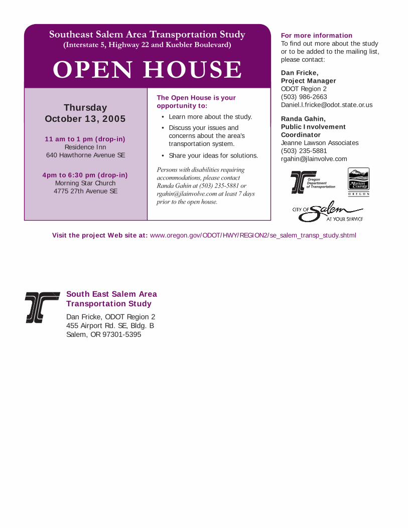
For more informationTo fi nd out more about the study or to be added to the mailing list, please contact:
Dan Fricke, Project ManagerODOT Region 2(503) [email protected]
Randa Gahin, Public Involvement CoordinatorJeanne Lawson Associates(503) [email protected]
Dan Fricke, ODOT Region 2455 Airport Rd. SE, Bldg. BSalem, OR 97301-5395
South East Salem Area Transportation Study
Southeast Salem Area Transportation Study(Interstate 5, Highway 22 and Kuebler Boulevard)
OPEN HOUSEThe Open House is your opportunity to:
• Learn more about the study.
• Discuss your issues and concerns about the area’s transportation system.
• Share your ideas for solutions.
Persons with disabilities requiring accommodations, please contact Randa Gahin at (503) 235-5881 or [email protected] at least 7 days prior to the open house.
ThursdayOctober 13, 2005
11 am to 1 pm (drop-in)Residence Inn
640 Hawthorne Avenue SE
4pm to 6:30 pm (drop-in)Morning Star Church4775 27th Avenue SE
Visit the project Web site at: www.oregon.gov/ODOT/HWY/REGION2/se_salem_transp_study.shtml
Public Open HouseSE Salem Transportation Study (I-5, Hwy 22 and Kuebler Blvd)
Thursday, Oct. 13, 200511 am to 1 pm (drop-in)Residence Inn 640 Hawthorne Avenue SE
4pm to 6:30 pm (drop-in)Morning Star Church4775 27th Avenue SE
• Learn more about the study.
• Discuss the area’s transportation issues.
• Share your ideas for solutions.
CONTACT: Randa Gahin (503) 235-5881 or [email protected]: www.oregon.gov/ODOT/HWY/REGION2/se_salem_transp_study.shtml
News Friday, October 14, 2005
Residents share their ideas for traffic in southeast Salem $900,000 project will prepare area roads for expected growth DENNIS THOMPSON Statesman Journal
October 14, 2005
A new interchange at Mission Street and Cordon Road SE.
Kuebler Boulevard widened from two lanes to four.
Improved on- and off-ramps along Interstate 5.
These and many other improvements to southeast Salem's road network were among the ideas floated during two open houses held Thursday by the Oregon Department of Transportation.
The meetings are part of a $900,000 effort to plan for the traffic caused by future development, such as Sustainable Fairview and the Mill Creek Industrial Park.
"We've got to figure out how to make this whole part of town work for the next 20-plus years," said Dan Fricke, the project's manager.
The Cordon Road interchange and the Kuebler Boulevard widening garnered much support at both sessions, officials said.
"They're going to need it real soon, once they get all the construction going on out there at the Mill Creek Industrial Park," South Salem resident Dave
Link
For information, go to the project Web site, http://egov.oregon.gov/odot/hwy/region2/se_salem_transp_study.shtor call (503) 235-5881.
Douglas said.
But people also suggested other ways to improve Southeast Salem traffic.
On a board where attendees could post their ideas, folks asked for bicycle/pedestrian connections across Interstate 5. One person wondered if a tunnel under the interstate, using the right-of-way of the old Geer Line Railroad, would be feasible.
People also urged road officials to develop alternate east-west routes through South Salem.
"I just wanted to see what's being planned on Kuebler, but it seems long-term Kuebler is going to be the street to relieve pressure on the south part of town," said South Salem resident Gary Lockwood. "It seems to me there are other streets that could be improved to relieve some of that pressure."
About 24 people attended a lunchtime open house at the Residence Inn at 640 Hawthorne Ave. SE, while others went to a late-afternoon session at Morning Star Community Church at 4775 27th Ave. SE.
Fricke said the open houses will prove valuable in making sure road officials are on the right track.
"This is a good check-in before we get too deep into it, to make sure we haven't missed anything," he said.
Transportation officials will return in the winter with another set of open houses to discuss the top ideas that they have identified for solving southeast Salem's future traffic woes, Fricke said.
[email protected] or (503) 399-6719
Copyright 2005 Statesman Journal, Salem, Oregon
Southeast Salem Area Transportation Study
OPEN HOUSE
• Learn about the study
• Ask questions of staff members
• Share your ideas!
(Please fill out a comment form and drop it in the box before you leave)

Southeast Salem Area Transportation Study
Overview Southeast Salem is a rapidly growing area of the city, requiring a closer look at how to resolve transportation issues both now and in the future.
Several new developments are either planned or anticipated in the near future, adding to the congestion already experienced in the area.
Study Objectives Support expected industrial and other growth in the study area. Provide better connections to I-5 and Highway 22. Improve operation of area interchanges. Keep traffic moving safely.
Timeline
Study Local System and Identify Deficiencies
Summer and Fall 2005
*Public Open House*
Develop Preliminary Alternatives
Fall and Winter 2005
Refine Alternatives Winter 2006 *Public Open House*
Prepare and Review Plans Spring and Summer 2006 *Public Hearing*
Adopt Final Plans Fall 2006
We are here
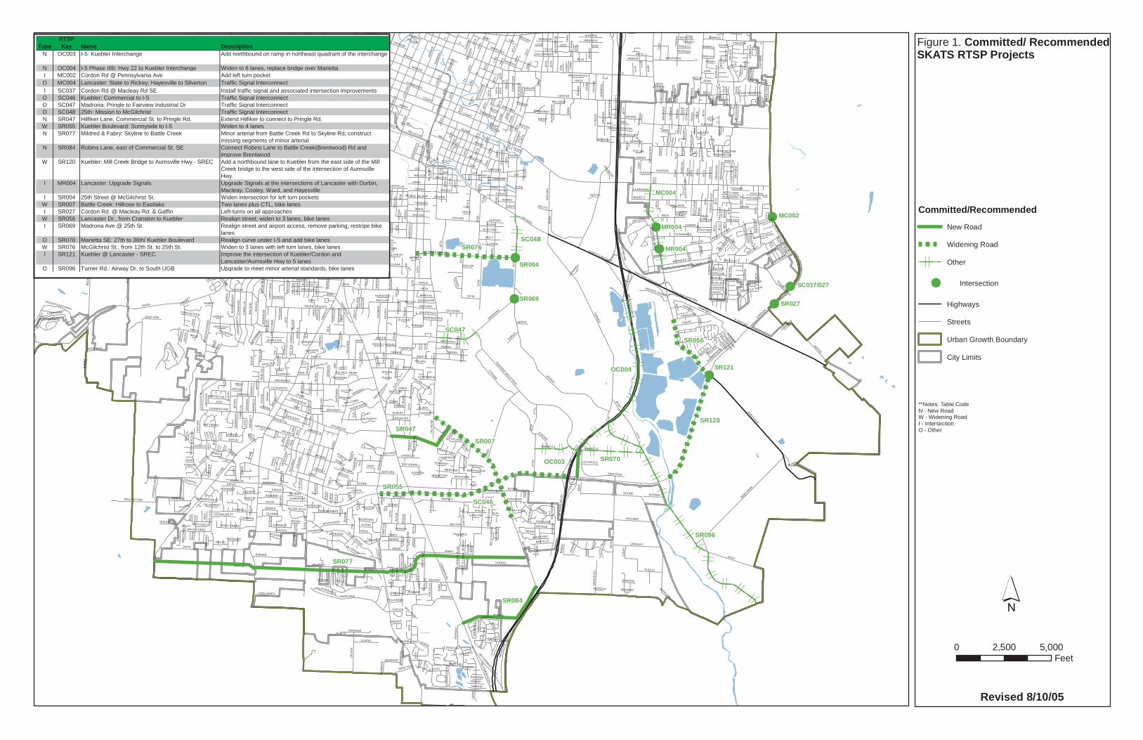
MC004
SR077
SR096
OC004
SC046
SR120
SR076
SR084
SR056
SR047
SR070
SC048
SC047
SR055
OC003
SR007
SR121
SR027
MC002
MR004
MR004
SR069
SR004
SC037/027
D
STATE
KUEBLER
12T
H
RIVER
TUR
NE
R
CENTER
CO
MM
ER
CIAL
HIG
H
LIBE
RTY
25T
H
SB
INT
ER
STA
TE 5
NB IN
TERSTATE 5
EOLA
BOONE
17TH
LAN
CAS
TER
B
36T
H
SUN
NYS
IDE
HOYT
PR
ING
LE
ELM
A
SKYLINE
RURAL
EWALD
HAW
TH
OR
NE
N SANTIAM
BROWNING
AUBURN
DAVIS
MISSION
C
AIRWAY
BATTLE CR
EEK
REE
D
MILDRED
CH
UR
CH
AUMSVILLE
GATH
23R
D
COURT
27T
H
ELLIS
8TH
CR
OIS
AN
CR
EEK
2ND MARION
BAXTER
44T
H
15TH
47T
H
DEER PARK
HO
ME
ST
EA
D
24TH
22N
D
FARAGATE
JON
ES
IDYLWOOD
MIZE
UNION
WILTSEY
A
HINES
WB SALEM DALLAS
EDGEWATER
EB SALEM DALLAS
EASTLA
ND
FAIRVIEW
FIR
MACLEAY
SAG
INAW
CAP
ITO
L
WIN
TER
SWEGLE
21S
T
HAGER
BARNES
CO
TTAG
E
RY
AN
HANSEN
37TH
NIN
A
DURBIN
BLU
FF
RICKEY
BOICE
GE
RTH
KEVIN
RO
YA
LTY
CHEMEKETA
FABRY
HRUBETZ
MCGILCHRIST
FAIRVIEW INDUSTRIAL
16T
H
DO
GW
OO
D
AIR
PO
RT
E
7TH
CREEKSIDE
HUDSON
CA
ME
LLIA
HYDE
FIR
DE
LL
JOPLIN
ROBINS
LANDAU
KU
RTH
FOR
D
BE
RR
Y
18TH
CAMPBELL
PE
CK
46T
H
FRO
NT
STRONG
HO
FF
MA
N
ARLENE
3RD
MADRONA
MYERS
MUNKERS
AS
H
ELM
SUM
MER
OAKHILL
BUSH
SB K
UEB
LER
BV
HOLDER
STONEWAY
LORI
HARRIS
VALLEYWOOD
CA
SC
AD
E
COLLEGE
RE
GA
L
BR
OW
NS
ISLA
ND
MILLER
DE
VO
N
HEATH
PIO
NE
ER
GLENWOOD
14TH
MILL
LON
E O
AK
KAMELA
PUBLIC
SYLVIA
BETH
CUNNINGHAM
CLA
Y
6TH
KING
WO
OD
LANGLEY
FERRY
13TH
10T
H
SAV
AG
E
ACACIA
OXFORD
MINTO ISLAND
JOH
N
ILLI
NO
IS
38TH
FAIR
WA
Y
LINCOLN
49T
H
LAN
DO
N
WALDO
KING
ILER
RE
D L
EA
F
1ST
ASTER
KATHY
AZ
ALE
A
12TH
ST
PALA
CE
MADRAS
EAST
RO
SEM
ON
T
WIN
OLA
SIMPSON
SALEM HEIGHTS
SUPERIOR
NORTH SANTIAM
MC
NAR
Y ANITA
LESLIE
HU
LSE
Y
45T
H
39TH
WILSON
MISSOURI
BR
INK
ALBERT
CO
LOM
A
PENNSYLVANIA
LA CRESTA
AERIAL
RUGE
HAZELTINE
FOXHAVEN
SU
NR
IDG
E
LEE
SK
OP
IL
MARSHALL
GEHLAR
DORAL
NE
EF
NB
DE
LAN
EY
RD
ELD
IN
ED
INA
CR
OIS
AN
SC
EN
IC
LOWEN
HO
LID
AY
BECK
KNOX
RATCLIFF
VINTAGE
CANDALARIA
MCK
AY
KASHMIR
CORINA
LEFFELLE
KANSAS
DIA
N
AR
AB
IAN
LUTHER
OR
EG
ON
BOLTO
N
GREENWAY
YEW
BA
LSA
M
CORDON
SCOTCH
WEATHERS
BR
EY
S
WO
OD
SID
E
W VISTA
BELL
OWENS
TRELSTAD
EASTLAKE
ADOBE
BY
ER
S
ALP
HA
BUFFALO
GENIE
WELCOME
PAR
K
ALA
NA
GAFFIN
DO
UG
HT
ON
CE
NT
UR
Y
MONROE
41S
T
STR
AND
MANOR
MU
RLAR
K
LEWIS
CLAUDE
OA
KM
AN P
EN
NY
PATTERSO
N
CLA
RM
OU
NT
TESSWAT
ER
RAINIER
ELKINS
OD
ELL
DO
AKS
FE
RR
Y
ALICE
SUN
WO
OD
BALLYNTYNE
CARTE
R
PULL
MA
N
CHASE
GREGORY
WINDING
HOOVER
J DAVID
KAY
TAN
OA
K
TRIPP
PLAZA
KANUKU
VISTA
CROZER
BREYMAN
MO
NTE
GO
FRIENDSHIP
MARIETTA
DU
AN
E
SPR
ING
CROSS
HE
RTE
L
FRANKLIN
OJAI
EV
ER
GR
EE
N
SAHALEE
ZOS
EL
SENATE
JAN
A
ALVA
RAD
O
CRANSTON
19T
H
JUNTURA
JONMART
BELEVEDERE
CARSON
TIE
RR
A
IRONWOOD
SADDLE CLUB
SH
OR
ES
ROCK CREEK
20T
H
WEBSTER
SU
GA
R P
LUM
CHEROKEE
WASHINGTON
RED OAK
ENGLEWOOD
ENGEL
TRIANGLE
KEARNEY
MANGO
VIN
YA
RD
ELF
DR
AP
ER
35T
H
SALEM DALLAS
SE
EG
ER
GA
RN
ET
WARREN
34TH
CHARLES
BURLEY H
ILL
DENISE
ROCKWOOD
JORDAN
NB COMMERCIAL ST
OLYMPIC
MO
UN
TAIN
VIE
W
CO
NN
EC
TIC
UT
CAPLINGER
STA
NLE
Y
WALN CREEK
CH
AN
LINK
WALLAC
E
PAG
E
HIL
LVIE
W
WALLER
FAN
NY
MIDWAY
WORMWOOD
NB
KU
EBLE
R B
V
PEACE
SHEN
AN
DO
AH
BELLEVUE
KIMERON
ELDER
BER
RY
ALBERTA
MONTEREY
CLO
UD
VIE
W
FAWK
TUR
NA
GE
AMBER
WE
ST N
OB
HIL
L
URBAN
SB CO
MM
ER
CIA
L ST
BAY
VIE
W
SALISHAN
MAN
DY
SEN
EC
A
DU
PLE
X
CIT
ATIO
N
HEATHER
SHILOH
CEDAR
SC
EP
TER
WILDWIND
ADAMS
RIC
HM
ON
D
WINDSOR
VINE
BAS
IN
JUSTICE
AKIN
DA
KO
TA
32N
D
BASTILLE
MU
LE D
EER
FRAN
BR
YAN
PIED
MO
NT
CASTLE
PIK
E
RO
SE
LARK
TOWER
9TH
SUNLA
ND
SA
WG
RA
SS
KE
NW
OO
D
ELSER
HIL
LRO
SE
JOSEPH
NB N
OR
TH S
ANTIAM
HW
DORIS
THO
MP
SO
N
NOMAD
CARNELIA
CLA
RM
AR
NAVAHO
BIE
BE
R
42ND
BOULDER
FAIR
MO
UN
T
BUTT
E
ELECTRIC
GA
RD
NE
R
SU
NC
RE
ST
SUM
AC
LANSFORD
TER
RAC
E LA
KE
CROWLEY
NADINE
LADD
EV
ELY
N
REES HILL
MA
UI
ICE
L
LINN HAVEN
FONTANA
NO
RM
AN
CR
ES
TV
IEW
DA
NIE
L
BONNIE
RIALTO
RIVERVIE
W
DORENA
MCKINLEY
MARILYN
CO
LT
GARLOCK
EISENHOWER
DAN
WILBUR
RIO
VIS
TA
OAK
JEWELARTHUR
SHELTON
TAHOE
KAUAI
WO
OD
SCA
PE
BAB
ER
UNNAMED
HILLENDALE
WIL
LA
EB EDGEW
ATER
NO
RM
A
KHYBER
GILBERT
JUDSON
BAR
RE
TT
BEAVER
BELVEDERE
BASSETT
LAC
HS
DIVISION
WAG
ON RO
AD
IBSEN
30T
H
JUNEAU
SPARTA
ALVINA
FIR
CR
ES
T
AUGUSTA NATIONAL
HAGERS GROVE
GRAY OAK
DUDLEY
MAPLEWOOD
KHARTOUM
WICKSHIRE
CAMBRIDGE
NEWPORT
HAR
VEY
ELKHO
RN
40TH
CLO
UD
CO
LBY
LUC
ILLE
MELISSA
SH
AN
IKO
CULVER
HARDING
NE
ELO
N
SU
NR
ISE
MAHRT
MORNINGSIDE
DAV
IDSO
N
GROUSE
SPARKS
AGATE
VIBBERT
MYR
LA
HA
LIFA
X
PILGRIM
WILMINGTON
COUNTRY
LEONA
VENIC
E
SUNMIST
RO
SS
WINDGATE
PENC
E
MIS
SIO
N-1
3TH
JAMESTOWN
MEA
DO
WLAW
N
CRAIG
BERNDT HILL
MU
RR
AY
CA
INS
FOX
CH
APA
RR
AL
SNOW WHITE
WA
LKE
R
BRO
ADM
OR
E
VIE
W
CEDARCREST
LOCKWOOD
BEGONIA
KINGDOM
HELM
ALTA
VIE
W
SUR
RY
RODAN
MA
RK
SEATTLE SLEW
FRIAR
NB
MAR
KET
ST
KUMLER
ROYVONNE
DO
VE
CAV
ALI
ER
NEAHKAHNIE
TULA
RE
MILITIA
KA
RE
N
SO
UTH
BE
ND
SER
EN
ITY
DOWNS
FELT
ON
TILLMANSONORA
GR
EE
NC
RE
ST
CA
MR
Y
12TH
-MIS
SIO
N
WIPWOOD
RO
SE
LLE
CIN
NA
MO
N H
ILL
RE
DIN
GE
R
BAYONNE
ELK
WOODACRE
INVERNESS
SN
OO
PY
SANTIAM-LANCASTER
GLENCOE
CLE
AR
WA
TER
TAMARA
LA BRANCH
ESSEX
LANAI
ARG
YLE
QUAIL RUNJA
SO
N
ROGETS
GREAR
TEAL
BUCKHORN
WESTLAWN
DEE
RFI
ELD
DIANNE
FAIROAKS
LICTHFIELD
MINERS
OSBORN
SN
OW
FLA
KE
THRUSH
HAAS
CH
AN
DE
LLE
5TH
RA
FFO
N
DEER RUN
REX
LONGVIEW
BIE
GLE
R
HE
LEN
RE
GA
N
CAUSEY
BR
EN
NE
R
KEGLERS
4TH
THELMA
CLA
RA
WITTEN
ATH
EN
S
SA
XO
N
TRADE
HOWARD
EA
RH
AR
T
SHADOW
GR
AN
AD
A
LOR
IAN
TERRAZA
LIN
DA
BARBERRY
PALISADES
SCH
UR
MA
N
OAKLAND
APRIL
WIL
DFL
OW
ER
FORT ROCK
EARLE
WE
LTY
CO
MPT
ON
KETTLE
CIN
NIB
AR
RAY
NO
R
FIR
GAR
DE
NS
GARDEN
DIA
MO
ND
INTEGRA
SHAWNEE
FARRELL
BRO
CK
AA
RO
N
UN
IVE
RS
ITY
CENTENNIAL
BELLBIRD
RA
INB
OW
LILLY
LLO
YD
GORDON
BLA
CK
SM
ITH
DEAN
WILDCHERRY
SUMMERCREST
ANACONDA
HILLWOOD
MU
LBE
RR
Y
BR
IAR
CANNON
SONG SPARROW
STAT
ESM
AN
OHMART
BABCOCK
GINGER
PARADISE
GLENDORAC
ATTE
RLI
N
JULIET
MARY
DAVCOR
WIN
D S
TON
E
MAY
WO
OD
BA
LLY
ME
AD
E
BALM
THORNDALE
FLIN
T
POLLYANNE
DE
AN
A
BO
W
WO
OD
MIL
L
MITZUR
HAYWARD
HAYDEN
HIL
LSID
E
COBURN
SILVER HILLS
BLUE SKY
ALTIM
ONT
LANCASTER-SANTIAM
REDHILL
ME
RLE
MARTIN
KENT
BR
AD
FO
RD
NEW
TOW
N
CRICKET
COUGAR
PINTAIL
MATTHEWS
PORTER
CAYUSE
WB WALLACE RD
MARKHAM
JEN
NIF
ER
MU
SIC
NIC
OLE
SPEARS
VIRGINIA
ROYAL
CO
NC
OR
D
SY
CA
NCH
ER
IE
BE
EC
HW
OO
D
MIKKELOBE
FIELDCREST
AN
NE
KA
OXEN
MER
DE
L
WINTERCREEK
SITKA DEER
GLADM
AR
HOLMES
STEW
ART
CR
AWF
OR
D
BLAI
R
HARNEY
SQUIRE
MAD
ELY
N
DRAKE
GILMER
RO
NA
LD
MA
LLA
RD
RH
INE
STO
NE
BATES
BREWSTER
TOWHEE
FURRIER
STO
NEH
AVE
N
KAILUA
EL DORADO
CE
CIL
IA
MO
ON
STO
NE
LIN
DAY
CIN
DY
PIPEBEND
DORCHESTER
EA
GLE
VIE
W
UPPER LA VISTADENVER
NATIONAL
KNIG
HTS
WES
TRID
GE
OCEAN
MESA
TER
RY
LEE
MADER
SHAMROCK
MO
RG
AN
GOLF COURSE
CAR
LA
DA
RC
Y
LANTZ
SA
LIN
AS
PO
PP
Y H
ILLS
KOTZY
COPPER GLEN
STANDISH
RITING
BOEHMER
NORWOOD
VILLA
GE
EA
ST
MAG
NO
LIA
FLINT RIDGE
NEBRASKA
SUSSEX
TIMBER
SKYCLIFF
STARLIGHT
LEXINGTON
SUGARPINE SHARON
PE
TE
RS
ON
PAM
SPH
INX
GA
BR
IELA
MAG
GIE
HARVARD
PH
EA
SA
NT
CASCARA JULIANA
CANARY
BURNTWOOD
FLA
IRS
TO
NE
DAVE
ANTIGUA
ALEX
TRAILS END
ESTH
ER
GERLEON
TWIL
IGH
T
KNAPPS
CO
BA
LT
RO
GE
R
WEDGEWOOD
EXMOOR
CADMUS
CRESTMO
NT
SUPR
EM
E
WILLOW
PAWNEE
RO
US
H
ED
WA
RD
TRA
GE
N
HOVENDEN
HE
AVE
NS
ALEXAN
DER
BASS
HACKNEY
LONE FIR
SPRIN
GD
ALE
PANSY
MELODY
BUTTO
NW
OO
D
NO
NA
ME
CLA
REN
CE
NO
VA
K
TURQUOISE
DA
NA
LEE
HIGHLIGHT
WAN
DE
R
MULLIGAN
BE
CK
Y
EA
ST
PA
RKTY
LER
OLD MACLEAY
CHURCHILL
HOSANNA
PROMONTORY
SMIT
HR
OC
K
TRO
TH
PAN
OR
AMA
PELT
ON
CH
ADBO
UR
NE
JAM
IE
LANE
WYA
TTBARRINGTON
CA
ND
Y F
LOW
ER
DISTINCTIVE
CITRUS
ROSEWAY
BASSWOOD
WHISPER
IMP
ERIA
L
IRENE
HERMITAGE
MANCHESTER
ALLISON
INDIAN HILLS
CANNEMARA
PERCHERON
BARKER
GLACIER
KNO
LL
CHERRYBUD
MARVIN
RO
SE
BR
OO
KE
SADDLE HORN
BE
LLF
LOW
ER
HAMLET
FRIS
CO
KIN
ZU
A
LOR
AIN
CREST
PRIMOSE
IDANHA
HURON
MO
OS
EBER
RY
JES
TE
R
SP
RIC
E
NOUGAT
MCGILCHRIST
ELM
A
6TH
COURT
HU
LSE
Y
LADD
UN
IVE
RSI
TY
CROSS
14T
H
46T
H
WIN
TER
OXFORD
JOH
N
9TH
BELLEVUE
27TH
DIVISION
AR
GY
LE
LESLIE
21S
T
2ND
15TH
JUNTURA
LIBERTY
MCGILCHRIST
UNNAMED
TRADE
45T
H
EWALD
3RD
FERRY
PAR
K
17T
H
40TH
UN
NA
ME
D
PULL
MA
N
45T
H
BLUFF
BELL
BOONE
FABRY
MONROE
KASHMIR
18TH
CO
NN
EC
TIC
UT
WALLER
46T
H
HYDE
12T
H
E
NB
KU
EBLE
R B
V
BA
RR
ETT
22N
D
UN
NAM
ED
TRADE
12T
H
CROSS
14T
H
EWALD
25T
H
PRIN
GLE
D
BOONE
7TH
YE
W
AERIAL
2ND
HOYT
WILBUR
23R
DLEE
CH
UR
CH
22N
D
SU
MM
ER
LADD
18T
H
A
7TH
21S
T
15TH
17TH
17TH
JUNTURA20
TH
12TH
BALM
SCEP
TER
OSBORN
20T
H
B
LEE
MILL
25TH
HUDSON
WILBUR
PAR
K
16TH
BLU
FF
45T
H
JUSTIC
E
27T
H
CR
ES
TV
IEW
EDW
AR
D
BELLEVUE
23R
D
WINDSOR
SUM
MER
CA
ME
LLIA
LEFFELLE
VISTA
UN
NAM
ED
ELM
SAG
INAW
RURAL
MARIETTA
LEE
FERRY
CLA
RM
AR
UNNAMED
19TH
ARABIAN
MILL
MARIETTA
FOR
D
40TH
BRIN
K
13TH
CHEMEKETA
15TH
45T
H
MARIETTA
37TH
WINDING
19TH
ELDIN
RA
INB
OW
13T
H
EA
STL
AN
D
HIG
H
LESLIE
22N
D
MISSION
23R
D
19TH
BELLEVUE
32N
D
NB
NO
RTH
SAN
TIAM
HW
COURT
12T
H
LEFFELLE
FIR
DE
LL
18TH
MACLEAY
24T
H
VISTA
OAK
49T
H
JUNEAU
2ND
WALKER
OXFORD
UN
NAM
ED
18TH
JOSEPH
WILBUR
16TH
OAK
WIN
TER
14TH
22N
D
ELD
ER
BE
RR
Y
7TH
LEE
CH
UR
CH
20TH
REES HILL
22N
D
BRO
WN
S IS
LAN
D
LIBE
RTY
SU
MM
ER
DA
KO
TA
FIR
TIE
RR
A
23R
D
13TH
DEAN
REDHILL
HOWARD
19TH
JOH
N
UNNAMED
JOSEPH
20T
H
21S
T
TIER
RA
12T
H
22N
D
KASHMIR
16T
H
34TH
20TH
PAR
K
44T
H
13T
H
BARNES
UNNAMED
BECK
24T
H
22N
D
CR
OIS
AN
CR
EEK
UNNAMED
PU
LLM
AN
HO
LID
AY
UNNAMED
CO
LOM
A
PUBLIC
BA
RR
ETT
37T
H
LON
E O
AK
15T
H
18T
H
36T
H
7TH
RUGE
BOONE
1ST
20TH
FELT
ON
20TH
JUDSON
HANSEN
19T
H
19TH
22N
D
UNNAMED
24T
H
CAP
ITO
L
46T
H
TIE
RR
A
23R
D
13TH
3RD
FERRY
RE
ED
STRONG
ELECTRIC
WIN
TER
LEWIS18
TH
AMBER
JOSEPH
FELT
ON
Committed/RecommendedNew Road
Widening Road
Other
Intersection
Highways
Streets
Urban Growth Boundary
City Limits
0 5,0002,500Feet
Figure 1. Committed/ RecommendedSKATS RTSP Projects
**Notes: Table CodeN - New RoadW - Widening RoadI - IntersectionO - Other
TypeRTSP Key Name Description
N OC003 I-5: Kuebler Interchange Add northbound on ramp in northeast quadrant of the interchange
N OC004 I-5 Phase IIIb: Hwy 22 to Kuebler Interchange Widen to 6 lanes, replace bridge over MariettaI MC002 Cordon Rd @ Pennsylvania Ave Add left turn pocketO MC004 Lancaster: State to Rickey; Hayesville to Silverton Traffic Signal InterconnectI SC037 Cordon Rd @ Macleay Rd SE Install traffic signal and associated intersection improvementsO SC046 Kuebler: Commercial to I-5 Traffic Signal InterconnectO SC047 Madrona: Pringle to Fairview Industrial Dr Traffic Signal InterconnectO SC048 25th: Mission to McGilchrist Traffic Signal InterconnectN SR047 Hilfiker Lane, Commercial St. to Pringle Rd. Extend Hilfiker to connect to Pringle Rd.W SR055 Kuebler Boulevard: Sunnyside to I-5 Widen to 4 lanesN SR077 Mildred & Fabry: Skyline to Battle Creek Minor arterial from Battle Creek Rd to Skyline Rd, construct
missing segments of minor arterialN SR084 Robins Lane, east of Commercial St. SE Connect Robins Lane to Battle Creek(Brentwood) Rd and
improve BrentwoodW SR120 Kuebler: Mill Creek Bridge to Aumsville Hwy - SREC Add a northbound lane to Kuebler from the east side of the Mill
Creek bridge to the west side of the intersection of Aumsville Hwy.
I MR004 Lancaster: Upgrade Signals Upgrade Signals at the intersections of Lancaster with Durbin, Macleay, Cooley, Ward, and Hayesville
I SR004 25th Street @ McGilchrist St. Widen intersection for left turn pocketsW SR007 Battle Creek: Hillrose to Eastlake Two lanes plus CTL, bike lanesI SR027 Cordon Rd. @ Macleay Rd. & Gaffin Left-turns on all approaches
W SR056 Lancaster Dr., from Cranston to Kuebler Realign street; widen to 3 lanes, bike lanesI SR069 Madrona Ave @ 25th St Realign street and airport access, remove parking, restripe bike
lanesO SR070 Marietta SE: 27th to 36th/ Kuebler Boulevard Realign curve under I-5 and add bike lanesW SR076 McGilchrist St., from 12th St. to 25th St. Widen to 3 lanes with left turn lanes, bike lanesI SR121 Kuebler @ Lancaster - SREC Improve the intersection of Kuebler/Cordon and
Lancaster/Aumsville Hwy to 5 lanesO SR096 Turner Rd.: Airway Dr. to South UGB Upgrade to meet minor arterial standards, bike lanes
Revised 8/10/05
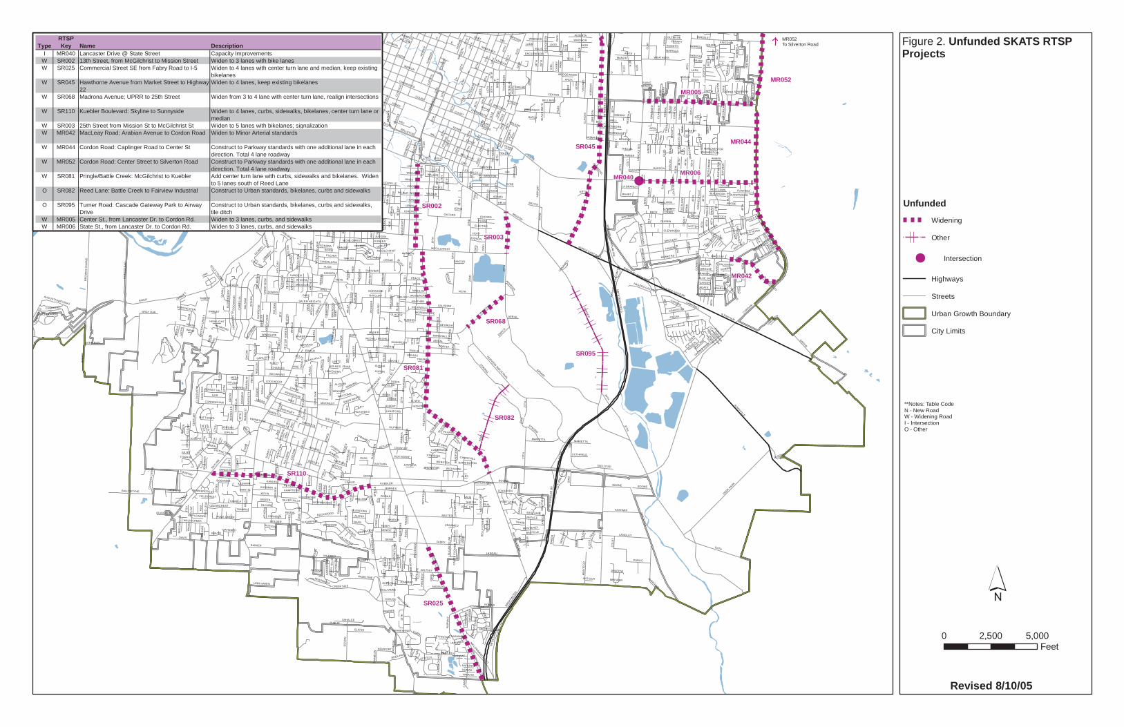
MR052
MR052To Silverton Road
MR005
MR006
SR081
SR045 MR044
SR110
SR025
SR095
SR002
SR082
MR042
SR068
SR003
D
STATE
KUEBLER
12T
H
RIVER
TUR
NE
R
CENTER
CO
MM
ER
CIAL
HIG
H
LIBE
RTY
25T
H
SB
INT
ER
STA
TE 5
NB IN
TERSTATE 5
EOLA
BOONE
17TH
LAN
CAS
TER
B
36T
H
SUN
NYS
IDE
HOYT
PR
ING
LE
ELM
A
SKYLINE
RURAL
EWALD
HAW
TH
OR
NE
N SANTIAM
BROWNING
AUBURN
DAVIS
MISSION
C
AIRWAY
BATTLE CR
EEK
REE
D
MILDRED
CH
UR
CH
AUMSVILLE
GATH
23R
D
COURT
27T
H
ELLIS
8TH
CR
OIS
AN
CR
EEK
2ND MARION
BAXTER
44T
H
15TH
47T
H
DEER PARK
HO
ME
ST
EA
D
24TH
22N
D
FARAGATE
JON
ES
IDYLWOOD
MIZE
UNION
WILTSEY
A
HINES
WB SALEM DALLAS
EDGEWATER
EB SALEM DALLAS
EASTLA
ND
FAIRVIEW
FIR
MACLEAY
SAG
INAW
CAP
ITO
L
WIN
TER
SWEGLE
21S
T
HAGER
BARNES
CO
TTAG
E
RY
AN
HANSEN
37TH
NIN
A
DURBIN
BLU
FF
RICKEY
BOICE
GE
RTH
KEVIN
RO
YA
LTY
CHEMEKETA
FABRY
HRUBETZ
MCGILCHRIST
FAIRVIEW INDUSTRIAL
16T
H
DO
GW
OO
D
AIR
PO
RT
E
7TH
CREEKSIDE
HUDSON
CA
ME
LLIA
HYDE
FIR
DE
LL
JOPLIN
ROBINS
LANDAU
KU
RTH
FOR
D
BE
RR
Y
18TH
CAMPBELL
PE
CK
46T
H
FRO
NT
STRONG
HO
FF
MA
N
ARLENE
3RD
MADRONA
MYERS
MUNKERS
AS
H
ELM
SUM
MER
OAKHILL
BUSH
SB K
UEB
LER
BV
HOLDER
STONEWAY
LORI
HARRIS
VALLEYWOOD
CA
SC
AD
E
COLLEGE
RE
GA
L
BR
OW
NS
ISLA
ND
MILLER
DE
VO
N
HEATH
PIO
NE
ER
GLENWOOD
14TH
MILL
LON
E O
AK
KAMELA
PUBLIC
SYLVIA
BETH
CUNNINGHAM
CLA
Y
6TH
KING
WO
OD
LANGLEY
FERRY
13TH
10T
H
SAV
AG
E
ACACIA
OXFORD
MINTO ISLAND
JOH
N
ILLI
NO
IS
38TH
FAIR
WA
Y
LINCOLN
49T
H
LAN
DO
N
WALDO
KING
ILER
RE
D L
EA
F
1ST
ASTER
KATHY
AZ
ALE
A
12TH
ST
PALA
CE
MADRAS
EAST
RO
SEM
ON
T
WIN
OLA
SIMPSON
SALEM HEIGHTS
SUPERIOR
NORTH SANTIAM
MC
NAR
Y ANITA
LESLIE
HU
LSE
Y
45T
H
39TH
WILSON
MISSOURI
BR
INK
ALBERT
CO
LOM
A
PENNSYLVANIA
LA CRESTA
AERIAL
RUGE
HAZELTINE
FOXHAVEN
SU
NR
IDG
E
LEE
SK
OP
IL
MARSHALL
GEHLAR
DORAL
NE
EF
NB
DE
LAN
EY
RD
ELD
IN
ED
INA
CR
OIS
AN
SC
EN
IC
LOWEN
HO
LID
AY
BECK
KNOX
RATCLIFF
VINTAGE
CANDALARIAM
CKAY
KASHMIR
CORINA
LEFFELLE
KANSAS
DIA
N
ARABIAN
LUTHER
OR
EG
ON
BOLTO
N
GREENWAY
YEW
BA
LSA
M
CORDON
SCOTCH
WEATHERS
BR
EY
S
WO
OD
SID
E
W VISTA
BELL
OWENS
TRELSTAD
EASTLAKE
ADOBE
BY
ER
S
ALP
HA
BUFFALO
GENIE
WELCOME
PAR
K
ALA
NA
GAFFIN
DO
UG
HT
ON
CE
NT
UR
Y
MONROE
41S
T
STR
AND
MANOR
LAW
RE
NC
E
MU
RLAR
K
LEWIS
CLAUDE
OA
KM
AN P
EN
NY
HILFIKER
PATTERSO
N
CLA
RM
OU
NT
TESSWAT
ER
RAINIER
ELKINS
OD
ELL
DO
AKS
FE
RR
Y
ALICE
SUN
WO
OD
BALLYNTYNE
CARTE
R
PULL
MA
N
CHASE
GREGORY
WINDING
HOOVER
J DAVID
KAY
TAN
OA
K
TRIPP
PLAZA
KANUKU
VISTA
CROZER
BREYMAN
MO
NTE
GO
FRIENDSHIP
MARIETTA
DU
AN
E
SPR
ING
CROSS
HE
RTE
L
FRANKLIN
OJAI
EV
ER
GR
EE
N
SAHALEE
ZOS
EL
SENATE
JAN
A
ALVA
RAD
O
CRANSTON
19T
H
JUNTURA
JONMART
BELEVEDERE
CARSON
TIE
RR
A
IRONWOOD
SADDLE CLUB
ROCK CREEK
20T
H
WEBSTER
SU
GA
R P
LUM
CHEROKEE
WASHINGTON
RED OAK
ENGLEWOOD
ENGEL
TRIANGLE
KEARNEY
MANGO
VIN
YA
RD
ELF
35T
H
SALEM DALLAS
SE
EG
ER
GA
RN
ET
WARREN
34TH
CHARLES
BURLEY H
ILL
DENISE
ROCKWOOD
JORDAN
NB COMMERCIAL ST
OLYMPIC
MO
UN
TAIN
VIE
W
CO
NN
EC
TIC
UT
CAPLINGER
STA
NLE
Y
WALN CREEK
BREN
TWO
OD
CH
AN
LINK
WALLAC
E
PAG
E
HIL
LVIE
W
WALLER
FAN
NY
MIDWAY
WORMWOOD
NB
KU
EBLE
R B
V
PEACE
GEORGIA
SHEN
AN
DO
AH
BELLEVUE
KIMERON
ELDER
BER
RY
ALBERTA
MONTEREY
CLO
UD
VIE
W
FAWK
TUR
NA
GE
AMBER
WE
ST N
OB
HIL
L
URBAN
SB CO
MM
ER
CIA
L ST
BAY
VIE
W
SALISHAN
MAN
DY
SEN
EC
A
DU
PLE
X
CIT
ATIO
N
HEATHER
SHILOH
CEDAR
SC
EP
TER
WILDWIND
ADAMS
RIC
HM
ON
D
WINDSOR
VINE
BAS
IN
JUSTICE
AKIN
DA
KO
TA
32N
D
BASTILLE
MU
LE D
EER
FRAN
BR
YAN
PIED
MO
NT
CASTLE
PIK
E
RO
SE
LARK
TOWER
9TH
SUNLA
ND
SA
WG
RA
SS
ELSER
HIL
LRO
SE
JOSEPH
NB N
OR
TH S
ANTIAM
HW
DORIS
THO
MP
SO
N
NOMAD
CARNELIA
CLA
RM
AR
NAVAHO
BIE
BE
R
42ND
BOULDER
FAIR
MO
UN
T
BUTT
E
ELECTRIC
GA
RD
NE
R
SU
NC
RE
ST
SUM
AC
LANSFORD
TER
RAC
E LA
KE
CROWLEY
NADINE
LADD
EV
ELY
N
REES HILL
MA
UI
ICE
L
LINN HAVEN
FONTANA
NO
RM
AN
CR
ES
TV
IEW
DA
NIE
L
BONNIE
RIALTO
RIVERVIE
W
DORENA
MCKINLEY
MARILYN
CO
LT
GARLOCK
EISENHOWER
DAN
WILBUR
RIO
VIS
TA
OAK
JEWELARTHUR
SHELTON
TAHOE
KAUAI
WO
OD
SC
AP
E
BAB
ER
UNNAMED
HILLENDALE
WIL
LA
EB EDGEW
ATER
NO
RM
A
KHYBER
GILBERT
JUDSON
BAR
RE
TT
BEAVER
BELVEDERE
BASSETT
LAC
HS
DIVISION
WAG
ON RO
AD
IBSEN
30T
H
JUNEAU
SPARTA
ALVINA
FIR
CR
ES
T
AUGUSTA NATIONAL
HAGERS GROVE
GRAY OAK
DUDLEY
MAPLEWOOD
KHARTOUM
WICKSHIRE
CAMBRIDGE
NEWPORT
HAR
VEY
ELKHO
RN
40TH
CLO
UD
CO
LBY
LUC
ILLE
MELISSA
CULVER
HARDING
NE
ELO
N
SU
NR
ISE
MAHRT
MORNINGSIDE
DAV
IDSO
N
GROUSE
SPARKS
AGATE
VIBBERT
MYR
LA
HA
LIFA
X
PILGRIM
WILMINGTON
COUNTRY
LEONA
VENIC
E
SUNMIST
RO
SS
WINDGATE
PENC
E
MIS
SIO
N-1
3TH
JAMESTOWN
MEA
DO
WLAW
N
CRAIG
BERNDT HILL
MU
RR
AY
CA
INS
FOX
CH
APA
RR
AL
SNOW WHITE
WA
LKE
R
BRO
ADM
OR
E
VIE
W
CEDARCREST
LOCKWOOD
BEGONIA
KINGDOM
HELM
ALTA
VIE
W
SUR
RY
RODAN
MA
RK
FRIAR
NB
MAR
KET
ST
KUMLER
ROYVONNE
DO
VE
CAV
ALI
ER
NEAHKAHNIE
TULA
RE
MILITIA
KA
RE
N
SO
UTH
BE
ND
SER
EN
ITY
DOWNS
FELT
ON
TILLMANSONORA
GR
EE
NC
RE
ST
CA
MR
Y
12TH
-MIS
SIO
N
WIPWOOD
RO
SE
LLE
CIN
NA
MO
N H
ILL
RE
DIN
GE
R
BAYONNE
ELK
WOODACRE
INVERNESS
SN
OO
PY
SANTIAM-LANCASTER
GLENCOE
CLE
AR
WA
TER
TAMARA
LA BRANCH
ESSEX
LANAI
ARG
YLE
QUAIL RUNJA
SO
N
ROGETS
GREAR
TEAL
BUCKHORN
WESTLAWN
DEE
RFI
ELD
DIANNE
FAIROAKS
LICTHFIELD
MINERS
OSBORN
SN
OW
FLA
KE
THRUSH
HAAS
CH
AN
DE
LLE
5TH
RA
FFO
N
DEER RUN
REX
LONGVIEW
BIE
GLE
R
HE
LEN
RE
GA
N
CAUSEY
BR
EN
NE
R
KEGLERS
4TH
THELMA
CLA
RA
WITTEN
ATH
EN
S
SA
XO
N
TRADE
HOWARD
EA
RH
AR
T
SHADOW
VALE
GR
AN
AD
A
LOR
IAN
TERRAZA
LIN
DA
BARBERRY
PALISADES
SCH
UR
MA
N
OAKLAND
APRIL
WILD
FLOW
ER
FORT ROCK
EARLE
WE
LTY
CO
MPT
ON
KETTLE
CIN
NIB
AR
RAY
NO
R
FIR
GAR
DE
NS
GARDEN
DIA
MO
ND
INTEGRA
SHAWNEE
FARRELL
BRO
CK
EDEN
AA
RO
N
UN
IVE
RS
ITY
BELLBIRD
RA
INB
OW
LILLY
LLO
YD
GORDON
BLA
CK
SM
ITH
DEAN
WILDCHERRY
SUMMERCREST
ANACONDA
HILLWOOD
MU
LBE
RR
Y
BR
IAR
CANNON
SONG SPARROW
STAT
ESM
AN
OHMART
BABCOCK
GINGER
PARADISE
GLENDORAC
ATTE
RLI
N
JULIET
MARY
DAVCOR
AVIATION
WIN
D S
TON
E
MAY
WO
OD
BA
LLY
ME
AD
E
BALM
THORNDALE
FLIN
T
POLLYANNE
DE
AN
A
BO
W
WO
OD
MIL
L
MITZUR
HAYWARD
HAYDEN
HIL
LSID
E
COBURN
SILVER HILLS
BLUE SKY
PO
LO
ALTIM
ONT
LANCASTER-SANTIAM
JUN
EV
A
REDHILL
ME
RLE
PETE
RS
MARTIN
KENT
BR
AD
FO
RD
NEW
TOW
N
CRICKET
COUGAR
PINTAIL
MATTHEWS
PORTER
CAYUSE
WB WALLACE RD
MARKHAM
JEN
NIF
ER
MU
SIC
NIC
OLE
SPEARS
VIRGINIA
ROYAL
CO
NC
OR
D
SY
CA
NCH
ER
IE
BE
EC
HW
OO
D
MIKKELOBE
FIELDCREST
AN
NE
KA
OXEN
MER
DE
L
WINTERCREEK
SITKA DEER
GLADM
AR
HOLMES
STEW
ART
CR
AWF
OR
D
BLAI
R
HARNEY
SQUIRE
MAD
ELY
N
DRAKE
GILMER
RO
NA
LD
MA
LLA
RD
RH
INE
STO
NE
BATES
BREWSTER
TOWHEE
FURRIER
STO
NEH
AVE
N
KAILUA
EL DORADO
CE
CIL
IA
MO
ON
STO
NE
LIN
DAY
CIN
DY
PIPEBEND
DORCHESTER
EA
GLE
VIE
W
UPPER LA VISTADENVER
NATIONAL
CLYDESDALE
TIBURON
KNIG
HTS
WES
TRID
GE
OCEAN
MESA
TER
RY
LEE
SANDSTONE
MADER
SHAMROCK
MO
RG
AN
GOLF COURSE
CAR
LA
DA
RC
Y
SORREL
LANTZ
SA
LIN
AS
PO
PP
Y H
ILLS
KOTZY
STANDISH
RITING
BOEHMER
NORWOOD
VILLA
GE
EA
ST
MAG
NO
LIA
FLINT RIDGE
NEBRASKA
SUSSEX
TIMBER
SKYCLIFF
STARLIGHT
LEXINGTON
SUGARPINE SHARON
PE
TE
RS
ON
PAM
GA
BR
IELA
MAG
GIE
DU
CH
HARVARD
PH
EA
SA
NT
CASCARA JULIANA
CANARY
BURNTWOOD
FLA
IRS
TO
NE
DAVE
TAN
ANTIGUA
ALEX
TRAILS END
ESTH
ER
GERLEON
TWIL
IGH
T
KNAPPS
CO
BA
LT
RO
GE
R
LIDBE
CK
WEDGEWOOD
EXMOOR
CADMUS
CRESTMO
NT
SUPR
EM
E
WILLOW
PAWNEE
RO
US
H
ED
WA
RD
TRA
GE
N
HOVENDEN
HE
AVE
NS
ALEXAN
DER
PALOMINO
BASS
HACKNEY
LONE FIR
SPRIN
GD
ALE
PANSY
MELODY
BUTTO
NW
OO
D
NO
NA
ME
CLA
REN
CE
NO
VA
K
DA
NA
LEE
HIGHLIGHT
WAN
DE
R
MULLIGAN
BE
CK
Y
EA
ST
PA
RKTY
LER
OLD MACLEAY
CHURCHILL
CO
RE
Y
HOSANNA
PROMONTORY
SMIT
HR
OC
K
TRO
TH
PAN
OR
AMA
PELT
ON
CH
ADBO
UR
NE
LANE
WYA
TTBARRINGTON
CA
ND
Y F
LOW
ER
DISTINCTIVE
CITRUS
ROSEWAY
BASSWOOD
WHISPER
IMP
ERIA
L
IRENE
HERMITAGE
MANCHESTER
ALLISON
INDIAN HILLS
CANNEMARA
PERCHERON
BARKER
GLACIER
KNO
LL
CHERRYBUD
MARVIN
RO
SE
BR
OO
KE
SADDLE HORN
BE
LLF
LOW
ER
HAMLET
FRIS
CO
KIN
ZU
A
LOR
AIN
CREST
PRIMOSE
IDANHA
HURON
MO
OS
EBER
RY
JES
TE
R
SP
RIC
E
NOUGAT
MCGILCHRIST
ELM
A
6TH
COURT
HU
LSE
Y
LADD
UN
IVE
RSI
TY
CROSS
14T
H
46T
H
WIN
TER
OXFORD
JOH
N
9TH
BELLEVUE
27TH
DIVISION
AR
GY
LE
LESLIE
21S
T
2ND
15TH
JUNTURA
LIBERTY
MCGILCHRIST
UNNAMED
TRADE
45T
H
EWALD
3RD
FERRY
PAR
K
17T
H
40TH
UN
NA
ME
D
PULL
MA
N
45T
H
BLUFF
BELL
BOONE
FABRY
MONROE
KASHMIR
18TH
CO
NN
EC
TIC
UT
WALLER
46T
H
HYDE
12T
H
E
NB
KU
EBLE
R B
V
BA
RR
ETT
22N
D
UN
NAM
ED
TRADE
12T
H
CROSS
14T
H
EWALD
25T
H
PRIN
GLE
D
BOONE
7TH
YE
W
AERIAL
2ND
HOYT
WILBUR
23R
DLEE
CH
UR
CH
22N
D
SU
MM
ER
LADD
18T
H
A
7TH
21S
T
15TH
17TH
FOR
D
17TH
JUNTURA20
TH
12TH
BALM
OSBORN
20T
H
B
LEE
MEA
DO
WLAW
N
MILL
25TH
HUDSON
WILBUR
PAR
K
16TH
BLU
FF
45T
H
JUSTIC
E
27T
H
CR
ES
TV
IEW
EDW
AR
D
BELLEVUE
23R
D
WINDSOR
SUM
MER
CA
ME
LLIA
LEFFELLE
VISTA
UN
NAM
ED
ELM
SAG
INAW
RURAL
MARIETTA
LEE
FERRY
CLA
RM
AR
UNNAMED
19TH
ARABIAN
MILL
MARIETTA
FOR
D
40TH
BRIN
K
13TH
CHEMEKETA
15TH
45T
H
MARIETTA
37TH
WINDING
19TH
ELDIN
RA
INB
OW
13T
H
EA
STL
AN
D
HIG
H
LESLIE
22N
D
MISSION
23R
D
19TH
BELLEVUE
32N
D
NB
NO
RTH
SAN
TIAM
HW
COURT
12T
H
LEFFELLE
18TH
MACLEAY
24T
H
VISTA
OAK
49T
H
JUNEAU
2ND
WALKER
OXFORD
UN
NAM
ED
18TH
JOSEPH
WILBUR
16TH
OAK
WIN
TER
14TH
22N
D
ELD
ER
BE
RR
Y
7TH
LEE
CH
UR
CH
20TH
REES HILL
22N
D
BRO
WN
S IS
LAN
D
LIBE
RTY
SU
MM
ER
DA
KO
TA
FIR
TIE
RR
A
23R
D
13TH
DEAN
REDHILL
HOWARD
19TH
JOH
N
UNNAMED
JOSEPH
20T
H
21S
T
TIER
RA
12T
H
22N
D
KASHMIR
16T
H
34TH
20TH
PAR
K
44T
H
13T
H
BARNES
UNNAMED
BECK
24T
H
22N
D
CR
OIS
AN
CR
EEK
UNNAMED
PU
LLM
AN
HO
LID
AY
UNNAMED
CO
LOM
A
PUBLIC
BA
RR
ETT
37T
H
LON
E O
AK
15T
H
18T
H
36T
H
7TH
RUGE
BOONE
1ST
20TH
FELT
ON
10T
H
20TH
JUDSON
HANSEN
19T
H
19TH
22N
D
UNNAMED
24T
H
CAP
ITO
L
46T
H
TIE
RR
A
23R
D
13TH
3RD
FERRY
RE
ED
STRONG
ELECTRIC
WIN
TER
LEWIS18
TH
AMBER
JOSEPH
FELT
ON
MR040
UnfundedWidening
Other
Intersection
Highways
Streets
Urban Growth Boundary
City Limits
0 5,0002,500Feet
Figure 2. Unfunded SKATS RTSP Projects
**Notes: Table CodeN - New RoadW - Widening RoadI - IntersectionO - Other
TypeRTSP Key Name Description
I MR040 Lancaster Drive @ State Street Capacity ImprovementsW SR002 13th Street, from McGilchrist to Mission Street Widen to 3 lanes with bike lanesW SR025 Commercial Street SE from Fabry Road to I-5 Widen to 4 lanes with center turn lane and median, keep existing
bikelanesW SR045 Hawthorne Avenue from Market Street to Highway
22Widen to 4 lanes, keep existing bikelanes
W SR068 Madrona Avenue; UPRR to 25th Street Widen from 3 to 4 lane with center turn lane, realign intersections
W SR110 Kuebler Boulevard: Skyline to Sunnyside Widen to 4 lanes, curbs, sidewalks, bikelanes, center turn lane or median
W SR003 25th Street from Mission St to McGilchrist St Widen to 5 lanes with bikelanes; signalizationW MR042 MacLeay Road; Arabian Avenue to Cordon Road Widen to Minor Arterial standards
W MR044 Cordon Road: Caplinger Road to Center St Construct to Parkway standards with one additional lane in each direction. Total 4 lane roadway
W MR052 Cordon Road: Center Street to Silverton Road Construct to Parkway standards with one additional lane in each direction. Total 4 lane roadway
W SR081 Pringle/Battle Creek: McGilchrist to Kuebler Add center turn lane with curbs, sidewalks and bikelanes. Widen to 5 lanes south of Reed Lane
O SR082 Reed Lane: Battle Creek to Fairview Industrial Construct to Urban standards, bikelanes, curbs and sidewalks
O SR095 Turner Road: Cascade Gateway Park to Airway Drive
Construct to Urban standards, bikelanes, curbs and sidewalks, tile ditch
W MR005 Center St., from Lancaster Dr. to Cordon Rd. Widen to 3 lanes, curbs, and sidewalksW MR006 State St., from Lancaster Dr. to Cordon Rd. Widen to 3 lanes, curbs, and sidewalks
Revised 8/10/05
What We Have Heard So Far… In November of 2004 and August and September of 2005, we interviewed representatives of neighborhoods, businesses, agencies, and institutions in the study area to find out their transportation concerns. The following are the issues identified and suggestions made by those participants. Items in RED were common themes mentioned by several of the participants. Please put a “ ” next to the ones you agree are of particular concern, and add your own ideas to the list below. Mission Street
• Very congested between I-5 and 25th Street
• Intersection at 25th Street is very congested and dangerous
• More medians would help
• Concern about access for emergency vehicles
• Traffic should be a lower priority than the needs of businesses
I-5 and Highway 22 Interchange
• Allow a right turn on red from Highway 22 westbound to I-5 northbound
• Huge bottleneck at off-ramp of I-5 southbound merging to Highway 22 westbound
I-5 and Kuebler interchange
• Northbound on-ramp is poorly configured and the merge length is too short
• Southbound off-ramp should have double lanes and/or a merge lane to westbound Kuebler Boulevard
• Land use around the interchange should be carefully planned to minimize traffic
Highway 22 and Lancaster Interchange
• Westbound off-ramp is congested and dangerous – traffic sometimes backs up onto Highway 22.
• Widen eastbound Highway 22 from I-5 to Lancaster Drive.
• Create a dedicated route to Lancaster from the I-5 interchange.
• Traffic backs up on Lancaster southbound at the signal for Highway 22 eastbound.
Highway 22 and Cordon Road
• Need an interchange at Cordon Road
• Interchange at Gaffin Road is less important than at Cordon Road
• Overpass at Cordon Road has limited sight distance and is very dangerous
Kuebler Boulevard
• Kuebler should be widened to four lanes between Highway 22 and Commercial Street
• Add overpasses at Aumsville Highway and Turner Road
• Signal at Kuebler Blvd and Battle Creek is a problem
Lancaster Drive
• Lancaster Drive south of Hwy 22 needs to be widened. It has no shoulders and is too narrow and poorly lit.
• Lancaster Drive north of Hwy 22 – lights are too close together and traffic backs up onto the overpass.
Cordon Road
• Difficult to turn left (north) onto Cordon Road from local streets
• Speed limit of 55 mph on Cordon Road is too fast
Turner Road
• Turner Road from Highway 22 to Kuebler Blvd needs improving
• Triangle intersection at Turner/Gath/Deer Park is dangerous due to poor visibility. Need a left turn lane on Turner.
• Signal at Turner and Kuebler to access I-5 north is on a hill – damages drive trains on trucks
Other
• Corner on Marietta Street underneath I-5 is difficult for tractor trailers
• Deer Park Drive needs to be widened and have a shoulder and/or bike lane added
• Would like to see bicycle and pedestrian connections between Sustainable Fairview and Mill Creek Industrial Park
• Need another major east-west route through Salem
• A west Salem bridge is needed

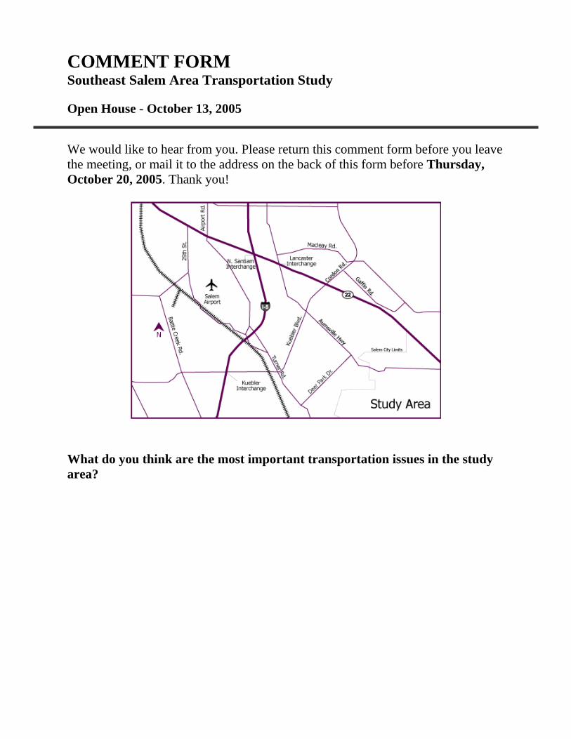
COMMENT FORM Southeast Salem Area Transportation Study
Open House - October 13, 2005 We would like to hear from you. Please return this comment form before you leave the meeting, or mail it to the address on the back of this form before Thursday, October 20, 2005. Thank you! What do you think are the most important transportation issues in the study area?
Other comments: ____________________________________________________________ ____________________________________________________________ ____________________________________________________________ ____________________________________________________________ ____________________________________________________________ ____________________________________________________________
Tell us about yourself (check all that apply):
I live in the study area. I work in the study area. I own property in the study area. I own a business in the study area. I drive through the study area. Other______________________________________
Would you like to be kept informed about the study? If so, please fill in your information below and we will add you to our contact list.
Name: Affiliation:
Address: City, State, Zip:
Phone: Email:
Return comment forms to: (mail by October 20, 2005) Randa Gahin Jeanne Lawson Associates 1110 SE Alder St., Suite 301 Portland, OR 97214
Contact for more information: Dan Fricke, Project Manager, ODOT Region 2 (503) 986-2663 [email protected]
Randa Gahin, Public Involvement Coordinator, Jeanne Lawson Assoc. (503) 235-5881 [email protected]
APPENDIX F
City of Salem Comprehensive Plan Consistency Determination
KUEBLER BOULEVARD INTERCHANGE AREA MANAGEMENT PLAN