![KUDU PCP - Schlumberger · KUDU PCP KUDU Elastomer Relative Specifications Elastomer† KUDU Reference Hardness Shore A Max. Temperature, degF [degC] Sand Resistance H 2 S Resistance](https://static.fdocuments.net/doc/165x107/5b2c266f7f8b9a6d188bcaef/kudu-pcp-kudu-pcp-kudu-elastomer-relative-specifications-elastomer-kudu.jpg)
KUDU POWER STATION (PS)
132
Central Contact Detail Tel: 012 460 6043 / 082 566 4530 Fax: 086 685 3822 / 012 346 2356 [email protected] [email protected] Polokwane Office 40 Juno Street, Sterpark, Polokwane, 0699 PO Box 5977, Pietersburg-Noord, Polokwane, 0750 Emalahleni (Witbank) Office 13 Delft Street, Die Heuwel Proper, Emalahleni, 1035 PO Box 8772, Die Heuwel, Emalahleni, 1042 Pretoria (Head) Office 91 Wenning Street, Groenkloof, Pretoria, 0181 PO Box 947, Groenkloof, Pretoria, 0027 Cape Town Office 3 Palomino Str, Die Wingerd, Somerset West, 7130 [email protected] KUDU POWER STATION (PS) – ORANJEMOND 1 ST & 2 ND 400KV LINES Scoping & EIA Application DEA Reference: 14/12/16/3/3/2/977 DRAFT ENVIRONMENTAL IMPACT REPORT February 2017 Applicant ESKOM HOLDINGS SOC LIMITED Contact Person: Ms Rudzani Ranwedzi Land Development and Management [email protected] Tel 011 516 7584
Transcript of KUDU POWER STATION (PS)

Central Contact Detail Tel: 012 460 6043 / 082 566 4530 Fax: 086 685 3822 / 012 346 2356
[email protected] [email protected]
Polokwane Office 40 Juno Street, Sterpark, Polokwane, 0699
PO Box 5977, Pietersburg-Noord, Polokwane, 0750
Emalahleni (Witbank) Office 13 Delft Street, Die Heuwel Proper, Emalahleni, 1035
PO Box 8772, Die Heuwel, Emalahleni, 1042
Pretoria (Head) Office 91 Wenning Street, Groenkloof, Pretoria, 0181 PO Box 947, Groenkloof, Pretoria, 0027 Cape Town Office 3 Palomino Str, Die Wingerd, Somerset West, 7130
KUDU POWER STATION (PS) –
ORANJEMOND 1ST & 2ND 400KV LINES
Scoping & EIA Application
DEA Reference: 14/12/16/3/3/2/977
DRAFT ENVIRONMENTAL IMPACT REPORT
February 2017
Applicant
ESKOM HOLDINGS SOC LIMITED Contact Person: Ms Rudzani Ranwedzi Land Development and Management
[email protected] Tel 011 516 7584

List of Contents ----------------------------------------------------------------------------------------------------------------------------------- EXECUTIVE SUMMARY
CHAPTER 1: INTRODUCTION
1.1 BACKGROUND 1.2 OBJECTIVES AND CONTENT OF THE ENVIRONMENTAL IMPACT REPORT 1.3 LEGAL REQUIREMENT
1.3.1 NATIONAL ENVIRONMENTAL MANAGEMENT ACT (ACT 107 OF 1998) 1.3.2 THE NATIONAL WATER ACT (ACT NO 36 OF 1998) 1.3.3 THE NATIONAL HERITAGE RESOURCES ACT (ACT 25 OF 1999) 1.3.4 ADDITIONAL ACTS, FRAMEWORKS AND GUIDELINES 1.3.5 ESKOM PLANNING PROCESSES
1.4 PROJECT TEAM 1.4.1 DETAILS OF THE ENVIRONMENTAL ASSESSMENT PRACTITIONER 1.4.2 PROFESSIONAL TEAM
1.5 WORKING PROGRAMME
CHAPTER 2: PROJECT INFORMATION 2.1 NEED AND DESIRABILITY 2.2 PROJECT INFORMATION 2.2.1 LOCALITY & REGIONAL CONTEXT
2.2.2 PROJECT COMPONENTS & TECHNICAL INFORMATION 2.2.3 SERVITUDE DETAILS 2.2.4 METHOD STATEMENT
2.2.5 DESIGN, CONSTRUCTION AND OPERATIONAL TARGETS
CHAPTER 3: ALTERNATIVES 3.1 ROUTE ALTERNATIVES 3.2 SUBSTATION SITE ALTERNATIVE 3.3 NO GO ALTERNATIVE 3.4 CONCLUSIVE STATEMENT IN TERMS OF ALTERNATIVES
CHAPTER 4: SPECIALIST STUDIES 4.1 GENERAL DESCRIPTION OF STUDY AREA 4.2 BIOPHYSICAL ENVIRONMENT
4.2.1 GEOLOGY, GROUNDWATER & AGRICULTURAL ASPECTS 4.2.2 AQUATIC IMPACT STUDY 4.2.3 ECOLOGICAL STUDY (TERRESTRIAL FAUNA & FLORA) 4.2.4 AVI-FAUNA IMPACT STUDY

4.3 CULTURAL/HISTORICAL ENVIRONMENT
4.3.1 PALAEONTOLOGICAL IMPACT ASSESSMENT 4.3.2 HERITAGE IMPACT ASSESSMENT
4.4 SOCIAL ENVIRONMENT 4.4.1 SOCIAL IMPACT REPORT 4.4.2 VISUAL IMPACT ASSESSMENT
4.5 ENVIRONMENTAL SENSITIVITY
CHAPTER 5: PUBLIC PARTICIPATION 5.1 OBJECTIVES OF THE PUBLIC PARTICIPATION PROGRAMME 5.2 PROCESS FOLLOWED 5.3 ISSUES RAISED DURING THE SCOPING PHASE
5.3.1 WRITTEN COMMUNICATION DURING THE INITIAL ADVERTISING PERIOD UP TO THE DISTRIBUTION OF THE SCOPING REPORT
5.3.2. KEY ISSUES RAISED DURING THE FOCUS GROUP MEETING 5.3.3 COMMENT RECEIVED ON THE DRAFT SCOPING REPORT 5.3.4 CONCLUSION OF PUBLIC PARTICIPATION DURING THE SCOPING PHASE
5.4 ISSUES RAISED DURING THE EIR PHASE 5.4.1 KEY ISSUES RAISED DURING THE PUBLIC INFORMATION MEETING AND SITE VISIT 5.4.2 COMMUNICATION DURING THE EIR PHASE 5.4.2 COMMENT RECEIVED ON THE DRAFT ENVIRONMENTAL IMPACT REPORT 5.4.2 CONCLUSION OF PUBLIC PARTICIPATION DURING THE EIR PHASE
CHAPTER 6: IMPACTS AND MITIGATION 6.1 METHODS USED TO IDENTIFY IMPACT 6.2 LIST OF IMPACTS ASSOCIATED WITH THE DEVELOPMENT
6.2.1 EXPECTED NEGATIVE IMPACTS 6.2.2 EXPECTED POSITIVE IMPACTS
6.3 PROPOSED MANAGEMENT OF IMPACTS AND MITIGATION 6.3.1 ENVIRONMENTAL IMPACT ASSESSMENT TABLE 6.3.2 ENVIRONMENTAL MANAGEMENT PLAN
CHAPTER 7 : CONCLUSION 7.1 LEGAL REVIEW 7.2 ENVIRONMENTAL IMPACT STATEMENT 7.3 RECOMMENDATIONS BY THE EAP 7.4 AFFIRMATIONS BY THE EAP

Appendices
Appendix A: Maps & Photos
A(1) Locality Map 1:250 000 A(2) (a) Route and Substation Map Topographical (b) Route and Substation Map Google Earth (c) Substation and Route Coordinates (d) KML File (electronic copy only) A(3) SANBI Environmental Sensitivity Maps
(a) Terrestrial CBAs (b) Threatened Ecosystems (c) National Protected Areas (d) National Rivers (e) Aquatic CBAs (f) National Wetlands
A(4) Site-specific Environmental Sensitivity (a) Requirement in terms of the Aquatic and Riparian Area (b) Requirement in terms of the Fauna and Flora (c) Requirement in terms of Bird Impact
A(5) Photos of the Study Area
Appendix B: Technical Information
B(1) Substation Site Detail
Concept Design Slideshow of the Oranjemond Substation
Diagrammatical Layout of the Substation Site
Contour Map of Substation Site B(2) Powerline Detail
Details of feeders entering the substation
Tower foundation types
Tower design alternatives Appendix C: Specialist Reports
C(1) Geology, Groundwater and Agricultural Aspects C(2) (a) Aquatic Ecological Impact Assessment C(2) (b) Addendum Freshwater Assessment C(3) Ecological Report on the Flora And Fauna C(4) Bird Impact Assessment C(5) Palaeontological Impact Assessment C(6) Cultural Heritage Impact Assessment C(7) Social Impact Assessment C(8) Visual Impact Assessment C(9) Legal Review of Draft Environmental Impact Report C(10) Legal Review of Draft Environmental Impact Report (to be included in the Final EIR)

Addendum D: Public Participation Programme
D(1) Background Information Document and Proof of Distribution D(2) Onsite Advertisement and Proof of Placement D(3) Newspaper Advertisements and Proof of Placement D(4) Minutes and Attendance Register of Meeting with Key Stakeholders D(5) Written Communication with I&AP's during the initial advertising period D(6) Proof of distribution of Draft Scoping Report D(7) Written correspondence on Draft Scoping Report D(8) Public Meeting & Site Visit
Proof of invitations sent for Public Meeting
Attendance Register
Minutes of Public Meeting
Proof of distribution of Minutes of Public Meeting D(9) Communication during the EIR Phase D(10) Proof of distribution of Draft EIR (to be included in Final BAR) D(11) Written correspondence on Draft EIR (to be included in the Final EIR) D(12) Register of Interested & Affected Parties
Appendix E: Environmental Management Plan Appendix F: Additional Information
G(1) Landscape Dynamics Company Profile and condensed CVs of EAPs

LIST OF ABBREVIATIONS BID Background Information Document CBA Critical Biodiversity Area DEA National Department of Environment Affairs DEIR Draft Environmental Impact Report DSR Draft Scoping Report DWS National Department of Water & Sanitation DMR Department of Mineral Resources EA Environmental Authorisation EAP Environmental Assessment Practitioner ECO Environmental Control Officer EIA Environmental Impact Assessment EIR Environmental Impact Report EMF Environmental Management Framework EMP Environmental Management Plan/Programme EWT Endangered Wildlife Trust FEIR Final Environmental Impact Report FSR Final Scoping Report GNR Government Notice Regulation ha Hectare(s) HIA Heritage Impact Assessment I&AP’s Interested and Affected Parties IEM Integrated Environmental Management m
3 Cubic metres
Mamsl Metres above mean sea level n/a Not applicable NEMA National Environmental Management Act, 1998 (Act No 107 of 1998) NEMPAA National Environmental Management: Protected Areas Act, 2003 (Act No 57 of 2003) NEMWA National Environmental Management: Waste Act, 2008 (Act No 59 of 2008) PPP Public Participation Process/Programme SAHRA South African Heritage Resources Agency SANBI South African National Biodiversity Institute SR Scoping Report PHRA Provincial Heritage Resources Authority PoS Plan of Study WULA Water Use License Application ELECTRICAL TERMS AND ABBREVIATIONS Eskom SOC South Africa’s Electricity Supply Commission (A State Owned Company) ICNIRP International Commission for Non-Ionising Radiation Protection IEP Integrated Energy Plan ISEP Integrated Strategic Electricity Planning MTS Main Transmission System NDP Network Development Plan NERSA National Energy Regulator of South Africa PV Photovoltaic (as in solar panels) Voltage : kV Kilovolt (1kV = 1 000V) MVA Mega Volt Ampére Units of power : kW Kilowatt (1kW= 1 000W) MW Megawatt (1MW=1 000kW)

Kudu Power Station (PS)- Oranjemond 1st and 2nd 400kV Lines Project Draft Environmental Impact Report Compiled by Landscape Dynamics Environmental Consultants, February 2017 i
EXECUTIVE SUMMARY
1. PROJECT OVERVIEW
Eskom Holdings SOC Limited : Group Technology and Commercial is in the process of undertaking
major infrastructural investments that includes the “Kudu Power Station (PS)- Oranjemond 1st and
2nd 400kV Lines Project”. The main purpose of this project is to integrate the new Kudu 885MW
Power Station in the Namibia into the Eskom network at the existing Oranjemond MTS Substation
in the Alexander Bay area in South Africa. It is proposed in to construct 2 x 400kV powerlines and
upgrade the Oranjemond MTS to accommodate these two lines accordingly.
The study area investigated by the project team consisted of a 3km corridor surrounding the
existing transmission line and substation. Eskom is responsible for the Orange River crossing
where the international border has moved as a result of the river dynamics. The study area
therefore extends to the riparian zone on the Namibian side of the river. The distance of the
proposed powerline from the substation to the South African side of the Orange River is
approximately 800m while the total length of the powerline to the border of the riparian
vegetation on the Namibian site is approximately 2km.
The Kudu Power Station (PS)- Oranjemond 1st and 2nd 400kV Lines project involves the following
main components:
The existing Oranjemond MTS Substation would be upgraded and expanded to
accommodate the new power lines as follows:
o Constructing a 400kV yard and equipment including busbar;
o Installing a 1x 315MVA 400/220kV transformer
o Create at least 4x 400kV line bays to allow for potential development.
2x 400kV power lines would be constructed from the Namibian side of the Orange River
across the river to connect to the Oranjemond MTS Substation
A new access road to the existing Oranjemond Substation site
The R382 road deviation at the south-east corner of the substation extension
A two-track service road between the two new powerlines within the servitude.
It is requested that a corridor width of 1km be authorised in which a 90m servitude for the
purpose of this powerline will be registered. The servitude width of a 400kV line is 55m for each
line – where parallel to each other it will be separated by 35m, with 27,5m on the outside - the
total width of the powerline servitude required for this project for the two lines together is
therefore 90m. This will enable reasonable adjustments within the corridor during the walk-down
and servitude negotiations with the relevant landowner without having to enter into an additional
environmental authorisation process.

Kudu Power Station (PS)- Oranjemond 1st and 2nd 400kV Lines Project Draft Environmental Impact Report Compiled by Landscape Dynamics Environmental Consultants, February 2017 ii
2. LEGAL REQUIREMENT
The construction of a 400kV power line is a listed activity in terms of Section 24(5) of the National
Environmental Management Act (NEMA), Act No 107 of 1998, as amended, and therefore
(amongst other relevant activities) environmental authorisation is required from the Department
of Environmental Affairs (DEA). Eskom has appointed Landscape Dynamics Environmental
Consultants to conduct an Environmental Impact Assessment (EIA) and apply for Environmental
Authorisation for this project.
This application for Environmental Authorisation is done in terms of the National Environmental
Management Act, 1998 (Act No 107 of 1998) (NEMA) and the Environmental Impact Assessment
Regulations published in Government Notice No. R.982, December 2014.
GN 983, Dec 2014, Numbers 12; 19; 24; 27 and 47
GN 984, Dec 2014 Listing Notice 2, Number 9
GN 985, Dec 2014 Listing Notice 3, Number 4, 12 and 14
A Scoping & Environmental Impact process is required. The Scoping Report was approved by DEA
on 17 January 2017. This document is the Environmental Impact Report (EIR) of this full EIA
process. According to the NEMA 2014 Regulations, Appendix 3, an EIR must contain all the
information that is necessary for the competent authority to consider and come to a decision on
the application.
An independent legal review of the Draft EIR is being done to confirm that the requirements of the
Environmental Impact Report had been met.
Specialist investigations informed that authorisation is also required in terms of the National
Water Act and the Cape Nature Conservation Ordinance. This does not form part of the
application for Environmental Authorisation, but the requirements of the regulating authorities
must be fulfilled prior to commencement of construction as will be specified in the Environmental
Management Plan.
The National Water Act, 1998 (Act Nr 36 of 1998)
The applicant is required to obtain a Water Use License or General Authorisation for the
activity from the regional office of DWS. The relevant listed activities are :
o Section 21 (c) Impeding or diverting the flow in a watercourse
o Section 21 (i) Altering the bed, banks, course or characteristics of a watercourse
National Forests Act (No 84 of 1998) &National Veld and Forests Fires Act (Act 101 of 1998)
The Northern Cape Department of Agriculture, Forestry & Fisheries administers permits for
the protection of threatened and/or endangered species.

Kudu Power Station (PS)- Oranjemond 1st and 2nd 400kV Lines Project Draft Environmental Impact Report Compiled by Landscape Dynamics Environmental Consultants, February 2017 iii
3. SPECIALIST INVESTIGATIONS
The specialist studies undertaken and the key findings and issues are supplied under the relevant
headings below. Detail information is supplied in Chapter 4 and the complete reports are
provided in Appendix C of the EIR. The details of the specialists (expertise, curriculum vitae’s and
declarations of independence) were included in Appendix E(2) of the Final Scoping Report and are
not again supplied in the EIR, but are available on request.
Key findings of the specialist studies
Geology, Groundwater and Agricultural Aspects Geology
The Gariep Supergroup is generally composed of low grade, metamorphosed volcanic sedimentary successions intruded by syn- to post orogenic granitoids. They have been extensively deformed by folding and faulting at times of orogeny activity.
Moderately hard rock appears from surface as outcrops and sub outcrops.
The underlying rocks can be expected to be thinly laminated owing to their lava flows, and with discontinuities caused by the tectonic activity with the rock having being folded and faulted and could be moderately jointed.
The Weinert N rating (an indication of the main weathering mode from mechanical to chemical weathering) for the area is high in correlation to its arid nature. This indicates that the rocks dominate mode of weathering is subject mostly to mechanical weathering rather than chemical weathering.
Soils
In areas away from the Orange River thin transported windblown soils (Aeolian) occur from surface comprising mainly yellowish brownish silty sands. They are largely absent around the substation site but the depths of these soils appear significantly across the steeper terrain and on the wind leeward side near the river. These soils may be considered to be loose in nature and unconsolidated.
Alluvial soils occur within the Orange River flood plain. They are typically finer in nature comprising silts and clays. A relative shallow residual soil profile is expected.
Ground and surface water
Recharge of groundwater is limited, occurring in small quantities being restricted by the limited rainfall and generally hard geological formations. Aquifer characteristics would thus typically be expected to be unfavourable.
There is also little potential for surface water to pond on the site providing little capacity for any ground water recharge from surface there.
In the area abstraction can easily be done from the Orange River therefore the need for boreholes around the site is minimal.
Kudu Power Station (PS)- Oranjemond 1st and 2nd 400kV Lines Project Draft Environmental Impact Report Compiled by Landscape Dynamics Environmental Consultants, February 2017 iv
Agricultural Aspects
As the area has little precipitation with sparse natural vegetation very difficult conditions are presented for being able to carry out agricultural activities in an economical manner within the sites limited area.
The Richtersveld Sida Hub Communal Property Association (CPA) currently uses a portion of land upstream of the project site for sheep and goat grazing purposes with limited irrigation activities confined to the limited floodplain area.
The project development site provides very limited and remote potential for pastoral activities. The flood plain is restricted along the proposed powerline route and little potential exists should the area be developed with irrigating from water supplied from the Orange River.
Aquatic and Riparian Area Impact
The Orange River is in a largely modified ecological state with a high ecological importance and sensitivity.
There must be no further deterioration in river condition for this section of river.
Potential impact (mostly during construction) o Direct modification or loss of aquatic habitat o Potential flow impact o Water quality impact
The pylons would be constructed within the recommend buffer but not within any of the mapped riparian zone (as per Appendix C(2)(b).
Water Use Authorisation in terms of the National Water Act (Nr 36 of 1998) is required for the crossing of the river. The Risk Assessment Matrix provided by the Department of Water and Sanitation was used in the assessment of the risk posed to the aquatic ecosystems by the proposed project. It was concluded that the proposed activities pose a low risk to the aquatic ecosystems for both the Construction and Operational & Maintenance Phases of the project.
The regulation relating to General Authorisations for Section 21 (c) and (i) water uses has been revised so that General Authorisation in terms of the Water Act could therefore be relevant to this project because of the low risk rating.
Vegetation Impact
The study area on the northern side of the Orange River is classified as an Ecological Support Area (ESA) and the section of the study area on the South African side of the Orange River is classified as a Critical Biodiversity Area (CBA) Type 2.
There are three vegetation types present in the study area: o Western Gariep Lowland Desert (Dn4); o Lower Gariep Alluvial Vegetation (Aza3) o Arid Estuarine Salt Marshes (AZe1).
Two vegetation units had been described :- o The desert area
- Lowland section - Rocky Section
o Riverbank area
Impact associated with powerlines :- o Loss of natural vegetation o Habitat fragmentation (loss of landscape connectivity) o Impacts on vulnerable species

Kudu Power Station (PS)- Oranjemond 1st and 2nd 400kV Lines Project Draft Environmental Impact Report Compiled by Landscape Dynamics Environmental Consultants, February 2017 v
o Establishment of invasive plants and declared weeds o Destruction of rocky vegetation where the new substation will be constructed
The results of the impact evaluations done by the ecologist for vegetation units 1 and 2 shows that the proposed power lines should have no severe (high) impact on the different units with medium-low impacts over the short-long term.
The expansion of the current substation to the east will lead to the destruction of a section of the rocky hill area (unit 1b) that will be permanent. If proper mitigation measures are implemented the effect can however be somewhat mitigated to lessen the impact.
A site walk-down with the ecologist is required once the pylon positions have been determined.
A Plant Rescue & Protection Management Plan must be compiled to confirm the permitting requirements of the Northern Cape Department of Environment and Nature Conservation to ensure compliance with the Northern Cape Provincial Act (Act 9 of 2009).
Bird Impact
The site is located 10km upstream from the Important Bird Area (IBA) - referred to as the Orange River Mouth Transboundary Ramsar Site.
Three main impacts of powerlines on birdlife are the following : o Electrocutions o Collisions o Displacement due to habitat destruction and disturbance
Bird flight diverters are proposed on the earth wires and there should be OWL devices (LED lights) for Flamingo’s. These devices are fitted with little solar panels with lights that flicker at night.
With mitigation : o Impact resulting from displacement and electrocution will be low to very low o Impact resulting from electrocution will be low.
Paleontological Impact
The area does not provide good conditions for the preservation of fossils. Heritage Impact
No sites of cultural heritage significance were located in the surveyed area.
Many stone tools have however been noted and the way forward will be determined during site walk-down.
Visual Impact
Visual issues have not been raised as a major concern by the local community and therefore the sensitivity to the project from this perspective is low.
The study area already contains a substation and power lines and the proposed new development would be constructed adjacent to these structures. The main impact is therefore of a cumulative nature and was assessed as such.
During the Construction Phase the proposed Project will exert a moderate negative impact (i.e. the impact is real but not substantial) on the visual and aesthetic environment. Mitigation during this phase is possible but it revolves mainly around ‘good housekeeping i.e. suppression of dust at the substation site and along access roads during construction.
The Operational Phase is predicted to exert a moderate impact without mitigation.

Kudu Power Station (PS)- Oranjemond 1st and 2nd 400kV Lines Project Draft Environmental Impact Report Compiled by Landscape Dynamics Environmental Consultants, February 2017 vi
Mitigation is possible, in the form of a tree screen to the east of the substation, during the operational phase but it will not substantially reduce the cumulative impact of the power lines. It will however screen sensitive views from the east to the sub-station. It also must be noted that the tree screen will not be effective immediately it will have to be established over a number of years before it will effectively contribute to mitigating the visual impact.
The visual impact specialist concluded that the proposed activity should be authorised with the proviso that the proposed management measures are binding to this authorization.
Key Social Issues
No objection was received.
The impact on tourism and land use is not expected to be significant.
The Richtersveld Sida Hub Communal Property Association (CPA) has a land claim against the property, gazetted on 29 August 2008 (Notice 1049 of 2008). They require continuous liaison with them. It was confirmed that from a legal point of view, nothing is contained in the relevant Act to preclude the Environmental Impact Assessment process to run its course however the notification step to the Regional Land Claims Commissioner is of fundamental importance – this is the responsibility of Eskom being the Applicant.
Only a few temporary unskilled job opportunities will be created during the construction phase.
4. PUBLIC PARTICIPATION
The Public Participation Process (PPP) followed during the Scoping Phase
Initial Advertising of project (proof is provided under the relevant headings in Appendix D.
o All potential directly and indirectly affected landowners, stakeholders and government
departments were identified.
o A Background Information Document (BID) was compiled and distributed via email during
the last week of July 2016 to all the stakeholders listed. A 30-day commenting period
applied.
o 5x A2 laminated onsite notices were placed in relative close proximity to the site.
o A newspaper advertisement was placed in Die Plattelander on 15 July 2016
o Focus Group Meetings were held with the Richtersveld Local Municipality; the Richtersveld
Sida Hub Communal Property Association (CPA) as well as a representative of the
landowner of Pico Eco Farm CC.
Distribution of the Draft Scoping Report
The Draft Scoping Report was distributed to Eskom for verification, thereafter to an
environmental attorney for legal review as well as to the Department of Environmental Affairs
and all registered Interested & Affected Parties for a 30-day commenting period.
Final Scoping Report
Comments received on the Draft Scoping Report (inclusive of the legal review) were incorporated

Kudu Power Station (PS)- Oranjemond 1st and 2nd 400kV Lines Project Draft Environmental Impact Report Compiled by Landscape Dynamics Environmental Consultants, February 2017 vii
into the Final Scoping Report. The Final Scoping Report was approved by DEA on 17 January
2017.
The Public Participation Process (PPP) followed during the EIR Phase
Public Meeting
A Public Meeting was held in Alexander Bay on 16 November 2016. The objectives of the
meeting were
• To communicate the details of the project
• To communicate the proceedings, findings and recommendations of the Environmental
Impact Assessment process
• Communicate the findings and recommendations of the specialists
• To enable informed discussion with and comment from stakeholders.
A site visit was also held afterwards. The minutes and attendance register are included in
Appendix D of the EIR.
Distribution of the Draft Environmental Impact Report
The Draft EIR (this document) is being distributed for a 30-day commenting period. All comment
received will be included in the Final EIR to be submitted to DEA for consideration for
Environmental Authorisation.
5. IMPACT AND MITIGATION
Expected impacts that can be associated with the project are the following:
NEGATIVE IMPACT
Planning Phase:
o Route selection and design:
o Impact on natural habitat (terrestrial fauna & flora)
o Impact on avi-fauna
o Impact on the Orange River
o Visual impact
o Impact on landownership / land claims issue
Construction Phase:
o Impact on natural habit (terrestrial fauna & flora)
o Disturbance to avi-fauna habitat
o Increased risk for surface and groundwater pollution
o Increased risk for erosion
o Influx of labourers with associated crime, access control, risk for habitat destruction
o Impacts associated with construction activities such as noise and dust

Kudu Power Station (PS)- Oranjemond 1st and 2nd 400kV Lines Project Draft Environmental Impact Report Compiled by Landscape Dynamics Environmental Consultants, February 2017 viii
During Operational Phase:
o Impact as a result of Eskom inspections and maintenance, i.e. on habitat destruction
(pollution, removal of plant species; placement of snares, etc.)
o Risk for collision with birds, specifically across the Orange River.
Cumulative Impacts
o Visual Impact
o Reduced ability to meet conservation obligations & targets
o Impact on broad-scale ecological processes
POSITIVE IMPACTS
The positive impacts of the proposed project on the environment are as follows: o This proposed Kudu Power Station (PS)- Oranjemond 1st and 2nd 400kV Lines project
provides a transmission solution for the proposed Kudu Gas Power Station in Southern Namibia. The power station will be producing 885MW power that will be evacuated via the NamPower and Eskom Transmission works.
o The project will result in a reliable supply of electricity to the Eskom grid – less power outages and failures are likely to occur;
o With the implementation of the project it is possible to accommodate new development and associated applications for electricity supply in the macro area;
o The proposed Eskom Kudu-Oranjemond Project planned in a legal, pro-active and structured manner taking all development components, potential and restrictions into account;
o The project will provide some, however limited, employment and training opportunities, during the construction phase of the project development.
A comprehensive Impact Assessment Table that includes proposed mitigation measures are include in Chapter 6, Paragraph 6.3.1. An Environmental Management Plan that includes all relevant mitigation measures is included in Appendix E of the EIR. It is suggested that the expected negative impact could be mitigated to acceptable levels. It is also suggested that the positive impact outweigh the negative impact associated with the project. 1. CONCLUSION AND RECOMMENDATION
It is the professional and objective opinion of the independent EAP that the following is relevant:
All reasonable actions were taken to identify any relevant environmental components in the study area.
The specialist input obtained up to date is comprehensive and effective in providing an assessment of the status quo of the study area and potentially sensitive areas and issues of concern that require re-consideration of route alternatives.

Kudu Power Station (PS)- Oranjemond 1st and 2nd 400kV Lines Project Draft Environmental Impact Report Compiled by Landscape Dynamics Environmental Consultants, February 2017 ix
Significant and reasonable actions were taken to identify and notify all Interested & Affected Parties that include government departments, relevant authorities, general stakeholders and affected landowners of the project.
The Environmental Impact Report includes all proceedings, findings and recommendations from the EIR Phase.
All relevant legal requirement in terms of the Environmental Impact Report Phase as per the Environmental Impact Assessment Regulations published on 4 December 2014 as per the National Environmental Management Act, 1998 (Act No 107 of 1998) as amended had been complied with.
The Environmental Assessment Practitioner recommends without hesitation the proposed Eskom project, the “Kudu Power Station (PS) – Oranjemond 1st & 2nd 400kV Lines’’ for Environmental Authorisation by the Department of Environmental Affairs (DEA). The implementation of the Environmental Management Plan provided in Appendix F of the Final EIR must form part of the conditions of Environmental Authorisation.
********************************************************************************

Kudu Power Station (PS)- Oranjemond 1st and 2nd 400kV Lines Project
Draft Environmental Impact Report Compiled by Landscape Dynamics Environmental Consultants, February 2017 Page 1
CHAPTER 1: INTRODUCTION
1.1 BACKGROUND
Eskom SOC Limited is the South African utility that generates, transmits and distributes electricity.
Eskom supplies about 95% of the country's electricity, and about 60% of the total electricity
consumed in Africa.
Eskom Holdings SOC Limited: Land Development and Management is in the process of undertaking
major infrastructural investments that includes the Kudu Power Station (PS)- Oranjemond 1st and
2nd 400kV Lines project. The main purpose of this project is to integrate the new Kudu 885MW
Power Station in Namibia into the Eskom network at the existing Oranjemond MTS Substation in
the Alexander Bay area in South Africa. It is proposed in to construct 2 x 400kV powerlines and
upgrade the Oranjemond MTS to accommodate these two lines accordingly.
The construction of a 400kV power line is a listed activity in terms of Section 24(5) of the National
Environmental Management Act (NEMA), Act No 107 of 1998, as amended, and therefore
(amongst other relevant activities) environmental authorisation is required from the Department
of Environmental Affairs (DEA). Eskom has appointed Landscape Dynamics Environmental
Consultants to conduct an Environmental Impact Assessment (EIA) and apply for Environmental
Authorisation for this project.
1.2 OBJECTIVES AND CONTENT OF THE ENVIRONMENTAL IMPACT REPORT
Objectives
According to the NEMA Regulations’ Appendix 3, the objective of the environmental impact
assessment process is to, through a consultative process
(a) determine the policy and legislative context within which the activity is located and
document how the proposed activity complies with and responds to the policy and
legislative context;
(b) describe the need and desirability of the proposed activity, including the need and
desirability of the activity in the context of the preferred location;
(c) identify the location of the development footprint within the preferred site based on an
impact and risk assessment process inclusive of cumulative impacts and a ranking process
of all the identified development footprint alternatives focusing on the geographical,
physical, biological, social, economic, heritage and cultural aspects of the environment;
(d) determine the
(i) nature, significance, consequence, extent, duration and probability of the impacts
occurring to inform identified preferred alternatives; and

Kudu Power Station (PS)- Oranjemond 1st and 2nd 400kV Lines Project
Draft Environmental Impact Report Compiled by Landscape Dynamics Environmental Consultants, February 2017 Page 2
(ii) degree to which these impacts-
(aa) can be reversed;
(bb) may cause irreplaceable loss of resources, and
(cc) can be avoided, managed or mitigated;
(e) identify the most ideal location for the activity within the preferred site based on the
lowest level of environmental sensitivity identified during the assessment;
(f) identify, assess, and rank the impacts the activity will impose on the preferred location
through the life of the activity;
(g) identify suitable measures to avoid, manage or mitigate identified impacts;
(h) and identify residual risks that need to be managed and monitored.
Content of the Environmental Impact Report
According to the NEMA 2014 Regulations, Appendix 3, Paragraph 3, the Environmental Impact
Report must contain the information that is necessary for the competent authority to consider and
come to a decision on the application described. In addition, an EIR must take into account any
guidelines applicable to the kind of activity which is the subject of the application. The items are
listed below with appropriate reference to the relevant sections in the EIR where the item is
addressed.
Regulation requirement Section in Environmental
Impact Report where
addressed
(a) details of-
(i) the EAP who prepared the report; and
(ii) the expertise of the EAP, including a curriculum vitae;
Chapter 1, Paragraph 1.4.1
and Appendix F
(b) the location of the activity, including:
(i) the 21 digit Surveyor General code of each cadastral land parcel;
(ii) where available, the physical address and farm name; and
(iii) where the required information in items (i) and (ii) is not available, the coordinates of the boundary of the property or properties;
Chapter 2, Paragraph 2.2.1
and Appendix A(1)
(c) a plan which locates the proposed activity or activities applied for as
well as the associated structures and infrastructure at an appropriate
scale, or, if it is- (i) a linear activity, a description and coordinates of
the corridor in which the proposed activity or activities is to be
undertaken; (ii) on land where the property has not been defined, the
coordinates within which the activity is to be undertaken;
Appendix A(2)(a); (b) & (c)
(d) a description of the scope of the proposed activity, including- (i) all
listed and specified activities triggered and being applied for; and (ii) a
description of the associated structures and infrastructure related to
the development;
Chapter 1, Paragraph 1.3.1
and
Chapter 2, Paragraph 2.2

Kudu Power Station (PS)- Oranjemond 1st and 2nd 400kV Lines Project
Draft Environmental Impact Report Compiled by Landscape Dynamics Environmental Consultants, February 2017 Page 3
(e) a description of the policy and legislative context within which the
development is located and an explanation of how the proposed
development complies with and responds to the legislation and policy
context;
Chapter 1, Paragraph 1.3 and
Chapter 7, Paragraph 7.1
(f) a motivation for the need and desirability for the proposed
development, including the need and desirability of the activity in the
context of the preferred location;
Chapter 2, Paragraph 2.1
g) a motivation for the preferred development footprint within the
approved site;
Chapter 3, Paragraphs 3.1 and
3.2
(h) a full description of the process followed to reach the proposed
development footprint within the approved site, including:
(i) details of the development footprint alternatives considered;
(ii) details of the public participation process undertaken in
terms of regulation 41 of the Regulations, including copies of
the supporting documents and inputs;
(iii) a summary of the issues raised by interested and affected
parties, and an indication of the manner in which the issues
were incorporated, or the reasons for not including them;
(iv) the environmental attributes associated with the development
footprint alternatives focusing on the geographical, physical,
biological, social, economic, heritage and cultural aspects;
(v) the impacts and risks identified including the nature,
significance, consequence, extent, duration and probability of
the impacts, including the degree to which these impacts-
(aa) can be reversed;
(bb) may cause irreplaceable loss of resources; and
(cc) can be avoided, managed or mitigated;
(vi) the methodology used in determining and ranking the nature,
significance, consequences, extent, duration and probability
of potential environmental impacts and risks;
(vii) positive and negative impacts that the proposed activity and
alternatives will have on the environment and on the
community that may be affected focusing on the
geographical, physical, biological, social, economic, heritage
and cultural aspects;
(viii) the possible mitigation measures that could be applied and
level of residual risk;
(ix) if no alternative development locations for the activity were
investigated, the motivation for not considering such; and
(x) a concluding statement indicating the preferred alternative
development location within the approved site;
Chapter 3
Chapter 5, Paragraph 5.2
Chapter 5, Paragraphs 5.3.2;
5.3.3 and 5.4.2
Chapter 4
Chapter 6 , Paragraph 6.3.1
Chapter 6, Paragraph 6.1
Chapter 6.2.1 and 6.3.1
Chapter 6, Paragraph 6.3.1
and Appendix E
Chapter 3, Paragraphs 3.1 and
3.2
Chapter 3, Paragraph 3.4
(I) a full description of the process undertaken to identify, assess and rank
the impacts the activity and associated structures and infrastructure
will impose on the preferred location through the life of the activity,
including-
Chapter 6, Paragraph 6.1 and
6.3.1

Kudu Power Station (PS)- Oranjemond 1st and 2nd 400kV Lines Project
Draft Environmental Impact Report Compiled by Landscape Dynamics Environmental Consultants, February 2017 Page 4
(i) a description of all environmental issues and risks that
were identified during the environmental impact
assessment process; and
(ii) an assessment of the significance of each issue and risk
and an indication of the extent to which the issue and
risk could be avoided or addressed by the adoption of
mitigation measures;
(j) an assessment of each identified potentially significant impact and risk,
including-
(i) cumulative impacts;
(ii) the nature, significance and consequences of the impact and risk;
(iii) the extent and duration of the impact and risk;
(iv) the probability of the impact and risk occurring;
(v) the degree to which the impact and risk can be reversed;
(vi) the degree to which the impact and risk may cause irreplaceable
loss of resources; and
(vii) the degree to which the impact and risk can be mitigated;
Chapter 6, Paragraph 6.1 and
6.3.1
(k) where applicable, a summary of the findings and recommendations of
any specialist report complying with Appendix 6 to these Regulations
and an indication as to how these findings and recommendations have
been included in the final assessment report;
Chapter 4 and Appendix E
(I) an environmental impact statement which contains
(i) a summary of the key findings of the environmental impact
assessment:
(ii) a map at an appropriate scale which superimposes the proposed
activity and its associated structures and infrastructure on the
environmental sensitivities of the preferred site indicating any
areas that should be avoided, including buffers; and
(iii) a summary of the positive and negative impacts and risks of the
proposed activity and identified alternatives;
Chapter 7 Paragraph 7.2
(m) based on the assessment, and where applicable, recommendations
from specialist reports, the recording of proposed impact
management objectives, and the impact management outcomes for
the development for inclusion in the EMPr as well as for inclusion as
conditions of authorisation;
Chapter 7, Paragraph 7.3 and
Appendix E
(n) the final proposed alternatives which respond to the impact
management measures, avoidance, and mitigation measures
identified through the assessment;
Chapter 7, Paragraph 7.3
(o) any aspects which where conditional to the findings of the assessment
either by the EAP or specialist which are to be included as conditions
of authorisation
Chapter 7, Paragraph 7.2 and
7.3 and Appendix E
(p) a description of any assumptions, uncertainties and gaps in knowledge
which relate to the assessment and mitigation measures proposed;
Included in specialist reports
where relevant – Appendix C
(q) a reasoned opinion as to whether the proposed activity should or
should not be authorised, and if the opinion is that it should be
Chapter 7, Paragraph 7.2 and
7.3

Kudu Power Station (PS)- Oranjemond 1st and 2nd 400kV Lines Project
Draft Environmental Impact Report Compiled by Landscape Dynamics Environmental Consultants, February 2017 Page 5
authorised, any conditions that should be made in respect of that
authorisation;
(r) where the proposed activity does not include operational aspects, the
period for which the environmental authorisation is required and the
date on which the activity will be concluded and the post construction
monitoring requirements finalised;
Not applicable
(s) an undertaking under oath or affirmation by the EAP in relation to:
(i) the correctness of the information provided in the reports;
(ii) the inclusion of comments and inputs from stakeholders and l&APs;
(iii) the inclusion of inputs and recommendations from the specialist
reports where relevant; and
(iv) any information provided by the EAP to interested and affected
parties and any responses by the EAP to comments or inputs made
by interested or affected parties;
Chapter 7, Paragraph 7.4
(t) where applicable, details of any financial provisions for the
rehabilitation, closure, and ongoing post decommissioning
management of negative environmental impacts;
Not applicable
(u) an indication of any deviation from the approved scoping report,
including the plan of study, including-
(i) any deviation from the methodology used in determining the
significance of potential environmental impacts and risks; and
(ii) a motivation for the deviation;
Deviation from Plan of Study
for PPP of the EIR Phase –
Chapter 5, Paragraph 5.3
(v) any specific information that may be required by the competent
authority; and
Not applicable
(w) any other matters required in terms of section 24(4)(a) and (b) of the
Act.
Not applicable
1.3 LEGAL REQUIREMENT
1.3.1 NATIONAL ENVIRONMENTAL MANAGEMENT ACT (ACT 107 OF 1998)
This application is done in terms of the National Environmental Management Act, 1998 (Act No
107 of 1998) (NEMA) and the Environmental Impact Assessment Regulations published in
Government Notice No. R.982, December 2014. Environmental Authorisation is requested for the
following listed activities:
Listing Notice 1
GN 983, Dec 2014, Number 12 The development of- (i) canals exceeding 100 square metres in size; (ii) channels exceeding 100 square metres in size; (iii) bridges exceeding 100 square metres in size;
Two approximately 2km new power lines will be constructed and the footprint of the pylons will be 100m2. Some of the pylon towers will be constructed within 32m from the Orange

Kudu Power Station (PS)- Oranjemond 1st and 2nd 400kV Lines Project
Draft Environmental Impact Report Compiled by Landscape Dynamics Environmental Consultants, February 2017 Page 6
(iv) dams, where the dam, including infrastructure and water surface area, exceeds 100 square metres in size;
(v) weirs, where the weir, including infrastructure and water surface area, exceeds 100 square metres in size;
(vi) bulk storm water outlet structures exceeding 100 square metres in size;
(vii) marinas exceeding 100 square metres in size; (viii) jetties exceeding 100 square metres in size; (ix) slipways exceeding 100 square metres in size; (x) buildings exceeding 100 square metres in size; (xi) boardwalks exceeding 100 square metres in size; or (xii) infrastructure or structures with a physical footprint of 100
square metres or more; where such development occurs- a) within a watercourse; b) in front of a development setback; or c) if no development setback exists, within 32 metres of a
watercourse, measured from the edge of a watercourse; - excluding- (aa) the development of infrastructure or structures within
existing ports or harbours that will not increase the development footprint of the port or harbour;
(bb) where such development activities are related to the development of a port or harbour, in which case activity 26 in Listing Notice 2 of 2014 applies;
(cc) activities listed in activity 14 in Listing Notice 2 of 2014 or activity 14 in Listing Notice 3 of 2014, in which case that activity applies;
(dd) where such development occurs within an urban area; or (ee) where such development occurs within existing roads or
road reserves.
River.
GN 983, Dec 2014, Number 19 The infilling or depositing of any material of more than 5 cubic metres into, or the dredging, excavation, removal or moving of soil, sand, shells, shell grit, pebbles or rock of more than 5 cubic metres from- (i) a watercourse; (ii) the seashore; or (iii) the littoral active zone, an estuary or a distance of 100
metres inland of the high-water mark of the sea or an estuary, whichever distance is the greater
But excluding where such infilling, depositing , dredging, excavation, removal or moving- a) will occur behind a development setback; b) is for maintenance purposes undertaken in accordance with a
maintenance management plan; or c) falls within the ambit of activity 21 in this Notice, in which
case that activity applies.
Foundations of 100m2 (therefore more than 5m3) will be constructed for the towers and some will occur within 32m of a watercourse (the Orange River).

Kudu Power Station (PS)- Oranjemond 1st and 2nd 400kV Lines Project
Draft Environmental Impact Report Compiled by Landscape Dynamics Environmental Consultants, February 2017 Page 7
GN 983, Dec 2014, Number 24 The development of- (i) a road for which an environmental authorisation was obtained
for the route determination in terms of activity 5 in Government Notice 387 of 2006 or activity 18 in Government Notice 545 of 2010; or
(ii) a road with a reserve wider than 13,5 meters, or where no reserve exists where the road is wider than 8 metres;
but excluding- (a) roads which are identified and included in activity 27 in Listing Notice 2 of 2014; or (b) roads where the entire road falls within an urban area.
The existing R382 road will be deviated at the south-east corner of the substation extension .
GN 983, Dec 2014, Number 27 The clearance of an area of 1 hectares or more, but less than 20 hectares of indigenous vegetation, except where such clearance of indigenous vegetation is required for- (i) the undertaking of a linear activity; or (ii) maintenance purposes undertaken in accordance with a
maintenance management plan.
The existing 2,5 hectare footprint of the substation site will be enlarged by an additional 4 hectares of land. The site contains indigenous vegetation.
GN 983, Dec 2017, Number 47 The expansion of facilities or infrastructure for the transmission and distribution of electricity where the extended capacity will exceed 275 kilovolts and the development footprint will increase.
The project components for the substation upgrade involve
the construction of a 400kV yard and equipment including busbar and bus coupler bay;
installing a 1x 315MVA 400/220kV transformer
creating at least 4x 400kV line bays to allow for potential development
In order to achieve the above, it is required to increase the existing 2,5 hectare footprint of the substation with an additional 4 hectares is required. The final footprint will be 6,5ha.
Listing Notice 2
GN 984, Dec 2014, Number 9 The development of facilities or infrastructure for the transmission and distribution of electricity with a capacity of 275 kilovolts or more, outside an urban area or industrial complex.
Two approximately 2km 400kV powerlines will be constructed. The expansion of the existing Oranjemond MTS Substation also forms part of the project components. The study area falls outside urban areas and industrial complexes.
Kudu Power Station (PS)- Oranjemond 1st and 2nd 400kV Lines Project
Draft Environmental Impact Report Compiled by Landscape Dynamics Environmental Consultants, February 2017 Page 8
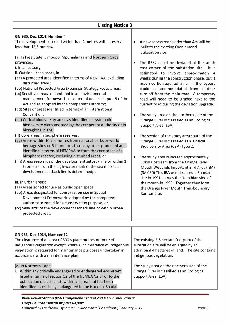
Listing Notice 3
GN 985, Dec 2014, Number 4 The development of a road wider than 4 metres with a reserve less than 13,5 metres. (a) In Free State, Limpopo, Mpumalanga and Northern Cape provinces: i. In an estuary; ii. Outside urban areas, in: (aa) A protected area identified in terms of NEMPAA, excluding
disturbed areas; (bb) National Protected Area Expansion Strategy Focus areas; (cc) Sensitive areas as identified in an environmental
management framework as contemplated in chapter 5 of the Act and as adopted by the competent authority;
(dd) Sites or areas identified in terms of an International Convention;
(ee) Critical biodiversity areas as identified in systematic biodiversity plans adopted by the competent authority or in bioregional plans;
(ff) Core areas in biosphere reserves; (gg) Areas within 10 kilometres from national parks or world
heritage sites or 5 kilometres from any other protected area identified in terms of NEMPAA or from the core areas of a biosphere reserve, excluding disturbed areas; or
(hh) Areas seawards of the development setback line or within 1 kilometre from the high-water mark of the sea if no such development setback line is determined; or
iii. In urban areas: (aa) Areas zoned for use as public open space; (bb) Areas designated for conservation use in Spatial
Development Frameworks adopted by the competent authority or zoned for a conservation purpose; or
(cc) Seawards of the development setback line or within urban protected areas.
A new access road wider than 4m will be built to the existing Oranjemond Substation site.
• The R382 could be deviated at the south east corner of the substation site. It is estimated to involve approximately 4 weeks during the construction phase, but it may not be required at all if the bypass could be accommodated from another turn-off from the main road. A temporary road will need to be graded next to the current road during the deviation upgrade.
The study area on the northern side of the Orange River is classified as an Ecological Support Area (ESA).
The section of the study area south of the Orange River is classified as a Critical Biodiversity Area (CBA) Type 2.
The study area is located approximately 10km upstream from the Orange River Mouth Wetlands Important Bird Area (IBA) (SA 030) This IBA was declared a Ramsar site in 1991, as was the Namibian side of the mouth in 1995. Together they form the Orange River Mouth Transboundary Ramsar Site.
GN 985, Dec 2014, Number 12 The clearance of an area of 300 square metres or more of indigenous vegetation except where such clearance of indigenous vegetation is required for maintenance purposes undertaken in accordance with a maintenance plan. (d) In Northern Cape: i. Within any critically endangered or endangered ecosystem
listed in terms of section 52 of the NEMBA 'or prior to the publication of such a list, within an area that has been identified as critically endangered in the National Spatial
The existing 2,5 hectare footprint of the substation site will be enlarged by an additional 4 hectares of land. The site contains indigenous vegetation. The study area on the northern side of the Orange River is classified as an Ecological Support Area (ESA).

Kudu Power Station (PS)- Oranjemond 1st and 2nd 400kV Lines Project
Draft Environmental Impact Report Compiled by Landscape Dynamics Environmental Consultants, February 2017 Page 9
Biodiversity Assessment 2004; ii. Within critical biodiversity areas identified in bioregional plans; iii. Within the littoral active zone or 100 metres inland from high
water mark of the sea or an estuary, whichever distance is the greater, excluding where such removal will occur behind the development setback line on erven in urban areas; or
iv. On land, where, at the time of the coming into effect of this Notice or thereafter such land was zoned open space, conservation or had an equivalent zoning.
The section of the study area on south of the Orange River is classified as a Critical Biodiversity Area (CBA) Type 2.
GN 985, Dec 2014, Number 14 The development of- (i) canals exceeding 10 square metres in size ; (ii) channels exceeding 10 square metres in size; (iii) bridges exceeding 10 square metres in size; (iv) dams, where the dam, including infrastructure and water
surface area exceeds 10 square metres in size; (v) weirs, where the weir, including infrastructure and water
surface area exceeds 10 square metres in size; (vi) bulk storm water outlet structures exceeding 10 square
metres in size; (vii) marinas exceeding 10 square metres in size; (viii) jetties exceeding 10 square metres in size; (ix) slipways exceeding 10 square metres in size; (x) buildings exceeding 10 square metres in size; (xi) boardwalks exceeding 10 square metres in size; or (xii) infrastructure or structures with a physical footprint of 10
square metres or more; where such development occurs (a) within a watercourse; (b) in front of a development setback or (c) if no development setback has been adopted, within 32 metres
of a watercourse, measured from the edge of a watercourse; excluding the development of infrastructure or structures within existing ports or harbours that will not increase the development footprint of the port or harbour. (a) In Free State, Limpopo, Mpumalanga and Northern Cape: i. In an estuary; ii. Outside urban areas, in: (aa) A protected area identified in terms of NEMPAA, excluding
conservancies; (bb) National Protected Area Expansion Strategy Focus areas; (cc) World Heritage Sites; (dd) Sensitive areas as identified in an environmental
management framework as contemplated in chapter 5 of the Act and as adopted by the competent authority;
(ee) Sites or areas identified in terms of an International Convention;
Two approximately 2km new power lines will be constructed and the footprint of the pylons will be 100m2 (will therefore exceed 10m2). Some towers will be constructed within 32m from a watercourse (the Orange River). The study area is located approximately 10km upstream from the Orange River Mouth Wetlands Important Bird Area (IBA) (SA 030) This IBA was declared a Ramsar site in 1991, as was the Namibian side of the mouth in 1995. Together they form the Orange River Mouth Transboundary Ramsar Site.

Kudu Power Station (PS)- Oranjemond 1st and 2nd 400kV Lines Project
Draft Environmental Impact Report Compiled by Landscape Dynamics Environmental Consultants, February 2017 Page 10
(ff) Critical biodiversity areas or ecosystem service areas as
identified in systematic biodiversity plans adopted by the competent authority or in bioregional plans;
(gg) Core areas in biosphere reserves; (hh) Areas within 10 kilometres from national parks or world
heritage sites or 5 kilometres from any other protected area identified in terms of NEMPAA or from the core area of a biosphere reserve;
(ii) Areas seawards of the development setback line or within 1
kilometre from the high-water mark of the sea if no such development setback line is determined; or
iii. In urban areas: (aa) Areas zoned for use as public open space; (bb) Areas designated for conservation use in Spatial
Development Frameworks adopted by the competent authority, zoned for a conservation purpose; or
(cc) Areas seawards of the development setback line.
In terms of the NEMA legislation, application for environmental authorisation is lodged with the National Department of Environmental Affairs (DEA). DEA has to evaluate this Scoping Study and based on the findings and proceedings documented in the Scoping Report supply the Environmental Assessment Practitioner (EAP) with a decision to proceed with the EIA or to amend the Scoping Report. The following departments and government institutions are key commenting authorities in terms of the Environmental Authorisation:
Department of Economic Development, Tourism and Environmental Affairs, Northern Cape Provinces: (Section Environmental Quality Management).
Department of Water and Sanitation (DWS), Northern Cape Region.
The South African Heritage Resources Agency (SAHRA). They will advise whether authorisation is also required from the Northern Cape Provincial Heritage Authority.
NEMA can be regarded as the most important piece of general environmental legislation. It provides a framework for environmental law reform and covers three areas, namely:
Land, planning and development;
Natural and cultural resources, use and conservation; and
Pollution control and waste management. The law is based on the concept of sustainable development. The objective of the NEMA is to provide for co-operative environmental governance through a series of principles relating to:
The procedures for state decision-making on the environment; and
The institutions of state which make those decisions.

Kudu Power Station (PS)- Oranjemond 1st and 2nd 400kV Lines Project
Draft Environmental Impact Report Compiled by Landscape Dynamics Environmental Consultants, February 2017 Page 11
NEMA principles serve as:
A general framework for environmental planning;
Guidelines according to which the state must exercise its environmental functions; and
A guide to the interpretation of NEMA itself and of any other law relating to the
environment.
NEMA principles are the following:
Environmental management must put people and their needs first;
Development must be socially, environmentally and economically sustainable;
There should be equal access to environmental resources, benefits and services to meet
basic human needs;
Government should promote public participation when making decisions about the
environment;
Communities must be given environmental education;
Workers have the right to refuse to do work that is harmful to their health or to the
environment;
Decisions must be taken in an open and transparent manner and there must be access to
information;
The role of youth and women in environmental management must be recognised;
The person or company who pollutes the environment must pay to clean it up;
The environment is held in trust by the state for the benefit of all South Africans; and
The utmost caution should be used when permission for new developments is granted.
1.3.2 THE NATIONAL WATER ACT (ACT NO 36 OF 1998)
The National Water Act guides the management of water in South Africa as a common resource.
The Act aims to regulate the use of water and activities which may impact on water resources
through the categorisation of ‘listed water uses’ encompassing water extraction, flow attenuation
within catchments as well as the potential contamination of water resources The Department of
Water & Sanitation (DWS) is the administering body in this regard.
The applicant is required to obtain a Water Use License or General Authorisation for the activity
from the regional office of DWS. The relevant listed activities are :
Section 21 (c) Impeding or diverting the flow in a watercourse
Section 21 (i) Altering the bed, banks, course or characteristics of a watercourse
1.3.3 THE NATIONAL HERITAGE RESOURCES ACT (ACT 25 OF 1999)
The proposed project falls within the scope of Section 38 of the National Heritage Resources Act,
(Act 25 of 1999) and the applicable activities are:

Kudu Power Station (PS)- Oranjemond 1st and 2nd 400kV Lines Project
Draft Environmental Impact Report Compiled by Landscape Dynamics Environmental Consultants, February 2017 Page 12
(a) the construction of a road, wall, power line, pipeline, canal or similar form of linear
development or barrier exceeding 300m in length;
(b) any development or other activity which will change the character of a site-
exceeding 5 000m2 in extent
involving three or more existing erven or subdivisions thereof
(c) the re-zoning of a site exceeding 10 000m2 in extent
1.3.4 ADDITIONAL ACTS, FRAMEWORKS AND GUIDELINES
National Environmental Management: Biodiversity Act, 2004 (Act No. 10 of 2004)
The purpose of the Biodiversity Act is to provide for the management and conservation of South
Africa’s biodiversity within the framework of the NEMA and the protection of species and
ecosystems that warrant national protection. As part of its implementation strategy, the National
Spatial Biodiversity Assessment was developed. Should protected species and ecosystems be
impacted on by the proposed substation or power line, this Act may be applicable and the
necessary measures should be taken for implementation.
National Environmental Management: Protected Areas Act (No 57 of 2003)
The Act came into operation on 01 November 2004. The aim of the Act is to provide for the
protection and conservation of ecologically viable areas representative of South Africa's biological
diversity, natural landscapes and seascapes. In 2004, the National Environmental Management:
Protected Areas Amendment Act 31 of 2004 was promulgated to amend Act 57 of 2003 with
regard to the application of that Act to national parks and marine protected areas. The NEM:
Protected Areas Amendment Act was published for public information on 11 February 2005 and
came into operation on 01 November 2005. The NEM: Protected Areas Act, as amended by the
NEM: Protected Areas Act 31 of 2004 repeals sections 16, 17 & 18 of the ECA as well as the
National Parks Act with the exception of section 2(1) and Schedule 1.
National Environmental Management: Air Quality Act, 2004 (No 39 of 2004)
Section 32 Control of dust; Section 34 Control of Noise; Section 35 Control of offensive odours.
The Constitution Act (No 108 of 1996)
Chapter 2 Bill of Rights; Section 24 Environmental rights; Section 25 Rights in property; Section 32
Administrative justice; Section 33 Access to information.
Expropriation Act (No. 63 of 1975)
Eskom has a policy of “willing buyer, willing seller”, and therefore endeavours to purchase land
where ever possible or necessary. However, the State and State-owned-enterprises can acquire
the rights to use or possess the requisite land through the Expropriation Act (No 63 of 1975). The
Expropriation Act requires the determination of compensation based on the principle of market

Kudu Power Station (PS)- Oranjemond 1st and 2nd 400kV Lines Project
Draft Environmental Impact Report Compiled by Landscape Dynamics Environmental Consultants, February 2017 Page 13
value (i.e. what would the value be in the event of both a willing buyer and a willing seller trading
the land). There is a suite of additional legislation, which, in conjunction with the Expropriation
Act, could be used to determine the compensation value.
Occupational Health and Safety Act (Act No 85 of 1993)
This Act makes provisions that address the health and safety of persons working at the proposed
substation and power line. The Act addresses amongst others the:
Safety requirements for the operation of plant machinery;
Protection of persons other than persons at work against hazards to health and safety,
arising out of or in connection with the activities of persons at work;
Establishment of an advisory council for occupational health and safety; and
Provision for matters connected therewith.
The law states that any person undertaking upgrades or developments for use at work or on any
premises shall ensure as far as is reasonably practicable that nothing about the manner in which it
is erected or installed make it unsafe or creates a risk to health when properly used.
The Tourism Act, 1993 (Act No. 72 of 1993)
Policy and legislation governing tourism in South Africa emphasises the concepts of responsible
tourism and sustainable tourism development. Tourism is legislated in terms of the Tourism Act
(Act No. 72 of 1993), which was amended as the Tourism Amendment Act (Act No. 105 of 1996
and the Tourism Second Amendment Act no. 70 of 2000. The 1996 White Paper on Development
and Promotion of Tourism in South Africa introduces the concept of “responsible tourism”; i.e.
tourism with a responsibility towards the environment, through sustainable use of resources,
involvement of local communities, and commitment to safety and security of all concerned.
Taking this further, the drive towards “sustainable tourism” development emphasises the
optimisation of benefits relating to tourism,
The Conservation of Agricultural Resources Act (No 43 of 1983)
Section 6: Implementation of control measures for alien and invasive plant species.
Atmospheric Pollution Prevention Act (No 45 of 1964) and regulations
Sections 27 – 35: Dust control.
Section 36 – 40: Air pollution by fumes emitted by vehicles.
Occupational Health and Safety Act (No 85 of 1993) and regulations
Section 8: General duties of employers to their employees.
Section 9: General duties of employers and self-employed persons to persons other than their
employees.

Kudu Power Station (PS)- Oranjemond 1st and 2nd 400kV Lines Project
Draft Environmental Impact Report Compiled by Landscape Dynamics Environmental Consultants, February 2017 Page 14
National Forests Act (No 84 of 1998) and regulations
Section 7: No person may cut, disturb, damage or destroy any indigenous, living tree in a natural
forest, except in terms of a licence issued under section 7(4) or section 23; or an exemption from
the provisions of this subsection published by the Minister in the Gazette.
Sections 12-16: These sections deal with protected trees, with the Minister having the power to
declare a particular tree, a particular group of trees, a particular woodland; or trees belonging to a
particular species, to be a protected tree, group of trees, woodland or species. In terms of section
15, no person may cut, disturb, damage, destroy or remove any protected tree; or collect, remove,
transport, export, purchase, sell, donate or in any other manner acquire or dispose of any
protected tree, except under a licence granted by the Minister.
Fencing Act (No 31 of 1963)
Section 17: Any person erecting a boundary fence may clean any bush along the line of the fence
up to 1.5m on each side thereof and remove any tree standing in the immediate line of the fence.
However, this provision must be read in conjunction with the environmental legal provisions
relevant to protection of flora.
Fertilisers, Farm Feeds, Agricultural Remedies and Stock Remedies Act (No 36 of 1947) and
regulations
Sections 3 to 10: Control of the use of registered pesticides, herbicides (weed killers) and
fertilisers. Special precautions must be taken to prevent workers from being exposed to chemical
substances in this regard.
Department of Environmental Affairs Integrated Environmental Management Series
DEA’s Information Series were drafted as sources of information about concepts and approaches
to Integrated Environmental Management (IEM). IEM is a key instrument of NEMA and provides
the overarching framework for the integration of environmental assessment and management
principles into environmental decision-making. The aim of the information series is to provide
general guidance on techniques, tools and processes for environmental assessment and
management.
Northern Cape Nature Conservation Ordinance Act (Act 9 of 2009)
This legislation was developed to protect both animal and plant species within the various provinces of the country which warrant protection. These may be species which are under threat or which are already considered to be endangered. The provincial environmental authorities are responsible for implementing the provisions of this legislation, which includes the issuing of permits etc. In the Northern Cape, the Department of Environment and Nature Conservation fulfils this mandate. The protection of these species is enforced through permitting requirements associated with provincial lists of protected species. Permits are administered by the provincial departments responsible for environmental affairs. Protected species are listed as Schedule 1 (Specifically protected), Schedule 2 (Protected) and Schedule 3 (Common indigenous).

Kudu Power Station (PS)- Oranjemond 1st and 2nd 400kV Lines Project
Draft Environmental Impact Report Compiled by Landscape Dynamics Environmental Consultants, February 2017 Page 15
Namaqua District Biodiversity Sector Plan, 2008 Biodiversity sector plans are intended to help guide land-use planning, environmental assessments and authorisations; and, natural resource management in order to promote development which
occurs in a sustainable manner. The Namaqua District Biodiversity Sector Plan was developed to
further the awareness of the unique biodiversity in the area, the value this bio diversity represents
to people as well as the management mechanisms that can ensure its protection and sustainable
utilisation. The biodiversity profile information from this plan has been incorporated into the
environmental planning section of the Spatial Development Frameworks (SDF's) for each of the six
local municipalities in the district.
The Namaqua District Critical Biodiversity Areas (CBA) has been mapped to include the
Richtersveld Municipal area including the study site:
The study side of the Orange River is classified as an Ecological Support Area (ESA) which is
due to it being classified as a terrestrial migration corridor.
The section of the study area on the South African side is classified as a Critical Biodiversity
Area (CBA) Type 2. Level 2 CBA‟s are designated to near-natural landscapes including:
o Ecosystems and species largely intact and undisturbed,
o Areas with intermediate irreplaceability or some flexibility in terms of area required
to meet biodiversity targets. T
o There are options for loss of some components of biodiversity in these landscapes
without compromising our ability to achieve targets,
o These are landscapes that are approaching but have not passed their limits of
acceptable change.
The ecological impact assessment acknowledges these impacts and confirms that the impact can
be mitigated since the affected activities (i.e. overhead transmission line and water pipeline) can
be micro-sited to minimise impact. Similarly these activities will be associated with already
transformed area (not reflected at CBA/ESA scale) associated with existing 66kV Eskom
transmission lines and access routes to the property. The implementation of the Alien Invasive
Management Plan and the Plant Rescue & Protection Management Plan will be vital in ensuring
that impacts within the areas designated as CBA and ESA are mitigated to within acceptable
environmental limits.
National Department of Environmental Affairs: Guidelines
The National Department of Environmental Affairs has a set of guidelines that have to be adhered
to during the EIA Process. The following guidelines are applicable:
Companion Guideline for the Implementation of the Environmental Impact Assessment
Regulations (Guideline 5), as published in Government Notice 805 of 10 October 2012.
Public Participation Guideline for the Environmental Impact Assessment Process (Guideline 7),
as published in Government Notice 807 of 10 October 2012.

Kudu Power Station (PS)- Oranjemond 1st and 2nd 400kV Lines Project
Draft Environmental Impact Report Compiled by Landscape Dynamics Environmental Consultants, February 2017 Page 16
Eskom Environmental Procedures
Eskom Environmental Procedures in terms of:
Acquiring of servitudes
Bush Clearing
Access to properties
1.3.5 ESKOM PLANNING PROCESSES
The following section, although not legislative, provide supplementary information on some of
Eskom’s planning processes.
White Paper on the Energy Policy of the Republic of South Africa – 1998
Development within the energy sector in South Africa is guided by the White Paper on the Energy
Policy, published by the Department of Minerals and Energy (DME) in 1998. This White Paper sets
out five objectives for the further development of the energy sector. The five objectives are as
follows:
Increased access to affordable energy services;
Improved energy governance;
Stimulating economic development;
Managing energy-related environmental and health impacts; and
Securing supply through diversity.
Furthermore, the Energy Policy identified the need to undertake an Integrated Energy Planning
(IEP) process in order to achieve a balance between energy demand and resource availability,
whilst taking into account health, safety and environmental aspects. In addition, the policy
identified the need for the adoption of a National Integrated Resource Planning (NIRP) approach
to provide a long-term cost-effective resource plan for meeting electricity demand, which is
consistent with reliable electricity supply and environmental, social and economic policies.
Integrated Resource Plan for Electricity (IRP) – 2010
The Integrated Resource Plan (IRP) is a long-term electricity capacity plan, which defines the need
for new generation and transmission capacity for the country. The IRP outlines the concepts and
development behind the IRP for the electricity industry in South Africa as well as the strategic
objectives of the IRP including the policy and technical parameters that drive the planning process.
The National Energy Act of 2008 (Act 34 of 2008) obligates the Minister of Energy to develop and
publish an IRP for energy. As electricity forms a sub-component of the energy sector the
electricity IRP needs to be integrated into the outlook for energy. The system Operations and
Planning Division in Eskom has been mandated by the Department of Energy (DoE), under the New

Kudu Power Station (PS)- Oranjemond 1st and 2nd 400kV Lines Project
Draft Environmental Impact Report Compiled by Landscape Dynamics Environmental Consultants, February 2017 Page 17
Generation Capacity regulations, to produce the IRP for electricity in consultation with the DoE
and the National Energy Regulator of South Africa (NERSA). The objective of the IRP is to develop
a sustainable electricity investment strategy for generation capacity and transmission
infrastructure for South Africa over the next 25 years. The investment strategy includes
implications arising from demand-side management (DSM) and pricing, and including capacity
provided by generators (Eskom and independent power producers).
The IRP is intended to:
Improve the long term reliability of electricity supply through meeting adequacy criteria
over and above keeping pace with economic growth and development;
Ascertain South Africa’s capacity investment needs for the medium term business planning
environment;
Consider environmental and other externality impacts and the effect on renewable energy
technologies;
Provide the framework for Ministerial determination of new generation capacity (inclusive
of the required feasibility studies) as envisaged in the New Generation Capacity
regulations.
1.4 PROJECT TEAM
1.4.1 DETAILS OF THE ENVIRONMENTAL ASSESSMENT PRACTITIONER
Landscape Dynamics Environmental Consultants is the Environmental Consultants appointed for
this project. Landscape Dynamics cc is an environmental consultancy firm, established in May
1997. The main line of business since that time up to the present date is the compilation of
environmental impact assessments. Landscape Dynamics has a broad client base from both the
private and government sectors which has developed over the past 20 years of professional
services supplied. The operating base for Landscape Dynamics is the entire South Africa; with local
representation in Gauteng, the Western Cape, Limpopo and the Northern Cape.
The Environmental Assessment Practitioners (EAP’s) for this project are Ms Annelize Grobler and Ms Susanna Nel. The Landscape Dynamics’ Company Profile as well as relevant condensed Curriculum Vitae’s are attached in Appendix F. 1.4.2 PROFESSIONAL TEAM The impact that this project might have on the environment could only effectively be assessed if all the environmental project components had satisfactorily been identified and considered. A multi-disciplinary approach is therefore required for this Environmental Impact Assessment.

Kudu Power Station (PS)- Oranjemond 1st and 2nd 400kV Lines Project
Draft Environmental Impact Report Compiled by Landscape Dynamics Environmental Consultants, February 2017 Page 18
The EIA Project Team members are the following:
Company Name Contact Person(s) Responsibility and/or Project
Component
Landscape Dynamics CC Ms Annelize Grobler
Ms Susanna Nel
EIA Project Management
Environmental Assessment
Practitioners
Public Participation Programme
Africa Concepts Mr Chris Groenewald Geology, groundwater & agricultural
aspects
Blue Science (Pty) Ltd Dr Toni Belcher & Mr
Dana Grobler Aquatic Impact Study
Enviroguard Ecological Services CC Dr Leslie Brown Ecological Study (Terrestrial Fauna &
Flora)
Chris van Rooyen Consulting Mr Chris van Rooyen Avi-Fauna Impact Study
Archaetnos Cultural & Heritage Resource
Consultants
Dr Anton van
Vollenhoven Heritage Impact Assessment
Evolutionary Studies Institute, University
of the Witwatersrand Prof Marion Bamford Palaeontology desktop study
AMP Property Management & Land
Acquisition
Ms Anna-Marie Botha
Ms Maritha Duvenage
Integrated Report : Social Impact,
Socio-economic, Land Use & Tourism
Newtown Landscape Architects Mr Graham Young Visual Impact Assessment
Moketla Mamabolo Attorneys Mr Moketla
Mamabolo Legal Review
Afrimage Photography Mr Albert Froneman Mapping and GIS support
The EIA Project Team is supported by the following team members from within Eskom SOC
Limited:
Division within Eskom Group Capital
Division Contact Person(s)
Responsibility and/or Project
Component
Environment Ms Rudzani Ranwedzi Applicant Representative &
Environmental Manager
Project Development Engineer Mr Fick Booysen Overall Project Management
Land Development: Acquisition Mr Wimpie Henning Compensation and Servitude
Acquisition
Land Development: Project Planning Ms Jamila Kombe Project Planning
Line Engineering Services Mr Shakir Dudhia Line Design
Substation Engineering Services Mr Mark Peffer Substation Design

Kudu Power Station (PS)- Oranjemond 1st and 2nd 400kV Lines Project
Draft Environmental Impact Report Compiled by Landscape Dynamics Environmental Consultants, February 2017 Page 19
1.5 WORKING PROGRAMME The following programme is pursued in this Environmental Impact Assessment process :
Activity Planned
Project Management
Date of Appointment May 2016
Kick-off meeting with Eskom May 2016
Date of Site Visit with Overview Site investigation with Eskom and Specialists
19 & 20 July 2016
Advertising (Notification Phase)
Compilation of General Stakeholder (I&AP) and Landowner List
June 2016
Placement of Onsite Advertisements July 2016
Placement of newspaper ad July 2016
Notification letter distributed to IAP’s and Landowner List
July 2016
Scoping Phase: Specialist Studies
Desktop Studies July 2016
Receive Final Specialist Reports:-
Freshwater Impact Assessment
Geotechnical Overview Investigation
Ecology, Fauna & Flora Assessment
Heritage Impact
Paleontological Desktop Study
Social & Socio-Economic Impact, Landuse & Eco-Tourism
Visual Impact Assessment
Legal review
31 August 2016
Focus Group Meetings with key stakeholders July
Draft Scoping Report to Eskom for perusal September 2016
Draft Scoping Report to IAP’s and DEA (with the Application) for comment (30day commenting period)
30 September to 30 October 2016
Legal Review 30 September to 30 October 2016
Final Scoping Report for approval to DEA 11 November 2016
Approval of Scoping Report by DEA December 2016
Public Meeting /Open Day
Invitations sent 25 October 2016
Actual Meeting 15 November 2016
Minutes sent out 25 November 2016
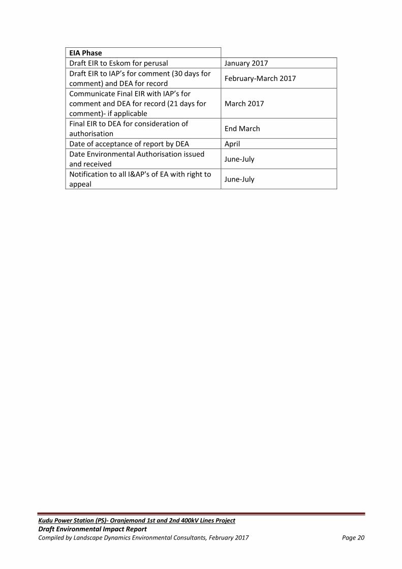
Kudu Power Station (PS)- Oranjemond 1st and 2nd 400kV Lines Project
Draft Environmental Impact Report Compiled by Landscape Dynamics Environmental Consultants, February 2017 Page 20
EIA Phase
Draft EIR to Eskom for perusal January 2017
Draft EIR to IAP’s for comment (30 days for comment) and DEA for record
February-March 2017
Communicate Final EIR with IAP’s for comment and DEA for record (21 days for comment)- if applicable
March 2017
Final EIR to DEA for consideration of authorisation
End March
Date of acceptance of report by DEA April
Date Environmental Authorisation issued and received
June-July
Notification to all I&AP's of EA with right to appeal
June-July

Kudu Power Station (PS)- Oranjemond 1st and 2nd 400kV Lines Project
Draft Environmental Impact Report Compiled by Landscape Dynamics Environmental Consultants, February 2017 Page 21
CHAPTER 2: PROJECT INFORMATION
2.1 NEED AND DESIRABILITY
A motivation for the need and desirability for the proposed development including the need and
desirability of the activity in the context of the preferred location must be supplied.
Eskom and NamPower have been tasked to provide a transmission solution to the proposed Kudu
Gas Power Station in Southern Namibia. The power station will be producing 885 MW power that
will be evacuated via the NamPower and Eskom Transmission works. The Kudu Power Station is
located in Namibia approximately 40km north of the Oranjemond Substation. NamPower is
responsible for the environmental authorisation on the Namibian side. Eskom must obtain
environmental authorisation for the part of the project situated on the South African side from the
Oranjemond Substation (situated north-east of Alexander Bay, adjacent to the Orange River).
Eskom proposes to construct two powerlines across the Lower Orange River and to expand the
existing Oranjemond Substation to provide a transmission solution to the proposed Kudu Gas
Power Station in Southern Namibia.
There are no further expansions planned in the area after the Oranjemond-Gromis 2nd 220kV
(built at 400kV) line is commissioned. This line is a pre-requisite for the Kudu integration.
The following paragraphs illustrates how this proposed project fits in with national planning
objectives and policies in terms of energy-related economic development and sustainable
environmental impact management.
Energy Policy of the Republic of South Africa, published by the
Department of Minerals and Energy (DME) in 1998
Eskom SOC Limited as the South African utility that generates, transmits and distributes electricity
must ensure compliance in terms of national requirement and relevant policies. Development
within the energy sector in South Africa is guided by the White Paper on the Energy Policy of the
Republic of South Africa, published by the Department of Minerals and Energy (DME) in 1998. This
White Paper sets out five objectives for the further development of the energy sector. The five
objectives are as follows:
Increased access to affordable energy services;
Improved energy governance;

Kudu Power Station (PS)- Oranjemond 1st and 2nd 400kV Lines Project
Draft Environmental Impact Report Compiled by Landscape Dynamics Environmental Consultants, February 2017 Page 22
Stimulating economic development;
Managing energy-related environmental and health impacts; and
Securing supply through diversity.
National Development Plan for 2030
The National Development Plan aims to eliminate poverty and reduce inequality by 2030. South
Africa can realise these goals by drawing on the energies of its people, growing an inclusive
economy, building capabilities, enhancing the capacity of the state, and promoting leadership and
partnerships throughout society.
The Commission’s Diagnostic Report, June 2011 set out South Africa’s achievements and
shortcomings since 1994. It identified a failure to implement policies and an absence of broad
partnerships as the main reasons for slow progress, and set out nine primary challenges of which
the following is relevant to this project: “Infrastructure is poorly located, inadequate and under-
maintained”.
Given the complexity of national development, the plan sets out six interlinked priorities.
Relevant to this project is bringing about faster economic growth.
The National Development Plan makes a firm commitment to achieving a minimum standard of
living. Elements of a decent standard of living include the following relevant to this project :
A more efficient and competitive infrastructure.
Infrastructure to facilitate economic activity that is conducive to growth and job creation.
An approach will be developed to strengthen key services such as commercial transport, energy,
telecommunications and water, while ensuring their long-term affordability and sustainability.
Economic infrastructure: The proportion of people with access to the electricity grid should rise to
at least 90 percent by 2030, with non-grid options available for the rest.
National Spatial Development Perspective (NSDP) (Presidency, 2006)
In addition, the National Spatial Development Perspective (NSDP) (Presidency, 2006) is the primary spatial lens through which policymakers view socio-economic development in the country as a whole. It presents wide variety of socio-economic trends emerging in South Africa, and then draws inferences about how that emerging space economy should affect public investment (expenditure) in the immediate future.

Kudu Power Station (PS)- Oranjemond 1st and 2nd 400kV Lines Project
Draft Environmental Impact Report Compiled by Landscape Dynamics Environmental Consultants, February 2017 Page 23
Those interpretations and conclusions are, however, guided by a number of normative principles that ultimately steer national infrastructure investment and development decisions. NSDP principles, amongst other are o Sustained, inclusive and rapid economic growth is a pre-requisite for the achievement of other
policy objectives (especially poverty alleviation). Government has a Constitutional obligation to provide basic services (water, electricity, health, education, etc.) to all citizens wherever they reside.
o Beyond the Constitutional obligation identified above, government spending on fixed investment should be focused on localities of economic growth and/or economic potential. This would enable it to leverage in private investment, to stimulate sustainable economic activities and to create long-term employment opportunities.
o One of the Provincial Targets set to ensure attainment of the provincial goals is to increase electricity supply from 83% in 2014 to 90% by 2020.
o Two of the prioritised Implementation Focus Areas are 1) Economic Development and Transformation and 2) Infrastructure Development.
This proposed Eskom Project forms part of the upgrade of various electrical networks in the Northern Cape Province as well as on national level and is therefore in support of above-mentioned goals.
General objectives of Integrated Environmental Management as set out in section 23 of NEMA
The stated objectives of Integrated Environmental Management as set out in Section 23 are to ensure integrated decision-making and co-operative governance so that NEMA’s principles and the general objectives for integrated environmental management of activities can be achieved. The goals are to
a) promote the integration of the principles of environmental management set out in section 2 into the making of all decisions which may have a significant effect on the environment;
b) identify, predict and evaluate the actual and potential impact on the environment, socio-economic conditions and cultural heritage, the risks and consequences and alternatives and options for mitigation of activities, with a view to minimising negative impacts, maximising benefits, and promoting compliance with the principles of environmental management set out in section 2;
c) ensure that the effects of activities on the environment receive adequate consideration before actions are taken in connection with them;
d) ensure adequate and appropriate opportunity for public participation in decisions that may affect the environment;
e) ensure the consideration of environmental attributes in management and decision-making which may have a significant effect on the environment; and
f) identify and employ the modes of environmental management best suited to ensuring that a particular activity is pursued in accordance with the principles of environmental management set out in section 2.
For this project the following actions were taken to reach the general objectives of Integrated Environmental Management as set out in Section 23 of NEMA:

Kudu Power Station (PS)- Oranjemond 1st and 2nd 400kV Lines Project
Draft Environmental Impact Report Compiled by Landscape Dynamics Environmental Consultants, February 2017 Page 24
a) Applicable environmental, economic and social aspects have been assessed, thereby ensuring an integrated approach in order to balance the needs of all whom would be affected by this development.
b) Impacts have been described and assessed elsewhere in this report. Mitigation measures have been supplied in order to ensure that all identified impacts are mitigated to acceptable levels. Alternatives have been thoroughly assessed and the best possible solution represents this development proposal.
c) The development proposal has to be evaluated and approved by DEA and no construction may commence prior to the issuing of the Environmental Authorisation.
d) The procedures which were followed during the public participation programme were based on the NEMA EIA Regulations which came into effect on 14 December 2015.
e) DEA will take all information as represented in this report into consideration and may request further information should they feel that further studies/information is required before an informed decision can be made.
f) The mitigation measures as supplied in this report together with the measures as per the Environmental Management Programme are deemed to be the best way to manage anticipated impacts.
By providing electricity whilst not impacting negatively on the environment, the project would contribute to a sustainable environment.
Principles of Environmental Management as set out in Section 2 of NEMA
Chapter 2 of NEMA provides a number of principles that decision-makers have to consider when making decisions that may affect the environment, therefore, when a Competent Authority considers granting or refusing environmental authorisation based on an Environmental Impact Assessment, these principles must be taken into account. The NEMA principles with which this application conforms are described as follows —
Environmental management must place people and their needs at the forefront of its concern, and serve their physical, psychological, developmental, cultural and social interests equitably.
Development must be socially, environmentally and economically sustainable.
Sustainable development requires the consideration of all relevant factors. The social, economic and environmental impacts of activities, including disadvantages and benefits, were considered, assessed and evaluated, and informed decision-making by the authority is hereby made possible.

Kudu Power Station (PS)- Oranjemond 1st and 2nd 400kV Lines Project
Draft Environmental Impact Report Compiled by Landscape Dynamics Environmental Consultants, February 2017 Page 25
2.2 PROJECT DESCRIPTION
2.2.1 LOCALITY & REGIONAL CONTEXT
Kudu Power Station is located about 40km north of Oranjemond Main Transmission Station (MTS),
in Namibia. This power station will provide power to both the NamPower and Eskom networks.
The Oranjemond MTS is approximately 20km east of Alexander Bay, directly south of the Orange
River in the Northern Cape Province.
The study area consists of a 3km corridor surrounding the existing transmission line and
substation. The map below is also supplied under Appendix A.
The project area is situated on the following properties :
Remaining Extent of the Farm Grootderm 10, Namaqualand RD (16 204,0182ha), registered
landowner Pico Eco Farm CC – site to accommodate the new powerline servitude to be
registered
Portion 4 of the Farm Grootderm 10, Namaqualand RD (9,0003ha), registered landowner Eskom Holdings Ltd – site to accommodate the extension of the existing substation on this land already belonging to the Applicant.

Kudu Power Station (PS)- Oranjemond 1st and 2nd 400kV Lines Project
Draft Environmental Impact Report Compiled by Landscape Dynamics Environmental Consultants, February 2017 Page 26
The 21 SG digit codes are :
C 0 5 3 0 0 4 3 0 0 0 0 0 0 1 0 0 0 0 0 0
C 0 5 3 0 0 4 3 0 0 0 0 0 0 1 0 0 0 0 0 4
Eskom is responsible for the construction of the power line crossing the river because the
international border has moved as a result of the river dynamics. The study area therefore
extends to the riparian zone on the Namibian side of the river. The distance of the proposed
powerline from the substation to the South African side of the Orange River is approximately
800m while the total length of the powerline to the border of the riparian vegetation on the
Namibian site is approximately 2km.
The site coordinates are provided in Appendix A(2)(c).
2.2.2 PROJECT COMPONENTS AND TECHNICAL INFORMATION
The Eskom Kudu-Oranjemond Project involves the following main components:
The existing Oranjemond MTS Substation would be upgraded and expanded to accommodate
the new power lines as follows:
o Constructing a 400kV yard and equipment including busbar;
o Installing a 1x 315MVA 400/220kV transformer
o Create at least 4x 400kV line bays to allow for potential development.
2x 400kV power lines would be constructed from the Namibian side of the Orange River across
the river to connect to the Oranjemond MTS Substation
A new access road to the existing Oranjemond Substation site
The R382 road deviation at the south-east corner of the substation extension
A two-track service road between the two new powerlines within the servitude.
Oranjemond MTS Substation
The footprint of the existing substation site is 2,5ha. An additional 4 hectares is required. The
final footprint will be 6,5ha.
The extension is planned to take place towards the east. This will involve the demolishing of
the current building on that section of the land, as well as the removal of the sand ridge
towards the east.
A balanced cut to fill platform is planned to be created for the development at the substation.
This is expected to be limited to approximately 2.5 ha that is required for the substation and
the further 4.0 ha for the future bay extensions on the eastern side of the substation site.
There is already an existing microwave tower – an additional telecommunication tower is not
required for the purpose of this project.

Kudu Power Station (PS)- Oranjemond 1st and 2nd 400kV Lines Project
Draft Environmental Impact Report Compiled by Landscape Dynamics Environmental Consultants, February 2017 Page 27
Lights do exist at the site, but they are used when operating and are not permanently on.
Towers of approximately 24m would be erected for lighting and security purposes for the new
extension. These lights will be fitted building; access control; a workshop; a cladded store; a
consumable store; and the existing building will be fitted with a new rood and the asbestos
will be disposed of.
The main access to the substation site will change.
Consideration will be given to the current sand-screen effect provided by the line of trees east
of the provincial road. The tree lane will have to be increased to prevent unnecessary sand on
the increased area of the substation site.
The entire site will be fenced in with a security fence and only controlled access would be
allowed.
2 x 400kV Powerlines
Eskom is responsible for the river crossing of the river– the international border has moved as a
result of the river dynamics and the study area extends to the riparian zone on the Namibian side
of the river. From initial profiles indications are that the maximum span could possibly be 950m.
There will however be no tower inside the river, but the regulated area of the Orange River would
probably be affected. The total length of the powerlines will be approximately 2km.
Two different tower structures are being considered for this project :
Self-Suppporting “518 H” - Top width 23,4m; total base width 8,95 meters
Angle Strain Tower Type ‘518 C” – Top width 22,32m; total base width 9,629m
Three different foundations types are considered :
Column & Pad Foundation 560cm X 560cm
Rock Anchor Column Pad Foundation 250cm X 250cm
Sugar Cane Tower Pad Foundation 300cm x 300cm
The foundation footprint for each pylon will involve 100m2.
The final pylon structure will however only be determined during the design phase. The choice of
pylon structure will mostly be guided by the site-specific characteristics in terms of geology and
topography.
The existing 66kV powerline across the river has been constructed on transmission type pylons
because of the significant length required across the river.
The two new powerlines will cross the existing 66kV line that runs in a north-easterly direction
toward the villages upstream of the project area. This line is placed on wooden poles.

Kudu Power Station (PS)- Oranjemond 1st and 2nd 400kV Lines Project
Draft Environmental Impact Report Compiled by Landscape Dynamics Environmental Consultants, February 2017 Page 28
Access Roads
The main access to the substation site will change.
The R382 could be deviated at the south east corner of the substation site. It is estimated to
involve approximately 4 weeks during the construction phase, but it may not be required at all
if the bypass could be accommodated from another turn-off from the main road. A temporary
road will need to be graded next to the current road during the deviation upgrade.
One single jeep track road is required in between the two new powerlines to serve both lines,
keeping in mind that trucks cannot make a 90° turn in sandy conditions.
2.2.3 SERVITUDE DETAILS
The servitude width of a 400kV line is 55m for each line – where parallel to each other it will be
separated by 35m – with 27,5m on the outside. The total width of the powerline servitude
required for this project for the two lines together is therefore 90m. The study area within a 3km
corridor investigated enables reasonable adjustments within the corridor during the corridor walk-
down and servitude negotiations with the relevant landowner without having to enter into an
additional environmental authorisation process.
After the agreement had been finalised; the servitude will be registered against the property at
the deeds office. The property remains that of the landowner, but Eskom will have the right to
build and maintain a power line according to the servitude conditions referred to above.
2.2.4 METHOD STATEMENT
The construction of a transmission line generally involves the following actions:
Surveying (Pegging of tower positions)
Resources: Surveyor, assistants, survey instruments, 4x4 vehicle, hammers, steel tapes and
steel pins.
The tower positions are pegged using a single steel pin knocked into the ground. The position
is reached by utilising GPS co-ordinates taken from the tower staking table. Cross sections of
the site will be taken to facilitate the calculation of the tower leg extensions.
Whilst driving in the field, special care is taken not to drive through visible wet areas and drive
through streams. Existing tracks are preferred and will be utilised as far as possible.
In the event that access is not available or impossible, walking will be an option.
The surveyor will note all available access routes and problem areas. Access routes will be
investigated and agreed upon in writing by the Environmental Control Officer (ECO), where
after they will be marked.
Kudu Power Station (PS)- Oranjemond 1st and 2nd 400kV Lines Project
Draft Environmental Impact Report Compiled by Landscape Dynamics Environmental Consultants, February 2017 Page 29
Geotechnical Soil Investigations
Resources: Geotechnical engineer, assistant, operator, ladder, geological pick, 4x4 vehicle and
excavator.
Access routes are followed as agreed upon and marked to reach the tower positions. No
multiple tracks will be allowed.
The excavator will dig a trail pit to the approximate depth of 3m deep x 2m square.
The topsoil will be removed and placed apart from the rest.
Geotechnical engineer will climb down the hole by means of the ladder and classify the soil
type and propose the tower foundation type to be installed.
The hole will be backfilled with the excavated soil and then covered with the topsoil.
In the event of probable oil spillage from the excavator (all vehicles and machinery will be
equipped with drip-trays), spillage will be removed using a spill kit as required by
environmental specification and disposed of at a registered dumping site.
Setting out of towers
Resources: Surveyor, assistants, survey equipment, steel measuring tapes, hammers and 4x4
vehicle.
Once the foundations have been designed and the drawings approved, the surveyor will peg
the foundation as per the approved drawings, driving to the tower position via the approved
access routes.
Notes and photographs are to be taken of the position for record purposes both before and
after construction.
Foundation Excavations
A site plan or a tower foundation excavation layout plan shall be drawn up as a basis for discussion
between the Contractor and the Employer (Site Representative and Environmental Control Officer)
resulting in a formal signed document of how the foundation will be excavated at a given site.
There are three basic part of this layout plan:
Tower site information
The tower site information includes all the limitations and restrictions as per the Environmental
Authorisation for access, operation and demobilisation of the equipment required to install the
spread foundation (conventional foundation) such as:
Restrictions on points of access to the tower position
Equipment limitations on site
Underground and overhead services
Existing structures
Clearing restrictions
Presence of surface water
Environmental restrictions

Kudu Power Station (PS)- Oranjemond 1st and 2nd 400kV Lines Project
Draft Environmental Impact Report Compiled by Landscape Dynamics Environmental Consultants, February 2017 Page 30
Foundation Construction Survey
The construction survey establishes the foundation centre hub, reference points, elevations and
required depth of the excavations. Before the excavation of the foundation can start, the outline
of the tower foundation is set out as per the approved foundation drawing and the depth of the
excavation calculated. The centre of the leg excavation is established and the depth calculated in
relation to the foundation hub. The foundation hub is used to control the depth of the excavation.
(The four corners of the foundation excavation should match the dimensions of the concrete
foundation slab if the concrete is cast against in-situ material).
Foundation Site Information
Foundation site information in compliance of the Environmental Authorisation includes the
following:
Access to the tower position;
Foundation assembly site;
Spoil pile management;
Erosion control measurements.
Access to the foundation sites and the sequence of excavating each foundation must be planned
to avoid the undercutting of other foundations. Access limitations may require that only one leg
foundation may be done at a time; excavated, assembled, set and backfilled. Large spread
foundations are often required, which require a spoil pile management plan. The excavated
material is normally used for backfilling. The topsoil and fines need to be separated so that they
can be replaced as topsoil and used adjacent to the foundation. All surplus material will be
removed from site. Erosion control measures to be done in consultation with the ECO.
Excavation
The equipment and methods that are used for the excavation of the foundation depends on the
type of soil that is encountered at the excavation site.
Often a high water table will require dewatering of the excavation (this could be possible in the
regulated area of the Orange River). Depending on the specific site conditions, open pumping,
cut-off drains (trenches), or drainage pits may be necessary to remove the water. Should the
water continue to run into or seep from the walls or the bottom of the excavation a sump hole
may be dug at one of the corners of the foundation bottom and a small pump used in these
pumping holes to keep the foundation dry during the construction of the foundation. Whenever
personnel are in the excavations, the safety hazards shall be assessed. There must be good means
of ingress and egress from the excavation. Excavated material shall be stock piled away from the
edges of the excavation and round rocks and boulders will be preferably placed in a location and
manner that will prevent them from rolling back into the excavation. The stability of the side walls
shall be inspected to establish the soundness thereof in mitigating against the collapsing of the
sides.

Kudu Power Station (PS)- Oranjemond 1st and 2nd 400kV Lines Project
Draft Environmental Impact Report Compiled by Landscape Dynamics Environmental Consultants, February 2017 Page 31
Foundation Preparation
After the excavation the stability of the foundation bottom shall be checked to ensure that the
bearing capacity is adequate. In the case of foundations in soil type “3’and “4”, a blinding layer of
not less than 50mm shall be cast as to have a firm and clean surface to work on. The excavation
shall be kept free of water and mud.
Foundation Installation
All the reinforcing shall be placed using the specified bar sizes and spacing top and bottom before
stubs are placed in the centre of the foundation and rake of the stub set at the required angles.
Foundation Setting
Once the reinforcing and the stubs have been placed the final setting are done. Measurement and
levels are set to within the allowable tolerances and checked. Cover blocks are placed and
checked that the specified cover is obtained from the bottom and sides of the excavation before
first layer of concrete is cast. Successive layers are checked and cast after the cover to the
shuttering is checked and released for concrete casting.
Concrete Placing
During the casting of concrete into the foundation slabs, plinths and columns care shall be taken
to prevent any spillage of concrete from the concrete mixer trucks. Any spillage shall be cleaned
and wasted concrete placed in special containers for this purpose and then disposed of at
registered dumping sites. No washing or rinsing of the mixer drums will be undertaken on site.
Rinsing will be disposed of in special constructed areas to contain the cement water in
consultation with, and approval of the ECO.
Backfilling
Backfilling will be done in layers of 300mm utilising suitable excavated material. Should the
excavated material not be suitable, imported material shall be used from approved borrow pits.
The final layers shall be done with the topsoil separated from the rest of the excavated material.
Site Restoration
After the backfilling has been completed the excess soil shall be removed from site and dumped at
an approved site as agreed with the ECO. The area around the excavation site shall be cleared of
all debris and rubbish. The oversight of possible oil, cement and concrete spillage shall be cleared
in the specified manner and properly disposed of. All site vehicles and equipment shall be
equipped with the necessary oil drip trays.
Tower Assembly and Erection
Access to the Tower sites and the sequence of assembly and erection of each tower will be
planned to avoid unsafe working conditions. All site vehicles and equipment shall be equipped
with oil drip trays.

Kudu Power Station (PS)- Oranjemond 1st and 2nd 400kV Lines Project
Draft Environmental Impact Report Compiled by Landscape Dynamics Environmental Consultants, February 2017 Page 32
Stringing of Phase and Earth Conductors
Puller and Tensioner Site Information
Tower site information in compliance with the Environmental Authorisation will include the
following:
Access to the proposed Puller, tensioner and drum station positions as per the agreement
and approval of the ECO.
Access to tower positions to offload and dress towers with Insulators and Hardware.
Access to Tower positions along the servitude to install the pilot ropes/ cables as per
agreement with, and approval of the ECO.
Installation of Pilot Cables
Once the stringing section (approximately 2000m to 3000m depending on the terrain) has been
established and agreed upon, the pilot cables/ ropes are run out along the servitude and installed
onto the stringing pulley blocks. Should access along the servitude be inadequate for the pulling
vehicle due to the presence of wetlands or deep valleys, a light rope or fish line can either be
walked through or pulled through by other approved means and the pilot cable then pulled along
the servitude. Both ends of the pilot cable are attached to the Puller and the Tensioner, ready for
pulling the phase and earth wire conductors.
Stringing Operation
The conductors (one phase at a time) are pulled through the tensioner from the drums and then
attached to the Pilot cable. The puller then starts applying tension to the pilot cable to lift the
cable off the ground, to a height of 1m to 3m to prevent any damage to the conductors by
dragging them on the surface and the clearing of obstacles along the servitude.
Regulating and Sagging
Once stringing has been completed, the conductors are pulled to the required tension as per the
sag and tension charts using a dynamometer of sag boards attached to the towers in a
predetermined span. The conductors are made of dead-ends applied and attached to the strain
towers. Suspension towers and the conductors are placed in the suspension clamps and the pulley
blocks lowered to the ground for collection and installation on the following stringing section.
Site Rehabilitation
After the completion of the binding in of the conductors, all pulley blocks and ropes shall be
removed from site using the access routes agreed upon. All rubbish will be collected and placed in
the required bins for collection and disposal at registered dumping sites. Once the site has been
cleared the ECO shall undertake an inspection to see that all the conditions as stated in the EA
have been complied with and then sign off the release. Special care shall always be taken when
crossing the Orange River and will take place strictly in compliance with the requirements of the
Water Use License. All site vehicles and equipment shall be equipped with oil drip trays.

Kudu Power Station (PS)- Oranjemond 1st and 2nd 400kV Lines Project
Draft Environmental Impact Report Compiled by Landscape Dynamics Environmental Consultants, February 2017 Page 33
2.2.4 DESIGN, CONSTRUCTION AND OPERATIONAL TARGETS
Construction is expected to take approximately 30 months for the substation and 4-5 months for
the powerline and will entail the following process post authorisation:
Corridor walk-down: This will be undertaken by both the Eskom Engineers and the
relevant specialists (Fauna & Flora Specialist and the Heritage Impact Specialist). The
purpose of this walk-down is to ensure that all site specific sensitivities are avoided. During
this process the exact design and co-ordinates of the proposed pylons will be established.
Construction Camps: An area of approximately 200m x 200m would be required as a lay-down area with a construction site office. A possible site is proposed next to the tree barrier outside the substation site. The specific area will be confirmed during the design phase of the project, also to be visited during the corridor walk-down. These construction sites will be secured by temporary fencing and 24-hour guarding personnel.
Commencement of Construction: It could be some time before construction can
commence, since it is also dependent on the working programme of Nampower on the
Namibian side of the river.
Accommodation for labourers : Workforce will be accommodated in the nearest town or
village. Only guarding personnel will be allowed to be accommodated on the construction
site.
Vegetation clearance: Because of vegetation type occurring along the proposed powerline
route, minimal vegetation clearance would be required for the purpose of both the
construction and the operational phases. This will be confirmed during the walk-down
phase.

Kudu Power Station (PS)- Oranjemond 1st and 2nd 400kV Lines Project
Draft Environmental Impact Report Compiled by Landscape Dynamics Environmental Consultants, February 2017 Page 34
CHAPTER 3: ALTERNATIVES
3.1 SUBSTATION SITE ALTERNATIVE
The Oranjemond MTS Substation is an existing facility. The expansion is however required to
accommodate future expansion. The project components for the substation upgrade involve
the construction of a 400kV yard and equipment including busbar and bus coupler bay;
installing a 1x 315MVA 400/220kV transformer
creating at least 4x 400kV line bays to allow for potential development
In order to achieve the above, it is required to increase the existing 2,5 hectare footprint of the
substation with an additional 4 hectares. The final footprint will be 6,5ha. The extension is
planned to take place towards the east. This will involve the demolishing of the current building
on that section of the land, as well as the removal of the sand ridge towards the east. A balanced
cut to fill platform is planned to be created for the development at the substation.
The following diagram illustrates the existing and future powerlines that enter and exit the
substation respectively :

Kudu Power Station (PS)- Oranjemond 1st and 2nd 400kV Lines Project
Draft Environmental Impact Report Compiled by Landscape Dynamics Environmental Consultants, February 2017 Page 35
Consideration from a technical point of view was given to the expansion of the footprint in all
directions, as follows:
Proposed direction, towards the east
The existing Oranjemond-Aggeneis 66kV powerline leaves the substation towards the north and
then turn towards the east. The expansion of the substation to the east will not affect this existing
line. At present no other line exits along the eastern side which makes expansion towards the east
a viable alternative. The recently approved Richtersveld Project requires the construction of a
132kV powerline and entry to the substation from the eastern side.
Consideration of expansion towards the north,
As described above, the existing Oranjemond-Aggeneis 66kV powerline leaves the substation
towards the north. There is also an existing 66kV powerline that leaves the substation from the
northern side and crosses the Orange River towers Namibia. Expansion of the substation to the
north is therefore not possible.
Consideration of expansion towards the south
This is not possible because there is an existing gravel road, the R382 that runs south and parallel
to the substation. Extension in this direction is not possible.
Consideration of expansion towards the west
Expansion to the west was not considered as the line entries are coming in from the north and
expansion to the west would mean several line crossings which are not feasible or technically
viable.
From an ecological point of view however it was requested to consider expanding the substation
towards the west instead of the east. Expanding to the east will result in the destruction of a
sandy / rocky ridge of approximately 1,4ha in extent and this will result in a loss of plant species. It
would be preferred from an ecosystem point of view that the ridge area is not developed.
However, as confirmed above, expansion to the west is not technically viable because of the line
entries coming in from the Namibian side on the north.
Since indications are that it would not be viable from a technical point of view to expand the
substation towards the west, then a Plan and Rescue Plan should be implemented prior to
construction to relocate the protected plant species to other suitable areas.

Kudu Power Station (PS)- Oranjemond 1st and 2nd 400kV Lines Project
Draft Environmental Impact Report Compiled by Landscape Dynamics Environmental Consultants, February 2017 Page 36
3.2 ROUTE ALTERNATIVE
The proposed route is planned to run parallel and adjacent to the existing 66kV powerline that
crosses the Orange River. This decision is motivated as follows :
This is the shortest route to get to the Kudu Power Station; therefore it is the cheapest
option.
Being the shortest route, it will also result in less impact on the Orange River. Eskom has
indicated that they will be unable to achieve the span of approximately 1 000m required
for the pylons to remain outside of the river channel, its riparian zone and the
recommended buffer areas. The river and riparian zones within the corridor assessment
ranges from approximately 825m to 1200m in width. The proposed crossing will take
place within the corridor where the mapped river channel and riparian zone does not
exceed 950m. This would imply that the pylons would be located within the recommend
buffer but not within any of the mapped riparian areas.
Because of the proposed layout of the substation site, the extension was planned to allow
for the lines entering the site from the northern side of the substation.
There is already an existing visual impact because of the existing 66kV line; which lessens
visual intrusion to some extent.
With the implementation of mitigation measures and plant rescue plans in place, it would be
acceptable from an ecological point of view. It would also be acceptable to have the new lines
running on the downstream side of the existing powerline across the river.
3.3 NO GO ALTERNATIVE
This is the “do nothing” alternative. Under these circumstances no power line will be constructed,
a new substation will not be constructed and there would obviously be no changes to the
environment.
With this alternative, it will not be possible for Eskom to fulfil the customer requirement of
integrating the Nampower Power Station with the Eskom network in South Africa.
Furthermore, the substation is an existing facility. By not expanding as would be the case if the
project does not go ahead then this structure would not be optimally utilised.
If this alternative is implemented then future development and demand in the macro area could
not be met.
The “No Go” option cannot be considered a responsible and viable alternative.

Kudu Power Station (PS)- Oranjemond 1st and 2nd 400kV Lines Project
Draft Environmental Impact Report Compiled by Landscape Dynamics Environmental Consultants, February 2017 Page 37
3.4 CONCLUSIVE STATEMENT IN TERMS ALTERNATIVES From the above information supplied, it is clear that the proposed project alternatives for the project investigated within the 3km corridor are the most viable from both a technical and environmental viewpoint meeting the objectives of the mandate of Eskom SOC Limited as the South African utility to generate, transmit and distribute electricity in compliance with national requirement and relevant policies. It is the considered opinion of the EAP that to assess additional alternatives which are for obvious reasons not preferred only for the sake of providing alternatives should not be required for this project.

Kudu Power Station (PS)- Oranjemond 1st and 2nd 400kV Lines Project
Draft Environmental Impact Report Compiled by Landscape Dynamics Environmental Consultants, February 2017 Page 38
CHAPTER 4: STATUS QUO OF RECEIVING ENVIRONMENT
4.1 GENERAL DESCRIPTION OF STUDY AREA
The macro study area falls within the Desert Biome of South Africa. The plant species richness and
diversity of the desert is very high compared to other deserts in the world. The diversity of the
study area is regarded as moderate compared to that of the Richtersveld.
The study area has a Mediterranean climate and falls within the winter rainfall area of South
Africa. The climate of the area is classified as being a “desert” area with a total annual rainfall of
between 20mm and 48mm. In addition to the rainfall the area is known known for its morning
fog. Fog can provide an important fraction of the annual water and nutrient accumulation needed
for ecosystem functioning. Fog carries nutrients that are deposited into the soil. Fog frequency is
estimated to be between 50 and 60 days a year.
The annual average daily temperatures range from 19°C in July to 22°C in January. The region is
the coldest during June, July and August when the temperature can drop as low as 8°C. The
warmest months are from November to April.
The area is known for its strong winds. The average wind speed for the area is 15 km/h with the
strongest winds experienced from October to February. Wind speeds of more than 70 km/h have
been experienced in the area.
Maps show the substation site to be ±800m from the southern banks of the Orange River. The
powerline however extends from the substation ±1,700m to the northern bank on the Namibian
side of the river. There is a difference in elevation of about 60m between the proposed substation
site and the Orange River with a change of elevation of only about 10m over the first 500m or so.
A further 50m change in elevation occurs over the remaining 300m with a steep gradient down to
the river. The natural gradient on the northern side of the Orange River is more gradual.
Surface water off the site is channelized in defined path ways to the Orange River. This relief
contains the Orange River in a well-defined flood plain area.
The area away from the river is sparsely vegetated typical to an arid terrain with a thin windblown
sand covering with sub outcrop and rock outcrops present. Greater vegetation appears in the
narrow riparian band on the banks of the Orange River concurrent with the floodplain there.
The Orange River and its associated plains occur to the north of the sub-station and flows from
north east to west across the study area. Tall trees (mostly Eucalyptus) occur along the southern
banks of the river.

Kudu Power Station (PS)- Oranjemond 1st and 2nd 400kV Lines Project
Draft Environmental Impact Report Compiled by Landscape Dynamics Environmental Consultants, February 2017 Page 39
Approximately 3 to 5km to the east of the project site is the Beauvallon Village and its associated
farm and residential units. Formalised agriculture (lands under central pivot irrigation) occurs to
the far east of the village and the study area. The rolling hills and plains to the south and east of
the project site are used as grazing lands by sheep and goats.
The main infrastructure activity is the various power lines that connect with the Oranjemond sub-
station. These radiate out to the north across the Orange River and the east, south and west
across the study area. At the far western edge of the study area is the Alexander Bay Aerodrome.
The main road (gravel) is the R382, which runs immediately south of the sub-station site and
roughly parallels the Orange River. A number of tracks traverse the southern section of the study
area.
Tourism in the area is limited to mostly people passing through the area to the Richtersveld
(approximately 50km from the study site). However, there is a guest house (Spogplaas B&B) to the
immediate east of the site (approximately 1 km) on the R382. Two camp grounds also occur within
the vicinity; the Pachtvlei Camping Site, west of the Oranjemond SS and the CPA camp site at the
far western edge of Beauvallon Village.
4.2 BIOPHYSICAL ENVIRONMENT
4.2.1 GEOLOGY, GROUNDWATER & AGRICULTURAL ASPECTS
A Geology, Groundwater & Agricultural Aspects Report was compiled by Africa Concepts (Pty) Ltd
and is attached under Appendix C(1). A summary thereof follows below.
SOILS AND GEOLOGY
Residual Soils and Rock
Available geological plans show the greater area to be underlain by the Gariep Supergroup
within which the general geology that relates to the project area may be broadly defined as
follows.
In terms of the South African stratigraphic record the Namibian Era and Cambrian Period are
represented by these rocks with those of the Richerstveld Suite and the Nama and
Vanrhynsdorp Group that are located east and south respectively, all being north of latitude
32°S.
The Gariep Supergroup is generally composed of low grade, metamorphosed volcanic
sedimentary successions intruded by syn- to post orogenic granitoids. They have been

Kudu Power Station (PS)- Oranjemond 1st and 2nd 400kV Lines Project
Draft Environmental Impact Report Compiled by Landscape Dynamics Environmental Consultants, February 2017 Page 40
extensively deformed by folding and faulting at times of orogeny activity. These major
tectonic activities have resulted in discontinuity with the forming of the so called Marmora
Terrane and other geological sequences of the area.
Moderately hard rock appears from surface as outcrops and sub outcrops. The underlying
rocks can be expected to be thinly laminated owing to their lava flows, and with discontinuities
caused by the tectonic activity with the rock having being folded and faulted. These rocks may
expect then to be highly through to moderately jointed.
The Weinert N rating, an indication of the main weathering mode from mechanical to chemical
weathering, for the area is high in correlation to its arid nature. This indicates that the rocks
dominate mode of weathering is subject mostly to mechanical weathering rather than
chemical weathering. Corresponding to this, a relative shallow residual soil profile may be
expected.
Transported Soil
In areas away from the Orange River thin transported windblown soils (Aeolian) occur from
surface comprising mainly yellowish brownish silty sands. They are largely absent around the
substation site but the depths of these soils appear significantly across the steeper terrain and
on the wind leeward side near the river. These soils may be considered to be loose in nature
and unconsolidated.
Alluvial soils occur within the Orange River flood plain. They may typically be expected to be
finer in nature comprising silts and clays with being cohesive in nature resulting from river
sediments over time.
Fill
It may be expected that the area has been disturbed in localised places. Typically this may have
arisen from some of the following prior activities that could have occurred across the site:
Agricultural, Diamond mining, Road works and Infrastructure development.
These activities are expected to have occurred to a limited extent from which variable and
unconsolidated fill may occur in an unconsolidated manner.
GROUND WATER
It is recognised that ground water is of major importance in the area as this may be the only
source in many areas away from the Orange River. In the surrounding and remote areas ground
water use typically would mostly be limited to rural domestic and stock watering use. Recharge of
groundwater is generally limited, occurring in small quantities with being restricted to the limited
Kudu Power Station (PS)- Oranjemond 1st and 2nd 400kV Lines Project
Draft Environmental Impact Report Compiled by Landscape Dynamics Environmental Consultants, February 2017 Page 41
rainfall and generally hard geological formations. Aquifer characteristics (borehole yields and
storage of groundwater) would thus typically be expected to be unfavourable. There is also little
potential for surface water to pond on the site providing little capacity for any ground water
recharge from surface there. Thus the potential for perched water tables to develop as well may
be considered to be minimal.
No boreholes were observed on site or noted. In the area abstraction can easily be done from the
Orange River and the need for boreholes around the site would be minimal. It may also be
expected that the ground water is closely related to the level of water encountered in the Orange
River. This is some 60 m below the level of the substation where any groundwater can be
expected.
AGRICULTURAL
Generally, from a land use perspective and as may relate to surface water management, the area
mostly still remains under natural sparse vegetation. As the area has little precipitation with this
sparse natural vegetation very difficult conditions are presented for being able to carry out
agricultural activities in an economical manner within the sites limited area.
The Richtersveld Sida Hub Communal Property Association (CPA) currently uses a portion of land
upstream of the project site for sheep and goat grazing purposes. This would be under irrigated
conditions within paddocked off areas. These are however located beyond the power line route
and away from the substation. It is seen that the remaining portions of the site provides a very
limited and remote potential for pastoral activities.
The flood plain is restricted along the proposed powerline route and little potential exists should
the area be developed with irrigating from water supplied from the Orange River. This is seen with
the CPA limiting their irrigation activities in an area upstream generally confined to the limited
floodplain area upstream.
EXPECTED IMPACTS
Also refer to Chapter 6 where impacts are assessed and mitigation measures provided.
Construction Phase
Impact on the Geology
Foundation excavations will be required for the project at the time of construction and these
subsurface activities could affect the geology.

Kudu Power Station (PS)- Oranjemond 1st and 2nd 400kV Lines Project
Draft Environmental Impact Report Compiled by Landscape Dynamics Environmental Consultants, February 2017 Page 42
Impact on Ground Water
Potential external sources of water to be considered during the construction phase include water
for drilling muds, should piling or anchors be required, moisture conditioning for earthworks
compaction control, dust control, some minor workforce ablution requirements and potable water
for the workforce. These are expected to be of limited quantity. Except for these a dry operation
is essentially envisaged without requiring any further external water sources for the construction.
As the area is greatly a rainfall deficient area ground water is not expected to be affected with the
construction.
Impact on Agricultural
There are very restricted agricultural activities on the site, with it being limited to a pastoral
nature. Construction activities will be restricted to demarcated and restricted areas thus mostly
avoiding interfacing with agricultural activities. The impact is considered to be minor, unlikely,
unknown and transient during the construction period.
Operational Phase
The operational phase will extend ongoing over nearly all of the time for the project. Expected
negative impacts over this period may be the least as considered below and may most effectively
be managed.
Impact on Geology and Soils
No further impacts on the geology or soils are anticipated during the operational phase.
Impact on Ground Water
Except for ongoing ablution facilities no external source of water is required for the operation.
Impact on Agriculture
No further impacts on the agricultural value of the land are anticipated during this phase.
4.2.2 AQUATIC ECOLOGICAL IMPACT ASSESSMENT
An Aquatic Ecological Impact Assessment was undertaken by BlueScience CC and is attached in
Appendix C(2). A summary thereof is provided below.
AQUATIC FEATURES
The main aquatic feature within the study area is the lower Orange River and its associated salt
marsh wetland areas. The Orange River Estuary is located approximately 10km downstream of the
study area. The head of the estuary is defined to be at the Sir Ernest Oppenheimer Bridge
approximately 9.5km from the river mouth. The Orange River Mouth is a designated Ramsar site,
an internationally protected wetland that consists largely of saline marshes which provide valuable

Kudu Power Station (PS)- Oranjemond 1st and 2nd 400kV Lines Project
Draft Environmental Impact Report Compiled by Landscape Dynamics Environmental Consultants, February 2017 Page 43
habitat for waterbirds. Large dams built in the Orange River’s upper reaches, surrounding land use
activities (in particular the mining activities adjacent to the mouth) and an associated increase in
salinity have resulted in modified aquatic habitat in these lower reaches with a loss of many of the
more sensitive estuarine biota, including migratory waterbirds. Since 1995, because of this loss of
the saline marshes, the area has been placed on the so-called “Montreux list” of endangered
wetlands.
The lower Orange River and estuary upstream of the Ramsar site and within the study area is
characterised by a braided river channel with sand bars that provide shallow habitat for biota. The
estuary is river dominated even in low flow conditions and receives little to no tidal influence
upstream of the Sir Ernest Oppenheimer Bridge. The lack of marine influence in the estuary results
in a low species richness and biomass from an estuarine point of view. The aquatic habitat
associated with the river is particularly important considering the surrounding arid areas.
Small drainage features also drain the hillside south of the lower Orange River at and adjacent to
the corridor for the proposed powerlines. These features seldom contain water and do not
provide any aquatic habitat of significance. They simply provide a conduit for water draining the
steep bank south of the Orange River. Flow in the drainage lines will only occur for short periods of
time immediately flowing rainfall events that are likely to be very infrequent considering the low
rainfall in the area. They do not appear to drain into the river.
Protected Areas
In terms of Freshwater Ecosystem Biodiversity Areas, the lower Orange River has been identified
as a Phase 2 River Freshwater Ecosystem Priority Area that should be rehabilitated if necessary to
meet aquatic biodiversity targets. There should be no further deterioration in river condition for
this section of river. The Orange River Estuary and associated wetland areas in the lower river have
been mapped as a FEPA wetland area.

Kudu Power Station (PS)- Oranjemond 1st and 2nd 400kV Lines Project
Draft Environmental Impact Report Compiled by Landscape Dynamics Environmental Consultants, February 2017 Page 44
AQUATIC ECOSYSTEM ASSESSMENT
The purpose of the aquatic ecosystem assessment is to determine the relative importance,
sensitivity and current condition (ecological state) of the aquatic features concerned in order to
assess the impact of proposed development activities on the freshwater resources. The
assessment is also required to make recommendations in terms of mitigation measures that can
be used to prevent or minimise the impact on the freshwater resources.
Orange River Estuary Health and Ecological Importance
The overall health score of 56 translates into a Present Ecological Status of a D+, which is classed
as a largely modified system. The estuary has been identified as a high priority estuary in need of
rehabilitation.
Lower Orange River
o Habitat Integrity
The evaluation of Index of Habitat Integrity (IHI) provides a measure of the degree to which a
river has been modified from its natural state. This assessment was undertaken for the lower
Orange River at the corridor for the proposed powerlines.
Both the riparian and instream habitat integrity of the Orange River can be described as
moderately modified. This is the result of flow modification, water quality changes and
vegetation removal that have taken place in the entire catchment.
o Ecological Importance and Sensitivity (EIS)
The EIS assessment considers a number of biotic and habitat determinants surmised to
indicate either importance or sensitivity.
The lower Orange River is considered to be of a high ecological importance and sensitivity. This
is due to the fact that it is directly upstream of the Orange River Mouth Ramsar site and the
aquatic habitat associated with the river is particularly important in providing refuge in an arid
area. The lower river also provides habitat for a number of endemic and rare and endangered
biota species.
AQUATIC ECOSYSTEM CONSTRAINTS
Within the corridor for the construction of the proposed powerlines, the aquatic ecosystem
constraints consist of the lower Orange River and its associated aquatic habitats. Small drainage
features also drain the hillside south of the river. These features do not drain into the river and do
not provide any aquatic habitat of significance but simply provide a conduit for water draining the
steep bank south of the Orange River.

Kudu Power Station (PS)- Oranjemond 1st and 2nd 400kV Lines Project
Draft Environmental Impact Report Compiled by Landscape Dynamics Environmental Consultants, February 2017 Page 45
The mapped drainage lines should preferably be avoided. If this is not avoidable the impact would
be negligible however the impact to the runoff in the drainage line would need to be mitigated.
The expansion of the substation should preferably take place to the south and/or east of the
existing substation as this would be further from the drainage feature to the west of the
substation.
Freshwater Constraints Map
Green areas indicate riparian zones and blue lines indicate drainage lines
EXPECTED IMPACT ON THE AQUATIC AND RIPARIAN AREA
(Also refer to Chapter 6 where impacts are assessed and mitigation measures provided.)
Potential impact consist largely of the direct modification or loss of aquatic habitat and the
associated impacts to aquatic biota, and to a lesser degree potential flow and water quality
impacts that would mostly take place in the construction phase of the project.
Eskom has indicated that they will be unable to achieve the span of approximately 1000m
required for the pylons to remain outside of the river channel, its riparian zone and the
recommended buffer areas. The river and riparian zones within the corridor assessment ranges

Kudu Power Station (PS)- Oranjemond 1st and 2nd 400kV Lines Project
Draft Environmental Impact Report Compiled by Landscape Dynamics Environmental Consultants, February 2017 Page 46
from approximately 825m to 1200m in width. The proposed crossing could thus be located within
the corridor where the mapped river channel and riparian zone does not exceed 950m. This
would imply that the pylons would be located within the recommend buffer but not within any of
the mapped riparian zone.
Google Earth image with the section of corridor where the river channel and riparian zone is less
than 950m (orange rectangle) and potentially where the line could cross without impacting on
the riparian zone
Orange rectangle- preferred area for powerline crossing
Green - riparian zones
Yellow lines - buffer areas
Blue lines - drainage lines
Any works within the recommended buffer would need to be limited as far as possible and rehabilitated after the works were completed. The minimum area required for the works in the buffer areas should be demarcated and the works restricted to these areas. Rehabilitation would entail reshaping of the disturbed areas around the pylon and along the access road to the pylon to resemble that of the surrounding landscape. Any topsoil removed for the works should be removed and stockpiled and then replaced as topsoil in the disturbed areas. If necessary these areas should be revegetated with local indigenous vegetation.
The mitigation measures provided in the freshwater assessment report would apply to the works
within the buffer. In particular any invasive alien plant growth occurring within the immediate
area of the construction activities in the buffer should be removed and any regrowth prevented.

Kudu Power Station (PS)- Oranjemond 1st and 2nd 400kV Lines Project
Draft Environmental Impact Report Compiled by Landscape Dynamics Environmental Consultants, February 2017 Page 47
Water Use Authorisation As per requirement in terms of the National Water Act (Act No 36 of 1998), the applicant is required to obtain a Water Use License or General Authorisation for the activity from the regional office of Department of Water and Sanitation. The relevant listed activities are :
Section 21 (c) Impeding or diverting the flow in a watercourse Section 21 (i) Altering the bed, banks, course or characteristics of a watercourse
The Risk Assessment Matrix as distributed in December 2014 by the DWS was used in the assessment of the risk posed to the aquatic ecosystems for the proposed road upgrade. The proposed activities pose the following risks to the aquatic ecosystems for each of the activities
Phase Activity Impact Significance Risk rating
Construction
Construction of the proposed substation extension, two powerlines and access road
Disturbance of habitat and possibly some very limited surface water runoff and water quality impacts
40 L
Operation
Maintenance activities associated with the proposed substation extension, two powerlines and access road
Loss of biodiversity & habitat - Facilitation of erosion and potential for invasion by alien plants
54 L
The regulation relating to General Authorisations for Section 21 (c) and (i) water uses has been
revised such that in future any water use activity that has a moderate to high risk of impacting on
water resources will be required to apply for a water use licence while those with a low risk of
impact can be authorised in terms of the new General Authorisation. General Authorisation in
terms of the Water Act could therefore be relevant to this project.
Conclusion
It was concluded that impact can be mitigated to acceptable levels and that the project can
continue from an aquatic point of view.
4.2.3 ECOLOGICAL REPORT ON THE FLORA AND FAUNA
An Ecological Report on the Flora And Fauna was compiled by EnviroGuard Ecological Services CC
and is attached in Appendix C(3). A summary of the relevant sections is provided below.

Kudu Power Station (PS)- Oranjemond 1st and 2nd 400kV Lines Project
Draft Environmental Impact Report Compiled by Landscape Dynamics Environmental Consultants, February 2017 Page 48
VEGETATION
There are three vegetation types present in the study area: o Western Gariep Lowland Desert (Dn4); o Lower Gariep Alluvial Vegetation (Aza3) o Arid Estuarine Salt Marshes (AZe1).
There are two vegetation units had been described (according the the following numbering system further down):-
o The desert area 1(a) Lowland section 1(b) Rocky Section
o Riverbank area
VEGETATION TYPES
On a small scale the proposed route falls within the desert biome and within a larger regional scale
the proposed routes are according to Mucina & Rutherford (2006) located within the Southern
Namib Desert Bioregion (Dn).
Map of Vegetation Types in the Macro Area
Medium Blue - Dn4 = Dn4Western Gariep Lowland Desert
Dark blue = Aza3 = Lower Gariep Alluvial Vegetation
Turquoois Blue = AZe1 = Arid Estuarine Salt Marshes

Kudu Power Station (PS)- Oranjemond 1st and 2nd 400kV Lines Project
Draft Environmental Impact Report Compiled by Landscape Dynamics Environmental Consultants, February 2017 Page 49
From a conservation point of view the Western Gariep Lowland Desert is regarded as being a least
threatened vegetation type, though none is formally conserved. Only 3% of this vegetation type
is considered as transformed.
From a conservation point of view Lower Gariep Alluvial Vegetation is regarded as being an
endangered vegetation type with only 6% of the target of 31% statutorily conserved. More than
50% is already transformed due to agricultural practices.
From a conservation point of view it is regarded as least threatened although some 15% is
transformed due to development and agricultural practices.
VEGETATION UNITS
Map of Vegetation Units in the Study Area
1. The desert area :-
LIGHT BROWN 1(a) Lowland section
GREEN 1(b) Rocky Section
2. Riverbank area
REDDISH BROWN

Kudu Power Station (PS)- Oranjemond 1st and 2nd 400kV Lines Project
Draft Environmental Impact Report Compiled by Landscape Dynamics Environmental Consultants, February 2017 Page 50
1. Desert area
Soil Red-yellow apedal freely drained. Tree cover 0%
Topography Low shrubland and rocky hills Shrub cover 2%
Land use Mostly natural – free moving wildlife Herb cover 5%
Unit status Mostly natural Grass cover 1%
Faunal spp. Birds, insects, small mammals Rock cover 5-50%
Erosion N/A
Dominant spp. Various
Conservation value High
Ecosystem functioning High
This unit comprises the largest section of the study area and stretches from the substation in the south to the Orange River in the north. The vegetation is as expected sparse and comprises plants adapted to this dry and harsh environment. Rock cover varies between 5-50% and is comprises small pebbles to medium-sized boulders. The lower-lying area closer and around the substation is degraded with old building material, roads and footpaths present. In these areas the natural vegetation has become degraded. There is also a small rocky ridge directly adjacent to the substation with buildings at its footslope. On the ridge there is a two-spoor road that leads to a water reservoir on top. The hill is mostly degraded and together with the lower-lying areas around the substation constitutes a degraded area. There is various species present with no one species dominant. This unit can be divided into two sub-units namely the a) Lowland section and b) the Rocky section. Both these sections form a mosaic distribution pattern and generally have a similar vegetation structure and composition. a) Lowland section
This section is located mostly around the substation in the southern section of the study area. The terrain is mostly flat with small pebbles and sand covering up to 85% of the area.

Kudu Power Station (PS)- Oranjemond 1st and 2nd 400kV Lines Project
Draft Environmental Impact Report Compiled by Landscape Dynamics Environmental Consultants, February 2017 Page 51
b) Rocky Section This section is located in the northern part of the study area and occurs mostly on rocky
ridges that are partly buried in sand. This area slopes towards the Orange River in the north
where moderate to steep inclines are present. The rocks cover up to 50% of the area and
consists of medium to large boulders. Deep sand covers some sections and can cover up to
40% of the area.
The vegetation is typical of the Western Gariep Lowland Desert vegetation type. The area is
scenically natural and undisturbed, and also rich in succulent species. More than 35 different
plant species were identified within this unit giving it a moderate to high species richness for this
vegetation type. From a plant ecological and ecosystem functioning point of view this unit has a
high conservation value.
2. Riverbank area
Soil Deep sand to loamy clay Tree cover 10-20%
Topography Steep to moderate northern slope Shrub cover 15-70%
Land use Mostly natural – free moving wildlife Herb cover 1%
Unit status Natural to degraded Grass cover 1%
Faunal spp. Birds, insects, small mammals Rock cover 3-40%
Erosion N/A
Dominant spp. Searsia lancea
Conservation value High
Ecosystem functioning High

Kudu Power Station (PS)- Oranjemond 1st and 2nd 400kV Lines Project
Draft Environmental Impact Report Compiled by Landscape Dynamics Environmental Consultants, February 2017 Page 52
The riverbank area forms a moderate to narrow strip along the edge of the Orange River. In some
areas there are steep embankments with large rocks covering up to 60% of the area while in other
areas the riverbank is gentle with mostly deep sand. The soil is characterised by red-yellow sand
that has been deposited onto the loamy clay soil underneath. The vegetation is very
homogeneous with only a few species present.
The unit comprises a narrow section along both sides of the Orange River. The vegetation is
dominated by the indigenous tree Searsia lancea that occurs as tall shrubs. In some areas the
vegetation forms dense impenetrable stands and in other areas especially where the riverbank is
steep and mostly rocky it is more open and sometimes bare with only sand and rocks present. As
is normal with riverbanks some areas are eroded and alien species are present in some localities.
Riverbanks are subjected to regular flooding causing erosion and also assisting with the dispersal
and establishment of alien and other invasive species. These areas are however important from a
plant ecological and ecosystem functioning point of view while also providing habitat for various
animal species. This unit is therefore regarded as having a high conservation value.
The results of the above impact evaluations for vegetation units 1 and 2 show that the proposed power lines should have no severe (high) impacts on the different units with medium-low impacts over the short-long term that will be experienced in the different vegetation units (fauna & flora). The expansion of the current substation to the east will however lead to the destruction of a section of the rocky hill area (unit 1b) that will be permanent. If proper mitigation measures are implemented the effect can however, be somewhat mitigated to lessen the impact.
THREATENED ECOSYSTEMS, CRITICAL BIODIVERSITY AREAS & PROTECTED AREAS
The maps below are also included in Appendix A.
Threatened Ecosystems
An Endangered Ecosystem is present within the site (the rocky ridge area).

Kudu Power Station (PS)- Oranjemond 1st and 2nd 400kV Lines Project
Draft Environmental Impact Report Compiled by Landscape Dynamics Environmental Consultants, February 2017 Page 53
Critical Biodiversity Areas
The site is identified as a CBA Type 2 on the South African side and an Ecological Support Area on
the Namibian side of the Orange River.
Protected Areas
The study site does not fall within a nationally protected area or a National Protected Area
Expansion Strategy (NPAES). The purple shaded area is adjacent to the site and identified as the
Richtersveld NPAES.

Kudu Power Station (PS)- Oranjemond 1st and 2nd 400kV Lines Project
Draft Environmental Impact Report Compiled by Landscape Dynamics Environmental Consultants, February 2017 Page 54
MEDICINAL SPECIES
A total of two medicinal plant species, have been identified within the study area. These plants
occur throughout the region and none are threatened species.
Plant name Plant part used Medicinal use Vegetation
unit
Vachellia
karroo Leaves, bark and gum
Diarrhoea & dysentery
Gum: colds, oral thrush & haemorrhage 2
Eriocephalu
s africanus Leaves & twigs Stomach ache, heart disease, perfumes 1a
ALIEN PLANT SPECIES The only alien plant species found to be present with the vegetation and fauna ecological study was Salix babylonica. The tree is a category 2 invader according to CARA, but not listed by NEMA. It is included in the final report. It might be true that other alien species are present along the riverine area, but although not found in this study it will not change or affect the results of the study. RED DATA SPECIES No red data species were found to be present in the study area. Unit 1 (a & b) do however present suitable habitat for some species. PROTECTED SPECIES The Northern Cape Provincial Act (Act 9 of 2009) has listed requirements regarding flora to ensure the sustainable utilisation of plants. According to this Act there is a list of protected and specially protected plant species for the Province. According to this Act no person may pick, import, export, transport, possess, cultivate or trade a specimen of a protected or specially protected plant from any natural area. The act further specifies that no person may without a permit pick an indigenous plant on a public road, within 100 m from a river except under a license or exemption granted by the Director of Nature Conservation of the Province to an applicant and subject to such period and conditions as may be stipulated. A formal application for such a permit must be made to the Director of Nature Conservation stating the purpose and reasons for removing, transporting, relocating etc. the plant. SENSITIVITY ANALYSIS A sensitivity analysis was done for the two vegetation units identified. The results indicate that both units have a medium ecological sensitivity to disturbance. The medium sensitivity is mostly due to the sparse vegetation cover, low number of medicinal plants and low area fragmentation. It does however not mean that the area has a low conservation value and ecosystem functioning, but rather that certain types of development can be tolerated and if properly mitigated it should have little negative impact.

Kudu Power Station (PS)- Oranjemond 1st and 2nd 400kV Lines Project
Draft Environmental Impact Report Compiled by Landscape Dynamics Environmental Consultants, February 2017 Page 55
Ecological Sensitivity Map
Light Yellow = Low sensitivity Orange = Medium sensitivity
Ecological Sensitivity of the different vegetation units (if properly mitigated)
along the proposed corridor based on the data and the sensitivity analyses
FAUNA
The desert of South Africa borders the Nama-karoo Biome in its eastern parts (summer rainfall
region) and the Succulent Karoo Biome in the western parts (winter-rainfall region). The Nama-
Karoo and Succulent Karoo, now almost devoid of large wild ungulates, holds some 10 million
Sheep (Ovis aries) and Goats (Capra hircus).
Prolonged heavy grazing is considered to suppress shoot/root formation and flowering in the
Nama-Karoo and Succulent-Karoo flora, which leads to compositional changes and depletion and
thinning out of the vegetation, particularly those components that the sheep find palatable.
Changes in the structure and composition of the vegetation affect the associated fauna. Thinning
of the already sparse vegetation layer has greatly accelerated rates of soil erosion. Although
conditions have improved since the 1950’s, vegetation changes in the Nama-Karoo and Succulent-
Karoo are now difficult or even impossible to reverse. Poaching and illegal hunting (dogs) are
further reducing the remnant faunal populations.

Kudu Power Station (PS)- Oranjemond 1st and 2nd 400kV Lines Project
Draft Environmental Impact Report Compiled by Landscape Dynamics Environmental Consultants, February 2017 Page 56
Mammals
The majority of larger mammal species are likely to have been eradicated or have moved away
from the area, as a result of previous agricultural activities, hunting and poaching as well as severe
habitat alteration and degradation.
The irrigated agricultural areas surrounding the site as well as historic hunting for the biltong
industry limits the suitability of the site for larger mammal species.
Animal burrows (Suricate) were observed around the sandy sections adjacent to the Orange River.
Several active Bat-eared Fox burrow systems were observed within the sandy areas adjacent to
the rocky ridges. Small isolated patches of rocky outcrops and ridges are present in some localities
and offer suitable habitat for rupicolous mammal species such as Rock Hyrax, Round-Eared
Elephant Shrew, Western Rock Elephant-shrew, Bushveld Elephant Shrew, Dassie Rat, Smith’s
Rock Rabbit and Namaqua Rock Mouse. The rocky ridges offer suitable habitat for Egyptian Free-
Tailed Bats which roost in narrow rock-crevices.
Threatened Mammal Species
According to Friedman & Daly (2004) and Skinner & Chimimba (2006), the majority of species
within the study area are common and widespread and listed as species of least concern. The site
does offers suitable foraging and exploratory habitat for Brown Hyaena.
The proposed powerline and extension of the substation should not have any significant impact on
any threatened mammals species likely to occur in the area and a low impact on remaining
mammal species.
Reptiles
Due to historic and current agricultural activities in the area coupled with increased habitat
degradation (overgrazing, soil erosion) and disturbances are all causal factors in the alteration of
reptile species occurring in these areas. Rocky outcrops as well as ridges occur around the
proposed alignments and provide favourable refuges for certain snake and lizard species
(rupicolous species).
Suitable habitat occurs in the rocky outcrops for several gecko species as well as Coral Snakes
(Aspidelaps lubricus). Suitable habitat occurs for the Karoo Girdled Lizard (Karusasaurus polyzonus)
in the rocky hills, inhabiting fissures between rocks and under loosely embedded rocks. Suitable
habitat occurs for the endemic Angulate Tortoise (Chersina angulata) as well as Namaqua Tent
Tortoise (Psammobates tentorius trimeni) within the rocky sandveld. Suitable habitat occurs for
the endemic Cape Cobra (Naja nivea), Puff Adder (Bitis arietans), Horned Adder (Bitis caudalis),
Mole Snake (Pseudaspis cana), Whip Snake (Psammophis notostictus), Spotted Grass Snake
(Psammophylax rhombeatus rhombeatus).
Kudu Power Station (PS)- Oranjemond 1st and 2nd 400kV Lines Project
Draft Environmental Impact Report Compiled by Landscape Dynamics Environmental Consultants, February 2017 Page 57
Threatened Species
No threatened reptile species have been recorded from the 2816 CC and 2816 BC and one species
namely the Richtersveld Pygmy Gecko (Goggia gemmula) has been recorded in the adjacent 2816
BB.
Several endemic reptile species occur in the area namely Cape Cobra (Naja nivea), Southern Spiny
Agama (Agama hispida), Smith’s Desert Lizard (Meroles ctenodactylus), Knox’s Desert Lizard
(Meroles knoxii), Spotted Desert Lizard (Meroles suborbitalis) and Austen's Gecko (Pachydactylus
austeni).
Amphibians
The biogeographical distribution of amphibians in the area falls within the Western Subregion and
the winter rainfall region. The frogs fall within the Namaqualand assemblage or Arid West
assemblage. One frog species has been recorded from the 2816 BC QDGC namely Queckett’s River
Frog (Amietia quecketti). The floodplain areas of the Orange River offer suitable habitat for
Raucous Toad (Sclerophrys capensis), Paradise Toad (Vandijkophrynus robinsoni) and Karoo Toad
(Vandijkophrynus gariepensis) and Namaqua Caco (Cacosternum namaquensis).
Habitat available for sensitive or endangered species
No red listed or threatened amphibian species were recorded from the 2816BC QDGC or are likely
to occur within the proposed substation extension footprint or powerline alignments.
EXPECTED IMPACTS
(Also refer to Chapter 6 where impacts are assessed and mitigation measures provided.)
Fauna
Habitat destruction and disturbance
During the construction phase and maintenance of powerlines, some habitat destruction and
alteration inevitably takes place. This happens with the construction of access roads, and the
clearing of servitudes. These activities have an impact on fauna breeding, foraging and roosting in
or in close proximity of the servitude, both through modification of habitat and disturbance
caused by human activity.
Surrounding Farming Activities: Domestic Livestock
The construction team could disturb and interfere with animals which could lead to injuries and
fatalities which could give rise to claims from the Landowners.
Kudu Power Station (PS)- Oranjemond 1st and 2nd 400kV Lines Project
Draft Environmental Impact Report Compiled by Landscape Dynamics Environmental Consultants, February 2017 Page 58
Flora
The construction of pylons for the power lines and substation will inevitably have an impact on the
surrounding ecosystem. The severity of the impact, however, varies, depending on the nature of
the activity and mitigation measures followed. Different impacts on the vegetation will be
experienced during construction and operational phase.
Impact 1 – Loss of natural vegetation
Impact 2 – Habitat fragmentation (loss of landscape connectivity)
Impact 3 – Impacts on vulnerable species
Impact 4 – Establishment of invasive plants and declared weeds
Impact 5 – Destruction of rocky vegetation where the new substation will be constructed
CONCLUSION
The impact assessment concluded that impact on the fauna & flora could be mitigated to
acceptable levels.
4.2.4 BIRD IMPACT ASSESSMENT
A Bird Impact Assessment was undertaken by Mr Chris van Rooyen Consulting and is attached in
Appendix C(4). A summary thereof is provided below.
IMPORTANT BIRD AREAS
The study area is located approximately 10km upstream from the Orange River Mouth Wetlands
Important Bird Area (IBA) (SA 030) This IBA was declared a Ramsar site in 1991, as was the
Namibian side of the mouth in 1995. Together they form the Orange River Mouth Transboundary
Ramsar Site.
The Orange River mouth is located on the arid Atlantic coast at South Africa's border with
Namibia. The nearest town is Alexander Bay. It is a delta-type river mouth, consisting of a series of
braided troughs interspersed with sand banks, channel bars and islets, with a tidal basin and salt
marshes. Extensive mudflats occur at the mouth, and large areas of intra-fluvial marsh occur
upstream of the mudflats. This system is so dominated by fresh water that it has few estuarine
characteristics. It is a highly disturbed, modified ecological system as a result of years of
degradation due to diamond mining activities, flow regulation of the river, and poor management
of the mouth. Approximately 60% of the landscape is in a near-natural state, and 40% has been
degraded or transformed by the cultivation of lucerne, mining activities, wind erosion, roads and
sewage ponds.
SA023

Kudu Power Station (PS)- Oranjemond 1st and 2nd 400kV Lines Project
Draft Environmental Impact Report Compiled by Landscape Dynamics Environmental Consultants, February 2017 Page 59
This IBA is considered to be a critical coastal wetland in southern Africa because of the overall
numbers of wetland birds it supports and because of its role as a migration stopover. A total of
253 bird species has been listed of which 102 are waterbirds.
The location of the Orange River Mouth Wetlands Important Bird Area (IBA) (SA 030) (green area)
in relation to the study area (purple oval).
AVIAN HABITAT CLASSES
The following avian habitat classes were recorded within the core study area:
Desert
The vegetation type (Western Gariep Lowland Desert) consists of sparse low shrubland with
mainly leaf- and stem-succulent chamaephytes (a low-growing perennial plant whose dormant
overwintering buds are borne at or just above the surface of the ground). This vegetation type
occurs mainly around the Oranjemond substation on dunes and rocky outcrops.
Priority species that could be found in this habitat are Ludwig’s Bustard, Barlow’s Lark, Cape Long-
billed Lark, Pale-winged Starling, Tractrac Chat, Martial Eagle Polemaetus bellicosus and Lanner
Falcon Falco biarmicus.

Kudu Power Station (PS)- Oranjemond 1st and 2nd 400kV Lines Project
Draft Environmental Impact Report Compiled by Landscape Dynamics Environmental Consultants, February 2017 Page 60
Rivers
The study area is situated at the upper end of the Orange River mouth which consists mostly of
salt marshes with patches of supratidal salt marshes on elevated terraces. Vegetation is formed
mainly of low succulent dwarf shrubland patches, forming a mosaic with creeping grassy mats and
patches of reed beds. Alien trees are found along the banks of the river, forming dense stands in
places.
Priority species that could be found in this habitat are Greater Flamingo, Lesser Flamingo, Great
White Pelican, Caspian Tern, African Marsh-harrier, Chestnut-banded Plover, Cape Spurfowl,
Black-necked Grebe, South African Shelduck, Cape Shoveler, Pied Avocet and Kelp Gull. The river
also acts as a flyway for a large number of non-priority waterbirds, including African Fish-Eagle
which utilises the stands of trees for nesting and roosting.
Agriculture
Limited agricultural activity, mostly irrigated lucerne, is cultivated along the edge of the river. Few
priority species would be attracted to this habitat, except Ludwig’s Bustard on occasion.
POWER LINE SENSITIVE PRIORITY SPECIES OCCURRING IN THE STUDY AREA
The species most relevant to this impact assessment are:
Resident and breeding priority species that is potentially susceptible to displacement from the
area during construction activities.
Priority waterbird species that may frequent the Orange River, possibly resulting in collision
with the proposed power line.
EXPECTED IMPACTS
(Also refer to Chapter 6 where impacts are assessed and mitigation measures provided.)
Negative interactions between wildlife and electricity structures take many forms, but two
common problems in southern Africa are electrocution of birds (and other animals) and birds
colliding with power lines. Other problems include electrical faults caused by bird excreta when
roosting or breeding on electricity infrastructure, and displacement through disturbance and
habitat destruction during construction and maintenance activities.
Impact 1 – Electrocutions
Impact 2 – Collisions
Impact 3 – Displacement due to habitat destruction and disturbance

Kudu Power Station (PS)- Oranjemond 1st and 2nd 400kV Lines Project
Draft Environmental Impact Report Compiled by Landscape Dynamics Environmental Consultants, February 2017 Page 61
CONCLUSION
The impact assessment concluded that impacts on the avifauna could be mitigated to acceptable
levels.
4.3 CULTURAL/HISTORICAL ENVIRONMENT
4.3.1 PALAEONTOLOGICAL IMPACT ASSESSMENT
A Palaeontological Impact Assessment was undertaken by Prof Marion Bamford (Evolutionary
Studies Institute. University of the Witwatersrand) and is attached in Appendix C(5). A short
summary thereof is provided below.
This whole region, the Gariep Belt, where the African plate was sub-ducted below the South
American plate, around 770-730 million years ago, was tectonically and volcanically active and did
not provide good conditions for the preservation of any marine or invertebrate fossils.
If, in the extremely unlikely event of any trace fossils or invertebrate fossils being found once
excavations for foundations for the towers, power station and infrastructure have begun, they
should be removed and protected, and a palaeontologist called to assess their significance.
CONCLUSION
As far as the palaeontology is concerned the proposed development can go ahead. Any further
palaeontological assessment would only be required after development has commenced and if
fossils are found by the geologist or environmental personnel.
4.3.2 CULTURAL HERITAGE IMPACT ASSESSMENT
A Cultural Heritage Impact Assessment was undertaken by Archaetnos Culture & Cultural Resource
Consultants and is attached in Appendix C(6). A short summary thereof is provided below.
This geographical area is not well-known as one containing many prehistoric sites. One however
has to realize that this most likely only indicates that not much research has been done in the area
before. On the existing SAHRA Database no such sites are indicated for this area, but there are a
few heritage surveys that were done in the macro area.
It should also be noted that the Richtersveld World Heritage Site is situated towards the south-
east of the project area. It however is more than 50 km away and therefore no impact is expected.

Kudu Power Station (PS)- Oranjemond 1st and 2nd 400kV Lines Project
Draft Environmental Impact Report Compiled by Landscape Dynamics Environmental Consultants, February 2017 Page 62
The palaeontological assessment done indicates that there are no records of invertebrate or trace
fossils from the study area.
CONCLUSION
No sites of cultural heritage significance was located in the surveyed area. However many stone
tools have been noted and this will need further investigation.
The survey of the indicated area was completed successfully. The following is recommended :
A walk-down study should be implemented once the pylon positions are known, to ensure
minimal impact on stone tools in the area. It may even be necessary to have an archaeologist
present on site when construction of the pylons and the demolition of the indicated hill are
being implemented, but the walk-down study will give the necessary guidance in this regard.
The latter would aim at collection a representative sample of stone tools from the area since it
is terra incognito as far as research goes and would therefore assist in elucidating this part of
history.
It should always be realized that the subterranean presence of archaeological and/or historical
sites, features or artefacts is a distinct possibility. Due to the nature of this development and
the environment, it is indeed expected that some Stone Age sites may only become known
later on, thus emphasizing the need for further studies.
4.4 SOCIAL ENVIRONMENT
4.4.1 SOCIAL IMPACT ASSESSMENT
A Social Impact Assessment was prepared undertaken by AMP Property Management and Land
Acquisition and is attached in Appendix C(7). A summary of the relevant sections is provided
below.
The aim of this assessment is to investigate and describe the potentially affected social, economic
and utilisation of property functions in the environment and the impact of the proposed project
thereon.
DEMOGRAPHICS
The region has a limited variety of land uses mostly but not exclusively diamond mining and
agricultural activities which mostly consist out wide spread, sparse cattle, sheep and goat
husbandry. Recent EIA’s have been conducted for Solar Energy Facilities and associated
infrastructure as well as mineral and mining right application.

Kudu Power Station (PS)- Oranjemond 1st and 2nd 400kV Lines Project
Draft Environmental Impact Report Compiled by Landscape Dynamics Environmental Consultants, February 2017 Page 63
The proposed project will not directly affect the residential areas but may have some impact on
rural farms in the area. The power line does not cross specifically over tourist areas however it
may have an indirect influence on Spogplaas Bed and Breakfast, which is the only tourist
accommodation other than camping facilities, on the road between Alexander Bay and
Richtersveld National Park. Denser residences are however found near on neighbouring
properties to the east of the proposed corridor.
SOCIAL CHANGE PROCESSES
The purpose of this section is to describe the social processes that this proposed Eskom project
will entail. It is important to understand that social and economic change processes can evolve to
relevant impacts. The following processes are predicted in the different phases of the project:
Demographic Processes
In small communities the movement of people looking for new opportunities is more visible.
This may happen during the construction phase, where people of other areas will be looking
for jobs. However job opportunities during the construction phase will be very limited since
most contractors do not use many unskilled labourers. In the operational phase the greater
electricity capacity may indirectly attract development of industries which may offer new work
opportunities.
Economic Processes
Macroeconomic factors as well as the way that people make a living in the area will have an
effect on the economic processes. There may be a possibility for a small amount of temporary
jobs for unskilled workers during the construction phase, but the operational phase will be
performed by Eskom employees.
Geographic Processes
These processes affect the land-use patterns of the community.
Most of the land in the area is used as grazing for widespread livestock including cattle, sheep
and goats. The vegetation does however have low potential grazing, there are also limited
cultivated lands.
The greatest encroachment on the property will be during the construction period.
The macro environment being defined as the area surrounding the specific portion of Groot
Derm 10, will be influenced through the increase of traffic of specifically construction related
vehicles. There will also be possibilities for the local communities in terms of hospitality
facilities for the contractors during construction.

Kudu Power Station (PS)- Oranjemond 1st and 2nd 400kV Lines Project
Draft Environmental Impact Report Compiled by Landscape Dynamics Environmental Consultants, February 2017 Page 64
The 2 x 400kV power lines as proposed could have a negative impact on the aesthetics of the
area. The existing 66kV power line however provides a visual impact on the area and is
therefore a mitigating factor to this process. During interviews and meetings with IAPs, it
appears that this aspect is not one of concern to local community.
Institutional and Legal Processes
These processes affect the efficiency of organisations, which include government and non-
government agencies, as well as the commercial sector that is responsible for the supply of the
services that the people depend on. The power line will not have a great effect on these
processes with regards to normal livestock and agricultural farming.
Emancipatory and Empowerment Processes
Emancipatory and empowerment processes lead to the ability of the local community to
participate in the decisions that will have an effect on their lives. The proposed project will not
have a direct benefit for the local people, since it will be between two substations, the
influence is therefore of an indirect nature since the substations will feed the local electricity
network with a better quality supply. Therefore it will be applicable in the operational phase.
As discussed above it will provide the possibility for economic growth in the area through
increasing the available electricity supply in the area.
Socio-Cultural Processes
The aspects in the culture and the way people live together are applicable in this section. This
project needs to be handled with great sensitivity in terms of socio-cultural aspects. All the
properties neighbouring the remainder of the farm Groot Derm 10, is owned by the
Richtersveld Sida Hub Communal Property Association.
According to Department of Rural Development and Land Affairs there is currently a land claim
under investigation on the property. Special measures have therefore been implemented to
ensure the CPA’s involvement in the EIA process, and it is essential that transparent and clear
communication channels remain open with the current land owner as well as the claimants
throughout the project scope.
During construction there may be an influx of people from other areas mainly for labour
purposes. The greater part of the local community also suffers from unemployment and job
opportunities are scarce in the area, it is therefore an aspect to consider especially during the
construction phase when there may be high expectations of job opportunities and wealth
inflow.

Kudu Power Station (PS)- Oranjemond 1st and 2nd 400kV Lines Project
Draft Environmental Impact Report Compiled by Landscape Dynamics Environmental Consultants, February 2017 Page 65
SOCIAL ASSESSMENT MEASURES
Main affected & interested parties
Mr FAM Gomes – Owner of the remainder of Groot Derm 10
Mr Carlos Alves – tenant and owner representative
Annamarie & Simone Reck – Spogplaas Guesthouse
Richtersveld Sida Hub Communal Property Association
LAND USE POTENTIAL
Tourism
The greater Richtersveld area provides various types of tourist attractions on a road less travelled.
Attractions include both cultural (Nama people) and environmental (unique landscapes, animals
and vegetation) aspects. The area offers various activities for the nature lover, adrenalin junkie
and outdoor enthusiast including: 4x4 trails, hiking trails, bird watching, flower season, kayaking
etc.
Spogplaas
This accommodation is located on the property that is affected by the proposed project. The
corridor is located approximately 950m from the guesthouse. Spogplaas is the only
accommodation of its kind on the road from Alexander Bay towards Sendelingsdrift at
Richtersveld National Park. The guesthouse is also approximately 12km by road from the
Alexander Bay Border Control.
During an interview with the owners of the guesthouse it became clear that the owners are
content with the proposed project and happy to cooperate with Eskom. The greatest concern
is that they currently do not have electricity on the premises. This means that they also do not
have water since they are unable to pump without electricity.
At the stage of the study they were dependent on water that is delivered to them by the
Richtersveld Local Municipality. Originally they purchased electricity from the neighbouring
Richtersveld Sida Hub CPA. Eskom has needed to cut the CPA’s connection due to non-
payment. This leaves not only the inhabitants of the neighbouring farms, but also Spogplaas
and the tenant of the agricultural activities without electricity and to great extent water. There
was however a negotiation in process for Eskom to arrange a new connection point directly on
the farm in return for the use of a water extraction point by Eskom.
Camping Sites
There are two camping sites located in a 10km radius from the corridor. Pacthvlei, to the west
of the corridor, seems to no longer be open to the public. Brandkaros, to the east of the

Kudu Power Station (PS)- Oranjemond 1st and 2nd 400kV Lines Project
Draft Environmental Impact Report Compiled by Landscape Dynamics Environmental Consultants, February 2017 Page 66
corridor, is now under the new management. According to recent reviews the facilities have
been upgraded.
Ai -Ais / Richtersveld Transfrontier Park
In the macro environment of the project is the Richtersveld National Park. In 2003 the park
joined with Ai-Ais Hot Springs Game Park and is known today as the Ai-Ais/Richtersveld
Transfrontier Park.
The quickest road to the park is along the dirt road past the proposed corridor. There are
alternative roads; from Vioolsdrift, Eksteenfontein towards Sendelingsdrift or through
Helskloof Reserve mountain pass (4x4 vehicles only).
Richtersveld Communal Conservancy
The 162,000ha Richtersveld Communal Conservancy was declared a world heritage site in 2007
based on its cultural and botanical significance. The area is also known as the Richtersveld
World Heritage Site. The area is known for the various species of hardy vegetation that is
located exclusively in the arid region as well as the nomadic livestock farmers, (Nama) that still
lives in the ancient traditional environment.
Other Attractions
Another Tourist attraction in the area, although about 80 kilometres away, is the
Eksteenfontein Tourism Information Centre, including a museum. Guided tours and craft work
with some guest houses and camping facilities. Khuboes is around 50km and Lekkersing 100km
away.
Agricultural
Agricultural activities in the area mostly consist out of limited livestock farming which includes:
cattle, goat and sheep. Historically there was vast citrus farming taking place in the area, this
however is no longer maintained and has therefore gone to ruin.
On the affected property there are irrigated lands planted with lucern as well as fruit tree orchards
(but outside of the 3km corridor). These activities have however suffered due to the lack of
electricity and thus water on the property.
Mining
Trans Hex
Trans Hex’s Lower Orange River operations are situated along the southern bank of the Orange
River in the Northern Cape and start approximately 60 km upstream from Alexander Bay and
20km from the corridor area. The operations consist of Baken and Bloeddrif Mines, both 100%
owned by Trans Hex.

Kudu Power Station (PS)- Oranjemond 1st and 2nd 400kV Lines Project
Draft Environmental Impact Report Compiled by Landscape Dynamics Environmental Consultants, February 2017 Page 67
Renewable Energy Facilities
Richtersveld Sunspot 75MW solar fascility - (DEA reference 14/12/16/3/3/2/624)
The Richtersveld Solar project entails the construction of a 75MW PV/CPV hybrid solar facility,
on the remainder of portion 10 of the farm Korridor Wes 2 (Arris) east of the corridor area
considered for the Kudu-Oranjemond Project.
Richtersveld Keren energy solar plant - (DEA reference: 14/12/16/3/3/2/381)
The Richtersveld Keren energy solar plant is a PV plant planned on Farm No 600 Richtersveld,
Namaqualand and east of the proposed Kudu corridor.
Richtersveld wind energy facility - (DEA reference: 12/12/20/1967/AM1)
Environmental authorisation was granted in 2012 for the construction of up to 69 wind
turbines on portions 2 and 6 of Korridor Wes 2 and the remainder of Farm 1. This facility will
be located south of the remainder of Groot Derm 10, where the proposed corridor is located.
LAND USE
Currently the most of the farms in the area of study is used grazing of livestock. There are
numerous renewable electricity projects proposed. The additional infrastructure of this project
will become invaluable of the electricity network in the region.
CONCLUSION
The impact that the proposed Kudu-Oranjemond project will have on the social environment will
be limited. The project will be mostly restricted to only the property on which construction will
take place that is the remainder of the farm Groot Derm 10.
The project is not expected to bring any direct significant changes to the local economy since there
will be few (if any) unskilled job opportunities during the construction phase, that will benefit the
community. This causes some concern since the majority of the community is unemployed.
It is of great importance that the community should be notified of as much information with
regards to the project as possible. This will avoid any assumptions and possible conflicts that may
arise.
The social environment has some sensitivity in terms of the current land claim on the property and
the cultural heritage of the greater community. It is therefore essential that all relevant
information be communicated to stakeholders during the entire EIA process.

Kudu Power Station (PS)- Oranjemond 1st and 2nd 400kV Lines Project
Draft Environmental Impact Report Compiled by Landscape Dynamics Environmental Consultants, February 2017 Page 68
4.3.2 VISUAL IMPACT ASSESSMENT
A Visual Impact Assessment was undertaken by Newtown Landscape Architects and is attached in
Appendix C(8). A summary thereof is provided below.
TERMINOLOGY
The Visual Resource
Landscape character, landscape quality and “sense of place” (Lynch, K., 1992) are used to evaluate
the visual resource i.e. the receiving environment.
Sensitivity of Visual Resource
The sensitivity of a landscape or visual resource is the degree to which a particular landscape type
or area can accommodate change arising from a particular development, without detrimental
effects on its character.
Sense of Place
Central to the concept of sense of place is that the landscape requires uniqueness and
distinctiveness. The primary informant of these qualities is the spatial form and character of the
natural landscape taken together with the cultural transformations and traditions associated with
the historic use and habitation of the area. The combination of the natural landscape (mountains,
streams and the vegetation) together with the manmade structures (residential areas, roads,
mining activities and power lines) contribute to the sense of place for the study area. It is these
land-uses which define the area and establish its identity.
Sensitive Viewer Locations
The sensitivity of visual receptors and views are dependent on the location and context of the
viewpoint, the expectations and occupation or activity of the receptor or the importance of the
view. This may be determined with respect to its popularity or numbers of people affected, its
appearance in guidebooks, on tourist maps, and in the facilities provided for its enjoyment and
references to it in literature or art.
VISUAL ISSUES
Typical issues associated with power supply projects of this nature are:
Who will be able to see the new development?
What will it look like and will it contrast with the receiving environment?
Will the development affect sensitive views in the area and if so how?
What will be the impact of the development at night?
What will the cumulative impact be?
Kudu Power Station (PS)- Oranjemond 1st and 2nd 400kV Lines Project
Draft Environmental Impact Report Compiled by Landscape Dynamics Environmental Consultants, February 2017 Page 69
VISUAL RESOURCE
Scenic quality
The highest value is assigned to Orange River and its wetland systems. These landscape types are
also the most sensitive to visual intrusion of proposed Project activities. The rolling hills to the
south, south west and north east of the site area also considered to be of high scenic quality,
within the context of the study area. The rolling plains, south of the project site, the agricultural
fields adjacent the Orange River and to a lesser extent the Beauvallon Village are considered to
have a moderate scenic value.
The tall trees (mostly alien vegetation) and existing power infrastructure have been rated as low in
scenic quality and are not sensitive to visual intrusion of project activities.
Taken together, the combination of these ratings results in an overall rating of moderate for the
study area. As a result of this rating, the study area, and particularly the Project Corridor (i.e. 3km
to either side of the proposed power lines) is regarded to be moderately sensitive to change to the
landscape. This is primarily due to the presence of the existing power lines and sub-station that
occur within the proposed new corridor, which compromise the scenic quality of the area which
otherwise would have been rated high.
High
River, Wetland and Rolling hills
Moderate
Gravel Plains, Agriculture Fields
and Beauvallon Village
Low
Roads, Power Lines and the
Aerodrome
This landscape type is considered to
have a high value because it is a:
Distinct landscape that exhibits a
very positive character with valued
features that combine to give the
experience of unity, richness and
harmony. It is a landscape that may
be considered to be of particular
importance to conserve and which
has a strong sense of place.
Sensitivity:
It is sensitive to change in general
and will be detrimentally affected if
change is inappropriately dealt with.
This landscape type is considered
to have a moderate value
because it is a common landscape
that exhibits some positive
character but which has evidence
of alteration / degradation/
erosion of features resulting in
areas of more mixed character.
Sensitivity:
It is potentially sensitive to
change in general and change
may be detrimental if
inappropriately dealt with
This landscape type is
considered to have a low
value because it is a:
Minimal landscape generally
negative in character with
few, if any, valued features.
Sensitivity:
It is not sensitive to change in
general and change
Sense of Place
The sense of place for the study area derives from the combination of all landscape types and their
impact on the senses. The river and its wetlands are in stark contrast to the surrounding semi-arid
nature of the landscape. The gravel / sand landscape along with the hills devoid of vegetation
other that the small succulents, makes for a vast open landscape with expansive views. The village

Kudu Power Station (PS)- Oranjemond 1st and 2nd 400kV Lines Project
Draft Environmental Impact Report Compiled by Landscape Dynamics Environmental Consultants, February 2017 Page 70
and other houses near the river add a cultural component that also contracts with the harshness
of the general landscape.
This combination focusses the senses on the river and its associated habitats, making the study
area unique to the sub-region, and exerts a strong sense of place.
Views
Visual receptors include people travelling along the R382 and local tracks, residents staying in the
village or at the guest farm and tourists passing through the area headed for or returning from the
Richtersveld.
Sensitive Viewers
The following receptors were identified as potential sensitive viewers during the site visit.
Potential Sensitivity of Visual Receptors –
the Project High
Residences in Beauvallon farm village,
tourists travelling along the R382 travellers
and people staying at the Spogplaas House
Moderate
Locals travelling through the
study area
Low
Workers on the Beauvallon
farm
Visitors of tourist attractions and travelling
along local routes, whose intention or
interest may be focused on the landscape;
Communities where the development
results in changes in the landscape setting
or valued views enjoyed by the
community;
Occupiers of residential properties with
views affected by the development.
People engaged in outdoor
sport or recreation (other than
appreciation of the landscape,
as in landscapes of
acknowledged importance or
value);
People travelling through or
past the affected landscape in
cars or other transport routes.
Visitors and people
working within the study
area and travelling along
local roads whose
attention may be focused
on their work or activity
and who therefore may be
potentially less susceptible
to changes in the view.
EXPECTED IMPACTS
Also refer to Chapter 6 where impacts are assessed and mitigation measures provided.
The following issues were considered in the assessment phase:
Public concern for scenic quality of the study area and their perception of what constitutes a
sensitive viewing site;
Determine the visibility of the proposed power transmission lines and sub-station within;
Determine visual intrusion (contrast) of the proposed power transmission lines and sub-station
by simulating its physical appearance from selected sensitive viewing areas;
Rate the impact of the power transmission line on views from sensitive viewing areas;
Rate the impact on the scenic quality and sense of place of the study area;
Establish management measures (mitigation) to reduce the impact of the Project where
appropriate.

Kudu Power Station (PS)- Oranjemond 1st and 2nd 400kV Lines Project
Draft Environmental Impact Report Compiled by Landscape Dynamics Environmental Consultants, February 2017 Page 71
CONCLUSION OF VISUAL IMPACT STUDY
Visual issues have not been raised as a major concern by the local community and therefore the sensitivity to the project from this perspective is low.
The study area already contains a substation and power lines and the proposed new development would be constructed adjacent to these structures. Therefore the main impact of the project is of a cumulative nature and is assessed as such.
During the Construction Phase the proposed Project will exert a MODERATE negative impact (i.e. the impact is real but not substantial) on the visual and aesthetic environment. Mitigation during this phase is possible but it revolves mainly around ‘good housekeeping i.e. suppression of dust at the substation site and along access roads during the construction of the towers.
The Operational Phase is predicted to exert a MODERATE impact without mitigation. Mitigation is possible, in the form of a tree screen to the east of the substation, during the operational phase but it will not substantially reduce the cumulative impact of the power lines. It will however screen sensitive views from the east to the sub-station. It also must be noted that the tree screen will not be effective immediately it will have to be established over a number of years before it will effectively contribute to mitigating the visual impact.
The visual impact specialist concluded that the proposed activity should be authorised with the proviso that the proposed management measures are binding to this authorization. 4.5 ENVIRONMENTAL SENSITIVITY All relevant specialist input is provided in the Environmental Impact Report. The EAP is of the opinion that no information not contained in these reports could change the outcome of the recommendations for the project. All the specialists concluded that the project could continue with the implementation of mitigatory measures as proposed. The detail impact assessment of these environmental components is provided in Chapter 6, Paragraph 6.3.1. The following Environmental Sensitivity Maps that provides the key issues are provided in Appendix A:-
SANBI Environmental Sensitivity Maps (g) Terrestrial CBAs (h) Threatened Ecosystems (i) National Protected Areas (j) National Rivers (k) Aquatic CBAs (l) National Wetlands
Site-specific Environmental Sensitivity (a) Requirement in terms of the Aquatic and Riparian Area (b) Requirement in terms of the Fauna and Flora (c) Requirement in terms of Bird Impact

Kudu Power Station (PS)- Oranjemond 1st and 2nd 400kV Lines Project
Draft Environmental Impact Report Compiled by Landscape Dynamics Environmental Consultants, February 2017 Page 72
CHAPTER 5: PUBLIC PARTICIPATION
5.1 OBJECTIVES OF THE PUBLIC PARTICIPATION PROGRAMME
The main aim of public participation is to ensure transparency throughout the EIA process. The
objectives of public participation in this EIA are the following:
During the Scoping Phase
To identify all potentially directly and indirectly affected stakeholders, government
departments, municipalities and landowners;
To communicate the proposed project in an objective manner with the aim to obtain
informed input;
To assist the Interested & Affected Parties (I&AP’s) with the identification of issues of
concern, and providing suggestions for enhanced benefits and alternatives;
To obtain the local knowledge and experience of I&AP’s;
To verify that the concerns and issues raised by I&AP’s define and guide the scope of
further studies to be undertaken during the Impact Assessment;
To ensure that all reasonable alternatives are identified for assessment in the EIA Phase.
During the Environmental Impact Assessment Phase
To communicate the progress of the EIA study as well as the proceedings and findings of
the specialist studies;
To ensure that informed comment is possible;
To ensure that all concerns, comment and objections raised are appropriately and
satisfactorily documented and addressed;
To obtain reasonable consensus with regards to the final route corridor proposed for the
Eskom project.
5.2 PROCESS FOLLOWED
Significant measures were taken to ensure that all stakeholders and I&AP’s were informed of the
project and were allowed the initial opportunity to place their concerns and comment on record.

Kudu Power Station (PS)- Oranjemond 1st and 2nd 400kV Lines Project
Draft Environmental Impact Report Compiled by Landscape Dynamics Environmental Consultants, February 2017 Page 73
The Public Participation Process (PPP) followed during the Scoping Phase
Advertisement
List of Interested & Affected Parties (I&APs)
All potential directly and indirectly affected landowners, stakeholders and government
departments were identified. The following I&AP lists were compiled (and is included in
Appendix D(8) of this report):-
o List of Government Departments
o List of Municipalities
o List of General Stakeholders
o List of Directly Affected Landowners
First Phase Notification: Distribution of the Background Information Document
A Background Information Document (BID) was compiled and distributed via email during the
last week of July 2016 to all the stakeholders listed. A 30-day commenting period applied.
Both the BID and the proof of distribution of the BID are included in Appendix D(1).
Onsite notices
5x A2 laminated onsite notices (in both Afrikaans and English) were placed at the following
venues - proof is supplied in Appendix D(2) :
o At the entrance to the existing Oranjemond Substation
o At the entrance to the Spogplaas Guesthouse
o At the turnoff to the Namibian border
o At the Sentra in Alexander Bay
o At the Post Office in Port Nolloth
Newspaper advertisement
A newspaper advertisement was placed in Die Plattelander on 15 July 2016 (proof thereof is
attached in Addendum D(3).
Focus Group Meetings
Focus Group Meetings were held with the following IAPs:
The Richtersveld Local Municipality together with the Richtersveld Sida Hub Communal
Property Association (CPA) at the Municipality’s offices on 19 July 2016. Minutes of this
meeting and the attendance register are attached in Appendix D(4).
Members of the CPA also attended the site visit on 20 July 2016 undertaken by Eskom and the
specialists appointed for this project. The attendance register is attached in Appendix D(4).
A site meeting was held with a representative of the landowner of Pico Eco Farm CC on 21 July
2016.

Kudu Power Station (PS)- Oranjemond 1st and 2nd 400kV Lines Project
Draft Environmental Impact Report Compiled by Landscape Dynamics Environmental Consultants, February 2017 Page 74
Distribution of the Draft Scoping Report
The Draft Scoping Report was distributed for a 30-day commenting period as follows:
Hard and electronic copies of the Scoping Report were delivered to the
o National Department of Environmental Affairs: Integrated Environmental
Authorisations. The Application Form will also be submitted in order to register the
project with DEA.
o National Department of Environmental Affairs: Biodiversity Section
o Northern Cape Department of Environmental Affairs & Nature Conservation
o Northern Cape Department of Agriculture, Forestry and Fisheries
o Richtersveld Local Municipality
o Department of Water Affairs & Sanitation
o Richtersveld Sida Hub Communal Property Association
All registered Interested and Affected Parties received an electronic copy of the Draft BAR
where possible.
The Draft Scoping Report was linked to the SAHRIS website of the South African Heritage
Resources Agency (SAHRA) for their perusal and comment.
The Draft Scoping Report was submitted to Eskom for verification as well as to the legal specialist
for a legal review.
Final Scoping Report
Comments received on the Draft Scoping Report (inclusive of the legal review) were incorporated
into the Final Scoping Report. The Final Scoping Report was approved by DEA on 17 January 2017.
The Public Participation Process (PPP) followed during the EIR Phase
Public Meeting
A Public Meeting was held in Alexander Bay on 16 November 2016. The objectives of the
meeting were
• To communicate the details of the project
• To communicate the proceedings, findings and recommendations of the Environmental
Impact Assessment process
• Communicate the findings and recommendations of the specialists
• To enable informed discussion with and comment from stakeholders.
A site visit was also held afterwards. The minutes and attendance register are included in
Appendix D of this document.

Kudu Power Station (PS)- Oranjemond 1st and 2nd 400kV Lines Project
Draft Environmental Impact Report Compiled by Landscape Dynamics Environmental Consultants, February 2017 Page 75
Deviation from the Plan of Study occurred in terms of the Public Participation Process. It was
initially proposed to have two Public Meetings; in Alexander Bay and Port Nolloth respectively.
On communication with the registered stakeholders in Port Nolloth it was confirmed that one
Public Meeting in Alexander Bay combined with a site visit is more sensible and practical.
Distribution of the Draft Environmental Impact Report
The Draft EIR (this document) is being distributed for a 30-day commenting period. All comment
received will be included in the Final EIR to be submitted to DEA for consideration for
Environmental Authorisation.
5.3 ISSUES RAISED DURING THE SCOPING PHASE
5.3.1 KEY ISSUES RAISED DURING THE FOCUS GROUP MEETING
Richtersveld Local Municipality and the Richtersveld Sida Hub Communal Property Association
Also refer to the attendance register and minutes of the meeting attached in Appendix E(4)
The purpose of the meeting was to introduce the municipality and the CPA to the proposed
project, the EIA process and the way forward. It was explained that they should give their input
and raise their concerns. All reasonable actions must be undertaken to address their concerns
directly relevant to the project. A project description was also provided.
The main issues raised were as follows:
Communication during a previous EIA undertaken in the area was not sufficient, because no
one has yet liaised with them with regards to compensation.
The CPA is a very important stakeholder because of the fact that they lodged a land claim on
the property on which the Eskom project is proposed.
The CPAs attorneys must be invited to all future meetings.
The CPA is a community within the municipality and that social impact on them should be
considered. The CPA currently uses a portion of the land upstream of the project site for
grazing purposes for their sheep and goats.
The CPA had some irrigation activities upstream but that they have had problems with Eskom
and the power supply was cut off.
Eskom should consider employing local people for the construction period of the project.
The CPA does have two water abstraction points upstream of the proposed project area.
These are flotation pumps and the water was abstracted for household and irrigation
purposes. There is however no Eskom power supply at the moment and water cannot be
abstracted.
Numerous canoe operators use the river much further upstream and the canoe trips end at
the confluence with the Fish River. The proposed project should therefore not impact
negatively on this tourism activity.

Kudu Power Station (PS)- Oranjemond 1st and 2nd 400kV Lines Project
Draft Environmental Impact Report Compiled by Landscape Dynamics Environmental Consultants, February 2017 Page 76
Response from Landscape Dynamics
Continues liaison with the CPA is taking place in order to ensure that their concerns are being
addressed throughout the EIA process.
Servitude negotiations and compensation can only commence once Environmental
Authorisation has been obtained.
The existing registered landowner of the Remainder of the Farm Groot Derm 10, Namaqualand
RD is Pico Eco Farm CC (contact person: Mr FAM Gomes).
The lawyer of the CPA’s contact detail was added to the I&AP register
This meeting was the first step in the Public Participation Process. The CPA and the
Municipality will be invited to attend a Public Information Meeting in due course. They would
also be offered the opportunity to comment on the Draft Scoping Report as well as on the Draft
Environmental Impact Report. Once Environmental Authorisation had been obtained, they will
also be notified of this and will be offered the opportunity to appeal if necessary.
5.3.2 WRITTEN COMMUNICATION DURING THE INITIAL ADVERTISING PERIOD UP TO THE
DISTRIBUTION OF THE DRAFT SCOPING REPORT
Attorneys for the CPA: Mr Duncan Korabie
Project detail was emailed to Mr Korabie and he requested an update regarding the status of the
EIA.
Response from Landscape Dynamics
The EIA process just commenced, which was kicked-off by the first round of public participation.
Mr Korabie’s comment, if any, during this stage will be appreciated so that concerns can be
addressed as early as possible in the assessment process.
No further comment was received from Mr Duncan.
SANRAL: Environmental Coordinator: Ms Nicole Abrahams
She requested that a locality and detailed route map be forwarded to her.
Response from Landscape Dynamics
The requested maps were forwarded to her but no further comment was received.
Endangered Wildlife Trust, Field Officer: Orange River Mouth, Source to Sea Programme: Mr
Grant Smith
He requested to be updated during the EIA process
Response from Landscape Dynamics
Mr Smith is on the I&AP register and will receive all communication regarding this project.

Kudu Power Station (PS)- Oranjemond 1st and 2nd 400kV Lines Project
Draft Environmental Impact Report Compiled by Landscape Dynamics Environmental Consultants, February 2017 Page 77
Umkalu Safari & Canoe Trails: Zahn du Toit
It was requested that the correct contact person should be added to the I&AP register.
Response from Landscape Dynamics
Their contact details were updated on the I&AP register.
Commission of Restitution of Land Rights: Office of the Regional Land Claims Commissioner:
Northern Cape
It was confirmed that there is restitution lodged against the Groot Derm settlement and that the
claim is valid.
Response from Landscape Dynamics
Comment noted
Department of Agriculture, Forestry and Fisheries: Designation: Chief Forester (NFA Regulation):
Directorate: Forestry Management (Other Regions) Northern Cape, Ms Jacoline Mans
This Department is responsible for implementation of the National Forests Act and the National
Veld and Forest Fires Act. The development should take note of Section 12(1), Section 15(1) and
Section 58(1) of the NFA. The list of protected tree species under Section 12(1) was published in
GN1161 November 2105.
The riparian vegetation is declared as endangered and it may contain protected trees. Should any
of these tree species be affected by the proposed development, an application must be made for a
Forest Act Licence from DAFF.
Response from Landscape Dynamics
This licence requirement will be included in the EMP.
5.3.3 COMMENT RECEIVED ON THE DRAFT SCOPING REPORT
Northern Department of Environment and Nature Conservation (Cape Research and Development Support Section), Springbok Office Mr Peter Cloete confirmed that the DENC Research and Development Support Unit will only provide comment on permit applications. He supplied the contact details of the DENC Permit unit in Kimberley and provided the internet links to the relevant legislation, permit application, payment requirements and agreements. Response from Landscape Dynamics The permit requirement and relevant input required by the DENC will be included in the Environmental Management Plan that will form part of the Environmental Impact Report.
Kudu Power Station (PS)- Oranjemond 1st and 2nd 400kV Lines Project
Draft Environmental Impact Report Compiled by Landscape Dynamics Environmental Consultants, February 2017 Page 78
The South African Heritage Resources Agency The SAHRA Archaeology, Palaeontology and Meteorites (APM) Unit accepts and promotes the recommendations in the Heritage Impact Assessment. They require that the following conditions (in addition to the requirements of the HIA) be incorporated in the Environmental Management Plan for the project :
The walk-down study must be conducted prior to the construction phase of the development. A Walk-down Report detailing the results of the walk-down must be submitted to SAHRA for comment prior to the commencement of the construction phase. No work may commence without comments from SAHRA.
The Final Scoping Report and all appendices must be submitted to the case file once submitted to DEA.
The Environmental Impact Report and all appendices must be submitted to the case file once submitted to DEA.
If any evidence of archaeological sites or remains (e.g remnants of stone-made structures, indigenous ceramics, bones, stone artefacts, ostrich eggshell fragments, charcoal and ash concentrations), fossils or other categories of heritage resources are found during the proposed development, SAHRA APM Unit (Natasha Higgit / Johan Gribble 021 462 4502) must be alerted immediately. A professional archaeologist or palaeontologist, depending on the nature of the finds, must be contracted as soon as possible to inspect the findings. If the newly discovered heritage resources prove to be of archaeological or paleontological significance, a Phase 2 rescue operation may be required.
Should the proposed development be granted an Environmental Authorisation, SAHRA must be informed and the decision letter must be updated to the case file.
Response from Landscape Dynamics: All the above requirements will be included in the Environmental Management Plan that will form part of the Environmental Impact Report. The South African National Roads Agency Ms Reneé de Kock enquired as to whether the N17 would be affected. Response from Landscape Dynamics: She was informed that it is not affected. Mr Morne Stroh on behalf of Mrs Melanie Stroh, the recently appointed Farm Manager and Pico Eco Farm/ Grootderm Farm legal proxy
Mr Stroh confirmed that Mr F Gomes resides in Macau, China and that is it difficult to obtain immediate feedback from him and that English is not his first language; therefore he appointed Ms Stroh as his Farm Manager.
He enquired about a meeting held on his farm between Eskom and Mr Gomes. They requested a synopsis of the discussions.

Kudu Power Station (PS)- Oranjemond 1st and 2nd 400kV Lines Project
Draft Environmental Impact Report Compiled by Landscape Dynamics Environmental Consultants, February 2017 Page 79
He confirmed that Pico Eco Farm and its owner and management are keen conservationists and that they might have questions with regards to the findings of the Scoping Report.
Response from Landscape Dynamics: It was confirmed that the Scoping Report wrongfully stated ‘a site meeting was held with the landowner’. It should have read ‘a site meeting was held with a representative of the landowner’. This has now been corrected.
Mr Stroh was provided with a synopsis of the communication between AMPPRO (appointed to liaise with the landowners during the EIA process). The key issues are the following :-
Ms M Duvenage and Ms A Botha from AMPPRO met with Mr Alves on 19/07/2016. He gave a brief explanation of his relationship and arrangement with Mr Gomes to farm on the remainder of Groot Derm 10.
AMPPRO communicated the scope of the project as well as the EIA process with him
Mr Alves raised his concerns with regards to the lack of electricity on the property and informed that there were some forms of negotiations in progress with Eskom where a water extraction point will be provided for Eskom’s trees in return for an electricity point on the property.
Permission was granted by Mr Alves for the EIA specialists to gain access to the property.
On 20/07/2016, the relevant EIA specialists, the Eskom engineers and project manager,
members of the CPA and Mr Alves met on site. The project was discussed and the extent of the
substation was pointed out as well as the approximate locality of the EIA corridor.
Mr Alves gave Ms Duvenage a brief tour of the activities on the farm.
A walk down of the proposed 2 x 400kV power lines servitude was conducted by the specialists.
AMP met with Ms Annmarie and Ms Salome Reck at the guesthouse. The meeting provided an
opportunity to introduce them to the proposed project and to establish whether they had any
concerns with regards to the proposed development. It became clear that their greatest
concern was the lack of electricity on the farm, and that the new power lines did not pose any
problems to them. They did confirm again that it was difficult to get hold of Mr Gomes and
that Mr Loreson and Mr Alves where probably the most appropriate representatives.
5.4 CONCLUSION OF PUBLIC PARTICIPATION DURING THE SCOPING PHASE
Even though the project was advertised widely as described above, very little comment was
received and no objections to the project as proposed were made.
The main issue identified is that the social environment has some sensitivity in terms of the
current land claim on the property and the cultural heritage of the greater community.

Kudu Power Station (PS)- Oranjemond 1st and 2nd 400kV Lines Project
Draft Environmental Impact Report Compiled by Landscape Dynamics Environmental Consultants, February 2017 Page 80
5.4 ISSUES RAISED DURING THE EIR PHASE 5.4.1 KEY ISSUES RAISED DURING THE PUBLIC INFORMATION MEETING AND SITE VISIT
The following issues were raised during the Public Meeting:- Mr Michael Stroh wanted to know what would happen to the existing 66kV line that crosses the river. Response : Mr Fick Booysen from Eskom stated that it will remain in place. Mr Herman van der Bergh wanted to know when the project will be constructed. Response : Mr Booysen stated that all authorisations and designs should be completed over the following two years. Construction might commence in 2019 at the earliest. Ms Melanie Stroh enquired if there was any way that the project could supply power to their farm. Response : Mr Booysen said the proposed project is a transmission project; therefore the request should be referred to the local distribution network office of Eskom. He undertook to provide the relevant information to Ms Stroh. Mr Ruway Baulackey from the Land Claims Commissioner enquired as to which properties are involved with the proposed project. Response : The relevant properties are the Remainder of the Farm Groot Derm 10, Namaqualand RD which is affected by the proposed two new powerlines as well as Portion 4 of the Farm Groot Derm 10, Namaqualand RD on which the existing Oranjemond Substation has been constructed and on which the extension is planned. Mr Baulackey also wanted to know who would benefit from this project and he questioned why the local community does not have any power.
Mr Booysen explained that the power is purchased from Nampower to strengthen the national grid, which eventually trickles down to local usage.
Ms Anne-Marie Botha from AMPPRO stated that the power supply to the local community was cut because they did not pay their outstanding account with Eskom.
It was requested that the impact on the environment be explained. Response : Ms Nel referred back to the slideshow with the summaries of the specialist studies as summarised under Paragraph 3 above. She stated that is was concluded that the impact on the environment would be acceptable with the proposed mitigatory measures in place. The question was raised as to who would ensure that mitigation and rehabilitation takes place as proposed. Response : The mitigation and rehabilitation measures would form part of the conditions of the Environmental Authorisation which is legally binding to Eskom SOC Limited as the project applicant. The Environmental Management Plan that would include these measures and conditions will also be available to the local community who could assist in confirming compliance.

Kudu Power Station (PS)- Oranjemond 1st and 2nd 400kV Lines Project
Draft Environmental Impact Report Compiled by Landscape Dynamics Environmental Consultants, February 2017 Page 81
Mr Peter Cloete from the Department of Environment and Nature Conservation stated that there are roosting areas of bats in close vicinity to the project area. He requires that the impact on bats be investigated in the report. Ms Jacoline Mans from the Department of Agriculture, Forestry and Fisheries wanted to know what the impact of the proposed OWL devices would be on the bats, since insects are normally attracted to light in the dark which will attract the bats to the lines. Response: Mr Cloete was requested to forward the roosting sites of the bats to Landscape Dynamics. The EWT was contacted in this regard. There comment is provided under the relevant heading in Paragraph 5.4.2 Ms Jacoline Mans was concerned about the bush clearing in the riparian areas specifically that could be required for the two powerlines. Response : Ms Nel explained that on the South African side the last pylon will be placed on the hill above the river, not affecting the riparian area at all. On the Namibian side it would be placed between the riparian edge and the buffer zone. This is also the reason why water use authorisation is required from the Department of Water and Sanitation. The question was raised as to what the impact of the Vioolsdrift Dam which is planned upstream would be on the powerline. Response : Mr Booysen explained that the proposed project is way outside the influence sphere of the proposed dam. The Department of Water and Sanitation will release water from the dam in a controlled manner which must comply with the flood requirements of the Orange River. The pylons will remain on dry land. Ms Jacoline Mans enquired about the difference between the vegetation units in the freshwater study and the vegetation study respectively. Response : These two relevant specialists would be contacted to address the comment supplied by Ms Mans and their reports would be updated accordingly if and where required. Please refer to the responses under the relevant heading in Paragraph 5.4.2 below. The Minutes of the Public Meeting, included in Appendix D(8), was distributed for perusal and comment with an invitation to provide written comment within the following two weeks. No further comment regarding the project as a result of the information communicated at the Public Meeting had been received. 5.4.2 COMMUNICATION DURING THE EIR PHASE Correspondence took place with the following stakeholders :-
The South African Heritage Resources Agency
The Department of Agriculture, Forestry and Fisheries (Directorate Forestry Management Northern Cape)
Endangered Wildlife Trust
The Commission on Restitution of Land Rights
Kudu Power Station (PS)- Oranjemond 1st and 2nd 400kV Lines Project
Draft Environmental Impact Report Compiled by Landscape Dynamics Environmental Consultants, February 2017 Page 82
The South African Heritage Resources Agency, APM Unit SAHRA Archaeology, Palaeontology and Meteorites (APM) Unit confirmed they accept and support the recommendation by Prof Anton van Vollenhoven of Archaetnos (Cultural Heritage Impact Study included as Appendix C(6). They requested that the following conditions be included in the Environmental Management Plan:-
The walk-down study must be conducted prior to construction and a Walk-down Report must be compiled and submitted to SAHRA for comments prior to commencement of construction.
The EIA and all appendices must be submitted to the case file once submitted to DEA.
If evidence of archaeological sites or remains (e.g. remnants of stone-made structures, indigenous ceramics, bones, stone artefacts, ostrich eggshell fragments, charcoal and ash concentrations), fossils or other categories or heritage resources are found during the proposed development, SAHRA APM Unit (Natasha Higgitt / John Gribble tel 021 462 4502) must be alerted immediately. If unmarked human burials are uncovered, the SAHRA Burial Grounds and Graves (BGG) Unit (Itumeleng Masiteng / Mimi Seetelo Tel 012 320 8490) must be alerted immediately. A professional archaeologist or palaeontologist, depending on the nature of the finds, must be contracted as soon as possible to inspect the findings. If the newly discovered heritage resources prove to be of archaeological or palaeontological significance, a Phase 2 rescue operation may be required.
Should the proposed development be granted an Environmental Authorisation, SAHRA must be informed and the decision letter must be uploaded to the case file.
Response from Landscape Dynamics: The Final EIR will be loaded on the case file as soon as submitted to DEA for authorisation. All the other requirements had been included in the Environmental Management Plan. The Department of Agriculture, Forestry and Fisheries (Directorate Forestry Management Northern Cape) Ms Jacoline Mans, Chief Forester : NFA Regulation, commented as follows :- Comments on the Draft Scoping Report
Page 42 of the DSR refers to the affected vegetation types and mentioned two types, namely Western Gariep Lowland Desert (Dn4) and the Lower Gariep Alluvial Vegetation (Aza3). However, page 9 of the Aquatic Ecological Impact Assessment refers to four (4) affected vegetation types. The two types already mentioned, as well as Arid Estuarine Salt Marshes (Aze1) and Western Gariep Plains Desert Vegetation Type (Dn3). Clarification is requested.
Page 47 of the Draft Scoping Report (DSR) and Page 42 of the Ecological Report stated that “No alien plants were identified on site’’, but the second paragraph on Page 62 of the DSR refers to “tall trees (mostly alien vegetation)”. Page 3 also stated at the bottom of the page that tall trees, mostly Eucalyptus occur along the southern banks of the river. Page 23 of the Aquatic Ecological Impact Assessment stated that ‘vegetation in the study area is still largely natural with minimal invasive alien plant growth’’. Clarification was requested.

Kudu Power Station (PS)- Oranjemond 1st and 2nd 400kV Lines Project
Draft Environmental Impact Report Compiled by Landscape Dynamics Environmental Consultants, February 2017 Page 83
Comments on the Ecological Report on the Fauna & Flora
Page 24 refers to ‘’….alien invasive Tamarix usneoides and Salix babylonica in some areas..’’. Tamarix unsneoides is an indigenous tree species (National Tree number 487) occurring naturally on the banks of the Orange River and often associated with the endangered Lower Gariep Alluvial Vegetation type. It should not be confused with the exotic T. Ramosissima (X743) which is a declared invader also found in the Orange River riparian zone. It was requested to amend the report by correcting the statement. Tamarix usneoides is not exotic, nor is it an invader.’’
Page 24 refers to alien Salix babylonica (X258). Salix babylonica must not be confused with the indigenous Salix mucronata (Tree Nr 36) also found on the banks of the Orange River. Impacts on indigenous riparian vegetation associated with the Endangered Lower Gariep Alluvial Vegetation must be minimised.
Page 40 of the report refers to tree species associated with the Lower Gariep Alluvial Vegetation type. Euclea pseudebenus was mentioned. It should be noted that E. pseudebenus is protected under the National Forests Act, Act 84 of 1998 and may not be damaged or disturbed without a valid Forest Act License from the Department of Agriculture, Forestry and Fisheries (DAFF).
Response from the relevant specialists, Dr Leslie Brown and Dr Tonie Belcher: Draft Scoping Report
It should be noted that two different specialist reports have reference, namely the Aquatic Ecological Impact Assessment which focused on the riparian area, as well as the Ecological Report on the Fauna & Flora focusing on the study area outside the riparian zone.
The two specialist reports had been amended to clarify the concerns as follows (these clarifications had also been integrated in the EIR):- Ecological Report on the Fauna & Flora (Dr Leslie Brown)
In terms of the Ecological Report on the Fauna & Flora and the relevant study area, there are only three vegetation types present in the study area namely Western Gariep Lowland Desert (Dn4); Lower Gariep Alluvial Vegetation (Aza3) and Arid Estuarine Salt Marshes (AZe1). The latter became part of the study area once it was enlarged and forms part of the Aquatic assessment report. The Western Gariep Plains Desert Vegetation (Dn3) does not occur in the study site. The general description of the AZe1 vegetation type has now been included in the final report.
The only alien plant species found to be present with the vegetation and fauna ecological study was Salix babylonica. The tree is a category 2 invader according to CARA, but not listed by NEMA. It is included in the final report. It might be true that other alien species are present along the riverine area, but although not found in this study it will not change or affect the results of the study.
Tamarix usneoides is indeed not an invasive woody species, it was a typo error that was corrected.
Salix babylonica was not confused with S. mucronata, the latter being an indigenous species along riverine areas throughout South Africa.

Kudu Power Station (PS)- Oranjemond 1st and 2nd 400kV Lines Project
Draft Environmental Impact Report Compiled by Landscape Dynamics Environmental Consultants, February 2017 Page 84
Euclea pseudebenus was NOT found to be present on site, it was ONLY listed as being characteristic of the Lower Gariep Alluvial Vegetation (Aza3) vegetation type as described by Mucina & Rutherford (2006). Thus it is irrelevant that it is a protected species and has no reference to the report. If found to be present on site it would obviously trigger a permit due to its protected status.
Aquatic Ecological Impact Assessment (Dr Toni Belcher) Clarification was made in this report in terms of the following :-
Within the corridor the vegetation is still largely natural. Immediately upstream is the agricultural area with the tall Eucalytus trees and other alien plants.
The Western Gariep Plains Desert Vegetation is indicated in the report as being further south of the corridor (and not in the corridor itself).
The Tamarisk and Salix are indicated in the report as commented on. The Tamarisk species identified at and upstream of the site was the indigenous Tamarix usneoides and the Salix species was the invasive S. babylonica that occurred together with the taller trees upstream of the corridor and was not the indigenous S. mucronata.
Endangered Wildlife Trust (EWT) Mr Grant Smith, Field Officer of the Orange River Mouth (Source to Sea Programme), requires that river bird diverters should be non-negotiable on the shield/earth wires and there should be OWL devices fitted for the flamingo’s. Response from Landscape Dynamics: The requirement for bird flight diverters with OWL devices on the shield/earth wires is included in the Environmental Management Plan. It should be noted that the potential impact of OWL devices on the bat population was raised during the Public Meeting. Mr Peter Cloete from the Department of Environment and Nature Conservation stated that there are roosting sites of the bats in close vicinity to the project area. He requested confirmation as to the impact the OWL devices could have on the bats, since insects are attracted to light and these insects will attract bats. Mr Smith from the EWT was subsequently contacted and he confirmed the following :
The OWL device is fitted with a flashing light, so not all insects will be attracted. It is the same as a flashing road marker that is sometimes used by SANRAL in poor visibility situations.
Bats do not collide with static objects. There is no record in the EWT database of bat collisions with power lines.
If the concern is that bats will be attracted to the lights due to insects which would disrupt their regular feeding regime, it would be required to assess this risk for every light that is switched on at night, which for obvious reasons are not viable.
In summary, the EWT has considered the matter and concluded that there is no concern from their side.
Kudu Power Station (PS)- Oranjemond 1st and 2nd 400kV Lines Project
Draft Environmental Impact Report Compiled by Landscape Dynamics Environmental Consultants, February 2017 Page 85
The Commission on Restitution of Land Rights Different reports as to the status of the land claim on Portion 4 and the Remainder of the Farm Grootderm 10, Namaqualand RD were received. The following documentation was supplied by the Regional Land Claims Commissioner : Northern Cape : 27/07/2016 No restitution lodged 02/08/2016 Restitution lodged, valid claim 08/11/2016 No land claims on database 09/11/2016 Restitution lodged, valid claim Ms Maritha Duvenage (AMPPRO on behalf of Landscape Dynamics) investigated the matter. It was subsequently confirmed that there is a valid claim from the Richtersveld Community on the two properties concerned and that a notice has been gazetted on 29 August 2008 with reference number KRK6/2/2/A/1/0/0/37(R323). The notice in the gazette states “…has been submitted to the Regional Land Claims Commissioner for the Free State and Northern Cape and that the Commission on Restitution of Land Rights will further investigate the claims in terms of the provisions of the Act, as amended in due course.’’ No further documentation regarding these claims could be supplied. Response from Landscape Dynamics: A condition is included in the Environmental Management Plan that Eskom must adhere to all legal requirement in terms of the said claims on the properties at the time that the servitude and land use are confirmed and registered. It should be noted that the following stakeholders who are key in terms of these claims had form part of the Public Participation Programme for the project (contact details and proof of communication are supplied in Appendix D of the EIR:
The Registered Landowner of the Remainder of the Farm Groot Derm 10, Namaqualand RD: o Pico Eco Farm CC, Mr FAM Gomes o On behalf of Mr Gomes who lives overseas - the Farm Manager: Ms Melanie Stroh
and her assistant, Mr Morné Ströh
The Registered Landowner of the Oranjemond Substation on Portion 4 of the Farm Groot Derm 10, Namaqualand RD : Eskom Group Capital, Regional Land Portfolio Managers Eskom Properties, Ms Bronwyn Stolp and/or Ms Tinkie Holl
Department of Rural Development & Land Reform, Office of the Regional Land Claims Commissioner, Northern Cape, Chief Director, for attention: Ms Mangalane du Toit, Nqabisa Mkalipi (Senior Communication Officer); Mr Ruwayda Baulackey (contact person of the CPA); Ms Cindy J Benyane; Nqabisa Mkalipi and Ms Darlit Esterhuizen
The Richtersveld Sida Hub Communal Property Association, the Chairperson Ms Lydia S Obies; Mr Pieter de Wet; Ms Anna Gewers; Mr Jacobus Farmer and Mr Jan de Wee
Attorney for the CPA: Mr Duncan Korabie
No objection with regards to the proposed project was raised and/or documented. The CPA however requested continuous communication with them throughput the EIA process and all phases of the project (planning/design, construction and operational phases of the project)
Kudu Power Station (PS)- Oranjemond 1st and 2nd 400kV Lines Project
Draft Environmental Impact Report Compiled by Landscape Dynamics Environmental Consultants, February 2017 Page 86
Mr Moketla Mamabolo Attorney who is also responsible for the legal review of the project, advised the following:
Once a notice of the claim in respect of any land had been published in the Gazette, specific restrictions apply that includes that no person may sell, exchange, donate, lease, subdivide, rezone or develop the land in question without having given the regional land claims commissioner one months’ written notice of his or her intention to do so. The Regional Land Claims Commissioner has 30 days in which to approach the court for an interdict. (This requirement is also included in the EMP)
From a legal point of view, nothing is contained in the Act to preclude the Environmental Impact Assessment process to run its course, however, the notification step to the Regional Land Claims Commissioner is of fundamental importance that it be issued as required by the Act.
5.4.3 COMMENT RECEIVED ON THE DRAFT ENVIRONMENTAL IMPACT REPORT Comment received on the Draft EIR will be included in the Final EIR. 5.4.2 CONCLUSION OF PUBLIC PARTICIPATION DURING THE EIR PHASE
The conclusion of the Public Participation Programme during the EIR Phase will be made in the
Final EIR.

Kudu Power Station (PS)- Oranjemond 1st and 2nd 400kV Lines Project
Draft Environmental Impact Report Compiled by Landscape Dynamics Environmental Consultants, February 2017 Page 87
CHAPTER 6: IDENTIFIED IMPACTS AND PROPOSED MITIGATION MEASURES
6.1 METHODS USED TO IDENTIFY IMPACT
Environmental issues and impacts have been identified through the following means:
Correspondence with Interested and Affected Parties, including directly affected landowners, general stakeholders and relevant authorities;
Consultation with the EIA Project Team, supported by the Eskom Project Team;
Evaluation and consideration of relevant existing environmental data and information;
The general knowledge and extensive experience of the Environmental Consultants in the field of Environmental Impact Assessments for linear development planning.
6.2 LIST OF IMPACTS ASSOCIATED WITH THE DEVELOPMENT
6.2.1 EXPECTED NEGATIVE IMPACTS
Direct (Primary) Impacts Planning Phase (Route selection and design of line and substation):
Impact on natural habitat (terrestrial fauna & flora)
Impact on the Orange River
Cultural-Heritage Impact
Visual impact
Impact on landownership / land claims issue Construction Phase:
Impact on natural habit (terrestrial fauna & flora)
Impact on avi-fauna habitat
Increased risk for surface and groundwater pollution
Increased risk for erosion
Influx of labourers to the area with associated crime, access control, risk for habitat destruction
Impacts associated with construction activities such as noise and dust
During Operational Phase:
Impact as a result of Eskom inspections and maintenance, i.e. on habitat destruction (pollution, removal of plant species; placement of snares, etc.)
Impact on avi-fauna –collisions and electrocution
Visual impact – cumulative impact
6.2.2 EXPECTED POSITIVE IMPACTS
The positive impacts of the proposed project on the environment are as follows:

Kudu Power Station (PS)- Oranjemond 1st and 2nd 400kV Lines Project
Draft Environmental Impact Report Compiled by Landscape Dynamics Environmental Consultants, February 2017 Page 88
This proposed Kudu Power Station (PS)- Oranjemond 1st and 2nd 400kV Lines project provides a transmission solution for the proposed Kudu Gas Power Station in Southern Namibia. The power station will be producing 885 MW power that will be evacuated via the NamPower and Eskom Transmission works.
The project will result in a reliable supply of electricity to the Eskom grid – less power outages and failures are likely to occur;
With the implementation of the project it is possible to accommodate new development and associated applications for electricity supply in the macro area;
The proposed Kudu Power Station (PS)- Oranjemond 1st and 2nd 400kV Lines project is planned in a legal, pro-active and structured manner taking all development components, potential and restrictions into account;
The project will provide some, however limited, employment and training opportunities, during the construction phase of the project development.
6.3 PROPOSED MANAGEMENT OF IMPACTS AND MITIGATION
6.3.1 ENVIRONMENTAL IMPACT ASSESSMENT TABLE
The Environmental Impact Assessment Table includes a description of expected impact on the
different environmental components; as well as proposed mitigation measures (which are also
included in the Environmental Management Plan).
Impacts were also evaluated and assessed in terms of the following criteria:-
Extent of impact Explanation of extent
Site Impacts limited to construction site and direct surrounding area
Local Impacts affecting environmental elements within the local area / district
Regional Impacts affecting environmental elements within the province
National Impacts affecting environmental elements on a national level
Global Impacts affecting environmental elements on a global level
Duration of impact Explanation of duration
Short term 0 - 5 years. The impact is reversible in less than 5 years.
Medium term 5 - 15 years. The impact is reversible in less than 15 years.
Long term >15 years, but where the impacts will cease if the project is decommissioned
Permanent The impact will continue indefinitely and is irreversible.
Probability of impact Explanation of Probability
Unlikely The chance of the impact occurring is extremely low
Possible The impact may occur
Probable The impact will very likely occur
Definite Impact will certainly occur
Magnitude/Intensity of impact Explanation of Magnitude/Intensity
Low Where the impact affects the environment in such a way that natural, social and cultural
functions and processes are not affected
Moderate Where the affected environment is altered, but natural, social and cultural functions and
processes continue albeit in a modified way

Kudu Power Station (PS)- Oranjemond 1st and 2nd 400kV Lines Project
Draft Environmental Impact Report Compiled by Landscape Dynamics Environmental Consultants, February 2017 Page 89
Severe Where natural, social and cultural functions or processes are altered to the extent that it will
temporarily or permanently cease
Significance of impact Explanation of Significance
None There is no impact at all
Low Impact is negligible or is of a low order and is likely to have little real effect
Moderate Impact is real but not substantial
High Impact is substantial
Very high Impact is very high and can therefore influence the viability of the project
PLANNING PHASE (ROUTE SELECTION AND DESIGN OF LINE AND SUBSTATION)
Aquatic & Riparian Vegetation Impact
Impact Description :
• The Orange River is in a largely modified ecological state with a high ecological importance
and sensitivity. There must be no further deterioration in river condition for this section of
river.
• Potential impact which could be avoided by proper planning and design during the pre-
construction phase are :
o Direct modification or loss of aquatic habitat
o Potential flow impact
o Water quality impact
Disturbance of habitat and possibly some very limited surface water runoff and water quality
impacts could occur.
Loss of biodiversity & habitat could occur.
Mitigation :
Water Use Authorisation in terms of the National Water Act (Nr 36 of 1998) is required for
the crossing of the river. The Risk Assessment Matrix provided by the Department of Water
and Sanitation was used in the assessment of the risk posed to the aquatic ecosystems by the
proposed project. It was concluded that the proposed activities pose a low risk to the aquatic
ecosystems for both the Construction and Operational & Maintenance Phases of the project.
The regulation relating to General Authorisations for Section 21 (c) and (i) water uses has
been revised so that General Authorisation in terms of the Water Act could therefore be
relevant to this project because of the low risk rating.
The pylons must be constructed within the recommend buffer but not within any of the
mapped riparian zone (as per Appendix C(2)(b). The overhead powerlines may however
cross over the buffer zones and the river.
Construction activities should occur outside of the delineated aquatic features and the
proposed buffer zones. These areas should be marked as no-go areas prior to construction.

Kudu Power Station (PS)- Oranjemond 1st and 2nd 400kV Lines Project
Draft Environmental Impact Report Compiled by Landscape Dynamics Environmental Consultants, February 2017 Page 90
Small drainage features also drain the hillside south of the river. These features do not drain
into the river and do not provide any aquatic habitat of significance but simply provide a
conduit for water draining the steep bank south of the Orange River. These drainage lines
should preferably be avoided. If this is not avoidable the impact would be negligible however
the impact to the runoff in the drainage line would need to be mitigated.
The expansion of the substation should preferably take place to the south and east of the
existing substation as this would be further from the drainage feature to the west of the
substation.
Impact Assessment :
Impact Description Significance
Without Mitigation
Extent Duration Probability Magnitude / Intensity
Significance After
Mitigation
Poor planning ito the Orange River and drainage lines
Moderate Local Temporary Possible Moderate Low
Terrestrial Flora Impact
Impact Description :
Impact associated with powerlines that could be prevented with proper planning and implementation of mitigation measures :
Impacts on vulnerable species For the purpose of the EIR the term “vulnerable species” refer to threatened, protected, medicinal and red data species. Natural populations of species not regarded as “vulnerable” usually occur in large numbers within various suitable habitats. Vulnerable species are normally species whose habitats have become smaller, usually as a result of human actions, but also as a result of natural disasters (e.g. floods, droughts, fire etc.). The result is that these species are already under stress and any further reduction in their habitat could cause their extinction. Not only will the loss of such a species cause further degradation of the environment and the conservation status of the ecosystem, but it will alter also the functioning of adjacent ecosystems and their species compositions.
Mitigation :
A site walk-down with the ecologist is required once the pylon positions have been
determined.
A Plant Rescue & Protection Management Plan must be compiled to confirm the permitting
requirements of the Northern Cape Department of Environment and Nature Conservation to
ensure compliance with the Northern Cape Provincial Act (Act 9 of 2009).

Kudu Power Station (PS)- Oranjemond 1st and 2nd 400kV Lines Project
Draft Environmental Impact Report Compiled by Landscape Dynamics Environmental Consultants, February 2017 Page 91
Impact Assessment :
Impact Description Significance
Without Mitigation
Extent Duration Probability Magnitude / Intensity
Significance After Mitigation
Impact on flora resulting from poor planning
Moderate to low Local Short-
Medium term
Possible Low Low
Cultural-Heritage Impact Impact Description :
No sites of cultural heritage significance were located in the surveyed area. Many stone tools have however been noted.
Mitigation :
A site walk-down with the cultural-heritage consultants is required once the pylon positions have been determined. The way forward in terms of further action in terms of the stone tools will be determined during this survey. The latter would aim at collection a representative sample of stone tools from the area since it is terra incognito as far as research goes and would therefore assist in elucidating this part of history.
It should always be realized that the subterranean presence of archaeological and/or historical sites, features or artefacts is a distinct possibility.
Impact Assessment :
Impact Description Significance
Without Mitigation
Extent Duration Probability Magnitude / Intensity
Significance After Mitigation
Impact on stone tools Low Site Permanent Possible Low Very low
Visual Impact
Impact Description :
Mitigation measures to reduce the visual impact of transmission lines are difficult and
costly after the alignment has been determined. To this end, the most effective mitigation
measure was to avoid conflict areas wherever possible and also to integrate mitigation
measures in the design and costing of the project.
Screening measures from sensitive viewing areas are difficult to achieve and it’s a moot
point as to whether visual issues are a concern of the community. Mitigation of any
significant kind is not achievable during the operational phase.
Light pollution :- Even though there are light at night in areas of the study site, light
pollution should still be seriously and carefully considered and kept to a minimum. Security
lighting should only be used where absolutely necessary and carefully directed.

Kudu Power Station (PS)- Oranjemond 1st and 2nd 400kV Lines Project
Draft Environmental Impact Report Compiled by Landscape Dynamics Environmental Consultants, February 2017 Page 92
Mitigation :
It is suggested that trees should planted along the eastern side of the substation. The trees will partially shield / screen the view of people living east of the project site.
The negative impact of night lighting, glare and spotlight effects, can be mitigated using
the following methods:
Install light fixtures that provide precisely directed illumination to reduce light
“spillage” beyond the immediate surrounds of the substation.
Light public movement areas (pathways and roads) with low level ‘bollard’ type
lights and avoid post top lighting
Avoid high pole top security lighting along the periphery of the substation site
and use only lights that are activated on movement at illegal entry to the site.
Use security lighting at the periphery of the site that is activated by movement
and are not permanently switched on.
Impact Assessment :
Impact Description Significance
Without Mitigation
Extent Duration Probability Magnitud
e / Intensity
Significance After
Mitigation
Visual impact Moderate Site and
Local Permanent High Low
Moderate-Low
Impact on Landownership and Land Claim
Impact Description :
It was confirmed that there is a valid claim from the Richtersveld Community on the two
properties concerned and that a notice was gazetted on 29 August 2008 with reference
number KRK6/2/2/A/1/0/0/37(R323). The notice in the gazette states “…has been
submitted to the Regional Land Claims Commissioner for the Free State and Northern Cape
and that the Commission on Restitution of Land Rights will further investigate the claims in
terms of the provisions of the Act, as amended in due course.’’
Moketla Mamabolo Attorneys advised the following:
Once a notice of the claim in respect of any land had been published in the Gazette,
specific restrictions apply that includes that no person may sell, exchange, donate, lease,
subdivide, rezone or develop the land in question without having given the regional land
claims commissioner one months’ written notice of his or her intention to do so. The
Regional Land Claims Commissioner has 30 days in which to approach the court for an
interdict.
From a legal point of view, nothing is contained in the Act to preclude the Environmental
Impact Assessment process to run its course, however, the notification step to the
Regional Land Claims Commissioner is of fundamental importance that it be issued as
required by the Act.

Kudu Power Station (PS)- Oranjemond 1st and 2nd 400kV Lines Project
Draft Environmental Impact Report Compiled by Landscape Dynamics Environmental Consultants, February 2017 Page 93
Mitigation :
Eskom must notify the Regional Land Claims Commissioner of the intent to develop the
property, as per advice in the previous paragraph.
Eskom must ensure that all legal requirement in terms of the land claim is met.
Impact Assessment :
Impact Description Significance
Without Mitigation
Extent Duration Probability Magnitude / Intensity
Significance After Mitigation
Land claim issue Low Local Permanent Probable Moderate Very low
CONSTRUCTION PHASE
Increased risk for groundwater pollution Impact Description : Potential for groundwater pollution exists as a result of oil spills, etc. during the construction period
Mitigation :
In all cases, abstraction of water from watercourses for construction purposes will not be allowed. Arrangements must be made prior to construction with the landowners or municipal water must be carted in.
Under no circumstances must surface or groundwater be polluted.
Adequate oil containment precautions must be taken.
If a spill from a construction vehicle occurs it must be reported to ECO with immediate effect. A bio-remediation contractor must be appointed to rehabilitate large oil spills. Small oil spills must be cleaned immediately with an oil spill kit.
Minimise on-site storage of petroleum products.
Ensure proper maintenance procedures are in place for vehicles and equipment.
Servicing of vehicles to be done in designated areas with appropriate spill management
procedures in place.
Ensure that measures to contain spills are readily available on site (spill kits).
All hazardous substance spills must be reported, recorded and investigated.
All stormwater runoff must be managed efficiently so as to avoid stormwater damage
and erosion to adjacent properties.
During and after construction, stormwater control measures should be implemented
especially around stockpiled soil, excavated areas, trenches etc. to avoid the export of
soil into any watercourse.
Stormwater should not be discharged into the working areas and it should be ensured
that stormwater leaving the footprint of the proposed development areas is not
contaminated by any substance, whether that substance is solid, liquid, vapour or any

Kudu Power Station (PS)- Oranjemond 1st and 2nd 400kV Lines Project
Draft Environmental Impact Report Compiled by Landscape Dynamics Environmental Consultants, February 2017 Page 94
combination thereof.
Stockpiling of construction material and soils should be such that pollution of water
resources is prevented and that the materials will be retained in a storm event.
Drinking water and water for ablution facilities must be provided to all construction
workers on the construction site.
Waste Management
General Waste
- Expected constructed waste (unused steel, conductor cables, cement or concrete)
and general waste around the construction site (plastic, tins and paper) may
degrade the environment if not disposed in the correct manner.
- Littering or illegal dumping of any waste material is prohibited.
- No waste disposal holes may be made on site.
- Under no circumstances should waste be burnt on site.
- Waste separation should be encouraged for recycling purposes.
- Provision must be made for the collection of all general waste materials.
Rubbish bags and bins with lids must be provided at various points within the
construction corridor and must be emptied on a regular basis.
- Deposit solid domestic waste in containers and dispose at registered municipal
waste disposal sites regularly.
- For all waste that is disposed of, Eskom shall obtain waste manifests and
disposal certificates, which shall be recorded and reported to the ECO on a
monthly basis.
- Liquid waste (grey water) must be disposed with sewerage.
Construction Waste
- Ensure compliance with stringent daily clean up requirements of site camp inert
waste (waste concrete, reinforcing rods, waste bags, wire, timber etc) and
dispose at municipal waste disposal sites.
- Construction waste must be collected and sold for recycling purposes as far as
possible.
Sewage
- Portable ablution facilities must be placed within the construction servitude and
must be serviced by registered companies only and on a regular basis. There
should be one toilet for every fifteen workers.
- No effluent to be dumped in the veld or any watercourse.
- The use of the open veld for ablution is prohibited.
Hazardous Waste
- Oil contaminated waste (soil, cloths used to clean small spills, spill kits, content of
drip trays, etc.) must be disposed of at a facility that is registered as a hazardous
landfill facility.
- All hazardous substances at the site must be adequately stored and accurately
identified, recorded and labelled. All these hazardous substances should be

Kudu Power Station (PS)- Oranjemond 1st and 2nd 400kV Lines Project
Draft Environmental Impact Report Compiled by Landscape Dynamics Environmental Consultants, February 2017 Page 95
disposed of at a H:H registered waste disposal facility.
- Hydrocarbon (oil, diesel, petrol) waste as well as hydrocarbon containing
material must be regarded as hazardous waste and separated from general
waste.
- Persons who remove hazardous waste must be appropriately qualified and
authorised.
Impact Assessment :
Impact Description Significance Without Mitigation
Extent Duration Probability Magnitude / Intensity
Significance After Mitigation
Groundwater pollution Moderate Local Medium – long term
Possible Moderate Low
Increased risk for erosion Impact Description : Concrete foundations will be made for each pylon and substation and new access roads will be constructed. Vegetation will therefore be cleared and there may be an increase in surface water runoff which could lead to soil erosion. Mitigation :
To cause the loss of soil by erosion is an offence under the Soil Conservation Act, Act No 76 of 1969. Access roads and site surfaces must be monitored for deterioration and possible erosion. Pro-active measures must be implemented to curb erosion and to rehabilitate eroded areas. All areas susceptible to erosion must be installed with temporary and permanent diversion channels and berms to prevent concentration of surface water and scouring of slopes and banks, thereby countering soil erosion.
All cleared areas must be ripped and rehabilitated after construction. The top 200mm
layer of topsoil must be removed and stockpiled in heaps not higher than 2m and replaced
on the construction areas once the activities have been completed. The affected areas
should be replanted with a grass mixture indigenous to the area.
All vehicle movement must be along existing roads or tracks as far as possible.
All stormwater runoff must be managed efficiently so as to avoid stormwater damage
and erosion to adjacent properties.
Should any new temporary access roads be required, the following should apply in areas
which are prone to erosion:
Where a cutting is made, subsoil drains should be installed wherever a perched water
table occurs within 900m of the formation in all cuttings and below fills in the alluvial
zones – however not expect for this project site.
It is further critical to manage surface water. Drains should be provided along the top and
bottom of all deep cuttings. This is to minimise the flow of surface water and erosion to
the exposed cut faces and erosion along the toe of the cuttings.

Kudu Power Station (PS)- Oranjemond 1st and 2nd 400kV Lines Project
Draft Environmental Impact Report Compiled by Landscape Dynamics Environmental Consultants, February 2017 Page 96
Steep sections of the service road must be supplied of sufficient drainage areas to reduce
flow velocity of run-off water.
Any eroded sections must be rehabilitated and part of the management plan must include
regular inspections of the water run-off areas.
If any erosion occurs, rehabilitation must immediately be done.
All embankments (if any) must be adequately compacted and planted with grass to stop
any excessive erosion and scouring of the landscape.
After construction, all temporary access roads should be rehabilitated.
The site must be rehabilitated and replanted with suitable, indigenous grass to prevent
erosion.
Any of the cleared areas that are not hardened surfaces should be rehabilitated after construction is completed by re-vegetating the areas disturbed by the construction activities with suitable indigenous plants. Invasive alien plant growth occurring within the immediate area of the construction activities should be removed and any regrowth prevented.
Impact Assessment :
Impact Description Significance
Without Mitigation
Extent Duratio
n Probabilit
y
Magnitude /
Intensity
Significance After
Mitigation
Erosion Moderate Local Medium Possible Moderate Low
Aquatic & Riparian Vegetation Impact
Impact Description :
o Direct modification or loss of aquatic habitat
o Potential flow impact
o Water quality impact
Mitigation :
o All conditions of the Department of Water and Sanitation in the Water Use License or
General Authorisation (whichever is applicable) must be implemented and adhered to.
o Direct modification or loss of aquatic habitat
As far as possible existing access roads should be utilised to minimise the extent of
disturbance in the area. Access roads should be contoured along any steep slope.
Run-off over the exposed areas and within the drainage lines should be mitigated to
reduce the rate and volume of run-off and prevent erosion.
Any of the cleared areas that are not hardened surfaces should be rehabilitated after
construction is completed by re-vegetating the areas disturbed by the construction
activities with suitable indigenous plants.

Kudu Power Station (PS)- Oranjemond 1st and 2nd 400kV Lines Project
Draft Environmental Impact Report Compiled by Landscape Dynamics Environmental Consultants, February 2017 Page 97
o Potential flow impact
Invasive alien plant growth occurring within the immediate area of the construction activities should be removed and any regrowth prevented.
As far as possible existing access roads should be utilised to minimise the extent of disturbance in the area. New access roads should be contoured along any steep slope. Run-off over the exposed areas and within the drainage lines should be mitigated to reduce the rate and volume of run-off and prevent erosion.
Any of the cleared areas that are not hardened surfaces should be rehabilitated after construction is completed by re-vegetating the areas disturbed by the construction activities with suitable indigenous plants. Invasive alien plant growth occurring within the immediate area of the construction activities should be removed and any regrowth prevented.
o Water quality impact
Contaminated runoff from construction should be prevented from entering the river.
All materials on the construction site should be properly stored and contained.
Disposal of waste from the site should also be properly managed. Construction
workers should be given ablution facilities at the construction site that are located
outside of the recommended buffer for the river and regularly serviced.
Contaminated runoff from construction should be prevented from entering the river.
All materials on the construction site should be properly stored and contained.
Disposal of waste from the site should also be properly managed. Construction
workers should be given ablution facilities at the construction site that are located
outside of the recommended buffer for the river and regularly serviced. These
measures should be addressed, implemented and monitored in terms of the
Environmental Management Plan for the construction phase.
Maintenance of infrastructure related to the project should only take place via the
designated access routes. Disturbed areas along the access routes should be
monitored to ensure that these areas do not become subject to erosion or invasive
alien plant growth.
Impact Assessment :
Impact Description Significance
Without Mitigation
Extent Duratio
n Probabilit
y
Magnitude /
Intensity
Significance After
Mitigation
Aquatic & Riparian Vegetation Impact
Low Local Short term
Possible Low Very low
Terrestrial Fauna and Flora Impact
Impact Description :
o Loss of natural vegetation
The construction of pylons could lead to the destruction and loss of vegetation. Vegetation
loss can result in degradation of the environment, loss of vegetation cover and resultant

Kudu Power Station (PS)- Oranjemond 1st and 2nd 400kV Lines Project
Draft Environmental Impact Report Compiled by Landscape Dynamics Environmental Consultants, February 2017 Page 98
erosion and loss of topsoil, increase in water runoff and less water infiltration, loss of habitat
for sensitive or secondary species, reduction of species richness and system diversity and
eventual loss of ecosystem functioning and species composition. These activities have an
impact on fauna breeding, foraging and roosting in or in close proximity of the servitude, both
through modification of habitat and disturbance caused by human activity. Thus it is
important that no unnecessary destruction of the habitat takes place during any
development/construction phase.
The expansion of the current substation to the east will lead to the destruction of a section of
the rocky hill area that will be permanent. If proper mitigation measures are implemented
the effect can however be somewhat mitigated to lessen the impact.
o Habitat fragmentation (loss of landscape connectivity)
Habitat fragmentation refers to destruction of the habitat leading to a discontinuity in a
species/populations’ the environment. The remaining habitat therefore becomes smaller. The
implications of habitat fragmentation is that edge effects along the fragments can cause a
further reduction in the habitat while plants and sessile organisms are not able to reproduce
anymore that will eventually lead to them dying out. Thus these isolated habitats will become
unsuitable to many of the original species occurring in the area. Species populations can only
remain viable if large enough habitat remains or if sizeable corridors exist between the
fragments.
o Impacts on vulnerable species
For the purpose of this report the term “vulnerable species” to threatened, protected,
medicinal and red data species. Natural populations of species not regarded as “vulnerable”
usually occur in large numbers within various suitable habitats. Vulnerable species are
normally species whose habitats have become smaller, usually as a result of human actions,
but also as a result of natural disasters (e.g. floods, droughts, fire etc.). The result is that these
species are already under stress and any further reduction in their habitat could cause their
extinction. Not only will the loss of such a species cause further degradation of the
environment and the conservation status of the ecosystem, but it will alter also the
functioning of adjacent ecosystems and their species compositions. It is therefore
recommended that buffer zones varying from 5m to a 1000m are placed around such
species/ecosystems to protect their integrity and survival.
o Establishment of invasive plants and declared weeds
Weeds, alien invasive and indigenous invasive plants are normally aggressive growers that
can out-compete other natural species growing in the environment. These species have
superior reproduction and/or vegetative growth mechanisms that enable them to grow and
increase faster than other species in the same habitat. Under normal conditions in a stable
ecosystem they will not become dominant. However, if a disturbance in the environment
takes place whether human induced or natural, these species will normally invade these
disturbed areas, displace the few natural species remaining and form a homogeneous stand
of vegetation. This could then lead to an uncontrollable spread of these species into the
ecosystem as well as adjacent systems. The consequences of alien plant invasions is a loss of

Kudu Power Station (PS)- Oranjemond 1st and 2nd 400kV Lines Project
Draft Environmental Impact Report Compiled by Landscape Dynamics Environmental Consultants, February 2017 Page 99
soil water, change in nutrient status of the soil, loss of indigenous and climax vegetation,
species diversity, change in plant community composition and structure and eventually loss in
ecosystem functioning as well as adjacent ecosystems.
Mitigation :
o Close site supervision must be maintained during construction
o The current roads present in the area must be used as far as possible to move equipment
and building material. This is especially important on the rocky ridge areas.
o During the construction phase workers must be limited to areas under construction within
the corridor and access to the undeveloped areas, especially the surrounding open areas
must be strictly regulated (“no-go” areas during construction activities).
o Provision of adequate toilet facilities must be implemented to prevent the possible
contamination of ground (borehole) water in the area.
o All temporary stockpile areas including litter and dumped material and rubble must be
removed on completion of construction. All alien invasive plant should be removed from
the site to prevent further invasion.
o Contract employees must be educated about the value of wild animals and the importance
of their conservation.
o Educational programmes for the contractor’s staff must be implemented to ensure that
project workers are alerted to the possibility of snakes being found during vegetation
clearance. The construction team must be briefed about the management of snakes in
such instances. In particular, construction workers are to go through ongoing refresher
courses to ensure that threatened snakes, such as Southern African Python, are not killed
or persecuted when found.
o Severe contractual fines must be imposed and immediate dismissal on any contract
employee who is found attempting to snare or otherwise harm remaining faunal species.
o All vegetation not interfering with the operation of the line shall be left undisturbed this is
especially pertinent to the protected species.
o In areas where degradation has taken place as a result of the construction, a suitably
qualified ecologist or rehabilitation specialist should be appointed for the commencement
of rehabilitation activities. The specialist should identify areas requiring rehabilitation as
well as appropriate seed mixes which are required.
o No pylons should be placed within the riverine vegetation and their associated floodplains.
o Control of alien vegetation:-
Alien vegetation in servitudes shall be managed in terms of the Regulation
GNR.1048 of 25 May 1984 (as amended) issued in terms of the Conservation of
Agricultural Resources Act, Act 43 of 1983. In terms of these regulations, Eskom
shall “control” i.e. to combat Category 1, 2 and 3 plants to the extent necessary to
prevent or to contain the occurrence, establishment, growth, multiplication,
propagation, regeneration and spreading such plants within servitude areas or
land owned by Eskom.

Kudu Power Station (PS)- Oranjemond 1st and 2nd 400kV Lines Project
Draft Environmental Impact Report Compiled by Landscape Dynamics Environmental Consultants, February 2017 Page 100
The use of herbicides shall be in compliance with the terms and conditions of The
Fertilisers, Farm Feeds, Agricultural Remedies and Stock Remedies Act, 1947 (Act
36 of 1947).
All alien vegetation should be eradicated along the servitude. Invasive species
should be given the highest priority.
o No dumping of any materials in undeveloped open areas and neighbouring properties.
o Activities in the surrounding open undeveloped areas (especially the rocky hills and koppies
must be strictly regulated and managed.
o It is imperative that the construction activities as well as vegetation clearance are
restricted to the powerline servitude. The limitation of the disturbance of vegetation cover
within the servitude will ameliorate this impact.
Impact Assessment :
Impact Description Significance
Without Mitigation
Extent Duration Probability Magnitude / Intensity
Significance After Mitigation
Substation extension Moderate-high Site Permanent Definite Moderate Moderate
Powerline construction Moderate - Low Site Long term Definite Moderate
to Low Low
Avi-Fauna Impact
Impact Description :
Displacement of priority species could occur due to habitat destruction and disturbance associated with the construction of the substation and power lines.
Cumulative Impact: Although each substation and power line development probably affects a relatively small proportion of the landscape, there are already several existing activities and infrastructure in this area that has resulted in significant habitat transformation, and additional infrastructure in the form of power lines and substations will add further cumulative impact. It is important therefore to try to limit the effects of the new substation and power line as much as possible, by applying the proposed mitigation measures.
Mitigation :
Construction activity should be restricted to the immediate footprint of the infrastructure.
Access to the remainder of the site should be strictly controlled to prevent unnecessary
disturbance of priority species.
Measures to control noise should be applied according to current best practice in the industry.
Maximum use should be made of existing access roads and the construction of new roads
should be kept to a minimum.
The recommendations of the ecological and botanical specialist studies must be strictly
implemented, especially as far as limitation of the construction footprint and rehabilitation of
disturbed areas is concerned.

Kudu Power Station (PS)- Oranjemond 1st and 2nd 400kV Lines Project
Draft Environmental Impact Report Compiled by Landscape Dynamics Environmental Consultants, February 2017 Page 101
Impact Assessment :
Impact Description Significance
Without Mitigation
Extent Duration Probability Magnitude / Intensity
Significance After Mitigation
Displacement of priority species due to habitat disturbance and destruction
Low Site Short term
Possible Moderate Very low
Visual Impact
Impact Description :
During the Construction Phase the proposed Project will exert a moderate negative impact (i.e.
the impact is real but not substantial) on the visual and aesthetic environment. Noise
pollution could be a nuisance due to loos consistency of the soils that occur together with
strong winds during certain times of the year.
Mitigation :
Mitigation during this phase is possible but it revolves mainly around ‘good housekeeping’ i.e. suppression of dust at the substation site and along access roads during construction.
It is proposed that as little vegetation as possible be removed during the construction
phase.
Ensure, wherever possible, all existing natural vegetation is retained and incorporated
into the project site rehabilitation (bosque of trees to the south of the site).
Dust suppression techniques should be in place always during the construction,
operational, the decommissioning / closure phases.
Only the footprint and a small ‘construction buffer zone’ around the proposed project
should be exposed. In all other areas, the natural vegetation should be retained.
It is suggested that trees should planted along the eastern side of the substation. The
trees will partially shield / screen the view of people living east of the project site.
During construction, operation, rehabilitation and closure of the Project, access roads will
require an effective dust suppression management programme, such as the use of non-
polluting chemicals that will retain moisture in the road surface.
Impact Assessment :
Impact Description Significance
Without Mitigation
Extent Duration Probability Magnitude / Intensity
Significance After Mitigation
Visual impact Moderate Local Short term
Definite Moderate Moderate

Kudu Power Station (PS)- Oranjemond 1st and 2nd 400kV Lines Project
Draft Environmental Impact Report Compiled by Landscape Dynamics Environmental Consultants, February 2017 Page 102
Influx of labourers to the area
Impact Description :
An influx of workers could result in an increased risk for crime and safety and disturbance to and
destruction of natural habitat.
Mitigation :
Construction workers must be extremely careful not to damage any property along the
proposed route. Should any damage occur it should be reported to the ECO and repaired and
to a state prior to the damage to the written satisfaction of the landowner and ECO.
• Removal of agricultural products is prohibited.
• No firewood may be collected.
• No open fires are to be made on private property.
• In order to prevent and/or minimise crime, it is required that all construction workers be
supplied with controlled serviced accommodation or be supplied with daily transport to and
from the site.
• No wandering on adjacent properties is allowed, unless written consent has been obtained
from the relevant landowners.
• All adjacent landowners have to be informed of the blasting programme (if applicable) prior to
any blasting taking place. Contractors must liaise personally with adjacent landowners. All
communication in this regard must be documented. Blasting may only be undertaken by
specialists in the field and should be limited to small localised areas. All relevant legislation
must be adhered to.
• All contractors and construction workers will be issued with temporary permits to enter the
property.
• All construction workers will be allowed only for specified day light hours. Transport should be
made available by the contractor to remove labourers from the site after working hours.
• Secure accommodation facilities must be provided for guarding personnel.
• Supervision of labourers must at all times take place.
• Construction hours will be restricted to specific periods that exclude Sundays and public
holidays.
• All excavated areas must be clearly marked and barrier tape must be placed around them to
prevent humans and animals from falling into them.
Impact Assessment :
Impact Description Significance
Without Mitigation
Extent Duration Probability Magnitude / Intensity
Significance After Mitigation
Influx of workers to the area
Low Local Short Possible Low Very Low

Kudu Power Station (PS)- Oranjemond 1st and 2nd 400kV Lines Project
Draft Environmental Impact Report Compiled by Landscape Dynamics Environmental Consultants, February 2017 Page 103
Impacts associated with construction activities such as noise and dust
Impact Description :
Dust created by construction vehicles could impact on air quality during the construction
period. In addition, the loose consistency of the soils together with the strong winds during
certain times of the year could result in a negative impact on the Eskom infrastructure and
buildings.
Labourers and machinery could result in noise pollution during the construction period.
Mitigation :
It is proposed to plan a trees screen along the eastern boundary of the substation site to act
as both a visual and wind barrier.
Sweeping of construction sites, clearing of building rubble and debris and watering of
construction sites (storage areas, roads, etc.) must take place on a regular basis.
• At the construction camp noise made by the workers (i.e. radios) must be limited to early
evenings.
• Construction vehicles must be services on a regular basis to ensure unnecessary noise is not
emitted due to poor vehicle performance.
• Eskom shall provide all necessary equipment with standard silencers and maintain silencer
units on vehicles where required. Equipment must always be in good working order to
minimise unnecessary noise levels.
Impact Assessment :
Impact Description Significance
Without Mitigation
Extent Duration Probability Magnitude /
Intensity Significance
After Mitigation
Dust Moderate to low Site Short term
(construction activities)
Probable Moderate Low
Noise Low Site Short terms Possible Low Very low
OPERATION AND MAINTENANCE PHASE
Aquatic and Riparian Impact
Impact Description : Impact is associated with disturbance of habitat and possibly impedance/diversion of flow at river crossings during maintenance procedures. Mitigation :
Maintenance of infrastructure related to the project should only take place via the designated
access routes. Disturbed areas along the access routes should be monitored to ensure that
these areas do not become subject to erosion or invasive alien plant growth.

Kudu Power Station (PS)- Oranjemond 1st and 2nd 400kV Lines Project
Draft Environmental Impact Report Compiled by Landscape Dynamics Environmental Consultants, February 2017 Page 104
Maintenance personnel must be provided with proper ablution and cooking facilities at all
times.
Impact Assessment :
Impact Description Significance
Without Mitigation
Extent Duration Probability Magnitude / Intensity
Significance After Mitigation
Aquatic and Riparian Impact
Low Local Short term
Low Low Very low
Avi-Fauna Impact
Impact Description :
Electrocution of priority species
With regards to the infrastructure within the substation yard, the hardware is too
complex to warrant any mitigation for electrocution at this stage. It is rather
recommended that if on-going impacts are recorded once operational, site specific
mitigation be applied reactively. This is an acceptable approach because priority bird
species are unlikely to frequent the substation and be electrocuted.
Cumulative impact : Any electrical infrastructure in the form of substations and switching
stations will undoubtedly increase the cumulative electrocution risk to small priority
species that are attracted to these structures and installations as a result of the roosting
and nesting opportunities that they provide, but the overall cumulative impact of current
infrastructure on priority species is rated as low. Reactive mitigation as discussed above
will further reduce this impact.
Priority species mortality due to collision
Cumulative Impact: The cumulative impacts of power lines on birds through collision are
significant nationally. However, if properly mitigated, the cumulative impact of the
proposed line could be reduced to low. The broader study area already has several
existing power lines. No effort should be spared to ensure that the new power line is built
bird friendly and results in the least possible additional impact on birds in the area.
Mitigation :
Nocturnal light emitting diode (LED) mitigation device diverters must be installed on the full span
length on the earthwire of each of the spans crossing the Orange River according to Eskom
guidelines. These devices are a combination of the basic bird flapper and bird flight diverter
concepts, but are equipped with a solar panel which powers flashing LED lights throughout the
night to prevent mortalities of bird species flying at night and in thick mist.

Kudu Power Station (PS)- Oranjemond 1st and 2nd 400kV Lines Project
Draft Environmental Impact Report Compiled by Landscape Dynamics Environmental Consultants, February 2017 Page 105
Impact Assessment :
Impact Description Significance
Without Mitigation
Extent Duration Probability Magnitude / Intensity
Significance After Mitigation
Electrocution of priority species
Low Site Long term
Possible Low Very low
Priority species mortality due to collision
HIgh Regional Long term
Definite Moderate Low
Impact on the natural habitat
Impact Description : Impact on the natural habitat during the operational phase is mostly related to erosion could occur where vegetation did not establish itself effectively; establishment of alien vegetation and uncontrolled maintenance labourers (addressed under another heading below). Mitigation : • The project area and disturbed areas along the access routes must be monitored to confirm
that vegetation has re-established effectively and monitor the site for any signs of erosion or
invasive alien plant growth .
Should any signs of erosion be evident along the access and maintenance roads during the
operational phase of the project, remedial action should take place as soon as possible.
• Maintenance of infrastructure related to the project should only take place via the designated access routes.
Control of alien vegetation:- Alien vegetation in servitudes shall be managed in terms of the Regulation GNR.1048 of
25 May 1984 (as amended) issued in terms of the Conservation of Agricultural Resources Act, Act 43 of 1983. In terms of these regulations, Eskom shall “control” i.e. to combat Category 1, 2 and 3 plants to the extent necessary to prevent or to contain the occurrence, establishment, growth, multiplication, propagation, regeneration and spreading such plants within servitude areas or land owned by Eskom.
The use of herbicides shall be in compliance with the terms and conditions of The Fertilisers, Farm Feeds, Agricultural Remedies and Stock Remedies Act, 1947 (Act 36 of 1947).
All alien vegetation should be eradicated along the servitude. Invasive species should be given the highest priority.
Impact Assessment :
Impact Description Significance
Without Mitigation
Extent Duration Probability Magnitude / Intensity
Significance After Mitigation
Erosion Moderate Site Long term
Possible Moderate Low
Alien vegetation Moderate Site Long term
Possible Moderate Low

Kudu Power Station (PS)- Oranjemond 1st and 2nd 400kV Lines Project
Draft Environmental Impact Report Compiled by Landscape Dynamics Environmental Consultants, February 2017 Page 106
Visual Impact
Impact Description :
The Operational Phase is predicted to exert a moderate impact without mitigation. Mitigation is
possible, in the form of a tree screen to the east of the substation, during the operational phase
but it will not substantially reduce the cumulative impact of the power lines. It will however
screen sensitive views from the east to the sub-station. It also must be noted that the tree screen
will not be effective immediately it will have to establish over a number of years before it will
effectively contribute to mitigating the visual impact.
Visual issues have not been raised as a major concern by the local community and therefore the
sensitivity to the project from this perspective is low. The study area already contains a
substation and power lines and the proposed new development would be constructed adjacent to
these structures. The main visual impact of the project is of a cumulative nature and is assessed
as such. Cumulative impact occurs as a result of the existing 66kV powerline crossing the Orange
River along which the two new lines are being planned to run parallel; as well as the existing
Oranjemond Substation that will be extended.
Mitigation :
Mitigation is very difficult during the operational phase. It is proposed that any mitigation be
implemented already during the design and construction phases. The results will show during the
operational phase.
Impact Assessment :
Impact Description Significance
Without Mitigation
Extent Duration Probability Magnitude / Intensity
Significance After Mitigation
Visual Impact Moderate Local Permanent Probable Moderate Moderate
Impact resulting from Eskom inspections and maintenance
Impact Description :
This impact is associated with Eskom maintenance personnel and/or outside contractors
appointed to inspect the Eskom structures. Impact that could potentially occur is destruction of
habitat (i.e. cutting of trees for firewood); illegal placement of snares, increased crime and safety
risk to adjacent landowners, etc.
Mitigation :
• Maintenance workers must be extremely careful not to damage any property along the
proposed route. Should any damage occur it should be reported to Eskom for immediate
action and rectification. .

Kudu Power Station (PS)- Oranjemond 1st and 2nd 400kV Lines Project
Draft Environmental Impact Report Compiled by Landscape Dynamics Environmental Consultants, February 2017 Page 107
• Removal of agricultural products is prohibited.
• No firewood may be collected.
• No open fires are to be made on private property.
• No wandering or entering on adjacent properties is allowed.
All maintenance workers will be allowed only for specified day light hours. Transport should
be made available by the contractor to remove labourers from the site after working hours.
Secure accommodation facilities must be provided for guarding personnel.
Supervision of maintenance contractors must at all times take place.
Maintenance of infrastructure related to the project should only take place via the designated access routes. Disturbed areas along the access routes should be monitored to ensure that these areas do not become subject to erosion or invasive alien plant growth.
Impact Assessment :
Impact Description Significance
Without Mitigation
Extent Duration Probability Magnitude / Intensity
Significance After Mitigation
Inspection and maintenance
Low Local Short Possible Low Very Low
6.3.2 ENVIRONMENTAL MANAGEMENT PLAN
The main objectives of the EMP are to identify actions and mitigation measures to minimise
expected negative impact and enhance positive impact during all development phases
(design/pre-construction, construction, and post-construction/operation) in terms of community
issues, construction site preparation, construction workers, habitat protection, security, etc.
Communication channels and contact details must also be provided.
According to the NEMA 2014 Regulations, Appendix 4, an EMPr must comply with section 24N of
the Act and include :-
(a) details of (i) the EAP who prepared the EMPr; and (ii) the expertise of that EAP to prepare an
EMPr, including a curriculum vitae;
(b) a detailed description of the aspects of the activity that are covered by the EMPr as
identified by the project description;
(c) a map at an appropriate scale which superimposes the proposed activity, its associated
structures, and infrastructure on the environmental sensitivities of the preferred site,
indicating any areas that any areas that should be avoided, including buffers;
(d) a description of the impact management objectives, including management statements,
identifying the impacts and risks that need to be avoided, managed and mitigated as
identified through the environmental impact assessment process for all phases of the
development including-

Kudu Power Station (PS)- Oranjemond 1st and 2nd 400kV Lines Project
Draft Environmental Impact Report Compiled by Landscape Dynamics Environmental Consultants, February 2017 Page 108
(i) planning and design;
(ii) pre-construction activities;
(iii) construction activities;
(iv) rehabilitation of the environment after construction and where applicable post
closure; and (v) where relevant, operation activities;
(e) a description and identification of impact management outcomes required for the aspects
contemplated in paragraph (d);
(f) a description of proposed impact management actions, identifying the manner in which the
impact management objectives and outcomes contemplated in paragraphs (d) and (e) will
be achieved, and must, where applicable, include actions to
(i) avoid, modify, remedy, control or stop any action, activity or process which causes
pollution or environmental degradation;
(ii) comply with any prescribed environmental management standards or practices;
(iii) comply with any applicable provisions of the Act regarding closure, where applicable;
and
(iv) comply with any provisions of the Act regarding financial provisions for rehabilitation,
where applicable;
(g) the method of monitoring the implementation of the impact management actions
contemplated in paragraph (f);
(h) the frequency of monitoring the implementation of the impact management actions
contemplated in paragraph (f);
(i) an indication of the persons who will be responsible for the implementation of the impact
management actions;
(j) the time periods within which the impact management actions contemplated in paragraph
(f) must be implemented;
(k) the mechanism for monitoring compliance with the impact management actions
contemplated in paragraph (f);
(l) a program for reporting on compliance, taking into account the requirements as prescribed
by the regulations;
(m) an environmental awareness plan describing the manner in which-
(i) the applicant intends to inform his or her employees of any environmental risk which
may result from their work; and
(ii) risks must be dealt with in order to avoid pollution or the degradation of the
environment; and
(n) any specific information that may be required by the competent authority.
Identified impacts and mitigation will be monitored through the application of the Environmental
Management Plan (EMP) that is included as Appendix E of the EIR.

Kudu Power Station (PS)- Oranjemond 1st and 2nd 400kV Lines Project
Draft Environmental Impact Report Compiled by Landscape Dynamics Environmental Consultants, February 2017 Page 109
CHAPTER 7: CONCLUSION
7.1 LEGAL REVIEW
The objectives of the Legal Review for an Environmental Impact Assessment are the following:
To review the processes followed with relevant to applicable legislation including the National
Environmental Management Act, 1998 (Act No 107 of 1998) (NEMA); the National
Environmental Management : Protected Areas Act, 2003 (Act No 57 of 2003) and the National
Environmental Management : Biodiversity, 2004 (Act No 10 of 2004)
To consider any legal issues and/or technicalities raised by the Interested & Affected Parties
and provide legal opinion in respect thereof.
To provide a legal opinion on the process followed and any legal issues emanating from that.
The Draft Environmental Scoping Report had been submitted to the Legal Review Specialist for the
project, Moketla Mamabolo Attorneys. The assessment letter for the Scoping Report was included
as Appendix C(9) in the Final Scoping Report to DEA.
Main findings and recommendations from the legal review of the Scoping Report
Listed Activities
It was confirmed that the listed activities described in the Draft Scoping Report are indeed
triggered by the activities involved.
Activity Nr 47 of Listing Notice 1 of GNR 983 “The expansion of facilities or infrastructure
for the transmission and distribution of electricity where the expanded capacity will exceed
275kilovolts and the development footprint will increase” also requires authorisation.
Response :
An amended “Application for Environmental Authorisation” was prepared to include this
activity.
Content of the Scoping Report (as per Regulation 21, 22 and 23 of the EIA Regulations)
It was confirmed that the information contained in the scoping report and the consultation
process undertaken, sufficiently comply with the requirement of the said objective of the
scoping process.
It was confirmed that the information contained in the scoping report and the
environmental specialist reports, sufficiently comply with the requirement of the content
of a scoping report.
All relevant details of the specialists are not supplied in the Scoping Report. The EAP must

Kudu Power Station (PS)- Oranjemond 1st and 2nd 400kV Lines Project
Draft Environmental Impact Report Compiled by Landscape Dynamics Environmental Consultants, February 2017 Page 110
ensure that the expertise; Curriculum vitae and Declaration of Independence of all the
specialists are included in the Final Scoping Report.
Response : All the required information of the specialists are now included in Appendix E(2).
Public Participation Process
It was confirmed that the public participation process was wide enough (more than what
the Regulations prescribed) and that all Interested & Affected Parties whom could
potentially be affected by the proposed development were notified and consulted on the
project.
Confirmation is required to confirm that the registered owner of the land, Pico Eco Farm
Close Corporation does give consent for the proposed Eskom development.
It was acknowledged that a claim against the property was confirmed by the Regional Land
Claims Commission as being valid. It must be noted that once a notice of the claim in
respect of any land had been published in the Gazette, specific restrictions apply that
includes that no person may sell, exchange, donate, lease, subdivide, rezone or develop
the land in question without having given the regional land claims commissioner one
months’ written notice of his or her intention to do so. The Regional Land Claims
Commissioner has 30 days in which to approach the court for an interdict.
It was recommended that the status of the claim (whether the notice had been gazetted or
not) needs to be confirmed.
It should be noted, from a legal point of view, that nothing is contained in the Act to
preclude the Environmental Impact Assessment process to run its course, however, the
notification step to the Regional Land Claims Commissioner is of fundamental importance
that it be issued as required by the Act.
Response :
Appendix D(7) includes confirmation of communication with the representative of the
registered landowner regarding this project. No objection was raised.
The Richtersveld Sida Hub Communal Property Association (CPA) has a land claim against
the two properties (Re and Portion 4 of the Farm Grootderm 10, Namaqualand RD,
gazetted on 29 August 2008 (Notice 1049 of 2008).
The requirement in terms of notification by Eskom to the Regional Land Claims
Commissioner of the intent to develop the property, has been included in the Environmental
Management Plan that will form part of the Environmental Impact Report.
Both the Department of Rural Development & Land Reform, Office of the Regional Land
Claims Commissioner, Northern Cape, Chief Director, Ms Mangalane du Toit (as well as
numerous other DRDL government officials) and the attorneys representing the CPA (Mr
Duncan Korabie) are included on the List of Interested & Affected Parties and their offices
are continuously being kept informed of the EIA process.

Kudu Power Station (PS)- Oranjemond 1st and 2nd 400kV Lines Project
Draft Environmental Impact Report Compiled by Landscape Dynamics Environmental Consultants, February 2017 Page 111
Compliance with other applicable parallel legislations
It was agreed that Water Use Authorisation is required in terms of the National Water Act,
1998 (Act No 36 of 1998). The relevant activities are 21(c) “Impeding or diverting the flow
in a water course’ and 21(i) ‘Altering the bed, banks, course or characteristics of a
watercourse’.
It was advised that the Water Use License Application be initiated as soon as possible to
prevent derailing of the physical implementation of the project as a result of the time it
could take to obtain water use authorisation.
Other legal matters
It was advised that rezoning of the property might become necessary to accommodate the
extension of the Oranjemond MTS. The property bears the description of ‘farm land’’ and
it is probably zoned ‘’Agriculture” in terms of the Town Planning/Land Use Management
Scheme of the Richtersveld Local Municipality. The existing zoning must be altered to
accommodate the proposed activity.
Response :
The requirement to ensure that the land use rights are in place will be included in the
Environmental Management Plan that will form part of the Environmental Impact Report.
Conclusion of the Legal Review of the Scoping Phase
It was concluded that the requirement as laid down in NEMA and its Regulations had
sufficiently been addressed, with the attention to the specific concerns/issues raised above.
Moketla Mamabolo Attorneys did not foresee that there would be any legal impediment for the
project to proceed.
Main findings and recommendations from the legal review of the Draft EIR
The Draft Environmental Impact Report was submitted to Moketla Mamabolo Attorneys, the Legal
Review Specialist for the project. The assessment letter for the EIR will be included as Appendix
C(10) in the Final Environmental Impact Report to DEA. The main findings of the legal review on
the Draft EIR will be summarised below.

Kudu Power Station (PS)- Oranjemond 1st and 2nd 400kV Lines Project
Draft Environmental Impact Report Compiled by Landscape Dynamics Environmental Consultants, February 2017 Page 112
7.2 ENVIRONMENTAL IMPACT STATEMENT
The following key issues should be considered to allow for informed and responsible decision-
making :
Soils
Thin transported windblown soils (Aeolian) occur away from the Orange River from surface
comprising mainly yellowish brownish silty sands. They are largely absent around the substation
site but the depths of these soils appear significantly across the steeper terrain and on the wind
leeward side near the river. These soils may be considered to be loose in nature and
unconsolidated. The area is known for its strong winds. The average wind speed for the area is 15
km/h with the strongest winds experienced from October to February. Wind speeds of more than
70 km/h have been experienced in the area. Mitigation to protect the Eskom infrastructure
should be implemented, i.e. plant of trees as windscreens (also to partially screen the substation
from the road – see Visual Impact below).
Ground and surface water
Recharge of groundwater is limited, occurring in small quantities being restricted by the
limited rainfall and generally hard geological formations. Aquifer characteristics would
thus typically be expected to be unfavourable.
There is also little potential for surface water to pond on the site providing little capacity
for any ground water recharge from surface there.
Aquatic and riparian environment
The Orange River is in a largely modified ecological state with a high ecological importance
and sensitivity.
There should be no further deterioration in river condition for this section of river.
Potential impact (mostly during construction)
o Direct modification or loss of aquatic habitat
o Potential flow impact
o Water quality impact
The pylons must be constructed within the recommend buffer but not within the mapped riparian zone, as per Appendices A4(a) and C(2)(b).
Water Use Authorisation in terms of the National Water Act (Nr 36 of 1998) is required for the crossing of the river. The relevant listed activities are :
o Section 21 (c) Impeding or diverting the flow in a watercourse o Section 21 (i) Altering the bed, banks, course or characteristics of a watercourse
The Risk Assessment Matrix provided by the Department of Water and Sanitation was used in the assessment of the risk posed to the aquatic ecosystems by the proposed project. The proposed activities pose a low risk to the aquatic ecosystems for both the Construction and Operational & Maintenance Phases of the project.

Kudu Power Station (PS)- Oranjemond 1st and 2nd 400kV Lines Project
Draft Environmental Impact Report Compiled by Landscape Dynamics Environmental Consultants, February 2017 Page 113
The regulation relating to General Authorisations for Section 21 (c) and (i) water uses has been revised so that General Authorisation in terms of the Water Act could therefore be relevant to this project because of the low risk rating.
Fauna and Flora
The study area on the northern side of the Orange River is classified as an Ecological Support Area (ESA) and the section of the study area on the South African side of the Orange River is classified as a Critical Biodiversity Area (CBA) Type 2.
There are three vegetation types present in the study area: o Western Gariep Lowland Desert (Dn4); o Lower Gariep Alluvial Vegetation (Aza3) o Arid Estuarine Salt Marshes (AZe1).
Two vegetation units were described :- o The desert area
(a) Lowland section (b) Rocky Section
o Riverbank area
Impact associated with powerlines :- o Loss of natural vegetation o Habitat fragmentation (loss of landscape connectivity) o Impacts on vulnerable species o Establishment of invasive plants and declared weeds o Destruction of rocky vegetation where the new substation will be constructed
The results of the impact evaluations done by the ecologist for both vegetation units show that the proposed power lines should have no severe (high) impact on the different units with medium-low impacts over the short-long term that will be experienced in the different vegetation units.
The expansion of the current substation to the east will lead to the destruction of a section of the rocky hill area (part of the rocky section) that will be permanent. If proper mitigation measures are implemented the effect can however be somewhat mitigated to lessen the impact.
A site walkdown with the ecologist is required once the pylon positions have been determined.
A Plant Rescue & Protection Management Plan must be compiled to confirm the permitting requirements of the Northern Cape Department of Environment and Nature Conservation to ensure compliance with the Northern Cape Provincial Act (Act 9 of 2009).
Bird Impact
The site is located 10km upstream from the Important Bird Area (IBA) - referred to as the Orange River Mouth Transboundary Ramsar Site.
Three main impacts of powerlines on birdlife are the following : o Electrocutions o Collisions o Displacement due to habitat destruction and disturbance
Bird flight diverters are proposed on the earth wires and there should be OWL devices (LED lights) for Flamingo’s. These devices are fitted with little solar panels with lights that flicker at night.

Kudu Power Station (PS)- Oranjemond 1st and 2nd 400kV Lines Project
Draft Environmental Impact Report Compiled by Landscape Dynamics Environmental Consultants, February 2017 Page 114
With mitigation : o Impact resulting from displacement and electrocution will be low to very low o Impact resulting from electrocution will be low.
Paleontological Impact
The area does not provide good conditions for the preservation of fossils. No impact is expected.
Heritage Impact
No sites of cultural heritage significance were located in the surveyed area.
Many stone tools have however been noted and the way forward will be determined during site walk-down.
The South African Heritage Resources Authority has already approved the Heritage Impact Report with its conditions, for this project (included in Appendix D(9).
Agricultural Aspects
As the area has little precipitation with sparse natural vegetation very difficult conditions are presented for being able to carry out agricultural activities in an economical manner within the sites limited area.
The project development site provides very limited and remote potential for pastoral activities. The flood plain is restricted along the proposed powerline route and little potential exists should the area be developed with irrigating from water supplied from the Orange River.
No impact is expected.
Visual Impact
Visual issues have not been raised as a major concern by the local community and therefore the sensitivity to the project from this perspective is low.
The study area already contains a substation and power lines and the proposed new development would be constructed adjacent to these structures. Therefore the main impact of the project is of a cumulative nature and is assessed as such.
During the Construction Phase the proposed Project will exert a moderate impact (i.e. the impact is real but not substantial) on the visual and aesthetic environment. Mitigation during this phase is possible but it revolves mainly around ‘good housekeeping i.e. suppression of dust at the substation site and along access roads during the construction of the towers.
The Operational Phase is predicted to exert a moderate impact without mitigation. Mitigation is possible, in the form of a tree screen to the east of the substation, during the operational phase but it will not substantially reduce the cumulative impact of the power lines. It will however screen sensitive views from the east to the sub-station. It also must be noted that the tree screen will not be effective immediately it will have to be established over a number of years before it will effectively contribute to mitigating the visual impact.
The visual impact specialist concluded that the proposed activity should be authorised with the proviso that the proposed management measures are binding to this authorization.

Kudu Power Station (PS)- Oranjemond 1st and 2nd 400kV Lines Project
Draft Environmental Impact Report Compiled by Landscape Dynamics Environmental Consultants, February 2017 Page 115
Community
No objection had been received during the comprehensive Public Participation Programme
undertaken for this project.
The impact on tourism and landuse is not expected to be significant.
The Richtersveld Sida Hub Communal Property Association (CPA) has a land claim against
the property, gazetted on 29 August 2008 (Notice 1049 of 2008). They require continuous
liaison with them. They require continuous liaison with them. It was confirmed that from
a legal point of view, nothing is contained in the relevant Act to preclude the
Environmental Impact Assessment process to run its course however the notification step
to the Regional Land Claims Commissioner is of fundamental importance – this is the
responsibility of Eskom being the Applicant.
Conclusive Impact Statement
It is the informed and carefully considered opinion of the EAP that all expected negative impact
associated with this proposed project can be mitigated to acceptable levels with the
implementation of the Environmental Management Plan included as Appendix F of the
Environmental Impact Report.
7.3 RECOMMENDATIONS BY EAP
It is the professional and objective opinion of the independent EAP that the following is relevant:
All reasonable actions had been taken to identify any relevant environmental components in
the study area.
The relevant specialist input obtained up to date is comprehensive and effective in providing
an assessment of each relevant environmental component together with expected impact and
proposed mitigation. The EAP is of the opinion that no information not contained in these
reports could change the outcome of the recommendations for the project.
All the specialists concluded that the project could continue with the implementation of
mitigatory measures as proposed.
Significant and reasonable actions were taken to identify and notify all Interested & Affected
Parties that include government departments, relevant authorities, general stakeholders and
affected landowners of the project.
The Environmental Impact Report includes all proceedings, findings and recommendations
from the EIR Phase.
All relevant legal requirement in terms of the Environmental Impact Report as per the
Environmental Impact Assessment Regulations published on 4 December 2014 as per the
National Environmental Management Act, 1998 (Act No 107 of 1998) as amended had been
complied with.

Kudu Power Station (PS)- Oranjemond 1st and 2nd 400kV Lines Project
Draft Environmental Impact Report Compiled by Landscape Dynamics Environmental Consultants, February 2017 Page 116
The Environmental Assessment Practitioner recommends without hesitation the proposed Eskom
project, the “Kudu Power Station (PS) – Oranjemond 1st & 2nd 400kV Lines’’ for Environmental
Authorisation by the Department of Environmental Affairs (DEA). The final project components
are the following:
• The existing Oranjemond MTS Substation would be upgraded and expanded to
accommodate the new power lines as follows:
o Constructing a 400kV yard and equipment including busbar;
o Installing a 1x 315MVA 400/220kV transformer
o Create at least 4x 400kV line bays to allow for potential development.
• 2x 400kV power lines would be constructed from the Namibian side of the Orange River
across the river to connect to the Oranjemond MTS Substation
• A new access road to the existing Oranjemond Substation site
• The R382 road deviation at the south-east corner of the substation extension
• A two-track service road between the two new powerlines within the servitude. The final
project components include :
The proposed project alternatives for the project within the investigated corridor are the most
viable from both a technical and environmental viewpoint meeting the objectives of the mandate
of Eskom SOC Limited as the South African utility to generate, transmit and distribute electricity in
compliance with national requirement and relevant policies.
It is recommended that the following specific conditions form part of the Environmental
Authorisation :-
o The implementation of the Environmental Management Plan provided in Appendix E of the Final EIR must be implemented.
o A site walk-down with the Ecologist and the Heritage Consultant should take place with the Eskom project team once the specific pylon conditions had been determined. A site walk-down report should be compiled and submitted to DEA for record purposes. All reasonable recommendations by the specialists resulting from the site walk-down must be implemented.
o A Plant Rescue & Protection Management Plan must be compiled and implemented. o An application must be made according to the permitting requirements of the Northern Cape
Department of Environment and Nature Conservation to ensure compliance with the Northern Cape Provincial Act (Act 9 of 2009).
o An application for Water Use Authorisation must be made with the Department of Water and Sanitation to ensure compliance with the National Water Act (Nr 36 of 1998).
o It is requested to approve a corridor width of 1km in which a 90 m servitude for the purpose of this project will be registered. The servitude width of a 400kV line is 55m for each line – where parallel to each other it will be separated by 35m, with 27,5m on the outside - the total width of the powerline servitude required for this project for the two lines together is therefore 90m. This will enable reasonable adjustments within the corridor during the walk-down and servitude negotiations with the relevant landowner without having to enter into an additional environmental authorisation process.
Kudu Power Station (PS)- Oranjemond 1st and 2nd 400kV Lines Project
Draft Environmental Impact Report Compiled by Landscape Dynamics Environmental Consultants, February 2017 Page 117
8.3 AFFIRMATIONS BY THE EAP
AFFIRMATION
We, Annelize Grobler & Susanna Nel, herewith confirm the following :-
The information contained in this report is to the best of our knowledge and experience correct
All relevant comment and input provided by the stakeholders and I&APs are included and addressed in this EIR.
Input and recommendations from the specialist reports are provided in and integrated with the EIR.
All information made available by the EAP to I&APs and any responses thereto as well as comment and input from I&APs are provided in the EIR
____________________________________________________________ Annelize Grobler Susanna Nel DATE: 30 January 2017 DATE: 30 January 2017
********************************************************************************