Krof property fact sheet 20120121
9
Krof Fact Sheet, January 20, 2012 1 of 9 Targets Metavolcanic hosted Volcanogenic Massive Sulphide (VMS) Besshi Style Copper, Zinc, Silver, Gold Deposit and Ultramafic hosted Nickel, Copper, Cobalt, PGE Deposit (similar to nearby Giant Mascot Mine) Location Krof is located 120 km east of Vancouver, near Harrison Hot Springs, British Columbia, Canada. Reference NTS map 092H052. The Property is located in the North Fork Creek drainage in an active logging area. In the past 20 years some 60% of the mineral claims area has been clear-cut. Access From Harrison Hot Springs via secondary road, then by logging road up Cogburn Creek Main to kilometer five at North Fork Creek. (~40km from Harrison Hot Springs). Land Ownership The Property consists of twelve BCMTO mineral tenures covering 2,493ha , owned by John A. Chapman (50%) and Gerald G. Carlson on behalf of KGE Management Ltd. (50%). The Krof (a.k.a. North Fork) Property is available for Option. Area History 1920s: The Seneca Noranda/Kuroko style massive sulphide deposit (Cu, Pb, Zn, Ag, Au) was discovered near the southwest end of Harrison Lake, some 30km from the Krof property. 1923: Nickel-copper mineralization was discovered in 1923 at the Pride of Emory deposit on Stulkawhits Creek, 12 km northwest of Hope and 18 kilometers southeast of the Krof property. Underground development at the Pride of Emory was begun in 1926, but it wasn’t until 1936 that commercial production was achieved. From 1936 to 1974, production totaled 26,573,090 kilograms of nickel and 13,212,770 kilograms of copper with silver, gold and cobalt credits. This property, known as the Giant Mascot Mine, is in the sixth largest nickel producing region in Canada (after Sudbury, Thompson, Lynn Lake, Raglan and Voisey’s Bay). 1969: Exploration in the vicinity of the Krof property began in the late 1960’s by the Nickel Syndicate (Giant Explorations Limited and Giant Mascot Mines Limited) and continued through 1975. The work focused on a series of ultramafic intrusions similar to those that host the Giant Mascot Mine orebodies. A very large area, including the eastern portion of the Krof property, was flown as part of a regional magnetometer survey, by the Nickel Syndicate in the early 1970’s. 1971: Upon completing 17 drill holes (1,220m) at Daioff Creek (tributary to East Talc Creek) the Nickel Syndicate announced a significant discovery of >100 million tonnes grading 0.21% sulphide nickel in a large pyroxenite body. This work was reported on by G.E.P. Eastwood, BCGSB in 1971 government geological reports. This discovery is 7km southeast of the Krof property. 1971: Western Standard Silver Mines Ltd. discovered a showing of semi-massive iron and copper on Cogburn Creek just one kilometer from the eastern boundary of the present Krof property. The showing known as Al grades ~1.0% copper and is hosted in a foliated quartz diorite panel, with and adjacent to fractured silicified mafic-rich layers. 1972: Gold was discovered and mined on a small scale at the ABO property ~25km south of Krof. Drilling at ABO by Kerr Addison Mines Limited in the 1980s defined a 2 million tonne deposit grading 2.8gpt gold. 1981: Carolin Mines Ltd. opened their underground Ladner Creek Gold Mine, 33km east of the Krof property, based upon geological reserves of 1.5 million tonnes grading 4.83gpt gold hosted in greenstone/ultramafic rocks. 1981: D. McCallum, H. Nickel and D. Crowhurst, employees of Pretty Timber Co. Ltd., upon rock blasting on a new logging road in the North Fork Creek watershed discovered sulphide mineralization (Krof VMS) and staked mineral claims over the area.
-
Upload
john-chapman -
Category
Documents
-
view
38 -
download
0
Transcript of Krof property fact sheet 20120121

Krof Fact Sheet, January 20, 2012 1 of 9
Targets Metavolcanic hosted Volcanogenic Massive Sulphide (VMS) Besshi Style Copper, Zinc, Silver, Gold Deposit and Ultramafic hosted Nickel, Copper, Cobalt, PGE Deposit (similar to nearby Giant Mascot Mine)
Location Krof is located 120 km east of Vancouver, near Harrison Hot Springs, British Columbia, Canada. Reference NTS map 092H052. The Property is located in the North Fork Creek drainage in an active logging area. In the past 20 years some 60% of the mineral claims area has been clear-cut.
Access From Harrison Hot Springs via secondary road, then by logging road up Cogburn Creek Main to kilometer five at North Fork Creek. (~40km from Harrison Hot Springs).
Land Ownership
The Property consists of twelve BCMTO mineral tenures covering 2,493ha , owned by John A. Chapman (50%) and Gerald G. Carlson on behalf of KGE Management Ltd. (50%). The Krof (a.k.a. North Fork) Property is available for Option.
Area History
1920s: The Seneca Noranda/Kuroko style massive sulphide deposit (Cu, Pb, Zn, Ag, Au) was discovered near the southwest end of Harrison Lake, some 30km from the Krof property.
1923: Nickel-copper mineralization was discovered in 1923 at the Pride of Emory deposit on Stulkawhits Creek, 12 km northwest of Hope and 18 kilometers southeast of the Krof property. Underground development at the Pride of Emory was begun in 1926, but it wasn’t until 1936 that commercial production was achieved. From 1936 to 1974, production totaled 26,573,090 kilograms of nickel and 13,212,770 kilograms of copper with silver, gold and cobalt credits. This property, known as the Giant Mascot Mine, is in the sixth largest nickel producing region in Canada (after Sudbury, Thompson, Lynn Lake, Raglan and Voisey’s Bay).
1969: Exploration in the vicinity of the Krof property began in the late 1960’s by the Nickel Syndicate (Giant Explorations Limited and Giant Mascot Mines Limited) and continued through 1975. The work focused on a series of ultramafic intrusions similar to those that host the Giant Mascot Mine orebodies. A very large area, including the eastern portion of the Krof property, was flown as part of a regional magnetometer survey, by the Nickel Syndicate in the early 1970’s.
1971: Upon completing 17 drill holes (1,220m) at Daioff Creek (tributary to East Talc Creek) the Nickel Syndicate announced a significant discovery of >100 million tonnes grading 0.21% sulphide nickel in a large pyroxenite body. This work was reported on by G.E.P. Eastwood, BCGSB in 1971 government geological reports. This discovery is 7km southeast of the Krof property.
1971: Western Standard Silver Mines Ltd. discovered a showing of semi-massive iron and copper on Cogburn Creek just one kilometer from the eastern boundary of the present Krof property. The showing known as Al grades ~1.0% copper and is hosted in a foliated quartz diorite panel, with and adjacent to fractured silicified mafic-rich layers.
1972: Gold was discovered and mined on a small scale at the ABO property ~25km south of Krof. Drilling at ABO by Kerr Addison Mines Limited in the 1980s defined a 2 million tonne deposit grading 2.8gpt gold.
1981: Carolin Mines Ltd. opened their underground Ladner Creek Gold Mine, 33km east of the Krof property, based upon geological reserves of 1.5 million tonnes grading 4.83gpt gold hosted in greenstone/ultramafic rocks.
1981: D. McCallum, H. Nickel and D. Crowhurst, employees of Pretty Timber Co. Ltd., upon rock blasting on a new logging road in the North Fork Creek watershed discovered sulphide mineralization (Krof VMS) and staked mineral claims over the area.

Krof Fact Sheet, January 20, 2012 2 of 9
1981: Silver Standard Mines Ltd. optioned the Krof property and completed soil geochemistry, self-potential and EM surveys over and around the new sulphide showing. Geochemical and geophysical anomalies were identified and drilling was recommended.
1982: Orbex Minerals Limited optioned the Krof property and conducted core drilling in four short holes over the discovery outcrop with all holes intersecting the sulphide horizon (VMS) – the best sample being 3.0m from Hole 82-1 grading 2.04%Cu, 0.98% Zn and 9.2gpt Ag.
1985: Corporation Falconbridge Copper acquired the Krof property and conducted detailed surface mapping and sampling of the discovery outcrop area on the Krof property. They reported that the showing consists of four stratabound lenses or beds of massive and banded sulphides with the lowermost lense ranging in width from 0.8m to 1.2m, with an average grade of 3.72% Cu, 1.41% Zn, 48ppm Ag and 0.35ppm Au over 0.8m. The authors concluded that the mineralization was a “distal” exhalative Besshi type similar to the Goldstream deposit near Revelstoke, B.C. as no footwall stringer alteration zone had been seen.
1987: Minnova Inc., a Falconbrige subsidiary, took over exploration on the Krof property completing more geological mapping and a small EM survey followed by a four hole core drilling program (stepping out from the discovery outcrop). Three out of the four holes intersected massive sulphides with the best returning 2.2m in Hole 87-4 grading 4.82% Cu, 0.46% Zn, 19.94gpt Ag and 0.17gpt Au.
1988: Minnova Inc. completed three long core holes to test the down-dip and lateral extension of the mineralized zone. All three holes intersected a geochemically anomalous horizon but no significant sulphides were contained in the horizon. The author concluded, “The possibility of the mineralized zone narrowing and swelling down plunge still exists and the North Fork [Krof] massive sulphide horizon remains an excellent target”.
1999: Discovery of a sulphide showing in an ultramafic rock outcrop on the adjacent Jason property yielded assays of 0.63% Cu, 0.64% Ni, 0.78ppm Pt, 0.47ppm Pd from a grab sample. The author, David Haughton, PhD., reported a similarity to the nearby Giant Mascot mine mineralization and pipe-like structure. The Jason property is immediately adjacent to the southeast corner of the Krof property. As rocks trend northwest in this area there is potential for these mineralized Jason property rocks to trend onto the central/east side of the Krof property.
2001: Gerald G. Carlson and John A. Chapman acquired the Krof VMS showings by staking new mineral claims.
2001: A significant magnesium deposit was discovered 6.5km south of the Krof property, adjacent to East Talc Creek, by Leader Mining International Inc. In 2003 upon completion of a positive production feasibility study, Hatch reported, “the Cogburn Magnesium Deposit is a large ultramafic intrusive body containing consistently high-grade magnesium silicate (+24% magnesium). The location has a significant infrastructure advantage in that electric power, natural gas, mainline rail, provincial highways and barge access to nearby deep-sea ports are all adjacent to the property.”
2006: A 44 line-kilometer AeroTEM II helicopter-borne electromagnetic and magnetometer survey was conducted by Aeroquest Limited over and near the Krof VMS showing – seven EM anomalies were defined, one being the original Krof discovery.
2007: The Krof property was optioned by Carlson and Chapman to Nomad Ventures Inc. 2008: Nomad retained Aeroquest Limited to conduct a 275km AeroTEM II (EM & Mag)
over the entire expanded Krof property – 97 EM anomalies were identified. A reconnaissance soil geochemical survey yielded three high nickel values (~2,000ppm Ni) from the last three contiguous samples on the most eastern line.
2010: Nomad expanded the 2008 soil survey grid and identified a 400m x 100m nickel-in-soil anomaly (~1,800ppm Ni) in the central-east part of the Krof property. In addition two core holes were drilled into EM targets near the confluence of North Fork and Cogburn Creeks in the southern part of the Property. The drill results were negative as only iron

Krof Fact Sheet, January 20, 2012 3 of 9
sulphides and graphite was intersected, explaining the EM anomalies. The Krof property Option was terminated in early 2011 and no further work has been done on the property since.
Geology The Krof, a Besshi type Cu, Zn, Ag, Au deposit, is underlain by Upper Paleozoic metavolcanic and metasedimentary rocks of the Chilliwack Group, intruded by Cretaceous and Tertiary granitic and ultramafic rocks. The Krof showing occurs within a northwest striking, steeply dipping sequence of schist, phyllite and recrystallized chert. The massive sulphide zone has been interpreted to rake steeply to the south. The massive sulphides are associated within a 50m thick unit of meta-basalt, including flows, flow breccia and minor tuff, bounded above and below by chert and meta-sediments. On the east half of the property mafic and ultramafic rocks of the Hut Creek Pluton dominate, including peridotite and diorite. Airborne magnetic and EM anomalies coincident with very high nickel-in-soils (~1,800 ppm average) over the peridotites provide good Giant Mascot Mine style deposit discovery potential.
Mineral-ization
The best mineralization at Krof was discovered by Minnova Inc., a Falconbrige subsidiary, in 1987: 2.2m in Hole 87-4 grading 4.82% Cu, 0.46% Zn, 19.94gpt Ag and 0.17gpt Au.
Potential It is important to recognize that the Krof VMS occurrence is 100km east of BC's largest VMS historical producer, the Britannia Mine. Britannia is classed as a Noranda/Kuroko VMS, and it produced 48 million tonnes of copper-zinc-lead ore (with minor cadmium, silver and gold) from 1905 to 1988. During the 1920s it was considered the largest copper mine in the British Empire. The geological setting and style of mineralization at Krof indicates potential for a large VMS deposit. The original Krof discovery remains open at depth and to the north.
In ultramafic rocks on the east side of the Krof property there is potential for copper, nickel and PGE discovery, similar to that at the adjacent Jason property and the former producing Giant Mascot Mine.
Recom-mended Explor-ation
The highest priority drill targets at the Krof Main Zone remain to be tested (refer to Figure 6).
Figure 6

Krof Fact Sheet, January 20, 2012 4 of 9
The 2008 Aeroquest geophysical survey defined some very interesting “bull’s-eyes” Total Magnetic Intensity features at, and near, the southern boundary of the Krof property. Sampling on the adjacent Jason property has shown anomalous values in copper, nickel and PGEs (AR 29304). Values are reportedly comparable with remaining reserves and resources at Giant Mascot’s Pride of Emory Deposit some 20km to the southeast of Krof. The local SW trending magnetics shown on Figure 7 indicates the possibility of the mineralized trend continuing onto the Krof property – this needs to be checked. A soil geochemical survey should be conducted in this area.
Figure 7 There are a significant number of EM and Total Magnetic Intensity anomalies that were identified in the 2008 Aeroquest geophysical program that remain untested. Refer to Figure 8 for recommendations on testing these targets.
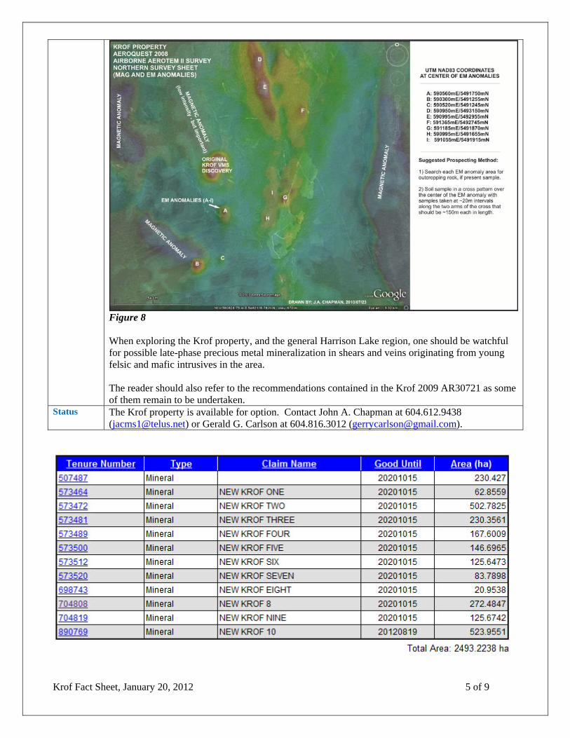
Krof Fact Sheet, January 20, 2012 5 of 9
Figure 8 When exploring the Krof property, and the general Harrison Lake region, one should be watchful for possible late-phase precious metal mineralization in shears and veins originating from young felsic and mafic intrusives in the area. The reader should also refer to the recommendations contained in the Krof 2009 AR30721 as some of them remain to be undertaken.
Status The Krof property is available for option. Contact John A. Chapman at 604.612.9438 ([email protected]) or Gerald G. Carlson at 604.816.3012 ([email protected]).

Krof Fact Sheet, January 20, 2012 6 of 9

Krof Fact Sheet, January 20, 2012 7 of 9

Krof Fact Sheet, January 20, 2012 8 of 9

Krof Fact Sheet, January 20, 2012 9 of 9