Kollo, Karin; Spada, Giorgio; Vermeer, Martin …...4 Karin Kollo, Giorgio Spada and Martin Vermeer...
14
This is an electronic reprint of the original article. This reprint may differ from the original in pagination and typographic detail. Powered by TCPDF (www.tcpdf.org) This material is protected by copyright and other intellectual property rights, and duplication or sale of all or part of any of the repository collections is not permitted, except that material may be duplicated by you for your research use or educational purposes in electronic or print form. You must obtain permission for any other use. Electronic or print copies may not be offered, whether for sale or otherwise to anyone who is not an authorised user. Kollo, Karin; Spada, Giorgio; Vermeer, Martin Studying earth rheology using GNSS permanent stations and GIA modelling tools Published in: Geophysica Published: 01/01/2016 Document Version Publisher's PDF, also known as Version of record Please cite the original version: Kollo, K., Spada, G., & Vermeer, M. (2016). Studying earth rheology using GNSS permanent stations and GIA modelling tools. Geophysica, 51(1-2), 3-15.
Transcript of Kollo, Karin; Spada, Giorgio; Vermeer, Martin …...4 Karin Kollo, Giorgio Spada and Martin Vermeer...

This is an electronic reprint of the original article.This reprint may differ from the original in pagination and typographic detail.
Powered by TCPDF (www.tcpdf.org)
This material is protected by copyright and other intellectual property rights, and duplication or sale of all or part of any of the repository collections is not permitted, except that material may be duplicated by you for your research use or educational purposes in electronic or print form. You must obtain permission for any other use. Electronic or print copies may not be offered, whether for sale or otherwise to anyone who is not an authorised user.
Kollo, Karin; Spada, Giorgio; Vermeer, MartinStudying earth rheology using GNSS permanent stations and GIA modelling tools
Published in:Geophysica
Published: 01/01/2016
Document VersionPublisher's PDF, also known as Version of record
Please cite the original version:Kollo, K., Spada, G., & Vermeer, M. (2016). Studying earth rheology using GNSS permanent stations and GIAmodelling tools. Geophysica, 51(1-2), 3-15.
Geophysica (2016), 51(1-2), 3–15
Studying Earth Rheology Using GNSS Permanent Stations andGIA Modelling Tools
Karin Kollo(1,3)*, Giorgio Spada(2), Martin Vermeer(3)
1Estonian Land Board, Mustamäe tee 51, Tallinn 106212Dipartimento di Scienze di base e Fondamenti (DiSBeF), Università degli Studi di Urbino, Via Santa
Chiara 27, 61029 Urbino, Italy3Department of Real Estate, Planning and Geoinformatics, School of Engineering, Aalto University, P.O. Box
15800, FI-00760 AALTO, Finland
* Corresponding author, [email protected]
(Received: October 2013; Accepted: April 2016)
Abstract
We studied the solid Earth rheology using observations in the North American and Fen-noscandian uplift regions, in the form of horizontal and vertical velocities from Global NavigationSatellite System (GNSS) permanent stations.
For North America the dataset from Sella and co-workers and for Fennoscandia theBIFROST dataset were used respectively. We performed GIA (Glacial Isostatic Adjustment) modellingwith the SELEN program, varying model parameters in order to find the best fit, in the chi-squaresense, to the GNSS-derived velocity values. In the GIA modelling, the ice models ICE-5G and KL05were used. The main results from this research were fitted Earth model parameters for these icemodels using data from the North American and Fennoscandian uplift areas. The application of thismethod to the North American uplift region for these two different ice models is novel.
Keywords: Earth rheology, GNSS, GIA modelling
1 Introduction
Glacial Isostatic Adjustment or GIA is known to cause a slow change in stationcoordinates in areas where continental ice sheets existed during the last glaciation,around 20 kyrs BP, a process which is ongoing to this day. GIA models can be used topredict rates of coordinate change in these areas.
GIA is nowadays observable by several techniques: GNSS, tide gauge and gravityobservations, SLR (Satellite Laser Ranging) and VLBI (Very Long Baseline Interfer-ometry). In this study we use GNSS observations, as they can measure both horizontaland vertical deformation rates in well-defined reference frames and they offer thedense coverage needed for detailed study. Horizontal position estimates can beachieved at an uncertainty level of a few millimetres, and vertical rates about twiceas uncertain (Koivula et al., 2006).
We focus on GIA processes in the North American and Fennoscandian upliftregions. Fennoscandia is well known for its good coverage by GNSS permanent sta-tions.
Published by the Geophysical Society of Finland, Helsinki

4 Karin Kollo, Giorgio Spada and Martin Vermeer
The BIFROST (Baseline Inferences for Fennoscandian Rebound, Sea-level, and Tectonics) project was initiated already in 1993 and we use its results to validate our computations. The North American uplift area is several times larger (Fennoscandia is approximately the size of Hudson Bay), but the GNSS permanent station coverage there is much poorer than in Fennoscandia. The Fennoscandian uplift area has a long publication history in GIA studies (Scherneck et al., 2001; Milne et al., 2001; Johans-son et al. 2002; Milne et al., 2004; Lidberg et al., 2006; Lidberg et al., 2010; Zhao et al., 2012).
Following these studies, we optimally fit, in the sense of χ² goodness of fit, Earth model parameters for both ice models, separately for both areas of investigation. While our Fennoscandian computations may be seen as a replication of results found in the literature, the novel part of our research is the application of our method to the North American uplift region for two different ice models, ICE-5G and KL05.
2 Data and methods
2.1 GNSS datasets
For North America the dataset from Sella et al., (2007) and for Fennoscandia, the dataset from Lidberg et al., (2010) (BIFROST project) were used. The data cover-age and the velocity field obtained from GNSS measurements are presented in Fig. 1 for both target areas.
Fig. 1. The velocity fields from GNSS observations for North American (left) and Fennoscandian (right) uplift regions. In the North American figure only the GIA-affected stations are plotted, the stations in the rigid plate area are indicated with triangles (Sella et al., 2007).
2.2 Glacial Isostatic Adjustment (GIA)
When the load history (the time-dependent configuration of the ice masses) is known, it is possible from the observations to approximately reconstruct Earth rheolo-gy, in the form of the radial viscosity distribution (Farrell and Clark, 1976).
Studying Earth Rheology Using GNSS Permanent Stations and GIA Modelling Tools 5
Maximum rates of the land uplift due to GIA at present are ~14 mm/yr and ~11 mm/yr for vertical motion in North America and Fennoscandia respectively (cf. Fig. 1). Horizontal motion does not exceed 3 mm/yr in either uplift area (Fig. 1).
We used a three-layer model called PREM (Preliminary Earth Model by Dziewonski and Anderson, 1981, spherical geometry) to describe the Earth's radial elastic and density structure. Lithosphere thicknesses typically range between 70 and 200 km, while upper mantle viscosities range between 1020 and 1021 Pa s, and low-er mantle viscosities between 5×10²¹ and 1023 Pa s (Whitehouse, 2009; Steffen and Wu, 2011). GIA studies have shown that it is important to use a lithosphere thick-ness that represents the local situation in order to accurately fit the data (Whitehouse, 2009).
2.3 Ice models
The most widely used global ice models are ICE-5G (Peltier, 2004) and KL05 (Fleming and Lambeck, 2004). The ICE-5G ice model uses viscosity model VM2 and is an updated version of ICE-4G, where improved ice-dynamic modelling and new sea-level data were used (Steffen and Wu, 2011; Whitehouse, 2009). For the ICE-5G model the lower mantle viscosity is approximately 3 × 10²¹ Pa s, which gives the best fit to the observations which are used to constrain the ice model (Peltier, 2004). Moreover, the ice model ICE-5G contains significantly more mass of land-based ice, added outside of Hudson Bay (Peltier, 2004), than its precursors. A second ice mod-el, which here is referred to as KL05, has been progressively developed at the Re-search School of Earth Sciences (RSES) of the National Australian University by Kurt Lambeck and coworkers (see Fleming and Lambeck, 2004, and references there-in).
The mentioned ice models estimate a maximum ice thickness of 2400 m over Fennoscandia, but for the KL05 model the location of the ice maximum is placed over the Gulf of Bothnia, whereas ICE-5G maximum thickness is in central Sweden. Therefore the two ice models produce different patterns of rebound when used within a GIA model (Whitehouse, 2009).
3 Computations and results
In the computations the Fennoscandian dataset was used for testing the method-ology used thereafter for North America. The benchmark study (Spada et al., 2011) showed that there are no differences due to the GIA computation strategy. However, the size of the study area as well as the locations of the GNSS permanent stations (Wu et al., 2010) can have an effect on the results obtained.
Although a newer and denser GNSS dataset for North America is available (cf. Argus and Peltier, 2010), their study showed that the results were similar to the study by Sella et al., (2007). Unfortunately most of the new GNSS stations are out-side the uplift area.

6 Karin Kollo, Giorgio Spada and Martin Vermeer
The computations were performed in two stages. Firstly, the sensitivity to the maximum harmonic degree included in the model was investigated. Secondly, GIA computations were performed finding the best fitting Earth model, in the maximum likelihood sense, to the GNSS-measured velocity field in the target areas. Finally, these best fitting models were compared with rates obtained from GNSS data.
In the research, the program SELEN (Spada and Stocchi, 2007), a code for solving the “Sea Level Equation”, was used.
3.1 Sensitivity to the harmonic degree
Firstly the sensitivity to the maximum harmonic degree included was tested. In the following test, nominal viscosity values and lithosphere thicknesses were used (cf. Table 1).
The idea was to keep the computation time reasonable by limiting the harmonic degrees included. We determine the lowest cut-off harmonic degree which results in a similarly good χ2 fit to the observations as all cut-off degrees larger than that. If the error measure does not change significantly when further increasing the maximum harmonic degree included (Fig. 2), then one may use that particular harmonic de-gree value as the bounding value (Spada, 2001).
Table 1. Ice models with their nominal parameters.
Ice model Lithosphere thickness
(km)
Upper mantle viscosity
(1021 Pa s)
Lower mantle viscosity
(1021 Pa s) ICE-5G 90 0.5 2.7 KL05 65 0.3 10
In the sensitivity test computation the harmonic degrees from 12 to 164 were tested, from which a maximum harmonic degree of 72 was chosen to perform the cal-culations, as larger values did not significantly modify the results obtained (Fig. 2), and the computational time was kept reasonable. For a maximum harmonic degree of 72 the difference with the result for the maximum harmonic degree of 128 re-mained always below 3% for both ice models. The most notable effect was on computation time, which was reduced by 50% between the two computations.
Fig. 2. Sensitivity to maximum harmonic degree for both ice models
Studying Earth Rheology Using GNSS Permanent Stations and GIA Modelling Tools 7
3.2 Optimal Earth parameters
Secondly, GIA modelling was performed in order to find the best fitting Earth model parameters. In this study a three-layer Earth model was used (upper and low-er mantle and lithosphere), and different viscosity and lithosphere thickness profiles for the Earth models were tested and their impact on horizontal and vertical velocity rates from GIA modelling was studied.
The global ice models ICE-5G and KL05 were used in GIA modelling. The SELEN program was used, which contains both ice models. The mantle viscosities for the first stage of the study varied in the range 0.1×10²¹…5×10²¹ Pa s for upper and 1×10²¹…50×1021 Pa s for lower mantle, respectively and the lithosphere thickness was held for the KL05 model at 65 km and for the ICE-5G model at 90 km. Step size used for upper mantle viscosity was 0.1×10²¹ Pa s, for lower mantle viscosity 1×10²¹ Pa s, and for lithosphere thickness 2 km.
In the computations firstly the lithosphere thickness was fixed, and the search for viscosity values was performed. Thereafter the viscosity was kept within the range indicated in the Table 2, and the best fitting lithosphere thickness was found.
As reference, the velocity field from GNSS permanent station time series was used both for North America and Fennoscandia. The GIA computations were performed to find the model fitting with highest likelihood to the GNSS-based velocity field in the two uplift regions. For every tested model the χ2 quality of fit (Eq. 1) for hori-zontal, vertical and three-dimensional velocity rates from the reference model was found (Milne et al., 2001). In the χ2 computation equal weighting for horizontal and vertical velocities was used, as for North America we found that the χ2 values for these rates were similar. For consistency, we used the same weighting for Fen-noscandia (cf. Fig. 4), although a different weighting might produce smoother χ2-fit plots.
The χ2 quality of fit is expressed as:
χ ,1
12
1
n
ioi
pi
oi xx
n (1)
where oix is the observed value (from GNSS time series), p
ix is the predicted value
(from GIA model), oi is the error measure for GNSS observation, and n is the num-
ber of data points. To find the Earth model parameters having the smallest χ2 fit with the GNSS-
data, we produced plots of χ2 as a function of Earth model rheology. In Figs. 3 and 4 the χ2 plots for the North American and Fennoscandian uplift areas are presented. These plots were produced using the 2D+1D approach, and should be taken qualitative-ly.

8 Karin Kollo, Giorgio Spada and Martin Vermeer
Fig. 3. χ2-fit for GIA modelling in North America, KL05 ice model (upper) and ICE-5G ice model (lower). Fixed lithosphere thicknesses were 65 km and 90 km for ice models KL05 and ICE-5G respectively.
Fig. 4. χ2-fit for GIA modelling in Fennoscandia, KL05 ice model (upper) and ICE-5G ice model (lower). Fixed lithosphere thicknesses were65 km and 90 km for ice models KL05 and ICE-5G respectively.
For North America the χ2 for best fitting Earth model parameters is about 2...3 (cf. Fig. 3). For the Fennoscandian area, the χ2 was in the range of 4.6...5.6 for both ice models (cf. Table 2, Fig. 4). This value agrees with other studies, which give around 4...5 (Milne et al., 2001, Milne et al., 2004, Lidberg et al., 2010).
The next step was to find the best fitting lithosphere thickness. Doing the optimi-zation in two separate steps is in our judgement a reasonable heuristic. For this step,

Studying Earth Rheology Using GNSS Permanent Stations and GIA Modelling Tools 9
the viscosity values for upper and lower mantle, indicated in Table 2 were used and the lithosphere thickness was varied between 50 and 150 km. The overall results are presented in Table 2 together with the χ2-misfit and F-test values.
Table 2. Earth model parameters for Fig. 5 and Fig. 6. In the parenthesis is given the range which corresponds to the smallest χ2-misfit.
Region + ice model Upper mantle
viscosity (1021 Pa s)
Lower mantle viscosity
(1021 Pa s)
Lithosphere thickness
(km) χ2-misfit F-test
Fennoscandia, KL05 0.5 (0.4…0.6) 5 (4…7) 75 (70…85) 4.719 (4.7…5.6) 1.015
Fennoscandia, ICE-5G 0.4 (0.3…0.4) 4 (4…7) 95 (95…105) 4.650 (4.6…5.4)
North-America, KL05 0.5 (0.4…0.6) 2 (2…3) 125 (115…125) 2.512 (2.5…3.0) 0.915
North-America, ICE-5G 0.5 (0.4…0.6) 2 (2…3) 65 (65…75) 2.742 (2.7…3.2)
The resulting velocity field is presented for North America in Fig. 5 and for
Fennoscandia in Fig. 6.
Fig. 5. Best fitting GIA model for North America, for ICE-5G ice model (left) and KL05 ice model (right), see Table 2 for numerical values. In the figure the GIA induced vertical velocity is repre-sented by contours (from GIA model) and horizontal velocity by arrows, while red arrows indicate pre-dictions (GIA) and blue arrows observations (GPS).
For the Fennoscandian area, the agreement between GNSS data and modelling results is fine for both ice models. In North America, on the other hand, the agree-ment is poor. Reasons for this include the sparseness of GNSS data and the huge size of the area where other phenomena besides GIA, like local tectonic movements, are in play (Sella et al., 2007).
In an additional investigation we compared the 2-steps computation algorithm (hereinafter 2D+1D) and the 1-step computation algorithm (hereinafter 3D). The com-parison was made for the Earth model parameters for the reduced ranges presented in Table 2. The results of this comparison are presented in Table 3.

10 Karin Kollo, Giorgio Spada and Martin Vermeer
Fig. 6. Best fitting GIA model for Fennoscandia, for ICE-5G ice model (left) and KL05 ice model (right), see Table 2 for numerical values. In the figure the GIA induced vertical velocity is represented by con-tours (from GIA model) and horizontal velocity by arrows, while red arrows indicate predictions (GIA) and blue arrows observations (GPS).
Table 3. Comparison of the Earth model parameters: 2D+1D versus 3D computation approach
2D+1D approach 3D approach Region + ice model
UM LM LT χ2-misfit UM LM LT χ2-misfit
FS, KL05 0.5 5 75 4.719 0.55 4.5 75 4.703
FS, ICE-5G 0.4 4 95 4.650 0.4 4 85 4.633
NA, KL05 0.5 2 125 2.512 0.4 2.5 135 2.417
NA, ICE-5G 0.5 2 65 2.745 0.5 1.5 60 2.584
FS: Fennoscandia UM: upper mantle viscosity (1021 Pa s) NA: North America LM: lower mantle viscosity (1021 Pa s) LT: lithosphere thickness, km
As seen from Table 3, the Earth model parameters obtained from 3D approach
differ only slightly. For the upper mantle, the change was about 0.1×10²¹ Pa s and for the lower mantle the change was about 0.5×10²¹ Pa s. For lithosphere thickness, the parameter changed about 0...10 km. The table also gives the optimum (small-est) χ2-misfit values for both computation strategies.
As the results show only small differences in the statistics, we discuss the results from the 2D+1D computation strategy (Table 2) in the following.
4 Discussion
Following (Paulson et al., 2007; Zhao et al., 2012) we used a three-layer Earth model (i.e. upper and lower mantle and lithosphere) in our modelling.
For additional testing the F-test was used to compare the variances from KL05 and ICE-5G ice models. The F-test statistic is expressed as the ratio of two χ2 val-ues (Riley et al., 2002):
Studying Earth Rheology Using GNSS Permanent Stations and GIA Modelling Tools 11
,2
5
205
GICE
KLF
(2)
where 205KL is the χ2 of the KL05 ice model fit and 2
5GICE is the χ2 of the ICE-5G ice
model fit. The number of degrees of freedom for Fennoscandia was 254 and for North America 698.
The F-test values are 1.015 and 0.915 for the two datasets, whereas the critical values for a two-sided confidence interval of 95% are for the Fennoscandian da-taset 0.782...1.280 and for the North-American dataset 0.862...1.160 respectively. Re-sults for the F-test (Eq. (2)) are shown in Table 2. From this analysis we cannot con-clude in this confidence level that the distribution of the residual of fit would be different for the two models, for either dataset.
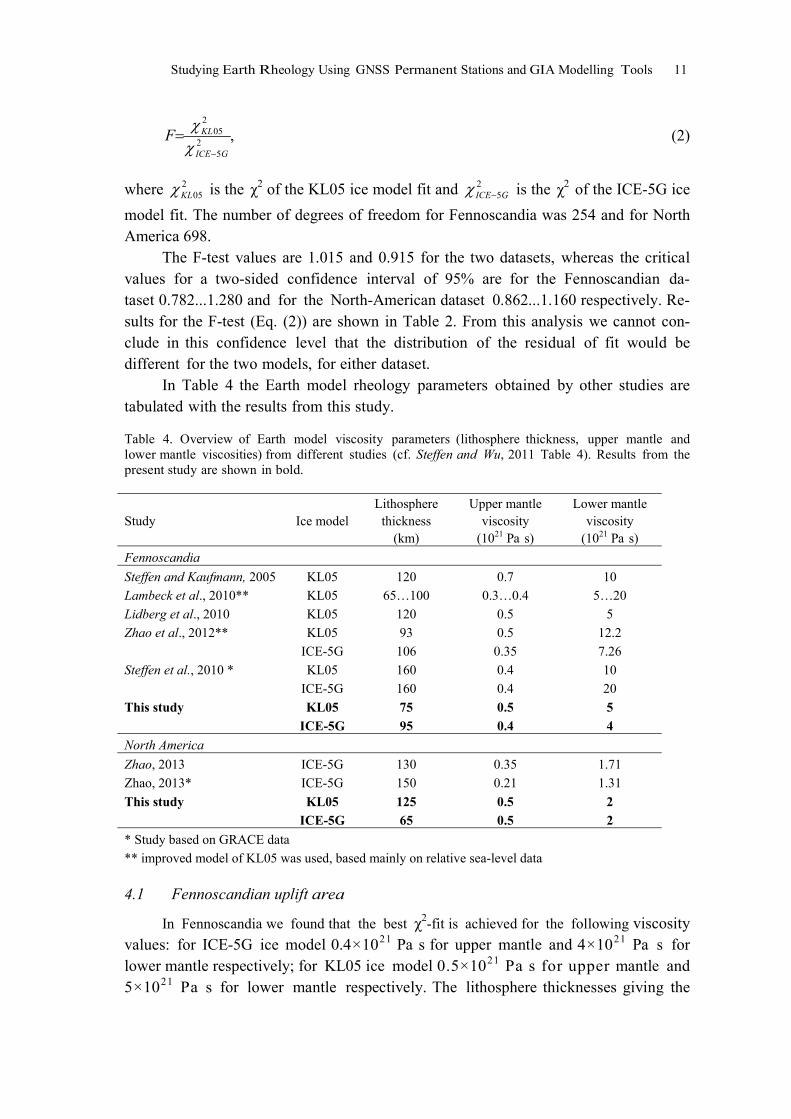
In Table 4 the Earth model rheology parameters obtained by other studies are tabulated with the results from this study.
Table 4. Overview of Earth model viscosity parameters (lithosphere thickness, upper mantle and lower mantle viscosities) from different studies (cf. Steffen and Wu, 2011 Table 4). Results from the present study are shown in bold.
Study Ice model Lithosphere
thickness (km)
Upper mantle viscosity
(1021 Pa s)
Lower mantle viscosity
(1021 Pa s)
Fennoscandia
Steffen and Kaufmann, 2005 KL05 120 0.7 10
Lambeck et al., 2010** KL05 65…100 0.3…0.4 5…20
Lidberg et al., 2010 KL05 120 0.5 5
Zhao et al., 2012** KL05
ICE-5G
93
106
0.5
0.35
12.2
7.26
Steffen et al., 2010 * KL05
ICE-5G
160
160
0.4
0.4
10
20
This study KL05 75 0.5 5
ICE-5G 95 0.4 4
North America
Zhao, 2013 ICE-5G 130 0.35 1.71
Zhao, 2013* ICE-5G 150 0.21 1.31
This study KL05 125 0.5 2 ICE-5G 65 0.5 2
* Study based on GRACE data
** improved model of KL05 was used, based mainly on relative sea-level data
4.1 Fennoscandian uplift area
In Fennoscandia we found that the best χ2-fit is achieved for the following viscosity values: for ICE-5G ice model 0.4×10²¹ Pa s for upper mantle and 4×10²¹ Pa s for lower mantle respectively; for KL05 ice model 0.5×10²¹ Pa s for upper mantle and 5×10²¹ Pa s for lower mantle respectively. The lithosphere thicknesses giving the

12 Karin Kollo, Giorgio Spada and Martin Vermeer
best results from χ2-fitting, were in the range of 95...105 km for ICE-5G and 70...85 km for KL05 ice models respectively (cf. Table 2).
We compared our results to other studies (cf. Table 4). We see that results for upper mantle viscosities from this study agree well with other studies for both ice models. Also the values found from Steffen et al., (2010), using GRACE data, are similar.
The results for lower mantle viscosity agree less well. Lambeck et al., (2010) estimates the lower bound of lower mantle viscosity being 5×10²¹ Pa s, and Lidberg et al. (2010), estimate a lower mantle viscosity of 5×10²¹ Pa s for ice model KL05, which agrees very well with results from this study. But Zhao et al., (2012) estimates the lower mantle viscosity for KL051 to be about 7×10²¹ Pa s which is about 40% higher than the estimate from this study. For ice model ICE-5G the differences for lower mantle viscosity are about three times larger, although there is only one comparable study (Zhao et al., 2012). One reason might be that the SELEN code uses an older version of the KL05 ice model than Zhao et al., (2012). The results from Steffen et al., (2010) show comparably large differences for lower man-tle viscosity from all other studies.
The agreement for lithosphere thickness values (Table 4) is good, although the lithosphere thickness from this study for ice model KL05 is lower than estimates from other studies. Lambeck et al., (1998) show that for an assumed lithosphere thickness of 75 km, the Earth rheology parameters are resolved with minimum er-ror of fit. This agrees as well with the results from the present study.
Comparing our results with the Earth model values used in generating the ice model (i.e., nominal values) for ICE-5G and KL05 (Table 1), we find poor agree-ment for the Fennoscandian area for both upper and lower mantle viscosity values. The lithosphere thickness shows good agreement for both ice models.
As a conclusion, the methodology used in our approach does not produce large differences for Earth model parameters, except for estimates of lower mantle viscosi-ty. As Milne et al., (2004) have found, the GNSS data cannot be used to resolve more than three mantle layers. Therefore the values for lower mantle viscosity are more un-certain and show larger differences between different studies than those for upper man-tle viscosity and lithosphere thicknesses (Zhao et al., 2012).
4.2 North American uplift area
In North America the best χ2-fit is achieved for the following viscosity values: for 0.4×10²¹ Pa s for upper mantle and 4×10²¹ Pa s for lower mantle respectively; for KL05 ice model 0.5×10²¹ Pa s for upper mantle and 5×10²¹ Pa s for lower man-tle respectively. The lithosphere thicknesses giving the best results from χ2-fitting,
were in the range of 95...105 km for ICE-5G and 70...85 km for KL05 ice models re-spectively (cf. Table 2).
1 Zhao et al., (2012) and Lambeck et al., (2010) use an improved version of the KL05 model based mainly on RSL data.

Studying Earth Rheology Using GNSS Permanent Stations and GIA Modelling Tools 13
For North America there are not very many studies comparing GNSS data and GIA models for the ice models used by us. We found only one recent study (Zhao, 2013) which compares GIA modelling results with GNSS and GRACE data.
Comparison with Zhao (2013) shows that there is good agreement for upper and lower mantle viscosity values for ice model ICE-5G. Lithosphere thicknesses val-ues, on the other hand, have very poor agreement, being about two times smaller for the present study (cf. Table 4). For ice model KL05 there are no other studies to compare with, but we see that the values estimated from our study agree well with es-timates from Zhao (2013).
Comparing our results with the nominal values of the ICE-5G and KL05 ice models (cf. Table 1) we see that the viscosity values fit particularly well for ICE-5G. The nominal lower mantle viscosity for KL05 is much higher that the estimate from our study. Lithosphere thickness shows large differences from the nominal values (Table 1). There is “reverse” effect visible, i.e., the estimated best fit for ICE-5G is 65 km, while the nominal value is 90 km; and the best fit for KL05 is 125 km, while the nominal value is 65 km. This phenomenon indicates the need for more extended re-search in the future.
5 Conclusions
From this research, suitable Earth model parameters were found for ice models ICE-5G and KL05 in the North American and Fennoscandian uplift areas. Values ob-tained and test statistics are listed in Table 2. For Fennoscandia the results agree with those of other authors (Table 4). In North America the results are novel, but al-so much more uncertain.
Acknowledgements
Gratefully acknowledged are: Academy of Finland Project No. 123113: “Region-al Crustal Deformation and Lithosphere Thickness Observed with Geodetic Tech-niques (RCD-LITO)”. Part of this study was supported by COST Action ES0701 “Improved constraints on models of Glacial Isostatic Adjustment”. First author would like to thank Estonian Science Academy Grant Nr ETF8749 and Aalto Univer-sity Doctoral programme RYM-TO. Two anonymous reviewers contributed signifi-cantly to the quality of the final manuscript. For graphics the GMT (Generic Mapping Tools, Wessel and Smith, 1998) were used.
References
Argus D.F. and W.R Peltier, 2010. Constraining models of postglacial rebound us-ing space geodesy: a detailed assessment of model ICE-5G (VM2) and its rela-tives. Geophys. J. Int. 181, 697–723.

14 Karin Kollo, Giorgio Spada and Martin Vermeer
Dziewonski, A.M. and D . L . Anderson, 1981. Preliminary reference Earth model, Phys. Earth Planet. Inter., 297–356.
Farrell, W.E. and J .A . Clark, 1976. On Postglacial Sea Level, Geophys. J. R. Astr. Soc., 46, 647–667.
Fleming, K. and K. Lambeck, 2004. Constraints on the Greenland Ice Sheet since the Last Glacial Maximum from sea-level observations and glacial-rebound mod-els, Quaternary Science Reviews, 23(9-10), 1053–1077.
Johansson, J. M., J.L. Davis, H.-G., Scherneck, G.A. Milne, M. Vermeer, J.X. Mitrovi-ca, R.A. Bennet, B. Jonsson, G. Elgered, P. Elosegui, H. Koivula, M. Poutanen, B.O. Rönnäng and I.I, Shapiro, 2002. Continuous GPS measurements of postgla-cial adjustment in Fennoscandia 1. Geodetic results, J. Geophys. Res., 107, B8.
Koivula, H., Tervo, M. and Poutanen, M., 2006. Contemporary crustal motion in Fen-noscandia observed with continuous GPS networks, LITHOSPHERE 2006, Fourth symposium on the structure, composition and evolution of the lithosphere in Finland, Kukkonen, I. T., Eklund, O., Korja, A., Korja, T., Pesonen, L. J. and Poutanen, M. (eds), 59–65.
Lambeck K., C. Smither and P. Johnston, 1998. Sea-level change, glacial rebound and mantle viscosity for northern Europe, Geophys.J. Int. 134, 102–144.
Lambeck, K., A . Purcell, J . Zhao and N-O. Svensson, 2010. The Scandinavian Ice Sheet: from MIS 4 to the end of the Last Glacial Maximum. Boreas 39, 410–435.
Lidberg, M., J.M. Johansson, H.-G. Scherneck, S. Bergstrand and G.A. Milne, 2006. BIFROST: A new improved velocity field for Fennoscandia – Implications for models of glacial isostatic adjustment, in: Proceedings of the NKG General As-sembly, May 29 – June 2, Copenhagen, Denmark.
Lidberg, M., J.M. Johannson, H.-G. Scherneck and G.A. Milne 2010. Recent results based on continuous GPS observations of the GIA process in Fennoscandia from BIFROST, Journal of Geodynamics, 50, 8–18.
Milne, G.A., J.L. Davis, J.X. Mitrovica, H.-G. Scherneck, J.M. Johansson, M. Vermeer and H. Koivula, 2001. Space-geodetic constraints on glacial isostatic adjustment in Fennoscandia, Science, 291, 2381–2385.
Milne, G. A. J.X. Mitrovica, J.L. Davis, H.-G. Scherneck, J.M. Johansson, H. Koivula and M. Vermeer, 2004. Continuous GPS Measurements of Postglacial Adjust-ment in Fennoscandia 2. Modeling Results, J. Geophys. Res.: Solid Earth, 109(B2), B02412.
Paulson, A., S. Zhong and J. Wahr, 2007. Inference of mantle viscosity from GRACE and relative sea level data, Geophysical Journal International, 171, 497–508.
Peltier, W.R., 2004. Global glacial isostasy and the surface of the ice-age Earth: The Ice-5G (VM2) model and GRACE, Annu. Rev. Earth Planet. Sci., 32, 111–149.
Riley, K.F., M.P. Hobson and S.J. Bence, 2002. Mathematical methods for physics and engineering, Cambridge University Press, Cambridge.

Studying Earth Rheology Using GNSS Permanent Stations and GIA Modelling Tools 15
Scherneck, H.-G., J.M. Johansson, M. Vermeer, J.L. Davis, G.A. Milne and J.X. Mi-trovica, 2001. BIFROST project: 3-D crustal deformation rates derived from GPS confirm postglacial rebound in Fennoscandia, Earth Planet Space, 53, 703–708.
Sella, G.F., S. Stein, T.H. Dixon, M. Craymer, T.S. James, S. Mazotti and R.K. Dok-ka, 2007. Observations of glacial isostatic adjustment in "stable" North America with GPS, Geophysical Research Letters, 34, L02306.
Spada, G., 2001. Mantle viscosity from Monte Carlo inversion of very long baseline interferometry data, J. Geophys. Res., 106(B8), 16,375–16,387.
Spada, G. and P. Stocchi, 2007. SELEN: A Fortran 90 program for solving the "sea-level equation", Computers & Geosciences, 33, 538–562.
Spada, G., V .R . Barletta, V. Klemann, R.E.M. Riva, Z. Martinec, P. Gasperini, B. Lund, D. Wolf, L.L.A. Vermeersen and M.A. King, 2011. A benchmark study for glacial isostatic adjustment codes, Geophysical Journal International, 185(1), 106–132.
Steffen, H., P. Wu and H. Wang, 2010. Determination of the Earth's structure in Fen-noscandia from GRACE and implications for the optimal post-processing of GRACE data, Geophysical Journal International, 181(2), 1295–1310.
Steffen, H. and P. Wu, 2011. Glacial isostatic adjustment in Fennoscandia – A re-view of data and modeling. J. Geodyn. 52(3–4), 169–204.
Wessel, P. and W.F. Smith, 1998. New, improved version of Generic Mapping Tools released, EOS Transactions of the AGU, 79, 579.
Whitehouse, P., 2009. Glacial isostatic adjustment and sea-level change, State of art report, TR-09-11, Svensk Kärnbränslehantering AB.
Wu, P., H. Steffen and H. Wang, 2010. Optimal locations for GPS measurements in North America and northern Europe for constraining Glacial Isostatic Ad-justment, Geophysical Journal International, 181(2), 653–664.
Zhao, S., K. Lambeck and M. Lidberg 2012. Lithosphere thickness and mantle viscosity inverted from GPS-derived deformation rates in Fennoscandia, Geophysical Journal International, 190, 278–292.
Zhao, S., 2013. Lithosphere thickness and mantle viscosity estimated from joint inver-sion of GPS and GRACE-derived radial deformation nd gravity rates in North America, Geophys. J. Int., 194, 1455–1472.