KNOX CITY COUNCIL - knox.vic.gov.au · A STATEMENT OF COMMITMENT AND A PRAYER ... the business...
437
KNOX CITY COUNCIL MINUTES Ordinary Meeting of Council Held at the Civic Centre 511 Burwood Highway Wantirna South On Tuesday 29 May 2012
Transcript of KNOX CITY COUNCIL - knox.vic.gov.au · A STATEMENT OF COMMITMENT AND A PRAYER ... the business...

KNOX CITY COUNCIL MINUTES
Ordinary Meeting of Council
Held at the Civic Centre
511 Burwood Highway Wantirna South
On
Tuesday 29 May 2012
KNOX CITY COUNCIL
MINUTES FOR THE ORDINARY MEETING OF COUNCIL HELD AT THE CIVIC CENTRE, 511 BURWOOD HIGHWAY, WANTIRNA SOUTH
ON TUESDAY 29 MAY 2012 AT 700 P.M.
PRESENT:
Cr A Gill (Mayor & Chairperson) Dinsdale Ward Cr P Cole Baird Ward Cr J Mortimore Chandler Ward Cr J Cossari Collier Ward Cr S McMillan Dobson Ward Cr A Walter Friberg Ward Cr D Cooper Scott Ward Cr D Pearce Taylor Ward Cr M Van de Vreede Tirhatuan Ward Mr G Emonson Chief Executive Officer Dr I Bell Director – Engineering &
Infrastructure Mr A Kourambas Director - City Development Mr M Dupe Director – Corporate Development Ms K Stubbings Director – Community Services
THE MEETING OPENED WITH A STATEMENT OF ACKNOWLEDGEMENT, A STATEMENT OF COMMITMENT AND A PRAYER
“Knox City Council acknowledges we are on the
traditional land of the Wurundjeri and Bunurong people and pay our respects to elders both past and present.”
COUNCIL 29 May 2012 BUSINESS: Page Nos. 1. APOLOGIES AND REQUESTS FOR LEAVE OF ABSENCE
Nil. 2. DECLARATIONS OF CONFLICT OF INTEREST Pursuant to Section 79 of the Local Government Act 1989 (the Act),
Councillor Pearce declared a direct interest pursuant to Section 77B of the Act in Item 6.12 on the grounds that he is a Director of a Company that is a property owner and business operator in Ferntree Gully.
3. CONFIRMATION OF MINUTES
MOVED: CR. COSSARI SECONDED: CR. McMILLAN 3.1 Confirmation of Minutes of Ordinary Meeting of Council
held on Tuesday 24 April 2012 CARRIED MOVED: CR. COSSARI SECONDED: CR. WALTER 3.2 Confirmation of Minutes of Strategic Planning Committee
Meeting held on Tuesday 8 May 2012 CARRIED
4. PETITIONS AND MEMORIALS 4.1 Councillor Pearce presented a petition with 14 signatories objecting to a
traffic treatment program in Liberty Avenue, Rowville.
The Petition lay on the table. 5. REPORTS BY COUNCILLORS
5.1
Committees & Delegates
1.
5.2
Ward Issues
3.
COUNCIL 29 May 2012 6. CONSIDERING AND ORDERING UPON OFFICERS’ REPORTS WITHIN THE
CITY DEVELOPMENT GROUP
6.1
All Wards Report Of Planning Applications Decided Under Delegation (160/1/06)
4.
6.2
Tirhatuan Ward Proposed Development Of A Three Storey Building Containing Thirty Seven (37) Apartments And Basement Car Parking And Creation/Alteration Of Access To A Category One Road At 1118-1120 Stud Road, Rowville, Melway Ref. 81 J1 (Application No. P2010/6822)
10.
6.3
Tirhatuan Ward Application To Develop The Land For A Three (3) Storey Apartment Building Containing (14) Dwellings At 1098 Stud Road, Rowville Melway Ref. 81 J1 (Application No. P/2011/6551)
45.
6.4
Tirhatuan Ward Application To Develop The Land For The Construction Of A Three (3) Storey Apartment Building Containing Fifteen (15) Dwellings At 5 Stamford Crescent, Rowville, Melway Ref. 81 J1 (P/2011/6750)
80.
6.5
Baird Ward Application To Develop The Land For A Two (2) Storey Apartment Building Containing Ten (10) Dwellings At 11 Iris Crescent, Boronia, Melway Ref. 64 K8 (Application No. P/2010/6964)
112.
6.6
Baird Ward Application To Develop The Land For A Three Storey Apartment Building Containing Sixteen (16) Dwellings And Associated Car Parking At 11 Tulip Crescent, Boronia, Melway Ref. 64 J10 (Application No. P2011/6563)
148.
6.7
Chandler Ward Application To Develop The Land For A Two Storey Apartment Building Containing Seventeen (17) Dwellings, Basement Car Parking And Vegetation Removal At 8 Bambury Street, Boronia, Melway Ref. 65 B8 (Application No. P/2011/6688))
179.
6.8
Collier Ward Application To Develop The Land For Five Dwellings (Two Double Storey And Three Single Storey) At 11 Hadlow Drive, Wantirna Melway Ref. 63 J5 (Application No. P/2011/6296)
227.
6.9
Friberg Ward Application To Develop The Land For Three (3) Double Storey Dwellings At 14 Anne Road, Knoxfield, Melway Ref. 73 C4 (Application No. P/2011/6853)
248

COUNCIL 29 May 2012 6. CONSIDERING AND ORDERING UPON OFFICERS’ REPORTS WITHIN THE
CITY DEVELOPMENT GROUP (cont’d)
6.10
All Wards Knox Open Space Plan (2012 – 2022)
272.
6.11
All Wards Knox Liveable Streets Plan (2012-2022)
284.
6.12
Dobson Ward Ferntree Gully Village Place Program Update
296.
7. PUBLIC QUESTION TIME (Following the completion of business relating to Item 6, City Development, the business before the Council Meeting was deferred to consider questions submitted by the public). 316. 8. CONSIDERING AND ORDERING UPON OFFICERS’ REPORTS WITHIN THE
ENGINEERING & INFRASTRUCTURE GROUP
8.1
All Wards Knox Mobility Study
318.
9. CONSIDERING AND ORDERING UPON OFFICERS’ REPORTS WITHIN THE
COMMUNITY SERVICES GROUP
9.1
All Wards Review Of Council’s Major Festival And Events Program 2011-2012
328.
9.2
All Wards Knox Arts And Cultural Plan 2012-22
343.
9.3
All Wards Submission To Ministerial Advisory Council On Public Libraries
353.
10. CONSIDERING AND ORDERING UPON OFFICERS’ REPORTS WITHIN THE
CORPORATE DEVELOPMENT GROUP
10.1
Dinsdale Ward Sale Of 13 Cullis Parade, Bayswater (Melway Ref: 64 F5)
379.
10.2
ALL Wards Management Financial Report For The Period Ended 31 March 2012
383.
10.3
All Wards Loan Funding Tender – Contract 1933 Loan Borrowings 2011-12
393.
COUNCIL 29 May 2012 11. ITEMS FOR INFORMATION
11.1
All Wards Works Report As At 14 May 2012
401.
11.2
All Wards Assemblies of Councillors
418.
12. MOTIONS FOR WHICH NOTICE HAS PREVIOUSLY BEEN GIVEN
12.1 Notice of Motion No. 20 - State Government Pensioner Rate Rebate 431.
13. SUPPLEMENTARY ITEMS 431. 14. URGENT BUSINESS 431. 14.2 Call Up Items 431. 15. QUESTIONS WITHOUT NOTICE 431. GRAEME EMONSON CHIEF EXECUTIVE OFFICER
1 COUNCIL - REPORTS BY COUNCILLORS 29 May 2012
5. REPORTS BY COUNCILLORS
5.1 Committees & Delegates 5.1.1 COUNCILLOR COOPER Councillor Cooper attended the following Meetings
• Eastern Recreation Precinct Reference Committee • Knox Central Advisory Committee • Special Meeting of Council – Preparation of Proposed Budget 2012-2013 • National Sorry Day • Management Advisory Committee for Cathies Lane Transfer Station • Knox Community Sports Centre Management Committee 5.1.2 COUNCILLOR MORTIMORE Councillor Mortimore attended the following Meetings
• ANZAC Day Dawn Service - Boronia • Knox Housing Advisory Committee • Wurundjeri Walk • The Basin Community House • Environment Advisory Committee • Inter Council Aboriginal Consultative Committee • Get it Right on Bin Night Media Launch • Alchester Playgroup • Special Meeting of Council – Preparation of Proposed Budget 2012-2013 • 5.1.3 COUNCILLOR COSSARI Councillor Cossari attended the following Meetings
• Municipal Association of Victoria State Council • 2012 Local Government Managers Australia National Congress • Knox Central Advisory Committee • Special Meeting of Council – Preparation of Proposed Budget 2012-2013 • National Sorry Day • Migrant Settlement Committee (Eastern Region) 5.1.4 COUNCILLOR WALTER Councillor Walter attended the following Meetings
• Recreation and Leisure Liaison Group • Special Meeting of Council – Preparation of Proposed Budget 2012-2013 5.1.5 COUNCILLOR COLE Councillor Cole attended the following Meetings
• Planning Consultative Committee (x 2) • National Sorry Day • Knox @50 Project
2 COUNCIL - REPORTS BY COUNCILLORS 29 May 2012
5.1 Committees & Delegates (cont’d)
5.1.6 COUNCILLOR VAN DE VREEDE Councillor Van de Vreede attended the following Meetings
• Knox Affordable Housing Reference Group • Eastern Affordable Housing Alliance • Planning Consultative Committee • Eastern Transport Coalition • Special Meeting of Council – Preparation of Proposed Budget 2012-2013
5.1.7 COUNCILLOR McMILLAN Councillor McMillan attended the following Meetings
• Ferntree Gully Football Club – All Abilities Game • Prosperous Modern Economic Conference • Boronia Football Club Luncheon • Chief Executive Officer’s Performance Evaluation Committee • Upper Ferntree Gully Football Club Ladies Evening • Special Meeting of Council – Preparation of Proposed Budget 2012-2013
5.1.8 COUNCILLOR PEARCE Councillor Pearce attended the following Meetings
• Chief Executive Officer’s Performance Evaluation Committee • Economic Development Committee • Knox Central Advisory Committee • Knox @50 Project
5.1.9 COUNCILLOR GILL (MAYOR) Councillor Gill attended the following Meetings
• ANZAC Day Dawn Service – Bayswater • ANZAC Day Service – Waterford Valley Lakes Retirement Village • Community Development Fund Evaluation Panel • Graffiti and Vandalism Committee • Bayswater Secondary College • Rowville-Lysterfield Community News Annual General Meeting • Prosperous Modern Economic Conference • Bayswater West Primary School – Presentation of Library Prize • Judging for Arthur Kleinert Reserve Public Artwork • Auditor-General’s Eastern Metropolitan Client Forum • Opening of Arthur Kleinert Reserve • Ferntree Gully North Primary School – Presentation of Knox Festival
Certificates • Mountain Gate Primary School – Walk Safely to School Event • Knox Central Advisory Committee • Holy Trinity Primary School • Community Cabinet/The Biggest Morning Tea at Ferntree Gully Library • Special Meeting of Council – Preparation of Proposed Budget 2012-2013 • National Sorry Day • Launch of Graffiti Plan
3 COUNCIL - REPORTS BY COUNCILLORS 29 May 2012
5.2 Ward Issues 5.2.1 COUNCILLOR COSSARI (COLLIER WARD) • Councillor Cossari advised that he was pleased to attend the Hungarian
National Day. • Councillor Cossari advised that he attended the National Sorry Day Flag
raising ceremony on 26 May 2012. Councillor Cossari proposed that the Knox City Council consider the purchase of a sculpture to recognise Sorry Day and the stolen generation.
5.2.2 COUNCILLOR MORTIMORE (CHANDLER WARD) • Councillor Mortimore was pleased to advise that the State Government
had recently announced funding for the K12 school in Boronia. • Councillor Mortimore advised of the recent visit by the Prime Minister the
Hon. Julia Gillard along with three senior Ministers to the Basin Community House. During this visit, the Basin Community House hosted live to air interviews with the Prime Minister.
4 COUNCIL – CITY DEVELOPMENT 29 May 2012
ALL WARDS
6.1 REPORT OF PLANNING APPLICATIONS DECIDED UNDER DELEGATION
SUMMARY: Manager – City Planning (Paul Dickie)
Details of planning applications considered under delegation are referred for information. It is recommended that the items be noted.
RECOMMENDATION
That the planning applications decided under delegation report (between 1 April to 30 April 2012) be noted.
REPORT
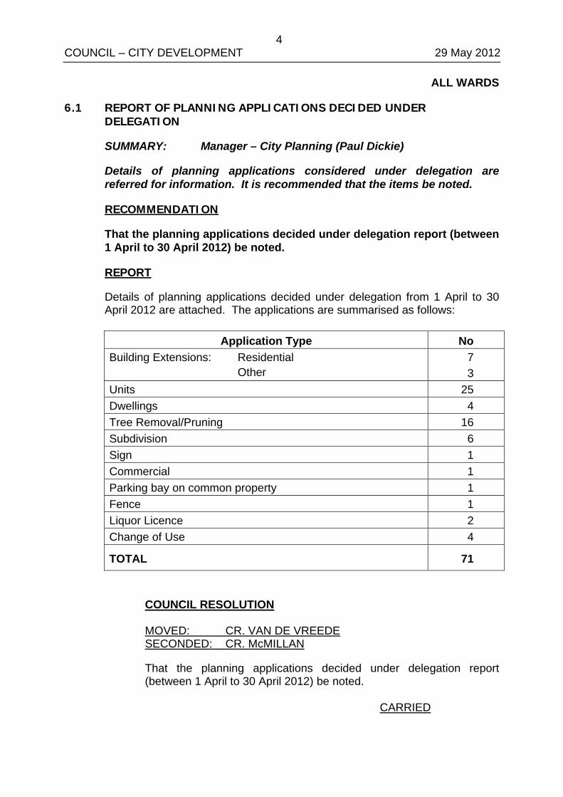
Details of planning applications decided under delegation from 1 April to 30 April 2012 are attached. The applications are summarised as follows:
Application Type No Building Extensions: Residential Other
7 3
Units 25 Dwellings 4 Tree Removal/Pruning 16 Subdivision 6 Sign 1 Commercial 1 Parking bay on common property 1 Fence 1 Liquor Licence 2 Change of Use 4
TOTAL 71 COUNCIL RESOLUTION MOVED: CR. VAN DE VREEDE SECONDED: CR. McMILLAN
That the planning applications decided under delegation report (between 1 April to 30 April 2012) be noted. CARRIED
5 COUNCIL – CITY DEVELOPMENT 29 May 2012
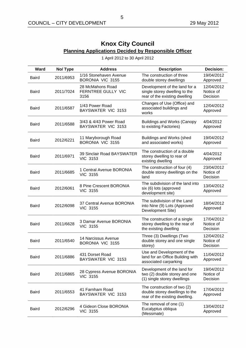
Knox City Council Planning Applications Decided by Responsible Officer
1 April 2012 to 30 April 2012
Ward No/ Type Address Description Decision:
Baird 2011/6953 1/16 Stonehaven Avenue BORONIA VIC 3155
The construction of three double storey dwellings
19/04/2012 Approved
Baird 2011/7024 28 McMahons Road FERNTREE GULLY VIC 3156
Development of the land for a single storey dwelling to the rear of the existing dwelling
12/04/2012 Notice of Decision
Baird 2011/6587 1/43 Power Road BAYSWATER VIC 3153
Changes of Use (Office) and associated buildings and works
12/04/2012 Approved
Baird 2011/6588 3/43 & 4/43 Power Road BAYSWATER VIC 3153
Buildings and Works (Canopy to existing Factories)
4/04/2012 Approved
Baird 2012/6221 11 Maryborough Road BORONIA VIC 3155
Buildings and Works (shed and associated works)
19/04/2012 Approved
Baird 2011/6971 39 Sinclair Road BAYSWATER VIC 3153
The construction of a double storey dwelling to rear of existing dwelling
4/04/2012 Approved
Baird 2011/6685 1 Central Avenue BORONIA VIC 3155
The construction of four (4) double storey dwellings on the land
23/04/2012 Notice of Decision
Baird 2012/6061 8 Pine Crescent BORONIA VIC 3155
The subdivision of the land into six (6) lots (approved development site)
13/04/2012 Approved
Baird 2012/6098 37 Central Avenue BORONIA VIC 3155
The subdivision of the Land into Nine (9) Lots (Approved Development Site)
18/04/2012 Approved
Baird 2011/6628 3 Damar Avenue BORONIA VIC 3155
The construction of a single storey dwelling to the rear of the existing dwelling
17/04/2012 Notice of Decision
Baird 2011/6540 14 Narcissus Avenue BORONIA VIC 3155
Three (3) Dwellings (Two double storey and one single storey)
12/04/2012 Notice of Decision
Baird 2011/6886 431 Dorset Road BAYSWATER VIC 3153
Use and Development of the land for an Office Building with associated carparking
11/04/2012 Approved
Baird 2011/6865 28 Cypress Avenue BORONIA VIC 3155
Development of the land for two (2) double storey and one (1) single storey dwellings
19/04/2012 Notice of Decision
Baird 2011/6553 41 Farnham Road BAYSWATER VIC 3153
The construction of two (2) double storey dwellings to the rear of the existing dwelling.
17/04/2012 Approved
Baird 2012/6296 4 Gideon Close BORONIA VIC 3155
The removal of one (1) Eucalyptus obliqua (Messmate)
13/04/2012 Approved
6 COUNCIL – CITY DEVELOPMENT 29 May 2012
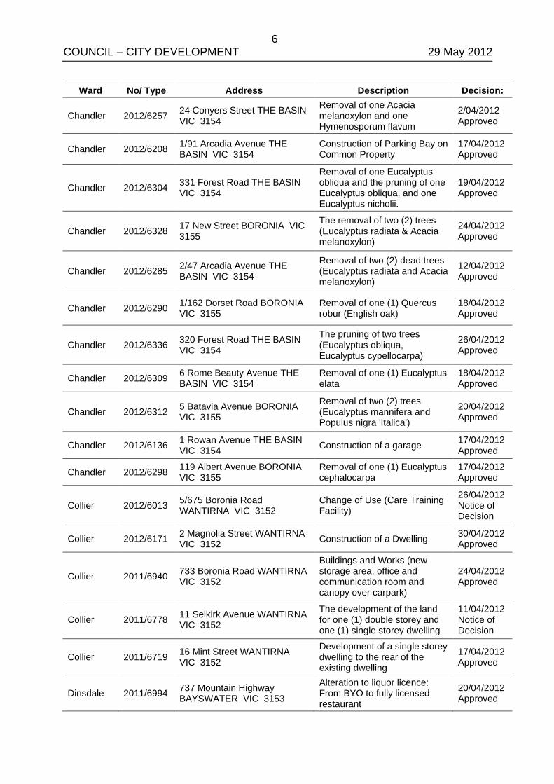
Ward No/ Type Address Description Decision:
Chandler 2012/6257 24 Conyers Street THE BASIN VIC 3154
Removal of one Acacia melanoxylon and one Hymenosporum flavum
2/04/2012 Approved
Chandler 2012/6208 1/91 Arcadia Avenue THE BASIN VIC 3154
Construction of Parking Bay on Common Property
17/04/2012 Approved
Chandler 2012/6304 331 Forest Road THE BASIN VIC 3154
Removal of one Eucalyptus obliqua and the pruning of one Eucalyptus obliqua, and one Eucalyptus nicholii.
19/04/2012 Approved
Chandler 2012/6328 17 New Street BORONIA VIC 3155
The removal of two (2) trees (Eucalyptus radiata & Acacia melanoxylon)
24/04/2012 Approved
Chandler 2012/6285 2/47 Arcadia Avenue THE BASIN VIC 3154
Removal of two (2) dead trees (Eucalyptus radiata and Acacia melanoxylon)
12/04/2012 Approved
Chandler 2012/6290 1/162 Dorset Road BORONIA VIC 3155
Removal of one (1) Quercus robur (English oak)
18/04/2012 Approved
Chandler 2012/6336 320 Forest Road THE BASIN VIC 3154
The pruning of two trees (Eucalyptus obliqua, Eucalyptus cypellocarpa)
26/04/2012 Approved
Chandler 2012/6309 6 Rome Beauty Avenue THE BASIN VIC 3154
Removal of one (1) Eucalyptus elata
18/04/2012 Approved
Chandler 2012/6312 5 Batavia Avenue BORONIA VIC 3155
Removal of two (2) trees (Eucalyptus mannifera and Populus nigra 'Italica')
20/04/2012 Approved
Chandler 2012/6136 1 Rowan Avenue THE BASIN VIC 3154 Construction of a garage 17/04/2012
Approved
Chandler 2012/6298 119 Albert Avenue BORONIA VIC 3155
Removal of one (1) Eucalyptus cephalocarpa
17/04/2012 Approved
Collier 2012/6013 5/675 Boronia Road WANTIRNA VIC 3152
Change of Use (Care Training Facility)
26/04/2012 Notice of Decision
Collier 2012/6171 2 Magnolia Street WANTIRNA VIC 3152 Construction of a Dwelling 30/04/2012
Approved
Collier 2011/6940 733 Boronia Road WANTIRNA VIC 3152
Buildings and Works (new storage area, office and communication room and canopy over carpark)
24/04/2012 Approved
Collier 2011/6778 11 Selkirk Avenue WANTIRNA VIC 3152
The development of the land for one (1) double storey and one (1) single storey dwelling
11/04/2012 Notice of Decision
Collier 2011/6719 16 Mint Street WANTIRNA VIC 3152
Development of a single storey dwelling to the rear of the existing dwelling
17/04/2012 Approved
Dinsdale 2011/6994 737 Mountain Highway BAYSWATER VIC 3153
Alteration to liquor licence: From BYO to fully licensed restaurant
20/04/2012 Approved
7 COUNCIL – CITY DEVELOPMENT 29 May 2012
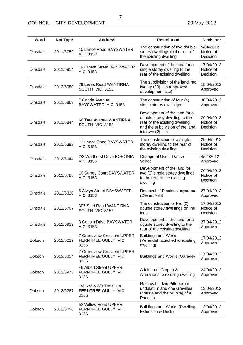
Ward No/ Type Address Description Decision:
Dinsdale 2011/6759 10 Lance Road BAYSWATER VIC 3153
The construction of two double storey dwellings to the rear of the existing dwelling
5/04/2012 Notice of Decision
Dinsdale 2011/6914 19 Ernest Street BAYSWATER VIC 3153
Development of the land for a single storey dwelling to the rear of the existing dwelling
17/04/2012 Notice of Decision
Dinsdale 2012/6080 79 Lewis Road WANTIRNA SOUTH VIC 3152
The subdivision of the land into twenty (20) lots (approved development site)
18/04/2012 Approved
Dinsdale 2011/6869 7 Coorie Avenue BAYSWATER VIC 3153
The construction of four (4) single storey dwellings
30/04/2012 Approved
Dinsdale 2011/6844 66 Tate Avenue WANTIRNA SOUTH VIC 3152
Development of the land for a double storey dwelling to the rear of the existing dwelling and the subdivision of the land into two (2) lots
26/04/2012 Notice of Decision
Dinsdale 2011/6392 11 Lance Road BAYSWATER VIC 3153
The construction of a single storey dwelling to the rear of the existing dwelling
20/04/2012 Notice of Decision
Dinsdale 2012/6044 2/3 Wadhurst Drive BORONIA VIC 3155
Change of Use - Dance School
4/04/2012 Approved
Dinsdale 2011/6785 10 Surrey Court BAYSWATER VIC 3153
Development of the land for two (2) single storey dwellings to the rear of the existing dwelling
26/04/2012 Notice of Decision
Dinsdale 2012/6320 5 Alwyn Street BAYSWATER VIC 3153
Removal of Fraxinus oxycarpa (Desert Ash)
27/04/2012 Approved
Dinsdale 2011/6707 307 Stud Road WANTIRNA SOUTH VIC 3152
The construction of two (2) double storey dwellings on the land
17/04/2012 Notice of Decision
Dinsdale 2011/6939 3 Cousin Drive BAYSWATER VIC 3153
Development of the land for a double storey dwelling to the rear of the existing dwelling
27/04/2012 Approved
Dobson 2012/6239 7 Grandview Crescent UPPER FERNTREE GULLY VIC 3156
Buildings and Works (Verandah attached to existing dwelling)
17/04/2012 Approved
Dobson 2012/6214 7 Grandview Crescent UPPER FERNTREE GULLY VIC 3156
Buildings and Works (Garage) 17/04/2012 Approved
Dobson 2011/6973 46 Albert Street UPPER FERNTREE GULLY VIC 3156
Addition of Carport & Alterations to existing dwelling
24/04/2012 Approved
Dobson 2012/6287 1/3, 2/3 & 3/3 The Glen FERNTREE GULLY VIC 3156
Removal of two Pittoporum undulatum and one Grevillea robusta and the pruning of a Photinia.
13/04/2012 Approved
Dobson 2012/6056 52 Willow Road UPPER FERNTREE GULLY VIC 3156
Buildings and Works (Dwelling Extension & Deck)
12/04/2012 Approved
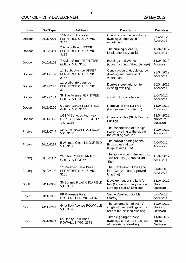
8 COUNCIL – CITY DEVELOPMENT 29 May 2012
Ward No/ Type Address Description Decision:
Dobson 2011/7001 19A Myrtle Crescent FERNTREE GULLY VIC 3156
Construction of a two storey dwelling & removal of vegetation
3/04/2012 Approved
Dobson 2012/6301 7 Acacia Road UPPER FERNTREE GULLY VIC 3156
The pruning of one (1) Liquidambar styraciflua
18/04/2012 Approved
Dobson 2012/6196 7 Alvina Street FERNTREE GULLY VIC 3156
Buildings and Works (Construction of Shed/Garage)
11/04/2012 Approved
Dobson 2011/6469 13 Seaby Avenue UPPER FERNTREE GULLY VIC 3156
Construction of double storey dwelling and removal of vegetation
23/04/2012 Approved
Dobson 2012/6193 11 Walbundry Avenue FERNTREE GULLY VIC 3156
Double storey addition to existing dwelling
26/04/2012 Approved
Dobson 2012/6174 38 The Avenue FERNTREE GULLY VIC 3156 construction of a fence 3/04/2012
Approved
Dobson 2012/6299 6 Joan Avenue FERNTREE GULLY VIC 3156
Removal of one (1) Tree (Lophostemon confertus)
11/04/2012 Approved
Dobson 2011/6956 1/1174 Burwood Highway UPPER FERNTREE GULLY VIC 3156
Change of Use (Skills Training Facility)
11/04/2012 Notice of Decision
Friberg 2011/6747 19 Anne Road KNOXFIELD VIC 3180
The construction of a single storey dwelling to the side of the existing dwelling
12/04/2012 Approved
Friberg 2012/6237 5 Wingate Close KNOXFIELD VIC 3180
The habitat pruning of one Eucalyptus radiata (Peppermint Gum)
2/04/2012 Approved
Friberg 2012/6097 29 Elton Road FERNTREE GULLY VIC 3156
The subdivision of the land into Two (2) Lots (Approved Unit Site)
18/04/2012 Approved
Friberg 2012/6102 11 Mountain Gate Drive FERNTREE GULLY VIC 3156
The Subdivision of the Land into Two (2) Lots (Approved Unit Site)
24/04/2012 Approved
Scott 2011/6665 30 Bunnett Road KNOXFIELD VIC 3180
Development of the land for two (2) double storey and one (1) single storey dwellings
11/04/2012 Notice of Decision
Taylor 2011/7008 6B Provence Rise LYSTERFIELD VIC 3156
Single Dwelling (Double Storey)
5/04/2012 Approved
Taylor 2011/6738 44 Willow Avenue ROWVILLE VIC 3178
The construction of two (2) single storey dwellings to the rear of the existing dwelling
12/04/2012 Notice of Decision
Taylor 2011/6693 65 Heany Park Road ROWVILLE VIC 3178
Three (3) single storey dwellings to the front and rear of the existing dwelling
11/04/2012 Notice of Decision
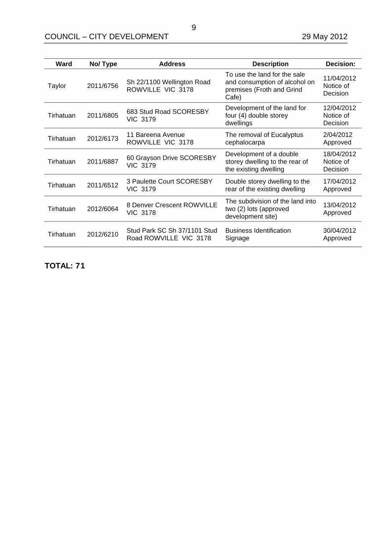
9 COUNCIL – CITY DEVELOPMENT 29 May 2012
Ward No/ Type Address Description Decision:
Taylor 2011/6756 Sh 22/1100 Wellington Road ROWVILLE VIC 3178
To use the land for the sale and consumption of alcohol on premises (Froth and Grind Cafe)
11/04/2012 Notice of Decision
Tirhatuan 2011/6805 683 Stud Road SCORESBY VIC 3179
Development of the land for four (4) double storey dwellings
12/04/2012 Notice of Decision
Tirhatuan 2012/6173 11 Bareena Avenue ROWVILLE VIC 3178
The removal of Eucalyptus cephalocarpa
2/04/2012 Approved
Tirhatuan 2011/6887 60 Grayson Drive SCORESBY VIC 3179
Development of a double storey dwelling to the rear of the existing dwelling
18/04/2012 Notice of Decision
Tirhatuan 2011/6512 3 Paulette Court SCORESBY VIC 3179
Double storey dwelling to the rear of the existing dwelling
17/04/2012 Approved
Tirhatuan 2012/6064 8 Denver Crescent ROWVILLE VIC 3178
The subdivision of the land into two (2) lots (approved development site)
13/04/2012 Approved
Tirhatuan 2012/6210 Stud Park SC Sh 37/1101 Stud Road ROWVILLE VIC 3178
Business Identification Signage
30/04/2012 Approved
TOTAL: 71
10 COUNCIL – CITY DEVELOPMENT 29 May 2012
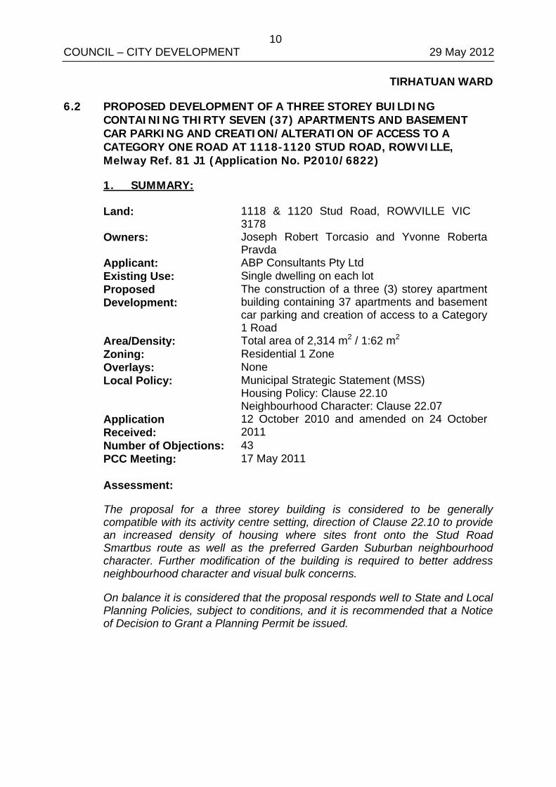
TIRHATUAN WARD
6.2 PROPOSED DEVELOPMENT OF A THREE STOREY BUILDING CONTAINING THIRTY SEVEN (37) APARTMENTS AND BASEMENT CAR PARKING AND CREATION/ALTERATION OF ACCESS TO A CATEGORY ONE ROAD AT 1118-1120 STUD ROAD, ROWVILLE, Melway Ref. 81 J1 (Application No. P2010/6822)
1. SUMMARY:
Land: 1118 & 1120 Stud Road, ROWVILLE VIC 3178
Owners: Joseph Robert Torcasio and Yvonne Roberta Pravda
Applicant: ABP Consultants Pty Ltd Existing Use: Single dwelling on each lot Proposed Development:
The construction of a three (3) storey apartment building containing 37 apartments and basement car parking and creation of access to a Category 1 Road
Area/Density: Total area of 2,314 m2 / 1:62 m2 Zoning: Residential 1 Zone Overlays: None Local Policy: Municipal Strategic Statement (MSS)
Housing Policy: Clause 22.10 Neighbourhood Character: Clause 22.07
Application Received:
12 October 2010 and amended on 24 October 2011
Number of Objections: 43 PCC Meeting: 17 May 2011 Assessment:
The proposal for a three storey building is considered to be generally compatible with its activity centre setting, direction of Clause 22.10 to provide an increased density of housing where sites front onto the Stud Road Smartbus route as well as the preferred Garden Suburban neighbourhood character. Further modification of the building is required to better address neighbourhood character and visual bulk concerns.
On balance it is considered that the proposal responds well to State and Local Planning Policies, subject to conditions, and it is recommended that a Notice of Decision to Grant a Planning Permit be issued.
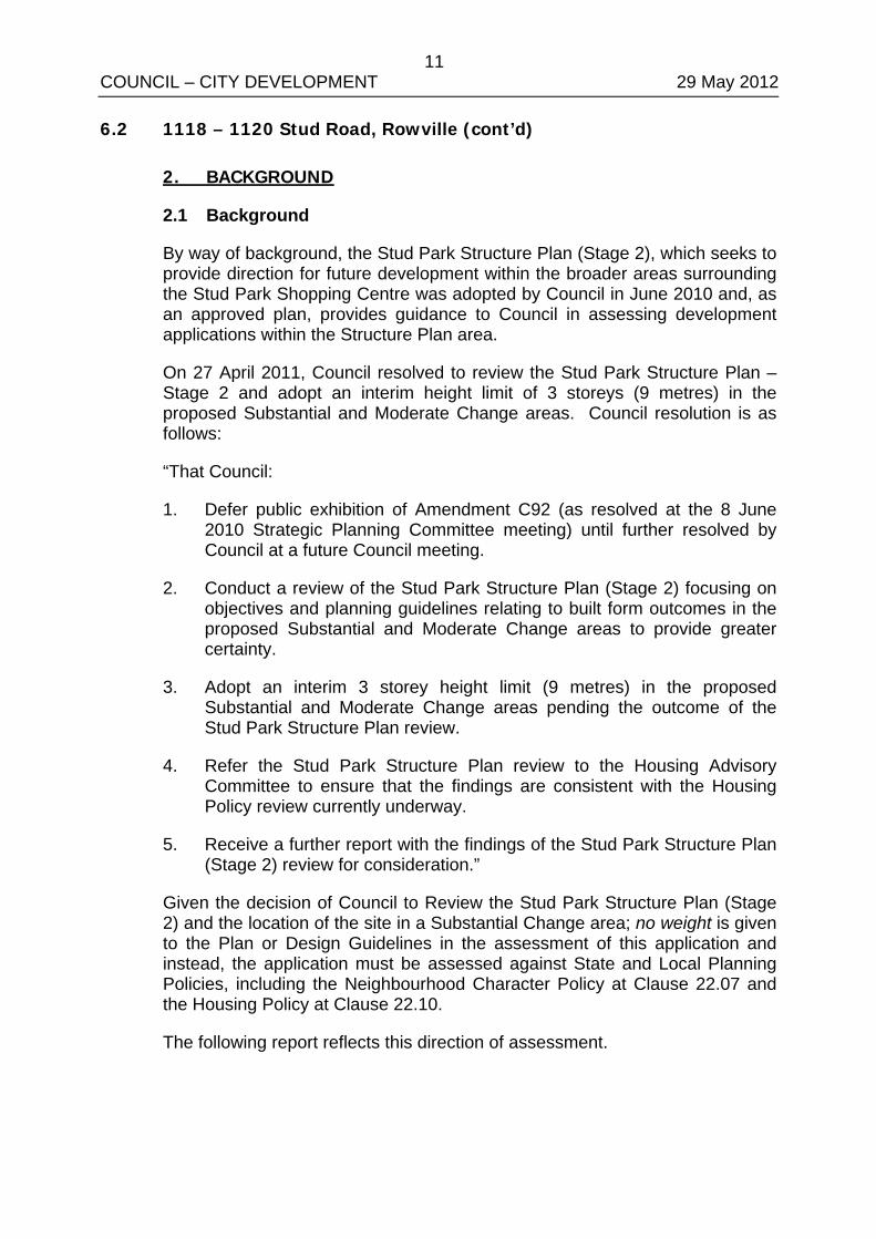
11 COUNCIL – CITY DEVELOPMENT 29 May 2012 6.2 1118 – 1120 Stud Road, Rowville (cont’d)
2. BACKGROUND
2.1 Background
By way of background, the Stud Park Structure Plan (Stage 2), which seeks to provide direction for future development within the broader areas surrounding the Stud Park Shopping Centre was adopted by Council in June 2010 and, as an approved plan, provides guidance to Council in assessing development applications within the Structure Plan area.
On 27 April 2011, Council resolved to review the Stud Park Structure Plan – Stage 2 and adopt an interim height limit of 3 storeys (9 metres) in the proposed Substantial and Moderate Change areas. Council resolution is as follows:
“That Council:
1. Defer public exhibition of Amendment C92 (as resolved at the 8 June 2010 Strategic Planning Committee meeting) until further resolved by Council at a future Council meeting.
2. Conduct a review of the Stud Park Structure Plan (Stage 2) focusing on objectives and planning guidelines relating to built form outcomes in the proposed Substantial and Moderate Change areas to provide greater certainty.
3. Adopt an interim 3 storey height limit (9 metres) in the proposed Substantial and Moderate Change areas pending the outcome of the Stud Park Structure Plan review.
4. Refer the Stud Park Structure Plan review to the Housing Advisory Committee to ensure that the findings are consistent with the Housing Policy review currently underway.
5. Receive a further report with the findings of the Stud Park Structure Plan (Stage 2) review for consideration.”
Given the decision of Council to Review the Stud Park Structure Plan (Stage 2) and the location of the site in a Substantial Change area; no weight is given to the Plan or Design Guidelines in the assessment of this application and instead, the application must be assessed against State and Local Planning Policies, including the Neighbourhood Character Policy at Clause 22.07 and the Housing Policy at Clause 22.10.
The following report reflects this direction of assessment.
12 COUNCIL – CITY DEVELOPMENT 29 May 2012 6.2 1118 – 1120 Stud Road, Rowville (cont’d)
2.2 Subject Site and Surrounds
The location of the site is shown in Appendix A.
• The site proposed for development comprises three parcels of land: 1118 Stud Road which has an area of 1,312 m2, 1120 Stud Road which has an area of 794 m2, and a triangle of land located between those two allotments which has an area of 28 m2. Collectively, the site has a total area of 2,134 m2, frontage to Stud Road of 58.5m, and an average depth of 42 metres. Two single storey brick dwellings are located on the land. No restrictive covenants are registered on title.
• The site is located opposite the Stud Park Activity Centre. Surrounding residential areas to the north, south and west are characterised by brick veneer dwellings. The site is accessed via the Stud Road service lane, which is two way. The sites contain largely exotic vegetation.
2.3 The Proposal
(Refer to attached plans at Appendix B)
It is proposed to construct a three storey building containing 37 apartments and create a new access point to Stud Road, a Category 1 Road.
• Access to the development is proposed to be via a new double crossover at the north eastern corner of the site to the Stud Road service lane. One level of basement parking will be provided, containing 44 car spaces, including seven (7) visitor spaces, bicycle racks and bin storage.
• The development proposes 33 two bedroom dwellings, four (4) one bedroom dwellings, communal open space at the north west corner of the site, and a communal multi-purpose room and amenities at the western elevation of the building. The overall height of the building is proposed to be 9 metres. External materials include rendered concrete and obscured glass balustrades.
• No significant vegetation is proposed to be removed.
3. CONSULTATION
3.1 Advertising
The application was first advertised on 11 March 2011 by way of a sign at the street frontage and notices sent to surrounding property owners and occupiers.
13 COUNCIL – CITY DEVELOPMENT 29 May 2012 6.2 1118 – 1120 Stud Road, Rowville (cont’d)
An application to amend the planning application after notice of the application had been given was made on 24 October 2011. The amendment reduced the height of the apartment building from 13 metres to 9 metres, provided a Traffic Impact Assessment Report, and altered the basement carpark. The amended application was advertised in the same manner on 5 March 2012.
Pursuant to Section 57A of the Planning & Environment Act 1987, all objections to the original application are taken to be to the amended application. 43 objections have been received in total. A summary of the issues raised is below:
Neighbourhood Character
• Refer to Section 4.2.2 of this report.
Building bulk, height and density of the development
• The building scale is considered appropriate within a Major Activity Centre, opposite the core retail centre and on a major road. The height of the development is 9 metres, consistent with Council’s interim height limit for the substantial change area and consistent with ResCode.
It is noted that apartment-style residential development has been approved by the Victorian Civil and Administrative Tribunal at 1088-1090 Stud Road, 250 metres to the north of the site (Jilip Eleven Pty Ltd v Knox CC [2011] VCAT 2094 [4 November 2011]) and at 39-41 Stamford Crescent abutting the western boundary of the site (ABP Consultants v Knox CC [2011] VCAT 2097 [4 November 2011]). Additionally, a proposal for a three (3) storey apartment building containing 36 apartments at 1114-1116 Stud Road, abutting the northern boundary of the site, is currently awaiting a hearing at VCAT.
In its consideration of the three storey apartment building at 1088-1090 Stud Road, the Tribunal found that the current provisions of the Knox Planning Scheme provide strategic imperative to consider built form of this nature favourably. While a balance between neighbourhood character and the provision of additional housing is needed, the Tribunal gave more weight to the provision of additional housing within a Major Activity Centre, than ensuring that the neighbourhood character of the area stays completely intact.
Inadequate car parking onsite
• The number of car parking spaces provided for both residents and visitors are in accordance with ResCode standards.
14 COUNCIL – CITY DEVELOPMENT 29 May 2012 6.2 1118 – 1120 Stud Road, Rowville (cont’d)
Existing traffic congestion on Stud Road, service road and surrounding streets
• In terms of traffic generation and congestion, the Tribunal in its consideration of the three storey development application located at 1088-1090 Stud Road, 250 metres to the north of the subject site and on the same stretch of service lane, reinforced that Council must consider this as part of its structure planning for the area, rather than trying to deal with it through individual applications.
In addition, Council’s Traffic Engineers have advised that the Traffic Impact Assessment submitted by the applicant demonstrate that traffic conditions along Stud Road will not be adversely impacted by the development.
Pedestrian safety
• Subject to minor modifications to the basement ramp and carpark, Council’s Traffic Department has not expressed any safety concerns.
Disabled access to building
• An accessible pedestrian ramp has been provided to the building entrance and will be subject to Building Regulations at the building permit stage.
Emergency vehicle access / Fire safety
• Sufficient access to the development for emergency vehicles has been provided. Issues such as fire egress and path of travel will be further considered at the building permit stage.
Inadequate public transport in Rowville
• Public transport availability is outlined at Section 4.2.1 of this report. The site is located on Stud Road, part of the Principal Public Transport Network.
Impact of development on infrastructure such as drainage, gas, water etc
• Conditions on any permit issued will ensure the site is adequately drained so as not to put any additional pressure on the existing system. Provision of sewerage and electrical infrastructure must be to the satisfaction of the relevant authorities.
ResCode compliance – Setbacks, overshadowing, overlooking, visual bulk
• A full assessment against the objectives of ResCode, including the above matters, is provided at Section 4.3 of this report.
15 COUNCIL – CITY DEVELOPMENT 29 May 2012 6.2 1118 – 1120 Stud Road, Rowville (cont’d)
Change to ‘family’ environment / socio-economic mix
• The proposed residential use of the land is compatible with the residential zoning of the site and surrounds. It is also noted that a communal open space area of approximately 150 m2 and a multipurpose room are provided onsite which allows for children or family recreation.
The mix of one and two bedroom dwellings proposed reinforces the direction of the Municipal Strategic Statement at Clause 21.05 to provide increased housing diversity while protecting the spacious garden character of remaining residential suburbs.
Rubbish collection
• Standard conditions will be placed on any permit issued to ensure that a Waste Management Plan is prepared to Council’s satisfaction.
Lack of landscaping / open space for children
• Private open space provided to each dwelling complies with ResCode standards. Communal open space provided at the south western corner of the site could be used for recreation. Landscaping buffers will be required via permit conditions to be provided at all sides of the apartment building.
Increase in noise and pollution
• The development is residential in nature and will not result in an unreasonable increase in residential noise or pollution.
Devaluation of properties
• Devaluation of properties is not a planning consideration.
Construction noise and pollution
• Standard conditions will be placed on any permit issued regarding amenity during the construction stage.
3.2 Planning Consultative Committee Meeting
A Planning Consultative Committee (PCC) Meeting was held at the Civic Centre on 17 May 2011. Forty (40) members of the public were in attendance. The concerns of the objectors were expressed, and the applicant presented the design concepts. Objectors expressed the following concerns:
• Building height / visual bulk
• Overdevelopment / inappropriate density
• Appearance of building
16 COUNCIL – CITY DEVELOPMENT 29 May 2012 6.2 1118 – 1120 Stud Road, Rowville (cont’d)
• Neighbourhood character
• Increased traffic along Stud Road and service lane
• Insufficient parking within development / increased on-street parking
• Limited public transport
• Safety for pedestrians/children along Stud Road service lane
• Vehicle fumes from basement level
• Loss of privacy
• Overshadowing
• Inadequate drainage / gas / electricity infrastructure
• Stormwater issues
• Fire risk due to congestion along Stud Road
• Impact on local community / quality of life / quiet family environment
• Increased pressure on public transport, shopping centre and schools
• Impact on environment / loss of fauna
• Construction noise
• Noise
• Property devaluation
• Increased property rates
• Stud Park Structure Plan / inappropriate future development in area
There were no negotiated outcomes as a result of this meeting.
3.3 Referrals
The application has been referred to VicRoads and internal departments for comment. No objection has been raised; the following is a summary of relevant advice:
VicRoads
• No objection to the proposal.
Traffic Engineer
• Minor alterations to basement car parks and ramp.
• Provision of car parking for residents and visitors is satisfactory.
• The Traffic Impact Assessment [submitted by the applicant] demonstrate that traffic conditions along the Stud Road service road are not estimated to be adversely impacted by the development.
17 COUNCIL – CITY DEVELOPMENT 29 May 2012 6.2 1118 – 1120 Stud Road, Rowville (cont’d)
Drainage Engineer
• No objections subject to standard conditions.
City Strategy
• No objection to the proposal.
Arborist
• No significant vegetation onsite.
• Excavation along the north boundary has the potential to adversely impact the health of neighbouring vegetation [if retained] unless a sufficient volume of soil is retained along the boundary.
Waste Management
• A Waste Management Plan must be approved by Council.
Building Services
• Fire safety / distance of travel will need to be further clarified.
4. DISCUSSION
This section considers the proposed development in light of the provisions of the Knox Planning Scheme including State and Local Planning Policies, any other relevant policies and objectives.
4.1 Zoning and Overlays
4.1.1 Residential 1 Zone
The land is located within a Residential 1 Zone. Within the R1Z, a planning permit is required to construct two or more dwellings on a lot.
4.2 Policy Consideration
4.2.1 State Planning Policy Framework
State policy requires Council to integrate the range of policies relevant to the issues to be determined, and balance conflicting objectives in favour of net community benefit and sustainable development.
18 COUNCIL – CITY DEVELOPMENT 29 May 2012 6.2 1118 – 1120 Stud Road, Rowville (cont’d)
Key Policies
Clause 15 Built Environment and Heritage – Encourages high quality architecture and urban design outcomes that reflect the particular characteristics, aspirations and cultural identity of the community; enhances liveability, diversity, amenity and safety of the public realm; and promotes attractiveness of towns and cities within broader strategic contexts.
• The development incorporates visually interesting and high quality architecture along its Stud Road frontage. However, as discussed throughout this report, further work has to be done to reduce the visual bulk of the development to side and rear elevations to promote the desired future character for Garden Suburban areas while reflecting a form of development suitable for the activity centre and main road setting.
Clause 15.02 Sustainable Development – Ensure land use and development is consistent with the efficient use of energy and the minimisation of greenhouse gas emissions.
• Dwellings are provided with an acceptable level of access to northern sunlight. Permit conditions should require submission of a Sustainable Design Assessment.
Clause 16 Housing – Encourage the development of well-designed medium-density housing that respects the neighbourhood character; improves housing choice; makes better use of existing infrastructure; and, improves energy efficiency of housing. Locate new housing in or close to activity centres and employment corridors and at other strategic development sites that offer good access to services and transport.
• Neighbourhood character - this is discussed in a later section of the report (Section 4.2.2).
• Housing choice – The development provides a mix of dwelling sizes, with four (4) of the 37 apartments containing one bedroom.
• Existing infrastructure – The site is located within a fully serviced area.
• Energy efficiency – This has been discussed above under Clause 15.02.
• Location – The site is located within the Stud Park Activity Centre.
19 COUNCIL – CITY DEVELOPMENT 29 May 2012 6.2 1118 – 1120 Stud Road, Rowville (cont’d)
Clause 18 Transport – Ensure that access is provided to all available modes of transport.
• The site is located adjacent to the Stud Park Shopping Centre and fronts onto Stud Road, part of the Principal Public Transport Network (PPTN).
• Smart Bus routes 901 and 900 runs along Stud Road, with the closest bus stop located approximately 60 metres to the south of the site. The 900 service runs between Rowville and Caulfield from 5am to midnight between two to four times an hour on weekdays, between 6am to midnight twice an hour on Saturdays, and between 7am to 10pm twice an hour on Sundays. The 901 service runs between Frankston and Melbourne Airport from 5am to midnight between two to five times an hour on weekdays, from 6am to midnight twice an hour on Saturdays, and from 7am to 6pm twice an hour on Sundays.
• Bus route 691 runs along Stud Road and out of Stud Park Shopping Centre. The service runs between Boronia and Waverley Gardens from 6am to 7:30pm twice an hour on weekdays, from 7:30am to 6pm once to twice an hour on Saturdays, and from 7:45am to 6pm hourly on Sundays.
• Bus route 754 runs along Stud Road and out of Stud Park Shopping Centre. The service runs between Rowville and Glen Waverley from 6am to 9pm between one and four times an hour on weekdays, from 8:20am to 9pm at hourly intervals on Saturdays, and from 9am to 9pm at hourly intervals on Sundays.
• Bus route 681 operates an occasional service along Stud Road. The one-way service runs between Lysterfield and Knox City at less than hourly intervals from 6:35am to 9pm.
4.2.2 Local Planning Policy Framework
Clause 21.07-2 Municipal Strategic Statement (MSS)
The MSS seeks to reduce the prevalence of infill housing development in dispersed locations as a major form of housing development by promoting activity centres and key redevelopment strategic sites as the preferred location.
• The site is located in an Activity Centre.
20 COUNCIL – CITY DEVELOPMENT 29 May 2012 6.2 1118 – 1120 Stud Road, Rowville (cont’d)
The MSS further seeks to manage the need for more housing and maintaining the valued qualities of identified areas of environmental and character significance. The MSS supports development that respects the existing or preferred residential neighbourhood character.
• The height of the development is considered to be consistent with the design objectives of the Garden Suburban Precinct as well as the main road setting of the development. However, permit conditions should require additional treatment to side and rear elevations to ameliorate the appearance of visual bulk.
Improve the interface between development and adjoining streets, open space and public spaces.
• Subject to permit conditions to require treatment of side and rear elevations to reduce the appearance of visual bulk and increase landscaping opportunities, the development will have an acceptable interface with the adjoining residential neighbourhood. While the appearance of the development towards Stud Road is visually dominant, it is appropriate for the activity centre setting and Category 1 Road frontage.
Clause 22.07 Neighbourhood Character: Garden Suburban While the site is located within a structure plan area, given the pending review of the structure plan, no weight can be given to it in the assessment of this application. As a result, assessment must then be made against the Neighbourhood Character Policy and other policies.
Within the Neighbourhood Character Policy, the site is specified as being in a Garden Suburban Precinct. The desired character of this area is for “Low scale dwellings set within an open landscape with occasional large native trees and in some precincts large stands of native trees”. Design objectives of the Garden Suburban Precinct are as follows:
To retain the tall trees.
• Council’s Arborist has inspected the site and determined that no significant vegetation will be affected. Trees on the neighbouring property at 1114-1116 Stud Road to the north of the site will be required via permit condition to be protected; however it is noted that a proposal for a three (3) storey apartment building is currently awaiting a hearing at the Tribunal. The front and rear setbacks provided to the building are capable of holding at least fourteen (14) canopy trees, particularly as there is no easement affecting communal open space areas along the western boundary of the site. Permit conditions will require a substantial amount of planting along all boundaries, which will enable the development to integrate with the preferred Garden Suburban setting for the neighbourhood.
21 COUNCIL – CITY DEVELOPMENT 29 May 2012 6.2 1118 – 1120 Stud Road, Rowville (cont’d)
To maintain the continuity of garden character between dwellings.
• Further work should be done to enable the apartment building to reflect the separation between dwellings that is characteristic of the surrounding area.
The building is generally setback from the rear boundary a sufficient distance to allow for planting of canopy trees to screen the building from the west; however, this setback narrows towards the south eastern corner of the site. Permit conditions should require that the south west corner of the building be altered in the vicinity of Units 10, 12, 23 and 25 in order to allow substantial canopy tree planting along the entire western boundary.
To the south, the 1m setback between the building and the southern boundary precludes any form of meaningful landscaping. Permit conditions should require a minimum 2m wide setback along the southern boundary which will allow for planting of large shrubs to reflect the garden character and separation of the area.
In addition, the roofed area to the basement located along the northern boundary of the site will be required via permit conditions to be altered to a landscaping area or planter box.
To minimise the dominance of buildings from the street.
• The visually dominating appearance of the development onto Stud Road is appropriate, given the main road and Activity Centre setting. More important is the visual dominance of the building as viewed from residential environs to the side and rear. As described in this section, permit conditions should require greater treatment and setbacks to side and rear elevations and increased landscaping opportunities.
To minimise loss of front garden space, and dominance of car storage facilities.
• All car parking is located in the basement to avoid dominating the appearance of the site.
The 5 metre front setback to the development is appropriate, given the location of the site within an Activity Centre and fronting onto a major road, and the ability to accommodate extensive canopy tree planting.
22 COUNCIL – CITY DEVELOPMENT 29 May 2012 6.2 1118 – 1120 Stud Road, Rowville (cont’d)
Clause 22.10 Housing: Apartment style residential development
The Housing Policy at Clause 22.10-1 recognises that the population of Knox will grow by 12,000 persons and 15,000 households by 2030.
It is policy that:
Apartment and multi-storey mixed use style housing development be encouraged in the Business Zones within the principal and major activity centres.
• The proposed apartment development is not located within the Business Zone of a Principal or Major Activity Centre.
The proposed development is consistent with a relevant approved structure plan or urban design framework.
• While there is no approved structure plan, the maximum 9 metre height proposed development is consistent with the 3 storey / 9 metre height limitation pursuant to the Council resolution of 27 April 2011.
Medium density housing is encouraged along the principal public transport network where properties have direct frontage, particularly along the Stud Road Orbital SmartBus Route.
• The site has direct frontage to the Stud Road Orbital SmartBus Route and is located approximately 60 metres walking distance from the closest bus stop.
Before deciding on an application, the responsible authority will consider, as appropriate, whether:
The proposed housing will contribute to a diversity of housing in Knox.
• The development proposes a mix of one and two bedroom dwellings.
There is access to frequent public transport services between 6.00am and 11.00pm daily, seven days a week.
• The subject site is not located to take advantage of frequent public transport services between 6.00am and 11.00pm daily, seven days a week.
23 COUNCIL – CITY DEVELOPMENT 29 May 2012 6.2 1118 – 1120 Stud Road, Rowville (cont’d)
The proposed development makes a positive contribution to the desired future neighbourhood character as identified at Clause 22.07 Neighbourhood Character policy or an approved structure plan or urban design framework.
• Subject to conditions to address visual bulk and provide additional landscaping, the development is capable of making a positive contribution to the desired Garden Suburban neighbourhood character for the reasons detailed in the assessment against Clause 22.07 above.
The proposed development is consistent with a relevant endorsed structure plan or urban design framework.
• The Stud Park Structure Plan (Stage 2) has no weight in the consideration of the amended proposal.
The development and building design response addresses any potential impact on adjoining development where there is a residential interface with respect to amenity, overlooking, overshadowing, height and bulk, views and vistas.
• An assessment of the proposed development against these aspects is provided at Section 4.3 of this report. Alterations to improve the amenity impact of the development will be imposed on any permit issued.
4.2.3 Stud Park Structure Plan (Stage 2)
Given the decision of Council to Review the Stud Park Structure Plan (Stage 2) and the location of the site in a Substantial Change area; no weight is given to the Plan or Design Guidelines in the assessment of this application and instead, the application must be assessed against the Neighbourhood Character Policy at Clause 22.07
4.3 Clause 55 – Two or More Dwellings on a Lot and Residential Buildings (ResCode)
The proposal generally complies with the provisions of Clause 55 of the Knox Planning Scheme, an assessment of the key criteria; including any areas of non compliance are considered below: Neighbourhood Character and Infrastructure
Neighbourhood Character – Generally complies, refer to Section 4.2.2 above
24 COUNCIL – CITY DEVELOPMENT 29 May 2012 6.2 1118 – 1120 Stud Road, Rowville (cont’d)
Site Layout and Building Massing
Street Setback – Generally complies. The 5 metre setback to the front walls of the development allows for efficient use of a site within a Major Activity Centre, while enabling canopy tree planting to contribute to the preferred Garden Suburban neighbourhood character.
Building Height – Complies.
Site Cover/permeability – Can comply, subject to a permit condition requiring that no more than 60% of the site area be covered by buildings.
Energy Efficiency – Can comply, subject to a Sustainable Design Assessment being required as condition of any permit issued.
Open space – Generally complies, subject to permit conditions to delete internal fencing which restricts views of the communal open space areas along the western boundary.
Landscaping – Can comply, subject to conditions to improve the landscaping onsite. A landscape plan will be required as condition of any permit issued.
Access – Can comply, subject to permit conditions regarding minor alterations to the basement car park.
Parking provision and location – Complies
Amenity Impacts
Side and rear setbacks – Generally complies, subject to permit conditions to address visual bulk and achieve minimum setback distances.
With regard to visual bulk, the southern elevation of the development, unlike the other sides of the building, is not provided with balconies, articulation, canopies or other forms of visual treatment. Permit conditions discussed in Section 4.2.2 will require a minimum 2m building setback from the southern boundary. In addition, sections of three storey-high walls at the southern elevation should be deleted and a greater mix of materials and articulation incorporated to provide visual interest and reduce bulk at this elevation.
Permit conditions should also require that minimum ResCode setbacks be achieved in the following areas: the north western corner of Unit 14 setback at least 1.75m from the northern boundary (an additional 450mm); the west-facing balconies to Units 23 and 25 setback at least 1.3m and 1.42m from the western boundary respectively; and the first floor walls and balconies to the building setback further from the southern boundary (between 1.27m and 1.81m), or otherwise in accordance with ResCode standards.
25 COUNCIL – CITY DEVELOPMENT 29 May 2012 6.2 1118 – 1120 Stud Road, Rowville (cont’d)
Walls on boundaries – Complies, subject to amended plans being required to confirm that the northern basement wall will be constructed on the northern boundary (described as such within the applicant’s written response). However, the length of basement wall will comply with the standard.
Daylight to existing windows/north facing windows – Generally complies. A north-facing living room window is located on the adjoining property at No. 1122 Stud Road to the south. However, this window is fully shaded by an existing verandah roof and it is surmised that a reduction in direct sunlight will not unduly impact on the amenity of the dwelling.
Overshadowing open space – Complies
Overlooking – Generally complies, subject to permit conditions to require screening to the following areas: the west-facing windows to the multi-purpose room and Bedroom 2 windows to Units 14, 21, 23, 25, 33 and 35.
Internal views – Can comply, subject to provision of screening for windows facing onto light wells.
On-Site Amenity and Facilities
Daylight to new windows - Complies
Private Open Space – Complies
Solar access – Complies
Storage – Can comply, subject to permit condition to require provision of at least 6 cubic metres of external storage to each dwelling.
Front fence – Complies
Common property – Generally complies, subject to permit conditions to require deletion of paling fences located within communal open space areas along the western boundary.
4.4 Particular Provisions
4.4.1 Clause 52.29 Land adjacent to a Road Zone, Category 1, or a Public Acquisition Overlay for a Category 1 Road
The purpose of Clause 52.29 is to ensure appropriate access to identified roads. A permit is required to create or alter access to a Category 1 Road (Stud Road).
The application has been referred to VicRoads who has made no objections to the proposal, nor directed that any conditions be included on any permit issued.
26 COUNCIL – CITY DEVELOPMENT 29 May 2012 6.2 1118 – 1120 Stud Road, Rowville (cont’d)
5. CONCLUSION
Clause 11 of the Knox Planning Scheme requires Council to balance relative policy objectives when making decisions to ensure resulting development is sustainable and achieves a net community gain. In this context, the development is appropriate given the following:
• The proposed development is generally consistent with the State Planning Policy, the MSS (Clause 21.07), Housing Policy (Clause 22.10) and the Neighbourhood Character Policy (Clause 22.07). As discussed above, the site is located within the Stud Park Major Activity Centre and subject to design modifications, the development is considered to represent an appropriate balance between providing additional housing and respecting the changing character of the area. Further, the site is a large, consolidated site and capable of absorbing a development in apartment form.
• The development is located within an existing urban area where services and transportation is located within close proximity.
• The proposal, subject to modifications that could be conditioned on any permit, is considered appropriate in terms of architectural quality, ecologically sustainable design principles, built form and landscaping.
• The development is generally compliant with ResCode subject to changes that could be conditioned on any permit issued.
6. CONFIDENTIALITY
There are no confidentiality issues associated with this report.
RECOMMENDATION
That Council issue a Notice of Decision to Grant a Planning Permit for development of the land for a three storey building containing thirty seven (37) apartments and basement car parking, and creation/alteration of access to a Category 1 Road at 1118-1120 Stud Rd, Rowville, subject to the following conditions:
Amended Plans
1. Prior to the commencement of any buildings or works, amended plans to the satisfaction of the Responsible Authority must be submitted to and approved by the Responsible Authority. When approved, the plans will be endorsed and will then form part of the permit. The plans must be drawn to scale with dimensions and three copies must be provided. The plans must be generally in accordance with the plans submitted with the application but modified to show:
27 COUNCIL – CITY DEVELOPMENT 29 May 2012 6.2 1118 – 1120 Stud Road, Rowville (cont’d)
Recommendation (cont’d)
1.1 Parking spaces no. 1, 2 and 26 clearly signed for ‘Reverse Parking Only’.
1.2 The basement access ramp to have a grade of 1 in 20 for at least 6 metres approaching the property boundary.
1.3 Visitor parking spaces and intercom system clearly identified by signage at the front of the site.
1.4 Parking spaces to be signed and allocated for use by individual dwellings and visitors.
1.5 Appropriate directional signage and line markings for the entry- and exit-only access points to the basement car park and one-way circulation within the car park.
1.6 Grade transitions for the crossover and access ramp, which must be in accordance with those specified in Council’s Standard Drawings to prevent vehicles scraping their undercarriages.
1.7 A reduction in site coverage so that no more than 60% of the site will be covered by buildings.
1.8 Deletion of the internal paling fences within communal open space areas along the western boundary of the site.
1.9 Provision of obscure glazing or other form of screening to a maximum height of 1.5 metres to the western elevation of balconies to Dwellings 2, 4, 6 and 8, or other method approved by the Responsible Authority to provide privacy to these balconies while ensuring substantial views of the communal open space.
1.10 All new boundary fencing to be located on property boundaries.
1.11 The south west corner of the building be altered to allow for planting of canopy trees along the western boundary. This may be achieved by setting back the balconies to Units 10, 12, 23 and 25 further from the western boundary, or converting the open roofed section of the basement at the south west corner to a planter box capable of holding canopy trees.
1.12 Provision of a minimum 2 metre wide setback along the southern boundary of the site to allow for planting of large shrubs.
28 COUNCIL – CITY DEVELOPMENT 29 May 2012 6.2 1118 – 1120 Stud Road, Rowville (cont’d)
Recommendation (cont’d)
1.13 Building setbacks in accordance with ResCode standards.
1.14 Alterations to the southern elevation to reduce visual bulk. Any section of three storey wall must be deleted through the articulation of wall surfaces by at least 500mm between wall surfaces, and greater use of high quality architectural materials and features such as cladding, canopies and verandahs to provide greater visual interest.
1.15 The roofed area to the basement car park along the northern boundary altered to a landscaping area or planter box.
1.16 Annotation of the setback distance between the basement wall and the northern boundary of the site.
1.17 Provision of screening to habitable room windows facing onto light wells in accordance with ResCode Standards B22 and B23.
1.18 Provision of at least 6 cubic metres of externally accessible, secure storage space to each dwelling. Details of the allocation of storage spaces to dwellings must be shown.
1.19 Drainage plans in accordance with Condition 2.
1.20 Landscaping plans in accordance with Condition 3.
1.21 Sustainable Design Assessment in accordance with Condition 6.
1.22 Waste Management Plan in accordance with Condition 8.
1.23 Any alteration to the basement car park or development as a whole as required by the Waste Management Plan.
1.24 Provision of an external colours and materials schedule.
Drainage Plans
2. Prior to the commencement of any buildings or works, three copies of road construction and drainage plans and computations prepared by a qualified Civil Engineering Consultant must be submitted to and approved by the Responsible Authority. Drainage and road construction works on site must be undertaken and completed in accordance with these plans to the satisfaction of the Responsible Authority prior to the occupancy of the buildings. Plans are to show:
29 COUNCIL – CITY DEVELOPMENT 29 May 2012 6.2 1118 – 1120 Stud Road, Rowville (cont’d)
Recommendation (cont’d)
2.1 Stormwater drainage runoff shall be properly collected in a complete and effective system of drains and connected to the Council drainage system via a new Stormwater Pit near the South West corner of the property.
2.2 Stormwater drainage discharge for the proposed development must be limited to predevelopment flows. The total Permissible Site Discharge is 30L/s for the property including all dwellings to the proposed Stormwater Pit. The developer must construct approximately 77 metres of 225mm diameter pipe from the Point of Discharge to the Stormwater Pit near the North West corner of No. 1126 Stud Road for a 5 year ARI event.
2.3 No structure or trees are to be built over an easement vested in Council, or any drainage asset not in an easement within the property without Council consent.
2.4 The proposed retaining wall at the rear of the property shall be designed to ensure that it will withstand live loadings, vibration loadings and hydrostatic pressures in the event of maintenance being undertaken on the pipe in the adjacent easement.
2.5 The proposed development is to provide adequate clearance for the overland flow path through the property to Council’s satisfaction. Details regarding overland flow must be included in the engineering stormwater design plans.
2.6 The use of water quality improvement systems is required to be considered for this development. The use of rainwater tanks, bioretention systems and vegetated swales can be used and these are to be incorporated in the stormwater drainage design plans.
2.7 The drainage design of this property is to ensure that the underground carpark is not flooded for 100 ARI event
2.8 All levels to be to AHD (Australian Height Datum).
2.9 incorporated into the onsite detention requirement for the proposed development. The Engineering Services team can assist the developer achieve this.
2.10 All levels to be to AHD (Australian Height Datum).
To the satisfaction of the Responsible Authority.
30 COUNCIL – CITY DEVELOPMENT 29 May 2012 6.2 1118 – 1120 Stud Road, Rowville (cont’d)
Recommendation (cont’d)
Landscape Plans
3. Prior to the commencement of any buildings or works, a landscape plan to the satisfaction of the responsible authority must be submitted to and approved by the responsible authority. The plan must show the following:
3.1 A survey (including botanical names) of all existing vegetation to be retained and / or removed.
3.2 Buildings and trees (including botanical names) on neighbouring properties within three metres of the boundary.
3.3 The identification and removal of all vegetation identified as an environmental weed in Knox (as outlined in Appendix 2 of Council’s Landscape Guidelines for Planning Permits).
3.4 Details of the surface finishes of pathways and driveways.
3.5 A planting schedule of all proposed trees, shrubs and ground covers, including botanical names, common names, pot sizes, sizes at maturity, and quantities of each plant.
3.6 Landscaping and planting within open space areas of dwellings.
3.7 Landscaping and planting within all public areas of the site.
3.8 Application of water sensitive urban design principles. (This may involve selection of appropriate plant species that are drought tolerant and indigenous to the local area).
3.9 Appropriate landscaping to support any selected stormwater quality works depicted on endorsed drainage plans.
3.10 Should existing vegetation at 1116 Stud Road to the north be retained, a sufficient volume of soil must be retained along the northern boundary to avoid adverse impacts on the health of neighbouring trees through the removal of roots and soil.
3.11 The plans must also show the provision of at least fourteen (14) additional indigenous or native canopy trees and at least 50 additional large shrubs chosen from Appendix 4 or 5 of Council’s Landscape Guidelines for Planning Permits.
31 COUNCIL – CITY DEVELOPMENT 29 May 2012 6.2 1118 – 1120 Stud Road, Rowville (cont’d)
Recommendation (cont’d)
3.12 There must be substantial canopy tree planting along the western and eastern boundaries, and substantial planting of large shrubs along the southern boundary.
To the satisfaction of the Responsible Authority.
4. Before the occupation of the development, the landscaping works shown on the endorsed plans must be carried out and completed to the satisfaction of the responsible authority.
5. The landscaping shown on the endorsed plan must be maintained to the satisfaction of the Responsible Authority.
Sustainable Design Assessment
6. Prior to the commencement of any buildings or works, a Sustainable Design Assessment detailing Sustainable Design initiatives to be incorporated into the development must be submitted to and approved by the Responsible Authority. The Sustainable Design Assessment must outline the proposed sustainable design initiatives to be incorporated throughout the development such as (but not limited to) energy efficiency, water conservation, stormwater quality, waste management and material selection, to the satisfaction of the Responsible Authority.
7. Prior to the occupation of the development, the development must be constructed in accordance with the Sustainable Design Assessment approved by the Responsible Authority.
Waste Management Plan
8. Before the development commences, a waste collection and management plan must be submitted to and approved by the Responsible Authority, demonstrating how waste storage and collection will be undertaken on site wholly within the confines of the site, including the operation of the garbage and recyclables storage area, to the satisfaction of the Responsible Authority. Garbage and recyclables storage and collection must be undertaken in accordance with the approved plan/documentation to the satisfaction of the Responsible Authority.
General
9. All development must be in accordance with the endorsed plans.
32 COUNCIL – CITY DEVELOPMENT 29 May 2012 6.2 1118 – 1120 Stud Road, Rowville (cont’d)
Recommendation (cont’d)
10. The development as shown on the endorsed plans must not be altered without the written consent of the Responsible Authority.
11. Once the development has started it must be continued and completed to the satisfaction of the Responsible Authority.
12. Prior to the occupation of the dwellings the development is to be completed in accordance with the endorsed plan/s to the satisfaction of the Responsible Authority.
13. All walls on the boundaries of adjoining properties must be cleaned and finished to the satisfaction of the Responsible Authority.
Car Parking and Traffic
14. Before the new dwellings are occupied, driveways and car parking areas must be fully constructed in accordance with plans submitted to and approved by the Responsible Authority.
15. Parking areas and driveways must be kept available and maintained for these purposes at all times to the satisfaction of the Responsible Authority.
16. The driveway and carparking areas associated with the proposed dwelling as shown on the endorsed plan must be fully constructed to the minimum standard of 100mm depth of reinforced concrete and properly formed to such levels that they can be used in accordance with the plans. Construction using any alternative hardstanding sealed surface is subject to detailed plans to be submitted to and approved by the Responsible Authority.
17. Redundant vehicle and pram crossovers shall be removed and the footpath, nature strip and kerbing reinstated to the satisfaction of the Responsible Authority.
18. All structures (including letter boxes, landscaping, fencing and meter boxes) should be constructed to a maximum height of 900mm or relocated clear of a splayed area (2 metres x 2.5 metres into site) in accordance with AS 2890.1 Clause 3.2.4.
19. For pedestrian safety, low height or bollard type lighting should be installed along access ways and within the car park in accordance with AS1158.
33 COUNCIL – CITY DEVELOPMENT 29 May 2012 6.2 1118 – 1120 Stud Road, Rowville (cont’d)
Recommendation (cont’d)
Stormwater
20. Stormwater runoff from all buildings and hardstanding surfaces shall be properly collected and discharged in a complete and effective system of drains within the property and shall not cause or create a nuisance to abutting properties.
Fencing
21. Prior to the occupancy of the development all fencing shall be in a good condition to the satisfaction of the Responsible Authority.
22. All fencing costs are to be borne by the developer/owner.
Street Tree Removal
23. All works associated with the removal and replacement of the street tree/s must be undertaken by Council and the owner/developer must bear all costs associated with these works. The owner/developer must pay all costs to Council prior to the commencement of any works approved under this permit.
Amenity during construction
24. Upon commencement and until conclusion of the development, the developer shall ensure that the development does not adversely affect the amenity of the area in any way, including:
24.1 the appearance of building, works or materials on the land
24.2 parking of motor vehicles
24.3 transporting of materials or goods to or from the site
24.4 hours of construction
24.5 stockpiling of top soil or fill materials
24.6 air borne dust emanating from the site
24.7 noise
24.8 rubbish and litter
24.9 sediment runoff.
Should the development cause undue detriment to the amenity of the area then immediate remedial measures must be undertaken to address the issue as directed by, and to the satisfaction of, the Responsible Authority.
34 COUNCIL – CITY DEVELOPMENT 29 May 2012 6.2 1118 – 1120 Stud Road, Rowville (cont’d)
Recommendation (cont’d)
25. Permit Expiry
This permit will expire if one of the following circumstances applies:
25.1 The development is not started within two years of the date of this permit.
25.2 The development is not completed within four years of the date of this permit.
The Responsible Authority may extend the periods referred to if a request is made in writing before the permit expires or within three months afterwards.
NOTES
Drainage Notes (to be read in conjunction with the above drainage conditions):
• Tc = 15 minutes; Tso = 25 minutes
• No structure or trees are to be built over an easement vested in Council, or any drainage asset not in an easement within the property without Council consent.
• Drainage works in the Road reserve or in the Council easement will require a road opening permit.
• Floor levels are to be designed appropriately and raised above the natural ground surface level to provide protection from any possible flooding, which may occur within the development.
• All utility services (e.g. Drainage, Sewer) are to be verified onsite by Applicant/Developer prior to commencement of any works.
Other Notes:
• In accordance with Council policy, an 8.5% public open space contribution may apply in the event of the subdivision of the land.
• Indigenous plants can be purchased through approved indigenous nurseries, as listed in the Knox City Council 'Preferred Local Replacement Plants' Information Sheet.
• Raised concrete slabs on the existing footpath fronting the site should be grounded.
35 COUNCIL – CITY DEVELOPMENT 29 May 2012 6.2 1118 – 1120 Stud Road, Rowville (cont’d)
COUNCIL RESOLUTION MOVED: CR. VAN DE VREEDE SECONDED: CR. PEARCE
That Council issue a Notice of Refusal to Grant a Planning Permit for the development of a three (3) storey apartment building containing thirty seven (37) dwellings and basement car parking, and creation/alteration of access to a Category 1 Road at 1118-1120 Stud Road, Rowville, on the following grounds:
1. The proposal is inconsistent with the direction of Clause 21 (Municipal Strategic Statement) and Clause 22.07 (Neighbourhood Character) and Clause 22.10 (Housing) in proposing a built form which fails to consider neighbourhood character, particularly with regard to the front setback, side and rear setbacks, visual bulk impact and landscaping opportunities.
2. The proposal is inconsistent with the direction of Clause 16.02 (Housing), Clause 21.07 (Municipal Strategic Statement), Clause 22.10 (Housing) and Clause 52.29 (Land adjacent to a Road Zone, Category 1, or a Public Acquisition Overlay for a Category 1 Road) with regard to adverse traffic impacts on surrounding streets and intersections.
3. The proposed development is inconsistent with Clause 22.10 (Housing) in particular that there is not access to frequent public transport services between 6.00 am and 11.00pm daily, seven days a week.
4. The proposed dwellings will result in unreasonable amenity impacts to adjoining properties.
5. The proposal is inconsistent with ResCode (Clause 55), particularly neighbourhood character, street setback, site coverage and permeability, energy efficiency, open space, landscaping, side and rear setbacks, daylight to existing windows, overlooking and internal views.
CARRIED

36 COUNCIL – CITY DEVELOPMENT 29 May 2012 APPENDIX A/1

37 COUNCIL – CITY DEVELOPMENT 29 May 2012 APPENDIX A/2

38 COUNCIL – CITY DEVELOPMENT 29 May 2012 APPENDIX B/1

39 COUNCIL – CITY DEVELOPMENT 29 May 2012 APPENDIX B/2

40 COUNCIL – CITY DEVELOPMENT 29 May 2012 APPENDIX B/3

41 COUNCIL – CITY DEVELOPMENT 29 May 2012 APPENDIX B/4

42 COUNCIL – CITY DEVELOPMENT 29 May 2012 APPENDIX B/5

43 COUNCIL – CITY DEVELOPMENT 29 May 2012 APPENDIX B/6

44 COUNCIL – CITY DEVELOPMENT 29 May 2012 APPENDIX B/7
45 COUNCIL – CITY DEVELOPMENT 29 May 2012
TIRHATUAN WARD
6.3 APPLICATION TO DEVELOP THE LAND FOR A THREE (3) STOREY APARTMENT BUILDING CONTAINING (14) DWELLINGS AT 1098 STUD ROAD, ROWVILLE Melway Ref. 81 J1 (Application No. P/2011/6551)
1. SUMMARY:
Land: 1098 Stud Road, Rowville Applicant: ABP Consultants Pty Ltd Proposed Development: Development of the land for a three
storey apartment building containing fourteen dwellings
Existing Land Use: Single Dwelling Area/Density: 985m2 / 1:70.4m2 Zoning: Residential 1 Zone Overlays: None Local Policy: Municipal Strategic Statement (MSS)
Housing Policy Neighbourhood Character Policy
Application Received: 19 July 2011 Number of Objections: 36 PCC Meeting: 20 March 2012 Assessment:
An application for review of Council’s failure to make a decision within the prescribed timeframes of the Planning and Environment Act 1987 has been lodged with VCAT. A hearing date has not yet been provided.
The proposal is considered to be compatible with its activity centre setting, the zoning of the land, as well as the preferred Garden Suburban neighbourhood character.
On balance it is considered that the proposal responds well to State and Local Planning Policies, and it is recommended, if Council were in a position to make a decision on the application, that a Planning Permit be issued subject to conditions.
2. BACKGROUND
2.1 Background
The Stud Park Structure Plan (Stage 2), which seeks to provide direction for future development within the broader areas surrounding the Stud Park Shopping Centre was adopted by Council in June 2010 and, as an approved plan, provides guidance to Council in assessing development applications within the Structure Plan area.
46 COUNCIL – CITY DEVELOPMENT 29 May 2012 6.3 1098 Stud Road, Rowville (cont’d)
On 27 April 2011, Council resolved to review the Stud Park Structure Plan – Stage 2 and adopt an interim height limit of 3 storeys (9 metres) in the proposed Substantial and Moderate Change areas. The Council resolution is as follows:
“That Council:
1. Defer public exhibition of Amendment C92 (as resolved at the 8 June 2010 Strategic Planning Committee meeting) until further resolved by Council at a future Council meeting.
2. Conduct a review of the Stud Park Structure Plan (Stage 2) focusing on objectives and planning guidelines relating to built form outcomes in the proposed Substantial and Moderate Change areas to provide greater certainty.
3. Adopt an interim 3 storey height limit (9 metres) in the proposed Substantial and Moderate Change areas pending the outcome of the Stud Park Structure Plan review.
4. Refer the Stud Park Structure Plan review to the Housing Advisory Committee to ensure that the findings are consistent with the Housing Policy review currently underway.
5. Receive a further report with the findings of the Stud Park Structure Plan (Stage 2) review for consideration.”
Given the decision of Council to Review the Stud Park Structure Plan (Stage 2) and the location of the site in a Substantial Change area; no weight is given to the Plan or Design Guidelines in the assessment of this application and instead, the application must be assessed State and Local Planning Policies, including the Neighbourhood Character Policy at Clause 22.07 and the Housing Policy at Clause 22.10.
The following report reflects this direction of assessment.
2.2 Subject Site and Surrounds
The location of the subject site is shown in Appendix A.
• The subject site is rectangular in shape, located on the western side of Stud Road, Rowville. The site has an overall area of 985m2 with a frontage to Stud Road of 20.12 metres. A single storey dwelling and associated outbuildings occupy the site.
47 COUNCIL – CITY DEVELOPMENT 29 May 2012 6.3 1098 Stud Road, Rowville (cont’d)
• Adjoining properties are used for residential purposes. Dwellings in the immediate area contain a mix of single and double storey brick dwellings. Stud Park Shopping Centre is located 52 metres to the east of the site, with the site and surrounding area located within the Stud Park Activity Centre. Recently several apartment buildings have been approved within the area bound by Stud Road and Stamford Crescent, ranging in height from 2 to 3 stories.
• The site is moderately vegetated with a variety of exotic and native of trees and shrubs, including a Liquidambar, Elm, Ash, and Eucalyptus.
2.3 The Proposal
(Refer to attached plans at Appendix B)
The applicant proposes to remove the existing dwelling and construct 14 dwellings within a three storey apartment building. Details are as follows:
• 13 dwellings each containing two bedrooms and 1 dwelling containing one bedroom. All dwellings are provided with amenities, kitchen and open plan living / meals area and a balcony. A communal open space area has been provided by way of a balcony on the second floor. The development proposes a maximum height of 8.9 metres.
• A car park is provided on the ground floor, accessed via a crossover in the southwest corner of the site containing 14 car parking spaces for residents and 2 car parking spaces for visitors. Storage, waste and bicycle parking spaces are also located within the basement level.
• All vegetation is proposed to be removed from the site to facilitate the development.
3. CONSULTATION
3.1 Advertising
The application was advertised by way of a sign on the site and notices were sent to adjoining property owners and occupiers. 36 objections were received and can be summarised as follows:
Neighbourhood Character
• Refer to Section 4.2.2 of this report.
48 COUNCIL – CITY DEVELOPMENT 29 May 2012 6.3 1098 Stud Road, Rowville (cont’d)
Building bulk, height and density of the development
• The building scale is considered appropriate within a Major Activity Centre, opposite the core retail centre and on a major road. The height of the development is 8.9 metres, consistent with Council’s interim height limit for the substantial change area and consistent with ResCode.
• It is noted that side and rear setbacks do not comply with the ResCode standard and a condition on any permit issued would require that the first and second floors be setback to comply.
• Additionally, a three storey residential development was recently approved by the Victorian Civil and Administrative Tribunal for 1088-1090 Stud Road (Jilip Eleven Pty Ltd v Knox CC [2011] VCAT 2094 (4 November 2011)). In its consideration of that development, the Tribunal found that the current provisions of the Knox Planning Scheme provide strategic imperative to consider built form of this nature favourably. While a balance between neighbourhood character and the provision of additional housing is needed, the Tribunal gave more weight to the provision of additional housing within a Major Activity Centre, than ensuring that the neighbourhood character of the area stays completely in tact.
Inadequate car parking onsite
• The number of car parking spaces provided for both residents and visitors are in accordance with ResCode standards.
Existing traffic congestion on Stud Road, service road and surrounding streets (particularly Stud Road and Avalon Road intersection)
• In terms of traffic generation and congestion, the Tribunal in its consideration of the three storey development application located at 1088-1090 Stud Road, 60 metres to the north of the subject site and on the same stretch of service lane, reinforced that Council must consider this as part of its structure planning for the area, rather than trying to deal with it through individual applications.
Pedestrian safety
• Subject to minor modifications to the car park ramp and car park, Council’s Traffic Department has not expressed any safety concerns.
Inadequate public transport in Rowville
• Public transport availability is outlined at Section 4.2.1 of this report. The site is located on Stud Road, part of the Principal Public Transport Network.
49 COUNCIL – CITY DEVELOPMENT 29 May 2012 6.3 1098 Stud Road, Rowville (cont’d)
Impact of development on infrastructure such as drainage, gas, water etc
• Conditions on any permit issued will ensure the site is adequately drained so as not to put any additional pressure on the existing system. Provision of sewerage and electrical infrastructure must be to the satisfaction of the relevant authorities.
ResCode compliance – Setbacks, overshadowing, overlooking, visual bulk
• A full assessment against the objectives of ResCode, including the above matters, is provided at Section 4.3 of this report.
Rubbish collection
• Standard conditions will be placed on any permit issued to ensure that a Waste Management Plan is prepared to Council’s satisfaction.
Lack of landscaping / open space for children
• Private open space provided to each dwelling complies with ResCode standards. Communal open space provided at the south western corner of the site could be used for recreation.
Increase in noise and pollution
• The development is residential in nature and will not result in an unreasonable increase in residential noise or pollution.
Devaluation of properties
• Devaluation of properties is not a planning consideration.
Construction noise and pollution
• Standard conditions will be placed on any permit issued regarding amenity during the construction stage.
3.2 Planning Consultative Committee Meeting
A Planning Consultative Committee (PCC) Meeting was held at the Civic Centre on 20 March 2012. Thirteen (13) objectors were in attendance. The concerns of the objectors were expressed, and the applicant presented the design concepts. Objectors expressed the following concerns:
50 COUNCIL – CITY DEVELOPMENT 29 May 2012 6.3 1098 Stud Road, Rowville (cont’d)
Amenity • Potential overlooking • Noise • Additional noise • Potential overshadowing • Traffic and parking issues • Waste disposal Neighbourhood Character
• Does not fit with the character of the area • Visual bulk • Setbacks • Overdevelopment • Building height
There were no negotiated outcomes as a result of the meeting.
3.3 Referrals
The application has been referred to internal departments for comment. The following is a summary of relevant advice:
Traffic Engineer
• Car parking spaces should be 5.4 metres long.
• 300mm clearance should be provided to pillars within the car park.
• The ramp to the basement should achieve a 1:20 grade.
• Letter boxes and meter boxes must not impede sightlines of vehicles exiting the site.
Drainage Engineer
• Standard conditions to be included on any permit issued.
Strategic and Economic Development
• No objection to the proposal.
Waste
• Waste storage and collection will need to be undertaken within the confines of the site by a private contractor. A Waste Management Plan would be required as a condition on any permit issued.
51 COUNCIL – CITY DEVELOPMENT 29 May 2012 6.3 1098 Stud Road, Rowville (cont’d)
Arborist
• There is no significant vegetation worthy of retention on the site.
• Tree protection fencing should be erected around the street tree at a distance of 3 metres.
• Root investigation works to be conducted where Unit 2 abuts the northern boundary and determine the impact to the Pittosporum eugenisides.
VicRoads
• No objection or conditions.
4. DISCUSSION
This section considers the proposed development in light of the provisions of the Knox Planning Scheme including State and Local Planning Policies, any other relevant policies and objectives.
4.1 Zoning and Overlays
4.1.1 Zone
The site is located within the Residential 1 Zone. Within the Residential 1 Zone (R1Z) a Planning Permit is required to construct more than one dwelling on a lot.
4.2 Policy Consideration
4.2.1 State Planning Policy Framework
State policy requires Council to integrate the range of policies relevant to the issues to be determined, and balance conflicting objectives in favour of net community benefit and sustainable development.
Key Policies:
Clause 15 Built Environment and Heritage – Encourages high quality architecture and urban design outcomes that reflect the particular characteristics, aspirations and cultural identity of the community; enhances liveability, diversity, amenity and safety of the public realm; and promotes attractiveness of towns and cities within broader strategic contexts.
• Subject to changes that will require reductions to the upper floor setbacks, subsequently reducing overall building bulk, the design is considered to be acceptable and sits below the 9 metre interim height limit.
52 COUNCIL – CITY DEVELOPMENT 29 May 2012 6.3 1098 Stud Road, Rowville (cont’d)
Clause 15.02 Sustainable Development – Ensure land use and development is consistent with the efficient use of energy and the minimisation of greenhouse gas emissions.
• The development consolidates living within walking distance of public transport, shops and services. Permit conditions would require submission of a satisfactory Sustainable Design Assessment that would outline sustainable initiatives to be utilised within the development.
Clause 16 Housing – Encourage the development of well-designed medium-density housing that respects the neighbourhood character; improves housing choice; makes better use of existing infrastructure; and, improves energy efficiency of housing.
• Neighbourhood character - This is discussed at Section 4.2.2 of the report.
• Housing choice – The provision of one and two bedroom apartment style dwellings provides a form of housing currently not common in the area and contributes to a greater choice of housing options.
• Integration with infrastructure – As detailed in Section 3.3 above, the development is considered to be satisfactorily integrated into the existing road network. Drainage plans will be required as a condition of any permit issued.
• Energy efficiency – This has been discussed at Clause 15.02.
• Location – The site is located within 400 metres walking distance of the Stud Park shopping centre and public transport.
Clause 18 Transport – Ensure that access is provided to all available modes of transport.
• The site is located adjacent to the Stud Park Shopping Centre, which is located on Stud Road and forms part of the Principal Public Transport Network (PPTN).
• Smart Bus routes 901 and 900 runs along Stud Road, with the closest bus stop located approximately 100 metres to the south of the site. The 900 service runs between Rowville and Caulfield from 5am to midnight between two to four times an hour on weekdays, between 6am to midnight twice an hour on Saturdays, and between 7am to 10pm twice an hour on Sundays. The 901 service runs between Frankston and Melbourne Airport from 5am to midnight between two to five times an hour on weekdays, from 6am to midnight twice an hour on Saturdays, and from 7am to 6pm twice an hour on Sundays.
53 COUNCIL – CITY DEVELOPMENT 29 May 2012 6.3 1098 Stud Road, Rowville (cont’d)
• Bus route 681 operates an occasional service along Stud Road, with the closest bus stop located approximately 300 metres walking distance from the site. The one-way service runs between Lysterfield and Knox City at less than hourly intervals from 6:35am to 9pm.
• Bus route 691 runs along Stud Road and out of Stud Park Shopping Centre. The service runs between Boronia and Waverley Gardens from 6am to 7:30pm twice an hour on weekdays, from 7:30am to 6pm once to twice an hour on Saturdays, and from 7:45am to 6pm hourly on Sundays.
• Bus route 754 runs along Stud Road and out of Stud Park Shopping Centre. The service runs between Rowville and Glen Waverley from 6am to 9pm between one and four times an hour on weekdays, from 8:20am to 9pm at hourly intervals on Saturdays, and from 9am to 9pm at hourly intervals on Sundays.
4.2.2 Local Planning Policy Framework Clause 21.05-2 Municipal Strategic Statement (MSS) The MSS seeks to reduce the prevalence of infill housing development in dispersed locations as a major form of housing development by promoting activity centres and key redevelopment strategic sites as the preferred location.
• The site is located in an Activity Centre.
The MSS further seeks to manage the need for more housing and maintaining the valued qualities of identified areas of environmental and character significance. The MSS supports development that respects the existing or preferred residential neighbourhood character.
• The double storey built form of the development is consistent with the design objectives of the Garden Suburban Precinct.
• The development is visually interesting and presents good quality architecture to Stamford Crescent and adjoining properties.
Clause 22.07 Neighbourhood Character: – While the site is located within a structure plan area, given the pending review of the structure plan, no weight can be given to it in the assessment of this application. As a result, assessment must then be made against the Neighbourhood Character Policy and other policies. Within the Neighbourhood Character Policy, the site is specified as being in a Garden Suburban Precinct. The desired character of this area is for “Low scale dwellings set within an open landscape with occasional large native trees and in some precincts large stands of native trees”. Design objectives of the Garden Suburban Precinct are as follows:
54 COUNCIL – CITY DEVELOPMENT 29 May 2012 6.3 1098 Stud Road, Rowville (cont’d)
To retain the tall trees.
• The development provides a front setback that is suitable to accommodate 3 new canopy trees. A condition on any permit issued would require that the site coverage comply with the ResCode requirement, allowing for an additional canopy tree to the rear of the site.
To maintain the continuity of garden character between dwellings. • Increases to side setbacks and reductions in site coverage will
allow for additional planting and greater setbacks to boundaries to maintain the continuity of garden character.
To minimise the dominance of buildings from the street.
• The front of the building provides an acceptable level of articulation to break up the façade. A condition on any permit issued would require the first and second floor to be reduced to increase side setbacks, reducing the overall bulk of the building. Given the setback is large enough to allow for canopy planting, the building is not expected to dominate the street.
To minimise loss of front garden space, and dominance of car storage facilities.
• All car parking is located to the rear of the site to avoid dominating the appearance of the site.
• Given the location of the site within an activity centre and on a major road with a service lane, the 5.5 metre front setback is considered to be suitable subject to a requirement for additional canopy tree planting.
Clause 22.10 Housing: Apartment style residential development The Housing Policy at Clause 22.10-1 recognises that the population of Knox will grow by 12,000 persons and 15,000 households by 2030.
It is policy that:
Apartment and multi-storey mixed use style housing development be encouraged in the Business Zones within the principal and major activity centres.
• The proposed apartment development is not located within the Business Zone of a Principal or Major Activity Centre.
55 COUNCIL – CITY DEVELOPMENT 29 May 2012 6.3 1098 Stud Road, Rowville (cont’d)
If an approved structure plan or urban design framework exists for an activity centre listed above, then the location and design of high and medium density housing be guided by the plan or framework.
• The proposed development is consistent with the 3 storey / 9 metre height limitation pursuant to the Council resolution of 27 April 2011 as the development has a maximum height of 8.9 metres.
Medium density housing be encouraged along the principal public transport network where properties have direct frontage, particularly along the Stud Road Orbital SmartBus Route.
• The development proposes additional housing with a direct frontage to Stud Road within a Major Activity Centre.
The development site graduates in height from the site boundaries to respect prevailing building height patterns.
• A condition on any permit issued will require that the first and second floor be further setback from side boundaries to provide a graduation in height.
The development and building design response addresses any potential impact on adjoining development where there is a residential interface with respect to amenity, overlooking, overshadowing, height and bulk, views and vistas.
• An assessment against ResCode has been undertaken in section 4.3 below.
Before deciding on an application, the responsible authority will consider, as appropriate, whether: The proposed housing will contribute to a diversity of housing in Knox.
• The proposed development incorporates one and two bedroom apartment style dwellings, a form of housing not common in the area.
There is access to frequent public transport services between 6.00am and 11.00pm daily, seven days a week. • The subject site is not located to take advantage of frequent public
transport services between 6.00am and 11.00pm daily, seven days a week.
56 COUNCIL – CITY DEVELOPMENT 29 May 2012 6.3 1098 Stud Road, Rowville (cont’d)
The proposed development makes a positive contribution to the desired future urban fabric, amenity and neighbourhood character. • The development can make a positive contribution to the desired
future urban fabric of the site given its location within a Major Activity Centre.
The proposed development is consistent with a relevant endorsed structure plan or urban design framework. • The Stud Park Structure Plan (Stage 2) has no weight in the
consideration of the amended proposal.
The development and building design response addresses any potential impact on adjoining development where there is a residential interface with respect to amenity, overlooking, overshadowing, height and bulk, views and vistas. • An assessment of the proposed development against these aspects
is provided at Section 4.3 of this report. Alterations to improve the amenity of the development will be imposed on any permit issued.
4.2.3 Stud Park Structure Plan (Stage 2)
Given the decision of Council to Review the Stud Park Structure Plan (Stage 2) and the location of the site in a Substantial Change area; no weight is given to the Plan or Design Guidelines in the assessment of this application and instead, the application must be assessed against the Neighbourhood Character Policy at Clause 22.07.
4.3 Clause 55 – Two or More Dwellings on a Lot and Residential Buildings (ResCode)
The proposal generally complies with the provisions of Clause 55 of the Knox Planning Scheme, an assessment of the key criteria; including any areas of non compliance are considered below:
Neighbourhood Character and Infrastructure
Neighbourhood Character – Generally complies. Refer to Section 4.2.2 above.
Residential Policy – Generally complies. Refer to comments above at Section 4.2.2.
Infrastructure – Complies
57 COUNCIL – CITY DEVELOPMENT 29 May 2012 6.3 1098 Stud Road, Rowville (cont’d)
Site Layout and Building Massing
Street Setback – Non compliance. ResCode stipulates a minimum setback of 9 metres in this instance. The proposed development provides a front setback of 5.5 metres. The encroachment of the building into the setback is not considered to be detrimental to the streetscape as there is adequate area available for meaningful landscaping and the site is located on a major road within a Major Activity Centre. It is expected that the character of front setbacks along this section of Stud Road will be re-established over the coming years.
Building Height – Complies.
Site Coverage – Can comply. 73.5% of the site will be covered by building which exceeds the 60% building coverage requirement of ResCode. A condition on any permit issued would require that the site have a maximum building coverage of 60%.
Permeability – Can comply. Impervious surfaces at 82.8% is above the 80% required by ResCode. A condition on any permit issued would require site coverage to comply with the ResCode standards.
Energy Efficiency – Can comply subject to a sustainable design assessment being required as a condition on any permit issued.
Landscaping – Complies. A condition on any permit issued should require a landscape plan to the satisfaction of the Responsible Authority.
Access – Complies.
Parking provision and location – Complies.
Amenity Impacts
Side and rear setbacks – Can comply. A condition on any permit issued will require that the first floor be setback a minimum 1.75 metres from the side boundaries, and the second floor, a minimum 4.1 metres from the side boundaries.
Walls on boundaries – Complies.
Daylight to existing windows/north facing windows – Complies.
Overshadowing open space – Complies.
Overlooking – Can comply. Conditions on any permit issued will require that all overlooking windows and balconies be adequately screened to a minimum 1.7 metres above floor level.
Internal views –Complies
58 COUNCIL – CITY DEVELOPMENT 29 May 2012 6.3 1098 Stud Road, Rowville (cont’d)
Noise –Complies
On-Site Amenity and Facilities
Daylight to new windows – Complies
Accessibility – Complies. There is ground floor access to ground floor units.
Private Open Space – Complies
Solar access – Generally complies. It is noted that this style of building will result in balconies that are south facing. Two of the 14 apartments have the main balcony facing south and this is considered to be acceptable.
Storage – Complies
Front fence – Complies
5. CONCLUSION
Clause 11 of the Knox Planning Scheme requires Council to balance relative policy objectives when making decisions to ensure resulting development is sustainable and achieves a net community gain. In this context, the development is appropriate given the following:
• The development is consistent with State Policy, Clause 21.07 (Municipal Strategic Statement), Clause 22.07 (Neighbourhood Character) and Clause 22.10 (Housing) of the Knox Planning Scheme.
• The site is located within the Stud Park Major Activity Centre and subject to design modifications, the development is considered to represent an appropriate balance between providing additional housing and respecting the changing character of the area.
• The development is located within an existing urban area where services and transportation is located within close proximity.
• The development is generally compliant with ResCode subject to conditions that should be placed on any permit issued.
6. CONFIDENTIALITY
There are no confidentiality issues associated with this report.
59 COUNCIL – CITY DEVELOPMENT 29 May 2012 6.3 1098 Stud Road, Rowville (cont’d)
RECOMMENDATION
That were Council in a position to make a decision in the prescribed timeframes of the Planning and Environment Act 1987, it would have issued a Planning Permit to develop the land for a three storey apartment building containing 14 dwellings at 1098 Stud Road, Rowville, subject to the following conditions:
Amended Plans 1. Prior to the commencement of any buildings or works, amended
plans to the satisfaction of the Responsible Authority must be submitted to and approved by the Responsible Authority. When approved, the plans will be endorsed and will then form part of the permit. The plans must be drawn to scale with dimensions and three copies must be provided. The plans must be generally in accordance with the plans submitted with the application but modified to show:
1.1 Building coverage to be a maximum 60%. To allow for increased setbacks and planting, areas to be reduced shall include the northern portion of Unit 1, the store area adjacent the Unit 10 car park, and the area in front of Visitor Car Park 1.
1.2 Site permeability to meet the minimum 20% requirement of ResCode.
1.3 The side setback of the first floor from the boundary is to be a minimum 1.75 metres.
1.4 The side setback of the second floor from the boundary is to be a minimum 4.1 metres in accordance with ResCode.
1.5 Car parking spaces to be 5.4 metres long and clearly dimensioned on the plans where there is no provision for vehicle overhang.
1.6 Balconies to be screened to a minimum height of 1.7 metres above finished floor level, in accordance with Standard B22 of ResCode.
1.7 Windows to be screened with external louvers to a minimum height of 1.7 metres above finished floor level in accordance with Standard B22 of ResCode.
1.8 A schedule of colours and materials.
60 COUNCIL – CITY DEVELOPMENT 29 May 2012 6.3 1098 Stud Road, Rowville (cont’d)
Recommendation (cont’d)
1.9 The driveway to have a maximum grade of 1:20 for the first 6 metres.
1.10 The location and dimensions of letter boxes and meter boxes to be shown on the plans. No structures above 900mm are to be located within the driveway sightline splay area. The meter box shall not be located within this area. Letter boxes must face the street.
1.11 Any changes require to the design as a result of tree root investigation works required under Condition 13.
1.12 Drainage plans in accordance with Condition 2.
1.13 Landscape plans in accordance with Condition 3.
1.14 Sustainable Design Assessment in accordance with Condition 11.
1.15 Waste Management Plan in accordance with Condition 12.
to the satisfaction of the Responsible Authority. Drainage 2. Prior to commencement of any buildings or works, three copies of
drainage plans and computations must be submitted to and approved by the Responsible Authority. Construction of the drainage is to be in accordance with these plans. The plans must show the following:
2.1 All stormwater drainage discharge from the site connected to a legal point of discharge.
2.2 The internal drains of the dwellings to be independent of each other.
2.3 An on-site detention system designed by a suitably qualified Civil Engineering Consultant to ensure no net increase in stormwater discharge from the proposed development.
2.4 The on-site detention system to be installed in a suitable location for easy access and maintenance.
2.5 A suitable overland flow path for the entire site to the satisfaction of the Responsible Authority. Details of the overland flow path are to be included on the plans.
61 COUNCIL – CITY DEVELOPMENT 29 May 2012 6.3 1098 Stud Road, Rowville (cont’d)
Recommendation (cont’d)
2.6 All levels to be to AHD (Australian Height Datum).
to the satisfaction of the Responsible Authority. Landscaping 3. Prior to the commencement of any buildings or works, a landscape
plan to the satisfaction of the responsible authority must be submitted to and approved by the responsible authority. When approved, the plan will be endorsed and will then form part of the permit. The plan must show:
3.1 A survey (including botanical names, height and width) of all existing vegetation to be retained and / or removed.
3.2 The identification and removal of all vegetation identified as an environmental weed in Knox (as outlined in Appendix 2 of Council’s Landscape Guidelines for Planning Permits).
3.3 Buildings and trees (including botanical names, height and width) on neighbouring properties within three metres of the boundary.
3.4 Details of the surface finishes of pathways and driveways.
3.5 Details and location of all existing and proposed services including above and below ground lines, cables and pipes.
3.6 A planting schedule of all proposed trees, shrubs and ground covers, including botanical names, common names, pot sizes, sizes at maturity, and quantities of each plant.
3.7 Landscaping and planting within all open areas of the site (including additional planting within open space areas of the existing dwelling/s).
3.8 The plans must also show the provision of at least 4 additional indigenous or native canopy trees and at least 12 additional large shrubs chosen from Appendix 4 or 5 of Council’s Landscape Guidelines for Planning Permits. These canopy trees must be a minimum two metres tall when planted.
to the satisfaction of the Responsible Authority. 4. Before the occupation of the development, the landscaping works
shown on the endorsed plans must be carried out and completed to the satisfaction of the responsible authority.
62 COUNCIL – CITY DEVELOPMENT 29 May 2012 6.3 1098 Stud Road, Rowville (cont’d)
Recommendation (cont’d) 5. The landscaping shown on the endorsed plans must be maintained
to the satisfaction of the responsible authority. Any dead, diseased or damaged plants are to be replaced.
General 6. All development must be in accordance with the endorsed plans. 7. The development as shown on the endorsed plans must not be
altered without the written consent of the Responsible Authority. 8. Once the development has started it must be continued and
completed to the satisfaction of the Responsible Authority.
9. Prior to the occupation of the dwellings the development is to be completed in accordance with the endorsed plan/s to the satisfaction of the Responsible Authority.
10. All walls on the boundaries of adjoining properties must be cleaned
and finished to the satisfaction of the Responsible Authority.
Sustainable Design Assessment 11. Prior to the commencement of any buildings or works, a
Sustainable Design Assessment detailing Sustainable Design initiatives to be incorporated into the development must be submitted to and approved by the Responsible Authority. The Sustainable Design Assessment must outline the proposed sustainable design initiatives to be incorporated throughout the development such as (but not limited to) energy efficiency, water conservation, stormwater quality, waste management and material selection, to the satisfaction of the Responsible Authority.
Waste Management Plan 12. Before the development commences, a waste collection and
management plan must be submitted to and approved by the Responsible Authority, demonstrating how waste collection will be undertaken on site, including the operation of the garbage and recyclables storage area. Garbage and recyclables storage and collection must be undertaken in accordance with the approved plan/documentation, and must be undertaken by a private contractor, to the satisfaction of the Responsible Authority. Council will not collect waste from the proposed development.
63 COUNCIL – CITY DEVELOPMENT 29 May 2012 6.3 1098 Stud Road, Rowville (cont’d)
Recommendation (cont’d)
Tree Root Investigations 13. Prior to the commencement of any buildings or works, the roots of
vegetation to the north of Unit 2, where it is located on the boundary, must be located using Air Knife or Hydro Excavation. Should any significant roots be found, alternative methods of construction may have to be used to the satisfaction of Council’s Arborist. The applicant must contact Council’s Arborist on 9298 8125 when undertaking the investigations.
Tree Protection Fencing 14. Before construction commences, tree protection fencing must be
established and maintained around the street tree at a radius of 3 metres.
Car Parking & Accessways 15. Before the dwellings are occupied, driveways and carparking areas
must be fully constructed in accordance with plans submitted to and approved by the Responsible Authority. All driveway and carparking areas as shown on the endorsed plan must be fully constructed to the minimum standard of 100mm depth of reinforced concrete and properly formed to such levels that they can be used in accordance with the plans. Construction using any alternative hardstanding sealed surface is subject to detailed plans to be submitted to and approved by the Responsible Authority.
16. Parking areas and driveways must be kept available and maintained
for these purposes at all times to the satisfaction of the Responsible Authority.
17. Visitor spaces are to be accessible to the public at all times.
Fencing 18. All costs associated with the provision of the fencing are to be
borne by the owner/developer under this permit. 19. Prior to the occupancy of the development all fencing shall be in a
good condition to the satisfaction of the Responsible Authority.
64 COUNCIL – CITY DEVELOPMENT 29 May 2012 6.3 1098 Stud Road, Rowville (cont’d)
Recommendation (cont’d) Amenity During Construction 20. Upon commencement and until conclusion of the development, the
developer shall ensure that the development
21. does not adversely affect the amenity of the area in any way, including: 21.1 the appearance of building, works or materials on the land 21.2 parking of motor vehicles 21.3 transporting of materials or goods to or from the site 21.4 hours of operation 21.5 stockpiling of top soil or fill materials 21.6 air borne dust emanating from the site 21.7 noise 21.8 rubbish and litter 21.9 sediment runoff Should the development cause undue detriment to the amenity of the area then immediate remedial measures must be undertaken to address the issue as directed by, and to the satisfaction of, the Responsible Authority.
Stormwater 22. Stormwater runoff from all buildings and hardstanding surfaces
shall be properly collected and discharged in a complete and effective system of drains within the property and shall not cause or create a nuisance to abutting properties.
Permit Expiry 23. This permit will expire if one of the following circumstances
applies:
23.1 The development is not started within two years of the date of this permit.
23.2 The development is not completed within four years of the date
of this permit.
The Responsible Authority may extend the periods referred to if a request is made in writing before the permit expires or within three months afterwards.
65 COUNCIL – CITY DEVELOPMENT 29 May 2012 6.3 1098 Stud Road, Rowville (cont’d)
Recommendation (cont’d)
NOTES Drainage Notes (to be read in conjunction with the above drainage conditions): • Applicant shall engage a certified Engineering Consultant to
analyse the site’s existing drainage to determine type and size of the Onsite Detention (OSD) system. This shall be designed in accordance with the Knox City Council (Responsible Authority) Stormwater Drainage Guidelines, (copy available on request), and approved drainage design methods specified in the current edition of Australian Rainfall and Runoff. It should be located preferably in a common area to the dwellings, and be easily accessible for maintenance.
• For all Tc and Tso calculations, please contact Council’s Drainage Department on telephone number 9298 8147.
• Applicant is to direct all stormwater to the north west of the property as this represents the Legal Point of Discharge (LPD) for the property. Applicant is to verify this on site. Connect all stormwater discharge from the site to the LPD via an Onsite Detention (OSD) system. The internal drains for the dwellings are to be independent of each other.
• The Applicant is required to use Australian Height Datum (AHD) to present levels in all future plans. Applicant must ensure that levels on the plan are accurate.
• Drainage works in the Road reserve or in the Council easement will require a road opening permit.
• Drainage system designed so as to avoid impact on any vegetation shown on the endorsed plans as being retained.
• Water Sensitive Urban Design (WSUD) should be addressed as part of this development, eg water storage tanks, swale drains, etc.
Other Notes: • Council encourages the consideration of water storage tanks for all
existing and proposed residential developments. • A building permit must be obtained before development is
commenced. • Buildings are not allowed to be built over Council easements. • The dwelling/s must achieve a minimum 6-Star Energy Rating. • In accordance with Council policy, an 8.5% public open space
contribution may apply in the event of the subdivision of the land.
66 COUNCIL – CITY DEVELOPMENT 29 May 2012 6.3 1098 Stud Road, Rowville (cont’d)
Recommendation (cont’d)
• Dwelling numbers as shown on the endorsed plans do not necessarily indicate any future street numbers. Property (street) numbering shall be in accordance with Council’s Property (Street) Numbering Policy. Information regarding this can be obtained from Council’s Property and Revenue Services Department on 9298 8215.
• All letterboxes shall face towards the street frontage and if located adjacent to the driveway the letterboxes and any associated structures shall not be greater than 900mm in height.
• Internal public lighting shall be provided to the satisfaction of the relevant authority and in accordance with AS1158. This would generally be low height or bollard type lighting to avoid spill-over into adjacent properties. It may be sensor activated, to avoid all night running costs.
• Raised concrete slabs on the existing footpath fronting the site should be grounded.
• All litter and rubbish associated with the construction must be contained on site at all times.
COUNCIL RESOLUTION MOVED: CR. VAN DE VREEDE SECONDED: CR. COOPER
That if Council were in a position to make a decision in the prescribed timeframes of the Planning and Environment Act 1987, it would have issued a Notice of Refusal to Grant a Planning Permit for the development of a three (3) storey apartment building containing fourteen (14) dwellings at 1098 Stud Road, Rowville, on the following grounds:
1. The proposal is inconsistent with the direction of Clause 21 (Municipal Strategic Statement) and Clause 22.07 (Neighbourhood Character) and Clause 22.10 (Housing) in proposing a built form which fails to consider neighbourhood character, particularly with regard to the front setback, side and rear setbacks, visual bulk impact and landscaping opportunities.
2. The proposal is inconsistent with the direction of Clause 16.02 (Housing), Clause 21.07 (Municipal Strategic Statement), Clause 22.10 (Housing) and Clause 52.29 (Land adjacent to a Road Zone, Category 1, or a Public Acquisition Overlay for a Category 1 Road) with regard to adverse traffic impacts on surrounding streets and intersections.
67 COUNCIL – CITY DEVELOPMENT 29 May 2012 6.3 1098 Stud Road, Rowville (cont’d)
3. The proposed development is inconsistent with Clause 22.10 (Housing) in particular that there is no access to frequent public transport services between 6.00 am and 11.00pm daily, seven days a week.
4. The proposed dwellings will result in unreasonable amenity impacts to adjoining properties.
5. The proposal is inconsistent with ResCode (Clause 55) specifically; side and rear setbacks, front setback, site coverage, and landscaping (particularly within the side setbacks).
CARRIED

68 COUNCIL – CITY DEVELOPMENT 29 May 2012 APPENDIX A/1

69 COUNCIL – CITY DEVELOPMENT 29 May 2012 APPENDIX A/2

70 COUNCIL – CITY DEVELOPMENT 29 May 2012 APPENDIX B/1

71 COUNCIL – CITY DEVELOPMENT 29 May 2012 APPENDIX B/2

72 COUNCIL – CITY DEVELOPMENT 29 May 2012 APPENDIX B/3

73 COUNCIL – CITY DEVELOPMENT 29 May 2012 APPENDIX B/4

74 COUNCIL – CITY DEVELOPMENT 29 May 2012 APPENDIX B/5

75 COUNCIL – CITY DEVELOPMENT 29 May 2012 APPENDIX B/6

76 COUNCIL – CITY DEVELOPMENT 29 May 2012 APPENDIX B/7

77 COUNCIL – CITY DEVELOPMENT 29 May 2012 APPENDIX B/8

78 COUNCIL – CITY DEVELOPMENT 29 May 2012 APPENDIX B/9

79 COUNCIL – CITY DEVELOPMENT 29 May 2012 APPENDIX B/10
80 COUNCIL – CITY DEVELOPMENT 29 May 2012
TIRHATUAN WARD
6.4 APPLICATION TO DEVELOP THE LAND FOR THE CONSTRUCTION OF A THREE (3) STOREY APARTMENT BUILDING CONTAINING FIFTEEN (15) DWELLINGS AT 5 STAMFORD CRESCENT, ROWVILLE, Melway Ref. 81 J1 (P/2011/6750)
1. SUMMARY:
Land: 5 Stamford Crescent, Rowville Applicant: Major Corporation (Australia) Pty Ltd Proposed Development: Construction of a three (3) storey
apartment building comprising fifteen (15) dwellings
Existing Land Use: Dwelling Area/Density: 981 m2 / 1:65.4m2 Zoning: Residential 1 Zone Overlays: No Overlays Local Policy: Municipal Strategic Statement
Neighbourhood Character Policy Housing Policy
Application Received: 21 September 2011 Number of Objections: 28 PCC Meeting: 17 April 2012 Assessment:
The proposed development is generally consistent with Council’s Neighbourhood Character Policy, Housing Policy, and ResCode.
The proposal is considered to be appropriate due to its location within an existing activity centre with access to the shopping and public transport services that it offers. The proposal is of a scale and design that responds to its location within an area where low-density residential uses and activities are also present, providing sufficient articulation and side setbacks to minimise overshadowing and visual bulk concerns.
The proposal is of a contemporary design and presents, for the most part, as a two-storey development. The proposal is described as a three-storey building due to a small portion of the basement car park protruding more than 1.2 metres above the ground. The basement achieves a wall height of 2 metres and is technically considered as an additional floor. In reality, there are only two habitable floors above ground. The proposal also incorporates landscaping opportunities through the site that will contribute positively to the surrounding area and the desired future character of the area as a growing hub for new housing and services.
On balance it is considered that the proposal responds well to State and Local Planning Policies, and it is recommended that a Notice of Decision be issued subject to conditions.
81 COUNCIL – CITY DEVELOPMENT 29 May 2012 6.4 5 Stamford Crescent, Rowville (cont’d)
2. BACKGROUND
2.1 Status of Stud Park Structure Plan
By way of background, the Stud Park Structure Plan (Stage 2), which seeks to provide direction for future development within the broader areas surrounding the Stud Park Shopping Centre was adopted by Council in June 2010 and, as an approved plan, provides guidance to Council in assessing development applications within the Structure Plan area.
On 27 April 2011, Council resolved to review the Stud Park Structure Plan – Stage 2 and adopt an interim height limit of 3 storeys (9 metres) in the proposed Substantial and Moderate Change areas. Council resolution is as follows:
“That Council:
1. Defer public exhibition of Amendment C92 (as resolved at the 8 June 2010 Strategic Planning Committee meeting) until further resolved by Council at a future Council meeting.
2. Conduct a review of the Stud Park Structure Plan (Stage 2) focusing on objectives and planning guidelines relating to built form outcomes in the proposed Substantial and Moderate Change areas to provide greater certainty.
3. Adopt an interim 3 storey height limit (9 metres) in the proposed Substantial and Moderate Change areas pending the outcome of the Stud Park Structure Plan review.
4. Refer the Stud Park Structure Plan review to the Housing Advisory Committee to ensure that the findings are consistent with the Housing Policy review currently underway.
5. Receive a further report with the findings of the Stud Park Structure Plan (Stage 2) review for consideration.”
Given the decision of Council to Review the Stud Park Structure Plan (Stage 2) and the location of the site in a Substantial Change area; no weight is given to the Plan or Design Guidelines in the assessment of this application and instead, the application must be assessed against State and Local Planning Policies, including the Neighbourhood Character Policy at Clause 22.07 and the Housing Policy at Clause 22.10.
The following report reflects this direction of assessment.
82 COUNCIL – CITY DEVELOPMENT 29 May 2012 6.4 5 Stamford Crescent, Rowville (cont’d)
2.2 Subject Site and Surrounds
The location of the subject site is shown in Appendix A.
• The site is rectangular in shape, located on the eastern side of Stamford Crescent, Rowville and has a total area of 981 square metres. The site has a frontage to Stamford Crescent of 20.12 metres with a depth of 48.77 metres.
• The site is presently occupied by a single storey dwelling, setback 7.5
metres from the Stamford Crescent frontage, with access provided to the site via a crossover to the south-western corner.
• A number of large canopy trees are present on the site throughout both
the front setback and the rear yard.
• The surrounding properties are zoned for residential use and have been developed accordingly. Generally, development is a mix of single detached dwellings on a lot interspersed with medium density unit development generally of around three to four (3-4) units. Sites at 19 and 39-41 Stamford Crescent presently have permits for higher density, apartment style development.
• The site is located within the Stud Park Major Activity Centre with Stud Park Shopping Centre located approximately 400 metres to the east on the far side of Stud Road.
2.3 The Proposal
(Refer to attached plans at Appendix B)
The application proposes to construct a three (3) storey apartment building on the land constituting (15) dwellings. Details are as follows:
• The proposal presents, for the most part, as a two-storey development. The reason for the proposal’s description as a three-storey building is due to a small portion of the basement car park protruding more than 1.2 metres above the ground towards the front of the site. It achieves a height of approximately 2 metres and consequently is considered as an additional floor. In reality, there are only two habitable floors above ground.
• Ground floor comprises of eight (8) two-bedroom dwellings. The upper floor comprises of seven (7) two-bedroom dwellings. Dwellings will contain open-plan living areas. Private open space to each dwelling will be provided with direct access to living areas. Upper storey dwellings and the two frontmost ground storey dwellings will be provided with balconies of minimum 8m2.
83 COUNCIL – CITY DEVELOPMENT 29 May 2012 6.4 5 Stamford Crescent, Rowville (cont’d)
• Other ground storey dwellings will be provided with ground level open space of minimum 25m2 with direct access to living areas.
• The basement car park provides for 15 car parking spaces for the dwellings at a ratio of one to each dwelling. A total of three (3) visitors spaces have also been provided in the basement car park along with bicycle racking and waste storage.
• The front setback is proposed to be 6 metres to the building, 4.5 metres to the porch entrance.
• Maximum building height above natural ground level will be 8.3 metres.
• All vegetation on the site will be removed as part of the development.
3. CONSULTATION
3.1 Advertising
The application was advertised by way of a sign on the site and notices were sent to adjoining property owners and occupiers. Twenty-eight (28) objections were received and are summarised below.
Overlooking concerns
• All proposed balconies and windows with overlooking potential will be screened in accordance with Standard B22 of ResCode.
Increased noise from density
• Noise generated from the development will be residential in nature and noise of this kind is anticipated and considered to be acceptable within a residential zone.
Excessive overshadowing
• The proposal does not result in undue overshadowing and the development complies with the relevant standard of ResCode in relation to this.
Traffic congestion and on-street parking issues
• The proposal will provide for one parking space per dwelling, as sought by Standard B16 of ResCode along with three (3) visitor parking spaces. In this regard, the on-site demands for parking are considered to be met and appropriate for the development minimising the proposal’s impact on on-street parking capacity. The proposal results in providing more dwellings in the area which will increase vehicular activity along Stamford Crescent however this is considered to be of a scale that can be accommodated by the existing road infrastructure.
Inadequate space within basement car park for safe use
• A condition on any permit issued will require the basement car park to meet the relevant ResCode and Australian Standards for access and parking dimensions.
84 COUNCIL – CITY DEVELOPMENT 29 May 2012 6.4 5 Stamford Crescent, Rowville (cont’d)
Location of crossover to bend in Stamford Crescent: Traffic safety
• The site is located near the bend in Stamford Crescent which restricts sight lines up the street when exiting the site. The crossover will be located on the south-side of the property, giving the crossover a setback of around 20 metres from the bend in the road. This arrangement is not uncommon in residential areas.
Waste disposal
• The proposal will require a Waste Management Plan as a condition on any permit issued.
Inadequate infrastructure
• In the event a permit is issued for the development, drainage plans to the satisfaction of Council will be included as a condition on permit.
Appropriateness of two storey units
• There is nothing inherently wrong with the proposal resulting in a predominantly two-storey built form. Such a height complies with the provisions of ResCode and can be entertained.
Not in existing neighbourhood character
• The neighbourhood character of the area is of low-scale fully detached dwellings. However, the designation of the site within a Major Activity Centre indicates that the site is in a location where the neighbourhood character is envisaged to change.
Visual bulk, inappropriate setback to front and side boundaries.
• The proposal results in an increase in visual bulk and presence compared to the surrounding area. The increase in visual bulk is seen to be acceptable. A Front setback of six (6) metres and rear setback of three (3) metres will allow for a softening landscape to be planted. Side setbacks will comply with the provisions of ResCode.
Excessive site coverage
• The proposal results in an extensive level of site coverage totalling 70% of the site. This does not meet the Standard of ResCode which prescribes a maximum of 60%. A condition will be placed on permit to alter the development to comply with this Standard. The overall impervious surfaces coverage of 74% does comply with the Standard of ResCode.
Building height
• The proposal achieves a maximum height of 8.3 metres, below the maximum ResCode height of nine (9) metres.
85 COUNCIL – CITY DEVELOPMENT 29 May 2012 6.4 5 Stamford Crescent, Rowville (cont’d)
3.2 Planning Consultative Committee Meeting
A Planning Consultative Committee (PCC) Meeting was held at the Civic Centre on 17 April 2012. Nine (9) objectors were in attendance. The concerns of the objectors were expressed, and the applicant presented the design concepts. Objectors expressed the following concerns:
Traffic
• Potential increase in traffic congestion and on street car parking
• Safety exiting and entering site
• Pedestrian safety
• Inadequate car parking onsite
• Inadequate public transport in Rowville
Infrastructure
• Impact of development on existing drainage system
• Impact of development on infrastructure such as gas, water etc
Neighbourhood character
• Height / three storey built form out of character
• Over development
• Family oriented area
Design and layout
• Insufficient setbacks
• Overshadowing of adjoining properties
• Overlooking of adjoining properties These issues were discussed between the parties however no negotiated outcomes resulted.
3.3 Referrals
Strategic and Economic Development
• No objections. The proposal provides diversity of housing in the form of 2-bedroom dwellings and is less than nine (9) metres in height.
Drainage Engineer
• No objections.
Traffic Department
• No objection subject to inclusion of standard conditions.
86 COUNCIL – CITY DEVELOPMENT 29 May 2012 6.4 5 Stamford Crescent, Rowville (cont’d)
Waste Management Department
• The requirement for the submission of a Waste Management Plan as a condition on any permit issued. Waste collection needs to be undertaken by private collection on-site.
Officer response: The requirements for a Waste Management Plan will be incorporated as conditions on any permit issued
Arborist
• No objection. There are no existing trees of retention value on site.
4. DISCUSSION
This section considers the proposed development in light of the provisions of the Knox Planning Scheme including State and Local Planning Policies, any other relevant policies and objectives.
4.1 Zoning and Overlays
4.1.1 Residential 1 Zone
The land is located within a Residential 1 Zone. Within the R1Z, a planning permit is required to construct two or more dwellings on a lot.
4.2 Policy Consideration
4.2.1 State Planning Policy Framework
State policy requires Council to integrate the range of policies relevant to the issues to be determined, and balance conflicting objectives in favour of net community benefit and sustainable development.
Clause 15 Built Environment and Heritage – Encourages high quality architecture and urban design outcomes that reflects the particular characteristics, aspirations and cultural identity of the community; enhances liveability, diversity, amenity and safety of the public realm; and promotes attractiveness of towns and cities within broader strategic contexts.
• The proposed building is of an appropriate level of design given its context within an activity centre but also in a street where lower density residential development exists. The two storey built form strikes a balance between sensitive urban design outcomes and seeking increase housing densities in the area. The use of different materials and articulation throughout the building contributes to minimising bulk and increasing visual interest.
87 COUNCIL – CITY DEVELOPMENT 29 May 2012 6.4 5 Stamford Crescent, Rowville (cont’d)
Clause 15.02 Environment – Ensure land use and development is consistent with the efficient use of energy and the minimisation of greenhouse gas emissions.
• The building has taken appropriate advantage of its ability to access northern light and has appropriately sited living areas accordingly. This will aid in the efficient use of energy. A Sustainable Design Assessment will be required as a condition on permit ensuring an acceptable level of sustainability is achieved by the building.
Clause 16.02 Housing – Encourage the development of well-designed medium-density housing that respects the neighbourhood character; improves housing choice; makes better use of existing infrastructure; and, improves energy efficiency of housing.
• Neighbourhood character - this is discussed in Section 4.2.2 of the report.
• Housing choice – the proposal provides for two-bedroom dwellings, a smaller style of dwelling from the majority within the area.
• Existing infrastructure – no issues have been raised by Council’s Engineers. The site is in a serviced area. Drainage plans will be required as a condition on any permit issued.
• Energy efficiency – this has been discussed at Clause 15.02.
Clause 18.02 Transport – Ensure that access is provided to all available modes of transport.
The site is located within 200 metres walking distance of bus routes along Stud Road, serviced by bus numbers 900 (Smartbus), 901 (Smartbus), 681 and 754.
• Bus route 900 (Smartbus) runs from Stud Park Shopping Centre to Caulfield at various intervals from 5.21am to 11.59pm Monday to Friday with peak times being every fifteen minutes. Saturday services run half hourly from the same times. Sunday services operate half hourly from 7.28am to 9.28pm.
• Bus route 901 (Smartbus) runs from Stud Park Shopping Centre to Melbourne Airport at various intervals from 5.15am to 12.42am Monday to Friday with peak times being every fifteen minutes. Saturday services run half hourly from the same times. Sunday services operate half hourly from 6.40am to 9.10pm.
88 COUNCIL – CITY DEVELOPMENT 29 May 2012 6.4 5 Stamford Crescent, Rowville (cont’d)
• Bus route 681 runs in a loop clockwise from Stud Park Shopping Centre to Lysterfield via Knox Shopping Centre and Scoresby at various intervals from 9.28am to 5.03pm Monday to Saturday with peak times being every ninety (90) minutes. Sunday services operate every 90 minutes between 12pm and 5.32pm between 90 minute and two hour intervals.
• Bus route 754 runs from Stud Park Shopping Centre to Glen Waverley Railway Station from 5.52am to 8.50pm at various times, peaking at 12 minute intervals Monday to Friday. Saturday from 7.48am to 9.05pm at approximately hourly intervals. Sunday services operate from 9.23am to 9.15pm at approximately hourly intervals.
4.2.2 Local Planning Policy Framework
Clause 21.05-2 Municipal Strategic Statement (MSS) The MSS seeks to reduce the prevalence of infill housing development in dispersed locations as a major form of housing development by promoting activity centres and key redevelopment strategic sites as the preferred location.
• The site is located in the Stud Park Major Activity Centre. As identified earlier in this report, the Stud Park Structure Plan is under review.
The MSS further seeks to manage the need for more housing and maintaining the valued qualities of identified areas of environmental and character significance. The MSS supports development that respects the existing or preferred residential neighbourhood character.
• The development has been assessed against the neighbourhood character policy and found to comply. See Clause 22.07 below.
Clause 22.07 Garden Suburban Precinct 8 – The desired future character of this area is for “Low scale dwellings set within an open landscape with occasional large native trees and in some precincts large stands of native and exotic trees.”
The key design objectives are as follows:
To retain tall trees.
• There are no significant trees on the site.
To maintain the continuity of garden character between dwellings.
• The proposal will allow for landscaping to be provided around the development through appropriate setbacks.
89 COUNCIL – CITY DEVELOPMENT 29 May 2012 6.4 5 Stamford Crescent, Rowville (cont’d)
To minimise the dominance of buildings from the street.
• In the context of the site’s location within a Major Activity Centre, the above objectives need to be balanced in light of the strategic direction to encourage development to achieve higher densities in these areas. The building will present as a two-storey development which is suitably modest. The proposal is considered to be in keeping with the policy and balances the strategic direction for greater densities in the area whilst respecting neighbourhood character.
To minimise loss of front garden space, and dominance of car storage facilities.
• Storage facilities are effectively concealed in the basement car park which is screened by a roller door finished in a soft, timber material. The proposal provides for adequate front garden space to contribute to the presence of front gardens along the streetscape.
Clause 22.10 - Housing: Apartment Development – The Housing Policy at Clause 22.10-1 recognises that the population of Knox will grow by 12,000 persons and 15,000 households over the 25 years to 2030. In response to this forecast, the housing policy directs that infill medium density housing in dispersed residential locations respects and complements the desired future residential character objectives of Clause 22.07 Neighbourhood Character policy and Clause 22.01 Dandenong Foothills policy, where relevant. Before deciding on an application, the responsible authority will consider, as appropriate, whether:
The proposed development will contribute to a diversity of housing in Knox.
• The development provides for two-bedroom apartment style dwellings in
a municipality where the majority of housing is single fully detached dwellings of three to four bedrooms. As a result, the proposal will contribute to diversity of housing options in Knox.
The proposed development makes a positive contribution to the desired future urban fabric, amenity and neighbourhood character.
• The proposal balances the strategic policy of locating additional housing within designated activity centres with the existing residential character which reflects a more low-density arrangement. The building’s presentation as a double storey form acknowledges the transition necessary between existing character and desired future character.
90 COUNCIL – CITY DEVELOPMENT 29 May 2012 6.4 5 Stamford Crescent, Rowville (cont’d)
There is access to frequent public transport services between 6.00am and 11.00pm daily, seven days a week.
• The site does not have access to public transport that operates between 6.00am and 11.00pm daily, seven days a week.
The proposed development is consistent with a relevant endorsed structure plan or urban design framework.
• No endorsed structure plan or urban design framework currently applies
to the Stud Park Major Activity Centre.
The development site graduates in height from the site boundaries to respect prevailing building height patterns. • The proposal provides acceptable side setback to site boundaries which
provide a transition from the single storey built form on adjacent properties to the double storey form on the subject site. Furthermore, the second floor is set in from the ground floor wall line providing a graduation in building heights and preventing the upper storey from resulting in an unduly imposing built form.
The development and building design response addresses any potential impact on adjoining development where there is a residential interface with respect to amenity, overlooking, overshadowing, height and bulk, views and vistas
• The proposal results in a development which has sufficient articulation, variation in building materials and minimisation of visual bulk to sit appropriately in the context of the surrounding area and its position within an activity centre.
4.3 Clause 55 – Two or More Dwellings on a Lot and Residential Buildings (ResCode)
The proposal generally complies with the provisions of Clause 55 of the Knox Planning Scheme, an assessment of the key criteria; including any areas of non compliance are considered below:
Neighbourhood Character and Infrastructure
Neighbourhood Character – Complies, refer to Clause 22.07 in Section 4.2.2 above.
91 COUNCIL – CITY DEVELOPMENT 29 May 2012 6.4 5 Stamford Crescent, Rowville (cont’d)
Site Layout and Building Massing
Street Setback – Does not comply with Standard. Does comply with Objective. The proposal achieves a setback of 6 metres to the building proper. The porch is set back 4.3 metres from the front boundary. This arrangement is considered to be acceptable as the site is in a central location within Stud Park Major Activity Centre. The setback still allows for landscaping at the front and the encroachment of the front porch occupies only a small area of the frontage.
Building Height – Complies.
Site Cover/permeability – Complies subject to conditions. Site Coverage is 70% - above the Standard prescribed 60%. The proposal will be required to meet this standard and a condition will be placed on any permit issued to alter the development to comply appropriately.
Energy Efficiency – Complies subject to conditions. The proposal will be required to provide a Sustainable Design Assessment as a condition on any permit issued. Additionally, a condition will be placed on permit to alter the roof form over Apartments 13 and 14 to allow for greater access to northern light to south-facing apartments. Landscaping – Complies. A condition on any permit issued should require the submission of a satisfactory landscape plan.
Access – Complies.
Parking provision and location – Complies subject to conditions. The ramp gradients will need to be changed as per the direction of the Traffic Department. This will be included as a condition on any permit issued. Additionally, the Waste Management Plan will require the car park to be accessible for on-site collection. The necessary modifications will be included as a condition on any permit issued.
Amenity Impacts
Side and rear setbacks – Complies subject to conditions. A number of points of the development encroach into the setbacks indicated in the Standard. This will be required to be changed to abide by the Standard as a condition on any permit issued. This includes increasing the setback of the portion of the basement car park that protrudes out of the ground along the southern boundary from 900mm to 1 metre and increasing the setback of the upper storey balcony and northern wall of Apartment 9.
Walls on boundaries – Complies.
Daylight to existing windows/north facing windows – Complies.
Overshadowing open space – Complies.
92 COUNCIL – CITY DEVELOPMENT 29 May 2012 6.4 5 Stamford Crescent, Rowville (cont’d)
Overlooking –Complies.
Internal views – Complies.
On-Site Amenity and Facilities
Access - Complies subject to condition. At present, the proposal does not provide access to people with limited mobility as the ground floor dwellings are raised above ground level and access via stairs. A condition on any permit issued will require the provision of an access ramp in accordance with Australian Standard 1428.1 or otherwise modify the floor levels of the ground floor to allow for limited mobility access to ground floor dwellings.
Daylight to new windows – Complies.
Private Open Space – Complies.
Solar access – Complies.
Storage – Complies.
Design Detail – Complies subject to condition. The interface between the side elevation of the building and surrounding residential dwellings can be softened through the inclusion of varied forms of screening. The provision of obscured glazing to all balconies and windows would appear repetitious and monotonous. A condition requiring the balconies to be screened via timber or aluminium louvered screens will provide further visual difference. This will be included as a condition on permit.
Front fence – Complies.
5. CONCLUSION
Clause 11 of the Knox Planning Scheme requires Council to balance relative policy objectives when making decisions to ensure resulting development is sustainable and achieves a net community gain. In this context, the development is appropriate given the following:
• The proposed development is generally consistent with the objectives of the Housing Policy through siting additional housing in designated activity centres.
• The proposed development is consistent with the Neighbourhood Character Policy (Garden Suburban 8) by attaining a balance in scale between the existing neighbourhood scale and the desired future character of the area due to its location within Stud Park Major Activity Centre.
93 COUNCIL – CITY DEVELOPMENT 29 May 2012 6.4 5 Stamford Crescent, Rowville (cont’d)
• The proposal has provided appropriate articulation and setbacks to minimise overshadowing to adjacent sites and provide visual interest through the use of varying materials and design elements to break up the prominence of built form. The proposed development is able to provide an increase in density to what is currently on site without undue detriment to adjoining properties and allowing appropriate room for landscaping.
• The development generally complies with ResCode and subject to minor conditions would be fully compliant.
• The proposed development is consistent with the Decision Guidelines of Clause 65 of the Knox Planning Scheme and Section 60 of the Planning and Environment Act (1987)
6. CONFIDENTIALITY
There are no confidentiality issues associated with this report.
RECOMMENDATION
That Council issue a Notice of Decision to Grant a Planning Permit for the Construction of a Three (3) Storey Apartment Building Containing Fifteen (15) Dwellings at 5 Stamford Crescent, Rowville, subject to the following grounds:
Amended Plans
1. Prior to the commencement of any buildings or works, amended plans to the satisfaction of the Responsible Authority must be submitted to and approved by the Responsible Authority. When approved, the plans will be endorsed and will then form part of the permit. The plans must be drawn to scale with dimensions and three copies must be provided. The plans must be generally in accordance with the plans submitted with the application but modified to show:
1.1 The incorporation of north-facing windows into the design for Apartments 14 and 15. This modification must not result in a building height of greater than nine (9) metres and be appropriately setback from property boundaries. It could take the form of a flat or skillion roof clerestory.
1.2 Total building site coverage complying with Standard B8 of ResCode.
1.3 The ground floor dwellings accessible to people of limited mobility as per Standard B25 of ResCode.
94 COUNCIL – CITY DEVELOPMENT 29 May 2012 6.4 5 Stamford Crescent, Rowville (cont’d)
Recommendation (cont’d)
1.4 The south-facing ground floor wall of the basement carpark is to be setback a minimum of 1 metre from the property boundary.
1.5 The balcony and north-facing wall of Apartment 9 set back from the northern boundary to comply with Standard B17 of ResCode.
1.6 All side-facing upper floor balcony screening changed from obscure glazing to fixed timber or aluminium batten screening.
1.7 The driveway grade to be in accordance with Australian Standard 2890.1 Clause 2.6.2 and 3.3, with the first six (6) metres of the driveway at a gradient of 1:20.
1.8 Car parking bays in accordance with Australian Standard 2890.1 Clause 2.4.1(a) at a length of 5.4 metres where there is no allowance for vehicle overhang.
1.9 Any modifications necessary to the basement car park and driveway entry to allow for the implementation of the Waste Management Plan as required under Condition 7.
1.10 Widening the proposed crossover to provide for a passing bay into and out of the basement car park. The passing bay shall be 5 metres wide x 7 metres long and is to be constructed in accordance with the relevant Australian Standard.
1.11 A notation on plan stating ‘The visitor parking space shall be accessible to the public at all times, identified by signage or linemarking to the satisfaction of the Responsible Authority.’
1.12 A notation on plan stating that “Parking and driveway areas are to be kept clear for these purposes at all times.”
1.13 A notation on plan stating that “All structures (including fences, letterboxes and meter boxes) shall be constructed to a maximum height of 900mm or relocated clear of a splayed area near the access way in accordance with AS2890.1, Clause 3.2.4 to ensure safe sight distances.”
1.14 Drainage Plans in accordance with Condition 2.
1.15 Landscape Plans in accordance with Condition 3.
95 COUNCIL – CITY DEVELOPMENT 29 May 2012 6.4 5 Stamford Crescent, Rowville (cont’d)
Recommendation (cont’d)
1.16 Sustainable Design Assessment in accordance with Condition 6.
1.17 Waste Management Plan in accordance with Condition 7.
to the satisfaction of the Responsible Authority.
Drainage Plans
2. Prior to commencement of any buildings or works, three copies of drainage plans and computations must be submitted to and approved by the Responsible Authority. Construction of the drainage is to be in accordance with these plans. The plans must show the following:
2.1 All stormwater drainage discharge properly collected in a complete and effective system of drains and connected to a legal point of discharge.
2.2 The internal drains of the dwellings to be independent of each other.
2.3 An on-site detention system designed by a suitably qualified Civil Engineering Consultant to ensure no net increase in stormwater discharge from the proposed development.
2.4 The on-site detention system to be installed in a suitable location for easy access and maintenance.
2.5 A suitable overland flow path for the entire site to the satisfaction of the Responsible Authority. Details of the overland flow path are to be included on the plans.
2.6 The proposed vehicle crossing is required to incorporate the existing Council drain in the road reserve to Council satisfaction.
2.7 All levels to be to AHD (Australian Height Datum).
to the satisfaction of the Responsible Authority.
96 COUNCIL – CITY DEVELOPMENT 29 May 2012 6.4 5 Stamford Crescent, Rowville (cont’d)
Recommendation (cont’d)
Landscaping Plans
3. Prior to the commencement of any buildings or works, a landscape plan to the satisfaction of the responsible authority must be submitted to and approved by the responsible authority. When approved, the plan will be endorsed and will then form part of the permit. The plan must show:
3.1 A survey (including botanical names, height and width) of all existing vegetation to be retained and / or removed.
3.2 The identification and removal of all vegetation identified as an environmental weed in Knox (as outlined in Appendix 2 of Council’s Landscape Guidelines for Planning Permits).
3.3 Buildings and trees (including botanical names, height and width) on neighbouring properties within three metres of the boundary.
3.4 Details of the surface finishes of pathways and driveways.
3.5 Details and location of all existing and proposed services including above and below ground lines, cables and pipes.
3.6 A planting schedule of all proposed trees, shrubs and ground covers, including botanical names, common names, pot sizes, sizes at maturity, and quantities of each plant.
3.7 Landscaping and planting within all open areas of the site (including additional planting within open space areas of the existing dwelling/s).
3.8 The plans must also show the provision of at least two (2) additional indigenous or native canopy trees and at least twenty (20) additional large shrubs chosen from Appendix 4 or 5 of Council’s Landscape Guidelines for Planning Permits.
These canopy trees must be a minimum two metres tall when planted.
to the satisfaction of the Responsible Authority.
4. Before the occupation of the development, the landscaping works shown on the endorsed plans must be carried out and completed to the satisfaction of the responsible authority.
97 COUNCIL – CITY DEVELOPMENT 29 May 2012 6.4 5 Stamford Crescent, Rowville (cont’d)
Recommendation (cont’d)
Landscaping Maintenance
5. The landscaping shown on the endorsed plans must be maintained to the satisfaction of the responsible authority. Any dead, diseased or damaged plants are to be replaced.
Sustainable Design Assessment
6. Prior to the commencement of any buildings or works, a Sustainable Design Assessment detailing Sustainable Design initiatives to be incorporated into the development must be submitted to and approved by the Responsible Authority. The Sustainable Design Assessment must outline the proposed sustainable design initiatives to be incorporated throughout the development such as (but not limited to) energy efficiency, water conservation, stormwater quality, waste management and material selection, to the satisfaction of the Responsible Authority.
Waste Management Plan
7. Before the development commences, a written Waste Management Plan must be submitted to the Responsible Authority and meet with its satisfaction, demonstrating how the garbage and recycling aspects of the development will operate. This must include showing storage areas for same and providing details of the intended private contractor collection arrangements. Once this Plan is approved, the garbage and recycling storage and collection arrangements must thereafter be undertaken in accordance with this Plan.
Car Parking and Driveway Areas
8. Before the dwellings are occupied, driveways and carparking areas must be fully constructed in accordance with plans submitted to and approved by the Responsible Authority. All driveway and carparking areas as shown on the endorsed plan must be fully constructed to the minimum standard of 100mm depth of reinforced concrete and properly formed to such levels that they can be used in accordance with the plans. Construction using any alternative hardstanding sealed surface is subject to detailed plans to be submitted to and approved by the Responsible Authority.
9. Parking areas and driveways must be kept available and maintained for these purposes at all times to the satisfaction of the Responsible Authority.
98 COUNCIL – CITY DEVELOPMENT 29 May 2012 6.4 5 Stamford Crescent, Rowville (cont’d)
Recommendation (cont’d)
Fencing
10. All costs associated with the provision of the fencing are to be borne by the owner/developer under this permit.
11. Prior to the occupancy of the development all fencing shall be in a good condition to the satisfaction of the Responsible Authority.
Stormwater Runoff
12. Stormwater runoff from all buildings and hardstanding surfaces shall be properly collected and discharged in a complete and effective system of drains within the property and shall not cause or create a nuisance to abutting properties.
Amenity During Construction
13. Upon commencement and until conclusion of the development, the developer shall ensure that the development does not adversely affect the amenity of the area in any way, including: 13.1 the appearance of building, works or materials on the land 13.2 parking of motor vehicles 13.3 transporting of materials or goods to or from the site 13.4 hours of operation 13.5 stockpiling of top soil or fill materials 13.6 air borne dust emanating from the site 13.7 noise 13.8 rubbish and litter 13.9 sediment runoff
Should the development cause undue detriment to the amenity of the area then immediate remedial measures must be undertaken to address the issue as directed by, and to the satisfaction of, the Responsible Authority.
General
14. The development as shown on the endorsed plans must not be altered without the written consent of the Responsible Authority.
15. Once the development has started it must be continued and completed to the satisfaction of the Responsible Authority.
16. All development must be in accordance with the endorsed plans.
99 COUNCIL – CITY DEVELOPMENT 29 May 2012 6.4 5 Stamford Crescent, Rowville (cont’d)
Recommendation (cont’d)
Permit Expiry
17. This permit will expire if one of the following circumstances applies:
(i) The development is not started within two years of the date of
this permit. (ii) The development is not completed within four years of the
date of this permit.
The Responsible Authority may extend the periods referred to if a request is made in writing before the permit expires or within three months afterwards.
*NOTES Drainage Notes (to be read in conjunction with the above drainage conditions): • Applicant shall engage a certified Engineering Consultant to
analyse the site’s existing drainage to determine type and size of the Onsite Detention (OSD) system. This shall be designed in accordance with the Knox City Council (Responsible Authority) Stormwater Drainage Guidelines, (copy available on request), and approved drainage design methods specified in the current edition of Australian Rainfall and Runoff. It should be located preferably in a common area to the dwellings, and be easily accessible for maintenance.
• The total Permissible Site Discharge for the property including all dwellings is 4.9 L/s to the existing Council drainage system for a 5 year ARI event.
• Tc = 24 minutes and Tso = 12 minutes please contact Council’s Drainage Department on telephone number 9298 8147 for any queries regarding these calculations.
• Applicant is to direct all stormwater to the Council pit in the front of the property as this represents the Legal Point of Discharge (LPD) for the property. Applicant is to verify this on site. Connect all stormwater discharge from the site to the LPD via an Onsite Detention (OSD) system. The internal drains for the dwellings are to be independent of each other.
• The Applicant is required to use Australian Height Datum (AHD) to present levels in all future plans. Applicant must ensure that levels on the plan are accurate.
100 COUNCIL – CITY DEVELOPMENT 29 May 2012 6.4 5 Stamford Crescent, Rowville (cont’d)
Recommendation (cont’d)
• Drainage works in the Road reserve or in the Council easement will require a road opening permit.
• Drainage system designed so as to avoid impact on any vegetation shown on the endorsed plans as being retained.
• Water Sensitive Urban Design (WSUD) should be addressed as part of this development, eg water storage tanks, swale drains, etc.
Other Notes: • Council encourages the consideration of water storage tanks for all
existing and proposed residential developments. • A building permit must be obtained before development is
commenced. • The dwelling/s must achieve a minimum 6-Star Energy Rating. • In accordance with Council policy, an 8.5% public open space
contribution may apply in the event of the subdivision of the land. • Indigenous plants can be purchased through approved indigenous
nurseries, as listed in the Knox City Council 'Preferred Local Replacement Plants' Information Sheet.
• A minimum of 80% of all new vegetation (both canopy trees and understorey) should be indigenous species.
• Dwelling numbers as shown on the endorsed plans do not necessarily indicate any future street numbers. Property (street) numbering shall be in accordance with Council’s Property (Street) Numbering Policy. Information regarding this can be obtained from Council’s Property and Revenue Services Department on 9298 8215.
• Internal public lighting shall be provided to the satisfaction of the relevant authority and in accordance with AS1158. This would generally be low height or bollard type lighting to avoid spill-over into adjacent properties. It may be sensor activated, to avoid all night running costs.
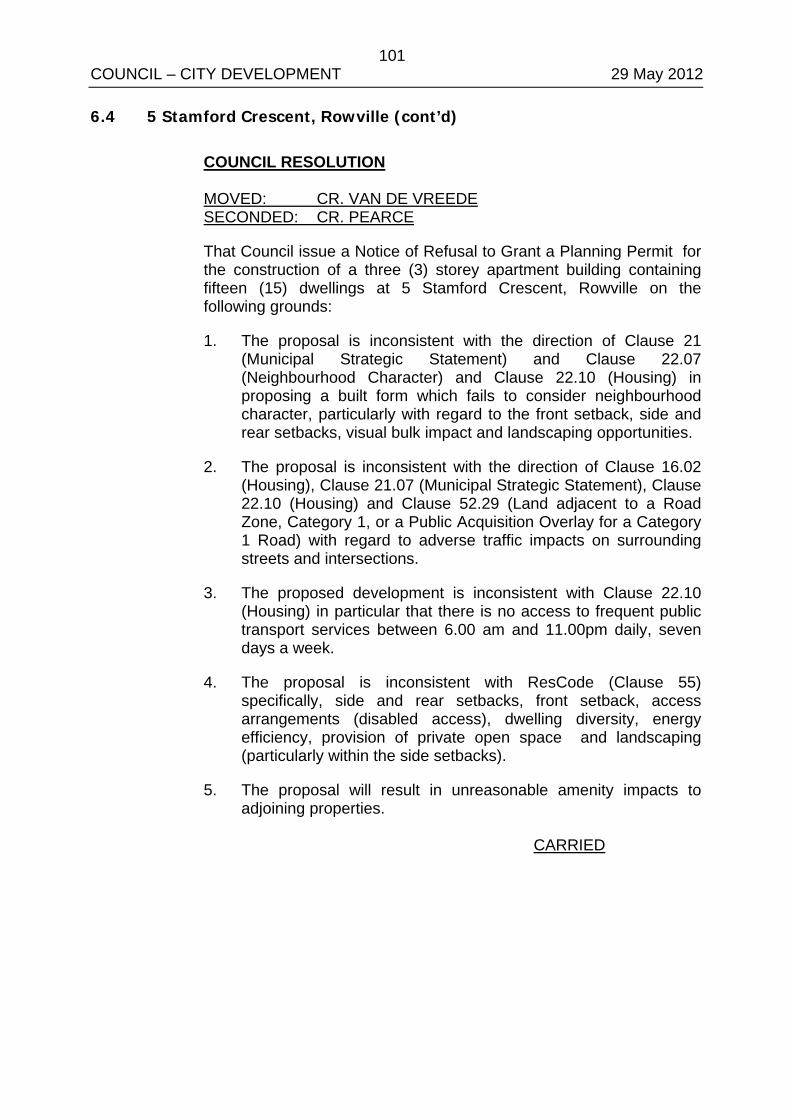
101 COUNCIL – CITY DEVELOPMENT 29 May 2012 6.4 5 Stamford Crescent, Rowville (cont’d)
COUNCIL RESOLUTION MOVED: CR. VAN DE VREEDE SECONDED: CR. PEARCE
That Council issue a Notice of Refusal to Grant a Planning Permit for the construction of a three (3) storey apartment building containing fifteen (15) dwellings at 5 Stamford Crescent, Rowville on the following grounds:
1. The proposal is inconsistent with the direction of Clause 21 (Municipal Strategic Statement) and Clause 22.07 (Neighbourhood Character) and Clause 22.10 (Housing) in proposing a built form which fails to consider neighbourhood character, particularly with regard to the front setback, side and rear setbacks, visual bulk impact and landscaping opportunities.
2. The proposal is inconsistent with the direction of Clause 16.02 (Housing), Clause 21.07 (Municipal Strategic Statement), Clause 22.10 (Housing) and Clause 52.29 (Land adjacent to a Road Zone, Category 1, or a Public Acquisition Overlay for a Category 1 Road) with regard to adverse traffic impacts on surrounding streets and intersections.
3. The proposed development is inconsistent with Clause 22.10 (Housing) in particular that there is no access to frequent public transport services between 6.00 am and 11.00pm daily, seven days a week.
4. The proposal is inconsistent with ResCode (Clause 55) specifically, side and rear setbacks, front setback, access arrangements (disabled access), dwelling diversity, energy efficiency, provision of private open space and landscaping (particularly within the side setbacks).
5. The proposal will result in unreasonable amenity impacts to adjoining properties.
CARRIED

102 COUNCIL – CITY DEVELOPMENT 29 May 2012 APPENDIX A/1

103 COUNCIL – CITY DEVELOPMENT 29 May 2012 APPENDIX A/2

104 COUNCIL – CITY DEVELOPMENT 29 May 2012 APPENDIX B/1

105 COUNCIL – CITY DEVELOPMENT 29 May 2012 APPENDIX B/2

106 COUNCIL – CITY DEVELOPMENT 29 May 2012 APPENDIX B/3

107 COUNCIL – CITY DEVELOPMENT 29 May 2012 APPENDIX B/4

108 COUNCIL – CITY DEVELOPMENT 29 May 2012 APPENDIX B/5

109 COUNCIL – CITY DEVELOPMENT 29 May 2012 APPENDIX B/6

110 COUNCIL – CITY DEVELOPMENT 29 May 2012 APPENDIX B/7

111 COUNCIL – CITY DEVELOPMENT 29 May 2012 APPENDIX B/8
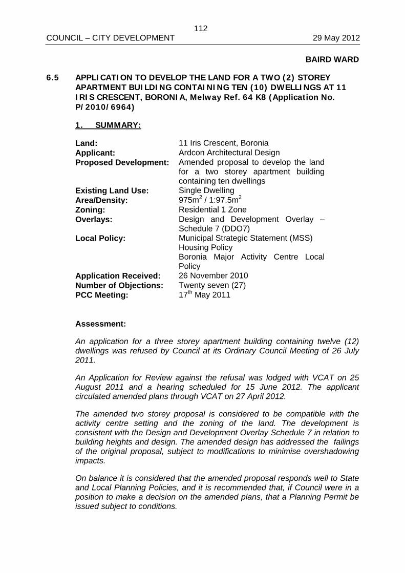
112 COUNCIL – CITY DEVELOPMENT 29 May 2012
BAIRD WARD
6.5 APPLICATION TO DEVELOP THE LAND FOR A TWO (2) STOREY APARTMENT BUILDING CONTAINING TEN (10) DWELLINGS AT 11 IRIS CRESCENT, BORONIA, Melway Ref. 64 K8 (Application No. P/2010/6964)
1. SUMMARY:
Land: 11 Iris Crescent, Boronia Applicant: Ardcon Architectural Design Proposed Development: Amended proposal to develop the land
for a two storey apartment building containing ten dwellings
Existing Land Use: Single Dwelling Area/Density: 975m2 / 1:97.5m2 Zoning: Residential 1 Zone Overlays: Design and Development Overlay –
Schedule 7 (DDO7) Local Policy: Municipal Strategic Statement (MSS)
Housing Policy Boronia Major Activity Centre Local Policy
Application Received: 26 November 2010 Number of Objections: Twenty seven (27) PCC Meeting: 17th May 2011 Assessment:
An application for a three storey apartment building containing twelve (12) dwellings was refused by Council at its Ordinary Council Meeting of 26 July 2011.
An Application for Review against the refusal was lodged with VCAT on 25 August 2011 and a hearing scheduled for 15 June 2012. The applicant circulated amended plans through VCAT on 27 April 2012.
The amended two storey proposal is considered to be compatible with the activity centre setting and the zoning of the land. The development is consistent with the Design and Development Overlay Schedule 7 in relation to building heights and design. The amended design has addressed the failings of the original proposal, subject to modifications to minimise overshadowing impacts.
On balance it is considered that the amended proposal responds well to State and Local Planning Policies, and it is recommended that, if Council were in a position to make a decision on the amended plans, that a Planning Permit be issued subject to conditions.
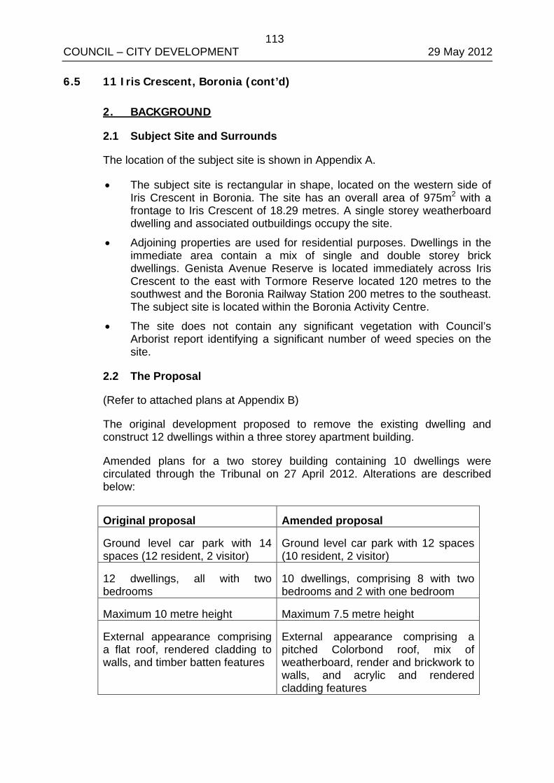
113 COUNCIL – CITY DEVELOPMENT 29 May 2012 6.5 11 Iris Crescent, Boronia (cont’d)
2. BACKGROUND
2.1 Subject Site and Surrounds
The location of the subject site is shown in Appendix A.
• The subject site is rectangular in shape, located on the western side of Iris Crescent in Boronia. The site has an overall area of 975m2 with a frontage to Iris Crescent of 18.29 metres. A single storey weatherboard dwelling and associated outbuildings occupy the site.
• Adjoining properties are used for residential purposes. Dwellings in the immediate area contain a mix of single and double storey brick dwellings. Genista Avenue Reserve is located immediately across Iris Crescent to the east with Tormore Reserve located 120 metres to the southwest and the Boronia Railway Station 200 metres to the southeast. The subject site is located within the Boronia Activity Centre.
• The site does not contain any significant vegetation with Council’s Arborist report identifying a significant number of weed species on the site.
2.2 The Proposal
(Refer to attached plans at Appendix B)
The original development proposed to remove the existing dwelling and construct 12 dwellings within a three storey apartment building.
Amended plans for a two storey building containing 10 dwellings were circulated through the Tribunal on 27 April 2012. Alterations are described below:
Original proposal Amended proposal
Ground level car park with 14 spaces (12 resident, 2 visitor)
Ground level car park with 12 spaces (10 resident, 2 visitor)
12 dwellings, all with two bedrooms
10 dwellings, comprising 8 with two bedrooms and 2 with one bedroom
Maximum 10 metre height Maximum 7.5 metre height
External appearance comprising a flat roof, rendered cladding to walls, and timber batten features
External appearance comprising a pitched Colorbond roof, mix of weatherboard, render and brickwork to walls, and acrylic and rendered cladding features
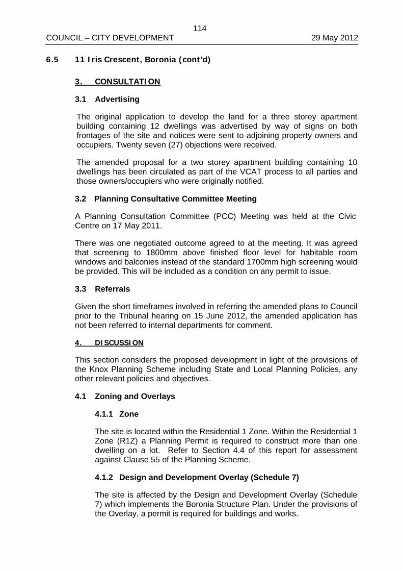
114 COUNCIL – CITY DEVELOPMENT 29 May 2012 6.5 11 Iris Crescent, Boronia (cont’d)
3. CONSULTATION
3.1 Advertising
The original application to develop the land for a three storey apartment building containing 12 dwellings was advertised by way of signs on both frontages of the site and notices were sent to adjoining property owners and occupiers. Twenty seven (27) objections were received.
The amended proposal for a two storey apartment building containing 10 dwellings has been circulated as part of the VCAT process to all parties and those owners/occupiers who were originally notified.
3.2 Planning Consultative Committee Meeting
A Planning Consultation Committee (PCC) Meeting was held at the Civic Centre on 17 May 2011.
There was one negotiated outcome agreed to at the meeting. It was agreed that screening to 1800mm above finished floor level for habitable room windows and balconies instead of the standard 1700mm high screening would be provided. This will be included as a condition on any permit to issue.
3.3 Referrals
Given the short timeframes involved in referring the amended plans to Council prior to the Tribunal hearing on 15 June 2012, the amended application has not been referred to internal departments for comment.
4. DISCUSSION
This section considers the proposed development in light of the provisions of the Knox Planning Scheme including State and Local Planning Policies, any other relevant policies and objectives.
4.1 Zoning and Overlays
4.1.1 Zone
The site is located within the Residential 1 Zone. Within the Residential 1 Zone (R1Z) a Planning Permit is required to construct more than one dwelling on a lot. Refer to Section 4.4 of this report for assessment against Clause 55 of the Planning Scheme.
4.1.2 Design and Development Overlay (Schedule 7)
The site is affected by the Design and Development Overlay (Schedule 7) which implements the Boronia Structure Plan. Under the provisions of the Overlay, a permit is required for buildings and works.
115 COUNCIL – CITY DEVELOPMENT 29 May 2012 6.5 11 Iris Crescent, Boronia (cont’d)
To achieve the design objectives in the Schedule, any proposed development must meet the requirements contained within the Schedule. These include preferred and mandatory building heights, design standards, materials and colours, landscape design and signage.
• The grounds of refusal for the original development cited a failure to meet the design objectives of the Boronia Structure Plan, including a failure to achieve a high level of architectural quality, incorporate ecologically sustainable design principles, provide a transition of building heights, or enable canopy tree planting along all setbacks.
The amended proposal is considered to adequately address these failings and achieve the design objectives of the DDO7.
o The site is located within a maximum building height area of 7.5 metres or 2 storeys. The proposed building at 7.5 metres height complies with the height limits in this area.
o The two storey built form to Iris Crescent ensures a pedestrian scale, complemented with expansive windows and visually interesting design elements such as an articulated roof form, acrylic cladding and mix of weatherboard and brickwork to walls.
o Built form is sufficiently offset from front, side and rear boundaries to allow for canopy tree planting. A landscape plan will be sought as a condition on any permit issued.
o Direct northern solar access is provided to all dwellings, including through the use of highlight windows and skillion roof forms to allow sunlight penetration to southern dwellings.
o An external colour and materials schedule will be sought to ensure that colours identified within the Boronia Structure Plan are utilised.
4.2 Policy Consideration
4.2.1 State Planning Policy Framework
State policy requires Council to integrate the range of policies relevant to the issues to be determined, and balance conflicting objectives in favour of net community benefit and sustainable development.
116 COUNCIL – CITY DEVELOPMENT 29 May 2012 6.5 11 Iris Crescent, Boronia (cont’d)
Key Policies:
Clause 15 Built Environment and Heritage – Encourages high quality architecture and urban design outcomes that reflect the particular characteristics, aspirations and cultural identity of the community; enhances liveability, diversity, amenity and safety of the public realm; and promotes attractiveness of towns and cities within broader strategic contexts.
• The amended development incorporates visually interesting and good quality architecture to the Iris Crescent frontage. A two storey height limit complies with the maximum heights prescribed by the DDO7 and provides a transition to existing residential interfaces.
Clause 15.02 Sustainable Development – Ensure land use and development is consistent with the efficient use of energy and the minimisation of greenhouse gas emissions.
• The proposal integrates ecologically sustainable design principles into the development; for instance, maximising northern solar access to every dwelling and minimising north facing windows. A Sustainable Design Assessment will be included as a condition on any permit issued.
Clause 16 Housing – Encourage the development of well-designed medium-density housing that respects the neighbourhood character; improves housing choice; makes better use of existing infrastructure; and, improves energy efficiency of housing.
• Neighbourhood character – see assessment (at Section 4.1.2 of this report) against the desired future character for the Boronia Structure Plan area as specified by the DDO7.
• Housing choice – providing the option of one and two bedroom dwellings on smaller lots is considered to increase housing choice.
• Existing infrastructure – the site is located within a fully serviced area.
• Energy efficiency – this has been discussed above under Clause 15.02.
• Location – the site is located within the Boronia Major Activity Centre.
117 COUNCIL – CITY DEVELOPMENT 29 May 2012 6.5 11 Iris Crescent, Boronia (cont’d)
Clause 18 Transport – Ensure that access is provided to all available modes of transport.
• The site is located within 250 metres of the Boronia Train Station and bus interchange which is serviced by bus routes No. 737, 753, 691 and 755 bus route along Dorset Road.
• The Boronia Station is part of the Belgrave train line which travels directly through the eastern suburbs to Melbourne’s CBD and operates Monday to Saturday, 4.30am to 1.30am at various intervals and Sunday 6.00am to 12.00 am at various intervals.
• Bus route 737 from Croydon Station via Knox City to Glen Waverley via Monash University operates at various intervals from 6.16am to 9.38pm Monday to Friday with peak times being half hourly. Saturday services run half hourly from 5.55am to 9.35pm. Sunday services operate from half hourly from 8.22am to 9.33pm.
• Route No. 755 Bayswater - Knox City via Basin, Boronia, Ferntree Gully operates between 5:42am and 9:14pm Monday to Friday at approximately 25 minute intervals; between 7:50am and 9:30pm on Saturdays at 60 minute intervals and; between 8:54am and 9pm on Sundays at 60 minute intervals.
• Route No. 753 provides direct access between the Glen Waverley and Bayswater activity centres, and operates between 5:42am and 9:14pm Monday to Friday at approximately 25 minute intervals; between 7:50am and 9:30pm on Saturdays at 60 minute intervals and; between 8:54am and 9pm on Sundays at 60 minute intervals.
• Route No. 691 operates between Waverley Garden Shopping Centre and Boronia Railway Station between 5.47am and 8.21pm Monday to Friday at approximately 30 minute intervals and between 7.26am and 7pm Saturdays and Sundays at 40-60 minute intervals.
4.2.2 Local Planning Policy Framework Clause 21.05-2 Municipal Strategic Statement (MSS) The MSS seeks to reduce the prevalence of infill housing development in dispersed locations as a major form of housing development by promoting activity centres and key redevelopment strategic sites as the preferred location.
• The site is located within an Activity Centre. The MSS further seeks to manage the need for more housing and maintaining the valued qualities of identified areas of environmental and character significance. The MSS supports development that respects the existing or preferred residential neighbourhood character.
118 COUNCIL – CITY DEVELOPMENT 29 May 2012 6.5 11 Iris Crescent, Boronia (cont’d)
• The proposed development is considered to be consistent with the preferred character for the area, as identified by the Boronia Structure Plan and DDO7, which indicates a discretionary height limit of 7.5 metres for this area.
Clause 22.06 Boronia Major Activity Centre Local Policy: This policy seeks to address a lack in availability of a variety of housing types within the Boronia Major Activity Centre, and identifies opportunities for higher density development within the centre to benefit from close proximity to social services and infrastructure. The site is located within a “Dispersed Infill Residential” area within the Land Use Framework Plan. Within this area, it is policy to ensure that infill development in ‘established residential environs’ provides a positive contribution to the local area.
• The proposal will contribute to a variety of housing types within the Activity Centre. The proposal can achieve a design outcome consistent with the DDO7 and ResCode, and will contribute positively to the local area.
Clause 22.10 Housing: Apartment style residential development The Housing Policy at Clause 22.10-1 recognises that the population of Knox will grow by 12,000 persons and 15,000 households to 2030. In response to this forecast, the Housing Policy directs the provision of a diversity of housing types and forms; housing that meets the needs of all groups within the community; accessible housing that is well designed and responsive to the local character and environment; and housing that recognises that the environment and landscape significance of the Dandenong Foothills outweighs the need for urban consolidation in the Foothills. Before deciding on an application, the responsible authority will consider, as appropriate, whether: Where an approved structure plan or urban design framework exists for an activity centre listed above, then the location and design of high and medium density housing is guided by the plan or framework.
• The site is located within the Boronia Activity Centre. As such, any development will be guided by the Boronia Structure Plan and the Design and Development Overlay (Schedule 7). See Section 4.1.2 for this discussion.
119 COUNCIL – CITY DEVELOPMENT 29 May 2012 6.5 11 Iris Crescent, Boronia (cont’d)
The proposed development will contribute to a diversity of housing in Knox.
• The proposed development proposes one and two bedroom dwellings as an option for a smaller household with balcony private open space, which will contribute to a diversity of housing within Knox.
There is access to frequent public transport services between 6.00am and 11.00pm daily, seven days a week.
• The site does not have access to public transport that operates between 6.00am and 11.00pm daily, seven days a week.
The proposed development is consistent with a relevant endorsed structure plan or urban design framework.
• The development at a maximum height of 7.5 metres is consistent with the preferred character and building heights for the area, as directed by the Design and Development Overlay (Schedule 7) which implements the Boronia Structure Plan. Setbacks to boundaries and Iris Crescent will allow for landscaping.
The development site graduates in height from the site boundaries to respect prevailing building height patterns.
• The proposed two storey built form is consistent with the height patterns envisaged in the Boronia Structure Plan and Design and Development Overlay (Schedule 7).
The development and building design response addresses any potential impact on adjoining development where there is a residential interface with respect to amenity, overlooking, overshadowing, height and bulk, views and vistas
• As discussed in Section 4.4, the development is considered to have an unreasonable shadowing impact to neighbouring properties. A condition on any permit to issue will require compliance with ResCode Standard B21 (Overshadowing).
For larger key strategic redevelopment sites, a variety of architectural styles and forms are provided.
• The site has not been identified as a key strategic redevelopment site.
120 COUNCIL – CITY DEVELOPMENT 29 May 2012 6.5 11 Iris Crescent, Boronia (cont’d)
Clause 22.10 Housing: Apartment style residential development
The Housing Policy at Clause 22.10-1 recognises that the population of Knox will grow by 12,000 persons and 15,000 households by 2030.
It is policy that:
The proposed development is consistent with a relevant approved structure plan or urban design framework.
• As discussed at Section 4.1.2, the development is consistent with the design objectives of the DDO7.
Before deciding on an application, the responsible authority will consider, as appropriate, whether:
The proposed housing will contribute to a diversity of housing in Knox.
• The development proposes a mix of one and two bedroom dwellings.
There is access to frequent public transport services between 6.00am and 11.00pm daily, seven days a week.
• The subject site is not located to take advantage of frequent public transport services between 6.00am and 11.00pm daily, seven days a week.
4.3 Clause 55 – Two or More Dwellings on a Lot and Residential Buildings (ResCode)
The proposal generally complies with the provisions of Clause 55 of the Knox Planning Scheme, an assessment of the key criteria; including any areas of non compliance are considered below:
Neighbourhood Character and Infrastructure
Neighbourhood Character – Complies, as discussed at Section 4.1.2.
Residential Policy – Complies, as discussed at Section 4.2.2.
Dwelling diversity – Complies
Infrastructure – Complies
Integration with the Street – Complies
121 COUNCIL – CITY DEVELOPMENT 29 May 2012 6.5 11 Iris Crescent, Boronia (cont’d)
Site Layout and Building Massing
Street Setback – Generally complies.
One of the grounds of refusal for the original proposal was the visual dominance to Iris Crescent, as a result of a reduced front setback and high front fencing forward of the development. The amended design deletes any front fencing forward of the building. The 7.8 metre front setback provides an adequate transition between neighbouring buildings which are setback 12.6 metres and 5 metres from Iris Crescent, and allows for canopy tree planting forward of the building.
Building Height – Complies
Site Coverage – Complies
Permeability – Complies
Energy Efficiency – Complies, subject to modifications on plans to demonstrate how highlight windows to the skillion roof will allow northern solar access to dwellings on the southern side of the upper level. A Sustainable Design Assessment will be included as a condition on any permit issued.
Landscaping – Complies
Access – Complies, subject to minor modifications to the driveway area to be required as conditions of any permit issued.
Parking provision and location – Complies, subject to minor modifications to the car parking area to be required as conditions of any permit issued.
Amenity Impacts
Side and rear setbacks – Complies
Walls on boundaries – Complies
Daylight to existing windows/north facing windows – Complies
Overshadowing open space – Can comply, subject to modification as discussed below.
Existing sunlight to the secluded private open space areas to neighbouring properties at Nos. 2/9 and 3/9 Iris Crescent is less than the requirements of Standard B21, and the Standard states that the amount of sunlight should not be further reduced.
Increased shadowing impact to No. 2/9 Iris Crescent is considered acceptable given the existing impact of fencing and medium height trees and shrubs located along the fence line.
122 COUNCIL – CITY DEVELOPMENT 29 May 2012 6.5 11 Iris Crescent, Boronia (cont’d)
Impact of shadows cast by the proposed building to No. 3/9 Iris Crescent are a concern to Council. A remaining area of approximately 20 m2 of secluded private open space with a minimum width of 3 metres will receive direct sunlight. Given the relatively unfettered access to sunlight currently enjoyed by No. 3/9, it is considered that a significant reduction in sunlight will unreasonably impact on the existing use of the neighbour’s open space. A condition on any permit to issue will require compliance with this Standard.
Overlooking - Complies, subject to minor modifications on any plans approved to show minimum 1.8 metre high screens to the western edge of the balconies to Units 9 and 10.
Internal views – Complies, subject to provision of details of screening to light court areas.
Noise – Complies
On-Site Amenity and Facilities
Daylight to new windows – Complies
Private Open Space – Can comply, subject to the balconies to Units 9 and 10 having a minimum 1.6 metre width.
Solar access – Complies
Storage – Can comply, subject to provision and allocation of at least 6 cubic metres of external storage to each dwelling.
Front fence – N/A
5. CONCLUSION
Clause 11 of the Knox Planning Scheme requires Council to balance relative policy objectives when making decisions to ensure resulting development is sustainable and achieves a net community gain. In this context, the development is inappropriate given the following:
• The development is consistent with State Policy, Clause 21.07 (Municipal Strategic Statement), Clause 22.06 (Boronia Activity Centre) and Clause 22.10 (Housing) of the Knox Planning Scheme.
• The development is generally compliant with ResCode subject to modifications as discussed.
• The development is consistent with the Design and Development Overlay 7 and Boronia Structure Plan.
123 COUNCIL – CITY DEVELOPMENT 29 May 2012 6.5 11 Iris Crescent, Boronia (cont’d)
6. CONFIDENTIALITY
There are no confidentiality issues associated with this report.
RECOMMENDATION
That, if Council were in a position to make a decision on the amended plans, that Council issue a Planning Permit for the development of land for a two storey apartment building containing ten (10) dwellings at 11 Iris Crescent, Boronia, subject to the following conditions to be placed on any permit issued:
Amended Plans
1. Prior to the commencement of any buildings or works, amended plans to the satisfaction of the Responsible Authority must be submitted to and approved by the Responsible Authority. When approved, the plans will be endorsed and will then form part of the permit. The plans must be drawn to scale with dimensions and three copies must be provided. The plans must be generally in accordance with the plans by Ardcon identified as Drawing Nos. 3-6 (all dated March 2012) but modified to show:
1.1 Overshadowing to the secluded private open space to No. 3/9 Iris Crescent in accordance with ResCode Standard B21.
1.2 Turning circles to ensure safe and efficient movements for all vehicle spaces within the car parking area.
1.3 The building and driveway layout altered to allow vehicles to manoeuvre into the minimum 5 metre by 7 metre passing area at the entrance to the site.
1.4 The combined mail/meter box structure setback at least 2.5 metres from the front boundary of the site.
1.5 The southern boundary fence reduced to a maximum 900mm in height for at least the first 2.5 metres from the front boundary of the site.
1.6 Height and location of retaining walls, which must be to the satisfaction of the Responsible Authority. Retaining walls must not obstruct vehicle parking or turning ability.
1.7 Location of columns within the car parking area to comply with AS2890.1 section 5 and/ or a 300mm clearance provided between the column and the side of car parking spaces. Columns must be protected against damage by vehicles.
124 COUNCIL – CITY DEVELOPMENT 29 May 2012 6.5 11 Iris Crescent, Boronia (cont’d)
Recommendation (cont’d)
1.8 Visitor parking spaces to be clearly identified by signage at the entrance to the site and line marking and signage within the car parking area.
1.9 Details of the allocation of parking spaces to individual dwellings.
1.10 Provision of bicycle parking spaces.
1.11 Privacy screens and obscured glazing to habitable room windows and balconies clearly dimensioned as having a minimum 1.8 metre height above finished floor level.
1.12 Sill heights to raised windows clearly dimensioned.
1.13 Screens to the western edge of balconies to Units 9 and 10 raised to a minimum 1.8 metre height.
1.14 Provision of screens to light court areas in accordance with ResCode Standard B23.
1.15 Location of highlight windows to the skillion roof to demonstrate the provision of northern solar access to dwellings on the southern side of the upper level.
1.16 All balconies having a minimum 1.6 metre width.
1.17 Removal of proposed landscape plantings from site and elevation plans to improve the clarity of plans.
1.18 Provision of at least 6 cubic metres of externally accessible, secure storage space to each dwelling. Details of the allocation of storage spaces to dwellings must be shown.
1.19 Drainage plans in accordance with Condition 2.
1.20 Landscaping plans in accordance with Condition 3.
1.21 Sustainable Design Assessment in accordance with Condition 6.
1.22 Waste Management Plan in accordance with Condition 8.
1.23 Any alteration to the basement car park or development as a whole as required by the Waste Management Plan.
125 COUNCIL – CITY DEVELOPMENT 29 May 2012 6.5 11 Iris Crescent, Boronia (cont’d)
Recommendation (cont’d)
1.24 Any alteration to the development, including to retaining walls and soil grades, in accordance with the outcome of tree root investigations required by Condition 9.
1.25 A materials and colours schedule in accordance with Condition 10.
Drainage Plans
2. Prior to the commencement of any buildings or works, three copies of road construction and drainage plans and computations prepared by a qualified Civil Engineering Consultant must be submitted to and approved by the Responsible Authority. Drainage and road construction works on site must be undertaken and completed in accordance with these plans to the satisfaction of the Responsible Authority prior to the occupancy of the buildings. Plans are to show:
2.1 Stormwater drainage runoff shall be properly collected in a complete and effective system of drains and connected to the Council drainage pit outside of 9 Iris Crescent
2.2 The internal drains of the dwellings to be independent of each other.
2.3 An on-site detention system designed by a suitably qualified Civil Engineering Consultant to ensure no net increase in stormwater discharge from the proposed development.
2.4 The on-site detention system to be installed in a suitable location for easy access and maintenance.
2.5 A suitable overland flow path for the entire site to the satisfaction of the Responsible Authority. Details of the overland flow path are to be included on the plans.
2.6 All levels to be to AHD (Australian Height Datum).
To the satisfaction of the Responsible Authority.
Landscape Plans
3. Prior to the commencement of any buildings or works, a landscape plan to the satisfaction of the responsible authority must be submitted to and approved by the responsible authority. The plan must show the following:
126 COUNCIL – CITY DEVELOPMENT 29 May 2012 6.5 11 Iris Crescent, Boronia (cont’d)
Recommendation (cont’d)
3.1 A survey (including botanical names) of all existing vegetation to be retained and / or removed.
3.2 Buildings and trees (including botanical names) on neighbouring properties within three metres of the boundary.
3.3 The identification and removal of all vegetation identified as an environmental weed in Knox (as outlined in Appendix 2 of Council’s Landscape Guidelines for Planning Permits).
3.4 Details of the surface finishes of pathways and driveways.
3.5 A planting schedule of all proposed trees, shrubs and ground covers, including botanical names, common names, pot sizes, sizes at maturity, and quantities of each plant.
3.6 Landscaping and planting within open space areas of dwellings.
3.7 Landscaping and planting within all public areas of the site.
3.8 Application of water sensitive urban design principles. (This may involve selection of appropriate plant species that are drought tolerant and indigenous to the local area).
3.9 Appropriate landscaping to support any selected stormwater quality works depicted on endorsed drainage plans.
3.10 The plans must also show the provision of at least five (5) additional indigenous or native canopy trees and at least 40 additional large shrubs chosen from Appendix 4 or 5 of Council’s Landscape Guidelines for Planning Permits.
3.11 Landscaping and planting should not result in a further reduction in sunlight available to the neighbouring property at No. 3/9 Iris Crescent.
To the satisfaction of the Responsible Authority.
4. Before the occupation of the development, the landscaping works shown on the endorsed plans must be carried out and completed to the satisfaction of the responsible authority.
5. The landscaping shown on the endorsed plan must be maintained to the satisfaction of the Responsible Authority.
127 COUNCIL – CITY DEVELOPMENT 29 May 2012 6.5 11 Iris Crescent, Boronia (cont’d)
Recommendation (cont’d)
Sustainable Design Assessment
6. Prior to the commencement of any buildings or works, a Sustainable Design Assessment detailing Sustainable Design initiatives to be incorporated into the development must be submitted to and approved by the Responsible Authority. The Sustainable Design Assessment must outline the proposed sustainable design initiatives to be incorporated throughout the development such as (but not limited to) energy efficiency, water conservation, stormwater quality, waste management and material selection, to the satisfaction of the Responsible Authority.
7. Prior to the occupation of the development, the development must be constructed in accordance with the Sustainable Design Assessment approved by the Responsible Authority.
Waste Management Plan
8. Before the development commences, a waste collection and management plan must be submitted to and approved by the Responsible Authority, demonstrating how waste storage and collection will be undertaken on site wholly within the confines of the site, including the operation of the garbage and recyclables storage area, to the satisfaction of the Responsible Authority.
Garbage and recyclables storage and collection must be undertaken in accordance with the approved plan/documentation to the satisfaction of the Responsible Authority.
Tree root investigations
9. Prior to the commencement of any buildings or works, the roots of a Lilly Pilly (Acmena Smithii, H: 9m x 8m x 90, 98, 100cms TPZ radius 6.36m, SRZ radius 2.5m, 10% TPZ encroachment radius 4.4m) located on the neighbouring property adjacent to the north west corner of the site, must be located using Air Knife or Hydro Excavation.
Should any significant roots be found, alternative methods of construction may have to be used to the satisfaction of Council’s Arborist. The applicant must contact Council’s Arborist on 9298 8125 when undertaking the investigations.
128 COUNCIL – CITY DEVELOPMENT 29 May 2012 6.5 11 Iris Crescent, Boronia (cont’d)
Recommendation (cont’d)
Materials and Colours
10. Before the development starts, a schedule of materials, external finishes and colours to the satisfaction of the responsible authority must be submitted to and approved by the responsible authority. When approved, the schedule will be endorsed and will then form part of the permit.
General
11. All development must be in accordance with the endorsed plans.
12. The development as shown on the endorsed plans must not be altered without the written consent of the Responsible Authority.
13. Once the development has started it must be continued and completed to the satisfaction of the Responsible Authority.
14. Prior to the occupation of the dwellings the development is to be completed in accordance with the endorsed plan/s to the satisfaction of the Responsible Authority.
15. All walls on the boundaries of adjoining properties must be cleaned and finished to the satisfaction of the Responsible Authority.
Car Parking and Traffic
16. Before the new dwellings are occupied, driveways and car parking areas must be fully constructed in accordance with plans submitted to and approved by the Responsible Authority.
17. Parking areas and driveways must be kept available and maintained for these purposes at all times to the satisfaction of the Responsible Authority.
18. The driveway and carparking areas associated with the proposed dwelling as shown on the endorsed plan must be fully constructed to the minimum standard of 100mm depth of reinforced concrete and properly formed to such levels that they can be used in accordance with the plans. Construction using any alternative hardstanding sealed surface is subject to detailed plans to be submitted to and approved by the Responsible Authority.
19. Redundant vehicle and pram crossovers shall be removed and the footpath, nature strip and kerbing reinstated to the satisfaction of the Responsible Authority.
129 COUNCIL – CITY DEVELOPMENT 29 May 2012 6.5 11 Iris Crescent, Boronia (cont’d)
Recommendation (cont’d)
20. All structures (including letter boxes, landscaping, fencing and meter boxes) should be constructed to a maximum height of 900mm or relocated clear of a splayed area (2 metres x 2.5 metres into site) in accordance with AS 2890.1 Clause 3.2.4.
21. For pedestrian safety, low height or bollard type lighting should be installed along access ways and within the car park in accordance with AS1158.
Stormwater
22. Stormwater runoff from all buildings and hardstanding surfaces shall be properly collected and discharged in a complete and effective system of drains within the property and shall not cause or create a nuisance to abutting properties.
Fencing
23. Prior to the occupancy of the development all fencing shall be in a good condition to the satisfaction of the Responsible Authority.
24. All fencing costs are to be borne by the developer/owner.
Amenity during construction
25. Upon commencement and until conclusion of the development, the developer shall ensure that the development does not adversely affect the amenity of the area in any way, including: 25.1 the appearance of building, works or materials on the land
25.2 parking of motor vehicles
25.3 transporting of materials or goods to or from the site
25.4 hours of construction
25.5 stockpiling of top soil or fill materials
25.6 air borne dust emanating from the site
25.7 noise
25.8 rubbish and litter
25.9 sediment runoff.
130 COUNCIL – CITY DEVELOPMENT 29 May 2012 6.5 11 Iris Crescent, Boronia (cont’d)
Recommendation (cont’d)
Should the development cause undue detriment to the amenity of the area then immediate remedial measures must be undertaken to address the issue as directed by, and to the satisfaction of, the Responsible Authority.
Permit Expiry
26. This permit will expire if one of the following circumstances applies:
26.1 The development is not started within two years of the date of this permit.
26.2 The development is not completed within four years of the date of this permit.
The Responsible Authority may extend the periods referred to if a request is made in writing before the permit expires or within three months afterwards.
NOTES Drainage Notes (to be read in conjunction with the above drainage conditions): • For all Tc and Tso calculations, please contact Council’s Drainage
Department on telephone number 9298 8147. • No structure or trees are to be built over an easement vested in
Council, or any drainage asset not in an easement within the property without Council consent.
• Drainage works in the Road reserve or in the Council easement will require a road opening permit.
• Floor levels are to be designed appropriately and raised above the natural ground surface level to provide protection from any possible flooding, which may occur within the development.
• All utility services (e.g. Drainage, Sewer) are to be verified onsite by Applicant/Developer prior to commencement of any works.
131 COUNCIL – CITY DEVELOPMENT 29 May 2012 6.5 11 Iris Crescent, Boronia (cont’d)
Recommendation (cont’d)
Other Notes: • In accordance with Council policy, an 8.5% public open space
contribution may apply in the event of the subdivision of the land. • Indigenous plants can be purchased through approved indigenous
nurseries, as listed in the Knox City Council 'Preferred Local Replacement Plants' Information Sheet.
• Raised concrete slabs on the existing footpath fronting the site
should be grounded.
COUNCIL RESOLUTION MOVED: CR. COLE SECONDED: CR. MORTIMORE
That, if Council were in a position to make a decision on the amended plans, that Council issue a Planning Permit for the development of land for a two storey apartment building containing ten (10) dwellings at 11 Iris Crescent, Boronia, subject to the following conditions to be placed on any permit issued:
Amended Plans
1. Prior to the commencement of any buildings or works, amended plans to the satisfaction of the Responsible Authority must be submitted to and approved by the Responsible Authority. When approved, the plans will be endorsed and will then form part of the permit. The plans must be drawn to scale with dimensions and three copies must be provided. The plans must be generally in accordance with the plans by Ardcon identified as Drawing Nos. 3-6 (all dated March 2012) but modified to show:
1.1 Overshadowing to the secluded private open space to No. 3/9 Iris Crescent in accordance with ResCode Standard B21.
1.2 Turning circles to ensure safe and efficient movements for all vehicle spaces within the car parking area.
1.3 The building and driveway layout altered to allow vehicles to manoeuvre into the minimum 5 metre by 7 metre passing area at the entrance to the site.
1.4 The combined mail/meter box structure setback at least 2.5 metres from the front boundary of the site.
132 COUNCIL – CITY DEVELOPMENT 29 May 2012 6.5 11 Iris Crescent, Boronia (cont’d)
1.5 Height and location of retaining walls, which must be to the satisfaction of the Responsible Authority. Retaining walls must not obstruct vehicle parking or turning ability.
1.6 Location of columns within the car parking area to comply with AS2890.1 section 5 and/ or a 300mm clearance provided between the column and the side of car parking spaces. Columns must be protected against damage by vehicles.
1.7 Visitor parking spaces to be clearly identified by signage at the entrance to the site and line marking and signage within the car parking area.
1.8 Details of the allocation of parking spaces to individual dwellings.
1.9 Provision of bicycle parking spaces.
1.10 Privacy screens and obscured glazing to habitable room windows and balconies clearly dimensioned as having a minimum 1.8 metre height above finished floor level.
1.11 Sill heights to raised windows clearly dimensioned.
1.12 Screens to the western edge of balconies to Units 9 and 10 raised to a minimum 1.8 metre height.
1.13 Provision of screens to light court areas in accordance with ResCode Standard B23.
1.14 Location of highlight windows to the skillion roof to demonstrate the provision of northern solar access to dwellings on the southern side of the upper level.
1.15 All balconies having a minimum 1.6 metre width.
1.16 Removal of proposed landscape plantings from site and elevation plans to improve the clarity of plans.
1.17 Provision of at least 6 cubic metres of externally accessible, secure storage space to each dwelling. Details of the allocation of storage spaces to dwellings must be shown.
1.18 Drainage plans in accordance with Condition 2.
1.19 Landscaping plans in accordance with Condition 3.
1.20 Sustainable Design Assessment in accordance with Condition 6.

133 COUNCIL – CITY DEVELOPMENT 29 May 2012 6.5 11 Iris Crescent, Boronia (cont’d)
1.21 Waste Management Plan in accordance with Condition 8.
1.22 Any alteration to the basement car park or development as a whole as required by the Waste Management Plan.
1.23 Any alteration to the development, including to retaining walls and soil grades, in accordance with the outcome of tree root investigations required by Condition 9.
1.24 A materials and colours schedule in accordance with Condition 10.
Drainage Plans
2. Prior to the commencement of any buildings or works, three copies of road construction and drainage plans and computations prepared by a qualified Civil Engineering Consultant must be submitted to and approved by the Responsible Authority. Drainage and road construction works on site must be undertaken and completed in accordance with these plans to the satisfaction of the Responsible Authority prior to the occupancy of the buildings. Plans are to show:
2.1 Stormwater drainage runoff shall be properly collected in a complete and effective system of drains and connected to the Council drainage pit outside of 9 Iris Crescent
2.2 The internal drains of the dwellings to be independent of each other.
2.3 An on-site detention system designed by a suitably qualified Civil Engineering Consultant to ensure no net increase in stormwater discharge from the proposed development.
2.4 The on-site detention system to be installed in a suitable location for easy access and maintenance.
2.5 A suitable overland flow path for the entire site to the satisfaction of the Responsible Authority. Details of the overland flow path are to be included on the plans.
2.6 All levels to be to AHD (Australian Height Datum).
To the satisfaction of the Responsible Authority.
134 COUNCIL – CITY DEVELOPMENT 29 May 2012 6.5 11 Iris Crescent, Boronia (cont’d)
Landscape Plans
3. Prior to the commencement of any buildings or works, a landscape plan to the satisfaction of the responsible authority must be submitted to and approved by the responsible authority. The plan must show the following:
3.1 A survey (including botanical names) of all existing vegetation to be retained and / or removed.
3.2 Buildings and trees (including botanical names) on neighbouring properties within three metres of the boundary.
3.3 The identification and removal of all vegetation identified as an environmental weed in Knox (as outlined in Appendix 2 of Council’s Landscape Guidelines for Planning Permits).
3.4 Details of the surface finishes of pathways and driveways.
3.5 A planting schedule of all proposed trees, shrubs and ground covers, including botanical names, common names, pot sizes, sizes at maturity, and quantities of each plant.
3.6 Landscaping and planting within open space areas of dwellings.
3.7 Landscaping and planting within all public areas of the site.
3.8 Application of water sensitive urban design principles. (This may involve selection of appropriate plant species that are drought tolerant and indigenous to the local area).
3.9 Appropriate landscaping to support any selected stormwater quality works depicted on endorsed drainage plans.
3.10 The plans must also show the provision of at least five (5) additional indigenous or native canopy trees and at least 40 additional large shrubs chosen from Appendix 4 or 5 of Council’s Landscape Guidelines for Planning Permits.
3.11 Landscaping and planting should not result in a further reduction in sunlight available to the neighbouring property at No. 3/9 Iris Crescent.
To the satisfaction of the Responsible Authority.
135 COUNCIL – CITY DEVELOPMENT 29 May 2012 6.5 11 Iris Crescent, Boronia (cont’d)
4. Before the occupation of the development, the landscaping works shown on the endorsed plans must be carried out and completed to the satisfaction of the responsible authority.
5. The landscaping shown on the endorsed plan must be maintained to the satisfaction of the Responsible Authority.
Sustainable Design Assessment
6. Prior to the commencement of any buildings or works, a Sustainable Design Assessment detailing Sustainable Design initiatives to be incorporated into the development must be submitted to and approved by the Responsible Authority. The Sustainable Design Assessment must outline the proposed sustainable design initiatives to be incorporated throughout the development such as (but not limited to) energy efficiency, water conservation, stormwater quality, waste management and material selection, to the satisfaction of the Responsible Authority.
7. Prior to the occupation of the development, the development must be constructed in accordance with the Sustainable Design Assessment approved by the Responsible Authority.
Waste Management Plan
8. Before the development commences, a waste collection and management plan must be submitted to and approved by the Responsible Authority, demonstrating how waste storage and collection will be undertaken on site wholly within the confines of the site, including the operation of the garbage and recyclables storage area, to the satisfaction of the Responsible Authority.
Garbage and recyclables storage and collection must be undertaken in accordance with the approved plan/documentation to the satisfaction of the Responsible Authority.
Tree root investigations
9. Prior to the commencement of any buildings or works, the roots of a Lilly Pilly (Acmena Smithii, H: 9m x 8m x 90, 98, 100cms TPZ radius 6.36m, SRZ radius 2.5m, 10% TPZ encroachment radius 4.4m) located on the neighbouring property adjacent to the north west corner of the site, must be located using Air Knife or Hydro Excavation.
Should any significant roots be found, alternative methods of construction may have to be used to the satisfaction of Council’s Arborist. The applicant must contact Council’s Arborist on 9298 8125 when undertaking the investigations.
136 COUNCIL – CITY DEVELOPMENT 29 May 2012 6.5 11 Iris Crescent, Boronia (cont’d)
Materials and Colours
10. Before the development starts, a schedule of materials, external finishes and colours to the satisfaction of the responsible authority must be submitted to and approved by the responsible authority. When approved, the schedule will be endorsed and will then form part of the permit.
General
11. All development must be in accordance with the endorsed plans.
12. The development as shown on the endorsed plans must not be altered without the written consent of the Responsible Authority.
13. Once the development has started it must be continued and completed to the satisfaction of the Responsible Authority.
14. Prior to the occupation of the dwellings the development is to be completed in accordance with the endorsed plan/s to the satisfaction of the Responsible Authority.
15. All walls on the boundaries of adjoining properties must be cleaned and finished to the satisfaction of the Responsible Authority.
Car Parking and Traffic
16. Before the new dwellings are occupied, driveways and car parking areas must be fully constructed in accordance with plans submitted to and approved by the Responsible Authority.
17. Parking areas and driveways must be kept available and maintained for these purposes at all times to the satisfaction of the Responsible Authority.
18. The driveway and carparking areas associated with the proposed dwelling as shown on the endorsed plan must be fully constructed to the minimum standard of 100mm depth of reinforced concrete and properly formed to such levels that they can be used in accordance with the plans. Construction using any alternative hardstanding sealed surface is subject to detailed plans to be submitted to and approved by the Responsible Authority.
19. Redundant vehicle and pram crossovers shall be removed and the footpath, nature strip and kerbing reinstated to the satisfaction of the Responsible Authority.
137 COUNCIL – CITY DEVELOPMENT 29 May 2012 6.5 11 Iris Crescent, Boronia (cont’d)
20. All structures (including letter boxes, landscaping, fencing and meter boxes) should be constructed to a maximum height of 900mm or relocated clear of a splayed area (2 metres x 2.5 metres into site) in accordance with AS 2890.1 Clause 3.2.4.
21. For pedestrian safety, low height or bollard type lighting should be installed along access ways and within the car park in accordance with AS1158.
Stormwater
22. Stormwater runoff from all buildings and hardstanding surfaces shall be properly collected and discharged in a complete and effective system of drains within the property and shall not cause or create a nuisance to abutting properties.
Fencing
23. Prior to the occupancy of the development all fencing shall be in a good condition to the satisfaction of the Responsible Authority.
24. All fencing costs are to be borne by the developer/owner.
Amenity during construction
25. Upon commencement and until conclusion of the development, the developer shall ensure that the development does not adversely affect the amenity of the area in any way, including: 25.1 the appearance of building, works or materials on the land 25.2 parking of motor vehicles 25.3 transporting of materials or goods to or from the site 25.4 hours of construction 25.5 stockpiling of top soil or fill materials 25.6 air borne dust emanating from the site 25.7 noise 25.8 rubbish and litter 25.9 sediment runoff.
Should the development cause undue detriment to the amenity of the area then immediate remedial measures must be undertaken to address the issue as directed by, and to the satisfaction of, the Responsible Authority.
138 COUNCIL – CITY DEVELOPMENT 29 May 2012 6.5 11 Iris Crescent, Boronia (cont’d)
Permit Expiry
26. This permit will expire if one of the following circumstances applies: 26.1 The development is not started within two years of the
date of this permit. 26.2 The development is not completed within four years of the
date of this permit. The Responsible Authority may extend the periods referred to if
a request is made in writing before the permit expires or within three months afterwards.
NOTES
Drainage Notes (to be read in conjunction with the above drainage conditions):
• For all Tc and Tso calculations, please contact Council’s Drainage Department on telephone number 9298 8147.
• No structure or trees are to be built over an easement vested in Council, or any drainage asset not in an easement within the property without Council consent.
• Drainage works in the Road reserve or in the Council easement will require a road opening permit.
• Floor levels are to be designed appropriately and raised above the natural ground surface level to provide protection from any possible flooding, which may occur within the development.
• All utility services (e.g. Drainage, Sewer) are to be verified onsite by Applicant/Developer prior to commencement of any works.
Other Notes:
• In accordance with Council policy, an 8.5% public open space contribution may apply in the event of the subdivision of the land.
• Indigenous plants can be purchased through approved indigenous nurseries, as listed in the Knox City Council 'Preferred Local Replacement Plants' Information Sheet.
• Raised concrete slabs on the existing footpath fronting the site should be grounded.
CARRIED

139 COUNCIL – CITY DEVELOPMENT 29 May 2012 APPENDIX A/1

140 COUNCIL – CITY DEVELOPMENT 29 May 2012 APPENDIX A/2

141 COUNCIL – CITY DEVELOPMENT 29 May 2012 APPENDIX B/1

142 COUNCIL – CITY DEVELOPMENT 29 May 2012 APPENDIX B/2

143 COUNCIL – CITY DEVELOPMENT 29 May 2012 APPENDIX B/3

144 COUNCIL – CITY DEVELOPMENT 29 May 2012 APPENDIX B/4

145 COUNCIL – CITY DEVELOPMENT 29 May 2012 APPENDIX B/5

146 COUNCIL – CITY DEVELOPMENT 29 May 2012 APPENDIX B/6

147 COUNCIL – CITY DEVELOPMENT 29 May 2012 APPENDIX B/7
148 COUNCIL – CITY DEVELOPMENT 29 May 2012
BAIRD WARD
6.6 APPLICATION TO DEVELOP THE LAND FOR A THREE STOREY APARTMENT BUILDING CONTAINING SIXTEEN (16) DWELLINGS AND ASSOCIATED CAR PARKING AT 11 TULIP CRESCENT, BORONIA, Melway Ref. 64 J10 (Application No. P2011/6563)
1. SUMMARY:
Land: 11 Tulip Crescent Boronia Applicant: Peter Brown Architects Pty Ltd Proposed Development: Development of a three storey
apartment building containing sixteen (16) dwellings and associated car parking
Existing Land Use: Single Dwelling Area/Density: 976m2 / 1:61m2 Zoning: Residential 1 Zone Overlays: Design and Development Overlay
(Schedule 7) Local Policy: Municipal Strategic Statement
Boronia Major Activity Centre Policy Housing Policy
Application Received: 22 July 2011 Number of Objections: 19 PCC Meeting: 21 February 2012 Assessment:
The subject site is located within the Boronia Structure Plan area as identified in the Knox Planning Scheme and defined in the Design and Development Overlay Schedule 7.
The proposal generally complies with the Residential 1 Zone, Municipal Strategic Statement and Housing Policy. Subject to modifications, the proposal will comply with ResCode.
The proposal will achieve an outcome consistent with the Design and Development Overlay Schedule 7.
On balance it is considered that the proposal responds well to State and Local Planning Policies, subject to modifications. It is recommended that Council issue a Notice of Decision to Grant a Planning Permit subject to conditions.
149 COUNCIL – CITY DEVELOPMENT 29 May 2012 6.6 11 Tulip Crescent, Boronia (cont’d)
2. BACKGROUND
2.1 Subject Site and Surrounds
The location of the subject site is shown in Appendix A.
• The subject site is located on the eastern side of Tulip Crescent, approximately 165 metres south of Boronia Road. The site has an overall area of 976m2 with a fall of approximately 1 metre from west to east. The land is developed with a single storey weatherboard dwelling and various outbuildings. Vehicle access is gained on the northern side.
• The surrounding area is characterised by single and double storey dwellings with multi-dwelling developments common in the surrounding area. Front setbacks vary with a variety of lawn, shrubs and trees within front and rear gardens.
• The site contains mature vegetation including a Queensland Brush Box and Lilly Pilly within the front setback, a Native Frangipani and Crimson Bottlebrush within the rear yard, as well as smaller shrubs and weed species. There are no trees within the nature strip.
2.2 The Proposal
(Refer to attached plans at Appendix B)
The applicant proposes to construct a three storey apartment building containing sixteen (16) dwellings with a semi-basement generally in accordance with the plans submitted on 21 November 2011. Details are as follows:
• The applicant submitted modified plans on 21 November 2011. The amended plans reduce the height of the building from a maximum of 9.65 metres to a maximum of 8.98 metres. No other changes were made.
• The existing dwelling is to be removed. A new crossover at 5.5 metres wide located on the southern boundary will lead to the semi-basement which will accommodate 20 car spaces including 3 visitor spaces. Also located within the basement will be a lift, staircases, bin enclosure and storage. Secure pedestrian access is provided via a small foyer.
• The building does not exceed 9 metres in height. On the ground floor will be a two-bedroom apartment, the first floor will contain eight (8) two-bedroom apartments, the second floor will contain five (5) one-bedroom apartments and two (2) one-bedroom apartments. Each apartment also provides living areas, kitchen, bathroom and laundry with balconies.
150 COUNCIL – CITY DEVELOPMENT 29 May 2012 6.6 11 Tulip Crescent, Boronia (cont’d)
• The building style is contemporary with a variety of materials and finishes including concrete with render, aluminium window frames, glass balaustrading and natural timber.
• The Queensland Brush Box and Lilly Pilly are shown to be retained within the front setback. All other existing vegetation is to be removed.
3. CONSULTATION
3.1 Advertising
The application was advertised by way of a sign on the site and notices were sent to adjoining property owners and occupiers. Nineteen (19) objections have been received and can be summarised as follows:
Inconsistent with neighbourhood character of the street
• The proposed built form is consistent with Council’s preferred neighbourhood character for this area, as detailed in the Design and Development Overlay (Schedule 7) for the Boronia Major Activity Centre. Council policy supports increased residential density within the Boronia Major Activity Centre.
• The height, density and bulk of the proposed development are consistent with the future development anticipated within the Boronia Structure Plan.
Overdevelopment
• The development capacity of the site is determined by compliance with the relevant Council policies and compliance with ResCode. The assessment of the application has demonstrated that the proposal complies with Council policies and ResCode objectives, therefore the proposal is not considered to be an overdevelopment of the land.
Safety
• The proposal is not expected to create any safety concerns. The development is secure, provides surveillance of the street and all vehicles will be able to exit in a forward direction from the basement.
Overlooking
• There is potential for overlooking to the residential properties to the north and south. A condition on any permit to issue can require details of all screening measures to ensure compliance with Clause 55.04-6 (Overlooking objective) of the Knox Planning Scheme (screening to a minimum height of 1.7 metres from finished floor level in accordance with ResCode). This is discussed in more detail at Section 4.3 of the report.
151 COUNCIL – CITY DEVELOPMENT 29 May 2012 6.6 11 Tulip Crescent, Boronia (cont’d)
Traffic and parking congestion / inadequate parking spaces
• The proposal provides car parking in accordance with ResCode, with a total of 19 spaces (one space for each one and two bedroom dwelling), including three (3) visitor parking spaces. Therefore the number of car parking spaces provided complies with ResCode.
• While there will be an increase in traffic generated, Tulip Crescent has capacity to absorb this additional traffic. Council’s Traffic Engineer’s have not raised any concern with traffic generation on Tulip Crescent or any connecting road as a result of this proposal.
Pedestrian / traffic safety
• The proposal is not expected to create any safety concerns. The development is secure, provides surveillance of the street and all vehicles will be able to exit in a forwards direction from the car parking area.
Increased residential noise
• There is nothing to suggest that this development, if constructed, will create any more noise to adjoining properties other than that normally encountered within a residential context.
Waste management
• A Waste Management Plan will be a requirement of any permit to issue, to detail the private collection of waste from the site.
Impact on views
• There are no rights to a view, particularly when reliant on private property to provide that view. Also, there are no specific controls within the Knox Planning Scheme that would apply protect a view reliant on private property.
Impact on property values
• This is not a valid planning consideration.
Impact on infrastructure and potential flooding
• Council’s Drainage Engineer has not raised any concern with overland flow or flooding issues. A standard condition on any permit to issue will require an Engineering Plan to detail the engineering requirements to ensure that stormwater runoff is detained to peak pre-development flows.
152 COUNCIL – CITY DEVELOPMENT 29 May 2012 6.6 11 Tulip Crescent, Boronia (cont’d)
Adverse social impacts
• The type of housing proposed will contribute to a housing diversity within Boronia and the wider municipality of Knox, consistent with the Boronia Structure Plan and Knox Housing Policy.
• There is no evidence to suggest that this type of housing would directly lead to adverse social impacts.
Removal of vegetation
• The existing vegetation within the property is not significant. A landscape plan to show suitable canopy tree planting would be a requirement of any permit to issue.
Amenity during construction
• There will be an increase in noise during construction, however this is a temporary disturbance and regulated by the EPA. Also Council’s standard amenity during construction condition will be included on any permit to issue.
The amended plans lodged on 21 November 2011 were not advertised, as the modifications were considered minor and would not increase detriment to any person.
3.2 Planning Consultative Committee Meeting
A Planning Consultation Committee (PCC) Meeting was held at the Civic Centre on 21 February 2012. Objectors expressed the following main concerns with the proposal (no additional concerns were raised during the meeting):
• Neighbourhood character and height.
• Density
• Traffic and parking congestion.
• Infrastructure impacts and flooding
• Impact on vegetation
• Overlooking
• Waste collection and bin enclosure
153 COUNCIL – CITY DEVELOPMENT 29 May 2012 6.6 11 Tulip Crescent, Boronia (cont’d)
A negotiated outcome was reached in relation to overlooking and the bin enclosure. The applicant agreed to review the screening treatments to habitable room windows and balconies within the development to ensure that long-range views were protected, specifically within the rear yard of 14 Stonehaven Avenue, and the bin enclosure can be vented into the car park. This is included in the recommended conditions.
There were no other negotiated outcomes or changes to the application as a result of the meeting.
3.3 Referrals
The application has been referred to internal departments for comment. No objection has been raised; the following is a summary of relevant advice:
Traffic Engineer
• Standard conditions to be included on any permit issued.
Drainage Engineer
• Standard conditions to be included on any permit issued.
Arborist
• None of the vegetation on the subject site is significant.
• Exploratory works are required to locate the roots of trees on adjoining properties, including the Fraxinus oxycarpa on the north boundary, the English Oak on the south boundary and the Eucalyptus botryoides on the south boundary to determine what impact the proposed excavation may have on the health and structure of the trees. Of particular concern is the large English Oak along the southern boundary. The exploratory works should be carried out using an Air knife or Hydro-excavation and the trench must be as deep as the proposed depth of the excavation.
Officer Response: The applicant has submitted plans to demonstrate that the first and second floor footprint can be modified to accommodate the canopy of the English Oak. This can be reflected as a condition in any permit to issue.
Discussions between Council’s Arborist, the Planning Officer and the applicant have confirmed that it is possible to locate the proposed crossover/driveway at least 1 metre from the southern boundary. In addition the driveway can be constructed at grade with minimal excavation and by bridging the driveway; a trench and irrigation system can be installed. Root investigation works will still be required to determine the maximum excavation and location of the trenching. This can be a condition on any permit issued.
The applicant has provided a letter from the adjoining owner consenting to the removal of the Fraxinus oxycarpa.
154 COUNCIL – CITY DEVELOPMENT 29 May 2012 6.6 11 Tulip Crescent, Boronia (cont’d)
Strategic and Economic Development
• The proposal is consistent with the strategic intent of the site and will contribute positively to the diversity of housing types and sizes in Knox.
Waste Management Department
• A condition on any permit issued will require an amended Waste Management Plan to increase the recyclables allowance to the Council’s standard allocation of 120L recyclables allowance per week per tenement.
4. DISCUSSION
This section considers the proposed development in light of the provisions of the Knox Planning Scheme including State and Local Planning Policies, any other relevant policies and objectives.
4.1 Zoning and Overlays
4.1.1 Zone
The site is located within the Residential 1 Zone. Within the Residential 1 Zone (R1Z) a planning permit is required to construct more than one dwelling on a lot.
4.1.2 Design and Development Overlay (Schedule 7)
The site is affected by the Design and Development Overlay (Schedule 7) which implements the Boronia Structure Plan. Under the provisions of the Overlay, a permit is required for buildings and works.
To achieve the design objectives in the Schedule, any proposed development must meet the requirements contained within the Schedule. These include preferred and mandatory building heights, design standards, materials and colours, landscape design and signage.
• The site is located within a mandatory 9 metre (three storey) maximum building height area. The proposal for a three (3) storey building with a maximum height of 8.98 metres complies with the maximum building height.
• The proposed three (3) storey built form and therefore scale of the building is consistent with the design standards in the Schedule.
• Materials and colours have been nominated that would reinforce the emerging contemporary natural character of the area.
155 COUNCIL – CITY DEVELOPMENT 29 May 2012 6.6 11 Tulip Crescent, Boronia (cont’d)
• There are opportunities for planting within the front setback and along the boundaries of the site. A landscape plan to the satisfaction of the Responsible Authority would be a requirement of any permit to issue, and also subject to minimum replanting requirements.
4.2 Policy Consideration
4.2.1 State Planning Policy Framework
State policy requires Council to integrate the range of policies relevant to the issues to be determined, and balance conflicting objectives in favour of net community benefit and sustainable development.
Key Policies: Clause 15 Built Environment and Heritage – Encourages high quality architecture and urban design outcomes that reflect the particular characteristics, aspirations and cultural identity of the community; enhances liveability, diversity, amenity and safety of the public realm; and promotes attractiveness of towns and cities within broader strategic contexts.
• The design of the development will not dominate the streetscape or adjoining properties. The three storey built form and height is consistent with maximum 9 metre mandatory height limit in the Design and Development Overlay (Schedule 7). There are areas for planting and landscaping, complimentary colours and materials are proposed and the building will incorporate sustainable design features.
Clause 15.02 Sustainable Development – Ensure land use and development is consistent with the efficient use of energy and the minimisation of greenhouse gas emissions.
• The density of the development contributes to the consolidation of urban development being located within reasonable distance to urban services and transport. A Sustainable Design Assessment would be a requirement of any permit to issue.
Clause 16 Housing – Encourage the development of well-designed medium-density housing that respects the neighbourhood character; improves housing choice; makes better use of existing infrastructure; and, improves energy efficiency of housing. Locate new housing in or close to activity centres and employment corridors and at other strategic development sites that offer good access to services and transport.
156 COUNCIL – CITY DEVELOPMENT 29 May 2012 6.6 11 Tulip Crescent, Boronia (cont’d)
• Neighbourhood character - this is discussed in a later section of the report (Section 4.2.2).
• Housing choice – The proposed development provides a different form of housing to that provided in the area and provides the option of dwellings on smaller lots which will contribute to housing choice.
• Existing infrastructure – the site is located within a fully serviced area.
• Energy efficiency – this has been discussed above under Clause 15.02.
• Location – The site is located within the Boronia Major Activity Centre.
Clause 18 Transport – Ensure that access is provided to all available modes of transport.
• The site is located within walking distance of bus stops on Boronia Road, which is serviced by Bus Routes No. 745B, 737 and 753.
• Route No. 745B from Bayswater to Boronia operates two services between 2.45pm and 6.40pm Monday to Friday.
• Route No. 737 from Croydon to Monash University via Boronia, Knox City Shopping Centre and Glen Waverley operates between 6.14am and 10.04pm Monday to Friday at 25 minute intervals. Saturday services run every 45 minutes from 6.30am to 10.21pm. Sunday services operate every 45 minutes from 8.41am to 10.02pm.
• Route No. 753 from Glen Waverley to Boronia Station via Knoxfield operates at various intervals from 6.23am to 9.03pm Monday to Friday with peak times being every 15 minutes. Saturday services run hourly from 7.51am to 4.19pm. Sunday services operate hourly from 8.51am to 5.48pm.
• Additionally, the site is within 800 metres of Boronia Railway Station and bus interchange, providing further connection to the municipality and Melbourne.
157 COUNCIL – CITY DEVELOPMENT 29 May 2012 6.6 11 Tulip Crescent, Boronia (cont’d)
4.2.2 Local Planning Policy Framework Clause 21.05-2 Municipal Strategic Statement (MSS) The MSS seeks to reduce the prevalence of infill housing development in dispersed locations as a major form of housing development by promoting activity centres and key redevelopment strategic sites as the preferred location.
• The site is located in a Major Activity Centre. The MSS further seeks to manage the need for more housing and maintaining the valued qualities of identified areas of environmental and character significance. The MSS supports development that respects the existing or preferred residential neighbourhood character.
• The proposed development is considered to be consistent with the preferred future character for the area, as determined by the Boronia Structure Plan and the Design and Development Overlay (Schedule 7) which indicates a mandatory maximum height limit of 9 metres for this area.
Clause 22.06 Boronia Major Activity Centre Local Policy: This policy seeks to address a lack in availability of a variety of housing types within the Boronia Major Activity Centre, and identifies opportunities for higher density development within the centre to benefit from close proximity to social services and infrastructure. The site is located within a “Dispersed Infill Residential” area within the Land Use Framework Plan. Within this area, it is policy to ensure that infill development in ‘established residential environs’ provides a positive contribution to the local area.
• The proposal will contribute to the availability of a variety of housing types within the Activity Centre and will achieve a design outcome consistent with the Design and Development Overlay (Schedule 7) and ResCode, and therefore will contribute positively to the local area.
Clause 22.10 Housing: The Housing Policy at Clause 22.10-1 recognises that the population of Knox will grow by 12,000 persons and 15,000 households to 2030. In response to this forecast, the Housing Policy directs the provision of a diversity of housing types and forms; housing that meets the needs of all groups within the community; accessible housing that is well designed and responsive to the local character and environment; and housing that recognises that the environment and landscape significance of the Dandenong Foothills outweighs the need for urban consolidation in the Foothills.
158 COUNCIL – CITY DEVELOPMENT 29 May 2012 6.6 11 Tulip Crescent, Boronia (cont’d)
Before deciding on an application, the responsible authority will consider, as appropriate, whether: Where an approved structure plan or urban design framework exists for an activity centre listed above, then the location and design of high and medium density housing is guided by the plan or framework.
• The site is located within the Boronia Activity Centre. As such, any development will be guided by the Boronia Structure Plan and the Design and Development Overlay (Schedule 7). See Section 4.1.2 for this discussion.
The proposed development will contribute to a diversity of housing in Knox.
• The proposed development proposes one and two bedroom dwellings as an option for a smaller household with balcony private open space, which will contribute to a diversity of housing within Knox.
There is access to frequent public transport services between 6.00am and 11.00pm daily, seven days a week.
• The site does not have access to public transport that operates between 6.00am and 11.00pm daily, seven days a week.
The proposed development is consistent with a relevant endorsed structure plan or urban design framework.
• The development, at a maximum height of 8.98 metres, is considered to be consistent with the preferred character and building heights for the area, as directed by the Design and Development Overlay (Schedule 7) which implements the Boronia Structure Plan. Setbacks to boundaries and Tulip Crescent will allow for landscaping.
The development site graduates in height from the site boundaries to respect prevailing building height patterns.
• The proposed three (3) storey built form is consistent with the height patterns envisaged in the Boronia Structure Plan and Design and Development Overlay (Schedule 7).
159 COUNCIL – CITY DEVELOPMENT 29 May 2012 6.6 11 Tulip Crescent, Boronia (cont’d)
The development and building design response addresses any potential impact on adjoining development where there is a residential interface with respect to amenity, overlooking, overshadowing, height and bulk, views and vistas
• The proposed development is generally compliant in terms of overlooking and overshadowing.
• The strategic direction of the Boronia Activity Centre Policy to promote higher density within the Activity Centre area will result in redevelopment of a height and bulk that is uncharacteristic when compared to existing residential development. It is expected that there will be an impact as a result of this change to the amenity of adjoining properties. A proposal that incorporates a variety of colours and materials and articulation of the built form, as the current proposal has, will limit the impact of the height and bulk of a design to ensure that any impact is reasonable within an area that has been identified for significant change.
For larger key strategic redevelopment sites, a variety of architectural styles and forms are provided.
• The site has not been identified as a key strategic redevelopment site.
4.3 Clause 55 – Two or More Dwellings on a Lot and Residential Buildings (ResCode)
The proposal generally complies with the provisions of Clause 55 of the Knox Planning Scheme, an assessment of the key criteria; including any areas of non-compliance are considered below:
Neighbourhood Character and Infrastructure
Neighbourhood Character – Complies, refer to Section 4.2.3 above.
Site Layout and Building Massing
Street Setback – Does not comply with Standard, however complies with the objective. The minimum front setback to Tulip Crescent to comply with the Standard would be 7.1 metres. The proposal is for a minimum front setback of 5 metres. Considering the site’s location within the Boronia Activity Centre and balancing Council policy encouraging re-development within this area, the proposed front setback is considered appropriate. Also, there is opportunity for canopy tree planting within the front setback and the three storey built form will not be incongruous with the preferred neighbourhood character detailed in the Boronia Structure Plan. As such, it is considered that the proposed minimum front setback of 5 metres will ensure an outcome consistent with the outcomes to be achieved in the Boronia Structure Plan.
160 COUNCIL – CITY DEVELOPMENT 29 May 2012 6.6 11 Tulip Crescent, Boronia (cont’d)
Building Height – Complies.
Site Coverage – Does not comply with the Standard however meets the objective. The total site coverage proposed is 69%, which exceeds the maximum site coverage by 9% (the Standard requires a maximum of 60%). The minor increase in total site coverage is considered acceptable. The site’s location within the Boronia Structure Plan Area and strategic direction for higher density development supports this minor increase in site coverage.
Permeability – Complies.
Energy Efficiency – Complies, a condition on any permit issued will require the submission of a Sustainable Design Assessment to the satisfaction of the Responsible Authority.
Open Space – Complies.
Safety – Complies.
Landscaping – Complies, a condition on any permit issued will require that appropriate landscape plans are submitted to the satisfaction of the Responsible Authority.
Access – Complies.
Parking Provision and Location – Complies.
Amenity Impacts
Side and rear setbacks – Complies.
Walls on boundaries – Complies.
Daylight to existing windows/north facing windows – Complies.
North-facing Windows – Complies.
Overshadowing open space – Complies.
Overlooking – Can comply subject to conditions. A condition on any permit will require details of all screening measures to ensure compliance with Clause 55.04-6 (Overlooking objective) of the Knox Planning Scheme (screening to a minimum height of 1.7 metres from finished floor level in accordance with ResCode) to be shown. This would apply to any external window screens and planter boxes.
The existing 1.6 metre high paling fence along the southern and northern boundaries is to be replaced with a 2.1 metre high paling fence to limit overlooking from the ground floor areas.
161 COUNCIL – CITY DEVELOPMENT 29 May 2012 6.6 11 Tulip Crescent, Boronia (cont’d)
Internal views – Complies.
Noise Impacts – Complies.
On-Site Amenity and Facilities
Accessibility – Complies.
Daylight to new windows – Complies.
Private Open Space – Complies.
Solar access – Complies.
Storage – Complies.
Detailed Design
Design Detail – Complies.
Common Property – Complies.
Site Services – Complies.
Front fence – Complies.
5. CONCLUSION
Clause 11 of the Knox Planning Scheme requires Council to balance relative policy objectives when making decisions to ensure resulting development is sustainable and achieves a net community gain. In this context, the development is appropriate given the following:
• The proposed development is consistent with Clause 15 (Built
Environment and Heritage), Clause 21.07 (Municipal Strategic Statement) and Clause 22.10 (Housing) of the Knox Planning Scheme.
• The built form and height of the proposed development is consistent with the intent of the Boronia Structure Plan and Design and Development Overlay (Schedule 7).
• The proposed development is consistent with the Housing Policy. As discussed above, the overall design of the development is considered to be consistent with key design objectives of the Boronia Structure Plan and therefore considered to be consistent with Clause 22.10 of the Knox Planning Scheme.
• The development demonstrates compliance with ResCode (Clause 55 of the Knox Planning Scheme) and is consistent the purpose and objectives of the Residential 1 Zone.
162 COUNCIL – CITY DEVELOPMENT 29 May 2012 6.6 11 Tulip Crescent, Boronia (cont’d)
6. CONFIDENTIALITY
There are no confidentiality issues associated with this report.
RECOMMENDATION
That Council issue a Notice of Decision to Grant a Planning Permit to develop the land for the development of a three storey apartment building containing sixteen (16) dwellings and associated car parking at 11 Tulip Crescent, Boronia, subject to the following conditions:
Amended plans
1. Prior to the commencement of any buildings or works, or certification of any plans, amended plans to the satisfaction of the Responsible Authority must be submitted to and approved by the Responsible Authority. When approved, the plans will be endorsed and will then form part of the permit. The plans must be drawn to scale with dimensions and three copies must be provided. The plans must be generally in accordance with the plans submitted on 21 November 2011 but modified to show:
1.1 For pedestrian safety, on-site access lighting shall be provided to the satisfaction of the relevant authority and in accordance with AS:1158.
1.2 Letterboxes and all other structures (including meter boxes) shall be constructed to a maximum height of 900mm or relocated clear of a splayed area (2m x 2.5m) in accordance with AS2890.1, Clause 3.2.4 to ensure safe sight distances.
1.3 The bin enclosure to be vented into the car parking area. There must be no vents toward the properties on the southern side.
1.4 Details of all measures to ensure compliance with Clause 55.04-6 (Overlooking objective) in the Knox Planning Scheme (overlooking from habitable room windows and balconies to be measured from 1.7 metres above finished floor levels).
1.5 The northern and southern boundary fence replaced with a new timber paling fence with a minimum height of 2.1 metres.
1.6 That part of the Tree Protection Zone extending within the subject site for the Quercus robur, and Eucalyptus botrioydes located within the neighbouring properties.
163 COUNCIL – CITY DEVELOPMENT 29 May 2012 6.6 11 Tulip Crescent, Boronia (cont’d)
Recommendation (cont’d)
1.7 The driveway to be re-located at least 1 metre from the southern boundary (the width of the driveway can be reduced to 5 metres). The 1 metre setback to the southern boundary is to form part of the landscaping.
1.8 Root investigation works to be carried out for the Quercus robur in accordance with Condition 6 of this Permit to determine the following:
1.8.1 Maximum excavation depth and area of excavation for the driveway.
1.8.2 Details of trenching and irrigation systems underneath the driveway including maximum depth of any trenching to be shown.
1.8.3 Details of bridging structures and materials for the driveway to be shown.
1.9 The footprint and layout of Dwelling 9 and Dwelling 16 amended as depicted in plans DD02 and DD03 dated 05.04.12.
1.10 Drainage plans in accordance with Condition 2 of this Permit.
1.11 Landscaping plans as described in Condition 3 of this Permit.
1.12 An amended Waste Management Plan in accordance with Condition 9 of this Permit.
1.13 A Sustainable Deign Assessment in accordance with Condition 7 of this Permit.
1.14 A materials and colours schedule in accordance with Condition 11 of this Permit.
To the satisfaction of the Responsible Authority.
Drainage plans
2. Prior to commencement of any buildings or works, three copies of drainage plans and computations must be submitted to and approved by the Responsible Authority. Construction of the drainage is to be in accordance with these plans. The plans must show the following:
164 COUNCIL – CITY DEVELOPMENT 29 May 2012 6.6 11 Tulip Crescent, Boronia (cont’d)
Recommendation (cont’d)
2.1 All stormwater drainage discharge from the site connected to a legal point of discharge.
2.2 The internal drains of the dwellings to be independent of each other.
2.3 An on-site detention system designed by a suitably qualified Civil Engineering Consultant to ensure no net increase in stormwater discharge from the proposed development.
2.4 The on-site detention system to be installed in a suitable location for easy access and maintenance.
2.5 All levels to be to AHD (Australian Height Datum).
To the satisfaction of the Responsible Authority.
Landscape plans
3. Prior to the commencement of any buildings or works, a landscape plan to the satisfaction of the responsible authority must be submitted to and approved by the responsible authority. When approved, the plan will be endorsed and will then form part of the permit. The plan must show:
3.1 A survey (including botanical names, height and width) of all existing vegetation to be retained and / or removed.
3.2 The identification and removal of all vegetation identified as an environmental weed in Knox (as outlined in Appendix 2 of Council’s Landscape Guidelines for Planning Permits).
3.3 Buildings and trees (including botanical names, height and width) on neighbouring properties within three metres of the boundary.
3.4 Details of the surface finishes of pathways and driveways.
3.5 Details and location of all existing and proposed services including above and below ground lines, cables and pipes.
3.6 A planting schedule of all proposed trees, shrubs and ground covers, including botanical names, common names, pot sizes, sizes at maturity, and quantities of each plant.
3.7 Landscaping and planting within all open areas of the site (including additional planting within open space areas of the existing dwelling/s).
165 COUNCIL – CITY DEVELOPMENT 29 May 2012 6.6 11 Tulip Crescent, Boronia (cont’d)
Recommendation (cont’d)
3.8 Details of the driveway construction and irrigation system.
To the satisfaction of the Responsible Authority.
4. Before the occupation of the development, the landscaping works shown on the endorsed plans must be carried out and completed to the satisfaction of the responsible authority.
5. The landscaping shown on the endorsed plan must be maintained to the satisfaction of the Responsible Authority.
Tree Root Investigations
6. Air knife, hydro-excavation or hand digging by spade shall be used to verify the location of roots of the Quercus robur to determine: the depth of any excavation for the driveway; location and depth of any trenching and irrigation system; location and depth of any proposed footings, bridging or foundations where applicable for the driveway or building structure. Council’s Arborist must be contacted on 9298 8125 to enable inspection of the root investigation work.
Sustainable Design Assessment
7. Prior to the commencement of any buildings or works, a Sustainable Design Assessment detailing Sustainable Design initiatives to be incorporated into the development must be submitted to and approved by the Responsible Authority. The Sustainable Design Assessment must outline the proposed sustainable design initiatives to be incorporated throughout the development such as (but not limited to) energy efficiency, water conservation, stormwater quality, waste management and material selection, to the satisfaction of the Responsible Authority.
8. Prior to the occupation of the development, the development must be constructed in accordance with the Sustainable Design Assessment.
Waste Management Plan
9. Before the development commences, an amended waste collection and management plan must be submitted to and approved by the Responsible Authority, demonstrating how waste collection will be undertaken on site, including the operation of the garbage and recyclables storage area. The amended plan must provide for an allocation of 120L recyclables allowance per week per tenement.
166 COUNCIL – CITY DEVELOPMENT 29 May 2012 6.6 11 Tulip Crescent, Boronia (cont’d)
Recommendation (cont’d)
10. Garbage and recyclables storage and collection must be undertaken in accordance with the approved plan/documentation, and must be undertaken by a private contractor, to the satisfaction of the Responsible Authority.
Council will not collect waste from the proposed development.
Materials and Colours
11. Before the development starts, a schedule of materials, external finishes and colours to the satisfaction of the responsible authority must be submitted to and approved by the responsible authority. When approved, the schedule will be endorsed and will then form part of the permit.
Fencing
12. Prior to the occupancy of the development all fencing shall be in a good condition to the satisfaction of the Responsible Authority.
13. All fencing costs are to be borne by the developer/owner.
Car parking and Traffic
14. Before the new dwellings are occupied, driveways and car parking areas must be fully constructed in accordance with plans submitted to and approved by the Responsible Authority.
15. The driveway and carparking areas associated with the proposed dwelling as shown on the endorsed plan must be fully constructed and properly formed to such levels that they can be used in accordance with the plans. Construction using any alternative hardstanding sealed surface is subject to detailed plans to be submitted to and approved by the Responsible Authority.
16. The vehicle crossing must incorporate the existing Council drain in the road reserve to the satisfaction of the Responsible Authority.
17. Any redundant crossovers must be removed and reinstated with kerb and channel to the satisfaction of the Responsible Authority.
General
18. All development must be in accordance with the endorsed plans.
19. The development as shown on the endorsed plans must not be altered without the written consent of the Responsible Authority.
167 COUNCIL – CITY DEVELOPMENT 29 May 2012 6.6 11 Tulip Crescent, Boronia (cont’d)
Recommendation (cont’d)
20. Once the development has started it must be continued and completed to the satisfaction of the Responsible Authority.
21. Prior to the occupation of the dwellings the development is to be completed in accordance with the endorsed plan/s to the satisfaction of the Responsible Authority.
22. Walls on the boundaries of adjoining properties must be cleaned and finished to the satisfaction of the Responsible Authority.
Tree Protection
23. All works, including excavation, within the critical root zone areas of the tree/s to be retained and other critical root zones on the land must be undertaken under the supervision of a qualified Arborist to ensure that there is no unreasonable damage to the root system of trees to be retained and/or protected, to the satisfaction of the Responsible Authority. Before the development starts, the owner must submit to the Responsible Authority details of the name of the Arborist who will supervise the works and the tasks to be undertaken by the Arborist, to the satisfaction of the Responsible Authority.
24. Prior to any works commencing on the site, all trees and vegetation to be retained including other critical root zones must be fenced off to create a protection zone. The protection zone must extend around the trees canopy drip-line unless an alternative tree protection zone has been approved by the responsible authority.
25. The fence is to be chain link or wire mesh, comprise either wooden or steel posts set into the ground or on concrete pads, and be a minimum height of 1.4 metres. Signage is to be affixed to the fence advising that the area is a tree protection zone and a no-go development area.
26. The fence and signage is to be maintained throughout the construction period and removed at the completion of all works.
27. No temporary removal of the fence or encroachment into the protection zone is permitted without the written consent of the responsible authority.
168 COUNCIL – CITY DEVELOPMENT 29 May 2012 6.6 11 Tulip Crescent, Boronia (cont’d)
Recommendation (cont’d)
28. Prior to erecting the fence around the tree protection zone, all unwanted vegetation and weed species must be removed from within the zone, and the ground within the protection zone must be covered with a layer of well composted organic mulch (maximum 100mm depth). The area is to be watered at least fortnightly throughout the construction period.
29. The following activities are prohibited from the tree protection area, without the written consent of the responsible authority:
• Construction activities.
• Dumping and/or storage of materials, goods and/or soil.
• Trenching or excavation.
• Lopping branches, nailing or affixing signs, service lines, lights etc to the trees.
30. Prior to any works commencing on site, the Responsible Authority must be contacted to inspect the Tree Protection fencing.
Amenity
31. Upon commencement and until conclusion of the development, the developer shall ensure that the development does not adversely affect the amenity of the area in any way, including: 31.1 The appearance of building, works or materials on the land 31.2 Parking of motor vehicles 31.3 Transporting of materials or goods to or from the site 31.4 Hours of operation 31.5 Stockpiling of top soil or fill materials 31.6 Air borne dust emanating from the site 31.7 Noise 31.8 Rubbish and litter 31.9 Sediment runoff
Should the development cause undue detriment to the amenity of the area then immediate remedial measures must be undertaken to address the issue as directed by, and to the satisfaction of, the Responsible Authority.
169 COUNCIL – CITY DEVELOPMENT 29 May 2012 6.6 11 Tulip Crescent, Boronia (cont’d)
Recommendation (cont’d)
Permit Expiry
32. This permit will expire if one of the following circumstances applies:
32.1 The development is not started within two years of the date of this permit.
32.2 The development is not completed within four years of the date of this permit.
The Responsible Authority may extend the periods referred to if a request is made in writing before the permit expires or within three months afterwards.
NOTES:
Drainage Notes (to be read in conjunction with the above drainage conditions):
• Applicant shall engage a certified Engineering Consultant to analyse the site’s existing drainage to determine type and size of the Onsite Detention (OSD) system. This shall be designed in accordance with the Knox City Council (Responsible Authority) Stormwater Drainage Guidelines, (copy available on request), and approved drainage design methods specified in the current edition of Australian Rainfall and Runoff. It should be located preferably in a common area to the dwellings, and be easily accessible for maintenance.
• The total Permissible Site Discharge for the property including all dwellings is 3L/s to the existing Council drainage system for a 5 year ARI event.
• Tc = 50 minutes; Tso = 14 minutes
• Applicant is to direct all stormwater to the Council Pit in the rear of the property as this represents the Legal Point of Discharge (LPD) for the property. Applicant is to verify this on site. Connect all stormwater discharge from the site to the LPD via an Onsite Detention (OSD) system. The internal drains for the dwellings are to be independent of each other.
• The Applicant is required to use Australian Height Datum (AHD) to present levels in all future plans. Applicant must ensure that levels on the plan are accurate.
170 COUNCIL – CITY DEVELOPMENT 29 May 2012 6.6 11 Tulip Crescent, Boronia (cont’d)
Recommendation (cont’d)
• Drainage works in the Road reserve or in the Council easement will require a road opening permit.
• Drainage system designed so as to avoid impact on any vegetation shown on the endorsed plans as being retained.
• Water Sensitive Urban Design (WSUD) should be addressed as part of this development, eg water storage tanks, swale drains, etc.
Other Notes:
• Council encourages the consideration of water storage tanks for all existing and proposed residential developments.
• A building permit must be obtained before development is commenced.
• Buildings are not allowed to be built over Council easements.
• The dwelling/s must achieve a minimum 6-Star Energy Rating.
• In accordance with Council policy, an 8.5% public open space contribution may apply in the event of the subdivision of the land.
• To arrange an inspection of the Tree Protection fencing please contact Council Landscape Team on 9298 8125.
• Indigenous plants can be purchased through approved indigenous nurseries, as listed in the Knox City Council 'Preferred Local Replacement Plants' Information Sheet.
• A minimum of 80% of all new vegetation (both canopy trees and understorey) should be indigenous species.
• Dwelling numbers as shown on the endorsed plans do not necessarily indicate any future street numbers. Property (street) numbering shall be in accordance with Council’s Property (Street) Numbering Policy. Information regarding this can be obtained from Council’s Property and Revenue Services Department on 9298 8215.
171 COUNCIL – CITY DEVELOPMENT 29 May 2012 6.6 11 Tulip Crescent, Boronia (cont’d)
Recommendation (cont’d)
• Letterboxes and all other structures (including meter boxes) shall be constructed to a maximum height of 900mm or relocated clear of a splayed area (2m x 2.5m) in accordance with AS2890.1, Clause 3.2.4 to ensure safe sight distances. Letterboxes shall face towards the street frontage.
• Internal public lighting shall be provided to the satisfaction of the relevant authority and in accordance with AS1158. This would generally be low height or bollard type lighting to avoid spill-over into adjacent properties. It may be sensor activated, to avoid all night running costs.
• Raised concrete slabs on the existing footpath fronting the site should be grounded.
• All litter and rubbish associated with the construction must be contained on site at all times.
COUNCIL RESOLUTION MOVED: CR. COLE SECONDED: CR. COSSARI That the recommendation be adopted. CARRIED

172 COUNCIL – CITY DEVELOPMENT 29 May 2012 APPENDIX A/1

173 COUNCIL – CITY DEVELOPMENT 29 May 2012 APPENDIX A/2

174 COUNCIL – CITY DEVELOPMENT 29 May 2012 APPENDIX B/1

175 COUNCIL – CITY DEVELOPMENT 29 May 2012 APPENDIX B/2

176 COUNCIL – CITY DEVELOPMENT 29 May 2012 APPENDIX B/3

177 COUNCIL – CITY DEVELOPMENT 29 May 2012 APPENDIX B/4

178 COUNCIL – CITY DEVELOPMENT 29 May 2012 APPENDIX B/5
179 COUNCIL – CITY DEVELOPMENT 29 May 2012
CHANDLER WARD
6.7 APPLICATION TO DEVELOP THE LAND FOR A TWO STOREY APARTMENT BUILDING CONTAINING SEVENTEEN (17) DWELLINGS, BASEMENT CAR PARKING AND VEGETATION REMOVAL AT 8 BAMBURY STREET, BORONIA, Melway Ref. 65 B8 (Application No. P/2011/6688)
1. SUMMARY:
Land: 8 Bambury Street, Boronia Applicant: Peter Brown Architects Pty Ltd Proposed Development: Development of the land for a two
storey apartment building containing seventeen (17) dwellings, basement car parking and vegetation removal.
Existing Land Use: Single Dwelling Area/Density: 1021m2/1:60m2 Zoning: Residential 1 Zone Overlays: Design and Development Overlay
(Schedule 7) Vegetation Protection Overlay (Schedule 3) Significant Landscape Overlay (Schedule 2)
Local Policy: Municipal Strategic Statement Boronia Major Activity Centre Policy Dandenong Foothills Policy Housing Policy
Application Received: 2 September 2011 Number of Objections: 34 PCC Meeting: 21 February 2012
The subject site is located within the Boronia Structure Plan area as identified in the Knox Planning Scheme and defined in the Design and Development Overlay Schedule 7.
The proposal generally complies with the Residential 1 Zone, Municipal Strategic Statement, Dandenong Foothills Policy and Housing Policy. Subject to modifications, the proposal will comply with ResCode.
The proposal will achieve an outcome consistent with the Design and Development Overlay Schedule 7.
On balance it is considered that the proposal responds well to State and Local Planning Policies, subject to modifications. It is recommended that Council issue a Notice of Decision to Grant a Planning Permit subject to conditions.
180 COUNCIL – CITY DEVELOPMENT 29 May 2012 6.7 8 Bambury Street, Boronia (cont’d)
2. BACKGROUND
2.1 Subject Site and Surrounds
The location of the subject site is shown in Appendix A.
• The subject site is located on the southern side of Bambury Street in Boronia. The site is rectangular in shape with a frontage to Bambury Street of 17.83 metres and an overall area of 1021m2. The property comprises a single storey weatherboard dwelling with associated outbuildings. The site slopes approximately 4 metres from the south to the northern frontage. A single crossover on the western side leads to a detached carport.
• The site adjoins residential properties to north, west and east and Boronia Primary School to the south (rear). Dwellings in the immediate area are single storey and of brick and weatherboard construction. The subject site is located within Boronia Activity Centre, with the nearest shops, railway station and bus interchange located approximately 630m to the south west.
• The site contains maturing vegetation including a Eucalyptus obliqua (Messmate Stringybark) and a Eucalyptus goniocalyx (Long leaf Bundy) within the rear yard, as well as smaller shrubs and weed species. There are two street trees within the nature strip, a Melaleuca lanceolata (Black Tea-tree) and a Callistemon viminalis (Weeping Bottlebrush).
2.2 The Proposal
(Refer to attached plans at Appendix B)
The application proposes to construct 17 dwellings within a two-storey apartment building with basement car parking and vegetation removal generally in accordance with the plans submitted on 21 November 2011. Details are as follows:
• Four dwellings containing one bedroom and thirteen dwellings containing two bedrooms. All dwellings are provided with amenities, kitchen, an open plan living/meals area and a balcony. A communal north facing terrace of 30m2 for residents is provided on the northwest side of the building.
• A basement car park, accessed via a new double crossover in the northeast corner of the site, provides 17 car spaces for residents, 3 spaces for visitors, bicycle parking, waste and residential storage.
181 COUNCIL – CITY DEVELOPMENT 29 May 2012 6.7 8 Bambury Street, Boronia (cont’d)
• The building has a maximum height of 7.5 metres. The building style is contemporary with a variety of materials and finishes including textured rendered walls, weatherboard panelling, aluminium window frames and timber cladding to the balconies.
• All vegetation is proposed to be removed from the site.
3. CONSULTATION
3.1 Advertising
The application was advertised by way of a sign onsite and notices were sent to adjoining property owners and occupiers. Thirty-four (34) objections have been received and can be summarised as follows:
Overshadowing of adjoining properties
• Overshadowing is within reasonable limits and complies with ResCode Standard B21.
Overlooking of adjoining properties
• Conditions of any permit issued will address overlooking issues. Please refer to Section 4.4 of this report for further discussion.
Vegetation removal and opportunities for landscaping
• The proposed vegetation removal has been assessed by Council’s Arborist and found to be reasonable given the replacement canopy planting proposed.
• The landscaping buffer along the west boundary and south boundary is sufficient to protect the neighbours’ vegetation.
• A condition of any permit issued will require the front setback to be increased to 7.5m, which will result in additional landscaping opportunities, contributing to the character of the area.
Setback from Bambury Street
• An assessment of the proposed front setback to Bambury Street is made at Section 4.3 of this report.
182 COUNCIL – CITY DEVELOPMENT 29 May 2012 6.7 8 Bambury Street, Boronia (cont’d)
Neighbourhood Character
• The subject site is located within the Boronia Structure Plan, which is a Major Activity Centre currently undergoing land use and built form change. The Boronia Structure Plan nominates building heights of up to 7.5 metres (2 Storey) for the site and surrounding area. In accordance with the Boronia Structure Plan, the development does not exceed the maximum height of 7.5 metres. The proposed development, subject to modifications, represents an appropriate transition from adjacent single storey developments. Further, the site is very well located in respect to local services and facilities and located within walking distance of an activity centre where there is strategic support for more intensive development as underpinned by Clause 22.10.
Overdevelopment
• Subject to modifications to increase the front and side setbacks and provide visual interest the western elevation, the proposal generally complies with the relevant provisions of Clause 55 (ResCode). This is an indication that the proposal is not an overdevelopment of the land.
Car Parking and traffic impacts
• Car parking has been provided at ratios consistent with ResCode Standard B16, and therefore provision of parking, is considered to be adequately catered for in the proposed design. The proposed development will not cause an unreasonable increase in traffic flows within the local street network. Further, the site is located within 600 metres of the Boronia Railway Station and approximately 350 metres from Albert Avenue, which provides public transport options for both residents and visitors.
Waste Collection
• Council’s Waste Department requires that a Waste Management Plan for private waste collection be submitted and approved by the Responsible Authority as a condition on any permit issued.
Flooding
• Conditions on any permit issued will ensure the site is adequately drained so as not to put any additional pressure on the existing system. Provision of sewerage and electrical infrastructure must be to the satisfaction of the relevant authorities.
183 COUNCIL – CITY DEVELOPMENT 29 May 2012 6.7 8 Bambury Street, Boronia (cont’d)
Landscaping
• Modifications to the design are required to increase landscaping opportunities along the front setback facing Bambury Street. Further, Council’s Arborist has identified that the site does not contain any significant vegetation. A landscaping plan will be a condition on any permit issued.
Devaluation of Properties
• Devaluation of properties is not a planning consideration.
Increase in noise and pollution
• Any increase in noise will be residential in nature and is not expected to be unreasonable.
Basement Excavation
• Excavation of the basement will be addressed by the relevant Building Surveyor at the building permit stage.
May be used for public housing
• Although not a planning consideration, it is worth noting that Council policies seek to encourage a diversity of housing styles, types, forms and sizes to cater for the changing needs of the community, including the provision of social housing
Boronia Structure Plan/Significant Landscape Overlay 2
• An assessment of the proposal against the Boronia Structure Plan/Significant Landscape Overlay is provided at Section 4.1.3 and 4.2.2 of this report.
Pedestrian / traffic safety
• The proposal is not expected to create any unreasonable safety issues. The development is secure, provides surveillance of the street and all vehicles will be able to exit in a forwards direction from the car parking area.
3.2 Planning Consultative Committee Meeting
A Planning Consultation Committee (PCC) Meeting was held at the Civic Centre on Tuesday 21 February 2012 to discuss the proposal to develop the land for a two storey apartment building containing 17 dwellings, basement car parking and vegetation removal. Objectors expressed the following main concerns with the proposal:
184 COUNCIL – CITY DEVELOPMENT 29 May 2012 6.7 8 Bambury Street, Boronia (cont’d)
Traffic • Existing traffic congestion in surrounding streets • Potential increase in traffic, congestion and on street car parking • Waste collection from the site • Number of car spaces provided; visitor parking; • Traffic safety Design and layout • Density of Development; • Built form out of character; height and views; • Inconsistent with neighbourhood character; • Overshadowing of adjoining properties • Overlooking of adjoining properties • Existing flooding issues and impact of development on existing drainage
system. Other • Increase in noise and pollution • Basement excavation • Devaluation of properties • May be used for public housing; • Removal of trees and habitat; • Boronia Structure Plan/Significant Landscape Overlay 2 • Loss of family home environment;
A negotiated outcome was reached in relation to landscaping and drainage. The applicant agreed to use native plants in any landscaping and to use a drainage retention system, including water tanks. The applicant also circulated an alternative street facade with colours and materials more sympathetic to the landscape. This is included in the recommended conditions.
There were no other negotiated outcomes or changes to the application as a result of the meeting.
3.3 Referrals
The application has been referred to internal departments for comment. No objection has been raised; the following is a summary of relevant advice: Strategic and Economic Development
• The proposal is consistent with this requirement and the strategic intent of the Boronia Structure Plan.
185 COUNCIL – CITY DEVELOPMENT 29 May 2012 6.7 8 Bambury Street, Boronia (cont’d)
Traffic Engineer
• The grades of the driveway abutting the footpath shall be a maximum of 1 in 20 for the first 6m within the property boundary.
• Standard conditions to be included on any permit issued. Drainage Engineer
• Standard conditions to be included on any permit issued.
Arborist
• The proposed development and excavation for the basement car park does not allow the retention of any of the vegetation on the subject site. No objection to the removal of the existing vegetation and replacement planting subject to a condition requiring the submission of a landscaping plan to the satisfaction of the Responsible Authority.
• The landscaping buffer along the west boundary and boundary is sufficient to protect the neighbours’ vegetation.
Waste Management
• Provision of a Waste Management Plan must be a condition on any permit issued.
ESD Officer
• A Sustainable Design Assessment must be a condition on any permit issued.
4. DISCUSSION
This section considers the proposed development in light of the provisions of the Knox Planning Scheme including State and Local Planning Policies, any other relevant policies and objectives.
4.1 Zoning and Overlays
4.1.1 Zone
The site is located within the Residential 1 Zone. Within the Residential 1 Zone (R1Z) a planning permit is required to construct more than one dwelling on a lot.
186 COUNCIL – CITY DEVELOPMENT 29 May 2012 6.7 8 Bambury Street, Boronia (cont’d)
4.1.2 Vegetation Protection Overlay (Schedule 3)
The VPO3 seeks to preserve remnant overstorey native vegetation and requires the issue of a permit for the removal of large native trees greater than 8 metres in height and with a trunk diameter of 300mm or more.
• The proposed development and excavation for the basement car park does not allow the retention of any of the vegetation on the subject site. Of the trees proposed to be removed, the Long-leaved Box (Eucalyptus goniocalyx) and the Messmate (Eucalyptus obliqua) located along the southern (rear) boundary triggers the need for a planning permit under the VPO3. The Pittosporum undulatum located in the front setback also triggers the need for a planning permit under the VPO3.
• Council’s Arborist has noted that the Eucalyptus goniocalyx grows on a lean towards the north with several dead and broken branches evident. The tree has developed a typical rangy growth form. The tree is considered as having a moderate retention value. The Eucalyptus obliqua bifurcates at ground level and wounds occur on the bole of the tree. The tree is considered as having low retention value. The Pittosporum undulatum is considered an environmental weed and therefore should be removed.
• Although the proposal does not allow for the retention of the trees outlined above, specifically the Eucalyptus goniocalyx which has a moderate retention value, the proposal will provide significant canopy tree planting opportunities to the frontage subject to a condition on any permit issued to increase the front setback to 7.5m to support further provision of canopy trees and other vegetation. The removal of the two indigenous trees, Eucalyptus goniocalyx and Eucalyptus obliqua attracts a net gain offset. This will be addressed as a condition on any permit issued.
4.1.3 Significant Landscape Overlay (Schedule 2)
The site is located within the Significant Landscape Overlay 2 (SLO2) relating to the Dandenong Foothills: Foothills Backdrop and Ridgeline Area. Within the SLO2, a planning permit is required to construct a building and to carry out works to remove, destroy or lop a tree if the circumference of the trunk is more than 0.5 metre or the height of the tree is 5 metres or more. This does not apply to weed species listed in the schedule.
187 COUNCIL – CITY DEVELOPMENT 29 May 2012 6.7 8 Bambury Street, Boronia (cont’d)
• Of the trees proposed to be removed, the Eucalyptus goniocalyx and the Eucalyptus obliqua located within the rear setback, require a planning permit for their removal under the SLO3.
• Council’s Arborist has advised that these trees are either of moderate or low significance. A condition on any permit issued will require a landscaping plan to be submitted to the satisfaction of the Responsible Authority.
• The proposed building and works are considered to be consistent with the decision guidelines of the SLO2. The development at a height of 7.5 metres will not impact upon views to the Dandenongs and will not penetrate above the tree canopy. A condition on any permit issued will require a materials and colours schedule indicating the use of non reflective materials and colours in muted tones.
4.1.4 Design and Development Overlay (Schedule 7)
The site is affected by the Design and Development Overlay (Schedule 7) which implements the Boronia Structure Plan. Under the provisions of the Overlay, a permit is required for buildings and works.
To achieve the design objectives in the Schedule, any proposed development must meet the requirements contained within the Schedule. These include preferred and mandatory building heights, design standards, materials and colours, landscape design and signage.
• The site is located within a preferred building height area of 7.5
metres or two (2) storeys. The proposed building height does not exceed 7.5 metres and therefore complies with the height standard in the schedule.
• Materials and colours have been nominated that would reinforce the emerging contemporary natural character of the area.
• Although the elevations have been designed to provide a level of interest through the use of contrast, texture and colours, further consideration is required with regards to the western elevation.
• There are opportunities for planting along the front and rear setbacks and throughout the development subject to an increased front setback which will allow additional canopy trees and shrubs to reinforce the Dandenong Foothills setting. A landscape plan to the satisfaction of the Responsible Authority will be a requirement of any permit issued.
188 COUNCIL – CITY DEVELOPMENT 29 May 2012 6.7 8 Bambury Street, Boronia (cont’d)
4.2 Policy Consideration
4.2.1 State Planning Policy Framework
State policy requires Council to integrate the range of policies relevant to the issues to be determined, and balance conflicting objectives in favour of net community benefit and sustainable development.
Key Policies: Clause 15 Built Environment and Heritage – Encourages high quality architecture and urban design outcomes that reflect the particular characteristics, aspirations and cultural identity of the community; enhances liveability, diversity, amenity and safety of the public realm; and promotes attractiveness of towns and cities within broader strategic contexts.
• The design of the development will make a positive contribution to the streetscape and, subject to modifications, the built form is considered to be appropriate in form and scale. The development proposes a mix of materials providing for architectural interest. A condition on any permit issued will require the upper levels to the west elevations to be well articulated to assist in reducing the appearance of building bulk and mass.
Clause 15.02 Sustainable Development – Ensure land use and development is consistent with the efficient use of energy and the minimisation of greenhouse gas emissions.
• The proposal contributes to the consolidation of urban development through the provision of increased density within an existing urban area within reasonable distance to services and transport. A Sustainable Design Assessment will be a condition on any permit issued.
Clause 16 Housing – Encourage the development of well-designed medium-density housing that respects the neighbourhood character; improves housing choice; makes better use of existing infrastructure; and, improves energy efficiency of housing. Locate new housing in or close to activity centres and employment corridors and at other strategic development sites that offer good access to services and transport.
• Neighbourhood character - this is discussed in a later section of the report (Section 4.2.2).
• Housing choice – The proposed development provides a different form of housing to that provided in the area and provides the option of dwellings on smaller lots which will contribute to housing choice.
189 COUNCIL – CITY DEVELOPMENT 29 May 2012 6.7 8 Bambury Street, Boronia (cont’d)
• Existing infrastructure – the site is located within a fully serviced area.
• Energy efficiency – this has been discussed above under Clause 15.02.
• Location – The site is located within the Boronia Major Activity Centre.
Clause 18 Transport – Ensure that access is provided to all available modes of transport. • The site is located within 640 metres of the Boronia Railway
Station and bus interchange, 350 metres walking distance of a bus stop on Albert Avenue, serviced by bus route 690 and approximately 450 metres from a bus stop on Dorset Road serviced by bus route 691.
• The Boronia Station is part of the Belgrave train line which travels directly through the eastern suburbs to Melbourne’s CBD and operates Monday to Saturday, 4.30am to 1.30am at various intervals and Sunday 6.00am to 12.00 am at various intervals.
• Route 690 from Croydon Station via Boronia Station operates at various intervals from 6.16am to 9.38pm Monday to Friday with peak times being half hourly. Saturday services run half hourly from 5.55am to 9.35pm. Sunday services operate from half hourly from 8.22am to 9.33pm.
• Route No. 691 from Boronia to Waverley Gardens via Ferntree Gully operates between 5:42am and 9:14pm Monday to Friday at approximately 25 minute intervals. Saturday services run at hourly intervals from 7:50am to 9:30pm. Sunday services operate hourly between 8:54am and 9pm.
• The site is also located within walking distance of bus stops on Boronia Road, which are serviced by Bus Routes No. 745B, 737 and 753.
• Route No. 745B from Bayswater to Boronia operates two services between 2.45pm and 6.40pm Monday to Friday.
• Route No. 737 from Croydon to Monash University via Boronia, Knox City Shopping Centre and Glen Waverley operates between 6.14am and 10.04pm Monday to Friday at 25 minute intervals. Saturday services run every 45 minutes from 6.30am to 10.21pm. Sunday services operate every 45 minutes from 8.41am to 10.02pm.
190 COUNCIL – CITY DEVELOPMENT 29 May 2012 6.7 8 Bambury Street, Boronia (cont’d)
• Route No. 753 from Glen Waverley to Boronia Station via Knoxfield operates at various intervals from 6.23am to 9.03pm Monday to Friday with peak times being every 15 minutes. Saturday services run hourly from 7.51am to 4.19pm. Sunday services operate hourly from 8.51am to 5.48pm.
4.2.2 Local Planning Policy Framework Clause 21.05-2 Municipal Strategic Statement (MSS) The MSS seeks to reduce the prevalence of infill housing development in dispersed locations as a major form of housing development by promoting activity centres and key redevelopment strategic sites as the preferred location.
• The site is located in a preferred location for this type of development being located within the Boronia Activity Centre.
The MSS further seeks to manage the need for more housing and maintaining the valued qualities of identified areas of environmental and character significance. The MSS supports development that respects the existing or preferred residential neighbourhood character.
• The development is considered to be consistent with the design objectives of the Design and Development Overlay Schedule 7 subject to modifications such as: amending the western elevation to provide increased articulation; increase front and side setbacks and increased screening to limit overlooking
Clause 22.01 Dandenong Foothills – Dandenong Foothills, Foothills Backdrop & Ridgeline Area – The objectives of the Dandenong Foothills policy are to ensure that the design and siting of buildings, works and landscaping protects and enhances the visual dominance of vegetation, including canopy trees and native understorey plants.
It is policy that: The design and siting of buildings, works and landscaping protects and enhances the visual dominance of vegetation, including canopy trees and native understorey plants, to ensure that:
• There is a continuous vegetation canopy across residential lots and roads.
• Development blends with vegetation on the hillsides to maintain and enhance the appearance of the area as an extension of the Dandenong Ranges National Park.
• There is effective screening of development and use of suitable colours and materials to maintain distant views and the appearance of a heavily vegetated natural hillside.
191 COUNCIL – CITY DEVELOPMENT 29 May 2012 6.7 8 Bambury Street, Boronia (cont’d)
• Development does not rise above the tree canopy height to maintain the significant landscape character of the area and near and distant view lines.
• The significant landscape character of the area is protected and enhanced by retaining existing vegetation and planting indigenous canopy and understorey vegetation.
• Buildings and works located on sites at high points and along ridges are designed, finished and sited so that they are not highly visible from the valley area below.
• The development will allow for canopy tree planting within the front and rear setbacks; however, does not allow for a continuous vegetation canopy across the allotment. This is considered an appropriate balance given the location of the site within the Boronia Activity Centre. In addition, an increased front setback will ensure that substantial canopy tree planting can be accommodated in the front setback to reinforce the significance of the landscaping quality of the Dandenong foothills.
• In accordance with both Clause 22.01 and the Design and Development Overlay Schedule 7, the maximum height of the proposed development will remain below the 7.5 metre height limit, which will result in the development not rising above the tree canopy height and intruding on near and distant view lines of the Foothills area.
Indigenous trees and understorey vegetation be retained and protected.
• As discussed in the Referrals comments at Section 3.3 above, the Council Arborist has determined that the proposed development and excavation for the basement car park does not allow the retention of any of the vegetation on the subject site including a Eucalyptus goniocalyx which has moderate retention value. No objection is offered to the removal of the existing vegetation and replacement planting subject to a condition requiring the submission of a landscaping plan to the satisfaction of the Responsible Authority.
A minimum of 80% of all new vegetation (both canopy trees and understorey) be indigenous.
• Should a permit be issued, conditions will require that 80% of new vegetation be indigenous species.
192 COUNCIL – CITY DEVELOPMENT 29 May 2012 6.7 8 Bambury Street, Boronia (cont’d)
Building height does not exceed 7.5 metres.
• As discussed throughout this report, the proposed maximum building height complies with the 7.5 metre (two storey) limit of both Clause 22.01 and the Design and Development Overlay Schedule 7 and is considered appropriate.
Clause 22.06 Boronia Major Activity Centre Local Policy: This policy seeks to address a lack in availability of a variety of housing types within the Boronia Major Activity Centre, and identifies opportunities for higher density development within the centre to benefit from close proximity to social services and infrastructure. The site is located within a “Dispersed Infill Residential” area within the Land Use Framework Plan. Within this area, it is policy to ensure that infill development in ‘established residential environs’ provides a positive contribution to the local area.
• The proposal will contribute to the availability of a variety of housing types within the Activity Centre and will achieve a design outcome consistent with the Design and Development Overlay (Schedule 7) and ResCode, and therefore will contribute positively to the local area.
Clause 22.10 Housing – Apartment style residential development: The Housing Policy at Clause 22.10-1 recognises that the population of Knox will grow by 12,000 persons and 15,000 households to 2030. In response to this forecast, the Housing Policy directs the provision of a diversity of housing types and forms; housing that meets the needs of all groups within the community; accessible housing that is well designed and responsive to the local character and environment; and housing that recognises that the environment and landscape significance of the Dandenong Foothills outweighs the need for urban consolidation in the Foothills. Before deciding on an application, the responsible authority will consider, as appropriate, whether: Where an approved structure plan or urban design framework exists for an activity centre listed above, then the location and design of high and medium density housing is guided by the plan or framework.
• The site is located within the Boronia Activity Centre. As such, any development will be guided by the Boronia Structure Plan and the Design and Development Overlay (Schedule 7). See Section 4.1.2 for this discussion.
193 COUNCIL – CITY DEVELOPMENT 29 May 2012 6.7 8 Bambury Street, Boronia (cont’d)
The proposed development will contribute to a diversity of housing in Knox.
• The proposed dwellings provide one and two bedroom dwellings as an option for a smaller household with balcony private open space, which will contribute to a diversity of housing within Knox.
There is access to frequent public transport services between 6.00am and 11.00pm daily, seven days a week.
• The site does not have access to public transport that operates between 6.00am and 11.00pm daily, seven days a week.
The proposed development is consistent with a relevant endorsed structure plan or urban design framework.
• As highlighted above, the site and surrounding area is located within the Boronia Activity Centre where increased residential densities and variety of housing types are encouraged. The proposal is consistent with the preferred character and building heights for the area, as directed by the Design and Development Overlay Schedule 7.
The development site graduates in height from the site boundaries to respect prevailing building height patterns.
• The maximum building height of the development is 7.5 metres, which complies with the maximum height stipulated in the Design and Development Overlay Schedule 7.
The development and building design response addresses any potential impact on adjoining development where there is a residential interface with respect to amenity, overlooking, overshadowing, height and bulk, views and vistas.
• Subject to modifications to the western elevation through increased articulation, increased front and side (western elevation) setbacks and additional screening to balconies, the development will achieve a high compliance with ResCode standards in regard to amenity, overlooking, overshadowing, building height, bulk, views and vistas.
194 COUNCIL – CITY DEVELOPMENT 29 May 2012 6.7 8 Bambury Street, Boronia (cont’d)
4.3 Clause 55 – Two or More Dwellings on a Lot and Residential Buildings (ResCode)
The proposal generally complies with the provisions of Clause 55 of the Knox Planning Scheme, an assessment of the key criteria; including any areas of non-compliance are considered below:
Neighbourhood Character and Infrastructure
Neighbourhood Character – Complies subject to modifications, as discussed above in the assessment of the key design themes within the Design and Development Overlay Schedule 7.
Residential Policy – Complies. Dwelling diversity – Complies Infrastructure – Complies
Integration with the Street – Complies
Site Layout and Building Massing
Street Setback – Generally complies, the proposed front setback is 5.8 metres, is less than the 9 metres setback required by Standard B6. It is considered that the front setback must be increased to 7.5m as this would maximise opportunities to incorporate substantial canopy planting and would maintain the landscape character of the area. It is considered that a setback of 7.5m would also reflect the transitional nature of Bambury Street, which is an established residential area within the Boronia Activity Centre on the edge of the Dandenong Foothills and based on the existing surrounding context, a 7.5m setback is approximately an average distance of the setbacks encountered in the streetscape.
Building Height – Complies
Site Coverage – Complies
Permeability – Can comply subject to conditions. The development provides 15.28% permeability which is less than the 20% requirement of Standard B9. It is noted that the amount of permeability would increase with the increased setback being provided at the front boundary. A permit condition can require a minimum 20% site permeability.
Energy Efficiency – Complies. A Sustainable Design Assessment will be required as a condition on any permit issued.
Open Space – Complies
195 COUNCIL – CITY DEVELOPMENT 29 May 2012 6.7 8 Bambury Street, Boronia (cont’d)
Landscaping – Complies, subject to increased landscaping opportunities within the front setback and a condition on any permit to require a landscape plan to the satisfaction of the Responsible Authority.
Access – Complies, subject to a condition on any permit to require the grades of the driveway abutting the footpath to be amended to a maximum of 1 in 20 for 6m.
Parking provision and location – Complies
Amenity Impacts
Side and rear setbacks – Can comply subject to conditions. The height of the planter box to dwelling 11 is 4.2m with a side setback of 0.9m, which is non-compliant with Standard B17, which requires a side setback of 1.18m. On the western boundary, the height of the walkway varies from between 5.2 and 7.1m. At 7.1m, a setback of 1.8m is provided which is non-compliant with Standard B17, which requires a side setback of 2.2m.
A condition on any permit will require all side setbacks to be in accordance with ResCode Standard B17.
Walls on boundaries – Complies
Daylight to existing windows/north facing windows – Complies
Overshadowing open space – Complies
Overlooking – Can comply subject to conditions. There are opportunities for overlooking to the east, as the proposed planter boxes are not designed to a sufficient height to prevent overlooking. A condition on any permit issued will require all privacy screening in the form of planter boxes to be increased in height to meet Standard B22. A condition of any permit issued will also require privacy screens to be annotated stating “1700mm high privacy screens”.
Further, the existing 1.8 metre paling fence located along the southern (rear) boundary must be clearly annotated on all plans.
Internal views – Complies
Noise –Complies
On-Site Amenity and Facilities
Dwelling entry – Complies
Daylight to new windows – Complies
Private Open Space – Complies
196 COUNCIL – CITY DEVELOPMENT 29 May 2012 6.7 8 Bambury Street, Boronia (cont’d)
Solar access – Complies
Storage – Complies
Front fence – Complies
5. CONCLUSION
Clause 11 of the Knox Planning Scheme requires Council to balance relative policy objectives when making decisions to ensure resulting development is sustainable and achieves a net community gain. In this context, the development is appropriate given the following:
• The proposed development is generally consistent with Clause 15 (Built
Environment and Heritage), Clause 22.01 (Dandenong Foothills), Clause 22.06 (Boronia Major Activity Centre Local Policy), Clause 21.07 (Municipal Strategic Statement), Clause 22.10 (Housing), the Significant Landscape Overlay Schedule 2 and the Vegetation Protection Overlay Schedule 3 of the Knox Planning Scheme.
• As highlighted above, the proposal, subject to modifications that could be conditioned on any permit, can be considered consistent with the design themes of the Design and Development Overlay Schedule 7 in terms of architectural quality, ecologically sustainable design principles, building height and landscaping.
• The development is generally compliant with ResCode (Clause 55 of the Knox Planning Scheme) subject to changes that could be conditioned on any permit issued.
RECOMMENDATION
That Council issue a Notice of Decision to Grant a Planning Permit to develop the land for a two storey apartment building containing seventeen (17) dwellings, basement car parking and vegetation removal at 8 Bambury Street, Boronia, subject to the following conditions:
Amended plans
1. Prior to the commencement of any buildings or works, or certification of any plans, amended plans to the satisfaction of the Responsible Authority must be submitted to and approved by the Responsible Authority. When approved, the plans will be endorsed and will then form part of the permit. The plans must be drawn to scale with dimensions and three copies must be provided. The plans must be generally in accordance with the plans submitted on 21 November 2011 but modified to show:
197 COUNCIL – CITY DEVELOPMENT 29 May 2012 6.7 8 Bambury Street, Boronia (cont’d)
Recommendation (cont’d)
1.1 Modification to the treatment of the western elevation, specifically to the walkway area to improve visual interest.
1.2 The setback to the front boundary must be increased to 7.5m.
1.3 Modifications to the design to ensure that side setbacks to the eastern and western boundary are in accordance with ResCode Standard B17.
1.4 Details of all measures to ensure compliance with Clause 55.04-6 (Overlooking objective) in the Knox Planning Scheme (overlooking from habitable room windows and balconies to be measured from 1.7 metres above finished floor levels).
1.5 Modifications to the design to ensure that at least 20 per cent of the site is not covered by impervious surfaces in accordance with Standard B9.
1.6 Modification to the driveway abutting the footpath. The gradient must be a maximum of 1 in 20 for the first 6m within the property boundary.
1.7 Visitor car parking must be clearly linemarked.
1.8 Clearly annotate the existing 1.8 metre high fence located along the southern (rear) boundary on all plans.
1.9 Annotation stating that all vehicles shall enter and exit the site in a forward direction.
1.10 Annotation stating that driveway, parking aisle, turning area must be kept available and maintained for these purposes at all times to the satisfaction of the Responsible Authority. Landscaping shall also be reduced in height or located clear of this splayed area.
1.11 Annotation stating “All structures (including fences, letterboxes and meter boxes) shall be constructed to a maximum height of 900mm or relocated clear of a splayed area near the access way in accordance with AS 2890.1, Clause 3.2.4 to ensure safe sight distances.
1.12 Provision of an external colours and materials schedule to demonstrate that subdued tones and colours will be used to the satisfaction of the Responsible Authority in accordance with Conditions 30 and 31.

198 COUNCIL – CITY DEVELOPMENT 29 May 2012 6.7 8 Bambury Street, Boronia (cont’d)
Recommendation (cont’d)
1.13 Drainage Plans in accordance with Condition 2.
1.14 Landscape Plans in accordance with Condition 4.
1.15 A Net Gain Offset Plan accordance with Condition 7.
1.16 A Sustainable Design Assessment in accordance with Condition 9.
1.17 A Waste Management Plan in accordance with Condition 11.
To the satisfaction of the Responsible Authority.
Drainage plans
2. Prior to commencement of any buildings or works, three copies of drainage plans and computations must be submitted to and approved by the Responsible Authority. Construction of the drainage is to be in accordance with these plans. The plans must show the following:
2.1 All stormwater drainage discharge from the site connected to a legal point of discharge.
2.2 The internal drains of the dwellings to be independent of each other.
2.3 An on-site detention system designed by a suitably qualified Civil Engineering Consultant to ensure no net increase in stormwater discharge from the proposed development.
2.4 The on-site detention system to be installed in a suitable location for easy access and maintenance.
2.5 All levels to be to AHD (Australian Height Datum).
To the satisfaction of the Responsible Authority.
Stormwater
3. Stormwater runoff from all buildings and hardstand surfaces shall be properly collected and discharged in a complete and effective system of drains within the property and shall not cause or create a nuisance to abutting properties.
199 COUNCIL – CITY DEVELOPMENT 29 May 2012 6.7 8 Bambury Street, Boronia (cont’d)
Recommendation (cont’d)
Landscape plans
4. Prior to the commencement of any buildings or works, a landscape plan to the satisfaction of the responsible authority must be submitted to and approved by the responsible authority. When approved, the plan will be endorsed and will then form part of the permit. The plan must show:
4.1 A survey (including botanical names, height and width) of all existing vegetation to be retained and / or removed.
4.2 The identification and removal of all vegetation identified as an environmental weed in Knox (as outlined in Appendix 2 of Council’s Landscape Guidelines for Planning Permits).
4.3 Buildings and trees (including botanical names, height and width) on neighbouring properties within three metres of the boundary.
4.4 Details of the surface finishes of pathways and driveways.
4.5 Details and location of all existing and proposed services including above and below ground lines, cables and pipes.
4.6 A planting schedule of all proposed trees, shrubs and ground covers, including botanical names, common names, pot sizes, sizes at maturity, and quantities of each plant.
4.7 Landscaping and planting within all open areas of the site (including additional planting within open space areas of the existing dwelling/s).
4.8 The plans must also show the provision of indigenous or native canopy trees and large shrubs chosen from Appendix 4 or 5 of Council’s Landscape Guidelines for Planning Permits. These canopy trees must be at least two metres tall when planted.
To the satisfaction of the Responsible Authority.
5. Before the occupation of the development, the landscaping works shown on the endorsed plans must be carried out and completed to the satisfaction of the responsible authority.
6. The landscaping shown on the endorsed plans must be maintained to the satisfaction of the responsible authority. Any dead, diseased or damaged plants are to be replaced.
200 COUNCIL – CITY DEVELOPMENT 29 May 2012 6.7 8 Bambury Street, Boronia (cont’d)
Recommendation (cont’d)
Net Gain Offset
7. The removal of vegetation authorised by this permit requires that a Net Gain Offset be provided in accordance with the principles of the Victorian Native Vegetation Management Framework to compensate for the removal of the vegetation. The Net Gain Offset can be provided by either:
7.1 A financial contribution paid to the Knox City Council Net Gain Reserve. Knox City Council will then be responsible for the planting and maintenance of the offset planting as required by the principles of Net Gain in the Native Vegetation Management Framework.
Should the applicant request Knox City Council to implement the Offset Plan, the total cost of implementation as calculated by Knox City Council must be paid to the Knox City Council Net Gain Reserve prior to the commencement of vegetation removal.
OR
7.2 A Net Gain Offset Plan submitted to and approved by the Responsible Authority. Three copies of the plan must be provided. When approved, the plan will be endorsed and will then form part of this permit. The plan must include details of the:
7.2.1 Vegetation to be removed.
7.2.2 Net Gain targets.
7.2.3 Offset(s) to compensate for the vegetation removal.
7.2.4 Details of the implementation (including timing) and monitoring of the Offset Plan.
7.2.5 Details of how the offset areas are protected and maintained in perpetuity.
To the satisfaction of the Responsible Authority.
The Net Gain Offset Plan required by this option must be submitted to and approved by the Responsible Authority prior to the commencement of vegetation removal.
201 COUNCIL – CITY DEVELOPMENT 29 May 2012 6.7 8 Bambury Street, Boronia (cont’d)
Recommendation (cont’d)
Street Tree Removal
8. All works associated with the removal and replacement of the street tree/s must be undertaken by Council and the owner/developer must bear all costs associated with these works. The owner/developer must pay all costs to Council prior to the commencement of any works approved under this permit.
Sustainable Design Assessment
9. Prior to the commencement of any buildings or works, a Sustainable Design Assessment detailing Sustainable Design initiatives to be incorporated into the development must be submitted to and approved by the Responsible Authority. The Sustainable Design Assessment must outline the proposed sustainable design initiatives to be incorporated throughout the development such as (but not limited to) energy efficiency, water conservation, stormwater quality, waste management and material selection, to the satisfaction of the Responsible Authority.
10. Prior to the occupation of the development, the development must be constructed in accordance with the Sustainable Design Assessment, to the satisfaction of the Responsible Authority.
Waste Management Plan
11. Before the development commences, a waste collection and management plan must be submitted to and approved by the Responsible Authority, demonstrating how waste collection will be undertaken on site, including the operation of the garbage and recyclables storage area. Garbage and recyclables storage and collection must be undertaken in accordance with the approved plan/documentation, and must be undertaken by a private contractor, to the satisfaction of the Responsible Authority. Council will not collect waste from the proposed development.
General
12. All development must be in accordance with the endorsed plans.
13. The development as shown on the endorsed plans must not be altered without the written consent of the Responsible Authority.
14. Once the development has started it must be continued and completed to the satisfaction of the Responsible Authority.
202 COUNCIL – CITY DEVELOPMENT 29 May 2012 6.7 8 Bambury Street, Boronia (cont’d)
Recommendation (cont’d)
15. Prior to the occupation of the dwellings the development is to be completed in accordance with the endorsed plan/s to the satisfaction of the Responsible Authority.
Car Parking and Driveways
16. Parking areas and driveways must be kept available and maintained for these purposes at all times to the satisfaction of the Responsible Authority.
17. Before the new dwellings are occupied, driveways and car parking areas must be fully constructed in accordance with plans submitted to and approved by the Responsible Authority.
18. The driveway and carparking areas associated with the proposed dwelling as shown on the endorsed plan must be fully constructed and properly formed to such levels that they can be used in accordance with the plans. Construction using any alternative hardstanding sealed surface is subject to detailed plans to be submitted to and approved by the Responsible Authority.
19. The vehicle crossing must incorporate the existing Council drain in the road reserve to the satisfaction of the Responsible Authority.
20. Any redundant crossovers must be removed and reinstated with kerb and channel to the satisfaction of the Responsible Authority.
Fencing
21. All costs associated with the provision of the fencing are to be borne by the owner/developer under this permit.
22. Prior to the occupancy of the development all fencing shall be in a good condition to the satisfaction of the Responsible Authority.
Tree Protection
23. All works, including excavation, within the critical root zone areas of the tree/s to be retained and other critical root zones on the land must be undertaken under the supervision of a qualified Arborist to ensure that there is no unreasonable damage to the root system of trees to be retained and/or protected, to the satisfaction of the Responsible Authority. Before the development starts, the owner must submit to the Responsible Authority details of the name of the Arborist who will supervise the works and the tasks to be undertaken by the Arborist, to the satisfaction of the Responsible Authority.
203 COUNCIL – CITY DEVELOPMENT 29 May 2012 6.7 8 Bambury Street, Boronia (cont’d)
Recommendation (cont’d)
24. Prior to any works commencing on the site, all trees and vegetation to be retained including other critical root zones must be fenced off to create a protection zone. The protection zone must extend around the trees canopy drip-line unless an alternative tree protection zone has been approved by the responsible authority.
25. The fence is to be chain link or wire mesh, comprise either wooden or steel posts set into the ground or on concrete pads, and be a minimum height of 1.4 metres. Signage is to be affixed to the fence advising that the area is a tree protection zone and a no-go development area.
26. The fence and signage is to be maintained throughout the construction period and removed at the completion of all works.
27. No temporary removal of the fence or encroachment into the protection zone is permitted without the written consent of the responsible authority.
28. Prior to erecting the fence around the tree protection zone, all unwanted vegetation and weed species must be removed from within the zone, and the ground within the protection zone must be covered with a layer of well composted organic mulch (maximum 100mm depth). The area is to be watered at least fortnightly throughout the construction period.
29. The following activities are prohibited from the tree protection area, without the written consent of the responsible authority: • Construction activities. • Dumping and/or storage of materials, goods and/or soil. • Trenching or excavation. • Lopping branches, nailing or affixing signs, service lines,
lights etc to the trees.
30. Prior to any works commencing on site, the Responsible Authority must be contacted to inspect the Tree Protection fencing.
204 COUNCIL – CITY DEVELOPMENT 29 May 2012 6.7 8 Bambury Street, Boronia (cont’d)
Recommendation (cont’d)
Construction Amenity
31. Upon commencement and until conclusion of the development, the developer shall ensure that the development does not adversely affect the amenity of the area in any way, including: 31.1 the appearance of building, works or materials on the land
31.2 parking of motor vehicles
31.3 transporting of materials or goods to or from the site
31.4 hours of operation
31.5 stockpiling of top soil or fill materials
31.6 air borne dust emanating from the site
31.7 noise
31.8 rubbish and litter
31.9 sediment runoff
Should the development cause undue detriment to the amenity of the area then immediate remedial measures must be undertaken to address the issue as directed by, and to the satisfaction of, the Responsible Authority.
External Materials
32. The external materials of the development hereby permitted (including the roof) shall be non-reflective and finished in subdued tones and/or colours to the satisfaction of the Responsible Authority
33. Before the development starts, a schedule of materials, external finishes and colours to the satisfaction of the responsible authority must be submitted to and approved by the responsible authority. When approved, the schedule will be endorsed and will then form part of the permit.
205 COUNCIL – CITY DEVELOPMENT 29 May 2012 6.7 8 Bambury Street, Boronia (cont’d)
Recommendation (cont’d)
Permit expiry
34. This permit will expire if one of the following circumstances applies:
The development is not started within two years of the date of this permit. The development is not completed within four years of the date of this permit.
The Responsible Authority may extend the periods referred to if a request is made in writing before the permit expires or within three months afterwards.
NOTES
Drainage Notes (to be read in conjunction with the above drainage conditions):
• Applicant shall engage a certified Engineering Consultant to analyse the site’s existing drainage to determine type and size of the Onsite Detention (OSD) system. This shall be designed in accordance with the Knox City Council (Responsible Authority) Stormwater Drainage Guidelines, (copy available on request), and approved drainage design methods specified in the current edition of Australian Rainfall and Runoff. It should be located preferably in a common area to the dwellings, and be easily accessible for maintenance.
• Applicant is to direct all stormwater to the Council pit at the front of the site as this represents the Legal Point of Discharge (LPD) for the property. Applicant is to verify this on site. Connect all stormwater discharge from the site to the LPD via an Onsite Detention (OSD) system.
• A heavy duty trafficable lid shall be installed on the pit and approved by Council’s Drainage Engineers.
• The proposed development is to provide adequate clearance for the overland flow path through the property to Council’s satisfaction. Details regarding overland flow must be included in the engineering stormwater design plans.
• The proposed vehicle crossing is required to incorporate the existing Council drain in the road reserve to Council’s satisfaction.

206 COUNCIL – CITY DEVELOPMENT 29 May 2012 6.7 8 Bambury Street, Boronia (cont’d)
Recommendation (cont’d)
• The Applicant is required to use Australian Height Datum (AHD) to present levels in all future plans. Applicant must ensure that levels on the plan are accurate.
• Stormwater drainage runoff shall be properly collected in a complete and effective system of drains and connected to the Council drain in front of the property.
• The total Permissible Site Discharge for the property including all dwellings is 3.9 L/s to the existing Council drainage system for a 5 year ARI event.
• Tc = 41 minutes; Tso = 20 minutes
• Drainage works in the Road reserve or in the Council easement will require a road opening permit.
• Drainage system designed so as to avoid impact on any vegetation shown on the endorsed plans as being retained.
• Water Sensitive Urban Design (WSUD) should be addressed as part of this development, e.g. water storage tanks, swale drains, etc.
Other Notes:
• Council encourages the consideration of water storage tanks for all existing and proposed residential developments.
• A building permit must be obtained before development is commenced.
• A road opening permit is required for the proposed crossovers.
• Buildings are not allowed to be built over Council easements.
• The dwelling/s must achieve a minimum 6-Star Energy Rating.
• In accordance with Council policy, an 8.5% public open space contribution may apply in the event of the subdivision of the land.
• Indigenous plants can be purchased through approved indigenous nurseries, as listed in the Knox City Council 'Preferred Local Replacement Plants' Information Sheet.
207 COUNCIL – CITY DEVELOPMENT 29 May 2012 6.7 8 Bambury Street, Boronia (cont’d)
Recommendation (cont’d)
• Dwelling numbers as shown on the endorsed plans do not necessarily indicate any future street numbers. Property (street) numbering shall be in accordance with Council’s Property (Street) Numbering Policy. Information regarding this can be obtained from Council’s Property and Revenue Services Department on 9298 8215.
• Raised concrete slabs on the existing footpath fronting the site should be grounded.
• All litter and rubbish associated with the construction must be contained on site at all times.
COUNCIL RESOLUTION MOVED: CR. MORTIMORE SECONDED: CR. COLE
That Council issue a Notice of Decision to Grant a Planning Permit for the development the land for a two (2) storey apartment building containing seventeen (17) dwellings, basement car parking and vegetation removal at 8 Bambury Street, Boronia, subject to the following conditions:
Amended plans
1. Prior to the commencement of any buildings or works, or certification of any plans, amended plans to the satisfaction of the Responsible Authority must be submitted to and approved by the Responsible Authority. When approved, the plans will be endorsed and will then form part of the permit. The plans must be drawn to scale with dimensions and three copies must be provided. The plans must be generally in accordance with the plans submitted on 21 November 2011 but modified to show:
1.1 Modification to the treatment of the western elevation, specifically to the walkway area to improve visual interest.
1.2 The setback to the front boundary must be increased to 7.5m.
1.3 Modifications to the design to ensure that side setbacks to the eastern and western boundary are in accordance with ResCode Standard B17.
208 COUNCIL – CITY DEVELOPMENT 29 May 2012 6.7 8 Bambury Street, Boronia (cont’d)
1.4 Details of all measures to ensure compliance with Clause 55.04-6 (Overlooking objective) in the Knox Planning Scheme (overlooking from habitable room windows and balconies to be measured from 1.7 metres above finished floor levels).
1.5 Modifications to the design to ensure that at least 20 per cent of the site is not covered by impervious surfaces in accordance with Standard B9. In addition to the 20 per cent requirement, the pathway located within the front setback must be constructed from a permeable surface to the satisfaction of the Responsible Authority.
1.6 Modification to the driveway abutting the footpath. The gradient must be a maximum of 1 in 20 for the first 6m within the property boundary.
1.7 Visitor car parking must be clearly linemarked.
1.8 Clearly annotate the existing 1.8 metre high fence located along the southern (rear) boundary on all plans.
1.9 Annotation stating that all vehicles shall enter and exit the site in a forward direction.
1.10 Annotation stating that driveway, parking aisle, turning area must be kept available and maintained for these purposes at all times to the satisfaction of the Responsible Authority. Landscaping shall also be reduced in height or located clear of this splayed area.
1.11 Annotation stating “All structures (including fences, letterboxes and meter boxes) shall be constructed to a maximum height of 900mm or relocated clear of a splayed area near the access way in accordance with AS 2890.1, Clause 3.2.4 to ensure safe sight distances.
1.12 Provision of an external colours and materials schedule to demonstrate that subdued tones and colours will be used to the satisfaction of the Responsible Authority in accordance with Conditions 30 and 31.
1.13 Drainage Plans in accordance with Condition 2.
1.14 Landscape Plans in accordance with Condition 4.
1.15 A Net Gain Offset Plan accordance with Condition 7.
209 COUNCIL – CITY DEVELOPMENT 29 May 2012 6.7 8 Bambury Street, Boronia (cont’d)
1.16 A Sustainable Design Assessment in accordance with Condition 9.
1.17 A Waste Management Plan in accordance with Condition 11.
To the satisfaction of the Responsible Authority.
Drainage plans
2. Prior to commencement of any buildings or works, three copies of drainage plans and computations must be submitted to and approved by the Responsible Authority. Construction of the drainage is to be in accordance with these plans. The plans must show the following:
2.1 All stormwater drainage discharge from the site connected to a legal point of discharge.
2.2 The internal drains of the dwellings to be independent of each other.
2.3 An on-site detention system designed by a suitably qualified Civil Engineering Consultant to ensure no net increase in stormwater discharge from the proposed development.
2.4 The on-site detention system to be installed in a suitable location for easy access and maintenance.
2.5 All levels to be to AHD (Australian Height Datum).
To the satisfaction of the Responsible Authority.
Stormwater
3. Stormwater runoff from all buildings and hardstand surfaces shall be properly collected and discharged in a complete and effective system of drains within the property and shall not cause or create a nuisance to abutting properties.
Landscape plans
4. Prior to the commencement of any buildings or works, a landscape plan to the satisfaction of the responsible authority must be submitted to and approved by the responsible authority. When approved, the plan will be endorsed and will then form part of the permit. The plan must show:
210 COUNCIL – CITY DEVELOPMENT 29 May 2012 6.7 8 Bambury Street, Boronia (cont’d)
4.1 A survey (including botanical names, height and width) of all existing vegetation to be retained and / or removed.
4.2 The identification and removal of all vegetation identified as an environmental weed in Knox (as outlined in Appendix 2 of Council’s Landscape Guidelines for Planning Permits).
4.3 Buildings and trees (including botanical names, height and width) on neighbouring properties within three metres of the boundary.
4.4 Details of the surface finishes of pathways and driveways.
4.5 Details and location of all existing and proposed services including above and below ground lines, cables and pipes.
4.6 A planting schedule of all proposed trees, shrubs and ground covers, including botanical names, common names, pot sizes, sizes at maturity, and quantities of each plant.
4.7 Landscaping and planting within all open areas of the site (including additional planting within open space areas of the existing dwelling/s).
4.8 The plans must also show the provision of indigenous or native canopy trees and large shrubs chosen from Appendix 4 or 5 of Council’s Landscape Guidelines for Planning Permits. These canopy trees must be at least two metres tall when planted.
To the satisfaction of the Responsible Authority.
5. Before the occupation of the development, the landscaping works shown on the endorsed plans must be carried out and completed to the satisfaction of the responsible authority.
6. The landscaping shown on the endorsed plans must be maintained to the satisfaction of the responsible authority. Any dead, diseased or damaged plants are to be replaced.
Net Gain Offset
7. The removal of vegetation authorised by this permit requires that a Net Gain Offset be provided in accordance with the principles of the Victorian Native Vegetation Management Framework to compensate for the removal of the vegetation. The Net Gain Offset can be provided by either:
211 COUNCIL – CITY DEVELOPMENT 29 May 2012 6.7 8 Bambury Street, Boronia (cont’d)
7.1 A financial contribution paid to the Knox City Council Net Gain Reserve. Knox City Council will then be responsible for the planting and maintenance of the offset planting as required by the principles of Net Gain in the Native Vegetation Management Framework.
Should the applicant request Knox City Council to implement the Offset Plan, the total cost of implementation as calculated by Knox City Council must be paid to the Knox City Council Net Gain Reserve prior to the commencement of vegetation removal.
OR
7.2 A Net Gain Offset Plan submitted to and approved by the Responsible Authority. Three copies of the plan must be provided. When approved, the plan will be endorsed and will then form part of this permit. The plan must include details of the:
7.2.1 Vegetation to be removed.
7.2.2 Net Gain targets.
7.2.3 Offset(s) to compensate for the vegetation removal.
7.2.4 Details of the implementation (including timing) and monitoring of the Offset Plan.
7.2.5 Details of how the offset areas are protected and maintained in perpetuity.
To the satisfaction of the Responsible Authority.
The Net Gain Offset Plan required by this option must be submitted to and approved by the Responsible Authority prior to the commencement of vegetation removal.
Street Tree Removal
8. All works associated with the removal and replacement of the street tree/s must be undertaken by Council and the owner/developer must bear all costs associated with these works. The owner/developer must pay all costs to Council prior to the commencement of any works approved under this permit.
212 COUNCIL – CITY DEVELOPMENT 29 May 2012 6.7 8 Bambury Street, Boronia (cont’d)
Sustainable Design Assessment
9. Prior to the commencement of any buildings or works, a Sustainable Design Assessment detailing Sustainable Design initiatives to be incorporated into the development must be submitted to and approved by the Responsible Authority. The Sustainable Design Assessment must outline the proposed sustainable design initiatives to be incorporated throughout the development such as (but not limited to) energy efficiency, water conservation, stormwater quality, waste management and material selection, to the satisfaction of the Responsible Authority.
10. Prior to the occupation of the development, the development must be constructed in accordance with the Sustainable Design Assessment, to the satisfaction of the Responsible Authority.
Waste Management Plan
11. Before the development commences, a waste collection and management plan must be submitted to and approved by the Responsible Authority, demonstrating how waste collection will be undertaken on site, including the operation of the garbage and recyclables storage area. Garbage and recyclables storage and collection must be undertaken in accordance with the approved plan/documentation, and must be undertaken by a private contractor, to the satisfaction of the Responsible Authority. Council will not collect waste from the proposed development.
General
12. All development must be in accordance with the endorsed plans.
13. The development as shown on the endorsed plans must not be altered without the written consent of the Responsible Authority.
14. Once the development has started it must be continued and completed to the satisfaction of the Responsible Authority.
15. Prior to the occupation of the dwellings the development is to be completed in accordance with the endorsed plan/s to the satisfaction of the Responsible Authority.
213 COUNCIL – CITY DEVELOPMENT 29 May 2012 6.7 8 Bambury Street, Boronia (cont’d)
Car Parking and Driveways
16. Parking areas and driveways must be kept available and maintained for these purposes at all times to the satisfaction of the Responsible Authority.
17. Before the new dwellings are occupied, driveways and car parking areas must be fully constructed in accordance with plans submitted to and approved by the Responsible Authority.
18. The driveway and carparking areas associated with the proposed dwelling as shown on the endorsed plan must be fully constructed and properly formed to such levels that they can be used in accordance with the plans. Construction using any alternative hardstanding sealed surface is subject to detailed plans to be submitted to and approved by the Responsible Authority.
19. The vehicle crossing must incorporate the existing Council drain in the road reserve to the satisfaction of the Responsible Authority.
20. Any redundant crossovers must be removed and reinstated with kerb and channel to the satisfaction of the Responsible Authority.
Fencing
21. All costs associated with the provision of the fencing are to be borne by the owner/developer under this permit.
22. Prior to the occupancy of the development all fencing shall be in a good condition to the satisfaction of the Responsible Authority.
Tree Protection
23. All works, including excavation, within the critical root zone areas of the tree/s to be retained and other critical root zones on the land must be undertaken under the supervision of a qualified Arborist to ensure that there is no unreasonable damage to the root system of trees to be retained and/or protected, to the satisfaction of the Responsible Authority. Before the development starts, the owner must submit to the Responsible Authority details of the name of the Arborist who will supervise the works and the tasks to be undertaken by the Arborist, to the satisfaction of the Responsible Authority.

214 COUNCIL – CITY DEVELOPMENT 29 May 2012 6.7 8 Bambury Street, Boronia (cont’d)
24. Prior to any works commencing on the site, all trees and vegetation to be retained including other critical root zones must be fenced off to create a protection zone. The protection zone must extend around the trees canopy drip-line unless an alternative tree protection zone has been approved by the responsible authority.
25. The fence is to be chain link or wire mesh, comprise either wooden or steel posts set into the ground or on concrete pads, and be a minimum height of 1.4 metres. Signage is to be affixed to the fence advising that the area is a tree protection zone and a no-go development area.
26. The fence and signage is to be maintained throughout the construction period and removed at the completion of all works.
27. No temporary removal of the fence or encroachment into the protection zone is permitted without the written consent of the responsible authority.
28. Prior to erecting the fence around the tree protection zone, all unwanted vegetation and weed species must be removed from within the zone, and the ground within the protection zone must be covered with a layer of well composted organic mulch (maximum 100mm depth). The area is to be watered at least fortnightly throughout the construction period.
29. The following activities are prohibited from the tree protection area, without the written consent of the responsible authority:
• Construction activities.
• Dumping and/or storage of materials, goods and/or soil.
• Trenching or excavation.
• Lopping branches, nailing or affixing signs, service lines, lights etc to the trees.
30. Prior to any works commencing on site, the Responsible Authority must be contacted to inspect the Tree Protection fencing.
Construction Amenity
31. Upon commencement and until conclusion of the development, the developer shall ensure that the development does not adversely affect the amenity of the area in any way, including: 31.1 the appearance of building, works or materials on the land
215 COUNCIL – CITY DEVELOPMENT 29 May 2012 6.7 8 Bambury Street, Boronia (cont’d)
31.2 parking of motor vehicles 31.3 transporting of materials or goods to or from the site 31.4 hours of operation 31.5 stockpiling of top soil or fill materials 31.6 air borne dust emanating from the site 31.7 noise 31.8 rubbish and litter 31.9 sediment runoff
Should the development cause undue detriment to the amenity of the area then immediate remedial measures must be undertaken to address the issue as directed by, and to the satisfaction of, the Responsible Authority.
External Materials
32. The external materials of the development hereby permitted (including the roof) shall be non-reflective and finished in subdued tones and/or colours to the satisfaction of the Responsible Authority
33. Before the development starts, a schedule of materials, external finishes and colours to the satisfaction of the responsible authority must be submitted to and approved by the responsible authority. When approved, the schedule will be endorsed and will then form part of the permit.
Permit expiry
34. This permit will expire if one of the following circumstances applies:
The development is not started within two years of the date of this permit. The development is not completed within four years of the date of this permit.
The Responsible Authority may extend the periods referred to if a request is made in writing before the permit expires or within three months afterwards.
216 COUNCIL – CITY DEVELOPMENT 29 May 2012 6.7 8 Bambury Street, Boronia (cont’d)
NOTES
Drainage Notes (to be read in conjunction with the above drainage conditions):
• Applicant shall engage a certified Engineering Consultant to analyse the site’s existing drainage to determine type and size of the Onsite Detention (OSD) system. This shall be designed in accordance with the Knox City Council (Responsible Authority) Stormwater Drainage Guidelines, (copy available on request), and approved drainage design methods specified in the current edition of Australian Rainfall and Runoff. It should be located preferably in a common area to the dwellings, and be easily accessible for maintenance.
• Applicant is to direct all stormwater to the Council pit at the front of the site as this represents the Legal Point of Discharge (LPD) for the property. Applicant is to verify this on site. Connect all stormwater discharge from the site to the LPD via an Onsite Detention (OSD) system.
• A heavy duty trafficable lid shall be installed on the pit and approved by Council’s Drainage Engineers.
• The proposed development is to provide adequate clearance for the overland flow path through the property to Council’s satisfaction. Details regarding overland flow must be included in the engineering stormwater design plans.
• The proposed vehicle crossing is required to incorporate the existing Council drain in the road reserve to Council’s satisfaction.
• The Applicant is required to use Australian Height Datum (AHD) to present levels in all future plans. Applicant must ensure that levels on the plan are accurate.
• Stormwater drainage runoff shall be properly collected in a complete and effective system of drains and connected to the Council drain in front of the property.
• The total Permissible Site Discharge for the property including all dwellings is 3.9 L/s to the existing Council drainage system for a 5 year ARI event.
• Tc = 41 minutes; Tso = 20 minutes
217 COUNCIL – CITY DEVELOPMENT 29 May 2012 6.7 8 Bambury Street, Boronia (cont’d)
• Drainage works in the Road reserve or in the Council easement will require a road opening permit.
• Drainage system designed so as to avoid impact on any vegetation shown on the endorsed plans as being retained.
• Water Sensitive Urban Design (WSUD) should be addressed as part of this development, e.g. water storage tanks, swale drains, etc.
Other Notes:
• Council encourages the consideration of water storage tanks for all existing and proposed residential developments.
• A building permit must be obtained before development is commenced.
• A road opening permit is required for the proposed crossovers.
• Buildings are not allowed to be built over Council easements.
• The dwelling/s must achieve a minimum 6-Star Energy Rating.
• In accordance with Council policy, an 8.5% public open space contribution may apply in the event of the subdivision of the land.
• Indigenous plants can be purchased through approved indigenous nurseries, as listed in the Knox City Council 'Preferred Local Replacement Plants' Information Sheet.
• Dwelling numbers as shown on the endorsed plans do not necessarily indicate any future street numbers. Property (street) numbering shall be in accordance with Council’s Property (Street) Numbering Policy. Information regarding this can be obtained from Council’s Property and Revenue Services Department on 9298 8215.
• Raised concrete slabs on the existing footpath fronting the site should be grounded.
• All litter and rubbish associated with the construction must be contained on site at all times.
CARRIED

218 COUNCIL – CITY DEVELOPMENT 29 May 2012 APPENDIX A/1

219 COUNCIL – CITY DEVELOPMENT 29 May 2012 APPENDIX A/2

220 COUNCIL – CITY DEVELOPMENT 29 May 2012 APPENDIX B/1

221 COUNCIL – CITY DEVELOPMENT 29 May 2012 APPENDIX B/2

222 COUNCIL – CITY DEVELOPMENT 29 May 2012 APPENDIX B/3

223 COUNCIL – CITY DEVELOPMENT 29 May 2012 APPENDIX B/4

224 COUNCIL – CITY DEVELOPMENT 29 May 2012 APPENDIX B/5

225 COUNCIL – CITY DEVELOPMENT 29 May 2012 APPENDIX B/6

226 COUNCIL – CITY DEVELOPMENT 29 May 2012 APPENDIX B/7
227 COUNCIL – CITY DEVELOPMENT 29 May 2012 COUNCILLOR COLE VACATED THE CHAMBER AT 8.22PM DURING DISCUSSION ON ITEM 6.8
COLLIER WARD
6.8 APPLICATION TO DEVELOP THE LAND FOR FIVE DWELLINGS (TWO DOUBLE STOREY AND THREE SINGLE STOREY) AT 11 HADLOW DRIVE, WANTIRNA Melway Ref. 63 J5 (Application No. P/2011/6296)
1. SUMMARY:
Land: Owner:
11 Hadlow Drive, Wantirna Housing Choices Australia
Applicant: Arg Planning Proposed Development: Amended proposal to develop the land
for five (5) dwellings (two double storey and three single storey)
Existing Land Use: Dwelling Area/Density: 981m2, 1:196m2 Zoning: Residential 3 Zone Overlays: None Local Policy: Municipal Strategic Statement (MSS)
Neighbourhood Character Policy Housing Policy
Application Received: 19 April 2011 Number of Objections: 14 objections PCC Meeting: 16 August 2011 Assessment:
An application for six (6) dwellings (three single storey and three double storey) was approved by Council at its Ordinary Council Meeting of 25 October 2011. Council imposed a condition requiring deletion of one of the three front dwellings, to reduce the number of dwellings to five (5).
An Application for Review of the permit condition requiring the removal of one dwelling was lodged with VCAT on 6 February 2012. The applicant has since submitted amended plans for Council’s consideration to enable mediation at VCAT. The amended proposal satisfies the permit condition to remove one dwelling. In addition, a dispensation of two (2) parking spaces is also sought, comprising one (1) visitor and one (1) resident car space.
The proposed parking dispensation is considered to be appropriate, taking into account empirical evidence and Planning Scheme guidelines acknowledging lower rates of car ownership within affordable housing developments.
It is considered that the amended design responds well to State and Local Planning Policies and will contribute to the supply of affordable housing in Knox. It is recommended that Council support the amended proposal.

228 COUNCIL – CITY DEVELOPMENT 29 May 2012 6.8 11 Hadlow Drive, Wantirna (cont’d)
2. BACKGROUND
2.1 Subject Site and Surrounds
The location of the subject site is shown in Appendix A.
• The subject site is rectangular in shape, located on the northern side of Hadlow Drive in Wantirna. The site has an overall area of 981m2 with a frontage to Hadlow Drive of 20.12 metres. A single storey brick dwelling exists on site.
• Adjoining the subject site to the north, east, west and south across Hadlow Drive is land used for residential purposes. Dwellings in the immediate area are a mixture of single and double storey with a mixture of brick and weatherboard throughout. The Wantirna Mall Neighbourhood Activity Centre is located 130 metres to the west.
• Vegetation on site comprises species such as Italian Cypress, Mirror Bush, South Mahogany Gum and environmental weed species.
2.2 The Proposal
(Refer to attached plans at Appendix B)
The original development proposed to construct three (3) single storey and three (3) double storey dwellings on the site for the purposes of affordable housing. The developer, Housing Choices Australia (HCA), is a registered Housing Association provider.
The original development was approved by Council on 25 October 2011 subject to a condition requiring removal of one of the three (3) front dwellings, reducing the total number of dwellings onsite to five (5). An appeal of permit conditions was lodged at VCAT on 6 February 2012.
Amended plans were submitted on 26 April 2012 for Council’s consideration and to enable mediation of the matter. The amended design satisfies the above mentioned permit condition as the total number of dwellings onsite is reduced to five (5). The alterations are described in detail below:
Original proposal Amended proposal
6 dwellings in total, comprising 3 dwellings with two bedrooms and 3 dwellings containing a mix of one and two bedrooms.
5 dwellings in total, containing two double storey dwellings at the front containing 3 bedrooms. The 3 rear dwellings will remain unchanged.
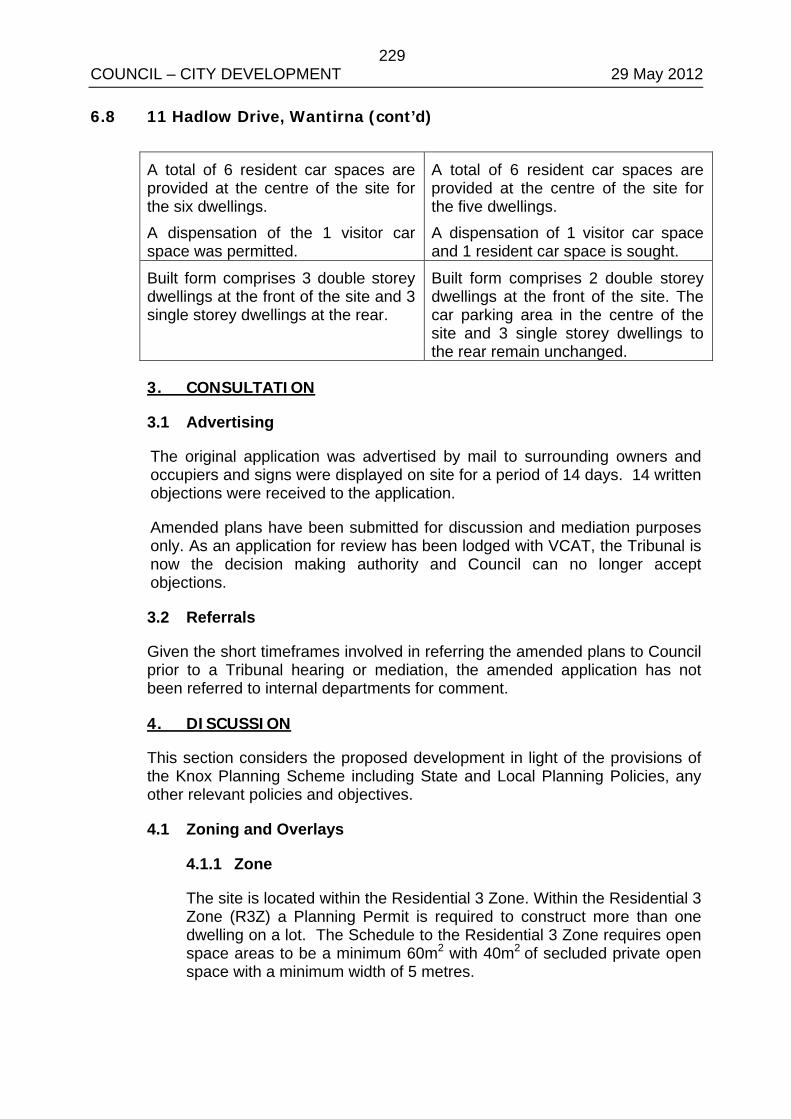
229 COUNCIL – CITY DEVELOPMENT 29 May 2012 6.8 11 Hadlow Drive, Wantirna (cont’d)
A total of 6 resident car spaces are provided at the centre of the site for the six dwellings. A dispensation of the 1 visitor car space was permitted.
A total of 6 resident car spaces are provided at the centre of the site for the five dwellings. A dispensation of 1 visitor car space and 1 resident car space is sought.
Built form comprises 3 double storey dwellings at the front of the site and 3 single storey dwellings at the rear.
Built form comprises 2 double storey dwellings at the front of the site. The car parking area in the centre of the site and 3 single storey dwellings to the rear remain unchanged.
3. CONSULTATION
3.1 Advertising
The original application was advertised by mail to surrounding owners and occupiers and signs were displayed on site for a period of 14 days. 14 written objections were received to the application.
Amended plans have been submitted for discussion and mediation purposes only. As an application for review has been lodged with VCAT, the Tribunal is now the decision making authority and Council can no longer accept objections.
3.2 Referrals
Given the short timeframes involved in referring the amended plans to Council prior to a Tribunal hearing or mediation, the amended application has not been referred to internal departments for comment.
4. DISCUSSION
This section considers the proposed development in light of the provisions of the Knox Planning Scheme including State and Local Planning Policies, any other relevant policies and objectives.
4.1 Zoning and Overlays
4.1.1 Zone
The site is located within the Residential 3 Zone. Within the Residential 3 Zone (R3Z) a Planning Permit is required to construct more than one dwelling on a lot. The Schedule to the Residential 3 Zone requires open space areas to be a minimum 60m2 with 40m2 of secluded private open space with a minimum width of 5 metres.
230 COUNCIL – CITY DEVELOPMENT 29 May 2012 6.8 11 Hadlow Drive, Wantirna (cont’d)
• The original proposal fell short of the private open space standards for the R3Z, with only one dwelling complying with the full requirements. Dwellings were provided with between 29 and 46m2 of secluded private open space with a 5 metre width.
As with the original proposal, the amended proposal falls short of the 5 metre width required for private open space areas. However, in line with the recommendation made in the previous officer’s report the trade off between providing much needed affordable housing by a Registered Housing Association and the provision of private open space is appropriate in this instance given the site’s location within close proximity to services and public transport.
In addition, the amended design significantly increases the area of private open space available to the front dwellings and enables canopy tree planting in the centre of the site to contribute to the character of the neighbourhood.
4.2 Policy Consideration
4.2.1 State Planning Policy Framework
State policy requires Council to integrate the range of policies relevant to the issues to be determined, and balance conflicting objectives in favour of net community benefit and sustainable development.
Key Policies:
Clause 15 Built Environment and Heritage – Encourages high quality architecture and urban design outcomes that reflect the particular characteristics, aspirations and cultural identity of the community; enhances liveability, diversity, amenity and safety of the public realm; and promotes attractiveness of towns and cities within broader strategic contexts.
• The amended design continues to make a positive contribution to the streetscape, with built form considered to be appropriate in form and scale. The development incorporates important neighbourhood character features such as pitched roofs, brick and weatherboard finishes, eaves and landscaped spacing between dwellings. Double storey built form has been located to the street frontage.
As noted with regards to the original design, the overall built form is quite modest and while it contains five (5) dwellings, the building footprint is similar to that of a large dual occupancy development.
231 COUNCIL – CITY DEVELOPMENT 29 May 2012 6.8 11 Hadlow Drive, Wantirna (cont’d)
Clause 15.02 Sustainable Development – Ensure land use and development is consistent with the efficient use of energy and the minimisation of greenhouse gas emissions.
• The amended proposal contributes to the consolidation of urban development through the provision of increased density within an existing residential area within close proximity to urban services and transport. Dwellings are orientated to the north and incorporate eaves.
Clause 16 Housing – Encourage the development of well-designed medium-density housing that respects the neighbourhood character; improves housing choice; makes better use of existing infrastructure; and, improves energy efficiency of housing.
• Neighbourhood character - this is discussed in a later section of the report (Section 4.2.2).
• Housing choice – providing the option of smaller dwelling sizes on smaller lots is considered to increase housing choice.
• Housing affordability – the proposal will provide accommodation solutions for low income people and people who are disadvantaged, have a disability or are homeless.
• Existing infrastructure – the site is located within a fully serviced area.
• Energy efficiency – this has been discussed above under Clause 15.02.
Clause 18 Transport – Ensure that access is provided to all available modes of transport.
• The site is located within 250 metres walking distance of bus stops on Boronia Road and Mountain Highway, which is serviced by bus routes No. 745C and D, 738 and 901.
• Bus route 745B from Bayswater to Wantirna Primary School.
• The 901 service (Smart Bus) runs between Frankston and Melbourne Airport from 5am to midnight between two to five times an hour on weekdays, from 6am to midnight twice an hour on Saturdays, and from 7am to 6pm twice an hour on Sundays.
232 COUNCIL – CITY DEVELOPMENT 29 May 2012 6.8 11 Hadlow Drive, Wantirna (cont’d)
Clause 21.05-2 Municipal Strategic Statement (MSS). The MSS seeks to reduce the prevalence of infill housing development in dispersed locations as a major form of housing development by promoting activity centres and key redevelopment strategic sites as the preferred location.
• The site is not located in an Activity Centre or key redevelopment site, however is located within 120 metres walking distance of the Wantirna Mall Neighbourhood Activity Centre.
The MSS further seeks to manage the need for more housing and maintaining the valued qualities of identified areas of environmental and character significance. The MSS supports development that respects the existing or preferred residential neighbourhood character.
• While the land is not in an Activity Centre, the proposal, provided it respects existing or preferred neighbourhood character, can be consistent with the requirements of the MSS. An assessment against Council’s preferred Neighbourhood Character Policy (Clause 22.07) is below. It should be noted that while the development proposes five (5) dwellings, these dwellings are very modest in size and result in a building footprint similar to that of a large dual occupancy.
Encourage the provision of affordable housing for all types of households.
• The proposed development seeks to provide affordable housing by a registered housing association.
Clause 22.07 Neighbourhood Character: Garden Court Character Precinct – The desired future character of this area is for “Low scale dwellings set within an open landscape with, in some areas, occasional pockets of large native trees.” To retain the remnant indigenous and other native trees and encourage the new planting of large native trees.
• There is one native tree on site, a South Mahogany Gum which has poor structure and health and is not worthy of retention.
To maintain the rhythm of spacing between dwellings.
• The proposed development maintains the rhythm of spacing between dwellings by consolidating built form to the front and rear of the site, separated by landscaping and car parking areas. From outside the site, the development would have the appearance of a large dual occupancy.
233 COUNCIL – CITY DEVELOPMENT 29 May 2012 6.8 11 Hadlow Drive, Wantirna (cont’d)
To maintain the openness of front boundary treatments.
• The front setback is adequate to allow for landscaping and the fencing within the front setback has been setback off the front boundary to soften fencing treatment.
To minimise the dominance of buildings from the street.
• Dwelling setbacks from Hadlow Drive allow for the planting and establishment of vegetation. Upper floors are setback from the lower façade to create articulation and minimise dominance of dwellings when viewed from the street.
It is also noted that the amended proposal reduces visual dominance within the streetscape, with the upper storey built form narrowed by 2 metres and overall height lowered by 250mm.
To minimise loss of front garden space, and dominance of car storage facilities.
• All car parking is located to the rear of Dwellings 1 to 2.
Clause 22.10 Housing: Medium Density – The Housing Policy at Clause 22.10-1 recognises that the population of Knox will grow by 12,000 persons and 15,000 households to 2030.
In response to this forecast, the Housing Policy directs that infill medium density housing in dispersed residential locations respects and complements the desired future residential character objectives of Clause 22.07 Neighbourhood Character Policy and Clause 22.01 Dandenong Foothills Policy, where relevant.
Before deciding on an application, the responsible authority will consider, as appropriate, whether:
The proposed development owned and managed by public authorities and/or non-profit registered housing associations and provides a type of housing that satisfies an identified housing need within the Knox community.
• The subject site and the proposed development is owned and managed by Housing Choices Australia, a registered, not for profit housing association. This form of development will provide accommodation solutions for low income people and people who are disadvantaged, have a disability or are homeless.
234 COUNCIL – CITY DEVELOPMENT 29 May 2012 6.8 11 Hadlow Drive, Wantirna (cont’d)
The proposed development will contribute to a diversity of housing in Knox.
• The proposed dwellings which incorporate one, two and three bedroom dwellings which will provide for a range of household types and sizes. The dwellings provide smaller areas of open space which are easier to maintain and suit the function of the proposed affordable housing development.
The proposed development makes a positive contribution to the desired future urban fabric, amenity and neighbourhood character.
• The proposed development maintains the rhythm of spacing between dwellings and minimises visual bulk as viewed from the streetscape, and allows for canopy tree planting across the site to contribute to the Garden Court neighbourhood character.
There is access to frequent public transport services between 6.00am and 11.00pm daily, seven days a week.
• The site does not have access to public transport that operates between 6.00am and 11.00pm daily, seven days a week.
4.3 Clause 55 – Two or More Dwellings on a Lot and Residential Buildings (ResCode)
The proposal generally complies with the provisions of Clause 55 of the Knox Planning Scheme, an assessment of the key criteria; including any areas of non compliance are considered below:
Neighbourhood Character and Infrastructure
Neighbourhood Character – Complies, refer to Section 4.2.2 above
Site Layout and Building Massing
Street Setback – Generally complies. The front setback does not comply with the minimum front setback of 9 metres required by ResCode. However, the setback 8.5 metre setback are similar to other dwellings within the street and allow for appropriate landscaping and canopy tree planting to soften the appearance of the dwellings from the street.
Building Height – Complies
Site Cover/permeability – Complies
Energy Efficiency – Complies. The design has ensured all dwellings have access to northern solar light and eaves.
Landscaping – Complies
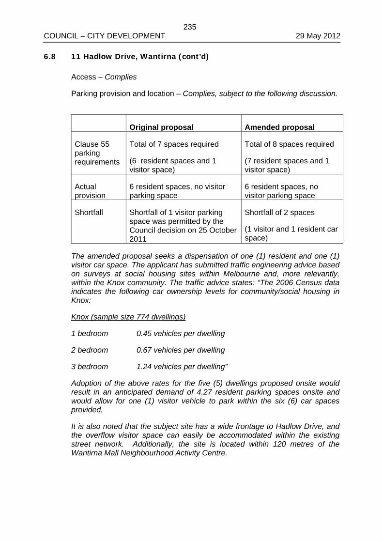
235 COUNCIL – CITY DEVELOPMENT 29 May 2012 6.8 11 Hadlow Drive, Wantirna (cont’d)
Access – Complies
Parking provision and location – Complies, subject to the following discussion.
Original proposal Amended proposal
Clause 55 parking requirements
Total of 7 spaces required
(6 resident spaces and 1 visitor space)
Total of 8 spaces required
(7 resident spaces and 1 visitor space)
Actual provision
6 resident spaces, no visitor parking space
6 resident spaces, no visitor parking space
Shortfall Shortfall of 1 visitor parking space was permitted by the Council decision on 25 October 2011
Shortfall of 2 spaces
(1 visitor and 1 resident car space)
The amended proposal seeks a dispensation of one (1) resident and one (1) visitor car space. The applicant has submitted traffic engineering advice based on surveys at social housing sites within Melbourne and, more relevantly, within the Knox community. The traffic advice states: “The 2006 Census data indicates the following car ownership levels for community/social housing in Knox:
Knox (sample size 774 dwellings)
1 bedroom 0.45 vehicles per dwelling
2 bedroom 0.67 vehicles per dwelling
3 bedroom 1.24 vehicles per dwelling”
Adoption of the above rates for the five (5) dwellings proposed onsite would result in an anticipated demand of 4.27 resident parking spaces onsite and would allow for one (1) visitor vehicle to park within the six (6) car spaces provided.
It is also noted that the subject site has a wide frontage to Hadlow Drive, and the overflow visitor space can easily be accommodated within the existing street network. Additionally, the site is located within 120 metres of the Wantirna Mall Neighbourhood Activity Centre.
236 COUNCIL – CITY DEVELOPMENT 29 May 2012 6.8 11 Hadlow Drive, Wantirna (cont’d)
Clause 55.03-11 of the Knox Planning Scheme directs that the Responsible Authority, in making a decision on whether parking provision in a multi unit development is satisfactory, must consider: “The reduction in the demand for on-site parking in rental housing, managed by not for profit organisations, intended for residents likely to have a low level of car ownership.” Taking the above empirical evidence and characteristics of the site into account, it is considered that the proposed dispensation of one (1) visitor and one (1) resident car space is acceptable in this instance.
Amenity Impacts
Side and rear setbacks – Complies
Walls on boundaries – Complies
Daylight to existing windows/north facing windows – Complies
Overshadowing open space – Complies
Overlooking –Complies.
Internal views –Complies
On-Site Amenity and Facilities
Daylight to new windows – Complies
Private Open Space – Complies
Solar access to open space – Complies
Storage – Complies
Front fence – Complies
4.4 Financial Implications
There are no direct costs to Council apart from provision of the usual domestic services.
5. CONCLUSION
Clause 11 of the Knox Planning Scheme requires Council to balance relative policy objectives when making decisions to ensure resulting development is sustainable and achieves a net community gain. In this context, the development is appropriate given the following:
237 COUNCIL – CITY DEVELOPMENT 29 May 2012 6.8 11 Hadlow Drive, Wantirna (cont’d)
• On balance, while the proposed development does not fully comply with the private open space requirements of the Schedule to the Residential 3 Zone, it is an excellent outcome in terms of providing much needed affordable housing in Knox and is therefore considered to be consistent with the objectives of the Housing Policy.
• As discussed above, the site is capable of absorbing five (5) modest dwellings while making a positive contribution to the character of the area. The development is located within an existing urban area where services and transportation is located within a very short distance.
• The development is consistent with the Neighbourhood Character Policy with the proposed dwellings considered to be appropriate in built form and scale, adequately separated with areas allowing for additional landscaping between the built form.
• The shortfall in parking provisions of two (2) car spaces is considered acceptable taking into account empirical evidence from social housing examples within Knox which demonstrate lowered rates of car ownership, as well as the characteristics of the site and surrounds.
• The development is generally compliant with ResCode subject to changes that will be conditioned on any permit issued.
6. CONFIDENTIALITY
There are no confidentiality issues associated with this report.
RECOMMENDATION
That Council resolve to support the proposed development of five (5) dwellings (two double storey and three single storey) at 11 Hadlow Drive, Wantirna, generally in accordance with plans by MAP Architecture identified as Sheets TP1-3 and SH1-3 by MAP Architecture (all dated April 2012) for the purposes of submission to VCAT regarding the appeal for Planning Application P/2011/6296.
COUNCIL RESOLUTION MOVED: CR. PEARCE SECONDED: CR. COOPER
That Council resolve to not support the proposed development of five (5) dwellings (two double storey and three single storey) at 11 Hadlow Drive, Wantirna, in accordance with plans by MAP Architecture identified as Sheets TP1-3 and SH1-3 (all dated April 2012) for the purposes of submission to VCAT regarding the appeal for Planning Application P/2011/6296. CARRIED
238 COUNCIL – CITY DEVELOPMENT 29 May 2012 6.8 11 Hadlow Drive, Wantirna (cont’d)
COUNCILLOR COLE RETURNED TO THE CHAMBER AT 8.24PM AFTER THE VOTE WAS TAKEN ON ITEM 6.8
SUBSEQUENT MOTION MOVED: CR. VAN DE VREEDE SECONDED: CR. COSSARI
That Council resolve to advised VCAT in the matter of P/2011/6296 that it would support the proposed development at 11 Hadlow Drive Wantirna if in addition to other relevant matters previously advised, the size of the two (2) front units was reduced from 3 bedrooms to 2 bedrooms respectively, open space requirements of the planning scheme be achieved and an additional two (2) car parking spaces that can also be used as communal open space when not required for carparking be provided on site. CARRIED

239 COUNCIL – CITY DEVELOPMENT 29 May 2012 APPENDIX A/1

240 COUNCIL – CITY DEVELOPMENT 29 May 2012 APPENDIX A/2

241 COUNCIL – CITY DEVELOPMENT 29 May 2012 APPENDIX B/1

242 COUNCIL – CITY DEVELOPMENT 29 May 2012 APPENDIX B/2

243 COUNCIL – CITY DEVELOPMENT 29 May 2012 APPENDIX B/3

244 COUNCIL – CITY DEVELOPMENT 29 May 2012 APPENDIX B/4

245 COUNCIL – CITY DEVELOPMENT 29 May 2012 APPENDIX B/5

246 COUNCIL – CITY DEVELOPMENT 29 May 2012 APPENDIX B/6

247 COUNCIL – CITY DEVELOPMENT 29 May 2012 APPENDIX B/7
248 COUNCIL – CITY DEVELOPMENT 29 May 2012
FRIGBERG WARD
6.9 APPLICATION TO DEVELOP THE LAND FOR THREE (3) DOUBLE STOREY DWELLINGS AT 14 ANNE ROAD, KNOXFIELD, Melway Ref. 73 C4 (Application No. P/2011/6853)
1. SUMMARY:
Land: 14 Anne Road, Knoxfield Applicant: Allan Armstrong and Associates Proposed Development: The development of the land for three
double storey dwellings Existing Land Use: Single Dwelling Area/Density: 978m2 / 1:326m2 Zoning: Residential 3 Zone Overlays: None Local Policy: Neighbourhood Character Policy
Housing Policy Application Received: 20 October 2011 Number of Objections: Eighteen (18) PCC Meeting: 20 March 2012 Assessment:
An application for review of Council’s failure to make a decision within the prescribed timeframes of the Planning and Environment Act 1987 has been lodged with VCAT.
The proposal does not comply with the Housing Policy or Neighbourhood Character Policy.
There are significant areas of non-compliance with ResCode, and as a result detrimental amenity impacts to adjoining properties.
The proposal does not meet the Schedule to the Residential 3 Zone.
On balance it is considered that the proposal does not respond well to State and Local Planning Policies. It is recommended that if Council was in a position to decide upon the application within the statutory timeframes, Council would have issued a Notice of Refusal to Grant a Planning Permit.
2. BACKGROUND
2.1 Subject Site and Surrounds
The location of the subject site is shown in Appendix A.
249 COUNCIL – CITY DEVELOPMENT 29 May 2012 6.9 14 Anne Road, Knoxfield (cont’d)
• The subject site is located at the northern side of Anne Road in Knoxfield. The allotment is rectangular in shape with a frontage of 21.11 metres, a depth of 46.33 metres and the overall site area is 978 square metres. A 2.44 metre wide easement abuts the eastern (side) boundary. The site is currently occupied by a single storey dwelling setback 7.59 metres from the frontage. Vehicular access is via an existing crossover adjacent the western boundary. The land has a fall of 1 metre to the front.
• Adjoining the western, eastern and northern boundaries, properties are developed with single storey dwellings fronting Anne Road and Norma Crescent. On the opposite side of Anne Road properties are developed for residential purposes. Surrounding development is characterised predominately by single storey dwellings with evidence of multi-dwelling development.
• The site does not contain any significant vegetation.
2.2 The Proposal
(Refer to attached plans at Appendix B)
The applicant proposes to remove the existing dwelling and construct three (3) double storey dwellings. Details are as follows:
• Dwelling 1 fronts Anne Road and is setback 7.6 metres from the street. Separate vehicle access utilising the existing crossover in the south-west corner of the site leads to a double garage on the western side. Dwellings 2 and 3 and a single/double garage for each dwelling are located to the rear of Dwelling 1 in a tandem arrangement across the length of the site, accessed by a new driveway extending from the existing crossover in the south-east corner of the site.
• The internal layout of the dwellings comprises ground level entry, open plan family/meals/kitchen area, lounge, four bedrooms (master with ensuite and walk-in-robe), a bathroom and laundry. Private open space is located on the northern/western side of each of the dwellings.
• The proposed dwellings will have a traditional design with brick and render walls and a pitched tiled roof to the ground and first floor.
• All vegetation will be removed to facilitate the development.
3. CONSULTATION
3.1 Advertising
The application was advertised by way of a sign on the frontage of the site and notices were sent to adjoining property owners and occupiers. Eighteen (18) objections were received. The concerns raised in the objection and a response to these concerns are provided below:
250 COUNCIL – CITY DEVELOPMENT 29 May 2012 6.9 14 Anne Road, Knoxfield (cont’d)
Neighbourhood Character
• The proposal is inconsistent with Council’s Neighbourhood Character Policy at Clause 22.07 of the Knox Planning Scheme (see assessment at Section 4.2.2 of the report).
Overlooking
• All ground floor and first floor habitable room windows are adequately screened to ensure that there will be no direct overlooking into adjacent habitable room windows or private open space, in accordance with ResCode Standard B22.
Impact on infrastructure
• Council’s Drainage Engineers have not advised of any issues with the capacity of Council’s existing drainage infrastructure. The development would be required to provide on-site detention of stormwater to ensure that stormwater flows are contained to peak pre-development levels. Connection to other services will be subject to the relevant servicing authority.
Property values
• This is not a relevant planning consideration.
Waste collection
• Council’s Waste Management Policy would allow for Council kerbside collection for this development. There is sufficient area for storage of waste/recycling bins and adequate space on the naturestrip for bins to be collected.
Set a precedent
• Council must assess any application on its own merits, and therefore previous decisions do not set a precedent for any future applications.
Removal of vegetation
• There is no significant vegetation on the property that is worthy of retention. Planting of canopy trees within the front setback can be achieved, however there is limited area for planting within the private open space areas of Dwellings 1 and 2, and along the driveway.
Increased noise
• Any increase in noise as a result of the proposed development would be normal for a residential environment.

251 COUNCIL – CITY DEVELOPMENT 29 May 2012 6.9 14 Anne Road, Knoxfield (cont’d)
Boundary wall construction
• The extent of boundary walls proposed on the western and eastern boundaries complies with ResCode Standard B18.
Impact of height of boundary fencing
• The proposed height of the boundary fencing (1.8m with 600mm trellis bringing the overall height to 2.4 metres) is unnecessary to limit overlooking. Also, 600mm of trellis is excessive and this height trellis can be unstable. Instead, solid boundary fencing to a height of 2.1 metres will ensure that any potential overlooking from ground floor areas and private open space areas is limited.
Traffic and parking
• Council’s Traffic Engineers have not identified any road capacity limitations that would preclude the development. All parking provision is in accordance with ResCode requirements, with each dwelling provided with a two spaces. Council has concerns that vehicles will not be able to exit in a forward direction, which is a ResCode requirement for a development with three or more dwellings.
Disruption during construction
• Some disruption during construction is inevitable. Council’s standard amenity during construction condition would be a requirement of any permit to issue. Building and Local Laws regulations also cover this issue.
3.2 Planning Consultation Committee Meeting
A Planning Consultation Committee (PCC) Meeting was held on 20 March 2012 for this application. Objectors attended and raised concerns with the proposal. The applicant did not attend and therefore there were no mediated outcomes as a result of the PCC meeting.
3.3 Referrals
The application has been referred to internal departments for comment. No objection has been raised; the following is a summary of relevant advice:
Traffic Engineer
• Standard conditions to be included on any permit issued.
Drainage Engineer
• Standard conditions to be included on any permit issued.
252 COUNCIL – CITY DEVELOPMENT 29 May 2012 6.9 14 Anne Road, Knoxfield (cont’d)
ESD Officer
• An amended Sustainable Design Assessment must be submitted to Council for approval. This can be incorporated as a condition on any permit issued.
4. DISCUSSION
This section considers the proposed development in light of the provisions of the Knox Planning Scheme including State and Local Planning Policies, any other relevant policies and objectives.
4.1 Zoning and Overlays
4.1.1 Zone
The subject site is located within a Residential 3 Zone. A permit is required pursuant to Clause 32.06-4 to construct two or more dwellings on a lot.
The Schedule to the Residential 3 Zone varies ResCode Standards B28 and B32, pertaining to private open space and front fences. To comply with the varied ResCode Standard B28, private open space must consist of an area of 60 m² with one part of the private open space to consist of secluded private open space at the side or rear of the dwelling with minimum area of 40m² and minimum dimension of 5 metres. The varied ResCode Standard B32 requires a permit for a front fence that exceeds 1.2 metres.
• Dwellings 1 and 3 meet the Schedule to the R3Z, with the dwellings provided with the required area and dimensions of secluded and private open space. The total private open space area for Dwelling 2 does not meet the minimum area of 60 square metres (46.35 square metres is provided). This is an indication of the proposal being an overdevelopment of the land.
• There is no front fence.
4.2 Policy Consideration
4.2.1 State Planning Policy Framework
State policy requires Council to integrate the range of policies relevant to the issues to be determined, and balance conflicting objectives in favour of net community benefit and sustainable development.
253 COUNCIL – CITY DEVELOPMENT 29 May 2012 6.9 14 Anne Road, Knoxfield (cont’d)
Key Policies:
Clause 15 Built Environment and Heritage – Encourages high quality architecture and urban design outcomes that reflect the particular characteristics, aspirations and cultural identity of the community; enhances liveability, diversity, amenity and safety of the public realm; and promotes attractiveness of towns and cities within broader strategic contexts.
• The development proposes medium density housing in a dispersed residential location. The design is poorly conceived, particularly in respect to the double storey built form and does not meet preferred neighbourhood character themes (as discussed below).
Clause 15.02 Energy and Resource Efficiency – Ensure land use and development is consistent with the efficient use of energy and the minimisation of greenhouse gas emissions.
• The proposal contributes to the consolidation of urban development through the provision of increased density within an existing residential area. Dwellings are orientated to the north however improvement can be made to protecting north facing windows. Further, any approval would be subject to the submission of a Sustainable Design Assessment.
Clause 16 Housing – Encourage the development of well-designed medium-density housing that respects the neighbourhood character; improves housing choice; makes better use of existing infrastructure; and, improves energy efficiency of housing.
• Neighbourhood character - this is discussed in a later section of the report (Section 4.2.2).
• Housing choice – providing the option of dwellings on smaller lots is considered to increase housing choice.
• Existing infrastructure – the site is located within a fully serviced area.
• Energy efficiency – this has been discussed above under Clause 15.02.
• Location – The site is located in an dispersed residential area.
254 COUNCIL – CITY DEVELOPMENT 29 May 2012 6.9 14 Anne Road, Knoxfield (cont’d)
Clause 18 Transport – Ensure that access is provided to all available modes of transport.
• The site is located within 180 metres walking distance of a bus stop on Scorseby Road, which is serviced by Bus Route Nos. 753 and 755, and 140 metres walking distance of a bus stop on Lloyd Street, serviced by Bus Route No. 758.
• Route No. 753 from Glen Waverley to Boronia Station via Knoxfield operates at various intervals from 6.23am to 9.03pm Monday to Friday with peak times being every 15 minutes. Saturday services run hourly from 7.51am to 4.19pm. Sunday services operate hourly from 8.51am to 5.48pm.
• Route No. 755 from Bayswater to Knox City via Boronia operates between 5.53am and 9.27pm Monday to Friday at 20 minute intervals. Saturday services run hourly from 7.51am to 9.18pm. Sunday services operate hourly from 8.55am to 9.21pm.
• Bus Route No. 758 provides direct access between the Knox Shopping Centre and Knoxfield via Wallace Road, and operates between 9:12am and 6:16pm Monday to Friday at approximately 50 minute intervals.
4.2.2 Local Planning Policy Framework
Clause 21.05-2 Municipal Strategic Statement (MSS) The MSS seeks to reduce the prevalence of infill housing development in dispersed locations as a major form of housing development by promoting activity centres and key redevelopment strategic sites as the preferred location.
• The site is not located in an Activity Centre or key redevelopment site.
The MSS further seeks to manage the need for more housing and maintaining the valued qualities of identified areas of environmental and character significance. The MSS supports development that respects the existing or preferred residential neighbourhood character.
• Whilst proximity to facilities is a characteristic which is desirable when considering new medium density development, it is not however a pre-requisite. Clause 22.10 recognises that well designed medium density housing consistent with neighbourhood character themes can also be contemplated on sites in more dispersed residential locations. However, the development fails to make a positive contribution to the desired neighbourhood character as described below and therefore cannot be justified.
255 COUNCIL – CITY DEVELOPMENT 29 May 2012 6.9 14 Anne Road, Knoxfield (cont’d)
Clause 22.07 Neighbourhood Character: Garden Suburban Character Precinct 7 – The desired future character of this area is for “Low scale dwellings set within an open landscape with occasional large native trees and in some precincts large stands of native and exotic trees.” To retain the tall trees
• All existing vegetation is to be removed. Broader garden character matters are relevant and these have been considered. The particular design response chosen fails to maximise landscaping opportunities as evidenced along the driveway and the entrance to the rear dwellings.
• Also, the reduced area of private open space to Dwelling 2 and ground floor building bulk leaves inadequate space to provide effective canopy tree planting on the site. This is a fundamental failing given the broader neighbourhood/garden character objectives.
To maintain the continuity of garden character between dwellings
• The building siting is such that there is minimal separation in between dwellings down the length of the site and as viewed from the streetscape. This results in a poor neighbourhood character response.
• Two storey construction at the rear needs to be treated cautiously given it can result in unreasonable neighbourhood character outcomes and amenity impacts on adjoining properties. Two storey dwellings can sometimes be accommodated on larger sites where substantial setbacks can be provided.
• The design response is such that the two storey form at the rear and down the length of the site with minimal separation between built forms and limited landscaping opportunities is problematic in terms of the visual bulk impact on adjacent properties.
• The two storey form of Dwelling 2 and Dwelling 3 at the rear also remains problematic despite compliance with ResCode setbacks. The siting of upper level built form at the rear of the site is contrary to neighbourhood themes and results in unreasonable visual bulk outcomes in a dispersed residential location.
• The result is a built form which is too close to adjacent private open space areas, massing and bulk that is dominant and contrary to established neighbourhood character themes.
256 COUNCIL – CITY DEVELOPMENT 29 May 2012 6.9 14 Anne Road, Knoxfield (cont’d)
To minimise the dominance of buildings from the street.
• The new two storey built form at the front is generally well setback from the street, consistent with neighbourhood themes.
• However, the extent of built form down the length of the site as described above remains problematic.
To minimise loss of front garden space, and dominance of car storage facilities.
• A front garden appearance to Dwelling 1 is retained, however the gun barrel effect of the shared driveway leading to the rear garage and limited landscaping is a poor neighbourhood character outcome.
• The garage to Dwelling 1 needs to be setback further behind the façade of the dwelling to minimise the dominance of the garage on the streetscape. This will impact on the provision of secluded private open space.
Clause 22.10 Housing: Medium Density – The Housing Policy at Clause 22.10-1 recognises that the population of Knox will grow by 12,000 persons and 15,000 households over the 25 years to 2030.
In response to this forecast, the Housing Policy directs that infill medium density housing in dispersed residential locations respects and complements the desired future residential character objectives of Clause 22.07 Neighbourhood Character Policy and Clause 22.01 Dandenong Foothills Policy, where relevant.
Before deciding on an application, the responsible authority will consider, as appropriate, whether:
The proposed development will contribute to a diversity of housing in Knox.
• The proposal for three larger dwellings on smaller allotments would contribute to housing diversity. The dwellings provide smaller areas of open space, which are easier to maintain.
There is access to frequent public transport services between 6.00am and 11.00pm daily, seven days a week.
• The subject site is not located to take advantage of frequent public transport services between 6.00am and 11.00pm, daily, seven days a week.
257 COUNCIL – CITY DEVELOPMENT 29 May 2012 6.9 14 Anne Road, Knoxfield (cont’d)
The proposed development makes a positive contribution to the desired future urban fabric, amenity and neighbourhood character.
• The proposal will not make a positive contribution to the desired future urban fabric, amenity and neighbourhood character (see assessment against Clause 22.07 Neighbourhood Character and ResCode).
The proposed development makes a positive contribution to the desired future neighbourhood character as identified at Clause 22.07 Neighbourhood Character Policy or an approved structure plan or urban design framework.
• Neighbourhood character is discussed above under Section 4.2.2 (Clause 22.07 Neighbourhood Character).
4.3 Clause 55 – Two or More Dwellings on a Lot and Residential Buildings (ResCode)
The proposal is not consistent with the provisions of Clause 55 of the Knox Planning Scheme, an assessment of the key criteria; including the areas of non compliance are considered below:
Neighbourhood Character and Infrastructure
Neighbourhood Character – Does not comply, refer to Section 4.2.2 above.
Residential Policy – Does not comply, as discussed under Section 4.2. Infrastructure – Complies. Integration with the Street – Complies. Site Layout and Building Massing
Street Setback – Complies.
Building Height – Complies.
Site Cover/Permeability – Complies.
Energy Efficiency – Does not comply. The design has not ensured that northern solar access is maximised, which can be achieved with the orientation of the allotment. Dwelling 1 and Dwelling 2 have limited north facing habitable room windows (the north facing living room windows to Dwelling 2 will need to be removed as insufficient clearance to the shared accessway is provided) and rely on western and eastern access. This is poor design response.
258 COUNCIL – CITY DEVELOPMENT 29 May 2012 6.9 14 Anne Road, Knoxfield (cont’d)
Safety – Complies.
Landscaping – Does not comply, as insufficient areas for landscaping have been provided as discussed in Section 4.2.2.
Access – Does not comply, Dwelling 2 requires a tandem car space which would encroach into the accessway, and the turning area provided would be inadequate to allow for safe and efficient vehicle movements to allow a vehicle to exit in a forward direction. Exiting the western space within the garage for Dwelling 3 would require multiple manoeuvres in order to leave the site in a forward direction, which does not lead to safe and efficient movements. This is considered indicative of an over-development of the site.
Parking provision and location – Does not comply. Habitable room windows have been setback a minimum 550mm from the shared accessway, with the window type either highlight or full length, resulting in poor internal amenity and design response, indicative of an overdevelopment of the land.
Amenity Impacts
Side and rear setbacks – Complies with Standard, however does not comply with objective.
Setbacks are in accordance with Standard B17. Nonetheless, as described in Section 4.2.2, the extent of built form down the site and dominant mass and bulk at the rear are all contrary to neighbourhood themes and results in unreasonable visual bulk outcomes.
Walls on boundaries – Complies.
Daylight to existing windows/north facing windows – Complies.
Overshadowing open space – Complies.
Overlooking – Complies.
Internal views –Complies.
On-Site Amenity and Facilities
Daylight to new windows – Complies.
Private Open Space – Does not comply. Dwellings 1 and 3 meet the Schedule to the R3Z, with the dwellings provided with the required area and dimensions of secluded and private open space. The total private open space area for Dwelling 2 does not meet the minimum area of 60 square metres (46.35 square metres is provided). This is an indication of the proposal being an overdevelopment of the land.
259 COUNCIL – CITY DEVELOPMENT 29 May 2012 6.9 14 Anne Road, Knoxfield (cont’d)
Solar access – Complies.
Storage – Complies.
Design detail – Complies. The design detail of the development will sufficiently respond to the preferred character of the neighbourhood notwithstanding the poor siting and amenity outcomes as described above.
Front fence – Complies.
5. CONCLUSION
Clause 11 of the Knox Planning Scheme requires Council to balance relative policy objectives when making decisions to ensure resulting development is sustainable and achieves a net community gain. In this context, the development is inappropriate given the following:
• The proposed development does not achieve a satisfactory design response, with significant areas of non-compliance with ResCode.
• The proposal is inconsistent with Neighbourhood Character objectives and will not result in an outcome that contributes to the preferred neighbourhood character detailed at Clause 22.07 of the Knox Planning Scheme.
• The proposal is inconsistent with Clause 22.10 (Housing Policy) as the proposal will not make a positive contribution to the desired future urban fabric, amenity and neighbourhood character.
• The proposal represents an overdevelopment of the land, with considerably off-site amenity impacts to adjoining properties.
6. CONFIDENTIALITY
There are no confidentiality issues associated with this report.
RECOMMENDATION
That had Council been in a position to make a decision in the prescribed timeframes of the Planning and Environment Act 1987, it would have issued a Refusal to Grant a Planning Permit for the development of the land for three (3) double storey dwellings at 14 Anne Road, Knoxfield subject to the following grounds:
260 COUNCIL – CITY DEVELOPMENT 29 May 2012 6.9 14 Anne Road, Knoxfield (cont’d)
Recommendation (cont’d)
1. The proposal does not achieve a design response that complies with Clause 55 of the Knox Planning Scheme (ResCode), in particular Standards B1 (Neighbourhood Character), B10 (Energy Efficiency), B13 (Landscaping), B14 (Access), B15 (Parking Location) B17 (Side and Rear Setbacks), and B28 (Private Open Space).
2. The proposal does not comply with the Neighbourhood Character Policy (Clause 22.07) and Housing Policy (Clause 22.10) of the Knox Planning Scheme.
3. The proposal is an overdevelopment of the land, and will result in unreasonable amenity impacts to adjoining properties.
COUNCIL RESOLUTION MOVED: CR. WALTER SECONDED: CR. MORTIMORE That the recommendation be adopted. CARRIED

261 COUNCIL – CITY DEVELOPMENT 29 May 2012 APPENDIX A/1

262 COUNCIL – CITY DEVELOPMENT 29 May 2012 APPENDIX A/2

263 COUNCIL – CITY DEVELOPMENT 29 May 2012 APPENDIX B/1

264 COUNCIL – CITY DEVELOPMENT 29 May 2012 APPENDIX B/2

265 COUNCIL – CITY DEVELOPMENT 29 May 2012 APPENDIX B/3

266 COUNCIL – CITY DEVELOPMENT 29 May 2012 APPENDIX B/4

267 COUNCIL – CITY DEVELOPMENT 29 May 2012 APPENDIX B/5

268 COUNCIL – CITY DEVELOPMENT 29 May 2012 APPENDIX B/6

269 COUNCIL – CITY DEVELOPMENT 29 May 2012 APPENDIX B/7

270 COUNCIL – CITY DEVELOPMENT 29 May 2012 APPENDIX B/8

271 COUNCIL – CITY DEVELOPMENT 29 May 2012 APPENDIX B/9
272 COUNCIL – CITY DEVELOPMENT 29 May 2012 COUNCILLOR COOPER VACATED THE CHAMBER AT 8.30PM PRIOR TO DISCUSSION ON ITEM 6.10 COUNCILLOR WALTER VACATED THE CHAMBER AT 8.30PM PRIOR TO DISCUSSION ON ITEM 6.10
ALL WARDS
6.10 KNOX OPEN SPACE PLAN (2012 – 2022)
SUMMARY: Co-ordinator Open Space and Landscape Design (Marshall Kelaher)
The Knox Open Space Plan (2012 – 2022) has been developed to provide a coordinated approach to the planning and development of Knox’s open spaces. This report provides an outline of the structure of the Plan, and the key findings and recommendations. Extensive Councillor, community and stakeholder group engagement has occurred to gain an understanding of their values and aspirations for open space in Knox. These findings have informed the development of the Knox Open Space Plan (2011-2022). The Knox Open Space Plan aligns with the Knox Liveable Streets Plan, the Knox Open Space Asset Management Plan, and Vision 2025.
RECOMMENDATION
That Council;
1. Endorse the Knox Open Space Plan (2012-2022) presented as Appendix A (distributed separately) of this report; and
2. Refer the resourcing of the Knox Open Space Plan (2012-2022) for consideration as part of Council’s long term financial strategy.
1. INTRODUCTION
The Knox Open Space Plan (2004) has been updated to help guide the assessment, planning, delivery and management of open space in the City of Knox as we work towards a sustainable, resilient city. This work has been carried out because the Knox community tell us that open space is a vital part of their way of living. It is the community’s view that open space is to be protected, enhanced and cared for. Furthermore, as demands on open space grow they will need to be planned and managed as multifunctional spaces that synchronise a complex set of functions and community values. The Knox Open Space Plan (2012-2022) draws from Vision 2025, builds on the Knox Open Space Plan (2004) and provides a foundation for the Knox Open Space Asset Management Plan (Draft 2011).
273 COUNCIL – CITY DEVELOPMENT 29 May 2012 6.10 Knox Open Space Plan 2012 - 2022 (cont’d)
The Knox Open Space Plan (2012-2022) (KOSP) is designed for several audiences. These include:
• People in the Knox community interested in improving their understanding of Knox’s open space and how it is planned and managed;
• Council to continue to improve the planning and management of Knox’s open space; and
• Key stakeholders to understand the potential benefits of taking a holistic view of Knox’s open space.
2. DISCUSSION
The KOSP has been developed by Knox City Council in collaboration with the community. It seeks to recognise the strong relationship that the community has with their open spaces and, for Council, the complexities in delivering services, amenity and spaces that people love. It also aims to harness existing key strategic and technical plans and unite them towards a clear vision.
The KOSP is designed to help achieve Vision 2025 through a combination of tools, actions and approaches. This Plan will make a major contribution to achieving all of the themes outlined in Vision 2025: • Healthy, connected communities;
• Culturally rich and active communities;
• Dynamic services and facilities;
• Accessible transport choices;
• Sustainable natural environment;
• Attractive and vibrant places; and
• A prosperous modern economy.
The KOSP seeks to deliver social, environmental and economic sustainability in the following ways: • Social sustainability: Knox’s open spaces contribute to community
wellbeing, social interaction, belonging and identity;
• Economic sustainability: Knox’s open spaces make Knox a desirable place to live and work, helping attract and retain workers, and to embrace new technologies as they emerge; and
• Environmental sustainability: Knox’s open spaces create habitat, support biodiversity, improve stormwater quality and may help reduce the effects of a changing climate.
274 COUNCIL – CITY DEVELOPMENT 29 May 2012 6.10 Knox Open Space Plan 2012 - 2022 (cont’d)
Realising the Vision: key objectives of the Draft Open Space Plan
The Plan’s objectives state the high level aspirations that Knox’s open spaces can contribute to Vision 2025.
The objectives for open space in Knox are to: • Share our open spaces; • Nurture our natural places; • Activate community use; and • Plan for our future. Strategic directions
The KOSP defines four strategic directions that are designed to help achieve the Plan’s objectives. The strategic directions are:
Strategic Direction 1: Create healthy creek corridors that people love
Healthy creek corridors that people love means focusing on our major creek and drainage lines to improve biodiversity, habitat, and water quality, and to create a network of well-designed shared paths linking key places and offering enjoyable experiences.
Strategic Direction 2: Activate community hubs
Activating community hubs means bringing together services, infrastructure and activities at key locations – community hubs – and activating the interface between buildings, open space and other infrastructure.
Strategic Direction 3: Empower the community to be stewards of open spaces
Empower the community to become stewards of open spaces means developing a framework through which Council will engage with the community, and listen to and work with them in improving local, neighbourhood and municipal open spaces.
Strategic Direction 4: Engender a network of sustainable open spaces
Engender a network of sustainable spaces means valuing the variety of spaces found in Knox and recognising their value as a network of diverse and connected spaces that support a range of activities and the city’s economy. This network of open spaces will provide opportunities for new sustainable infrastructure such as local energy production, community education and engagement in sustainability activities.

275 COUNCIL – CITY DEVELOPMENT 29 May 2012 6.10 Knox Open Space Plan 2012 - 2022 (cont’d)
Types of open space
The plan proposes to categorise open space around its context, physical scale, use and extent of influence in the community. These categories help to prioritise use of Council’s resources with the community’s use of open space across the municipality.
Knox’s open spaces can be categorised into five major types, each with a distinctive role in the overall open space network.
• Municipal; • Neighbourhood; • Local; • Creek corridors; and • Community hubs.
Lenses of open space
The lenses provide a series of filters to analyse, plan and manage open space. This allows a multi-layered analysis of open space which in turn enables integrated and dynamic solutions to complex service delivery. Nine lenses have been defined as follows:
• Biodiversity; • Culture; • Connections; • Economy; • Leisure; • People; • Play; • Sustainable; and • Water. Delivering the Plan
The Plan identifies five ways in which the strategic directions can be delivered. This ‘toolkit’ of approaches has been developed by Knox City Council teams and through consultation with the community. The five key tools are:
• Community participation; • Stakeholder partnerships; • Integrated processes; • Good design principles; and • Good management practices.
276 COUNCIL – CITY DEVELOPMENT 29 May 2012 6.10 Knox Open Space Plan 2012 - 2022 (cont’d)
The Plan also outlines a methodology for assessing and prioritising open space for future Capital Works Programs (p.82-83 and 96 of the KOSP). The methodology uses the function of the space and the nine lenses as a base for scoring the quality of the open space now and its potential for improved open space service delivery in the future. This comparative scoring process results in a percentage measure that contributes to determining the priorities for upgrade or renewal investment. This methodology, coupled with change area priorities, will also assist in identifying the best way to invest relevant developer contributions in order to deal with demand and use changes in Activity Centres.
The KOSP includes a rolling four year action plan with detailed one year actions that would be reviewed annually. These actions are framed around delivering the Strategic Directions as outlined above. Relationship to other Council documents
This Plan presents a coordinated approach to understanding, prioritising and developing open space. It compliments the following plans and strategies and embeds these in the nine lenses: • Open Space Asset Management Plan; • Play Space Strategy (under development); • Revegetation Plan (currently being drafted); • Sites of Biological Significance; • WSUD Plan; • Drainage Plan; • Economic Futures Study (Draft); • Arts and Culture Plan; • The Housing Strategy; • The Liveable Streets Plan; • Recreation and Leisure Plan; • Integrated Travel Plan; • Shared Path Plan; and • Bike Plan.
These plans inform but do not duplicate the assessment criteria outlined above. The detail in these plans provides service specific measures that can operate in isolation but through the KOSP will be realised in a more integral manner through the implementation of the rolling four year action plan.
277 COUNCIL – CITY DEVELOPMENT 29 May 2012 6.10 Knox Open Space Plan 2012 - 2022 (cont’d)
3. CONSULTATION
The Knox Open Space Plan (2012-2022) has been developed collaboratively with teams from all of Council’s directorates and Council Advisory Committees including the Arts and Cultural Development Advisory Committee, Environment Advisory Committee, Knox Multicultural Advisory Committee, Recreation Leisure Liaison Group, Youth Issues Advisory Committee and the Early Years Advisory Committee. This consultation has played a key part in shaping the Plan, the objectives and identifying challenges in understanding and developing open space.
On 13 December 2011 Council resolved;
That Council refer the Draft Knox Open Space Plan (2011-2022) for public exhibition and feedback as per the Community and Stakeholder Engagement Plan.
The detailed Community and Stakeholder Engagement Plan was prepared to test the KOSP and Draft Liveable Streets Plan with a broad cross section of the Knox community. This Plan was prepared in conjunction with the “Your Knox – Managing Future Housing Needs” project. This project has now evolved into the Knox@50 project.
Summarised below is an outline of the activities undertaken to engage with the community and a summary of the responses received. All the feedback received from the consultation activities has been referred for consideration in the KOSP. Generally the feedback has affirmed the findings in the KOSP. Key additions include a reference to ‘access for all’ in the plan, and the confirmation of the importance of undertaking the open space service planning process. Detailed feedback is attached at Appendix B – Draft Open Space Plan Community Consultation Findings.
Exhibition – The KOSP and Draft Knox Liveable Streets Plans were placed on display for viewing in Council Libraries, Council Offices, Community Centres, Rowville Customer Centre and online.
One response was received from a resident at Knox City Library regarding the incorporation of disabled access into the KOSP. Disabled access is addressed in a revised note in the ‘Connection Lens’ in the KOSP.
Cricket Victoria provided comments on the KOSP in relation to availability of grounds in Rowville and Lysterfield, and the requirement for facilities at grounds in general. Ground use and specific facility requirements will be addressed in more detail in the review of the Knox Recreation Plan.
Facilitated Workshops and Presentations – The KOSP and the Draft Liveable Streets Plan were presented and discussed at a series of industry and advisory group meetings including:
278 COUNCIL – CITY DEVELOPMENT 29 May 2012 6.10 Knox Open Space Plan 2012 - 2022 (cont’d)
• A Stakeholder and Authorities workshop attended by representatives from neighbouring Councils, Parks Victoria, VicRoads and Melbourne Water. Subsequently, a letter was received from Maroondah City Council supporting the KOSP and noting that JW Manson Reserve in Wantirna is owned by Maroondah Council. This has been addressed by amending the ‘Major government landholders and managers in Knox’ map.
• The Environment Advisory Committee indicated its support for the KOSP at its meeting of 18 April 2012. Particular notes were as follows:
o The importance of investing in the protection of irreplaceable community assets such as remnant bushland. This was already addressed in the ‘Biodiversity Lens’ and no change to the Plan was required.
o The opportunity to partner with other stakeholders including neighbouring municipalities, schools and aged care providers. This is addressed in the ‘Partnership Principles’ section by including adding in aged care providers.
• Following a discussion about the KOSP and the Knox Liveable Streets Plan at the March 2012 Knox Youth Council, the group resolved to attend the final neighbourhood workshop on 11 April 2012. The Youth Council attended this workshop and provided excellent input. Their feedback included the importance of a ‘green and leafy image’, safety, maintenance and connection. These have been addressed in the plan and no change was required.
• The Recreation and Leisure Liaison Group (RLLG) was consulted on 16 May 2012. The RLLG was presented with the same information as the following neighbourhood workshops. The key question raised by the RLLG was the issue of Capital Works prioritisation and allocation. The RLLG was referred to the Identification and Prioritisation Section in the Plan which addresses this question. It was also agreed with the RLLG that it is important to have the rankings reviewed by various Council departments to ensure a robust and equitable order of priorities.
Ten Neighbourhood Workshops – Knox residents where invited to a series of nine evening neighbourhood workshops, one in each Ward that were held in February 2012. These workshops were advertised in the Knox Weekly and the Knox Leader in December 2011 and January 2012. In addition Knox residents were invited via a letterbox drop, however some residents received their invitations late due to distribution issues. As such a final workshop at the Council Civic Centre was convened. This workshop was advertised over two weeks in the Knox Leader and the Knox Weekly newspapers. One hundred and sixty (160) community members attended these workshops. The attendees were from diverse backgrounds including residents that had lived in Knox for over sixty years, young people, parents, and people with a specific focus on history, sport, planning, or the environment.
279 COUNCIL – CITY DEVELOPMENT 29 May 2012 6.10 Knox Open Space Plan 2012 - 2022 (cont’d)
The workshops where structured and facilitated in such a way that the attendees had an opportunity to ask questions, share ideas and engage in debate. The facilitator presented the reasons for developing the Plans, facts about the drivers of change in the community, how the Plans respond to these, and how the Plans will be used to improve open space and create liveable streets in the future. The workshops included two key activities being:
1. Attendees giving feedback and sharing stories about where they lived and how they related to and experience open space and streets in their area; and
2. What they saw as important for Council to achieve when it came to managing open space and liveable streets. All feedback was recorded for consideration in the KOSP. Three key themes that emerged from these workshops included:
• A ‘Green and Leafy Knox’ was seen by the majority of participants as being very important and of all the areas of consideration this was seen as the highest priority for Council to achieve.
• Increasing the level of service provision was seen as important particularly in areas of footpath connections, consistency of parks maintenance, and amenity provision such as seating and toilets. This will be dealt with in detail in the current service planning work that is underway in response to the KOSP and the Knox Open Space Asset Management Plan.
• Attendees identified the importance of connecting the quality of open space provision to increasing housing density. This is being dealt with through the ranking mechanism in the ‘Identification and Prioritisation of Open Space’ Section in the Plan where a strategic weighting is placed on open space scores in areas of change.
In summary, the Neighbourhood Workshops dealt with a broad spectrum of neighbourhood specific issues however the common themes as noted above were consistent across the municipality. The attendees gave positive feedback at each workshop on the consultation undertaken and endorsed the Plan subject to adequate resources to enable them to be implemented.
Schools Competition – Forty eight (48) schools in Knox were invited to participate in the ‘Future Knox Parks and Schools Competition’. Nine (9) schools participated, submitting a total of one hundred and twenty one (121) artworks. These artworks were produced by children in classes from Prep to Year Seven (7). One entry was also received from a University Student. Within the artworks there were themes of shared use, environment, sustainability, community and innovation. Six winners were chosen and each was presented a certificate and a prize by the Mayor at a ceremony on Friday 20 April 2012. The winning entries are currently being developed with an artist facilitating community workshops to produce art pieces for public display.
280 COUNCIL – CITY DEVELOPMENT 29 May 2012 6.10 Knox Open Space Plan 2012 - 2022 (cont’d)
Live Projects – Community engagement activities around capital works projects have confirmed the strategic directions and approaches being proposed in the KOSP.
• The Guy Turner Reserve Masterplan community consultation highlighted the importance of ensuring that good connections are developed, that well designed open space can accommodate a greater number and variety of users, and that authentic community participation will make a project easier to deliver. This project did also highlight the issue of the provision of toilet facilities in neighbourhood parks. This is to be addressed in the development of an Open Space Service Plan which will provide further detail for open space service delivery (design and maintenance levels).
• The Marie Wallace Reserve Passive Recreation Project consultation has revealed the community are open to change when the reasons are well articulated and they have the opportunity for input.
• The delivery of the new path networks and landscape upgrade at Liberty Ave Reserve has revealed community satisfaction with well scoped projects. The new path networks at Liberty Ave Reserve are receiving a great deal of favourable comments from local residents. Feedback has also highlighted concerns about the lack of public toilet facilities in neighbourhood parks.
Wurundjeri Landscape Tour – Four elders from the Wurundjeri Land and Compensation Cultural Heritage Council (WLCCHC) attended a tour of various open spaces in Knox on 27 April 2012. The purpose of the tour was for Council Officers to gain a greater appreciation of the perspective of traditional owners of the land that is now Knox. The elders shared some stories of the area and were very interested in the work that Knox Council is undertaking in Open space. They were particularly interested in the work of the Biodiversity team, who gave them a tour of Starlight reserve and Yarrabing wetlands. On the day the elders expressed support for the approaches being taken by Knox Council in the management of open space. The elders indicated a desire to continue an effective working relationship. At the time of writing this report Council is yet to receive any written notes to this extent.
In summary all the feedback received from the consultation activities has been referred for consideration in the KOSP. Generally the feedback has affirmed the findings in the KOSP. Key additions include a reference to ‘access for all’ in the plan, and the confirmation of the importance of undertaking the open space service planning process.
4 ENVIRONMENTAL/AMENITY ISSUES
The Knox Open Space Plan (2012-2022) is intended to contribute to appreciating, protecting and enhancing our ecological systems and supporting the continued quality of life in Knox. These qualities are held in high regard by Council and the community.
281 COUNCIL – CITY DEVELOPMENT 29 May 2012 6.10 Knox Open Space Plan 2012 - 2022 (cont’d)
5. FINANCIAL & ECONOMIC IMPLICATIONS
The Knox Open Space Plan (2012-2022) is being delivered within the approved Council Budget. It is also being prepared in conjunction with the Knox Open Space Asset Management Plan (2011).
Findings from the completed Knox Open Space Plan (2011-2022) will be referred for consideration to the Capital Works program for 2013/14 and beyond. This will include an analysis of currently unfunded masterplans and a prioritisation of these in the context of the LTFS.
6. SOCIAL IMPLICATIONS
Knox’s open space contributes towards a sense of community wellbeing, belonging, and local identity.
7. RELEVANCE TO COUNCIL PLAN
The Knox Open Space Plan (2012-2022) will be a key contributor to the realisation of Vision 2025, as it will help to deliver on the key themes of the Council Plan.
8. CONCLUSION
Council has been developing this robust planning and delivery framework for open space in Knox for over twelve months. The Knox Open Space Plan (2012-2022) has brought together the many complexities in delivery and management of open space and presents a coherent process for analysing, planning, delivering and managing open space into the future. This Plan builds on the quantitative base that the existing Knox Open Space Plan (2004-2014) delivered, and provides a framework that assesses open space quality to ensure that our open spaces are appropriately delivered across the municipality.
The endorsement of the KOSP will enable Council to realise the community’s aspirations for open space through well planned and appropriately prioritised investment, and quality design, detailing and management.
9. CONFIDENTIALITY
There are no issues of confidentiality associated with this report.
282 COUNCIL – CITY DEVELOPMENT 29 May 2012 6.10 Knox Open Space Plan 2012 - 2022 (cont’d)
COUNCIL RESOLUTION MOVED: CR. MORTIMORE SECONDED: CR. McMILLAN
That Council;
1. Endorse the Knox Open Space Plan (2012-2022) presented as Appendix A (distributed separately) of this report; and
2. Refer the resourcing of the Knox Open Space Plan (2012-2022) for consideration as part of Council’s long term financial strategy.
CARRIED

283 COUNCIL – CITY DEVELOPMENT 29 May 2012
APPENDIX A – Knox Open Space Plan (2012-2022)
APPENDIX B – Draft Open Space Plan
Community Consultation Findings
(Circulated Separately)

284 COUNCIL – CITY DEVELOPMENT 29 May 2012 COUNCILLOR COOPER RETURNED TO THE CHAMBER AT 8.34PM PRIOR TO DISCUSSION ON ITEM 6.11 COUNCILLOR WALTER RETURNED TO THE CHAMBER AT 8.35PM DURING DISCUSSION ON ITEM 6.11
ALL WARDS
6.11 KNOX LIVEABLE STREETS PLAN (2012-2022)
SUMMARY: Co-ordinator Open Space and Landscape Design (Marshall Kelaher)
The Knox Liveable Streets Plan (2012-2022) has been developed to provide a coordinated approach to the development of Knox’s streets in order to determine the preferred character for Knox’s streets, enhance safe public use of streets and guide Council’s streetscape renewal programs.
Extensive Councillor, community and stakeholder group engagement has occurred to gain an understanding of their values and aspirations for liveable streets in Knox. These findings have informed the development of the Knox Liveable Streets Plan (2012-2022). This report summarises the Plan and outlines the findings of the latter engagement and how it is considered in the plan.
The Knox Liveable Streets Plan aligns with the Knox Open Space Plan, and Vision 2025.
RECOMMENDATION
That Council;
1. Endorse the Knox Liveable Streets Plan (2012-2022) presented as Appendix A (distributed separately) of this report; and
2. Refer the resourcing of the Knox Liveable Streets Plan (2012-2022) for consideration as part of Council’s long term financial strategy.
1. INTRODUCTION
The Knox Liveable Streets Plan (2012-2022) has been developed to provide a comprehensive forward thinking framework to guide the replacement of the Knox Streetscape Policy (2003). The purpose of the Knox Liveable Streets Plan (2012-2022) is to define Council’s and the community’s long-term vision for the streets of Knox while serving as an integrated design guide for future street renewal programs and a guiding action plan. Furthermore, the Plan will guide the development of various street related policies and will form the basis for the development of future investment priorities for street upgrade programs.
285 COUNCIL – CITY DEVELOPMENT 29 May 2012 6.11 Knox Liveable Streets Plan (2012-2022) (cont’d)
The Knox Liveable Streets Plan (2012-2022) (KLSP) is designed for several audiences. These include:
• People in the Knox community interested in improving their understanding of Knox’s streets and how they are planned and managed;
• Council to continue to improve the planning and management of Knox’s street network; and
• Key stakeholders to understand the potential benefits of taking a holistic view of Knox’s street network.
2. DISCUSSION
In 2009, Aspect Studios and Context Pty Ltd were commissioned by Council to develop a Liveable Streets Plan in collaboration with Council officers. The development of the plan included a detailed analysis of Council strategies, examination of typical street design in Knox, extensive community and Council officer consultation and international literature review in order to develop a long-term visionary plan for the streets of Knox.
The KLSP is a document which is visionary in its aspirations. It recognises and responds to the key challenges in creating liveable streets across Knox. It builds on, rather than replaces, other Council plans and strategies. This Plan will make a major contribution to achieving the Vision 2025 goals of healthy and connected communities, creating accessible transport choices and sustaining the natural environment.
The KLSP is designed to help achieve Vision 2025 through a combination of tools, actions and approaches. This Plan will make a major contribution to achieving all of the themes outlined in Vision 2025:
• Healthy, connected communities; • Culturally rich and active communities; • Dynamic services and facilities; • Accessible transport choices; • Sustainable natural environment; • Attractive and vibrant places; and • A prosperous modern economy.
The KLSP seeks to deliver social, environmental and economic sustainability in the following ways:
• Social sustainability: Liveable streets contribute to community wellbeing, social interaction, belonging and identity;
• Economic sustainability: Liveable streets make Knox a desirable place to live and work, helping attract and retain workers, and to embrace new technologies as they emerge; and
286 COUNCIL – CITY DEVELOPMENT 29 May 2012 6.11 Knox Liveable Streets Plan (2012-2022) (cont’d)
• Environmental sustainability: Liveable streets can create habitat, support biodiversity, improve stormwater quality and may help reduce the effects of climate change.
The KLSP is comprised of four main sections:
1. Liveable Streets Principles
The Liveable Streets Principles outline the key objectives and principles that should be used to guide the planning, design, implementation and maintenance of streets in Knox. These principles will also inform the future ranking process for capital works in street related projects.
2. Liveable Streets Plan
The Liveable Streets Plan defines the themes, context, opportunities, challenges, goals, approaches and actions. This section identifies both Council and community actions that contribute to the goals. This section identifies seven themes to guide analysis, planning and management of liveable streets;
• Streets as places;
• Streets for travel;
• Streets for the environment;
• Streets and the economy;
• Safe streets;
• Streets for the community; and
• Streets for infrastructure.
3. Liveable Streets Design Guidelines
The Liveable Streets Design Guidelines contain a range of key design factors for each of the street types in Knox. This section includes a typical profile of each street type in Knox with proposed guidelines that consider factors such as pedestrian safety and amenity, crossovers, cycle infrastructure, signage, lighting and power infrastructure, vegetation, commercial development, residential areas and development and water sensitive urban design.
4. Liveable Streets Action Plan.
The Liveable Streets Action Plan provides a program of Council actions, resources required, partnerships and measures of success. The Action Plan will assist with setting annual budgets, work programs and monitoring and evaluation.
A copy of the Liveable Streets Plan is shown as Appendix A.
287 COUNCIL – CITY DEVELOPMENT 29 May 2012 6.11 Knox Liveable Streets Plan (2012-2022) (cont’d)
3. CONSULTATION
An extensive two stage community consultation process has taken place to inform the development of the KLSP. The first stage was designed to develop an understanding of the values and views of the Knox community about what makes a street liveable. The second stage tested the KLSP in conjunction with the Knox Open Space Plan (2012-2022).
The first stage of consultation utilised the following methods:
• Articles in the local papers notifying the community of ways they could become involved.
• Information and surveys on the Knox City Council website.
• Dialogue groups in which community leaders were trained and then held neighbourhood discussions with their neighbours.
• Stalls at Stud Park shopping centre.
• Workshop at Wantirna South Primary School.
• Additional surveys were mailed out in order to gain a more even distribution of feedback from across the whole of the municipality.
In total, 200 surveys were completed and analysed and 130 people voted on their favourite streets in Knox. Whilst some areas were considered to be over-represented compared to the 2006 Census figures, there were no substantial differences in responses between suburbs. The majority of responses were from residents with 3% being from businesses. Students in Grades 5 and 6 at Wantirna South Primary School also participated in responding to questions.
The most common reasons people like their streets are because their street is quiet, the trees/greenery and proximity to shops and neighbours. The most common reasons people did not like their streets was due to speeding cars, Eucalyptus trees, and a lack of native/indigenous vegetation.
Four workshops were held for internal Council Officers and many informal meetings with teams and Council Officers occurred from July 2009 through to February 2011. Information discussed in these workshops and meetings included the following:
• How would the perfect street be designed? • What are the current issues associated with streets facing your team? • International benchmarking. • Development of the Plan’s structure to ensure its usability. • Development of themes, goals and actions. • Development and feasibility of design guidelines. • Identification of possible pilot projects to be delivered within existing
resources to test the Plan.
288 COUNCIL – CITY DEVELOPMENT 29 May 2012 6.11 Knox Liveable Streets Plan (2012-2022) (cont’d)
Consultation was held with Officers from all four directorates.
A further workshop was held with Councillors at the Leadership Weekend in February 2011. This workshop requested Councillors to discuss and draw the ideal liveable street.
As part of the development of the Knox Open Space Plan (2012-2022) (KOSP) a community plan was prepared that included consultation on both the Knox Open Space Plan and the Knox Liveable Streets Plan. On 13 December 2011 Council resolved:
That Council refer the Draft Knox Open Space Plan (2012-2022) for public exhibition and feedback as per the Community and Stakeholder Engagement Plan.
The detailed Community and Stakeholder Engagement Plan was prepared to test the KOSP and KLSP with a broad cross section of the Knox community. This Plan was prepared in conjunction with the “Your Knox – Managing Future Housing Needs” project. This project has now evolved into the Knox@50 project.
Summarised below is an outline of the activities undertaken to engage with the community. The feedback received from the consultation activities has been referred for consideration in the KLSP. Generally the feedback has affirmed the findings in the KLSP.
Exhibition – The KOSP and KLSP, were placed on display for viewing in Council Libraries, Council Offices, Community Centres, Rowville Customer Centre and online.
One response was received from a resident at Knox City Library regarding the incorporation of disabled access into the KOSP. Disabled access is addressed in the KLSP in the ‘Streets for travel’ section and no change to the Plan is required.
Facilitated Workshops and Presentations – The Draft Knox Open Space and Liveable Streets Plans where presented and discussed at a series of industry and advisory group meetings including:
• A Stakeholder and Authorities workshop attended by representatives from neighbouring Councils, Parks Victoria, VicRoads and Melbourne Water.
• The Environment Advisory Committee indicated their support for the KLSP at their meeting of 18 April 2012. Of particular note was the importance of investing in the protection of irreplaceable community assets such as remnant bushland. This is addressed in the ‘Streets for the environment’ theme and no change to the Plan is required.
289 COUNCIL – CITY DEVELOPMENT 29 May 2012 6.11 Knox Liveable Streets Plan (2012-2022) (cont’d)
• Following a discussion about the KOSP and the KLSP at the March 2012 Knox Youth Council, the group resolved to attend the final neighbourhood workshop on 11 April 2012. The Youth Council attended this workshop and provided excellent input. Their feedback included the importance of a ‘green and leafy image’, safety, maintenance and connection. These have been addressed in the Plan and no change was required.
Ten Neighbourhood Workshops – Knox residents where invited to a series of nine evening neighbourhood workshops, one in each Ward that were held in February 2012. These workshops were advertised in the Knox Weekly and the Knox Leader in December 2011 and January 2012. In addition Knox residents were invited via a letterbox drop, however some residents received their invitations late due to distribution issues. As such a final workshop at the Council Civic Centre was convened. This workshop was advertised over two weeks in the Knox Leader and the Knox Weekly newspapers. One hundred and sixty (160) community members attended these workshops. The attendees were from diverse backgrounds including residents that had lived in Knox for over sixty years, young people, parents, and people with a specific focus on history, sport, planning, or the environment.
The workshops where structured and facilitated in such a way that the attendees had ample opportunity to ask questions, share ideas and engage in debate. The facilitator presented the reasons for developing the Plans, facts about the drivers of change in the community, how the Plans respond to these, and how the Plans will be used to improve open space and create liveable streets in the future. The workshops included two key activities being: 1. Attendees giving feedback and sharing stories about where they lived and how they related to and experience open space and streets in their area, and 2. what they saw as important for Council to achieve when it came to managing open space and liveable streets. All feedback, was recorded for consideration in the KLSP. Three key themes that emerged from these workshops included:
• A ‘Green and Leafy Knox’ was seen by the majority of participants as being very important and of all the areas of consideration this was seen as the highest priority for Council to achieve. In the KLSP this is addressed in the actions and guidelines for the ‘Streets as places’ and ‘Streets for the environment’ themes and no change to the Plan is required.
290 COUNCIL – CITY DEVELOPMENT 29 May 2012 6.11 Knox Liveable Streets Plan (2012-2022) (cont’d)
• Increasing the level of service provision was seen as important particularly in areas of footpath connections, consistency of maintenance, the quality of the ‘treescape’ and consistency around Council’s approach to naturestrips. The issues of street trees and nature strips will be dealt with in a revision to the current policy. Footpaths are addressed in the ‘Streets for travel’ theme and maintenance will be addressed through service planning work. As such no change to the Plan is required.
• Attendees identified the importance of connecting the quality of liveable streets to increasing housing density. This issue is connected to the treescape and naturestrip quality above as well the themes of ‘Streets as Places’, ‘Streets for the community’ and ‘Safe streets’. No change to the Plan is required however the revision of the ‘Knox Streetscape Policy(2003)’ will help to address this important issue.
In summary the neighbourhood workshops dealt with a broad spectrum of neighbourhood specific issues however the common themes as noted above where consistent across the municipality. The attendees gave positive feedback at each workshop on the consultation undertaken and endorsed the Plan subject to adequate resources to enable them to be implemented.
Schools Competition – Forty eight (48) schools in Knox were invited to participate in the ‘Future Knox Parks and Schools Competition’. Nine (9) schools participated, submitting a total of one hundred and twenty one (121) artworks. These artworks were produced by children in classes from Prep to Year Seven (7). One entry was also received from a University Student. Within the artworks there were themes of shared use, environment, sustainability, community and innovation. Six winners were chosen and each was presented a certificate and a prize by the Mayor at a ceremony on Friday 20 April 2012. The winning entries are currently being developed with an artist facilitating community workshops to produce art pieces for public display.
Pilot Projects – A range of projects were identified to test the Draft Knox Liveable Streets Plan against the ability to implement it in within existing resources. As the KLSP discusses the importance of multiple projects in areas aligning to achieve greater efficiencies, this exercise is proving valuable in understanding opportunities and practicalities for alignment. The findings to date do not identify a need to make changes to the KLSP. In fact the following projects emphasis the importance of an integrated approach to creating liveable streets which is advocated for in the KLSP. Following are the pilot projects that are being assessed and a summary of findings to date:
291 COUNCIL – CITY DEVELOPMENT 29 May 2012 6.11 Knox Liveable Streets Plan (2012-2022) (cont’d)
• The Ferntree Gully Village Place Program includes a streetscape revitalization project which responds to three key objectives identified during a comprehensive community engagement process by a Community Reference Group. $800,000 has been allocated through Council's Capital works program for the construction of Station Street, north of The Avenue with construction planned to start in June 2012. This project balances a number of challenges including car parking, public transport requirements, power infrastructure and trader concerns to identify improvement opportunities. Through engagement process the improvement opportunities include footpath pavement widening, new tree plantings, pedestrian crossings and parking rationalisation. This project is a good example of balancing needs in a multiple stakeholder environment.
• VicRoads is undertaking design work to duplicate High Street Road east of Stud Road, and Stud Road north of Boronia Road. Opportunity exists in this project to leverage these works to realise the Bush Boulevard outcomes proposed in the KLSP. Approaches have been made to VicRoads on this matter and it has been agreed to meet in the near future. However the challenge may be the extent to which this opportunity can be realised given possible budget constraints on the project.
• A range of Water Sensitive Urban Design (WSUD) projects are being undertaken in the Dobsons Creek Catchment area in The Basin. Three specific projects in Bowen Avenue, the corner of Bowen Avenue and Golden Grove, and in the Golden Grove bushland area are good examples of projects that are effectively utilising the resources of Council to deliver innovative solutions to stormwater runoff from the street network. Furthermore, these projects are engaging their immediate community in alternative ways to managing the environment in their streets. The Engineering Team is working closely with the Open Space and Landscape Design Team, and the immediate residents to deliver WSUD outcomes that will fit well within the street, improve the amenity of the area, and provide for a better natural environment.
• A resident near Boronia Park has made enquiries to Council regarding the potential to undertake a WSUD project on the street on which she lives. Discussion with the resident revealed the potential to include other streetscape improvements including tree planting, naturestrip improvements and the like. The opportunity exists for strong community involvement and will be scoped further in the 2012/2013 financial year.
• In 2010, significant planting was undertaken on High Street Road west of Stud Road. The planting of indigenous shrubs and trees continues to establish well. This planting has improved the visual amenity of this section of High Street Road and has added greatly to the intended Bush Boulevard feel of this area. In 2012/2013, a review of the success of this planting will be carried out to inform the development of Bush Boulevard planting priorities.
292 COUNCIL – CITY DEVELOPMENT 29 May 2012 6.11 Knox Liveable Streets Plan (2012-2022) (cont’d)
4. ENVIRONMENTAL/AMENITY ISSUES
The design of streets can have a massive impact on local environmental conditions and the amenity of an area. Street environments can support habitat, biodiversity, improve water and air quality, reduce the suburban temperatures which are affected by paved surfaces and reduce wind speeds.
Implementation of the design guidelines will increase biodiversity, increase canopy cover, improve the overall amenity of Knox and create a unique character for Knox residents.
The community consultation highlighted the issues associated with street trees and nature strips and a ‘Street Tree & Nature Strip Policy’ (Green Streets Policy) will be produced as the first action for this Plan.
5. FINANCIAL & ECONOMIC IMPLICATIONS
The adoption of the Plan will require changes to current practices in ranking and delivering the capital works program in relation to streets. This approach is more about changes in practices rather than providing new funding to the program.
Some additional funds may be required in the future to fund components of the Plan, however many of the actions can be incorporated into existing capital works and operational programs including the review of the Street Tree & Nature Strip Policy.
The implementation of the Plan will contribute to the attractiveness of commercial and industrial areas for businesses, customers and their employees. Well designed streets also contribute to the increase in value of properties for residential and shopping areas.
Increased health benefits resulting from cleaner air and an increase in pedestrian activity with less reliance on cars will also have a positive financial effect on residents’ health care and living costs.
6. SOCIAL IMPLICATIONS
Well designed streets improve perceptions of safety, provide low-cost easy exercise options such as walking, and create local identity and pride. Safe streets that are attractive for walking can increase social connectivity through interaction with neighbours and meeting places for communities. Well designed streets can also slow traffic in residential areas which increases the desire to walk and meet with people.
Interaction with nature has a positive effect on both mental and physical health, as does improved community connections which are more likely to occur through pedestrian activity. This can have a flow-on effect leading to a reduction in cars in the street and slower operating traffic.
293 COUNCIL – CITY DEVELOPMENT 29 May 2012 6.11 Knox Liveable Streets Plan (2012-2022) (cont’d)
There is a strong component of community actions in the Plan in order to encourage residents to become active in their streets. Greater community participation in street life improves perceptions of safety; increases social health and can assist in strengthening community relationships.
7. RELEVANCE TO COUNCIL PLAN
The Liveable Streets Plan supports the themes in the Council Plan with particular reference to:
- Healthy, Connected Communities
• Work in partnership with schools and other agencies to improve infrastructure for access to schools to encourage children to walk and cycle to school.
- Culturally Rich and Active Communities
• Continue to address identified shortfalls in recreation and cultural opportunities, including opportunities for passive recreation.
• Facilitate provision of opportunities for the Knox community to engage in artistic and cultural expression.
• Create opportunities for neighbourhood activities that assist and encourage people to connect at the neighbourhood level.
• Facilitate good accessibility for all to Council and other community facilities and spaces.
• Enrich community facilities, open space and neighbourhoods through the use of contemporary public art that reflects and promotes cultural heritage and diversity.
- Accessible Transport Choices
• Provide and improve local transport infrastructure within Council’s control, including footpaths, bike paths and shared pathways, and establish cycling as a transport mode of choice.
• Promote non-car based transport modes through the municipality.
• Local Area Traffic Management.
- Sustainable Natural Environment
• As a minimum, achieve no net loss in Council’s street trees on an annual basis.
• Further identify sites of biological significance and seek, where practicable, to protect and enhance through linking these to other sites of significance and best practice bushland management.
294 COUNCIL – CITY DEVELOPMENT 29 May 2012 6.11 Knox Liveable Streets Plan (2012-2022) (cont’d)
- Attractive and Vibrant Places
• Continue to contribute to a seamless tree canopy stretching from the Dandenong Valley to the tip of the Dandenong’s.
• Establish a program of village ambassadors to work in collaboration with the community and business, to build village life through initiatives such as community arts, markets, festivals and street performance, as well as community and business development initiatives.
The Plan includes indicators such as ‘Knox is a pleasant environment, nice streets, well planned, open spaces’, ‘Community Satisfaction rating for Local Roads and Footpaths’, ‘An active community, people do things and get involved in local issues/activities’, and ‘Residents feel safe on the street after dark’.
8. CONCLUSION
The Knox Liveable Streets Plan (2012-2022) was developed with extensive community engagement and it is important that the community continue to have a high level of input into this Plan.
The Knox Liveable Streets Plan (2012-2022) sets out to provide a framework in which both Council and the community can work together to provide future direction and an integrated approach to the design, renewal, capital and maintenance works within street spaces.
9. CONFIDENTIALITY
There are no issues of confidentiality associated with this report.
COUNCIL RESOLUTION MOVED: CR. MORTIMORE SECONDED: CR. COSSARI
That Council;
1. Endorse the Knox Liveable Streets Plan (2012-2022) presented as Appendix A (distributed separately) of this report; and
2. Refer the resourcing of the Knox Liveable Streets Plan (2012-2022) for consideration as part of Council’s long term financial strategy.
CARRIED

295 COUNCIL – CITY DEVELOPMENT 29 May 2012
APPENDIX A –Knox Liveable Streets Plan (2012-2022)
APPENDIX B – Draft Knox Liveable Streets Plan Community Consultation Findings
(Circulated Separately)
296 COUNCIL – CITY DEVELOPMENT 29 May 2012 PURSUANT TO SECTION 79 OF THE LOCAL GOVERNMENT ACT 1989 (THE ACT), COUNCILLOR PEARCE DECLARED A DIRECT INTEREST PURSUANT TO SECTION 77B OF THE ACT IN ITEM 6.12 ON THE GROUNDS THAT HE IS A DIRECTOR OF A COMPANY THAT IS A PROPERTY OWNER AND BUSINESS OPERATOR IN FERNTREE GULLY. COUNCILLOR PEARCE VACATED THE CHAMBER PRIOR TO DISCUSSION ON ITEM 6.12
DOBSON WARD
6.12 FERNTREE GULLY VILLAGE PLACE PROGRAM UPDATE
SUMMARY: Program Manager – Ferntree Gully Village Place Program (Justin Schreuder)
This report provides an update on the status of the Ferntree Gully Village Place Program with an outline of what has been achieved and what projects and initiatives the Place Program seeks to implement and enable over the next few years.
RECOMMENDATION
That Council:
1. Note the progress and work completed to date on the Place Program for Ferntree Gully Village; and
2. Consider the new initiatives and financial implications outlined this report as part of a future budget process.
1. INTRODUCTION
Council’s Place Program team is responsible for the facilitation of key investment and development projects known as Place Programs, in locations within the municipality that are recognised as being under social, environmental and economic development pressure. These locations are seen as important and display strengths and attributes that contribute to both Knox’s and the locations ability to be resilient.
A key benefit of a Place Program and the associated projects is that Council and stakeholder investment can be coordinated, sequenced and prioritised in order to gain an optimum return on investment and achieve Program objectives.
The Place Program approach often results in triple bottom line benefits to locations because the focus is on opportunities that aim to strengthening positive attributes of a location, that in turn have a spill over effect in building its other assets.
297 COUNCIL – CITY DEVELOPMENT 29 May 2012 6.12 Ferntree Gully Village Program Update (cont’d)
2. DISCUSSION
In 2010, Council funded the delivery of a Streetscape Master Plan and the associated streetscape upgrade for Ferntree Gully Village. The first step in this process was to engage with the local community through a series of workshops to gain an understanding of aspirations for the streetscape master plan. Community workshops facilitated by Village Well Pty Ltd on 21 March 2009, and a Traders Visioning Night on 14 May 2009, identified issues and opportunities that were captured in the Ferntree Gully Village Key Directions Plan July 2009, which served as a Terms of Reference for future workshops.
A survey that captured ideas for the streetscape master plan of the local community and traders was also undertaken in mid 2009. In early 2010, the community and traders were invited to attend a further series of facilitated workshops that assisted in confirming the issues and opportunities to be included in the project brief for the Streetscape Master Plan. Approximately 50 people attended these workshops. Participants that wished to remain involved in the development of the Streetscape Master Plan were invited to form a Reference Group for the project. This group of approximately 25 people has representation from local residents, the Lower Gully Traders Association and the Mountain District Learning Centre. During the community engagement process for the Streetscape Master Plan, the Reference Group identified a range ideas and opportunities for the Village beyond the streetscape upgrade. The Reference Group with the Place Program team captured these ideas and opportunities in the form of a Place Program for Ferntree Gully Village. The draft Place Program for Ferntree Gully is comprised of the following projects:
• Project 1 Develop a Ferntree Gully Village Streetscape Master Plan; • Project 2 Improve the shopping experience; • Project 3 Develop public open space; • Project 4 Establish better use of Vic Track car parks; • Project 5 Develop a historical trail throughout the Village; • Project 6 Link the bike track through the Village; • Project 7 Create a ‘safer’ Village; • Project 8 Develop the identity of the Village; and • Project 9 Improve the Transport Hub.
The range of projects for the Place Program for Ferntree Gully Village suggests that the aspirations of the community are to see the Village develop its strengths. Given this agenda, the role of the Place Program team has been able to work in partnership with the Reference Group and other key stakeholders to coordinate and facilitate activity that will assist in advancing the various Ferntree Gully Village Place Program projects.
298 COUNCIL – CITY DEVELOPMENT 29 May 2012 6.12 Ferntree Gully Village Program Update (cont’d)
Given that currently only the Streetscape Upgrade is funded and the resources required to commence each project are beyond the reach of Council and the Reference Group and indeed some projects are interrelated thus requiring a sequential rollout, the Reference Group prioritised the following projects:
• Project 1 Develop a Ferntree Gully Village Streetscape Master Plan, • Project 4 Establish better use of Vic Track car parks, • Project 5 Develop a historical trail throughout the Village.
The following provides an update on the progress of the priority projects:
2.1 Ferntree Gully Place Program - Current Projects To enable an ongoing and workable engagement and governance model with the Reference Group, the Place Program team called on the members to indicate their interest to continue their involvement in specific project groups.
2.1.1 Project 1 - Develop a Ferntree Gully Village Streetscape Master Plan
The Ferntree Gully Village Streetscape Master Plan has been completed and was endorsed by Council on 25 October 2011. The tender process for capital works associated with implementing part of the streetscape master plan in Station Street (north of The Avenue) has been completed and construction is planned to commence in June, with completion in November this year. Works include:
• Installation of a flashing lights pedestrian crossing;
• Footpath widening;
• New street furniture and street tree planting;
• Improvements to the bus stop; and
• Relocation of on street taxi bays to more convenient locations adjacent to the station.
2.1.2 Project 4 - Establish better use of VicTrack car parks
Ferntree Gully increasingly plays an important role as a regional public transport hub. However the impacts of the growing patronage of rail and bus commuters on the Village are a key concern of the Reference Group and the Lower Gully Traders Association. These concerns include:
• the rail commuter car park is at capacity with overflow into surrounding residential and commercial streets;
• poor pedestrian, bicycle and vehicle access and mobility;
• general amenity and safety; and
• uncertainty about the future development of Vic Track land.
299 COUNCIL – CITY DEVELOPMENT 29 May 2012 6.12 Ferntree Gully Village Program Update (cont’d)
Investigations have revealed that neither Vic Track, Metro Trains Melbourne or the Department of Transport have a strategic plan for the future use of the land. The investigations also revealed that for Ferntree Gully Station to receive the attention that the community desire, an argument needed to be put to the relevant authorities that would justify their investment in Ferntree Gully Station over other locations in the rail network.
The Place Program team, Ward Councillor and Lower Gully Traders Association have worked together to bring to the attention of key political representatives and bureaucrats, the need for a master plan for the Vic Track land.
Through the coordinated Place Program approach, the Lower Gully Traders Association and the Reference Group have advocated for the relevant state agencies to look at this issue. Evidence gathered from a survey of public transport users conducted by the Lower Gully Traders Association has assisted these efforts. (Refer Appendix A).
The advocacy approach appears to have been successful. In November last year, Mr Nick Wakeling MP raised the need for a master plan and requested the Minister for Public Transport or a representative to meet at Ferntree Gully to view the situation first hand. This request resulted in a meeting at Ferntree Gully Station on the 14 November, attended by the Place Program team, representatives of the Reference Group, Department of Transport, Vic Track, Metro Trains Melbourne, the Ward Councillor, Edward O’Donohue Parliamentary Secretary for Transport and Nick Wakeling MP.
The Place Program team now understands that the Department of Transport has prepared a business case that will request funding to prepare a master plan for the VicTrack land in Ferntree Gully.
2.1.3 Project 5 - Develop a Heritage trail through out the Village
The Place Program Team in collaboration with the Knox City Council Cultural Planning & Development has recently begun an engagement process with the Heritage Trail Reference Group, which includes representation from the Knox Historical Society, to prepare a scope and brief for a Heritage Trail through Ferntree Gully Village. Initial discussions have focused on the questions of what events and themes of Ferntree Gully’s history are to be celebrated and how it might be conveyed.
The potential exists for the Heritage Trail to form part of a broader way-finding scheme for the Village. Such a scheme could utilise ubiquitous technologies such as smart phones to exchange information, often in real-time, to enhance the experience and understanding of a place. Information conveyed can include such elements as way finding and emergency advice, community services, business directories and events.
300 COUNCIL – CITY DEVELOPMENT 29 May 2012 6.12 Ferntree Gully Village Program Update (cont’d)
The scope and brief to further develop the Heritage Trail and a way-finding scheme will form the basis of a future budget business case for Council to consider.
2.2 Ferntree Gully Place Program - New initiatives
During the course of Place Program work in Ferntree Gully with the Reference Group, it has become apparent that there are changes, pressures and future potential in the Village. These issues are linked to Project 8 Develop the identity of the Village.
To assist this understanding, the Ferntree Gully Village Investment and Development Statement (Econ-KM September 2011) was completed and has lead to a further investigation into the Health & Community Wellbeing not for profit cluster.
2.2.1 Ferntree Gully Village Investment & Development Statement
The aim of the Ferntree Gully Village Investment and Development Statement was to provide:
• Understanding Ferntree Gully Villages’ existing attributes, strengths and weaknesses future opportunities and threats.
• Inform Council as to the existing and potential roles that Ferntree Gully Village plays or may play in meeting the economic, social and cultural needs of its community. This will enable Council to make future decisions regarding the levels of investment and support in the Village.
• Provide a strategy and prioritized action plan for Ferntree Gully Village so that resources can be focused into activities, investment and development that will have the greatest influence on Ferntree Gully Villages’ transition to a resilient commercial/community hub.
A key finding of the study was that a Health & Community Wellbeing 3rd Sector cluster (ie Not-for-Profit sector) exists in the Village and that the strengthening of this cluster may in turn have positive influence in leveraging further investment in the Village. If it is found that the sector has a future in Ferntree Gully, a strategy will be prepared that Council and its partners can utilise to enhance the sector’s performance in the local economy and beyond. The findings of this study could influence the direction of a future place based development policy for the Village.
2.2.2 Placed based Development Facilitation & Assessment Framework Evidence from Council’s Planning Department suggests that Ferntree Gully Village is currently experiencing some of the most significant change to its built environment in a generation. Currently any development in the Village is guided by the Knox Planning Scheme, and community feedback suggests that the case exists for a more nuanced, placed based development framework.
301 COUNCIL – CITY DEVELOPMENT 29 May 2012 6.12 Ferntree Gully Village Program Update (cont’d)
In consultation with the Ward Councillor and the Reference Group there appears to be an appetite for greater guidance of development & investment. The starting point would be the preparation of a Development Facilitation and Assessment Framework, supporting the communities shared vision for Ferntree Gully Village.
This Development Facilitation and Assessment Framework would enable dialogue between the developer and community representatives prior to the formal pre-application stage, with an appraisal of the proposals triple bottom line cost benefit to the Village. This process would sit outside the legal statutory process however the intent of this process would be to allow a deeper understanding of both parties’ aspirations, reduce conflict and may assist in development outcomes that have greater community support. This process has been piloted with the developer of 44 Station Street and some members of the Reference Group, Nick Wakeling MP and the Ward Councillor. All parties have benefited from the opportunity to openly discuss and critique the development proposal, prior to the formal pre application stage.
The Development Facilitation and Assessment Framework would also provide the basis for a future legally binding, place based development policy (Structure Plan) for Ferntree Gully Village.
3. CONSULTATION
The Place Program team continues to engage actively with the Reference Group and broader Ferntree Gully. During the streetscape construction works regular bulletins will be distributed to provide advice on the progress of construction and any temporary disruptions. Updates regarding the progress of other Place program projects are ongoing. The Council website and a dedicated email address allow communication with the broader community.
The most valuable means of communication however, continues to be face to face dialogue with the Ward Councillor, Reference Group members, the Lower Gully Traders Association and more recently, the Mountain District Learning Centre.
The level of engagement at Ferntree Gully Village has informed and shaped the place program and there is a strong sense of ownership by the Reference Group of this process.
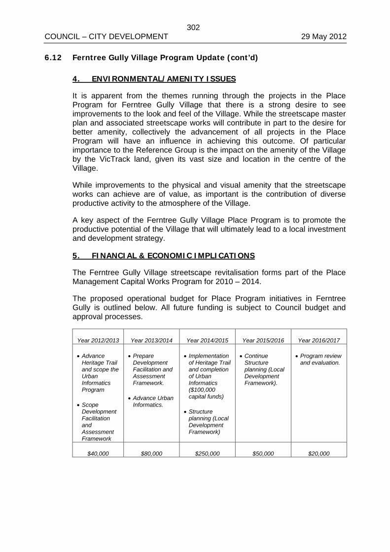
302 COUNCIL – CITY DEVELOPMENT 29 May 2012 6.12 Ferntree Gully Village Program Update (cont’d)
4. ENVIRONMENTAL/AMENITY ISSUES
It is apparent from the themes running through the projects in the Place Program for Ferntree Gully Village that there is a strong desire to see improvements to the look and feel of the Village. While the streetscape master plan and associated streetscape works will contribute in part to the desire for better amenity, collectively the advancement of all projects in the Place Program will have an influence in achieving this outcome. Of particular importance to the Reference Group is the impact on the amenity of the Village by the VicTrack land, given its vast size and location in the centre of the Village.
While improvements to the physical and visual amenity that the streetscape works can achieve are of value, as important is the contribution of diverse productive activity to the atmosphere of the Village.
A key aspect of the Ferntree Gully Village Place Program is to promote the productive potential of the Village that will ultimately lead to a local investment and development strategy.
5. FINANCIAL & ECONOMIC IMPLICATIONS
The Ferntree Gully Village streetscape revitalisation forms part of the Place Management Capital Works Program for 2010 – 2014.
The proposed operational budget for Place Program initiatives in Ferntree Gully is outlined below. All future funding is subject to Council budget and approval processes.
Year 2012/2013 Year 2013/2014 Year 2014/2015 Year 2015/2016 Year 2016/2017
• Advance Heritage Trail and scope the Urban Informatics Program
• Scope Development Facilitation and Assessment Framework
• Prepare Development Facilitation and Assessment Framework.
• Advance Urban Informatics.
• Implementation of Heritage Trail and completion of Urban Informatics ($100,000 capital funds)
• Structure planning (Local Development Framework)
• Continue Structure planning (Local Development Framework).
• Program review and evaluation.
$40,000 $80,000 $250,000 $50,000 $20,000
303 COUNCIL – CITY DEVELOPMENT 29 May 2012 6.12 Ferntree Gully Village Program Update (cont’d)
6. SOCIAL IMPLICATIONS
A key outcome of the Place Program to date has been the strengthening of relationships between Council, the Reference Group, the Lower Gully Traders Association and The Mountain District Learning Centre. The Place Program team has enabled this by providing a forum for representatives of these groups to get together and discuss the key issues and opportunities that exist in Ferntree Gully Village. Importantly, the conversation about Ferntree Gully’s future has gained its own momentum and continues beyond forums arranged by the Place Program team. Of note are the editorials run by The Ferntree Gully News that have picked up the theme of the potential future for the Village which in term encourage the conversation through the local community.
7. RELEVANCE TO COUNCIL PLAN
The engagement process and outcomes that led to the development of the Place Program for Ferntree Gully Village are relevant to the following key focus areas for Council activity, identified in the Council Plan for 2009-2013:
• Improving the community’s pride and connection within Knox. • Improving the functioning and appearance of activity centres. • Supporting local economic development and employment growth.
Strategic objectives relevant to the future Place Program for Ferntree Gully Village identified in the Council Plan for 2009-2013 are:
• Healthy, Connected Communities. • Culturally Rich and Active Communities. • Dynamic Services and Facilities. • Accessible Transport Choices. • Sustainable Natural Environment. • Attractive and Vibrant Places. • A Prosperous Modern Economy. • A Well Governed and Leading Organisation.
Council’s Organisation Objectives relevant to the Place Program for Ferntree Gully Village are:
• Partnering & Engaging. • Innovation & Excellence. • Effective Governance. • Stewardship of Finances and Assets. • Social and Environmental Responsibility.
304 COUNCIL – CITY DEVELOPMENT 29 May 2012 6.12 Ferntree Gully Village Program Update (cont’d)
8. CONCLUSION
The Place Program team has built a strong working relationship and level of trust with its partners in Ferntree Gully Village. Important advances on key initiatives of the Program have been made and energy and commitment in the community exists to see further progress. The Place Program team continue to support the Reference Group and enable a greater role for the local community in managing their future towards the Village’s transition to a resilient commercial/community hub.
9. CONFIDENTIALITY
There are no confidentiality issues associated with this report.
COUNCIL RESOLUTION MOVED: CR. McMILLAN SECONDED: CR. COOPER
That Council:
1. Note the progress and work completed to date on the Place Program for Ferntree Gully Village; and
2. Consider the new initiatives and financial implications outlined this report as part of a future budget process.
CARRIED
COUNCILLOR PEARCE RETURNED TO THE CHAMBER AT 8.47PM AFTER THE VOTE AND PRIOR TO DISCUSSION ON ITEM 7

305 COUNCIL – CITY DEVELOPMENT 29 May 2012 Appendix A - Lower Gully Traders Association Public Transport Survey

306 COUNCIL – CITY DEVELOPMENT 29 May 2012 2

307 COUNCIL – CITY DEVELOPMENT 29 May 2012 3

308 COUNCIL – CITY DEVELOPMENT 29 May 2012 4

309 COUNCIL – CITY DEVELOPMENT 29 May 2012 5

310 COUNCIL – CITY DEVELOPMENT 29 May 2012 6

311 COUNCIL – CITY DEVELOPMENT 29 May 2012 7

312 COUNCIL – CITY DEVELOPMENT 29 May 2012 8

313 COUNCIL – CITY DEVELOPMENT 29 May 2012 9

314 COUNCIL – CITY DEVELOPMENT 29 May 2012 10

315 COUNCIL – CITY DEVELOPMENT 29 May 2012 11
316 COUNCIL 29 May 2012
7. PUBLIC QUESTION TIME
Following the completion of business relating to Item 6, City Development, the business before the Council Meeting was be deferred to consider questions submitted by the public.
Question Time commenced at 8.47pm. The following questions were raised with Council:
Question 1 I wish to address my question, through the Chairman, to Cr. John Mortimore. The question is: What does Cr. Mortimore consider to be the significance of the photograph of himself in front of the town houses at 32 – 35 Chandler Road, as published in “Your Knox”, Autumn 2012.
Answer Councillor Mortimore responded that his desire was to promote a positive development within the municipality, an ideal type of development that Councillors are seeking. He further highlighted that this development was in the middle of an Activity Centre (in Boronia).
Councillor Mortimore re-inforced that this was the style of development that would meet the aspirations of the community and that the Council is looking for more developments of this type.
Question 2 Could any member of council tell us, the resident ratepayers, how we can WIN one of these building application arguments. It would seem that there is no way for residents to be successful in opposing building permit applications and that all that is being debated is how badly we will loose, because loose we will.
Answer The Mayor, Councillor Adam Gill responded by outlining that the Council is currently developing a strategy called Knox@50. Councillor Gill advised that this strategy seeks to provide a way forward for the Council to understand the aspirations of the community and it will do this by seeking feedback from the community. He further advised that the Knox@50 is not only about structure planning.
Question 3 Question directed to the whole of Council without notice – rubbish dumping at charitable institutions??? How can Council assist in reducing this problem!!!
317 COUNCIL 29 May 2012 7. Public Question Time (cont’d)
Answer to Question 3
The Director Engineering & Infrastructure Dr Ian Bell advised that tip vouchers had not been provided in the municipality for approximately ten (10) years. It was noted that Council provides a twice yearly kerbside hard waste collection service rather than tip passes. It was further noted that tip passes would necessitate residents carting hard waste to the transfer stations. The community continues to provide positive feedback in the annual satisfaction survey results regarding the kerbside hard waste collection service.
Dr Bell advised that the issue of rubbish being left alongside charitable donation bins or opportunity shops is a significant issue across all municipalities across all municipalities. Knox City Council encourages all charitable organisations who offer these donation points to work with Council’s Local Laws department to put in place strategies that may eradicate the dumping. Examples of such strategies are the installation of close circuit cameras. It was noted that Council is not in a position to resource the clean up of this rubbish dumping.
Question 4 Can Council provide an update on the myrtle rust threat in Knox and have any changes been made to Councils street and landscape plantings policy in response to the threat?
Answer The Director Engineering & Infrastructure Dr Ian Bell advised that officers are continuing to investigate the Myrtle Rust matter and are mindful of the risk that is presents to the municipality. Officers are also continuing to work with plant suppliers.
Question 5 How does Council propose to protect the newly replaced footpath assetts (sic) in the Heany Park Estate, from the assett (sic) damaging culpret(?) (sic) trees which are present in the residential naturestrips?
Answer The Director Engineering & Infrastructure Dr Ian Bell acknowledged that in hindsight that in parts of the municipality had not had the most appropriate species of trees planted.
Dr Bell advised that officers are following a process of ranking and prioritisation to remove some inappropriate trees in locations across the municipality. He also advised that in some instances that even though trees maybe damaging the infrastructure it has proven more cost effective to replace the infrastructure rather than removal and replacement of the tree
Question Time Concluded at 9.04pm.
318 COUNCIL – ENGINEERING & INFRASTRUCTURE 29 May 2012 COUNCILLOR COSSARI VACATED THE CHAMBER AT 9.00PM PRIOR TO DISCUSSION ON ITEM 8.1 COUNCILLOR COSSARI RETURNED TO THE CHAMBER AT 9.08PM DURING DISCUSSION ON ITEM 8.1 COUNCILLOR COLE VACATED THE CHAMBER AT 9.11PM DURING DISCUSSION ON ITEM 8.1 COUNCILLOR COLE RETURNED TO THE CHAMBER AT 9.13PM DURING DISCUSSION ON ITEM 8.1 COUNCILLOR WALTER LEFT THE MEETING AT 9.27PM DURING DISCUSSION ON ITEM 8.1
ALL WARDS
8.1 KNOX MOBILITY STUDY
SUMMARY: Sustainable Transport Planner (Melissa Sparrow)
Council commissioned a study into the accessibility of the footpath and shared path network for people using mobility equipment within Knox. The study has been completed and is now presented to Council with an Implementation Plan for consideration.
RECOMMENDATION
That Council:
1. endorse the draft Knox Mobility Study (circulated under separate cover to Councillors and available on Council’s website);
2. endorse the draft Implementation Plan in principle;
3. authorise consultation on the draft Implementation Plan; and
4. receive a subsequent report following consultation on the draft Implementation Plan, which includes a draft Five Year Capital Works Program to enact the Implementation Plan.
1. INTRODUCTION
Following a Call Up Item at the 23 February 2010 meeting of Council, a report was presented assessing the cost of undertaking a study of sustainable transport users across Knox at the 27 April 2010 Council meeting. Following consideration of the report, Council resolved to refer a business case to the 2011/12 budget process for a study of mobility scooters and wheelchairs. Funding was then allocated at the 2010/2011 midyear budget review ($50,000).
Consultants were commissioned and the Knox Mobility Study (the Study) was completed as a draft in October 2011. This study is believed to be one of the first of its kind to be undertaken by Victorian local government.
319 COUNCIL – ENGINEERING & INFRASTRUCTURE 29 May 2012 8.1 Knox Mobility Study (cont’d)
A draft Implementation Plan (the Plan) was subsequently prepared, with Council being briefed on both the Study and the Plan at the 3 April 2012 Issues Briefing Meeting. The draft Knox Mobility Study (circulated under separate cover to Councillors and available on Council’s website) is now presented for Council’s consideration and endorsement. The draft Implementation Plan (refer Appendix A) is submitted for Council’s consideration and endorsement for the purposes of proceeding with a consultation process.
2. DISCUSSION
2.1 Background
The primary purpose for undertaking the mobility study is to improve the quality of the footpath and shared path network in order to make it easier, safer and more comfortable for people using mobility equipment to move around and access services and facilities within Knox.
While there is information available regarding cyclists and pedestrians using the path network, little is currently known about the movement and needs of people using mobility equipment. To this end, it is noted that:
“The number and proportion of older people (55+) in Knox has been growing steadily over the last decade…….between 1996 and 2006 (numbers) increased by a massive 64 per cent. This means that a person aged 55 or older now accounts for one in every five Knox residents.
Between now and 2031, the percentage of Knox’s population age 55 and older will grow from 20 per cent (in 2008) to 28 per cent percent of the city’s population.” Knox Healthy Ageing Strategic Plan 2009-2013.
As mobility equipment is predominantly used by older people, Council can reasonably expect an increase in the number of people using mobility equipment on a regular basis. Of note, mobility equipment includes wheelchairs, mobility scooters, walking frames etc.
2.2 Findings in Knox • Anecdotally it has been observed that there is an increasing number of
older people using the shared path network and that a corresponding increase in the use of mobility scooters has occurred.
• It is of concern that “hundreds of older people go to hospital each year suffering serious head wounds and injuries to their hips and limbs after losing control of their mobility scooter or falling from the scooter.” (Help Cut Mobility Scooter Accidents, Australian Competition and Consumer Commission, 2010).
The objectives of the Study were to understand the current and future use of mobility aids within the City of Knox and to identify potential improvement to paths to make them more accessible for residents using mobility aids.
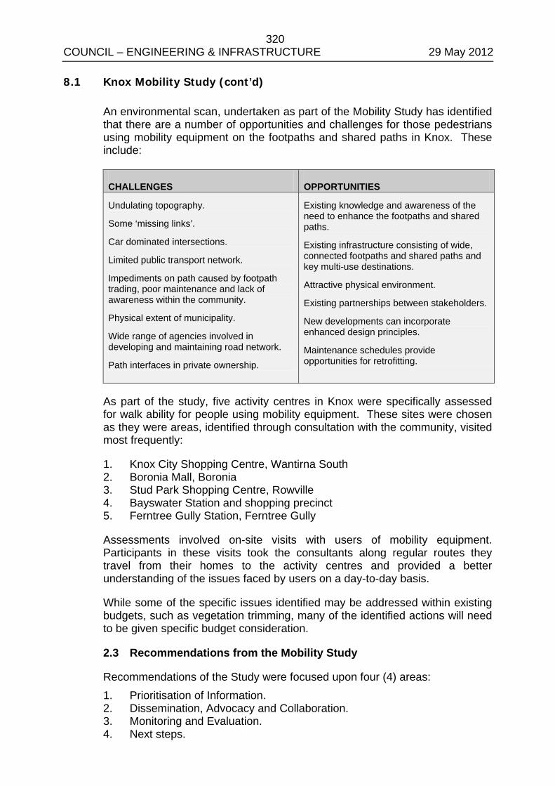
320 COUNCIL – ENGINEERING & INFRASTRUCTURE 29 May 2012 8.1 Knox Mobility Study (cont’d)
An environmental scan, undertaken as part of the Mobility Study has identified that there are a number of opportunities and challenges for those pedestrians using mobility equipment on the footpaths and shared paths in Knox. These include:
CHALLENGES OPPORTUNITIES
Undulating topography.
Some ‘missing links’.
Car dominated intersections.
Limited public transport network.
Impediments on path caused by footpath trading, poor maintenance and lack of awareness within the community.
Physical extent of municipality.
Wide range of agencies involved in developing and maintaining road network.
Path interfaces in private ownership.
Existing knowledge and awareness of the need to enhance the footpaths and shared paths.
Existing infrastructure consisting of wide, connected footpaths and shared paths and key multi-use destinations.
Attractive physical environment.
Existing partnerships between stakeholders.
New developments can incorporate enhanced design principles.
Maintenance schedules provide opportunities for retrofitting.
As part of the study, five activity centres in Knox were specifically assessed for walk ability for people using mobility equipment. These sites were chosen as they were areas, identified through consultation with the community, visited most frequently:
1. Knox City Shopping Centre, Wantirna South 2. Boronia Mall, Boronia 3. Stud Park Shopping Centre, Rowville 4. Bayswater Station and shopping precinct 5. Ferntree Gully Station, Ferntree Gully
Assessments involved on-site visits with users of mobility equipment. Participants in these visits took the consultants along regular routes they travel from their homes to the activity centres and provided a better understanding of the issues faced by users on a day-to-day basis.
While some of the specific issues identified may be addressed within existing budgets, such as vegetation trimming, many of the identified actions will need to be given specific budget consideration.
2.3 Recommendations from the Mobility Study
Recommendations of the Study were focused upon four (4) areas: 1. Prioritisation of Information. 2. Dissemination, Advocacy and Collaboration. 3. Monitoring and Evaluation. 4. Next steps.
321 COUNCIL – ENGINEERING & INFRASTRUCTURE 29 May 2012 8.1 Knox Mobility Study (cont’d)
In addition to the Study, a separate toolkit has been developed in relation to best practice design and construction of footpaths and shared paths for people using mobility equipment. This will be a resource for Council, developers and others involved in the planning, design and construction of paths within Knox, as the Study may be applied to all users of the footpath and shared paths.
2.4 Implementation Plan
Following completion of the Study, a Draft Implementation Plan was developed (Appendix A) to reflect the recommendations contained in the Study.
The Draft Mobility Study Implementation Plan has the overall aim of ensuring that infrastructure meets the increasing mobility needs of the community.
Actions have been divided into the areas of:
• Policy/standards • Education • Advocacy, and • Evaluation
The Implementation Plan identifies the major stakeholders, the timeframe for implementation and includes a preliminary estimate of cost.
While specifically focusing on people using mobility equipment the Knox Mobility Study will assist in the planning and design for all users of the footpath and shared path network including cyclists and pedestrians with prams.
By implementing the recommendations of the Knox Mobility Study, the quality of the footpath and shared path network will be enhanced which in turn, provides opportunities for a wide range of users to engage in healthy lifestyles and engage in community life in a safe and secure way.
3. CONSULTATION
The development of the scope of this study was undertaken in consultation with Councils Bicycle and Pedestrian Advisory Committee and a brief prepared following the Committee’s input.
An electronic survey was available on Council’s website.
Hard copy surveys were distributed to retirement villages in Knox and previous attendees at Council Scooter Forums.
Two workshops were held - one with residents using mobility equipment and one with Council officers.
322 COUNCIL – ENGINEERING & INFRASTRUCTURE 29 May 2012 8.1 Knox Mobility Study (cont’d)
Four experiential site visits were undertaken with people using different types of mobility equipment.
The Implementation Plan was developed by the Transport & Traffic and Community Access & Equity teams.
A steering group with relevant Council officers will be established to guide the implementation of the Mobility Study actions.
In order to develop a prioritised 5-Year Capital Works Program, further consultation with the community is required. This will involve seeking feedback from those involved in the workshops and site visits during development of the Mobility Study. Following the consultation, the Implementation Plan will be reviewed and a prioritised Five Year Capital Works Program will be presented to Council for consideration.
4. ENVIRONMENTAL/AMENITY ISSUES
Transport services affect the quality of life of residents and it is therefore important that there are transport choices and sustainable transport options available. This is particularly significant given the growing aging population in Knox.
5. FINANCIAL & ECONOMIC IMPLICATIONS
Funding for the Mobility Study Implementation Plan will need to be referred to future budget submissions.
There are approximately $200,000 of initiatives (mainly process and system improvements) identified within the 5 year Draft Mobility Study Implementation Plan. These are critical to support the identification and prioritisation of infrastructure improvements and education of Council officers to ensure the needs of mobility aid users are considered at all times.
As part of the Mobility Study, consultants undertook site visits with users of mobility aids to experience the issues they face when travelling around their local area. This and feedback from users via workshops and surveys were then collated and recommendations made for five focus areas- Knox, Boronia, Stud Park, Bayswater and Ferntree Gully Activity Centres.
In many instances while Council is meeting existing standards, mobility aids are changing in design and an increasing ageing population is necessitating a higher standard of infrastructure.
Actions identified within each focus area range from maintenance improvements such as removal of lips on pram ramps and overhanging trees through to new works such as missing footpath links and pedestrian crossings. It is estimated that Capital Works improvements identified for each focus area is in the order of $500,000.
323 COUNCIL – ENGINEERING & INFRASTRUCTURE 29 May 2012 8.1 Knox Mobility Study (cont’d)
Recommended actions within each of the five focus areas may be used to determine the level of investment needed in other parts of the municipality.
It is noted that the focus areas also incorporate land or infrastructure that is privately owned or controlled or managed by a government department such as VicTrack. In these cases, Council would advocate for improvements to mobility access.
6. SOCIAL IMPLICATIONS
Being mobile is critical to those wishing to access local services, facilities and fully participate in community life and maintain wellbeing. A mobile and accessible community helps people to have equitable access to reliable public and community transport systems and, in turn enables them to move about, travel to work and visit family and friends.
Transport infrastructure needs to serve the needs of the community to travel to activities and places in a safe, efficient and affordable manner.
“To maximise social inclusion, it is critical to ensure buildings, community infrastructure and transport are accessible and that older people have information about alternative transport options”. Key result area 4: Supporting independence, Knox Healthy Ageing Strategic Plan 2009-2013.
7. RELEVANCE TO COUNCIL PLAN
A number of issues concerning access and inclusion for people with disabilities arise in each of the eight (8) strategic objectives of the Council Plan.
These include:
1. creating an accessible Knox for all members of our diverse community;
2. ensuring a wide range of sporting and leisure opportunities is readily available;
3. planning, managing and maintaining appropriate facilities and infrastructure to meet the community’s needs into the future;
4. building partnerships and advocating for services and facilities to meet identified communities needs;
5. planning for and delivering high quality and appropriate services and facilities that support transport choice in Knox; and
6. partnering and engaging with and on behalf of our community.
324 COUNCIL – ENGINEERING & INFRASTRUCTURE 29 May 2012 8.1 Knox Mobility Study (cont’d)
Other relevant Council documents include Vision 2025; Knox Health and Wellbeing Strategy 2009-2013, Knox City Council Access and Inclusion Plan 2011-2015, Knox City Council Pedestrian Plan 2005, Knox City Council Knox Bicycle Plan Review and Knox City Council (2006) Footpath and Shared Path Asset Management Plan.
Undertaking improvements to the footpath and shared path network to better meet the needs of residents who use mobility equipment fits within the Theme of ‘Accessible Transport Choices’ and the objective:
To provide real travel choice and reduce inequalities in access to transport opportunities in Knox by advocating for and facilitating improvements in transport infrastructure and services.
8. CONCLUSION
While specifically focussing on the needs of mobility aid users, it is clear that recommendations from the Knox Mobility Study will improve access for all pedestrians.
A priority action list, ranking criteria and a 5-Year Capital Works Program for mobility improvements is needed. Development of this program will require additional community consultation.
9. CONFIDENTIALITY
There are no issues of confidentiality associated with this report. PROCEDURAL MOTION
MOVED: CR. VAN DE VREEDE SECONDED: CR. McMILLAN That Council grant Councillor Pearce an extension of time under Clause 47 of the Meeting Procedure and use of common Seal of Local Law 2008. CARRIED
PROCEDURAL MOTION
MOVED: CR. COOPER SECONDED: CR. COLE That Council grant Councillor Van de Vreede an extension of time under Clause 47 of the Meeting Procedure and use of common Seal of Local Law 2008. CARRIED
325 COUNCIL – ENGINEERING & INFRASTRUCTURE 29 May 2012 8.1 Knox Mobility Study (cont’d)
COUNCIL RESOLUTION MOVED: CR. MORTIMORE SECONDED: CR. COOPER
That Council:
1. endorse the draft Knox Mobility Study (circulated under separate cover to Councillors and available on Council’s website);
2. endorse the draft Implementation Plan in principle;
3. authorise consultation on the draft Implementation Plan; and
4. receive a subsequent report following consultation on the draft Implementation Plan, which includes a draft Five Year Capital Works Program to enact the Implementation Plan.
CARRIED

326 COUNCIL – ENGINEERING & INFRASTRUCTURE 29 May 2012 APPENDIX A/1

327 COUNCIL – ENGINEERING & INFRASTRUCTURE 29 May 2012 APPENDIX A/2
328 COUNCIL – COMMUNITY SERVICES 29 May 2012 COUNCILLOR COLE LEFT THE MEETING AT 9.34PM PRIOR TO DISCUSSION ON ITEM 9.1
ALL WARDS
9.1 REVIEW OF COUNCIL’S MAJOR FESTIVAL AND EVENTS PROGRAM 2011-2012
SUMMARY: Events and Cultural Development Officer (Malcolm Russell)
This report reviews Council’s 2011-12 major Festivals and Events being the Stringybark Festival, Carols by Candlelight, and the Knox Festival. It also acknowledges the contribution to the festivals made by volunteers and nominates proposed dates for the 2012-13 program.
RECOMMENDATION
That Council:
1. Notes this evaluation report of Council’s major Festival and Events for 2011-12;
2. Acknowledge the outstanding contribution made by the 2,330 volunteers and 250 community groups for the critical role they played in the delivery of Council’s major Festivals and Events 2011-12;
3. Forward a letter of thanks to the community groups for their significant roles in the growing success of these events; and
4. Endorse the dates for the 2012-13 major Festivals and Events being Stringybark Festival on Saturday, 20 October and Sunday, 21 October 2012, Knox Carols by Candlelight on Saturday, 1 December 2012, and the Knox Festival to be held on Saturday, 2 March and Sunday, 3 March 2013.
1. INTRODUCTION
Knox City Council is widely recognised for the quality, scale, and level of community engagement created by its annual program of major festivals and events.
In 2011-12 the Knox Festival was acknowledged in Hansard by James Merlino MP, Member for Monbulk, as one of the longest running and most successful community art festivals in Melbourne, while the Stringybark Suburban Sustainability Festival enjoyed a record attendance. In addition, Carols by Candlelight, featuring Gina Jeffries, Jay Laga’aia and the Australian Army band, was one of the largest events of its kind in Melbourne, with 200 performers and an audience in excess of 15,000.
This report provides an overview and evaluation of the major Festivals and Events Program 2011-12, (the Program) and proposes the 2012-13 program and dates.
329 COUNCIL – COMMUNITY SERVICES 29 May 2012 9.1 Review of Councils Major Festival and Events Program 2011-12
(cont’d)
2. DISCUSSION
2.1 Themes
Unique community advocacy themes drive the programming focus of each event and contribute substantially to their high levels of recognition, growth and community engagement.
In 2011, the Stringybark Festival expanded its traditional environmental showcase to include contemporary sustainability issues around the theme “Use Less, Waste Less, Pay Less, Live Smarter”.
In 2012, Knox Festival’s “In the Making” theme celebrated the making of community through a substantial community art making focus, recognising the important foundations of the event. It was an outstanding success that was acknowledged by many of its longstanding community stakeholders.
Meanwhile, Carols by Candlelight, Council’s flagship access and inclusion event, reached out across Knox as Council’s largest single day community gathering of the year.
2.2 Key Numbers
During 2011-12, nearly 75,000 people attended one or all of the City’s major festivals and events. In a municipality of 156,000 people, this number demonstrates the strong sense of ownership our community has for these events, and the sense of identity the community receives from this program.
Supporting the program were over 300 event management volunteers, consisting mainly of Council staff and students from the Holmesglen and Chisholm TAFEs. Supporting the community stakeholders presence at these events were also over 2000 additional local community volunteers.
These volunteers were part of over 300 predominantly Knox-based community groups and local businesses that took part in the Program. These organisations included: Local Businesses: 76 Schools: 52 Sustainability Organisations: 46 Local Arts Practioners: 46 Health & Seniors: 23 Churches: 16 Sport & Recreation Clubs: 16 Youth Organisations: 15 Multicultural Groups: 6
330 COUNCIL – COMMUNITY SERVICES 29 May 2012 9.1 Review of Councils Major Festival and Events Program 2011-12
(cont’d)
While the growth in the engagement of community groups continues from year to year, one area where there was a substantial decrease in the Program was multicultural groups with a reduction from the previous year of 23 to 6. This resulted from changes in the priorities of the Knox Multicultural Advisory Committee, and Council no longer being eligible to access State government funding to support a specialised program in this area.
A full breakdown of community groups that participated in the major Program is attached to this report as Appendix ‘A’.
2.3 Highlights of the Festival and Events Program 2011-2012
2.3.1 Knox Festival
School programming
In 2012 a record number of schools and learning institutions were involved in a range of different art based and learning projects which culminated at the festival. They included students from Pre-school, Primary, Secondary, Tertiary, Victorian Certificate of Applied Learning and Access and Inclusion programs. A range of creative works generated from these programs will be displayed throughout the community at sites such the Arboretum, the Knox Skate and BMX Park billboard, and the Boronia Cinema Lane lightboxes.
The Knox and Ferntree Gully Community Arts Centres
The Ferntree Gully Community Arts Centre was handed back to Centre staff for the first time in many years as they promoted programs for both venues including ‘Contact - the Netball Opera’, in conjunction with Netball Victoria, and ‘Loopy Tunes’, a joint project with the Victorian Arts Centre.
Engagement with Knox Community Artists
The 2012 theme, “In the Making”, promoted local performers and visual artists through a contemporary festival theme and program that linked the festival’s traditional roots, and the special place it holds in the City’s identity.
2.3.2 Stringybark
Stakeholders
A significant number of major sustainability stakeholders in Victoria were engaged in the 2011 event, which reflects the growing reputation of the Stringybark Suburban Sustainability initiative across the state. Peak attendees included Parks Victoria, the Sustainable Living Foundation and Melbourne Water.
331 COUNCIL – COMMUNITY SERVICES 29 May 2012 9.1 Review of Councils Major Festival and Events Program 2011-12
(cont’d)
Programming
Stringybark’s increased focus on biodiversity in 2011 created a unique event program that promoted awareness and sensitivity to our local species of flora and fauna. Featuring personalities from the ABCTV children’s program, ‘Wild Action’, the display proved highly popular with audience numbers spilling in to adjoining displays as they queued to come in to contact with live indigenous species such as the koala, wallaby, kookaburra, tawny frogmouth, and ring-tail possum. This theme was also reflected in an exhibition of over 30 paintings of favourite animals by budding artists from the Rowville Community Centre Pre-kinder Care program.
The Hybrid Powered Vehicle display, featuring vehicles and schools based working programs was also hugely successful, specifically featuring vehicles produced by Knox students.
2.3.3 Carols by Candlelight
Community Engagement
A unique balance of community and professional performances created a quality program that also provided high profile professional development opportunities for the over 100 young local singers, dancers, acrobats and roving performers. The program also included on-stage presence by 15 local Churches, the State Emergency Services and Country Fire Authority.
2.4 Issues
Following each event there are a series of consultation processes as outlined in Section 3.1 of this report to discuss challenges and opportunities.
2.4.1 Poor Weather at Knox Festival
Council officers were tested throughout the weekend by high winds and heavy rain resulting in some infrastructure and site damage. Overnight gusts on the Thursday and Friday night of up to 50kph, and persistent rain through most of Saturday also created the need for extra marquee hire to support those community groups with inadequate protection.
These conditions also resulted in the inability of the SES to provide gate staff as they were required to attend other weather related issues across the state.
Further difficulties ensued with the build up of mud in heavy pedestrian traffic areas, and resulted in some heavy vehicles being bogged on site.
332 COUNCIL – COMMUNITY SERVICES 29 May 2012 9.1 Review of Councils Major Festival and Events Program 2011-12
(cont’d)
At 6:00pm on the Saturday night during the pre-scheduled emergency services briefing for Police, Security and Council’s own Events, Risk and Parks staff it was decided that the site was unsafe for public access for the evening program that included outdoor cinema and fireworks. Issues raised by those present included mud related tripping hazards in darkness, electrical safety and high water movement of the adjoining creek.
In accordance with the Knox Festival Event Management Plan, a decision was made to cancel the evening event. The public were notified of this change via Council’s webpage and Twitter sites, along with arranging a community announcement on radio station 3AW. Signage was also placed on the entrance gates with security who estimated that no more than 20 to 30 people enquired at the gates throughout the evening about the status of the event. Given there were over 5000 people in attendance at this event the previous year, the cancellation process was considered to be successful. No negative feedback was received from either the general public or media about this decision.
2.4.2 Stringybark Siteholder Turnover
The presence and participation of organisations that espouse a strong sustainability message is critical to the identity and success of Stringybark. The fact that many are under-resourced is a challenge, and will continue to contribute to a relatively high turnover of siteholders.
Council officers do not believe the difficulties experienced by these peak organisations will directly impact on income or community engagement levels, particularly as the feedback received from local stakeholders has been overwhelmingly positive. However, there will need to be continued work done by Council staff to consolidate the presence of key stakeholders as an important cornerstone of the Stringybark event.
2.4.3 Increasing Demand from Community Groups
The increasing number of community groups applying for sites at Knox’s major festivals and events continues to impact upon Council officer time and budget. At the same time, Council staff are experiencing increasing requests from community groups to assist them in a range of compliance issues related to the delivery of their own non-Council events.
This substantial increase in community groups involved with Council’s major festival and events contributes greatly to the quality of our events, and their connection to our community, while Council’s support on compliance issues for those community groups wishing to run their own events creates greater potential for them to fundraise, membership drive and promote community programs.
333 COUNCIL – COMMUNITY SERVICES 29 May 2012 9.1 Review of Councils Major Festival and Events Program 2011-12
(cont’d)
Council will continue to monitor the resource implications of supporting the growing number of community groups requiring event delivery assistance. A proposed part-time community support events officer will be referred to Council for consideration in future budget processes.
2.4.4 Volunteer Management
Greater compliance demands have also impacted substantially in the need for volunteers. In 2011-2012 over 2000 volunteer hours were required specifically for Council’s critical role in the compliant delivery of its events. The amount of officer time to facilitate such large numbers is estimated to be 755 hours per annum. The increasing demand on officer time to contact and attract, coordinate and induct, manage and then debrief this growing volunteer corps has been included within Council’s workforce planning process.
Volunteers present a significant two fold benefit to Council and the community; providing an opportunity for individuals to be involved in a positive community experience, and enabling Council staff to manage the costs associated with the delivery of these three major events within budget.
A detailed breakdown of volunteer hours is attached to the report as Appendix B.
2.4.5 Proposed Dates and Theme for Knox Festival 2013
The proposed dates for the Council’s major Festival and Events program for 2012-13 are Saturday 20 and Sunday 21 October 2012 for the Stringybark Festival, Knox Carols by Candlelight on Saturday 1 December 2012, and Knox Festival on Saturday 2 March and Sunday 3 March, 2013.
The Knox Festival’s community art making theme for 2013 will be a celebration of Knox@50.
3. CONSULTATION
3.1 Processes
All three events use a detailed briefing and de-briefing process involving all major local event stakeholders including Knox Police, SES, CFA, and St. John, along with the relevant Council units including Parks, Health Services, Risk Management, Facilities and Local Laws. All community groups, participating Council staff, student volunteers and other festival stakeholders are requested to attend pre-event meetings for both the Stringybark and Knox Festivals, and invited to evaluate their experiences post-event.
334 COUNCIL – COMMUNITY SERVICES 29 May 2012 9.1 Review of Councils Major Festival and Events Program 2011-12
(cont’d)
For the first time in 2011-12 Council’s Customer Service team conducted a survey of our 3 major events, with 2446 residents polled on their festival experiences. Both the feedback and response levels were very positive with 46% of all callers having attended one or more of Council’s major events in recent years.
Informal feedback is also sought from a diverse range of general public surveys run by groups such as Eastern Regional Libraries, Rowville & District Neighbourhood House and the Council’s Youth Services Unit.
In addition, community comments found in the local media are monitored and where appropriate, a response provided.
The successful public behaviour at the events program developed by Council staff and Knox Police in recent years was expanded in 2011-12 to include a group meeting with local liquor outlet proprietors on the prevention of alcohol sale to minors and other related issues.
Coordinated by Council, in conjunction with Knox Police, the program received positive endorsement from the local proprietors, and included an onsite visit to Ferntree Gully Woolworths and the other six liquor outlets located near Wally Tew Reserve, in the lead up to this year’s Festival.
3.2 Community Feedback
The feedback received following each event was very constructive. This feedback provides the Council with a range of comments which are included in planning for the following year’s events. The Program was widely considered by community and stakeholders to be the best ever. The Knox Police in particular were very happy with the planning and night time strategies for both Knox Festival and Carols.
The feedback received from our surveys highlighted the family friendly community atmosphere, low cost, and quality of programming and organisation levels. The Knox Festival in particular received many positive comments about the access to Council and community programs.
Negative feedback was predominantly specific to a lack of parking across all 3 events, whilst queues for toilets at Carols were also a big concern.
Other comments forwarded to Council included:
Knox Festival
Whole community aspect of the festival is with local people, not some big show that gets shipped in from interstate.
Loved the fact that I could speak with someone from Council and understand what Council can do for me!!!
335 COUNCIL – COMMUNITY SERVICES 29 May 2012 9.1 Review of Councils Major Festival and Events Program 2011-12
(cont’d)
Lots of variety and shows off Knox. Able to access information about Knox.
Great updates advising that the night had been cancelled. Thank you.
Would like to congratulate Knox on getting it right.
Like the great community spirit of the festival. Liked the local clubs having the opportunity to showcase themselves.
Nice atmosphere and supporting communities also its great finding out about little things in the community that you would normal find out.
We like the rides and kids hanging with their friends in a safe environment.
Joined the CFA from the event, love the multicultural food to try.
Kids like the rides and the daughter likes to vote for the banners. Enjoy seeing the artwork
See the community, fun event, safe.
(Local residents’ feedback from survey conducted by Knox City Council Customer Service).
Stringybark Festival
I certainly can’t speak after 2 days of talking! However can write to express my sincere thanks for having Very Edible Gardens there at your incredible Stringybark festival. To have 25,000 people through the gates to a festival devoted to showcasing sustainability is testament to you insight, values and passions to make this incredible world we live in healthier, happier and a whole lot more fun! Congratulations to all of your hard working staff and volunteers on a wonderful and unsurpassed event.
Hello - we went to the Stringybark festival on Sunday, the first time for many years, with our 4 and 6 yr old children. It was brilliant! The rides were particularly good - reasonably priced, exciting and well supervised. The range of stands etc was so good - well done on organising it, a job really, really well done!
(From letters forwarded to Council post event).
Carols By Candlelight
Good family atmosphere, kids enjoy, excellent acts and it's free.
Go every year and enjoy everything about the event.
Whole set up - very impressed.
Beautiful family event, loved it.
336 COUNCIL – COMMUNITY SERVICES 29 May 2012 9.1 Review of Councils Major Festival and Events Program 2011-12
(cont’d)
Family oriented, great event
Wheelchair parking close by is very good, love the fireworks
Sense of community, lovely to see families together as it’s free. Extremely well run.
It’s fantastic
(Local resident’s feedback from survey conducted by Knox City Council Customer Service).
4. ENVIRONMENTAL/AMENITY ISSUES
The Program contributes directly and indirectly to improving Knox’s environment and amenity. All three events actively promote the amenity, safety and accessibility of outdoor and indoor public space through the staging of large scale events which engage substantial numbers of the Knox community directly with Council’s facilities and services.
The Stringybark Festival adopted leading event practice around sustainable event delivery through initiatives such as Wash against Waste, Natural Event Waterless toilets, interchangeable signage, recycling and green waste, and the use of biodiesel to power its low energy fairground. Stringybark raised awareness around sustainability through programming in partnership with some of Victoria’s leading sustainability stakeholders in The Sustainable Living Foundation, Melbourne Water, Aurora Solar Vehicle Association, and Ceres.
Council’s Community Transport team operated a shuttle bus service for the Stringybark and Knox Festivals receiving increased profile and support. 544 residents took advantage of this service. Both events also promoted the use of Knox’s bike paths, walking and public transport, resulting in reduced parking and traffic congestion.
5. FINANCIAL & ECONOMIC IMPLICATIONS
The cost to deliver the logistics and infrastructure of Council’s Major Festivals and events is principally met by Council’s operating budget. In 2011-12 Council provided a total budget of $332,755.00 to stage these three events, including revenue raised from siteholder fees and gate takings.
Various compliance issues related to public events, including Public Risk, Occupational Health and Safety, Access & Inclusion, Waste Management and Food Services continue to require budget attention and dictate a substantial requirement for volunteers. The associated costs of maintaining compliance, and securing, managing and catering for such large numbers of volunteers continues to rise.

337 COUNCIL – COMMUNITY SERVICES 29 May 2012 9.1 Review of Councils Major Festival and Events Program 2011-12
(cont’d)
The engagement of sponsors was principally linked to the branding of entertainment program items such as stages, performers, workshops and activities. In 2011-2012 sponsorship was received from first time sponsor Mirvac, while other sponsors included Ferntree Gully Holden and Suzuki, Knox Shopping Centre, Bus Association Victoria, Leader Newspapers, and Channel Nine. Sponsorship income totalled $45,478.09, the equivalent to 49% of our total entertainment budget.
Anecdotally, community groups reported record returns in terms of income for Stringybark and Carols although these figures are not disclosed.
Returns for Knox Festival were down for both the gate and all siteholders due to inclement weather.
6. SOCIAL IMPLICATIONS
Council’s major festivals and events attract participation from a wide cross section of the community, most notably schools, families, young people, and an increasing number of older people. Their themes are based around Council advocacy issues such as public transport, community building and safety, health and wellbeing and sustainability.
All three events contribute to community wellbeing by creating fundraising and awareness raising opportunities for organisations to deliver services to the community, the promotion of volunteerism, the provision of staging facilities for local performers, equal access to people of all abilities, healthy catering choices and appropriate activities for people of all ages that encourage participation and community connectivity.
Local schools are involved with festival programs, supported by Councils’ own Family and Children’s Services, Youth Services, Sustainability, Waste and Community Wellbeing units. Meanwhile older members of the community actively participate through the work of such organisations as the Knox Woodworkers Association, and the Mountain District Women’s Co-op and the promotion of Seniors Week as an important part of Stringybark’s Sustainable Communities program.
Knox Carols by Candlelight through the provision of access infrastructure for parking, toilets, site access, marketing and programming, has created a benchmark free accessible event for all ages and abilities.
338 COUNCIL – COMMUNITY SERVICES 29 May 2012 9.1 Review of Councils Major Festival and Events Program 2011-12
(cont’d)
7. RELEVANCE TO COUNCIL PLAN
The Program supports the objectives of the Council Plan 2009-13 (2010 update) by contributing to a safe, healthy and connected community specifically by: • Developing healthy connected communities through consulting, working
with and actively promoting a comprehensive range of community organisations.
• Building culturally rich and active communities by providing programs that promote diverse arts, leisure and cultural pursuits in an environment of shared inclusive open space.
• Contributing to Council’s dynamic services and facilities by providing a high profile forum to consult actively with our community about their needs and expectations as part of building and promoting Council’s own best value programs.
• Showcasing accessible transport choices through partnerships with BusVic, Metlink, Council’s own Transport and Traffic Unit, and local businesses in the promotion of Council’s own bicycle path network, public transport options, and safe use of public space.
• Promoting a sustainable natural environment as a leader in community sustainability events that promotes a healthier local environment, a green and leafy municipality, and sustainable living opportunities for all.
• Encouraging attractive and vibrant places through the promotion of local facilities, open spaces and cultural sites such as Stamford Park, and heritage groups such as Knox Historical Society.
• Contributing to a prosperous modern economy by creating effective and good value opportunities for local and emerging contemporary businesses to promote their products and services, and develop relationships with each other, their community, and Council.
• Highlighting a well governed and leading organisation through creating best practice events that develop strong partnerships between community and Council.
8. CONCLUSION
Knox City Council’s Major Festival and Events Program for 2011-12 was an outstanding success. It was successful in building opportunities for the community to source information and enable consultation, celebrate and experience cultural activities, and to promote and receive feedback on Council’s own programs. The record levels of attendance, participation and positive response indicate that Knox City Council’s Major Festival and Event program for 2010-12 was one of the best ever.
339 COUNCIL – COMMUNITY SERVICES 29 May 2012 9.1 Review of Councils Major Festival and Events Program 2011-12
(cont’d)
Nearly half of the residents surveyed by Council’s Customer Service team had visited at least one of our major festivals and events within the last 5 years. Council’s positive image featured strongly in this feedback, as did access to community information, and the strong community identity attached to these events.
It is proposed that the 2012-13 programs build on the successes and improvements of 2011-12. The proposed dates will be Stringybark Festival on Saturday, 20 October and Sunday, 21 October 2012, Knox Carols by Candlelight on Saturday, 1 December 2012, and Knox Festival to be held on Saturday, 2 March and Sunday, 3 March 2013.
9. CONFIDENTIALITY
There are no confidential items in this report.
COUNCIL RESOLUTION MOVED: CR. COOPER SECONDED: CR. COSSARI
That Council:
1. Notes this evaluation report of Council’s major Festival and Events for 2011-12;
2. Acknowledge the outstanding contribution made by the 2,330 volunteers and 250 community groups for the critical role they played in the delivery of Council’s major Festivals and Events 2011-12;
3. Forward a letter of thanks to the community groups for their significant roles in the growing success of these events; and
4. Endorse the dates for the 2012-13 major Festivals and Events being Stringybark Festival on Saturday, 20 October and Sunday, 21 October 2012, Knox Carols by Candlelight on Saturday, 1 December 2012, and the Knox Festival to be held on Saturday, 2 March and Sunday, 3 March 2013.
CARRIED
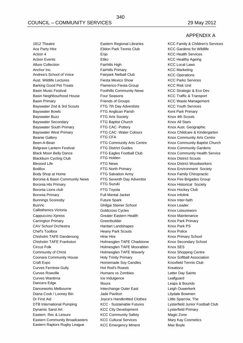
340 COUNCIL – COMMUNITY SERVICES 29 May 2012
APPENDIX A 1812 Theatre Ace Party Hire Action 4 Action Events Allure Collection Anchor Inc. Andrea's School of Voice Aust. Wildlife Lectures Barking Good Pet Treats Basin Music Festival Basin Neighbourhood House Basin Primary Bayswater 2nd & 3rd Scouts Bayswater Bowls Bayswater Buzz Bayswater Secondary Bayswater South Primary Bayswater West Primary Beanie Gallery Been-A-Bean Belgrave Lantern Festival Black Moon Belly Dance Blackburn Cycling Club Blessed Life Bodiluv Body Shop at Home Boronia & Basin Community News Boronia Hts Primary Boronia Lions club Boronia Primary Bunnings Scoresby BusVic Callisthenics Victoria Cappuccino Xpress Carrington Primary CAV School Orchestra Chef's Toolbox Chisholm TAFE Dandenong Chisholm TAFE Frankston Circus Folk Community of Christ Coonara Community House Craft Expo Curves Ferntree Gully Curves Rowville Curves Wantirna Dancers Edge Danceworks Melbourne Diana Cook / Looney Bin Dr First Aid DTB International Pumping Dynamic Sand Art Eastern Rec & Leisure Eastern Community Broadcasters Eastern Raptors Rugby League
Eastern Regional Libraries Eildon Park Tennis Club Enjo Etiko Fairhills High Fairhills Primary Fairpark Netball Club Fiesta Mexico Show Flamenco Fiesta Group Foothills Community News Four Seasons Friends of Groups FTG 7th Day Adventists FTG Anglican Parish FTG Arts Society FTG Baptist Church FTG CAC -Pottery FTG CAC -Water Colours FTG CFA FTG Community Arts Centre FTG District Guides FTG Eagles Football Club FTG Holden FTG News FTG North Primary FTG Salvation Army FTG Seventh Day Adventist FTG Suzuki FTG Toyota Full Mental Jacket Future Spark Ghilgai Steiner School Goldcross Cycles Greater Eastern Health Greenbuilder Hardart Landshapes Heany Park Scouts Hine Hire Holmesglen TAFE Chadstone Holmesglen TAFE Moorabbin Holmesglen TAFE Waverly Holy Trinity Primary Homemade Soy Candles Hot Rod's Roasts Humans vs Zombies Ice Indulgence Illoura Interchange Outer East Jade Pavilion Joyce's Handknitted Clothes KCC - Sustainable Futures KCC City Development KCC Community Safety KCC Cultural Services KCC Emergency Mment
KCC Family & Children's Services KCC Gardens for Wildlife KCC Health Services KCC Healthy Ageing KCC Local Laws KCC Marketing KCC Operations KCC Parks Services KCC Risk Unit KCC Strategic & Eco Dev KCC Traffic & Transport KCC Waste Management KCC Youth Services Kent Park Primary Knox 4th Scouts Knox All Stars Knox Aust. Geographic Knox Childcare & Kindergarten Knox Community Arts Centre Knox Community Baptist Church Knox Community Gardens Knox Community Health Service Knox District Scouts Knox District Woodworkers Knox Environment Society Knox Family Chiropractic Knox Fire Brigades Group Knox Historical Society Knox Hockey Club Knox Infolink Knox Inter-faith Knox Leader Knox Leisureworx Knox Maintenance Knox Park Primary Knox Park PS Knox Police Knox Primary School Knox Secondary School Knox SES Knox Shopping Centre Knox Softball Association Knoxfield Tennis Club Kreationz Latter Day Saints Leafguard Leaps & Bounds Leigh Ouwerkerk Lilydale Bowmen Little Sparrow, The Lysterfield Junior Football Club Lysterfield Primary Magic Zone Mary Kay Cosmetics Max Boyle
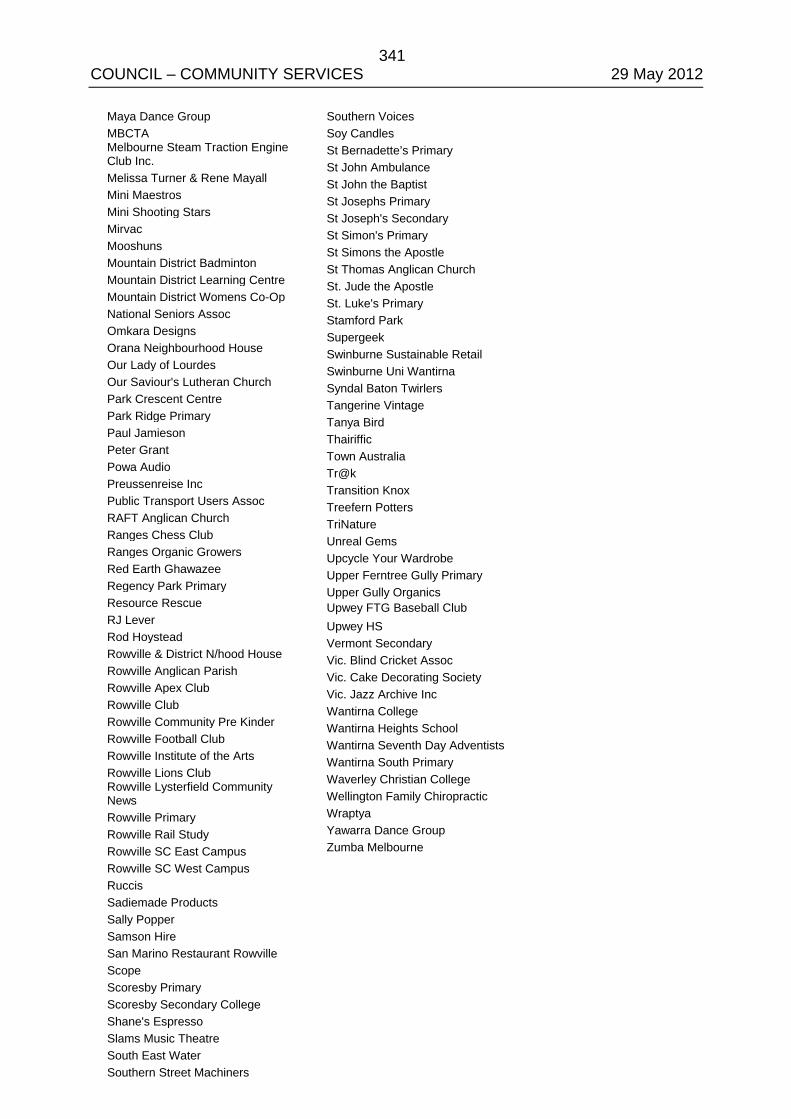
341 COUNCIL – COMMUNITY SERVICES 29 May 2012
Maya Dance Group MBCTA Melbourne Steam Traction Engine Club Inc. Melissa Turner & Rene Mayall Mini Maestros Mini Shooting Stars Mirvac Mooshuns Mountain District Badminton Mountain District Learning Centre Mountain District Womens Co-Op National Seniors Assoc Omkara Designs Orana Neighbourhood House Our Lady of Lourdes Our Saviour's Lutheran Church Park Crescent Centre Park Ridge Primary Paul Jamieson Peter Grant Powa Audio Preussenreise Inc Public Transport Users Assoc RAFT Anglican Church Ranges Chess Club Ranges Organic Growers Red Earth Ghawazee Regency Park Primary Resource Rescue RJ Lever Rod Hoystead Rowville & District N/hood House Rowville Anglican Parish Rowville Apex Club Rowville Club Rowville Community Pre Kinder Rowville Football Club Rowville Institute of the Arts Rowville Lions Club Rowville Lysterfield Community News Rowville Primary Rowville Rail Study Rowville SC East Campus Rowville SC West Campus Ruccis Sadiemade Products Sally Popper Samson Hire San Marino Restaurant Rowville Scope Scoresby Primary Scoresby Secondary College Shane's Espresso Slams Music Theatre South East Water Southern Street Machiners
Southern Voices Soy Candles St Bernadette’s Primary St John Ambulance St John the Baptist St Josephs Primary St Joseph's Secondary St Simon's Primary St Simons the Apostle St Thomas Anglican Church St. Jude the Apostle St. Luke's Primary Stamford Park Supergeek Swinburne Sustainable Retail Swinburne Uni Wantirna Syndal Baton Twirlers Tangerine Vintage Tanya Bird Thairiffic Town Australia Tr@k Transition Knox Treefern Potters TriNature Unreal Gems Upcycle Your Wardrobe Upper Ferntree Gully Primary Upper Gully Organics Upwey FTG Baseball Club Upwey HS Vermont Secondary Vic. Blind Cricket Assoc Vic. Cake Decorating Society Vic. Jazz Archive Inc Wantirna College Wantirna Heights School Wantirna Seventh Day Adventists Wantirna South Primary Waverley Christian College Wellington Family Chiropractic Wraptya Yawarra Dance Group Zumba Melbourne
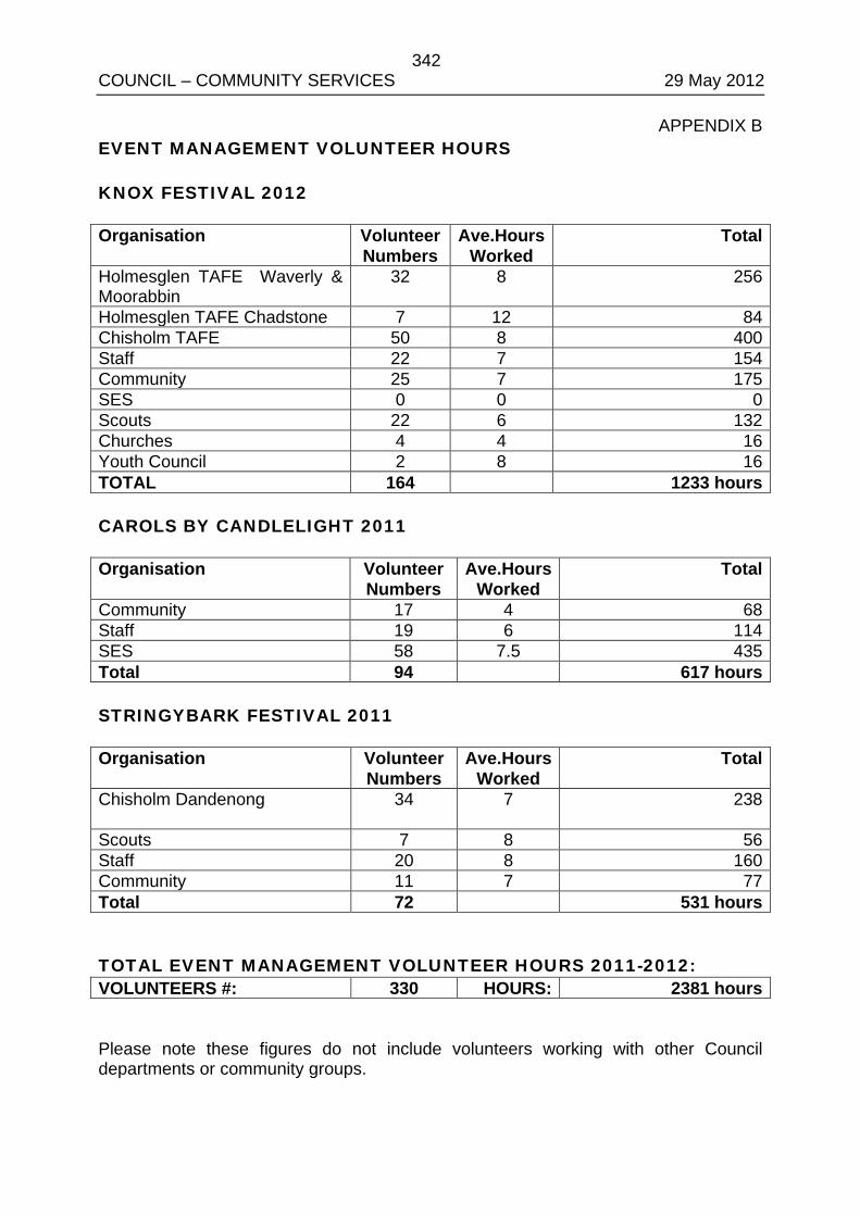
342 COUNCIL – COMMUNITY SERVICES 29 May 2012
APPENDIX B EVENT MANAGEMENT VOLUNTEER HOURS KNOX FESTIVAL 2012 Organisation Volunteer
Numbers Ave.Hours
Worked Total
Holmesglen TAFE Waverly & Moorabbin
32 8 256
Holmesglen TAFE Chadstone 7 12 84 Chisholm TAFE 50 8 400 Staff 22 7 154 Community 25 7 175 SES 0 0 0 Scouts 22 6 132 Churches 4 4 16 Youth Council 2 8 16 TOTAL 164 1233 hours CAROLS BY CANDLELIGHT 2011 Organisation Volunteer
Numbers Ave.Hours
Worked Total
Community 17 4 68 Staff 19 6 114 SES 58 7.5 435 Total 94 617 hours STRINGYBARK FESTIVAL 2011 Organisation Volunteer
Numbers Ave.Hours
Worked Total
Chisholm Dandenong 34
7 238
Scouts 7 8 56 Staff 20 8 160 Community 11 7 77 Total 72 531 hours TOTAL EVENT MANAGEMENT VOLUNTEER HOURS 2011-2012: VOLUNTEERS #: 330 HOURS: 2381 hours Please note these figures do not include volunteers working with other Council departments or community groups.
343 COUNCIL – COMMUNITY SERVICES 29 May 2012 COUNCILLOR VAN DE VREEDE VACATED THE CHAMBER AT 9.37PM PRIOR TO DISCUSSION ON ITEM 9.2 COUNCILLOR VAN DE VREEDE RETURNED TO THE CHAMBER AT 9.38PM DURING DISCUSSION ON ITEM 9.2
ALL WARDS
9.2 KNOX ARTS AND CULTURAL PLAN 2012-22
SUMMARY: Coordinator Cultural Planning and Development – (Sarah Dugdale)
The draft Knox Arts and Cultural Plan 2012-22, will guide the development and delivery of arts and cultural activities across the City over the next 10 years. Support for the draft Knox Arts and Cultural Plan was secured at the Strategic Planning Committee in February, 2012, and a full public engagement process was completed on 28 March, 2012.
The draft Knox Arts and Cultural Plan comprises a detailed background section, a strategic section containing the key principles and the four key objectives that will guide future progress of the arts and culture development within Knox over the next ten years. It is proposed that a review of the Plan be undertaken in three years to accommodate any outcomes following Council’s service planning process, and a further review in five years to ensure the values and objectives of the Plan remain pertinent to the social/economic environment, and that the outcomes continue to meet community and Council objectives.
Over 1,000 responses in support of the Plan were received. Approximately 20 respondents requested some minor additions or changes be made to the draft, and a small number made specific program or project requests. These have been duly considered and some minor amendments made to the original draft.
RECOMMENDATION
That Council
1. Endorse the Knox Arts and Cultural Plan 2012-22, as provided in Appendix A; and
2. Receives a report each year that outlines the progress being made to deliver upon the actions identified in the Plan to bring to the Council’s attention any significant service issues that may arise.
1. INTRODUCTION
Work on the draft Knox Arts and Cultural Plan 2012-22, started in September 2011, with an engagement process undertaken which included 15 external stakeholders and over 20 different internal individuals, teams and departments. Responses to this initial engagement resulted in a draft Plan that focused on developing the cultural vitality of the City around the following four key objectives:
344 COUNCIL – COMMUNITY SERVICES 29 May 2012 9.2 Knox Arts and Cultural Plan 2012-22 (cont’d)
• Increasing Community Participation in the arts; • Creating Creative and Vibrant Public Places; • Partnerships and Leadership in the community for the arts; and • Increasing the Capacity at Knox City Council to deliver the arts.
The community consultation process on the draft Plan included two major projects held at the Knox Festival in March, the Mobile Billboard Project and the Art Trees project. In addition, information for community access was provided to Community Houses, Knox Libraries, the Civic Centre and Arts Centres, as well as The Hut Art Gallery, Knox U3A, and the two local community theatres. The community was also provided with the opportunity to respond directly to the draft Plan on-line via the Council’s website and a dedicated email address, and with reply paid response cards.
2. DISCUSSION
2.1 Overview of the draft Knox Arts and Cultural Plan 2012-22.
The draft Plan responds to the creative and cultural aspirations of the community, as identified in Vision 2025, by providing a response to some of the evolving trends in society. These issues or drivers of change include the redevelopment and intensification of occupancy which is often accompanied by the increased desire for more attractive public open spaces with greater flexibility of use, an increase in demand on existing facilities, and a growing interest in local and city-wide cultural events that will brand the city as innovative and inclusive.
The draft Plan is focused on improving community participation levels, building social connectivity, creating attractive public spaces, the provision of leadership and advocacy by the Council to facilitate better networking and partnerships in the arts community, and improving Council infrastructure, capacity and performance in the delivery of cultural services to the City.
The draft Plan sets out four key objectives to meet these outcomes:
2.1.1 Increase Community Participation in the arts – to encourage and promote a wide range of opportunities for the enjoyment of and participation in the arts by all sectors of the community including encouraging greater engagement with our Culturally and Linguistically Diverse (CALD) communities, supporting our ageing community to remain active and engaged, and breaking down existing access and inclusion constraints.
2.1.2 Develop Creative and Vibrant Public Places – to identify and support opportunities to integrate the arts and a range of creative initiatives into the planning and delivery of public open spaces, improve access to the city’s existing cultural heritage infrastructure, and contribute to the promotion of a vibrant and distinctive city identity.
345 COUNCIL – COMMUNITY SERVICES 29 May 2012 9.2 Knox Arts and Cultural Plan 2012-22 (cont’d)
2.1.3 Provide Leadership and Advocacy for the arts – to foster and develop a leadership role for Council in the arts and cultural sector, identify and support opportunities for partnerships, and advocate for the benefits of creativity and innovation in a range of opportunities, both within Council and within the community.
2.1.4 Increase Capacity at Knox City Council to deliver the arts– to acknowledge and advance opportunities for the arts to contribute to the well-being of the City by identifying opportunities to streamline Council processes and increase arts-focused amenity and infrastructure, and improve the capacity and performance of the organisation to increase the cultural vitality, health and wellbeing of the city.
The draft Plan will operate alongside other Council Plans, such as the Libraries Services Plan, Major Festivals and Events Plan, Open Spaces Plan, Access and Inclusion Plan, Healthy Ageing Plan, Multicultural Strategic Plan, the Youth Plan and the organisation’s key strategies; the Municipal Strategic Plan, Community Health and Wellbeing Strategy, the Sustainable Environments and the Economic Development Strategy.
2.2 Key Actions and Outcomes identified in the draft Plan
The following are examples of proposed actions identified to deliver the key objectives of the draft Plan.
2.2.1 Increase Community Participation in the Arts: • Support the development of arts-based programs for access and inclusion
initiatives and the multicultural community; • Improve promotion of arts-based activities to the community; • Work with young people to identify arts-based activities which support
them to be part of the community, contribute to and be heard by the community; and
• Support and promote arts-based lifelong learning opportunities for older persons in our community.
2.2.2 Create Vibrant Public Places: • Develop a strong and effective Public Arts Policy; • Develop a City-wide plan or vision for the future development of creative
public places and identification of public art projects; • Continue to progress an arts and cultural aspect to the development of
Stamford Park Community precinct; and • Improve public access to Ambleside and Millers Homesteads.
346 COUNCIL – COMMUNITY SERVICES 29 May 2012 9.2 Knox Arts and Cultural Plan 2012-22 (cont’d)
2.2.3 Provide Leadership and Advocacy for the Arts: • Develop and grow local arts and cultural networks; • Identify opportunities to build community partnerships in the arts and
cultural sector; • Support an arts portal to provide access to arts based information for
users and creators of arts to inform the community of events and activities; and
• Promote opportunities for Council, libraries and the arts sector to share resources and build the capacity of the arts community.
2.2.4 Increase Council’s Capacity to deliver arts and cultural outcomes: • Assist Council teams to identify and provide arts-based engagement
opportunities in the delivery of their projects; • Develop a streamlined and integrated approach to working with local
artists in the community; • Encourage the inclusion of artistic elements in the design of Council-
owned facilities; • Continue to develop Arts Link, the register of local artists interested in
working with Council on projects; • Continue to support the professional development of the arts community
through the Arts Development Grant Scheme; and • Continue the upgrade of Knox Community Arts Centre in Bayswater, and
the development of other suitable sites to meet growing local arts development needs.
• Continue to support efforts to progress a significant cultural facility and Arts Centre in the Knox Central Precinct.
2.3 General Response to the draft Plan
The community supported in an overwhelmingly positive manner to the draft Plan, noting that the Plan was accessible and easy to read and that while it did not appear to promise much by way of new projects or programs, it was clearly designed to build relationships and grow a range of partnerships within the arts community and raise the profile of the arts in the wider community. These were seen as constructive and effective ways for the Council to move forward with developing the arts and cultural vitality of the City in challenging times.
347 COUNCIL – COMMUNITY SERVICES 29 May 2012 9.2 Knox Arts and Cultural Plan 2012-22 (cont’d)
2.4 Community Response to the Plan
The community anticipated some of the key projects the Council will be developing and supporting over the next year, such as easy access to an Arts Event Calendar and the regular opportunity for the arts community to meet and network. As hoped, the community feedback also identified a number of points not present in the draft, such as a reference to the contribution the six local community newspapers make to the cultural wellbeing of the City, and acknowledgement of the Council’s art collection. Interest in developing a strong and well supported Public Art program was also a popular response, as was support to find ways to identify, support and celebrate the contribution made by individual artists, and not just groups, in the community. In addition, respondents supported progressing the Knox Central Arts Centre and the Ambleside Master Plan, and sought an increased level of support for community theatre groups and artists.
A small degree of concern was expressed by some parties, particularly from Council’s recently established artists’ register, about the lack of specific objectives and expected outcomes or detail about how ideas will be implemented. However, officers are confident that the draft Plan provides a sufficiently clear and focused strategic direction to both guide the Council forward in its own art and cultural development and to also identify and support opportunities as they arise in our community. The initial three year Action Plan for Council is focused on consolidating the projects, programs and facilities currently managed by Council, building relationships in the community, and meeting some of the key policy gaps identified in the initial research, such as developing and adopting an effective Public Art Policy.
2.5 Organisational Responses to the Plan
Responses from Council staff included a suggestion that more detail be considered around the future measurement of arts and cultural outcomes, in particular with regards to identifying future need in resourcing service growth and development. Other suggestions included making a stronger connection between the draft Plan and its contribution to the wellbeing of the community, and the guiding strategic document, the Knox Community Health and Wellbeing Strategy; the opportunities provided by the local Progress Halls; exploring future sponsorship development opportunities and clarifying details relating to growth statistics and the demographic drivers to change in the City.
2.6 Review of Responses
As a result of the feedback received proposed amendments to the draft Plan have been made. All recommended changes are included in red in the amended draft Plan, set out in Appendix A.
348 COUNCIL – COMMUNITY SERVICES 29 May 2012 9.2 Knox Arts and Cultural Plan 2012-22 (cont’d)
2.7 Implementation Process
The draft Plan is recommending that an annual report be prepared and presented to Council, advising of the current status to the roll out program, celebrating successes and reporting on any issues or concerns that have arisen during the year. In addition, in three years time, a review of the Plan will be undertaken to address any emerging issues that may have been highlighted during the implementation process. Further, a detailed review of the Plan, considering the social and economic environment and the Plan’s ongoing relevance to community and Council objectives, will be undertaken in five years time. At that time, a review cycle for the final five years of the current Plan will be identified and implemented.
3. CONSULTATION
The community consultation process for the draft Plan built on the work started during the initial stakeholder consultation process and was focused around the Knox Festival program. The Festival provided two significant interactive projects to engage the community in the objectives of the Plan and receive feedback on the draft Plan. The first was an opportunity to contribute to the creation of two arts trees. Four hundred and eleven participants participated in the construction of the trees and recorded their support and ideas for the plan during the two days of this festival activity.
The second project focused on engaging young people and encouraged youth to contribute their ideas about arts in the community and the plan’s objectives by writing on a mobile billboard. Over six hundred and sixty young people enjoyed this activity and used the format to advise Council of their ideas for future arts activities and events in the city. The information received during this project has been shared with Council’s Youth Services Team to assist in the development of the draft Youth Plan.
Seventeen general responses to the Plan were also received: • the Council’s website (5 responses); • general mail (3 responses); and • reply paid postcards (8 responses).
Council received only 1 response that did not support the Plan but it did not provide any further detail on this position.
In addition, responses were received from the Arts and Cultural Development Advisory Committee, the Knox Library Management Team, and from members of the Arts Link, the newly established Knox artists’ database.
349 COUNCIL – COMMUNITY SERVICES 29 May 2012 9.2 Knox Arts and Cultural Plan 2012-22 (cont’d)
Feedback from Council staff and teams seeking clarification, amendments or additions to the draft, included: • Open Space and Landscape Design; Healthy Ageing; Youth Services;
Leisure Services; Community Development; Community Safety; and Asset Management.
4. ENVIRONMENTAL/AMENITY ISSUES
The draft Plan has as a key objective a desire to contribute to the improvement of the City’s parks and public spaces and commitment to the principles of sustainability in its delivery.
5. FINANCIAL & ECONOMIC IMPLICATIONS
The draft Plan has been written and developed within the parameters set within the Council’s Long Term Financial Strategy. The draft Plan responds to the current financial environment by placing at its core a focus on working more closely with a range of partners, both within the organisation and across the City. The opportunity to encourage increased support from the City’s service groups and local businesses through a program to encourage business contributions to community development (a Corporate Responsibility model), may promote the inclusion of arts and cultural activities by profiling the benefits made by the arts to the wellbeing of the community.
Of the specific proposed project and service developments that would require consideration of additional resources over the next three years, these will be considered by Council as part of the normal annual budget process. Current unfunded projects which have been identified as priorities for future consideration are; the review and upgrade of the Ferntree Gully Community Arts Centre; the provision of a Community Heritage Officer (part-time); and the provision of a Community Events Support Officer (part-time).
It is proposed that Council considers these as part of the development of its annual budget process for 2013-14 and beyond. In addition, Council will continue to proactively seek external funding opportunities to support the implementation of the Plan.
6. SOCIAL IMPLICATIONS
A strong focus of the draft Plan is the profiling and acknowledgement of the benefits provided through arts and cultural activity within the community. The arts contribute to the building of social connections, the development of vibrant public places, and the development of a strong and healthy City.
350 COUNCIL – COMMUNITY SERVICES 29 May 2012 9.2 Knox Arts and Cultural Plan 2012-22 (cont’d)
7. RELEVANCE TO COUNCIL PLAN
The draft Plan is developed as a ‘Partnership in Progress’ with the wider community and with local artists and arts organisations in particular. The draft Plan links to the Council Plan by contributing to the community’s aspirations for a strong and healthy community under a number of themes:
• Theme 1: Healthy and Connected Communities – to contribute to the health and wellbeing of the community
Building community skills, leadership and connections, supporting older adults to be valued and enjoy healthy independent lives, and creating an accessible Knox for all members of the community.
• Theme 2: Culturally Rich and Active Communities – to provide and support opportunities for community members to participate in a vibrant community life.
Encouraging and supporting opportunities for artistic and cultural expression and experience, addressing identified shortfalls in cultural opportunities, and continuing to facilitate provision of opportunities for local artists and the Knox community to engage in artistic and cultural expression.
Further, the Plan will assist to identify opportunities for Knox’s diverse community to be recognised and celebrated, create opportunities for people to connect at a neighbourhood level, and enrich community facilities, open space and neighbourhoods through the use of contemporary public art that reflects and promotes cultural heritage and diversity. Continuing to plan for a regional performing arts facility in Knox Central has also been identified as a key action under this theme.
• Theme 3: Dynamic Services and Facilities – To continuously improve the capacity of Council’s services and infrastructure to best meet the community’s needs.
Continuing to review and improve the quality and effectiveness of Council’s cultural service provision, and plan, manage and maintain appropriate facilities and infrastructure to meet communities’ needs into the future.
Progressing the development of Stamford Park as a major regional visitor destination, building partnerships and advocating for services and facilities to meeting identified community needs.
351 COUNCIL – COMMUNITY SERVICES 29 May 2012 9.2 Knox Arts and Cultural Plan 2012-22 (cont’d)
• Theme 6: Attractive and Vibrant Places – To improve the quality and sustainability of the built environment and ensure it enhances the City’s leafy character and cultural heritage.
Supporting the provision of quality built form that is suitable for and respectful of our local environments, and encouraging and facilitating environmentally sustainable development through the arts. The Plan will assist in establishing mechanisms to conserve and celebrate places of cultural heritage and work in collaboration with the community and business to build village life through initiatives such as community arts, markets, festivals and street performances, as well as community and business development initiatives.
8. CONCLUSION
The draft Knox Arts and Cultural Plan 2012-22 has been developed in response to three key drivers. These are: • community interests and needs, as identified during the initial stakeholder
consultation and supported during the community consultation process (referred to in section 3 of this report);
• ensuring it contributes to the broader aspirations of the community as identified in Vision 2025, and the Council Plan (2009-13), amended 2010; and
• managing the development of a strong and healthy arts community and vibrant City, during a period of financial constraint.
9. CONFIDENTIALITY There are no confidential issues pertaining to this report.
COUNCIL RESOLUTION MOVED: CR. COOPER SECONDED: CR. COSSARI
That Council:
1. Endorse the Knox Arts and Cultural Plan 2012-22, as provided in Appendix A; and
2. Receives a report each year that outlines the progress being made to deliver upon the actions identified in the Plan to bring to the Council’s attention any significant service issues that may arise.
CARRIED

352 COUNCIL – COMMUNITY SERVICES 29 May 2012
KNOX ARTS AND CULTURAL PLAN 2012-2022
APPENDIX A
Circulated separately
353 COUNCIL – COMMUNITY SERVICES 29 May 2012 COUNCILLOR COOPER VACATED THE CHAMBER AT 9.45PM PRIOR TO DISCUSSION ON ITEM 9.3 COUNCILLOR COOPER RETURNED TO THE CHAMBER AT 9.46PM DURING DISCUSSION ON ITEM 9.3
ALL WARDS
9.3 SUBMISSION TO MINISTERIAL ADVISORY COUNCIL ON PUBLIC LIBRARIES
SUMMARY: Manager – Youth, Leisure & Cultural Services (David Blair)
This report provides Council with a proposed submission to the Ministerial Advisory Council on Public Libraries.
RECOMMENDATION
That Council approves the submission as set out at Appendix A to this report to be lodged with the Victorian State Government’s review of public libraries being conducted by the Ministerial Advisory Council on Public Libraries.
1. INTRODUCTION
Following concerns raised by the local government and library sectors regarding reductions in funding provided by the State Government to public libraries, the State Government announced that it was re-establishing the Ministerial Advisory Council on Public Libraries (MAC). This body has been charged with conducting a review on the future role and functions of Victorian public libraries, recognising their changing role.
The Government has prepared a discussion paper, titled Tomorrow’s Library to guide the consultation component of the review which is being conducted in two stages.
The first stage assesses the current use of public libraries and their future needs including the use of emerging technologies. Stage two will commence in early 2013 and will review costs, prioritisation of library projects and programs, sustainability and levels of funding.
This report and the proposed submission relates to stage one of the review.
2. DISCUSSION
Council’s proposed Submission for stage one of the review is set out at Appendix A.
The Submission has responded to the framework provided in the discussion paper which seeks Council’s views on the following topics:
354 COUNCIL – COMMUNITY SERVICES 29 May 2012 9.3 Submission to Ministerial Advisory Council on Public Libraries
(cont’d)
• Collections, resources and programs • Library buildings • Technology • Service Delivery
As Council’s proposed Submission notes, libraries are central to Knox’s future. Consequently to assist Council to realise its vision for the City to be culturally rich with active communities, Council undertook a review of its library service and endorsed a strategic plan for library services and infrastructure in 2008. This provided a strategic direction for Council with respect to the delivery of a sustainable library service to our community and has been used to inform the proposed Submission. • The key issue raised in the proposed Submission are: • Council’s capacity to replace bookstock in a timely manner and keep the
recommended per capita stock rate. • Council has adopted a ‘hub and spoke’ infrastructure model for its library
service. Amongst other things, this foreshadows building new libraries at Knox City and Bayswater.
• The opportunities to create strategic partnerships and joint programming through the co-location in libraries of other community services providers is highly desirable but can impact on the capital cost of building such multi-purpose library facilities.
• With building costs growing due to compliance requirements and the need to increase the size of library buildings to accommodate the growing content of services, including increased public access PC’s and Wi-Fi, additional assistance from Government is required.
• The need to develop specific programs to assist older persons to meet the challenges raised by new technologies.
• The early roll out of NBN would enhance the capacity of Council’s library service to influence and demonstrate to the community the benefits of technology.
• The challenges for Council to meet the growing needs of its ageing population and how it can connect with hard to reach users and non users.
• The development of a strategy to address early childhood literacy. This includes the introduction of exciting and stimulating children’s themed areas within libraries.
It also should be noted that in April 2012 Councillors Gill and Mortimore met with the MAC at which time a presentation was made on the challenges facing our City with respect to library services.
355 COUNCIL – COMMUNITY SERVICES 29 May 2012 9.3 Submission to Ministerial Advisory Council on Public Libraries
(cont’d)
3. CONSULTATION
Input to the draft Submission has been provided by Eastern Regional Libraries Corporation.
4. ENVIRONMENTAL/AMENITY ISSUES
The draft Submission highlights the role libraries play in developing attractive and accessible places in our City.
5. FINANCIAL & ECONOMIC IMPLICATIONS
Council’s 2011-12 operating budget for library services is $3,564,355. This represents 80% of the cost required to deliver library services each year. In addition, since 2008-09 Council has allocated $443,200 for capital improvements to libraries. Furthermore, major capital investment flagged for libraries in the future is estimated at $21.5ml which includes library facilities in Bayswater and Knox Central.
The inadequacy of support for capital and operational funding for library facilities will be highlighted in Stage 2 of the review.
6. SOCIAL IMPLICATIONS
The vital contribution of public libraries to the wellbeing of our residents and to the education and economic development of communities is recognised across the developed world. Support for this role has underpinned the commitment of Council and ERLC to the provision of high quality public library services.
7. RELEVANCE TO COUNCIL PLAN
A key four year priority action for Council under the theme of culturally rich and active communities is to provide local libraries as key community hubs for lifelong learning, leisure and connection for people of all ages, to increase access to information and opportunity.
8. CONCLUSION
This report provides Council with an overview of the content of a submission to be presented to the State Government as input into the review of public libraries in Victoria.
The Submission flags key issues for the future of Knox library services focussed on the key questions listed by the State Government’s discussion paper “Tomorrow’s Library” that covers Stages 1 of the review. Stage 2, which commences in early 2013, will provide Council the opportunity to input into the issue of State Government funding for libraries.
356 COUNCIL – COMMUNITY SERVICES 29 May 2012 9.3 Submission to Ministerial Advisory Council on Public Libraries
(cont’d)
9. CONFIDENTIALITY
There are no confidential issues relating to this matter.
COUNCIL RESOLUTION MOVED: CR. PEARCE SECONDED: CR. McMILLAN
That Council approves the submission as set out at Appendix A to this report to be lodged with the Victorian State Government’s review of public libraries being conducted by the Ministerial Advisory Council on Public Libraries. CARRIED

357 COUNCIL – COMMUNITY SERVICES 29 May 2012 APPENDIX A/1 – Submission to Ministerial Advisory Committee on Public Libraries

358 COUNCIL – COMMUNITY SERVICES 29 May 2012 APPENDIX A/2

359 COUNCIL – COMMUNITY SERVICES 29 May 2012 APPENDIX A/3

360 COUNCIL – COMMUNITY SERVICES 29 May 2012 APPENDIX A/4

361 COUNCIL – COMMUNITY SERVICES 29 May 2012 APPENDIX A/5

362 COUNCIL – COMMUNITY SERVICES 29 May 2012 APPENDIX A/6

363 COUNCIL – COMMUNITY SERVICES 29 May 2012 APPENDIX A/7

364 COUNCIL – COMMUNITY SERVICES 29 May 2012 APPENDIX A/8

365 COUNCIL – COMMUNITY SERVICES 29 May 2012 APPENDIX A/9

366 COUNCIL – COMMUNITY SERVICES 29 May 2012 APPENDIX A/10

367 COUNCIL – COMMUNITY SERVICES 29 May 2012 APPENDIX A/11

368 COUNCIL – COMMUNITY SERVICES 29 May 2012 APPENDIX A/12

369 COUNCIL – COMMUNITY SERVICES 29 May 2012 APPENDIX A/13

370 COUNCIL – COMMUNITY SERVICES 29 May 2012 APPENDIX A/14

371 COUNCIL – COMMUNITY SERVICES 29 May 2012 APPENDIX A/15

372 COUNCIL – COMMUNITY SERVICES 29 May 2012 APPENDIX A/16

373 COUNCIL – COMMUNITY SERVICES 29 May 2012 APPENDIX A/17

374 COUNCIL – COMMUNITY SERVICES 29 May 2012 APPENDIX A/18

375 COUNCIL – COMMUNITY SERVICES 29 May 2012 APPENDIX A/19

376 COUNCIL – COMMUNITY SERVICES 29 May 2012 APPENDIX A/20

377 COUNCIL – COMMUNITY SERVICES 29 May 2012 APPENDIX A/21

378 COUNCIL – COMMUNITY SERVICES 29 May 2012 APPENDIX A/22
379 COUNCIL – CORPORATE DEVELOPMENT 29 May 2012
DINSDALE WARD
10.1 SALE OF 13 CULLIS PARADE, BAYSWATER (MELWAY REF: 64 F5)
SUMMARY: Property Management Coordinator (Angela Mitchell)
This report is presented following the closing of submissions regarding the sale of 13 Cullis Parade, Bayswater.
RECOMMENDATION
That Council, having undertaken the statutory requirements and received no submissions at the closure of the submission period, hereby resolves to:
1. Proceed with the sale of 13 Cullis Parade, Bayswater to Bridges Connecting Communities Limited for $450,000, which includes an interest free loan of $50,000 (with payments of $5,000 per year) provided by Council payable over a ten (10) year period or earlier if Bridges Connecting Communities Limited are able to do so.
2. Authorise the Chief Executive Officer to sign and seal all necessary documentation associated with the sale of 13 Cullis Parade, Bayswater identified as Lot 5 on Plan of Subdivision No. 011208 and contained within Certificate of Title Volume 8300 Folio 112 and Lot 1 on Title Plan 872546Y and contained within Certificate of Title Volume 8106 Folio 296.
1. INTRODUCTION
The proposed sale of 13 Cullis Parade, Bayswater was presented and considered at the Council meetings on 27 April 2010, 27 April 2011 and more recently on 13 March 2012.
At the meeting on 13 March 2012, Council resolved as follows:
“That Council
1. Set aside Part 2 of Item 10.2 of the resolution of Council 27 April 2010. 2. Having completed the process to rezone the Council owned land at
13 Cullis Parade, Bayswater, Council now gives public notice pursuant to Section 189 of the Local Government Act 1989 of its intention to sell this property to Bridges Connecting Communities Limited for $450,000, which includes an interest free loan of $50,000 (with payments of $5,000 per year) provided by Council payable over a ten (10) year period, or earlier if Bridges Connecting Communities Limited are able to do so, and that under Section 223 of that Act, give public notice of the proposed sale in the Knox Leader and Knox Weekly.
380 COUNCIL – CORPORATE DEVELOPMENT 29 May 2012 10.1 Sale of 13 Cullis Parade, Bayswater (cont’d)
3. Hear submissions in accordance with Section 223(1)(b) of the Local Government Act 1989 and appoint the following Committee of Council comprising of Councillors Gill, Cossari and Walter to consider submissions on Tuesday, 8 May 2012 at 4.30pm.
4. Forward correspondence of Council’s intention, including a copy of the public notice, to all residents abutting Cullis Parade and Coorie Avenue, Bayswater.
5. Resolve that a further report be presented to Council following the conclusion of the statutory process.
6. Authorise a review of Council’s procedures associated with the disposal of Council land/buildings with a view to expanding and strengthening processes associated with the disposal of land/buildings.”
At the conclusion of the submission period no submissions were received.
2. DISCUSSION
Bridges Connecting Communities Limited (BCC) currently leases the Council owned facility at 658 Mountain Highway, Bayswater and is in the process of finalising a licence agreement to occupy the former Bayswater Tennis Pavilion at Marie Wallace Bayswater Park.
BCC is a provider of aged services to the Knox and Yarra Ranges communities together with being the local Volunteer Resource Centre for Knox.
Council resolved at the meeting on 13 March 2012 to commence the statutory process to sell the Council property at 13 Cullis Parade, Bayswater to BCC. This property is identified as Lot 5 on Plan of Subdivision No. 011208 and contained within Certificate of Title Volume 8300 Folio 112 and Lot 1 on Title Plan 872546Y and contained within Certificate of Title Volume 8106 Folio 296.
Public notice advising of the proposed sale was undertaken on 20 and 21 March 2012. At the conclusion of the submission period no submissions were received.
3. CONSULTATION
Public notice of the proposed sale was given in the Knox Leader and Knox Weekly on 20 and 21 March 2012 respectively. At the conclusion of the submission period no submissions were received.
4. ENVIRONMENTAL/AMENITY ISSUES
This site has not been identified as an area of biological significance. The site has been vacant for a considerable period of time with inappropriate signage being placed there regularly. The sale of this site would alleviate amenity issues.
381 COUNCIL – CORPORATE DEVELOPMENT 29 May 2012 10.1 Sale of 13 Cullis Parade, Bayswater (cont’d)
5. FINANCIAL & ECONOMIC IMPLICATIONS
A valuation obtained for 13 Cullis Parade, Bayswater has been assessed at $450,000. Council received correspondence dated 24 October 2011 from BCC of their offer to purchase this property for $450,000 with $400,000 payable on settlement and seeking Council support for the balance of $50,000 by way of an interest free loan over a ten year period.
Council has agreed to provide an interest free loan of $50,000. This loan will be payable over a ten year period with a requirement to meet a minimum payment of $5,000 per year. BCC have indicated that subject to their finances, payment of this loan may be met earlier. It is proposed that this loan will be identified as a mortgage on title.
The allocation of the sale proceeds will be undertaken consistent with Council policy.
6. SOCIAL IMPLICATIONS
BCC is a community based, not for profit organisation that provides a range of support and recreational programs for older adults primarily with the support of volunteers. The current demand for these services has placed increasing pressure on this organisation to access infrastructure that will support service aspirations.
Sale of the site to BCC would enable them to relocate from their current site at 658 Mountain Highway, Bayswater to a larger site and provide them with an opportunity to support the growth and development of this service.
7. RELEVANCE TO COUNCIL PLAN
This proposal relates to:
• Dynamic Services and Facilities – All services and facilities delivered by Council will respond to community need and expectation, will be well managed and effective, and seek best value outcomes for our community.
• A Well Governed and Leading Organisation - Council will operate in an efficient and effective manner and demonstrate strong local governance practices for the benefit of the Knox community.
8. CONCLUSION
BCC approached Council to acquire the property by private treaty as they required larger premises for their expanding services. In recognition of services undertaken by this community group and in accordance with the guidelines:
382 COUNCIL – CORPORATE DEVELOPMENT 29 May 2012 10.1 Sale of 13 Cullis Parade, Bayswater (cont’d)
• Sales of land should be in the best interests of the community and provide the best result, both financial and non-financial for the Council and the community; and
• Generally all sales of land should occur at not less than the market value assessed by a valuer engaged by the Council.
Council undertook the statutory process to sell this land at market value. The appropriate documentation will now be prepared for the sale of this property to BCC and it is recommended that the Chief Executive Officer be authorised to sign and seal all necessary documentation to effect the sale of this property.
9. CONFIDENTIALITY
There are no confidentiality issues associated with this report.
COUNCIL RESOLUTION MOVED: CR. VAN DE VREEDE SECONDED: CR. MORTIMORE
That Council, having undertaken the statutory requirements and received no submissions at the closure of the submission period, hereby resolves to:
1. Proceed with the sale of 13 Cullis Parade, Bayswater to Bridges Connecting Communities Limited for $450,000, which includes an interest free loan of $50,000 (with payments of $5,000 per year) provided by Council payable over a ten (10) year period or earlier if Bridges Connecting Communities Limited are able to do so.
2. Authorise the Chief Executive Officer to sign and seal all necessary documentation associated with the sale of 13 Cullis Parade, Bayswater identified as Lot 5 on Plan of Subdivision No. 011208 and contained within Certificate of Title Volume 8300 Folio 112 and Lot 1 on Title Plan 872546Y and contained within Certificate of Title Volume 8106 Folio 296.
3. Note the commitment by Bridges Connecting Communities Limited in their letter to Council on 29 November 2011 to vacate their current occupation of Council’s building at 658 Mountain Highway, Bayswater within twelve months of the date of settlement and ensure this commitment is included as a condition of sale of 13 Cullis Parade, Bayswater.
4. Initiate the necessary process to propose to sell the property 658 Mountain Highway, Bayswater after it is vacated.
CARRIED
383 COUNCIL – CORPORATE DEVELOPMENT 29 May 2012
ALL WARDS
10.2 MANAGEMENT FINANCIAL REPORT FOR THE PERIOD ENDED 31 MARCH 2012
SUMMARY: Financial Accountant (Wendy McGorm)
The March 2012 Management Accounting Financial Report is presented for consideration.
The overall financial position for the period ended 31 March 2012 is satisfactory and indicates that Council remains on track to achieve the Revised Budget targets for the year.
Council recorded a net cash result of $21.258 million for the nine months ending 31 March 2012 which is a favourable variance of $8.514 million in relation to the year to date 2011-12 Revised Budget. This result excludes several non-cash items such as depreciation and includes capital expenditure. The overall surplus of $21.258 million is the result of bringing to account the full amount of Council’s annual rate income during August 2011, and due to the timing of some components of the Eastern Recreation Precinct project and the capital works renewal program.
The Eastern Recreation Precinct project is expected to be completed in June 2012. The divestment of Amaroo Gardens Residential Aged Care facility occurred on 2 November 2011.
The report provides greater detail for all significant areas of expenditure and variances.
RECOMMENDATION
That Council:
1. Receive and note the Management Financial Report for the period ended 31 March 2012.
2. Approve the write-off of debts totalling $3,776.80 which are considered no longer collectable as detailed in the confidential attachment to this report.
384 COUNCIL – CORPORATE DEVELOPMENT 29 May 2012 10.2 Management Financial Report for the Period Ended 31 March 2012
(cont’d)
1. INTRODUCTION
The attached Financial Reports that are presented to Council include the following: • Management Accounting Result (Attachment A) • Income Statement (Attachment B to F) • Capital Works Analysis (Attachment G and H) • Balance Sheet (Attachment I) • Cash Flow Statement and Cash Assets Summary (Attachment J to L) • Monthly Summary Revenue and Expenditure Report (Attachment M) • Investment and Interest Income Analysis (Attachment N and O) • Rates and Sundry Debtors Summary (Attachment P to S) • Capital Works Program Detail (Attachment T) • Confidential Matters (Attachment U)
All above attachments are circulated separately.
The Income Statement and the Balance Sheet have been prepared on an accrual basis and are the results for the period ended March 2012.
The report has been prepared based on the 2011-12 Revised Budget as adopted by Council on 22 November 2011. Full year figures represent the variance between the Revised Budget and Forecast.
2. DISCUSSION
General discussion in regards to this report is detailed under Section 5 ‘Financial & Economic Implications’.
3. CONSULTATION
This report does not necessitate community consultation. A copy of this report will be provided to Council’s Audit Committee after it has been noted by Council.
4. ENVIRONMENTAL/AMENITY ISSUES
This report does not have any environmental or amenity issues for discussion.
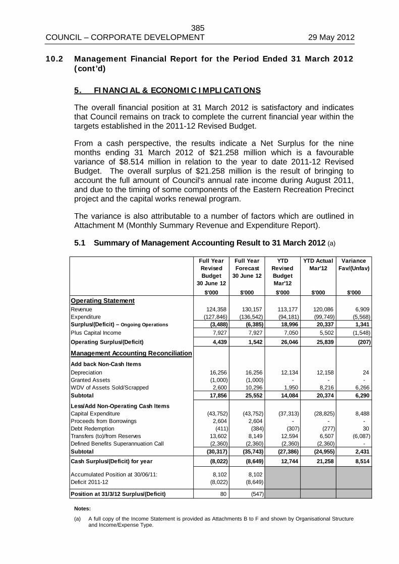
385 COUNCIL – CORPORATE DEVELOPMENT 29 May 2012 10.2 Management Financial Report for the Period Ended 31 March 2012
(cont’d)
5. FINANCIAL & ECONOMIC IMPLICATIONS
The overall financial position at 31 March 2012 is satisfactory and indicates that Council remains on track to complete the current financial year within the targets established in the 2011-12 Revised Budget.
From a cash perspective, the results indicate a Net Surplus for the nine months ending 31 March 2012 of $21.258 million which is a favourable variance of $8.514 million in relation to the year to date 2011-12 Revised Budget. The overall surplus of $21.258 million is the result of bringing to account the full amount of Council's annual rate income during August 2011, and due to the timing of some components of the Eastern Recreation Precinct project and the capital works renewal program.
The variance is also attributable to a number of factors which are outlined in Attachment M (Monthly Summary Revenue and Expenditure Report).
5.1 Summary of Management Accounting Result to 31 March 2012 (a)
Full Year Revised Budget
30 June 12
Full Year Forecast
30 June 12
YTD Revised BudgetMar'12
YTD Actual Mar'12
VarianceFav/(Unfav)
$'000 $'000 $'000 $'000 $'000Operating StatementRevenue 124,358 130,157 113,177 120,086 6,909 Expenditure (127,846) (136,542) (94,181) (99,749) (5,568)Surplus/(Deficit) – Ongoing Operations (3,488) (6,385) 18,996 20,337 1,341 Plus Capital Income 7,927 7,927 7,050 5,502 (1,548)Operating Surplus/(Deficit) 4,439 1,542 26,046 25,839 (207)
Management Accounting ReconciliationAdd back Non-Cash ItemsDepreciation 16,256 16,256 12,134 12,158 24 Granted Assets (1,000) (1,000) - - - WDV of Assets Sold/Scrapped 2,600 10,296 1,950 8,216 6,266 Subtotal 17,856 25,552 14,084 20,374 6,290
Less/Add Non-Operating Cash ItemsCapital Expenditure (43,752) (43,752) (37,313) (28,825) 8,488 Proceeds from Borrowings 2,604 2,604 - - - Debt Redemption (411) (384) (307) (277) 30 Transfers (to)/from Reserves 13,602 8,149 12,594 6,507 (6,087)Defined Benefits Superannuation Call (2,360) (2,360) (2,360) (2,360) - Subtotal (30,317) (35,743) (27,386) (24,955) 2,431 Cash Surplus/(Deficit) for year (8,022) (8,649) 12,744 21,258 8,514
Accumulated Position at 30/06/11: 8,102 8,102 Deficit 2011-12 (8,022) (8,649)
Position at 31/3/12 Surplus/(Deficit) 80 (547) Notes:
(a) A full copy of the Income Statement is provided as Attachments B to F and shown by Organisational Structure and Income/Expense Type.
386 COUNCIL – CORPORATE DEVELOPMENT 29 May 2012 10.2 Management Financial Report for the Period Ended 31 March 2012
(cont’d)
5.2 Major Variance Analysis
5.2.1 Operating Surplus/(Deficit) A complete analysis of major variances against the year to date 2011-12 Revised Budget that have impacted on performance for the period ended 31 March 2012 has been attached to this report as Attachment M. The report has been prepared based on the 2011-12 Revised Budget as adopted by Council on 22 November 2011.
For the nine months ending 31 March 2012, there was an unfavourable variance on operations compared to the 2011-12 Revised Budget of $0.207 million. This variance is partially due to the divestment of Amaroo Gardens Residential Aged Care facility, whereby income was generated from the derecognition of accommodation bonds and the sale of the land, offset by redundancy costs, costs to sell the facility and the write-off of the facility’s assets. The accounting entries for the divestment are still being finalised. The operational result also includes an unfavourable variance relating to the timing of recognising supportive funding income relating a number of capital projects including the Indoor Sports Stadium/Soccer Pavilion at the Eastern Recreation Precinct.
The significant variances are explained in more detail below:
Negative variances – Revenue
• Operating Grants $0.702 million – An unfavourable variance in grant income of $1.377 million due to the Amaroo Gardens Residential Aged Care facility divestment (refer Attachment U) and the final School Crossing Subsidy payment of $0.169 million not yet received. This variance was partially offset by unbudgeted funding received for a number of projects such as Preventing Violence Against Women in our Community of $0.110 million and the National Partnership Agreement Preventative Health program of $0.276 million.
• Fines, Fees and Charges $1.066 million - The unfavourable variance is primarily due to a reduction in Amaroo Gardens Residential Aged Care facility fees due to the divestment of the facility (refer Attachment U). A significant drop in utilisation across three Child Care Centres has resulted in lower than anticipated Child Care fees. There is also an unfavourable variance in Family Day Care fees due to service hours not being delivered as a result of lower staff numbers than anticipated, however this is partially offset by a reduction in expenditure. Income from resident green waste bins, commercial waste bins and additional resident waste bins has been higher than anticipated resulting in a favourable variance of $0.141 million slightly reducing the overall unfavourable variance.
387 COUNCIL – CORPORATE DEVELOPMENT 29 May 2012 10.2 Management Financial Report for the Period Ended 31 March 2012
(cont’d)
• Capital Income $1.548 million – The unfavourable variance is due to the timing of recognising supportive funding income relating to the Indoor Sports Stadium/Soccer Pavilion at the Eastern Recreation Precinct - $1.100 million, Wellington Road/Eastlink Shared Path project - $0.167 million and the Bayswater Oval Floodlighting project of $0.358 million.
Positive variances – Revenue
• Additional income of $8.792 million primarily due the derecognition of accommodation bonds as a result of the Amaroo Gardens Residential Aged Care facility divestment (transferred to Amaroo Reserve) and the sale of Amaroo Gardens Residential Aged Care facility land – refer Attachment U.
Negative variances – Expenditure
• Contractors and Services $0.935 million unfavourable variance mainly due to: a) The divestment of Amaroo Gardens Residential Aged Care
facility - refer Attachment U. b) Drainage Maintenance Works program - Unfavourable
variance of $0.465 million due to cleaning of storm water pipes and repairs following on from the storms. Savings from slowing down of non urgent maintenance in the Bike Path and Footpath Maintenance programs and savings in Works Management is being used to offset some of the over expenditure in Drainage Maintenance.
c) Tree Maintenance program – Unfavourable variance of $0.199 million due to recent storm events.
• Written Down Value of Assets Sold/Scrapped of $6.266 million – This variance is largely due to Amaroo Gardens Residential Aged Care facility assets being written down on sale of the facility and is partially offset by a favourable variance due to the timing of disposals of property, plant and equipment across the organisation.
5.2.2 Capital Works Program (Overview)
Performance of the Capital Works Program including details of variances is included at Attachment G. The detailed Capital Project Status and Expenditure Report has been included as Attachment T. Performance of the Capital Works Program is also detailed in the Works Report provided to Council monthly.
388 COUNCIL – CORPORATE DEVELOPMENT 29 May 2012 10.2 Management Financial Report for the Period Ended 31 March 2012
(cont’d)
For the period ended 31 March 2012, the Capital Works Program shows an overall favourable variance of $6.940 million against the year to date 2011-12 Revised Budget. A favourable variance in expenditure compared to the Revised Budget totals $8.488 million and is primarily due to the timing of some components of the Eastern Recreation Precinct project and timing within the capital works Renewal program. The favourable variance in expenditure is partially offset by an unfavourable variance in external funding of $1.548 million due to the timing of recognising supportive funding relating to the Indoor Sports Stadium/Soccer Pavilion at the Eastern Recreation Precinct of $1.100 million, Wellington Road/Eastlink Shared Path project of $0.167 million and Bayswater Oval Floodlighting project of $0.358 million.
5.3 Balance Sheet The Balance Sheet as at 31 March 2012 indicates a continued satisfactory result. A comparison of total Current Assets of $65.655 million with total Current Liabilities of $21.646 million (working capital ratio of 3.03 to 1) continues to depict a satisfactory financial position.
The working capital ratio of 3.03 reflects the increase in current debtors resulting from the striking of the rates and this working capital ratio will diminish over the remainder of the year as Council funds its operating programs and capital works.
Trust Funds and Deposits have decreased by $6.098 million primarily due to the derecognition of accommodation bonds as a result of the Amaroo Gardens Residential Aged Care facility divestment. Additional income was recognised and subsequently transferred to an Amaroo Reserve (refer Attachment U).
The Balance Sheet as at 31 March 2012 has been attached to this report as Attachment I.
5.4 Investment Analysis There was $44.010 million invested with various financial institutions as at 31 March 2012. These funds include monies from trust funds and deposits, employee provisions and specific purpose reserves. This is a decrease from funds held as at 30 June 2011. Contributing factors to the reduced cash position are costs relating to the Eastern Recreation Precinct project, the Defined Benefits Superannuation call from Vision Super paid in July 2011 and redundancy costs as a result of the Amaroo Gardens Residential Aged Care facility divestment. Attachment N and Attachment O display graphs showing investment performance for the period ended 31 March 2012.
389 COUNCIL – CORPORATE DEVELOPMENT 29 May 2012 10.2 Management Financial Report for the Period Ended 31 March 2012
(cont’d)
The earning on investments to 31 March 2012 is:
YTD Actual YTD Budget Variance Investment Earnings $1.515M $1.393M $0.122M
The higher than budgeted investment earnings are primarily due to higher than anticipated cash holdings including interest generated from grants received to develop the Eastern Recreation Precinct Project (refer Attachment O). The year end forecast has been adjusted to reflect the movement in cash holdings.
5.5 Debtors
Council’s rate debtors comprise the largest component of Receivables owing to Council. The percentage of rates collected to 31 March 2012 of 79.48% is equal to the percentage collected for the same time last year (refer to Attachment P). The total amount of outstanding rates debtors as at 31 March 2012 including associated interest, land fill levy, waste, legal and GST charges was $17.846 million of which $1.977 million relates to arrears pre July 2011. Arrears are consistent with previous years and a significant proportion of arrears are under formal payment arrangements.
Rate amounts owing are a charge over the property and therefore Council has recourse to collect these debts. Penalty interest at 10.5% also applies.
The level of Sundry Debtors owing as at 31 March 2012 is $0.884 million (refer to Attachment R). The balance includes an amount of $0.148 million owing by Waverley Christian College Inc for construction of a footbridge and pathway, $0.220 million owing by the Department of Sustainability and Environment for stage 3 of landscape construction environmental works at Peregrine Heights Reserve (former CSR quarry) and $0.123 million owing by Lend Lease Primelife Ltd for the sale of land within the Waterford Valley Precinct. These amounts are within Council’s payment terms of 30 days.
While the level of debt fluctuates depending on the level of invoicing, the percentage of Debtors outstanding for 60-90 days, 90 days and over has been relatively consistent for Home Help, Family Day Care and Community Groups and Centres.
Follow up letters and further contact has been made with Sporting Clubs who do not have a repayment plan for amounts owing or who are not adhering to their repayment plan. These amounts predominantly relate to ground rentals (refer to Attachment R and confidential Attachment U).
390 COUNCIL – CORPORATE DEVELOPMENT 29 May 2012 10.2 Management Financial Report for the Period Ended 31 March 2012
(cont’d)
5.5.1 Write-off of Unrecoverable Debt A recommendation to write-off an outstanding debt for agistment charges for Lakeview Avenue, Rowville from April 2008 to October 2008 and associated legal costs totalling $3,776.80 has been included in the confidential attachment to this report. An extensive debt collection process both internally and by Council’s Debt Collection Agency has not been successful. Accordingly, the relevant Manager and Director have recommended that this amount should be written off.
6. SOCIAL IMPLICATIONS
There are no direct social implications arising from this report.
7. RELEVANCE TO COUNCIL PLAN
Through the provision of quarterly financial reports, Council ensures that it is contributing towards meeting its objective of Stewardship of Finances and Assets which states that we will manage our assets and financial resources on behalf of the community in a responsible and sustainable manner.
8. CONCLUSION
The overall financial position for the period ended 31 March 2012 is satisfactory and indicates that Council is on track to achieve the Revised Budget targets for the year.
In management accounting terms, the net result for the nine months ended 31 March 2012 was a surplus of $21.258 million which compares favourably with the year to date 2011-12 Revised Budget of $12.744 million. This result comprises both the operating and capital works program but excludes the non-cash items (eg: depreciation).
9. CONFIDENTIALITY
There is one attachment (U) which has been declared confidential and distributed separately due to the nature of the documents.
391 COUNCIL – CORPORATE DEVELOPMENT 29 May 2012 10.2 Management Financial Report for the Period Ended 31 March 2012
(cont’d)
COUNCIL RESOLUTION MOVED: CR. PEARCE SECONDED: CR. COSSARI
That Council:
1. Receive and note the Management Financial Report for the period ended 31 March 2012.
2. Approve the write-off of debts totalling $3,776.80 which are considered no longer collectable as detailed in the confidential attachment to this report.
. CARRIED

392 COUNCIL – CORPORATE DEVELOPMENT 29 May 2012
Management Financial Report for the Period Ended 31 March 2012
ATTACHMENTS A TO U
(Circulated separately)
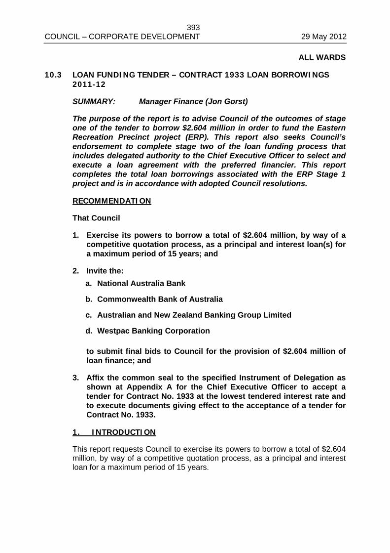
393 COUNCIL – CORPORATE DEVELOPMENT 29 May 2012
ALL WARDS
10.3 LOAN FUNDING TENDER – CONTRACT 1933 LOAN BORROWINGS 2011-12
SUMMARY: Manager Finance (Jon Gorst)
The purpose of the report is to advise Council of the outcomes of stage one of the tender to borrow $2.604 million in order to fund the Eastern Recreation Precinct project (ERP). This report also seeks Council’s endorsement to complete stage two of the loan funding process that includes delegated authority to the Chief Executive Officer to select and execute a loan agreement with the preferred financier. This report completes the total loan borrowings associated with the ERP Stage 1 project and is in accordance with adopted Council resolutions.
RECOMMENDATION
That Council
1. Exercise its powers to borrow a total of $2.604 million, by way of a competitive quotation process, as a principal and interest loan(s) for a maximum period of 15 years; and
2. Invite the: a. National Australia Bank
b. Commonwealth Bank of Australia
c. Australian and New Zealand Banking Group Limited
d. Westpac Banking Corporation
to submit final bids to Council for the provision of $2.604 million of loan finance; and
3. Affix the common seal to the specified Instrument of Delegation as shown at Appendix A for the Chief Executive Officer to accept a tender for Contract No. 1933 at the lowest tendered interest rate and to execute documents giving effect to the acceptance of a tender for Contract No. 1933.
1. INTRODUCTION
This report requests Council to exercise its powers to borrow a total of $2.604 million, by way of a competitive quotation process, as a principal and interest loan for a maximum period of 15 years.
394 COUNCIL – CORPORATE DEVELOPMENT 29 May 2012 10.3 Loan Funding Tender – Contract 1933 Loan Borrowings 2011-12
(cont’d)
2. DISCUSSION
2.1 Background
Council at its meeting of 31 May 2011 resolved to authorise the Chief Executive Officer to approve $10.200 million of loan borrowing to fund its initial contribution to the Eastern Recreation Precinct (Stage 1).
This report deals with the second loan of $2.604 million to arrive at a total borrowing of $12.804 million ($10.200 million plus $2.604 million).
Council’s total loan borrowing for allocation to the Eastern Recreation Precinct is an amount of $12.804 million comprising: a) $12.004 million Council borrowing – Council’s loan contribution to the ERP
project (Stage 1); and
b) $0.800 million Council borrowing – loan cost to be reimbursed from external parties (no net cost to Council).
Council’s 2011-12 Budget was formulated on the basis of conducting a public tender process to raise a total of $2.604 million of loan funds to be used to partly finance the further development of the Eastern Recreation Precinct.
The 2011-12 Budget includes a loan program to raise a total of $2.604 million during the 2011-12 year as well as scheduled loan repayments of $0.400 million during the course of the 2011-12 financial year. Council’s total loan borrowing is projected to be $12.405 million at the end of the current 2011-12 financial year based on the $0.400 million repayment and this report proposal to raise a total of $2.604 million.
Due to the availability of funds and favourable cash flow management throughout the year the loan draw down has been delayed, however, this must be effected prior to 30 June 2012 in accordance with the 2011-12 Budget resolution.
2.2 Tender Process
The appointment of financiers for the loan funding is to be conducted as a two stage process.
Council has completed a public tender process and sought responses from the financial market as stage one of the two stage process.
Stage one was designed to: • Elicit responses from the market from suitably qualified financiers.
395 COUNCIL – CORPORATE DEVELOPMENT 29 May 2012 10.3 Loan Funding Tender – Contract 1933 Loan Borrowings 2011-12
(cont’d)
• Ensure compliance with the Local Government Act 1989 Section 186 that requires a public tender process for the procurement of goods and services to the value in excess of $150,000. As the service value of the loan contract is expected to exceed $150,000, being the total amount of interest over the life of the loan, Council was required to give public notice and invite tenders from any person wishing to undertake the contract.
Stage two of the process, to be conducted following Council’s meeting of 29 May 2012, is designed to ensure Council obtains the most competitive available interest rate and terms of loan finance. As interest rates are market sensitive, financiers are only able to hold interest rates for a short period of time being typically only a few hours. Lengthy time periods between the time of submission of interest rates, the time for Council approval, and the subsequent draw down date (date funds are deposited to Council’s bank account) would result in financiers submitting either:
• a higher rate of interest to hedge against expected movements in interest rates between the date of submission, date of approval and date of draw down and/or
• an indicative only interest rate that would require amendment at the time of loan approval. Indicative only interest rates are therefore not appropriate for the purposes of a competitive tendering process.
2.3 Tenders Received from Stage One
Council invited public tenders from financial institutions for a 15 year fixed interest loan of $2.604 million. Tenders were invited on 30 April 2012 with a closing time and date of 4pm on Thursday 17 May 2012. The following tenders were received: • National Australia Bank submitted an interest rate of 6.15% based on a 15
year loan. The rate was valid for acceptance until 4pm 17 May 2012 (closing date of tenders). This submission provides Council with an indication of the expected interest rate and subsequent cost to Council following completion of stage two of the process.
• Australian and New Zealand Banking Group Limited also submitted a rate of 6.15% that was valid for acceptance as at 17 May 2012.
• Commonwealth Bank of Australia (CBA) submitted quotations for a 5 year loan at an interest rate of $5.73% and a 10 year loan at an interest rate of 6.20%. It should be noted that the CBA did not provide a 15 year fixed rate as requested within the tender specifications.
396 COUNCIL – CORPORATE DEVELOPMENT 29 May 2012 10.3 Loan Funding Tender – Contract 1933 Loan Borrowings 2011-12
(cont’d)
• Westpac Banking Corporation submitted a fixed interest rate for 15 years at 6.743%. While firm for the period of 15 years and complying with Council’s term of 15 years. It is expected the higher rate of 6.743% included sufficient contingency for the bank to hedge against movements in future interest rates between the closing date of tenders and the date of drawdown of loan funds.
It is proposed to invite all four (4) financial institutions to submit fixed and firm competitive quotations for a $2.604 million to be repaid over a period of 15 years.
2.4 Proposed Process for Stage Two
Following completion of stage one, it is proposed to conduct a competitive quotation process for the four (4) financial institutions to submit fixed and final quotations for $2.604 million of loan funding based on the following criteria: • Principal and interest loan repayable quarterly in arrears amortised over
15 years (loan to be fully repaid over 15 years). • Fixed interest terms of 5 years and 10 years. The receipt of 5 year and 10
year fixed interest scenarios is prudent in the event that market volatility were to result in an uncompetitive fixed rate for a fixed 15 year period. Approval of a fixed interest term of either 5 years or 10 years would then require Council to refinance at the end of the shorter term (less than 15 years).
• Optional fixed interest term of 15 years. This is the period of loan repayment and should be available as a fixed interest option to financiers. The 15 year fixed interest is to be optional rather than a compulsory condition so as not to exclude financiers whose policy may prohibit submission of fixed interest loans for a period in excess of 10 years. It should be noted that during the stage one public tender process the CBA only submitted 5 year and 10 year proposals.
• That Council has the right to redeem any amount of principal without cost at the time of fixing a new interest rate for a subsequent period of time (based on acceptance of a 5 year or 10 year term).
The following process is proposed to ensure Council receives competitive loan finance: • Seek competitive quotations at a fixed and firm interest rate with a closing
date of 14 June 2012.
397 COUNCIL – CORPORATE DEVELOPMENT 29 May 2012 10.3 Loan Funding Tender – Contract 1933 Loan Borrowings 2011-12
(cont’d)
• Evaluation, approval and appointment of a successful financier is to occur on the same day. Quotations to close at 11.30am followed by evaluation and CEO approval pursuant to an Instrument of Delegation and advice (by 4.00pm) to the successful financier.
• Drawdown of loan proceeds to occur the day following loan approval to enable financiers to submit the most competitive interest rates.
3. CONSULTATION
There are no consultation issues regarding this matter.
4. ENVIRONMENTAL / AMENITY ISSUES
There are no environmental nor amenity issues regarding this matter.
5. FINANCIAL & ECONOMIC IMPLICATIONS
An amount of $0.772 million has been included within the 2011-12 Revised Budget to fund interest payments in respect of Council’s loan portfolio in accordance with Council’s Long Term Financial Strategy.
6. SOCIAL IMPLICATIONS
There are no social implications regarding this matter.
7. RELEVANCE TO COUNCIL PLAN
Theme Eight of Council’s Plan 2009-2013 is “A Well Governed and Leading Organisation”. Within this theme, the Key Priority Action below demonstrates the relevance to the Council Plan: • Explore opportunities for Council to reduce reliance on rates and utilise
alternate revenue streams.
8. CONCLUSION
The delegation of authority to the Chief Executive Officer proposed at Appendix A enables the acceptance of a loan tender and the execution of loan documents on behalf of Council.
The recommendation gives Council the flexibility to assess the best option available to Council at the drawdown date of 15 June 2012.
398 COUNCIL – CORPORATE DEVELOPMENT 29 May 2012 10.3 Loan Funding Tender – Contract 1933 Loan Borrowings 2011-12
(cont’d)
9. CONFIDENTIALITY
The borrowing of loan proceeds by way of a public tender process and subsequent authorisation of a loan contract is to be the subject of confidentiality.
COUNCIL RESOLUTION MOVED: CR. PEARCE SECONDED: CR. COSSARI
That Council
1. Exercise its powers to borrow a total of $2.604 million, by way of a competitive quotation process, as a principal and interest loan(s) for a maximum period of 15 years; and
2. Invite the: a. National Australia Bank b. Commonwealth Bank of Australia c. Australian and New Zealand Banking Group Limited d. Westpac Banking Corporation
to submit final bids to Council for the provision of $2.604 million of loan finance; and
3. Affix the common seal to the specified Instrument of Delegation as shown at Appendix A for the Chief Executive Officer to accept a tender for Contract No. 1933 at the lowest tendered interest rate and to execute documents giving effect to the acceptance of a tender for Contract No. 1933.
CARRIED
399 COUNCIL – CORPORATE DEVELOPMENT 29 May 2012
Loan Funding Tender – Contract 1933 Loan Borrowings 2011-12 (cont’d)
Appendix A
Instrument of Delegation
In exercise of the power conferred by section 98(1) of the Local Government Act 1989 (the Act) and all other powers enabling it and as a consequence of a Resolution to borrow money authorised by section 144(1) of the Act, Knox City Council (Council) delegates to the member of Council staff holding, acting in or performing the position of Chief Executive Officer, the powers, duties and functions set out in the Schedule to this Instrument of Delegation, AND declares that
1. This Instrument of Delegation is authorised by a Resolution of Council passed on
29 May 2012;
2. The delegation
2.1 comes into force immediately the common seal of Council is affixed to this Instrument of Delegation;
2.2 is subject to any conditions and limitations set out in the Schedule;
2.3 must be exercised in accordance with any guidelines or policies which Council from time to time adopts; and
2.4 remains in force until Council resolves to vary or revoke it.
3. The member of Council staff occupying the position or title of or acting in the position of Chief Executive Officer may delegate to a member of Council staff any of the powers (other than the power of delegation conferred by section 98(3) of the Act or any other powers not capable of sub-delegation) which this Instrument of Delegation delegates to him or her.
THE COMMON SEAL of the KNOX CITY COUNCIL was
hereunto affixed pursuant to an Order of the Council made the
………..…..…………..day of ……..…..…………….. 2012
in the presence of
Chief Executive Officer ……………………………………..
Mayor ………………………………………………………..
Councillor ……………………………………………………
400 COUNCIL – CORPORATE DEVELOPMENT 29 May 2012
Loan Funding Tender – Contract 1933 Loan Borrowings 2011-12 (cont’d)
Appendix A (cont’d)
SCHEDULE The power to:
1. Accept a tender for Contract No. 1933 at the lowest tendered interest rate; and
2. Execute documents giving effect to the acceptance of a tender for Contract No. 1933.
401 COUNCIL – ITEMS FOR INFORMATION 29 May 2012
ALL WARDS
11.1 WORKS REPORT AS AT 14 MAY 2012
SUMMARY: Coordinator – Capital Works (Gene Chiron)
The Works Report shows projects on Council’s Capital Works Program and indicates the status of each project as at 14 May 2012.
RECOMMENDATION
That the works report for May 2012 be received and noted.
1. INTRODUCTION
This report summarises progress on Council’s Capital Works Program for the 2011/2012 financial year. The aim of this report is to provide a regular and succinct status summary of each project over the last month. The Capital Works Report, as of 14 May 2012, is attached as Appendix A.
COUNCIL RESOLUTION MOVED: CR. PEARCE SECONDED: CR. COOPER
That the works report for May 2012 be received and noted. CARRIED

402 COUNCIL – ITEMS FOR INFORMATION 29 May 2012
APPENDIX A 001 Bridges Renewal Program $57,000
Works have been programmed for Cathies Lane bridge at the rear of the Knox Transfer Station, the bridge connecting Henderson Road and the Ferntree Gully Community Centre bridge. All works to be completed by the end of May.
004 High Risk Road Failures $525,177
Ferndale Road retaining wall works have now commenced. The remainder of the program will be committed on works at Cornish Road and patching at Albert Avenue which is set to be completed by mid May.
007 Road Surface Renewal Program $4,173,756
Works are progressing without issue. 120 streets have been completed in the program so far.
008 Drainage Pit and Pipe Renewal Program $1,889,000
Program progressing. Works programmed for May include Halsel Drive, Orson Street, The Glade, Hilda Avenue, The Avenue and Myrtle Crescent.
009 Footpath Renewal Program $2,900,000
Program progressing on schedule with 82% expended and 93% committed.
010 Bicycle / Shared Path Renewal Program $857,000
Contract 1906 has been completed. Minor maintenance works will complete the program.
011 Information System Plan Implementation $392,000
Mobile Phones and Blackberrys purchased and deployed, antivirus software upgraded with server infrastructure upgrade planning underway. 90% of funds expended.
403 COUNCIL – ITEMS FOR INFORMATION 29 May 2012 016 Building Renewal Program $1,589,000
Program is 80% committed/expended with 55% budget expended - works commencing and/or nearing completion over the month of May include Eastgate - Internal painting and male toilet refit, Knox Gardens Community Hall - internal painting, toilets refit, Miller Park Tennis Pavilion - replacement of plumbing fixtures, hand basins and vanities, Fairpark Pavilion - internal/external painting, kitchen refit, FTG Community Centre - automatic door DDA retrofitting, Orana Neighbourhood House - DDA retrofitting.
017 Playground Renewal Program $455,800
Design works completed and construction commenced in early May for completion in June 2012.
022 Fire Hydrant Replacement Program $100,000
Payments to South East Water due by late June. 024 Carpark Renewal Program $201,000
Contract 1906 for carparks has now been completed. 025 Plant & Machinery Replacement Program $2,123,500
Program under way with 55% of funds expended and 82% of funds committed.
026 Street Tree Replacement Program $610,000
All tree and stump removals for streets included in the program have been completed. Planting for these streets is underway.
031 Stamford Park Redevelopment $120,000
The Directions Hearing for the panel process in relation to the Stamford Park planning scheme amendment was held on 18 April. The Panel meeting will take place on 21 May. Advertising for the subdivision planning permit has now closed.
043 Shade Sails for Family and Children's Services Facilities $60,000
Program funds are 100% committed and 70 % expended.
404 COUNCIL – ITEMS FOR INFORMATION 29 May 2012
055 Corhanwarrabul Creek Trail (to Dandenong Creek) - Shared Path $50,000
(1) Demolition of Stamford House shed completed and the remainder of pathway link construction from rear of Stamford House to Emmeline Row to be completed.
(2) Design works only for next stage to be undertaken in consultation with Parks Victoria and the Scoresby Employment Precinct developer.
070 Dog Related Signage $20,000
Project funds are 50% committed and 10% expended. 082 Drainage Upgrades - Ongoing Customer Response $151,911
(1) Minor Works package 1 (various) – completed. (2) Minor Works package 2 (Grange Road ) - completed.
100 Open Space Fencing Replacement $8,710
Permission to install fencing obtained 12/4/2012. Contractor unable to start this week due to weather but will start as soon as possible.
102 Major Reserves Conversion to Warm Season Grass $175,000
Warm season grass sod laid at Fair Park. Top-dressing to occur in spring. Irrigation system connected to stormwater tank.
104 Roadside Furniture Renewal Program $39,000
Program has been completed. 138 Wantirna Mall Place Management Design Implementation $1,115,227
Powerline and civil contract works completed. 147 Energy & Greenhouse Program for Council Facilities $82,000
Awaiting quotes for insulation pilot project which will be carried out during June. The LED lighting on the canopy outside the Knox Arts Centre to be completed following asbestos remedial works scheduled for June 2012.
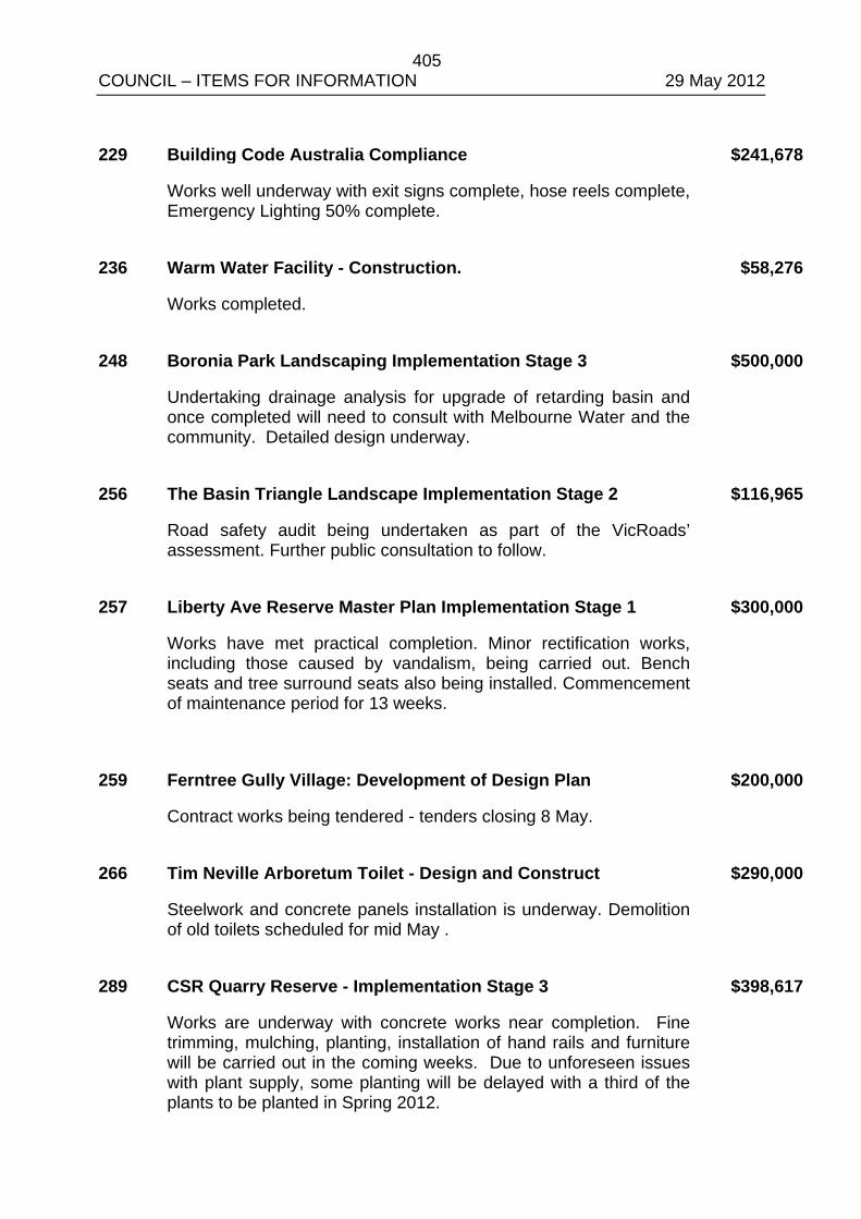
405 COUNCIL – ITEMS FOR INFORMATION 29 May 2012 229 Building Code Australia Compliance $241,678
Works well underway with exit signs complete, hose reels complete, Emergency Lighting 50% complete.
236 Warm Water Facility - Construction. $58,276
Works completed. 248 Boronia Park Landscaping Implementation Stage 3 $500,000
Undertaking drainage analysis for upgrade of retarding basin and once completed will need to consult with Melbourne Water and the community. Detailed design underway.
256 The Basin Triangle Landscape Implementation Stage 2 $116,965
Road safety audit being undertaken as part of the VicRoads’ assessment. Further public consultation to follow.
257 Liberty Ave Reserve Master Plan Implementation Stage 1 $300,000
Works have met practical completion. Minor rectification works, including those caused by vandalism, being carried out. Bench seats and tree surround seats also being installed. Commencement of maintenance period for 13 weeks.
259 Ferntree Gully Village: Development of Design Plan $200,000
Contract works being tendered - tenders closing 8 May. 266 Tim Neville Arboretum Toilet - Design and Construct $290,000
Steelwork and concrete panels installation is underway. Demolition of old toilets scheduled for mid May .
289 CSR Quarry Reserve - Implementation Stage 3 $398,617
Works are underway with concrete works near completion. Fine trimming, mulching, planting, installation of hand rails and furniture will be carried out in the coming weeks. Due to unforeseen issues with plant supply, some planting will be delayed with a third of the plants to be planted in Spring 2012.
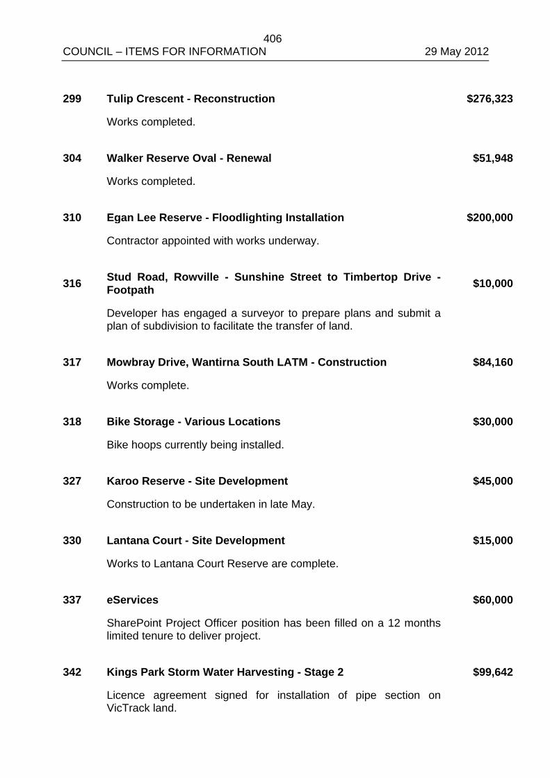
406 COUNCIL – ITEMS FOR INFORMATION 29 May 2012 299 Tulip Crescent - Reconstruction $276,323
Works completed. 304 Walker Reserve Oval - Renewal $51,948
Works completed. 310 Egan Lee Reserve - Floodlighting Installation $200,000
Contractor appointed with works underway.
316 Stud Road, Rowville - Sunshine Street to Timbertop Drive - Footpath $10,000
Developer has engaged a surveyor to prepare plans and submit a plan of subdivision to facilitate the transfer of land.
317 Mowbray Drive, Wantirna South LATM - Construction $84,160
Works complete. 318 Bike Storage - Various Locations $30,000
Bike hoops currently being installed. 327 Karoo Reserve - Site Development $45,000
Construction to be undertaken in late May. 330 Lantana Court - Site Development $15,000
Works to Lantana Court Reserve are complete. 337 eServices $60,000
SharePoint Project Officer position has been filled on a 12 months limited tenure to deliver project.
342 Kings Park Storm Water Harvesting - Stage 2 $99,642
Licence agreement signed for installation of pipe section on VicTrack land.
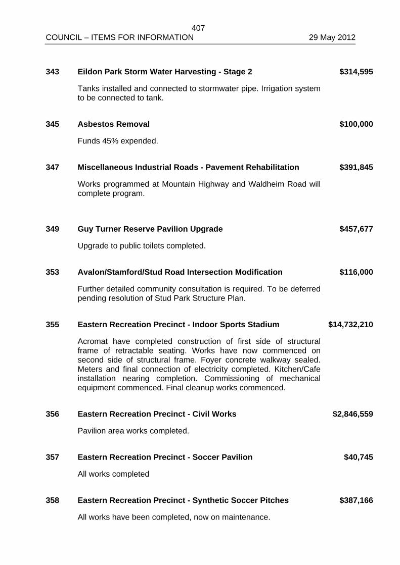
407 COUNCIL – ITEMS FOR INFORMATION 29 May 2012 343 Eildon Park Storm Water Harvesting - Stage 2 $314,595
Tanks installed and connected to stormwater pipe. Irrigation system to be connected to tank.
345 Asbestos Removal $100,000
Funds 45% expended. 347 Miscellaneous Industrial Roads - Pavement Rehabilitation $391,845
Works programmed at Mountain Highway and Waldheim Road will complete program.
349 Guy Turner Reserve Pavilion Upgrade $457,677
Upgrade to public toilets completed. 353 Avalon/Stamford/Stud Road Intersection Modification $116,000
Further detailed community consultation is required. To be deferred pending resolution of Stud Park Structure Plan.
355 Eastern Recreation Precinct - Indoor Sports Stadium $14,732,210
Acromat have completed construction of first side of structural frame of retractable seating. Works have now commenced on second side of structural frame. Foyer concrete walkway sealed. Meters and final connection of electricity completed. Kitchen/Cafe installation nearing completion. Commissioning of mechanical equipment commenced. Final cleanup works commenced.
356 Eastern Recreation Precinct - Civil Works $2,846,559
Pavilion area works completed. 357 Eastern Recreation Precinct - Soccer Pavilion $40,745
All works completed 358 Eastern Recreation Precinct - Synthetic Soccer Pitches $387,166
All works have been completed, now on maintenance.
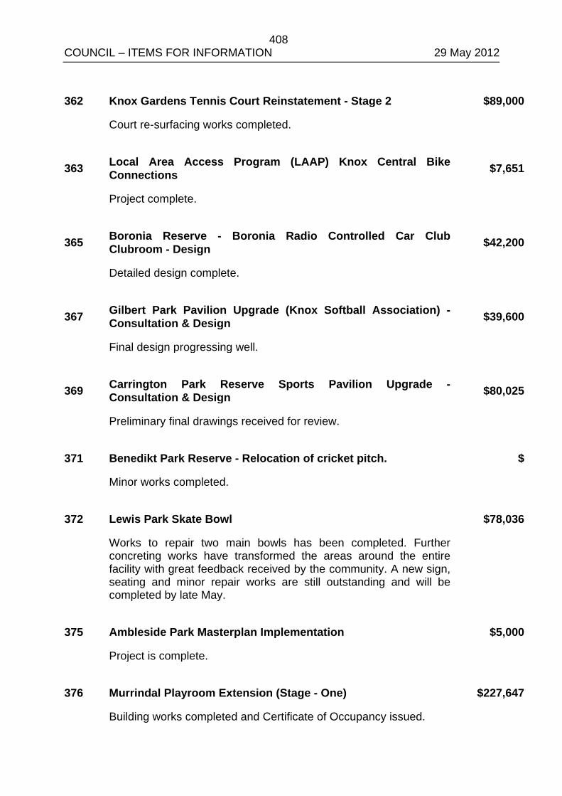
408 COUNCIL – ITEMS FOR INFORMATION 29 May 2012 362 Knox Gardens Tennis Court Reinstatement - Stage 2 $89,000
Court re-surfacing works completed.
363 Local Area Access Program (LAAP) Knox Central Bike Connections $7,651
Project complete.
365 Boronia Reserve - Boronia Radio Controlled Car Club Clubroom - Design $42,200
Detailed design complete.
367 Gilbert Park Pavilion Upgrade (Knox Softball Association) - Consultation & Design $39,600
Final design progressing well.
369 Carrington Park Reserve Sports Pavilion Upgrade - Consultation & Design $80,025
Preliminary final drawings received for review. 371 Benedikt Park Reserve - Relocation of cricket pitch. $
Minor works completed. 372 Lewis Park Skate Bowl $78,036
Works to repair two main bowls has been completed. Further concreting works have transformed the areas around the entire facility with great feedback received by the community. A new sign, seating and minor repair works are still outstanding and will be completed by late May.
375 Ambleside Park Masterplan Implementation $5,000
Project is complete. 376 Murrindal Playroom Extension (Stage - One) $227,647
Building works completed and Certificate of Occupancy issued.
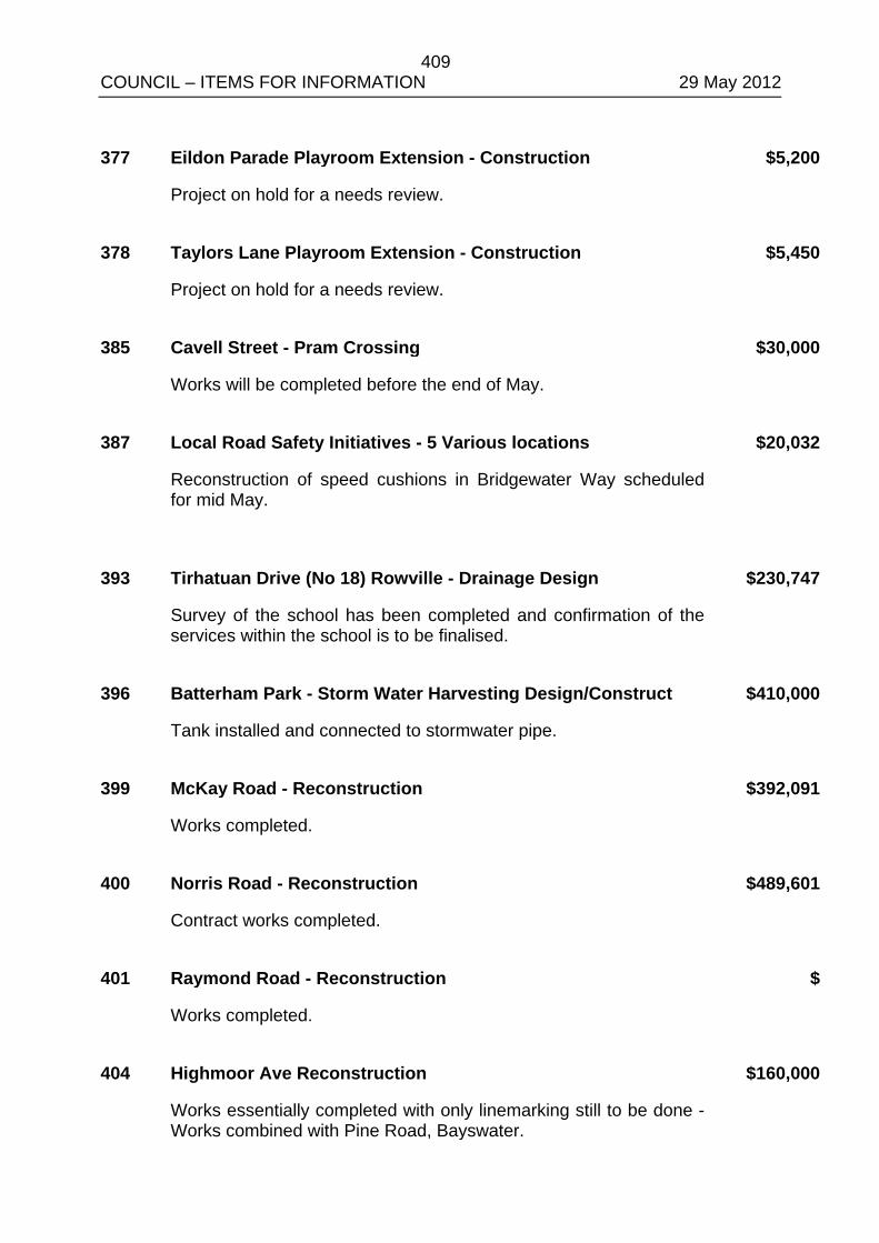
409 COUNCIL – ITEMS FOR INFORMATION 29 May 2012 377 Eildon Parade Playroom Extension - Construction $5,200
Project on hold for a needs review. 378 Taylors Lane Playroom Extension - Construction $5,450
Project on hold for a needs review. 385 Cavell Street - Pram Crossing $30,000
Works will be completed before the end of May. 387 Local Road Safety Initiatives - 5 Various locations $20,032
Reconstruction of speed cushions in Bridgewater Way scheduled for mid May.
393 Tirhatuan Drive (No 18) Rowville - Drainage Design $230,747
Survey of the school has been completed and confirmation of the services within the school is to be finalised.
396 Batterham Park - Storm Water Harvesting Design/Construct $410,000
Tank installed and connected to stormwater pipe. 399 McKay Road - Reconstruction $392,091
Works completed. 400 Norris Road - Reconstruction $489,601
Contract works completed. 401 Raymond Road - Reconstruction $
Works completed. 404 Highmoor Ave Reconstruction $160,000
Works essentially completed with only linemarking still to be done - Works combined with Pine Road, Bayswater.
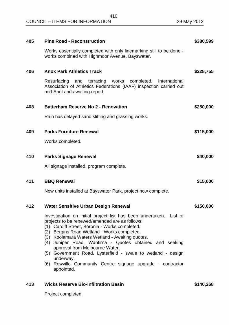
410 COUNCIL – ITEMS FOR INFORMATION 29 May 2012 405 Pine Road - Reconstruction $380,599
Works essentially completed with only linemarking still to be done - works combined with Highmoor Avenue, Bayswater.
406 Knox Park Athletics Track $228,755
Resurfacing and terracing works completed. International Association of Athletics Federations (IAAF) inspection carried out mid-April and awaiting report.
408 Batterham Reserve No 2 - Renovation $250,000
Rain has delayed sand slitting and grassing works. 409 Parks Furniture Renewal $115,000
Works completed. 410 Parks Signage Renewal $40,000
All signage installed, program complete. 411 BBQ Renewal $15,000
New units installed at Bayswater Park, project now complete. 412 Water Sensitive Urban Design Renewal $150,000
Investigation on initial project list has been undertaken. List of projects to be renewed/amended are as follows: (1) Cardiff Street, Boronia - Works completed. (2) Bergins Road Wetland - Works completed. (3) Koolamara Waters Wetland - Awaiting quotes. (4) Juniper Road, Wantirna - Quotes obtained and seeking
approval from Melbourne Water. (5) Government Road, Lysterfield - swale to wetland - design
underway. (6) Rowville Community Centre signage upgrade - contractor
appointed.
413 Wicks Reserve Bio-Infiltration Basin $140,268
Project completed.
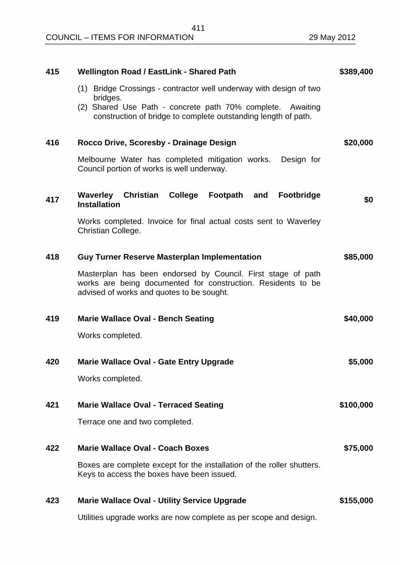
411 COUNCIL – ITEMS FOR INFORMATION 29 May 2012 415 Wellington Road / EastLink - Shared Path $389,400
(1) Bridge Crossings - contractor well underway with design of two bridges.
(2) Shared Use Path - concrete path 70% complete. Awaiting construction of bridge to complete outstanding length of path.
416 Rocco Drive, Scoresby - Drainage Design $20,000
Melbourne Water has completed mitigation works. Design for Council portion of works is well underway.
417 Waverley Christian College Footpath and Footbridge Installation $0
Works completed. Invoice for final actual costs sent to Waverley Christian College.
418 Guy Turner Reserve Masterplan Implementation $85,000
Masterplan has been endorsed by Council. First stage of path works are being documented for construction. Residents to be advised of works and quotes to be sought.
419 Marie Wallace Oval - Bench Seating $40,000
Works completed. 420 Marie Wallace Oval - Gate Entry Upgrade $5,000
Works completed. 421 Marie Wallace Oval - Terraced Seating $100,000
Terrace one and two completed. 422 Marie Wallace Oval - Coach Boxes $75,000
Boxes are complete except for the installation of the roller shutters. Keys to access the boxes have been issued.
423 Marie Wallace Oval - Utility Service Upgrade $155,000
Utilities upgrade works are now complete as per scope and design.
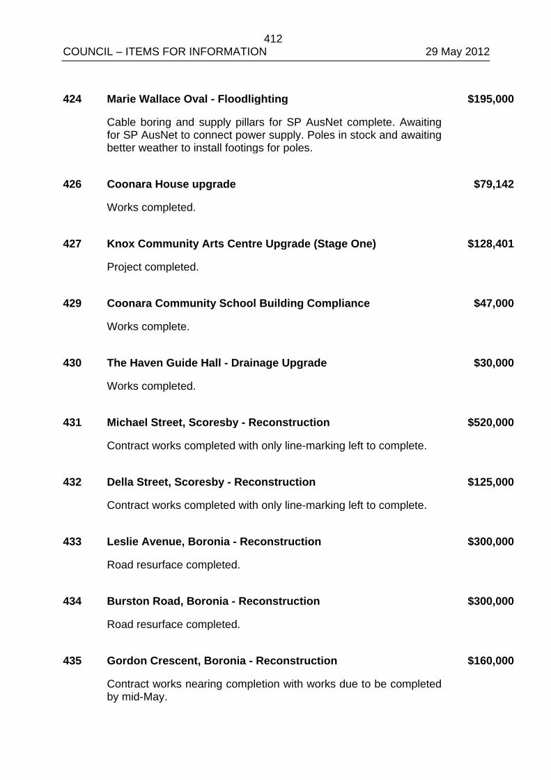
412 COUNCIL – ITEMS FOR INFORMATION 29 May 2012 424 Marie Wallace Oval - Floodlighting $195,000
Cable boring and supply pillars for SP AusNet complete. Awaiting for SP AusNet to connect power supply. Poles in stock and awaiting better weather to install footings for poles.
426 Coonara House upgrade $79,142
Works completed. 427 Knox Community Arts Centre Upgrade (Stage One) $128,401
Project completed. 429 Coonara Community School Building Compliance $47,000
Works complete. 430 The Haven Guide Hall - Drainage Upgrade $30,000
Works completed. 431 Michael Street, Scoresby - Reconstruction $520,000
Contract works completed with only line-marking left to complete. 432 Della Street, Scoresby - Reconstruction $125,000
Contract works completed with only line-marking left to complete. 433 Leslie Avenue, Boronia - Reconstruction $300,000
Road resurface completed. 434 Burston Road, Boronia - Reconstruction $300,000
Road resurface completed. 435 Gordon Crescent, Boronia - Reconstruction $160,000
Contract works nearing completion with works due to be completed by mid-May.
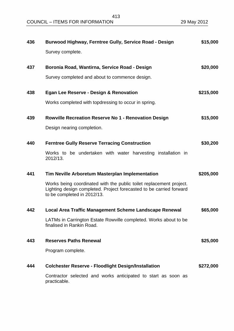
413 COUNCIL – ITEMS FOR INFORMATION 29 May 2012 436 Burwood Highway, Ferntree Gully, Service Road - Design $15,000
Survey complete. 437 Boronia Road, Wantirna, Service Road - Design $20,000
Survey completed and about to commence design. 438 Egan Lee Reserve - Design & Renovation $215,000
Works completed with topdressing to occur in spring. 439 Rowville Recreation Reserve No 1 - Renovation Design $15,000
Design nearing completion. 440 Ferntree Gully Reserve Terracing Construction $30,200
Works to be undertaken with water harvesting installation in 2012/13.
441 Tim Neville Arboretum Masterplan Implementation $205,000
Works being coordinated with the public toilet replacement project. Lighting design completed. Project forecasted to be carried forward to be completed in 2012/13.
442 Local Area Traffic Management Scheme Landscape Renewal $65,000
LATMs in Carrington Estate Rowville completed. Works about to be finalised in Rankin Road.
443 Reserves Paths Renewal $25,000
Program complete. 444 Colchester Reserve - Floodlight Design/Installation $272,000
Contractor selected and works anticipated to start as soon as practicable.
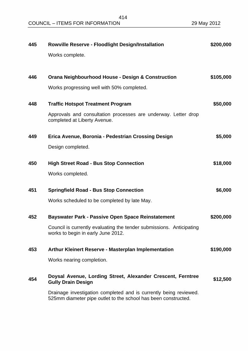
414 COUNCIL – ITEMS FOR INFORMATION 29 May 2012 445 Rowville Reserve - Floodlight Design/Installation $200,000
Works complete.
446 Orana Neighbourhood House - Design & Construction $105,000
Works progressing well with 50% completed. 448 Traffic Hotspot Treatment Program $50,000
Approvals and consultation processes are underway. Letter drop completed at Liberty Avenue.
449 Erica Avenue, Boronia - Pedestrian Crossing Design $5,000
Design completed. 450 High Street Road - Bus Stop Connection $18,000
Works completed. 451 Springfield Road - Bus Stop Connection $6,000
Works scheduled to be completed by late May. 452 Bayswater Park - Passive Open Space Reinstatement $200,000
Council is currently evaluating the tender submissions. Anticipating works to begin in early June 2012.
453 Arthur Kleinert Reserve - Masterplan Implementation $190,000
Works nearing completion.
454 Doysal Avenue, Lording Street, Alexander Crescent, Ferntree Gully Drain Design $12,500
Drainage investigation completed and is currently being reviewed. 525mm diameter pipe outlet to the school has been constructed.
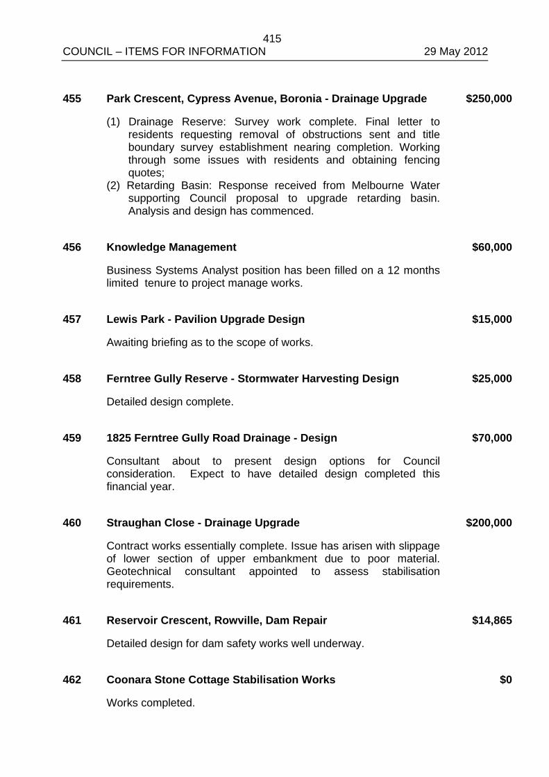
415 COUNCIL – ITEMS FOR INFORMATION 29 May 2012 455 Park Crescent, Cypress Avenue, Boronia - Drainage Upgrade $250,000
(1) Drainage Reserve: Survey work complete. Final letter to residents requesting removal of obstructions sent and title boundary survey establishment nearing completion. Working through some issues with residents and obtaining fencing quotes;
(2) Retarding Basin: Response received from Melbourne Water supporting Council proposal to upgrade retarding basin. Analysis and design has commenced.
456 Knowledge Management $60,000
Business Systems Analyst position has been filled on a 12 months limited tenure to project manage works.
457 Lewis Park - Pavilion Upgrade Design $15,000
Awaiting briefing as to the scope of works. 458 Ferntree Gully Reserve - Stormwater Harvesting Design $25,000
Detailed design complete. 459 1825 Ferntree Gully Road Drainage - Design $70,000
Consultant about to present design options for Council consideration. Expect to have detailed design completed this financial year.
460 Straughan Close - Drainage Upgrade $200,000
Contract works essentially complete. Issue has arisen with slippage of lower section of upper embankment due to poor material. Geotechnical consultant appointed to assess stabilisation requirements.
461 Reservoir Crescent, Rowville, Dam Repair $14,865
Detailed design for dam safety works well underway. 462 Coonara Stone Cottage Stabilisation Works $0
Works completed.
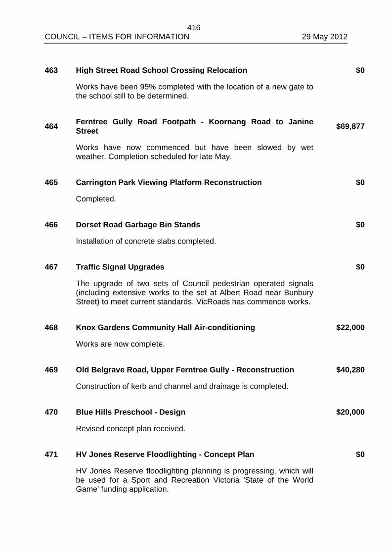
416 COUNCIL – ITEMS FOR INFORMATION 29 May 2012 463 High Street Road School Crossing Relocation $0
Works have been 95% completed with the location of a new gate to the school still to be determined.
464 Ferntree Gully Road Footpath - Koornang Road to Janine Street $69,877
Works have now commenced but have been slowed by wet weather. Completion scheduled for late May.
465 Carrington Park Viewing Platform Reconstruction $0
Completed. 466 Dorset Road Garbage Bin Stands $0
Installation of concrete slabs completed. 467 Traffic Signal Upgrades $0
The upgrade of two sets of Council pedestrian operated signals (including extensive works to the set at Albert Road near Bunbury Street) to meet current standards. VicRoads has commence works.
468 Knox Gardens Community Hall Air-conditioning $22,000
Works are now complete. 469 Old Belgrave Road, Upper Ferntree Gully - Reconstruction $40,280
Construction of kerb and channel and drainage is completed. 470 Blue Hills Preschool - Design $20,000
Revised concept plan received. 471 HV Jones Reserve Floodlighting - Concept Plan $0
HV Jones Reserve floodlighting planning is progressing, which will be used for a Sport and Recreation Victoria 'State of the World Game' funding application.
417 COUNCIL – ITEMS FOR INFORMATION 29 May 2012
472 Bowen Avenue and Golden Grove - Water Sensitive Urban Design $250,000
Dobsons Creek High Value Catchment Pilot. Melbourne Water funding for Water Sensitive Urban Design streetscape elements along Bowen Avenue and Golden Grove - Design underway.
473 Audio System Upgrade - Civic Centre $0
Contract accepted for upgrade of Civic Centre sound system and microphones.
474 Security System Upgrade - Civic Centre $0
Quotations being assessed for upgrade of Civic Centre Security System.
418 COUNCIL – ITEMS FOR INFORMATION 29 May 2012
ALL WARDS
11.2 ASSEMBLIES OF COUNCILLORS
SUMMARY: Manager – Governance (Rhys Thomas)
This report provides details of Assembly of Councillors established under section 80A of the Local Government Act as required under section 80A(2) of the Act.
RECOMMENDATION
That Council
1. Note the written record of Assemblies of Councillors as attached to this report.
2. Incorporate the records of the Assemblies into the minutes of the meeting.
1. INTRODUCTION
Under section 80A(2) of the Local Government Act, the Chief Executive Officer must present a written record of an Assembly of Councillors to an ordinary meeting of Council as soon as practicable after an Assembly occurs. This written record is required to be incorporated into the minutes of the meeting.
Details of Assemblies of Councillors that have occurred between Monday 9 April 2012 and Sunday 13 May 2012 are attached to this report.
COUNCIL RESOLUTION MOVED: CR. VAN DE VREEDE SECONDED: CR. McMILLAN
That Council
1. Note the written record of Assemblies of Councillors as attached to this report.
2. Incorporate the records of the Assemblies into the minutes of the meeting excluding the record of Issues Briefing Meeting held on 1 May 2012.
CARRIED
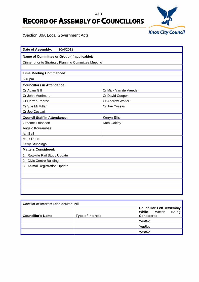
419
RREECCOORRDD OOFF AASSSSEEMMBBLLYY OOFF CCOOUUNNCCIILLLLOORRSS (Section 80A Local Government Act)
Date of Assembly: 10/4/2012
Name of Committee or Group (if applicable):
Dinner prior to Strategic Planning Committee Meeting Time Meeting Commenced:
6:40pm
Councillors in Attendance: Cr Adam Gill Cr Mick Van de Vreede Cr John Mortimore Cr David Cooper Cr Darren Pearce Cr Andrew Walter Cr Sue McMillan Cr Joe Cossari Cr Joe Cossari
Council Staff in Attendance: Kerryn Ellis Graeme Emonson Kath Oakley Angelo Kourambas Ian Bell Mark Dupe Kerry Stubbings Matters Considered:
1. Rowville Rail Study Update 2. Civic Centre Building 3. Animal Registration Update Conflict of Interest Disclosures: Nil Councillor’s Name
Type of Interest
Councillor Left Assembly While Matter Being Considered
Yes/No Yes/No Yes/No
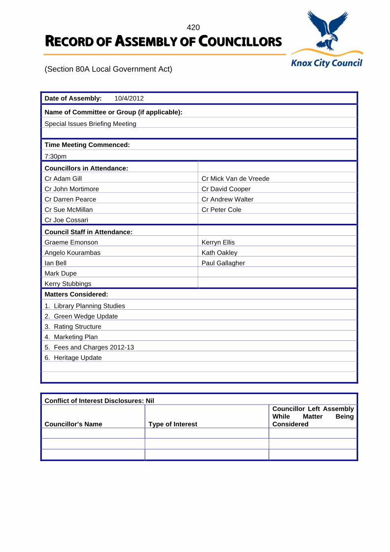
420
RREECCOORRDD OOFF AASSSSEEMMBBLLYY OOFF CCOOUUNNCCIILLLLOORRSS (Section 80A Local Government Act)
Date of Assembly: 10/4/2012
Name of Committee or Group (if applicable):
Special Issues Briefing Meeting Time Meeting Commenced:
7:30pm
Councillors in Attendance: Cr Adam Gill Cr Mick Van de Vreede Cr John Mortimore Cr David Cooper Cr Darren Pearce Cr Andrew Walter Cr Sue McMillan Cr Peter Cole Cr Joe Cossari
Council Staff in Attendance: Graeme Emonson Kerryn Ellis Angelo Kourambas Kath Oakley Ian Bell Paul Gallagher Mark Dupe Kerry Stubbings Matters Considered:
1. Library Planning Studies 2. Green Wedge Update 3. Rating Structure 4. Marketing Plan 5. Fees and Charges 2012-13 6. Heritage Update Conflict of Interest Disclosures: Nil Councillor’s Name
Type of Interest
Councillor Left Assembly While Matter Being Considered
421
RREECCOORRDD OOFF AASSSSEEMMBBLLYY OOFF CCOOUUNNCCIILLLLOORRSS (Section 80A Local Government Act)
Date of Assembly: 16/4/2012
Name of Committee or Group (if applicable):
Knox Multicultural Advisory Committee Time Meeting Commenced:
6:00pm
Councillors in Attendance: Cr Joe Cossari Cr David Cooper
Council Staff in Attendance: Kathy Parton Nicole Hunter Belinda Gillam Jemma Wood Lisette Pine Matters Considered:
1. Knox Youth Plan 2. Knox Community Safety Plan 3. Knox City Council Multicultural Strategic Plan 2012-2017 4. Updates from Members Conflict of Interest Disclosures: Nil Councillor’s Name
Type of Interest
Councillor Left Assembly While Matter Being Considered
422
RREECCOORRDD OOFF AASSSSEEMMBBLLYY OOFF CCOOUUNNCCIILLLLOORRSS (Section 80A Local Government Act)
Date of Assembly: 17/4/2012
Name of Committee or Group (if applicable):
Planning Consultation Committee Time Meeting Commenced:
6:00pm
Councillors in Attendance: Cr Sue McMillan Cr Mick Van de Vreede
Council Staff in Attendance: Will Priestley Wilhelmina Knorr Peter Steele Matters Considered:
The construction of a three (3) storey apartment building containing fifteen (15) dwellings at 5 Stamford Crescent, Rowville (Application No. P2011/6750). Conflict of Interest Disclosures: Nil Councillor’s Name
Type of Interest
Councillor Left Assembly While Matter Being Considered
Yes/No Yes/No Yes/No
423
RREECCOORRDD OOFF AASSSSEEMMBBLLYY OOFF CCOOUUNNCCIILLLLOORRSS (Section 80A Local Government Act)
Date of Assembly: 17/4/2012
Name of Committee or Group (if applicable):
Planning Consultation Committee Time Meeting Commenced:
7:00pm
Councillors in Attendance: Cr Sue McMillan Cr John Mortimore
Council Staff in Attendance: Peter Steele Wilhelmina Knorr Renee Haddock Matters Considered:
Development of the land for a two (2) storey apartment building containing eleven (11) dwellings at 1/27 Chandler Road and 2A Rangeview Road, Boronia (Application No. P2011/6938). Conflict of Interest Disclosures: Nil Councillor’s Name
Type of Interest
Councillor Left Assembly While Matter Being Considered
424
RREECCOORRDD OOFF AASSSSEEMMBBLLYY OOFF CCOOUUNNCCIILLLLOORRSS (Section 80A Local Government Act)
Date of Assembly: 17/4/2012
Name of Committee or Group (if applicable):
Planning Consultation Committee Time Meeting Commenced:
8:00pm
Councillors in Attendance: Cr Sue McMillan
Council Staff in Attendance: Will Priestley Peter Steele Wilhelmina Knorr Matters Considered:
Application for the development of the land for three (3) double storey dwellings at 15 Woodmason Road, Boronia (Application No. P2011/6825). Conflict of Interest Disclosures: Nil Councillor’s Name
Type of Interest
Councillor Left Assembly While Matter Being Considered
Yes/No Yes/No Yes/No

425
RREECCOORRDD OOFF AASSSSEEMMBBLLYY OOFF CCOOUUNNCCIILLLLOORRSS (Section 80A Local Government Act)
Date of Assembly: 18/4/2012
Name of Committee or Group (if applicable):
Environment Advisory Committee Time Meeting Commenced:
6:30pm
Councillors in Attendance: Cr John Mortimore
Council Staff in Attendance: Ellen Mitchell Trish Winterling Marshall Kelaher Geoff McMeeken Matters Considered:
1. DSE Waste Policy Review Submission 2. Knox Open Space and Liveable Streets Plan 3. Climate Change Response Plan 4. Outcomes from MAV Environment Committee 5. Stamford Park ZEN 6. Environment Advisory Committee Strategic Workshop Conflict of Interest Disclosures: Nil Councillor’s Name
Type of Interest
Councillor Left Assembly While Matter Being Considered
Yes/No Yes/No Yes/No
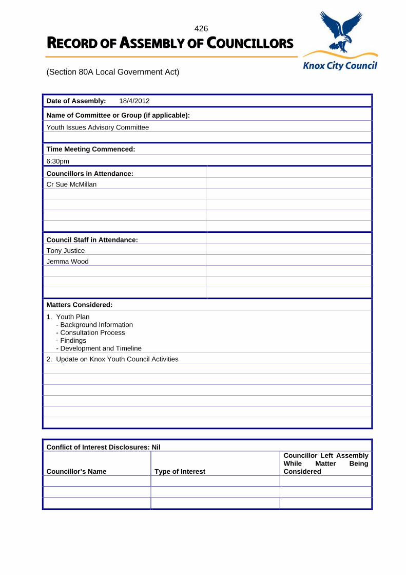
426
RREECCOORRDD OOFF AASSSSEEMMBBLLYY OOFF CCOOUUNNCCIILLLLOORRSS (Section 80A Local Government Act)
Date of Assembly: 18/4/2012
Name of Committee or Group (if applicable):
Youth Issues Advisory Committee Time Meeting Commenced:
6:30pm
Councillors in Attendance: Cr Sue McMillan
Council Staff in Attendance: Tony Justice Jemma Wood Matters Considered:
1. Youth Plan - Background Information - Consultation Process - Findings - Development and Timeline 2. Update on Knox Youth Council Activities Conflict of Interest Disclosures: Nil Councillor’s Name
Type of Interest
Councillor Left Assembly While Matter Being Considered
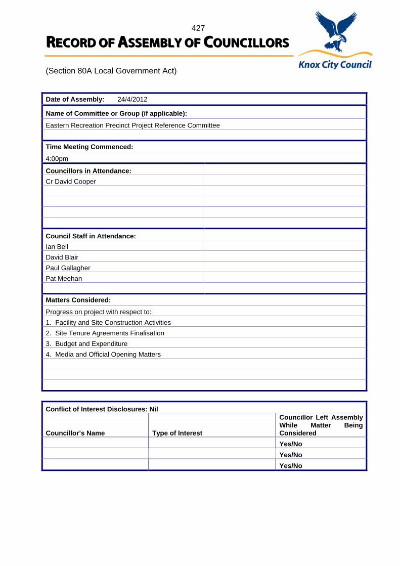
427
RREECCOORRDD OOFF AASSSSEEMMBBLLYY OOFF CCOOUUNNCCIILLLLOORRSS (Section 80A Local Government Act)
Date of Assembly: 24/4/2012
Name of Committee or Group (if applicable):
Eastern Recreation Precinct Project Reference Committee Time Meeting Commenced:
4:00pm
Councillors in Attendance: Cr David Cooper
Council Staff in Attendance: Ian Bell David Blair Paul Gallagher Pat Meehan Matters Considered:
Progress on project with respect to: 1. Facility and Site Construction Activities 2. Site Tenure Agreements Finalisation 3. Budget and Expenditure 4. Media and Official Opening Matters Conflict of Interest Disclosures: Nil Councillor’s Name
Type of Interest
Councillor Left Assembly While Matter Being Considered
Yes/No Yes/No Yes/No
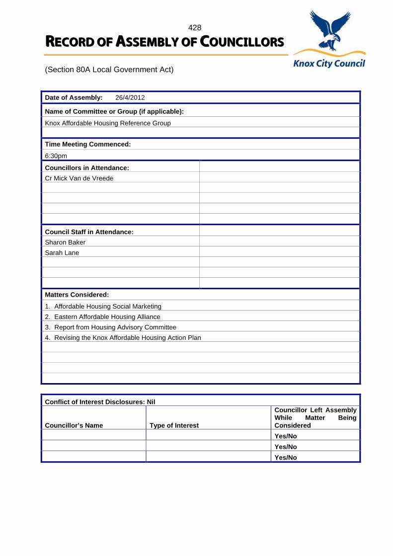
428
RREECCOORRDD OOFF AASSSSEEMMBBLLYY OOFF CCOOUUNNCCIILLLLOORRSS (Section 80A Local Government Act)
Date of Assembly: 26/4/2012
Name of Committee or Group (if applicable):
Knox Affordable Housing Reference Group Time Meeting Commenced:
6:30pm
Councillors in Attendance: Cr Mick Van de Vreede
Council Staff in Attendance: Sharon Baker Sarah Lane Matters Considered:
1. Affordable Housing Social Marketing 2. Eastern Affordable Housing Alliance 3. Report from Housing Advisory Committee 4. Revising the Knox Affordable Housing Action Plan Conflict of Interest Disclosures: Nil Councillor’s Name
Type of Interest
Councillor Left Assembly While Matter Being Considered
Yes/No Yes/No Yes/No
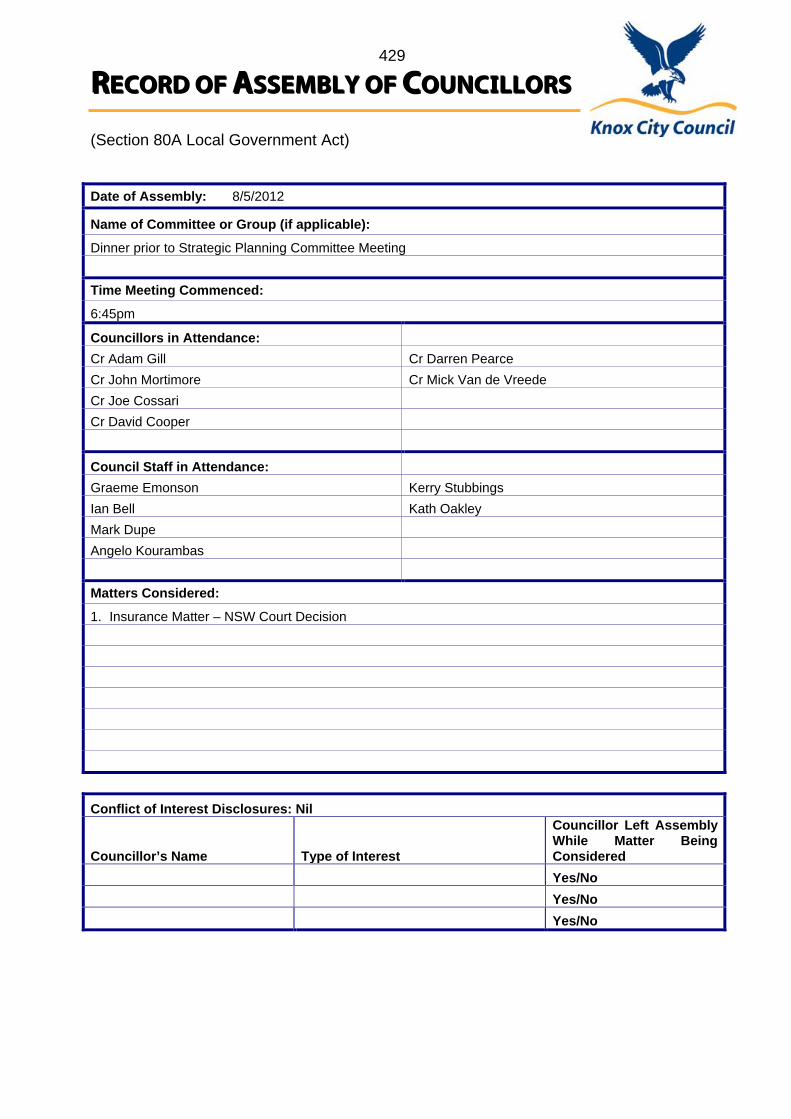
429
RREECCOORRDD OOFF AASSSSEEMMBBLLYY OOFF CCOOUUNNCCIILLLLOORRSS (Section 80A Local Government Act)
Date of Assembly: 8/5/2012
Name of Committee or Group (if applicable):
Dinner prior to Strategic Planning Committee Meeting Time Meeting Commenced:
6:45pm
Councillors in Attendance: Cr Adam Gill Cr Darren Pearce Cr John Mortimore Cr Mick Van de Vreede Cr Joe Cossari Cr David Cooper
Council Staff in Attendance: Graeme Emonson Kerry Stubbings Ian Bell Kath Oakley Mark Dupe Angelo Kourambas Matters Considered:
1. Insurance Matter – NSW Court Decision Conflict of Interest Disclosures: Nil Councillor’s Name
Type of Interest
Councillor Left Assembly While Matter Being Considered
Yes/No Yes/No Yes/No
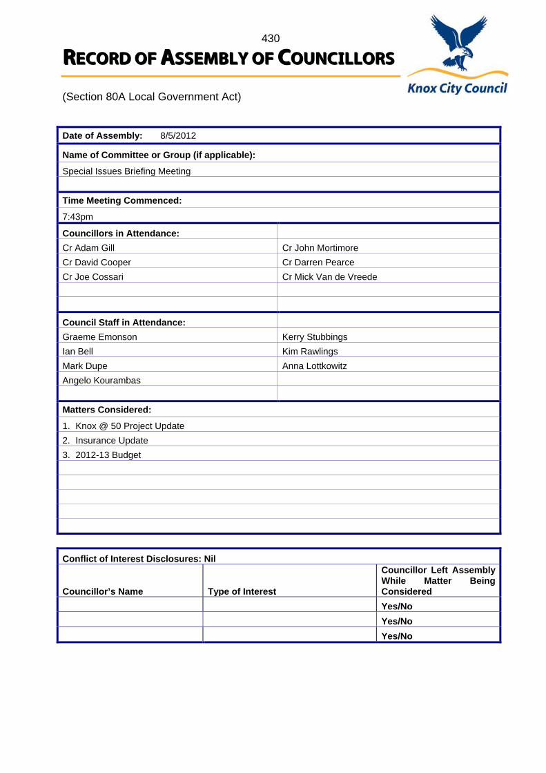
430
RREECCOORRDD OOFF AASSSSEEMMBBLLYY OOFF CCOOUUNNCCIILLLLOORRSS (Section 80A Local Government Act)
Date of Assembly: 8/5/2012
Name of Committee or Group (if applicable):
Special Issues Briefing Meeting Time Meeting Commenced:
7:43pm
Councillors in Attendance: Cr Adam Gill Cr John Mortimore Cr David Cooper Cr Darren Pearce Cr Joe Cossari Cr Mick Van de Vreede
Council Staff in Attendance: Graeme Emonson Kerry Stubbings Ian Bell Kim Rawlings Mark Dupe Anna Lottkowitz Angelo Kourambas Matters Considered:
1. Knox @ 50 Project Update 2. Insurance Update 3. 2012-13 Budget Conflict of Interest Disclosures: Nil Councillor’s Name
Type of Interest
Councillor Left Assembly While Matter Being Considered
Yes/No Yes/No Yes/No

431 COUNCIL 29 May 2012
12. MOTIONS FOR WHICH NOTICE HAS PREVIOUSLY BEEN GIVEN
NOTICE OF MOTION NO.20
12.1 STATE GOVERNMENT PENSIONER RATE REBATE
MOVED: CR. MORTIMORE SECONDED: CR. PEARCE
That Council call upon the Victorian State Government to substantially increase the State Government’s maximum annual pensioner rate rebate concession, in addition to annual indexation, to better reflect the increasing costs of living being experienced by eligible pensioners in the community CARRIED
13. SUPPLEMENTARY ITEMS
Nil
14. URGENT BUSINESS
14.1 URGENT BUSINESS
Nil
14.2 CALL UP ITEMS
Nil
15. QUESTIONS WITHOUT NOTICE
Nil
MEETING CLOSED AT 9.56PM
Minutes of Meeting confirmed at the Ordinary Meeting of Council
held on Tuesday 26 June 2012
………………………………… Chairman