kite lpsc 2018 poster v2 - UChicago...
1
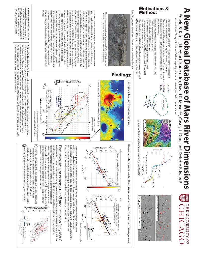
A New Global Database of Mars River Dimensions Acknowledgements: Particular thanks to Jonathan Sneed and Sam Holo for contributing to fieldwork. Thanks to Marjorie Chan for logistic and intellectual support for fieldwork. Thank you to Sharon Wilson, Caleb Fassett, Joel Davis, and Marisa Palucis, who each shared unpublished work. We acknowledge useful discussions with Becky Williams, Robert Jacobsen, Ben Cardenas, Alan Howard, Devon Burr, Tim Goudge, Alastair Hayden, Caleb Fassett, Nicolas Mangold, David Mohrig, Ben Cardenas, Roman diBiase, and especially Ross Irwin. Grants: NASA (NNX15AM49G, NNX16AG55G). We have ruled out the possibilities that my observations result from limited image resolution, postfluvial modification, flash-snowmelt due to reentry heating from distal impact ejecta, dam-overtopping, karst-like modification of paleochannels, or misinterpretation of debris-flow deposits. We might be measuring strath terraces or channel belts at some sites, but not most. Published work on Earth permafrost-river hydraulic geometry does not support a large permafrost correction. Two possibilities remain: Fine grain sizes, or extreme runoff production on Early Mars? Rivers on Mars were wider than rivers on Earth for the same drainage area The main surprise so far: Channels are frequently too big (relative to their drainage area) to be easily reconciled with a seasonal-snowmelt climate. As expected from Earth data, scatter is high. At Earth sites, the width of flat-topped ridges can record channel-belt width (not channel width). On Mars, width-inferred and wavelength-inferred paleodischarges agree, consistent with the interpretation that well-preserved flat-topped sinuous ridges record channel width. Evidence for regional variations Repeated ArcGIS traces are merged and analysed in MATLAB. 172 drainage areas are represented. ~83% of sites have HiRISE coverage (~60% of those with HiRISE anaglyphs or HiRISE DTMs) an advance over the pioneering THEMIS study of Irwin et al., Geology, 2005 Two main biases in the database: (1) Only well-preserved channels and drainage areas are included. (2) We measured the largest visible channels in a catchment. Discharge Q inferred from width w: (using the Ref. 24 scaling; the Ref. 23 scaling gives very similar results). Discharge Q inferred from wavelength λ: R: R: Edwin S. Kite 1,* ([email protected]), David P. Mayer 1,2 , Casey J. Duncan 3 , Deirdre Edward 1 Rivers on Earth adjust their depths to just mobilize sediment. Therefore, if grainsize on Mars was small, then modest river depths could transport sediment, so discharge could be small (consistent with snowmelt) for a given width. Extremely high runoff production (rainfall?) on Early Mars. 1 2 1. University of Chicago. 2. Now at USGS Astrogeology Center. 3. University of Utah. * poster author. Motivations & Findings: Method: The scale of ancient Mars rivers – their paleochannel widths and meander wavelengths – is a proxy for past river discharge. Discharge, divided by drainage area, yields runoff production, which is a key parameter for selecting between climate models (e.g rain versus snowmelt). Gale region (1) + supraglacial channels (2,8) SW Melas Chasma (9) Colors correspond to geographic clusters k-means clustering of geographic distribution of measured rivers High-quality data only Open circles: widths Closed circles: wavelengths Do the flat tops of sinuous ridges measured from orbit corre- spond to channel-belt widths, or channel widths? Sinuous ridges near Green River in SE Utah preserve channel deposits and point-bar deposits. At this site, channel deposits preserved within sinuous ridges can be less than the width of the flat top of the ridge, and in some interpretations the width of the flat top of the ridge corresponds to channel-belt width, not a channel width. These Earth-analog data are a warning against over-interpreting HiRISE DTMs, because the decisive grain-size and bedset-thickness measurements are very difficult from orbit. For many Mars river deposits, the simplest interpretation of sinuous-ridge width is nevertheless that ridge-top width corresponds to inverted channel width. This is because 0 3D view of drone-derived Digital Terrain Model (DTM) of SE Utah inverted λ-only global trend (λ) (w) w-only global trend yellow trend-line: all-data fit, high quality only cyan trend-line: all-data fit, all qualities Exploiting preservation of river channel properties in river deposits Author contributions. E.S.K. analysed Mars data and supervised fieldwork. D.P.M. built the Mars GIS, and the Mars DTMs, for the project. C.J.D. collected the drone data and built the Earth DTMs. D.E. analysed drone data. (n = 577; 106 channels) Automatic extraction from hand-picked traces (Kite et al., EPSL, 2015) centerlines picked in triplicate R: runoff production (mm/hr) channel (Oct 2017). Flat top is ~20 m wide. No vertical exaggeration. (1) sandblasting-away of floodplain deposits allows diagnostic bedforms, e.g. lateral-accretion deposits, to be recognized from orbit; (2) agreement between meander-wavelengths and paleochannel widths allows cross-checking; (3) rivers can transition from negative-relief valley floors to positive-relief channel floors, which decreases the likelihood that either is an artifact. Earth data from Bieger et al., JAWRA 2015
Transcript of kite lpsc 2018 poster v2 - UChicago...
A N
ew G
lobal Database of M
ars River Dim
ensions
Acknowledgem
ents: Particular thanks to Jonathan Sneed and Sam H
olo for contributing to fieldwork.
Thanks to Marjorie Chan for logistic and intellectual support for fieldw
ork. Thank you to Sharon Wilson,
Caleb Fassett, Joel Davis, and M
arisa Palucis, who each shared unpublished w
ork. We acknow
ledge useful discussions w
ith Becky William
s, Robert Jacobsen, Ben Cardenas, Alan How
ard, Devon Burr, Tim
Goudge,
Alastair Hayden, Caleb Fassett, N
icolas Mangold, D
avid Mohrig, Ben Cardenas, Rom
an diBiase, and especiallyRoss Irw
in. Grants: N
ASA (NN
X15AM49G
, NN
X16AG55G
).
We have ruled out the possibilities that m
y observations result from lim
ited image resolution, postfluvial
modification, flash-snow
melt due to reentry heating from
distal impact ejecta, dam
-overtopping, karst-like m
odification of paleochannels, or misinterpretation of
debris-flow deposits. W
e might be m
easuring strath terraces or channel belts at som
e sites, but not most. Published w
ork on Earth perm
afrost-river hydraulic geometry does not support a large
permafrost correction. Tw
o possibilities remain:
Fine grain sizes, or extreme runoff production on Early M
ars?
Rivers on Mars w
ere wider than rivers on Earth for the sam
e drainage area
The main surprise so far: Channels are frequently too big (relative to their drainage area) to be
easily reconciled with a seasonal-snow
melt clim
ate. As expected from Earth data, scatter is
high. At Earth sites, the width of flat-topped ridges can record channel-belt w
idth (not channel width).
On M
ars, width-inferred and w
avelength-inferred paleodischarges agree, consistent with the
interpretation that well-preserved flat-topped sinuous ridges record channel w
idth.
Evidence for regional variations
Repeated ArcGIS traces are m
erged and analysed in MATLAB.
172 drainage areas are represented. ~83%
of sites have HiRISE coverage
(~60% of those w
ith HiRISE anaglyphs or H
iRISE DTM
s) an advance over the pioneering THEM
IS study of Irwin et al., Geology, 2005
Two m
ain biases in the database: (1) O
nly well-preserved channels and drainage areas are included.
(2) We m
easured the largest visible channels in a catchment.
Discharge Q
inferred from w
idth w:
(using the Ref. 24 scaling; the Ref. 23 scaling gives very sim
ilar results).
Discharge Q
inferred from w
avelength λ:
R:R:
Edwin S. Kite
1,* ([email protected]), D
avid P. Mayer 1,2, Casey J. D
uncan3, D
eirdre Edward
1
Rivers on Earth adjust their depths to just mobilize sedim
ent. Therefore, if grainsize on M
ars was sm
all, then modest
river depths could transport sediment, so discharge
could be small (consistent w
ith snowm
elt) for a given width.
Extremely high runoff production (rainfall?) on Early M
ars.
12
1. University of Chicago. 2. N
ow at U
SGS Astrogeology Center. 3. U
niversity of Utah. * poster author.
Motivations &
Findings:
Method:
The scale of ancient Mars rivers – their paleochannel w
idths and m
eander wavelengths – is a proxy for past river discharge.
Discharge, divided by drainage area, yields runoff production, w
hich is a key param
eter for selecting between clim
ate models (e.g rain
versus snowm
elt).
Gale region (1)
+ supraglacial channels (2,8)
SW M
elasChasm
a (9)
Colors correspond togeographic clusters
k-means clustering of geographic distribution of m
easured rivers
High-quality data onlyO
pen circles: widths
Closed circles: wavelengths
Do the flat tops of sinuous ridges m
easured from orbit corre-
spond to channel-belt widths, or channel w
idths? Sinuous ridges near G
reen River in SE Utah preserve channel deposits
and point-bar deposits. At this site, channel deposits preserved w
ithin sinuous ridges can be less than the width of the flat top
of the ridge, and in some interpretations the w
idth of the flat top of the ridge corresponds to channel-belt w
idth, not a channel w
idth. These Earth-analog data are a warning against
over-interpreting HiRISE D
TMs, because the decisive grain-size
and bedset-thickness measurem
ents are very difficult from
orbit. For m
any Mars river deposits, the sim
plest interpretation of sinuous-ridge w
idth is nevertheless that ridge-top width
corresponds to inverted channel width. This is because
0
3D view
of drone-derived Digital Terrain M
odel (DTM
) of SE Utah inverted
λ-only global trend(λ)
(w)
w-only global trend
yellow trend-line: all-data fit, high quality only
cyan trend-line: all-data fit, all qualities
Exploiting preservation of river channel properties in river deposits
Author contributions. E.S.K. analysed M
ars data and supervised fieldwork.
D.P.M. built the M
ars GIS, and the M
ars D
TMs, for the project. C.J.D
. collected the drone data and built the Earth D
TMs. D.E. analysed drone data.
(n = 577; 106 channels)
Automatic extraction from
hand-picked traces (Kite et al., EPSL, 2015)
centerlines picked in triplicate
R: runoff production (mm
/hr)
channel (Oct 2017). Flat top is ~20 m
wide. N
o vertical exaggeration.
(1) sandblasting-away of floodplain deposits allow
s diagnostic bedform
s, e.g. lateral-accretion deposits, to be recognized from
orbit; (2) agreement betw
een meander-w
avelengths and paleochannel w
idths allows cross-checking; (3) rivers can
transition from negative-relief valley floors to positive-relief
channel floors, which decreases the likelihood that either is an
artifact.
Earth data from Bieger
et al., JAWRA 2015