Kingfi sher Charts - KIS-ORCAkis-orca.eu/media/9328/4 NORTH SEA SOUTH.pdf · belgium france...
3
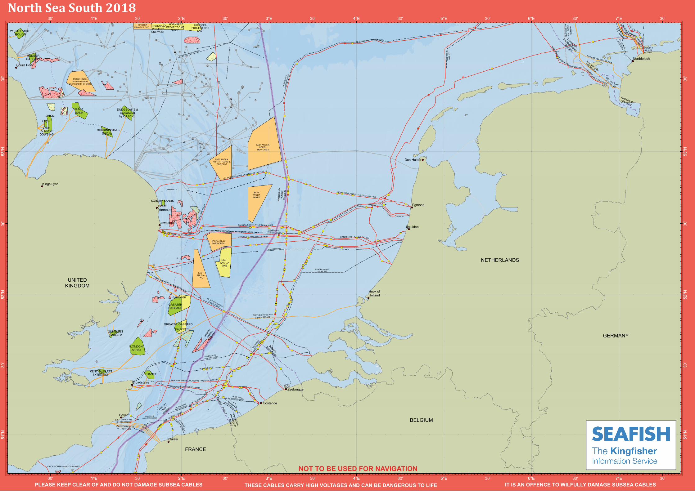
FRANCE NETHERLANDS UNITED KINGDOM EAST ANGLIA NORTH TRANCHE 2 EAST ANGLIA NORTH TRANCHE ONE EAST EAST ANGLIA ONE NORTH EAST ANGLIA THREE EAST ANLGIA TWO HORNSEA PROJECT TWO TRITON KNOLL (Estimated to be Operational by Q1 2023) EAST ANGLIA ONE GALLOPER GALLOPER HORNSEA PROJECT ONE EAST HORNSEA PROJECT ONE WEST HORNSEA PROJECT ONE NJORD DUDGEON (Est Operational by Q1 2018) GREATER GABBARD GREATER GABBARD GUNFLEET SANDS 2 HUMBER GATEWAY KENTISH FLATS EXTENSION LINCS LINCS LONDON ARRAY LYNN & INNER DOWSING RACE BANK SCROBY SANDS SHERINGHAM SHOAL THANET WESTERMOST ROUGH RIOJA 2 +44(0)84 575 55 999 UK- F RANCE 4 +44(0)845 755599 9 ULYSSES 1 +44(0)7771 730654 ODIN 1 00 45 6665 1571 UK-BELGIUM6 +442392756227 UK-BELGIUM5 +442392756227 HERMES SOUTH UK-NETHERLANDS 12 +44 2392 756227 REMBRANDT 2 +44(0)1472 252307 STRATOS+442392756227 CONCERTO +420 225 352 905 HERMES NORTH REMBRANDT 1 +44(0)1472 252307 RIO JA30 031 (0)7140 91000 UK - G ERM AN Y 5 +4 4 ( 0 ) 8 4 5 7 5 5 5 9 9 9 IF A 1- Cable 2 +4 4 (0)1303 815200 IFA 1 - Cable 1 IF A1- Ca ble 3 IFA 1- Cable 4 +44 (0)1303 815200 BRITNED HVDC+44 (0)1634 273093 UK-NETHERLANDS 14 +31(0)714091000 SEA -ME-W E3 +44 2 392 756227 UK-NETHERLANDS 14 +44(0)207 138 7123 TANG E R INE +44(0)208 5103119 PAN EUROPEAN CROSSIN G+44(0)208 5103119 FARLAND NORTH +44 2392 756227 TA M PN E T 00 47 81 5 21 5 00 CIR CE NORTH +4 4(0)1784 494100 ULYSSES 2 +44(0)7771730654 CONCERTO +420 22 5 352 905 PANGEA SOUTH+44(0)7800 626888 T A T 1 4 +31( 0)71409 1 00 0 A TLANTIC CROSSING 1 +44(0)208 5103119 SEA-ME-WE3 +49 4931 9 2700 CIRCE SOUTH +44(0)1784 494100 Spurn Point Den Helder Lowestoft Great Yarmouth Egmond Zeebrugge Dover Oostende Calais Broadstairs Hook of Holland Kings Lynn Ijmuiden Connection line Belgium - France Belgium - France Belgium - Netherlands Belgium - United Kingdom France - United Kingdom Netherlands - United Kingdom 5°E 4°E 3°E 2°E 1°E 30' 5°E 30' 4°E 30' 3°E 30' 2°E 30' 1°E 30' PLEASE KEEP CLEAR OF AND DO NOT DAMAGE SUBSEA CABLES THESE CABLES CARRY HIGH VOLTAGES AND CAN BE DANGEROUS TO LIFE IT IS AN NOT TO BE USED FOR NAVIGATION Regional Awareness Kingfisher Charts NORTH SEA SOUTH JANUARY 2018 Compensation for loss of fishing gear, will ONLY be considered, if you have up to date KIS-ORCA data displayed on your fishing plotter EMERGENCY PROCEDURES If you suspect you have snagged a subsea cable or renewable energy structure, DO NOT endanger your vessel and crew by attempting to recover your gear. Carefully plot your vessel’s position as accurately as possible. Advise the Coastguard of your situation, or call the 24 hour Emergency Number and state that an incident is occurring concerning an underwater structure, or subsea cable. 1. 2. 3. Active Wind Farm Under Construction Wind Farm Proposed Wind Farm Aggregate Production Area Aggregate Option Area Aggregate Licence Option Area Aggregate Application Area Aggregate Exploration and Option Area Wind Farm Cable Telecomms Cable Power Cable Out of Use Cable ESCA Non Members Cable UK EEZ International Maritime Boundary 12 Mile Fishing Limit " ) Final Splice ! ( Repeater # * Oil & Gas Subsurface Feature ! ( Oil & Gas Surface Feature " ) Suspended Wells Pipeline Route This data is issued as a guide only. Seafish, Cable/Structure owners and distributors accept no responsibility for any inaccuracies however caused. Please be aware that other structures & cables may exist in addition to those shown on this chart. Coastlines are reproduced using GEBCO Digital Atlas, Centenary Edition 2003. Date: January 2018 Projection: WGS_1984_World_Mercator Spheroid: GCS_WGS_1984 Datum: D_WGS_1984 Scale: 1:1,500,000
Transcript of Kingfi sher Charts - KIS-ORCAkis-orca.eu/media/9328/4 NORTH SEA SOUTH.pdf · belgium france...

BELGIUM
FRANCE
GERMANY
NETHERLANDS
UNITEDKINGDOM
EAST ANGLIANORTH
TRANCHE 2
EAST ANGLIANORTH TRANCHE
ONE EAST
EAST ANGLIAONE NORTH
EASTANGLIATHREE
EASTANLGIA
TWO
HORNSEAPROJECT TWO
TRITON KNOLL(Estimated to be
Operational by Q1 2023)
EASTANGLIA
ONE
GALLOPER
GALLOPER
HORNSEAPROJECT ONE
EAST
HORNSEAPROJECT
ONE WEST
HORNSEAPROJECT ONE
NJORD
DUDGEON (EstOperationalby Q1 2018)
GREATERGABBARD
GREATER GABBARD
GUNFLEETSANDS 2
HUMBERGATEWAY
KENTISH FLATSEXTENSION
LINCS
LINCS
LONDONARRAY
LYNN& INNER
DOWSING
RACEBANK
SCROBY SANDS
SHERINGHAMSHOAL
THANET
WESTERMOSTROUGH
NO
RN
ED
HVD
C - FO
+47 22733710
TAT 10D 00 49
4931 92700
RIOJA 2
+44(0)8457 555999
UK-FRANCE4
+44(0)8457555999
ULYSSES 1+44(0)7771 730654
OD
IN 1
00
4566
65 1
571
UK-BELGIUM 6
+44 2392 756227
UK-BELGIUM 5+44 2392 756227
HERMES SOUTH
UK-NETHERLANDS 12
+44 2392 756227
REMBRANDT 2
+44(0)1472 252307
STRATOS +44 2392 756227
CONCERTO +420225 352 905
HERMES NORTH
REMBRANDT 1+44(0)1472 252307
RIOJA
3 0031
(0)7
1409
1000
UK
-GE
RM
ANY
5+4
4(0)
8457
555 9
99
DOL WIN 1+49 513289-2400
DOL
WIN
2 +49
513289 -2400
BOR WIN
1+49
5132 89-2400
BORWIN
3 +49
5132 89-2400
BORW
IN
2 +49
5132 89-2400
IFA 1- Cable 2 +44(0)1303 815200 IFA 1- Cable 1
IFA 1-Cable 3
IFA 1- Cable 4 +44(0)1303 815200
RIFFGAT +49 5132 89-2400
COBRA+49 5132 89-2400
DOL WIN3 +49
5132 89-2400
BRITNED HVDC +44(0)1634 273093
TAT
14 00 49493192700
TATANO
RTHEUROPE 0080 0 89 266 298
UK-NETHERLANDS 14 +31(0)71409 1000
SEA-ME-W
E3 +44 2392 756227
UK-NETHERLANDS 14 +44(0)207 138 7123
TANGERINE +44(0)208 5103119
PAN EUROPEAN CROSSING +44(0)208 5103119
FARLAND NORTH +44 2392 756227
TAM
PNET
0047
815
2150
0
CIRCE NORTH +44(0)1784 494100
ULYSSES 2 +44(0)7771 730654 CONCERTO +420 225 352 905
PANGEA SOUTH +44(0)7800 626888
TAT1
4 +31(0)71409 1000
ATLANTIC CROSSING 1 +44(0)208 5103119
SEA-ME-WE3 +49 4931 92700
CIRCE SOUTH +44(0)1784 494100
Spurn Point
Den Helder
Lowestoft
GreatYarmouth
Egmond
Zeebrugge
Dover
Oostende
Calais
Broadstairs
Hook ofHolland
Kings Lynn
Norddeiech
Ijmuiden
Connection
line Belgium
- France
Connection
line Netherlands
- Germany
Belgium - France
Belgium -
Netherlands
Belgi
um- U
nited
King
dom
Netherlands- Germany
France
-
United
Kingdo
m
Net
herla
nds
- Uni
ted
King
dom
7°E
7°E
6°E
6°E
5°E
5°E
4°E
4°E
3°E
3°E
2°E
2°E
1°E
1°E
53°N
53°N
52°N
52°N
51°N
51°N
30'
30'
7°E
7°E
30'
30'
6°E
6°E
30'
30'
5°E
5°E
30'
30'
4°E
4°E
30'
30'
3°E
3°E
30'
30'
2°E
2°E
30'
30'
1°E
1°E
30'
30'
30'
30'
53°N
53°N
30'
30'
52°N
52°N
30'
30'
51°N
51°N
North Sea South 2018
PLEASE KEEP CLEAR OF AND DO NOT DAMAGE SUBSEA CABLES THESE CABLES CARRY HIGH VOLTAGES AND CAN BE DANGEROUS TO LIFE IT IS AN OFFENCE TO WILFULLY DAMAGE SUBSEA CABLES
NOT TO BE USED FOR NAVIGATION
Regional AwarenessKingfi sher ChartsNORTH SEA SOUTH
JANUARY 2018
Compensation for loss of fi shing gear, will ONLY be considered, if you have up to date KIS-ORCA data displayed on your fi shing plotter
EMERGENCY PROCEDURESIf you suspect you have snagged a subsea cable or renewable energy structure, DO NOT endanger your vessel and crew by attempting to recover your gear.
Carefully plot your vessel’s position as accurately as possible.
Advise the Coastguard of your situation, or call the 24 hour Emergency Number and state that an incident is occurring concerning an underwater structure, or subsea cable.
1.
2.3.
Active Wind Farm
Under Construction Wind Farm
Proposed Wind Farm
Aggregate Production Area
Aggregate Option Area
Aggregate Licence Option Area
Aggregate Application Area
Aggregate Exploration and Option Area
Wind Farm Cable
Telecomms Cable
Power Cable
Out of Use Cable
ESCA Non Members Cable
UK EEZ
International Maritime Boundary
12 Mile Fishing Limit
") Final Splice
!( Repeater
#* Oil & Gas Subsurface Feature
!( Oil & Gas Surface Feature
") Suspended Wells
Pipeline Route
This data is issued as a guide only. Sea� sh, Cable/Structure owners and distributors accept no responsibility for any inaccuracies however caused. Please be aware that other structures & cables may exist in addition to those shown on this chart. Coastlines are reproduced using GEBCO Digital Atlas, Centenary Edition 2003.
Date: January 2018
Projection: WGS_1984_World_Mercator
Spheroid: GCS_WGS_1984
Datum: D_WGS_1984
Scale: 1:1,500,000
BELGIUM
FRANCE
GERMANY
NETHERLANDS
UNITEDKINGDOM
EAST ANGLIANORTH
TRANCHE 2
EAST ANGLIANORTH TRANCHE
ONE EAST
EAST ANGLIAONE NORTH
EASTANGLIATHREE
EASTANLGIA
TWO
HORNSEAPROJECT TWO
TRITON KNOLL(Estimated to be
Operational by Q1 2023)
EASTANGLIA
ONE
GALLOPER
GALLOPER
HORNSEAPROJECT ONE
EAST
HORNSEAPROJECT
ONE WEST
HORNSEAPROJECT ONE
NJORD
DUDGEON (EstOperationalby Q1 2018)
GREATERGABBARD
GREATER GABBARD
GUNFLEETSANDS 2
HUMBERGATEWAY
KENTISH FLATSEXTENSION
LINCS
LINCS
LONDONARRAY
LYNN& INNER
DOWSING
RACEBANK
SCROBY SANDS
SHERINGHAMSHOAL
THANET
WESTERMOSTROUGH
NO
RN
ED
HVD
C - FO
+47 22733710
TAT 10D 00 49
4931 92700
RIOJA 2
+44(0)8457 555999
UK-FRANCE4
+44(0)8457555999
ULYSSES 1+44(0)7771 730654
OD
IN 1
00
4566
65 1
571
UK-BELGIUM 6
+44 2392 756227
UK-BELGIUM 5+44 2392 756227
HERMES SOUTH
UK-NETHERLANDS 12
+44 2392 756227
REMBRANDT 2
+44(0)1472 252307
STRATOS +44 2392 756227
CONCERTO +420225 352 905
HERMES NORTH
REMBRANDT 1+44(0)1472 252307
RIOJA
3 0031
(0)7
1409
1000
UK
-GE
RM
ANY
5+4
4(0)
8457
555 9
99
DOL WIN 1+49 513289-2400
DOL
WIN
2 +49
513289 -2400
BOR WIN
1+49
5132 89-2400
BORWIN
3 +49
5132 89-2400
BORW
IN
2 +49
5132 89-2400
IFA 1- Cable 2 +44(0)1303 815200 IFA 1- Cable 1
IFA 1-Cable 3
IFA 1- Cable 4 +44(0)1303 815200
RIFFGAT +49 5132 89-2400
COBRA+49 5132 89-2400
DOL WIN3 +49
5132 89-2400
BRITNED HVDC +44(0)1634 273093
TAT
14 00 49493192700
TATANO
RTHEUROPE 0080 0 89 266 298
UK-NETHERLANDS 14 +31(0)71409 1000
SEA-ME-W
E3 +44 2392 756227
UK-NETHERLANDS 14 +44(0)207 138 7123
TANGERINE +44(0)208 5103119
PAN EUROPEAN CROSSING +44(0)208 5103119
FARLAND NORTH +44 2392 756227
TAM
PNET
0047
815
2150
0
CIRCE NORTH +44(0)1784 494100
ULYSSES 2 +44(0)7771 730654 CONCERTO +420 225 352 905
PANGEA SOUTH +44(0)7800 626888
TAT1
4 +31(0)71409 1000
ATLANTIC CROSSING 1 +44(0)208 5103119
SEA-ME-WE3 +49 4931 92700
CIRCE SOUTH +44(0)1784 494100
Spurn Point
Den Helder
Lowestoft
GreatYarmouth
Egmond
Zeebrugge
Dover
Oostende
Calais
Broadstairs
Hook ofHolland
Kings Lynn
Norddeiech
Ijmuiden
Connection
line Belgium
- France
Connection
line Netherlands
- Germany
Belgium - France
Belgium -
Netherlands
Belgi
um- U
nited
King
dom
Netherlands- Germany
France
-
United
Kingdo
m
Net
herla
nds
- Uni
ted
King
dom
7°E
7°E
6°E
6°E
5°E
5°E
4°E
4°E
3°E
3°E
2°E
2°E
1°E
1°E
53°N
53°N
52°N
52°N
51°N
51°N
30'
30'
7°E
7°E
30'
30'
6°E
6°E
30'
30'
5°E
5°E
30'
30'
4°E
4°E
30'
30'
3°E
3°E
30'
30'
2°E
2°E
30'
30'
1°E
1°E
30'
30'
30'
30'
53°N
53°N
30'
30'
52°N
52°N
30'
30'
51°N
51°N
North Sea South 2018
PLEASE KEEP CLEAR OF AND DO NOT DAMAGE SUBSEA CABLES THESE CABLES CARRY HIGH VOLTAGES AND CAN BE DANGEROUS TO LIFE IT IS AN OFFENCE TO WILFULLY DAMAGE SUBSEA CABLES
NOT TO BE USED FOR NAVIGATION
BELGIUM
FRANCE
GERMANY
NETHERLANDS
UNITEDKINGDOM
EAST ANGLIANORTH
TRANCHE 2
EAST ANGLIANORTH TRANCHE
ONE EAST
EAST ANGLIAONE NORTH
EASTANGLIATHREE
EASTANLGIA
TWO
HORNSEAPROJECT TWO
TRITON KNOLL(Estimated to be
Operational by Q1 2023)
EASTANGLIA
ONE
GALLOPER
GALLOPER
HORNSEAPROJECT ONE
EAST
HORNSEAPROJECT
ONE WEST
HORNSEAPROJECT ONE
NJORD
DUDGEON (EstOperationalby Q1 2018)
GREATERGABBARD
GREATER GABBARD
GUNFLEETSANDS 2
HUMBERGATEWAY
KENTISH FLATSEXTENSION
LINCS
LINCS
LONDONARRAY
LYNN& INNER
DOWSING
RACEBANK
SCROBY SANDS
SHERINGHAMSHOAL
THANET
WESTERMOSTROUGH
NO
RN
ED
HVD
C - FO
+47 22733710
TAT 10D 00 49
4931 92700
RIOJA 2
+44(0)8457 555999
UK-FRANCE4
+44(0)8457555999
ULYSSES 1+44(0)7771 730654
OD
IN 1
00
4566
65 1
571
UK-BELGIUM 6
+44 2392 756227
UK-BELGIUM 5+44 2392 756227
HERMES SOUTH
UK-NETHERLANDS 12
+44 2392 756227
REMBRANDT 2
+44(0)1472 252307
STRATOS +44 2392 756227
CONCERTO +420225 352 905
HERMES NORTH
REMBRANDT 1+44(0)1472 252307
RIOJA
3 0031
(0)7
1409
1000
UK
-GE
RM
ANY
5+4
4(0)
8457
555 9
99
DOL WIN 1+49 513289-2400
DOL
WIN
2 +49
513289 -2400
BOR WIN
1+49
5132 89-2400BOR
WIN3 +49
5132 89-2400
BORW
IN
2 +49
5132 89-2400
IFA 1- Cable 2 +44(0)1303 815200 IFA 1- Cable 1
IFA 1-Cable 3
IFA 1- Cable 4 +44(0)1303 815200
RIFFGAT +49 5132 89-2400
COBRA+49 5132 89-2400
DOL WIN3 +49
5132 89-2400
BRITNED HVDC +44(0)1634 273093
TAT
14 00 49493192700
TATANO
RTHEUROPE 0080 0 89 266 298
UK-NETHERLANDS 14 +31(0)71409 1000
SEA-ME-W
E3 +44 2392 756227
UK-NETHERLANDS 14 +44(0)207 138 7123
TANGERINE +44(0)208 5103119
PAN EUROPEAN CROSSING +44(0)208 5103119
FARLAND NORTH +44 2392 756227
TAM
PNET
0047
815
2150
0
CIRCE NORTH +44(0)1784 494100
ULYSSES 2 +44(0)7771 730654 CONCERTO +420 225 352 905
PANGEA SOUTH +44(0)7800 626888
TAT1
4 +31(0)71409 1000
ATLANTIC CROSSING 1 +44(0)208 5103119
SEA-ME-WE3 +49 4931 92700
CIRCE SOUTH +44(0)1784 494100
Spurn Point
Den Helder
Lowestoft
GreatYarmouth
Egmond
Zeebrugge
Dover
Oostende
Calais
Broadstairs
Hook ofHolland
Kings Lynn
Norddeiech
Ijmuiden
Connection
line Belgium
- France
Connection
line Netherlands
- Germany
Belgium - France
Belgium -
Netherlands
Belgi
um- U
nited
King
dom
Netherlands- Germany
France
-
United
Kingdo
m
Net
herla
nds
- Uni
ted
King
dom
7°E
7°E
6°E
6°E
5°E
5°E
4°E
4°E
3°E
3°E
2°E
2°E
1°E
1°E
53°N
53°N
52°N
52°N
51°N
51°N
30'
30'
7°E
7°E
30'
30'
6°E
6°E
30'
30'
5°E
5°E
30'
30'
4°E
4°E
30'
30'
3°E
3°E
30'
30'
2°E
2°E
30'
30'
1°E
1°E
30'
30'
30'
30'
53°N
53°N
30'
30'
52°N
52°N
30'
30'
51°N
51°N
North Sea South 2018
PLEASE KEEP CLEAR OF AND DO NOT DAMAGE SUBSEA CABLES THESE CABLES CARRY HIGH VOLTAGES AND CAN BE DANGEROUS TO LIFE IT IS AN OFFENCE TO WILFULLY DAMAGE SUBSEA CABLES
NOT TO BE USED FOR NAVIGATION

Inter Array Wind Farm CablingThe inter array cables interconnect the turbines typically in radial strings going to the offshore substation platform. The issues associated with these are largely the same as per cable burial. Each turbine will usually have up to two cables entering the foundation structure at the seabed through a protective tube. Typically the tube end has a bellmouth at the seabed to aid alignment and pulling in of the cables. Whilst the cables may have been jetted in or ploughed as close as practical to the foundation, cables may not be fully buried and may also become exposed by scour holes forming. In these circumstances scour protection in the form of rock dumping or cable mattresses may be used. Cables, albeit close to the foundation, may present a snagging risk to anchors and/or trawled gear.
Reducing the Risks whilst FishingTo reduce the risks of fishing near offshore structures, it is essential to be up to date with KIS-ORCA information. KIS-ORCA information is easy to install on your vessel’s fishing plotter and ensures skippers are able to make informed decisions for their safety.
The closer to the surface a subsea cable is lifted when fouled by fishing gear, the more danger there is to the fishing vessel.
In the interests of fishing safety and to prevent damage to subsea structures, fishermen are advised to exercise caution when fishing in the vicinity of subsea cables and renewable energy structures. Loss of gear, fishing time and catch can result if a trawler snags a subsea structure and there is serious risk of loss of life.
If it is thought prudent to slip, or cut your fishing gear in an attempt to clear a subsea structure, always lower the gear to the seabed first. Never attempt to slip anything bearing excessive weight.
Claims for loss of gear should be made to the appropriate authority within 24 hours of arrival in port. Full particulars of the incident should be given and full details recorded in the vessel’s official log, date and exact time, the vessel’s position (VMS if suitable), depth of water and a description of the cable if sighted.
Claims for loss will only be considered if current KIS-ORCA data is installed on your vessel’s fishing plotter.
Use of KIS-ORCA DataKIS-ORCA data is available free of charge to skippers and includes Northern European cables and UK renewable energy structures. This includes the structure and cable positions and essential attribute information, such as the name and emergency contact number.
The data is converted by Kingfisher into the most popular fishing plotter systems, including:
Olex, Maxsea, Sodena, Transas Navifisher, TMPlanner/Quodfish, Penta+, SIS Microplot and Litton Fishmaster. KIS-ORCA data is easy to install on these systems and is displayed as an information layer.
KIS-ORCA updates are provided annually in January and are distributed free of charge to the fishing industry by the Scottish Fishermen’s Federation (SFF), the National Federation of Fishermen’s Organisations (NFFO) and Kingfisher. From www.KIS-ORCA.eu you are able to view an interactive Google map and download fishing plotter files and awareness charts.
KIS-ORCA data is easy to install and installation instructions are available at the following fishing exhibitions:
25th – 26th May – Aberdeen
21st – 24th August – Norfish (Norway)
27th – 28th September - Bristol
Awareness Charts
KingfisherSubsea Cables and Renewable Energy Structures
The KIS-ORCA ProjectThe Kingfisher Information Service - Offshore Renewable & Cable Awareness project (KIS-ORCA) is a joint initiative between European Subsea Cables Association (ESCA) and RenewableUK and is being managed by the Kingfisher Information Service of Seafish.Offshore wind farms, renewable energy structures and subsea cables are increasing in number around the shores of the UK. The potential risks these structures may cause to fishermen is significant and the KIS-ORCA project aims to ensure these are managed in a responsible way.
It is against the law to wilfully damage a subsea cable. To enable fishermen to continue to work safely in the vicinity of subsea cables and renewable energy structures, KIS-ORCA provides fishermen with information and accurate positions of all these offshore structures.
KIS-ORCA information is made available as fishing plotter files and awareness charts for use on vessels and on www.kis-orca.eu, where information may be viewed and downloaded.
Dangers of Renewable Energy Structures & Cables to FishingRenewable Energy Structures and Subsea Cables are a hazard and fishing over them should be avoided at all times. Heavily armoured cables used within the subsea cable and renewable energy industry are very strong and have high breaking strains, sometimes over 70 tonnes and can do extensive damage before they give way. Most modern subsea cables carry high voltages which could prove lethal if attempts are made to cut them.
Fibre Optic cable consists of an inner optical core encased within a copper clad high tensile steel wire rope insulated with polythene. In water less than 1500 meters deep, protection is added against fishing and anchor damage in the form of external steel wire armour.
Due to the severe environmental demands placed on submarine cables, a lead-alloy sheath is often specified because of its compressibility, flexibility and resistance to moisture and corrosion. The sheath is usually covered by a number of outer layers, comprising a PE or PVC jacket and metal wire armouring.
Cable BurialSubmarine cables have been laid on the seabed since the 1850’s. In most cases recently installed cables are buried beneath the seabed, unfortunately there remains a percentage of cables unburied. Cables can be scoured out by tides and currents or moved by anchors and fishing gear. Therefore cables that were considered safe from subsea activities at the time of installation may become partially or totally unburied and could present a serious risk to fishing activities. Please exercise extreme caution when fishing in the vicinity of submarine cables.
Cables as Potential Gear FastenersAs a result of movements of the seabed the cables may occasionally be spanning hollows in the sea bed. Also where a cable repair has been carried out, although every effort is made to have it fall back flat on the bottom, it can sometimes finish with a bight of cable standing proud of the seabed which is easily picked up or fouled by a trawl door.
Cable RepairsFurther hazards to fishing gear are the repairs to the cables called FINAL SPLICE BIGHT. After a repair has been completed by splicing two ends together, the cable vessel has a large section or bight of wire leading from the seabed to the ship. This is held onboard by rope stoppers, then the procedure is simply to slip both stoppers and lower the bight of cable back onto the seabed.
Burial of repairs are often more difficult, therefore the risk of contact is increased. The Final Splice Bight is laid on the seabed at right angles to the cable route. The crown of the bight may be up to 1 x water depth from the charted cable route.
Wind Turbines and FoundationsAs wind turbines get larger and are deployed in deeper waters, a range of different foundation types may be encountered such as monopole, jacket, gravity base and suction bucket. In some cases multiple foundation types may be used within a single site. In all cases it is likely that scour holes will form around the foundation base, the depth and extent being dependent
upon a range of factors including seabed type and current strength and direction. Scour protection in the form of rock dumping or cable mattresses is often used around the base of the foundations which may present a snagging risk. During the operational phase of a wind farm, an operator may request a 50m advisory safety zone around each structure.
STAY UPTO DATE - ALWAYS ENSURE YOU HAVE THE LATEST KINGFISHER BULLETIN AND OFFSHORE FISHING PLOTTER DATA ON-BOARD.
For more information contact: The Kingfisher Information Service Seafish Industry Authority, Origin Way, Europarc, Grimsby DN37 9TZt: +44 (0)1472 252 307 | e: [email protected] | w: www.kingfishercharts.org | w: www.KIS-ORCA.eu | @KingfisherInfo