Khumani Iron Ore Mine Infrastructure Expansion Project ...€¦ · DRAFT REPORT FOR SUBMISSION...
266
63 Wessel Road Rivonia 2128 PO Box 2597 Rivonia 2128 South Africa Telephone: +27 (0)11 803 5726 Facsimile: +27 (0)11 803 5745 Web: www.gcs-sa.biz GCS (Pty) Ltd. Reg No: 2004/000765/07 Est. 1987 Offices: Durban Johannesburg Lusaka Ostrava Pretoria Windhoek Directors: AC Johnstone (Managing) PF Labuschagne AWC Marais S Pilane Non-Executive Director: B Wilson-Jones www.gcs-sa.biz Khumani Iron Ore Mine Infrastructure Expansion Project Environmental Impact Assessment (EIA) and Environmental Management Programme (EMP) Report In terms of Mineral and Petroleum Resources Development Act, 2002 (Act No. 28 of 2002) and National Environmental Management Act, 1998 (Act No. 107 of 1998) * Regulation 543, 544, 545, 546 (2010) applicable DRAFT REPORT SUBMISSION TO STAKEHOLDERS September 2015 Version – 1 Assmang Proprietary Limited DMR Reference: NC30/5/1/2/3/2/1/070 NCDENC Reference: NC/EIA/17/JTG/GAM/KAT2/2014 GCS Project Number: 13-843
Transcript of Khumani Iron Ore Mine Infrastructure Expansion Project ...€¦ · DRAFT REPORT FOR SUBMISSION...

63 Wessel Road Rivonia 2128 PO Box 2597 Rivonia 2128 South Africa Telephone: +27 (0)11 803 5726 Facsimile: +27 (0)11 803 5745 Web: www.gcs-sa.biz
GCS (Pty) Ltd. Reg No: 2004/000765/07 Est. 1987
Offices: Durban Johannesburg Lusaka Ostrava Pretoria Windhoek
Directors: AC Johnstone (Managing) PF Labuschagne AWC Marais S Pilane
Non-Executive Director: B Wilson-Jones
www.gcs-sa.biz
Khumani Iron Ore Mine
Infrastructure Expansion Project
Environmental Impact Assessment (EIA) and
Environmental Management Programme (EMP)
Report
In terms of Mineral and Petroleum Resources Development Act, 2002
(Act No. 28 of 2002) and National Environmental Management Act, 1998
(Act No. 107 of 1998) * Regulation 543, 544, 545, 546 (2010) applicable
DRAFT REPORT SUBMISSION TO STAKEHOLDERS
September 2015
Version – 1
Assmang Proprietary Limited
DMR Reference: NC30/5/1/2/3/2/1/070
NCDENC Reference: NC/EIA/17/JTG/GAM/KAT2/2014
GCS Project Number: 13-843

Assmang (Pty) Ltd: Khumani Iron Ore Mine EIA/EMP Khumani Proposed Infrastructure Expansion
13-843 September 2015 Page ii
Khumani Iron Ore Mine Infrastructure Expansion Project
Environmental Impact Assessment (EIA) and Environmental Management Programme (EMP) Report
In terms of Mineral and Petroleum Resources Development Act, 2002 (Act No. 28 of 2002) and National Environmental Management Act, 1998 (Act No. 107 of 1998)
DRAFT REPORT FOR SUBMISSION
August 2015
Version – Draft
DMR Reference: NC30/5/1/2/3/2/1/070 NCDENC Reference: NC/EIA/17/JTG/GAM/KAT2/2014
GCS Project Number: 13 - 843
DOCUMENT ISSUE STATUS
Report Issue Draft for Authority and I&AP review
GCS Reference Number GCS Ref – 13-843
Client Reference Khumani Proposed Infrastructure Expansion
Title EIA/EMP Report
Name Signature Date
Author (GCS) Riana Panaino August 2015
Document Reviewer (GCS) Renee Janse van Rensburg August 2015
Document Reviewer (Envirogistics)
Tanja Bekker August 2015
Director GCS Seabelo Pilane August 2015
Applicant (Khumani Iron Ore Mine)
Dirk Coetzee August 2015
Applicant (Asmang (Pty) Ltd)
Quentin Hall August 2015
LEGAL NOTICE
This report or any proportion thereof and any associated documentation remain the property of GCS until the mandator effects payment of all fees and disbursements due to GCS in terms of the GCS Conditions of Contract and Project Acceptance Form. Notwithstanding the aforesaid, any reproduction, duplication, copying, adaptation, editing, change, disclosure, publication, distribution, incorporation, modification, lending, transfer, sending, delivering, serving or broadcasting must be authorised in writing by GCS.

Assmang (Pty) Ltd: Khumani Iron Ore Mine EIA/EMP Khumani Proposed Infrastructure Expansion
13-843 September 2015 Page iii
DISCLAIMER
Information contained in this report is based on data/information supplied to GCS Water and
Environment (Pty) Ltd (GCS) by the client and other external sources (including previous site
investigation data and external specialist studies). It has been assumed that the information
provided to GCS is correct and as such the accuracy of the conclusions made are reliant on
the accuracy and completeness of the data supplied. No responsibility is accepted by GCS
for incomplete or inaccurate data supplied by the client and/or other external sources.
Opinions expressed in this report apply to the site conditions and features that existed at the
time of the start of the relevant investigations and the production of this report.

Assmang (Pty) Ltd: Khumani Iron Ore Mine EIA/EMP Khumani Proposed Infrastructure Expansion
13-843 September 2015 Page iv
EXECUTIVE SUMMARY
Background
Assmang (Pty) Ltd’s Khumani Iron Ore Mine (Khumani) is situated 15km south of Kathu,
adjacent to the Kumba Iron Ore Mine. Khumani compromises of four (4) farms, namely Parson
564 (Portions 0, 2, and 6), King (Portions 0, 1, 2, and 3), Bruce 544 (Portions 3, 4, 5 and the
Remainder of Bruce No. 544) and Mokaning 560 (Portions 0, 1, 2, 3, 4, and 5).
The mine falls within two Local and District Municipalities. The farm Mokaning is situated
within the Tsantsabane Local Municipality (NC085), which forms part of the ZF Mgcawu
District Municipality (formally known as the Siyanda District Municipality). The farms Parson,
Bruce and King are situated within the Gamagara Local Municipality (NC01B1), which forms
part of the John Taolo Gaetsewe Districts Municipality (formally known as the Kgalagadi
District Municipality). Neighbouring towns and villages include, Olifantshoek, Beeshoek,
Postmasburg, and Dingleton. The main industries in the area include mining (mainly for
manganese ore, iron ore and tiger’s eye), agriculture (mainly for cattle, sheep, goat and
game farming) and tourism.
The right to mine was granted to Assmang Proprietary Limited (Assmang) in terms of the
Mineral and Petroleum Resources Development Act, 2002 (Act No. 28 of 2002) (MPRDA) in
January 2007. Construction of the mine was initiated after approval was received from the
Northern Cape Department of Environment and Nature Conservation (NCDENC) in June 2006
on the farm Parson and the first train was loaded with iron ore at Khumani in May 2008. The
overall mining area over which Khumani operates is approximately 9000ha. Today, the mine
is a fully operational opencast mining operation, with an approved capacity of producing 16
million tons of iron ore per annum.
The iron ore is mined from a series of open pits on the farms Bruce and King by conventional
drill and blasting methods. Haul trucks transport the Run of Mine (RoM) to the primary
crushers, from where the material is transferred by conveyor to the RoM stockpiles, ahead of
the Beneficiation Plant (Parsons Plant), located on the farm Parson. Thereafter, the product
is transported via conveyor to the rapid load out and local railway siding for transport to
either Saldanha for export and to Port Elizabeth for the local market. The following
infrastructure has been approved through various application processes under National Water
Act, 1998 (Act No. 36 of 1998) (NWA), National Environmental Management: Waste Act, 2008
(Act 59 of 2008) (NEM:WA), National Environmental Management Act, 1998 (Act No. 107 of
1998) (NEMA) and Mineral and Petroleum Resources Development Act, 2002 (Act No. 28 of
2002) (MPRDA):

Assmang (Pty) Ltd: Khumani Iron Ore Mine EIA/EMP Khumani Proposed Infrastructure Expansion
13-843 September 2015 Page v
Opencast Mining Operations;
Conveyors and service roads;
Powerlines and service roads;
Access roads and haul roads;
Crushers;
Washing and screening plant;
Stockpiles (topsoil, RoM, product) and overburden;
Paste Disposal Facility;
Local and export railway siding;
Two (2) approved river diversions;
Clean and dirty water infrastructure;
Sewage treatment plants;
Offices, workshops and ancillary buildings;
Potable and process water storage tanks;
Water supply from Sedibeng Pipeline;
Domestic Landfill Site and Temporary Storage area for Hazardous Waste;
Diesel storage; and
Borrow pits.
Through Khumani’s ongoing commitment to optimise its existing mineral resources, the
design and operational team has identified the need for two (2) additional process facilities
to optimise beneficiation with the aim of producing the required grade for its Markets and
strive to meet its approved production allocation. These facilities include the Off-Grade 2
Plant (approved in terms of the NEMA during October 2013) and the proposed WHIMS 2 Plant
(part of this application). The new infrastructure will result in the need for ancillary
infrastructure associated with the activities. The construction of the Off-Grade 2 Plant has
been placed on hold due to the current decline in the iron ore market. When the market
stabilizes the feasibility of the Off-Grade 2 Plant will be reinvestigated. The Off-Grade 2
Environmental License is valid for a period of three (3) years from allocation (i.e. up until
the last quarter of 2016). The applicant will remain in consultation with the department to
ensure that the validity of this permit does not expire. Saying this, the current project has
a different philospy and aim, in that the purpose of this project is to reuse existing material
from exsiting stockpiles, as described in the section hereafter.
Project Description
It is the intention of Assmang to upgrade infrastructure on the Farms Bruce, Parsons and King
within their existing mining boundary area. The proposed upgrades on the farm Bruce include:
The extension of the existing approved Bruce Low Grade ROM Stockpile and
Overburden Dump with 75ha.

Assmang (Pty) Ltd: Khumani Iron Ore Mine EIA/EMP Khumani Proposed Infrastructure Expansion
13-843 September 2015 Page vi
The proposed upgrades on the farm Parsons include:
The extension of the existing approved Low Grade Stockpile (previously known as the
Parson Discard Dump);
Tertiary By-pass Stockpile area at the existing Low Grade Stockpile s;
A new Low-Grade Reclaim Facility adjacent to existing Low Grade Stockpile;
The new WHIMS 2 Plant; and
Three (3) additional conveyors.
The proposed upgrades on the farm King include;
Extension of the existing King/Mokaning Overburden Low-Grade ROM Stockpile; and
A new Low Grade Stockpile for reclaiming purposes within the King Plant area.
Other activities required will include:
Upgrading and expansion of storm water facilities (separating clean and dirty water);
High Pressure Grinding Roll (HPGR) Crushing Facility;
Haul roads; and 22kV power lines to accommodate the WHIMS 2 Plant and the
reclamation activities.
These additional activities on the farms King, Bruce and Parson will require approval under
NEMA, the NWA and an Amendment to the Environmental Management Programme (EMP) in
terms of the MPRDA. The activities will not influence the production output or Mining Works
Programme of the mine.
Environmental Process Objectives
GCS Water and Environment (Pty) Ltd (GCS) have been appointed as the independent
Environmental Assessment Practitioners (EAP) to undertake the environmental processes
required to obtain approval for the proposed listed activities, as requested by the relevant
competent authorities. The project requires authorisations in respect of the following Acts:
MPRDA;
NEMA; and
NWA.
In order to mitigate potentially negative impacts and to identify any potential fatal flaws
which may render the project environmentally unacceptable, GCS has adopted an integrated,
step-by-step process to identify issues of concern and to thoroughly investigate these issues.
To ensure that the negative impacts are identified and mitigated in the early stages of the

Assmang (Pty) Ltd: Khumani Iron Ore Mine EIA/EMP Khumani Proposed Infrastructure Expansion
13-843 September 2015 Page vii
project, and that the positive impacts are maximised, it will be necessary for the
environmental study to meet the following aims:
Follow the guideline process as outlined by the NEMA and the MPRDA;
Provide input in the feasibility phases to ensure that the most technically feasible,
and environmentally sound options are selected;
Ensure that impacts are identified early through investigations to minimize
environmental damage and maximise benefits;
Conduct thorough special investigations that will allow the project team to develop
an adequate understanding of the issues to be dealt with;
Compile an EIA that will identify, evaluate and address the potential impacts;
Provide ongoing environmental input into the project planning and development;
Compile an EMP that will limit the significance of the negative impacts and maximise
the positive aspects;
Ensure that all relevant Interested and Affected Parties (I&APs) are consulted and
involved throughout the environmental process; and
Ensure that an open and transparent communication structure is in place during the
life of the mine.
Strong emphasis has been placed placed on the MPRDA, NEMA and NWA processes to ensure
that the processes will be able to run concurrently, and will easily be comparable with no
confusion between the different processes.
Public Participation Process (PPP)
The following process was followed with respect to consultation of I&APs and the Government
Authorities.
List of Authorities Consulted
The following Authorities have been identified and invited to become involved in the process
to date:
National Government Authorities:
Department of Water and Sanitation (DWS); and
Department of Mineral Resources (DMR).
Provincial Government Authorities:
NCDENC;
Department of Transport, Roads and Public Works; and
Provincial Administration Northern Cape.
Catchment Agency:
Tshiping Water Users Association

Assmang (Pty) Ltd: Khumani Iron Ore Mine EIA/EMP Khumani Proposed Infrastructure Expansion
13-843 September 2015 Page viii
District Municipalities:
John Taolo Gaetsewe District Municipality.
ZF Mgcawu District Municipality
Local Municipalities:
Tsantsabane Local Municipality; and
Gamagara Local Municipality.
Other Authorities:
Transnet;
South African National Parks;
The Wildlife and Environment Society of South Africa (WESSA); and
The South African Heritage Resource Agency (SAHRA).
Identification of I&APs
A Comprehensive List of I&APs, which had been previously contacted for previous Khumani
applications has been updated by GCS through a process of networking, press advertisements
and site notices.
Notification of Stakeholders
Site Notice
Site Notices were placed at the mine and at the proposed sites to inform the public of the
proposed infrastructure and upgrades at Khumani.
BID
A Background Information Document (BID) was sent to all I&APs on the existing database by
means of email, fax and or post. The BID was compiled in English and it included details of
the proposed project, the EIA process and the requirements of the NEMA, MPRDA and NWA.
The BID also included relevant contact details and a comment/registration sheet for I&APs
to complete. I&APs were invited to register and send responses, by fax, telephone or email
to GCS.
Advertisements
An advertisement regarding the proposed project and associated environmental applications
was placed in the regional newspaper, Diamond Fields Advertiser (DFA), on the 17 September
2014.
An advertisements was placed on the DFA newspaper notifying the I&APs on the availability
of the draft Environmental Scoping Report (ESR) on Friday, 31 October 2014)

Assmang (Pty) Ltd: Khumani Iron Ore Mine EIA/EMP Khumani Proposed Infrastructure Expansion
13-843 September 2015 Page ix
An additional advertisement was placed in the Volksblad and Kathu Gazette on the 15th of
May 2015, as notification of the inclusion of the Dump expansion on the Farm Bruce.
Availability of Report
The draft ESR was made available for Public review and comments for a 40 day period from
23 October 2014 until 28 November 2014. The report was made available on the GCS
Website www.gcs-sa.biz. I&APs were notified of the availability of the draft report via emails,
faxes and letters. No comments from any stakeholders were received.
An addendum to the ESR which served to include the expansion of the Dump on the farm
Bruce was submitted on the 15th of May 2015 for consideration by the department before
continueing with the EIA.
The PPP is on-going and will follow the environmental process up until the decision by the
Competent Authorities has been reached.
Environmental Baseline Description
Geology
The farm Parsons is situated in the northern part of the Maramane Dome. Carbonate rocks of
the Campbellrand Subgroup and iron formations of the Asbesheuwels Subgroup of the
Transvaal sequence define the dome. The eastern part of Maramane Dome is exposed. The
red beds of the Gamagara Formation of the Olifantshoek Group overlie the Transvaal
sequence along an angular unconformity to the west.
Topography
The general topography is characterised by fairly flat terrain, with no steep inclines, except
for the two (2) mountain ranges to the west (Langberg range) and a smaller range to the east
(Kuruman Heuwels). Altitudes range from approximately 1360 metres above mean sea level
(mamsl) in the south to 1200mamsl in the north. Various landform elevations occur on the
four (4) farms, with the highest elevations on the southern portion of Mokaning farm
(1365mamsl) and on the border between Mokaning and King farms (1347mamsl).
Climate
The proposed infrastructure upgrades are located in an area that is characterised by a low
rainfall. Most of the rainfall in this semi-arid region occurs in summer and autumn months
between December and April. The mean annual rainfall recorded at the Postmasburg
Weather Station between 1918 and 1999 equates to 325mm. The mean monthly rainfall is

Assmang (Pty) Ltd: Khumani Iron Ore Mine EIA/EMP Khumani Proposed Infrastructure Expansion
13-843 September 2015 Page x
27mm. The summers in the Northern Cape are hot with maximum temperatures usually
between 30 and 35 Degrees Celsius. High summer temperatures are the cause of atmospheric
instability and turbulence, which leads to the development of thunderstorms. Winter
temperatures are cold, with temperatures below 10 Degrees Celsius not uncommon. The
area is characterised by a north-westerly wind. The average wind speed is between 1.6 and
3.5m/s.
Soils
Soil distribution is strongly linked to the topography of the area. In turn, the topography is
closely linked to the underlying surface geology. Hard rock outcrops characterise the
topographic highs of the area. The outcrops generally comprise quartzites and the iron ore
bearing ironstones. These outcrops form prominent hills or ridges with moderate to steep
slopes. In these areas, soils are very shallow to non-existent, occurring as erratic pockets of
orange sands within the outcrops. The pockets can be as deep as 1m. These soils are classified
as Mispah Form soils, with minor occurrences of Hutton Form soils.
Land Use
Kumba Iron Ore Mine (Kumba), a large opencast mining operation of the Anglo American
Group, is situated directly north of the farm Parson, west of the farm Bruce, and north west
of the farm King. Besides the mining operations, other activities in the region include
livestock farming, and small residential communities and business trade. The land use on site
is currently mining and mining related operations.
The main land uses in the study area are:
Livestock grazing;
Game farming; and
Mining.
In terms of the municipal Strategic Development Framework the area is zoned for mining
activities.
Land Capability
The site is located within the mining area and surrounded by infrastructure associated with
the mining industry and as a result, has no specific land capabilities other than that of mining
and mining related activities. There are no substantial areas of arable land or wetland areas
within the site, some pans (depressions) does exists in the proposed Low Grade Stockpile area
on the southern Khumani extent.

Assmang (Pty) Ltd: Khumani Iron Ore Mine EIA/EMP Khumani Proposed Infrastructure Expansion
13-843 September 2015 Page xi
Heritage and Sites of Cultural Significance
No archaeological artifacts have been identified in the footprint areas where infrastructure
is planned. The sites of heritage and cultural significance as identified during the original EIA
studies, is not in close proximity of the proposed activities and will be maintained as per the
management conditions.
Biodiversity
A total of 70 plant species were recorded during the field investigations on the farm Parsons
564 (April 2014). During the April 2014 survey a well-developed herbaceous stratum was
found, represented by 28 forbs (40%) and 18 grass species (25.7%). A physiognomically
dominant shrub and tree layer is represented by 12 shrub species (17.1%) and 5 tree species
(7.1%). This floristic diversity is represented by 32 families dominated by Poaceae (20 species,
29.1%), Fabaceae (8 species, 11.4%) and Asteraceae (7 species, 10.0%). The physiognomy and
diversity exhibited by natural habitat with the study areas is regarded representative of the
regional vegetation types. Degradation and transformation is noted on a local and regional
scale. It is therefore concluded that the vegetation is in a sub climax status.
Animals known to be present in the Q-grids 2723CC, 2722BA, 2722BB and 2722BD were
considered potential inhabitants of the study area (all species known from the Northern Cape
Province were included in the assessment to limit the known effects of sampling bias, except
for birds, which have been sampled extensively and the data for the Q-grids is accepted as
accurate).
Wetlands
The recently published Atlas of Freshwater Ecosystem Priority Areas in South Africa (Nel et
al, 2011a) (The Atlas) which represents the culmination of the National Freshwater Ecosystem
Priority Areas project (NFEPA), a partnership between SANBI, CSIR, WRC, DEA, DWA, WWF,
SAIAB and SANParks, provides a series of maps detailing strategic spatial priorities for
conserving South Africa’s freshwater ecosystems and supporting sustainable use of water
resources. Freshwater Ecosystem Priority Areas (FEPA’s) were identified through a systematic
biodiversity planning approach that incorporated a range of biodiversity aspects such as
ecoregion, current condition of habitat, presence of threatened vegetation, fish, frogs and
birds, and importance in terms of maintaining downstream habitat. The Atlas incorporates
the National Wetland Inventory (SANBI, 2011) to provide information on the distribution and
extent of wetland areas.
According to the NFEPA database, no pans are present on the Parsons or King footprint areas.
This was confirmed during the 2014 site visit. There are numerous pans present in the

Assmang (Pty) Ltd: Khumani Iron Ore Mine EIA/EMP Khumani Proposed Infrastructure Expansion
13-843 September 2015 Page xii
adjacent areas of the Parsons expansion, but none within the footprint area. A wetland was
identified to be present on the proposed Bruce Expansion site. The wetland was characterized
as an Eastern Kalahari Bushveld Depression.
The following important observations can be made:
Flagship river: Ga-Magara river traverses the farm Bruce to the south and the farm
Parson to the North. The river is however not in close proximity to the proposed
activities; and
There is one wetland present within the proposed Bruce expansion area.
Hydrology
The area of the proposed upgrades falls within the Lower Vaal Water Management Area. The
area is situated in the catchment of the Gamagara River, the quaternary catchment being
D41J. The site is located on gently sloping to hilly terrain with rivers flowing in a north-
westerly direction. The major river traversing the site is the Gamagara River, which flows
from the east to west north of the Parsons Plant area. The river then flows north to
confluence with the Kuruman River.
Iron ore, diamonds and manganese are mined in the water management area. Farming
activity ranges from extensive livestock production and rain fed cultivation to intensive
irrigation enterprises at Vaalharts. Kimberley, which straddles the divide between the Lower
Vaal and Upper Orange water management areas, is the largest urban centre in the area.
More than 50% of the yield from natural water resources in the tributary catchments within
the water management area is supplied from groundwater.
None of the proposed activities are located within floodlines of river systems in the area.
The mine further has a well established monitoring programme in place, which has not
indicated any significant pollution sources from the mine.
Geohydrology
The hydraulic properties of the area are characterised by shallow dolomitic aquifers with
high transmissivities. The lithologies below the dolomites are characterised by a host
interbedded chert, ironstones, chert breccias, quartzites, conglomerates and shales which
would be indicative of primary and secondary aquifers. Groundwater flow will mainly be in
the form of fracture flow. Porosities vary greatly throughout the lithologies from 1% to 30%.
The dykes in the area that have not been permeated by faulting, form compartments where
water is dammed up and greatly disrupt groundwater flow; this phenomenon is known as
compartmentalisation. The shallow aquifers are of younger age than the dyke structures and

Assmang (Pty) Ltd: Khumani Iron Ore Mine EIA/EMP Khumani Proposed Infrastructure Expansion
13-843 September 2015 Page xiii
are therefore not intruded by these structures. The implication of this is that the shallow,
unconsolidated sandy aquifers were previously not affected by the dyke structures and water
could flow freely across the top of the dyke structures and the water levels would be more
constant throughout the area. As the water table has now been lowered, the effect of
compartmentalisation has now become relevant.
No dewatering activiites are undertaken by the mine, due to ongoing dewatering activities
taking place in the surrounding area.
Air Quality
Sources that may contribute to air pollution include, blasting activities associated with the
mining operations, windblown dust from the various mine stockpiles in the area, vehicle
emissions (the N14 runs between the farms Bruce and King), household fuel combustion,
biomass burning (from veld fires and agriculture) and various miscellaneous fugitive dust
sources (agriculture activities, wind erosion of open areas and vehicle entrainment of dust
along unpaved and paved roads).
Sensitive receptor areas in the vicinity of the mine are road users on the N14, the towns of
Dingleton, Olifantshoek and Kathu. In addition, there are various farms and homesteads
surrounding the proposed area.
Visual
The semi-arid open nature of the landscape renders it particularly sensitive to visual
intrusion, especially from mining activities or any other surface infrastructure such as the
proposed various infrastructure at Khumani. However, the landscape character and sense of
place is also determined, to a large extent, by the existing mining activities in the region.
The expectation of visitors to the area and those persons travelling along the N14 will
therefore be of a mining area and not a pristine landscape devoid of human intervention. The
proposed upgrades at Khumani will be vital for the mine and add to the visual aspect of the
mining activities in the area.
Noise
The area in which the proposed the proposed infrastructure upgrades are to be established,
is characterised by the following environments:
A rural farming community where the farmsteads are located at large distances
apart;
The existing large opencast operation at Kumba;
The existing opencast operation at Khumani; and

Assmang (Pty) Ltd: Khumani Iron Ore Mine EIA/EMP Khumani Proposed Infrastructure Expansion
13-843 September 2015 Page xiv
The N14 and the railway lines that cross the area.
Areas in the proximity of existing mining activities will already be subjected to the noise
emissions from diesel-powered equipment and other mining processes. The proposed
activities, should not contribute to the current noise sources in this area.
Social
The Northern Cape Province is the largest province in South Africa with a land area the size
of 361 830km2. The province has a population density of two (2) persons per every km2.
Prominent languages include Afrikaans, English, Nama, SeTswana and Xhosa
(www.northerncape.org.za). The Province is divided into 5 DMs. These are again subdivided
into 4 LMs. Major Towns include Calvinia, Colesberg, Kuruman, Springbok and Upington.
Population and Household
The population size (persons) for the Gamagara District Municipality increased by 25.47% over
the 1995 to 2011 time period, whereas the John Taolo Gaetsewe District Municipality only
grew by 12.49% over the same period. Households have also grown over the 1995 to 2011 time
period, with the Gamagara Local Municipality showing a 30.36% increase and the John Taolo
Gaetsewe District Municipality by 27.23%.
Population Group
The Gamagara Local Municipality population are composed of mostly Black African persons
(49.96%) followed by 34.58% Coloured persons. The John Taolo Gaetsewe District
Municipality, however, shows an 87.36% Black African population with a much smaller
percentage of Coloured persons (8.76%). According to the 2011 Statistics SA census, Kathu
(Ward 4) has mainly a Coloured population (58.53%).
The sex ratio is 120,1 males per 100 females, (Statistics South Africa, census 2011)
The main languages that are spoken in the area are: Afrikaans, Setswana and English.
Age
It is important to assess the age distribution of persons in order to determine both the current
and future needs of an area. Age is an important indicator as it relates to education, skills
and dependency. A young population may require an improved educational system, whereas
an older society may need an accented focus on healthcare. The largest percentage of people
in the Gamagara Local Municipality, 71.9% fall within the working age category (16-64 years
of age). 25.5% of the population are between the age of 0 and 14. And the elderly population

Assmang (Pty) Ltd: Khumani Iron Ore Mine EIA/EMP Khumani Proposed Infrastructure Expansion
13-843 September 2015 Page xv
forms 2.5% of the municipality’s population. (Statistics South Africa, census 2011) Persons
younger than 15 years of age do not form part of the Economically Active Population (EAP)
of the area.
Education
The largest percentage (89,5%) of the Gamagara Local Municipality population has obtained
some form of primary schooling. 24.9% of the population has attained matric and a further
3.6% with higher education.
Employment and Labour
The largest sector of employment in the Local Municipality is the mining sector, supplying
just over a third of the jobs in the area. Followed by wholesale and retail trade jobs, which
make up around 12% of the total employment. The main reason for this distribution are mines,
like Sishen and Khumani in the area that are the largest employers in the municipality.
The main average income of households in the Gamagara Local Municipality is between
R9,601 and R307,600 as derived from the census 2011 data. It should however be noted that
around 10% of the population in the municipality do not earn an income.
Services and Infrastructure
Social service delivery centres on the provision of health, education and community
development facilities and services. The concept of service delivery also comprises various
elements such as affordability, quality, efficiency and access.
This indicator therefore examines the level of service provision in the study area. Services
assessed include sanitation, water, housing and electrification. There are three priority
services (water, sanitation and electricity) for the promotion of health, convenience and
quality of life.
Housing
According to the 2011 census, almost 75% of the households in the Gamagara municipality
live in formal dwellings. The second largest dwelling group in the municipality is workers’
hostels, which can be associated with mining activities. Kumba is converting its hostels into
bachelor flats (www.northerncapebusiness.co.za). The third largest dwelling type in
Gamagara is informal dwellings that are not in someone’s backyard. These settlements are
an indication that people are coming to the area from other areas to seek employment. Quite
often these work seekers are not successful because most of the jobs have already been filled

Assmang (Pty) Ltd: Khumani Iron Ore Mine EIA/EMP Khumani Proposed Infrastructure Expansion
13-843 September 2015 Page xvi
and they lack the funds to return home, or they do not earn enough to afford to rent a house
or a room in the area.
Energy Use
The use of electricity for lighting, cooking and heating was by far the highest across all
regions. Some gas, paraffin and wood is also used, but these energy sources are being used
less and less, mainly due to the fact that the majority of people live in formal dwellings.
Water and Sanitation
The households in the municipality have access to piped water inside their residence. 3% of
the households rely on boreholes for water supply.
As for sanitation, 87,6% of the households have flush toilets with a small percentage of
households making use of pit latrines. (Statistics South Africa, census 2011)
Activities Resulting in Impacts and Requiring Mitigation
The following activities may result in impact on the bio-physical and socio-cultural
environment:
Site clearance:
o Stripping of vegetation for infrastructure development;
o Stripping of topsoil and subsoil as the construction activities start on site;
Construction activities:
o Construction of the WHIMS2 Plant on Parsons;
o Enlargement of the Low Grade Stockpile on Parsons;
o Construction of Low Grade Reclamation Facility on Parsons;
o Constuction of Tertiary By-pass Stockpile on Parsons;
o Construction of Low Grade Stockpile on King
o Expansion of the the King/Mokaning Low Grade RoM Stockpile;
o Expansion of the Bruce Low Grade RoM Stockpile;
o Construction and expansion of converyer belts on Parsons; and
o Upgrade of the existing stormwater management structures.
Decommissioning and Closure activites:
o Stockpile shaping and stabilising for closure;
o Removal of plant and associated infrastructure; and
o Landscaping of footprint area.
The following impacts may arise due to the above mentioned activities:
Loss of vegetation, which may include senstitive strata, such as the Kameeldoring
tree;.

Assmang (Pty) Ltd: Khumani Iron Ore Mine EIA/EMP Khumani Proposed Infrastructure Expansion
13-843 September 2015 Page xvii
Loss of topsoil
Minimal impact on the water system albeit with an increase in runoff and associated
siltation potential;
Loss of sensitive aquatic systems, such as the pans present on Parsons and impact on
the pan wetland on the farm Bruce;
Possible compaction of soils by the establishment of topsoil stockpiles and berms;
and
Dust dispersion from infrastructure construction activities.
An impact assessment (Section 7) has been undertaken for the life of the project as the
activities specified may trigger impacts requiring mitigation and management measures to
be implemented. It should however be noted, that the management measures included are
based on the management measures recommended and approved as part of prior EMPs and
conditions stipulated in approved Environmental Permits and Licenses.
Needs and Desirability of the Project
The project should be seen as a continuation of Khumani’s commitment made in the Mining
Right Application and subsequent EMPs, to reclaim all low grade material as far as practically
possible. The motivation can therefore be stated as the following:
Through Khumani’s ongoing commitment to optimise its existing mineral resources, the
operational team has identified the need for additional process facilities required to optimise
beneficiation and still meet its approved production allocation. The approved Khumani Mining
Right Application, submitted by the mine, stipulated the mine’s intention to reuse low grade
material by reclaiming same in the future. The proposed project ensures that the mine fulfils
this commitment.
No-Go Option
Not reclaiming the low-grade material, will result in the presence of extensive infrastructure
requiring shaping and stabilising as part of the closure conditions stipulated in the approved
EMPs. Reusing material throughout the life of mine, can be regarded as ongoing
rehabilitation, whist also resulting in an economic benefit to both the mine and iron ore
markets. This in return will lower the mines financial environmental liability in terms of
rehabilitation. The overall project as presented in this report is therefore presented with
the view of reducing long term rehabilitation requirements.
Identified Direct Impacts
Direct Impacts during Construction

Assmang (Pty) Ltd: Khumani Iron Ore Mine EIA/EMP Khumani Proposed Infrastructure Expansion
13-843 September 2015 Page xviii
It shoud be noted that impacts associated with the proposed projects will be significantly
lower than those in greenfields area, as activities are located within the mine’s dirty water
management area and mostly within already disturbed environments.
Topography
Direct impact: topographical changes as a result of land and footprint clearance,
topsoil stripping, stockpiling, and infrastructure establishment.
Soils, Land Use and Land Capability
Direct impact: loss of topsoil (soil stripping) in preparation for the construction
phase;
Direct impact: stripping of topsoil and sub-surface layers will alter the soil landscape
during the construction phase;
Direct impact: soil compaction due to construction activities and vehicular movement
on site;
Direct impact: soil erosion due to exposed surfaces; and
Direct impact: soil contamination due to construction vehicles and potential
hydrocarbon spillages and/or leaks.
Hydrology
Direct impact: hydrocarbon spillages from equipment utilised in construction
activities.
Geohydrology
Direct impact: allthough no significant impacts are foreseen by the proposed
activities on the geohydrological resources, the increase in stockpile areas, may
reduce the potential recharge to aquifers.
Biodiversity
Direct impact: loss of floral and faunal species of conservation importance due to
topsoil removal and vegetation disturbance;
Direct impact: displacement of faunal species and human/animal conflict during site
preparation activities; and.
Air Quality
Direct impact: incease in dust fallout from topsoil removal and vegetation removal.
Visual

Assmang (Pty) Ltd: Khumani Iron Ore Mine EIA/EMP Khumani Proposed Infrastructure Expansion
13-843 September 2015 Page xix
Direct impact: loss of soil due to soil due to stripping and footprint clearance will
impact the perceptions of people travelling past site and staying/working near site.
Noise
Direct impact: increased noise due to increased vehicular movement on site.
Wetlands
Direct Impact: Destruction of non perennial pan systems
Direct Impacts during the Operational Phase
Topography
Direct impact: topographical changes resulting from the changes in the stockpiles
sizes and heights due to disposal and reclamation activities;
Soils, Land Use and Land Capability
Direct impact: soil erosion due to exposed surfaces; and.
Direct impact: soil contamination due to operation vehicles and equipment and
potential hydrocarbon spillages and/or leaks.
Geohydrology
Direct impact: the increase in stockpile areas, may reduce the potential recharge to
aquifers.
Biodiversity
No further impacts foreseen.
Air Quality
Direct impact: increase in dust fallout from the stockpiles due to the disposal of
material onto stockpile areas and the relamation activities.
Visual
Direct impact: visual changes resulting from the changes in the stockpiles sizes and
heights due to disposal and reclamation activities.
Direct impact: increase in dust fallout from the disposal of material onto stockpile
areas and the relamation activities.
Noise

Assmang (Pty) Ltd: Khumani Iron Ore Mine EIA/EMP Khumani Proposed Infrastructure Expansion
13-843 September 2015 Page xx
Direct impact: increased noise due to increased vehicular movement on site; and
Direct impact: operation of the plant.
Wetlands
Direct impact: Destruction of non-perennial pan system.
Direct Impacts during Decommissioning and Closure
Topography
Direct impact: reshaping of the area following mining activities in order to achieve
the proposed end of mine land use.
Soils, Land Use and Land Capability
Direct impact: soil compaction due to vehicles and equipment utilised in the
rehabilitationactivities contributing to vehicular movement on site;
Direct impact: soil erosion due to exposed surfaces and rehabilitation;
Direct impact: soil contamination due to the operation of vehicles and equipment
during rehabilitation and potential hydrocarbon spillages and/or leaks;
Direct impact: Re-establishment of end land use objectives; and
Hydrology
• Direct impact: surface water contamination as a result of hydrocarbon spills from
vehicles used during decommissioning; and
• Direct impact: Siltation during to water running off site once the berms and
stormwater structure are decommissioned.
Geohydrology
• Direct impact: groundwater quality impacts due to potential spillages and
contamination.
Biodiversity
• Direct impact: disruption to faunal and floral communities that have established on
site during the operational phase; and.
• Direct impact: re-establishment of faunal and floral communities during the
rehabilitation process.
Air Quality
• Direct impact: fugitive dust emissions; and

Assmang (Pty) Ltd: Khumani Iron Ore Mine EIA/EMP Khumani Proposed Infrastructure Expansion
13-843 September 2015 Page xxi
• Direct impact: dust entrainment from vehicles on site as a result of driving on
exposed surfaces.
Visual
• Direct impact: landscaping of the entire site and berm removals; and
• Direct impact: removal of infrastructure from site and re-establishment of vegetated
areas.
Noise
• Direct impact: increased noise due to rehabilitation activities; and
• Direct impact: reduction in noise levels due to mining cessation.
Social
• Direct impact: out-migration of job seekers as the mining operations cease;
• Direct impact: job losses;
• Direct impact: loss of the social and economic investment by the mine as part of the
mine’s Social and Labour Plan into the municipal Integrated Development Plan (IDP);
and
• Direct impact: a reduction in economic activities due to job losses and mine closure.
Direct Cumulative Impacts
Biodiversity
• Direct impact: loss of ecological connectivitiy and ecosystem functioning, resulting
in the overall movement of animals within this region, which could impact
surrounding game reserves and tourism activities.
Air Quality
• Direct impact: increase in dust fallout throughout the life of mine and impact on
surrounding residence, especially considering the combined impact with including
surrounding mining activities in the area.
Social and economical
• Direct impact: in-migration of job seekers;;
• Direct impact: employment opportunites during all phases of the operation, which
will contribute to the multiplier effect;
• Direct impact: improvement of service delivery in the immediate project area; and

Assmang (Pty) Ltd: Khumani Iron Ore Mine EIA/EMP Khumani Proposed Infrastructure Expansion
13-843 September 2015 Page xxii
• Direct impact: increase in crime, which may extent the boundaries of the mining
area;
Wetlands
• Direct impact: increased sedimentation in the wetland on site and downstream
wetlands and water course.
Impact Statement
From the assessment of impacts throughout all the phases it is clear that though the impacts
may occur directly as a result of the proposed infrastructure upgrades, the impacts are mostly
of medium significance before mitigation. According to the assessment carried out by the
EAP the majority of the impacts can be reduced to a low significance with the appropriate
mitigation measures in places. The motivation of the project in terms of long term economic
benefits and also the indirect rehabilitation which will take place as part of the reworking
activities must be considered in the conclusion of the assessment. The EAPs and
environmental consultants responsible for the compilation of this document, and the
associated PPP are of the opinion based on the presented specialist assessments and impact
assessment that the Khumani Ifrastructure upgrades should be authorised. The following
mitigation measures are crucial and should form part of the environmental authorisation to
ensure that the applicant manages impacts adeaquatly:
• Adhere to the updated Stormwater Management Plan;
• Adhere to the Existing Environmental Management Plan;
• Ensure that all design drawings include effective erosion control measures;
• Comply with the conditions of the WUL;
• Adhere to the Emergency Procedures Report and implement spill clean-up
procedures;
• Apply for relevant permits with authorities for the removal of indigenous tree and
plant species; and
• Major Spill should be reported within 24hr to the Department of Water and Sanitation
and the NCDENC.

Assmang (Pty) Ltd: Khumani Iron Ore Mine EIA/EMP Khumani Proposed Infrastructure Expansion
13-843 September 2015 Page xxiii
ABBREVIATIONS AND ACRONYMS
ABBREVIATION/ACRONYM DESCRIPTION
% Percent
± Plus/Minus
°C Degrees Celsius
< Less than
> Greater than
ABA Acid Based Accounting
AEL Air Emmission License
AM Ante Meridiem (Before midday)
ADMS 5 Atmospheric Dispersion Modelling System
BA Basic Assessment
BFS Bankable Feasibility Study
BID Background Information Document
Ca Calcium
Ca-HCO3 Calcium bicarbonate
CARA Conservation of Agricultural Resources Act, 1983 (Act No. 43 of 1983)
CD Compact Disc
CERC Cambridge Environmental Research Consultants
cm Centimeter
CR Critically Rare
CSI Corporate Social Investment
CSR Corporate Social Responsibility
DTPW Department of Transport and Public Works
DA Department of Agriculture
dB decibel
dBA Decibels (Weighted)
DDD Insufficient Information
DDT Taxonomically Problematic
DEA Department of Environmental Affairs
DM District Municipality
DMR Department of Mineral Resources
DMS Dense Medium Separation
DWS Department of Water and Sanitation
E East
EAP Environmental Assessment Practitioner
EERP Environmental Emergency Response Plan
EC Electrical Conductivity
ECA Environment Conservation Act, 1989 (Act No. 73 of 1989)
EIA Environmental Impact Assessment
EIS Ecological Importance and Sensitivity analysis

Assmang (Pty) Ltd: Khumani Iron Ore Mine EIA/EMP Khumani Proposed Infrastructure Expansion
13-843 September 2015 Page xxiv
ABBREVIATION/ACRONYM DESCRIPTION
EMP Environmental Management Plan/Programme
EN Endangered
ESR Enviromental Scoping Report
FEL Front End Loader
Fe2O3 Ironoxide
Fax Facsimile
FEPA Freshwater Ecosystem Priority Areas
GCS GCS Water and Environment (Pty) Ltd
GPS Global Positioning System
Ha/lsu Hectare/Livestock Unit
HDPE High-Density Polyethylene
HGM Hydro-geomorphic
HIA Heritage Impact Assessment
HL Habitat linkage
HR Habitat requirements
HS Habitat status
Hz Hertz
I&APs Interested and Affected Parties
IDP Integrated Development Plan
IHAS Invertebrate Habitat Assessment System
IHI Index of Habitat Integrity
IRR Issues and Response Register
IUCN International Union for Conservation of Nature
IWUL Integrated Water Use License
IWULA Integrated Water Use License Application
IWWMP Integrated Water and Waste Management Plan
K Potassium
Kg Kilogram
Kl/d Kilolitres per Day
km Kilometres
l Litres
l/d Litres per Day
l/s Litres per Second
LED Local Economic Development
LM Local Municipality
LOM Life of Mine
LOS Level Of Service
Mg Magnesium
m Metres
m2 Square Meters
m3 Cubic Metres

Assmang (Pty) Ltd: Khumani Iron Ore Mine EIA/EMP Khumani Proposed Infrastructure Expansion
13-843 September 2015 Page xxv
ABBREVIATION/ACRONYM DESCRIPTION
m3/Hr Cubic Metres per Hour
MAE Mean Annual Evaporation
MAP Mean Annual Precipitation
MAR Mean Annual Runoff
masl Metres Above Sea Level
mbgl Metres Below Ground Level
mg/Kg Milligrams per Kilogram
mm Millimetres
MPRDA Mineral and Petroleum Resources Development Act (Act No. 28 of 2002)
Na Sodium
Na-Cl Sodium chloride
N/A Not Applicable
NEAS National Environmental Authorisation System
NEMA National Environmental Management Act (Act No. 107 of 1998)
NFEPA National Freshwater Ecosystem Priority Areas
NGA National Groundwater Archive
NEM:BA National Environmental Management: Biodiversity Act (Act No. 10 of
2004)
NEM:WA National Environmental Management: Waste Act
NT Near Threatened
NWA National Water Act (Act No. 36 of 1998)
P phosphorus
PCD Pollution Control Dam
PES Present Ecological State
PFD Process Flow Diagram
pH Potential of Hydrogen
PM Post meridiem (After midday)
PoC Probability of Occurrence
PPP Public Participation Process
ROM Run of Mine
S South
S&EIR Scoping and Environmental Impact Report
SAHRA South African Heritage Resource Agency
SANBI South African National Biodiversity Institute
SANRAL South African National Roads Agency Limited
SANS 10103 South African National Standard 10103
SAR Sodium Absorption Ratio
SASS5 South African Scoring System
SAWS South African Weather Service
SDF Strategic Development Framework
SEA Strategic Environmental Assessment
SIA Social Impact Assessment

Assmang (Pty) Ltd: Khumani Iron Ore Mine EIA/EMP Khumani Proposed Infrastructure Expansion
13-843 September 2015 Page xxvi
ABBREVIATION/ACRONYM DESCRIPTION
SLP Social and Labour Plan
SMMEs Small, Micro and Medium Enterprises
sms Short Message Services
SWMP Stormwater Management Plan
t Ton
t/hr Tons per Hour
t/day Tons per Day
t/w Tons per Week
t/m3 Tons per Cubic Metre
TFR Transnet Freight Rail
tpm Tons per Month
TSP Total Suspended Particulates
vph Vehicles Per Hour
VU Vulnerable
WHIMS Wet High Intensity Magnetic Seperator
WMA Water Management Area
WUL Water Use License

Assmang (Pty) Ltd: Khumani Iron Ore Mine EIA/EMP Khumani Proposed Infrastructure Expansion
13-843 September 2015 Page xxvii
CONTENTS PAGE
1 INTRODUCTION AND BACKGROUND .......................................................................................... 1
1.1 BACKGROUND ............................................................................................................................... 1 1.2 BRIEF PROJECT DESCRIPTION ........................................................................................................... 3 1.3 DESCRIPTION OF LAND .................................................................................................................... 4 1.5 LEGISLATIVE BACKGROUND .............................................................................................................. 6
1.5.1 The Constitution ................................................................................................................ 7 1.5.2 Environmental Principles .................................................................................................. 8 1.5.3 Polluter Pays Principle..................................................................................................... 10 1.5.4 Precautionary Principle ................................................................................................... 10 1.5.5 Preventive Principle ........................................................................................................ 10 1.5.6 Cradle-to-Grave .............................................................................................................. 11 1.5.7 Mineral and Petroleum Resources Development Act (Act No. 28 of 2002) (MPRDA) Process 11 1.5.8 National Environmental Management Act, 1998 (Act No. 107 of 1998) (NEMA) Process 13 1.5.9 National Environmental Management, Waste Act, 2008 (Act No. 59 of 2008) (NEM:WA) Process 15 1.5.10 National Water Act, 1998 (Act No. 36 of 1998) (NWA) Process ..................................... 17
1.6 ENVIRONMENTAL PROCESSES ......................................................................................................... 19 1.6.1 Environmental Process Objectives .................................................................................. 19 1.6.2 The MPRDA Amendment ................................................................................................ 19 1.6.3 The NEMA ....................................................................................................................... 20 1.6.4 The NEM:WA................................................................................................................... 26 1.6.5 The NWA ......................................................................................................................... 28
1.7 ROLES AND RESPONSIBILITIES IN TERMS OF THE NEMA AND MPRDA ................................................... 29 1.7.1 The Applicant .................................................................................................................. 29 1.7.2 The Environmental Assessment Practitioner .................................................................. 30 1.7.3 Interested and Affected Parties ...................................................................................... 32
1.8 ENVIRONMENTAL REPORTING ........................................................................................................ 32 1.8.1 Environmental Impact Assessment ................................................................................. 32 1.8.2 Environmental Management Programme ...................................................................... 34 1.8.3 Reporting Structure (EIA/EMP) ....................................................................................... 34
2 DETAILED PROJECT DESCRIPTION ............................................................................................. 38
2.1 EXISTING INFRASTRUCTURE ............................................................................................................ 38 2.2 PROPOSED INFRASTRUCTURE AND UPGRADES ................................................................................... 55
2.2.1 WHIMS 2 Plant (C) .......................................................................................................... 55 2.2.2 Parsons Low Grade Stockpile Expansion (A) ................................................................... 56 2.2.3 Low Grade Reclaim Facility (B) ....................................................................................... 56 2.2.4 Tertiary By-pass Stockpile (E) .......................................................................................... 57
2.3 ADDITIONAL LOW GRADE STOCKPILES ............................................................................................. 57 2.3.1 King ROM Stockpile (J) .................................................................................................... 57 2.3.2 King/Mokaning Low Grade ROM Stockpile Expansion (H) .............................................. 58 2.3.3 Bruce Low Grade ROM Stockpile and Overburden Dump Expansion (K) ........................ 58
2.4 ANCILLARY INFRASTRUCTURE ......................................................................................................... 59 2.5 BULK SUPPORTING SERVICES .......................................................................................................... 59 2.6 MINING ACTIVITIES ...................................................................................................................... 60 2.7 PROPOSED PROJECT PLANNING AND ASSOCIATED ACTIVITIES ............................................................... 60
2.7.1 Pre-Construction Phase ................................................................................................... 61 2.7.2 Construction Phase ......................................................................................................... 61 2.7.3 Operational Phase .......................................................................................................... 62

Assmang (Pty) Ltd: Khumani Iron Ore Mine EIA/EMP Khumani Proposed Infrastructure Expansion
13-843 September 2015 Page xxviii
2.7.4 Decommissioning and Closure Phase.............................................................................. 63
3 PROJECT ALTERNATIVES ........................................................................................................... 64
3.1 ACTIVITY ALTERNATIVES ................................................................................................................ 64 3.2 NEEDS AND DESIREABILITY OF THE PROJECT ...................................................................................... 65 3.3 NO-GO PRINCIPLE ....................................................................................................................... 65
4 DETAILED ENVIRONMENTAL DESCRIPTION ............................................................................... 66
4.1 GEOLOGY ................................................................................................................................... 66 4.2 TOPOGRAPHY ............................................................................................................................. 67 4.3 CLIMATE .................................................................................................................................... 68
4.3.1 Precipitation.................................................................................................................... 68 4.3.2 Temperature ................................................................................................................... 69 4.3.3 Wind................................................................................................................................ 70
4.4 SOILS, LAND USE AND LAND CAPABILITY ........................................................................................... 72 4.4.1 Soil .................................................................................................................................. 72 4.4.2 Land Capability ............................................................................................................... 74 4.4.3 Land Use ......................................................................................................................... 75
4.5 HERITAGE AND SITES OF CULTURAL SIGNIFICANCE .............................................................................. 75 4.6 BIODIVERSITY .............................................................................................................................. 76
4.6.1 Regional Ecology ............................................................................................................. 76 4.6.2 Freshwater Ecosystems ................................................................................................... 77 4.6.3 Flora ................................................................................................................................ 79
4.6.3.1 Botanical diversity ..................................................................................................................... 79 4.6.3.2 Flora species of conservation importance ................................................................................. 80 4.6.3.3 Protected tree species (National Forest Act) ............................................................................ 82 4.6.3.4 Vegetation development drivers ............................................................................................... 82 4.6.3.5 Macro habitat types and variations observed ........................................................................... 82 4.6.3.6 Botanical sensitivity of the study area ...................................................................................... 84
4.6.4 Fauna .............................................................................................................................. 86 4.6.7.1 Degraded faunal habitat ........................................................................................................... 89
4.7 HYDROLOGY ............................................................................................................................... 90 4.7.1 MAP and MAE ................................................................................................................. 92 4.7.2 Peak Rainfall ................................................................................................................... 93 4.7.3 Mean Annual Runoff (MAR) ............................................................................................ 93 4.7.4 Normal Dry Weather Flow (NDWF) ................................................................................ 95 4.7.5 Downstream water users ................................................................................................ 95
4.8 GEOHYDROLOGY .......................................................................................................................... 95 4.8.1 General aquifer description ............................................................................................ 96 4.8.2 Hydrocensus .................................................................................................................... 97
4.8.2.1 Boreholes Visited ...................................................................................................................... 99 4.8.2.2 Groundwater Levels .................................................................................................................. 99
4.8.3 Groundwater Quality .................................................................................................... 102 4.8.4 Conceptual model ......................................................................................................... 104
4.8.4.1 Conceptual Model Boundaries ................................................................................................ 104 4.8.4.2 Groundwater Consideration .................................................................................................... 104
4.9 AIR QUALITY ............................................................................................................................. 105 4.9.1 Single Dust Monitoring Units ........................................................................................ 106 4.9.2 Directional Dust Monitoring Units ................................................................................ 108
4.10 VISUAL .................................................................................................................................... 110 4.11 NOISE...................................................................................................................................... 110 4.12 SOCIAL CONDITIONS ................................................................................................................... 111
4.12.1 Introduction and approach ........................................................................................... 111 4.12.3 Local Context (Gamagara Local Municipality) .............................................................. 112
4.12.3.1 Demographic Profile ........................................................................................................... 113
5 PUBLIC PARTICIPATION PROCESS ........................................................................................... 121

Assmang (Pty) Ltd: Khumani Iron Ore Mine EIA/EMP Khumani Proposed Infrastructure Expansion
13-843 September 2015 Page xxix
5.1 PURPOSE OF PUBLIC PARTICIPATION .............................................................................................. 121 5.2 LIST OF AUTHORITIES CONSULTED ................................................................................................. 122 5.3 SCOPING PHASE ........................................................................................................................ 122
5.3.1 Identification of I&APs .................................................................................................. 123 5.3.2 Notification of Stakeholders ......................................................................................... 123
5.3.2.1 Site Notice ............................................................................................................................... 123 5.3.2.2 BID ........................................................................................................................................... 123 5.3.2.3 Advertisements ....................................................................................................................... 123
5.3.3 Availability of Reports ................................................................................................... 123 5.4 EIA PHASE ............................................................................................................................... 124
5.4.1 Advertisements ............................................................................................................. 124 Availability of Reports ........................................................................................................... 124
6 ENVIRONMENTAL MANAGEMENT GOALS AND OBJECTIVES ................................................... 125
6.1 ACTIVITIES ................................................................................................................................ 125 6.1.1 Pre-Construction Phase ................................................................................................. 126 6.1.2 Construction Phase ....................................................................................................... 126 6.1.3 Operational Phase ........................................................................................................ 127 6.1.4 Closure and Decommissioning Phase............................................................................ 127 6.1.5 Post-Closure Phase........................................................................................................ 127
6.2 ENVIRONMENTAL MANAGEMENT OBJECTIVES ................................................................................. 128 6.2.1 Construction Phase ....................................................................................................... 128
6.2.1.1 Land Clearance, Soil Stripping and Stockpiling ........................................................................ 128 6.2.1.2 Establishment of Infrastructure and stockpiles ....................................................................... 129 6.2.1.3 Waste handling ....................................................................................................................... 129
6.2.2 Operational Phase ........................................................................................................ 130 6.2.2.1 Low Grade Stockpiles, ROM Stockpile and Overburden stockpiling ........................................ 130 6.2.2.2 Reworking Strategy ................................................................................................................. 130 6.2.2.3 Operation of Clean and Dirty Water Systems and Stormwater Management Systems .......... 130 6.2.2.4 Hydrocarbon Storage ............................................................................................................. 131
6.2.3 Closure and Decommissioning ...................................................................................... 131 6.2.3.1 Aftercare, Monitoring and Maintenance ................................................................................ 131
7 IDENTIFICATION OF IMPACTS AND CONCERNS WITH MANAGEMENT MEASURES AND ACTION PLANS ............................................................................................................................................ 132
7.1 ENVIRONMENTAL IMPACT ASSESSMENT METHODOLOGY ................................................................... 133 7.2 PRE-CONSTRUCTION PHASE ......................................................................................................... 136 7.3 CONSTRUCTION PHASE ............................................................................................................... 136
7.3.1 Geology ......................................................................................................................... 136 7.3.2 Climate .......................................................................................................................... 136 7.3.3 Topography ................................................................................................................... 136 7.3.4 Soils, Land Use and Land Capability .............................................................................. 136 7.3.5 Heritage and Sites of Cultural Significance ................................................................... 137 7.3.6 Hydrology ...................................................................................................................... 137 7.3.7 Geohydrology ................................................................................................................ 137 7.3.8 Biodiversity ................................................................................................................... 137 7.3.9 Air Quality ..................................................................................................................... 138 7.3.10 Visual ............................................................................................................................ 138 7.3.11 Noise ............................................................................................................................. 138 7.3.12 Social ............................................................................................................................. 139 7.3.13 Wetlands ....................................................................................................................... 139 7.3.14 Construction Phase Impact Assessment ....................................................................... 139
7.4 OPERATIONAL PHASE ................................................................................................................. 147 7.4.1 Geology ......................................................................................................................... 147 7.4.2 Topography ................................................................................................................... 147 7.4.3 Soils, Land Use and Land Capability .............................................................................. 147
Assmang (Pty) Ltd: Khumani Iron Ore Mine EIA/EMP Khumani Proposed Infrastructure Expansion
13-843 September 2015 Page xxx
7.4.4 Heritage and Sites of Cultural Significance ................................................................... 147 7.4.5 Hydrology ...................................................................................................................... 147 7.4.6 Geohydrology ................................................................................................................ 148 7.4.7 Biodiversity ................................................................................................................... 148 7.4.8 Air Quality ..................................................................................................................... 148 7.4.9 Visual ............................................................................................................................ 148 7.4.10 Noise ............................................................................................................................. 149 7.4.11 Social ............................................................................................................................. 149 7.4.12 Wetlands ....................................................................................................................... 149 7.4.13 Operational Phase Impact Assessment ......................................................................... 149
7.5 DECOMMISSIONING AND CLOSURE PHASE ...................................................................................... 155 7.5.1 Geology ......................................................................................................................... 155 7.5.2 Topography ................................................................................................................... 155 7.5.3 Soils, Land Use and Land Capability .............................................................................. 156 7.5.4 Heritage and Sites of Cultural Significance ................................................................... 156 7.5.5 Hydrology ...................................................................................................................... 156 7.5.6 Geohydrology ................................................................................................................ 156 7.5.7 Biodiversity ................................................................................................................... 156 7.5.8 Air Quality ..................................................................................................................... 157 7.5.9 Visual ............................................................................................................................ 157 7.5.10 Noise ............................................................................................................................. 157 7.5.11 Social ............................................................................................................................. 158 7.5.12 Wetlands ....................................................................................................................... 158 7.5.13 Decomissioning and Closure Phase Impact Assessment ............................................... 158
7.6 POST CLOSURE AND RESIDUAL IMPACTS ......................................................................................... 166 7.7 CUMULATIVE IMPACTS ................................................................................................................ 169
7.7.1 Geology ......................................................................................................................... 169 7.7.2 Topography ................................................................................................................... 170 7.7.3 Soils, Land Use and Land Capability .............................................................................. 170 7.7.4 Heritage and Sites of Cultural Significance ................................................................... 170 7.7.5 Hydrology ...................................................................................................................... 170 7.7.6 Geohydrology ................................................................................................................ 170 7.7.7 Biodiversity ................................................................................................................... 170 7.7.8 Air Quality ..................................................................................................................... 171 7.7.9 Social ............................................................................................................................. 171
8 MONITORING AND AUDIT MANAGEMENT PROGRAMME ...................................................... 175
8.1 WATER MONITORING................................................................................................................. 176 8.1.1 Surface Water Monitoring ............................................................................................ 176
8.1.1.1 Locality of Surface Water Sampling Points: ............................................................................. 177 8.1.1.2 Variables .................................................................................................................................. 177 8.1.1.3 Frequency ................................................................................................................................ 178 8.1.1.4 Operational, Inspection and Maintenance Requirements ...................................................... 178
8.1.2 Groundwater Monitoring Programme .......................................................................... 180 8.2 DUST MONITORING ................................................................................................................... 184 8.3 NOISE MONITORING ................................................................................................................... 188 8.4 SOIL AND VEGETATION MONITORING ............................................................................................ 189 8.5 PERIODIC MINE ENVIRONMENTAL AUDIT ....................................................................................... 189
9.2.1 Defining an Environmental Emergency Response Plan ................................................. 191 9.4.1 Communication Sectors ................................................................................................ 195 9.4.2 Management Sector ..................................................................................................... 195 9.4.3 Administrative Sector .................................................................................................... 195 9.4.4 Contractors ................................................................................................................... 204 9.5.1 Induction ....................................................................................................................... 204 9.5.2 Environmental Symposiums .......................................................................................... 204

Assmang (Pty) Ltd: Khumani Iron Ore Mine EIA/EMP Khumani Proposed Infrastructure Expansion
13-843 September 2015 Page xxxi
9.5.3 In-house Training .......................................................................................................... 205 9.5.4 On the Job Training ....................................................................................................... 205 9.5.5 General Training and Skills Development ..................................................................... 205 9.5.6 Environmental Open Days ............................................................................................ 205 9.5.7 Publications................................................................................................................... 205 9.6.1 Internal Communication ............................................................................................... 206 9.6.2 External Communication Strategies ............................................................................. 206
10 FINANCIAL PROVISION ........................................................................................................... 209
10.1 OVERVIEW OF LEGAL REQUIREMENTS ............................................................................................ 209
11 ENVIRONMENTAL REHABILITATION PROGRAMME ................................................................ 211
11.1 BACKGROUND INFORMATION ....................................................................................................... 211 11.1.1 Nature of the Mining Operation ................................................................................... 211 11.1.2 Impacts of the Mining Operation .................................................................................. 211 11.1.3 Land Use of the Surrounding Area ................................................................................ 212
11.2 AIM OF REHABILITATION PLAN ..................................................................................................... 212 11.3 REHABILITATION OBJECTIVES ....................................................................................................... 213 11.4 MANAGEMENT CRITERIA FOR THE REHABILITATION OF LAND .............................................................. 213
11.4.1 Removal of Infrastructure ............................................................................................. 214 11.4.2 Active Rehabilitation - Landscaping .............................................................................. 214 11.4.3 Disposal of material ...................................................................................................... 214 11.4.4 Water Pollution Control Structures ............................................................................... 215 11.4.5 Maintenance ................................................................................................................. 215
12 INFORMATION GAPS AND FURTHER ASSESSMENTS REQUIRED .............................................. 218
13 MOTIVATION FOR THE PROJECT ............................................................................................. 219
14 LIST OF SPECIALIST STUDIES UNDERTAKEN ............................................................................. 220
15 ENVIRONMENTAL IMPACT STATEMENT ................................................................................. 223
16 CONCLUSION .......................................................................................................................... 228
LIST OF FIGURES
Figure 1.1: Locality Map................................................................................... 1 Figure 1.2: Khumani Mining Right Boundary Area .................................................... 4 Figure 2.1: Proposed new infrastructure on the farm Parsons .................................... 56 Figure 2.2: Proposed new stockpiles on the farm King ............................................. 58 Figure 2.3: Proposed stockpile expansion on the farm Bruce ..................................... 59 Figure 4.1: Geological Map of the Khumani Mine area. ............................................ 67 Figure 4.2: Topographical map of the Khumani mine area. ....................................... 68 Figure 4.3 Average Monthly Temperature measured at Parsons Weather Station (2012-2014) 69 Figure 4.4 Average Monthly Temperature measured at Parsons Weather Station (2012-2014) 70 Figure 4.5: Period Wind roses recorded at Parsons Weather Station for period (2012-2014) 71 Figure 4.6: Period Wind roses recorded at Parsons Weather Station for period (2012-2014) 72 Figure 4.7: Soil Types. .................................................................................... 73 Figure 4.8: Current Land Use within the Khumani mine area. .................................... 75 Figure 4.9: NFEPA’s of the study area ................................................................. 78 Figure 4.10: Surface water management areas of the greater mining right area. ............ 92 Figure 4.11: Runoff in Regional Rivers ................................................................. 94 Figure 4.12: Runoff into Local Rivers .................................................................. 94 Figure 4.13: Hydrocensus points ........................................................................ 98 Figure 4.14 Single dust monitoring units (annual average results per site 2007-2014) . 107

Assmang (Pty) Ltd: Khumani Iron Ore Mine EIA/EMP Khumani Proposed Infrastructure Expansion
13-843 September 2015 Page xxxii
Figure 4.15 Directional DustWatch dust monitoring units (annual average results per site 2007-2014) 109 Figure 4.16: Population and household size (1995 – 2011) ....................................... 114 Figure 4.17 Age and Sex distribution (2011) ................................................... 115 Figure 4.18 Education Level (2011) .............................................................. 116 Figure 4.19 Economic Status (2011) ............................................................. 117 Figure 4.20 Average household Income (2011) ................................................ 118 Figure 4.21 Type of Energy (2011) ............................................................... 119 Figure 4.22 Access to Water (2011) ............................................................. 120 Figure 4.23 Access to Sanitation (2011) ........................................................ 120 Figure 6.1: Proposed Activity Flowchart ............................................................ 126 Figure 7.1: Process for impact assessment. ........................................................ 134 Figure 8.1: Surface water and Groundwater Monitoring Points ................................. 179
LIST OF TABLES
Table 1.1: Land Ownership ............................................................................... 5 Table 1.2: Description of the S&EIR process in terms of GN R543 in GG 33306 of 18 June 2010 of NEMA. .................................................................................................... 21 Table 1.3: Listed activities in terms of NEMA 2010 Regulations. ................................. 23 Table 1.4: Name and address of Applicant representative. ...................................... 30 Table 1.5: Name and Address of Environmental Assessment Practitioner. ..................... 31 Table 1.6: Environmental Project Resources. ....................................................... 31 Table 2.1 Existing infrastructure at Khumani Iron Ore Mine ...................................... 39 Table 4.1: Land Capability Classes ..................................................................... 74 Table 4.2: Growth form recorded on Parson during the April 2014 survey ..................... 80 Table 4.3: Plant families recorded on Parson during the April 2014 survey .................... 80 Table 4.4: Botanical conservation data for the Northern Cape ................................... 81 Table 4.5: Plant species conservation status in the Northern Cape .............................. 81 Table 4.6: Conservation important plant species recorded during the April 2014 survey .... 81 Table 4.7: Protected tree species of the region ..................................................... 82 Table 4.8: Floristic sensitivity estimations of the study area ..................................... 86 Table 4.9: Protected species of the Northern Cape Province ..................................... 89 Table 4.10: Faunal habitat sensitivity of the study area ........................................... 90 Table 4.11: Mean annual rainfall and evaporation in mm/month ................................ 92 Table 4.12:24-hour design rainfall values ............................................................. 93 Table 4.13: Groundwater Statistics (2013) ........................................................... 99 Table 4.14: Summary of hydrocensus (Please refer to Appendix C for the high resolution Table). ..................................................................................................... 100 Table 4.15: Hydrochemistry results for the hydrocensus points. .............................. 103 Table 4.16: Gamagara Local Municipality ........................................................... 112 Table 7.1: Ranking Scales used in Impact Assessment. ........................................... 135 Table 7.2: Impact Significance Ratings .............................................................. 135 Table 7.3: Impacts and Management Measures for Construction Phase Activities. .......... 140 Table 7.4: Impacts and Management Measures for Operational Phase Activities. ........... 150 Table 7.5: Impacts and Management Measures for Closure and Decommissioning Phase Activities. ................................................................................................. 159 Table 7.6: Impacts and Management Measures for Post Closure Impacts. .................... 167 Table 7.7: Impacts and Management Measures for Cumulative Activities. ................... 172 Table 8.1: Groundwater monitoring points and schedules ....................................... 180 Table 8.2 Groundwater Quality Parameters .................................................... 182 Table 8.3 Khumani Dust Management Plan ..................................................... 185 Table 8.4: Environmental Emergency Procedures and Responses .............................. 193 Table 8.5: Environmental Awareness Plan for the Construction Phase at Khumani. ....... 197 Table 8.6: Environmental Awareness Plan for the Operational Phase at Khumani. ........ 200

Assmang (Pty) Ltd: Khumani Iron Ore Mine EIA/EMP Khumani Proposed Infrastructure Expansion
13-843 September 2015 Page xxxiii
Table 8.7: Environmental Awareness Plan for the Decommissioning Phase at Khumani. .. 203 Table 11.1: Responsibilities and Responsible Parties for Rehabilitation Activities. ......... 217 Table 14.1: Previous Specialist Studies .............................................................. 221
LIST OF APPENDICES
APPENDIX A: A3 FIGURES ....................................................................................
FIGURE 1.1: LOCALITY MAP. ...............................................................................
FIGURE 1.2: KHUMANI MINING RIGHT BOUNDARY AREA ............................................
FIGURE 2.1: PROPOSED NEW INFRASTRUCTURE ON THE FARM PARSONS .......................
FIGURE 2.2: PROPOSED NEW STOCKPILES ON THE FARM KING ....................................
FIGURE 2.3: PROPOSED STOCKPILE EXPANSION ON THE FARM BRUCE ...........................
FIGURE 4.1: GEOLOGICAL MAP OF THE KHUMANI MINE AREA. ....................................
FIGURE 4.2: TOPOGRAPHICAL MAP OF THE KHUMANI MINE AREA. ...............................
FIGURE 4.7: SOIL TYPES. ................................................................................
FIGURE 4.8: CURRENT LAND USE WITHIN THE KHUMANI MINE AREA. ............................
FIGURE 4.9: NFEPA’S OF THE STUDY AREA ...........................................................
FIGURE 4.10: SURFACE WATER MANAGEMENT AREAS OF THE GREATER MINING RIGHT AREA.
FIGURE 4.13: HYDROCENSUS POINTS ...................................................................
FIGURE 8.1: SURFACE WATER AND GROUNDWATER MONITORING POINTS ......................
APPENDIX B: PROOF OF PPP ................................................................................
APPENDIX C: SPECIALIST ASSESSMENTS ...................................................................
C1: GROUNDWATER STUDIES ...............................................................................
C2: HYDROLOGY ..............................................................................................
C3: ECOLOGY ..................................................................................................

Assmang (Pty) Ltd: Khumani Iron Ore Mine EIA/EMP Khumani Proposed Infrastructure Expansion
13-843 June 2015 Page 1
1 INTRODUCTION AND BACKGROUND
1.1 Background
Khumani Iron Ore Mine (Khumani) is situated 15km south of Kathu, adjacent to the Kumba
Iron Ore Mine. Khumani compromises of four (4) farms, namely Parson 564 (Portions 0, 2, and
6), King (Portions 0, 1, 2, and 3), Bruce 544 (Portions 3, 4, 5 and the Remainder of Bruce No.
544) and Mokaning 560 (Portions 0, 1, 2, 3, 4, and 5).
The mine falls within two Local and District Municipalities (Figure 1.1). The farm Mokaning
is situated within the Tsantsabane Local Municipality (NC085), which forms part of the ZF
Mgcawu District Municipality (formally known as the Siyanda District Municipality). The farms
Parson, Bruce and King are situated within the Gamagara Local Municipality (NC01B1), which
forms part of the John Taolo Gaetsewe Districts Municipality (formally known as the Kgalagadi
District Municipality). Neighbouring towns and villages include, Olifantshoek, Beeshoek,
Postmasburg, and Dingleton. The main industries in the area include mining (mainly for
manganese ore, iron ore and tiger’s eye), agriculture (mainly cattle, sheep, goat and game
farming) and tourism.
(Please refer to Appendix A for the A3 figure.)
Figure 1.1: Locality Map.

Assmang (Pty) Ltd: Khumani Iron Ore Mine EIA/EMP Khumani Proposed Infrastructure Expansion
13-843 June 2015 Page 2
The right to mine was granted to Assmang Proprietary Limited (Assmang) in terms of the
Mineral and Petroleum Resources Development Act, 2002 (Act No. 28 of 2002) (MPRDA) in
January 2007. Construction of the mine was initiated after approval was received from the
Northern Cape Department of Environment and Nature Conservation (NCDENC) in June 2006
on the farm Parson and the first train was loaded with iron ore at Khumani in May 2008. The
overall mining area over which Khumani operates is approximately 9000ha. Today, the mine
is a fully operational opencast mining operation, with an approved capacity of producing 16
million tons of iron ore per annum.
The iron ore is mined from a series of open pits on the farms Bruce and King by conventional
drill and blasting methods. Haul trucks transport the Run of Mine (RoM) to the primary
crushers, from where the material is transferred by conveyor to the RoM stockpiles, ahead of
the Beneficiation Plant (Parsons Plant), located on the farm Parson. Thereafter, the product
is transported via conveyor to the rapid load out and local railway siding for transport to
either Saldanha for export and to Port Elizabeth for the local market. The following
infrastructure has been approved through various application processes under NWA, NEMA
and MPRDA:
Opencast Mining Operations;
Conveyors and service roads;
Powerlines and service roads;
Access roads and haul roads;
Crushers;
Washing and screening plant;
Stockpiles (topsoil, RoM, product) and overburden;
Paste Disposal Facility;
Local and export railway siding;
Two (2) approved river diversions;
Clean and dirty water infrastructure;
Sewage treatment plants;
Domestic Landfill Site and Temporary Storage area for Hazardous Waste;
Offices, workshops and ancillary buildings;
Potable and process water storage tanks;
Water supply from Sedibeng Pipeline;
Diesel storage; and
Borrow pits.
Through Khumani’s ongoing commitment to optimise its existing mineral resources, the
design and operational team has identified the need for two (2) additional process facilities

Assmang (Pty) Ltd: Khumani Iron Ore Mine EIA/EMP Khumani Proposed Infrastructure Expansion
13-843 June 2015 Page 3
to optimise beneficiation with the aim of producing the required grade for its markets and
strive to meet its approved production allocation. These facilities include the Off-Grade 2
Plant (approved in terms of the NEMA during October 2013) and the proposed WHIMS 2 Plant
(part of this application). The new infrastructure will result in the need for ancillary
infrastructure associated with the activities. The construction of the Off-Grade 2 Plant has
been placed on hold due to the current decline in the iron ore market. When the market
stabilizes the feasibility of the Off-Grade 2 Plant will be reinvestigated. The Off-Grade 2
Environmental License is valid for a period of three (3) years from allocation (i.e. up until
the last quarter of 2016). The applicant will remain in consultation with the department to
ensure that the validity of this permit does not expire. Saying this, the current project has
a different philospy and aim, in that the purpose of this project is to reuse existing material
from exsiting stockpiles, as described in the section hereafter.
1.2 Brief Project Description
It is the intention of Assmang to upgrade infrastructure on the Farms Bruce, Parsons and King
within their existing mining boundary area (Figure 1.2). The proposed upgrades on the farm
Bruce include:
The extension of the existing approved Bruce Low Grade ROM Stockpile and
Overburden Dump with 75ha.
The proposed upgrades on the farm Parsons include:
The extension of the existing approved Low Grade Stockpile (previously known as the
Parson Discard Dump);
Tertiary By-pass Stockpile area at the existing Low Grade Stockpile s;
A new Low-Grade Reclaim Facility adjacent to existing Low Grade Stockpile;
The new WHIMS 2 Plant; and
Three (3) additional conveyors.
The proposed upgrades on the farm King include;
Extension of the existing King/Mokaning Overburden Low-Grade ROM Stockpile; and
A new Low Grade Stockpile for reclaiming purposes within the King Plant area.
Other activities required will include:
Upgrading and expansion of storm water facilities (separating clean and dirty water);
High Pressure Grinding Roll (HPGR) Crushing Facility;
Haul roads; and 22kV power lines to accommodate the WHIMS 2 Plant and the
reclamation activities.

Assmang (Pty) Ltd: Khumani Iron Ore Mine EIA/EMP Khumani Proposed Infrastructure Expansion
13-843 June 2015 Page 4
These additional activities on the farms Bruce, King and Parson will require approval under
NEMA, the National Water Act, 1998 (Act No. 36 of 1998) (NWA) and an Amendment to the
Environmental Management Programme (EMP) in terms of the Mineral and Petroleum
Resources Development Act, 2002 (Act No. 28 of 2002) (MPRDA). The activities will not
influence the production output or Mining Works Programme of the mine.
(Please refer to Appendix A for the A3 figure.)
Figure 1.2: Khumani Mining Right Boundary Area
1.3 Description of Land
This section of the report relates to Section 31(2) of the GNR543 published in the Government
Gazette No.33306 of 18 June 2010, under Section 24(5) of the National Environmental
Management Act, 1998 (Act No. 107 of 1998) (NEMA).
Regulation 31(2)
2 c) A description of the property on which the activity is to be undertaken and the location of the activity on the property and if it is:
i. A linear activity, a description of the route of activity;
ii. An ocean based activity ,the co-ordinates where the activity is to be undertaken

Assmang (Pty) Ltd: Khumani Iron Ore Mine EIA/EMP Khumani Proposed Infrastructure Expansion
13-843 June 2015 Page 5
The mine falls within two Local and District Municipalities. The farm Mokaning is situated
within the Tsantsabane Local Municipality (NC085), which forms part of the ZF Macgawu
District Municipality. The farms Parson, Bruce and King are situated within the Gamagara
Local Municipality (NC01B1), which forms part of the John Taolo Gaetsewe Districts
Municipality (formally known as the Kgalagadi District Municipality). Neighbouring towns and
villages include, Olifantshoek, Beeshoek, Postmasburg, and Dingleton.
The farms and portions that will be affected by the proposed Khumani infrastructure upgrades
are detailed in Table 1.1.
Table 1.1: Land Ownership
FARM NAME PORTION REGISTRATION
DIVISION SIZE
SURFACE OWNER AND
TITLE DEED
Parson 564 RE Kuruman RD 1878.83 Ha Owner: Assmang (Pty) Ltd
Title Deed: T193/2006
King 561 RE Kuruman RD 2320.31 Ha Owner: Assmang (Pty) Ltd
Title Deed: T349/1954
Mokaning 560 1 and 3 Kuruman RD 558.8023 Ha
Owner: Assmang (PTY)
Ltd
Title Deed: T572/1968
Bruce 544 RE Kuruman RD 2346.86Ha Owner: Assmang (PTY) Ltd Title Deed: T349/1954
1.4 Offset Area Investigation
Assmang has been in the process of investigating opportunities for the establishment of an
Offset Area since 2006. The offset area has been under investigation from 2006, various
areas have been part of lengthy discussions with NCDENC. Some of the areas already discussed
included:
The Witsand Nature Reserve and surrounding farms;
The Kathu Forest and surrounding farms;
A number of identified farms in the Olifantshoek area;
The Assmang Outside Story Game Farm;
Undisturbed parts of the Khumani Iron Ore Mine site; and
Portion 1 and Portion 2 of the farm Beaumont 569 west of Khumani.

Assmang (Pty) Ltd: Khumani Iron Ore Mine EIA/EMP Khumani Proposed Infrastructure Expansion
13-843 June 2015 Page 6
NCDENC also listed preferences in terms of offset opportunities:
The first priority for the NCDENC is to expand existing areas;
The second priority for the NCDENC is to look at a conservation plan and funding
where specific areas (as part of the SANBI strategy) have been identified by the
government;
The third priority for the NCDENC is to look at a fund which will be managed by the
NCDENC.
Various constraints have delayed this process (i.e. land claims, departmental philosophy
change and guidance). During the meeting in November 2013, preliminary agreement was
obtained from the Department that the existing 2006 Environmental Conservation Act, 1989
(ECA) permit (Permit 43/2006) be amended, not to exclude the offset area, but to re-issue
the condition in terms of a working strategy between the mine and NCDENC. This amendment
request was submitted to the department on 24 February 2014.
A meeting was held with NCDENC on the 15th of April 2014 regarding the status of the process
and to discuss the agreed way forward of the Khumani Iron Ore Mine Offset Area process.
Subsequent to the submission of the amendment application to the department, the
Department has requested that Assmang present the department with a commitment in
writing of the proposed process that will be followed to work towards a Biodiversity Offset
Agreement and that this letter will be attached to the existing permit (2006) with the
department’s agreement on the way forward.
The way forward agreed to for the proposed Biodiversity Offset Area will be the undertaking
of a Biodiversity Offset Agreement which must be undertaken by a suitable and qualified
Biodiversity Specialist, as suggested by the Department.
To date the following has been implemented by Khumani to give effect to the Biodiversity
Offset Agreement:
Mr. Mark Botha from Conservation Strategy Tactics & Insight was appointed on the
6th of August 2014 as recommended by NCDENC to compile the Biodiversity Offset
Agreement. Consultation meetings are currently still ongoing.
Feedback of this process will be given to all stakeholders as part of this application process.
1.5 Legislative Background

Assmang (Pty) Ltd: Khumani Iron Ore Mine EIA/EMP Khumani Proposed Infrastructure Expansion
13-843 June 2015 Page 7
For most of its history, the mining industry in South Africa has not been subjected to
comprehensive environmental regulation. However, in recent years, this has changed
significantly and the industry is now required to comply with a multifaceted network of
mining and environmental legislation. There are no shortages of policy and legal frameworks
to ensure “responsible” mining in South Africa. The Minerals and Mining Policy for South
Africa, 1998 affirmed that the State, as custodian of the nation’s natural resources will
support mining development while maintaining and enhancing environmental awareness of
the mining industry in accordance with national environmental policy, norms and standards.
To this end, 10 principles on sustainable mining were adopted. These include the adoption
of the precautionary approach as well as the polluter pays principle; assertion that a
consistent standard of environmental impact management would be adopted, irrespective of
the scale of mining concerned; encouraging the mining industry to reduce problems of
pollution by promoting a culture of waste minimisation through re-cycling, and re-use of
waste products; and ensuring the effective implementation of environmental management
measures and monitoring of occurrences of pollution, amongst others.
1.5.1 The Constitution
The Constitution reigns supreme and the advancement of human rights is one of the
foundations of South Africa’s democracy. Furthermore, the Bill of Rights plays a central role
in the democratic regime because it embodies a set of fundamental values which should be
promoted at all times. One of the fundamental values is contained in Section 24 and is,
arguably, the cornerstone for environmental governance in South Africa which includes the
mining industry. Section 24(a) proclaims the right of everyone “to an environment that is
not harmful to their health or well-being”. Mining companies are thus duty-bound to
constitutional, legislative, and other measures to prevent pollution and ecological
degradation, promote conservation and to develop in a sustainable manner.
Two particular judgments deserve consideration in that they contain a comprehensive
analysis of the nature and content of the environmental right within the sustainability
context. Firstly, the court in BP Southern Africa (Pty) Ltd v MEC for Agriculture, Conservation
and Land Affairs 2004 5 SA 124 (WLD) confirmed that environmental interests should be
balanced with justifiable economic and social development well beyond the interests of the
present living generation. The court justified the latter with Section 24(b), since this Section
requires the environment to be protected for the benefit of present and future generations.
The court confirmed the importance of sustainable development and predicted that it will
“…play a major role in determining important environmental disputes in the future”.
Furthermore, the court emphasised the importance of progressively realising the protected

Assmang (Pty) Ltd: Khumani Iron Ore Mine EIA/EMP Khumani Proposed Infrastructure Expansion
13-843 June 2015 Page 8
environmental right by stating that “Pure economic principles will no longer determine, in
an unbridled fashion, whether a development is acceptable. Development, which may be
regarded as economically and financially sound, will, in future, be balanced by its
environmental impact, taking coherent cognisance of the principle of intergenerational
equity and sustainable use of resources in order to arrive at an integrated management of
the environment, sustainable development and socio-economic concerns. By elevating the
environment to a fundamental justifiable human right, South Africa has irreversibly
embarked on a road, which will lead to the goal of attaining a protected environment by an
integrated approach, which takes into consideration, inter alia, socio-economic concerns and
principles.”
Within this context, the mining industry (and the accompanied social and economic
development it should bring with it) is constitutionally bound to uphold the environmental
right. The court in Fuel Retailers Association of Southern Africa v Director General:
Environmental Management, Department of Agriculture, Conservation and Environment,
Mpumalanga Province 2007 6 SA 4 (CC) attempted to balance these social, environmental and
economic concerns by recognising the importance of economic and social development for
the well-being of human beings. However, the court emphasised that development and the
environment are inexorably linked and development cannot exist upon a weakening
environmental base. Consequently, the promotion of development requires the protection
of the environment.
The constitutional environmental right elevates the importance of environmental protection
and conservation, and emphasises the significance that South Africans attach to a sound and
healthy environment. In addition, the environmental right applies horizontally and this
implies that the mining industry has to exercise a duty of care if liability, on the basis of the
constitutional environmental right, is to be avoided. The constitutional environmental right
is given effect to by means of detailed statutory provisions ranging from framework to
sectoral legislation which relate to mining.
1.5.2 Environmental Principles
Section 2(1)(c) of the NEMA provides that “The principles set out in this section apply
throughout the Republic to the actions of all organs of state that may significantly affect
the environment and serve as guidelines by reference to which any organ of state must
exercise any function when taking any decision in terms of this Act or any statutory provision
concerning the protection of the environment…”

Assmang (Pty) Ltd: Khumani Iron Ore Mine EIA/EMP Khumani Proposed Infrastructure Expansion
13-843 June 2015 Page 9
Any decision taken in respect of the proposed application for environmental authorization
should take into account the principles as set out in Section 2 of NEMA. GCS Water &
Environment (Pty) Ltd (GCS) acknowledge that these principles serve as guiding principles
because they are binding, enforceable and justifiable. By adhering to these principles, GCS
promotes a cautious approach when advising on the activities, processes and daily operations
of the mine and Infrastructure and also advocates compliance with environmental regulatory
measures.
The principles contained in Section 2 of NEMA are the corner stone of environmental
governance and liability in South Africa and is based on the foundation of sustainable
development. These principles all apply directly to mines by virtue of Section 37(1) of the
MPRDA which provides that regard must be had to the NEMA principles by stipulating that the
principles set out in Section 2 of NEMA:
“a) Apply to all prospecting and mining operations, as the case may be, and any matter or
activity relating to such operation; and
b) Serve as a guideline for the interpretation, administration and implementation of the
environmental requirements of this Act.”
Section 37(2) of the MPRDA further provides that “Any prospecting or mining operation must
be conducted in accordance with generally accepted principles of sustainable development
by integrating social, economic and environmental factors into the planning and
implementation of prospecting and mining projects in order to ensure that exploitation of
mineral resources serves present and future generations.”
(own emphasis)
By virtue of Section 37(1) of the MPRDA, these principles apply to the mining sector and
therefore the mining industry must adopt a risk-averse and cautious approach; prevent
negative impacts or effects of their activities on the health and well-being of people and the
environment; and pay for all their pollution since they remain liable for the effects of their
policies, projects, programmes, products, processes, services or activities throughout their
life cycles. When a competent authority takes a decision in terms of NEMA or any other law
concerned with environmental protection, the principles must serve as guidelines. More
specifically, the principles should guide the interpretation and implementation of the liability
regime of NEMA and any other law concerned with environmental protection including mining
related legislation. The following principles are particularly important and are discussed in
the following sections.

Assmang (Pty) Ltd: Khumani Iron Ore Mine EIA/EMP Khumani Proposed Infrastructure Expansion
13-843 June 2015 Page 10
1.5.3 Polluter Pays Principle
The polluter pays principle is reflected in the provision that the costs of remedying pollution,
environmental degradation and consequent adverse health effects and of preventing,
controlling or minimising further pollution, environmental damage or adverse health effects
must be paid for by those responsible for harming the environment. Therefore rehabilitation
guarantees are put in place.
In essence, the polluter pays principle means that “polluters and users of natural resources
(should) bear the full environmental and social costs of their activities”. The polluter pays
principle can also be described as an economic principle that requires the polluter (the mining
industry in this instance) to be held liable to compensate or pay for pollution prevention,
minimisation and remediation. Therefore, the crux of the principle is to impose economic
obligations when environmental damage is caused by a polluter and this is achieved by setting
minimum rules on liability for environmental damage.
1.5.4 Precautionary Principle
The precautionary principle provides guidance during development or when anything occurs
which might harm the environment and where there is scientific uncertainty. NEMA stipulates
and requires “a risk averse and cautious approach” to be applied and that decision-makers
should take “into account the limits of current knowledge about the consequences of
decisions and actions”. This approach is also acknowledged in the White Paper on a Minerals
and Mining Policy for South Africa in that:
“…during decision-making a risk averse and cautious approach that recognises the limits of
current environmental management expertise will be adopted and where there is
uncertainty, action is required to limit the risk”.
The precautionary principle requires the mining industry to take adequate precautionary
measures to safeguard against contamination, pollution or degradation of the environment
and where there is uncertainty, the action taken should be to limit the risk to the
environment.
1.5.5 Preventive Principle
The preventive principle is reflected in the concept that the disturbance of ecosystems and
loss of biological diversity are to be “…avoided, or minimised and remedied.” Furthermore,
the principle prescribes that the disturbance of the landscape and the nation’s cultural
heritage is to be avoided, and where it cannot be altogether avoided, must be minimised and

Assmang (Pty) Ltd: Khumani Iron Ore Mine EIA/EMP Khumani Proposed Infrastructure Expansion
13-843 June 2015 Page 11
remedied. Any negative impacts on the environment and on people’s environmental rights
should also be anticipated and prevented, and where they cannot be altogether prevented
they should minimised and remedied.
The principle aims to minimise environmental damage by requiring that action be taken at
an early stage of the process, and if possible, before such damage actually occurs. Broadly
stated, it prohibits any activity which causes or may cause damage to the environment in
violation of the duty of care established under environmental law. The preventive principle
bestows on the mining industry an obligation to take steps to avoid causing certain types of
damage to the environment, including the environment beyond their own territory or
property.
1.5.6 Cradle-to-Grave
A cradle-to-grave stewardship perspective indicates the adoption of a comprehensive
ecological view of the impacts of a process on the environment, commencing with research,
development and design through the extraction and use of raw materials, production and
processing, storage, distribution and use, to the final disposal of the product and the waste
generated as a by-product. The integrated consideration of all the environmental impacts
forms part of this cycle. The cradle-to-grave principle advocates liability as a result of, or
caused by, policies, programmes, projects, products, processes, services and activities.
Given the general purpose of NEMA, together with the other sustainability principles, this
legal liability may include to rectify, remedy or compensate for environmental damage or
degradation. The principle also recognises that environmental impacts, pollution or
degradation may be associated with the entire life cycle of a mine, that is, from the
identification, exploration phase through project planning, implementation, operations and
post-operational closure, decommissioning and rehabilitation. Thus, the mining industry will
remain liable for the damage or degradation caused by its activities throughout the life cycle
of the mining operations until decommissioning and rehabilitation.
1.5.7 Mineral and Petroleum Resources Development Act (Act No. 28 of 2002) (MPRDA) Process
Section 38 provides a key insight into the MPRDAs environmental liability approach. In terms
of this Section, mining companies are required to familiarize themselves of potential
environmental impacts; manage any environmental impacts; and rehabilitate the
environment in so far as is reasonably possible. Furthermore, Section 38(1)(e) states that
such holders, whose mining causes or results in ecological degradation, pollution, or
environmental damage that may be harmful to the health or well-being of anyone “…is

Assmang (Pty) Ltd: Khumani Iron Ore Mine EIA/EMP Khumani Proposed Infrastructure Expansion
13-843 June 2015 Page 12
responsible for any environmental damage, pollution or ecological degradation as a result
of his or her operations and which may occur inside and outside the boundaries of the area
to which such right, permit or permission relates.”
These holders will “…remain responsible for any environmental liability, pollution or
ecological degradation and the management thereof until a closure certificate has been
issued”. Similar to NEMA, the MPRDA specifically extends the widely-framed liability of mines
to the director of the mining company concerned in his or her personal capacity, by stating
in Section 38(2) the following:
“...the directors of a company or members of a close corporation are jointly and severally
liable; for any unacceptable negative impact on the environment, including damage,
degradation or pollution; advertently or inadvertently caused by the company or close
corporation which they represent or represented.”
In general, this provides for a comprehensive liability net which must also be considered in
light of NEMAs provisions. According to Section 39, a mine must indicate how it will contain
or remedy the cause of pollution or degradation and migration of pollutants and comply with
any prescribed waste standards or management practice. Granting of permission to mine or
prospect, among others, is conditional on an environmental management programme and
plan being submitted and accepted by the relevant government authority. Section 43 is one
of the most important provisions as it deals with the responsibility for any environmental
liability, pollution or ecological degradation until the issue of the closure certificate. It is
important to note that environmental liability will not necessarily cease or fall away by the
issuing of a closure certificate. In addition to the broader liability provisions above, Section
45 provides that the relevant authority may direct a mine to undertake remedial measures
where:
“...any prospecting, mining, reconnaissance or production operations cause or results in
ecological degradation, pollution or environmental damage which may be harmful to the
health or well-being of anyone and requires urgent remedial measures.”
Where the mine fails to take these measures, the relevant authority will act on its behalf and
then recover costs incurred from the mine. If the mine fails to compensate the authority,
the latter is empowered to seize and sell the mine’s property to recover the costs. The mine
will thus remain financially liable for the rehabilitation, even if it chooses to ignore the
government directive.
Assmang (Pty) Ltd: Khumani Iron Ore Mine EIA/EMP Khumani Proposed Infrastructure Expansion
13-843 June 2015 Page 13
It is noted that there have been substantial amendments to the MPRDA. However, due to
uncertainty and lack of guidance from the Department of Mineral Resources on how the new
amendments should be implemented, it is assumed that the old MPRDA (before the
amendments were promulgated) still functions as guiding mining legislation. Kindly note
that Section 39 (pertaining to environmental management plans/programmes) has been
repealed by the new amendments to the MPRDA. However, to ensure compliance with
Section 24 of the Constitution (i.e. the constitutionally protected environmental right) and
the environmental management principles contained in Section 2 of NEMA as well as to
ensure compliance with best practice guidelines, Section 38 and 39 should be utilised as a
guideline to indicate how compliance will be met.
1.5.8 National Environmental Management Act, 1998 (Act No. 107 of 1998) (NEMA) Process
As stated above, NEMA provides for a comprehensive array of principles which cumulatively
aim to create among others, corporate socially responsible behaviour by establishing legal
liability for environmental damage as well as damage to human health and well-being. Apart
from these principles, NEMA also contains mechanisms, procedures and structures to
facilitate pollution prevention, minimisation and remediation.
Chapter 7 of NEMA contains essential provisions dealing with liability for environmental
damage in South Africa and two key elements form part thereof; namely: pollution prevention
and remediation. A duty of care is contained in Section 28, which encompasses the main
liability provision which applies retrospectively and therefore also to historical pollution.
Section 28(1) applies to all forms of pollution, including mining pollution, and is formulated
generally by providing a duty of care to avoid, minimise and/or remedy pollution or
environmental degradation. In terms of this subsection, the duty imposes liability on an
almost non-exhaustive category of persons, because it refers to “every person”. Section
28(2) goes even further and imposes the duty on a range of people including owners or people
in control of land or premises and people who have the right to use the land or premises on
which, or in which, an activity or process is, or was, performed or undertaken, or any other
situation exists which causes, or is likely to cause, significant pollution or degradation to the
environment.
The duty of care imposes strict liability since Section 28(1) requires reasonable persons to
take reasonable measures. Subsection (3) provides an indicative range of measures that can
be considered as “reasonable measures” and these may include measures to investigate,
assess and evaluate the impact on the environment; inform and educate employees about
Assmang (Pty) Ltd: Khumani Iron Ore Mine EIA/EMP Khumani Proposed Infrastructure Expansion
13-843 June 2015 Page 14
the environmental risks of their work and the manner in which their tasks must be performed
in order to avoid causing significant pollution or degradation, contain or prevent the
movement of pollutants or the causing of degradation, eliminate any source of the pollution
or degradation and remedy the effects of the pollution or degradation. One can identify from
the wording an obligation to prevent and minimise pollution or degradation and the list
indicates that remediation is clearly part of South African law. Where a mine fails to take
reasonable measures to prevent or minimise pollution, it can be directed to do so by the
relevant authority and if it does not comply with the directive, measures will be taken by
government on its behalf, but at the mine’s expense.
Under Section 34(7), liability is specifically extended to the director of the mining company
concerned in his or her personal capacity, in other words, the director is personally liable.
Furthermore, Section 43 provides that if directors failed to take all reasonable steps to
prevent the offence being committed, and monetary advantage was gained, they may be
personally liable for damages or compensation, have to pay a fine, or have to comply with
remedial measures determined by the Court, and may even have to pay the State’s
investigative costs. The latter was confirmed in Minister of Water Affairs and Forestry v
Stilfontein Coal Mining Co Ltd and Others 2006 5 SA 333 (W) where the court held, in a telling
statement that “To permit mining companies and their directors to flout environmental
obligations is contrary to the Constitution, the Mineral Petroleum Development Act and to
the National Environmental Management Act. Unless courts are prepared to assist the State
by providing suitable mechanisms for the enforcement of statutory obligations an impression
will be created that mining companies [and their directors] are free to exploit the mineral
resources of the country for profit over the lifetime of the mine, thereafter they may simply
walk away from their environmental obligations. This simply cannot be permitted in a
constitutional democracy which recognises the right of all of its citizens to be protected
from the effects of pollution and degradation.”
Under the “One Environmental System”, the Minister of Mineral Resources will issue
environmental authorisations and waste management licences in terms of the NEMA and
NEM:WA, respectively, for mining and related activities. The Minister of Environmental Affairs
will be the appeal authority for these authorisations. This is important, as the above
specifically gives rise to the question of the regulation of Mine Residue Stockpiles in terms of
the NEM:WA, which is categorised as a Schedule A waste in NEM:WA.
This is important, as the above specifically gives rise to the question of the regulation of
Residue Stockpiles in terms of the NEM:WA. The address the current view on this aspect as
part of this application, and to open up communication with the NCDENC as the regulatory

Assmang (Pty) Ltd: Khumani Iron Ore Mine EIA/EMP Khumani Proposed Infrastructure Expansion
13-843 June 2015 Page 15
authority on this application, it is important to present the current views included as part of
this project and the proposed way forward.
In terms of the NEM:WA, waste is classified as “Any substance, material or object that is
unwanted, rejected, abandoned, discarded or disposed of by the holder of that substance,
material or object.”
1.5.9 National Environmental Management, Waste Act, 2008 (Act No. 59 of 2008) (NEM:WA) Process
The NEM:WA fundamentally reformed the law regulating waste management, and for the first
time provides a coherent and integrated legislative framework addressing all the steps in the
waste management hierarchy. The objects of the NEM:WA are to protect health, well-being
and the environment by providing reasonable measures for, inter alia, remediating land
where contamination presents, or may present, a significant risk of harm to health or the
environment. The objects of the NEM:WA are structured around the steps in the waste
management hierarchy, which is the overall approach that informs waste management in
South Africa. The waste management hierarchy consists of options for waste management
during the lifecycle of waste, arranged in descending order of priority; i.e. waste avoidance,
reduction, re-use, recycling, recovery, treatment, and safe disposal as a last resort.
NEMA, as previously mentioned, introduced a number of additional guiding principles into
South African environmental legislation, including the life-cycle approach to waste
management, producer responsibility, the precautionary principle and the polluter pays
principle (i.e. the sustainability principles as contained in Section 2 of NEMA). Section 5(2)
of the NEM:WA stipulates that the Act should be interpreted and guided in accordance with
these sustainability principles. The NEM:WA, furthermore, echoes the duty of care provision,
in terms of Section 28 of NEMA, by obliging holders of waste to take reasonable measures to
implement the waste management hierarchy. Section 16(1) of the NEM:WA provides that:
“A holder of waste must, within the holder’s power, take all reasonable measures to –
(a) avoid the generation of waste and where such generation cannot be avoided, to
minimise the toxicity and amounts of waste that are generated;
(b) reduce, re-use, recycle and recover waste;
(c) where waste must be disposed of, ensure that the waste is treated and disposed of
in an environmentally sound manner;
(d) manage the waste in such a manner that it does not endanger health or the
environment or cause a nuisance through noise, odour or visual impacts;
(e) prevent any employee or any person under his or her supervision from contravening
this Act; and

Assmang (Pty) Ltd: Khumani Iron Ore Mine EIA/EMP Khumani Proposed Infrastructure Expansion
13-843 June 2015 Page 16
(f) prevent the waste from being used for an unauthorised purpose.”
When considering whether a “substance” is considered a “waste” or not, the definition of
the NEM:WA must be considered. The NEM:WA defines “waste” as:
“any substance, whether or not that substance can be reduced, re-used, recycled and
recovered;
(a) that is surplus, unwanted, rejected, discarded, abandoned or disposed of;
(b) which the generator has no further use of for the purposes of production;
(c) that must be treated or disposed of; or
(d) that is identified as a waste by the Minister by notice in the Gazette and includes
waste generated by the mining, medical or other sector.”
Furthermore, the following is not regarded as waste for the purposes of the NEM:WA:
A by-product as defined in the NEM:WA; and
Any portion of waste, once re-used, recycled and recovered, ceases to be waste.
While the NEM:WA creates a comprehensive legal framework for waste management, its
provisions will be meaningless without measures to monitor and, where necessary, enforce
compliance. Compliance monitoring is supported by a range of reporting provisions contained
in the NEM:WA. In addition to compliance reports for waste management licences and norms
and standards, the NEM:WA has provisions for annual performance reports on the
implementation of provincial and local Integrated Waste Management Plans. Industry Waste
Management Plans are subject to review at intervals to be determined by the authority that
mandated the plan. Furthermore, Environmental Management Inspectors and Waste
Management Officers can request a Waste Impact Report where they suspect a contravention
of the Act, licence conditions or exemption conditions.
Section 26(1) of the NEM:WA contains the main liability provision and states that:
“no person may-
a. dispose of waste, or knowingly or negligently cause or permit waste to be disposed
of, in or on any land, waterbody or at any facility unless the disposal of that waste
is authorised by law; or
b. dispose of waste in a manner that is likely to cause pollution of the environment or
harm to health and well-being”.
The penalty for non-compliance with Section 26(1) is a fine not exceeding R 1,000,000.00 or
to imprisonment for a period not exceeding 10 years, or to both such fine and such
imprisonment.
Assmang (Pty) Ltd: Khumani Iron Ore Mine EIA/EMP Khumani Proposed Infrastructure Expansion
13-843 June 2015 Page 17
The NEM:WA provides for a licensing regime specific to waste management activities. It
replaces the historical system of permits issued in terms of the repealed Section 20 of the
Environment Conservation Act, 1989 (Act No. 73 of 1989) (hereinafter referred to as the
“ECA”). Transitional arrangements allow existing permits granted in terms of ECA to be
regarded as licences in terms of the NEM:WA until the Minister requires a licence application
as per the NEM:WA category of the waste management activity (i.e. category A or B). The
NEM:WA waste management categories determine the environmental assessment procedure
(which is the equivalent of the EIA regulations' requirements) required to obtain a licence.
Category A activities need a basic assessment as defined in the EIA regulations provided in
NEMA. A Basic Assessment (BA) is appropriate where the environmental impact of a particular
activity is well understood and limited in scope. Category B activities require a full
assessment report in terms of the EIA regulations. A full assessment is appropriate where
the potential scope and extent of environmental impacts are not well understood, or is likely
to be significant.
1.5.10 National Water Act, 1998 (Act No. 36 of 1998) (NWA) Process
One of the main and ever-continuing concerns in South Africa is the sustainability of water
management, and the costs associated with the prevention and remediation of pollution in a
country with an average rainfall far below international standards. The NWA is one of the
government’s answers to some of these challenges and functions as sectoral legislation within
the framework of NEMA.
Section 19 of the NWA mirrors the provision of Section 28 of NEMA and addresses the
prevention and remediation of the effects of pollution. The NWA provides a wide duty of
care in that:
“(1) an owner of land, a person in control of land or a person who occupies or uses the land
on which-
a) Any activity or process is or was performed or undertaken; or
b) Any other situation exists, which causes, has caused or is likely to cause pollution of
a water resource must take all reasonable measures to prevent any such pollution
from occurring, continuing or recurring”.
The words “likely to cause pollution” broadens the scope of the duty, which enables an
activity, or situation that is land-based, to trigger the application of the duty. The
“reasonable measures” are not prescribed, but may include measures intended to “Cease,
modify or control any act or process causing the pollution; comply with any prescribed waste
standard or management practice; contain or prevent the movement of pollutants; eliminate

Assmang (Pty) Ltd: Khumani Iron Ore Mine EIA/EMP Khumani Proposed Infrastructure Expansion
13-843 June 2015 Page 18
any source of pollution; remedy the effects of pollution; and remedy the effects of any
disturbance to the bed and banks of a watercourse”.
The NWA, furthermore, provides for water use authorisations which a mine will have to apply
for, before commencing with its primary activity of mining. Various conditions may be
attached to these licenses and a breach thereof will result in criminal and civil liability. The
conditions attached to water use authorisations will function alongside the additional
protective measures, duty of care and statutory liability provisions provided by the NWA and
other legislation to regulate a whole array of water issues.
The detrimental impact of mining on water resources is further regulated by the NWA in a
comprehensive set of regulations titled: “Regulations on the Use of Water for Mining and
Related Activities Aimed at the Protection of Water Resources”. In terms of these regulations
“No person in control of a mine or [mining] activity may place or dispose of any residue or
substance which causes or is likely to cause pollution of a water resource, in the workings
of any underground or opencast mine excavation, prospecting diggings, pit or any other
excavation”.
Regulations provide for a whole array of provisions which specifically aim to protect water
resources from mining. These provisions state that every person in control of a mine or
mining activity must take all reasonable measures to, inter alia: prevent water containing
waste or any substance which causes or is likely to cause pollution from entering any water
resource; design, modify, locate, construct and maintain all water systems including residue
deposits, to prevent the pollution of any water resource through the operation or use thereof;
cause effective measures to be taken to minimise the flow of any surface water or floodwater
into mine workings, opencast workings, other workings or subterranean caverns; prevent the
erosion or leaching of materials from any residue deposit or stockpile from any area; and
ensure that water used in any process at a mine or activity is recycled as far as practicable.
These provisions specifically relate to the protection of water resources and they clearly set
out further additional liabilities for mines as far as their water resource protection activities
are concerned.
According to NWA, water may not be used without prior authorisation from the leading
authority, in this case the Department of Water and Sanitation (DWS). Due to the
requirements of the NWA, an Integrated Water Use License Application (IWULA) and
Integrated Water and Waste Management Plan (IWWMP) needs to be compiled and submitted
to the DWS to ensure the legality of the water uses. GCS will be undertaking the development
of the required WULs as per the NWA.

Assmang (Pty) Ltd: Khumani Iron Ore Mine EIA/EMP Khumani Proposed Infrastructure Expansion
13-843 June 2015 Page 19
1.6 Environmental Processes
1.6.1 Environmental Process Objectives
In order to mitigate potentially negative impacts and to identify any potential fatal flaws
which may render the project environmentally unacceptable, GCS has adopted an integrated,
step-by-step process to identify issues of concern and to thoroughly investigate these issues.
To ensure that the negative impacts are identified and mitigated in the early stages of the
project, and that the positive impacts are maximised, it will be necessary for the
environmental study to meet the following aims:
Follow the guideline process as outlined by the NEMA and the MPRDA;
Provide input in the feasibility phases to ensure that the most technically feasible,
and environmentally sound options are selected;
Ensure that impacts are identified early through investigations to minimize
environmental damage and maximise benefits;
Conduct thorough special investigations that will allow the project team to develop
an adequate understanding of the issues to be dealt with;
Compile an EIA that will identify, evaluate and address the potential impacts;
Provide ongoing environmental input into the project planning and development;
Compile an EMP that will limit the significance of the negative impacts and maximise
the positive aspects;
Ensure that all relevant Interested and Affected Parties (I&APs) are consulted and
involved throughout the project; and
Ensure that an open and transparent communication structure is in place during the
life of the mine.
Strong emphasis will be placed on the MPRDA, NEMA, and NWA processes to ensure that the
processes will be able to run concurrently, and will easily be comparable with no confusion
between the different processes.
The environmental process is being undertaken in accordance with the provisions of the
MPRDA, NEMA and NWA. The various environmental authorisation processes being followed
for this project are described in the sections which follow.
1.6.2 The MPRDA Amendment

Assmang (Pty) Ltd: Khumani Iron Ore Mine EIA/EMP Khumani Proposed Infrastructure Expansion
13-843 June 2015 Page 20
The EMP Amendment process, required in terms of the Mineral and Petroleum Resources
Development Act, 2002 (Act No. 28 of 2002) (MPRDA), considers the project as a whole
including all activities related to the proposed Khumani Infrastructure Expansion Project. The
EIA/EMP developed in terms of the MPRDA will address all the environmental impacts and
proposed management measures associated with the proposed mining operation, as well as
provide background on the current environmental conditions on site. The activities will
however not influence the production output or Mining Works Programme (MWP) of the mine.
In terms of Section 39(1) of the MPRDA, every person who has applied for a mining right in
terms of Section 22 must conduct an EIA and submit an EMP within 180 days of the date on
which he or she is notified by the Regional Manager to do so. There also rests an obligation
on the applicant to notify and consult with interested and affected parties within 180 days
from the date of the notice. Khumani is required to conduct an environmental assessment
for all new activities in terms of the Khumani Infrastructure Expansion Project and submit a
Scoping Report and EIA/EMP to the DMR in the Northern Cape for authorisation.
1.6.3 The NEMA
Section 24(1) of NEMA requires that the potential consequences of or impacts on the
environment of listed activities must be considered, investigated, assessed and reported on
to the competent authority. Where EIAs have been identified as the instrument to be utilised
in achieving the aforementioned, an application for environmental authorisation needs to be
obtained. The identified activities are listed under Government Notice (GN) R544, R545,
R546 and R547 of the NEMA Regulations respectively.
The listed activities which are triggered by the proposed mine operation are contained in
Listing Notice 1 (GN R544) and Listing Notice 2 (GN R545). Activities contained in Listing
Notice 1 require a Basic Assessment (BA) process to be followed whilst activities in Listing
Notice 2 require a Scoping and Environmental Impact Report (S&EIR) process to be followed.
For the purposes of this application all items listed under Listing Notice 1 will be addressed
in the required EIA process applicable to Listing Notice 2 activities. The NCDENC is regarded
as the competent authority and as such a consolidated EIA report will be developed for
proposed application and submitted to the NCDENC for assessment and authorisation.
S&EIR processes entail a comprehensive EIA process which includes a scoping phase and an
EIA phase. In the scoping phase, issues and a plan of study for the EIA phase are identified
and an ESR is developed. The EIA phase assesses issues identified during the scoping phase
and includes an EMP. The EMP provides information on the proposed activity and the manner

Assmang (Pty) Ltd: Khumani Iron Ore Mine EIA/EMP Khumani Proposed Infrastructure Expansion
13-843 June 2015 Page 21
in which potential impacts will be minimised or mitigated. This process is required for all
listed activities.
Table 1.2 provides a description of the S&EIR process followed in respect of the proposed
Khumani infrastructure updagrades. Please note the process was followed using NEMA
regulations as a guideline.
Table 1.2: Description of the S&EIR process in terms of GN R543 in GG 33306 of 18 June
2010 of NEMA.
REGULATION PROVISION PROGRESS DATE
Regulation 26 The Applicant or the Environmental
Assessment Practitioner (EAP) must
complete the application form for
environmental authorisation and
submit to the competent authority.
The EIA application form was
submitted to the NCDENC.
31 July 2014
Regulation
13(2)
The competent authority must
acknowledge receipt of the
application within 14 days of receipt
of the application.
The NCDENC acknowledged
receipt of the application and
granted permission to proceed
with the S&EIR.
31 July 2014
Regulation 27 After having submitted an
application, the EAP managing the
application must:
Conduct a public participation
process;
Give notice of the proposed
application to any organ of
state which has jurisdiction in
respect of any aspect of the
activity;
Open and maintain a register of
all interested and affected
parties;
Consider all comments and
representations received from
interested and affected parties
following the public
participation process;
Subject the application to
scoping;
Prepare a scoping report;
Give all registered interested
and affected parties an
opportunity to comment on the
scoping report; and
Submit at least five copies of
the scoping report to the
competent authority.
All I&APs and authorities on the
existing Khumani mine database
were contacted at the onset of
the NEMA process. During
consultation with I&APs, as well
as with the applicant, additional
parties were identified be
identified and were included
within the existing database.
Additional I&APs will be notified
by word of mouth by other parties
and will be included in the
database as necessary. Additional
parties who respond to the
advertisements and notifications
will also be included in the
database.
GCS has developed and will
maintain an electronic database
for the duration of the project
where stakeholder details are
captured and automatically
updated as and when information
is received from I&APs and/or
authorities.
Ongoing
Site notices were placed at the
following locations:
Entrance from N14 to
King Mine
King Mine Security Gate;
06 October
2014

Assmang (Pty) Ltd: Khumani Iron Ore Mine EIA/EMP Khumani Proposed Infrastructure Expansion
13-843 June 2015 Page 22
REGULATION PROVISION PROGRESS DATE
Main Entrance to Load
Out Security Gate;and
Load Out Northern
Entrance Security Gate.
An advertisement regarding the
proposed project, including
background information, the
assessment process being
followed was placed in the DFA
newspaper.
17
September
2014
Background Information
Documents (BIDs) were sent to all
registered I&APs/stakeholders.
All I&APs were notified by way of
sms, fax, email or letter,
depending on their preferred
method of contact. The BID
included details of the proposed
project, the EIA process and the
requirements of the NEMA. The
BID also includes relevant contact
details and a
comment/registration sheet for
I&APs to complete. I&APs were
also invited to register and send
responses by fax, telephone or
email to GCS.
30
September
2014
The Draft ESR for Review was
made available on the GCS
website www.gcs-sa.biz for
review by authorities and I&APs
for a maximum 40 day period and
all registered I&APs were
informed of the report
availability. CD’s were provided
to I&APs on request. The Draft
ESR was also be submitted to
authorities for comment.
The Final ESR for Submission was
submitted via courier on 15
December 2014 and received by
the Department on 12 January
2015. This report was made
available via the GCS website to
all registered I&APs.
Amendment to the final ESR,
which included the expansion of
the Bruce Dump was submitted
and received by the department
on the 15th of May 2015. All
23 October
2014
15 December
2014
15 May 2015
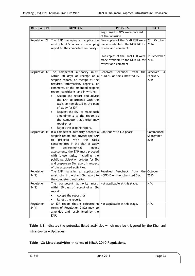
Assmang (Pty) Ltd: Khumani Iron Ore Mine EIA/EMP Khumani Proposed Infrastructure Expansion
13-843 June 2015 Page 23
REGULATION PROVISION PROGRESS DATE
Registered I&AP’s were notified
of the inclusion.
Regulation 29 The EAP managing an application
must submit 5 copies of the scoping
report to the competent authority.
Five copies of the Draft ESR were
made available to the NCDENC for
review and comment.
Five copies of the Final ESR were
made available to the NCDENC for
review and comment.
23 October
2014
15 December
2014
Regulation 30 The competent authority must,
within 30 days of receipt of a
scoping report, or receipt of the
required information, reports, or
comments or the amended scoping
report, consider it, and in writing:
Accept the report and advise
the EAP to proceed with the
tasks contemplated in the plan
of study for EIA;
Request the EAP to make such
amendments to the report as
the competent authority may
require; or
Reject the scoping report.
Received Feedback from the
NCDENC on the submitted ESR.
Received 4
February
2015
Regulation 31 If a competent authority accepts a
scoping report and advises the EAP
to proceed with the tasks
contemplated in the plan of study
for environmental impact
assessment, the EAP must proceed
with those tasks, including the
public participation process for EIA
and prepare an EIA report in respect
of the proposed activities.
Continue with EIA phase. Commenced
September
2015
Regulation
34(1)
The EAP managing an application
must submit the draft EIA report to
the competent authority.
Received Feedback from the
NCDENC on the submitted EIA.
October
2015
Regulation
34(2)
The competent authority must,
within 60 days of receipt of an EIA
report:
Accept the report; or
Reject the report.
Not applicable at this stage. N/A
Regulation
34(4)
An EIA report that is rejected in
terms of Regulation 34(2) may be
amended and resubmitted by the
EAP.
Not applicable at this stage. N/A
Table 1.3 indicates the potential listed activities which may be triggered by the Khumani
Infrastructure Upgrades.
Table 1.3: Listed activities in terms of NEMA 2010 Regulations.
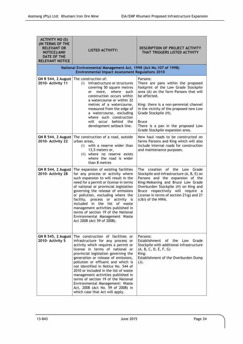
Assmang (Pty) Ltd: Khumani Iron Ore Mine EIA/EMP Khumani Proposed Infrastructure Expansion
13-843 June 2015 Page 24
ACTIVITY NO (S) (IN TERMS OF THE
RELEVANT OR NOTICE):AND DATE OF THE
RELEVANT NOTICE
LISTED ACTIVITY: DESCRIPTION OF PROJECT ACTIVITY
THAT TRIGGERS LISTED ACTIVITY
National Environmental Management Act, 1998 (Act No.107 of 1998) Environmental Impact Assessment Regulations 2010
GN R 544, 2 August 2010- Activity 11
The construction of: (i) Infrastructure or structures
covering 50 square metres or more, where such construction occurs within a watercourse or within 32 metres of a watercourse, measured from the edge of a watercourse, excluding where such construction will occur behind the development setback line.
Parsons: There are pans within the proposed footprint of the Low Grade Stockpile area (A) on the farm Parsons that will be affected. King: there is a non-perennial channel in the vicinity of the proposed new Low Grade Stockpile (H). Bruce There is a pan in the proposed Low Grade Stockpile expansion area.
GN R 544, 2 August 2010- Activity 22
The construction of a road, outside urban areas,
(i) with a reserve wider than 13,5 meters or,
(ii) where no reserve exists where the road is wider than 8 metres
New haul roads to be constructed on farms Parsons and King which will also include internal roads for construction and maintenance purposes.
GN R 544, 2 August 2010- Activity 28
The expansion of existing facilities for any process or activity where such expansion to will result in the need for a permit or license in terms of national or provincial legislation governing the release of emissions or pollution, excluding where the facility, process or activity is included in the list of waste management activities published in terms of section 19 of the National Environmental Management Waste Act 2008 (Act 59 of 2008).
The creation of the Low Grade Stockpile and infrastructure (A, B, E) on Parsons and the expansion of the King/Mokaning and Bruce Low Grade Overburden Stockpile (H) on King and Bruce respectively will require a License in terms of section 21(g) and 21 (c&i) of the NWA.
GN R 545, 2 August 2010- Activity 5
The construction of facilities or infrastructure for any process or activity which requires a permit or license in terms of national or provincial legislation governing the generation or release of emissions, pollution or effluent and which is not identified in Notice No. 544 of 2010 or included in the list of waste management activities published in terms of section 19 of the National Environmental Management: Waste Act, 2008 (Act No. 59 of 2008) in which case that Act will apply.
Parsons: Establishment of the Low Grade Stockpile with additional infrastructure (A, B, C, D, E, F, G) King: Establishment of the Overburden Dump (J).

Assmang (Pty) Ltd: Khumani Iron Ore Mine EIA/EMP Khumani Proposed Infrastructure Expansion
13-843 June 2015 Page 25
ACTIVITY NO (S) (IN TERMS OF THE
RELEVANT OR NOTICE):AND DATE OF THE
RELEVANT NOTICE
LISTED ACTIVITY: DESCRIPTION OF PROJECT ACTIVITY
THAT TRIGGERS LISTED ACTIVITY
National Environmental Management Act, 1998 (Act No.107 of 1998) Environmental Impact Assessment Regulations 2010
GN R 545, 2 August 2010- Activity 15
Physical alteration of undeveloped vacant or derelict land for residential retail, commercial, recreational, industrial or institutional use where the total area to be transformed is 20 hectares or more, except where such physical alteration takes place for:
(i) Linear development activities; or
(ii) Agriculture or afforrestation where activity 16 in this Schedule will apply.
The project will comprise the development of mining related surface infrastructure in areas on both farms Bruce, Parsons and King, where no previous mining activity took place.
GN R 546, 2 August 2010- Activity 14
Physical alteration of undeveloped vacant or derelict land for residential retail, commercial, recreational, industrial or institutional use where the total area to be transformed is 20 hectares or more, except where such physical alteration takes place for:
(i) Linear development activities; or
(ii) Agriculture or afforrestation where activity 16 in this Schedule will apply.
The removal of indigenous trees on farms Bruce, Parsons and King, for the development of infrastructure and creation of stockpiles.
The main implication of the abovementioned amendments is that the thresholds of the
activities have been changed from being measured in terms of annual throughput capacity to
being measured in terms of daily throughput capacity. This in effect means an increase in
the thresholds. Only expansion of facilities on undeveloped land will require an
environmental authorisation.
Kindly note that GCS is mindful of the new legislative changes which came into force on
Monday, 8 December 2014. Accordingly, we direct the Department’s attention to the
transitional arrangements contained in Regulation 53(1) of the 2014 Environmental Impact
Assessment Regulations (GN R 982 in Government Gazette 38282 of 4 December 2014) which
states the following:

Assmang (Pty) Ltd: Khumani Iron Ore Mine EIA/EMP Khumani Proposed Infrastructure Expansion
13-843 June 2015 Page 26
“(1) An application submitted in terms of the previous NEMA regulations which is
pending when these Regulations take effect, including pending applications for auxiliary
activities directly related to-
(a) Prospecting or exploration of a mineral or petroleum resource; or
(b) Extraction and primary processing of a mineral or petroleum resource,
Must despite these Regulations be dispensed with in terms of those previous NEMA
regulations as if those previous regulations were not repealed.
(2) If a situation arises where an activity or activities, identified under the previous
NEMA Notices, no longer requires environmental authorisation in terms of the current
activities and competent authorities identified in terms of Section 24(2) and 24D of the
National Environmental Management Act, 1998 (Act No. 107 of 1998) or in terms of the
National Environmental Management: Waste Act, 2008 (Act No. 59 of 2008), and where
a decision on an application under the previous NEMA regulations is still pending, the
competent authority will consider such application to be withdrawn.
(3) Where an application submitted in terms of the previous NEMA regulations, is
pending in relation to an activity of which a component of the same activity was not
identified under the previous NEMA notices, but is now identified in terms of Section
24(2) OF THE Act, the competent authority must dispense of such application in terms
of the previous NEMA regulations and may authorise the activity identified in terms of
Section 24(2) as if it was applied for, on condition that all impacts of the newly
identified activity and requirements of these Regulations have also been considered and
adequately addressed.”
In accordance with the abovementioned provision, the Environmental Authorisation Process
currently underway in terms of the NEMA will continue in terms of the previous NEMA
Regulations (2010).
1.6.4 The NEM:WA
In terms of the National Environmental Management Laws Amendment Act, 2014 (Act No. 25
of 2014) (NEMLA 3), Waste Management Licences (WMLs) were to be regulated by the Minister
of Mineral Resources for residue stockpiles and deposits relating to prospecting, mining,
exploration or production activities as from 3 September 2014 as part of the “One
Environmental System”. However NEMLA 3 and its associated regulations for the One
Environmental System will be implemented from 8 December 2014 in terms of a press
statement by the Department of Environmental Affairs in September 2014.
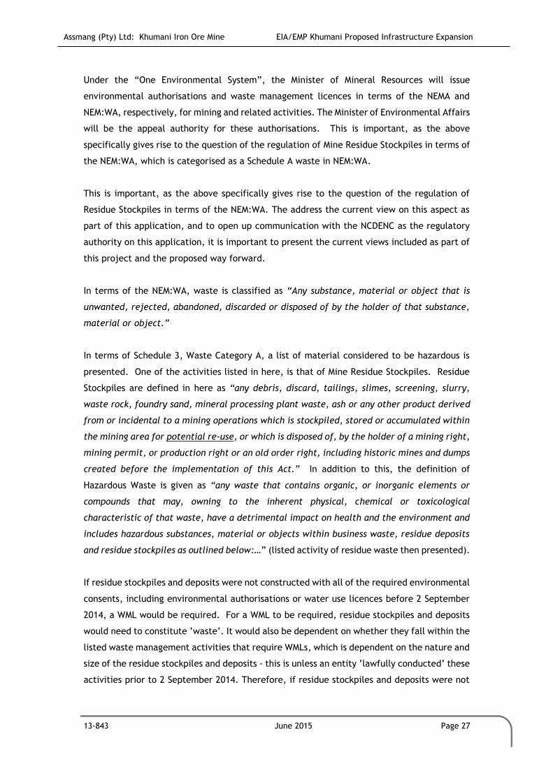
Assmang (Pty) Ltd: Khumani Iron Ore Mine EIA/EMP Khumani Proposed Infrastructure Expansion
13-843 June 2015 Page 27
Under the “One Environmental System”, the Minister of Mineral Resources will issue
environmental authorisations and waste management licences in terms of the NEMA and
NEM:WA, respectively, for mining and related activities. The Minister of Environmental Affairs
will be the appeal authority for these authorisations. This is important, as the above
specifically gives rise to the question of the regulation of Mine Residue Stockpiles in terms of
the NEM:WA, which is categorised as a Schedule A waste in NEM:WA.
This is important, as the above specifically gives rise to the question of the regulation of
Residue Stockpiles in terms of the NEM:WA. The address the current view on this aspect as
part of this application, and to open up communication with the NCDENC as the regulatory
authority on this application, it is important to present the current views included as part of
this project and the proposed way forward.
In terms of the NEM:WA, waste is classified as “Any substance, material or object that is
unwanted, rejected, abandoned, discarded or disposed of by the holder of that substance,
material or object.”
In terms of Schedule 3, Waste Category A, a list of material considered to be hazardous is
presented. One of the activities listed in here, is that of Mine Residue Stockpiles. Residue
Stockpiles are defined in here as “any debris, discard, tailings, slimes, screening, slurry,
waste rock, foundry sand, mineral processing plant waste, ash or any other product derived
from or incidental to a mining operations which is stockpiled, stored or accumulated within
the mining area for potential re-use, or which is disposed of, by the holder of a mining right,
mining permit, or production right or an old order right, including historic mines and dumps
created before the implementation of this Act.” In addition to this, the definition of
Hazardous Waste is given as “any waste that contains organic, or inorganic elements or
compounds that may, owning to the inherent physical, chemical or toxicological
characteristic of that waste, have a detrimental impact on health and the environment and
includes hazardous substances, material or objects within business waste, residue deposits
and residue stockpiles as outlined below:…” (listed activity of residue waste then presented).
If residue stockpiles and deposits were not constructed with all of the required environmental
consents, including environmental authorisations or water use licences before 2 September
2014, a WML would be required. For a WML to be required, residue stockpiles and deposits
would need to constitute ’waste’. It would also be dependent on whether they fall within the
listed waste management activities that require WMLs, which is dependent on the nature and
size of the residue stockpiles and deposits - this is unless an entity ’lawfully conducted’ these
activities prior to 2 September 2014. Therefore, if residue stockpiles and deposits were not

Assmang (Pty) Ltd: Khumani Iron Ore Mine EIA/EMP Khumani Proposed Infrastructure Expansion
13-843 June 2015 Page 28
constructed with all of the required environmental consents, including environmental
authorisations or water use licenses before 2 September 2014, a WML would be required.
Based on the above:
1. The Parson Low Grade Stockpile, King/Mokaning ROM and Low Grade Stockpile were
approved in terms of NEMA, and also the NWA, making these lawful activities.
2. Khumani is not considering potential re-use, the material stockpiled, which forms
part of this application is now specifically earmarked for re-use, with the
infrastructure to undertake these activities included in this application.
3. Khumani is an iron ore operation; the beneficiation process is in the form of a wash
and screening operations. The process is considered as inert, with no potential of
hazardous impacts (as stipulated in this activity definition).
1.6.5 The NWA
The NWA stipulates that activities which have the potential to impact on a water resource
require that an Integrated Water Use License (IWUL) be issued by the DWS. In accordance
with the requirements of the NWA, an IWULA will be compiled for the proposed Upgrades and
update to the storm water management plan and submitted to the DWS to ensure the legality
of the identified water uses associated with the proposed operation.
It is anticipated that following water uses (in bold) in terms of Section 21 of the NWA will be
applied for at the Northern Cape Regional Office of the DWS:
a) Taking water from a water resource;
b) Storing water;
c) Impeding or diverting the flow of water in a watercourse;
d) Engaging in a stream flow reduction activity contemplated in section 36;
e) Engaging in a controlled activity identified as such in section 37(1) or declared under
section 38(1);
f) Discharging waste or water containing waste into a water resource through a pipe,
canal, sewer, sea outfall or other conduit;
g) Disposing of waste in a manner which may detrimentally impact on a water
resource;
h) Disposing in any manner of water which contains waste from, or which has been
heated in, any industrial or power generation process;
i) Altering the bed, banks, course or characteristics of a watercourse;
j) Removing, discharging or disposing of water found underground if it is necessary for
the efficient continuation of an activity or for the safety of people; and

Assmang (Pty) Ltd: Khumani Iron Ore Mine EIA/EMP Khumani Proposed Infrastructure Expansion
13-843 June 2015 Page 29
k) Using water for recreational purposes.
A pre-consultation meeting were held with the DWS on the 4th of February 2015 during which
time the relevant Section 21 water uses and way forward were discussed. The final Section
21 water uses that need to be applied for has been confirmed with the DWS prior to the
submission of the IWULA.
A Water Use License (WUL) may be issued for a maximum period of 40 years with a specified
review period. The WUL also prescribes a set of conditions to protect water resources, and
gauge the impact of the water use. These have to be strictly adhered to for as long as the
water use continues. This may extend beyond the life of mine and the applicant will be
responsible for impacts caused by the operation after decommissioning and closure.
Furthermore, Section 27 of the NWA specifies that the following factors, regarding water use
authorization, must be taken into consideration:
The efficient and beneficial use of water in the public interest;
The socio-economic impact of the decision whether or not to issue a license;
Alignment with the catchment management strategy;
The impact of the water use and possible resource directed measures; and
Investments made by the applicant in respect of the water use in question.
Section 27 considerations will be included in the IWULA. This will assist the applicant in
ensuring that the water uses applied for, are undertaken in a manner that does not negatively
impact on the public, water resources, or downstream water users or compromise any of the
country’s international obligations with regards to shared water resources.
1.7 Roles and Responsibilities in terms of the NEMA and MPRDA
This section sets out the roles and responsibilities of the Applicant, Environmental Assessment
Practitioner (EAP) and Interested and Affected Parties (I&APs).
1.7.1 The Applicant
An applicant is a person (including a juristic person) who has submitted an application for,
inter alia, environmental authorisation. For the purpose of this application, Assmang
Proprietary Limited’s Khumani Iron Ore Mine submitted an application for authorisation in

Assmang (Pty) Ltd: Khumani Iron Ore Mine EIA/EMP Khumani Proposed Infrastructure Expansion
13-843 June 2015 Page 30
terms of the NEMA on 31 July 2014, and in the same process also to conduct an amendment
of the approved EMP under MPRDA.
The contact details of the applicant are provided in Table 1.4.
Table 1.4: Name and address of Applicant representative.
ITEM COMPANY CONTACT DETAILS
Name of Applicant Assmang Proprietary Limited: Khumani Iron Ore Mine
Contact Person Mr Dirk Coetzee
Physical Address Khumani Iron Ore Mine, Kathu, Northern Cape Province
Postal Address Private Bag X503,Kathu, Northern Cape Province, 8446
Tel no. +27 (0) 53 723 8090
E-mail address [email protected]
The NEMA Regulations require the applicant to appoint an EAP who will comply with the
requisite statutory provisions and regulations on behalf of the Applicant. Further, the
Applicant must:
Provide the EAP with a detailed and precise statement of the purpose and need for
the proposed activities;
Take all necessary steps to verify whether the EAP complies with Sections 17(a) and
(b) of NEMA; and
Provide the EAP with access to all information regarding the application, whether or
not such information is favourable to the Applicant.
1.7.2 The Environmental Assessment Practitioner
In terms of Section 17 of the NEMA, the applicant has to appoint and EAP before applying for
an environmental authorisation of any activity listed in terms of GN 544 and 545. An EAP is
responsible for the planning, management and coordination of EIAs, Strategic Environmental
Assessments (SEAs), EMPs or any other appropriate environmental management instruments
introduced through regulations. The EAP must be independent, objective and have expertise
in conducting EIAs. Such expertise should include knowledge of all relevant legislation and
of any guidelines that have relevance to the proposed activity.
An EAP must perform the work relating to the application in an objective manner, even if it
results in views and findings that are not favourable to the applicant, and disclose to the
applicant and competent authority all material information in the possession of the EAP.
For this purpose the applicant has appointed GCS Water and Environment (Pty) Ltd (GCS) as
the EAP to undertake the necessary environmental assessments and to ensure that all

Assmang (Pty) Ltd: Khumani Iron Ore Mine EIA/EMP Khumani Proposed Infrastructure Expansion
13-843 June 2015 Page 31
legislative requirements are adhered to as part of the environmental authorisation processes.
GCS provides a professional, independent consulting service in the fields of water,
environmental, engineering and earth sciences. The GCS team consists of highly trained staff
that has extensive experience in the fields of geohydrology, hydrology, pedology, engineering
geology, engineering and environmental science.
GCS have considerable experience in Southern Africa and undertake investigations for
environmental assessments. The environmental scientists carry out all aspects of
environmental assessments and management programmes.
GCS was founded in 1987 and the broad GCS client base ranges from individuals, engineers,
municipalities and mines, to Independent States and Governments. GCS is an independent
practice wholly owned by the partners of the company.
GCS is a level 4 contributor to B-BBEE.
GCS is an independent environmental consulting firm and has undertaken the EIA/EMP Report
development. GCS is also responsible for undertaking the Public Participation Process (PPP)
pertaining to the proposed operation.
The contact details of the EAP are provided in Table 1.5.
Table 1.5: Name and Address of Environmental Assessment Practitioner.
ITEM COMPANY CONTACT DETAILS
Company Name GCS Water and Environment (Pty) Ltd
Company Representative Mrs Riana Panaino
Qualification B. Sc Honours Biodiversity and Conservation
Tel no. +27 (0)11 803 5726
Fax no: +27 (0)11 803 5745
E-mail address [email protected]
Postal address PO Box 2597, Rivonia, 2128
Table 1.6 provides a summary of the appointed EAPs working on the Khumani Infrastructure
expansion environmental authorisation process.
Table 1.6: Environmental Project Resources.
PROFESSIONAL STAFF TITLE COMPANY
Renee Janse van Rensburg Senior Project Manager GCS Water & Environment
Riana Panaino Environmental Consultant GCS Water & Environment
Tanja Bekker Project Advisor EnviroGistics

Assmang (Pty) Ltd: Khumani Iron Ore Mine EIA/EMP Khumani Proposed Infrastructure Expansion
13-843 June 2015 Page 32
1.7.3 Interested and Affected Parties
An Interested and Affected Party (I&AP) is defined as any person, group of persons or
organisation interested in or affected by an activity; and any organ of state that may have
jurisdiction over any aspect of the activity.
The NEMA Regulations distinguish between I&APs and registered I&APs. Registered I&APs
refer to an I&AP whose name is recorded in the register opened for the environmental
authorisation application. Accordingly, only registered I&APs will be notified of:
The availability of reports and other written submissions made (or to be made) to the
competent authority (I&APs are entitled to comment on these reports and
submissions); and
The outcome of the application, the reasons for the decision and that an appeal may
be lodged against a decision.
For the purpose of an application, the EAP must open and maintain a register which contains
the names, contact details and addresses of:
All persons who have submitted written comments or attended meetings with the
Applicant or EAP;
All persons who have requested the Applicant or EAP, in writing, to be entered on
the register; and
All organs of state which have jurisdiction in respect of the activity to which the
application relates.
1.8 Environmental Reporting
Based on the outcome of the Environmental Scoping Phase, an EIA and an EMP Report must
be submitted to the DMR and NCDENC for consideration and approval.
1.8.1 Environmental Impact Assessment
The EIA Report must determine the nature, extent, duration, probability and significance of
the environmental, social and cultural impacts of the project, the reasonable alternatives
and the required mitigation measures for each impact during the life of the mine. It is the
role of the relevant environmental authorities to make a decision on whether the project
should proceed or not, based on the information provided in the EIA. The EAP does, as is
required of them, make a recommendation on whether the project should proceed or not,

Assmang (Pty) Ltd: Khumani Iron Ore Mine EIA/EMP Khumani Proposed Infrastructure Expansion
13-843 June 2015 Page 33
based on the findings of specialist assessments, the needs and desireability of the project
and on the impact assessment findings.
Regulation 31(2) of Government Notice R543 of the NEMA Regulations stipulates that an EIA
Report must contain all necessary information to enable the competent authority to consider
the application and to reach a decision. The EIA Report must contain, inter alia, the
following:
A description and comparative assessment of all alternatives identified;
A description of all environmental issues identified as well as the significance of each
issue and an indication if the extent to which the issue could be addressed by the
adoption of mitigating measures;
An Environmental Impact Statement; and
An Environmental Management Programme.
Furthermore, the criteria which the competent authority will apply, when considering
applications in terms of the provisions of NEMA, is enunciated in Regulation 8 of Government
Notice R543 of the Regulations. The latter regulation states that consideration must be had
for Section 24O, Section 24(4), as well as the need and desirability of the activity. The
activities identified in the provisions of NEMA and the Regulations thereto pertain to activities
which may have a detrimental impact on the environment.
The criteria to be taken into account by the competent authority when considering
applications as set out in Section 24O and 24(4) of NEMA includes, inter alia, the following
relevant factors:
Any pollution, environmental impacts or environmental degradation likely to be
caused if the application is approved or refused;
Measures taken to protect the environment from harm as a result of the activity
which is the subject of the application;
Measures taken to prevent, control, abate or mitigate any pollution, substantially
detrimental environmental impacts or environmental degradation;
The ability of the applicant to implement mitigation measures and to comply with
any conditions subject to which the application may be granted;
Where appropriate, any feasible and reasonable alternatives to the activity which is
the subject of the application and any feasible and reasonable modifications or
changes to the activity that may minimise harm to the environment; and
Any comments received from organs of state that have jurisdiction over any aspect
of the activity which is the subject of the application.
Assmang (Pty) Ltd: Khumani Iron Ore Mine EIA/EMP Khumani Proposed Infrastructure Expansion
13-843 June 2015 Page 34
1.8.2 Environmental Management Programme
Each specialist was required to identify means of avoiding, mitigating and/or managing the
negative impacts in his/her particular aspect of the investigation. The recommended
management strategies are synthesised in this report by GCS to formulate the EMP for the
proposed listed activities and the operation as a whole. Management strategies are based on
the recommendations by specialists in their specific field of study and on best practise
guidelines where applicable. The management measures will be incorporated into the mine
systems to avoid, or appropriately manage impacts from the outset.
A draft EMP must include details of the person who prepared the EMP and the expertise of
that person to prepare an EMP. The draft EMP must, furthermore, include information on
any proposed management or mitigation measures that will be taken to address the
environmental impacts that have been identified, including environmental impacts or
objectives in respect of –
Planning and design:
o Pre-construction and construction activities;
o Operation or undertaking of the activity;
o Rehabilitation of the environment; and
o Closure, where relevant.
A detailed description of the aspects of the activity that are covered by the draft
EMP;
An identification of the persons who will be responsible for the implementation of
the mitigating measures;
Where appropriate, time periods within which the measures contemplated in the
draft EMP must be implemented; and
Proposed mechanisms for monitoring compliance with the environmental
management plan and reporting thereon.
The EIA ensures that the needs of the environment (biophysical and socio-economic) are
identified. The EMP in turn provides a tool for meeting the objective to reduce or avoid
negative environmental impacts associated with a project within a certain environment by
providing detailed mitigation measures and management commitments. All of these sections
will become legally binding on the approval of this report.
1.8.3 Reporting Structure (EIA/EMP)

Assmang (Pty) Ltd: Khumani Iron Ore Mine EIA/EMP Khumani Proposed Infrastructure Expansion
13-843 June 2015 Page 35
The EIA/EMP Report has been compiled to identify the impacts associated with the mining
activities and to determine the management measures that need to be implemented.
Chapter 1: Introduction and Background
This chapter provides a description of the location and the land ownership of the mine, as
well as the purpose, approach and methodology followed for the completion of this project.
It also includes a review of applicable legislation reviewed during the compilation of this
report.
Chapter 2: Detailed Project Description
This chapter provides a description of the proposed mining operation, mining method,
required services, access routes, transport routes and surface infrastructure. It also includes
a detailed section on the proposed mine development.
Chapter 3: Project Alternatives
This chapter provides a description of the project alternatives considered and a motivation
for why the preferred alternative was selected.
Chapter 4: Detailed Environmental Description
This chapter provides a description of the baseline biophysical and socio-economic conditions
of the project area prior to commencement of the proposed project. The information in this
chapter has been obtained from the specialist studies undertaken as well as various desktop
sources.
Chapter 5: Public Participation Process
This chapter details the process undertaken for stakeholder engagement and provides a
discussion on the issues raised and how these have been addressed.
Chapter 6: Environmental Management Goals and Objectives
This chapter outlines the environmental management goals and objectives for the proposed
operation.
Chapter 7: Identification of Impacts and Concerns with Management Measures and Action
Plans
This chapter assesses and rates the potential impacts on the environment, prior to the
consideration of mitigation measures, as well as the potential impacts after the
implementation of the proposed mitigation measures. It furthermore provides management
measures per impact identified and details specifica actions plans that are required.

Assmang (Pty) Ltd: Khumani Iron Ore Mine EIA/EMP Khumani Proposed Infrastructure Expansion
13-843 June 2015 Page 36
Chapter 8: Monitoring and Audit Management Programme
This chapter outlines the monitoring and auditing programmes which have been
recommended by the relevant specialists. It includes objectives of each proposed monitoring
programme, the location of monitoring points, the procedures to be followed when
undertaking monitoring; the frequency of monitoring required; criteria to assess
environmental performance, as well as the recommendations for internal and external
(independent) auditing to be undertaken.
Chapter 9: Environmental Awareness Plan and Environmental Emergency Response Plan
This chapter sets out procedures to be followed during and after various types of incidents
and accidents. It also sets out the procedure for inducting employees and informing all mine
employees and contractors of the various risks which may results from the various activities
on site and all required management and mitigation measures.
Chapter 10: Financial Provision
The chapter provides the financial provision required for the project.
Chapter 11: Environmental Rehabilitation Programme
This chapter outlines the environmental rehabilitation to be undertaken following
environmental disturbances caused by the proposed activities associated with the proposed
mine.
Chapter 12: Information Gaps and Further Assessments Required
This chapter outlines the assumptions made during the specialist studies and environmental
impact assessment, the adequacy of underlying assumptions, the uncertainties in the
information provided, as well as recommendations to improve the accuracy of the
information used to compile this report and the relevant appendices. It also outlines further
assessments that may be required.
Chapter 13: List of Specialist Studies Undertaken
List of specialist reports which are appended to this document.
Chapter 14: Motivation for the Project
This chapter provides motivation for the commencement of the proposed project.
Chapter 15: Environmental Impact Statement
Assmang (Pty) Ltd: Khumani Iron Ore Mine EIA/EMP Khumani Proposed Infrastructure Expansion
13-843 June 2015 Page 37
The chapter details whether the project should or should not be granted approval by the
competent authority in the opinion of the EAP.
Chapter 16: Conclusion
The conclusion provides a brief discussion on the findings in the report.
Chapter 17: Undertaking
This chapter provides an undertaken to be signed by the applicant.
Chapter 18: References
The conclusion a list of references to studies used in this report.

Assmang (Pty) Ltd: Khumani Iron Ore Mine EIA/EMP Khumani Proposed Infrastructure Expansion
13-843 June 2015 Page 38
2 DETAILED PROJECT DESCRIPTION
This section of the report relates to Section 31 (2) of the GNR543 published in Government
Gazette No.33306 of 18 June 2010, under Section 24(5) of the NEMA.
REGULATION 31 (2)
2 b) Detailed description of the proposed activity
2 f) A description of the need and the desirability of the proposed activity
2.1 Existing Infrastructure
The following infrastructure has been approved through various application processes under
NWA, NEMA and MPRDA:
Opencast Mining Operations;
Conveyors and service roads;
Powerlines and service roads;
Access roads and haul roads;
Crushers;
Washing and screening plant;
Stockpiles (topsoil, RoM, product) and overburden;
Paste Disposal Pacility;
Local and export railway siding;
Domestic Landfill Site and Temporary Storage area for Hazardous Waste;
Two (2) approved river diversions;
Clean and dirty water infrastructure;
Sewage treatment plants;
Offices, workshops and ancillary buildings;
Potable and process water storage tanks;
Water supply from Sedibeng Pipeline;
Diesel storage; and
Borrow pits.
A detailed description of the existing infrastructure is provided in Table 2.1.
Assmang (Pty) Ltd: Khumani Iron Ore Mine EIA/EMP Khumani Proposed Infrastructure Expansion
13-843 June 2015 Page 39
Table 2.1 Existing infrastructure at Khumani Iron Ore Mine
INFRASTRUCTURE DESCRIPTION
Roads
The N14 National Road
Existing N14 National Road:
The N14 national road traverses the Khumani property between the farm Bruce and King in a North / South direction.
The Secondary road (R325)
Existing Secondary Road (R325):
A Secondary road (R325) to the town Dingleton runs through to the farm Parson in a north-south direction.
Access Roads Approved Access Roads:
Access to the plant and main administrative buildings is from the existing R325 Dingleton road. Roads to the administrative buildings are surfaced.
Access to the King/Mokaning operations is directly from the N14 road.
Access to the Bruce operations is from an existing road turning off from the N14.
Treated roads serve the plant area.
Treated access roads have been established for access to the Bruce and King opencast operations.
Haul Roads Approved Haul Roads:
Haul roads serve as links between the various mine pits, the two ore crushing facilities (at Bruce and King respectively), as well as the topsoil storage areas and discard dumps.
Overburden is transported via trucks on treated roads to the crushers, which are situated in close proximity to the opencast operations.
ROM is transported to the crushers via haul roads from where it is loaded onto conveyors.
Various haul roads have been / will be constructed to provide access from one opencast working area to the other.
Two categories of haul roads:
Category 1 has a width of 38.0m, and serves as main arterials between pits and crushing facilities.
Category 2 haul roads have a width of 31.0m without a central berm, and function as links from pits to Category 1 haul roads.
Other Roads Approved Other Roads:
Service roads have been constructed connecting the plant area to the Bruce and King / Mokaning opencast operations.
The service road from the plant to the Bruce opencast operations runs parallel to the conveyors in a north-easterly direction.
The service road from the plant area to the King / Mokaning operations utilizes the same road as the Bruce opencast operations for the first 1.5km, after which it crosses the N14 national road under a bridge in an easterly direction parallel to the conveyors connecting the King / Mokaning opencast operations with the plant.

Assmang (Pty) Ltd: Khumani Iron Ore Mine EIA/EMP Khumani Proposed Infrastructure Expansion
13-843 June 2015 Page 40
INFRASTRUCTURE DESCRIPTION
A surface road has been constructed between the Bruce and King / Mokaning opencast operation, to serve as access between the two mining operations. This road is known as the A1 highway. The road runs on the eastern boundary of the King farm in an approximate northerly direction. The road crosses the N14 national road under a bridge. Table ‘blocks to be on 1 page – don’t split as per this block
Conveyors
Bruce Conveyor Approved Conveyor at Bruce:
This single length conveyor PS 15/CV60 is 6,5km long. From the stockpile at Bruce, where the conveyor is loaded, it passes under a Transnet railway line (OREX line) and public road (N14) to surface on the south side of these.
The conveyor further crosses a bridge (400m wide) across the Gamagara, travelling outside of the 1:100 floodline. The fourth crossing is under the Transnet Hotazel/PE line. Before arriving at the load off point at Parson, the conveyor travels over two small flood plains where it is suspended on culverts, and under the Khumani export siding.
King Conveyors Approved Conveyor at King:
This conveyor route is made up of two conveyors. The first leg, PS25/CV60, which is 1km long, travels west from the stockpile where it is loaded. After 400m, the conveyor passes over the Mine Access road and Hotazel/PE Transnet railway line.
The conveyor further passes under the N14 highway to arrive at a transfer tower. The ore is then transferred to the second conveyor PS25/CV70 which is ~1,5km long. The conveyor passes under the export siding at the same point as the Bruce conveyor.
Railway Lines and Associated Infrastructure
The OREX Railway Line
Existing OREX Railway Line:
The OREX Railway Line is an existing railway line between Kumba Iron Ore Mine and the Saldanha Port (export market) which runs parallel to the R325.
The Port Elizabeth / Hotazel Railway line
Existing Port Elizabeth / Hotazel Railway Line:
The Port Elizabeth / Hotazel Railway line (local markets) traverses the farms Mokaning and King where after it runs west of the farm Bruce.
Rapid Load-Out Facilities
Approved Rapid Load-Out Facility:
The layout of the siding is of a balloon shape with double track arrangement comprising two (2) balloons. The siding is electrified at 50kV in common with the Transnet Main Line (OREX Line), and the take-off from the Transnet line is fully signalled and controlled from Saldanha.
The siding line initiates from the OREX line and splits to form two balloons (loop structures) in order to load the required product on the train wagons for export. The railway siding has been established to accommodate 342 wagons plus 6 locomotives. Wagons capable of transporting 100 tonnes of product are used.
The layout basically allows for a 342 wagon train to enter the siding, one at a time, and proceed on to the balloon layout in an anti-clockwise direction. The train will proceed to one of the load-out stations. Uncoupling will take place and the rear part of the train with two (2) locomotives now leading will proceed to the load-out station. Loading will commence after the train has entered the load-out and the first

Assmang (Pty) Ltd: Khumani Iron Ore Mine EIA/EMP Khumani Proposed Infrastructure Expansion
13-843 June 2015 Page 41
INFRASTRUCTURE DESCRIPTION
wagon in each rake has been aligned and declared ready for loading. Three (3) rakes of 114 wagons each are loaded separately, connected and dispatched to the OREX line. Movement of rakes on the balloons is currently undertaken by diesel locomotives.
The following design criteria has been adopted: (track standards as per Transnet, i.e. 30 ton axle loads, 60kg/m rails)
30t axle loads
50kV ac overhead electrification
Multi aspect colour light signalling
Maximum train length 342 wagons excluding locomotives.
Port Elizabeth / Hotazel Railway Line
Diversion
Approved Port Elizabeth / Hotazel Railway Line Diversion:
The railway line linking Hotazel to Port Elizabeth passes through an area that has been earmarked for open cast pits on King. In order to mine these open cast pits, the railway line was diverted to the west.
Local Railway Line Siding
Approved Local Railway Line Siding:
There are requirements for iron ore on the local market and financial feasibility studies carried out by Assmang indicated that it would be advantageous to sell material on the local market. A siding linked to the Hotazel – Port Elizabeth line has been constructed.
The local siding will be a single track railway tying into with the Hotazel-Port Elizabeth railway line south-east of the point at which the Hotazel-Port Elizabeth line crosses the Sishen-Saldanha Line. The local siding then crosses the following existing infrastructure:
1. A Rail-over-Road bridge over the Dingleton Provincial road.
2. The 100 year flood line of the Gamagara River where drainage structures are be provided.
3. The 132kV Eskom power line - this line has been raised to accommodate the siding.
4. The three Assmang transmission lines - these lines have been raised to accommodate the siding.
5. The Bruce overland conveyor - a culvert has been placed over the conveyor.
6. The Sishen Saldanha (OREX) export railway line with a Rail-over-Rail bridge.
7. The DWA pipeline running parallel to the Dingleton provincial road - this has been protected with a culvert incorporated in the
bridge design.
The local siding joins up with the second railway balloon running outside of the first balloon.
Power Lines
Eskom Power Lines Existing Eskom Power Lines:
Existing Eskom Power lines (132 kV) from the Sishen traction station are present to the north of the farm Parson and transect the farm Bruce. Another line traverses the farms Mokaning and King parallel to the Port Elizabeth / Hotazel railway line.

Assmang (Pty) Ltd: Khumani Iron Ore Mine EIA/EMP Khumani Proposed Infrastructure Expansion
13-843 June 2015 Page 42
INFRASTRUCTURE DESCRIPTION
Three New Power Lines (132kV)
Approved New Power Lines:
Three power lines (132kV) have been taken from an existing Eskom Substation near Sishen Mine. The power lines are taken to an Eskom yard, situated at the plant area on the farm Parson. From the Eskom yard, two 22 kV lines are taken to the Bruce opencast operations and two 22kV lines are taken to the King / Mokaning opencast operations. The balloons can be electrified at 50kV a.c., in common with the Transnet OREX Line, and the take-off from the Transnet line is fully signalled and controlled from Saldanha. Power supply for traction on the siding is from the Transnet system.
The structure-series Eskom used for pylons is the "Steel mono pole Raptor Friendly" series. The intermediate suspension structure can be self-supporting or guyed structures depending on the landowner and/or environmental preferences.
Additional Power Supply
Approved Additional Power Supply:
The electricity shortage in this country has precipitated the need for the creation of additional power supplies on site. The mine intends to implement the use of additional diesel generators for this purpose. An additional 1.25MVA generator will be placed on Parsons and an additional 2 800kVA of generatored power has been placed at King, all of which are located within the existing plant areas on site (Bruce, Parson and King). These generators are located at the following coordinates:
King Genset – X = +81,417.940, Y = +49,365.570
Parsons Genset – X = +83,253.980, Y = +52,677.310
Fuel and Lubricant Storage
Temporary Fuel Storage
Approved Temporary Fuel Storage:
The temporary fuel storage facility consists of two (2) above ground temporary diesel storage facilities, each with a capacity of 61 m3. Each tank is double bunded (so-called “Transtanks”) and have been equipped with drip free nozzles. The structures have been established on concrete slabs with humps on all sides. A sloped, fully bunded area has been located between the two tanks in order to enable the collection and management of potential spillages from the tanks.
Additional Diesel and Lubricant
Storage
Approved Additional Diesel and Lubricant Storage
The operation of the diesel generators and the additional activities on site require the storage of additional fuel and oil. The mine has a storage capacity of 21 days. This translates to an additional 1312m3 of diesel and 276m3 lubricants being stored on site at any time.
All fuel is stored above-ground within designated and appropriately constructed hazardous material storage areas.
Solid Waste Management Facilities
Industrial and Domestic Waste Disposal Sites
Approved Industrial and Waste Deposal Sites:
Industrial waste is limited to oil, diesel and grease. This waste is sold in bulk back to the manufacturers and suppliers. Unwanted waste is disposed of by a contractor at an approved industrial waste site.
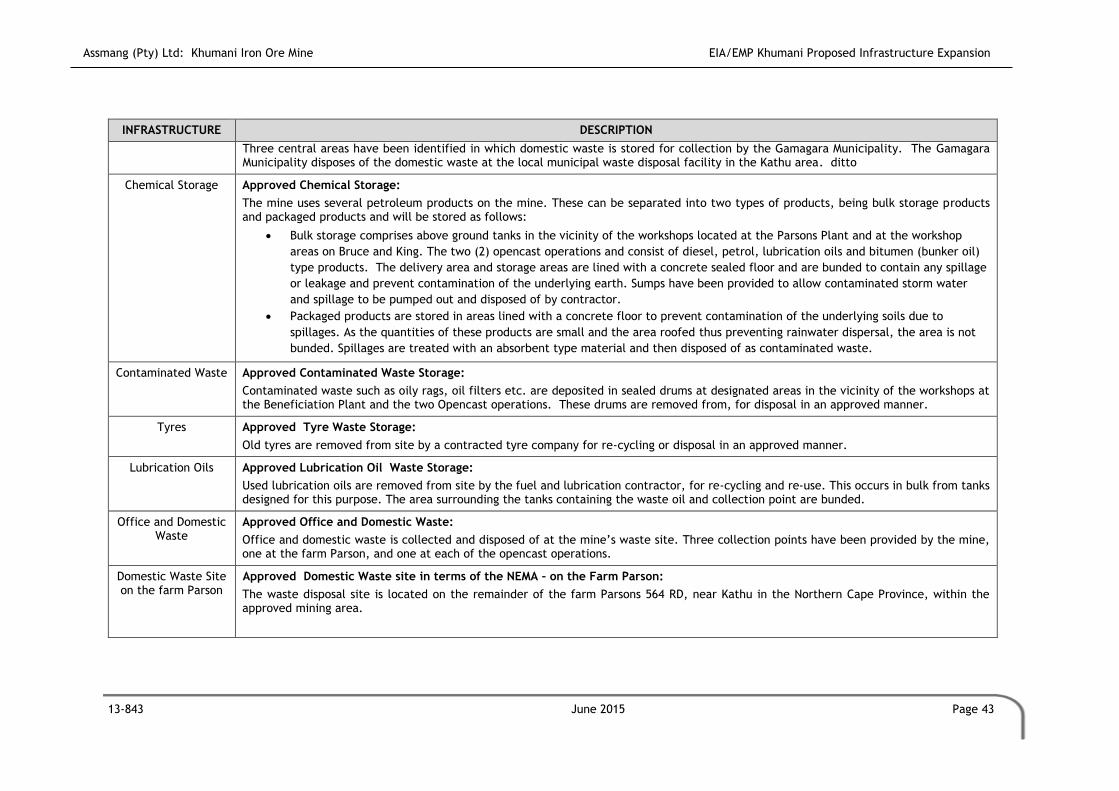
Assmang (Pty) Ltd: Khumani Iron Ore Mine EIA/EMP Khumani Proposed Infrastructure Expansion
13-843 June 2015 Page 43
INFRASTRUCTURE DESCRIPTION
Three central areas have been identified in which domestic waste is stored for collection by the Gamagara Municipality. The Gamagara Municipality disposes of the domestic waste at the local municipal waste disposal facility in the Kathu area. ditto
Chemical Storage Approved Chemical Storage:
The mine uses several petroleum products on the mine. These can be separated into two types of products, being bulk storage products and packaged products and will be stored as follows:
Bulk storage comprises above ground tanks in the vicinity of the workshops located at the Parsons Plant and at the workshop
areas on Bruce and King. The two (2) opencast operations and consist of diesel, petrol, lubrication oils and bitumen (bunker oil)
type products. The delivery area and storage areas are lined with a concrete sealed floor and are bunded to contain any spillage
or leakage and prevent contamination of the underlying earth. Sumps have been provided to allow contaminated storm water
and spillage to be pumped out and disposed of by contractor.
Packaged products are stored in areas lined with a concrete floor to prevent contamination of the underlying soils due to
spillages. As the quantities of these products are small and the area roofed thus preventing rainwater dispersal, the area is not
bunded. Spillages are treated with an absorbent type material and then disposed of as contaminated waste.
Contaminated Waste Approved Contaminated Waste Storage:
Contaminated waste such as oily rags, oil filters etc. are deposited in sealed drums at designated areas in the vicinity of the workshops at the Beneficiation Plant and the two Opencast operations. These drums are removed from, for disposal in an approved manner.
Tyres Approved Tyre Waste Storage:
Old tyres are removed from site by a contracted tyre company for re-cycling or disposal in an approved manner.
Lubrication Oils Approved Lubrication Oil Waste Storage:
Used lubrication oils are removed from site by the fuel and lubrication contractor, for re-cycling and re-use. This occurs in bulk from tanks designed for this purpose. The area surrounding the tanks containing the waste oil and collection point are bunded.
Office and Domestic Waste
Approved Office and Domestic Waste:
Office and domestic waste is collected and disposed of at the mine’s waste site. Three collection points have been provided by the mine, one at the farm Parson, and one at each of the opencast operations.
Domestic Waste Site on the farm Parson
Approved Domestic Waste site in terms of the NEMA – on the Farm Parson:
The waste disposal site is located on the remainder of the farm Parsons 564 RD, near Kathu in the Northern Cape Province, within the approved mining area.

Assmang (Pty) Ltd: Khumani Iron Ore Mine EIA/EMP Khumani Proposed Infrastructure Expansion
13-843 June 2015 Page 44
INFRASTRUCTURE DESCRIPTION
Uncontaminated rubble is collected and transported by trucks via the existing road network at the mine and is transported to the waste disposal site. The waste is collected on a weekly basis. Offloading and compaction takes about 5-10 minutes, which implies that the waste is exposed to the atmosphere within an enclosed building for only a very short period of time during normal operational conditions. ditto
Temporary Hazardous Waste Disposal Facility
Approved Temporary Hazardous Waste Disposal Facility in terms of the NEMA:
The facility consists of an area where all hazardous waste can temporarily be stored prior to removal and disposal at a licensed hazardous waste disposal site. The proposed temporary storage facility is located adjacent to the proposed general waste disposal site.
Topsoil Stockpiles
Topsoil Stockpiles Approved Topsoil Stockpiles:
Due to the shallow soil cover at Khumani, all topsoil and subsoil has been / will be stripped (minimum of 0.25m or until hard rock is reached) from the:
Opencast pits.
Overburden and low-grade ROM stockpiles.
Overburden dump.
Paste disposal facility.
Parsons plant.
Discard stockpile.
Export stockpile.
Haul roads.
Seven topsoil stockpiles have been created (Total area: 106.110ha, height: ranges from 1.5m to 5m volume: 4,378,000m3). An eighth area is reserved for topsoil north of the rapid load out facility on Parsons.
Stockpiling of topsoil
The height of the topsoil stockpiles range between 1.5m and 5m. All topsoil stockpiles higher than 1.5m will require erosion control measures (i.e. terraces).
Overburden and low-grade ROM Stockpiles
Overburden and Low-grade ROM
Stockpiles
Approved Overburden and Low-grade ROM Stockpiles:
Three overburden stockpiles (three types) have been established on the Khumani property:
The overburden and waste rock, with an iron content of less than 50 percent and high in impurities (i.e. Al2O3 and K2O) will be
stockpiled on overburden dumps situated at the Paste Disposal Facility.
The waste rock and overburden from the KM_NTH opencast pit will be stockpiled as material for the Paste Disposal Facility walls.

Assmang (Pty) Ltd: Khumani Iron Ore Mine EIA/EMP Khumani Proposed Infrastructure Expansion
13-843 June 2015 Page 45
INFRASTRUCTURE DESCRIPTION
Material with an approximated 50 percent iron content and high Al2O3 and K2O will be stockpiled on the overburden and low
grade ROM stockpiles situated at the King / Mokaning and Bruce opencast workings. These stockpiles will be utilized once the
mine reaches the end of life should it be proven economically feasible to process and sell the product. The following is
anticipated:
o Currently, it is planned that 1.3 percent (1.6 million tons) of the Bruce overburden and low-grade ROM stockpiles will be
reworked. The remainder of the stockpile will remain as a rehabilitated overburden dump upon decommissioning.
o Currently, it is planned that 4.9 percent (19.4 million tons) of the King / Mokaning overburden and low-grade ROM
stockpiles will be reworked. The remainder of the stockpile will remain as a rehabilitated overburden dump upon
decommissioning.
Paste Disposal Facility
Paste Disposal Facility
Approved Paste Disposal Facility:
All residue derived from the Parsons Plant is thickened and disposed of at the approved paste disposal facility.
Khumani has developed a paste disposal facility to ensure that no significant environmental impacts occur.
The area of the paste disposal facility is 168.4854ha.
Water derived during the thickening process is returned to the Parsons Plant to be reused.
The paste disposal facility has been constructed by means of sound engineering and environmental principles.
Borrow Pits
Borrow Pits Approved Borrow Pits:
There are large volumes of borrow material available for use as bulk and engineered fill materials as well as road and sub ballast layer works. The hauling distances are expected to vary between 2km and 6km depending on the location of the borrow pit and the place where the material is needed.
Materials were tested to determine the suitability for use: road pavement layers, upper and lower sub-ballast layers, gravel wearing coarse, semi permeable material for the seepage cut-off and construction materials for paste disposal facility starter walls and storm water retention dams, and materials for engineered fills.
The engineering properties of the materials were evaluated in terms of the Technical Recommendations for Highways: Standards for Road Construction Materials 1980, (TRH14).
Mineral Processing
Mineral Processing The iron ore processing facility has been designed to process run-of-mine ores from the Bruce and Kingopencast pits. The first phase (phase 1) allows for 8 million dry metric tons product per annum, with a second phase (phase 2), ramping up to an approved 16 million dry metric tons product per annum.
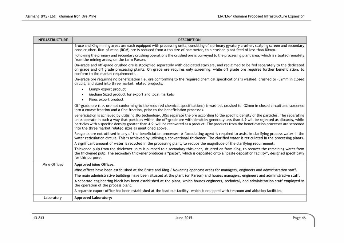
Assmang (Pty) Ltd: Khumani Iron Ore Mine EIA/EMP Khumani Proposed Infrastructure Expansion
13-843 June 2015 Page 46
INFRASTRUCTURE DESCRIPTION
Bruce and King mining areas are each equipped with processing units, consisting of a primary gyratory crusher, scalping screen and secondary cone crusher. Run-of-mine (ROM) ore is reduced from a top size of one meter, to a crushed plant feed of less than 80mm.
Following the primary and secondary crushing operations the crushed ore is conveyed to the processing plant area, which is situated remotely from the mining areas, on the farm Parson.
On-grade and off-grade crushed ore is stockpiled separately with dedicated stackers, and reclaimed to be fed separately to the dedicated on grade and off grade processing plants. On grade ore requires only screening, while off grade ore requires further beneficiation, to conform to the market requirements.
On-grade ore requiring no beneficiation i.e. ore conforming to the required chemical specifications is washed, crushed to -32mm in closed circuit, and sized into three market related products:
Lumpy export product
Medium Sized product for export and local markets
Fines export product
Off-grade ore (i.e. ore not conforming to the required chemical specifications) is washed, crushed to -32mm in closed circuit and screened into a coarse fraction and a fine fraction, prior to the beneficiation processes.
Beneficiation is achieved by utilising JIG technology. JIGs separate the ore according to the specific density of the particles. The separating units operate in such a way that particles within the off-grade ore with densities generally less than 4.9 will be rejected as discards, while particles with a specific density greater than 4.9, will be recovered as a product. The products from the beneficiation processes are screened into the three market related sizes as mentioned above.
Reagents are not utilised in any of the beneficiation processes. A flocculating agent is required to assist in clarifying process water in the water reticulation circuit. This is achieved by utilising a conventional thickener. The clarified water is reticulated in the processing plants.
A significant amount of water is recycled in the processing plant, to reduce the magnitude of the clarifying requirement.
Thickened pulp from the thickener units is pumped to a secondary thickener, situated on farm King, to recover the remaining water from the thickened pulp. The secondary thickener produces a “paste”, which is deposited onto a “paste deposition facility”, designed specifically for this purpose.
Mine Offices Approved Mine Offices:
Mine offices have been established at the Bruce and King / Mokaning opencast areas for managers, engineers and administration staff.
The main administrative buildings have been situated at the plant (on Parson) and houses managers, engineers and administrative staff.
A separate engineering block has been established at the plant, which houses engineers, technical, and administration staff employed in the operation of the process plant.
A separate export office has been established at the load out facility, which is equipped with tearoom and ablution facilities.
Laboratory Approved Laboratory:

Assmang (Pty) Ltd: Khumani Iron Ore Mine EIA/EMP Khumani Proposed Infrastructure Expansion
13-843 June 2015 Page 47
INFRASTRUCTURE DESCRIPTION
A laboratory has been established at the plant, which is utilized for the testing and certification of the product being processed and exported from the mine.
Change House Approved Change House:
Staff facilities for washing, ablutions and the safe keeping of personal belongings have been established at the Bruce and King / Mokaning opencast areas as well as at the Plant. (
A laundry facility has been established at the King Mine to provide a washing service to Bruce, King and Parson for the cleaning of overalls and other clothing issued to staff.
Sewage plants have been established at the opencast and plant areas, to treat the sewage within the mine area.
Clinic / Training Centre
Approved Clinic / Training Centre:
A medical centre and a training centre has been established at the Parsons Plant.
Security Building Approved Security Building:
Security buildings have been established at the Bruce and King opencast area, as well as at the Plant area.
Plant Control Centre Approved Plant Control Centre:
A plant control centre has been established on the farm Parson for operators to monitor and control the process plant. The centre is equipped with offices, electronics, workshop, tearoom and ablutions for staff associated with the centre.
A Control Centre for the operation of the load out and discard areas has been established on the farm Parson.
Workshops / Stores / Substations
Approved Workshop, Stores and Substations:
The following infrastructure has been established:
Garage for the servicing and repair of mine vehicles at the Bruce and King / Mokaning opencast areas;
Stores on the Bruce and King / Mokaning opencast areas, as well as the plant, for the daily requirements of the mine (i.e.
spares).
Workshops on the Bruce and King / Mokaning opencast areas, as well as the plant, for the maintenance and repair of equipment
used on the mine (i.e. crusher screens and conveyors etc.).
Substations to house electrical equipment have been established at the Plant and the opencast operations.
Sumps equipped with a submersible pumps and oils traps have established at the workshops where lubricants and chemicals are
stored.
Vehicle cleaning facilities, linked to oil/water separator have been established.
Mess Facility Approved Mess Facility:
A mess area for train drivers and Transnet staff associated with the rapid load out facility has been provided at the export facility.

Assmang (Pty) Ltd: Khumani Iron Ore Mine EIA/EMP Khumani Proposed Infrastructure Expansion
13-843 June 2015 Page 48
INFRASTRUCTURE DESCRIPTION
Weighbridge Approved Weighbridge:
A weighbridge has been established at the Plant area for means of verification regarding weight of loaded and unloaded vehicles etc.
Explosives Magazine Approved Explosives Magazine:
The explosives magazine has been built to Sasol Nitro design with the finished structures having been approved by Sasol Nitro.
An exclusion zone of 800m radius within which there will be no buildings, other structures or public access is maintained.
Housing and Recreation
Housing and Recreation
Approved Housing and Recreation:
Assmang is not directly involved in the provision of housing. Housing is included as an element within the remuneration package to allow the employees to provide their own housing. By undertaking this view, Assmang envisages their employees becoming self-sustaining.
No permanent housing has been erected for employees on the site. The existing infrastructure and residential areas in and around Kathu, Postmasburg and Olifantshoek are utilised.
Transport
Transportation of Ore on site
Approved Transportation Of Ore on Site:
Haul trucks transport the blasted product to the crushers. Following the primary and secondary crushing operations, the crushed ore is conveyed to and is stacked in the ROM Yard at Parsons. Re-claimers are used to load the ore onto belt conveyors to transport the ore to the processing plant on the farm Parson.
From the plant the final product is transported via conveyor to the product stockpiles, from where it is loaded into the rapid load out facilities.
Transport of Ore off-site
Approved Transportation of Ore Off-site:
The final product is transported from the rapid loud-out facilities, via the OREX railline to Saldanha (for export) and the Port Elizabeth / Hotazel line (for local markets).
Water Pollution and Storm Water Management Facilities
Water Pollution and Storm Water Management
Facilities - Legalities
Storm water management infrastructure at Khumani does and will comply with the requirements of Government Notice Number 704, published in terms of the National Water Act, 1998 (Act 26 of 1998).
Government Notice No. 704 requires the following:
All clean water systems must be designed and operated in such a manner that they are at all times capable of handling the 1:50
year flood event on top of their mean operation level without spilling;
Any water arising from an area, which causes, has caused or is likely to cause pollution of a water resource, including polluted
storm water, must be contained within a dirty water system. In order to reduce the volume of polluted water, contaminated

Assmang (Pty) Ltd: Khumani Iron Ore Mine EIA/EMP Khumani Proposed Infrastructure Expansion
13-843 June 2015 Page 49
INFRASTRUCTURE DESCRIPTION
areas should be minimised. While clean water should be diverted to natural watercourses, polluted water should be re-used
wherever possible, thereby reducing the use of clean water;
Design, construct, maintain and operate any dam or tailings dam (in the Khumani situation, a paste disposal facility) that forms
part of a dirty water system to have a minimum freeboard of 0.8 m above full supply level.
The following criteria have therefore been assumed for design purposes at Khumani:
1:50 year, 24hr flood event.
Average precipitation in the annual wettest month.
Average operations water pumped to the Paste Disposal Facility.
0.8 m freeboard (incl. freeboard for wave action) on the Paste Disposal Facility.
Sewage Treatment Plants
Approved Sewage Treatment Plants:
During construction, chemical toilets and mobile ablution blocks will be provided for the construction workers. These toilets will be cleaned as and when required. The waste material will be taken by a contractor to a suitable waste water treatment facility.
During the operational phase the three main areas of operation, i.e.the Parsons Plant, Bruce opencast area and the King / Mokaning? opencast areas, will be supplied with sewage treatment plants designed to treat 120 to 140l of sewage per person per day. The rapid load-out facilities and the explosives magazine are equipped with smaller treatment facilities.
At each site, underground piping carries the sewage to a central collection tank capable of buffering the loading from the sewage plant. This tank also acts as a combined settling tank and aerobatic digester.
A secondary aerobic process comprising of a Bio Filter RBC (rotating biological concentrator), fixed film reactor unit, followed by a humus settlement tank and disinfection tank completes the process.
The discharges, following chlorination, from the sewage plants are:
Parsons Plant (2,33m3 / hr) – to the 5000m3 process water dam, forming part of the water employed in the plant process.
Rapid Load-Out Facilities (0.05m3 / hr) – to the storm water dam where the returning water is pumped to the process water dam
as described above.
Explosives magazine (0.02m3 / hr) – to the storm water dam where the water is allowed to evaporate.
Bruce opencast operations (1.33m3 / hr) – to the 300m3 mine water tank where the water will be used for mining activities.
King / Mokaning? opencast operation (1.2.1m3 / hr) – to the 300m3 mine water tank where the water will be used for mining
activities.
Once a day, the filter elements are washed using clean water and once a week the units moving parts are inspected and greased.
The settled sludge is emptied once a year or as necessary using an outside contractor. It is part of the contract for the contractor to safely dispose of the solid waste off-site.

Assmang (Pty) Ltd: Khumani Iron Ore Mine EIA/EMP Khumani Proposed Infrastructure Expansion
13-843 June 2015 Page 50
INFRASTRUCTURE DESCRIPTION
Additional Sewerage Works
Approved Additional Sewerage Works:
The expansion of capacity and operations on King required an increase in the number of staff on site. This growth in the workforce created the need for additional sewerage capacity. The peak workforce on King was 1800 during construction. This number has dropped to 600 for operations. The sewerage was designed to handle the peak conditions at 1800 people.
Parsons Plant Area
and Surroundings - Water Pollution and
Storm Water Management
Facilities
Approved Water Pollution and Storm Water Management Facilities at Parsons Plant Area and Surroundings
Surrounding Area:
All the storm water runoff from the upstream catchment of the plant area, ROM stockpile area and product stockpile area is diverted around the affected areas by means of berms and channels and has been sized for a 1:50 year flood event.
The surface runoff from the areas is collected in pollution control dams. All the pollution control dams are sized to contain the 1:50 year storm event, including a 0.8m freeboard. The pollution control dam capacities are:
Process plant pollution control dam: 34 000 m3
Product stockpile pollution control dam: 4 000 m3
Inside Parsons Plant:
All plant sections, which process ore or form part of the processing facility have been designed and laid out within proper sump areas, as contingency measures should spills occur. These have been constructed from concrete and are equipped with suitable vertical spindle centrifugal pumps, to allow for controlled evacuation of potential spillages.
The design of the volumetric proportions of the bunds allow accommodation of the maximum volume of the tank or container, which might drain or overflow in that particular catchment.
Sumps have been allowed for in the area of water treatment and clarification, and are similarly equipped with suitable sump pumps.
Potential overflows from the thickener and process water tank are channelled to the dedicated storm water dam.
Opencast Area - Water Pollution and
Storm Water Management
Facilities
Approved Water Pollution and Storm Water Management Facilities at Opencast Area
Diversion systems have been/will be constructed upslope of the King and Bruce opencast areas in order to divert clean water away from the contaminated areas. Clean runoff from upstream of the opencast areas is/will be diverted around the affected area by means of berms, sized so as to prevent spilling from a 1:50 year storm event. The diversion berms have been and will be constructed with overburden material from the mining area.
Groundwater seepage and direct rainfall water onto the opencast areas is pumped out by means of portable pumps. The water is used for dust suppression on the mine haul roads and operation water in the process plant.
Water within the opencast pit areas is contained within the pit perimeter in low-lying areas. The water is pumped to various areas within the pit perimeter should it be required by the mining activities.

Assmang (Pty) Ltd: Khumani Iron Ore Mine EIA/EMP Khumani Proposed Infrastructure Expansion
13-843 June 2015 Page 51
INFRASTRUCTURE DESCRIPTION
Primary and Secondary Crushers - Water Pollution and
Storm Water Management
Facilities
Approved Water Pollution and Storm Water Management Facilities at Primary and Secondary Crushers
All the storm water runoff from the upstream catchment of the King crusher and Bruce crusher, is diverted around the areas by means of berms and channels which are sized for a 1:50 year storm event to designated pollution control dams.
The sumps within the pollution control dams are lined to minimise seepage. All the pollution control dams are sized to contain the 1:50 year storm event including 0.8m freeboard. The pollution control dam capacities are:
King crusher pollution control dam: 1 500 m3
Bruce crusher pollution control dam: 1 700 m3
Water collected is used for dust suppression at the primary and secondary crushers at the Bruce and King / Mokaning opencast operations.
Dry materials from the paddock is then removed to the Overburden and Low-grade ROM Stockpiles. Sumps have been constructed at the crushers to contain the water from the dust suppression system. The sumps have been provided with silt traps and a submersible pump. Sludge and mud are removed and disposed of on the nearest overburden dump and/or low-grade ROM stockpile.
Stockpiles and dumps - Water
Pollution and Storm Water Management
Facilities
Approved Water Pollution and Storm Water Management Facilities at Stockpiles and Dumps
Diversion systems have been constructed upslope of the stockpiles and / or dump areas in order to divert clean water away from the contaminated areas. Clean runoff from upstream of the opencast areas is diverted around the affected area by means of berms, sized for a 1:50 year storm event. The diversion berms have been constructed with overburden material from the mining area.
Paste disposal facility - Water
Pollution and Storm Water Management
Facilities
Approved Water Pollution and Storm Water Management Facilities at Paste Disposal Facility
Under Drainage and Seepage Control System:
An under drainage and seepage control system with downstream paddocks has been designed and implemented to assist in lowering the phreatic surface in the starter wall, to maximize water return and to limit the release of potentially contaminated water into the downstream environment.
A layer of sand underlies the paste disposal facility. Supernatant water collects at the interface between the residue surface and the natural ground. In this area seepage into the underlying sand is likely to occur, as the sand will not be sufficiently blinded with residue. This seepage water will be confined to the sand layer and will flow down gradient towards the downstream environment. To capture and control this flow a combined under drainage and cut-off system is required.
Contaminated Runoff Control:
Any storm water runoff from the downstream embankment slopes will contain some eroded residue solids. In order to prevent the eroded residue solids from discharging into the surrounding environment, catchment paddocks are provided downstream of the embankment toe. The paddocks are sized to contain the peak runoff from the outer embankment expected from the 1:50 year recurrence interval storm and allow for sedimentation of any eroded solids and evaporation of storm runoff.
The catchment paddocks require periodic cleaning of deposited sediment. This should form part of normal operation and maintenance.

Assmang (Pty) Ltd: Khumani Iron Ore Mine EIA/EMP Khumani Proposed Infrastructure Expansion
13-843 June 2015 Page 52
INFRASTRUCTURE DESCRIPTION
Due to the site being positioned in a valley, storm water diversion forms a significant consideration in terms of the overall design.
The external catchment draining towards the paste disposal facility has an area of 171ha. The catchment is largely positioned to the east of the site. In order to divert the flows from each portion of the catchment, cut-off trenches and diversion bunds are required.
The sand is highly permeable and therefore any water entering the sand will drain rapidly. The deposition method results in the blinding of the surface of this sand layer with the residue material. This serves to reduce seepage from the basin once it has been covered by residue.
Containment:
A containment dam has been constructed to contain all precipitation. Supernatant water (above the paste in the paste facility) is pumped into the return water system when required, and is returned to the plant for reuse.
The slurry delivery system to the paste disposal facility has been designed to allow containment of potential spills at any location along the route for the full volume of the pipeline contents. A pipeline break will therefore result in the controlled spill of slurry into a spill collection ditch that discharges into an emergency paddock, where the slurry will be contained for subsequent removal, to prevent release into the environment.
Linear infrastructure - Water Pollution and Storm Water
Management Facilities
Approved Storm Water Management Facilities for Linear Infrastructure
Haul roads are constructed to allow storm water to run-over low points.
Storm water is allowed to run off the access roads to low points.
Culverts have been constructed where conveyors and roads cross the 1:100 year flood lines. The culverts have been constructed
such as to allow through flow of 1:100 year floods and debris.
The following have reference to the Rail Siding:
o Culverts are located at the lowest points along the long section.
o Long sections are used to determine the acceptable sizes of culverts so that the depth of the culvert does not exceed
the depth available under the railway line.
Workshops - Water Pollution and Storm Water Management
Facilities
Approved Water Pollution and Storm Water Management Facilities for Workshops
Maintenance workshops have been provided as part of the infrastructure in the vicinity of the Parsons Plant, and Bruce and King / Mokaning opencast operations. Oil / water separators have been installed on each of the water discharges of the three workshops.
The separators have three compartments. The first compartment collects sand, grit and stones and is emptied and cleaned once a year or when necessary. The material is disposed of with the waste being deposited in the oil contaminated waste skip for disposal.
Retained oils and grease in the second compartment are emptied once a year and discharged off site in line with the Mines contract for the disposal of such material. Water from the separator is collected in the third compartment before being pumped to the process water dam at Parson and the mine water tank at the Bruce and King / Mokaning operations, depending on where the workshop is located.

Assmang (Pty) Ltd: Khumani Iron Ore Mine EIA/EMP Khumani Proposed Infrastructure Expansion
13-843 June 2015 Page 53
INFRASTRUCTURE DESCRIPTION
Laboratory Acid Treatment Plant
Approved Water Pollution and Storm Water Management Facilities for Laboratory Acid Treatment Plant
Weak diluted acids are used in the laboratory at the Parsons Plant. These solutions are discharged from sinks in the laboratory. Prior to the discharge of these solutions into the sewage system, they are treated in an acid neutralising treatment plant to a neutral pH.
Potable Water Supply
Potable Water Supply
Approved Potable Water Supply
With the start of the Kumba iron ore mining operation, the Vaal-Gamagara water scheme was built with one of the main purposes being to supply water from the Vaal River to the Sishen mining operations. The magnitude of the dewatering requirements at Kumba Iron Ore MIne necessary to create dry mining conditions was not foreseen at the time of the construction of the Vaal-Gamagara pipeline. In recent years, the dewatering programs at both Kumba operations and further south at Assmang’s Beeshoek Mine near Postmasburg have started pumping more and more water into the pipeline.
Although Kumba currently discharges excess water into the pipeline, water demand from the pipeline is also on the increase. Population numbers in the Kathu area as well as the manganese mines that rely on water from the pipeline are on the increase. More importantly, however, is the fact that water pumped from the Vaal River is very expensive and projects are underway to substitute as far as possible the water from the Vaal River with groundwater from the Kumba and Beeshoek mines.
Operational Phase Water is contracted to be supplied at a rate of 800m3/hour from an abstraction point on the existing Sedibeng water pipeline to a point on the Farm Parsons.
Coordinates of the Sedibeng Pipeline Abstraction Point on the Farm Parsons:
Reference X Coordinate
South Y-Coordinate
North
Abstraction Point from the Sedibeng Pipeline
27º 51’ 48.2” 22º 58’ 14.5”
Water supply is potable water, and is used to top up the 10 000m3 make-up Gamagara Tank, and for certain other uses. Water in the plant system is recycled where possible to minimise the potable water top-up demand.
Khumani plans to utilize 4.5 million m3 per year.
A 10 000m3 and two (2) other potable water dams have been established at the Parsons Plant in which the water from the Sedibeng Pipeline is stored. From the potable water dam, the water is pumped to potable water tanks (150m3), which have been established at the plant and the opencast areas to provide water for domestic, workshop and wash bay purposes.
Dirty water from the pits, sewage facilities, workshops and wash bays is re-used in the plant process and/or mining activities.
Assmang’s objective is to reduce the volume of water obtained by maintaining the re-use of water.
Disturbance of Water Courses

Assmang (Pty) Ltd: Khumani Iron Ore Mine EIA/EMP Khumani Proposed Infrastructure Expansion
13-843 June 2015 Page 54
INFRASTRUCTURE DESCRIPTION
Disturbance of Water Courses
Two (2) river diversions have been approved for Khumani:
Drainage channel diversion associated with the King/Mokaning Low Grade Stockpile; and
Diversion of the non-perennial drainage channel around the King West opencast mining area.

Assmang (Pty) Ltd: Khumani Iron Ore Mine EIA/EMP Khumani Proposed Infrastructure Expansion
13-843 September 2015 Page 55
2.2 Proposed Infrastructure and Upgrades
As part of the original Khumani mining operations there was always the philosophy that low-
grade material will be processed in the future. Process enhancements now allow for low
grade material to be beneficiated.
To give effect to the reclaiming philosophy, a new beneficiation plant will be required to
process material previously considered as discard and now designated low grade. The plant
designed to beneficiate this material will be known as the WHIMS 2 Plant. The
implementation of this plant will result in a need for various additional equipment such as
reclaiming infrastructure and conveyors. The implementation of this plant, will further
ensure that the already approved Off Grade 2 plant now can produce two streams of product,
i.e. product directly considered as final product for earmarked markets, and product
considered as low-grade with the potential of be reprocessed to fulfil the requirements for
earmarked markets.
The sections below provide more details on the infrastructure required. The sections are
broken down into various sub-sections to represent the overall reclaiming strategy and the
associated activities of the mine. Infrastructure is labled for ease of reference on the map
shown in Figure 2.1 and Appendix A.
2.2.1 WHIMS 2 Plant (C)
The first WHIMS Plant was approved, constructed and completed on Khumani in 2013. As part
of the optimisation of the current processing activities, an additional WHIMS Plant (C) is
proposed as part of the infrastructure expansion project (Figure 2.1). The new facility will
be located on the western side of the Khumani access road (R523) and north of the Parsons
Low Grade Stockpile (A) (previously known as the Parsons Discard Dump with the Parsons Low
Grade Stockpile (A) forming part of this application). The facility will comprise an area of
approximately 23ha.
Referring to Figure 2.1; the New Parsons Low Grade Conveyor (F) will convey low grade
material from the existing Parsons Plant to the Low Grade Stockpile (A) and to the Tertiary
By-pass Stockpile (E). The Reclaimimg Product Conveyor (G) will convey product from the
Low Grade Reclaim Facility (B) to the new WHIMS 2 Plant (C). The Low Grade Conveyors (D)
will convey product from the already approved Off Grade 2 facility.

Assmang (Pty) Ltd: Khumani Iron Ore Mine EIA/EMP Khumani Proposed Infrastructure Expansion
13-843 September 2015 Page 56
(Please refer to Appendix A for the A3 figure.)
Figure 2.1: Proposed new infrastructure on the farm Parsons
2.2.2 Parsons Low Grade Stockpile Expansion (A)
The existing and approved discard stockpile now referred to as the Low Grade Stockpile on
the farm Parsons, will be expanded to accommodate the low grade product from the plants
which will be reclaimed in the future. The facility will be expanded by approximately 245ha,
as depicted by (A) in Figure 1 resulting in an overall footprint of 356.3ha.
Material, reclaimed from the (expanded) Low Grade Stockpile (A), will be processed at the
WHIMS 2 Plant (C) as part of the reclamation process.
2.2.3 Low Grade Reclaim Facility (B)
The Low Grade Reclaim Facility (B) will be located on the northern side of the Parsons Low
Grade Stockpile (A) (Figure 2.1). The facility will comprise an area of approximately 13ha.
The facility will comprise reclaiming infrastructure which may include a conveyor and loading
equipment. From the Low Grade Reclaim Facility (B), the material will be conveyed to WHIMS
2 Plant (C), and after WHIMS 2 Plant will be conveyed either to the Parsons product stockpile
yard or will be returned via the New Parsons Low Grade Conveyor (F) Low Grade Stockpile
(A) for further stockpiling and possible processing.
Assmang (Pty) Ltd: Khumani Iron Ore Mine EIA/EMP Khumani Proposed Infrastructure Expansion
13-843 September 2015 Page 57
2.2.4 Tertiary By-pass Stockpile (E)
Referring to Figure Figure 2.1, proposed infrastructure will allow feed to the Low Grade
Stockpile (A) and the Tertiary By-pass Stockpile (E) from either the existing Parsons Plant
(New Parsons Low Grade Conveyor (F)) or the proposed Off Grade 2 Plant (shown in yellow to
the right of the R523 and south-east of the existing Parsons Plant). The Off-Grade 2 Plant
was approved in October 2013 by NCDENC and the DMR. The Off-Grade 2 Plant is part of the
processing optimisation strategy, which aims at ensuring that Khumani reaches its optimal
approved production target of 16 million tons per annum.
Low grade material from the existing Parsons Plant and the Off-Grade 2 Plant will be
transported via conveyors to a transfer bin, just west of the Dingleton Road (R523). From
the transfer bin, the material will be transported via the Low Grade Conveyors (D) to either
the Parsons Low Grade Stockpile (A) or the Tertiary By-pass Stockpile (E).
The Tertiary By-pass Stockpile (E) will be utilised during times when access to the Low Grade
Stockpile (A) is not available (for example during maintenance periods, expansion activities,
or logistical constraints). The facility will be located on the western side of the Khumani
access road (R523) and just east of the Low Grade Stockpile (A) (previously known as the
Parsons Discard Dump). The facility will comprise an area of approximately 30ha.
All conveyors will be associated with service roads of less than 8m in width.
2.3 Additional Low Grade Stockpiles
2.3.1 King ROM Stockpile (J)
The King ROM (Run of Mine) Stockpile (J) (refer to Figure 2.2), will be located to the south
west of the existing King Mine crushing facility on the farm King and will comprise an area of
approximately 48ha. The material deposited on the King ROM Stockpile (J) is ROM material
that is to be stockpiled when down stream equipment is unable to accept material due to
maintenance, breakdown repair and other constraints. In time, the ROM material that has
been stockpiled will be reclaimed and processed through the King Mine crushing facilities and
conveyed to the Parsons Plnat for further beneficiation.

Assmang (Pty) Ltd: Khumani Iron Ore Mine EIA/EMP Khumani Proposed Infrastructure Expansion
13-843 September 2015 Page 58
(Please refer to Appendix A for the A3 figure.)
Figure 2.2: Proposed new stockpiles on the farm King
2.3.2 King/Mokaning Low Grade ROM Stockpile Expansion (H)
Referring to Figure 2.2, the existing King/Mokaning Low Grade ROM Stockpile on farm King
will be expanded to accommodate material from the King Mine opencast pit. This expansion
is indicated as (H) on the map. During the application phase it was initially indicated as a
stand-alone stockpile. To optimize stockpiling and design requirements, the facility will be
integrated with the existing King/Mokaning Low Grade Stockpile.
The King/Mokaning Low Grade Stockpile is located east of the decommissioned Port Elizabeth
/ Hotazel railway line and the south of the King opencast pit. The stockpile will be an
extended to the west by 58ha.
2.3.3 Bruce Low Grade ROM Stockpile and Overburden Dump Expansion (K)
Referring to Figure 2.3, the existing Bruce Low Grade ROM Stockpile and Overburden Dump
on farm Bruce will be expanded. Based on the current mining schedule the mine has
determined that the areas for the Bruce Low Grade ROM and Overburden Dump will not be
sufficient in the long term and will require expansion.

Assmang (Pty) Ltd: Khumani Iron Ore Mine EIA/EMP Khumani Proposed Infrastructure Expansion
13-843 September 2015 Page 59
The Bruce Low Grade ROM Stockpile and Overburden Dump area is proposed to be extended
by 75ha to increase the capacity of the stockpiling area. The area originally approved for the
Bruce Low Grade ROM Stockpile and Overburden Dump was 268ha thus increasing the area to
343ha in total.
(Please refer to Appendix A for the A3 figure.)
Figure 2.3: Proposed stockpile expansion on the farm Bruce
2.4 Ancillary Infrastructure
Additional infrastructure will include:
Upgrading and expansion of storm water facilities (separating clean and dirty water);
High Pressure Grinding Roll (HPGR) Crushing Facility to be located within the
approved Parsons Plant area;
Haul roads; and
22kV power lines to accommodate the WHIMS 2 Plant and the reclamation activities.
2.5 Bulk Supporting Services
The proposed activities will tie into all the existing approved facilities and services on
Khumani which will include:
Potable water from the Sedibeng Water Scheme;

Assmang (Pty) Ltd: Khumani Iron Ore Mine EIA/EMP Khumani Proposed Infrastructure Expansion
13-843 September 2015 Page 60
Electricity from the BKM substation located on the farm Parsons;
Use of existing sewerage facilities;
Use of existing and approved waste disposal facilities (domestic and temporary
hazardous site) on Parsons and waste management protocol; and
No expansion required on the existing Paste Disposal Facility.
2.6 Mining Activities
Please note: All mining activities on Khumani have already been approved by the
previous EMPs submitted to the DMR and NCDENC. The following is a summary of the
current mining activities on Khumani as approved. The mining work programme as
submitted for mining activities is still applicabnle as the change in processing activities
does not change the production output from mining at Khumani.
Khumani mines high-grade hematite iron ore. Iron ore in the Sishen/Postmasburg area is
preserved within a sequence of Proterozoic sediments of the Transvaal Supergroup and
Olifantshoek Group. The ore deposits occur within the Wolhaarkop Breccia, which overlies
the dolomites of the Cambellrand Formation and is overlain by the Sishen shale.
The northern iron ore deposits on the farms Bruce, King and Mokaning are relatively shallow
lending themselves to economical opencast mining.The ore and associated overburden are
removed by truck and shovel operations.
As an integral part of the mining operations, backfilling is employed to minimise both the
final voids left open at the end of mining and the size of the waste dumps.
The opencast area is subdivided into four areas, namely Bruce A, B, C and King/Mokaning.
These areas are associated with 19 individual opencast pits.
Iron ore is transported via conveyors for washing and screening in the beneficiation plant.
Thereafter, it is transported via conveyor to the rapid load out siding and loaded to be railed
to Saldanha for export. The local railway siding will allow for transport of iron ore to Port
Elizabeth for the local market.
2.7 Proposed Project Planning and Associated Activities

Assmang (Pty) Ltd: Khumani Iron Ore Mine EIA/EMP Khumani Proposed Infrastructure Expansion
13-843 September 2015 Page 61
2.7.1 Pre-Construction Phase
The pre-construction phase has been included as a project phase to afford the applicant
sufficient time to address all the environmental authorisations required for the proposed
operation (i.e. in terms of the MPRDA, NEMA and NWA), as well as to address other regulatory
requirements. In addition the development of various management plans, action plans and
identification of potential services providers will also be undertaken during this phase.
The Mine commits to obtain all necessary environmental authorisations from the relevant
government departments, before undertaking any construction activities.
No impact assessment is undertaken for the pre-construction phase as the activities assessed
are all process related.
2.7.2 Construction Phase
The following activities may result in impact on the bio-physical and socio-cultural
environment:
Site clearance:
o Stripping of vegetation for infrastructure development;
o Stripping of topsoil and subsoil as the construction activities start on site;
Construction activities:
o Construction of the WHIMS2 Plant;
o Enlargement of the Low Grade Stockpile on Parsons;
o Construction of Low Grade Reclaim Facility on Parsons;
o Constuction of Tertiary By-pass Stockpile on Parsons;
o Construction of King ROM Stockpile on King;
o Expansion of the the King/Mokaning Low Grade ROM Stockpile;
o Expansion of the the Bruce Low Grade ROM Stockpile and Overburden Dump;
o Construction and expansion of conveyor belts; and
o Upgrade of the existing stormwater management structures.
Decommissioning and Closure activites:
o Stockpile shaping and stabilising for closure;
o Removal of Plant and associated infrastructure; and
o Landscaping of footprint area.
The following impacts may arise due to the above mentioned activities:

Assmang (Pty) Ltd: Khumani Iron Ore Mine EIA/EMP Khumani Proposed Infrastructure Expansion
13-843 September 2015 Page 62
Loss of vegetation, which may included senstitive strata, such as the Kameeldoring
tree;
Loss of topsoil;
Impact on the water system with an increase in runoff and associated siltation
potential;
Loss of sensitive aquatic systems, such as the pans present on Parsons;
Possible compaction of soils by the establishment of topsoil stockpiles and berms;
and
Dust dispersion from infrastructure construction activities.
An impact assessment (Section 7) has been undertaken for the life of the project as the
activities specified may trigger impacts requiring mitigation and management measures to
be implemented. It should however be noted, that the management measures included are
based on the management measures recommended and approved as part of prior EMPs and
conditions stipulated in approved Environmental Permits and Licenses.
2.7.3 Operational Phase
The Operational Phase of the project will begin shortly after the Construction Phase due to
the current mining operations taking place and the need for the stockpile areas. The
following activities are envisaged during the operational phase:
Stockpiling of overburden;
Stockpiling of low grade material
Stockpiling of ROM;
Dust suppression;
Processing of Low grade material; and
Final product handling and transportation.
During the operational phase, the following activities could impact on the bio-physical
environment and the cultural/social setting:
Impact on surface- and groundwater system due to the operational activities;
Dust dispersion from workings and haul roads;
Dust dispersion from ROM, low grade and product stockpiles;
Clean and dirty water control and maintenance; and
Operation of the plant.

Assmang (Pty) Ltd: Khumani Iron Ore Mine EIA/EMP Khumani Proposed Infrastructure Expansion
13-843 September 2015 Page 63
An impact assessment (Section 7) has been undertaken for the operational phase as the
activities specified may trigger impacts requiring mitigation and management measures to
be implemented.
2.7.4 Decommissioning and Closure Phase
After the Operational Phase has been finalised, Khumani will commence with the
Decommissioning and Closure Phase of their operation in line with their approved
environmental authorisations. The following activities are envisaged during the
decommissioning and closure phase:
Recovery of all saleable infrastructure;
Demolition of all buildings and structures, unless buildings and/or infrastructure can
remain as a social or economic contribution to the area;
Ripping of all compacted areas, which will be followed with amelioration and
vegetation;
Shaping of all remaining piles and slopes to blend in with the surrounding
environment;
Amelioration and vegetation of all disturbed areas;
Maintenance of all re-vegetated areas up until such areas initiate succession and
create a sustainable cover;
Monitoring of key environmental variables (i.e. air quality, soil, flora, groundwater
and surface water) in order to demonstrate stability of rehabilitated areas;
Weed management after closure, limited to surface areas disturbed by mining
activities/operations; and
Monitoring for a specific period after closure or up until such time that all areas
create a sustainable cover and ecosystem (in accordance with legislative
requirements).
An impact assessment (Section 7) has been undertaken for the decommisisiong and closure
phase as the activities specified may trigger impacts requiring mitigation and management
measures to be implemented.

Assmang (Pty) Ltd: Khumani Iron Ore Mine EIA/EMP Khumani Proposed Infrastructure Expansion
13-843 September 2015 Page 64
3 PROJECT ALTERNATIVES
This section of the report relates to Section 31 (2) of the GNR543 published in Government
Gazette No.33306 of 18 June 2010, under Section 24(5) of the NEMA.
Regulation 31 (2)
2 f) A description of the need and the desirability of the proposed activity
2 g) A description of identified potential alternatives to the proposed activity, including
advantages and disadvantages that the proposed activity or alternatives may have on the
environment and the community that may be affected by the activity.
2 i) Description and comparative assessment of all alternatives identified during the
environmental impact assessment process
A number of alternative options have been identified during the Scoping and EIA Phases. A
high-level qualitative risk assessment was performed to determine the most preferred option
in each case from an economic and/or environmental perspective.
It should be noted that Khumani is an approved mining area, with a detailed mine layout. It
is the philosophy of the mine to utilise their existing infrastructure or areas in close proximity
thereof, for any additional infrastructure required. In terms of the proposed infrastructure
and upgrades required at Khumani, Assmang aims to utilise areas within their approved
mining area and to avoid undisturbed sites. The infrastructure associated with this project
is mostly associated with the expansion of existing, approved infrastructure footprints, with
the King ROM Stockpile the only stand-alone stockpile located within the King mining area.
Based on the abovementioned, location alternatives have not been considered as part of this
application.
3.1 Activity Alternatives
No activity alternatives were considered for the project. The mine is committed to the
reclaiming of low-grade material as part of their process to optimally utilise their resources
and therefor the activities presented in this application is submitted for approval. The
activities proposed present the least footprint impact and is considered to be the most
economically feasible option.

Assmang (Pty) Ltd: Khumani Iron Ore Mine EIA/EMP Khumani Proposed Infrastructure Expansion
13-843 September 2015 Page 65
3.2 Needs and Desireability of the Project
The project should be seen as a continuation of Khumani’s commitment made in the Mining
Right Application and subsequent EMPs, to reclaim all low grade material as far as practically
possible. The motivation can therefore be stated as the following:
Through Khumani’s ongoing commitment to optimise its existing mineral resources,
the operational team has identified the need for additional process facilities required
to optimise beneficiation and still meet its approved production allocation. The
approved Khumani Mining Right Application, submitted by Assmang, stipulated the
mine’s intention to reuse low grade material by reclaiming same in the future. The
proposed project ensures that the mine fulfils this commitment.
3.3 No-Go Principle
Through Khumani’s ongoing commitment to optimise its existing mineral resources, the
operational team has identified the need for additional process facilities required to optimise
beneficiation and still meet its approved production allocation. Based on the current mining
schedule the mine has determined that the areas for the Bruce Low Grade ROM and
Overburden Dump will not be sufficient in the long term and would require expansion. The
Bruce Low Grade ROM and Overburden Dump is proposed to be extended by 75ha to increase
the capacity of the dump.
Not reclaiming the low-grade material will result in the presence of extensive infrastructure
(stockpiles) requiring shaping and stabilising as part of the closure conditions stipulated in
the approved EMPs. Reusing material throughout the life of mine, can be regarded as ongoing
rehabilitation, whilst also resulting in an economic benefit to both the mine and iron ore
markets. This in return will lower the mines financial environmental liability in terms of
rehabilitation. The overall project as presented in this report is therefore presented with
the view of reducing long term rehabilitation requirements.

Assmang (Pty) Ltd: Khumani Iron Ore Mine EIA/EMP Khumani Proposed Infrastructure Expansion
13-843 September 2015 Page 66
4 DETAILED ENVIRONMENTAL DESCRIPTION
This section of the report relates to Section 31(2) of the GNR543 published in Government
Gazette No.33306 of 18 June 2010, under Section 24(5) of the NEMA.
Regulation 31 (2)
2 d) A description of the environment that may be affected by the activity and the manner in
which the physical, biological, social, economic and cultural aspects of the environment may
be affected by the proposed activity
2 j) A summary of the findings and any recommendations of any specialist report or a report on
a specialized process
This chapter of the report provides a summarised description of the environment as obtained
from specialist investigations undertaken in 2014, and from specialist studies conducted
during different phases of the mine’s development. The information plays an important role
in identifying the significance of the potential impacts which may occur as a result of the
proposed project.
4.1 Geology
The farm Parsons is situated in the northern part of the Maramane Dome. Carbonate rocks of
the Campbellrand Subgroup and iron formations of the Asbesheuwels Subgroup of the
Transvaal sequence define the dome. The eastern part of Maramane Dome is exposed. The
red beds of the Gamagara Formation of the Olifantshoek Group overlie the Transvaal
sequence along an angular unconformity to the west.
The south-eastern and central parts of Bruce are characterised by higher topography than
the surroundings, which is defined by the Manganore Iron-formation. This includes chert
breccia, banded ironstone, shale and laminated iron ore. The ore deposits occur within the
Wolhaarkop Breccia, which overlies the dolomites of the Cambellrand Formation and in turn
is overlain by the Sishen shale.These geological formations can be seen in Figure 4.1.
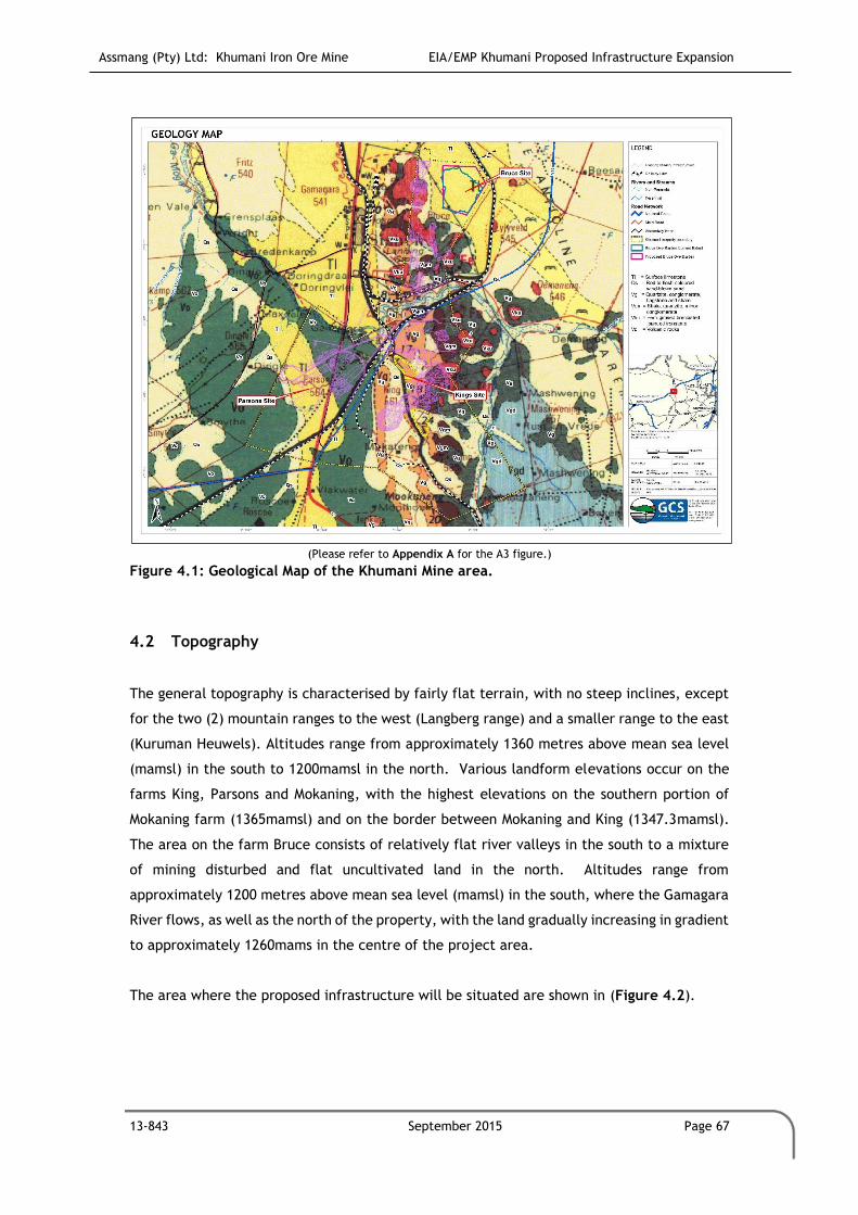
Assmang (Pty) Ltd: Khumani Iron Ore Mine EIA/EMP Khumani Proposed Infrastructure Expansion
13-843 September 2015 Page 67
(Please refer to Appendix A for the A3 figure.)
Figure 4.1: Geological Map of the Khumani Mine area.
4.2 Topography
The general topography is characterised by fairly flat terrain, with no steep inclines, except
for the two (2) mountain ranges to the west (Langberg range) and a smaller range to the east
(Kuruman Heuwels). Altitudes range from approximately 1360 metres above mean sea level
(mamsl) in the south to 1200mamsl in the north. Various landform elevations occur on the
farms King, Parsons and Mokaning, with the highest elevations on the southern portion of
Mokaning farm (1365mamsl) and on the border between Mokaning and King (1347.3mamsl).
The area on the farm Bruce consists of relatively flat river valleys in the south to a mixture
of mining disturbed and flat uncultivated land in the north. Altitudes range from
approximately 1200 metres above mean sea level (mamsl) in the south, where the Gamagara
River flows, as well as the north of the property, with the land gradually increasing in gradient
to approximately 1260mams in the centre of the project area.
The area where the proposed infrastructure will be situated are shown in (Figure 4.2).
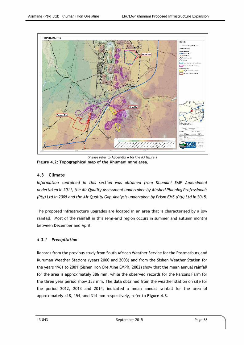
Assmang (Pty) Ltd: Khumani Iron Ore Mine EIA/EMP Khumani Proposed Infrastructure Expansion
13-843 September 2015 Page 68
(Please refer to Appendix A for the A3 figure.)
Figure 4.2: Topographical map of the Khumani mine area.
4.3 Climate
Information contained in this section was obtained from Khumani EMP Amendment
undertaken in 2011, the Air Quality Assessment undertaken by Airshed Planning Professionals
(Pty) Ltd in 2005 and the Air Quality Gap Analysis undertaken by Prism EMS (Pty) Ltd in 2015.
The proposed infrastructure upgrades are located in an area that is characterised by a low
rainfall. Most of the rainfall in this semi-arid region occurs in summer and autumn months
between December and April.
4.3.1 Precipitation
Records from the previous study from South African Weather Service for the Postmasburg and
Kuruman Weather Stations (years 2000 and 2003) and from the Sishen Weather Station for
the years 1961 to 2001 (Sishen Iron Ore Mine EMPR, 2002) show that the mean annual rainfall
for the area is approximately 386 mm, while the observed records for the Parsons Farm for
the three year period show 353 mm. The data obtained from the weather station on site for
the period 2012, 2013 and 2014, indicated a mean annual rainfall for the area of
approximately 418, 154, and 314 mm respectively, refer to Figure 4.3.
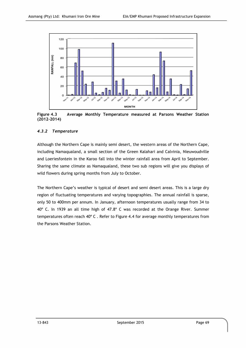
Assmang (Pty) Ltd: Khumani Iron Ore Mine EIA/EMP Khumani Proposed Infrastructure Expansion
13-843 September 2015 Page 69
Figure 4.3 Average Monthly Temperature measured at Parsons Weather Station (2012-2014)
4.3.2 Temperature
Although the Northern Cape is mainly semi desert, the western areas of the Northern Cape,
including Namaqualand, a small section of the Green Kalahari and Calvinia, Nieuwoudville
and Loeriesfontein in the Karoo fall into the winter rainfall area from April to September.
Sharing the same climate as Namaqualand, these two sub regions will give you displays of
wild flowers during spring months from July to October.
The Northern Cape’s weather is typical of desert and semi desert areas. This is a large dry
region of fluctuating temperatures and varying topographies. The annual rainfall is sparse,
only 50 to 400mm per annum. In January, afternoon temperatures usually range from 34 to
40º C. In 1939 an all time high of 47.8º C was recorded at the Orange River. Summer
temperatures often reach 40º C . Refer to Figure 4.4 for average monthly temperatures from
the Parsons Weather Station.

Assmang (Pty) Ltd: Khumani Iron Ore Mine EIA/EMP Khumani Proposed Infrastructure Expansion
13-843 September 2015 Page 70
Figure 4.4 Average Monthly Temperature measured at Parsons Weather Station (2012-2014)
4.3.3 Wind
The weather station that monitors standard meteorological parameters has been operational
on Parsons Farm at the Salvage Yard, north of processing plant and west of
stackers/reclaimers since the end of November 2011. The station experienced problems with
data capturing during the first few months of operation, but is now yielding results on a
regular basis. The graphs for wind roses and different measured parameters are presented
below.
In terms of the data collected from the weather station, the spatial and annual variability in
the wind field for Parsons Farm is clearly evident in Figure 4.5. The predominant wind
direction is from north-northeast and south southwest, with frequent winds also occurring
from the north and south. Over the three-year period, frequency of occurrence was over 8%
from the south and south south-westerly sector, with south-westerly winds occurring over 7%
of the time. Less frequent winds (above 6% of the time), but stronger were noted from the
north, north-north-easterly and north-easterly sector.

Assmang (Pty) Ltd: Khumani Iron Ore Mine EIA/EMP Khumani Proposed Infrastructure Expansion
13-843 September 2015 Page 71
Figure 4.5: Period Wind roses recorded at Parsons Weather Station for period (2012-
2014)
Calm conditions (wind speeds less than 0.5 m/s) occur for less than 11.8% of the time, with
winds between 0.5-2.1 m/s occurring for 40% of the time. The data is in good agreement with
data sourced for the previous study for the SAWS automated weather station in Kathu,
indicating that the average wind speeds over this site for the period November 2011 to end
November 2014 is 2.21 m/s.
During daytime there is an increase in winds from north-northwest, north and northwest,
with frequencies of greater than 10%. Nocturnal wind flow reflects more dominant winds
from the south, south-southwest and southwest. Frequent winds from the south occur for
approximately 10% of the time. Night-time conditions also reflect a decrease in wind speeds
with average wind speed decreasing to 1.87 m/s in comparison to daily wind speeds of
between 2.55 m/s. Refer to Figure 4.6 for indictation of seasonal wind directions as measures
at Parsons Weather Station.

Assmang (Pty) Ltd: Khumani Iron Ore Mine EIA/EMP Khumani Proposed Infrastructure Expansion
13-843 September 2015 Page 72
Figure 4.6: Period Wind roses recorded at Parsons Weather Station for period (2012-
2014)
4.4 Soils, Land use and Land Capability
Information contained in this section was obtained from Khumani EMP Amendment
undertaken in 2011 and the Soils and Land Capability Assessment undertaken by GCS (Pty)
Ltd in 2005.
4.4.1 Soil
Soil distribution is strongly linked to the topography of the area. In turn, the topography is
closely linked to the underlying surface geology. Hard rock outcrops characterise the
topographic highs of the area. The outcrops generally comprise quartzites and the iron ore
bearing ironstones. These outcrops form prominent hills or ridges with moderate to steep
slopes. In these areas, soils are very shallow to non-existent, occurring as erratic pockets of
orange sands within the outcrops. The pockets can be as deep as 1m. These soils are classified
as Mispah Form soils, with minor occurrences of Hutton Form soils.
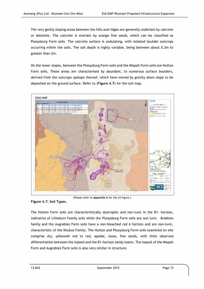
Assmang (Pty) Ltd: Khumani Iron Ore Mine EIA/EMP Khumani Proposed Infrastructure Expansion
13-843 September 2015 Page 73
The very gently sloping areas between the hills and ridges are generally underlain by calcrete
or dolomite. The calcrete is overlain by orange fine sands, which can be classified as
Plooysburg Form soils. The calcrete surface is undulating, with isolated boulder outcrops
occurring within the soils. The soil depth is highly variable, being between about 0,3m to
greater than 2m.
On the lower slopes, between the Plooysburg Form soils and the Mispah Form soils are Hutton
Form soils. These areas are characterised by abundant, to numerous surface boulders,
derived from the outcrops upslope thereof, which have moved by gravity down slope to be
deposited on the ground surface. Refer to (Figure 4.7) for the soil map.
(Please refer to Appendix A for the A3 figure.)
Figure 4.7: Soil Types.
The Hutton Form soils are characteristically dystrophic and non-luvic in the B1- horizon,
indicative of Lillieburn Family soils while the Plooysburg Form soils are non luvic – Brakkies
family and the Augrabies Form soils have a non-bleached red A horizon and are non-luvic,
characteristic of the Khubus Family. The Hutton and Plooysburg Form soils examined on site
comprise dry, yellowish red to red, apedal, loose, fine sands, with little observed
differentiation between the topsoil and the B1-horizon sandy loams. The topsoil of the Mispah
Form and Augrabies Form soils is also very similar in structure.

Assmang (Pty) Ltd: Khumani Iron Ore Mine EIA/EMP Khumani Proposed Infrastructure Expansion
13-843 September 2015 Page 74
4.4.2 Land Capability
The Mispah Form soils can be classified as wilderness land or non-arable land. Although the
remainder of the area is underlain by Plooysburg and Hutton Form soils, due to the variability
of soil depth and the presence of isolated rock outcrops within these soils, as well as abundant
to numerous scattered boulders on the surface, these soils are classified as low yield grazing
land.
The site is located within the mining area and surrounded by infrastructure associated with
the mining industry and as a result, has no specific land capabilities other than that of mining
and mining related activities. There are no substantial areas of arable land or wetland areas
within the site, some pans do exist in the proposed low grade stockpile area on King and
Bruce. Refer to Table 4.1 for Land Capability Classes.
Table 4.1: Land Capability Classes
CLASS DESCRIPTION
CLASS I:
WETLAND
Diagnostic O horizon at the surface.
A horizon that is gleyed throughout more than 50% of its volume and is significantly
thick, occurring within 750 mm of the surface.
CLASS II:
ARABLE LAND
Does not qualify as a wetland.
The soil is readily permeable to the roots of common cultivated plants throughout
a depth of 0.75 m from the surface.
pH value between 4,0 and 8.4.
Low Sodium Absorption Ratio (SAR) and Salinity.
The soil has a permeability of at least 1.5-mm per hour in the upper 0.5 mm of
soil.
The soil has less than 10% (by volume) rocks or pedocrete fragments larger than
100-mm in diameter in the upper 0.75 m.
Has a slope (in %) and erodibility factor (K) such that their product is <2.0.
Occurs under a climatic regime, which facilitates crop yields that are at least
equal to the current national average for these crops or is currently being irrigated
successfully, or is scheduled for irrigation by the Department of Water and
Sanitation.
CLASS III:
GRAZING LAND
Does not qualify as wetland or arable land.
Has soil, or soil-like material, permeable to roots of native plants, that is more
than 250-mm thick and contains less than 50% by volume of rocks or pedocrete
fragments larger than 100 mm in diameter.
Supports, or is capable of supporting, a stand of native or introduced grass species,
or other forage plants, utilizable by domesticated livestock or game animals on a
commercial basis.
CLASS IV:
WILDERNESS
LAND
Land which does not qualify as wetland, arable land or grazing land.

Assmang (Pty) Ltd: Khumani Iron Ore Mine EIA/EMP Khumani Proposed Infrastructure Expansion
13-843 September 2015 Page 75
4.4.3 Land Use
Kumba Iron Ore Mine, a large opencast mining operation, is situated directly north of the
farm Parson, northwest of the farm King and west of the farm Bruce. Besides the mining
operations, other activities in the region include livestock farming, and small residential
communities and business trade. The land use on site is currently mining and mining related
operations.
The main land uses in the study area are:
Livestock grazing;
Game farming; and
Mining.
Figure 4.8 indicates the current land use of the mining area.
(Please refer to Appendix A for the A3 figure.)
Figure 4.8: Current Land Use within the Khumani mine area.
4.5 Heritage and Sites of Cultural Significance
No archaeological artifacts have been identified in the footprint areas where infrastructure
is planned. The sites as identified during the original EIA for Khumani will be maintained as
per the management conditions.

Assmang (Pty) Ltd: Khumani Iron Ore Mine EIA/EMP Khumani Proposed Infrastructure Expansion
13-843 September 2015 Page 76
It is possible that sub-surface features of an archaeological nature (ostrich eggshell cache,
high density artifact horizons, and burials) may be found during activities. In the event of
these being found, an archaeologist will be contacted immediately to assess significance and
recommend mitigation measures.
4.6 Biodiversity
The biodiversity description was undertaken by GCS Water & Environment as part of the
detailed Ecological Assessment (2014) (Appendix C-1). A desktop study was performed for
the Bruce expansion area to serve as an update to the previous studies conducted previously
for that area.
4.6.1 Regional Ecology
The Savanna Biome is the largest biome in southern Africa, covering about 46% of its area.
The term savanna is widely accepted as describing a vegetation type with a well-developed
grassy layer and an upper layer of woody plants. Many environmental factors correlate with
the distribution of different savannah vegetation types, including landform, climate, soil
types, fire and a very specific fauna. South African savannas of nutrient-poor substrates are
characteristically broad-leaved and without thorns, while those of nutrient-rich substrates
are fine-leaved and thorny. Nutrient-rich savannas have high grass layer productivity and the
grasses are acceptable to grazers, resulting in a high grazing capacity (Knobel, 1999).
The diversity of African savanna is exceptional, comprising more than 13,000 plant species,
of which 8,000 are savanna endemics. Specifically, dry savannas have more than 3,000. This
diversity equals that of the South African grasslands and is only exceeded by Fynbos (Knobel
1999). Similarly, in respect of animal diversity, savannas are without peer, including
approximately 167 mammals (15% endemism), 532 birds (15% endemism), 161 reptiles (40%
endemism), 57 amphibians (18% endemism) and an unknown number of invertebrates
(Knobel, 1999). Flagship species include the Starburst Horned Baboon Spider (Ceratogyrus
bechuanicus), ground Hornbill (Bucorvus leadbeateri), Cape Griffon (Gyps coprotheres), Wild
dog (Lycaon pictus), Short-Eared Trident Bat (Cloeotis percivali) and the White Rhino
(Ceratotherium simum) (EWT, 2002).
Conservation within and of the savanna biome is good in principle, mainly due to the presence
of a number of wildlife reserves. Urbanisation is not a threat, perhaps because the hot, dry
climate and diseases prominent in the savanna areas have hindered urban development. Much

Assmang (Pty) Ltd: Khumani Iron Ore Mine EIA/EMP Khumani Proposed Infrastructure Expansion
13-843 September 2015 Page 77
of the area is used for game farming and the importance of tourism and big-game hunting in
the conservation areas must not be underestimated. Savannas are the basis of the African
wildlife and ecotourism industry and play a major role in the meat industry.
Surprisingly little is known about the vegetation as most studies have been done in nature
reserves and game farms, but five major regions are present, three of which are represented
in the study area. Sweet Bushveld occurs on fertile soils in the dry and hot valleys of the
Limpopo River and the thorny, small-leaved vegetation is dominated by Acacia species that
increase to dense, impenetrable thickets at the expense of the grass layer when overutilised.
Mixed Bushveld varies from short, dense bushveld to a rather open tree savanna.
On shallow, infertile soils the broad-leaved Red Bushwillow (Combretum apiculatum)
dominates, whereas on deeper, leached soils the Silver Clusterleaf (Terminalia sericea)
becomes dominant. The Waterberg moist mountain bushveld is a typical example of moist,
infertile savanna. Due to the high proportion of unpalatable grasses, the area has become
known as ‘sour bushveld’. An interesting phenomenon is the presence of many plant species
showing affinities with the flora of the Drakensberg, which indicates an ancient link with this
range (Knobel, 1999).
The vegetation that characterises this area has developed many survival strategies, including
the ability to produce tannins that are triggered when the leaves are browsed, the production
of toxic sap, the development of thorns or their adaptation to sourveld areas that are not
generally favoured by grazers. The interaction of vegetation, fire and animals play important
roles in maintaining savanna ecosystems (Knobel, 1999). Over thousands of years, the savanna
system and the antelope that inhabit them have developed side by side. Grasses, for example,
have become well adapted to defoliation, as much a defensive response to constant pressure
by grazers as to the regular veld fires that rage through the savanna in the dry seasons.
4.6.2 Freshwater Ecosystems
The proposed development is situated in quaternary catchment D41J in the Lower Vaal
Management Area (WMA4), Sub water management area Molopo. The recently published Atlas
of Freshwater Ecosystem Priority Areas in South Africa (Nel et al, 2011a) (The Atlas), which
represents the culmination of the National Freshwater Ecosystem Priority Areas project
(NFEPA), a partnership between SANBI, CSIR, WRC, DEA, DWA, WWF, SAIAB and SANParks,
provides a series of maps detailing strategic spatial priorities for conserving South Africa’s
freshwater ecosystems and supporting sustainable use of water resources. Freshwater
Ecosystem Priority Areas (FEPA’s) were identified through a systematic biodiversity planning
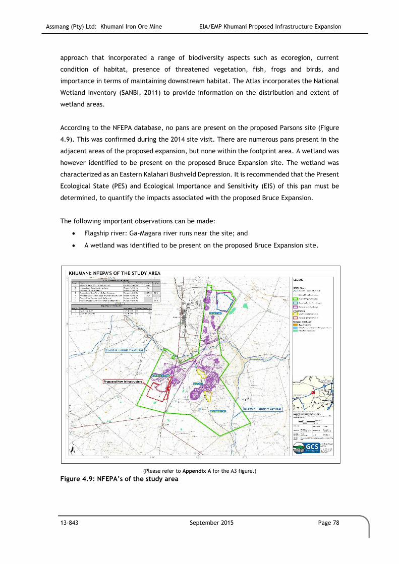
Assmang (Pty) Ltd: Khumani Iron Ore Mine EIA/EMP Khumani Proposed Infrastructure Expansion
13-843 September 2015 Page 78
approach that incorporated a range of biodiversity aspects such as ecoregion, current
condition of habitat, presence of threatened vegetation, fish, frogs and birds, and
importance in terms of maintaining downstream habitat. The Atlas incorporates the National
Wetland Inventory (SANBI, 2011) to provide information on the distribution and extent of
wetland areas.
According to the NFEPA database, no pans are present on the proposed Parsons site (Figure
4.9). This was confirmed during the 2014 site visit. There are numerous pans present in the
adjacent areas of the proposed expansion, but none within the footprint area. A wetland was
however identified to be present on the proposed Bruce Expansion site. The wetland was
characterized as an Eastern Kalahari Bushveld Depression. It is recommended that the Present
Ecological State (PES) and Ecological Importance and Sensitivity (EIS) of this pan must be
determined, to quantify the impacts associated with the proposed Bruce Expansion.
The following important observations can be made:
Flagship river: Ga-Magara river runs near the site; and
A wetland was identified to be present on the proposed Bruce Expansion site.
(Please refer to Appendix A for the A3 figure.)
Figure 4.9: NFEPA’s of the study area

Assmang (Pty) Ltd: Khumani Iron Ore Mine EIA/EMP Khumani Proposed Infrastructure Expansion
13-843 September 2015 Page 79
4.6.3 Flora
4.6.3.1 Botanical diversity
A total of 70 plant species were recorded during the field investigations (April 2014). During
the April 2014 survey a well-developed herbaceous stratum (Table 4.2) is represented by 28
forbs (40%) and 18 grass species (25.7%). A physiognomically dominant shrub and tree layer
is represented by 12 shrub species (17.1%) and 5 tree species (7.1%). This floristic diversity is
represented by 32 families (Table 4.3), dominated by Poaceae (20 species, 29.1%), Fabaceae
(8 species, 11.4%) and Asteraceae (7 species, 10.0%). The physiognomy and diversity
exhibited by natural habitat with the study areas is regarded representative of the regional
vegetation types. Degradation and transformation is noted on a local and regional scale. It is
therefore concluded that the vegetation is in a sub climax status.

Assmang (Pty) Ltd: Khumani Iron Ore Mine EIA/EMP Khumani Proposed Infrastructure Expansion
13-843 September 2015 Page 80
Table 4.2: Growth form recorded on Parson during the April 2014 survey GROWTH FORM NUMBER PERCENTAGE
Climber 2 2.9
Forb 28 40
Geophyte 4 5.7
Grass 18 25.7
Parasite 1 1.4
Shrub 12 17.1
Tree 5 7.1
Total 70 100
Table 4.3: Plant families recorded on Parson during the April 2014 survey GROWTH FORM NUMBER PERCENTAGE GROWTH FORM NUMBER PERCENTAGE
Acanthaceae 1 1.1 Liliaceae 1 1.1
Aizoaceae 1 1.1 Loranthaceae 1 1.1
Amaranthaceae 1 1.1 Malvaceae 2 2.3
Amaryllidaceae 3 3.4 Meliaceae 1 1.1
Anacardiaceae 1 1.1 Mimosaceae 1 1.1
Asclepiadaceae 1 1.1 Oleaceae 1 1.1
Asteraceae 9 10.2 Oxalidaceae 1 1.1
Bignoniaceae 1 1.1 Papaveraceae 1 1.1
Boraginaceae 1 1.1 Pedaliaceae 1 1.1
Capparaceae 4 4.5 Poaceae 23 26.1
Chenopodiaceae 2 2.3 Rhamnaceae 1 1.1
Combretaceae 1 1.1 Scrophulariaceae 1 1.1
Commelinaceae 1 1.1 Selaginaceae 1 1.1
Cucurbitaceae 1 1.1 Solanaceae 2 2.3
Cucurbiteae 1 1.1 Sterculiaceae 2 2.3
Ebenaceae 1 1.1 Tiliaceae 2 2.3
Ehretiaceae 1 1.1 Zygophyllaceae 2 2.3
Fabaceae 11 12.5
Illebracaceae 1 1.1
Lamiaceae 1 1.1
4.6.3.2 Flora species of conservation importance
South Africa’s Red List system is based on the IUCN Red List Categories and Criteria Version
3.1 (finalized in 2001), amended to include additional categories to indicate species that are
of local conservation concern (Table 4.4). The IUCN Red List system is designed to detect risk
of extinction (Table 4.5). Species that are at risk of extinction, also known as threatened or

Assmang (Pty) Ltd: Khumani Iron Ore Mine EIA/EMP Khumani Proposed Infrastructure Expansion
13-843 September 2015 Page 81
endangered species are those that are classified in the categories Critically Endangered (CR),
Endangered (EN) and Vulnerable (VU) (SANBI. 2011).
Table 4.4: Botanical conservation data for the Northern Cape
Table 4.5: Plant species conservation status in the Northern Cape
No ‘Threatened’ species were recorded on Parson during the survey period in the study area.
Though a field investigation was not conducted, the occurence of ‘Threatened’ species on
the Bruce expansion area is unlikely due to the proximity to several mining activities. Since
much of the remaining natural habitat within the study area comprises primary climax status
woodland habitat, the possibility that Red Data species might be present within the study
area cannot be excluded at this stage. Species included in the ‘Declining’ category was
recorded during the site investigation on Parson (refer Table 4.6). The definition implies that
the species is declining but the population has not yet reached a threshold of concern and
limited loss of habitat may be permitted. If individuals will not be conserved in situ, plants
should be rescued and used as mother stock for medicinal plant cultivation programmes.
Table 4.6: Conservation important plant species recorded during the April 2014 survey TAXON STATUS ANNOTATIONS
Total number of taxa 4864
Endemic taxa 1302
% of SA flora occurring in province 23.50%
Threatened taxa 295
Endemic threatened taxa 236
% of national threatened flora 11.20%
Taxa of conservation concern 739
Endemic taxa of conservation concern 584
Status Total
Critically Endangered, Possibly Extinct 7
Critically Endandered 16
Endangered 46
Vulnerable 231
Near Threatened 57
Critically Rare 29
Rare 284
Declining 11
Data Deficient (insufficient information) 63
Data Deficient (taxonomically problematic) 129

Assmang (Pty) Ltd: Khumani Iron Ore Mine EIA/EMP Khumani Proposed Infrastructure Expansion
13-843 September 2015 Page 82
Acacia erioloba Declining (National status) Abundant through the study area, legal
implications - National Forest Act, 198
4.6.3.3 Protected tree species (National Forest Act)
According the National Forests Act, 1998 (Act No. 84 of 1998), the Minister may declare a
tree, group of trees, woodland or a species of trees as protected. The prohibitions state that
‘No person may cut, damage, disturb, destroy or remove any protected tree, or collect,
remove, transport, export, purchase, sell, donate or in any other manner acquire or dispose
of any protected tree, except under a license granted by the Minister’.
Table 4.7: Protected tree species of the region
4.6.3.4 Vegetation development drivers
Development of the regional (natural) vegetation is generally the result of complex
interacting driving forces that include climatic-, geological-, topographical- and moisture
gradients typical of the arid savanna regions of southern Africa. Little transformation is
evident from livestock farming and suboptimal management strategies (fire management)
that tend to result in minor changes to the herbaceous and shrub layer. These changes are
strongly reflected in localised species changes.
4.6.3.5 Macro habitat types and variations observed
Natural (untransformed) vegetation of the study area and the surrounds is strongly
representative of the regional vegetation types, exhibiting extremely limited (localised)
divergence from the species composition, diversity and vegetation structure described by
Mucina and Rutherford (Vegmap, 2006). Typical of the vegetation of the region is that
extremely little zonality is observed in vegetation forms.
Results of previous studies from 2006, the photo analysis and site investigations revealed the
presence of the following macro habitat types and variations on the farm Parson
• Degraded and Transformed Habitat, including;
o Degraded Woodland; and
Taxon Family
Acacia erioloba Fabaceae
Acacia haematoxylon Fabaceae
Boscia albitrunca Capparaceae
Olea europaea subsp. africana Oleaceae

Assmang (Pty) Ltd: Khumani Iron Ore Mine EIA/EMP Khumani Proposed Infrastructure Expansion
13-843 September 2015 Page 83
o Overgrazed Area.
• Woodland Community (Bruce and Parson), including the following:
o Natural Woodland – Open Tarchonanthus camphoratus veld.
Degraded and transformed habitat
These areas generally comprise parts of the landscape where anthropogenic effects caused
an irreversible change in the vegetation. Clearance of land for building of roads, houses and
the mining of resources resulted severe changes to the habitat.
Degraded Woodland
This habitat is characterised by an area that are affected by grazing activities, but not to the
extent that the natural woodland character has been compromised entirely. A cattle kraal is
situated within this area, attributing to the degraded nature of this area. While the largest
extent of the species composition remains similar to the surrounding natural woodland
variations, but some surface disturbances caused the influx of poor quality species to render
the vegetation in a sub climax status. This area does not exhibit any particular aspect of
sensitivity.
Woodland community
Natural woodland of the site is representative of the natural variations that is encountered
on a local and regional scale. The physiognomy is dominated by a well-developed tree/ shrub
layer that tends to encroach where intense and high grazing pressure is applied. A species
rich herbaceous layer is characteristic of the region, comprising a grass layer of which the
composition provides an indication of the reaction of the herbaceous layer on grazing
strategies. Imbedded within this savanna type are various local and regional variations that
establish based on soil characteristics. Localised areas of atypical habitat occur where
underlying geology is exposed.
Open Tarchonanthus camphoratus veld
The localised dominance of the shrubs Tarchonanthus camphoratus, Acacia mellifera, Grewia
flava and Rhigozum trichotomum provides evidence of the reaction of the vegetation on high
grazing pressure. Similarly, the grass sward tends to become less diverse and an increase in
poor quality species is observed.
Much of the tree and shrub layer remained the same with the dominant trees on Parson being
Acacia erioloba and Boscia albitrunca. A noteworthy exception is that Acacia haematoxylon
occurs at much lower intervals compared to the open Acacia erioloba veld, which is probably
Assmang (Pty) Ltd: Khumani Iron Ore Mine EIA/EMP Khumani Proposed Infrastructure Expansion
13-843 September 2015 Page 84
also a reaction on either high grazing pressure, or the competitive increase in abundance of
other woody species.
The tree and shrub layer on Bruce consisted mainly off Acacia erioloba (Not abundant in
Bruce), Boscia albitrunca, Acacia hebeclada, Acacia mellifera, Grewia flava, Lycium spp.,
Rhigozum obovatum, Rhigozum trichotomum, Rhus ciliata, Salsola rabieana, Tarchonanthus
camphoratus, Ziziphus mucronata.
Noteworthy grasses on Parson include Aristida stipitata, Eragrostis pallens, E. lehmanniana,
Schmidtia pappophoroides, S. ciliata and Tricholaena monachne, with the less abundant
Aristida congesta subsp. congesta, Cenchrus ciliaris, Melinis repens, Pogonarthria squarrosa
and A. stipitata. The forb layer is similarly less diverse than in the open woodland, containing
Geigeria ornativa, Oxalis semiloba, Hermannia tomentosa, Indigofera alternans, Monechma
divaricatum and Senna italica.
Noteworthy grasses on Bruce were Aristida adscensionis, Aristida congesta subsp. barbicollis,
Aristida congesta subsp. congesta, Aristida stipitata, Cymbopogon plurinodis, Enneapogon
cenchroides, Enneapogon desvauxii, Eragrostis curvula, Eragrostis echonochloidea,
Eragrostis lehmanniana, Eragrostis nindensis, Eragrostis trichophora, Fingerhuthia africana,
Melinis repens, Pogonarthria squarrosa, Schmidtia pappophoroides, Stipagrostis uniplumis.
Shrubs that were recorded in 2006 included Aloe grandidentata, Aloe hereroensis,
Ammocharis coranica, Babiana hypogea, Boophone disticha, Crinum bulbispermum, Felicia
muricata, Geigeria pectidia, Mariscus congestus, Moraea polystachya, Nerine laticoma,
Orbea lutea, Oxalis corniculata, Oxalis semiloba subsp. semiloba, Pentzia spp.,
Protasparagus spp., Senna italica, Solanum supinum.
Protected trees were recorded within this unit and a moderate probability is estimated for
other species of conservation importance occurring within this unit.
4.6.3.6 Botanical sensitivity of the study area
Botanical sensitivity values are presented in Table 4.8. These estimations are used to ascribe
a sensitivity index value to units of the respective variations.
Habitat sensitivity is categorised as follows:
Low
No natural habitat remaining; this category is represented by developed/ transformed areas,
nodal and linear infrastructure, areas of agriculture or cultivation, areas where exotic species
dominate exclusively, mining land (particularly surface mining), etc. The possibility of these
Assmang (Pty) Ltd: Khumani Iron Ore Mine EIA/EMP Khumani Proposed Infrastructure Expansion
13-843 September 2015 Page 85
areas reverting to a natural state is impossible, even with the application of detailed and
expensive rehabilitation activities. Similarly, the likelihood of plant species of conservation
importance occurring in these areas is regarded negligent.
Medium – low
All areas where the natural habitat has been degraded, with the important distinction that
the vegetation has not been decimated and a measure of the original vegetation remain,
albeit dominated by secondary climax species. The likelihood of plant species of conservation
importance occurring in these areas is regarded low. These areas also occur as highly
fragmented and isolated patches, typical to cultivated fields, areas that have been subjected
to clearing activities and areas subjected to severe grazing pressure. The species composition
of these areas is typically low and is frequently dominated by a low number of species, or
invasive plants.
Medium
Indigenous natural habitat that comprehend habitat with a high diversity, but
characterised by moderate to high levels of degradation, fragmentation and habitat
isolation; and
Also include areas where flora species of conservation importance could potentially
occur, but habitat is regarded marginal.
Medium – high
Indigenous natural vegetation that comprise a combination of the following attributes:
• The presence of habitat that is suitable for the presence of these species;
• Areas that are characterised by a high/ moderate-high intrinsic floristic diversity;
• Areas characterised by moderate to low levels of habitat fragmentation and isolation;
• Regional vegetation types that are included in the lower conservation categories,
particularly prime examples of these vegetation types;
• Low to moderate levels of habitat transformation; and
• A moderate to high ability to respond to disturbance factors.
It may also include areas that are classified as protected habitat, but that are of a moderate
status.
High
Indigenous natural vegetation that comprehend for a combination of the following attributes:
• The presence of plant species of conservation importance, particularly threatened
categories (Critically Endangered, Endangered, Vulnerable);

Assmang (Pty) Ltd: Khumani Iron Ore Mine EIA/EMP Khumani Proposed Infrastructure Expansion
13-843 September 2015 Page 86
• Areas where ‘threatened’ plants are known to occur, or habitat that is highly suitable
for the presence of these species;
• Regional vegetation types that are included in the ‘threatened’ categories (Critically
Endangered, Endangered, Vulnerable), particularly prime examples of these
vegetation types;
• Habitat types are protected by national or provincial legislation (Lake Areas Act,
National Forest Act, draft Ecosystem List of NEM:BA, Mountain Catchment Areas Act,
Ridges Development Guideline, Integrated Coastal Zone Management Act, etc.);
• Areas that have an intrinsic high floristic diversity (species richness, unique
ecosystems), with particular reference to Centres of Endemism; and
• These areas are also characterised by low transformation and habitat isolation levels
and contribute significantly on a local and regional scale in the ecological
functionality of nearby and dependent ecosystems, with particular reference to
catchment areas, pollination and migration corridors, genetic resources. A major
reason for the high conservation status of these areas is the low ability to respond to
disturbances (low plasticity and elasticity characteristics).
A medium high floristic sensitivity is therefore estimated for this type located on the farm
Parson.
Table 4.8: Floristic sensitivity estimations of the study area
4.6.4 Fauna
The study area is located within the regional vegetation community of Kathu Bushveld
(Eastern Kalahari Bushveld Bioregion). This regional vegetation community is listed as Least
threatened (VEGMAP, 2006). The Eastern Kalahari Bushveld Bioregion is situated within the
Savanna Biome of South Africa.
It is important to view the study area on an ecologically relevant scale; consequently, all
sensitive animal species (specific faunal groups) known from the Northern Cape Province are
included in this assessment. Detailed regional and scientific data on all faunal groups are
lacking (notably for most of the invertebrate groups) and as a result only data sets on specific
faunal groups allow for habitat sensitivity analyses based on the presence/ absence of
Criteria RD Species
Landscape
sensitivity Status
Species
diversity
Functionality/
Fragmentation Total
Sensitivity
Index
Sensitivity
Class
Degraded woodland 4 3 3 4 5 117 37% Medium/Low
Open Tarchonanthus camphoratus veld 7 5 8 7 8 221 70% Medium/High

Assmang (Pty) Ltd: Khumani Iron Ore Mine EIA/EMP Khumani Proposed Infrastructure Expansion
13-843 September 2015 Page 87
sensitive faunal species (Red Data species) and their specific habitat requirements. The
following faunal groups were included in these analyses:
• Butterflies (Invertebrata: Insecta: Lepidoptera – Nymphalidae, Lycaenidae,
Hesperiidae, Pieridae and Papilionidae). References used include the IUCN Red List
(2011) – http://www.iucnredlist.org and the South African Butterfly Conservation
Assessment (SABCA, 2011) – http://sabca.adu.org.za.
• Frogs (Amphibia: Anura). References used include the Atlas and Red Data Book of the
South Africa, Lesotho and Swaziland, the Giant Bullfrog Conservation Group (2011) –
http://www.up.ac.za/bullfrog and a Complete Guide to the Frogs of Southern Africa
(du Preez & Carruthers, 2009).
• Reptiles (Reptilia: Testudines and Squamata). References used include the IUCN Red
List (2011) and the South African Reptile Conservation Assessment (SARCA, 2011) –
http://sarca.adu.org.za.
• Birds: All bird groups (Roberts VII Multimedia: Birds of Southern Africa, PC Edition).
• Terrestrial Mammals (Mammalia: Insectivora, Chiroptera, Primates, Lagomorpha,
Pholidota, Rodentia, Carnivora, Tubulidentata, Proboscidea, Hyracoidea,
Perissodactyla and Artiodactyla). References used include the Red Data Book of the
Mammals of South Africa: A Conservation Assessment (Endangered Wildlife Trust -
2004).
As more data become available, additional faunal groups are likely to be added to these
assessments. Dragonflies and Damselflies (Invertebrata - Insecta: Odonata) are some
examples of possible future inclusions.
Animals known to be present in the Q-grids 2723CC, 2722BA, 2722BB and 2722BD were
considered potential inhabitants of the study area (all species known from the Northern Cape
Province were included in the assessment to limit the known effects of sampling bias, except
for birds which have been sampled extensively and the data for the Q-grids is accepted as
accurate).
4.6.5 Faunal diversity of the site
The presence of 19 animal species was confirmed during the April 2014 site investigation
(refer to Appendix C1), by means of visual sightings, tracks, scats and burrows:
• Four insects;
• Two reptiles;
• Eleven birds; and
• Two mammals.

Assmang (Pty) Ltd: Khumani Iron Ore Mine EIA/EMP Khumani Proposed Infrastructure Expansion
13-843 September 2015 Page 88
The 19 species found to occur in the study area during the April 2014 survey included no Red
Data species.
The presence of fourty four animal species was confirmed during the 2006 site investigation
(refer to Appendix C1), by means of visual sightings, tracks, scats and burrows:
• Two reptiles;
• Thirty four birds; and
• Eight mammals.
4.6.6 Red data faunal assessment
The estimated probabilities of occurrence (PoC) of Red Data fauna taxa are based on:
• the size of the study area;
• the location of the study area;
• the diversity and status of faunal habitat within the study area as well as other
ecological characteristics; and
• the connectivity of the study area to surrounding faunal habitats.
A total of 92 Red Data animals are known to occur in the Northern Cape (butterflies, frogs,
reptiles and mammals) and in the Q-grids 2722BA 2722BB and 2722BD (birds)
The following categories are included:
• 19 taxa are listed as Data Deficient (DD);
• 25 taxa are listed as Near Threatened (NT);
• 38 taxa are listed as Vulnerable (VU);
• 5 taxa are listed as Endangered (EN); and
• 5 taxa are listed as Critically Endangered (CR).
An assessment of the PoC for these animals yielded the following probabilities (refer Table
4.9.
• 63 RD species have an estimated low PoC for the study area;
• 7 RD species have an estimated moderate-low PoC for the study area;
• 8 RD species have an estimated moderate PoC for the study area;
• 7 RD species have an estimated moderate-high PoC for the study area; and
• 7 RD species were confirmed to be present in the study area.
In addition to the above-listed Red Data species of the Northern Cape and the Q-grids 2722BA,
2722BB and 2722BD, ten animal species (some overlap does occur) have protected status

Assmang (Pty) Ltd: Khumani Iron Ore Mine EIA/EMP Khumani Proposed Infrastructure Expansion
13-843 September 2015 Page 89
(NEMBA) within the Northern Cape (www.speciesstatus.sanbi.org). PoC for these species was
estimated as follows:
• 7 species have a low PoC; and
• 3 species have a moderate-high PoC.
Table 4.9: Protected species of the Northern Cape Province
4.6.7 Faunal habitat types
The close relationship between vegetation units and specific faunal composition has been
noted in several scientific studies. For the purpose of this investigation, floristic units are
therefore considered representative of the faunal habitat types. The following habitat types
were condensed from the botanical assessment:
• Degraded Faunal Habitat; and
• Natural Faunal Habitat.
4.6.7.1 Degraded faunal habitat
The degraded woodland and pans or impoundments of the study area are deemed degraded
faunal habitat. In contrast to the transformed habitat of the study area, the degraded faunal
habitat retained some of the ecological elements of the region and some intrinsic biodiversity
value. The degraded faunal habitat includes fragments of variable ecological integrity and
biodiversity value (some fragments have lost more of the original ecological elements and
likely faunal species, especially invertebrates, than others do). These fragments of degraded
faunal habitat exhibit medium faunal sensitivities:
• Degraded Woodland: medium faunal sensitivity.
4.6.7.2 Natural faunal habitat
Scientific name Common name NEMBA statusProbability
assessment
Aonyx capensis African Clawless Otter Protected Low
Atelerix frontalis South African hedgehog Protected Low
Ceratotherium simum White rhinpcerus Protected Low
Circus ranivorus African Marsh Harrier Protected Low
Crocuta crocuta Spotted hyaena Protected Low
Diceros bicornis Black rhinocerus Protected Low
Felis nigripes Black footed cat Protected Moderate/High
Parahyaena brunnea Brown hyeana Protected Moderate/High
Spheniscus demersus African penguin Protected Low
Vulpes chama Cape fox Protected Moderate/High

Assmang (Pty) Ltd: Khumani Iron Ore Mine EIA/EMP Khumani Proposed Infrastructure Expansion
13-843 September 2015 Page 90
The study area included various natural terrestrial faunal habitats. Open Tarchonanthus
camphoratus and open Acacia erioloba veld differ slightly in terms of floristic attributes and
consequently faunal community structure (most notably invertebrates), but significant
overlap of larger animals’ assemblage structures exist between the different natural faunal
habitats of the study area. The natural faunal habitats of the study area differ slightly in
terms of status, diversity, linkage and sensitivity, but these differences are insignificant.
The estimated faunal sensitivities of all the natural faunal habitats in the study area are
estimated to be medium-high faunal sensitivity:
• Open Tarchonanthus camphoratus veld: medium-high faunal sensitivity.
4.6.8 Faunal habitat sensitivity assessment
During the field assessment, the study area was investigated and assessed in terms of the
following biodiversity attributes:
• Habitat status: level of habitat transformation and degradation vs. pristine faunal
habitat;
• Habitat diversity: the number of different faunal habitat types (both on micro- and
macro-scale) found within the proposed site and bordering areas;
• Habitat linkage: the degree to which the faunal habitat of the proposed site is linked
to other natural areas enabling movement of animals to and from the habitat found
on site;
• Red Data species: the degree to which suitable habitat for the red data species likely
to be found in the study area (larger study area) is located on each site; and
• Sensitive faunal habitat: the relative presence of faunal sensitive habitat type
elements such as surface rock associated with outcrops and hills as well as wetland
elements.
Table 4.10: Faunal habitat sensitivity of the study area
The current habitat sensitivity on the farm Bruce could not be analised due to only having
the 2006 information available for that area.
4.7 Hydrology
Criteria Status Diversity Linkage Red data SensitivitySensitivity
Index
Sensitivity
class
Community
Degraded Woodland 5 6 5 4 6 52% Medium
Open Tarchonanthus camphoratus veld 7 7 8 6 7 70% Medium/High
Criteria Ranking
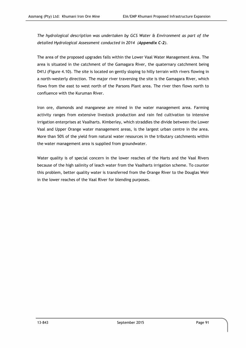
Assmang (Pty) Ltd: Khumani Iron Ore Mine EIA/EMP Khumani Proposed Infrastructure Expansion
13-843 September 2015 Page 91
The hydrological description was undertaken by GCS Water & Environment as part of the
detailed Hydrological Assessment conducted in 2014 (Appendix C-2).
The area of the proposed upgrades falls within the Lower Vaal Water Management Area. The
area is situated in the catchment of the Gamagara River, the quaternary catchment being
D41J (Figure 4.10). The site is located on gently sloping to hilly terrain with rivers flowing in
a north-westerly direction. The major river traversing the site is the Gamagara River, which
flows from the east to west north of the Parsons Plant area. The river then flows north to
confluence with the Kuruman River.
Iron ore, diamonds and manganese are mined in the water management area. Farming
activity ranges from extensive livestock production and rain fed cultivation to intensive
irrigation enterprises at Vaalharts. Kimberley, which straddles the divide between the Lower
Vaal and Upper Orange water management areas, is the largest urban centre in the area.
More than 50% of the yield from natural water resources in the tributary catchments within
the water management area is supplied from groundwater.
Water quality is of special concern in the lower reaches of the Harts and the Vaal Rivers
because of the high salinity of leach water from the Vaalharts irrigation scheme. To counter
this problem, better quality water is transferred from the Orange River to the Douglas Weir
in the lower reaches of the Vaal River for blending purposes.

Assmang (Pty) Ltd: Khumani Iron Ore Mine EIA/EMP Khumani Proposed Infrastructure Expansion
13-843 September 2015 Page 92
(Please refer to Appendix A for the A3 figure.)
Figure 4.10: Surface water management areas of the greater mining right area.
4.7.1 MAP and MAE
The climate data used for the Hydrology study was obtained from the Water Resources of
South Africa, 2005 Study (WR2005), and Water Research Commission Report Numbers TT 380
to 382/08. Please note the data differs from the data discussed in Section 4.3.1 which were
taken from the Parsons Weather Station. The MAP calculated for this area is 357.74mm while
the MAE is 2 351mm. MAE is more than five times greater than MAP; which confirms the arid
nature of the area.
Table 4.11: Mean annual rainfall and evaporation in mm/month
MONTH RAINFALL (MM) EVAPORATION (MM)
Oct 27.13 249.53
Nov 41.49 283.20
Dec 52.81 311.46
Jan 65.65 293.29
Feb 56.41 235.40
Mar 55.66 203.85
Apr 29.67 148.50
May 10.70 111.86

Assmang (Pty) Ltd: Khumani Iron Ore Mine EIA/EMP Khumani Proposed Infrastructure Expansion
13-843 September 2015 Page 93
MONTH RAINFALL (MM) EVAPORATION (MM)
Jun 4.36 84.87
Jul 1.97 96.35
Aug 3.40 140.86
Sep 8.49 191.84
Mean Annual 357.74 2351.00
4.7.2 Peak Rainfall
The 24-hour peak rainfall depths were obtained for the site in order to calculate the design
flood peaks. These values were obtained using the Design Rainfall Estimation software
(Smithers, 2000). This software analyses gauged rain data in South Africa and tabulates peak
rainfall depths for various storm durations and return periods. The closest reliable rainfall
station nearby the Khumani area is the Olifantshoek station at Olifantshoek Dam, which has
rainfall and evaporation data records from December 1959 to September 2000. Only this data
was utilised for the study. The 24-hour design rainfall depths used are shown in Table 4.12:
Table 4.12:24-hour design rainfall values
STATION NAME OLIFANTSHOEK
Station Number
Return Period (years) 2 5 10 20 50 100
Design Rainfall (mm) 45 64 77 91 109 124
4.7.3 Mean Annual Runoff (MAR)
The runoff data for the quaternary catchment D41J was extracted from the WR2005 database.
The calculated MAR (for rivers in the region) can be seen in Figure 4.11.
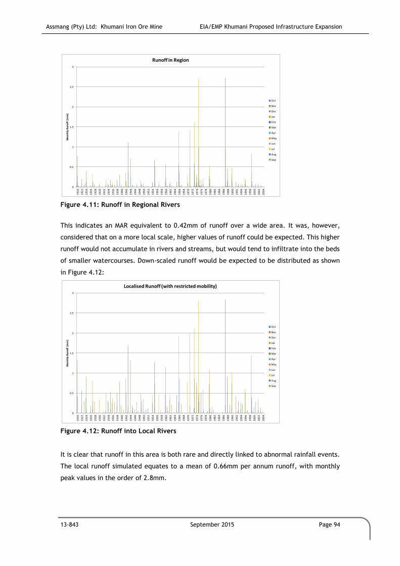
Assmang (Pty) Ltd: Khumani Iron Ore Mine EIA/EMP Khumani Proposed Infrastructure Expansion
13-843 September 2015 Page 94
Figure 4.11: Runoff in Regional Rivers
This indicates an MAR equivalent to 0.42mm of runoff over a wide area. It was, however,
considered that on a more local scale, higher values of runoff could be expected. This higher
runoff would not accumulate in rivers and streams, but would tend to infiltrate into the beds
of smaller watercourses. Down-scaled runoff would be expected to be distributed as shown
in Figure 4.12:
Figure 4.12: Runoff into Local Rivers
It is clear that runoff in this area is both rare and directly linked to abnormal rainfall events.
The local runoff simulated equates to a mean of 0.66mm per annum runoff, with monthly
peak values in the order of 2.8mm.
0
0.5
1
1.5
2
2.5
3
19
20
19
22
19
24
19
26
19
28
19
30
19
32
19
34
19
36
19
38
19
40
19
42
19
44
19
46
19
48
19
50
19
52
19
54
19
56
19
58
19
60
19
62
19
64
19
66
19
68
19
70
19
72
19
74
19
76
19
78
19
80
19
82
19
84
19
86
19
88
19
90
19
92
19
94
19
96
19
98
20
00
20
02
20
04
Mo
nth
ly R
un
off
[m
m]
Runoff in Region
Oct
Nov
Dec
Jan
Feb
Mar
Apr
May
Jun
Jul
Aug
Sep
0
0.5
1
1.5
2
2.5
3
19
20
19
22
19
24
19
26
19
28
19
30
19
32
19
34
19
36
19
38
19
40
19
42
19
44
19
46
19
48
19
50
19
52
19
54
19
56
19
58
19
60
19
62
19
64
19
66
19
68
19
70
19
72
19
74
19
76
19
78
19
80
19
82
19
84
19
86
19
88
19
90
19
92
19
94
19
96
19
98
20
00
20
02
20
04
Mo
nth
ly R
un
off
[m
m]
Localised Runoff (with restricted mobility)
Oct
Nov
Dec
Jan
Feb
Mar
Apr
May
Jun
Jul
Aug
Sep

Assmang (Pty) Ltd: Khumani Iron Ore Mine EIA/EMP Khumani Proposed Infrastructure Expansion
13-843 September 2015 Page 95
It would seem that these simulated runoff values don't agree with traditional methods used
for estimating peak floods. Simple Rational Method flood calculations indicate up to 27 mm
runoff in a 1.5 hour period that would produce a 1:50 year flood in the areas being developed.
In upstream clean water catchments this runoff is estimated at 24 mm in the same 1.5 hour
period. These higher flood runoff values are accepted for the following reasons:
1. Sandy soils in the region have a limited infiltration rate. It has been seen that with
extreme storm events, where rain falls with a high intensity, a surface layer within
the soil becomes saturated and further rain runs off.
2. It is noted that extreme storm events in the region are often extremely localised and
can occur over an area of 1 km2, or less.
3. Localised runoff peaks are not expected to be mobile and often tend to infiltrate into
the beds of watercourses rather than to flow downstream.
There is little data available on area reduction factors that apply in these extreme arid
conditions and for the purpose of this study, extreme point rainfall and runoff values
expected are applied over the full study area.
4.7.4 Normal Dry Weather Flow (NDWF)
The GaMagara River and the tributaries within the existing and proposed development area
are normally dry and only flow for comparatively short periods after significant rainfall events
(Knight Piesold, 2005). There is thus no NDWF that would be impacted by the LGS extensions.
4.7.5 Downstream water users
There are no significant surface water users downstream of the mine due to the unreliability
of flow in the GaMagara River and its tributaries (Knight Piesold, 2005). Downstream users
(primarily the farming community) rely on groundwater abstraction for livestock watering
and domestic consumption (Knight Piesold, 2005). During a site visit on the 27th of March
2014, mine personnel confirmed that there are no significant surface water users downstream
of the mine area.
4.8 Geohydrology
Information in this section was optained from a Hydrocensus Study and Conceptual model
undertaken by Geo Pollution Solutions Gauteng (Pty) Ltd as part of the detailed
Geohydrological Assessment conducted in September 2011 (Appendix C-3).

Assmang (Pty) Ltd: Khumani Iron Ore Mine EIA/EMP Khumani Proposed Infrastructure Expansion
13-843 September 2015 Page 96
4.8.1 General aquifer description
The hydraulic properties of the area are characterised by shallow dolomitic aquifers with
high transmissivities. The lithologies below the dolomites are characterised by a host
interbedded chert, ironstones, chert breccias, quartzites, conglomerates and shales which
would be indicative of primary and secondary aquifers. Groundwater flow will mainly be in
the form of fracture flow. Porosities vary greatly throughout the lithologies from 1% to 30%.
The dykes in the area that have not been permeated by faulting, form compartments where
water is dammed up and greatly disrupt groundwater flow; this phenomenon is known as
compartmentalisation. The shallow aquifers are of younger age than the dyke structures and
are therefore not intruded by these structures. The implication of this is that the shallow,
unconsolidated sandy aquifers were previously not affected by the dyke structures and water
could flow freely across the top of the dyke structures and the water levels would be more
constant throughout the area. As the water table has now been lowered, the effect of
compartmentalisation has now become relevant.
It is likely that the geohydrological regime in the study area is made up of two aquifer
systems. The first, the upper, semi-confined aquifer occurs in the calcrete or on the contact
between the calcrete and underlying Kalahari clay formation, if the latter is present. This
aquifer is, however, often poorly developed in the study area and only sustains livestock and
domestic water supply. Where thick clay layers are developed in this aquifer, a recharge lag
time to the underlying aquifer(s) often occurs. The second, deeper aquifer is associated with
fractures, fissures and joints and other discontinuities within the older hard rock geology of
the Transvaal Supergroup and associated intrusives. The aquifer occurs at depths of between
20m and 350m or even deeper in the study area. Where the upper aquifer is present, mining
in the BKM mine boundary area will completely destroy it but the dewatering effects of the
aquifer will not be so widespread due to its limited depth. The most significant dewatering
effect as well as contamination, if present, will be on the deeper secondary aquifer with
higher transmissive properties and more dynamic hydraulic properties.
Theoretically, water entering the system will migrate vertically downwards until a perched
aquifer is encountered. As the perched aquifer did not feature very prominently during
drilling, it is likely that the recharging water might be retarded, but the majority will
continue to migrate downwards into the saturated zone. From there it will migrate in the
direction of the hydraulic gradient until it eventually enters surface water bodies (i.e. rivers
or springs) from where it will flow out as surface water.

Assmang (Pty) Ltd: Khumani Iron Ore Mine EIA/EMP Khumani Proposed Infrastructure Expansion
13-843 September 2015 Page 97
4.8.2 Hydrocensus
The hydrocensus was mostly conducted in a 12km radius of the mine boundary. The potential
radius of influence on the groundwater regime around an iron ore mine in this area has been
shown from nearby examples to be potentially significant. The radius of influence depends
strongly on geological structures such as faults (preferred groundwater flow paths), and dykes
(horizontal flow barriers), groundwater gradients and nearby mining operations where
dewatering already occurs and the presence of other groundwater production boreholes in
the area. The western side yielded more boreholes along the Gamagara River than on the
eastern side because of the greater abundance of farm owned property on the western side.
The survey was also extended beyond the 12km radius to the SW where the contact zones of
the numerous SW-NE striking dykes could form preferential groundwater flow paths and hence
render this area potentially more prone to dewatering influences. Water levels of the
boreholes located vary from 4.84mbgl (metres below ground level) to 110.8mbgl. The deep
water levels are characteristic of the dewatered areas. Any boreholes where the static water
level could not be measured were excluded from the hydrocensus. This had no influence on
the data, as there were enough boreholes available with easy access to water levels. The
positions of all the boreholes relative to the area are shown in Figure 4.13.
The majority of the boreholes visited were equipped with wind pumps for the supply of
domestic water as well as for livestock watering. No irrigation was noted in the area during
the hydrocensus.

Assmang (Pty) Ltd: Khumani Iron Ore Mine EIA/EMP Khumani Proposed Infrastructure Expansion
13-843 June 2015 Page 98
(Please refer to Appendix C for the high resolution figure.)
Figure 4.13: Hydrocensus points

Assmang (Pty) Ltd: Khumani Iron Ore Mine EIA/EMP Khumani Proposed Infrastructure Expansion
13-843 June 2015 Page 99
4.8.2.1 Boreholes Visited
There are 80 hydrocensus boreholes. The main characteristics of the hydrocensus data are
summarised in Table 4.14.
4.8.2.2 Groundwater Levels
Water levels of the boreholes located vary from 4.6mbgl (metres below ground level) at
borehole SIS6, Sishen Portion 24 to 86.4mbgl at borehole JKN1 on the farm Jenkins. Deeper
water levels are characteristic of the potentially dewatered areas.
Table 4.13: Groundwater Statistics (2013) YEAR 2013 (MBGL)
Minimum 4.6 (SIS6)
Maximum 86.4 (JKN1)
Average 17.5
Approximately 43% of the boreholes visited were equipped with wind pumps for the supply
of domestic water and/or for livestock watering. No irrigation was noted in the area during
the hydrocensus.
The two boreholes located on Parsons were provisionally equipped with pumps and meters
but were not in use at the time of the investigation.

Assmang (Pty) Ltd: Khumani Iron Ore Mine EIA/EMP Khumani Proposed Infrastructure Expansion
13-843 June 2015 Page 100
Table 4.14: Summary of hydrocensus (Please refer to Appendix C for the high resolution Table).

Assmang (Pty) Ltd: Khumani Iron Ore Mine EIA/EMP Khumani Proposed Infrastructure Expansion
13-843 June 2015 Page 101

Assmang (Pty) Ltd: Khumani Iron Ore Mine EIA/EMP Khumani Proposed Infrastructure Expansion
13-843 June 2015 Page 102
4.8.3 Groundwater Quality
Water was sampled from nine (9) boreholes around the site during the investigation, and
submitted for major cation and anion analyses to determine water quality in the area. These
are the boreholes sampled during November 2013. The results from these analyses are
contained in Table 4.15

Assmang (Pty) Ltd: Khumani Iron Ore Mine EIA/EMP Khumani Proposed Infrastructure Expansion
13-843 June 2015 Page 103
Table 4.15: Hydrochemistry results for the hydrocensus points.

Assmang (Pty) Ltd: Khumani Iron Ore Mine EIA/EMP Khumani Proposed Infrastructure Expansion
13-843 June 2015 Page 104
4.8.4 Conceptual model
A conceptual model is a representation of the perceived reality of a given scenario based on
known information/data of that area/scenario. The more information that is known about an
area will result in a better conceptual model. The conceptual model represents the best idea
if how the aquifer works under a specific set of conditions. Developing a good conceptual
model for an area requires that we have detailed information including geology, water
quality, recharge, abstraction in the area, groundwater flow direction, sources, sinks, rivers
in the area, hydraulic parameters and accurate water levels. It must be noted that once a
conceptual model has been developed, it may become obsolete over time as more data are
gathered and a better understanding of the area is gained. The data has its limitations in
terms of lacking data on the northern, south-eastern and eastern areas.
4.8.4.1 Conceptual Model Boundaries
Due to the fact that the dewatering is taking place in shallow as well as deep aquifers the
lateral extent of the dewatering has the potential of having an effect over a considerable
area. The dykes in the area could be partially permeable because of high hydraulic gradients
and faulting creating preferential flow paths across the dykes. A likely boundary in the south
is located on a structure on the farm Macarthy where a spring has formed on the surface. The
location of this spring is S 27.93960 E 23.04245. The spring is reported to be perennial and
has reportedly not ceased flowing for the last 15 years. The total depth from ground surface
to the aquifer ranges from approximately 5 metres to 100 metres. The furthest points away
from the point of dewatering will experience the least effect and therefore least water level
drop.
4.8.4.2 Groundwater Consideration
a. Hydraulic properties
The hydraulic properties of the area are characterised by shallow dolomitic aquifers with
high transmissivities. The lithologies below the dolomites are characterised by a host
interbedded cherts, ironstones, chert breccias, quartzites, conglomerates and shales which
would be indicative of primary and secondary aquifers. Typical transmissivities will be in the
order of 10 m2/d. Water flow will be in the form of fracture flow in the fractured aquifers
and porous flow in primary aquifer systems.
b. Discharge/Pumping from the aquifer

Assmang (Pty) Ltd: Khumani Iron Ore Mine EIA/EMP Khumani Proposed Infrastructure Expansion
13-843 June 2015 Page 105
Water is constantly pumped in the area, hence the dewatering. Exact quantities and histories
of pumping are not known, although it is possible to conclude that dewatering commenced
during the 1970s.
c. Flow directions
Due to the extraction taking place in the area it is assumed that the natural conditions no
longer exist. Therefore the general flow direction will be towards the major points of
abstraction in the area. Flow directions will as a rule of thumb follow the topography of the
area.
4.9 Air Quality
The air quality data used was from the previous Khumani EMP Amendment 2011, and from
the Air Quality Gap Analysis undertaken by Prism EMS (Pty) Ltd in 2015
Sources that may contribute to air pollution include, blasting activities associated with the
mining operations, windblown dust from the various mine stockpiles in the area, vehicle
emissions (the N14 runs between the farms Bruce and King), household fuel combustion,
biomass burning (from veld fires and agriculture) and various miscellaneous fugitive dust
sources (agriculture activities, wind erosion of open areas and vehicle entrainment of dust
along unpaved and paved roads).
Sensitive receptor areas in the vicinity of the mine are road users on the N14, the towns of
Olifantshoek and Kathu. In addition, there are various farms and homesteads surrounding the
proposed area.
Dingleton is in the process of being demolished with residents relocated to Kathu, and will
thus not be a sensitive receptor.
Khumani currently has an ambient air and weather monitoring programme that includes
dusfall monitoring, Particulate Matter 10 microns (PM10) and meteorological monitoring. Dust
fallout is measured at:
Eight (8) unique locations using single dust monitoring units (all situated within mine
premises).
Four (4) directional dust monitoring units (DustWatch), that are located at different
locations in order to provide sampling data from four (4) different wind directions,
with the aim of indicating the predominant direction of dust loading in the area.
PM10 monitoring is conducted at:

Assmang (Pty) Ltd: Khumani Iron Ore Mine EIA/EMP Khumani Proposed Infrastructure Expansion
13-843 June 2015 Page 106
Seven (7) PM10 monitoring locations (E-Samplers manufactured by Met One
Instruments, Inc.) that are located at strategic locations to capture ambient
concentration of particulate matter on mine premises [five (5) instruments are co-
located with dust monitoring points, while two (2) are independent, stand-alone
sites].
Three (3) monitoring locations with handheld instrument (SKC Deployable Particulate
Sampler System with Portable Air Kit for 24-hour sampling) once a month for 24 hours.
A meteorological Station (EM-02-WXT weather station with Vaisala all-weather sensor)
measures temperature, relative humidity, rainfall, hail, barometric pressure, as well as wind
direction, wind speed, and wind gusts via ultrasonic anemometer. The station is located in
the Salvage Yard on the Parsons Farm (coordinates: 27°51'23.05"S; 22°58'34.59"E), east of the
Dingleton Road.
4.9.1 Single Dust Monitoring Units
Khumani introduced their current dust monitoring programme in February 2007 with seven
(7) single dust monitoring units (this coincided with the issuance of the Mining Right and
approved EMP at the end of January 2007, and mechanical erection at the Parsons
Beneficiation Plant that commenced on 9 March 2007), adding a single dust monitoring unit
in June 2009 (as the mine reached its full production capacity of 10 million tons per annum),
and at the same time decommissioning two sites that were located at the future opencast
pits. Two (2) more monitoring sites were commissioned in January 2011, making the current
setup of eight (8) single (unique) monitoring units at present.
The results from single bucket monitoring units were averaged over the calendar year, as
well as over the seasons (quarterly) to establish the contribution of mine to the dust loading
in the mining area. The results were also compared against National Dust Control Regulations
(NDCR) that were published on the 01 November 2013 in the Government Gazette (GG 36974).
The standard states 600mg/m2/day for residential areas and 1 200mg/m2/day for non-
residential areas.
The results for all the single monitoring sites comply with the Dustfall Standard, with
exception of site BKM15, refer to Figure 4.15. Site BKM15 has exceeded the standard for
acceptable dustfall rates for non-residential areas in 2013 – when measured values exceeded
1 200mg/m2/day during May and June, during this time construction activities associated
with the King TFR Mainline Deviation Project was ongoing. Construction activities are now
complete.
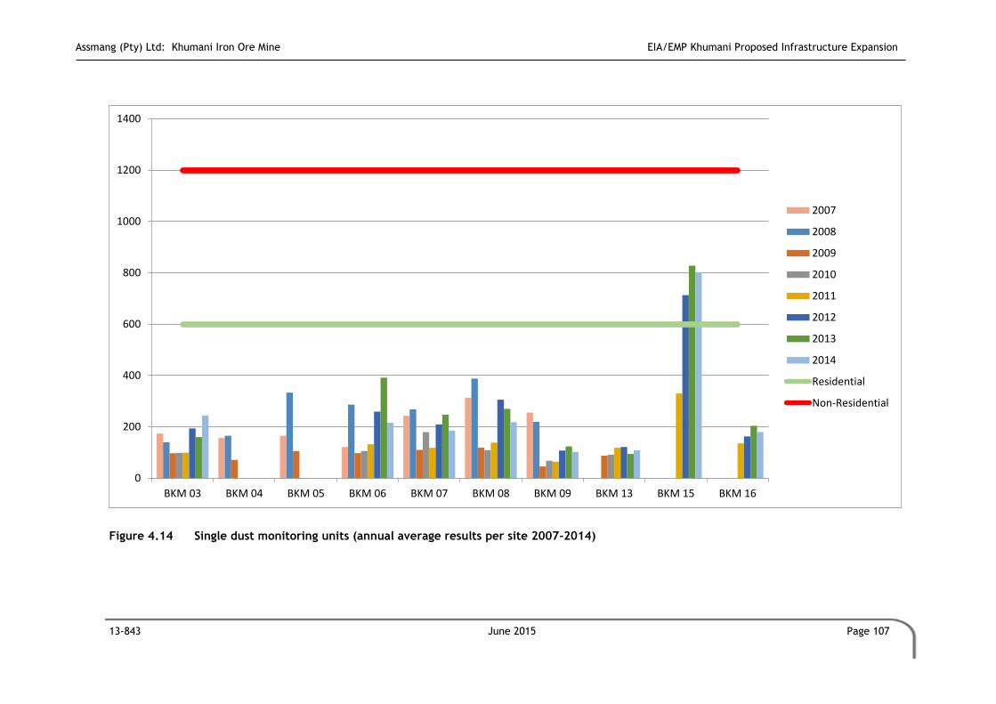
Assmang (Pty) Ltd: Khumani Iron Ore Mine EIA/EMP Khumani Proposed Infrastructure Expansion
13-843 June 2015 Page 107
Figure 4.14 Single dust monitoring units (annual average results per site 2007-2014)
0
200
400
600
800
1000
1200
1400
BKM 03 BKM 04 BKM 05 BKM 06 BKM 07 BKM 08 BKM 09 BKM 13 BKM 15 BKM 16
2007
2008
2009
2010
2011
2012
2013
2014
Residential
Non-Residential

Assmang (Pty) Ltd: Khumani Iron Ore Mine EIA/EMP Khumani Proposed Infrastructure Expansion
13-843 June 2015 Page 108
4.9.2 Directional Dust Monitoring Units
Directional monitoring units (DustWatch) were commissioned in February 2007 at three (3)
locations, while one (1) more unit was commissioned in February 2009, bringing the total for
directional units to four (4).
The results from directional bucket monitoring units (DustWatch) were averaged over the
calendar year, as well as over the seasons (quarterly) to establish the contribution of mine
to the dust loading in the mining area.
The results for all the directional monitoring sites comply with Dustfall Standard, on the
annual average level, refer to Figure 4.16. Monitoring site BKM02 exceeded the non-
residential standard from East South and West sectors in 2012 and East and South sectors in
2013 during the spring season - September, while monitoring site BKM12 exceeded the non-
residential standard during spring season 2013 (September) from three sectors (East, South
and West). Site BKM02 is situated to the south of Mokaning farm and was considered as
background site until middle of 2012, when the construction of the Transnet rail line was
undertaken in the immediate vicinity of the site, thus increasing the dust load to current
elevated levels. Monitoring site BKM12 is located immediately north of the said railway. Old
line section has been de-commissioned and receives most of its dust load from the trains
passing next to it. Even during previous years the results from this site were elevated when
compared with other directional sites.

Assmang (Pty) Ltd: Khumani Iron Ore Mine EIA/EMP Khumani Proposed Infrastructure Expansion
13-843 September 2015 Page 109
Figure 4.15 Directional DustWatch dust monitoring units (annual average results per site 2007-2014)
0
200
400
600
800
1000
1200
1400
BKM02 N
BKM02 E
BKM02 S
BKM02 W
BKM11 N
BKM11 E
BKM11 S
BKM11 W
BKM12 N
BKM12 E
BKM12 S
BKM12 W
BKM14 N
BKM14 E
BKM14 S
BKM14 W
2007
2008
2009
2010
2011
2012
2013
2014
Residential
Non-Residential
Assmang (Pty) Ltd: Khumani Iron Ore Mine EIA/EMP Khumani Proposed Infrastructure Expansion
13-843 September 2015 Page 110
4.10 Visual
The visual description was from the previous Khumani EIA/EMP as part of the EMP
Amendment 2011.
The semi-arid open nature of the landscape renders it particularly sensitive to visual
intrusion, especially from mining activities or any other surface infrastructure such as the
proposed various infrastructure at Khumani. However, the landscape character and sense of
place is also determined, to a large extent, by the existing mining activities in the region.
The expectation of visitors to the area and those persons travelling along the N14 will
therefore be of a mining area and not a pristine landscape devoid of human intervention.
Trees were planted along the N14, by khumani to aid as a visual screen.
Presently, the Kumba Iron Ore Mine spoil dumps can be seen from distances of 15 to 20 km,
both from the west and east along the N14. Khumani Stockpiles are less visible from a
distance. To the south of the Khumani, along the N14, are extensive areas where mining
activities, both current and past, are evident. These “intrusions” into the landscape
therefore contribute to the sense of place and landscape characteristics of the study area.
4.11 Noise
The noise description was from the previous Khumani EIA/EMP as part of the EMP
Amendment 2011.
The area in which the proposed the proposed infrastructure upgrades are to be established
is characterised by the following environments:
A rural farming community where the farmsteads are located at large distances
apart;
The existing large opencast operation at Kumba;
The existing opencast operation at Khumani; and
The N14 and the railway lines that cross the area.
Areas in the proximity of existing mining activities will already be subjected to the noise
emissions from diesel-powered equipment and other mining processes. However, unless
farmsteads are very close to these sources of noise, the pre-development ambient noise
levels are still expected to be very low.
The major sources of noise from the current mining operations are:

Assmang (Pty) Ltd: Khumani Iron Ore Mine EIA/EMP Khumani Proposed Infrastructure Expansion
13-843 September 2015 Page 111
The diesel powered equipment, such as bulldozers, FELs, construction and haul trucks
used during both the construction and operational periods of the mine;
The drilling of rock inside the open pit;
The handling of material inside the pit, e.g. the loading of haul trucks;
The hauling of ore and waste rock from the open pit to the surface;
The dumping of ore and waste rock at the crushing plant and on the waste rock dumps
respectively. During this process the use of reverse warning hooters may be audible
over long distances, particularly during the night;
The crushing and screening of ore in the plant area.
Limited noise may result from the proposed infrastructure, although this may be considered
to be insignificant as the proposed location is already surrounded by mining activities.
4.12 Social Conditions
The data contained in this section of the report was obtained from Quantec Regional Data,
2012 for the John Taolo Getswe District Municipality.
4.12.1 Introduction and approach
When conceptualising a proposal to develop a greenfields mine, the anticipated social and
environmental impacts are generally broad and not limited to one specific area or town. The
proposed expansion project falls within the Northern Cape Province, John Taolo District
Municipality and Gamagara Local Municipality.
In order to assess the potential impact of the proposed project, it is important to consider
the particular Province, district municipalities, and local municipalities as well as the nearby
towns in a holistic way.
4.12.2 Regional Context (John Taolo Gaetsewe District Municipality)
The Northern Cape Province is the largest province in South Africa with a land area the size
of 361 830km2. The province has a population density of two (2) persons per every km2.
Prominent languages include Afrikaans, English, Nama, SeTswana and Xhosa
(www.northerncape.org.za). The Province is divided into 5 DMs. These are again subdivided
into 4 LMs. Major Towns include Calvinia, Colesberg, Kuruman, Springbok and Upington.

Assmang (Pty) Ltd: Khumani Iron Ore Mine EIA/EMP Khumani Proposed Infrastructure Expansion
13-843 September 2015 Page 112
The John Taolo District Municipality is divided into the following Local Municipalities:
The Gamagara Local Municipality consists of the following main towns (Statistics SA, 2001):
Refer to Table 4.16 for town area and population numbers.
Table 4.16: Gamagara Local Municipality
PLACE AREA (KM2) POPULATION
Dibeng 8.58 4 023
Dingleton 1.56 2 866
Ditloung 0.62 3 044
Kathu 8.53 8 247
Olifantshoek 3.51 3 985
Remainder 2 449.38 1 048
Source: Statistics SA, 2001
4.12.3 Local Context (Gamagara Local Municipality)
District Municipalities
John Taolo Gaetsewe;
Namakwa;
Pixley ka Seme;
Siyanda; and
Frances Baard.
Local Municipalities
Joe Morolong ;
Ga-Segonyana; and
Gamagara.
Gamagara Local Municipality
Dibeng;
Dingleton;
Ditloung;
Kathu; and
Olifantshoek.

Assmang (Pty) Ltd: Khumani Iron Ore Mine EIA/EMP Khumani Proposed Infrastructure Expansion
13-843 September 2015 Page 113
The Gamagara Local Municipality covers the smallest area in the JTGDM, namely 2 619 km2
(www.kgalagadi.gov.za), and it has the second smallest population size in the area after the
Kgalagadi District Management Area. The primary land use in the municipality is mining and
agriculture with iron ore and manganese being the prime minerals mined in the area and the
main focus of agriculture being on cattle and goats. Game farming and hunting are increasing
in popularity.
The municipal area of Gamagara consists of four towns (Kathu, Debeng, Dingleton
(demolishing) and Olifantshoek), a large farming community and the mining corporations
(Kgalagadi District Municipality, 2007).
4.12.3.1 Demographic Profile
1. Population and Household
According to Figure 4.16, the population size (persons) for the Gamagara District Municipality
increased by 25.47% over the 1995 to 2011 time period, whereas the John Taolo Gaetsewe
District Municipality only grew by 12.49% over the same period. Households have also grown
over the 1995 to 2011 time period, with the Gamagara Local Municipality showing a 30.36%
increase and the John Taolo Gaetsewe District Municipality by 27.23%.

Assmang (Pty) Ltd: Khumani Iron Ore Mine EIA/EMP Khumani Proposed Infrastructure Expansion
13-843 September 2015 Page 114
Source: Quantec Research (Pty) Ltd
Figure 4.16: Population and household size (1995 – 2011)
2. Population Group
The Gamagara Local Municipality population are composed of mostly Black African persons
(49.96%) followed by 34.58% Coloured persons. The John Taolo Gaetsewe District
Municipality, however, shows an 87.36% Black African population with a much smaller
percentage of Coloured persons (8.76%). According to the 2011 Statistics SA census, Kathu
(Ward 4) has mainly a Coloured population (58.53%).
The sex ratio is 120,1 males per 100 female, which indicates more males than females
(Statistics South Africa, census 2011)
The main languages that are spoken in the area are: Afrikaans, Setswana and English.

Assmang (Pty) Ltd: Khumani Iron Ore Mine EIA/EMP Khumani Proposed Infrastructure Expansion
13-843 September 2015 Page 115
3. Age
It is important to assess the age distribution of persons in order to determine both the current
and future needs of an area. Age is an important indicator as it relates to education, skills
and dependency. A young population may require an improved educational system, whereas
an older society may need an accented focus on healthcare. The largest percentage of people
in the Gamagara Local Municipality, 71.9% fall within the working age category (16-64 years
of age). 25.5% of the population are between the age of 0 and 14. And the elderly population
forms 2.5% of the municipality’s population. (Statistics South Africa, census 2011) Persons
younger than 15 years of age do not form part of the Economically Active Population (EAP)
of the area. The age and sex distribution for the Gamagara Local Municipality is depicted in
Figure 4.17 below.
Figure 4.17 Age and Sex distribution (2011)
4. Education
The largest percentage (89,5%) of the Gamagara Local Municipality population has obtained
some form of primary schooling (Figure 4.18). 24.9% of the population has attained matric
and a further 3.6% with higher education.

Assmang (Pty) Ltd: Khumani Iron Ore Mine EIA/EMP Khumani Proposed Infrastructure Expansion
13-843 September 2015 Page 116
Figure 4.18 Education Level (2011)
4.12.3.2 Economic Profile
This section provides a delineation of the study area and a brief economic status quo
pertaining to employment and labour profile.
1. Employment and Labour
The employment status of the population has a variety of important implications.
Economically active and employed persons can contribute to the overall welfare of a specific
community by paying their taxes, looking after the youth and aged and by stimulating the
economy. However, should a community have a large number of economically inactive and /
or unemployed persons, the burden on the EAP of that community are amplified.
Figure 4.19 illustrates that the economic status of the Gamagara Local Municipality. It can
be seen that the largest part of the economically active population in the municipality is
employed. However, unemployment is still high with 22.4% of the youth in the area being
unemployed. (Statistics South Africa, census 2011)
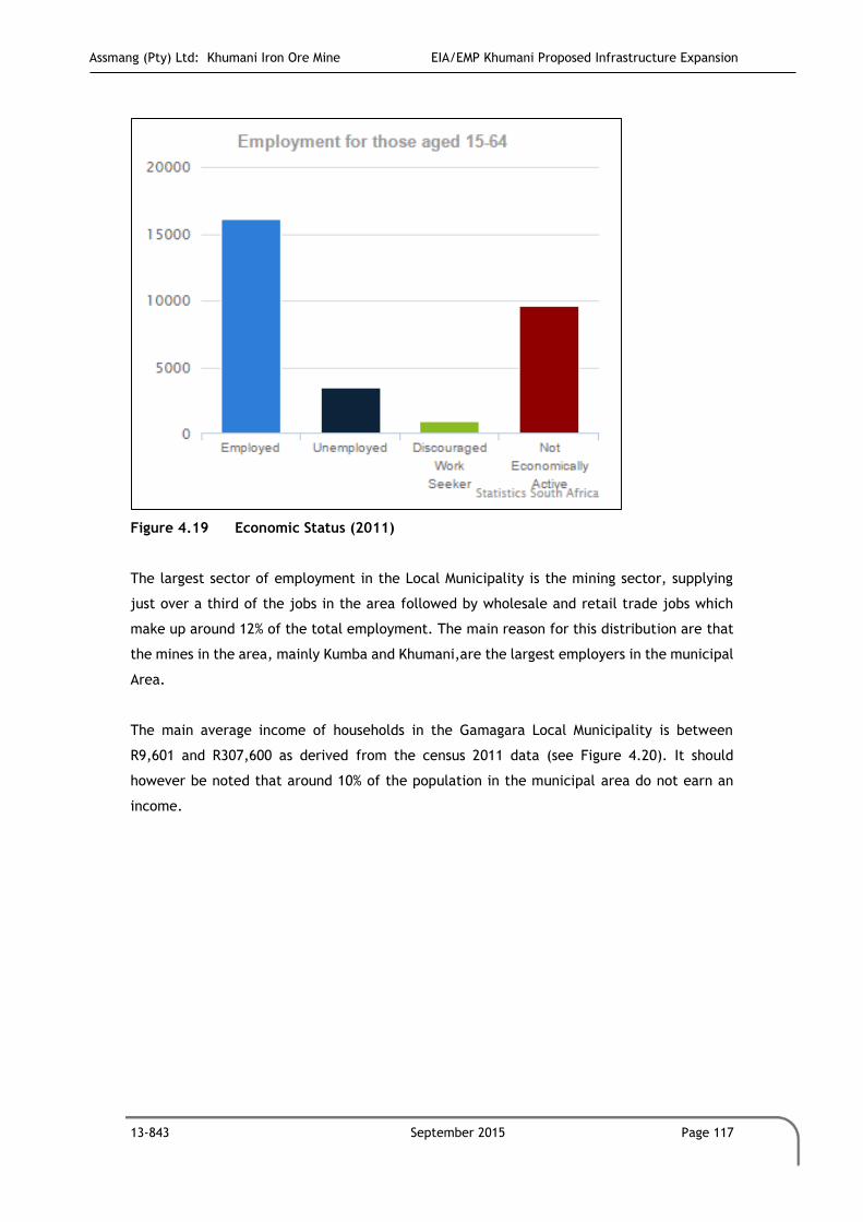
Assmang (Pty) Ltd: Khumani Iron Ore Mine EIA/EMP Khumani Proposed Infrastructure Expansion
13-843 September 2015 Page 117
Figure 4.19 Economic Status (2011)
The largest sector of employment in the Local Municipality is the mining sector, supplying
just over a third of the jobs in the area followed by wholesale and retail trade jobs which
make up around 12% of the total employment. The main reason for this distribution are that
the mines in the area, mainly Kumba and Khumani,are the largest employers in the municipal
Area.
The main average income of households in the Gamagara Local Municipality is between
R9,601 and R307,600 as derived from the census 2011 data (see Figure 4.20). It should
however be noted that around 10% of the population in the municipal area do not earn an
income.
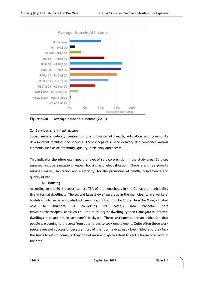
Assmang (Pty) Ltd: Khumani Iron Ore Mine EIA/EMP Khumani Proposed Infrastructure Expansion
13-843 September 2015 Page 118
Figure 4.20 Average household Income (2011)
2. Services and Infrastructure
Social service delivery centres on the provision of health, education and community
development facilities and services. The concept of service delivery also comprises various
elements such as affordability, quality, efficiency and access.
This indicator therefore examines the level of service provision in the study area. Services
assessed include sanitation, water, housing and electrification. There are three priority
services (water, sanitation and electricity) for the promotion of health, convenience and
quality of life.
a. Housing
According to the 2011 census, almost 75% of the households in the Gamagara municipality
live in formal dwellings. The second largest dwelling group in the municipality are workers’
hostels which can be associated with mining activities. Kumba (Sishen Iron Ore Mine, situated
next to Khumani) is converting its hostels into bachelor flats
(www.northerncapebusiness.co.za). The third largest dwelling type in Gamagara is informal
dwellings that are not in someone’s backyard. These settlements are an indication that
people are coming to the area from other areas to seek employment. Quite often these work
seekers are not successful because most of the jobs have already been filled and they lack
the funds to return home, or they do not earn enough to afford to rent a house or a room in
the area.

Assmang (Pty) Ltd: Khumani Iron Ore Mine EIA/EMP Khumani Proposed Infrastructure Expansion
13-843 September 2015 Page 119
b. Energy Use
Figure 4.21 indicates that the use of electricity for lighting, cooking and heating was by far
the highest across all regions. Some gas, paraffin and wood is also used, but these energy
sources are being used less and less, mainly due to the fact that the majority of people live
in formal dwellings.
Figure 4.21 Type of Energy (2011)
3. Water and Sanitation
Figure 4.22 illustrates that 97% of the households in the municipality have access to piped
water inside their residence. With 3% of the households relying on boreholes for water supply.
As for sanitation, 87,6% of the households have flush toilets with a small percentage of
households making use of pit latrines (see Figure 4.23). (Statistics South Africa, Census 2011)

Assmang (Pty) Ltd: Khumani Iron Ore Mine EIA/EMP Khumani Proposed Infrastructure Expansion
13-843 September 2015 Page 120
Figure 4.22 Access to Water (2011)
Figure 4.23 Access to Sanitation (2011)
.

Assmang (Pty) Ltd: Khumani Iron Ore Mine EIA/EMP Khumani Proposed Infrastructure Expansion
13-843 September 2015 Page 121
5 PUBLIC PARTICIPATION PROCESS
This section of the report relates to Section 31 (2) of the GNR543 published in Government
Gazette No.33306 of 18 June 2010, under Section 24(5) of the NEMA.
Regulation 31 (2)
2 e) Details of the public participation process conducted in terms of the subregulation (1),including:
i. Steps undertaken in accordance with the plan of the study;
ii. A list of persons, organizations and organs of state that were registered as
interested and affected parties;
iii. A summary of comments received from and a summary of issues raised by
interested and affected parties, the date of receipt of these comments and the
response of the EAP to these comments; and
This section of the report further documents the process, which were followed to date with
respect to consultation of I&APs, stakeholders and the Government Authorities (Refer to
Appendix B).
5.1 Purpose of Public Participation
The Public Participation Process (PPP) is a requirement of the EIA/EMP process and ensures
that all relevant I&APs are consulted. The process ensures that all stakeholders have an
opportunity to raise their comments as part of an open and transparent process, which in
turn ensures for a complete comprehensive environmental study.
The purpose of PPP and the engagement process is to:
Introduce the proposed project;
Explain the EIA/EMP and PPP processes to be undertaken;
Determine and record public issues and concerns;
Provide opportunities for public input and gathering of local knowledge;
Inform a broad range of stakeholders about the project and the environmental
process to be followed;
Establish lines of communication between stakeholders and the project team;
Identify all the significant issues in the project; and
Identify possible mitigation measures or environmental management plans to
minimise and/or prevent environmental impacts, associated with the project.
Once the concerns of I&APs have been established, the EIA phase of the project will address
these concerns.

Assmang (Pty) Ltd: Khumani Iron Ore Mine EIA/EMP Khumani Proposed Infrastructure Expansion
13-843 September 2015 Page 122
5.2 List of Authorities Consulted
The following Authorities have been identified and invited to become involved in the process
to date:
National Government Authorities:
Department of Water Affairs (DWA).
Department of Mineral Resources (DMR).
Provincial Government Authorities:
Department of Environment and Nature Conservation (NCDENC);
Department of Transport, Roads and Public Works;
Provincial Administration Northern Cape.
Catchment Agency:
Tshiping Water Users Association
District Municipalities:
ZF Mcgawu Districts Municipality;
John Taolo Gaetsewe District Municipality.
Local Municipalities:
Tsantsabane Local Municipality.
Gamagara Local Municipality
Other Authorities:
Transnet;
South African National Parks;
The Wildlife and Environment Society of South Africa (WESSA); and
The South African Heritage Resource Agency (SAHRA).
The reasons for the inclusion of Authorities in the consultation process are the following:
Inform the Authorities of the proposed activities at the Khumani;
Inform and discuss the projected timeframes of the project;
Determine the technical issues associated to the project;
Understand the concerns of the Authorities; and
Highlight the importance of the Authorities’ input in the EIA / EMP process.
Refer to Appendix B for proof of consultation report.
5.3 Scoping Phase
Assmang (Pty) Ltd: Khumani Iron Ore Mine EIA/EMP Khumani Proposed Infrastructure Expansion
13-843 September 2015 Page 123
5.3.1 Identification of I&APs
A comprehensive list of I&APs who have been previously contacted for previous Khumani
projects has been updated by GCS through a process of networking, newspaper
advertisements and site notices.
5.3.2 Notification of Stakeholders
5.3.2.1 Site Notice
Site Notices were placed at the entrance to Khumani and at other key areas to inform the
public of the proposed development and its associated infrastructure. Refer to Appendix B
for proof of site notices.
5.3.2.2 BID
A Background Information Document (BID) (Refer to Appendix B) was sent to all I&APs by
means of email, fax and or post. The BID was compiled in English and it included details of
the proposed development, vital to the EIA process. The BID also included relevant contact
details and a comment/registration sheet for I&APs to complete. I&APs were invited to
register and send responses, by fax, telephone or email to GCS (Please refer to Appendix B
for a copy of the BID).
5.3.2.3 Advertisements
An advertisement regarding the proposed project, including background information, the
assessment process being followed was placed in the DFA newspaper, on 17 September 2014
(refer to Appendix B for a copy of the advertisement).
An advertisement was placed on the DFA newspaper notifying the I&APs on the availability
of the draft Environmental Scoping Report (ESR) on Friday, 31 October 2014. An additional
advertisement was placed in the Volksblad and Kathu Gazette on the 15th of May 2015, as
notification of the inclusion of the Dump expansion on the Farm Bruce.
5.3.3 Availability of Reports
The draft ESR was made available for public review and comments for a 40 day period from
23 October 2014 until 28 November 2014. The report was made available on the GCS Website,
www.gcs-sa.biz. I&APs were notified of the availability of the draft report via emails, faxes
and letters. Refer to Appendix B for proof of notification letters sent to I&APs. The draft ESR

Assmang (Pty) Ltd: Khumani Iron Ore Mine EIA/EMP Khumani Proposed Infrastructure Expansion
13-843 September 2015 Page 124
was updated to a final version and was submitted to the competent authority for review on
the 12th of December 2014. No comments were received on the draft Scoping report from
I&APs.
An addendum to the ESR which served to include the expansion of the Dump on the farm
Bruce was submitted on the 15th of May 2015 for consideration by the department before
continueing with the EIA.
The draft EIA/EMP will be made available to all registered stakeholders for the required
public review period.
5.4 EIA Phase
5.4.1 Advertisements
An advertisement regarding the availability of the Final EIA/EMP reports will be placed in the
Kathu Gazette and Volksblad, (refer to Appendix B for a copy of the advertisement).
Availability of Reports
The draft EIA/EMP will be made available to all registered stakeholders on the Khumani
Project for the required public review period.

Assmang (Pty) Ltd: Khumani Iron Ore Mine EIA/EMP Khumani Proposed Infrastructure Expansion
13-843 September 2015 Page 125
6 ENVIRONMENTAL MANAGEMENT GOALS AND OBJECTIVES
This section of the report relates to Section 33 of the GNR543 published in Government
Gazette No.33306 of 18 June 2010, under Section 24(5) of the NEMA.
REGULATION 33
c) A detailed description of the aspects of the activity that are covered by the draft environmental
management programme
k) Where appropriate, closure plans, including closure objectives.
6.1 Activities
Before the potential environmental impacts posed by the Khumani infrastructure and
stockpile upgrades can be identified, the activities associated with the establishment,
operation and decommissioning must first be identified.
The proposed infrastructure upgrades are described in detail in Section 2 of this EIA/EMP
report. The main activities which will create impacts during the different phases of the mine
life cycle were assessed during the impact assessment phase, and mitigation and management
measures proposed accordingly (Section 7). The main activities that were assessed are
summarised in Figure 6.1.

Assmang (Pty) Ltd: Khumani Iron Ore Mine EIA/EMP Khumani Proposed Infrastructure Expansion
13-843 September 2015 Page 126
Figure 6.1: Proposed Activity Flowchart
6.1.1 Pre-Construction Phase
The applicant commits to obtain all necessary environmental authorisations from the relevant
government departments, before undertaking any construction activities.
6.1.2 Construction Phase
After the Pre-Construction Phase has been finalised, the applicant will commence with the
Construction Phase for their mining activities and project related infrastructure in line with
their approved environmental authorisations. The activities anticipated in the Construction
Phase include:
Land and footprint clearance;
Topsoil stripping and stockpiling;
Establishment of surface infrastructure;
Waste handling; and
Dust suppression.

Assmang (Pty) Ltd: Khumani Iron Ore Mine EIA/EMP Khumani Proposed Infrastructure Expansion
13-843 September 2015 Page 127
6.1.3 Operational Phase
After the Construction Phase has been finalised, the applicant will commence the Operational
Phase. The applicant will commence with the Operational Phase of their activities in line
with their approved environmental authorisations. The activities anticipated in the
Operational Phase include:
Stockpiling ROM and low grade material;
Stockpiling overburden;
Processing of low grade material;
Transporting of material via conveyor;
Control of clean/dirty water separation;
Generation and handling of waste;
Hydrocarbon storage; and
Dust suppression.
6.1.4 Closure and Decommissioning Phase
Closure phase will be in line with approved EMP for mine closure. The infrustucture will be
decommissioned at the end of life of mine. The activities anticipated in the Closure and
Decommissioning Phase includes:
Removal of surface infrastructure; and
Active surface rehabilitation of disturbed areas.
Closure for mining activities is highly important as far as the environmental factors are
concerned. If mitigation measures are not followed properly it could have significant
negative impacts. As closure without mitigation factors could have a permanent effect on
the area and its surrounds.
The mine will be required to apply for a Closure Certificate according to Section 43 of the
MPRDA. Section 43 (1) of the MPRDA stated that “the holder of a … mining right …remains
responsible for any environmental liability, pollution or ecological degradation, and the
management thereof, until the Minister has issued a closure certificate to the holder
concerned”.
6.1.5 Post-Closure Phase

Assmang (Pty) Ltd: Khumani Iron Ore Mine EIA/EMP Khumani Proposed Infrastructure Expansion
13-843 September 2015 Page 128
After the Closure and Decommissioning Phase has been finalised, the applicant will
commence with the Post-Closure Phase of their mining activities in line with their approved
EMP. The activities anticipated in the Post-Closure Phase include:
Residual impacts post closure;
Monitoring of surface and groundwater;
Monitoring of air quality; and
Annual performance assessments of closure goals.
6.2 Environmental Management Objectives
6.2.1 Construction Phase
6.2.1.1 Land Clearance, Soil Stripping and Stockpiling
The environmental objectives associated with land clearance and removal of vegetation for
construction purposes are:
Understand the ecological characteristics of the area in which the mine is located,
implement an ecological (fauna and flora) rescue programme and establish an off-set
area;
To limit activities to the indicated and approved areas to ensure that no additional
land surface, vegetation and habitats outside of the project area are destroyed,
disturbed and/or alienated;
To avoid ecological sensitive areas as far as practically possible;
Delineate ecological sensitive (no-go) zones prior to construction taking place and
remain outside of these areas;
To investigate opportunities for offsetting (tying into the Provincial Conservation
Plan) where avoidance of sensitive areas is not possible;
Removal of weeds and other invasive species over the project area;
To prevent any cumulative impact associated with the removal of vegetation and
footprint clearance;
To reduce the dust dispersion as a result of the removal of earth material as far as
possible;
To ensure an effective surface run-off control system is in order from the
commencement of the construction activities to deal with the separation of clean
and dirty water;
To ensure that the necessary approvals are in-place should any red-data or protected
species be relocated or removed;

Assmang (Pty) Ltd: Khumani Iron Ore Mine EIA/EMP Khumani Proposed Infrastructure Expansion
13-843 September 2015 Page 129
To strictly manage the activities taking place within the project areas by
implementing clear and effective ground rules;
Actively drive the process of the establishment of the Offset Area; and
To rehabilitate the area as per the closure objectives in order to address all
environmental impacts as far as possible and practical.
6.2.1.2 Establishment of Infrastructure and stockpiles
The environmental objectives associated with the establishment of infrastructure associated
with this project are:
To remain within the approved project scope and area; take care that no additional
land surface, vegetation and habitats outside of the project area are destroyed,
disturbed and/or alienated;
To ensure that the area over which the infrastructure will be placed is stable;
To ensure that the placement of infrastructure will not sterilize any potential future
mining reserves;
To prevent any cumulative impact associated with the removal of vegetation and
topsoil;
To manage any other nuisance dust which may occur as a result of the establishment
of new infrastructure;
To accommodate the use of natural material and colours where possible to reduce
the potential visual impact on the surrounding area; and
To rehabilitate the area as per the closure objectives in order to address all
environmental impacts as far as possible and practical.
6.2.1.3 Waste handling
The objectives for waste generation and handling of domestic, diesel and chemical storage
are to:
Ensure that storage takes place in such a manner as not to cause any pollution to the
environment;
Ensure that temporary storage facilities comply with best practice guidelines;
Prevent any pollution of water resources by ensuring that an effective surface runoff
control system is in place;
Prevent, contain and clean up any spillages; and
Ensure that all facilities are monitored on a regular basis.

Assmang (Pty) Ltd: Khumani Iron Ore Mine EIA/EMP Khumani Proposed Infrastructure Expansion
13-843 September 2015 Page 130
6.2.2 Operational Phase
6.2.2.1 Low Grade Stockpiles, ROM Stockpile and Overburden stockpiling
The objective set for stockpiling activities are to:
Minimise spills from trucks and/converyors;
Minimise contamination of natural water resources;
Minimise dust generated from the stockpiles; and
Ensure that no other areas are disturbed except for the appoved areas.
6.2.2.2 Reworking Strategy
The objectives set for the reclaiming activities are to
Optimally rework all low grade material on the site;
Plan the reworking activities in a systematic manner to work towards ongoing
rehabilitation and closure;
Replace discard material from the reworking facilities on an approved and already
disturbed footprint area in a planned manner to enhance the philosophy of ongoing
rehabilitation.
6.2.2.3 Operation of Clean and Dirty Water Systems and Stormwater Management Systems
The objectives set for the clean and dirty water systems are:
To maintain all pollution control systems in such a manner as to reduce any possibility
of dirty water entering the stormwater management systems;
To operate the mine in a closed water circuit;
To ensure compliance to all best practices in terms of the operation of the
stormwater management systems;
To maintain the integrity of the stormwater management systems, including the
berms, bunds, drains;
To ensure that all dirty water systems are cleaned and maintained on a regular basis
to prevent pollution of the water resources and where pollution prevention is not
possible, to minimise the impact on water sources (ground and surface);
Implement the requirements of Water Use License or the DWS Best Practice
Guidelines where applicable;
To achieve overall legal compliance; and
To rehabilitate the area as per the closure objectives in order to address all
environmental impacts as far as possible and practical.
Assmang (Pty) Ltd: Khumani Iron Ore Mine EIA/EMP Khumani Proposed Infrastructure Expansion
13-843 September 2015 Page 131
6.2.2.4 Hydrocarbon Storage
The environmental management objectives for hydrocarbon storage are:
To ensure that all hydrocarbons are stored in a manner which will prevent any harm
to the environment;
To prevent spillages of hydrocarbons;
To capture, contain and manage any spillage; and
To ensure that any area which has been affected by a hydrocarbon spill is suitably
rehabilitated and monitored until rehabilitation efforts have been successful.
6.2.3 Closure and Decommissioning
6.2.3.1 Aftercare, Monitoring and Maintenance
The objectives for aftercare, monitoring and maintenance are to:
Ensure that monitoring takes place until rehabilitation measures are considered
successful.

Assmang (Pty) Ltd: Khumani Iron Ore Mine EIA/EMP Khumani Proposed Infrastructure Expansion
13-843 September 2015 Page 132
7 IDENTIFICATION OF IMPACTS AND CONCERNS WITH MANAGEMENT MEASURES AND ACTION PLANS
This section of the report relates to Section 31 (2) and 33 of the GNR543 published in
Government Gazette No.33306 of 18 June 2010, under Section 24(5) of the NEMA.
Regulation 31 (2)
2 g) A description of identified potential alternatives to the proposed activity, including
advantages and disadvantages that the proposed activity or alternatives may have on the
environment and the community that may be affected by the activity.
2 h) An indication of the methodology used in determining the significance of potential
environmental impacts
2 j) A summary of the findings and any recommendations of any specialist report or a report
on a specialized process
2 k) A description of all environmental issues that were identified during the environmental
impact process, an assessment of the significance of each issue and an indication of the
extent to which the issue could be addressed by the adoption of mitigation measures
2 l) An assessment of each identified potentially significant impact including:
i. Cumulative impacts;
ii. The nature of the impact;
iii. The extent and duration of the impact;
iv. The probability of the impact occurring;
v. The degree to which the impact can be reversed;
vi. The degree to which the impact can cause irreplaceable loss of
resources and ;
vii. The degree to which the impact can be mitigated.
2 p) A draft Environmental Management Programme containing the aspects contemplated
in regulation 33
Regulation 33
b) Information on any proposed management or mitigation measures that will be taken to
address the environmental impacts that have been identified in a report contemplated by
these regulations, including environmental impacts or objects in respect of :
i) Planning and designing;
ii) Pre Construction and construction activities;
iii) Operation or undertaking of the activity;
iv) Rehabilitation of the Environment; and
v) Closure, where relevant
c) A detailed description of the aspects of the activity that are covered by the draft
environmental management programme

Assmang (Pty) Ltd: Khumani Iron Ore Mine EIA/EMP Khumani Proposed Infrastructure Expansion
13-843 September 2015 Page 133
d) An identification of the persons who will be responsible for the implementation of the
measures contemplated in paragraph (b)
f) As far as is reasonably practical, measures to rehabilitate the environment affected by
the undertaking of any listed activity or specified activity to its natural or predetermined
state or to a land use which conforms to the generally accepted principal of sustainable
development ,including ,where appropriate, concurrent or progressive rehabilitation
measures
g) A description of the manner in which it intends to :
i) Modify, remedy, control or stop any action, activity or process which causes
pollution or environmental degradation;
ii) Remedy the cause of pollution or degradation and migration of pollutants;
iii) Comply with any prescribed environmental management standards or practices;
h) Time periods within which the measures contemplated in the environmental management
programme must be implemented
i) The process for managing any environmental damage, pollution, pumping and treatment
of extraneous water or ecological degradation as a result of undertaking a listed activity
k) Where appropriate, closure plans, including closure objectives.
The pre-construction phase has been included as a project phase, to afford the applicant
sufficient time to address all the environmental authorisations required for the proposed
operation (i.e. in terms of the MPRDA, NEMA and NWA), as well as to address other regulatory
requirements. In addition the development of various management plans, action plans and
identification of potential services providers will also be undertaken during this phase.
Khumani commits to obtain all necessary environmental authorisations from the relevant
government departments, before undertaking any construction activities. Khumani also
commits to obtaining the rezoning classification before any construction or operational
activities commence. Finally, Khumani commits to developing site specific action plans
and management plans to address all identified environmental impacts.
7.1 Environmental Impact Assessment Methodology
To ensure uniformity, the assessment of potential impacts was addressed in a standard
manner so that a wide range of impacts is comparable. The ranking criteria and rating scales
was applied to all specialist studies for this project.

Assmang (Pty) Ltd: Khumani Iron Ore Mine EIA/EMP Khumani Proposed Infrastructure Expansion
13-843 September 2015 Page 134
Each impact identified was assessed in terms of probability (likelihood of occurring), scale
(spatial scale), magnitude (severity) and duration (temporal scale). To enable a scientific
approach to the determination of the environmental significance (importance), a numerical
value is linked to each rating scale.
The following criteria were applied to the impact assessment for the EIA/EMP:
Occurrence
Probability of occurrence (how likely is it that the impact may occur?); and
Duration of occurrence (how long may impact last?).
Severity
Magnitude (severity) of impact (will the impact be of high, moderate or low
severity?); and
Scale/extent of impact (will the impact affect the national, regional or local
environment, or only that of the site?).
Status of Impact
+: Positive impact
-: Negative impact
N: Neutral (no impact)
The process presented in Figure 7.1 shows the process followed during the impact
assessment.
Figure 7.1: Process for impact assessment.
In order to assess each of these factors for each impact, the ranking scales in Table 7.1 are
used.

Assmang (Pty) Ltd: Khumani Iron Ore Mine EIA/EMP Khumani Proposed Infrastructure Expansion
13-843 September 2015 Page 135
Table 7.1: Ranking Scales used in Impact Assessment.
Status of Impact
+: Positive (A benefit to the receiving environment)
N: Neutral (No cost or benefit to the receiving environment)
-: Negative (A cost to the receiving environment)
Probability:=P
5 – Definite/don’t know
4 – Highly probable
3 – Medium probability
2 – Low probability
1 – Improbable
0 – Not applicable/none/negligible
Duration:=D
5 – Permanent
4 - Long-term (ceases with the operational life)
3 - Medium-term (5-15 years)
2 - Short-term (0-5 years)
1 – Immediate
0: Not applicable/none/negligible
Scale:=S
5 – International
4 – National
3 – Regional
2 – Local
1 – Site only
0 – Not applicable/none/negligible
Magnitude:=M
10 - Very high/don’t know
8 – High
6 – Moderate
4 – Low
2 – Minor
0: Not applicable/none/negligible
Once the above factors had been ranked for each impact, the environmental significance of
each was assessed using the following formula:
SP = (magnitude + duration + scale) x probability
Once the formula has been applied, the impact significance ratings (Table 7.2) are applied.
Table 7.2: Impact Significance Ratings
SIGNIFICANCE ENVIRONMENTAL SIGNIFICANCE POINTS COLOUR CODE
High (positive) >60 H
Medium (positive) 30 to 60 M
Low (positive) <30 L
Neutral 0 N
Low (negative) >-30 L
Medium (negative) -30 to -60 M
High (negative) <-60 H
The flow chart of activities that were assessed was provided previously in Figure 6.1.

Assmang (Pty) Ltd: Khumani Iron Ore Mine EIA/EMP Khumani Proposed Infrastructure Expansion
13-843 September 2015 Page 136
7.2 Pre-Construction Phase
The applicant commits to obtain all necessary environmental authorisations from the relevant
government departments, before undertaking any construction activities.
No impact assessment is undertaken for the pre-construction phase as the activities
assessed are all process related.
7.3 Construction Phase
After the Pre-Construction Phase has been finalised, the applicant will commence with the
Construction Phase for their infrastructure and upgrades in line with their approved
environmental authorisations.
7.3.1 Geology
No direct impacts on geology are anticipated. Indirect impacts on the geology are anticipated
due to the locality of the new low grade stockpile expansion area on the farm Parsons. The
mining rights on the farm Parsons are not owned by Assmang but by Khumba Iron Ore Mine.
Agreements are in place between the two companies to allow Assmang to construct and utlise
the farm Parsons for operational activities.
7.3.2 Climate
No direct or indirect impacts on the climate are anticipated during the construction phase.
7.3.3 Topography
Impacts associated with topography as a result of construction include:
Direct impact: topographical changes as a result of land and footprint clearance,
topsoil stripping and stockpiling, infrastructure establishment.
7.3.4 Soils, Land Use and Land Capability
Impacts on the soils, land use and land capability of the mining area as a result of construction
activities include:
Direct impact: loss of topsoil (soil stripping) in preparation for the construction
phase;

Assmang (Pty) Ltd: Khumani Iron Ore Mine EIA/EMP Khumani Proposed Infrastructure Expansion
13-843 September 2015 Page 137
Direct impact: soil contamination due to construction vehicles and potential
hydrocarbon spillages and/or leaks; and
Indirect impact: dust fallout as a result of exposed surfaces and vehcilular movement
on site.
This activitiy / impact will result throughout the life of mine as the facility increases.
7.3.5 Heritage and Sites of Cultural Significance
No direct or indirect impacts are anticipated.
7.3.6 Hydrology
Impacts on hydrology of the mining area as a result of construction activities include:
Direct impact: vegetation and topsoil clearance could obstruct drainage, cause
waterlogging and pollute water resources and reduce runoff to the river systems;
Direct impact: hydrocarbon spillages from equipment utilised in construction
activities could lead to the contamination of water resources;; and
Indirect impact: water quality and quantity deterioration due to changes in the
surface water regime.
The proposed construction activity is not likely to have any measurable impacts on local
surface water resources or water availability to other local water users.
7.3.7 Geohydrology
Impacts on geohydrology of the mining area as a result of construction activities include:
Direct impact: reduction in groundwater recharge, due to the compaction of surfaces
and the establishment of permanent infrastructure.
Accidental spillages from the bulldozers and trucks clearing the site are possible. Baseline
monitoring during this period should continue to ensure sufficient data is available to
evaluate the difference in natural trends and any changes occurring during the operational
phase.
7.3.8 Biodiversity
Impacts on biodiversity of the mining area as a result of construction activities include:

Assmang (Pty) Ltd: Khumani Iron Ore Mine EIA/EMP Khumani Proposed Infrastructure Expansion
13-843 September 2015 Page 138
Direct impact: loss of floral and faunal species of conservation importance due to
topsoil removal and vegetation disturbance;
Direct impact: displacement of faunal species and human/animal conflict during site
preparation activities; and
Indirect impact: loss of ecological connectivity and ecosystem functioning.
7.3.9 Air Quality
Impacts on air quality of the mining area as a result of construction activities include:
Direct impact: dust fallout from topsoil removal and vegetation removal; and
Indirect impact: emissions to air by vehicles will occur due to vehicles operating on
site.
Impacts associated with the dust emitting activities within the mine boundary (vehicle
movement and stockpiling) may be significant without mitigation and so every effort should
be made to mitigate against any fugitive emissions from these sources in order to protect
mine personnel from occupational exposure to dust.
7.3.10 Visual
Impacts on visual aspects of the mining area as a result of construction activities include:
Direct impact: soil stripping and footprint clearance will impact the perceptions of
people travelling past site and staying/working near the site.
The significance of visual impact associated with the surface infrastructure during the
construction phase will be moderate - low, and can be minimised to a low impact provided
recommended mitigation measures are successful.
7.3.11 Noise
Impacts on the noise environment of the mining area as a result of construction activities
include:
Direct impact: increased noise due to increased vehicular movement on site.
During construction there will be increase noise on the mine, however since the mine is in
full operation, this additional noice will have a medium significance without mitigation. With
mitigation the noise levels will decrease to a low impact.

Assmang (Pty) Ltd: Khumani Iron Ore Mine EIA/EMP Khumani Proposed Infrastructure Expansion
13-843 September 2015 Page 139
7.3.12 Social
There will be no direct or indirect social impacts during construction.
7.3.13 Wetlands
Impacts on the wetlands of the mining area as a result of construction activities include:
Direct Impact: Destruction of non perennial pan systems
7.3.14 Construction Phase Impact Assessment
Table 7.3 details the identified impacts and management measures for the construction
phase activities.

Assmang (Pty) Ltd: Khumani Iron Ore Mine EIA/EMP Khumani Proposed Infrastructure Expansion
13-843 September 2015 Page 140
Table 7.3: Impacts and Management Measures for Construction Phase Activities.
POTENTIAL ENVIRONMENTAL IMPACT
ACTIVITY INFRASTRUCTURE
AREA
ENVIRONMENTAL SIGNIFICANCE
BEFORE MITIGATION
RECOMMENDED MITIGATION MEASURES
ENVIRONMENTAL SIGNIFICANCE
AFTER MITIGATION
ACTION PLAN PHASE PERSON ANNUAL MANAGEMENT
COST
M D S P
TO
TA
L
ST
AT
US
SP M D S P
TO
TA
L
ST
AT
US
SP
INFRASTRUCTURE DEVELOPMENT AREAS: 1. OVERBURDEN AREA 2. STOCKPILE AREAS 3. NEW INFRASTRUCTURE AREA
CONSTRUCTION PHASE ACTIVITIES: 1. LAND & FOOTPRINT CLEARANCE 2. TOPSOIL STRIPPING AND STOCKPILING 3. ESTABLISHMENT OF NEW INFRASTRUCTURE 4. UPGGRADE OF EXISTING INFRASTRUCTURE 5. WASTE HANDLING 6. DUST SUPPRESSION
GEOLOGY
No direct or indirect impacts anticipated.
1, 2, 3, 4 & 5
1, 2 & 3 0 0 0 0 0 N N No mitigation necessary. 0 0 0 0 0 N N N/A N/A N/A N/A
TOPOGRAPHY
Direct impact: alteration of topography
1, 2, 3, 4 & 5
1 & 2 6 4 3 3 39 - M
Demarcate footprint area clearly Minimise site clearance to the footprint area only
6 4 2 2 24 - L All areas are to be dermacted clearly. All construction must take place within designated areas.
Construction Environmental Officer
Included in construction costs
SOILS, LAND USE AND LAND CAPABILITY
Direct impact: loss of topsoil
1, 2, 3, 4 & 5
1, 2 & 3 10 5 1 5 80 - H
Minimise the stripping footprint as far as possible. Tosoil should be stripped where infrastructure is placed and site clearance take place
10 5 1 5 80 - H Ensure that soil management methods are communicated and implemented by contractors and staff.
Construction Environmental Officer
Included in construction costs
Direct impact: soil compaction
1, 2, 3, 4 & 5
1, 2 & 3 4 4 1 2 18 - L
Avoid clearance and earthworks after heavy rain. Drive only on approved roads
2 4 1 1 7 - L Adhere to Soil Stripping, Soil Stockpiling and Soil Management Plan Implement Vehicle Operating Plan
Constuction Environmental Officer
Included in construction costs
Direct impact: soil erosion
1, 2, 3, 4 & 5
1, 2 & 3 6 4 1 3 33 - M
Demarcate the footprint area clearly. Manage storm water flow with temporary erosion control measures where possible (cut-off trenches or berms). Schedule construction as soon as possible after site clearing.
4 4 1 2 18 - L
Adhere to Stormwater Management Plan Ensure that all design drawings include effective erosion control measures. Ensure the required erosion protection measures are monitored and corrected where necessary.
Constuction Environmental Officer
Included in construction costs

Assmang (Pty) Ltd: Khumani Iron Ore Mine EIA/EMP Khumani Proposed Infrastructure Expansion
13-843 September 2015 Page 141
POTENTIAL ENVIRONMENTAL IMPACT
ACTIVITY INFRASTRUCTURE
AREA
ENVIRONMENTAL SIGNIFICANCE
BEFORE MITIGATION
RECOMMENDED MITIGATION MEASURES
ENVIRONMENTAL SIGNIFICANCE
AFTER MITIGATION
ACTION PLAN PHASE PERSON ANNUAL MANAGEMENT
COST
M D S P
TO
TA
L
ST
AT
US
SP M D S P
TO
TA
L
ST
AT
US
SP
INFRASTRUCTURE DEVELOPMENT AREAS: 1. OVERBURDEN AREA 2. STOCKPILE AREAS 3. NEW INFRASTRUCTURE AREA
CONSTRUCTION PHASE ACTIVITIES: 1. LAND & FOOTPRINT CLEARANCE 2. TOPSOIL STRIPPING AND STOCKPILING 3. ESTABLISHMENT OF NEW INFRASTRUCTURE 4. UPGGRADE OF EXISTING INFRASTRUCTURE 5. WASTE HANDLING 6. DUST SUPPRESSION
Direct impact: soil contamination
1, 2, 3, 4 & 5
1, 2 & 3 6 2 1 5 45 - M
Store solid waste in approved waste disposal area. Remove waste regularly (approved contractor). Chemicals and fuels to be stored in bunded areas. Vehicles to be correctly maintained to prevent oil leakages and in the approved workshop areas on either Parson, Bruce or King area. Any hydrocarbon spills to be cleaned immediately. Significant spills should be reported to the regulatory authorites withn 24 hours and a clean up strategy should be formulated.
4 2 1 2 14 - L
Adhere to Waste Storage and Handling Plan Adhere to Spill Management Plan Adhere to the Emergency procedures Report and implement spill clean-up uprocedures
Constuction Environmental Officer
Included in construction costs
HERITAGE
No direct or indirect impacts anticipated.
1, 2, 3, 4 & 5
1, 2 & 3 0 0 0 0 0 - N N/A 0 0 0 0 0 - N N/A N/A N/A N/A
HYDROLOGY
Direct imact: Vegetation and topsoil clearance could obstruct drainage, cause water to stand in some areasand pollute water resources
1, 2, 3, 4 & 5
1, 2 & 3 4 4 2 3 30 - M
Rehabilitate open areas as soon as practically possible. Vegetate open areas as soon as practically possible. Only remove vegetation within demarcated areas. Manager stormwater systems and runoff.
4 2 2 2 16 - L
Adhere to Storwater Management Plan Implement the surface water-monitoring programme to prevent, manage and monitor potential erosion. Construct the required erosion protection measures. Adhere to Rehabilitation Plan
Construction Environmental Officer
Included in construction costs
Direct impact: Contamination of water resources due to hydrocarbon spillages
1, 2, 3, 4 & 5
1, 2 & 3 6 3 3 3 36 - M
Ensure clean and dirty water separation Implement immediate spill clean-up procedures Undertake emergency water monitoring Notify water users of potential pollution immediately Inform relevant authority immediately
4 3 2 2 18 - L Adhere to Stormwater Management Plan Adhere to Water Quality Monitoring Plan Adhere to Spill Management Plan
Construction Environmental Officer
Included in construction costs

Assmang (Pty) Ltd: Khumani Iron Ore Mine EIA/EMP Khumani Proposed Infrastructure Expansion
13-843 September 2015 Page 142
POTENTIAL ENVIRONMENTAL IMPACT
ACTIVITY INFRASTRUCTURE
AREA
ENVIRONMENTAL SIGNIFICANCE
BEFORE MITIGATION
RECOMMENDED MITIGATION MEASURES
ENVIRONMENTAL SIGNIFICANCE
AFTER MITIGATION
ACTION PLAN PHASE PERSON ANNUAL MANAGEMENT
COST
M D S P
TO
TA
L
ST
AT
US
SP M D S P
TO
TA
L
ST
AT
US
SP
INFRASTRUCTURE DEVELOPMENT AREAS: 1. OVERBURDEN AREA 2. STOCKPILE AREAS 3. NEW INFRASTRUCTURE AREA
CONSTRUCTION PHASE ACTIVITIES: 1. LAND & FOOTPRINT CLEARANCE 2. TOPSOIL STRIPPING AND STOCKPILING 3. ESTABLISHMENT OF NEW INFRASTRUCTURE 4. UPGGRADE OF EXISTING INFRASTRUCTURE 5. WASTE HANDLING 6. DUST SUPPRESSION
Indirect impact: pollution of water resources
1, 2, 3, 4 & 5
1, 2 & 3 10 3 3 3 48 - M
Fix damaged stormwater management structure Implement immediate spill clean-up procedures Notify water users of potential pollution immediately Inform relevant authority in terms of the conditions of the license
6 2 2 2 20 - L Adhere to Stormwater Management Plan Adhere to Water Quality Monitoring Plan Adhere to Spill Management Plan
Construction Environmental Officer
Included in construction costs
Indirect impact: water quality deterioration
1, 2, 3, 4 & 5
1, 2, 3, 4, 5 & 6 10 3 3 3 48 - M
Ensure stormwater management on site Undertake water quality monitoring Notify water users of potential pollution immediately Inform relevant authority immediately Update the groundwater model to include the new stockpiles in a time series Undertake a waste classification on the low grade material to establish the waste type and disposal requirements in terms of the relevant Norms and Standards.
4 2 2 2 16 - L
Adhere to Stormwater Management Plan Adhere to Water Quality Monitoring Plan Adhere to Spill Management Plan Waste charcaterisation and Classification of all residue stockpiles (i.e. low grade stockpiles and paste disposal material)
Construction Environmental Officer
Included in construction costs
GROUNDWATER
No direct or indirect impacts anticipated.
1, 2, 3, 4 & 5
1, 2 & 3 0 0 0 0 0 - N N/A 0 0 0 0 0 - N N/A N/A N/A N/A
TERRESTRIAL BIODIVERSITY (FAUNA AND FLORA)
Direct impact: Loss of floral species of conservation importance
1, 2, 3, 4 & 5
1, 2 & 3 10 4 2 4 64 - H
Minimise the area to be cleared. Identify important species in the footprint areas. Conduct detailed, multi-seasonal walk-through prior to construction activities. Compile list of protected and Red Data species. Develop relocation programme if possible, or invest ruther into the current nursery on site. Apply for relevant permits with authorities prior to the
10 4 2 3 48 - M
Adhere to Biodiversity Conservation Plan Adhere to Alien and Invasive Vegetation Management Plan Adhere to Flora and Fauna Relocation Programme Built onto the existing nursery on site and the tree planting strategy
Construction Environmental Officer
Included in construction costs

Assmang (Pty) Ltd: Khumani Iron Ore Mine EIA/EMP Khumani Proposed Infrastructure Expansion
13-843 September 2015 Page 143
POTENTIAL ENVIRONMENTAL IMPACT
ACTIVITY INFRASTRUCTURE
AREA
ENVIRONMENTAL SIGNIFICANCE
BEFORE MITIGATION
RECOMMENDED MITIGATION MEASURES
ENVIRONMENTAL SIGNIFICANCE
AFTER MITIGATION
ACTION PLAN PHASE PERSON ANNUAL MANAGEMENT
COST
M D S P
TO
TA
L
ST
AT
US
SP M D S P
TO
TA
L
ST
AT
US
SP
INFRASTRUCTURE DEVELOPMENT AREAS: 1. OVERBURDEN AREA 2. STOCKPILE AREAS 3. NEW INFRASTRUCTURE AREA
CONSTRUCTION PHASE ACTIVITIES: 1. LAND & FOOTPRINT CLEARANCE 2. TOPSOIL STRIPPING AND STOCKPILING 3. ESTABLISHMENT OF NEW INFRASTRUCTURE 4. UPGGRADE OF EXISTING INFRASTRUCTURE 5. WASTE HANDLING 6. DUST SUPPRESSION
removal of protected plant species. Develop an offset area action plan which should be signed of by the NCDENC
Direct impact: Loss of fauna species of conservation importance
1, 2, 3, 4 & 5
1, 2 & 3 8 4 2 5 70 - H
Minimise the area to be cleared. Identify important species in the footprint areas. Develop relocation programme. The importance to finalise and conclude the current Offset Area process must be emphasised. Implement biodiversity offset principles (if necessary).
6 5 2 4 52 - M
Develop a timeframe and programme for the finalisation of the Offset Area and keep track of the process with feedback to commenting stakeholders. It is important to take cognisance of the increase in footprint disturbance on the mine when finalising the Offset Area footprint requriements. Note, that the focus should be on the residual footprint, which should therefore assess what volume of residue stockpile will remain after reworking has completed. Adhere to Alien and Invasive Vegetation Management Plan Adhere to Biodiversity Offset Plan Adhere to Flora and Fauna Relocation Programme
Construction Environmental Officer
Included in construction costs
Direct impact: Displacement of faunal species and human/animal conflict
1, 2, 3, 4 & 5
1, 2 & 3 4 4 2 5 50 - M
Identify a protocol that will allow for protection of animals during construction phases, this should include no hunting and/or poaching of animals. Implement awareness programmes.
4 4 2 4 40 - M Adhere to Environmental Awareness Programme
Construction Environmental Officer
Included in construction costs

Assmang (Pty) Ltd: Khumani Iron Ore Mine EIA/EMP Khumani Proposed Infrastructure Expansion
13-843 September 2015 Page 144
POTENTIAL ENVIRONMENTAL IMPACT
ACTIVITY INFRASTRUCTURE
AREA
ENVIRONMENTAL SIGNIFICANCE
BEFORE MITIGATION
RECOMMENDED MITIGATION MEASURES
ENVIRONMENTAL SIGNIFICANCE
AFTER MITIGATION
ACTION PLAN PHASE PERSON ANNUAL MANAGEMENT
COST
M D S P
TO
TA
L
ST
AT
US
SP M D S P
TO
TA
L
ST
AT
US
SP
INFRASTRUCTURE DEVELOPMENT AREAS: 1. OVERBURDEN AREA 2. STOCKPILE AREAS 3. NEW INFRASTRUCTURE AREA
CONSTRUCTION PHASE ACTIVITIES: 1. LAND & FOOTPRINT CLEARANCE 2. TOPSOIL STRIPPING AND STOCKPILING 3. ESTABLISHMENT OF NEW INFRASTRUCTURE 4. UPGGRADE OF EXISTING INFRASTRUCTURE 5. WASTE HANDLING 6. DUST SUPPRESSION
Direct impact: Loss of ecological connectivity and ecosystem functioning
1, 2, 3, 4 & 5
1, 2 & 3 6 4 2 5 60 - M
Minimise the area to be cleared. Identify important species in the footprint areas.
4 4 2 4 40 - M
Develop a timeframe and programme for the finalisation of the Offset Area and keep track of the process with feedback to commenting stakeholders.
Construction Environmental Officer
Included in construction costs
AIR QUALITY
Direct impact: dust-fallout
1, 2, 3, 4 & 5
1, 2 & 3 4 1 2 4 28 - L
Dust monitoring by means of single dust buckets in the eight major wind directions should be continued. A workable system to monitor PM10s’ should be implemented. Minimise dust liberation by watering/wetting surfaces Monitoring of fence-line fallout dust Treating of haul roads with dust retardant Strictly enforced speed limits on haul roads Limiting of transfer of material
2 1 1 4 16 - L
Implement dust monitoring progamme in terms for the Dust Montiroing Gap Analysis undertaken by Prism EMS during 2014. Strictly enforced speed limits on haul roads Dust suppression to be implemented as per the approved EMP and subsequent dust monitoring studies where these have improved the monitoring protocol.
Construction Environmental Officer
Included in construction costs
Direct impact: vehicle entrained dust
1, 2, 3, 4 & 5
1, 2 & 3 4 1 2 4 28 - L
Dust monitoring Minimise dust liberation by watering/wetting surfaces Treating of haul roads with dust retardant to limit the use of water as a dust suppressant.
2 2 1 2 10 - L Adhere to Dust Fallout Management Plan Strictly enforced speed limits on haul roads
Construction Environmental Officer
Included in construction costs
Indirect impact: emissions to air by vehicles
1, 2, 3, 4 & 5
1, 2 & 3 4 1 2 4 28 - L Monitor vehicular emissions Dust supression and speed control
2 2 1 2 10 - L Implement a Vehicle Maintenance Plans All vehicles must services regurlarly during th construction phase
Construction Environmental Officer
Included in construction costs
VISUAL

Assmang (Pty) Ltd: Khumani Iron Ore Mine EIA/EMP Khumani Proposed Infrastructure Expansion
13-843 September 2015 Page 145
POTENTIAL ENVIRONMENTAL IMPACT
ACTIVITY INFRASTRUCTURE
AREA
ENVIRONMENTAL SIGNIFICANCE
BEFORE MITIGATION
RECOMMENDED MITIGATION MEASURES
ENVIRONMENTAL SIGNIFICANCE
AFTER MITIGATION
ACTION PLAN PHASE PERSON ANNUAL MANAGEMENT
COST
M D S P
TO
TA
L
ST
AT
US
SP M D S P
TO
TA
L
ST
AT
US
SP
INFRASTRUCTURE DEVELOPMENT AREAS: 1. OVERBURDEN AREA 2. STOCKPILE AREAS 3. NEW INFRASTRUCTURE AREA
CONSTRUCTION PHASE ACTIVITIES: 1. LAND & FOOTPRINT CLEARANCE 2. TOPSOIL STRIPPING AND STOCKPILING 3. ESTABLISHMENT OF NEW INFRASTRUCTURE 4. UPGGRADE OF EXISTING INFRASTRUCTURE 5. WASTE HANDLING 6. DUST SUPPRESSION
Direct impact: soil stripping and footprint clearance
1, 2, 3, 4 & 5
1, 2 & 3 4 4 2 4 40 - M
Minimise the stripping footprint to only cover the areas to be cleared and stripped Limit vegetation loss
4 4 1 3 27 - L
Adhere to Soil Stripping, Soil Stockpiling and Soil Management Plan Adhere to Visual Screening Plan (tree planting strategy)
Construction Environmental Officer
Included in construction costs
NOISE
Direct impact: vehicular movement
1, 2, 3, 4 & 5
1, 2 & 3 4 2 2 5 40 - M
Implement acoustic screening measures such as the planting of endemic tree species as is currently being undertaken by the mine, similar to the intitiative by the mine along the N14 on Parson Farm Undertake regular vehicle maintenance and keep records of such monitoring Undertake noise monitoring
4 1 2 2 14 - L Adhere to Provincial Noise Regulations Adhere to Noise Management Plan Adhere to Vehicle Maintenance Plans
Construction Environmental Officer
Included in construction costs
Direct impact: construction
1, 2, 3, 4 & 5
1, 2 & 3 6 4 2 5 60 - M
Implement acoustic screening measures such as the planting of endemic tree species as is currently being undertaken by the mine, similar to the intitiative by the mine along the N14 on Parson Farm. Utilise only state of the art equipment Undertake noise monitoring
4 4 1 2 18 - L Adhere to Provincial Noise Regulations Adhere to Noise Management Plan
Construction Environmental Officer
Included in construction costs
SOCIAL
No direct or indirect impacts anticipated.
1, 2, 3, 4 & 5
1, 2 & 3 0 0 0 0 0 - N N/A 0 0 0 0 0 - N N/A N/A N/A N/A
WETLAND
Direct impact: wetland destruction
3 2 6 5 3 5 70 - H
No mitigation possible. The low grade stockpile encrouches the pans. The pans will be permanently destroyed.
6 5 3 5 90 - H
Develop a timeframe and programme for the finalisation of the Offset Area and keep track of the process with feedback to commenting stakeholders. It is important to take cognisance of the increase in footprint disturbance on the mine when finalising the Offset Area footprint requriements. Note,
N/A N/A N/A

Assmang (Pty) Ltd: Khumani Iron Ore Mine EIA/EMP Khumani Proposed Infrastructure Expansion
13-843 September 2015 Page 146
POTENTIAL ENVIRONMENTAL IMPACT
ACTIVITY INFRASTRUCTURE
AREA
ENVIRONMENTAL SIGNIFICANCE
BEFORE MITIGATION
RECOMMENDED MITIGATION MEASURES
ENVIRONMENTAL SIGNIFICANCE
AFTER MITIGATION
ACTION PLAN PHASE PERSON ANNUAL MANAGEMENT
COST
M D S P
TO
TA
L
ST
AT
US
SP M D S P
TO
TA
L
ST
AT
US
SP
INFRASTRUCTURE DEVELOPMENT AREAS: 1. OVERBURDEN AREA 2. STOCKPILE AREAS 3. NEW INFRASTRUCTURE AREA
CONSTRUCTION PHASE ACTIVITIES: 1. LAND & FOOTPRINT CLEARANCE 2. TOPSOIL STRIPPING AND STOCKPILING 3. ESTABLISHMENT OF NEW INFRASTRUCTURE 4. UPGGRADE OF EXISTING INFRASTRUCTURE 5. WASTE HANDLING 6. DUST SUPPRESSION
that the focus should be on the residual footprint, which should therefore assess what volume of residue stockpile will remain after reworking has completed. Adhere to Alien and Invasive Vegetation
Indirect impact: pollution of water resources
3 1 10 3 3 3 48 - M
Maintain stormwater management structures Implement immediate spill clean-up procedures Undertake emergency water monitoring Notify water users of potential pollution immediately Inform relevant authority immediately
6 2 2 2 20 - L Adhere to Stormwater Management Plan Conduct Water Quality Monitoring Adhere to Spill Response Plan

Assmang (Pty) Ltd: Khumani Iron Ore Mine EIA/EMP Khumani Proposed Infrastructure Expansion
13-843 September 2015 Page 147
7.4 Operational Phase
The Operational Phase will commence once construction is completed. The applicant will
commence with the Operational Phase for their reclaiming and stockpiling activities and
project related infrastructure in line with their approved environmental authorisations.
7.4.1 Geology
No direct or indirect impacts on the geology of the area due to the operational phase of the
project.
7.4.2 Topography
Impacts associated with topography as a result of the operational phase include:
Direct impact: topographical changes will continue through the increase of the
stockpile footprints and then they will decrease as a result of the reclaiming
activities.
7.4.3 Soils, Land Use and Land Capability
Impacts on the soils, land use and land capability of the project area as a result of operational
activities include:
Direct impact: soil erosion due to exposed surfaces; and
Direct impact: soil contamination due to operation vehicles and equipment and
potential hydrocarbon spillages and/or leaks.
7.4.4 Heritage and Sites of Cultural Significance
Impacts on the heritage environement of the project area as a result of operational activities
include:
Indirect impact: unearthing of archaeological and/or paleontological artefacts as
operational activities progress.
7.4.5 Hydrology
Impacts on hydrology of the project area as a result of operational activities include:
Indirect impact: pollution of water resources due to spillages and dust fallout; and
Indirect impact: water quality and quantity deterioration due to changes in the
surface water regime.

Assmang (Pty) Ltd: Khumani Iron Ore Mine EIA/EMP Khumani Proposed Infrastructure Expansion
13-843 September 2015 Page 148
The proposed activity is not likely to have any measurable impacts on local surface water
resources or water availability to other local water users.
7.4.6 Geohydrology
Impacts on geohydrology of the project area as a result of operational activities include:
Direct impact: groundwater quality impacts due to potential spillages and
contamination.
7.4.7 Biodiversity
Impacts on the biodiversity regime of the project area as a result of operational activities
include:
Direct impact: Encroachment of invasive species due to the presence of mining
activities in the area;
Indirect impact: impacts on surrounding habitats.
7.4.8 Air Quality
Impacts on the air quality environment of the project area as a result of operational activities
include:
Direct impact: dust fallout from the stockpiles, and
Indirect impact: emissions to air by vehicles will occur due to vehicles operating on
site.
Dust emissions will occur during operational activities, particularly associated with loading
and offloading of material and the transport of the ROM and low-grade materials either via
truck or conveyor.
7.4.9 Visual
Impacts on visual aspects of the project area as a result of operational activities include:
Direct impact: Increase in dust could lead to a visual impact.
The significance of visual impact associated with the surface infrastructure during the
operational phase will be moderate - high, and can be minimised to a moderate impact
provided recommended mitigation measures are successful..

Assmang (Pty) Ltd: Khumani Iron Ore Mine EIA/EMP Khumani Proposed Infrastructure Expansion
13-843 September 2015 Page 149
7.4.10 Noise
Impacts on the noise environment of the project area as a result of operational activities
include:
Direct impact: increased noise due to increased vehicular movement on site; and
Direct impact: operation of the plant
7.4.11 Social
No Impacts envisaged
7.4.12 Wetlands
Impacts on the wetlands of the mining area as a result of construction activities include:
Direct Impact: Destruction of non perennial pan systems
7.4.13 Operational Phase Impact Assessment
Table 7.4 details the identified impacts and management measures for the operational phase
activities.
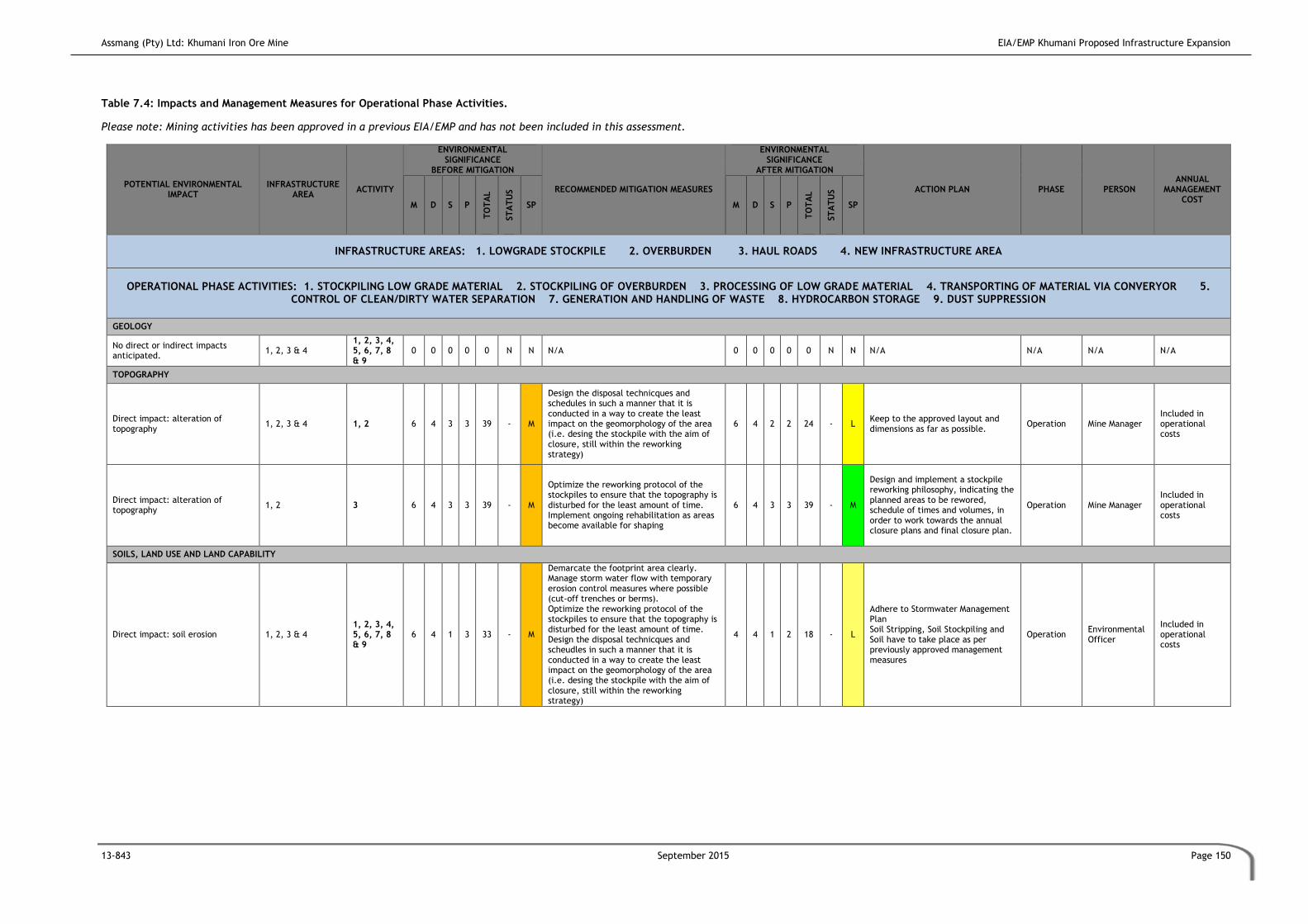
Assmang (Pty) Ltd: Khumani Iron Ore Mine EIA/EMP Khumani Proposed Infrastructure Expansion
13-843 September 2015 Page 150
Table 7.4: Impacts and Management Measures for Operational Phase Activities.
Please note: Mining activities has been approved in a previous EIA/EMP and has not been included in this assessment.
POTENTIAL ENVIRONMENTAL IMPACT
INFRASTRUCTURE AREA
ACTIVITY
ENVIRONMENTAL SIGNIFICANCE
BEFORE MITIGATION
RECOMMENDED MITIGATION MEASURES
ENVIRONMENTAL SIGNIFICANCE
AFTER MITIGATION
ACTION PLAN PHASE PERSON ANNUAL
MANAGEMENT COST
M D S P
TO
TA
L
ST
AT
US
SP M D S P
TO
TA
L
ST
AT
US
SP
INFRASTRUCTURE AREAS: 1. LOWGRADE STOCKPILE 2. OVERBURDEN 3. HAUL ROADS 4. NEW INFRASTRUCTURE AREA
OPERATIONAL PHASE ACTIVITIES: 1. STOCKPILING LOW GRADE MATERIAL 2. STOCKPILING OF OVERBURDEN 3. PROCESSING OF LOW GRADE MATERIAL 4. TRANSPORTING OF MATERIAL VIA CONVERYOR 5. CONTROL OF CLEAN/DIRTY WATER SEPARATION 7. GENERATION AND HANDLING OF WASTE 8. HYDROCARBON STORAGE 9. DUST SUPPRESSION
GEOLOGY
No direct or indirect impacts anticipated.
1, 2, 3 & 4 1, 2, 3, 4, 5, 6, 7, 8 & 9
0 0 0 0 0 N N N/A 0 0 0 0 0 N N N/A N/A N/A N/A
TOPOGRAPHY
Direct impact: alteration of topography
1, 2, 3 & 4 1, 2 6 4 3 3 39 - M
Design the disposal technicques and schedules in such a manner that it is conducted in a way to create the least impact on the geomorphology of the area (i.e. desing the stockpile with the aim of closure, still within the reworking strategy)
6 4 2 2 24 - L Keep to the approved layout and dimensions as far as possible.
Operation Mine Manager Included in operational costs
Direct impact: alteration of topography
1, 2 3 6 4 3 3 39 - M
Optimize the reworking protocol of the stockpiles to ensure that the topography is disturbed for the least amount of time. Implement ongoing rehabilitation as areas become available for shaping
6 4 3 3 39 - M
Design and implement a stockpile reworking philosophy, indicating the planned areas to be rewored, schedule of times and volumes, in order to work towards the annual closure plans and final closure plan.
Operation Mine Manager Included in operational costs
SOILS, LAND USE AND LAND CAPABILITY
Direct impact: soil erosion 1, 2, 3 & 4 1, 2, 3, 4, 5, 6, 7, 8 & 9
6 4 1 3 33 - M
Demarcate the footprint area clearly. Manage storm water flow with temporary erosion control measures where possible (cut-off trenches or berms). Optimize the reworking protocol of the stockpiles to ensure that the topography is disturbed for the least amount of time. Design the disposal technicques and scheudles in such a manner that it is conducted in a way to create the least impact on the geomorphology of the area (i.e. desing the stockpile with the aim of closure, still within the reworking strategy)
4 4 1 2 18 - L
Adhere to Stormwater Management Plan Soil Stripping, Soil Stockpiling and Soil have to take place as per previously approved management measures
Operation Environmental Officer
Included in operational costs

Assmang (Pty) Ltd: Khumani Iron Ore Mine EIA/EMP Khumani Proposed Infrastructure Expansion
13-843 September 2015 Page 151
POTENTIAL ENVIRONMENTAL IMPACT
INFRASTRUCTURE AREA
ACTIVITY
ENVIRONMENTAL SIGNIFICANCE
BEFORE MITIGATION
RECOMMENDED MITIGATION MEASURES
ENVIRONMENTAL SIGNIFICANCE
AFTER MITIGATION
ACTION PLAN PHASE PERSON ANNUAL
MANAGEMENT COST
M D S P
TO
TA
L
ST
AT
US
SP M D S P
TO
TA
L
ST
AT
US
SP
INFRASTRUCTURE AREAS: 1. LOWGRADE STOCKPILE 2. OVERBURDEN 3. HAUL ROADS 4. NEW INFRASTRUCTURE AREA
OPERATIONAL PHASE ACTIVITIES: 1. STOCKPILING LOW GRADE MATERIAL 2. STOCKPILING OF OVERBURDEN 3. PROCESSING OF LOW GRADE MATERIAL 4. TRANSPORTING OF MATERIAL VIA CONVERYOR 5. CONTROL OF CLEAN/DIRTY WATER SEPARATION 7. GENERATION AND HANDLING OF WASTE 8. HYDROCARBON STORAGE 9. DUST SUPPRESSION
Direct impact: soil contamination 1, 2, 3 & 4 1, 2, 3, 4, 5, 6, 7, 8 & 9
6 2 1 5 45 - M
Store solid waste in approved waste disposal area. Remove waste regularly (approved contractor). Chemicals and fuels to be stored in bunded areas. Vehicles to be correctly maintained to prevent oil leakages. Adhere to recommended vehicle maintenance schedule and environmental policies Provide spill kits and follow spill procedures on site for collection of contaminated soil Ensure correct functioning of storm water management Ensure correct bunding of hydrocarbon and chemical storage areas
4 2 1 2 14 - L Adhere to Waste Storage and Handling Plan Adhere to Spill Management Plan
Operation Environmental Officer
Included in operational costs
HERITAGE
No direct or indirect impacts anticipated.
1, 2, 3 & 4 1, 2, 3, 4, 5, 6, 7, 8 & 9
0 0 0 0 0 N N N/A 0 0 0 0 0 N N N/A N/A N/A N/A
Indirect impact: Unearthing of archaeological/paleantological artefacts
1, 2, 3 & 4 1, 2, 3, 4, 5, 6, 7, 8 & 9
10 2 2 3 42 - M Cease mining immediately Do not remove/damage artefact
4 2 1 2 14 - L Employ registered Archaeologist to assess before proceeding with mining
Operational Environmental Officer
R 50 000.00
HYDROLOGY
No direct impacts anticipated - - 0 0 0 0 0 N N N/A 0 0 0 0 0 N N N/A N/A N/A N/A
Indirect impact: pollution of water resources
1, 2, 3 & 4 1, 2, 3, 4, 5, 6, 7, 8 & 9
10 3 3 3 48 - M
Fix damaged stormwater management structure Implement immediate spill clean-up procedures Undertake emergency water monitoring Notify water users of potential pollution immediately Inform relevant authority immediately
6 2 2 2 20 - L
Adhere to Stormwater Management Plan Adhere to Water Quality Monitoring Plan Adhere to Spill Management Plan
Operational Environmental Officer
Included in operational
costs

Assmang (Pty) Ltd: Khumani Iron Ore Mine EIA/EMP Khumani Proposed Infrastructure Expansion
13-843 September 2015 Page 152
POTENTIAL ENVIRONMENTAL IMPACT
INFRASTRUCTURE AREA
ACTIVITY
ENVIRONMENTAL SIGNIFICANCE
BEFORE MITIGATION
RECOMMENDED MITIGATION MEASURES
ENVIRONMENTAL SIGNIFICANCE
AFTER MITIGATION
ACTION PLAN PHASE PERSON ANNUAL
MANAGEMENT COST
M D S P
TO
TA
L
ST
AT
US
SP M D S P
TO
TA
L
ST
AT
US
SP
INFRASTRUCTURE AREAS: 1. LOWGRADE STOCKPILE 2. OVERBURDEN 3. HAUL ROADS 4. NEW INFRASTRUCTURE AREA
OPERATIONAL PHASE ACTIVITIES: 1. STOCKPILING LOW GRADE MATERIAL 2. STOCKPILING OF OVERBURDEN 3. PROCESSING OF LOW GRADE MATERIAL 4. TRANSPORTING OF MATERIAL VIA CONVERYOR 5. CONTROL OF CLEAN/DIRTY WATER SEPARATION 7. GENERATION AND HANDLING OF WASTE 8. HYDROCARBON STORAGE 9. DUST SUPPRESSION
Indirect impact: hydrocarbon spillages
1, 2, 3 & 4 1, 2, 3, 4, 5, 6, 7, 8 & 9
10 2 3 3 45 - M
Ensure clean and dirty water separation Implement immediate spill clean-up procedures Undertake emergency water monitoring Notify water users of potential pollution immediately Inform relevant authority immediately as per the conditions of the environmental license
4 2 1 2 14 - L
Adhere to Stormwater Management Plan Adhere to Water Quality Monitoring Plan Adhere to Spill Management Plan
Operational Environmental Officer
Included in operational
costs
Indirect impact: water quality/quantity deterioration
1, 2, 3 & 4 1, 2, 3, 4, 5, 6, 7, 8 & 9
10 3 3 3 48 - M
Ensure clean and dirty water separation Undertake water quality monitoring in terms of the approved Water Use License Notify water users of potential pollution immediately Inform relevant authority immediately of any significant incidents as required in terms of the environmental license Identify alternative water provider, if necessary
4 2 2 2 16 - L
Adhere to Stormwater Management Plan Adhere to Water Quality Monitoring Plan Adhere to Spill Management Plan
Operational Environmental Officer
Included in operational
costs
GROUNDWATER
Direct impact: groundwater quality deterioration
1, 2, 3 & 4 1, 2, 3, 4, 5, 6, 7, 8 & 9
4 5 3 3 36 - M Prevent infiltration of contaminated water Rre-circulation of contaminated water should be optimised.
4 5 3 3 36 - M
Adhere to Stormwater Management Plan Undertake Water Quality Monitoring Adhere to Spill Management Plan Ensure that the closed water circuit is enforced on site, i.e. all dams (stormwater dams) are equipped with pumps in a working conditions and operational.
Operational Environmental Officer
Included in operational
costs
TERRESTRIAL BIODIVERSITY (FAUNA AND FLORA)
Indirect impact: impact on surrounding habitats
1, 2, 3 & 4 1, 2, 3, 4, 5, 6, 7, 8 & 9
2 2 2 2 12 - L
Prevent the spread of impacts to adjacent habitat by containing activities to mining area only. Prevent invader species spreading.
1 2 2 2 10 - L Update the weed eradication protocol to include all new areas as applied for in this report.
Operational Environmental Office
Included in operational
costs

Assmang (Pty) Ltd: Khumani Iron Ore Mine EIA/EMP Khumani Proposed Infrastructure Expansion
13-843 September 2015 Page 153
POTENTIAL ENVIRONMENTAL IMPACT
INFRASTRUCTURE AREA
ACTIVITY
ENVIRONMENTAL SIGNIFICANCE
BEFORE MITIGATION
RECOMMENDED MITIGATION MEASURES
ENVIRONMENTAL SIGNIFICANCE
AFTER MITIGATION
ACTION PLAN PHASE PERSON ANNUAL
MANAGEMENT COST
M D S P
TO
TA
L
ST
AT
US
SP M D S P
TO
TA
L
ST
AT
US
SP
INFRASTRUCTURE AREAS: 1. LOWGRADE STOCKPILE 2. OVERBURDEN 3. HAUL ROADS 4. NEW INFRASTRUCTURE AREA
OPERATIONAL PHASE ACTIVITIES: 1. STOCKPILING LOW GRADE MATERIAL 2. STOCKPILING OF OVERBURDEN 3. PROCESSING OF LOW GRADE MATERIAL 4. TRANSPORTING OF MATERIAL VIA CONVERYOR 5. CONTROL OF CLEAN/DIRTY WATER SEPARATION 7. GENERATION AND HANDLING OF WASTE 8. HYDROCARBON STORAGE 9. DUST SUPPRESSION
Direct impact: human-animal conflicts and interactions
1, 2, 3 & 4 1, 2, 3, 4, 5, 6, 7, 8 & 9
4 4 2 4 40 - M Identify a protocol that will allow for protection of animals Implement awareness programmes.
4 4 1 3 27 - L Adhere to Environmental Awareness Programme
Operational Environmental Officer
Included in operational
costs
AIR QUALITY
Indirect impact: emissions to air by vehicles
1, 2, 3 & 4 1, 2, 3, 4, 5, 6, 7, 8 & 9
6 2 2 4 40 - M Monitor vehicular emissions Ensure that all vehicles are in good working order.
2 2 2 2 12 - L Adhere to Vehicle Maintenance Plans
Operational Environmental Officer
Included in operational costs
Direct impact: dust-fallout 1, 2, 3 & 4 1, 2, 3, 4, 5, 6, 7, 8 & 9
6 3 2 3 33 - M
Dust monitoring programmes must be continued. The monitoring programmes should be updated periodically to ensure that the best standards and methods for the purpose of Khumani is being implemented. Minimise dust liberation by treating roads and surfaced with a dust suppression, and where this is not possible or economically feasible, the watering/wetting of surfaces Strictly enforced speed limits on haul roads
4 2 1 2 14 - L Adhere to Dust Fallout Management Plan
Operational Environmental Officer
Included in operational
costs
VISUAL
Direct impact: infrastructure – and stockpiles
4 4 & 5 8 5 3 4 64 - H
Ensure that the stockpiles are designed with closure in mind, and that the reworking of these faciltieis are undertaken in a phased method to minimise the impact on the overall geomorphology of the area during the operational phase. Use screening, similar to what is currently being undertaken at Khumani with the planning of endemic tree species, at the new WHIMS Plant area to limit visual intrusion
6 5 2 4 52 - M Adhere to Operation Plan Adhere to Construction Plan
Operation Mine Manager Included in operational costs
NOISE

Assmang (Pty) Ltd: Khumani Iron Ore Mine EIA/EMP Khumani Proposed Infrastructure Expansion
13-843 September 2015 Page 154
POTENTIAL ENVIRONMENTAL IMPACT
INFRASTRUCTURE AREA
ACTIVITY
ENVIRONMENTAL SIGNIFICANCE
BEFORE MITIGATION
RECOMMENDED MITIGATION MEASURES
ENVIRONMENTAL SIGNIFICANCE
AFTER MITIGATION
ACTION PLAN PHASE PERSON ANNUAL
MANAGEMENT COST
M D S P
TO
TA
L
ST
AT
US
SP M D S P
TO
TA
L
ST
AT
US
SP
INFRASTRUCTURE AREAS: 1. LOWGRADE STOCKPILE 2. OVERBURDEN 3. HAUL ROADS 4. NEW INFRASTRUCTURE AREA
OPERATIONAL PHASE ACTIVITIES: 1. STOCKPILING LOW GRADE MATERIAL 2. STOCKPILING OF OVERBURDEN 3. PROCESSING OF LOW GRADE MATERIAL 4. TRANSPORTING OF MATERIAL VIA CONVERYOR 5. CONTROL OF CLEAN/DIRTY WATER SEPARATION 7. GENERATION AND HANDLING OF WASTE 8. HYDROCARBON STORAGE 9. DUST SUPPRESSION
Direct impact: vehicular movement 1, 2, 3, 4 & 5 1, 2, 3, 4, & 5
6 4 2 5 60 - M Implement acoustic screening measures Undertake regular vehicle maintenance
4 1 2 2 14 - L Adhere to Provincial Noise Regulations Adhere to existing EMP
Operation Environmental Officer
Included in operation costs
Direct impact: plant operation 4 5 6 4 2 2 24 - L Utilise only state of the art equipment 4 4 2 2 20 - L
Adhere to Provincial Noise Regulations Adhere to measures in the existing EMP
Operational Phase
Environmental Officer
Included in operation costs
SOCIAL
Indirect impact: longer life of mine, securing current jobs
1, 2, 3, 4 & 5 1, 2, 3, 4, 5, 6, 7, 8
& 9 4 2 4 5 50 + M
Communicate employment criteria to the employees, operational phase being initiated Implement skills development to allow career progression and portable skills transfer
6 4 4 5 70 + H Adhere to Social and Labour Plan Adhere to Recruitment Policy Adhere to Skills Development Plan
Operational Mine Manager Included in operational
costs
WETLAND
Direct impact: wetland destruction 3 2 6 5 3 5 70 - H No mitigation possible. The low grade stockpile runs through the pans
10 5 3 5 90 - H Adhere to Mining Work Programme Adhere to Operational Plan
Operational Mine Manager Included in operational costs

Assmang (Pty) Ltd: Khumani Iron Ore Mine EIA/EMP Khumani Proposed Infrastructure Expansion
13-843 September 2015 Page 155
7.5 Decommissioning and Closure Phase
After the Operational Phase has been finalised, the applicant will commence with the
Decommissioning and Closure Phase for their mining activities and project related
infrastructure and stockpiles in line with their approved environmental authorisations. It
should be noted, that the overall aim of this project is to reduce the overall environmental
liaibilities of the mine by reducing the size and presence of residue stockpiles on site.
Closure for mining activities is highly important as far as the environmental factors are
concerned. If mitigation measures are not followed properly it could have hegative impacts.
The mine will be required to apply for a Closure Certificate according to Section 43 of the
MPRDA. Section 43 (1) of the MPRDA stated that “the holder of a … mining right …remains
responsible for any environmental liability, pollution or ecological degradation, and the
management thereof, until the Minister has issued a closure certificate to the holder
concerned”.
It is therefore assumed that all environmental impacts will be successfully addressed and
managed at this phase. When the decision is taken to decommission the mine, monitoring of
key environmental variables in order to demonstrate and ensure acceptable
quality/rehabilitation measurements will be undertaken.
Following cessation of mining, it is customary that all infrastructure will be decommissioned
and removed from site in a systematic and regulated manner. Following this, active surface
rehabilitation will be undertaken until the end of mine land use is attained.
7.5.1 Geology
No direct or indirect geological impacts are anticpated during the decommissioning and
closure phase.
7.5.2 Topography
Impacts associated with topography as a result of the decommissiiong and closure phase
include:
Direct impact: reshaping of the area following mining activities in order to achieve
the proposed end of mine land use.

Assmang (Pty) Ltd: Khumani Iron Ore Mine EIA/EMP Khumani Proposed Infrastructure Expansion
13-843 September 2015 Page 156
7.5.3 Soils, Land Use and Land Capability
Impacts on the soils, land use and land capability of the mining area as a result of
decommissioning and closure sactivities include:
Direct impact: soil compaction due to vehicles and equipment utilised in the
rehabilitation activities contributing to vehicular movement on site;
Direct impact: soil erosion due to exposed surfaces and rehabilitation;
Direct impact: soil contamination due to the operation of vehicles and equipment
during rehabilitation and potential hydrocarbon spillages and/or leaks;
Direct impact: change in land use after mining; and
Direct impact: change in land capability as agricultural land will be lost once mining
related activities cease.
Post-closure land use will depend on the success and outcomes of the rehabilitation phase.
7.5.4 Heritage and Sites of Cultural Significance
No direct or indirect impacts associated with decommissiong and closure with regards to
heritage and sites of cultural significance are anticipated.
7.5.5 Hydrology
Impacts on hydrology of the mining area as a result of decommissiong and closure activities
include:
Direct impact: surface water contamination;
Direct impact: increase in runoff and contribution to catchment; and
Direct impact: siltation during to water running off site once the berms and
stormwater structure are decommissioned.
7.5.6 Geohydrology
Impacts on geohydrology of the mining area as a result of decommissiong and closure
activities include:
Direct impact: groundwater quality impacts due to potential spillages and
contamination.
7.5.7 Biodiversity

Assmang (Pty) Ltd: Khumani Iron Ore Mine EIA/EMP Khumani Proposed Infrastructure Expansion
13-843 September 2015 Page 157
Impacts on the biodiversity regime of the mining area as a result of decommissioning and
closure activities include:
Direct impact: disruption to faunal and floral communities that have established on
site during the operational phase; and
Direct impact: re-establishment of faunal and floral communities during the
rehabilitation process (Self succession).
7.5.8 Air Quality
Impacts on the air quality environment of the mining area as a result of decommissioning and
closure activities include:
Direct impact: fugitive dust emissions;
Direct impact: dust entrainment from vehicles on site as a result of driving on
exposed surfaces; and
Indirect impact: wind-blown dust as rehabilitation activities takes place.
There will be fugitive dust emissions resulting from the removal of infrastructure and the
landscaping of the mining areas.
7.5.9 Visual
Impacts on visual aspects of the mining area as a result of decommissioning and closure
activities include:
Direct impact: landscaping of the entire site and berm removals.
Direct impact: removal of infrastructure from site and re-establishment of vegetated
areas.
The significance of visual impact associated with the mining operation during the closure
phase will be moderate for most of the activities, and can be minimised to a low impact
provided recommended mitigation measures are successful. The removal/dismantling of all
surface infrastructures will greatly reduce the visual impact. The shaping and vegetation of
discard dumps will also minimise the visual impact and reduce the intrusion.
7.5.10 Noise
Impacts on the noise environment of the mining area as a result of decommissioning and
closure activities include:
Direct impact: increased noise due to rehabilitation activities; and
Direct impact: reduction in noise levels due to mining cessation.

Assmang (Pty) Ltd: Khumani Iron Ore Mine EIA/EMP Khumani Proposed Infrastructure Expansion
13-843 September 2015 Page 158
The noise levels during decommissioning will be negligible.
7.5.11 Social
Impacts on the social environment of the mining area as a result of decommissioning and
closure activities include:
Direct impact: out-migration of job seekers as the mining operations cease;
Direct impact: job losses;
Direct impact: a reduction in economic activities due to job losses and mine closure;
and
Indirect impact: increased crime due to job losses and impacts on economic activity
in the area.
It is important that the mine adhere to the comitments made in the Social and Labour Plan
with regards to closure.
7.5.12 Wetlands
No further direct or indirect impacts on wetlands.
7.5.13 Decomissioning and Closure Phase Impact Assessment
Table 7.5 details the identified impacts and management measures for the decommissioning
and closure phase activities.

Assmang (Pty) Ltd: Khumani Iron Ore Mine EIA/EMP Khumani Proposed Infrastructure Expansion
13-843 September 2015 Page 159
Table 7.5: Impacts and Management Measures for Closure and Decommissioning Phase Activities.
POTENTIAL ENVIRONMENTAL IMPACT
APPLICABLEMINE AREA
ACTIVITY
ENVIRONMENTAL SIGNIFICANCE BEFORE MITIGATION
RECOMMENDED MITIGATION MEASURES
ENVIRONMENTAL SIGNIFICANCE AFTER MITIGATION
ACTION PLAN PHASE PERSON ANNUAL
MANAGEMENT COST M D S P
TO
TA
L
ST
AT
US
SP M D S P
TO
TA
L
ST
AT
US
SP
MINE AREAS (BRUCE, KING AND MOKANENG): 1. PITS 2. OVERBURDEN 3. DUMPS 4. INFRASTRUCTURE AREAS 5. ROADS
DECOMISSIONING & CLOSURE ACTIVITIES: 1. REMOVAL OF SURFACE INFRASTRUCTURE 2. ACTIVE SURFACE REHABILITATION OF DISTURBED AREAS
GEOLOGY
No direct impacts anticipated 1, 2, 3, 4 & 5 1 &2 0 0 0 0 0 N N N/A 0 0 0 0 0 N N N/A Decommissioning and Closure
N/A N/A
TOPOGRAPHY
Direct impact: reshaping of area
1, 2, 3, 4 & 5 1 &2 6 4 3 3 39 - M
The area must be ripped.. All slopes to be shaped to accommodate natural flow and vegetation establishment. All slopes to be safe for animals and humans Selfsuccession will be promoted, where it does not succeed the client will investigate a revegation programme
6 4 2 2 24 - L
Adhere to Rehabilitation Plan Adhere to Revegetation Plan Adhere to Stormwater Management Plan
Decommissioning and Closure
Environmental Officer Included in decommissioning and closure costs
SOILS, LAND USE AND LAND CAPABILITY
Direct impact: soil compaction 1, 2, 3, 4 & 5 1 &2 4 4 1 2 18 - L
Correct use of vehicles to prevent compaction Avoidance of work in very wet or waterlogged conditions Use tracked vehicles instead of wheeled vehicles where possible Avoid clearance and earthworks after heavy rain Drive only on demarcated roads
2 4 1 1 7 - L
Adhere to Soil Stripping, Soil Stockpiling and Soil Management Plan Implement Vehicle Operating Plan Adhere to Rehabilitation Plan Adhere to Revegetation Plan
Decommissioning and Closure
Environmental Officer Included in decommissioning and closure costs

Assmang (Pty) Ltd: Khumani Iron Ore Mine EIA/EMP Khumani Proposed Infrastructure Expansion
13-843 September 2015 Page 160
POTENTIAL ENVIRONMENTAL IMPACT
APPLICABLEMINE AREA
ACTIVITY
ENVIRONMENTAL SIGNIFICANCE BEFORE MITIGATION
RECOMMENDED MITIGATION MEASURES
ENVIRONMENTAL SIGNIFICANCE AFTER MITIGATION
ACTION PLAN PHASE PERSON ANNUAL
MANAGEMENT COST M D S P
TO
TA
L
ST
AT
US
SP M D S P
TO
TA
L
ST
AT
US
SP
MINE AREAS (BRUCE, KING AND MOKANENG): 1. PITS 2. OVERBURDEN 3. DUMPS 4. INFRASTRUCTURE AREAS 5. ROADS
DECOMISSIONING & CLOSURE ACTIVITIES: 1. REMOVAL OF SURFACE INFRASTRUCTURE 2. ACTIVE SURFACE REHABILITATION OF DISTURBED AREAS
Direct impact: soil contamination
1, 2, 3, 4 & 5 1 &2 6 2 1 5 45 - M
Prevent spillage of fuel and oils Adhere to recommended vehicle maintenance schedule and environmental policies Provide spill kits and follow spill procedures on site for collection of contaminated soil Ensure correct functioning of storm water management structure until all structures are decommissioned. Ensure correct bunding of hydrocarbon and chemical storage areas
4 2 1 2 14 - L
Adhere to Waste Storage and Handling Plan Spill Management methods must be adhered to Adhere to Vehicle Maintenace Plan
Decommissioning and Closure
Environmental Officer Included in decommissioning and closure costs
Direct impact: soil erosion 1, 2, 3, 4 & 5 1 &2 6 4 1 3 33 - M
Minimise infrastructure footprint Manage stormwater and stormwater management measures Employ cut-off trenches or berms until area is established The mine willl investigate an appropriate seed mix for the rehabilitation purposes should self-succession not establish on rehabilitated sites
4 4 1 2 18 - L
Adhere to Rehabilitation Plan Adhere to Revegetation Plan Adhere to Stormwater Management Plan
Decommissioning and Closure
Environmental Officer Included in decommissioning and closure costs
Direct impact: change in land use
1, 2, 3, 4 & 5 1 &2 8 5 1 5 70 - H Plan land use after mining with the local authorities and in consultation with specialist
8 5 1 4 56 - M Adhere to Rehabilitation Plan Adhere to Revegetation Plan
Decommissioning and Closure
Environmental Officer Included in decommissioning and closure costs
HERITAGE
No direct or indirect impacts anticipated
1, 2, 3, 4 & 5 1 &2 0 0 0 0 0 N N N/A 0 0 0 0 0 N N N/A Decommissioning and Closure
N/A N/A
HYDROLOGY

Assmang (Pty) Ltd: Khumani Iron Ore Mine EIA/EMP Khumani Proposed Infrastructure Expansion
13-843 September 2015 Page 161
POTENTIAL ENVIRONMENTAL IMPACT
APPLICABLEMINE AREA
ACTIVITY
ENVIRONMENTAL SIGNIFICANCE BEFORE MITIGATION
RECOMMENDED MITIGATION MEASURES
ENVIRONMENTAL SIGNIFICANCE AFTER MITIGATION
ACTION PLAN PHASE PERSON ANNUAL
MANAGEMENT COST M D S P
TO
TA
L
ST
AT
US
SP M D S P
TO
TA
L
ST
AT
US
SP
MINE AREAS (BRUCE, KING AND MOKANENG): 1. PITS 2. OVERBURDEN 3. DUMPS 4. INFRASTRUCTURE AREAS 5. ROADS
DECOMISSIONING & CLOSURE ACTIVITIES: 1. REMOVAL OF SURFACE INFRASTRUCTURE 2. ACTIVE SURFACE REHABILITATION OF DISTURBED AREAS
Direct impact: Surface water contamination
1, 2, 3, 4 & 5 1 &2 8 2 2 4 48 - M
Prevent spillage of fuel and oils Adhere to recommended vehicle maintenance schedule and environmental policies Provide spill kits and follow spill procedures on site for collection of contaminated soil Ensure correct functioning of storm water management structure
4 2 2 2 16 - L
Adhere to Rehabilitation Plan Adhere to Stormwater Management Plan Adhere to Revegetation Plan Adhere to Water Quality Monitoring Programme
Decommissioning and Closure
Environmental Officer Included in decommissioning and closure costs
Direct impact: Siltation 1, 2, 3, 4 & 5 1 &2 4 3 2 4 36 - M
Re-establish vegetated areas in a timely manner through active planting and maintenance Minimise erosion through erosion control measures such as the use of energy dissipaters and other technologies.
4 3 2 2 18 - L
Adhere to Rehabilitation Plan Adhere to Stormwater Management Plan Adhere to Revegetation Plan Adhere to Water Quality Monitoring Programme
Decommissioning and Closure
Environmental Officer Included in decommissioning and closure costs
GROUNDWATER
Indirect impact: groundwater quality
1, 2, 3, 4 & 5 1 &2 8 2 2 4 48 - M Manage water ingress Manage hydrocarbons to avoid spillages
4 3 2 3 27 - L
Adhere to Rehabilitation Plan Adhere to Water Monitoring Programme Adhere to Spill Management Plan
Decommissioning and Closure
Environmental Officer Included in decommissioning and closure costs
TERRESTRIAL BIODIVERSITY (FAUNA AND FLORA)
Direct impact: disruption to faunal and floral communites established on site
1, 2, 3, 4 & 5 1 &2 8 2 2 5 60 - M
Limit activities to areas requiring rehabilitation only Ensure these areas are demarcated and fenced off Selfsuccession will be promoted, where it does not succeed the client will investigate a revegation programme as quickly as possible to minimise impact on faunal and floral communities
6 2 1 3 27 - L Adhere to Rehabilitation Plan Adhere to Revegetation Plan
Decommissioning and Closure
Environmental Officer Included in decommissioning and closure costs

Assmang (Pty) Ltd: Khumani Iron Ore Mine EIA/EMP Khumani Proposed Infrastructure Expansion
13-843 September 2015 Page 162
POTENTIAL ENVIRONMENTAL IMPACT
APPLICABLEMINE AREA
ACTIVITY
ENVIRONMENTAL SIGNIFICANCE BEFORE MITIGATION
RECOMMENDED MITIGATION MEASURES
ENVIRONMENTAL SIGNIFICANCE AFTER MITIGATION
ACTION PLAN PHASE PERSON ANNUAL
MANAGEMENT COST M D S P
TO
TA
L
ST
AT
US
SP M D S P
TO
TA
L
ST
AT
US
SP
MINE AREAS (BRUCE, KING AND MOKANENG): 1. PITS 2. OVERBURDEN 3. DUMPS 4. INFRASTRUCTURE AREAS 5. ROADS
DECOMISSIONING & CLOSURE ACTIVITIES: 1. REMOVAL OF SURFACE INFRASTRUCTURE 2. ACTIVE SURFACE REHABILITATION OF DISTURBED AREAS
Direct impact: re-establishment of faunal and floral communites
1, 2, 3, 4 & 5 1 &2 6 2 1 3 27 + L
Re-establish vegetated areas in a timely manner through active planting and maintenance Minimise erosion Manage alien and invasive plant/weed establishment Consider active introduction of faunal species
8 5 3 4 64 + H Adhere to Rehabilitation Plan Adhere to Revegetation Plan
Decommissioning and Closure
Environmental Officer Included in decommissioning and closure costs
AIR QUALITY
Direct impact: fugitive dust emissions
1, 2, 3, 4 & 5 1 &2 4 2 2 4 32 - M
Implement appropriate dust mitigation measures Re-covering of exposed areas Implement dust suppression where necessary Rehabilitate exposed areas as soon after infrastructure removal as possible
2 2 2 3 18 - L Adhere to Rehabilitation Plan Adhere to Dust Management Plan
Decommissioning and Closure
Environmental Officer Included in decommissioning and closure costs
Direct impact: vehicle entrained dust
1, 2, 3, 4 & 5 1 &2 4 1 2 4 28 - L
Implement appropriate dust mitigation measures Re-covering of exposed areas Implement dust suppression where necessary Rehabilitate exposed areas as soon after infrastructure removal as possible Manage vehicle movement on site and ensure speed limts are adhered to
2 2 1 2 10 - L
Adhere to Rehabilitation Plan Adhere to Dust Management Plan Adhere to Vehicle Operation Plan Adhere to South African Road Rules
Decommissioning and Closure
Environmental Officer Included in decommissioning and closure costs
Indirect impact: wind-blown dust off rehabilitated areas
1, 2, 3, 4 & 5 1 &2 4 4 2 4 40 - M
Ensure effective rehabilitation of exposed areas Monitor final rehabilitation for three years after closure (or according to legislative requirements at the time)
2 2 2 2 12 - L Adhere to Rehabilitation Plan Adhere to Dust Management Plan Adhere to Revegetation Plan
Decommissioning and Closure
Environmental Officer Included in decommissioning and closure costs
VISUAL

Assmang (Pty) Ltd: Khumani Iron Ore Mine EIA/EMP Khumani Proposed Infrastructure Expansion
13-843 September 2015 Page 163
POTENTIAL ENVIRONMENTAL IMPACT
APPLICABLEMINE AREA
ACTIVITY
ENVIRONMENTAL SIGNIFICANCE BEFORE MITIGATION
RECOMMENDED MITIGATION MEASURES
ENVIRONMENTAL SIGNIFICANCE AFTER MITIGATION
ACTION PLAN PHASE PERSON ANNUAL
MANAGEMENT COST M D S P
TO
TA
L
ST
AT
US
SP M D S P
TO
TA
L
ST
AT
US
SP
MINE AREAS (BRUCE, KING AND MOKANENG): 1. PITS 2. OVERBURDEN 3. DUMPS 4. INFRASTRUCTURE AREAS 5. ROADS
DECOMISSIONING & CLOSURE ACTIVITIES: 1. REMOVAL OF SURFACE INFRASTRUCTURE 2. ACTIVE SURFACE REHABILITATION OF DISTURBED AREAS
Direct impact: landscaping and berm removal
1, 2, 3, 4 & 5 1 &2 5 2 2 4 36 - M
All slopes to be shaped to accommodate natural flow and vegetation establishment. All slopes to be safe for animals and humans Selfsuccession will be promoted, where it does not succeed the client will investigate a revegation programme
2 5 1 2 16 - L Adhere to Rehabilitation Plan Adhere to Revegetation Plan
Decommissioning and Closure
Environmental Officer Included in decommissioning and closure costs
Direct impact: landscaping of Discard dump
1, 2, 3, 4 & 5 1 &2 6 5 2 4 52 - M
All slopes to be shaped to accommodate natural flow and vegetation establishment. All slopes to be safe for animals and humans Selfsuccession will be promoted, where it does not succeed the client will investigate a revegation programmed
4 2 2 2 16 - L Adhere to Rehabilitation Plan Adhere to Revegetation Plan
Decommissioning and Closure
Environmental Officer Included in decommissioning and closure costs
Direct impact: removal of surface infrastructure
1, 2, 3, 4 & 5 1 &2 6 5 2 4 52 - M
The area is to be resurfaced. All depresions and slopes will be modeled to ensure a natural surface flow regime. Materials which can be resold will be removed and resold All other waste will be discarded appropriately Re-establishment of Indigenous vegetation will be encouraged
2 2 1 2 10 - L Adhere to Rehabilitation Plan Adhere to Revegetation Plan
Decommissioning and Closure
Environmental Officer Included in decommissioning and closure costs
NOISE

Assmang (Pty) Ltd: Khumani Iron Ore Mine EIA/EMP Khumani Proposed Infrastructure Expansion
13-843 September 2015 Page 164
POTENTIAL ENVIRONMENTAL IMPACT
APPLICABLEMINE AREA
ACTIVITY
ENVIRONMENTAL SIGNIFICANCE BEFORE MITIGATION
RECOMMENDED MITIGATION MEASURES
ENVIRONMENTAL SIGNIFICANCE AFTER MITIGATION
ACTION PLAN PHASE PERSON ANNUAL
MANAGEMENT COST M D S P
TO
TA
L
ST
AT
US
SP M D S P
TO
TA
L
ST
AT
US
SP
MINE AREAS (BRUCE, KING AND MOKANENG): 1. PITS 2. OVERBURDEN 3. DUMPS 4. INFRASTRUCTURE AREAS 5. ROADS
DECOMISSIONING & CLOSURE ACTIVITIES: 1. REMOVAL OF SURFACE INFRASTRUCTURE 2. ACTIVE SURFACE REHABILITATION OF DISTURBED AREAS
Direct impact: rehabilitation equipment and demolition activities
1, 2, 3, 4 & 5 1 &2 6 3 2 4 44 - M
Activities will be limited to the hours of 07h00to 18h00 on weekdays. Vehicles will be equipped with mufflers to ensure noise reduction Employees will be briefed on the need to keep noise to a minimum
4 3 2 2 18 - L Adhere to Rehabilitation Plan Adhere to Revegetation Plan
Decommissioning and Closure
Environmental Officer Included in decommissioning and closure costs
Direct impact: reduction in noise with cesation of mining activities
1, 2, 3, 4 & 5 N/A 6 4 1 3 33 + M
Remove infrastructure in a timely manner to minimise noise Remove all vehicles/machinery from site that are not required for rehabilitation activities
10 4 2 4 64 + H Adhere to Closure Plan
Decommissioning and Closure
Environmental Officer Included in decommissioning and closure costs
SOCIAL
Direct impact: out-migration of job seekers
1, 2, 3, 4 & 5 1 &2 8 2 2 5 60 - M
Communicate decommissioning and closure prior to the decommissioning and closure phase being initiated
10 5 2 5 85 - H Adhere to Social and Labour Plan Adhere to Retrenchment Policy
Decommissioning and Closure
Environmental Officer Included in decommissioning and closure costs
Direct impact: loss of jobs 1, 2, 3, 4 & 5 1 &2 10 5 2 5 85 - H
Communicate job losses/retrenchment prior to the decommissioning and closure phase being initiated
8 5 2 5 75 - H Adhere to Social and Labour Plan Adhere to Retrenchment Policy
Decommissioning and Closure
Environmental Officer Included in decommissioning and closure costs
Direct impact: reduced economic activity
1, 2, 3, 4 & 5 1 &2 10 4 3 4 68 - H Notify the LM of mine closure prior to decommissioning and closure phase
6 3 3 3 36 - M Adhere to Social and Labour Plan Decommissioning and Closure
Environmental Officer Included in decommissioning and closure costs

Assmang (Pty) Ltd: Khumani Iron Ore Mine EIA/EMP Khumani Proposed Infrastructure Expansion
13-843 September 2015 Page 165
POTENTIAL ENVIRONMENTAL IMPACT
APPLICABLEMINE AREA
ACTIVITY
ENVIRONMENTAL SIGNIFICANCE BEFORE MITIGATION
RECOMMENDED MITIGATION MEASURES
ENVIRONMENTAL SIGNIFICANCE AFTER MITIGATION
ACTION PLAN PHASE PERSON ANNUAL
MANAGEMENT COST M D S P
TO
TA
L
ST
AT
US
SP M D S P
TO
TA
L
ST
AT
US
SP
MINE AREAS (BRUCE, KING AND MOKANENG): 1. PITS 2. OVERBURDEN 3. DUMPS 4. INFRASTRUCTURE AREAS 5. ROADS
DECOMISSIONING & CLOSURE ACTIVITIES: 1. REMOVAL OF SURFACE INFRASTRUCTURE 2. ACTIVE SURFACE REHABILITATION OF DISTURBED AREAS
Indirect impact: increased crime
1, 2, 3, 4 & 5 1 &2 6 4 2 3 36 - M
Enforce access control to limit loitering of people Engage with adjacent land owners to form a Community Forum Employ security guards on site Consult with the SAPS and/or community watch organisations
8 2 2 2 24 - L Adhere to Social and Labour Plan Adhere to Access Control Procedures
Decommissioning and Closure
Environmental Officer Included in decommissioning and closure costs
WETLANDS
No further direct impacts anticipated
1, 2, 3, 4 & 5 1 &2 0 0 0 0 0 N N N/A 0 0 0 0 0 N N N/A Decommissioning and Closure
N/A N/A
Assmang (Pty) Ltd: Khumani Iron Ore Mine EIA/EMP Khumani Proposed Infrastructure Expansion
13-843 September 2015 Page 166
7.6 Post Closure and Residual Impacts
After the Closure and Decommissioning Phase has been finalised, the applicant will
commence with the Post-Closure Phase of their mining activities in line with their approved
environmental authorisations.
Although it is assumed that all impacts will be managed, mitigated and rehabilitated by the
proposed closure objectives, some post closure and residual impacts may still remain.
Table 7.6 details the post closure impacts that may remain once the mine has been
decommissioned.

Assmang (Pty) Ltd: Khumani Iron Ore Mine EIA/EMP Khumani Proposed Infrastructure Expansion
13-843 September 2015 Page 167
Table 7.6: Impacts and Management Measures for Post Closure Impacts.
POTENTIAL ENVIRONMENTAL IMPACT
APPLICABLE MINE AREA
ACTIVITY
ENVIRONMENTAL SIGNIFICANCE
BEFORE MITIGATION
RECOMMENDED MITIGATION MEASURES
ENVIRONMENTAL SIGNIFICANCE
AFTER MITIGATION
ACTION PLAN PHASE PERSON ANNUAL
MANAGEMENT COST
M D S P
TO
TA
L
ST
AT
US
SP M D S P
TO
TA
L
ST
AT
US
SP
MINE AREAS: 1. LOWGRADE STOCKPILE 2. OVERBURDEN 3. HAUL ROADS 4. INFRASTRUCTURE AREA 5.OC AREAS
POST-CLOSURE ACTIVITIES: MONITORING AND MAINTENANCE
GEOLOGY
No impacts anticipated 1, 2, 3, 4 & 5 - 0 0 0 0 0 N N N/A 0 0 0 0 0 N N N/A N/A N/A N/A
TOPOGRAPHY
No impacts anticipated 1, 2, 3, 4 & 5 - 0 0 0 0 0 N N N/A 0 0 0 0 0 N N N/A N/A N/A N/A
SOILS, LAND USE AND LAND CAPABILITY
Indirect impact: soil erosion 1, 2, 3, 4 & 5 - 8 2 2 4 48 - M
Erosion due to water and wind may occur Poor vegetation establishment on site may increase erosion potential Ensure vegetation cover is adequately established Ensure the area is free draining
4 2 1 2 14 - L
Adhere to Rehabilitation Plan Adhere to Revegetation Plan Adhere to Soil Stripping, Soil Stockpiling and Soil Management Plan Adhere to Stormwater Management Plan
Post-Closure
Environmental Office
N/A
HERITAGE
No impacts anticipated 1, 2, 3, 4 & 5 - 0 0 0 0 0 N N N/A 0 0 0 0 0 N N N/A N/A N/A N/A
HYDROLOGY
No impacts anticipated 1, 2, 3, 4 & 5 - 0 0 0 0 0 N N N/A 0 0 0 0 0 N N N/A N/A N/A N/A
GROUNDWATER
Indirect impact: groundwater quality deterioration
1, 2, 3, 4 & 5 - 4 5 3 3 36 - M
Maintain water quality monitoring up until closure certificate is obtained Implement water management measures if/when required
4 5 3 3 36 - M Adhere to Water Quality Monitoring Programme
Post-Closure
Environmental Office
N/A
TERRESTRIAL BIODIVERSITY (FAUNA AND FLORA)
Direct impact: faunal and floral reestablishment
1, 2, 3, 4 & 5 - 2 2 1 3 15 + L Ensure vegetation establishment is self-sustaining to support faunal re-establishment
6 5 2 4 52 + M Adhere to Revegetation Programme
Post-Closure
Environmental Office
N/A
TRAFFIC
No impacts anticipated 1, 2, 3, 4 & 5 - 0 0 0 0 0 N N N/A 0 0 0 0 0 N N N/A N/A N/A N/A
AIR QUALITY
Direct impact: improvement in air quality
1, 2, 3, 4 & 5 - 4 4 2 4 40 - M
All mining related activities with the potential to generate dust will have ceased Ensure erosion is maintained Ensure vegetation reestablishment is self-sustaining
6 5 2 2 26 + L Adhere to Revegetation Programme
Post-Closure
Environmental Office
N/A

Assmang (Pty) Ltd: Khumani Iron Ore Mine EIA/EMP Khumani Proposed Infrastructure Expansion
13-843 September 2015 Page 168
POTENTIAL ENVIRONMENTAL IMPACT
APPLICABLE MINE AREA
ACTIVITY
ENVIRONMENTAL SIGNIFICANCE
BEFORE MITIGATION
RECOMMENDED MITIGATION MEASURES
ENVIRONMENTAL SIGNIFICANCE
AFTER MITIGATION
ACTION PLAN PHASE PERSON ANNUAL
MANAGEMENT COST
M D S P
TO
TA
L
ST
AT
US
SP M D S P
TO
TA
L
ST
AT
US
SP
MINE AREAS: 1. LOWGRADE STOCKPILE 2. OVERBURDEN 3. HAUL ROADS 4. INFRASTRUCTURE AREA 5.OC AREAS
POST-CLOSURE ACTIVITIES: MONITORING AND MAINTENANCE
VISUAL
No impacts anticipated 1, 2, 3, 4 & 5 - 0 0 0 0 0 N N N/A 0 0 0 0 0 N N N/A N/A N/A N/A
NOISE
No impacts anticipated 1, 2, 3, 4 & 5 - 0 0 0 0 0 N N N/A 0 0 0 0 0 N N N/A N/A N/A N/A
SOCIAL
Direct impact: loss of jobs 1, 2, 3, 4 & 5 - 10 5 2 5 85 - H Communicate job losses/retrenchment prior to the decommissioning and closure phase being initiated
8 5 2 5 75 - H Adhere to Social and Labour Plan Adhere to Retrenchment Policy
Post-Closure
Environmental Office
N/A
WETLANDS
No impacts anticipated 1, 2, 3, 4 & 5 - 0 0 0 0 0 N N N/A 0 0 0 0 0 N N N/A N/A N/A N/A

Assmang (Pty) Ltd: Khumani Iron Ore Mine EIA/EMP Khumani Proposed Infrastructure Expansion
13-843 September 2015 Page 169
7.7 Cumulative Impacts
Section 2 of the NEMA requires the consideration of cumulative impacts as part of any
environmental assessment process. Furthermore this is carried forward into Regulation 543
which requires assessment of cumulative impacts in an EIA Report. EIAs have however
traditionally failed to come to terms with such impacts, largely as a result of the following
considerations:
Cumulative effects may be local, regional or global in scale and dealing with such
impacts requires co-ordinated institutional arrangements; and
EIA’s are typically carried out on specific developments, whereas cumulative impacts
result from broader biophysical, social and economic considerations which typically
cannot be addressed at the project level.
Cumulative impacts associated with this type of development could lead to initial,
incremental or augmentation of existing types of environmental degradation, including
impacts on the air, soil and water present within the habitat. Pollution of these elements
might not always be immediately visible or readily quantifiable, but incremental or fractional
increases might rise to levels where biological attributes could be affected adversely on a
local or regional scale. In most cases are these effects are not bound and are dispersed, or
diluted over an area that is much larger than the actual footprint of the causal factor.
Similarly, developments in untransformed and pristine areas are usually not characterised by
visibly significant environmental degradation and these impacts are usually most prevalent
in areas where continuous and long-term impacts have been experienced.
The nature of the development is such that pollution and degradation of the surrounding
areas are expected to some extent.
Cumulative impacts are assessed over the entire lifespan of the mining operation and are
therefore not broken down into the construction, operation and decommission phases as was
performed for the EIA.
7.7.1 Geology
Cumulative Impacts associated with geology as a result of the proposed operation include:
Direct impact: the removal of ore as part of regional mining activities and the
reclaiming of lower grade material to ensure the least amount of material remaining
at the end of LOM.
There are various other iron ore mines in the area and this has permantly altered the geology
of the greater region.

Assmang (Pty) Ltd: Khumani Iron Ore Mine EIA/EMP Khumani Proposed Infrastructure Expansion
13-843 September 2015 Page 170
7.7.2 Topography
Cumulative impacts associated with topography as a result of the proposed operation include:
Direct impact: the permanent altering of the topography resulting in the alteration
of the regional run-off.
There are various other iron ore mines in the area and this has permantly altered the
topography of the greater region.
7.7.3 Soils, Land Use and Land Capability
Cumulative impacts associated with soil, land use and land capability as a result of the
proposed operation includes:
Direct impact: Loss of soils and land use reducing the economic potential for grazing land.
7.7.4 Heritage and Sites of Cultural Significance
The only matter that may have a cumulative impact is if graves or any other site of historical
or archaeological importance is found during the construction, operation and closure phases
of the mine. It should be noted that the subterranean presence of archaeological and/or
historical sites, including graves, features or artefacts is always a distinct possibility.
7.7.5 Hydrology
Cumulative impacts associated with hydrology as a result of the proposed operation includes:
Indirect impact: water quality and quantity deterioration of downstream water users
over the life of mine.
7.7.6 Geohydrology
Cumulative impacts associated with geohydrology as a result of the proposed operation
includes:
Direct impact: the deterioration of groundwater quality and recharge potential.
7.7.7 Biodiversity
Cumulative impacts associated with biodiversity as a result of the proposed operation
includes:

Assmang (Pty) Ltd: Khumani Iron Ore Mine EIA/EMP Khumani Proposed Infrastructure Expansion
13-843 September 2015 Page 171
Direct impact: loss of faunal and floral species of conservation importance due to
mining related activities result in an overall decline of specie diversity within the
province.
7.7.8 Air Quality
Cumulative impacts associated with air quality as a result of the proposed operation includes:
Direct impact: dust fallout throughout the life of mine, this is additional impact in
an area that already has increased dust emission from surrounding mining activities.
The potential increase in dust liberation and fall-out within the immediate and surrounding
areas is of concern. This could be a significant impact when considered in conjunction with
the impacts on air quality and dust liberation and fall-out as a result of the surrounding mining
activities.
7.7.9 Social
Cumulative impacts associated with social aspects as a result of the proposed operation
includes:
Direct impact: in-migration of job seekers;
Direct impact: increase in employement opportunites during all phases of the
operation;
Potential cumulaitive impacts are anticipated with regard to impacts on employment figures.
The potential to exacerbate unemployment figures within the province is possible in the long
term.
Direct impact increased need for water resources, which could put strain on the
already strained Sedibeng pipeline, if a close water ciruit is not effectively
maintained.
Direct Impact increased need for power, which could put strain on the already
strained electricity circuit in the area.
Table 7.7 details the identified impacts and management measures for the cumulative
activities.

Assmang (Pty) Ltd: Khumani Iron Ore Mine EIA/EMP Khumani Proposed Infrastructure Expansion Infrastructure Expansion
13-843 September 2015 Page 172
Table 7.7: Impacts and Management Measures for Cumulative Activities.
POTENTIAL ENVIRONMENTAL IMPACT
APPLICABLE MINE AREA
ACTIVITY
ENVIRONMENTAL SIGNIFICANCE
BEFORE MITIGATION
RECOMMENDED MITIGATION MEASURES
ENVIRONMENTAL SIGNIFICANCE
AFTER MITIGATION
ACTION PLAN PHASE PERSON ANNUAL
MANAGEMENT COST
M D S P
TO
TA
L
ST
AT
US
SP M D S P
TO
TA
L
ST
AT
US
SP
MINE AREAS: 1. LOWGRADE STOCKPILE 2. OVERBURDEN 3. HAUL ROADS 4. INFRASTRUCTURE AREA 5. ROADS
CUMULATIVE IMPACTS: IMPACTS CONSIDERED ON A REGIONAL SCALE
GEOLOGY
Direct impact: removal of ore, and reclaiming of lower grade material and ROM
1, 2, 3,4 & 5 Mining and Reclaiming
8 5 3 5 80 - H
Adhere to the prescribed mining works programme and approved EMPs. Ensure optimisation of the processing activities for optimal reclamation.
6 4 1 4 44 - M Adhere to all approved EMPs. All Phases N/A N/A
TOPOGRAPHY
The permanent altering of the topography resulting in the alteration of the regional run-off.
1, 2, 3, 4 & 5 - 8 5 2 5 75 - H No mitigation possible as a permanent pit will remain
8 5 2 5 75 - H N/A Operation; Decommissioning and Closure; Post-Closure
N/A N/A
SOILS, LAND USE AND LAND CAPABILITY
Loss of soils and land use reducing the economic potential for grazing land
1, 2, 3, 4 & 5 Local mining 10 5 1 5 80 - H
Minimise the stripping footprint as far as possible. No further mitigation possible as topsoil will be removed permanently.
10 5 1 5 80 - H Stripping, Soil Stockpiling and Soil Management Methods that ensure minimal loss of soils.
All Phases N/A N/A
HERITAGE
No impacts anticipated 1, 2, 3, 4 & 5 - 0 0 0 0 0 N N N/A 0 0 0 0 0 N N N/A N/A N/A N/A
HYDROLOGY
Indirect impact: pollution of water resources
1, 2, 3, 4 & 5 Regional
watercourses 4 4 2 3 30 - M
Fix damaged stormwater management structure Implement immediate spill clean-up procedures Undertake emergency water monitoring Notify water users of potential pollution immediately Inform relevant authority immediately Adhere to approved Water Use Licence and conditions
4 2 2 2 16 - L
Adhere to Stormwater Management Plan Adhere to Water Quality Monitoring Plan Adhere to Spill Management Plan
All phases N/A N/A
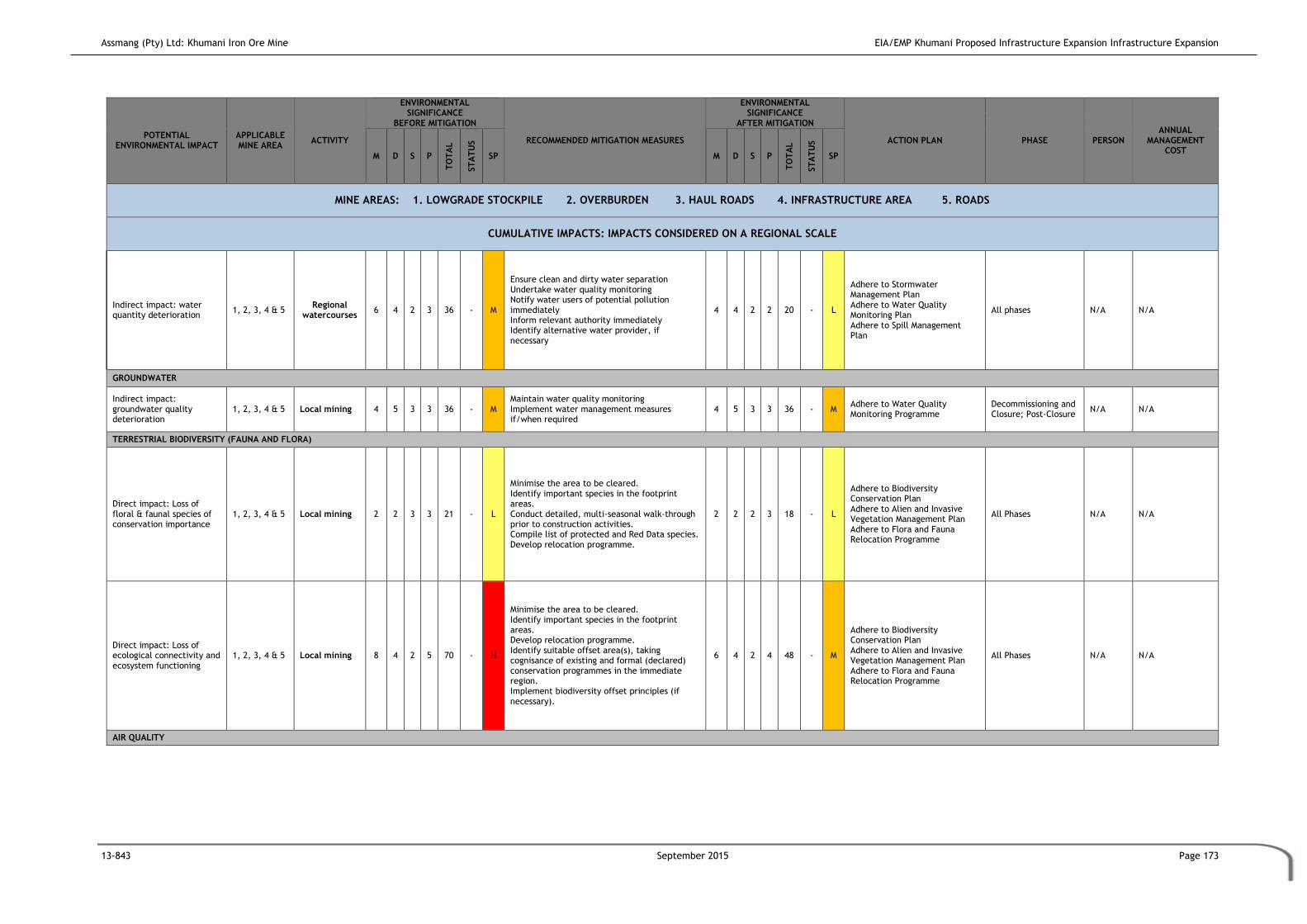
Assmang (Pty) Ltd: Khumani Iron Ore Mine EIA/EMP Khumani Proposed Infrastructure Expansion Infrastructure Expansion
13-843 September 2015 Page 173
POTENTIAL ENVIRONMENTAL IMPACT
APPLICABLE MINE AREA
ACTIVITY
ENVIRONMENTAL SIGNIFICANCE
BEFORE MITIGATION
RECOMMENDED MITIGATION MEASURES
ENVIRONMENTAL SIGNIFICANCE
AFTER MITIGATION
ACTION PLAN PHASE PERSON ANNUAL
MANAGEMENT COST
M D S P
TO
TA
L
ST
AT
US
SP M D S P
TO
TA
L
ST
AT
US
SP
MINE AREAS: 1. LOWGRADE STOCKPILE 2. OVERBURDEN 3. HAUL ROADS 4. INFRASTRUCTURE AREA 5. ROADS
CUMULATIVE IMPACTS: IMPACTS CONSIDERED ON A REGIONAL SCALE
Indirect impact: water quantity deterioration
1, 2, 3, 4 & 5 Regional
watercourses 6 4 2 3 36 - M
Ensure clean and dirty water separation Undertake water quality monitoring Notify water users of potential pollution immediately Inform relevant authority immediately Identify alternative water provider, if necessary
4 4 2 2 20 - L
Adhere to Stormwater Management Plan Adhere to Water Quality Monitoring Plan Adhere to Spill Management Plan
All phases N/A N/A
GROUNDWATER
Indirect impact: groundwater quality deterioration
1, 2, 3, 4 & 5 Local mining 4 5 3 3 36 - M Maintain water quality monitoring Implement water management measures if/when required
4 5 3 3 36 - M Adhere to Water Quality Monitoring Programme
Decommissioning and Closure; Post-Closure
N/A N/A
TERRESTRIAL BIODIVERSITY (FAUNA AND FLORA)
Direct impact: Loss of floral & faunal species of conservation importance
1, 2, 3, 4 & 5 Local mining 2 2 3 3 21 - L
Minimise the area to be cleared. Identify important species in the footprint areas. Conduct detailed, multi-seasonal walk-through prior to construction activities. Compile list of protected and Red Data species. Develop relocation programme.
2 2 2 3 18 - L
Adhere to Biodiversity Conservation Plan Adhere to Alien and Invasive Vegetation Management Plan Adhere to Flora and Fauna Relocation Programme
All Phases N/A N/A
Direct impact: Loss of ecological connectivity and ecosystem functioning
1, 2, 3, 4 & 5 Local mining 8 4 2 5 70 - H
Minimise the area to be cleared. Identify important species in the footprint areas. Develop relocation programme. Identify suitable offset area(s), taking cognisance of existing and formal (declared) conservation programmes in the immediate region. Implement biodiversity offset principles (if necessary).
6 4 2 4 48 - M
Adhere to Biodiversity Conservation Plan Adhere to Alien and Invasive Vegetation Management Plan Adhere to Flora and Fauna Relocation Programme
All Phases N/A N/A
AIR QUALITY

Assmang (Pty) Ltd: Khumani Iron Ore Mine EIA/EMP Khumani Proposed Infrastructure Expansion Infrastructure Expansion
13-843 September 2015 Page 174
POTENTIAL ENVIRONMENTAL IMPACT
APPLICABLE MINE AREA
ACTIVITY
ENVIRONMENTAL SIGNIFICANCE
BEFORE MITIGATION
RECOMMENDED MITIGATION MEASURES
ENVIRONMENTAL SIGNIFICANCE
AFTER MITIGATION
ACTION PLAN PHASE PERSON ANNUAL
MANAGEMENT COST
M D S P
TO
TA
L
ST
AT
US
SP M D S P
TO
TA
L
ST
AT
US
SP
MINE AREAS: 1. LOWGRADE STOCKPILE 2. OVERBURDEN 3. HAUL ROADS 4. INFRASTRUCTURE AREA 5. ROADS
CUMULATIVE IMPACTS: IMPACTS CONSIDERED ON A REGIONAL SCALE
Direct impact: dust-fallout 1, 2, 3, 4 & 5 Regional air quality
4 1 2 4 28 - L
Dust monitoring Minimise dust liberation by watering/wetting surfaces Monitoring of fence-line fallout dust Spraying of haul roads with dust retardant Strictly enforced speed limits on haul roads Limiting of transfer of material
2 1 1 4 16 - L Adhere to Dust Fallout Management Plan
All Phases N/A N/A
NOISE
No impacts anticipated 1, 2, 3, 4 & 5 - 0 0 0 0 0 N N N/A 0 0 0 0 0 N N N/A N/A N/A N/A
SOCIAL
Direct impact: In-migration of job seekers
1, 2, 3, 4 & 5 Regional economy
10 4 2 4 64 - H
Communicate employment criteria to the community (e.g. in newspapers, community forum notice boards, etc) prior to the operational phase being initiated Use local or existing labour should as far as possible to aid in the management of in-migration.
6 2 2 3 30 - M Adhere to Social and Labour Plan Adhere to Recruitment Policy
All phases N/A N/A
Increase electricity demand in the area.
1, 2, 3, 4 & 5 Regional economy
10 5 3 5 90 - H Electricity must be used only when required for the operation of the mine.
4 4 2 3 30 - M
Assmang must always be in contact with Eskom to ensure that the demand of electricity does not put too much pressure on the grid and infrastructure.
All phases Mine manager
Cost must be considered throughout all phases
WETLANDS
No impacts anticipated 1, 2, 3, 4 & 5 - 0 0 0 0 0 N N N/A 0 0 0 0 0 N N N/A N/A N/A N/A

Assmang (Pty) Ltd: Khumani Iron Ore Mine EIA/EMP Khumani Proposed Infrastructure Expansion
13-843 September 2015 Page 175
8 MONITORING AND AUDIT MANAGEMENT PROGRAMME
This section of the report relates to Section 33 of the GNR543 published in Government Gazette
No.33306 of 18 June 2010, under Section 24(5) of the NEMA.
Regulation 33
e) Proposed mechanisms for monitoring compliance with and performance assessment
against the environmental management programme and reporting thereon
Furthermore, Regulation 55 (1) (2) of the MPRDA Regulations, R527 require that the holder of
a mining right conduct monitoring on a continuous basis. Monitoring provides qualitative and
quantitative information pertaining to the possible impacts of the development on the
environment, and enables the measurement of the effectiveness of environmental
management measures. The implementation of a monitoring plan is necessary to ensure
compliance with the NEMA, MPRDA and NWA environmental authorisations which must be
obtained before any of the proposed activities may commence.
The key to the success of environmental management lies in the effective implementation of
the proposed mitigation and management measures. Monitoring provides qualitative and
quantitative information pertaining to the possible impacts of the development on the
environment, and enables the measurement of the effectiveness of environmental
management measures. Compliance monitoring is therefore crucial. Monitoring ensures that
the environmental requirements stipulated in the EMP are being complied with. It also allows
for ongoing impacts to be tracked so that the effectiveness of the mitigation can be measured.
This monitoring programme will allow the mine to monitor its compliance with the approved
EMP for the proposed mining and related activities. The monitoring programme will
incorporate the following impacts and environmental components:
Hydrological (surface water and biomonitoring);
Geohydrological (groundwater);
Terrestrial ecology (fauna and flora); and
Air quality (dust);
Mine environmental audits are also required to ensure that all proposed management and
mitigation measures together with monitoring programmes are being implemented. These
audits must be undertaken annually unless specified otherwise by the relevant authorities.
This section of the report is compiled in accordance to the National Environmental
Management Act, 1998 (Act No. 107 of 1998) Environmental Impact Assessment Regulation 543
of 2010, Section 31 (2) (b), and Section 33 (e), (g), (h) and (i).

Assmang (Pty) Ltd: Khumani Iron Ore Mine EIA/EMP Khumani Proposed Infrastructure Expansion
13-843 September 2015 Page 176
Ongoing monitoring of the bio-physical and socio-economic environments will continue
throughout the life of the project as per the approved EMP and the accepted monitoring
programmes. Khumani will monitor and assess the performance of the EMP on an ongoing basis.
Monitoring of different environmental aspects/impacts takes place by means of quantitative
and qualitative evaluation techniques in order to determine whether the requirements of the
environmental management programme are being complied with.
Monitoring is a continuous data-gathering and control procedure. It may range from routine
visual inspections to in-depth investigative monitoring.
There is already an established monitoring programme on the mine. The approved surface and
groundwater monitoring programme as well as the dust monitoring programme will form part
of this project and will be utilised for the new plant.
All monitoring will be undertaken in terms of the approved EMP for the mine as well as the
barrier Pillar EMP. The EMP draft that corresponds with this EIAR includes the monitoring
provisions relevant to the activities addressed in this report.
Based on the location of the project, the focus of monitoring will be based on the requirements
of the terrestrial and aquatic impacts of the mine.
8.1 Water Monitoring
8.1.1 Surface Water Monitoring
The purpose of establishing the monitoring program is to provide timely and accurate water
quality data to the DWS and to manage impacts caused by mining activities. These data are
used for a variety of purposes which may be summarized in broad terms as the determination
of status and trends in river water quality.
Specific objectives of the water quality monitoring program are as follows:
Determine whether water quality at sampling sites exceeds water quality standards;
Assess the status of water quality in the surrounding areas;
Provide analytical water quality information that describes present conditions and
changes (trends); and
Provide timely data for other users.

Assmang (Pty) Ltd: Khumani Iron Ore Mine EIA/EMP Khumani Proposed Infrastructure Expansion
13-843 September 2015 Page 177
8.1.1.1 Locality of Surface Water Sampling Points:
The area in which Khumani is located is known for its scarcity of water. There are no perennial
rivers in the near vicinity to the mine. The Gamagara River, which flows through the mining
property, is dry for most of the year. The various drainage channels present on the property
only flow (low flow) during storm events.
Due to the above there are no rivers in the vicinity of Khumani monitor. The mine has however
adopted a no-discharge policy, which will ensure that all dirty water on the mine property will
remain within the mining area. Due to the scarceness of water in the area, the mine will reuse
dirty water contained within the dirty water systems (i.e. containment dams).
Due to the fact that all dirty water contained will be utilized in the mine process it is
recommended that all dirty water systems be monitored monthly.
Monitoring points (Figure 8.1) which have been included and should be continued to be
monitored in the monitoring process, are:
All containment dams and clean water systems; and
All river courses (in the event that they contain water).
No new monitoring points are suggested as the current monitoring programme will be sufficient
to continue monitoring on Khumani in an effective manner.
8.1.1.2 Variables
The following variables are recommended. (All variables shall be in milligrams per litre except
for pH, which is in pH units and electrical conductivity in mS/m):
pH;
Total Suspended Solids and Turbidity;
Total Dissolved Solids;
Electrical Conductivity;
Chloride;
Sulphate;
Nitrate (as Nitrogen);
Nitrite (as Nitrate);
Sodium;
Manganese;
Iron; and

Assmang (Pty) Ltd: Khumani Iron Ore Mine EIA/EMP Khumani Proposed Infrastructure Expansion
13-843 September 2015 Page 178
Fluoride.
Please note that variables to be monitored must be according to the approved Water Use
License (WULA).
8.1.1.3 Frequency
It must be noted that due to the hydrological characteristic of the Vaal Gamagara Catchment,
the streams only flow after a significant storm event. During the investigation period, no flow
was observed at the nearby water resources. During the wet season, samples must be collected
monthly.
8.1.1.4 Operational, Inspection and Maintenance Requirements
The following principles should form part of the monitoring programme:
Design capacities of dirty water containment facilities should be maintained;
Clean and dirty water separation systems should be maintained i.e. control of
blockages, overflows, erosion and pollution;
Emergency procedures should be developed for the site and these should be clearly
defined and documented;
Should an emergency occur, it should be thoroughly investigated, the magnitude
should be quantified (volume and discharge rate and quality), impact determined (on
downstream receiving water bodies), and the circumstances which caused them;
Regular inspections should be undertaken of the facilities in order to monitor the
condition of each facility. This includes the undertaking of pro-active maintenance
and replacement;
Inspections should be undertaken by an appropriate qualified and experienced person
(engineer) in liaison with operators;
Facilities must be maintained as to operate at design capacity and with the efficiency
and effectiveness initially intended and required to meet objectives. Maintenance
include desilting of the dams, clearance of vegetation and de-scaling of pipes;
Erosion, damage to pipelines, build-up of sediment should be visually inspected.
Inspections should be used to alert mine personnel as to prevent emergencies and
ensure that corrective response measures are taken timeously;
Operational monitoring should include flow monitoring (as part of the water balance),
assessment of hydraulic integrity of all pipelines, monitoring of water levels and
quality, rainfall measurements and assessment or monitoring of silt build-up; and

Assmang (Pty) Ltd: Khumani Iron Ore Mine EIA/EMP Khumani Proposed Infrastructure Expansion
13-843 September 2015 Page 179
Personnel at the mine need to be allocated the responsibility of managing the
different components of the SWMP and its associated infrastructure.
(Please refer to Appendix A for the A3 figure.)
Figure 8.1: Surface water and Groundwater Monitoring Points
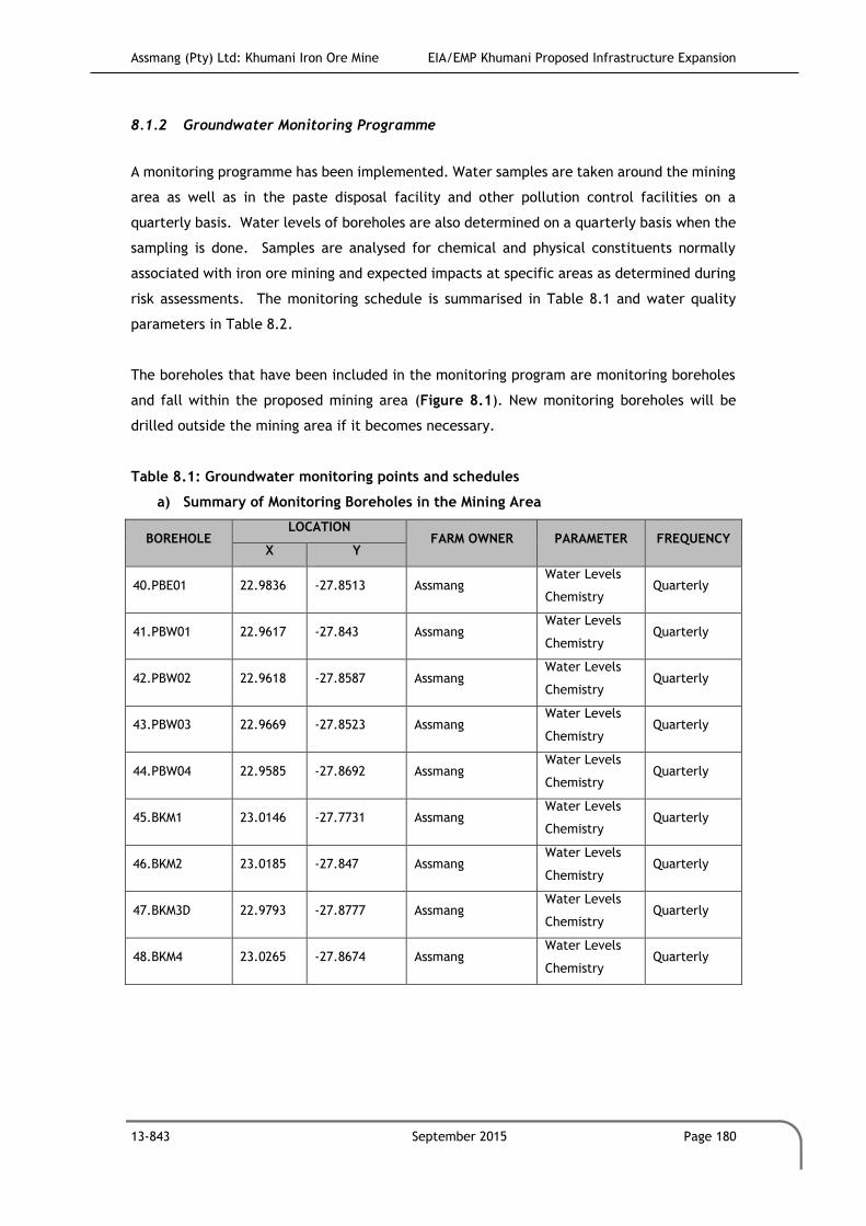
Assmang (Pty) Ltd: Khumani Iron Ore Mine EIA/EMP Khumani Proposed Infrastructure Expansion
13-843 September 2015 Page 180
8.1.2 Groundwater Monitoring Programme
A monitoring programme has been implemented. Water samples are taken around the mining
area as well as in the paste disposal facility and other pollution control facilities on a
quarterly basis. Water levels of boreholes are also determined on a quarterly basis when the
sampling is done. Samples are analysed for chemical and physical constituents normally
associated with iron ore mining and expected impacts at specific areas as determined during
risk assessments. The monitoring schedule is summarised in Table 8.1 and water quality
parameters in Table 8.2.
The boreholes that have been included in the monitoring program are monitoring boreholes
and fall within the proposed mining area (Figure 8.1). New monitoring boreholes will be
drilled outside the mining area if it becomes necessary.
Table 8.1: Groundwater monitoring points and schedules
a) Summary of Monitoring Boreholes in the Mining Area
BOREHOLE LOCATION
FARM OWNER PARAMETER FREQUENCY X Y
40.PBE01 22.9836 -27.8513 Assmang Water Levels
Chemistry Quarterly
41.PBW01 22.9617 -27.843 Assmang Water Levels
Chemistry Quarterly
42.PBW02 22.9618 -27.8587 Assmang Water Levels
Chemistry Quarterly
43.PBW03 22.9669 -27.8523 Assmang Water Levels
Chemistry Quarterly
44.PBW04 22.9585 -27.8692 Assmang Water Levels
Chemistry Quarterly
45.BKM1 23.0146 -27.7731 Assmang Water Levels
Chemistry Quarterly
46.BKM2 23.0185 -27.847 Assmang Water Levels
Chemistry Quarterly
47.BKM3D 22.9793 -27.8777 Assmang Water Levels
Chemistry Quarterly
48.BKM4 23.0265 -27.8674 Assmang Water Levels
Chemistry Quarterly

Assmang (Pty) Ltd: Khumani Iron Ore Mine EIA/EMP Khumani Proposed Infrastructure Expansion
13-843 September 2015 Page 181
b) Groundwater Level Monitoring Boreholes
BOREHOLE LOCATION
FARM FARM OWNER PARAMETER FREQUENCY X Y
1.Wright 3 22.92230 -27.79459 Wright Stephanie
Cornellisen Water Levels Quarterly
2.SEK 0023 23.0705 -27.7235 Sekagame Khumba Water Levels Quarterly
3.BEST 2 23.09101 -27.68138 Bestwood Fred Viljoen Water Levels Quarterly
4.MOK 2 23.04974 -27.91066 Mokaning Nic Steyn Water Levels Quarterly
5.Mashwenin 23.0485 -27.88725 - Assmang Water Levels Quarterly
6.Mashwenin 23.0566 -27.89595 - Assmang Water Levels Quarterly
7.Mokaning 1 23.0296 -27.88651 - Assmang Water Levels Quarterly
8.Mokaning 2 23.0351 -27.89274 - Assmang Water Levels Quarterly
9.King 3 23.9954 -27.8496 - Assmang Water Levels Quarterly
10 King 2 23.0012 -27.85562 - Assmang Water Levels Quarterly
11.King 1 22.9881 -27.87321 - Assmang Water Levels Quarterly
12.BKM 1 23.0146 -27.77299 - Assmang Water Levels Quarterly
13.BKM 3D 22.991 -27.88483 - Assmang Water Levels Quarterly
14.PBW 01 22.9693 -27.84925 - Assmang Water Levels Quarterly
15.Parson 1 22.9848 -27.85842 - Assmang Water Levels Quarterly
16.Parson 8 22.9844 -27.85207 - Assmang Water Levels Quarterly
17.Parson 9 22.9849 -27.85231 - Assmang Water Levels Quarterly
18.AGK2/87 22.9868 -27.8875 - Assmang Water Levels Quarterly
19.AIK1/45 23.0011 -27.8858 - Assmang Water Levels Quarterly
20.VK2/81 22.9837 -27.8695 - Assmang Water Levels Quarterly
21.VK1/49 22.9827 -27.8677 - Assmang Water Levels Quarterly
22.WK2/35 22.9959 -27.8672 - Assmang Water Levels Quarterly
23.QK4/55 22.9959 -27.8636 - Assmang Water Levels Quarterly
24.QK4/70 22.9985 -27.8641 - Assmang Water Levels Quarterly
25.QK2/9 22.998 -27.857 - Assmang Water Levels Quarterly
26.ZR3/24 23.0208 -27.808 - Assmang Water Levels Quarterly
27.ABK2/24 22.9944 -27.8767 - Assmang Water Levels Quarterly
28.ZR3/2 23.0198 -27.8072 - Assmang Water Levels Quarterly
29.AMK1/47 22.9923 -27.8943 - Assmang Water Levels Quarterly
30.AGK1/89 22.9832 -27.8871 - Assmang Water Levels Quarterly
31.AAK2/45 22.9862 -27.8763 - Assmang Water Levels Quarterly
32.WK4/70 22.999 -27.8728 - Assmang Water Levels Quarterly
33.VK3/67A 22.9822 -27.8727 - Assmang Water Levels Quarterly
34.KM3/24 23.0005 -27.8893 - Assmang Water Levels Quarterly
35.ALK3/22 22.9796 -27.8979 - Assmang Water Levels Quarterly
36.AKK4/26 22.9761 -27.8984 - Assmang Water Levels Quarterly
37.ABK2/46 22.9964 -27.8767 - Assmang Water Levels Quarterly

Assmang (Pty) Ltd: Khumani Iron Ore Mine EIA/EMP Khumani Proposed Infrastructure Expansion
13-843 September 2015 Page 182
BOREHOLE LOCATION
FARM FARM OWNER PARAMETER FREQUENCY X Y
38.AAK3/27 22.9817 -27.8803 - Assmang Water Levels Quarterly
39.ALK2/49 22.9878 -27.8948 - Assmang Water Levels Quarterly
Table 8.2 Groundwater Quality Parameters
SUBSTANCE/PARAMETER KHUMANI WATER QUALITY LIMITS
pH 7- 8.5
Electrical conductivity (Ec) in mS/m 115.6
Chlorides (Cl) in mg/l 140.5
Sulphate (SO4) in mg/l 80.6
Sodium (Na) in mg/l 60
Calcium (Ca) in mg/l 93.8
Magnesium (Mg) in mg/l 70.4
Nitrate and Nitrite (NO3 and NO2) in mg/l 14.8
Fluoride (mg/l) 0.5
Total Alkalinity (CaCO3) mg/l 364.8
Khumani and Kumba Iron Ore Mine have established a co-operative monitoring programme,
in order to establish an integrated groundwater model. Monitoring boreholes will be drilled
down gradient of the opencast mine to monitor any contaminant migration. The positions of
the boreholes are shown in Figure 8.1.
It is recommended that water level measurements be conducted in the same boreholes as for
the chemical and physical monitoring, but also in additional boreholes as may be required to
accurately describe the extent of the cone-of-depression caused by mine dewatering or water
supply from boreholes. Such monitoring program will have to be designed in conjunction
with a geohydrologist and with the approval of the regional director of DWA
The quarterly report will be an update of the database with time-series graphs, statistical
analysis (average, maximum, minimum, 5 -, 50 –and 95%ile values as well as linear
performance). Data will also be presented in a map format to present a clear picture of the
water quality and water level situation. Laboratory results will be analysed against the target
water quality guidelines for domestic use, livestock watering and irrigation (according to the
South African Water Quality Guidelines, 1996: DWAF). The strictest value between the target
water quality objectives or objectives through a reserve determination will be used.
In terms of flow, all water uses and discharges will be measured on an ongoing basis. The
flows include:
Make-up water.
Volumes of groundwater pumped out for mine dewatering purposes.
Volumes of water pumped from the plant as part of tailings.

Assmang (Pty) Ltd: Khumani Iron Ore Mine EIA/EMP Khumani Proposed Infrastructure Expansion
13-843 September 2015 Page 183
Volumes of contaminated water that is recovered and used in the plant or for dust
suppression.
An annual detailed water quality audit report on the surface and groundwater quality is
prepared that analyses the water quality situation in detail to investigate trends and non-
compliance. The report is submitted annually to the relevant authorities. Should the
monitoring data indicate that the groundwater conditions are adversely affected, additional
studies will be undertaken if it is deemed necessary.
Data Management
Monitoring results are entered into an electronic database as soon as results are available,
and at no less than one monthly interval, allowing:
Data presentation in tabular format,
Time-series graphs with comparison abilities,
Statistical analysis (minimum, maximum, average, percentile values) in tabular
format,
Graphical presentation of statistics,
Linear trend determination,
Performance analysis in tabular format,
Presentation of data, statistics and performance on diagrams and maps, and
Comparison and compliance to South African Water Quality Guidelines and any other
given objectives.
As far as possible, the same monitoring points will be used from the construction phase
through the operational and decommissioning phases to after mine closure to develop a long
term data record and enable trend analysis and recognition of progressive impacts with time.

Assmang (Pty) Ltd: Khumani Iron Ore Mine EIA/EMP Khumani Proposed Infrastructure Expansion
13-843 September 2015 Page 184
8.2 Dust Monitoring
Khumani currently has an ambient air and weather monitoring programme that includes
dusfall monitoring, Particulate Matter 10 microns (PM10) and meteorological monitoring. Dust
fallout is measured at:
Eight (8) unique locations using single dust monitoring units (all situated within mine
premises).
Four (4) directional dust monitoring units (DustWatch), that are located at different
locations in order to provide sampling data from four (4) different wind directions,
with the aim of indicating the predominant direction of dust loading in the area.
PM10 monitoring is conducted at:
Seven (7) PM10 monitoring locations (E-Samplers manufactured by Met One
Instruments, Inc.) that are located at strategic locations to capture ambient
concentration of particulate matter on mine premises [five (5) instruments are co-
located with dust monitoring points, while two (2) are independent, stand-alone
sites].
Three (3) monitoring locations with handheld instrument (SKC Deployable Particulate
Sampler System with Portable Air Kit for 24-hour sampling) once a month for 24 hours.
A meteorological Station (EM-02-WXT weather station with Vaisala all-weather sensor)
measures temperature, relative humidity, rainfall, hail, barometric pressure, as well as wind
direction, wind speed, and wind gusts via ultrasonic anemometer. The station is located in
the Salvage Yard on the Parsons Farm (coordinates: 27°51'23.05"S; 22°58'34.59"E), east of the
Dingleton Road.
The dust fallout network can serve to meet various objectives, such as:
Compliance monitoring;
Validate dispersion model results;
Use as input for health risk assessment;
Assist in source apportionment;
Temporal trend analysis;
Spatial trend analysis;
Source quantification; and,
Tracking progress made by control measures.
The current program and Dust Management Plan should be maintained and extended to
include the new infrastructure areas, refer to Table 8.3.

Assmang (Pty) Ltd: Khumani Iron Ore Mine EIA/EMP Khumani Proposed Infrastructure Expansion
13-843 September 2015 Page 185
Table 8.3 Khumani Dust Management Plan
IDENTIFICATION OF SUITABLE POLLUTION ABATEMENT MEASURES
IMPACTING SOURCE RECOMMENDED CONTROL
EFFICIENCY
CONTROL MEASURES
Wind erosion from
the overburden
dump, the topsoil
storage piles, the
discard stockpile,
low-grade ROM
storage piles and the
paste disposal facility
Reduction by at least 80%,
specifically from the
overburden dump and topsoil
storage piles and the paste
residue facility.
Walls of the discard stockpiles, topsoil
piles, overburden dump, and paste
disposal facility to be vegetated or
covered up to 1 m from the top throughout
the life of mine.
The vegetation cover should be such to
ensure at least 80% control efficiency for
the walls. This should be an on-going
process. As an alternative option (due to
the dry nature of the region), waste rock
could be used to form the side slopes of
the paste disposal facility. In addition,
waste rock can also be used to cover the
slopes of the large overburden dump and
topsoil piles.
Vehicle entrained
dust from unpaved
road surfaces
It is recommended that 85%
control efficiency should be
achieved on the unpaved
roads. It is highly likely that
this might not prove feasible
due to the semi-arid
environment of the mine.
Chemical surfactants such as
Dust-a-Side should therefore
be considered for all the
main unpaved roads.
Chemical suppressants could
achieve control efficiencies
of 80% to 90% through
effective application.
If a water truck will be operational at the
mine, it was estimated that water sprays
resulting in at least 75% control efficiency
would be a requirement to result in a
significant reduction in ground level
concentrations from these roads. The
amounts of water needed to ensure 75%
control efficiency on the various haul
roads and the water consumption for 85%
control efficiency is depicted.

Assmang (Pty) Ltd: Khumani Iron Ore Mine EIA/EMP Khumani Proposed Infrastructure Expansion
13-843 September 2015 Page 186
IDENTIFICATION OF SUITABLE POLLUTION ABATEMENT MEASURES
IMPACTING SOURCE RECOMMENDED CONTROL
EFFICIENCY
CONTROL MEASURES
Materials handling
operations including
primary crushing and
screening and tipping
of material
It is recommended that
control efficiencies of
between 80% and 90% be
achieved at all tipping
points, and crushing and
screening facilities to ensure
a significant reduction in off-
site impacts.
By doubling the moisture content of the
material at all the tipping points a 62%
reduction in emissions would result. The
Australian EPA indicated that a telescopic
chute with water sprays would ensure 75%
control efficiency and enclosure of storage
piles where tipping occurs would reduce
the emissions by 99%. Emissions from train
loading would reduce by 75% if enclosed
and by a further 24% if fabric filters were
added.
In addition chemical suppressants or water
sprays on the primary crusher and dry dust
extraction units with wet scrubbers on the
secondary and tertiary crushers and
screens will assist in the reduction of the
cumulative dust impacts from Khumani.
According to the Australian EPA, water
sprays can have up to 50% control
efficiency and hoods with scrubbers up to
75%. If in addition, the scrubbers and
screens are enclosed; up to 100% control
efficiency can be achieved. With these
control measures in place, the impacts
would reduce to negligible levels. It is
important that this control equipment be
maintained and inspected on a regular
basis to ensure that the expected control
efficiencies are met.
It is further recommended that a Business
Unit manager in terms of the Mine Health
and Safety Act be employed to manage
these sources and to ensure that the
proposed mitigation measures are applied
on a continuous basis.
Performance Indicators
Indicator for Indicator should include
Source based
performance
indicators for the
overburden dump and
topsoil storage piles
and paste residue
facility
Vegetation cover density to be 80% on the entire slope up to 1 m from
crest, and dustfall immediately downwind to be <1 200 mg/m2/day.
Similarly, should waste rock be used to cover the sidewalls, it should be up
to 1 m from the top.

Assmang (Pty) Ltd: Khumani Iron Ore Mine EIA/EMP Khumani Proposed Infrastructure Expansion
13-843 September 2015 Page 187
IDENTIFICATION OF SUITABLE POLLUTION ABATEMENT MEASURES
IMPACTING SOURCE RECOMMENDED CONTROL
EFFICIENCY
CONTROL MEASURES
Source based
performance
indicators for the
unpaved haul roads
Dustfall in the immediate vicinity of mining perimeter be less than1 200
mg/m2/day.
All tipping points and
outside the primary
crusher during
crushing operations
The absence of visible dust plume at all tipping points and outside the
primary crusher during crushing operations would be the best indicator of
effective control equipment in place. In addition the dustfall in the
immediate vicinity of various sources should be less than 1 200
mg/m2/day.
From all activities
associated with
Khumani
Dustfall in close proximity to sensitive receptors (i.e. Dingleton, Kathu and
Mooihoek, Vlakwater and Weltevreden) should not exceed 600
mg/m2/day.
Receptor based Performance Indicators
Aim Methodology
Indication of what
the increase in
fugitive dust levels
are once mining
operations commence
In addition, a dust fallout network can serve to meet various objectives,
such as Compliance monitoring; Validate dispersion model results; Use as
input for health risk assessment; Assist in source apportionment; Temporal
trend analysis; Spatial trend analysis; Source quantification; and Tracking
progress made by control measures
With Dingleton and Mooihoek identified as the main sensitive areas
potentially negatively impacted upon by the proposed Khumani mining
operations, it is recommended that a PM10 monitor be implemented to
monitor respirable dust. With the plan to relocate the residents of
Dingleton, and with a PM10 sampler operated by Sishen mine near this
residential area, it is recommended that a PM10 sampler be implemented
at Mooihoek. It is further suggested that a data sharing agreement be
formed with Sishen mine to share information recorded by their dust
fallout and ambient monitoring network.
The analysis of the four directional dust fallout buckets should preferably
be linked to the frequency of the wind direction (from the four sectors)
and the two weekly results be presented as total daily dustfall over a
month (28 to 32 days) as set out by the DEAT dust fallout categories. The
ambient PM10 monitor at Dingleton records PM10 concentrations over a 14
day period. If this is to be used for compliance assessment it is
recommended that the filters be changed and analysed on a 24-hour
interval.
Record-keeping, Environmental Reporting and Community Liaison
Activity Methodology

Assmang (Pty) Ltd: Khumani Iron Ore Mine EIA/EMP Khumani Proposed Infrastructure Expansion
13-843 September 2015 Page 188
IDENTIFICATION OF SUITABLE POLLUTION ABATEMENT MEASURES
IMPACTING SOURCE RECOMMENDED CONTROL
EFFICIENCY
CONTROL MEASURES
Periodic Inspections
and Audits
Periodic inspections and external audits are essential for progress
measurement, evaluation and reporting purposes. According to the
Guidelines of the Chamber of Mines (1996), every decommissioned residue
deposit should be inspected at yearly intervals by a suitably qualified
person and any alteration or deterioration of conditions at the deposit
reported to the responsible authority.
It is recommended that site inspections and progress reporting be
undertaken at regular intervals (at least quarterly) during operations, with
annual environmental audits being conducted. Annual environmental
audits forms part of an APCS and should be initiated at Khumani. Results
from site inspections and off-site monitoring efforts should be combined to
determine progress against source- and receptor-based performance
indicators. Progress should be reported to all interested and affected
parties, including authorities and persons affected by pollution.
Corrective action or the implementation of contingency measures must be
proposed to the stakeholder forum in the event that progress towards
targets is indicated by the quarterly/annual reviews to be unsatisfactory.
Liaison Strategy for
Communication with
I&APs
EMPs should stipulate specific intervals at which forums will be held, and
provide information on how people will be notified of such meetings. For
operations for which un-rehabilitated or party rehabilitated tailings
impoundments (in this case paste disposal facility) are located in close
proximity (within 3 km) from residential areas, it is recommended that
such meetings be scheduled to be held at least on a quarterly basis. This,
for example would be applicable to Dingleton, Kathu and the farming
residents.
Financial Provision
(Budget)
The budget should provide a clear indication of the capital and annual
maintenance costs associated with dust control measures and dust
monitoring plans. It may be necessary to make assumptions about the
duration of aftercare prior to obtaining closure. This assumption must be
made explicit so that the financial plan can be assessed within this
framework. Costs related to inspections, audits, environmental reporting
and I&AP liaison should also be indicated where applicable. Provision
should also be made for capital and running costs associated with dust
control contingency measures and for security measures.
The financial plan should be audited by an independent consultant, with
reviews conducted on an annual basis.
8.3 Noise monitoring
Ambient noise measurements are taken at two points on site (N1 and N2). The average daily
and night-time noise levels are monitored and recorded. In addition to these measurements,
personal noise monitoring takes place utilising portable noise monitors.

Assmang (Pty) Ltd: Khumani Iron Ore Mine EIA/EMP Khumani Proposed Infrastructure Expansion
13-843 September 2015 Page 189
8.4 Soil and Vegetation Monitoring
Soil and vegetation monitoring takes place in a qualitative manner and is conducted by the
Environmental Supervisor and the Environmental Control Officer. All non-conformances are
recorded in an Incident Register.
8.5 Periodic Mine Environmental Audit
A register of environmental monitoring and auditing results will be available for inspection.
This will also include compliance with environmental legislation, e.g. Environment
Conservation Act, 1989 (Act No.73 of 1989), NEMA, NWA, etc.
In order to ensure compliance with the environmental management programme and to assess
the continued appropriateness and adequacy of the environmental management programme,
Khumani commits to:
Conduct the monitoring on an ongoing basis.
Conducting monthly performance audits.
Conduct a performance assessment of the environmental management programme
every two years or as agreed by the Minister in writing.
Compile and submit the performance assessment report of the MPRDA environmental
management programme to the Director: Mineral Development.
Compile and submit the performance assessment report of the NEMA environmental
management programme to the NCDENC.
The mine further undertakes to:
Appoint a responsible person(s), in writing, who will monitor all environmental
aspects of the site on a regular basis.
The appointed person will communicate, on a regular basis, with the local interested
and affected parties identified with regards to the project and will report on the
progress made with regards to implementation of the mitigation measures. Any
complaints with regard to the mining activity will be reported to the appointed
person and be recorded in a complaint register.
Maintain records relating to compliance/non-compliance with the conditions of
authorisation. These records must be made available to the NCDENC, DMR and all
I&APs within 7 (seven) days of receipt of a written request.

Assmang (Pty) Ltd: Khumani Iron Ore Mine EIA/EMP Khumani Proposed Infrastructure Expansion
13-843 September 2015 Page 190
9 ENVIRONMENTAL AWARENESS PLAN AND ENVIRONMENTAL EMERGENCY RESPONSE PLAN
This section of the report relates to Section 33 of the GNR543 published in Government Notice
R.543 in Government Gazette No.33306 of 18 June 2010, under Section 24(5) of the NEMA.
Regulation 33
j) An environmental awareness plan describing the manner in which-
i) The applicant intends to inform his or her employees of any environmental risk
which may result from their work; and
ii) Risks must be dealt with in order to avoid pollution or the degradation of the
environment
This chapter of the EIA/EMP Report also relates to sections of the MPRDA in order to ensure
that the reports are in line with one another.
REGULATION 51 (B)
7) Procedures for environmentally related emergencies and remediation (An environmental
emergency plan that includes all the items referred to in the concomitant section of the
guideline posted on the official website of the Department)
10) Environmental Awareness Plan (Section 39 (3) (c)) (Include all the items referred to in
the concomitant section of the guideline posted on the official website of the Department).
The purpose of this section of the EMP is to anticipate the occurrence of environmental
crises, which may occur due to unforeseen circumstances. Since these events can never be
predicted, a procedure has been prepared that must be followed in the event of such an
incident, which will assist in the mitigation, remediation and conservation of the environment
and contribute to the safety of workers and I&APs. It also sets out the procedure for inducting
employees and informing all mine employees and contractors of the various risks which may
results from the various activities on site and all required management and mitigation
measures which are in place and that must be complied with in order to avoid environmental
pollution and degradation.
9.1 Introduction
An Environmental Awareness Plan (EAP) and Environmental Emergency Response Plan (EERP)
has been implemented at Khumani Iron Ore Mine. The EAP and EERP have been implemented
to create environmental awareness and productivity in the management of potential impacts
associated with the mining and associated activities.

Assmang (Pty) Ltd: Khumani Iron Ore Mine EIA/EMP Khumani Proposed Infrastructure Expansion
13-843 September 2015 Page 191
The material/source of information for the EAP and EERP is the approved Environmental
Management Programmes (EMP), as well as other relevant specialist reports. These
documents were utilised to compile a database, which is referred to in the EAP/EERP which
contains all medium to high significant environmental aspects and issues. The environmental
issues and aspects were entered into the database along with associated mitigation measures
and responses and includes specific legislation that governs such an impact or aspect.
9.2 Emergency Response Plan
9.2.1 Defining an Environmental Emergency Response Plan
An effective, comprehensive, well-considered and tested environmental emergency
preparedness and response plan has the potential to save lives, prevent uncessary damage to
the company and other property and to manage environmental risk in the event of a large
chemical spill, oil spill, fuel spill, explosives spill or sewerage spill.
Environmental emergencies occur over the short term and require an immediate response. A
mine, as part of its management tools, especially if it is ISO 9000 and ISO 14001 compliant,
should have an Environmental Emergency Response Plan. If one does not exist then one
should be compiled and disseminated to all employees and contractors and in the event of
an emergency, the emergency response plan should be consulted.
This plan should be placed around the mine where it can be viewed easily. The plan should
contain a list of procedures, evacuation routes and a list of emergency contact numbers. It
is advisable that the mine tests the emergency response plan in order to identify any areas
for improvement.
If the emergency has the potential to affect surrounding communities, they should be alerted
via alarm signals or contacted in person. The surrounding community must be informed, on
a continuous basis, of the potential dangers and emergencies that exist, and the actions to
be taken in such emergencies.
Communication is vital in an emergency and thus communication devices, such as mobile
phones, two-way radios, pagers or telephones, must be placed around the mine. A checklist
of emergency response units must be consulted and the relevant units notified.
The checklist includes:
Fire department;

Assmang (Pty) Ltd: Khumani Iron Ore Mine EIA/EMP Khumani Proposed Infrastructure Expansion
13-843 September 2015 Page 192
Police;
Emergency health services such as ambulances, paramedic teams, poisons centres;
Hospitals, both local and further afield, for specialist care;
Public health authorities;
Environmental agencies, especially those responsible for air, water and waste issues;
Other industrial facilities in the vicinity with emergency response facilities;
Public works and highways departments, port and airport authorities; and
Public information authorities and media organisations.
9.3 Emergency Procedures
Below are the possible environmental related emergencies, procedures and responses to be
followed and incorporated into the Emergency Preparedness and Response Plan.

Assmang (Pty) Ltd: Khumani Iron Ore Mine EIA/EMP Khumani Proposed Infrastructure Expansion
13-843 September 2015 Page 193
Table 8.4: Environmental Emergency Procedures and Responses POSSIBLE
ENVIRONMENTAL
RELATED EMERGENCY
ACTION PLANS/REMEDIATION TIME/PERIOD RESPONSIBLE
PERSON/PARTY
Spillage of oil, diesel by
vehicles, tankers,
storage tanks etc.
The spillage should be contained (bund earth walls) by all means. Depending on the
amount of spillage it could be remediated in situ or in the case of large amount of spillage
that is contained, could be removed, etc.
Leakage from the vehicle, tanker etc, that caused the emergency, should be stopped and
the vehicle removed to the workshop area for repairs.
In all cases of spillage, irrespective of the chemical, remove or extinguish any fire (naked
flame) to within at least 10 metres from the spill.
Cover the spills with absorbent material.
Immediately
Khumani
Sewerage Spills
The spillage should be contained (bund earth walls) by all means. Depending on the
amount of spillage it could be remediated in situ or in the case of large amount of spillage
that is contained, could be removed, etc.
The leakage must be stopped and reason for spill must be rectified.
The person who reported the spill must fill out an incident report and forward it to the
Environmental Department after a thorough investigation.
Immediately
Khumani
Fires All fires in the veld, buildings, diesel tanks, chemical fires, etc. should be extinguish and
prevented to spread to any other piece of land, building, etc. During the winter months
an adequate fire breaks should be put in place around the property. The necessary
equipment should be in place and ready to be used if an accidental fire is started.
There shall be an emergency preparedness plan is in place in order to fight accidental
fires and veld fires, should they occur. The adjacent land owners/users/managers should
also be informed and/or involved.
Immediately
Environmental
manager, Safety
officer, Local
Fire Brigade

Assmang (Pty) Ltd: Khumani Iron Ore Mine EIA/EMP Khumani Proposed Infrastructure Expansion
13-843 September 2015 Page 194
The use of branches of trees and shrubs for fire making purposes must be strictly
prohibited.
No fires may be lit except at places approved by the ESM (private residences will be able
have lit fires but not for the purpose of waste disposal).
All businesses shall ensure that the basic fire-fighting equipment is to the satisfaction of
the Local Emergency Services.
All businesses must take precautions when working with welding or grinding equipment
near potential sources of combustion. Such precautions include having a suitable, tested
and approved fire extinguisher immediately at hand and the use of welding curtains.
The Atmospheric Pollution Prevention Act (No. 45 of 1965) states that burning is not
permitted as a means of disposal.

Assmang (Pty) Ltd: Khumani Iron Ore Mine EIA/EMP Khumani Proposed Infrastructure Expansion
13-843 September 2015 Page 195
9.4 Environmental Awareness Plan
9.4.1 Communication Sectors
The environmental risks for each phase of the project will be communicated to Khumani’s
work force ie management, administration, plant and mine workers. Contractors will receive
the same communication.
9.4.2 Management Sector
A workshop will be conducted to inform all mine management of the risks associated with
the mining operation and/or developments. The risks for all aspects will be explained and
the appropriate management options discussed. The workshop will also elaborate on the
monitoring programmes that will be implemented to identify and monitor the mines level of
impact on the environment and discuss various remediation actions, should there be
deterioration.
The evaluation process is integral in the assurance that the mine reduces any possible
environmental risks associated with the operation.
The workshop will be conducted prior to the construction phase to ensure that all risks are
discussed before there is any chance of the impacts occurring. The workshop may be
repeated at certain stages during the life of the project, in the case of new employees.
9.4.3 Administrative Sector
The communication of the environmental risks to the administrative sector will occur through
a workshop / half day course. This workshop will seek to explain the following necessary
actions:
Firstly, each aspect will be described as shown in Table 8.5, Table 8.6 and Table
8.7. The risk associated with each aspect will be discussed to ensure that there is
an understanding of how each action of the project may impact on the environment.
The mitigation of the environmental risk will be elaborated on. It is important that
each person understand these management strategies as it ensures that the impact
on the environment is kept to a minimum. Data collection regarding each aspect will
also be explained to ensure that each aspect is monitored according to those
protocols specified by the mine and the DMR. Along with data collection the
reporting of findings will be discussed.
Assmang (Pty) Ltd: Khumani Iron Ore Mine EIA/EMP Khumani Proposed Infrastructure Expansion
13-843 September 2015 Page 196
This workshop will take place before the construction phase begins, thus ensuring a
full understanding of the project and its associated environmental risks before any
construction activity is undertaken. The course will be repeated at the beginning of
the operational phase and the material will be integrated in the induction for new
personnel.
The following communication channels and media will / can be used to communicate
environmental issues within the operation:
o HOD Meetings: The Mine Manager communicates information to senior
management on environmental issues and the information is minuted.
o HSEC Meetings: ‘Environmental issues’ should be an agenda item on plant
and section monthly safety, health & environmental meeting agendas.
o Publications: Leaflets, posters etc are produced by the relevant department
or other designated persons, for use on notice boards, and distribution.
Quarterly newsletter will also be made available. Email notifications and or
relevant articles are also distributed.
o EMS Database (if established): Feedback from line management on
objectives, targets and actions.
o Daily / Weekly Safety Meeting: All meetings are scheduled to commence
with a discussion on safety, health & environmental topics.

Assmang (Pty) Ltd: Khumani Iron Ore Mine EIA/EMP Khumani Proposed Infrastructure Expansion
13-843 September 2015 Page 197
Table 8.5: Environmental Awareness Plan for the Construction Phase at Khumani.
ENVIRONMENTAL
PARAMETER RISK
COMMUNICATION STRATEGY MITIGATION ACTIVITY
MANAGEMENT ADMINISTRATION MINE WORKERS CONTRACTORS
Soil
Increase in soil erosion Workshop Induction Induction Induction
Areas must not be stripped of vegetation before the area
will be needed for construction. Use phased approach in
clearance activities.
Reestablishment of vegetation will be encouraged after
construction. If area is exposed for longer than 18 months
and no self-succession has taken place, other options must
be investigated.
Effective dust management must be employed during the
construction phase.
Contamination of soil Workshop Induction Induction Induction
Employees and contractors will be educated by means of
training to make them aware of the necessity to prevent
spillages through the implementation n of good
housekeeping practices. The management of chemicals
and hydrocarbons should form part of the emergency
response programme. No activities associated with
hydrocarbons and or chemicals (i.e. wash bays etc.) may
be undertaken outside of an effectively designed
contained area.
Soil compaction Workshop Induction Induction Induction
Keep infrastructure localized to reduce footprint.
All areas not directly within the proposed infrastructure
footprint area where the soil has been compacted will
need to be ripped to break up the compacted soil surface.
This will aid infiltration and decrease run-off.
All ripped areas should be monitored to ensure successful
re establishment of natural vegetation and to prevent
invasion by alien species.
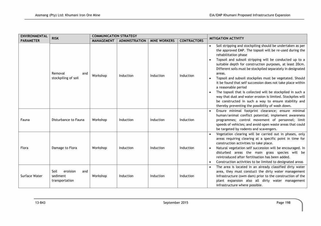
Assmang (Pty) Ltd: Khumani Iron Ore Mine EIA/EMP Khumani Proposed Infrastructure Expansion
13-843 September 2015 Page 198
ENVIRONMENTAL
PARAMETER RISK
COMMUNICATION STRATEGY MITIGATION ACTIVITY
MANAGEMENT ADMINISTRATION MINE WORKERS CONTRACTORS
Removal and
stockpiling of soil Workshop Induction Induction Induction
Soil stripping and stockpiling should be undertaken as per
the approved EMP. The topsoil will be re-used during the
rehabilitation phase
Topsoil and subsoil stripping will be conducted up to a
suitable depth for construction purposes, at least 20cm.
Different soils must be stockpiled separately in designated
areas.
Topsoil and subsoil stockpiles must be vegetated. Should
it be found that self succession does not take place within
a reasonable period
The topsoil that is collected will be stockpiled in such a
way that dust and water erosion is limited. Stockpiles will
be constructed in such a way to ensure stability and
thereby preventing the possibility of wash down.
Fauna Disturbance to Fauna Workshop Induction Induction Induction
Ensure minimal footprint clearance; ensure minimal
human/animal conflict potential; implement awareness
programmes; control movement of personnel; limit
speeds of vehicles; and avoid open waste areas that could
be targeted by rodents and scavengers.
Flora Damage to Flora Workshop Induction Induction Induction
Vegetation clearing will be carried out in phases, only
areas requiring clearing at a specific point in time for
construction activities to take place.
Natural vegetation self succession will be encouraged. In
disturbed areas the main grass species will be
reintroduced after fertilisation has been added.
Construction activities to be limited to designated areas
Surface Water
Soil eroision and
sediment
transportation
Workshop Induction Induction Induction
The area is located in an already classified dirty water
area, they must constuct the dirty water management
infrastructure (swm dam) prior to the construction of the
plant expansion also all dirty water management
infrastructure where possible.

Assmang (Pty) Ltd: Khumani Iron Ore Mine EIA/EMP Khumani Proposed Infrastructure Expansion
13-843 September 2015 Page 199
ENVIRONMENTAL
PARAMETER RISK
COMMUNICATION STRATEGY MITIGATION ACTIVITY
MANAGEMENT ADMINISTRATION MINE WORKERS CONTRACTORS
Contamination of
surface water Workshop Induction Induction Induction
Employees and contractors will be educated to necessity
to prevent spillages through the implementation of good
housekeeping practices.
The management of chemicals and hydrocarbons must
form part of the emergency preparedness and response
programme.
A dedicated area for the placement of waste skips must
be determined prior to construction activities, and the
area will to be cemented. Allowance for keeping clean
water run-off away from the skip area through the correct
bunding design
Measures should be in place to contain any spills and allow
safe collection and disposal of waste.Khumani has an
approved Waste disposal site and a Temporary Hazardous
storage facility. Waste generated on site will be stored in
Skips until it can be collected and transported to the
licensed area.
Groundwater Groundwater
Contamination Workshop Induction Induction Induction
The management of chemicals and hydrocarbons should
form part of the emergency preparedness and response
programme
A dedicated area for the placement of waste skips must
be determined prior to construction activities. Waste will
be temporarily stored in the dedicated area until it is
collected and disposed off at the approved Khumani waste
disposal area.
Air Quality Generation of Dust Workshop Induction Induction Induction Recover exposed land promptly, where possible.
Dust suppression techniques will be implemented.

Assmang (Pty) Ltd: Khumani Iron Ore Mine EIA/EMP Khumani Proposed Infrastructure Expansion
13-843 September 2015 Page 200
Table 8.6: Environmental Awareness Plan for the Operational Phase at Khumani.
ENVIRONMENTAL
PARAMETER RISK
COMMUNICATION STRATEGY MITIGATION ACTIVITY
MANAGEMENT ADMINISTRATION MINE WORKERS CONTRACTORS
Soil
Increase in soil erosion Workshop Induction Induction &
Monthly Meeting
Induction &
Monthly Meeting
Contamination of soil Workshop Induction Induction &
Monthly Meeting
Induction &
Monthly Meeting
Workshops must be constructed within the dirty water
area of the mine. Clean and dirty water separation
structures to be constructed around the workshop and
wash bay areas.
All heavy vehicles within the mining rights area will make
use of driptrays when parked.
Fauna Damage to Fauna Workshop Induction Induction &
Monthly Meeting
Induction &
Monthly Meeting
Develop dedicated waste handling areas; prevent the
spread of waste.
Develop dedicated waste handling areas; prevent access
to rodents and opportunistic species; prevent the spread
of waste.
Flora Damage to Flora Workshop Induction Induction &
Monthly Meeting
Induction &
Monthly Meeting
Develop dedicated waste handling areas; prevent the
spread of waste.
Develop dedicated waste handling areas; prevent access
to rodents and opportunistic species; prevent the spread
of waste.

Assmang (Pty) Ltd: Khumani Iron Ore Mine EIA/EMP Khumani Proposed Infrastructure Expansion
13-843 September 2015 Page 201
ENVIRONMENTAL
PARAMETER RISK
COMMUNICATION STRATEGY MITIGATION ACTIVITY
MANAGEMENT ADMINISTRATION MINE WORKERS CONTRACTORS
Surface Water
Water Quality Workshop Induction Induction &
Monthly Meeting
Induction &
Monthly Meeting
Workshops must be constructed within the dirty water
area of the mine. Clean and dirty water separation
structures to be constructed around the workshop and
wash bay areas.
All heavy vehicles within the mining rights area will make
use of driptrays when parked.
Suitable oil traps must be provided to trap and store
hydrocarbons for safe disposal off-site. Water associated
with stockpiles will be dirty water and therefore has to be
channelled and contained in a dirty water dam. Dirty
water areas must be kept as small as possible.
All contaminated surface water run contained within a
downstream lined pollution control dam. These structures
should be located well away from surface water resources
and drainage lines.
A dedicated area for the placement of waste skips must
be determined prior to construction activities, and the
area will to be cemented. Allowance for keeping clean
water run-off away from the skip area through the correct
bunding design
Contaminated runoff Workshop Induction Induction &
Monthly Meeting
Induction &
Monthly Meeting
Clean and dirty water separation system to be constructed
uprstream from the stockpile area and divert clean water
around the stockpile area as to prevent it from entering
the area.
Groundwater Groundwater
Contamination Workshop Induction
Induction &
Monthly Meeting
Induction &
Monthly Meeting
Workshops must be constructed within the dirty water
area of the mine. Clean and dirty water separation
structures to be constructed around the workshop areas.
All heavy vehicles within the mining rights area will make
use of driptrays when parked
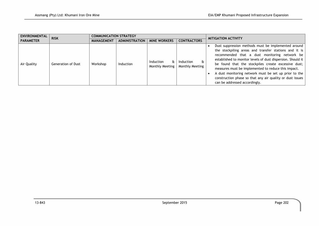
Assmang (Pty) Ltd: Khumani Iron Ore Mine EIA/EMP Khumani Proposed Infrastructure Expansion
13-843 September 2015 Page 202
ENVIRONMENTAL
PARAMETER RISK
COMMUNICATION STRATEGY MITIGATION ACTIVITY
MANAGEMENT ADMINISTRATION MINE WORKERS CONTRACTORS
Air Quality Generation of Dust Workshop Induction Induction &
Monthly Meeting
Induction &
Monthly Meeting
Dust suppression methods must be implemented around
the stockpiling areas and transfer stations and it is
recommended that a dust monitoring network be
established to monitor levels of dust dispersion. Should it
be found that the stockpiles create excessive dust;
measures must be implemented to reduce this impact.
A dust monitoring network must be set up prior to the
construction phase so that any air quality or dust issues
can be addressed accordingly.

Assmang (Pty) Ltd: Khumani Iron Ore Mine EIA/EMP Khumani Proposed Infrastructure Expansion
13-843 September 2015 Page 203
Table 8.7: Environmental Awareness Plan for the Decommissioning Phase at Khumani.
ENVIRONMENTAL
PARAMETER RISK
COMMUNICATION STRATEGY MITIGATION ACTIVITY
MANAGEMENT ADMINISTRATION MINE WORKERS CONTRACTORS
Soil Incorrect rehabilitation Workshop Workshop Induction Induction The correct placement of soil layers will be implemented.
Lack of soil fertility Workshop Workshop Induction Induction Fertilization programmes will be introduced.
Flora Alien Invader Species Workshop Workshop Induction Induction
Indigenous vegetation establishment will be encouraged;
and
A weed control programme will be implemented.
Surface Water Water Quality Workshop Workshop Induction Induction Detailed water monitoring programme to be
implemented.
Groundwater Groundwater
Contamination Workshop Workshop Induction Induction Detailed water monitoring programme to be implemented
Air Quality Generation of Dust Workshop Workshop Induction Induction Dust suppression methods will be implemented.

Assmang (Pty) Ltd: Khumani Iron Ore Mine EIA/EMP Khumani Proposed Infrastructure Expansion
13-843 September 2015 Page 204
9.4.4 Contractors
An environmental awareness section will be added to the contractors health and safety
induction programme. The environmental induction will focus on activities that carry an
environmental risk, actions to be taken to reduce these risks, and procedures to be followed
in the event of an incident.
9.5 Methods of Communication
The following methods of communitation will be used to inform employees of the EAP and
EERP to ensure safe and sustainable mining operations. Not all methods of communication
will be used for each group of employees as some may require more comprehensive
knowledge of the EAP and EERP depending on their job descriptions.
9.5.1 Induction
Comprehensive induction forms a critical component during the construction period and
operational period. This includes the following:
Ensure that all employees are aware of their individual and their job descriptions
potential impact on the environment; and
Employees are aware of any ecological sensitive, cultural sensitive sensitive sites.
The measure and procedures to follow should cover ecologically sensitive, culturally sensitive
or historically sensitive sites which have been detected.
The preventative measures and procedures to undertake in order to reduce the risk of a
potential impact.
9.5.2 Environmental Symposiums
Environmental symposiums are held with management, and selected groups of supervisors /
foremen and / or employee representatives. These take the form of an open discussion
between the environmental department and these individuals. The symposiums aid in
environmental awareness being generated at all levels, as well as assist the relevant
department in defining all, or identifying new environmental issues, concerns and pollution
sources. These are undertaken on a quarterly basis.

Assmang (Pty) Ltd: Khumani Iron Ore Mine EIA/EMP Khumani Proposed Infrastructure Expansion
13-843 September 2015 Page 205
9.5.3 In-house Training
In-house training sessions are held with relevant employees. The training sessions are
planned by the environmental department, and allow for employees to participate in
determining what the environmental issues and concerns are with regard to their specific
occupation. Education with regard to environmental incident reporting is detailed at these
sessions.
9.5.4 On the Job Training
On the job training is an essential tool in environmental awareness. Employees are given
details of the expected environmental issues and concerns specifically related to their
occupation. Employees are trained on how to respond if an environmental problem or source
of environmental pollution arises. The training is on-going, and all new employees are
provided with the same standard of training as existing employees.
9.5.5 General Training and Skills Development
The current Khumani training schedule will be implemented for the proposed activities.
9.5.6 Environmental Open Days
If necessary (i.e. requested by the environmental forums), environmental open days can be
arranged by the operation’s environmental department. Open days will be utilised to discuss
environmental issues in a less formal manner, thereby allowing employees the opportunity
to participate in environmental management by educating them about environmental
pollution and waste management in areas beside the workplace (e.g. at home). The open
days do not necessarily have to be confined to employees only, but may be made open to
employee’s families and schools so as to ensure that the principles of environmental
management, pollution prevention, waste management and sustainable development are
communicated to the communities surrounding the operation.
9.5.7 Publications
Selected publications are produced and used to communicate environmental issues to outside
parties. Examples include newsletters and the ARM (African Rainbow Minerals Annual Report).
The quarterly distribution of the information newspapers at Khumani has been implemented
to ensure that all parties are aware of the status of environmental, safety and health issues
at the mine. The newspaper further provides information regarding specific environmental

Assmang (Pty) Ltd: Khumani Iron Ore Mine EIA/EMP Khumani Proposed Infrastructure Expansion
13-843 September 2015 Page 206
issues (i.e. plant species which should be protected), which the employees can implement
and make them more knowledgeable in the working environment.
9.6 External and Internal Environmental Communication Strategies
Khumani’s management shall continue to establish and maintain procedures for the internal
communication between the various levels and functions of the organisation, and receiving,
documenting and responding to relevant communication from external interested and
affected parties. The communication of the environmental risks for each phase of the project
will take place for the management, administrative, plant and mine worker sectors of the
mine, as well as contractors. The organisation shall consider processes for external
communication on its significant environmental aspects and record its decision.
Communication is a management responsibility. All supervisors are responsible for effective
communication within their own sections. Environmental communication can be divided into
two categories: internal communication and external communication.
9.6.1 Internal Communication
Internal communication is done within the Administrative Sector. Please refer to Section
9.4.3 for details pertaining to internal communication within the administrative sector.
9.6.2 External Communication Strategies
The following communication channels and media will / can be used to communicate
environmental issues to individuals who are not employed by the mine:
Environmental Committee: An Environmental Committee will be established and
used as a forum to keep interested and affected parties informed of the significant
environmental aspects identified through the Environmental Impact Assessments and
Management Plans. This will also be the forum where interested and affected parties
get the opportunity to raise environmental concerns. Records will be kept of all
decisions and concerns. The Environmental Committee will be chaired by the General
Manager, or another appropriately appointed competent individual. All issues and
concerns raised will be addressed within a specific timeframe as approved by the
relevant stakeholders and authorities. The Environmental Committee will be chaired
by the Environmental Manager, or another appropriately appointed individual. Bi-
annual forum meetings will be held at which time stakeholders will be presented with

Assmang (Pty) Ltd: Khumani Iron Ore Mine EIA/EMP Khumani Proposed Infrastructure Expansion
13-843 September 2015 Page 207
the opportunity to raise issues and concerns. Should the stakeholders require more
meetings (i.e. quarterly) this will be undertaken
Communication from external parties and employees: A clear communication point
will be established within the company that will be responsible for liaison with the
media in respect of any crisis that may arise within the Mine. A complete procedure
for media liaison will be made available to all employees. Communication from
external interested and affected parties may be received by e-mail, fax,
telephonically or by mail. Where required, a written response will be sent, on
receiving such communication, by the appropriately appointed individual under
signature of the General Manager, to the respective interested and / or affected
party. All telephonic or facsimile correspondence received on the mine will be
forwarded to the relevant department for action. All events or concerns will be
captured and actioned on an existing and / or future database.
E-mail: E-mail communication received will be stored, with replies, in an appropriate
folder on a server. E-mail messages, relevant to environmental management, will be
kept for a minimum of two years before deletion.
Mail: Correspondence received by mail will be filed, along with the response (where
relevant), within the relevant department’s filing system for a minimum period of
two (2) years. Paper correspondence will be archived in this department.
Telephone: A register of telephonic environmental queries will be kept by the
relevant department detailing caller, contact details, date, query, action taken and
response. Furthermore, the person answering the call will be responsible for logging
their particulars against the call, as well as ensuring that all communication that
leads to an aspect or an impact, is entered on the database.
Storage of Correspondence: All original correspondence will be retained by the by
Khumai for a minimum period of two years.
Environmental Reports: Copies of relevant specialist study reports and
Environmental Impact Assessments will be available on request from an external
party by the General Manager.
Queries from Interested and Affected Parties: Response to queries about
environmental impacts and aspects will be addressed by the relevant department,
and approved by the General Manager.

Assmang (Pty) Ltd: Khumani Iron Ore Mine EIA/EMP Khumani Proposed Infrastructure Expansion
13-843 September 2015 Page 208
9.7 Evaluation of the Environmental Awareness Plan
The evaluation of the environmental awareness plan will be conducted by the management
of the mine. This evaluation will entail the auditing of the operation in both the construction
and operation phase once activity has commenced.
The environmental awareness plan described above is sufficient to make all those involved
in the project aware of those risks that may occur as well as the necessary mitigation required
to minimize these risks. The awareness plan indicates that the applicant is serious about the
environments well being, empowerment of the local people and returning the land to the
appropriate use in the future. Environmental issue will be highlighted at monthly meetings
scheduled at the mine.

Assmang (Pty) Ltd: Khumani Iron Ore Mine EIA/EMP Khumani Proposed Infrastructure Expansion
13-843 September 2015 Page 209
10 FINANCIAL PROVISION
This section of the report relates to Section 33 of the GNR543 published in Government
Gazette No.33306 of 18 June 2010, under Section 24(5) of the NEMA.
Regulation 33
g) A description of the manner in which it intends to :
i) Comply with any applicable provisions of the act regarding closure, where
applicable;
ii) Comply with any provisions of the Act regarding financial provisions for
rehabilitation, where applicable.
k) Where appropriate, closure plans, including closure objectives.
The ‘Guideline document for the evaluation of financial provision made by the mining
industry’ has been developed by the Department of Minerals and Energy (DMR) to empower
the personnel at the Regional DMR offices to review the quantum determination for the
rehabilitation and closure of mining sites.
10.1 Overview of Legal Requirements
Section 41 and 45 of MPRDA:
Section 41(1): Requires that an applicant must before the Minister approves the EMP
in terms of section 39(4) make the prescribed “financial provision” for the
rehabilitation or management of negative environmental impacts.
Section 41(2): If a holder of a mining right fails to rehabilitate / manage, is unable
to undertake such rehabilitation or to manage any negative impact on the
environment, the Minister may upon written notice to such holder, use all or part of
the financial provision to rehabilitate or manage the negative environmental impact
in question.
Section 41(3): Require the holder to undertake an annual assessment of his or her
environmental liability and increase his or her financial provision to the satisfaction
of the Minister.
Section 45: Allows the Minister to recover cost in the event of urgent remedial
measures.
Regulation 53 and 54 of the MPRDA Regulation R527:

Assmang (Pty) Ltd: Khumani Iron Ore Mine EIA/EMP Khumani Proposed Infrastructure Expansion
13-843 September 2015 Page 210
Regulation 53 sets out the methods for providing the financial provision required, i.e.
trust fund, financial guarantee by a bank or other financial institution, or direct
deposit into a bank account stipulated by the DMR Director General;
Regulation 54: Requires that the quantum of financial provision to be approved by
the Minister must be based on the requirements of the approved EMP and shall include
detailed itemization of all actual costs required for premature closure regarding:
o The rehabilitation of the surface of the area;
o The prevention and management of pollution of the atmosphere;
o The prevention and management of pollution of water and the soil; and
o The prevention of leakage of water and minerals between subsurface
formations and the surface.
o Decommissioning and final closure of the operation; and
o Post closure management or residual latent environmental impacts.
The Closure Cost will be updated during the annual closure cost reviews to include the
expansion of the existing stockpiles and also the additional stockpile areas.

Assmang (Pty) Ltd: Khumani Iron Ore Mine EIA/EMP Khumani Proposed Infrastructure Expansion
13-843 September 2015 Page 211
11 ENVIRONMENTAL REHABILITATION PROGRAMME
This section of the report relates to Section 33 of the GNR543 published in Government
Gazette No.33306 of 18 June 2010, under Section 24(5) of the NEMA.
REGULATION 33
b) Information on any proposed management or mitigation measures that will be taken to address the
environmental impacts that have been identified in a report contemplated by these regulations,
including environmental impacts or objects in respect of :
i) Planning and designing;
ii) Pre Construction and construction activities;
iii) Operation or undertaking of the activity;
iv) Rehabilitation of the Environment; and
v) Closure, where relevant
f) As far as is reasonably practical, measures to rehabilitate the environment affected by the
undertaking of any listed activity or specified activity to its natural or predetermined state or to a
land use which conforms to the generally accepted principal of sustainable development ,including
,where appropriate, concurrent or progressive rehabilitation measures
11.1 Background Information
The overall land use vision for the proposed Upgrades of the current operations is to ensure
the operations are safe, stable and non-polluting over the long-term.
If one is to consider an end of mine land use for the proposed project area there are certain
criteria that must be borne in mind, namely:
The nature of the mining operation;
The impacts of the mining operation; and
The land use of the surrounding areas.
11.1.1 Nature of the Mining Operation
Khumani is an existing mine and is currently managed in terms of the existing EMP.
11.1.2 Impacts of the Mining Operation
The main impacts associated with the mining actiivites are:
1. Loss of species of conservation activities, for which the mine has permits;
Assmang (Pty) Ltd: Khumani Iron Ore Mine EIA/EMP Khumani Proposed Infrastructure Expansion
13-843 September 2015 Page 212
2. Loss of land for grazing potential, which should be re-esablished to an extent as part
of the closure objectives;
3. Due to the fact that the mine is not privileged to groundwater resources to
supplement water needs, the mine is purchasing water from the Sedibeng water
scheme, which places additional needs on the already strained system;
4. Increase in dust dispersion, although the mine is generally compliance with the dust
dispersion standards for a rural area;
5. Increase in the overall noise and vibrasions of the area; and
6. Permanent change in the geomorphology of the area.
Noting the above, the mine is also contributing positively towards the bio-phisical and socio-
economic environment. These activities are considered sustainable and long terms and
include:
1. Establishment of a long term and sustainable offset area in consultation with the
provincial authorities;
2. Ongoing establishment of endemic species on site;
3. Implimentaton of skill development programmes and training programmes, which will
benefit employees for their personal lives; and
4. Significant contribution to programmes and projects in line with the Integrated
Development Plan of the local municipalities as part of the mines; Social and Labour
Plan.
11.1.3 Land Use of the Surrounding Area
The main industries in the area include mining (mainly for manganese ore, iron ore and tiger’s
eye), agriculture (mainly for cattle, sheep, goat and game farming) and tourism. Surrounding
land use such as agriculture and tourism will not be affected. The mine is already in operation
and the proposed extensions are adjacent to the existing structures on property leased by
the mine. While no further impacts can be expected on these land uses during the
construction and operational phases, significant gains may be experienced post mining as the
land can be reused for agricultural or tourism purposes post rehabilitation efforts.
11.2 Aim of Rehabilitation Plan
The aim of the rehabilitation plan is to:
Return the disturbed areas to an acceptable post mining state;
Ensure all areas are stable, and there is not risk of erosion or subsistence;

Assmang (Pty) Ltd: Khumani Iron Ore Mine EIA/EMP Khumani Proposed Infrastructure Expansion
13-843 September 2015 Page 213
Prevent alien plant invasion on the site until the site is in a stable state; and
Ensure that all areas are free-draining and non-polluting.
The rehabilitation plan will attempt to restore the area to an acceptable standard as required
by the economic planning reality (as per the Integrated Development Plan at the time) and a
viable end of mine land use.
11.3 Rehabilitation Objectives
The overall rehabilitation objectives for Khumani are the following:
Visual impacts of rehabilitated areas should be minimised by recreating natural
landforms and ensuring that reshaped areas are visually suited to surrounding
landscapes;
Natural landforms such as drainage lines, undulating areas and ridges, which have
been damaged during activities, must be restored where practically possible;
Soil integrity is the most important aspect of rehabilitation as it forms the base from
which rehabilitation proceeds. If soils are not correctly prepared, suitable conditions
for re-vegetation will not be achieved;
The mine is committed to backfilling, however due to the fact that residue material
will be reprocessed and reused, the possibility that open voids remain, is possible.
For this purpose, those open voids must be made safe; and
Alien floral invasion poses a threat both during and post-rehabilitation activities.
Adequate alien and invasive species control measures will contribute towards an
effective rehabilitation effort.
The closure involves the rehabilitation of all areas disturbed as a result of the operations
during all of the project phases.
11.4 Management Criteria for the Rehabilitation of Land
The following management measures are required:
The rehabilitated areas will be barricaded, and all animals kept off the area until the
vegetation is self-sustaining;
Newly seeded/planted areas will be protected against compaction and erosion;
Vegetation will be watered, if required, and weeded at least once in three months;
Ongoing monitoring for pests and diseases will be undertaken at least once in six
months and vegetation will be treated in accordance with identified accepted
procedures if necessary;

Assmang (Pty) Ltd: Khumani Iron Ore Mine EIA/EMP Khumani Proposed Infrastructure Expansion
13-843 September 2015 Page 214
Unhealthy or dead plant material will be replaced if necessary;
A general application of potassium, nitrate and phosphorous fertilizer should be
applied, where self-succession does not establish. Small quantities should be applied
at regular intervals (to be determined at rehabilitation onset) across the site so as
not to affect the surface and groundwater environments;
Any damage caused by erosion will be rehabilitated and the necessary erosion control
measures will be maintained; and
Annual inspections of rehabilitated areas will be undertaken for the first three (3)
years after rehabilitation or until such time that the areas are self-sustaining.
11.4.1 Removal of Infrastructure
Following cessation of mining, it is customary that all infrastructures will be decommissioned
and removed from site in a systematic and regulated manner.
11.4.2 Active Rehabilitation - Landscaping
Landscaping activities involve the active rehabilitation of an area with the following activities
taking place:
Recovery of all saleable infrastructure;
Demolition and removal of all buildings and structures;
Ripping of all compacted areas, which will be followed with amelioration and
vegetation;
Ensure that all remaining piles and slopes are sufficiently shaped to blend in with the
surrounding environment;
Amelioration and vegetation of all disturbed areas;
Maintenance of all re-vegetated areas up until such areas initiate succession and
create a sustainable cover;
Monitoring of key environmental variables (i.e. soils, vegetation, groundwater and
surface water) in order to demonstrate stability of rehabilitated areas; and
Weed management after closure, limited to areas disturbed by mining or included as
infrastructure related to the mine.
11.4.3 Disposal of material
The disposal of material will include the following and will be completed within a period as
specified in the appropriate closure document:

Assmang (Pty) Ltd: Khumani Iron Ore Mine EIA/EMP Khumani Proposed Infrastructure Expansion
13-843 September 2015 Page 215
Waste removal will be undertaken in accordance with the applicable Waste
Legislation of the time;
No building rubble or any other types of waste shall be dumped in the surrounding
environment. In cases where it has already happened the sites shall be cleaned up
and the waste and/or rubble removed to appropriate sites in consultation with the
Environmental Coordinator;
All types of waste (with the exclusion of residue stockpiles) shall be removed entirely
from the area and appropriately dealt with in respect of the general waste handling
procedure;
All foreign matter shall be removed from the site;
Inert ceramics such as bricks, concrete, gravel etc. will be disposed of in a licensed
waste disposal site; and
Inert ceramic and buried waste with a salvage value to individuals such as scrap
metal, building materials, etc. will be removed and disposed of at a licensed facility.
11.4.4 Water Pollution Control Structures
Water pollution control structures will remain until the completion of all demolition and
associated rehabilitation activities where after these will be rehabilitated.
11.4.5 Maintenance
The aim of the maintenance measures are to ensure that the area affected by the mining
operations is rehabilitated according to the closure plan and to apply for closure. The
objective is for the area to be rehabilitated sustainability, ensuring self-succession of plants
and the associated return of natural wildlife; as well as the improvement of the natural
watercourses and groundwater systems.
The following maintenance measures will be implemented as part of the post-closure process:
All natural physical, chemical and biological processes for which a closure condition
has been specified must be monitored for three (3) years after closure or as long as
deemed necessary at the time. Such processes include erosion of the rehabilitated
surfaces, surface water drainage, surface water quality, groundwater quality,
vegetative re-growth, weed encroachment and colonization by animals;
Measures must be implemented to curb environmental impacts and to ensure that
they do not worsen/cumulate over time;
The closure plan will be reviewed every five (5) years; and
All rehabilitated areas will be monitored and maintained until such time as required
to enable the mine to apply for closure of these different areas.

Assmang (Pty) Ltd: Khumani Iron Ore Mine EIA/EMP Khumani Proposed Infrastructure Expansion
13-843 September 2015 Page 216
The following activities will be included during the maintenance phase:
The closure costs (demolition, removal, re-shaping and rehabilitation quotes per key
quantity) for the facility must be included in a database so that the total closure cost
can be determined;
Attention must be paid to the latest developments in mine rehabilitation sciences;
Rehabilitation should be done as soon as possible, to ensure that the rehabilitation
work required is kept to a minimum at the end of the life of the mine;
Ensure that the area is free draining;
Ensure that no subsidence will occur and the area is stable;
Ensure that self-succession has been implemented;
Ensure that all slopes are stable in the long term;
Submission of closure report and application for closure to the authorities; and
Environmental monitoring and maintenance for three years after closure, after which
the the effectiveness will be reassessed.
11.5 Submission of Information
The following applies to the submission of information:
All procedures (emergency, environmental awareness, rehabilitation strategies, etc.)
must be included into the mine’s Environmental Management System (EMS). The
mine’s EMS will monitor and assess the performance of the EMP on an ongoing basis.
Formal audits of the performance assessment of the EMP will take place every year
as stipulated by law, or at any other period if required by government;
All information as required by the various government departments should be
captured and be readily available for submission when required;
An bi-annual Performance Assessment Report (PAR) will be submitted to the DMR;
Groundwater monitoring occurs on a quarterly basis and is undertaken by outsourced
specialists. Annual groundwater reports will be submitted to the DWA;
The groundwater levels will be monitored on a quarterly basis and will be presented
in the form of piezometric maps, from which changes can be determined through
time. Annual groundwater reports will be submitted to the DWA;
Surface water monitoring will be undertaken monthly and annually reports will be
submitted to the DWA together with the groundwater reports;
The financial provision for closure (quantum and method) will be updated annually
as part of the Environmental Programme Performance Assessment; and
The closure plan must be reviewed every five (5) years, and must always keep pace
with the current best practices.

Assmang (Pty) Ltd: Khumani Iron Ore Mine EIA/EMP Khumani Proposed Infrastructure Expansion
13-843 September 2015 Page 217
11.6 Rehabilitation Responsibilities
Table 11.1 indicates the various responsibilities and responsible parties for the rehabilitation
activities.
Table 11.1: Responsibilities and Responsible Parties for Rehabilitation Activities.
RESPONSIBLE PARTY RESPONSIBILITY
Khumani Environmental Manager
Planning of rehabilitation projects
Initiating rehabilitation projects
Compilation of closure plans with regard to rehabilitation
areas/sites
Khumani Environmental Manager
General monitoring/surveillance and reporting and
coordination
Implementation/coordination with regard to particular
environmental measure/action plans
Khumani Environmental
Coordinator
Audits (Environmental, EMP Performance Assessment, etc.) and
surveillance
General Manager and Excecutives Authorisation of all rehabilitation projects

Assmang (Pty) Ltd: Khumani Iron Ore Mine EIA/EMP Khumani Proposed Infrastructure Expansion
13-843 September 2015 Page 218
12 INFORMATION GAPS AND FURTHER ASSESSMENTS REQUIRED
This section of the report relates to Section 31 (2) of the GNR543 published in Government
Gazette No.33306 of 18 June 2010, under Section 24(5) of the NEMA.
REGULATION 31 (2)
2 m) A description of the assumptions, uncertainties and gaps in knowledge
The following section describes the information gaps that presented during the compilation
of this EIA/EMP report, as well as the specialist studies undertaken.
Information contained in this EIA/EMP document is based on technical information received
from the applicant as well as the outcomes of the updated specialist studies undertaken. The
baseline description of this report is largely based on previous specialist studies undertaken
over time.
The area where the Bruce Low Grade ROM Stockpile and Overburden Dump Expansion is
located has only undergone a desktop assessment and the status of the ecology in that area
has not been verified by field visits.

Assmang (Pty) Ltd: Khumani Iron Ore Mine EIA/EMP Khumani Proposed Infrastructure Expansion
13-843 September 2015 Page 219
13 MOTIVATION FOR THE PROJECT
The project should be seen as a continuation of Khumani’s commitment made in the mining
right application and subsequent EMPs, to reclaim all low grade material as far as practically
possible. The motivation can therefore be stated as the following:
Through Khumani’s ongoing commitment to optimise its existing mineral resources, the
operational team has identified the need for additional process facilities required to optimise
beneficiation and still meet its approved production allocation. The approved Khumani Mining
Right Application, submitted by the mine, stipulated the mine’s intention to reuse low grade
material by reclaiming same in the future. The proposed project ensures that the mine fulfils
this commitment, and ensures that Khumani continues mining in a manner optimally utilising
its resource.

Assmang (Pty) Ltd: Khumani Iron Ore Mine EIA/EMP Khumani Proposed Infrastructure Expansion
13-843 September 2015 Page 220
14 LIST OF SPECIALIST STUDIES UNDERTAKEN
The following specialist studies have been undertaken with regards to the proposed Upgrades
in 2014:
Biodiversity and Wetland Impact Assessment (2014);
Geohydrological Impact Assessment –Hydrocensus and Consceptual Model (2014);
Hydrological Impact Assessment – Update to the Storm Water Management
Plan(2014);
All these studies are provided in Appendix C.
Khumani is an existing mine and various specialist studies were undertaken over the years
and thus deemed sufficient to use in this EMP. Below is a list of all specialist studies that
were undertaken previously and used in the last amendment of the EMP date? (Table 14.1).

Assmang Ltd: Khumani Iron Ore Mine EIA/EMP Khumani Proposed Infrastructure Expansion
13-843 September 2015 Page 221
Table 14.1: Previous Specialist Studies
YEAR CONSULTANT SPECIALIST STUDY CONDUCTED FOR PN
2004 Clean Stream Groundwater Services
Geohydrological inputs to fulfill the EMP requirements for the Bruce-King-Mokaning iron ore project of Associated Manganese
EIA - The expansion of capacity, railway diversion and establishment of a local railway siding at Khumani Iron Ore Mine
08-191/08-343
2004 -
2005 Knight Piésold (Pty) Ltd BKM Project : Surface Water Evaluation For EMPR
EIA - The expansion of capacity, railway diversion and establishment of a local railway siding at Khumani Iron Ore Mine
08-191/08-343
2005 GCS - Ian Jones Soil/Pedological, Land Capability And Land Use Assessment Study
EIA - The expansion of capacity, railway diversion and establishment of a local railway siding at Khumani Iron Ore Mine
08-191/08-343
2005 GCS - Ian Jones For BKM – Sishen Project EIA - The expansion of capacity, railway diversion and establishment of a local railway siding at Khumani Iron Ore Mine
08-191/08-344
2005 Airshed Planning Professionals (Pty) Ltd
Air Quality Impact Assessment And Management Plan For BKM Mine In The Kathu District, Northern Cape
EIA - The expansion of capacity, railway diversion and establishment of a local railway siding at Khumani Iron Ore Mine
08-191/08-343
2005 F le R Malherbe Pr Eng Noise Impact Study For The BKM Mine EIA - The expansion of capacity, railway diversion and establishment of a local railway siding at Khumani Iron Ore Mine
08-191/08-343
2005 David Morris Report on a Phase 1 Archaeological Assessment of proposed mining areas on the farms Bruce, King, Mokaning and Parson, between Postmasburg and Kathu, Northern Cape.
EIA - The expansion of capacity, railway diversion and establishment of a local railway siding at Khumani Iron Ore Mine
08-191/08-343
2005 Newtown Landscape Architects Visual Impact Assessment for BKN Mine EIA - The expansion of capacity, railway diversion and establishment of a local railway siding at Khumani Iron Ore Mine
08-191/08-343

Assmang Ltd: Khumani Iron Ore Mine EIA/EMP Khumani Proposed Infrastructure Expansion
13-843 September 2015 Page 222
YEAR CONSULTANT SPECIALIST STUDY CONDUCTED FOR PN
2006 McGREGOR MUSEUM (ZOOLOGY DEPARTMENT)
Ecological Impact Assessment (Vertebrates): Proposed BKM Mine
Bruce Barrier Pillar EMP Amendment 06-405
2006 Botanical Report: Khumani Mine Project Bruce Barrier Pillar EMP Amendment 06-405
2009 GCS Khumani Hydrological Assessment EIA - The expansion of capacity, railway diversion and establishment of a local railway siding at Khumani Iron Ore Mine
08-191/08-343
2010 GCS Storm Water Management Plan Section A, Section B and Section C
Khumani EIA/EMP Amendment 10-070/10-314
2010 Geo Pollution Technnologies (Pty) Ltd
Evaluation of the hydrogeological data at Khumani Mine and the Development of a Groundwater Management Plan
Khumani Iron Ore Mine
Kum-09-403
2011 Geo Pollution Technnologies (Pty) Ltd
Geophysical Survey on the farm King Khumani Iron Ore Mine KHU/11/096
2012 GCS Khumani Bruce Storm Water Management 11-361
2012 Scientific Aquatic Services CC Biodiversity: Faunal And Floral Specialist Studies And Action Plan For The Assmang Iron Ore Khumani Mine
Off-grade 2 Plant 12-408
2012 Geo Pollution Technnologies (Pty) Ltd
Leaching Potential of the Paste Material Khumani Iron Ore Mine
KHU-12-319
2013 Geo Pollution Technnologies (Pty) Ltd
Khumani Hydrocensus Survey and and interpretation of of data in the Kathu Area
Khumani Iron Ore Mine KhuHy-13-656
2014 GCS Ecological Assessment associated with the Khumani Mine Dump Extension
Khumani Iron Ore Mine Infrastructure Expansion Project
13-843
2014 GCS Khumani Hydrology (Surface water and Storm Water Management Plan) update
Khumani Iron Ore Mine Infrastructure Expansion Project
13-843
2015 Geo Pollution Technnologies (Pty) Ltd
Hydrogeological Assessment Khumani Iron Ore Mine

Assmang Ltd: Khumani Iron Ore Mine EIA/EMP Khumani Proposed Infrastructure Expansion
13-843 September 2015 Page 223
15 ENVIRONMENTAL IMPACT STATEMENT This section of the report relates to Section 31 (2) of the GNR543 published in Government
Gazette No.33306 of 18 June 2010, under Section 24(5) of the NEMA.
REGULATION 31 (2)
2 n) A reasoned opinion as to whether the activity should or should not be authorised, and if it should
be authorized any conditions that should be authorized, any conditions that should be made in respect
of that authorization.
2 o) An environmental impact statement which contains :
i. A summary of the key finding of the Environmental Impact Assessment ; and
ii. A comparative assessment of the positive and negative implications of the proposed activity
and identified alternatives.
The proposed project is going to form part of the existing mining operations currently being
undertaken in the area. Khumani is operated in an environmental and social responsible
manner. The applicant is committed in fulfilling their corporate responsibility, which includes
social and environmental responsible practices. Khumani has all environmental permits and
licences in place and implements these conditions in their daily operations. Ongoing
monitoring is undertaken and annual performance assessments are conducted by independent
environmental consultants.
The project applied for is founded in the operations need and desire to optimally mine and
process its resources and the commitment to reuse material as far as practically possible.
Allthough the project will result in impacts on the environment, these impacts are both of
positive and negative nature.
The main impacts associated with the overall mining activites are:
1. Loss of species of conservation activities, for which the mine do have permits;
2. Loss of land for grazing potential, which should be re-esablished to an extent as part
of the closure objectives;
3. Due to the fact that the mine is not privileged to groundwater resources to
supplement water needs, the mine is purchasing water from the Sedibeng water
scheme, which places additional needs on the already strained system;
4. Increase in dust dispersion, although the mine is generally compliance with the dust
dispersion standards for a rural area;
5. Increase in the overall noise and vibrasions of the area; and
6. Permanent change in the geomorphology of the area

Assmang Ltd: Khumani Iron Ore Mine EIA/EMP Khumani Proposed Infrastructure Expansion
13-843 September 2015 Page 224
Noting the above, the mine is also contributing positively towards the bio-physical and socio-
economic environment. These activities are considered sustainable over the long term and
include:
1. Establishment of a long term and sustainable offset area in consultation with the
provincial authorities;
2. Ongoing establishment of endemic species on site;
3. Implimentaton of skill development programmes and training programmes, which will
benefit employees for their personal lives; and
4. Significant contribution to programmes and projects in line with the Integrated
Development Plan of the local municipalities as part of the mines; Social and Labour
Plan.
The specific project may contribute to direct impacts during the following phases:
Construction;
Operational;
Closure and decommisoning;
Direct Impacts during Construction
Topography
Direct impact: topographical changes as a result of land and footprint clearance,
topsoil stripping and stockpiling, infrastructure establishment.
Soils, Land Use and Land Capability
Direct impact: loss of topsoil (soil stripping and compation) in preparation for the
construction phase;
Direct impact: soil contamination due to construction vehicles and potential
hydrocarbon spillages and/or leaks.
Hydrology
Direct impact: vegetation and topsoil clearance could obstruct drainage, cause
waterlogging and pollute water resources.
Geohydrology
Direct impact: reduction in recharge footprints.
Biodiversity

Assmang Ltd: Khumani Iron Ore Mine EIA/EMP Khumani Proposed Infrastructure Expansion
13-843 September 2015 Page 225
Direct impact: loss of floral and faunal species of conservation importance due to
topsoil removal and vegetation disturbance.
Air Quality
Direct impact: increase in dust fallout from topsoil removal and vegetation removal.
Direct Impacts during Operations
Topography
Direct impact: topographical changes due to the increase and decrease in the
stockpile sizes.
Geohydrology
Direct impact: reduction in recharge footprints.
Air Quality
Direct impact: increase in dust fallout from the stockpiles.
Direct impact: Wetland destruction
Direct Impacts during Decommissioning and Closure
Topography
Direct impact: reshaping of the area following mining activities in order to achieve
the proposed end of mine land use.
Soils, Land Use and Land Capability
Direct impact: soil compaction due to vehicles and equipment utilised in the
rehabilitation activities contributing to vehicular movement on site;
Direct impact: soil erosion due to exposed surfaces and rehabilitation;
Direct impact: soil contamination due to the operation of vehicles and equipment
during rehabilitation and potential hydrocarbon spillages and/or leaks;
Direct impact: change in land use after mining; and
Direct impact: change in land capability as agricultural land will be lost once mining
related activities cease.
Hydrology
• Direct impact: reinstating the natural runoff patterns of the site.

Assmang Ltd: Khumani Iron Ore Mine EIA/EMP Khumani Proposed Infrastructure Expansion
13-843 September 2015 Page 226
Geohydrology
• Direct impact: groundwater quality impacts due to potential spillages and
contamination.
Biodiversity
• Direct impact: disruption to faunal and floral communities that have established on
site during the operational phase; and.
• Direct impact: re-establishment of faunal and floral communities during the
rehabilitation process.
Air Quality
• Direct impact: fugitive dust emissions; and
• Direct impact: dust entrainment from vehicles on site as a result of driving on
exposed surfaces.
Visual
• Direct impact: landscaping of the entire site and berm removals.
• Direct impact: removal of infrastructure from site and re-establishment of vegetated
areas.
Noise
• Direct impact: increased noise due to rehabilitation activities; and.
• Direct impact: reduction in noise levels due to mining cessation.
Social
• Direct impact: out-migration of job seekers as the mining operations cease;
• Direct impact: job losses; and
• Direct impact: a reduction in economic activities due to job losses and mine closure.
From the assessment of impacts throughout all the phases it is clear that though the impacts
may occur directly as a result of the proposed infrastructure upgrades, the impacts are mostly
of medium significance before mitigation. According to the assessment carried out by the
EAP the majority of the impacts can be reduced to a low significance with the appropriate
mitigation measures in places.
Not reclaiming the low grade material, will result in the presence of extensive infrastructure
requiring shaping and stabilising as part of the closure conditions stipulated in the approved
EMPs. Reusing material throughout the life of mine, can be regarded as ongoing

Assmang Ltd: Khumani Iron Ore Mine EIA/EMP Khumani Proposed Infrastructure Expansion
13-843 September 2015 Page 227
rehabilitation, whist also resulting in an economic benefit to both the mine and iron ore
markets. This in return will lower the mines financial environmental liability in terms of
rehabilitation. The overall project as presented in this report is therefore presented with
the view of reducing long term rehabilitation requirements.
The EAPs and environmental consultants responsible for the compilation of this document,
and the associated PPP are of the opinion based on the presented specialist assessments and
impact assessment that the Khumani infrastructure upgrades should be authorised. The
following mitigation measures are crucial and should form part of the environmental
authroisation to ensure that the applicant manages impacts adeaquatly:
• Adhere to the updated Stormwater Management Plan
• Adhere to the Existing Environmental Management Plan
• Ensure that all design drawings include effective erosion control measures
• Adhere to the Emergency procedures Report and implement spill clean-up procedures
• Apply for relevant permits with authorities for the removal of indigenous tree species
• Major spills should be reported within 24hr to the Department of Water and Sanitation
and the NCDENC.

Assmang Ltd: Khumani Iron Ore Mine EIA/EMP Khumani Proposed Infrastructure Expansion
13-843 September 2015 Page 228
16 CONCLUSION
Khumani is operated in an environmental and social responsible manner. The applicant is
committed in fulfilling their corporate responsibility, which includes social and
environmental responsible practices. Khumani has all environmental permits and licences in
place and implements these conditions in their daily operations. Ongoing monitoring is
undertaken and annual performance assessments are conducted by independent
environmental consultants.
It is the intention of Assmang to upgrade infrastructure on the Farms Bruce, Parsons and King
within their existing mining boundary area. The proposed upgrades on the farm Bruce include:
The extension of the existing approved Bruce Low Grade ROM Stockpile and
Overburden Dump with 75ha.
The proposed upgrades on the farm Parsons include:
The extension of the existing approved Low Grade Stockpile (previously known as the
Parson Discard Dump);
Tertiary By-pass Stockpile area at the existing Low Grade Stockpile s;
A new Low-Grade Reclaim Facility adjacent to existing Low Grade Stockpile;
The new WHIMS 2 Plant; and
Three (3) additional conveyors.
The proposed upgrades on the farm King include;
Extension of the existing King/Mokaning Overburden Low-Grade ROM Stockpile; and
A new Low Grade Stockpile for reclaiming purposes within the King Plant area.
Other activities required will include:
Upgrading and expansion of storm water facilities (separating clean and dirty water);
High Pressure Grinding Roll (HPGR) Crushing Facility;
Haul roads; and 22kV power lines to accommodate the WHIMS 2 Plant and the
reclamation activities.
These additional activities on the farms Bruce, King and Parson will require approval under
NEMA, the NWA and an Amendment to the EMP in terms of the MPRDA. The activities will not
influence the production output or Mining Works Programme of the mine.
The project applied for is founded in the operation’s need and desire to optimally mine and
process its resources with the commitment to re-process material as far as practically

Assmang Ltd: Khumani Iron Ore Mine EIA/EMP Khumani Proposed Infrastructure Expansion
13-843 September 2015 Page 229
possible. Although the project will result in impacts on the environment, these impacts are
both of positive and negative nature. The impacts are mostly of medium significance before
mitigation. According to the assessment carried out by the EAP the majority of the impacts
can be reduced to a low significance with the appropriate mitigation measures in place.
Not reclaiming the low-grade material will result in the presence of extensive infrastructure
requiring shaping and stabilising as part of the closure conditions stipulated in the approved
EMPs. Reusing material throughout the life of mine, can be regarded as ongoing rehabilitation
whist also resulting in an economic benefit to both the mine and iron ore markets. This in
return will lower the mine’s financial environmental liability in terms of rehabilitation. The
overall project as presented in this report is therefore presented with the view of reducing
long term rehabilitation requirements as well as optimising beneficiation of the iron ore
mined.
The EAPs and environmental consultants responsible for the compilation of this document,
and the associated PPP are of the opinion based on the presented specialist assessments and
impact assessment that the Khumani Infrastructure upgrades should be authorised. The
following mitigation measures are crucial and should form part of the environmental
authroisation to ensure that the applicant manages impacts adeaquatly:
• Adhere to the updated Stormwater Management Plan
• Adhere to the Existing Environmental Management Plan
• Ensure that all design drawings include effective erosion control measures
• Adhere to the Emergency procedures Report and implement spill clean-up procedures
• Apply for relevant permits with authorities for the removal of indigenous tree species
• Major Spill should be reported within 24hr to the Department of Water and Sanitation
and the NCDENC.
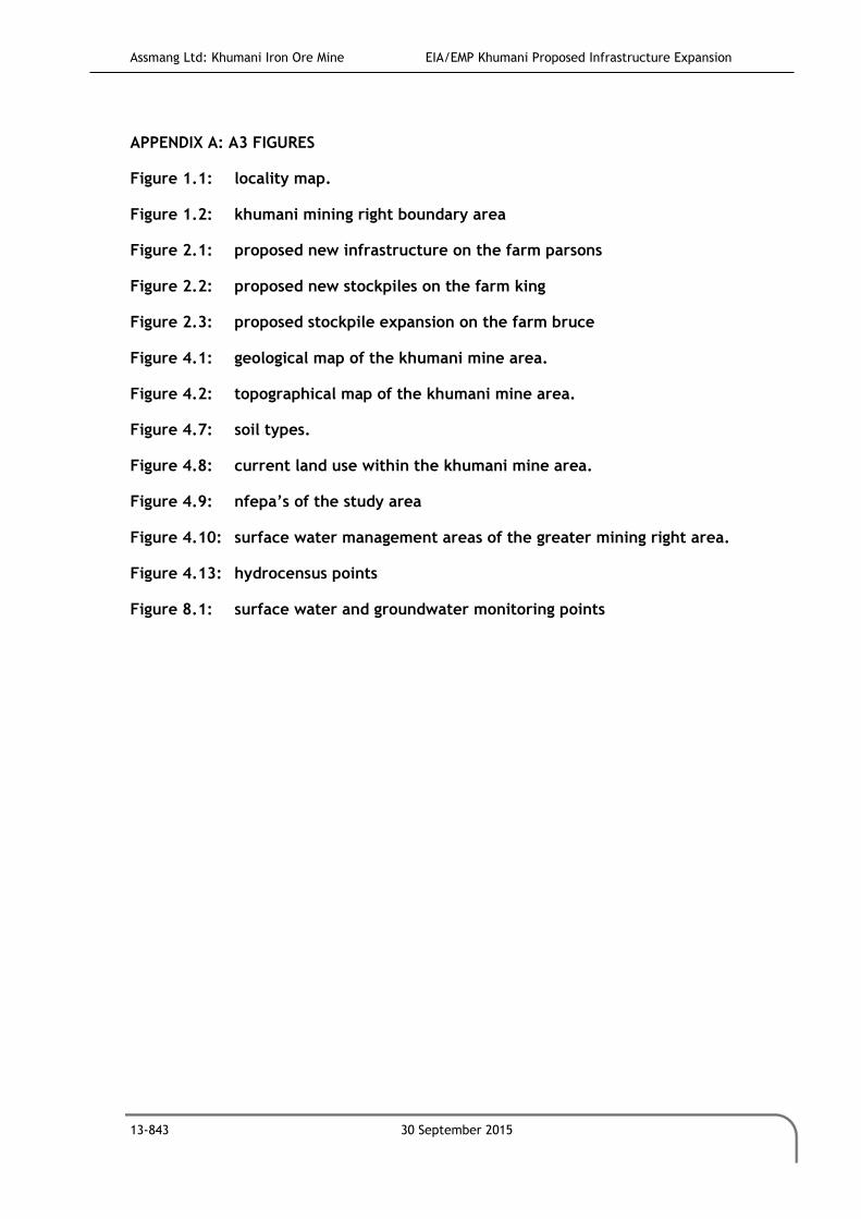
Assmang Ltd: Khumani Iron Ore Mine EIA/EMP Khumani Proposed Infrastructure Expansion
13-843 30 September 2015
APPENDIX A: A3 FIGURES
Figure 1.1: locality map.
Figure 1.2: khumani mining right boundary area
Figure 2.1: proposed new infrastructure on the farm parsons
Figure 2.2: proposed new stockpiles on the farm king
Figure 2.3: proposed stockpile expansion on the farm bruce
Figure 4.1: geological map of the khumani mine area.
Figure 4.2: topographical map of the khumani mine area.
Figure 4.7: soil types.
Figure 4.8: current land use within the khumani mine area.
Figure 4.9: nfepa’s of the study area
Figure 4.10: surface water management areas of the greater mining right area.
Figure 4.13: hydrocensus points
Figure 8.1: surface water and groundwater monitoring points

Assmang Ltd: Khumani Iron Ore Mine EIA/EMP Khumani Proposed Infrastructure Expansion
13-843 30 September 2015
APPENDIX B: PROOF OF PPP

Assmang Ltd: Khumani Iron Ore Mine EIA/EMP Khumani Proposed Infrastructure Expansion
13-843 30 September 2015
APPENDIX C: SPECIALIST ASSESSMENTS
C1: groundwater studies
C2: hydrology
C3: ecology

Assmang Ltd: Khumani Iron Ore Mine EIA/EMP Khumani Proposed Infrastructure Expansion
13-843 30 September 2015