Key West and Great White Heron National Wildlife Refuges Backcountry Management Plan
119
Transcript of Key West and Great White Heron National Wildlife Refuges Backcountry Management Plan

MANAGEMENT AGREEMENTFOR
CERTAIN LANDS IN MONROE COUNTY, FLORIDA
AGREEMENT NO. MA-44-088
WHEREAS, the Board of Trustees of the Internal Improvement Trust Fund holds title tocertain sovereignty submerged lands in Monroe County, Florida; and
WHEREAS, the Board may authorize the management of said lands by virtue of Chapter253.03, Florida Statutes; and
WHEREAS, the U.S. Fish and Wildlife Service possesses authority to enter intoagreement by virtue of the National Wildlife Refuge Administration Act, 16 U.S.C. & 668dd etseq.; and
WHEREAS, the U.S. Fish and Wildlife Service desires to manage the subject lands forpublic purposes as outlined in Exhibit “A” attached hereto;
NOW, THEREFORE, THE BOARD OF TRUSTEES OF THE INTERNALIMPROVEMENT TRUST FUND OF THE STATE OF FLORIDA, referred to herein as“Board,” hereby grants to the U.S. Fish and Wildlife Service, herein referred to as “Grantee,” theright to manage for public purposes all lands titled in the Board (including islands, tidal lands,and sovereignty submerged lands) which are located within the boundaries described in Exhibit“A” attached hereto and made a part hereof, for a period of twenty-five years from November 17,1992, the effective date of this Agreement, on the following terms and conditions:
1. Grantee shall manage the subject properties as provided in the management planattached as Exhibit “A” in a manner which will not conflict with the conservation, protection,and enhancement of said lands and which will not interfere with the maintenance of publicnavigation projects or other public works projects authorized by the United States Congress.
2. Grantee shall manage said lands as part of Key West, Great White Heron NationalWildlife Refuges, and National Key Deer Refuge. The wildlife management and public useprograms of said lands will be administered according to the policies of the Fish and WildlifeService as well as the regulations set forth in the National Wildlife Refuge SystemAdministration Act of 1966.
3. The management plan attached hereto as Exhibit “A” shall be reviewed jointly bythe Board and the Grantee at no greater than five (5) year intervals and updated as necessary. The Grantee shall not alter the property or engage in any activity except as provided for therequired plan without the prior written approval of the Board.
Page One

4. Upon execution of the Agreement, the Grantee shall have the right to enter andoccupy the property for the purpose of fulfilling the activities designated in Paragraph 1 andExhibit “A,” subject to all pre-existing rights and interests.
5. The Board shall have the right at any time to inspect the works and operations ofthe Grantee in any matter pertaining to this agreement.
6. This Agreement does not convey any title interest to the area described in Exhibit“A” attached hereto.
7. This Agreement may be unilaterally terminated by either party, with or withoutcause, by providing written notice of the intent to terminate this Agreement to the other party atleast 60 days prior to the proposed date of termination.
8. The Board retains the right to enter the property and to engage in managementactivities other than those provided for herein following notification to and consultation with theGrantee and further retains the right to grant approval for compatible uses of the property to thirdparties during the term of this Agreement. The Board shall determine whether or not anyproposed uses by a third party are compatible with the uses authorized herein.
9. This Agreement may be renewed for succeeding additional ten-year terms bymutual agreement of the parties. The Agreement to renew, together with all additions, deletions,and modifications to this management agreement, shall be affixed hereto.
10. This Agreement and any rights and privileges contained herein are for the sole useof the Grantee and shall not be assigned or transferred in whole or in part to any other partywithout the written consent of the Board.
11. The Grantee agrees to assist in the investigation of injury or damage claims eitherfor or against the State of the Board and pertaining to Grantee’s area of responsibility or arisingout of Grantee’s management programs hereunder and to contact the Board regarding whateverlegal action Grantee deems appropriate to remedy same.
12. The liability of the Grantee for the acts and omissions of its employees pursuant tothis instrument shall be governed by the Federal Tort claims Act.
13. Section 267.061(1) (b), Florida Statutes, specifies that title to all treasure trove,artifacts, and such objects of antiquity having intrinsic, scientific, or historical and archeologicalvalue, which have been abandoned on state-owned lands or state-owned sovereignty submergedlands, is vested in the Division of Historical Resources of the Department of State for thepurpose of administration and protection for the State of florida. Execution of this Agreement inno way affects any of the parties’ obligations pursuant to Chapter 267, Florida Statutes. Thedisturbance of archeological and historical sites on state-owned lands is prohibited unless priorauthorization has been obtained from DHR. All proposals for changes in the character or use ofState lands shall be coordinated with DHR in order to mitigate potential damage or disturbanceof, or to preserve archeological and historical sites and properties.
Page Two

14. Upon termination or expiration of this Agreement, the Grantee agrees to leave allfixed improvements for the use of the Board and to put no claim upon said fixed improvements;or, at the option of the Board, the Grantee agrees to remove any or all improvements from theproperty at Grantee’s expense.
15. The Grantee shall not discriminate against any individual because of theindividual’s race, color, religion, sex, national origin, age, handicap, or marital status withrespect to any activity occurring within the area subject to this Agreement or upon lands adjacentto and used as an adjunct to the area.
16. In the event of litigation between the parties, arising out of this Agreement, therecovery by the Board of its attorney’s fees and costs incurred in such litigation, including anyappeal therefrom, shall be governed by the provision of the Equal Access to Justice Act, 28U.S.C. & 2412.
17. All notices given under this agreement shall be in writing and shall be mailed to thelast address of the party to whom notice is to be given, as designed by such party in writing. TheBoard and the Grantee hereby designate their respective address as follows:
18. Unless specified herein to the contrary, this agreement shall be governed andinterpreted according to the laws of the State of Florida.
Page Three


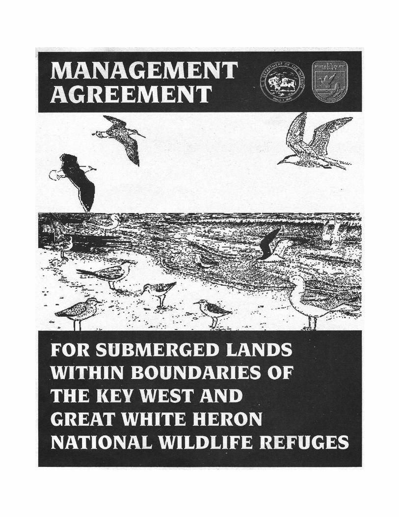
EXHIBIT A
MANAGEMENT AGREEMENT
for
BACKCOUNTRY PORTIONS
of
KEY WEST NATIONAL WILDLIFE REFUGEGREAT WHITE HERON NATIONAL WILDLIFE REFUGE
andNATIONAL KEY DEER REFUGE
Monroe County, Florida
SEPTEMBER 1992
UNITED STATES DEPARTMENT OF THE INTERIOR
FISH AND WILDLIFE SERVICE75 SPRING STREET, S.W.
ATLANTA, GEORGIA 30303
and
STATE OF FLORIDADEPARTMENT OF NATURAL RESOURCES
TALLAHASSEE, FLORIDA

ii
TABLE OF CONTENTS
INTRODUCTION
PART I - BACKGROUND Page
1. Purposes for Establishment of the National Wildlife Refuges in the Lower Florida Keys
2. Management Authority3. Environment4. Traditional Uses5. Resources
A. General Habitat CharacteristicsB. Endangered and Threatened Species
6. Administration7. Land Status8. Management Activities (1986 - present)9. Agreements and Permits
PART II - RESOURCE PROBLEMS
1. Literature Review: Human disturbance of wildlifeA. OverviewB. Potential Effects of Human Disturbance on BirdsC. Colonially Nesting WaterbirdsD. Raptors
2. Special ConsiderationsA. Bald EaglesB. OspreysC. Magnificent FrigatebirdsD. Mangrove Islands
3. Personal Watercraft (jet skis)A. DefinitionsB. BackgroundC. NumbersD. DistributionE. Problems
4. Airboats5. Water Skiing6. Commercial Use7. Law Enforcement Problems8. Conflicts Between User Groups9. Loss of Wilderness Values

iii
PART III - REFUGE OBJECTIVES AND MANAGEMENT STRATEGY Page
1. Refuge ObjectivesA. Highest PriorityB. High PriorityC. Moderate Priority
2. Management Strategy
PART IV - MANAGEMENT ACTIONS
1. Idle Speed, No Motor, and No Access Buffer ZonesA. OverviewB. Resources Available/Current ProgramC. Proposed Management
a. Definitionsb. Organizationc. Signaged. Key West National Wildlife Refugee. Great White Heron National Wildlife Refuge
2. Closure of Mangrove Islands3. Public Education
A. News releasesB. Public Service AnnouncementsC. Backcountry BrochureD. Educational Panels at Boat RampsE. Volunteer Program
4. Law Enforcement5. Commercial Use6. Personal Watercraft (jet skis)7. Airboats8. Water Skiing9. Wildlife Inventories10. Permits for Backcountry Islands Containing Key Deer11. Traditional Uses12. Aircraft Landing Prohibition
LITERATURE CITED
LIST OF TABLESNumber Page
1. Reproductive success of ospreys in the Snipe Keys.2. Reproductive success of ospreys in the Mud Keys.3. Prioritized list of protected zones for wildlife.

iv
LIST OF FIGURES*Number Page
1. General location of proposed management actions on Key West National Wildlife Refuge.
2. General location of proposed management actions on Great White HeronNational Wildlife Refuge (west part).
3. General location of proposed management actions on Great White HeronNational Wildlife Refuge (east part) and National Key Deer Refuge.
4. Location of area closed to the use of Personal Watercraft, water skiing,airboats, and aircraft landing, Great White Heron NWR (east part),and National Key Deer Refuge.
5. Location of area closed to the use of Personal Watercraft, water skiing,airboats, and aircraft landing, Great White Heron NWR (west part).
6. Location of area closed to the use of Personal Watercraft, water skiing,airboats, and aircraft landing, Key West NWR.
7. Twenty-eight osprey nests less than 4 feet above mean high tide havebeen documented.
8. Some osprey nests in tidal creeks are vulnerable to boat wakes fromshallow-draft vessels.
9. Ospreys nesting in low mangroves readily flush at the approach of boats.10. Personal watercraft bearing commercial tags at northwest East Harbor key.11. Personal watercraft operators (jet-skiers) often travel in groups.12. Personal watercraft use in sensitive tidal creeks may occur for an hour or more.13. Water skiing in tidal creeks not only disturbs but is dangerous, as shown here
in the Mud Keys.14. Personal watercraft at the mouth of a tidal creek in the Mud Keys. Notice
the oncoming boat.15. Camping on beaches can deter nesting sea turtles.16. Part of the group who caused extensive damage at a state-owned portion
of west Content Keys.17. A placard bearing the names of the people who damaged west Content
Keys. They cut large red mangroves and left behind spent ammunitionand fireworks, a smoldering fire, and a large amount of debris.
18. Bullet-riddled cans bear mute evidence of gunfire on a backcountry island.19. The large manmade clearing at northwest East Harbor Key.20. Chain saws and lawn mowers are among the tools used to maintain campsites.
The gentleman here mowed successional vegetation on a state-ownedpart of the Mud Keys.
21. The 6' x 6' x 6' pit found in the Marquesas Keys. Notice the steel liner andlarge pile of extracted sand.
22. Poacher’s blind on Little Pine Key.23. Large crowds may gather on Snipe Point on weekends and holidays. Notice
the unleashed dogs and volleyball net.* Figures 7-29 were provided in the draft management plan and were not included in the final. Copies are on file at the National Key Deer Refuge, Big Pine Key, (305) 872-2239.

v
LIST OF FIGURES (continued)
24. Dogs have been observed on seven of eight keys containing nestingsea turtles.
25. A manmade clearing in the Marquesas Keys. Notice the fire area, abandonedgas can, and chair.
26. Littering is a recurring problem at several islands including Boca Grande Key.27. A manmade clearing at northwest Bay Key. Notice the pontoon boat at the
entrance of the clearing and the personal watercraft in the foreground.28. Commercial use of the northwest Bay Key. The pontoon boat ferries
customers to the island. The boat on the left pulls water skiers or a five-man water slide (yellow craft). Jet skis are a part of the tourpackage.
29. A baseball game at the northwest Bay Key. The outfielders are standingin the water.
LIST OF APPENDICES
APPENDIX A. List of scientific names of plants and animals mentioned in the text.
APPENDIX B. Proposed management actions in the Backcountry of Key West andGreat White Heron National Wildlife Refuges - as depicted on aerialphotographs of management areas. (DUE TO COST OF REPRO-DUCTION, THIS WAS NOT INCLUDED IN THE FINAL PLAN - COPIES AT NATIONAL KEY DEER REFUGE.)

vi
EXECUTIVE SUMMARY
Recreational and commercial use of State waters surrounding islands of the three nationalwildlife refuges of the Lower Florida Keys - National Key Deer Refuge, Great White HeronNational Wildlife Refuge (NWR) and Key West NWR - have risen concurrently with thedramatic increase in residential growth and tourism on mainline keys (islands linked by U.S.Highway 1). These refuges are administered by the U.S. Fish and Wildlife Service (Service) ofthe Department of the Interior. Attendant with this growth in recreational and commercial usehas been an increase in human-wildlife interactions involving disruption of roosting, foraging,and nesting avifauna. The advent of shallow draft vessels, particularly jet-ski* type craft, hasmade previously inaccessible areas susceptible to the adverse impacts of increasing numbers ofboaters, sometimes during the sensitive pre-nesting and incubation period.
In 1990, public use in some areas, notably in Great White Heron NWR, had increased to thepoint where the primary purpose of the refuges - protection of wildlife - could not be achievedbecause of unrestricted boater access on state-owned waters surrounding Service islands.
Included in this management plan are measures to be implemented by the Service incoordination with the State of Florida, Department of Natural Resources, for the purpose ofprotecting wildlife and their habitat. Management actions would be implemented on selectedState-owned waters within the administrative boundaries of the refuges. Further, the Servicewill acquire the authority to manage State-owned lands on islands within the refuge boundaries.
If the management agreement is approved, the Service’s resource protection in the area willinvolve:
1. A prohibition on the use of Personal Watercraft, airboats, water skiing, and aircraftlanding (including hovercraft) within specified areas of Key West, Great White Heron,and National key Deer Refuges (Figures 1-6).
2. Establishment of idle speed, no motor, and no access buffer zones in appropriate areas forthe protection of wildlife.
3. Increased public education for backcountry boaters through news releases, public serviceannouncements, brochures, information maps, and educational panels at boat ramps.
4. Enhance enforcement of current regulations that require a permit for commercial use ofrefuge islands. Hold public meetings, develop policy, evaluate permit requests forcompatibility with the purpose for which the refuges were established, and issue permitsas appropriate.
* The term ‘jet ski’ is commonly applied to all types of shallow draft, jet drive watercraft in which the operator sits, kneels, or stands on the craft as opposed to inside the craft. Jet-ski is the trade name for this type of water craft which is manufactured by Kawasaki.

vii
5. Increase Service enforcement with personnel to ensure compliance with the terms of thisplan and existing rules covering camping, vegetation clearing, littering, and illegalstructures.
6. Close mangrove islands, where public use opportunities are virtually nonexistent (nobeaches present) and inherently incompatible with wildlife.
The Service does not intend to close backcountry areas to traditional sport and commercialfishing, diving, and recreational boating except when these activities are in conflict with theprotection of refuge resources. Additional management actions will not be implemented withoutfull public involvement and review. Locations and type of management action are outlined fullyin this report.
1
INTRODUCTION
Background
The three national wildlife refuges of the Lower Florida Keys - National Key Deer, Great WhiteHeron National Wildlife Refuge (NWR), and Key West NWR - include virtually all of theoffshore islands that are not linked by U.S. Highway 1. These refuge islands extend for about 60miles from East Bahia Honda Key west to the Marquesas Keys. There is some partial overlap inthe administrative boundaries of the National Key Deer and Great White Heron NWR. The U.S.Fish and Wildlife Service (Service) administers the refuges from the National Key Deer Refugeheadquarters on Big Pine Key.
Recreational and commercial use of the State-owned waters surrounding refuge islands andactivities on some of the islands themselves have risen with the dramatic increase in residentialgrowth and tourism on mainland keys. For example, the residential population of Big Pine Keyincreased 400 percent between 1970 and 1988 (Sedway Cooke Associates et al., 1989). Also,more than 3,000 additional boats were registered in Monroe county in 1989-90 than in 1985-86(Florida Marine Patrol, Tallahassee).
Attendant with this growth has been an inevitable increase in wildlife-human interactions,involving disruption of roosting, foraging, and nesting avifauna over a widespread area. Theadvent of shallow-draft vessels, particularly personal watercraft (PWC) or jet skis, has madepreviously inaccessible areas susceptible to the adverse impacts of increasing numbers ofboaters, often to the detriment of wildlife. Public use in many areas, most notably in the GreatWhite Heron NWR, has increased to the point where the primary purpose of the refuges -protection of wildlife - can no longer be achieved under present management constraints.
Management Agreement
Management actions described here are to be implemented within the administrative boundariesof the refuges (Figure 1-6). This is needed since only the islands, not the surrounding waters, areunder Service jurisdiction, and refuge regulations are enforceable only on islands owned by theService. Thus, the Service is unable to adequately protect the wildlife resources of the refuges. This management agreement with the State of Florida includes protective wildlife managementand law enforcement programs on the State-owned waters within the administrative boundariesof National Key Deer, Great White Heron, and Key West NWR. Further, the Service is grantedauthority to manage the State-owned islands (lands above mean high tide) within theseboundaries. State authority granted to the Service through a management agreement is limited tothe actions described in this plan.
Service Management Policies
The Service has formulated policies for coastal island refuges in Region 4, which includesFlorida, governing public use management “...based on methods of access and sensitivity of theislands’ wildlife” (see 8 RM1-002). Two of the three categories assigned to coastal refuges(Groups A and B) are germane to this document. Group A involves “...islands too fragile to

2
allow public use for all or part of a year.” Group B “...includes those islands that canaccommodate a moderate level of public use.” In addition, the Refuge Recreation Act of 1962(Public Law 87-714) authorizes the Secretary of Interior to administer national wildlife refugesfor recreational use when “...such uses do not interfere with the areas’ primary purposes.”
Purpose and Scope of Management Agreement
The purpose of this document is to identify the resource problems specific to the protection ofcertain islands and their associated wildlife which require immediate attention. Managementactions are provided for each of the problems identified. Broader issues involving aquatichabitat, such as propeller damage to seagrass meadows and an improved channel markingsystem, are not addressed. Such issues are deemed more appropriate for consideration as part ofa comprehensive management plan for the recently created Florida Keys National MarineSanctuary (Marine Sanctuary).
Because of the large area involved, this report represents a synthesis of information involving avariety of wildlife species, with attention focused on selected avian species and public useproblems in specific areas. Observations on public use were collected incidentally to theService’s surveys of nesting ospreys, bald eagles, great white herons, and sea turtles from 1986-present. Because virtually all surveys of bald eagles and ospreys were conducted duringweekends and holidays by the refuge biologist, public use was frequently observed during peakperiods. Some of the problems identified are relatively infrequent but merit attention. The goalof this report is to protect wildlife, particularly avifauna, while not recommending unnecessaryrestrictions on boaters. A concerted effort has been made to accommodate public use wherecompatibility with wildlife was not considered a factor at this time.
Scientific names for species described in the text are provided in Appendix A.
PART I. BACKGROUND
1. Purposes for establishment of the National Wildlife Refuges in the Lower Florida Keys.
Key West NWR was established by Executive Order 923 in 1908 and is one of the oldest refugesin the United States. It was created as “...a preserve and breeding ground for native birds andother wildlife.”
Great White Heron NWR was established by Executive Order 7993 in 1938, with additionalislands acquired under the Migratory Bird Conservation Act (16 U.S.C., S. 715). This refugewas created to provide an “...inviolate sanctuary, or for any other management purpose, formigratory birds.”
The National Key Deer Refuge was established in 1957 “...to protect and preserve in the nationalinterest the Key deer and other wildlife resources in the Florida Keys” (Public Law 85-164).
The wilderness Act of 1964 (Public Law 88-577) established a National Wilderness PreservationSystem “...to be composed of federally owned areas designated by Congress as “wilderness
3
areas...” so as “... to provide protection of these areas....” In 1975, Public Law 93-632designated all islands within the Key West NWR and many other islands within the NationalKey Deer Refuge and Great White Heron NWR as part of the National Wilderness PreservationSystem. Nearly 6,200 acres comprise the Florida Keys wilderness designated within these threerefuges (see Figures 1, 2, and 3.)
2. Management Authority
The Service’s wildlife management authority is provided by various Congressional Acts,including the Migratory Bird Treaty Act of 1918, Migratory Bird Conservation Act of 1929,Migratory Bird Hunting Stamp Act of 1934, Bald and Golden Eagles Protection Act of 1940,Refuge Trespass Act of 1948, Fish and Wildlife Act of 1956, Wilderness Act of 1964, NationalWildlife Refuge System Administration Act of 1966, and the endangered Species Act of 1973.
3. Environment
A. Climate - The climate of the Lower Florida Keys is tropical (Jordan 1991) with a meanannual temperature of about 25 degrees C. The coldest average monthly temperature, 20.5degrees C, occurs during January and the warmest mean monthly temperature, 28.8 degrees C,occurs in August (Thomas 1974). Temperatures below 4 degrees C are unusual due to themoderating effects of the Florida current. Freezing temperatures and frost have never beenrecorded. The mean annual rainfall is 99.1 cm, of which 80 percent falls from May throughOctober (Hanson 1980).
B. Geology - The geology of the Lower Florida Keys has been described in detail byHoffmeister (1974). Two limestone formations of marine origin are found in the Lower FloridaKeys. Miami oolite overlays the Key Largo limestone formation. Miami oolite was formedduring the Pleistocene era in a high energy, shallow water environment containing an abundanceof calcium carbonate. On some islands (e.g., Little Pine Key), this formation is exposed and ischaracterized by numerous vertical solution holes. Any soils that are present are thin.
C. Physiography - The backcountry islands of the Lower Florida Keys range in size from lessthan an acre (e.g., Hurricane Key) to more than 900 acres (i.e., Howe Key). Relatively fewislands are larger than 100 acres. Elevations range from sea level on inundated mangrove islands(e.g., Little Crane Key) to a few feet above sea level (e.g., pinelands on Little Pine Key). Acomplex network of narrow tidal creeks dissects many of the small mangrove islands in someareas (e.g., between Snipe Point and Outer Narrows).
4. Traditional Uses
Traditional uses include recreational and commercial fishing, scuba diving and snorkeling,photography, bird watching, and sightseeing. Some picnicking and walking also occur on a fewislands such as the beaches in Key West NWR.

4
5. Resources
A. General Habitat Characteristics - The acreage of various habitat types for many islands inthe Lower Keys backcountry have never been determined. Davis (1942) reported on thevegetation of Marquesas and Boca Grande Keys. Dickson (1955) provided a broad descriptionof habitat types on 14 backcountry islands extending from Knockemdown Key northeast to LittlePine Key. Folk et al. (1992) determined areal coverage for habitat types on islands within theKey deer range. The information presented below is, by necessity, cursory and generalized andis based on an examination of aerial photographs augmented by visits to many of thebackcountry islands. It is emphasized that appreciable uplands (an acre of more) are present onrelatively few islands. Robertson and Kushlan (1974) noted that a slight difference in elevationoften causes marked differences in plant communities of southern Florida.
a. Beaches - Extensive beaches, formed primarily of calcareous remains from various shallowwater marine organisms, are found on Woman, Marquesas, and Boca Grande Keys in Key WestNWR. Small beaches are present on Man, Sawyer, and Snipe Point.
b. Wetlands - A number of islands in the National Key Deer Refuge and Great White HeronNWR contain freshwater throughout all or most of the year (Klimstra et al., in prep). Freshwaterwetlands are absent in the backcountry of the Great White Heron and Key West NWR’s.
Salt ponds are shallow impoundments which were cut off from open water when storms createda berm, effectively blocking tidal flow except during intense storms. These impoundments alsocollect rainwater; thus, their salinity and water levels are highly variable. Of special note is thesalt pond on Boca Grande Key, which is used seasonally by piping plovers, least and Forster’sterns, black-necked stilts, and a variety of wading birds including reddish egrets.
Red mangrove forests constitute all or part of the vegetation on all backcountry islands exceptfor one sand island and three dredged material islands in Key West NWR. The roots of thesetrees are usually either constantly submerged or inundated daily by the tides. Lugo and Snedaker(1974) described six mangrove forest types, of which five occur in the Florida Keys: overwash,riverine, basin, scrub (dwarf), and fringe forests. The latter are the most prominent type in thebackcountry.
c. Uplands - Pinelands, consisting of slash pine with a diverse understory, are present only onLittle Pine Key and on a small tract in Knockemdown Key. A few scattered pines are present onHowe Key.
Tropical hardwood hammocks are among the most imperiled habitats in the U.S. and occur in theLower Keys backcountry in the form of low hammocks (Weiner 1979) consisting of vegetationprimarily of West Indian origin. They are present on Little Pine, Johnson, Water (nearest LittlePine), Annette, Howe, Toptree Hammock, Knockemdown, and Johnston Keys. The largest ofthese hammocks is on Little Pine Key.

5
Berm hammocks, a form of low hammock that forms on beach berms, are found on Sawyer,Mud, Snipe Point, Boca Grande, Woman, and Marquesas Keys. Of these, the largest by faroccurs on the north side of the Marquesas. It contains yellowheart, a tree known from only a fewsites in the Florida Keys.
Salt prairies characterized by saltwort, glasswort, needlerush, and/or Key grass are present on anumber of islands, inland of the mean sea level. The plants in this habitat type are tolerant ofperiodic tidal inundation and fluctuating salinity.
Invasive exotics, Australian pine (AP), Brazilian pepper (BP), Asiatic colubrina (AC), and/orjumbie bean (JB) are present on the following backcountry islands: Marquesas Keys (AP, BP,AC, JB), Woman Key (BP), (dredged material islands in Key West NWR (AP), East Harbor(AC), Snipe Point (State owned, AC), Toptree Hammock (AP), east Sawyer and an unnamedisland in Niles Channel (AP). AP has been eradicated from Boca Grande Key and most of theMarquesas Keys. AC has been virtually eradicated by refuge personnel from Bay, west Content,and Marquesas Keys. The following privately-owned backcountry islands contain AP: Tank,Wisteria, Tarpon Belly, Howell, and Budd; west Sawyer Key contains AC.
B. Endangered and Threatened Species
a. Birds - Three federally-listed endangered or threatened birds are found in the backcountry ofthe Lower Florida Keys: bald eagle, piping plover, and peregrine falcon. State-listed threatenedspecies or species of special concern which nest on the refuge islands include the white-crownedpigeon, little blue heron, tri-colored heron, reddish egret, snowy egret, osprey, brown pelican,and least tern. The roseate spoonbill, which is listed by Florida as a species of special concern,has been observed annually.
b. Mammals - Endangered or threatened mammals include the Key deer, silver rice rat, LowerKeys marsh rabbit, West Indian manatee, and sperm whale.
c. Reptiles and Amphibians - Federally listed endangered or threatened amphibians and reptileswithin the management area include the Atlantic Ridley turtle, Atlantic loggerhead turtle,Atlantic hawksbill turtle, Atlantic green turtle, and eastern indigo snake.
d. Other Wildlife - More than 250 avian species have been recorded on the Lower Keysrefuges, a rich and diverse assemblage of birds in a subtropical setting. In addition to providingnesting habitat for a variety of birds, the refuges provide important loafing and feeding areas formagnificent frigatebirds, migrant shorebirds, terns, raptors, and waterfowl such as the red-breasted merganser.
6. Administration
The headquarters for the four national wildlife refuges (including Crocodile Lake NWR in KeyLargo) in the Florida Keys is located on Big Pine Key. Nine full time employees constitute thestaff for these refuges, including a refuge manager, an assistant refuge manager, a biologist, twolaw enforcement officers, a secretary, and two maintenance workers.

6
7. Land Status
Virtually all of the islands in the Lower Florida Keys backcountry are in Service ownership. Theonly exceptions are privately held tracts on all or part of Budd, Tarpon Belly, Howell, Wahoo,Little Knockemdown, Marvin, Mallory, West Harbor, and Ballast Keys. The State of Floridaowns small tracts on the Content Keys and a large tract on Snipe Point. Raccoon Key is a 200-acre island currently used for breeding free-roaming rhesus monkeys. A 25-acre tract owned bythe Service was leased in 1982 to Charles River Breeding Laboratories in exchange for land onCudjoe Key. The Service will be deeded all of Raccoon Key upon the termination of this 30-year lease or within 90 days of the facility’s close of operation.
8. Management Activities (1986 - present)
The Service’s involvement in the backcountry has historically been limited because of the lackof personnel and the need to focus on the endangered Key deer. Backcountry projects involvingKey deer during the past five years have included radio telemetry, prescribed burning ofpinelands, installation of guzzlers, excavation of waterholes, and eradication of exotic plants andanimals.
In 1986, the Service initiated systematic surveys of nesting sea turtles and ospreys. That sameyear, aerial surveys were initiated to monitor the numbers and kinds of birds using the refugeislands. Bald eagle productivity has been monitored at all known nests: two new nests have beenfound since 1988. Efforts have been underway to address invading exotic plants. Australianpines were killed on Boca Grande Key and most of the Marquesas Keys, and Asiatic colubrinawas removed from the Marquesas, west Content, and Bay Keys. Large metal panels known asMarston matting which were used as aircraft landing zones for military maneuvers by the Navyin the 1960's were removed in 1991 from a turtle nesting beach in the Marquesas.
“Area Closed” signs have been installed at several mangrove islands to prevent disturbance tonesting birds. “No Camping” signs have also been erected on several islands. There was little-to-no Service law enforcement of the backcountry between 1986-1990, but this situationimproved slightly in 1991. Service personnel have provided more than 20 presentations on thebackcountry to various groups, prepared a backcountry brochure to educate boaters on ethicalboating, and participated in the boating Impact Work Group.
9. Agreements and Permits
The Service currently has a cooperative law enforcement agreement with the Florida Game andFreshwater Fish Commission. Efforts to enter into cooperative agreements with the FloridaMarine Patrol and Marine Sanctuary officers are underway.

7
PART II - RESOURCE PROBLEMS
1. Human Disturbance of Wildlife: A Literature Review
A. Overview - Rapid, expanding development of coastal areas inevitably leads to increasedrecreational use of adjacent waters. As recreational activity increases, there is a concurrent risein human interactions with wildlife, often to the detriment of the latter (Burger and Gochfeld1991, Kaiser and Fritzell 1984, Vos et al. 1985, Bratton 1990, Burger 1991). Concern over thisproblem has generated a flurry of research since the 1970's on the effects of human disturbanceon a wide variety of wildlife species, with an extensive literature of more than 300 references(Wildlife Review - Database). Of special interest in the Lower Florida Keys backcountry are theeffects of human disturbance on colonial nesting birds (e.g., herons) and raptors. These topicsare followed by a general discussion of the potential effects of human disturbance on avifaunawith emphasis on colonial nesters and raptors.
B. Potential effects of human disturbance on avifauna - The effects of human disturbance onnesting birds vary according to species, but even within the same species, there are tremendousdifferences between individual birds in tolerance of the presence of man (Fyfe and Olendorff1976). Raptors and colonial nesting waterbirds are among the more sensitive groups (Fyfe andOlendorff 1976, Buckley and Buckley 1976, Tremblay and Ellison 1979, Anderson and Keith1980, Vos et al. 1985). Human interference can have adverse effects on nesting avifauna. Thefrequency, duration, proximity, and kind of disturbance; past experience with man; location ofthe nest and stage of the nesting cycle may influence a bird’s response to human intrusion. It iswell known that nesting birds are more prone to abandonment of nests during the courtship andincubation periods (Fyfe and Olendorff 1976, Buckley and Buckley 1976, Safina and Berger1983).
Desertion of the nest, eggs broken, and eggs or young dislodged by a frightened parent,overheating or predation of nestlings or eggs when a parent is flushed from the nest, prematurefledgling causing injury or death to nestlings, and missed feedings impacting growth arepotential consequences of human interference to nesting birds (Gillett et al. 1975, Kury andGochfeld 1975, Wetschkul et al. 1976, Fyfe and Olendorff 1976, Tremblay and Ellison 1978,Ellison and Cleary 1979, Parsons and Burger 1982, Safina and Burger 1983, Erwin 1989). Burger (1981) observed that human disturbance of birds resulted in decreased incubation andchick attendance, entanglement of chicks in vegetation, and greater energy expended by adults interritorial defense. Flemming (1988) believed that for piping plovers, "Human disturbance maybe an important component of the species' population decline throughout its range." Drent(1975) reported that the range of temperatures for optimal development of eggs is especiallynarrow in terms of overheating.
Disruption of feeding or roosting birds can increase expenditure of energy, decrease foragingsuccess, and alter foraging patterns. A bird in flight uses considerably more energy than forother activities (Tucker 1973 cited in Korschgen et al. 1985). Owen and Reinecke (1979)suggested that human disturbance of female waterfowl increased flight time and reduced feedingrates and thus was energetically costly. Kahl (1991) found that when slow-moving boatsapproached, canvasbacks flushed less readily and at much shorter distances than when fast-

8
moving boats approached. Korschgen et al. (1985) believed that boater disturbances resulted inas much as one hour of additional flight time for diving ducks. Kaiser and Fritzell (1984) foundthat feeding activity of green-backed herons was adversely affected by recreational canoeists. Based on a four year study of sanderlings, Burger and Gochfeld (1991) reported that an increasein the number of humans within 100 m decreased diurnal feeding rates and led to greaternocturnal feeding, resulting in an increase in intraspecific aggression at night. Burger's (1981)examination of shorebirds and wading birds in foraging and nesting areas revealed that birdswere present 30 percent less when humans were present. Other studies have documentedcorrelations between bird densities and human use of an area (Erwin 1980; Kahl 1991).
C. Colonially nesting waterbirds - Bratton (1990) documented Ciconiiformes (herons andegrets) in tidal creeks were more susceptible to boater disturbance than those along the shore as74 percent and 83 percent of all disturbances in two tidal creeks resulted in birds flushing oraltering their behavior. Buckley and Buckley (1976) provided comprehensive guidelines for theprotection of colonial nesting waterbirds. Colonial birds are especially vulnerable to humandisturbance because they nest proximally to one another (Buckley and Buckley 1976, Burger1981). Thus, as noted by Buckley and Buckley (1976), "...whole populations are vulnerable to asingle disturbance." Because colonial waterbirds do not nest singly, they are conspicuous andthus attract the attention of humans (Anderson and Keith 1980). These investigators also notedthat human disturbance caused nest abandonment in brown pelicans - even from only onedisturbance during the early nesting season - and territorial displacement of adult and nestlingHeerman's gulls. Buckley and Buckley (1976) reported that species at the extreme of theirranges are inherently under greater stress than those toward the center of their range, thusrequiring greater levels of protection. A perfect example of this in the Lower Florida Keys wasthe only U.S. nesting colony of magnificent frigatebirds which was active in the Marquesas Keysfrom 1969 to 1988. This colony abandoned the islands after being subjected to both aerial andwater-based human disturbances from 1986 to 1988 (Wilmers, pers. obs.).
Buckley and Buckley (1976) also noted that relocation of a nesting colony may not result insuccess and that the suitability of a habitat must be assessed only by its use. Thus, if someislands are not used by a species, it cannot be assumed that those islands would provide suitablehabitat for a displaced colony. Because the reproductive success of the great blue heron(principally the all-white form, the great white heron) is poor in the Florida Keys (Powell andBjork 1990), closure of mangrove islands to protect nesting colonies on refuge lands is essential.
D. Raptors - Bald eagles, red-shouldered hawks, turkey vultures, and ospreys are the raptorialbirds which nest in the Lower Florida Keys backcountry. Only ospreys and bald eagles areconsidered below.
a. Bald eagles - As with many other avian species, individual bald eagles vary in their responseto human activity (see discussion by Green 1985). Bangs et al. (U982) believed bald eagles tobe susceptible to human disturbance and that reproduction was less successful in areas of highhuman activity.
Others have correlated human disturbances at nests with lowered productivity and nestabandonment (Weekes 1974, Anthony and Issacs 1989). Fraser et al. (1985) (but see Grier

9
1969) noted the distance at which bald eagles flushed increased with repeated intrusions,suggesting some birds do not habituate to disturbance. Gerrard et al. (1975) observed thatnesting density decreased when recreational activity was permitted. McGarigal et al. (1991)reported that bald eagles in Oregon avoided areas within an average 300-400 m of a singlestationary boat, effectively displacing them from 28 to 50 ha of foraging habitat.
Buffer zones to protect bald eagles have been advocated widely (see Mathiesen et al.1977,Stalmaster and Newman 1978, Issacs and Silovsky 1981, USFWS 1986, USFWS 1987,McGarigal et al. 1991). The small eagle nesting population in the Lower Florida Keys (fivenesting pairs) would benefit from buffer zones. Regrettably, sight-seeing tours by local aircraftat f1ight levels less than 200 feet have been observed over a bald eagle nest in the Key WestNWR.
b. Ospreys - Ospreys are generally among the most tolerant of all raptorial birds to humanactivity (Fyfe and Olendorff 1976, Poole 1981), but there are notable exceptions. For example,Swenson (1979) found that nesting ospreys (during the last half of incubation) near campingareas were negatively affected when annual camping and fishing seasons commenced. Thesepairs had poorer reproductive success than those in an undisturbed setting. Two studies ofospreys nesting in Scandinavia found that spring boating traffic may negatively affectreproductive success of certain pairs (Haga 1981, Hallberg et al. 1983 cited in Poole 1989). Alt(1980, cited in Poole 1989) reported that boats operating parallel to a shoreline did not flushincubating ospreys, but the boats at the same distance heading directly at the nest caused thebirds to flee.
2. Special Considerations
A. Bald eagles - Bald eagles require special consideration not only because of their endangeredstatus and their relatively low population in the Lower Florida Keys but also because they can behighly sensitive to human disturbance (see Weekes 1974, Anthony and Issacs 1989). Accordingto Grubb et al. (1982), for such an eagle population, there is justifiable cause for concern andintensive management. Prudence dictates that the precise locations of their nests and favoredroost sites not be disclosed in this document. In all instances where protection of bald eaglenests and favored roosts were the reasons for management measures, other species (e.g., wadingbirds) on the same island warranted similar protective measures. Sufficient managementflexibility must be allowed to immediately protect any new nesting pair of eagles discovered orany existing pair which builds its nest on a different island.
Regarding the latter scenario, although bald eagles have great fidelity to a nest site, nest treesmay, for example, be struck by lightning or be blown down by winds. Two bald eagle nest treesin the Lower Florida Keys, one in the backcountry, are either dead or dying. At a third nest tree,one of the limbs supporting the nest has broken, and the tree may become unsuitable for nestingin the next few years. Sometimes, there may be one or more alternate nest sites within a nestingterritory (see Green 1985), but these are not necessarily located on the same island.
Of five confirmed bald eagle nests on Federal lands in the Lower Florida Keys, four are onbackcountry islands (one in the Key West NWR, one in the Great White Heron NWR, and two in

10
the National Key Deer Refuge). Two of these four nests are vulnerable to human encroachment;both are within 10 m of the edge of an island. These nests are visible from a boat, and one hasbeen subjected to disturbance by boaters, including guide-led commercial trips.
B. Ospreys - Only in Monroe County is the osprey designated by the State as a Species ofSpecial Concern. Many ospreys in the Lower Florida Keys backcountry nest on the edges ofislands or in low isolated mangroves and thus are subjected to varying amounts of disturbance byboaters (Figures 7, 8 and 9).
Ospreys in the Lower Florida Keys differ dramatically in their tolerance of human activity neartheir nests. Those nesting on mainline keys on poles or platforms next to roads or residences arehabituated to vehicular traffic or certain forms of other human activity. At such nests, the kindand degree of disturbance are somewhat uniform (e.g., traffic) or predictable thus allowinghabituation. These nests are at least 25 feet above ground level, affording an elevational buffercompared to the many low nests in the backcountry (discussed below).
Since 1986, 28 osprey nests less than about four feet above "normal" high tide have beendocumented. The bottoms of three nests in shallow protected creeks are sometimes wet at hightides (Figures 7, 8 and 9). These birds are generally very wary of humans. All low nests areaccessible by shallow-draft vessels including PWC. Boat and PWC wakes, at high tide, canoverwash some of these nests. Such an event was once observed at a low nest in the Mud Keys.
Human disturbance at both high and low nests along tidal creeks (e.g., Mud and Snipe Keys), isof much concern, especially during sensitive nesting periods, including courtship and incubation. As Poole (1989) suggested, the "... timing of the disturbance and the extent to which ospreys arehabituated to it" is an important factor in their response to human presence. In the Lower FloridaKeys, most ospreys appear at old nests during October and November, when relatively fewhumans are in the backcountry. Eggs may be laid as early as the third week of November or aslate as March, but most pairs lay during December, just when an influx of tourists and winterresident visitors begin arriving in the backcountry. Disturbance is often inadvertent but isinevitable.
A number of nesting ospreys in the backcountry are being disturbed during sensitive periods. On12 occasions since 1986, boats have been observed anchored within about 10 m of osprey nestsduring incubation (Wilmers, pers. obs). In each instance, the parent bird was not on the nest butwas either vocalizing while flying above the nest or calling from a perch. The extent to which ahuman lingers near a nest is a crucial factor as eggs may overheat when exposed. Drent (1975)reported that "...overheating of the egg is a real danger at any time."
At Snipe Keys in the tidal creeks south of Snipe Point and north of outer Narrows, there were sixnesting ospreys in 1986. Boat traffic, notably PWC, in these tidal creeks increased noticeablyduring 1987 and thereafter. Abandonment of nests has been abnormally high and productivityabysmal (Table 1). During the 1990-91 nesting season, four pairs were at nests but none laideggs. Ospreys have nested in the main tidal creek since 1987. While many factors such as foodsupply affect the reproductive success of ospreys, frequent or pro1onged human disturbance isclearly a key factor.

11
In the Mud Keys, high levels of boat traffic may be negatively influencing reproductive success. Productivity has been poor and nest shifts (abandonment) high (Table 2). Most boaters either donot realize they have flushed a nesting osprey or fail to realize the potential problems involvedwith a prolonged visit.
Table 1. Reproductive success of ospreys nesting in Snipe Keys tidal creeks, north of Outer Narrows.YEAR
Parameter 1986-87 1987-88 1988-89 1989-90 TOTALS
Occupied nests (% successful) 6 (50) 5 (0) 2 (0) 4 (0) 17 (18)Active nests 1 (% successful) 5 (60) 5 (0) 1 (0) 0 (0) 11 (27)Young/occupied nests 0.83 0 0 0 0.29
Young/active nests 1.00 0 0 0 0.46Young/successful nests 1.67 0 0 0 1.67Nest shifts 2 1 4 2 7
1 Nest in which one or more eggs were laid. Nests without eggs but with adults were considered “occupied.”2 Nests not used, which had been occupied the preceding year.
Table 2. Reproductive success of Ospreys nesting in the Mud Keys.YEAR
Parameter 1986-87 1987-88 1988-89 1989-90 TOTALS
Occupied nests (% successful) 4 (50) 5 (0) 4 (25) 4 (25) 17 (24)Active nests 1 (% successful) 3 (66) 4 (0) 4 (25) 4 (25) 15 (27)Young/occupied nests 1.00 0 0.75 1.00 0.65
Young/active nests 1.30 0 0.75 1.00 0.73Nest shifts 2 1 3 1 5
1 Nest in which one or more eggs were laid. Nests without eggs but with adults were considered “occupied.”2 Nests not used, which had been occupied the preceding year.
c. Magnificent Frigatebirds - Buckley and Buckley (1976) reported that species at the extremesof their range are inherently under greater stress and thus require a greater measure of protection. The frigatebird nesting colony in the Marquesas Keys (active 1969-1988) is a classic example,having been subjected to both aerial and water-based disturbances from 1986-1988. OrnithologistPaul Sykes (18 September 1969) suggested that because "approximately 235 days are required foryoung frigatebirds to develop and fledge, it is essential that human disturbance be kept to aminimum." He recommended that signs be erected 200-300 yards from the colony to provide aprotective zone.
Given that a frigatebird nesting colony appeared in the Dry Tortugas the year following theabandonment of the Marquesas Keys site, many of the birds from the latter site may have movedto the Tortugas. However, the Marquesas site still seems to be suitable for nesting, and, if it canbe protected from aerial and water-based disturbances, it is possible the site can be reoccupied bynesting Frigatebirds. Because of the large number of islands in the Lower Keys and that nesting

12
has occurred only in the two referenced areas, it would seem that the Marquesas Keys possessspecial qualities lacking at other refuge-owned islands. Substantial numbers of figatebirds stillroost in the Marquesas Keys, both at the old nesting area and, more recently, at an island on thesouthwest side. Both areas are occasionally subjected to high speed boat traffic. A commercialaircraft charter brochure touts visits to a "frigate island."
D. Mangrove Islands - Mangrove islands are composed largely of red and black mangroves.Upland vegetation is either absent or, in the case of a few keys, occurs on only a small fraction ofthe island, usually as a narrow sand berm landward of the mangrove fringe. Some of these islandsare less than an acre in size, such as Hurricane Key.
Mangrove islands contain a diverse assemblage of vertebrates (see Odum et al. 1982), including alarge number of birds (see Robertson and Kushlan 1974). Such islands are used heavily by birdsas roosting, feeding, and nesting areas. Odum et al. (1982) lists more than 180 avian speciesknown to occupy mangrove communities as migrants or breeders. Three of four bald eagle nestsand many osprey nests in the management area are on mangrove islands. These islands constitutethe most important nesting areas for wading birds such as the great white heron, little blue heron,tri-colored heron, green-backed heron, yellow-crowned night heron, great egret, snowy egret,reddish egret, and cattle egrets. Brown pelicans and double-crested cormorants also nest on thesemangrove islands.
Human entry onto mangrove islands in the refuge is currently unrestricted, unlike those at nearbyEverglades National Park (NP), where access is prohibited. Given the large number of theService's mangrove islands and their importance as nesting sites in the management area, humandisturbance is a potential problem over a wide area. Platforms (including one about 50 feet longon Horseshoe Key Mangrove Key), makeshift shelves, and small man-made clearings have beenfound on a few mangrove islands. Boaters have also been observed disembarking on a fewmangrove islands, especially at Little Crane Key, which is the site of a great egret colony and alarge magnificent frigatebird night roost.
3. Personal Watercraft
A. Definition - PWC are defined here as jet and air-powered watercraft operated by standing,sitting, or kneeling on or behind the vessel, in contrast to a conventional boat where the operatorstands or sits inside the vessel. They are further defined as any watercraft which uses a two-cycleinboard engine to power a water jet pump for propulsion, instead of a propeller as in aconventional boat. PWC are known by such brand names as Bombardier, Sea Doo, Jet Ski, WaveRunner, etc., and are often referenced as jet skis, water bikes, jet bikes, and water scooters (Snow1989). The registered trade name, Jet Ski (Kawasaki Motors Corporation) is widely used as ageneric term for all brands of PWC.
B. Background - A literature search (Wildlife Review - Database) by the Service's Office ofInformation Transfer in Fort Collins, Colorado, revealed about 300 citations on the effects ofhuman disturbance on wildlife, but none was specific to PWC. Literature germane to the potentialimpact of PWC to wildlife are discussed here, along with the observations of a Service biologiststationed in the Lower Florida Keys from September 1985 to the present. The following
13
information also borrows heavily from the work of Snow (1989) regarding the potential impact ofPWC in Everglades NP, where their use has been prohibited for several years.
Technologically, PWC represent a unique type of recreational boating that is relatively recent inorigin. Snow (1989) reported that they were first introduced in the U.S. in 1974. Thus, theiroperation is not a historical use of waters within the administrative boundaries of the refuges. Hence, they are considered separately from the conventional watercraft discussed elsewhere inthis document.
Snow (1989) reported that regulation of PWC was a contentious issue on local, state, and nationallevels and that some states did not know how to classify them while others were attempting topreclude their use in certain waterways. In Monroe County, the only areas that are presentlyclosed to PWC are Everglades NP, Biscayne NP, and Fort Jefferson National Monument, whichare administered by the National Park Service.
c. Numbers - The number of PWC operating in the Lower Florida Keys backcountry isunknown. Information on the numbers of PWC registered in Monroe County was requested on 2July 1991 from the Florida Marine Patrol, Bureau of Vessel Titling and Registration. The dataprovided are confounding, however, because PWC are combined with conventional boats in ClassA-I (those 12 feet or less in length) of which 1,723 vessels were registered for 1989-90 in MonroeCounty compared to 974 in 1985-86.
However, several indicators suggest an increase in their use. First, Snow (1989) reported that the30,000 to 40,000 PWC sold annually in the U.S. during the late 1980's was projected to increase to100,000 units within 5 years. Second, it is noteworthy that PWC accidents in Monroe County(records available only since 1989) doubled between 1989 and 1990 (Florida Marine Patrol,Tallahassee). Third, the number of PWC dealers listed in the Key West telephone directory under"Boat Dealers" increased from 0 in 1983-84 to 3 in 1990-91, while listings for PWC rentals (under"Boat - Renting and Leasing") increased from 0 in 1983-84 to 7 in 1990-91. Two additional rentaloperations have opened in recent months. Fourth, the refuge biologist has observed a greatincrease in the use of PWC in the tidal creek areas in the Great White Heron NWR from 1986-91. In 1986, for example, no more than two PWC were observed simultaneously in the Snipe Keys; inSeptember 1990, 17 were observed simultaneously in tidal creeks between Snipe Point and outerNarrows. Fifth, PWC operation has been banned in waters in nearby Everglades NP and BiscayneNP, with the likely result of a shift of that traffic elsewhere, including the Lower Florida Keys. Sixth, at least one national PWC magazine has published a cover story promoting the Florida Keysas a place for tour riding on a PWC (see Water Scooter, Vol. 4, August 1990).
D. Distribution in the Lower Florida Keys - PWC are operated throughout virtually the entireLower Florida Keys backcountry. Aside from East Bahia Honda Key southwest to the JohnsonKeys (north of Little Pine Key), PWC have been observed in operation adjacent to virtually allService managed islands, including the Marquesas Keys, a distance of some 25 miles from KeyWest. Their use is greatest in the Great White Heron NWR in the Bay, Cayo Agua, LowerHarbor, East Harbor, Mud, and Snipe Keys.

14
Bratton (1990) reported that wading birds resting and feeding in tidal creeks were highly sensitiveto boat traffic. In light of this finding, observations of PWC operation in Lower Florida Keys tidalcreeks are germane. PWC have been observed flushing birds repeatedly in extensive networks oftidal creeks in Cayo Aqua, Lower Harbor, East Harbor, Mud, Snipe, Sawyer, and Content Keys.
E. Problems - In the maze of tidal creeks in the Snipe Keys between outer Narrows and SnipePoint, PWC have been observed in continuous operation running a circuitous route for more than1 hour, resulting in wading birds and nesting ospreys chaotically fleeing. One incubating ospreywas kept off of its nest for one hour; it alighted near the nest 11 times only to be flushed whenPWC’s passed by. Heat is stressful to eggs and young (Drent 1975). Direct sun may result inoverheating of eggs in the absence of an incubating parent. Thus, even if all other factors werefavorable, such as food supples, this event alone may result in the failure of the nest. It isreasonable to determine that excessive disturbance by boaters, especially those using PWC,contributes to the abnormally high number of abandoned osprey nests and poor productivity inMud and Snipe Keys (Tables 1,2).
Rented PWC’s, as based on commercial tags, have been observed as distant as Boca Grande Keyand have also been observed near Woman, Cottrell, Little Mullet, Big Mullett, Man, and MuleKeys in Key West NWR. In Great White Heron NWR, rented PWC’s have been observedadjacent to the Bay, Lower Harbor, Cayo Agua, East Harbor, Mud, and Snipe Keys. Commercialtags have been observed on PWC moored on Woman, Boca Grande, East Harbor (Figure 10), andBay Keys. At least three commercial, guide-led tours visit refuge islands (frequency unknown) onPWC’s, even though these operations have no permits to conduct commercial endeavors on refugelands.
Snow (1989) suggests disturbance of wildlife by PWC is similar to that generated by conventionalboats, but there are salient differences in these user groups in the Lower Florida Keysbackcountry. First, in 5 years of observing PWC, the refuge biologist has observed only oneinstance (near Raccoon Key) where PWC operators were either fishing or transporting fishinggear. Second, users of PWC tend to travel in groups of two to five vessels (Figure 11) andoccasionally 15 or more. This type of group use sets them apart from other boaters (Snow 1989). As many as six PWC have been observed on a single trailer, and they can be launched virtuallyanywhere where slope permits their sliding off into the water. Third, some PWC operators have apronounced habit of driving at high speed and making repeated circuitous trips, sometimes inalmost race-like fashion, through the narrow mangrove-lined creeks (Figure 12). This type ofwave-pounding, high speed use is rare in conventional motorboats. The greater turning radius,slower handling, and larger mass of the conventional motorboat precludes its use even at planingspeeds in some creeks regularly used by PWC. Fourth, the habit of some PWC users to repeatedlycircumnavigate small islands (e.g., Bay Keys) in shallow water has not been observed forconventional motorboats. Fifth, as noted by Snow (1989), because of maneuverability, PWC mayrun "...circuits which are constantly changing and therefore unpredictable." This is in markedcontrast to most operators of conventional boats, who, by necessity, must stay on course or riskrunning aground in shallow water.

15
4. Airboats
One commercial airboat is currently known to be operating within the administrative boundariesof Great White Heron NWR. The airboat operator lists "Back Country Island Tours" and "SeeMarine and Bird Life" in advertising brochures. This vessel is very loud (the operator andpassengers wear headphones) and has been observed flushing birds in the Mud Keys.
Two other different airboats have been observed in the National Key Deer Refuge backcountrysince 1986, one north of Howe Key and the other in Coupon Bight. A few local residents havecomplained about the use of these airboats to the National Key Deer Refuge staff. Airboats havebeen prohibited in the Florida Bay portion of Everglades NP for a number of years.
5. Water Skiing
The extent of water skiing adjacent to mainline keys (islands linked by roads) within theadministrative boundaries of the refuge is not documented. It appears to be most frequent in Pine,Kemp, Niles, and Bow channels.
In the backcountry waters north of the mainline keys, water skiing is uncommon except for acommercial water skiing venture which frequently operates near the Bay Keys. Water skiingoccurs occasionally in the tidal creeks in the Mud Keys (Figures 13, 14) and in nearby Waltz KeyBasin. It has also been observed on at least two occasions in Turkey and Jewfish Basins, inCudjoe, Johnston Key and Spanish Channels, and in several other unnamed areas, thus indicatingthat it has occurred at least infrequently over a widespread area. As with other recreationalpursuits, this activity has the potential to become increasingly frequent and thus merits attentionnow. Water skiers pulled by PWC have been observed on two occasions in Key West NWRbetween Archer and Barracuda Keys.
Water skiing, unlike fishing, is not a traditional use in the backcountry waters of the LowerFlorida Keys. It is believed a highly dangerous activity in the Mud Keys because of thenarrowness and curvature of the creeks and the occasional high speeds of oncoming boat traffic. Water skiing has been observed for more than two consecutive hours in the Mud Key tidal creeks(Wilmers, pers. obs.). Such prolonged disturbance in a relatively confined area is disruptive towildlife. Boufford (1982) noted that water skiing created considerable disturbance to waterfowl.
6. Commercial Use: An Overview
Advertising brochures and first-hand knowledge regarding the commercial users of the refugeislands indicate a broad spectrum of ongoing activities. Although the extent of commercial use isunknown, several known current activities are cause for concern. For example, at least two partiestake visitors to bald eagle nesting sites on refuge lands. Several aircraft charter companiesadvertise "wildlife excursions" to backcountry islands in the Lower Florida Keys. PWC rentalsinvolving guided backcountry tours, including landing on backcountry islands, operate from atleast four facilities. A guided backcountry tour in an airboat is conducted by at least oneindividual whose craft passes near refuge islands.

16
One company advertises an all-day island party, complete with jet skiing, water skiing, windsurfing, and a five man waterslide on the northwest Bay Key. PWC launched from this island areknown to flush birds on nearby Service managed islands. Another commercial venture moors alarge catamaran near Woman Key, a designated wilderness island about 12 miles offshore of KeyWest. Up to 40 passengers then disembark and either snorkel or walk on the beaches. Terns andshorebirds, including piping plovers, are flushed en masse by such visitors.
7. Law Enforcement Problems
Several resource problems have been observed since 1986. Although their occurrence is notregular, these problems merit attention.
A. Camping - Camping has been observed on 21 islands within the refuges’ administrativeboundaries since 1986, but it occurs infrequently, except on Tarpon Belly (privately owned) andBoca Grande Keys, and, to a lesser extent, the Marquesas Keys. Camping (Figure 15) has beenobserved one or more times on 18 other keys: Woman, Man, Bay, East Harbor, Mud, Snipe (SnipePoint), Marvin, Johnston (Great White Heron NWR), Sawyer, Water (west), Content, LittleSpanish, Little Pine, Coconut, Friend, Teakettle, and Horseshoe. There is one known instance ofcamping on a refuge island within 100 m of a bald eagle nest and a few instances where tents werenear nesting ospreys, white-crowned pigeons or great white herons. On 23 May 1991, the remainsof two campfires and ropes strung in trees (for unknown reasons) were observed within 50 m of alaughing gull colony which supported an estimated 400 breeding pairs in 1991. A similar incidentwas also observed in this same area on 13 August 1991.
Camping may occur during any month of the year, but is more common during the winter whenmosquitoes are at their lowest levels and tourism is at its peak. Camping may be widespreadduring certain holiday weekends or special events such as the special sport-diver lobster season. Night patrols may be necessary to catch violators because campers, perhaps realizing that theiractivity is illegal, may arrive at islands near dusk and dismantle tents shortly after sunrise,escaping detection by law enforcement personnel. Dismantled tents, hidden in vegetation alongwith other stored gear, have been found on several occasions on Boca Grande Key.
Camping is a serious problem. At a State-owned lot in the west Content Keys, 19 campers(Figures 16, 17) spent one week on the island. They cut large red mangroves to create five boatslips and erected platforms to store provisions. They also shot firearms and set off fireworks andleft behind a smoldering fire and a large amount of litter. An active osprey nest was locatedwithin 5 m of this campsite - the parents abandoned the nest.
Campfires and campers walking along a beach can deter sea turtles from nesting. Boca Grande,Woman, and the Marquesas Keys provide habitat for three species of nesting sea turtles; fire pitshave been found within a few meters of nests in each of these areas.
Trash pits, associated with either camping or day use, have also been found near nests. In oneinstance, a green turtle attempted to nest in an old trash pit, but was possibly deterred by the litterbeneath the sand, including broken beer and whiskey bottles.

17
Land clearings and poaching (discussed below) may also be associated with camping. Campfireshave resulted in at least two wildfires (on Boca Grande and Johnston Keys) since 1986.
B. Fireworks - Bottle rockets and other fireworks have been found on Mud, Content, Marquesas,and Boca Grande Keys.
C. Firearms - Bullet-riddled cans (Figure 18) and signs and spent ammunition have beenobserved on eight keys: Marquesas, Boca Grande, Bay, Mud, Marvin, East Harbor (aka LowerHarbor), Content (west), and Little Pine Keys.
D. Land Clearings - Significant land clearings, the largest of which is about 0.5 acre (northwestBay Key), are present on the Marquesas (four sites), Boca Grande (two areas), East Harbor(Figure 19), Mud, Marvin (privately owned), and west Content Keys. Some of these areas werecleared many years ago and are "maintained" by camping (firewood cutting) or day use activitieswhich prevent natural succession. Chain saws, hand saws, hatchets, "weed wackers," and lawnmowers (Figure 20) have been used to cut vegetation for campsites or campfires.
E. Poaching - Hunters’ blinds (Figure 21) have been found twice since 1988 on a backcountryisland containing Key deer. The extent of poaching is unknown, but this illegal activity is verydifficult to detect, even with adequate law enforcement personnel. Kushlan and Frohring (1985)reported four documented cases of poaching of brown pelicans during a four year period inFlorida Bay.
F. Illegal Structures - A 6' x 6' x 6' pit lined with pressure- treated lumber and reinforced with asteel jacket and corner posts was found in the Marquesas Keys in 1990, but its purpose has neverbeen determined (Figure 22). Plywood platforms (one about 50 feet long) and makeshift tablesand shelves have been found on nine islands since 1986: Horseshoe Key, Contents, Upper Harbor,Lower Harbor, Marvin, Woman, Boca Grande, Marquesas, and an unnamed State-owned islandsouth of Howe Key. Several of these structures were old and rotted when found. It appears thatthey were used either for drying sponges or to support tents on mangrove islands. It is disturbingthat one of the most heavily used islands for wading birds, Upper Harbor Key, contained severalsmall wooden platforms nailed into trees.
G. Crowds - Crowds, 10 or more persons on an island or 5 or more boats moored next to anisland, have been observed on Marvin (privately owned), Content (west), Snipe (Snipe Point),Mud (northwest side), East Harbor (northernmost island), Bay (northernmost island), Woman,Boca Grande (northwest side), and Marquesas Keys. The largest crowds are typically found onSnipe Point, Woman, and Boca Grande Keys.
Snipe Point, where loggerhead turtles nest, has had a history of attracting large crowds onweekends since 1986 (Figure 23). On 21 June 1991, at least 150 persons and 7 unleashed dogswere present on or next to the island. High speed boats and a parade of at least 15 PWC were inseemingly continuous motion offshore. Both of these vessel types were also observed periodicallyrunning a circuit through the channels and creeks south of Snipe Point for at least one hour.

18
Boca Grande Key, which harbors three species of nesting sea turtles as well as wintering pipingplovers, has had a chronic history of public use problems (large scale littering, vegetation clearing,and cooking f ires) and has had crowds in excess of 40 persons. When crowds are present on anisland, because of the sheer numbers of people involved, there seemingly is a greater chance ofdegradation of natural resources and noncompliance with established regulations (e.g.,prohibitions on campfires, pets, littering, etc.).
H. Dogs
Dogs chase and can kill birds and Key deer and can quickly dig up a turtle nest. Although theyare not permitted on refuge islands, dogs nonetheless have been observed one or more times onseven of eight keys (four in the Marquesas Keys) known to contain nesting sea turtles (Figure 24). On 22 September 1991, dog tracks followed to a known loggerhead turtle nest yielded evidence ofthe body pit being disturbed by digging. Dogs have been observed chasing birds on sand flatsnear the Marvin Keys and on Woman, Boca Grande, Sawyer, west Content, and Mud Keys andSnipe Point. Dogs killed a Key deer on Knockemdown Key in 1988.
I. Low-level Aircraft
Small tour planes were observed several times at low altitude above the magnificent frigatebirdcolony (when it was still active) in the Marquesas Keys. Such aircraft have been observed makingpasses in Key West NWR at very low level (less than 200 feet) over islands containing active baldeagle, osprey, little blue heron, and great white heron nests on numerous occasions. Stunt flyinginvolving near vertical dives and ascents and flying upside down over Boca Grande and WomanKeys has been observed.
8. Conflicts Between User Groups
As public use increases on the refuges, competition between different user groups will increaseand intensify. A conflict already exists between fishing guides and operators of PWC. Flatsfishermen must pole quietly and arduously in shallow water to enable clients to sight cast forskittish gamefish such as permit tarpon and bonefish. Often these efforts are thwarted whenfishing areas are invaded by PWC operators who scatter the fish, shatter the solitude, and degradethe quality of an outing, resulting in disgruntled clients and a loss of repeat business. Concern hasalso been voiced by those engaged in nature observation and other nonconsumptive activities.
9. Loss of Wilderness Values
The wilderness values in some areas of the refuges are being degraded by litter, noise,overcrowding, habitat degradation, and loss of solitude. Given the inevitable increase in publicuse on several wilderness designated islands having beaches such as Woman, Boca Grande, andMarquesas Keys, further losses in wilderness character and resource degradation are possible. Charter aircraft buzzing wilderness islands at low-levels, crowds of 30 or more on Woman andBoca Grande Keys, destruction of habitats in some areas, and the invasion of exotic plants are allindicators of potential future problems.

19
PART III. REFUGE OBJECTIVES AND MANAGEMENT STRATEGY
1. Refuge Objectives
A. Highest Priority
a. To prevent human disturbance at bald eagle nest sites, particularly at nests near the edges ofislands where interference by boaters has been documented.
b. To provide safe nesting, feeding, and roosting areas for ospreys, wading birds, and brownpelicans in vulnerable, disturbance-prone areas, with particular emphasis on protection ofrookeries.
c. To protect nesting laughing gulls at the only known colony in the Lower Florida Keys.
d. To minimize human disturbance to migrant shorebirds, particularly piping plovers, at knownconcentration areas.
e. To provide safe nesting beaches for sea turtles in Key West and Great White Heron NWR’s.
f. To protect Key deer on backcountry islands.
g. To curtail incompatible or illegal public use activities, such as camping on refuge islands,through education and law enforcement efforts.
B. High Priority
a. To reduce human disturbance to nesting ospreys, particularly those activities which result inprolonged disturbance during the pre-nesting association and incubation periods.
b. To provide safe loafing areas for royal and least terns in areas of known concentration.
c. To minimize boater disruption to roosting magnificent frigatebirds.
d. To preclude dangerous boating activities in tidal creeks bordered by islands.
C. Moderate Priority
a. To provide day use opportunities for the public on selected islands where compatibility withwildlife is not a factor.
2. Management strategy
The goal of the management plan is to protect wildlife of the Lower Florida Keys withoutimposing unnecessary restrictions on boaters. It is recognized that greater enforcement of existingregulations is needed, and law enforcement efforts will be bolstered. But even if all existing

20
regulations were enforced, many of the refuges' management objectives may still not achieved.For example, PWC use in narrow tidal creeks is not illegal but it can nonetheless result inprolonged disturbance to birds and hazard to human safety.
Along with increased law enforcement, public education will play an increasingly important rolein the protection of backcountry resources. Many backcountry boaters are apparently unawarethat their activities can be disruptive to wildlife and cumulatively threaten the well being ofprotected species. Educational avenues that can be pursued include maps, brochures, publicservice announcements, newspaper and magazine articles, and interpretive signs at boat ramps andmarinas. Slide programs, with narrated cassettes or videos detailing the fragile nature of thebackcountry, will be provided to local schools, libraries, and interested organizations.
Certain areas can best be protected by establishing idle speed, no motor, and no access bufferzones. Idle speed and no motor zones will allow access to areas but reduce wildlife disruption byprecluding high speed boat traffic.
Mangrove islands, which are important bird nesting and roosting areas, afford virtually no publicuse opportunities. Public entry on such islands is inherently incompatible with the protection ofbirds and must be prohibited.
Curtailing dangerous and disruptive boating activities in tidal creeks and other biologicallysensitive areas near refuge islands is a priority. Water skiing, use of PWC, and operation ofairboats are nontraditional uses in backcountry waters and present a human safety problem.
The regulations governing commercial use of refuge islands will be followed. Commercial use ofrefuge islands requires a permit (8RM1-OO2). Permit requests will be evaluated on a case-by-case basis for compatibility with the purposes for which the refuges were established.
PART IV. MANAGEMENT ACTIONS
1. Idle Speed. No Motor, and No Access Buffer Zones
A. Overview
In this section, idle speed, no motor, and no access buffer zones (defined below) or other signageare discussed. Prioritization of these measures is summarized in Table 3. The aerial photographsreferenced in Table 3 provide detailed maps of each area. These aerial photographs are includedin Appendix B. Copies are available for review at National Key Deer Refuge. Figures 1, 2, and 3are large-scale locator maps of these areas. Because of the length of the management agreementand the inevitable increase of boaters in the backcountry, a long-term, comprehensivemanagement strategy is warranted. The measures in this section are inextricably tied toimplementation of recommendations contained in other chapters. For example, the lack of an areawide closure on PWC would require the implementation of additional management actions onother areas not currently impacted, may result in expanded buffer zone sizes, or both. Currentprotected areas represent the absolute minimum necessary for protection and are a compromisebetween wildlife protection needs and recreational use needs.

21
Table 3. Prioritized list of protected zones for wildlife.
AREA MEASURE FIGURE
HIGHEST PRIORITY
Sawyer Key Close tidal creeks on south side 11
Upper Harbor Key No access buffer zone (300 feet) around island 14
East Harbor Key (northeast) No access buffer zone (300 feet) around island 7
Little Mullet Key No access buffer zone (300 feet) around island 4
Little Crane Key No access buffer zone (300 feet) around island 12
Boca Grande Key Close one-half of the beach 3
Woman Key Close one-half of the beach and sand pit (southeast side) 3
Horseshoe Key Post entire island off limits
HIGH PRIORITY
Cottrell Key No motor zone (300 feet) around island 5
Marquesas Keys No motor zones (300 feet) around 3 small islands; noaccess buffer zone (300 feet) around 1 island; idle speedzone through one tidal creek
1, 2
Snipe Key (tidal creeks north ofouter narrows)
Idle speed zone in main creek; no motor zone elsewhere 9
Mud Keys Idle speed zones in 2 main creeks; close 2 smaller creeks. 8
Big Mullet Key No motor zone (300 feet) around island 5
Tidal flat south of Marvin Key No access buffer zone 10
MODERATE PRIORITY
West Content Keys Idle speed zones in tidal creeks 13
East Content Keys Idle speed zones in tidal creeks 14
Bay Keys No motor zone (300 feet) around one island 6
Lower Harbor Keys Idle speed zone 7
Cayo Agua Keys Idle speed zone 7
B. Resources Available/Current Program
Prior to this agreement, the Service had no jurisdiction over the waters surrounding thebackcountry refuge islands. All islands are open for day use except for the three areas describedbelow. A few small mangrove islands on the west side of the Snipe Keys were posted closed in1989 to protect the last of the remaining nesting ospreys there. In 1991, following the release ofseveral rehabilitated deer and the subsequent discovery of a poacher's blind on Little Pine Key, themain access points (e.g., paths cut by visitors through the mangroves) were posted closed. That

22
same year, "Area Closed" signs in both English and Spanish were posted at the openings in themangrove fringe on the southwest side of Horseshoe Key, following the discovery of ropessuspended in trees and fireplaces near a large laughing gull colony.
"No Camping" signs were replaced on the Marquesas Keys and erected at the clearing on westContent Key in 1991. Law enforcement is discussed in Section 4.
C. Management Actions
a. Definitions
Idle Speed Zones - Areas where boats must operate at a speed not greater than that needed tomaintain forward progress; operation at planing speed is prohibited.
No Motor Zones - Areas where use of boat motors powered by gasoline or diesel fuel isprohibited. Boats with such motors are permitted access to no motor zones only through the useof a push pole, paddle, or electric motor.
No Access Buffer Zones - Areas closed to all types of vessels.
b. Organization of this section: For each island, the degree of accessibility to boater traffic issummarized, followed by a brief general description of the island's salient features. Separatesubsections on the island's wildlife, problems, recommendations, and signage are then providedfor each island. Aerial photographs delineating the area for each management measure are alsoprovided for each island in Appendix B. The islands are listed by specific refuge and in the orderin which they appear on the aerial photographs, beginning with the Marquesas Keys westward toUpper Harbor Key. A prioritized list of the wildlife protection zones is provided in Table 3.
c. Signaqe: The size and number of signs will vary according to location and purpose but will beno greater than that needed to effectively meet their intended purpose. Separate colors for signsdelineating idle speed, no motor, and no access buffer zones will be used to allow instant, long-range recognition by boaters. Where mounting posts are used, they will be of the same color asthe signs to further facilitate recognition by boaters. The color of lettering should contrast sharplywith the background color of the sign. Because ultraviolet light fades red objects very quickly, this color will not be used for signs. Where practicable, anchored, floating signs (buoys) will beused on an experimental basis to mark a number of idle speed or no motor zones in deep tidal creeks coursing between adjacent islands. The U.S. Coast Guard will be consulted to ensureeffective and safe marking of the referenced zones. U. S. Army Corps of Engineers, the State ofFlorida Department of Environmental Regulation, and Monroe County will also be consultedregarding placement of markers.
KEY WEST NATIONAL WILDLIFE REFUGE
Visitors at the Key West NWR will be allowed on all the man-made (unnamed, dredged material)islands, such as those southwest of Crawfish Key. These dredge islands provide loafing areas for

23
shorebirds, and one island was once used for nesting by ospreys. However, their closure seemsunwarranted at this time.
Visitors will also be allowed on portions of Woman, Boca Grande, and Marquesas Keys. Theseare the only keys containing extensive beaches, and public use has historically centered aroundthese islands. Other than the Dry Tortugas, Boca Grande and the Marquesas Keys are the onlyplaces where green sea turtles nest, and Boca Grande Key is one of only two confirmed nestingareas for hawksbill turtles.
The tiny beach on Man Key is largely inaccessible at most tides to all but shallow draft boats andreceives little public use (only one known instance of camping). A great white heron colony (fourpairs on 15 March 1991) on this island could be disturbed by public use on the beach. All theremaining refuge managed lands in the Key West NWR are essentially mangrove islands affordingno compatible public use opportunities.
Marguesas Keys
This chain of islands, approximately 20 miles from Key West, constitutes the most distant locationfrom the mainline keys (islands linked by U. S. Highway 1). An extensive network of low energy beaches and dunes characterizes the area, with narrow low hammock vegetation present innarrow strands on some islands. Yellowheart, a State-listed endangered species growing on fewerthan five other sites in the Florida Keys, occurs on one of the islands. Deep-water channels coursethrough the interior of the pseudo-atoll chain. Most of the beaches are accessible at high tide.
Wildlife - Nesting wildlife species include green and loggerhead turtles (the largest number inthe Florida Keys), brown pelican, double-crested cormorants, little blue and great blue herons,yellow-crowned night heron, osprey, great egret, white-crowned pigeon, and the magnificentfrigatebird which nested in the area from 1969-1988. Nesting by cattle, snowy, and reddish egrets- all of which have been observed regularly in the area - most likely occurs but has not beenconfirmed. Shorebirds use the shallow water habitats and beaches year-round.
Problems - Historically, public use of the area has been low due to its distant location and thenotoriously rough waters of the Boca Grande Channel, a 6 mile passage. The area has a longhistory of camping, particularly on the west side, where clearings have been created in severalplaces (Figure 25). Camping and campfires can deter nesting sea turtles. Large-scale littering,liveaboards moored next to islands, illegal structures (including a 6!x 6'x 6' pit, Figure 21), fire ortrash pits dug within 2 m of turtle nests, pontoon airplanes flying at low altitudes, dogs roamingfree on the beaches, grounding of large (>30 feet length) pleasure or commercial vessels in theinterior channels, and bullet riddled cans and signs are among the problems observed since 1986. Disturbance to roosting magnificent frigatebirds, brown pelicans, and various wading birds iscurrently a problem on several small islands and along one tidal creek.
The beaches in the Marquesas are so narrow that they are sometimes inundated at high tide. During such times, visitors inevitably trample the dune vegetation when they come ashore - a fewsmall areas have become damaged. Invasion of Asiatic colubrina, jumbe bean, and Australianpine has occurred, with most of the latter now eradicated.

24
Management Actions - Establish an idle speed zone in the southwest tidal creek. Create a nomotor zone around one island and no access zones around a group of four tiny islands (AppendixB, Figures 1, 2). Enforcement of existing prohibitions on camping, campfires, littering, and petswill be enhanced. Monitor dune vegetation (e.g., sea oats), which is fragile and vulnerable totrampling (see McDonnell 1981). Damage to dunes is a serious potential problem if visitationincreases. Install vandal-resistant no camping signs on four beaches at 100 m intervals. Searchannually for invasive exotic plants and eradicate them.
Signage - No Motor Zone - 4 signs; Idle Speed Zone - 2 signs; No Access Buffer Zones - 8 signs;No Camping - 15 signs.
Boca Grande Key
Boca Grande Key has an extensive, narrow, low energy beach on the west and southwest side,with a relatively large interior pond on the shallow wash flats behind the dunes on the southwestside. Deep water near the beach on the northwest side provides access at any tide. The State-listed endangered sea lavender grows adjacent to the beach on the southwest side.
Wildlife - Green, loggerhead, and hawksbill turtles nest on the beach and dune areas. Thehawksbill, in particular, has been recorded nesting in only one other area (Soldier Key) in theFlorida Keys, with an average of only two nests found in the U.S. annually (Gordon 1983). Federally-listed endangered and threatened species which use the island include the piping plover,peregrine falcon (migrant), and bald eagle (nesting not confirmed). As many as nine peregrinefalcons have been observed here simultaneously, suggesting the site is an importanthunting/loafing area. A host of terns and shorebirds use the washflats seasonally. Nestingwildlife species include the reddish egret, great white heron, osprey, double-crested cormorant,white-crowned pigeon, least tern, and black-necked stilt. Other species of wading birds have beenobserved but not confirmed as nesters.
Problems - Camping, campfires (including one wildfire and a fire pit dug near a turtle nest),extensive littering (Figure 26), and cutting live vegetation are recurring problems on the northwestside. Damage to dune vegetation on the northwest side has occurred and may increase withgreater visitation. The same area is sometimes the site of large-scale parties (40 or more persons). Unleashed dogs have been observed on the island on a number of occasions.
Management Actions - Close about one-half of the beach and the uplands behind it (Appendix B,Figure 3). This measure will provide an undisturbed area for wildlife, while still allowing for deepwater access to the beach area most heavily used by people. Stringent enforcement is needed tocurtail illegal camping during the turtle nesting season (May-August). The dune vegetation in thepublic use area will be monitored. Picnicking will be restricted to the beach or the two sitescurrently cleared to protect dune vegetation. Vandal-resistant no camping signs will be erected atexisting clearings on the northwest side of the beach.
Signage - Area Closed - 6 signs; No Camping - 4 signs.

25
Woman Key
This island contains an extensive south-facing, low energy beach and associated dunes. Anoteworthy profusion of sea lavender, a State-listed endangered plant, grows adjacent to thebeach. Shallow water flats (hardbottom) border most of the beach.
Wildlife - Loggerhead turtles nest on the beach and dunes. Yellow- crowned night herons, greatwhite herons, and ospreys are confirmed nesting species. Nesting by several other species ofwading birds is likely. A large number of shorebirds, including the threatened piping plover, andthree tern species use the sand spits on the southeast side of the island. This is the same area mostfrequented by people because of its wide beach and accessibility (navigable at virtually any tide).
Problems - Boats operating in the narrow channel between Woman and Ballast Keys flush birdsfrom the sand spit mentioned above. When persons disembark from vessels on the east side of thebeach, birds are usually flushed from the area. A commercial tour vessel regularly places 20 ormore persons on the beach; this represents a non-traditional use of relatively recent origin. Aclearing on the southeast corner in 1986 is now largely revegetated but is strewn with litter.Campfires, camping, and dogs are occasional problems here. The State-listed, endangered sealavender has been burned in one area. Tramp1ing of dune vegetation by picnickers occursoccasionally, especially on the east corner of the beach. Invasion by Brazilian pepper hasoccurred on the west corner.
Management Actions - Close one-half of the beach on the east side and create a clearlydelineated off limits area (Appendix B, Figure 3) on the aforementioned sand spit (southeast side)to protect terns and shorebirds from disturbance. The remainder of the beach can remain open tothe public, with picnicking limited to the beach itself, not on the dunes. Prohibitions on dogs,camping, campfires, and littering must be strictly enforced. Vandal-resistant no camping signswill be installed at 200 m intervals on the beach.
Signage - Area Closed - 4 signs; No Camping - 6 signs.
Little Mullet Key
This small mangrove island is accessible at virtually any tide via a deep water channel extendingwestward from the island. With a shallow-draft boat and the motor tilted up, it is possible tocircumnavigate the island at close range at virtually any tide.
Wildlife - The island contains nesting great white herons, a large number of great egrets (110individuals on 4 December 1990), and a variety of other wading birds.
Problems - Vessel traffic, including PWC use, has been observed flushing wading birds from theisland.
Management Actions - Create a no access buffer zone (300 feet) around the island (Appendix B,Figure 4).

26
Signage - Area Closed - 6 signs.
Big Mullet Key
This island has relatively deep, navigable water on the west and northwest sides with extensiveflats extending outward. The island is accessible at most tides to shallow draft boats.
Wildlife - The island harbors nesting great white herons and double- crested cormorants, and avariety of other wading birds and mangrove terrapins are also present.
Problem - Boat/traffic, including PWC use, flushes wading birds.
Management Actions - Create a no motor zone (300 feet) around the island (Appendix B, Figure5).
Signaqe - No Motor Zone - 6 signs.
Cottrell Key
This is a relatively large mangrove island that is accessible to shallow-draft vessels at most tides.
Wildlife - This island harbors the largest known great white heron rookery (n= 51 pairs duringthe 1989-90 nesting season) in the Lower Florida Keys backcountry. It contains a largemagnificent frigatebird roost, nesting brown pelicans, a variety of other wading birds, andmangrove terrapins.
Problems - Vessel traffic, including PWC use, flushes nesting and roosting birds.
Management Actions - Create a no motor zone (300 feet) around island (Appendix B, Figure 5).
Signage - No Motor Zone - 6-to-8 signs.
GREAT WHITE HERON NATIONAL WILDLIFE REFUGE
Visitors to Great White Heron NWR will be allowed only on the existing man-made clearings atthe northern end of Mud Key and Snipe Point. These sites, as well as the illegal clearings on East Harbor and Bay keys, constitute the four main landing areas for boaters. Snipe Point and thenorthern end of Mud Key have had a history of public use problems (camping, campfires, dogs,littering, shooting, and/or cutting vegetation) and will require regular visits by law enforcementofficers. The large size of the clearings on Bay and East Harbor Keys will be reduced by postingthe areas as closed to allow natural succession to occur. It should be noted that three islands listedbelow, Little Crane, Content, and Upper Harbor Keys, are also within the overlappingadministrative boundaries of the National Key Deer Refuge.

27
Bay Keys
The Bay Keys are a series of islands that are accessible at virtually any tide by a deep waterchannel. Aside from the northwest Bay Key, the islands are unspoiled and largely composed ofred mangroves.
Wildlife - The northwest Bay Key receives heavy public use and is currently little used byavifauna. Nest of the mangrove clapper rail and Cuban yellow warbler have been observed onceon this island. The other islands harbor wading birds: the largest of the Bay Keys harbors nestinggreat white herons (peak population = 36 pairs) and considerable numbers of tricolored and littleblue herons.
Problems - A man-made clearing, present for more than a decade, exists on the northwest BayKey. This island is used by a commercial tour group on a frequent basis (Figure 27, 28). The"tour package" includes transport on a large pontoon boat to the extensive existing clearing on theisland. Once at the island, water skiing from a second boat, wind surfing, PWC use, and/or a five-man waterslide are used by visitors. One instance of "water baseball" (home plate, batter, pitcher,and catcher on island, outfielders in the water) has been observed (Figure 29). Unknown partiesclear additional vegetation every year, including the cutting of large black mangroves in 1988. This island has literally been taken away from the wildlife. Lawn mowers or "string trimmers"have been used every year since 1988 to cut successional vegetation for camping. On the otherBay Keys, operation of PWC’s and conventional boats flush birds.
Management Actions - Create idle speed zones in each of the channels leading to the islands(Appendix B, Figure 6). The northwest Bay Key will be closed to allow natural succession tooccur.
Signage - Area Closed - 4 signs, Idle Speed - 6 signs.
Cava Agua Keys
This series of islands is dissected by tidal creeks and is accessible at high tides. A deep waterchannel from the north allows ready access once the shallow waters have been crossed. All of theCayo Agua islands consist largely of red mangroves.
Wildlife - These islands are used for nesting by great white herons and ospreys. A variety ofother wading birds have been observed, but nesting has not been confirmed.
Problems - Conventional boats and PWC flush birds, especially in the tidal creeks.
Management Actions - Create idle speed zones in each of the navigable tidal creeks (AppendixB, Figure 7).
Signaqe - Idle Speed - 4 signs.

28
East Harbor Keys
All but one of the East Harbor Keys are mangrove islands lacking dry land. Several are largelyinaccessible at most low tides; others can be reached via deep water channels at virtually any tide. A large man-made clearing, present for many years, exists on the northernmost East Harbor Key,and the island has been invaded by Asiatic colubrina, an exotic pest plant, in one area. This site isheavily used by boaters on some weekends.
Wildlife - Several of the islands contain nesting great white herons and double-crestedcormorants. The islands are used by a variety of other waterbirds, but it is not known if nestingoccurs.
Problems - Camping, campfires, shooting, extensive littering, and vegetation clearing have beendocumented on the northernmost island. High speed boating, including PWC use, occurs in thetidal creeks and flushes birds on some of the islands. A nesting osprey has been flushed from itsnest several times by boaters; one boat was observed anchored within about 10 m of the nest.
Management Actions - Create idle speed zones in tidal creeks (Appendix B, Figure 7). Close thelarge clearing on the northwest island and allow natural succession to occur. Eradicate Asiaticcolubrina and monitor the island for its recurrence. Create a no access buffer zone of 300 feetaround the smallest island.
Signaqe - Three or four Area Closed signs for the northwest island. Six signs for the No Accessbuffer zone around the smallest island.
Lower Harbor Keys
These islands are dissected by tidal creeks, lack dry land, and are composed primarily of redmangroves. Most of the islands are readily accessible by navigable channels. Boat traffic in thearea is sometimes heavy on weekends.
Wildlife - The islands harbor nesting great white herons, double crested cormorants, and ospreys. A variety of other wading birds use the islands, but nesting has not been investigated.
Problems - High speed boats and PWC operate adjacent to the islands and flush the birds.
Management Actions - Create idle speed zones in selected tidal creeks (Appendix B, Figure 7).
Signage - Idle Speed - 8 signs.
Mud Keys
This series of islands is highly dissected by navigable tidal creeks accessible at virtually any tide. These creeks are heavily used by boaters, sometimes at very high, unsafe speeds. Relatively largeboats up to 25 feet use these creeks regularly. Most of the islands consist almost wholly of red

29
mangroves, but the northernmost island contains considerable upland vegetation. The latter islandcontains a large, man-made clearing, present for many years, which is frequently used by boaters.
Wildlife - This series of islands contains nesting ospreys and a small great white heron rookery. Magnificent frigatebirds and a variety of wading birds sometimes roost on islands on the westside.
Problems - High speed boating and water skiing through the tidal creeks flush birds; nestingospreys and other roosting birds are flushed from their nests. Camping, campfires, and litteringoccur on the northwest island.
Management Actions - Create idle speed zones for the two main tidal creeks; close two smallercreeks on the west side to provide a sanctuary for birds (Appendix B, Figure 8). Allow day use onthe northernmost key, but rigorously enforce the current regulations on camping, campfires, andlittering.
Signage - Five to seven Idle Speed Zone signs in the two main tidal creeks; four Area Closedsigns in the other two tidal creeks.
Snipe Keys - (north of Outer Narrows)
This area consists of a large number of small islands dissected by a maze of tidal creeks betweenSnipe Point and the Outer Narrows. A deep, relatively wide tidal creek meandering from east towest is frequently used by boaters with craft as large as 27 feet long observed using the channel.
Wildlife - Aggregations of little blue herons are present on the east tidal creeks. Eight greatwhite heron nests were documented in 1986. Of the six nesting ospreys observed in 1986, twopairs remain; in 1992, one pair produced one fledgling. Snipe Point is also used by least terns,various shorebirds, and loggerhead turtles.
Problems - High speed boats traveling through the main tidal creek have been a long-standingproblem. Packs of as many as 17 PWC run through virtually all of the creeks, regardless of tide,and may run circuitous routes for more than an hour. As many as seven unleashed dogs have beenobserved on Snipe Point. Nesting by loggerhead turtles is jeopardized by overnight camping androaming dogs which have been known to dig up turtle nests.
Management Actions - Create an idle speed zone in the main tidal creek; establish no motor zonefor the remaining creeks (Appendix B, Figure 9).
Signaqe - Four signs for the Idle Speed. Zones; 8 to 10 signs for the No Motor Zone.
Tidal flats south of Marvin Keys
These flats comprise about 1-2 acres and are inundated at high tides. Boater access to the area isavailable via a nearby channel, with boats mooring and occupants then walking to the flats.

30
Wildlife - The flats are used for resting by large numbers of a variety of migrant shorebirds andby least and royal terns.
Problem - Humans walking the flats flush the birds.
Management Actions - Create a no access buffer zone to protect the birds resting on the flats(Appendix B, Figure 10).
Sawyer Keys
The Sawyer Keys consist of a series of islands dissected by relatively shallow tidal creeks that arenavigable by shallow-draft vessels at high tide. The northwest side of the largest island isprivately owned and contains a beach used by nesting turtles. The ruins of an old dwelling,possibly of historic significance, are present on the northeast island. Both of these islands containupland vegetation; the remainder of the islands lack dry land.
Wildlife - This series of islands constitutes a premier area for wildlife and contains the largestnumber of nesting ospreys in the Lower Florida Keys (as many as seven active pairs). The watersand islands south of the two largest islands are an important staging area for migrant shorebirds inautumn. This area is used by 11 species of wading birds (four are listed as Species of Special Concern by the State of Florida) and contains a large magnificent frigatebird roost. Fourteen greatwhite heron nests were active in 1991. Green and loggerhead turtles nest on the northwest beach.
Problems -Shallow-draft vessels flush nesting, foraging, and roosting birds. Camping hasoccurred in at least three areas on two islands.
Management Actions - Create a no access buffer zone on the south sides of the two largestislands (Appendix B, Figure 11) to create sanctuaries for wildlife.
Signage - Five or six Area Closed signs.
Little Crane Key
This is a very small island, one side of which has been blown apart by storms. A navigablechannel provides access at most tides. Nearby coral heads attract divers.
Wildlife - Nesting great egrets and double-crested cormorants. The island contains a largemagnificent frigatebird roost. Two great white heron nests were present in 1986, but no furthernesting has been documented.
Problems - This island is too small to provide birds a place to hide when flushed by humanintruders, and they may flush en masse. Boats can literally be piloted beneath the mangrovecanopy.
Management Actions - Create a no access buffer zone (300 feet) around the island (Appendix B,Figure 12).

31
Siqnage - Four to six Area Closed signs.
West Content Keys
These islands, west of Content Passage, are accessible at most tides. A series of broad, shallowtidal creeks dissects the area.
Wildlife - Three to four pairs of nesting ospreys have been present since 1986. Aggregations oftri-colored, little blue, and great white herons are usually present in trees along the interior tidalcreeks.
Problems - As many as 19 persons have camped for as long as a week on a small upland site onstate land, where a clearing has been present for many years. Dogs, fireworks, shooting, andcutting of large red mangroves were associated with that group. Shallow-draft boats and PWCsometimes run at planing speeds through the tidal creeks, flushing birds including nesting ospreys.
Management Actions - Create idle speed zones in the tidal creeks (Appendix B, Figure 13). Rigorously enforce existing regulations on camping and vegetation clearing.
Signaqe - Eight Idle Speed Zone signs.
East Content Keys
These islands, east of Content Passage, are dissected by several shallow tidal creeks. The islandsare inaccessible to most vessels at low tide.
Wildlife - Nesting green-backed herons and aggregations of little blue and tri-colored herons andwhite ibises are noteworthy along the interior tidal creeks. A great white heron rookery of fournests was active during 1989.
Problems - Shallow draft boats and PWC have been observed running at planing speed in the tidal creeks on several occasions.
Management Actions - Create idle speed zones in the tidal creeks (Appendix B, Figure 14).
Signaqe - Five Idle Speed signs.
Upper Harbor Key
This mangrove island is surrounded by flats but is accessible at high tides. It is one of the premierareas for wading birds.
Wildlife - This island is consistently used by a large number of birds. The island harbors nestinggreat white herons (24 pairs in 1989), double-crested cormorants, and ospreys. It usually containsroosting magnificent frigatebirds, large numbers of brown pelicans, great egrets, and little blueand tri-colored herons.

32
Problem - Boats approaching the island at planing speed flush the birds.
Management Actions - Create a no access buffer zone (300 feet) around the island (Appendix B,Figure 14).
Signage - Six No Access zone signs.
Horseshoe Key
Horseshoe Key is a relatively large island bordered entirely by red mangroves. Two largeopenings on the island’s interior contain extensive salt prairies dominated by Batis maritima andSesuvium portulacastrum. The island is readily accessible on the southwest side where themangrove fringe is narrow.
Wildlife - This island contains the only known laughing gull nesting colony in the Lower FloridaKeys, with documented nesting by great white herons, willets, and ospreys (three active nests in1988).
Problems - Human activity is occurring near the laughing gull colony.
Management Actions - Close the island to public access; increase enforcement patrols from Aprilthrough August to protect the gull nesting colony.
Signage - Twenty Area Closed signs.
D. Program Needs
Funding to purchase, install, and maintain the signs and posts is needed. Costs will varysubstantially depending on the size, material, and kind of signage; the method of installation; andthe contractor selected. Volunteers will be needed to assist refuge personnel in the installation ofall signs on the islands, a measure that will greatly reduce labor costs. Volunteers are nowavailable to help on such a project, and more could be readily recruited.
Some signs placed above the water will likely require special equipment that is currently lacking. It is suggested that a cooperative venture with another agency, such as the Coast Guard, beexplored. Coast Guard personnel are knowledgeable about the special demands (e.g., corrosion)inherent in the maintenance of signs in a salt water environment. Regardless, the emphasis onsignage will be ease of maintenance, visibility and effectiveness, and minimal impact on theenvironment (e.g., an absolute minimum of contact with the bay bottom).

33
2. Closure of Mangrove Islands
A. Resources Available/Current Program
Currently, aside from a few islands on the west side of the Snipe Keys, all mangrove islands areopen for public use.
Management Actions
Kahl (1991) noted that creating inviolate areas is "...the most effective and most enforceable..."management alternative to address boater disturbances. Because of their importance as nestingsites for wading birds and bald eagles, mangrove islands merit full protection. Public use on theseislands is virtually nonexistent and inherently incompatible with the stated objectives ofpreventing disturbance to nesting and roosting birds. If all mangrove islands were closed, it wouldeliminate what Kahl (1991) terms the "...subjectivity of interpretation..." regarding enforcementassociated with other management alternatives: A person is either on an island or he is not.Observations of boaters on mangrove islands have been few; closing these islands will notsignificantly affect public use opportunities. It bears repeating that wooden platforms have beenfound on a number of islands containing wading bird colonies.
Because of the large number of mangrove islands in the management area, posting the islands willbe prohibitively expensive and a maintenance nightmare. Instead, a list of only those islands openfor public use (which contain beaches and/or uplands) will be made available to the public, similarto the program now in operation at Everglades NP. Because the number of islands open for publicuse is relatively small, they can be readily depicted on maps. Moreover, because the definition ofa mangrove island is easy to understand, it is unlikely any confusion would result.
C. Program Needs
No major funding will be necessary to implement this measure. Widespread dissemination ofinformation to the public regarding the new regulations, coupled with enforcement, will beneeded.
3. Public Education
A. Resources Available/Current Program
Current education efforts are limited to a backcountry brochure, occasional slide programs, andinfrequent newsletter and newspaper articles.

34
B. Management Actions
Public education efforts by the Service need to be bolstered in the following manner as staffinglevels allow.
1. News Releases - News releases on the backcountry will be sent to newspapers Keys-wide.The news releases will contain information on selected backcountry regulations and be timed toappear shortly before anticipated periods of high levels of public use (e.g., opening day of lobsterseason, 3-day holiday weekends, etc.). A monthly wildlife column written by Service personnelwould be beneficial. An article detailing the new regulations and the reasons for them will bewritten for the periodicals Salt Water, Sportsman, and Florida Sportsman.
2. Public service announcements - Public service announcements will be made available to localradio stations willing to broadcast the messages. The announcements will provide suggestions tominimize disturbance to nesting, feeding, and roosting birds. Additionally, some of theannouncements will be geared to particular times of the year when certain species (e.g., ospreys)or groups of species (shorebirds) merit special consideration.
3. Backcountry brochure/map - Upon approval of the management agreement, new regulationsand a detailed map will be incorporated into the existing backcountry brochure. The Service willprovide funds for the printing and mailing of the revised brochure. Volunteers will also berecruited to distribute the brochures and the existing network of distributors (e.g., Reef Relief) willcontinue to be used. The Service will provide funding for brochure racks attached to the supportposts of educational panels erected at public and private boat ramps in the Lower Keys (see nextsection). A vandal-resistant brochure dispenser will be tried on an experimental basis at BocaGrande Key at the existing clearing on the northwest side.
4. Revision of Nautical Charts/Notice to Mariners - New restrictions on vessel use will beincluded with Notice to Mariners, Coast Pilot, and navigational charts.
5. Educational Panels at Private and Public Boat Ramps - The Service will seek permission toerect illustrated educational panels on the backcountry at public and private boat ramps. Suchpanels have been used successfully by the Looe Key National Marine Sanctuary to educate boatersabout the sanctuary's coral reefs. High priority locations include City Marina (Garrison Bight-KeyWest), Sigsbee Park (U.S. Navy), public ramps on U.S. Highway 1 at West Summerland and southof Shark Key, and private ramps at Sunshine Key Camping Resort, Big Pine Fishing Lodge, Old Wooden Bridge Fishing Camp, Venture Out, and Boyd's Key West Campground.
6. Volunteer Program - Volunteers can also play a pivotal role in the dissemination ofinformation on the backcountry. During anticipated peak use weekends, volunteers could bestationed experimentally on Boca Grande and Woman Keys and Snipe Point, along with a smallportable information booth displaying the Service logo. The booth would contain not only the

35
backcountry brochures, but brochures from other federal and state agencies and organizations onsuch topics as coral reefs, hardbottom communities, and State fishing regulations. Volunteerswould be provided a radio, the standard Service volunteer shirt and cap, and would be trained toanswer commonly asked questions on wildlife and refuge regulations. The volunteers would alsorecord the number of visitors and visitor contacts, the numbers and kinds of vessels used to accessthe islands, and the number and kinds of violations observed. They would provide informationonly when asked and would not solicit visitors to the booths.
The mere presence of volunteers in uniform could be especially valuable in facilitatingcompliance with the recommended partial closure of Woman and Boca Grande Keys. Thismeasure would particularly aid in the protection of migrant piping plovers which are known to useboth islands.
Volunteers could also assist in a wide variety of other tasks such as beach cleanups, posting signs,etc. The formation of such a "Backcountry Brigade" is recommended and would promote moraleand pride among volunteers and other supporters of refuge programs.
C. Program Needs
1. Funding for revision and printing of the existing backcountry brochure and for refuge specificbrochure depicting locations of management areas and listing new regulations.
2. Funding for educational panels at public and selected private boat ramps.
4. Law Enforcement
A. Resources Available/Current Program
Currently, law enforcement efforts focus on peak use periods such as holiday weekends. Two newrefuge law enforcement officers were recently hired, and they have begun activity in thebackcountry. Refuge officers are occasionally assisted by the refuge staff and a Florida Game andFreshwater Fish Commission (FGFWFC) officer.
B. Management Actions
The presence of two officers will allow for increased patrol of the backcountry, with emphasis onweekend and holiday patrols. Assistance from other collateral duty Refuge Officers during peakuse periods will be provided with additional assistance sought from FMP and FGFWFC. TheService will use a variety of marked (high visibility) and unmarked watercraft for lawenforcement. Regular patrols will be made but will not be limited to current problem areas suchas Snipe Point and Boca Grande and Woman Keys. The Service will rigorously enforce existingregulations regarding dogs and camping, particularly during the tur1e nesting season atMarquesas, Boca Grande, and Woman Keys. Commercial use on refuge islands without a permitwill be curtailed, and companies taking visitors to a bald eagle nest will be prosecuted. Aircraft

36
tours involving low level flights below legal altitudes will be prosecuted through Federal AviationAdministration regulations. Personal contacts, public notice, and news releases will inform thepublic that commercial use of refuge islands requires a permit.
Enforcement personnel will not enter mangrove islands or no access buffer zones unless there is aclear reason to do so (e.g., violators observed) to avoid disturbance to birds. At those islands openfor public use, the refuge officer will record the date, time, and number of persons, and number,approximate size, and type of vessels present as well as general weather conditions. This willrequire little time but will yield essential information on public use levels.
Volunteers, especially from such groups as the Coast Guard Auxiliary, could also assist bypatrolling specified routes, recording public use levels, and reporting violators to enforcementpersonnel. They would not approach violators nor intercede in any manner other than contactinglaw enforcement personnel.
Because of the large areas involved, the use of aircraft is recommended for the enforcement ofrefuge regulations during special events or holiday weekends which draw large numbers of peopleto the backcountry. As a cost-saving measure, the refuge biologist would gather biological dataon nesting birds and record public use levels from the aircraft. Observations of violators would beradioed to enforcement personnel patrolling the area in boats.
C. Program Needs
Increase law enforcement staff to include seasonal enforcement officers to work full time in thebackcountry during peak season.
Deploy law enforcement aircraft during peak use periods.
Purchase an additional shallow draft boat.
5. Commercial Use
A. Resources Available/Current Program
A permit is required for commercial use involving refuge islands. Such commercial use isoccurring but to date no permits have been issued for activities involving backcountry islands. Itis likely that some commercial users are unaware that a permit is required.
B. Management Actions
Public notices will be developed to inform the public that commercial uses of refuge islandsrequire a permit. A fee will be charged for each permit to cover costs of processing the permit andmonitoring compliance with the permit conditions. Issuance of permits will be based on theproposed activity's compatibility with the purposes for which the refuges were established, public

37
use policies of the refuge and the Service, interpretive value of the public use, and other elementsto be developed during public involvement. Commercial users will provide periodic informationon the island(s) used, and dates and numbers of persons involved, and will be subject to periodicreview for compliance with the terms of the permit.
Program needs above current
1. The hiring of a law enforcement officer to work full time in the backcountry (Chapter 4).
2. Development of commercial use guidelines and a process for permitting suitable commercialuse applicants.
6. Personal Watercraft (PWC)
Resources Available/Current Program
PWC can currently operate anywhere within the refuges’ administrative boundaries.
Management Actions
Problems associated with PWC were discussed in detail earlier. Management will consist of aprohibition on use of PWC within the boundary of Key West NWR and Great White Heron NWRwith the exception of the following areas:
Township 66 South, Range 29 East, Sections 5, 11, 12, and 14;Township 66 South, Range 28 East, Section 2;Township 67 South, Range 26 East, Sections 16 and 20;all Tallahassee Meridian.
In addition to the areas listed above, areas within the boundary of National Key Deer Refugewhich do not overlap with the boundary of Great White Heron will remain open to the use ofPWC’s. These open areas will allow PWC users the opportunity to gain access to open areas fromtheir residence.
The Service will also engage in an education program with PWC owners, dealers, and renters todirect use away from the backcountry on a voluntary basis.
Current management proposals represent a compromise between the need for free accessexpressed by PWC users and others and the need to protect refuge habitats.
Program Needs Above Current
Additional law enforcement personnel including use of aircraft and small boats will be neededinitially and during peak periods of public use activity such as holiday weekends.

38
Effective dissemination of information regarding the new regulations will be needed to inform PWC users about the new regulation, the reasons for the regulation, and the penalties involved.
7. Airboats
A. Resources Available/Current Program
Airboats can currently operate anywhere within the refuge boundaries.
Management Actions
Management actions are the same as those described for PWC. These types of craft have similarimpacts on the backcountry habitats and wildlife but have much greater noise impact. There iscurrently only one airboat regularly operating in the backcountry.
Program Needs Above Current
No major funding will be needed to implement this measure. Effective dissemination ofinformation to the public and enforcement are the only measures necessary.
8. Water Skiing
A. Resources Available/Current Program
Currently, water skiing is permitted anywhere within the boundary of the refuges.
B. Management Actions
Management actions are the same as those described for PWC’s.
C. Program Needs Above Current
No major funding is needed to implement this measure. Widespread dissemination of informationto the public regarding the restricted areas will be necessary.
9. Wildlife Inventories
A. Resources Available/Current Program
Currently, an aerial survey is conducted five times per year at about 2 ½-month intervals over 37named individual islands or chains of islands extending from East Bahia Honda Key to theMarquesas Keys. A bi-monthly bird survey is also conducted by boat at two-month intervals at 13named islands or chains of islands extending from Upper Harbor Key southeast to Friend Key.Both the aerial and boat surveys provide information on the numbers and kinds of birds using therefuge islands, but they are ineffective in assessing the productivity of even highly visible species

39
such as great white herons because of the intervals between surveys. Thus, ground surveys ofgreat white heron rookeries were initiated in 1989 to provide an index to productivity. Thistechnique proved to be highly effective and was expanded to five colonies in 1990 and 1991.
The refuge biologist has conducted extensive surveys of nesting ospreys and bald eagles since1986. Funding provided by the Florida Game and Fresh Water Fish Commission allowed anexhaustive search throughout the Lower Florida Keys for undocumented bald eagle nests duringthe 1990 nesting season.
A weekly check of seven sea turtle nesting beaches (five in the Marquesas Keys) in Key WestNWR has been ongoing since 1986. For each species, data on numbers, characteristics, clutchsizes, and productivity of nests have been collected. Because of refuge budgetary constraints,Save-A-Turt1e has provided funds for turtle surveys during the past three nesting seasons. Since1989, the refuge biologist has also conducted nesting sea turtle surveys on Sawyer Key during off-duty hours.
Casual observations have also been made on magnificent frigatebird night roosts, shorebird andtern aggregations, white-crowned pigeon colonies, wading bird feeding and roosting areas, etc.
A one-day migrant raptor survey has been conducted during October on Boca Grande Key for thepast two years. Christmas bird counts on the refuge have been ongoing for more than a decade.
Management Actions
Productivity data are available only for bald eagles, ospreys, and great white herons. The currentground surveys for these species will be continued and augmented by monthly aerial surveysduring October through March. There is a pressing need for information on other Ciconiiformes(long-legged waders), particularly the four State-listed Species of Special Concern (little blue andtri- colored herons, snowy and reddish egrets). Colony locations for these species are poorlyunderstood with virtually nothing known for tri-colored or snowy egret rookeries. Such coloniesmust be identified if they are to be protected. Because aerial surveys are ineffective for detectingnests of these four species, flight-line counts (Erwin 1981) will be employed during the springnesting season to obtain baseline information. Reddish egrets, which nest during about ninemonths of the year, will require a protracted survey effort.
A formal migrant shorebird census will be instituted to obtain a better understanding of the kindsand numbers of shorebirds, particularly piping plovers using refuge areas. As part of this census,further information on tern loafing areas will be collected.
Sea turtle nesting surveys have provided invaluable information and will be continued duringsummer months. Flight line counts of white-crowned pigeon colonies will be conducted duringthe summer nesting season. A standardized migrant raptor survey will be survey will beconducted at Boca Grande Key for one week in October.

40
Program Needs
1. As funds and staffing resources allow, a second biologist will be hired to work full-time onKey deer and other species or projects involving mainline refuge islands. The current biologisthas an intimate knowledge of the backcountry and will be assigned the full-time biologicalresponsibilities for that area, including designing and conducting referenced biological surveys onbackcountry wildlife, writing survey reports, providing management recommendations,eradicating invasive exotic plants, etc.
2. Funding for additional aerial bird surveys.
10. Permits for Backcountrv Islands Containing Key Deer
A free permit will be required for visiting the following islands containing Key deer: Little Pine,Johnson, Water (off Little Pine), Mayo, Annette, Howe, and Water (west of Howe), andKnockemdown Keys. Visitors could request a permit by writing, phoning, or visiting the refugeheadquarters and will be asked to supply their vessel type and registration number, the number andnames of persons in their party, and the date and purpose of their visit.
Written and phone requests will be received at the refuge Monday through Friday, with permitsmailed by the next business day. The permits will be of the same type used at Everglades NP.They will be attached to the bow of the visitor's vessel. This will facilitate prompt inspection byenforcement personnel. If implemented, this measure will provide information on the numbers and seasonality of visitors to the refuge islands. It will also promote protection for Key deer.Currently, a person could be dropped off on an island by an accomplice, who then leaves the area.If the former does not stay after dark, he is not violating a regulation. With the permit system, if aperson is found on an island and no boat is present, he would be violation.
11. Traditional Uses
A. Resources Available/Current Program
Traditional uses of the backcountry waters include commercial and recreational fishing, scubadiving and snorkeling, and sightseeing. The Service does not currently regulate these water-basedactivities.
B. Management Actions
Aside from the no access buffer zones near the islands identified earlier, traditional water-orientedactivities will be permitted throughout the backcountry.

41
12. Aircraft Landing Prohibition
Resources Available/Current Program
Landing of aircraft is not specifically prohibited anywhere within the boundary of the refuges. Aircraft here is considered to include fixed wing, rotary, and hover type craft. Aircraft landinghas occurred rarely, but various proposals to conduct commercial use have surfaced from time totime. Since this use is currently, and has traditionally been, very limited, a prohibition on thisactivity is considered to have negligible impact on users.
B. Management Actions
Landings of aircraft for recreational activity are prohibited. Exceptions include use of aircraft toconduct law enforcement investigations and surveillance, emergency landings, search and rescueoperations, and other such activities as may be permitted by the Refuge Manager. The intent is toeliminate use of aircraft that will disturb wildlife and detract from the wilderness values andpublic use of the area.

42

43

44

45

46

47

48
PHOTOGRAPHS INCLUDED IN THE DRAFT MANAGEMENT PLAN WERE NOTINCLUDED HERE TO REDUCE COSTS OF REPRODUCTION.
PERSONS INTERESTED IN REVIEWING COPIES OF THESE PHOTOGRAPHS SHOULDCONTACT REFUGE STAFF AT (305) 872-2239.

49
LITERATURE CITED
Anderson, D.W. and J.O. Keith, 1980. The human influence on seabird nesting success:conservation implications. Biol. Cons. 18:65-80.
Anthony, R.G., and F.B. Issacs, 1989. Characteristics of bald eagle nest sites in Oregon. J. Wildl.Manage. 53:148-159.
Bangs, E.E., T.N. Bailey, and V.O. Berns, 1982. Ecology of nesting bald eagles on the KenaiNational Wildlife Refuge, Alaska, in W.N. Ladd and P.F. Schempf, eds. Proc. symposium andworkshop on raptor biology and management in Alaska and western Canada. U.S. Fish andWildlife Serv., Anchorage, AK. FWS/AK proc. -82, pp 47-54.
Boufford, S.H., 1982. Wildlife values versus human recreation: Ruby Lake National WildlifeRefuge. Proc. of forty-seventh N.A. Wildl. Conf.: 553-558.
Bratton, S.P., 1990. Boat disturbance of Ciconiiformes in Georgia estuaries: Col. Waterbirds13:124-128.
Buckley, P.A. and F.G. Buckley, 1976. Guidelines for the protection and management ofcolonially nesting waterbirds. North Atlantic Regional Office, Nat. Park Serv., Boston,Massachusetts. 54 pp.
Burger, J., 1981. The effect of human activity on birds at a coastal bay. Biol. Cons. 21:231-241.
Burger, J., 1991. Human activity influence and diurnal and nocturnal foraging of sanderlings(Calidris alba). Condor 93:259-265.
_______ and M. Gochfeld, 1991. Reproductive vulnerability: parental attendance around hatchingin roseate (Sterna dougalli) and common (S. hirundo) terns. Condor 93:125-129.
Davis, J.H., Jr., 1942. Ecology of the vegetation of the Sand Keys of South Florida in Papers fromTortugas Laboratory, Vol. 23, Carnegie Inst. Washington Publ. 524, pp 113-195.
Dickson, J.D., 1955. An ecological study of the Key deer. Florida Game and Freshwater FishCommission. Tech. Bull. No. 3 Tallahassee, FL. 104 pp.
Drent, R.H., 1975. Incubation in D.S. Farmer and J.R. King, eds. Avian Biology. Vol. 5, pp 333-420.
Ellison, L.N. and L. Cleary, 1978. Effects of human disturbance on breeding of double-crestedcormorants. Auk 95:510-517.
Erwin, M., 1980. Breeding habitat use by colonially nesting water birds in two mid-Atlantic U.S.regions under different regimes of human disturbance. Biol. Cons. 18:39-51.
Erwin, M. 1981. Censusing wading bird colonies: an update on the “flight-line” count method. Colonial Waterbirds 4:91-95.
Erwin, M., 1989. Responses to human intruders by birds nesting in colonies: experimental resultsand management guidelines. Colonial Waterbirds 12:104-108.
50
Flemming, S.P., P.J. Austin-Smith, R.P. Bancroft, R.D. Chiasson, and P.C. Smith, 1988. Pipingplover status in Nova Scotia related to reproductive and behavioral responses to humandisturbance. J. Field Ornith. 59:321-330.
Folk, M.L., W.D. Klimstra, and C Kruer, (Draft). Habitat evaluation of National Key deer range. 388 pp.
Fraser, J.D., L.D. Frenzel, and J.E. Mathisen, 1985. The impact of human activities on breedingbald eagles in north central Minnesota. J. Wildl. Manage. 49:585-592.
Fyfe, R.W. and R.R. Olendorff, 1976. Minimizing the dangers of nesting studies on raptors andother sensitive species. Can. Wildl. Serv. Occas. Pap. 23, 17 pp.
Gerrard, J.M., P. Gerrard, and D.W. Whitfield, 1975. Factors influencing nest site selection ofbald eagles in northern Saskatchewan and Manitoba. Blue Jay 33:169-176.
Gillet, W.H., F.R. Hayward, Jr., and J.F. Stout, 1975. Effects of human activity on egg and chickmortality in a Glaucous-winged gull colony. Condor 77:492-495.
Green, N., 1985. The Bald Eagle in Audubon Wildlife Report, 1985, R.L. DiSilvestro, ed., pp509-531.
Gordon, W.G., 1983. National report for the country of the United States in Proc. WesternAtlantic Turtle Symp. Vol. 3, App. 7: National Reports Center for Environmental education. Washington, D.C., pp 423-488.
Grier, J.W., 1969. Bald eagle behavior and productivity responses to climbing nests. J. Wildl.Manage. 41:438-443.
Grubb, T.G., D.M. Rubink, S.W. Hoffman, and L.A. Forbis, 1982. Management of breeding baldeagles in Arizona - problems and perspectives in T.N. Ingram, ed., Proc. Bald Eagle Days, 1982,pp 73-88.
Hanson, C.E., 1980. Freshwater resources of Big Pine Key. U.S. Geol. Surv. Open File Rep. 80-477. 36 pp.
Hodges, J.I., J.G. King, and R. Davies, 1984. Bald eagle breeding population survey of coastalBritish Columbia. J. Wildl. Manage. 48:993-998.
Hoffmeister, J.E., 1974. Land from the Sea, the geologic story of South Florida. Univ. MiamiPress, Coral Gables. 143 pp.
Issacs, and Silovsky, 1981, Bald eagle management plan - Fremont Natl. For. U.S. Dept. Agric.,Forest Serv., Portland, OR, 86 pp.
Jordan, B., 1991. Weather and climate of the Florida Keys in J. Gato and D. Gallagher, eds. TheMonroe County environmental Story, pp 12-16.
Kahl, R., 1991. Boating disturbance of canvasbacks during migration at Lake Poygan, Wisconsin. Wildl. Soc. Bull. 19:242-248.
Kaiser, M.S. and E.K. Fritzell, 1984. Effects of river recreationists on green-backed heronbehavior. J. Wildl. Manage. 48:561-567.

51
Korschgen, C.E., L.S. George, W.L. Green. Disturbance of diving ducks on a migrationalstaging area. Wild. Soc. Bull. 13:290-296.
Kury, C.R., and M. Gochfeld, 1975. Human interference and gull predation in cormorantcolonies. Biol. Cons. 8:23-24.
Kushlan, J.A., and P.C. Frohring, 1985. Decreases in the brown pelican population. Col.Waterbirds. 8:83-95.
Kushland, J.A., and D.D. White, 1977. Laughing gull colonies in extreme south Florida. FL FieldNat. 5.
Lugo, A.E., and S.C. Snedaker, 1974. The ecology of mangroves. Annu. Rev. Ecol. Syst. 5:39-64.
Mathiesen, J., D.J. Sorenson, L.D. Frenzel, and T.C. Dunston, 1977. A management strategy forbald eagles. Trans North Am. Wildl. Nat. Resour. Conf. 42:86-92.
McDonnell, M.J., 1981. Trampling effects on coastal dune vegetation in the Parker RiverNational Wildlife Refuge, Massachusetts, U.S.A. Biol. Cons. 6:289-301.
McGarigal, K., R.G. Anthony, and F.B. Issacs, 1991. Interactions of humans and bald eagles onthe Columbia River Estuary. Wildl. Manag. 115:1-47.
Odum, W.E., C.G. McIvor, and T.J. Smith, III, 1982. The mangroves of South Florida: acommunity profile. U.S. Fish and Wildl. Serv., Office of Bird. Surv., Washington, D.C.,FWS.OBS - 8/24. 144 pp.
Owen, R.B., and K.J. Reinecke, 1979. Bioenergetics of breeding dabbling ducks in T.A. Bookout,ed., Waterfowl and wetlands - an integrated review. Proc. Of N. central Sec. Wildl. Soc.,Madison, WI, pp 71-94.
Parsons, K.C., and J. Burger, 1982. Human disturbance and nestling behavior in black-crownednight herons. Condor 84:184-187.
Poole, A.F., 1989. Ospreys. Cambridge Univ. Press, New York, 246 pp.
Powell, G.U.N., and R.O. Bjork, 1990. Studies of wading birds in Florida Bay: a biologicalassessment of the ecosystem. Comp. Rep. To Elizabeth Ordway Dunn Foundation. 23 pp.
Robertson, W.B., and J.A. Kushlan, 1974. The Southern Florida avifauna. Miami Geo9l. Soc.Mem. 2:414-452.
Safina, C., and J. Burger, 1983. Effects of human disturbance on reproductive success in the blackSkimmer. Condor 85:164-171.
Sedway Cooke Associates, Greiner Inc., and Leventhal and Horwath, 1989. Big Pine KeyCommunity Plan alternative concept plans. Key West, FL.
Snow, S., 1989. A review of personal watercraft and their potential impacts on the naturalresources of Everglades National Park. Unpubl. ms., Everglades Natl. Park.
Stalmaster, M.V., and J.R. Newman, 1978. Behavioral responses of wintering bald eagles tohuman activity. J. Wildl. Manage. 42:506-513.

52
Swenson, J.E., 1979. Factors affecting status and reproduction of ospreys in YellowstoneNational park. J. Wildl. Manage. 43:595-602.
Thomas, T.M., 1974. A detailed analysis of climatological and hydrological records of southFlorida with references to man’s influences upon ecosystem influences in Environments of SouthFlorida. Miami Geol. Soc. Memo. No. 2, pp 82-122.
Tremblay, J., and L.N. Ellison, 1979. Effects of human disturbance on breeding black-crownednight herons. Auk. 96:364-369.
U.S. Fish and Wildlife Service, 1986. Pacific bald eagle recovery plan. U.S. Fish and Wildl.Serv., Portland, OR, 160 pp.
U.S. Fish and Wildlife Service, 1987. Habitat management guidelines for the bald eagle in thesoutheastern region. U.S. Fish and Wildl. Serv., Atlanta.
Vos, D.K., R.A. Ryder, and W.D. Graul, 1985. Response of breeding great blue herons to humandisturbance in north-central Colorado. Colonial Waterbirds. 8:13-22.
Weekes, F.M., 1974. A survey of bald eagle nesting attempts in southern Ontario, 1969-1973. Can. Field Nat. 88:415-419.
Weiner, A.H., 1979. The hardwood hammocks of the Florida Keys: an ecological study. Mimeo.42pp.
Werschkul, D.O., F. McMahon, and M. Leitschuh, 1976. Some effects of human activities on thegreat blue heron in Oregon. Wilson Bull. 88:660-662.

A-1
APPENDIX A
List of Scientific Names of Plants and Animals Mentioned in the Text
Common Name Scientific Name
PLANTS Asiatic colubrinaAustralian pineBlack mangroveBrazilian pepperGlasswortKey Grass Red MangroveSaltwort Sea LavenderSlash pineYellowheart
MAMMALS Key Deer West Indian manateeLower Keys rabbitSliver rice ratSperm whale
BIRDS Bald eagleBlack-necked stiltBrown pelicanCanvasbackCattle egretDouble crested cormorantForster's ternGreat blue heronGreat egretGreen-backed heronHeerman's gullLaughing gullLeast ternLittle blue heronMagnificent frigatebirdOspreyPeregrine falconPiping ploverReddish egret
Colubrina asiaticaCasuarina equisetifoliaAvicennia germinansSchinus terebinthifoliusSalicornia spp.Monanthochloe littoralisRhizophora mangleBatis maritimaTournefortia gnaphalodesPinus elliottiiZanthoxylum flavum
Odocoileus virginianus claviumTrichechus manatus latirostrisSylvilagus palustris hefneriOryzomys argentatusPhyseter catodon
Haliaeetus leucocephalusHimantopus mexicanusPelecanus occidentalisAythya valisineriaBubulcus ibisPhalacrocorax auritusSterna forsteriArdea herodiasCasmerodius albusButorides striatusLarus heermanniLarus atricilla Sterna antillarumEgretta caeruleaFregata magnificensPandion haliaeetusFalco peregrinusCharadrius melodusEgretta rufescens

A-2
List of Scientific Names of Plants and Animals Mentioned in the Text (cont.)
Common Name Scientific Name
BIRDS (cont.) Red-breasted merganserRed-shouldered hawkRoseate spoonbillRoyal ternSanderling Snowy egretTri-colored heronTurkey vultureWhite-crowned pigeonWilletYellow-crowned night heron
REPTILES American alligatorEastern indigo snakeGreen turtleHawksbill turtleLoggerhead turtle
Mergus serratorButeo lineatusAjaia ajaiaSterna maximaCalidris albaEgretta thulaEgretta tricolorCoragyps atratusColumba leucocephalaCatoptrophorus semipalmatusNycticorax violaceus
Alligator mississippiensisOrymarchon corais couperiChelonia mydasEretmochelys imbricataCarretta carretta

B-1
APPENDIX B.
Proposed Management Actions in the Backcountry of Key West and Great White HeronNational Wildlife Refuges As Depicted on Aerial Photographs of Management Areas.
FIGURE 1. Aerial photograph of the Marquesas Keys (south side) showing proposed idlespeed zone (300 feet - ORANGE).
FIGURE 2. Aerial photograph of the Marquesas Keys (west side) showing proposed no accesszone (300 feet - PINK) and no motor zones (300 feet -YELLOW).
FIGURE 3. Aerial photograph of Boca Grande Key and Woman Key showing proposed noaccess areas (PINK).
FIGURE 4. Aerial photograph of Little Mullet Key showing proposed no access zone (300feet - PINK).
FIGURE 5. Aerial photograph showing proposed no motor zones (300 feet -YELLOW)around Cottrell and Mullet Keys.
FIGURE 6. Aerial photograph of the Bay Keys showing proposed idle speed zones (300 feet -ORANGE).
FIGURE 7. Aerial photograph of Cayo Agua, Lower Harbor, and East Harbor Keys showingproposed idle speed zones (ORANGE) and no access zone (300 feet around EastHarbor Key - PINK).
FIGURE 8. Aerial photograph of the Mud Keys showing proposed idle speed zone(ORANGE) and no access zone (PINK).
FIGURE 9. Aerial photograph of the Snipe Keys, north of the Outer Narrows, showingproposed idle speed zone (ORANGE) and no motor zones (YELLOW).
FIGURE 10. Aerial photograph of the Marvin Keys showing proposed no access zone(YELLOW).
FIGURE 11. Aerial photograph of Sawyer Keys showing proposed no access zone.
FIGURE 12. Aerial photograph of Little Crane Key showing proposed no access zone (300 feet- PINK).
FIGURE 13. Aerial photograph of the Content Keys (west side) showing proposed idle speedzones (ORANGE) and no access zones (PINK).
FIGURE 14. Aerial photograph of Content Keys (east side) and Upper Harbor Keys showingproposed no access zone (300 feet) and idle speed zones (ORANGE).


ENVIRONMENTAL ASSESSMENTfor
MANAGEMENT OF "BACKCOUNTRY" PORTIONS OFKEY WEST NATIONAL WILDLIFE REFUGE,
GREAT WHITE HERON NATIONAL WILDLIFE REFUGE, ANDNATIONAL KEY DEER REFUGE
Monroe County, Florida
Prepared By:
U.S. Fish and Wildlife ServiceNational Key Deer Refuge
P. O. Box 510Big Pine Key, FL 33043
September 1992

ii
TABLE OF CONTENTS
1.0 NEED AND PURPOSE FOR THE PROPOSED ACTION1.1 Proposal1.2 Need for Proposed Action1.3 Purpose1.4 Proposed Management1.5 Relationship to Other Projects
2.0 DESCRIPTION OF THE ALTERNATIVES2.1 Alternative A - No Action2.2 Alternative B - Cooperative Management Agreement, Great
White Heron/Key West NWR’s Specific Areas2.3 Alternative C - Cooperative Management Agreement, Great
White Heron/Key West NWR’s, National Key Deer Refuge - FWS Preferred Alternative
2.4 Alternative D - Submerged Lands Lease - Great White Heron/Key West NWR’s, National Key Deer Refuge
3.0 AFFECTED ENVIRONMENT3.1 Climate3.2 Physiography, Geology, and Soils3.3 Water Resources3.4 Vegetation3.5 Wildlife3.6 Archeological and Historical Resources3.7 Land Use and Socioeconomics
4.0 ENVIRONMENTAL CONSEQUENCES4.1 Climate4.2 Physiography, Geology, and Soils4.3 Vegetation4.4 Water Resources4.5 Wildlife4.6 Archeological and Historical Resources4.7 Land Use and Socioeconomics
5.0 CONSULTATION AND COORDINATION
6.0 LIST OF PREPARERS
7.0 LITERATURE CITED

iii
FIGURES
Figure 1. General location of proposed management actions on Key West National WildlifeRefuge.
Figure 2. General location of proposed management actions on Great White Heron NationalWildlife Refuge (west part).
Figure 3. General location of proposed management actions on Great White Heron NationalWildlife Refuge (east part) and National Key Deer Refuge.
Figure 4. Location of area closed to the use of personal watercraft, water skiing, airboats, andaircraft landing, Great White Heron NWR - east part.
Figure 5. Location of area closed to the use of personal watercraft, water skiing, airboats, andaircraft landing, Great White Heron NWR-west part.
Figure 6. Location of area closed to the use of personal watercraft, water skiing, airboats, andaircraft landing, Key West NWR.
TABLES
Table 2-1. List of proposed management actions for Great White Heron and Key West NationalWildlife Refuges under Alternative B.
Table 3-1. Presence of invasive exotic plants on Key West, Great White Heron, and NationalKey Deer Refuges, Monroe County, FL, adapted from refuge files.
Table 3-2. List of plants Federally threatened (THR), endangered (END), and review species(UR), and State of Florida Species of Special Concern which occur or probablyoccur in the Backcountry portions of Key West (KWNWR), Great White Heron(GWHNWR), and National Key Deer (NKDR) Refuges.
Table 3-3. List of animals Federally threatened (THR), endangered (END), and review species(UR), and State of Florida Species of Special Concern which occur or probablyoccur in the Backcountry portions of Key West (KWNWR), Great White Heron(GWHNWR) and National Key Deer (NKDR) Refuges.
Table 3-4. Major categories of civilian employment in Monroe County, FL, as of 1990.Summarized from U.S. Bureau of Census data and White (1991).
Table 3-5. The top 25 business or product sales categories in Monroe County, FL. Figures arerounded to the nearest million dollars. Adapted from White (1991), original datafrom Florida Dept. of Revenue.

iv
APPENDICES
Appendix A: Management Plan for Backcountry portions of Key West National WildlifeRefuge, Great White Heron National Wildlife Refuge, and National Key DeerRefuge.
Appendix B: Federal Laws and Regulations Applicable to Management of Fish and WildlifeResources.
Appendix C: Summary of Public Involvement for the Draft Environmental Assessment andDraft Management Plan for the Backcountry portions of Key West NationalWildlife Refuge, Great White Heron National Wildlife Refuge, and National KeyDeer Refuge.

1-1
1.0 NEED AND PURPOSE FOR THE PROPOSED ACTION
1.1 Proposal
The U.S. Fish and Wildlife Service (Service) proposes to acquire authorization from the State ofFlorida to conduct specific management activities on State sovereignty submerged lands and landsabove mean high water as described in a Management Agreement prepared pursuant to Section18-21.005(1) (e), F.A.C. The lands in question are within the administrative boundaries ofNational Wildlife Refuges (Refuges) in the Lower Florida Keys.* .The refuges involved are: KeyWest National Wildlife Refuge (NWR), Great White Heron NWR, and portions of National KeyDeer Refuge (Figure 1, 2, and 3). The lands included in the Management Agreement wouldremain under the ownership of the State of Florida. Specific authorities described in theManagement Agreement would be granted to the Service.
This Environmental Assessment addresses implementation of the proposed ManagementAgreement between the Service and the State of Florida. Other actions including managementplans for the Florida Keys National Marine Sanctuary (Marine Sanctuary) and development of achannel marking system are not addressed here.
1.2 Need for Proposed Action
The refuges of the Lower Florida Keys were established primarily for the benefit of wildlife. Language in the legislation and Executive Orders establishing these refuges refers to them as"inviolate sanctuaries" (Executive Order 7993, Great White Heron NWR), or as a "preserve andbreeding ground for birds..." (Key West NWR, Executive Order 923). Purposes for establishment
* A Management plan has been prepared. This Plan provides detailed background information and a specific description of the proposed management actions, authorities granted to the Fish and Wildlife Service, and the general terms of the agreement. It is summarized in Section 2.0, Description of the Alternatives, and should be considered the Service preferred alternative.
vary, but generally these lands were set aside as a haven for wildlife, e.g., to "preserve andprotect" wildlife and their habitats (Public Law 85-164, National Key Deer Refuge). The NationalWildlife Refuge System as a whole is managed under federal laws and regulations which providea priority for the protection of wildlife and require that all activities which occur on refuge landsbe compatible with the purposes for which the refuge was established (See Appendix B).

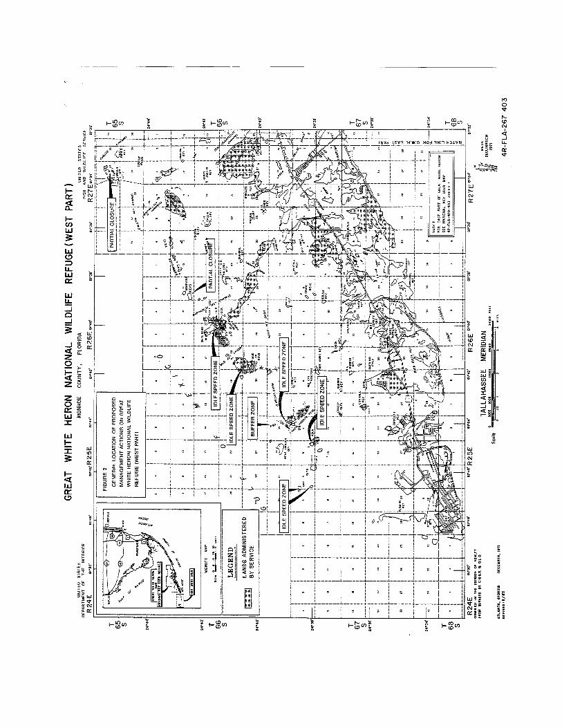

1.0 NEED AND PURPOSE FOR THE PROPOSED ACTION

1-2
Refuge policies and procedures also are designed to provide specific protection to wildlife andtheir habitats (Service Refuge Manual, 8 RM 1-002).
In keeping with the growth of the resident population of Florida, the degree and type of public useof the refuge "backcountry"* has increased and changed substantially in the last five years. Florida leads all coastal states in population growth with numbers projected to continue increasingthrough 2010 to more than twice the State's 1960 population (World Resources Institute, 1991). Alocal indicator of this growth is the rate of boat registrations for Monroe County. Approximately3,000 more boats were registered in Monroe County in the five year period 1985 to 1990. Inaddition to boats used by residents, an unknown but substantial number of boats are trailered tothe Keys from the adjacent mainland.
Attendant with the increase in the number of people and boats is an increase in impacts on refugewildlife and habitats. Camping and associated vegetation clearing have increased dramaticallyover this time period. Disturbance activities of this type have been documented on a number ofrefuge islands. In most instances, the size of cleared areas has increased to accommodate greaternumbers of campers, more frequent use, or both.
Wildlife disturbance resulting from increased public use is more difficult to document due to itsephemeral nature. Nevertheless, disturbance to nesting bald eagles (Haliaeetus leucocephalus) hasbeen documented at one nest site (there are five known sites in the Florida Keys backcountry), andguide led trips have featured visits to bald eagle nest sites. Impacts on nesting ospreys (Pandionhaliaetus) have been documented in the Snipe and Mud Keys with some historic nesting areasabandoned and productivity reduced or eliminated in other areas. Abandonment of a nest colonyby magnificent frigatebirds (Fregata magnificens) is suspected to have resulted from increasedhuman activity. For a detailed analysis and summary of human disturbance to wildlife, seeAppendix A.
Parallel with the growth in population and public use is the advent of new ways to recreate. Mostnotable among these new forms of recreation are personal watercraft (PWC) which were originallyintroduced in 1974. These watercraft are variously known as jet bikes, water bikes, and waterscooters or by the trade names Jet Skis, Wave Runners or Sea-Doos. The most frequently usedname is Jet Ski which is the registered trade name of the PWC manufactured by Kawasaki MotorsCorporation. PWC’s are distinguished from other recreational craft by their water jet-propulsionengines, shallow draft, and position of the operator standing, sitting, or kneeling on the craft.
Use of PWC’s has increased significantly in the past five years. There are now seven licensedrental businesses and three dealers in the Lower Keys whereas none were present in 1983-84 (KeyWest Telephone Directories). Observations by refuge staff and professional sportfishing guidesstrongly indicate marked increases in PWC activity in new areas. Another indicator is thedoubling of the number of PWC related accidents from 1989 to 1990 (Florida Marine Patrolstatistics).
* "Backcountry" is a term used to define that portion of the uplands and submerged lands of the Florida Keys that can not be reached by road.

1-3
Concern over this increase in PWC activity and the related impact on refuge wildlife and habitat isprimarily a function of the way in which these watercraft may be used. Due to their design,PWC’s are capable of accessing shallow waters adjacent to backcountry keys, some of which arecritical bird nesting habitat. Routes of travel, mode of use, and speed are all different than thetraditional shallow draft "flats boats." The potential for damaging submerged sea grass beds alsoexists should the PWC stall or the operator stop or operate the craft in very shallow water.
Given the continued increase in the resident population of Florida and the associated increase inboat registration, the impacts described here are expected to increase. Management of theseproblems is necessary now to arrest current impacts on refuge resources and to avoid futureimpacts on wildlife since recovery of populations and habitats, when this is possible, would takeconsiderable time.
Addressing the concerns listed above has been difficult in light of the current mixture of federaland state jurisdictions. The backcountry of the Florida Keys lie in an area of submerged and tidallands which are under the ownership of the State of Florida. The Division of State LandsDepartment of Natural Resources administers and manages submerged lands as staff to theGovernor and Cabinet sitting as the Board of Trustees of the Internal Improvement Trust Fund. Lying among these State owned, submerged lands are Federally owned and managed uplands.Management of the lands above the mean high water line, the refuge portion of the backcountry, isthus complicated by a split in management jurisdiction and legislative authorities and purpose.Currently, activities which take place adjacent to the refuge, but outside the boundary, do not fallwithin the management authority of the Service. While many of these activities are entirelyappropriate, in some areas, their presence adjacent to sensitive wildlife habitat results in damageto refuge wildlife.
Despite this split in jurisdiction, there is currently no provision for cooperative, unifiedmanagement of Federal uplands and submerged lands under the control of the State of Florida. Development of an agreement to address this split in authority would provide a means wherebymanagement and law enforcement actions would be implemented.
Granting of specific, limited authorities would allow the Service to manage human activity in andaround important habitats so as to eliminate impacts on nesting, roosting, and feeding birds; otherwildlife; and their habitats. (See Section 2.0 for a full description of the Management Agreementalternative).
1.3 Purpose
The purposes of the proposed agreement are:
1) To assure continued health of refuge populations of nesting, roosting, and feeding birds;
2) To create an environment where previously abandoned nesting or roosting areas may bere-occupied and where habitats previously impacted may be allowed to revegetate;

1-4
3) To foster close cooperation between the Service and the State of Florida Department ofNatural Resources and the Florida Game and Freshwater Fish Commission with respect toconservation of the natural resources of the "backcountry;"
4) To provide management protection for refuge wildlife during development of managementplans for the Marine Sanctuary and to foster close cooperation with Sanctuary staff;
5) To simplify implementation of management and programs for critical wildlife habitatswithin the administrative boundaries of the Lower Florida Keys Refuges; and
6) To provide a framework for implementation of educational activities aimed at reducingimpacts to wildlife, through voluntary compliance with regulations and "interpretive" lawenforcement.
1.4 Proposed Management
The specific actions proposed are described in the Management Agreement contained in AppendixA. In general, management will be focused on assuring that established traditional uses of thebackcountry be conducted in such a way as to be compatible with the purposes for which therefuges were established. Existing authorities for lands above mean high water will be fullyexercised as staff and funds allow.
Management will consist of a two-pronged approach of education and enforcement. Educationprograms are expected to include signage at key points of entry to the refuge including boatramps, existing channels, and other areas. A variety of signage will also be put in place in thebackcountry to inform users about management actions. An enhanced media program will becoupled with this to include pamphlets, radio, TV, and newspaper coverage and hiring of a RefugeEducation Specialist.
Refuge signs will be used to inform the public that they are near an area of importance to wildlifeand that they should adhere to the specific instructions stated. Instructions might includeproceeding at idle speed, shutting off motors, and in especially critical cases, no access at all.
It is believed that broad compliance with the terms of the management plan will only occurthrough voluntary cooperation by the public. However, a law enforcement program will besimultaneously implemented to contact and cite individuals not in compliance with the newlyestablished regulations. Simplification of jurisdiction will greatly enhance enforcement activityby allowing apprehension and citing of individuals disturbing refuge wildlife by their activity inbuffer areas which are under State ownership.
Specific management actions are fully described under section 2.0. Generally, these consist of three types of zones: idle speed zones, no motor zones, and no access zones. These managementactions would affect traditional uses over less than 1percent of the area within the administrativeboundaries of the refuges. Broader closure areas wi1l apply for specific activities such as waterskiing, PWC, airboat, and aircraft use.

1-5
1.5 Relationship to Other Projects
In November of 1990, the U.S. Congress established the Florida Keys National Marine Sanctuary(PL 101-605). Plans are now being developed for management of the Marine Sanctuary. Theseplans are not expected to be finalized for approximately 18 months and implementation wouldoccur at some time subsequent to this. Although it is believed that the Sanctuary managementplans will address concerns about disturbance to wildlife and their habitat, the need for protectionof these areas is immediate. The proposed action therefore represents an interim action to addressmanagement problems in the near-term. Throughout development of the Sanctuary ManagementPlan, the Service will be invo1ved to assure that proposed management actions are coordinatingwith Sanctuary planning.
It is anticipated that law enforcement personnel will be jointly deputized and will be capable ofenforcing both Marine Sanctuary and Refuge regulations.
The State of Florida owns the submerged lands surrounding refuge areas. The State is seeking toaddress its management concerns through this management agreement and has been involved in development throughout.
A variety of alternatives were initially considered to address protection of refuge habitats andwildlife. The development of these alternatives was based on expertise within the Service, theFlorida Department of Natural Resources, the Florida Game and Freshwater Fish Commission,and various forms of public involvement. Public involvement and scoping activity is summarizedin Appendix C.
The alternatives considered here represent the feasible array of alternatives that are available tothe Service. Described in this section are: Alternative A, the No Action Alternative; AlternativeB, a Management Agreement with the State of Florida for selected areas and activities in GreatWhite Heron NWR and Key West NWR; Alternative C, a Management Agreement with the Stateof Florida for the area within the administrative boundaries of Great White Heron NWR, KeyWest NWR, and National Key Deer Refuge, the Service Preferred Alternative; and Alternative D,a Submerged Lands Lease from the State of Florida for the same area and actions covered inAlternative C. All of the alternatives, except the No Action Alternative, deal with transfer ofsome degree of State of Florida jurisdiction to the Federal Government for the purpose ofimproving protection of refuge resources.
2.1 Alternative A - No Action
Under the No Action Alternative, the Service would not enter into a submerged lands lease orcooperative management agreement with the State of Florida. Placement of buffer zones, nomotor zones, or other types of management areas would not be developed by the Service andwould not be implemented. Such activities could be handled by the Florida DNR or throughregulations developed in relation to the Marine Sanctuary. Differing jurisdictions over upland andsubmerged lands would remain. Implementation of actions under this alternative would probablybe delayed for one to two years or until completion of Marine Sanctuary planning.

2-1
The Service would attempt to implement protection efforts as it has in the past, with questionableauthority to limit damaging activities which occur on adjacent lands or waters. It would be theresponsibility of the Florida Department of Natural Resources or the Marine Sanctuary toimplement management actions aimed at protection of refuge resources. Protection of refugeresources from activities taking place outside Federal jurisdiction would rely on existingregulations and authorities which have to date proven inadequate and difficult to implement.Those activities harmful to refuge resources taking place on refuge lands will be addressedthrough increased enforcement efforts.
2.2 Alternative B - Management Agreement with the State of Florida on Key West and GreatWhite Heron National Wildlife Refuges
Under Management Agreement Alternative B, the Service would be designated manager of thespecific State jurisdiction submerged lands and uplands inside the administrative boundaries of therefuge (Figures 1, 2 and 3). Management actions would be restricted to the locations listed belowin Table 2-1. These management actions could be modified, eliminated, or new actions takendepending on future activities. Implementation of additional management actions would bethrough a public process which would include opportunities for comment. Under this alternative,the listed actions would become a part of the Management Agreement and would comprise thesum of management actions to be implemented by the Service. The specific actions to be includedin the Management Agreement are incorporated by reference and made a part of thisEnvironmental Assessment as Appendix A, Management Plan for Backcountry Portions of KeyWest National Wildlife Refuge, Great White Heron National Wildlife Refuge, and National KeyDeer Refuge.
General conditions of the agreement are as follows:
1. Term of the agreement is 25 years, with reviews every 5 years. However, terminationof the agreement may be made by either party with written notice 60 days prior thetermination date.
2. Changes in the agreement described here must be approved jointly by the State ofFlorida and the Service after written notice to each other.
3. Public involvement will include an announcement of the proposed change, a 30 dayreview period, and at least one public meeting. Public involvement will take place forall amendments to the Management Plan and Agreement, e.g., additions, changes, ordeletions of areas subject to management.
4. This agreement will not authorize the Service to regulate commercial fishing, sportfishing, or other traditional uses which do not impact refuge resources.
5. The specific management actions to be taken by the Service are described briefly below. Rationale and specific details regarding each action are provided in Appendix A,Management Plan for Backcountry Portions of Key West NWR, Great White HeronNWR, and National Key Deer Refuge.

2-2
Summary of Management Actions - Alternative B
This summary lists measures the Service would implement under Management Agreement -Alternative B. Also listed are steps the Service would take, using its existing authority, to regulatepublic use on certain offshore refuge islands where refuge wildlife and habitat is being damagedby incompatible public use activities.
The goal of these measures is to protect wildlife, particularly nesting, feeding, and roosting birds,without imposing unnecessary restrictions on the general public. A concerted effort has beenmade to accommodate public use where compatibility with wildlife is not considered a factor atthis time. These restrictions would affect less than 1percent of the waters and lands within theadministrative boundaries of the refuge.
Management Actions
1. Establish idle speed, no motor, and no access buffer zones in appropriate areas for theprotection of wildlife. These zones are defined as follows (see below and Figures 1, 2, and3 for general locations):
Idle speed zones - Areas where boats must operate at a speed not greater than that neededto maintain forward progress; operating at planing speed is prohibited.
No motor zones - Areas where use of boats powered by internal combustion engines isprohibited. Boats with such motors are permitted access to motor zones only through theuse of a push pole, paddle, or electric motor.
No access buffer zones - Areas closed to all types of vessels and human activity.
2. Provide increased public education for backcountry boaters through news releases, publicservice announcements, brochures, and educational panels at boat ramps.
3. Implement the current regulation that requires a permit for commercial use of refugeislands. Conduct scoping meetings, establish local policies, and evaluate permit requestsfor compatibility with the purpose for which the refuges were established to determine ifspecific commercial use is compatib1e.
4. Provide increased Service enforcement personnel to ensure compliance with the regulationslisted here and existing rules governing camping, vegetation clearing, littering, and illegalstructures.
5. Require a permit (no fee) to visit backcountry islands containing Key deer.
6. Mangrove islands would remain closed except where specifically opened when the openingis shown to be compatible with the purposes for which the refuge was established. In mostcases, public use opportunities are virtually nonexistent and inherently incompatible withwildlife on mangrove islands.

2-3
The general location of the areas listed below are identified in Figures 1-3. Specific locations aredepicted on aerial photographs on file at the refuge headquarters on Big Pine Key. Due to theexpense of reproduction, a limited number of copies were made. Please contact the RefugeManager at (305) 872-2239 if you would like to examine these photographs.
Table 2-1. List of management actions for Great White Heron and Key West National Wildlife Refuges under Alternative B.
AREA MANAGEMENT ACTION1. Sawyer Key Close tidal creeks on south side.2. East Harbor Key No access buffer zone (300 feet) around island.3. Little Mullet Key No access buffer zone (300 feet) around island.4. Upper Harbor Key No access buffer zone (300 feet) around island.5. Little Crane Key No access buffer zone (300 feet) around island.6. Boca Grande Key Close one-half of the beach (south side).7. Woman Key Close one-half of the beach and sand spit (southeast
side).8. Horseshoe Key Post entire island off-limits.9. Cottrell Key No motor zone (300 feet) around island.10. Marquesas Keys No motor zones (300 feet) around the three smallest
islands; no access buffer zone (300 feet) around onemangrove island; idle speed zone through one tidal creek.
11. Snipe Keys (tidal creeks north of Outer Narrows
Idle speed in main creek. No motor zone elsewhere.
12. Mud Keys Idle speed zones in two main creeks; close two smallercreeks.
13. Big Mullet Key No motor zone (300 feet) around island.14. Tidal flat south of Marvin Key No access buffer zone.
15. West Content Keys Idle speed zones in tidal creeks and one no access bufferzone.
16. East Content Keys Idle speed zones in tidal creeks.17. Bay Keys Idle speed zone (300 feet) around one island.18. Lower Harbor Keys Idle speed zone in tidal creeks.19. Caya Agua Keys Idle speed zone in tidal creeks.
This Management Agreement will be signed by the Regional Director, U.S. Fish and WildlifeService, Atlanta, GA, and the Director, Division of State Lands, Florida Department of NaturalResources, after approval by the Governor and Cabinet sitting as the Board of Trustees.

2-4
Amendments to the plan resulting from public involvement and subsequent agreement betweenthe State of Florida and the Service must be made by the same parties.
2.3 Alternative C - Management Agreement with the State of Florida for Key West and GreatWhite Heron National Wildlife Refuges and National Key Deer Refuge - The U.S. Fishand Wildlife Service Preferred Alternative.
This Alternative is identica1to Alternative B except for three additional management actions to beimplemented over a wide area. These actions are:
(1) Prohibit personal watercraft and airboats from operation within the administrativeboundaries of Key West and Great White Heron NWR’s (see Figures 4, 5 and 6). Selectedareas within this boundary are excluded from this closure to provide for access to openareas, e.g., Port Pine Heights on Big Pine Key. The areas excluded are as follows:
Township 66 South, Range 29 East, Sections 5, 11, 12 and 14;Township 66 south, Range 28 East, Section 2; Township 67 South, Range 26 East, Sections 16 and 20,all Tallahassee Meridian.
(2) Prohibit water skiing within the administrative boundaries of Key West and Great WhiteHeron NWR’s (see Figures 4, 5 and 6).
(3) Prohibit aircraft (including hovercraft) landing within the administrative boundaries ofGreat White Heron and Key West Refuges.
Terms of the Management Agreement would be the same and the same list of protective measuresincluded in Alternative B, Table 2-1, would be implemented.
2.4 Alternative D - Submerged Lands Lease with the State of Florida
Under the Submerged Lands Lease alternative, management actions would be the same asdescribed under Alternative C except that the actions would be included in the terms of aSubmerged Lands Lease as opposed to a Management Agreement.
Under the Submerged Lands Lease Alternative, the Service would request from the Governor andCabinet, sitting as the Board of Trustees of the Internal Improvement Trust Fund of the State ofFlorida, a long term lease (25 years) of State owned tide and submerged lands. In addition to tideand submerged lands, the Service would request management of State owned lands above meanhigh water within the boundary of the refuges. The lands and waters are the same as thoseconsidered under Alternative C.
A Submerged Lands Lease must receive the approval of the Governor and Cabinet of the State ofFlorida and the Regional Director of the Service. Likewise, changes in the agreement must beagreed to by these parties. The Submerged Lands lease Alternative thus represents a longer term,less flexible means of management. The Submerged Lands Lease is similar to Alternative C in

2-5
that actions which would be taken by the Service are only those specifically granted to the Serviceand included in a management plan attached thereto.


3-1
3.0 AFFECTED ENVIRONMENT
3.1 Climate
Climate of the Lower Florida Keys is characterized as Tropical-Maritime. The highesttemperature on record was 97 degrees and the lowest 41. The southern latitude and maritimeinfluences contribute to minimal seasonal variation in temperatures with average annual highs of81 degrees and lows of 72 degrees and average winter temperatures that are about 16 degreeslower than in summer. Differences in daily highs and lows average 10 degrees.
The Florida Keys experience the highest level of solar radiation in the State of Florida. Duringspring (April), the sun shines 84% of the possible sunlight hours.
There are no records of snow, sleet, or ice from the Florida Keys. Rainfall is seasonal with wetperiods extending from May through October. There are two peaks in rainfall, the first in Juneand the second in September-October. Annual precipitation totals about 39 inches with 80 percentof this falling from May to October.
The Florida Keys are within an area with high probability for tropical storms (39-74 mph winds)and hurricanes (greater than 74 mph winds). There is a one in seven chance of a hurricane strikingthe Keys in any given year. Prevailing winds are from the east, varying from due east in fall toeast-southeast in spring and summer. Wind speeds average 10 to 12 mph (Monroe CountyEnvironmental Education Task Force 1991).
3.2 Physiography, Geology, and Soils
Elevations range from sea level for many of the mangrove keys to a few feet above sea level. Thehighest points in the Florida Keys are less than 20 feet above sea level. Sea depths are extremelyshallow with large areas covered by less than 5 feet of water at high tide. Low tides typicallyexpose large intertidal areas with the amount of exposed area varying with wind and weatherconditions and the phase of the tidal cycle.
Lower Florida Keys backcountry islands range in size from less than one acre to over 900 acres. Most keys are less than 100 acres. Tidally flushed "creeks" occur on some of the mangroveislands.
The geology of the Lower Florida Keys has been described in detail by Hoffmeister (1974). Geologic features are comprised primarily of two limestone components of marine origin. KeyLargo Limestone is the remnant of a former coral reef and underlies much of the study area. Thiscomponent reaches the surface in the southern portion of National Key Deer Refuge. Most of theremainder of the backcountry is overlain with Miami Oolite. Both Key Largo and Miami Oolitewere in the process of being formed until about 100,000 years ago when sea levels dropped duringthe Wisconsin Glaciation. Soil layer is thin when present. Both limestone components have beenpartially dissolved by rainfall, leaving characteristic solution holes or sinkho1es.

3-2
3.3 Water Resources
Water resources of the Florida Keys backcountry are dominated by a marine environment. Inmuch of the backcountry, shallow water depths result in fairly rapid changes in daily and seasonalwater temperature. Annually temperatures may vary by as much as 25 degrees, from 65 to 90degrees in winter and summer respectively.
Tidal cycles are extremely difficult to predict due to the shallow water area and the combination ofwinds, local topography, and tidal currents. The effect of wind is especially important in shallowwater areas and may overshadow affects of tidal influence. Differences in the number of tidalchanges per day further complicate prediction. There are four tides each day, two high and twolow, although the degree of these tides is affected greatly by location. Lower Keys mean tiderange is about 1.3 feet, spring tide range is about 3 feet.
On some of the larger backcountry keys in National Key Deer Refuge, freshwater lenses mayoccur. These lenses are relatively small in size and float on top of saline groundwater. They arefed entirely by rainfall and in some cases are present during the wet season only. Permanence ofthese lenses is dependent on amount of rainfall and the permeability of the substrate.
3.4 Vegetation Communities
Distribution of vegetation communities of the refuge backcountry have never been determined andhave not been mapped. Davis (1942) reported on vegetation on the Marquesas and Boca GrandeKeys. Dickson (1955) provided a broad description of habitat types on 14 backcountry islandsextending from Knockemdown Key northeast to Little Pine Key. From these studies and fromgeneral knowledge of refuge areas acquired through site visits, several plant communities havebeen identified. The general community types described are: beach, wetland, and upland. Namesof plants and distributional information are from Long and Lakela (1976), Tomlinson (1986), andScurlock (1987).
Beach Community
Beaches, formed primarily of calcareous remains from various shallow water marine organisms,occur as narrow strips, often with a landward berm of sand which has accumulated through windand wave action. Good examples of these beaches are found on Woman, Marquesas, and BocaGrande Keys in Key West National Wildlife Refuge. Smaller beaches are present on Man, Sawyer, and west Content Keys and Snipe Point. Characteristic herbaceous plants of thiscommunity are sea oats (Uniola paniculata), railroad vine (Ipomoea pes-caprae), sea purslane(Sesuvium spp.) and puncture weed (Tribulus spp.). As these plants pioneer and become established, additional sand and sediment accumulates, allowing the establishment of other beachplants including bay bean (Canavalia spp.), sea lavender (Mallotonia gnaphalodes), sand spur(Cenchrus spp.), saltbush (Baccharis spp.), bay cedar (Suriana maritima), wild lantana (Lantanaspp.), sea oxeye daisy (Borrichia arborescens), and golden beach creeper (Ernodea littoralis). Eventually, larger woody plants may become established on the landward side of the beach berm. Examples of these plants are: sea grape (Coccoloba uviflera), black bead (Pithecellobium
3-3
quadalugense), buttonwood (Conocarpus erectus), seven-year apple (Casasia clusifolia), blacktorch (Erithalus fruticosa), and joewood (Jacguinia keyensis).
Wetland Community
Wetland communities are predominantly marine and estuarine with limited areas of freshwaterwetland. For example, freshwater wetlands are restricted to the larger islands (e.g., Little PineKey) and are absent in the Great White Heron and Key West Refuge backcountry. In almost allcases, Lower Florida Keys wetlands occur in association with the freshwater lenses describedabove. Typical plants of freshwater wetlands include sawgrass (Cladium jamaicensis), buttonwood, white mangrove (Laguncularia racemosa), and pond apple (Annona glabra).
Saltwater wetlands are more extensive and consist of transitional wetlands and mangrove wetlandsand, in a few locations, saltwater ponds.
Transitional wetlands are wet only part of the time. Most of these wetlands are subject to floodingfrom tides at certain times of the year. This community frequently occurs between the beachcommunity and the higher elevation pineland and hammock community. Characteristic plantspecies of this community are salt tolerant and include glasswort (Salicornia spp.), sea purslane(Sesuvium portulacastrum), key grass (Monanthochloe littoralis), saltgrass (Distichlis spicata),saltwort, sea oxeye daisy, various airplants (Tilandsia spp.), beach carpetweed (Philoxerusvermicularis), joewood, sea lavender, saffron plum (Bumelia celastrina), red mangrove(Rhizophora mangle), black mangrove (Avicenni germinans), christmas berry (Lyciumcarolinianum), and buttonwood. An excellent example of transitional wetland community isfound on Water Key. Red mangrove forest is the predominant vegetation community on allbackcountry islands except for one sand island and three dredged material islands in Key WestNational Wildlife Refuge. The roots of these trees are usually either constantly submerged orinundated daily by the tides. Buttonwood, white mangrove, and black mangrove may occur inclose proximity to red mangrove but are generally confined to more upland areas. Lugo andSnedaker (1974) described six mangrove forest types, of which five occur in the Florida Keys:overwash, riverine, basin, scrub (dwarf), and fringe forests. Fringe forest is the most commontype in the backcountry, occurring around the edges of keys and extending inland varyingdistances. Some islands are comprised almost entirely of mangrove forest with no upland.
Saltwater ponds are shallow impoundments which were cut off from open water when stormscreated a berm, effectively blocking tidal flow except during intense storms. The impoundmentsalso collect rainwater, and salinities and water levels are highly variable. Due to the widelyvarying salinities, vegetation is restricted to the occasional black mangrove on the fringes of thepond.
Uplands
Uplands may be divided broadly into two plant communities: pine rockland and hardwoodhammock. Neither of these communities is extensive in the refuge backcountry. Both arerestricted to upland sites which are not influenced by tides or intrusion of saltwater into freshwaterlenses.

3-4
Pine rocklands are dominated by the South Florida slash pine (Pinus elliottii). Other characteristicplants include silver palm (Coccothrinax arqentata) and brittle thatch palm (Thrinax morrisii), sawpalmetto (Serenoa repens), poisonwood (Metopium toxiferum), black bead, myrsine (Myrsinequianensis), pisonia (Pisonia rotundata), and wild guava (Psidium longipes). This community isheavily influenced by periodic fires which burn away leaf litter, cycle nutrients, and suppressgrowth of hardwood species. Backcountry pine rocklands are present only on Little Pine Key andon a small tract in Knockemdown Key. A few scattered pines are present on Howe Key.
The tropical hardwood hammock is a highly diverse plant community with vegetation primarily ofWest Indian origin. Hammocks are also structurally diverse with tall growing forest species(overstory) and a variety of lower growing (understory) species. This community is veryrestricted in distribution occurring (in the United States) only in the Florida Keys and a few othermainland locations. A few examples of the more common members of the hammock plantcommunity are gumbo limbo (Bursara simaruba), poisonwood, Jamaica dogwood (Piscidiapiscipula), willow bustic (Dipholis salicifolia), in the overstory; pigeon plum (Coccoloba diversifolia), and cinnamon bark (Canella winterana) in the midstory levels; and Spanish stopper(Eugenia foetida), white stopper (Eugenia axillaris), hog plum (Ximenia americana), falseboxwood (Gyminda latifolia), and limber caper (Capparis flexuosa) in the understory.
Hammocks of the refuge backcountry are present on Little Pine, Johnson, Water (nearest LittlePine), Annette, Howe, Toptree Hammock, Knockemdown, and Johnston Keys. By far the largestof these hammocks is on Little Pine Key. Berm hammocks, a form of low hammock that forms onbeach berms, are found on Sawyer, Mud, Snipe Point, Boca Grande, Woman, and MarquesasKeys.
Invasive exotic vegetation in the form of Australian pine (Casuarina equisetifolia), Brazilianpepper (Schinus terebinthifolius) and Asiatic colubrina (Colubrina asiatica) are the three principleinvasive exotics.
Table 3.1 Presence of invasive exotic plants on Key West, Great White Heron, and National Key Deer Refuges, Monroe County, FL, adapted from refuge files.
AREA Colubrinaasiatica
Casuarinaequisetifolia
Schinusterebinthifolius
Marquesas X X XBoca Grande XWoman Keys XKey West NWR dredge islands XBay Key XEast Harbor Key XSnipe Point (State-owned) XTopTree Hammock XEast Sawyer Key XWest Content Keys XUnnamed island Niles channel X
3-5
Australian pine is present on backcountry islands, including Tank, Wisteria, Tarpon Belly,Howell, and Budd; the privately owned portion of Sawyer Key contains Asiatic colubrina.
Threatened and Endangered Plants
Few of the unique plants of the Florida Keys have been designated as threatened or endangeredunder the Federal Endangered Species Act. However, the flora of the Keys are unique and havevery limited distributions. This limited distribution coupled with habitat loss have resulted in alarge number of plants being listed as Species of Special Concern by the State of Florida. Speciesknown or expected to occur on refuge backcountry islands that are of special concern are listedbelow.
Table 3.2 List of plants federally threatened (THR), endangered (END) and review species (UR)and State of Florida Species of Special concern which occur or probably occur in thebackcountry portions of Key West (KWNWR), Great White Heron (GWHNWR) andNational Key Deer Refuge (NKDR).
SPECIES STATUS ENDEMIC NKDR GWH KWFED STATE TO KEYS NWR NWR
Golden Leather Fern THR XLeather Fern THR XPine Fern THR XPine Pink Orchid THR XStrap Fern THR XKey Cassia UR END YES XSmall Flowered Lily Thorn END XPrickly Apple Cactus THR END XBarb Wire Cactus THR X X XSatinleaf THR XSilver Palm END XGeiger Tree THR X X XCupania END XDollar Orchid UR END X X XButterfly Orchid THR X X XMichaux’s Orchid THR XManchineel THR XJoewood THR X X XSea Lavender END X X XVine Fern THR XPrickly Pear Cactus THR X X XLadder Brake THR XScaevola END XPride of Big Pine END XBay Cedar END X X XMahogany THR X XFlorida Thatch Palm THR X X XKey Thatch Palm THR X X X

3-6
SPECIES STATUS ENDEMIC NKDR GWH KWFED STATE TO KEYS NWR NWR
Reflexed Airplant THR X X XTwisted Airplant THR X X XWild Airplant THR X X XBanded Wild Pine Airplant THR X X XNeedle-leaved Airplant THR X X XGiant Airplant THR X X XSoft-leaved Airplant THR X X XWorm Vine Orchid THR X XShoestring Fern THR X
3.5 Wildlife
Wildlife populations of the Lower Florida Keys are characterized by their uniqueness and limiteddistribution. Although the vegetation is predominantly West Indian in origin, wildlife populationshave, for the most part, originated from mainland Florida. Many species, left in isolation frommainland habitats, have evolved into separate subspecies from their mainland counterparts.Examples of this include many of the endangered forms such as the Key deer (Odocoileusvirginianum clavium), Lower Keys marsh rabbit, (Sylvilagus palustris hefneri), Key mud turtle(Kinosternon bauri), and the silver rice rat (Oryzomys palustris argentatus). Diversity of residentspecies is low. An exception to this occurs during bird migration in spring and fall when a varietyof species may be found using mangroves, shorelines, and upland habitats for feeding and resting.
Amphibians and reptiles are represented by more than 40 species. Diversity is limited by the lackof freshwater habitats, especially for amphibians. Many of the amphibians and reptiles found inthe Keys are found nowhere else in the United States. As with other wildlife species, manyreptiles and amphibians require a source of freshwater or upland habitat to complete some portionof their life cycle. Many backcountry areas have limited hammock or freshwater resources andtherefore have a low diversity of reptiles and amphibians. Exceptions are the larger islands suchas Little Pine. On these islands, diamondback rattlesnakes (Crotalus adamanteus) may be present. Diamondbacks may also move among islands. Alligators (Alligator mississippiensis) may also bepresent on the larger islands which have freshwater habitats. Common species found onbackcountry mangrove islands include the mangrove water snake (Nerodia fasciatacompressicauda) and diamondback terrapins (Malaclemys terrapin). Cuban tree frogs(Osteophilus septentrionalis) may be present on many of the islands although some upland habitatis necessary for year round residence.
Of special significance in the refuge backcountry are wading birds, the herons and egrets. Thereare 12 species of wading birds known to nest in the project area. It is extremely difficult toestimate populations sizes since the birds are secretive and frequent visits to nesting areas mayresult in abandonment of eggs or young. These birds use backcountry islands for nesting due tothe remote setting and the freedom from human disturbance and predators such as the raccoon(Procyon lotor). Nesting areas are also chosen on the basis of nearness to shallow water feedingareas. Locations of these feeding areas change as tide and wind conditions expose or submerge

3-7
tidal flats. The combined requirements of suitable vegetation, lack of disturbance and predators,and the closeness of feeding habitats restricts the number of acres available for nesting.
Two other common nesting species are the double-crested cormorant (Phalacrocorax auritus) andthe brown pelican (Pelecanus occidentalis). Both of these species use backcountry islands fornesting and feed throughout the backcountry.
Raptors are another important group of nesting birds in the backcountry. Ospreys and bald eaglesare linked with the marine ecosystem. Bald eagles are discussed under the next section. Ospreysnest throughout the backcountry, sometimes at very high densities. Ospreys may adapt to highlevels of human disturbance under the right conditions. However, ospreys using backcountryhabitats are subject to highly variable levels of disturbance ranging from no human presence forextended periods, mixed intermittently with intense levels of activity for brief periods. Red-shouldered hawks (Buteo lineatus) may be present in pine rocklands and hammock and have beendocumented nesting on at least two backcountry islands.
There are very few mammal species present in the project area with only 10 terrestrial speciesrecorded for the entire Keys. Most of the species present are endangered and are discussed underthe following section.
Endangered and Threatened Wildlife
Federally endangered or threatened species and State of Florida Species of Special concern arelisted below (Table 3-3). There are 5 (Federa1) threatened and 10 (Federal) endangered speciesknown to occur in refuge backcountry areas.
Table 3.3 List of animals federally threatened (THR), endangered (END) and review species(UR) and State of Florida Species of Special concern which occur or probably occurin the backcountry portions of Key West (KWNWR), Great White Heron(GWHNWR) and National Key Deer Refuge (NKDR).
SPECIES STATUS ENDEMIC NKDR GWH KWFED STATE TO KEYS NWR NWR
Keys Silverside END YES XAmerican Alligator THR/SA* SSC X XLoggerhead Turtle THR THR X X XAtlantic Green Turtle END END X X XAmerican Crocodile END END XIndigo Snake THR END XAtlantic Hawksbill Turtle END END X X XKey Mud turtle UR END YES X XAtlantic Ridley Turtle END END X X XKey Ringneck Snake UR THR YES XFlorida Brown Snake UR THR YES XFlorida Ribbon Snake THR YES XBrown Pelican SSC X X XSE Snowy Plover UR END X X X

3-8
SPECIES STATUS ENDEMIC NKDR GWH KWFED STATE TO KEYS NWR NWR
Piping Plover THR THR X X XWhite Crowned Pigeon UR THR X X XPeregrine Falcon THR END X X XBald Eagle END THR X X XOsprey SSC X X XWood Stork END END X XRoseate Tern THR END X XLeast Tern THR X X XLower Keys Marsh Rabbit END END XSilver Rice Rat END END X XKey Deer END END YES X XManatee END END X
* SA = similarity of appearance. This species, although not endangered itself, received the same protection to avoid unintentional killing or disturbing of the actual endangered or threatened species.
Federally listed endangered or threatened amphibians and reptiles within the management areainclude the Atlantic loggerhead turtle (Caretta caretta), Atlantic hawksbill turtle (Eretmochelysimbricata), Atlantic green turtle (Chelonia mydas), and Eastern indigo snake (Drymarchon coraiscouperi). The marine turtles require sand beaches for nesting and therefore make limited use ofthe refuge. However, use that occurs is essential. Successful nesting must occur largely in theabsence of human activity, e.g., camping. The indigo snake is limited to upland habitats of thelarger backcountry islands.
Five federally endangered or threatened bird species are present in the Lower Keys backcountry. The bald eagle (Haliaeetus leucocephalus) is known to nest in five locations. The population isbelieved to remain in the area year round, with the exception of dispersing young birds. Habitatsused include mangrove forest, hammocks, and pine rockland for nesting, feeding perches, androosting.
The piping plover (Charadrius melodus) winters in the Florida Keys and is dependent on beachesand wetland areas for feeding and resting. Accurate population estimates for this species arelacking, but it may be present, at one time or another, on almost any sand beach or open wetlandin the Florida Keys from September to April.
Peregrine falcons (Falco peregrinus) migrate throughout the Keys in spring and fall with someindividuals remaining through the winter. Peregrines range widely in search of birds which aretheir primary prey item. Peregrines therefore are encountered in areas of high bird concentrationssuch as sand spits, beaches, and wetlands.
Wood storks (Mycteria americana) occur rarely in the backcountry as post breeding wanderers. Roseate terns (sterna dougallii) may nest in the backcountry in some years and are present in smallnumbers for a short period before and after the breeding season.

3-9
Other bird species which have been listed by the State of Florida as species of Special Concernand which nest on refuge islands include white-crowned pigeon (Columba leucocephala), roseatespoonbill (Ajaia ajaja), little blue heron (Egretta caerulea), tri-colored heron (Egretta tricolor), reddish egret (Egretta rufescens), snowy egret (Egretta thula), osprey (Pandion haliaetus), brownpelican (Pelecanus occidentalis), and least tern (Sterna antillarum).
Federally listed endangered or threatened mammalian species include three terrestrial species: Keydeer, silver rice rat (Oryzomys argentatus), Lower Keys marsh rabbit, and two marine species: theWest Indian manatee (Trichechus manatus), and sperm whale (Physeter catodon). The terrestrialmammals are restricted to larger islands with at least some upland habitat. The Key deer arepresent in pine rockland habitat with some source of freshwater. The marine species occurthroughout the Lower Keys.
3.6 Archeological and Historical Resources
A review of the Lower Florida Keys for archeological and historical resources was funded by theNational Park Service and completed in 1990 (Carr and Fay 1990). The summary presented hereis derived primarily from this report. Known archeological-sites are present on Little Pine, WaterKey, and Sawyer Key. Due to the sensitive nature of this information, specific data are beingwithheld to protect the sites. A copy of this assessment was been provided to the State HistoricPreservation Officer for review.
An on site inventory was not conducted for this project since the area was recently surveyed, sincethe management actions would result in increased protection, and since management activitieswould have negligible potential for impacting archeological or historical resources.
3.7 Land Use and Socioeconomics
Backcountry islands are comprised primarily of wetland habitats and thus are protected by avariety of land use regulations and policies at the county, state and federal levels. Because ofthese limitations and the largely public ownership of the islands, significant development inbackcountry areas is not anticipated.
There is a total of 6,170 acres of designated wilderness in the project area. Land use restrictionsare greater in these areas. Generally, human activity is restricted to temporary uses such as dayvisits. No clearing of vegetation, construction of buildings, or use in a nontraditional way isallowed. The objective of wilderness management is to maintain the land in as nearly a pristinestate as is possible.
Almost all of the upland lands above mean high water in the project area are under Federalmanagement as part of the National wildlife Refuge System. As such, these areas are managedprimarily for wildlife and public recreation that is compatible with the purposes for which therefuge was established. Most of the islands are uninhabited and remain in their natural condition.
Current public use consists of recreational activities such as: boating, fishing, snorkeling, scubadiving, photography, and bird watching. These activities are increasing as reflected by the greater

3-10
number of boat registrations in Monroe County and the increase in commercially led tours in theFlorida Keys backcountry.
A significant amount of commercial fishing takes place in the waters surrounding the refugeislands. Impacts associated with these activities such as deposition of trap debris and prop-dredging are not addressed specifically in this plan.
The human population of the Florida Keys is growing rapidly. Total population for MonroeCounty now stands at 78,024 (U. S. Census data for 1990) with about 43,000 of these residing inthe Lower Keys (south of the Seven-mile Bridge). Since 1970, the resident human population hasincreased 48 percent from 52,586 to its current level. Most of this growth (75-80 percent) is aresult of migration into the Florida Keys as opposed to births from residents (White 1991).
In addition to the resident population, there is a sizable transient population present during thewinter months, peaking in February and March. The number of transient residents is estimated at56,643 (Monroe County 1992). This figure includes about 25,000 persons residing on a seasonalbasis and 21,000 present in tourist facilities. The total "functional" population for the County is134,667. Population projections made by the U.S. Department of Commerce for Monroe Countyindicate a population of nearly 100,000 by the year 2010 (Monroe County 1992).
Visitation to public lands in the Florida Keys is growing rapidly. Visitors to state parks aloneneared 2 million in 1990, an increase of about 240 percent since 1980 (Monroe County 1992). Visitation to the headquarters of National Key Deer Refuge averages 80,000 annually based ontraffic counts and counts of visitors to the refuge office and areas such as the Blue Hole andWatson Nature Trail. These figures reflect the recorded visits at staffed locations and areconsidered conservative estimates of actual public use. For example, volunteers have tallied visitsby several thousand individuals at the Blue Hole on Big Pine in a single day. No information isavailable on the number of backcountry visits that are occurring although it is clear that visitationhas greatly increased in recent years based on observations of refuge staff and others withextensive experience in those areas.
Boat registration is closely related to population growth. Since 1971, the number of boatsregistered in Monroe County has nearly tripled from 6, 740 to 18,236. The trend is slowlyincreasing, 500-1000 boats/year is expected to continue.
Employment is comprised primarily of private sector jobs (about 80 percent) with the remaining20 percent made up of federal, state, and local governments and the military. Total annual payrollwas slightly more than $500,000,000 in 1989. Unemployment rates average well below the stateand national averages.
Cost of living in Monroe County has traditionally been the highest in the state of Florida. Percapita income for Monroe County was $16,626 in 1988, slightly more than the national average. In 1980, the percentage of persons below the federally defined poverty level was 13 percent.

3-11
Table 3-4. Major categories of civilian employment in Monroe County, Florida, as of 1990. Summarized from U.S. Bureau of Census and White 1991.
Private Industry
Retail Trade 9,114Services 8,526Contract Construction 1,838Transport., Comm., and Util. 1,585Finance, Insurance, and Real Estate 1,391Manufacturing 590Wholesale Trade 586Agriculture and Fisheries 355TOTAL 23,985
Government
Federal 1,285State of Florida 605Local 3,685 TOTAL 5,575
GRAND TOTAL 29,560
Gross annual sales for Monroe County totaled 1.6 billion dollars in 1990. About 630 milliondollars of this total consisted of grocery, restaurant, and motel/hotel sales, indicating the generaleconomic environment of the region as a tourist and retirement economy (Table 3-5). In fact, theretail trade and service industries (heavily tourism based) accounted for a little more than two-thirds of the private sector employment in Monroe County.
Table 3-5. The top 25 business or product sales categories in Monroe County, Florida.Figures are rounded to the nearest million dollars. Adapted from White 1991,original data from Florida Department of Revenue.
Hotel/Motel 324Grocery Stores 175Restaurants/Catering 134Utilities-Electric/Gas 82Motor Vehicle 55Building Materials 55Service Stations 51Communications 49Marine 47Leasing Commercial Space 44Wholesale 39Drug Stores 39Bars/Liquor Stores 38Jewelry/Sports 37Department Stores 36Clothing/Alterations 35Park/Marinas 33
3-12
Gift Shops 32Property Rental 31Seafood Dealers 31Variety Stores 29Fuel and LP Gas 16Manufacturing 13Repair 12
Permits for residential housing in the Florida Keys have averaged about 85 units during the periodApril 1990 to October 1991. Approximately one-third of these units were located in the LowerKeys. This provides some indication of the rate of growth that has been occurring in recent years. If the 1992 Monroe County Comprehensive Plan is adopted, permitting will be limited toapproximately 250 residential building permits per year for the next decade. 'These permits wouldbe allocated as follows: 99 for the Upper Keys, 41 for the Middle Keys, and 110 for the LowerKeys.
Economic uses of the refuge are comprised entirely of recreational activities such as nature toursand recreational boating. Economic value on a county wide basis is thought to be minor at thistime, but growth of these activities is continuing. Estimates of the income from these activities arenot available. However, on a County wide basis, a study conducted by the U.S. MineralsManagement Service estimated the value of marine based recreation in the Florida Keys at $22billion, and visitors in 1990 had a direct spending impact of nearly three-quarters of a billiondollars (Kearney and Centaur 1990).
4.0 ENVIRONMENTAL CONSEQUENCES
This section compares and contrasts the environmental consequences of implementing each of thealternatives described in Section 2.0.
The alternatives are listed below for reference along with a brief over view of the alternatives. Fora thorough discussion of the Preferred Alternative, see Appendix A.
2.1 Alternative A - No Action
2.2 Alternative B - Management AgreementGreat White Heron/Key West RefugesSpecific Areas
2.3 Alternative C - Management AgreementGreat White Heron/Key West Refuges, National Key Deer RefugeService Preferred Alternative
2.4 Alternative D - Submerged Lands LeaseGreat White Heron/Key West Refuges, National Key Deer Refuge

3-13
Overview of Environmental Consequences
The alternatives and environmental consequences assessed here vary in two principle ways: (1) the method used to convey management authority to the Service - e.g., submerged land leaseor management agreement, and (2) the level of management authority that the Service wouldacquire from the State, e.g., the size of the area to be managed by the Service.
Although the method of obtaining management authority varies between Alternative C and D, itshould be noted that the actual management is the same. Therefore, the only difference betweenthese two alternatives is the type of agreement and its term. A longer, less flexible agreementunder terms of a lease in Alternative D and a more flexible, shorter term agreement underAlternative C.
The level of authority acquired by the Service would be the lowest under Alternative A (NoAction), broadest under Alternatives C and D (management actions on 19 sites and area wideclosures on PWC’s, airboats, water skiing, and aircraft landing) and intermediate underAlternative B (which would include actions on 19 sites but no area wide closures on PWC’s orairboats, aircraft, or water skiing).
4.1 Climate
None of the alternatives is expected to have an effect on area climate.
4.2 Physiography, Geology, and Soils
Impacts are expected to be minimal under all alternatives.
Under the No Action alternative, the Service would not implement any additional protectivemeasures for soils or geologic features. Impacts would be addressed through existing regulationsor regulations developed through the Marine Sanctuary planning process. Sufficient regulationsexist to protect soils on refuge lands at the present time; however, implementation of protectionmeasures has been complicated by an inability to manage adjacent incompatible uses. This wouldcontinue under the No Action alternative.
Alternative B would focus management actions on the specific islands needing protection. Anyindirect benefits to soils or local geology of refuge islands resulting from increased managementcontrol would therefore be focused on the problem management areas.
Alternatives C and D would provide the greatest level of control over activities which couldimpact soils and geology by providing better control over public use activity and by allowingmanagement authority on areas above the mean high water line now managed by DNR. It isbelieved this better control would provide a minor indirect benefit to local geology and soils. Alternative D would assure long term management control in the form of a lease, whileAlternative C would provide essentially the same level of authority in the form of a more flexibleManagement Agreement.

4-1
4.3 Vegetation
Under the No Action alternative, use would continue as it has in the past. Enforcement of impactson refuge uplands will still be prosecuted, but implementation of management actions to preventdamage to vegetation before it happens would be complicated by a lack of authority over adjacentwaters. On islands managed in part by the State and in part by the Service, implementation ofcorrective measures would continue to be complicated and impractical to carry out. It isreasonable to expect that vegetation clearing would expand in currently impacted areas if noaction is taken. It should be noted that vegetation clearing is currently illegal. Future vegetationclearing would be prosecuted under all alternatives since the authority to do so currently exists.
Under Alternative B, protection would be restricted to specific areas surrounding refuge islandsand would have somewhat less beneficial impacts on vegetation than alternatives C and D,although this difference is difficult to quantify. Impacts on existing public use would be minimal. State owned uplands would still be transferred to the Service for management.
Under Alternatives B, C, and D, refuge vegetation would indirectly receive increased protection. Alternatives C and D would provide essentially the same level of protection since the onlydifferences between these alternatives is the method of establishing authority. These alternativeswould be restrictive in terms of the use of airboats, water skiing, PWC’s, and aircraft landing andwould change the basic nature of public use in the backcountry to a much lower level of impact onupland environments. Therefore, it is likely that these alternatives would result in the leastamount of damage to vegetation.
On islands now partially managed by DNR, unification of management authority would enhanceand simplify management controls aimed at protection of vegetation.
4.4 Water Resources
Water resources on upland areas are limited and are unlikely to be affected significantly by any ofthe alternatives.
Under the No Action alternative, it is possible that water resources could be impacted bycontinued vegetation clearing and unregulated public use on some of the larger islands withfreshwater lenses or wetland habitats. This is more likely on islands managed in part by the Stateand partly by the Service where adjacent authorities have caused problems in implementingprotective measures. For the most part, the Service would rely on existing authorities to addressthese concerns under the No Action alternative.
As with other resource management problems, the Service has been hampered by a lack of unifiedauthority to implement management actions. Alternatives B, C, and D would allow managementauthority on upland area now partially managed by the State and the Service. This would simplifyand enhance the ability of the Service to implement protective measures if needed.

4-2
4.5 Wildlife
Under the No Action alternative, the Service would continue to attempt to protect refuge resourcesusing existing regulations and management authorities. Efforts to date have proven to beineffective. It is considered unlikely that the Service will be able to address current impacts withexisting authorities. It is anticipated that impacts and displacement of nesting, roosting, and feeding birds and other wildlife would continue. It is also likely that such impacts wouldincrease without implementation of an active public use management and enforcement program,given the current trends of population growth and development and growth of backcountry publicuse.
Under the No Action alternative, the Service could attempt to incorporate the necessarymanagement actions into the Marine Sanctuary planning process. This process is not expected tobe completed for at least one year. Use of the Marine Sanctuary process would still leave amixture of management authority on some islands which are in parts managed by the DNR and theService.
Alternative B would focus on specific problem areas where conflicts with public use activity havebeen clearly identified.
Alternative C and D would provide the same level of protection for refuge wildlife, differing fromeach other only in the way in which authority would be transferred to the Service. Specificmanagement actions would be implemented to address impacts of boat traffic adjacent toimportant bird habitats. Areas previously impacted would also be managed so as to allow habitatsto be re-occupied by previously displaced wildlife.
The area wide closure on the use of PWC’s, water skiing, airboats, and aircraft landing included inAlternatives C and D would provide the maximum level of protection for wildlife resources. Enforcement of such regulations and an area-wide closure would be more effective and simple toenforce. Area wide closures of this type have already been implemented in Florida Bay by theNational Park Service and have proven to be feasible and effective in reducing impacts andmanaging public use. This alternative wou1d also have the greatest negative impact on a growingrecreational activity, e.g., elimination of PWC use. Conversely, elimination of these uses fromlarge backcountry areas would enhance other types of public use activities such as sportfishingand ecotourism.
Alternatives C and D would provide the highest level of protection among the alternativesconsidered and the greatest impact on current public use activities. Alternative C represents afocused and flexible Management Agreement that could be revised more easily than the longerterm submerged lands lease alternative.
Additional restrictions, if necessary, could be pursued through the Marine Sanctuary planningprocess by adopting zoning measures on a broad area basis. It is unknown whether this type ofaction would be included in the final Marine Sanctuary plan.

4-3
It should be noted that all of the Alternatives considered here may be considered dynamic. It islikely that whatever course of action is adopted it, will be necessary to modify managementactions to adjust to changes in public use activities and wildlife use patterns.
4.6 Archaeological and Historical Resources
Under the No Action alternative, archaeological and historical resources would continue to receiveprotection under Federal laws on lands now under Federal jurisdiction.
On lands under State ownership (submerged and upland sites), Federal management authoritywould provide an increased level of protection for these resources. Management and protection ofthese areas would also be simplified since the management authorities would be under oneagency.
Under all alternatives, management authority obtained by the Service would be conducted in amanner consistent with the provisions of the Archaeological Resources Protection Act of 1979(PL 96-95) and applicable Florida Statutes and Administrative Codes. The State of Florida hasreviewed this management plan and has determined that there will be no adverse impacts onarcheological resources (letter on file).
4.7 Land Use and Socioeconomics
Current land use in the backcountry is primarily recreation based. Under the No Actionalternative, these activities would continue and probably increase with little restriction. Somerestrictions in the form of zoning of public use could come about through the Marine Sanctuaryplanning process. It is unlikely that any development in the backcountry would occur since thearea is primarily owned and managed by the State or Federal government.
Commercial and recreational fishing are major "land uses" in the backcountry. These uses wouldcontinue essentially unaffected under all alternatives since they occur on areas away from refugeislands. However, under Alternatives B, C, and D, access to a small percentage of the refugebackcountry (less than 1 percent) would be managed under no motor, idle speed, and, in somecases, no access zones. Negligible impact is expected, but users should examine the managementareas described in Appendix A to determine impact on individual activities.
Under Alternatives C and D, there would be an area-wide closure on the use of PWC’s, waterskiing, airboats, and aircraft landing. This would obviously preclude some types of use of therefuge backcountry, resulting in the movement of these activities to other areas. Overall impact isexpected to be minor since the entire refuge backcountry covered by this restriction totals about 17percent of the Marine Sanctuary planning area. It is believed other areas are available for this typeof use which would have negligible impact on refuge resources and still provide viable options forPWC use.

4-4
Socioeconomics
The predominant social and economic elements of the backcountry are recreational activities andcommercial fishing. Commercial fishing is expected to be impacted negligibly since access bycommercial boats would not be affected and no regulations on commercial fishing are included inthis proposal. Significant impacts on population, area employment, land values, and income arenot anticipated. The following analysis therefore concentrates on the potential socioeconomicimpacts on public use and recreational activities.
Under the No Action alternative, these current activities would continue, as is, with no change inaccess or use levels. Economic use would probably continue to grow. At the same time, impactson the environment would continue and grow. These impacts are expected to adversely affect thebackcountry environment that is the principle reason for the interest in visitation. Managementactions could eventually be developed through the Marine Sanctuary planning process, but it is notknown when these actions would be implemented and whether they would be more or lessrestrictive than those described here.
Alternative B would allow for elimination of activities which are directly impacting refuge habitatand wildlife resources. Activities occurring away from refuge islands would not be affected. Themanagement under Alternative B consists of a redirection of activity rather than an elimination ofactivity on an area-wide basis. For example, PWC’s and airboats would be directed away fromsensitive areas rather than excluded entirely from an area. Existing types and levels of publicvisitation are therefore not expected to be significantly changed under this alternative.
Alternatives C and D would have similar impacts on recreational activities. These alternativeswould adversely impact certain types of recreational activity, e.g., PWC’s, water skiing, andairboats by excluding them from the refuge backcountry. It is possible that elimination of theseuses would positively affect other recreational uses such as sportfishing and "ecotourism" whichhave been displaced or adversely impacted. Since PWC and possibly airboat users could relocatetheir activities to other areas, economic impacts are not thought to be significant.
5.0 CONSULTATION AND COORDINATION
The Fish and Wildlife Service coordinated the proposed management plan with various local,State, and Federal agencies throughout development of the plan and assessment. Coordinationand communication activities are summarized in Appendix C. Public meetings and workshopswere held in August and December of l991 to discuss proposals and gather public comment.
Draft copies of this cooperative management plan and environmental assessment were sent to allparties participating in public meetings and workshops.
Especially close coordination has been maintained with Planning and Management staff of theFlorida Keys National Marine Sanctuary to assure activities were in concert with Sanctuaryactivities.
6-1
6.0 LIST OF PREPARERS
Jon Andrew, Refuge Manager, U.S. Fish and Wildlife Service, Florida Keys National WildlifeRefuges, P.O. Box 510, Big Pine Key, FL.7.0 LITERATURE CITED
Carr, R.S. and P. Fay, 1990. An archeological Survey of the Lower Keys, Monroe County, Florida. Archaeological and Historical Conservancy, Miami, FL, 119 pp.
Davis, J.H., Jr., 1942. Ecology of the vegetation of the Sand Keys of south Florida in Papersfrom the Tortugas Laboratory, Carnegie Institute of Washington, Publ. 524, pp 113-195.
Dickson, J.D., 1955. An ecological study of the Key deer, Florida Game and Freshwater FishCommission, Tech. Bull. No. 3, Tallahassee, FL. 104 pp.
Hoffmeister, J.E., 1974. Land from the sea, the geologic story of south Florida, Univ. MiamiPress, Coral Gables, 143 pp.
Kearney and Centaur, 1990. Impact of oil and gas development on the recreation and tourism offthe Florida Straits. Minerals Management Service.
Long, R.W. and O. Lakela, 1976. A flora of tropical Florida. Univ. Miami Press, Coral Gables. 962 pp.
Lugo, A.E. and S.C. Snedeker, 1974. The ecology of mangroves. Annu. Rev. Ecol. and Syst.5:39-64.
Monroe County, 1992. Monroe County Year 2010 Comprehensive Plan. Technical document.Final Draft. Monroe County, FL.
Monroe County Environmental Education Task Force. 1991. The Monroe County Environmental Story. Editor in chief: Jeannette Gato. Marathon, FL, 377 pp.
Scurlock, J.P., 1987. Native trees and shrubs of the Florida Keys. Laurel Press. Pittsburgh, PA.120 pp.
Tomlinson, P.B., 1986. The biology of trees native to tropical Florida. Harvard UniversityPrinting Office. Allston, MA. 480 pp.
U.S. Bureau of the Census, 1990. Census of Population and Housing.
White, Brooks (ed.)., 1991. Statistical abstract for Monroe County, Florida. NCS corporation.Key West, FL. 296 pp.
World Resources Institute, 1992. The 1992 information please environmental almanac.Houghton-Mifflin Company. Boston, MA. 606 pp.

APPENDIX A
MANAGEMENT PLANFOR THE BACKCOUNTRY PORTIONS OF
KEY WEST NATIONAL WILDLIFE REFUGE,GREAT WHITE HERON NATIONAL WILDLIFE REFUGE, AND
NATIONAL KEY DEER REFUGE
September 1992
PREPARED BY
FLORIDA KEYS NATIONAL WILDLIFE REFUGEP.O. Box 510
Big Pine Key, Florida 33043

APPENDIX B
FEDERAL LAWS AND REGULATIONS APPLICABLE TOPRESERVATION AND MANAGEMENT OF FISH AND WILDLIFE
RESOURCES
DRAFTENVIRONMENTAL ASSESSMENT
ANDDRAFT MANAGEMENT PLAN
FOR THE BACKCOUNTRY PORTIONS OFKEY WEST NATIONAL WILDLIFE REFUGE,
GREAT WHITE HERON NATIONAL WILDLIFE REFUGE,AND NATIONAL KEY DEER REFUGE
September 1992
PREPARED BY
FLORIDA KEYS NATIONAL WILDLIFE REFUGESP.O. Box 510
Big Pine Key, Florida 33043

B-2
FEDERAL LAWS AND REGULATIONS APPLICABLE TO PRESERVATION ANDMANAGEMENT OF FISH AND WILDLIFE RESOURCES.
Antiquities Act of 1906 (34 Stat. 225). Provides for protection of artifacts and historical objectsand their recovery by accredited institutions.
Migratory Bird Treaty Act of 1918 (16 U.S.C. 703-711; 40 Stat. 755). Implements treaties withGreat Britain (for Canada), Mexico, Japan, and Soviet Union for protection of migratory birdswhose welfare is a Federal responsibility; provides for regulations to control taking, possessing,selling, transporting, and importing of migratory birds and provides penalties for violations.
Migratory Bird Conservation Act of 1929 (16 U.S.C. 715-715r; 45 Stat. 1222). Authorizesacquisition, development, and maintenance of migratory bird refuges; cooperation with otheragencies in conservation; and investigations and publications on North American Birds.
Migratory Bird Hunting Stamp Act 1934 (16 U.S.C. 718 - 718h; 48 Stat. 451). Requires that allwaterfowl hunters, sixteen (16) years of age or older, possess a valid "duck stamp;” requires use of"duck stamp" net revenue to acquire migratory bird refuges and waterfowl production areas.
Criminal Code Provisions of 1940 (18 U.S.C. 41) as amended. States the intent of Congress toprotect all wildlife within Federal sanctuaries, refuges, fish hatcheries, and breeding grounds andprovides that anyone, except in compliance with rules and regulations promulgated by authority oflaw, who hunts, traps, or willfully disturbs any such wildlife or willfully injures, molests, ordestroys any property of the United States on such land or water shall be fined up to $500.00 orimprisoned for not more than six (6) months or both.
Bald and Golden Eagles Protection Act of 1940 (16 U.S.C. 668- 668d; 54 Stat. 250). Provides forprotection of the bald eagle (the national emblem) and the golden eagle.
Refuge Trespass Act of June 25, 1948 (18 U.S.C. 41; 62 stat. 686). The Act makes it unlawful tohunt, trap, capture, willfully disturb, or kill any bird or wild animal, or take or destroy the eggs ofany such birds on any lands of the United States set apart or reserved as refuges or breedinggrounds for such birds or animals by any law, proclamation, or executive order, except under rulesand regulations of the Secretary. The Act also protects Government property on such lands.
Fish and Wildlife Act of 1956 (16 U.S.C. 742 a-742j; 70 Stat. 1119). Approved August 8, 1956,the Act established a comprehensive fish and wildlife policy and directed the Secretary to providecontinuing research, extension and information services, and directed development, management,and conservation of fish and wildlife resources.
Refuge Recreation Act of 1962 (16 U.S.C. 460k-460k-4; 76 Stat. 653). Authorizes appropriate,incidental, or secondary recreational use on conservation area administered by the Secretary of theInterior for fish and wildlife purposes.
Wilderness Act (16 U.S.C. 1131; 78 Stat. 890), Establishes the wilderness system as a supplementto the purposes for which units of the National Wildlife Refuge System are established.

B-3
Land and Water Conservation Fund Act of 1965. This Act provides financial assistance to thestates for outdoor recreation, primarily in (1) planning, (2) acquisition of land, water, or interests in land or waters, or (3) development.
In addition to assistance to the states, the Land and Water Conservation Fund Act provides thatnot less than 40 percent of the annual appropriation shall be available for Federal purposes. Fundsappropriated for Federal purposes shall be made available for the acquisition of land, waters, orinterests in land or waters for the (1) National Park System, (2) National Forest System, (3)National Wildlife Refuge System, and (4) Bureau of Land Management.
The appropriations provided by Land and Water Conservation Fund Act are derived from OuterContinental Shelf leases, tax on motorboat fuels, and sale of certain surplus Federal lands. TheAct also increased Land and Water Conservation Fund authorization for FY 1978 and thefollowing years through FY 1989.
The Fish and Wildlife Service utilizes four basic acquisition authorities which are allowed throughthe funding authority of Land and Water Conservation Fund Act to purchase land and water,including (1) Endangered Species Act of 1973, (2) Recreation Act of 1962, (3) Fish and WildlifeAct of 1956, except for migratory waterfowl areas, and (4) any areas authorized as additions to theNational Wildlife Refuge System by specific Congressional Acts.
National Historic Preservation Act of 1966 (16 U.S.C. 470, et seq., 80 Stat. 915). The Actprovides for the preservation of significant historical features (buildings, objects, etc.) through agrant-in-aid program to the states. Establishes a National Register of Historic Places. FederalAgencies are required to consider the effects of their actions on buildings, etc., included or eligiblefor inclusion in the National Register.
National Wildlife Refuge System Administration Act of 1966 (16 U.S.C. 668dd, 668ee; 80 Stat.927). Consolidates the authorities for the various categories of areas previously established thatare administered by the Secretory of the Interior for the conservation of fish and wildlife,including species that are threatened with extinction. All lands, waters, and interests thereinadministered by the Secretary as wildlife refuges, etc., are hereby designated as the NationalWildlife Refuge System. Provides, according to the Act, that the Secretary may authorize huntingand fishing to the extent practicable and consistent with State fish and wildlife laws andregulations.
National Environmental Policy Act of 1969, NEPA (42 U.S.C. 4321, et seq.; 83 Stat. 852). Declares the national policy to encourage a productive and enjoyable harmony between man andhis environment. Section 102 of that Act directs that "to the fullest extent possible: (1) thepolicies, regulations, and public laws of the United states shall be interpreted and administered inaccordance with the policies set forth in this Act, and (2) all agencies of the Federal Governmentshall * * * insure that presently unquantified environmental amenities and values may be givenappropriate consideration in decision making along with economic and technical considerations* * *. "

B-4
Section 102 (2)c of the National Environmental Policy Act requires all Federal Agencies, withrespect to major Federal actions significantly affecting the quality of the human environment,prepare a detailed statement on:
(i) The environmental impact of the proposed action,
(ii) Any adverse environmental effect which cannot be avoided should the proposal beimplemented,
(iii) Alternatives to the proposed action,
(iv) The relationship between local short-term uses of man's environment and themaintenance and enhancement of long-term productivity,
(v) Any irreversible and irretrievable commitments of resources which would be involvedin the proposed action should it be implemented.
Use of Off-Road Vehicles on Public Lands (Executive Order 11644, as amended by ExecutiveOrder 11989). Provides policy and procedures for regulating off-road vehicles.
Endangered Species Act of 1973 (16 U.S.C. 1531, et seq.; 87 Stat. 884). This Act provides for theconservation of threatened and endangered species of fish, wildlife, and plants by Federal actionand by encouraging state programs. Specific provisions include: (1) authorizes the listing anddetermination of critical habitat of endangered or threatened species and requires consultationwith the Service on any Federally funded or licensed project that could affect any of these speciesor their habitat; (2) prohibits unauthorized taking, possession, sale, transport, etc. of endangeredspecies; (3) authorizes an expanded program of habitat acquisition; (4) authorizes theestablishment of cooperative agreements and grant-in-aid to states which establish and maintain anactive, adequate program for endangered and threatened species; and (5) authorizes the assessmentof civil and criminal penalties for violating the Act or regulations.
Refuge Revenue Sharing Act of 1935, as amended in 1978, (16 U.S.C. 715s; 92 Stat. 1319). Makes revenue sharing applicable to all lands solely or primarily administered by the Service,whereas previously it was applicable only to areas in the National Wildlife Refuge System. Thenew law makes payments available for any governmental purpose, whereas the old law restrictedthe use of payments to roads and schools. For fee (acquired) lands, the new law provides apayment of 75 cents per acre, 3/4 of 1 percent of fair market value, or 25 percent of net receipts,whichever is greater, whereas the old law provided a payment of 3/4 of 1 percent adjusted cost or25 percent of net receipts, whichever was greater. For reserve (public domain) lands, the lawprovides for a payment of 25 percent of net receipts. The new law authorizes appropriations tomake up any short-fall in net receipts to make payments in the full amount for which counties areeligible. The old law provided that if the net receipts were insufficient to make the full payment,the payment to each county would be reduced proportionately.

B-5
National Wildlife Refuge Regulations for the most recent fiscal year (50 CFR Subchapter C; 43CFR 3101.3-3). Provides regulations for administration and management of wildlife refuge areasincluding mineral leasing, exploration, and development.
Emergency Wetland Resources Act of 1986. (S.B.740). Provides for 1) an extension ofWetlands Loan Act until September 30, 1988, 2) sale of admission permits at certain NationalWildlife Refuges, 3) increasing the price of the Migratory Bird Hunting and Conservation Stampto $10.00 in hunting years 1987 and 1988, $12.50 for hunting years 1989 and 1990, and $15.00 foreach hunting year thereafter; 4) transfers import duties collected on arms and ammunition toMigratory Bird Conservation Fund, 5) establishment of National Wetlands Priority ConservationPlan, 6) use of Land and Water Conservation Fund monies for acquisition of wetlands formigratory birds, 7) inclusion of wetlands in statewide outdoor recreation plans, 8) acquisition ofwetlands, 9) certain restrictions on use of eminent domain wetland acquisition, and 10)continuation of National Wetlands Inventory Project.
North American Wetlands Conservation Act of 1990. Encourage partnership among publicagencies and other interests to: (1) protect, restore, and manage an appropriate distribution anddiversity of wetland ecosystems and other habitats for migratory birds and other fish and wildlife;(2) maintain distribution of migratory bird populations; and (3) sustain an abundance of waterfowland other migratory birds consistent with the goals of the North American WaterfowlManagement Plan.
Appropriations provided by the North American Wetland Conservation Act are derived fromFederal Aid in Wildlife Restoration Act (Pittman-Robertson) funds and proceeds from migratorybird fines, penalties, and forfeitures under the Migratory Bird Treaty Act. Appropriations are notto exceed $15 million beginning in FY 1991 and continuing through 1994. Allocation of fundingfrom the Act provides at least 50 percent but not more than 70 percent of available funds for projects in Canada and Mexico. At least 30 percent but not more than 50 percent of availablefunds will be appropriated for projects in the United States.
Food Security Act (Farm Bill) of 1990 as amended (HR2100). The provisions of the 1990 farmbill makes the goals of the U.S. Department of Agriculture farm and conservation programs moreconsistent. The conservation reserve, conservation compliance, and sodbuster and swampbusterprovisions of the bill encourage reduction of soil erosion, retention of wetlands, and reducesprotection of surplus commodities.

APPENDIX C
SUMMARY OF PUBLIC INVOLVEMENTFOR THE
DRAFTENVIRONMENTAL ASSESSMENT
ANDDRAFT MANAGEMENT PLAN
FOR THE BACKCOUNTRY PORTIONS OFKEY WEST NATIONAL WILDLIFE REFUGE,
GREAT WHITE HERON NATIONAL WILDLIFE REFUGE, ANDNATIONAL KEY DEER REFUGE
September 1992
PREPARED BYFLORIDA KEYS NATIONAL WILDLIFE REFUGES
P.O. Box 510Big Pine Key, FL 33043
C-2
PREFACE TO PUBLIC COMMENT SUMMARY
Public involvement activities conducted by the Fish and Wildlife Service in coordination with theState of Florida Department of Natural Resources related to the management of the backcountryportions of Key West and Great White Heron National Wildlife Refuges and National Key DeerRefuge are summarized in this Appendix.
Public involvement began with a proposal to lease submerged lands from the State of Florida forthe purpose of improving management of refuge islands. These meetings were sponsored jointlyby the Fish and Wildlife Service and the State of Florida, Dept. of Natural Resources. Themeetings were held in August of 1991.
Following the August 1991 meetings, it was found that sufficient concern existed about theproposed lease that the Service should reconsider the lease proposal, prepare a management planoutlining the specific proposed actions, and then conduct another series of publicmeetings/involvement to receive comment on the revised proposal.
However, before commencing work on the plan and revised proposal, the Fish and WildlifeService felt an additional set of public meetings were in order to more fully scope the issue. Thissecond round of public involvement was sponsored by the Fish and Wildlife Service and consistedo£ a one-day workshop held on December 5, 1991. This meeting was designed to bring allaffected parties together to discuss management options and strategies and hopefully gain someconsensus on management actions.
Public input received at the August and December 1991 meetings was used to scope and identifyissues, identify viable alternatives, and prepare both the Management Plan and EnvironmentalAssessment. In addition to input obtained during these meetings, public comment was receivedfrom countless sources as the plan and assessment was in preparation. These sources includedformal and informal meetings with conservation and civic groups, comments received from thegeneral public, conservation groups, industry, development interests, and numerous otherinterested parties.
Following these meetings, the Fish and Wildlife Service set about preparing a ManagementAgreement and Plan to be presented to the State of Florida for its consideration. In conjunctionwith this, the Service prepared an Environmental Assessment in compliance with the NationalEnvironmental Policy Act. The purpose of this Environmental Assessment was to determine theenvironmental impact of the proposed management plan and cooperative agreement. Afterpreparation of a draft plan and assessment, copies were circulated to interested parties, and a 45day public review period followed. Two public meetings were scheduled to receive comment onthe draft proposal. The meetings were held in Key West on June 22 and in Key Colony Beach onJune 24.
Following these meetings, the Service redrafted the proposal and developed the finalEnvironmental Assessment, Management Plan, and Agreement for review and approval by theRegional Director of the Service in Atlanta, GA, and the Director, Division of State Lands,Department of Natural Resources, State of Florida.

C-3
Individuals contacted by the Fish and Wildlife Service or who testified at public meetings, wroteto the Fish and Wildlife Service or did both are listed below. Copies of written comments and oraltestimony are on file at National Key Deer Refuge, P. O Box 510, Big Pine Key, Florida, 33043, (305) 872-2239, and are available for public review.
MEETINGS AND PRESENTATIONS
Public meetings on proposed submerged lands lease with the State of Florida, Key West, August8,1991, and Marathon, August 9,1991.
Public workshop and scoping meeting for development of a Backcountry Management Plan, KeyWest, December 5, 1991.
Florida Keys National Marine Sanctuary, slide presentation for Billy Causey, Sanctuary Manager,Marathon, May 5, 1992.
Last Stand Board Meeting, slide presentation, Key West, May 6, 1992.
Key Deer Protection Alliance, slide presentation, Big Pine Key, May 7, 1992.
Florida Keys Audubon Society, slide presentation, Key West, May 11, 1992.
Key West Lion's Club, oral presentation, Key West, June 2, 1992.
Florida Keys National Marine Sanctuary Advisory Committee Meeting, slide presentation, KeyLargo, June 4, 1992.
TCI, Channel 5, Cable Television, Conservation in the Florida Keys, Key West, June 18, 1992.
U.S. 1 Radio News, Key Issues, Big Pine Key, June 21, 1992.
Murphy in the Morning, WIIS, Radio Talk Show, June 22, 1992.
Public Meeting on proposed plan, Key West., June 22, 1992.
Public Meeting on proposed plan, Key Colony Beach, June 24, 1992.
Sugarloaf Shores Homeowners Association, discussion of plan and other refuge issues, SugarloafKey, June 30, 1992.

C-4
LIST OF ORGANIZATIONS AND INDIVIDUALS SUBMITTING WRITTEN COMMENTS
Federal Agencies
United States Department of Commerce, NOAA, Washington, D.C.United states Department of the Interior, Fish and Wildlife Service
Fish and Wildlife Enhancement, Vero Beach, FLDistrict Wildlife Management Biologist, Jacksonville, FL
State Agencies
Office of the Governor, Florida State Clearinghouse, Tallahassee, FLDepartment of Natural Resources, Division of State Lands, Marathon, FLDepartment of Natural Resources, Bureau of Sanctuaries and Research Reserves
Local Government
Monroe County, Planning Department, Marine Resources, Key West, FL
Citizen Organizations
Big Pine Key Civic Association, Big Pine Key, FLCoral Reef Coalition, Washington, D. C. and Marathon, FLDefender's of Wildlife, Washington, D. C.Dolphin Research Center, Marathon Shores, FLFlorida Keys Guides Association, Islamorada, FLFriends of Florida, Key West, FLLast Stand, Key West, FLMarathon Guides Association, Marathon, FLNational Audubon Society, Dept. of Scientific and Policy Research, Florida Keys Office,
Tavernier, FLNational Audubon Society, Washington, D. C.The Izaak Walton League of America, Florida Keys Chapter, Islamorada, FLThe Wilderness Society, Washington, D. C.
List of citizens submitting written comment (alphabetic order)
George Anderson, Yellowstone Angler, Livingston, MTScott Benevento, FLWilliam and Elizabeth Botts, Key Largo, FLDel Brown, S. Martinelli and Co., Martinsville, GAMargaret Rulon Brown, Summerland Key, FLSally Buehler, Marathon, FLJimmy Buffett, MargaritavilleRoss Stafford Burnaman, Tallahassee, FLDora L. Carter, Marathon FL

C-5
List of citizens submitting written comment (alphabetic order) (continued)Helen R. Chapman, Key West, FLDr. Michael D. Coe, New Haven, CTJ. P. Cosgrove, Tavernier, FLAlfred J. Coyle, Tequesta, FLEllie Crane, Key West, FLDan Crowley, Big Pine Key, FLCapt. Marshall Cutchin, Key West, FLFranklin M. Denison, Islamorada, FLEdward S. DeSalvio, Glen Rock, NJJean Dillon, Big Pine Key, FLGil Drake, Key West, FLE. F. Dwyer, Summerland Key, FLJames Ellis, Islamorada, FLBruce Etshman, Key West, FLAlan Farago, Key West, FLF. Feldman, Key Largo, FLE. P. Fennell, S. Newport, KYJean and Eugene Ferriez, Key West, FLJoy Fiore, Key West, FLFrank Foster, Islarnorada, FLDr. G. L. Freed, Summerland, Key, FLHenry S. Gartner, Key Largo, FLLou and Geraldine Greene, Islamorada, FLDieter P. Gerlach, Big Pine Key, FLHarold H. Harms, Miami, FLRon Heroux, Big Pine Key, FLGeorge Hommnell, Jr., World Wide Sportsman, Inc., Islamorada, FLIsidro G. Huerta, Miami, FLT. Huot, Key West, FLSteve Huff, Duck Key, FLMark B. Hyatt, Key West, FLTimothy S. Karr, Villager Realty, Inc., Lewisburg, PADouglas Keen, Key Colony Beach, FLRobert W. Kilgore, Key Biscayne, FLKathleen E. Koury, Islamorada, FLMicheline B. Krech, Big Pine Key, FLCurtis Kruer, Summerland Key, FLGeorge Kundtz, Key Largo, FLPaul Labbe, Key West, FLWilliam Levy, Marathon, FL and Conway, NHHenry Lippolt, Manhasset, NYJim and Ruth Locke, Scarborough, Ontario, CanadaMarabeth Lomazzo, Islamorada, FLMarcia Ludevig, Miami Beach, FLKen March, Islamorada, FL

C-6
List of citizens submitting written comment (alphabetic order) (continued)Scott McLendon, Key West, FLA. Ewan Macdonald, Del Monte Foods, San: Francisco, CAMr. and Mrs. Wm. McNulty, Marathon, FLBernice E. McQuaide, Miami, FLFred C. Mannillo, Big Pine Key, FLAnthony R. Marchione, Key West, FLRaymond Mendez, New York, NYNorine and Don Meng, Big Pine Key, FLRichard C. Mikkelsen, Summerland Key, FLDavid J. Moret, Miami, FLSanford W. Moret, Florida Keys Outfitters, Islamorada, FLHenry Lee Morgenstern, Key West, FLGeorge Morrice, Granville, OH and Islamorada, FLJohn H. Morrell, Islamorada, FLBarry Morris, Duck Key, FLEric Mueller, Big Pine Key, FLGil Muratori, Miami, FLFrank Nelkin, Summerland Key, FLWilliam E. Nevin, III, Key West, FL, (also included petition)Capt. Zach Nichols, Charleston, SCWayne Niskanen, Front Royal, VARick Nobregas, Islamorada, FLA. Louis O'Connor, Key West, FLTina Odenbaugh, Key West, FL(Two unreadable first names), O'Neil, Key Largo, FLDebra Pansire, Key West, FLPerk Perkins, Orvis, Manchester, VTJohn Perrotti, Key Largo, FLCapt. Albert Ponzoa, Marathon, FLH. T. Pontin, Ramrod Key, FLEloise Pratt, Key West, FLMichael C. Price, Peoria, ILMarilyn Rayside, Key Largo, FLE. Nelson Read, Key West, FLNathaniel Pryor Reed, Hobe Sound, FLCapt. John Redman, Tavernier, FLGeorge Reeder, Key West, FLMichael W. Riedel, Riedel and Associates, Ketchum, IDJacky Robinson, Miami, FLHoward Robinson, Big Pine Key, FLJoe Robinson, Miami, FLFord Scott Rollo, The Scott Agency, Ketchum, IDJohn Riley, Fort Myers, FLLois Robison, Big Pine Key, FLMr. and Mrs. William A. Ross, Big Pine Key, FL

C-7
List of citizens submitting written comment (alphabetic order) (continued)Linda and Don Rubino, Big Pine Key, FLMarcel L. Seguin, Tavernier, FLMr. and Mrs. Richard P. Skehan, Hebron, CTJohn and Karen Slater, Davison, MIRonald E. Solomon, Fort Lauderdale, FLJ. B. Spence, Miami, FLCarlos B. Solis, Miami, FLAnn Sutherland, Key Colony Beach, FLScott Swanton, Islamorada, FLTanya S. Taylor, Tavernier, FLJacques S. Theriot, New York, NYCheri Tindall, Islamorada, FLMarin Topal, Woodmere, NYPamela S. Viele, Summerland Key, FLJ. R. Walters, Melbourne Beach, FLCapt. Richard P. Waltman, Big Pine Key, FLElizabeth B. Warner, Islamorada, FLJeanne and Millard Wells, Islamorada, FLSharon Wells, Key West, FLJames C. Wilborn, Western Springs, ILKathy Williams, Big Pine Key, FLCapt. Craig (unreadable last name), Islamorada, FL
Speakers at Public Meetings in Key West June 22 and Key colony Beach, June 24, 1992. (Inorder of appearance at the meeting. Affiliation included if noted during presentation).
Key West
Alan FaragoShamus EtheridgeCapt. Michael VaughanH. T. PontinMaureen Eldredge, Coral Reef CoalitionWilliam Wehrman, Bombardier, Sea-DooDaniel MorrisonJoan Borel, Friends of FloridaIrving WeinmanJim McLernanMr. GatewoodAl CrockettPeter BacleChris BellandMike Laudicina, Organized Fisherman of FloridaDaniel McConnellSteve Carrier

C-8
Speakers at Public Meetings in Key West June 22 and Key colony Beach, June 24, 1992. (Cont.)Jeff StottsJoyce NewmanJames Farrell, Last StandDon KincaidEllie CraneMichael LogunTim CarlisleAl Griffin, Monroe County UnitedBruce WachobMichele HardinJohn Donaldson, Personal Watercraft Industry AssociationBilly Causey, Florida Keys National Marine SanctuaryBob Wallace
Key Colony Beach
Vern Pokorski, Big Pine Key Civic AssociationKaren Roberts, Dolphin Research CenterCapt. Ben TaylorBill GrimesH. T. PontinBuddy LaPointeKathy BaierDebbie Harrison, The Wilderness SocietyJohn GrodzinskiFernan BraunPhyllis RosenJoyce NewmanJohn KippRichard GrathwohlRick NobregasTony NobregrasBarry MorrisKathy KouryGeorge Kundtz, Florida Keys Citizens CoalitionSandy MoretSteve HuffAlan FaragoNancy MorrellMike CollinsGeorge Barley, Florida Keys National Marine Sanctuary Advisory CommitteeRich KeatingJoe RobinsonDr. Douglas GrahamJohn Morrell