Kern County General Plan - Safety Element · PDF fileA safety element for the protection of...
31
151 Safety Element Chapter 4
Transcript of Kern County General Plan - Safety Element · PDF fileA safety element for the protection of...
151
Safety Element
Chapter 4

152
4. SAFETY ELEMENT 4.1 INTRODUCTION Section 65302 (g) of the California Government Code requires: A safety element for the protection of the community from any unreasonable risks associated with the effects of seismically induced surface rupture, ground shaking, ground failure, tsunami, seiche, and dam failure; slope instability leading to mudslides and landslides; subsidence, liquefaction and other seismic hazards identified pursuant to Chapter 7.8 (commencing with Section 2690) of the Public Resources Codes, and other geologic hazards known to legislative body; flooding; and wildland and urban fires. The safety element shall include mapping of known seismic and other geologic hazards. It shall also address evacuation routes, peak load water supply requirements, and minimum road widths and clearances around structures, as those items relate to identified fire and geologic hazards. Prior to the periodic review of its general plan and prior to preparing or revising its safety element, each city and County shall consult the California Geological Survey and the Office of Emergency Services for the purpose of including information known by and available to the department and the office required by this subdivision. Assumptions Certain assumptions must be made in the preparation of this element to form a basis for projecting viable policy statements and recommendations. The following assumptions have been made:
• The regulation of land uses will remain under local supervision, legislation, and enforcement, although certain federal and State policies and programs may require compliance.
• As currently projected, the population of Kern County will continue to increase at
a gradual rate.
• Agricultural use will continue under the provisions of the California Land Conservation Act of 1965, as amended.
• The percentage of the total population living in urbanized areas will continue to
increase. Issues
• Intermittent tule fog and dust storms are safety hazards in Kern County.
153
• The control of the production, usage, transportation, and disposal of hazardous
substances, is a matter of both Statewide and local concern.
• Many buildings in the County could suffer severe damage or collapse in the event of an earthquake that produces moderate-to-strong ground shaking.
• Effective implementation of seismic policies will reduce the magnitude of damage
in an earthquake, but a variety of damage should still be expected.
• Remote areas of the County require secondary means of access points for evacuation in case of fire or other emergency.
• Growth projections within the County indicate a need for increased police and fire
facilities and services.
• As a result of declining revenues, the burden of financing police, fire, and other emergency facilities and services has fallen increasingly upon local governments, requiring new and more cost effective methods of financing police, fire, and other emergency services.
• Provision of emergency services very often requires coordination between local,
State, and federal agencies.
• Protection of the planning areas from flooding.
• Encroachment of development into floodplains.
• The County is susceptible to moderate-to-extreme ground shaking from a number of seismic sources.
• Various areas of the County may be subject to liquefaction during seismic event
due to high groundwater
• Encroachment of development into areas used for oil and gas drilling and production
Goals 1) Minimize injuries and loss of life and reduce property damage. 2) Reduce economic and social disruption resulting from earthquakes, fire, flooding,
and other geologic hazards by assuring the continuity of vital emergency public services and functions.

154
3) Assist in the allocation of public resources in Kern County to develop information regarding geologic, fire, and flood safety hazards and to develop a systematic approach toward the protection of public health, safety, and welfare from such hazards.
4) Create an awareness of the residents in Kern County through the dissemination
of information about geologic, fire, and flood safety hazards. 5) Ensure the availability and effective response of emergency services following a
catastrophic event. 6) Prepare the County for effective response to, and rapid beneficial recovery from
the occurrence of a catastrophic event. 7) Ensure that adequate emergency services and facilities are available to the
residents of Kern County through the coordination of planning and development of emergency facilities and services.
8) Reduce the public’s exposure to fire, explosion, blowout, and other hazards
associated with the accidental release of crude oil, natural gas, and hydrogen sulfide gas.
155
4.2 GENERAL POLICIES AND IMPLEMENTATION MEASURE, WHICH APPLY TO MORE THAN ONE SAFETY CONSTRAINT Policies 1) That the County’s program of identification, mapping, and evaluating the
geologic, fire, flood safety hazard areas, and significant concentrations of hydrogen sulfide in oilfield areas, presently under way by various County departments, be continued.
2) Those hazardous areas, identified as unsuitable for human occupancy, are
guided toward open space uses, such as agriculture, wildlife habitat, and limited recreation.
3) That the County government encourage public support of local, State, and
federal research programs on geologic, fire, flood hazards, valley fever, plague, and other studies so that acceptable risk may be continually reevaluated and kept current with contemporary values.
4) The County shall encourage extra precautions be taken for the design of
significant lifeline installations, such as highways, utilities, and petrochemical pipelines.
5) The adopted Kern County, California Multi-Hazard Mitigation Plan is incorporated
by reference. This multi-jurisdictional plan, approved in compliance with the Disaster Mitigation Act of 2000, provides long-term planning to reduce the impacts of future disasters.
Implementation Measures A) All hazards (geologic, fire, and flood) should be considered whenever a Planning
Commission or Board of Supervisor’s action could involve the establishment of a land use activity susceptible to such hazards.
B) The Safety Element should be reviewed and comprehensively revised every five
years, or whenever substantially new scientific evidence becomes available. C) Require detailed site studies for ground shaking characteristics, liquefaction
potential, dam failure inundation, flooding potential, and fault rupture potential as background to the design process for critical facilities under County discretionary approval.
D) Require seismic review prior to major addition, renovation, or increase in
occupancy of buildings.
156
E) Maintain adequate setbacks between oil/gas wells and development through the use of the zone districts DI (Drilling Island) or PE (Petroleum Extraction) and implementation of the uniform Fire Code 7904.32.3
F) The adopted multi-jurisdictional Kern County, California Multi-Hazard Mitigation
Plan, as approved by FEMA, shall be used as a source document for preparation of environmental documents pursuant to CEQA, evaluation of project proposals, formulation of potential mitigation, and identification of specific actions that could, if implemented, mitigate impacts from future disasters and other threats to public safety.
4.3 SEISMICALLY INDUCED SURFACE RUPTURE, GROUND SHAKING, AND GROUND FAILURE
• Surface Fault Rupture
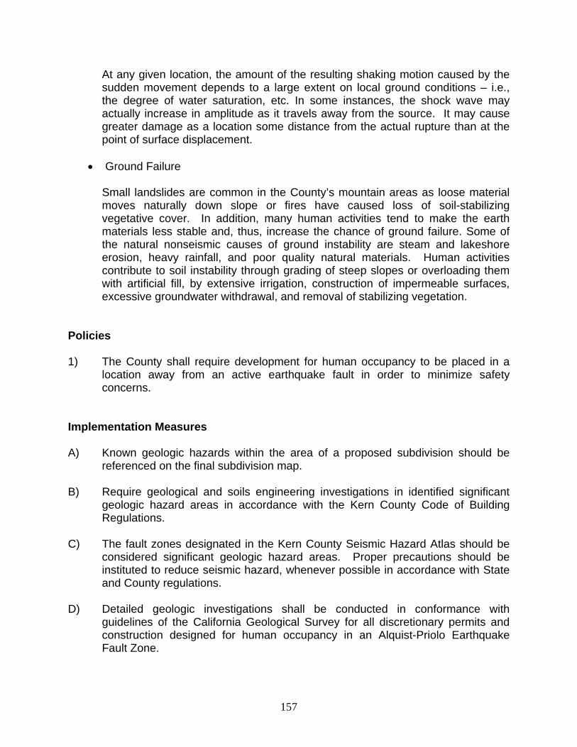
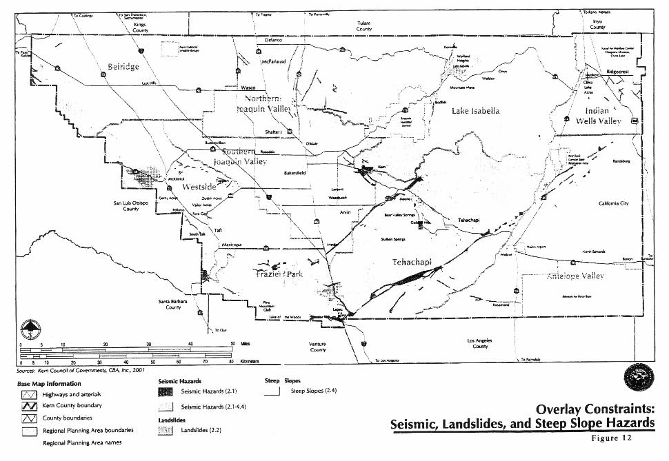
Surface fault ruptures are designated on the maps in the Seismic Hazard Atlas (available through the County Engineering and Survey Services Department), as well as some faults that are not apparent at the surface. It must be recognized that some faults may not have been recognized, either because the evidence for detecting them has not been preserved or that there has not been sufficient work in the area to detect their presence. Several atlas maps have a special note to this effect in order to call the users’ attention to this lack. It could be said that all maps need additional work because all surface and subsurface information has not been collected and/or analyzed. This statement of fact should not prevent the use of that information which is available. As new geological and geophysical data are collected and analyzed that are pertinent to this study, they should be added to the maps. Known faults must be considered in planning and land use activities. The faults identified as active deserve special consideration. No structure should be built astride an active fault. Utilities that cross such faults, both underground and on the surface, must be designed to remain operable if at all possible after fault movement. The Seismic Hazard Atlas maps show the approximate location of these features. Building permit applications must identify the exact location of proposed structures so that proper evaluation may be accomplished by the building official prior to the issuance of any permits.
• Ground Shaking
Kern County is located in one of the more seismically active areas of California and may, at any time, be subject to moderate-to-severe ground shaking. This hazard exists because elastic strains that accumulate deep within the earth become so great that the rock can no longer be contained. When this happens, movement along a fracture zone occurs, releasing enormous amounts of energy.
157
At any given location, the amount of the resulting shaking motion caused by the sudden movement depends to a large extent on local ground conditions – i.e., the degree of water saturation, etc. In some instances, the shock wave may actually increase in amplitude as it travels away from the source. It may cause greater damage as a location some distance from the actual rupture than at the point of surface displacement.
• Ground Failure
Small landslides are common in the County’s mountain areas as loose material moves naturally down slope or fires have caused loss of soil-stabilizing vegetative cover. In addition, many human activities tend to make the earth materials less stable and, thus, increase the chance of ground failure. Some of the natural nonseismic causes of ground instability are steam and lakeshore erosion, heavy rainfall, and poor quality natural materials. Human activities contribute to soil instability through grading of steep slopes or overloading them with artificial fill, by extensive irrigation, construction of impermeable surfaces, excessive groundwater withdrawal, and removal of stabilizing vegetation.
Policies 1) The County shall require development for human occupancy to be placed in a
location away from an active earthquake fault in order to minimize safety concerns.
Implementation Measures A) Known geologic hazards within the area of a proposed subdivision should be
referenced on the final subdivision map. B) Require geological and soils engineering investigations in identified significant
geologic hazard areas in accordance with the Kern County Code of Building Regulations.
C) The fault zones designated in the Kern County Seismic Hazard Atlas should be
considered significant geologic hazard areas. Proper precautions should be instituted to reduce seismic hazard, whenever possible in accordance with State and County regulations.
D) Detailed geologic investigations shall be conducted in conformance with
guidelines of the California Geological Survey for all discretionary permits and construction designed for human occupancy in an Alquist-Priolo Earthquake Fault Zone.

158
E) Revise building codes and zoning ordinances to prohibit construction of buildings for human occupancy within 50 foot of the trace of an active fault. For critical facilities, the setback should be at least 300 feet.
F) Reflect the location of active faults in zoning and subdivision approvals, through
low-density zoning designations, and through locations of lot lines and public ways to allow adequate flexibility in placement of buildings, such that active fault traces can be avoided.
G) Route major lifeline components such as highways, utilities, petroleum or
chemical pipelines around areas of high groundwater whenever possible. Where they must cross an area of high groundwater, plans, and permits shall require design features to accommodate extensive ground rupture without prolonged disruption of an essential service or threat to health and safety.
H) Require that plans and permits for installation of major lifeline components such
as highways, utilities, petroleum or chemical pipelines to incorporate design features to accommodate potential fault movement in areas of active faults without prolonged disruption of essential service or threat to health and safety.
I) Design significant lifeline installations, such as highways, utilities, and
petrochemical pipelines which cross an active fault, to accommodate potential fault movement without prolonged disruption of essential service or creating threat to health and safety.
J) Update the County’s Seismic Hazard Atlas as necessary. K) Encourage and support local, State, and federal research programs for
delineation of geologic and seismic hazards so that acceptable risk may be continually re-evaluated and kept current with state-of-the-art information and contemporary values.
L) Require seismic review prior to major addition, renovation, or increase in
occupancy of buildings.

161
4.4 DAM FAILURE, FLOODING, AND INUNDATION Hazard Identification Flood damage to undeveloped areas may be intensified by structures located within a floodplain. Any further development within recognized floodplains will be required to pass adopted floodplain regulations.
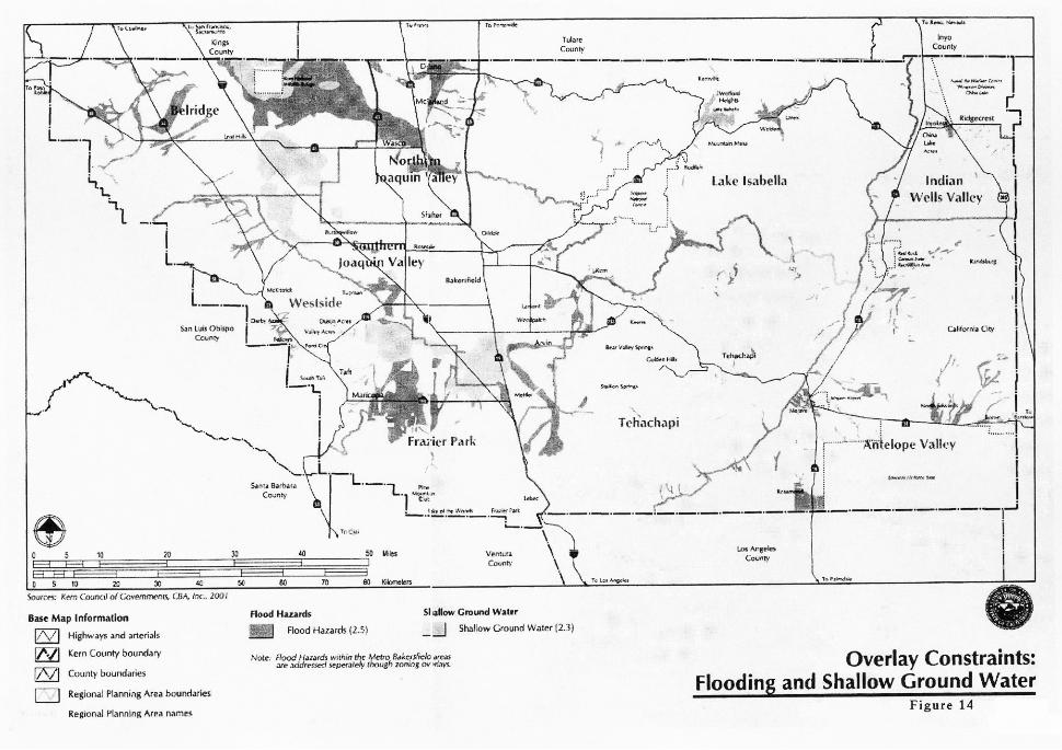
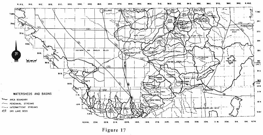
• Flood Hazard Maps The most intensive flood hazard areas are or will be shown on documented maps known as “Flood Insurance Rate Maps (FIRM’s),” the Kern County Engineering and Survey Services Department has the responsibility for conducting specific engineering studies to determine where definite waterways and floodplains have been identified, located, and mapped.
• Flood Hazard Zoning
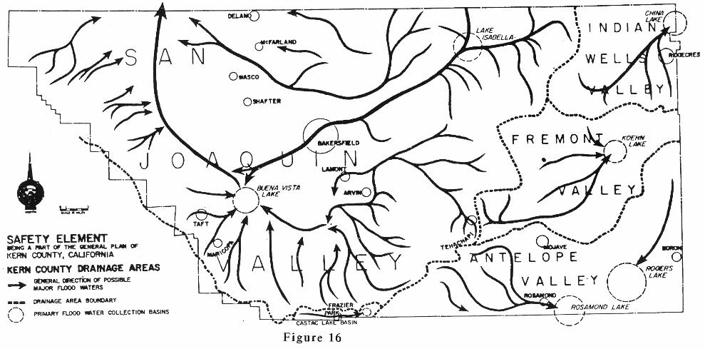
The Primary Floodplain is the area of the floodplain bounded by the floodway encroachment lines, including the land necessary to carry the design flood under conditions of full encroachment. These are based on a flood which has a one-percent probability of occurrence in any given year (sometimes referred to as a 100-year storm). A map of the Kern County Drainage Areas is included and shows the general direction of natural water flows within the County. The application of flood hazard zoning (see Chapter 19.70 of the Kern County Zoning Ordinance) to areas subject to flood hazard will provide improved protection for the general public.
• Kern County Inundation Mapping Program
Flooding resulting from inundation caused by a dam and/or dike failure is presently under study by the California State Offices of Emergency Services (OES) and Planning and Research (OPR). Inundation maps are being prepared pursuant to Section 8589.5 of the Government Code and will become a mandatory consideration in this Safety Element when completed and approved by the Office of Emergency Services.

162
The following dams and dikes are included in the Kern County inundation mapping program. Isabella Lake Dam, Brite Valley Dam, and Haiwee Reservoir
Inundation maps can be found in the Kern County Flood Evacuation Plan for the County and Greater Bakersfield Area.
• Flood
Floods that are induced by seismic activity may be of significance in areas where earth movement causes failure of dams, canal banks, or where landslides block drainage channels, streams, and/or rivers.
Policies 1) Design discretionary critical facilities located within the potential inundation area
for dam failure in order to mitigate the effects of inundation on the facility; promote orderly shutdown and evacuation (as appropriate); and prevent on-site hazards from affecting building occupants and the surrounding communities in the event of dam failure.
2) Design discretionary critical facilities in the potential dam inundation area used
for the storage, or use of hazardous materials to prevent on-site hazards from affecting surrounding communities in the event of inundation.
3) Require emergency response plans for the planning area to include specific
procedures for the sequential and orderly evacuation of the potential dam inundation area.
4) Encourage critical and high occupancy facilities as well as facilities for the
elderly, handicapped, and other special care occupants, located in the potential inundation area below the dam to develop and maintain plans for the orderly evacuation of their occupants.
Implementation Measures A) Facilities used for the manufacture, storage, and use of hazardous materials
shall comply with the Uniform Fire Code, with requirements for siting or design to prevent on-site hazards from affecting surrounding communities in the event of inundation.
B) Discretionary critical facilities within potential inundation areas shall be designed
to mitigate or prevent effects of inundation.
163
4.5 LANDSLIDES, SUBSIDENCE, SEICHE, AND LIQUEFACTION Hazard Identification
• Landslides
Landslides have been shown on the maps in the Seismic Hazard Atlas. Additional landslide areas may subsequently be identified and should be added to these maps. Development in landslide areas is an unwise practice that imposes an unnecessary risk on life and property. The slide-prone area may have reached a state of equilibrium and become stable for a number of years; however, the factors that caused the original slide could reoccur and cause additional movement. Added moisture injected into the soil by water and sewer systems tends to be detrimental in unstable areas, thus increasing the probability of slides. Landslide-prone areas can be identified with great accuracy by geologic studies and, when mapped in sufficient detail, can be used for reference in land use planning. The severity of landslide problems depends upon the local bedrock and soil conditions, including moisture content, slope, and vegetation. Losses due to landslides can be almost totally eliminated by a combination of geologic investigations, engineering practice, use of hazard area zoning, and effective enforcement of the Zoning and Grading Ordinances.
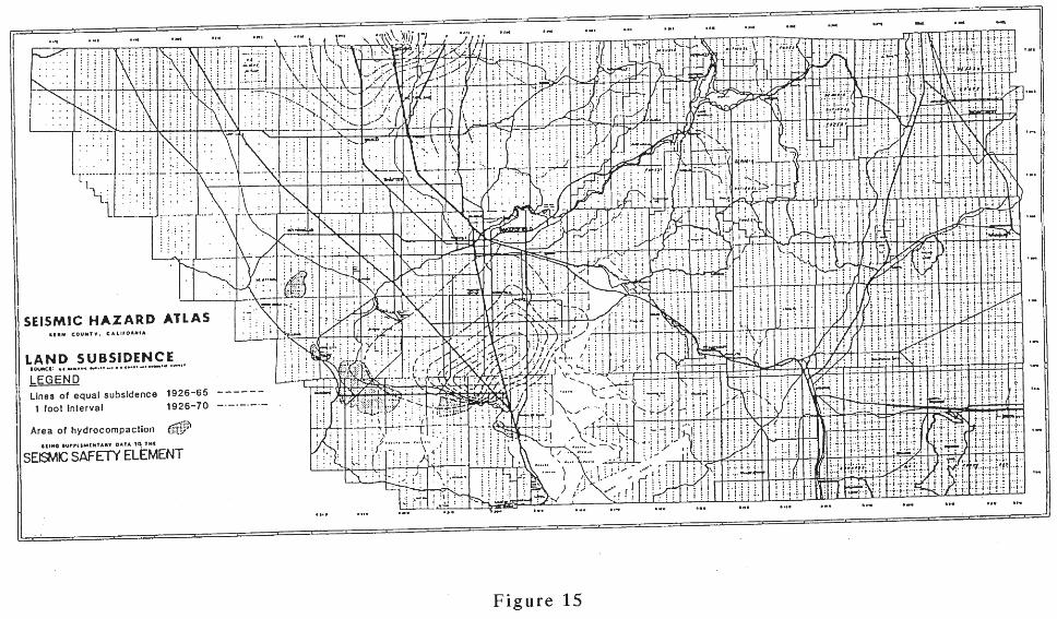
• Land Subsidence
Land subsidence is occurring within the San Joaquin Valley (see Figure 16). This type of ground failure can be aggravated by ground shaking. It is most often caused by the withdrawal of large volumes of fluids from underground reservoirs, but it can also occur by the addition of surface water to certain types of soils (hydrocompaction). Subsidence from any cause accelerates maintenance problems on roads, lined and unlined canals, and underground utilities. All new installations in areas suspected of subsidence should be engineered to withstand such subsidence. The usual remedial action is that of raising the water table by injecting water or by reducing groundwater pumpage. This increases the fluid pressure in the aquifer and, in most instances, subsidence decreases or stops after a period of time. There are four types of subsidence occurring in Kern County. Tectonic subsidence, a long-term, very slow sinking of the valley, which is significant only over a geologic time period.
164
Subsidence caused by the extraction of oil and gas. This type of subsidence is still too small to be of serious concern. The State Division of Oil, Gas, and Geothermal Resources monitors subsidence in oil and gas fields and regulates oil and gas withdrawal and repressurizing of the fields. Subsidence caused by withdrawal of groundwater in quantities much larger than replacement can occur, causing a decline of the water level. This type of subsidence is of major concern and should be regulated and reduced, especially in urbanizing areas. This practice has lowered the ground level over a large area south of Bakersfield and in other areas of the County. Subsidence caused by hydrocompaction of moisture – deficient alluvial deposits. This is a one time densification from collapse of the soil structure in near-surface strata where the rainfall or other moisture has not penetrated during a long period of time. Parts of the California Aqueduct were constructed through and over hydrocompatable deposit after compaction has occurred through ponding. The areas where hydrocompaction exists and suspect areas should be mapped, studied, and evaluated. Any development on these areas of damaging subsidence requires corrective measures.
• Clay Soils
Fine-grained, cohesive clay soils, that expand when moisture is added, tend to lose their ability to support foundations of structures. The weight of these structures squeezes the water-saturated clays laterally from under the foundations. A soils report, prepared by a soils engineer, should be required for every new building permit in suspect areas. This report should be based upon adequate test borings, excavations, soil and chemical tests, approved by the Building Official, and should include recommendations for corrective measures when necessary. The Building Official may waive the requirement for a soils report if he determines there is adequate information on the soil qualities of a particular lot available for review by the department.
• Liquefaction
Liquefaction can occur in certain types of soils that are associated with a shallow water table. It has been observed in many areas of the world that ground shaking produced by earthquakes tends to cause liquefaction to the extent that buildings have fallen over on their sides due to the lack of ground support. Some buildings designed to withstand earthquake shock waves, have been deemed inhabitable due to earthquake-triggered liquefaction. The building design was good except the foundation, which failed because liquefaction occurred during an
165
earthquake. The Department of Conservation has mapped liquefaction hazard areas in Los Angeles County. Near Rosamond, the liquefaction hazard is sited up to the Kern County boarder.
• Erosion
Erosion is the general process whereby the materials of the earth’s crust are worn down, removed by weathering, and deposited in other places by water or air. Losses due to erosion can be greatly reduced by a properly engineered design, construction, and effective enforcement of the ordinance relative to grading, landscaping, and drainage (Uniform Building Code). Lakeshore erosion is a special problem involving wave action and can be practically eliminated by proper engineering, construction, and soil stabilization through vegetative cover. Within urbanized areas, the major cause of erosion is from the continued need to remove sediment from drainage systems and basins. Erosion induced by seismic activity occurs on gentle-to-steep slopes covered by loose sediments. Fissures, steep slopes, and offsets along a fracture zone may enhance seismically induced erosion. It could become a significant hazard in many areas of the County. The flood management program should provide protection against this type of geologic hazard.
• Seiche
A seiche is a standing wave in an enclosed or partly enclosed body of water. Seiches are normally caused by earthquake activity, and can affect harbors, bays, lakes, rivers and canals. In the majority of instances, earthquake-induced seiches do not occur close to the epicenter of an earthquake, but hundreds of miles away. This is due to the fact that earthquake shock waves close to the epicenter consist of high-frequency vibrations, while those at much greater distances are of lower frequency, which can enhance the rhythmic movement in a body of water. The biggest seiches develop when the period of the ground shaking matches the frequency of oscillation of the water body, seiches create a "sloshing" effect on bodies of water. This effect can cause damage to anchored boats, piers and facilities close to the water. Secondary problems, including landslides and floods, are related to accelerated water movements and elevated water levels.
166
Policies 1) Determine the liquefaction potential at sites in areas of shallow groundwater
(Map Code 2.3) prior to discretionary development and determine specific mitigation to be incorporated into the foundation design, as necessary, to prevent or reduce damage from liquefaction in an earthquake.
2) Route major lifeline installations around potential areas of liquefaction or
otherwise protect them against significant damage from liquefaction in an earthquake.
3) Reduce potential for exposure of residential, commercial, and industrial
development to hazards of landslide, land subsidence, liquefaction, and erosion. Implementation Measures A) The need for buffer zones to protect residential and recreational areas around
Lake Isabella from possible seiches in the event of a major earthquake should be investigated.
B) Require liquefaction investigations in all areas of high groundwater potential and
appropriate foundation design to mitigate potential damage to buildings on sites with liquefaction potential.
C) Develop and maintain maps, at an appropriate scale, showing the location of all
geologic hazards, including active faults, Alquist-Priolo Earthquake Fault Zones, 100-year flood hazard boundary, the extent of projected dam failure inundation and time arcs, depth of inundation, land subsidence, slope failure and earthquake-induced landslides, high groundwater, and liquefaction potential.
D) Discretionary actions will be required to address and mitigate impacts from
inundation, land subsidence, landslides, high groundwater areas, liquefaction and seismic events through the CEQA process.

171
4.6 WILDLAND AND URBAN FIRE Hazard Identification
• Access and Evacuation Routes Good planning principles, as well as existing policies and laws, dictate that all developments must be planned with circulation routes that will assure safe access for fire and other emergency equipment. The circulation routes must include secondary means of ingress and egress, consistent with topography, to meet emergency needs. The general circulation routes are provided throughout the County by federal, State, and County-maintained road systems which are adequate for access and evacuation. State and County laws regulate the standards for new public circulation routes. Private circulation routes that are not maintained by the State or County are subject to the standards set forth in Kern County Ordinance No. G-1832.
• Clearance of Vegetative Cover for Fire Control
In 1963 the State of California enacted the Public Resources Code clearance law. This is a minimum Statewide clearance law of flammable vegetative growth around structures, especially in brush- and tree- covered watershed areas. The enactment of a local ordinance is necessary where more restrictive fire safety clearance measures are desirable to meet local conditions.
• Fuel Breaks and Firebreaks
Fuel breaks and/or firebreaks separating communities or clusters of structures from the native vegetation may be required. Such fuel breaks may be “greenbelts,” as all vegetation need not be removed but thinned or landscaped to reduce the volume of fuel. All fuel and firebreaks are required to meet the minimum design standards of the Kern County Fire Chief. The Fire Department’s Chief may require a fire plan for a development during the critical fire season. This plan should reflect the proposed course of action for fire prevention and suppression. The parcel size and setback distances of buildings placed thereon should be such that adequate clearance of flammable vegetation cover may be performed within the limits of the owner’s parcel of land.

172
Should the owner of a property fail to apply the required firebreak clearance, following proper notice, the County may elect to clear the firebreak vegetation and make the expense of the clearing a lien against the property upon which the work was accomplished.
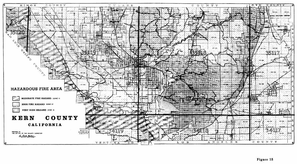
• Hazardous Fire Area
The Hazardous Fire Areas consists mainly of wildlands, which are mountain and hill land in an uncultivated, more or less natural state, covered with timber, wood, brush, and grasslands. This area includes some urban influence and agricultural use, such as exists around Isabella Lake and the Kern River, Woody/Glennville, Tehachapi/Cummings Valley, and Lebec/Frazier Park/Lake of the Woods. The wildlands provide prime habitats for deer, mountain lions, bears, kit foxes, quail, chucker, wild turkeys, and condors. They also harbor fifteen identified and important rare botanic communities and vegetation associations. The Kern County Hazardous Fire Area was established by an amendment to the Uniform Fire Code, Section 1.49H under Section 4016 of the Kern County Ordinance Code. The boundaries of the Hazardous Fire Area are determined and publicly announced before the start of each annual “fire season” and is normally the period from April 15 to December 1 of each year, except when the Fire Chief extends this period. The wildlands include valuable watersheds that must be preserved for receiving and passing water into surface streams and underground storage. Protection of the watersheds will prevent erosion and flood damages. For the protection of our wildlands we must consider all factors which will aid in fulfilling the policy stated in the California Environmental Quality Act, Public Resources Code Section 21000 et seq., to “create and maintain conditions under which man and nature can exist in productive harmony to fulfill the social and economic requirements of present and future generations.”
In implementing their Fire Prevention Program, Fire Department personnel periodically inspect the areas around all buildings for accumulations of flammable material and closure of openings of vacant buildings.
Policies 1) Require discretionary projects to assess impacts on emergency services and
facilities.
173
2) The County will encourage the promotion of public education about fire safety at home and in the work place.
3) The County will encourage the promotion of fire prevention methods to reduce
service protection costs and costs to taxpayers. 4) Ensure that new development of properties have sufficient access for emergency
vehicles and for the evacuation of residents. 5) Require that all roads in wildland fire areas are well marked, and that homes
have addresses prominently displayed. 6) All discretionary projects shall comply with the adopted Fire Code and the
requirements of the Fire Department. Implementation Measures A) Require that all development comply with the requirements of the Kern County
Fire Department or other appropriate agency regarding access, fire flows, and fire protection facilities.
B) The provision of an adequate water supply for fire fighting purposes should be
encouraged for all housing areas where an inadequate supply now exists.
175
4.7 KERN COUNTY EMERGENCY PLAN All agencies of Kern County are expected to respond promptly and effectively to any foreseeable emergency, using the Kern County Emergency Plan as amended. Policies 1) Continue to maintain and update the Kern County Emergency Plan and
continuously educate program participants of their responsibilities. 2) Monitor, enforce, and update, as appropriate, all emergency plans as needs and
as conditions change. Implementation Measures A) Incorporate specific plans and procedures for the sequential and orderly
evacuation of the potential dam inundation area into Kern County emergency plans.
B) Maintain an effective Joint Powers Agreement (JPA) for fire, police, medical
response, emergency morgue, mass care, heavy rescue, or other functions as appropriate.
C) Require emergency plans to include procedures for traffic control and security of
damaged areas. D) Require public education and preparedness to be a major continuing component
of the emergency program. It should include, at a minimum:
a) The existence and approximate locations of local faults, liquefaction susceptibility areas, and the dam evacuation areas and the procedures that have been developed to deal with them.
b) The potential for strong ground shaking in the area and means of
strengthening buildings and protecting furnishings, equipment, and other building contents from damage.
c) The need for businesses and residents to be self-sufficient for several
days following an earthquake, including food, water, sanitation, medical assistance, and limited fire fighting.
d) The provision for the orderly evacuation of elderly, handicapped, and other
special-care persons.

176
e) The steps residents and businesses should take to help themselves before, during, and after earthquakes.
177
4.8 CRITICAL FACILITIES AND HAZARDOUS BUILDINGS Hazard Identification The public should have explicit notice of structurally hazardous buildings. This could be accomplished by requiring all potentially dangerous structures to have signs posted indicating that their seismic safety is suspect. Generally, existing substandard structures of all types and materials pose the greatest hazard to the community. Special consideration is given to unsafe buildings in the Kern County Ordinance Code, including the Uniform Building, Housing, Fire, and other Codes adopted by reference. Any building declared an unsafe building under the Kern County Ordinance Code is required to be either repaired in accordance with the current edition of the regulations or demolished at the option of the building owner. The Kern County Building Official is authorized to enforce these ordinance code provisions with the exception of residential buildings, used or intended to be used for human habitation, which are subject to abatement under the requirements of the Kern County Health Officer. Although new residential buildings are constructed to code regulations and inspected before occupancy, many older residential structures no longer conform to the code regulations. Kern County, like most counties in the United States, has no program requiring periodic inspection of existing residential buildings for the purpose of upgrading to code requirements. Inspections of residential buildings showing obvious deteriorations, and in cases where complaints have been received, are presently made by Building and Health Department personnel. Buildings and other structures indispensable to emergency services, disaster control, and refuge should remain operational during any major disaster and should be designed, located, and constructed accordingly. Policies 1) That buildings and other structures indispensable to emergency services,
including hospitals, law enforcement stations, fire stations, communication control stations, and other facilities of disaster control and refuge (e.g. schools) remain operational during any major disaster and be designed, located, and constructed accordingly.
178
2) That there should be an awareness of the hazards that exist in many of the older structures in Kern County. To reduce the total risk to life and property, there should be encouragement to rehabilitate substandard structures to meet the requirements set forth in adopted codes.
3) Require that the siting and development of critical facilities under discretionary
approval be supported by documentation thorough hazard investigations relating to site selections, preconstruction site investigations, and application of the most current professional standards for seismic design.
4) The location of all critical facilities should be cataloged and mapped. 5) Incorporate planning for incidents affecting critical facilities into contingency plans
for disaster response and recovery. 6) The County shall ensure the inventory, periodic inspection, and adoption of high
seismic standards for potentially hazardous buildings. Implementation Measures A) A listing should be prepared and kept current, identifying all “critical facilities” and
“critical structures” throughout the County. All “such facilities and structures” should then be reviewed for safety and, if necessary, be brought up to improved safety levels equal to that now required for schools and hospitals.
B) A building strong-motion instrumentation program should be instituted for
buildings over six stories in height with an aggregate floor area of 60,000 square feet or more and for every building over ten stories in height regardless of floor area.
C) An inspection program of masonry structures that are not reinforced should be
initiated to determine whether such buildings create an unacceptable hazardous situation. Consideration should then be given for initiating hazard abatement proceedings against masonry structures that are not reinforced and found to be unsafe.
D) An inspection program identify hazardous buildings should be initiated. Once a
hazardous building has been identified, enlargement thereof, except as necessary to make the structure safer, should not be permitted.
E) Techniques by which dynamic analysis of structures can be performed by
computers have been developed. In the future, use of such techniques should be studied to determine whether these techniques could be incorporated in those portions of the County code regulating construction.
179
F) Amend County building and zoning ordinances to incorporate specific standards for siting and seismic design of critical facilities.
G) Review existing critical facilities for any significant siting, design, or construction
problems that would make them vulnerable in an earthquake. Findings shall be incorporated into emergency operations plans as well as addressed in longer-term programs of facilities upgrading or relocation.
H) Concrete tilt up and concrete frame buildings built before enactment of the
current seismic codes should be required to meet basic seismic standards before a change in use or occupancy level is approved or when significant alteration or repair is proposed.
I) Detailed geologic investigations shall be conducted in conformance with
guidelines of the California Geological Survey for all construction designed for human occupancy in an Alquist-Priolo Earthquake Fault Zone.
J) Revise the building codes and the Zoning Ordinance to prohibit construction of
buildings for human occupancy within 50 feet of the trace of an active fault. For critical facilities, the setback should be at least 300 feet.
K) Reflect the location of active faults in zoning and subdivision approvals, through
low- density zoning designations, and through locations of lot lines and public ways to allow adequate flexibility in placement of buildings such that active fault traces can be avoided.
L) Require that plans and permits for installation of major lifeline components such
as highways, utilities, and petroleum or chemical pipelines to incorporate design features to accommodate potential fault movement in areas of active faults without prolonged disruption of essential service or threat to health and safety.
M) Require preparation and maintenance of a map showing all critical facilities within
the planning area. N) Develop procedures for the discretionary review of critical facilities proposed in
an area of potential dam inundation. Approvals shall include requirements that emergency shut down, facility evacuation plans be developed, maintained, and exercised for each facility, and the potential effects of inundation on critical facility functions, the safety of occupants, and the community in general are addressed.
180
4.9 HAZARDOUS MATERIALS Policies 1) The proposed siting or expansion of hazardous waste facilities will be in
conformance with the adopted Kern County and Incorporated Cities Hazardous Waste Management Plan.
2) Innovative technologies to manage hazardous waste streams generated in Kern
County will be encouraged. Implementation Measures A) Facilities used to manufacture, store, and use of hazardous materials shall
comply with the Uniform Fire Code, with requirements for siting or design to prevent on-site hazards from affecting surrounding communities in the event of inundation.
B) The proposed siting or expansion of hazardous waste facilities will be in
conformance with the adopted Kern County and Incorporated Cities Hazardous Waste Management Plan.
181
4.10 ABANDONED OPEN SHAFTS AND WELLS In some areas of the County, there exist abandoned mine shafts which, if not secured, contribute to the injury of or fatality to unsuspecting members of the public. Many such shafts are within lands owned and controlled by various agencies of the federal government. Policy 1) The County should protect residents from the hazards of improperly abandoned
mine shafts. 2) The County should protect residents from the hazards associated with
development in areas where wells have been drilled and abandoned for exploration and/or production of oil and natural gas.
Implementation Measure A) Work with State and federal governments to assure that existing mine shafts are
properly abandoned and designated. B) Support the construction site review program of the Department of Oil, Gas, and
Geothermal Resources that assures wells are precisely located, properly plugged and abandoned, and tested for leakage prior to development of the area.