Kennebec Highlands Management Plan
115
Kennebec Highlands Management Plan View from Round Top Maine Department of Conservation Bureau of Parks and Lands October 19, 2011
Transcript of Kennebec Highlands Management Plan

Kennebec Highlands Management Plan
View from Round Top
Maine Department of Conservation
Bureau of Parks and Lands
October 19, 2011


Table of Contents I. Introduction ............................................................................................................................... 1
What is the Kennebec Highlands? .............................................................................................. 2 Acquisition History .............................................................................................................................. 3 The Interim Plan and Call for Research on the Legal Status of Kennebec Highlands Roads.............. 4 Road Research Summary and Implications.......................................................................................... 5
Statutory and Policy Guidance.................................................................................................... 8 Public Participation and the Planning Process............................................................................ 8
II. The Planning Context........................................................................................................... 11 Character of the Region ............................................................................................................ 11 Public Recreation Opportunities in the Region ........................................................................ 15 Recreational Tourism in the Region ......................................................................................... 20 General Trends in Recreational Use ......................................................................................... 20 Planning Implications ............................................................................................................... 22
III. Character and Resources of Kennebec Highlands ............................................................ 25 Character of the Land Base....................................................................................................... 25 Natural Resources ..................................................................................................................... 25
Natural Resource Issues ..................................................................................................................... 31 Historic and Cultural Resources ............................................................................................... 33
Historic and Cultural Resource Issues................................................................................................ 38 Recreation Resources................................................................................................................ 39
Recreation Issues and Opportunities .................................................................................................. 42 Timber Resources ..................................................................................................................... 46 Transportation and Administrative Considerations .................................................................. 49
Transportation and Administrative Issues.......................................................................................... 49 IV. A Vision for the Kennebec Highlands ................................................................................ 51 V. Resource Allocations............................................................................................................. 53
Overview of Allocations for the Kennebec Highlands ............................................................. 54 Special Protection Areas ........................................................................................................... 54 Backcountry Motorized Areas .................................................................................................. 55 Wildlife Dominant Areas.......................................................................................................... 55 Remote Recreation Areas ......................................................................................................... 56 Visual Consideration Areas ...................................................................................................... 57 Developed Recreation Areas..................................................................................................... 57 Timber Management Areas....................................................................................................... 58
VI. Management Recommendations ......................................................................................... 61 VII. Monitoring and Evaluation ............................................................................................... 75 VIII. Appendices ........................................................................................................................ 77
Appendix A. The Public Process ............................................................................................. 78 Appendix B. Management Plan Guiding Statutes and Rules for the Use of Public Reserved Lands......................................................................................................................................... 97 Appendix C. Summary of the Resource Allocation System.................................................. 101 Appendix D. References ........................................................................................................ 107

Acknowledgements The Kennebec Highlands Management Plan was prepared as a collaborative effort among the following Bureau of Parks and Lands staff:
Will Harris Director, Bureau of Parks and Lands Kathy Eickenberg Acting Deputy Director Amy Hudnor Plan Coordinator, Final Plan Cindy Bastey Plan Coordinator, Interim Plan Pete Smith Manager, Western Lands Region Scott Ramsay Director, Off-road Vehicle Program Brian Bronson ATV Coordinator Tom Charles Chief of Silviculture Gena Denis GIS Coordinator Tom Desjardin Historic Site Specialist Tom Dinsmore Property Records Specialist Bill Haslam Forester, Western Lands Region Joe Higgins Snowmobile Coordinator Rex Turner Outdoor Recreation Specialist Joe Wiley Wildlife Biologist
During the 2007 interim plan process, Frank O’Hara and Antje Kablitz of Planning Decisions, Inc. provided meeting facilitation, research and writing support to the Bureau. The Maine Natural Areas Program prepared the natural resources inventory for the Highlands, which addresses geology, soils, hydrology, water quality, natural communities, wetlands, ecological processes, and rare plant and animal species. The inventory report, written by ecologist Brooke Wilkerson, is included in the Plan (under separate cover) as Appendix E, Natural Resource Inventory of the Bureau of Parks and Lands Kennebec Highlands Unit. It is available upon request to the Bureau. The Kennebec Highlands Phase I Archaeological Survey, prepared for the Land for Maine’s Future Board by Maine Historic Preservation Commission for the Kennebec Highlands acquisition project, provides the information about archaeological and historical resources on the Highlands. The Bureau acknowledges the time and thoughtful contributions of members of the Kennebec Highlands Management Plan Advisory Committee, listed below, and the many members of the public who participated in meetings and sent comments to the Bureau during the preparation of the plan.
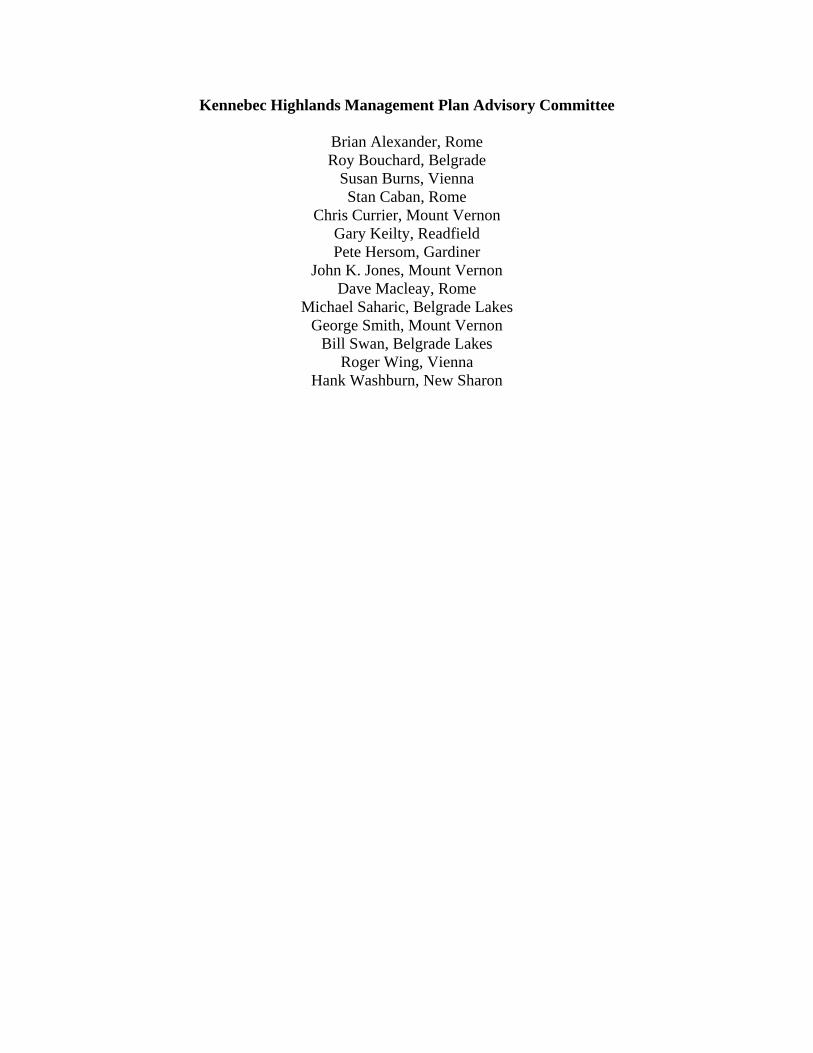
Kennebec Highlands Management Plan Advisory Committee
Brian Alexander, Rome Roy Bouchard, Belgrade
Susan Burns, Vienna Stan Caban, Rome
Chris Currier, Mount Vernon Gary Keilty, Readfield Pete Hersom, Gardiner
John K. Jones, Mount Vernon Dave Macleay, Rome
Michael Saharic, Belgrade Lakes George Smith, Mount Vernon
Bill Swan, Belgrade Lakes Roger Wing, Vienna
Hank Washburn, New Sharon

1
I. Introduction
About This Document
This document constitutes a fifteen-year Management Plan for the Kennebec Highlands, an approximately 6,000 acre public reserved land unit managed by the Maine Bureau of Parks and Lands (the Bureau). The Plan summarizes the character of the region and the planning process, but its primary function is to 1) provide a description of the resources found on the Kennebec Highlands, 2) describe management issues identified by members of the public and Bureau staff, and 3) put forth a vision for the future of the Kennebec Highlands, designate resource allocations across the landbase, and make management recommendations to be implemented over the next fifteen-year period. One objective of the Bureau is to provide a variety of recreational opportunities across lands and parks it manages, keeping in mind the available opportunities in the larger region as well. In developing the management recommendations for the Kennebec Highlands, the Bureau has considered this broader perspective. The Kennebec Highlands Management Plan is also a commitment to the public that the property will be managed within prescribed legislative mandates and in accordance with the Bureau’s Integrated Resource Policy and its stated mission and goals. Future revisions to these commitments will occur only after providing opportunities for public comment. The Plan provides guidance to Bureau staff with responsibility for managing these properties, including a degree of flexibility in achieving the stated objectives. This document is not, however, a plan of operations. An important aspect of the management of public lands is monitoring and evaluation of proposed management activities in terms of stated objectives. This Plan describes monitoring and evaluation procedures for recreational use, wildlife management, and timber management. The fifteen-year duration for this Plan is a departure from previous plans prepared for public lands. In 2007, the Bureau amended its policy to increase the Plan interval from 10 to 15 years. This change brings the Plan interval into closer alignment with Bureau forest management plan prescriptions, and most other resource management concerns other than recreation. The Bureau recognizes that some resources and management issues, most notably recreation, may undergo more rapid or unanticipated change over time. Thus, in addition to the fifteen year scheduled Plan revision, a review of current issues and progress on implementing the Plan’s recommendations will be undertaken every five years, with a status report issued at that time to the advisory committee. If amendments to the Plan are then proposed, there will be an opportunity for public review and comment prior to their adoption. At the fifteen year interval, the Bureau will undertake a full review and revision of the Plan. The Bureau recognizes that several of the stated objectives will require longer than the fifteen year Plan period to achieve.

2
What is the Kennebec Highlands? The Kennebec Highlands is comprised of 6,076 acres of land in northwest Kennebec County and southeastern Franklin County. It includes Kennebec County’s highest elevations – McGaffey and Vienna mountains, numerous streams and wetlands, and five undeveloped ponds. The lands are located within 15 miles of Augusta, Farmington and Waterville and roughly 90 minutes from Portland and Bangor. Kennebec Highlands Location Map
Kennebec Highlands
3
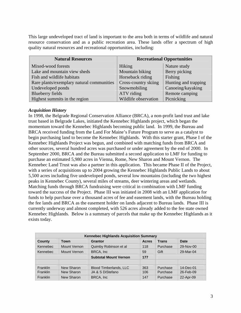
This large undeveloped tract of land is important to the area both in terms of wildlife and natural resource conservation and as a public recreation area. These lands offer a spectrum of high quality natural resources and recreational opportunities, including:
Natural Resources Recreational Opportunities
Mixed-wood forests Hiking Nature study Lake and mountain view sheds Mountain biking Berry picking Fish and wildlife habitats Horseback riding Fishing Rare plants/exemplary natural communities Cross-country skiing Hunting and trapping Undeveloped ponds Snowmobiling Canoeing/kayaking Blueberry fields ATV riding Remote camping Highest summits in the region Wildlife observation Picnicking
Acquisition History In 1998, the Belgrade Regional Conservation Alliance (BRCA), a non-profit land trust and lake trust based in Belgrade Lakes, initiated the Kennebec Highlands project, which began the momentum toward the Kennebec Highlands becoming public land. In 1999, the Bureau and BRCA received funding from the Land For Maine’s Future Program to serve as a catalyst to begin purchasing land to become the Kennebec Highlands. With this starter grant, Phase I of the Kennebec Highlands Project was begun, and combined with matching funds from BRCA and other sources, several hundred acres was purchased or under agreement by the end of 2000. In September 2000, BRCA and the Bureau submitted a second application to LMF for funding to purchase an estimated 5,980 acres in Vienna, Rome, New Sharon and Mount Vernon. The Kennebec Land Trust was also a partner in this application. This became Phase II of the Project, with a series of acquisitions up to 2004 growing the Kennebec Highlands Public Lands to about 5,500 acres including five undeveloped ponds, several low mountains (including the two highest peaks in Kennebec County), several miles of streams, deer wintering areas and wetlands. Matching funds through BRCA fundraising were critical in combination with LMF funding toward the success of the Project. Phase III was initiated in 2008 with an LMF application for funds to help purchase over a thousand acres of fee and easement lands, with the Bureau holding the fee lands and BRCA as the easement holder on lands adjacent to Bureau lands. Phase III is currently underway and almost completed, with 526 acres already added to the fee state owned Kennebec Highlands. Below is a summary of parcels that make up the Kennebec Highlands as it exists today.
Kennebec Highlands Acquisition Summary
County Town Grantor Acres Trans Date
Kennebec Mount Vernon Quimby Robinson et al 118 Purchase 29-Nov-00
Kennebec Mount Vernon BRCA, Inc 59 Gift 29-Mar-04
Subtotal Mount Vernon 177
Franklin New Sharon Blood Timberlands, LLC 363 Purchase 14-Dec-01 Franklin New Sharon JA & S DiStefano 106 Purchase 26-Feb-09
Franklin New Sharon BRCA, Inc 147 Purchase 22-Apr-09

4
Subtotal New Sharon 616
Kennebec Rome BRCA, Inc 1,872 Purchase 22-Mar-01
Kennebec Rome Barry Dolley Trust 77 Purchase 05-Jul-01
Kennebec Rome BRCA, Inc 221 Purchase 21-Sep-01
Kennebec Rome BRCA, Inc 456 Gift 29-Mar-04
Kennebec Rome DL & DJ May 186 Purchase 30-Jun-04
Kennebec Rome Thorndike & Sons, Inc. 114 Purchase 30-Jun-04
Subtotal Rome 2,926
Kennebec Vienna DG Pillsbury 68 Purchase 26-Jul-00
Kennebec Vienna DG Pillsbury 15 Purchase* 26-Jul-00
Kennebec Vienna FM & JF Webber 69 Purchase 26-Jul-00
Kennebec Vienna BRCA, Inc 300 Purchase 22-Mar-01
Kennebec Vienna Herbert C. Haynes, Inc 819 Purchase 11-Jun-01
Kennebec Vienna BRCA, Inc 142 Purchase 21-Sep-01
Kennebec Vienna BRCA, Inc 111 Purchase 21-Sep-01
Kennebec Vienna DL & J Marstaller 135 Purchase 21-Sep-01
Kennebec Vienna DL & VA Taylor et al. 170 Purchase 21-Sep-01
Kennebec Vienna RW & JJ Hall 38 Purchase 28-Aug-02
Kennebec Vienna BRCA, Inc 66 Gift 17-Mar-03
Kennebec Vienna HC Haynes, Inc 102 Purchase 27-Jun-03
Kennebec Vienna BRCA, Inc 42 Gift 29-Mar-04 Kennebec Vienna BRCA, Inc 64 Gift 26-Feb-09
Kennebec Vienna Goucher & Son, Inc 180 Purchase 04-Aug-09
Kennebec Vienna R.B Krause 29 Purchase 06-Nov-09
Subtotal Vienna 2,350
Grand Total 6,069
*Cost included in other purchase.
Currently the Kennebec Highlands is the largest contiguous block of conserved land in Central Maine. The BRCA is working to expand conservation lands around the current Bureau lands to meet the minimum habitat requirements for numerous wildlife species including interior nesting birds, many raptors, bear, bobcat, moose, lynx and otter. The Interim Plan and Call for Research on the Legal Status of Kennebec Highlands Roads The Kennebec Highlands Management Plan process was begun in 2006, when the landbase was composed of 5,500 acres (a result of Phases I and II). Several public meetings were held in 2007 to get public input to set the direction for the plan and receive comments on drafts. However, during the process of plan research and public input, concerns about the status of roads leading into and traveling throughout the Kennebec Highlands came to light. Since the Kennebec Highlands is composed of land in four organized towns, the potential of public rights of access on existing roads that may have formerly been town roads was identified. In 2007, there was a great deal of uncertainty regarding these potential rights. Understanding public rights of access on roads was determined to be critical to completing the Plan, because the most significant issue raised by the public in 2007 was motorized access. While the Bureau allows pedestrian access broadly across public reserved lands, it determines motorized access during the management planning process. A significant number of people in 2007 expressed the desire for broad motorized access across the Kennebec Highlands, while another significant number wanted the Highlands to be non-motorized with parking areas on the perimeter. There were many opinions
5
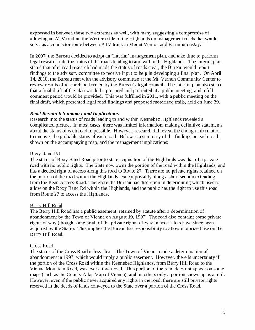
expressed in between these two extremes as well, with many suggesting a compromise of allowing an ATV trail on the Western side of the Highlands on management roads that would serve as a connector route between ATV trails in Mount Vernon and Farmington/Jay. In 2007, the Bureau decided to adopt an ‘interim’ management plan, and take time to perform legal research into the status of the roads leading to and within the Highlands. The interim plan stated that after road research had made the status of roads clear, the Bureau would report findings to the advisory committee to receive input to help in developing a final plan. On April 14, 2010, the Bureau met with the advisory committee at the Mt. Vernon Community Center to review results of research performed by the Bureau’s legal council. The interim plan also stated that a final draft of the plan would be prepared and presented at a public meeting, and a full comment period would be provided. This was fulfilled in 2011, with a public meeting on the final draft, which presented legal road findings and proposed motorized trails, held on June 29. Road Research Summary and Implications Research into the status of roads leading to and within Kennebec Highlands revealed a complicated picture. In most cases, there was limited information, making definitive statements about the status of each road impossible. However, research did reveal the enough information to uncover the probable status of each road. Below is a summary of the findings on each road, shown on the accompanying map, and the management implications: Roxy Rand Rd The status of Roxy Rand Road prior to state acquisition of the Highlands was that of a private road with no public rights. The State now owns the portion of the road within the Highlands, and has a deeded right of access along this road to Route 27. There are no private rights retained on the portion of the road within the Highlands, except possibly along a short section extending from the Bean Access Road. Therefore the Bureau has discretion in determining which uses to allow on the Roxy Rand Rd within the Highlands, and the public has the right to use this road from Route 27 to access the Highlands. Berry Hill Road The Berry Hill Road has a public easement, retained by statute after a determination of abandonment by the Town of Vienna on August 19, 1997. The road also contains some private rights of way (though some or all of the private rights-of-way to access lots have since been acquired by the State). This implies the Bureau has responsibility to allow motorized use on the Berry Hill Road. Cross Road The status of the Cross Road is less clear. The Town of Vienna made a determination of abandonment in 1997, which would imply a public easement. However, there is uncertainty if the portion of the Cross Road within the Kennebec Highlands, from Berry Hill Road to the Vienna Mountain Road, was ever a town road. This portion of the road does not appear on some maps (such as the County Atlas Map of Vienna), and on others only a portion shows up as a trail. However, even if the public never acquired any rights in the road, there are still private rights reserved in the deeds of lands conveyed to the State over a portion of the Cross Road..

6
In conclusion, the Bureau’s discretion in deciding whether or not to allow motorized access on the Cross Road within the Highlands is constrained by the considerable uncertainty about pre-existing rights, which may be of both public and private nature. Vienna Mountain Road The Bureau has no ownership of any portion of this road, but did want to determine what rights the public has to use the road. The status of the Vienna Mountain Road is that it is a public way over a portion, and is subject to a public easement on the remainder resulting when the Town of Vienna made a determination of abandonment in 1997. Rugged Hill Road The status of the “Rugged Hill Road” is that it was formerly a public way. A public easement was retained on the road when the Town of Vienna made a determination of abandonment in 1997. However, it appears that the road currently being maintained and referred to as the “Rugged Hill Rd” is a newer road that is roughly parallel to the original Rugged Hill Rd. There is no public easement on this current road. The original Rugged Hill Rd, which has a public easement, has not been located and may not be in any condition to accommodate motorized vehicles. The location of the road from old maps would only be partly on state land. The Bureau has no plans to upgrade the short portion of the original Rugged Hill Rd and a public easement does not give other parties the right to ‘upgrade’ the road. McGaffey Mountain Road The status of the McGaffey Mountain Road is that it was formerly a public way. A public easement was retained on the road when the Town of Vienna made a determination of abandonment in 1997. This implies the Bureau has a responsibility to allow motorized use on the McGaffey Mountain Road. North Access Road The North Access Road is a private road. No public easement has been shown. However, when the State acquired land south of this road, a public pedestrian right-of-way and a vehicular right-of-way for “land management and forestry purposes only” was acquired. It appears the Bureau may only grant the public pedestrian use of this road. Bean Access Road The State owns the Bean Access Road between the Roxy Rand Road and the McGaffey Mountain Road; and only a portion of the road between the Watson Pond Road and the Roxy Rand Road. Prior to state ownership the probable status of this road was a private road, with no public rights. The Bureau appears to have discretion in determining types of access allowed on those portions within state ownership. There are no known public rights across those sections remaining in private ownership. Prescott Road This road is also known as the Wildflower Estates Road and the Old Rome Road. The Bureau now owns the northerly half of the road for a portion of the road beginning at the Watson Pond Road extending for approximately two miles, and then owns the entire road on that section where the Bureau lands abut both sides of the road. The probable status of this road prior to state
7
acquisition was private. There are no known pre-existing public rights to use this road., though the state ownership is likely subject to private access rights.

8
Statutory and Policy Guidance Multiple use management plans are required for public reserved lands pursuant to Title 12 MRSA § 1847 (2), and must be prepared in accordance with the guidelines of the Integrated Resource Policy adopted in December 2000 by the Bureau. These laws and policies direct the Bureau to identify and protect important natural, ecological, and historic attributes; enhance important fisheries and wildlife habitat; provide opportunities for a variety of quality outdoor recreation experiences; and produces a sustained yield of forest products by utilizing forest management techniques and silvicultural practices that enhance the forest environment. Public Participation and the Planning Process The development of management plans includes a series of steps, each involving interdisciplinary review and public comment, to achieve a plan that integrates various perspectives and needs while protecting and conserving the resources of Bureau lands. A summary of the Kennebec Highlands management planning process, with emphasis on the public process is below: Resource Assessments: The first phase of the planning process included a study of the resources and opportunities available on the Kennebec Highlands, including natural and geological, historic and cultural, fisheries and wildlife, recreation, and timber resources. Some of this information comes from formal inventories conducted by the Maine Natural Areas Program and the Maine Historic Preservation Commission, while other information was supplied by Bureau staff with expertise in wildlife, recreation, timber management and mapping and by people who have personal knowledge of the property. Issue Identification/Discussion through Public Scoping Meetings: A Public Scoping Meeting was held at the Mount Vernon Community Center on May 17, 2007 to identify hopes and concerns for the future of the Highlands and management issues that needed to be addressed in the plan from the perspective of the public. Preparation of Preliminary Plan: The Bureau then documented the resources and management issues identified as described above and proposed a vision and management recommendations for the Highlands, including “resource allocations,” or areas designated for a specific type of management such as remote recreation, wildlife management, timber management, etc. These were assembled as a Preliminary Plan for discussion. Advisory Committee Formation and Review of Preliminary Plan: At the same time, a public Advisory Committee was formed to review and discuss the Preliminary Plan on a more formal basis. Members of the committee were selected based on their knowledge in areas important to the management of this Highlands and their interest in the property. An Advisory Committee meeting to review the Preliminary Plan, open to the public, was held at the Mount Vernon Community Center on June 28, 2007. Working Meeting on Trails: A special meeting, open to the public, to improve trail location information and identify existing and potential trail routes for different uses was held at the Mount Vernon Community Center on July 10, 2007.

9
Preparation of Final Draft Interim Plan and Public Meeting: Comments from the Advisory Committee and public on the Preliminary Draft, from the Working Meeting on Trails and comments submitted by the public were considered in developing a final draft of the “Kennebec Highlands Interim Management Plan”. An interim plan was needed because it was determined that more information about rights of public access over existing roads to and on the property was needed to complete recreation planning. An interim plan was designed to guide Kennebec Highlands management until research on the status of roads could be performed and more detailed planning for recreation could be undertaken. This interim plan was presented at a public meeting on September 6, 2007. Additional written comments on this interim plan draft were received until September 21, 2007. Advisory Committee Meeting to Review Legal Research on Roads The Bureau did research into the legal status of existing roads to and on the Kennebec Highlands. This research was presented at an Advisory Committee meeting on April 14, 2010 at the Mount Vernon Community Center. Potential ATV and snowmobile trails were discussed at this meeting, as well as non-motorized recreation needs. Public Meeting on Final Draft Plan A public meeting was held June 29, 2011 to review the final draft of the Plan and receive the public’s comments. A written comment period extended from June 6 to July 20. Commissioner’s Review of the Proposed Plan, and Plan Adoption: Comments received on the final Draft Plan were considered in preparing a Final Management Plan for review by the Department of Conservation’s Commissioner, as recommended by the Director of the Bureau of Parks and Lands. After the Commissioner’s review and comment and any needed revisions to the Final Plan, the plan was formally adopted by the Commissioner on October 19, 2011. Plan Follow-up: Typically, following adoption of a management plan, the unit will be subdivided into geographic compartments to develop operational plans and implement management recommendations. The Bureau annually reviews commitments made in the plan and determines what specific projects will be undertaken in the coming year, based on the resources available. At five-year intervals, the Bureau reports to the Advisory Committee on accomplishments and changing conditions that may warrant amendments to the plan.

10

11
II. The Planning Context
Introduction The key focus of this Plan is management allocations and recommendations for the Kennebec Highlands Public Reserved Lands. However, the Planning Context section describes the larger region, including the character of the region, demographic information, tourism and recreation trends, and other private and public conservation lands. This larger context has been considered in developing the Kennebec Highlands Management Plan. Character of the Region To provide context, the plan describes a broader region within which the Highlands are located, a smaller area immediately around the property that includes four “Highlands towns” (Mount Vernon, New Sharon, Rome and Vienna) and ten “adjacent towns” (Belgrade, Chesterville, Farmington, Fayette, Industry, Manchester, Mercer, Readfield, Smithfield and Starks.) Considered for regional context is an area generally within 25 miles of the Highlands – a comfortable driving distance for day use visits to the Highlands. This region spans portions of six counties in central Maine – Androscoggin, Franklin, Kennebec, Oxford, Somerset and Waldo, and a range of community types, from regional employment, trade and service centers – including the state capital of Augusta - to small rural towns. Over one-quarter of the population of this region lives in the largest communities of Augusta (pop. 19,000), Waterville (pop. 15,700), Skowhegan (pop. 8,500), Winslow (pop. 7,800) and Farmington (pop. 7,800). The fourteen Highlands and adjacent towns include some of the smaller communities in the region: eleven towns have a population of less than 3,000, and four towns have a population of less than 1,000 (US Census Bureau, 2010). Communities in the region share a history of farming and forestry followed by water-powered industrial development; tourism and seasonal home development centered on abundant lakes; and residential development of rural areas with associated commuter travel to service centers for work and trade. Major roads serving larger communities and destinations beyond the region include Interstate 95 and US Routes 201, 202, 2, 3 and 4. Within the Highlands and adjacent communities, US Routes 2 and 4 and State Route 27 are the primary travel corridors.
12
13
Both the region and the Highlands property include portions of the Kennebec and Androscoggin river basins. Part of the Central Interior biophysical region, the region characterized by flat to gently rolling terrain, although the relatively high elevations within the Highlands give the property much in common with the neighboring Western Foothills. The climate of the Central Interior is moderate. Summers are warm, and the frost-free season is about 120 days. Mean maximum July temperature is 80° F, and the mean minimum January temperature is 3° F. Average annual precipitation (45”) and snowfall (90”) are intermediate between southern and northern regions. The flora of this region reflect its relatively moderate climate (Wilkerson 2007). Over 75% of the Central Interior is forested (US Forest Service, 2003), and forest ecosystems reflect a transition from a northern Appalachian forest of oak, pine, and mixed hardwoods in southern Maine to the spruce, fir, northern hardwoods forests found in northern and eastern Maine. Forests on the Highlands reflect this transition, with oak-dominated forests only present in small patches on warm, south-facing slopes (Wilkerson 2007).
The fourteen Highlands and adjacent towns are small communities with sizeable tracts of undeveloped land. Historically rural farm, timber and mill communities, the four Highlands towns are today predominantly residential and seasonal recreation communities. The 2000 US census indicates that at that time, a quarter of the housing in the Highlands towns are vacant seasonally, indicating a large number of second family homes and camps and an expanded seasonal population. In adjacent towns and beyond this proportion decreases to roughly 11%, with the majority of year round residents (91%) commuting a mean of 28.8 minutes or more to their place of work. Information from the 2010 census regarding seasonal homes and commuting distances are not yet available at the time of printing this plan. However, the US Census for 2010 indicates the population of Highlands and adjacent towns to be 26,512, with 4,627 individuals living in Highlands towns. In 2000, the average median age within the Highlands towns was 40.6, which is slightly older than the average for the adjacent towns (38.8) and the State as a whole (38.6). The median household income of Highlands towns households was $ 38,047 in 2000, which is higher than both the State median of $37,240 and the adjacent towns $37,627. This may reflect the seasonal/second home characteristics of these communities (Kablitz 2007). Again, this type of information has not been released yet for the 2010 census.
14
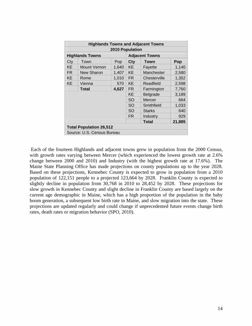
Highlands Towns and Adjacent Towns 2010 Population
Highlands Towns Adjacent Towns
Cty Town Pop Cty Town Pop KE Mount Vernon 1,640 KE Fayette 1,140 FR New Sharon 1,407 KE Manchester 2,580 KE Rome 1,010 FR Chesterville 1,352 KE Vienna 570 KE Readfield 2,598 Total 4,627 FR Farmington 7,760
KE Belgrade 3,189 SO Mercer 664 SO Smithfield 1,033 SO Starks 640 FR Industry 929
Total 21,885 Total Population 26,512 Source: U.S. Census Bureau
Each of the fourteen Highlands and adjacent towns grew in population from the 2000 Census, with growth rates varying between Mercer (which experienced the lowest growth rate at 2.6% change between 2000 and 2010) and Industry (with the highest growth rate at 17.6%). The Maine State Planning Office has made projections on county populations up to the year 2028. Based on these projections, Kennebec County is expected to grow in population from a 2010 population of 122,151 people to a projected 123,664 by 2028. Franklin County is expected to slightly decline in population from 30,768 in 2010 to 28,452 by 2028. These projections for slow growth in Kennebec County and slight decline in Franklin County are based largely on the current age demographic in Maine, which has a high proportion of the population in the baby boom generation, a subsequent low birth rate in Maine, and slow migration into the state. These projections are updated regularly and could change if unprecedented future events change birth rates, death rates or migration behavior (SPO, 2010).

15
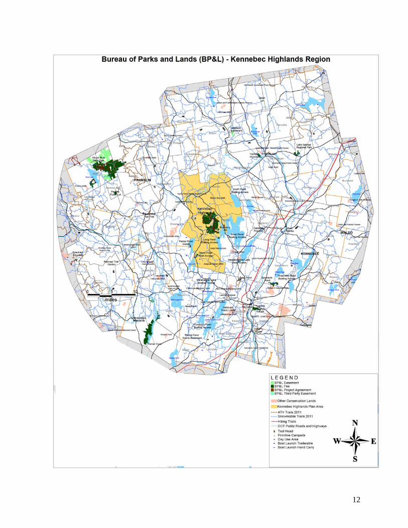
Public Recreation Opportunities in the Region There is a variety of public recreation opportunities in the broader region, and many are provided by municipalities, private individuals and business and nonprofit organizations. It is beyond the scope of this plan to inventory all of these. This section focuses on the major outdoor recreation areas and facilities provided by state agencies. Worth noting, however, is the expanding role of local land trusts in providing places for outdoor recreation. The Belgrade Regional Conservation Alliance played a pivotal role in establishing the Kennebec Highlands as public land and has conserved other important sites nearby. The Small Woodlot Owners Association of Maine (SWOAM) holds the 200-acre Hammond Woodlot directly across Watson Pond Road from the Kennebec Highlands where it hopes to provide recreational and educational trails. The Kennebec Land Trust has conserved a number of properties (over 3,850 fee and easement acres including 23 miles of trails) in the Kennebec River and lakes region that include many hiking and nature trails, the largest of which is the Mount Pisgah Conservation Area (730 acres) in Winthrop and Wayne. The Belgrade Regional Conservation Alliance The Belgrade Regional Conservation Alliance (BRCA) began in 1988, and is dedicated to conserving the lands, water quality and natural heritage of the Belgrade Lakes region. Based in the town of Belgrade Lakes, BRCA has over 1200 members and has expanded into both a land trust and a lake trust. The land trust owns fee and easement lands, including The Mountain, French Mountain, and Phillip Mountain, all in Rome. As mentioned in the introduction, BRCA initiated the Kennebec Highlands Project and partners with the Bureau in LMF applications, and acquisitions that have built and continue to build the Kennebec Highlands Public Reserved Land. BRCA’s lake trust is an alliance of the five lake associations in the Belgrade Lakes watershed, which work on invasive species prevention, erosion control projects, and watershed based plans to improve water quality. BRCA holds educational programs and outdoor events, including guided hikes in the Kennebec Highlands. BRCA also assists the Bureau with on-the-ground maintenance at Kennebec Highlands, including plowing the parking areas for winter recreationists, trail construction and maintenance, and signage. (BRCA, 2011) Boating in the Region Boating is a primary recreation activity in a region with many lakes. There are 63 state sponsored and assisted boat access sites on freshwater lakes, ponds and rivers across the region and another six sites on the tidal waters of the Kennebec River. These can be seen on the Kennebec Highlands Region map above. These are managed by, or have received financial support from, the state Departments of Conservation, Inland Fisheries and Wildlife or Transportation. Indicative of the level of boating activity around the Highlands are the number of area lakes marked with navigational aids by the state or lake associations, including Great, Long, Lovejoy and North ponds and Maranacook, Messalonskee, Salmon/McGrath, and Torsey lakes.

16
Twenty of the sites are located within Highlands and adjacent towns:
State Sponsored and Assisted Boat Access Sites in Highlands and Adjacent Towns
Town Water Body Type Owner BELGRADE GREAT PD TR DOC BELGRADE MESSALONSKEE LK TR DOC BELGRADE SALMON LK TR IFW
CHESTERVILLE EGYPT PD CI DOC CHESTERVILLE L NORRIDGEWK STR CI IFW FAYETTE TILTON PD CI TOWN FAYETTE BASIN PD CI DOC INDUSTRY CLEARWATER PD TR TOWN MANCHESTER JAMIES PD CI IFW
MANCHESTER TYLER PD CI IFW
MANCHESTER SILVER LK TR IFW
MT VERNON DESERT PD CI IFW
MT VERNON ECHO LK TR DOC MT VERNON FLYING PD TR DOT MT VERNON LONG PD TR DOC
MT VERNON TAYLOR PD TR DOC
NEW SHARON MCINTIRE PD CI DOC READFIELD MARANACOOK LK TR DOC
READFIELD TORSEY PD TR DOC
SMITHFIELD NORTH PD TR DOC TR = Trailerable access. CI = Carry-in Access. DOC = Department of Conservation. IFW = Department of Inland Fisheries & Wildlife. DOT = Department of Transportation Source: Maine Department of Conservation, Boating Facilities Division, 2007
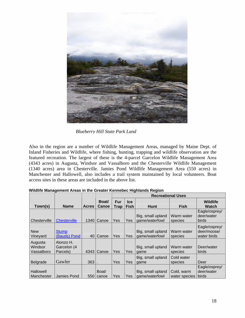
Other State Recreational Lands and Resources in the Region The principal state park lands in the region include Mount Blue State Park (8,220 acres), a day use, camping and all-season trail park in Weld, Avon and Temple; Androscoggin River Lands (2,675 acres), a multi-use trail property in Turner and Leeds; and the multi-use Jay-Farmington Rail Trail in Jay, Farmington and Wilton. Other state park lands in the region are managed by other agencies or towns, including two popular town-operated day use/swim parks: Woodbury Pond in Litchfied and Lake St. George Regional Park in Skowhegan and Canaan. The principal public reserved and nonreserved lands in the region include the recently acquired Tumbledown-Mount Blue project lands (22,585 fee and easement acres) in Franklin County that include a number of popular hiking trails, and the Kennebec Highlands. Highlands and adjacent towns include two small units of state park land: Blueberry Hill (70 acres), a popular scenic and picnic area in Rome, and a parcel on Long Pond, managed as a boat access site. The Kennebec Highlands is the Bureau’s only unit of public reserved land and its largest property in Kennebec County.
State Park and Public Reserved Lands in Highlands and Adjacent Towns
Town Type Name Acres Recreation Uses Rome Park land Blueberry Hill 70 Scenic, picnic
Mt Vernon, Rome Park land Long Pond 63 Boat access

17
Mt Vernon, New Sharon, Rome, Vienna Reserved Land Kennebec Highlands 6,076
Trails, fishing, hunting
Maine Department of Conservation, Bureau of Parks and Lands, 2007
State Park Properties in the Greater Kennebec Highlands Region
Cty Town Name Fee
Acres Easement
Acres Total Recreation Uses Manager
AN Turner, Leeds
Androscoggin River Lands 2,262 0 2,262 Trails (hike, bike, atv) BPL
FR
Weld Temple Avon Mount Blue State Park 8,220 0 8,220
Camp, swim, picnic, trails (hike, bike, atv, horseback, snowmobile, ski) BPL
FR
Jay, Farmington Wilton
Jay-Farmington Rail Trail 138 2 141 Trail (multi-use) BPL
KE Augusta Pine Tree State Arboretum 16 0 16
Arboretum, trails (interpretive, ski) Arboretum
KE Rome Blueberry Hill 70 0 70 Picnic BPL KE Pittston Coburn House 7 0 7 State Historic Site BPL KE Winslow Fort Halifax 1 0 1 State Historic Site BPL
KE Mt Vernon Rome Long Pond 63 0 63 Boat access BPL
KE Oakland Snow Pond 2 0 2 Water access BPL KE Vassalboro Spectacle Pond 271 0 271 Wildlife management IFW
KE Augusta Manchester Tyler Pond 128 0 128 Wildlife management IFW
KE Litchfield Woodbury Pond 17 0 17 Swim, picnic Town
OX Peru Sumner Speckled Mountain 65 0 65 Hiking trail BPL
SO Canaan Skowhegan
Lake George Regional Park 352 0 352 Swim, picnic, trails Towns
Total 11,612 2 11,615
Public Reserved/Nonreserved Lands in the Greater Kennebec Highlands Region
Cty Town Name Fee
Acres Easement Acres Total Uses Manager
FR
Weld Phillips Twp 6 PerkinsTwp
Tumbledown/Mount Blue 10,556 12,030 22,586
Trails (hike, snowmobile atv) BPL
KE Augusta Augusta Surplus 341 0 341Ballfields, gardens
CARA, County
KE Hallowell Hallowell Public Lands 8 0 8 Gardens City
KE, FR
Rome Vienna Mt Vernon New Sharon Kennebec Highlands 6,076 0 5,543 Trails BPL
SO Skowhegan Yankee Woodlot 238 0 238Woodlot, wildlife BPL
Total 17,261 12,030 28,758
18
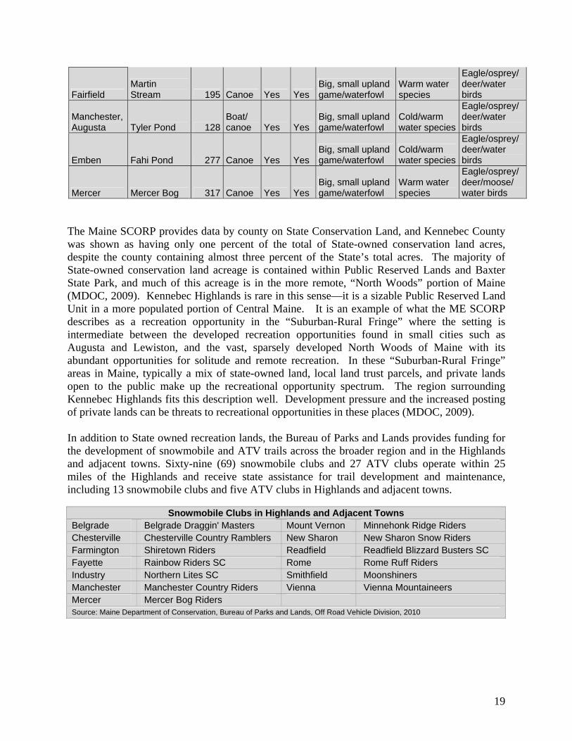
Also in the region are a number of Wildlife Management Areas, managed by Maine Dept. of Inland Fisheries and Wildlife, where fishing, hunting, trapping and wildlife observation are the featured recreation. The largest of these is the 4-parcel Garcelon Wildlife Management Area (4343 acres) in Augusta, Windsor and Vassalboro and the Chesterville Wildlife Management (1340 acres) area in Chesterville. Jamies Pond Wildlife Management Area (550 acres) in Manchester and Hallowell, also includes a trail system maintained by local volunteers. Boat access sites in these areas are included in the above list. Wildlife Management Areas in the Greater Kennebec Highlands Region
Recreational Uses
Town(s) Name Acres Boat/ Canoe
Fur Trap
Ice Fish Hunt Fish
Wildlife Watch
Chesterville Chesterville 1340 Canoe Yes Yes Big, small upland game/waterfowl
Warm water species
Eagle/osprey/deer/water birds
New Vineyard
Stump (Bauds) Pond 40 Canoe Yes Yes
Big, small upland game/waterfowl
Warm water species
Eagle/osprey/deer/moose/ water birds
Augusta Windsor Vassalboro
Alonzo H. Garcelon (4 Parcels) 4343 Canoe Yes Yes
Big, small upland game
Warm water species
Deer/water birds
Belgrade Gawler 363 . Yes Yes Big, small upland game
Cold water species Deer
Hallowell Manchester Jamies Pond 550
Boat/ canoe Yes Yes
Big, small upland game/waterfowl
Cold, warm water species
Eagle/osprey/deer/water birds
Blueberry Hill State Park Land
19
Fairfield Martin Stream 195 Canoe Yes Yes
Big, small upland game/waterfowl
Warm water species
Eagle/osprey/deer/water birds
Manchester, Augusta Tyler Pond 128
Boat/ canoe Yes Yes
Big, small upland game/waterfowl
Cold/warm water species
Eagle/osprey/deer/water birds
Emben Fahi Pond 277 Canoe Yes Yes Big, small upland game/waterfowl
Cold/warm water species
Eagle/osprey/deer/water birds
Mercer Mercer Bog 317 Canoe Yes Yes Big, small upland game/waterfowl
Warm water species
Eagle/osprey/deer/moose/ water birds
The Maine SCORP provides data by county on State Conservation Land, and Kennebec County was shown as having only one percent of the total of State-owned conservation land acres, despite the county containing almost three percent of the State’s total acres. The majority of State-owned conservation land acreage is contained within Public Reserved Lands and Baxter State Park, and much of this acreage is in the more remote, “North Woods” portion of Maine (MDOC, 2009). Kennebec Highlands is rare in this sense—it is a sizable Public Reserved Land Unit in a more populated portion of Central Maine. It is an example of what the ME SCORP describes as a recreation opportunity in the “Suburban-Rural Fringe” where the setting is intermediate between the developed recreation opportunities found in small cities such as Augusta and Lewiston, and the vast, sparsely developed North Woods of Maine with its abundant opportunities for solitude and remote recreation. In these “Suburban-Rural Fringe” areas in Maine, typically a mix of state-owned land, local land trust parcels, and private lands open to the public make up the recreational opportunity spectrum. The region surrounding Kennebec Highlands fits this description well. Development pressure and the increased posting of private lands can be threats to recreational opportunities in these places (MDOC, 2009). In addition to State owned recreation lands, the Bureau of Parks and Lands provides funding for the development of snowmobile and ATV trails across the broader region and in the Highlands and adjacent towns. Sixty-nine (69) snowmobile clubs and 27 ATV clubs operate within 25 miles of the Highlands and receive state assistance for trail development and maintenance, including 13 snowmobile clubs and five ATV clubs in Highlands and adjacent towns.
Snowmobile Clubs in Highlands and Adjacent Towns Belgrade Belgrade Draggin' Masters Mount Vernon Minnehonk Ridge Riders Chesterville Chesterville Country Ramblers New Sharon New Sharon Snow Riders Farmington Shiretown Riders Readfield Readfield Blizzard Busters SC Fayette Rainbow Riders SC Rome Rome Ruff Riders Industry Northern Lites SC Smithfield Moonshiners Manchester Manchester Country Riders Vienna Vienna Mountaineers Mercer Mercer Bog Riders Source: Maine Department of Conservation, Bureau of Parks and Lands, Off Road Vehicle Division, 2010

20
ATV Clubs in Highlands and Adjacent Towns
Farmington Western Maine ATV Club New Sharon New Sharon Area Riders Fayette Fayette Crossroads ATV Club Starks Starks Trail Riders Mt Vernon Mountain View ATV Club Source: Maine Department of Conservation, Bureau of Parks and Lands, Off Road Vehicle Division, 2010
Recreational Tourism in the Region The Kennebec Highlands region lies within the tourist market area known as the Kennebec and Moose River Valleys and directly on the border of the Maine Lakes & Mountains Region. The Kennebec and Moose River Valleys Region stretches from the state capital to the snowmobiling center of Jackman and includes popular whitewater rafting destinations near The Forks. The Maine Lakes and Mountains Region includes many of Maine’s “big lakes” and high mountain peaks near the New Hampshire border. Both regions feature opportunities for hiking, bicycling, camping, boating, fishing, hunting, snowmobiling and sightseeing. The Belgrade Lakes Region is one of the top destinations in the Kennebec and Moose River Valleys tourism area and is marketed as a destination for boating, fishing, hiking and touring. Located near a primary route to the Maine Lakes and Mountains (state Route 27), The Kennebec Highlands may draw visitors from tourist initiatives geared toward that region, as well. Tourism, and in particular outdoor recreation tourism, is a mainstay of Maine’s economy. Outdoor recreation is the primary purpose for between 18% and 23% (depending on season) of all overnight leisure trips in Maine. Outdoor recreation is the primary purpose of between 9% (winter) and 24% (summer) of leisure day trips. Both tourism regions are popular day and overnight travel destinations, with 10% of leisure travelers in Maine visiting the Lakes and Mountains region and 6% visiting Kennebec and Moose River Valley in 2008. (Davidson Peterson Associates, 2009 cited in MDOC, 2009) General Trends in Recreational Use The Maine State Comprehensive Outdoor Recreation Plan for 2009 to 2014 (ME SCORP) gives an overview of demand for and supply of outdoor recreation activities and lands in Maine. Among findings of the ME SCORP are that Maine residents participate in outdoor recreation activities at an overall higher rate than both national and regional averages, particularly in nature-based activities. Over 50% of Maine residents participate in walking for pleasure, viewing and photographing natural scenery and wildlife, swimming in lakes and streams, sightseeing, boating, and gathering berries, among other activities (USDOI and USDOC, 2006 cited in MDOC, 2009). Additionally Maine has a high proportion of non-residents that participate in outdoor recreation. An example of this is that Maine State Parks report approximately 40% non-resident camper registrations. The Maine Office of Tourism collects data in the form of information requests, and two-thirds of the top 36 information requests for 2008 involved outdoor recreation activities. Sightseeing, day hiking, foliage viewing, wildlife photography, fishing, canoeing and kayaking are in the top 20 (MDOC, 2009).

21
Trends in outdoor recreation identified through surveys, licenses, entrance figures and other methods show fluctuations across time and variations by type of activity and resource. Trends in Maine State Park day use and camping can be observed from the graphs below (MDOC, 2009). Overall use for camping and day use appears to be increasing, with variations from year to year. More recent data showed 2010 as the strongest year in Maine State Park history with the highest number of visitor days and the second highest number of camper nights since record keeping began.
Visitation to Acadia National Park, Baxter State Park, and North Maine Woods have shown declines since the mid-1990s, but with recent upticks since 2005 that may indicate a reversal of the downward trends (MDOC, 2009). The reasons for these declines are not completely known, but may be connected to the distance of these areas from population centers in southern Maine and much of Maine’s tourist market in the Northeastern U.S. Distance, combined with a trend toward heavier work schedules with less vacation time may be a contributing factor to the declines in these outdoor areas farther from population centers. Trends in the sale of recreation licenses and registrations were mixed. While the number of Mane motorboat registrations remained relatively stable from 1992 to 2008, the number of snowmobile registrations rose steadily until 2003, and has fluctuated based on weather since then. ATV registrations rose steadily from1992 until 2004, and they have fluctuated slightly every year since then.. The number of annual hunting licenses issued appears relatively stable, and the number of fishing licenses has been steadily increasing since 2005 (MDOC, 2009).

22
Planning Implications The Kennebec Highlands fills an important niche in providing a semi-remote recreation experience and large block of undeveloped wildlife habitat in a more heavily populated part of Maine. Located within a short distance of the population centers of Augusta, Waterville, Farmington and Skowhegan, the recreation opportunities are important to these cities as well as the year-round population in Highlands and adjacent towns and the seasonal population and tourists to the region. Use of the Highlands and surrounding recreation lands is expected to grow at a modest rate, as populations grow (both seasonal and permanent) and tourism increases, and as development decreases the amount of open space available to the public for recreation. Kennebec Highlands is well poised to provide many of the activities desired by both Maine residents and visitors—namely day hiking, sightseeing, photographing natural scenery and wildlife, boating, gathering berries, hunting, fishing, ATV riding and snowmobile riding. When projecting future visitation trends, it may be more appropriate to compare Kennebec Highlands to state park figures on day use due to its proximity to population centers (though no fees are collected at the Highlands and no visitor numbers are known). State park day use numbers have fluctuated some, declining from 2001-2005, but have grown since 2005 with their highest number ever in 2010. The Highlands is in some ways more similar to a state park, as it is easily accessible from public roads and located closer to population centers than most public reserved lands. Public reserved lands—in which a variety of recreational opportunities is open to the public generally at no charge and there is a generally low Bureau staff presence—are particularly rare in central Maine. The Kennebec Highlands is an atypical public reserved land for this reason—because it is close to population centers in Central Maine and easy to access by a variety of public roads. Somewhat high visitation levels and demand for a variety of uses presents challenges for Bureau management, and the Kennebec Highlands will continue to thrive on partnerships in recreation management. The BRCA will continue to be vital partners in on-the-ground trail and non-motorized recreation management. Snowmobile clubs—the Rome Ruff Riders and the Vienna Mountaineers—remain critical partners in maintaining the snowmobile trails and work collaboratively with the Bureau’s Off Road Vehicle Program. The Mountain View ATV Club will be a new partner in upgrading and maintaining a trail system travelling through west side of the Highlands in collaboration with the Bureau’s ATV coordinator and the Kennebec Highlands Public Reserved Land Manager. The Kennebec Highlands is a large landscape open to the public for a variety of uses—with enough space to provide for both non-motorized and motorized uses. Remote hiking opportunities with views are particularly scarce in the region surrounding Augusta and Waterville. Expanding the non-motorized trail system—for hiking, but also for mountain biking —is important to serve the community of users in this relatively high population area. Though boating is not a major component of the Kennebec Highlands experience, as many boating opportunities are provided on the larger lakes in region, the opportunity to hand carry boats in to McIntire Pond provides a remote trout pond fishing experience that is more typically found in the North Woods and sought after by anglers.

23
Snowmobiling is a popular Maine activity that is provided in the Kennebec Highlands, which allows for the protection and continuation of snowmobile routes authorized by previous Highlands landowners and maintained by local snowmobile clubs. Routes in the Highlands provide a family-friendly route apart from the busier ITS trails, yet allows for connectivity within the ITS. ATV riding is also a popular activity in Maine and the increasing number of clubs, improving landowner relations and growing network of trails are improving opportunities for ATV riders statewide. The Kennebec Highlands contributes to the growth of this recreational activity by providing an ATV route that connects trails in Mt. Vernon to trails in Farmington and Jay. Partnerships with clubs will be vital in trail maintenance and landowner relations. The Bureau’s planning for the Kennebec Highlands carefully considered the broader picture of demographics, recreational trends and other opportunities in the region, ecology, wildlife management, tourism. Management recommendations and resource allocations in this plan reflect responsiveness to the broader needs in the surrounding region and a celebration of the niche the Highlands provides.

24
25
III. Character and Resources of Kennebec Highlands
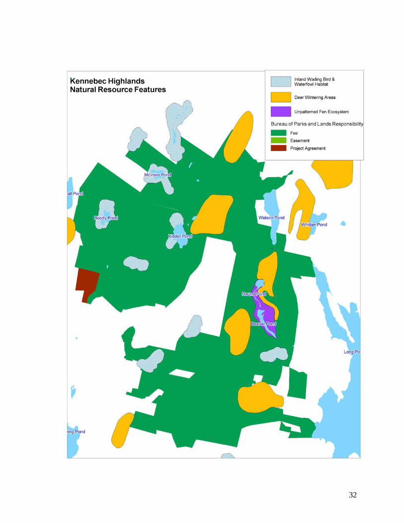
Character of the Land Base The 6,075 acre Kennebec Highlands features remote ponds, streams, rolling uplands, several low mountains and two parcels with frontage on Long Pond in the Belgrade chain of lakes. Uplands are forested with early- to mid-successional growth, and most have a relatively recent history of timber harvest or other human intervention such that undisturbed upland settings are scarce. Several small, undeveloped ponds on the Highlands provide important native fish habitat. Other features include deer wintering areas, wading bird and waterfowl habitat, and an exemplary wetland ecosystem. At present, Kennebec Highlands’ primary conservation values are as undeveloped open space, undeveloped ponds, and wildlife habitat. The Kennebec Highlands is easily accessed as it is close to State Routes 27 and 41 and the property itself has between one and two miles of paved public road frontage on Watson Pond Road. Within the Highlands, there is an extensive network of field and woods roads in varying states of repair some of which probably carry public easements due to their former status as town roads. Early land use of the Highlands was for farming and forestry. Surviving stonewalls, foundation remnants, old roads and the condition of the present forest all attest to these past uses. Succeeding recreational uses have included fishing, hunting, hiking, primitive camping, skiing, snowshoeing, horseback riding, cycling, scenic viewing, berry picking, snowmobiling, and ATV riding. Natural Resources Geology and Soils A variety of metamorphic rocks and granite underlie the Vienna Mountain area west of Great and Long Ponds in Belgrade. The metamorphic rocks were originally heterogeneous units of sand and mud, with some limy layers, that were deposited in an ocean adjacent to North American about 435 million years ago. A collision between a microcontinent and the North American margin around 400 million years ago built the largest mountains ever to exist here and also consumed the ocean basin, contorting and metamorphosing the sedimentary materials. The thickening of continental crust that accompanies such collisions caused the lower crust to partially melt. The more buoyant magma then migrated upward to mid-crustal levels before cooling into granite. The heat that accompanied the granite intrusion additionally metamorphosed the rocks it contacted, creating metamorphic rock that is highly resistant to erosion. Nearly 400 million years of erosion followed, culminating with Nature’s greatest agent of erosion – glacial ice – to expose the granite and metamorphic rocks at the surface of the Earth (Marvinney, 2007 cited in Wilkerson, 2007, p. 5).

26
The high ground of this tract of land is underlain with the more resistant metamorphic rocks, including quartzite, schist, and metamorphosed limy sediments called calc-silicate rock. A dark gray schist and metasandstone unit exposed just west of the summit of Roberts Hill and on the western slopes of McGaffey Mountain contains abundant sulfide minerals that produce a rusty weathering rind and often give rocks an orangey hue. Geologic forces contorted the original horizontal layering of these rocks such that it is now tilted on edge and aligned in a northeast-southwest direction. The distribution of these units and the orientation of layering is the primary control on topography in the area. On the east and northwest sides, the lower slopes of these hills are underlain with granite, which is less resistant to weathering and erosion. This granite is medium grained, with abundant quartz, orthoclase and plagioclase feldspars, and both biotite and muscovite micas. These so-called two-mica granites typically have substantial quantities of naturally occurring uranium (Marvinney, 2007 cited in Wilkerson, 2007, p. 5). Sculpting by glaciers during the last 2 million years has rounded the hills, imparting a secondary northwest-oriented streamlining to some (particularly those underlain with granite). Thin, sandy glacial till drapes over most of the lower to intermediate slopes of the hills, with most of the summit areas having abundant rock exposures. Post-glacial swamp materials underlie the low-lying areas (Marvinney, 2007 cited in Wilkerson, 2007, p. 5). Soils at Kennebec Highlands formed in glacial till and the underlying bedrock. The two most common soil types on the Highlands are Lyman loam and Berkshire very stony fine sandy loam. The Lyman series is characterized by shallow, somewhat excessively drained soils that developed in a thin mantle of glacial till and frost fractured rock fragments. The Berkshire series consists of very deep well drained soils on glaciated uplands (Wilkerson, 2007). Hydrology and Water Quality Ponds in the Kennebec Highlands include McIntire Pond, Kidder Pond, and Boody Pond in the western half of the area, and the Round Pond – Beaver Pond complex in the eastern portion. The Kennebec Highlands borders Watson Pond, which has camps along its east side but is otherwise undeveloped. Long Pond, a major lake in the Belgrade Lakes chain, lies to the east. The western half of the unit is part of the Androscoggin River watershed, via Hopkins Stream and Androscoggin Lake. The eastern half of the Highlands is part of the Kennebec River watershed via Long Pond (Wilkerson, 2007). Several of the ponds at Kennebec Highlands have been selected by The Nature Conservancy as portfolio lakes, meaning they are high value waters that best represent the ecosystems, natural communities, and species characteristic of the region. Criteria used in evaluating lakes and ponds include water quality, dam impacts, presence of rare or noteworthy species, rarity, and remoteness. Portfolio lakes in the Kennebec Highlands include Beaver Pond, Round Pond, McIntire Pond, and Boody Pond (Wilkerson, 2007).

27
Wetlands The relatively steep, narrow drainages within the Highlands do not lend themselves to the creation of large wetlands. Kennebec Highlands has 337 acres of wetlands, only 97 of which are forested. These wetlands tend to surround ponds or be in small, isolated pockets along drainages. The largest wetland in the Highlands is the exemplary Unpatterned Fen Ecosystem that surrounds Beaver and Round Ponds (Wilkerson, 2007). Ecological Processes Human use has had a profound impact on the landscape and constitutes one of the major disturbances on the Highlands. Homesteads established in the late 1800s have left a lasting imprint on the landscape and clearing of areas for agriculture and pasture likely affected soil structure. Heavy harvests in recent times may mask other natural disturbance patterns such as blow-downs (Wilkerson, 2007). Portions of the forest on the Highlands were heavily damaged in the 1998 ice storm. Damage is worst on east and north-facing slopes and is less noticeable west of Vienna and McGaffey Mountains. Isolated lightning strikes have likely occurred on the Highlands, though no large-scale fires are known. Small fires, such as those caused by lightening strikes, open up patches of forest that are typically recolonized by fast growing, short lived species such as aspen and paper birch. This patchy disturbance contributes to an uneven and diverse forest canopy (Wilkerson, 2007). Beaver activity has been noted along many of the drainages in the Highlands. Beavers build dams to give them safe access to the hardwoods they prefer to eat. When active, beaver ponds flood adjoining uplands, enlarging wetlands and creating new areas for wetland species to colonize. Once the hardwoods within a safe distance of the pond are gone, beavers often abandon their dam and build a new dam in a different location. These abandoned ponds typically slowly fill with sediment and transition from marshy wetlands back to uplands. By creating and abandoning impoundments along the stream course, beavers create a mosaic of habitats for other plant and wildlife species (Wilkerson, 2007). Fisheries and Wildlife The Kennebec Highlands are a designated “Focus Area of Ecological Significance,” under the Beginning with Habitat (BWH) program administered by Department of Inland Fisheries and Wildlife. BWH provides information to support the retention of wildlife habitat needed to sustain Maine’s wildlife species. Many features qualify the Highlands as a focus area: undeveloped ponds; abundant riparian areas (transition zones between aquatic habitats and wetlands and dry or upland habitats); significant wildlife habitats (deer wintering areas and wading bird and waterfowl habitat); an exemplary natural community (unpatterned open-basin fen ecosystem); and a rare plant site (alpine club moss). However, most important is its size and lack of building development and permanent roads. Large blocks of land are important to species with large
28
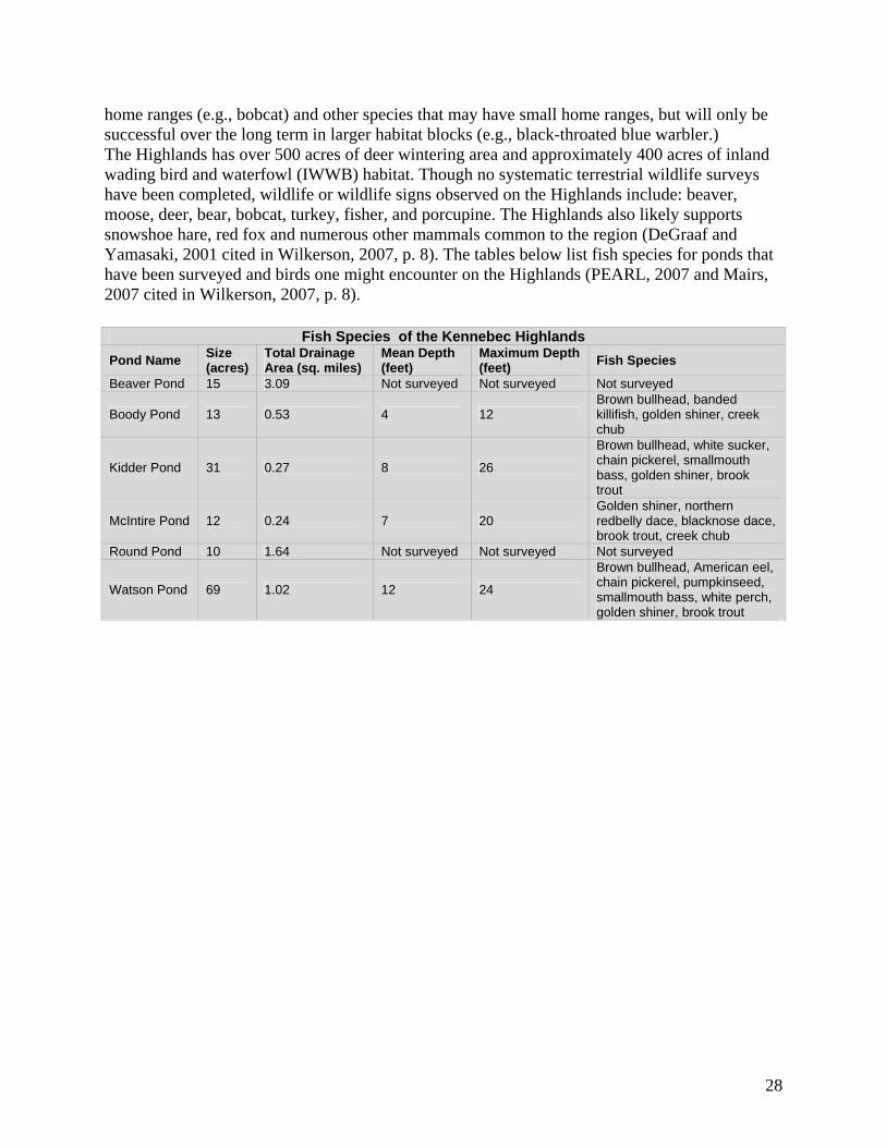
home ranges (e.g., bobcat) and other species that may have small home ranges, but will only be successful over the long term in larger habitat blocks (e.g., black-throated blue warbler.) The Highlands has over 500 acres of deer wintering area and approximately 400 acres of inland wading bird and waterfowl (IWWB) habitat. Though no systematic terrestrial wildlife surveys have been completed, wildlife or wildlife signs observed on the Highlands include: beaver, moose, deer, bear, bobcat, turkey, fisher, and porcupine. The Highlands also likely supports snowshoe hare, red fox and numerous other mammals common to the region (DeGraaf and Yamasaki, 2001 cited in Wilkerson, 2007, p. 8). The tables below list fish species for ponds that have been surveyed and birds one might encounter on the Highlands (PEARL, 2007 and Mairs, 2007 cited in Wilkerson, 2007, p. 8).
Fish Species of the Kennebec Highlands
Pond Name Size (acres)
Total Drainage Area (sq. miles)
Mean Depth (feet)
Maximum Depth (feet)
Fish Species
Beaver Pond 15 3.09 Not surveyed Not surveyed Not surveyed
Boody Pond 13 0.53 4 12 Brown bullhead, banded killifish, golden shiner, creek chub
Kidder Pond 31 0.27 8 26
Brown bullhead, white sucker, chain pickerel, smallmouth bass, golden shiner, brook trout
McIntire Pond 12 0.24 7 20 Golden shiner, northern redbelly dace, blacknose dace, brook trout, creek chub
Round Pond 10 1.64 Not surveyed Not surveyed Not surveyed
Watson Pond 69 1.02 12 24
Brown bullhead, American eel, chain pickerel, pumpkinseed, smallmouth bass, white perch, golden shiner, brook trout

29
Bird Species of the Kennebec Highlands
Expected Species Species
Probably Present
Canada Goose Herring Gull Common Raven Black-and-white Warbler Mallard
Wood Duck Mourning Dove Tree Swallow American Redstart Common Goldeneye
American Black Duck Black-billed Cuckoo
Black-capped Chickadee Ovenbird Green Heron
Green-winged Teal Great Horned Owl Tufted Titmouse
Northern Waterthrush Merlin
Ring-necked Duck Barred Owl
Red-breasted Nuthatch
Common Yellowthroat Virginia Rail
Hooded Merganser
Northern Saw-whet Owl
White-breasted Nuthatch Canada Warbler
Greater Yellowlegs
Common Merganser
Ruby-throated Hummingbird Brown Creeper Scarlet Tanager Solitary Sandpiper
Ruffed Grouse Belted Kingfisher House Wren Eastern Towhee Rock Pigeon
Wild Turkey Yellow-bellied Sapsucker Winter Wren
American Tree Sparrow
Common Nighthawk
Common Loon Downy Woodpecker Eastern Bluebird Chipping Sparrow Brown Thrasher American Bittern Hairy Woodpecker Veery
Savannah Sparrow
Tennessee Warbler
Great Blue Heron Northern Flicker Hermit Thrush Fox Sparrow
Cape May Warbler
Osprey Pileated Woodpecker Wood Thrush Song Sparrow Palm Warbler Bald Eagle Olive-sided Flycatcher American Robin Swamp Sparrow Mourning Warbler
Northern Harrier Eastern Wood-Pewee Gray Catbird White-throated Sparrow Wilson’s Warbler
Sharp-shinned Hawk Alder Flycatcher European Starling Dark-eyed Junco Field Sparrow
Cooper’s Hawk Least Flycatcher Cedar Waxwing Rose-breasted Grosbeak Lincoln’s Sparrow
Northern Goshawk Eastern Phoebe Nashville Warbler
Red-winged Blackbird
White-crowned Sparrow
Red-shouldered Hawk
Great Crested Flycatcher Northern Parula Common Grackle Northern Cardinal
Broad-winged Hawk Eastern Kingbird Yellow Warbler
Brown-headed Cowbird Indigo Bunting
Red-tailed Hawk Northern Shrike
Chestnut-sided Warbler Baltimore Oriole Pine Grosbeak
American Kestrel Blue-headed Vireo Magnolia Warbler Purple Finch Evening GrosbeakPeregrine Falcon Warbling Vireo
Black-throated Blue Warbler Red Crossbill
Sora Red-eyed Vireo Yellow-rumped Warbler
White-winged Crossbill
Spotted Sandpiper Blue Jay
Black-throated Green Warbler Common Redpoll
American Woodcock American Crow Blackburnian Warbler Pine Siskin
Pine Warbler American Goldfinch
30
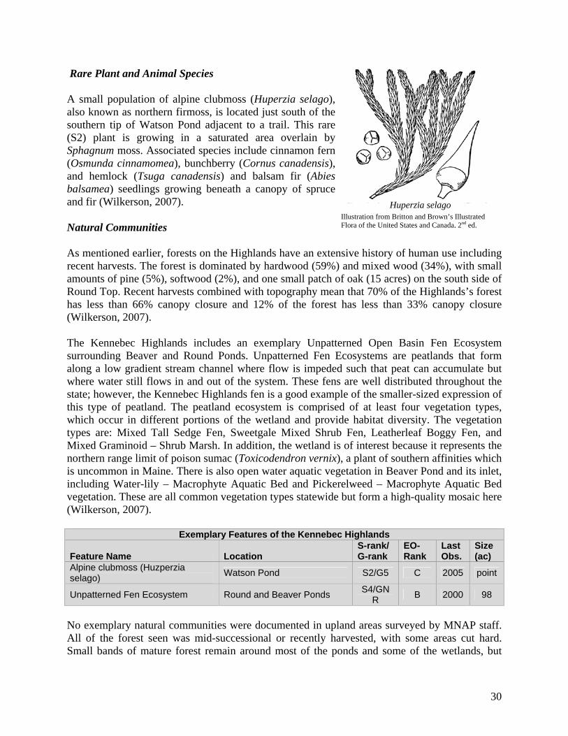
Rare Plant and Animal Species
A small population of alpine clubmoss (Huperzia selago), also known as northern firmoss, is located just south of the southern tip of Watson Pond adjacent to a trail. This rare (S2) plant is growing in a saturated area overlain by Sphagnum moss. Associated species include cinnamon fern (Osmunda cinnamomea), bunchberry (Cornus canadensis), and hemlock (Tsuga canadensis) and balsam fir (Abies balsamea) seedlings growing beneath a canopy of spruce and fir (Wilkerson, 2007). Natural Communities As mentioned earlier, forests on the Highlands have an extensive history of human use including recent harvests. The forest is dominated by hardwood (59%) and mixed wood (34%), with small amounts of pine (5%), softwood (2%), and one small patch of oak (15 acres) on the south side of Round Top. Recent harvests combined with topography mean that 70% of the Highlands’s forest has less than 66% canopy closure and 12% of the forest has less than 33% canopy closure (Wilkerson, 2007). The Kennebec Highlands includes an exemplary Unpatterned Open Basin Fen Ecosystem surrounding Beaver and Round Ponds. Unpatterned Fen Ecosystems are peatlands that form along a low gradient stream channel where flow is impeded such that peat can accumulate but where water still flows in and out of the system. These fens are well distributed throughout the state; however, the Kennebec Highlands fen is a good example of the smaller-sized expression of this type of peatland. The peatland ecosystem is comprised of at least four vegetation types, which occur in different portions of the wetland and provide habitat diversity. The vegetation types are: Mixed Tall Sedge Fen, Sweetgale Mixed Shrub Fen, Leatherleaf Boggy Fen, and Mixed Graminoid – Shrub Marsh. In addition, the wetland is of interest because it represents the northern range limit of poison sumac (Toxicodendron vernix), a plant of southern affinities which is uncommon in Maine. There is also open water aquatic vegetation in Beaver Pond and its inlet, including Water-lily – Macrophyte Aquatic Bed and Pickerelweed – Macrophyte Aquatic Bed vegetation. These are all common vegetation types statewide but form a high-quality mosaic here (Wilkerson, 2007).
Exemplary Features of the Kennebec Highlands
Feature Name Location S-rank/ G-rank
EO-Rank
Last Obs.
Size (ac)
Alpine clubmoss (Huzperzia selago)
Watson Pond S2/G5 C 2005 point
Unpatterned Fen Ecosystem Round and Beaver Ponds S4/GN
R B 2000 98
No exemplary natural communities were documented in upland areas surveyed by MNAP staff. All of the forest seen was mid-successional or recently harvested, with some areas cut hard. Small bands of mature forest remain around most of the ponds and some of the wetlands, but
Huperzia selago
Illustration from Britton and Brown’s Illustrated Flora of the United States and Canada, 2nd ed.
31
these forests are not extensive enough to be considered exemplary. They do, however, provide important buffer functions (Wilkerson, 2007). Given sufficient time to develop, some of the upland areas could become good representative natural forests. At present, Kennebec Highlands’ primary conservation values are as undeveloped open space, undeveloped ponds, and large unfragmented habitat (Wilkerson, 2007). Further fieldwork conducted in June 2007 has resulted in no changes or additions to the description of natural resources on the Highlands. Natural Resource Issues Management and recreation activities in or adjacent to exemplary features—the Unpatterned Fen Ecosystem or the alpine clubmoss population—require sensitivity to the needs of these natural resources. One of the prime ecological values of Kennebec Highlands is the comparative lack of permanent roads and other fragmenting features, located in a part of the state that is developing rapidly. Its status as a relatively large habitat block makes it important to species with large home ranges. The challenges involve accommodating recreation use, forestry and other management activities, but avoiding adverse impacts to wildlife habitat that may result from fragmenting features such as paved roads, new gravel roads or structures. Maintaining the high quality of the numerous small ponds on the Kennebec Highlands requires buffering the ponds, brooks and wetlands from roads, and conducting forestry that maintains appropriate shading for streams and ponds, and minimizes erosion and siltation. Many of the currently existing roads are close to the ponds, running through wetlands or streams without proper culverts, or on steep slopes. Some were in poor shape when the State acquired the property, and continue to have erosion problems. Some have been shown to probably have public rights. The Bureau must manage these public rights in a way that provides public vehicular access while protecting water quality. There are over 500 acres of mapped deer wintering area, however, much of the viable winter deer cover had been cut prior to state ownership. Additionally, overall high trail density and certain types of winter recreational use, especially pedestrian uses, could have adverse impacts on the current or potential value of these areas as deer habitat.
32
33
Historic and Cultural Resources Prehistory of the Belgrade Lakes Region
There are no known prehistoric sites in Rome, Vienna or Mount Vernon, and only one in New Sharon. The Kennebec Highlands includes a number of small ponds and brooks, as well as limited frontage on Long Pond. Most of the small water bodies are not canoe-navigable, nor are they interconnected as might be expected of known Native American routes. Little is known about prehistoric settlement and subsistence in small watersheds (Mosher and Cramner, 2004).
Paleoindians, the first people to settle Maine, arrived at the end of the last ice age. These hunter-gatherers hunted a variety of game and apparently traveled great distances to obtain high-quality stone for making spear points and other tools. Paleoindian sites are rare statewide, but there are two known sites in or near the Belgrade Lakes region: the Dam site in Wayne (Spiess, Wilson and Bradley, 1998 cited in Mosher and Cramner, 2004), and a possible fluted-point site in Farmington. Each is situated on outwash or dune sands away from major rivers. Very few Paleoindian sites in the New England-Maritimes are situated on till soils like those found in the Kennebec Highlands (Mosher and Cramner, 2004).
The Archaic period (10,000 to 3000 years ago) is distinguished by the production and use of ground stone woodworking tools and the development of a burial tradition using red ocher. Settlement patterns in the period changed dramatically toward sites on canoe-navigable waters, and in combination new woodworking tools, suggest that boat travel became important. Major changes in subsistence also occurred: fishing apparently became important, and warmer, drier conditions may have encouraged expanded reptile populations, as snakes and turtles became fare. There are two Early or Middle Archaic sites in the Belgrade Lakes region, and four or five more nearby. The sites are located on both lakeshores and riverbanks. During the Late Archaic period (6000-3000 BP) there were several archaeological cultures in Maine, but only the Susquehanna and Laurentian traditions are represented at sites in the Belgrade Lakes region (Mosher and Cramner, 2004).
By around 3000 years ago, an essentially modern landscape and climate developed in Maine. Fired-clay pottery technology was adopted. While fragile and time-consuming to make, pots could be placed directly in the fire, unlike earlier containers. There are hundreds of Ceramic period sites in Maine, but only seven in the Belgrade Lakes region: three are known from private collections, and the rest were identified during a phase I survey at Farmington Falls by the University of Maine at Farmington (Cyr et al. 2003, cited in Mosher and Cramner, 2004).
The Contact period refers to the time when Native Americans first encountered European culture on a sustained basis. The nearest Contact period sites to the Kennebec Highlands are clustered at Farmington Falls (Cyr et al. 2003 cited in Mosher and Cramner, 2004).
34
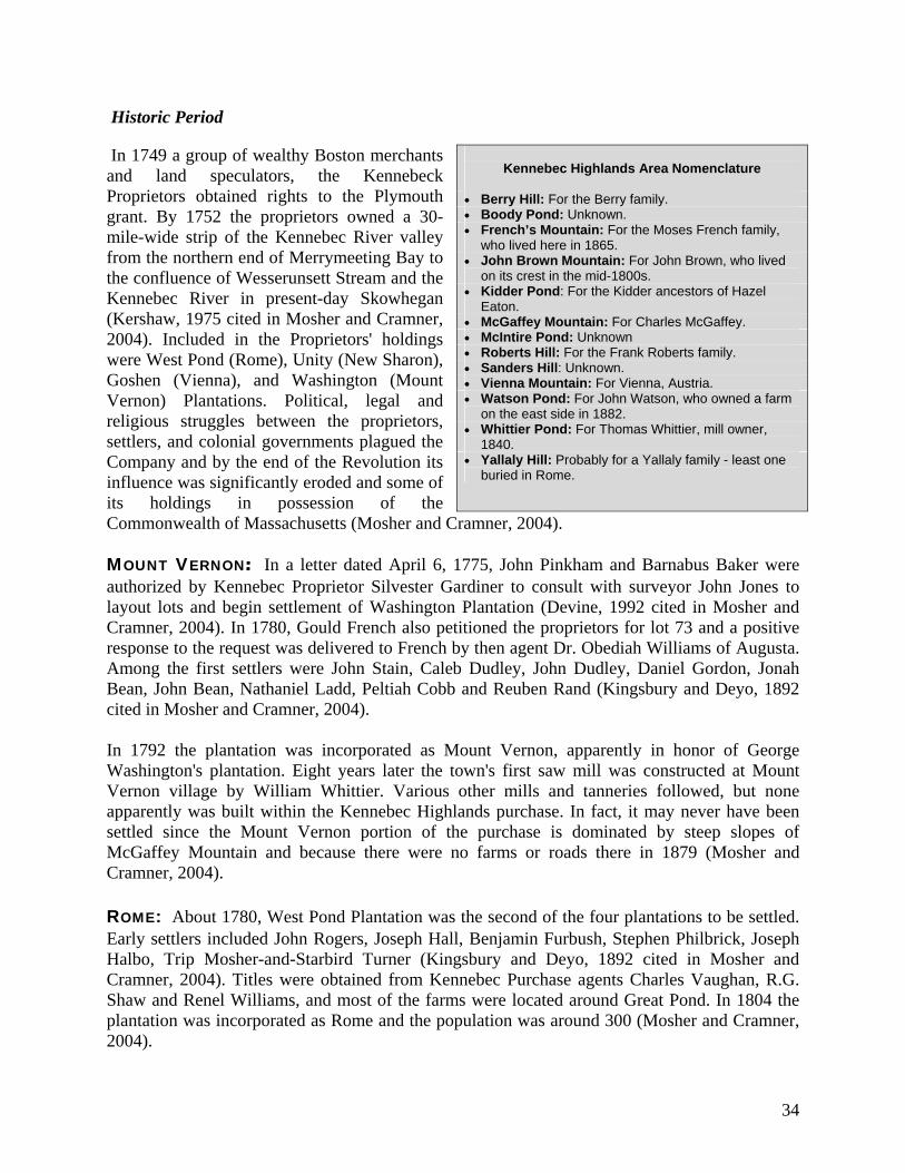
Historic Period
In 1749 a group of wealthy Boston merchants and land speculators, the Kennebeck Proprietors obtained rights to the Plymouth grant. By 1752 the proprietors owned a 30-mile-wide strip of the Kennebec River valley from the northern end of Merrymeeting Bay to the confluence of Wesserunsett Stream and the Kennebec River in present-day Skowhegan (Kershaw, 1975 cited in Mosher and Cramner, 2004). Included in the Proprietors' holdings were West Pond (Rome), Unity (New Sharon), Goshen (Vienna), and Washington (Mount Vernon) Plantations. Political, legal and religious struggles between the proprietors, settlers, and colonial governments plagued the Company and by the end of the Revolution its influence was significantly eroded and some of its holdings in possession of the Commonwealth of Massachusetts (Mosher and Cramner, 2004).
MOUNT VERNON: In a letter dated April 6, 1775, John Pinkham and Barnabus Baker were authorized by Kennebec Proprietor Silvester Gardiner to consult with surveyor John Jones to layout lots and begin settlement of Washington Plantation (Devine, 1992 cited in Mosher and Cramner, 2004). In 1780, Gould French also petitioned the proprietors for lot 73 and a positive response to the request was delivered to French by then agent Dr. Obediah Williams of Augusta. Among the first settlers were John Stain, Caleb Dudley, John Dudley, Daniel Gordon, Jonah Bean, John Bean, Nathaniel Ladd, Peltiah Cobb and Reuben Rand (Kingsbury and Deyo, 1892 cited in Mosher and Cramner, 2004). In 1792 the plantation was incorporated as Mount Vernon, apparently in honor of George Washington's plantation. Eight years later the town's first saw mill was constructed at Mount Vernon village by William Whittier. Various other mills and tanneries followed, but none apparently was built within the Kennebec Highlands purchase. In fact, it may never have been settled since the Mount Vernon portion of the purchase is dominated by steep slopes of McGaffey Mountain and because there were no farms or roads there in 1879 (Mosher and Cramner, 2004). ROME: About 1780, West Pond Plantation was the second of the four plantations to be settled. Early settlers included John Rogers, Joseph Hall, Benjamin Furbush, Stephen Philbrick, Joseph Halbo, Trip Mosher-and-Starbird Turner (Kingsbury and Deyo, 1892 cited in Mosher and Cramner, 2004). Titles were obtained from Kennebec Purchase agents Charles Vaughan, R.G. Shaw and Renel Williams, and most of the farms were located around Great Pond. In 1804 the plantation was incorporated as Rome and the population was around 300 (Mosher and Cramner, 2004).
Kennebec Highlands Area Nomenclature
Berry Hill: For the Berry family. Boody Pond: Unknown. French’s Mountain: For the Moses French family,
who lived here in 1865. John Brown Mountain: For John Brown, who lived
on its crest in the mid-1800s. Kidder Pond: For the Kidder ancestors of Hazel
Eaton. McGaffey Mountain: For Charles McGaffey. McIntire Pond: Unknown Roberts Hill: For the Frank Roberts family. Sanders Hill: Unknown. Vienna Mountain: For Vienna, Austria. Watson Pond: For John Watson, who owned a farm
on the east side in 1882. Whittier Pond: For Thomas Whittier, mill owner,
1840. Yallaly Hill: Probably for a Yallaly family - least one
buried in Rome.

35
. The town's first grist mill was constructed before 1820 by Joel Richardson on Robbins Mills Stream, which empties into Great Pond. The first saw mill on the outlet of Watson Pond (then known as Allen Pond) was constructed by Thomas Whittier in 1840. Six years later Whittier built a shingle mill that he operated for 15 years before tearing it down (Kingsbury and Deyo 1892 cited in Mosher and Cramner, 2004). Settlement along Watson Pond Road, which forms the eastern boundary of the Kennebec Highlands property, probably began by 1820, and some of the early families included the Chesleys, Watsons, Prescotts and Philbricks. The Trasks apparently arrived sometime before the 1830 census was taken. The Wilts, Browns, Farnhams and Wards, whose cellar holes were identified during phase I survey, settled later (Mosher and Cramner, 2004). NEW SHARON: New Sharon was part of a tract granted by Massachusetts to the representatives of Captain William Tyng and company in recognition for services during the first winter of Queen Anne's War in 1703. Known initially as Tyngstown, it later was known as Carr Plantation (Cass Plantation in the 1790 census), then Unity Plantation. The first settler was Prince Baker, a Pembroke, Massachusetts native who built a cabin in 1783. Baker accumulated several hundred acres of the plantation, and then sold parcels off to later settlers. Surveyor Jedidiah Prescott was appointed to initiate purchase and in 1791the township was granted to Prince Baker and others by Massachusetts. In 1794 the town was incorporated as New Sharon in honor of Sharon, Massachusetts from which many of the early settlers had emigrated (Kearney and Bonney, 1981 cited in Mosher and Cramner, 2004). The first settler on the Kimball Pond Road leading to the Kennebec Highlands purchase was Christopher Dyer who built a house in 1797. Others followed including Henry McIntire whose farm was located about halfway between McIntire and Kimball Ponds. The McIntires, Henry and/or Henry Jr. were recorded by New Sharon census takers from 1850 to 1880, so they likely established their farms sometime after 1840. When comparing the 1861 town map to the modern topographic sheet, it appears that neither the McIntires nor their closest neighbors in New Sharon lived on what is now Kennebec Highlands land. By 1910, the road leading to McIntire Pond was long abandoned and the nearest house standing in New Sharon was owned by W.G. Rand (Mosher and Cramner, 2004).

36
.
VIENNA: English settlement in Vienna began sometime around 1780, when the Withees, Thompsons and Wymans built cabins. About 1786, the surveyor Jedidiah Prescott and his brother-in-law Nathaniel Whittier purchased much of Wyman's Plantation for about 10 cents an acre (Smith, 1985 cited in Mosher and Cramner, 2004). Soon after, Prescott and Whittier sold the first parcels to Joshua Howland, John Thompson, Patrick Galbraith, Noah Prescott, John Allen and William Allen. These settlers were soon followed by Arnold Wethren, James Cofren, Robert Cofren, Jonathan Gordon, Gideon Wells, Elijah Bunker, Daniel Matthews, Benjamin Porter, Timothy White, Caleb Brown and Joshua Moore (Kingsbury and Deyo 1892 cited in Mosher and Cramner, 2004). Perhaps because of Prescott and Whittier's land speculation, in 1788 Abram Wyman petitioned the Commonwealth of Massachusetts to grant him and his four sons a sufficient amount of land as a reward for bridge construction, land clearing and road building in the plantation (Smith 1985 cited in Mosher and Cramner, 2004). While the Wymans stayed in Vienna, neither Whittier nor Prescott settled there. Whittier gave lots to sons Jedediah, Abel, Nathaniel, and Levi, daughters Dorothy Johnson, Ruhamah Whittier, and Hannah Whittier, and grandsons Nathaniel Cochran and Cyrus Whittier upon his death in 1798 (Patterson, 1895 cited in Mosher and Cramner, 2004). The first grist mill and dam was constructed in Vienna village in 1800 by Patrick Galbraith. By 1870 the mill was owned and operated by George H. Mooers. One of the first saw mills was built
Chimney Base on Kennebec Highlands (photo from Mosher and Cramner, 2004)
37
on McGurdy Stream south of Boody Pond by Nathaniel Cochran and Arnold Wethren. It does not appear that any mills were constructed within the Kennebec Highlands purchase (Mosher and Cramner, 2004). At least a score of family farms and a school house were located in the Kennebec Highlands of Vienna in 1879. Some of the families were residents of Vienna since around 1800, such as the Brayleys, Mooers, and Wells. Others like Crowell Merchant and William Atkins, whose cellar holes are located in the purchase on the east side of Kimball Pond, may have moved to Vienna after 1860 (Mosher and Cramner, 2004). Land Use and Harvest History The Kennebec Highlands includes old homesteads and pasture land, as evidenced by numerous stone walls and old foundations. During the 2003 Phase I archaeological survey by the Maine Historic Preservation Commission (MHPC) for the Kennebec Highlands Project, 15 homesteads were mapped, and it was reported that the 1897 town maps of Vienna and Rome indicate that the remains of at least 20 houses and two schools may be within the parcel (Mosher and Cranmer 2004). It is estimated that as much as one-quarter of the Kennebec Highlands parcel may have been cleared for agriculture and pasture at one time (Alexander, 2007 cited in Mosher and Cramner, 2004). In addition, diversion ditches were dug from Kidder Pond to the Mill Stream watershed and from Round Pond to the Watson Pond drainage; both presumably served to provide more water to small mills downstream (Alexander, 2007 cited in Mosher and Cramner, 2004). Timber has been harvested multiple times, including recent heavy harvests that occurred prior to state acquisition of the Highlands. In 2009, a follow-up report was done my MHPC, titled “Finding What Was Lost: 19th Century Rural Life in the Kennebec Highlands of West Central Maine.” This reported findings from additional surveying in 2008, which mapped homesteads missed during the 2003 survey. An additional 10 farmsteads and a schoolhouse were mapped, and a small dig was performed at the Elias Farnham site on the former Dolley property now owned by the BRCA. “Finding What Was Lost” also described the people and families that inhabited these old farmsteads, sketching what stories could be pieced together from population and agricultural census reports from the 19th Century together with findings from surveys.

38
Historic Sites on the Kennebec Highlands MHPC has identified 35 farmhouse cellars and barn foundations in or adjacent to the Kennebec Highlands. Roads and stone fences that cross the landscape also may add to the historical knowledge of the region. Each farmstead may not in itself be considered to contribute significant information about the past. However, looked at collectively, these sites represent a microcosm of 19th Century rural Maine life and have potential to contribute considerable knowledge about our past. (Mosher and Cramner, 2009) Approximately 23 of these sites lye with in the Kennebec Highlands Public Lands borders. These and other adjacent sites may be considered for future shovel testing as they all have potential to contain significant archeological remains (Mosher, personal communication). Historic and Cultural Resource Issues The remains of the 19th-century homesteads could be impacted by increased use of trails, trail upgrades, sign posts or other alterations in the future. Increased recreational use increases the vulnerability of the sites to collecting/theft as has already occurred on some sites. Timber harvesting activities also have the potential to impact these sites if not done carefully. MHPC is planning future shovel testing—on some sites to assess the integrity of cultural deposits, and more in depth follow-up on sites that show intact archeological deposits.
Example of mapped farmstead from Mosher and Cramner, 2009

39
Recreation Resources The features of the Kennebec Highlands that make it an unusual and attractive area for outdoor recreation in this area include:
its overall size as public land in central Maine; its lack of building development and permanent roads; a varied terrain that includes multiple elevations and lowlands; scenic views of lakes and distant mountains from a variety of locations on the present
ownership and on abutting private land within the Kennebec Highlands Project area; five undeveloped ponds on its interior, some with important sport fisheries, and frontage
on Long Pond; deer wintering areas and waterfowl habitat that support hunting; a network of old field and woods roads – estimates range from nine to ninety miles – that
provide routes for a variety of trail activities; other sites of interest, including blueberry fields and remnants of former farmsteads; and access to the Highlands from public or private roads with public easements.
Recreation Resources Experience The current recreational experience over much of the Highlands is of a semi-remote “back woods” based on a forest returning after a long history of farming and former heavy timber harvests. The quality of remoteness ranges from most remote in the area generally between Boody, Kidder and McIntire ponds, to less remote as one approaches developed and managed areas and public roads. In addition to providing a core of remote to semi-remote recreation opportunities, the Highlands also are served by the adjacent Watson Pond Road, a paved public road, and public and private roads provide good 2-wheel drive access to the summit on Vienna Mountain. The future use of a portion of the Dolley property as an education center will also add to the diversity of recreation opportunities and experiences in this area. Camping There are no designated campsites on the Highlands, although the potential for such sites exists, particularly at popular fishing ponds and in some more remote areas. No campsites have been authorized for open fire, but there is evidence of recent campfires at Kidder Pond. On most public reserved lands, informal camping, without an open fire, is permitted and campfires are allowed on snow-covered ground. Boating Boating on the Highlands’ small ponds – primarily McIntyre and Kidder ponds - is generally in association with fishing and generally in small boats. Although there has been some drive-to boat access to the ponds for many years, past and potential future impacts on water quality are such that carry-in access or approved boat storage are now the authorized means of boat access to these waters. There is now a small parking area to serve hand carry boat access to McIntire Pond.

40
Long Pond (off of the Kennebec Highlands) currently has public boat access from a state boat launch in Rome. ATV Riding There are formal ATV trails north of the Kennebec Highlands in New Sharon and Farmington and south of the Highlands in Mount Vernon. As recommended later in this Plan, local ATV clubs will be linking these trails through the Kennebec Highlands as part of a larger system connecting the capital area to the state’s multi-use Jay-Farmington Rail Trail. The connector trail will be on existing management roads in Kennebec Highlands and on adjacent private lands. It will enter the Highlands from the south, on McGaffey Mountain Rd, circle Vienna Mountain on a route authorized by Allen Blueberry, re-enter Kennebec Highlands via the Cross Road and then travel north via the Berry Hill Rd. See Kennebec Highlands Region map for regional ATV trails.
Snowmobiling Area snowmobile clubs maintain and use several miles of trail in the Highlands. The trails connect to Interconnected Trail System route 87 (ITS 87) in New Sharon via York Hill Road and to local club trail systems in other directions. Previous Highlands property owners gave clubs permission to establish the trails, which, with some modifications, continue today. The trails on the Highlands are not major thoroughfares, are generally drag-groomed to a width of five feet and are based on cooperative arrangements with adjacent landowners. Hiking There are two designated, improved hiking trails on the Highlands: Sanders Hill Loop and Round Top Trail (The Dolley Trail, a management road also used by snowmobiles, is no longer designated as a hiking trail, though pedestrians are welcome). The Round Top and Sanders Hill trails and are served by a parking area for about five cars each on Watson Pond Road that are signed and equipped with bulletin boards. LMF access funding was used for the trails and parking areas. The parking lots are plowed in winter, so these hikes can be done with snowshoes in winter. The Round Top Trail is 3.9 miles round-trip, with a parking lot at the corner of the Watson Pond Road and Wildflower Estates Road. The trail winds through diverse forest, crosses the management road known as the Roxy Rand Road or Kennebec Highlands Trail, and climbs steadily northward to the Round Top Spur Trail. The Round Top Spur Trail leads to the north end of Round Top Mountain, where fabulous views of the surrounding lakes and mountains can be seen. On the way back, the trail uses the management road for more than half a mile, before connecting back with the trail to the parking area. Sanders Hill Loop is a 2.9 mile loop which also begins in a parking lot on Watson Pond Road. Watson Pond can be viewed along part of this trail, which also gives filtered views of distant mountains as it crosses the ridgeline of Sanders Hill. The trail also winds along the brook entering Round Pond. As with the Round Top Trail, this hiking loop uses the Roxy Rand Road/Kennebec Highlands Trail for a portion of the hike. Many of the existing management roads are used for hiking as well.

41
Bicycling, Horseback Riding, and Skiing The old roads within the Highlands are used for mountain biking, horseback riding and skiing, although specific routes have not been designated, and the roads have not been maintained for these activities. The management planning process has been an opportunity to begin identifying interest in these activities and considering routes to designate for their use. Hunting and Fishing The Kennebec Highlands is popular hunting and fishing territory. Deer hunting, probably the most common type of hunting, is supported by a number of deer wintering areas and relatively high deer populations on the Highlands. Bear, moose, and turkey are also hunted in the Highlands. Under Bureau rules, hunting is allowed throughout public reserved lands, except that loaded firearms are not permitted in campsites, on marked hiking trails, or at boat launches and picnic sites, and should not be discharged within 300 feet of such areas. Currently there are no campsites, and only two marked hiking trails as described above. Fishing interest centers on the undeveloped ponds, in particular McIntire and Kidder ponds, which offer brook trout fishing. McIntire is stocked every year with spring yearlings, and there is drive-to access to a hand carry boat access site on the Pond. McIntire Pond is particularly sought after as it offers a unique
View from Round Top Trail

42
remote trout pond experience more common in the North Woods Trapping on Kennebec Highlands requires permission from the Bureau (as it is in organized towns). Berry Picking Berry picking is a popular activity among local residents, and there is a bluebery field on the Highlands near the summit of Vienna Mountain. The field is accessible over the Vienna Mountain Road—on the left side of the Road, south of Kidder Pond. Berry pickers should avoid the commercial fields nearby. Recreation Issues and Opportunities Character of the Recreation Experience • There is a general, though not unanimous, desire to continue to provide access to the Kennebec
Highlands for multiple recreational uses, including hiking, horseback riding, mountain biking, skiing, ATV riding, snowmobiling, and educational activities; and to provide recreation opportunities for people with varying abilities and disabilities. The LMF application celebrated as the most exceptional feature of the property the potential for an excellent trail system, particularly for hiking, mountain biking, skiing, horseback riding and snowmobiling. At the same time, potential overuse has been a concern expressed by many. Many fear discovery of the Highlands by more people will lead to to development pressures in and around the Highlands, which could be “loved to death” by too many trails, people, and uses - to the detriment of the natural environment and character of the area. There is a general desire to see the Highlands retain its undeveloped and semi-remote character. Too much use could alter this character and the special experience that the Highlands offers. This is a difficult balance for the Bureau and partners to achieve.
ATV Use • Current and future conflicts between motorized and non-motorized recreation in the Highlands
was the major concern raised by the public during the management planning process. ATV use was a particular source of differing views, with some wanting broad ATV use across the Highlands, others wanting no ATV use, and varying perspectives in between.
Two area ATV clubs initially proposed routes that would serve as connectors to long-distance routes. They wanted to access the Highlands from the south via the McGaffey Mountain Road, circle around Vienna Mountain over logging roads on the Kennebec Highlands Trail, and connect north to the York Hill Road in New Sharon. This would connect ATV trails authorized on private land north and south of the Highlands and to the state's Jay-Farmington multi-use rail trail. Clubs would maintain the proposed ATV route through the Highlands, working to reduce unauthorized use off these routes and be a resource for landowners with ATV issues.
Many people have opposed the establishment of ATV use in the Highlands because they see it as inconsistent with the conservation values of the property, fear it will destroy trail improvements, and think club members cannot control irresponsible non-member riders. A specific conflict noted would be ATV use on sections of the logging road now included in hiking loops. Some expressed a compromise solution of allowing ATV trails in the Highlands,

43
but separate from hiking trails. Some expressed the desire to see ATVs confined to the western portion of the Highlands. The idea was raised of exploring a shorter ATV route over the mountain or on public roads to avoid conflict with the hiking trails.
Another important consideration is the potential of public rights of access on former town roads in the Highlands. Since the rights of public access on roads is an important determinant in the Bureau’s ability to guide access—particularly motorized use—on the property, Bureau staff decided that more research was needed before decisions could be made. In 2007, an interim Highlands plan was adopted, so the Bureau could perform legal research into the status of roads in the Highlands. With research completed, this plan recommends an ATV route in the western side of the Highlands, which is described in section V and VI.
Snowmobile Trails • Local snowmobile clubs (with assistance from the Bureau’s Off Road Vehicle Division)
maintain a number of snowmobile trails on the Highlands. Routes used vary depending on snow depth. Riders often access the Highlands from Long Pond and take the Goat Path and the Kennebec Highlands Trail to connect to with Mount Vernon and New Sharon trails and with ITS 86 north of the Highlands. There is a snowmobile destination trail to Blueberry Hill for views. There can be conflicts when 4-wheel-drive vehicles use snowmobile trails in summer, as the bridges put in place for snowmobiles can not withstand this use.
There is generally less conflict between motorized and non-motorized uses in winter in the Highlands than exists with summer use. Some cross-country skiers use snowmobile trails, taking advantage of the grooming as well as the bridges put in place by the clubs. However, there is the desire from some to have separate areas set aside for non-motorized winter use such as snowshoeing and backcountry skiing. Another consideration with snowmobile trails is areas where they cross historic deer wintering areas. Whether portions of snowmobile trails within deer wintering areas (which occurs in two locations on the Roxy Rand Rd) are having an adverse impact on the deer populations is an issue that has been raised.
Non-motorized Recreation Many non-motorized uses occur on the Kennebec Highlands, including hiking, mountain
biking, horseback riding, cross-country skiing, and snowshoeing.
Certain areas were identified as particularly desirable for the development of new hiking, cross-country skiing and snowshoeing opportunities. The presence of few roads and the character of the landscape and forest in the area between Boody, Kidder and McIntyre ponds make this area particularly suitable for remote hiking and primitive camping. The Round and Beaver ponds area has some relatively gentle gradients that may be well suited for walking, skiing and other activities over less steep terrain than characterizes much of the rest of the Highlands. In the longer term, there is the potential to connect the summits on the Highlands with a hiking trail that, along with well-placed campsites, could offer a two or three day backpacking trip. There is interest in a new hiking trail between the ponds; a trail up No Name

44
Hill from Cross Road, east of Boody Pond; and a peak-to-peak trail from Sanders Hill to Berry Hill. It will be challenging to prioritize these ideas and determine how to allocate scarce resources into developing new trails.
Use of the Highlands by horseback riders is sporadic, with no organized club. It is likely the
views that attract riders, with routes used including Berry Hill Road, Cross Road and Vienna Mountain Road. Higher volume use could pose the need for greater management, such as a parking area large enough for trailers, work to harden trails to reduce erosion problems, and education on etiquette around horses for mountain bikers and ATV riders. It is not known at this time if demand for this use will increase.
Mountain bikers use many of the management roads. Interest has been expressed by the
Central Maine Chapter of the New England Mountain Bike Association (CeMeNEMBA) in constructing single track mountain biking trails that would provide a cross-country experience.
Much of the Highlands landscape is used for skiing. Many ski routes overlap with snowmobile
trails, and some skiers enjoy the benefit of a groomed trail this provides. Some skiers would like trails available separate from snowmobiles. The future nature center on the Dolley property is a potential short ski trail. There is also potential to designate routes that could provide a blend of opportunities—both using the snowmobile trails and branching off to a more backcountry experience loop experience.
The two trailhead parking areas are occasionally over capacity, and people park along the
Watson Pond Road. There may be demands for additional parking and toilet facilities at these trailheads. However, there is the counter concern that too much parking capacity concentrated in one area will lead to overcrowding on trails and diminishment of the remote experience.
Camping There is some interest in having designated campsites in the Highlands, particularly on remote
ponds. There is concern that these be a sufficient distance from roads, and accessible by trail only, to deter large crowds or inappropriate use.
Access to Ponds • Access for the Highlands ponds for fishing is important to many people, although some have
expressed reservations about providing vehicle access to Boody and Kidder ponds similar to that provided on McIntire Pond. Improvements to the Roxy Rand Road are needed to accommodate use to McIntire Pond. Spring gating may be needed to protect this road and protect water quality, which could impede access for early fishing.
Access for Different Abilities • It has been recommended that the Bureau provide access for people with disabilities, such
as inability to walk or blindness, for whom there are trail and facility design guidelines under the Americans with Disabilities Act. Such facilities could be particularly appropriate in connection with the nature education center envisaged for the Dolley/Monataka property.

45
• It has been recommended that access for differently-abled people (DAP) be provided, for whom trail design incorporates dimensions, grades and surfaces that can be comfortably used by all age groups. These would incorporate level areas or benches for resting and switchback approaches to higher elevations, for example. These trails could also potentially accommodate bikes.
Prioritizing Trail Upgrades and New Trail Construction • The trail opportunities—existing and potential—are outstanding on the Kennebec Highlands.
These lands were purchased primarily for their recreation potential—in particular, the current and future trail network was noted in the LMF application as the Kennebec Highlands’ signature feature. The old road network—which serves as the backbone of the motorized trail system and also a part of the non-motorized trail system—remains in need of upgrades to protect water quality and improve the recreational experience. New trail potential was scoped during the public process, and new hiking, skiing, snowshoeing and mountain biking opportunities are abundant and exciting. The challenging aspect of this is prioritizing new trail development—determining which trails are in the most demand—while also prioritizing current trail upgrades, all in a climate of scarce resources for these projects.
Dolley/Monataka Property Boat house (photo from Mosher and Cramner, 2009 taken during test archeological dig of the site)

46
Timber Resources Harvest History The current forest within the Kennebec Highlands is primarily a product of relatively recent harvesting. About 75% of the forest received moderate to heavy harvesting during the past 20 years, and most of the remainder has been entered since 1970. The most extensive harvesting occurred during the late 1980s and early 1990s, mainly on Vienna Mountain and the lands north and east of Round Top. Much of this acreage is now dominated by abundant hardwood saplings. A few areas on the northern edge of the tract were cut after 2000, and often have marginal stocking of seedlings and saplings, though their eventual full stocking is expected. Harvesting on Vienna Mountain took most of the timber value at that time, and most other moderate to heavy cuts took the very best trees but left areas with quality small and mid-sized trees. Few of these post-1985 harvest areas warrant any timber harvesting during the 15-year plan period, though there may be opportunities to improve species mix by thinning small poletimber (trees of 6-10” in diameter). Those areas entered lightly or not at all over the past 30+ years are generally well stocked with desirable species of good quality. These acres lie mainly on the southern part of the tract, though some well-stocked areas are also found near Boody Pond and between Round Pond and Watson Pond Road. A second significant recent factor in the Highlands forest is the 1998 ice storm. Its effects were quite variable on the Highlands, with some severe damage to large trees on east to north aspects from Round Pond south; and some small pole stands south of Round Top with patches totally crumpled by ice. Lands north and west of Vienna Mountain had much less damage, probably because the storm fell more as ice pellets that did not cling to the trees. Though some small areas were largely destroyed, the affected acreage is relatively small, and it is well beyond the time when any salvage work might be feasible. Stand Types This information is tentative due to the lack of a standardized inventory. However, site and exploration and review of air photos allow a reasonable estimation. About 70% of the forest area is in C or D density classes: the overstory is somewhat open (C) or sparse (D) on those acres. Only 9% of the forest is A density, and 25% of that is thick sapling hardwoods. Using related stand types on somewhat similar sites and conditions on other Bureau lands, the merchantable volume is estimated to be about 16 cords per acre. This is almost 30% below the average for Bureau forests but close to the statewide average. If this estimate were valid, Kennebec Highlands would be in the lowest 20% of large Bureau tracts for average volume per acre. The species percentages offered below are even more speculative than the volumes, and represent rough estimates only, due also to incomplete data.
47
Nearly all of this land is capable of growing high value forest products, both of hardwood and softwood species. Though late successional forest is scarce at present, the current mix of trees includes a high proportion of long-lived species. Though species percentages are only estimates because of a lack of current data, some conclusions are warranted. First, the most abundant species is hemlock, a very long-lived tree, though it is probably less than 20% of overall tract volume. Next in abundance are red maple, beech, and white pine, all in the range of 12-15% of tract size. Following these are sugar maple, red oak, white birch, yellow birch, aspen, and white ash, with estimated stocking ranging from 8% for sugar maple down to 4% for white ash. Of the ten species noted, all but white birch and aspen are characteristic of a late successional forest, though red maple is commonly found in all successional stages. Thus, the Highlands forest holds the potential to manage for future late successional stands holding high value timber products while maintaining/enhancing the ecological characteristics of such stands. Stand Type Characteristics Hardwood types cover over 3,400 acres, 59% of Highlands forested acres. This includes all of the size class 1 (seedling/sapling) stands on the tract (+/- 400 acres), with most of the rest being understocked poletimber. Though the low stocking levels are a result of the recent harvesting, the preponderance of acres in hardwood type is probably not. Most of the tract was hardwood type before these harvests because the soils in most areas hold sufficient fertility to grow large and valuable hardwoods. Beech and red maple seem to be the most common species, followed by sugar maple and oak. (The only sawtimber-sized hardwood stand is also the only stand typed as oak, 15 acres on very steep ground south of Round Top.) Hemlock, yellow birch, white birch, and aspen are also significant. Some of the latter two are smaller trees established by recent cuts. Oak is the key species, most valuable for both timber and wildlife, and should be favored wherever found. This is true even in the small areas of former deeryard converted to hardwood type by cutting, as oak over hemlock can provide good cover plus mast. Sugar maple and yellow birch are also preferred species: hemlock can be retained as a mid-story species, and white pine should usually be retained, as it is scattered and thus not a significant competitor with the shorter species. Tree quality is presently fair to good in hardwoods, with the younger trees being better on average as many older trees are leftovers from high grading or ice damaged. Mixedwood types are found on almost 2,000 acres, 34% of the Highlands forested acreage. They are found on all but the wettest and driest sites. Though, like hardwoods, these acres are mainly in C density, mixedwood acres have somewhat higher stocking on average than hardwoods. There is significant well-stocked mixedwood acreage in the southern part of the property. Hemlock is by far the leading species in mixedwood, and may represent one third of the stocking. Red maple and white pine are each estimated at 11-12%, and beech at just under 10%. Other significant species include white birch, spruces, oak, sugar maple and yellow birch. Management should work to keep the aggressive red maple from increasing, while encouraging pine and oak and maintaining the strong hemlock component. Given the comparatively small area in non-pine softwood type, hemlock-rich mixedwood may offer the best opportunities for deer winter cover. Most other species can be retained in amounts similar to at present, consistent with individual tree quality. Tree quality is generally good in mixedwood, with a preponderance of younger stems on most acres.

48
Softwood types cover only about 400 acres, 7% of Highlands forested acreage. There are two distinct subtypes within the broad type. S type is the less common, covering only 100 acres, though it includes a stand near Boody Pond with late successional (and possibly old growth) character. This subtype is about half hemlock, with significant components of red maple, white and red pines, and spruce. Management should retain the hemlock and spruce, increase the white pine (probably as red pine inevitably decreases), and encourage the scattered oak component in the above-mentioned oak-over-hemlock condition. Pine type covers about 5% of the overall tract, and is found mainly near Boody and Round Ponds, and near the south property line. White pine is estimated to make up over two-thirds of the stand, and hemlock almost half of the remainder. Red maple, red pine and spruce are scattered amid the two major species. White pine should remain the key species here, and regenerating it on the more fertile sites will be challenging. Hemlock regeneration is fine as long as it does not suppress the younger pine. Overall quality in the softwood types is good. The pines are generally healthy and well formed, though some are limby. The pine sawtimber acres include frequent stems 20-30+” in diameter. Hemlocks average much smaller, typically 8-14”, and are mostly vigorous and well formed. Estimated volume per acre on softwood types averages 50-75% higher than on hardwood or mixedwood acres.
Estimated Acreage of Forested Land in Kennebec Highlands Regulated Acres (for now, all forest) Tract Total Acres Forest
Acres Total H+Oak MW S+Pine Unreg. For. Ac.
Kennebec Highlands 6,076 5,833 5,833 3,441 1,983 408 0 Forest % of land 96.1% (for now) H/M/S % of regul. 59.0% 34.1% 6.9% 0 Very rough estimated volumes per acre 16 14 17 28 n/a

49
Transportation and Administrative Considerations The Kennebec Highlands is generally accessible via State Routes 27 and 41, which lie beyond the property boundaries to the east and the west respectively, and from town roads in Rome, Vienna and New Sharon. The only paved public road that provides direct public access to the Highlands is the Watson Pond Road in Rome, where two existing trailheads and parking areas are located. Roads to other parts of the property continue to be used informally, but these are in varied conditions and carry a mix of public and private access rights is described in the Introduction of this Plan. Transportation and Administrative Issues • Some are interested in the Bureau maintaining roads on the Highlands for vehicle access,
particularly for trucks, while others want roads closed to general vehicle access. Issues with keeping roads open include: poor road conditions and road damage from vehicle use in wet conditions, damage to snowmobile bridges from vehicle use, trespass by recreation users onto abutting private property, and water quality impacts that result from vehicle use of deteriorated roads. The Bureau’s need for roads on the Highlands is primarily for forest management, developing and maintaining recreation facilities and administrative purposes. Management class roads meet most of these needs and are likely to meet the needs of fire protection and emergency services, as well. Maintenance of roads to public use standards requires a higher level of investment and supports a higher level of public access than is desired by some abutters who share access rights with the Bureau. Additionally, general vehicle travel throughout the Highlands could diminish the recreation experience, particularly in areas designated as remote recreation.
Research into the status of old roads on the Highlands indicates that there are residual public and private rights to use some of these roads that will affect the Bureau’s ability to manage access to the property. This also must factor into the Bureau’s decisions on access to roads within the Highlands. This is described in much more detail in the Introduction to this Plan.
• There are many abutting property owners with whom the Bureau must communicate about
access to and use of the Highlands to address concerns about trespass and misuse of private property.
• The Bureau must coordinate with four distinct host communities on topics such as: public
access rights over existing roads, planning, land use, fire protection and emergency access. This can be a challenge, due to competing demands on limited Bureau staff resources.
• Because of the Highlands is located close to significant populations of people, issues of illegal
dumping, theft of gravel, timber and other materials may be more prevalent than public lands in more remote areas.

50
•
51
IV. A Vision for the Kennebec Highlands
General Principles:
The Kennebec Highlands Management Plan is a commitment to the public that the land will be managed in accordance with the Bureau’s mission and goals, and within prescribed mandates.
Multiple Use Management 1. Management of the Kennebec Highlands is based on the principle of multiple use to
produce a sustained yield of products and services, and sound planning (Title 12, Section 1847).
2. The Highlands provides a demonstration of exemplary land management practices, including silvicultural, wildlife, and recreation management practices (Title 12, Section 1847).
Recreational Uses 3. The Kennebec Highlands provides a variety of outdoor recreational and educational
opportunities (IRP), including provision of remote, undeveloped areas (Title 12, Section 1847).
4. There is full and free public access to the Highlands together with the right to reasonable use of those lands; reasonable fees may be charged to defray the cost of constructing and maintaining camping and recreation facilities. Restrictions on free and reasonable public access are imposed where appropriate to ensure the optimum value of the Highlands as a public trust (Title 12 Section 1846).
Specific to the Kennebec Highlands:
Overall Vision 5. The Kennebec Highlands provides a unique, semi-remote “back woods” experience
within a short distance of central Maine population centers. 6. Management of the Highlands provides high quality recreational experiences,
demonstrates exemplary multiple use and sustainable forestry, advances understanding of the value of special protected resources; and models partnerships with private landowners, municipalities, and conservation, recreation and education groups.
7. The spectrum of available recreation experiences includes:
remote and quiet areas, with limited or no road access, characterized by low-intensity and primarily non-motorized use;
snowmobile and ATV touring on designated routes that are components extended trail systems based on cooperative arrangements with adjacent landowners.
destinations for recreation and education with facilities that ensure enjoyment by visitors of different abilities.
8. Recreation opportunities include hunting, fishing, trapping, boating, hiking, primitive camping, wildlife viewing, nature and history study, mountain biking, horseback riding, snowshoeing, skiing, and ATV and snowmobile touring.
52
Recreation Experience 9. The recreational experience of the Kennebec Highlands is primarily one of a forest
returning after a history of farming and moderate to heavy timber harvests. Improved trails and old roads invite exploration of a landscape that is large enough to impart a sense of remoteness, varied enough to encompass lowland ponds and high elevation vistas, and rich in evidence of past settlement by area families.
10. There is public access to points in the Highlands from public roads in New Sharon, Rome and Vienna. Existing roads within the property have been systematically evaluated to determine public and private access rights and identify those that are needed for forest management, recreation, administration and fire protection. All roads are management roads, some of which have shared use status.
11. Pond access is primarily walk-to. McIntire Pond will be maintained for vehicle access with a small parking area and a hand carry boat access site.
Recreational Trails and Facilities 12. Recreational trails are designated or developed to meet the needs of different users
through a combination of single use and shared use routes, depending on the compatibility of the uses. There are summer and winter trails for both motorized and non-motorized trail activities, and trails for different abilities. The trail system includes improved components and in some cases, sections of old woods roads as unimproved components.
13. ATV and snowmobile trails are provided as connectors to a larger regional system of trails, and are designated or developed in collaboration with the state, local clubs and surrounding landowners to minimize adverse impacts on wildlife, other users, and adjacent owners.
14. Accessible nature trails that offer plant, wildlife or scenic viewing opportunities are developed in conjunction with efforts to develop an education center on the Dolley property.
15. Trail needs and issues are addressed annually at a trails forum including representatives of the different user groups.
Forest and Wildlife Management 16. The quality of the forests on the Kennebec Highlands is improved, and a multi-aged
forest is being regenerated that supports a high quality recreation experience, enhances wildlife habitat, and, on those areas actively managed for timber, produces high value timber products. Timber management is conducted with a minimum of roads.
17. The Highlands is generally managed without permanent public use roads to retain its value as a large and minimally fragmented habitat block in an otherwise developed area of the state. Much of the Highlands is managed cooperatively with the Maine Department of Inland Fisheries and Wildlife to enhance deeryards, fisheries and other wildlife habitat.
53
V. Resource Allocations
Summary of the Resource Allocation System The Resource Allocation System is a land management and planning tool first developed in the 1980’s and formalized in an Integrated Resource Policy (IRP). The system is used to designate appropriate management based on resource characteristics and values and is based on a hierarchy of natural and cultural resource attributes found on the land base. The hierarchy ranks resources along a scale from those that are scarce and/or most sensitive to management activities, to those that are less so. The resource attributes are aggregated into seven categories or “allocations,” including (from most sensitive to least) special protection, backcountry recreation, wildlife management, remote recreation, visual consideration, developed recreation, and timber management. Timber-dominant acres, if any, are determined by subtraction of other allocations. This hierarchy defines the type of management that will be applied where these resource attributes are found, with dominant and secondary uses or management designations as appropriate to achieve an integrated, multi-use management. Appendix C contains a detailed description of each Resource Allocation. The following is a description of the resource allocation system applied in this plan to the Kennebec Highlands.

54
Overview of Allocations for the Kennebec Highlands
Resource Allocation Dominant Allocations (acres)
Secondary Allocations (acres)
Special Protection 61
Backcountry Recreation Motorized 1,868 Wildlife Management*
1,199* 5,842 Remote Recreation
2,141 780 Developed Recreation
77 Timber Management
557 5,285 TOTAL ACRES
5,903** *Not including wildlife habitat such as den trees, snags, and other habitats that will be delineated for protection in the course of any timber inventory and prescription process. Restoration and establishment of deer wintering areas may result in changes to wildlife allocation acreage. **These do not total Kennebec Highlands deeded acres for two possible reasons: 1. allocation acres are representations based on GIS metrics and there are limits of precision, and 2. no dominant allocations were assigned to ponds, whereas deeded acres include ponds less than 10 acres.
Special Protection Areas
In general, uses allowed in Special Protection areas are carefully managed and limited to protect the important resources and values that qualify for this allocation. Because of their sensitivity, these areas can seldom accommodate active manipulation or intensive use of the resource. Timber harvesting is prohibited and wildlife management will be only non-extractive. Secondary recreation use is allowed with emphasis on non-motorized dispersed recreation. Special Protection Areas on the Kennebec Highlands There are no ecological reserves on the Highlands. Special Protection areas include the following sites: Historic Sites: The remains of 26 19th Century homesteads identified as potentially significant
archaeological sites by the Maine Historic Preservation Commission. A 200 foot buffer is allocated around each site as a Special Protection—Historic/Cultural area.
Secondary uses Motorized use will be allowed on the exiting roads with public easements running through these areas. The rationale for this is that for the most part, the roads that run through the special protection areas are roads that were originally put in place by 19th Century homesteaders. These roads themselves are part of the historical picture, and many of them probably have public

55
easements due to their status as abandoned town ways. Roads have been maintained to an extent by subsequent landowners and in some cases have private rights of ways. Though not allocated for special protection, the locally important diversion ditches or canals from Kidder Pond to Mill Stream and from Round Pond to the Watson Pond drainage should be defined during fieldwork in preparation for forest or recreation management activities. Backcountry Motorized Areas These areas are usually 1,000 acres or more and offer opportunities for motorized recreation such as ATV riding and snowmobiling on designated trails within an environment with superior scenic quality and opportunity for solitude. Multi-aged timber harvesting and management roads are allowed in these areas. The Backcountry Motorized allocation is used in the Highlands surrounding designated
snowmobile and ATV trails. Broad areas surrounding designated motorized trails are allocated Backcountry Motorized to emphasize the experience of this type of recreation in a large, unbroken forest. An area on the western portion of the Highlands northwest of the Vienna Mountain Road that contains the snowmobile and future ATV trail on the Cross Rd and Berry Hill Rd will be Backcountry Motorized. A corridor on either side of the Roxy Rand Rd (where not contained in a wildlife dominant allocation) will be Backcountry Motorized due to the snowmobile trail running along its length. A broad area in the southern portion of the Highlands will be Backcountry Motorized, recognizing and managing for the experience of the ATV and snowmobile trail along McGaffey Mountain Rd, and the snowmobile along the management roads known as the South Vienna Mountain Trail, the Goat Path, Prescott Rd and Bean Access Rd (note that snowmobile use along the Bean Access Road and Prescott Rd requires permission from abutting landowners). These backcountry motorized allocations are designed to accommodate the designated trail system within them, not to expand the motorized trail system. ATV use is on the designated trail only, not throughout the Backcountry Motorized allocation.
Secondary Uses Multi-aged timber management and wildlife management are secondary uses in Backcountry Motorized areas. Non-motorized trails for hiking and mountain biking may also be constructed in these areas. Wildlife Dominant Areas These area areas managed primarily for wildlife including: habitat for endangered or threatened species, deer wintering areas, inland wading bird and waterfowl habitat, and riparian corridors. Recreation and timber management are secondary uses in most Wildlife Dominant Areas. Recreational use of Wildlife Dominant Areas typically includes hiking, camping, fishing, hunting, trapping, and sightseeing. Motorized trails for snowmobiling and ATV riding are allowed to cross these areas if they do not conflict with the primary wildlife use of the area and there is no other safe, cost-effective alternative (such as routing a trail around the wildlife area).

56
Wildlife Dominant Areas on the Kennebec Highlands Wildlife Dominant areas include significant habitat defined under the Natural Resources Protection Act and designated by the Department of Inland Fisheries and Wildlife, and major riparian shorelines along ponds and major streams (330-foot zone from edge of water). The significant wildlife habitat on the Highlands includes: Five Inland Waterfowl and Wading Bird and Habitat and the fringes of two others located off
the Highlands; Three deer wintering areas and the fringes two others located off the Highlands. The Bureau
will cooperate with IF&W to assess mapped deer wintering areas and determine the most suitable sites to re-establish viable winter cover for deer. Forest management techniques in these areas will be designed with wildlife management as the dominant use. Restored deer wintering area may not precisely align with currently mapped DWA, and boundaries of wildlife allocations will be refined as on-the-ground management determines the extent of new deer wintering areas.
Major riparian shorelines occur on Long, Watson, Kidder, McIntire, Boody, Round and
Beaver ponds and on Beaver Brook and Mill Stream. There is also one exemplary natural community, the Unpatterned Fen Ecosystem associated
with Round and Beaver ponds that is wholly contained within a significant wildlife habitat and the Wildlife allocation. Any management activity that may affect this natural community will be undertaken in consultation with MNAP.
Additional specialized habitat areas and features areas may be defined through detailed
fieldwork related to forest management, including additional riparian zones, vernal pools, wetlands; wildlife trees etc.
Secondary Allocations Remote Recreation is a secondary allocation in Wildlife Dominant allocations that are adjacent to Remote Recreation dominant areas, such as around all the ponds. Remote Recreation Areas Remote Recreation areas are allocated to protect natural/scenic values as well as recreation values. The primary objective of this category is to provide non-motorized recreational opportunities in remote areas. Remote Recreation Areas on Kennebec Highlands The Boody Pond-Kidder Pond-McIntire Pond area that is not otherwise allocated as Wildlife
Dominant is allocated as a Remote Recreation area. The presence of few roads and the character of the landscape and forest make this area capable of imparting a sense of remoteness and is particularly suitable for remote hiking and primitive camping.

57
A broad area on the eastern-most portion of the Highlands encompassing Roberts Hill, Sanders Hill, and east of the Round Pond/Beaver Pond Wildlife Dominant allocation south to the Bean Access Rd will be Remote Recreation Dominant.
Round Top Mountain will be Remote Recreation Dominant where not allocated as Wildlife Dominant.
Secondary Allocations Wildlife management and timber management are secondary uses in Remote Recreation areas. Visual Consideration Areas—Secondary Allocations Only Many public reserved lands have natural settings in which visual attributes enhance the enjoyment of recreational users. Timber harvests that create large openings, stumps and slash, gravel pits, and new road construction, when viewed from roads or trails, may detract significantly from the visual enjoyment of the area. To protect the land’s aesthetic character, the Bureau uses a two-tier classification system to guide management planning, based on the sensitivity of the visual resource to be protected. Visual Consideration Areas on the Kennebec Highlands Both Visual Classes I and II areas are more specifically defined during compartment exams in preparation for forest management activities. Visual Class I as a secondary allocation (managed for foreground views) on the Kennebec Highlands are designated at the following locations: the management road open to vehicles leading to McIntire Pond, the land abutting the Watson Pond Road; trailhead parking areas (current and future); improved, marked hiking trails (currently Sanders Hill Loop and Round Top Trail); the shorelines of McIntire, Boody, Kidder, Round, Beaver, Watson and Long Ponds; and the Developed Recreation Class I allocations on the Dolley property. Visual Class II areas as a secondary allocation (managed for background views) on the Highlands are designated for areas with views of the forest canopy from ridge lines, the forest interior as it fades from the foreground of the observer, background hillsides viewed from water or public use roads, or interior views beyond the Visual Class I area likely to be seen from a trail or road. These will be determined in the forestry prescription process. Developed Recreation Areas Developed Recreation Class I areas allow a broad range of recreational activities and are the most intensely developed sites in public reserved lands (though typically not as developed as state parks). They may contain features such as gravel boat ramp areas, parking areas, drive-to campsites and roads. Developed Recreation Areas on the Kennebec Highlands Areas allocated as Developed Recreation Class I include the following:

58
the Sanders Hill Trailhead; the Round Top Trailhead; the Dolley property between Watson Pond Road and Long Pond. Additional trailhead parking if built Secondary Uses Timber and wildlife management allowed as secondary uses. Visual Class I is a secondary allocation. Timber Management Areas Timber Management Areas An area on the south end of the Highlands, east of McGaffey Mountain will be timber dominant. This area extends from the 1,120 foot contour east of McGaffey to the snowmobile trails on the north, east and south (snowmobile trails have a 200 foot backcountry motorized buffer). Secondary uses Wildlife management and dispersed recreation are allowed secondary uses in timber dominant areas. However, in the Kennebec Highlands, ATVs will be allowed on the designated trail described in this plan only, and not on management roads in the timber dominant area.

59
*ATV and snowmobile trails that extend onto private land depend on landowner permission.

60
*ATV and snowmobile trails that extend onto private land depend on landowner permission
61
VI. Management Recommendations
Issue/Opportunity Recommendations Natural Resource Issues Sensitive Natural Features Activities in or adjacent to the Unpatterned Fen Ecosystem or the alpine clubmoss population—require sensitivity to the needs of these natural resources.
Avoid the rare plant population of alpine clubmoss when designing new trail or planning new recreation activity. Determine if a portion of the Sanders Hill Trail needs to be re-located if too close to the population. Consult with the Maine Natural Areas Program when planning management activities in or near the Unpatterned Fen Ecosystem or alpine clubmoss population.
Forest Contiguity One of the prime ecological values of Kennebec Highlands is the comparative lack of permanent roads and other fragmenting features, located in a part of the state that is developing steadily. The challenges involve accommodating recreation use, forestry and other management activities, but avoiding fragmenting features such as paved roads, new gravel roads or structures.
In keeping with the Vision for the Kennebec Highlands, manage without paved or public use roads. All roads will be management roads, and some existing roads will have shared use status—allowing pedestrians, ATVs, horses, and bikes. Some management roads will be for Bureau management, emergency access and snowmobile only. Future timber management will use existing roads when feasible, minimize the creation of new roads, and retire roads and trails not designated for shared use, recreation or fire and rescue, when timber operations are completed in a particular area. No new roads for public use will be built, as this plan designates many exiting roads as having shared use status, factoring in a balance of motorized recreation, fishing access and maintaining a semi-remote character for the Highlands. No new structures are needed on the State-owned Kennebec Highlands, however, the BRCA-owned parcel on the Monataka property has good potential for a nature center, with associated facilities.
Water quality Maintaining the high quality of the numerous small ponds on the Kennebec Highlands is a challenge, as many of the currently existing roads are close to the ponds, running through wetlands or streams without proper culverts, or on steep slopes. Most were in poor shape when the State acquired the
Allocate areas around ponds, streams and wetlands as wildlife dominant, which permits forestry that maintains shading and minimizes siltation of wetlands and waterbodies, and facilitates wildlife travel opportunities. Permit vehicular access to McIntire Pond, which has had a small parking area built, and a barrier installed allowing visitors to hand-carry boats a short distance, but prohibiting vehicles from driving right to the water. On management roads designated shared use, improve condition of roads to accommodate use while

62
property, and continue to have erosion problems. Some have been shown to probably have public rights, implying an obligation on the Bureau to keep them open to public vehicular access.
protecting water quality, re-locating portions of roads if necessary (working with snowmobile and ATV clubs as appropriate). Consider springtime gating of roads if necessary to protect water quality. Block roads not designated as shared use (for those designated for snowmobile only, block only in summer). On existing roads around ponds other than McIntire, designate for non-motorized use only. If new non-motorized trails are built in these areas, design trails to minimize erosion including avoiding wet areas wherever possible. Any new trail should be constructed to prevent erosion, siltation and degradation of water quality.
Deer Wintering Areas Much of the mapped deer wintering area on the Highlands has been cut heavily prior to state ownership. Currently mapped Deer Wintering Areas are allocated as Wildlife.
Cooperate with IF&W to assess mapped deer wintering areas and determine the most suitable sites to re-establish viable winter cover for deer. Design forest management techniques in these areas appropriate to support wildlife habitat needs. Refine boundaries of wildlife allocations as on-the-ground management determines the extent of appropriate new deer wintering areas. Consider avoiding impacts from recreational use if possible in designating areas to restore or to establish as new deer wintering areas.
Historic/Cultural Resource Issues
The remains of the 19th-century homesteads could be impacted by increased use of trails, trail upgrades, sign posts or other alterations in the future. Increased recreational use increases the vulnerability of the sites to collecting/theft as has already occurred on some sites.
Consistent with recommendations from MHPC, designate a 200 foot buffer around each old homestead site as special protection-historic/cultural. Prohibit timber management and new motorized trail construction in these areas; but allow existing roads in these special protection areas to continue—as these roads were put in place in the 19th Century as access to these homesteads. Allow motorized use roads subject to existing public access easements and rights, and as needed to provide trails for ATV and snowmobile use that are on existing roads and separated from non-motorized areas. Relocate sections of road or trail if a particular site is found to be negatively impacted by recreational use. There is the potential that future timber harvesting near McGaffey Mountain Road may lead to the need to place a yard within one of the Special Protection buffer areas. If this is the case, the Bureau will
63
consult with MHPC on the placement, to avoid impact to the historic site. Append and post state law regarding removal of artifacts on state lands to rules for the use of the Kennebec Highlands and post these in trail parking areas and add to upcoming map and guide. Work with MHPC and BRCA to secure documentation of the existence and location of drainage ditches or canals associated with Kidder and Round/Watson Ponds.
Recreation Issues and Opportunities
Balancing Character of the Highlands with High Demand for Multiple Recreational Uses There is a general desire to provide access to the Kennebec Highlands for multiple recreational uses. There is also a general desire to see the Highlands retain its undeveloped and semi-remote character, which could be altered by too much use or too many uses. The Kennebec Highlands is a large landscape with enough space and topographical diversity to accommodate a variety of recreational uses while remaining remote feeling in appropriate areas.
Manage the Highlands to balance the divergent goals of accommodating a wide range of recreation uses while maintaining a remote character in designated remote recreation areas. In summertime, designate separate trail systems for motorized and non-motorized uses. In wintertime, provide a trail network of both multi-use and non-motorized trails—where cross-country skiers and snowshoers can choose between using snowmobile trails in whole or in part, but also have opportunities for remote, non-motorized trails. In developing new non-motorized trails in remote recreation areas (and parking areas designed to provide access to trails), consider the protection of the remote experience. Collect information on visitor satisfaction with the current trails and remote areas to determine if increased use from expansion of parking areas or additional trailheads would adversely impact the current visitor experience in a particular remote recreation area. Avoid expanding parking areas or building new trails in a remote recreation area where the current remote experience may be compromised (as determined by feedback from visitors). Develop a plan in partnership with BRCA and CeMeNEMBA, for development of new non-motorized trails in the Highlands. Several recommendations in this ‘Recreation Issues and Opportunities’ section add further guidance in

64
developing this trail plan.
ATV Riding There are many conflicting views on ATV use in the Highlands, with some wanting broad access, others wanting no ATVs in the Highlands, and some expressing a compromising view of allowing them on roads in the western portion of the Highlands. Local ATV clubs would like to designate a connector route allowing ATVs to travel from Mount Vernon to New Sharon Trails. Legal research on the status of roads in the Highlands have revealed the probability of public access easements on some of the roads in Vienna, implying the obligation to remain available to the public for motorized access. Permission from private landowners has been obtained to connect roads with public easements together to provide a continuous north-south route through the Highlands. Keeping riders on this route and out of more remote areas will be necessary to preserve the non-motorized recreation experience in other parts of the Highlands. Enforcement could be a challenge.
Designate an ATV route in the western portion of the Highlands on management roads, that serves as a connector route from the Mount Vernon trail system to the trails north in New Sharon and Farmington. Partner with local ATV clubs to upgrade and maintain the trail system and to deter ATV use off the trail system. Note: A proposed route is shown on the Dominant Allocations map. No trailhead parking for unloading ATVs is needed, as this route will be a connector to other trails and not a destination in itself. This route is made possible by cooperation with private landowners to the south and north of the Highlands, and a private landowner who is allowing riders to connect the McGaffey Mountain Road with the Vienna Mountain Road through their land. Work with local ATV clubs on management of the trail and educating users to keep them on authorized trails. Continue the Bureau’s preferred approach to recreation management - provide quality facilities that will be attractive to use – in this case ATV trails - and provide supporting information and education that directs users to these facilities. If more effort is needed, work with enforcement agencies to bring strategic enforcement to the trail.
Snowmobiling A number of club trails have been maintained on the Highlands that existed prior to state ownership. There is generally less conflict between wintertime recreationists and some skiers and snowshoers take advantage of grooming and other trail improvements that come with snowmobiling. There are some conflicts when 4WD vehicles use snowmobile trails.
Maintain network of snowmobile trails, in cooperation with clubs, except for sporadic trail around Kidder Pond, which has been designated Remote Recreation. This trail will be eliminated from the snowmobile network. See allocation maps for snowmobile trails. As is typical of snowmobile trails, re-locations may be necessary from time to time to accommodate forest management and/or wildlife considerations. For snowmobile trails that are not part of the ATV trail and do not hold public easements, block in

65
summer to maintain trail quality and prevent cars, trucks and ATVs from entering. However, these trails/roads can be used by the Bureau for forest management and for emergency access.
Cross-country Skiing Much of the Highlands landscape is used for skiing. Many skiers use snowmobile trails, enjoying the benefit of trail grooming. Some skiers would like trails available that are separate from snowmobiles.
Consider the potential of designating ski routes that could provide a blend of opportunities: some that use the snowmobile trails, and others that provide a quiet experience in remote recreation areas. Some routes may be designed to use snowmobile trails to access more remote areas, and then branch off into backcountry loops around ponds or exploring ridgelines, for those that want a more backcountry experience. Consider ski-use when designing new non-motorized trails and parking areas to access them. As much as feasible, new non-motorized trails should be designed to accommodate winter use, including backcountry skiing.
Hiking The Sanders Hill Loop and Round Top Trails provide the backbone of the hiking trail system at this point. Many areas were identified as desirable for new hiking opportunities in the management plan process, especially in the northern part of the Highlands around ponds and over hills. Interest was expressed in a peak to peak trail that surrounded the entire Highlands. Limited resources as well as a desire to keep the Highlands somewhat remote mean that not all ideas suggested for new trail development will be feasible or desirable to implement. A method of identifying and prioritizing new hiking trails is needed.
Develop a plan to prioritize new hiking trail development, and to determine which other non-motorized uses will be accommodated on which trails. Utilize the annual forum as one venue for communication in developing this plan (see annual forum section below). Consult with BRCA and other user groups such as CeMeNEMBA to gain input. Collect information on demand for various trails, as needed. In prioritizing new trail development, consider: • Prioritizing remote recreation areas for new hiking
trail development. However, this should be balanced with the concern expressed in the ‘Balancing Character….’ section above that visitor feedback may show that building new trails in particular remote recreation areas may diminish the experience.
• When feasible, develop trails to accommodate the other non-motorized uses mentioned in this plan. Though it is not always desirable to designate routes for multiple uses, it is part of the Vision of this plan to develop both single use and shared-

66
use routes. Multiple uses can best be accommodated if considered in the trail design phase.
• Improve the experience on current hiking trails as a priority before undertaking new trail construction. Current hiking trails use portions of management roads and the experience could be improved by re-routing these portions of trail.
• Consider development of a trail that minimizes barriers to visitors with mobility challenges as these currently do not exist on the Highlands (see accessible trails for the disabled section below).
• Consider the potential hiking trails identified during the working meeting on trails held during the management planning process. Though not bound by the routes identified in this brainstorming meeting, these represent ideas that may be in demand by the general public and can be considered in trail development.
• Consider information on demand for new hiking trails that may be collected from visitors to the current hiking trails in concert with data collected on satisfaction with the current experience.
Accessible Trails for the Disabled • It has been recommended that
access for people with disabilities should be provided, on safe and attractive trails. Such facilities could be particularly appropriate in connection with the nature education center envisaged for the Dolley/Monataka property.
• Trail designs incorporating
gentle grades and firm, even surfaces would serve visitors with mobility challenges and would enhance the overall value of the recreational opportunities provided at the Highlands.
• Recognize that Maine is among
the nation’s ‘grayest’ states and
In cooperation with BRCA, explore the feasibility of providing a walking trail on the Dolley/Monataka property, that minimizes barriers to visitors with mobility challenges while offering access to historic and scenic resources. If this area is found infeasible, consider other areas within the Highlands for a similar trail experience. If a trail is established at the Dolley property, consider bringing the trail to the shoreline along Long Pond with the intent of a) providing trail access to the shoreline, and b) providing water-based access to the shore and via the trail, to the Round Top trailhead and the trail network at the Highlands. Consider developing one or more trails that provide opportunities for trail experiences for visitors of all abilities; such trails should provide firm level footing and low grades to accommodate person with mobility challenges. Incorporate level areas or benches for resting and switchback approaches to

67
that there is a strong correlation between older populations and physical disabilities. Recognize also that the 2009-2014 Maine State Comprehensive Outdoor Recreation Plan includes a strategy recommending the state to “provide more outdoor recreation opportunities suitable for Maine’s Seniors” (MESCORP, 2009).
higher elevations. As resources allow, consider adapting existing trails to accommodate a wider range of hikers—including senior citizens and young children. Ensure that any trailhead facilities developed, such as privies, meet accessibility standards.
Horseback Riding Use of the Highlands by horseback riders is likely sporadic, with routes used including Berry Hill Road, Cross Road and Vienna Mountain Road.
Designate which roads are open as shared use and open to horseback riders. Provide signage indicating allowed uses—so that horseback riders know what other users to expect on trails.
Mountain Biking Mountain bikers use many of the management roads. Interest has been expressed by Central Maine NEMBA in constructing single track mountain biking trails that would provide a cross-country experience.
Post management roads open to ATVs and snowmobiles as also open to mountain bikes. Explore the feasibility of partnering with CeMeNEMBA in constructing single-track mountain bike trails. In determining the location and volume of trails, consider the character of remote recreation areas as expressed in ‘Balancing Character…’ section above. Consider timber management needs in trail location and avoid whenever possible locating trails in areas with wet soils or deer wintering areas. Whenever feasible, design trails to provide other opportunities for non-motorized uses such as hiking, cross-country skiing and snowshoeing.
Trailhead Parking Areas The two trailhead parking areas serving the hiking community are at times over capacity with cars parking on Watson Pond Rd—though no systematic survey has been taken to determine how frequently this occurs. There may be demands for additional parking and toilet facilities at these trailheads. However, there is the counter concern that too much parking capacity concentrated in
Work with BRCA to collect more information on use of the Kennebec Highlands trails. Information to be gathered could include: visitor use numbers for trails and parking areas, visitor preferences for social conditions on the trails, visitor satisfaction with current experiences and willingness to accept additional use. This information could be collected by one or a combination of the following: visitor surveys, parking lot interviews, or gathering info the annual trails forum. If the Bureau finds that overflow parking is a frequent problem, visitor experience is not being
68
one area or in the Highlands in general will lead to overcrowding on trails and diminishment of the remote experience. No systematic survey has been made to determine if the hiker experience is currently being diminished by over-crowding or if hikers could accommodate additional use with out diminishment of experience. One proposed solution to retain the remote character of the Highlands is maintaining a limited number of small parking areas to restrain use. A small parking area in the western side of the Highlands was suggested as one additional parking area to disperse use and give an alternate access point from the west. It has been recommended that current parking areas be maintained to current size (4 cars). However, also expressed during the management plan process was a desire for more trails and a variety of trails. Limiting the trailhead parking options to just three parking lots for four cars each may constrain the option for new trail development.
diminished by current use level and could tolerate additional use, consider expanding existing parking areas on Watson Pond Rd. Consider an additional trailhead parking area on the western portion of the Highlands to provide access to the current and future trail system from the west and disperse use. Potential locations include:
off the Vienna Mountain Road near the Kennebec Highlands-owned blueberry field—where visitors could park to pick blueberries or to access a non-motorized trail system around Kidder Pond
off of the Kimball Pond Road if future acquisitions make this possible and a trail system is determined to be desirable from this direction
An alternate location considered during the annual forum.
Do not eliminate the possibility of an additional trailhead parking area, however, carefully consider current use, demand, and visitor satisfaction with the current levels of use and remote experience before building an additional trailhead. Build an additional trailhead if necessary to accommodate a trail system which cannot be accessed by the two existing parking areas (for example, a third potential parking area on the western side of the Highlands may be warranted in the future).
Fishing and boating Access to the ponds for fishing is important to many, with McIntire Pond being a destination for those seeking a remote trout fishing experience. The condition of the road into McIntire needs improvement, and spring travel further deteriorates the condition. Some expressed reservations about drive-to access to Boody
As resources allow, upgrade the Roxy Rand and McIntire Pond Roads to accommodate vehicular use and improve water quality. A small parking area is provided at McIntire Pond which allows close access to a hand carry boat site. This provides access to an exceptional fishing experience. However, consider spring gating when conditions are extremely muddy, re-opening the gate as early as road conditions allow. At Boody and Kidder Ponds, the fishing and boating experience will be more remote, with walk-in access

69
and Kidder Ponds as is provided at McIntire Pond.
only. As alternatives to improved vehicle access to Boody and Kidder Ponds, the Bureau will permit storage of personal small boats or canoes. The boat-owner must be identified on the boat. Consider designating ‘boat storage areas’ on these two ponds to reduce clutter of boats scattered around the ponds.
Hunting Considerable hunting access is available in the Highlands. Public Reserved Land rules prohibit hunting within 300 feet of marked hiking trails, boat launches, picnic sites and campsites. The Highlands is broadly available for hunting, with the only areas currently restricted being the Sanders Hill Loop, the Round Top Trail, and the McIntire Pond hand carry boat site. There is a need to clarify through signage and other means, which areas are open and closed to hunting. Also, some expressed the need to communicate to non-hunters that hunting is occurring on the property, and to take necessary precautions.
As time and resources allow, the Bureau will work with partners to notify the public regarding hunting seasons and rules for hunting on the Highlands. This includes indicating rules on the upcoming Map and Guide, and at trailhead parking areas. This should include not only rules for hunters, but notification to non-hunters about seasons for hunting and taking precautions such as wearing blaze orange.
Camping Interesting in camping has been expressed in the Highlands. Currently Bureau rules allow camping without fires anywhere on most public reserved lands (with fires on snow-covered ground). This is the case at the Highlands and there are no formally designated campsites. Some interest has been expressed in providing campsites that would be walk-to only in connection with the hiking trail system.
Explore the feasibility of constructing one or more primitive campsites near ponds or other scenic locations in the Highlands. These should be walk-to only, and location should be considered in coordination with the current and future hiking trail network.
Annual Recreation Forum Many themes in this Recreation
Implement an annual trails forum, to include Bureau staff members and representatives from
70
Issues and Opportunities section point to the need for greater communication between the Bureau and its managing partners, including minimizing conflict between recreation users, developing a plan of prioritizing new non-motorized trail development and upgrading existing trails, determining which non-motorized uses to designate on each trail, and coordinating recreation .
organizations that partner with the Bureau on trail maintenance. Include the following Bureau staff members (if schedules allow): the Bureau Recreation Specialist, the Western Region Lands Manager, the Forester assigned to the Kennebec Highlands, and an ORV Division representative. Managing partners currently include: BRCA, Mountainview ATV club Rome Ruff Riders Snowmobile Club and Vienna Mountaineers Snowmobile Club. Representatives from other recreation user groups (such as CeMeNEMBA) may attend as the need arises. Topics for this forum could include: • Conflicts that may be occurring amongst
recreationists and potential solutions • Work plans for the following year • Sharing information on any upcoming forestry
operations • Sharing plans for new non-motorized trails • Sharing of any information collected from
recreationists (anecdotally or through surveys) • Coordination in matters such as signage, visitor
information, etc. • Development of additional trailhead parking
opportunities as mentioned above • Other topics deemed relevant
Transportation and Administrative Considerations
Roads for General Vehicular Travel Some are interested in the Bureau maintaining roads on the Highlands for general vehicle access while others want most roads closed to general vehicle access. The Bureau’s need for roads on the Highlands is primarily for forest management, developing and maintaining recreation facilities and administrative purposes. Management class roads meet most of these needs and are likely to meet the needs of fire protection and emergency
Designate roads in the Highlands as management roads (rather than public use roads, which are roads maintained to access recreation destinations such as campgrounds, and require a high level of maintenance to accommodate significant use). Some of these roads will be designated as management roads with “shared-use” status, and will allow vehicular travel. In these cases, some improvements may be necessary to allow safe two-way traffic (periodic turnouts for example). Roads open to general vehicular access include roads with probable public easements: Berry Hill Rd Vienna Mountain Rd McGaffey Mountain Rd

71
services, as well. Maintenance of roads to public use standards requires a higher level of investment and supports a higher level of public access than is desired by some abutters who share access rights with the Bureau. Additionally, general vehicle travel throughout the Highlands could significantly diminish the recreation experience, particularly in areas designated as remote recreation. Research into the status of old roads on the Highlands indicates that there are residual public and private rights to use some of these roads that will affect the bureau’s ability to manage access to the property. This also must factor into the Bureau’s decisions on access to roads within the Highlands.
The McIntire Pond Road and the Roxy Rand Road leading up to the McIntire Pond Road will be designated a management road open to passenger vehicles, due to the fishing opportunity and handcarry boat access and parking at the Pond. However, this will not be open to ATVs. All other roads will be blocked as necessary to deter general vehicular travel. Seasonal blocking may be necessary to allow snowmobile travel on roads designated for this winter use, but off limits to summer motorized use.
Abutting Property Owners There are many abutting property owners with whom the Bureau must communicate about access to and use of the Highlands to address concerns about trespass and misuse of private property.
Mark the perimeter boundary of the Highlands for easy identification. As the need arises, communicate with abutting property owners about management and use of the Highlands. Make clear through signage and information on maps which roads are off limits to vehicular travel to deter travel on private roads and property (some roads it may be desirable not to show on maps, if not open to the public and not leading to a recreation destination). Coordinate with BRCA on public information to determine which roads and trails to display on maps and trailhead kiosks.
Unlike most public reserved lands located in the remote unorganized territories, the Highlands is located in four organized towns. This can be an administrative challenge as communication with four host communities is needed
Communicate with town representatives about road access needs for fire and rescue. Communicate with town representatives about other issues as they arise.

72
for Kennebec Highlands management. Potential for Vandalism Because of the Highlands is located close to significant populations of people, issues of illegal dumping, theft of gravel, timber and other materials may be more prevalent than public lands in more remote areas.
As time and resources allow, periodically monitor the Highlands and communicate with Maine Forest Service to arrange for their assistance in monitoring as dumping and theft issues arise. Maintain communication with managing partners and abutting landowners about these issues. Follow-up with the Maine Forest Service about enforcement action as necessary.
Public Information
Develop a ‘map and guide’ about the Kennebec Highlands consistent with that provided for other public reserved lands with recreational opportunities. Improve and update trail signage to reduce incidents of lost hikers.
Written Agreements Develop written agreements with organizations that will assist in management of the Highlands, specifically with the BRCA, snowmobile club(s) the ATV club.
Structures on the Highlands There are two structures on the Highlands, the Saddle Camp and the Boathouse, that are not needed by the Bureau at this time.
Determine the disposition of the Saddle Camp and Boathouse. Communicate with BRCA about their potential interest in upgrading and maintaining these structures.
Blueberry Fields on the Highlands Continue to manage the blueberry fields without herbicides, using periodic burns, if necessary, and mowing, if feasible.
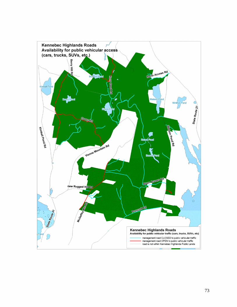
73
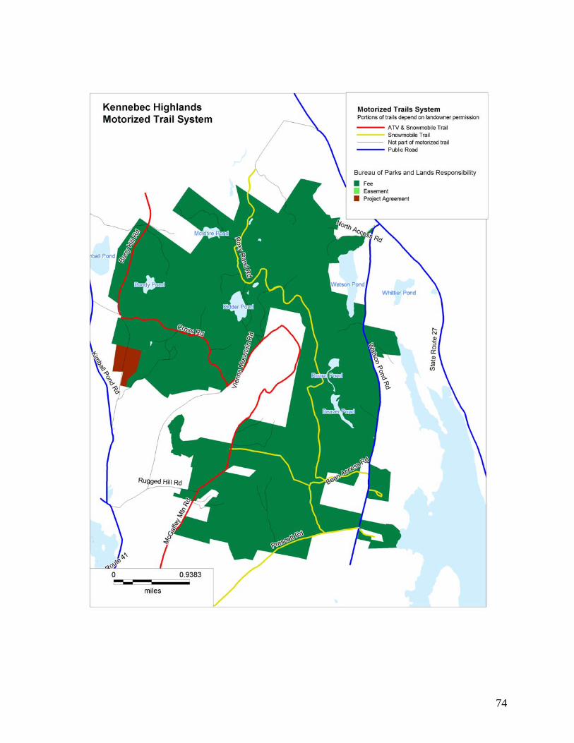
74

75
VII. Monitoring and Evaluation
Monitoring and evaluation are needed to track progress in achieving the management goals and objectives for the Highlands and the effectiveness of particular approaches to resource management. Monitoring and evaluation will be conducted on wildlife, ecological, timber, and recreational management efforts on the Kennebec Highlands. Implementation of Plan Recommendations The Bureau will develop, within 2 years of final plan adoption, an action plan for implementing and monitoring the management recommendations in this Plan. This will include an assignment of priorities and timeframes for accomplishment that will be utilized to determine work priorities and budgets on an annual basis. The Bureau will annually document its progress in implementing the recommendations, plans for the coming year, and adjustments to the priorities and timeframes as needed. Recreation The Bureau will monitor public use to determine: whether improvements to existing facilities or additional facilities might be needed; whether additional measures are needed to ensure that recreational users have a high quality
experience (which could be affected by the numbers of users, and interactions among users with conflicting interests);
whether use is adversely affecting sensitive natural resources or the ecology of the area; whether measures are needed to address unforeseen safety issues; whether changing recreational uses and demands present the need or opportunity for
adjustments to existing facilities and management; and whether any changes are needed in the management of recreation in relation to other
management objectives, including protection or enhancement of wildlife habitat and forest management.
The primary means of gathering information about recreational use and issues include: reports from the seasonal recreation ranger; reports from management partners (BRCA, ATV and snowmobile clubs); discussions at the annual trails forum; and incident and other reports made to the Bureau’s central and regional offices. Wildlife The Bureau’s wildlife biologist and technician routinely conduct a variety of species monitoring activities statewide. The following monitoring activities that are anticipated for the Kennebec Highlands: cooperation with MDIF&W on fisheries management of the Highlands ponds; cooperation with MDIF&W in the monitoring of game species;

76
location of additional, smaller-scale significant wildlife habitat (e.g., vernal pools and den trees) during the preparation of forest management prescriptions.
Special Protection Areas The Bureau coordinates with the Maine Natural areas program and the Maine Historic Preservation Commission in the documentation and protection of these areas. The Maine Natural Areas Program will be consulted on management near the rare plant
population or exemplary Unpatterned Fen Ecosystem; The Maine Historic Preservation Commission will be consulted as needed regarding protection
of historic sites and their on-going research. Timber Management Local work plans, or prescriptions, are prepared by professional foresters in accordance with the Bureau’s Integrated Resource Policy and peer-reviewed prior to approval. Preparation and layout of timber sales require field investigation of every acre to be treated. Trees to be harvested are generally hand marked. Regional field staff provide regular on-site supervision of harvest activities, with less frequent visits by senior staff. After harvest, roads, trails, and water crossings are discontinued as appropriate. Changes in stand type resulting from the harvest are recorded in the Bureau’s GIS system. The Bureau is currently developing a post-harvest monitoring plan to assist forest managers in assessing harvest outcomes on all managed lands. The monitoring plan will also address water quality and best management practices (BMPs) utilized during harvest activities. Third party monitoring is done mainly through the forest certification programs of the Forest Stewardship Council (FSC) and the Sustainable Forestry Initiative (SFI). Each program conducts rigorous investigations of both planning and on-ground practices. An initial audit by both programs was completed in 2000, with certification awarded in 2002. A full re-audit of both programs was conducted in the fall of 2006 with certification granted in 2007. The Bureau is also subject to compliance audits during the 5-year certification period.

77
VIII. Appendices
A. Public Process—Public Written Comments and Bureau Responses B. Management Plan Guiding Statutes and Rules for the Use of Public Reserved Lands C. Summary of the Resource Allocation System D. References E. Natural Resource Inventory of the Bureau of Parks and Lands Kennebec Highlands Unit. Brooke Wilkerson, Maine Natural Areas Program, Maine Department of Conservation, July 2007. Under separate cover, available upon request

78
Appendix A. The Public Process
Maine Department of Conservation Bureau of Parks and Lands
Kennebec Highlands WRITTEN COMMENTS
Summary of Written Comments on the Final Draft of the Kennebec Highlands Management Plan Received in 2011
Comments Response From: Jean Stewart I look forward to continued enjoyment of the
Highlands for skiing, snowshoeing and hiking and hope low impact uses take priority and soil, water and flora and fauna are protected.
The final plan has many provisions to protect soil, water and natural resources. Forestry that is sensitive to soils, wildlife, and water quality especially in riparian areas is foremost. Trails for motorized and non-motorized activities will be improved and maintained using BMPs to minimize erosion.
From: Dennis Phillips A significant historic fact is that the west line of the
so-called ‘Plymouth Grant’ runs through the Highlands and was the line between Rome and Vienna until Vienna annexed part of Rome.
Thank you for the information—it has been added to the Historic and Cultural Resources section.
From: Jerry Bley, Creston Gaither The Rugged Hill Rd, which is referred to as having a
public easement, was actually washed away in years gone by, and a new road roughly parallel to this was constructed by the Kohtalas (current landowners) about 15 years ago. The Kohtalas have conveyed easement rights to a number of parties including the state and they had no obligation to do so. Rights granted to the state were not for general public use but for land management, and require BPL to cover maintenance costs associated with its use. The steepness of the road would mean increased public use could lead to significant cost and if the Bureau invited the public on the road it could violate the ROW agreements.
Thank you for passing on this information. Further research has indicated this conclusion is correct—the road now referred to as ‘Rugged Hill Rd’ is north of what used to be called the Rugged Hill Rd. So the new so-called Rugged Hill Rd does not hold a public easement. The plan was changed to reflect this. The Vienna Abandonment order in 1997 does refer to the Rugged Hill Rd being abandoned and it would retain a public easement due to the date of the abandonment. This does not have significant management implications for the Bureau. Only a short portion of the ‘old’ Rugged Hill Rd is on state land and it is unknown where the precise location is. The Rugged Hill Rd (old or new) is not part of the designated ATV trail.
From: Hank Washburn, Jean Stewart I support BRCA’s idea that if the state acquires more
land, the ATV trail should be re-routed to be more directly north-south.
Generally, when new land is added to an existing public land unit, the status quo of existing uses is maintained until a new management planning processes is initiated. Now that the Bureau is holding 5-year reviews on management plans to look at issues that arise between the 15-year plan life cycle, new parcels can be examined at that time. However, this 5-year review will not open the entire plan to revision, but would only address uses on the newly acquired parcel.

79
From: Hank Washburn Please do not let the ATVs use the snowmobile trails
on the east side—they would be much too close to the hikers.
The plan is consistent with this recommendation.
From: Hank Washburn Please keep the needs of people with disabilities in
mind when there is money in the budget to do so. The final plan recommends providing a trail for the
disabled and/or adapting existing trails, and ensuring any trailhead facilities meet accessibility standards.
From: Toby Halperin The people of Wildflower Estates want the Bureau to
post signage on the road saying: ‘private road’ ‘no motorized vehicles’ and ‘no parking’. Signage should also state that it is a privately financed road. If the Bureau uses this road for public purposes, we may request in court financial support. We do not want the cross-country skiers or snowshoers to use the road because unlike snowmobilers who have headlights, they create difficulty in visibility on a road used by cars.
The Bureau will post this road as closed to public vehicular access. The Bureau would consider a proposal for assistance with road maintenance if the uses resulting from State ownership have an impact on the road, or if the maintenance of the road supports and is necessary for allowed public uses. Note that the Bureau will not be designating the Wildflower Estates Rd for skiing and snowshoeing; nevertheless there is a public right to use the northern half of the road that the state owns. Contact the Western Lands Regional Manager for further information.
From: Perry Nye I am an abutting landowner on the Bean Access Rd,
and my neighbor and I hunt and would like to continue to use ATVs to get to the McGaffey Mountain Rd and official ATV trail. We have put up with many issues from the Highlands over the years and have given many lost hikers a ride out on ATVs. If the road is not included in the ATV trail, there will be no way for Mt. Vernon, Rome and Belgrade rescue to save someone from the east side.
The Bureau recognizes that some existing uses are going to be limited as a result of this Plan, which has sought to balance the sometimes conflicting interests of motorized and non-motorized users. The Bureau will not restrict the part-owner of the road to use the road up to point where it reaches the intersection of the so-called Kennebec Highlands trail. However, use of the remainder of the Bean Access Road or so-called ‘South Vienna Mountain Trail’ is restricted to foot travel and snowmobile. Hunting by foot is allowed along this road as it does not meet the definition of a ‘marked hiking trail’ (rules restrict hunting within 300 feet of a marked hiking trail). Emergency access is a real concern and the final plan recommends communicating with host towns about road access needs for fire and rescue. This road could be designated for emergency and fire control, if all landowners on which the road is located agree.
Comments after the 2010 Advisory Committee Meeting
Relating to Research Findings on the Status of Roads Comment Response
From: Dave McLeay In order for a public right of way to exist on any of
the roads in Vienna, the town would have to have acquired rights on the roads. When Vienna issued their abandonment order on several roads in 1997,
The purpose of the legal research on Roands or former roads on the Kennebec Highlands was primarily to determine if the Bureau had discretion in designating allowed uses; that is, could the

80
their intent was to disclaim responsibility for roads in response to a population growth in town, to make clear to new landowners which roads would not be maintained by the town. It is likely they included roads that never were town roads to begin with. Inclusion in an abandonment order is not sufficient evidence that a town was a public way. In particular, the Cross Rd on the Highlands, and the southern portion of the Berry Hill Rd are unlikely to have been town roads, as they appear as trails on some of the older County Atlas maps, and in some cases don’t appear at all. The Pyne report points out this uncertainty on these roads segments. Also the proliferation of private rights over these segments suggests they were not public ways.
Bureau chose to close a road to public vehicular uses? If no public easement was found to exist, the Bureau could designate the road for any configuration of uses it saw fit. If there is a question of what rights the public has, the Bureau has to use caution in limiting uses. If there is certainty that a public easement exists, the Bureau cannot disallow vehicular use, but it does not have to maintain it for that use.
Jane Surran Pyne, the Bureau’s attorney, does point out uncertainty on whether the Cross Rd was ever a town way, and the Bureau notes this uncertainty in the final plan. However, this uncertainty does not bar the Bureau from designating the Cross Rd for motorized access; in fact, as pointed out above, it presents a caution in dissallowing motorized uses. The Cross Rd is designated in the Plan for ATV use because it enables the ATV trail to connect other roads with more certain public easements—the McGaffey Mountain Rd and the Berry Hill Rd upper section—to make a connector trail to points north and south.
From: David McLeay The Vienna Abandonment Order, dated 1997, states
that the roads have not had regular town maintenance for 30 or more years. The town does not have records on past road maintenance. It is unlikely the roads were all abandoned to maintenance in 1967. It is much more likely they were abandoned long before that date, as the population of Vienna declined considerably from the mid-1800s to the mid-1900s. Also evidence that these roads were abandoned long before 1967 is the 1956 USGS map, which shows some of the roads as trails (and does not show the Cross Road at all). If the roads were abandoned to maintenance by the town before 1965, a public easement is NOT retained. There is much evidence indicating the roads have not been maintained by the town for much longer than 30 years.
See previous response.
From: David McLeay It is not in the Bureau’s interest to declare public
rights of way unless there is clear evidence they exist. Once a right of way is established, the Bureau loses its ability to limit conflicting uses, re-route eroding sections and managing access becomes difficult if not impossible.
The Bureau’s determination of road status is for its own use in allocating uses for the roads on the State property. This research is not meant to declare legal status; only to guide our decisions. The Bureau, in this Plan, is simply acknowledging that the best available information shows public easements on these roads given the action of Vienna in abandonment of the roads pursuant to 23 MRS 3028, which states that “the determination of the municipal officers regarding the status of a town way or public easement is binding on all

81
persons until a final determination of that status has been made by a court.’
In the end the Bureau was able to find an appropriate balance for motorized and non-motorized uses, within the constraints of the probable legal status of the roads. The final plan establishes a through route for ATV uses; provides for continuation of almost all existing snowmobile trails, and establishes ‘remote recreation’ areas where only non-motorized uses will be allowed. The Bureau has experience state-wide in managing motorized uses on roads and trails in public lands and is prepared for the challenge of maintaining these roads for all designated public uses.
From: David McLeay Establishing a public right of way on the Vienna
Mountain Road brings traffic onto the Allen Blueberry Fields which may endanger negotiations with them to purchase their property for the Highlands.
Bureau staff worked with Allen Blueberry to gain permission for a motorized trail on their land which avoids active blueberry fields and connects roads on the Highlands with probable public easements.
From: David McLeay The Bureau should conduct research on the status
of the York Hill Rd. New Sharon municipal officers told the Bureau the
York Hill Rd was a town way abandoned to maintenance by the town but kept open to public use. Though they presented no formal ‘abandonment order’ as Vienna did, 23 MRS 3028 provides that a town way is presumed abandoned (known as ‘statutory abandonment’) if not kept passable for motor vehicles at public expense for 30 or more years. The municipal officers initially determine whether a road is presumed abandoned which becomes a ‘rebuttable presumption’ after which the burden of proof shifts to the landowner(s) or party who feels aggrieved by this presumption and must take it to Maine Superior Court.
Related to Use of Roads and Trails From: SS Caban Snowmobilers would like to continue to use the trails
that we have put time and money into maintaining. They are there for everyone to use, and available for emergency access as well.
The final plan allows for continued use of the vast majority of the existing snowmobile trail network, except for the short trail around Kidder Pond.
From: Russell Krause My family owns land which encompasses part of the
abandoned road to the left at the intersection of Rugged Hill Rd. I’m concerned our rights as landowners will be compromised by trails and campsites built next our land because of the 300 foot hunting rule. We have hunted on McGaffey Mountain for three generations. We have respect for the land and have allowed others to hunt on our land.
The Bureau will not designate campsites or hiking trails within 300 feet of private lands. The Bureau’s management plans and rules and policies for public lands only apply on public lands and are not meant to have regulatory implications for abutting private landowners.
From: Bob Dalot, Western Maine ATV Club

82
ATVs should be allowed on the same trails as snowmobiles, so the clubs can pool their money for maintenance. Riders pay club dues and registration fees that pay for the trails.
ATV and snowmobile clubs will both be able to pool their resources on the trail designated for both on the western side of the Highlands. However, snowmobile trails on the eastern side will not open to ATVs. The Bureau heard during the management plan process that there was greater conflict between motorized and non-motorized users in the non-winter months, and a desire to keep ATVs and hikers on separate trail systems. Many participants felt there was not much conflict between snowmobilers and skiers/snowshoers and that some skiers like to use the groomed trails.
From: Hank Washburn There has been a lot of erosion caused by ATV
riders in our town. Please don’t let ATVs on the east side of the Highlands.
ATVs will be designated on a trail on the west side of the Highlands, and trail upgrades will be made to minimize erosion.
Summary of Written Comments on the Preliminary Plan and Final Draft
Interim Plan Received in 2007
Comment Response
General Comments From: Steven Krause Some take a dim view of hunters and overstate the
danger of being killed. Wear blaze orange like the hunters do.
The final plan recommends notifying the public when hunting is available on the property and recommending safety precautions such as wearing blaze orange.
From: Bob Weingarten There are people who value landscapes without
formal trails and developed recreation opportunities. The plan should pursue leaving the Highlands in its natural state, without ‘Developed Recreation’ opportunities.
The Highlands will be managed without paved public use roads, but there will be some rustic recreational facilities such as gravel parking areas, hand carry boat access sites, and potentially walk-to campsites. Trails exist for ATVs and snowmobiles on existing management roads, and hiking trails are part of the blend of opportunity. However, there are still many areas where one can explore off-trail.
From: George Seel The plan should specify how the timber
management will be conducted to protect water quality. Protective measures should include avoiding areas too steep or too close to streams/ponds, and using BMPs for roads, skid trails and yards.
A 330 foot buffer around ponds, lakes and major streams is allocated ‘wildlife’ where any timber harvesting that occurs is conducted with the goal of promoting or maintaining vegetative diversity, continuity of wildlife travel cover throughout the watershed and adjoining ecosystems, and to protect the aquatic environment from degradation. In regards to roads, skid trails and yards, the Bureau adheres to the Maine Forest Service guidelines in “Best Management Practices for Forestry: Protecting Maine’s Water Quality”.

83
From: George Seel, Peter Wohl The plans should recognize that the KH fulfills an
unmet need in Central Maine for day hiking, cross-country skiing, snow shoeing and hunting. People come to the Highlands from Augusta, Waterville and further (and tourists use the Highlands) for these uses as opportunities are rare.
The final plan is consistent with this recommendation—see Planning Context section.
From: George Seel The management plans should ban dirt bikes. Maine law considers dirt bikes to be All Terrain
Vehicles under the definition. Public lands generally allow dirt bikes wherever they allow ATVs. In the Kennebec Highlands, dirt bikes will be allowed on the ATV trail on the western side of the Highlands, which will be improved to accommodate this use.
From: George Seel, Bob Weingarten DOC should not give more credibility to ‘stake
holder’ groups than to the general public. Stakeholder groups and the general public were
given ample opportunity to participate throughout the planning process. A total of 3 public meetings and 3 advisory committee meetings were held, and many of the advisory committee members were local residents not necessarily representing stakeholder groups. Credibility is given to anyone who participates in the management planning process.
From: George Seel KH should be managed as a regional resource for
much of Central Maine, and views of the public from a wider region should be considered.
The management plan and planning process is consistent with this recommendation. Everyone was invited to attend public meetings, and articles in the Kennebec Journal advertised the meeting to the wider region. All views expressed were considered.
From: George Seel Protection of water quality of the Belgrade and
Winthrop Lakes chains was key to the early KH initiative. This is not addressed in the plan. The increase in ATV use proposed will stress already stressed waterbodies through increased soil erosion and phosphorous run-off. ATVs should only be allowed on paved or permanent gravel roads, and such gravel roads should be improved to meet DEP Best Management Practices.
The final plan addresses the importance of water quality in the natural resource issues and management recommendations. ATVs will only be allowed on management roads in the western side of the Highlands, and Bureau staff will work with clubs to implement trail improvements that meet BMPs. The Bureau ORV staff are trained and certified by the DEP Non-point Source Training and Resource Center in erosion and sedimentation control practices.
From: Bob Weingarten, Joshua Royte Public lands—including the Highlands—should be
managed as late-successional forest to protect species that needs this forest in a landscape where it has become rare.
The Bureau’s general practices in forestry throughout the public lands is resulting in an increase in late-successional forests. This is due to the Bureau’s objectives to grow large trees, and a policy of no proportional loss of late-successional trees without documented cause. Additionally, Bureau management for wildlife leads to a retention of large trees for cavity nesters. Most of the Kennebec Highlands forests

84
have been heavily cut during the last 20 years (prior to state ownership). Therefore, it will be some time before Bureau timber management results in any late-successional forests on the Highlands.
From: Joshua Royte, The Nature Conservancy (TNC) The site design for Kennebec Highlands should be
expanded to 15,000 acres. Bureau management plans are designed to
address management of current state-owned public lands, and do not plan for future acquisitions.
From: Joshua Royte, The Nature Conservancy (TNC) A potential ecological reserve should be allocated
around the ponds in the remote recreation area and expanded as additional parcels acquired.
The Bureau will consider new additions to the ecological reserve system upon the completion of management plan updates for all public lands (expected in 2013). The reason for this timing is that with each management plan, the Maine Natural Areas Program conducts a ‘Natural Resource Inventory’ (NRI) on the landscape and identifies important ecological features. Once the NRIs are completed, a comprehensive look at potential ecological reserves on public lands across the state can be taken. This approach is needed because there is a legislatively mandated limit on the total land acreage designated as ecological reserve (MRSA 12 1805 sec. 5). No more than 100,000 acres and no more than 6% of operable timberland on public land may be allocated as ecological reserve. Because of this upper limit, potential ecological reserves must be compared and choices must be made about the ‘best’ reserves to designate. There are some areas that were temporarily allocated as ‘potential ecological reserves’ in management plans (such as at Scopan in the Aroostook Hills Plan and Donnell in the Downeast Plan). These are areas that were identified in a report called “An Inventory of Potential Ecological Reserves on Maine’s Public Lands and Private Conservation Lands” prepared for the Maine Forest Biodiversity Project by Janet McMahon in 1998. Areas identified in this report that are not yet designated as ecological reserves are being managed to retain the features that would make them eligible for future designation. When decisions about new ecological reserves are made, the Bureau will consider these areas, as well as any other potential areas identified in the NRIs. The NRI for Kennebec Highlands did not identify any specific areas as desirable for future designation, as much of the Highlands has been heavily cut prior to state acquisition. However, Bureau management should serve to improve the current forest condition, and will only make it more eligible for future ecological reserve designation should it rise to the top when the time comes to make future designations.
From: Richard Krause

85
I am concern that restrictions on ‘marked trails’ may infringe on my personal property rights as the ‘Round Top Trail’ crosses the corner of my property. I also think liability responsibilities for use of the trail should be established.
The Round Top Trail no longer crosses private land and is entirely within state-owned land.
From: Richard Krause I am concerned that roads I use to access my
property will become restricted—McGaffey Mountain Rd, Rugged Hill Rd, and the logging road on the eastern side of McGaffey Mtn.
The Bureau has determined the McGaffey Mountain Road and Rugged Hill Road to hold public easements and has designated them as open to motorized use where they are contained within the public land. As for the logging road on the east side of McGaffey Mountain—the Bureau is unsure of which road this refers to. However, there are no roads open to motorized vehicles (except snowmobiles) east of McGaffey Mountain except for those who have a legal right of way. Please contact the Bureau if you have reason to believe you have right of way for use of any roads listed as off limits to motorized use in the management plan.
From: Patty Cormier, SWOAM The SWOAM land trust lot across from Kennebec
Highlands will be constructing trails and could connect with the Highlands—the missions of these two properties are similar.
The Bureau appreciates SWOAM’s interest in partnering in trail connections. Please contact the Bureau’s Western Lands Manager about potential trail connectivity. The plan talks about holding an ‘Annual Trails Forum’ for managing partners to discuss issues related to trails. A member of SWOAM may be interested in attending if opportunities arise to develop an interconnecting trail.
From: Sylvia Cypher I’m concerned about language about solitary areas
and noise control. Does this mean the Bureau is going to try and control noise in the Highlands from airplanes, chainsaws of abutting landowners, ATVs and snowmobiles, horseback riders? This would be impossible to enforce. Posting notices about considerate behavior would be more appropriate.
There is no language in the plan regarding controlling noise from abutting landowners. The Bureau’s management plans are for management of state-owned lands only and are not intended to have regulatory implications on surrounding lands.
From: Sylvia Cypher There is no mention of whether beaver trapping will
be allowed. Bureau policy indicates that trapping is allowed
subject state laws, across public lands, unless: it is prohibited by deed, local ordinance, or written management policies, it creates unsafe situations or jeopardizes property or resources, or jeopardizes dominant uses of the resource allocation system. Generally, trapping in the Highlands should be acceptable in all resource allocations. However, permission to trap must be obtained from the landowner in organized towns. In the Highlands, permission must be obtained from the Western Region Lands staff, who may withhold permission if they determine trapping may cause unsafe situations or jeopardize resources or property.
From: Sylvia Cypher

86
Signage on trails with mileage and directions is critical. I have rescued two groups of hikers who got very lost. I’m sure there have been many more incidents.
The final plan recommends updating trail signage to reduce incidents of lost hikers.
From: Richard Krause The Highlands boundaries need to be posted so the
public knows not to trespass on private property. The final plan recommends marking the
boundaries of the state lands for easy identification.
Comments relating to ATVS
From: Dennis Phillips I was part of the group that originally conceived of
the Highlands. When we all sat down to draft the first trail map, we saw ATVs as a growing use. We originally mapped some of the old the logging roads as ATV trails and thought we could permit ATV riders who were members of club—entice them into club membership, helping with trail maintenance and enforcement, for being able to use the Highlands trails. This is still a good idea. If we completely ban ATVs, the bad feelings that will remain will not be worth it. We have to promote responsible use of the Highlands by ATVs.
The plan is consistent with this recommendation. However, the Bureau does not require ATV club membership for use of trails. The Bureau does encourage ATV club membership, and works with clubs by distributing grants for trail maintenance and equipment to incorporated clubs. The Bureau will work with local ATV clubs in the Highlands on trail maintenance and enforcement.
From: Belgrade Regional Conservation Alliance (BRCA), Thomas Klingenstein Management should not make the area an ATV
‘destination’ and should focus on a connector trail in a north-south orientation without parking areas or loop trails. The ATV trail should avoid Blueberry Hill which would become a staging area, and conflicts would result with non-motorized users and landowners. Suicide Hill, the Kennebec Highlands Trail and the Singletrack should be avoided due to potential conflicts with non-motorized users and landowners who may someday sell to the state or BRCA. The western part of the Highlands is preferable for the north-south connector trail, as it could connect with trails outside the Highlands and would reduce conflicts with non-motorized users. One promising option is using Berry Hill Rd and Kimball Pond Rd if Vienna gave permission.
The proposed ATV trail is in a generally north/south orientation on the western side of the Highlands, without a connection to Blueberry Hill. It does not use Suicide Hill or the so-called Kennebec Highlands Trail. The ATV trail uses roads with public easements and connects them with management roads on private land, whose owner gave the Bureau and ORV clubs permission to use roads that avoid their blueberry fields.
From: Belgrade Regional Conservation Alliance (BRCA), Thomas Klingenstein Adequate resources should be devoted to conflict
management between ATV riders and non-motorized users. There should be oversight of the property at strategic times. A cooperative agreement with law enforcement agencies could be pursued. ATV clubs should be part of the solution as well. A useful model exists with TNC and an ATV club in which permission is only given by TNC to ATV riders who contact the club first, when they receive information on responsible use.
The plan recommends Bureau staff working with ATV clubs to educate users to stay on the designated trail, and make that trail attractive for use as a connector trail to other trail networks. The Bureau has found in other areas that clubs have had a positive influence on the ATV community. If necessary, however, the plan recommends working with enforcement agencies to bring strategic enforcement presence to the Highlands. The strategy used by a private non-profit organization of requiring ATV club membership for use of the property is not a model appropriate for a public

87
agency. However, the Bureau does encourage ATV club membership, and works with clubs by distributing grants for trail maintenance and equipment to incorporated clubs.
From: Edward Hinckley The original vision of the Kennebec Highlands
Project focused on natural resources and non-motorized pursuits, with an acknowledgment that providing linkages for motorized trails may be needed. Self-contained motorized trails were not in that vision.
The plan lives up to this vision by protecting natural resources, providing non-motorized opportunities and providing linkages for motorized trails.
From: Hildie Lipson I oppose any increase in ATVs in the Highlands, or
ATV use near hiking trails, but feel a route in the west side on roads would be OK.
The plan is consistent with this recommendation.
From: Daniel Onion, Daniel Paradis, Lea Ramirez Preserve some of the Highlands for non-motorized
skiing and hiking. ATVs should not be on current non-motorized trails.
The plan is consistent with this recommendation.
From: Brian Lawson An ATV trail to connect New Sharon and Mt. Vernon
trails with a spur to Blueberry Hill would be a great idea and a boon to the economy.
The final plan seeks to provide economic benefits from both motorized and non-motorized recreation by providing trail systems for many uses, with separation of motorized and non-motorized uses emphasized in the non-winter months. The spur to Blueberry Hill was not authorized in order to maintain the remote recreation experience in the eastern portion of the Highlands.
From: Melvin Croft I was originally opposed to any ATV use in the
Highlands but after attending the public meeting, I see a compromise is needed. I support the BRCA position paper on the issue. I think it is important to make clear the connector trail concept and not allow the ATV riders to push for more and more access. Getting the clubs involve in enforcement is a good idea.
The plan is consistent with this recommendation.
From: Susan Burns The geographic options should be kept open for
locating an ATV trail, rather than stating now that the trail will be on the west side of the Highlands in a north-south orientation. It seems the only option in that scenario would be the Berry Hill Road and the Kimball Pond Rd, which would potentially put ATVs through Vienna village. The trail may need to run east-west along the Cross Rd, or use the Kidder Pond Rd and the McGaffey Mtn Rd.
The plan designates the ATV trail on McGaffey Mountain Rd, connecting to the Cross Rd via roads on private lands (with landowner permission) and travels west on the Cross Rd, then north on the Berry Hill Rd. It largely uses roads with public easements and avoids Vienna village.
From: Libby Harville, Pam Cobb Heuberger, Alice Knapp ATV riders should have their own trails specifically
built to withstand their use without degrading the environment. They should be kept off hiking trails.
The plan is consistent with this recommendation.
From: Carol Hanson I have cross-country skied on snowmobile trails The final plan recommends a wide network of

88
since I was a child—non-motorized and motorized users have co-existed in this area my entire life. Creating separate areas creates animosity that has not existed before.
snowmobile trails and recommends designating ski routes that provide a blend of opportunities—those that use snowmobile trails, and those that access more remote areas. Separation of motorized and non-motorized trails in the non-winter months was a recommendation the Bureau heard from many participants in the management planning process and we have reflected this sentiment accordingly.
From: Richard Krause, Steven Krause The variety of uses that have traditionally been
allowed should continue—hunting, hiking, ATV riding, etc. They have co-existed well this far.
All of these uses are being allowed in the final plan. A separation of ATV and hiking trails has been emphasized in the final plan as was recommended by many participants in the planning process.
From: Deane Jones The Kidder Pond area should be off-limits to ATVs as
it has an informal hiking trail used by the “Half Fast Hiking Club” who would like to see it blazed and maintained. The area is fragile due to Beaver Brook, a bog and other wet areas and ATVs have cause damage and erosion.
The plan is consistent with this recommendation.
From: Susan and Berchard Jackman We are in our 60’s and ride ATVs responsibly. We
would appreciate the use of Highlands trails and would help maintain them.
The Bureau appreciates this offer of assistance and encourages membership in local ATV clubs that work with us on trail maintenance.
From: Susan Alto, Christopher Begin, Fred & Margery Blonder, Stephen Collins, Melvin Croft, Jackie P. Fournier, Priscilla Grant, John Joseph, Wynne Keller, Michael and Ruth Kahn, Kevin Kobel and Rebecca Millett, Alice Knapp, Cheryl Pratt, Lea Ramirez, David Hugh Smith, Ray Van Orden, Peter Wohl, Ed Riggs, Ben Swan of Pine Island Camp, Kathryn Risley Zakroff and William Zakroff, Wally Buschmann, Doug Ide, David Mcleay, Jean Stewart, Bob Weingarten Because ATVs are noisy they would destroy
recreation experience that many enjoy at the Highlands.
The plan provides an ATV trail on the western side of the Highlands which is separated from remote recreation areas and current hiking trails. This will maintain a quiet environment for the current hiking trails as well as provide opportunities in remote recreation areas for future hiking trails separated from the ATV trail.
From: Susan Alto, Jo Frances and Arthur Brown, Melvin Croft, Jackie P. Fournier, Alison Godburn, Jacqueline Hill, John Joseph, Wynne Keller, Lori Lewis, Sarah Massey, Kevin Kobel and Rebecca Millett, Adair Mulligan, Emily Payne, Liz Ramsey, William Reid, Earl and Barbara Smith, Jean Stewart, Kathryn Risley Zakroff and William Zakroff, David Mcleay, Emily Payne, Jean Stewart, Bob Weingarten ATVs cause environmental damage from erosion
and disturbance to wildlife and should not be allowed in the Highlands.
ATVs will be designated on a trail system in the western side of the Highlands on existing management roads which will be upgraded to accommodate their use while minimizing erosion. The Bureau ORV staff are trained and certified by the DEP Non-point Source Training and Resource Center in erosion and sedimentation control practices. They regularly hold field seminars for ORV clubs on Best Management Practices (BMPs) in trail maintenance. As on other trails, BMPs will be emphasized on Highlands trails.
On the issue of wildlife impacts, a Natural

89
Resource Inventory of the Highlands did not reveal any sensitive wildlife species in the vicinity of this trail. The Bureau has a rigorous public process and uses scientific management criteria to provide the most appropriate blend of multiple uses on public lands. Wildlife protection is one of the Bureau’s many objectives. Provision of a variety of recreational opportunities is also a critical goal of the Bureau. Though there are some studies that show impacts to wildlife from various recreational uses, using this information to close public lands entirely to these uses would not serve the public well, and could cause a decline in support of land conservation and public land ownership.
From: Susan Alto, Susan Anderson, Christopher Begin, Jo Frances and Arthur Brown, Stephen Collins, Melvin Croft, Richard and Nancy Elderkin, Donald Foster, Jackie P. Fournier, Alison Godburn, Priscilla Grant, Pam Cobb Heuberger, Doug Ide, Jacqueline Hill, Michael and Ruth Kahn, Joanna Linden, Sarah Massey, Kevin Kobel and Rebecca Millett, Adair Mulligan, Liz Ramsey, David Hugh Smith, Ray Van Orden, Ed Riggs, David Mcleay ATVs should not be allowed in the Highlands
because it would ruin the remote and peaceful experience that hikers and other non-motorized users desire.
The plan provides an ATV trail on the western side of the Highlands and designates several remote recreation areas for quiet, non-motorized recreation which will be off-limits to any motorized use.
From: Dwight L. Allison III, Ken Blonder, Dancy and Jim Duffus, Richard K Jennings, Michael Johnson, Nancy Weingarten These individuals expressed general opposition to
ATVs in the Highlands (no specific reasons noted). The plan designates an ATV trail on the western
side of the Highlands, which connects several management roads which have public easements. This represents an acknowledgement of the ATV interest in the region as well as a fulfillment of the Bureau’s legal obligation to allow motorized access on roads with public easements.
From: Dwight L. Allison III, Dancy and Jim Duffus, Priscilla Grant, John Joseph, Thomas Klingenstein, Kevin Kobel and Rebecca Millett, Mara Pentlarge, Earl and Barbara Smith, Ben Swan of Pine Island Camp, Kathryn Risley Zakroff and William Zakroff, Stephen Collins, Adair Mulligan, Belgrade Regional Conservation Alliance (BRCA),Bob Weingarten, David Mcleay When I donated money to help buy the Highlands, I
did not realize the land would be considered for ATV use. ATVs run counter to the early vision of the Highlands.
When working with partners and potential funders in the acquisition process for the Highlands, the Bureau clearly expressed that the ultimate decision-making on vision and uses would be done at the end of a management planning process. Early visioning and identification of the Highlands important natural, cultural and recreational resources was undoubtedly helpful in identifying important values in the Highlands during the acquisition process. However, the ultimate vision, allocations and management recommendations were always intended to be decided at the end of a public management planning process, and the Bureau has been clear in explaining this process to partners and funders.
From: Susan Anderson, Christopher Begin, Adair Mulligan, Liz Ramsey, George Seel, David Hugh Smith, David Mcleay, Adair Mulligan, George Seel, Peter Wohl, Bob Weingarten I am worried there will not be adequate enforcement The plan recommends Bureau staff working with
90
to keep ATVs on designated trails if their use is allowed.
ATV clubs to educate users to stay on the designated trail, and make that trail attractive for their use. The Bureau has found in other areas that clubs have had a positive influence on the ATV community. If necessary, however, the plan recommends working with enforcement agencies to bring strategic enforcement presence to the Highlands.
From: Priscilla Grant, Lori Lewis, Cheryl Pratt, Lea Ramirez, Liz Ramsey, William Reid, Kati Sutton, Doug Ide, David Mcleay, Peter Wohl ATV use will cause damage to hiking/walking trails. The plan designates ATV trails separate from the
hiking trail system. ATVs are not allowed on hiking trails.
From: Sarah Massey, Alice Knapp, Cheryl Pratt, Peter Wohl, Kathryn Risley Zakroff and William Zakroff, Doug Ide, David Mcleay ATV use near hikers causes safety issues as hikers
or dogs may get hit. The final plan designates separate areas for
remote and motorized recreation. Hikers will be able to find ample opportunity to hike on trails where they will not encounter ATVs.
From: Susan Anderson, Richard Jennings, Liz Ramsey, Adair Mulligan The availability of hiking and other non-motorized
recreation in a remote quiet environment helps the local tourism economy.
The Bureau understands that a diversity of recreation experiences, including both motorized and non-motorized opportunities, will support the local tourism economy. Regarding the availability of hiking opportunities in remote environments, the plan designates several areas as ‘remote recreation’ which provide these opportunities which should continue to compliment the tourist economy in the region. Additionally, the plan has several recommendations regarding improving public information and expanding non-motorized trail opportunities that should increase the Highlands’ contribution to the tourists’ experience.
From: Dwight Allison, Wally Buschmann, Robyn LeGrand Neither ATVs nor Snowmobiles should be allowed in
the Highlands. The Plan reflects the diverse interests in and
existing uses on the Kennebec Highlands. The plan provides opportunities for ATVs ands snowmobiles on designated trails on management roads as well as designating remote recreation areas off-limits to these uses.
From: David Axelman, MD The incidence of obesity has doubled in our
communities since I began my medical practice in 1979, and many people don’t even have a concept of incorporating exercise in their lives. Designating ATV trails in the Highlands will encourage this trend. We should encourage physical activity in the Highlands by developing hiking, biking, canoeing, snowshoeing, cross-country skiing opportunities. We should especially encourage this for children—if they don’t learn exercise they won’t teach their children either and the long term cost of obesity-related health problems will far outweigh the potential economic benefits from ATV trails.
Ample opportunities for physical exercise in the outdoors are available in the Highlands. The Bureau encourages outdoor exercise for children and others by providing non-motorized trails throughout Maine and through special programs such as “Take It Outside” and “Take a Hike”. The Bureau also provides Off Road Vehicle trails for those who prefer that type of experience, or need motorized assistance to recreate due to disabilities.

91
From: Beverly Shaw ATVs should have a 10 to 20 acre area to zoom
around in and the rest of the Highlands should be off-limits.
The potential environmental impacts of a concentrated area of this size for ATV use could be significant. The plan designates an ATV trail on existing roads that will serve as a through route to connect to other trail systems. The plan emphasizes upgrading the condition of the roads/ trails and working to keep ATV riders on that trail system. This should provide a positive experience for ATV riders, minimize the environmental impact, and maintain ample areas for remote recreation.
From: Jean Stewart ATV trails are costlier to maintain correctly than
hiking trails. Upgrade and maintenance of the ATV trails (which
are also snowmobile trails) will be funded in part by the Bureau’s Off Road Vehicle Program using funding from ATV and snowmobile registrations and the state and federal gas taxes. Additional funding and volunteer work is provided by the ORV clubs.
From: Bob Weingarten The state should be promoting forms of recreation
that do not use fossil fuels. The Bureau encourages non-motorized recreation
by providing non-motorized trails throughout Maine and through special programs such as “Take It Outside” and “Take a Hike”. The Bureau also provides Off Road Vehicle trails for those who prefer that type of experience, or need motorized assistance to recreate due to disabilities. Snowmobile and ATV riding are projected to continue to grow in popularity as the demographic trends in Maine lead it to become the second oldest state in the U.S. (MDOC, 2009)
From: Liz Ramsey If the state opens the Highlands to ATV use, there
will be less support for state land ownership in the future. This is because supporters will increasingly rely on private owners like Roxanne Quimby.
During the management planning process for the Highlands, as has been the case in many other planning processes, the public has expressed a variety of preferences on recreational issues. The Bureau must constantly weigh these differing views and determine the best combination uses on each landscape, also factoring in environmental considerations, financial constraints and in the case of the Highlands, legal issues. The Bureau decided to designate an ATV trail on the Western side of the Highlands, using management roads with public easements where practical, in order to provide a through travel/connector experience. This will provide a positive experience for ATV riders while separating this use from hiking and other non-motorized pursuits. There may be some citizens who give less support to public lands acquisitions because of ATV trails, and others who withhold their support because of loss of ATV access on some public lands. The Bureau as a public agency must serve all citizens, and
92
consistently works to find balance by offering a variety of opportunities while recognizing not every recreational experience could or should happen on every acre or unit of public land.
From: Christopher Begin, Michael and Ruth Kahn ATV riders should not be allowed because of their
behavior—leaving designated trails and tearing up the landscape, leaving garbage, creating unwanted campsites as ‘party spots’.
The plan recommends Bureau staff working with ATV clubs to educate users to stay on the designated trail, and make that trail attractive for use as a connector trail to other trail networks. The Bureau has found in other areas that clubs have had a positive influence on the ATV community. If necessary, however, the plan recommends working with enforcement agencies to bring strategic enforcement presence to the Highlands.
From: Stephen Collins It is problematic that the Bureau has an ATV and
Snowmobile coordinator, and an ORV Director, but no one to represent the interest of bicyclists, skiers or hikers.
The Bureau’s Outdoor Recreation Specialist represents the interest of bicyclists, skiers and hikers. Additionally, the Bureau works hard to assure all user groups are invited to the table to participate in the planning process and listens carefully to their input.
From: David Mcleay, Emily Payne, Peter Wohl There is not a solution to irresponsible ATV riders
and designating a trail on the Highlands (where use was illegal and small scale before) will increase the use from both responsible riders and irresponsible.
The plan recommends Bureau staff working with ATV clubs to educate users to stay on the designated trail, and make that trail attractive for their use. The Bureau has found in other areas that clubs have had a positive influence on the ATV community and is hopeful this will be the case in the Highlands as well. If necessary, however, the plan recommends working with enforcement agencies to bring strategic enforcement presence to the Highlands.
From: David Mcleay Authorizing a trail near Allen Blueberry lands may
bring irresponsible riders who will damage crops and jeopardize relationships with Allen’s and sabotage future opportunities for acquisition of their land.
The Bureau’s discussions with Allen Blueberry involved a consideration of designating a route that would keep riders away from their blueberry fields. The current, agreed upon route will keep riders on management roads in forested areas except for a short section of the Vienna Mountain Rd after its’ intersection with the Cross Rd. The Bureau will remain in contact with the landowner and the clubs to assist in resolving any issues that may arise.
From: David Mcleay The management plan should not treat ATVs and
snowmobiles similarly. Snowmobiles generally don’t cause trail damage, co-exist better with the more limited non-motorized users out in winter, and have a long established, more responsible history of use in the Highlands.
The final plan recognizes that there is generally less conflict between motorized and non-motorized users during the winter. Snowmobile use is allowed on trails in “Backcountry Motorized” areas which are near remote recreation areas, and it is acknowledged that some cross-country skiers prefer to use trails that have some snowmobile use. Ski routes may be designated that use snowmobile trails in part, and branch off into more remote areas for those who want remote skiing experience.
93
From: David Mcleay It is not true that ATV riders don’t have equal access
rights—they are free to walk on the Highlands like everyone else. They just can’t take their preferred mode of transportation. Accessible walking trails are being promoted for the less abled.
The final plan provides a trail for ATV riders, plans for increased hiking trails and plans for providing more accessible walking trails. This variety of opportunities is in line with the Bureau’s policies and statutory guidance on management planning and with input received from the public process.
From: David Mcleay It appears there are economic pressures driving
DOC to cater to ATV users, as evidenced by the “ATV Economic Impact Report” on the DOC website which reports $200 million to Maine’s economy. An Outdoor Industry Association report concludes that non-motorized recreation contributes $2.4 billion to Maine’s economy. Real estate listings in the area list being near ‘conservation land’ to help sell properties. The Belgrade Lakes area has many vacationers that contribute to the local economy who most likely do not want to see/hear ATVs.
The Bureau recognizes positive economic impacts that public lands provide from motorized and non-motorized uses. Recent Bureau reports such as the Maine State Comprehensive Outdoor Recreation Plan 2009-2014 acknowledge some of the research recently conducted showing trends in various types of recreation and their contributions to tourism. The Kennebec Highlands plan seeks to provide economic benefits from both motorized and non-motorized recreation by providing trail systems for many uses, with separation of motorized and non-motorized uses emphasized in the non-winter months.
From: David Mcleay The ATV route proposed by clubs which links the
McGaffey Mtn Rd to the York Hill Road by using the Kennebec Highlands Trail has several problems. It uses 11.2 miles to link points that are only 3.1 miles apart, runs very closely to the Sanders Hill Loop and Round Top Trail, and goes close to the blueberry field near Kidder Pond (which will tempt ATV riders). It crosses private property and is not a vital connection that will serve many users. Many sections such as Suicide Hill and the Singletrack would be very expensive to re-habilitate. Noise from ATVs would reach into ‘remote recreation’ areas—sound travels well between Vienna Mountain and Sanders Hill.
A more appropriate route which would keep ATVs to no closer than 1.25 miles from hiking routes would be to head northwest from McGaffey Mountain Rd, seek permission to cross private land near Vienna Mountain Rd, use the Frog Hollow Trail to connect to Berry Hill Rd (map attached).
This ATV route is no longer being considered. An ATV route similar to this is designated in the
final plan. However, it will not run directly northwest from McGaffey Mountain Rd. Negotiations with Allen Blueberry led to a trail configuration which keeps riders on management roads and away from blueberry fields. Additionally, the trail uses the Cross Rd, which research showed may hold a public easement, rather than the Frog Hollow Trail to connect to the Berry Hill Rd.
From: George Seel, Peter Wohl The Bureau should establish speed and other ATV
rules specific to the Highlands to ensure safety and environmental protection. The Bureau should enter into an agreement with the Maine Warden Service to enforce the rules and post on signs and maps who to call for the public when they see violations.
The plan recommends Bureau staff working with ATV clubs to educate users to stay on the designated trail, and make that trail attractive for their use. The Bureau has found in other areas that clubs have had a positive influence on the ATV community. If necessary, however, the plan recommends working with enforcement agencies such as Maine Department of Inland Fisheries and Wildlife, to bring strategic enforcement presence to the Highlands. IF&W maintains and enforces state-wide rules on ATV use, published in their

94
“Maine ATV Laws and Rules”. Among other rules, riders must operate at a ‘reasonable and prudent speed for existing conditions’.
From: David Mcleay An ATV route to Blueberry Hill is particularly
concerning. It is currently not part of an ATV trail system, and does not provide a connection to regional trail systems, and would become a de facto ATV trailhead and parking area. It would run the trail too close to the Round Top Hiking Trail and cross private property close to a residence on Watson Pond Rd. You can drive a car to Blueberry Hill, so disabled access is not needed.
The final plan does not recommend an ATV trail to Blueberry Hill.
From: David Mcleay The plan should not assert that ‘the unit had
considerable, legally permitted ATV use prior to state acquisition’. Determining what was legally permitted prior to the 2004 law change would be very difficult, and the area has a history of ‘no ATV’ signs and trail plugs being removed by ATV and 4WD trail users. Consultation of former private land owners would be needed to determine if ATV use was permitted.
The final plan does not take a stand on whether past ATV use was legally permitted.
From: Emily Payne I am a property owner on York Hill and have been
asked to consider donating an easement to BRCA. I will not do this if there is an ATV trail authorized on the York Hill Rd, as that will only increase the illegal ATV use on my property. There has already been a lot of damages done on my property by illegal ATVs.
The Berry Hill Rd was shown to have a public easement, requiring the landowner to permit ATV and other vehicular use. This road becomes the York Hill Rd in New Sharon. Bureau research shows the town of New Sharon abandoned the York Hill Rd to maintenance, with the date unknown. When a town has not kept a road passable for 30 or more years it is a presumed abandoned, and a public easement is retained if the minimum 30 year abandonment period ends after 1965. The municipal officers must make the ultimate determination of abandonment. The Bureau, based on the information available, assumes the portion of the York Hill Rd within the Kennebec Highlands is retaining a public easement.
From: Emily Payne, George Seel Exceptions can be made for ATV use for the
disabled and for emergency access without creating a whole new ATV trail network.
The disabled will be able to use the designated ATV trail on the western side of the Highlands. The final plan recommends the Bureau communicate with the four host towns of the Highlands on access needs for fire and rescue.
From: George Seel ATV users should pay for upgrades to gravel roads
used for their trails. Upgrade and maintenance of the ATV trails (which
are also snowmobile trails) will be funded in part by the Bureau’s Off Road Vehicle Program using funding from ATV and snowmobile registrations and the state and federal gas taxes. Additional funding and volunteer work is provided by the ORV clubs.

95
From: William Reid Allowing ATVs will increase the incidents of illegal
use on surrounding private lands. ATV use occurred on the properties prior to State
ownership. The Bureau is designating a trail on the western side of the Highlands, using mostly roads with public easements that will serve as a connector trail from points south and north. The Bureau will be working with the local ATV club to guide riders to this trail and keep them on it. Strategic enforcement will be used if necessary.
From: David Hugh Smith By allowing ATVs, you would destroy peace and
quiet for the many Watson Pond Campowners. The designated ATV trail does not pass near
Watson Pond. From: Heather Roberts Abutting landowners will shut their land off to hikers
if ATV use is banned from the Highlands. ATVs have been allocated a trail in the western
side of the Highlands. It is not the Bureau’s intent to make choices for abutting private landowners. Each landowner must decide for him or herself which uses to allow.
From: Heather Roberts I am an abutting landowner to the Highlands and my
family has enjoyed all types of recreation on what is now the Highlands. I am concerned the BRCA and their members have too much influence on rules for the property and I dislike the discussion about limiting how people enjoy the property. A compromise needs to be made, but giving ATV riders only one trail on the entire 6,000 acres is not a reasonable compromise. If hikers want to be away from ATV riders, they can travel on the thousands of acres off the trails—the roads/trails were maintained by ATV and snowmobile riders.
The final plan allows people to enjoy a variety of activities on the Highlands. An ATV trail is designated on the west side of the Highlands, snowmobiling is available on an extensive trail network, and hiking, cross-country skiing and snowshoeing are also available. A multitude of viewpoints were expressed and heard during the management planning process, which included three general public meetings. Three advisory committee meetings were held as well, which included BRCA as well as snowmobile and ATV club representatives.
From: Dana Hanson The ATV and snowmobilers should be allowed to
use the trails they have used for decades and have put work into maintaining. Hikers can establish their own trails where motorized users can’t go.
While recreational uses that occurred prior to state ownership are an important factor in determining future uses, they are not the only factor. When the Bureau writes a management plan for a new state property, all interests are invited to the table. Existing uses are considered, but also the public’s desire for future uses. That being said, the final plan allows for snowmobile use on most existing trails that clubs have assisted in maintaining in the past. ATV use is allowed on a designated trail in the west side of the Highlands.
From: Jeff Hanke ATV use should be allowed on snowmobile trails so
those who cannot hike or bike can access these areas.
Those who are disabled can use the ATV trail designated on the western side of the Highlands. Additionally, the plan recommends developing a walking trail and/or improving current trail(s) to provide opportunities for visitors of all abilities with firm, level footing and low grades.
From: Jeff Hanke ATVs should continue to be allowed to use
snowmobile trails as they have done to hunt, fish Now that the land has become public, use is
expected to increase, though at a modest rate.

96
and access short hikes. Use has been historically low, and erosion from ATV use has not been a problem.
Many of the existing roads have problems with erosion. The final plan designates an ATV trail and recommends working with clubs to upgrade the trail to accommodate use without degrading water quality.
From: Alfred Barlow, Shawn Grant Disallowing ATVs in the Highlands would be
discriminatory—as public lands, it should be available for all types of activities.
There are many activities that are not allowed on public lands, and activities that are only allowed in certain resource allocations. The Bureau manages for multiple uses, including forestry, wildlife, and ecological values in addition to various recreational activities. Recreational and other uses may only be allowed when they do not compromise the dominant resource allocation of a particular areas. That being said, in the final plan ATVs are allowed on a through trail on the western side of the Highlands.
From: Elaine Barlow, Dana Hanson ATVs and Snowmobiles should be allowed in the
Highlands because users maintain trails that allow everyone to reach the more backcountry areas.
The Bureau will continue partnerships with snowmobile clubs and partner with ATV clubs in maintenance of trails in the Highlands. Partnerships with BRCA and potentially CeMeNEMBA will expand non-motorized trail opportunities. Drive-to access will be allowed on certain management roads. The Bureau believes this provides sufficient access to the Highlands.
From: Sylvia Cypher ATVs should be allowed in the Highlands and rock
barriers should not be placed on roads such as those leading to ponds. Many families use these areas for fishing and though there are some ‘bad apples’ who tear up the land, this should not ruin it for everyone. Education of how to treat the land would be better than the power struggle message of boulder barriers that cause defiant behavior.
Education will be key to the effort to direct ATV riders to the designated trail system and keep them on the trail. However, blocking roads is often a necessary supplement to educational approaches. Families may still fish the ponds. McIntire Pond has drive to access to a hand carry boat access site. Boody and Kidder Ponds may be accessed by short walks from the Berry Hill Rd and Vienna Mountain Rd respectively.

97
Appendix B. Management Plan Guiding Statutes and Rules for the Use of Public Reserved Lands
Guiding Statutes 12 MRSA §1846. Access to public reserved lands
1. Legislative policy. The Legislature declares that it is the policy of the State to keep the
public reserved lands as a public trust and that full and free public access to the public reserved lands to the extent permitted by law, together with the right to reasonable use of those lands, is the privilege of every citizen of the State. The Legislature further declares that it recognizes that such free and reasonable public access may be restricted to ensure the optimum value of such lands as a public trust but that such restrictions, if and when imposed, must be in strict accordance with the requirements set out in this section. [1997, c. 678, §13 (new).] 2. Establishment of restrictions on public access. [2001, c. 604, §10 (rp).] 3. Unlawful entry onto public reserved lands. [2001, c. 604, §10 (rp).] 4. Development of public facilities. The Bureau may construct and maintain overnight campsites and other camping and recreation facilities. [1997, c. 678, §13 (new).] 5. User fees. The Bureau may charge reasonable fees to defray the cost of constructing and maintaining overnight campsites and other camping and recreation facilities. [1997, c. 678, §13 (new).] 12 MRSA §1847. Management of public reserved lands 1. Purpose. The Legislature declares that it is in the public interest and for the general benefit of the people of this State that title, possession and the responsibility for the management of the public reserved lands be vested and established in the Bureau acting on behalf of the people of the State, that the public reserved lands be managed under the principles of multiple use to produce a sustained yield of products and services by the use of prudent business practices and the principles of sound planning and that the public reserved lands be managed to demonstrate exemplary land management practices, including silvicultural, wildlife and recreation management practices, as a demonstration of state policies governing management of forested and related types of lands. [1997, c. 678, §13 (new).] 2. Management plans. The director shall prepare, revise from time to time and maintain a comprehensive management plan for the management of the public reserved lands in accordance with the guidelines in this subchapter. The plan must provide for a flexible and practical approach to the coordinated management of the public reserved lands. In preparing, revising and maintaining such a management plan the director, to the extent practicable, shall compile and maintain an adequate inventory of the public reserved lands, including not only the timber on

98
those lands but also the other multiple use values for which the public reserved lands are managed. In addition, the director shall consider all criteria listed in section 1858 for the location of public reserved lands in developing the management plan. The director is entitled to the full cooperation of the Bureau of Geology and Natural Areas, the Department of Inland Fisheries and Wildlife, the Maine Land Use Regulation Commission and the State Planning Office in compiling and maintaining the inventory of the public reserved lands. The director shall consult with those agencies as well as other appropriate state agencies in the preparation and maintenance of the comprehensive management plan for the public reserved lands. The plan must provide for the demonstration of appropriate management practices that will enhance the timber, wildlife, recreation, economic and other values of the lands. All management of the public reserved lands, to the extent practicable, must be in accordance with this management plan when prepared. Within the context of the comprehensive management plan, the commissioner, after adequate opportunity for public review and comment, shall adopt a specific action plan for each unit of the public reserved lands system. Each action plan must include consideration of the related systems of silviculture and regeneration of forest resources and must provide for outdoor recreation including remote, undeveloped areas, timber, watershed protection, wildlife and fish. The commissioner shall provide adequate opportunity for public review and comment on any substantial revision of an action plan. Management of the public reserved lands before the action plans are completed must be in accordance with all other provisions of this section. [1999, c. 556, §19 (amd).]
Rules for the Use of Public Reserved Lands
SUMMARY: These rules give the definition of "Public Lands" and explain the Bureau's policy governing public use on camping, fires, litter, disturbances, altering of property, abandoned property, storage of property, closed areas, vehicular use, firearms, preserves, and enforcement and penalty.
1.1 Definitions "Public Lands" shall include the Public Reserved Lands of the State and all other lands under the
jurisdiction, and control of the former Bureau of Public Lands. "Bureau" shall mean the Bureau of Parks and Lands within the Department of Conservation.
1.2 Camping No person shall camp, stay overnight or maintain any tent, camper, shelter, trailer or other camping unit on any public lands for more than fourteen days in any 45 day period, without the prior written permission of the Bureau.
1.3 Fires Unless ground is snow covered no person shall build or maintain an open fire including charcoal on public lands except (i) at a campsite duly authorized and designated for open fires or (ii) where a permit has been obtained for such fire from the Maine Bureau of Forestry. For visitor safety and resource protection, open fires must be attended. Campstoves fueled with sterno, propane, kerosene, etc. are allowed in any safe location. Charcoal fires, off the ground, attended and used in proper cooking containers, which will not leave a disposable residue or ash on the ground, are

99
permitted on structurally improved leased lots. On islands in tidal areas, all fires shall be built below the mean high tide line.
1.4 Litter In accordance with State law that prohibits littering, trash which cannot be burned in accordance with Section 1.3 Fires, must be carried out. Plastic and other tarps such as shelters shall be removed.
1.5 Disturbances All persons camping on public lands will conduct themselves in a manner which does not impair the reasonable use and enjoyment of public lands by others. In consideration of other visitors and wildlife, pets in campsites must be kept leashed, and shall not be left unattended; outside of campsites, pets must be kept under control. To maintain reasonable quiet, the use of chain saws, generators, and other power equipment is prohibited within and around campsites.
1.6 Property No person shall deface, paint, damage or mutilate any structure, natural feature, tree or marker, on any public lands. Dead and down wood only may be used for campfires. No living trees shall be cut without the Bureau's prior written permission.
1.7 Abandoned Property Any boat, tent, shelter or other personal property (or structure or fixture) which is left unattended on any public land for more than three consecutive days without prior written authorization from the Bureau shall be deemed to have been abandoned, and the Bureau may take custody of such property and dispose of the same in accordance with the law. For purposes of this regulation, personal property shall be deemed to be "unattended" unless it is actually personally used. 1.8 Closed Areas During periods determined by the Bureau to be critical for forest fire danger or other condition, any portion of the public lands may be closed to the public at the discretion of the Bureau and no person shall enter or remain in said closed area except agents of the Bureau, law enforcement personnel in the line of duty and others authorized by the Bureau in writing. In making a determination to close any portion of the public lands because of a forest fire danger, the Bureau will consult with the Bureau of Forestry.
1.10 Enforcement These regulations may be enforced by any law enforcement officer. These regulations shall constitute written authorization to the appropriate agencies of the State and its political subdivisions to enforce the provisions of Title 12, M.R.S.A. §556
1.11 Authorized Storage Storage of private property on public lands is authorized only by special use permit issued by the Bureau. Unauthorized stored property shall be confiscated or destroyed.
Permits for storage will be subject to an annual fee (based upon the estimated cost of disposing such property). Permittees will be liable for the removal of their property upon request of the Bureau. Failure to remove such property within thirty (30) days of notice will result in the forfeit of said property and payment of a $50 penalty.

100
1.12 Firearms Except for persons holding a valid Maine concealed weapons permit, loaded firearms are not permitted in campsites, on marked hiking trails, or at boat launches and picnic sites, and should not be discharged within 300 feet of such areas. 1.13 Vehicular Use Vehicles shall use only designated public access roads. Parked vehicles shall not block any road (including closed side roads). Off-road travel by wheeled vehicles of any sort is prohibited. Except as specified by the Bureau, all-terrain vehicles (ATVs) are not permitted on public lands. Snowmobiles are permitted to traverse public lands, but may not travel on plowed roads, marked cross-country ski trails, and other areas so designated.
1.14 Preserves To preserve Critical Areas, Forest Preserves, Cultural Resources and other designated sites for educational and scientific purposes, such areas and objects are to be left undisturbed.

101
Appendix C. Summary of the Resource Allocation System
Designation Criteria for Special Protection Areas
1. Natural Areas, or areas left in an undisturbed state as determined by deed, statute, or management plan; and areas containing rare and endangered species of wildlife and/or plants and their habitat, geological formations, or other notable natural features; 2. Ecological Reserves, established by Title 12, Section 1801: "an area owned or leased by the State and under the jurisdiction of the Bureau, designated by the Director, for the purpose of maintaining one or more natural community types or native ecosystem types in a natural condition and range of variation and contributing to the protection of Maine's biological diversity, and managed: A) as a benchmark against which biological and environmental change can be measured, B) to protect sufficient habitat for those species whose habitat needs are unlikely to be met on lands managed for other purposes; or C) as a site for ongoing scientific research, long-term environmental monitoring, and education." Most ecological reserves will encompass more than 1,000 contiguous acres.
3. Historic/Cultural Areas (above or below ground) containing valuable or important prehistoric, historic, and cultural features. Management Direction
In general, uses allowed in special protection areas are carefully managed and limited to protect the significant resources and values that qualify for this allocation. Because of their sensitivity, these areas can seldom accommodate active manipulation or intensive use of the resource. Recreation as a secondary use is allowed with emphasis on non-motorized, dispersed activities. Other direction provided in the IRP includes:
Vegetative Management on Ecological Reserves, including salvage harvesting, is also considered incompatible. Commercial timber harvesting is not allowed on either Ecological Reserves or Special Protection natural areas.
Wildlife management within these areas must not manipulate vegetation or waters to create or enhance wildlife habitat.
Management or public use roads are allowed under special circumstances, if the impact on the protected resources is minimal.
Trails for non-motorized activities must be well designed and constructed, be situated in safe locations, and have minimal adverse impact on the values for which the area is being protected. Trail facilities and primitive campsites must be rustic in design and accessible only by foot from trailheads located adjacent to public use roads, or by water.
Carry-in boat access sites are allowed on water bodies where boating activity does not negatively impact the purposes for which the Special Protection Area was established.
Hunting, fishing, and trapping are allowed where they do not conflict with the management of historic or cultural areas or the safety of other users.
Research, interpretive trails, habitat management for endangered or threatened species, are allowed in Special Protection natural areas unless limited by other management guidelines
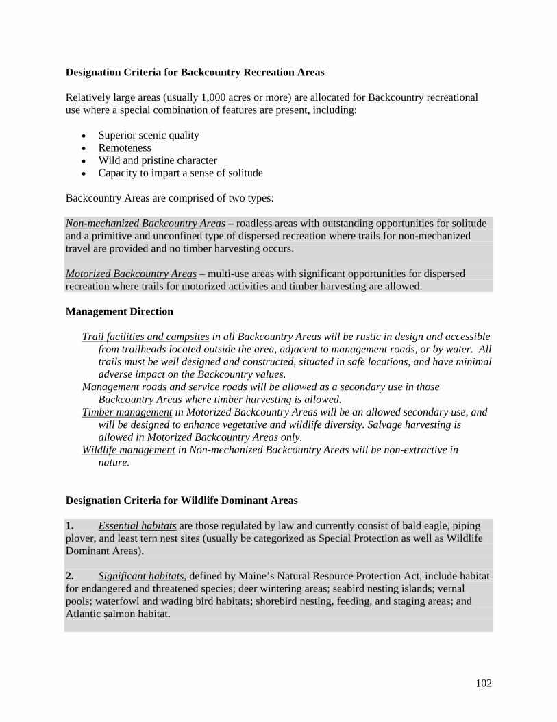
102
Designation Criteria for Backcountry Recreation Areas
Relatively large areas (usually 1,000 acres or more) are allocated for Backcountry recreational use where a special combination of features are present, including:
Superior scenic quality Remoteness Wild and pristine character Capacity to impart a sense of solitude
Backcountry Areas are comprised of two types: Non-mechanized Backcountry Areas – roadless areas with outstanding opportunities for solitude and a primitive and unconfined type of dispersed recreation where trails for non-mechanized travel are provided and no timber harvesting occurs. Motorized Backcountry Areas – multi-use areas with significant opportunities for dispersed recreation where trails for motorized activities and timber harvesting are allowed. Management Direction
Trail facilities and campsites in all Backcountry Areas will be rustic in design and accessible from trailheads located outside the area, adjacent to management roads, or by water. All trails must be well designed and constructed, situated in safe locations, and have minimal adverse impact on the Backcountry values.
Management roads and service roads will be allowed as a secondary use in those Backcountry Areas where timber harvesting is allowed.
Timber management in Motorized Backcountry Areas will be an allowed secondary use, and will be designed to enhance vegetative and wildlife diversity. Salvage harvesting is allowed in Motorized Backcountry Areas only.
Wildlife management in Non-mechanized Backcountry Areas will be non-extractive in nature.
Designation Criteria for Wildlife Dominant Areas
1. Essential habitats are those regulated by law and currently consist of bald eagle, piping plover, and least tern nest sites (usually be categorized as Special Protection as well as Wildlife Dominant Areas). 2. Significant habitats, defined by Maine’s Natural Resource Protection Act, include habitat for endangered and threatened species; deer wintering areas; seabird nesting islands; vernal pools; waterfowl and wading bird habitats; shorebird nesting, feeding, and staging areas; and Atlantic salmon habitat.
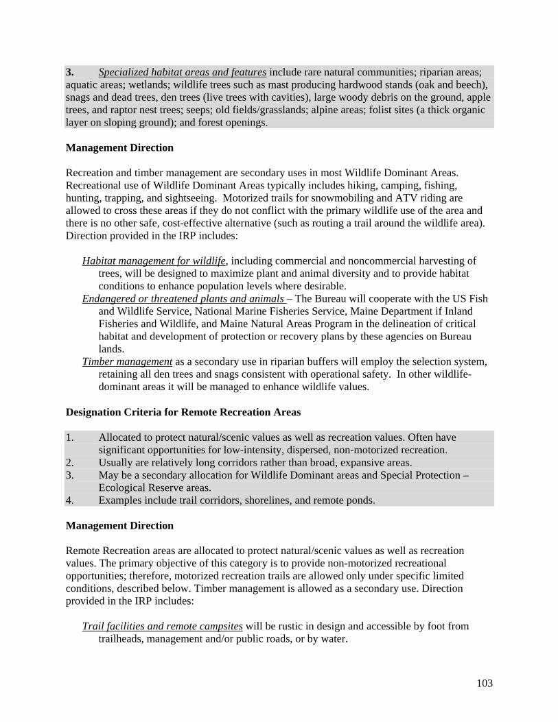
103
3. Specialized habitat areas and features include rare natural communities; riparian areas; aquatic areas; wetlands; wildlife trees such as mast producing hardwood stands (oak and beech), snags and dead trees, den trees (live trees with cavities), large woody debris on the ground, apple trees, and raptor nest trees; seeps; old fields/grasslands; alpine areas; folist sites (a thick organic layer on sloping ground); and forest openings. Management Direction Recreation and timber management are secondary uses in most Wildlife Dominant Areas. Recreational use of Wildlife Dominant Areas typically includes hiking, camping, fishing, hunting, trapping, and sightseeing. Motorized trails for snowmobiling and ATV riding are allowed to cross these areas if they do not conflict with the primary wildlife use of the area and there is no other safe, cost-effective alternative (such as routing a trail around the wildlife area). Direction provided in the IRP includes:
Habitat management for wildlife, including commercial and noncommercial harvesting of trees, will be designed to maximize plant and animal diversity and to provide habitat conditions to enhance population levels where desirable.
Endangered or threatened plants and animals – The Bureau will cooperate with the US Fish and Wildlife Service, National Marine Fisheries Service, Maine Department if Inland Fisheries and Wildlife, and Maine Natural Areas Program in the delineation of critical habitat and development of protection or recovery plans by these agencies on Bureau lands.
Timber management as a secondary use in riparian buffers will employ the selection system, retaining all den trees and snags consistent with operational safety. In other wildlife-dominant areas it will be managed to enhance wildlife values.
Designation Criteria for Remote Recreation Areas
1. Allocated to protect natural/scenic values as well as recreation values. Often have significant opportunities for low-intensity, dispersed, non-motorized recreation.
2. Usually are relatively long corridors rather than broad, expansive areas. 3. May be a secondary allocation for Wildlife Dominant areas and Special Protection –
Ecological Reserve areas. 4. Examples include trail corridors, shorelines, and remote ponds. Management Direction Remote Recreation areas are allocated to protect natural/scenic values as well as recreation values. The primary objective of this category is to provide non-motorized recreational opportunities; therefore, motorized recreation trails are allowed only under specific limited conditions, described below. Timber management is allowed as a secondary use. Direction provided in the IRP includes:
Trail facilities and remote campsites will be rustic in design and accessible by foot from trailheads, management and/or public roads, or by water.

104
Existing snowmobile and all-terrain vehicle activity may be continued on well-designed and constructed trails in locations that are safe, where the activity has minimal adverse impact on protected natural resource or remote recreation values, and where the trails cannot be reasonably relocated outside of the area.
New snowmobile or all-terrain vehicle trails are allowed only if all three of the following criteria are met:
(1) no safe, cost effective alternative exists; (2) the impact on protected natural resource values or remote recreation values is minimal; and (3) the designated trail will provide a crucial link in a significant trail system;
Access to Remote Recreation areas is primarily walk-in, or boat, but may include vehicle access over timber management roads while these roads are being maintained for timber management.
Designation Criteria for Visual Areas
Many Bureau-managed properties have natural settings in which visual attributes enhance the enjoyment of recreational users. Timber harvests which create large openings, stumps and slash, gravel pits, and new road construction, when viewed from roads or trails, may detract significantly from the visual enjoyment of the area. To protect the land’s aesthetic character, the Bureau uses a two-tier classification system to guide management planning, based on the sensitivity of the visual resource to be protected. Visual Class I Areas where the foreground views of natural features may directly affect enjoyment of the viewer. Applied throughout the system to shorelines of great ponds and other major watercourses, designated trails, and designated public use roads.
Visual Class II Include views of forest canopies from ridge lines, the forest interior as it fades from the foreground of the observer, background hillsides viewed from water or public use roads, or interior views beyond the Visual Class I area likely to be seen from a trail or road. Visual Class I Management Direction:
Timber harvesting is permitted under stringent limitations directed at retaining the
appearance of an essentially undisturbed forest. Openings will be contoured to the lay of the land and limited to a size that will maintain a
natural forested appearance. Within trail corridors or along public use roads it may be necessary to cut trees at ground
level or cover stumps. Branches, tops, and other slash will be pulled well back from any trails. Scenic vistas may be provided.
Visual Class II Management Direction:
Managed to avoid any obvious alterations to the landscape. Openings will be of a size and orientation as to not draw undue attention.

105
Designation Criteria for Developed Recreation Areas
Developed Class I areas are low to medium density developed recreation areas, while Developed Class II areas have medium to high density facilities and use such as campgrounds with modern sanitary facilities. There are no developed class II areas in the Aroostook Hills public reserved lands (they are more typical of State Parks).
Class I Developed Recreation Areas Typically include more intensely developed recreation facilities than found in Remote Recreation Areas such as: drive-to primitive campsites with minimal supporting facilities; gravel boat access facilities and parking areas; shared use roads and/or trails designated for motorized activities; and trailhead parking areas. These areas do not usually have full-time management staff. Management Direction Developed Recreation areas allow a broad range of recreational activities, with timber management and wildlife management allowed as secondary uses. Direction provided in the IRP includes:
Timber management, allowed as compatible secondary use, is conducted in a way that is sensitive to visual, wildlife and user safety considerations. Single-age forest management is not allowed in these areas. Salvage and emergency harvests may occur where these do not significantly impact natural, historic, or cultural resources and features, or conflict with traditional recreational uses of the area.
Wildlife management may be a compatible secondary use. To the extent that such management occurs, it will be sensitive to visual, and user safety considerations.
Visual consideration areas are often designated in a buffer area surrounding the Developed Recreation area.
Designation Criteria for Timber Management Areas
1. Area meets Bureau guidelines as suitable for timber management, and is not prohibited by deed or statute.
2. Area is not dominated by another resource category. Where other uses are dominant, timber management may be a secondary use if conducted in a way that does not conflict with the dominant use.
Management Direction The Bureau’s timber management practices are governed by a combination of statute and Bureau policy, including but not limited to policies spelled out in the IRP. These general policies include:
Overall Objectives: The Bureau’s overall timber management objectives are to demonstrate exemplary management on a large ownership, sustaining a forest rich in late successional character and producing high value products (chiefly sawlogs and veneer) that contribute

106
to the local economy and support management of Public Reserved lands, while maintaining or enhancing non-timber values (secondary uses), including wildlife habitat and recreation.
Forest Certification: Timber management practices (whether as a dominant or secondary use) meet the sustainable forestry certification requirements of the Sustainable Forestry Initiative, and the Forest Stewardship Council.
Roads: Public use, management, and service roads are allowed. However, the Bureau seeks to minimize the number of roads that are needed for reasonable public vehicular access or timber harvesting.
Recreational Use: Most recreational uses are allowed but may be subject to temporary disruptions during management or harvesting operations. The Bureau has latitude within this allocation category to manage its timber lands with considerable deference to recreational opportunities. It may, through its decisions related to roads, provide varying recreational experiences. Opportunities for hiking, snowshoeing, back-country skiing, horseback riding, bicycling, vehicle touring and sightseeing, snowmobiling, and ATV riding all are possible within a timber management area, but may or may not be supported or feasible, depending on decisions related to creation of new trails, or management of existing roads and their accessibility to the public.
In addition, the IRP provides the following specific direction for timber management:
Site Suitability: The Bureau will manage to achieve a composition of timber types that best utilize each site.
Diversity: For both silvicultural and ecological purposes, the Bureau will maintain or enhance conditions of diversity on both a stand and wide-area (landscape) basis. The Bureau will manage for the full range of successional stages as well as forest types and tree species. The objective will be to provide good growing conditions, retain or enhance structural complexity, maintain connectivity of wildlife habitats, and create a vigorous forest more resistant to damage from insects and disease.
Silvicultural Systems: A stand will be considered single-aged when its tree ages are all relatively close together or it has a single canopy layer. Stands containing two or more age classes and multiple canopy layers will be considered multi-aged. The Bureau will manage both single- and multi-aged stands consistent with the objectives stated above for diversity; and on most acres will maintain a component of tall trees at all times. Silvicultural strategy will favor the least disturbing method appropriate, and will usually work through multi-aged management.
Location and Maintenance of Log Landings: Log landings will be set back from all roads
designated as public use roads. Off-road yarding may be preferable along all gravel roads, but the visual intrusion of roadside yarding must be balanced with the increased soil disturbance and loss of timber producing acres resulting from off-road spurs and access spurs. All yard locations and sizes will be approved by Bureau staff prior to construction, with the intention of keeping the area dedicated to log landings as small as feasible. At the conclusion of operations, all log landings where there has been major soil disturbance will be seeded to herbaceous growth to stabilize soil, provide wildlife benefits, and retain sites for future management need.
107
Appendix D. References
Belgrade Regional Conservation Alliance (BRCA). 2011. Online resource: http://www.belgradelakes.org. Accessed 02/09/2011. Kablitz, Antje. 2007. Draft KH Inventory Report. Planning Decisions, Inc. Maine Department of Conservation (MDOC). 2009. Maine State Comprehensive Outdoor Recreation Plan 2009-2014. Maine Department of Conservation, Bureau of Parks and Lands. Mosher, John P. and Cramner, Leon. 2004. Report on Phase I Archaeological Survey of the Kennebec Highlands Land for Maine’s Future Board Acquisition in Rome, Vienna, New Sharon and Mount Vernon, Maine. Maine Historic Preservation Commission. Mosher, John P. and Cramner, Leon. 2009. Finding What Was Lost: 19th- Century Rural Life in the Kennebec Highlands of West-Central Maine. Maine Historic Preservation Commission. State Planning Office (SPO). 2010. Maine Population Outlook: Maine County and State Population Projections 2013-2028. March 2010. Economics and Demographics Team, State Planning Office. Accessed Online at: http://www.maine.gov/spo/economics/projections. U.S. Census Bureau. 2011. Maine Municipality Population, 2010 (xls). Accessed Online: http://www.maine.gov/spo/economics/census. US Forest Service, Northeastern Forest Inventory and Analysis, 2003 Maine Inventory Tables, Table 1. Distribution of forest land by biophysical region, Maine, 2003. Wilkerson, Brooke. 2007. Natural Resources Inventory for the Bureau of Parks and Lands Kennebec Highlands Unit. Maine Natural Areas Program, Maine Department of Conservation. Available online at: