Kemess Underground Project Overview - Minerals...
22
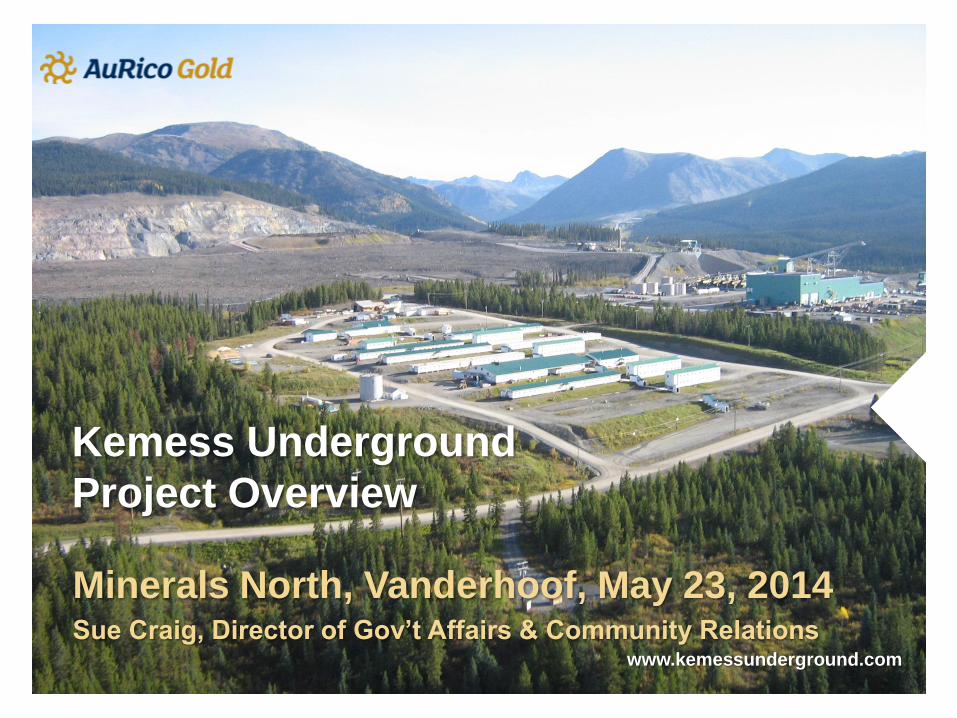
Kemess Underground Project Overview Minerals North, Vanderhoof, May 23, 2014 Sue Craig, Director of Gov’t Affairs & Community Relations www.kemessunderground.com
Transcript of Kemess Underground Project Overview - Minerals...
Kemess Underground
Project Overview
Minerals North, Vanderhoof, May 23, 2014 Sue Craig, Director of Gov’t Affairs & Community Relations
www.kemessunderground.com

Kemess Underground
Who is AuRico Gold?
• Canadian company with two operating mines – one
in Ontario and one in Mexico
• In 2011, AuRico acquired Northgate Minerals who
owned Kemess South Mine
• Kemess South Mine operated from 1998 until
closure in 2011
We are proposing to build an underground mine
6 km north of Kemess South
• Will produce 105,000 ounces of gold and 44
million pounds of copper annually over 12 years
2

Location relative to Vanderhoof
3
Vanderhoof

Kemess Underground Team
Team
• Chris Rockingham
• VP Exploration and Business
Development; Project Lead
• Harold Bent
• Director, Environment
• Linda Hodgson
• HR Advisor
• Wade Barnes
• Project Geologist
• Sue Craig
• Director Government Affairs &
Community Relations
4
Contact info: [email protected], 250.643.0723
Website: www.kemessunderground.com

Kemess South Mine
5
Operated from 1998 to 2011
• Open pit mine
• Significant Reclamation Completed
• Currently on care & maintenance – six people at site
Existing Infrastructure at Kemess South (valued at +$750 million)
• Camp
• Powerline
• Mill
• Admin Building, Warehouse
• Air Strip
• Access Road

Kemess South Mine Reclamation
• Annual programs since 1999, Large scale reclamation began in 2008
• Awards won for reclamation in 2001, 2008, 2009, 2010
• Reclamation included:
• contouring slopes
• Planting grasses, seeds and trees on tailings dam
• Construction of tailings dam spillway (expected discharge Q4 2014)
• Waste rock dump recontoured and planted
• Secondary mine roads
6

Kemess Underground
Environmental Assessment
• Project is being reviewed by both Federal and BC government
• Process was accepted for “substitution” and is being led by the BC Environmental Assessment Office
Steps in the Process
Submit Project Description to governments (Feb 2014)
This was reviewed by Takla, Kwadacha and Tsay Keh Dene before submission
• Working groups formed to determine what needs to go into the application about the project (June 2014)
• Submit application to government for review (end of 2014)
• Government and First Nations review of application
• Project approved (or not) by both federal and BC governments (end of 2015)
7
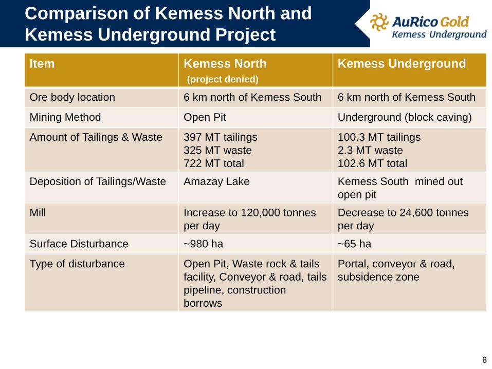
Comparison of Kemess North and
Kemess Underground Project
8
Item Kemess North
(project denied)
Kemess Underground
Ore body location 6 km north of Kemess South 6 km north of Kemess South
Mining Method Open Pit Underground (block caving)
Amount of Tailings & Waste 397 MT tailings
325 MT waste
722 MT total
100.3 MT tailings
2.3 MT waste
102.6 MT total
Deposition of Tailings/Waste Amazay Lake Kemess South mined out
open pit
Mill Increase to 120,000 tonnes
per day
Decrease to 24,600 tonnes
per day
Surface Disturbance ~980 ha ~65 ha
Type of disturbance Open Pit, Waste rock & tails
facility, Conveyor & road, tails
pipeline, construction
borrows
Portal, conveyor & road,
subsidence zone

Comparison Kemess North (Open Pit)
and Kemess Underground Project
9
Kemess North Surface Disturbance Kemess Underground Surface Disturbance
Waste/Tailings
Impoundment
Open PIt
Haul Road
Spillway
Tunnel &
Declines
Waste Rock & Tailings Conveyor &
Road
Tunnel
Zone of Subsidence

Kemess Underground Mine Method – Block Caving
10
• Top of economic mineralization in ore body is ~150 m below surface (extends to
550 m below surface)
• Orebody is 540 m long by 230 m wide
• Surface projection shown below – area outlined in circle is where “caving” or
subsidence will take place
• Block caving involves
systematic undercutting
of ore body such that the
ore will cave (uses
gravity)
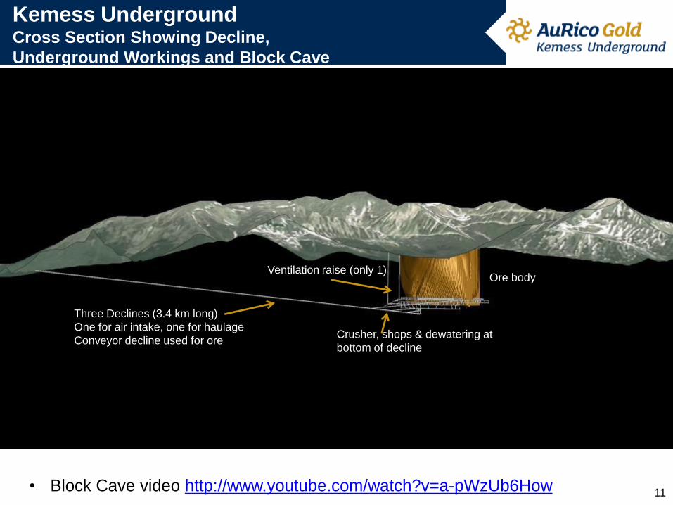
Kemess Underground Cross Section Showing Decline,
Underground Workings and Block Cave
Three Declines (3.4 km long)
One for air intake, one for haulage
Conveyor decline used for ore
Ventilation raise (only 1)
Crusher, shops & dewatering at
bottom of decline
Ore body
• Block Cave video http://www.youtube.com/watch?v=a-pWzUb6How 11
12
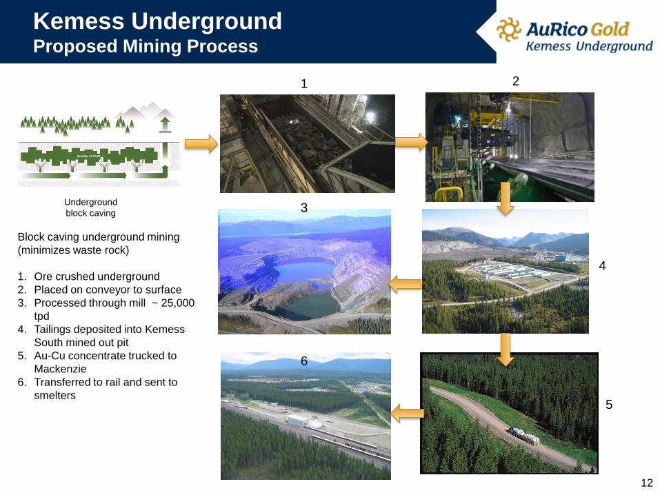
Kemess Underground Proposed Mining Process
Underground
block caving
Block caving underground mining
(minimizes waste rock)
1. Ore crushed underground
2. Placed on conveyor to surface
3. Processed through mill ~ 25,000
tpd
4. Tailings deposited into Kemess
South mined out pit
5. Au-Cu concentrate trucked to
Mackenzie
6. Transferred to rail and sent to
smelters
1 2
3
4
5
6
Kemess Underground Protecting the Environment
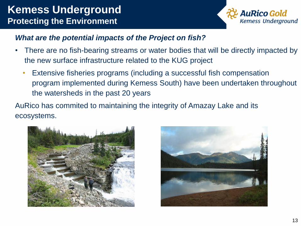
What are the potential impacts of the Project on fish?
• There are no fish-bearing streams or water bodies that will be directly impacted by
the new surface infrastructure related to the KUG project
• Extensive fisheries programs (including a successful fish compensation
program implemented during Kemess South) have been undertaken throughout
the watersheds in the past 20 years
AuRico has commited to maintaining the integrity of Amazay Lake and its
ecosystems.
13
Kemess Underground Protecting the Environment
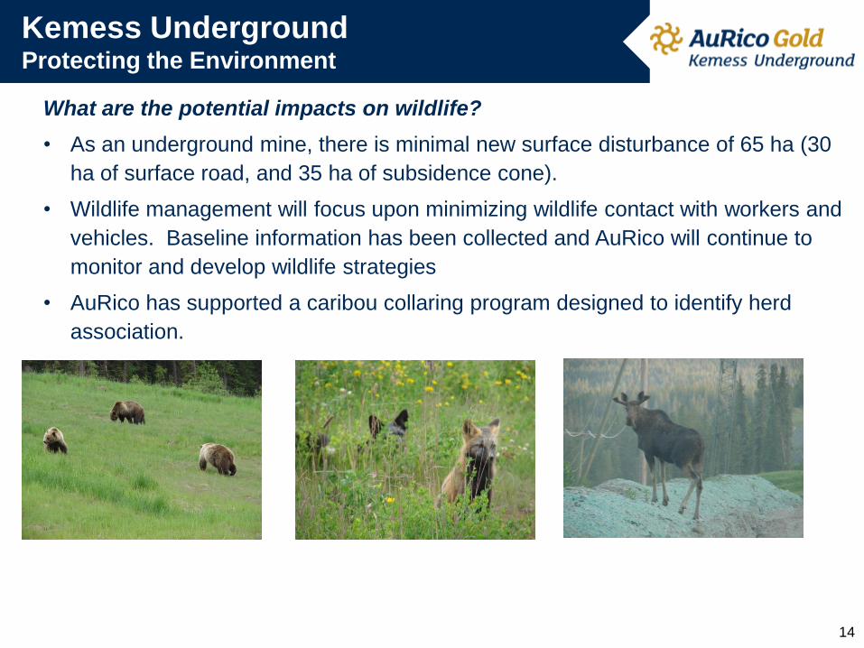
What are the potential impacts on wildlife?
• As an underground mine, there is minimal new surface disturbance of 65 ha (30
ha of surface road, and 35 ha of subsidence cone).
• Wildlife management will focus upon minimizing wildlife contact with workers and
vehicles. Baseline information has been collected and AuRico will continue to
monitor and develop wildlife strategies
• AuRico has supported a caribou collaring program designed to identify herd
association.
14

Ongoing studies:
• Archaeology
• Socio-Economic Review
• Hydrology
• Hydrogeology
• ML/ARD
• Surface Water Quality
• Meteorology
• Underground water prediction
Additional Studies:
• Archaeological Overview
Assessment
• Caribou
15
Tunnel &
Declines
Waste & Tailings Conveyor &
Road
Tunnel
Kemess Underground Ongoing Environmental Programs

Kemess Underground Aboriginal Engagement
• Which First Nations will be affected by the Project?
• Two Aboriginal traditional territories overlap the project location: Tsay Keh
Dene, and Takla Lake. One Aboriginal traditional territory is adjacent and
downstream from the project location: Kwadacha. These three nations identify
themselves as Tse Keh Nay (TKN).
• The Gitxsan House of Nii Kyap traditional territory lies adjacent to the Project
area along the western boundary.
• There are Metis communities in the larger regional area and the project is
located within the Treaty 8 disputed area.
• Discussions between AuRico and Tse Keh Nay, the primary First Nations affected
by the Project have been ongoing since AuRico acquired the property in 2011.
• Fourteen formal meetings over three years between the Tse Keh Nay, Northgate
and subsequently AuRico resulted in the signing of an Interim Measures
Agreement on June 22, 2012.
16

The agreement addresses a variety of topics including:
• Project permitting and environmental studies including:
• Environmental Assessment Conduct Agreement
• Additional Studies
• Business opportunities, employment and training opportunities
• Negotiation of an Impact Benefits Agreement (IBA)
• Review of the Kemess South Mine closure plans
• Senior Implementation Committee (SIC) – oversees agreement
• Comprised of Chiefs and senior AuRico representatives
• Meets on a monthly basis
• Environmental Management Committee (EMC)
• Representative from each FN and AuRico
• Meet regularly to review environmental plans/studies for proposed project
17
Kemess Underground Interim Measures Agreement
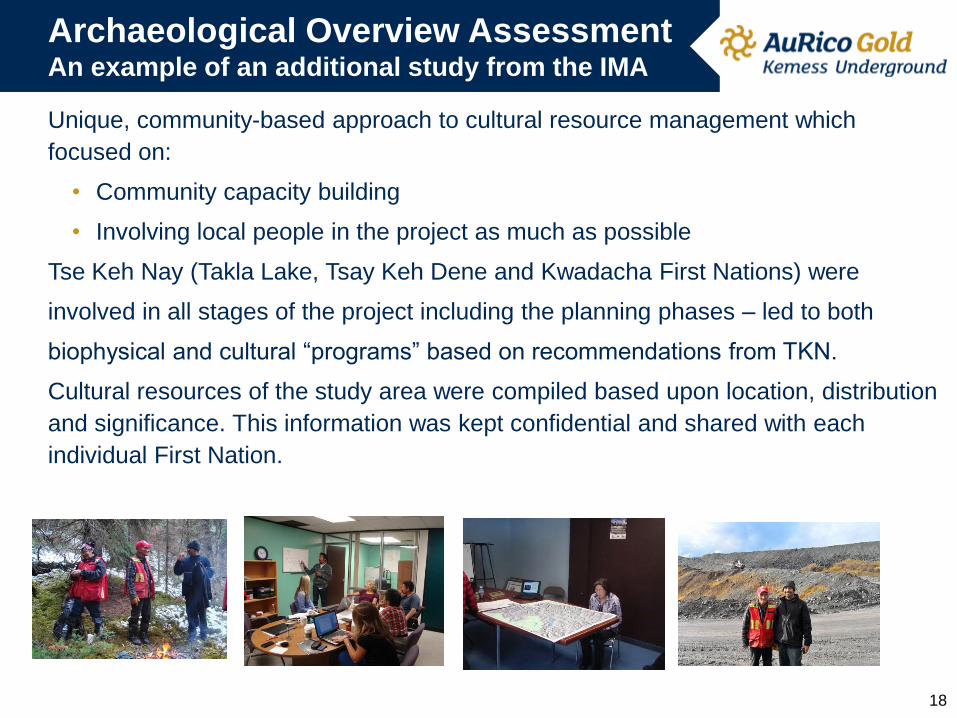
Archaeological Overview Assessment An example of an additional study from the IMA
Unique, community-based approach to cultural resource management which
focused on:
• Community capacity building
• Involving local people in the project as much as possible
Tse Keh Nay (Takla Lake, Tsay Keh Dene and Kwadacha First Nations) were
involved in all stages of the project including the planning phases – led to both
biophysical and cultural “programs” based on recommendations from TKN.
Cultural resources of the study area were compiled based upon location, distribution
and significance. This information was kept confidential and shared with each
individual First Nation.
18
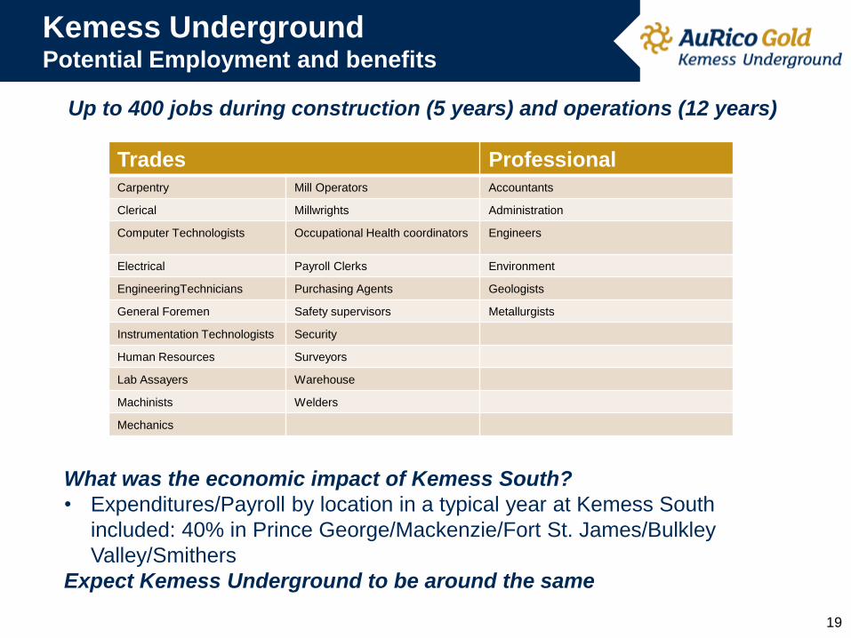
Kemess Underground Potential Employment and benefits
19
What was the economic impact of Kemess South?
• Expenditures/Payroll by location in a typical year at Kemess South
included: 40% in Prince George/Mackenzie/Fort St. James/Bulkley
Valley/Smithers
Expect Kemess Underground to be around the same
Up to 400 jobs during construction (5 years) and operations (12 years)
Trades Professional Carpentry Mill Operators Accountants
Clerical Millwrights Administration
Computer Technologists Occupational Health coordinators Engineers
Electrical Payroll Clerks Environment
EngineeringTechnicians Purchasing Agents Geologists
General Foremen Safety supervisors Metallurgists
Instrumentation Technologists Security
Human Resources Surveyors
Lab Assayers Warehouse
Machinists Welders
Mechanics
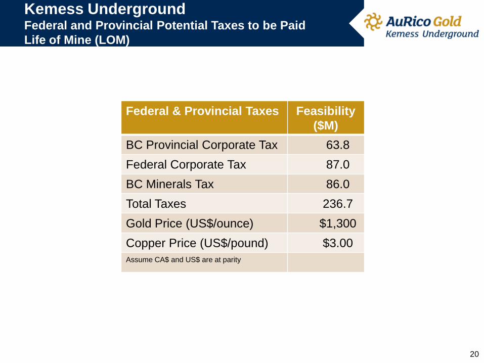
Kemess Underground Federal and Provincial Potential Taxes to be Paid
Life of Mine (LOM)
20
Federal & Provincial Taxes Feasibility
($M)
BC Provincial Corporate Tax 63.8
Federal Corporate Tax 87.0
BC Minerals Tax 86.0
Total Taxes 236.7
Gold Price (US$/ounce) $1,300
Copper Price (US$/pound) $3.00
Assume CA$ and US$ are at parity
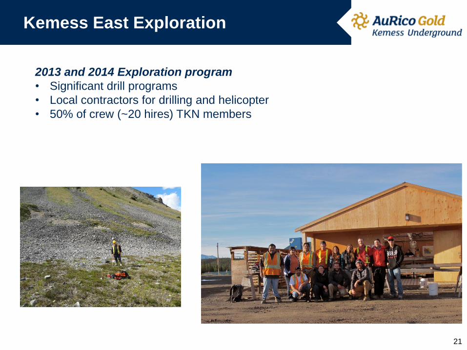
Kemess East Exploration
21
2013 and 2014 Exploration program
• Significant drill programs
• Local contractors for drilling and helicopter
• 50% of crew (~20 hires) TKN members

KEMESS UNDERGROUND
Summary & Next Steps
INFRASTRUCTURE
• KUG utilizes substantial existing KS infrastructure
• Waste rock & tailings will be deposited into empty KS Pit
• New disturbance of 65ha
AURICO & TSE KEH NAY RELATIONSHIP
• Interim Measures Agreement
• Open and regular communication via Senior Implementation Committee &
Environment Management Committee
ENVIRONMENTAL ASSESSMENT
• Beginning June – working groups to discuss what to be in application
• December – submission of application
• January to August 2015 – review of report
• Late 2015 – decision on project
22