Kawarau/Remarkables Conservation Area historicheritage values
22
Kawarau/Remarkables Conservation Area historic heritage values Cathryn Barr and Matthew Schmidt October 2020
Transcript of Kawarau/Remarkables Conservation Area historicheritage values

Kawarau/Remarkables Conservation Area historic heritage values
Cathryn Barr and Matthew Schmidt
October 2020

2
Cover: Hut and sluicing’s Baileys Hill, Upper Nevis. Photo: Carl Walrond.
Crown copyright 2020, New Zealand Department of Conservation
In the interest of forest conservation, we support paperless electronic publishing.

3
Contents 1. Setting............................................................................................................................................................................................. 4
2. Heritage background ............................................................................................................................................................ 6
2.2. Māori occupation and use of the valley .......................................................................................................... 6
2.2 Pakeha occupation and use .................................................................................................................................... 8
2.3 Gold mining ................................................................................................................................................................... 10
3. Physical evidence of heritage sites............................................................................................................................. 14
4. Statements of heritage significance ........................................................................................................................... 16
4.1 Aesthetic significance or value .......................................................................................................................... 16
4.2 Archaeological significance or value ............................................................................................................. 16
4.3 Architectural significance or value ................................................................................................................. 18
4.4 Historical significance or value ......................................................................................................................... 18
4.5 Social significance or value .................................................................................................................................. 19
4.6 Technological significance or value ............................................................................................................... 19
4.7 Summary of heritage significance or values ............................................................................................ 20
5. References .................................................................................................................................................................................. 22

4
1. Setting Te Papapuni/Nevis River (Nevis valley) is an iconic feature of the Central Otago landscape,
being vast and untouched by any modern developments. The valley is often described as being
divided into two areas: the Lower Nevis and the Upper Nevis, with these areas of the valley
being separated by the Nevis Gorge (Fig. 1). Together, these areas make up large parts of the
Kawarau/The Remarkables Conservation Area. Most of the historic heritage values of the area
are found within this valley and its tributaries (Hamel 2001).
The Upper Nevis area stretches from the valley floor to the crest of the Tāpuae
O’Uenuku/Hector Mountains) above Whakatipu-wai-Māori. This land was acquired through
tenure review in 2001, with this decision being based on the significance of both historic and
botanical values.
The Lower Nevis area was similarly acquired as a result of the tenure review process, on the
basis of the same values. The Lower Nevis includes the site of two settlements, one at the north
end of the valley known as Nevis Crossing, and the other at the southern end called Lower Nevis
Township.
Te Papapuni/Nevis River has a long history of human occupation, with evidence of occupation
spanning from the time of the early Māori settlement in Aotearoa through to today. The Nevis
valley is subject to an Area of Outstanding Landscape Value Notation in the Central Otago
District Plan, the result of an Environment Court Consent Order, granted in 2007. This notation
also applies to the valley floor and recognises that the historic gold mining remains in the valley
are part of this landscape.
The mountains have a rich pastoral run holding history from the 1860s when Grant, Gammie
and Rees held Run 345 (Kelvin Peninsula in west to the Nevis-Kawarau confluence in the east)
and Run 331 (Jacks Point in the north to Kingston in the south). Run 331 became Kawarau Falls
Station owned by Jardine family (Jardine 1978).

5
Figure 1. Kawarau/The Remarkables Conservation Area, is made up of two main areas totalling over 33,000 hectares. The southern Remarkables Conservation Area identified is also referred to as the Upper Nevis, and larger, northern Conservation Area is the Lower Nevis.

6
2. Heritage background
2.2. Māori occupation and use of the valley
Te Papapuni/Nevis River (Nevis valley) (Fig. 2) was crucial to pre-contact Māori as an inland trail
from Murihiku/Southland through to the West Coast (Anderson 1986).
Two moa-hunting sites identified as F42/5 and F42/7 under the New Zealand Archaeological
Association (NZAA) Site Recording Scheme (ArchSite) were originally recorded in the Lower
Nevis valley by naturalist Philip George in 1917 (George 1937) (Fig. 3).
Figure 2. Te Papapuni/Nevis River (Nevis valley) is part of an ara tawhito (traditional travel route) known as Te Ara a Tamatea (the path of Tamatea) that gave access from Te Ara a Kewa (Foveaux area) through to the Kawarau River and further on connects with ngā ara tawhito from the western and eastern coasts. Upper Nevis looking downstream towards Nevis Gorge. Photo: John Roberts, DOC.
7
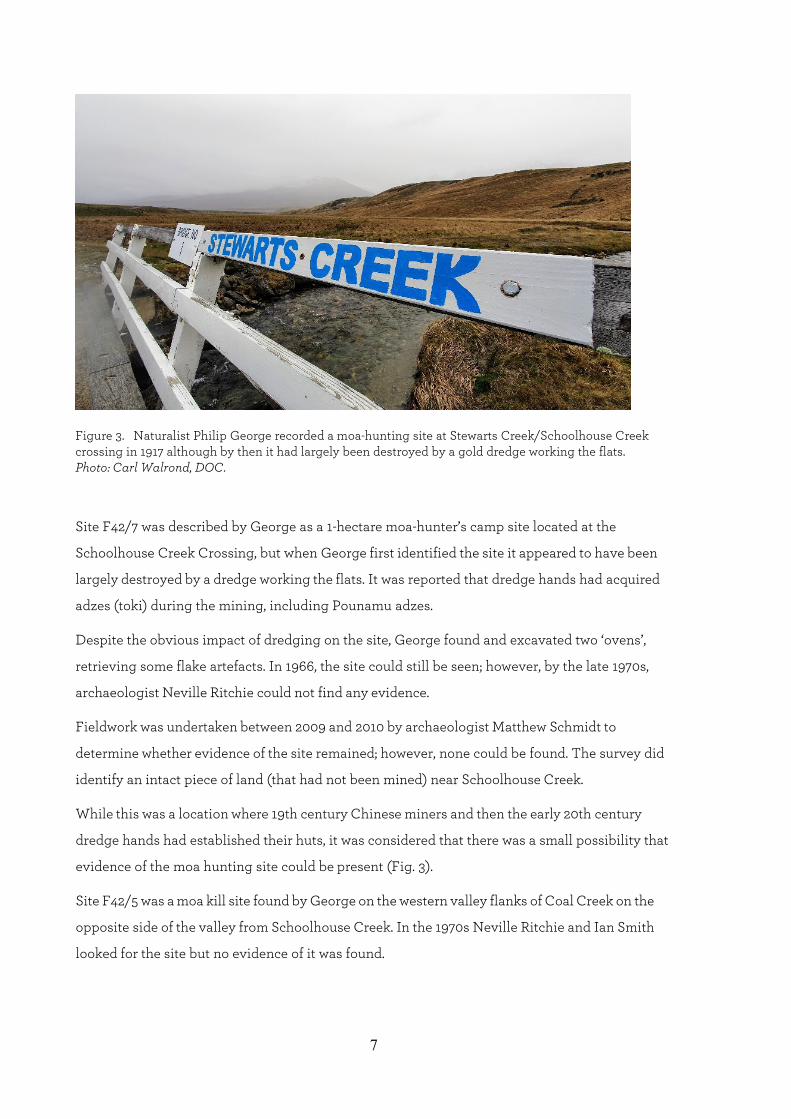
Figure 3. Naturalist Philip George recorded a moa-hunting site at Stewarts Creek/Schoolhouse Creek crossing in 1917 although by then it had largely been destroyed by a gold dredge working the flats. Photo: Carl Walrond, DOC.
Site F42/7 was described by George as a 1-hectare moa-hunter’s camp site located at the
Schoolhouse Creek Crossing, but when George first identified the site it appeared to have been
largely destroyed by a dredge working the flats. It was reported that dredge hands had acquired
adzes (toki) during the mining, including Pounamu adzes.
Despite the obvious impact of dredging on the site, George found and excavated two ‘ovens’,
retrieving some flake artefacts. In 1966, the site could still be seen; however, by the late 1970s,
archaeologist Neville Ritchie could not find any evidence.
Fieldwork was undertaken between 2009 and 2010 by archaeologist Matthew Schmidt to
determine whether evidence of the site remained; however, none could be found. The survey did
identify an intact piece of land (that had not been mined) near Schoolhouse Creek.
While this was a location where 19th century Chinese miners and then the early 20th century
dredge hands had established their huts, it was considered that there was a small possibility that
evidence of the moa hunting site could be present (Fig. 3).
Site F42/5 was a moa kill site found by George on the western valley flanks of Coal Creek on the
opposite side of the valley from Schoolhouse Creek. In the 1970s Neville Ritchie and Ian Smith
looked for the site but no evidence of it was found.

8
However, archaeologist Matthew Schmidt narrowed down where the site was likely located
based on George’s memoirs and determined that the site was actually in upper Coal Creek which
has never been systematically surveyed for archaeological sites. This un-surveyed area is also
outside of the areas dredged in the valley in the 19th and early 20th centuries and has been used
for grazing since the 19th century.
Philip George in his 1937 memoir makes reference to a third Māori site he identified in 1917 while
exploring in the Upper Nevis. A review of the description provided suggests that this may have
also been a moa kill site; however, no archaeological survey of the area has been carried out.
It is important to note that the Nevis Valley has never been systematically surveyed for Māori
archaeological sites and, despite 19th and early 20th century mining activity being extensively
recorded, it is likely evidence of Māori occupation is still present.
2.2 Pakeha occupation and use
Early pastoralists who followed Māori explorers and travellers introduced sheep to the Nevis
valley in 1860 (Hamel 1996: 3).
The Upper Nevis was found to be too difficult to farm logistically, with harsh seasonal climatic
conditions and inhospitable terrain, but also because of problems with wild dogs. As a result,
sheep were all but removed from the Upper Nevis during the 1860s (Hamel 1996: 3).
In the 1870s, sheep farming was again attempted, but not successfully, with some of the run-
holders supplementing their income as miners (Hamel 1996: 15). There is only one 19th century
structure related to pastoral history in the Upper Nevis, with the most significant and extensive
pastoral buildings and related structures being located in the Lower Nevis (Figs 4 & 5).
The earliest pastoral buildings in the Lower Nevis date to 1906 and relate to the Ben Nevis
Pastoral lease. These two stone buildings (a homestead and a shearers quarters) are of a style of
the 19th century.
The reason these buildings date to the early 20th century is because the Lower Nevis was
originally managed from the Kawarau Station side, and the Ben Nevis buildings were only
constructed when the larger run was broken up to create the Ben Nevis and Craigroy Runs.
The Ben Nevis farm complex does have buildings of 19th century origin however, such as the
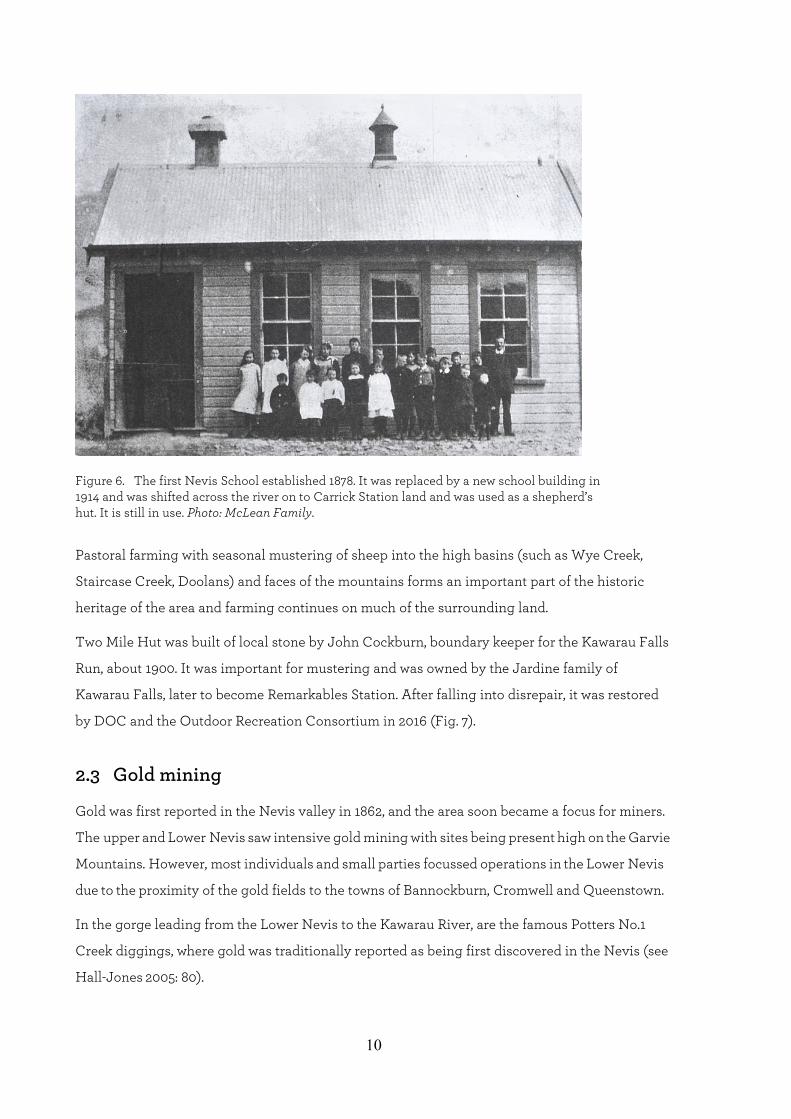
old Schoolhouse Creek School re-used for farm workers (Fig. 6).

9
Figure 4. The remaining wall of the Roxburgh Arms Hotel, Lower Nevis built by William and Helen Elliot in 1887. Their daughter (also Helen) lived there with her husband James Ritchie until 1934, when the building was abandoned. Photo: Carl Walrond, DOC.
Figure 5. Johnny Williams, proprietor of the Nevis Hotel (1920–1946), also Lower Nevis baker, shop keeper, butcher, postmaster. In winter the dough was not always sure to rise due to sub-zero temperatures. Photo: Graeme Stewart Collection.
10
Figure 6. The first Nevis School established 1878. It was replaced by a new school building in 1914 and was shifted across the river on to Carrick Station land and was used as a shepherd’s hut. It is still in use. Photo: McLean Family.
Pastoral farming with seasonal mustering of sheep into the high basins (such as Wye Creek,
Staircase Creek, Doolans) and faces of the mountains forms an important part of the historic
heritage of the area and farming continues on much of the surrounding land.
Two Mile Hut was built of local stone by John Cockburn, boundary keeper for the Kawarau Falls
Run, about 1900. It was important for mustering and was owned by the Jardine family of
Kawarau Falls, later to become Remarkables Station. After falling into disrepair, it was restored
by DOC and the Outdoor Recreation Consortium in 2016 (Fig. 7).
2.3 Gold mining
Gold was first reported in the Nevis valley in 1862, and the area soon became a focus for miners.
The upper and Lower Nevis saw intensive gold mining with sites being present high on the Garvie
Mountains. However, most individuals and small parties focussed operations in the Lower Nevis
due to the proximity of the gold fields to the towns of Bannockburn, Cromwell and Queenstown.
In the gorge leading from the Lower Nevis to the Kawarau River, are the famous Potters No.1
Creek diggings, where gold was traditionally reported as being first discovered in the Nevis (see
Hall-Jones 2005: 80).

11
Figure 7. Two Mile Hut is one of the few, and perhaps the only, remaining structure of historic heritage on the western side of the Remarkables Conservation Area. Photo: N.C. Simpson.
In the Upper Nevis, gold mining was also intense; however, due to the different geology, the gold
mining methods employed were more complex and involved sluicing projects that required
extensive water race construction.
The harsh climate was also a major influence on mining operations in the Upper Nevis, with the
fields being closed during the winter months (Fig. 8). The large mining operations took off in the
Upper Nevis in the early 20th century with large sluicing and dredging operations.

12
Figure 8. Using the chair to cross the frozen Nevis River. In the background is The Crossing Dredge, locked in ice and snow until the spring thaw. Photo: Louise Joyce.
The first miners to arrive in the area were Europeans, arriving in the early 1860s, shortly after the
discovery of gold. Chinese miners are reported to have started working in the Nevis a few years
later.
Chinese miners were physically barred by the European miners from various gold producing
areas in the Upper Nevis, such as at Whittens Creek, where European miners assaulted and
chased off Chinese miners who had arrived in 1866 to stake claims.
The Chinese population in the Nevis Valley was large by 1866, with almost half of the 600
people in the Valley reported as being of Chinese origin (Hall-Jones 2005: 80). By the 1870s, the
Chinese dominated the Lower Nevis mining population. In the Upper Nevis both Europeans and
Chinese mined through the 1870s to the 1880s with Europeans becoming the main mining
population from the 1890s onwards (Fig. 9).
Gold mining continued in the lower and Upper Nevis into the 20th century with later operations
still using the old 19th century sluicing methods such as ground sluicing and hydraulic
elevating. After the Depression, gold mining by particular families continued from the 1930s
until as late as 1991 in some areas, such as at Baileys Hill in the Upper Nevis and by McClean’s
in the Lower Nevis (Fig. 10).

13
Figure 9. The Rev George McNeur with Chinese miners in the Lower Nevis. Taken about 1900–01. Photo: Graeme Stewart Collection.
Figure 10. Elevator and crew working Bob McDonald’s claim near Baileys Hill in Upper Nevis sometime after 1903. In the background is Crewe No 2 dredge which worked the flats from 1903 to 1918. Photo: Toms Family.
It is of note that in addition to adaptation of mining techniques to suit the specific environment
in the Nevis valley, use of technology to aid operations is reflected in the early introduction of
power generation, with the miners using electric light to provide light for night mining as early
as 1904. Unusually, the Upper Nevis retains its physical evidence of independent power
generation dating from 1906 until the 1980s (Hamel 1996: 3) (Fig. 11).

14
Figure 11. Old hydro-electric lines and gold sluicings, Te Papapuni/Nevis River. At Baileys Hill in the Upper Nevis, a network of three family groups worked the complex alluvial faces improvising simple electric power systems using the 19th century water races up until the late 1980s. Photo: Carl Walrond, DOC.
The importance of the intactness of the 20th mining operations in the Remarkables
Conservation Area saw all mining evidence from this century declared an archaeological site by
Heritage New Zealand in 2007. This declaration was supported by the Department of
Conservation.
3. Physical evidence of heritage sites Hamel (1996: 19) notes that over 80% of historic gold-mining sites in the Upper Nevis lie in the
Kawarau/Remarkables Conservation Area. Mining sites in the conservation area were originally
mapped by Hamel in 1989, 1994 and 1996 as part of a series of historic values surveys associated
with pastoral lease surveys carried out by the Department of Conservation in the 1990s.
An additional survey of the area was carried out by Dr Matthew Schmidt and Shar Briden in 2007
as part of tenure review assessments of a neighbouring block and as part of the Heritage
New Zealand declaration process noted above (Schmidt 2007).
At that time, concentrated areas of mining remains along the boundary of the conservation area
were mapped in detail, along with the mining in Whittens Creek on the northern boundary. As a
result of the archaeological surveys, the complexity and significance of the mining history in the
Upper Nevis has been well established.

15
The Department of Conservation’s Conservation Resources Report describes the cultural
landscape on the valley floor as having been created by ‘extensive early gold and coal mining
activity’ (Fig. 12).
Mining workings include tailings, sluicing faces, dredge ponds, and water races, which show the
various mining technologies used in the valley. The extensive mine workings in this isolated
area give a sense of ‘both remoteness and stepping back in time, as well as providing examples of
adaptation of techniques to suit this harsh environment’.
The standing structures, as well as the remnants of buildings at the settlements at Lower Nevis
Township and Nevis Crossing, as well as those associated with the pastoral runs (the Ben Nevis
and Craigroy farmsteads) provide an insight into the type of settlement in the Nevis Valley and
its inter-relationship with the activities that took place there.
The Lower Nevis goldfield is a mosaic of evidence of all types of workings techniques covering
all of the major periods of historic gold working in Otago from 1863 to the 1930s. Though many
of the early workings in the river bed were destroyed by later dredging, the ground sluicings
along the edges of the higher terraces of both the Nevis River (Craigroy side and Schoolhouse
Flat), along the banks of Schoolhouse Creek and probably those in Scotchman’s Creek very
likely belong to the 1860–1880s period.
The Nevis Valley mining system is unique in Otago, and as part of the Otago goldfields in that
their landscape, range of mining technology type and scale are not represented elsewhere in
New Zealand (Bauchop 2010:19).
Figure 12. The cultural landscape of the Nevis valley includes sluicing faces such as these in the Lower Nevis which were created by jets of high-pressure water which washed gold-bearing gravels down to areas where they were worked. Photo: Carl Walrond, DOC.

16
4. Statements of heritage significance 4.1 Aesthetic significance or value
The stark, barren landscape of the Nevis valley is a dramatic setting which provides essential
context for the history of human occupation in the valley. The Māori, pastoralists, miners and
others who lived here lived in a climate of extremes which is reflected in the landscape.
This was an isolated undeveloped place and remains as such to a large extent today. This visual
context makes it possible to step back in time and imagine life for the earlier occupants of this
beautiful, harsh, isolated place. The relatively unmodified landscape of the Nevis basin is an
important context for the historic sites, giving it special, high aesthetic significance (Fig. 13).
Figure 13. The relatively unmodified landscape of the Nevis basin is an important aspect of the area’s historic heritage. This is the Nevis gorge between the Upper and Lower Nevis. Photo: Carl Walrond, DOC.
4.2 Archaeological significance or value
The high archaeological significance of the Nevis Valley lies in the culmination of layers of
interaction between humans and the natural environment from moa-hunting times to the
pastoralism of today, forming a palimpsest (a multi-layered record). This has left a dynamic
array of inter-related archaeological and historic sites which have been untouched by any
modern developments and are of outstanding significance.

17
The Nevis Valley is the only extensive, isolated, yet easily accessible, valley system of this type
in New Zealand where a range of key events of a region’s history can still be seen scattered on
the landscape. Moa hunters camped in the valley several hundred years ago, pastoralism which
continues today, began here in the 1850s and the full array of gold mining evidence from the
1860s to the 1990s can be seen.
Linking these key sites are stone sources for Māori, surveyors’ trigs, bullock and pack tracks,
coal mines, telegraph lines, living sites from sod walled structures to wood, brick and corrugated
iron buildings. The gold mining heritage stems from European and Chinese occupation in the
valley, with the Chinese once dominating the valley population, numbering up to 500. Coal has
also been mined in the Nevis valley (Fig. 14).
Figure 14. One of several coal pits in Lower Nevis. Photo: Graeme Stewart Collection.
Nineteenth century ground and hydraulic sluicing can be seen alongside early twentieth century
dredging remains. These sites lie amongst the pastoral sites of buildings, fence lines and yards
dating from the 19th and 20th centuries, some structures built from the discarded materials of the
gold miners.
Artefacts from every activity which has taken place in the valley can still be seen on the cultural
landscape, adding to the uniqueness of this place.
18
The archaeological and historic remains in the Nevis are unique and interconnected, and
through this it is possible to tell the story of the endeavours of humans within a valley system
from the 14th century until to the present.
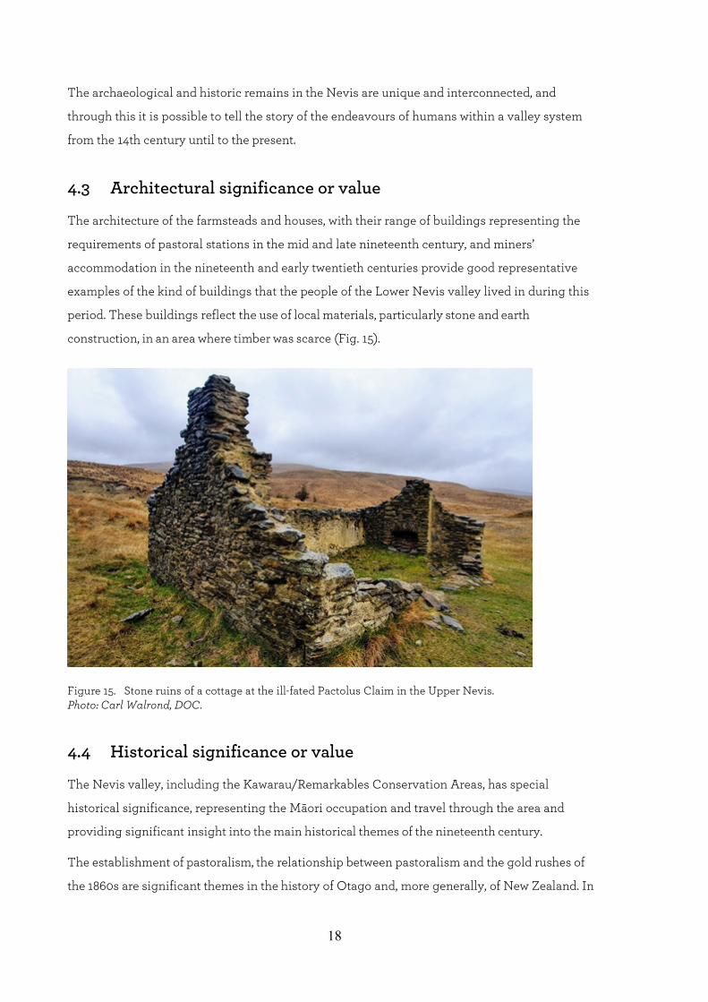
4.3 Architectural significance or value
The architecture of the farmsteads and houses, with their range of buildings representing the
requirements of pastoral stations in the mid and late nineteenth century, and miners’
accommodation in the nineteenth and early twentieth centuries provide good representative
examples of the kind of buildings that the people of the Lower Nevis valley lived in during this
period. These buildings reflect the use of local materials, particularly stone and earth
construction, in an area where timber was scarce (Fig. 15).
Figure 15. Stone ruins of a cottage at the ill-fated Pactolus Claim in the Upper Nevis. Photo: Carl Walrond, DOC.
4.4 Historical significance or value
The Nevis valley, including the Kawarau/Remarkables Conservation Areas, has special
historical significance, representing the Māori occupation and travel through the area and
providing significant insight into the main historical themes of the nineteenth century.
The establishment of pastoralism, the relationship between pastoralism and the gold rushes of
the 1860s are significant themes in the history of Otago and, more generally, of New Zealand. In

19
particular, the Lower Nevis Historic Area shows a continuity of mining history from the 1860s
through into the twentieth century in a largely undeveloped setting and is of special significance.
The history of mining in the Lower Nevis provides insight into the experiences of European and
Chinese miners in this harsh environment.
4.5 Social significance or value
The Kawarau/Remarkables Conservation Areas are considered to have high social significance.
The Lower Nevis Valley was once home to a scattered community of pastoralists, miners (both
European and Chinese) and their families.
The social activities and networks are reflected in the stories and sites: the settlements at The Crossing,
the Lower Nevis township (Fig. 16), and other gathering places, in the Valley provide insight into the
community. Places such as The Grandstand, and the remains of the hotels and schools tell stories of an
isolated community which social events were the glue that held them together (Joyce 2019) (Fig. 17).
Understanding the social connections still evident in the landscape in this isolated place
provides significant insight into life in this harsh environment.
Figure 16. Lower Nevis township in 1907. Photo: C.A. Tomlinson.
4.6 Technological significance or value
Within the Conservation Areas, the Lower Nevis Historic Area is considered to be of high
technological heritage significance. The archaeological and heritage remains in the landscape
range from early ground sluicing which dates from the 1860s through to dredging in the 1940s.

20
Figure 17. The Nevis Hotel in the 1890s. It burnt down in 1918. Photo: Louise Joyce.
In between were hydraulic elevating, hydraulic sluicing and coal mining. These remains
represent mining systems, interconnected and interrelated technologies which can be read on the
landscape: systems of head and tail races, dams, reservoirs, sluicing pits, tailings, dredge ponds
and tailings, as well as artefacts in the landscape relating to these mining technologies – dredge
remains and buckets, sluicing pipes and the like (Figs 18, 19).
These mining systems provide insight into the range of gold mining technologies used in the
valley, which are almost untouched and therefore provide a significant record of the workings of
such systems (Fig. 19).
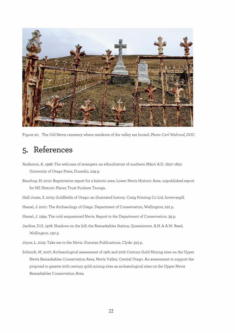
4.7 Summary of heritage significance or values
Relevant reports and documents associated with the heritage values of the Kawarau/Remarkables
Conservation Area have been reviewed as part of this assessment. Based on these reports,
particularly those completed by the NZ Historic Places Trust (now Heritage New
Zealand/Pouhere Taonga) it has been identified that the Kawarau Remarkables Conservation
Area possess high aesthetic, archaeological, architectural, historical, social and technological
significance or values (e.g. Fig. 20).

21
Figure 18. The Jones family had one of the richest claims in Upper Nevis in the 1930s and 1940s. This gold pans contain more than 400 oz of gold after one wash-up day. Photo: Graeme Stewart Collection.
Figure 19. Hydraulic elevator sluicing at Dave Adie’s claim in Lower Nevis in 1934. Photo: Louise Joyce.
22
Figure 20. The Old Nevis cemetery where residents of the valley are buried. Photo: Carl Walrond, DOC.
5. References Anderson, A. 1998: The welcome of strangers: an ethnohistory of southern Māori A.D. 1650–1850.
University of Otago Press, Dunedin. 249 p.
Bauchop, H. 2010: Registration report for a historic area: Lower Nevis Historic Area. unpublished report
for NZ Historic Places Trust Pouhere Taonga.
Hall-Jones, S. 2005: Goldfields of Otago: an illustrated history. Craig Printing Co Ltd, Invercargill.
Hamel, J. 2001: The Archaeology of Otago. Department of Conservation, Wellington. 222 p.
Hamel, J. 1994: The cold sequestered Nevis. Report to the Department of Conservation. 39 p.
Jardine, D.G. 1978: Shadows on the hill: the Remarkables Station, Queenstown. A.H. & A.W. Reed,
Wellington. 190 p.
Joyce, L. 2019. Take me to the Nevis. Dunstan Publications, Clyde. 323 p.
Schmidt, M. 2007: Archaeological assessment of 19th and 20th Century Gold Mining sites on the Upper
Nevis Remarkables Conservation Area, Nevis Valley, Central Otago. An assessment to support the
proposal to gazette 20th century gold mining sites as archaeological sites on the Upper Nevis
Remarkables Conservation Area.