Kāpiti Coast District Council · Topic Advisor Report Title ... believes there is no justification...
48
Kāpiti Coast District Council Submission to the New Zealand Transport Agency on Options for a State Highway 1 Expressway through the Kāpiti Coast District 30 October 2009
-
Upload
nguyenliem -
Category
Documents
-
view
217 -
download
0
Transcript of Kāpiti Coast District Council · Topic Advisor Report Title ... believes there is no justification...

Kāpiti Coast District Council
Submission to the New Zealand Transport Agency on
Options for a State Highway 1 Expressway
through the Kāpiti Coast District
30 October 2009


Page 1 of 46
CONTENTS
Kāpiti Coast District Council Submission
Part A Executive Summary Page 5
Part B Summary of the Kapiti Coast District Council’s Key Submission Points Page 8
Part C Detailed Submission
Section 1: Analysis of Proposed Motorway/Expressway Concept Page 15
Section 2: Mitigating Actions Required Page 37
Supporting Documentation
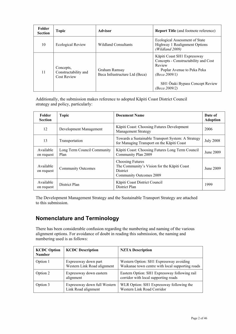
The Council has commissioned considerable professional advice in the course of its consideration of the NZTA proposals. The specific reports are an integral part of the submission and are listed, together with their submission folder section numbers, in the table below.
Folder Section Topic Advisor Report Title (and footnote reference)
2 Planning Processes Stuart Kinnear Consultancy Limited
Proposed Kāpiti Coast Expressway - Overview of Process (Kinnear 2009)
3 Urban Design Review Common Ground Studio Kāpiti Coast State Highway Expressway - Urban Design Review (Common Ground 2009)
4 Land Use Implications Jim Ebenhoh, Sustainable Development Manager Kāpiti Coast District Council
Land Use Implications of State Highway 1 Proposals (Ebenhoh 2009)
5 Transportation Review Angie Crafer flow Transportation Specialists Ltd
Road Transport Upgrade Through Kāpiti - Transportation Review for Kāpiti Coast District Council
Addendum: Road Capacity (Flow 2009)
6 Effects on Retail and Commercial Activity
Stimpson & Co with Don Wignall – Transport Futures Dr Ganesh Nana – BERL Ian Reid – Urban Economics
Kāpiti Coast SH1 Expressway Concepts - Technical Advice to Support KCDC Submission to NZTA Economic Effects (Stimpson 2009/1)
7 Economic Impacts Brent Wheeler, Brent Wheeler Limited Common Ground Studio
Kāpiti Road Upgrade Options: Economic Impacts (Wheeler 2009/1 and Wheeler 2009/2)
8 Effects on Properties Ian Reid – Urban Economics Davis Stimpson – Stimpson and Co
Kāpiti Coast SH1 Expressway Concepts - Technical Advice to Support KCDC Submission to NZTA Property Effects (Stimpson 2009/2)
9 Social Effects Dianne Buchan Corydon Consultants Ltd
Social effects of proposed Kāpiti expressway options - Technical Report (Buchan 2009)
Page 2 of 46
Folder Section Topic Advisor Report Title (and footnote reference)
10 Ecological Review Wildland Consultants Ecological Assessment of State Highway 1 Realignment Options (Wildland 2009)
11 Concepts, Constructability and Cost Review
Graham Ramsay Beca Infrastructure Ltd (Beca)
Kāpiti Coast SH1 Expressway Concepts - Constructability and Cost Review
Poplar Avenue to Peka Peka (Beca 2009/1)
SH1 Ōtaki Bypass Concept Review (Beca 2009/2)
Additionally, the submission makes reference to adopted Kāpiti Coast District Council strategy and policy, particularly:
Folder Section
Topic Document Name Date of Adoption
12 Development Management Kāpiti Coast: Choosing Futures Development Management Strategy 2006
13 Transportation Towards a Sustainable Transport System: A Strategy for Managing Transport on the Kāpiti Coast July 2008
Available on request
Long Term Council Community Plan
Kāpiti Coast: Choosing Futures Long Term Council Community Plan 2009 June 2009
Available on request Community Outcomes
Choosing Futures The Community’s Vision for the Kāpiti Coast District Community Outcomes 2009
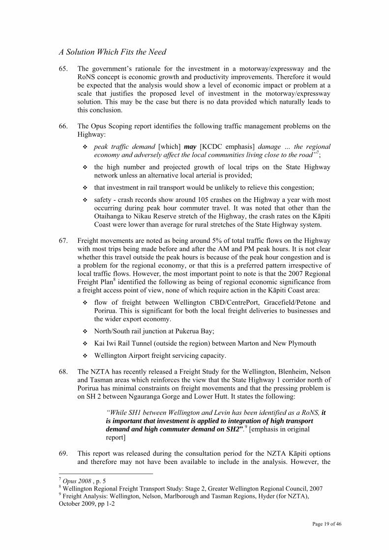
June 2009
Available on request District Plan Kāpiti Coast District Council
District Plan 1999
The Development Management Strategy and the Sustainable Transport Strategy are attached to this submission.
Nomenclature and Terminology
There has been considerable confusion regarding the numbering and naming of the various alignment options. For avoidance of doubt in reading this submission, the naming and numbering used is as follows: KCDC Option Number
KCDC Description NZTA Description
Option 1 Expressway down part Western Link Road alignment
Western Option: SH1 Expressway avoiding Waikanae town centre with local supporting roads
Option 2 Expressway down eastern alignment
Eastern Option: SH1 Expressway following rail corridor with local supporting roads
Option 3 Expressway down full Western Link Road alignment
WLR Option: SH1 Expressway following the Western Link Road Corridor

Page 3 of 46
EXECUTIVE SUMMARY
The Kāpiti Coast District Council is committed to working constructively with the New Zealand Transport Agency to support the Minister of Transport’s goal of better road transport options between Wellington Airport and Levin with a design horizon of 50 years. Further, the Council will work with NZTA to meet its strategy and priorities set out in its Statement of Intent 2009-2012.
The Kāpiti Coast District Council believes the most appropriate package of transport options is:
1. Two-Lane Western Link Road (WLR)
to be built at the earliest possible stage to provide significant relief to State Highway 1 with maximum local connectivity (road and active transport modes), fully integrated with the surrounding centres and environment;
2. Rail System
support the efficiency of the road network through passenger and freight rail improvements to Ōtaki and Palmerston North;
3. Improvements to State Highway 1
generally along the current alignment, addressing safety issues and peak congestion; including four lanes as and when necessary, median barriers, grade-separated or left in left out intersections, slip roads to manage direct property access, removal of traffic lights, and with operating speeds compatible with centres it passes through.
Introduction
1. The Kāpiti Coast District Council (The Council) welcomes the opportunity to submit on the New Zealand Transport Agency’s (NZTA) proposed motorway/expressway options from Raumati to the north of Ōtaki.
2. The Council has commissioned considerable expert analysis and advice in the course of formulating its position on the NZTA proposals. Topics covered included traffic and transportation issues, economic impacts, urban design and land use issues, social and amenity effects and ecological effects. Additionally, consideration has been given to national, regional and local strategies and policies, as well as legislative requirements.
3. The Council has taken a strategic view in this submission. The focus has been on identifying the best long term outcome for the District that still meets the needs of the national transport corridor.
Acknowledgement of NZTA Objectives
4. The Council acknowledges and supports the Minister of Transport’s desire for a Strategic Plan for the transport corridor between Wellington Airport and Levin and recognises its important national and regional function. The Council recognises the role of a Strategic Plan in identifying a programme to ensure the corridor’s functionality, including safety, security of access to Wellington, and more efficient movement of freight, particularly as this affects the national economy.
5. The Council acknowledges the need to resolve peak congestion points at Ōtaki, Waikanae and Paraparaumu, over time, in a manner consistent with the Strategic Plan.

Page 4 of 46
Road Design Standards
6. The Council considers the proposals, while described as motorway/expressway, are in fact a motorway standard. The Council considers the motorway/expressway standard design is unnecessary and inappropriate given the key issue is impediment to free traffic flow at critical points rather than fundamental State Highway capacity over the design horizon. In conjunction with the 2 lane Western Link, changes to the existing highway generally along the current alignment north of Poplar Avenue (excluding Ōtaki) will accommodate forecast traffic growth for 50 years.
7. A State Highway with no traffic lights, free flow of traffic, four lanes (as and when necessary), allowance for some areas of lower speed and some at-grade left in/left out access, offers a more pragmatic and flexible approach. It will achieve the intent of the Roads of National Significance programme more quickly, at less cost and not impose unnecessary and detrimental effects on the Kāpiti Coast community.
Economic Benefits
8. The Government Policy Statement on Land Transport Funding (May 2009) states land transport infrastructure investment should generate growth and productivity gains and enhance the economic efficiency of individual projects. The Council is of the view the proposals fail to demonstrate these issues have been addressed and that the economic rationale for the motorway/expressway standard road and the level of investment that requires is not supported by impartial analysis.
Integrated land use/transport planning
9. A significant issue for the District is the impact of the proposals on land use. The Council has a policy of limiting urban sprawl and consolidating development within clearly defined areas (Kāpiti Coast District Council Development Management Strategy 2007.) The western alignment options and the proposal for a full interchange at Peka Peka will encourage development pressure beyond the ‘urban edge’ north of Waikanae. The Council rejects options and intersection locations that are not consistent with land use policy.
South of Peka Peka
10. The Council’s analysis of the proposals for south of Peka Peka compared the three scenarios:
Options 1 & 3 : the motorway/expressway along the western (avoids town centres) alignment or use of the Western Link corridor, together with use of the existing SH1 as a local road; and
Option 2: the motorway/expressway down the eastern alignment (following the rail corridor) and part of the two lane Western Link Road.
11. The Council absolutely rejects both Option 1 and Option 3 because of the adverse strategic impacts, immediate effects and poor connectivity. In comparison, while Option 2 offers some improved connectivity through construction of a length of the Western Link Road, there are still significant long term adverse effects, including effects on property owners.
12. Should NZTA choose to proceed with a full motorway/expressway proposal, the Eastern Option including the full 2 lane Western Link Road is the least unacceptable alternative, only if there is significant mitigation of effects, including:

Page 5 of 46
Immediate construction of the underpass at Te Moana Road to reduce peak congestion on the State Highway at the earliest opportunity;
The proposed interchange at Peka Peka needs to be moved south (due to its impact on wider urban development and land use strategies) to Waikanae North and become the full interchange providing access at Waikanae;
Connectivity (intersection numbers and locations) is reviewed to provide workable arrangements which support rather than degrade town centres (including provision of a full intersection to serve the Paraparaumu town centre);
A significant focus on design quality, particularly for the town centres, to minimise the severance between east and west, and to assist adaptation to the new environment;
The alignment between Paraparaumu and Waikanae is reviewed to minimise the unacceptable impacts on this section of the community;
The speed limit is appropriate to the environment being passed through.
North of Peka Peka
13. The Council supports the proposal for a bypass of Ōtaki, generally on the alignment proposed, provided there is :
Review of intersection arrangements to ensure there is adequate and full north/ south access at the northern and southern edges of the town;
Review of the design speed through the central area;
Adequate investment in mitigation, including assistance for the town centre area to adapt.
14. The Council does not consider a new motorway/expressway is necessary between Ōtaki and Peka Peka, but does not oppose the concept, subject to:
Review of the need for four lanes;
Review of alignment as it affects valuable horticultural soils;
Adequate access at Te Horo is retained between east and west and to the old highway
KCDC’s Preferred Package of Options
15. The Council believes the most appropriate package of transport investment actions is:
1. two-lane Western Link Road (WLR)
2. rail system
3. improvements to State Highway 1.
16. Kāpiti Coast District Council requests a full and transparent consideration of its preferred package of transport investment actions.

Page 6 of 46
Page Intentionally blank

Page 7 of 46
SUMMARY OF THE KĀPITI COAST DISTRICT
COUNCIL’S KEY SUBMISSION POINTS
17. The Kāpiti Coast District Council’s submission makes the following points in relation to the government’s proposals for the Kāpiti Coast State Highway 1 Expressway routes.
18. The Council:
recognises the important national and regional function of State Highway 1, the need to maintain its functionality and the need for a long term strategic plan;
believes there is no justification to override established national and regional planning policy (NZTA, ex-Transit,) as to the future location of State Highway 1 and the need for a local arterial road;
is of the view that given the treatment of the Expressway intersections, the actual proposals are, in effect, to a motorway level design and that this has not been made explicit in the consultation process;
is of the view that peak congestion points at Ōtaki, Waikanae and Paraparaumu on the State Highway need to be addressed, in the short and the longer term;
questions why NZTA appears to have moved away from the concept of four lanes on the existing highway when projected traffic numbers do not support anything more expensive or disruptive for at least fifty years;
rejects the unilateral application of proposed design standards (in particular severely limited access and inflexible design speeds) which ignore a range of impacts on centres and communities;
believes NZTA has shown poor understanding of tāngata whenua on the Kāpiti Coast and a lack of understanding of local consultation processes, particularly in giving insufficient consideration to impacts on Māori cultural sites;
believes local communities should not be sacrificed for national interests but must be recognised as part of the overall economy and a vital part of integrated planning for a balanced package of infrastructure improvements and transportation measures delivering improved productivity and economic efficiency;
questions the Minister of Transport’s investment model that:
~ focuses on a presumed economic benefit derived from major expressway/ motorway investment which fails to take into account impacts and opportunities for economic activity occurring in local areas as part of overall net benefit;
~ focuses on expressway investment as a tool for national productivity gains but fails to account for the costs to productivity created by unacceptable urban form impacts (e.g. the real costs of urban sprawl), arising from the proposals;
has seen no analysis and evidence that the proposed Expressway model through the District is justified in order to address these issues, given an apparent benefit/cost ratio of 1 or less;
questions why, if the Roads of National Significance (RoNS) and expressway/ motorway concepts are considered a major tool in the government’s economic efficiency, productivity and growth programmes, no comprehensive economic analysis options has been undertaken as part of the RoNS programme roll out;

Page 8 of 46
believes the proposals do not acknowledge, clarify or contribute to wider responsibilities to reduce greenhouse gas emissions.
19. The Council acknowledges that the Minister of Transport has made it clear that his intention is for NZTA to construct a 100km/h limited access motorway/expressway through the Kāpiti Coast District. Should NZTA choose to proceed, the Council makes the following comments and suggests mitigation measures on the specific proposals put forward for consultation.
Design Standards
20. The Council considers the motorway standard design, including the management of access, is unnecessary and inappropriate given the key issue is impediment to free traffic flow at critical points rather than State Highway capacity over the design horizon. In conjunction with the two lane Western Link, and changes described below, the existing highway alignment (excluding Ōtaki) will accommodate forecast traffic growth for 50 years.
21. Analysis of the traffic volumes expected on the State Highway between Poplar Ave and Peka Peka Road indicate that a four lane highway in conjunction with a two lane local road will have sufficient capacity, even for peak hour traffic volumes. Even if the growth rate was 2% per annum, this section of highway could accommodate expected traffic growth for at least 50 years assuming adequate design and management of access and safety.
22. Unilateral application of motorway design standards is not supported. The Council recommends the application of a range of options where the need is justified to improve traffic flows and deliver required functionality from the existing State Highway. These include: four-laning, removing traffic lights, using median strips, reducing the number of entrances and exits onto the highway, careful consideration of intersection location, using slip roads and looking at underpasses.
South of Peka Peka
23. The Council is of the view that the adverse strategic impacts, immediate effects and poor connectivity of the western options (Options 1 and 3) are unacceptable. In comparison, while Option 2 offers some improved connectivity through construction of a length of the Western Link Road, there are still significant long term adverse effects, including effects on property owners.
24. The Council absolutely rejects both Option 1 (expressway on western alignment) and Option 3 (expressway on WLR alignment) for the following reasons:
the proposals significantly undermine the District’s urban consolidation policy described in the Community Outcomes 2009 and the 2009 Long Term Council Community Plan, and in the District’s adopted Development Management Strategy. It would re-introduce major urban sprawl pressures north of Waikanae and impose significant consequent costs on the community;
planning and property acquisition processes for the expressway would take at least five years to complete, there would be no benefit from the improvements at either a national, regional or local level for ten years;
the impact on the Takamore waahi tapu area
an expressway using any part of the Western Link corridor would introduce a significant new line of severance, leaving the communities of Raumati, Paraparaumu and Waikanae tri-sected by major road and rail corridors;

Page 9 of 46
any use of the Western Link corridor by the expressway would compromise the ability to provide the local connectivity around which the District’s development has been planned for many years;
the NZTA scoping report and technical reports are flawed because of the use of incorrect and out of date information, particularly urban design and planning assumptions around town centres and intersections.
25. The Council identifies the Eastern Option (Option 2) as the least unacceptable, but only if there is significant mitigation of effects, including:
measures to minimise severance between east and west;
reviewing assumed motorway/ expressway standards and in particular, operating speeds through Waikanae and Paraparaumu town centres;
the alignment between Paraparaumu and Waikanae is reviewed to minimise the unacceptable impacts on this section of the community;
reviewing the location and design of intersections to support town centres, and in particular, shifting the proposed Peka Peka intersection south to Waikanae North and providing a full interchange to serve the Paraparaumu town centre;
Immediate construction of the underpass at Te Moana Road to reduce peak congestion on the State Highway at the earliest opportunity;
integrating highway design with the Waikanae and Paraparaumu town centres at the quality and scale of concepts provided later in the Detailed Submission (Appendix 1), and offsetting economic and social effects while the centres and surrounding communities adapt;
providing major investment to mitigate and avoid social, environmental and ecological impacts.
North of Peka Peka
26. In relation to the proposal for a bypass of Ōtaki, the Council:
supports the establishment of a bypass behind the rail area, more or less on the proposed alignment, provided:
~ a full interchange is provided immediately south or just north of the river;
~ the current proposed intersections and access points at County Road and Rahui Road are abandoned as unacceptable;
~ an alternative local access route is provided should Rahui Road be closed;
~ the operating speed on the bypass as it passes through the urban area is reviewed;
~ the chosen route ensures potential is retained for Ōtaki to be used again as a freight railhead;
~ there is major investment in:
• integrating highway design and mitigation effects;
• upgrading the adjacent centre (at the quality and scale of concepts described later in the submission) to offset economic and social effects while the centre adapts;
• passenger rail services to Ōtaki within the time period for the construction of the bypass.

Page 10 of 46
27. The Council does not believe an expressway is necessary between Ōtaki and Peka Peka but does not oppose the concept (including limited access to the expressway at Te Horo), subject to:
a review of the proposed alignment as it affects valuable horticultural soils and the more intensive settlement on the eastern side of the rail line immediately north of Mary Crest;
adequate access between east and west across the expressway and rail line at Te Horo;
adequate access to the expressway with a full interchange within 10 minutes travel time.
KCDC’s Preferred Package
28. Having acknowledged and responded to the Minister’s position above, the Council reiterates its view that a combined package of transport investment will meet the national transport requirements and minimise adverse community effects. The Council believes the most appropriate package is as follows:
1. Two-Lane Western Link Road (WLR)
to be built at the earliest possible stage to provide significant relief to State Highway 1 with maximum local connectivity (road and active transport modes), fully integrated with the surrounding centres and environment;
2. Rail System
support the efficiency of the road network through passenger and freight rail improvements to Ōtaki and Palmerston North;
3. Improvements to State Highway 1
generally along the current alignment, addressing safety issues and peak congestion; including four lanes as and when needed, median barriers, grade-separated or left in left out intersections, slip roads to manage direct property access, removal of traffic lights, and with operating speeds compatible with centres it passes through.
29. It is the Council’s firm view these investment actions would contribute to the Minister of Transport’s goal of better road transport options between Wellington Airport and Levin with a design horizon of 50 years, and meet NZTA’s strategies and priorities as set out in its Statement of Intent 2009-2012.
Policy Framework
30. The policy framework underlying the Kāpiti Coast District Council response to the NZTA’s proposals/ options for the State Highway 1 has five broad components :
a. its responsibilities under the Local Government Act 2002 to pursue a sustainable development approach to its promotion of social, economic, environmental and cultural wellbeing.;
b. the community’s vision for its future which is outlined in detail in a series of documents known as District and Local Community Outcomes which have been developed as part of the required LTCCP process. This includes addressing issues of social severance and impacts on households and communities from transport investment decisions;

Page 11 of 46
c. the place of the District in the regional economy and the importance of good quality sustainable urban form as a contribution to that economy – a position developed as part of the Wellington Regional Strategy;
d. two major Council strategy documents: the Development Management Strategy 2007 and the Sustainable Transport Strategy 2008.
e. consideration of a series of significant global trends and issues which shape local and regional social, economic and environmental outcomes. The issues identified in its Long Term Council Community Plan (LTCCP) 1 relevant to consideration of the NZTA’s proposals for the State Highway are:
~ climate change;
~ peak oil and cost of energy;
~ the existing narrow economic base on the Kāpiti Coast and reliance on commuting to Wellington;
~ the economic downturn.
31. This broad framework is consistent with national, regional and local strategies and policies, as well as other legislative requirements. These include the direction set out in objectives of the Land Transport Management Amendment Act 2008, and the goals of the Regional Land Transport Strategy and its targets around mode shift, green house gas emission reduction and a complete and integrated transport network.
32. Embedded in the Council’s strategy documents is an explicit consideration of the role of the State Highway and the relationship of the Kāpiti Coast with it. Considerable work has been undertaken to develop a sustainable transport strategy and development management strategy in what has been a policy vacuum around the Government’s detailed intentions for the State Highway. Kāpiti Coast District Council has had similar concerns to those of the Minister of Transport, for a much longer period, regarding the lack of certainty about the Government’s long term intentions for the State Highway.
33. In considering the proposals, the Council has also had regard for minimising the number of directly affected households and minimising the social and environmental effects on surrounding communities. These are aspects that should not be underestimated in terms of potential disruption and dislocation.
34. The Kāpiti Coast District Council has consistently submitted on a range of regional and national transport programmes and strategies based on its strategic framework. Solutions to the issues of traffic flow and capacity on the State Highway have been proposed as follows:
a. construction of the Western Link as proposed by Kāpiti Coast District Council and previously supported by NZTA at 90% subsidy. This would remove 24% of the current State Highway traffic within three years, improve local connectivity and reduce travel times (and associated emissions) and foster a shift to active modes;
b. significant investment in passenger transport, particularly rail, to reduce reliance on private vehicles. This includes the need for serious investigation of the possibility for rail shuttle services between Palmerston North and Waikanae, particularly in light of the impacts on passenger services, particularly the Capital connection service, following the extension of the suburban electric network to Waikanae;
1 Kāpiti Coast District Council, Long Term Council Community Plan – 2009. pp. 26-27.

Page 12 of 46
c. investment in a four-lane State Highway 1 on the current alignment. The Council has stated its support for a four-lane State Highway and introduction of a limited number of grade-separated interchanges, notably at Paraparaumu and Waikanae, with a number of controlled left in and left out access points, with median barriers where necessary, combined with management of direct property access with well designed slip lanes. It has previously acknowledged the need for a bypass at Ōtaki;
d. provision of high quality integrated design solutions at the District’s centres, including clear statements that State Highway functionality can also be achieved with lower design speeds through the town centres, provided traffic flow is unimpeded;
e. promotion of a sustainable urban form framework for the Kāpiti Coast which encourages the creation of local jobs and therefore reduced commuting pressures, uptake of passenger transport and travel by cycling or walking.
35. Kāpiti Coast District Council has, in the course of consideration of NZTA’s proposals, commissioned work on the urban design impacts and opportunities presented by the proposals. Details of these potential State Highway improvements along with examples of how town centre design and access can be handled at Paraparaumu, Waikanae and Ōtaki are found in Appendix 2. None of these examples should be seen as a final solution advocated by Kāpiti Coast District Council: they are examples of how the work on the State Highway can be integrated with surrounding areas to achieve a better land-use/ transport outcome.
36. There are already serious congestion issues at key points on the Highway. The important reasons why the issues need to be addressed are:
the risks to emergency and other essential services with no second route across the Waikanae and Ōtaki Rivers, should the State Highway become blocked from an accident or congestion;
a more general risk of major highway failure and inability to travel north from or south into Wellington;
the cost of congestion and delay to national traffic, especially freight (not addressed by increasing speed).
37. These issues need to be addressed now. However, both the western options (Options 1 and 3) have at least a ten year completion horizon. Benefits can be provided to the highway in a shorter timeframe through improvements to State Highway 1.
38. The construction of the two lane WLR is an integral part of the Council’s preferred package. All the necessary consents have been obtained. Work could be started within nine months and completed within three years of starting. The project would reduce traffic volumes on the highway by 24% significantly reducing congestion and providing benefits to both national and local traffic while the other parts of the project were being designed, consented and constructed. Building the underpass at Te Moana Road is one of the urgent and beneficial improvements that would reduce peak congestion on the State Highway at a much earlier date.
39. These overall actions have been regularly offered as solutions by the Kāpiti Coast District Council to the issue of traffic flow on the State Highway. They have also been offered as contributions to addressing wider issues of sustainable development, climate change issues, the rising cost of travel and the building of a local economy, consistent with national policy. It is of concern that these essential points of logic were not properly considered as part of the review process and were prematurely dismissed on

Page 13 of 46
the grounds it would be too difficult and expensive to achieve the objectives of a motorway/expressway.
40. In respect of the published criteria against which the options will be considered, the Council makes the following observations:
Economic development – the Council expects the proposals will produce long term benefits in respect of growth and productivity gains and but remains uncertain about the economic efficiency of the substantial investment required for a motorway standard road to deal with the predicted State Highway traffic volumes for the 50 year period;
Safety and personal security – a four lane State Highway with a median barrier and reduced access undoubtedly improves safety but flexibility in setting speed limits is an important aspect that must also be considered;
Access and mobility – the primary purpose of the expressway is to enable people and businesses to move efficiently through the District but accessibility within the District and the location of intersections, particularly servicing town centres, is of major concern;
Public health – there is limited evidence of provision for active transport modes unless the Western Link is included. Increased severance created by the western alignments for the motorway/ expressway will increase reliance on car-based trips;
Environmental sustainability – the Council is unable to comment on this criterion due to lack of information.
41. Kāpiti Coast District Council requests a full and transparent consideration of its preferred package of transport investment actions, including objective assessment of all the reports commissioned or prepared in the course of developing this submission.

Page 14 of 46
Page Intentionally blank

Page 15 of 46
DETAILED SUBMISSION OF THE KĀPITI COAST
DISTRICT COUNCIL ON THE
NEW ZEALAND TRANSPORT AGENCY
MOTORWAY/EXPRESSWAY PROPOSALS SECTION 1: ANALYSIS OF PROPOSED MOTORWAY /
EXPRESSWAY CONCEPT
42. There are four key issues the Kāpiti Coast District Council considers to be significant strategic flaws in the proposed approach and rationale presented by NZTA. These are:
a. the unexplained shift in the Technical Report2 from the scenarios and the conclusions derived from them, the subsequent options selected for analysis and the final conclusions of the Technical Report;
b. the unsubstantiated view that the level of congestion and capacity need requires the motorway/expressway solution that is presented;
c. the land-use/urban planning or design framework set out in the Scoping Report3 and re-used in the Technical Report.
d. the failure to provide an analysis of the wider economic and productivity costs/benefits of the proposal that are the focus of the governments thinking around RONS and infrastructure investment.
From Scenarios to Options: The Missing Link.
43. The first part of the Opus Technical Report reviews four scenarios: Do-nothing, State Highway Expressway only (Scenario 1), Western Link Expressway only no SH1 upgrade (Scenario 2), and State Highway 1 Expressway and Western Link Road (Scenario 3). The scenarios assume the Western Link is funded through to Peka Peka, rather than to Te Moana Road.
44. The analysis looked at the total benefits across the local and State Highway networks. Despite the assumptions about the proposed WLR extent, the conclusions reached were:
a local arterial (the Western Link) allows traffic to be widely dispersed around the road network and therefore reduces queued time;
‘the total economic benefits achieved by building the WLR and the state highway expressway is significantly greater than the sum of the benefits calculated by providing each as a stand-alone scheme. The tangible benefits for a SH1 expressway with a supporting WLR are approximately +$470m.
the greatest reductions in the total hourly traffic flow on SH1 were achieved under Scenario 3 (the combined scenario).
45. The report also noted that if Paraparaumu and Waikanae were isolated from the State Highway this would give better WLR performance in terms of traffic volumes and
2 Opus 2009 - Kāpiti SH1 Strategy Study Technical Report, Opus International Consultants Ltd, 19 August 2009 3 Opus 2008 - Transit NZ SH1 Kāpiti Strategic Study Scoping Report, Opus International Consultants Ltd, 7 July 2008

Page 16 of 46
reduce travel time further on the Highway. The argument for a local arterial (WLR), in the view of the report writers, was strengthened as the level of the isolation from the Highway at the town centres was increased.
46. It was however, argued that a local arterial giving a connection between Waikanae and Paraparaumu was desirable but not essential as the old State Highway could be used as an eastern link. This would have eliminated a bridge crossing on the WLR alignment and forced all traffic to travel along the old Highway. This variant was subsequently eliminated.
47. The Technical Report then moved on to assess four options, none of which considered a full WLR option (Poplar Avenue to Te Moana Road) alongside the State Highway improvements. No data on final travel movements etc is provided and no explanation is given as to why these options were finally chosen, although it is possible to see an inkling of Option 2 as finally proposed.
48. The conclusion Kāpiti Coast District Council has come to is that the options chosen for analysis for the southern end of the District are arbitrary and imposed later in the process, after the RoNS concept was announced. In the Council’s view, this is emphasised by the final conclusions of the report which seem to have been added despite the earlier analysis of the options. These conclusions note:
“The Western Link Road … has been shown to significantly reduce the number of vehicles using the SH and hence reduce congestion now and in future years”;
“Given the need to serve both inter-regional and local trips, both the SH1 expressway and parts of the Western Link Road are required to be built. Other sections of the Western Link Road are desirable”.
49. This is further reinforced by the statements in the Technical Report that the Western Link Road between Te Moana Road and Otaihanga Road has the highest benefit/cost ratio (BCR) of any element considered, including any element of the expressway. (See later discussion of BCR).
50. This sense of the arbitrary nature of this analytical and consultation process has been further reinforced by the late addition of Option 3 (WLR Option/Sandhills Motorway) into the consultation process. Formally reviewed and rejected by NZTA, it has been reintroduced by the Minister of Transport in apparent response to the justifiable distress of property owners affected by Option 1 and Option 2. Ironically, in the process of doing so, the underpinning urban form rationale presented in the Opus Scoping and Technical Reports which seeks to limit the local traffic on the motorway/expressway and avoid direct access to centres is undermined. It is not clear to what extent this fundamental building block of the original strategy is still valid. As a consequence, the Council is left with the difficult task of responding to options with uncertain base rationale and data.
51. This readiness to introduce new options so easily suggests there is a lack of confidence that due diligence has been undertaken in the initial analysis. If new information had been offered which might point to the need to re-open options, then this would be appropriate. This has not been the case. Given the need at the designation stage to have clearly shown that all options have been adequately traversed, the Kāpiti Coast District Council is of the view that, before a decision is reached, the NZTA must formally consider its package of the WLR between Poplar Avenue and Te Moana Road, alongside a four lane concept for the State Highway on the existing alignment.

Page 17 of 46
Expressway or Motorway – and Why?
52. This section considers three matters:
a. what exactly is being proposed – an expressway or a motorway?
b. what is the problem and what justification is there for the proposed level of service?
c. benefit/cost ratio assessment
Clarifying Definitions: Expressway or Motorway?
53. The NZTA proposals are identified as being intended to move the State Highway level of service to an Expressway standard. It is Kāpiti Coast District Council’s view that the proposals are clearly a motorway standard and that this has not been communicated to the community in the consultation process. This lack of transparency is of considerable concern and is of such seriousness in terms of outcomes for the District that it is the Council’s view that the NZTA has failed to consult in an open and transparent manner.
54. The NZTA defines expressways as4:
high speed roads, [with] well spaced at-grade intersections. This means they have accesses and driveways on to them and traffic lights;
design speeds of 80-100kph;
cyclists are permitted but not pedestrians.
55. Motorways are defined as:
“highly controlled, high-speed roads which normally have grade-separated intersections. In other words they have things such as flyovers so that motorists don't have to stop at traffic lights”;
design speeds of 100-110kph
dual carriageway where opposing traffic is separated by a median strip or barrier;
cyclists and pedestrians prohibited.
56. Flow Transportation in their report notes ‘the distances required for safe merging, weaving, deceleration and signage generally dictate the minimum spacing of interchanges. Typically minimum interchange spacing is 1.5 km in urban areas and 3 km in rural areas.’5
57. The Opus Transit NZ: SH1 Kāpiti Strategic Study 2008 (Scoping Report) prepared by Opus for NZTA on the expressway design notes “it is proposed that the strategy will be developed on the assumption that a minimum spacing of about 5km is provided between interchanges.6 No rationale is offered for this spacing except that it appears after the concept diagram for developing the State Highway on the Kāpiti Coast. This diagram indicates a link via the interchanges outside the urban areas with a western arterial (assumed to be the Western Link) which is to be used to then decant traffic back into the urban areas. It can only be assumed that this is the source of the rationale
4 http://www.transit.govt.nz/about/faqs.jsp#6 5 Flow 2009, pp 3-5. The report references ‘A Policy on Geometric Design of Highways and Streets’, American Association of State Highway and Transportation Officials (AASHTO), 2004. See also Stimpson 2009, p.5 6 Opus 2008, p. 99

Page 18 of 46
for excluding interchanges from the urban areas and for the 5km distance standard between interchanges.
58. The initially proposed spacing is approximately 6.4 km between the Poplar Avenue and Otaihanga Road interchanges and 7.9 km between Otaihanga Road and Peka Peka Road. Of equal importance, the current proposals do not provide for a complete western arterial (Western Link) with the section between Kāpiti Road and Otaihanga Road removed. Therefore the rationale offered for the interchange distances collapses.
59. The proposed interchange at Ōtaki comprises four ramps separated over a distance of some 4.2 km.
60. In effect the proposals deliver:
a stated design speed of 100km posted limit. This is at the top end of the posted design speed for expressways;
excessive distances (i.e. outside accepted urban and rural motorway/expressway standards ) between interchanges;
full grade-separated interchanges only;
the possibility of pedestrian and cycling access along the route but a recommendation that this occur on arterials and other routes because of the design standards.
61. The concept of an expressway was first identified as part of the Western Corridor Study in 2006. Kāpiti Coast District Council has consistently questioned the application of rigid design speeds for an expressway as it passes along the edge of a town centre. The view taken by the Council is that the key to State Highway 1 functionality and performance is uninterrupted flow, with speeds possible down to 70kph in the town centres. The design process for the Te Moana Road Underpass during 2008 included clear signals that NZTA was moving away from the more rigid approach and was considering a lower speed limit, provided there was no impediment to the free flow of traffic.
62. Given the actual design standards and assumptions now being used, the Council has received expert advice that the proposals should more properly be described as a motorway system. The Council has been at pains to point out these discrepancies during the consultation process, so the community is not misled about what is being proposed. For the remainder of this submission the term motorway/expressway is used.
63. The revised consultation document issued on 30 September 2009, indicates a preparedness to look at interchanges at Paraparaumu and Waikanae for the eastern alignment and for Paraparaumu, Otaihanga and Te Moana Road, in addition to Poplar Avenue and Peka Peka, for Option 3. It is not made clear whether all possible interchanges would be funded but this would be highly unlikely. While the shift potentially brings the interchange distances closer to accepted urban motorway standards, it is still a motorway.
64. Finally, it should be noted that the Transit New Zealand Planning Policy Manual states that some State Highways are managed as “expressways” and that this “signals Transit New Zealand’s long term intention to seek the declaration of the road as motorway”. This appears to be the intent of the standards used and should have been made clear in the consultation process. It is a serious flaw in the discharge of the NZTA’s consultation responsibilities.
Page 19 of 46
A Solution Which Fits the Need
65. The government’s rationale for the investment in a motorway/expressway and the RoNS concept is economic growth and productivity improvements. Therefore it would be expected that the analysis would show a level of economic impact or problem at a scale that justifies the proposed level of investment in the motorway/expressway solution. This may be the case but there is no data provided which naturally leads to this conclusion.
66. The Opus Scoping report identifies the following traffic management problems on the Highway:
peak traffic demand [which] may [KCDC emphasis] damage … the regional economy and adversely affect the local communities living close to the road”7;
the high number and projected growth of local trips on the State Highway network unless an alternative local arterial is provided;
that investment in rail transport would be unlikely to relieve this congestion;
safety - crash records show around 105 crashes on the Highway a year with most occurring during peak hour commuter travel. It was noted that other than the Otaihanga to Nikau Reserve stretch of the Highway, the crash rates on the Kāpiti Coast were lower than average for rural stretches of the State Highway system.
67. Freight movements are noted as being around 5% of total traffic flows on the Highway with most trips being made before and after the AM and PM peak hours. It is not clear whether this travel outside the peak hours is because of the peak hour congestion and is a problem for the regional economy, or that this is a preferred pattern irrespective of local traffic flows. However, the most important point to note is that the 2007 Regional Freight Plan8 identified the following as being of regional economic significance from a freight access point of view, none of which require action in the Kāpiti Coast area:
flow of freight between Wellington CBD/CentrePort, Gracefield/Petone and Porirua. This is significant for both the local freight deliveries to businesses and the wider export economy.
North/South rail junction at Pukerua Bay;
Kai Iwi Rail Tunnel (outside the region) between Marton and New Plymouth
Wellington Airport freight servicing capacity.
68. The NZTA has recently released a Freight Study for the Wellington, Blenheim, Nelson and Tasman areas which reinforces the view that the State Highway 1 corridor north of Porirua has minimal constraints on freight movements and that the pressing problem is on SH 2 between Ngauranga Gorge and Lower Hutt. It states the following:
“While SH1 between Wellington and Levin has been identified as a RoNS, it is important that investment is applied to integration of high transport demand and high commuter demand on SH2”.9 [emphasis in original report]
69. This report was released during the consultation period for the NZTA Kāpiti options and therefore may not have been available to include in the analysis. However, the
7 Opus 2008 , p. 5 8 Wellington Regional Freight Transport Study: Stage 2, Greater Wellington Regional Council, 2007 9 Freight Analysis: Wellington, Nelson, Marlborough and Tasman Regions, Hyder (for NZTA), October 2009, pp 1-2
Page 20 of 46
earlier freight report did lead to similar conclusions. The report appears to be stating that from a freight efficiency perspective, the RoNS concept is focused on the wrong part of the Highway network in Wellington.
70. Of equal importance in the study is the clearly stated view that there is sufficient capacity in the system, even possibly at SH2, provided that this is optimised. Rather than build major new capacity, the report identifies a number of actions which would release latent capacity in the system. It notes that a UK Treasury Study in 2006 suggested that a 1% improvement in the efficiency of an existing network had seven times the economic impact of a 1% increase in spending to expand capacity.
71. The report suggests that there needs to be more emphasis on improved freight logistics, investigation of high performance freight hubs, reallocation of road space to freight on some parts of the network (notably in the southern Ngauranga/ SH2 area), traffic management at peak times, marginal extra capacity through other modes and some capacity improvements at key pinch points.
72. It would appear that the congestion issues on the Kāpiti Coast do not have a significant direct regional economic impact – certainly the Opus Scoping report only speculates that this may be an effect and offers no data. Rather, the current issues appear to be more about general travel times and probably can be summed up more at this time as commuter frustration. However, there are likely to be direct local economy development opportunity costs over time as congestion increases. This is an issue for building a sustainable local economy which generates local job choice.
73. The recent freight report is extremely important in the context of the Minister of Transport’s rationale for RoNS being investment to solve a significant economic/ productivity growth blockage. It is also significant in the context of the NZTA’s design proposals which plan to add significant new capacity to the SH1 Highway itself. If the problem, from a freight perspective is optimisation (possibly even at SH2) then optimisation by removing local traffic via a well designed local arterial and removal of impediments to free flow on the highway would seem the appropriate level of solution to the true nature of the problem.
74. The report further reinforces the Kāpiti Coast District Council view that the proposals by the Minister and NZTA are paradigms and highway design standard orthodoxies that bear no relation to the context. This is of considerable concern to Kāpiti Coast given the potential harm to the local community and economy and its long term vision and the apparent misallocation of resources relative to the problem – an issue highlighted in the recent Treasury report on infrastructure investment (see later in the submission).
75. It should be noted that the present problem for freight movement is when SH 1 is closed due to accident or flooding etc. The most obvious solution to this is completion of the Western Link river crossing in the next 2-5 years rather than the possible construction period of 10 years or more under any other scenario.
76. The following table10 summarises the future traffic predicted on the expressway for Option 2 and indicates that between Poplar Avenue and Peka Peka Road, the state highway is expected to carry no more than some 900 vph by 2026. Opus has also indicated that future traffic growth from 2026 is expected to be 0.9% (arithmetic) per annum. Even if the growth rate was 2% per annum, theoretically, this section of highway (upgraded to four lanes) could accommodate expected traffic growth for at least 50 years. However, critical to this assumption is that the highway and its intersections will be able to accommodate turning traffic safely and efficiently.
10 Flow 2009

Page 21 of 46
Minimising the number of intersections will improve flow for highway traffic, but will mean that traffic loads at the remaining intersections will be higher.
Table: Traffic Model Future Traffic Flow Predictions for Option 2 (data source: Opus)
2026 AADTa 2026 AMb vphc 2026 PMd vph 2-way vpd Northbound Southbound Northbound Southbound
SH1 north of Peka Peka Road
24,173 903 1,050 1,158 889
SH1 between Otaihanga Road and Peka Peka Road
17,083 588 723 893 673
SH1 between Poplar Avenue and Otaihanga Road
15,481 436 811 848 502
SH1, south of Poplar Avenue 28,661 907 1,416 1,643 882
a AADT – annual average daily traffic b AM – morning commuter peak period c vph– vehicles per hour d PM – evening commuter period
77. The volumes identified in the Scoping Report are very low for a motorway or even an expressway. Based on the AustRoad guidelines, Flow Transportation Specialists Ltd calculate that the proposals provide capacity well beyond the Minister of Transport’s target of 50 years. This reinforces the Council’s questions about the overall design standard proposed by NZTA, and suggests there is capacity for a more flexible and integrated design.11 Flow Transportation Specialists Ltd conclude that ‘a four-lane carriageway is more than capable of carrying these volumes’.
78. The Council has had Opus separately model its preferred option of the full Western Link Road plus progressive upgrades to the existing State Highway as the configuration might look in 2026. The table below summarises future traffic flows for this option:
11 Projections are based on 2% traffic growth between 2016 and 2026 and then 0.9% beyond that point. This is more conservative than the Opus Reports which assume 0.9% traffic growth from 2016. As a consequence the level of over-capacity, relative to design horizon targets for the State Highway is probably under-reported.

Page 22 of 46
Table: Traffic Model Future Traffic Flow Predictions for Existing SH Alignmente (source: Opus)
2026 AADTa 2026 AMb vphc 2026 PMd vph 2-way vpd Northbound Southbound Northbound Southbound
SH1 north of Peka Peka Road
24,117 899 1,050 1,148 889
SH1 through Waikanae Town Centre
15,486 585 578 885 566
SH1 between Paraparaumu and Waikanae
26,274 930 1,131 1,411 857
SH1 between Poplar Avenue and Paraparaumu
28,080 840 1,425 1,391 965
SH1 south of Poplar Avenue 28,083 898 1,371 1,618 840
a AADT – annual average daily traffic b AM – morning commuter peak period c vph– vehicles per hour d PM – evening commuter period e Modelled scenario is Full Western Link (Poplar Avenue to SH north of Waikanae), with reduced and modified SH intersections.
79. Key points are:
Assuming growth from 2026 of 0.9% pa then the theoretical capacity for a LOS C12 on the State Highway between Poplar Avenue and Peka Peka Road would be reached in 2053 for an undivided road with a design speed of 80 kph, in 2061 for a 100 kph undivided road or in 2063 for a 100 kph divided road.
A 50 year design life at LOS C is achievable for State Highway 1 between Poplar Avenue and Peka Peka with the 0.9% pa expected growth from 2026 and a design speed of 100 kph through the high volume areas, ie outside of Waikanae.
All scenarios predict the same traffic volumes on the state highway south of Poplar Avenue. Assuming growth from 2026 of 0.9% pa then the theoretical capacity for LOS C for the state highway south of Poplar Avenue would be reached in 2065 for four lane rural highway with a design speed of 100 kph, or in 2087 for a 100 kph expressway.
80. It is noted from the Opus information that the peak flow through Paraparaumu and Waikanae is around 1,400 vehicles per hour, some 87% of the flow south of Poplar Avenue. Therefore there would be a high degree of confidence that the 50 year capacity target can be easily achieved through the urban areas.
81. In summary, the combination of the Western Link Road and upgrading the existing state highway will be able to accommodate the expected traffic volumes for the proposed 50 year design life and beyond. In addition, this combination will benefit the local economy by improving the ability to undertake shorter local trips, whilst providing an efficient through route that will improve journey time reliability, ease congestion, make better use of existing capacity, and provide a secure and resilient transport network with the added crossing of the Waikanae River.
12 LOC C – Level of Service C as defined in AustRoads guidelines: “stable operating conditions but with manoeuvring becoming more restricted and motorists experience appreciable tension in driving”.

Page 23 of 46
82. The differences between the Expressway and Motorway models being proposed by the NZTA and the Council’s models are shown in the following table. The functionality achieved for the State Highway can be delivered by the Council model while ensuring other strategic costs and benefits are addressed.
KCDC 4 lane model
NZTA Expressway Model
NZTA Motorway Model (Kāpiti Coast context)
Motorway best practice Standards
Access
Limited access, grade separated interchanges, at grade left in/left out Off road provision for pedestrian and cycling access
Limited access at grade or separated Provision for cycling
Grade separated intersections only No cycling or pedestrian access
Grade separated intersections only No cycling or pedestrian access
Design Speed
Modification down to 70kph in sensitive environments (e.g. town centres) 80-100km design speeds otherwise
80-100km design speeds
100-110 km design speeds
100-110 km design speeds
Interchange Distance
Variable depending on design speed – and grade separation/at grade decisions
Variable depending on design speed – and grade separation/at grade decisions
Target 5km distances outside urban area
Approx. 1.5km urban Approx. 3km rural (peri-urban)
83. In Kāpiti Coast District Council’s view, the congestion problems which do exist are not necessarily about total traffic volumes but are more to do with impediments to free flow of traffic. Congestion on the State Highway has a three-fold cause:
the existence of traffic lights at Paraparaumu and Waikanae which require traffic to slow and stop;
congestion at Ōtaki at public holidays which reduces flow;
two-lane down to one lane (north bound and south bound) at key points on the Highway.
84. The provision of a four-lane carriageway with grade separation at two selected intersections in the south and managed access at other points with the Western Link Road through to Te Moana Road, Waikanae, would give the Highway sufficient capacity at the southern end. The provision of a well-designed bypass at Ōtaki, a well designed full interchange at the south end of Ōtaki, and a well-designed major roundabout at the north end, plus safety improvements to the Te Horo/Hautere straight on the current alignment would deliver the desired functionality in the north.
Benefit/Cost Ratio Information Identified to Date
85. The indicative benefit/cost ratios developed to date reinforce this view that the proposed motorway/expressway standard is a large and costly solution for the problem that exists. In effect, a motorway is to be built for traffic volumes that could be catered for by an integrated and controlled access four-lane carriageway over the next 50 years.
86. To date, the only economic analysis information generated by NZTA is around the traditional BCR assessment of traffic economic efficiencies which is presented in the

Page 24 of 46
Technical Report. This analysis will be significantly affected by the quality of costings undertaken by the NZTA on the initial options. There are a number of concerns, including:
a. flawed growth assumptions (see Transport and Land Use discussion below) and the impacts on BCR analysis;
b. an unexplained shift in the report from the analysis of benefits of the initial scenarios to the options. It can be conjectured that the options have been imposed into the analysis at a later date;
c. shifting costings within the Technical Report and between the Technical Report and the consultation material which are not explained13;
d. potentially underreported costs for the western alignment options14. These are:
~ land acquisition costs. The technical report appears to be making an assumption of rural land values at Waikanae North rather than land values based on the low-impact urban development area recently approved. Given the nature and quality of the proposed developments which are entrenched in the regulatory framework, these sections are likely to achieve a premium in the housing market;
~ potential underestimated road construction costs through Waikanae North due to large areas of peat that would need to be crossed;
~ lack of clarity about the risk assumptions and costs for the designation and resource consent processes for the western alignments. The fact that NZTA would have to begin a new designation and resource consent process and how this influences costs is not made clear.
87. The reported indicative BCR for the proposed motorway/expressway southern options achieve a forecast transport economic efficiency BCR for the State Highway of between 0.4 and 1.0. Option 3 receives the highest BCR of 0.6 – 1.0 but this must remain in doubt until the costing issues raised above are addressed. KCDC would expect these issues are resolved and the information made public for further comment before the NZTA Board makes a final decision.
88. The Peka Peka to Ōtaki section delivers a BCR between 0.5 and 0.9.
89. These ratios are low, even when taking into account the fact that lower BCRs can be justified, relative to requirements for other roads, because of the wider State Highway function. Even if the assumption about traffic growth is revised upwards, this only shifts the BCR to 0.6 – 1.0. The Opus Technical Report notes of the Peka Peka to Ōtaki proposal that:
“Although the significant benefits are forecast to result from the scheme over the 30 year benefit period they are not sufficient to cover expected costs.”15
13 For example, the original Option 1 (upgrade of the existing alignment) costings in the Technical Report are noted on p. 40 as being $560 expected cost and $700m at the 95th percentile. On p. 53 of the same report the range is noted as $560-920m. Similarly, Option 2 (eastern alignment) with the truncated WLR is noted as between $510m and $610m (95th percentile) (upper range $770m if built in stages) and on p.53 is noted as the same but is reported in the consultation document as $610 - $930 million. 14 Because the information provided to date does not provide a detailed breakdown, it is difficult to ascertain actual estimates. However, the accompanying text suggests that this has been the case. See also Stimpson 2009/1. 15 Opus 2009, p. 26
Page 25 of 46
90. These low BCRs support the Council’s position that the cost to the country and this community of a motorway/expressway through the District is not justified in terms of the traffic volumes that the road would carry.
91. It is important to note that the Western Link Stage 1 (Raumati Road to Te Moana Road) of the KCDC proposal has a BCR of 1.8.16
92. Kāpiti Coast District Council requests a final assessment by the NZTA of the BCR of the Council proposed full two lane Western Link to Te Moana Road, plus four lane/limited interchange (grade separated) State Highway design, with flexible design speeds, generally on the current State Highway alignment or on a highly modified Option 2 alignment.
93. Kāpiti Coast District Council is of the firm opinion this information should be made public prior to a final decision being made by the NZTA.
Transport and Land Use: Kāpiti Coast Sustainable Urban Form and Transport Framework
94. A major consideration in assessing the proposed motorway/expressway options is to assess the proposals against the Kāpiti Coast urban development management framework and sustainable transport strategy. The Council’s approach is set out in two major documents: the Development Management Strategy (2006) and Towards a Sustainable Transport System: A Strategy for Managing Transport on the Kāpiti Coast (2007). The Transport Strategy explicitly recognises the regional and national role of the State Highway and addresses the relationship between the Kāpiti Coast urban and rural areas and the functional needs of the Highway. The documents complement each other and take the clear position that transport priorities, location and design are to be driven by the wider vision for the Kāpiti Coast.
95. This understanding of the land-use/transport linkage at both a conceptual/strategic and on-the-ground level is consistent with the broad approach set out in the Land Transport Management Act 2003 where transport design and investment decisions are required to be assessed against their delivery of a range of objectives, not simply transportation (movement efficiency) outcomes.
96. The Kāpiti Coast community and the Kāpiti Coast District Council’s long-term strategy for the District is to move the main urban area from being an ‘edge community’ of commuters to a place that has a strong local economy which can provide local jobs as well as contribute to the regional and national economies in a sustainable way. The Council is focused on achieving this in a way that reduces the social, economic and environmental costs of urban sprawl, retains and enhances natural features and reduces reliance on and costs associated with major public health (e.g. water and wastewater) and roading infrastructure.17 These policies have even further urgency given the global issue of climate change and rising transportation costs over time as a result of the peak oil phenomenon.
97. The main policies relevant to the assessment of the overall expressway concept and the specific options are discussed in this section.
16 Scheme Assessment Report for the Western Link – not yet published. 17 The opportunity costs to the economy and to household incomes (e.g. travel costs) are well-documented in a range of studies – e.g. 1996 Report of the Greater Toronto Area Taskforce. These economic costs as well as direct social and environmental costs arising from the disconnect between transport planning, land-use planning and sustainable urban form have led to a major focus on new ways of thinking and planning e.g. ‘Smart growth’, New Urbanism.
Page 26 of 46
Containment
98. A recently released Treasury report18 makes the following point:
“Major transport projects … have a significant impact on the location and form of economic activity – they tend to shape urban development rather than follow it.”
99. The Kāpiti Coast District Council has a policy of limiting urban sprawl north of Waikanae and consolidating development within clearly defined areas, both within the southern urban area and at Ōtaki. These policies are reinforced under the proposed Wellington Regional Policy Statement.19 The objective is to minimise demand for new infrastructure and services, including the significant stormwater flooding and ponding issues that arise in peat/dune areas across the District. The intent is to also avoid incremental pressure on valuable rural productive lands further to the north. Consolidation also serves to reinforce the current centres as places for retail, employment, passenger transport and social infrastructure (such as schools), as residential densities refocus around these areas.
100. To provide regulatory weight to the community’s wish for an ‘urban edge’ north of Waikanae, the Council developed Plan Change 79 (pre-notification consultation 2007 and notification in 2008) and approved it in early 2009. Two appeals have been received and are currently the subject of mediation between the appellants and the Council. Neither of the appeals seek removal of an Urban Edge north of Waikanae.
101. The western alignment options in particular, combined with the proposed full interchange at Peka Peka, will have the effect of driving development pressures beyond the proposed urban edge, with intensive pressure for development occurring at Peka Peka.
102. It appears the interchange at Peka Peka is based on what appear to be incorrect, outdated population and employment growth assumptions appearing in NZTA’s 2008 Scoping Report20. The study appears to be assuming urban expansion well to the north of the urban edge introduced under Plan Change 79. The information used is at least three years out of date.
103. The Scoping Study cites anticipated population growth in the Waikanae area of around 1% per year, which is less than half of what is actually expected by the Council in the Waikanae area. The future Low Impact Urban Area south of the new Urban Edge, and the private plan changes described later in this submission will add up to nearly 3000 new households over 20 years, plus other smaller subdivisions and infill potential within the existing Waikanae urban area.
104. The Scoping Study also refers to an expected 300ha of ‘employment growth’ at Te Horo, which it can only be assumed is related to the ‘new town’ concept that was abandoned by the Council through its adoption of the Development Management Strategy in 2006.
105. These flawed growth assumptions mean NZTA might be intending that an interchange at Peka Peka could service growth in that northern area, whereas nearly all the growth in that area is expected to be south of the Urban Edge (which is approximately 3km to the south of the proposed Peka Peka interchange). Accessibility should be provided closer to that Urban Edge (i.e. just north of Waikanae), not as far north as Peka Peka,
18 The Treasury: Infrastructure: Facts and Issues – Towards the First National Infrastructure Plan – 2009, p.10 19 Greater Wellington Regional Council, Proposed Regional Policy Statement 2009 20 Opus 2008, p. 28

Page 27 of 46
so as not to stimulate or facilitate growth where it is not planned. It should instead give good state highway access to the Waikanae Town Centre and Waikanae North areas where growth is planned.
106. A similar issue arises with the location of a major interchange at Otaihanga, whether just west of the rail line for Option 2 (Eastern Option), or further to the west under the western alignments (Options 1 or 3). The Development Management Strategy is intent on avoiding further significant urban development in this area, in effect creating a green belt, partly as a way of minimising exposure to significant flooding risks from the Waikanae River. This area would come under development pressure with a full interchange, in much the same way as would occur at Peka Peka with both proposals.
107. While some form of connection is desirable at Otaihanga to serve the Southwards Car Museum (e.g. left in/left out) the Council is of the view that a full interchange is undesirable. The funding proposed for this structure would be better directed towards constructing the middle portion of the Western Link (between Kāpiti Road and Otaihanga Road) that is not included in any of the motorway/expressway options put out by NZTA for consultation.
108. In addition, the two western expressway options are not compatible with the vision for low impact urban development promoted by Public Plan Change 79 and furthered by specific plans for the Waikanae North, through private Plan Change 81. Both these plan changes are integral to the wider containment framework. In addition to keeping urban development south of a recognisable urban edge, the Ngarara development under Plan Change 81 proposes an arterial road that would deviate from the Western Link Road designation to carefully avoid ecologically significant wetlands and preserve dune formations as much as possible. In contrast, a motorway/expressway along the Western Link Road designation would have a severe impact on wetlands and dunes (See also Part 2: Mitigating Actions Required).
109. The Ngarara development is also designed to be an integrated, pedestrian and cyclist-friendly development, and this would be severely compromised with a four-lane motorway/expressway bisecting the area, unless large numbers of overpasses and underpasses were provided. Under both Option 1 and Option 3 the proposed development would be unlikely to proceed and a significant leading-edge low-impact urban development would be lost. The economic impact on Waikanae in particular, and the Kāpiti Coast in general, would be significant.
110. It is clear from the analysis undertaken in the original Scoping Report and the more recent Technical Report that neither the District’s Development Management Strategy nor the recent district Plan Changes have been considered in the preparation of the NZTA proposals. Nor does what is being proposed along the western designation and at Peka Peka follow good urban consolidation and containment principles. There has been no direct assessment of the land-use/transport interface and urban sprawl costs. The opportunity costs associated with damage to the establishment of leading edge sustainable urban developments at Waikanae North have also not been factored into the analysis.
Centres
111. A major part of the District’s development management framework and its transport and local economic development strategies, is the focus on existing centres. This includes reinforcing their role in attracting investment into the District, in a form which will develop a more mature local economy and provide employment opportunities beyond the current relatively low skill, low paid retail, rest home and construction activities. Extensive work via the Wellington Regional Strategy has confirmed the role

Page 28 of 46
of local centres in this process.21 This focus on local centres will also reduce pressure for commuting out of the District and the economic leakage which accompanies it.
112. In addition, the centres, particularly Paraparaumu, Waikanae and Ōtaki have a role to play as major passenger transport nodes and it is imperative that the design and development of roading and rail infrastructure enhances these existing or future transport hubs. For some time, the Council has been seeking an integrated package at Waikanae and Paraparaumu and has been grateful for NZTA support in developing these ideas and attempting to ensure Greater Wellington Regional Council’s rail development plans are consistent with this wider vision. There is much still to do in this respect.
113. Two issues arise from the NZTA proposals: the overall alignments and the location of the interchanges in relation to the District’s centres.
General Alignments
114. The western expressway options are incompatible with the Council’s strategy of consolidating growth in existing urban areas, particularly around town centres, as they divert through-traffic well away from the centres. Less traffic would probably lead to less economic support for town centres and their retail and commercial activity. Waikanae in particular would be ignored and become invisible on the State Highway corridor.
115. NZTA identified the original western option as a way of reducing the severance effects at Waikanae, with the current State Highway becoming a local road. However, it is important to note that the area still continues to be severed by the rail line and the arguments used further south that limiting the severance effects by placing the new motorway/expressway alignment alongside the corridor are equally valid in Waikanae. This is especially important when considering the relative social and environmental effects of severance along the western alignments. (See Part 2 for detailed discussion of these effects). Effectively, the Waikanae Town Centre can adapt, provided there is a good design process and sufficient investment in the adaptation process.
116. In terms of local urban design, the eastern expressway option reinforces the severance created within the Paraparaumu and Waikanae Town Centre areas but in doing so retains a clear opportunity for mitigation and re-development, if design assumptions are modified (see Part 2). The existing SH1 /rail barrier would have to be acknowledged and addressed but there are opportunities to do this as part of the NZTA development programme. This issue is canvassed in more detail later in the submission.
Location of Interchanges.
117. The NZTA Technical Report states the following:
“Good expressway design limits the number of high-quality interchanges in order to minimise vehicle interaction and conflict at speed. There is a need to ensure that large grade-separated interchanges are located outside urban areas to minimise negative impacts upon amenity and urban form”.
21 For example, SGS Economic and Planning, Wellington Regional Strategy: Key Policy Levers – Urban Form and Economic Development, May 2005. This report and others formed the basis for the Wellington Regional Strategy focus on urban form as a key sustainable economic development tool. Of key importance is the agglomeration effect as investment enters the CBD and then flows through to other centres.

Page 29 of 46
118. The whole statement is predicated on an extremely unsophisticated understanding of the land-use/transport interface. It is incontrovertible that expressway design will seek to limit the number of access points in order to reduce side friction. It is also appropriate to avoid having expressways travel through the middle of actual retail or town centres. However, it is highly contentious to state that interchanges should be outside the urban area and away from town centres. As stated earlier, major interchanges will drag economic development away from existing centres as businesses chase access and visibility at transport nodes. The implication for the Kāpiti Coast is loss of infrastructure (private and public) investment already sunk into an existing centre and the significant risk of failure of its town centres, while also incurring increased costs from urban sprawl.22 Most bypasses have interchanges along their length, not just at either end.
119. The original eastern and western motorway/expressway options starve centres of access and traffic to the extent that they fail to provide access at Waikanae Town Centre (e.g. Te Moana Road or at Waikanae North), or Paraparaumu Town Centre (e.g. Kāpiti Road or Ihakara Street). If access is provided at either or both of those town centres, however, there is potential for the town centres to continue to benefit economically from the SH1 traffic which could access the town centres more easily and to contribute to the national economy (See below for further discussion of the latter). It is essential that the underpinning analysis in the Scoping and Technical Reports is revisited and peer reviewed by experts in integrated urban land-use/transport planning and urban geography and economics.
120. It is essential to the wider vision of sustainable economic development that there is full interchange access to the expressway adjacent to both Waikanae and Paraparaumu Town Centres. In the case of Ōtaki, given its size, this needs to be achieved by keeping access on and off the bypass close to the town edges, in a simple logical layout that is user friendly to tourists and shoppers.
121. As noted earlier, since the initial consultation document was published a variant to the original proposals has been introduced, with the potential for interchanges at Paraparaumu (Option 1 and 2) and Waikanae under the eastern option (Option 2). Option 3 also makes provision for the possibility of a connection at Paraparaumu Town Centre. This general shift is welcomed. Ironically however, in doing so the underpinning rationale for the provision of two arterials and a new eastern State Highway alignment becomes less convincing or secure.
122. In terms of detail, the Council would not support a full interchange at Te Moana Road but prefers, as stated above, to see the Peka Peka interchange removed and brought south to Waikanae North. This relieves pressure on achieving good town centre design, reduces likely impacts on residential areas and provides opportunities for a future connection to east Waikanae at a later date should that be desirable. The Council does not support Option 3.
Connectivity
123. Connectivity is a major issue for the District and a significant factor in any sustainable urban development framework. There is a macro-economic cost in terms of impact on job creation and GDP. Work has been undertaken on behalf of Kāpiti Coast District Council to identify the economic value of the Western Link Road as a local arterial, well connected east/west to communities and adjacent land-uses and providing excellent walking and cycling access across and along the route, and an motorway/expressway model (in terms of connections).
22 Stimpson 2009/1

Page 30 of 46
124. The projected cost to the local economy of not proceeding with the integrated Western Link Road as planned, along with a modified eastern option (proposed or current alignment) and developing a western expressway option, is in the order of at least $300m by 2026.23 This is discussed later in the submission.
125. The motorway/expressway option in any form severs communities and imposes a range of social impacts – especially the isolation of communities and increased cost to household incomes as they rely on vehicle access to move across the expressway barrier. This household cost in a place which has a very large number living on fixed incomes is very significant. The increased reliance on vehicles to surmount the barrier of the expressway also brings an environmental cost in terms of vehicle emissions and runs counter to wider national, regional and local climate change and transport policy.
126. As noted above, NZTA has been conscious of the severance effects and has identified the eastern alignment as a way of avoiding compounding that effect. However, this has then been significantly negated by the location and nature of interchanges and access points along the route. The impacts on centres have been discussed earlier. The only acceptable solution is an integrating arterial (the Western Link) and an eastern alignment which connects to the Paraparaumu and Waikanae centres.
127. The more recently introduced Option 3 offers the possibility of interchanges at Poplar Avenue (or 200 Main Road South), Ihakara St, Kāpiti Road, Otaihanga and Te Moana Road. While as noted above, access to the centres is desirable, the provision of access at Otaihanga Road and Te Moana Road simply does not make sense in terms of the stated intent of the motorway/expressway. The information meetings run by NZTA have been at pains to point out that the goal is to get as much local traffic off the State Highway as possible.
128. By providing an interchange at Waikanae, the NZTA appears to be accepting that a high level of local traffic will use the motorway/expressway, assuming an interchange is also provided at Paraparaumu. Given this, Kāpiti Coast District Council considers it unlikely that full interchanges would be provided at both Waikanae and Paraparaumu. If an interchange is provided at Paraparaumu Town Centre a connection probably would not be provided at Waikanae. If a Waikanae connection was provided it appears unlikely there would be access off the motorway/expressway at Paraparaumu.
129. Under these scenarios local traffic would be forced to travel down Te Moana Road on to the old Highway. There would be no local bridge access for the Beach, the long travel distances would continue and travel costs would continue to be an issue. Given that social services, such as health, are likely to be focused at Paraparaumu and that this is an adverse effect of such importance, this is a significant issue.
A Comment on the Issue of Community Severance
130. The NZTA is to be commended for its focus on mitigating severance effects inevitably created by a State Highway. The Scoping Report expends considerable time discussing potential severance effects on the town centres and the final Option 1 (town avoidance) was intended as a way of avoiding the severance effects through Waikanae Town Centre.
131. The Kāpiti Coast District Council agrees that the issue of severance is a very significant one for the community and this potential impact was reviewed in a range of reports, including a report on social and amenity impacts.24 The Council is also of the view that what is a well-meaning analysis takes a nonetheless narrow view of severance and is
23 Wheeler 2009/1 and Wheeler 2009/2 24 Buchan 2009

Page 31 of 46
primarily concerned about severance at town centres. Community severance can occur a way from town centres and have significant social, economic and environmental effects. A significant concern for the Council is the creation of a new major severance of the communities via Option 1 and Option 3. While Option 2 (eastern) reinforces, and in some cases exacerbates the severance created by the existing rail corridor, it creates no new severance corridor.
132. The Buchan report notes that all the proposed NZTA options for the south and at Ōtaki have severance effects but concludes that on balance Option 2 has the lesser effect in the south. The report notes the severance impacts can be mitigated or off-set at Ōtaki but that in all cases, there is a need for NZTA investment in assistance to enable the communities to adapt. The Common Ground Report25 also notes the need to provide extra connectivity in Ōtaki (see Part 2).
133. In terms of social, economic and environmental impacts created by the severance effects and poor connectivity, the Council considers Option 3 (Sandhills Motorway) and the original western alignment (Option 1) are absolutely unacceptable. It considers that the eastern alignment (Option 2) must be highly modified before it could be considered acceptable. In the Council’s view, the integrating design of the proposed Western Link combined with solutions on the existing alignment have the least severance effects.
Rural Productive Potential
134. The 2006 Development Management Strategy emphasises the major food production potential of the Te Horo/Hautere area, both in terms of export markets and as a primary source of food supply for the Wellington region26. This will become increasingly important as transportation costs rise. This area is vulnerable to development pressures both from extension of the urban area to the south and from intensification around the Te Horo area. For this reason, the proposed approach of avoiding access to the expressway at Te Horo is supported, provided that there is full access at the south end of Ōtaki and at Waikanae North and across the motorway/expressway and rail line. The proposed alignment needs to be reviewed to ensure the hostile impacts on good quality highly productive land to the east of the rail line are removed or at least minimised. This is discussed further in Part 2: Mitigating Actions Required.
Promoting Transport Mode Shifts
135. Achieving mode shift is one of the five focus areas of the Council’s Sustainable Transport Strategy. The Strategy identifies the opportunities for people to shift travel modes include improved rail infrastructure and passenger transport services (bus and rail), and continued investment in the cycleway, walkway and bridleway network.
136. The Council has a policy of using a range of tools, including improved urban form, to promote travel mode shifts. The social impact analysis report concludes that:
“whatever the route selected [of the three options], the effects on the on the public transport system through Kāpiti District are likely to be significant. ... Should the expressway proceed, NZTA should work with KCDC, GWRC and Kiwi Rail to fast track improvements to rail services and facilities and promote use of rail and car-pooling.” 27
25 Common Ground 2009 26 See also: A Study of the Rural Productive Potential for the Northern Part of the Kāpiti Coast District, Sustainable Land Use Initiative, SLURI (Sustainable Land Use Research Initiative), September 2005 27 Buchan 2009

Page 32 of 46
137. In addition, the loss of the Western Link design (Option 3) or part of the route (Options 2 and 3) will significantly reduce the opportunities for increased active mode activity and public transport systems (bus) within the District. This is particularly true if Option 3 is taken up and crossing the motorway/expressway can only be achieved at five or six points.
138. Emphasis on good urban form and design are major considerations for the Western Link which creates a shared space for all users, with particular provision for active transport users (walking and cycling). Maximising the potential to attract people out of their cars and onto active transport, causing a modal shift. The main objectives include:
creating a local multi-modal corridor linking the communities of the Kāpiti Coast District;
creating a link which functions as open space;
evoking a sense of place;
providing an alternative to SH1 for local traffic.
The Purpose of RoNS: Economic Growth and Productivity Improvements?
139. The NZTA, or more specifically the Minister of Transport, is of the view that an motorway/expressway design and standard will, when rolled out across the seven selected RoNS, deliver economic growth and productivity benefits. Perhaps more accurately, the Minister is seeking such improvements through roading investment and it is being assumed that the motorway/expressway model is the necessary level of service to achieve that outcome. Given the low BCR which measures traffic economic efficiencies, it could be assumed there is a wider economic analysis which offsets this initial poor BCR rating. This is reviewed below.
140. The recently released Treasury discussion document ‘Infrastructure: Facts and Issues – Towards the First National Infrastructure Plan’ makes the following points:
infrastructure is one of the priorities the government has identified in its aim to lift New Zealand economic performance;
roads of national significance have been identified as one of four immediate priorities (the others are: broadband, electricity transmission and the Rugby World Cup);
roads of national significance, along with broadband and electricity transmission, have a unifying characteristic – they ‘make markets’;
roads enable the transport of goods to purchasers and workers to work;
highways provide the main links between our major business centres, facilitating the transport of goods and people. Congestion creates inefficiency and makes it more difficult for businesses to operate and grow.
141. The NZTA consultation document states:
‘The Levin to Wellington Airport corridor has been identified as a road of national significance…
The existing highway through the [Kāpiti Coast] district is regularly congested and has a very poor safety record. It limits the movement of people and goods through

Page 33 of 46
and around the district, restricting economic growth and causing frustration for residents, commuters and travellers…
The new priority is to provide a high standard four-lane expressway through the whole corridor, to the benefit of all road users.”
By implication, expressway (motorway) design standards are seen as the transport solution to economic inefficiencies and to growing the national economy. The statements on the congestion issues are correct only in so far as they relate to peak travel congestion. The analysis offered in the two documents raises a number of key issues.
142. The 2009 Government Policy Statement notes the importance of links between economic efficiency and productivity and integrated land-use and transport planning while the 2009 National Land Transport Programme notes that the NZTA is ‘also working closely with local government to ensure the full benefits of the RoNS are realised’.28 However, there is no analysis of the net economic benefit derived from investment in the RoNS concept, the expressway model as a whole, or from the three options proposed.29 Nor is there a clear analysis of a different combination of State Highway design and use of other modes to resolve congestion costs and deliver economic efficiencies, and deliver wider economic benefits.
143. Given the national economy is the sum of its parts, including the economic activity occurring in all of the communities through which the State Highway, including the RoNS, passes then the focus should be on the net economic benefit of the investment decision. This should include the positive and negative impacts of the road design standard and alignment on the local/regional economies it passes through.
144. The government has long acknowledged the importance of regional economies. New Zealand Trade and Enterprise through its Regional Strategy Fund helps pay for the development and implementation of regional economic development strategies.
145. Kāpiti Coast District is part of the Wellington regional economy. Over the last few years it has performed better than the national average across the main KPIs, even allowing for a small base. For example, for the 2008 year Kāpiti Coast’s GDP performance was up 5.8%. This is higher than the 2.6% for the Wellington region and the 3.2% for the country. There has also been strong growth in GDP per capita and in employment Notably, this growth has been less in retail activity and more in social and business services. The District’s regional performance ranking (relative to other local authority areas) rose from 19th in 2007 to 8th in 2008.30
146. The Kāpiti Coast District Council has a specific focus on growing value added businesses (with a local, regional and export focus) built around food production and clean technologies. Given that the NZTA proposed RoNS concept is apparently focused on the main centres, there is no assessment of the net impacts on the Wellington regional economy, or the opportunities for future sustainable economic benefit.
147. The Treasury report does identify that transport investment decisions are also a major consideration in its specific concerns about productivity. It makes the following point:
28 Government Policy Statement on Land Transport Funding 2009/10- 2018/19, p.16; National Land Transport Programme 2009-2012, p.12 29 It understood that the Treasury is embarking on an economic analysis of the RONS concept but it is not clear whether this will be completed before the decision on the Kāpiti Coast proposals. 30 BERL Economics, Economic Profile of the Nature Coast: Kāpiti and Horowhenua in 2008, p.5

Page 34 of 46
“the government is focused on the need to ensure that the right strategic or ‘shaping’ infrastructure [e.g. roads] is delivered at the right time and in the right place, to ensure maximum productivity gains over the longer term.” 31
148. In the case of national infrastructure (roading) investment, the rationale appears to be focused on increasing productivity via reducing the travel (time) costs. However, productivity can also be affected by cumulative costs arising from such things as urban sprawl and green house gas emissions created by poor roading investment decisions. This should be seen as an opportunity cost to the local, regional and national economies. Equally, good transport/land-use design and location decisions can deliver direct economic and social benefit, as well as reducing the costs of emissions.
149. Ideally, given the significant direct impacts that transport decisions can have on a national economy and an urban economy, the components of any economic analysis should include the following inputs – to be assessed as a net economic benefit;
long term assessment of relative benefit of travel modes;
benefit/cost in terms of investment over traffic efficiencies (traditional benefit /cost ratio);
economic benefits and costs of options to the national (export) economy;
direct economic benefit/cost to the local/regional economy – includes consideration of different design options;
costs of urban form outcomes driven by a roading investment decision:
~ local travel times – household and business income and time costs
~ public and social infrastructure investment costs – e.g. stormwater, local roads upgrades as a result of consequent urban sprawl
~ centres adaptation and mitigation costs
~ health benefits/costs – in relation to mode choices
green-house gas emissions costs.
150. The absence of this kind of analysis for such a large investment programme suggests that the RoNS concept is simply a paradigm that has not been tested, which has then been combined with an ‘off-the-shelf’ adoption of a roading design standard, equally untested in either the context of the government’s objectives or the Kāpiti Coast. It is understood that the Opus report has been largely reliant on the earlier Maunsell report for the Western Corridor Study with no subsequent re-analysis of assumptions around the type of State Highway design solution and economic impacts.
Wider Economic Impacts
151. In the absence of a wider economic analysis being undertaken as part of the general RoNS concept roll-out, or the NZTA proposals for the Kāpiti Coast, Kāpiti Coast District Council had to commission work to assess the net economic benefit of the proposed options. This study built on work which assessed the wider economic benefits of the integrated Western Link Road design versus a bare arterial. In undertaking this work, it remains the Council’s view that Option 2 does not deliver the full integration capable of being provided by the Kāpiti Coast District Council Western Link proposal. Nonetheless, the comparison of the NZTA options provides useful information.
31 The Treasury: Infrastructure: Facts and Issues – Towards the First National Infrastructure Plan – 2009, p.10
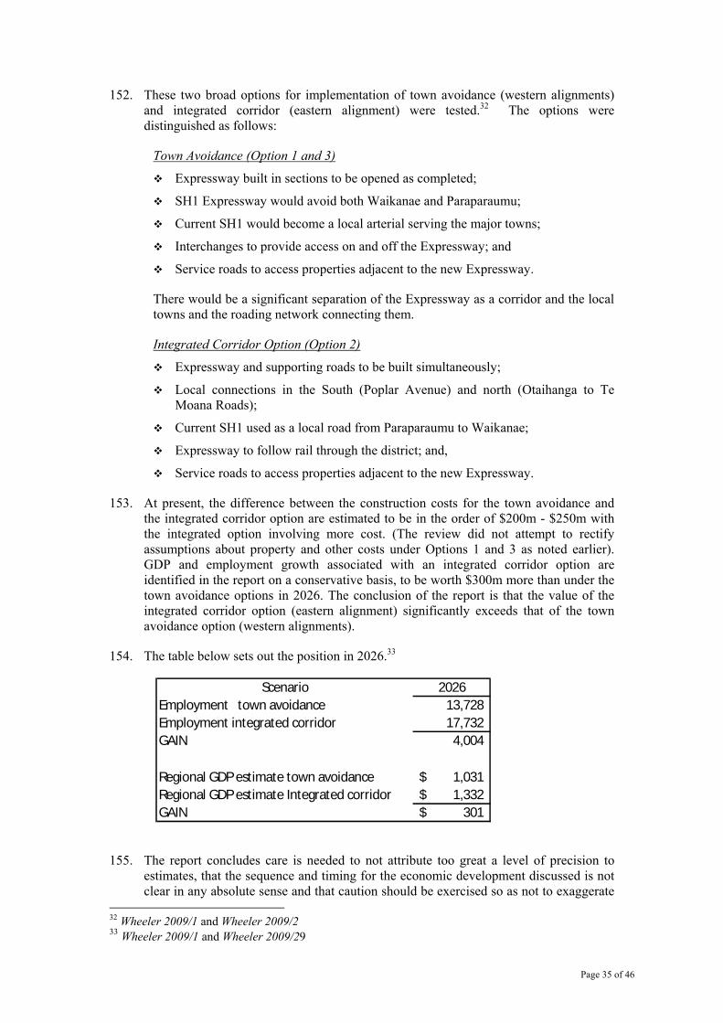
Page 35 of 46
152. These two broad options for implementation of town avoidance (western alignments) and integrated corridor (eastern alignment) were tested.32 The options were distinguished as follows:
Town Avoidance (Option 1 and 3)
Expressway built in sections to be opened as completed;
SH1 Expressway would avoid both Waikanae and Paraparaumu;
Current SH1 would become a local arterial serving the major towns;
Interchanges to provide access on and off the Expressway; and
Service roads to access properties adjacent to the new Expressway.
There would be a significant separation of the Expressway as a corridor and the local towns and the roading network connecting them.
Integrated Corridor Option (Option 2)
Expressway and supporting roads to be built simultaneously;
Local connections in the South (Poplar Avenue) and north (Otaihanga to Te Moana Roads);
Current SH1 used as a local road from Paraparaumu to Waikanae;
Expressway to follow rail through the district; and,
Service roads to access properties adjacent to the new Expressway.
153. At present, the difference between the construction costs for the town avoidance and the integrated corridor option are estimated to be in the order of $200m - $250m with the integrated option involving more cost. (The review did not attempt to rectify assumptions about property and other costs under Options 1 and 3 as noted earlier). GDP and employment growth associated with an integrated corridor option are identified in the report on a conservative basis, to be worth $300m more than under the town avoidance options in 2026. The conclusion of the report is that the value of the integrated corridor option (eastern alignment) significantly exceeds that of the town avoidance option (western alignments).
154. The table below sets out the position in 2026.33
Scenario 2026Employment town avoidance 13,728 Employment integrated corridor 17,732 GAIN 4,004
Regional GDP estimate town avoidance 1,031$ Regional GDP estimate Integrated corridor 1,332$ GAIN 301$
155. The report concludes care is needed to not attribute too great a level of precision to estimates, that the sequence and timing for the economic development discussed is not clear in any absolute sense and that caution should be exercised so as not to exaggerate
32 Wheeler 2009/1 and Wheeler 2009/2 33 Wheeler 2009/1 and Wheeler 2009/29

Page 36 of 46
the benefits of the integrated corridor option. It also concludes, given these caveats, there is a substantial difference in the level of [economic] benefits which the integrated (eastern) corridor has to offer over and above those offered by the town avoidance (western) options.
156. It is important to note this economic analysis does not include the potential impacts from urban sprawl of the western options or the unmodified eastern options. Similarly it does not factor in the adaptation costs from the impacts of the Ōtaki bypass or the redesign and investment in the southern centres.
157. In conclusion, even with a full economic analysis that includes social and environmental costs, the Kāpiti Coast District Council can see no obvious simple traffic economic efficiency or wider net economic benefit in moving to a motorway service standard level. The Council believes the proposals as they stand build unnecessary capacity into the State Highway system through the Kāpiti Coast which could be better invested in other transport outcomes. If the full economic and consequent social benefits are to be realised, and unnecessary environmental and social costs and over-investment in capacity are to be avoided, the model of the two-lane Western Link to Te Moana Road needs to be followed alongside an up-graded four lane State Highway model along the existing alignment, or a significantly modified eastern (Option 2) alignment.
Page 37 of 46
SECTION 2: MITIGATING ACTIONS REQUIRED
158. The previous sections identified a range of concerns about the proposed eastern option and indicated the Eastern Option including the full 2 lane Western Link Road is the least unacceptable alternative, only if there is significant mitigation of effects. The Council has also made clear that it rejected the proposed motorway levels of service and clearly stated that the overall assumptions design needed to be revisited. These concerns apply along the full corridor, including at Ōtaki.
159. Previous discussion has focused on major strategic considerations for the Kāpiti Coast District Council in arriving at its strong preference for an eastern alignment for the State Highway upgrade. These can be summarised as:
significant concerns about the impacts of the western options (and the proposed Peka Peka interchange) on managing the economic, social and environmental costs of urban sprawl and the loss of innovative urban development solutions at Waikanae North;
the introduction of major new severance impacts for local communities;
a view that the western alignments are inconsistent with the government’s own focus on achieving an increase in net economic benefit and productivity;
the major duplication of severance effects with the western alignment options has a significant economic and social cost to the wider community.
160. Additional comments on options are provided below. These comments are summaries derived from the detailed assessment by independent consultants on the proposed options. This detailed analysis and commentary is also part of this formal submission.
Response to the Proposed Expressway Alignment Options: Poplar Avenue to Peka Peka
Option 1: (Western Option/Avoiding Waikanae town centre)
161. The town avoidance option, in addition to the earlier strategic analysis presents the following further issues :
impacts on the remnant dune landscapes from Otaihanga through to Peka Peka. These are significant in the context of the wider urban area and have a significant value placed on them by the wider community;
the motorway/expressway will pass through or will be immediately adjacent to areas of high natural values.34 These include significant effects on the following ecological sites:
~ Te Harakeke/Smith’s Farm (regional significance/QE II covenants). This is an extensive wetland habitat for threatened native bird and plant species. The motorway option through this area is very unlikely to be able to avoid severe effects because of the scale and the need to pass along the designation. In contrast, the proposed re-alignment via the Ngarara development avoids these impacts.
~ El Rancho/Takamore Trust (regional significance/QE II covenants). This is an area of large manuka wetland with plant associations and good regeneration. The impacts would be severe as the motorway scale and
34 Wildland 2009

Page 38 of 46
alignment would limit the flexibility to avoid impacts. In contrast, the Western Link design as two lanes minimises impacts.
~ Osbourne’s Swamp/Te Moana Road (regional significance/QEII covenants). The impacts would be severe and unavoidable.
will have a major impact on the waahi tapu area in the vicinity of the Takamore Trust urupa. This has been a highly contentious issue for the Takamore Trust and for wider Te Atiawa in relation to the current designation and previous Western Link Road design proposals. The concerns relate to the proximity and direct impacts on an area identified as waahi tapu. This includes the impacts on the vegetation and habitat of that area. The Takamore Trust arrived at a position of reluctant accommodation of a much modified two lane proposal for the Western Link, such that resource and Historical Places Trust consents have been issued for the proposed for the two-lane Western Link. There are still members of the Trust who oppose even this level of impact.
It is notable the consultation maps provided by NZTA show the route avoiding the urupa but the Opus Technical Report shows the route impinging on the urupa. However, the issues that the Council has had to address in its own designation and consenting processes relate to the wider waahi tapu. Extensive conditions to minimise impacts on the waahi tapu had to be complied with and these considerations and issues would apply to a new proposal. Takamore Trustees have already stated their opposition to a return to what is a four lane motorway option through this area. The Kāpiti Coast District Council, in keeping with its good faith commitments to the Trust and the wider relationship with tangata whenua, will continue to support the Takamore Trust’s position that any increased level of effect is unacceptable, irrespective of the outcomes of decisions on the Western Link.
visual and amenity impacts from the overbridges which will require approximately 200m rising to a height of about 7m. A grade separated interchange was previously proposed at Otaihanga and an overbridge at Te Moana Road. The new consultation material raises the possibility of a grade-separated interchange at Te Moana Road as well as Otaihanga. While it is considered unlikely an interchange will be provided at Te Moana Road (see part 1), it is important to note how out of character it or an overbridge would be for the area. By contrast, the Western Link provides for significantly smaller at grade intersections.
the need to apply for a new designation, resource and Historic Places Trust consents approval and land acquisition. The designation and consents currently held by the Kāpiti Coast District Council cannot be transferred to the new proposal. None of the land north of Te Moana Road is in public ownership and land acquisition would have to follow the designation process.
consequent significant lead in times before construction could commence. The earliest time for construction to be able to start is estimated at five years if every thing proceeds without major objections. Full completion is estimated to be ten years from time of decision to proceed with this route.35
in terms of social impacts36, it was concluded that there will be:
~ some ‘low positive’ impacts, such as reducing the current effects of severance for the communities east of the rail line at Paraparaumu and
35 Kinnear 2009 36 Buchan 2009

Page 39 of 46
Waikanae and current highway and improved amenity for those living along the highway north of Paraparaumu;
~ negative impacts arising from:
• impacts on private property owners at Raumati/Paraparaumu on the Highway although these would have expected some impacts over time;
• severance and reduced amenity for those living an area where a new high design motorway/expressway corridor is introduced through the Waterstone are
• planning blight for properties not immediately affected by (as in requiring purchase) but adjacent to the proposed corridor. All properties north of Paraparaumu will experience effects generated by motorway/expressway standard design, rather than the 2-lane Western Link proposal;
• an increase of traffic volumes on Ratanui, Mazengarb and Arawhata Roads which will become extensions to the part formed Western Link;
• loss of 200-300 existing properties. (See also discussion of effects at Waikanae)
~ on balance in the terms of social impacts Option 1 (town avoidance/western) presents the greater disadvantages over Option 2 (eastern) given that it ‘severs a large area high in environmental and social values with a four-lane expressway’. 37
Option 2 (Eastern Option)
162. Option 2, in addition to the earlier strategic comments, presents the following further issues:
the motorway/expressway will pass through or will be immediately adjacent to areas of high natural values.38 These include significant effects on the following ecological sites:
~ Muaupoko Swamp Forest/SH 1 North of Lindale. (regional, DOC reserve and QE II covenants). This has rare wetland/forest associations, important habitat for birds with good linkages. There would be possible hydrology effects from earthworks but these would be expected to be relatively minor.
~ south of Greendale Reserve. This has mature tawa, puketea and kohekohe forest which would be severely affected by the proposal;
~ Greendale Reserve. (Council reserve, high community significance) The reserve has one small grove of natural occurring kahikatea otherwise it is planted. The proposed alignment would have a severely adverse effect.
the need to apply for a new designation, resource and Historic Places Trust consents approval and land acquisition between Paraparaumu and Waikanae.
the expressway concept would also potentially affect the historical right for funeral processions at Whakarongotai marae in Waikanae to cross the Highway on foot to the urupa and church on Elizabeth St.
consequent significant lead in times before construction could commence. The earliest time for construction to be able to start is estimated at five years if every
37 Buchan 2009, p.9 38 Wildland 2009

Page 40 of 46
thing proceeds without major objections. Full completion is estimated to be ten years from time of decision to proceed with this route.39
in terms of social impacts40, it was concluded there will be:
~ some ‘low positive’ impacts, such as reducing the current effects of severance for the communities east of the rail line at Paraparaumu and west of the rail line in the Lindale/Waterstone area through the construction of pedestrian underpasses. There would also be improved amenity for those living along the current highway north of Paraparaumu;
~ negative impacts arising from:
• severance and reduced amenity for those living an area where a new high design motorway/expressway corridor is introduced.
• planning blight for properties not immediately affected by (as in requiring purchase) but adjacent to the proposed corridor. All properties north of Paraparaumu will experience effects generated by motorway/expressway standard design, rather than the 2-lane Western Link;
• an increase of traffic volumes on Ratanui, Mazengarb and Arawhata Roads which will become extensions to the partly formed Western Link;
• loss of 300-400 existing properties and the loss of an area at Waterstone which was intended as a passenger transport node with rail station and medium density housing to support it;
• increased road and traffic speeds on the motorway/expressway will exacerbate severance through the Waikanae Town Centre.
~ on balance from a social impact perspective Option 2 presents social effects which are less in number than for Option 1 and Option 3.
~ in comparison to the other routes, the eastern option was the least unacceptable subject to a range of changes including:
• reduction of road speeds and dimensions;
• provision of the full WLR to enhance connectivity and avoid traffic impacts on local roads;
• investment in mitigation;
• provision of adequate park and ride facilities so the Waikanae Station was not compromised.
163. The urban design review also raised similar concerns. The Council concluded that if the Minister was to insist on a motorway/expressway option at the current design standards and the proposed eastern alignment was chosen, then major modification needed to be made to the proposal. 41 The key features required are:
retention of the proposed alignment on the eastern side of the rail line until after the Greendale/Camelot area. This would involve crossing the rail line somewhere in the area between Ihakara Street and the Paraparaumu Overbridge. This would avoid impacts on large residential areas and make the development of a rail station at Lindale servicing the Water stone area achievable. There are consequent impacts which are covered further below.
39 Kinnear 2009 40 Buchan 2009 41 Common Ground 2009

Page 41 of 46
a full interchange at the Paraparaumu Town Centre, probably near Ihakara Street, to ensure connectivity to the Highway. It should be noted NZTA’s initial proposal as publicised had no interchange and that this has now changed to become a possibility. It is Council’s view that this is a minimum requirement for the eastern option.
significant investment at Paraparaumu to upgrade the transport hub and the links with the town centre;
lowering of road speed to 70kph as it passes through the Paraparaumu and Waikanae Town Centres;
retention of the right of Te Atiawa to have funeral processions at Whakarongotai Marae cross the Highway at grade to the urupa and church on Elizabeth Street;
immediate construction of the underpass at Te Moana Road to reduce peak congestion on the State Highway at the earliest opportunity
significant investment in design and works to provide a high quality of connectivity between the western and eastern Waikanae parts of the town centre. This includes a plaza area to the quality and size of the Wellington City to Sea bridge across the highway42;
provision of an interchange at Waikanae North (and the removal of the interchange at Peka Peka.) The Council does not support an interchange at Te Moana Road, given the increased impact on properties and the pressures and the impacts this would have on the potential design for the town centre itself. The more northern location would offer opportunities for improved eastern access at some time in the future.
164. There are negative impacts from following this modified alignment and NZTA would need to explore these further. The impacts are:
Southwards Car Museum – possible loss of land and the need to re-orient the building. This could be offset to some extent by pushing the rail line to the west on to edge of the landfill site;
effects on the Muaupoko Swamp Forest site and Tini Bush which contains remnant bush. The road would pass along the edge of the former and would also be likely to have some effect on hydrology. The road would also pass along the edge of Tini Bush and there could be limited to moderate effects depending on design solutions.
Option 3: (WLR Option /Sandhills Motorway)
165. Option 3, in addition to the earlier strategic analysis, presents the following further issues:
impacts on the remnant dune landscapes from Raumati South to Peka Peka. These are significant in the context of the wider urban area and have a high value placed on them by the wider community. This dune landscape, which provides much of the character and amenity of the urban area would be lost. This is both a social and an economic effect;
the motorway/expressway will pass through or will be immediately adjacent to areas of high natural values.43 These include significant effects on the following ecological sites:
42 Common Ground 2009 43 Wildland 2009

Page 42 of 46
~ Queen Elizabeth Park, Poplar Avenue, Raumati South (regional significance, regional park). The site consists of wetland – manuka, harakeke and raupo.
~ Raumati South peatlands (local) It consists of damp sand plain and dune, kanuka and scrub). This area has a high amenity value for the surrounding area and would be severely affected.
~ Te Harakeke/Smith’s Farm (regional significance/QE II covenants). This is an extensive wetland habitat for threatened native bird and plant species. The motorway option through this area is very unlikely to be able to avoid severe effects because of the scale and the need to pass along the designation. In contrast, the proposed re-alignment via the Ngarara development avoids these impacts.
~ El Rancho/Takamore Trust (regional significance/QE II covenants). This an area of large manuka wetland with plant associations and good regeneration. The impacts would be severe as the motorway scale and alignment would limit the flexible to avoid impacts. In contrast, the Western Link design as two lanes minimises impacts.
~ Osbourne’s Swamp/Te Moana Road (regional significance/QEII covenants). The impacts would be severe and unavoidable.
will have a major impact on the waahi tapu area in the vicinity of the Takamore Trust urupa. This has been a highly contentious issue for the Takamore Trust and for wider Te Atiawa in relation to the current designation and previous Western Link Road design proposals. The concerns relate to the proximity and direct impacts on an area identified as waahi tapu. This includes the impacts on the vegetation and habitat of that area. The Takamore Trust have arrived at a position of reluctant accommodation of a much modified two-lane proposal for the Western Link, such that resource and Historical Places Trust consents for the proposed for the two-lane Western Link. There are still members of the Trust who oppose even this level of impact.
It is notable that the consultation maps provided by NZTA show the route avoiding the urupa. However, the issues that the Council has had to address in its own designation and consenting processes relate to the wider waahi tapu. Extensive condition to minimise impacts on the waahi tapu had to be complied with and these considerations and issues would apply to a new proposal. Takamore Trustees have already stated their strong opposition to a return to a motorway option through this area. The Kāpiti Coast District Council, in keeping with its good faith commitments to the Trust and the wider relationship with tangata whenua, will continue to support the Takamore Trust’s position that any increased level of effect is unacceptable, irrespective of the outcomes of decisions on the Western Link.
visual and amenity impacts from the interchanges or overbridges which will require approximately 200-300 metre approaches at each end rising to a height of about 7m. Grade separated interchanges are identified as possible at the southern entrance, or at 200 Main Road south depending on the entrance chosen, at Ihakara Street, Kāpiti Road, Otaihanga Road, Te Moana Road and Peka Peka. Those that do not become full interchanges will require overbridges. Irrespective of the final layout, there will need to be significant structures rising to 7m along the route or at right angles to it. Given that few buildings in the landscape are above 1-2 storeys and many are surrounded by vegetation, this will be a major impact.
the need to apply for a new designation, resource and Historic Places Trust consents approval and land acquisition. The designation and consents currently held by the Kāpiti Coast District Council cannot be transferred to the new
Page 43 of 46
proposal. None of the land north of Te Moana Road is in public ownership and land acquisition would have to follow the designation process.
consequent significant lead in times before construction could commence. The earliest time for construction to be able to start is estimated at five years if every thing proceeds without major objections. Full completion is estimated to be ten years from time of decision to proceed with this route.44
in terms of social impacts45, it was concluded that there will be:
~ some ‘low positive’ impacts, such as reducing the current effects of severance for the communities east of the rail line at Paraparaumu and Waikanae and current highway and improved amenity for those living along the highway north of Paraparaumu;
~ limited impacts on private property owners. Given that it is proposed that the motorway/expressway should along the current designation allocated to the Western Link, there will approximately 20-50 parcels of land affected.
~ negative impacts arising from:
• severance and reduced amenity for those living an area where a new high capacity motorway/expressway corridor is introduced. It is some fourteen years since the old designation for the Sandhills Motorway was let lapse and all property owners could have expected to be living in an environment which would have significantly lower impacts from the Western Link. This is exacerbated through the Raumati/Paraparaumu areas. The social impact report notes these impacts as severe;
• planning blight for properties not immediately affected by (as in requiring purchase) but adjacent to the proposed corridor. All properties from Raumati to Waikanae will experience effects generated by motorway/expressway standard design, rather than the 2-lane Western Link proposal;
~ on balance in the terms of social impacts Option 3 is seen as presenting greater disadvantages over Option 2 (eastern) given that it ‘severs a large area high in environmental and social values with a four-lane expressway’. 46
Response to the Proposed Expressway Alignment Options: Peka Peka to Ōtaki
166. In addition to the earlier strategic analysis which is also relevant to the area, this commentary extends discussion of selected issues. This section is divided in to two parts: Ōtaki town and the Te Horo/Hautere area. The two areas are intimately linked through the role of the town in its rural hinterland but it is easier to address matters in two stages.
Ōtaki Town
167. The proposal for a bypass is generally supported by the community given the current congestion on the existing Highway and the importance of the Railway area to the town
44 Kinnear 2009 45 Buchan 2009 46 Buchan 2009, p.9

Page 44 of 46
and District economy. Residents and business have limited confidence that NZTA will address the current congestion problems in a timely way and expect problems to worsen. While the weekend congestion further south has limited impact on the Waikanae and Paraparaumu town centre economies, it is of major significance to Ōtaki as a destination centre. As the town continues to build its economy around its current retail, historic, beach and recreation strengths this will become more of an issue.
168. Ideally a bypass should be located near the edge of a rural town with strong linkages to the local centre. This is theoretically possible to the east for Ōtaki around the edge of the Waitohu Plateau residential area but there are issues and impacts which make such an approach unlikely. The main effects of a bypass through the town are as follows:
major severance of the Waitohu Plateau area from the main town through the potential loss of access at Rahui Road. The map in the consultation material shows closure but enquiries to NZTA suggest this is less than clear. The severance is particularly significant for children attending the primary and secondary schools but also affects businesses, particularly the horse trainers clustered around the race course. Easy access to the racecourse (the only Maori owned racecourse in the country) becomes impossible on closure;
some small improvements in current severance effects associated with the current highway;
potential to improve the appearance of the rail retail area with the removal of State Highway through traffic;
potential to support the expansion of the industrial area on Riverbank Road, provided that are improvements to access design;
loss of retail trade in the 3-5 year period at an estimated annual average of 2.7% over the period. The extent to which this might occur will be directly affected by the quality of access into the town and the extent to which there is support for marketing of Ōtaki as a destination over the adjustment period.
169. However, this view does not signal unqualified support for the motorway/expressway design standards. The same challenge to these underpinning assumptions applies in this area as further south. This support is contingent on resolution of the following issues:
a commitment to reducing travel speeds on the route to 70 kph as it passes through the rail area. This will allow for much better design, amenity and economic outcomes for the surrounding area and still provides for the desired Highway functionality sought by NZTA.
the very poor access design north and south to the town that accompanies the bypass proposal. This is discussed in more detail below.
delivery of support to the town to enable it to adapt to the very real economic impacts that have been identified will occur over the first 3-5 years. This support is not simply about providing assistance to a retailers to adapt to the change – its is about supporting a town with a large number of low income households which is actively focused on growing its community socially and developing a viable economy. The latter ranges from the early stages of an innovative clean technology cluster through to Te Wānanga O Raukawa;
an investment programme to support regular passenger train services to Ōtaki (servicing the local population, staff and customers of destination retail outlets and the 2,000 – 3,000 staff and students at Te Wānanga O Raukawa), to be achieved within the time period for the construction of the bypass. This includes ensuring potential for Ōtaki to be once again used as a local freight railhead is retained. This requires the new route to be designed in a way that retains the

Page 45 of 46
station (even if it moves slightly) and does not compromise the shunting capability that already exists;
investment in signage (more than just basic NZTA directional signs) at the southern and northern ends of Ōtaki.
Access and Interchanges
170. The review work done to date identifies major problems with the proposed access points to Ōtaki.
171. At the northern end, the Council queries the need for a grade-separated interchange and argues for a large roundabout that would push Ōtaki bound traffic on to the old State Highway alignment. This would also help lower speeds coming into the 70kph expressway section through Ōtaki. A roundabout is consistent with 4-lane or expressway design standards.
172. The access from County Road to the old State Highway and the need to go north on the old Highway and down County Road to get on to the motorway/expressway to go south is unworkable – and undesirable in terms of amenity impacts. It is very tight access and confusing for both older drivers and visitors to the town and will compound any adverse economic effects of the bypass itself. This southern access route proposal needs to be abandoned and full southern access on to the Highway provided at the south end of the town.
173. At a minimum a well-designed pedestrian bridge needs to be provided at Rahui Road, if the road is closed. It should be of the quality and design intent of the Wellington ‘City to Sea’ structures and have strong design links to the town’s history and culture. Given the economic importance of this link and the residential use, the potential for road access over the motorway/expressway should still be explored. This process should include providing the community with the opportunity to understand the likely significant visual and wider property effects of an overbridge before a firm commitment is made. If cross-access is not provided at Rahui Road ,then a local road access from Rahui Road behind the racecourse and across the motorway/expressway route to join the old Highway should be provided. This should be done in a way that provides racehorse trainers with exercise space on the route and is compatible with surrounding character.
174. Full south/north access at the southern end of the town needs to be provided. Exits and entries to the town need to be made as easy to understand as possible. The rationale for this southern access from the town onto the Highway is the un-workability of the currently proposed route and the need to provide full access on to the motorway/expressway at some point for the Te Horo/Hautere area. At the same time provision must be made for grade separated access across the Highway from Ōtaki Gorge Road and safe access from Old Hautere Road.
Te Horo/Hautere
175. The Council questions the need for an motorway/expressway through this area and suggests the need to shift to a four-lane road is some time away, provided direct access on to the Highway is managed through slip roads, an overbridge at Te Horo and an interchange at the south end of Ōtaki to push traffic on to the bypass or into the town. The key issue along this route is safety rather than congestion, at least in the short or medium term and investment actions should be prioritised to reflect this.
176. If the Minister insists on an motorway/expressway model for the Te Horo/Hautere area, the key issues are:

Page 46 of 46
safe access across and onto the current State Highway;
severance effects created by the new motorway/expressway at the Te Horo settlement;
the impacts of the current alignment on good quality soils between Gear Road and the railway line and the impacts on properties along that edge;
the likely more severe economic impacts on businesses along the current Highway;
the need to ensure access for transport of products from the rural area;
impacts on Hautere Bush and Cottle’s Bush. The former has titoki-totara forest which is under represented in the area and rare plants. The latter has totara matai forest. Impacts on both are likely to be severe.
177. The Council supports restricted access at Te Horo between School Road and the old Highway route (i.e. no direct access on to the motorway/expressway.) It has significant concerns that any access on to or off the Highway at this point will create major development pressures both at Te Horo itself and on to the more valuable soils of the Hautere Plain. However, it is essential that there is access on to the motorway/expressway at some point. This would be available either at Waikanae North or just south of Ōtaki. There would be adequate access along the old Highway and local roads at that point. The travel distances to such access would be about eight kilometres to the south and about four kilometres to the north.
178. The Council seeks the further review of the point at which the proposed route would ‘jump’ the rail line, given the good quality soils to the south end of the Hautere Plain and the relatively poor soils to the west of the State Highway. It is envisaged that this western alignment could skirt the Te Horo settlement and cross to the east just north of it. This needs to be tested in terms of impacts on ecological sites on the western side. The Council does not support a further option which has been previously suggested of a western option that passes between Ōtaki Town and Ōtaki Beach. This would create unacceptable severance effects and would cross extremely flood prone land gifted by Te Rauparaha to generate educational grants for descendants of all three local iwi.
179. As with Ōtaki, any proposal needs to place considerable emphasis on marketing the old Highway as a quiet tourist route. This adaptation process requires direct funding as part of the development costs.