KANSAS GEOLOGICAL SURVEY Open File Report 2007-22 LAND ...
11
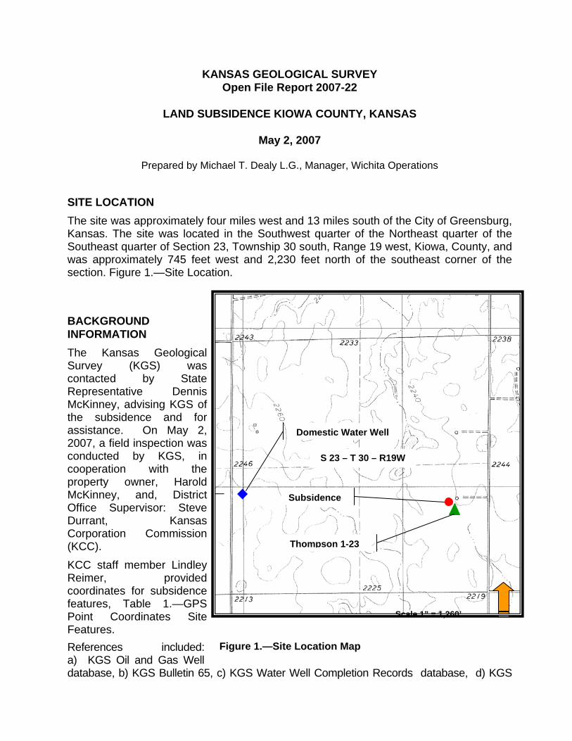
KANSAS GEOLOGICAL SURVEY Open File Report 2007-22 LAND SUBSIDENCE KIOWA COUNTY, KANSAS May 2, 2007 Prepared by Michael T. Dealy L.G., Manager, Wichita Operations SITE LOCATION The site was approximately four miles west and 13 miles south of the City of Greensburg, Kansas. The site was located in the Southwest quarter of the Northeast quarter of the Southeast quarter of Section 23, Township 30 south, Range 19 west, Kiowa, County, and was approximately 745 feet west and 2,230 feet north of the southeast corner of the section. Figure 1.—Site Location. BACKGROUND INFORMATION The Kansas Geological Survey (KGS) was contacted by State Representative Dennis McKinney, advising KGS of the subsidence and for assistance. On May 2, 2007, a field inspection was conducted by KGS, in cooperation with the property owner, Harold McKinney, and, District Office Supervisor: Steve Durrant, Kansas Corporation Commission (KCC). KCC staff member Lindley Reimer, provided coordinates for subsidence features, Table 1.—GPS Point Coordinates Site Features. Scale 1” = 1,260’ S 23 – T 30 – R19W Domestic Water Well Thompson 1-23 Subsidence References included: a) KGS Oil and Gas Well database, b) KGS Bulletin 65, c) KGS Water Well Completion Records database, d) KGS Figure 1.—Site Location Map
Transcript of KANSAS GEOLOGICAL SURVEY Open File Report 2007-22 LAND ...
KANSAS GEOLOGICAL SURVEY Open File Report 2007-22
LAND SUBSIDENCE KIOWA COUNTY, KANSAS
May 2, 2007
Prepared by Michael T. Dealy L.G., Manager, Wichita Operations
SITE LOCATION The site was approximately four miles west and 13 miles south of the City of Greensburg, Kansas. The site was located in the Southwest quarter of the Northeast quarter of the Southeast quarter of Section 23, Township 30 south, Range 19 west, Kiowa, County, and was approximately 745 feet west and 2,230 feet north of the southeast corner of the section. Figure 1.—Site Location.
BACKGROUND INFORMATION The Kansas Geological Survey (KGS) was contacted by State Representative Dennis McKinney, advising KGS of the subsidence and for assistance. On May 2, 2007, a field inspection was conducted by KGS, in cooperation with the property owner, Harold McKinney, and, District Office Supervisor: Steve Durrant, Kansas Corporation Commission (KCC). KCC staff member Lindley Reimer, provided coordinates for subsidence features, Table 1.—GPS Point Coordinates Site Features.
Scale 1” = 1,260’
S 23 – T 30 – R19W
Domestic Water Well
Thompson 1-23
Subsidence
References included: a) KGS Oil and Gas Well database, b) KGS Bulletin 65, c) KGS Water Well Completion Records database, d) KGS
Figure 1.—Site Location Map

Kansas Geological Survey – Open File Report 2007-22 Land Subsidence Kiowa County May 2, 2007 Page 2
S:\MSOFFICE\WORD\Investigations\Kiowa_sink_report.doc
Water Level database, e) Natural Resources Conservation Service Web Soil Survey and f) KGS Bulletin 162.
Property owner, Harold McKinney, was present during the field inspection and provided historical site information.
SURFACE TOPOGRAPHY, SOIL, AND LAND USE Surface elevation at the proposed site ranged from 2,244 feet to 2,219 feet above mean sea level. The land surface slope ranged from one percent to 20 percent and surface drainage was predominantly to the southeast. Site soil was Harney Silt Loam 1 to 3 percent slopes. The soil was described as deep, gently sloping, well drained, soils on uplands. The soil unit has a silt loam surface layer, a very firm silty clay loam and silty clay subsoil. The soil unit was not highly erodible. The soil’s hydraulic conductivity (Ksat) was 6.7 micrometers per second and was based on soil characteristics observed in the field, particularly structure, porosity, and texture. The numeric Ksat values have been grouped according to standard Ksat class limits. The classes are: Very low: 0.00 to 0.01; Low: 0.01 to 0.1; moderately low: 0.1 to 1.0; moderately high: 1 to 10; High: 10 to 100; Very high: 100 to 705 Land use was agricultural, predominately dryland grain production. For water conservation purposes, level terraces were constructed at the site.
HYDROGEOLOGY The proposed site overlies a portion of the unconsolidated freshwater aquifer known as the High Plains aquifer. The aquifer is the principal source of freshwater for the site and region. Underlying the High Plains aquifer were consolidated rocks of the Cretaceous(?) and Permian systems which may yield small quantities of mineralized water to wells. Refer to Table 2 for a generalized geologic section for Kiowa County from alluvium, Quaternary System, to the Flowerpot Shale, Permian System. Rocks in the Cretaceous system were predominantly shale, siltstone, and sandstone. Unconformities were present between younger rocks, Tertiary system, and older rocks, Permian system. Rocks in the Permian system were predominantly sandstone, siltstone, gypsum, and salt. Thickness of evaporitic rocks in the Permian system ranged from 500 feet to 1,000 feet. Data from the Wheeler #1, API # 15-097-30205, located in the Northwest quarter of the Southeast quarter of the Southeast quarter Section 28, Township 30 south, Range 19 west, show top of the Hutchinson Salt member at 1,877 feet above mean sea level and base at 2,334 feet above mean sea level. Site data for the Nippewalla group was sparse. Steve Durrant advised that a shallow lost circulation zone, less than 500 feet below land surface, was encountered while drilling several oil and gas wells in the area.
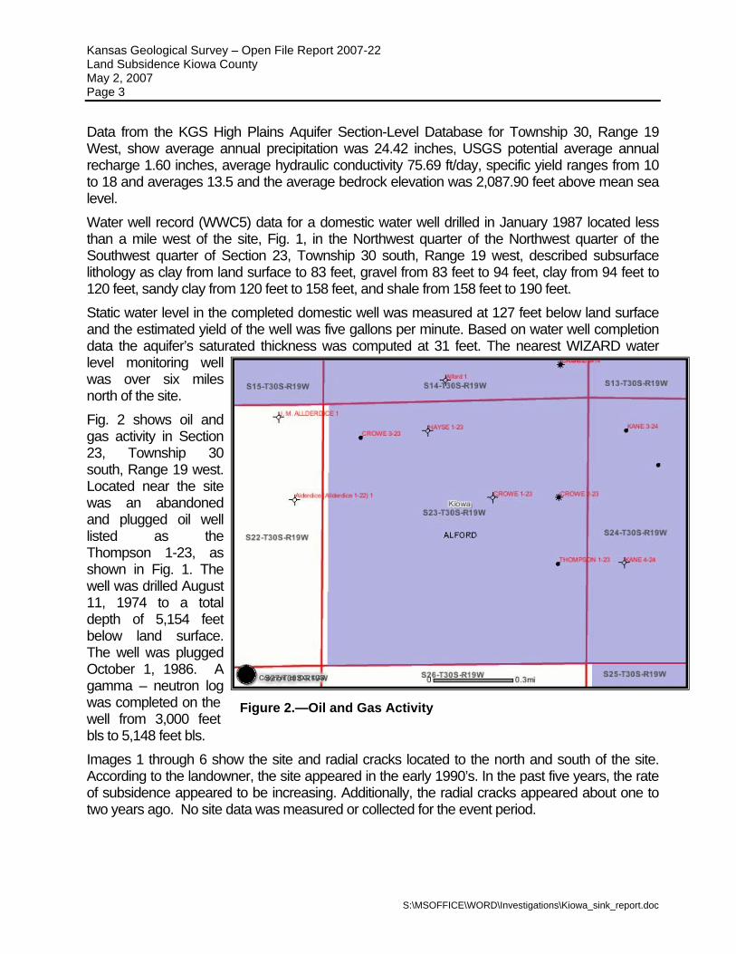
Kansas Geological Survey – Open File Report 2007-22 Land Subsidence Kiowa County May 2, 2007 Page 3
Data from the KGS High Plains Aquifer Section-Level Database for Township 30, Range 19 West, show average annual precipitation was 24.42 inches, USGS potential average annual recharge 1.60 inches, average hydraulic conductivity 75.69 ft/day, specific yield ranges from 10 to 18 and averages 13.5 and the average bedrock elevation was 2,087.90 feet above mean sea level. Water well record (WWC5) data for a domestic water well drilled in January 1987 located less than a mile west of the site, Fig. 1, in the Northwest quarter of the Northwest quarter of the Southwest quarter of Section 23, Township 30 south, Range 19 west, described subsurface lithology as clay from land surface to 83 feet, gravel from 83 feet to 94 feet, clay from 94 feet to 120 feet, sandy clay from 120 feet to 158 feet, and shale from 158 feet to 190 feet. Static water level in the completed domestic well was measured at 127 feet below land surface and the estimated yield of the well was five gallons per minute. Based on water well completion data the aquifer’s saturated thickness was computed at 31 feet. The nearest WIZARD water level monitoring well was over six miles north of the site. Fig. 2 shows oil and gas activity in Section 23, Township 30 south, Range 19 west. Located near the site was an abandoned and plugged oil well listed as the Thompson 1-23, as shown in Fig. 1. The well was drilled August 11, 1974 to a total depth of 5,154 feet below land surface. The well was plugged October 1, 1986. A gamma – neutron log was completed on the well from 3,000 feet bls to 5,148 feet bls.
Figure 2.—Oil and Gas Activity
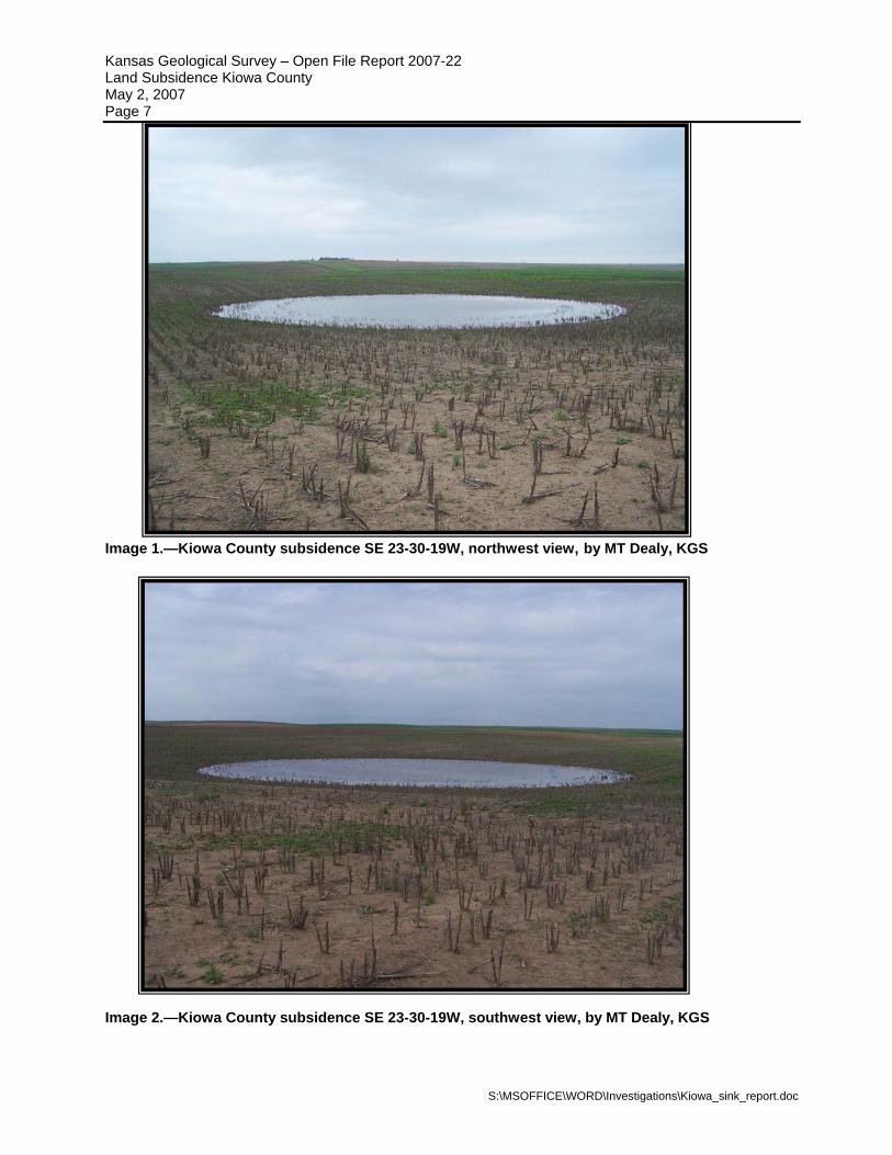
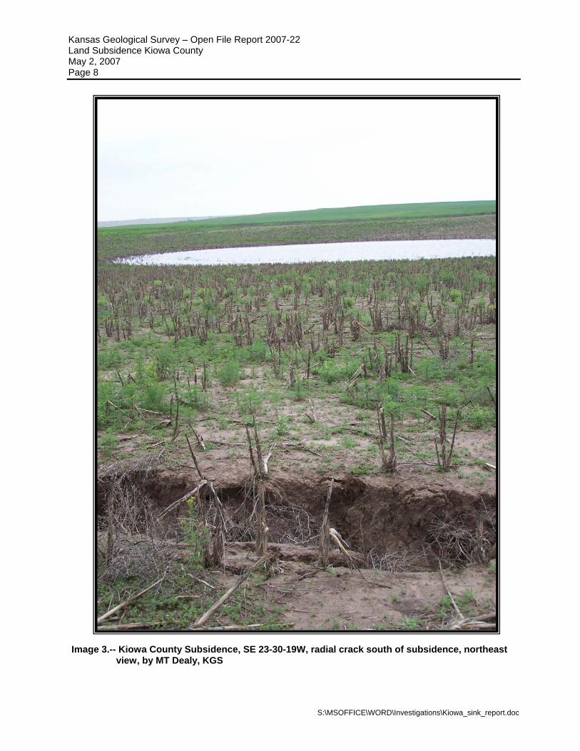
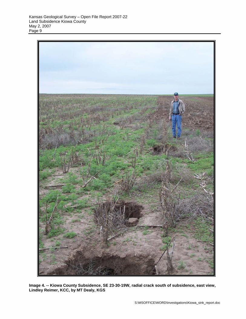
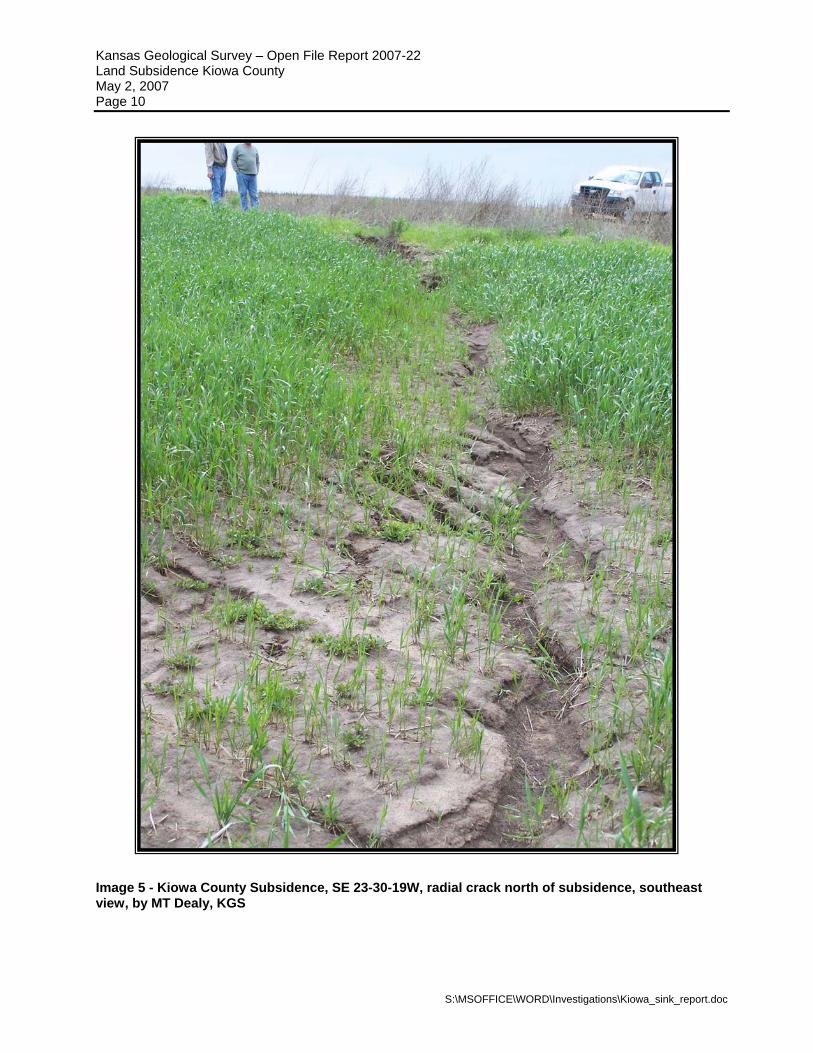
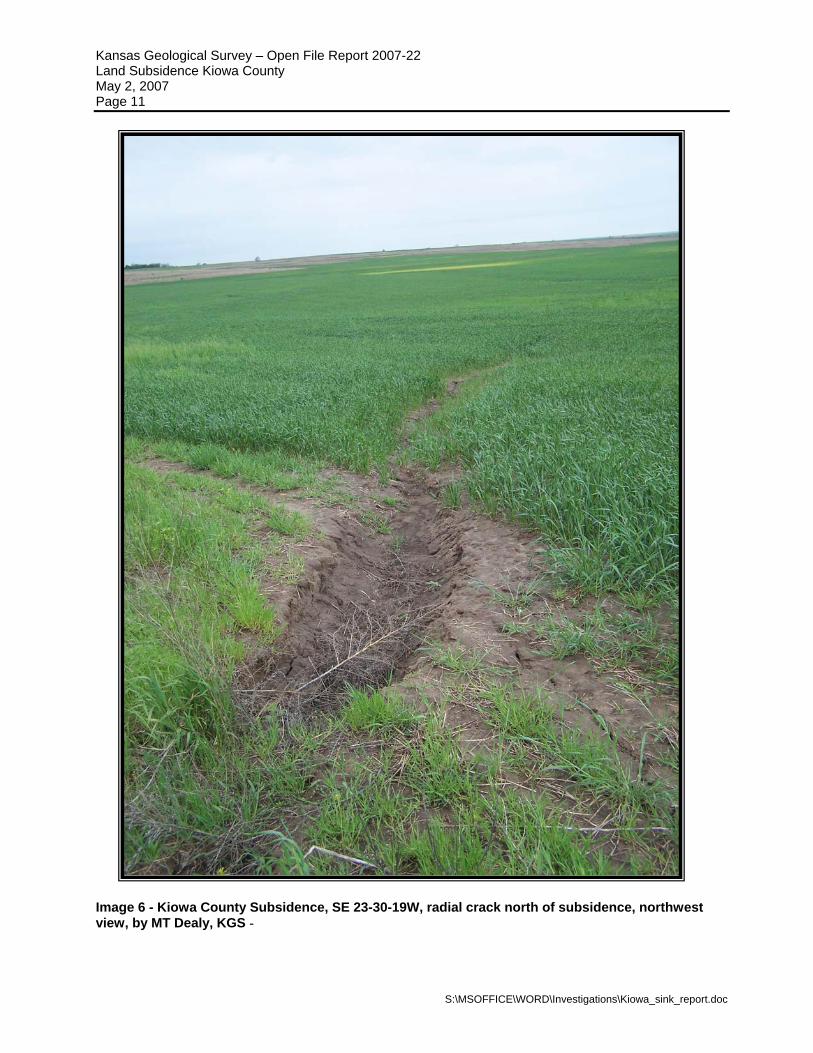
Images 1 through 6 show the site and radial cracks located to the north and south of the site. According to the landowner, the site appeared in the early 1990’s. In the past five years, the rate of subsidence appeared to be increasing. Additionally, the radial cracks appeared about one to two years ago. No site data was measured or collected for the event period.
S:\MSOFFICE\WORD\Investigations\Kiowa_sink_report.doc
Kansas Geological Survey – Open File Report 2007-22 Land Subsidence Kiowa County May 2, 2007 Page 4
S:\MSOFFICE\WORD\Investigations\Kiowa_sink_report.doc
RECOMMENDATIONS The following recommendations were made based on the findings of the field inspection and were not intended to limit or preclude other investigative actions. Funding and implementation of the recommendations were not within the scope of the report. 1. Establish at least one elevation bench mark(s) in the area of subsidence to
monitor elevation changes. 2. For elevation control, establish or use an existing elevation bench mark away from
the area of subsidence. 3. Measure both elevation bench marks a minimum of once a year. 4. Review the completion and plugging records for the Thompson 1-23 and other
surrounding oil or gas wells to determine if fluid is migrating to the evaporitic rocks via the well borehole or casing.
5. Review the elevation data each year to determine elevation change. 6. Perform a literature review for similar subsidence phenomena in Kiowa County
and the surrounding region. 7. Based on the findings and results of Recommendations 1 through 6, determine if a
shallow seismic survey should be conducted at the site.
Kansas Geological Survey – Open File Report 2007-22 Land Subsidence Kiowa County May 2, 2007 Page 5
S:\MSOFFICE\WORD\Investigations\Kiowa_sink_report.doc
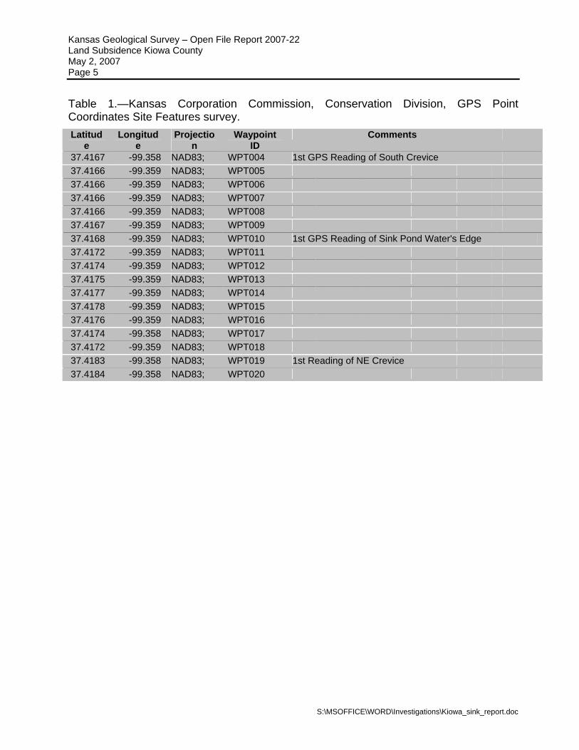
Table 1.—Kansas Corporation Commission, Conservation Division, GPS Point Coordinates Site Features survey. Latitud
e Longitud
e Projectio
n Waypoint
ID Comments
37.4167 -99.358 NAD83; WPT004 1st GPS Reading of South Crevice 37.4166 -99.359 NAD83; WPT005 37.4166 -99.359 NAD83; WPT006 37.4166 -99.359 NAD83; WPT007 37.4166 -99.359 NAD83; WPT008 37.4167 -99.359 NAD83; WPT009 37.4168 -99.359 NAD83; WPT010 1st GPS Reading of Sink Pond Water's Edge 37.4172 -99.359 NAD83; WPT011 37.4174 -99.359 NAD83; WPT012 37.4175 -99.359 NAD83; WPT013 37.4177 -99.359 NAD83; WPT014 37.4178 -99.359 NAD83; WPT015 37.4176 -99.359 NAD83; WPT016 37.4174 -99.358 NAD83; WPT017 37.4172 -99.359 NAD83; WPT018 37.4183 -99.358 NAD83; WPT019 1st Reading of NE Crevice 37.4184 -99.358 NAD83; WPT020
Kansas Geological Survey – Open File Report 2007-22 Land Subsidence Kiowa County May 2, 2007 Page 6
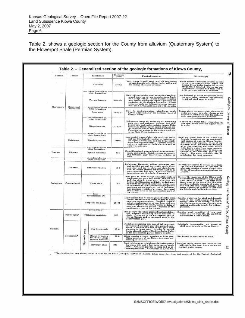
Table 2. shows a geologic section for the County from alluvium (Quaternary System) to the Flowerpot Shale (Permian System).
Table 2. – Generalized section of the geologic formations of Kiowa County,
S:\MSOFFICE\WORD\Investigations\Kiowa_sink_report.doc
Kansas Geological Survey – Open File Report 2007-22 Land Subsidence Kiowa County May 2, 2007 Page 7
Image 1.—Kiowa County subsidence SE 23-30-19W, northwest view, by MT Dealy, KGS
Image 2.—Kiowa County subsidence SE 23-30-19W, southwest view, by MT Dealy, KGS
S:\MSOFFICE\WORD\Investigations\Kiowa_sink_report.doc
Kansas Geological Survey – Open File Report 2007-22 Land Subsidence Kiowa County May 2, 2007 Page 8
Image 3.-- Kiowa County Subsidence, SE 23-30-19W, radial crack south of subsidence, northeast
view, by MT Dealy, KGS
S:\MSOFFICE\WORD\Investigations\Kiowa_sink_report.doc
Kansas Geological Survey – Open File Report 2007-22 Land Subsidence Kiowa County May 2, 2007 Page 9
Image 4. -- Kiowa County Subsidence, SE 23-30-19W, radial crack south of subsidence, east view, Lindley Reimer, KCC, by MT Dealy, KGS
S:\MSOFFICE\WORD\Investigations\Kiowa_sink_report.doc
Kansas Geological Survey – Open File Report 2007-22 Land Subsidence Kiowa County May 2, 2007 Page 10
Image 5 - Kiowa County Subsidence, SE 23-30-19W, radial crack north of subsidence, southeast view, by MT Dealy, KGS
S:\MSOFFICE\WORD\Investigations\Kiowa_sink_report.doc
Kansas Geological Survey – Open File Report 2007-22 Land Subsidence Kiowa County May 2, 2007 Page 11
Image 6 - Kiowa County Subsidence, SE 23-30-19W, radial crack north of subsidence, northwest view, by MT Dealy, KGS -
S:\MSOFFICE\WORD\Investigations\Kiowa_sink_report.doc