Kananaskis Country · the Canadian Rockies. Having said that, hiking usually starts in April in...
10
Kananaskis Country Gillean Daffern Popular Day Hikes
Transcript of Kananaskis Country · the Canadian Rockies. Having said that, hiking usually starts in April in...

Kananaskis Country
Gillean Daffern
Popular Day Hikes

3
About Kananaskis CountryKananaskis Country (commonly called K Country) is located on the eastern slopes of the Canadian Rockies, west and south of the Olympic city of Calgary, Alberta.
In the west near the Great Divide the scenery is much the same as in the adjoin-ing Banff National Park: High limestone peaks (up to 3449 m), glaciers, waterfalls, blue-green lakes, boisterous streams, forested valley bottoms of spruce and fir with larches at treeline. Winter snowfall can be heavy, so some trails, such as Burstall Pass trail, may not be clear of snow until mid July.
To the east the friendly foothills are a mosaic of sandstone bluffs, pine/aspen forests and meadows. They dry quickly of snow, making hiking possible from March to November, and sometimes right through the winter.
In between are the Front Ranges, a complex jumble of arid valleys, rocky peaks and interconnecting ridges built of both limestones and sandstones. It’s here you’ll find easy peaks to climb and ridges to wander over, the Centennial trail up Mt. Allan being a prime example.
Alpine meadows are sandwiched between forest and rock and coat many good hiking ridges. For too brief a time from late June to mid August, they are crammed with flowers. In particular, overseas visitors will be intoxicated by the gaudy colours of North America’s Indian Paintbrush. I advise all flower buffs to buy a field guide to put in the pack.
Getting thereSee the map on page 6. Other than Grey-hound buses that run along the Trans-Canada Highway between Calgary and Canmore, there is no public transporta-tion. You need to rent a car. Consider also a mountain bike for some trails. Know that all the trails in this book are accessible from Calgary as a day trip.
Introduction Seasonal road closuresHwy. 40 is closed December 1 to June 14 between Kananaskis Lakes Trail (road) and Highwood Junction.
Hwy. 66 is closed December 1 to May 14 west of Elbow Falls parking lot. Also closed December 1 to May 14 is Hwy. 546 west of Sandy McNabb Recreation Area, Powderface Trail between Dawson trailhead and Hwy. 66 and all of the Gorge Creek Trail.
FacilitiesCalgary, Cochrane, Canmore, Bragg Creek, Turner Valley, Black Diamond and Longview have all the amenities.
Hwy. 1A Exshaw: Heart Mountain Store (cafe, groceries, gas).
Hwy. 1X Bow Valley Provincial Park: Small store at Bow Valley campground. Off-season closure.
Hwy. 1 Dead Man’s Flat: Motel, B&B, gas station/small grocery store, a few eateries.
Hwy. 40 Kananaskis Village and Rib-bon Creek: two hotels, one hostel, small grocery store with snacks, outdoor rental store, numerous eateries and watering holes, nordic spa. Fortress Junction: Gas, good grocery selection and snack bar.
The following are closed off-season. Highwood Junction: Gas, some groceries and snacks. Sundance Lodges: camping in teepees, small store. Boundary Ranch: trail rides, restaurant. Kananaskis Coun-try Golf Course: restaurant.
Kananaskis Lakes Trail Boulton Creek restaurant /grocery store. Boulton Creek Rental for bikes, canoes and Kayaks. Off-season closure.
Hwy. 742 Mount Engadine Lodge: accom-modation (all meals provided), evening meals at 24 hours notice.
Hwy. 66—on nearby McLean Creek Trail (road)—McLean Creek Camper Centre: groceries and snacks.

4
WeatherSnow can fall in any month of the year in the Canadian Rockies. Having said that, hiking usually starts in April in eastern K Country. In May there is usually a period of warm sunny weather. Rains fall mainly in June–the peak run-off time. During July and August temperatures can reach the mid 30s and any rain is often associ-ated with late afternoon thunderstorms. Smoke haze from far off forest fires may bother some people. The weather starts cooling off in mid September. Indian sum-mers can occur in late September through October and are glorious, bringing sunny stable weather. By late October and No-vember temperatures are dipping to the minus 20s and snow that falls stays over the winter. But all is not lost. During this period chinook winds can roar in and raise the temperatures by 20 degrees in an hour. This occurs mainly in eastern K Country where is it sometimes possible to hike all the year round.
Generally, low cloud is not the problem it is in other wetter ranges of the world and navigating by compass in K Country is an unusual event.
Drinking WaterMost locals drink from the creeks. How-ever, there is a chance the water, especially the water in the eastern foothills, may be contaminated by Giardia lamblia, a parasite that can cause severe gastroin-testinal distress. It is best to at least start off carrying water from your home, hotel or campground.
Wildlife ConcernsAt all times be aware of bears, both Grizzly and Black bears, particularly in spring or in the early fall when the berries ripen. It’s a good idea to check K Country’s website to see if there have been any sightings in the area you are going to. K Country will often close a trail until a bear has moved out of the area.
Elk and moose should also be given a wide berth, especially in fall during the mating season when males get very ornery. Lately, cougars have become a year round worry. However, they are rarely seen, as are wolves. And don’t get too close to picas, ground squirrels and chipmunks. They bite and could carry disease.
Ticks are lurking about between about March and mid June in areas where there is a lot of sheep, such as Teahouse Ridge on Lady MacDonald. Wear light-coloured clothing—all the better to see them—and do a thorough check of your body and clothes BEFORE you get into your car! In this part of the Rockies, none of the ticks carry Lyme’s Disease.
A few rules to know about• No registration is necessary. However,
for your safety, registration books are available at information centres.
• Respect trail closures, open fire bans.• Dogs must be on a leash.
Safety Tips• It is safer to travel with company. If you
travel alone, let someone know where you are going and when you expect to return.
• Unless you are a seasoned hiker who knows the area well, going off trail can be fraught with dangers. Rock is usually friable and rockfall common.
• Start early, especially during the sum-mer thunderstorm season. Carry a flashlight or headlamp when the days become shorter.
• Carry bear repellent and read up on what to do if you encounter a bear/cougar. K Country information centres carry leaf-lets on the subject.
• Hunting is allowed everywhere except in provincial parks and provincial rec-reation areas. September to November is the time to dress in red. Know that hunting is not allowed on Sundays.
• Carry a cellphone or satellite phone.
Introduction

5
How the trails were chosenFor their popularity, first of all. You are not likely to be alone. They are easily accessible from a road, start from parking lots for the most part that usually have toilets and picnic tables, have no major river crossings and are well-marked. To give variety trails in each area range from short to long and from easy to strenuous. Because of the constraints, this selection does not mean they are my favourite trails, or even that they are the best trails.
Trails in the second editionSome trails from the first edition have been omitted because of 2013 flood dam-age, and others trails, that have since come to the forefront of popularity have been in-serted. Well-marked trails have signposts of the “You are here” variety at junctions, and coloured markers or arrows on trees and posts in between junctions. Above treeline watch for cairns, paint splodges or metal tags on rocks. Other trails, while not marked in any way apart from cairns or flagging are well used and obvious. Some trails are shared with mountain bikers and equestrians, most often those in the east Elbow.
OptionsType in blue indicates Going Farther, Side trips, Bypasses, Detours and Optional Returns. A few of the Optional Returns require a second vehicle or a bicycle.
Numbers in TextFor clarity the text is written in short numbered paragraphs. Numbers in the photo captions refer back to the paragraph numbers. Numbers in photo captions with an 0 in front of them, refer to the option.
DifficultyDescribes conditions underfoot and the steepness of the grades. Scramble steps are noted. A few of the Going farthers involve scrambling or going off official trails.
Except after rain or during run-off, minor creek crossings can usually be jumped or crossed on rocks.
DistancesDistances are usually round trip.
Sketch MapsRed lines indicate main trails. Red-dashed lines are options: Going Farther, Side Trips, Detours and Optional Returns. Black-dashed lines are other trails and are generally only shown where they intersect the red trails.
Do I need other Maps?While it’s possible to hike the trails us-ing the maps in this book, why not take along a 1:50000 recreation map by Gem Trek? They are available at most outdoor stores, bookstores and gas stations in the region. The four that cover the trails in this book are:
Canmore and Kananaskis Village Kananaskis Lakes Highwood and Cataract Creek Bragg Creek and Elbow Falls
What to wear for the trailsBe prepared for fast weather changes and pack raingear. For walks and scrambles above treeline, particularly in the off season, take a wind jacket, long pants and extra warm clothing like hat and gloves. During the heat of summer a sun hat, sun cream and mosquito repellent are must-takes. Light hiking boots suffice for all the trails in this book.
Doing MoreIf you have enjoyed the trails in this book why not hike more trails in Kananaskis Country? Kananaskis Country Trail Guide volumes 1 through 5 cover all of K Country plus the Bow Valley, The Ghost and Elk Lakes Provincial Park. They are compre-hensive, and describe all designated and undesignated trails, long-distance trails, backpacks, easy scrambles and ridgewalks.
Using this book

6
Kana
nask
is V
a lle
y
COCHRANE
DEAD MAN’S FLAT
KANANASKIS VILLAGE
JUMPINGPOUND
PETER LOUGHEED PROVINCIAL PARK
ELK LAKES PROVINCIAL
PARK
Highwood Pass
River
Wilkinson Summit
Cataract
Willow Creek The Hump
Flat Creek
Pekisko C r eek
to High River
BLACK DIAMOND
Sheep R iver
to Okotoks
Threepoint Creek
Elbow Rive
r
POWDERFACE TRAIL
Elbow River
RICHMOND ROAD
Fortress Junction
CALGARY
Jumpingpound Creek
Highwood Junction
to Nanton
to Coleman
to HWY 3
Spray Lakes Reservoir
EXSHAW
CANMORE
SIBBALD C R EEK TRAIL
PRIDDIS
BRAGG CREEK
MILLARVILLE
to Hwy 2
LONGVIEW
TURNER VALLEY
JOHNS ON CRE
EK TRAIL
SMITH-DORRIEN/SPRAY TRAIL
Fortress Ski Area
to Sundre
Kananaskis Lakes
Whiteman's Gap
WEST BRAGG CREEK ROAD
MCLEAN CREEK
Canyon Creek
to Banff
TRANS-CANADA HIGHWAY
Cre
ek
532
MOUNTSHARKROAD
ELBOW
SHEEP
HIGHWOOD Highwood
TRAIL
Nakiska Ski Area
HIG
HW
OOD TRAIL
Information CentresWinter GatesPermanent GatesRafter Six Trail Riding SpecialistsSundance LodgesKananaskis VillageBoundary RanchFortress JunctionBoulton CreekMount Engadine LodgeHighwood Junction
KEY
GORGE CREEK TRAIL

7
Hwy. 1 Canmore, Bow Valley
1GrassiLakes–8 2HaLingPeak–13 3LadyMacDonald–17 4GrottoCanyon–21 5Raven’sEnd–24 6BowValleyProvincialParkLoop–28 7HeartCreek–32 8WindRidge–36
Hwy. 40 Kananaskis Valley
9BarrierLakeLookout–4010TrollFallsLoop—4511CentennialRidgeofMountAllan–4712RibbonFalls–5113GalateaLakes–54
Hwy. 40 Peter Lougheed Prov. Park
14UpperKananaskisLake–5815RawsonLake–6216ElbowLake–6417PtarmiganCirque–66
Hwy. 742 The Smith-Dorrien
18BullerPass–6919BurstallPass–7320ChesterLake–7721RummelLake–80
Hwys. 40, 541 The Highwood
22MistRidge–8323PicklejarLakes–8824MountBurke–9225GrassPass,–96
Hwy. 66 The Elbow
29FullertonLoop—11030ElbowValley / RiverviewLoop–11231MooseMountain–11632PrairieMountain–12033PowderfaceRidge–12434NihahiRidge–128
Hwys. 546, 549 The Sheep
26ForanGradeLoop–10027VolcanoRidgeLoop—10328MesaButte—107
Hwy. 68, Powderface Road
36JumpingpoundLoop—13537JumpingpoundMountain–13838CoxHill–141
The Trails
Twp. Rd. 232 West Bragg
35TelephoneRidgeLoop–132

13
2 Ha Ling PeakA muscle-aching grind up the west
slope of Ha Ling Peak, the prominent mountain overlooking Canmore and a fabulous viewpoint. From the col between the mountain and Miners Peak, both peaks are accessible.
1. Cross the highway, walk up a road or shortcut trail to the canal and cross it via the bridge.
2. Turn right and reach a large boulder with plaque “dedicated to the mining commu-nity that worked beneath this mountain.”
3. Go straight across a gully and make a long curving arc through forest into the first left-hand zig. At its end viewpoint climb a rocky ridge to a second viewpoint. Zig right below a long slab, then back left to the third and best viewpoint for Whitemans Pond and Mt. Rundle. At the far end of the view-ing trail is a bench with a view of Canmore.
4. After the next two zigs, the trail travers-es through Whitebark pines at treeline. Steeper slopes at the end of this stretch is where stone steps and cable ladders make their first appearance. The last steepest zig climbs through scree with help from stone steps and ends on the col between Ha Ling and Miners Peak. Here ends the good trail.
5. Turn left and pick your way up the rocky southwest ridge to the summit. There’s no one route, just innumerable trails etched in scree winding about the slabs.
Distance 5.6 km returnHeight gain 732 mHigh point 2408 mStrenuousLate spring, summer, fall
Start: Hwy. 742 (Smith-Dorrien—Spray Trail) at Whiteman’s Gap. Park in the Goat Creek parking lot just south of Whiteman’s Pond.
Difficulty: In 2018/19 the Matt Had-ley trail to the col superseded the old Trailminders trail that had become badly eroded. The new trail has easy switch-backs and rock steps and cable ladders up the steeper parts. The final ascent requires some route finding on scree.
Ha Ling Peak from Whitemans Pond.
Plaque at the beginning of the trail at 2.
At 2. The first plaque erected by Trailminders was stolen and never recovered. Photo Doug Campbell.

14
Hwy. 1 Canmore, Bow Valley
Leon ’sTraverse
gul ly
gu l l y
co l
Whitemans Pond
GOAT CREEK
Ha Ling Peak
MinersPeak
Mt. Lawrence Grassi
to C
anm
ore
4.0
Left: Steps chipped into bedrock between the first and second viewpoints at 3. Photo Alberta Parks/Kananaskis Region.
The new trail was designed by Matt Hadley of McElhanney Consulting Services in consultation with Alberta Parks/Kananaskis Region.
Below: The best viewpoint at the end of 3 overlooks Whitemans Pond and Mt. Rundle. A stone bench out of sight to the right open ups a view of Canmore. This is the logical turnaround place for walkers who don’t want to climb any higher, Photo Matt Hadley.

15
Hwy. 1 Canmore, Bow Valley
6. In 1896, Ha Ling, a Chinese cook working in Canmore, was bet 50 dollars he couldn’t climb up and down within 10 hours. He made it in a 5 hour round trip—a remarkable time that can hardly be bettered today. Not surprisingly no one believed him, so the next day he led a group of doubters to the top where his flag was seen “proudly flapping in the breeze.”
“As the peak has no name let it hence forth be called Ha Ling Peak in honour of his daring intrepidity” it was proclaimed. For many generations, though, it was called “Chinaman’s Peak.” Then during the Great Canmore Influx of the 1990s the name officially changed to Ha Ling. To this day there are pockets of resistance to the new name by long-time locals.
Top left: Treeline Whitebark pines at 4. The tree is an endangered species, so please don’t carve your names into the bark. Photo Matt Hadley.
Top right: At the end of 4, a series of rock steps lead to the col. Photo Matt Hadley.
Right: At 5, the last stretch to the summit is a lot rougher with trails winding between slabs
16
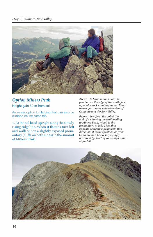
Option Miners PeakHeight gain 50 m from col
An easier option to Ha Ling that can also be climbed on the same trip.
1. At the col head up right along the slowly rising ridgeline. When it flattens turn left and walk out on a slightly exposed prom-ontory (cliffs on both sides) to the summit of Miners Peak.
Hwy. 1 Canmore, Bow Valley
Above: Ha Ling’ summit cairn is perched on the edge of the north face, a popular rock climbing venue. From here enjoy a more extensive view of Canmore and the Bow Valley.
Below: View from the col at the end of 4 showing the trail leading to Miners Peak, which is the promontory at left. Though it appears scarcely a peak from this direction, it looks spectacular from Canmore and has a surprisingly narrow ridge leading to its high point at far left.