Kamil Teke - Hacettepeyunus.hacettepe.edu.tr/~kteke/index_files/... · Kamil Teke Hacettepe...
58
Kamil Teke Hacettepe Üniversitesi, Mühendislik Fakültesi, Jeodezi ve Fotogrametri Mühendisliği Bölümü, Ankara, [email protected] VLBI Uygulamaları
Transcript of Kamil Teke - Hacettepeyunus.hacettepe.edu.tr/~kteke/index_files/... · Kamil Teke Hacettepe...
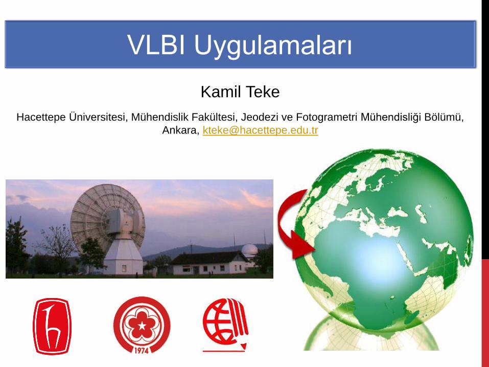
Kamil Teke
Hacettepe Üniversitesi, Mühendislik Fakültesi, Jeodezi ve Fotogrametri Mühendisliği Bölümü,
Ankara, [email protected]
VLBI Uygulamaları
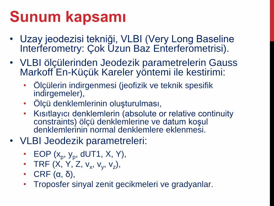
• Uzay jeodezisi tekniği, VLBI (Very Long Baseline Interferometry: Çok Uzun Baz Enterferometrisi).
• VLBI ölçülerinden Jeodezik parametrelerin Gauss Markoff En-Küçük Kareler yöntemi ile kestirimi:
• Ölçülerin indirgenmesi (jeofizik ve teknik spesifik indirgemeler),
• Ölçü denklemlerinin oluşturulması,
• Kısıtlayıcı denklemlerin (absolute or relative continuity constraints) ölçü denklemlerine ve datum koşul denklemlerinin normal denklemlere eklenmesi.
• VLBI Jeodezik parametreleri:
• EOP (xp, yp, dUT1, X, Y),
• TRF (X, Y, Z, vx, vy, vz),
• CRF (α, δ),
• Troposfer sinyal zenit gecikmeleri ve gradyanlar.
Sunum kapsamı
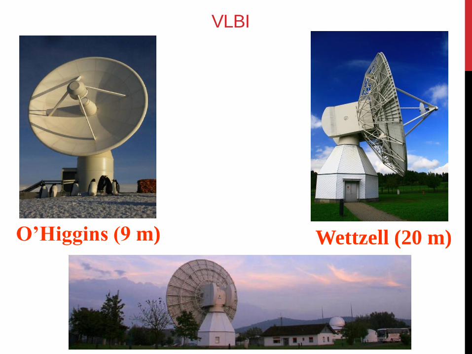
Wettzell (20 m) O’Higgins (9 m)
VLBI
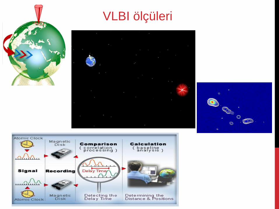
VLBI ölçüleri
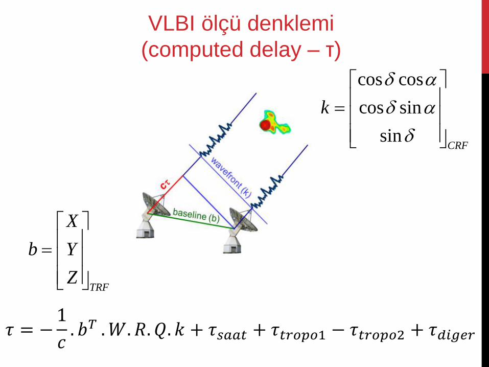
𝜏 = −1
𝑐. 𝑏𝑇 .𝑊. 𝑅. 𝑄. 𝑘 + 𝜏𝑠𝑎𝑎𝑡 + 𝜏𝑡𝑟𝑜𝑝𝑜1 − 𝜏𝑡𝑟𝑜𝑝𝑜2 + 𝜏𝑑𝑖𝑔𝑒𝑟
TRF
X
b Y
Z
cos cos
cos sin
sinCRF
k
VLBI ölçü denklemi
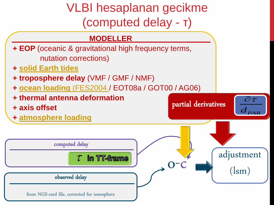
(computed delay – τ)
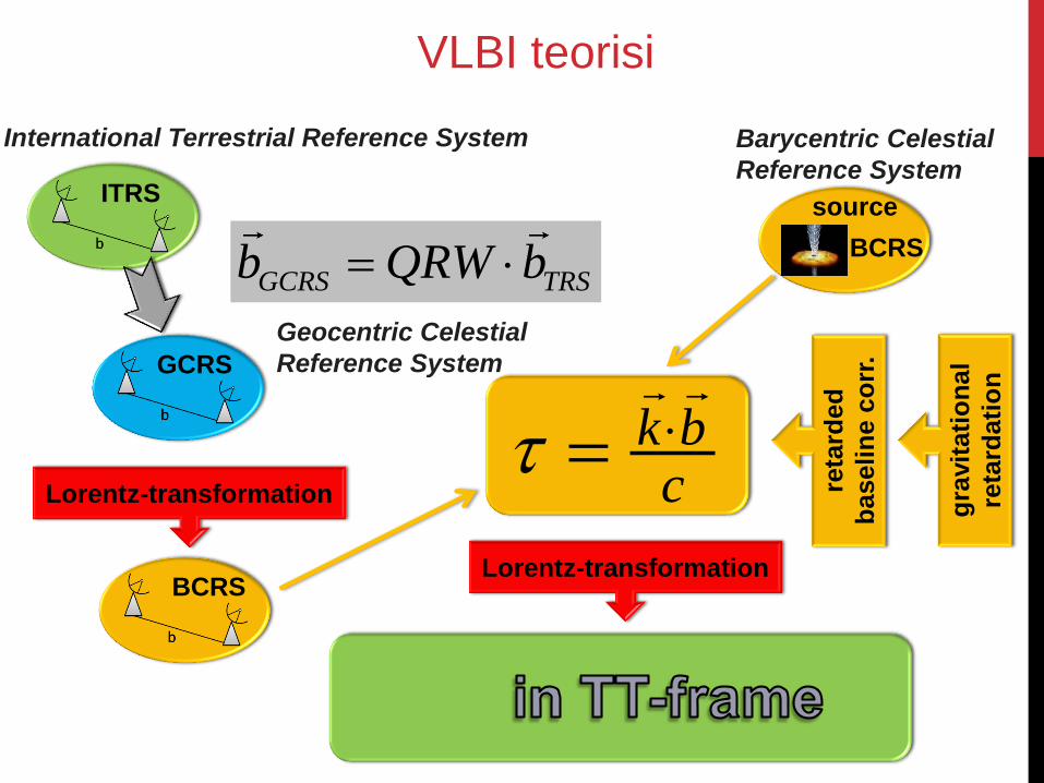
GCRS TRSb QRW b
Geocentric Celestial
Reference System
ITRS
BCRS
International Terrestrial Reference System
GCRS
Lorentz-transformation
BCRS
cbk
reta
rded
baselin
e c
orr
.
Barycentric Celestial
Reference System
source
Lorentz-transformation
gra
vit
ati
on
al
reta
rdati
on
VLBI teorisi
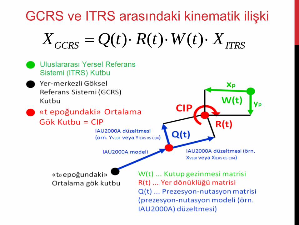
( ) ( ) ( )GCRS ITRSX Q t R t W t X
GCRS ve ITRS arasındaki kinematik ilişki
VLBI ölçülerinden jeodezik
parametrelerin kestirimi
VieVS User Workshop 2010
adjustment (lsm)
observed delay
from NGS-card file, corrected for ionosphere
computed delay o-c
MODELLER
+ EOP (oceanic & gravitational high frequency terms,
nutation corrections)
+ solid Earth tides
+ troposphere delay (VMF / GMF / NMF)
+ ocean loading (FES2004 / EOT08a / GOT00 / AG06)
+ thermal antenna deformation
+ axis offset
+ atmosphere loading
partial derivatives PARd
VLBI hesaplanan gecikme
(computed delay - τ)
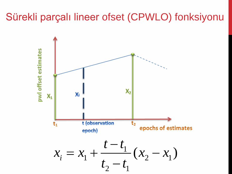
11 2 1
2 1
( )i
t tx x x x
t t
Sürekli parçalı lineer ofset (CPWLO) fonksiyonu
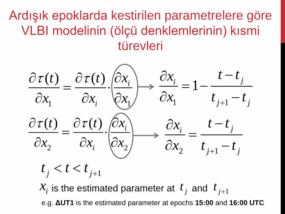
1 1
( ) ( ) i
i
xt t
x x x
2 2
( ) ( ) i
i
xt t
x x x
1 1
1ji
j j
t tx
x t t
2 1
ji
j j
t tx
x t t
1j jt t t
ix is the estimated parameter at jt and 1jt
e.g. ΔUT1 is the estimated parameter at epochs 15:00 and 16:00 UTC
Ardışık epoklarda kestirilen parametrelere göre
VLBI modelinin (ölçü denklemlerinin) kısmi
türevleri
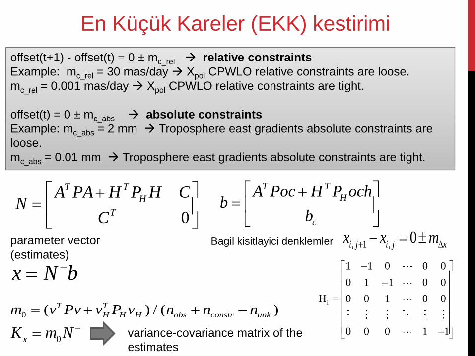
0
T T
H
T
A PA H P H CN
C
T T
H
c
A Poc H P ochb
b
x N b
0 ( ) / ( )T T
H H H obs constr unkm v Pv v P v n n n
parameter vector
(estimates)
0xK m N variance-covariance matrix of the
estimates
offset(t+1) - offset(t) = 0 ± mc_rel relative constraints
Example: mc_rel = 30 mas/day Xpol CPWLO relative constraints are loose.
mc_rel = 0.001 mas/day Xpol CPWLO relative constraints are tight.
offset(t) = 0 ± mc_abs absolute constraints
Example: mc_abs = 2 mm Troposphere east gradients absolute constraints are
loose.
mc_abs = 0.01 mm Troposphere east gradients absolute constraints are tight.
En Küçük Kareler (EKK) kestirimi
Bagil kisitlayici denklemler
i
1 1 0 0 0
0 1 1 0 0
H 0 0 1 0 0
0 0 0 1 1
, 1 , 0i j i j xx x m
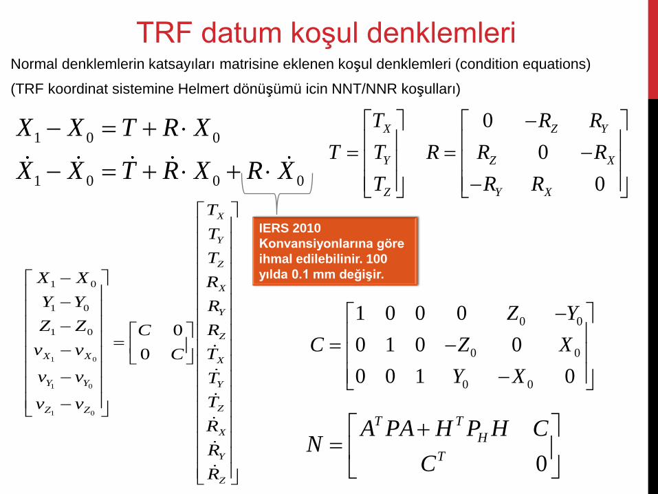
Normal denklemlerin katsayıları matrisine eklenen koşul denklemleri (condition equations)
(TRF koordinat sistemine Helmert dönüşümü icin NNT/NNR koşulları)
TRF datum koşul denklemleri
1 0 0
1 0 0 0
X X T R X
X X T R X R X
X
Y
Z
T
T T
T
0
0
0
Z Y
Z X
Y X
R R
R R R
R R
1 0
1 0
1 0
1 0
1 0
1 0 0
0
X
Y
Z
X
Y
Z
X X X
Y Y Y
ZZ Z
X
Y
Z
T
T
T
X X R
Y Y R
Z Z RC
v v TC
v v T
Tv v
R
R
R
0 0
0 0
0 0
1 0 0 0
0 1 0 0
0 0 1 0
Z Y
C Z X
Y X
0
T T
H
T
A PA H P H CN
C
IERS 2010
Konvansiyonlarına göre
ihmal edilebilinir. 100
yılda 0.1 mm değişir.
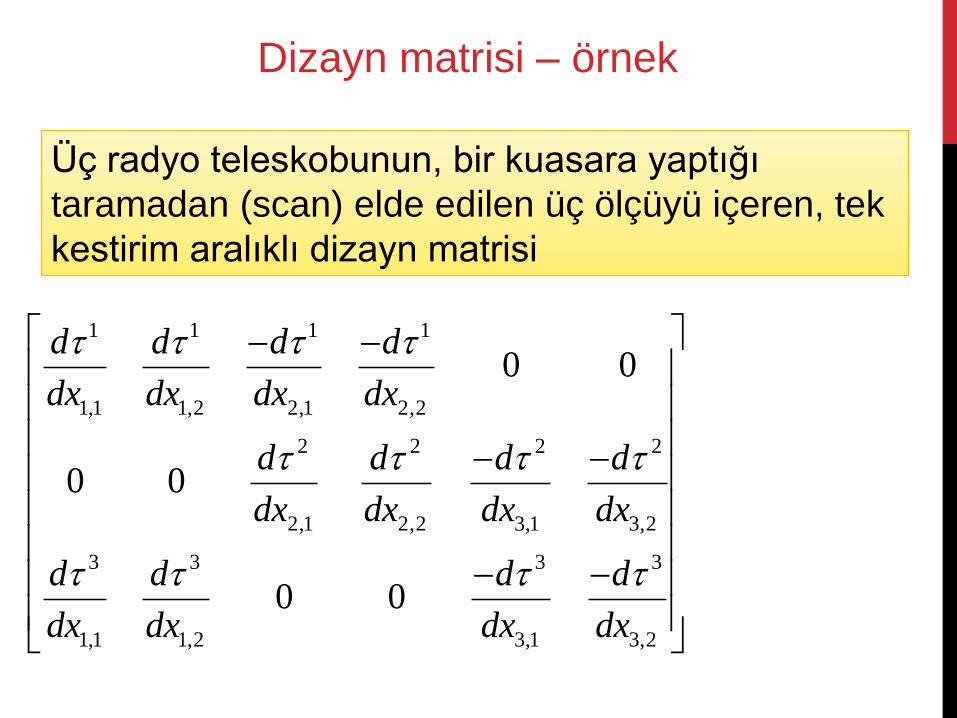
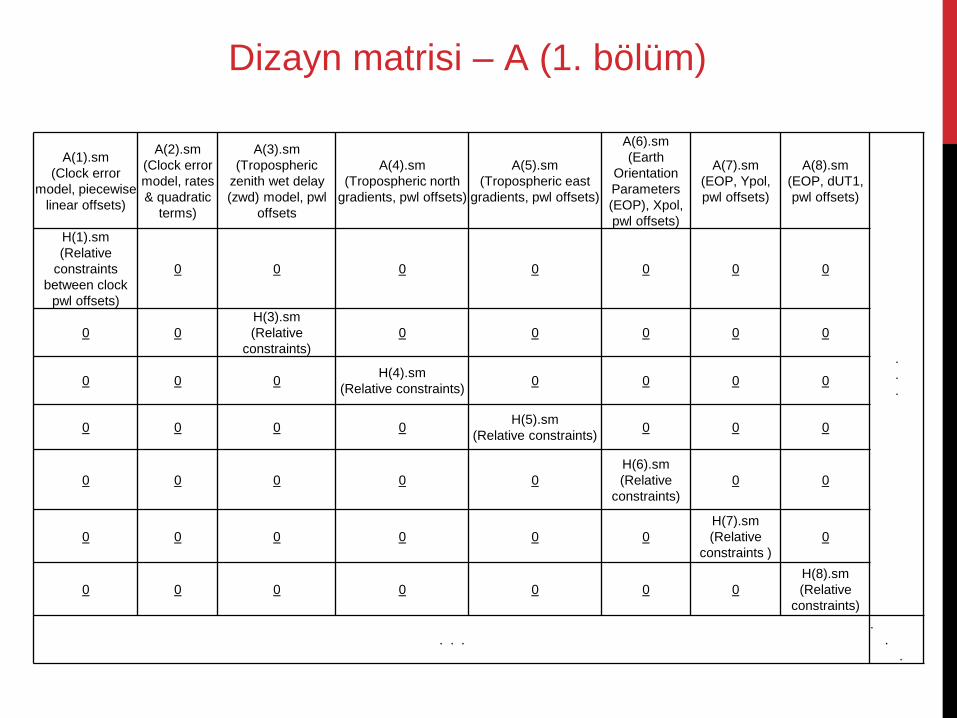
Dizayn matrisi – örnek
1 1 1 1
1,1 1,2 2,1 2,2
2 2 2 2
2,1 2,2 3,1 3,2
3 3 3 3
1,1 1,2 3,1 3,2
0 0
0 0
0 0
d d d d
dx dx dx dx
d d d d
dx dx dx dx
d d d d
dx dx dx dx
Üç radyo teleskobunun, bir kuasara yaptığı
taramadan (scan) elde edilen üç ölçüyü içeren, tek
kestirim aralıklı dizayn matrisi
A(1).sm
(Clock error
model, piecewise
linear offsets)
A(2).sm
(Clock error
model, rates
& quadratic
terms)
A(3).sm
(Tropospheric
zenith wet delay
(zwd) model, pwl
offsets
A(4).sm
(Tropospheric north
gradients, pwl offsets)
A(5).sm
(Tropospheric east
gradients, pwl offsets)
A(6).sm
(Earth
Orientation
Parameters
(EOP), Xpol,
pwl offsets)
A(7).sm
(EOP, Ypol,
pwl offsets)
A(8).sm
(EOP, dUT1,
pwl offsets)
.
.
.
H(1).sm
(Relative
constraints
between clock
pwl offsets)
0 0 0 0 0 0 0
0 0
H(3).sm
(Relative
constraints)
0 0 0 0 0
0 0 0 H(4).sm
(Relative constraints) 0 0 0 0
0 0 0 0 H(5).sm
(Relative constraints) 0 0 0
0 0 0 0 0
H(6).sm
(Relative
constraints)
0 0
0 0 0 0 0 0
H(7).sm
(Relative
constraints )
0
0 0 0 0 0 0 0
H(8).sm
(Relative
constraints)
. . .
.
.
.
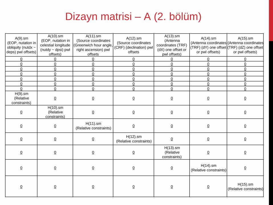
Dizayn matrisi – A (1. bölüm)
A(9).sm
(EOP, nutation in
obliquity (nutdx ~
deps) pwl offsets)
A(10).sm
(EOP, nutation in
celestial longitude
(nutdy ~ dpsi) pwl
offsets)
A(11).sm
(Source coordinates
(Greenwich hour angle,
right ascension) pwl
offsets
A(12).sm
(Source coordinates
(CRF) (declination) pwl
offsets
A(13).sm
(Antenna
coordinates (TRF)
(dX) one offset or
pwl offsets)
A(14).sm
(Antenna coordinates
(TRF) (dY) one offset
or pwl offsets)
A(15).sm
(Antenna coordinates
(TRF) (dZ) one offset
or pwl offsets)
0 0 0 0 0 0 0
0 0 0 0 0 0 0
0 0 0 0 0 0 0
0 0 0 0 0 0 0
0 0 0 0 0 0 0
0 0 0 0 0 0 0
0 0 0 0 0 0 0
H(9).sm
(Relative
constraints)
0 0 0 0 0 0
0
H(10).sm
(Relative
constraints)
0 0 0 0 0
0 0 H(11).sm
(Relative constraints) 0 0 0 0
0 0 0 H(12).sm
(Relative constraints) 0 0 0
0 0 0 0
H(13).sm
(Relative
constraints)
0 0
0 0 0 0 0 H(14).sm
(Relative constraints) 0
0 0 0 0 0 0 H(15).sm
(Relative constraints)
Dizayn matrisi – A (2. bölüm)
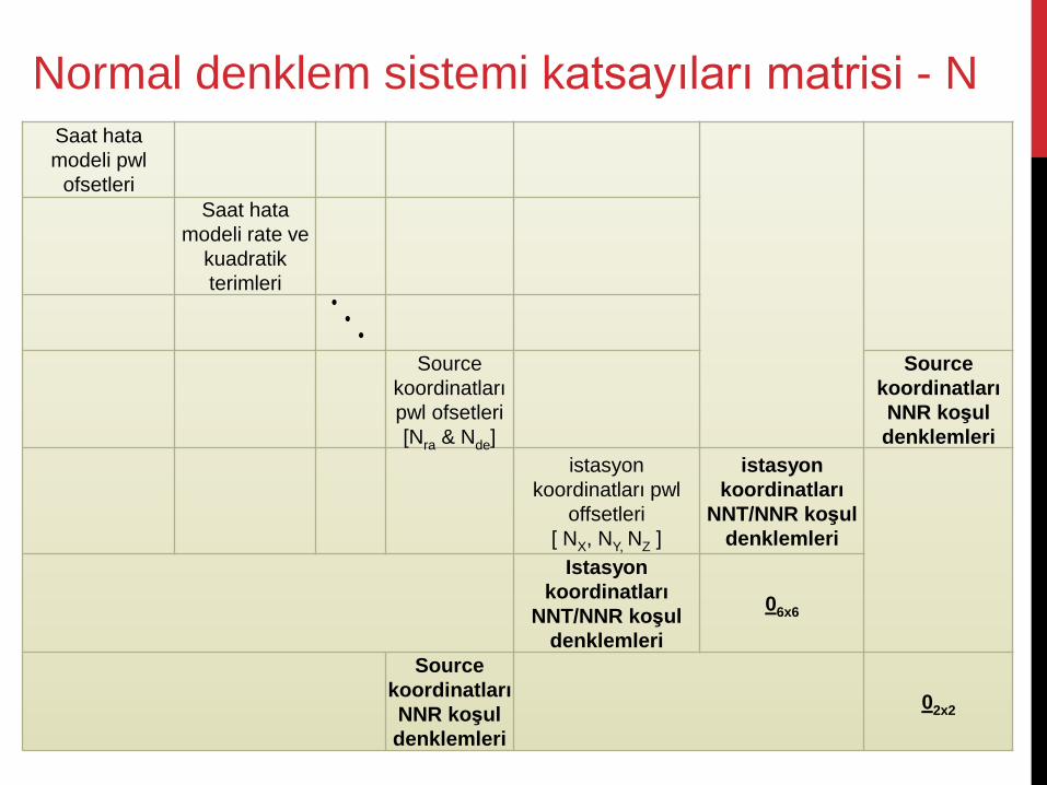
Saat hata
modeli pwl
ofsetleri
Saat hata
modeli rate ve
kuadratik
terimleri
Source
koordinatları
pwl ofsetleri
[Nra & Nde]
Source
koordinatları
NNR koşul
denklemleri
istasyon
koordinatları pwl
offsetleri
[ NX, NY, NZ ]
istasyon
koordinatları
NNT/NNR koşul
denklemleri
Istasyon
koordinatları
NNT/NNR koşul
denklemleri
06x6
Source
koordinatları
NNR koşul
denklemleri
02x2
Normal denklem sistemi katsayıları matrisi - N
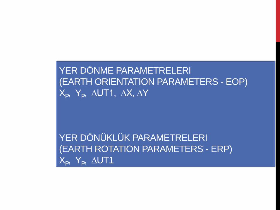
YER DÖNME PARAMETRELERI
(EARTH ORIENTATION PARAMETERS - EOP)
XP, YP, ∆UT1, ∆X, ∆Y
YER DÖNÜKLÜK PARAMETRELERI
(EARTH ROTATION PARAMETERS - ERP)
XP, YP, ∆UT1
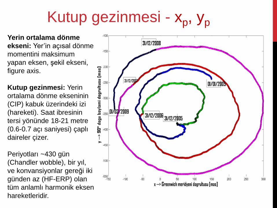
Yerin ortalama dönme
ekseni: Yer’in açısal dönme
momentini maksimum
yapan eksen, şekil ekseni,
figure axis.
Kutup gezinmesi: Yerin
ortalama dönme ekseninin
(CIP) kabuk üzerindeki izi
(hareketi). Saat ibresinin
tersi yönünde 18-21 metre
(0.6-0.7 açı saniyesi) çaplı
daireler çizer.
Periyotları ~430 gün
(Chandler wobble), bir yıl,
ve konvansiyonlar gereği iki
günden az (HF-ERP) olan
tüm anlamlı harmonik eksen
hareketleridir.
Kutup gezinmesi - xp, yp
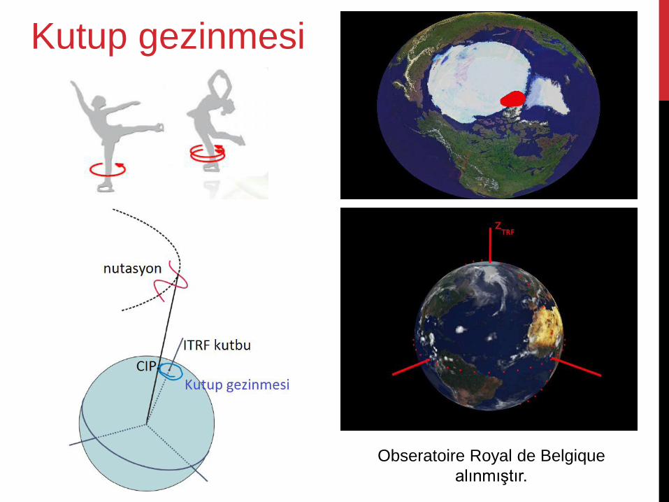
Obseratoire Royal de Belgique
alınmıştır.
Kutup gezinmesi
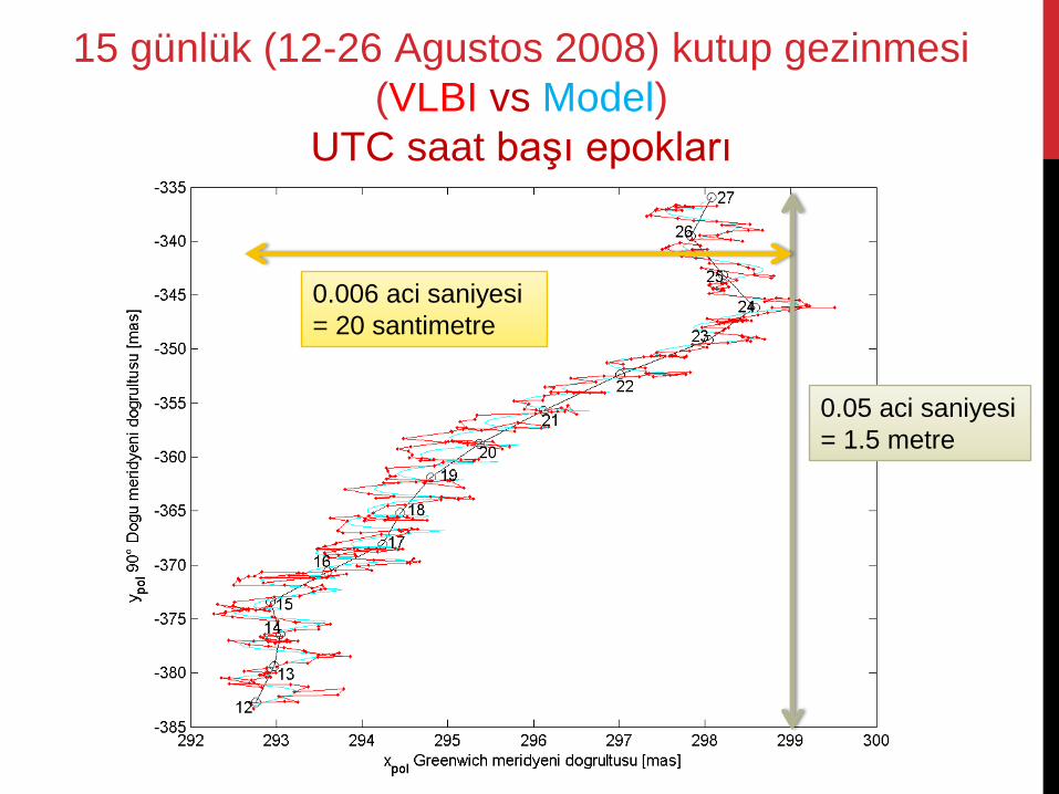
0.05 aci saniyesi
= 1.5 metre
0.006 aci saniyesi
= 20 santimetre
15 günlük (12-26 Agustos 2008) kutup gezinmesi
(VLBI vs Model)
UTC saat başı epokları
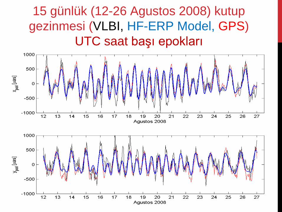
15 günlük (12-26 Agustos 2008) kutup
gezinmesi (VLBI, HF-ERP Model, GPS)
UTC saat başı epokları
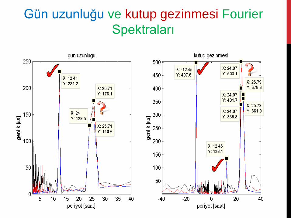
Gün uzunluğu ve kutup gezinmesi Fourier
Spektraları
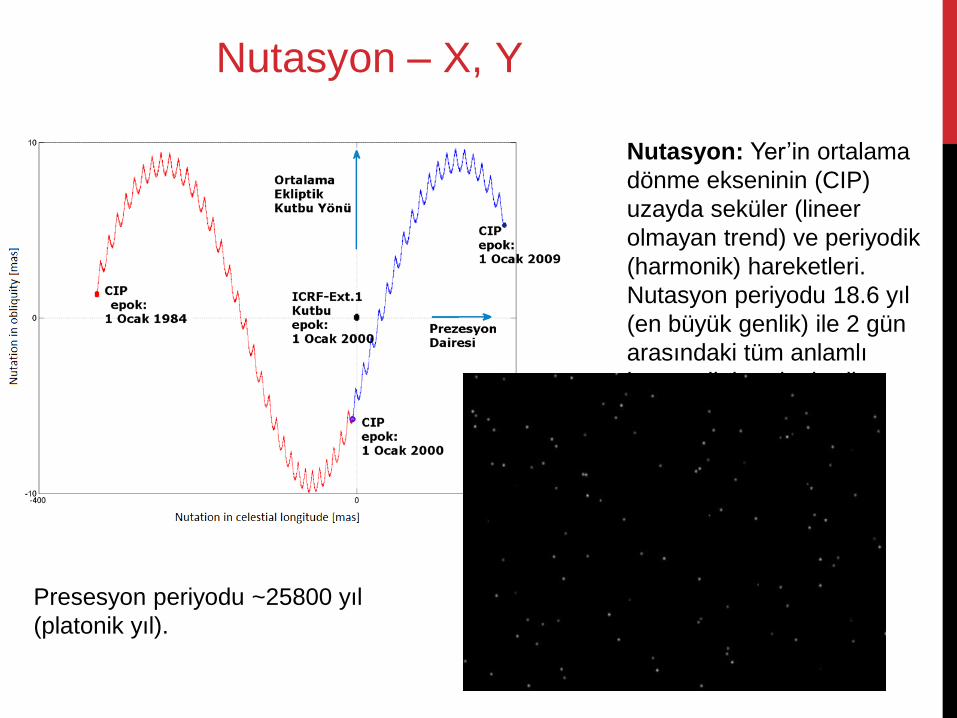
Nutasyon: Yer’in ortalama
dönme ekseninin (CIP)
uzayda seküler (lineer
olmayan trend) ve periyodik
(harmonik) hareketleri.
Nutasyon periyodu 18.6 yıl
(en büyük genlik) ile 2 gün
arasındaki tüm anlamlı
harmonik hareketlerdir.
Presesyon periyodu ~25800 yıl
(platonik yıl).
Nutasyon – X, Y
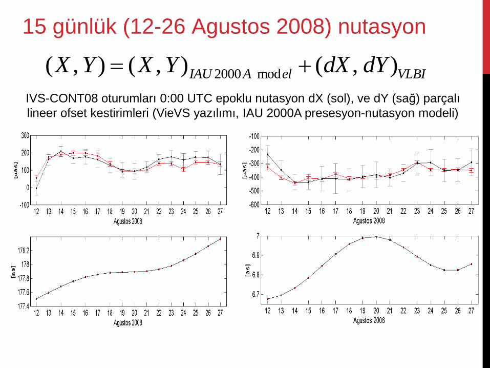
2000 mod( , ) ( , ) ( , )IAU A el VLBIX Y X Y dX dY
IVS-CONT08 oturumları 0:00 UTC epoklu nutasyon dX (sol), ve dY (sağ) parçalı
lineer ofset kestirimleri (VieVS yazılımı, IAU 2000A presesyon-nutasyon modeli)
15 günlük (12-26 Agustos 2008) nutasyon
TRF
(Tide free crust)
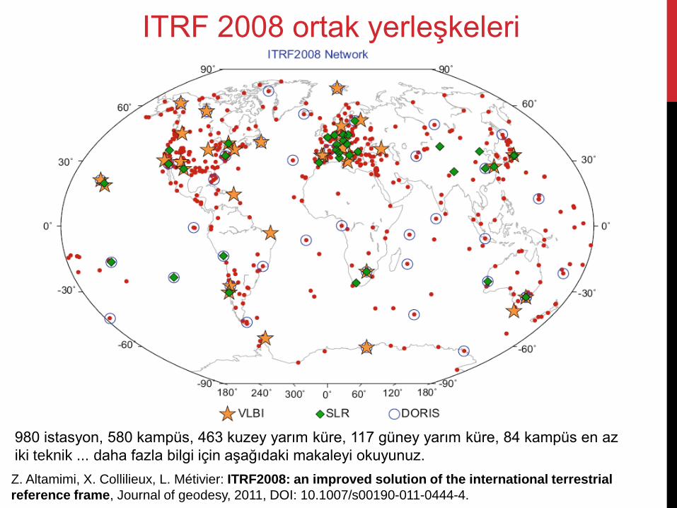
Z. Altamimi, X. Collilieux, L. Métivier: ITRF2008: an improved solution of the international terrestrial
reference frame, Journal of geodesy, 2011, DOI: 10.1007/s00190-011-0444-4.
ITRF 2008 ortak yerleşkeleri
980 istasyon, 580 kampüs, 463 kuzey yarım küre, 117 güney yarım küre, 84 kampüs en az
iki teknik ... daha fazla bilgi için aşağıdaki makaleyi okuyunuz.
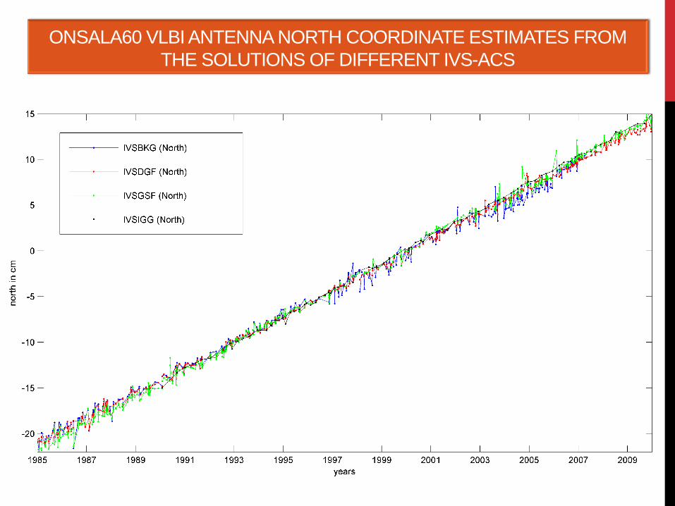
ONSALA60 VLBI ANTENNA NORTH COORDINATE ESTIMATES FROM
THE SOLUTIONS OF DIFFERENT IVS-ACS
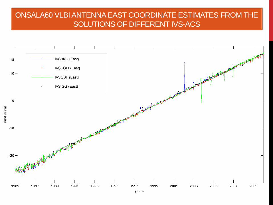
ONSALA60 VLBI ANTENNA EAST COORDINATE ESTIMATES FROM THE
SOLUTIONS OF DIFFERENT IVS-ACS
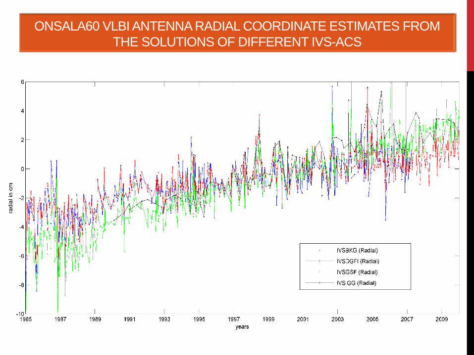
ONSALA60 VLBI ANTENNA RADIAL COORDINATE ESTIMATES FROM
THE SOLUTIONS OF DIFFERENT IVS-ACS
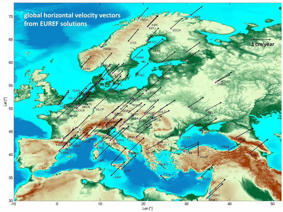
global horizontal velocity vectors from EUREF solutions
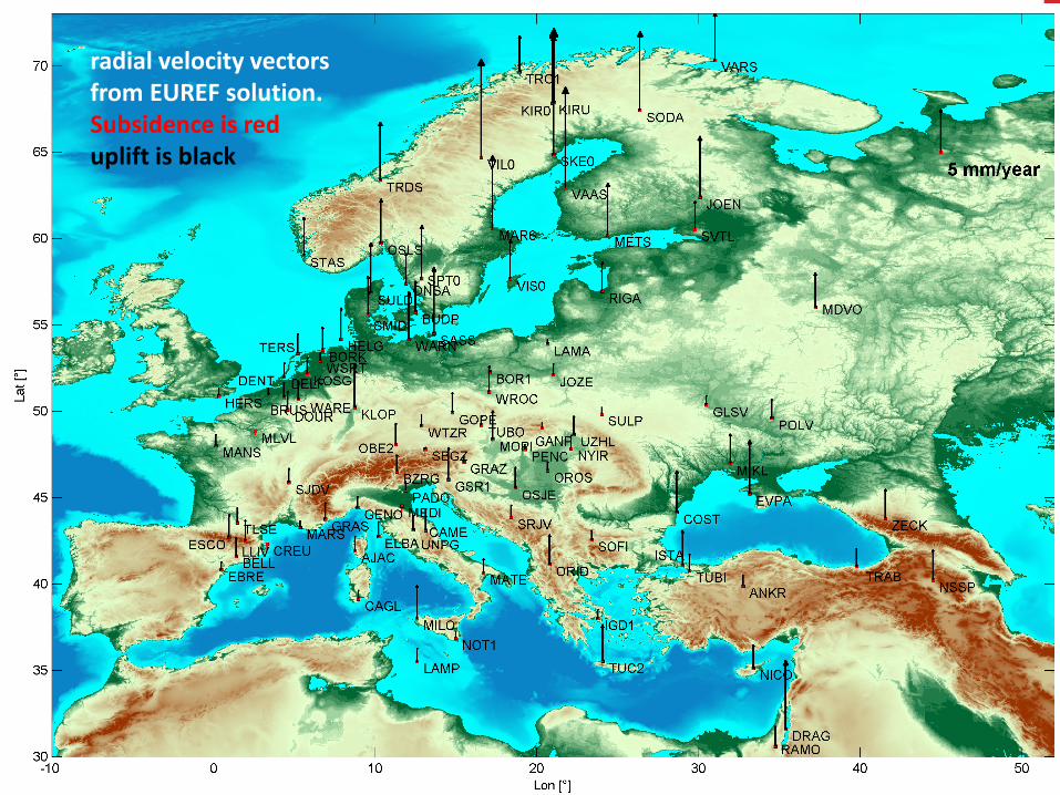
radial velocity vectors from EUREF solution. Subsidence is red uplift is black
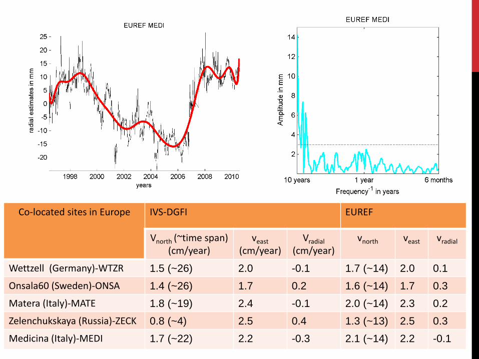
Co-located sites in Europe IVS-DGFI EUREF
Vnorth (~time span) (cm/year)
veast (cm/year)
Vradial
(cm/year) vnorth veast vradial
Wettzell (Germany)-WTZR 1.5 (~26) 2.0 -0.1 1.7 (~14) 2.0 0.1
Onsala60 (Sweden)-ONSA 1.4 (~26) 1.7 0.2 1.6 (~14) 1.7 0.3
Matera (Italy)-MATE 1.8 (~19) 2.4 -0.1 2.0 (~14) 2.3 0.2
Zelenchukskaya (Russia)-ZECK 0.8 (~4) 2.5 0.4 1.3 (~13) 2.5 0.3
Medicina (Italy)-MEDI 1.7 (~22) 2.2 -0.3 2.1 (~14) 2.2 -0.1
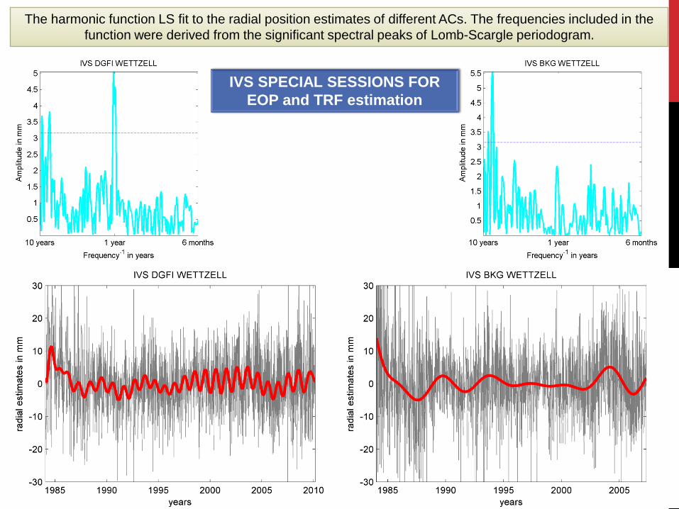
The harmonic function LS fit to the radial position estimates of different ACs. The frequencies included in the
function were derived from the significant spectral peaks of Lomb-Scargle periodogram.
IVS SPECIAL SESSIONS FOR
EOP and TRF estimation
CRF
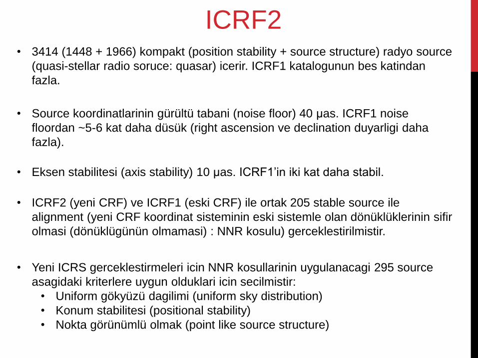
ICRF2 • 3414 (1448 + 1966) kompakt (position stability + source structure) radyo source
(quasi-stellar radio soruce: quasar) icerir. ICRF1 katalogunun bes katindan
fazla.
• Source koordinatlarinin gürültü tabani (noise floor) 40 μas. ICRF1 noise
floordan ~5-6 kat daha düsük (right ascension ve declination duyarligi daha
fazla).
• Eksen stabilitesi (axis stability) 10 μas. ICRF1’in iki kat daha stabil.
• ICRF2 (yeni CRF) ve ICRF1 (eski CRF) ile ortak 205 stable source ile
alignment (yeni CRF koordinat sisteminin eski sistemle olan dönüklüklerinin sifir
olmasi (dönüklügünün olmamasi) : NNR kosulu) gerceklestirilmistir.
• Yeni ICRS gerceklestirmeleri icin NNR kosullarinin uygulanacagi 295 source
asagidaki kriterlere uygun olduklari icin secilmistir:
• Uniform gökyüzü dagilimi (uniform sky distribution)
• Konum stabilitesi (positional stability)
• Nokta görünümlü olmak (point like source structure)
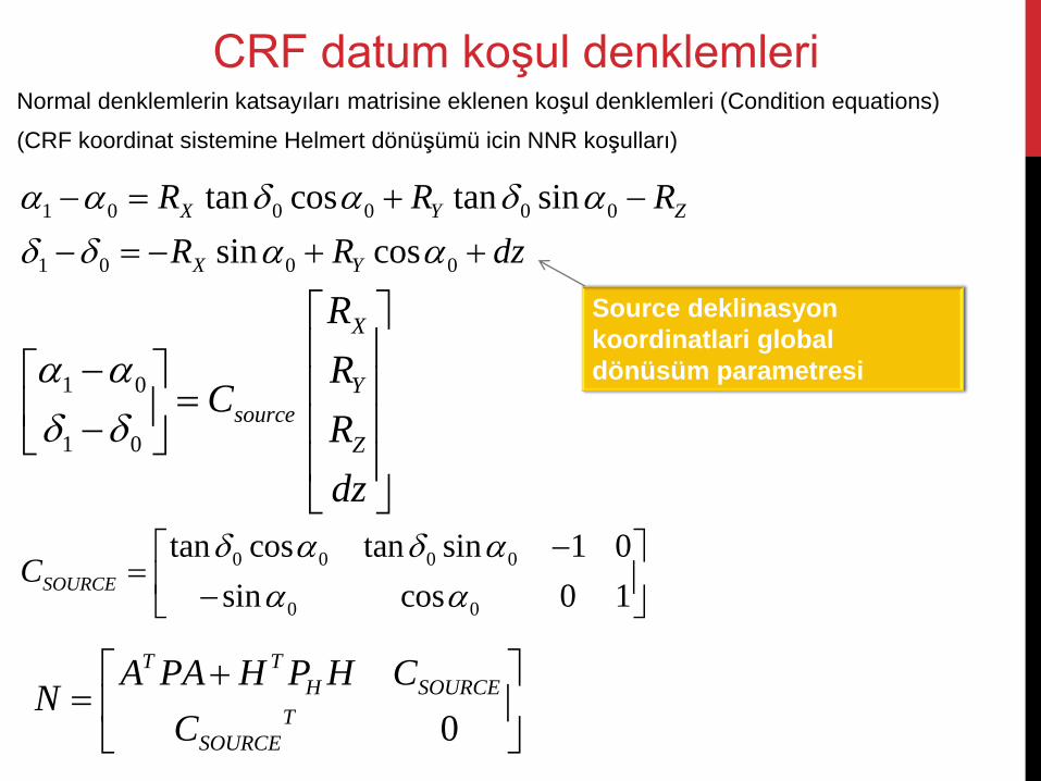
Normal denklemlerin katsayıları matrisine eklenen koşul denklemleri (Condition equations)
(CRF koordinat sistemine Helmert dönüşümü icin NNR koşulları)
CRF datum koşul denklemleri
0 0 0 0
0 0
tan cos tan sin 1 0
sin cos 0 1SOURCEC
0
T T
H SOURCE
T
SOURCE
A PA H P H CN
C
1 0 0 0 0 0
1 0 0 0
tan cos tan sin
sin cos
X Y Z
X Y
R R R
R R dz
1 0
1 0
X
Y
source
Z
R
RC
R
dz
Source deklinasyon
koordinatlari global
dönüsüm parametresi
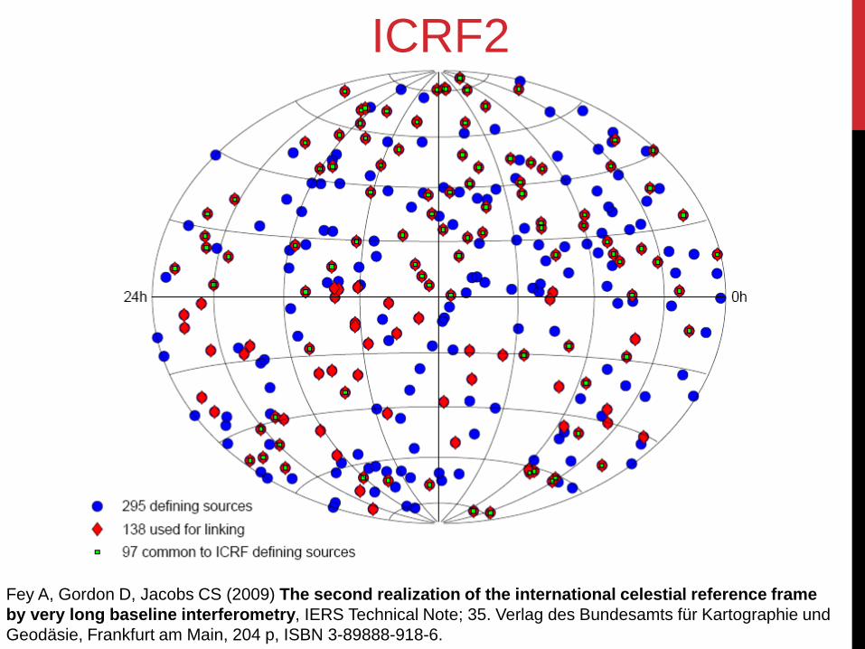
Fey A, Gordon D, Jacobs CS (2009) The second realization of the international celestial reference frame
by very long baseline interferometry, IERS Technical Note; 35. Verlag des Bundesamts für Kartographie und
Geodäsie, Frankfurt am Main, 204 p, ISBN 3-89888-918-6.
ICRF2
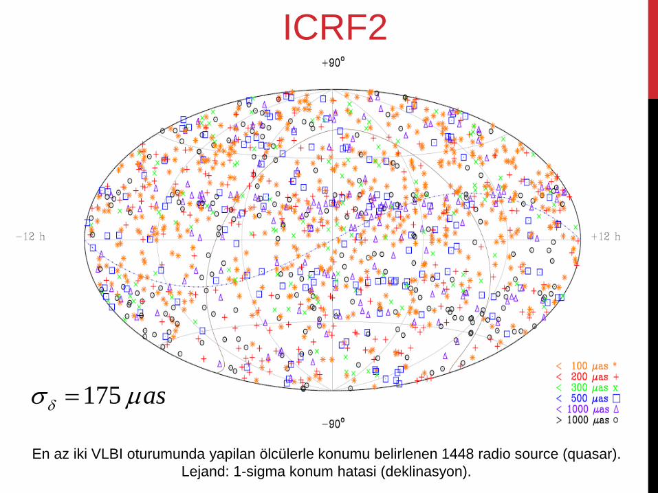
En az iki VLBI oturumunda yapilan ölcülerle konumu belirlenen 1448 radio source (quasar).
Lejand: 1-sigma konum hatasi (deklinasyon).
ICRF2
175 as
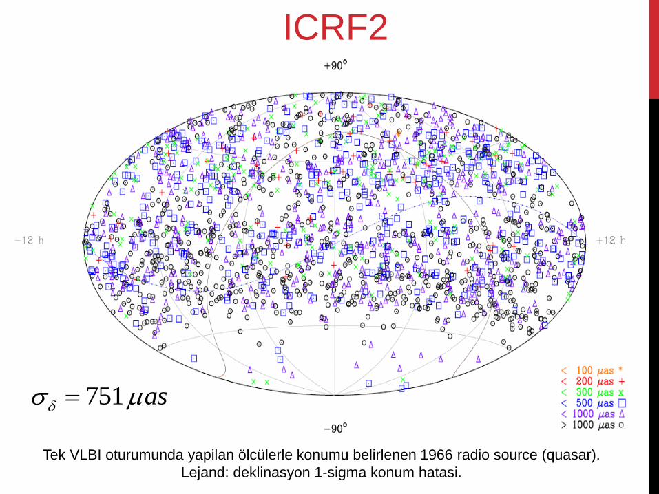
Tek VLBI oturumunda yapilan ölcülerle konumu belirlenen 1966 radio source (quasar).
Lejand: deklinasyon 1-sigma konum hatasi.
ICRF2
751 as
Troposfer
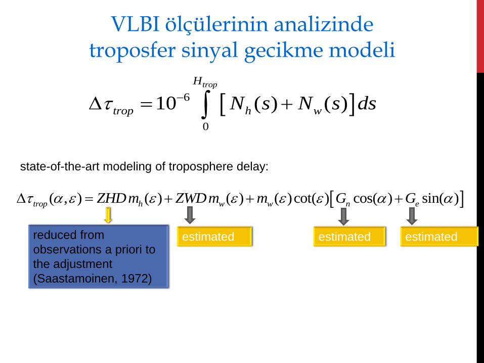
6
0
10 ( ) ( )
tropH
trop h wN s N s ds
( , ) ( ) ( ) ( )cot( ) cos( ) sin( )trop h w w n eZHDm ZWDm m G G
reduced from
observations a priori to
the adjustment
(Saastamoinen, 1972)
estimated estimated estimated
state-of-the-art modeling of troposphere delay:
VLBI ölçülerinin analizinde troposfer sinyal gecikme modeli
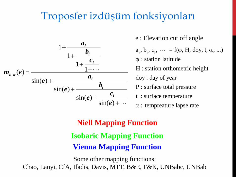
,
1
1
11( )
sin( )
sin( )
sin( )sin( )
i
i
i
h wi
i
i
a
b
c
m ea
eb
ec
ee
Niell Mapping Function
Isobaric Mapping Function
Vienna Mapping Function
Some other mapping functions:
Chao, Lanyi, CfA, Ifadis, Davis, MTT, B&E, F&K, UNBabc, UNBab
e : Elevation cut off angle
i i ia , b , c , = f( , H, doy, t, , ...)
: station latitude
H : station orthometric height
doy : day of year
P : surface total pressure
t : surface temperature
: tempreature lapse rate
Troposfer izdüşüm fonksiyonları
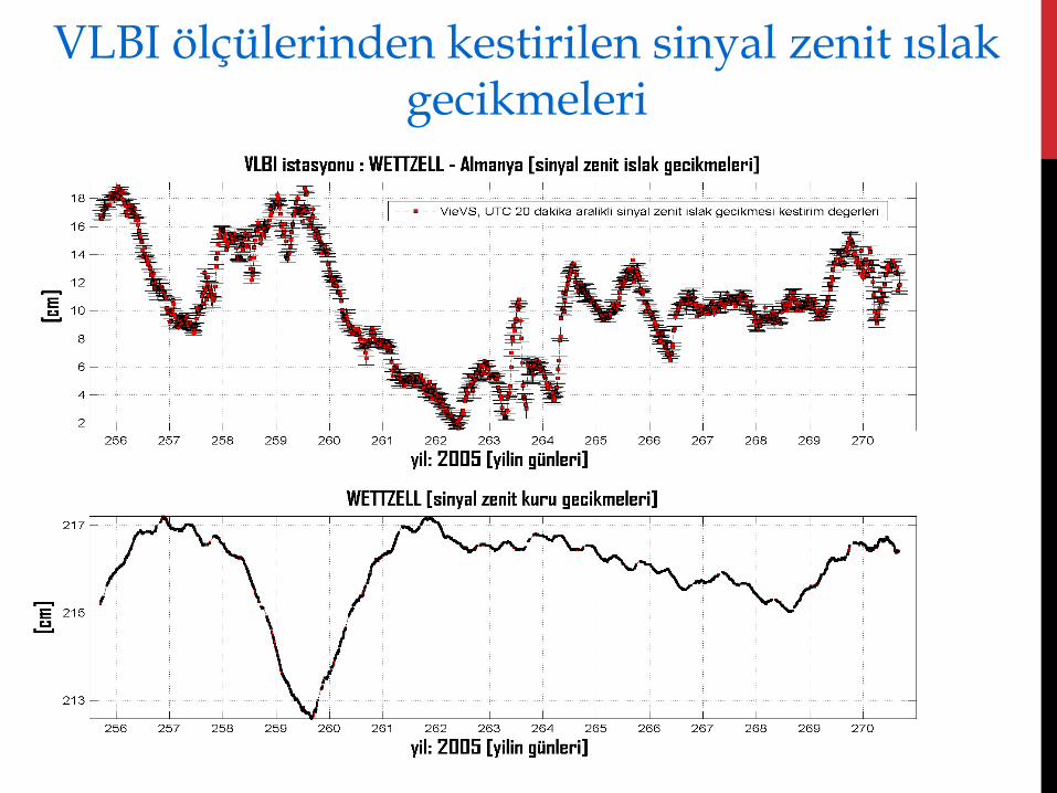
VLBI ölçülerinden kestirilen sinyal zenit ıslak gecikmeleri
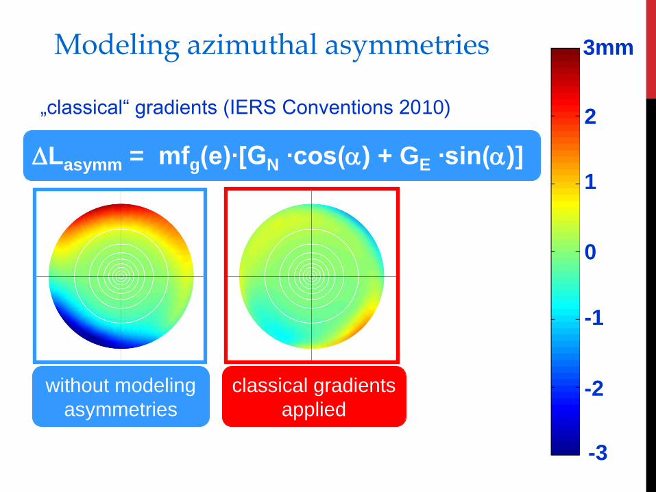
Modeling azimuthal asymmetries
-3
-2
-1
0
1
2
3mm
without modeling
asymmetries
classical gradients
applied
„classical“ gradients (IERS Conventions 2010)
Lasymm = mfg(e)∙[GN ∙cos() + GE ∙sin()]
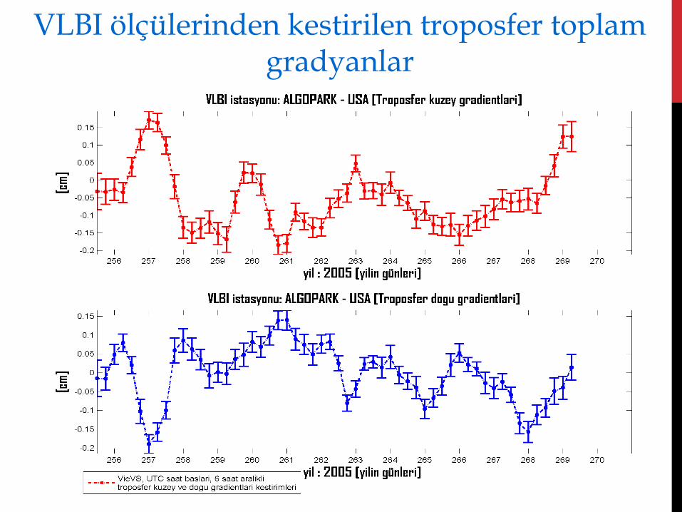
VLBI ölçülerinden kestirilen troposfer toplam gradyanlar
Katılımınız ve dinlediğiniz
için teşekkür ederiz !

EKLER
İstasyon noktalarında
oluşan hareketler
(deformasyonlar)
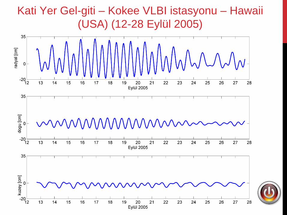
Kati Yer Gel-giti – Kokee VLBI istasyonu – Hawaii
(USA) (12-28 Eylül 2005)
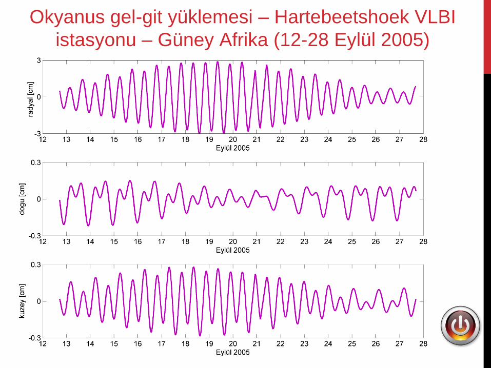
Okyanus gel-git yüklemesi – Hartebeetshoek VLBI
istasyonu – Güney Afrika (12-28 Eylül 2005)
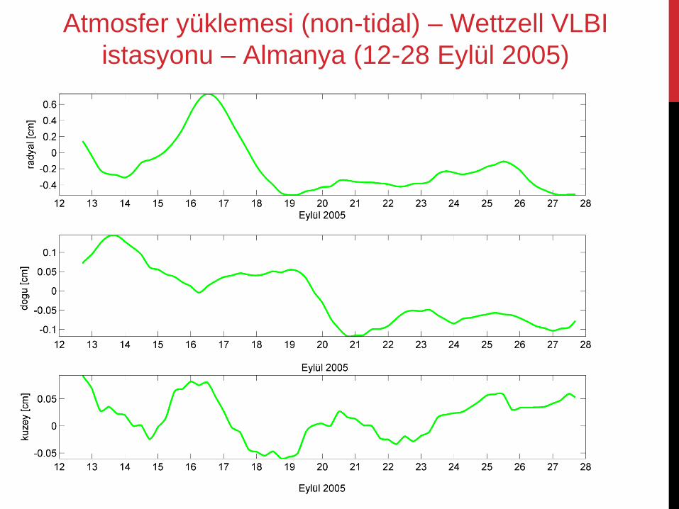
Atmosfer yüklemesi (non-tidal) – Wettzell VLBI
istasyonu – Almanya (12-28 Eylül 2005)
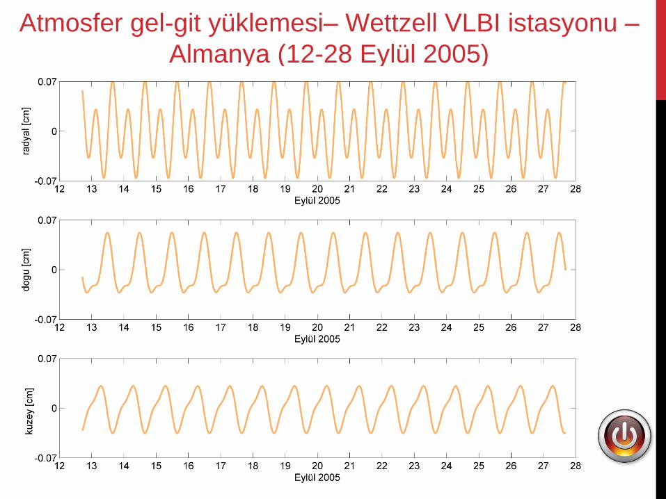
Atmosfer gel-git yüklemesi– Wettzell VLBI istasyonu –
Almanya (12-28 Eylül 2005)
VLBI parametrizasyonu
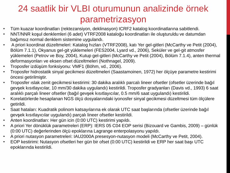
• Tüm kuazar koordinatları (rektezansiyon, deklinasyon) ICRF2 katalog koordinatlarına sabitlendi.
• NNT/NNR koşul denklemleri (6 adet) VTRF2008 kataloğu koordinatları ile oluşturuldu ve datumdan
bağımsız normal denklem sistemine uygulandı.
• A priori koordinat düzeltmeleri: Katalog hızları (VTRF2008), katı Yer gel-gitleri (McCarthy ve Petit (2004),
Bölüm 7.1.1), Okyanus gel-git yüklemeleri (FES2004, Lyard vd., 2006), Seküler ve gel-git atmosfer
yüklemeleri (Petrov ve Boy, 2004), Kutup gel-gitleri (McCarthy ve Petit (2004), Bölüm 7.1.4), anten thermal
deformasyonları ve eksen ofset düzeltmeleri (Nothnagel, 2009).
• Troposfer izdüşüm fonksiyonu: VMF1 (Böhm, vd., 2006).
• Troposfer hidrostatik sinyal gecikmesi düzeltmeleri (Saastamoinen, 1972) her ölçüye parametre kestirimi
öncesi getirilmiştir.
• Troposfer ıslak zenit gecikmesi kestirimi: 30 dakika aralıklı parcalı lineer ofsetler (ofsetler üzerinde bağıl
gevşek kısıtlayıcılar, 10 mm/30 dakika uygulandı) kestirildi. Troposfer gradyanları (Davis vd., 1993) 6 saat
aralıklı parçalı lineer ofsetler (bağıl gevşek kısıtlayıcılar, 0.5 mm/6 saat uygulandı) kestirildi.
• Korelatörlerde hesaplanan NGS ölçü dosyalarındaki iyonosfer sinyal gecikmesi düzeltmesi tüm ölçülere
getirildi.
• Saat hataları: Kuadratik polinom katsayılarına ek olarak UTC saat başlarında (ofsetler üzerinde bağıl
gevşek kısıtlayıcılar uygulandı) parçalı lineer ofsetler kestirildi.
• Anten koordinatları: Her gün icin (0:00 UTC) kestirimi yapıldı.
• A priori Yer dönüklük parametreleri (ERP): IERS 05 C04 EOP serisi (Bizouard ve Gambis, 2009) – günlük
(0:00 UTC) değerlerinden ölçü epoklarına Lagrange enterpolasyonu yapıldı.
• A priori nutasyon parametreleri: IAU2000A presesyon-nutasyon modeli (McCarthy ve Petit, 2004).
• EOP kestirimi: Nutasyon ofsetleri her gün bir ofset (0:00 UTC) kestirildi ve ERP her saat başı UTC
epoklarında kestirildi.
24 saatlik bir VLBI oturumunun analizinde örnek
parametrizasyon
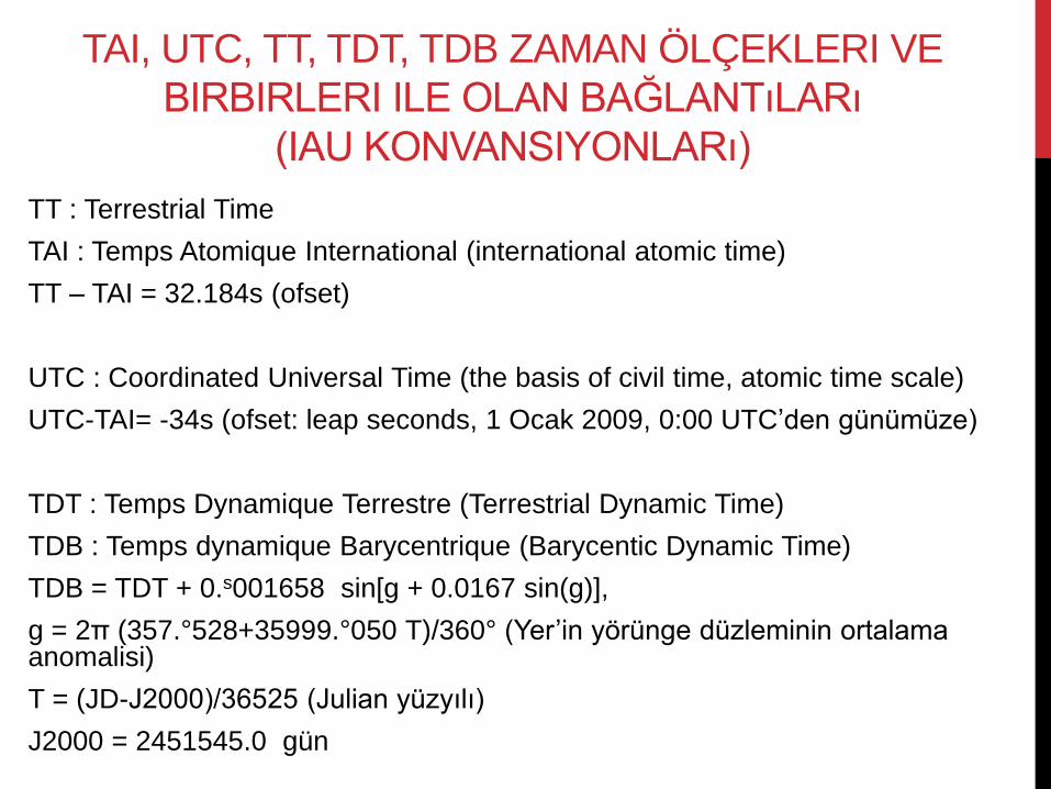
TAI, UTC, TT, TDT, TDB ZAMAN ÖLÇEKLERI VE
BIRBIRLERI ILE OLAN BAĞLANTıLARı
(IAU KONVANSIYONLARı)
TT : Terrestrial Time
TAI : Temps Atomique International (international atomic time)
TT – TAI = 32.184s (ofset)
UTC : Coordinated Universal Time (the basis of civil time, atomic time scale)
UTC-TAI= -34s (ofset: leap seconds, 1 Ocak 2009, 0:00 UTC’den günümüze)
TDT : Temps Dynamique Terrestre (Terrestrial Dynamic Time)
TDB : Temps dynamique Barycentrique (Barycentic Dynamic Time)
TDB = TDT + 0.s001658 sin[g + 0.0167 sin(g)],
g = 2π (357.°528+35999.°050 T)/360° (Yer’in yörünge düzleminin ortalama anomalisi)
T = (JD-J2000)/36525 (Julian yüzyılı)
J2000 = 2451545.0 gün
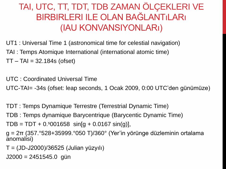
TAI, UTC, TT, TDT, TDB ZAMAN ÖLÇEKLERI VE
BIRBIRLERI ILE OLAN BAĞLANTıLARı
(IAU KONVANSIYONLARı)
UT1 : Universal Time 1 (astronomical time for celestial navigation)
TAI : Temps Atomique International (international atomic time)
TT – TAI = 32.184s (ofset)
UTC : Coordinated Universal Time
UTC-TAI= -34s (ofset: leap seconds, 1 Ocak 2009, 0:00 UTC’den günümüze)
TDT : Temps Dynamique Terrestre (Terrestrial Dynamic Time)
TDB : Temps dynamique Barycentrique (Barycentic Dynamic Time)
TDB = TDT + 0.s001658 sin[g + 0.0167 sin(g)],
g = 2π (357.°528+35999.°050 T)/360° (Yer’in yörünge düzleminin ortalama anomalisi)
T = (JD-J2000)/36525 (Julian yüzyılı)
J2000 = 2451545.0 gün
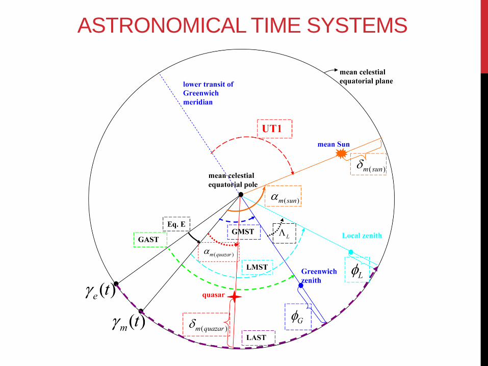
ASTRONOMICAL TIME SYSTEMS