July Heatwave Europe Europe August 2013 - WeatherAction
9
Weather Action™ © & Piers Corbyn accept no liability for any loss howsoever arising from use of forecast information. Application of forecasts is entirely at the user’s risk. None of this forecast may be published or circulated in media or web or used in production of other forecasts without agreement of Weather Action & Piers Corbyn. Media use is welcome but may only be from specific issued quotes to the newspaper or media concerned or issued displays on www.weatheraction.com Europe August 2013 Heatwaves for most of Continent, E Scandinavia + West Russia till late month ● Centre & W Scandinavia variable with Low attacks – espec 4-6 th (R4) 10-13 th (less), 14-20 th (R5). ● From 26 th colder air takes over most Scandinavia. ● From 29 th a basic change of circulation as mobile storm (R5) systems attack Scandinavia and N Germany / Poland heading into Siberia, thunderstorms hit the Med and generally cooler weather takes over. The changes in circulation giving these extreme weather patterns will be driven by changes in the Solar-Lunar factors which govern the behavior of the Jet stream and are predictable by WeatherAction’s revolutionary Solar-Lunar-Action-Technique (SLAT9A) months ahead and nothing to do with CO2 changes - the ‘Climate Change’ ‘theory’ of which is delusional and fraudulent. The wild extremes are consequences of the Wild Jet Stream / ‘Mini Ice Age (ie on average significantly colder) Climate decades the world is now entering. Standard Meteorology will run into serious problems this month in SLAT main Red ( R4 & R5) periods during which short range standard Meteorology forecasts for precipitation will generally need to be doubled and strong wind / tornado /thunder risk enhanced. EUROPE Regional Weathermaps Forecast AUGUST 2013 SLAT9A Prod 30 July from developing choices: 12Mar(SLAT8c), 16Jul(SLAT9), 30Jul(SLAT9A) www.weatheraction.com +442079399946 July Heatwave Europe ● WeatherAction warnings for S & SE confirmed Motorways in Bavaria, SE Germany suffered ‘blow-ups’ as ongoing heat expanded concrete which cracked and ‘ramped up’ – Pic 24 July on A29 during WeatherAction forecast hot blast 21-26 th http://bit.ly/14SoY38 WeatherAction July ‘Top Red’ periods: impressive hits for major Solar events, quakes & USA extreme weather. ● High Pressure/Heat errors advance forecasts to SLAT9A Through July Weather Action's Solar Lunar Action Technique, SLAT8c, impressively forecast extreme Earth-facing solar events, and associated Major (M6.5+) Quake trials, weather patterns and extremes USA and early month and late/end month (relatively) developments Brit+Ire+Eu. SLAT’s unique forecasting power was shown in both the major ‘Top Red’ periods – R5, 7-9 th and R4, 21-23 July by eg the appearance of major Earth-facing sunspot region AR1785 (pic) and associated earthquake* trial success and USA/Canada** Weather Extremes. (*M6.6 Papua New Guinea, **Toronto floods, USA hail and ~’Derecho’ storm). However from ~8th July surprise High pressure over Brit+Ire knocked SLAT8c off course for much of 2nd + 3rd weeks in most parts and especially in South & Central parts later and nearby NW Europe / Scandinavia. SLAT9, and now SLAT9A were newly developed to understand what happened and should cope better in future; and impressively suggested a delayed (from R4 21-23rd) breakdown of warm high pressure to ~24-26th which was well confirmed. Indeed SLAT9 late July has been better than most standard Met 10-14d ahead which dithered and erred to more ongoing heat and high pressure. For details of events see blog http://bit.ly/15pnjFK and Comment and UPDATE (SLAT9) Forecasts WANews28 and WANews29 and Met Map 60d ahead which largely confirms WeatherAction 140d ahead view although pattern is further North (pto) - ie relatively warmer S England and N France than SLAT8c but this is as SLAT9(A) would imply; see pdfs: http://www.weatheraction.com/docs/WANews13No29.pdf http://www.weatheraction.com/docs/WANews13No28.pdf
Transcript of July Heatwave Europe Europe August 2013 - WeatherAction

Weather Action™ © & Piers Corbyn accept no liability for any loss howsoever arising from use of forecast information. Application of forecasts is entirely at the user’s risk. None of this forecast may be published or circulated in media or web or used in production of other forecasts without agreement of Weather Action & Piers Corbyn. Media use is welcome but may only be from specific issued quotes to the newspaper or media concerned or issued displays on www.weatheraction.com
Europe August 2013 Heatwaves for most of Continent, E Scandinavia + West Russia till late month ● Centre & W Scandinavia variable with Low attacks
– espec 4-6th (R4) 10-13th (less), 14-20th (R5).
● From 26th colder air takes over most Scandinavia.
● From 29th a basic change of circulation as mobile storm (R5) systems attack Scandinavia and N Germany / Poland heading into Siberia, thunderstorms hit the Med and generally cooler weather takes over.
The changes in circulation giving these extreme weather patterns will be driven by changes in the Solar-Lunar factors which govern the behavior of the Jet stream and are predictable by WeatherAction’s revolutionary Solar-Lunar-Action-Technique (SLAT9A) months ahead and nothing to do with CO2 changes - the ‘Climate Change’ ‘theory’ of which is delusional and fraudulent. The wild extremes are consequences of the Wild Jet Stream / ‘Mini Ice Age (ie on average significantly colder) Climate decades the world is now entering. Standard Meteorology will run into serious problems this month in SLAT main Red (R4 & R5) periods during which short range standard Meteorology forecasts for precipitation will generally need to be doubled and strong wind / tornado /thunder risk enhanced.
EUROPE Regional Weathermaps Forecast AUGUST 2013 SLAT9A Prod 30 July from developing choices: 12Mar(SLAT8c), 16Jul(SLAT9), 30Jul(SLAT9A) www.weatheraction.com +442079399946
July Heatwave Europe ● WeatherAction warnings for S & SE confirmed
Motorways in Bavaria, SE Germany suffered ‘blow-ups’ as ongoing heat expanded concrete
which cracked and ‘ramped up’ – Pic 24 July on A29 during
WeatherAction forecast hot blast 21-26th http://bit.ly/14SoY38
WeatherAction July ‘Top Red’ periods: impressive hits for major Solar events, quakes & USA extreme weather. ● High Pressure/Heat errors advance forecasts to SLAT9A Through July Weather Action's Solar Lunar Action Technique, SLAT8c, impressively forecast extreme Earth-facing solar events, and associated Major (M6.5+) Quake trials, weather patterns and extremes USA and early month and late/end month (relatively) developments Brit+Ire+Eu. SLAT’s unique forecasting power was shown in both the major ‘Top Red’ periods – R5, 7-9th and R4, 21-23 July by eg the appearance of major Earth-facing sunspot region AR1785 (pic) and associated earthquake* trial success and USA/Canada** Weather Extremes. (*M6.6 Papua New Guinea, **Toronto floods, USA hail and ~’Derecho’ storm). However from ~8th July surprise High pressure over Brit+Ire knocked SLAT8c off course for much of 2nd + 3rd weeks in most parts and especially in South & Central parts later and nearby NW Europe / Scandinavia. SLAT9, and now SLAT9A were newly developed to understand what happened and should cope better in future; and impressively suggested a delayed (from R4 21-23rd) breakdown of warm high pressure to ~24-26th which was well confirmed. Indeed SLAT9 late July has been better than most standard Met 10-14d ahead which dithered and erred to more ongoing heat and high pressure. For details of events see blog http://bit.ly/15pnjFK and Comment and UPDATE (SLAT9) Forecasts WANews28 and WANews29 and Met Map 60d ahead which largely confirms WeatherAction 140d ahead view although pattern is further North (pto) - ie relatively warmer S England and N France than SLAT8c but this is as SLAT9(A) would imply; see pdfs: http://www.weatheraction.com/docs/WANews13No29.pdf http://www.weatheraction.com/docs/WANews13No28.pdf

2013 AUGUST (3-30d) ahead fc Europe detail SLAT9A prod 30 July. First detailed look was 16th July (SLAT9) for Brit & Ire. General reportage welcome but any publication of details in media or web must be agreed through www.weatheraction.com
Confidential. © Weather Action (+44/0)2079399946
European Forecast Noted Areas Map SLAT 9A AUGUST 2013 for: 1st – 3rd August Confidence: B = 75%
From Forecast Pressure Maps main choices of 16th July (which amended SLAT 8C 145-175d ahead) Timing to 1 day. Likely success rate of weather periods is 8 or 9 basically successful out of every 10
Weather Action™ © & Piers Corbyn accept no liability for any loss howsoever arising from use of forecast information. Application of forecasts is entirely at the user’s risk. None of this forecast may be published or circulated in media or web or used in production of other forecasts without agreement of Weather Action & Piers Corbyn. Media use is welcome but may only be from specific issued quotes to the newspaper or media concerned or issued displays on www.weatheraction.com
Key Weather Development Notes: 1-3rd AUGUST 2013 Solar-Lunar Factors: R2 1st August NSF/Q 2-3rd Thunder Risk: Mod (from slow moving systems + local convection rather than solar factors) Jet Stream: Partly split (N strongest) + blocked Key Development: Filling Low pressure over British Isles. Azores High extending to West France/ Spain. High pressure Germany and East Scandinavia. Low pressure (extensive) Norway Sea. Low Black Sea/Ukraine Main Uncertainties: Strength of Euro block.
For Brit & Ireland see B&I Separate Forecast
Very warm, humid, probably dry,
variable sky/sunny
Very warm + humid, variable sky, threats of
thunder but only isolated sharp showers with hail
Threats of thunder, some localised sharp
thunderstorms
Dry, warm + sunny
Hot, sunny, dry, heatwave +
drought
Some thundery showers, humid,
warm, variable sky
Very warm, thundery showers, turbulent
skies
cc
2013 AUGUST (3-30d) ahead fc Europe detail SLAT9A prod 30 July. First detailed look was 16th July (SLAT9) for Brit & Ire. General reportage welcome but any publication of details in media or web must be agreed through www.weatheraction.com
Confidential. © Weather Action (+44/0)2079399946
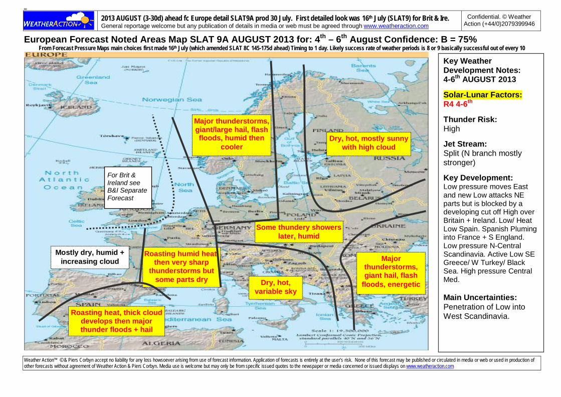
European Forecast Noted Areas Map SLAT 9A AUGUST 2013 for: 4th – 6th August Confidence: B = 75%
From Forecast Pressure Maps main choices first made 16th July (which amended SLAT 8C 145-175d ahead) Timing to 1 day. Likely success rate of weather periods is 8 or 9 basically successful out of every 10
Weather Action™ © & Piers Corbyn accept no liability for any loss howsoever arising from use of forecast information. Application of forecasts is entirely at the user’s risk. None of this forecast may be published or circulated in media or web or used in production of other forecasts without agreement of Weather Action & Piers Corbyn. Media use is welcome but may only be from specific issued quotes to the newspaper or media concerned or issued displays on www.weatheraction.com
Key Weather Development Notes: 4-6th AUGUST 2013 Solar-Lunar Factors: R4 4-6th Thunder Risk: High Jet Stream: Split (N branch mostly stronger) Key Development: Low pressure moves East and new Low attacks NE parts but is blocked by a developing cut off High over Britain + Ireland. Low/ Heat Low Spain. Spanish Pluming into France + S England. Low pressure N-Central Scandinavia. Active Low SE Greece/ W Turkey/ Black Sea. High pressure Central Med. Main Uncertainties: Penetration of Low into West Scandinavia.
For Brit & Ireland see B&I Separate Forecast
Dry, hot, mostly sunny with high cloud
Some thundery showers later, humid
Dry, hot, variable sky
Roasting humid heat, then very sharp
thunderstorms but some parts dry
Roasting heat, thick cloud develops then major thunder floods + hail
Mostly dry, humid + increasing cloud
Major thunderstorms, giant/large hail, flash floods, humid then
cooler
Major thunderstorms, giant hail, flash
floods, energetic

2013 AUGUST (3-30d) ahead fc Europe detail SLAT9A prod 30 July. First detailed look was 16th July (SLAT9) for Brit & Ire. General reportage welcome but any publication of details in media or web must be agreed through www.weatheraction.com
Confidential. © Weather Action (+44/0)2079399946
European Forecast Noted Areas Map SLAT 9A AUGUST 2013 for: 7th – 9th August Confidence: B = 75%
From Forecast Pressure Maps main choices first made 16th July (which amended SLAT 8C 145-175d ahead) Timing to 1 day. Likely success rate of weather periods is 8 or 9 basically successful out of every 10
Weather Action™ © & Piers Corbyn accept no liability for any loss howsoever arising from use of forecast information. Application of forecasts is entirely at the user’s risk. None of this forecast may be published or circulated in media or web or used in production of other forecasts without agreement of Weather Action & Piers Corbyn. Media use is welcome but may only be from specific issued quotes to the newspaper or media concerned or issued displays on www.weatheraction.com
Key Weather Development Notes: 7-9th AUGUST 2013 Solar-Lunar Factors: NSF/Q then R2 9th Thunder Risk: Low Jet Stream: Split, North branch stronger. S branch 5th Spain/Med. Key Development: Intensity of Britain + Ireland High decreases and East wind/ Spanish plumes in South/ Channel + N France decreases. High pressure over Britain + Ireland more like Azores extension. Greenland High somewhat South of normal giving High pressure Iceland. Low pressure West Scandinavia. High East Scandinavia /Russia. High France. Low Greece/Turkey. Main Uncertainties: Temps Spain, France, Germany
For Brit & Ireland see B&I Separate Forecast
Dry, warm/very warm, variable sky
Thundery showers, variable sky, humid
Dry, hot, variable sky
Dry, very warm, mostly sunny
Dry, hot, sunny, clear skies, cool
nights. Morning fog + mist, Baltic states
Hot, variable sky, rather humid
Dry, very fine, sunny, prob hot becoming v
warm / warm
Some showers,
variable sky, turning cooler

2013 AUGUST (3-30d) ahead fc Europe detail SLAT9A prod 30 July. First detailed look was 16th July (SLAT9) for Brit & Ire. General reportage welcome but any publication of details in media or web must be agreed through www.weatheraction.com
Confidential. © Weather Action (+44/0)2079399946
European Forecast Noted Areas Map SLAT 9A AUGUST 2013 for: 10th – 13th August Confidence: B = 75%
From Forecast Pressure Maps main choices first made 16th July (which amended SLAT 8C 145-175d ahead) Timing to 1 day. Likely success rate of weather periods is 8 or 9 basically successful out of every 10
Weather Action™ © & Piers Corbyn accept no liability for any loss howsoever arising from use of forecast information. Application of forecasts is entirely at the user’s risk. None of this forecast may be published or circulated in media or web or used in production of other forecasts without agreement of Weather Action & Piers Corbyn. Media use is welcome but may only be from specific issued quotes to the newspaper or media concerned or issued displays on www.weatheraction.com
Key Weather Development Notes: 10–13th AUGUST 2013 Solar-Lunar Factors: SF R2 10-11th + 12-13th Thunder Risk: Mod Jet Stream: Split Jet Key Development: High over Britain + Ireland expands and strengthens. Low pressure/heat Low Spain. Active lows Iceland/ Norway Sea blocked from B+I. High pressure South Baltic/Baltic states, East/ NE Europe. Low Greece/Turkey. High pressure band BI to Russia (weaker around Denmark/NW Germany) Main Uncertainties: Mobility of Low over (N) Scandinavia
For Brit & Ireland see B&I Separate Forecast
Dry, sunny, warm, less warm than before
Some thundery showers, very humid, variable
cloud, tornado threats but little actual development
Dry, sunny, warm, broken sky
Dry, hot, sunny, very fine weather, cool nights
Mostly dry, sunny/variable sky, less warm
Showery + cloudy, turning cooler.
Morning fog + mist
Thundery showers at times, variable sky,
humid + warm

2013 AUGUST (3-30d) ahead fc Europe detail SLAT9A prod 30 July. First detailed look was 16th July (SLAT9) for Brit & Ire. General reportage welcome but any publication of details in media or web must be agreed through www.weatheraction.com
Confidential. © Weather Action (+44/0)2079399946
European Forecast Noted Areas Map SLAT 9A AUGUST 2013 for: 14th – 20th August Confidence: BC = 70%
From Forecast Pressure Maps main choices first made 16th July (which amended SLAT 8C 145-175d ahead) Timing to 1 day. Likely success rate of weather periods is 8 or 9 basically successful out of every 10
Weather Action™ © & Piers Corbyn accept no liability for any loss howsoever arising from use of forecast information. Application of forecasts is entirely at the user’s risk. None of this forecast may be published or circulated in media or web or used in production of other forecasts without agreement of Weather Action & Piers Corbyn. Media use is welcome but may only be from specific issued quotes to the newspaper or media concerned or issued displays on www.weatheraction.com
Key Weather Development Notes: 14-20th AUGUST 2013 Solar-Lunar Factors: R2 14th
R5+ 15-17th
R4 18-19th Thunder Risk: Very high in places Jet Stream: Split/blocked Key Development: Extremely active Low(s) to NE of Britain and cyclonic sublows track through N Sea, Ireland and Britain giving cyclonic – cyclonic N’ly circulation in N Sea while centre + West Britain stay high pressure dominated. Azores High reaching Spain. Partially blocking High Germany/ Poland. Low pressure South Spain and South Greece/ East Mediterranean. Main Uncertainties: Med details
For Brit & Ireland see B&I Separate Forecast
Humid + thunder and
thnderstorms, less warm later
Thunderstorms, tornadoes, hail +
waterspouts
Dry, very fine + warm, mostly sunny,
less warm later Thunderstorms,
humid, cooler later
Mostly dry,
variable sky,
misty mornings turning cooler
Dry, fine, mostly
sunny but high cloud,
hot/ less hot later
Major thunderstorms + large hail,
thunderfloods, turning much cooler
especially in Low countries + NW
Germany + Denmark
Dry + warm at first, then
some showers +
more cloud. Turning cooler
Showery + cool with large hail

2013 AUGUST (3-30d) ahead fc Europe detail SLAT9A prod 30 July. First detailed look was 16th July (SLAT9) for Brit & Ire. General reportage welcome but any publication of details in media or web must be agreed through www.weatheraction.com
Confidential. © Weather Action (+44/0)2079399946
European Forecast Noted Areas Map SLAT 9A AUGUST 2013 for: 21st – 25th August Confidence: B = 75%
From Forecast Pressure Maps main choices first made 16th July (which amended SLAT 8C 145-175d ahead) Timing to 1 day. Likely success rate of weather periods is 8 or 9 basically successful out of every 10
Weather Action™ © & Piers Corbyn accept no liability for any loss howsoever arising from use of forecast information. Application of forecasts is entirely at the user’s risk. None of this forecast may be published or circulated in media or web or used in production of other forecasts without agreement of Weather Action & Piers Corbyn. Media use is welcome but may only be from specific issued quotes to the newspaper or media concerned or issued displays on www.weatheraction.com
Key Weather Development Notes: 21-25th AUGUST 2013 Solar-Lunar Factors: NSF/Q then R1 24-25th Thunder Risk: Low Jet Stream: Split (one branch well south) Key Development: Deep Low(s) move to South Scandinavia from N Sea/Norway Sea and fill with sublow remnant likely over N Sea. High pressure (Azores extension) over Ireland + West Britain. Greenland High extends to Iceland. Blocking High pressure band N + Central Scandinavia to Italy + Central Med. Main Uncertainties: Developments in N Sea/ Low countries
For Brit & Ireland see B&I Separate Forecast
Dry, variable sky, turning
cooler
Cloudy + showery,
cooler
Some showers, coolish + cloudy
Warm, variable sky, mostly dry, becoming
cooler
Dry, fine, sunny +
warm
Showery + cloudy, cooler
later
Dry, sunny, very fine + warm / hot
cold nights, morning fog + mist

2013 AUGUST (3-30d) ahead fc Europe detail SLAT9A prod 30 July. First detailed look was 16th July (SLAT9) for Brit & Ire. General reportage welcome but any publication of details in media or web must be agreed through www.weatheraction.com
Confidential. © Weather Action (+44/0)2079399946
European Forecast Noted Areas Map SLAT 9A AUGUST 2013 for: 26th – 28th August Confidence: B = 75%
From Forecast Pressure Maps main choices first made 16th July (which amended SLAT 8C 145-175d ahead) Timing to 1 day. Likely success rate of weather periods is 8 or 9 basically successful out of every 10
Weather Action™ © & Piers Corbyn accept no liability for any loss howsoever arising from use of forecast information. Application of forecasts is entirely at the user’s risk. None of this forecast may be published or circulated in media or web or used in production of other forecasts without agreement of Weather Action & Piers Corbyn. Media use is welcome but may only be from specific issued quotes to the newspaper or media concerned or issued displays on www.weatheraction.com
Key Weather Development Notes: 26-28th AUGUST 2013 Solar-Lunar Factors: R2 26-27th Thunder Risk: Low Jet Stream: Blocked. NAO suddenly decreases. Key Development: Low pressures centred North sea near Denmark and N Scandinavia intensify. East Greenland High. Azores High shifts West and Azores (islands) pressure decreases. N’ly flow over Britain and Ireland rapidly strengthens. High pressure (block) S + Central Europe + East Scandinavia. Low Spain. Main Uncertainties: Southward penetration of fronts from N Sea Low.
For Brit & Ireland see B&I Separate Forecast
Some showers, cloudy, turning
cooler
Dry, mostly sunny, cold nights
Dry, fine, sunny, cold nights
Dry, fine days, misty + foggy
mornings
Dry, mostly warm, sunny, misty
mornings
Dry + mostly fine
Quite warm, cloudy, threat of
thunder
Wintry
Showery + increasingly cold, wintry in N parts of
Scandinavia

2013 AUGUST (3-30d) ahead fc Europe detail SLAT9A prod 30 July. First detailed look was 16th July (SLAT9) for Brit & Ire. General reportage welcome but any publication of details in media or web must be agreed through www.weatheraction.com
Confidential. © Weather Action (+44/0)2079399946
European Forecast Noted Areas Map SLAT 9A AUGUST 2013 for: 29th – 31st Aug/1st Sep Confidence: B = 75%
From Forecast Pressure Maps main choices first made 16th July (which amended SLAT 8C 145-175d ahead) Timing to 1 day. Likely success rate of weather periods is 8 or 9 basically successful out of every 10
Weather Action™ © & Piers Corbyn accept no liability for any loss howsoever arising from use of forecast information. Application of forecasts is entirely at the user’s risk. None of this forecast may be published or circulated in media or web or used in production of other forecasts without agreement of Weather Action & Piers Corbyn. Media use is welcome but may only be from specific issued quotes to the newspaper or media concerned or issued displays on www.weatheraction.com
Key Weather Development Notes: 29th–31st AUG/1st SEP 2013 Solar-Lunar Factors: R5 29-30th R4 31st-1st Sep Thunder Risk: Very High (Top) Jet Stream: Blocked/South Key Development: Very active Low pressure centred probably over South England/ south N Sea, active Scandinavian Low loosely linked to it. Azores High extended North in mid Atlantic largely blocking Lows from East Atlantic. Very vigorous cyclonic/ cyclonic - N’ly circulation over Britain & Ire. Blocking High East Europe. Low West + Central Med. Main Uncertainties: Behaviour of Low N Sea/Britain.
For Brit & Ireland see B&I Separate Forecast Dry, bright, warm
days, cool nights, high cloud
Mostly dry, some showers, variable sky,
warm
Mostly dry, some showers, variable
sky, cool
Thunderstorms, hail, tornadoes, local floods
Showers + cloudy
Dry, bright, sunny, warm, cool nights
Torrential rain, major thunderstorms + local floods, large/giant hail
Sleet/snow, blizzards in parts, windy, cold