Journey to the tip - Tourism Cape York · Journey to the tip - The Epic Journey ... you will pass...
2
Transcript of Journey to the tip - Tourism Cape York · Journey to the tip - The Epic Journey ... you will pass...
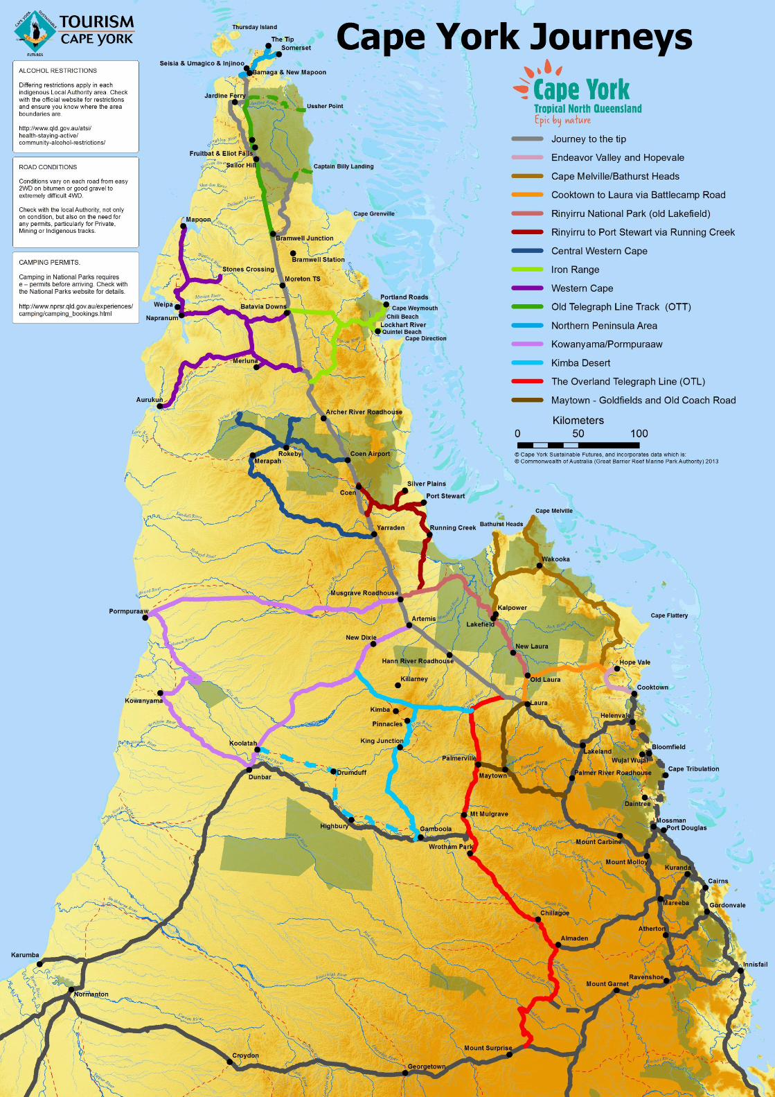
Journey to the tip - The Epic Journey (4WD or Adventure 4WD)
This 800km journey one way can be rough and dusty, or it may be smooth and no problem, depending on the time of year and how well it has been maintained. Generally, you can expect corrugation, dust holes, the odd dip or
washout that is poorly marked or yet to be marked, wandering cattle, feral horses and pigs, and suicidal kangaroos. Driving at night is not recommended because many animals are more active at this time. Drive to the prevailing
condition – headlights on – CB radios to Channel 40
Endeavour Valley and Hopevale
Travelling on the Endeavour Valley Road, you will pass many small farms growing tropical fruit, and some small scale grazing properties. Passion fruit is grown in the area, as well as dragon fruit, limes, lychees, and many more
tropical fruits - the Endeavour River has some small falls, which are within the Endeavour Falls Tourist Park - Continue on past the turnoff to Battlecamp Road until you reach Hopevale. and drop in to the Hopevale Arts and
Cultural Centre. Pass through Hopevale and on towards the coast via Elim Road where there are spectacular coloured sand formations which can be reached on foot - a beach camp site is run by local elder Eddie Deemal.
Wakooka/Cape Melville/Bathurst Heads/Lakefield
This section of road is not as well maintained as others, and can be quite rough, with many creek crossings, and some beach driving. It heads north from Hopevale towards Cape Flattery, then up to Cape Melville NP and Bathurst
Bay. There is camping inside and outside the NP, and the sand on the beaches can be very fine so beware when driving on the beach. Places of interest on the route include the turnoff the Cape Flattery (beach access only), Starcke
River and Jeannie River, Wakooka Aborginal Lands, and Cape Melville National Park ending at Lakefield Ranger Station. Bathurst Head is a great spot to camp and fish.
Cooktown to Laura via Battlecamp Road – Isabella Falls/Lake Emma/Horseshoe Lagoon/Old Laura/Laura (100km)
This journey enables you to access Rinyirru NP (Lakefield) by heading north from Cooktown, and continues on to Laura, the home of many amazing rock art galleries. This section of road can stay closed until June, due to the
crossing over the Normanby River, and because Rinyirru NP sometimes opens late. The southern access to Cape Melville is also from the eastern end of this road.
Rinyirru National Park (old Lakefield) – Old Laura/Lakefield/Normanby Crossing/Breeza Plains/Bizant/Nifold Plans/Marina Plains/Annie River
This is the second largest National Park in Queensland, and has plenty of bush camping for the independent traveller. The park is very flat, with meandering rivers that swell in the wet creating a huge flood plain, and ideal
conditions for the famous barramundi to breed. Once the waterways recede, many lagoons and waterholes remain teaming with birdlife, and fish. There is great camping along the Normanby and Hann Rivers, and Salt Water
Creek. The roads in the park are maintained to a good standard.
Rinyirru to Port Stewart via Violet Vale, Lilyvale and Running Creek and on to Coen via the Old Coen Track
About 18km east of Musgrave is the turnoff north to Running Creek. This road is 4WD and crosses the Stewart River near the coast at the northern end. It does pass through Lilly Vale Station so travellers are asked to leave gates
as you find them. There is no camping along this route so it is mainly used as a short cut to Port Stewart at this stage and allows you to bypass a section of the PDR. Once you reach Port Stewart there are few facilities (no fuel or
general store). You can camp near the boat ramp; however, Silver Plains Station is a short distance from the coast and has camping on the property, with opportunity to interact with the local Lama Lama people who run it. At the
north western end, the Old Coen Track is a great 4WD track.
Central Western Cape - Oyala Thumotang – Holroyd|Kendall|Coen|Archer Rivers
The southern road turns in about half way between Coen and Musgrave - at the turnoff there is a sign to Yarraden Station. On your right hand side is the old Hamilton Goldfield with the site of the old Ebagoola township. The road
continues in a loop through the Oyala Thumotang NP. The northern entry to Oyala Thumotang NP is a few km past the Quarantine Station near the Coen Airport on the left Situated on the headwaters of the Coen and Archer
Rivers, this is a remote park offering fishing, camping and bird watching.
Iron Range – Lockhart/Portland Roads/Chili Beach/Quintel Beach/Frenchman’s Track
The Wenlock and Pascoe Rivers are crossed. Just past the Wenlock on the left is the old Batavia goldfields. Past the Wenlock River you travel through the Kaanju Ngaachi Wenlock and Pascoe Rivers Indigenous Protected Area
and then on through the Kutini Payamu (Iron Range) National Park. Bush camp on the western side of the Wenlock or have a hot shower while camping at the Chuulangun Camping Area (Chuula), 5km east of the Wenlock
crossing. Iron Range has great birdwatching with 15 endemic species, and walking trails in the National Park. The thriving Lockhart River indigenous community is home to the Lockhart River Art Gang (Lockart River Art Centre).
Portland Roads community is a small idyllic refuge by the sea. It offers beachfront accommodation at Portland House and the Portland Roads Beach Shack, ask locals about the jetty, WWII historic sites, birdwatching, and fishing.
Chili Beach is reached just south of Portland Roads and is is one of the best camping spots on the Cape. make sure you book your e-permit early. Quintel Beach is just on the eastern side of the Lockhart community and has the
barge ramp.
Frenchmans Track is a 4WD route to Iron Range. The rugged track fords the Wenlock River and has some very rough and boggy sections before the deep, challenging Pascoe River crossing.
Western Cape – Aurukun, Merluna, Napranum, Weipa, Mapoon
The Western Cape offers visitors a unique insight into the history of Cape York and a rich and varied travel experience. The mining town of Weipa is a great place to replenish supplies before exploring the Western Cape and
beyond. Services in the region include accommodation, supermarkets, fuel, post office, newsagency, specialty shops, bakery, butcher, café, and 4WD and fishing tackle supply stores, public services, internet, airport. Attractions
include fishing, camping, sight seeing, cultural experiences, mine tours. Aurukun is situated near the mouths of the Archer and Watson Rivers, and has excellent fishing in the sheltered bay. There is a new guesthouse in town.
Mapoon is a very small and remote township approximately 90km north of Weipa. Merluna Station is a privately owned working Cattle Station situated 120 klms south east of Weipa. Stones Crossing is situated on the Wenlock
River, Stones Crossing is about 71km north-east of Weipa.
Old Telegraph Line Track (OTT)/Captain Billy Landing/Ussher Point
One of Cape York’s most notorious 4WD tracks, the OTT is an unmaintained route following the path of the original overland telegraph line, starting from Bramwell Junction and continuing to the Jardine River. This track takes you
through some beautiful countryside, and requires all the proper recovery gear, and ideally some previous ‘adventure 4WD’ experience. The highlights are definitely the many crystal clear creeks you will cross., providing great
swimming and camping opportunities. Off route tracks take you to Captain Billy Landing and Ussher Point.
Northern Peninsula Area/ Tip of the Cape/ Somerset/ Punsand Bay
A day drive from Bamaga to the Tip of the Cape. The road is of a good gravel standard, subject to seasonal corrugation and dust. Return through Punsand Bay and Loyalty Beach to New Mapoon and return to Bamaga. Food and
fuel are available at the NPA communities. Souvenirs are available at the ‘Croc Tent’ at the Somerset intersection.
Artemis/Dixie/Koolatah/Kowanyama/Pormpuraaw/Musgrave
The section from Artemis turn off through Dixie to Koolatah must be treated with respect at all times. Koolatah to Kowanyama is considered to be trafficable seasonally. The road from Kowanyama to Musgrave via Pormpuraaw
is once again seasonal. Food and fuel are available at Kowanyama, Pormpuraaw and Musgrave Roadhouse. There are camping places along the route, and accommodation available in Pomrpuraaw. Attractions include fishing,
camping bird watching and cultural experiences. These communities are alcohol prohibited.
Kimba Desert – Mungana/Strathleven/King Junction/Pinnacles/Kimba/Killarney - Drumduff
Accessed from Laura or Mungana in the south, these roads cross the Kimba Desert, a dry but heavily forested area. The route connects with the Artemis route or the OTL to Fairview and Laura. A connection running parallel to the
Mitchell River (north side) crosses the Palmer River to Drumduff and on to Koolatah. There is also a causeway from Highbury across the Mitchell joining it.
The Overland Telegraph Line (OTL)
MOUNT SURPRISE TO FAIRVIEW - Heading north, follows the old OTL track to Almaden, Chillagoe, and Wrotham Park before heading north through Mount Mulgrave, Palmerville (turn off to Maytown), Fairlight and Fairview. FAIRVIEW TO BRAMWELL - Follows the PDR to the Bamaga Turnoff and then heads north along the Northern Peninsula Road to Bramwell Junction. BRAMWELL TO JARDINE - Follows the OTT. There are over 16 creek crossings along the 4WD section of the OTT. JARDINE RIVER TO PEAK POINT - Follows roughly the OTL to the north of the Jardine River bed crossing. Peak Point was the jumping off point for the original undersea cable to Thursday Island.
MAYTOWN – Goldfields & Old Coach Road - Maytown and Old Coach Road (Adventure 4WD)
A great 4WD adventure to start your Cape York journey from the Burke Developmental Road through Palmer River Goldfields, or start from the Mulligan Highway to Maytown ruins, at the Whites Creek Road turnoff 17km south
of the Palmer River Roadhouse. Circuit route through the Palmer River gold fields to Laura. The road is definitely seasonal, and subject to flooding and washout. Carry food and fuel as there is none available other than at Lakeland,
Laura and the Palmer River Roadhouse.
For more information please visit - www.tourismcapeyork.com or call 1800 174 895