Journal Summer 2016 - sdhs.org.uk · PDF file1 Fellside 2 Hollin Cottage 3 Parish Room 4 John...
12
Staveley & District History Society Journal Summer 2016 ___________________________________________________________ CONTENTS 2 From the President Clare Brockbank's mid-summer reflections 3 How many bridges have there been at the Eagle and Child? Alan Lord discusses the history of the Staveley bridge 7 May Walk: Old Bowness with John Campbell 9 June Walk: Mislet, Ings, with James Walling 10 July Walk: Kirkby Lonsdale with Michael Kingsbury 11 Tales from the Tapes: Slate and slate quarrying. Part 3 The transcript of an interview of John Williams with Joe Scott in 1991 The views expressed in articles in this Journal are those of the individual authors and not necessarily those of the Society. Cover photo: The Eagle and Child bridge is demolished - 30 th June 2016. . The next issue of the Journal (No 38, the Winter 2016-17 issue) will be published about the 12 th December 2016. All contributions (letters, articles, etc.) are welcome at any time but should be with the Editor by early November.
-
Upload
vuongduong -
Category
Documents
-
view
215 -
download
2
Transcript of Journal Summer 2016 - sdhs.org.uk · PDF file1 Fellside 2 Hollin Cottage 3 Parish Room 4 John...

Staveley & District History Society
Journal Summer 2016___________________________________________________________
CONTENTS
2 From the PresidentClare Brockbank's mid-summer reflections
3 How many bridges have there been at the Eagle and Child?Alan Lord discusses the history of the Staveley bridge
7 May Walk: Old Bowness with John Campbell
9 June Walk: Mislet, Ings, with James Walling
10 July Walk: Kirkby Lonsdale with Michael Kingsbury
11 Tales from the Tapes: Slate and slate quarrying. Part 3The transcript of an interview of John Williams with Joe Scott in 1991
The views expressed in articles in this Journal are those of the individual authors and not necessarily those of the Society.
Cover photo: The Eagle and Child bridge is demolished - 30th June 2016.
.
The next issue of the Journal (No 38, the Winter 2016-17 issue) will be publishedabout the 12th December 2016. All contributions (letters, articles, etc.) are welcomeat any time but should be with the Editor by early November.

2
From the President
We start a new season of our Society, we have certainlyhad plenty of weather to talk about. The last Journal waswonderful for its descriptions and photos of the “deluge”which indeed it was. The 'Eagle and Child' bridge is nowno more as I write (see photo below on 30th June) andScroggs Bridge has hardly any sides. We must all lobby toget a new Eagle and Child bridge, a temporary one for astart and then one built to last, as long as there is localstone employed and not dressed stone. We really cannotwait another whole year to get our village put right.
We are hoping to involve our membership in recording details of buildings inStaveley, Ings and Kentmere. To that end we have produced a simple form to fill inso that we can know more about our villages. It is now available and can be requestedfrom committee members or by emailing the Secretary. It can be collected at ourmeetings from October.
When Joe Scott started our Society he was keen that members should be keen toparticipate in making history; there is still plenty to go at! So I hope as many of our
membership as possible will fill inour easy form. Encourage yourfriends and neighbours and fellowmembers. I would be happy toshow anyone the form I have filledin for my house.
I have been asked a few times ifthere is a history of the DukeWilliam, which is about to changeits use. We would be glad to hearof anyone who may be inclined topursue this.
I am looking forward to the wintertalks especially to hear whatconnection the Brontes have withour area. I must congratulatemembers of our Committee whoare so diligent in their work for theSociety.
Clare Brockbank
3
How many bridges have there been at the Eagle and Child?
In earlier times Baptisms, Weddings and Funerals were not permitted at St Margaret'sand had to be conducted in Kendal. It is quite probable that the journey into Kendalinvolved fording the Gowan near its confluence with the Kent which was frequentlydangerous. Matters must have come to a head in 1588, when 48 Staveley men sent apetition to the Bishop requesting that these rights be carried out at St Margaret's:
“…The waters of [the Gowan]…. doth …. at divers seasonsflowe and runne soe forciblie that no traveller can passewithout great danger.... but most especially betweenStaveley Church and Kendall when the saide waterscrossing the waye to Kendall and meeting the river calledKente many tymes overflowing the bankes thereof andrysing so abundantlie that men dwelling on both sides ofthe hie waye purposing to take their naturale rest in beddhath been in greate danger of drowning, in so much that ifthe speedy helpe of good neighbours had not been, 11 menwomen and children had perished. Whereof some for refugewas carried into the Chapell there of Staveley ….......as cantestify the same Gabriel Noble, John Baitman Geo.Birkhead and others more.
Local field names suggest quite clearly that there wereat least two bridges over the Kent. “Stang” was a stakeor a length of wood, so these would be wooden bridges,but we don't know how substantial they were. This isthe 1836 Corn Rent Map.
It was John Ogilby, a Scotsman from Dundee who firstrealised the importance of mapping the roads. In 1675he approached Charles II for help and was appointed“His Majesty's Cosmographer and Printer”. He and hisassistants surveyed 40,000 miles of roads and his“Britannia”, a book of 100 road maps, was in use forover 70 years. A section of one of his maps showing the road from Kendal throughIngs and over Moor Howe towards Troutbeck Bridge is on p4. The miles are shown
with a dot every quarter mile and are drawn at ascale of one inch to a mile. This scale, which heintroduced, remained in use for nearly 300 years.This enlargement of the portion through Staveleyshows the beck at Stock Bridge and St Margaret'sChurch, and there is now a stone bridge over theGowan, which suggests that the wooden bridgeshad proved inadequate.

4
Jeffery's Map of 1770 introduces the “Turnpikes” with a Toll Gate at the Eagle andChild. The bridge over the Gowan now forms a distinct bend, much as it is today,showing a deviation in the road alignment which appears illogical, but must have hada purpose. Possibly it was to reduce the impact of the Kent against the side of thebridge during flood conditions. The Corn Rent Map of 1836 shows the conflict at theconfluence of the two rivers, where the Kent and the Gowan meet head on. In flood

5
conditions the Kent could flow up the Gowan. There appears to have been someattempt to reduce this problem.
An extract of the 1859 First Edition Large Scale OS plan on p4 shows that somework has been undertaken to reduce the conflict. The surveyor, after consulting allthe interested parties, has mered the boundary as “Face of Wall” which suggests thatthis was generally agreed to have been the original course of the Gowan. The namehowever was given as “New Bridge” so it appears to have been replaced fairlyrecently. How long would one continue to call it a new bridge?
This is an extract of the 1914 Edition of OSLarge Scale plan. The boundary remains inthe same position, but since the wall hasbeen partially removed, there is no detail towhich it could be mered, so the mereing hasbeen changed to Defaced. The name of thebridge is now shown as Gowan Bridge.
The photographs were taken in the fieldopposite the Eagle on the day following theDecember 2015 flood when the flow of bothrivers was much reduced. They show someof the problems and offer some possiblesolutions. The flow down the Kent being
about four times the flow down the Gowan, the Gowan is struggling to make anyheadway and its width appears even narrower than it is further upstream.
At some stage following the modification of the confluence shown on the 1859 map,a sewerage system was introduced and the main pipe crosses the Kent with inspectionchambers at each end and then continues across the field. It might be possible towiden the Kent somewhat as indicated by white dotted line, but the inspectionchamber on the left bank restricts it to about two metres at most. It might also bepossible to lower the bed of the Kent, but that depends on the depth of the sewer pipe.
A more effective solution would be to divert the Kent round behind the inspectionchamber so that its confluence would be about 50 metres further downstream, helpingto ease the pressure of water on the bridge. This would take about a fifth of an acreoff the field corner. Alternatively, an overflow diversion along the same route, wouldcomprise a shallow depression dry and grazeable under normal conditions, but lowenough to allow excess flood water to leave the Kent from an earlier point upstream.
Alan Lord

6
Eagle and Child bridge - 10th February 2016

7
Summer Walk May 2016, Old Bowness, with John Campbell
For anybody with an interest in the history of Bowness this was pure Viagra. BothJohn Campbell's knowledge and enthusiasm were prodigious. This was the bestSociety walk I have been on. The sixteen attendees were entertained with manyanecdotes from John throughout the evening.
The walk started on Rayrigg road with a look at Fellside, a group of terraced cottageswhere John's grandfather lived. After two and a half hours going through the village,a deal of which John now considers to be 'tat' we ended up at Fold Head overlookingOld Fallbarrow. The walk took us from Fellside to Queens Square and up CraggBrow until we walked the length of Langrigg Drive meeting Brantfell Road.Descending School Hill a detour up Kendal Road allowed us to examine the site ofthe old Crown Hotel. Ash Square and Market House Square took us to the ParishChurch of Windermere. Finally after a visit to Bowness Bay we meandered backeventually reaching Piper Hill and Rayrigg Road. For those members who missed thiswalk much of the evening's information mat be found in John's book,"Village by theWater. A History of Bowness-on-Windermere".
I wonder just how many members are aware of both the starting and finishingproperties? Despite the comment above John's affection for the village and its historywas quite obvious. A splendid evening.
Don MorrisBowness Historical Trail – key to map
1 Fellside2 Hollin Cottage3 Parish Room4 John Peel Inn5 Sutherland’s Restaurant6 Albert (Arms) Hotel7 Central Buildings8 Chestnut tree9 Smithy (site of)
10 Cragg Brow (NW side)11 Cragg Brow (SE side)12 Fent shop (site of)13 Lonsdale Gallery (site of)14 Chestnut Tree (site of)15 Public Hall16 Police Station (former)17 Brow Top18 Langrigg19 Poor House and Gas Works (site of)20 Fairfield21 School plaque22 Windermere Endowed School for Boys (site of)23 Windermere Endowed School for Girls & Infants
(former)24 Royal Oak Inn25 Crown Hotel (original; former)26 Crown Hotel (former)27 Spinnery Cafe28 Laurel Cottage/ Windermere Grammar School (former)29 London, City & Midland Bank (former)30 Deborah Ash (site of)
31 Date plaque 181332 Restaurant, former inn33 Old buildings (early shop)34 Victoria Buildings35 White Lion Inn/Royal Hotel (former)36 Figureheads37 Wakefeld, Crewdson & Co’s Bank (former)38 Tenter Beck Pool & Drinking Fountain (site of)39 Marker House (former)40 Windermere Parish Church and Churchyard41 Belles Howe/Quaker Burial Ground (site of)42 Lake Cottage (remains of)43 Cushion Huts (site of)44 Steamer Pier45 Belsfield Farm (site of)46 Belsfield Hotel47 Waterside Cottage (site of)48 Old England Hotel49 Stags Head Hotel50 Tiles51 Rose Cottage52 Robinson Place cottages & inn (site of)53 Royal Windermere Yacht Club54 New Hall Inn55 Fold Head56 Old Fallbarrow57 Fallbarrow Hall58 Green Farm59 Millbeck Stock60 Windermere Hydro Hotel61 Sir William Forwood’s Drinking Fountain

8
Map copyrighted – published here by kind permission of John Campbell
9
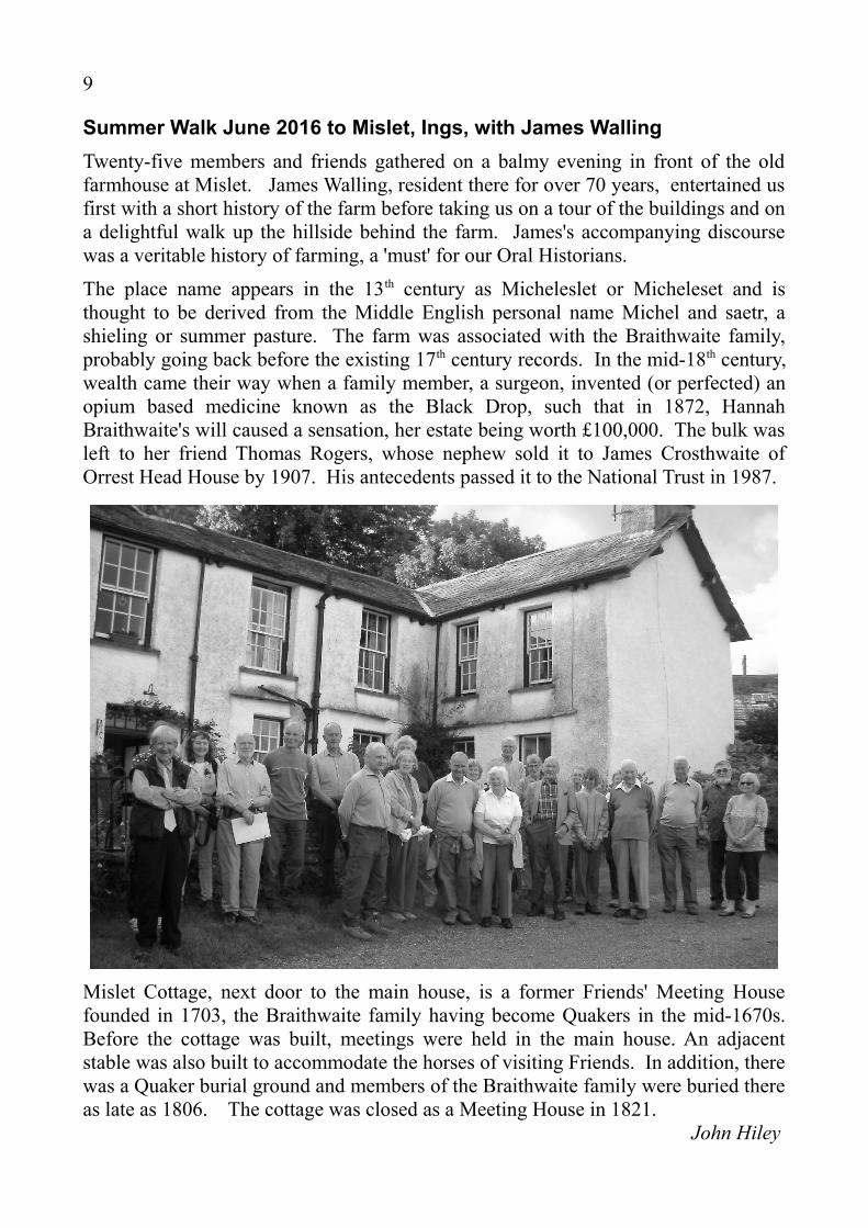
Summer Walk June 2016 to Mislet, Ings, with James Walling
Twenty-five members and friends gathered on a balmy evening in front of the oldfarmhouse at Mislet. James Walling, resident there for over 70 years, entertained usfirst with a short history of the farm before taking us on a tour of the buildings and ona delightful walk up the hillside behind the farm. James's accompanying discoursewas a veritable history of farming, a 'must' for our Oral Historians.
The place name appears in the 13th century as Micheleslet or Micheleset and isthought to be derived from the Middle English personal name Michel and saetr, ashieling or summer pasture. The farm was associated with the Braithwaite family,probably going back before the existing 17th century records. In the mid-18th century,wealth came their way when a family member, a surgeon, invented (or perfected) anopium based medicine known as the Black Drop, such that in 1872, HannahBraithwaite's will caused a sensation, her estate being worth £100,000. The bulk wasleft to her friend Thomas Rogers, whose nephew sold it to James Crosthwaite ofOrrest Head House by 1907. His antecedents passed it to the National Trust in 1987.
Mislet Cottage, next door to the main house, is a former Friends' Meeting Housefounded in 1703, the Braithwaite family having become Quakers in the mid-1670s.Before the cottage was built, meetings were held in the main house. An adjacentstable was also built to accommodate the horses of visiting Friends. In addition, therewas a Quaker burial ground and members of the Braithwaite family were buried thereas late as 1806. The cottage was closed as a Meeting House in 1821.
John Hiley

10
Summer Walk July 2016, Tour of Kirkby Lonsdale with Mike Kingsbury
A meagre group of eightmembers enjoyed asplendid conducted tourof Kirkby Lonsdale withMike Kingsbury.Meeting at the [new]Market Square we learntthat when the RoyalHotel was built [thenJackson Hall] no otherbuildings were visiblefrom the Square. Thebuildings in the squarewere built after 1820.One shop in the square,the sweet shop, has beencontinuously in the samefamily since the early 19th century. The Chemist next to The Snooty Fox has also beenopened for that time but has recently been acquired by Boots.
We were then taken through KirkbyLonsdale via Main St, New Rd,Mitchelgate, Market St, Queen St, StMary's Church & Ruskin's View, theswine market, the old market site, MillBrow, the horse market, Back Lane, andfinally Jingling Lane before reaching theMarket Square again. There are toomany interesting facts to relate here butone thing that fascinated me was that thenow underground stream which ran the
short distance from Market St steeply down to the Lune worked no less than sevenwater mills. A good day out, in good weather.
Don Morris
From the Over Staveley Parish Council Minute Book 30 April 1952
'Miss Miller, having recently been supplied with a new car, several members of thepublic have been speaking unfavourably of her habit of carrying her large dog aboutin it. It was decided that the clerk write to the County Council pointing out thematter and asking if, in the interests of cleanliness etc., it can be stopped.'

11
Tales from the Tapes: Slate and slate quarrying. Part 3The third instalment of the interview of John Williams of Kentmere by Joe Scott inNovember 1991
JS: You're talking about the twenties?
JW: Twenties and earlier.
JS: Yes, the number of slate works had fallen off and slate was less important about that time wasn't it?
JW: Well, J.J. Thomas was once the Mayor of Kendal, and he used to be the lessee of Kentmere for a while. In fact, during the first world war, he kept all, not all the staff, but all the staff that weren't called up to military service. He kept them all.
JS: Mrs. Gosden says that nearly all the labourers went off to the army, because you could not get labourers then.
JW: And he kept everybody on he could and the story is that he had 400 tons of slate in stock by the end of the war and he sold it all within a couple of months.
JS: Did he?
JW: Yes because he had the backing, he was a little Welshman, his brother used to come up here, quite often. I remember him but I can only just vaguely remember J.J. Thomas. How time flies.
JS: You'd bought a compressed air system....
JW: Possibly, possibly, yes I wouldn’t be too sure about that.
JS: I bet when Christopher Robin... that’s what he says in his notes.
JW: Yes because a big engine that used to drive the compressed air system was drivenby a big engine driver of a chap who lived in Kendal, his family ran the wire mills and he lived at, their home was Castle Green where the Electricity Board offices arenow. He, their family had quite a big interest in it. They had the registered office wasat the wire mills at Stramongate Bridge. He used to come up on a motorbike and I'm pretty sure it was before the war, the first war.
JS: Yes according to Christopher its in the 90's quite early on, you got the compressedair. This J.J. Thomas comes at the time of the strike I think.
JW: Phew, I don’t know about that. You see I remember J.J. Thomas in the thirties.
JS: He died in 1942 according to Christopher. I think he must have got some information from somewhere.
JW: Oh he must have, he could possibly be right, but I would have said certainly that the compressed air system was in before the first world war.
JS: Yes well I think he would agree with that then, he would go along with that, yes.

12
JW: I am surprised because Hugh John Thomas... John was the middle name of both because there was Hugh John, John John and so on.....anyway he, Hugh John was a quarry man in Spain for most of his life but when he retired he came back here. He used to come up to Kentmere, his brother was long dead by then I think, and it was pandemonium right up to 1942.
JS: But then in the 20s and 30s the Kentmere quarries fell off to the investor.
JW: Yes, yes between 20s and 30s, well I don't know about 20's because early 30s I can remember going up there and it was very active then, Oh yes, three of the workings would be producing and I would say about there would probably be something like twelve men living in the barracks and as many if not more travelling daily from Staveley.
JS: The barracks would he roughly where the reservoir cottage is?
JW: No, the reservoir cottage is the reservoir cottage, always has been. The barracks is the one the Blackburn Education has now. That was built as the barracks and I don't know if that was built in the early 20s or so. Before that they probably wrappedthemselves up in a sack in a shed. You cannot believe how tough they were.
JS: Was this the labourers, or the companies themselves?
JW: The companies and the labourers as well, of course.
JS: They must have been tough.
JW: Because they couldn't afford to move and travelling back and forwards was time lost. They could work as long as they wanted. There was no restriction on the amount of time they put in so that they would work as long as they could get the labourers to work for them.
JS: And the quarry was lit by candles?
JW: The quarry owners supplied candles, gunpowder and if you like to call it, accommodation, but they even charged for accommodation.
JS: They charged for it?
JW: Oh they charged for the accommodation.
JS: And they used to go down to Staveley at the weekend?
JW: Well the month end. They were all paid then and they used to go down to Staveley on spree at the month end with their wages and the Fat Lamb, which is...
JS: ….where Ronnie Parkinson is.
JW: Where they live, that was the main pub but now there's the Duke William as well. The Eagle and Child was not terribly popular. It was, I think, at that time, didn't George Cannon senior old senior run the Fat Lamb?
to be continued