Journal of Mining and Geology Vol. 47(2) 2011, pp. 97–114...
18
Journal of Mining and Geology Vol. 47(2) 2011, pp. 97–114 © Nigerian Mining and Geosciences Society (NMGS) - Printed in Nigeria 1116-2775 97 INTRODUCTION The Bida Basin, also known as the Mid-Niger Basin or Nupe Basin, is one of the inland sedimentary basins in Stratigraphy, Paleogeography and Hydrocarbon Resource Potentials of the Bida Basin in North-Central Nigeria 1 2 2 3 N. G. OBAJE* , A. MOUMOUNI , N. G. GOKI and M. S. CHAANDA 1 Department of Geology & Geography, Ibrahim Badamasi Babangida University, Lapai, Niger State, Nigeria 2 Department of Geology & Mining, Nasarawa State University, Keffi, Nigeria 3 Department of Geology, Federal University of Petroleum Resources, Effurun-Warri, Nigeria Abstract The Bida Basin is a NW-SE trending intracratonic sedimentary basin in Nigeria extending from Kontagora in the north to areas slightly beyond Lokoja in the south. Spectral analysis of the residual total magnetic field values over several sections of the basin reveals an average depth to the basement rock to be ca. 3. 4 km with sedimentary thickness of up to 4. 7 km in the central and southern part of the basin. The stratigraphic successions in the basin comprise the Bida Sandstone at the base in the Northern Bida Basin, followed successively upward by the Sakpe, Enagi and Batati Formations. In the Southern Bida Basin, the Lokoja Formation lies at the base and it is followed upward by the Patti and Agbaja Formations. All the formations in the basin are of Campanian-Maastrchtian ages. The geology and stratigraphic successions of sedimentary rocks in the basin point to the possibility of the build up of potential petroleum systems which normally encompass the generation, migration and accumulation of hydrocarbons in commercial quantities. More importantly, hydrocarbon seepages have been reported from around Petegi/Muregi on the shore of the River Niger in Niger State and at Ahoko near Lokoja in Kogi State, both of which lie within the Bida Basin. Source rock geochemical investigations show that the hydrocarbon resources in the basin are overwhelmingly gaseous. The areas surrounding Bida and south of Bida towards Pategi, Muregi, Baro, Agbaja, Ahoko, Abaji, Gada- Biyu are the most prospective for hydrocarbon exploratory drilling campaigns. Nigeria (Fig. 1). Nigeria's current national petroleum reserve asset (proven) put at 38 billion barrels of oil and about 190 trillion standard cubic feet of gas *Corresponding author: [email protected]
Transcript of Journal of Mining and Geology Vol. 47(2) 2011, pp. 97–114...

Journal of Mining and Geology Vol. 47(2) 2011, pp. 97–114 © Nigerian Mining and Geosciences Society (NMGS) - Printed in Nigeria
1116-2775
97
INTRODUCTIONThe Bida Basin, also known as the Mid-Niger Basin or Nupe Basin, is one of the inland sedimentary basins in
Stratigraphy, Paleogeography and Hydrocarbon Resource Potentials of the Bida Basin in North-Central Nigeria
1 2 2 3N. G. OBAJE* , A. MOUMOUNI , N. G. GOKI and M. S. CHAANDA
1Department of Geology & Geography, Ibrahim Badamasi Babangida University, Lapai, Niger State, Nigeria2Department of Geology & Mining, Nasarawa State University, Keffi, Nigeria
3Department of Geology, Federal University of Petroleum Resources, Effurun-Warri, Nigeria
Abstract
The Bida Basin is a NW-SE trending intracratonic sedimentary basin in Nigeria extending from Kontagora in the north to areas slightly beyond Lokoja in the south. Spectral analysis of the residual total magnetic field values over several sections of the basin reveals an average depth to the basement rock to be ca. 3. 4 km with sedimentary thickness of up to 4. 7 km in the central and southern part of the basin. The stratigraphic successions in the basin comprise the Bida Sandstone at the base in the Northern Bida Basin, followed successively upward by the Sakpe, Enagi and Batati Formations. In the Southern Bida Basin, the Lokoja Formation lies at the base and it is followed upward by the Patti and Agbaja Formations. All the formations in the basin are of Campanian-Maastrchtian ages. The geology and stratigraphic successions of sedimentary rocks in the basin point to the possibility of the build up of potential petroleum systems which normally encompass the generation, migration and accumulation of hydrocarbons in commercial quantities. More importantly, hydrocarbon seepages have been reported from around Petegi/Muregi on the shore of the River Niger in Niger State and at Ahoko near Lokoja in Kogi State, both of which lie within the Bida Basin. Source rock geochemical investigations show that the hydrocarbon resources in the basin are overwhelmingly gaseous. The areas surrounding Bida and south of Bida towards Pategi, Muregi, Baro, Agbaja, Ahoko, Abaji, Gada-Biyu are the most prospective for hydrocarbon exploratory drilling campaigns.
Nigeria (Fig. 1). Nigeria's current national petroleum reserve asset (proven) put at 38 billion barrels of oil and about 190 trillion standard cubic feet of gas
*Corresponding author: [email protected]

derives solely from the Niger Delta onshore and offshore. Some exploration campaigns have been undertaken in the inland basins aimed at expanding the national exploration and production base and add to the proven reserves asset. The inland basins of Nigeria comprise the Anambra Basin, the Dahomey Basin, the Lower, Middle and Upper Benue Trough, the Chad Basin, the Bida Basin, and the Sokoto Basin. However, these inland basins have continued to frustrate the efforts of many explorers, principally because of the poor knowledge of their geology and the far distance from existing infrastructure (discovery must be large enough to warrant production investments), and for these reasons, many international companies have turned their focus away from frontier onshore to frontier deep-water and ultra deepwater offshore.The inland basins of Nigeria constitute one set of a series of Cretaceous and later rift basins in Central and West Africa whose origin is related to the opening o the South Atlantic (Fig. 2). Commercial hydrocarbon
accumulations have been discovered in Chad, Niger and Sudan within this riff trend. In SW Chad, exploitation of the Doba discovery (with an estimated reserve of about 1 billion barrels) has caused the construction of a 1070 km-long pipeline through Cameroon to the Atlantic coast. In the Sudan, some “giant fields” (Unity 1 & 2, Kaikang, Heglig, etc) have been discovered in the Muglad Basin (Mohammed et al., 1999). It is expected that with relentless and re-invigorated geological, geochemical and geophysical studies, particularly with respect to the evaluation of potential petroleum systems, commercial success may also be achieved in the Nigerian sector of Africa's inland basins, even if it may take some time to put all the elements together. It is important to continue with and to step up efforts on the hydrocarbon exploration programmes in Nigeria's other sedimentary basins outside the Niger Delta as mitigating measure against agitation for resources control, dwindling national and global reserves, pandemic unemployment rate particularly amongst the youths, and conflicts and
98

restiveness in the present oil producing communities. This paper is aimed at evaluating the stratigraphic successions in the Bida Basin with particular emphasis on the Southern Bida Basin, their sedimentological characteristics and hydrocarbon resource potentials.
The Bida Basin The Bida Basin is a NW-SE trending intracratonic sedimentary basin extending from Kontagora in Niger State of Nigeria to areas slightly beyond Lokoja in the south (Fig. 3). It is delimited in the northeast and southwest by the basement complex while it merges with Anambra and Sokoto basins in sedimentary fill comprising post orogenic molasse facies and few thin unfolded marine sediments. The basin is a gently downwarped trough whose genesis may be closely c o n n e c t e d w i t h t h e S a n t o n i a n o r o g e n i c movements of south-eastern Nigeria and the Benue valley, nearby. The basin is a NW-SE trending e m b a y m e n t , perpendicular to the main axis of the Benue Trough and Niger Delta Basin. It is frequently regarded as the north-western extension of the Anambra Basin, both of which were major depocentres during the third major transgressive cycle of southern Nigeria in Late Cretaceous time. Interpretations of Landsat images, borehole logs, as well as geophysical data across the entire Bida Basin suggest that the basin is bounded by a system of linear faults trending NW-SE. Gravity studies also confirm central positive anomalies f l anked by nega t ive anomalies as shown for the adjacent Benue Trough and typical of rift structure (Ojo, 1984; Ojo and Ajakaiye, 1989).
The Benue Trough is a failed arm of a triple
junction (aulacogen) that existed beneath the present position of the Niger Delta during the Cretaceous time. The trough is filled with over 5000m of predominantly Aptian to Maastrichtian sediments in the lower, middle and upper Benue geographical regions. The Lower Benue Trough which includes the Anambra Basin is considered as the southern extension of the Bida Basin. Initial gravity studies in the Bida Basin put the maximum thickness of the sedimentary successions at about 3.5 km (Ojo, 1984) in the central axis. Although the hydrocarbon potential of the basin has not been fully tested with seismic and the basin remains undrilled, both ground and aeromagnetic studies by several workers have outlined the basin's configuration (Adeniyi, 1985; Udensi and Osazuwa, 2004). A recent spectral
99

analysis of the residual total magnetic field values over several sections of the basin reveals an average depth to the basement rock to be ca. 3.4 km with sedimentary thickness of up to 4.7 km decreases in the central and southern parts of the basin (Udensi and Osazuwa, 2004). In general, sediment thickness decreases smoothly from the central portion to the flanks of the basin
Previous studies on the geology of the Bida Basin were reported in Adeleye (1974) and the micropaleontological studies of Jan du Chene et al. (1978) which documented the palynomorph-foraminiferal association including the interpretation of the paleoenviroments of the Lokoja and Patti Formations. Akande et al. (2005) interpreted the paleoenvironments of the sedimentary successions in the Southern Bida Basin as ranging from continental to marginal marine and marsh environments for the Cretaceous lithofacies. Whereas the origin of the oolitic ironstones in the Bida Basin has been a principal subject of several workers (e. g. Adeleye, 1974; Ladipo et al. 1994 Abimbola, 1997), not much have been reported on the stratigraphic successions, sedimentological characteristics and hydrocarbon resource potentials of the basin.
Stratigraphy and PaleogeographyThe stratigraphic succession of Bida Basin, collectively referred to as the Nupe Group (Adeleye, 1974) comprises a twofold Northern Bida Basin (Sub-Basin) and Southern Bidan Sub-Basin or Lokoja Sub-Basin (Figs. 4, 5). The basin fill comprises a northwest trending belt of Upper Cretaceous sedimentary rocks that were deposited as a result of block faulting, basement fragmentation, subsidence, rifting and drifting consequent to the Cretaceous opening of the South Atlantic Ocean. Major horizontal (sinistral) movements along the northeast-southwest axis of the adjacent Benue Trough appear to have been translated to the north-south and north-westerly trending shear zones to form the Bida Basin perpendicular to the Benue Trough (Benkhelil, 1989). Although the sedimentary fill of the Benue Trough consists of three unconformity-bounded depositional successions (Petters, 1978), the Bida and Amambra geographical regions were platforms until the Santonian. Pre-Santonian marine sediments are recorded principally in the older Benue Trough and part of the southern Anambra Basin. The collapse of the Bida and Anambra platforms led to the sedimentation of the Upper Cretaceous depositional
100

cycle commencing with the fully marine shales of the Campanian Nkporo and Enugu Formations which may have some lateral equivalents in the Lokoja Formation of the Bida Basin. Overlying the sedimentary units of the Mamu Formation whose lateral equivalents are the conglomerates, cross-bedded and poorly sorted sandstones and claystones of the Lokoja and Bida Formations and partly the Patti Formation in the Bida Basin.
The Mamu Formation is succession by sandstones of the Lower Maastrichtian Ajalli Formation laterally equivalent to the Patti, Sakpe and Enagi Formations of the Bida Basin. The Patti and Enagi Formations are overlain by the Agbaja and Batati Formations (lateral equivalents) of Upper Maastrichtian age (Figs. 4, 5). A comparison of the sediment thicknesses in the Anambra and Bida Basins indicates that's the successions of the Anambra Basin reached up to 8 km thickness compared with an average of 3.4 km sediment thickness in the Bida Basin (Akande and Erdtman, 1998). The stratigraphic successions in the Bida Basin and their relationship to those in the Anambra Basin is shown in Figure 4 while Figure 5 shows the wholly Bida Basin stratigraphy. Detailed stratigraphic description of the succession in the Southern and Northern Bida Basin is given below. Greater attention has been given to the Southern Bida Basin from where most of the field data were obtained.
Northern Bida Basin
The Bida SandstoneThe Bida Sandstone is divisible into two members, namely the Doko Member and the Jima Member. The Doko Member is the basal unit and consists mainly of very poorly sorted pebbly arkoses, sub-arkoses and quartzose sandstones. These are thought to have been deposited in a braided alluvial fan setting. The Jima Member is dominated by cross-stratified quartzose sandstones, siltstones and claystones. Trace fossils comprising mainly Ophiomorpha burrows have been observed. These were also observed in the overlying Sakpe Ironstone, suggesting a possible shallow marine subtidal to intertidal influence during sedimentation. The Jima Sandstone Member is thus considered as the more distal equivalent of the upper part of the Lokoja Sandstone, where similar features also occur.
The Sakpe Ironstone The Sakpe Ironstone comprises mainly oolitic and pisolitic ironstones with sandy claystones localy, at the base, followed by dominantly oolitic ironstone which exhibits rapid facies changes across the basin, at the top.
The Enagi Siltstone The Enagi Siltstone consists mainly of siltstones and correlate with the Patti Formation in the Lokoja Sub-
101

Basin. Other subsidiary lithologies include sandstone-siltstone admixture with some claystones. Fossil leaf impressions and rootlets have been found within the formation. The formation ranges in thickness of between 30m and 60m. Mineral assemblage consists mainly of quartz, feldspars and clay minerals.
The Batati FormationThis formation constitutes the uppermost units in the sedimentary sequence of the Bida Basin. The Batati Formation consists of argillaceous, oolitic and geothitic ironstones with ferruginous claystone and siltstone intercalations and shaley beds occurring in minor proportions, some of which have yielded near-shore shallow marine to fresh water fauna (Adeleye, 1974).
Southern Bida Basin
The Lokoja FormationLithologic units in this formation range from conglomerates, coarse to fine grained sandstones,
siltstone and claystones in the Lokoja area (Figs. 6, 7). Sub-angular to sub-rounded cobbles, pebbles and granule sized quartz grains in the units are frequently distributed in a clay matrix. Both grain supported and matrix supported conglomerates form recognizable beds at the base of distinct cycles at outcrops. The sandstone units are frequently cross-stratified, generally poorly sorted and composed mainly of quartz plus feldspar and are thus texturally and mine ra log i ca l ly immature. The gene ra l characteristics of this sequence especially the fining upward character, compositional and textural immaturity and unidirectional paleocurrent trends, suggest a fluvial depositional environment dominated by braided streams with sands deposited as channel bars consequent to fluctuating flow velocity. The fine grained sandstones, siltstones and clays represent flood plain overbank deposits. However, Petters (1986) reported on the occurrence of some diversified arenaceous foraminfers from clayey intervals of the Lokoja Formation indicating some shallow marine influence. These foraminiferal microfossils identified by Petters (1986) are however
102

more common in the overlying Patti Formation where shallow marine depositional conditions are known to have been more prevalent.
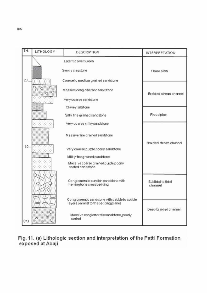
The Patti FormationOutcrops of the Patti Formation occur extensively on the Agbaja Plateau (Figs. 8, 9) and Ahoko and Abaji (Figs. 10, 11) on the Lokoja-Abuja expressway. This formation consists of sandstones, siltstones, claystones and shales interbedded with bioturbated ironstones. Argillaceous units predominate in the central parts of the basin. The siltstones of the Patti Formation are commonly parallel stratified with occasional soft deformational sedimentary structures (e. g. slumps), and other structures as wave ripples, convolute laminations and load structures. Trace fossils (especially Thallasinoides) are frequently preserved. Interbedded claystones are generally massive and kaolinitic, whereas the interbedded grey shales are frequently carbonaceous. The subsidiary sandstone units of the Patti Formation are more texturally and mineralogically mature compared with the Lokoja Formation sandstones. The predominance of argillaceous rocks, especially siltstones, shales and claystones in the Patti Formation requires suspension
and settling of finer sediments in a quite low energy environment probably in a restricted body of water (Braide, 1992).The abundance of woody and plant materials comprising mostly land-derived organic matter, suggests prevailing fresh water conditions. However biostratigraphic and paleoecologic studies by Petters (1986) have revealed the occurrence of arenaceous foraminifers in the shales of the Patti Formation with an assemblage of Ammobaculites, Milliamina, Trochamina and Textularia which are essentially cosmopolitan marsh species similar to those reported in the Lower Maastrichtian marginal marine Mamu Formation (the lateral equivalent) in the adjacent Anambra Basin (Gebhardt, 1998). Shales of the Mamu Formation on the southern side of the Anambra Basin are commonly interbedded with chamositic carbonates and overlain by bioturbated siltstones, sandstones and coal units in coarsening upward cycles toward the northern side of the basin (Akande et al., 2006). This sequence is overlain by herringbone-cross-bedded mature sandstones of the Ajalli Formation (Middle Maastrichtian) in the northern fringes of the basin hence providing strong evidence for shallow marine, deltaic to intertidal depositional environments for the Maastrichtian
103

104

105
106

sediment of the Anambra Basin. The Patti Formation, therefore, appears to have been deposited in marginal shallow marine to brackish water condition identical to the depositional environments of similar lithologic units of the Mamu and Ajalli Formations in the Anambra Basin (Ladipo, 1988; Nwajide and Reijers, 1996). The more marine influences in the adjacent Anambra Basin is probably related to the nearness of that basin to the Cretaceous Atlantic Ocean prior to the growth of the Niger Delta.
The Agbaja Formation This formation forms a persistent cap for the Campanian-Maastrichtian sediments in the Southern Bida Basin as a lateral equivalent of the Batati Formation on the northern side of the basin. The Agbaja Formation is best exposed on the Agbaja Plateau (Figs. 8, 9b) where it overlies successively the Lokoja and Patti Formations. The Agbaja Formation consists of sandstone beds in this region. The sandstones and claystones are interpreted as abandoned channel sand overbank deposits influenced by marine reworking to form the massive concretionary and oolitic ironstones that had been mapped in some details (Ladipo et al., 1994). Minor marine influences were also reported to have inundated the initial continental environment of the upper parts of the Lokoja Sandstone and the Patti Formation (Braide, 1992; Olaniyan and Olabaniyi, 1996). The marine inundations appear to have continued throughout the period of deposition of the Agbaja ironstones in the southern Bida Basin (Ladipo et al., 1994).
Hydrocarbon Resources Evaluation The hydrocarbon resource evaluation of the Bida Basin has been carried out in line with the standard evaluation of the composite petroleum system of a basin that begins usually with the determination of source rock availability if any, followed by reservoir availability and quality, migration of any generated hydrocarbons, trapping mechanisms and sealing integrity.
Source RocksThe Bida Basin has potential source rocks composed of carbonaceous shales (Fig. 12), intercalated with sandstones and clay. Interpretation of geochemical data by Obaje et al. (2004) indicates that organic matter in these source rocks is in the early-mature stage of gas generation (Fig. 13) and may have reached peak stages in the deeper portions of the basin. Further geochemical investigations (Obaje, 2009) suggest that kerogen in the Patti Formation is dominated by Type III material (vitrinites) with some Type II (liptinites) and Type lV (inertinites). Vitrinite reflectance and fluorescent properties of investigated macerals suggest immature to marginally mature kerogens with Ro values varying mostly from 0.42 to 0.63%. T0C values range from 0.17 to as high as 3.8% (mean = 2.3%). Rock Eval data for the shale support the microscopic evidence for the prevalence of land-derived humic kerogen derived from terrestrial organic matter. The results indicate that the shales are gas prone with minor oil generation potential.
107

Reservoir FaciesThe stratified nature of the shales and sandstones provides likely favourable pathways for migration of fluids into potential reservoir rocks made up mainly of fluvial, shelf and flood plain sandstones in the Lokoja and the Patti Formations (Fig. 14). The relatively well-sorted sandstone units of the tidally influenced facies of the Patti Formation has been observed as better characterized reservoir rock compared to the fluvial Lokoja Sandstone with the prevalence of alluvial fans, containing poorly sorted massive conglomeratic sandstone proximal to the basement. These continental alluvial fans with obvious clogging of the pore throats by clays and clay-filled minerals will be responsible for the inferred reduced porosity and permeability in the Lokoja Sandstone than in the tidally influenced facies (obvious from observed herringbone and cross-stratifications) of the Patti Formation which may provide better reservoir possibilities at greater depths.
TrappingFour different trap configurations are possible in the Bida Basin. These are namely, a) traps within uplifted blocks, b) traps in drapes and/or compacted structures over deep horsts, c) traps in structures developed along major faults and lineaments, and finally d) stratigraphic traps along flanks of uplifted blocks. The trapping mechanisms in the basin will be enhanced by regional seals provided by the shales, siltstones and claystones of the Patti and Agbaja Formations. They appear in the form of drapes of sand overlying uplifted blocks of basement, basement in-filled by proximal alluvial fans and tidally influenced sand bodies. Slumps and abandoned channel structures (Fig. 15) observed within the Patti Formation in different parts of the basin are also expected to contribute to the trapping mechanisms on minor scales at depth.
108

109

Other FactorsIn 1998, crude oil shows on a sand bay was observed along the confluence between River Kaduna and River Niger near Pategi/Muregi community by the Geology Department of the Federal University of Technology Minna. The seepage may be from the River Kaduna fault zone and this may be a pointer to the presence of hydrocarbon occurrence in the subsurface of the basin. Recently also, some oil coats were intercepted in water wells in Ahoko village during a routine mapping project by students of the Federal University of Petroleum Effurun. These shows may have seeped from a near-by petroleum pipeline although no leakages in any pipeline in the Ahoko vicinity were reported at the time.
Deeper portions of the basin are those areas where the Patti Formation and or the Agbaja Formation overlie the Lokoja Formation. In this regard the areas surrounding Bida and south of Bida towards Pategi, Muregi, Baro, Agbaja, Ahoko, Abaji, Gada Biyu are possibly the most prospective for exploration drilling. In a traverse from Lokoja to Gada Biyu on the Lokoja-Abuja expressway, the localities towards Ahoko through Abaji to Gada Biyu have been identified as most prospective for hydrocarbon exploratory drilling campaigns (Fig. 16). Shaly units of the Patti and Agbaja Formations would provide regional seals for any trapped hydrocarbons in the southern portion of the basin.
Discussion and Conclusions Nigeria is encouraged and challenged by the hydrocarbon discoveries in contiguous basins in Chad, Niger, Sudan, Uganda, and other areas to step up exploration for hydrocarbons in her inland basins that lie outside the Niger Delta region. The major constraint so far lie on the poor knowledge of the subsurface geology of the inland basins as only very few exploration wells have been drilled. Furthermore, discovery must be large enough to warrant production investments (due to far distance from existing facilities: pipelines, flow stations, etc.). Other factors include the overdependence on geophysics at the expense of other geological studies like geochemistry and sedimentology. In many cases the Niger Delta exploration experience is mixed-up with that of the inland basins (Niger Delta is entirely silici-clastics while inland basins are generally calcareous-clastics or carbonate-clastics). It is therefore necessary to apply appropriate analogs and geological syntheses to the evaluation of the inland basins exploration separate from Niger Delta Basin experience in all aspects.
Stratigraphical, paleogeographical and sedimentological interpretations based on field studies have indicated that petroleum system elements (source rocks, reservoir facies, trapping mechanisms) exist to some limited extent in the Bida Basin. Source rock geochemical investigations show that the hydrocarbon resources in the basin are
110

overwhelmingly gaseous. Reservoirs will be found in the fluvial sandstones of the Lokoja Formation and in the well sorted shelf and flood plain sandstones of the Patti Formation. The shales and claystones of the Patti and Agbaja Formations are expected to provide regional seals for the trapping of any generated hydrocarbons in the Southern Bida Basin. Different trap configurations are possible in the basin. The presence of unconformities, slump structures and abandoned channels are further indications of potential hydrocarbon traps in the deeper subsurface sections of the basin. The areas surrounding Bida and south of Bida towards Pategi, Muregi, Baro, Agaja, Ahoko, Abaji Gada Biyu are the most prospective necessitating further investigations.
Acknowledgements The field guide hand-out on the Bida Basin provided by Prof. S. O. Akande and his team at the University of Ilorin for NAPE 2006 excursion assisted greatly in the interpretation of the sedimentological features of the Bida Basin. The grant by the Raw Materials Research and Development Council (Abuja) to the first author for the study of Nigerian coal resources enabled many travels and traverses through the Southern Bida Basin to access the Okaba and Ogboyaga coal deposits in the northern Anambra Basin. This grant is therefore gratefully acknowledged. Review comments by the three anonymous JMG reviewers have helped greatly to improve the quality of this paper and are gratefully acknowledged.
111

ABIMBOLA, F. A., 1997. Petrographic and paragenetic studies of the Agbaja Ironstone Formation, Nupe Basin, Nigeria. Journal of African Earth Sciences 25, 169181.
ADELEYE, D. R., 1974. Sedimentology of the fluvial Bida Sandstones (Cretaceous) Nigeria. Sedimentary Geology 12, 1-24.
ADENIYI, J. O., 1985. Ground total magnetic intensity in parts of the Nupe Basin and the adjacent basement complex, Niger State, Nigeria. Nigerian Journal of Applied Science 3, 6778.
AKANDE, S. O. and ERDTMANN, B. D., 1998. Burial metamorphism (thermal maturation) in Cretaceous sediments of the Southern Benue Trough and Anambra Basin, Nigeria. American Association of Petroleum Geologists Bulletin, 82, 11911206.
AKANDE, S. O., OJO, O. J., ERDTMANN, B. D. and HETENYI, M., 2005. Paleoenvironments, organic petrology and Rock-Eval studies on source rock facies of the Lower Maastrichtian Patti Formation, southern Bida Basin, Nigeria. Journal of African Earth Sciences, 41, 394-406.
AKANDE, S. O., OJO, O. J., ADEKEYE, O. A. and LADIPO, K. O., 2006. A Geological Field Duide to the Southern Bida Basin. Nigerian Association of Petroleum Explorationists (NAPE), 24th Annual Conference and Exhibition, Abuja, 21pp.
BENKHELIL, J., 1989. The origin and evolution of the Cretaceous Benue Trough, Nigeria. Journal of African Earth Science, 8, 251282.
BRAIDE, S. P., 1992. Syntectonic fluvial sedimentation in the central Bida Basin. Journal of Mining and Geology, 28, 5564.
GEBHARDT, H., 1998. Benthic foraminifera from the Maastrichtian Lower Mamu Formation near Leru (Southern Nigeria): paleoecology and paleogeographic significance. Journal of
Foraminiferal Research, 28, 7689.
JAN DU CHENE, R. E., KLASZ, I DE and ARCHIBONG, E. E., 1979. Biostratigraphic study of the borehole Ojo-1, SW Nigeria, with special emphasis on the Cretaceous microflora. Revue de Micropalaeontologie, 21, 123-139.
LADIPO, K. O., 1988. Paleogeography, sedimentation and tectonics of the Upper Cretaceous Anambra Basin, south-eastern Nigeria. Journal of African Earth Sciences, 7, 865871.
LADIPO, K. O., AKANDE S. O. and MUCKE, A., 1994. Genesis of ironstones from the Mid-Niger sedimentary basin: evidence from sedimentological, ore microscopic and geochemical studies. Journal of Mining and Geology, 30, 161-168.
MOHAMED, A. Y., PEARSON, M. J., ASHCROFT, W. A., ILLIFFE J. E. and WHITEMAN, A. J., 1999. Modelling petroleum generation in the Southern Muglad rift basin, Sudan. American Association of Petroleum Geologists Bulletin, 83, 1943-1964.
NWAJIDE, C. S., 1990. Sedimentation and paleogeography of the Central Benue Trough, Nigeria. In: Ofoegbu, C. O. (Ed.), The Benue Trough Structure and Evolution. Vieweg, Braunschweig, pp19-38.
NWAJIDE, C. S. and REIJERS, T. J. A., 1996. Sequence architecture in outcrops: examples from the Anambra Basin, Nigeria. Nigerian Association of Petroleum Explorationists Bulletin, 11, 2333.
OBAJE, N. G., WEHNER, H., SCHEEDER, G., ABUBAKAR, M. B. and JAURO, A., 2004. Hydrocarbon prospectivity of Nigeria's inland basins: from the viewpoint of organic geochemistry and organic petrology. American Association of Petroleum Geologists Bulletin, 87, 325353.
REFERENCES
112

113
OBAJE, N. G., 2009. Geology and Mineral Resources of Nigeria. Springer, Heidelberg, 221pp.
OJO, S. B., 1984. Middle Niger Basin revisited: magnetic constraints on gravity interpretations. Abstract, 20th Conference of the Nigeria Mining and Geosciences Society, Nsukka, pp. 5253.
OJO, S. B. and AJAKAIYE, D. E., 1989. Preliminary interpretation of gravity measurements in the Mid-Niger Basin area, Nigeria. In: Kogbe, C.A. (Ed.), Geology of Nigeria. 2nd edition, Elizabethan Publishers, Lagos, pp. 347358.
OLANIYAN, O. and OLOBANIYI, S. B., 1996. Facies analysis of the Bida Sandstone Formation around Kajita, Nupe Basin, Nigeria. Journal of African Earth Sciences, 23, 253-256.
PETTERS, S. W., 1978. Middle Cretaceous paleoenvironments and biostratigraphy of the Benue Trough, Nigeria. Geological Society of America Bulletin, 89, 151154.
PETTERS, S. W., 1986. Foraminiferal biofacies in the Nigerian rift and continental margin deltas. In: OTI, M. N. and POSTMA, G. (Eds.) Geology of Deltas. AA Balkema, Rotterdam, pp219-235
UDENSI, E. E.and OSAZUWA, I. B., 2004. Spectral determination of depths to magnetic rocks under the Nupe Basin, Nigeria. Nigerian Association of Petroleum Explorationists Bulletin, 17, 2227.
Received 9th June, 2010, Revision accepted 29th November, 2010

continues on page 150
CAPITAL PROJECTS CONSULTWater & Mineral Resource Practicians
Petroleum Consultants
Specialists in Complete Geochemical Servicesfor Petroleum Exploration, Development & Production
Geological and Mining Consultants
16/18 Rumuadaolu Market Road, Rumuola Junction, P.O. Box 7580, Port Harcourt
Ighomo House, 7 Akpakpava Road, Benin-City
c/o Alique Enterprises Ltd., Murtala Mohammed Square, P.O. Box 4173, Kaduna
Tel. 084-239729 (Port Harcourt Office); 062-239438 (Kaduna Office)
4th Floor Bankers’ House, PC 19 Adeola Hopewell Street
P.O.Box 71253, Victoria Island, Lagos, Nigeria
Tel. 08033551187, 08023430214
Suite 2, Mina Hotels Ltd., 23 Igbodo Street, Old GR, Port Harcourt
Tel. 084-236356, 236357
E-mail [email protected]
18 Peace Drive, Off 221 Okporo Road, Rumuodara, P.O. Box 6056, Port Harcourt, NigeriaTel. 084-230594 Fax 084-239514 E-mail [email protected]
5 Adebola Street, Alpha Beach Road, LekkiP.O. Box 55708, Ikoyi, Lagos, NigeriaTel. 01-8044255, 08033300966
P.O. Box 6022, Jos, NigeriaTelefax 073-462280 E-mail <[email protected]>
Plot 3317 Rantya Village, Off Miango Road
Getamme GeochemGETAMME (NIGERIA) LIMITED
MOCAD ENTERPRISES (NIG.) LTD.
Consultants in Geology/Stratigraphy, Mineral Exploration & Water Resources Development
MECON GEOLOGY & ENGINEERING SERVICES LTD.
PRIME EXPLORATION & PRODUCTION LIMITED
114


![Untitled-2 [nmgsjournal.org]nmgsjournal.org/journals/mar2012/Article_2.pdfand Th) with respect to the LREE, strong Nb and Ti anomalies for the most fractionated rocks, high fractionation](https://static.fdocuments.net/doc/165x107/5b350fb77f8b9a6b548cc561/untitled-2-th-with-respect-to-the-lree-strong-nb-and-ti-anomalies-for-the.jpg)