Journal of Environmental Management - Harvard...
7
Research article Integrated design workflow and a new tool for urban rainwater management Yujiao Chen a , Holly W. Samuelson b , Zheming Tong a, * a Center for Green Buildings and Cities, Graduate School of Design, Harvard University, Cambridge, MA 02138, USA b Graduate School of Design, Harvard University, Cambridge, MA 02138, USA article info Article history: Received 24 July 2015 Received in revised form 11 April 2016 Accepted 28 April 2016 Keywords: Decision-making tool Rainwater management Stormwater runoff LID Integrated design Bioretention abstract Low Impact Development (LID) practices provide more sustainable solutions than traditional piping and storm ponds in stormwater management. However, architects are not equipped with the knowledge to perform runoff calculations at early design stage. In response to this dilemma, we have developed an open-source stormwater runoff evaluation and management tool, Rainwaterþ. It is seamlessly integrated into computer-aided design (CAD) software to receive instant estimate on the stormwater runoff volume of architecture and landscape designs. Designers can thereby develop appropriate rainwater manage- ment strategies based on local precipitation data, specific standards, site conditions and economic considerations. We employed Rainwaterþ to conduct two case studies illustrating the importance of considering stormwater runoff in the early design stage. The first case study showed that integrating rainwater management into design modeling is critical for determining LID practice at any specific site. The second case study demonstrated the need of visualizing runoff flow direction in assisting the placement of LID practices at proper locations when the terrain is of great complexity. © 2016 Elsevier Ltd. All rights reserved. 1. Introduction With the rapid progress of urbanization, environmental dete- rioration and ecological destruction in urban areas are becoming the bottleneck of sustainable urban growth (Cohen, 2006; Grimmond, 2007; Hubacek et al., 2009; Tong et al., 2015, 2016a, 2016b). The increased impervious surfaces associated with city development have consistently shown to result in degraded aquatic ecosystems (Carter and Jackson, 2007; Hsieh and Davis, 2005; Lee and Bang, 2000; Miltner et al., 2004). The replacement of vege- tated areas that provide rainwater interception and storage often results in an increase in the rate and volume of stormwater runoff (Kim et al., 2003; Mansell, 2003; Whitford et al., 2001). The sub- sequent urban flooding with increased frequency and severity is exacerbated by the climate change, which causes amplified magnitude of rainfall intensity in some parts of the world (Dore, 2005; Villarreal et al., 2004). The resultant urban flooding causes exceptionally severe damage where massive, rapid urbanization is occurring due to poorly engineered infrastructure (Huong and Pathirana, 2011; Liu, 2009; Wang, 2001). To address this urgent concern, it is crucial for architects and landscape designers to have a greater understanding and modeling capability of stormwater runoff to face the increasing risks in the future. In regard to strategies for reducing high runoff and harvesting of rainwater as an alternative water supply source, the conventional strategydusing piping to partially offset the environmental dam- age of impervious surfacesdis becoming obsolete because of its limited effect on drainage capacity and pollution control, as well as the high costs and disturbance to local neighborhoods (EPA, 2000). As a result, Low Impact Development (LID) practices have been suggested as a viable solution (Burns et al., 2012; Chang, 2010; Dietz, 2007; Maniquiz-Redillas and Kim, 2016; Qin et al., 2013; Tong et al., 2016c). LID practices increase sustainability by using porous pavement, bioretention, green roofs, rainwater harvesting and other strategies that manage rainwater as close to its source as possible. In particular, bioretention is effective in retaining large volumes of runoff. As well, porous pavement is effective in infil- trating stormwater runoff (Niu et al., 2015), and green roofs can retain a large percentage of rainfall in a variety of climates (Dietz, 2007). These approaches increase groundwater replenishment, rainwater reuse, and on-site water balance, while mitigating downstream flooding (Pyke et al., 2011). In the U.S., the rainwater runoff of a development project is * Corresponding author. E-mail address: [email protected] (Z. Tong). Contents lists available at ScienceDirect Journal of Environmental Management journal homepage: www.elsevier.com/locate/jenvman http://dx.doi.org/10.1016/j.jenvman.2016.04.059 0301-4797/© 2016 Elsevier Ltd. All rights reserved. Journal of Environmental Management 180 (2016) 45e51
-
Upload
truongtram -
Category
Documents
-
view
216 -
download
0
Transcript of Journal of Environmental Management - Harvard...

lable at ScienceDirect
Journal of Environmental Management 180 (2016) 45e51
Contents lists avai
Journal of Environmental Management
journal homepage: www.elsevier .com/locate/ jenvman
Research article
Integrated design workflow and a new tool for urban rainwatermanagement
Yujiao Chen a, Holly W. Samuelson b, Zheming Tong a, *
a Center for Green Buildings and Cities, Graduate School of Design, Harvard University, Cambridge, MA 02138, USAb Graduate School of Design, Harvard University, Cambridge, MA 02138, USA
a r t i c l e i n f o
Article history:Received 24 July 2015Received in revised form11 April 2016Accepted 28 April 2016
Keywords:Decision-making toolRainwater managementStormwater runoffLIDIntegrated designBioretention
* Corresponding author.E-mail address: [email protected] (Z. Tong).
http://dx.doi.org/10.1016/j.jenvman.2016.04.0590301-4797/© 2016 Elsevier Ltd. All rights reserved.
a b s t r a c t
Low Impact Development (LID) practices provide more sustainable solutions than traditional piping andstorm ponds in stormwater management. However, architects are not equipped with the knowledge toperform runoff calculations at early design stage. In response to this dilemma, we have developed anopen-source stormwater runoff evaluation and management tool, Rainwaterþ. It is seamlessly integratedinto computer-aided design (CAD) software to receive instant estimate on the stormwater runoff volumeof architecture and landscape designs. Designers can thereby develop appropriate rainwater manage-ment strategies based on local precipitation data, specific standards, site conditions and economicconsiderations. We employed Rainwaterþ to conduct two case studies illustrating the importance ofconsidering stormwater runoff in the early design stage. The first case study showed that integratingrainwater management into design modeling is critical for determining LID practice at any specific site.The second case study demonstrated the need of visualizing runoff flow direction in assisting theplacement of LID practices at proper locations when the terrain is of great complexity.
© 2016 Elsevier Ltd. All rights reserved.
1. Introduction
With the rapid progress of urbanization, environmental dete-rioration and ecological destruction in urban areas are becomingthe bottleneck of sustainable urban growth (Cohen, 2006;Grimmond, 2007; Hubacek et al., 2009; Tong et al., 2015, 2016a,2016b). The increased impervious surfaces associated with citydevelopment have consistently shown to result in degraded aquaticecosystems (Carter and Jackson, 2007; Hsieh and Davis, 2005; Leeand Bang, 2000; Miltner et al., 2004). The replacement of vege-tated areas that provide rainwater interception and storage oftenresults in an increase in the rate and volume of stormwater runoff(Kim et al., 2003; Mansell, 2003; Whitford et al., 2001). The sub-sequent urban flooding with increased frequency and severity isexacerbated by the climate change, which causes amplifiedmagnitude of rainfall intensity in some parts of the world (Dore,2005; Villarreal et al., 2004). The resultant urban flooding causesexceptionally severe damage where massive, rapid urbanization isoccurring due to poorly engineered infrastructure (Huong andPathirana, 2011; Liu, 2009; Wang, 2001). To address this urgent
concern, it is crucial for architects and landscape designers to havea greater understanding and modeling capability of stormwaterrunoff to face the increasing risks in the future.
In regard to strategies for reducing high runoff and harvesting ofrainwater as an alternative water supply source, the conventionalstrategydusing piping to partially offset the environmental dam-age of impervious surfacesdis becoming obsolete because of itslimited effect on drainage capacity and pollution control, as well asthe high costs and disturbance to local neighborhoods (EPA, 2000).As a result, Low Impact Development (LID) practices have beensuggested as a viable solution (Burns et al., 2012; Chang, 2010;Dietz, 2007; Maniquiz-Redillas and Kim, 2016; Qin et al., 2013;Tong et al., 2016c). LID practices increase sustainability by usingporous pavement, bioretention, green roofs, rainwater harvestingand other strategies that manage rainwater as close to its source aspossible. In particular, bioretention is effective in retaining largevolumes of runoff. As well, porous pavement is effective in infil-trating stormwater runoff (Niu et al., 2015), and green roofs canretain a large percentage of rainfall in a variety of climates (Dietz,2007). These approaches increase groundwater replenishment,rainwater reuse, and on-site water balance, while mitigatingdownstream flooding (Pyke et al., 2011).
In the U.S., the rainwater runoff of a development project is

Y. Chen et al. / Journal of Environmental Management 180 (2016) 45e5146
calculated by hydrology engineers who are usually engaged duringthe design development phase or perhaps even later. In addition,for the sizing of conventional runoff management such as retentionponds or drainage pipes, hydrology engineers could conduct thetask with little participation by the architectural team. Unfortu-nately, overlooking the site hydrology in the early design stage canlead to many challenges when incorporating LID strategies. This isbecause many LID practices must be integrated with other designelements or, to some extent, are parts of the design itself. Architectsand landscape designers must be able to develop preliminary on-site stormwater management strategies in harmony with earlyarchitectural, structural and landscape design. Addressing theproblem later in the process may limit one’s options for selection,location or sizing of systems. Moreover, since local regulations,environmental standards such as LEED (USGBC, 2013) and designbest practices increasingly mandate rainwater management tar-gets, project teams need to consider runoff issues as an integratedpart of the early design to guarantee the fulfillment of their goals.The team should be able to conduct quick compliance checks, and ifthe design falls short, adjust their strategies accordingly.
To address the issues discussed earlier in the paper, there is aneed for developing a stormwater runoff model that providesquantitative visualization and estimation that incorporates sitegeometries. There are only few models in the market for storm-water runoff calculation that can benefit landscape design. Themost advanced tool is EPA’s Storm Water Management Model(SWMM) (Huber et al., 2005). It is a rainfall-runoff simulationmodel that predicts runoff quantity and quality from primarilyurban areas. It is not friendly to landscape designers for thefollowing reasons. First, the model does not support direct importof complex computer-aided design (CAD) geometries. Second, themodel simplifies terrain to two dimensions, which does not indi-cate runoff flow directions. HydroCAD is another applicationdeveloped by HydroCAD Software Solutions, LLC (Koo, 1989). Itsfunction is limited towater conveyance and pond design (includingstorage chamber), and this model has no capacity for other runoffmanagement practices such as green roofs, permeable pavement orrainwater harvesting. The model presented in the paper is the firstone to our knowledge that offers 1) graphical visualization ofbuildings and landscape; 2) prediction of runoff flow directions;and 3) user-friendly interface for architect and landscape designers.With these tailored features, Rainwaterþ is an intuitive tool forrunoff evaluation and management that can enables designers tointegrate rainwater considerations into their design workflow.
In Table 1, four softwares listed are positioned to solve differentproblems although they all belong to the general category of“stormwater runoff estimation”. SWMM and HydroCAD arecomprehensive packages with dynamic modeling capacity for peakflow and water quality prediction, whereas the National Storm-water Calculator (NSC) and Rainwaterþ only concern about runoffvolume. The former two can be used for water conveyance (e.g.pipe design) in the Construction Documents phase, while the lattertwo, used in the Schematic Design phase, can provide generalreference for the compliance of the “runoff management”
Table 1A comparison of four stormwater runoff estimation softwares in terms of their features
Tool Runoff volumeestimation
Flow rateestimation
Water qualityprediction
LIDdesign
Ss
SWMM ✓ ✓ ✓ ✓ ✓
HydroCAD ✓ ✓ Limited Limited LNational Stormwater
Calculator (NSC)✓ N/A N/A ✓ N
Rainwaterþ ✓ N/A N/A ✓ ✓
requirements in the vast majority of sustainable rating systems orstate codes. Unlike SWMM and HydroCAD whose target users arecivil engineers and researchers, Rainwaterþ and NSC are toolstailored for “less-professional” users such as architects and land-scape designers. Their user interfaces are designed to be muchsimpler. In contrast with NSC, Rainwaterþ provides features (sys-tem sizing and flow visualization) that can greatly assist the LIDdesign process. In addition, the integration of Rainwaterþ into CADplatform (e.g., Rhino) allows the possibility to accommodate theneed of frequent design changes in the early design stage whileachieving the same accuracy of calculation. The streamlined pro-cess of Rainwaterþ eliminates the uncertainties associated with re-drawing and simplifying geometries in other platforms for runoffcalculation.
This paper is organized as follows: We start with a detaileddescription of our numerical model, Rainwaterþ. Next, we sharetwo case studies that employed the Rainwaterþ software to illus-trate the importance of considering stormwater runoff in the earlydesign stage. Finally, we provide design recommendations based onthe results of our analysis.
2. Model description
Rainwaterþ presented in this paper is an intuitive and interac-tive tool for the use in the early design process, which was designedto better serve architects, landscape designers and ultimately thehydrological engineers who work with them. Rainwaterþ is anopen source model available for download from the website, www.rainwaterplus.com.
Rainwaterþ is built upon the software platforms Rhinoceros andGrasshopper, developed by Robert McNeel & Associates. Rhinoc-eros is one of the fastest-growing, three-dimensional modelingtools for architects and landscape designers. As many designers arealready familiar with Rhinoceros, Rainwaterþ allows them toconsider stormwater runoff based on existing geometries withoutinterrupting their workflow by having to engage a separate tool.Rainwaterþ is developed with Grasshopper, a graphical program-ming platform integrated with Rhinoceros’s 3Dmodeling tools. Thegeneral workflow of Rainwaterþ is displayed in Fig. 2. Using thisplatform, Rainwaterþ is able to provide instant feedback based onCAD models throughout the entire design process. Rainwaterþ ispositioned to address rainwater management issues of site lessthan 1 km2 e the relatively small and integrated drainage basins inhighly developed urban regions that are vulnerable to severe urbanflood risks (Lee and Heaney, 2003; Dietz and Clausen, 2008).
2.1. Model features
Rainwaterþ can be used for design evaluation, decision-making,compliance checking, and rough cost estimation. It is comprised offour major process components that will be discussed in greaterdetail: 1) a built-in precipitation database; 2) a terrain analysis tool;3) a runoff volume calculator; and 4) a library of LID practices andsizing components. The interface integrates directly with the
and target users.
ystemizing
Graphic inter-connection
Flowvisualization
Targeted user
Limited N/A Civil engineers, Scientific researchersimited Limited N/A Civil engineers/A N/A N/A Developer, Landscape architects, Urban
planners, Homeowner✓ ✓ Architects, Landscape architects
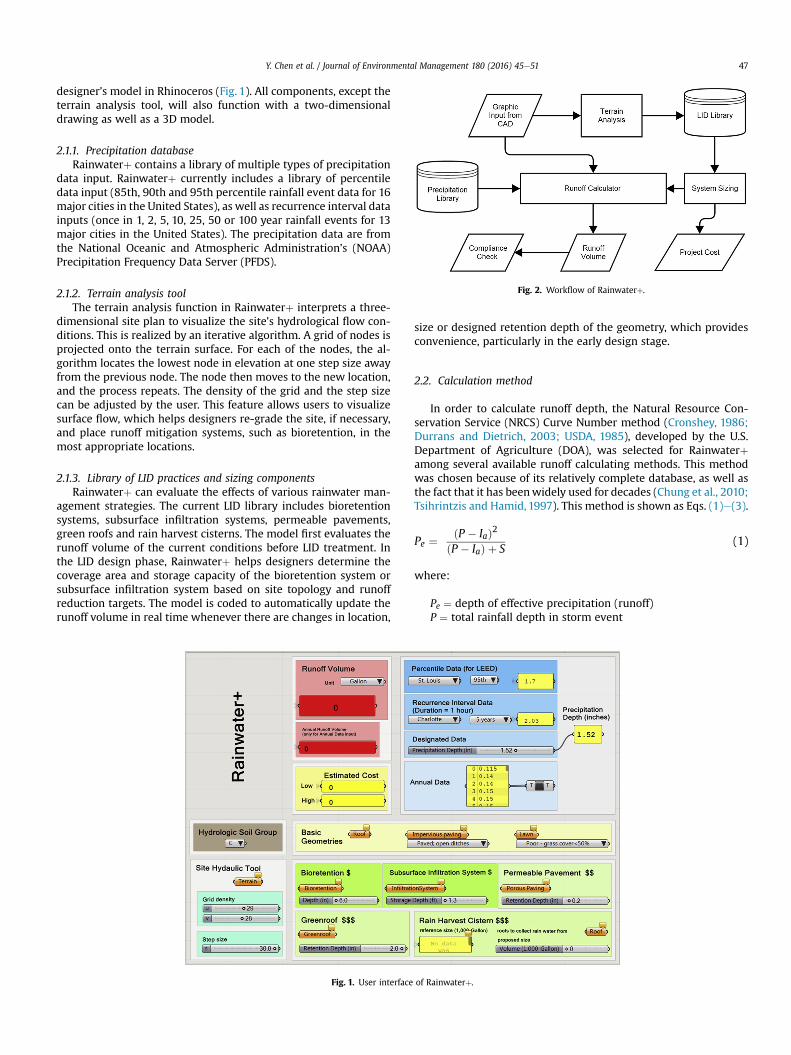
Fig. 2. Workflow of Rainwaterþ.
Y. Chen et al. / Journal of Environmental Management 180 (2016) 45e51 47
designer’s model in Rhinoceros (Fig. 1). All components, except theterrain analysis tool, will also function with a two-dimensionaldrawing as well as a 3D model.
2.1.1. Precipitation databaseRainwaterþ contains a library of multiple types of precipitation
data input. Rainwaterþ currently includes a library of percentiledata input (85th, 90th and 95th percentile rainfall event data for 16major cities in the United States), as well as recurrence interval datainputs (once in 1, 2, 5, 10, 25, 50 or 100 year rainfall events for 13major cities in the United States). The precipitation data are fromthe National Oceanic and Atmospheric Administration’s (NOAA)Precipitation Frequency Data Server (PFDS).
2.1.2. Terrain analysis toolThe terrain analysis function in Rainwaterþ interprets a three-
dimensional site plan to visualize the site’s hydrological flow con-ditions. This is realized by an iterative algorithm. A grid of nodes isprojected onto the terrain surface. For each of the nodes, the al-gorithm locates the lowest node in elevation at one step size awayfrom the previous node. The node then moves to the new location,and the process repeats. The density of the grid and the step sizecan be adjusted by the user. This feature allows users to visualizesurface flow, which helps designers re-grade the site, if necessary,and place runoff mitigation systems, such as bioretention, in themost appropriate locations.
2.1.3. Library of LID practices and sizing componentsRainwaterþ can evaluate the effects of various rainwater man-
agement strategies. The current LID library includes bioretentionsystems, subsurface infiltration systems, permeable pavements,green roofs and rain harvest cisterns. The model first evaluates therunoff volume of the current conditions before LID treatment. Inthe LID design phase, Rainwaterþ helps designers determine thecoverage area and storage capacity of the bioretention system orsubsurface infiltration system based on site topology and runoffreduction targets. The model is coded to automatically update therunoff volume in real time whenever there are changes in location,
Fig. 1. User interface
size or designed retention depth of the geometry, which providesconvenience, particularly in the early design stage.
2.2. Calculation method
In order to calculate runoff depth, the Natural Resource Con-servation Service (NRCS) Curve Number method (Cronshey, 1986;Durrans and Dietrich, 2003; USDA, 1985), developed by the U.S.Department of Agriculture (DOA), was selected for Rainwaterþamong several available runoff calculating methods. This methodwas chosen because of its relatively complete database, as well asthe fact that it has beenwidely used for decades (Chung et al., 2010;Tsihrintzis and Hamid, 1997). This method is shown as Eqs. (1)e(3).
Pe ¼ ðP � IaÞ2ðP � IaÞ þ S
(1)
where:
Pe ¼ depth of effective precipitation (runoff)P ¼ total rainfall depth in storm event
of Rainwaterþ.

Table 3Hydrologic soil group.
Type Infiltration rate Texture
A 0.76e1.14 cm/h Sand and gravelsB 0.38e0.76 cm/h Coarse to moderately fineC 0.13e0.38 cm/h Moderately fine to fineD <0.13 cm/h Clays with high swelling, high water tables
Y. Chen et al. / Journal of Environmental Management 180 (2016) 45e5148
Ia ¼ equivalent depth of initial abstractionsS ¼ maximum possible water retention
Data analyzed by the NRCS indicated that on average, Ia ¼ 0.2S,thus the equation above becomes
Pe ¼ ðP � 0:2SÞ2P þ 0:8S
(2)
The maximum possible retention S is related to the curvenumber (CN):
S ¼ 1000CN
� 10 (3)
where: CN ¼ runoff curve number.The curve number used in Rainwaterþ and shown in Table 2 is
from Urban Hydrology for Small Watersheds TR-55 by the U.S. DOA(Cronshey et al., 1985). In the Rainwaterþ calculation, the curvenumber is automatically read from the table based on the landcover condition of each surface and user-specified soil type.Detailed land cover conditions are assigned to geometries (indi-vidual, group or layer) in the designer’s model, which enablesRainwaterþ to read geometry data from Rhinoceros.
Soils in the United States have been classified by the NRCS intofour hydrologic groups: A, B, C and D, as shown in Table 3. Group Asoils have high infiltration rates. These soil types are available forselection by the user in Rainwaterþ. Hydrologic soil groups for lo-cations in the United States can be found on NRCS’s SOILS website(soils.usda.gov).
As described above, the user’s decision on the location of LIDfeatures is assisted by the terrain analysis tool, which will illustratethe flow and its convergence within the site boundary. The user’sdecision on the size of LID features is reached by adjusting the areaand depth (or volume for cistern) of each feature to achieve theaimed runoff volume of the site. Table 4 lists the constraints ofretention capacity of each LID feature adopted in Rainwaterþ ac-cording to common engineering practice and the manufacturer’scatalog. These constraints are included in the Rainwaterþ to pre-vent unrealistic system sizing during the design process. However,users are able to override these settings with custom values ifnecessary.
3. Case studies
Two case studies are presented in this study to demonstrate theapplication of Rainwaterþ on real sites and the importance of
Table 2Land cover description and curve number.
Cover description Curve numbers for hydrologic soilgroup
A B C D
LawnsPoor condition (grass cover < 50%)
68 79 86 89
LawnsFair condition (grass cover 50%e75%)
49 69 79 84
LawnsGood condition (grass cover > 75%)
39 61 74 80
Roofs 98 98 98 98Paved parking lots 98 98 98 98Paved (curbs and sewers) 98 98 98 98Paved (open ditches) 83 89 92 93Gravel 76 85 89 91Dirt 72 82 87 89Newly graded areas 77 86 91 94
considering stormwater runoff at the early design stage. Case 1 is areal university campus extension plan, and Case 2 is a new devel-opment of a R&D center. Our goal of using these two case studies isto prove the importance and feasibility of integrating rainwatermanagement into the workflow of architects and landscape de-signers to maximize the site potential of runoff mitigation andrainwater harvesting, which also helps to meet the requirement incorresponding standards and codes such as LEED and stateregulations.
The university campus in Case 1 (Fig. 3) is located in theNortheastern U.S. with a total area of approximately 72 ha. Thedevelopment team aims to achieve LEED v4 credits bymanaging onsite the 95th percentile rainfall. Given that the current site consistsof a high percentage of previously developed, impervious surfaces,there is an opportunity to reduce the volume of stormwaterdischarge to the river adjacent to the campus and increase waterconservation by rainwater harvesting. The site elevations from localgovernment’s GIS database show that overall the site is vastly flat,with very sparse contour lines ranging from 2.7 m to 5.8 m overseveral city blocks with no clear surface trend. Thereforewe treatedthe terrain as two-dimensional in our model. The 95th percentilerainfall of 3.86 cm was selected from the built-in precipitation li-brary of Rainwaterþ. Hydrologic soil group C was also assignedbased on site condition.
The project in Case 2 is an R&D Center also located in theNortheastern U.S. with the site boundary of approximately 26 ha(Fig. 5). The 590 m � 440 m hilly terrain has a large variation inaltitude. The greatest difference between the lowest and highestaltitude is 50 m. The gross floor area of this development is50,000 m2, comprised of three major buildings on an elevatedplatform. One of the project’s goals for reaching site sustainability isto manage on site the annual increase in runoff volume from thenatural land cover condition to the post-developed condition. Theaverage annual precipitation of the location is approximately102 cm. On average, there are approximately 56 rainfall events withmore than 0.25 cm in precipitation.
4. Results
4.1. Case 1: extension plan of a university campus
Through the preliminary site screening test using Rainwaterþ,the visualized results as shown in Fig. 3 suggest that building roofareas have the greatest runoff depth, followed by the paved roadsand walkways. The red and orange colors of these areas illustratethat the largest portion of the 3.86 cm of rain falling on thesesurfaces will run off the site. In contrast, the lawn area in blueshows a partial infiltration capacity. Given the condition that thesite is vastly flat, it is assumed that the runoff will be channeled tothe designated treatment areas. Therefore, we can skip the Rain-waterþ terrain analysis.
In order to better apply localized stormwater managementpractices, the proposed site has been divided into six sub-zones(Fig. 4a) on which the various rainwater management practicesare tested with Rainwaterþ. For cost consideration, we selectedbioretention practices first, because these systems generally have

Table 4LID retention capacity constraints.
LID Constraint
Bioretention Preferred retention depth between 15 cm and 30 cm (max 38 cm)Subsurface infiltration system Equivalent retention depth between 30 cm and 135 cmPermeable pavement Max retention depth 7.5 cmGreen roof Max retention depth 5 cmRain harvest cistern Max retention volume 160 m3
Fig. 3. Whole site runoff depth in 95th rainfall event before LID design.
Table 5Runoff calculations e zone D.
Project area D
No LID
Area (m2) Runoff depth (cm) Runoff (m3)
Roof 12,096 3.30 399Paved 3907 2.08 81Lawn 5326 0.68 36Total 21,329 516
With LID Planning
Area (m2) Retention Capacity Runoff Depth (cm) Runoff (m3)
Roof 2419 3.30 80Green roof 9677 2.30 cm 1.56 152Porous Paving 3907 5.10 cm �1.24 �48Lawn 4919 0.68 33Bio-retention 407 20.30 cm �16.44 �67Cistern 83 m3
68 m3�151
Total 21,329 ¡1
Y. Chen et al. / Journal of Environmental Management 180 (2016) 45e51 49
the lowest cost per unit of stormwater treated (Dietz, 2007). Ifbioretention systems are not adequate for capturing the desiredrunoff volume, permeable pavement, cisterns and green roofs willbe considered in the order based on relative costs. In most cases acombination of practices was selected as part of an integratedtreatment system. We repeatedly adjusted the system size of thesedesign combinations by trial-and-error and checked the runoffnumber until it reached zero. The campus plans before and afterredesign are shown in Fig. 4.
The analysis from Rainwaterþ suggests that proper LID design isable to offset the total 4542 m3 of runoff from the entire site in the95th percentile rainfall event. At the subzone level of each indi-vidual land parcel, the combination of bioretention, subsurfaceinfiltration system and porous pavement was sufficient to retainthe 95th percentile rainfall on-site for a majority of the projectzones. Other on-site low-impact stormwater management prac-tices such as rain harvest tanks and green roofs were only needed inone zone with a high Floor Area Ratio (FAR) and percentage ofimpervious area.
Fig. 4. Site plan without (a) a
The calculations performed by Rainwaterþ for zone D in thiscase study are shown in Table 5 as an example. 516 m3 of rainwaterwill end up as runoff from this 21,329 m2 site area in a 95thpercentile rainfall event if no mitigation strategy is applied on-site.However, with properly designed 9677 m2 of green roof with2.3 cm water retention capacity, 3907 m2 of porous paving with5.1 cm retention capacity, 407 m2 of bioretention area with 20.3 cmretention capacity, as well as two rainwater harvest cisterns of83 m3 and 68 m3, theoretically the runoff volume can be entirelyoffset if the site drainage is appropriately designed.
4.2. Case 2: new development of an R&D center
The aim of this project is to earn LEED v4 credit that requiresmanaging on site the annual increase in runoff volume from the
nd with LID design (b).
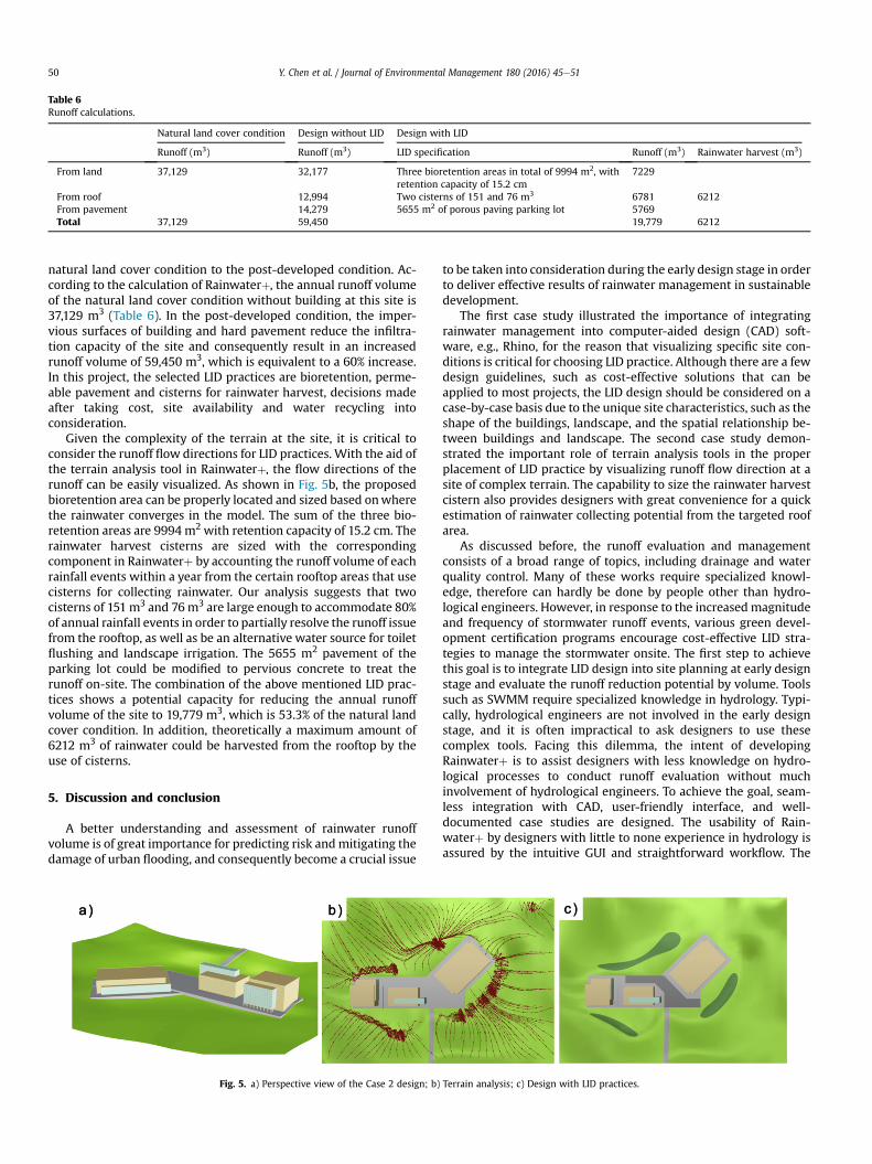
Table 6Runoff calculations.
Natural land cover condition Design without LID Design with LID
Runoff (m3) Runoff (m3) LID specification Runoff (m3) Rainwater harvest (m3)
From land 37,129 32,177 Three bioretention areas in total of 9994 m2, withretention capacity of 15.2 cm
7229
From roof 12,994 Two cisterns of 151 and 76 m3 6781 6212From pavement 14,279 5655 m2 of porous paving parking lot 5769Total 37,129 59,450 19,779 6212
Y. Chen et al. / Journal of Environmental Management 180 (2016) 45e5150
natural land cover condition to the post-developed condition. Ac-cording to the calculation of Rainwaterþ, the annual runoff volumeof the natural land cover condition without building at this site is37,129 m3 (Table 6). In the post-developed condition, the imper-vious surfaces of building and hard pavement reduce the infiltra-tion capacity of the site and consequently result in an increasedrunoff volume of 59,450 m3, which is equivalent to a 60% increase.In this project, the selected LID practices are bioretention, perme-able pavement and cisterns for rainwater harvest, decisions madeafter taking cost, site availability and water recycling intoconsideration.
Given the complexity of the terrain at the site, it is critical toconsider the runoff flow directions for LID practices. With the aid ofthe terrain analysis tool in Rainwaterþ, the flow directions of therunoff can be easily visualized. As shown in Fig. 5b, the proposedbioretention area can be properly located and sized based onwherethe rainwater converges in the model. The sum of the three bio-retention areas are 9994 m2 with retention capacity of 15.2 cm. Therainwater harvest cisterns are sized with the correspondingcomponent in Rainwaterþ by accounting the runoff volume of eachrainfall events within a year from the certain rooftop areas that usecisterns for collecting rainwater. Our analysis suggests that twocisterns of 151 m3 and 76m3 are large enough to accommodate 80%of annual rainfall events in order to partially resolve the runoff issuefrom the rooftop, as well as be an alternative water source for toiletflushing and landscape irrigation. The 5655 m2 pavement of theparking lot could be modified to pervious concrete to treat therunoff on-site. The combination of the above mentioned LID prac-tices shows a potential capacity for reducing the annual runoffvolume of the site to 19,779 m3, which is 53.3% of the natural landcover condition. In addition, theoretically a maximum amount of6212 m3 of rainwater could be harvested from the rooftop by theuse of cisterns.
5. Discussion and conclusion
A better understanding and assessment of rainwater runoffvolume is of great importance for predicting risk andmitigating thedamage of urban flooding, and consequently become a crucial issue
Fig. 5. a) Perspective view of the Case 2 design; b)
to be taken into consideration during the early design stage in orderto deliver effective results of rainwater management in sustainabledevelopment.
The first case study illustrated the importance of integratingrainwater management into computer-aided design (CAD) soft-ware, e.g., Rhino, for the reason that visualizing specific site con-ditions is critical for choosing LID practice. Although there are a fewdesign guidelines, such as cost-effective solutions that can beapplied to most projects, the LID design should be considered on acase-by-case basis due to the unique site characteristics, such as theshape of the buildings, landscape, and the spatial relationship be-tween buildings and landscape. The second case study demon-strated the important role of terrain analysis tools in the properplacement of LID practice by visualizing runoff flow direction at asite of complex terrain. The capability to size the rainwater harvestcistern also provides designers with great convenience for a quickestimation of rainwater collecting potential from the targeted roofarea.
As discussed before, the runoff evaluation and managementconsists of a broad range of topics, including drainage and waterquality control. Many of these works require specialized knowl-edge, therefore can hardly be done by people other than hydro-logical engineers. However, in response to the increasedmagnitudeand frequency of stormwater runoff events, various green devel-opment certification programs encourage cost-effective LID stra-tegies to manage the stormwater onsite. The first step to achievethis goal is to integrate LID design into site planning at early designstage and evaluate the runoff reduction potential by volume. Toolssuch as SWMM require specialized knowledge in hydrology. Typi-cally, hydrological engineers are not involved in the early designstage, and it is often impractical to ask designers to use thesecomplex tools. Facing this dilemma, the intent of developingRainwaterþ is to assist designers with less knowledge on hydro-logical processes to conduct runoff evaluation without muchinvolvement of hydrological engineers. To achieve the goal, seam-less integration with CAD, user-friendly interface, and well-documented case studies are designed. The usability of Rain-waterþ by designers with little to none experience in hydrology isassured by the intuitive GUI and straightforward workflow. The
Terrain analysis; c) Design with LID practices.

Y. Chen et al. / Journal of Environmental Management 180 (2016) 45e51 51
Rainwaterþ has some limitations. Functions such as estimatingrunoff water quality and flow rate are not included in the model.However, they are not required in most municipal and state codesas well as LEED for rainwater management. In the SupplementaryMaterial, we compared five key steps in the workflow of Rain-waterþ with SWMM, which shows the advantage of using Rain-waterþ in the early design stage.
Rainwater management is no longer solely the engineer’s re-sponsibility in the new era of low-impact development. In fact,architects and landscape designers may be uniquely positioned toconsider rainwatermanagement strategies in the early design stageto avoid the lost rainwater management opportunities in the laterphases as well as prevent construction confliction of buildingstructure and LIDs. However, no tool currently exists to adequatelysupport designers in integrating rainwater performance into theirdecision-making process. Considering this context, Rainwaterþ isan intuitive tool for runoff evaluation and management that canenables designers to integrate rainwater considerations into theirdesign workflow with tailored features such as ease of use, instantfeedback of runoff volume, seamless graphic interconnection,straightforward system sizing, compliance checking, and visuali-zation of rainwater surface flow.
Acknowledgement
We would like to thank Dr. Edward Eric Adams, Professor JoyceKlein Rosenthal, Nicole Holmes and Chelsea Christenson for theirinsightful comments and suggestions.
Appendix A. Supplementary data
Supplementary data related to this article can be found at http://dx.doi.org/10.1016/j.jenvman.2016.04.059.
References
Burns, M.J., Fletcher, T.D., Walsh, C.J., Ladson, A.R., Hatt, B.E., 2012. Hydrologicshortcomings of conventional urban stormwater management and opportu-nities for reform. Landsc. Urban Plan. 105, 230e240.
Carter, T., Jackson, C.R., 2007. Vegetated roofs for stormwater management atmultiple spatial scales. Landsc. Urban Plan. 80, 84e94.
Chang, N.-B., 2010. Hydrological connections between low-impact development,watershed best management practices, and sustainable development. J. Hydrol.Eng. 15, 384e385.
Chung, W., Wang, I., Wang, R., 2010. Theory-based SCS-CN method and its appli-cations. J. Hydrol. Eng. 15, 1045e1058.
Cohen, B., 2006. Urbanization in developing countries: current trends, future pro-jections, and key challenges for sustainability. Technol. Soc. 28, 63e80.
Cronshey, R., 1986. Urban hydrology for small watersheds. U. S. Dept. Agric. SoilConserv. Serv. Eng. Div.
Cronshey, R., Roberts, R., Miller, N., 1985. Urban hydrology for small watersheds (TR-55 Rev.). Hydraul. Hydrol. Small Comput. Age 1268e1273. ASCE.
Dietz, M.E., 2007. Low impact development practices: a review of current researchand recommendations for future directions. Water Air Soil Pollut. 186, 351e363.
Dietz, M.E., Clausen, J.C., 2008. Stormwater runoff and export changes with devel-opment in a traditional and low impact subdivision. J Environ Manag. 87,560e566.
Dore, M.H., 2005. Climate change and changes in global precipitation patterns:what do we know? Environ. Int. 31, 1167e1181.
Durrans, S.R., Dietrich, K., 2003. Stormwater Conveyance Modeling and Design.EPA, 2000. Low Impact Development (LID) - A Literature Review. United States
Environmental Protection Agency, Washington, DC.Grimmond, S.U.E., 2007. Urbanization and global environmental change: local ef-
fects of urban warming. Geogr. J. 173, 83e88.Hsieh, C-h, Davis, A.P., 2005. Evaluation and optimization of bioretention media for
treatment of urban storm water runoff. J. Environ. Eng. 131, 1521e1531.Hubacek, K., Guan, D., Barrett, J., Wiedmann, T., 2009. Environmental implications
of urbanization and lifestyle change in China: ecological and water footprints.J. Clean. Prod. 17, 1241e1248.
Huber, W.C., Rossman, L.A., Dickinson, R., 2005. EPA Storm Water ManagementModel SWMM 5. 0. Watershed Modeling. CRC Press, Boca Raton, FL,pp. 339e361.
Huong, H., Pathirana, A., 2011. Urbanization and climate change impacts on futureurban flood risk in Can Tho city. Vietnam. Hydrol. Earth Syst. Sci. Discuss. 8,10781e10824.
Kim, H., Seagren, E.A., Davis, A.P., 2003. Engineered bioretention for removal ofnitrate from stormwater runoff. Water Environ. Res. 355e367.
Koo, T., 1989. Hybrid digital processing in hydrography: the hydrocad solution. Surv.Rev. 30, 97e108.
Lee, J.H., Bang, K.W., 2000. Characterization of urban stormwater runoff. Water Res.34, 1773e1780.
Lee, J.G., Heaney, J.P., 2003. Estimation of urban imperviousness and its impacts onstorm water systems. J Water Resour. Plan. Manag. 129, 419e426.
Liu, Z., 2009. Analysis of characteristics and cause of urban storm runoff change anddiscussion on some issues. J. China Hydrology 29, 55e58.
Maniquiz-Redillas, M.C., Kim, L.-H., 2016. Evaluation of the capability of low-impactdevelopment practices for the removal of heavy metal from urban stormwaterrunoff. Environ. Technol. 1e8.
Mansell, M.G., 2003. Rural and Urban Hydrology: Thomas Telford.Miltner, R.J., White, D., Yoder, C., 2004. The biotic integrity of streams in urban and
suburbanizing landscapes. Landsc. urban Plan. 69, 87e100.Niu, Z.-G., Lv, Z.-W., Zhang, Y., Cui, Z.-Z., 2015. Stormwater infiltration and surface
runoff pollution reduction performance of permeable pavement layers. Environ.Sci. Pollut. Res. 23, 2576e2587.
Pyke, C., Warren, M.P., Johnson, T., LaGro, J., Scharfenberg, J., Groth, P., et al., 2011.Assessment of low impact development for managing stormwater withchanging precipitation due to climate change. Landsc. Urban Plan. 103, 166e173.
Qin, H-p, Li, Z-x, Fu, G., 2013. The effects of low impact development on urbanflooding under different rainfall characteristics. J. Environ. Manag. 129,577e585.
Tong, Z., Whitlow, T.H., Landers, A., Flanner, B., 2016a. A case study of air qualityabove an urban roof top vegetable farm. Environ. Pollut. 208 (Part A), 256e260.
Tong, Z., Whitlow, T.H., MacRae, P.F., Landers, A.J., Harada, Y., 2015. Quantifying theeffect of vegetation on near-road air quality using brief campaigns. Environ.Pollut. 201, 141e149.
Tong, Z., Chen, Y., Malkawi, A., Adamkiewicz, G., Spengler, J.D., 2016b. Quantifyingthe impact of traffic-related air pollution on the indoor air quality of a naturallyventilated building. Environ. Int. 89e90, 138e146.
Tong, Z., R.W., Baldauf, Isakov, V., Deshmukh, P., Max Zhang, K., 2016c. Roadsidevegetation barrier designs to mitigate near-road air pollution impacts. Sci. TotalEnviron. 541, 920e927.
Tsihrintzis, V.A., Hamid, R., 1997. Urban stormwater quantity/quality modeling usingthe scs method and empirical equations. JAWRA J. Am. Water Resour. Assoc. 33,163e176.
USDA S. Hydrology, 1985. National Engineering Handbook, Section 4. US Depart-ment of Agriculture, Washington, DC, USA.
USGBC, 2013. LEED v4 User Guide. US Green Building Council.Villarreal, E.L., Semadeni-Davies, A., Bengtsson, L., 2004. Inner city stormwater
control using a combination of best management practices. Ecol. Eng. 22,279e298.
Wang, H-z, 2001. Calculation method for stormwater infiltration facilities in urbanarea of Beijing city. China Water Wastewater 17, 37e39.
Whitford, V., Ennos, A.R., Handley, J.F., 2001. “City form and natural proc-ess”dindicators for the ecological performance of urban areas and theirapplication to Merseyside. UK. Landsc. Urban Plan. 57, 91e103.