Johnson & Webb NSF tectonics proposal, 2005 · - 1 - Collaborative Research: Strike-slip history of...
21
Collaborative Research: Strike-Slip History of the East Gobi Fault Zone, Mongolia: Modes of Intraplate Deformation, Sedimentary Basin Evolution, and Regional Fault Linkages C.L. Johnson (University of Utah) and L.E. Webb (Syracuse University), co-PIs The proposed three-year study will employ tools of structural geology, geochronology, and sedimentary basin analysis to reconstruct displacement history and basin evolution along the East Gobi Fault Zone (EGFZ), Mongolia. Preliminary data suggest that this major intracontinental shear zone was reactivated at least four times since the late Paleozoic; the proposed work will document two of the least-constrained episodes of left-lateral slip (early Mesozoic and early Cenozoic). Intellectual Merit. Due to paucity of data from southeastern Mongolia, the EGFZ is essentially played as a wildcard against models of evolution of the Asian tectonic ‘collage.’ For example, published models estimate left-lateral offset ranging from ~200 km of early Mesozoic slip (Lamb et al., 1999) to ~400 km of purely Cenozoic slip (Yue and Liou, 1999), both citing regional map relations that have not been field-tested. The latter interpretation implies a pre- Miocene linkage between the Altyn Tagh fault and hypothesized—but as yet largely undocumented—strike-slip faults extending through southeastern Mongolia to the Sea of Okhotsk. The proposed study will test whether this kinematic linkage is permissible via mapping near the China-Mongolia border zone, southwest from control sites where Cenozoic strike-slip faulting has been established in the EGFZ, and will test piercing points providing the first field and analytical constraints on the timing and magnitude of slip. These results bear further on mechanisms favoring initiation and reactivation of shear zones by testing the hypothesis that the EGFZ reactivates a Paleozoic suture. Geochronologic data will help evaluate the timing of intraplate deformation in southeastern Mongolia as a function of far field forces and evolving boundary conditions. Thus, this research is relevant to models of continental block extrusion and continuum shortening during Asia’s history of collisions from Mesozoic–Recent. Furthermore, investigation of the relationship between wrench tectonics and sedimentation will elucidate how structures control basin initiation, evolution, preservation and/or dissection (due to strike-slip offset) in regions of long-lived, episodic intracontinental deformation. Broader Impacts. The proposed collaborative and multidisciplinary work will highlight the power of integration of diverse geoscience datasets to address a complex set of questions. The research will employ a newly NSF-funded excimer laser system in the Syracuse University Noble Gas Isotopic Research Laboratory (SUNGIRL) via in situ 40 Ar/ 39 Ar analyses of K-bearing minerals in multiply deformed rocks. The international nature of this work will foster collaboration between Mongolian and American geologists, including two early-career female scientists (Webb and Johnson). In addition to two Ph.D. students, multiple undergraduates from Utah and Syracuse will participate in all aspects of the study. The proposed analytical work will enhance graduate and undergraduate student education and training through the use of cutting- edge technology and hands-on field experiences. Graduate and undergraduate researchers and Mongolian colleagues will have the opportunity to present their work at international meetings and co-author manuscripts. We seek to include Mongolian students in this research, potentially opening doors of international opportunity for them. A special theme session at the American Geophysical Union Fall Meeting in San Francisco will be organized during the final year of the grant, designed to facilitate comparisons between the EGFZ and other intracontinental fault zones within Asia, as well as wrench tectonic settings around the world. 0537318
-
Upload
phungkhuong -
Category
Documents
-
view
217 -
download
1
Transcript of Johnson & Webb NSF tectonics proposal, 2005 · - 1 - Collaborative Research: Strike-slip history of...

Collaborative Research: Strike-Slip History of the East Gobi Fault Zone, Mongolia: Modes of Intraplate Deformation, Sedimentary Basin Evolution, and Regional Fault Linkages
C.L. Johnson (University of Utah) and L.E. Webb (Syracuse University), co-PIs
The proposed three-year study will employ tools of structural geology, geochronology, and sedimentary basin analysis to reconstruct displacement history and basin evolution along the East Gobi Fault Zone (EGFZ), Mongolia. Preliminary data suggest that this major intracontinental shear zone was reactivated at least four times since the late Paleozoic; the proposed work will document two of the least-constrained episodes of left-lateral slip (early Mesozoic and early Cenozoic).
Intellectual Merit. Due to paucity of data from southeastern Mongolia, the EGFZ is essentially played as a wildcard against models of evolution of the Asian tectonic ‘collage.’ For example, published models estimate left-lateral offset ranging from ~200 km of early Mesozoic slip (Lamb et al., 1999) to ~400 km of purely Cenozoic slip (Yue and Liou, 1999), both citing regional map relations that have not been field-tested. The latter interpretation implies a pre-Miocene linkage between the Altyn Tagh fault and hypothesized—but as yet largely undocumented—strike-slip faults extending through southeastern Mongolia to the Sea of Okhotsk. The proposed study will test whether this kinematic linkage is permissible via mapping near the China-Mongolia border zone, southwest from control sites where Cenozoic strike-slip faulting has been established in the EGFZ, and will test piercing points providing the first field and analytical constraints on the timing and magnitude of slip. These results bear further on mechanisms favoring initiation and reactivation of shear zones by testing the hypothesis that the EGFZ reactivates a Paleozoic suture. Geochronologic data will help evaluate the timing of intraplate deformation in southeastern Mongolia as a function of far field forces and evolving boundary conditions. Thus, this research is relevant to models of continental block extrusion and continuum shortening during Asia’s history of collisions from Mesozoic–Recent. Furthermore, investigation of the relationship between wrench tectonics and sedimentation will elucidate how structures control basin initiation, evolution, preservation and/or dissection (due to strike-slip offset) in regions of long-lived, episodic intracontinental deformation.
Broader Impacts. The proposed collaborative and multidisciplinary work will highlight the power of integration of diverse geoscience datasets to address a complex set of questions. The research will employ a newly NSF-funded excimer laser system in the Syracuse University Noble Gas Isotopic Research Laboratory (SUNGIRL) via in situ 40Ar/39Ar analyses of K-bearing minerals in multiply deformed rocks. The international nature of this work will foster collaboration between Mongolian and American geologists, including two early-career female scientists (Webb and Johnson). In addition to two Ph.D. students, multiple undergraduates from Utah and Syracuse will participate in all aspects of the study. The proposed analytical work will enhance graduate and undergraduate student education and training through the use of cutting-edge technology and hands-on field experiences. Graduate and undergraduate researchers and Mongolian colleagues will have the opportunity to present their work at international meetings and co-author manuscripts. We seek to include Mongolian students in this research, potentially opening doors of international opportunity for them. A special theme session at the American Geophysical Union Fall Meeting in San Francisco will be organized during the final year of the grant, designed to facilitate comparisons between the EGFZ and other intracontinental fault zones within Asia, as well as wrench tectonic settings around the world.
0537318

- 1 -
Collaborative Research: Strike-slip history of the East Gobi Fault Zone, Mongolia: Modes of intraplate deformation, sedimentary basin evolution, and regional fault linkages
C.L. Johnson (University of Utah) and L.E. Webb (Syracuse University), co-PIs
INTRODUCTION Southeastern Mongolia lies near the center of the largest mosaic of assembled tectonic
elements on Earth (Hendrix and Davis, 2001). The East Gobi Fault Zone (EGFZ) is a major tectonic feature of this region, defined by a structural corridor of northeast-striking faults in the East Gobi basin (Fig. 1). The EGFZ has a protracted history of faulting, igneous activity, and sedimentary basin development following continental assembly of Mongolia and North China in the late Paleozoic (Johnson and Webb, 2005). Briefly, these events include early Mesozoic ductile sinistral shear, Early Cretaceous NW-SE extension, mid-Cretaceous basin inversion, and early Cenozoic left-lateral strike-slip (Webb et al., 2004). This protracted geologic history records far field forces and evolving (plate) boundary conditions, and therefore data from the EGFZ bear on the relative roles of continental block extrusion (e.g. Tapponnier et al., 1982) and continuum shortening (e.g., Houseman and England, 1996) during Phanerozoic amalgamation of Asia. Thus the EGFZ is an excellent laboratory in which to study fault reactivation, intracontinental deformation, and basin evolution in the context of continental dynamics.
Of the four main reactivation episodes that characterize the EGFZ, the two periods of left-lateral offset are the least constrained. Despite having largely unknown slip histories, these sinistral deformation events are the subject of regional tectonic models with major implications. For example, current models for the EGFZ include 200 km of mainly early Mesozoic slip (Lamb et al., 1999) and, in contrast, ~ 400 km of entirely early Cenozoic slip (Yue and Liou, 1999; Yue et al., 2001a). The latter model invoking Cenozoic offset further implies that the EGFZ may have been kinematically linked to the Altyn Tagh fault prior to ~16 Ma as part of a major fault zone extending more than 3000 km northeast from the Qilian Shan to the Sea of Okhotsk (Fig. 1, inset). The proposed switch from transferred sinistral faulting (extrusion) to termination into
0537318

- 2 -
thrust faults in the Qilian Shan (crustal thickening) roughly coincides with the transition along the northeastern Pacific margin from transtensional to transpressional tectonics in the Late Miocene (Jolivet et al., 1994; Worrall et al., 1996). Clearly, regional tectonic models are hampered by lack of data from Mongolia, and are therefore subject to wide speculation. Our proposed research will focus on two main topics relevant to the strike-slip history of the EGFZ: 1) Structural characterization and mapping of the fault zone. We have collected data from several basement blocks in the EGFZ in the northeastern part of the field area (Fig. 2). This work includes documentation of lithologies involved in deformation, kinematic constraints on the different phases of faulting, and radiometric and relative age constraints on the timing of deformation. We propose to augment and extend these field studies to the southwest towards the China-Mongolia border, in part to determine if and how this fault zone may link with other regional structures such as the Altyn Tagh fault. 2) Documenting the slip history of the EGFZ. Our studies will concentrate on the two phases of left-lateral strike-slip activity indicated by preliminary observations and data. Timing of deformation will be determined by integration of various thermochronologic techniques, such as 40Ar/39Ar analyses of minerals that grew during deformation events, U/Pb analyses of zircons from intrusive and other units, and apatite fission track plus (U-Th)/He data to constrain the final stages of denudation and cooling at key control sites. Magnitude of slip will be constrained by testing proposed offset of sedimentary sequences and crystalline units ranging from Paleozoic–Cenozoic in age via basin analysis, geochronology, and related methods. Studies of Cenozoic offset in our control area will be aided by tectonic reconstruction of basement blocks in which the early Mesozoic sinistral shear zone is exposed. The results of this work will comprise the first strategically collected data set from this region to test the feasibility of various existing models and guide further studies.
0537318

- 3 -
The PIs will leverage significant experience in collaborative, multidisciplinary research in southeastern Mongolia (3-4 field seasons in the Gobi each), critical to the success of the proposed work. Our preliminary data from the EGFZ direct the scientific goals and define a set of specific testable hypotheses that address the two main topics of investigation. These hypotheses are detailed along with the methods we will use in subsequent parts of this proposal.
GEOLOGIC OVERVIEW AND PRELIMINARY DATA
Major deformation events and tectonostratigraphic successions associated with the EGFZ are described below, including preliminary results from our own work in the region. Beyond establishing geologic background and outstanding questions relevant to this study, we highlight three main topics critical to the broader scientific implications of the proposal: 1) the presence of heterogeneous, accreted crust in southern Mongolia, and how this may influence the subsequent development of shear zones; 2) evidence for multiple phases of intracontinental deformation in the EGFZ, including strike-slip, and associated models proposing linkage with the Altyn Tagh Fault; and 3) tectonic driving mechanisms and paleo-stress regimes from late Paleozoic–Cenozoic time, as indicated by available Asian tectonic literature.
Paleozoic continental and island arc amalgamation. Paleozoic rocks of southern Mongolia record collision and accretion of volcanic arcs, associated marine basins and, perhaps, fragments of continental crust (Sengor et al., 1993; Lamb and Badarch, 1997). Permian “flysch-molasse’ sequences in southeastern Mongolia record final closure of a remnant ocean basin and collision with the North China block (Amory, 1996). While the presence of Ordovician–Carboniferous arc material in southern Mongolia is well established (Badarch et al., 2002), the extent to which Precambrian crust exists is still debated (Wang et al., 2001). Metamorphic tectonites of southern Mongolia are commonly mapped as Precambrian basement based solely on the degree of deformation and metamorphism, as well as apparent position underlying variably low-grade metamorphosed Paleozoic sedimentary rocks (e.g., at Tavan Har and Onch Hayrhan localities shown on Figs. 1 and 2). However, these inferences are generally not supported by published radiometric ages, and recent field studies indicate that many of these lithologies are in fact Mesozoic tectonites with late Paleozoic protoliths (Webb et al., 2004). Although we cannot completely discount the possibility of Precambrian crust in southern Mongolia, it likely represents at most a minor component compared to accreted Paleozoic successions.
Late Triassic–Early Jurassic transpression. Following late Paleozoic arc accretion, early Mesozoic contractile deformation in southern Mongolia is linked with deformation in the Tian Shan, possibly due to collision of the Qiantang block (Yin and Nie, 1996). Evidence for this event is found in southwestern Mongolia at Noyon Uul (Fig. 1), where >5 km of Upper Permian−Lower Jurassic nonmarine strata are interpreted to have formed in a foreland-style sedimentary basin (Hendrix et al., 2001). Zheng et al. (1991, 1996) reported nappes of Proterozoic dolomite thrust over Cambrian to Lower–Middle Jurassic units in the Beishan, just south of the Mongolian border. We have observed similar relations at Onch Hayrhan, where large klippe of marble and dolomite are in subhorizontal thrust-fault contact with phyllite and schist with probable Permian protoliths. At Onch Hayrhan, top-to-the-SW shear sense indicators are observed at the base of the thrust sheets and at deeper structural levels where amphibolite-grade gneisses are exposed to the south. These fabrics become locally overprinted and then fully transposed as one nears the detachment fault of an Early Cretaceous metamorphic core complex (Johnson et al., 2001).
Farther to the northeast, metamorphic tectonites along the EGFZ (mapped as Precambrian basement) belong to a sinistral shear zone that comprises a suite of synkinematic intrusions,
0537318

- 4 -
amphibolite-facies gneisses and greenschist-facies mylonites. We have documented this shear zone at several localities over a distance of 300 km along strike (Tsagan Subarga to Urgun, Fig. 2). The shear zone is dominated by steeply dipping foliations and subhorizontal ENE or WSW-plunging stretching lineations. At higher structural levels, variably metamorphosed Paleozoic sedimentary and volcanic sequences are caught up in discrete zones of mylonitic deformation.
Preliminary data from Tavan Har indicate a Late Triassic age of deformation: synkinematic biotite sampled from mylonite showing sinistral shear sense yielded a 40Ar/39Ar weighted mean age of 209 ± 2 Ma (Lamb et al., 1999). Regional overlap relations also support an early Mesozoic age of movement on these and other NE−SW-striking faults within the EGFZ. Lamb et al. (1999) suggested 185–235 km of early Mesozoic sinistral slip on the EGFZ, defined by offset of seven Paleozoic–lower Mesozoic successions. These estimates of displacement magnitude were based primarily on map relations, but the actual offset piercing points have not yet been tested by a field and complementary analytical campaign.
Our initial studies of the EGFZ support a possible temporal link between left-lateral shear and metamorphism at Tavan Har (~209 Ma) and early Mesozoic thrust faulting to the southwest. At Onch Hayrhan, 40Ar/39Ar data suggest Early Jurassic metamorphism (≥ 203 Ma) for phyllite and schist involved in top-to-SW thrusting. Though preliminary, this suggests that sinistral shear in the EGFZ may overlap temporally with thrust faulting along the China-Mongolia border, and may imply the presence of a restraining bend south of Onch Hayrhan. Alternately, if thrusting is truly slightly younger than sinistral faulting, the data could imply a transition from strike-slip faulting to crustal thickening. An issue related to this puzzle is if and how the orientation of fabric elements in either region may have been modified by subsequent deformation.
Late Jurassic–Early Cretaceous extension. In the late Mesozoic, NW–SE extension formed multiple rift basins in China and Mongolia (Fig. 1; Watson et al., 1987). Various driving mechanisms that have been proposed include backarc extension related to the Pacific margin (Watson et al., 1987), gravitational collapse of early Mesozoic orogens (Johnson et al., 2001), collision of the Lhasa block and/or closure of the Mongol-Okhotsk ocean (Yin and Nie, 1996), and finally, removal of a lithospheric keel beneath North China (Gao et al., 2002).
In much of the East Gobi basin, this extensional event is recorded by ~3 km of nonmarine synrift sediment and volcanic units filling asymmetric grabens (Fig. 3; Graham et al., 2001). 40Ar/39Ar dating of volcanic ash beds exposed along the margins of the basin indicate synrift sedimentation spanning ~155–122 Ma, and vertebrate assemblages suggest that synrift units may be as young as Albian (Graham et al., 2001). Preliminary fault-slip data from the EGFZ show NW–SE extensional reactivation of subvertical foliations associated with the Late Triassic sinistral shear zone (Webb et al., 2004). Seismic data and correlated outcrop mapping at Tavan Har indicate that a major basin-dividing fault associated with the EGFZ (the ‘North Zuunbayan Fault,’ Fig. 3), was active during Jurassic–Cretaceous time (Johnson, 2004).
In contrast to the rift sequences exposed in the northeastern Gobi, an Early Cretaceous metamorphic core complex at Onch Hayrhan (Fig. 1) indicates that NW–SE extension was also accompanied by formation of a low-angle detachment fault (Webb et al., 1999). Biotite samples from core migmatite and gneiss, and detachment mylonite give 40Ar/39Ar weighted mean ages of 129–126 Ma, which roughly corresponds to the main phase of active rifting and basin subsidence to the northeast (Johnson, 2004). The presence of these two ‘end-member’ extensional regimes indicates the East Gobi basin was partitioned into regions of high and low-strain extension during the late Mesozoic. We note that the domains of high angle or low angle normal faulting in SE Mongolia appear to correlate with similarly defined structural domains related to Late
0537318

- 5 -
Triassic–Early Jurassic transpression. In particular, the Early Cretaceous detachment fault developed in the region of subhorizontal thrust fabrics, while the high-angle rift basins formed in the shear zone corridor dominated by a subvertical sinistral shear zone. Thus establishing temporal and kinematic links between the high and low angle faulting and shear zone geometry in this region has broader implications related to controls on metamorphic core complex versus rift basin (graben) formation.
Mid-Cretaceous basin inversion. Regional uplift during middle Cretaceous time (~100–95 Ma; Johnson, 2004) inverted the synrift sequence along the basin margins. Relatively undeformed Upper Cretaceous strata unconformably overlap the deformed synrift section in much of southeastern Mongolia, signaling the end of Mesozoic rifting (Traynor and Sladen, 1995). Seismic data indicate that the North Zuunbayan (NZB) fault zone accommodated much of this movement (Johnson, 2004), but other structures within the EGFZ show a reverse or oblique sense of shear related to reactivation of older normal faults, as well (Prost, 2004; Webb et al., 2004). This basin inversion event is expressed in several late Mesozoic rift basins in the region (Traynor and Sladen, 1995; Ren et al., 2002), and thus represents a major phase of tectonic reorganization. Approximate timing of the inversion event (Cenomanian) is synchronous with strike-slip activity on other faults such as the Tan Lu, which may reflect collision between the Yangtze-Indochina Block and the West Philippines Block (Ratschbacher et al., 2003). Early Cenozoic strike-slip. Regional maps show very little Cenozoic sedimentation (Tomurtogoo, 1999), implying that Upper Cretaceous rocks lie relatively undeformed on the older synrift sequence. However, seismic data clearly show that the mid-Cretaceous unconformity surface itself is deformed, and overlying strata are folded along the NZB fault zone (Fig. 3). As it is imaged in the subsurface, faults of the EGFZ are typically near-vertical with minor flower structures. They juxtapose distinct seismic sequences, and are characterized by sudden along-strike changes in both the amount and sense of apparent offset (Johnson, 2004). Such features are common to the subsurface expression of strike-slip faults in other regions (Zolnai, 1991). Thus, the NZB and related faults both offset and deform post-rift Cretaceous strata, indicating some degree of post mid-Cretaceous fault activity. This phase of strike-slip faulting has only recently been recognized in southeastern Mongolia, and the mechanisms and style of Cenozoic deformation are not well established.
Our transects and mapping from Ulgay Khid to Urgun reveal a series of generally NE-striking brittle fault zones, with 1–50-meter wide zones of clay, powder-sized fault gouge, and
0537318

- 6 -
breccia (Figs. 2, 4). Trenching and modern stream-cuts reveal that unconsolidated alluvium was caught up and deformed during faulting, as demonstrated by cross-cutting relationships with fault gouge and breccia (Fig. 4b). Although lithologies within the unconsolidated alluvium have not yet yielded radiometric or spore/pollen dates, we note that they bear little resemblance to widespread and well-studied Cretaceous strata in the region, which are well-lithified and contain distinct volcanic and lacustrine facies not found in the alluvium. The unconsolidated sediment found deformed within the fault zones therefore postdates the Upper Cretaceous post-rift sequence, and is most likely Cenozoic in age. The faults typically do not have a clear surface expression (i.e., modern fault scarp) except that resulting from erosion. An undisturbed layer of unconsolidated sediment forms the modern desert pavement surface of rock-varnished alluvium common to the area, and this layer overlaps both the gouge and deformed sediment zones.
Cenozoic faults in the Ulgay Khid–Urgun region of the EGFZ are dominated by a series of sinistral, left-stepping, NE-striking faults. Fault slip data are consistent with apparent NNW-shortening and ENE-extension directions (Fig. 2; Webb and Johnson, in review). Although there is not complete agreement regarding the implications of geodetic data for this region, the Cenozoic fault slip data from the EGFZ yield axes nearly orthogonal to those calculated by many studies (e.g., Calais and Amarjargal, 2000; Calais et al., 2003; Shen et al., 2000). Furthermore, compiled 20th century seismicity data for Mongolia reveal that the EGFZ is located in one of the least seismically active areas of Mongolia (Ankhtsetseg et al., 2003). These data and our observations lead us to propose a Tertiary age for Cenozoic faulting in the EGFZ.
The Altyn Tagh connection. Cenozoic strike-slip fault activity is well documented in parts of western and central Mongolia (Cunningham et al., 1997, 2003; Bayasgalan et al., 1999). Comparatively, strike-slip faulting in southeastern Mongolia has not been sufficiently addressed by field-based studies even though the region has figured prominently in recent models proposed by Lamb et al. (1999), Yue and Liou (1999), and Yue et al. (2001b). These models contend that a major left-lateral strike-slip fault exists in the East Gobi basin, and that this structure links with the Altyn Tagh fault south of the China-Mongolia border (Fig. 1). Aside from these similarities, the models construe very different histories of the fault in terms of timing and amounts of offset. According to Yue and Liou (1999), Cenozoic offset may have been accomplished by 350–400 km of left-lateral movement during Oligocene–Miocene (prior to ~16 Ma; Yue et al., 2001a, b), whereas others (Lamb et al., 1999) suggest about 200 km of mainly Mesozoic offset, possibly connected with movement on an ancestral Altyn Tagh fault (Vincent and Allen, 1999).
Evidence for this linkage is largely circumstantial, based on the presence of a strong NE–SW-trending lineament just south of Onch Hayrhan that runs subparallel to the Altyn Tagh fault
0537318

- 7 -
where it approaches the China-Mongolia border (Fig. 1). Yue and Liou (1999) cited the ‘Alxa’ fault in the Beishan region of North China as a likely structural link between the Altyn Tagh and the EGFZ. New observations from the Alxa region document the presence of Cenozoic sinistral strike-slip activity on roughly E–W striking faults (Fig 1; Darby et al., 2005). These workers estimate post-Cretaceous offsets in the range of tens of kilometers to greater than 150 kilometers, noting limited Neogene displacement. Study of the ‘linkage zone’ in the Beishan and Alxa areas is beyond the scope of this proposal; however, we expect to contribute the first quantitative and field-based data from the EGFZ in order to complement recent and ongoing studies in North China (e.g., Darby and Ritts, 2002; Meng et al., 2003), and to guide future investigations.
SUMMARY OF OUTSTANDING QUESTIONS
The preceding discussion highlights several critical unanswered questions about the long-term evolution of the EGFZ that are at the heart of this proposal. First, much of what we know about the EGFZ stems from study of basement blocks in the northeastern part of the corridor (Ulgay Khid, Tsagan Subarga, Tavan Har, and Urgun; Fig. 2). Thus, a major unanswered question is what happens to this fault zone to the southwest of our control points. In particular, we must ask if and how the EGFZ might link with other structures on the Chinese side of the border, including recently-discovered Cenozoic strike-slip faults in the Alxa region, which are interpreted to represent an along-strike continuation of the Altyn Tagh fault (Darby et al., 2005).
A related issue is whether the EGFZ exploits a terrane boundary between high-grade metamorphic rocks mapped as Precambrian and upper Paleozoic arc sequences. Map relations imply such a juxtaposition along much of the length of the EGFZ (e.g., Tavan Har), but our preliminary observations suggest that the high-grade rocks may represent equivalents of the arc sequences, exhumed from greater depths and modified by subsequent deformation events. No radiometric ages currently exist to establish the age of protolith rocks in the East Gobi, but we have already collected several samples that, when analyzed (e.g., U/Pb dating of zircon grains via ion microprobe), will help address this problem. Furthermore, a spectrum of structural levels of the shear zone are exposed in uplifted blocks of the EGFZ and both field and petrographic evidence support the notion that the protoliths of the mylonitic and gneissic rocks are Paleozoic sedimentary and volcanic rocks. The question of whether Precambrian crust forms a significant part of the basement of southern Mongolia bears on broad questions of how continental crust is made and what localizes deformation over long time periods.
Finally, the timing and magnitude of offset associated with the two-phase strike-slip history of the EGFZ has figured prominently in recent Asian tectonic models, but these are mainly based on hypothesized, but currently untested, offset markers. This ambiguity results in estimates ranging from ~200 km of mainly early Mesozoic offset versus ~400 km of slip in the early Cenozoic (Lamb et al., 1999, Yue and Liou, 1999). We have observed evidence for both early Mesozoic and Tertiary sinistral shear in multiple parts of the EGFZ, thus slip estimates based on offset Paleozoic rocks are an estimate of total left-lateral displacement only. Based on our experience and preliminary data, we are now positioned to better constrain the timing of these events as well as the magnitude of slip associated with each via linked geochronologic, structural, and piercing point (including basin analysis) studies.
PROPOSED WORK Our research is framed by two main topics: Structural characterization of the EGFZ, and
determining its slip history. Our multidisciplinary approach is augmented by a substantial body of preliminary data and observations which guide specific hypotheses that we will test in order to
0537318

- 8 -
address these topics and questions. Geochronologic, thermochronologic, petrographic, and geochemical analyses are fundamental components of this project. Local mapping, transects, and measured stratigraphic sections will provide critical context and documentation of field relations for these analyses. Samples of igneous, metamorphic, and/or fault zone rocks that will place constraints on the timing and duration of faulting, as well as those units that are specific candidates for piercing point/offset marker studies, will be collected strategically in the field. Although we will collect only the freshest samples possible, the final cut of samples will be selected for analytical work only after petrographic analyses have been completed. The analytical methods we intend to implement include U/Pb geochronology by ion microprobe; 40Ar/39Ar, apatite fission track, and (U-Th)/He thermochronology; XRD and electron microprobe geochemical analyses; and invertebrate and spore/pollen stratigraphy. Note that virtually all of the analytical work will either be completed in-house either at University of Utah or at Syracuse University (see facilities sections). Cathodal luminescence imaging of zircon grains and U/Pb ion probe dating will be performed at an NSF supported facility, the W.M. Keck Foundation Center for Isotope Geochemistry at the University of California, Los Angeles (see letters of support).
Part One: Structural Characterization of the EGFZ
Question: What are the structural, lithologic, and temporal relationships that characterize the EGFZ to the southwest near the Chinese border?
Hypotheses: Landsat imagery, regional maps, and reconnaissance field work, indicate that the EGFZ can be traced to the southwest of our ‘control points’ (i.e., Ulgay Khid–Urgun, Figs. 1, 2). Models suggest the EGFZ may connect with Cenozoic left-lateral faults just across the border in the Alxa region, and ultimately may have a genetic link at least in part with movement on the Altyn Tagh fault. Similarly, we suggest that the EGFZ exploits weak and heterogenous crustal elements of the Mongolian arc terranes (as compared to ‘stable’ Precambrian blocks to the north and the south), and that mapped Proterozoic rocks along this corridor are actually Upper Paleozoic arc sequences that were metamorphosed and deformed at depth during Late Triassic sinistral shear.
Methods: We will track the EGFZ by conducting a series of transects across the fault zone at several localities described below and indicated on Figure 5. These study sites are chosen based on results from our previous work in the region (including reconnaissance visits to all but one of the field areas; exception= ‘ER,’ Fig. 5), and proposed offset markers (Lamb et al., 1999), as well as local geologic maps, reports, and remote sensing data. Further field work at the Onch Hayrhan locality is critical because our previous work there, though focused on Early Cretaceous extension, yielded preliminary data reflecting both older and younger deformation events. This includes emplacement of thrust nappes during early Mesozoic top-to-SW thrusting, which may be correlated or at least contemporaneous with Late Triassic sinistral shear along the EGFZ. Several lithologies involved in top-to-the-SW thrusting at Onch Hayrhan are strikingly similar to those observed at Tsagan Subarga and Tavan Har. Geochronologic analyses from these more deeply exhumed levels, including syntectonic intrusions, will be compared with data from Tavan Har to establish whether a temporal link or progression exists between apparent sinistral shear and thrusting in these two regions. Via fault slip analyses and sampling campaigns for possible excimer laser targets (discussion to follow) we will also investigate lines of evidence that suggest the presence of Cenozoic faulting in the Onch Hayrhan region: specifically, Oligocene argon loss in age spectra from the core complex and brittle faults along strike of what appears to be a fault-related lineament just across the border in China (Fig. 1).
0537318

- 9 -
Structural Analysis. Following our previous work, geologic transects will include the mapping, measurement, and documentation of structural elements and their relative timing with respect to igneous activity, metamorphism, and sedimentation. The orientation of faults, shear bands, foliations, lineations, tension gashes, and veins, etc., will be recorded, as will the intensity and style of deformation in each rock type. Sense of shear will be determined from offset features, asymmetric boudinage, and shear band cleavage, or, in domains of homogeneous deformation, by sigma or delta-type objects. Fault slip data will be collected at localities where brittle faulting is observed. Sense of slip will be deduced based on offset markers or features on the fault plane such as steps, Riedel shears, or fibers. The nature of the fault surface, such as coating or specific fibrous mineral growth associated with a slip direction, will be noted and can be useful in the correlation of data between outcrops or multiple slip events. Data for each locality will first be carefully pooled if overprinting relationships are observed or other evidence for more than one slip event exists. The pooled data will then be used to calculate principal “stress” orientations for each reactivation event (see Angelier (1984) and Twiss and Unruh (1998) for detailed discussions of this technique). In case of heterogeneous fault slip data sets (e.g. Fig. 2), these data can still be interpreted to reflect the kinematics of the fault zone. Oriented samples will be collected for petrographic and microstructural analyses, including determining the relative timing of mineral growth with respect to deformation and sense of shear. We will evaluate the relative temperatures of deformation and the presence of a fluid phase (or lack thereof) based on the deformation mechanisms that were operative. In total, these studies will allow for final selection of key samples for further analytical work.
Part Two: Strike-Slip History of the EGFZ
Question 1: When was the EGFZ active as a left-lateral strike-slip fault? Hypotheses: Preliminary data argue for a two phase history of left-lateral movement
along the EGFZ. As discussed previously, the older phase of ductile shear is thought to be Late Triassic–Early Jurassic in age based on preliminary 40Ar/39Ar data. This early Mesozoic age is bracketed by field evidence indicating that the shear zone deforms Paleozoic rocks and was
0537318

- 10 -
reactivated during Early Cretaceous rifting. Relative age relations observed on seismic data support a younger, Cenozoic phase of sinistral faulting, along with field observations of brittle faults that cut Upper Cretaceous sedimentary rocks and are overlapped by Quaternary alluvium. Paleogene faulting may be indicated by the recent recognition and mapping of several early Tertiary sedimentary basins along the EGFZ (Tomurtogoo, 1999; Fig. 5) as well as the apparent age of argon loss in biotites from Onch Hayrhan. At the very least, preliminary data do not contradict models for a possible pre-mid Miocene (>16 Ma) linkage with the Altyn Tagh fault.
Methods: U/Pb, 40Ar/39Ar, apatite fission track, and (U-Th)/He thermochronologic data from minerals that have a variety of closure temperatures will yield data reflecting the protracted history of the EGFZ. Through careful integration, we can use a complex data set, such as is expected, to our advantage. For example, by comparing suites of thermochronologic data from the Tsagan Subarga, Tavan Har and Urgun blocks, we will be able to document if a common thermal history existed and if/when a departure from this temperature-time path occurred. These data will yield information regarding the timing of deformation, and will facilitate tectonic reconstructions and test possible piecing point/offset marker correlations (discussion to follow).
To date deformation, we will principally target synkinematic minerals whose ages will most likely represent the timing of deformation and fabric development. In cases where the timing of deformation cannot be directly addressed or the data need augmentation, we will target samples that bracket the age of deformation based on crosscutting relationships. Classical implementation of the 40Ar/39Ar technique (e.g. furnace step-heating of mineral separates) is generally insufficient when mixed populations of minerals are present. When more than one generation of a single mineral phase (biotite, for example) is identified by petrographic analysis, we will employ a new, NSF-funded excimer laser system at Syracuse University. In situ 40Ar/39Ar analyses of minerals in thick section allow the textural context of minerals to be preserved. Thus we will be able to determine ages for both porphyroclastic minerals, perhaps inherited from the protolith, and synkinematic populations. We may also use this technique to document domains of deformation-related argon loss or growth of mineral phases (e.g. sericite) associated with low temperature deformation. Given that deformation events in the EGFZ appear to be separated by tens of millions of years, this is an ideal project in which to employ the excimer laser. The expected ages and time between events should allow reasonable distinction of age populations. Overall, our interpretations will be refined by integrating data from several techniques and evaluated in the context of microstructural analyses.
Where gouge zones are preserved along faults at shallow crustal depths, we have the analytical capabilities to employ techniques shown effective by van der Pluijm et al. (2001). This method involves a combination of i) quantitative definition of populations of detrital and authigenic phyllosilicate components in fault gouge via X-ray spectra modeling and ii) sample encapsulation (Foland et al., 1992) to circumvent problems associated with 39Ar recoil during irradiation of fine-grained clay minerals in the fault gouge. The abundance of gouge zones in the EGFZ and varieties of lithologies exposed provide promise for this approach. We note that even coarse constraints on the age of brittle faulting will constitute the first data of their kind from this region, and can provide a useful test of our hypothesis for early rather than late Cenozoic movement. Only samples that can be effectively modeled based on XRD data will be pursued for 40Ar/39Ar analyses. This work is a natural complement to the excimer laser analyses described above and will constitute a portion of a Ph.D. thesis under Johnson (Matt Affolter, U. of Utah).
In addition to 40Ar/39Ar analyses, U/Pb ion probe dating of zircons from crosscutting and synkinematic intrusions will constrain the timing and duration of faulting episodes. This
0537318

- 11 -
technique will also elucidate the age and nature of the middle to lower crust if inherited zircon cores are found, thus providing important clues regarding primary controls on shear zone localization. Samples will also be chosen for a final test of provenance and/or correlation of piercing points to constrain offset associated with each phase of faulting, as described below.
Apatite fission track and (U-Th)/He thermochronology will constrain the final stages of denudation and cooling at our control site localities (Fig. 2). These data will yield insight regarding the amount of Cenozoic exhumation, if any, recorded by basement blocks within this structural corridor. We will complete sampling transects (Fig. 5) along and across strike of the faults bounding basement blocks within the EGFZ, principally targeting Tsagan Subarga–Urgun. These data will be especially critical to the tectonic reconstruction of the basement blocks by placing added constraints in the 3rd (vertical) dimension. Apatite fission-track and (U-Th)/He analyses will constitute a portion of a Josh Taylor’s Ph.D. thesis, a student currently completing a Masters thesis in low temperature thermochronology under the supervision of Professor Paul Fitzgerald at Syracuse University (see letters of support).
Question 2: How much slip is associated with each phase of left-lateral movement? Hypothesis: Lamb et al. (1999) proposed eight offset geologic features along the EGFZ
that were thought to represent about 200–250 km of primarily early Mesozoic left-lateral movement. In contrast, Yue et al., (1999, 2001a) cite piercing points on either side of the Chinese border to represent 400 km of Cenozoic slip. These potential offset markers have not been field-tested, but our initial studies suggest that a combination of two existing interpretations may be valid. Specifically, we propose ~300-350 km of total offset, with ~100-150 km attributed to Cenozoic movement.
Total offset is estimated from reconnaissance observation of Paleozoic strata on either side of the EGFZ. Measured sections, mapping (Amory, 1996 and our 1997-1998 unpublished data), and new regional maps (Tomurtogoo, 1999) suggest that Permian and Devonian strata near Onch Hayrhan and Bulgan Uul may be correlated to Nomgon (Fig. 5, A-A’). Devonian(?) rocks southwest of Oyu Tolgoi (A’’) will be compared to the Nomgon area as well, to investigate a ‘null hypothesis’ of essentially no offset between these two marker units. We note that age relations, particularly in Paleozoic units shown on these regional maps (Fig. 5) are only general guidelines except in the few places where published biostratigraphic or other data actually constrain the ages (e.g., Roberts and Tsetsegmaa (2004) argue that mapped ‘Ordovician’ rocks near Tavan Har are Carboniferous based on macrofossil biostratigraphy).
A Paleozoic piercing point showing a complementary amount of total slip (compared to the Nomgon-Bulgan Uul reconstruction, A-A’) may be the Han Bogd pluton (Fig. 5) and associated mineral deposits at Oyu Tolgoi. Extensive field mapping and analyses by mining companies provide an excellent context for this marker, which includes distinctive copper porphyry deposits hosted in Silurian–Devonian arc sequences and intruded by Permian peralkaline granite (Perello et al., 2001). Analogous units have been speculated on the south side of the EGFZ, 200 km to the northeast (Fig. 5, B-B’; www.qgxgold.com), but have not been studied in detail. As part of ongoing exploration by international mining companies (see letters of support), we will join in local field mapping and geochronologic analyses to test this northeastern offset marker near Erlian (‘ER,’ Fig. 5).
Remote sensing data indicate that multiple fault strands exist northeast of the Qilian Shan, suggesting that Cenozoic slip was distributed over several faults (Fig. 1). We therefore hypothesize that slip magnitude along the EGFZ in the Cenozoic was significantly less than 400 km (c.f. Yue and Liou, 1999), with maximum offset on the order of 150 km based partly on the
0537318

- 12 -
work of Darby et al. (2005) in the Alxa region. Comparative field studies of synrift strata at Tavan Har and Har Hotol support the inference from seismic data (Fig. 3) that very different sequences of Cretaceous and younger strata are juxtaposed by some amount of movement postdating their deposition. These observations include distinct sediment sources and overall stratigraphic architecture for Lower Cretaceous strata (Graham et al., 2001), which at Har Hotol (Fig. 5) include distinctive red bed alluvial and fluvial units, basalt flows and reworked ash deposits, and freshwater lacustrine units. In contrast, synrift strata at Tavan Har include extensive and lithologically distinctive ‘paper shales.’ While facies transitions are common over relatively short distances in nonmarine basins, our studies indicate that some of these lake systems were long-lived, widespread (e.g., >50 km) and stratified, and are actually truncated by the EGFZ (Johnson and Graham, 2004). North of the fault zone, the most likely lithologic match with paper shale units from Tavan Har occurs near Ulgay Khid. Molecular organic geochemical studies also indicate similarities between distinctive lacustrine units at these localities (Johnson et al., 2003). Thus the sedimentary data would suggest that ~100-150 km of slip can be attributed to the Cenozoic deformation phase, pending further comparison of those units (Fig. 5, C-C’). Strain associatied with Cenozoic deformation can be further assessed by tectonic reconstructions of the Tsagan Subarga, Tavan Har, and Urgun blocks. Left-stepping sinistral faults by definition are linked via pull-apart basins. This overall extending nature of the fault zone sub-parallel to its strike is consistent with interpretations of the fault-slip analyses. From SW to NE, the overall metamorphic grade increases progressively from insipiently metamorphosed sedimentary and volcanic rocks to amphibolite facies gneisses. The exposure of deeper structural levels of the early Mesozoic sinistral shear zone to the NE is consistent with studies that show the Zuunbayan subbasin deepens to the NE (Johnson, 2004). In other words, the along strike variation in exhumation of the shear zone was likely controlled by Late Jurassic–Early Cretaceous basin-bounding faults. The amount of NE–SW extension represented by the Tsagan Subarga–Urgun blocks is estimated in the range of 75–125%. Although based on finite strain, kinematic data suggest that most of this can likely be attributed to Cenozoic faulting.
Methods: We have identified multiple marker units—of varying ages and lithologies—that could represent offset equivalents associated with two phases of slip in the EGFZ (Fig. 5). Total left-lateral slip along the EGFZ will be assessed based on apparent offset of Devonian and Permian sequences at Onch Hayrhan–Bulgan Uul and Nomgon (Fig. 5, A-A’ vs. A’’), as well as late Paleozoic plutons also associated with copper porphyry deposits (B-B’). Cenozoic piercing point studies will focus on examining Cretaceous–Paleogene strata along the EGFZ (e.g., Fig. 5, lacustrine units at C-C’) in conjunction with reconstruction of the Tsagan Subarga–Urgun basement blocks based on structural, petrological, and thermochronological data. Similar piercing point studies from strike-slip settings have proven quite useful in constraining magnitude of offset (e.g., Bennett et al., 2004, Yin et al., 2002; Ritts and Biffi, 2000), however these constraints are not without controversy or ambiguity. We do not expect that any single piercing point will yield incontrovertible constraints at precise (<10 km) scales. Rather, we have identified multiple offset sequences that will allow for a rigorous test of our hypotheses, in part based on published models. Whether the hypotheses are supported or refuted, even coarse constraints will advance our understanding of the EGFZ strike-slip history, which has only been recognized in the last 5 years, and are absolutely required to place this region in the context of regional Asian tectonics.
Basin analysis and reconstruction. Studies of sedimentary sequences (Devonian–Permian and Cretaceous-Paleogene) adjacent to the EGFZ will include facies descriptions and
0537318

- 13 -
paleocurrent analyses via multiple measured sections to characterize depositional style and sediment dispersal pathways (Miall, 2000). Stratigraphic correlation of these sections based on mapping, bio- and floral-stratigraphy, and 40Ar/39Ar and U/Pb geochronology (of volcanic units) will allow for reconstruction of basin paleogeography. Provenance studies including conglomerate clast counts, sandstone petrography, and major and trace element geochemistry of mudstone units will be used to test sediment-source correlation. In particular, we will look for distinctive clast lithologies and petrographic/geochemical signatures that could indicate specific source terranes along the EGFZ (Crowell, 1982; Nilsen and Sylvester, 1995). For the main tectonic phases we are targeting, these combined data will document basin paleogeography and facies distribution, rates of sedimentation versus accommodation, relationship between sedimentation patterns and major structures, and overall evolution of the East Gobi basin as a response to multiple phases of activity along the EGFZ. Furthermore, these data will permit comparative basin studies in order to identify and test potential offset markers on either side of the fault. Potential linkages of cross-fault Paleozoic sedimentary sequence pairs are best evaluated by comparing facies distribution, paleocurrent directions, age relations, and provenance indicators to determine whether two separated sedimentary sections can be reasonably restored back to a single, continuous basin system. Similar integrative approaches have successfully helped constrain strike-slip fault histories (i.e., time vs. displacement plots) in basins worldwide (Crowell, 1982; Nilsen and McLaughlin, 1985; Ritts and Biffi, 2000).
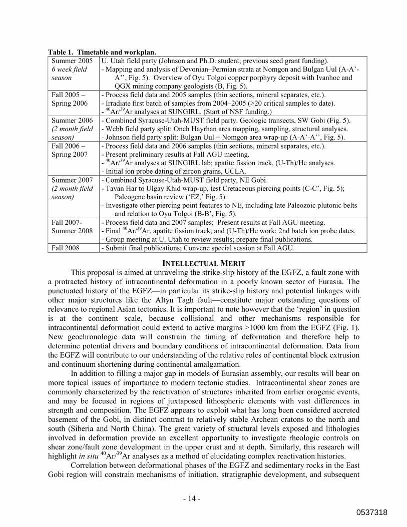
PROJECT LOGISTICS AND TIMETABLE Our scientific goals, proposed work and time line, and budgets are based on significant previous experience in the study area (four field seasons in Mongolia for Johnson and three for Webb). We propose to do this work over the course of three years and two field seasons (Table 1). Dr. Minjin, our colleague at Mongolian University of Science and Technology (MUST), has agreed to support this study through logistical arrangements in Mongolia (see letters of support, also G. Badarch of the Institute of Geology and Mineral Resources). As part of our scientific collaboration with MUST and IGMR, we will have assistance in locating local maps, translating Mongolian and Russian articles, and connecting with other scientists who may be able to contribute to the study, particularly in the area of biostratigraphy. Field work will be conducted by all collaborators (see Table 1). PI Webb will oversee analysis of structural data, thermochronologic analyses, and, in collaboration with Prof. Paul Fitzgerald, supervise one Ph.D. student and REU students from Syracuse University. PI Johnson will supervise one Ph.D. student and multiple undergraduates from the University of Utah in comparison of proposed piercing points, including all basin analysis techniques, as well as XRD modeling of clay populations in fault gouge.
Our timeline (Table 1) is calibrated by prior experience working in this region, and we have an excellent feel for the amount of time necessary for transit to and between field areas, as well as the amount of work that can be accomplished on a daily basis while in the field (e.g., see Fig. 2). We are also well aware of the timeframe necessary to complete the proposed sample processing and analytical work. Note that several of the proposed geochronological and thermochronological analyses will be conducted on samples strategically collected for such work during field seasons completed prior to the start date of this proposal. Our combined experience working in the region and complementary areas of expertise in structural geology, geochronology, and basin analysis, assure a successful collaboration and a positive experience for the graduate and undergraduate students who will participate in the proposed research.
0537318
- 14 -
Table 1. Timetable and workplan. Summer 2005 6 week field season
U. Utah field party (Johnson and Ph.D. student; previous seed grant funding). - Mapping and analysis of Devonian–Permian strata at Nomgon and Bulgan Uul (A-A’-
A’’, Fig. 5). Overview of Oyu Tolgoi copper porphyry deposit with Ivanhoe and QGX mining company geologists (B, Fig. 5).
Fall 2005 – Spring 2006
- Process field data and 2005 samples (thin sections, mineral separates, etc.). - Irradiate first batch of samples from 2004–2005 (>20 critical samples to date). - 40Ar/39Ar analyses at SUNGIRL. (Start of NSF funding.)
Summer 2006 (2 month field season)
- Combined Syracuse-Utah-MUST field party. Geologic transects, SW Gobi (Fig. 5). - Webb field party split: Onch Hayrhan area mapping, sampling, structural analyses. - Johnson field party split: Bulgan Uul + Nomgon area wrap-up (A-A’-A’’, Fig. 5).
Fall 2006 – Spring 2007
- Process field data and 2006 samples (thin sections, mineral separates, etc.). - Present preliminary results at Fall AGU meeting. - 40Ar/39Ar analyses at SUNGIRL lab; apatite fission track, (U-Th)/He analyses. - Initial ion probe dating of zircon grains, UCLA.
Summer 2007 (2 month field season)
- Combined Syracuse-Utah-MUST field party, NE Gobi. - Tavan Har to Ulgay Khid wrap-up, test Cretaceous piercing points (C-C’, Fig. 5);
Paleogene basin review (‘EZ,’ Fig. 5). - Investigate other piercing point features to NE, including late Paleozoic plutonic belts
and relation to Oyu Tolgoi (B-B’, Fig. 5). Fall 2007-Summer 2008
- Process field data and 2007 samples; Present results at Fall AGU meeting. - Final 40Ar/39Ar, apatite fission track, and (U-Th)/He work; 2nd batch ion probe dates. - Group meeting at U. Utah to review results; prepare final publications.
Fall 2008 - Submit final publications; Convene special session at Fall AGU.
INTELLECTUAL MERIT This proposal is aimed at unraveling the strike-slip history of the EGFZ, a fault zone with a protracted history of intracontinental deformation in a poorly known sector of Eurasia. The punctuated history of the EGFZ—in particular its strike-slip history and potential linkages with other major structures like the Altyn Tagh fault—constitute major outstanding questions of relevance to regional Asian tectonics. It is important to note however that the ‘region’ in question is at the continent scale, because collisional and other mechanisms responsible for intracontinental deformation could extend to active margins >1000 km from the EGFZ (Fig. 1). New geochronologic data will constrain the timing of deformation and therefore help to determine potential drivers and boundary conditions of intracontinental deformation. Data from the EGFZ will contribute to our understanding of the relative roles of continental block extrusion and continuum shortening during continental amalgamation. In addition to filling a major gap in models of Eurasian assembly, our results will bear on more topical issues of importance to modern tectonic studies. Intracontinental shear zones are commonly characterized by the reactivation of structures inherited from earlier orogenic events, and may be focused in regions of juxtaposed lithospheric elements with vast differences in strength and composition. The EGFZ appears to exploit what has long been considered accreted basement of the Gobi, in distinct contrast to relatively stable Archean cratons to the north and south (Siberia and North China). The great variety of structural levels exposed and lithologies involved in deformation provide an excellent opportunity to investigate rheologic controls on shear zone/fault zone development in the upper crust and at depth. Similarly, this research will highlight in situ 40Ar/39Ar analyses as a method of elucidating complex reactivation histories. Correlation between deformational phases of the EGFZ and sedimentary rocks in the East Gobi region will constrain mechanisms of initiation, stratigraphic development, and subsequent
0537318

- 15 -
dismembering of ‘poly-history’ sedimentary basins in wrench-tectonic settings. The structural and temporal modes controlling multi-phase reactivation of deformation zones are complex, and few studies exist that integrate geochronology, structural data, and sedimentary basin analysis to understand the evolution of long-lived intracontinental deformation zones.
BROADER IMPACTS The multidisciplinary nature of the proposed collaboration will highlight the power of integration of diverse geologic datasets to address a complex set of questions. Results of this study are not only expected to contribute to the greater understanding of an understudied and mineral resource-rich region of our planet, but to advance knowledge of large scale tectonic processes in intraplate settings. The research will employ a newly NSF-funded excimer laser system in the Syracuse University Noble Gas Isotopic Research Laboratory via in situ 40Ar/39Ar analyses of K-bearing minerals in multiply deformed rocks. The international nature of this work will foster collaboration between Mongolian and American geologists, including two early-career female PI’s. In addition to two Ph.D. students, undergraduate students from Utah and Syracuse will participate in all aspects of the study. The proposed analytical work will enhance graduate and undergraduate student education and training through the use of cutting-edge technology and hands-on field experiences. Graduate and undergraduate researchers and Mongolian colleagues will have the opportunity to present their work at international meetings and co-author manuscripts. We seek to include Mongolian students in this research, potentially opening doors of international opportunity for them. A special theme session at the American Geophysical Union Fall Meeting in San Francisco will be organized during the final year of the grant, and this will help guide final publications related to this work and direct future studies. The session will be designed to facilitate comparisons between the EGFZ and other intracontinental fault zones within Asia, as well as wrench tectonic settings around the world.
RESULTS FROM PRIOR NSF SUPPORT NSF-EAR 0345822, $77,340, 7/04–6/06*, “Acquisition of an Excimer Laser System
for Syracuse University Noble Gas Isotope Research Laboratory (SUNGIRL)” S.L. Baldwin, L.E. Webb, Co-PI’s. *A one year, no cost extension was requested.
In conjunction with $33,146 in cost-sharing by Syracuse University, this grant funds the purchase an excimer laser, permitting the measurement of argon isotopes within a textural context. A complete sample cell was designed in house and has been fabricated. Following on site tests, a laser system was selected. Commissioning will follow delivery of the American Beam, turn-key, ArF excimer laser ablation system in June 2005.
NSF-INT 0414133, $13,132, 7/04–9/05,“U.S.-Azerbaijan Cooperative Research:
Geochemistry and sequence stratigraphy of the Maikop series, Azerbaijan—Climatic and tectonic signals in the sedimentary record” C.L. Johnson, PI. This seed grant supported two planning visits to Azerbaijan (Johnson and her Ph.D. student), and one reciprocal visit to Utah by an Azeri scientist. Initial geochemical and biostratigraphic studies have been completed and will be submitted for presentation at the GSA annual meeting in 2005. We have subsequently received funding through the U.S. Civilian’s Research and Defense Foundation (CRDF) to further advance this work, which is unrelated to the current Mongolia proposal (~1 month/yr PI commitment).
0537318

- 1 -
REFERENCES CITED Amory, J., 1996, Permian Sedimentation and Tectonics of Southern Mongolia: [MS
thesis], Stanford University. Angelier, J., 1984, Tectonic analysis of fault slip data sets: Journal of Geophysical
Research, v. 89, p. 5835-5848. Ankhtsetseg, A.M., and 13 others, 2003, One Century of Seismicity in Mongolia (1900-
2000): Res. Cent. Astron. & Geophys., Mongolian Acad. Sci., Ulaan Bataar, Mongolia.
Badarch, G., Cunningham, W.D., and Windley, B.F., 2002, A new terrane subdivision for Mongolia; implications for the Phanerozoic crustal growth of Central Asia: Journal of Asian Earth Sciences, v. 21, p. 87-110.
Bayasgalan, A., Jackson, J., Ritz, J.-F., and Carretier, S., 1999, "Forebergs", flower structures, and the development of large intracontinental strike-slip faults; the Gurvan Bogd fault system in Mongolia: Journal of Structural Geology, v. 21, p. 1285-1302.
Bennett, R.A., Friedrich, A.M., and Furlong, K.P., 2004, Codependent histories of the San Andreas and San Jacinto fault zones from inversion of fault displacement rates: Geology, v. 32, n. 11, p. 961–964.
E. Calais, and Amarjargal, S., 2000, New constraints on current deformation in Asia from continuous GPS measurements at Ulan Bataar, Mongolia: Geophys. Res. Lett., v. 27, p. 1527-1531.
E. Calais, Vergnolle, M., Sankov, V., Lukhnev, A., Miroshnitchenko, A., Amarjargal, S., and Deverchère, J., 2003, GPS measurements of crustal deformation in the Baikal-Mongolia area (1994-2002): Implications for current kinematics of Asia: J. of Geophys. Res., v. 108, B10, 2501, doi:10.1029/2002JB002373.
Crowell, J.C., 1982, The tectonics of Ridge Basin, southern California: in Crowell, J.C., and Link, M.H., eds., Geologic history of Ridge Basin, southern California: Los Angeles, Pacific Section - SEPM.
Cunningham, D., Dijkstra, A.H., Howard, J., Quarles, A., and Badarch, G., 2003, Active intraplate strike-slip faulting and transpression uplift in the Mongolian Altai: Geological Society Special Publications, v. 210, p. 65-87.
Cunningham, W.D., Windley, B.F., Owen, L.A., Barry, T., Dorjnamjaa, D., and Badamgarav, J., 1997, Geometry and style of partitioned deformation within a late Cenozoic transpressional zone in the eastern Gobi Altai Mountains, Mongolia: Tectonophysics, v. 277, p. 285-306.
Darby, B.J., and Ritts, B.D., 2002, Mesozoic contractional deformation in the middle of the Asian tectonic collage; the intraplate western Ordos fold-thrust belt, China: Earth and Planetary Science Letters, v. 205, p. 13-24.
Darby, B.J., Ritts, B.D., and Yue, Y., 2005, Does the Altyn Tagh fault extend beyond the Tibetan plateau?: Geologie Alpine (HKT20 Extended Abstracts Volume), n. 44, p. 42-43.
Foland, K.A., Hubacher, F.A., and Arehart, G.B., 1992, (super 40) Ar/ (super 39) Ar dating of very fine-grained samples; an encapsulated-vial procedure to overcome the problem of (super 39) Ar recoil loss: Chemical Geology, v. 102, p. 269-276.
0537318

- 2 -
Gao, S., Rudnick, R.L., Carlson, R.W., McDounough, W.F., and Liu, Y.S., 2002, Re-Os evidence for replacement of ancient mantle lithosphere beneath the North China craton: Earth and Planetary Science Letters, v. 198, p. 307-322.
Graham, S.A., Hendrix, M.S., Johnson, C.L., Badamgarav, D., Badarch, G., Amory, J., Porter, M., Barsbold, R., Webb, L.E., and Hacker, B.R., 2001, Sedimentary record and tectonic implications of late Mesozoic rifting, southeast Mongolia: Geological Society of America Bulletin, v. 113, p. 1560-1579.
Hendrix, M., Beck, M., Badarch, G., and Graham, S., 2001, Triassic synorogenic sedimentation in southern Mongolia: early effects of intracontinental deformation, in Hendrix, M., and Davis, G., eds., Paleozoic and Mesozoic tectonic evolution of central Asia: From continental assembly to intracontinental deformation: Geological Society of America Memoir 194, p. 199-214.
Hendrix, M.S., and Davis, G.A., 2001, (Preface) Paleozoic and Mesozoic tectonic evolution of central Asia: From continental assembly to intracontinental deformation: Geological Society of America Memoir, v. 194, p. v-vi.
Houseman, G., and England, P., 1996, A lithospheric-thickening model for the Indo–Asian collision, in: A. Yin, and Harrison, M., (Ed), The Tectonic Evolution of Asia, Cambridge University Press, Cambridge, p. 3-17.
Johnson, C.L., and Webb, L.E., 2005, Cenozoic Reactivation of the East Gobi Fault Zone, 20th Symposium, Himalaya-Karakorum-Tibet Workshop (HKT20), Aussois, France, Geologie Alpine, H.S. Memoir, n. 44, p. 94-95.
Johnson, C.L., Webb, L.E., Minjin, C., Sersmaa, G., Affolter, M., Manchuk, N., 2004, Sedimentary Basin Evolution in the Context of Polyphase Intracontinental Deformation: New Insights From Southeastern Mongolia: AGU Annual Meeting, Abstracts Volume, p. T31E-08.
Johnson, C.L., 2004, Polyphase evolution of the East Gobi basin: sedimentary and structural records of Mesozoic-Cenozoic intraplate deformation in Mongolia: Basin Research, v. 16, p. 79-99.
Johnson, C.L., Greene, T.J., Zinniker, D.A., Moldowan, J.M., Hendrix, M.S., and Carroll, A.R., 2003, Geochemical characteristics and correlation of oil and nonmarine source rocks from Mongolia: AAPG Bulletin, v. 87, n. 5, p. 817-846.
Johnson, C.L., Webb, L.E., Graham, S.A., Hendrix, M.A., and Badarch, G., 2001, Sedimentary and structural records of late Mesozoic high-strain extension and strain partitioning, East Gobi basin, southern Mongolia, in Hendrix, M., and Davis, G.A., eds., Paleozoic and Mesozoic tectonic evolution of central Asia: From continental assembly to intracontinental deformation: Geological Society of America Memoir 194, p. 413-434.
Jolivet, L., Tamaki, K., and Fournier, M., 1994, Japan Sea, opening history and mechanism—A synthesis: J. Geophys. Res., v. 99, p. 22,237–222,259.
Lamb, M.A., and Badarch, G., 1997, Paleozoic sedimentary basins and volcanic-arc systems of southern Mongolia; new stratigraphic and sedimentologic constraints: International Geology Review, v. 39, p. 542-576.
Lamb, M.A., Hanson, A.D., Graham, S.A., Badarch, G., and Webb, L.E., 1999, Left-lateral sense offset of upper Proterozoic to Paleozoic features across the Gobi Onon, Tost, and Zuunbayan faults in southern Mongolia and implications for
0537318

- 3 -
other Central Asian faults: Earth and Planetary Science Letters, v. 173, p. 183-194.
Miall, A.D., 2000, Principles of Sedimentary Basin Analysis: Springer-Verlag, New York, 616 p.
Meng, Q.-R., Hu, J.-M., Jin, J.-Q., Zhang, Y., and Xu, D.-F., 2003, Tectonics of the late Mesozoic wide extensional basin system in the China-Mongolia border region: Basin Research, v. 15, p. 397-415.
Nilsen, T.H., and McLaughlin, R.J., 1985, Comparison of tectonic framework and depositional patterns of the Hornelen strike-slip basin of Norway and the Ridge and Little Sulphur Creek strike-slip basins of California: Special Publication - Society of Economic Paleontologists and Mineralogists, v. 37, p. 79-103.
Nilsen, T.H., and Sylvester, A.G., 1995, Strike-Slip Basins, in Busby, C.J., and Ingersoll, R.V., eds., Tectonics of Sedimentary Basins: Oxford, Blackwell Scientific Publishing, p. 579.
Perello, J., Cox, D., Garamjav, D., Sanjdorg, S., Diakov, S., Schissel, D., Munkhbat, T.-O., and Oyun, G., 2001, Oyu Tolgoi, Mongolia: Siluro-Devonian porphyry Cu-Au-(Mo) and high-sulfide Cu mineralization with a Cretaceous chalcocite blanket, Economic Geology, v. 96, p. 1407-1428.
Prost, G., 2004, Tectonics and hydrocarbon systems of the East Gobi basin, Mongolia: American Association of Petroleum Geologists Bulletin, v. 88, p. 485-513.
Ratschbacher, L., Hacker, B.R., Calvert, A., Webb, L.E., Grimmer, J.C., McWilliams, M., Ireland, T.R., Dong, S., and Hu, J., 2003, Tectonics of the Qinling (central China): Tectonostratigraphy, geochronology, and deformation kinematics: Tectonophysics, v. 336, p. 1-53.
Ren, J., Tamaki, K., Li, S., and Zhang, J., 2002, Late Mesozoic and Cenozoic rifting and its dynamic setting in eastern China and adjacent areas: Tectonophysics, v. 344, p. 175-205.
Ritts, B.D., and Biffi, U., 2000, Magnitude of post-Middle Jurassic (Bajocian) displacement on the central Altyn Tagh fault system, Northwest China: Geological Society of America Bulletin, v. 112, p. 61-74.
Roberts, M.B., and Tsetsegmaa, Khuut, 2004, Suspected Carboniferous rocks of Tavan Har, Gobi desert, Mongolia, 17th Annual Keck Research Symposium in Geology Proceedings, p. 205-208.
Ruzhentsev, S.V., Pospelov, I.I., and Badarch, G., 1989, Tectonics of the Mongolian Indosinides: Geotectonics, v. 23, p. 476-487.
Sengor, A.M.C., Natal'in, B.A., and Burtman, V.S., 1993, Evolution of the Altaid tectonic collage and Palaeozoic crustal growth in Eurasia: Nature (London), v. 364.
Shen, Z.-K., Zhao, C., Yin, A., Li, Y., Jackson, D., Fang, P., and Dong, D., 2000, Contemporary crustal deformation in east Asia constrained by global positioning system measurements: J. of Geophys. Res., v. 105, p. 5721-5734.
Tapponnier, R., Peltzer, G., Le Dain, A.Y., Armijo, R., and Cobbold, P., 1982, Propagating extrusion tectonics in Asia; new insights from simple experiments with plasticine: Geology, v. 10, p. 611-616.
0537318

- 4 -
Traynor, J.J., and Sladen, C., 1995, Tectonic and stratigraphic evolution of the Mongolian People's Republic and its influence on hydrocarbon geology and potential: Marine and Petroleum Geology, v. 12, p. 35-52.
Tomurtogoo, O., 1999, Geological Map of Mongolia, 1:1,000,000 scale: Ankara, Turkey, General Directorate of Mineral Research and Exploration, p. 1 sheet.
Twiss, R.J., and Unruh, J. R., 1998, Analysis of fault slip inversions: Do they constrain stress or strain rate?: J. Geophys. Res., v. 103, p. 12,205-12,222.
van der Pluijm, B.A., Hall, C.M., Vrolijk, P.J., Pevear, D.R., and Covey, M.C., 2001, The dating of shallow faults in the Earth's crust: Nature, v. 412, p. 172-175.
Vincent, S.J., and Allen, M.B., 1999, Evolution of the Minle and Chaoshui basins, China; implications for Mesozoic strike-slip basin formation in Central Asia: Geological Society of America Bulletin, v. 111, p. 725-742.
Wang, T., Zheng, Y., Gehrels, G., Mu, Z., 2001, Geochronological evidence for existence of the South Gobi microcontinent—A zircon U-Pb age of granitoid gneisses from the Yagan-Onch Hayrhan metamorphic core complex: Chinese Science Bulletin, v. 46, n. 23, p. 2005-2008.
Watson, M.P., Hayward, A.B., Parkinson, D.N., and Zhang, Z.M., 1987, Plate tectonic history, basin development and petroleum source rock deposition onshore China: Marine and Petroleum Geology, v. 4, p. 205-225.
Webb, L.E., and Johnson, C.L., in review, Tertiary strike-slip faulting in southeastern Mongolia and implications for Asian tectonics: submitted to Earth and Planetary Science Letters, March, 2005.
Webb, L.E., Johnson, C.L., Minjin, C., Sersmaa, G., Affolter, M.D., Manchuk, N., 2004, Mesozoic and Cenozoic intracontinental deformation in southeastern Mongolia: AGU Annual Meeting, Abstracts Volume, p. T31E-07.
Webb, L.E., Graham, S.A., Johnson, C.L., Badarch, G., and Hendrix, M.S., 1999, Occurrence, age, and implications of the Yagan-Onch Hayrhan metamorphic core complex, southern Mongolia: Geology, v. 27, p. 143-146.
Worrall, D.M., Kruglyak, V., Kunst, F., and Kuznetsov, V., 1996, Tertiary tectonics of the Sea of Okhotsk, Russia: Far-field effects of the India-Eurasia collision: Tectonics, v. 15, p. 813–826.
Yin, A., Rumelhart, P.E., Butler, R., Cowgill, E., Harrison, T.M. , Foster, D.A., Ingersoll, R.V., Qing, Z., Qiang, Z., Feng, W., Hanson, A., and Raza, A., 2002, Tectonic history of the Altyn Tagh fault system in northern Tibet inferred from Cenozoic sedimentation, Geological Society of America Bulletin, v. 114, n. 10, p. 1257–1295.
Yin, A., and Nie, S., 1996, A Phanerozoic palinspastic reconstruction of China and its neighboring regions, in Yin, A., and Harrison, M., eds., The Tectonic Evolution of Asia: Cambridge, Cambridge University Press, p. 442-485.
Yue, Y., and Liou, J.G., 1999, Two-stage evolution model for the Altyn Tagh Fault, China: Geology, v. 27, p. 227-230.
Yue, Y., Liou, J.G., and Graham, S.A., 2001a, Tectonic correlation of Beishan and Inner Mongolia orogens and its implications for the palinspastic reconstruction of North China: Memoir - Geological Society of America, v. 194, p. 101-116.
Yue, Y., Ritts, B.D., and Graham, S.A., 2001b, Initiation and long-term slip history of the Altyn Tagh Fault: International Geology Review, v. 43, p. 1087-1093.
0537318

- 5 -
Zheng, Y., Wang, S., and Wang, Y., 1991, An enormous thrust nappe and extensional metamorphic core complex newly discovered in Sino-Mongolian boundary area: Scientia Sinica, Series B: Chemistry, Life Sciences, & Earth Sciences, v. 34, p. 1145-1152.
Zheng, Y., Zhang, Q., Wang, Y., Liu, R., Wang, S.G., Zuo, G., Wang, S.Z., Lkaasuren, B., Badarch, G., and Badamgarav, Z., 1996, Great Jurassic thrust sheets in Beishan (North Mountains); Gobi areas of China and southern Mongolia: Journal of Structural Geology, v. 18, p. 1111-1126.
Zolnai, G., 1991, Continental wrench-tectonics and hydrocarbon habitat [revised]: American Association of Petroleum Geologists Continuing Education Course Note Series, v. 30, p. 1-304.
0537318