
JEFFERSON COUNTY SHORELINE MASTER PROGRAM UPDATE PROJECT · JEFFERSON COUNTY SHORELINE MASTER...
151
JEFFERSON COUNTY SHORELINE MASTER PROGRAM UPDATE PROJECT ECOLOGY GRANT #G0600343 Final Shoreline Restoration Plan October 2008 Prepared by: ESA Adolfson in association with Searun Consulting LaRoche+Associates Coastal Geologic Services Prepared for: Jefferson County Department of Community Development
Transcript of JEFFERSON COUNTY SHORELINE MASTER PROGRAM UPDATE PROJECT · JEFFERSON COUNTY SHORELINE MASTER...

JEFFERSON COUNTY SHORELINE MASTER PROGRAM UPDATE PROJECT ECOLOGY GRANT #G0600343 Final Shoreline Restoration Plan October 2008 Prepared by: ESA Adolfson in association with Searun Consulting LaRoche+Associates Coastal Geologic Services
Prepared for:
Jefferson County Department of Community Development


Jefferson County SMP Update Restoration Plan
Cover Photo: Chimacum Beach Restoration, by Al Latham.
October 2008 Page i


Jefferson County SMP Update Restoration Plan
ACRONYMS ALEA Aquatic Lands Enhancement Account
BMPs best management practices
Cfs cubic feet per second
CD Conservation District
DNR Wahington Department of Natural Resources
Ecology Washington State Department of Ecology
ESA Endangered Species Act
ESU Evolutionary Significant Unit
FWS U.S. Fish and Wildlife Service
GIS Geographic Information Systems
LWD large woody debris
MHHW Mean Higher High Water
MHT Mean High Tide
MRC Jefferson County Marine Resources Committee
NGO Non-governmenta1organization
NOCS North Olympic Salmon Commission
NRC Nodal Riparian Corridor
NRCA Natural Resource Conservation Area
NRCS Natural Resources Conservation Service
OHWM Ordinary High Water Mark
ONF Olympic National Forest
ONP Olympic National Park
PNPTC Point No Point Treaty Council
PSAT Puget Sound Action Team
October 2008 Page 1

Jefferson County SMP Update Restoration Plan
PSNERP Puget Sound Nearshore Ecosystem Restoration Project
PSP Puget Sound Partnership
PUD Public Utility District
RCW Revised Code of Washington
RM river mile
SASSI Salmon and Steelhead Inventory
SCSCI Summer Chum Salmon Conservation Initiative
SSHEAR Salmonid Screening, Habitat Enhancement and Restoration Section
SMA Washington State Shoreline Management Act (RCW 90.58)
SMP Shoreline Master Program
SWS Society of Wetland Scientists
SPAC Shoreline Policy Advisory Committee
STAC Shoreline Technical Advisory Committee
SICR Shoreline Inventory and Characterization Report
TMDL Total Maximum Daily Load
USEPA U.S. Environmental Protection Agency
USFS U.S. Forest Service
USFWS U.S. Fish and Wildlife Service
USGS U.S. Geological Survey
WAC Washington Administrative Code
WDFW Washington Department of Fish and Wildlife
WDOH Washington Department of Health
WRIA Water Resource Inventory Area
WSU Washington State University
Page 2 October 2008

Jefferson County SMP Update Restoration Plan
ACKNOWLEDGEMENTS
This document was prepared with guidance from a Shoreline Technical Advisory Committee (STAC) and Shoreline Policy Advisory Committee (SPAC). The County gratefully acknowledges the committee members for contributing to this effort.
STAC Members: SPAC Members:
Hans Daubenberger Hugh Shipman, Jeffree Stewart Jill Silver Jim Brennan John Cambalik Marty Ereth Michael Adams (alt. Anne Murphy) Peter Bahls (Jude Rubin) Peter Best Randi Thurston (alt. Jeff Davis) Richard Brocksmith (alt. Scott Brewer) Stephen Stanley (alt. Susan Grigsby) Steve Allison Steve Todd Yvonne Dettlaff
Al Bergstein (alt. Cyrilla Cook) Al Latham Aleta Erickson (alt. Randy Johnson) Bill Mahler (alt. Bill Brock) Bill Miller Connie Muggli David Roberts (alt. Hugo Flores) Dick Broders Eveleen Muehlethaler (alt. Frank Espy/Alice McConaughy) Hans Daubenberger (alt. Steve Todd) Jeffree Stewart Jerry Gorsline John Cambalik Johnathon Ciesla Judy Surber Karen Best (alt. Kevin Tuuri) Keith Dublanica Larry Crockett (alt Eric Toewes) Margie Shirato (alt. Randi Thurston/Jeff Davis) Marty Ereth Mike McHenry Peter Downey Ross Goodwin Sarah Krueger (alt. Reed Waite) Scott Brewer (alt Richard Brocksmith) Steve Allison (alt. Bob Howell/Tim Snowden)
The County also gratefully acknowledges the following staff from Ecology and the Battelle Marine Science Laboratory for their contributions to this effort:
• Battelle’s Marine Sciences Laboratory - Heida Diefenderfer and her colleagues for providing detailed information on the ecology of the nearshore environment as part of their effort to rank and prioritize nearshore restoration opportunities.
• Ecology - Stephen Stanley, Susan Grigsby for contributing information, maps, and data and providing technical guidance in assessing and characterizing watershed conditions in eastern Jefferson County.
October 2008 Page 3

Jefferson County SMP Update Restoration Plan
TABLE OF CONTENTS
1.0 INTRODUCTION ..........................................................................................................................1-1 1.1 Plan Purpose and Scope .............................................................................................................1-1 1.1.1 Format and Content – How to Use this Plan...................................................................................... 1-2 1.2 Defining Restoration ..................................................................................................................1-3 1.2.1 Difference between Restoration and Protection................................................................................. 1-3 1.2.2 No Net Loss and Restoration ............................................................................................................. 1-5 1.3 Need for Additional Study and Feasibility Assessment .............................................................1-6 1.3.1 Role of the Marine Resources Committee (MRC)............................................................................. 1-6 1.3.2 Data Gaps .......................................................................................................................................... 1-6 2.0 RESTORATION VISION AND GOALS .....................................................................................2-1 2.1 Restoration Vision......................................................................................................................2-2 2.2 Restoration Goals .......................................................................................................................2-2 3.0 WATERSHED OVERVIEW.........................................................................................................3-1 3.1 Watershed Descriptions..............................................................................................................3-1 3.1.1 WRIA 16 (Skokomish-Dosewallips) ................................................................................................. 3-8 3.1.2 WRIA 17 (Quilcene-Snow) ............................................................................................................. 3-10 3.1.3 WRIA 18 (Elwha-Dungeness) ......................................................................................................... 3-12 3.1.4 WRIA 20 (Sol Duc-Hoh)................................................................................................................. 3-12 3.1.5 WRIA 21 (Queets-Quinault)............................................................................................................ 3-13 4.0 OVERVIEW OF RESTORATION PRIOIRITIES.....................................................................4-1 4.1 Freshwater Restoration Potential................................................................................................4-1 4.2 Nearshore Restoration Potential .................................................................................................4-6 5.0 RECOMMENDED RESTORATION ACTIONS........................................................................5-1 5.1 Programmatic Actions................................................................................................................5-1 5.2 Restoration Recomendations - WRIA 16...................................................................................5-2 5.3 Restoration Recomendations - WRIA 17.................................................................................5-13 5.4 Restoration Recomendations - WRIA 18.................................................................................5-50 5.5 Restoration Recomendations - WRIA 20 and WRIA 21..........................................................5-50 6.0 EXISTING RESTORTION PROGRAMS AND PARTNERS...................................................6-1 7.0 IMPLEMENTATION AND MONITORING ..............................................................................7-1 7.1 Implementation Process .............................................................................................................7-1 7.2 Timelines and Benchmarks ........................................................................................................7-1 7.3 Potential Funding .......................................................................................................................7-3 7.4 Obstacles and Challenges.........................................................................................................7-11 7.5 Monitoring and Adaptive Management Strategies...................................................................7-12 8.0 REFERENCES................................................................................................................................8-1 LIST OF APPENDICES
Appendix A – Watershed Characterization for Eastern Jefferson County Appendix B – Appendix B Battelle Marine Science Laboratory Multi-Scale Restoration Prioritization for Local and Regional Shoreline Master Programs: A Case Study from Jefferson County, Washington Appendix C – Summary of Existing Restoration Programs
October 2008 Page i

Jefferson County SMP Update Restoration Plan
LIST OF FIGURES
Figure 3-1. Jefferson County, Washington, and WRIA Boundaries .......................................... 3-1
Figure 3-2. WRIA 16 in Southeast Jefferson County ................................................................. 3-9
Figure 3-3. WRIA 17 (north) in Northeast Jefferson County................................................... 3-10
Figure 3-4. WRIA 17 (south) in Northeast Jefferson County................................................... 3-11
Figure 3-5. WRIA 20 in Northwest Jefferson County.............................................................. 3-13
Figure 3-6. WRIA 21 in Southwest Jefferson County.............................................................. 3-14
Figure 4-1. Determining restoration, protection and development categories for hydrologic processes............................................................................................................................... 4-2
Figure 4-2. Freshwater Priority Areas for Restoration & Protection (Ecology 2007)................ 4-5
Figure 4-3. Nearshore Drift Cell Stressor and Function Scores ................................................. 4-7
Figure 4-4 Drift Cell and Shorezone Reach Polygons used in Battelle Study, Northeastern Jefferson County................................................................................................................... 4-8
Figure 4-5 Drift Cell and Shorezone Reach Polygons used in Battelle Study, Southeastern Jefferson County................................................................................................................... 4-9
Figure 4-6 Battelle Drift Cell Stressor and Function Scores at the Reach (Top) and Watershed (Bottom) Scales .................................................................................................................. 4-15
LIST OF TABLES
Table 1-1. Examples of Typical Protection and Restoration Actions......................................... 1-4
Table 1-2. Typical Restoration Phases and Actions ................................................................... 1-5
Table 2-1. Jefferson County Restoration Goals, Objectives, Actions, and Success Measures... 2-3
Table 3-1. SMP Waterbodies and Reaches by WRIA ................................................................ 3-2
Table 4-1. Nearshore Restoration Priorities Based on Battelle Study ........................................ 4-6
Table 4-2. Nearshore Reaches (Drift Cells) with High Function and Low Stress Ratings Based on Battelle Study ................................................................................................................ 4-10
Table 5-1. Recommended Freshwater Restoration Actions - WRIA 16 .................................... 5-3
Table 5-2. Recommended Nearshore Restoration Actions - WRIA 16...................................... 5-7
Page ii October 2008

Jefferson County SMP Update Restoration Plan
Table 5-3. Recommended Freshwater Restoration Actions - WRIA 17 .................................. 5-14
Table 5-4. Recommended Nearshore Restoration Actions - WRIA 17................................... 5-29
Table 6-1. Potential Restoration Partner Organizations and their Role in Future Restoration... 6-3
October 2008 Page iii

Jefferson County SMP Update Restoration Plan
1.0 INTRODUCTION This plan was prepared as part of Jefferson County’s Shoreline Master Program (SMP) Comprehensive Update project1. The County is currently in the process of updating the SMP (known as Chapter 18.25 of the Jefferson County Code [JCC]) to comply with the Washington State Shoreline Management Act -2 (SMA or the Act) requirements, enacted in 1972 and the state’s shoreline guidelines3, (the guidelines) which were adopted in 2003.
The County’s SMP contains policies and regulations that govern the use and development of the County’s freshwater rivers, lakes and marine shorelines4. The SMP is designed to protect shoreline ecological functions, provide for public access to public shorelines, and accommodate reasonable and appropriate uses of the shoreline. The SMP also must include a “real and meaningful” strategy to restore shoreline ecological functions where such functions are impaired. This restoration plan is a key element of the County’s shoreline restoration strategy. It supplements the County’s Shoreline Inventory and Characterization Report (SICR; ESA Adolfson et al., 2008), which documents general shoreline conditions throughout the County.
1.1 PLAN PURPOSE AND SCOPE This plan, in conjunction with the SMP policies and regulations, is designed to satisfy the shoreline guideline requirements for shoreline restoration planning. It provides a planning-level framework for understanding how and where shoreline ecological functions can be restored in Jefferson County. The plan also describes how future restoration activities can be integrated with existing and ongoing restoration efforts including: the region-wide effort to restore Puget Sound (which the Puget Sound Partnership is spearheading); the work of the Jefferson County Marine Resources Committee, the regional recovery efforts for threatened Hood Canal summer chum, Puget Sound Chinook, bull trout, and endangered southern resident killer whales (orca); and the diversity of other restoration efforts being implemented by agencies, tribes, the City of Port Townsend, non-governmental organizations (NGOs), and private citizens.
This plan differs from the previous Shoreline Restoration Plans prepared in October 2007 and June 2008 in several ways. This document consolidates and summarizes much of the information presented previously, and contains more details on timeline and benchmarks. It also highlights the main steps needed to implement the recommended actions and attempts to more clearly indicate the roles that restoration partners can play in helping to implement this plan. These
1 The project is funded in part through a grant from the Washington State Department of Ecology (Grant # G0600343). 2 Revised Code of Washington (RCW) 90.58 3 Washington Administrative Code (WAC) 173-26, Part III 4 In this document, the term ‘shoreline’ is synonymous with ‘shorelines of the state.’ These are defined in RCW 90.58 and generally include all streams with a mean annual flow of 20 cubic feet per second or more, all marine shores, and lakes greater than 20 acres as well as the adjacent ‘shorelands’ that accompany these waters. Shorelands means the lands extending 200 feet from the ordinary high water mark, floodways and contiguous floodplains 200 feet from the floodway, and all associated wetlands. For a list of all of the shorelines of the state in Jefferson County, refer to the Shoreline Inventory and Characterization Report (SICR; ESA Adolfson et al., 2008).
October 2008 Page 1-1

Jefferson County SMP Update Restoration Plan
changes were made in response to comments from technical reviewers and Washington Department of Ecology (Ecology) staff.
1.1.1 Format and Content – How to Use this Plan The format and content of this plan are designed to:
• Describe an overarching vision that guides future restoration efforts;
• Summarize the County’s shoreline restoration goals and objectives;
• Identify the freshwater and nearshore areas that are high priorities for restoration;
• Describe specific restoration opportunities and recommended actions for each watershed and waterbody;
• Identify potential partners and existing/ongoing restoration activities and describe opportunities to integrate this plan with those existing efforts; and
• Explain how future restoration efforts can be implemented in a way that maximizes effectiveness and achieves the greatest overall benefits.
To understand and effectively implement this plan, restoration planners and practitioners are encouraged to review the vision, goals, and objects in Chapter 2 to understand the desired restoration outcomes. Planners and practitioners should then consider the information in Chapter 3 identifying general areas of the County that have been identified as top priorities for restoration. Specific opportunities and actions in those areas and elsewhere in Jefferson County can be found in Chapter 5. Restoration projects can then be fully developed in cooperation with the partners and programs identified in Chapter 6 to maximize restoration benefits.
Most of the restoration opportunities noted in this plan affect private property. It is not the County’s intention to require restoration on private property or to commit privately owned land for restoration purposes without the willing cooperation and participation of the affected landowners. However, the County is eager to support and foster restoration actions on public and private lands and strongly encourages private landowners to help implement this plan. In addition, private landowners who are required to provide mitigation for development related impacts may wish to implement actions noted in this plan to meet their mitigation obligations.
With the understanding that alterations anywhere within a watershed can affect the entire ecosystem, this plan identifies areas where restoration could or should occur whether or not those areas are located within shoreline (SMA) jurisdiction. This plan emphasizes restoration opportunities in eastern Jefferson County, which is where the majority of the county-regulated shorelines occur5 and where most of the County’s citizens reside. Information on ecological conditions and alterations is generally more readily available and comprehensive for eastern Jefferson County compared to the western part of the County. That said, both areas are equally important in terms of the resources, habitats, and features that would benefit from restoration and
5 The marine coast along the western edge of Jefferson County is under federal or tribal jurisdiction and not subject to the state’s Shoreline Management Act. Much of the upper watershed draining to the western marine shore is also in Federal or Tribal ownership.
Page 1-2 October 2008

Jefferson County SMP Update Restoration Plan
there is no provision in the SMA to exempt sparsely populated areas from the SMP policies and regulations nor from the requirement to plan for the restoration of degraded habitats.
1.2 DEFINING RESTORATION Restoration can be defined generally as returning an area to a previous condition by improving ecological structure and function. Restoration creates a net increase in the amount, size, and/or functions of an ecosystem or components of an ecosystem compared to a baseline condition (Thom et al. 2005a). The shoreline guidelines define restoration more specifically as follows:
“The reestablishment or upgrading of impaired ecological shoreline processes or functions. This may be accomplished through measures including but not limited to re-vegetation, removal of intrusive shoreline structures and removal or treatment of toxic materials. Restoration does not imply a requirement for returning the shoreline area to aboriginal or pre-European settlement conditions.” 6 (Emphasis added)
The guidelines require that restoration goals, policies and actions “be designed to achieve overall improvements in shoreline ecological functions over time, when compared to the status upon adoption of the master program.”7 Inherent in these definitions is the concept of repairing past damage to natural resources and habitats, but not necessarily re-creating pristine or historic conditions.
Many researchers have cautioned that simply recreating the form or structure of a particular habitat without also addressing the ecosystem processes and their interaction with ecological functions may not fully achieve restoration goals or objectives (Stanley et al., 2005, Montgomery et al. 2003; Gersib 2001). As a result, this plan emphasizes the need to restore ecosystem processes so that restoration strategies are sustainable and successful in the long-term.
1.2.1 Difference between Restoration and Protection Restoration is different from protection. For shorelines, the latter is achieved primarily through the SMP policies and regulations (as well as other County, state, and federal regulations) that safeguard resources from damage caused by use and development. Protection requires that development be prohibited in some areas and that when allowed, development occur in a way that mitigates adverse effects on the natural environment such that the net result of the development activity is no worse than the pre-development condition. Protection also requires that deliberate measures be taken to ensure that natural ecosystem processes (such as net shore-drift, channel migration, large woody debris recruitment, for example) continue with minimal impairment8.
6 WAC 173-26-020 7 WAC 173-26-201(2)(f) 8 Readers are encouraged to read the County’s SMP for more information on the specific shoreline protection strategies and requirements.
October 2008 Page 1-3

Jefferson County SMP Update Restoration Plan
Restoration, on the other hand, involves more than simply following and enforcing existing rules or maintaining existing conditions. It requires taking active steps to improve the condition of existing resources and replace resources that have been lost. Restoration measures are intended to supplement shoreline protection efforts such that environmental conditions improve over time. Table 1-1 identifies and differentiates typical shoreline protection and restoration actions. The protection measures are addressed in the SMP (and/or required by other regulatory programs such as critical areas regulations and stormwater regulations). The restoration actions reflect a range of activities that are applicable to Jefferson County. This plan is built around this list or menu of common restoration actions as indicated in the subsequent chapters.
Table 1-1. Examples of Typical Protection and Restoration Actions Examples of Protection Actions Examples of Restoration Actions9
• Treating stormwater runoff using best management or low impact development practices
• Maintaining existing wetlands • Preventing development on feeder bluffs • Maintaining/repairing on-site septic systems • Observing buffer and setback requirements • Protecting/preserving existing trees/vegetation • Protecting water quality by limiting
pesticide/fertilizer use • Regulating groundwater withdrawals • Limiting construction of new docks, bulkheads,
and staircases • Clustering residential development • Preserving property through easement or
acquisition
• Removing dikes and setting levees back • Replacing bulkheads with soft shore
stabilization (bio-stabilization) • Replanting/enhancing riparian/nearshore
vegetation • Planting/transplanting eelgrass, kelps and
other aquatic macrophytes • Replacing or enlarging blocked or
undersized culverts • Removing fill from wetlands, intertidal
habitats and floodplains • Removing invasive species • Reconnecting intertidal wetlands • Replacing existing dock/pier decking with
open grating material to allow light penetration
• Replacing treated wood docks/piers with concrete, steel and other materials
• Retrofitting existing impervious surfaces to include stormwater treatment and flow control
• Removing derelict vessels, fishing gear, creosote pilings and other in-water apparatus
• Decommissioning underused forest roads • Adding large woody debris or engineered
log jams to streams • Replacing pavement with pervious pavement
(such as parks/ boat launches) • Relocating public infrastructure outside of
floodplains and other sensitive habitats
Restoration typically occurs in phases with each phase composed of one or more actions (Table 1-2). The progression from planning to reporting can take weeks, months, or even years depending on the complexity and scope of the restoration effort. In general, the phases and tasks build on and inform one another. Yet in some cases, the progression of phases and actions is not linear but iterative, meaning that it may be necessary to go back and revisit goals or priorities 9 In some circumstances, these actins may already be required by law.
Page 1-4 October 2008

Jefferson County SMP Update Restoration Plan
during the implementation phase or do more construction in response to performance monitoring information. This is an adaptive management approach. This plan addresses and accomplishes most of the actions required in the restoration planning phase. Additional effort will be required to implement, monitor, manage, and report on the outcomes of this planning effort.
Table 1-2. Typical Restoration Phases and Actions Phase Actions Timeline
Beginning → →→ Completion Planning Visioning
Collecting background data Setting goals Defining objectives Identifying priority areas Identifying potential restoration measures in priority areas Identifying partners and collaborators Identifying funding sources Integrating plans with other efforts
Implementation Selecting projects/sites Developing conceptual designs/ plans Preparing detailed design plans Constructing project/site
Performance Assessment / Monitoring
Defining success criteria Comparing to reference sites Designing monitoring program Collecting performance monitoring data
Adaptive Management Adjusting design Correcting problems (barriers to success) Implementing contingency measures
Reporting Publishing reports documenting project effectiveness
1.2.2 No Net Loss and Restoration The concept of no net loss of shoreline ecological functions is rooted in the Shoreline Management Act and in the goals, policies, and governing principles of the state’s shoreline guidelines. The Act states: “permitted uses in the shoreline shall be designed and conducted in a manner that minimizes insofar as practical, any resultant damage to the ecology and environment of the shoreline area.” The guidelines suggest that no net loss is achieved primarily through regulatory mechanisms including mitigation requirements but that restoration incentives and voluntary actions are also critical to achieving no net loss.
The SMP requires that proponents of shoreline development fully mitigate impacts caused by their proposed development and although they are not required to improve conditions over and above the impacts of their development action, they may elect to implement elements of this plan as mitigation for shoreline development if appropriate. Citizens, agencies, and other groups may
October 2008 Page 1-5

Jefferson County SMP Update Restoration Plan
also elect to implement portions of this plan irrespective of any proposed development activity or requirement to mitigate impacts. Components of this plan can also be implemented as part of future capitol or resource management endeavors. As an example, a park improvement project could be designed to include removal of intertidal fill and restoration of nearshore habitat. All of these actions would have the effect of improving conditions over time, which is necessary for achieving no net loss.
1.3 NEED FOR ADDITIONAL STUDY AND FEASIBILITY ASSESSMENT Preparing a detailed plan for restoring shoreline resources throughout Jefferson County is a difficult undertaking that cannot be easily summarized in one document. All of the restoration opportunities mentioned herein will require further investigation and analysis to fully assess feasibility and determine actual benefits and costs. In some cases, restoration actions are recommended that involve private properties. This plan makes no claims as to the ownership or availability of any parcel of land for restoration purposes and does not recommend takings of any private land. Considerable additional study, collaboration, and public discourse will be required to ensure consensus on the restoration priorities; acquire permission, easements or ownership of private property; and develop detailed implementation plans, budgets, schedules, and monitoring programs. Considerable additional effort will also be required to better identify and plan restoration projects in western Jefferson County.
1.3.1 Role of the Marine Resources Committee (MRC) The Jefferson County Marine Resources Committee (MRC) is charged with “achieving the protection and restoration of the marine resources of Jefferson County and to do so in furtherance of the benchmarks for performance as identified in the August 20, 1998, report to the conveners by the Murray-Metcalf Northwest Straits Citizens Advisory Commission.” The MRC’s Strategic Plan calls for adoption of this restoration plan, which will become the Action Plan for future MRC restoration efforts. As such, the MRC will have a primary role in overseeing the implementation of the restoration actions included herein. As an advisory group to the County’s Board of Commissioners, the MRC does not have funding to fully implement this plan nor do they have the regulatory responsibility for achieving the no net loss standard. That responsibility resides with County government. Nevertheless, the MRC will, at a minimum, convene an annual meeting of interested and responsible restoration partners to identify and discuss strategies for plan implementation based on funding availability and regional needs. To the degree feasible given their staff and funding resource, the MRC will also provide additional logistical support to the County and other entities seeking to complete identified restoration efforts. Additional information on implementation is provided in Section 7.
1.3.2 Data Gaps Due to data limitations (including data that were not available, not adaptable to a database, or of poor quality) many important ecological processes, features, and conditions could not be fully described in this plan. Specifically, surface water quantity and quality are critical components of the riparian ecosystem largely missing from existing watershed and riparian analyses. These components are typically measured as in-stream flow and surface water chemistry. Although
Page 1-6 October 2008
Jefferson County SMP Update Restoration Plan
surface water studies have been conducted in Jefferson County, available data were focused on specific conditions at a few locations. For example, in-stream flows are a primary controlling factor for salmon spawning, egg incubation, juvenile rearing, and migration; however, this restoration plan did not include a full analysis of in-stream flows or hydrograph data in relationship to in-stream habitat. Furthermore, it is not clear if this data is available for analysis. Water quality characterization is also limited almost exclusively to periodic seasonal measurement of fecal coliform concentrations at shellfish harvesting areas, but the tests are not designed to identify year-round concentrations, trends, or sources. These data gaps should be considered when evaluating the restoration priorities discussed in this report. Efforts to address these gaps through acquisition of new/additional pertinent data are encouraged.
Important habitat features or processes that were not fully assessed due to a lack of applicable quantitative data include:
• High/peak in-stream flow
• Low summer flow • Dissolved oxygen concentrations, nutrient and fecal coliform loading • Sediment grain size, distribution, and quantities • Channel complexity (i.e., length and area of side channels; numbers, size, and ratios of
in-stream features such as pools, riffles, logjams, etc.)
• Channel stability (e.g., shifts in substrate, scouring, sedimentation) • Acres of lost or filled side channels and floodplain
October 2008 Page 1-7


Jefferson County SMP Update Restoration Plan
2.0 RESTORATION VISION AND GOALS This plan seeks to establish a basic framework for improving the quality and sustainability of Jefferson County’s shoreline resources over time in a collaborative and cohesive manner. This overarching goal is consistent with the Shoreline Management Act and with the newly developing regional strategy for restoring Puget Sound, which is embodied in Engrossed Substitute Senate Bill (ESSB) 5372 signed by the State Legislature in May 2007. In ESSB 5372, the Legislature declared that:
“Puget Sound, including Hood Canal and the waters that flow to it are a national treasure and a unique resource. Residents enjoy a way of life centered around these waters that depends upon clean and healthy marine and freshwater resources. Puget Sound is in serious decline, and Hood Canal is in a serious crisis. This decline is indicated by loss of and damage to critical habit, rapid decline in species populations, increases in aquatic nuisance species, numerous toxics contaminated sites, urbanization and attendant storm water drainage, closure of beaches to shellfish harvest due to disease risks, low-dissolved oxygen levels causing death of marine life, and other phenomena. If left unchecked, these conditions will worsen. Puget Sound must be restored and protected in a more coherent and effective manner. The current system is highly fragmented. Immediate and concerted action is necessary by all levels of government working with the public, nongovernmental organizations, and the private sector to ensure a thriving natural system that exists in harmony with a vibrant economy.”
The Legislature directed the Puget Sound Partnership (the Partnership) to coordinate and lead the regional restoration effort. The Partnership is developing an ‘Action Agenda’ that will describe the steps needed to restore the Sound by 2020. In identifying specific restoration goals and objectives that the Action Agenda must achieve, the Legislature described the characteristics of a healthy and restored Puget Sound as follows:
• A healthy human population supported by a healthy Puget Sound that is not threatened by changes in the ecosystem;
• A quality of human life that is sustained by a functioning Puget Sound ecosystem;
• Healthy and sustaining populations of native species in Puget Sound, including a robust food web;
• A healthy Puget Sound where freshwater, estuary, nearshore, marine, and upland habitats are protected, restored, and sustained;
• An ecosystem that is supported by ground water levels as well as river and stream flow levels sufficient to sustain people, fish, and wildlife, and the natural functions of the environment; and
• Fresh and marine waters and sediments of a sufficient quality so that the waters in the region are safe for drinking, swimming shellfish harvest and consumption, and other human uses and enjoyment, and are not harmful to the native marine mammals, fish, birds, and shellfish of the region.
October 2008 Page 2-1

Jefferson County SMP Update Restoration Plan
This plan seeks to achieve those same goals by contributing to the Puget Sound restoration effort and to the specific strategies being developed by the Partnership as part of the 2020 Action Agenda. This plan is also intended to be compatible with the restoration goals already developed by other restoration planning entities in the region including, but not limited to: the Jefferson County Marine Resources Committee, the Hood Canal Coordinating Council, the City of Port Townsend, and area tribes.
2.1 RESTORATION VISION The restoration vision for Jefferson County is similar to the vision adopted by the City of Port Townsend as part of the Port Townsend SMP Update in 2007. The vision can be described as follows:
Ecological processes, functions, and habitats damaged by past or unregulated future development are improved over time through a combination of public and private actions. Where appropriate, restoration actions are included as part of future shoreline development in a way that enhances the environment and is compatible with planned shoreline uses. Restoration efforts, when combined with protection of existing resources, create a net improvement in the shoreline ecosystem to benefit native fish and wildlife and the people of Jefferson County.
2.2 RESTORATION GOALS Jefferson County has the following restoration goals:
• To improve shoreline processes, functions, and values over time through regulatory and voluntary and incentive-based public and private programs and actions that are consistent with the SMP and other agency/ locally adopted restoration plans.
• To increase the availability, viability and sustainability of shoreline habitats for salmon, shellfish, forage fish, shorebirds and marine seabirds, and other species;
• To improve habitat quality for sensitive and/or locally important species, and support the biological recovery goals for federally protected species;
• To encourage cooperative restoration actions involving local, state, and federal public agencies, tribes, NGOs, and private landowners.
• To integrate restoration efforts with capitol projects and other resource management efforts including, but not limited to, shellfish closure response plans and water cleanup plans.
Page 2-2 October 2008

Jefferson County SMP Update Restoration Plan
Table 2-1. Jefferson County Restoration Goals, Objectives, Actions, and Success Measures
Goal Objective Potential Restoration10 Actions
Potential Measures of Success
To improve ecosystem processes, functions and values over time.
Restore natural sediment transport and littoral drift.
Restore native riparian and nearshore vegetation.
Improve natural hydrologic pathways.
Remove/set back levees, dikes and other structures.
Replace bulkheads with soft shore stabilization.
Replant/enhance riparian/nearshore vegetation.
Remove fill from wetlands, floodplains and intertidal habitats.
Decommission forest roads.
Acres of riparian enhancement.
Linear feet of bulkhead removed.
Acres of reconnected floodplain.
Linear feet of road decommissioned.
Acres of wetland restored.
Acres of native vegetation planted.
To increase habitat quality and availability for salmon, shellfish, forage fish, and other sensitive and/or locally important species, and support biological recovery goals for federally listed species.
Reduce nearshore shading of kelp/eelgrass.
Restore stream channels, channel migration zones, side channels, and floodplains.
Enhance disturbed tidelands and riparian zones and support the essential ecological functions those areas provide.
Restore wetland and salt marsh habitats.
Improve water quality to provide safe water for drinking, swimming, and producing/consuming fish and shellfish.
Replace decking on overwater structures with open grating.
Replace or enlarge blocked or undersized culverts.
Replant/enhance riparian/nearshore vegetation.
Remove invasive species.
Add large woody debris to stream channels.
Remove abandoned or decrepit overwater and in-water structures and derelict vessels.
Replace treated wood docks/piers with concrete, steel and other materials.
Retrofit existing impervious surfaces to include stormwater treatment and flow control.
Number of culverts replaced or number of miles of stream open to migration.
Number of creosote structures/ pilings removed.
Acres of riparian/nearshore enhancement
Water quality measurements.
Area of retrofit.
Reduced shellfish closures.
10 These actions would supplement existing regulatory requirements and other protection actions related to stormwater management/low impact development, critical areas, septic system maintenance, etc. See Table 1-1.
October 2008 Page 2-3

Jefferson County SMP Update Restoration Plan
Potential Restoration10 Goal Objective Potential Measures of Actions Success
Table 2-1. Jefferson County Restoration Goals (continued)
Integrate restoration efforts with capitol projects and resource management efforts.
Evaluate restoration opportunities when planning for parks, transportation, and other capitol projects.
Replace paved parking areas with pervious pavement at parks/ boat launches.
Relocate public infrastructure outside of floodplains, migration zones and other sensitive areas.
Retrofit existing impervious surfaces to include stormwater treatment and flow control.
Number of restoration actions implemented in conjunction with other projects.
Encourage cooperative restoration actions involving local, state, and federal public agencies, tribes, NGOs, and landowners.
Engage in coordinated planning to identify and scope restoration projects.
Provide incentive to landowners to restore private properties.
Establish local improvement districts to facilitate and fund restoration
Provide bonus points to landowners who restore shorelines through an open space taxation program.
Sponsor an annual restoration planning workshop with other partners.
Work with restoration partners to establish a database and tracking program for restoration projects.
Fund or otherwise facilitate a restoration demonstration project such as a soft shore armoring project.
Create stewardship programs and/or work with existing stewardship programs to educate private landowners on appropriate restoration actions.
Number of collaborative projects implemented.
Number of projects tracked via database.
Number of landowners participating in stewardship workshops.
Number of partners participating in joint efforts.
Page 2-4 October 2008

Jefferson County SMP Update Restoration Plan
October 2008 Page 3-1
Parts of five Water Resource Inventory Areas (WRIAs) occur within Jefferson County: WRIA 16 (Skokomish-Dosewallips), WRIA 17 (Quilcene-Snow), WRIA 18 (Elwha-Dungeness), WRIA 20 (Sol Duc-Hoh), and WRIA 21 (Queets-Quinault) (Figure 3-1). A brief description of each of these WRIAs and their respective shorelines follows (Table 3-1).
3.1 WATERSHED DESCRIPTIONS
This section provides an overview of watersheds that comprise Jefferson County. This is background information that helps set the context for the discussion in the subsequent chapters of this plan.
3.0 WATERSHED OVERVIEW
Figure 3-1. Jefferson County, Washington, and WRIA Boundaries

Jefferson County SMP Update Restoration Plan
1 Table 3-1. SMP Waterbodies and Reaches by WRIA Reach11 Area Description12
WRIA 16 Freshwater
Fulton Creek 1 Fulton Creek From the stream mouth to the falls
Fulton Creek 2 Fulton Creek From the falls to the confluence of Fulton Creek and South Fork Fulton Creek
Duckabush River 1 Duckabush River From the mouth to the National Forest boundary
Duckabush River 2 Duckabush River From the National Forest boundary to the edge of the last private inholding
Dosewallips River 1 Dosewallips River From the mouth to the ONF boundary
Dosewallips River 2 Dosewallips River From the ONF boundary to the upstream extent of private inholdings
Dosewallips Tributary 1 Dosewallips River Rocky Brook from the confluence at Dosewallips to the impassable falls
WRIA 16 Nearshore
A Fulton Creek and Associated Nearshore County line north to the terminus of drift cell JE-30
B Fulton Creek and Associated Nearshore Drift cell JE-29/JE-30
C Fulton Creek and Associated Nearshore Drift cell JE-29, originates 0.5 mile northeast of the mouth of Fulton Creek
D Duckabush River and Black Point North shore of McDaniel Cove (terminus of drift cell JE-29) to start of drift cell JE-28
E Duckabush River and Black Point Duckabush delta to the edge of Quatsap Point (drift cell JE-28)
F Duckabush River and Black Point From the origin of drift cell JE-27 to the tip of Quatsap Point spit
G Duckabush River and Black Point Area of no net drift around Black Point
H Duckabush River and Black Point From north to south entrances of Pleasant Harbor
I Dosewallips River and Brinnon Shoreline Drift cells JE-26 and JE-25, northeastern edge of Pleasant Harbor to south edge of Dosewallips River delta
J Dosewallips River and Brinnon Shoreline Dosewallips River delta to the start of drift cell JE-24 in Right Smart Cove
WRIA 17 Freshwater
Big Quilcene River 1 Big Quilcene River From the upper edge of the estuary to the fish hatchery at the confluence with Penny Creek (RM 2.8)
Big Quilcene River 2 Big Quilcene River From the fish hatchery to the National Forest boundary
Lake Leland Little Quilcene River Approximately 4.5 miles north of the City of Quilcene, immediately west of Highway 101
Lords Lake Little Quilcene River 0.6 mile north of Little Quilcene River 2
11 Reaches are in geographic order (southeast to northeast beginning in the southeast corner of eastern Jefferson County). These reaches correspond to the reaches identified in the Jefferson County Shoreline Inventory and Characterization Report (ESA Adolfson, June 2008). 12 Drift cell identifiers (e.g., JE-25) are as defined by Johanessen (1992) and Keuler (1998).
Page 3-2 October 2008

Jefferson County SMP Update Restoration Plan
Description12Reach11 Area
Table 3-1. SMP Waterbodies and Reaches by WRIA (continued) Little Quilcene River 1 Little Quilcene River River mouth to approximately RM 3.0
Little Quilcene River 2 Little Quilcene River RM 3.0 to the ONF boundary
Tarboo Lake Tarboo Lake, Sandy Shore Lake, and Wahl Lake
5.5 miles to the north of Tarboo Bay’s northern boundary, adjacent to the headwaters of Tarboo Creek
Sandy Shore Lake Tarboo Lake, Sandy Shore Lake, and Wahl Lake
Approximately 1.5 miles to the west of the intersection of Highway 104 and State Route 19, at 47°53’26”N and 122°46’00”W
Wahl Lake Tarboo Lake, Sandy Shore Lake, and Wahl Lake
Approximately 2.2 miles to the west of northwest extent of Squamish Harbor, at 47°51’50”N and 122°44’22”W
Chimacum Creek 1 Chimacum Creek (Admiralty Inlet) From the end of tidal influence to just downstream of where east and west forks diverge
Chimacum Creek 2 Chimacum Creek (Admiralty Inlet) From downstream of where east and west forks diverge to approximately RM 3.3
Chimacum Creek 3 Chimacum Creek (Admiralty Inlet) From approximately RM 3.3 to near the crossing of State Route (SR) 19
Chimacum Creek 4 Chimacum Creek (Admiralty Inlet) From near SR 19 to near the crossing of Highway 104 and Center Road
Gibbs Lake Gibbs, Anderson, and Peterson Lakes and Mill Pond (Admiralty Inlet)
0.9 mile northwest of the intersection of Gibbs Lake Road and West Valley Road
Anderson Lake Gibbs, Anderson, and Peterson Lakes and Mill Pond (Admiralty Inlet)
Approximately 1.2 miles west of Chimacum Creek 2 and Chimacum Creek 3 reaches
Peterson Lake Gibbs, Anderson, and Peterson Lakes and Mill Pond (Admiralty Inlet)
Near the intersection of Highway 104 and Highway 101
Mill Settling Pond Gibbs, Anderson, and Peterson Lakes and Mill Pond (Admiralty Inlet)
Located directly east of the Port Townsend Paper Mill facility, near Glenn Cove
Snow Creek 1 Snow Creek and Salmon Creek River mouth to approximately RM 1.2
Snow Creek 2 Snow Creek and Salmon Creek RM 1.2 to approximately RM 3.3, below Crocker Lake
Salmon Creek 1 Snow Creek and Salmon Creek River mouth to approximately RM 0.75
Salmon Creek 2 Snow Creek and Salmon Creek RM 0.75 to approximately RM 1.5
Crocker Lake Crocker Lake 0.5 mile south of the upstream limit of Snow Creek 2
WRIA 17 Nearshore
K Jackson Shoreline From the head of Right Smart Cove to Wawa Point
L Jackson Shoreline Wawa Point to Point Whitney, including Point Whitney Lagoon, adjacent to Point Whitney State Shellfish Lab
M Quilcene Bay Point Whitney to Quilcene Boat Haven (now Herb Beck Marina), encompassing drift cells JE-19, JE-19/JE-20, and JE-20
N Quilcene Bay Quilcene marina to the southern edge of the Indian George estuary
O Quilcene Bay From Indian George estuary to the terminus of drift cell JE-18
P Quilcene Bay North edge of Fisherman’s Point Salt Marsh to the start of drift cell JE-17
October 2008 Page 3-3
Jefferson County SMP Update Restoration Plan
Description12Reach11 Area
Table 3-1. SMP Waterbodies and Reaches by WRIA (continued)
Q Dabob Bay From the center of the divergence zone between drift cells JE-17 and JE-18 to the terminus of drift cell JE-17 at Tarboo Bay barrier spits
R Dabob Bay Tarboo Bay north of the barrier spits and Long Spit
S Dabob Bay From the center of the JE-15/JE-16 divergence zone north along the west shore of Toandos Peninsula to the terminus of drift cell JE-16
T Southern Toandos Peninsula, Thorndyke Bay, and Squamish Harbor
From center of divergence between drift cell JE-15 and JE-16 to terminus of drift cell JE-15 at Hazel Point
U Southern Toandos Peninsula, Thorndyke Bay, and Squamish Harbor
Drift cell JE-14, Hazel Point to center of divergence zone JE-13/JE-14
V Southern Toandos Peninsula, Thorndyke Bay, and Squamish Harbor
Toandos Peninsula along Hood Canal, from the center of divergence zone JE-13/JE-14, including drift cells JE-13 and JE-12, to the terminus of drift cell JE-12 at Squamish Harbor
W Southern Toandos Peninsula, Thorndyke Bay, and Squamish Harbor
Drift cell JE-11, including areas inside the spit at the head of Squamish Harbor that are part of the extensive estuary of Shine Creek
X Hood Canal Bridge to Tala Point Drift cell JE-10, including Termination Point, the western shore of Bywater Bay, and Wolfe Property State Park
Y Hood Canal Bridge to Tala Point Drift cell JE-9 on the western side of Hood Head
Z Hood Canal Bridge to Tala Point Drift cell JE-8 on the east side of Hood Head
AA Hood Canal Bridge to Tala Point From Point Hannon to Tala Point, including north Hood Head, White Rock Cove, and Paradise Bay
BB Port Ludlow Drift cell JE-6 from the origin at Tala Point to the salt marsh at the terminus of drift cell JE-6
CC Port Ludlow Ludlow Bay from the terminus of drift cell JE-6 to Ludlow Spit, including the Twins, the two basaltic islands in the southern bay
DD Port Ludlow Drift cell JE-5, the Mats Mats shoreline from Ludlow Spit north to the south jetty at the barge harbor near Basalt Point
EE Mats Mats Bay Olele Point to Basalt Point, including the entire Mats Mats Bay shoreline
FF Oak Bay Drift cells JE-3 and JE-4
GG Oak Bay Drift cell JE-2
HH Oak Bay Divergent zone JE-1/JE-2, and drift cell JE-1 to Washington Street, south of Oak Bay County Park
II Oak Bay Origin of drift cell JE-1 through Oak Bay County Park, as well as the west shore of the Portage Canal
JJ South Indian Island and Marrowstone Island Western shore of Indian Island along Portage Canal
KK South Indian Island and Marrowstone Island Drift cell JEF-2, from Portage Canal east to the divergence zone JEF-2/JEF-3 between Kinney Point and Lilip Point
LL South Indian Island and Marrowstone Island Divergence zone JEF-2/JEF-3 and drift cell JEF-3 to Marrowstone Point
MM South Indian Island and Marrowstone Island Drift cell JEF-4 and eastern part of divergence zone JEF-4/JEF-5
NN South Indian Island and Marrowstone Island Feeder bluffs in zone of divergence JEF-4/JEF-5 and drift cell JEF-5, including the end of the spit by the Flagler Campground
Page 3-4 October 2008

Jefferson County SMP Update Restoration Plan
Description12Reach11 Area
Table 3-1. SMP Waterbodies and Reaches by WRIA (continued) OO South Indian Island and Marrowstone Island Area of divergence JEF-6/JEF-7, drift cell JEF-6 north to the Flagler Campground
PP South Indian Island and Marrowstone Island Area of divergence JEF-6/JEF-7, and drift cell JEF-7
QQ South Indian Island and Marrowstone Island Mystery Bay and eastern end of divergence zone JEF-8
RR South Indian Island and Marrowstone Island Drift cell JEF-9, from the eastern edge of Mystery Bay State Park to the terminus in Scow Bay.
SS South Indian Island and Marrowstone Island Scow Bay Marsh, the area of undefined drift at the head of Scow Bay
TT South Indian Island (Navy) Southeast side of Indian Island
UU Indian Island (Navy) Northeast side of Indian Island
VV Indian Island (Rat Island) North side of Indian Island
WW Indian Island (Navy) Northwest side of Indian Island
XX Indian Island (Navy) Southwest side of Indian Island
YY Port Townsend Bay From the origin to the terminus of drift cell JEF-16
ZZ Port Townsend Bay Hadlock Lagoon, drift cell JEF-17, and the southern end of divergence zone JEF-18
AAA Port Townsend Bay The northern end of divergence zone JEF-18 and the Chimacum Creek estuary
BBB Port Townsend Bay Kala Point, including drift cells JEF-19, JEF-20, JEF-21, and the divergence zone JEF-21/JEF-22
CCC Port Townsend Bay (portion outside of City) Drift cell JEF-22, including the shoreline from the north edge of Old Fort Townsend State Park to the City of Port Townsend boundary
DDD City of PT shoreline
EEE City of PT shoreline East end of divergence zone JEF-23/JEF-24 and drift cell JEF-23 to the City of Port Townsend boundary
FFF Strait of Juan de Fuca and Discovery Bay West end of divergence zone JEF-23/JEF-24 and drift cell JEF-24 to the northern edge of Beckett Point
GGG Strait of Juan de Fuca and Discovery Bay Segment of undefined drift around Beckett Point
HHH Strait of Juan de Fuca and Discovery Bay Northern half of divergence zone JEF-25/JEF-26 and drift cell JEF-25
III Strait of Juan de Fuca and Discovery Bay Southeast Discovery Bay, from the south edge of divergence zone JEF-25/JEF-26 south through the Salmon/Snow Creek delta
JJJ Strait of Juan de Fuca and Discovery Bay Drift cell JEF-27 including Mill Point, and the southern half of divergence zone JEF-27/JEF-28
KKK Strait of Juan de Fuca and Discovery Bay Northern half of divergence zone JEF-27/JEF-28 and drift cell JEF-28 to south of Contractor’s Point
LLL Strait of Juan de Fuca and Discovery Bay The shoreline from the terminus of drift cell JEF-29 to the Jefferson/Clallam County boundary
IslandX Sitting in Strait of Juan de Fuca
IslandXI Sitting in Strait of Juan de Fuca
October 2008 Page 3-5

Jefferson County SMP Update Restoration Plan
Description12Reach11 Area
Table 3-1. SMP Waterbodies and Reaches by WRIA (continued) WRIA 20 Freshwater
Bogachiel River Bogachiel River The entire length of the Bogachiel River within western Jefferson County and outside of federal land is treated as one reach. The reach extends from approximately RM 17 to RM 22
Goodman Creek 1 Goodman Creek From the ONP boundary upstream to the confluence with Minter Creek
Goodman Creek 2 Goodman Creek From the confluence of Minter Creek upstream to the divergence of the east and west forks
Goodman Creek 3 Goodman Creek East and west forks of Goodman Creek
Minter Creek Goodman Creek From the confluence with Goodman Creek to the upstream extent of shoreline jurisdiction
Mosquito Creek 1 Mosquito Creek (Goodman Creek) From the ONP boundary upstream to RM 5.2
Mosquito Creek 2 Mosquito Creek (Goodman Creek) From RM 5.2 to the upstream extent of shoreline jurisdiction
Hoh River 1 Hoh River and Tributaries (Hoh River Lower, Middle and South Fork)
From the Hoh Indian Reservation boundary upstream to the confluence with Nolan Creek
Hoh River 2 Hoh River and Tributaries (Hoh River Lower, Middle and South Fork)
From the confluence with Nolan Creek to the confluence with Winfield Creek
Hoh River 3 Hoh River and Tributaries (Hoh River Lower, Middle and South Fork)
From the confluence with Winfield Creek to the confluence with Maple Creek
Hoh River 4 Hoh River and Tributaries (Hoh River Lower, Middle and South Fork)
From the confluence with Maple Creek to the confluence with Owl Creek
Hoh River 5 Hoh River and Tributaries (Hoh River Lower, Middle and South Fork)
From the confluence with Owl Creek to the ONP boundary
Hoh River South Fork Hoh River and Tributaries (Hoh River Lower, Middle and South Fork)
From the confluence with the mainstem to the upstream extent of shoreline jurisdiction
Nolan Creek Hoh River and Tributaries (Hoh River Lower, Middle and South Fork)
From the confluence with the Hoh River mainstem to the upstream extent of shoreline jurisdiction
Winfield Creek Hoh River and Tributaries (Hoh River Lower, Middle and South Fork)
From the confluence with the Hoh River mainstem to the upstream extent of shoreline jurisdiction
Maple Creek Hoh River and Tributaries (Hoh River Lower, Middle and South Fork)
From the confluence with the Hoh River mainstem to the upstream extent of shoreline jurisdiction
Owl Creek 1 Hoh River and Tributaries (Hoh River Lower, Middle and South Fork)
From the confluence with the Hoh River mainstem to the falls
Owl Creek 2 Hoh River and Tributaries (Hoh River Lower, Middle and South Fork)
From the falls to the upstream extent of shoreline jurisdiction
Cedar Creek Cedar Creek (Hoh River Lower) Cedar Creek has been treated as one reach, from the ONP boundary to approximately RM 6.6
Page 3-6 October 2008

Jefferson County SMP Update Restoration Plan
October 2008 Page 3-7
Reach11 Area Description12
Table 3-1. SMP Waterbodies and Reaches by WRIA (continued) WRIA 21 Freshwater
Kalaloch Creek 1 Kalaloch Creek From the ONP boundary to the impassable falls
Kalaloch Creek 2 Kalaloch Creek From the impassable falls to the upstream extent of shoreline jurisdiction
Clearwater River 1 Clearwater River and Tributaries From the ONP boundary to the confluence with Shale Creek
Clearwater River 2 Clearwater River and Tributaries From the confluence with Shale Creek to the confluence with Miller Creek
Clearwater River 3 Clearwater River and Tributaries From the confluence with Miller Creek to the confluence with Christmas Creek
Clearwater River 4 Clearwater River and Tributaries From the confluence with Christmas Creek to the confluence with the Snahapish River
Clearwater River 5 Clearwater River and Tributaries From the confluence with the Snahapish River to the confluence with Stequaleho Creek
Clearwater River 6 Clearwater River and Tributaries From the confluence with Stequaleho Creek to the confluence with the Sollecks River
Clearwater River 7 Clearwater River and Tributaries From the confluence with the Sollecks River to the impassable falls
Clearwater River 8 Clearwater River and Tributaries From the falls to the upstream extent of shoreline jurisdiction
Hurst Creek Clearwater River and Tributaries From the confluence with the mainstem Clearwater River to the upstream extent of shoreline jurisdiction
Shale Creek Clearwater River and Tributaries From the confluence with the mainstem Clearwater River to the upstream extent of shoreline jurisdiction
Miller Creek Clearwater River and Tributaries From the confluence with the mainstem Clearwater River to the upstream extent of shoreline jurisdiction
Miller Creek East Fork 1 Clearwater River and Tributaries From the confluence with the mainstem Miller Creek to the impassable falls
Miller Creek East Fork 2 Clearwater River and Tributaries From the impassable falls to the upstream extent of shoreline jurisdiction
Christmas Creek Clearwater River and Tributaries From the confluence with the mainstem Clearwater River to the upstream extent of shoreline jurisdiction
Snahapish River Clearwater River and Tributaries From the confluence with the mainstem Clearwater River to the upstream extent of shoreline jurisdiction
Stequaleho Creek 1 Clearwater River and Tributaries From the confluence with the mainstem Clearwater River to the impassable falls
Stequaleho Creek 2 Clearwater River and Tributaries From the impassable falls to the upstream extent of shoreline jurisdiction
Sollecks River 1 Clearwater River and Tributaries From the confluence with the mainstem Clearwater River to approximately RM 6.3
Sollecks River 2 Clearwater River and Tributaries From RM 6.3 to the upstream extent of shoreline jurisdiction
Salmon River Salmon River The sections within the shoreline jurisdiction are less than 2 miles in total length, and are therefore considered a single reach
Matheny Creek Matheny Creek (Queets/Matheny Creek) The segment of Matheny Creek that falls within shoreline jurisdiction extends from the ONP boundary upstream to the ONF boundary
Quinault River Quinault River A 4.9-mile section of the Quinault River downstream of the park boundary and upstream of the Grays Harbor county line is classified as a shoreline of statewide significance. This section of river is upstream of Lake Quinault.
1

Jefferson County SMP Update Restoration Plan
3.1.1 WRIA 16 (Skokomish-Dosewallips) 1
2 3
WRIA 16 extends from the Turner Creek watershed in southeast Jefferson County southward to, a
Page 3-8 October 2008

Jefferson County SMP Update Restoration Plan
nd including, the Skokomish watershed in northwest Mason County (Figure 3-2). The four principal watersheds within this WRIA—the Dosewallips, the Duckabush, the Hamma Hamma and the Skokomish—originate in the rugged terrain of the Olympic Mountains and terminate along the western shore of Hood Canal. The Dosewallips and Duckabush basins lie entirely within Jefferson County. Although portions of the Hamma Hamma and Skokomish basins are in Jefferson County, they do not include shorelines of the state. Some portions are federal lands and therefore not under Jefferson County jurisdiction (ESA Adolfson et al., 2008).
Fulton Creek and the Dosewallips and Duckabush rivers were evaluated as part of WRIA 16 freshwater drainages within SMP jurisdiction. Walker, McDonald, and Turner creeks, as well as an unnamed creek south of Fulton Creek, were too small to fall within SMP jurisdiction, but their estuaries were evaluated as part of the marine shoreline. No specific information was available to describe riparian conditions in these small creeks, but surrounding land use and watershed hydrologic processes and conditions were evaluated by Ecology. The Dosewallips and Duckabush rivers are considered Habitat Core Areas by Jefferson County.
Reaches A-C, the Fulton Creek Estuary, McDaniel Cove, the Duckabush River Estuary, Reaches F-I, the Dosewallips River Estuary, Reach J, and an unnamed creek estuary were evaluated as WRIA 16 nearshore areas within SMP jurisdiction.
Figure 3-2. WRIA 16 in Southeast Jefferson County
October 2008 Page 3-9

Jefferson County SMP Update Restoration Plan
3.1.2 WRIA 17 (Quilcene-Snow)
WRIA 17 includes portions of Jefferson and Clallam Counties, extending from the Marple/Jackson watershed in southeast Jefferson County northward and westward to, and including, the Contractors Creek watershed along the west side of Discovery Bay (Figures 3-3 and 3-4). WRIA 17 is bordered to the north by the Strait of Juan de Fuca, to the east by Admiralty Inlet, northern Puget Sound and Hood Canal, and to the south and west by the Olympic Mountains and associated foothills and floodplains. Major basins within this watershed include the Big Quilcene River, Little Quilcene River, Hood Canal West, Admiralty Inlet, and Discovery Bay. Over 70 percent of the WRIA is privately owned (ESA Adolfson et al., 2008).
Figure 3-3. WRIA 17 (north) in Northeast Jefferson County
Page 3-10 October 2008

Jefferson County SMP Update Restoration Plan
Figure 3-4. WRIA 17 (south) in Northeast Jefferson County
Although all watersheds within WRIA 17 are addressed in this report, only the streams that fall under SMP jurisdiction are addressed in detail. Several other non-jurisdictional streams for which limited information was available were also included to better understand watershed estuarine effects.
Freshwater systems under SMP jurisdiction that were evaluated are: the Big and Little Quilcene Rivers, Leland Lake, Lords Lake, Tarboo Lake, Sandy Shore Lake, Wahl Lake, Chimacum Creek, Anderson Lake, Gibbs and Peterson Lake, Snow Creek, Salmon Creek, and Crocker Lake. Other drainages (not under SMP jurisdiction) evaluated include: Spencer/Maple Creek, Devils Lake, Indian George Creek, Donovan Creek, Tarboo Creek, Thorndyke Creek, and Shine Creek Basin.
Nearshore systems under SMP jurisdiction that were evaluated are: Jackson/Marple Creek Estuary, Spencer Creek Estuary, Reaches L-O, Bolton Peninsula, Taboo Bay/Estuary, Fisherman Harbor, Thorndyke Estuary, Reaches U-V, South Point Spit and Salt Marsh, Squamish Harbor, Shine Creek Estuary, Reach W, Port Ludlow, Mats Mats Bay, Oak Bay, Marrowstone Island, Kilisut Harbor, Port Townsend Bay, Chimacum Creek Estuary, Strait of Juan de Fuca, Snow Creek, Salmon Creek, Discovery Bay, Reaches X-Z, Reach AA, Bywater Bay, and Hood Head.
October 2008 Page 3-11

Jefferson County SMP Update Restoration Plan
3.1.3 WRIA 18 (Elwha-Dungeness)
WRIA 18 includes two large river systems (Dungeness and Elwha Rivers); one medium sized river system (Morse Creek); and 14 smaller independent drainages, all of which drain to the Strait of Juan de Fuca. The headwaters of the Upper Dungeness, Grey Wolf, and Elwha River Upper basins fall within Jefferson County. Thirty percent of the Dungeness River watershed and 83 percent of the Elwha River watershed are within the federal lands of the Olympic National Park (ONP) (ESA Adolfson et al., 2008).
WRIA 18 has no SMA-regulated shorelines in Jefferson County.
3.1.4 WRIA 20 (Sol Duc-Hoh)
The largest drainage basin in WRIA 20 is the Quillayute, with its four major subbasins: the Dickey, Calawah, Bogachiel, and Sol Duc (ESA Adolfson et al., 2008) (Figure 3-5). Only a small fraction of this basin (i.e., parts of the Bogachiel and lower Quillayutes subbasins) is within Jefferson County. The second largest drainage basin is the Hoh, which lies almost entirely within Jefferson County.
WRIA 20 river and stream channels within the Jefferson County SMP jurisdictional area include the Upper, Middle, and Lower Hoh, the Hoh South Fork, Goodman, Mosquito, and Steamboat, and parts of the Bogachiel (ESA Adolfson et al., 2008). The Bogachiel River within the SMP boundary includes just five miles, from RM 17 to RM 22. Goodman, Mosquito, and Steamboat creeks are almost entirely within the SMP jurisdiction, except for short (i.e., one-mile long) downstream reaches that flow through the coastal ONP. WRIA 20 has no nearshore reaches under the jurisdiction of Jefferson County.
Page 3-12 October 2008

Jefferson County SMP Update Restoration Plan
Figure 3-5. WRIA 20 in Northwest Jefferson County
3.1.5 WRIA 21 (Queets-Quinault)
WRIA 21 extends from Kalaloch Creek in Jefferson County in the north to Conner Creek in Grays Harbor County in the south (Figure 3-6). The largest basins within the WRIA are the Queets and Quinault. The Queets Upper, Middle, Lower, Matheny, and Salmon River subbasins, along with the Quinault Upper, North Fork, Clearwater, and Quinault Lake Frontal subbasins lie within Jefferson County.
The Clearwater subbasin lies almost entirely within Jefferson County SMP jurisdiction. This subbasin is large and contains numerous significant tributaries, including Shale, Miller, Christmas, Stequaleho, and Hurst creeks, and Snahapish and Sollecks rivers. Other streams within the Jefferson County SMP jurisdiction include about two miles of the Kalaloch Creek, about four miles of Matheny Creek (a tributary of the middle Queets), about two miles of the Salmon River (a tributary of the lower Queets) (ESA Adolfson et al., 2008), and about five miles of the Quinault River.
October 2008 Page 3-13

Jefferson County SMP Update Restoration Plan
Figure 3-6. WRIA 21 in Southwest Jefferson County
The part of the Quinault basin within Jefferson County lies on Federal land (both ONP and NFS). Along the 4.9-mile-section of the Quinault River within Jefferson County, the north bank is ONP and the south bank is NFS riparian reserve, rural residential, and wilderness, with a handful of private timber holdings within the reserve. The upper watershed is largely protected by the ONP and considered to be in good condition. Although lower reaches of the Queets River are in Jefferson County, these do not fall within SMP jurisdiction, as they are on federal land.
Page 3-14 October 2008

Jefferson County SMP Update Restoration Plan
4.0 OVERVIEW OF RESTORATION PRIOIRITIES This section provides a broad overview of the individual watersheds and nearshore reaches that are considered high priorities for restoration. The following chapter (Chapter 5) provides information on specific restoration opportunities within these watersheds/reaches.
The relative restoration potential and restoration priorities summarized below were determined by Ecology (2007) and Battelle Marine Science Laboratory (Diefenderfer et al., 2006a, b) in separate but related studies pertaining to the freshwater and nearshore environments, respectively. This section addresses only eastern Jefferson County as the Ecology and Battelle studies did not include the western part of the County. The assessment methods and the assumptions underlying the Ecology and Battelle analyses are provided in Appendices A and B, respectively. Readers are strongly encouraged to review these appendices as this plan only summarizes their results.
4.1 FRESHWATER RESTORATION POTENTIAL The Draft Ecology Watershed Characterization for Eastern Jefferson County (2007) analyzed individual watersheds in WRIAs 16 and 17 to determine relative restoration potential and priority13. Ecology rated each watershed in terms of its level of importance in performing freshwater water flow processes and evaluated the extent to which each watershed was altered. The ‘importance rating’ was then compared to the ‘alteration rating’ so that each watershed could be assigned to a category based on its relative suitability for restoration, protection, or development (Figure 4-1).
This approach assumes that, in general:
• Areas of high importance (for water processes) are higher priorities for restoration than areas of low importance, and
• Areas of low alteration are higher priorities for preservation than highly altered areas, and
• Highly altered (i.e., urbanized or developed) areas should generally not be high priorities for restoration.
13 WRIAs 18, 20 and 21 were not evaluated as part of Ecology’s study.
October 2008 Page 4-1

Jefferson County SMP Update Restoration Plan
Figure 4-1. Determining restoration, protection and development categories for hydrologic processes
(Ecology 2007)
For each category (restoration, protection, and development), there are two tiers—tier 1 represents the highest priority areas for that category and tier 2 represents the secondary priority areas for the category and shown below:
Protection Restoration Development
Tier 1 (Highest Priority)
Tier 2 (Secondary Priority)
Page 4-2 October 2008

Jefferson County SMP Update Restoration Plan
When using Ecology’s watershed characterization for ecosystem restoration planning, it is important to note that the goal of the study was to describe hydrologic processes. It does not characterize all ecosystem processes and it does not directly assess biological functions. The watershed characterization focuses on groundwater and surface water movement because the way that water flows through a watershed has a major impact on other key ecosystem processes (related to water quality, sediment generation and transport, and the movement of organic materials such as large woody debris) and therefore influences habitat structure and biological function. Hydrologic processes drive other important functions; therefore the former can serve as an indicator of the latter. Other assumptions should be considered when evaluating this model:
• The ratings are coarse-scale. Analysis was at the watershed scale, not at the reach scale. As an example, it is possible that there are some restoration opportunities in watersheds categorized as ‘development ‘and some development opportunities in areas categorized as ‘restoration’.
• Rating categories are not absolute. A rating of ‘development’ or ‘restoration’ applies generally to the sub-basin as a whole. It does not exclude or devalue the need to protect existing resources in those watersheds. All areas in the watershed are protected under existing regulations and management policies.
• Categories suggest types of policies that should be emphasized. For areas in the ‘protection’ category, strengthening regulations and policies is emphasized. For areas in the ‘restoration’ category, strengthening restoration efforts, programs and projects is emphasized.
The results of this analysis should be evaluated again in light of community goals and information on locally significant habitats so that site-specific priorities for restoration and protection within each area of the watershed are fully understood.
Ecology rated the following watersheds as areas where freshwater restoration should be emphasized:
• Tier 1 Restoration - Lower Big Quilcene, Donovan Creek and middle Chimacum Creek.
• Tier 2 Restoration - Upper and lower Chimacum Creek, McDonald Creek, Walker Creek (including Pleasant Harbor), Discovery Bay-East Shore, Strait of Juan de Fuca, and Marrowstone Island.
These areas are priorities for restoration due to moderate to high levels of alteration and relatively high hydrologic importance. Restoration in these priority watersheds could also help offset impacts of development occurring in areas prioritized for development.
Ecology rated the following watersheds as areas where protection of existing freshwater resources should be emphasized:
• Tier 1 Protection- Fulton Creek, Dosewallips, Rocky Brook, Spencer/Marple Creeks, Devils Lake and Big Quilcene River, Toandos and Bolton Peninsulas, Tarboo Creek,
October 2008 Page 4-3

Jefferson County SMP Update Restoration Plan
Thorndyke Creek, Port Ludlow, Snow Creek, and Squamish Harbor, Bywater Bay, Hood Head, and Tala Point.
• Tier 2 Protection- Southern Discovery Bay - West Shore, Little Quilcene River, Upper Salmon Creek, and Oak Bay.
Protection is the priority in these areas due to their importance for sustaining intact water flow processes (precipitation and snow-driven events, surface and groundwater processes) and their relatively low level of alteration. Low-impact developments that would allow critical landscape processes to be sustained may be preferred for these priority protection areas.
The Port Townsend Bay watershed was considered to be ‘processes altered’ and was not recommended as a priority for freshwater restoration efforts. Ecology also identified the Leland Creek sub basin as a ‘development’ area, but information provided by the Pacific Ecological Institute (PEI) notes that unmapped tributaries and wetlands in the headwaters provide vital habitat for spawning salmon including coho, summer chum, and trout (cutthroat and steelhead) making protection of these resources very important (Larson and Hunter, 2008).
The results of Ecology’s analysis are depicted in Figure 4-2 and described in detail in Appendix A.
Page 4-4 October 2008
Jefferson County SMP Update Restoration Plan
Hood Head is a Protection area (color not shown on map)
Figure 4-2. Freshwater Priority Areas for Restoration & Protection (Ecology 2007).
October 2008 Page 4-5

Jefferson County SMP Update Restoration Plan
4.2 NEARSHORE RESTORATION POTENTIAL Battelle (Diefenderfer et al., 2006a, b) evaluated the marine nearshore conditions of 13 drainages with direct nearshore input and their estuaries to assess the potential for long-term, self-sustaining shoreline restoration, considering the importance of watershed condition, function, and presence of biological resources to estuarine and marine riparian areas of eastern Jefferson County. Over 50 nearshore drift cells were evaluated for the presence and significance of a series of stressors and a series of functions to identify nearshore areas with the greatest potential for restoration success. Not all nearshore functions or sources of stressors were assessed. Readers are encouraged to read Appendix B for a complete description of the methods.
Stress and function scores were calculated for each drift cell and watershed in eastern Jefferson County. Results were presented in a matrix comparing drift cell stress versus function and drift cell stress versus watershed stress. A reach with a combination of low stress and high function was indicative of the best ecosystem conditions. Conversely, a reach with high stress and low function was indicative of the poorest ecosystem conditions (Diefenderfer et al., 2006a, b).
Battelle interpreted the results of their model based on the following tenet: that restoration is increasingly contraindicated by high levels of disturbance on small (i.e., drift cell unit), large (i.e., watershed), or combined scales. If disturbance is high on the drift cell and watershed scales, then landscape-scale restoration is required to achieve restoration success. Low disturbance on both small and large scales indicates the need for preservation and/or conservation. Sites with moderate disturbances have a greater choice of options, depending on the outcome of specific evaluation criteria.
Watersheds with low stress scores indicate that landscape processes are sufficiently intact to make them suitable for restoration. Five of 13 watersheds with low stress scores had stressed drift cell units, suggesting these watersheds are priorities for nearshore restoration (Table 4-1). A summary of stressor and function scores for drift cell units is presented in Figure 4-3 and Table 4-2. Figures 4-4 and 4-5 show the reach (drift cell) and shorezone unit identifiers. Figure 4-6 shows the scatter plot results for stressors and functions at the drift cell and watershed scales.
Table 4-1. Nearshore Restoration Priorities Based on Battelle Study Reaches/Drift Cells with High Stress Watersheds with Low Stress
Reach A Fulton Creek Reach J Dosewallips River Reach O Big Quilcene, Little Quilcene, and Donovan Creek Reach R Tarboo Creek Reach III Salmon, Snow, Trapper, and Andrews Creeks
Page 4-6 October 2008

Jefferson County SMP Update Restoration Plan
Figure 4-3. Nearshore Drift Cell Stressor and Function Scores (Diefenderfer et al., 2006b)
Dark red areas with the highest Stressor scores (left panel) are the most altered reaches of the marine shoreline according to Battelle’s analysis. Likewise, dark green areas with the highest Function scores (right panel) are the most valuable in terms of the nearshore functions assessed in the Battelle analysis.
October 2008 Page 4-7

Jefferson County SMP Update Restoration Plan
Figure 4-4 Drift Cell and Shorezone Reach Polygons used in Battelle Study, Northeastern
Jefferson County
Page 4-8 October 2008

Jefferson County SMP Update Restoration Plan
Figure 4-5 Drift Cell and Shorezone Reach Polygons used in Battelle Study, Southeastern
Jefferson County
October 2008 Page 4-9

Jefferson County SMP Update Restoration Plan
Table 4-2. Nearshore Reaches (Drift Cells) with High Function and Low Stress Ratings Based on Battelle Study
Reach/Drift Cell
Waterbody High Function14
Low Stress15
Notes
x=YES x=YES A Fulton Creek
and Associated Nearshore
B Fulton Creek and Associated Nearshore
C Fulton Creek and Associated Nearshore
Fill and alterations in the Fulton Creek estuary and along drift cells leading to this area warranted a high to moderately high stressor score and low function score.
D Duckabush River and Black Point
E Duckabush River and Black Point
X X
Duckabush River estuary was rated as having low stress on a watershed scale. For the Duckabush estuary drift cell stress was moderately low and function was moderate. Stressors affecting the estuary may come from degradation within the estuary itself, rather than from upland sources. Small areas of high stress and low function deep within the estuary (measured on the ShoreZone Unit scale) indicate localized degradation.
F Duckabush River and Black Point
G Duckabush River and Black Point
H Duckabush River and Black Point
I Dosewallips River and Brinnon Shoreline
Reaches F-I were not evaluated on a watershed scale. Drift cell stressors for Reaches F, G, H, and I were moderate, moderately low, moderately high, and high, respectively. Reach F received a moderate function rating, while Reaches G, H, and I received low function ratings. The Dosewallips estuary drift cell was rated as maintaining moderately low functions under moderately high stressors. .
J Dosewallips River and Brinnon Shoreline
Reach J received a low watershed stress rating. The drift cell stressors along Reach J were rated as moderately high to high and the drift cell function was moderate to moderately low.
K Jackson Shoreline
X The drift cell stressors along Reach K were rated as moderately high to high and the drift cell function was moderate to moderately low.
14 These are reaches (drift cells) that received an ecological function that was higher than the mean. Functions considered are: herring spawning, herring holding, surf smelt spawning, sand lance spawning, geoduck, rare plants, wetlands, eelgrass, bull kelp, and intertidal macroalgae (See Appendix B). 15 These are reaches (drift cells) that received a stressor score that was higher than the mean. Stressors that were considered are: roads, fish passage barriers, shoreline armoring (e.g., bulkheads, rip rap) high risk septic systems, marinas, shoreline modifications (launch ramps, rail launches, docks, stairs, jetties/groins), shellfish closure areas, WDOE facilities of interest, fill, dredge, and diking (See Appendix B).
Page 4-10 October 2008

Jefferson County SMP Update Restoration Plan
Reach/Drift Waterbody High Low Notes Cell Function14 Stress15
x=YES x=YES
Table 4-2. Nearshore Reaches etc. (continued) L Jackson
Shoreline The Spencer/Marple Creek watershed stress score was rated
as moderate. Drift cell stressors for the Jackson/Marple Creek Estuary (included in Reach L) were rated as moderately stressed, with moderate function.
M Quilcene Bay X
N Quilcene Bay X X
The Devil’s Lake watershed was rated as moderately stressed based in part on road density and the number of road crossings. These stressors may be due to a generalized Devil’s Lake watershed boundary, which includes numerous short, unnamed drainages that flow directly into Dabob Bay and Jackson Cove. The small drainages have dozens of roads and road crossings within their riparian corridors, but the roads and culverts do not directly affect (for the most part) the Devil’s Creek or Indian George drainage basins, unless the data are grouped together and analyzed as a single watershed. Reach N, which includes the Herb Beck Marina, was given a moderate watershed stress score. Drift cell scores for Reach N were rated low for stress and moderately high for function.
O Quilcene Bay X Reach O, including Indian George and Donovan Creek estuaries, was given a moderately low watershed stress score. Drift cell scores for Reach O were rated high for stress and moderately low for function.
P Quilcene Bay X X
Q Dabob Bay X X
A watershed stress score was not evaluated for Bolton Peninsula. East Bolton Peninsula (Reach Q) was given a low drift cell stress rating and a moderate function rating. West Bolton Peninsula (Reach P) was given a moderate drift cell stress rating and a high function rating.
R Dabob Bay The Tarboo Creek watershed was rated as having a moderately low watershed stress score. Reach R associated with Tarboo Bay and Estuary was given a high drift cell stress rating and a moderately low function rating.
S Dabob Bay This reach on the west shore of the Toandos Peninsula was rated as having moderately low function and low stress.
T Southern Toandos Peninsula, Thorndyke Bay, and Squamish Harbor
X X
U Southern Toandos Peninsula, Thorndyke Bay, and Squamish Harbor
X
Fisherman Harbor, located at the south end of Toandos Peninsula (Reach T) was rated as having low drift cell stress and medium drift cell function. Reach U, also located at the south end of the peninsula was rated as having moderately low stress and moderate function. A watershed stress score was not assessed. The Thorndyke Creek Estuary was given a low watershed stress score. Despite extensive shoreline alterations in a few areas along Reach V (associated with the Thorndyke Creek watershed), drift cell scores for the Thorndyke Estuary were rated as moderately stressed and moderately functioning. The north shoreline of Squamish Harbor exhibited high stress and moderately high function. The south shore of Squamish Harbor (Reach W, Lower Shine Creek Estuary) exhibited moderately low stress and moderate function. A watershed stress score for Squamish Harbor was not evaluated.
October 2008 Page 4-11

Jefferson County SMP Update Restoration Plan
Reach/Drift Waterbody High Low Notes Cell Function14 Stress15
x=YES x=YES Table 4-2. Nearshore Reaches etc. (continued) V Southern
Toandos Peninsula, Thorndyke Bay, and Squamish Harbor
X X
W Southern Toandos Peninsula, Thorndyke Bay, and Squamish Harbor
X
X Hood Canal Bridge to Tala Point
X X
Y Hood Canal Bridge to Tala Point
Z Hood Canal Bridge to Tala Point
X X
AA Hood Canal Bridge to Tala Point
X X
These reaches have moderately high to high function and low stress.
BB Port Ludlow
CC Port Ludlow
DD Port Ludlow X
The Port Ludlow watershed was rated as moderately stressed. Drift cell scores for the inner harbor and estuary (Reach CC) were rated as highly stressed, having low function. The reach along Tala Point (Reach BB) was rated as exhibiting moderate stress and moderately low function. The shoreline between Port Ludlow and Mats Mats Bay (Reach DD) was rated as exhibiting moderately high stress and moderate function.
EE Mats Mats Bay
FF Oak Bay
GG Oak Bay
HH Oak Bay
II Oak Bay
JJ South Indian Island and Marrowstone Island
No watershed stress score was calculated for Oak/Mats Mats Bay. The Piddling Creek shoreline (located in Mats Mats Bay) exhibits moderately high stress and low function. Drift cell stress ratings (Reaches HH, II, and JJ) were moderately low and function ratings ranged from low to medium low on the west side of Oak Bay. Drift cell stress ratings were moderate and function ratings were moderately high for the east shore along Indian Island. No watershed stress score was calculated for Oak Bay/Indian Island.
KK South Indian Island and Marrowstone Island
X
LL South Indian Island and Marrowstone Island
The east shore of Marrowstone Island was rated having low stress and the north shore as moderately stressed. The east shore was rated as exhibiting low function, while the north shore was rated as exhibiting moderately high function. The west shore of Marrowstone was rated low to moderately low for function and moderate to highly stressed.
Page 4-12 October 2008

Jefferson County SMP Update Restoration Plan
Reach/Drift Waterbody High Low Notes Cell Function14 Stress15
x=YES x=YES Table 4-2. Nearshore Reaches etc. (continued) MM South Indian
Island and Marrowstone Island
X
NN South Indian Island and Marrowstone Island
OO South Indian Island and Marrowstone Island
PP South Indian Island and Marrowstone Island
X
QQ South Indian Island and Marrowstone Island
RR South Indian Island and Marrowstone Island
X
SS South Indian Island and Marrowstone Island
X
TT South Indian Island (US Navy)
X X No County jurisdiction.
UU Indian Island (US Navy)
X X No County jurisdiction.
VV Indian Island (Rat Island)
x X No County jurisdiction. The Indian Island shoreline within Kilisut Harbor exhibited moderately low stress and moderate function. Rat Island (Reach VV), along the northern tip of Indian Island exhibited low stress and high function. Scow Bay exhibits high stress and moderately high function.
WW Indian Island (Navy)
X X No County jurisdiction.
XX Indian Island (Navy)
X No County jurisdiction.
YY Port Townsend Bay
ZZ Port Townsend Bay
This area exhibited moderately high stress and low function.
AAA Port Townsend Bay
Port Hadlock exhibited moderately high stress and low function. The shoreline reaches between the Portage Canal and Port Hadlock exhibited high stress and moderately low function. The Irondale to Chimacum Creek Estuary Drift Cell (Reach AAA) was rated as being moderately high stressed and moderately low function.
October 2008 Page 4-13

Jefferson County SMP Update Restoration Plan
Reach/Drift Waterbody High Low Notes Cell Function14 Stress15
x=YES x=YES Table 4-2. Nearshore Reaches etc. (continued) BBB Port
Townsend Bay X X
CCC Port Townsend Bay (portion outside of City)
Reach CCC (including Glen Cove and the City of Port Townsend) was rated as highly stressed and exhibiting moderate function.
DDD City of PT shoreline
X X No County jurisdiction.
EEE City of PT shoreline
X X
FFF Strait of Juan de Fuca and Discovery Bay
X
The shoreline along the Strait of Juan de Fuca exhibited moderately low stress and moderately high function.
GGG Strait of Juan de Fuca and Discovery Bay
X
HHH Strait of Juan de Fuca and Discovery Bay
X
These reaches were rated as having high function and moderately high stress.
III Strait of Juan de Fuca and Discovery Bay
X The Salmon/Snow Creek watersheds were rated as having moderately low stress. The inner Salmon/Snow Creek Estuary was rated as having moderate function and high stress, and the south part of the bay along this estuary as moderately high function and high stress.
JJJ Strait of Juan de Fuca and Discovery Bay
X
KKK Strait of Juan de Fuca and Discovery Bay
X X
LLL Strait of Juan de Fuca and Discovery Bay
X
The Discovery Bay East Shore was moderately stressed (except Cape George, which was highly stressed), and exhibiting moderately high function. The Discovery Bay West Shore was given a moderate watershed stress score. Drift cell scores along the western shore (Reaches JJJ-LLL) range from low to moderate stress and high function. Contractor’s Point was experiencing moderately high stress, but exhibiting moderately high functions.
Island X Strait of Juan de Fuca
Not rated.
Island XI Strait of Juan de Fuca
Not rated.
Page 4-14 October 2008

Jefferson County SMP Update Restoration Plan
Figure 4-6 Battelle Drift Cell Stressor and Function Scores at the Reach (Top) and Watershed (Bottom) Scales (Diefenderfer et al., 2006b)
October 2008 Page 4-15


Jefferson County SMP Update Restoration Plan
5.0 RECOMMENDED RESTORATION ACTIONS The restoration opportunities and recommended actions presented here were derived from technical studies done in support of the SMP or other published reports or are based on input provided by knowledgeable experts from Jefferson County, state and federal agencies, area tribes, the Jefferson County Marine Resources Committee, NGOs, and the general public16. In compiling the lists of recommended actions for each watershed, the County identified some of the most apparent and significant causes of shoreline degradation and impairment and matched them with the restoration actions (from the menu of restoration actions in Tables 1-1 and 2-1) that would have the greatest opportunity for achieving the goals in Chapter 2. So, if replacing bulkheads with bio-stabilization is listed in the table, it is because the bulkheads are extensive, appear to be unnecessary (i.e., expanding lawns rather than protecting residences), are noted as being directly related to an impairment (blocking shallow water habitat or interfering with natural drift cell functions), or are otherwise believed to be high priority issues that need corrective action in that specific area. Similarly, replacing decking material on docks and other in-water structures is mentioned in locations where it is a priority because there is a proliferation of docks and other structures that are interrupting long-shore drift or shading out eelgrass habitat, even though that action would be applicable anywhere there is a dock. For each recommended action there is general list of the implementation steps that would likely be required before the action could be implemented and a qualitative estimate of the relative cost, required time, and technical and logistical difficulty or complexity (rated as High, Medium or Low).
Additional restoration opportunities may be present in Jefferson County that are not identified in the tables and some of the actions identified here may prove to be infeasible or impractical based on further analysis. This list should be used as a starting point for future collaboration and planning.
Programmatic restoration/conservation actions that are applicable to all areas of the County are also identified in this Chapter. Implementing the programmatic actions will also help to improve ecological conditions over time.
5.1 PROGRAMMATIC ACTIONS Where compiling information on ecological degradation and impairment in Jefferson County, it is common to encounter management recommendations related to conservation practices, education and outreach efforts, and enforcement of existing regulations—all of which would potentially have beneficial outcomes that improve ecological conditions over time. These actions 16 Jefferson County conducted an inventory of shoreline conditions in 2006 - 2007 as part of the SMP update process. The inventory identifies areas of the shoreline that have been damaged or impaired by past actions and areas that are relatively unaltered or undisturbed. The inventory results are presented in a technical report referred to as the Shoreline Inventory and Characterization Report (SICR, or I&C report) (ESA Adolfson et al., 2008 available at http://www.co.jefferson.wa.us/commdevelopment/ShorelineInventory.htm). A summary of that information is provided in Appendix C.
October 2008 Page 5-1
Jefferson CountRestoration Plan
y SMP Update
Page 5-2 October 2008
should be broadly and comprehensively implemented on a programmatic basis to help achieve restoration goals. The following programmatic actions are recommended for Jefferson County:
• Managing water withdrawals to address in-stream flows, especially in water-limited basins;
• Implementing best management practices to control runoff from agricultural lands;
• Encouraging low impact development practices for shoreline property owners;
• Inspecting, maintaining and fixing leaking or unauthorized septic systems to prevent nutrient and bacteria loading in streams and bays. Where possible, public sewer systems should be installed to replace on-site septic systems;
• Educating property owners about proper vegetation/landscape maintenance (including preservation of native vegetation along stream/nearshore riparian corridors) to promote shore stabilization and protect water quality;
• Reforesting commercial forest lands and repairing/abandoning forest roads;
• Educating property owners about the negative impacts of shore armoring and over-water structures and encouraging soft shore protection where shore protection is unavoidable.
• Continuing to survey and monitor invasive species, including noxious weeds and nonnative invertebrates (e.g., tunicates), and initiating eradication programs as needed; and
• Educating boaters about proper waste disposal methods, anchoring techniques, and other best boating practices to minimize habitat damage and prevent water quality contamination.
5.2 RESTORATION RECOMENDATIONS - WRIA 16 Restoration recommendations for freshwater and nearshore areas of WRIA 16 are summarized in Table 5-1 and Table 5-2, respectively. The recommendations are described relative to the benefits they would help to achieve. Implementing these recommendations would complement the protection efforts encompassed in the SMP. Both protection and restoration efforts are necessary to offset impacts of existing and future development, repair past damages, and improve the ecological baseline.

Jefferson County SMP Update Restoration Plan
Table 5-1. Recommended Freshwater Restoration Actions - WRIA 16 Recommended
Restoration Actions Steps to Implementing Action Logistical and Technical Considerations 17 Expected Outcome/Benefit
Watershed Cost Time Difficulty
Fulton Creek Summary of Conditions: Impairments are mainly due to forest practices (clearing and road construction) and numerous septic systems near rivers and marine waterbodies. Sediment loading and high stream temperatures have degraded freshwater habitats, especially in lower reaches where banks are eroding. High nutrient loads are impairing streams and estuaries. Fish passage is impaired due to blocked/undersized culverts. Rating: Ecology rated this watershed as a priority for protection. Replace or enlarge blocked
/ undersized culverts in the upper watershed. Ideally begin at downstream end and work upstream but also proceed opportunistically.
Conduct hydraulic analysis to determine appropriate culvert size Acquire property/ right-of-way if needed Complete engineering to design replacement culvert Acquire permits Install new culvert Monitor culvert function
M L L Increase miles of stream habitat accessible to salmonids.
Replant/enhance riparian vegetation in the lower reach to the falls.
Identify properties suitable for planting Acquire easements if needed Prepare planting plan Purchase plant materials and prepare site Install plantings Monitor and maintain plant establishment
L M L Stabilize banks with vegetation. Improve shading to ameliorate high stream temperatures. Increase LWD recruitment potential and organic inputs (food chain support). Create buffers to trap sediments and nutrients.
Remove the old levee near RM 0.4.
Conduct hydraulic analysis to assess flood issues Acquire property/ right-of-way if needed Complete engineering to design levee removal Acquire permits Remove levee Monitor project
H H H Reduce channel constriction, reconnect stream and floodplain/wetland habitat.
17 These are preliminary qualitative ratings of the relative level of complexity, cost, and time required to implement the recommended action. H= High, M=Moderate, L=Low based on best professional judgment of the plan authors.
October 2008 Page 5-3

Jefferson County SMP Update Restoration Plan
Recommended Logistical and Technical Steps to Implementing Action Expected Outcome/Benefit Restoration Actions Considerations 17
Watershed Cost Time Difficulty
Table 5-1. Recommended Freshwater Restoration Action - WRIA 16 (continued) Duckabush River Summary of Conditions: Clearcutting in the lower watershed has reduced the potential for LWD recruitment. Development on stream banks has removed riparian vegetation and destabilized banks. Bank armoring is extensive downstream of the BPA Powerlines. Floodplain fill, channel constriction, and lack of side channel habitat are problems in the lower reaches. Rating: Ecology rated this watershed as a priority for protection. Add LWD for channel
complexity.
Conduct hydraulic and in-stream habitat assessment to determine log size and placement Acquire property/ right-of-way if needed Complete engineering to design LWD installation Acquire permits Install logs Monitor stream habitat function
M L M Improve in-stream conditions for fish by facilitating development of pools and riffles. Reduce potential for spawning bed scour.
Replant/enhance riparian vegetation in the lower reach and at Murhut/Duckabush confluence.
Identify properties suitable for planting Acquire easements if needed Prepare planting plan Purchase plant materials and prepare site Install plantings Monitor and maintain plant establishment
L L L Stabilize banks with vegetation. Improve shading to ameliorate high stream temperatures. Increase LWD recruitment potential and organic inputs (food chain support). Create buffers to trap sediments and nutrients.
Remove bank armoring to open side channels and reconnect floodplain habitat.
Identify willing landowners Conduct hydraulic analysis to determine appropriate bank stabilization approach Acquire property if needed Design new bank stabilization (bio-stabilization) Prepare grading and planning plans Construct project Monitor project
H M M Increase rearing habitat for salmonids. Improve natural sediment supply and transport processes.
Page 5-4 October 2008

Jefferson County SMP Update Restoration Plan
Recommended Logistical and Technical Steps to Implementing Action Expected Outcome/Benefit Restoration Actions Considerations 17
Watershed Cost Time Difficulty
Table 5-1. Recommended Freshwater Restoration Action - WRIA 16 (continued) Replace or enlarge blocked
/ undersized culverts. Ideally begin at downstream end and work upstream but also proceed opportunistically.
Conduct hydraulic analysis to determine appropriate culvert size Acquire property/ right-of-way if needed Complete engineering to design replacement culvert Acquire permits Install new culvert Monitor culvert function
M L L Increase miles of stream habitat accessible to salmonids.
Dosewallips Summary of Conditions: Road and septic system densities are high within the lower river reach. Fecal coliform loading is a problem. Forest practices and development have eliminated side channels, wetlands, and log jams. The mainstem is channelized and the lower channel migration zone is constricted by SR 101, the town of Brinnon (from SR 101 west to a revetment), and Dosewallips State Park (east of the large levee). Bank armoring restricts channel migration and access to major side channels and floodplains around RM 2, near the Lazy C development. Near RM 5, a mile-long side channel has been isolated from the main channel. Removal of log jams has disconnected this side channel and destabilized the channel bed, eliminating critical habitat for fish spawning and overwintering. Winter steelhead and Chinook, summer chum and pink salmon runs have steadily declined. Wood removal from gravel bars in the Brinnon Flat reach is responsible for the lack of pool habitat and complexity. Rating: Ecology rated this watershed as a priority for protection. Remove intertidal fill, bank
armoring, and accumulated sediment at Steelhead Campground.
Conduct site studies to define area and quantities for fill removal Conduct hydraulic analysis to determine appropriate bank stabilization approach Design new bank stabilization (bio-stabilization) Prepare grading and planning plans Construct project Monitor project
H M M Increase rearing habitat for salmonids. Improve natural sediment supply and transport processes. Reconnect stream and floodplain/wetland habitat.
Replant/enhance riparian vegetation.
Identify properties suitable for planting Acquire easements if needed Prepare planting plan Purchase plant materials and prepare site Install plantings Monitor and maintain plant establishment
L L L Stabilize banks with vegetation. Improve shading to ameliorate high stream temperatures. Increase LWD recruitment potential and organic inputs (food chain support). Create buffers to trap sediments and nutrients.
October 2008 Page 5-5

Jefferson County SMP Update Restoration Plan
Recommended Logistical and Technical Steps to Implementing Action Expected Outcome/Benefit Restoration Actions Considerations 17
Watershed Cost Time Difficulty
Table 5-1. Recommended Freshwater Restoration Action - WRIA 16 (continued) Add engineered log jams
until natural LWD recruitment occurs.
Conduct hydraulic and in-stream habitat assessment to determine log size and placement Acquire property/ right-of-way if needed Complete engineering to design LWD installation Acquire permits Install logs Monitor stream habitat function
M L M Improve in-stream conditions for fish by facilitating development of pools and riffles. Reduce potential for spawning bed scour.
Explore opportunities to create natural side channels in areas recently acquired by Jefferson County in the vicinity of the Lazy C.
Conduct hydraulic analysis to determine channel size/design Prepare grading and planting plans Construct project Monitor project
H M M Increase rearing habitat for salmonids. Improve shading to ameliorate high stream temperatures. Stabilize banks with vegetation. Increase LWD recruitment potential and organic inputs (food chain support). Create buffers to trap sediments and nutrients
Work with Jefferson County, State Parks, and Port Gamble S'Klallam Tribe to restore undeveloped riparian-floodplain properties they are attempting to acquire from RM 1.2 to 2.1.
Complete property acquisition/ right-of-way Design restoration actions Acquire permits Construct project Monitor and maintain project
M M M Stabilize banks with vegetation. Improve shading to ameliorate high stream temperatures. Increase LWD recruitment potential and organic inputs (food chain support). Create buffers to trap sediments and nutrients.
Support the Wild Fish Conservancy’s efforts to remove a dike, restore river-estuary connectivity, and improve tidal exchange in a blind tidal slough through culvert replacement.
Conduct hydraulic and habitat assessment to determine dike removal feasibility and culvert replacement Acquire property/ right-of-way if needed Complete engineering Acquire permits Install/construct project Monitor project
M L M Restore sediment transport processes. Improve rearing habitat for fish by restoring saltwater-freshwater habitat connectivity. Improve water quality by enhancing estuary flushing and circulation.
Page 5-6 October 2008

Jefferson County SMP Update Restoration Plan
Table 5-2. Recommended Nearshore Restoration Actions - WRIA 16
Recommended Restoration Actions Steps to Implementing Action Logistical and Technical Considerations
Expected Outcome/Benefit
Watershed Cost Time Difficulty
Fulton Creek Estuary (Reach A) Summary of Conditions: There are extensive areas of fill protected by bulkheads along the unnamed creek and estuary south of Fulton Creek. A WDFW parking lot at a park / public shellfish harvesting area has created a sizable area of floodplain constriction and estuary fill. Upland vegetation, including exotic vegetation, near the upstream side of Fulton Creek at the SR 101 crossing, is displacing former salt marsh. This area appears to have been dredged, possibly to fill in the intertidal area on the opposite side of the highway. A minimal amount of low-elevation salt marsh remains seaward of the highway crossing. Rating: Battelle rated this reach as a priority restoration area. Remove intertidal fill and armoring from
WDFW parking lot on creek mouth south of Fulton Creek.
Survey site to establish desired grades Conduct hydraulic analysis to determine appropriate bank stabilization approach Prepare engineering plans for grading, fill removal and bio-stabilization Acquire permits Remove fill Monitor estuary recovery
M M M Improve and increase floodplain and shallow water nearshore habitat, including potential forage fish habitat (e.g., sand lance). Improve and increase estuary/ rearing habitat for salmon.
Remove fill and armoring from Fulton Creek estuary as feasible around the SR 101 crossing and private properties.
Identify willing property owners / acquire property Survey site to establish desired grades Conduct hydraulic analysis to determine appropriate bank stabilization approach Prepare engineering plans for grading and excavation Design road improvements to protect SR 101 if necessary Acquire permits Remove fill Monitor estuary recovery
H M M-H Improve and increase estuary/ rearing habitat for salmon. Improve nearshore sediment supply and transport. Improve nearshore LWD supply and transport.
October 2008 Page 5-7

Jefferson County SMP Update Restoration Plan
Steps to Implementing Action Recommended Restoration Actions Logistical and Technical Expected Considerations Outcome/Benefit
Watershed Cost Time Difficulty
Table 5-2. Recommended Nearshore Restoration Actions - WRIA 16 (continued) Remove fill and upland vegetation from
dredged salt marsh above SR 101. Conduct technical studies to identify options for invasive plant removal and estuary re-establishment Prepare engineering plans for fill removal Acquire property/ right-of-way if needed Develop planting plans if needed Acquire permits Remove dredge material Monitor and maintain project
H H H Improve and increase marsh habitat for shorebirds and other species. Improve and increase estuary/ rearing habitat for salmon.
McDaniel Cove (Reach C) Summary of Conditions: There are extensive areas of fill protected by residential bulkheads along the lower reach and estuary. A jetty that may have been installed to protect the highway has created a sizable area of floodplain constriction and estuary fill. Rating: Battelle did not rate this reach as a priority restoration area. Remove jetty from McDonald Creek
estuary. Conduct technical studies to assess sediment transport issues and identify options for jetty removal Acquire property/ right-of-way if needed Complete engineering to design jetty removal Acquire permits Remove jetty Monitor estuary recovery and sediment processes
M L M Restore natural sediment transport and deposition in the estuary. Improve and increase estuary/ rearing habitat for salmon. Improve nearshore LWD supply and transport.
Page 5-8 October 2008

Jefferson County SMP Update Restoration Plan
Steps to Implementing Action Recommended Restoration Actions Logistical and Technical Expected Considerations Outcome/Benefit
Watershed Cost Time Difficulty
Table 5-2. Recommended Nearshore Restoration Actions - WRIA 16 (continued) Replace existing bulkheads with
bioengineered stabilization. Identify willing property owners Conduct studies to assess bio-stabilization options Prepare engineering plans for bio-stabilization Install bio-stabilization Monitor shoreline stability
L L L Improve and increase shallow water nearshore habitat. Improve nearshore sediment supply and transport. Improve nearshore LWD supply and transport.
Duckabush Estuary (Reach E) Summary of Conditions: The estuary is bisected by fill supporting SR 101, which restricts access to side channels and limits channel migration. Several side roads in this vicinity also constrict channels in the estuary. Concrete bulkheads along the north side of the estuary appear to support fill over salt marsh, extending residential properties into the former riparian zone. Invasive tunicates have been found on shellfish aquaculture lines in the vicinity of the estuary.
Rating: Battelle did not rate this reach as a priority restoration area. Remove fill at north and south sides of
Duckabush estuary. Conduct technical studies to assess options for fill removal Survey site to establish desired grades Prepare engineering plans for fill removal Acquire property/ right-of-way if needed Develop planting plans if needed Acquire permits Remove fill Monitor project
M L L Improve and increase estuary rearing habitat for salmon. Improve and increase shallow water nearshore habitat. Improve and increase side channel rearing habitat for salmon. Improve tidal connectivity between channels near lower reach. Improve tidal circulation and flushing.
Quatsap Point, Black Point, Pleasant Harbor (Reaches F-I) Summary of Conditions: The shoreline is densely developed with houses and roads. Just north of Quatsap Point, bulkheads and fill are numerous along Lackawanda Beach. Bulkheads and a dock may affect longshore sediment transport within drift cell Reach F to Quatsap Point, affecting about 14 percent of the drift cell. Some bulkheads appear to have been installed to extend yards, rather than protect structures. On Black Point, a small salt marsh near a kettle lake has been filled by residential development. Pleasant Harbor contains numerous private docks and two marinas: one smaller marina just inside the spit; and a larger marina along the north shore. A launch ramp and parking area also occur at the head of the bay. Bulkheads occur along about 21 percent of this drift cell. Shade created by docks may limit eelgrass growth, which is patchy in the harbor. A large infestation of invasive tunicates has been documented within Pleasant Harbor.
Rating: Battelle did not rate these reaches as priority restoration areas.
October 2008 Page 5-9

Jefferson County SMP Update Restoration Plan
Steps to Implementing Action Recommended Restoration Actions Logistical and Technical Expected Considerations Outcome/Benefit
Watershed Cost Time Difficulty
Table 5-2. Recommended Nearshore Restoration Actions - WRIA 16 (continued) Replace residential bulkheads with
bioengineered stabilization at Lackawanda Beach.
Identify willing property owners Conduct studies to assess bio-stabilization options Prepare engineering plans for bio-stabilization Install bio-stabilization Monitor shoreline stability
L L L Improve and increase shallow water nearshore habitat. Improve nearshore sediment supply and transport. Improve nearshore LWD and transport.
Replace decking on residential docks and marina structures with open-grating and re-establish eelgrass.
Identify willing property owners Replace/ repair docks Transplant eelgrass, if feasible Monitor eelgrass establishment
L M L-M Improve and expand eelgrass habitat to improve foraging for salmon.
Dosewallips Estuary (Reach J) Summary of Conditions: The estuary includes areas of severe degradation and areas of high-quality habitat. Wolcott Slough is the most dominant feature located in the northern part of the estuary. At least six diked areas, protected by four tide gates, occupy approximately 15 percent of the Dosewallips estuary. An additional 2.5 acres of fill are associated with residential and agricultural activities. In the southern part of the Dosewallips delta, fill behind a bulkhead has eliminated shallow water habitat. Highway 101 truncates several sloughs and restricts channel migration near the mouth of the Dosewallips River. Other diked and filled areas occur in the Dosewallips State Park campground and to the north of the main river channel. The state has made repeated efforts to remove invasive cordgrass (Spartina sp.) from the delta. Sediment and hydrologic processes within the Dosewallips River estuary have been negatively affected by diking, armoring, and construction of ramps, bulkheads, and docks. The estuary is prograding, which is generally attributed to continual, episodic upstream disturbances, such as erosion triggered by clearcutting and road failure over a long period of time. The estuarine drift cell has been impaired by construction activities in the estuary. Rating: Battelle rated this as a priority restoration area. Remove dikes near Wolcott Slough and
allow wetlands and side channels to reestablish.
Conduct technical studies to identify options for dike removal and wetland/ side channel restoration Prepare engineering plans for dike removal and site restoration Acquire property/ right-of-way if needed Acquire permits Remove dikes Monitor project
M M M Improve and increase estuary and side channel rearing habitat for salmon. Improve and increase shallow water nearshore habitat. Improve tidal circulation and flushing. Restore natural channel migration processes.
Page 5-10 October 2008

Jefferson County SMP Update Restoration Plan
Steps to Implementing Action Recommended Restoration Actions Logistical and Technical Expected Considerations Outcome/Benefit
Watershed Cost Time Difficulty
Table 5-2. Recommended Nearshore Restoration Actions - WRIA 16 (continued) Remove fill from behind bulkhead in
southern part of the delta and at the State Park to open up shallow water habitat.
Survey site to establish desired grades Prepare engineering plans for fill removal Acquire property/ right-of-way if needed Develop planting plans if needed Acquire permits Remove fill Monitor project
M M L Improve and increase shallow water nearshore habitat. Improve nearshore sediment supply and transport. Improve nearshore LWD supply and transport.
Work with Washington State Department of Agriculture on ongoing Spartina sp. Removal efforts in the estuary.
Develop Spartina sp. control plan if needed Implement plan Monitor and control Spartina sp. reestablishment
L L L Improve quality of estuary habitat. Control invasive, non-native vegetation (e.g., Spartina sp.) and provide opportunities for native vegetation to establish. Enhance foraging opportunities for shorebirds and other species.
Brinnon (Reaches J and K) Summary of Conditions: Reach J, north of the Dosewallips estuary, receives estuarine and bluff sediments from the north-moving drift cell, which terminates at Right Smart Cove. Sediment transport and supply has been impeded by shoreline armoring along Reach J. North of Brinnon, the shore is armored in several areas by bulkheads that extend below the high water mark, eliminating intertidal area and reducing recruitment of sediment onto the nearshore. At this particular section of the reach there is a discontinuity of eelgrass, forage fish spawning, and shellfish beds, which are otherwise present along the entire reach. Longshore transport of sediment is also impaired by fill, armoring, and boat ramps in the intertidal area near Turner Creek. The creek channel appears to have been ditched and culverted between SR 101 and the bay. Road and residential development is dense and clustered along the shoreline. Right Smart Cove encloses a large tidal lagoon, where native vegetation is being displaced by invasive species (e.g., Scot’s broom, Himalayan blackberry). A small stream drains into the lagoon from a large pasture to the north. Pasture drainage is likely to impair water quality by carrying high nutrient loads, fecal coliform from animals, invasive plant seeds, and high soil and water temperatures. Tidal connectivity between the tidal lagoon and channel remains functional, although some fringing salt marsh has been filled for homes to the east of the tidal inlet. Rating: Battelle rated these reaches as priority restoration areas.
October 2008 Page 5-11

y SMP Update
Page 5-12 October 2008
Recommended Restoration Actions Steps to Implementing Action Logistical and Technical Considerations
Expected Outcome/Benefit
Watershed Cost Time Difficulty
Table 5-2. Recommended Nearshore Restoration Actions - WRIA 16 (continued) Replace residential bulkheads with
bioengineered stabilization and open up intertidal habitat north of Brinnon.
Identify willing property owners Conduct studies to assess bio-stabilization options Prepare engineering plans for bio-stabilization Install bio-stabilization Monitor shoreline stability
L-M L L-M Improve and increase shallow water nearshore habitat. Improve nearshore sediment supply and transport. Improve nearshore LWD supply and transport.
Explore opportunities to remove fill and other in-water structures (e.g., boat ramps) near Turner Creek that are disrupting sediment transport.
Conduct technical studies to assess fill/ structure removal Survey site to establish desired grades Prepare engineering plans Acquire property/ right-of-way if needed Acquire permits Remove fill and structures Monitor project
M M M Improve and increase shallow water nearshore habitat. Improve nearshore sediment supply and transport. Improve nearshore LWD supply and transport.
Remove invasive vegetation from upland areas at Right Smart Cove.
Develop weed control plan Implement plan Monitor and control weed re-establishment
L L L Improve quality of estuary habitat. Control invasive, non-native vegetation (e.g., Spartina sp.) and provide opportunities for native vegetation to establish. Enhance foraging opportunities for shorebirds and other species.
Jefferson CountRestoration Plan

Jefferson County SMP Update Restoration Plan
October 2008 Page 5-13
5.3 RESTORATION RECOMENDATIONS - WRIA 17 Restoration recommendations for freshwater and nearshore areas of WRIA 17 are summarized in Table 5-3 and Table 5-4, respectively. Implementing these recommendations would complement the protection efforts encompassed in the SMP. Both protection and restoration efforts are necessary to offset impacts of existing and future development, repair past damages, and improve the ecological baseline.
WRIA 17 includes a very large portion of eastern Jefferson County and there are likely thousands of potential restoration measures that could be implemented to improve ecological conditions. Many projects are currently in the works, including, but not limited to:
• Grant funded projects such as the Little Quilcene River (Acquisition-McClanahan), the Quilcene Estuarine Wetlands Restoration (Schinke), and the Skokomish Tribe Quilcene Floodplain Acquisition.
• Efforts by the Jefferson County Conservation District to work with property owners to restrict livestock access to streams in the Little Quilcene, Dabob-Thorndyke, Salmon-Snow, and Chimacum sub-basins.
• Grant funded partnership efforts led by NGOs like North Olympic Salmon Coalition to restore tidal marsh and channel habitat at the Salmon and Snow Creek Estuary on Discovery Bay.
• Acquisition by the state of conservation easements on 285 acres as the first phase of an effort to preserve key riparian shoreline and salt marsh along inner Tarboo Bay, between the Dabob Natural Area Preserve (WDNR) and Lower Tarboo Creek Preserve (WDFW).
• Washington Department of Ecology’s proposal to permanently protect and restore wetlands and salmon runs on approximately 124 acres on the east side of Tarboo Bay, adjacent to the Dabob Natural Area Preserve. This represents the last 90% of unprotected wetlands in the lower Tarboo Creek floodplain joining the Tarboo-Dabob Bay.
• Conservation easements obtained by the Jefferson Land Trust on nine acres of Tarboo Creek estuary including the eventual removal of a bulkhead, trailers, outbuildings, and one house.
• Wild Fish Conservancy’s plans to remove the blocking culvert at Oak Bay Road and restore coho salmon to Piddling Creek.
• In Port Townsend Bay, WDFW purchased the old log dump area south of the mouth of Chimacum Creek in 2003 and removed the fill from approximately 6 acres to restore the beach and shoreline; riparian vegetation is also being restored (Todd, personal communication, 2006; Davis, personal communication, 2006).
Some of the potential future opportunities are listed below. These measures would supplement the past/ongoing restoration efforts, the recommended programmatic actions listed in section 5.1, and the protection efforts encompassed in the SMP to improve the ecological baseline over time.
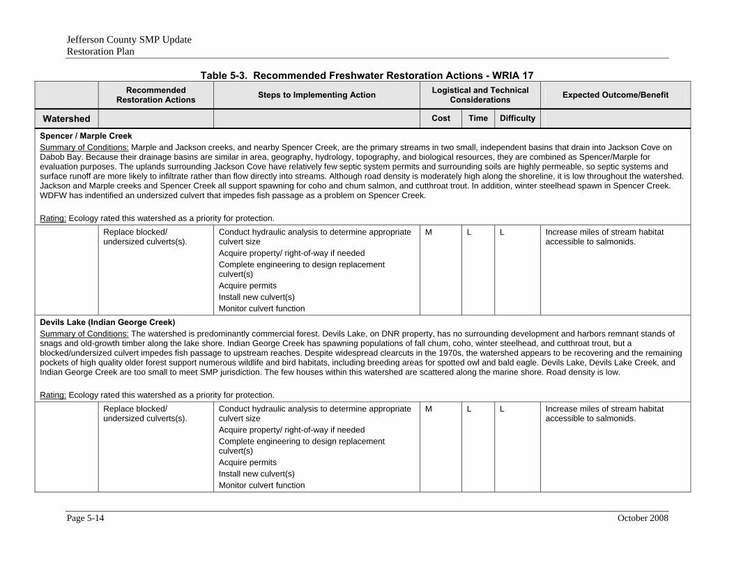
Jefferson County SMP Update Restoration Plan
Table 5-3. Recommended Freshwater Restoration Actions - WRIA 17 Recommended
Restoration Actions Steps to Implementing Action Logistical and Technical Considerations Expected Outcome/Benefit
Watershed Cost Time Difficulty
Spencer / Marple Creek Summary of Conditions: Marple and Jackson creeks, and nearby Spencer Creek, are the primary streams in two small, independent basins that drain into Jackson Cove on Dabob Bay. Because their drainage basins are similar in area, geography, hydrology, topography, and biological resources, they are combined as Spencer/Marple for evaluation purposes. The uplands surrounding Jackson Cove have relatively few septic system permits and surrounding soils are highly permeable, so septic systems and surface runoff are more likely to infiltrate rather than flow directly into streams. Although road density is moderately high along the shoreline, it is low throughout the watershed. Jackson and Marple creeks and Spencer Creek all support spawning for coho and chum salmon, and cutthroat trout. In addition, winter steelhead spawn in Spencer Creek. WDFW has indentified an undersized culvert that impedes fish passage as a problem on Spencer Creek. Rating: Ecology rated this watershed as a priority for protection. Replace blocked/
undersized culverts(s). Conduct hydraulic analysis to determine appropriate culvert size Acquire property/ right-of-way if needed Complete engineering to design replacement culvert(s) Acquire permits Install new culvert(s) Monitor culvert function
M L L Increase miles of stream habitat accessible to salmonids.
Devils Lake (Indian George Creek) Summary of Conditions: The watershed is predominantly commercial forest. Devils Lake, on DNR property, has no surrounding development and harbors remnant stands of snags and old-growth timber along the lake shore. Indian George Creek has spawning populations of fall chum, coho, winter steelhead, and cutthroat trout, but a blocked/undersized culvert impedes fish passage to upstream reaches. Despite widespread clearcuts in the 1970s, the watershed appears to be recovering and the remaining pockets of high quality older forest support numerous wildlife and bird habitats, including breeding areas for spotted owl and bald eagle. Devils Lake, Devils Lake Creek, and Indian George Creek are too small to meet SMP jurisdiction. The few houses within this watershed are scattered along the marine shore. Road density is low. Rating: Ecology rated this watershed as a priority for protection. Replace blocked/
undersized culverts(s). Conduct hydraulic analysis to determine appropriate culvert size Acquire property/ right-of-way if needed Complete engineering to design replacement culvert(s) Acquire permits Install new culvert(s) Monitor culvert function
M L L Increase miles of stream habitat accessible to salmonids.
Page 5-14 October 2008
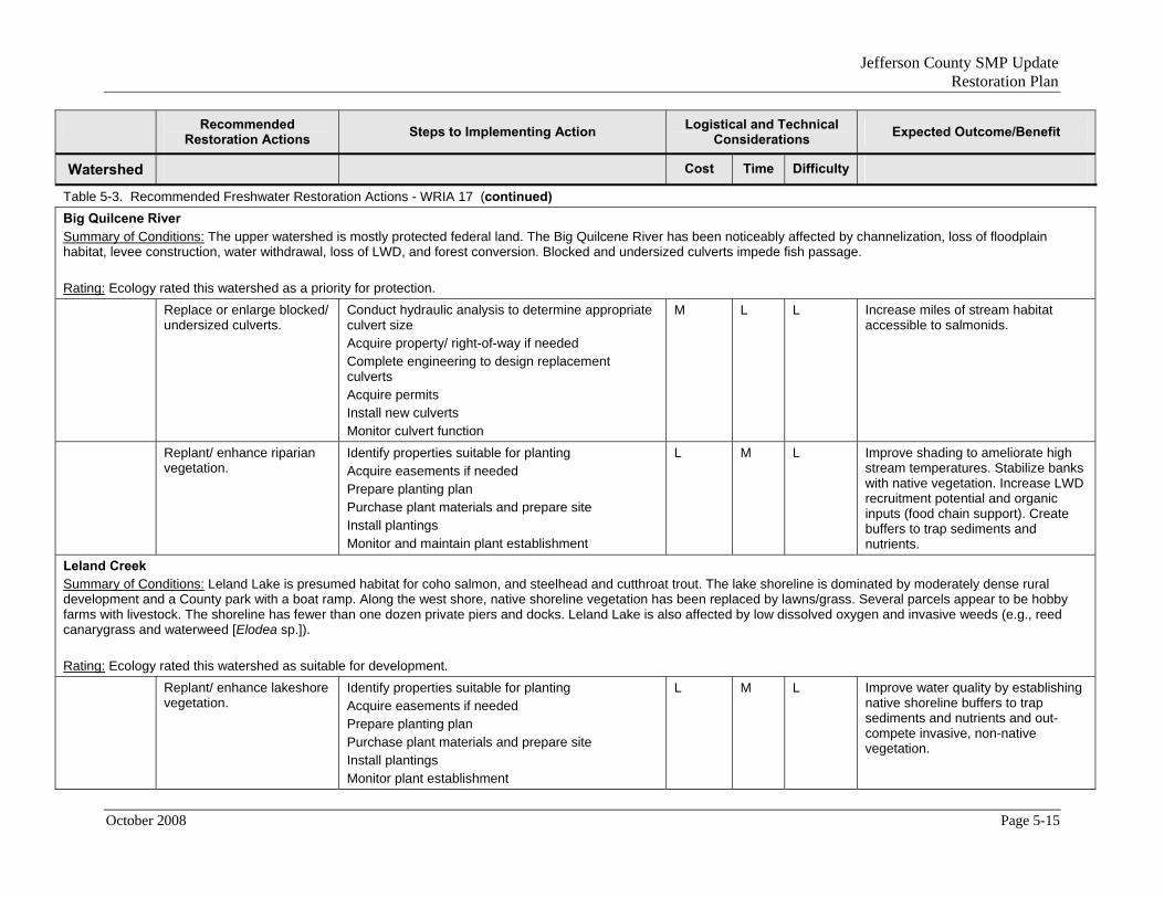
Jefferson County SMP Update Restoration Plan
Recommended Logistical and Technical Steps to Implementing Action Expected Outcome/Benefit Restoration Actions Considerations
Watershed Cost Time Difficulty
Table 5-3. Recommended Freshwater Restoration Actions - WRIA 17 (continued) Big Quilcene River Summary of Conditions: The upper watershed is mostly protected federal land. The Big Quilcene River has been noticeably affected by channelization, loss of floodplain habitat, levee construction, water withdrawal, loss of LWD, and forest conversion. Blocked and undersized culverts impede fish passage. Rating: Ecology rated this watershed as a priority for protection. Replace or enlarge blocked/
undersized culverts.
Conduct hydraulic analysis to determine appropriate culvert size Acquire property/ right-of-way if needed Complete engineering to design replacement culverts Acquire permits Install new culverts Monitor culvert function
M L L Increase miles of stream habitat accessible to salmonids.
Replant/ enhance riparian vegetation.
Identify properties suitable for planting Acquire easements if needed Prepare planting plan Purchase plant materials and prepare site Install plantings Monitor and maintain plant establishment
L M L Improve shading to ameliorate high stream temperatures. Stabilize banks with native vegetation. Increase LWD recruitment potential and organic inputs (food chain support). Create buffers to trap sediments and nutrients.
Leland Creek Summary of Conditions: Leland Lake is presumed habitat for coho salmon, and steelhead and cutthroat trout. The lake shoreline is dominated by moderately dense rural development and a County park with a boat ramp. Along the west shore, native shoreline vegetation has been replaced by lawns/grass. Several parcels appear to be hobby farms with livestock. The shoreline has fewer than one dozen private piers and docks. Leland Lake is also affected by low dissolved oxygen and invasive weeds (e.g., reed canarygrass and waterweed [Elodea sp.]). Rating: Ecology rated this watershed as suitable for development. Replant/ enhance lakeshore
vegetation.
Identify properties suitable for planting Acquire easements if needed Prepare planting plan Purchase plant materials and prepare site Install plantings Monitor plant establishment
L M L Improve water quality by establishing native shoreline buffers to trap sediments and nutrients and out-compete invasive, non-native vegetation.
October 2008 Page 5-15

Jefferson County SMP Update Restoration Plan
Recommended Logistical and Technical Steps to Implementing Action Expected Outcome/Benefit Restoration Actions Considerations
Watershed Cost Time Difficulty
Table 5-3. Recommended Freshwater Restoration Actions - WRIA 17 (continued) Little Quilcene River Summary of Conditions: Like the Big Quilcene River, the Little Quilcene River has been affected by channelization, floodplain encroachment, levees, water withdrawal, loss of riparian vegetation, gravel extraction, and development. The Little Quilcene River is also used as a municipal water source for Port Townsend. Development along the lower reaches affects areas of highly permeable deposits that are critical for maintaining water levels. Water quality impacts include high temperatures, nutrient loads, and fecal coliform contamination, especially in the lower reaches where agricultural operations, failing septic systems, the hatchery, and stormwater runoff contribute nutrients and bacteria to the stream. WDFW recorded multiple culverts that block miles of salmon spawning and rearing habitat on the Little Quilcene River and Penny and Leland creeks. An unscreened irrigation withdrawal pipe in the upper reach of Little Quilcene River is reported to trap fish. Lords Lake is a reservoir constructed on a tributary of the Little Quilcene River as part of the water supply system for the City of Port Townsend. Ecosystem processes and functions appear to be in excellent condition; however, reservoir construction likely eliminated high-quality riparian wetlands. The lake has no public access and no developed parcels, based on recent aerial photos. Rating: Ecology rated this watershed as a priority for restoration. Screen or remove irrigation
pipe in upper reach of Little Quilcene River
Assess pipe screening and removal options Acquire permits Remove/screen pipe Monitor project
L L L Enhance natural flow regime in Little Quilcene River. Increase miles of stream habitat accessible to salmonids.
Acquire Lords Lake to protect quality habitat.
Identify willing property owners Acquire property Develop public access plan Implement and monitor public access
M L L Protect remaining priority habitats (e.g., riparian wetlands) along the lakeshore. Provide opportunities for establishment of native vegetation and for passive recreational opportunities at the lake.
Donovan Creek Summary of Conditions: Donovan Creek consists of fragmented forest land, with concentrations of agriculture and residential land in the downstream reach around the village of East Quilcene. Watershed disturbances from extensive clearing have degraded conditions throughout most of the basin, although a narrow vegetated buffer (approximately 50 to 75 ft wide) has been retained along the creek through the forest parcels. Landslides due to logging roads and clearing are prevalent throughout the upper basin. In the downstream reaches that flow through farmlands, the channel has been straightened and filled, and the riparian zone has been cleared of vegetation. At least one fish barrier blocks access to a tributary of Donovan Creek. Donovan Creek was designated as a core area for high-quality habitat by Jefferson County. Rating: Ecology rated this watershed as a priority for restoration.
Page 5-16 October 2008

Jefferson County SMP Update Restoration Plan
Recommended Logistical and Technical Steps to Implementing Action Expected Outcome/Benefit Restoration Actions Considerations
Watershed Cost Time Difficulty
Table 5-3. Recommended Freshwater Restoration Actions - WRIA 17 (continued) Replace or enlarge blocked/
undersized culverts.
Conduct hydraulic analysis to determine appropriate culvert size Acquire property/ right-of-way if needed Complete engineering to design replacement culverts Acquire permits Install new culverts Monitor culvert function
M L L Increase miles of stream habitat accessible to salmonids.
Restore natural stream morphology in areas where channelization has occurred.
Conduct technical studies to support channel design Prepare engineering plans Acquire property/ right-of-way if needed Acquire permits Install LWD and other in-stream structures to improve channel complexity Construct other stream modifications Monitor project
M-H M-H M Restore nature flow regime. Reduce channel constriction, reconnect stream and floodplain/wetland habitat. Increase miles of stream habitat accessible to salmonids. Increase LWD recruitment potential and organic inputs (food chain support). Improve in-stream conditions for fish by installing LWD and facilitating development of pools and riffles.
Replant/ enhance riparian vegetation.
Identify properties suitable for planting Acquire easements if needed Prepare planting plan Purchase plant materials and prepare site Install plantings Monitor and maintain plant establishment
L M L Improve water quality by establishing native shoreline buffers to trap sediments and nutrients. Improve shading to ameliorate high stream temperatures. Stabilize banks with native vegetation. Increase LWD recruitment potential and organic inputs (food chain support).
October 2008 Page 5-17

Jefferson County SMP Update Restoration Plan
Recommended Logistical and Technical Steps to Implementing Action Expected Outcome/Benefit Restoration Actions Considerations
Watershed Cost Time Difficulty
Table 5-3. Recommended Freshwater Restoration Actions - WRIA 17 (continued) Tarboo Creek Summary of Conditions: Tarboo Creek is designated as a core area for high-quality habitat by Jefferson County. The creek supports runs of coho, fall chum, and Chinook salmon. Because the watershed is quite small and the surrounding uplands have been altered by agriculture and forest practices, future impacts to habitat within the watershed could have a disproportionately degrading effect on the creek. Tarboo and Browns lakes are part of tributary headwaters for Tarboo Creek. Tarboo Lake is surrounded by commercial forest that does not appear to have been recently cut. The shoreline is densely vegetated and riparian wetlands are intact. The only clearing on the lake is a small public access boat ramp provided by WDFW. WDFW also stocks the lake annually with several thousand hatchery rainbow trout, although this is not a threat to native salmon populations because the lake reportedly has no surface connection to Tarboo Creek. No significant degradation of habitat features or functional impairments were identified for Tarboo Lake. During in-stream flow monitoring in 2003, WDFW scientists noted high sediment loads in Tarboo Creek, which are indicative of erosion and mass wasting. High densities of platted parcels and septic systems on steep slopes with impermeable soils pose a serious threat to water quality. Although the east stream bank appears sparsely developed, the riparian corridor on both sides of Tarboo Creek has been heavily logged, leading to fragmented early seral regrowth with little LWD potential. Low summer flow has been identified as a limiting factor for coho salmon production, but consumptive use of groundwater is not suspected as a cause. Road density is high and has created numerous fish passage blockages—at least seven culverts on the mainstem and four culverts on tributaries. These factors all contribute to declining salmon populations in this system. Restoration potential in the Tarboo Creek watershed is high. Since the mid-1990s, restoration efforts have focused on fencing livestock out of the creek at six farms, stabilizing eroded banks, restoring lost channel habitat, replanting riparian vegetation, and improving or restoring fish passage in at least three locations. Protection would be appropriate in the headwaters, especially around Tarboo Lake. Rating: Ecology rated this watershed as a priority for protection. Replant/ enhance riparian
vegetation on the mainstem and tributaries.
Identify properties suitable for planting Acquire easements if needed Prepare planting plan Purchase plant materials and prepare site Install plantings Monitor and maintain plant establishment
L M L Improve water quality by establishing native shoreline buffers to trap sediments and nutrients. Improve shading to ameliorate high stream temperatures. Stabilize banks with native vegetation. Increase LWD recruitment potential and organic inputs (food chain support).
Acquire extant surface water claims.
Conduct hydraulic and in-stream habitat assessment to determine surface water conditions Identify properties suitable for acquisition Acquire property/ right-of-way if needed Acquire permits Implement project Monitor project
M M M Improve/protect in-stream flows.
Page 5-18 October 2008

Jefferson County SMP Update Restoration Plan
Recommended Logistical and Technical Steps to Implementing Action Expected Outcome/Benefit Restoration Actions Considerations
Watershed Cost Time Difficulty
Table 5-3. Recommended Freshwater Restoration Actions - WRIA 17 (continued) Replace or enlarge 11
blocked/ undersized culverts.
Conduct hydraulic analysis to determine appropriate culvert size Acquire property/ right-of-way if needed Complete engineering to design replacement culverts Acquire permits Install new culverts Monitor culvert function
M L-M L Increase miles of stream habitat accessible to salmonids.
Acquire Tarboo Lake to protect quality habitat.
Identify willing property owners Acquire property Develop public access plan Implement and monitor public access
M L L Protect remaining priority habitats (e.g., riparian wetlands) along the lakeshore. Provide opportunities for establishment of native vegetation and for passive recreational opportunities at the lake.
Thorndyke Creek Summary of Conditions: The upper Thorndyke Creek’s basin contains numerous small wetlands. This area is composed of highly permeable soils with high infiltration capacity and almost complete forest cover in various stages of regrowth, creating an ideal infiltration and recharge area. A shallow groundwater table supports the wetlands, lakes, and creek tributaries. Although the basin has been heavily logged in recent decades, the cleared plots are evenly scattered through the watershed and many have been replanted. Stream buffers appear to be intact. Pools, riffles, and LWD are present in adequate densities creating functional in-stream habitat structure. Recent records of low summer flows, which may be related to consumptive use of groundwater, have been identified as a factor limiting coho salmon production in Thorndyke Creek. Sandy Shore Lake is part of the headwaters of Thorndyke Creek. Sandy Shore Lake, along with numerous other headwaters wetlands and seasonal lakes, control Thorndyke Creek flows by moderating the extremes of both winter and summer precipitation. Sandy Shore Lake is presumed to provide coho, cutthroat, and steelhead habitat. The lake does not have an identifiable surface connection during summer to Thorndyke Creek; fish access may be limited to winter, when stream flows are high enough to allow juveniles to enter and rear in the lake. Although road density within the Thorndyke Creek watershed is relatively low, 12 culverts were identified in 2000 that blocked fish passage, with at least two additional culverts blocking tributaries. Logging roads may be responsible for sediment loading and other impacts of timber harvest were noted in fisheries assessments of the creek. Because of the unusually high habitat values and functions that are present throughout this watershed, acquisition and conservation of riparian areas along Thorndyke Cree and Sandy Shore Lake should be a priority. However, the long-term, ecosystem-wide functions of Thorndyke Creek are unknown because of the potential effects on in-stream flows due to surface water allocations and permitted pit mining along the east side of the basin. Rating: Ecology rated this watershed as a priority for protection.
October 2008 Page 5-19

Jefferson County SMP Update Restoration Plan
Recommended Logistical and Technical Steps to Implementing Action Expected Outcome/Benefit Restoration Actions Considerations
Watershed Cost Time Difficulty
Table 5-3. Recommended Freshwater Restoration Actions - WRIA 17 (continued) Replace or enlarge 14
blocked / undersized culverts.
Conduct hydraulic analysis to determine appropriate culvert size Acquire property/ right-of-way if needed Complete engineering to design replacement culverts Acquire permits Install new culverts Monitor culvert function
M M L Increase miles of stream habitat accessible to salmonids.
Acquire Sandy Shore Lake to protect quality habitat.
Identify willing property owners Acquire property Develop public access plan Implement and monitor public access
M L L Protect remaining priority habitats (e.g., riparian wetlands) along the lakeshore. Provide opportunities for establishment of native vegetation and for passive recreational opportunities at the lake.
Squamish Harbor Summary of Conditions: The Squamish Harbor watershed lies between the watersheds of Thorndyke Creek and Port Ludlow. Wahl Lake lies in this basin. Shine Creek is the largest creek at slightly over two miles in length, with no tributaries except within the estuary. It drains a small fraction of the watershed. Nordstrom Creek, south of Bridgehaven, is a smaller drainage. Shine Creek supports chum and coho salmon and cutthroat and steelhead trout spawning. Wetlands associated with the creek provide important rearing habitat for natal and non-natal juvenile pink, chum, coho, and Chinook salmon. The watershed has been heavily logged. A large part of the Shine Creek basin southwest of the estuary has been pit mined and retains unvegetated areas, exposed sand, and gravel deposits. Road density in this area is high, concentrated along the Shine Creek estuary, the pit mine, and the community at Bridgehaven. At least four culverts were identified as partially blocking fish access. Fill for SR 104 has altered the Shine Creek stream channel in multiple locations (especially along the estuary) and restricted channel migration. The part of the Squamish Harbor watershed that drains to Shine Creek is critical to maintaining in-stream flows and habitat function for this salmon-bearing stream and large estuary. Two unnamed streams flow into the estuary at Bywater Bay in Wolfe Property State Park. These streams are subject to degradation if stormwater is not properly managed in residential developments on the hillside above. Rating: Ecology rated this watershed as a priority for protection. Replace or enlarge blocked/
undersized culverts on Shine Creek.
Conduct hydraulic analysis to determine appropriate culvert size Acquire property/ right-of-way if needed Complete engineering to design replacement culverts Acquire permits Install new culverts Monitor culvert function
M M L Increase miles of stream habitat accessible to salmonids.
Page 5-20 October 2008

Jefferson County SMP Update Restoration Plan
Recommended Logistical and Technical Steps to Implementing Action Expected Outcome/Benefit Restoration Actions Considerations
Watershed Cost Time Difficulty
Table 5-3. Recommended Freshwater Restoration Actions - WRIA 17 (continued) Repair channel constriction
caused by SR 104 on Shine Creek near the estuary.
Conduct hydraulic analysis to assess flood and in-stream conditions Acquire property/ right-of-way if needed Complete engineering to restore channel morphology Acquire permits Install project Monitor project
M-H M M Reduce channel constriction, reconnect stream and floodplain/wetland habitat. Restore stream meanders to improve salmonid access and habitat for salmonid spawning and rearing.
Replant/ enhance riparian vegetation in cleared areas.
Identify properties suitable for planting Acquire easements if needed Prepare planting plan Purchase plant materials and prepare site Install plantings Monitor and maintain plant establishment
L M L Improve water quality by establishing native shoreline buffers to trap sediments and nutrients. Improve shading to ameliorate high stream temperatures. Stabilize banks with native vegetation. Increase LWD recruitment potential and organic inputs (food chain support).
Port Ludlow Summary of Conditions: The Port Ludlow watershed has been highly altered by logging and residential development. The watershed will likely experience increased residential and resort-related development in the near future. Between 80 and 100 percent of the watershed has been clearcut. Hydrological alterations from clearcutting and development are comparable to impairments experienced in urban watersheds. In this small watershed, precipitation is the primary source of surface water for the lakes, wetlands, and creeks; very little area in the upper watershed contains permeable soils. Although current groundwater withdrawals may not be threatening in-stream flow on an annual basis, overpumping of groundwater has the potential to impair creek base flows. Ludlow Creek is the largest drainage within the watershed, having more than 10 miles of perennial channel within its many tributaries. Ludlow Creek provides spawning and rearing habitat for several species of salmon and trout. WDFW stocks Ludlow Lake with rainbow trout for recreational fishing. Stocked trout threaten native fish populations because they outgrow (and out-compete) native salmonids for limited food resources, prey on smaller native fish, and spread hatchery diseases to native fish. A small, unnamed stream entering Ludlow Bay between Ludlow Creek and the marina supports cutthroat trout and possibly chum salmon, although habitat is limited due to a blocking culvert at Oak Bay Road. Rating: Ecology rated this watershed as a priority for protection.
October 2008 Page 5-21

Jefferson County SMP Update Restoration Plan
Recommended Logistical and Technical Steps to Implementing Action Expected Outcome/Benefit Restoration Actions Considerations
Watershed Cost Time Difficulty
Table 5-3. Recommended Freshwater Restoration Actions - WRIA 17 (continued) Replace or enlarge blocked/
undersized culverts on Oak Bay Road.
Conduct hydraulic analysis to determine appropriate culvert size Acquire property/ right-of-way if needed Complete engineering to design replacement culverts Acquire permits Install new culverts Monitor culvert function
M M L Increase miles of stream habitat accessible to salmonids.
Chimacum Creek Summary of Conditions: The upper and middle Chimacum Creek basins are noticeably degraded. The stream channel in the lower subbasin, from the mouth to RM 2.9, is largely unaltered and in good condition, with medium to high quality spawning and reading habitat and floodplain wetlands. However, commercial and residential development along the riparian corridor put this stream segment at risk. Alterations have destroyed 90 percent of juvenile salmonid rearing habitat in the watershed and most fish populations in Chimacum Creek have been extirpated and re-stocked for at least several decades; it is unlikely that any runs in this basin are native. The riparian areas are notable for having the greatest area of impervious surface, the greatest density of septic systems, and the greatest extent of watershed alteration in Jefferson County. Roadways parallel both the east and west forks of Chimacum Creek, but are generally outside of the riparian zone, with the exception of a short stretch of West Valley Road within the mid subbasin. Fourteen road crossings occur in the mid and lower subbasins, the majority of which involve culverts. In 2000, WDFW recorded partial obstructions to fish access in Chimacum Creek and its tributaries by at least 20 culverts under Center Road, four culverts under Egg & I Road, and eight culverts under Eaglemount Road. A recent study found that irrigation accounts for the greatest water use, comprising 75 percent of the total instantaneous quantity and 98 percent of the total annual quantity. The next largest use is for domestic single use followed by domestic multiple uses and stock watering. A study of in-stream flows concluded that the recommended spawning flows for the various salmonid species have a very low to medium probability of occurrence in Chimacum Creek during the months they are needed. Only coho and steelhead are likely to remain viable in Chimacum Creek if the current rate of surface water withdrawal is not addressed. Historic beaver ponds and forested wetlands have been converted to agriculture and rural residential use and are now predominantly ditches without structure, complexity, or well-vegetated riparian zones. LWD is lacking and future recruitment potential is limited due to lack of a forested riparian zone. Agriculture, including livestock production, has been identified as a major source of pollutants in the mid subbasin. Runoff from the towns of Chimacum, Port Hadlock, and Irondale is also a potential non-point source of pollution that is expected to increase with increasing population. The lakes in this watershed (Gibbs, Peterson, and Anderson) are relatively unimpaired. WDFW annually stocks Anderson Lake with rainbow trout, which compete with native fish for limited food resources, threaten genetic integrity by spawning with native salmonids, prey on smaller native fish, and spread hatchery diseases to native fish. The lake has exhibited water quality problems, including blooms of toxic algae that killed several dogs in 2006. The Chimacum Creek watershed has been the focus of numerous restoration efforts during the past two decades. Efforts have included planting riparian areas, adding LWD, placing livestock exclusion fences along the riparian zone, removing fine sediments, and creating off-channel habitat. Stocked summer chum from the Salmon Creek watershed appear to have established a natural spawning population. Voluntary implementation of agricultural best management practices by landowners may have improved salmon habitat and reduced the impacts on water quality, although no studies have confirmed measurable changes. The success of self-sustaining salmonid populations in Chimacum Creek may be the best indicator of restoration potential and long-term sustainability; however, increasing agricultural, commercial, and residential development in the watershed is expected to place continued pressure on habitat features (especially water quality and quantity) and function in the next decade. Rating: Ecology rated the Upper and Lower basins as tier 1 priorities for restoration. The East Fork and Middle basins are tier 2 priorities for restoration.
Page 5-22 October 2008

Jefferson County SMP Update Restoration Plan
Recommended Logistical and Technical Steps to Implementing Action Expected Outcome/Benefit Restoration Actions Considerations
Watershed Cost Time Difficulty
Table 5-3. Recommended Freshwater Restoration Actions - WRIA 17 (continued) Replace/ enlarge culverts
on Naylor Creek that may block fish passage to upstream reaches and Gibbs Lake, and on Chimacum Creek at Center Road, Egg & I Road, and Eaglemount Road that may block fish passage.
Conduct hydraulic analysis to determine appropriate culvert size Acquire property/ right-of-way if needed Complete engineering to design replacement culverts Acquire permits Install new culverts Monitor culvert function
M M L Increase miles of stream habitat accessible to salmonids.
Restore natural channel morphology in the East and West Forks where the channel has been straightened.
Conduct technical studies to determine channel dimensions and configuration Acquire property/ right-of-way if needed Complete engineering to design stream channel Acquire permits Construct project Monitor culvert function
M M L Increase miles of stream habitat accessible to salmonids.
Replant/ enhance riparian vegetation along Chimacum Creek mainstem and tributaries.
Identify properties suitable for planting Acquire easements if needed Prepare planting plan Purchase plant materials and prepare site Install plantings Monitor and maintain plant establishment
L M L Improve water quality by establishing native shoreline buffers to trap sediments and nutrients. Improve shading to ameliorate high stream temperatures. Stabilize banks with native vegetation. Increase LWD recruitment potential and organic inputs (food chain support).
October 2008 Page 5-23

Jefferson County SMP Update Restoration Plan
Recommended Logistical and Technical Steps to Implementing Action Expected Outcome/Benefit Restoration Actions Considerations
Watershed Cost Time Difficulty
Table 5-3. Recommended Freshwater Restoration Actions - WRIA 17 (continued) Restore wetlands and
floodplain connectivity in the mid-subbasin.
Conduct technical studies to determine existing basin conditions Determine target levee or dike removal areas or other necessary alterations (e.g., culvert replacement/enlargement, removal of irrigation ditches) Complete engineering to design wetland and floodplain connectivity restoration Acquire property/ right-of-way if needed Acquire permits Prepare planting plan if needed Purchase plant materials and prepare site(s) Install project and plantings Monitor and maintain project
Restore natural flow regime. Improve water quality by establishing native shoreline buffers to trap sediments and nutrients. Stabilize banks with native vegetation. Increase LWD recruitment potential and organic inputs (food chain support).
Page 5-24 October 2008

Jefferson County SMP Update Restoration Plan
Recommended Logistical and Technical Steps to Implementing Action Expected Outcome/Benefit Restoration Actions Considerations
Watershed Cost Time Difficulty
Table 5-3. Recommended Freshwater Restoration Actions - WRIA 17 (continued) Snow and Salmon Creeks Summary of Conditions: The Snow and Salmon Creek basins are primarily forested, with agriculture and residential uses dominating the riparian areas of the lower watersheds. Snow Creek originally flowed through the valley as an east bank tributary to Salmon Creek, but was moved to further east to drain directly to Discovery Bay. During certain flood events, Snow Creek overflows into its original channel in the pasture, reestablishing some direct contact with Salmon Creek. Both Snow and Salmon Creeks flow mainly over bedrock or till and have no ability to be recharged by groundwater. Water withdrawals for agriculture have the potential to affect the lower stream channels in both basins. Artificially depressed summer flows reduce fish habitat, degrade water quality by elevating temperature and concentrating nutrients, and impair fish passage. Large clear cuts in the 1980s contributed to degraded stream conditions in the middle and upper portions of the Snow Creek watershed on the south side of Big Skidder Hill. Near the Discovery Bay outlet, and in the Crocker Lake area, habitat degradation from animal access, lack of channel shading, and vegetation growth are problems. A portion of Snow Creek below RM 3.5 has been armored with riprap. Most habitat conditions in the lower reaches are fair to poor. The majority of Snow Creek’s riparian corridor is narrow (less than 70 ft wide) and has been cleared of all large conifers, leaving only deciduous trees. Snow Creek has an annual average discharge of 22 cfs. Winter in-stream flows are unusually high and erosive. The multiple factors of high winter flows, unusually high annual discharge, and a notably narrow riparian corridor suggest Snow Creek was too small to accommodate a 30 percent increase in watershed area, which occurred when Anderson Creek was diverted into Snow Creek. WDFW maintains a weir on Snow Creek at approximately RM 0.8 that obstructs downstream movement of bedload and LWD. To compensate for this, gravel and sediments are removed periodically and disposed of at an upland site. LWD is passed downstream and contributes to habitat structure. This accommodation is neither restorative nor self-sustaining. Road densities are relatively high, and at least six culverts are known to block fish access. Over half of the lower Salmon Creek has been channelized, and some of the channel has been armored with rock. Agricultural and grazing practices have severely reduced channel sinuosity, habitat complexity, and riparian buffers on Salmon Creek. Most of the stream banks are fenced from cattle, with some exceptions, but the lower reach of Salmon Creek does not meet fecal coliform standards. The primary sources of non-point pollution in the sub-basin are forestry and agricultural operations, and the two primary pollutants are fecal coliform and sediment. Very few people live in the sub-basin; failing septic systems and urban runoff are not considered major sources of pollution. Rating: Ecology rated the Snow Creek watershed as a priority for protection. Ecology rated the lower Salmon Creek watershed as suitable for development and the upper Salmon Creek watershed as a priority for protection. Replant/ enhance riparian
vegetation along the middle and upper reaches of Snow Creek.
Identify properties suitable for planting Acquire easements if needed Prepare planting plan Purchase plant materials and prepare site Install plantings Monitor and maintain plant establishment
L M L Improve water quality by establishing native shoreline buffers to trap sediments and nutrients. Improve shading to ameliorate high stream temperatures. Stabilize banks with native vegetation. Increase LWD recruitment potential and organic inputs (food chain support).
October 2008 Page 5-25

Jefferson County SMP Update Restoration Plan
Recommended Logistical and Technical Steps to Implementing Action Expected Outcome/Benefit Restoration Actions Considerations
Watershed Cost Time Difficulty
Table 5-3. Recommended Freshwater Restoration Actions - WRIA 17 (continued) Examine options to mitigate
the effects of diverting streamflow from Andrews Creek into Snow Creek.
Conduct technical studies to determine channel morphology and existing habitat conditions Acquire property/ right-of-way if needed Develop mitigation plan and planting plan Complete engineering plans for LWD installation, grading, and other restoration activities Acquire permits Purchase plant materials and prepare site Implement restoration activities and install plants Monitor and maintain restoration site and plant establishment
M-H M M Widen the riparian corridor and provide greater opportunities for flood storage in the watershed. Improve water quality by establishing native shoreline buffers to trap sediments and nutrients. Improve shading to ameliorate high stream temperatures. Stabilize banks with native vegetation. Increase LWD recruitment potential and organic inputs (food chain support).
Work with WDFW to examine options for restoring sediment transport and LWD transport capacity past the Snow Creek weir at RM 0.8 (current option of removing gravel above the weir may not be sustainable).
Conduct technical study to determine channel dimensions and configuration Acquire property/ right-of-way if needed Design restoration actions Complete engineering to design LWD installation Acquire permits Construct project/ install logs Monitor stream habitat function
M M M Restore sediment transport processes. Create buffers to trap sediments and nutrients. Increase LWD recruitment potential and organic inputs (food chain support).
Examine options for mitigating effects of high winter flows in Salmon Creek.
Conduct technical study to determine channel dimensions and configuration Acquire property/ right-of-way if needed Develop mitigation plan and planting plan Complete engineering plans for LWD installation, grading, and other restoration activities Acquire permits Purchase plant materials and prepare site Implement restoration activities and install plants Monitor and maintain restoration site and plant establishment
M-H M M Increase flood storage and sediment/nutrient loading opportunities along stream banks. Improve water quality by establishing native, woody vegetation along stream banks. Improve shading to ameliorate high stream temperatures. Stabilize banks with native vegetation. Increase LWD recruitment potential and organic inputs (food chain support).
Page 5-26 October 2008

Jefferson County SMP Update Restoration Plan
Recommended Logistical and Technical Steps to Implementing Action Expected Outcome/Benefit Restoration Actions Considerations
Watershed Cost Time Difficulty
Table 5-3. Recommended Freshwater Restoration Actions - WRIA 17 (continued) Remove fill and blocked
culverts on SR 104 and SR 101.
Conduct site studies to determine desired locations and grades for fill removal Conduct hydraulic analysis to determine appropriate culvert sizes and appropriate bank stabilization approach Acquire property/ right-of-way if needed Complete engineering plans for grading, fill removal, bio-stabilization, and replacement culverts Acquire permits Remove fill and install new culverts Monitor culvert function and in-stream flow
M L-M L-M Increase miles of accessible stream habitat for salmonids.
Enhance connection between Salmon Creek stream and its estuary.
Conduct technical studies to determine channel morphology and existing habitat conditions Determine target levee or dike removal areas or other necessary alterations (e.g., culvert replacement/enlargement, removal of irrigation ditches) Complete engineering to design grading and other activities to enhance riparian-estuarine connectivity Acquire property/ right-of-way if needed Acquire permits Prepare planting plan if needed Purchase plant materials and prepare site Install project and plantings Monitor and maintain project
M-H M M Enhance natural flow regime. Restore natural sediment transport and deposition in the estuary. Increase LWD recruitment potential and organic inputs (food chain support). Improve and increase miles of accessible estuary/stream rearing habitat for salmonids.
Discovery Bay - West Shore Summary of Conditions: Riparian vegetation has been removed from Contractor’s Creek and a culvert blocks access to the lower stream channel. Rating: Ecology rated this watershed as a priority for protection.
October 2008 Page 5-27

Jefferson County SMP Update Restoration Plan
Recommended Logistical and Technical Steps to Implementing Action Expected Outcome/Benefit Restoration Actions Considerations
Watershed Cost Time Difficulty
Table 5-3. Recommended Freshwater Restoration Actions - WRIA 17 (continued) Replant/ enhance riparian
vegetation at Contractor’s Creek.
Identify properties suitable for planting Acquire easements if needed Prepare planting plan Purchase plant materials and prepare site Install plantings Monitor and maintain plant establishment
L M L Improve water quality by establishing native shoreline buffers to trap sediments and nutrients. Improve shading to ameliorate high stream temperatures. Stabilize banks with native vegetation. Increase LWD recruitment potential and organic inputs (food chain support).
Remove/ enlarge culvert at the mouth of Contractor’s Creek and place LWD in the channel to improve in-stream habitat complexity.
Conduct hydraulic analysis to determine appropriate culvert size Acquire property/ right-of-way if needed Complete engineering to design replacement culverts and LWD installation Acquire permits Install new culverts and LWD Monitor culvert and in-stream functions
M L L Increase miles of stream habitat accessible to salmonids. Improve in-stream conditions for fish by facilitating development of pools and riffles. Reduce potential for spawning bed scour.
Page 5-28 October 2008

Jefferson County SMP Update Restoration Plan
Table 5-4. Recommended Nearshore Restoration Actions - WRIA 17 Recommended
Restoration Actions Steps to Implementing Action Logistical and Technical Considerations Expected Outcome/Benefit
Watershed Cost Time Difficulty
Jackson Cove (Reach L) Summary of Conditions: This reach includes the Jackson/Marple creek estuary and Spencer Creek estuary. The Jackson/Marple Creek estuary is heavily altered but the Spencer Creek estuary is in good condition and the meander channels, distributary channels, and riparian vegetation appear mostly intact. Outside of the Spencer Creek estuary, the Jackson Cove shoreline is mostly armored with boat ramps/piers/floats for each residential lot. Much of the riparian vegetation is cleared and the armoring appears to function as yard enlargement, rather than building protection. Because most of the cove is an area of no net drift, the in-water structures and armoring may not have impaired longshore sediment transport. Indeed, along the most heavily armored parts of the cove, eelgrass is continuous and herring spawning is documented, indicating productive biological functions despite shoreline alterations. Riparian vegetation increases to about 30 percent coverage between Pulali and Whitney points, although it is absent in front of the former state shellfish lab. An accretion beach near Whitney Point encloses a lagoon that has been highly altered. Bulkheads extend into the intertidal zone to provide parking for the shellfish facility. Rating: Battelle did not rate this reach as a priority restoration area. The Willamette Valley-Puget Trough-Georgia Basin Ecoregional Assessment identifies this as a priority conservation area for its high-quality nearshore and terrestrial habitat. Replace residential
bulkheads with bio-stabilization.
Identify willing property owners Conduct studies to assess bio-stabilization options Prepare engineering and design plans Install bio-stabilization Monitor shoreline stability
L L L Improve and increase shallow water nearshore habitat for migrating salmon. Improve nearshore sediment supply and transport. Improve nearshore woody debris supply and transport.
Replace bulkhead in front of B.S.A. Camp Parsons with bio-stabilization and create natural backshore habitat.
Conduct studies to assess bio-stabilization options Prepare engineering and design plans for backshore habitat Install bio-stabilization Grade and plant to create backshore Monitor shoreline stability and habitat formation
L L M Improve and increase shallow water nearshore habitat. Increase backshore habitat. Improve nearshore sediment supply and transport. Improve nearshore woody debris supply and transport.
Replace decking on residential docks with open-grating at Jackson Cove.
Identify willing property owners Replace/ repair docks
L L L-M Increase light penetration to improve conditions for eelgrass and other aquatic plants.
October 2008 Page 5-29

Jefferson County SMP Update Restoration Plan
Recommended Logistical and Technical Steps to Implementing Action Expected Outcome/Benefit Restoration Actions Considerations
Watershed Cost Time Difficulty
Table 5-4. Recommended Nearshore Restoration Actions - WRIA 17 (continued) Remove fill and armoring at
Marple Creek estuary. Conduct technical studies to identify estuary re-establishment Conduct studies to assess bio-stabilization options Prepare engineering plans for fill removal Acquire property/ right-of-way if needed Acquire permits Remove fill material and bulkheads Install bio-stabilization Monitor project
M M M Improve and increase estuary/ rearing habitat for migrating salmon. Improve nearshore sediment supply and transport. Improve nearshore woody debris supply and transport.
Relocate shellfish facility parking lot to an upland location at Point Whitney, remove fill and the dike across the lagoon, and return the spit and lagoon to a more natural state.
Conduct technical studies to identify dike removal and lagoon restoration options Conduct studies to assess sediment transport issues Acquire property/ right-of-way if needed for new parking area Prepare engineering plans Develop planting plans, if needed Acquire permits Remove fill and dike Monitor project
H H H Improve and increase lagoon habitat. Increase nearshore habitat for marine migrating salmon, marine birds and other species. Improve nearshore sediment supply and transport.
Qulicene Bay (Reach M) Summary of Conditions: On Reach M, shoreline development is minimal and there are no major modifications north of the state shellfish laboratory. The Devils Lake riparian area is largely intact, with few disturbances and very few houses. Unlike the majority of the watershed, the marine shoreline was not cleared in the 1970s, so vegetation is mature. Trees and shrubs overhang the upper shore. The Devils Creek estuary, at Frenchman’s Point, is a rare example of an unaltered creek mouth that transitions into a natural delta with a large alluvial fan, side channels, LWD, and dense vegetation. The only visible marine modification in this reach is a series of piles that once supported a marine railway near Herb Beck Marina.
Rating: Battelle did not rate this reach as a priority restoration area. Remove derelict piles from
old marina railway at north end of reach.
Prepare pile removal plan Acquire permits Remove piles
L L L Improve nearshore woody debris supply and transport. Improve water quality by removing treated piles.
Page 5-30 October 2008

Jefferson County SMP Update Restoration Plan
Recommended Logistical and Technical Steps to Implementing Action Expected Outcome/Benefit Restoration Actions Considerations
Watershed Cost Time Difficulty
Table 5-4. Recommended Nearshore Restoration Actions - WRIA 17 (continued) Indian George Creek (Reach N) Summary of Conditions: Reach N has no freshwater inputs. Most of the shoreline is armored and cleared of riparian vegetation. Linger Longer Road runs along the shore. The Herb Beck Marina was built behind a natural spit and the spit is heavily armored, but the marina has not impaired sand lance spawning or longshore sediment transport. The Port of Port Townsend provides public parking and access to the spit, which is a state beach park on the south side. The Port also maintains a public boat launch in the marina, a boat sewage pump-out, and public restrooms. Adjacent to the marina is a commercial shellfish operation with a boat ramp, floats, and shellfish gear occupying intertidal and shallow subtidal elevations. A former airstrip, now operated as a commercial recreational vehicle park, was constructed on intertidal habitat between the road and the water. The remainder of the reach consists of a cluster of houses built along the shoreline in a former delta salt marsh. The shoreline is entirely filled and armored. Little riparian vegetation remains. Each lot appears to have a bulkhead and a private boat ramp. Eelgrass is patchy along this reach, but herring spawning and holding areas are present. Near Indian George Creek, a major restoration project was recently completed at a state shellfish harvesting site, which included the removal of an abandoned barge, dikes and fill associated with a parking lot. Rating: Battelle rated this as a priority restoration area. Remove fill at airstrip north
of marina and restore the shoreline.
Survey site to establish desired grades Prepare engineering plans for fill removal Develop planting plans, if needed Acquire permits Remove fill Monitor project
M L M Improve and increase intertidal habitat for forage fish, salmon, marine birds and other species. Improve nearshore sediment supply and transport. Improve nearshore woody debris supply and transport.
Replace residential bulkheads with bio-stabilization.
Identify willing property owners Conduct studies to assess bio-stabilization options Prepare engineering and design plans Install bio-stabilization Monitor shoreline stability
L L L Improve and increase shallow water nearshore habitat for migrating salmon. Improve nearshore sediment supply and transport. Improve nearshore woody debris supply and transport.
October 2008 Page 5-31

Jefferson County SMP Update Restoration Plan
Recommended Logistical and Technical Steps to Implementing Action Expected Outcome/Benefit Restoration Actions Considerations
Watershed Cost Time Difficulty
Table 5-4. Recommended Nearshore Restoration Actions - WRIA 17 (continued) Quilcene Bay, Quilcene River Delta (Reach O) Summary of Conditions: Reach O consists of the broad delta of the Big and Little Quilcene rivers and other smaller streams that drain into the head of Quilcene Bay. May and Peterson (2003) identify Quilcene Bay as a Category A salmonid refugia. The marine shoreline along this reach is highly altered by development. The Quilcene delta, including Indian George Creek and Donovan Creek estuaries, has been extensively modified by clearing, grading, filling, diking, stream channelization, and commercial, agricultural, and residential development. More than 50 percent of the tide flats have been diked for farming. Numerous roads extend into the estuary on fill, and surrounding tide flats have been platted and diked or filled. The floodplain of the lower Little Quilcene is narrowly confined between Dabob Road and Frank Beck Road, which extend across the tide flats well into the estuary. The upper estuary has been extensively diked and filled for agriculture and residential development. Other impairments include tide gates, abandoned piles and barges, boat ramps, and maintained pastures. High sediment loads due to logging in the upper watersheds of these rivers and agriculture in the lower reaches are deposited on the Quilcene delta, causing progradation and shoaling. Despite this disturbance, the extensive tide flats have retained numerous natural features, including dendritic and distributary channels, and natural functions, including providing spawning and rearing habitat for forage fish, salmon, and shellfish. Degraded water quality is a problem in the estuary.
Rating: Battelle rated this as a priority restoration area. Explore opportunities to
remove / repair tide gates, derelict piles and barges, and boat ramps that are impairing habitat within the broad estuary delta.
Conduct technical studies to identify estuary re-restoration options Conduct studies to assess options for removing structures Prepare engineering plans Acquire property/ right-of-way if needed Acquire permits Restore estuary Monitor project
H H H Improve and increase estuary habitat for salmon and marine birds. Improve and increase shallow water nearshore habitat for migrating salmon. Improve tidal circulation and flushing. Restore natural channel migration and sediment transport processes.
Bolton Peninsula and Tarboo Bay (Reaches P, Q and R) Summary of Conditions: The west slope of the Bolton Peninsula drains directly into Quilcene Bay; the east slope drains into Tarboo Bay. Tarboo Bay is considered one of the top oyster growing areas in the state. The forested shorelines and protected lands of the Dabob Natural Area Preserve protect Tarboo Bay and provide nest sites for bald eagles, osprey, and great blue herons. The shorelines of the Bolton Peninsula are zoned rural residential and almost every waterfront parcel has a septic system within 200 ft of the shore. Water quality degradation, due to fecal coliform, has been a problem in the bay, leading to shellfish closures. The low bank shoreline on the Quilcene Bay side of the Bolton Peninsula faces increasing development pressure because it is closer to Quilcene and relatively accessible. Steep hillsides on the west side of the peninsula restrict shoreline development to fewer locations, primarily at Lindsay Beach, Broad Spit, and at several unnamed small creeks. Groins at Camp Discovery may be disrupting longshore sediment transport. East Quilcene Road runs along the northwest shore of Quilcene Bay, with numerous private drives leading to houses. Rating: Battelle rated Reach R as a priority restoration area.
Page 5-32 October 2008

Jefferson County SMP Update Restoration Plan
Recommended Logistical and Technical Steps to Implementing Action Expected Outcome/Benefit Restoration Actions Considerations
Watershed Cost Time Difficulty
Table 5-4. Recommended Nearshore Restoration Actions - WRIA 17 (continued) Replace residential
bulkheads on low bank shores with bio-stabilization.
Identify willing property owners Conduct studies to assess bio-stabilization options Prepare engineering and design plans Install bio-stabilization Monitor shoreline stability
L L L Improve and increase shallow water nearshore habitat for migrating salmon. Improve nearshore sediment supply and transport. Improve nearshore woody debris supply and transport.
Replant/enhance riparian vegetation on private residential properties along the east and west shores of the Tarboo estuary.
Identify willing property owners Prepare planting plans Install plants Monitor plant establishment
L L L Improve quality of estuary habitat. Provide opportunities for native vegetation to establish. Enhance foraging opportunities for shorebirds and other species.
Remove fill at the terminus of the drift cell near East Quilcene Road and Lindsey Hill Road to restore natural deposition of sediment into northern Quilcene Bay and restore lost shallow water habitat.
Conduct technical studies to identify fill removal and habitat restoration options Prepare engineering plans Acquire property/ right-of-way if needed Acquire permits Remove fill and restore estuary Monitor project
H H M-H Improve and increase estuary and intertidal habitat for salmon. Improve and increase shallow water nearshore habitat. Improve tidal circulation and flushing. Restore natural sediment transport processes.
Toandos Peninsula (Reaches S, T and U) Summary of Conditions: The Toandos Peninsula has had relatively sparse development along its shores, although recent development pressures and residential subdivision are increasing. Shoreline development is concentrated at Camp Discovery, Camp Harmony, and Zelatched Point (part of a U.S. Navy base for torpedo and submarine testing). A large salt marsh lagoon at Zelatched Point has been partially filled (10%) for Navy base parking. The south end of the peninsula includes the small communities of Coyle and Fisherman Harbor. Two small salmon-bearing streams flow into the head of the harbor; one with 13 culverts that block fish passage; the other with three. Road (and housing) density in the harbor area is relatively high, but otherwise there are few bulkheads or areas of fill. A small marina (about 70 slips) is near the head of the bay and there are numerous residential docks, piers, ramps, and boathouses. The harbor is surrounded by high densities of septic systems along the shoreline, but also highly permeable soils, which would aid in septic system function. The harbor provides important sheltered foraging habitat for juvenile salmonids, with abundant shellfish resources just outside the natural spit that encloses the harbor entrance. On the east side of the peninsula, just north of Hazel Point, a residential bulkhead and house extend into the upper intertidal zone, possibly interfering with longshore sediment transport to the point; otherwise the drift cell is minimally altered. Most feeder bluffs in this area are not armored, indicating high-quality shoreline conditions. Eelgrass is continuous from Hazel Point to South Point. In general the Toandos Peninsula east shoreline reaches retain high function, with undisturbed feeder bluffs interspersed by lower banks covered in healthy riparian vegetation. Rating: Battelle did not rate this as a priority restoration area.
October 2008 Page 5-33

Jefferson County SMP Update Restoration Plan
Recommended Logistical and Technical Steps to Implementing Action Expected Outcome/Benefit Restoration Actions Considerations
Watershed Cost Time Difficulty
Table 5-4. Recommended Nearshore Restoration Actions - WRIA 17 (continued) Replace residential
bulkheads north of Hazel Point with bio-stabilization.
Identify willing property owners Conduct studies to assess bio-stabilization options Prepare engineering and design plans Install bio-stabilization Monitor shoreline stability
L L L Improve and increase shallow water nearshore habitat for migrating salmon. Improve nearshore sediment supply and transport. Improve nearshore woody debris supply and transport.
Remove ramps, bulkheads, and fill from lagoon at Zelatched Point and restore salt marsh
Coordinate with US Navy to develop restoration plan Survey site to establish desired grades, bio-stabilization needs Prepare engineering plans Acquire permits Remove fill and structures Restore marsh Monitor project
H H H Improve and increase shallow water nearshore habitat for migrating salmon. Improve nearshore sediment supply and transport. Improve nearshore woody debris supply and transport. Increase salt marsh habitat for marine birds and other species.
Throndyke Bay and Shine Creek Estuary (Reach V) Summary of Conditions: The Thorndyke Bay shoreline is one of the least developed areas on Hood Canal and is considered one of the top priorities for estuarine conservation in the Puget Sound region. Thorndyke Creek is unique for several reasons, including a lack of road crossings, sparse residential development, and beaver dams in the lower reaches of the stream down to the high-tide line. It has a large (32-acre) marsh and mudflat complex enclosed by a barrier beach. Bald eagles and osprey nest in this area. May and Peterson (2003) identify the Thorndyke Creek estuary as a Category A refugia for salmonids. Thorndyke Bay is also a regionally significant overwintering site for waterfowl. Despite a history of logging activity in the watershed and apparent log storage in the estuary, the general extent and configuration of major habitat features are similar to historical conditions. The overall connectivity of the Thorndyke Creek estuary appears unimpaired. Water quality in Thorndyke Bay is generally considered good. Just north of the Thorndyke estuary is an area of undeveloped marine shoreline and frequent landslides that contribute abundant sediment to longshore drift. Between the Thorndyke estuary and South Point there are few bulkheads or shoreline alterations of note. Forage fish spawning beaches are common, but patchy, along the shore. The long and narrow South Point Spit was formed by sediment transport from an extensive drift cell from the south. The habitat complex historically supported fringing tidal marsh and lagoon habitat protected behind the spit, but most of that habitat has been lost to housing development on the spit and along the shoreline at Bridgehaven. The Bridgehaven area consists of high-density housing and waterfront facilities (i.e., an old ferry landing and parking lots), with pavement and armoring extending well into the intertidal range. Bulkheads and fill have narrowed and coarsened spawning beach along the outside side of the spit. The historic broad sand beaches are gradually being replaced with gravel and cobble. The spit-side of the back bay consists of an armored shoreline lined with wood piles and docks. Overwater coverage is nearly continuous because the docks tend to parallel the waterfront edge of each parcel. A large community dock sits at the entrance to the back bay. A jetty at the back bay entrance interrupts net shore-drift to the north. Immediately south of the spit, between the South Point ferry terminal and the spit road, a large salt marsh has been filled and confined by roads around all sides that function as dikes. The dikes prevent upland and nearshore processes from sustaining natural salt marsh function. About half the marsh appears to be vegetated with large shrubs and trees. Despite extensive shoreline alteration in the South Point area, sand lance spawn both south of South Point and north along the outside of the spit. Surf smelt spawn on the shore just north of the spit (Penttila, 2000; Long et al., 2005). Shellfish beds are found along most of these reaches. Eelgrass is continuous from Hazel Point to South Point, and patchy from South Point to Squamish Harbor.
Rating: Battelle did not rate this reach as a priority restoration area. The Nature Conservancy has identified this area as a priority conservation area.
Page 5-34 October 2008

Jefferson County SMP Update Restoration Plan
Recommended Logistical and Technical Steps to Implementing Action Expected Outcome/Benefit Restoration Actions Considerations
Watershed Cost Time Difficulty
Table 5-4. Recommended Nearshore Restoration Actions - WRIA 17 (continued) Restore the former salt
marsh south of the South Point Spit by removing fill and dikes to restore tidal action.
Conduct technical studies to identify fill/dike removal and marsh restoration options Prepare engineering plans Acquire property/ right-of-way if needed Acquire permits Remove fill and restore marsh Monitor project
H H M-H Improve and increase intertidal habitat. Improve and increase shallow water nearshore habitat for migrating salmon. Improve tidal circulation and flushing. Restore natural sediment transport processes. Increase marine bird habitat.
Replace residential bulkheads at Bridgehaven with bio-stabilization to restore the broad sand beach on the outer sides of side of the Spit and improve habitat on the back bay side.
Identify willing property owners Conduct studies to assess bio-stabilization options and beach nourishment options Prepare engineering and design plans Install bio-stabilization Monitor shoreline stability and beach restoration
L-M L L-M Improve and increase shallow water nearshore habitat for migrating salmon. Improve nearshore sediment supply and transport. Improve nearshore woody debris supply and transport. Improve forage fish habitat.
Replace decking on residential docks on the inside of the spit with open-grating or consider redevelopment using shared docks to minimize overwater coverage.
Identify willing property owners Replace/ repair docks
L L L-M Increase light penetration to improve conditions for eelgrass and other aquatic plants.
Explore options for restoring sediment processes to the north of the spit that are blocked due to the jetty at the opening.
Conduct technical studies to assess sediment transport issues Prepare engineering plans Acquire property/ right-of-way if needed Acquire permits Implement project Monitor project
H H M-H Restore natural sediment transport processes. Increase marine bird habitat.
October 2008 Page 5-35

Jefferson County SMP Update Restoration Plan
Recommended Logistical and Technical Steps to Implementing Action Expected Outcome/Benefit Restoration Actions Considerations
Watershed Cost Time Difficulty
Table 5-4. Recommended Nearshore Restoration Actions - WRIA 17 (continued) Squamish Harbor (Reach W) Summary of Conditions: Within Squamish Harbor development density increases significantly and riparian vegetation decreases. Shoreline vegetation has been cleared to provide views for waterfront homes. Road density, septic system density, pavement, and impermeable cover are high within the riparian areas of Squamish Harbor. Shoreline armoring affects about 26 percent of the north shore. Two boat ramps and a parking lot at a Jefferson County park have been constructed into intertidal habitat. The Shine Creek estuary is an extensive salt marsh totaling 85 acres with about 5 acres of intertidal habitat. Shine Creek supports chum and coho salmon and cutthroat and steelhead trout spawning. The wetlands are also important rearing habitat for natal and non-natal juvenile pink, chum, coho, and Chinook salmon. May and Peterson (2003) identify Squamish Harbor and the Shine Creek estuary as a Category A salmonid refugia. The intertidal marsh, mud flat, sand pit and other features of the harbor and estuary provide habitat diversity that increases their ecological value. A considerable portion of the lower Shine Creek estuary salt marsh has been filled for residential development, probably beginning in the 1960s. The estuary is prograding from high sediment loads due to upland land practices (logging and mining) and interrupted drift cell movement from fill and shoreline armoring. Rating: Battelle rated this as a priority restoration area. Replant/enhance riparian
vegetation on private residential properties along the harbor shore.
Identify willing property owners Prepare planting plans Install plants Monitor plant establishment
L L L Improve quality of estuary habitat. Provide opportunities for native vegetation to establish. Enhance foraging opportunities for shorebirds and other species.
Restore the former salt marsh at the Shine Creek estuary by removing fill associated with residential development.
Conduct technical studies to identify fill removal and marsh restoration options Prepare engineering plans Acquire property/ right-of-way if needed Acquire permits Remove fill and restore marsh Monitor project
H H M-H Improve and increase estuary and salt marsh habitat. Improve and increase shallow water nearshore habitat for migrating salmon. Restore natural sediment transport processes. Increase marine bird habitat.
Replace residential bulkheads at with bio-stabilization to restore the intertidal habitat on both sides of the harbor.
Identify willing property owners Conduct studies to assess bio-stabilization options and beach nourishment options Prepare engineering and design plans Install bio-stabilization Monitor shoreline stability and beach restoration
L-M L L-M Improve and increase shallow water nearshore habitat for migrating salmon. Improve nearshore sediment supply and transport. Improve nearshore woody debris supply and transport. Improve forage fish habitat.
Page 5-36 October 2008

Jefferson County SMP Update Restoration Plan
Recommended Logistical and Technical Steps to Implementing Action Expected Outcome/Benefit Restoration Actions Considerations
Watershed Cost Time Difficulty
Table 5-4. Recommended Nearshore Restoration Actions - WRIA 17 (continued) Termination Point and Bywater Bay (Reach Y) Summary of Conditions: On the reach north of Squamish Harbor there is less than 2 miles of bulkhead. The footing of the Hood Canal Bridge interferes with the longshore transport of sediment. Just to the north of the Hood Canal Bridge, a long riprap bulkhead protects the road and parking lot at Shine Tidelands State Park. Fill and riprap surrounding the marsh and lagoon at Shine Tidelands State Park prevent any regular tidal connection. The west shore of Bywater Bay is largely free of bulkheads, but the east shore has numerous low bulkheads and small piers and ramps along a cluster of houses built very close to the shoreline. A narrow strip of highly permeable soil occurs along this shoreline. No shoreline armoring exists on the north or east sides of Hood Head. Shoreline vegetation is dense and many other houses on Hood Head are set back from the shore. The Bywater Bay estuary provides habitat for coho, chum, and chinook salmon as well as cutthroat trout and forage fish and has no notable degraded features or function impairments. Point Hannon is a fully functioning cuspate spit and surrounds a saltwater marsh. This marsh is essential habitat for forage fish as well as song and shore birds. Beaches in the Bywater Bay/Hood Head area support documented forage fish spawning, as well as osprey and bald eagle nesting sites. Rating: Battelle did not rate this reach as a priority restoration area. Replace the bulkhead at
Shine Tidelands State Park parking lot with bio- stabilization to restore the intertidal/nearshore habitat.
Identify willing property owners Conduct studies to assess bio-stabilization options Prepare engineering and design plans Install bio-stabilization Monitor shoreline stability and beach restoration
L L L-M Improve and increase shallow water nearshore habitat for migrating salmon. Improve nearshore sediment supply and transport. Improve nearshore woody debris supply and transport. Improve forage fish habitat.
Replace residential bulkheads on the east shore of the Bay on Hood Head with bio-stabilization to restore the intertidal habitat.
Identify willing property owners Conduct studies to assess bio-stabilization options Prepare engineering and design plans Install bio-stabilization Monitor shoreline stability and beach restoration
L L L Improve and increase shallow water nearshore habitat for migrating salmon. Improve nearshore sediment supply and transport. Improve nearshore woody debris supply and transport. Improve forage fish habitat.
Support ongoing Spartina removal and monitoring of the Bay.
Develop weed control plan, if needed Implement plan Monitor and control weed re-establishment
L L L Improve quality of estuary habitat. Control invasive, non-native vegetation (e.g., Spartina sp.) and provide opportunities for native vegetation to establish. Enhance foraging opportunities for shorebirds and other species.
October 2008 Page 5-37

Jefferson County SMP Update Restoration Plan
Recommended Logistical and Technical Steps to Implementing Action Expected Outcome/Benefit Restoration Actions Considerations
Watershed Cost Time Difficulty
Table 5-4. Recommended Nearshore Restoration Actions - WRIA 17 (continued) White Rock Cove(Reach AA) Summary of Conditions: Twenty percent of the White Rock Cove shoreline is armored. Armoring, road density, and cleared vegetation increase significantly along the Paradise Bay shoreline. North of Paradise Bay, a private access road with a bulkhead extends into the intertidal zone interrupting net shore-drift. Just north of this, a large riprap bulkhead was installed to protect a stairway/patio/gazebo structure and a house situated close to the edge of a slumping bluff. The high bluff at the origin of the drift cell at Tala Point is armored at the toe, which interrupts the sediment source for drift cells that transport material toward Port Ludlow. Rating: Battelle did not rate this reach as a priority restoration area. Replace the bulkheads on
the toe of the feeder bluff Tala Point with bio- stabilization to restore natural drift function.
Identify willing property owners Conduct studies to assess bio-stabilization options Prepare engineering and design plans Install bio-stabilization Monitor shoreline stability and beach restoration
L L L Improve and increase shallow water nearshore habitat for migrating salmon. Improve nearshore sediment supply and transport. Improve nearshore woody debris supply and transport. Improve forage fish habitat.
Tala Point and Port Ludlow (Reaches BB and CC) Summary of Conditions: Between Tala Point and Port Ludlow, the marine shore remains largely unaltered. Net shore-drift continues to the west to form an accretionary beach in front of a salt marsh. Several groins placed to capture sediment and an old shipwreck interfere with net shore-drift. The high eroding feeder bluffs on Tala Point provide much of the sediment for the south shore of Ludlow Bay. Ludlow Lagoon, a small salt marsh on the south shore of Port Ludlow Bay (i.e., outer Port Ludlow), has been partly diked and filled since the 1800s. A large area of mixed-density residential development surrounds inner Port Ludlow. Road density is relatively high and concentrated along the water. The marine riparian shoreline within Port Ludlow is dominated by bulkheads and residential properties that were constructed along the upper intertidal beach fringe. Most properties have replaced native vegetation with grass. Ludlow Creek has a highly altered prograding estuary. Former tidal channels have been impaired by fill for roads, culverts associated with Paradise Bay Road, and former industrial uses. Juvenile cutthroat and coho use the tidal channels cut into the road fill. An unnamed stream entering inner Port Ludlow between Ludlow Creek and the marina supports cutthroat trout and possibly chum salmon, although habitat is limited due to a blocking culvert at Oak Bay Road. A rail launch, possibly from the port’s logging and shipbuilding days, is mapped within the inner harbor. Along the shoreline to the northeast of Ludlow Creek is an old log storage yard and loading area that may no longer be in use. Construction of the mill in the 1800s resulted in substantial filling of shallow tide flats within the inner harbor, followed by successive re-development plans that included the current resort and marina. Numerous private piers, ramps, and docks have been built along the south bay shore and likely shade marine substrate. These overwater structures do not appear to significantly impact the transport of sediment to the accretion beach at the terminus of the drift cell outside of the inner harbor. Geologic shore forms have largely been maintained, except near the old mill/current marina and resort. Rating: Battelle did not rate this reach as a priority restoration area. Remove groins and derelict
ship which are interrupting drift function north of Tala Point.
Obtain property access Prepare engineering and design plans Remove structures Monitor shoreline stability and beach restoration
L-M L L Improve and increase shallow water nearshore habitat for migrating salmon. Improve nearshore sediment supply and transport.
Page 5-38 October 2008
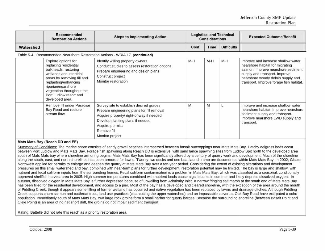
Jefferson County SMP Update Restoration Plan
Recommended Logistical and Technical Steps to Implementing Action Expected Outcome/Benefit Restoration Actions Considerations
Watershed Cost Time Difficulty
Table 5-4. Recommended Nearshore Restoration Actions - WRIA 17 (continued) Explore options for
replacing residential bulkheads, restoring wetlands and intertidal areas by removing fill and replanting/enhancing riparian/nearshore vegetation throughout the Port Ludlow resort and developed area.
Identify willing property owners Conduct studies to assess restoration options Prepare engineering and design plans Construct project Monitor restoration
M-H M-H M-H Improve and increase shallow water nearshore habitat for migrating salmon. Improve nearshore sediment supply and transport. Improve nearshore woody debris supply and transport. Improve forage fish habitat.
Remove fill under Paradise Bay Road and restore stream flow.
Survey site to establish desired grades Prepare engineering plans for fill removal Acquire property/ right-of-way if needed Develop planting plans if needed Acquire permits Remove fill Monitor project
M M L Improve and increase shallow water nearshore habitat. Improve nearshore sediment supply and transport. Improve nearshore LWD supply and transport.
Mats Mats Bay (Reach DD and EE) Summary of Conditions: The marine shore consists of sandy gravel beaches interspersed between basalt outcroppings near Mats Mats Bay. Patchy eelgrass beds occur between Port Ludlow and Mats Mats Bay. Forage fish spawning along Reach DD is extensive, with sand lance spawning sites from Ludlow Spit north to the developed area south of Mats Mats bay where shoreline armoring begins. Mats Mats Bay has been significantly altered by a century of quarry work and development. Much of the shoreline along the south, east, and north shorelines has been armored for lawns. Twenty-two docks and one boat launch ramp are documented within Mats Mats Bay. In 2002, Glacier Northwest applied for permits to enlarge and deepen the quarry at Mats Mats Bay over a ten-year period. Considering the extent of existing alterations and development pressures on this small watershed and bay, combined with near-term plans for further development, restoration potential may be limited. The bay is large and shallow, with nutrient and fecal coliform inputs from the surrounding homes. Fecal coliform contamination is a problem in Mats Mats Bay, which was classified as a seasonal, conditionally approved shellfish harvest area in 2005. High summer temperatures combined with nutrient loads cause algal blooms in summer and likely depress dissolved oxygen. In autumn, dissolved oxygen in Mats Mats Bay is further depressed because of upwelling from Admiralty Inlet. A narrow fringing salt marsh at the south end of Mats Mats Bay has been filled for the residential development, and access to a pier. Most of the bay has a developed and cleared shoreline, with the exception of the area around the mouth of Piddling Creek, though it appears some filling of former wetland has occurred and native vegetation has been replaced by lawns and drainage ditches. Although Piddling Creek supports chum salmon and cutthroat trout, land use practices (clearcutting the upper watershed) and an impassable culvert at Oak Bay Road have extirpated a coho population. Immediately south of Mats Mats Bay, two large rock groins form a small harbor for quarry barges. Because the surrounding shoreline (between Basalt Point and Olele Point) is an area of no net short drift, the groins do not impair sediment transport. Rating: Battelle did not rate this reach as a priority restoration area.
October 2008 Page 5-39

Jefferson County SMP Update Restoration Plan
Recommended Logistical and Technical Steps to Implementing Action Expected Outcome/Benefit Restoration Actions Considerations
Watershed Cost Time Difficulty
Table 5-4. Recommended Nearshore Restoration Actions - WRIA 17 (continued) Replace decking on
residential docks on Mats Mats Bay with open-grating or consider redevelopment using shared docks to minimize overwater coverage.
Identify willing property owners Replace/ repair docks
L L L-M Increase light penetration to improve conditions for eelgrass and other aquatic plants.
Replace residential bulkheads with bio-stabilization within the sediment transport zone south of the Bay to restore natural drift function and intertidal habitat.
Identify willing property owners Conduct studies to assess bio-stabilization options Prepare engineering and design plans Install bio-stabilization Monitor shoreline stability and beach restoration
L L L Improve and increase shallow water nearshore habitat for migrating salmon. Improve nearshore sediment supply and transport. Improve nearshore woody debris supply and transport. Improve forage fish habitat.
Replant/enhance riparian vegetation on private residential properties along the north half of the reach.
Identify willing property owners Conduct studies to assess restoration options Prepare engineering and design plans Construct project Monitor restoration
L L L Improve shading and stabilize banks with vegetation. Increase LWD recruitment potential and organic inputs (food chain support).
Oak Bay (Reaches FF, GG, HH and II) Summary of Conditions: Oak Bay extends from Olele Point, through the Port Townsend Portage Canal, along the south end of Indian and Marrowstone islands. The marine reaches immediately north of Olele Point include an undeveloped salt marsh on private property; moderate clearing, and little armoring. Farther north over 80 percent of the marine shoreline has been cleared and platted for residential development. Riparian vegetation along the west shore of Oak Bay ranges from 20 percent to 50 percent, with patches of trees separated by areas cleared for views. Most of the shoreline is developed along Oak Bay Road. Residential docks are prevalent. Longshore drift is impaired by ramps, piers, and bulkheads. Saltwater intrusion from groundwater withdrawals is a problem along Oak Bay and Marrowstone Island. A salt marsh behind a depositional spit near Olele Point has been incrementally filled for residential development and is truncated by a driveway. In the northwest corner of Oak Bay, a broad depositional beach and spit have been armored to provide a campground and parking lot associated with the Oak Bay County Park. This spit and the jetty on the west side of the Portage Canal keep the salt marsh isolated from the bay, although in recent years the spit has eroded and riprap is failing, allowing for a regular tidal connection. The mouth of Little Goose Creek once entered the extensive salt marsh, but the lower reach was blocked during construction of the Canal and the creek was re-routed through a pipe to a new discharge location. On the east side of the canal, a Jefferson County Park on Indian Island has filled in part of the salt marsh to provide parking and picnic tables. Rating: Battelle did not rate this reach as a priority restoration area.
Page 5-40 October 2008

Jefferson County SMP Update Restoration Plan
Recommended Logistical and Technical Steps to Implementing Action Expected Outcome/Benefit Restoration Actions Considerations
Watershed Cost Time Difficulty
Table 5-4. Recommended Nearshore Restoration Actions - WRIA 17 (continued) Replace decking on
residential docks with open-grating to minimize overwater coverage.
Identify willing property owners Replace/ repair docks
L L L-M Increase light penetration to improve conditions for eelgrass and other aquatic plants.
Replace residential bulkheads with bio-stabilization to restore natural drift function and intertidal habitat.
Identify willing property owners Conduct studies to assess bio-stabilization options Prepare engineering and design plans Install bio-stabilization Monitor shoreline stability and beach restoration
L L L Improve and increase shallow water nearshore habitat for migrating salmon. Improve nearshore sediment supply and transport. Improve nearshore woody debris supply and transport. Improve forage fish habitat.
Replant/enhance riparian vegetation on private residential properties along the north half of the reach and west side of the Bay.
Identify willing property owners Conduct studies to assess restoration options Prepare planting plans Plant vegetation Monitor plant establishment
L L L Improve shading and stabilize banks with vegetation. Increase LWD recruitment potential and organic inputs (food chain support).
Explore opportunities to remove ramps and piers along this reach that are interrupting longshore sediment transport.
Identify willing property owners Conduct studies to assess sediment transport issues Prepare engineering and design plans Construct project Monitor restoration
L L L Improve and increase shallow water nearshore habitat for migrating salmon. Improve nearshore sediment supply and transport. Increase LWD recruitment potential and organic inputs (food chain support).
Explore opportunities for restoring intertidal habitat at Oak Bay County Park by removing riprap and/or reconnecting the salt marsh to Portage Canal and/or Little Goose Creek.
Conduct technical analysis to determine appropriate restoration approach Survey site to establish desired grades Prepare engineering plans for grading, fill removal and bio-stabilization Acquire permits Remove fill Monitor recovery
M M M Improve and increase intertidal and shallow water nearshore habitat, including potential forage fish habitat (e.g., sand lance). Improve and increase marsh habitat.
October 2008 Page 5-41

Jefferson County SMP Update Restoration Plan
Recommended Logistical and Technical Steps to Implementing Action Expected Outcome/Benefit Restoration Actions Considerations
Watershed Cost Time Difficulty
Table 5-4. Recommended Nearshore Restoration Actions - WRIA 17 (continued) Marrowstone Island and Kilisut Harbor (Reaches KK to SS) Summary of Conditions: In Reaches MM and NN, the parking lot and campground at Fort Flagler State Park were constructed on fill placed on top of approximately 22 acres of historic salt marsh. A riprap bulkhead protecting the marine research station and Marrowstone Light interferes with sediment transport along the north side of Marrowstone Point. The Fort Flagler boat ramp is built on creosote-treated wood piles. The ramp interferes with longshore drift and is seldom used. The Indian Island shoreline along Kilisut Harbor has been largely unaltered for the past several decades. Many of the shoreline alterations on the Marrowstone Island shore of Kilisut Harbor are due to armoring and fill that are unnecessary for property protection within this sheltered harbor. Several degraded salt marshes are on public lands. Extensive fill and armoring along 32 percent of the feeder bluffs of Reach PP impair nearshore sediment drift and may have already degraded the salt marsh at the entrance to Mystery Bay. Little riparian vegetation remains along east Reaches PP and QQ and Mystery Bay and the remaining vegetation has been fragmented by clearing for lawns and views along most residential parcels. At the south end of Mystery Bay, a small salt marsh has been filled at two locations by causeways for parallel, connecting driveways. Access roads along the bay run within a few feet of the intertidal zone or are built on fill within the upper intertidal range. Within Mystery Bay, development around Nordland has eliminated riparian vegetation on the eastern shore of the bay; in contrast, about 65 percent of riparian vegetation remains on the western shore. A small salt marsh near the Nordland store and main road has been completely filled. The Mystery Bay shellfish harvest area is listed as an area of concern due to the number of boats moored in the bay, although a sewage pump-out facility is available year-round at the pier in Mystery Bay State Park. At the south end of Kilisut Harbor, riparian degradation along Scow Bay (Reaches RR and SS) includes numerous structures, such as residential bulkheading on more than 16 percent of the drift cell, a small house built on stilts over the intertidal, 11 staircases, three dock/pier structures, and a rail launch. Commercial aquaculture in Scow Bay potentially adds to the nutrient loads in Kilisut Harbor. At the head of Scow Bay, along the border of Reaches SS and KK, the causeway that connects Marrowstone Island to Indian Island impairs tidal flow and salmonid access between the islands. Rating: Battelle did not rate this reach as a priority restoration area. Remove derelict pilings at
the boat ramp at the north end of the island at Fort Flagler State Park and at Mystery Bay State Park (if not completed in 2008)
Conduct technical studies to assess sediment transport issues and identify options for pile/ramp removal Acquire property/ right-of-way if needed Complete engineering to design Acquire permits Remove piles Monitor recovery and sediment processes
L L L Improve water quality in the bay and State Park. Improve nearshore sediment transport.
Replace decking on residential docks on the Kilisut Harbor side of the Island with open-grating to minimize overwater coverage.
Identify willing property owners Replace/ repair docks Transplant eelgrass, if feasible Monitor eelgrass establishment
L M L-M Improve and expand eelgrass habitat to improve foraging for salmon.
Page 5-42 October 2008

Jefferson County SMP Update Restoration Plan
Recommended Logistical and Technical Steps to Implementing Action Expected Outcome/Benefit Restoration Actions Considerations
Watershed Cost Time Difficulty
Table 5-4. Recommended Nearshore Restoration Actions - WRIA 17 (continued) Replant/enhance riparian
vegetation on private residential properties along the east shore of Kilisut Harbor.
Identify properties suitable for planting Acquire easements if needed Prepare planting plan Purchase plant materials and prepare site Install plantings Monitor and maintain plant establishment
L L L Stabilize banks with vegetation. Improve. Increase LWD recruitment potential and organic inputs (food chain support).
Replace existing bulkheads with bioengineered stabilization.
Identify willing property owners Conduct studies to assess bio-stabilization options Prepare engineering and design plans Install bio-stabilization Monitor shoreline stability and beach restoration
L L L Improve and increase shallow water nearshore habitat for migrating salmon. Improve nearshore sediment supply and transport. Improve nearshore woody debris supply and transport. Improve forage fish habitat.
Remove fill for the driveway near the mouth of the salt marsh at the south end of Mystery Bay if property access could be provided via the adjacent loop driveway.
Survey site to establish desired grades Conduct hydraulic analysis to determine appropriate bank stabilization approach Prepare engineering plans for grading and excavation Design road improvements Acquire permits Remove fill Monitor recovery
H M M-H Improve and increase estuary/ rearing habitat for salmon. Improve nearshore sediment supply and transport. Improve nearshore LWD supply and transport.
Remove fill within a salt marsh in Reach PP to increase salt marsh habitat.
Survey site to establish desired grades Conduct hydraulic analysis to determine appropriate restoration approach Prepare engineering plans for grading, fill removal and marsh recovery Acquire permits Remove fill Monitor recovery
M M M Improve and increase salt marsh and shallow water nearshore habitat, including potential forage fish habitat (e.g., sand lance). Improve and increase estuary/ rearing habitat for salmon.
October 2008 Page 5-43

Jefferson County SMP Update Restoration Plan
Recommended Logistical and Technical Steps to Implementing Action Expected Outcome/Benefit Restoration Actions Considerations
Watershed Cost Time Difficulty
Table 5-4. Recommended Nearshore Restoration Actions - WRIA 17 (continued) Restore the tidal connection
through the causeway connecting Marrowstone and Indian Islands to restore tidal exchange between Kilisut Harbor and Oak Bay, to improve water quality within the harbor (especially near the Scow Bay aquaculture operations), and restore juvenile salmonid migratory habitat between the islands.
Conduct technical studies to identify options for tidal reconnection Prepare engineering plans Acquire property/ right-of-way if needed Acquire permits Remove dikes Monitor project
M M M Improve and increase shallow water nearshore habitat. Improve tidal circulation and flushing. Restore natural channel migration processes. Improve water quality within the harbor (especially near the Scow Bay aquaculture operations), and restore juvenile salmonid migratory habitat between the islands.
Port Hadlock (Reach YY and ZZ) Summary of Conditions: Between the Portage Canal and Port Hadlock, riparian vegetation in the Hadlock Bluffs area is largely intact, but it is largely absent from the Hadlock waterfront. About 17 percent of the shoreline in Reach YY is armored. Modifications appear concentrated along the low bank area near the origin of an important drift cell for Port Hadlock. Three wooden bulkheads along the contributing bluff area of this drift cell may limit sediment recruitment into the nearshore. A marina with about 100 small slips at the Inn at Port Hadlock does not appear to significantly affect net shore-drift, although over-water coverage likely suppresses aquatic vegetation because of shading. Numerous docks, bulkheads, boat ramps, and other structures are present along Port Hadlock. The spit south of Hadlock has been hardened and armored to provide a road down the spit to a house and dock (Johannessen, 1999; Ecology, 2001). The riparian corridor surrounding the large lagoon behind the spit is impaired by SR 116, Lower Hadlock Road, and NW Water Street. Overall, shoreline armoring impairs about 31 percent of the drift cell in Port Hadlock; however, net shore-drift is not obviously impaired, as the spit south of the Hadlock waterfront continues to prograde. The Port of Port Townsend dredges sand that accumulates on the up-drift side of a public boat ramp and transfers it to the down-drift side of the ramp several times a year. Water quality along the shore from Port Hadlock to Chimacum Creek is degraded by high concentrations of fecal coliform. Rating: Battelle did not rate this reach as a priority restoration area. Replace existing bulkheads
with bioengineered stabilization.
Identify willing property owners Conduct studies to assess bio-stabilization options Prepare engineering plans for bio-stabilization Install bio-stabilization Monitor shoreline stability
L L L Improve and increase shallow water nearshore habitat. Improve nearshore sediment supply and transport. Improve nearshore LWD supply and transport.
Page 5-44 October 2008

Jefferson County SMP Update Restoration Plan
Recommended Logistical and Technical Steps to Implementing Action Expected Outcome/Benefit Restoration Actions Considerations
Watershed Cost Time Difficulty
Table 5-4. Recommended Nearshore Restoration Actions - WRIA 17 (continued) Replace decking on
residential docks with open grating
Identify willing property owners Replace/ repair docks Transplant eelgrass, if feasible Monitor eelgrass establishment
L M L-M Improve and expand eelgrass habitat to improve foraging for salmon.
Chimacum Estuary (Reach AAA) Summary of Conditions: Reach AAA, including Irondale and the Chimacum Creek estuary, is extensively modified by armoring and fill along a third of a mile of shoreline, mostly at the Irondale former iron mill and log dump sites. Many marine structures from historic use as an iron smelting business, including tanks and long piers, have been removed. Originally, an area of low bank and sand spit was probably a salt marsh/spit complex that was filled and armored for log storage and transfer. The site was recently acquired for a park and the rock armoring and fill were removed to restore shallow water habitat for juvenile salmonids and beach habitat for forage fish spawning.
Rating: Battelle did not rate this reach as a priority restoration area. Restore former salt marsh
habitat by replacing fill placed in the 1800s.g
Identify willing property owners / acquire property Survey site to establish desired grades Conduct hydraulic analysis to determine appropriate restoration approach Prepare engineering plans for grading and excavation Acquire permits Remove fill Monitor Estuary recovery
H M M-H Improve and increase marsh habitat. Improve nearshore sediment supply and transport. Improve nearshore LWD supply and transport.
October 2008 Page 5-45

Jefferson County SMP Update Restoration Plan
Recommended Logistical and Technical Steps to Implementing Action Expected Outcome/Benefit Restoration Actions Considerations
Watershed Cost Time Difficulty
Table 5-4. Recommended Nearshore Restoration Actions - WRIA 17 (continued) Strait of Juan de Fuca and Discovery Bay (Reaches EEE- HHH)18
Summary of Conditions: The northwest Quimper Peninsula drains into the Strait of Juan de Fuca and Discovery Bay. The shoreline along the Strait of Juan de Fuca (Reach EEE) is subject to the greatest wave action in eastern Jefferson County and is characterized by tall, steep, eroding bluffs. Most of the bluffs are vegetated on the steep slopes and good forest cover is common from McCurdy Point to Cape George, with few exceptions. Housing density increases with proximity to Port Townsend, as does riparian clearing. The watershed along the Strait receives little precipitation and has few wetlands and no streams. The soils are largely till and there is limited rainfall and groundwater recharge. Pockets of residential development along the shoreline of Discovery Bay have altered the intertidal and upper riparian areas with structures (including houses), septic drainage, (untreated) sewage drainage, stormwater runoff, armoring, and fill. Saltwater intrusion was noted at several wells along the east shore. Residential development at Cape George has resulted in extensive clearing for views, possibly contributing to bluff erosion. Several private stormwater drains discharge on the beach and one large storm drain discharges into a ravine with an intermittent stream, which then flows into the bay. A jetty at the entrance to the Cape George marina interrupts longshore sediment transport of sediment. The marina, constructed within a dredged spit or spit/lagoon complex, is armored with riprap. Along the northwest shore of Beckett Point is another area of armoring with seawalls and riprap. Longshore drift is interrupted on the north side of Beckett Point by a boat ramp, which has eroded the down drift side, toward the tip of the spit. Both the north and south sides of Beckett Point have several sizable bulkheads, which may adversely affect net longshore sediment drift. Shoreline armoring and fill along the Adelma Beach (Reaches HHH and III) may affect sediment recruitment into the nearshore, as well as interrupt longshore transport and increase wave reflection, causing the beach to steepen and coarsen.
Rating: Battelle did not rate this reach as a priority restoration area. Replant/enhance riparian
vegetation on private residential properties near Cape George.
Identify properties suitable for planting Acquire easements if needed Prepare planting plan Purchase plant materials and prepare site Install plantings Monitor and maintain plant establishment
L L L Stabilize banks with vegetation. Improve. Increase LWD recruitment potential and organic inputs (food chain support).
Replace residential bulkheads at Beckett Point, Adelma Beach and Fairmont with bio-stabilization
Identify willing property owners Conduct studies to assess bio-stabilization options Prepare engineering plans for bio-stabilization Install bio-stabilization Monitor shoreline stability
L L L Restore natural drift function and intertidal habitat. Improve and increase shallow water nearshore habitat. Improve nearshore sediment supply and transport. Improve nearshore LWD supply and transport.
18 Reaches CCC - EEE are under the City of Port Townsend’s jurisdiction. The City has its own Restoration Plan.
Page 5-46 October 2008

Jefferson County SMP Update Restoration Plan
Recommended Logistical and Technical Steps to Implementing Action Expected Outcome/Benefit Restoration Actions Considerations
Watershed Cost Time Difficulty
Table 5-4. Recommended Nearshore Restoration Actions - WRIA 17 (continued) Remove or fix the boat ramp
at Beckett Point which is interrupting sediment transport.
Conduct analysis to assess sediment transport issues Prepare engineering plans Acquire permits Remove/ fix structure Monitor recovery
M M L-M Improve nearshore sediment supply and transport. Improve nearshore LWD supply and transport.
Snow-Salmon Creek Estuary (Reach III and JJJ) Summary of Conditions: Between Woodman and the delta of Salmon and Snow Creeks, the backshore is isolated by a 2.5-mile long bulkheaded railroad grade. At Fairmont, extensive armoring, including structures built on armored fill, extends into the intertidal zone. The salt marsh at Fairmont is isolated by the railroad grade. Due to a culvert failure in early 2005, the tidal connection may now be compromised. Mill ponds northwest of the mouth of Salmon Creek, which are located on a historic broad tide flat with fringing salt marsh have been truncated by road fill. Also northwest of the estuary, condominiums have been built on armored fill that extends over the intertidal, eliminating shallow water habitat essential for the migratory success of juvenile summer chum. In 2007, the Washington State Department of Health listed Station 48 within the southwest portion of Discovery Bay as restricted due to increasing biotoxin or fecal coliform contamination. Other portions of the bay are listed as having a threatened or concerned status based on water quality monitoring. Two studies identified specific non-point sources of pollution in the sub-basin. Discovery Bay is a moderately developed shoreline of Jefferson County that is projected to experience a significant increase in population within a decade. Increases in housing are typically accompanied by increases in impervious surfaces, septic systems, animal waste, water withdrawal, and loss of vegetation. Although the south end of the bay is currently considered to be highly functional, increased stress in the already stressed Snow/Salmon watershed puts the entire bay at risk. Rating: Battelle rated Reach III as a priority restoration area. Explore opportunities to
remove railroad fill and road fill in both estuaries to increase intertidal habitat and restore estuarine functions on the broad tidal flats.
Identify willing property owners / acquire property Survey site to establish desired grades Conduct analysis to determine appropriate restoration approach Prepare engineering plans for grading and excavation Acquire permits Remove fill Monitor estuary recovery
H M M-H Improve and increase estuary/ rearing habitat for salmon. Improve nearshore sediment supply and transport. Improve nearshore LWD supply and transport.
October 2008 Page 5-47

Jefferson County SMP Update Restoration Plan
Recommended Logistical and Technical Steps to Implementing Action Expected Outcome/Benefit Restoration Actions Considerations
Watershed Cost Time Difficulty
Table 5-4. Recommended Nearshore Restoration Actions - WRIA 17 (continued) Replace/enlarge the culvert
at the estuary near Farimont.
Conduct hydraulic analysis to determine appropriate culvert size Acquire property/ right-of-way if needed Complete engineering to design replacement culvert Acquire permits Install new culvert Monitor culvert function
M L L Increase miles of stream habitat accessible to salmonids. Restore tidal connection and circulation.
Contractor’s Point (Reach LLL)19
Summary of Conditions: The shoreline between Kalset Point and Contractor’s Point is relatively undeveloped with abundant riparian vegetation, as is the area south of Kalset. Portions of Contractor’s Point have been armored for a peripheral access road and vehicle access, eliminating 2 acres of historic salt marsh. The mouth of Contractors Creek, discharging under a pier on the south side of the spit, has been highly altered by being moved and piped through a series of undersized culverts. A 15-acre salt marsh historically present on the spit in the estuary has disappeared because shoreline fill and armoring that cut off its sediment supply. The spit is also covered in invasive non-native vegetation. Between Gardiner and the Jefferson County border is the Upper West Discovery Bay Shore watershed. The only named drainage is Eagle Creek, which flows into Clallam County. The upland area of this shore section has been almost completely logged and developed with homes and farms. A narrow riparian buffer of trees remains along the steep marine shore. Contractors Creek is a source of eroded sediment in Discovery Bay; furthermore, agricultural practices, aquaculture operations, and failing septic systems also contribute non-point source pollution to streams and Discovery Bay. Jefferson County Public Health Department is currently working with citizens and elected officials to create a clean water district, which would adopt a water quality improvement program. Rating: Battelle did not rate this reach as a priority restoration area. Remove fill and bulkheads
from historic salt marsh habitat.
Acquire property or easements Conduct studies to assess restoration options Prepare engineering plans Remove fill and restore marsh Monitor restoration
L-M L L-M Restore natural drift function and intertidal habitat. Improve and increase shallow water nearshore habitat. Improve nearshore sediment supply and transport. Improve nearshore LWD supply and transport.
19 Protection Island is federal ownership and managed by USFWS and State as nesting sanctuary/wildlife refuge.
Page 5-48 October 2008

Jefferson County SMP Update Restoration Plan
October 2008 Page 5-49
Recommended Restoration Actions Steps to Implementing Action Logistical and Technical
Considerations Expected Outcome/Benefit
Watershed Cost Time Difficulty
Table 5-4. Recommended Nearshore Restoration Actions - WRIA 17 (continued) Remove invasive species
on the spit. Prepare weed control plan Monitor and control plant re-establishment
L L L Control invasive, non-native vegetation and provide opportunities for native vegetation to establish. Enhance foraging opportunities for shorebirds and other species.
Replace/enlarge or restore the natural channel near the mouth.
Acquire property or easements Conduct studies to assess restoration options Prepare engineering and design plans for channel restoration Construct project Monitor restoration
M-H M-H M-H Improve and increase in-stream and shallow water nearshore habitat for migrating salmon. Improve nearshore sediment supply and transport.

Jefferson County SMP Update Restoration Plan
5.4 RESTORATION RECOMENDATIONS - WRIA 18 The Elwha and Glines Canyon Dams are scheduled to be removed beginning in 2009. Salmon and other habitat restoration activities will be implemented after dam removal. Specific information regarding restoration opportunities and recommendations was not available. Other freshwater restoration opportunities may be available. Nearshore habitat in this WRIA is outside Jefferson County.
5.5 RESTORATION RECOMENDATIONS - WRIA 20 AND WRIA 21 Impairments in WRIA 20 include channel erosion (both lateral bank failure and vertical incising, channel migration, construction, and excessive sedimentation caused by forest roads and SR 101 within and across the Hoh River channel. Other impairments include water quality degradation (especially high temperatures) and reduction of channel habitat (riffle-pool complex) caused by clearcutting in the surrounding watershed and timber removal from the adjacent riparian areas and within the river channel. High flows and erosive surface water runoff exacerbated by logging practices are reported as causes of significant water quality and shoreline degradation along the rivers and creeks within this WRIA. Stretches of the lower Hoh River are mined for gravel. Road density is evaluated as high within the four-mile stretch of Bogachiel River, within the Goodman Creek basin, within the Hoh River basin, and along Steamboat Creek. High road density often coincides with culverts that block stream flow, sediment and wood transport, and fish passage. At least 10 road crossings obstruct fish passage on Hoh River tributaries. At least eight culverts block fish passage on Goodman Creek. Several blocking culverts were also noted on Mosquito Creek.
Because the Hoh River headwaters are protected within the ONP, hydrologic conditions of the upper watershed would be considered highly functional and contributing to downstream watershed health and stability. The absence of typical hydrologic impairments caused by agricultural and urban development, surface and groundwater withdrawals, dams and levees, and filling of wetlands, indicates low to moderate impairment (apart from logging impacts) with low levels of alteration. Other ecosystem qualities, including strong populations of wild anadromous fish, including tributaries outside the ONP with documented bull trout use, and other rare species such as spotted owl, marbled murrelet, Olympic mudminnow, and Roosevelt elk, indicate both high ecosystem value and high potential for restoration success.
Restoration opportunities in this WRIA are linked to the dominant land use, which is forestry. Rural residential is a secondary, but significant, land use that also provides opportunities for restoration. Restoration opportunities within forest land center on alleviating the potentially harmful effects of roads constructed within riparian corridors. Restoration recommendations include road removal; improved road surfacing; removal of excess sediment from channels; decommissioning sidecast roads; replacing culverts that block fish passage, bedload transport, and channel migration; and revegetating riparian areas. Although replanting large coniferous trees would restore LWD recruitment
Page 5-50 October 2008

Jefferson County SMP Update Restoration Plan
potential, the beneficial effects on channel complexity and water temperature would not be realized for decades, so several restoration proposals have advocated the placement of large downed trees along stream banks for near-term recruitment.
In areas of commercial forestry, acquisition and protection of riparian corridors is recommended. Restoration opportunities in rural residential areas include road removal; improved road surfacing; removal of excess sediment from channels; replacing culverts that block fish passage, bedload transport, and channel migration; and revegetating riparian areas. The benefits of restoration could be enhanced by coordinating new actions with restoration actions that have already been completed, such as revegetating stream banks where fish passage has been restored.
Impairments in WRIA 21 are similar to WRIA 20. Little is known about the conditions of the Kalaloch basin and the status of the salmon and trout populations that spawn in this river system, except that a population of chum salmon has been eliminated, presumably as a result of high sediment loads from logging in the mid-1900s. Despite moderately high road density, the watershed hydrology and riparian conditions are reported as fair to good. A series of channel constrictions due to road fill and blocking culverts along Highway 101 are noted as impairments, along with high temperatures and salvaging of LWD from stream channels.
The Clearwater River basin is under intensive old-growth timber management by the WDNR, which manages over 80 percent of the drainage basin. As of 1980, the basin was 40 percent clearcut (ESA Adolfson et al., 2008). The majority of large tributaries to the Clearwater are managed as commercial forest. The lower Clearwater is dominated by forestry, with a large component (41 percent) of rural residential and agriculture. Overall hydrologic conditions are considered poor. Extensive logging and associated road construction in the tributaries and upper watershed have caused numerous impacts typical to forestry lands, including elimination of LWD, surface erosion, debris flows and landslides, altered peak flows, increased channel erosion, channel confinement caused by road construction, blocking culverts, high sedimentation rates, and loss of off-channel habitat. The WDNR is currently working to decommission side-cast roads in the upper tributaries to reduce habitat degradation from logging road failures; some roads have already been removed in the Miller and Christmas Creek drainages. Because the upper watersheds of all the tributaries of the Clearwater River are at relatively low elevations (desirable for timber production) and lack protection from park or wilderness land designations, the entire Clearwater subbasin has low ecosystem-wide restoration potential. However, there are numerous opportunities for small-scale restoration efforts that could address blocking culverts, sidecast roads, landslides and associated erosion, and channel constrictions. In addition, improved riparian management practices that eliminate logging and road-building activities from the riparian corridor may help balance the aggressive clearing practices in the watershed.
The Salmon River subbasin is generally considered to have intact, well-functioning ecosystem features and processes, although a few problems have been noted. Fluvial sediment deposition from erosion related to logging practices and road construction was identified as a significant impairment. High sediment loads may be the cause of the
October 2008 Page 5-51

Jefferson County SMP Update Restoration Plan
depressed chinook salmon population in the Salmon River. Few other degraded processes were identified, and the most common impairments (roads constricting stream channels and floodplain area, blocking culverts) were not present. Other than sediment loads within gravel reaches, the only other problem was the absence of large conifers in riparian corridors, although large hardwood species were present.
In contrast to the Salmon River, the adjacent Matheny River subbasin exhibits significant impairment from the effects of logging and road construction. The headwaters lie within the ONF, which do not appear to provide protection from intensive logging and road construction. There is an extensive road network across the upper subbasin, along virtually every tributary. The negative effects are apparent in overall poor hydrologic function, degraded riparian habitat, and altered (or lost) stream channel form and function in the lower subbasin.
The Quinault River headwaters are protected within the ONP. The steep topography and shallow soils of the upper watershed generate both a quick hydrologic response and a high susceptibility to mass wasting events (ESA Adolfson et al., 2008). Lake Quinault controls both the hydrologic response and sediment loads for the downstream reaches, damping negative impacts on the lower reaches. It also limits LWD transport downstream. The vast majority of the river’s watershed within this reach is protected either in ONP or in National Forest riparian reserve and wilderness (ESA Adolfson et al., 2008).
Page 5-52 October 2008

Jefferson County SMP Update Restoration Plan
6.0 EXISTING RESTORTION PROGRAMS AND PARTNERS Numerous agencies and organizations are planning and implementing restoration efforts in Jefferson County (see Appendix D for a summary description of some of the organizations/programs). Most restoration efforts are implemented because citizens, tribes, NGOs and local, state and federal resource agencies collaborate to solve problems and achieve shared goals. Continued collaboration at all levels is needed if the goals of this plan are to be achieved.
The Puget Sound Partnership (Partnership) is likely to play a major role in future restoration efforts in Jefferson County. This new state agency proposed by Governor Christine Gregoire and formed by the Washington State Legislature in 2007, is unique in state government in that it is a community effort of citizens, governments, tribes, scientists and businesses working together to restore and protect Puget Sound (see Engrossed Substitute Senate Bill 5372 and 90.71 RCW).
One of the most important responsibilities given to the Partnership by the Governor and the Legislature is to create an Action Agenda that will be a living, adaptable roadmap to health for Puget Sound. The Action Agenda will prioritize cleanup, restoration and protection efforts, coordinate federal, state, local, tribal and private resources, and ensure a cooperative working environment through the year 2020. The Partnership, through the 2020 Action Agenda, will base decisions on science, focus on actions that have the biggest impact, and hold people, governments and organizations accountable for results.
As enacted by the Legislature, the goals of the 2020 Action Agenda are:
• A healthy human population supported by a healthy Puget Sound that is not threatened by changes in the ecosystem;
• A quality of human life that is sustained by a functioning Puget Sound ecosystem;
• Healthy and sustaining populations of native species in Puget Sound, including a robust food web;
• A healthy Puget Sound where freshwater, estuary, near shore, marine, and upland habitats are protected, restored, and sustained;
• An ecosystem that is supported by ground water levels as well as river and stream flow levels sufficient to sustain people, fish, and wildlife, and the natural functions of the environment;
• Fresh and marine waters and sediments of a sufficient quality so that the waters in the region are safe for drinking, swimming, shellfish harvest and consumption, and other human uses and enjoyment, and are not harmful to the native marine mammals, fish, birds, and shellfish of the region.
October 2008 Page 6-1
Jefferson County SMP Update Restoration Plan
Page 6-2 October 2008
Given that this plan embraces these same goals and seeks to achieve them, it is anticipated that the Partnership, through the Action Agenda, will help to implement this restoration plan and the SMP as a whole.
Other organizations that are likely to play a major role in carrying out the restoration efforts include the described in this plan are identified in Table 6-1. These are some of the key organizations with a primary focus on ecological restoration who are actively involved in restoration and stewardship of the County’s marine and freshwater resources. The list, which is not exhaustive, describes the key partners, their mission or area of focus, the role they can likely play in future restoration activities, and some of their past projects.

Jefferson County SMP Update Restoration Plan
Table 6-1. Potential Restoration Partner Organizations and their Role in Future Restoration Partner
Organization/ Program
Mission and Scope Role in Future Restoration Efforts
Examples of Past and Ongoing Projects
Jefferson County Marine Resources Committee (MRC)
The MRC was established: “To achieve the protection and restoration of the marine resources of Jefferson County and to do so in furtherance of the benchmarks for performance as identified in the August 20, 1998, report to the conveners by the Murray-Metcalf Northwest Straits Citizens Advisory Commission.” Their mission is as follows: • Protection and restoration of important marine
resources and habitats. • Address local marine environmental issues
through our programs and actions, and to • Build local awareness of the issues through
education, outreach and citizen involvement • Recommend actions to the Board of County
Commissioners to remedy issues consistent with our advisory role.
The MRC’s Strategic Plan calls for adoption of this restoration plan which will become the Action Plan for future MRC restoration efforts.
The MRC is one of the most important partners and can play a major role in the following types of restoration efforts: • Implementing variety of the
programmatic actions related to nearshore areas (see Chapter 5).
• Providing technical support and coordinating volunteer resources for specific nearshore restoration and enhancement projects that improve intertidal habitat.
• Derelict fishing gear removal. • Forage fish spawning habitat
surveys. • Olympia oyster seeding. • Eelgrass habitat protection • Drift cell restoration • Invasive species • Marine birds
• Identified and mapped 10.5 miles of previously unreported and unmapped forage fish spawning beaches between 2001 and 2004. The maps are used in shoreline permitting.
• Seeded approximately 400,000 native Olympia oysters at seven sites in Discovery Bay since 2003. Bi-annual monitoring continues as of 2007.
• Implemented a voluntary anchor free eelgrass protection zone near Port Townsend to reduce eelgrass impacts.
• Conducted gametogenesis studies on Olympia Oyster 2006-2009.
• Mapped eelgrass beds in Lower Hadlock & Mystery Bay.
• Conducted soft shore protection site assessment studies in 3 locations 2007.
Jefferson County Conservation District (CD)
A non-regulatory government agency that performs and supports a wide range of conservation-related activities involving farming, grazing, timber supply, parks, outdoor recreation, potable water supplies, watershed stabilization, erosion control, flood prevention, scenic preservation, protection of fish and wildlife, salmon recovery and preservation of wilderness areas and wild rivers. The CD manages the Conservation Reserve Enhancement Program (CREP) and along with local, state, federal and tribal partners are actively involved in habitat restoration throughout the County.
• Using the CREP to implement riparian planting/enhancement on Chimacum, Snow and Salmon Creeks and other areas.
• Livestock fencing to protect riparian areas.
• Acquiring high quality habitats for conservation purposes.
• Working with farmers and residential property owners to implement BMPs for water quality and habitat protection.
• Sunfield Farm land preservation. • Livestock control to streams in the Little
Quilcene, Dabob-Thorndyke, Salmon-Snow, and Chimacum sub-basins.
October 2008 Page 6-3

Jefferson County SMP Update Restoration Plan
Mission and Scope Examples of Past and Ongoing Projects Partner Role in Future Restoration Organization/ Efforts
Program Table 6-1. Potential Restoration Partner Organizations and their Role in Future Restoration (continued) WSU Jefferson County Cooperative Extension
Enlists local volunteers in education, research, and stewardship activities such as the Water/Beach Watchers program.
• Removing derelict pilings. • Replanting and enhancing
riparian/ nearshore areas. • Educating landowners and
residents about shoreline conservation.
• Removing fill and obstructions to increase salmon habitat availability.
• Providing volunteer resources/support for restoration and monitoring efforts.
• Surveys to identify and remove creosote-soaked pilings from county beaches.
• Riparian tree planting along Chimacum Creek.
Jefferson Land Trust
A private, nonprofit organization focused on the preservation of open space, working lands and habitat in east Jefferson County. The Land Trust also works with Chumsortium on habitat restoration efforts.
• Acquiring properties as a precursor to restoration.
• Providing technical resources for projects involving public access, interpretation and trails.
• Property acquisition in Snow and Salmon Creek estuaries, and in the Chimacum Creek, Tarboo Creek, and Dosewallips River watersheds.
• Remeander of Salmon Creek in conjunction with Chumsortium.
Hood Canal Coordinating Council
The HCCC is a council of governments consisting of Jefferson, Kitsap and Mason counties, Port Gamble S'Klallam and Skokomish tribes, and with the support of federal and state agencies. Its mission is to coordinate actions that protect and restore the environment and natural resources of the Hood Canal basin. It also provides educational services to local communities.
• Coordinating restoration efforts among diverse entities related to recovery of Hood Canal salmonid stocks.
• Summer Chum Salmon Recovery Plan. • Lead entity (salmon) and 3-year work
programs
Hood Canal Salmon Enhancement Group
One of 14 Regional Fisheries Enhancement Groups (RFEGs) (similar to NOSC, above) implementing salmon restoration projects throughout Hood Canal.
• Removing culverts. • Replanting and enhancing
riparian/ nearshore areas. • Removing fill and obstructions to
increase salmon habitat availability.
• Bank stabilization on the Big Quilcene River. • Removal of a dike on the lower Big Quilcene
River, which opened up habitat for salmonids in the estuary.
• Culvert removal in Shine estuary, which opened the 300-acre Shine Creek watershed and 77-acre estuary for fish access.
Page 6-4 October 2008

Jefferson County SMP Update Restoration Plan
Mission and Scope Examples of Past and Ongoing Projects Partner Role in Future Restoration Organization/ Efforts
Program Table 6-1. Potential Restoration Partner Organizations and their Role in Future Restoration (continued) Jamestown S’Klallam Tribe*
The Tribe’s Habitat Program protects healthy and functional nearshore, estuarine, and river habitat, restores degraded areas, and does research to understand the organisms and the land/water they occupy.
• Stream and estuarine restoration involving LWD, fill removal, invasive species control, and other actions related to tribal fish and shellfish resources.
• Jimmycomelately Creek and estuary restoration (Clallam County)
• Snow-Salmon estuary project • Chumsortium • WRIA 17 planning process
Port Gamble S’Klallam Tribe*
The Tribe is an active participant in the Hood Canal Coordinating Council, and serves as a restoration partner working on a variety of projects around Hood Canal. These include the multi-stakeholder Hood Canal Salmon Sanctuary and the WRIA 17 watershed planning unit.
• Stream and estuarine restoration involving LWD, fill removal, invasive species control, and other actions related to tribal fish and shellfish resources.
• Securing conservation easements for sensitive riparian, riverine and estuarine restoration efforts in the Dosewallips and Big/Little Quilcene watersheds.
• Digital mapping and assessment of salmon habitat in Dosewallips River.
Skokomish Tribe
The Skokomish Tribe Natural Resources Department strives to protect the Skokomish treaty rights through effective management that will preserve and enhance the natural and cultural resources of the Tribe and perpetuate the tribal fisheries resources for this and future generations.
• Various fisheries and shellfish enhancement projects
• Various restoration activities.
Point No Point Treaty Council
The Council is a natural resource management organization to fulfill the requirements placed upon the Jamestown S’Klallam and Port Gamble S’Klallam Tribes by the Boldt Decision. The Council confirms the reserved rights established in the 1855 Treaty of Point No Point. It implements goals set by member tribes for resource conservation, fisheries management and the protection of treaty fishing rights.
• Gathering habitat information in selected watersheds, with research and monitoring projects targeted at specific watersheds.
• Hood Canal historical and contemporary nearshore habitat comparison report.
October 2008 Page 6-5

Jefferson County SMP Update Restoration Plan
Page 6-6 October 2008
Partner Organization/
Program
Mission and Scope Role in Future Restoration Efforts
Examples of Past and Ongoing Projects
Table 6-1. Potential Restoration Partner Organizations and their Role in Future Restoration (continued) Washington State Fish and Wildlife Department
Management and regulatory oversight of state water’s and other habitats. WDFW sponsors several key restoration related activities including the Summer Chum Salmon Conservation Initiative and the Barrier Culvert Inventory and Prioritization. They also manage the SSHIAP (co-managed with the NW Indian Fisheries Commission), which provides information on habitat conditions and prescriptions for improving fish habitat.
• All aspects of project design, implementation, permitting, funding, and oversight on WDFW-managed and private lands.
• Fish passage barrier inventory and correction.
• Purchased old log dump area south of the mouth of Chimacum Creek and removed the fill from approximately 6 acres to restore the beach and shoreline.
North Olympic Salmon Coalition
One of 14 Regional Fisheries Enhancement Groups under the auspices of the Regional Fisheries Enhancement Group Program that involve local communities, citizen volunteers, and landowners in salmon recovery efforts.
• Remeandering channelized streams.
• In-stream placement of large woody debris.
• Riparian planting and enhancement.
• Culvert removal to improve fish passage.
• Beach nourishment. • Livestock fencing to protect
riparian areas. • Acquisition of acquire estuarine
habitat. • Forage fish spawning surveys.
• Salmon/Snow Creek estuary restoration. • Chimacum Beach fill removal.
Wild Fish Conservancy (formerly Washington Trout)
Wild Fish Conservancy seeks to improve conditions for all of the Northwest’s wild fish by conducting important research on wild-fish populations and habitats, advocating for better land-use, harvest, and hatchery management, and developing model restoration projects.
• Projects that restore ecological processes and benefit wild fish stocks.
• Culvert replacement – West Fork Chimacum Creek.
• Dosewallips estuary restoration project.
Washington DNR Aquatic Program
WDNR manages state owned aquatic lands, and restores aquatic lands where appropriate
• Derelict vessel removal • Removal of creosote pilings • Aquatic weed removal
• Derelict gear removal program. • Establishment of Aquatic Reserves and AR
management plans with potential restoration actions, research and monitoring

Jefferson County SMP Update Restoration Plan
October 2008 Page 7-1
7.0 IMPLEMENTATION AND MONITORING As a long-range planning effort without dedicated funding, it is difficult to articulate a firm strategy for accomplishing the goals of this plan. Under the Shoreline Management Act, the County is required to review, and amend if necessary, its SMP once every seven years (RCW 90.58.080(4)). At the time of the update, the County is required to report progress toward meeting its restoration goals, but there is no requirement or timeframe for specifically implementing the Restoration Plan. That said, the County has developed a process to help ensure that this plan is implemented over time.
7.1 IMPLEMENTATION PROCESS As noted in Section 1.3.1, the MRC will have a lead role as conveners of an annual restoration planning summit involving County government, federal, state, and local resource agencies, tribes, NGOs and other restoration partners to review and discuss options for implementing the recommended actions in this plan. The goal of the annual summit will be to match and align priority restoration actions with available resources and funding, ongoing capitol improvement projects, and community needs and interests in a systematic and objective way. Projects and actions that are in watersheds/areas that are noted as having the best potential for restoration (highest priority) would be emphasized. Ideally, the meeting participants would agree on one or more projects/actions to target for implementation in the coming year and assign responsibility for the implementation steps as appropriate. Progress toward fulfilling this plan would be tracked and recorded on an annual basis and Jefferson County would provide a written status report to Ecology by December of each year. The status report would document progress made based on the benchmarks offered in sections 7.2.
7.2 TIMELINES AND BENCHMARKS Specific timelines should be developed according to the general priorities described herein and emphasis should be given to areas with the greatest restoration potential. A suggested timeline for initiating implementation of this plan is as follows: Within 1 year of adoption of this plan:
• Identify at least 2 potential bulkhead removal/ bio-stabilization projects on high priority shorelines, apply for funding and initiate steps toward implementation.
• Identify at least 2 potential riparian enhancement projects on high priority shorelines, apply for funding and initiate steps toward implementation.
• Initiate conversations with at least one public agency regarding an intertidal fill removal or culvert removal project on a high priority shoreline.
Within 5 years of adoption of this plan (assuming funding is available):
• Complete at least 2 bulkhead removal/ bio-stabilization projects.

Jefferson County SMP Update Restoration Plan
Page 7-2 October 2008
• Complete at least 2 riparian enhancement projects.
• Initiate technical work to support at least 1 large-scale intertidal fill removal or culvert removal on a high priority shoreline on public lands.
Within 7 years of adoption of this plan:
• Complete at least 2 additional bulkhead removal/ bio-stabilization projects.
• Complete at least 2 additional riparian enhancement projects.
• Identify at least 2 new potential riparian enhancement projects on high priority shorelines, secure funding and initiate steps toward implementation.
• Identify at least 2 new potential bulkhead removal/bio-stabilization projects on high priority shorelines, secure funding and initiate steps toward implementation
• Complete technical work to support at least 1 potential large-scale intertidal fill removal or culvert removal on a high priority shoreline on public lands.
Overtime restoration efforts must be evaluated against a set of benchmarks to determine if adequate progress is being made. One way to assess progress will be to track and report on the following general benchmarks:
• Acres of riparian enhancement
• Linear feet of bulkhead removed
• Acres of reconnected floodplain
• Linear feet of road decommissioned
• Acres of wetland restored
• Acres of native vegetation planted
• Number of culverts replaced or number of miles of stream open to migration
• Number of creosote structures/ pilings removed
• Acres of riparian/nearshore enhancement
• Fewer exceedances of water quality criteria as measured in the state water quality assessment
• Reduced shellfish closures and downgrades
• Number of restoration actions implemented in conjunction with other projects

Jefferson County SMP Update Restoration Plan
October 2008 Page 7-3
• Number of collaborative projects implemented
• Number of projects tracked via database
• Number of landowners participating in stewardship workshops
• Number of partners participating in joint efforts
More specific benchmarks should be developed for specific projects. For example, a project that involves fill removal and salt marsh restoration might be evaluated based on the number of acres of upper intertidal habitat, the number of different plant species present or the degree of use by shorebirds. Restoration of estuarine habitat might be evaluated based on the number of fish present or the development of habitat conditions over time.
7.3 POTENTIAL FUNDING Implementing this restoration plan will be challenge given that there is currently no dedicated funding source. At present, shoreline restoration is almost entirely dependent on grant funding, which is unpredictable and variable from year to year. The County’s ability to devote any general funds to the implementation of this plan is doubtful, but potential internal funding sources do exist. One potential funding mechanism would be the establishment of a shoreline restoration program organized like or integrated with a capital improvement program (CIP). Similar to an infrastructure CIP, a shoreline restoration CIP would be evaluated and updated regularly. A restoration CIP could be focused on site-specific projects and could be funded through grants or County general funds. For example, funds could be dedicated to support derelict vessel removal or bulkhead removal. Further, existing CIP projects, such as stormwater facility and road improvements, could be evaluated to determine if their design could advance shoreline restoration goals.
Special Districts or local improvement districts (LIDs) could also be established to help fund and/or implement restoration projects. A Special District is a local unit of government authorized by law to perform a single function or a limited number of functions, and including but not limited to, water-sewer districts, irrigation districts, and transportation districts. LIDs are primarily a means of financing needed capital improvements. LIDs allow improvements to be financed and paid for over a period of time through assessments on the benefitting properties. They require the approval of the local government and benefited property owners. LIDs involve the sale of bonds to investors and the retirement of those bonds via annual payments by the property owners within a district. Both of the models would provide a potential mechanism for achieving some of the goals of this plan.
A variety of outside funding sources are available for restoration projects in Puget Sound. Funding opportunities have generally increased since the implementation of Governor Gregoire’s Puget Sound Initiative in 2005, though the process by which organizations are able to obtain funds is typically quite competitive. Funds are distributed through grant-making agencies at the local, state, and federal level; opportunities described below are primarily administered by state and federal agencies. Sources listed here do not represent an exhaustive list of potential funding opportunities, but are meant to provide an overview of the types of opportunities available.
Jefferson County SMP Update Restoration Plan
Page 7-4 October 2008
Interagency Committee for Outdoor Recreation Washington Wildlife Recreation Program 1111 Washington St. SE PO Box 40917 Olympia, WA 98504 360-902-3000, [email protected]
The WWRP provides funds for the acquisition and development of recreation and conservation lands. WWRP funds are administered by account and category. The Habitat Conservation Account includes critical habitat, natural areas, and urban wildlife categories. The Outdoor Recreation Account includes local parks, state parks, trails, and water access categories. Letters of intent are usually due March 1. Applications are usually due May 1.
Washington State Department of Ecology Post Office Box 47600 Olympia, Washington 98504-7600 [email protected] www.ecy.wa.gov/programs/wq/plants/grants/index.html
Grant programs administered by Washington State Department of Ecology are described below.
• Aquatic Weeds Financial Assistance Program: This program provides funding for technical assistance, public education and grants to help control aquatic weeds. Grant projects must address prevention and/or control of freshwater, invasive, non-native aquatic plants. The types of activities funded include: Planning, education, monitoring, implementation, pilot/demonstration projects, surveillance and mapping projects. Grant applications are accepted from October 1 through November 1 of each year during a formal application process.
• Water Quality Program: The Department of Ecology's Water Quality Program administers three major funding programs that provide low-interest loans and grants for projects that protect and improve water quality in Washington State. Ecology acts in partnership with state agencies, local governments, and Indian tribes by providing financial and administrative support for their water quality efforts. As much as possible, Ecology manages the three programs as one; there is one funding cycle, application form, and offer list. The three programs are: The Centennial Clean Water Fund, The State Revolving Loan Fund (SRF), and The Section 319 Nonpoint Source Grants Program (Section 319).
• Local governments, recognized Native American tribes, special purpose districts, and non-profit groups are eligible for funding. Grants and loans are available for point source and nonpoint source projects. This includes, but is not limited to, treatment facilities, stream and salmon habitat restoration, and water quality monitoring.
• Coastal Protection Fund: This account is funded primarily by oil spill penalties levied against responsible parties. Restoration efforts undertaken with these funds are diverse and include land acquisition, fish barrier removal, and environmental education projects.
• Coastal Zone Management Administration/Implementation Awards: This program assists states in implementing and enhancing Coastal Zone Management (CZM) programs that have been approved by the Secretary of Commerce. Funds are available for projects in areas such

Jefferson County SMP Update Restoration Plan
October 2008 Page 7-5
as coastal wetlands management and protection, natural hazards management, public access improvements, reduction of marine debris, assessment of impacts of coastal growth and development, special area management planning, regional management issues, and demonstration projects with potential to improve coastal zone management.
Washington Department of Fish & Wildlife 600 Capitol Way North Olympia, WA 98501-1091 360-902-2806. http://wdfw.wa.gov/volunter/vol-7.htm
• Aquatic Lands Enhancement Account (ALEA) Volunteer Cooperative Projects Program: The Washington Department of Fish and Wildlife (WDFW) accepts grant applications from individuals and volunteer groups conducting local projects to benefit fish and wildlife. Grants have ranged from $300 to $75,000 in past years to help volunteers pay for materials necessary for projects approved by the agency. Funding cannot be used for wages or benefits. Examples of past projects include habitat restoration, improving access to fish and wildlife areas for disabled people, fish and wildlife research, public education and fish-rearing projects that can benefit the public.
• Landowner Incentive Program: The Landowner Incentive Program (LIP) is a competitive grant program designed to provide financial assistance to private landowners for the protection, enhancement or restoration of habitat to benefit species at risk on privately owned lands. At risk species depend on specific ecosystems for survival. These ecosystems include riparian areas, wetlands, oak woodlands, prairies and grasslands, shrub steppe and nearshore environments. Through Washington’s LIP, individual landowners are eligible to apply for up to $50,000 in assistance. In addition, $50,000 is typically set aside for small grants. Any individual applying for these small grant funds may apply for up to $5,000. A 25% non-federal contribution is required, which may include cash and/or in-kind (labor, machinery, materials) contribution.
National Fish and Wildlife Foundation 1120 Connecticut Avenue, NW, #900 Washington, DC 20036 Kathleen Pickering 202-857-0166 www.nfwf.org
Non-profit organizations, local, state or federal government agencies are eligible to apply for funds for community-based projects that improve and restore native salmon habitat, remove barriers to fish passage, or for the acquisition of land/ conservation easements on private lands where the habitat is critical to salmon species. Specific grant programs are listed below.
• Bring Back the Natives: A Public-Private Partnership for Restoring Populations of Native Aquatic Species: The Bring Back the Natives initiative (BBN) funds on-the-ground efforts to restore native aquatic species to their historic range. Projects should involve partnerships between communities, agencies, private landowners, and organizations that seek to rehabilitate streamside and watershed habitats. Projects should focus on habitat needs of

Jefferson County SMP Update Restoration Plan
Page 7-6 October 2008
species such as fish, invertebrates, and amphibians that originally inhabited the waterways across the country. Twelve to fifteen grants averaging $60,000 are awarded annually.
• Hood Canal Community Salmon Fund: The National Fish and Wildlife Foundation (NFWF) and Salmon Recovery Funding Board (SRFB) have established the Hood Canal Community Salmon Fund to stimulate small-scale, voluntary action by landowners, community groups, and businesses to support salmon recovery on private property (or public property, in some cases) in Hood Canal and Eastern Strait of Juan de Fuca Watersheds. Grants will be jointly selected by NFWF and the Hood Canal Lead Entity and administered by NFWF.
• North Olympic Community Salmon Fund: The National Fish and Wildlife Foundation (NFWF) and Salmon Recovery Funding Board (SRFB) have established the North Olympic Community Salmon Fund to stimulate small-scale, voluntary action by landowners, community groups, and businesses to support salmon recovery on private property (or public property, in some cases) in the North Olympic Peninsula. Grants will be jointly selected by NFWF and the North Olympic Peninsula Lead Entity (NOPLE) and administered by NFWF.
• Five-Star Restoration Matching Grants Program: The Five-Star Restoration Program provides modest financial assistance on a competitive basis to support community-based wetland, riparian, and coastal habitat restoration projects that build diverse partnerships and foster local natural resource stewardship through education, outreach and training activities.
• Marine Debris Prevention and Removal Program: The NOAA Marine Debris Program (NOAA MDP), codified by the Marine Debris Research, Prevention, and Reduction Act (33 U.S.C. 1951 et seq.) coordinates, strengthens, and enhances the awareness of marine debris efforts within the agency and works with external partners to support research, prevention, and reduction activities related to the issue of marine debris. The NOAA MDP mission is to support a national and international effort focused on preventing, identifying and removing the occurrence of marine debris and to protect and conserve our nation’s natural resources, oceans, and coastal waterways from the impacts of marine debris.
• Native Plant Conservation Initiative: Through this initiative, grants of federal dollars will be provided to non-profit organizations and agencies at all levels of government to promote the conservation of native plants and pollinators.
• Puget Sound Marine Conservation Fund: In spring 2005, the United States charged an international shipping company with violating numerous federal pollution laws after inspections and actions taken by the Washington Department of Ecology and the Coast Guard identified the violations. As part of the settlement, the courts ordered $2,000,000 in community service payments to be made to the National Fish and Wildlife Foundation (Foundation) to be invested in conservation projects in the area of environmental impact.
• The Migratory Bird Conservancy: The MBC will fund projects that directly address conservation of priority bird habitats in the Western Hemisphere. Acquisition, restoration, and improved management of habitats are program priorities. Education, research, and monitoring will be considered only as components of actual habitat conservation projects.
Jefferson County SMP Update Restoration Plan
October 2008 Page 7-7
Salmon Recovery Funding Board (SRFB) Tara Galuska (North Olympic Peninsula) (360) 902-2953 Mike Ramsey (Hood Canal) (360) 902-2969 http://www.iac.wa.gov/srfb/board.htm
The Salmon Recovery Funding Board supports salmon recovery by funding habitat protection and restoration projects. It also supports related programs and activities that produce sustainable and measurable benefits for fish and their habitat. SRFB distributes funds through two grant programs: SRFB grants, and Family Forest Fish Passage Program grants.
Depending on the grant program, eligible applicants may include municipal subdivisions (cities, towns, counties, and special districts such as port, conservation, utility, park and recreation, and school), tribal governments, state agencies, nonprofit organizations, regional fisheries enhancement groups, and private landowners. To be considered for funding, projects must be operated and maintained in perpetuity for the purposes for which funding is sought. All projects require lead entity approval and must be a high priority in the lead entity strategy or regional recovery plan.
Grants are awarded by the Salmon Recovery Funding Board based on a public, competitive process that weighs the merits of proposed projects against established program criteria.
NOAA Restoration Center
Community-based Restoration Program
Northwest Region Jennifer Steger, Director [email protected] http://www.nmfs.noaa.gov/
The NOAA Community-based Restoration Program (CRP) is a financial and technical assistance program that helps communities implement restoration projects. Specific opportunities are listed below.
• NOAA CRP 3-Year Partnership Grants: These grants fund national and regional habitat restoration partnerships for up to 3 years that provide sub awards for individual grass-roots restoration projects. Typical awards range from $100,000 to $2,000,000.
• NOAA CRP Project Grants: These grants fund grass-roots marine and coastal habitat restoration projects that will benefit anadromous fish species, commercial and recreational resources, and endangered and threatened species. Typical awards range from $30,000 to $250,000.
• American Sportfishing Association’s FishAmerica Foundation Grants: Since 1998, NOAA CRP has partnered with the FishAmerica Foundation to provide funding for fisheries habitat restoration projects nationwide. Grants will fund marine and anadromous fish habitat restoration projects that benefit recreationally fished species. Typical awards range from $5,000 to $50,000.

Jefferson County SMP Update Restoration Plan
Page 7-8 October 2008
• National Fish & Wildlife Foundation/National Association of Counties Coastal Counties Restoration Initiative: In partnership with NOAA CRP, this grant program funds innovative, high quality county-led or supported projects that support wetland, riparian and coastal habitat restoration projects. Typical awards range from $25,000 to $100,000.
Environmental Protection Agency
Region 10: Pacific Northwest Grants Administration Unit Bob Phillips [email protected] (206) 553-6367
The Environmental Protection Agency funds a variety of projects that aim to safeguard the natural environment and protect human health. Potential opportunities specific to watershed protection and restoration are listed below.
• The Clean Water State Revolving Fund Program: Under this program, EPA provides grants or “seed money” to all 50 states plus Puerto Rico to capitalize state loan funds. The states, in turn, make loans to communities, individuals, and others for high-priority water-quality activities. Projects funded by the low-interest loans may include wetlands protection and restoration, estuary management efforts – including wildlife habitat restoration – and development of streambank buffer zones.
• Nonpoint Source Implementation Grant (319) Program: Clean Water Act Section 319(h) funds are provided only to designated state and tribal agencies to implement their approved nonpoint source management programs. State and tribal nonpoint source programs include a variety of components, including technical assistance, financial assistance, education, training, technology transfer, demonstration projects, and regulatory programs. Each year, EPA awards Section 319(h) funds to states in accordance with a state-by-state allocation formula that EPA has developed in consultation with the states.
• Wetland Protection, Restoration, and Stewardship Discretionary Funding: This program provides support for studies and activities related to implementation of Section 404 of the Clean Water Act for both wetlands and sediment management. Projects can support regulatory, planning, restoration or outreach issues. Typical grant awards range from $5,000 to $20,000.
U.S. Fish & Wildlife Service Nell Fuller 911 NE 11th Avenue Portland, OR 97232-4181 (503) 231-2014 [email protected]
• Partners for Fish and Wildlife Program: This program provides technical and financial assistance to private landowners and Tribes who are willing to work with USFWS and other partners on a voluntary basis to help meet the habitat needs of Federal Trust Species. The

Jefferson County SMP Update Restoration Plan
October 2008 Page 7-9
Partners Program can assist with projects in all habitat types which conserve or restore native vegetation, hydrology, and soils associated with imperiled ecosystems such as longleaf pine, bottomland hardwoods, tropical forests, native prairies, marshes, rivers and streams, or ecosystems that otherwise provide an important habitat requisite for a rare, declining or protected species. The typical grant award is approximately $25,000.
• Puget Sound Program: The Puget Sound Program was established to protect, restore, and enhance the natural resources of Washington’s coastal ecosystems. USFWS works closely with the U.S. Environmental Protection Agency’s National Estuary Program, and their State partner, the Puget Sound Water Quality Action Team to conserve fish and wildlife and their habitats in Puget Sound, an “estuary of national significance”. Partnerships with other agencies, Native American Tribes, citizens, and organizations are emphasized.
• National Fish Passage Program: Each year the Service solicits and inputs select fish passage projects into the Fisheries Operational Needs System database. Projects are prioritized and selected based upon the benefits to species and the geographical area. Typical projects include barrier culvert removal or replacement with a fish passable culvert or bridge, and re-opening oxbow and off channel habitats. Typical funding amounts range from $30,000 to $110,000 with a minimum 25% cost share requested.
• Cooperative Endangered Species Conservation Fund: Grants offered through the Cooperative Endangered Species Conservation Fund support participation in a wide array of voluntary conservation projects for candidate, proposed and listed species. These funds may in turn be awarded to private landowners and groups for conservation projects.
• North American Wetlands Conservation Act Grants Program: The North American Wetlands Conservation Act of 1989 provides matching grants to organizations and individuals who have developed partnerships to carry out wetlands conservation projects in the United States, Canada, and Mexico for the benefit of wetlands-associated migratory birds and other wildlife. The Standard Grants Program supports projects in Canada, the United States, and Mexico that involve long-term protection, restoration, and/or enhancement of wetlands and associated uplands habitats. The Small Grants Program operates only in the United States; it supports the same type of projects and adheres to the same selection criteria and administrative guidelines as the U.S. Standard Grants Program. However, project activities are usually smaller in scope and involve fewer project dollars. Grant requests may not exceed $75,000, and funding priority is given to grantees or partners new to the Act’s Grants Program.
U.S. Army Corps of Engineers Section 206 Aquatic Ecosystem Restoration Projects Mr. John R. Kennelly, Chief Planning Branch U.S. Army Corps of Engineers New England District 696 Virginia Road Concord, Massachusetts 01742-2751
Under the authority provided by Section 206 of the Water Resources Development Act of 1996, the Corps may plan, design and build projects to restore aquatic ecosystems for fish and wildlife. The process for Section 206 projects begins after a non-federal sponsor requests Corps of Engineers

Jefferson County SMP Update Restoration Plan
Page 7-10 October 2008
assistance under the program. When funding is available, the Corps of Engineers prepares a Preliminary Restoration Plan (PRP) paid for by the federal government. The PRP is a 3 to 5 pdocument used to determine whether federal involvement is appropriate. It describes the project benefits and contains an initial schedule and budget. The Final PRP contains a letter from the nofederal sponsor indicating that they understand their obligations for cost sharing and obtaining any necessary real estate. If the sponsor agrees to move forward with the project, the Corps prepares a feasibility study, then plans and specifications. The Corps then manages construction of the project
age
n-
.
.S. Army Corps of Engineers rts General Investigation
34
unding for projects related to coastal ecosystems, fish and wildlife, flood management, land , and
ashington Department of Transportation
499 a.gov
he City Fish Passage Barrier Removal and Habitat Restoration Grant Program provides $2 million
al and
ashington Department of Natural Resources Small Forest Landowner Office ( SFLO)
n Street SE
he Family Forest Fish Passage Program will pay qualified landowners up to 100% for replacing
ucks Unlimited estore State Habitat (MARSH)
.org
UBasinwide Restoration New StaBruce Sexauer P.O. Box 3755 Seattle, WA 981(206) 764-6959 Fmanagement and planning, outdoor recreation, general restoration, riparian areas, water qualitywetlands is provided through this program at a 65:35 cost share. Studies on the same topics are funded at a 50:50 cost share. WCity Fish Passage Grant Program Cliff Hall (360) [email protected] Tto be used towards city fish passage barrier removal projects, with complimenting habitat restoration and stormwater components. The intent of the City Fish Passage Barrier RemovHabitat Restoration Grant program is to integrate clean water with salmon restoration efforts and compliments the WSDOT ESA response. Grant funding may vary from year to year; check with the Program Manager at WSDOT for more detailed information. WPO Box 47000 1111 WashingtoOlympia, WA 98504-7000 (360) 902-1000 Tblocked culverts. The Forest Riparian Easement Program also pays qualified landowners 50 to 100% of the value of timber they leave in riparian zones in exchange for a 50-year easement. DMatching Aid to R(916) 852-2000 conserve@ducks

Jefferson County SMP Update Restoration Plan
October 2008 Page 7-11
The MARSH program was instituted in 1985 to develop and protect waterfowl habitat in the United States. This reimbursement program provides matching funds for wetland acquisition and habitat
ts submitted for MARSH funding must significantly benefit waterfowl. Normally, all projects must be on land under the control of a public agency or private cooperator with which DU
ate foundations, businesses, and other organizations administer grant programs with the intent of restoring habitat and ecosystems. Organizations with focal areas including Puget
.kenneyfdn.org/);
ation.org);
•
7.4development of a restoration plan ome of these challenges are
rts undertaking, particularly at larger (e.g., watershed or reach) scales. In
• ling or
• an require substantial time and effort. Although encouraged and allowed by the
SMP, complicated restoration projects may take a year or more to permit.
restoration and enhancement in each state based on Ducks Unlimited (DU's) income within that state.
Projec
has an approved memorandum of understanding. Control must be through ownership, lease, easement, or management agreement. Control must be adequate for protection, maintenance, and use of the project throughout its projected life.
Other Sources
A number of priv
Sound, watershed protection, and habitat conservation include:
• The Russell Family Foundation (www.trff.org/home.asp);
• William C. Kenney Watershed Protection Foundation (www
• Northwest Fund for the Environment (www.nwfund.org/);
• Kongsgaard-Goldman Foundation (www.kongsgaard-goldman.org/);
• The Bullitt Foundation (www.bullitt.org);
• The Compton Foundation (www.comptonfound
The Acorn Foundation (www.commoncounsel.org);
• Doris Duke Charitable Foundation (www.ddcf.org); and
• The Hugh and Jane Ferguson Foundation (http://www.foundationcenter.org/grantmaker/ferguson/).
OBSTACLES AND CHALLENGES There are a number of potential complicating factors between the and on-the-ground implementation of its programs and projects. Sbriefly summarized below:
• Lack of funding: Designing, carrying out, and monitoring the success of restoration effocan be an expensive general, funding for restoration is limited and competition for funds extensive.
Landowner participation: Ownership of Jefferson County’s shorelines is highly variable. Landowners in areas identified as priorities for restoration efforts may be unwilunable to participate in those efforts, while others may be willing to participate in future projects.
Project permitting: Obtaining necessary permits from local, state, and federal regulatory agencies c

Jefferson County SMP Update Restoration Plan
Page 7-12 October 2008
• Climate change: Rising temperatures and sea levels have the potential to dramatically alteJefferson County’s shoreline jurisdiction, processes, and functions over time. Depending onthe scale of change and time period over which changes occur, restoration
r
priorities could
7.5 STRA
propriately goals”
f)). Phase 3 of the SMP guidelines restoration framework (based on Palmer ch
inform future restoration activities. As d n agement is “the integration of design, managem
est shoreline
ple, ces of
d to in our previous example, if a catastrophic
landslide occurs within the reach formerly deprived of sediment, it may no longer be necessary to
onservation community can benefit from this information, as they can design and manage better projects and avoid some of the
oration
shift substantially within a relatively short period of time.
MONITORING AND ADAPTIVE MANAGEMENT TEGIES
The SMP guidelines for restoration planning state that local programs should “…apreview the effectiveness of the projects and programs in meeting the overall restoration(WAC 173-26-201(2)(et al, 2005) provides a general roadmap for assessing restoration actions and revising the approato meeting restoration goals. It includes the following objectives:
• Adaptively manage restoration projects;
• Monitor post-restoration conditions; and
• Use monitoring and maintenance results to
efi ed by Salafsky et al. (2001), adaptive manent, and monitoring to systematically test assumptions in order to adapt and learn.”
ing assumptions involves first thinking about the situation at a project site, such as aTscheduled for beach nourishment and developing a specific set of assumptions about what is occurring at that site and what actions one might be able to use to affect these events. For examone might look at a scoured beach surrounded by shoreline armoring and conclude that a) sourfeeder material are no longer able to feed the beach, and therefore that b) beach nourishment may need to be performed on a recurring basis until/unless shoreline armoring is reduced. Restoration practitioners can then implement these actions and monitor the actual results to see how they compare to the ones predicted by the set of assumptions.
Adaptation, in turn, is about taking action to improve a project based on the results of monitoring (Salafsky et al., 2001). Adaptation involves changing assumptions and interventions to responnew information obtained through monitoring efforts. As
perform beach nourishment on a recurring basis within that reach. Ongoing monitoring would make clear the necessity of adapting to changed circumstances; namely, the unexpected addition of a new sediment source within the drift cell feeding the scoured beach.
Learning is an additional important component of adaptive management (Salafsky et al., 2001). Learning is about systematically documenting the process of restoration and the results achieved, in order to prevent the repetition of mistakes in the future. Others in the c
hazards and perils of previous efforts that were well documented by practitioners.
In context of all Jefferson County’s shorelines, monitoring and adaptive management could include a re-review of environmental processes and functions at the time of periodic SMP updates to, at a minimum, validate the effectiveness of the SMP. Re-review should consider what rest

Jefferson County SMP Update Restoration Plan
October 2008 Page 7-13
activities actually occurred compared to stated goals, objectives and priorities, and whether restoration projects resulted in a net improvement of shoreline resources.
Under the Shoreline Management Act, the SMP must result in no net loss of shoreline ecologresources. If reviews demonstrate that this standard has not been met, Jeff
ical erson County will be
required to take corrective actions. The goal for restoration is to achieve a net improvement of
to ne
conditions.
could em-wide monitoring of shoreline conditions and development activity, to the degree
practical, recognizing that individual project monitoring does not provide an assessment of overall
a. New shoreline development
s
The County may r o monitor as part of project mitigation, which may be incorporate ss, as development and restoration activities occur in the horeline area, the County should seek to monitor shoreline conditions to determine whether both
become elevated in priority to prevent loss of critical resources. Alternatively, successful
sive Plan update cycle. A complete reassessment of conditions, policies and regulations should be considered
shoreline resources. The cumulative effect of restoration over the time between reviews should beevaluated along with an assessment of impacts of development that is not fully mitigated to determine effectiveness at achieving a net improvement to shoreline ecological resources.
To conduct a valid reassessment of the shoreline conditions every seven years, it is necessarymonitor, record and maintain key environmental metrics to allow a comparison with baseli
In context of project and site-specific monitoring and adaptive management, Jefferson Countyconduct syst
shoreline ecological health. The following approach is suggested:
Track information using the County’s GIS and permit system as activities occur (development, conservation, restoration, and mitigation), such as:
b. Shoreline variances and the nature of the variance c. Compliance issues d. New impervious surface areae. Number of pilings f. Removal of fill g. Vegetation retention/loss h. Bulkheads/armoring
equire project proponents td into this process. Regardle
sproject specific and SMP overall goals are being achieved. Mitigation plans, including those for restoration activities, shall be based on site-specific conditions and shall include a monitoring proposal intended to capture development of habitat conditions and features within the mitigation area. Mitigation plans shall be submitted to Jefferson County for County review and approval.
As monitoring occurs, Jefferson County should reassess environmental conditions and restoration objectives. Those ecological processes and functions that are found to be worsening may need to
restoration may reduce the importance of some restoration objectives in the future.
Evaluation of shoreline conditions, permit activity, GIS data, and policy and regulatory effectiveness should occur at varying levels of detail consistent with the Comprehen
every seven years.


Jefferson County SMP Update Restoration Plan
October 2008 Page 8-1
8.0 REFERENCES Allan, J.D. 2004. Landscapes and riverscapes: the influence of land use on stream ecosystems.
Annual Review of Ecology, Evolution and Systematics 35: 257-284.
Bahls, P. 2004. Fish Distribution and Abundance in Shallow Intertidal Habitats of Tarboo and North Dabob Bays. Prepared for Jefferson County Marine Resources Committee. February 2004.
Bargmann, G. 1998. Forage Fish Management Plan. Washington Department of Fish and Wildlife.
Benda, L.E., P. Bigalow, and W. Worsley. 2002. Recruitment of instream large wood in old-growth and second-growth redwood forests, northern California, U.S.A. Canadian Journal of Forestry Research 32: 1460–1477.
Berbells, R.S. 2003. Shoreline Survey of the Discovery Bay Shellfish Growing Area. Prepared by Scott Berbells, Public Health Advisor. March 2004.
Beschta, R.L. 1978. Long-term patterns of sediment production following road construction and logging in the Oregon Coast Range. Water Resources Research. 14:1101-1016.
Bilby, R. E. 1984. Characteristics and frequency of cool-water areas in a western Washington stream. Journal of Freshwater Ecology 2: 593-602.
Bilby, R.E. and J.W. Ward. 1989. Changes in characteristics and function of woody debris with increasing size of streams in western Washington. Transactions of the American Fisheries Society 188:368-378.
Bishop D.M. and M.E. Stevens. 1964. Landslides on logged areas in southeast Alaska. U.S. Dept. Agr. For. Serv. Res. Pap. NOR-1.
Blunt, D.J., D.J. Easterbrook, and N.W. Rutter. 1987. Chronology of Pleistocene sediments in the Puget Lowland, Washington, Washington Division of Earth Resources Bulletin 77: 321-353.
Booth, D.B. 1994. Glaciofluvial infilling and scour of the Puget Lowland, Washington, during ice-sheet glaciation. Geology 22: 695-698.
Booth, D.B. 2000. Forest Cover, Impervious-Surface Area, and the Mitigation of Urbanization Impacts in King County, Washington. Prepared for King County Water and Land Resources Division. Seattle, Washington. 18 pp.
Booth, D.B. and C.R. Jackson. 1997. Urbanization of aquatic systems: degradation thresholds, stormwater detection, and the limits of mitigation. Journal of the American Water Resources Association 33(5): 1077-1090.
Booth, D.B. and L.E. Reinelt. 1993. Consequences of urbanization on aquatic systems – Measured effects, degradation thresholds, and corrective strategies. Proceedings from Watershed ’93 A National Conference on Watershed Management, March 21-23, 1993. pp. 545-550.

Jefferson County SMP Update Restoration Plan
Page 8-2 October 2008
Brabec, E., S. Schulte, and P.L. Richards. 2002. Impervious Surfaces and Water Quality: A Review of Current Literature and Its Implications for Watershed Planning. Journal of Planning Literature 16(4) 499-514.
Brewer, S., J. Watson, D. Christensen, and R. Brocksmith. 2005. Hood Canal and Eastern Strait of Juan de Fuca Summer Chum Salmon Recovery Plan. Hood Canal Coordinating Council, version November 15, 2005.
Caicco, S.L. 1989. Natural Features Report: Dabob Bay Natural Area Reserve. Prepared for Division of Land and Water Conservation, Department of Natural Resources, Olympia, Washington
Cairns, J. Jr. 1988. Increasing Diversity by Restoring Damaged Ecosystems. In: National Research Council. 1992. Restoration of Aquatic Ecosystems: Science, Technology and Public Policy. Washington, DC: National Academy Press.
Cascadia Consulting Group. 2003. Watershed Management Plan for the Quilcene-Snow Water Resource Inventory Area (WRIA 17). Report to the Jefferson County Natural Resources Division. October 28, 2003.
Cascadia Consulting Group. 2006. Summary of Watershed Management Plan for the Skokomish-Dosewallips Water Resource Inventory Area (WRIA 16). Report to the Mason County Department of Community Development.
Casola, J., J. Kay, A. Snover, R. Norheim, and L. Whitely Binder. 2005a. Climate Impacts on Washington’s Hydropower, Water Supply, Forests, Fish, and Agriculture. Prepared for King County Conference on Climate Change, by University of Washington Climate Impacts Group. October 27, 2005. Available at: http://www.cses.washington.edu/cig/outreach/workshops/kc2005.shtml
Casola, J., J. Kay, and A. Snover. 2005b. Climate Change Impacts Sector Fact Sheets. Prepared for King County Conference on Climate Change, by University of Washington Climate Impacts Group. October 27, 2005. Available at: http://www.cses.washington.edu/cig/outreach/workshops/kc2005.shtml
Cederholm, C.J., D.B. Houston, D.L. Cole, W.J. Scarlett. 1989. Fate of Coho Salmon (Oncorhynchus kisutch) Carcasses in Spawning Streams. Canadian Journal of Fisheries and Aquatic Sciences. 46:1347-1355.
Cederholm, C.J., L.M. Reid, and E.O. Salo. 1980. Cumulative Effects of Logging Road Sediment on Salmonid Populations in the Clearwater River, Jefferson County, Washington. Contribution No. 543, College of Fisheries, University of Washington, Seattle, Washington.
Christensen, D. 2004. Environmental Analysis of Brinnon Subarea and Associated Comprehensive Plan and UDC Amendments, Jefferson County Natural Resources Division. Available at: http://www.co.jefferson.wa.us/commdevelopment/Brinnon%20Plan/Addendum%20to%20FEIS%201-26-2004%20FINAL%20.pdf

Jefferson County SMP Update Restoration Plan
October 2008 Page 8-3
Coffin, B.A. and R.D. Harr. 1992. Effects of forest cover on volume of water delivery to soil during rain-on-snow. Final Report, Project SH-1. Sediment, Hydrology, and Mass Wasting Steering Committee, Timber/Fish/Wildlife program, Olympia, Washington.
Collins, B.D., and Sheikh A.J. 2005. Historical reconstruction, classification, and change analysis of Puget Sound tidal marshes. Project Completion Report to: Washington Dept. Natural Resources, Aquatic Resources Division. Olympia, Washington 98504-7027. Puget Sound River History Project, Dept. of Earth and Space Sciences, Seattle, Washington 98195.
Collins, B.D., D.R. Montomery, and A.J. Sheikh. 2003. Chapter 4: Reconstructing the historic riverine landscape of the Puget lowland. In: Montgomery, D.R., S. Bolton, D.B. Booth, and L. Wall (eds.). Restoration of Puget Sound Rivers. University of Washington Press.p. 79-128.
Correa, G. 2002. Salmon and Steelhead Habitat Limiting Factors WRIA 17, Quilcene-Snow Basin, Washington State Conservation Commission.
Correa, G. 2003. Salmon and Steelhead Habitat Limiting Factors WRIA 16, Skokomish-Dosewallips Basin, Washington Conservation Commission.
Davis, J. 2006. personal communication to ESA Adolfson, comments on preliminary draft I&C report. October 2006
Diefenderfer, H L., K L. Sobocinski, R. M. Thom, C. W. May, S. L. Southard, A. B. Borde, C. Judd, J. Vavrinec, and N. K. Sather. 2006a. Jefferson County Marine Shoreline Restoration Prioritization: Summary of Methods. Battelle Marine Sciences Laboratory, Sequim, Washington. Report No. PNWD-3762. November 22, 2006.
Diefenderfer, H L., K L. Sobocinski, R. M. Thom, C. W. May, S. L. Southard, A. B. Borde, C. Judd, J. Vavrinec, and N. K. Sather. 2006b. Multi-Scale Restoration Prioritization for Local and Regional Shoreline Master Programs: A Case Study from Jefferson County, Washington. Battelle Marine Sciences Laboratory, Sequim, Washington Report - Not for Distribution.
Elwha-Dungeness Planning Unit. May 2005. Elwha-Dungeness Watershed Plan, Water Resource Inventory Area 18 (WRIA 18) and Sequim Bay in West WRIA 17. Published by Clallam County. Volume 1: Chapters 1-3 and 15 appendices; Volume 2: Appendix 3-E.
Fagergren, D., A. Criss, and D. Christensen. 2004. Hood Canal Low Dissolved Oxygen Preliminary Assessment and Corrective Action Plan. Puget Sound Action Team and Hood Canal Coordinating Council. Publication #PSAT04-06. May 6, 2004.
Finlayson, D., and H. Shipman. 2003. Puget Sound Drift Cells: The importance of waves and wave climate: Puget Sound Notes, v. 47, p. 1-4.
Floberg, J., M. Goering, G. Wilhere, C. MacDonald, C. Chappell, C. Rumsey, Z. Ferdana, A Holt, P. Skidmore, T. Horsman, E. Alverson, C. Tanner, M. Bryer, P. Ianchetti, A. Harcombe, B. McDonald, T. Cook, M. Summers, and D. Rolph. 2004. Willamette Valley- Puget Trough-

Jefferson County SMP Update Restoration Plan
Page 8-4 October 2008
Georgia Basin Ecoregional Assessment, Volume One: Report. Prepared by the Nature Conservancy with support from the Nature Conservancy of Canada, Washington Department of Fish and Wildlife, Washington Department of Natural Resources, Oregon State Natural Heritage Information Center and the British Columbia Conservation Data Centre.
GeoEngineers. 2004. Characterization of Functions and Ecosystem-Wide Processes, Jefferson County, Washington. Prepared for City of Port Townsend. November 23, 2004.
Gersib, R. 2001. The Need for Process-Driven, Watershed-based Wetland Restoration in Washington State. Proceedings of the Puget Sound Research Conference 2001.
Golder Associates. 2002. Skokomish- Dosewallips Basin Watershed Planning (WRIA 16) Level 1 Assessment- DRAFT. Prepared for WRIA 16 Planning Unit Steering Committee, Shelton.
Golder Associates. 2005. Mulit-Purpose Storage Assessment, Water Resources Inventory Area 20. Prepared for Clallam County and the WRIA 20 Planning Unit. June 30, 2005.
Hirschi, R. 1999. Critical nearshore habitats, Tala to Kala Point, Jefferson County. Prepared for Jefferson County Long Range Planning, Port Townsend, 33 p.
Hirschi, R. 1999. Critical nearshore habitats, Tala to Kala Point, Jefferson County. Prepared for Jefferson County Long Range Planning, Port Townsend, 33 p.
Hirschi, R., T. Doty, A. Keiler, and T. Labbe. 2003a. Juvenile Salmonid Use of Tidal Creek and Independent Marsh Areas in North Hood Canal: Summary of First Year Findings. Point No Point Treaty Council.
Hirschi, R., T. Doty, A. Keiler, and T. Labbe. 2003a. Juvenile salmonid use of tidal creek and independent marsh areas in North Hood Canal: summary of first year findings. Point No Point Treaty Council.
Hirschi, R., T. Labbe, and A. Carter- Mortimer. 2003b. Shoreline Alterations in Hood Canal and the Eastern Strait of Juan de Fuca. Point No Point Treaty Council Technical Report 03-1.
Hirschi. 2003. personal communication to Neil Harrington, Jefferson County.
Hoh River Trust. 2006. www.hohrivertrust.org (accessed 11/1/06).
Hood Canal Coordinating Council. 2005. Salmon Habitat Recovery Strategy for the Hood Canal & Eastern Strait of Juan de Fuca, Version 09-2005. Poulsbo, WA.
Hood Canal Dissolved Oxygen Program (HCDOP). 2006. www.hoodcanal.washington.edu
Hook, A. 2004. WRIA 20 Technical Assessment Level I, Water Quality and Habitat. Prepared for the WRIA 20 Planning Unit. June 10, 2004.
Intergovernmental Panel on Climate Change. 2007. Climate Change 2007: The Physical Science Basis – Summary for Policy Makers. Contribution of Working Group I to the Fourth

Jefferson County SMP Update Restoration Plan
October 2008 Page 8-5
Assessment Report of the Intergovernmental Panel on Climate Change. February 2007. Available at: http://www.ipcc.ch/
Jacobsen, E. E. and M.L. Schwartz. 1981. The use of geomorphic indicators to determine the direction of net shore-drift. Shore and Beach, 49: 38-42.
Jefferson County Conservation District. 2003. 2003 Annual Report. Accessed at: http://www.nosc.org/downloads/nosc_annual2003.pdf
Jefferson County Department of Community Development (JCDCD). 2005. Wahl permit decision with SEPA MLA03-00377. http://www.co.jefferson.wa.us/commdevelopment/PDFS/FINAL%20WAHL%20decision%207-18-05.pdf
Jefferson County Department of Public Works. 1998. Lower Big Quilcene River Comprehensive Flood Hazard Management Plan, Quilcene, Washington. Prepared for Jefferson County Department of Public Works and State of Washington, Department of Ecology. Grant Number G9700029.
Jefferson County Marine Resources Committee (MRC). 2006. Jefferson County Marine Resource Maps. Available at: http://jefferson.wsu.edu/mrc/maps.html
Jeffries, S.J., P.J. Gearin, H.R. Huber, D.L. Saul, and D.A. Pruett. 2000. Atlas of Seal and Sea Lion Haulout Sites in Washington. Washington Department of Fish and Wildlife, Wildlife Science Division, 600 Capitol Way North, Olympia WA. pp. 150.
Johannessen, J. 1992. Net Shore-Drift of San Juan and parts of Jefferson, Island and Snohomish Counties, Washington. Shorelands and Coastal Zone Management Program, Washington Department of Ecology, Olympia, Washington.
Johannessen, J. 1999. Critical shoreline areas relative to critical nearshore habitats at Tala Point to Kala Point, Eastern Jefferson County, Washington. Prepared for Jefferson County Planning Department. Prepared by Coastal Geologic Services, Inc.
Johannessen, J. 1999. Critical shoreline areas relative to critical nearshore habitats at Tala Point to Kala Point, Eastern Jefferson County, Washington. Prepared for Jefferson County Planning Department. Prepared by Coastal Geologic Services, Inc.
Johannessen, J.W. and M.C. Chase. 2003. Point Whitehorn to Birch Bay State Park Shoreline Reach Analysis, Whatcom County WA. Final Report. Prepared for Whatcom County Public Works, River and Flood Division by Coastal Geologic Services, Inc. 33p.
Johannessen, J.W., and M.C. Chase. 2002. Coastal Processes, Historic Shoreline Change, and Sediment Distribution of Portage Bay, Lummi Indian Reservation, WA. Prepared for the Lummi Nation by Coastal Geologic Services, Inc. Bellingham, Washington.
Kahler, T., M Grassley, and D. Beauchamp. 2000. A Summary of the Effects of Bulkheads, Piers, and Other Artificial Structures and Shorezone Development on ESA-listed Salmonids in Lakes: Final Report. Prepared for City of Bellevue, July 2000.
Jefferson County SMP Update Restoration Plan
Page 8-6 October 2008
Kalina, B. 2000. personal communication to Neil Harrington, Jefferson County.
Keuler, R.F. 1979. Coastal zone processes and geomorphology of Skagit County, Washington. Unpublished M.S. thesis, Western Washington University., Bellingham, 127 p., 8 maps.
Keuler, R.F. 1988. Map showing coastal erosion, sediment supply, and longshore transport in the Port Townsend 30- by 60-minute quadrangle, Puget Sound region, Washington. U.S. Geologic Survey Miscellaneous Investigations Map I-1198-E, scale 1:100,000.
Klawon, J.E. 2004. Channel Migration Zone Study for the Duckabush, Dosewallips, Big Quilcene and Little Quilcene Rivers, Jefferson County, Washington. US Department of Interior Bureau of Reclamation. September 2004.
Labbe, T. 2004. personal communication to Neil Harrington, Jefferson County.
Labbe, T., A. Adams, and B.Conrad. 2006. Hood Canal riparian landscapes: early historical condition and ecological changes. Port Gamble S’Klallam Tribe
Labbe, T., R. Grotefendt, A. Carter-Mortimer, and J.L. Jones. 2005. Dosewallips River Habitat Assessment: Coupling High-Resolution Remote Sensing and Ground Surveys to Prioritize Aquatic Conservation, Olympic Mountains, Washington State. Final Report to USDI – Bureau of Indian Affairs. December 6, 2005.
Lambert, G. 2005. Invasive Ascidians in Washington State—Problematic Species and Current Status. Prepared for WDFW. December 2005. Available at: http://www.psat.wa.gov/Programs/Aquatic.htm
Lance, M., S. Richardson, and H. Allen. 2004. State of Washington Sea Otter Recovery Plan. Prepared by WDFW, Olympia WA.Lambert, G. 2005. Invasive Ascidians in Washington State—Problematic Species and Current Status. Prepared for WDFW. December 2005. available online at http://www.psat.wa.gov/Programs/Aquatic.htm (accessed 10/31/06)
Larson, K and T. Hunter, 2008. Personal communication to Michelle McConnell, Jefferson County, July 10, 2008.
Latham, A. 2006. personal communication to Michelle McConnell, Jefferson County, October 12, 2006.
Leon, H.C. and A.L. Driscoll. 1975. The tidal marshes of Jefferson County, Washington. Prepared for: Jefferson County Planning Department, Port Townsend, Washington
Lewis, R. R. III. 1989. Wetland restoration/creation/enhancement terminology: Suggestions for standardization. Wetland Creation and Restoration: The Status of the Science, Vol. II. EPA 600/3/89/038B. U.S. Environmental Protection Agency, Washington, D.C. in: National Research Council. 1992. Restoration of Aquatic Ecosystems: Science, Technology and Public Policy. Washington, DC: National Academy Press.
Long, K., N.E. Harrington and P.J. Mackrow. 2003. Forage fish spawning site investigation for Eastern Jefferson County, Northeastern Kitsap County and North Mason County, North

Jefferson County SMP Update Restoration Plan
October 2008 Page 8-7
Olympic Salmon Coalition. Second year status report to the Jefferson County Marine Resources Committee.
Long, K., N.E. Harrington and P.J. Mackrow. 2005. Intertidal forage fish spawning site investigation for Eastern Jefferson County, Northeastern Kitsap County and North Mason County 2001-2004. Prepared by North Olympic Salmon Coalition. Final Report to: Salmon Recovery Funding Board, Washington Department of Fish and Wildlife, Jefferson County Marine Resources Committee, Jefferson County, and City of Port Townsend.
Magnuson, J.J., H.A. Regier, W.J. Christies, and W.C. Sonzogni. 1980. To Reinhabit and Restore Great Lakes Ecosystems. In: National Research Council. 1992. Restoration of Aquatic Ecosystems: Science, Technology and Public Policy. Washington, DC: National Academy Press.
Magnuson, M.D. 1972. Washington Climate for these counties: Clallam, Grays Harbor, Jefferson, Pacific, Wahkiakum. Washington State University Cooperative Extension Service
Mahala, J. 1985. Net shore-drift along the Pacific Coast of Clallam and Jefferson counties, Washington, unpublished masters thesis, Western Washington University.
May, C. and G. Peterson. 2003. East Jefferson County Salmonid Refugia Report.
McBride, M., and D. B. Booth. 2005. Urban Impacts on Physical Stream Conditions: Effects of Spatial Scale, Connectivity, and Longitudinal Trends: Journal of the American Water Resources Association, Vol. 41, No. 3, pp. 565-580.
McMillan, B. and N. Gayeski. 2006. Historic Steelhead Abundance: Washington NW Coast and Puget Sound (With Particular Emphasis on the Hoh River). Wild Salmon Center. Available at: http://wildsalmoncenter.org/pubs/mcmillan_gayeski.php
Menashe, E. 2001. “Bio-structural” Erosion Control: Incorporating Vegetation in Engineering Designs to protect Puget Sound Shorelines. In: Puget Sound Research 2001, Conference Proceedings, Puget Sound Action Team. Bellevue, WA, 2001.
Menashe, E., 1993, Vegetation Management: A guide for Puget Sound bank property owners, Shorelands and Coastal Zone Management Program, Washington Department of Ecology, Olympia, WA.
Montgomery, D. R., S. Bolton, D. B. Booth, and L. Wall, editors. 2003. Restoration of Puget Sound rivers. University of Washington Press, Seattle.
Montgomery, D.R. and J.M. Buffington. 1993. Channel classification, prediction of channel response, and assessment of channel conditions. Washington State Dept. of Natural Resources, Timber/Fish/Wildlife Agreement, Rpt. TFW-SH10-93-002, 84 p.
Morgan, D.S. and J.L. Jones. 1999. Numerical Model Analysis of the Effects of Ground-Water Withdrawals on Discharge to Streams and Springs in Small Basins Typical of the Puget Sound Lowland, Washington. U.S. Geological Survey Water-Supply Paper 2492. 73 pp.

Jefferson County SMP Update Restoration Plan
Page 8-8 October 2008
Munn, M.D., R.W. Black, A.L. Haggland, M.A. Hummling, and R.L. Huffman. 1999. An assessment of stream habitat and nutrients in the Elwha River basin: Implications for restoration. U.S. Geological Survey Water-Resources Investigations Report 98-4223. 38 p.
Murray, M and L. Ferguson. 1998. The Status of Marine Protected Areas in Puget Sound, Volume II: MPA Site Profiles & Appendices. March 1998. Prepared for the Puget Sound/Georgia Basin International Task Force Work Group on Marine Protected Areas with support from Puget Sound Action Team U.S. Environmental Protection Agency, Region 10.
National Park Service. 2006. Final Environmental Impact Statement (EIS) on Elwha River Ecosystem Restoration Implementation (PDF).
Newton, J.A., S.L. Albertson, K. Nakata, and C. Cishe. 1998. Washington State Marine Water Quality in 1996 and 1997, No. 98-338. Department of Ecology, Olympia, WA.
Nightingale, B. 2002. Shoreline inventory summary report, Jefferson County Planning Department, p. 94 pp.
Norris, J. 2007. Personal communication to ESA Adolfson. May 2007.
O’Connor, J.E., M.A. Jones, and T.L. Haluska. 2003. Flood plain and channel dynamics of the Quinault and Queets Rivers, Washington, USA. Geomorphology 51 (2003): 31–59.
Olympic National Park (ONP). 2006. Questions and Answers about the Proposed Reintroduction of Fishers to Olympic National Park. January 2006.
Palmer, M.A., E.S. Bernhardt, J.D. Allan, P.S. Lake, G. Alexander, S. Brooks, J. Carr, S, Clayton, C.N. Dahm, J. Follstad Shah, D.L. Galat, S.G. Loss, P. Goodwin, D.D. Hart, B. Hassett, R. Jenkinson, G.M. Kondolf, R. Lave, J.L. Meyer, T.K. O’Donnell, L. Pagano, And E. Sudduth. 2005. Standards for ecologically successful river restoration. Journal of Applied Ecology. 42, 208-217.
Parametrix, Inc., Olympic Park Institute, and Olympic National Park. 2005. Environmental Assessment: OPI and Rosemary Inn Historic District Improvement Project. Prepared for Olympic Park Institute and Olympic National Park. February 2005.
Parametrix, Inc., Pacific Groundwater Group, Inc., Montgomery Water Group, Inc., and Caldwell and Associates. 2000. Stage 1 technical assessment as of February 2000 of WRIA 17. Prepared for WRIA 17 planning group. October 2000.
Penttila, D. 2000. Documented spawning areas of the pacific herring (Clupea), surf smelt (Hypomesus) and Pacific Sand Lance (Ammodytes) in East Jefferson County. Washington State Department of Fish and Wildlife, Marine Resources Division Manuscript Report.
Penttila, D.E. 1978. Studies of the surf smelt (Hypomesus pretiosus) in Puget Sound. Wash. Dept. Fisheries Technical Report 42. 47pp.
Penttila, D.E. 1995. Investigations of the spawning habitat of the Pacific sand lance (Ammodytes hexapterus) in Puget Sound. Puget Sound Research ’95 Proceedings, Bellevue, WA.

Jefferson County SMP Update Restoration Plan
October 2008 Page 8-9
Perkins Geosciences and TerraLogic GIS. 2004. Lower Hoh River Channel Migration Study. Prepared for the Hoh Tribe .
Perkins, S.J. and J. Klawon. 2004. Channel Migration Hazard Maps for the Dosewallips, Duckabush, Big Quilcene, and Little Quilcene Rivers, Jefferson County, Washington. Final Draft Report. Prepared for Jefferson County Natural Resources Division. October 2004.
Phinney, L.A. and P. Bucknell. 1975. A Catalog of Washington Streams and Salmon Utilization, Volume 2, Coastal Region. Washington Department of Fisheries.
Point No Point Treaty Council and Washington Department of Fish and Wildlife. 2003. 2003 Management Framework Plan and Salmon Runs’ Status for the Strait of Juan de Fuca Region. http://jamestowntribe.org/1-2003%20Management%20Plan%20-%20PNP.pdf
Puget Sound Action team (PSAT). 2001. Sound Facts: Eelgrass. Available at: http://www.psat.wa.gov/Publications/Fact_sheets/eelgrass.pdf
Puget Sound Action Team (PSAT). 2005. Regional Nearshore and Marine Aspects of Salmon Recovery in Puget Sound. Prepared for Shared Strategy for Puget Sound. June 28, 2005.
Puget Sound Action Team (PSAT). 2006. Aquatic Nuisance Species News. October 6, 2006. http://www.psat.wa.gov/Programs/ANS/tunicate_update_100606.htm (accessed 10/31/06).
Puget Sound Cooperative River Basin Team. 1992. The Discovery Bay Watershed. Discovery Bay Watershed Management Committee, Jefferson County, Washington.
Puget Sound Technical Recovery Team. 2002. Planning Ranges and Preliminary Guidelines for the Delisting and Recovery of the Puget Sound Chinook Salmon Evolutionarily Significant Unit. http://www.nwr.noaa.gov/Salmon-Recovery-Planning/Recovery-Domains/Puget-Sound/upload/trtpopesu.pdf
Puget Sound Water Quality Action Team. 2002. 2002 Puget Sound Update: Eighth Report of the Puget Sound Ambient Monitoring Program. Puget Sound Water Quality Action Team. Olympia, Washington
Ruckelshaus, M. H. and M. M. McClure. 2007. Sound Science: Synthesizing ecological and socioeconomic information about the Puget Sound ecosystem. prepared in cooperation with the Sound Science collaborative team. U.S. Dept. of Commerce, National Oceanic & Atmospheric Administration (NMFS), Northwest Fisheries Science Center. Seattle, Washington.93 p.
Salafsky, N., R. Margoluis, K. Redford. 2001. Adaptive Management: A Tool for Conservation Practitioners. World Wildlife Fund, Inc. Washington, DC.
Schreiner, E.G. and B.D. Winter. 2005. Restoration of the Elwha River Ecosystem, Results of a Biological Monitoring/Research Workshop: March 18-19, 2003. U.S. Department of the Interior, U.S. Geological Survey. Port Angeles, WA.

Jefferson County SMP Update Restoration Plan
Page 8-10 October 2008
Schwartz, M.L., B.D. Harp, B.E. Taggart, and M. Chrzastowski. 1991. Net shore-drift in Washington state: Shorelands and Coastal Zone Management Program. WA Dept. of Ecology, Olympia, WA.
Shared Strategy Development Committee. 2007. Puget Sound Salmon Recovery Plan. Seattle, Washington. (http://www.sharedsalmonstrategy.org/plan/toc.htm)
Simonds, F.W., C.I. Longpré, and G.B. Justin. 2003. Hydrogeology of the Chimacum Creek Basin and Surface Water / Groundwater Interactions in the Quilcene Bay Area, Eastern Jefferson County, Washington. US Geological Survey, prepared in cooperation with the Jefferson Count Department of Natural Resources. Tacoma, WA.
Smith, C.J. 2000. Salmon and steelhead habitat limiting factors in the North Washington coastal streams of WRIA 20. Washington State Conservation Commission.
Smith, C.J. and J. Caldwell. 2001. Salmon and steelhead limiting factors in the Washington coastal streams of WRIA 21. Washington State Conservation Commission
Stanley, S., J. Brown, and S. Grigsby. 2005. Protecting Aquatic Ecosystems: A Guide for Puget Sound Planners to Understand Watershed Processes. Washington State Department of Ecology. Publication #05-06-027. Olympia, Washington.
Thom RM, GD Williams, AB Borde, JA Southard, SL Sargeant, DL Woodruff, JC Laufle, and S Glasoe. 2005. "Adaptively Addressing Uncertainty in Estuarine and Near Coastal Restoration Projects." Journal of Coastal Research. JCR 40(sp. iss.):94-108.
Thom RM, GD Williams, and HL Diefenderfer. 2005. "Balancing the Need to Develop Coastal Areas with the Desire for an Ecologically Functioning Coastal Environment: Is Net Ecosystem Improvement Possible?" Restoration Ecology 13(1):193-203. doi:10.1111/j.1526-100X.2005.00024.x
Thom, R. M., A. B. Borde, G. D. Williams, J. A. Southard, S. L. Blanto and D. L. Woodruff,. 2001. Effects of Multiple Stressors on Eelgrass Restoration Projects. Battelle Marine Sciences Laboratory, Pacific Northwest National Laboratory. In Puget Sound Research.
Thom, R., L. Antrim, A. Borde, W. Gardiner, D. Schreffler, P. Farley, J. Norris, S.Willey-Echeverria, and T. McKenzie. 1998. Puget Sound's eelgrass meadows: Depth distribution and spatial patchiness. Puget Sound '98,Conference Proceedings, March 12-13, 1998, Seattle, WA.
Thompson, R.E. 1994. Physical oceanography of the Strait of Georgia-Puget Sound-Juan de
Todd, S., N. Fitzpatrick, A. Carter-Mortimer , and C. Weller. 2006. Historical Changes to Estuaries, Spits, and Associated Tidal Wetland Habitats in the Hood Canal and Strait of Juan de Fuca Regions of Washington State. Final Report. Point No Point Treaty Council Technical Report 06-1. December 2006.

Jefferson County SMP Update Restoration Plan
October 2008 Page 8-11
Todd, Steve. 2006. Point No Point Treaty Council Habitat Biologist, personal communication to Michelle McConnell, Jefferson County Department of Community Development, October 2006.
United States Bureau of Reclamation (2004) , Geomorphic Assessment of the Hoh River, Washington State, Hoh River Miles 17 to 40: Oxbow Canyon and Mount Tom Creek U.S. Department of the Interior, Bureau of Reclamation Technical Service Center, Denver, Colorado.
United States Environmental Protection Agency (EPA). 2006. Puget Sound Georgia Basin Ecosystem: Species at Risk. Available at: http://epa.gov/region10/psgb/indicators/species_at_risk/
United States Geological Survey (USGS). 1998. Determination of Upstream Boundaries on Western Washington Streams and Rivers Under the Requirements of the Shoreline Management Act of 1971. By David L. Kresch, Water-Resources Investigations Report 96-4208. Prepared in cooperation with Washington State Department of Ecology.
United States Geological Survey (USGS). 2000. An Assessment of Available Data and Information and Possible Methods of Analysis of the Water Resources of the Elwha-Morse Watershed, Washington. Tacoma, WA. March 2000.
USDA, Forest Service (USFS). 1998. Forest plan monitoring and evaluation report - 1998. Idaho Panhandle National Forests. Coeur d'Alene, ID. 166 pp. [835k]
USDA, Forest Service (USFS). 1999. Forest plan monitoring and evaluation report - 1999. Idaho.
Warrick, J. 2005. Dam Removal on the Elwha River in Washington—Nearshore Impacts of Released Sediment. USGS Soundwaves Newsletter: February 2005. Accessed at: http://soundwaves.usgs.gov/2005/02/research.html.
Washington Conservation Commission. 1999. Habitat Factors Limiting Salmon Success in Washington State. Washington Conservation Commission.
Washington Department of Ecology (Ecology), 2007. Draft Watershed Characterization for Jefferson County, Version 3. Shorelands and Environmental Assistance Program. May 16, 2007. Prepared for Jefferson County Department of Community Development.
Washington Department of Ecology (Ecology). Puget Sound Shorelines. Available at: http://www.ecy.wa.gov/programs/sea/pugetsound/species/shorebird.html
Washington Department of Ecology (Ecology). 1978. Coastal Zone Atlas of Washington, Volume Eleven, Jefferson County. General editor Carl Youngman.
Washington Department of Ecology (Ecology). 2001 Shoreline Photos Shorelands and Environmental Assistance Program
Washington Department of Ecology (Ecology). 2005. Stormwater Management Manual for Western Washington. Publication Numbers 05-10-029 through 05-10-032. February 2005.

Jefferson County SMP Update Restoration Plan
Page 8-12 October 2008
Washington Department of Ecology (Ecology). 2006. Cleanup sites.
Washington Department of Fish and Wildlife (WDFW), Salmonid Screening, Habitat Enhancement and Restoration Section (SSHEAR). 2001. 2000 Annual Report. Environmental Restoration Division, Habitat Program. Accessed at: http://wdfw.wa.gov/hab/tapps/reports/2000sshear.pdf
Washington Department of Fish and Wildlife (WDFW). 2006. Aquatic Invasive Species Factheets: Tunicates. Available at: http://wdfw.wa.gov/factshts/tunicates_fact_mar06.htm
Washington Department of Fish and Wildlife (WDFW). 2000. Fish Passage Barrier and Surface Water Diversion Screening Assessment and Prioritization Manual. Accessed at: http://wdfw.wa.gov/hab/engineer/mnl2000.pdf
Washington Department of Fish and Wildlife (WDFW). 2000a. Critical spawning habitat for herring, surf smelt, sand lance, and rock sole in Puget Sound Washington. Washington Department of Fish and Wildlife, Fish Program. Olympia, Washington.
Washington Department of Fish and Wildlife (WDFW). 2000b. Salmonid and Steelhead Stock Inventory (SaSSI). Accessed August 2006. Available at: http://wdfw.wa.gov/fish/sassi/intro.htm
Washington Department of Fish and Wildlife (WDFW). 2006. Aquatic Invasive Species Fact Sheets: Tunicates. Available at: http://wdfw.wa.gov/factshts/tunicates_fact_mar06.htm
Washington Department of Health (WDH). 2006a Early warning system summary for shellfish growing areas on Jefferson County. Available at: http://www.doh.wa.gov/ehp/sf/growreports.htm#county
Washington Department of Health (WDH). 2006b. Recreational Shellfish Beach Closures Due to Biotoxin or Pollution. Jefferson County. Available at: http://www.doh.wa.gov/ehp/sf/BiotoxinProgram.htm
Washington Department Of Health (WDOH). 2005. Report to the Puget Sound Action Team. Nitrogen Reducing Technologies for Onsite Wastewater Treatment Systems. Office Of Environmental Health & Safety. Wastewater Management Program Division. June 2005.
Washington Department of Natural Resources (WDNR). 2001. Washington State ShoreZone Inventory, Nearshore Habitat Program, Olympia, WA.
Washington Department of Natural Resources (WDNR). 2005. Draft Environmental Impact Statement on the Policy for Sustainable Forests. April 2005.
Washington Sea Grant. 2000. Draft Northwest Straits Overview, A Science Gap Report. Seattle, Washington. April 2000. Prepared for the Northwest Straits Commission.
Washington State Department of Agriculture (WSDA). 2007. Spartina Eradication Program 2006 Progress Report. WSDA Spartina Program , Olympia, WA.

Jefferson County SMP Update Restoration Plan
October 2008 Page 8-13
Washington State Department of Agriculture (WSDA). 2001 Spartina Management Plan for Hood Canal. WSDA Spartina Program, Olympia, WA.
Washington State Department of Health. 2005. 2004 Shoreline Survey of the Hood Canal 4 Shellfish Growing Area. Zabel-Lincoln.
Washington State Parks (WSP). 2006. Parks Information website. Available at: http://www.parks.wa.gov/parks/
WDFW and PNPTC. 2000. Summer Chum Salmon Conservation Initiative, An Implementation Plan to Recover Summer Chum in the Hood Canal and Strait of Juan de Fuca Region. Washington Department of Fish and Wildlife and Point-No-Point Treaty Tribes. April 2000.
Western Rivers Conservancy. 2006. Washington Campaigns, Creating a Salmon Sanctuary, Hoh River, Jefferson County, Washington. http://www.westernrivers.org/camp_wa_hoh.html (accessed 11/2/06).
Woodruff, D., A. Borde, G. Williams, J. Southard, R. Thom, C. Simenstad, R. Garono, R. Robinson, and J. Norris. 2002. Mapping of subtidal and intertidal habitat resources: Hood Canal Floating Bridge, Washington. Prepared for the Washington State Transportation Commission.
WRIA 16 Planning Unit. 2006. Watershed Management Plan, Skokomish-Dosewallips Water Resource Inventory Area (WRIA 16), Including the WRIA 14 South Shore Sub-basin. February 2006.


Jefferson County SMP Update Restoration Plan
October 2008 Appendix A
APPENDIX A: WATERSHED CHARACTERIZATION FOR EASTERN JEFFERSON
COUNTY (under separate cover)


Jefferson County SMP Update Restoration Plan
October 2008 Appendix B
APPENDIX B: BATTELLE MARINE SCIENCE LABORATORY MULTI-SCALE
RESTORATION PRIORITIZATION FOR LOCAL AND REGIONAL SHORELINE MASTER PROGRAMS:
A CASE STUDY FROM JEFFERSON COUNTY, WASHINGTON (under separate cover)


Jefferson County SMP Update Restoration Plan
APPENDIX C - SUMMARY OF EXISTING RESTORATION PROGRAMS
October 2008 Appendix C


Jefferson County SMP Update Restoration Plan
SUMMARY OF EXISTING RESTORATION PLANS & PROGRAMS
This section supplements the information in Chapter 6 on restoration partners. These additional restoration planning efforts in Jefferson County may help to inform and implement future restoration actions.
Shared Strategy for Puget Sound
The Shared Strategy for Puget Sound (Shared Strategy) began as a collaborative effort to protect and restore salmon runs for Puget Sound Chinook across Puget Sound. Shared Strategy engaged local citizens, tribes, technical experts and policy makers to build a practical, cost-effective recovery plan endorsed by the people living and working in the watersheds of Puget Sound.
The Shared Strategy operated through a five-step process:
1) Identify what should be in a recovery plan and assess how current efforts can support the plan.
2) Set recovery targets and ranges for each watershed.
3) Identify actions needed at the watershed level to meet targets.
4) Determine if identified actions add up to recovery. If not, identify needed adjustments.
5) Finalize the plan and actions and commitment necessary for successful implementation.
Fourteen watershed areas participated in the Shared Strategy to recover Puget Sound Chinook salmon and obtain the commitments needed to achieve them. These individual watershed groups developed the technical content and implementation structure of their local recovery chapter. Watersheds, in turn, worked with stakeholders in the Puget Sound to integrate science and social policy into the regional recovery plan. In addition to the work within the fourteen watershed areas, work by the Puget Sound Action Team, the predecessor agency to the Puget Sound Partnership, lead the development of a nearshore chapter as part of Shared Strategy’s salmon recovery plan for Puget Sound. The regional consensus process ensured the plan ultimately reflected local needs and priorities while meeting ESA requirements (http://www.sharedsalmonstrategy.org/about.htm).
In Jefferson County, restoration efforts carried out under the umbrella of the Shared Strategy and the Hood Canal Coordinating Council include a number of projects focused on estuaries. Projects include removal of levees, borrow ditches and tidegates to allow disconnected and degraded salt marshes to recover in the Dosewallips estuary, and significant acquisition efforts to allow for future restoration in the Dosewallips, Big and Little Quilcene, and Snow/Salmon estuaries. Natural functions and processes are also being restored in the Chimacum estuary through removal of fill and riprap. Work has begun in the Duckabush estuary to model potential alternatives and their associated benefits for reconfiguring the SR101 causeway (http://www.sharedsalmonstrategy.org/watersheds/watershed-hoodcanal.htm).
The removal of two dams on the Lower Elwha River is scheduled to begin around 2013. The Elwha and Glines Canyon dams, both located in Clallam County, currently block access to
October 2008 Page C-1

Jefferson County SMP Update Restoration Plan
approximately 95 percent of historic spawning and rearing habitat for anadromous salmon in the river basin – including headwater areas located in Jefferson County (Warrick, 2005, available at: http://soundwaves.usgs.gov/2005/02/research.html). These efforts should increase habitat connectivity between fresh and marine waters of Jefferson County, and likely will restore important nearshore processes including drift cell function. On January 1, 2008, the regional salmon recovery functions of the Shared Strategy became the responsibility of the Puget Sound Partnership.
Pacific Northwest Recovery Implementation Science Team RIST.
After listing 27 Pacific salmon Evolutionarily Significant Units (ESUs) as threatened or endangered under the Endangered Species Act, NMFS initiated a west coast-wide process to develop recovery plans for these species. An important part of this process was the creation of geographically based multi-disciplinary science teams Technical Recovery Teams (TRTs). The TRTs were tasked with providing science support to recovery planners by developing biologically based viability criteria, analyzing alternative recovery strategies, and providing scientific review of draft plans.
With the imminent publication of recovery plans for most Pacific Northwest recovery domains, the Pacific Northwest TRTs either have completed or are close to completing their initial task of developing viability criteria and providing science support for recovery plan development. NMFS therefore has phased out most of the existing Pacific Northwest TRTs.
As the recovery plans are completed, there is a continuing need for broad-based scientific support for recovery plan implementation. Examples of ongoing science needs include:
• Analysis of the efficacy of particular recovery actions
• Development of monitoring and evaluation programs
• Scientific information and analysis to inform critical uncertainties, and the prioritization, sequencing, and development of effective strategies and actions
• Providing scientific review of plans and analyses for policy, funding, and oversight groups
To meet these ongoing needs, NMFS initiated the Recovery Implementation Science Team (RIST), which will be responsible for coordinating scientific analyses in support of recovery plan implementation across the Pacific Northwest and other locations along the west coast.
There are two active technical recovery teams in the Puget Sound domain: the Puget Sound Steelhead Technical Recovery Team (PSSTRT), and the Puget Sound Recovery Implementation Technical Team (PSRITT). Both teams work in coordination with the Pacific Northwest Recovery Implementation Science Team (RIST). The PSSTRT is tasked with identifying population structure and developing biological viability criteria for Puget Sound steelhead. The PSRITT is providing recovery implementation technical support for Puget Sound Chinook and steelhead, Eastern Strait of Juan de Fuca / Hood Canal summer chum, and Lake Ozette sockeye. The PSRITT also works closely with the Puget Sound Partnership. The original Puget Sound
Page C-2 October 2008
Jefferson County SMP Update Restoration Plan
salmon TRT was formed in April of 2000, and was phased out in early 2008 with the formation of the PSRITT.
Nearshore Ecosystem Restoration Project (PSNERP)
The Puget Sound Nearshore Ecosystem Restoration Project (PSNERP) was formally initiated as a General Investigation (GI) Feasibility Study in September 2001, through a cost-share agreement between the U.S. Army Corps of Engineers and the State of Washington, represented by the Washington Department of Fish and Wildlife. This agreement describes our joint interests and responsibilities to complete a feasibility study to: “…evaluate significant ecosystem degradation in the Puget Sound Basin; to formulate, evaluate, and screen potential solutions to these problems; and to recommend a series of actions and projects that have a federal interest and are supported by a local entity willing to provide the necessary items of local cooperation.” Collaborating with the Puget Sound Action Team (PSAT), the Nearshore Partnership seeks to implement portions of PSAT’s Work Plan pertaining to nearshore habitat restoration issues.
The purpose of the project is to identify significant ecosystem problems in Washington State's Puget Sound basin, evaluate potential solutions, and restore and preserve critical nearshore habitat. The project is a cooperative effort among government organizations, tribes, industries, and environmental organizations to preserve and restore the health of the Sound's nearshore.
The project is currently in its feasibility study phase. The purpose of the feasibility study is to evaluate the factors that are causing the habitat to decline and pollution to occur in the Puget Sound basin, to formulate, evaluate, and screen potential solutions to these problems; and to recommend a series of actions and projects. The study will look for projects that have both a federal interest and support from local communities that are willing to provide the necessary investment to address the habitat or pollution problems in their area of the Sound (http://pugetsoundnearshore.org/what.htm).
Northwest Straits Marine Conservation Initiative
The Northwest Straits Marine Conservation Initiative was authorized by Congress in 1998. This federally funded program is a grassroots approach to protecting and restoring the marine resources of the Northwest Straits. The Northwest Straits currently falls under the jurisdiction of the state of Washington and Clallam, Jefferson, Whatcom, Skagit, San Juan, Island, and Snohomish counties, each of which coordinates local restoration projects through seven Marine Resources Committees (MRCs). A 13-person Northwest Straits Commission has been formed to help guide and offer resources to the Marine Resources Committees in each of the seven counties (http://www.nwstraits.org/PageID/132/default.aspx).Puget Sound Salmon Management Plan. The implementation of the habitat element of this plan will involve a continuing and evolving process. The habitat element assesses habitat factors for decline and recommends strategies and actions to sustain and rebuild summer chum salmon in this region. However, the authority to implement these measures is dispersed through a variety of federal, state and local jurisdictions. The parties to this plan will continue to work with the appropriate jurisdictions on implementing plans for habitat protection and restoration. This will include working with the lead entities, Hood Canal Coordinating Council and local governments, the Governor’s Salmon Recovery Office, the Salmon Recovery Funding Board, U.S. Forest Service, etc. Implementation plans
October 2008 Page C-3

Jefferson County SMP Update Restoration Plan
developed by these agencies and processes are expected to be consistent with and integral to this plan.
Northwest Maritime Center
The Northwest Maritime Center is a nonprofit organization that focuses on providing maritime educational programs. The Center has participated in a renovation effort at Point Hudson Marina – Port Townsend’s downtown marina – which included the removal of creosote soaked piles, old docks, and utilities dating from the 1940s. It has also undertaken clean-up efforts at the future site of the Northwest Maritime Center, a waterfront site with soils contaminated from a bulk oil terminal formerly located on site. Restoration of an eelgrass bed was an additional component of this project (http://nwmaritime.org/news/news_7.shtml). Removal of derelict structures improves nearshore processes and functions, and restoration of eelgrass significantly enhances nearshore habitat for a variety of species.
Washington Department of Fish and Wildlife’s Summer Chum Salmon Conservation Initiative: A Plan to Recover Summer Chum Salmon
The goal of the Summer Chum Salmon Conservation Initiative is to protect, restore and enhance the productivity, production and diversity of Hood Canal summer chum salmon and their ecosystems to provide surplus production sufficient to allow future directed and incidental harvests of summer chum salmon. Part of the goal is to support and expand on ongoing and future recovery efforts such that there will be a comprehensive and cohesive strategy or plan for the recovery and restoration of these populations. The Summer Chum Salmon Conservation Initiative provides specific actions to be taken to lead to the recovery of the region’s summer chum salmon. It is anticipated that management of all elements of the plan will periodically be evaluated and reshaped if necessary to achieve plan objectives. To facilitate this adaptive management approach, annual reports will be prepared to gage progress and assess the effectiveness of actions taken. In addition, five-year plan reviews will be conducted to measure overall progress toward recovery and evaluate and/or revise the strategies and actions provided in the plan.
One approach is to provide for the habitat requirements of each life stage (including adult migration, spawning, incubation and emergence, rearing, and juvenile migration) and for overall life history diversity to ensure the integrity and resilience of the entire region. The strategies outlined in the plan focus on protecting or restoring habitat conditions that appear to limit particular life stages. Habitat evaluations were organized around three primary habitat types – freshwater, estuarine delta, and estuarine nearshore – that are utilized by summer chum salmon during their life cycle. A fourth habitat type, offshore and open ocean, is not discussed because of limited information and a lack of expertise within the habitat workgroup.
Watershed Planning (WRIA 16 – Skokomish/Dosewallips)
The Watershed Management Plan for WRIA 16 was adopted by the WRIA 16 Planning Unit on May 11, 2006 and approved by the Mason and Jefferson Board of County Commissioners on July 11, 2006. The plan is intended to guide future water resource management in WRIA 16, and, to that end, makes recommendations concerning water quality, water quantity, habitat and
Page C-4 October 2008

Jefferson County SMP Update Restoration Plan
other topics. The Planning Unit has agreed that nothing in the plan creates an obligation for a Planning Unit member unless that member determines that funding is available. Recommendations specific to habitat restoration are briefly discussed below.
The Watershed Management Plan supports existing salmon recovery and habitat conservation programs, including many types of in-stream restoration projects and acquisition efforts. It also recommends the validation of stream typing designations through ground-truthing, the adoption of the Adaptive Management rule-making petitions presented by the Policy Committee of the Forest and Fish Program, and the consideration of land preservation programs to preserve critical habitat (Cascadia Consulting Group, 2006, available at: http://www.ecy.wa.gov/apps/watersheds/planning/docs/WRIA_16_ES_final.pdf).
Watershed Planning (WRIA 17 – Quilcene/Snow)
The 18-member Planning Unit adopted the Watershed Management Plan for WRIA 17 in late 2003. Purposes of the plan are similar to those described for WRIA 16. Recommendations specific to habitat restoration are briefly outlined below.
The Watershed Management Plan supports existing salmon recovery efforts by the Hood Canal Coordinating Council and other local organizations, in addition to recommending that citizen-based salmon habitat programs, such as Washington State University’s Water Watchers program, be expanded. It also recommends that the Limiting Factors Analysis and East Jefferson County Refugia Study be used as a guide for habitat restoration efforts. The Planning Unit encourages its members to collaborate with other planning units and organizations to create a stable revenue source for correcting public fish passage barriers and maintaining clear passage, and also recommends that impassable culverts be replaced as soon as funding is secure, in coordination with local road planning efforts. Finally, large woody debris (LWD) should be conserved whenever possible, and governmental agencies should make the large woody debris stockpiling part of their normal operations (Cascadia Consulting Group, 2003, available at: http://wria17.co.jefferson.wa.us/documentsf.htm). The retention of LWD in freshwater systems is an important process that, among other benefits, contributes to the capacity of rivers and streams to support salmonids and the biological productivity associated with their abundance.
Watershed Planning (WRIA 18 – Elwha/Dungeness)
Recommendations specific to habitat restoration in WRIA 18 rely largely on planning documents previously developed for the area, including the Limiting Factors Analysis for WRIA 18 (Washington Conservation Commission, 1999); a 1997 inventory by Washington Department of Fish & Wildlife; and the North Olympic Peninsula Lead Entity Group’s 2001 comprehensive habitat restoration project strategy, which includes identification of restoration priorities for each WRIA 18 stream and a four-tier framework that prioritizes the streams relative to each other based on their habitat and stock restoration potential, as well as other factors (Elwha-Dungeness Planning Unit, 2005, available at: http://www.clallam.net/environment/html/wria_18_draft_watershed_plan.htm).
The majority of WRIA 18 streams fall within Clallam County, though the headwaters of the Dungeness River and upstream sections of the Elwha River are located in Jefferson County. The
October 2008 Page C-5
Jefferson County SMP Update Restoration Plan
Elwha River Ecosystem and Fisheries Restoration Act (1992) provides a federal mandate for the restoration of the river system and its associated fisheries. The removal of two hydroelectric dams on the lower river is necessary to accomplish goals of the Act, and removal is scheduled to begin between 2008 and 2012 (Elwha-Dungeness Planning Unit, 2005). The removal of the Elwha River’s two dams will significantly improve connectivity between fresh waters of Jefferson/Clallam counties and marine waters of Clallam County.
Watershed Planning (WRIA 20 – Soleduck/Hoh)
The "Hoh River Conservation Corridor" project is an ongoing effort by the Western Rivers Conservancy and Wild Salmon Center to acquire over 7,000 acres/56 miles of Hoh River riparian corridor for conservation. The Conservation Corridor project is managed by the Western Rivers Conservancy through the Hoh River Trust, a non-profit organization created to manage the lands acquired for the benefit of fish and wildlife. Between 2003 and 2005, the project received over $6.7 million dollars in federal Interior Department grants, state grants, and funding from private organizations. As of June 2004, WRC had acquired Hoh River riparian lands at Schmidt Bar near lower Elk and Winfield Creeks (757 acres), Watermarker at Spruce Creek (1,617 acres) and Nolan Creek (1,325 acres). In 2006, the Hoh River Conservation Corridor, Phase IV (Jefferson County, WA) received $6,371,250 to acquire and protect 2,320 acres of riparian and upland forest habitat in the lower Hoh River Valley. This acquisition added to the 4,481 acres already acquired and protected. Partners include Washington Department of Natural Resources, Western Rivers Conservancy, and Hoh River Trust.
Wild Salmon Center research between 2002 and 2006 documented that Owl Creek supports the greatest abundance of rearing juvenile steelhead of any tributary outside of the Olympic National Park. Nolan Creek also supports an abundance of juvenile steelhead, coho, and coastal cutthroat, and is the only tributary where the presence of bull trout (ESA listed species) has been confirmed (Mcmillan and Gayeski, 2006). As mentioned previously, acquisition of intact watersheds protects important shoreline functions within Jefferson County.
Watershed Planning (WRIA 21 – Queets/Quinault)
As of December 2005, no activities under the Watershed Planning Act have occurred in WRIA 21 (http://www.ecy.wa.gov/pubs/0511038.pdf).
Page C-6 October 2008


![Shoreline Master Program Update First Review of Preliminary Draft Shoreline Master Program [Entity] [Month Day, 2009] 1.](https://static.fdocuments.net/doc/165x107/56649e5d5503460f94b55840/shoreline-master-program-update-first-review-of-preliminary-draft-shoreline.jpg)