
A River Runs Underneath It: Geological Control of Spring and ...
FOOD FOR THOUGHT
JANUARY 2014
Jay Walljasper: A River Runs Through UsWhy the Mississippi is crucial to MSP’s future
Commissioned by The McKnight Foundation


PAGE 2 | JAY WALLJASPER: A RIVER RUNS THROUGH US
Foreword
Jay Walljasper’s A River Runs Through Us was commissioned by The McKnight Foundation as part of our “Food for Thought” series — a collection of independent essays to help inform our understanding of the fields in which we operate and our related program strategies.
More than 50 cities and 18 million people rely on drinking water from the Mississippi River and its tributaries. Since 1992, McKnight has focused funding on the 10-state corridor from Minnesota to the Gulf of Mexico, seeking to maintain and restore the Mississippi River for future generations by protecting floodplains, reducing pollution, and strengthening advocacy. At the same time, McKnight’s Region & Communities program supports a variety of efforts to increase efficient and sustainable regional development that creates livable communities and expands opportunities for all to thrive, with specific strategies revolving around sustainable regional development, affordable housing, and economically vibrant neighborhoods.
Although McKnight doesn’t allocate funding specifically for riverfront development, Jay’s essay helps illustrate why our region’s broad relationship with the Mississippi is crucially important to both programs. Even as we celebrate our well-known identity as the “Land of 10,000 Lakes,” it is painfully ironic that so many of us disregard our proximity to one of the world’s most iconic waterways. Suffering from limited access and low public awareness, the Mississippi River is largely under-utilized as a regional tourist attraction, a development opportunity, and a community amenity. Our nation’s “Big River” deserves better — and even more important, our home region is missing out on untapped economic and cultural potential by not leveraging the Mississippi’s strengths.
Jay’s essay aims to draw attention to, and hopefully help diminish, that gap in public recognition of this unique U.S. treasure that literally “runs through” the heart of our daily lives. Enjoy the piece, and the next time you drive alongside or over the Mississippi River, I hope you’ll consider it with a fresh perspective. It’d be worth your while to look for an off-ramp, so you can get to know it better.
Neal Cuthbert, Vice President of ProgramThe McKnight Foundation

PAGE 3 | JAY WALLJASPER: A RIVER RUNS THROUGH US

PAGE 4 | JAY WALLJASPER: A RIVER RUNS THROUGH US
A River Runs Through UsWhy the Mississippi is crucial to MSP’s future
Patrick Seeb, executive director of the Saint Paul Riverfront Corporation, remembers visiting a remote village at the foot of the Himalayas where school kids asked him where he lived. “They’d never heard of Minnesota and not St. Paul, but when I mentioned the Mississippi, they just beamed. They knew the river.”
David Wilson, director of the Minneapolis office of Accenture, recently visited the Amazon, where he discovered the same thing. “People don’t know about Minnesota. Don’t know Minneapolis. But they know the Mississippi.”
Move over Prince, Garrison Keillor, Joe Mauer and the Pillsbury Dough Boy. Make room for our real local star, the mighty Mississippi.
“The river is what we’re known for,” explains Tom Fisher, dean of the University of Minnesota’s College of Design. “It links us to the whole world, literally and in people’s imaginations.”
Minneapolis-St. Paul (MSP) is the largest urban region along the river’s 2300-mile path to the Gulf of Mexico. The Mississippi’s watershed covers all or part of 31 states as well as two Canadian provinces, which amounts to 41 percent of land in the continental U.S. Forty percent of North America’s migratory waterfowl and shorebirds follow the Mississippi flyway and 60 percent of all American grain exports travel on the river — seven percent shipped from the port of St. Paul. Counting its major tributaries — the Missouri and the Ohio — the Mississippi River system is the fourth longest in the world after the Nile, Amazon, and Yangtze.
MSP is home to the only waterfall and the only river gorge on the entire length of the Mississippi, and we are just a short drive from Lake Pepin, the widest and arguably most scenic spot along the river. At last count there were 38 pairs of Bald Eagles nesting on the riverfront in the metropolitan region — more than in Voyageurs National Park. In fact few folks realize the Mississippi is actually a national park here along the 72-mile stretch between where it meets the Crow River (just north of Anoka) and where it meets the Vermillion River (just north of Red Wing).
The biking and walking paths paralleling both sides of the river most of the way from the Coon Rapids dam to South St. Paul comprise one of the best urban trail network in the country, taking you from cosmopolitan neighborhoods with sidewalk cafes to deep woods in a matter of minutes. The best opportunities for boating and paddling anywhere on the open river with minimal interference from barges are found between downtown St. Paul and Minneapolis. Yet few of us consider how remarkable the Mississippi is. Even those enamored by the river see it mostly as a nice setting for a stroll or a picnic. We don’t recognize it as a world-famous

PAGE 5 | JAY WALLJASPER: A RIVER RUNS THROUGH US
landmark that puts Minneapolis-St. Paul on the international map.
Indeed, the Mississippi is one of MSP’s key selling points in an era when competition between world cities is heating up. The river has potential to draw business, newcomers, and tourists here — the way the mountains do for Denver and the seacoast for Sydney.
Bolstering our identity as a river city (or, more accurately, the Mississippi Metropolis) offers a solution to growing concerns that MSP’s non-descript image is becoming an increasing liability in maintaining and widening our prosperity and quality-of-life. (See my earlier McKnight Food for Thought report.)
“The Mississippi is important to our future,” declares CEO Michael Langley of Greater MSP, which works to draw and retain businesses and investors to the region. “It’s an asset we need to highlight, and to keep pristine.”
BECOMING AMERICA’S # 1 RIVER CITY
We have the potential to become America’s #1 River City. That’s the goal of Whitney Clark, executive director of Friends of the Mississippi River, who notes how much national attention shone on Minneapolis when it was named the #1 Bike City in 2010. The river would bring us lots more, he believes.
The competition for #1 River City is fierce. While MSP has made admirable progress over recent decades cleaning up the river and enlivening our urban riverfronts, so have many cities from New Orleans to New York to Paris to Seoul.
But we do have one great advantage on our side: the dazzling diversity of the Mississippi as it flows through our metropolitan area. It begins as a lazy prairie river and then travels through a steep gorge before spreading out across a wide valley filled with islands and backchannels. Along the way, water volume doubles and its character dramatically evolves...
The Minneapolis central waterfront bustles with bike-riders, theatergoers, hipsters, and strolling suburban families while just a few miles downstream you can experience the natural awe that inspires some Dakota people to believe all creation began at the confluence of the Mississippi and Minnesota rivers. Around a bend from there you arrive in downtown St. Paul with its parks, condos, houseboats, a showboat, frequent music festivals, and dockings by the American Queen paddle wheeler. Shortly beyond that appears Pig’s Eye Island Scientific and Natural Area, home to one of the Midwest’s largest rookeries of herons, egrets, and cormorants.
“The view of the river from St. Paul looking out on the valley for five miles is unique in the whole country,” says John Anfinson, chief of resources management for the Mississippi National River and Recreation area and author of a definitive history of the river.

PAGE 6 | JAY WALLJASPER: A RIVER RUNS THROUGH US
“I show the river to people from out of town and they say, ‘Oh my God! You have it all,’” remarks Anne Hunt, environmental director for St. Paul mayor Chris Coleman. “I mean you can kayak, hike, go fishing, or enjoy fabulous biking and then change your clothes and go to great restaurants, music shows, and art events on the river.” Our recipe for becoming an internationally-recognized river town is neatly encapsulated in three goals established by the city of St. Paul in its long range plan for the riverfront: More Natural. More Urban. More Connected.
While seemingly contradictory, the river can become more “urban” by improving public spaces, cultural offerings, and recreational facilities along its banks and more “natural” by protecting wild areas and restoring the environmental quality of water and land. Becoming more “connected” means providing better access to everything the river offers, especially in challenged neighborhoods like the East Side of St. Paul and North Minneapolis as well as suburban areas where much of the riverfront is off-limits to the public.
But the consensus among people I interviewed for this report is that we still have a ways to go before claiming the title of Best River City.
“We need to make the Mississippi what the Thames is in London or the Seine in Paris,” notes David Wilson, who is involved in a number of business-led initiatives to ensure the economic vitality of the region. “You would never go to those cities without wandering over to the river. I bring a lot of people to town who are surprised that the Mississippi is even here. The river needs to be the core of our downtowns.”
“Let’s build something iconic to draw people’s attention,” Wilson adds, “something like the glass gondolas in London or the public fountain in Geneva that shoots water 500 to 1000 feet high.”
University of Minnesota College of Design Dean Tom Fisher believes the riverfront could become the centerpiece of the entire metro region if we improve park and pedestrian connections to the river’s banks. “The more we brand ourselves as part of the Mississippi, the more we will be recognized. What if we put a school on a barge? Or a park on a barge like they did in Venice? That would get the world’s attention.”
Several years ago a team of 12 students at the College of Design came up with 30 ideas for Minneapolis’ central riverfront in a project they named Imagine the Mississippi. Their proposals ranged from the practical (a birding park looking out on the falls) to the preposterous (restore an island complete with a swimming beach near the Plymouth Avenue bridge) to the visionary (honor Spirit Island, a sacred site to Dakota Indians that was destroyed building the lock for St. Anthony Falls dam, by creating a memorial reached by an underground tunnel). Some of these ideas have been incorporated into future plans for the area, including the seemingly outrageous idea of rebuilding an island with a swimming beach north of the Plymouth Avenue bridge.

PAGE 7 | JAY WALLJASPER: A RIVER RUNS THROUGH US
THE DEATH AND LIFE OF A GREAT AMERICAN RIVER
The river is the only reason MSP exists. In the days of steamboats, St. Paul’s location at the head of navigation turned it into a shipping center while Minneapolis grew up around mills that harnessed the waterpower of St. Anthony Falls. But early in their history both towns turned their backs on river, focusing their aspirations outward toward pristine lakes and leafy neighborhoods rather than the increasingly filthy riverfronts where they were born.
It’s easy to see why. For most of our history the riverfront was an economic engine running full-tilt with little thought given to environmental and social consequences. Contaminants poured into the water while industrial facilities, hobo camps, and bordellos sprouted on the banks. Typhoid fever traced to tainted water killed 95 people a year on average in Minneapolis between 1891 and 1910, and continued to claim lives into the 1930s. At that time sewage was being dumped untreated into the Mississippi, forming an enormous mat of stinking sludge behind the Ford dam. Downstream the South St. Paul stockyards added tons of animal waste. In a 1926 study, biologists found only two living fish in the river here south of St. Anthony Falls.
As late as 1969, plans to expand St. Paul’s Harriet Island Regional Park were scrapped due to unappealing sights and smells in the water. Raw sewage continued to flow into the Mississippi during rainstorms until the 1990s — a problem finally remedied by a large public investment in separating storm sewers from sanitary sewer lines.
The river running through MSP is substantially cleaner now than it was 125 years ago, according to the recent State of the River report issued by the National Park Service and Friends of the Mississippi River. This is the legacy of pollution laws limiting industrial and municipal waste going back to the 1970s. But threats to the river persist including nitrogen, phosphorous, and sediment in agricultural run-off, invasive species, and new toxic contaminants like Triclosan and PFOs.
“The biggest problem on this stretch of the Mississippi is the Minnesota River,” declares Reggie McLeod, editor of Big River magazine, which covers all aspects of river life. As more land is put into cultivation throughout the Minnesota River watershed by draining wetlands and plowing pasture and prairie, more farm chemicals, sediment and water wash out of farm fields and eventually into the Mississippi.
A TALE OF TWO CITIES REDISCOVERING THE MISSISSIPPI
With cleaner water and less heavy industry on the riverfront, the two downtowns are connecting to the Mississippi again. At one time 26 sets of railroad tracks divided downtown Minneapolis from the river and even 20 years ago the Stone Arch bridge was sealed off to public. In the 1990s Patrick Seeb of the Saint Paul Riverfront Corporation remembers hosting a delegation from Nagasaki — St. Paul’s sister city — who wanted to bring a vial of water from the Mississippi

PAGE 8 | JAY WALLJASPER: A RIVER RUNS THROUGH US
back to Japan. “They couldn’t figure out how to get down to the riverbank from downtown,” he recalls. “That incident became the starting point for creating better access to the riverfront in St. Paul.”
This rediscovery of the riverfront builds on the legacy of Horace Cleveland, the eminent landscape architect who designed much of the Minneapolis and St. Paul park districts as well as the University of Minnesota campus. His plans called for a green ribbon of parkways connecting lakes, creeks, and the Mississippi River. “The Mississippi River,” Cleveland wrote in 1883 to Minneapolis officials, is “a grand natural feature which gives character to your city and constitutes the main spring of prosperity.” He proposed parks preserving the river gorge, which he hoped would be “a setting worthy of so priceless a jewel.”
The genius of Cleveland’s plan was keeping the gorge — along with other treasures like the Chain of Lakes, Minnehaha Creek, and Como Lake — in public hands. “Think how different the city would be if houses abutted the gorge and had all the views,” says Anne Hunt.
You can actually see what would have happened by looking upriver from Minneapolis and downriver from St. Paul. Most of the riverfront property in these communities is occupied by private businesses and homes, which means the Father of Waters is visible only intermittently from parks or stretches of trail. Cleveland’s vision continues to be carried forward today in exciting ways. St. Paul moved Shepherd Rd. away from the river to create public walking paths, bike trails and riverfront housing, and is now planning a “green” redevelopment of the Ford plant site and an elevated riverfront promenade downtown. Minneapolis opened new parks at St. Anthony Falls, which helped spark a redevelopment boom. The Minneapolis Park Board is now pursuing its largest expansion in 130 years by planning trails and riverside parks in North and Northeast neighborhoods.
Not all the action is in the central cities. Anoka, Elk River, South St. Paul, Inver Grove Heights, and Hastings have added new parks, open space, or trails. And this year, the Minnesota Department of Natural Resources will begin authorizing metro communities to update their zoning and land use regulations on riverfront property as part of the 1979 Mississippi River Critical Corridor program. These decisions will guide riverfront development over the next generation.
“In the beginning, the riverfront was our front door but it became the mudroom at our back door, the place where we made a mess,” summarizes Pat Nunnally, coordinator of the RiverLife program at the University of Minnesota. “Now we are looking for the best ways to make it a front door again. To put the river back at the heart of our communities.”
PAGE 9 | JAY WALLJASPER: A RIVER RUNS THROUGH US
ST. PAUL: TAKE ME TO THE RIVERFRONT
For years the Mississippi was barely visible from downtown St. Paul. Indeed, prisoners enjoyed the best view inside the county jail, which was built into the river bluffs. Now you can easily reach the water via steps down from the Science Museum and from the new Wabasha Street Bridge. Parks and trails follow the river on both banks for most of its 17-mile journey through the city.
The Upper Landing, at the bottom of the bluffs from downtown, makes a great setting for strolls, and Harriet Island Regional Park across the river brings St. Paulites together for festivals, concerts, and celebrations. This area evokes steamboat days with a showboat presenting theatrical productions, a Bed-and-Breakfast aboard a towboat and a floating village of houseboats.
Downstream from downtown you’ll find one of the city’s oldest and one of its newest parks. Mounds Park, providing sweeping views of the river as it widens across the valley, preserves Indian mounds that ancient Hopewell people erected in this spot, which still feels like a sacred place. The Bruce Vento Nature Sanctuary is a newly opened park pushed for by East Side residents who wanted to restore these 29 acres of bluff, woods, prairie, and wetlands in their backyard.
Patrick Seeb of the Saint Paul Riverfront Corporation marvels that there is now an outfitter in St. Paul that rents paddleboards for people to go onto the river in their swimming suits. “It would have been unimaginable 20 years ago that anyone would want to get that close to the water.”
The city’s Great River Passage plan, approved earlier this year but not yet funded, calls for more big changes on the riverfront in the coming years, including:
• An elevated riverwalk called “the balcony” offering scenic views from the top of the downtown bluffs;
• Traffic calming to make Shepherd Road on the east bank feel more like a parkway than a highway;
• An environmental education center at the Watergate marina upstream from downtown;
• Public plazas, homes and offices to create an urban village on the West Side Flats next to Harriet Island Regional Park;
• A kayaking route with shuttle service from Hidden Falls Park (near the Ford Bridge) to Pig’s Eye Lake;
• A floating swimming pool in a barge anchored at the downtown waterfront;
PAGE 10 | JAY WALLJASPER: A RIVER RUNS THROUGH US
• Improved access to the natural splendor of Pig’s Eye Lake Park on the East Side; and
• Improved parkway connections between the riverfront and interior neighborhoods.
• Ideas percolating for the 132-acre Ford plant site on the river includes a mixed-use neighborhood and business center, both based on pioneering green practices such as net zero energy use, a district energy system and ecological storm water treatment. Minnesota Secretary of State Mark Ritchie, with backing from Arne Carlson and Walter Mondale, proposes staging a world’s fair as the first phase of development plans.
MINNEAPOLIS: MAKING THE MOST OF THE MISSISSIPPI
The Stone Arch Bridge is muscling its way past the IDS Center and Claes Oldenburg’s Cherry Spoon sculpture as Minneapolis’ premiere iconic symbol. This amounts to a startling comeback for an 1883-landmark that was fenced off for a quarter-century after rail traffic ceased in 1978.
The handsome bridge now stands as a centerpiece of the city’s reviving central riverfront, home to four new parks — Mill Ruins, Gold Medal, and Water Power along with the planned Water Works — as well as the Guthrie Theater, Mill City Museum, MacPhail Center for Music, and acres of recently constructed housing and office space. Even by conservative estimates, every public dollar spent here leveraged at least five more in private investment.
The next focus on the riverfront is the Gateway district on the downtown side of the Hennepin Avenue Bridge, envisioned 100 years ago as the pulsing heart of the city but now mostly empty. Plans promoted by the Downtown Council and other groups call for making Gateway Park into the central gathering spot the city so dearly needs. Green space would front one side of Nicollet Avenue from the light rail station on 5th Street to the riverfront, with a plaza built at the foot of the bridge. This would strengthen the connection between the river and the Central Business District along with fixing what David Wilson of Accenture calls one of the downtown Minneapolis’ major flaws: “a paucity of parks.”
Even broader improvements are being proposed for five-and-a-half miles of the Mississippi north of St. Anthony Falls, where neighborhoods in North and Northeast Minneapolis are bereft of waterfront parks and trails, which do so much to boost livability and neighborhood stability in South Minneapolis. “These are neighborhoods that have been disconnected and underserved in terms of parks,” notes Mary deLaitre, executive director of the Minneapolis Parks Foundation, which is partnering with the city and park board on the projects. “The river becomes North and Northeast’s version of the lakes.”
This 20-year project, called RiverFirst is not yet fully funded but the design team of Berkeley-based Tom Leader Studio and Boston-based Kennedy & Violich Architecture has been selected to carry it out. “We want to expand the sense of the riverfront beyond just grass and trees,” says Haila Maze of the Minneapolis planning department, who is working on RiverFirst. “We’re
PAGE 11 | JAY WALLJASPER: A RIVER RUNS THROUGH US
looking at things like swimming beaches, amphitheaters, and gathering places” as well as chance to bring more jobs to an economically challenged community.
Here’s an outline of what’s proposed for the next few years:
Bike and Walking Trails: Adding bike and walking paths between Plymouth Avenue to meet regional trails that start at the Camden Bridge. Bike and pedestrian lanes will be attached to existing bridges and the BNSF rail bridge converted to pedestrian and bike use, a favorite idea of former Mayor RT Rybak.
Water Works Park: Centered on a 4-acre site overlooking St. Anthony Falls on the west side, this project will create opportunities for active recreation where kids and adults can touch the water and explore mill ruins. Scherer Park: The site of a lumberyard recently acquired just north of the Plymouth Avenue Bridge, this new park will include a restored river island with a beach for sunbathing and perhaps swimming.
Fairview Park Expansion: A land bridge over Interstate-94 in Fairview Park between 26th to 28th streets has been proposed to reconnect North Minneapolis with the riverfront, providing low-income communities access to the Mississippi with a pier and overlook.
The Upper Harbor Terminal: This city-owned facility will close next year, creating the chance to restore 6-8 acres of wetlands and to redevelop the facility.
OUR VERY OWN NATIONAL PARK
A 72-mile stretch of the river flowing through the heart of the Twin Cities became a National Park in 1988 thanks to legislation introduced by Republican Senator Dave Durenberger and the late Democratic Congressman Bruce Vento. The Mississippi National River and Recreation Area (MNRRA) encompasses the river itself, nine islands and 27 acres onshore at the Coldwater spring site south of Minnehaha Park.
The National Park Service plays an active role protecting natural assets and promoting cultural amenities throughout the river corridor. In addition to the popular river visitors’ center in St. Paul’s Science Museum, their “Bike with a Ranger” 3-hour interpretative tours get families connected to the river at various waterfront locations. And more than 50,000 local students have ventured out on the river in classes conducted on paddlewheel boats and 10-person voyageur canoes.
“They’re terrified at first because few of them have much experience with nature,” says National Park ranger David Wiggins who leads canoe classes for middle-school students in partnership with the Wilderness Inquiry outdoor education organization. “Out on the river, we tell them

this belongs to all of you, it’s a commons. Kids get that and you can see the transformation, especially for those who may live in tiny apartments and feel they don’t have much. It gives them a new sense of their relationship in the community.”
Wiggins is exploring other ideas on how to connect local residents and visitors to the river in partnership with the city of Minneapolis, the University of Minnesota, and the Minnesota Historical Society. These ideas include:
• Opening up access to a web of tunnels that run underneath St. Anthony Falls;
• Launching taxi canoes between Boom Island across the river to the mouth of Basset Creek, which flows underground through the North Loop neighborhood;
• Establishing an interpretative site in the historic limestone structure (once housing Fuji-Ya restaurant) overlooking the falls, which could offer traditional foods and crafts of the native people’s who lived on the Mississippi before white settlement.
• Offering one-hour tours of the Fort Snelling riverfront for passengers landing or changing planes at the MSP airport; and
• Creating new recreational opportunities if the lock at the St. Anthony Falls dam is closed to prevent Asian carp from migrating upstream. The gorge could become a top-flight destination for paddlers and boaters.
PAGE 12 | JAY WALLJASPER:A RIVER RUNS THROUGH US

PAGE 13 | JAY WALLJASPER:A RIVER RUNS THROUGH US

PAGE 14 | JAY WALLJASPER:A RIVER RUNS THROUGH US
Rolling Down the RiverDiscovering the Mississippi from Red Wing to Dubuque
The Mississippi’s strategic value to the MSP region does not stop as it flows south to Lake Pepin, Winona, and Dubuque. We are fortunate to be close to scenic, recreational, natural, historical, and arts amenities that add up to one of America’s most overlooked vacation regions. Even many MSP residents miss out on the great outdoor recreation and cultural opportunities of the Mississippi bluff country because we are acculturated to look north for fun and relaxation.
Increased attention to the Upper Mississippi as a tourism destination would bring direct economic impact for MSP as the gateway, much like San Francisco is for the California Wine Country and Boston for the New England coast. Even more valuable to us, the river region offers strong evidence to quell misconceptions that Minneapolis-St. Paul surrounded by endless miles of flat, barren Mid-American dullness.
Consider these opportunities, which few people outside the Midwest (and not many within) know about:
• sailing on Lake Pepin;
• exploring river islands and backchannels by kayak, canoe or houseboat;
• trout fishing in Mississippi tributaries;
• hiking the near-mountainous bluffs along the river;
• biking the bucolic Great River rail trail between LaCrosse and Winona;
• birding and strolling in the gorgeous Upper Mississippi Wildlife and Fish Refuge, which preserves 261 miles of wild nature between Wabasha, MN and Rock Island, IL;
• one-of-a-kind art galleries, artisans’ studios, wineries, locavore eateries, brewpubs, historic inns, B&Bs in old mansions, vintage stores, supper clubs and cozy cafes up and down the river;
• the rich scenery seen out the window of an Amtrak train, over the railing on a boat ride, through the windshield of your car or from the seat of a bicycle rolling on the Mississippi River Trail;

PAGE 15 | JAY WALLJASPER:A RIVER RUNS THROUGH US
• Lake Pepin, the widest spot on the river surrounded by towering bluffs, which deserves to be known as the Midwestern equivalent of Switzerland’s fabled Lake Constance;
• the gloriously unspoiled feel of many parts of the river, which might trick you into thinking the boaters in the distance are actually Native Americans gliding in a canoe;
• Friday night fish fries in amiable riverfront taverns;
• the Fenelon Place Elevator in Dubuque, one of the last funiculars in the US, which runs from downtown to a blufftop neighborhood on what is claimed to be the shortest and steepest railroad in the world;
• the National Eagle Center in Wabasha;
• the Smithsonian-affiliated National Mississippi River Museum in Dubuque (Shangri-la for river lovers);
• the jaw-dropping Minnesota Museum of Marine Art in Winona featuring Monet, Cezanne, Renoir, Matisse, Turner, Gauguin, Van Gogh, Picasso, Winslow Homer and other masterpieces in its collection;
• the awe-inspiring; engineering and scale of the lock-and-dams;
• the childhood home of Laura Ingalls Wilder (whose fans may outnumber Mark Twain’s);
• Effigy Mounds National Monument, near Marquette, Iowa, which preserves intact more than 200 mounds built by native peoples 800-1800 years ago;
• skirting the sheer cliffs on Highway 35 above Lake Pepin near Maiden Rock and Stockholm, WI;
• charming communities like Frontenac, MN, Stockholm, WI, Fountain City WI, and McGregor, IA, which feel like Old World Villages;
• the major league Shakespeare Festival, Beethoven Festival and Frozen River Documentary Film Festivals in Winona;
• the tiny ferryboat that plies a lovely stretch of river between Cassville, WI and Millville, IA;
• couples promenading arm-in-arm along the riverwalk in LaCrosse;

PAGE 16 | JAY WALLJASPER:A RIVER RUNS THROUGH US
• the funky riverboat community on Latsch Island, just across the channel from Winona;
• the exuberant Tiffany stained glass windows in the downtown Methodist church in Dubuque;
• the famous Walnut burgers at the Trempealeau Hotel in Trempealeau, Wisconsin (which looks like something out of Norman Rockwell, and still rents rooms);
• the birthplace of water skiing (Lake City);
• the National Brewery Center in tiny Potosi, Wisconsin (you’ll stay much longer than you expected, not counting time in the taproom);
• Sachsen Halle tavern in Brownville, MN, which looks straight out of a German folk tale;
• the river rat haven of Harper’s Ferry, IA where trailers far outnumber houses, and you see almost as many golf carts on the streets as cars; and
• the eagle-eyed view of the St. Croix merging into the Mississippi from Freedom Park in Prescott, WI.
The economic, cultural and recreational potential of the river region south of Minneapolis-St. Paul give us all the more reason to take care of the river, including a full-cost assessment of the frac sand mining that is proliferating in Wisconsin, Iowa, and Minnesota.

PAGE 17 | JAY WALLJASPER: A RIVER RUNS THROUGH US

PAGE 18 | JAY WALLJASPER: A RIVER RUNS THROUGH US
ABOUT FOOD FOR THOUGHT
This publication was commissioned by The McKnight Foundation as part of the “Food for Thought” se-ries — a collection of third-party reports that inform our program strategies and are shared with the fields we support. This publication is available for download at www.mcknight.org.
ABOUT THE McKNIGHT FOUNDATION
The McKnight Foundation, a Minnesota-based family foundation, seeks to improve the quality of life for present and future generations. Through grantmaking, collaboration, and encouragement of strategic policy reform, we use our resources to attend, unite, and empower those we serve. Program interests include regional economic and community development, Minnesota’s arts and artists, early literacy, youth development, Midwest climate and energy, Mississippi River water quality, neuroscience, interntional crop research, and community-building in Southeast Asia. Our primary geographic focus is the state of Minnesota, with significant support also directed to strategies throughout the U.S. and in Africa, Southeast Asia, and Latin America.
Founded in 1953 and endowed by William and Maude McKnight, the Minnesota-based Foundation had assets of approximately $2 billion and granted about $85 million in 2012.
ABOUT THE AUTHOR
Jay Walljasper writes, speaks, and consults about urban and community issues. He is author of the Great Neighborhood Book and All That We Share: A Field Guide to the Commons. For many years he was editor of Utne Reader and now edits OnTheCommons.org. His website is JayWalljasper.com.
PHOTO CREDITS
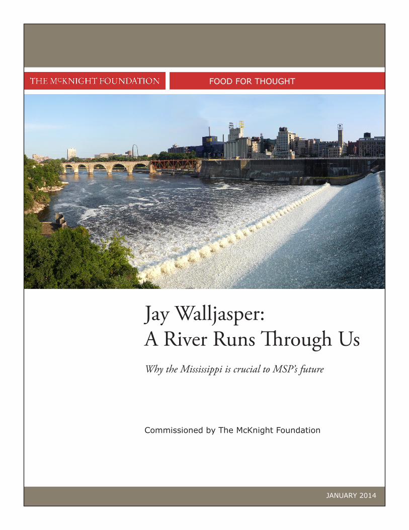
Cover — Bobak Ha’Eri, Panoramic photo of St. Anthony Falls and the Stone Arch Bridge in Minneapolis, MN.
Rolling Down the River — Photos from the websites of U.S. Fish & Wildlife Service, Minnesota Department of Transportation, Explore Minnesota, Dubuque Area Chamber, Explore LaCrosse, and Lake City Historical Society.
710 South Second Street, Suite 400 Minneapolis, MN 55401 T 612.333.4220 F 612.332.3833 www.mcknight.org
@mcknightfdn /mcknightfdn


