Japanese Spatial Data Infrastructure Initiatives Shin-ichi Sobue [email protected] National...
17
Japanese Spatial Data Infrastructure Initiatives Shin-ichi Sobue [email protected] National Space Development Agency of Japan Earth Observation Planning Department
-
date post
20-Dec-2015 -
Category
Documents
-
view
220 -
download
0
Transcript of Japanese Spatial Data Infrastructure Initiatives Shin-ichi Sobue [email protected] National...

Japanese Spatial Data Infrastructure Initiatives
Shin-ichi [email protected]
National Space Development Agency of JapanEarth Observation Planning Department

Problem
• Scattering data archive and dissemination– Earth observation satellite data archive and
dissemination by government (STA/NASDA & EA & MITI) + private sector (Mitsubishi, Hitachi, IMI/NTT-D)
– DEM data archive and dissemination by GSI / MOC– Other GIS related data archive and dissemination by
national / local government / Private sectors (aerial photo companies, VAR)

Problem Points
• Standard– No standard for metadata, data format?, etc...
• Data policy– Commercialization
• Needs– Aerial photo is enough for Japanese GIS
• Do we really need EO satellite data to GIS???– For spatial small country with fine high resolution DEM by
GSI (1/1, 000)

Standards
• Metadata– No activity to coordinate between STA/NASDA
and other entities including private sectors yet.• Different interest of data
• Data Format– CEOS Superstructure and/or HDF is not adopted
by private sectors although public agencies adopt

Data Policy
• Pricing
• Data quality– Calibration / Validation
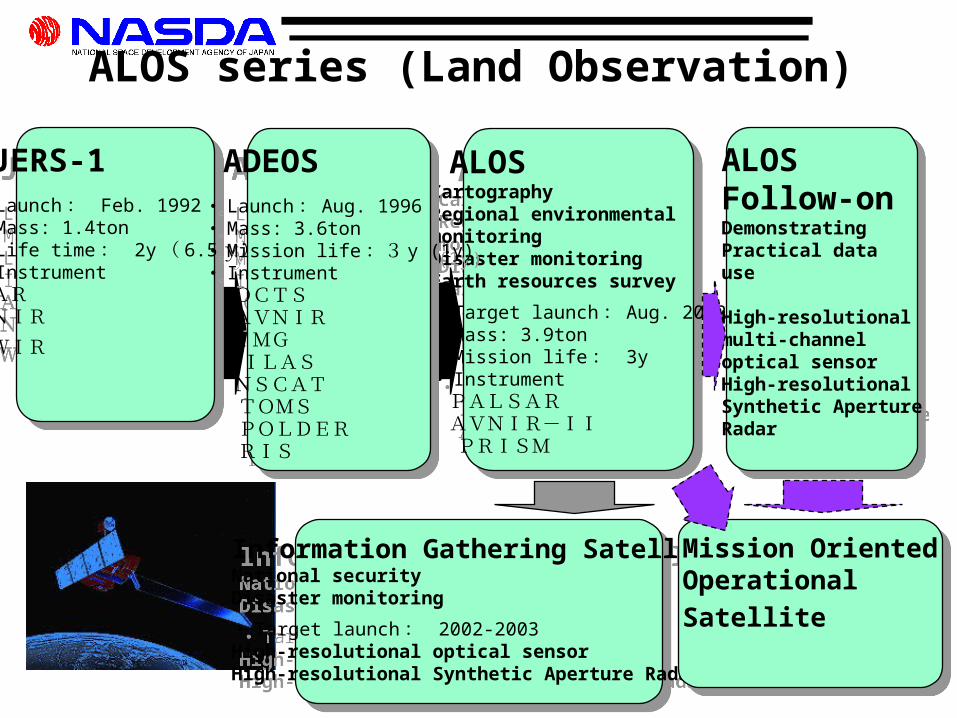
JERS-1・ Launch : Feb. 1992・ Mass: 1.4ton・ Life time : 2y ( 6.5 y)・ InstrumentSARVNIR
SWIR
JERS-1・ Launch : Feb. 1992・ Mass: 1.4ton・ Life time : 2y ( 6.5 y)・ InstrumentSARVNIR
SWIR
ALOSCartographyRegional environmental monitoringDisaster monitoringEarth resources survey
・ Target launch : Aug. 2002・ Mass: 3.9ton・ Mission life : 3y ・ Instrument PALSAR AVNIR-II PRISM
ALOSCartographyRegional environmental monitoringDisaster monitoringEarth resources survey
・ Target launch : Aug. 2002・ Mass: 3.9ton・ Mission life : 3y ・ Instrument PALSAR AVNIR-II PRISM
ALOS Follow-onDemonstrating Practical datause
High-resolutionalmulti-channeloptical sensorHigh-resolutionalSynthetic ApertureRadar
ALOS Follow-onDemonstrating Practical datause
High-resolutionalmulti-channeloptical sensorHigh-resolutionalSynthetic ApertureRadar
ALOS series (Land Observation)
ADEOS・ Launch : Aug. 1996・ Mass: 3.6ton・ Mission life :3 y (1y)・ Instrument OCTS AVNIR IMG ILAS NSCAT TOMS POLDER RIS
ADEOS・ Launch : Aug. 1996・ Mass: 3.6ton・ Mission life :3 y (1y)・ Instrument OCTS AVNIR IMG ILAS NSCAT TOMS POLDER RIS
Information Gathering SatelliteNational securityDisaster monitoring
・ Target launch : 2002-2003High-resolutional optical sensorHigh-resolutional Synthetic Aperture Radar
Information Gathering SatelliteNational securityDisaster monitoring
・ Target launch : 2002-2003High-resolutional optical sensorHigh-resolutional Synthetic Aperture Radar
Mission OrientedOperational Satellite
Mission OrientedOperational Satellite

Main Characteristics Mass 3.9 tons Orbit Sun-synchronous
SubrecurrentAltitude 800km
Mission Period 2002-2006
Main Characteristics Mass 3.9 tons Orbit Sun-synchronous
SubrecurrentAltitude 800km
Mission Period 2002-2006
Advanced Land Observing Satellite (ALOS)
Observing Sensors Panchromatic Remote sensing Instrument for Stereo Mapping (PRISM) Advanced Visible and Near Infrared Radiometer type 2 (AVNIR-2) Phased Array type L-band Synthetic Aperture Radar (PALSAR)
Observing Sensors Panchromatic Remote sensing Instrument for Stereo Mapping (PRISM) Advanced Visible and Near Infrared Radiometer type 2 (AVNIR-2) Phased Array type L-band Synthetic Aperture Radar (PALSAR)

ALOSLaunch Mass : ~4 tAltitude : ~691.65 kmInclination : ~98.16 deg. (Sun-synchronous Sub-recurrent)Repeat cycle : 46 days, (Sub cycle 2 days)Power : ~7KWAttitude Control : 3 Axis Zero-momentumAttitude Determination Accuracy : 2.0 * 10-4 degPotion Determination Accuracy : 1 m Data Rate :240Mbps (DRTS) / 120Mbps (DT)Mission Life : 3-5 yearsData Transmission : Via DRTS (primary)
PALSAR is developed jointly between JAROS and NASDA
PRISM (simulated data)
ADEOS/AVNIR
JERS-1/SAR

NASDA ALOS Data Policy• NASDA Law• UN Remote Sensing Principles
…Law/Resolution
…National Plans
Program of the Office of Earth Observation Systems
- Three Main goals - (1) Contribution to Earth Science (2) Promotion of Practical Use (3) Technology Development
ALOS Data Policy
…NASDA Plans
…NASDA Data Policy
Fundamental Policy for Japan’s Space Activities (1996) Space Development Plan (annual)

NASDA Missions and Expected Roles
Contribution to Earth Science
Technology Development
ADEOS-ⅡADEOS-Ⅱ
AMSR-EAMSR-ETRMMTRMM
ALOSALOS
Japanese Japanese DistributorDistributorNASDA
Promotion of public use
Promotion of Practical Use
Data Node
Promotion of commercial use
◎
◎
◎
○
△
△
○
◎
◎
△
◎
◎
△: not primarily expected○: expected◎: strongly expected

NASDA ALOS Data PolicyPrinciples
• Open and non-discriminatory access to data;
• Data use exclusively for peaceful purposes;
• No more than cost of reproduction for all
data issued from NASDA (Royalty will be
charged for commercially distributed data).

NASDA ALOS Data Policy Pricing Policy
• Open data on the web (limited data: catalog data, disaster, public relations)
• NASDA internal use (including PIs) • Research and Public Use = Cost of reproduction
• Other General Purposes (distributed by a Distributor) = Data will be provided from NASDA to the Distributor at cost of reproduction and royalty (approx. 10%) → Customer Price will be determined by the
Distributor

GIS implementation
• Governmental initiative– Inter-ministry committee for GIS
• Long term plan to implement national spatial data infrastructure and promotion of GIS
• Standardization of national spatial data infrastructure and implementation plan
– 96-98 : Development of infrastructure
– 98-00 : Promotion of GIS (data exchange, policy of inter-use of GIS)
– ISO/TC211 national meeting– Spatial Data Standardization Committee

GIS implementation
• Government Initiative (2/2)– Administrative information promotion plan– Development of on-line system for administrative
information– Implementation plan for national spatial data information
system (1/2,500 for urban area, 1/25,000 for national level from JFY2000)
• Joint effort between public and government– NSDIPA (National Spatial Data Infrastructure Promotion
Association)
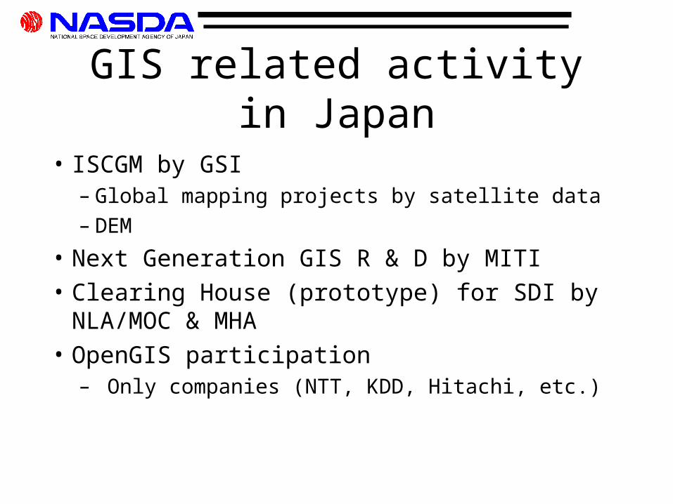
GIS related activity in Japan
• ISCGM by GSI– Global mapping projects by satellite data– DEM
• Next Generation GIS R & D by MITI• Clearing House (prototype) for SDI by
NLA/MOC & MHA • OpenGIS participation
– Only companies (NTT, KDD, Hitachi, etc.)

ALOS for GIS• Joint Research
– With GSI • to create Asia Pacific DEM by using ALOS PRISM
– With EA• to create seasonal vegetation map of Japan
• Pilot Projects with local government– Gunma, Hokkaido, Fukuoka, Okinawa, etc.
• International Pilot Projects– Thailand, Indonesia
• GIS for agriculture

Earth Observation data promotion center (Concept)ALOS
Data reception, Processing
Data Analysis SystemData set generation
EORC
S/WData
Promotion Center
Training and Analysis
Visualization
User support
Software develop for endusers
UsersData Archive
Data Network
Earth Observation Information System
Pilot Project Systems
Partners


![Shin-ichi KIMURA [kimura@fbs.osaka-u.ac.jp] Photophysics ...Shin-ichi KIMURA [kimura@fbs.osaka-u.ac.jp] Photophysics Laboratory, FBS and Dept. Phys., Osaka University, JAPAN真空紫外光電子分光](https://static.fdocuments.net/doc/165x107/610a74d44fd2c52b8d359bf1/shin-ichi-kimura-kimurafbsosaka-uacjp-photophysics-shin-ichi-kimura-kimurafbsosaka-uacjp.jpg)