![[Urban transportation policy program]city paper presentation jakarta](https://static.fdocuments.net/doc/165x107/587a65831a28ab8a2a8b53f7/urban-transportation-policy-programcity-paper-presentation-jakarta.jpg)
[Urban transportation policy program]city paper presentation jakarta
Upload
truongthuyCategory
view
223download
1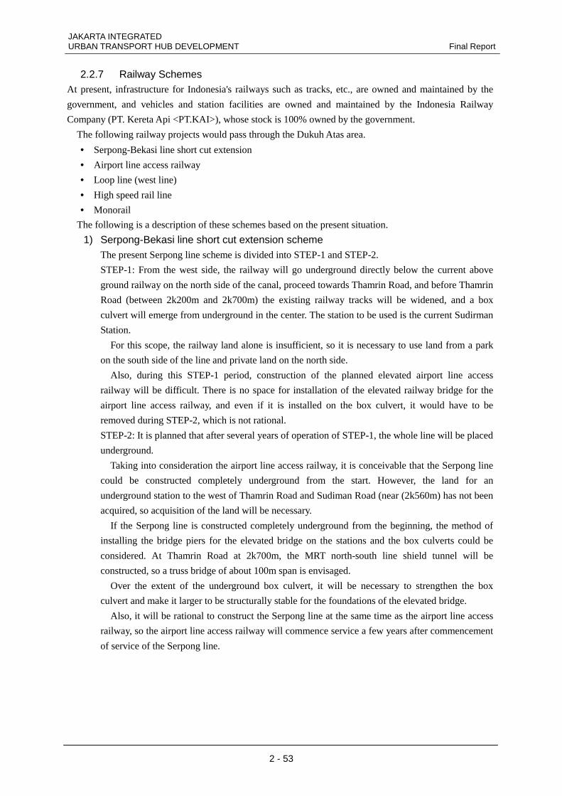
JAKARTA INTEGRATED URBAN TRANSPORT HUB DEVELOPMENT Final Report
2 - 53
2.2.7 Railway Schemes At present, infrastructure for Indonesia's railways such as tracks, etc., are owned and maintained by the
government, and vehicles and station facilities are owned and maintained by the Indonesia Railway
Company (PT. Kereta Api <PT.KAI>), whose stock is 100% owned by the government.
The following railway projects would pass through the Dukuh Atas area.
• Serpong-Bekasi line short cut extension
• Airport line access railway
• Loop line (west line)
• High speed rail line
• Monorail
The following is a description of these schemes based on the present situation.
1) Serpong-Bekasi line short cut extension scheme The present Serpong line scheme is divided into STEP-1 and STEP-2.
STEP-1: From the west side, the railway will go underground directly below the current above
ground railway on the north side of the canal, proceed towards Thamrin Road, and before Thamrin
Road (between 2k200m and 2k700m) the existing railway tracks will be widened, and a box
culvert will emerge from underground in the center. The station to be used is the current Sudirman
Station.
For this scope, the railway land alone is insufficient, so it is necessary to use land from a park
on the south side of the line and private land on the north side.
Also, during this STEP-1 period, construction of the planned elevated airport line access
railway will be difficult. There is no space for installation of the elevated railway bridge for the
airport line access railway, and even if it is installed on the box culvert, it would have to be
removed during STEP-2, which is not rational.
STEP-2: It is planned that after several years of operation of STEP-1, the whole line will be placed
underground.
Taking into consideration the airport line access railway, it is conceivable that the Serpong line
could be constructed completely underground from the start. However, the land for an
underground station to the west of Thamrin Road and Sudiman Road (near (2k560m) has not been
acquired, so acquisition of the land will be necessary.
If the Serpong line is constructed completely underground from the beginning, the method of
installing the bridge piers for the elevated bridge on the stations and the box culverts could be
considered. At Thamrin Road at 2k700m, the MRT north-south line shield tunnel will be
constructed, so a truss bridge of about 100m span is envisaged.
Over the extent of the underground box culvert, it will be necessary to strengthen the box
culvert and make it larger to be structurally stable for the foundations of the elevated bridge.
Also, it will be rational to construct the Serpong line at the same time as the airport line access
railway, so the airport line access railway will commence service a few years after commencement
of service of the Serpong line.
JAKARTA INTEGRATED Final Report URBAN TRANSPORT HUB DEVELOPMENT
2 - 54
Source: Preparatory Survey for JABODETABEK Railways Capacity Enhancement Project
Figure-2.2.47 Serpong line short cut and extension scheme
2) Airport line access railway There are two routes for the airport line access line: a route that leaves the Sukarno-Hatta Airport
as a high-speed railway and passes through the north of Jakarta and enters the existing Angke
Station, and a route that uses the Tangerang line as a commuter line.
In January 2012 PT.SMI (PT.SARANA MULTI INFRASTRUKTUR) placed an order with a
consultant to carry out a F/S for the high speed railway, and it is currently being studied.
The seemingly promising proposal for the railway is to run from the airport through Pluit, Tanah
Abang, Dukuh Atas, and Manggarai, and then extended to Halim. On the other hand, as regards
the route connecting the Tangerang line from the south of the airport, elevated bridges are being
constructed by PT.KAI, by which the line is to pass through Dukuh Atas and stretch to Manggarai.
To the extent that we have examined, when the positional relationship to the Serpong line is
taken into consideration, it is conceivable that the airport line access line will pass through the
park land to the south of the canal. However, there is also a future monorail scheme and a scheme
for transJakarta (BRT) to pass through here instead of the monorail scheme. If it is to the south of
the canal, the construction can be easily carried out separate from the existing railways.
If the airport line access railway is placed to the south of the canal, it will be necessary to
construct structures crossing the canal, and there is a possibility that there will be insufficient land
in places, so confirm whether land will become, insufficient that the height for passing above the
road on artificial foundations will be high, or that the span will become larger due to the
underground shield tunnel, etc.
JAKARTA INTEGRATED URBAN TRANSPORT HUB DEVELOPMENT Final Report
2 - 55
3) Loop line (west line) This is a scheme to make the JABODETABEK railway which at present operates above ground as
the west line into a loop line such as the Yamanote Line in Japan. If the loop line can be
constructed, railways can be constructed to the outskirts from each station, the same as in Japan,
so it is expected that the number of rail users will increase.
From the results of predictions of passenger demand for the loop line, the number of passengers
would be small, so joint operation with the west line is being considered.
4) High speed rail line This is a scheme to connect Jakarta to Bandung, a distance of 144km, in a shortest time of 45
minutes, and it is intended to be implemented as a PPP project.
The earliest that this railway can be operational is 2017 to 2018. Depending on the concept the
scheme will include six stations: Dukuh Atas, Bekasi, Karawang, the new airport (Karawang),
Bandung, and Gedebage (Bandung), with Dukuh Atas as the terminal station. It is still at the
preliminary study stage.
5) Monorail Studies for the Jakarta Province monorail scheme were started in 2001 by the Jakarta Monorail
Company who formed a consortium, the groundbreaking ceremony was held in June 2004, and it
was started as a 30 year BOT scheme. However, the development company went bankrupt with
the bridges in the Asia Africa Road and Setia Budi areas finished, and construction work has been
completely stopped since July 2008.
According to recent newspaper reports, a plan to use the substructure on an elevated road as a
busway to operate Transjakarta and a new monorail route plan were announced; however, they
have not been decided yet.
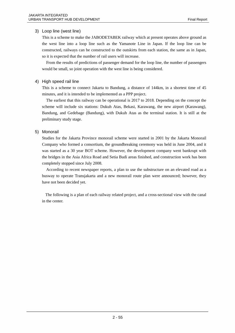
The following is a plan of each railway related project, and a cross-sectional view with the canal
in the center.
JAKARTA INTEGRATED Final Report URBAN TRANSPORT HUB DEVELOPMENT
2 - 56
(Source: Study Team)
Figure-2.2.48 Map of railway related projects
(Source: Study Team)
Figure-2.2.49 Cross-section at Banjir Kanal
Dukuh Atas
JAKARTA INTEGRATED URBAN TRANSPORT HUB DEVELOPMENT Final Report
2 - 57
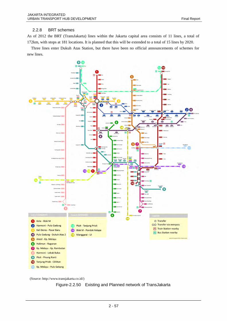
2.2.8 BRT schemes As of 2012 the BRT (TransJakarta) lines within the Jakarta capital area consists of 11 lines, a total of
172km, with stops at 181 locations. It is planned that this will be extended to a total of 15 lines by 2020.
Three lines enter Dukuh Atas Station, but there have been no official announcements of schemes for
new lines.
(Source: http://www.transjakarta.co.id/)
Figure-2.2.50 Existing and Planned network of TransJakarta
JAKARTA INTEGRATED Final Report URBAN TRANSPORT HUB DEVELOPMENT
2 - 58
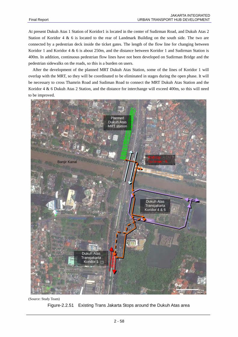
At present Dukuh Atas 1 Station of Koridor1 is located in the center of Sudirman Road, and Dukuh Atas 2
Station of Koridor 4 & 6 is located to the rear of Landmark Building on the south side. The two are
connected by a pedestrian deck inside the ticket gates. The length of the flow line for changing between
Koridor 1 and Koridor 4 & 6 is about 250m, and the distance between Koridor 1 and Sudirman Station is
400m. In addition, continuous pedestrian flow lines have not been developed on Sudirman Bridge and the
pedestrian sidewalks on the roads, so this is a burden on users.
After the development of the planned MRT Dukuh Atas Station, some of the lines of Koridor 1 will
overlap with the MRT, so they will be coordinated to be eliminated in stages during the open phase. It will
be necessary to cross Thamrin Road and Sudiman Road to connect the MRT Dukuh Atas Station and the
Koridor 4 & 6 Dukuh Atas 2 Station, and the distance for interchange will exceed 400m, so this will need
to be improved.
(Source: Study Team)
Figure-2.2.51 Existing Trans Jakarta Stops around the Dukuh Atas area
Railway Sudirman St.
Dukuh Atas Transjakarta Koridor 4 & 6
Dukuh Atas Transjakarta
Koridor 1
Planned Dukuh Atas MRT station
0 0 0 0
Banjir Kanal
JAKARTA INTEGRATED URBAN TRANSPORT HUB DEVELOPMENT Final Report
2 - 59
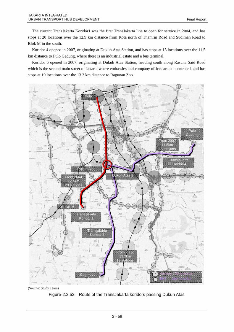
The current TransJakarta Koridor1 was the first TransJakarta line to open for service in 2004, and has
stops at 20 locations over the 12.9 km distance from Kota north of Thamrin Road and Sudiman Road to
Blok M in the south.
Koridor 4 opened in 2007, originating at Dukuh Atas Station, and has stops at 15 locations over the 11.5
km distance to Pulo Gadung, where there is an industrial estate and a bus terminal.
Koridor 6 opened in 2007, originating at Dukuh Atas Station, heading south along Rasuna Said Road
which is the second main street of Jakarta where embassies and company offices are concentrated, and has
stops at 19 locations over the 13.3 km distance to Ragunan Zoo.
(Source: Study Team)
Figure-2.2.52 Route of the TransJakarta koridors passing Dukuh Atas
Transjakarta Koridor 6
Transjakarta Koridor 4
Transjakarta Koridor 1
Dukuh Atas
BLOK M
Kota
Pulo Gadung
Ragunan
Dukuh Atas 2 From 2004 12.9km
20 stations
From 2007 13.3km
19 stations
From 2007 11.5km
15 stations
Railway 750m radius BRT 250m radius
JAKARTA INTEGRATED Final Report URBAN TRANSPORT HUB DEVELOPMENT
2 - 60
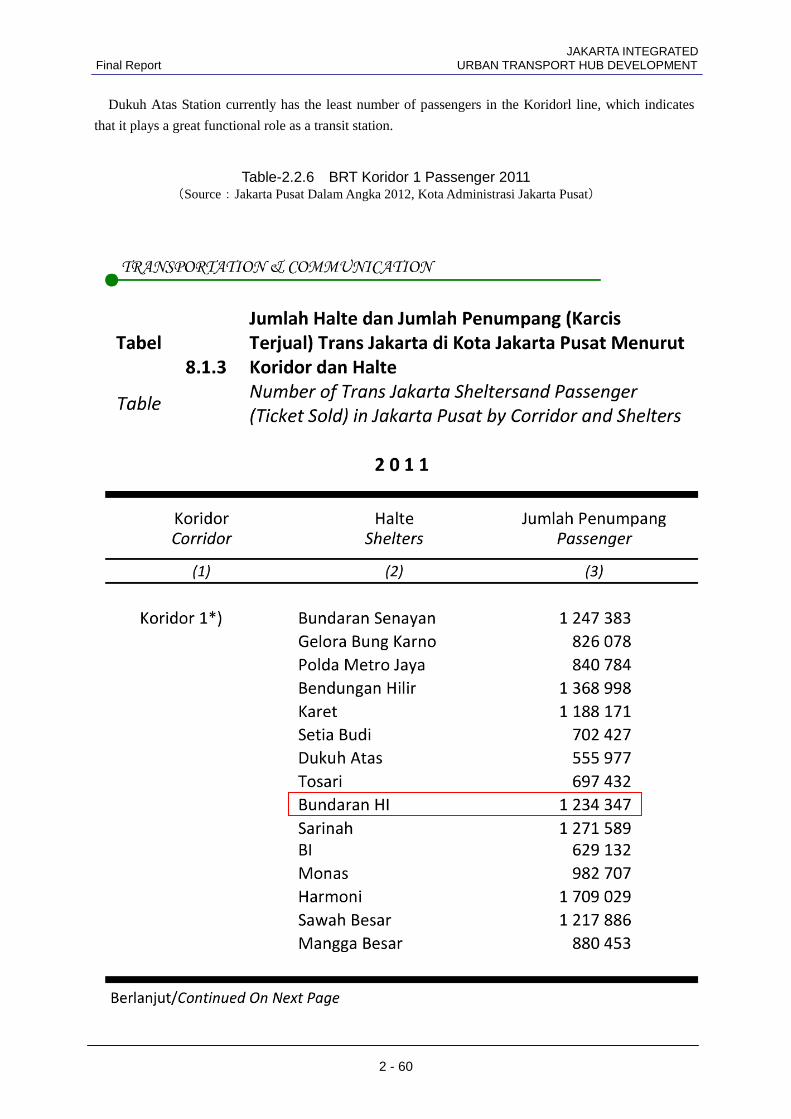
Dukuh Atas Station currently has the least number of passengers in the Koridorl line, which indicates
that it plays a great functional role as a transit station.
Table-2.2.6 BRT Koridor 1 Passenger 2011 (Source:Jakarta Pusat Dalam Angka 2012, Kota Administrasi Jakarta Pusat)
JAKARTA INTEGRATED URBAN TRANSPORT HUB DEVELOPMENT Final Report
2 - 61
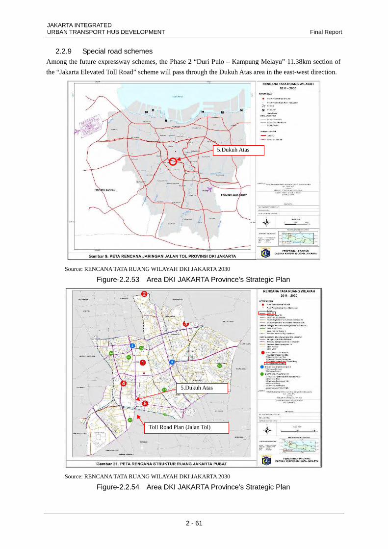
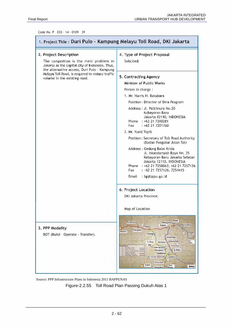
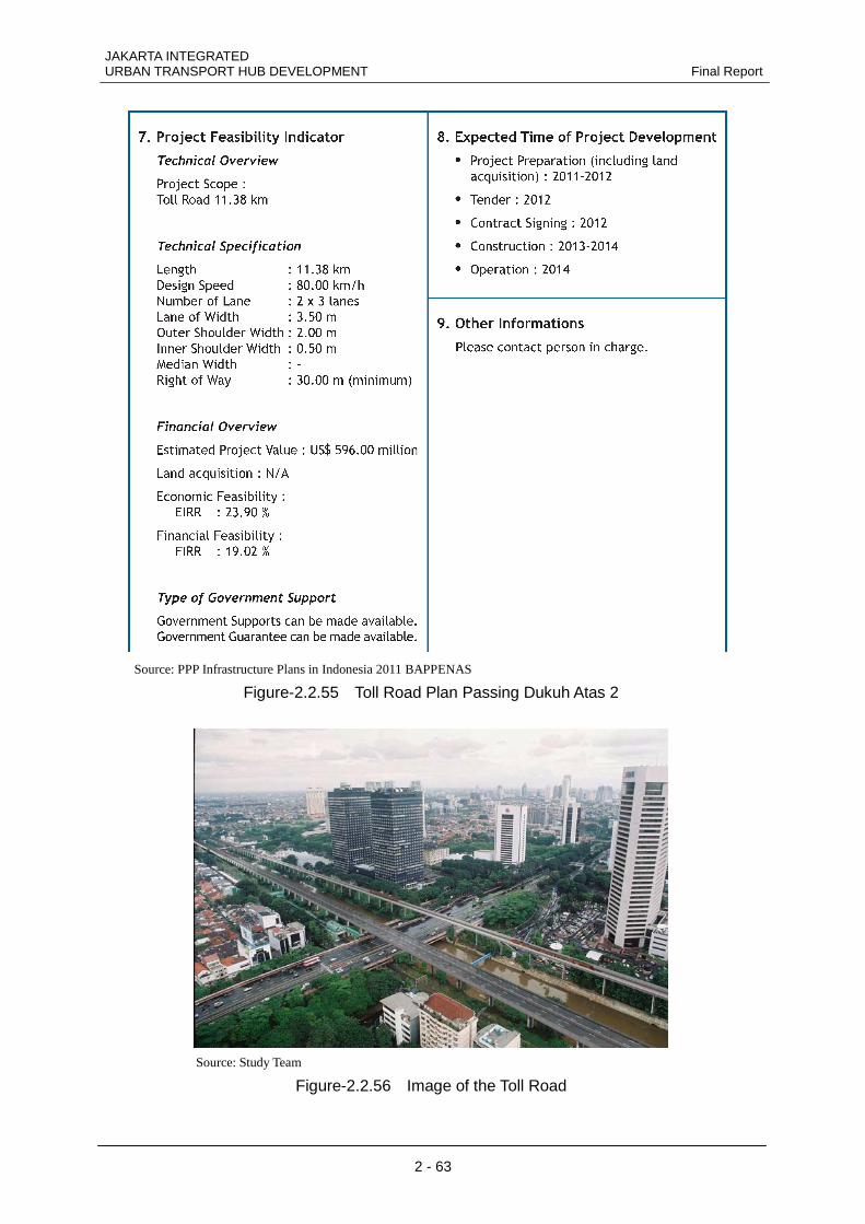
2.2.9 Special road schemes Among the future expressway schemes, the Phase 2 “Duri Pulo – Kampung Melayu” 11.38km section of
the “Jakarta Elevated Toll Road” scheme will pass through the Dukuh Atas area in the east-west direction.
Source: RENCANA TATA RUANG WILAYAH DKI JAKARTA 2030
Figure-2.2.53 Area DKI JAKARTA Province’s Strategic Plan
Source: RENCANA TATA RUANG WILAYAH DKI JAKARTA 2030
Figure-2.2.54 Area DKI JAKARTA Province’s Strategic Plan
Toll Road Plan (Jalan Tol)
5.Dukuh Atas
5.Dukuh Atas
JAKARTA INTEGRATED Final Report URBAN TRANSPORT HUB DEVELOPMENT
2 - 62
Source: PPP Infrastructure Plans in Indonesia 2011 BAPPENAS
Figure-2.2.55 Toll Road Plan Passing Dukuh Atas 1
JAKARTA INTEGRATED URBAN TRANSPORT HUB DEVELOPMENT Final Report
2 - 63
Source: PPP Infrastructure Plans in Indonesia 2011 BAPPENAS
Figure-2.2.55 Toll Road Plan Passing Dukuh Atas 2
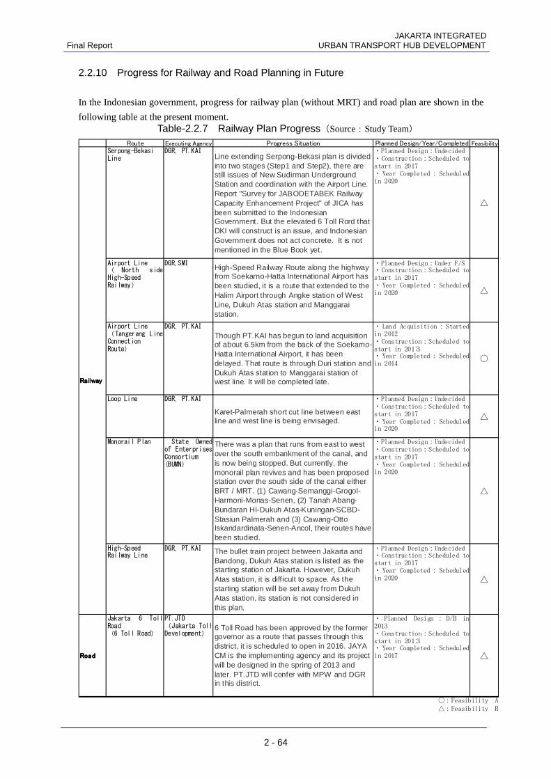
Source: Study Team
Figure-2.2.56 Image of the Toll Road
JAKARTA INTEGRATED Final Report URBAN TRANSPORT HUB DEVELOPMENT
2 - 64
2.2.10 Progress for Railway and Road Planning in Future In the Indonesian government, progress for railway plan (without MRT) and road plan are shown in the
following table at the present moment.
Route Executing Agency Progress Situation Planned Design/Year/Completed Feasibility
Serpong-Bekasi
Line
DGR, PT.KAI
Line extending Serpong-Bekasi plan is dividedinto two stages (Step1 and Step2), there arestill issues of New Sudirman UndergroundStation and coordination with the Airport Line.Report "Survey for JABODETABEK RailwayCapacity Enhancement Project" of JICA hasbeen submitted to the IndonesianGovernment. But the elevated 6 Toll Rord thatDKI will construct is an issue, and IndonesianGovernment does not act concrete. It is notmentioned in the Blue Book yet.
・Planned Design:Undecided
・Construction:Scheduled to
start in 2017
・Year Completed:Scheduled
in 2020
△
Airport Line
( North side
High-Speed
Railway)
DGR,SMI
High-Speed Railway Route along the highwayfrom Soekarno-Hatta International Airport hasbeen studied, it is a route that extended to theHalim Airport through Angke station of WestLine, Dukuh Atas station and Manggaraistation.
・Planned Design:Under F/S
・Construction:Scheduled to
start in 2017
・Year Completed:Scheduled
in 2020△
Airport Line
(Tangerang Line
Connection
Route)
DGR, PT.KAI
Though PT.KAI has begun to land acquisitionof about 6.5km from the back of the Soekarno-Hatta International Airport, it has beendelayed. That route is through Duri station andDukuh Atas station to Manggarai station ofwest line. It will be completed late.
・Land Acquisition:Started
in 2012
・Construction:Scheduled to
start in 2013
・Year Completed:Scheduled
in 2014
○
Loop Line DGR, PT.KAI
Karet-Palmerah short cut line between eastline and west line is being envisaged.
・Planned Design:Undecided
・Construction:Scheduled to
start in 2017
・Year Completed:Scheduled
in 2020
△
Monorail Plan State Owned
of Enterprises
Consortium
(BUMN)
There was a plan that runs from east to westover the south embankment of the canal, andis now being stopped. But currently, themonorail plan revives and has been proposedstation over the south side of the canal eitherBRT / MRT. (1) Cawang-Semanggi-Grogol-Harmoni-Monas-Senen, (2) Tanah Abang-Bundaran HI-Dukuh Atas-Kuningan-SCBD-Stasiun Palmerah and (3) Cawang-OttoIskandardinata-Senen-Ancol, their routes havebeen studied.
・Planned Design:Undecided
・Construction:Scheduled to
start in 2017
・Year Completed:Scheduled
in 2020
△
High-Speed
Railway Line
DGR, PT.KAI The bullet train project between Jakarta andBandong, Dukuh Atas station is listed as thestarting station of Jakarta. However, DukuhAtas station, it is difficult to space. As thestarting station will be set away from DukuhAtas station, its station is not considered inthis plan.
・Planned Design:Undecided
・Construction:Scheduled to
start in 2017
・Year Completed:Scheduled
in 2020
△
RoadRoadRoadRoad
Jakarta 6 Toll
Road
(6 Toll Road)
PT.JTD
(Jakarta Toll
Development)
6 Toll Road has been approved by the formergovernor as a route that passes through thisdistrict, it is scheduled to open in 2016. JAYACM is the implementing agency and its projectwill be designed in the spring of 2013 andlater. PT.JTD will confer with MPW and DGRin this district.
・ Planned Design : D/B in
2013
・Construction:Scheduled to
start in 2013
・Year Completed:Scheduled
in 2017 △
RailwayRailwayRailwayRailway
○:Feasibility A
△:Feasibility B
Table-2.2.7 Railway Plan Progress(Source:Study Team)

JAKARTA INTEGRATED URBAN TRANSPORT HUB DEVELOPMENT Final Report
2 - 65
2.3 Related legal systems
In Indonesia all business activities must comply with the laws and regulations of Indonesia. Based on
Article 7 of the Law Concerning the Establishment of Laws and Regulations No. 12/2011, the laws of
Indonesia have the following layers.
1. The 1945 Constitution
2. Assembly Decrees
3. Laws
4. Government Regulations
5. Presidential Regulations
6. Provincial Regulations
7. Regency/City Regulations
The legal binding power of laws and regulations is structured in accordance with the above levels.
2.3.1 PPP-related legal system Main regulations:
Presidential Regulations No. 67/2005 Amended by Presidential Regulations 56/2011
concerning the Second Amendment to Presidential Regulations No. 67/2005 concerning
cooperation between government and corporations in connection with infrastructure
development
Subsidiary regulations:
Minister of National Development Plan / National Planning Regulations No. 4/2010 Guidelines
for Implementing PPP Infrastructure Development
Regulations No. Per-03/M.EKON/06/2006 of the Coordinating Minister for Economic Affairs
as the head of the Committee for Acceleration of Infrastructure Development
Procedures and Criteria for Preparation of the PPP Infrastructure Development Priority List
Regulations No. Per-04/M.EKON/06/2006 of the Coordinating Minister for Economic Affairs
as the head of the Committee for Acceleration of Infrastructure Development
Procedures for Evaluation of Public-Private Projects for Infrastructure Development
Regulations No. 260/PMK.001/2010 of the Minister for Investment Guidelines for
Infrastructure Guarantees in PPP Projects
PPP was established by the Presidential Regulations No. 67/2005. These were amended by the
Presidential Regulations 56/2011 concerning the Second Amendment to Presidential Regulations
No. 67/2005 concerning cooperation between government and corporations in connection with
infrastructure development. The important items in the PPP law are as follows.
• The PPP Law is only applicable to projects where there may be cooperation with a private
entity. These are as follows.
a) Transport facilities including airport facilities, port facilities, and railway facilities
b) Road facilities including toll roads and toll bridges
c) Irrigation facilities including watercourses for transporting raw water
d) Water supply facilities including water intakes, water distribution networks, and
drinking water processing facility structures
e) Sewage facilities including sewerage networks, and sewage treatment plant
JAKARTA INTEGRATED Final Report URBAN TRANSPORT HUB DEVELOPMENT
2 - 66
f) Telephone and information facilities including telephone networks and e-government
facilities
g) Electrical power facilities including power generation by geothermal power generation,
power transmission, and distribution
h) Oil and gas facilities including transport of oil and gas
• Cooperation between the Indonesian government and private organizations on public works
can be implemented via a cooperation agreement or development permit.
• Joint projects shall be entered on the priority list of the PPP book issued by the national
development planning agency (BAPPENAS). Also, unsolicited projects may be proposed by
corporations. Selection of operators for unsolicited projects shall also be by public tender.
• Risks shall be managed by that entity that is most capable of controlling that risk.
• Government support can take the form of financial contribution, licenses, acquisition of land,
partial construction assistance, and favorable treatment in terms of tax from the Minister of
Finance.
• Forms of guarantee are available by both government guarantee and operator infrastructure
guarantee.
The Indonesian Government announced its 15-year Economic Development Program
(MP3EI) to develop six major economic corridors covering till the year 2025 and to envisage to
making Indonesia as one of the ten largest nations in terms of economy by then. The
infrastructure is considered as one of the major pillars to support economic development but the
government realized it is difficult to seek financial resources only from the budgetary
allocations, and thus it encourages private sector participation and finance, that is to say, to
develop its infrastructure under the Public-Private Partnership scheme.
PPP projects, classified either its selection, planning or implementation stage, must be
registered to the PPP Book that BAPPENAS compiles summary of the each project.
The Government plans to introduce a Viability Gap Fund (VGF) as a supplemental support
from the Government with the initiative of MOF in addition to its guarantee and infrastructure
funding guarantee.
PPP Book 2012 describes the PPP project classifications and development benchmarks as
follows. The PPP Book registers PPP projects when reviewing the Government Annual
Government Work Plan under the Medium-term Economic Development Plan. The registration
to PPP Book is applied to BAPPENAS and BAPPENAS will incorporate the application in
accordance with the development stage of the applied project after its own appraisal. The
application is usually closed in December and a revised version of the PPP Book is published in
May in the case of year 2012.
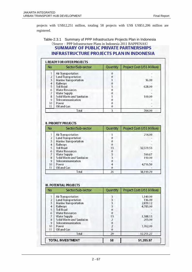
PPP Book 2012 reviews that, firstly, there are 12 tendered and implemented projects in
electricity, water supply and road sectors. It classifies 3 projects with US$764 million as the
“Ready for Offer Projects, 26 projects with US$38,191 million as the Priority Projects, and 29
JAKARTA INTEGRATED URBAN TRANSPORT HUB DEVELOPMENT Final Report
2 - 67
projects with US$12,251 million, totaling 58 projects with US$ US$51,206 million are
registered.
Table-2.3.1 Summary of PPP Infrastructure Projects Plan in Indonesia (Source:PPP Infrastructure Plans in Indonesia 2011 BAPPENAS)
JAKARTA INTEGRATED Final Report URBAN TRANSPORT HUB DEVELOPMENT
2 - 68
A. Potential Projects
• Conformity with the national / regional mid term development plan and the
infrastructure sector’s strategic plant;
• Conformity of the project’s location with the Regional Spatial Planning;
• Linkage between the infrastructure sectors and the regional areas;
• Cost recovery potential; and
• Preliminary Study
B. Priority Projects
• Included in PPP Potential Project Plan or proposed by contracting as unsolicited
project;
• Based on Pre-Feasibility, the project is feasible from legal, technical, and financial
aspect;
• Risk identification and allocation has been identified;
• PPP mode has been defined; and
• Government support has been identified (for marginal project).
C. Ready for Offer Projects
• Bidding Document has been completed;
• PPP procurement team has been established and ready to operate;
• Procurement schedule has been defined;
• Government support has been approved (if required)
These classified projects are listed in the PPP Book, and based on those contents, the
Government adopts its Annual Government Work Plan. Further the Annual Ministry/Agency
Annual Work Plan is decided and the relevant amount is allocated from the budget.
There are two different project schemes in Public Private Partnership. The first scheme is a
PPP project based on initiative of government or the “Solicited project” and the other is a PPP
project based on initiative of business entities or the “Unsolicited project”. There are
considerable differences between the solicited project and the unsolicited project.
Solicited projects are regulated in article 7 of Presidential Regulation No 67/2005 which has
amended by Presidential Regulation No 56/2011 regarding Second Amendment of the
Presidential Regulation Number 67 Year 2005 concerning The Cooperation Between
Government And Business Entity On Provision Of Infrastructure. The following is general
stages in solicited project.
JAKARTA INTEGRATED URBAN TRANSPORT HUB DEVELOPMENT Final Report
2 - 69
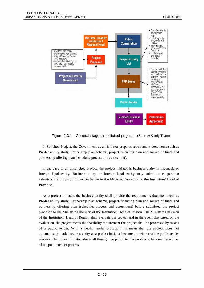
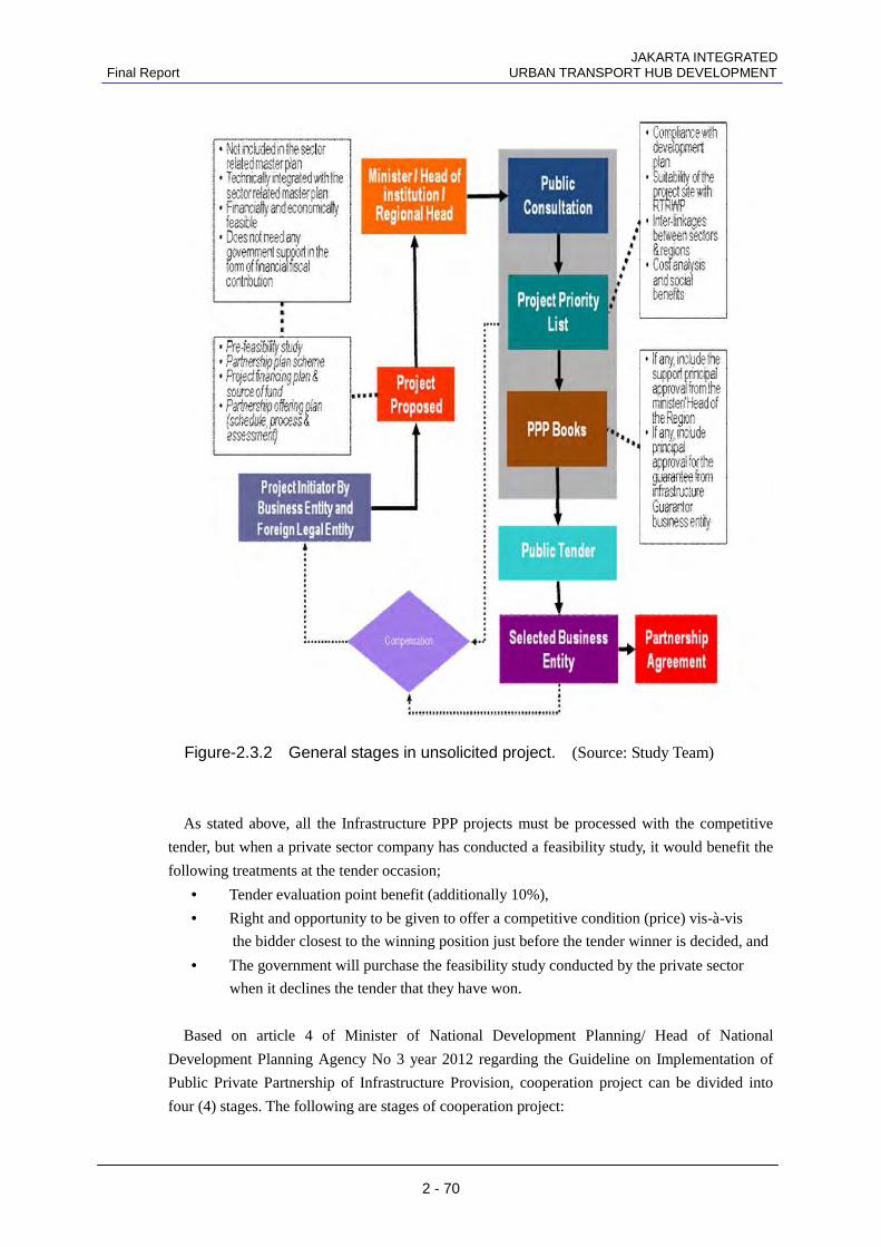
Figure-2.3.1 General stages in solicited project. (Source: Study Team)
In Solicited Project, the Government as an initiator prepares requirement documents such as
Pre-feasibility study, Partnership plan scheme, project financing plan and source of fund, and
partnership offering plan (schedule, process and assessment).
In the case of an unsolicited project, the project initiator is business entity in Indonesia or
foreign legal entity. Business entity or foreign legal entity may submit a cooperation
infrastructure provision project initiative to the Minister/ Governor of the Institution/ Head of
Province.
As a project initiator, the business entity shall provide the requirements document such as
Pre-feasibility study, Partnership plan scheme, project financing plan and source of fund, and
partnership offering plan (schedule, process and assessment) before submitted the project
proposed to the Minister/ Chairman of the Institution/ Head of Region. The Minister/ Chairman
of the Institution/ Head of Region shall evaluate the project and in the event that based on the
evaluation, the project meets the feasibility requirement the project shall be processed by means
of a public tender. With a public tender provision, its mean that the project does not
automatically made business entity as a project initiator become the winner of the public tender
process. The project initiator also shall through the public tender process to become the winner
of the public tender process.
JAKARTA INTEGRATED Final Report URBAN TRANSPORT HUB DEVELOPMENT
2 - 70
Figure-2.3.2 General stages in unsolicited project. (Source: Study Team)
As stated above, all the Infrastructure PPP projects must be processed with the competitive
tender, but when a private sector company has conducted a feasibility study, it would benefit the
following treatments at the tender occasion;
• Tender evaluation point benefit (additionally 10%),
• Right and opportunity to be given to offer a competitive condition (price) vis-à-vis
the bidder closest to the winning position just before the tender winner is decided, and
• The government will purchase the feasibility study conducted by the private sector
when it declines the tender that they have won.
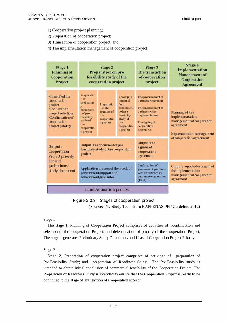
Based on article 4 of Minister of National Development Planning/ Head of National
Development Planning Agency No 3 year 2012 regarding the Guideline on Implementation of
Public Private Partnership of Infrastructure Provision, cooperation project can be divided into
four (4) stages. The following are stages of cooperation project:
JAKARTA INTEGRATED URBAN TRANSPORT HUB DEVELOPMENT Final Report
2 - 71
1) Cooperation project planning;
2) Preparation of cooperation project;
3) Transaction of cooperation project; and
4) The implementation management of cooperation project.
Figure-2.3.3 Stages of cooperation project (Source: The Study Team from BAPPENAS PPP Guideline 2012)
Stage 1
The stage 1, Planning of Cooperation Project comprises of activities of: identification and
selection of the Cooperation Project; and determination of priority of the Cooperation Project.
The stage 1 generates Preliminary Study Documents and Lists of Cooperation Project Priority.
Stage 2
Stage 2, Preparation of cooperation project comprises of activities of preparation of
Pre-Feasibility Study; and preparation of Readiness Study. The Pre-Feasibility study is
intended to obtain initial conclusion of commercial feasibility of the Cooperation Project. The
Preparation of Readiness Study is intended to ensure that the Cooperation Project is ready to be
continued to the stage of Transaction of Cooperation Project.
JAKARTA INTEGRATED Final Report URBAN TRANSPORT HUB DEVELOPMENT
2 - 72
Stage 3
Stage 3, Transaction of cooperation project comprises completion of Feasibility Study and the
draft of procurement plan of the Business Entity; and public tender of the Business Entity
covering the planning and implementation of the Business Entity’s public tender. In the event the
Government Support and/or Government Security are required, the Minister, Institutional Head,
Regional Head and President Director of the State/ Regional-Owned Company in respect of laws
and regulations pertaining to the related sector hall submit: Documents of the Feasibility Study
to the Finance Minister to obtain statement of readiness of the Government Support; and/or
Documents of the Feasibility study including the proposal of warranty to the SPV to obtain
statement of readiness of the Government Security.
.
Stage 4
Stage 4 , The implementation management of cooperation project comprises of planning of
Implementation Management of the Cooperation Contract. Activities of implementation
management of the Cooperation Contract shall be carried out at the time of: pre-construction,
commencing since the signing of the Cooperation Contract until the funding is obtained;
Construction, commencing since the beginning of construction until the Cooperation Project
operates commercially; commercial operation, commencing since the Cooperation Project
operates commercially until the expiry date of the Cooperation Contract; and expiration of the
Cooperation Contract.
[Government guarantee and infrastructure guarantee]
Government guarantee is executed considering the financial risk management principles in the
state budget under Presidential Decree No13/2010 Article 17.b.
a) The standards for government guarantee to be provided for a subject project is determined.
b) Data and information are requested from the party concerned which can be judged necessary
for the project to receive government guarantee.
c) A proposal for government guarantee within the framework of infrastructure development is
approved.
d) The form and type of government guarantee provided for partnership projects are
determined.
Government will guarantee in the form of monetary compensation by the Minister of Finance
from a business entity founded by the government for purposes of implementing the subject
infrastructure project. All government guarantees must be stated in public tendering documents.
In addition to Presidential Decree No13/2010, government guarantee was stipulated
specifically in Ministry of Finance Order No260/2010 (concerning guidelines for fulfillment of
infrastructure guarantee in PPP projects) in relation to infrastructure guarantee and guidelines
for infrastructure guarantee included in Presidential Decree No78/2010 (concerning
infrastructure guarantee in PPP projects initiated by the infrastructure guarantee agency (BUPI)).
Generally, there are two types of government guarantee:
1) Government guarantee based on a government guarantee contract
2) Government guarantee based on a guarantee contract by an infrastructure guarantee agency
JAKARTA INTEGRATED URBAN TRANSPORT HUB DEVELOPMENT Final Report
2 - 73
As regards the order of priority for execution, government guarantee is executed based on
infrastructure guarantee, and government guarantee is executed jointly with an infrastructure
guarantee agency. In this joint execution, government guarantee can be executed on several
conditions as follows:
a)An infrastructure guarantee agency does not provide sufficient capital to execute the
guarantee.
b) There is no partnership between an infrastructure guarantee agency and multinational
financing institutions.
c) Under government’s capital participation, an infrastructure guarantee agency does not
provide sufficient capital.
Several requirements are established for risks which can be covered by government
guarantee based on the Ministry of Finance No260/2010 Article 10. The following are
infrastructure risks covered by infrastructure guarantee.
a)Infrastructure risks caused by no action from the party having authority to take charge of
and implement cooperating projects of other government agencies based on current laws
and regulations.
b) Infrastructure risks due to policies of PJPK or other government agencies
c) Infrastructure risks caused by determination by PJPK or other government agencies
d) Infrastructure risks arising from PJPK in violation of obligations/contracts
2.3.2 Urban development project-related legal system 1) Land-related
Main regulations:
Law No. 5/1960 Basic Act for Land
Law No. 5/1960 Basic Agricultural Law
Law No. 2/2012 Land Expropriation for the Development of the Public Benefit
Subsidiary regulations: Presidential Regulations No. 36/2005 Supply of Land for
Development of the Public Benefit
Presidential Regulations No. 65/2006 Amendment to Presidential Regulations No. 36/2005
National Land Agency Regulations No. 3/2007 Implementation of Regulations for
Presidential Regulations No. 36/2005
One of the difficult problems for infrastructure development is land expropriation. These
land-related laws and regulations acknowledge public rights regarding land and land-related
problems and allocate authority to the public in accordance with regulations, management,
implementation, and supervisory authority.
(1) Property Rights
Property rights consisting from land and building is still governed by the Indonesian Agrarian
Law, Law No. 5 of 1960. In Paragraph 1 of Article 16 of the Law No. 5, Land rights are stated. The
summary under is based on the “Indonesian Real Estate Rights”, report from the JETRO, January
2010. The main rights are:
JAKARTA INTEGRATED Final Report URBAN TRANSPORT HUB DEVELOPMENT
2 - 74
・Freehold title(hak milik)
・Cultivation Rights Title(hak guna-usaha)
・Building Rights Title(hak guna-bangunan)
・Right to Use Title(hak pakai)
・Right to Rent for Buildings(hak sewa)
・Land Clearing Rights(hak membuka tanah)
・Forestry Rights(hak memungut-hasil hutan)
・Other (hak-hak lain yang tidak termasuk dalam hak-hak tersebut diatas yang akan
ditetapkan)
From these rights, the rights with certificate are, Freehold title(hak milik),Cultivation Rights
Title(hak guna-usaha), Building Rights Title(hak guna-bangunan),Right to Use Title(hak pakai),
and also Rights of Management (Hak Pegelolaan) and Strata Title
(a) Freehold Title (HM or Hak Milik, Article 20-27)
Freehold title is the strongest and fullest title that can be obtained. However such rights are not
absolute as the UUPA recognises the "social functions" of land, however infers a right of "peaceful
occupation" of land by the titleholder. Freehold title may only be held by Indonesian citizens
(natural persons). It is therefore impossible for a foreign individual to have direct freehold
ownership of land in Indonesia.
All Indonesian companies, no matter if they are PMA (foreign investment companies) or not,
cannot possess freehold title over land and are compelled to use other titles such as Hak Guna
Usaha and Hak Guna Bangunan.
According to the UUPA, land that is titled Hak Milik can be used as security for debt.
However, foreign companies and individuals must take care in accepting freehold land as security,
and should consult with competent advisors beforehand.
(b) Land Cultivation Rights Title (HGU or Hak Guna Usaha, Article 28-34)
The Land Cultivation Title (HGU) gives the right to use a state-owned land for the purpose of
agriculture, in particular plantations, fishing or cattle-raising. Such title is granted for periods of
25 or 35 years, and may be extended for another 25 years if the land is deemed to be managed and
utilised properly. This title of right is given to Indonesian citizens or legal entities (including
PMA companies). A HGU title can be used as collateral, or, with the approval of the government,
transferred to a third party.
(c) Building Rights Title
A Building Rights Title (HGB) gives the right to construct and own buildings on a piece of land
that someone else owns. Such title is granted for a maximum period of 30 years, and can be
extended for another 20 years. HGB title is granted to Indonesian citizens or legal entities
(including PMA companies), and can also be used as collateral or transferred to a third party.
(d) Right to Use Title (HP or Hak Pakai, Article 41-43)
JAKARTA INTEGRATED URBAN TRANSPORT HUB DEVELOPMENT Final Report
2 - 75
The Right of Use on Land (HP) is the right to use land for any purpose for a period of 25 years.
This type of title should not be confused with a lease contract or sharecropping agreement.
Foreign residents of Indonesia and Indonesian legal entities (including PMA companies) may
hold HP titles. HP title has no collateral value to the owners and is not transferable.
(e) Rights of Management (Hak Pegelolaan)
Also applied with a certificate, this is a new law applied in regulation of minister of agaria No9.
of 1965 right, which allows private parties to operate manage land with government ownership.
Development in Ancol amusement park and Batam islands are based on this law.
The law permits
>To plan the usage of the land area
>To use and manage the land based on plan
>To rent the rights of management to 3rd party for 6 years.
>To acquire income from the usage
The law limits
>The land area must be within the area of 1,000m2
> The delegate must be an Indonesian national or a Indonesian company based on Indonesian
law and delegation can be done only once.
Registration in only required for rights over 6 years.
(f) Strata Title
Strata Title is used to have divided ownership for an individual lot of an apartment building.
Under the law “ Hak atas Tanah Kepunyaan Bersama dan Pemilikan Bagian-Bagian Bangunan
Yang Ada di Atasnya(Rights of land co-ownership and the building above) is used for strata title.
The relevant legal language for Indonesia uniquely employs the term rumah susun. The legal basis
for rumah susun regulations are: Law No. 16 of 1985 on Rumah Susun, and; Government
Regulation No. 4 of 1988 on Rumah Susun.
The Definition of rumah susun under the Law is:
"A multi-storey building which was built in such a manner as to be divided into parts that are
functionally structured in separate horizontal and vertical directions and the units can each
separately be owned and inhabited primarily as a means of shelter, equipped with parts, goods, and
lands that must be used together by the people living under the building."
Individual apartment owners possess the following common rights:
joint rights over common parts,
joint rights over common objects / goods,
joint rights over lands
all of which are a unified rights and are inseparable.
JAKARTA INTEGRATED Final Report URBAN TRANSPORT HUB DEVELOPMENT
2 - 76
Ownership of a Unit of Rumah Susun ("HMSRS") is considered exist the ‘Deed of Separation’
has been registered and the ‘Land Book’ is made. To provide legal certainty surrounding the
creation of flats, the government provides a strong evidentiary tool called the HMSRS certificate
which is issued by the Land Office in the regency / city.
(2) Issues regarding property rights for foreigners Foreigners are not permitted to have property title in Indonesia. However, foreign individuals
can legally acquire property in Indonesia and enjoy full beneficial rights. This is done using one of
two models: the first by a nominee arrangement, and the second, by way of an Indonesian
incorporated company.
With nominee method, an Indonesian citizen or legal entity (including PMAs) is nominated to
buy the land on behalf of the purchaser. Land Title deeds will thus be under the name of the
nominee. The PPAT handling the land sale and transfer will simultaneously make a Power of
Attorney giving the foreign purchaser total and exclusive authority to utilize, sell, transfer, or lease
the land without any reference whatsoever from the nominee, along with a statement declaring that
the money used the buy the land belongs to the foreign purchaser and not to the nominee.
The power of attorney must give the foreign party full beneficial rights on the property and must
waive all rights of the nominee. The foreign party is then free to build on the land, sell or lease
the property and transfer the title to next of kin. Often, the nominee will receive a nominal fee for
his responsibilities as the title holder.
An even more secure way to obtain Indonesian land is to establish an Indonesian company.
100% foreign equity companies are now possible in Indonesia, however a minimum of two
shareholders is required, with an initial minimum of 5%. Such a company can then become the
legal owner of the land, with the Title Deed in the name of the company.
Whist freehold title is not possible with this method, the Building Rights Title has effectively the
same strength as freehold title as long as the company continues to operate and utilize the land. A
foreigner or company cannot simply buy up land and then do nothing with it. Indonesian land
laws are designed to prevent speculation by absentee landlords who leave land idle for years at a
time. As long as the land is being used for whatever purpose, then the title is completely secure.
The most significant change in Indonesian investment law came in 1997 when the Government
introduced the ‘PMA’ (Penanaman Modal Asing or Foreign Investment Company Programme).
This allows foreign investors to set up a company in Indonesia, without having to have Indonesian
partners; the PMA can be 100% owned by the foreign investor. PMA companies are allowed to
own the title of the property for a period of 20 or 30 years, when the title has to be renewed by the
Government.
To set up a PMA company you will be required to:
•Submit a detailed business plan
•Operate in a business environment that adds value to Indonesia in terms of foreign skills,
employment and environmental benefit
JAKARTA INTEGRATED URBAN TRANSPORT HUB DEVELOPMENT Final Report
2 - 77
•Make an appropriate cash deposit in an Indonesian based bank. (The amount varies and is
calculated from the capital employed in the business)
•Show the property investment as an asset of the company
•The process takes approximately 3 to 4 months and once completed the company can apply for
work permits for the foreign directors, 3 permits in the first year of operation. The cost of setting
up is between 30 to 40 million Indonesian Rupiah
1.Enter into a legal arrangement with an Indonesian nominee, either an individual or PT
company, whereby he/she/corporation holds title to the property. Simultaneously, complete a power
of attorney, handing over full rights from the Indonesian entity to the foreign investor.
2.Make a leasehold investment in the property, usually for 20-30 years. Partnerships with
Indonesian citizens are not required in leasehold transactions. This method does offer complete
protection to the foreigner during the term of the lease, however, once the lease term has expired
the agreement can be extended or the property reverts to the Owner
3.Form a foreign investment company (PMA).Here the foreigner can own the company 100%
and the title of the property will be in the company name. However, title in this case could only last
for 20 or 30 years as PMA companies have to re-apply to the Indonesian Government to extend
their license
(3) Land registration procedure A Land Title Deed is known in Indonesia as a Sertifikat Tanah, and is always accompanied by a
Survey Certificate known as Surat Ukur that documents the location and dimensions of the land.
Land transfers and land title deeds are drafted by a Land Deed Official known as Pejabat
Pembuat Akte Tanah or PPAT. Most of a PPAT’s work involves land transfers (in the case of sale or
inheritance) and land registration. Much are should be taken when selecting a PPAT to handle
land matters, especially if the matter involves foreigners or PMA companies.
The vast majority of land in Indonesia is in fact not registered at the BPN and is held under
traditional title (Hak Adat). Occasionally, provincial governments will carry out publicity
campaigns urging people, especially those in non-urban areas, to survey and register their land.
However, this can be very problematic indeed, as lands are often "owned" by extended families
who extent is difficult to actually clearly define.
(4) Current issues regarding land titles The vast majority of land in Indonesia is in fact not registered at the BPN and is held under
traditional title (Hak Adat). Occasionally, provincial governments will carry out publicity
campaigns urging people, especially those in non-urban areas, to survey and register their land.
However, this can be very problematic indeed, as lands are often "owned" by extended families
who extent is difficult to actually clearly define.
The following are the basic problems regarding land expropriation.
• Guarantee of the availability of land by governments and local government with public
benefit and funds.
JAKARTA INTEGRATED Final Report URBAN TRANSPORT HUB DEVELOPMENT
2 - 78
• Expropriation of land for the public benefit shall be carried out in accordance with the
following.
a) Local spatial plan
b) National/local development plan
c) Staged plan
d) Implementation plan for land required by each organization
• Land expropriation shall be implemented via a plan to which all stakeholders have
contributed.
• Land expropriation shall take into consideration the balance between development benefit
and public benefit.
• Land acquisition for public benefit shall be carried out by giving fair and rational
compensation.
• Land for public benefit shall be used for the following developments.
a) National defence or public security
b) Public roads, toll roads, tunnels, railway stations, railway operation facilities
c) Reservoirs, dams, levees, irrigation, piping for drinking water, wastewater, plumbing
system, and other irrigation structures
d) Ports, airports, terminals
e) Oil, gas, geothermal energy
f) Power stations, power transmission lines, substations, networks, distribution stations
g) Telephone, government information networks
h) Reclaimed land, waste processing facilities
i) Government hospitals/local government hospitals
j) Public safety facilities
k) Government/local government public bases
l) Social facilities, public facilities, public green spaces
m) Natural conservation and cultural assets
n) Government/local government/village offices
o) Urban slum schemes and/or land integration, and rental housing for low income persons
p) Educational facilities or government/local government schools
q) Government/local government sports facilities
r) Public markets or public car parks
This Land Acquisition Act for Public Development 2012 aims at the land acquisition
acceleration that has been one of the major stumbling blocks when implementing a public
development projects.
2) Spatial management related Main regulations:
Law No. 26/2007 Regarding Spatial Management
Presidential Regulations No. 15/2010 Regarding Spatial Management
Subsidiary regulations: Presidential Regulations No. 26/2008 National Spatial Planning
Presidential Regulations No. 54/2008 Jabodetabekjur Spatial Planning
JAKARTA INTEGRATED URBAN TRANSPORT HUB DEVELOPMENT Final Report
2 - 79
The space of Indonesia including land, marine, air, underground, and resources, are protected and
managed for the maximum welfare of the people in accordance with Paragraph 3, Article 33 of the
Republic of Indonesia 1945 Constitution. This is regulated by the Indonesia Spatial Management
Law No. 26/2007 and Presidential Regulations No. 15/2010. Based on these regulations the
country is managed spatially, and approvals are given by the government or a local government.
Implementation of spatial management includes regulation, support, execution, and monitoring.
The typical problem of the Spatial Management Law is utilization of spaces. Utilization of spaces
is implemented in accordance with a usage plan and investment. Spatial utilization is implemented
as above ground use and below ground use.
2.3.3 Special Economic Zone Development Main Act: No39/2009 Special Economic Zone
Sub Act: No2/2011 Designation of Special Economic Zones
The Special Economic Zone is designed to designate an area for regional development with the
infrastructure development in line with the development objectives. An SEZ aims to induce target
industries and related industries to accelerate economic activities and let the SEZ to contribute to
the regional and national economy. The central and regional governments will offer support such
as benefits on tax treatment. The main act was introduced in 2009 and a government order was
issued in 2011 to accelerate its implementation.
According to the Government Regulation (No2/2011), SEZ is classified in seven categories.
They are export processing, logistics, manufacturing, technology development, tourism, energy,
and other economic undertaking. The application must be made by business organization,
district/city administration or provincial administration to the National Council. The Government
may designate a certain territory as a SEZ that must meet the following criteria: a) it is in line with
the Regional Spatial Plan and will not potentially disturb any conservation areas, b) there is a
support from the said provincial administration and/or district/city administration, c) located close
to international trade channel or international trading hub in Indonesia or situated in an area with
potential prime resources, and d) has a clearly defined boundaries.
When a SEZ designation is proposed by the provincial administration, the proposal must be
attached equipped with a) description of the proposed SEZ containing the plan, funding sources
and SEZ development schedules, b) detailed map of the locations of development, c) spatial
allotment plan, d) economic and financial feasibility studies, e) environmental impact assessment,
f) proposed period of SEZ operations and strategic plans of SEZ development, g) designation of
locations or proof of land rights, h) agreement from the district/city administration, i)
recommendations from the authority who manages the supporting infrastructure in case the SEZ
operations requires more infrastructure support, and j) commitment to carry out the development
and management of SEZ. In case of the National Council agrees with SEZ designation, the
National Council will recommend the SEZ designation to the President accompanied by the draft
Government Regulation concerning designation of a given area as SEZ, to be further designated in
accordance with the provisions of laws and regulations. The SEZ once designated as such must be
ready to operate not later than 3 (three) years from its enactment date.
JAKARTA INTEGRATED Final Report URBAN TRANSPORT HUB DEVELOPMENT
2 - 80
SEZ Development will be funded from State Budget and/or Regional Budget, Business Entities
or the cooperation by the central government, provincial administration and/or district/city
administration and Business Entities. Land acquisition for SEZ location shall be conducted by the
applied party. The selected Business Entities shall develop SEZ in accordance with the SEZ
development agreement. The provincial administration or other administration shall forward the
SEZ development progress reports to the National Council via the Zone Council. The National
Council shall evaluate the SEZ development implementation every year.
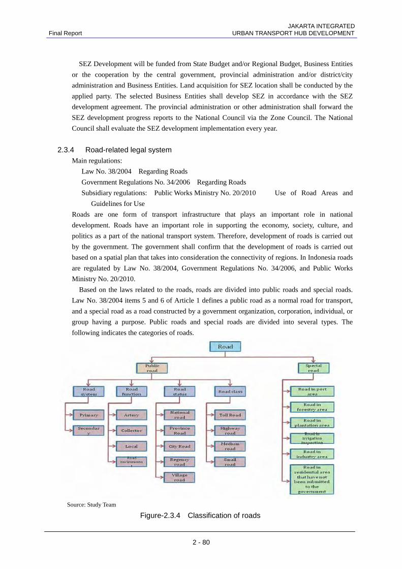
2.3.4 Road-related legal system Main regulations:
Law No. 38/2004 Regarding Roads
Government Regulations No. 34/2006 Regarding Roads
Subsidiary regulations: Public Works Ministry No. 20/2010 Use of Road Areas and
Guidelines for Use
Roads are one form of transport infrastructure that plays an important role in national
development. Roads have an important role in supporting the economy, society, culture, and
politics as a part of the national transport system. Therefore, development of roads is carried out
by the government. The government shall confirm that the development of roads is carried out
based on a spatial plan that takes into consideration the connectivity of regions. In Indonesia roads
are regulated by Law No. 38/2004, Government Regulations No. 34/2006, and Public Works
Ministry No. 20/2010.
Based on the laws related to the roads, roads are divided into public roads and special roads.
Law No. 38/2004 items 5 and 6 of Article 1 defines a public road as a normal road for transport,
and a special road as a road constructed by a government organization, corporation, individual, or
group having a purpose. Public roads and special roads are divided into several types. The
following indicates the categories of roads.
Source: Study Team
Figure-2.3.4 Classification of roads
JAKARTA INTEGRATED URBAN TRANSPORT HUB DEVELOPMENT Final Report
2 - 81
Based on the commentary on item 27 of Government Regulations No. 34/2006, all the roads of
Jakarta Provincial Government are national roads and province roads. The authority for national
roads is allocated to the Central Government Public Works Ministry, and the authority for province
roads is allocated to local governments.
2.3.5 River-related legal system
Main regulations:
Law No. 7/2004 Water Resources
Government Regulations No. 38/2011 Water Resources
Subsidiary regulations: Public Works Ministry No. 63/1993 River Boundaries, Hinterlands,
and Old River Areas
The 1945 Constitution establishes the fundamental principles of water resource management in
Indonesia. Article 33 of the Constitution states that the land, water, and wealth shall be utilized for
the welfare of the people as much as possible. Basically, the river laws of Indonesia are regulated
by Law No. 7/2004, Water Resources. In particular, Government Regulation No. 38/2011 relates
to rivers. The government regulations deal with river spaces, river management, permits,
information systems, and transfer of local rights. In Article 3 of the government regulations
concerning rivers, rivers belong to the nation, they are national asset, and management of rivers is
carried out by the government or local government.
Use of rivers is limited, including household, agriculture, environmental hygiene, industry,
tourism, sports, defence, fishery, electric facilities, and transit in Government Regulations No.
38/2011. It is stipulated that use of the air space above rivers should not become a cause of river
pollution or blockage to the flow of rivers. The Public Works Ministry No. 63/1993 prescribes river
boundaries, hinterlands, and old river areas. The Article 11 states that in the use of river
boundaries, road infrastructure facilities work such as bridge piles and railway piles or works of a
public nature not affecting river maintenance and management or safety can be carried out.
2.3.6 Railway-related legal system Main regulations:
Law No. 23/2007 Railways
Government Regulations No. 56/2009 Railway Operation and Railway Development
Government Regulations No. 72/2009 Railway Freight and Railway Passengers
Subsidiary regulations: Presidential Regulations No. 83/2011 Sukarno-Hatta Airport Line
and Jabodetabek Loop Line Facilities and Railway Facilities and the Promotion of the
Indonesia Railway Company (PT. KAI)
Minister of Transport Regulations No. 29/2011 Technical Standards for Station Buildings
Minister of Transport Regulations No. 30/2011 Inspection Procedures and Approval of
Railway Facilities
Minister of Transport Regulations No. 31/2011 Standards and Inspection Procedures for
Railway Facilities
JAKARTA INTEGRATED Final Report URBAN TRANSPORT HUB DEVELOPMENT
2 - 82
Minister of Transport Regulations No. 32/2011 Railway Facility Standards and Maintenance
Methods
Minister of Transport Regulations No. 33/2011 Class, Type, and Operation of Railway
Stations
Prior to the enactment of Law No. 23/2007, railways in Indonesia were owned by the country. The
Railway Law No. 13/1993 (the Old Railway Law) applied only to special railways owned by
individuals. However, with the enactment of Law No. 23/2007, Government Regulations No.
56/2009, and No. 72/2009, railways in Indonesia were no longer a national monopoly. In other
words, the development of railways could be carried out by local government, national
corporations, local government corporations, either individually or jointly with the private sector.
Railways are classified into two categories, in accordance with function. One category is public
railways, and another is special railways. Special railways indicate railways used by a certain
corporation for activities such as mining, tourism, agriculture, etc. To implement public railways
requires railway facilities including stations, lines, and railway operation facilities. Article 18 of
Law No. 23/2007 states that implementation of public railways includes construction of facilities,
operation of facilities, and maintenance of facilities.
Public railways shall be implemented by an operator either singly or jointly. Also, if there is no
operator for development of a public railway, the government or a local government may
undertake that responsibility.
The operator of a public railway shall have a business permit, a construction permit, and an
operation permit. For public railways that require land expropriation, the land expropriation shall
be carried out in accordance with a National Railway Master Plan (NRMN).
2.4 Other trends
2.4.1 Trends of Private Parties and Donors
By the MRT north-south line opening in Dukuh Atas area, and transforming the area into an important
urban transport hub, large numbers of local enterprises (developers, hotel enterprise, and financial banks)
and Japanese corporate are interested in the area.
PD.Pasar Jaya, the local state owned enterprise that owns a market (Pasar Blora) in front of the Sudirman
Station, has a plan to redevelop the current market. Other markets with redevelopment plan that are
confirmed are Pasar Minggu, Pasar Rumput ,Pasar Cempaka Putih,Jati Rawasari .
The east side of Jl.Thamrin , the Jl.Blora has few low-rise commercial land use, and some of the blocks are
starting an individual redevelopment. The are deeper inside have low-rise, high density residential
development, lacking roads with rights of way, and currently in dangerous situation for fire and other
hazards. The west side of Jl.Thamrin has a larger block per housing, and in Jl.Tanjung Karang, there are two
new hotel building plan, now on going.
2.4.2 Requests, development situations, etc., in Jakarta
The users of the existing railway and Transjakarta are limited mainly to low- and middle-income earners.
Use of them by part of a high-income group can also be seen, depending on situations.
JAKARTA INTEGRATED URBAN TRANSPORT HUB DEVELOPMENT Final Report
2 - 83
The interview survey conducted to the public transport users around Dukuh Atas on 23,January (sun),
2012 , between 16:00-18:00 of has revealed the following toward public transportation of Jakarta:
・ The way I see it, the transportation terminal is a place attracting pickpockets and thieves. It is
dangerous so I would prefer not to pass through it. This is all the more so as there is a dark
image like Blok M. (Bekasi, 30’s)
・ Although I had never used a railway in my life, after I moved to a residential lot along the
Serpong line, I use the Commuterline to go to work in Senayan several times on days when my
husband does not drive to work. If I can be patient with the congestion, it saves me half the
time than by commuting by car. I get off at Palmerah Station and have to use Ojek from there
to Senayan. It is inconvenient that I cannot catch a taxi in front of the station. (Tangerang,
20’s)
・ The Commuterline is delayed often in the morning. The longer the delay is, the worse the
congestion becomes, and it is far from comfortable. But if it runs on time, you can come
earlier into the city than a bus. (Depok, 40’s)
・ There is no doubt I will use it when MRT opens. But I will never feel safe to park a car if Park
& Ride is a space like the open-air parking lot that can be found at present in front of the
station on the Serpong line. (Jakarta, 40’s)
・ Taxies do not come in front of Tanah Abang Station. There are only Ojek. I ride public
transports less often carrying my children since there is no means from the station.
(Tangerang, 20’s)
・ I worry about the security of subway stations of MRT. I also fear that elevators and others will
not be maintained and break down. Just as there are no places where an elevator is running at
bus stops on Transjakarta koridorl at present. Subway is very worrisome in terms of
management and safety. (Jakarta, 20’s)
・ I do not wish to use public transports on a rainy day. They do not run on time, and if you are
stranded in a station, it is filled with people and overcrowded. Harmoni Station, particularly, is
in a terrible condition in wet weather. I hope the station facilities will be larger. It would be
convenient if there are also shops as well as automatic vending machines. (Jakarta, 30’s)
To summarize the opinions above on the transportation terminal, a number of users have a concern over
security at present and particularly regarding underground stations, feel greater anxiety about the
management and other aspects. From this understanding, it is important to maintain a brighter image in terms
of management and safety as well as of facilities and accordingly, if PPP with private management and
operation is assumed, participation by businesses having an ability to pay attention to these matters is
desirable.
JAKARTA INTEGRATED Final Report URBAN TRANSPORT HUB DEVELOPMENT
2 - 84
In addition, there are many responses to address the feeder transportation from a station as a
problem. The situations such as people from peripheral stations wish to ride a taxi to the Jakarta CBD
but find no means other than Ojek can be understood from taxi users’ resistance to use a railway and
the current state that there is no space available for taxis to wait for customers at many stations.
JAKARTA INTEGRATED Final Report URBAN TRANSPORT HUB DEVELOPMENT
3 - 1
Chapter 3. Issues and Project Needs of the Area
3.1 Current issues in the area
The following are the current issues in the Dukuh Atas Station area based on the Chapter 2
Circumstances of the Project.
1) Division of the area
The area around Dukuh Atas is located between the commercial area Bundaran HI subdistrict
to the north and the business area Setia Budi subdistrict to the south. Despite its excellent
location, it is divided north-south by the Banjir Kanal and the West Line and further, it is fully
divided also east-west by the bridge constructed where Thamrin/Sudirman Avenue extends
beyond the Banjir Kanal and the Sest Line. Due to this, the travelling of people and vehicles is
extremely limited.
2) Area left over after development
The south side of the Banjir Kanal was as the Landmark Center and BNI Town, but the
northeast side is a spread of commercial and low-rise residential lots with floor area ratios
restricted to between 180% and 300%. In the northwest side, a little higher floor area ratio of
450% is given and middle-rise buildings can be found on Tanjung Karang Avenue; however,
the area on the back of it is characterized by one- and two-story houses, resulting in a
situation which does not effectively use the floor area ratio.
Consequently, the Dukuh Atas area is left over after development.
3) Traffic congestion due to vehicle traffic and air pollution
As a result, economic activities in the center of Jakarta have been seriously impeded, and it
might be said that the image of Jakarta has been damaged.
On Thamrin/Sudirman Avenue in the Dukuh Atas area, the section around Sudirman Bridge is
a bottleneck, creating an extended line of vehicles congestion to the south side of Banjir Kanal
during morning hours from 9 to 10 o’clock and in the evening peak time; conversely, the
traffic line of congestion is stretched to the north side. The roads running east and west under
Sudirman Bridge (RM Margomo Djojohadikusumo Avenue and Galunggung Avenue) are also
congested in both the morning and evening rush hours.
4) Inefficient road network
The traffic in the north-and-south direction concentrates on Thamrin/Sudirman Avenue
because Banjir Kanal flows east and west in the center of the Dukuh Atas area. Moreover, due
to topographical problems and the artery nature of Thamrin/Sudirman Avenue, the roads
connecting east and west are only RM Margomo Djojohadikusumo Avenue and Galunggung
Avenue to the south of the canal, on which east- and west-bound traffic builds up. The roads
on the north side of the canal do not form a network to allow vehicles to drive through to the
east and west directions and are only used as alternative passages to limited routes,
contributing to extremely inefficient traffic functions.
JAKARTA INTEGRATED URBAN TRANSPORT HUB DEVELOPMENT Final Report
3 - 2
5) Concentrated traffic facility schemes
In the Dukuh Atas area, the MRT north-south line Dukuh Atas Station is planned. In addition,
there is a high possibility of development of the Serpong - Bekasi line and the airport access
line using the space below ground and above ground of the existing West Line. Also, there is a
possibility of development of a monorail (or the BRT) to the south side of the Banjir Kanal. In
addition, to the north side of the Banjir Kanal there is a scheme for six toll roads within the
Province of Jakarta (already approved by the Governor of Jakarta Province), so transport
facilities may be suddenly concentrated into the limited land. However each scheme is being
planned without coordination between them.
6) Lack of flow lines for interchange, and interchange space
As described above many transport facilities are being planned, but each operator is planning
them individually, without coordination between schemes. In particular, there has been no
investigation into the flow lines for the users to interchange and interchange spaces. Therefore
even when the transport facilities are completed interchange will be inconvenient and will take
time, so there are concerns that passengers interchanging will flow out onto the surrounding
sidewalks which is extremely dangerous. It can be said that the public transport organizations
are not properly planning for interchange.
7) Lack of attractive public spaces
The Dukuh Atas area has valuable waterside and green spaces in the city center. These are the
green areas along roads and rivers specified by the “Public Project Ministry Ordinance
Concerning Green Space No. 5, 2.2.3-gl/g3,” promulgated in 2008, in which many existing
tall trees have grown, forming a lush landscape. However, it appears that it will become less
verdant under the concentrated transport facilities. Even after felling trees for development
purposes, if trees ten times the volume of the felled trees are planted in the province, then
there will be no change in the overall volume of trees. However, at present there is no
movement to take an overall view of the Dukuh Atas area, or to create even a small attractive
open space provided with greenery.
3.2 Project needs
3.2.1 Project needs At present the following projects are being implemented or planned in connection with the issues
described above.
(1) Formulation of Special Capital Territory of Jakarta or urban planning guidelines and
management of urban development based on these guidelines: corresponds to the above
issues 1) and 2)
JAKARTA INTEGRATED Final Report URBAN TRANSPORT HUB DEVELOPMENT
3 - 3
(2) Projects to develop and reorganize public transport, such as the MRT north-south line, and
east-west line development projects, BRT line and the bus line development schemes:
corresponds to the above issues 3), 4) and 5)
In order to supplement the above projects that are being implemented or planned, it is necessary
to implement a project that satisfies the following items.
1) Development of concentrated transport facilities in three dimensions (corresponds to the
above issue 4)
In order to accommodate the concentrated new transport facilities in the limited public land
around Dukuh Atas Station, it will be necessary to develop a transport hub that uses the
public land below ground, above ground, and above the Banjir Kanal.
2) Development of comprehensive terminal function for smoothly connecting public transport
(corresponds to the above issue 5)
In the area around Dukuh Atas Station, development of the MRTJ Dukuh Atas Station,
development of the Serpong – Bekasi Line Station, development of the Airport Access
Railway Station, and re-organization of the BRT Dukuh Atas Station are intended, so it is
necessary to create a comprehensive terminal function for smoothly connecting
interchanging passengers of these main public transport organizations.
3) Expansion of urban planning based on pedestrians with attractive spaces using the space
above the Banjir Kanal (corresponds to the above issue 6)
The development of not just a transport plaza, but an attractive space with a safe view of the
city's valuable waterside space provided with greenery. Also, with this as a starting point to
link it to a new urban area with pedestrians at the center.
Figure 3.2.1 shows the relationship between the current issues of the area and project needs,
action currently taken for the needs; planning projects, and project position in relation to the
needs.
JAKARTA INTEGRATED URBAN TRANSPORT HUB DEVELOPMENT Final Report
3 - 4
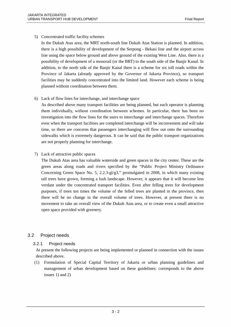
Current status and issues of the area Project needs Projects being implemented/planned
Figure-3.2.1 Current issues of the area and project needs
3.2.2 Project development effects and impacts Project needs will be identified in connection with the current status and issues of the Dukuh
Atas area and based on the needs, the “Development of Traffic and Urban Structures in the Dukuh
Atas Station Area” will be implemented, from which a variety of development effects can be
expected. The specific feasibility assessment is provided in Chapter 9. This section describes
development effects and the impacts relating to an enhancement in competitiveness of the city.
Development effects from the implementation of a project which fulfills project needs are
summarized as follows:
1) Multi-storied development of concentrated traffic facilities
Multiple transportation means are concentrated in a limited area with ground level differences and
containing only a few public lots. The area will be developed by introducing multi-tiered land use
where each facility will be interconnected and establishing the whole area as an attractive traffic
nodal point. This will transform the area into an area of high convenience, contributing to
enhance the economic activities in the area and an increase in the number of public transport
usesrs.
2) Construction of comprehensive terminal functions providing seamless connection of public
transports
Multiple public transport means will be connected in a comfortable environmental space. This
will improve their convenience and consequently, development effects including an increase in
the number of public transport users can be expected.
Detailed urban planning, establishment of urban guidelines
Development of MRTJ/reorganization of bus lines
1) Urban development management
2) Development and reorganization of public transport
Three-dimensional development of transport facilities
Development of comprehensive terminal function
Creation and expansion of attractive public spaces
Development of traffic and urban structure of Dukuh
Atas Station area
1. Division of the area
2. Area left over after development
4 Inefficient road network
5. Concentrated traffic facility schemes
6. Lack of interchange flow lines, interchange spaces
7. Lack of attractive public spaces
3. Traffic congestion and air pollution caused by vehiclular traffic
JAKARTA INTEGRATED Final Report URBAN TRANSPORT HUB DEVELOPMENT
3 - 5
3) Expansion of development to pedestrian-oriented town using the space above Banjir Kanal
Using the space above Banjir Kanal as a traffic plaza will not only increase the number of of
public transport users but will also connect adjacent town blocks, increasing the expectation of
greater circulation in the area, strengthened regional interaction, and expanded regional economic
activities. Further, the connection of public transportation means and developed buildings in the
surrounding area will also enhance the value of the adjacent town blocks, which will in turn add
variety to economic activities in the Dukuh Atas area.
These development effects can be expected to serve as a model case of similar traffic nodes
development and will also have a great impact on competition with major cities in Southeast Asia.
JAKARTA INTEGRATED Final Report URBAN TRANSPORT HUB DEVELOPMENT
4 - 1
Chapter 4. Planning of Infrastructure
4.1 Demand Forecast
4.1.1 Objectives For the planning and design of intermodal facilities in accordance with urban development at Dukuh Atas,
future traffic demand is required. For this, the traffic demand forecast is executed in 2 steps
1. Future traffic demand for the Dukuh Atas Project calculated by the traffic assignment model prepared by
the "JABODETABEK Urban Transportation Policy Integration : JUTPI (2012, JICA)".
The traffic assignment model includes future road/transit network and traffic demand in Jabodetabek area,
considering its large impact of ridership and transit volume in Dukuh Atas from MRT and railway plans.
The demand esitamated in these forecasts are including the weekdays peak time passenger volume of
stations and bus stops in the Dukuh Atas area
2. Demand forecast from the maximum station area development of Dukuh Atas, and adding it onto the 1.
Future traffic demand for the Dukuh Atas Area.
This includes the ridership increase of the transport modes of Dukuh Atas from the effect from the station
area development of new office and commercial buildings in the area., to be added to the 1. Future traffic
demand for the Dukuh Atas Project. The volume of office and commercial development differs in the floor
volume setting under the spatial development, and for this reason is to be calculated at later chapter of the
study.
4.1.2 Methodology and Precondition Future traffic demand for the Dukuh Atas Project is calculated by the traffic assignment model prepared by
the "JABODETABEK Urban Transportation Policy Integration : JUTPI (2012, JICA)". The traffic
assignment model includes future road/transit network and traffic demand in Jabodetabek.
Table 4.1.1 shows the preconditions of traffic demand forecast in relevant studies, namely, Engineering
Consulting Services for Jakarta Mass Rapid Transit System Project (Jan 2011, JMEC, DGR) and JUTPI.
Table-4.1.1 Summary of Precondition of Traffic Demand Forecast Engineering Consulting Services for
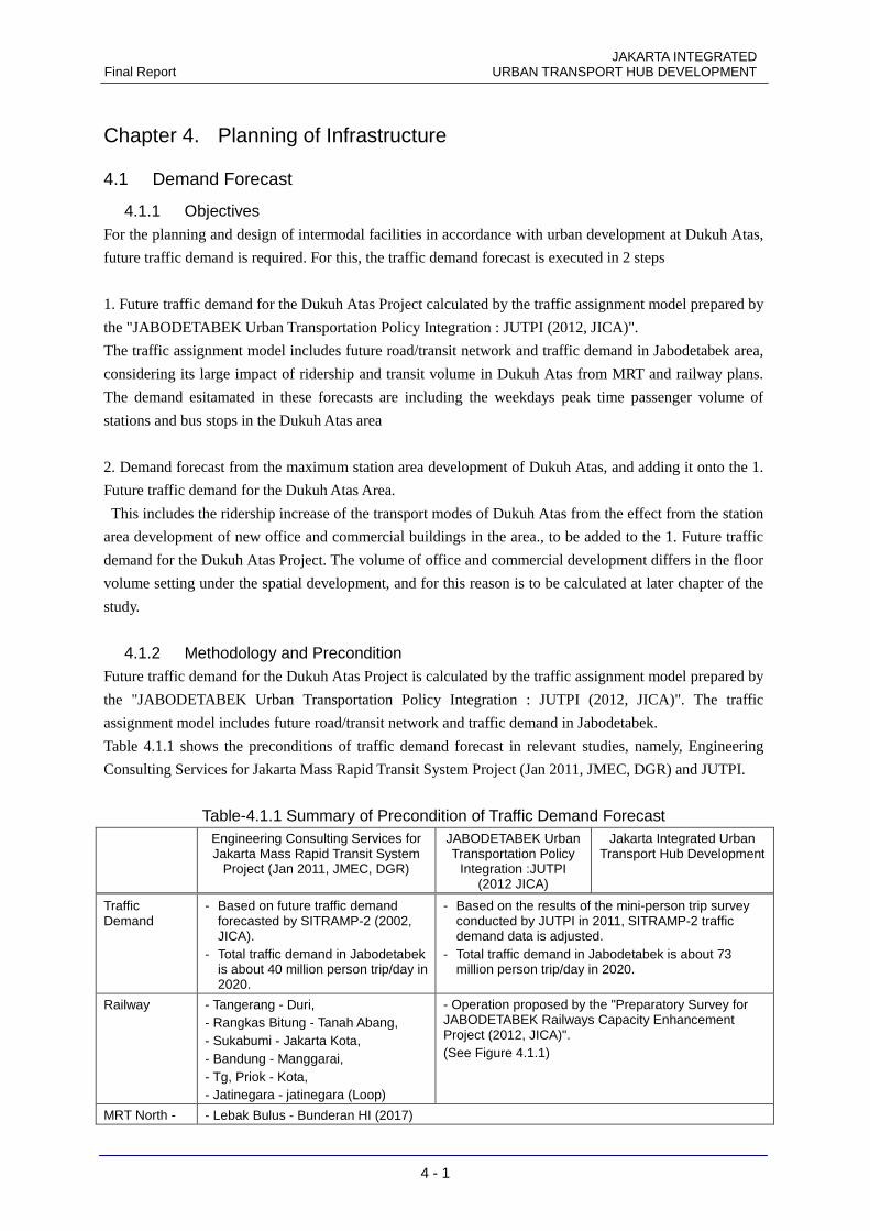
Jakarta Mass Rapid Transit System Project (Jan 2011, JMEC, DGR)
JABODETABEK Urban Transportation Policy
Integration :JUTPI (2012 JICA)
Jakarta Integrated Urban Transport Hub Development
Traffic Demand
- Based on future traffic demand forecasted by SITRAMP-2 (2002, JICA).
- Total traffic demand in Jabodetabek is about 40 million person trip/day in 2020.
- Based on the results of the mini-person trip survey conducted by JUTPI in 2011, SITRAMP-2 traffic demand data is adjusted.
- Total traffic demand in Jabodetabek is about 73 million person trip/day in 2020.
Railway - Tangerang - Duri, - Rangkas Bitung - Tanah Abang, - Sukabumi - Jakarta Kota, - Bandung - Manggarai, - Tg, Priok - Kota, - Jatinegara - jatinegara (Loop)
- Operation proposed by the "Preparatory Survey for JABODETABEK Railways Capacity Enhancement Project (2012, JICA)". (See Figure 4.1.1)
MRT North - - Lebak Bulus - Bunderan HI (2017)
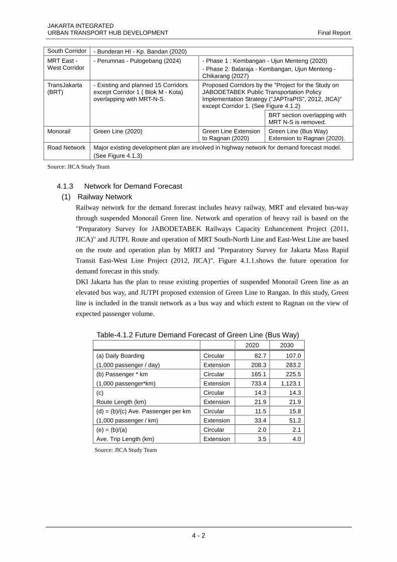
JAKARTA INTEGRATED URBAN TRANSPORT HUB DEVELOPMENT Final Report
4 - 2
South Corridor - Bunderan HI - Kp. Bandan (2020)
MRT East - West Corridor
- Perumnas - Pulogebang (2024) - Phase 1 : Kembangan - Ujun Menteng (2020) - Phase 2: Balaraja - Kembangan, Ujun Menteng - Chikarang (2027)
Proposed Corridors by the "Project for the Study on JABODETABEK Public Transportation Policy Implementation Strategy ("JAPTraPIS", 2012, JICA)" except Corridor 1. (See Figure 4.1.2)
TransJakarta (BRT)
- Existing and planned 15 Corridors except Corridor 1 ( Blok M - Kota) overlapping with MRT-N-S.
BRT section overlapping with MRT N-S is removed.
Monorail Green Line (2020) Green Line Extension to Ragnan (2020)
Green Line (Bus Way) Extension to Ragnan (2020).
Road Network Major existing development plan are involved in highway network for demand forecast model. (See Figure 4.1.3)
Source: JICA Study Team
4.1.3 Network for Demand Forecast (1) Railway Network
Railway network for the demand forecast includes heavy railway, MRT and elevated bus-way
through suspended Monorail Green line. Network and operation of heavy rail is based on the
"Preparatory Survey for JABODETABEK Railways Capacity Enhancement Project (2011,
JICA)" and JUTPI. Route and operation of MRT South-North Line and East-West Line are based
on the route and operation plan by MRTJ and "Preparatory Survey for Jakarta Mass Rapid
Transit East-West Line Project (2012, JICA)". Figure 4.1.1.shows the future operation for
demand forecast in this study.
DKI Jakarta has the plan to reuse existing properties of suspended Monorail Green line as an
elevated bus way, and JUTPI proposed extension of Green Line to Rangan. In this study, Green
line is included in the transit network as a bus way and which extent to Ragnan on the view of
expected passenger volume.
Table-4.1.2 Future Demand Forecast of Green Line (Bus Way) 2020 2030
(a) Daily Boarding Circular 82.7 107.0
(1,000 passenger / day) Extension 208.3 283.2
(b) Passenger * km Circular 165.1 225.5
(1,000 passenger*km) Extension 733.4 1,123.1
(c) Circular 14.3 14.3
Route Length (km) Extension 21.9 21.9
(d) = (b)/(c) Ave. Passenger per km Circular 11.5 15.8
(1,000 passenger / km) Extension 33.4 51.2
(e) = (b)/(a) Circular 2.0 2.1
Ave. Trip Length (km) Extension 3.5 4.0
Source: JICA Study Team
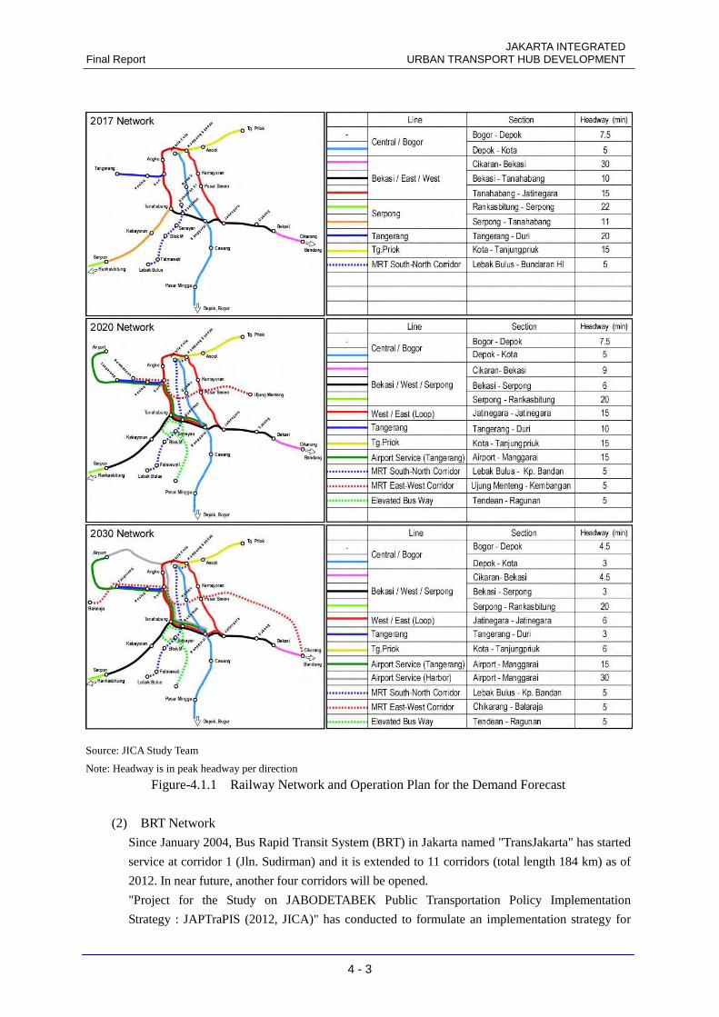
JAKARTA INTEGRATED Final Report URBAN TRANSPORT HUB DEVELOPMENT
4 - 3
Source: JICA Study Team
Note: Headway is in peak headway per direction
Figure-4.1.1 Railway Network and Operation Plan for the Demand Forecast
(2) BRT Network
Since January 2004, Bus Rapid Transit System (BRT) in Jakarta named "TransJakarta" has started
service at corridor 1 (Jln. Sudirman) and it is extended to 11 corridors (total length 184 km) as of
2012. In near future, another four corridors will be opened.
"Project for the Study on JABODETABEK Public Transportation Policy Implementation
Strategy : JAPTraPIS (2012, JICA)" has conducted to formulate an implementation strategy for
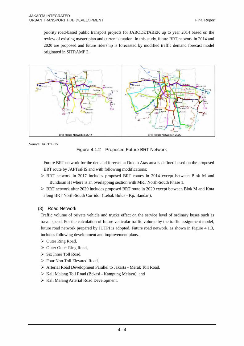
JAKARTA INTEGRATED URBAN TRANSPORT HUB DEVELOPMENT Final Report
4 - 4
priority road-based public transport projects for JABODETABEK up to year 2014 based on the
review of existing master plan and current situation. In this study, future BRT network in 2014 and
2020 are proposed and future ridership is forecasted by modified traffic demand forecast model
originated in SITRAMP 2.
Source: JAPTraPIS
Figure-4.1.2 Proposed Future BRT Network
Future BRT network for the demand forecast at Dukuh Atas area is defined based on the proposed
BRT route by JAPTraPIS and with following modifications;
� BRT network in 2017 includes proposed BRT routes in 2014 except between Blok M and
Bundaran HI where is an overlapping section with MRT North-South Phase 1.
� BRT network after 2020 includes proposed BRT route in 2020 except between Blok M and Kota
along BRT North-South Corridor (Lebak Bulus - Kp. Bandan).
(3) Road Network Traffic volume of private vehicle and trucks effect on the service level of ordinary buses such as
travel speed. For the calculation of future vehicular traffic volume by the traffic assignment model,
future road network prepared by JUTPI is adopted. Future road network, as shown in Figure 4.1.3,
includes following development and improvement plans.
� Outer Ring Road,
� Outer Outer Ring Road,
� Six Inner Toll Road,
� Four Non-Toll Elevated Road,
� Arterial Road Development Parallel to Jakarta - Merak Toll Road,
� Kali Malang Toll Road (Bekasi - Kampung Melayu), and
� Kali Malang Arterial Road Development.
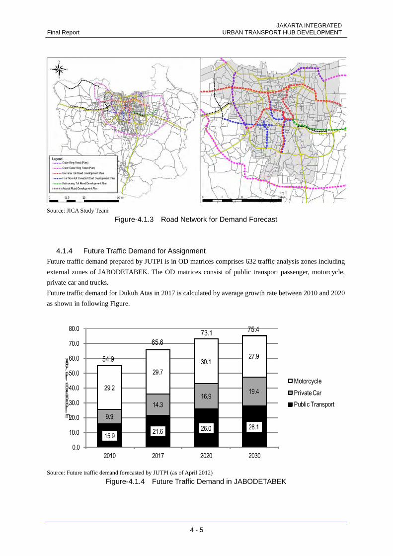
JAKARTA INTEGRATED Final Report URBAN TRANSPORT HUB DEVELOPMENT
4 - 5
Source: JICA Study Team
Figure-4.1.3 Road Network for Demand Forecast
4.1.4 Future Traffic Demand for Assignment Future traffic demand prepared by JUTPI is in OD matrices comprises 632 traffic analysis zones including
external zones of JABODETABEK. The OD matrices consist of public transport passenger, motorcycle,
private car and trucks.
Future traffic demand for Dukuh Atas in 2017 is calculated by average growth rate between 2010 and 2020
as shown in following Figure.
15.921.6 26.0 28.1
9.9
14.3
16.919.4
29.2
29.7
30.127.9
0.0
10.0
20.0
30.0
40.0
50.0
60.0
70.0
80.0
2010 2017 2020 2030
million person trip / day
Motorcycle
Private Car
Public Transport
54.9
73.175.4
65.6
Source: Future traffic demand forecasted by JUTPI (as of April 2012)
Figure-4.1.4 Future Traffic Demand in JABODETABEK
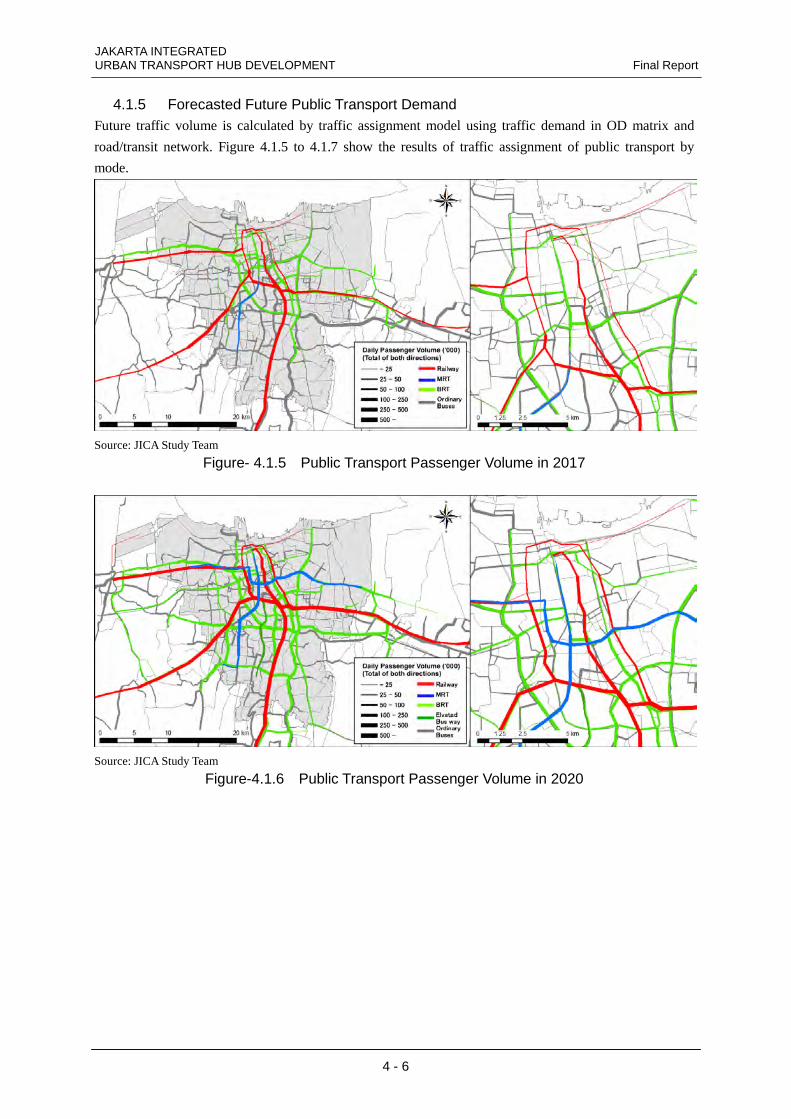
JAKARTA INTEGRATED URBAN TRANSPORT HUB DEVELOPMENT Final Report
4 - 6
4.1.5 Forecasted Future Public Transport Demand Future traffic volume is calculated by traffic assignment model using traffic demand in OD matrix and
road/transit network. Figure 4.1.5 to 4.1.7 show the results of traffic assignment of public transport by
mode.
Source: JICA Study Team
Figure- 4.1.5 Public Transport Passenger Volume in 2017
Source: JICA Study Team
Figure-4.1.6 Public Transport Passenger Volume in 2020
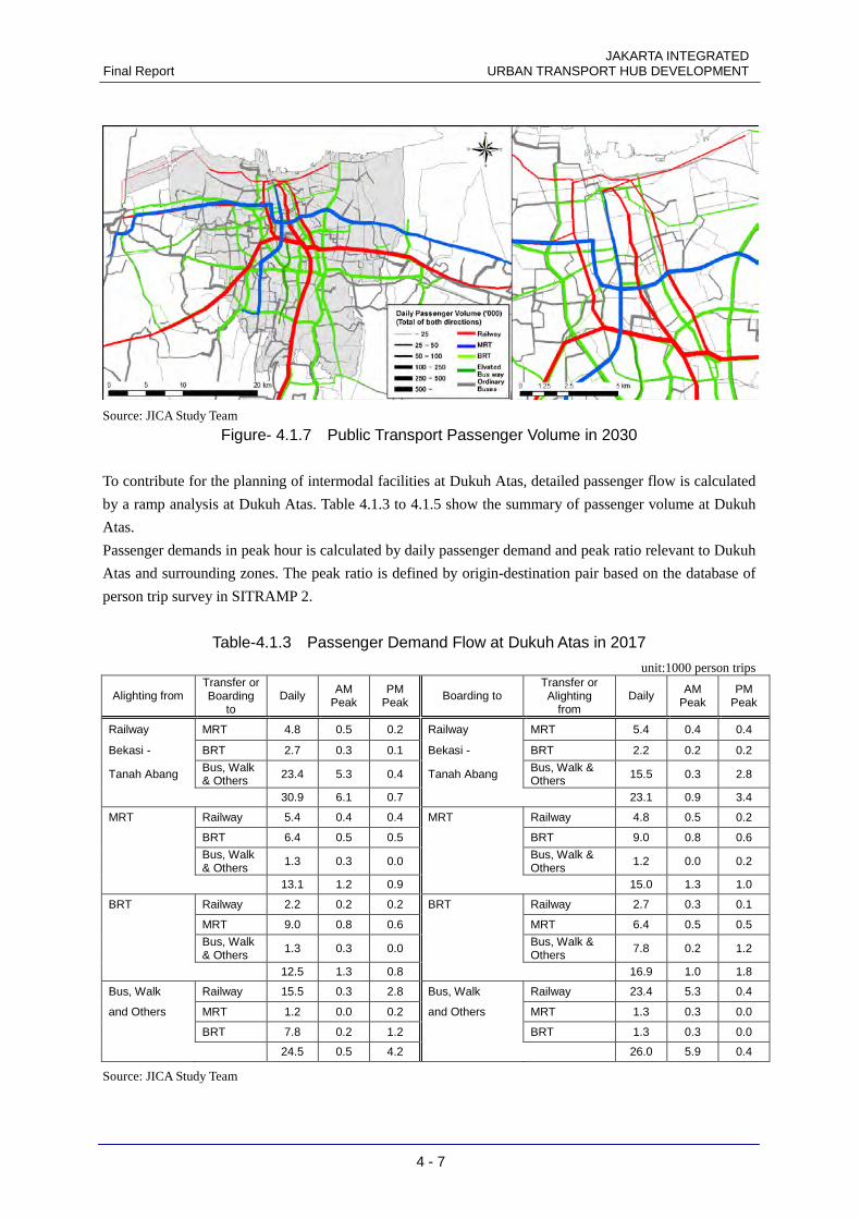
JAKARTA INTEGRATED Final Report URBAN TRANSPORT HUB DEVELOPMENT
4 - 7
Source: JICA Study Team
Figure- 4.1.7 Public Transport Passenger Volume in 2030
To contribute for the planning of intermodal facilities at Dukuh Atas, detailed passenger flow is calculated
by a ramp analysis at Dukuh Atas. Table 4.1.3 to 4.1.5 show the summary of passenger volume at Dukuh
Atas.
Passenger demands in peak hour is calculated by daily passenger demand and peak ratio relevant to Dukuh
Atas and surrounding zones. The peak ratio is defined by origin-destination pair based on the database of
person trip survey in SITRAMP 2.
Table-4.1.3 Passenger Demand Flow at Dukuh Atas in 2017
unit:1000 person trips
Alighting from Transfer or Boarding
to Daily AM
Peak PM
Peak Boarding to
Transfer or Alighting
from Daily AM
Peak PM
Peak
Railway MRT 4.8 0.5 0.2 Railway MRT 5.4 0.4 0.4
Bekasi - BRT 2.7 0.3 0.1 Bekasi - BRT 2.2 0.2 0.2
Tanah Abang Bus, Walk & Others 23.4 5.3 0.4 Tanah Abang Bus, Walk &
Others 15.5 0.3 2.8
30.9 6.1 0.7 23.1 0.9 3.4
MRT Railway 5.4 0.4 0.4 MRT Railway 4.8 0.5 0.2
BRT 6.4 0.5 0.5 BRT 9.0 0.8 0.6
Bus, Walk & Others
1.3 0.3 0.0 Bus, Walk & Others
1.2 0.0 0.2
13.1 1.2 0.9 15.0 1.3 1.0
BRT Railway 2.2 0.2 0.2 BRT Railway 2.7 0.3 0.1
MRT 9.0 0.8 0.6 MRT 6.4 0.5 0.5
Bus, Walk & Others
1.3 0.3 0.0 Bus, Walk & Others
7.8 0.2 1.2
12.5 1.3 0.8 16.9 1.0 1.8
Bus, Walk Railway 15.5 0.3 2.8 Bus, Walk Railway 23.4 5.3 0.4
and Others MRT 1.2 0.0 0.2 and Others MRT 1.3 0.3 0.0
BRT 7.8 0.2 1.2 BRT 1.3 0.3 0.0
24.5 0.5 4.2 26.0 5.9 0.4
Source: JICA Study Team
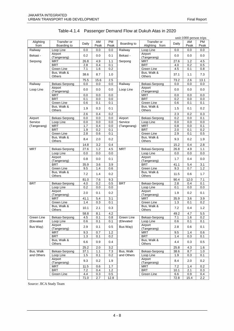
JAKARTA INTEGRATED URBAN TRANSPORT HUB DEVELOPMENT Final Report
4 - 8
Table-4.1.4 Passenger Demand Flow at Dukuh Atas in 2020
unit:1000 person trips Alighting
from Transfer or Boarding to
Daily AM Peak
PM Peak
Boarding to Transfer or Alighting from
Daily AM Peak
PM Peak
Railway Loop Line 0.0 0.0 0.0 Railway Loop Line 0.0 0.0 0.0
Bekasi - Airport (Tangerang)
0.2 0.0 0.1 Bekasi - Airport (Tangerang)
0.0 0.0 0.0
Serpong MRT 26.8 4.9 1.1 Serpong MRT 27.6 1.2 4.5 BRT 2.8 0.4 0.1 BRT 4.0 0.2 0.5 Green Line 7.1 1.6 0.2 Green Line 4.5 0.1 0.8
Bus, Walk & Others
38.6 8.7 1.0 Bus, Walk & Others
37.1 1.1 7.3
75.5 15.6 2.5 73.2 2.6 13.1 Railway Bekasi-Serpong 0.0 0.0 0.0 Railway Bekasi-Serpong 0.0 0.0 0.0
Loop Line Airport (Tangerang)
0.0 0.0 0.0 Loop Line Airport (Tangerang)
0.0 0.0 0.0
MRT 0.0 0.0 0.0 MRT 0.0 0.0 0.0 BRT 0.1 0.0 0.0 BRT 0.2 0.0 0.0 Green Line 0.6 0.1 0.1 Green Line 0.6 0.1 0.1
Bus, Walk & Others
1.9 0.3 0.1 Bus, Walk & Others
1.5 0.1 0.2
2.6 0.4 0.2 2.3 0.2 0.3 Airport Bekasi-Serpong 0.0 0.0 0.0 Airport Bekasi-Serpong 0.2 0.0 0.1 Service Loop Line 0.0 0.0 0.0 Service Loop Line 0.0 0.0 0.0 (Tangerang) MRT 1.7 0.4 0.0 (Tangerang) MRT 0.8 0.0 0.1 BRT 1.9 0.2 0.1 BRT 2.0 0.1 0.2 Green Line 2.8 0.6 0.1 Green Line 2.9 0.1 0.5
Bus, Walk & Others 8.4 2.0 0.2 Bus, Walk &
Others 9.3 0.2 1.9
14.8 3.2 0.4 15.2 0.4 2.8 MRT Bekasi-Serpong 27.6 1.2 4.5 MRT Bekasi-Serpong 26.8 4.9 1.1 Loop Line 0.0 0.0 0.0 Loop Line 0.0 0.0 0.0
Airport (Tangerang)
0.8 0.0 0.1 Airport (Tangerang)
1.7 0.4 0.0
BRT 35.9 3.6 3.9 BRT 41.1 5.4 3.1 Green Line 9.5 1.4 0.6 Green Line 9.3 0.7 1.2
Bus, Walk & Others
7.2 1.4 0.2 Bus, Walk & Others
11.5 0.6 1.7
81.0 7.6 9.3 90.4 12.0 7.1 BRT Bekasi-Serpong 4.0 0.2 0.5 BRT Bekasi-Serpong 2.8 0.4 0.1 Loop Line 0.2 0.0 0.0 Loop Line 0.1 0.0 0.0
Airport (Tangerang)
2.0 0.1 0.2 Airport (Tangerang)
1.9 0.2 0.1
MRT 41.1 5.4 3.1 MRT 35.9 3.6 3.9 Green Line 1.4 0.3 0.1 Green Line 1.3 0.1 0.2
Bus, Walk & Others
10.1 2.1 0.3 Bus, Walk & Others
7.2 0.4 1.2
58.8 8.1 4.2 49.2 4.7 5.5 Green Line Bekasi-Serpong 4.5 0.1 0.8 Green Line Bekasi-Serpong 7.1 1.6 0.2 (Elevated Loop Line 0.6 0.1 0.1 (Elevated Loop Line 0.6 0.1 0.1
Bus Way) Airport (Tangerang)
2.9 0.1 0.5 Bus Way) Airport (Tangerang)
2.8 0.6 0.1
MRT 9.3 0.7 1.2 MRT 9.5 1.4 0.6 BRT 1.3 0.1 0.2 BRT 1.4 0.3 0.1
Bus, Walk & Others 6.6 0.9 0.4 Bus, Walk &
Others 4.4 0.3 0.5
25.2 2.0 3.2 25.8 4.3 1.6 Bus, Walk Bekasi-Serpong 37.1 1.1 7.3 Bus, Walk Bekasi-Serpong 38.6 8.7 1.0 and Others Loop Line 1.5 0.1 0.2 and Others Loop Line 1.9 0.3 0.1
Airport (Tangerang) 9.3 0.2 1.9 Airport
(Tangerang) 8.4 2.0 0.2
MRT 11.5 0.6 1.7 MRT 7.2 1.4 0.2 BRT 7.2 0.4 1.2 BRT 10.1 2.1 0.3 Green Line 4.4 0.3 0.5 Green Line 6.6 0.9 0.4 71.0 2.7 12.8 72.8 15.4 2.2
Source: JICA Study Team
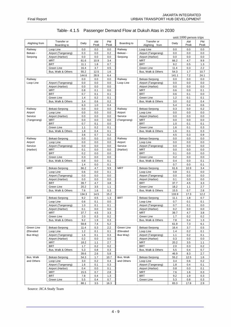
JAKARTA INTEGRATED Final Report URBAN TRANSPORT HUB DEVELOPMENT
4 - 9
Table- 4.1.5 Passenger Demand Flow at Dukuh Atas in 2030
unit:1000 person trips
Alighting from Transfer or Boarding to
Daily AM
Peak PM
Peak Boarding to
Transfer or Alighting from
Daily AM
Peak PM
Peak
Railway Loop Line 0.0 0.0 0.0 Railway Loop Line 0.0 0.0 0.0 Bekasi - Airport (Tangerang) 0.3 0.0 0.2 Bekasi - Airport (Tangerang) 0.0 0.0 0.0 Serpong Airport (Harbor) 0.0 0.0 0.0 Serpong Airport (Harbor) 0.0 0.0 0.0 MRT 61.6 10.9 3.4 MRT 66.2 4.7 9.9 BRT 11.1 1.8 0.7 BRT 9.2 0.5 1.3 Green Line 16.4 3.7 0.5 Green Line 11.4 0.3 2.2 Bus, Walk & Others 55.2 12.5 1.6 Bus, Walk & Others 54.3 1.7 10.7 144.6 28.9 6.4 141.1 7.2 24.1 Railway 0.0 0.0 0.0 Railway Bekasi-Serpong 0.0 0.0 0.0 Loop Line Airport (Tangerang) 0.0 0.0 0.0 Loop Line Airport (Tangerang) 0.0 0.0 0.0 Airport (Harbor) 0.0 0.0 0.0 Airport (Harbor) 0.0 0.0 0.0 MRT 0.8 0.1 0.0 MRT 0.6 0.0 0.1 BRT 0.7 0.1 0.1 BRT 0.6 0.1 0.0 Green Line 1.4 0.2 0.1 Green Line 1.2 0.1 0.1 Bus, Walk & Others 3.4 0.6 0.2 Bus, Walk & Others 3.0 0.2 0.4 6.3 1.0 0.4 5.4 0.4 0.6 Railway Bekasi-Serpong 0.0 0.0 0.0 Railway Bekasi-Serpong 0.3 0.0 0.2 Airport Loop Line 0.0 0.0 0.0 Airport Loop Line 0.0 0.0 0.0 Service Airport (Harbor) 0.0 0.0 0.0 Service Airport (Harbor) 0.0 0.0 0.0 (Tangerang) MRT 0.0 0.0 0.0 (Tangerang) MRT 0.0 0.0 0.0 BRT 0.7 0.1 0.0 BRT 1.0 0.1 0.1 Green Line 1.1 0.2 0.1 Green Line 1.6 0.1 0.3 Bus, Walk & Others 1.8 0.4 0.1 Bus, Walk & Others 1.6 0.1 0.3 3.6 0.7 0.2 4.5 0.3 0.9 Railway Bekasi-Serpong 0.0 0.0 0.0 Railway Bekasi-Serpong 0.0 0.0 0.0 Airport Loop Line 0.0 0.0 0.0 Airport Loop Line 0.0 0.0 0.0 Service Airport (Tangerang) 0.0 0.0 0.0 Service Airport (Tangerang) 0.0 0.0 0.0 (Harbor) MRT 0.1 0.0 0.0 (Harbor) MRT 0.0 0.0 0.0 BRT 0.2 0.0 0.0 BRT 0.1 0.0 0.0 Green Line 0.3 0.0 0.0 Green Line 0.2 0.0 0.0 Bus, Walk & Others 0.8 0.0 0.1 Bus, Walk & Others 0.4 0.0 0.1 1.4 0.0 0.1 0.7 0.0 0.1 MRT Bekasi-Serpong 66.2 4.7 9.9 MRT Bekasi-Serpong 61.6 10.9 3.4 Loop Line 0.6 0.0 0.1 Loop Line 0.8 0.1 0.0 Airport (Tangerang) 0.0 0.0 0.0 Airport (Tangerang) 0.0 0.0 0.0 Airport (Harbor) 0.0 0.0 0.0 Airport (Harbor) 0.1 0.0 0.0 BRT 39.7 4.7 3.8 BRT 37.7 4.5 3.3 Green Line 20.2 3.5 1.1 Green Line 18.2 1.1 2.7 Bus, Walk & Others 7.6 1.6 0.3 Bus, Walk & Others 15.5 0.7 2.8 134.3 14.5 15.2 133.9 17.3 12.2 BRT Bekasi-Serpong 9.2 0.5 1.3 BRT Bekasi-Serpong 11.1 1.8 0.7 Loop Line 0.6 0.1 0.0 Loop Line 0.7 0.1 0.1 Airport (Tangerang) 1.0 0.1 0.1 Airport (Tangerang) 0.7 0.1 0.0 Airport (Harbor) 0.1 0.0 0.0 Airport (Harbor) 0.2 0.0 0.0 MRT 37.7 4.5 3.3 MRT 39.7 4.7 3.8 Green Line 2.0 0.3 0.2 Green Line 1.7 0.2 0.2 Bus, Walk & Others 9.2 1.9 0.3 Bus, Walk & Others 7.8 0.4 1.3 59.8 7.4 5.2 61.9 7.3 6.1 Green Line Bekasi-Serpong 11.4 0.3 2.2 Green Line Bekasi-Serpong 16.4 3.7 0.5 (Elevated Loop Line 1.2 0.1 0.1 (Elevated Loop Line 1.4 0.2 0.1 Bus Way) Airport (Tangerang) 1.6 0.1 0.3 Bus Way) Airport (Tangerang) 1.1 0.2 0.1 Airport (Harbor) 0.2 0.0 0.0 Airport (Harbor) 0.3 0.0 0.0 MRT 18.2 1.1 2.7 MRT 20.2 3.5 1.1 BRT 1.7 0.2 0.2 BRT 2.0 0.3 0.2 Bus, Walk & Others 5.3 0.8 0.3 Bus, Walk & Others 5.5 0.4 0.7 39.6 2.6 5.8 46.9 8.3 2.7 Bus, Walk Bekasi-Serpong 54.3 1.7 10.7 Bus, Walk Bekasi-Serpong 55.2 12.5 1.6 and Others Loop Line 3.0 0.2 0.4 and Others Loop Line 3.4 0.6 0.2 Airport (Tangerang) 1.6 0.1 0.3 Airport (Tangerang) 1.8 0.4 0.1 Airport (Harbor) 0.4 0.0 0.1 Airport (Harbor) 0.8 0.0 0.1 MRT 15.5 0.7 2.8 MRT 7.6 1.6 0.3 BRT 7.8 0.4 1.3 BRT 9.2 1.9 0.3 Green Line 5.5 0.4 0.7 Green Line 5.3 0.8 0.3 88.1 3.5 16.3 83.3 17.8 2.9
Source: JICA Study Team
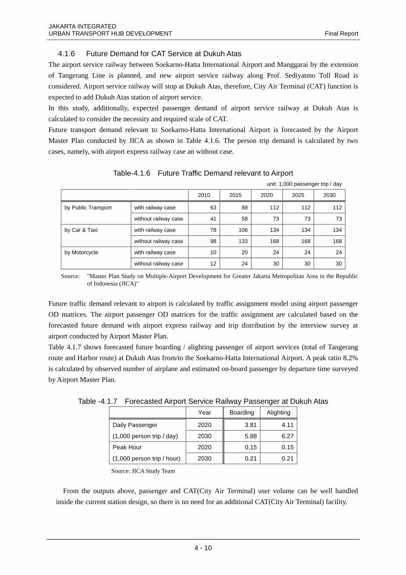
JAKARTA INTEGRATED URBAN TRANSPORT HUB DEVELOPMENT Final Report
4 - 10
4.1.6 Future Demand for CAT Service at Dukuh Atas The airport service railway between Soekarno-Hatta International Airport and Manggarai by the extension
of Tangerang Line is planned, and new airport service railway along Prof. Sediyatmo Toll Road is
considered. Airport service railway will stop at Dukuh Atas, therefore, City Air Terminal (CAT) function is
expected to add Dukuh Atas station of airport service.
In this study, additionally, expected passenger demand of airport service railway at Dukuh Atas is
calculated to consider the necessity and required scale of CAT.
Future transport demand relevant to Soekarno-Hatta International Airport is forecasted by the Airport
Master Plan conducted by JICA as shown in Table 4.1.6. The person trip demand is calculated by two
cases, namely, with airport express railway case an without case.
Table-4.1.6 Future Traffic Demand relevant to Airport unit: 1,000 passenger trip / day
2010 2015 2020 2025 2030
by Public Transport with railway case 63 89 112 112 112
without railway case 41 58 73 73 73
by Car & Taxi with railway case 78 106 134 134 134
without railway case 98 133 168 168 168
by Motorcycle with railway case 10 20 24 24 24
without railway case 12 24 30 30 30
Source: "Master Plan Study on Multiple-Airport Development for Greater Jakarta Metropolitan Area in the Republic of Indonesia (JICA)"
Future traffic demand relevant to airport is calculated by traffic assignment model using airport passenger
OD matrices. The airport passenger OD matrices for the traffic assignment are calculated based on the
forecasted future demand with airport express railway and trip distribution by the interview survey at
airport conducted by Airport Master Plan.
Table 4.1.7 shows forecasted future boarding / alighting passenger of airport services (total of Tangerang
route and Harbor route) at Dukuh Atas from/to the Soekarno-Hatta International Airport. A peak ratio 8.2%
is calculated by observed number of airplane and estimated on-board passenger by departure time surveyed
by Airport Master Plan.
Table -4.1.7 Forecasted Airport Service Railway Passenger at Dukuh Atas Year Boarding Alighting
Daily Passenger 2020 3.81 4.11
(1,000 person trip / day) 2030 5.88 6.27
Peak Hour 2020 0.15 0.15
(1,000 person trip / hour) 2030 0.21 0.21
Source: JICA Study Team
From the outputs above, passenger and CAT(City Air Terminal) user volume can be well handled
inside the current station design, so there is no need for an additional CAT(City Air Terminal) facility.
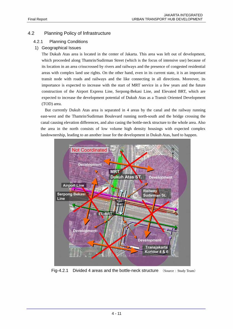
JAKARTA INTEGRATED Final Report URBAN TRANSPORT HUB DEVELOPMENT
4 - 11
4.2 Planning Policy of Infrastructure
4.2.1 Planning Conditions
1) Geographical Issues The Dukuh Atas area is located in the center of Jakarta. This area was left out of development,
which proceeded along Thamrin/Sudirman Street (which is the focus of intensive use) because of
its location in an area crisscrossed by rivers and railways and the presence of congested residential
areas with complex land use rights. On the other hand, even in its current state, it is an important
transit node with roads and railways and the like connecting in all directions. Moreover, its
importance is expected to increase with the start of MRT service in a few years and the future
construction of the Airport Express Line, Serpong-Bekasi Line, and Elevated BRT, which are
expected to increase the development potential of Dukuh Atas as a Transit Oriented Development
(TOD) area.
But currently Dukuh Atas area is separated in 4 areas by the canal and the railway running
east-west and the Thamrin/Sudirman Boulevard running north-south and the bridge crossing the
canal causing elevation differences, and also casing the bottle-neck structure to the whole area. Also
the area in the north consists of low volume high density housings with expected complex
landownership, leading to an another issue for the development in Dukuh Atas, hard to happen.
図-4.2.1 東西南北4地区分断とボトルネック構造 (出典:調査団)
Fig-4.2.1 Divided 4 areas and the bottle-neck structure (Source:Study Team)
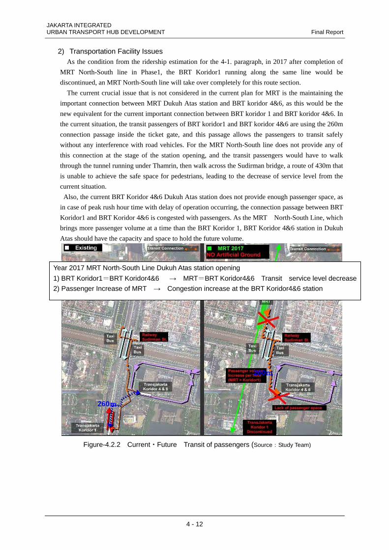
JAKARTA INTEGRATED URBAN TRANSPORT HUB DEVELOPMENT Final Report
4 - 12
2) Transportation Facility Issues As the condition from the ridership estimation for the 4-1. paragraph, in 2017 after completion of
MRT North-South line in Phase1, the BRT Koridor1 running along the same line would be
discontinued, an MRT North-South line will take over completely for this route section.
The current crucial issue that is not considered in the current plan for MRT is the maintaining the
important connection between MRT Dukuh Atas station and BRT koridor 4&6, as this would be the
new equivalent for the current important connection between BRT koridor 1 and BRT koridor 4&6. In
the current situation, the transit passengers of BRT koridor1 and BRT koridor 4&6 are using the 260m
connection passage inside the ticket gate, and this passage allows the passengers to transit safely
without any interference with road vehicles. For the MRT North-South line does not provide any of
this connection at the stage of the station opening, and the transit passengers would have to walk
through the tunnel running under Thamrin, then walk across the Sudirman bridge, a route of 430m that
is unable to achieve the safe space for pedestrians, leading to the decrease of service level from the
current situation.
Also, the current BRT Koridor 4&6 Dukuh Atas station does not provide enough passenger space, as
in case of peak rush hour time with delay of operation occurring, the connection passage between BRT
Koridor1 and BRT Koridor 4&6 is congested with passengers. As the MRT North-South Line, which
brings more passenger volume at a time than the BRT Koridor 1, BRT Koridor 4&6 station in Dukuh
Atas should have the capacity and space to hold the future volume.
260mmmm
260mmmm
Figure-4.2.2 Current・Future Transit of passengers (Source:Study Team)
Year 2017 MRT North-South Line Dukuh Atas station opening
1) BRT Koridor1=BRT Koridor4&6 → MRT=BRT Koridor4&6 Transit service level decrease
2) Passenger Increase of MRT → Congestion increase at the BRT Koridor4&6 station
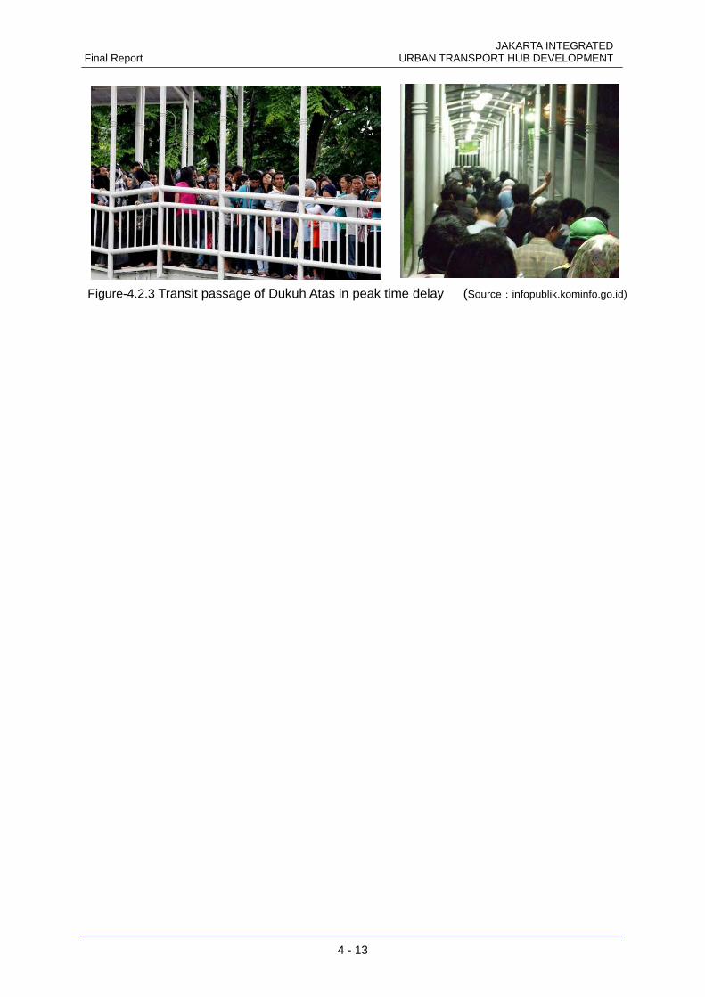
JAKARTA INTEGRATED Final Report URBAN TRANSPORT HUB DEVELOPMENT
4 - 13
Figure-4.2.3 Transit passage of Dukuh Atas in peak time delay (Source:infopublik.kominfo.go.id)
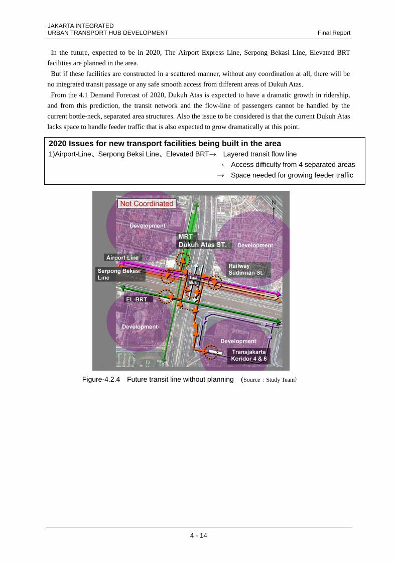
JAKARTA INTEGRATED URBAN TRANSPORT HUB DEVELOPMENT Final Report
4 - 14
In the future, expected to be in 2020, The Airport Express Line, Serpong Bekasi Line, Elevated BRT
facilities are planned in the area.
But if these facilities are constructed in a scattered manner, without any coordination at all, there will be
no integrated transit passage or any safe smooth access from different areas of Dukuh Atas.
From the 4.1 Demand Forecast of 2020, Dukuh Atas is expected to have a dramatic growth in ridership,
and from this prediction, the transit network and the flow-line of passengers cannot be handled by the
current bottle-neck, separated area structures. Also the issue to be considered is that the current Dukuh Atas
lacks space to handle feeder traffic that is also expected to grow dramatically at this point.
Figure-4.2.4 Future transit line without planning (Source:Study Team)
2020 Issues for new transport facilities being built in the area 1)Airport-Line、Serpong Beksi Line、Elevated BRT→ Layered transit flow line → Access difficulty from 4 separated areas
→ Space needed for growing feeder traffic
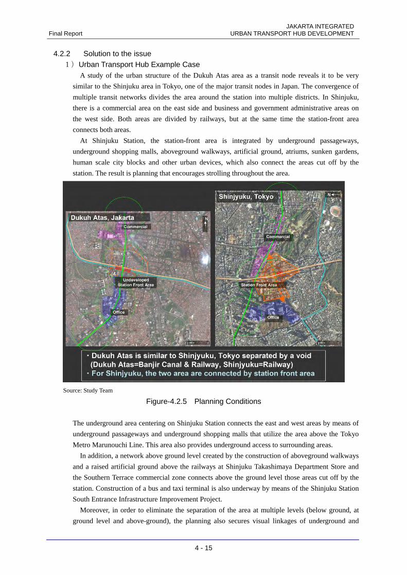
JAKARTA INTEGRATED Final Report URBAN TRANSPORT HUB DEVELOPMENT
4 - 15
4.2.2 Solution to the issue 1)Urban Transport Hub Example Case
A study of the urban structure of the Dukuh Atas area as a transit node reveals it to be very
similar to the Shinjuku area in Tokyo, one of the major transit nodes in Japan. The convergence of
multiple transit networks divides the area around the station into multiple districts. In Shinjuku,
there is a commercial area on the east side and business and government administrative areas on
the west side. Both areas are divided by railways, but at the same time the station-front area
connects both areas.
At Shinjuku Station, the station-front area is integrated by underground passageways,
underground shopping malls, aboveground walkways, artificial ground, atriums, sunken gardens,
human scale city blocks and other urban devices, which also connect the areas cut off by the
station. The result is planning that encourages strolling throughout the area.
Source: Study Team
Figure-4.2.5 Planning Conditions
The underground area centering on Shinjuku Station connects the east and west areas by means of
underground passageways and underground shopping malls that utilize the area above the Tokyo
Metro Marunouchi Line. This area also provides underground access to surrounding areas.
In addition, a network above ground level created by the construction of aboveground walkways
and a raised artificial ground above the railways at Shinjuku Takashimaya Department Store and
the Southern Terrace commercial zone connects above the ground level those areas cut off by the
station. Construction of a bus and taxi terminal is also underway by means of the Shinjuku Station
South Entrance Infrastructure Improvement Project.
Moreover, in order to eliminate the separation of the area at multiple levels (below ground, at
ground level and above-ground), the planning also secures visual linkages of underground and
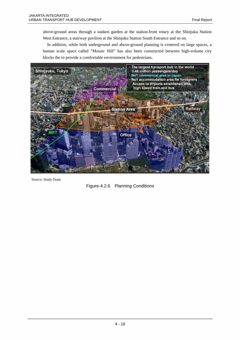
JAKARTA INTEGRATED URBAN TRANSPORT HUB DEVELOPMENT Final Report
4 - 16
above-ground areas through a sunken garden at the station-front rotary at the Shinjuku Station
West Entrance, a stairway pavilion at the Shinjuku Station South Entrance and so on.
In addition, while both underground and above-ground planning is centered on large spaces, a
human scale space called “Mosaic Hill” has also been constructed between high-volume city
blocks the to provide a comfortable environment for pedestrians.
Source: Study Team
Figure-4.2.6 Planning Conditions
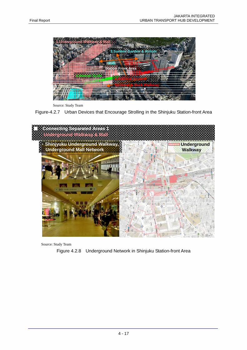
JAKARTA INTEGRATED Final Report URBAN TRANSPORT HUB DEVELOPMENT
4 - 17
Station Front Area
1.Underground Walkway & Mall
2.Artificial Ground
Terminal & Deck Walkway
3.Sunken Garden & Atrium
4.Human Scale
Source: Study Team
Figure-4.2.7 Urban Devices that Encourage Strolling in the Shinjuku Station-front Area
UndergroundWalkway
・・・・Shinjyuku Underground Walkway,Underground Mall Network
■■■■ Connecting Separated Areas 1Underground Walkway & Mall
UndergroundWalkway
・・・・Shinjyuku Underground Walkway,Underground Mall Network
■■■■ Connecting Separated Areas 1Underground Walkway & Mall
Source: Study Team
Figure 4.2.8 Underground Network in Shinjuku Station-front Area
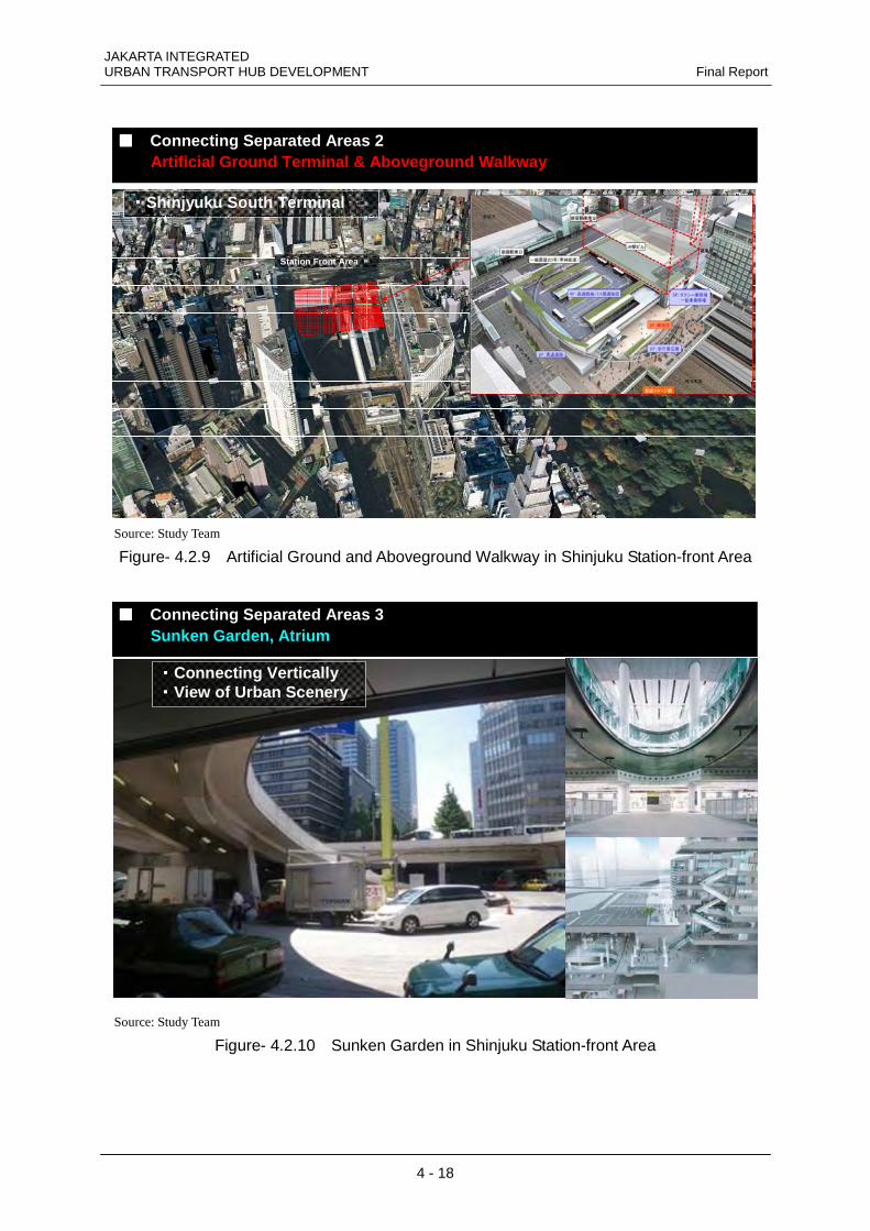
JAKARTA INTEGRATED URBAN TRANSPORT HUB DEVELOPMENT Final Report
4 - 18
・・・・Shinjyuku South Terminal
Station Front Area
■■■■ Connecting Separated Areas 2Artificial Ground Terminal & Aboveground Walkway
・・・・Shinjyuku South Terminal
Station Front Area
■■■■ Connecting Separated Areas 2Artificial Ground Terminal & Aboveground Walkway
Source: Study Team
Figure- 4.2.9 Artificial Ground and Aboveground Walkway in Shinjuku Station-front Area
・・・・Connecting Vertically・・・・View of Urban Scenery
■■■■ Connecting Separated Areas 3Sunken Garden, Atrium
・・・・Connecting Vertically・・・・View of Urban Scenery
■■■■ Connecting Separated Areas 3Sunken Garden, Atrium
Source: Study Team
Figure- 4.2.10 Sunken Garden in Shinjuku Station-front Area
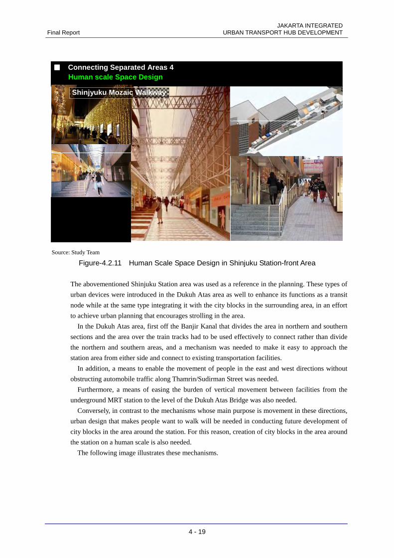
JAKARTA INTEGRATED Final Report URBAN TRANSPORT HUB DEVELOPMENT
4 - 19
■■■■ Connecting Separated Areas 4Human scale Space Design
Shinjyuku Mozaic Walkway
■■■■ Connecting Separated Areas 4Human scale Space Design
Shinjyuku Mozaic Walkway
Source: Study Team
Figure-4.2.11 Human Scale Space Design in Shinjuku Station-front Area
The abovementioned Shinjuku Station area was used as a reference in the planning. These types of
urban devices were introduced in the Dukuh Atas area as well to enhance its functions as a transit
node while at the same type integrating it with the city blocks in the surrounding area, in an effort
to achieve urban planning that encourages strolling in the area.
In the Dukuh Atas area, first off the Banjir Kanal that divides the area in northern and southern
sections and the area over the train tracks had to be used effectively to connect rather than divide
the northern and southern areas, and a mechanism was needed to make it easy to approach the
station area from either side and connect to existing transportation facilities.
In addition, a means to enable the movement of people in the east and west directions without
obstructing automobile traffic along Thamrin/Sudirman Street was needed.
Furthermore, a means of easing the burden of vertical movement between facilities from the
underground MRT station to the level of the Dukuh Atas Bridge was also needed.
Conversely, in contrast to the mechanisms whose main purpose is movement in these directions,
urban design that makes people want to walk will be needed in conducting future development of
city blocks in the area around the station. For this reason, creation of city blocks in the area around
the station on a human scale is also needed.
The following image illustrates these mechanisms.
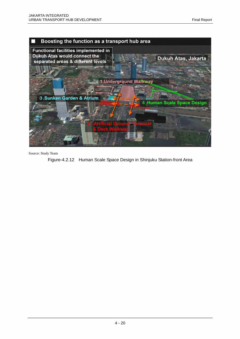
JAKARTA INTEGRATED URBAN TRANSPORT HUB DEVELOPMENT Final Report
4 - 20
Source: Study Team
Figure-4.2.12 Human Scale Space Design in Shinjuku Station-front Area
JAKARTA INTEGRATED Final Report URBAN TRANSPORT HUB DEVELOPMENT
4 - 21
2) The Solution For the case above, to meet the needs in the current land ownership condition of Dukuh Atas, it is
essential to plan the transport facilities within the existing public land around the area to ensure, project
implementation minimizing the risk and avoiding project delay.
Also, the location of the facilities should consider the usage and the connection distance between each
other, considering the distance of 200m, which is consider to be the average walking distance under the
TOD planning. As Dukuh Atas is divided into areas by the Banjir canal and the Thamrin-Sudirman
boulevard, it is beneficial to consider the area to plan the transport facility inside the 200m radius centered
by the Surdirman Bridge. Inside this area, the area with high-potential is the area above Banjir Kanal, as by
constructing an artificial ground over this area in terms of gaining areal surface, it would become an traffic
terminal that can be accessed from North, South , East, and West, from all directions.
For the conclusion of the matters above, the condition is to plan the facilities using areas over the Banjir
Kanal.
For the conclusion above, the condition is to plan the facilities using areas over the Banjir Kanal.
MRT Dukuh Atas St.
Sudirman St.
Pasar Blora
Banjir Kanal Private Land Public Land (PD PASAR JAYA) Public Land(DGR) Green Area/Park (DKI PW)
Water Body (MPW) Water Body (DKI PW)
Road (DKI PW)
Figure-4.2.13 Existing Landownership in Dukuh Atas (Source:Study Team)
200m
JAKARTA INTEGRATED URBAN TRANSPORT HUB DEVELOPMENT Final Report
4 - 22
Rise of growth potential for development will occur by integrating the transport hub, which will lead to
the interest of private developers wanting to develop the area. To thrust this interest of the private parties to
get involved, it is important to form a network of pedestrians, not just for the transport facilities, but also
for the whole Dukuh Atas area. The north south dividence by the Banjir Kanal, the east west dividence by
the Thamrin/Sudirman Boulevard, the elevation dividence by the Sudirman Bridge, must be solved by an
effective infrastructure to connect all 4 areas.
To solve this issue, the study proposes to build an artificial ground over the Banjir Kanal with multiple
passages to connect pedestrian network between north and south to solve the bottle neck structure. Also the
passage connecting MRT and the railway station on the north side, and passage connecting the artificial
ground between east and west would form a large circulation network around the area.
Also for the station area, in contrast to the current UDGL study focusing on equal KLB(Floor area ratio)
around the area, the study team proposes to concentrate the KLB(Floor area ratio) to the working distance
of 200m around the station area, according to the TOD concept, to focus and speed up the station area
development in the early stage.
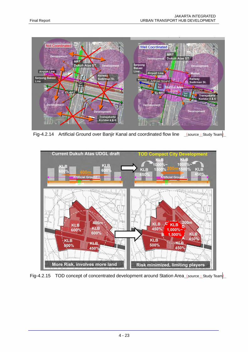
JAKARTA INTEGRATED Final Report URBAN TRANSPORT HUB DEVELOPMENT
4 - 23
Fig-4.2.14 Artificial Ground over Banjir Kanal and coordinated flow line (source:Study Team)
Fig-4.2.15 TOD concept of concentrated development around Station Area(source:Study Team)
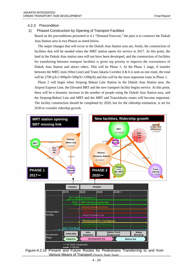
JAKARTA INTEGRATED URBAN TRANSPORT HUB DEVELOPMENT Final Report
4 - 24
4.2.3 Precondition 1) Phased Construction by Opening of Transport Facilities Based on the preconditions presented in 4.1 “Demand Forecast,” the plan is to construct the Dukuh
Atas Station area in two Phases as noted below.
The major changes that will occur in the Dukuh Atas Station area are, firstly, the construction of
facilities that will be needed when the MRT station opens for service in 2017. At this point, the
land in the Dukuh Atas station area will not have been developed, and the construction of facilities
for transferring between transport facilities is given top priority to improve the convenience of
Dukuh Atas Station and attract riders. This will be Phase 1. At the Phase 1 stage, if transfer
between the MRT, train (West Line) and Trans Jakarta Corridor 4 & 6 is seen as one route, the total
will be 2700 p/h (=900p/h+500p/h+1300p/h) and this will be the most important route in Phase 1.
Phase 2 will begin when Serpong Bekasi Line Station in the Dukuh Atas Station area, the
Airport Express Line, the Elevated BRT and the new transport facility begins service. At this point,
there will be a dramatic increase in the number of people using the Dukuh Atas Station area, and
the Serpong-Bekasi Line and MRT and the MRT and TransJakarta routes will become important.
The facility construction should be completed by 2020, but for the ridership estimation, is set for
2030 to consider ridership growth.
MRT
Bus Taxi etc
Railway (Loop Line) (West Line)
Airport Express
Railway
(Serpong--Bekasi)
Trans Jakarta
Green Line
(EL-BRT)
31,800p/h
36,100p/h
14,700p/h 10,900p/h
1,400p/h
1,000p/h
15,600p/h
9,200p/h
6,700p/h
Trans Jakarta
MRT
Railway
(West Line)
Bus Taxi etc
2,500p/h
2,300p/h
7,000p/h 2,700p/h
900p/h
1,300p/h 500p/h
PHASE 2 2020~~~~
PHASE 1 2017~~~~
MRT station opening BRT missing link
New facilities, Ridership growth
Figure-4.2.16 Present and Future Routes for Pedestrians Transferring to and from Various Means of Transport (Source: Study Team)
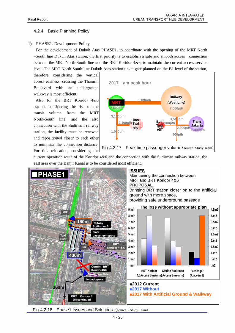
JAKARTA INTEGRATED Final Report URBAN TRANSPORT HUB DEVELOPMENT
4 - 25
4.2.4 Basic Planning Policy
1) PHASE1. Development Policy
For the development of Dukuh Atas PHASE1, to coordinate with the opening of the MRT North
–South line Dukuh Atas station, the first priority is to establish a safe and smooth access connection
between the MRT North-South line and the BRT Koridor 4&6, to maintain the current access service
level. The MRT North-South line Dukuh Atas station ticket gate planned on the B1 level of the station,
therefore considering the vertical
access easiness, crossing the Thamrin
Boulevard with an underground
walkway is most efficient.
Also for the BRT Koridor 4&6
station, considering the rise of the
transit volume from the MRT
North-South line, and the also
connection with the Sudirman railway
station, the facility must be renewed
and repositioned closer to each other
to minimize the connection distance.
For this relocation, considering the
current operation route of the Koridor 4&6 and the connection with the Sudirman railway station, the
east area over the Banjir Kanal is to be considered most efficient.
2) PHASE2.
Fig-4.2.18 Phase1 Issues and Solutions(source:Study Team)
.min
1.min
2.min
3.min
4.min
5.min
6.min
7.min
8.min
9.min
BRT Koridor4,6Access time(min)
Station SudirmanAccess time(min)
PassengerSpace (m2)
.m2
.5m2
1.m2
1.5m2
2.m2
2.5m2
3.m2
3.5m2
4.m2
4.5m2
■2012 Current ■2017 Without ■2017 With Artificial Ground & Walkway
ISSUES Maintaining the connection between MRT and BRT Koridor 4&6 PROPOSAL Bringing BRT station closer on to the artificial ground with more space, providing safe underground passage
The loss without appropriate plan
PHASE 1
2017 am peak hour
Railway
(West Line)
7,000p/h
6,100p/h
2,100p/h
MRT 2,500p/h
Bus Taxi etc
Bus Taxi etc
900p/h 3,500p/h
Trans Jakarta 2,300p/h
3,100p/h
1,000p/h 2,300p/h
500p/h
MRT
Fig-4.2.17 Peak time passenger volume(source:Study Team)
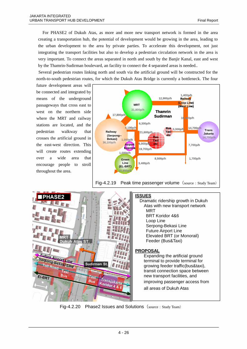
JAKARTA INTEGRATED URBAN TRANSPORT HUB DEVELOPMENT Final Report
4 - 26
For PHASE2 of Dukuh Atas, as more and more new transport network is formed in the area
creating a transportation hub, the potential of development would be growing in the area, leading to
the urban development to the area by private parties. To accelerate this development, not just
integrating the transport facilities but also to develop a pedestrian circulation network in the area is
very important. To connect the areas separated in north and south by the Banjir Kanal, east and west
by the Thamrin-Sudirman boulevard, an facility to connect the 4 separated areas is needed..
Several pedestrian routes linking north and south via the artificial ground will be constructed for the
north-to-south pedestrian routes, for which the Dukuh Atas Bridge is currently a bottleneck. The four
future development areas will
be connected and integrated by
means of the underground
passageways that cross east to
west on the northern side
where the MRT and railway
stations are located, and the
pedestrian walkway that
crosses the artificial ground in
the east-west direction. This
will create routes extending
over a wide area that
encourage people to stroll
throughout the area.
Fig-4.2.20 Phase2 Issues and Solutions(source:Study Team)
ISSUES Dramatic ridership growth in Dukuh Atas with new transport network MRT BRT Koridor 4&6 Loop Line Serpong-Bekasi Line Future Airport Line Elevated BRT (or Monorail) Feeder (Bus&Taxi) PROPOSAL Expanding the artificial ground terminal to provide terminal for growing feeder traffic(bus&taxi), transit connection space between new transport facilities, and improving passenger access from
all areas of Dukuh Atas
MRT
BusTaxietc
Railway(Loop Line)(West Line)
AirportExpress
Railway(Serpong--Bekasi)
31,800p/h
36,100p/h
1,400p/h
1,000p/h
BusTaxietc
12,900p/h
10,800p/h
3,300p/h TransJakarta
14,700p/h
14,700p/h
17,800p/h
6,300p/h8,100p/h
1,000p/h
19,700p/h
GreenLine
(EL-BRT)10,900p/h
21,600p/h
6,900p/h
ThamrinSudirman
7,700p/h
GreenLine
(EL-BRT)3,400p/h
10,900p/h
1,700p/h8,500p/h
Fig-4.2.19 Peak time passenger volume(source:Study Team)