
J. KIRBY DEVELOPMENT, L.L.C. AND - Montgomery … COUNTY, MARYLAND Office of Zoning and...
92
BEFORE THE COUNTY COUNCIL FOR MONTGOMERY COUNTY, MARYLAND SITTING AS THE DISTRICT COUNCIL FOR THE MARYLAND- WASHINGTON REGIONAL DISTRICT IN MONTGOMERY COUNTY, MARYLAND Office of Zoning and Administrative Hearings 100 Maryland Avenue, Room 200 Rockville, Maryland 20850 (240) 777-6660 IN THE MATTER OF: * * J. KIRBY DEVELOPMENT, L.L.C. AND * VEDANTA CENTER OF GREATER * Zoning Application No. G-836 WASHINGTON D.C., INC., * * Applicants * * John Clapsaddle * Stuart Elkman * Wes Guckert * Jeff Kirby * Rock Lopes * James O’Brien * Phil Perrine * * For the Application * * Scott Wallace, Esquire * * Attorney for the Applicant * * * * * * * * * * * * * * * * * * * * * * * * * * * * * * * * * * * * * * * Laurence Andrews * Max Bronstein * Wayne Courtney * Richard Kauffinger * Linda Nishioka * Joe Podson * * In Opposition to the Development * Plan * * * * * * * * * * * * * * * * * * * * * * * * * * * * * * * * * * * * * * Before: Françoise M. Carrier, Hearing Examiner HEARING EXAMINER’S REPORT AND RECOMMENDATION
Transcript of J. KIRBY DEVELOPMENT, L.L.C. AND - Montgomery … COUNTY, MARYLAND Office of Zoning and...

BEFORE THE COUNTY COUNCIL FOR MONTGOMERY COUNTY, MARYLAND SITTING AS THE DISTRICT COUNCIL FOR THE MARYLAND-
WASHINGTON REGIONAL DISTRICT IN MONTGOMERY COUNTY, MARYLAND
Office of Zoning and Administrative Hearings 100 Maryland Avenue, Room 200
Rockville, Maryland 20850 (240) 777-6660
IN THE MATTER OF: * * J. KIRBY DEVELOPMENT, L.L.C. AND * VEDANTA CENTER OF GREATER * Zoning Application No. G-836 WASHINGTON D.C., INC., * * Applicants * * John Clapsaddle * Stuart Elkman * Wes Guckert * Jeff Kirby * Rock Lopes * James O’Brien * Phil Perrine * * For the Application * * Scott Wallace, Esquire * * Attorney for the Applicant * * * * * * * * * * * * * * * * * * * * * * * * * * * * * * * * * * * * * *
* Laurence Andrews * Max Bronstein * Wayne Courtney * Richard Kauffinger * Linda Nishioka * Joe Podson * * In Opposition to the Development * Plan * * * * * * * * * * * * * * * * * * * * * * * * * * * * * * * * * * * * * *
Before: Françoise M. Carrier, Hearing Examiner
HEARING EXAMINER’S REPORT AND RECOMMENDATION
LMA G-836 Page 2.
TABLE OF CONTENTS
Page No.
I. SUMMARY ...............................................................................................................................3 II. STATEMENT OF THE CASE..................................................................................................4 III. FINDINGS OF FACT ..............................................................................................................5
A. Subject Property .................................................................................................. 5 B. Surrounding Area................................................................................................. 6 C. Zoning and Land Use History .......................................................................... 9 D. Proposed Development .................................................................................. 10 E. Development Plan ........................................................................................... 20 F. Master Plan ...................................................................................................... 27 G. Environmental Issues and Storm Water Management ................................... 34 H. Public Facilities .................................................................................................. 35
1. Transportation............................................................................................. 36 2. Water and Sewer ......................................................................................... 42 3. Schools ....................................................................................................... 42
I. Support for the Application ................................................................................. 43 J. Community Concerns about Development Plan.............................................. 44
IV. SUMMARY OF HEARING ..................................................................................................49
A. Applicant’s Case in Chief .................................................................................. 49 B. Applicant’s Rebuttal .......................................................................................... 62 C. Community Participation................................................................................... 64
V. ZONING ISSUES ..................................................................................................................72
A. The Development Plan....................................................................................... 73 1. Purposes of the Zone................................................................................. 77 2. Standards and Regulations of the Zone................................................... 85
B. Public Interest .................................................................................................... 90 VI. CONCLUSIONS ....................................................................................................................91 VII. RECOMMENDATION .........................................................................................................92
LMA G-836 Page 3.
I. SUMMARY
The present application seeks to rezone 16 acres of land at the intersection of Bel
Pre Road and Homecrest Road in Silver Spring from the RE-2 Zone to the PD-2 Zone. The 16-acre
tract is made up of three parcels. Two are developed with single-family detached homes and the
third is the site of the Vedanta Center, a non-denominational worship center. The Vedanta Center
has joined J. Kirby Development as an applicant. Together, they propose development of 38 new
homes (20 single-family detached, 12 duplex units and six MPDU townhouses) and construction of
a new worship building. The existing Vedanta Center worship building and guest house would
remain.
The PD Zone cannot be applied unless the District Council simultaneously approves
a Development Plan that meets the requirements set forth in the Zoning Ordinance. In this case,
the Development Plan has four serious deficiencies: a dense form of development on the west side
of the site that is not compatible with the surrounding area; a provision stating that building locations
are entirely illustrative, suggesting that a completely different layout might be presented at site plan;
a provision stating that the green area, shown at 46 percent of the site, could decrease by as much
as a third, down to the minimum 30 percent required in the zone, with no explanation of how such a
dramatic change would affect the site layout; and a provision indicating that one of the two access
points shown on Homecrest Road may not be built. The latter deficiency is troubling for two
reasons: it inhibits the District Council from fully evaluating the access and circulation plan, and it
calls into question compliance with the Master Plan, which identified one of the Homecrest Road
access points as an important goal. The Development Plan also contains a series of minor
deficiencies, which are identified in Part III.E. of this report.
The Hearing Examiner recommends a remand of the present case, rather than
denial, because all of the deficiencies that have been identified can be cured by a revision of the
Development Plan. The Hearing Examiner is persuaded that with an appropriate development
plan, reclassification of the subject property to the PD-2 Zone and its use for residential housing

LMA G-836 Page 4. and an expanded Vedanta Center would be in the public interest. Accordingly, this report
recommends a remand of this case to give the Applicants the opportunity to correct the deficiencies
on the Development Plan that are identified in this report, and to propose a form of development
that will be compatible with surrounding land uses.
II. STATEMENT OF THE CASE
Application No. G-836, filed on March 3, 2005 by Applicants J. Kirby Development,
L.L.C. and Vedanta Center of Greater Washington D.C., Inc., requests reclassification from the RE-
2 Zone (Residential, one-family, two-acre minimum lot size) to the PD-2 Zone (Planned
Development) of 16 acres of land located at 2929, 3001 and 3031 Bel Pre Road in Silver Spring,
Maryland, in the 13th Election District. The property is identified as Part of Lots 3, 4 and 5 of the
“Homecrest” subdivision, recorded in Plat Book 25, Plat 1586. The Vedanta Center is currently the
owner of Lot 4. Lots 3 and 5 are currently owned by separate individuals. J. Kirby Development is
identified as a contract purchaser, presumably with reference to Lots 3 and 5. The proposed
Development Plan contemplates land swaps between the two Applicants, with both remaining as
owners.
The application was initially reviewed by Technical Staff of the Maryland-National
Capital Park and Planning Commission (“MNCPPC”) who, in a report dated October 11, 2005,
recommended approval.1 The Montgomery County Planning Board (“Planning Board”) considered
the application on October 20, 2005 and recommended approval by a vote of 4 to 0. A public
hearing was conducted on November 4, 2005 at which testimony and evidence were presented in
support of and in opposition to the application. The record was held open briefly to receive
supplemental submissions from the parties and Technical Staff, and closed on December 9, 2005.
By Resolution dated January 24, 2006 and effective nunc pro tunc as of January 23, 2006, the
District Council extended the time for submission of the Hearing Examiner’s report and
recommendation by two weeks, to February 6, 2006.

LMA G-836 Page 5.
III. FINDINGS OF FACT
For the convenience of the reader, the findings of fact are grouped by subject matter.
Where there are conflicts in the evidence, these conflicts are resolved under the preponderance of
the evidence test.
A. Subject Property
The subject property consists of approximately 16 acres of land located in the
northeast quadrant of the intersection of Bel Pre Road and Homecrest Road, roughly midway
between Bel Pre Road’s intersections with Georgia Avenue to the west and Layhill Road to the
east. The three lots comprising the subject property form a nearly square tract of land, with
approximately 867 feet of frontage on Bel Pre Road, a five-lane undivided arterial road with an 80-
foot right-of-way, and 800 feet of frontage on Homecrest Road, a narrow, two-lane, residential
primary street. Confronting to the south, across Bel Pre Road, are three- and four-story apartments
and townhouses. Confronting to the west, across Homecrest Road, are Aspenwood Senior Living
Community, located at the northwest corner of Bel Pre and Homecrest Roads, which provides
assisted living for senior adults and special needs care; three single-family homes; and, diagonally
to the northwest, Homecrest House, a senior housing and assisted living facility. To the east, the
subject property abuts the Wheaton Moose Lodge, which is occupied by a social lodge and is about
half wooded. To the north, the subject property abuts the Aspen Hill Racquet and Tennis Club (the
“Racquet Club”), a large complex of indoor and outdoor sports facilities, with very large buildings
and extensive parking lots.
Lot 3, at the east end of the site, is mostly wooded, and has a one-story brick house,
a carport and a driveway off of Bel Pre Road. Lot 4, in the center, is also mostly wooded. It is
developed with the Vedanta Center, a worship center consisting of a concrete and stone building
with a one-story wing and a two-story wing, which is used for congregation gatherings and a home
1 The Staff Report is liberally paraphrased and quoted in Part II of this report.

LMA G-836 Page 6. for resident monks; a small, brick, 1 ½ story guest house; a paved driveway off of Bel Pre Road;
and a gravel parking area. Lot 5, at the west end of the site, is mostly grassy, with a one-story brick
house, a concrete block garage, a metal shed and driveway access from Homecrest Road.
The subject property is gently to moderately sloping. It contains approximately 9.62
acres of forest, with two major forest stands rated good quality. The property contains no flood
plains, but a small stream known as Bel Pre Creek flows through the northeast part of the property,
making a substantial portion of the combined property undevelopable stream valley buffer.
The general shape and location of the subject property are shown on the map that
follows (excerpted from Ex. 60(a)).
B. Surrounding Area
The surrounding area must be identified in a floating zone case so that compatibility
can be evaluated properly. The “surrounding area” is defined less rigidly in connection with a
floating zone application than in evaluating a Euclidean zone application. In general, the definition
of the surrounding area takes into account those areas that would be most directly affected by the
proposed development.
In the present case, Technical Staff described the surrounding area as the land
designated in the 1994 Approved and Adopted Aspen Hill Master Plan (the “Master Plan”) as the

LMA G-836 Page 7. Bel Pre Road Area. See Staff Report, Ex. 28 at 6; Master Plan at 46-47. As shown on the Master
Plan map below, this 63-acre area extends from Bel Pre Road to the south to Homecrest Road to
the west, the property line of Argyle Country Club to the north and the Bel Pre Square Townhouses
to the east (located across from North Gate Drive).
The Applicants’ land planner, Phil Perrine, considered the surrounding area to
include principally the abutting and confronting land uses, noting that the surrounding area to be
considered for a small development is smaller than for a development with larger impacts, such as
a ten-story high-rise. Mr. Perrine appears to underestimate the likely impact of the proposed
development, which would represent a significant change in density and intensity of use on an
important corner property. Accordingly, the Hearing Examiner agrees with Technical Staff that the
Bel Pre Road Area as described in the Master Plan may properly be considered part of the
surrounding area for purposes of this application. However, confronting properties on Bel Pre and
Homecrest Roads and the adjacent property that are not within that defined area undoubtedly
would be affected by the proposed development. Taking both into account, the Hearing Examiner
designates the surrounding area as, roughly, the Bel Pre Road Area described in the Master Plan
plus properties that are either adjacent or directly or diagonally confronting. The relationship of the
subject property to existing land uses in the surrounding area is shown in the aerial photograph on
the next page.
The surrounding area contains a mix of uses including three- and four-story
apartment buildings, senior housing including assisted living, townhouses, single-family detached
homes, churches, a large sports facility, a social lodge and a country club. As shown on the zoning
vicinity map on page 9, the zoning pattern is a mixture of RE-2, RE-2/TDR, R-200 and R-150
zoning. Mr. Perrine explained this apparently random zoning pattern by stating that at one time, the
entire area was classified under the RE-2 Zone. In 1970, the master plan recommended R-200
zoning, but that was not implemented. Instead individual, piecemeal zoning applications came in
for a variety of zones. Most of the properties in the vicinity were reclassified to their current zones

LMA G-836 Page 8.
Aerial Photograph, Ex. 38

LMA G-836 Page 9. between 1965 and 1980, and were developed with a variety of uses. Mr. Perrine observed that the
current Master Plan attempted to reconcile the different rezonings and provide a plan for the
developed areas by retaining existing RE-2 classifications, while also recommending the PD-2 Zone
for the subject property and the remaining undeveloped property east of it, all the way to Big Bear
Court. Mr. Perrine noted that the PD-2 Zone has the same density as the RE-2 Zone, but allows for
more design flexibility to achieve some of the Master Plan’s other goals.
Zoning Vicinity Map, Ex. 4
C. Zoning and Land Use History
The subject property was classified under the R-A (Agricultural Residential) Zone in
the 1958 County-wide comprehensive rezoning. The R-A Zone was redesignated the RE-2 Zone
by text amendment in 1973, and the subject property’s zoning has remained the same since then.
The area was recommended for reclassification to the R-200 Zone in the 1970 Aspen Hill Master
Plan, but no sectional map amendment followed. RE-2 zoning on the subject property was
confirmed by Sectional Map Amendment G-709 in 1994, as recommended in the 1994 Master Plan.
Subject Site

LMA G-836 Page 10.
As noted above, lots 3 and 5 of the subject property are each developed with a
single-family home, while lot 5 has been the site of the Vedanta Center for eight and a half years.
The Center has ties to Indian spiritual traditions, but considers itself a universal, non-
denominational movement, accepting people from all religions and different spiritual paths. The
Center teaches spiritual principals and practices including meditation, and tries to maintain a serene
atmosphere. The main program is on Sunday morning at 11:00, which involves a series of lectures
on different topics, attracting about 60 to 70 people. The Center has study groups on Wednesday
and Friday nights from 8:00 to 9:00, youth programs on Saturday afternoons, early morning
meditation at 5:30, and evening meditation. Generally, the only people attending weekday activities
are the small number who live on site or are staying in the guest house. The Center has larger
programs two or three times a year, necessitating a larger parking lot.
The small house on the Vedanta Center property pre-dates the Center and is used
as a guest house, where people occasionally come for a retreat for a few days. The house
accommodates five comfortably, with a maximum of seven. It is used as a women’s guest house,
or for a family. The larger, L-shaped building contains approximately 4,300 square feet of space. It
houses the auditorium and a residential wing, whose current residents are two monks. Male
visitors, some of whom stay overnight every weekend, sleep in the residential wing of the main
building, which can accommodate eight residents.
D. Proposed Development
The Development Plan proposes expansion of the Vedanta Center’s facilities and the
coordinated development of a residential community with a total of 39 dwelling units: 20 new single-
family detached homes, 12 new single-family, semidetached duplex units, six single-family attached
units to be marketed as moderately-priced dwelling units (“MPDUs”), and the existing Vedanta
Center guest house. The preliminary bedroom calculation indicates that the single-family detached
units would have four bedrooms, the townhouses would have two bedrooms with an optional third
bedroom, and the duplexes would have three bedrooms. The graphic portion of the Development

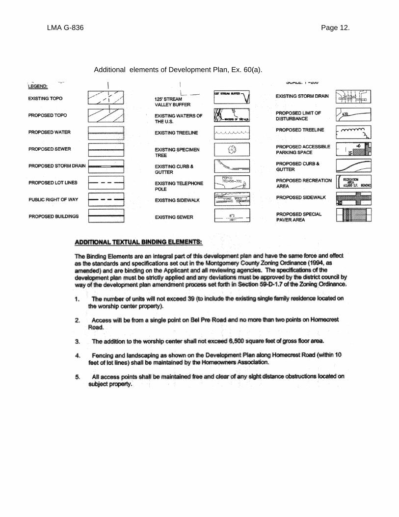
LMA G-836 Page 11. Plan, Exhibit 60(a), is reproduced below, with textual elements of the plan provided on the pages
that follow.
Graphic Portion of Development Plan, excerpted from Ex. 60(a)
Single-family detachedHomecrest
Road
Bel
Pre
Roa
d
MPDU townhouses
Duplex units
N
LMA G-836 Page 12.
Additional elements of Development Plan, Ex. 60(a).

LMA G-836 Page 13.
Additional elements of Development Plan, Ex. 60(a).

LMA G-836 Page 14.
Additional elements of Development Plan, Ex. 60(a).

LMA G-836 Page 15.
General N
otes from D
evelopment
Plan, E
x. 60(a)

LMA G-836 Page 16.
General N
otes from
Developm
entPlan,cont.
LMA G-836 Page 17.
The existing Vedanta Center worship building and its attached residential wing,
roughly in the middle of the site, would be retained. In addition, a new, 6,500-square foot structure
would be built onto the rear wall of the existing worship building, with a landscaped courtyard
between the old and new structures. The new building would provide a worship space with
approximately 212 seats, a study room, an entry lobby, bathrooms, storage space, a cellar
gathering space and a kitchen. The Center plans to use the existing auditorium as a multi-function
meeting space. The new building would provide a larger auditorium, as well a space in the cellar to
serve refreshments after worship activities, which is lacking in the current facility. The architecture
for the new building is based on a well-known Indian Hindu temple, incorporating a blend of
traditional Indian and European styles. The maximum height, excluding cupolas and domes, would
be 24 feet. The new Vedanta Center building would face east, towards a wooded area abutting the
stream valley buffer. It would be partially obscured from Bel Pre Road by the existing Vedanta
Center buildings, so one would have only an oblique view of the new building from Bel Pre Road.
The Development Plan allocates the land immediately south of the Vedanta Center,
between the Center and Bel Pre Road, to an 85-space parking lot for the Vedanta Center. East of
the parking lot, in the southeast corner of the site, the Development Plan shows 12 duplex units.
Testimony indicated that these units would be under the Vedanta Center’s ownership, and that the
Center hopes to sell the units with covenants restricting their occupancy to members of the Vedanta
Center community. The duplex units are shown with access via the same driveway serving the
Vedanta Center; cars would turn left to enter the Vedanta Center parking lot or right to reach the
cluster of duplex units. Each duplex unit is shown with a one-car garage and one driveway space.
The Development Plan depicts the 12 units as six buildings, arranged in two rows of three that face
each other across a median ringed by an oblong access road. Six parallel parking spaces are
shown along each side of the median. The plan shows a sidewalk winding from Bel Pre Road to
the duplex units, and continuing on to link the duplexes to sidewalks within the Vedanta Center

LMA G-836 Page 18. facility, and from there to a path leading along the stream valley buffer to a proposed recreation
area on the west side of the site.
The Development Plan places the cluster of duplex units adjacent to a dry
stormwater management pond to the north. To the south, the duplex units would be buffered from
the adjacent Bel Pre Road by a stand of trees ranging in depth from about 25 feet to about 40 feet.2
To the west, as noted above, the duplex units are shown abutting the Vedanta Center parking lot,
with a setback of about 65 feet. No buffering is shown between the backyards for the units and the
sidewalk along the parking lot access road. To the east, the duplex units would abut the property of
the Wheaton Moose Lodge. The lodge structure is located directly across the property line from the
location proposed for some of the duplex units; at its closest point, the lodge is shown
approximately 62 feet from the two closest duplex units and 70 feet from four others.3 The duplex
units would be buffered from the noise and activity of Moose Lodge activities by a wooded area
about 30 to 35 feet deep.4
As described above and shown on the Development Plan, the Vedanta Center and
its 12 duplex units would occupy roughly a third of the site, in the central and southeast portion of
the site. Roughly another third of the site, in the central and northeast portion of the site, would be
occupied by non-developable stream valley buffer and a provision for future dedication of a 50-foot
road right-of-way along the northern border. The Development Plan shows the western third of the
property as the main residential area, with 20 single-family, detached homes and six MPDU
townhouses. The Development Plan shows most of the single-family homes facing each other
across an internal roadway (“Road B”), with two homes at either end facing Bel Pre Road to the
2 These figures were scaled off by the Hearing Examiner from a revised site plan submitted after the hearing. 3 The site plan that was submitted at the hearing showed the duplex units quite close to the eastern property line, only 35 feet from the Moose Lodge building. Based on concerns raised at the hearing by a representative of the Moose Lodge, the site plan was revised to move these units 25 to 30 feet west, creating space for a wooded buffer. This necessitated removing a wooded buffer that was previously shown between the duplex units and the Vedanta Center parking lot. 4 These figures were scaled off by the Hearing Examiner from a revised site plan submitted after the hearing.

LMA G-836 Page 19. south and a proposed stub road to the north. The Development Plan anticipates that each house
will have a two-car garage and two driveway parking spaces. The MPDUs are shown clustered in
two groups of three townhouses, which would be designed to have the appearance of large single-
family homes. They would have their own stub access road, and each would have a one-car
garage and one driveway parking space. All of the streets would be connected by sidewalks. The
Development Plan also shows a 2,500-square-foot open recreation area along the main internal
roadway, with benches along the adjacent path. The duplex units at the other end of the site would
be connected to this recreation area, and to the rest of the community, by a trail shown running
along part of the stream valley and past the Vedanta Center.
The Development Plan shows one point of access on Bel Pre Road, aligned with the
Vedanta Center’s existing entrance and its parking lot. It shows two points of access on Homecrest
Road, “Road A” near the southeast corner of the site, not far from the intersection of Bel Pre and
Homecrest Roads, and “Road C” at the very northern end of the site. Road C is proposed in an
effort to satisfy a transportation objective stated in the Master Plan, which called for a road along
the northern boundary of the subject site and beyond, to provide internal circulation routes for future
development in the area. As candidly stated by the Applicants’ traffic planner, Wes Guckert, Road
C would be convenient for the homes at the northern end of the development, but is not necessary
for safe, adequate and efficient circulation. The Development Plan provides for actual construction
of Road C only as far as the houses would be built, on the expectation that a length of road with no
homes on it would tend to become a lover’s lane and attract undesirable nighttime activity. The
Development Plan shows Road C stopping at the end of the last home, with a 50-foot right-of-way
dedication along the remainder of the frontage.5 The testimony indicated that Applicants intend to
provide a small dedication of land along the site’s Homecrest Road frontage, but this dedication is
5 Testimony indicated that Applicant J. Kirby Development expects to be obligated during site plan review to pay for construction of the road to the eastern property line at some future point, if needed for proposed development of properties to the east.

LMA G-836 Page 20. not clearly shown on the Development Plan.6 It would be intended to provide 35 feet from the
property line to the center of the roadway, consistent with the Master Plan’s recommendation that
Homecrest Road should have a 70-foot right-of-way.
An additional element of the on-site circulation plan is a feature located where Road
B would otherwise connect with the Vedanta Center parking lot, which Mr. Perrine described as a
“friendly connection.” This connection would be paved, but would not have the appearance of a
normal road. The specifics have not yet been determined, but Mr. Perrine indicated that the
connection would be available to pedestrians and emergency vehicles, but not to normal traffic.
With regard to phasing, the Development Plan divides the proposed development
into four phases (grading and infrastructure, single-family detached homes and townhouses, duplex
units, and Vedanta Center expansion, in that order). It specifies, however, that the four phases may
occur in any order or simultaneously, provided that “construction of the 6 MPDU townhouses will
commence no later than commencement of the 18th market rate unit.” Ex. 60(a).
The aerial photograph reproduced on the next page shows most of the subject
property, as well as some adjacent properties, with the lot lines proposed on the Development Plan
superimposed.
E. Development Plan
Pursuant to Code § 59-D-1.11, development under the PD Zone is permitted only in
accordance with a development plan that is approved by the District Council when the property is
reclassified to the PD Zone. This development plan must contain several elements, including a
land use plan showing site access, proposed buildings and structures, a preliminary classification of
dwelling units by type and number of bedrooms, parking areas, land to be dedicated to public use,
and land intended for common or quasi-public use but not intended to be in public ownership. Code
§59-D-1.3. The Development Plan is binding on the Applicant except where particular elements are
identified as illustrative or conceptual. The Development Plan is subject to site plan review by the
6 As discussed further below, this deficiency will need to be rectified if the application moves forward.

LMA G-836 Page 21. Planning Board, and changes in details may be made at that time. The principal specifications on
the Development Plan – those that the District Council considers in evaluating compatibility and
compliance with the zone, for example – may not be changed without further application to the
Council to amend the Development Plan.
Aerial Photograph with Proposed Lot Lines, Ex. 39

LMA G-836 Page 22.
The principal component of the Development Plan in this case is a document entitled
Development Plan, Exhibit 60(a), which is reproduced in the previous section (pages 11-16).
Additional elements of the Development Plan have been submitted through exhibits, including two
aerial photographs of the area (Exs. 38 and 39) and a Natural Resources Inventory/Forest Stand
Delineation (“NRI/FSD,” Ex. 23(d)).
The Development Plan, Exhibit 60(a), shows access points, approximate locations of
existing and proposed buildings and structures, preliminary classification of dwellings by number of
bedrooms, parking areas, some intended right-of-way dedications, and areas intended for common
use but not public ownership (the small recreation area on Road B and the stream valley). During
the hearing, the Hearing Examiner initiated a discussion of the binding nature of a Development
Plan, explaining to the Applicants and counsel that anything intended to be illustrative, rather than
binding, should be so noted on the plan. This resulted in the submission of a revised Development
Plan after the hearing, which made several changes limiting the binding nature of the features
shown on the Development Plan. In its current form, the binding nature of the Development Plan is
subject to the following limitations, which the Hearing Examiner finds to be overly broad:
1. The Development Plan specifies that “Lot sizes and shapes and building locations
are for illustration only and may be further revised at subsequent Preliminary and Site Plan
proceedings.”
2. Green area shown covers approximately 46 percent of the site, but the text of the
Development Plan states that green area may be reduced, provided that the statutory requirement
of a minimum of 30 percent green area is met.
3. A textual binding element specifies that the development will have a single access
point on Bel Pre Road, and no more than two access points on Homecrest Road. This suggests
that one of the two Homecrest Road access points shown on the Development Plan could be
eliminated at a later stage of review.

LMA G-836 Page 23.
The Hearing Examiner finds that these limitations reduce the Development Plan to a
document so lacking in specifics that it is impossible to fully and fairly evaluate compatibility with
surrounding uses, compliance with the purpose clause for the zone or master plan consistency.
The Development Plan states, without limitation, that “building locations are for illustration only.” A
broad, general statement of this kind leaves open the possibility that if the rezoning were approved,
the Applicants might present a site plan to the Planning Board and its staff with a totally different
site layout than what is currently shown. Similarly, the Development Plan provides for a possible
reduction of green area by more than a third, from 46 percent of the site to 30 percent. The
Applicants may not have fully recognized the implications of this provision. In the Hearing
Examiner’s view, it is impossible to anticipate what the Development Plan would look like with such
a dramatic reduction in green area. Would it mean eliminating the recreation area on Road B;
eliminating the wooded buffer south and east of the duplex units; eliminating the wooded area south
of the Vedanta Center expansion; and/or dramatically reducing the size of the front and back yards
for individual homes? These questions require an answer.
Finally, the Development Plan leaves open the possibility that one of the two access
points shown on Homecrest Road could be eliminated. This makes it impossible to evaluate
consistency with the Master Plan, which proposed as one of its main objectives for the area of the
subject site an internal roadway that would begin in the northwest corner of this property. The
promise of that roadway appears to have played a significant role in Technical Staff’s evaluation of
master plan compliance, so the potential for its elimination undercuts Staff’s support for the
application as well as that of the Planning Board, which relied on the Staff Report. The possible
elimination of one of the Homecrest Road access points could also have impacts on the safety,
adequacy and efficiency of vehicular circulation that have not been specified and, therefore, cannot
be fully assessed.
The Applicants appear to labor under a fundamental misapprehension of the District
Council’s role in this case. The Montgomery County Zoning Ordinance specifies that in certain

LMA G-836 Page 24. zones (mostly planned development and transit station zones), development is permitted “only in
accordance with a plan approved by the district council at the time the land is classified” in one of
these zones. Code § 59-D-1.1. The zones that require a development plan generally do not
include the type of strict development parameters that are imposed in other zones, for example
maximum building heights and minimum building setbacks. They do, however, require the
submission of a development plan, which “must clearly indicate how the proposed development
meets the standards and purposes of the applicable zone.” Code § 59-D-1.3. The Zoning
Ordinance specifies that a development plan must show general locations of points of access, the
locations and uses of all buildings and structures, a preliminary classification of dwelling units by
type and number of bedrooms, the location of parking areas and number of spaces, the location of
land to be dedicated to public use, and the location of land intended for common or quasi-public use
but not proposed for public ownership. Code § 59-D-1.3(a) – (c). These submission requirements
ensure that the Council has enough information about the proposed development to fully assess its
compatibility and compliance with applicable requirements. The Zoning Ordinance further specifies
that “[a] site plan that is consistent with the approved development plan must subsequently be
approved in accordance with the requirements of Division 59-D-3 [(which establishes parameters
for Planning Board review and approval of site plans)] prior to the issuance of any building permit.”
Code § 59-D-1.2.
Thus, the legislative framework for the zones that require submission of a
development plan at the rezoning stage assigns to the District Council the responsibility to evaluate
the submitted development plan, not just the concept of applying the proposed zoning classification
to the land in question. To fully carry out that evaluation, the Council must have enough hard data
to assess whether the proposed development satisfies the standards and purposes of the zone,
complies with the Master Plan, and would be compatible with surrounding uses. At a minimum, this
must include the information specifically required in a development plan, such as the locations
proposed for buildings and points of access. In recognition of the need for some measure of
LMA G-836 Page 25. flexibility at site plan to respond to field conditions, the Council has, in the past, approved
development plans that specified that exact building locations or the exact location of an access
point were illustrative. Approximate locations, or building envelopes, can provide a sufficient basis
for evaluation of a proposed development at the zoning stage. In the present case, however, the
application lacks even that level of detail. The submitted Development Plan leaves open the
potential for a complete site re-design, a reduction of green area by as much as one third, and the
potential elimination of one of two access points shown on Homecrest Road. This is unacceptable.
In addition to the major flaws described above, the Development Plan contains a
number of more minor deficiencies that must be addressed if this plan moves forward. These
deficiencies are described in detail below.
1. Textual binding element No. 1 states that the number of units will not exceed 39,
including the existing Vedanta Center guest house. The General Notes are written in more exact
terms: 21 single-family detached units, 12 duplex units and six townhouses. During the hearing,
Applicants’ counsel indicated an intention to revise the General Notes to provide for “up to” the
number of each unit type specified; the failure to make that change may have been a simple
oversight. If the Applicants’ intention is to leave the Planning Board the discretion to reduce the
number of units, if necessary, during subdivision or site plan review, the General Notes must be
changed to allow for that possibility.
2. Textual binding element No. 3 states that the addition to the Vedanta Center will
not exceed 6,500 square feet of gross floor area. The graphic portion of the Development Plan
depicts the proposed worship space addition with an approximate size of “6,000± SF.” The
“Development Program” (phasing) description describes the Vedanta Center expansion as “6,500±
SF.” These inconsistencies between text and graphics must be rectified to avoid confusion. The
approximate size of the addition must be shown consistently, and must not be shown (as it currently
is in the phasing program) with the possibility of exceeding the maximum square footage indicated
in the textual binding element.

LMA G-836 Page 26.
3. Textual binding element No. 4 states that fencing and landscaping “as shown on
the Development Plan along Homecrest Road (within 10 feet of lot lines) shall be maintained by the
Homeowners Association.” This is consistent with testimony during the hearing, which indicated
that the HOA would ensure uniform fencing and landscaping between the rear yards of the new
homes and Homecrest Road. The Hearing Examiner, however, could not find any indications on
the submitted Development Plan of fencing or landscaping along Homecrest Road. The graphic
portion of the Development Plan and the textual binding elements must be consistent.
4. As noted above, a development plan is required to show all property intended for
dedication to public use. The Development Plan submitted here shows very clearly the intended
road right-of-way dedications for Roads A, B and C, including the possible future extension of Road
C along the full length of the northern boundary. It does not clearly show, however, the intended
right-of-way dedication along Homecrest Road that was described during testimony. This omission
must be rectified.
5. As discussed in more detail in Part III.F.2. below, the 50-foot right-of-way
dedication shown for Road C may not be sufficient to build the access road that the Master Plan
envisioned at this location. A finding of Master Plan compliance cannot be made without sufficient
right-of-way dedication to ensure enough land to carry out this important Master Plan objective.
An additional flaw on a separate document relates to the NRI/FSD, Exhibit 23(d).
The Zoning Ordinance specifies that a development plan must include “a natural resources
inventory prepared in accordance with a technical manual adopted by the Planning Board. . . “
Code § 59-D-1.3(a). The submitted NRI/FSD does not show MNCPPC approval, nor does it have a
professional certification that it was prepared in accordance with a technical manual adopted by the
Planning Board. A memorandum from Environmental Planning Staff at the MNCPPC (attached to
the Staff Report, Ex. 28) states that the NRI/FSD was approved on June 6, 2005. A copy of the
approved document should be submitted into the record if this project goes forward.

LMA G-836 Page 27.
F. Master Plan
1. Summary of Objectives and Recommendations
The subject property lies within the area covered by the 1994 Approved and
Adopted Aspen Hill Master Plan (previously defined as the “Master Plan”).7 The Master Plan
states the following with regard to its vision (Master Plan at 3):
The Plan reinforces the primarily suburban and residential character of the Aspen Hill area by retaining its residential zoning with relatively few refinements. The Plan seeks to increase opportunities for community interaction. It looks to reduce the social and sometimes physical isolation of various neighbors through both public investment and physical designs of private activity. The Master Plan states a number of broad goals. The housing goal is stated
thus: “Encourage and maintain a wide choice of housing types and neighborhoods for people of
all incomes, ages, lifestyles and physical capabilities at appropriate densities and locations.”
Master Plan at 21. The environmental goal is to “[c]onserve and protect natural resources to
provide a healthy and beautiful environment for present and future generations.” Id. at 22.
Stream quality, wetland protection and reduction of flooding are specific issues addressed in the
plan, and in particular the prevention of further degradation of stream quality and erosion. With
regard to community identity and design, the Master Plan states as its goal to “[p]rovide for
attractive land uses that encourage opportunity for social interaction and promote community
identity.” Id. The plan identifies the advancement of social interaction and community identity
as a major issue, with many goals and strategies aimed at this objective. These include design
improvements to increase connectivity between residential neighborhoods, guidelines for
special exceptions and the retention of publicly-owned sites for future community facilities. Id.
7 There are in circulation two versions of the Master Plan that have identical text and maps and the same date. One is in a vertical format and the other is horizontal, so their page numbers are different. The Hearing Examiner, like Technical Staff and Mr. Kauffunger, refers to the page numbers in what appears to be the final published edition (in vertical format). Mr. Perrine referred to the “Interim Edition,” which, based on testimony from a community member, is the version that MNCPPC commonly supplies when a request for a copy of the Master Plan is made. The record contains a complete copy of the Interim Edition and excerpts from the final edition.

LMA G-836 Page 28.
The Master Plan divides its geographic range into planning areas. The subject
property is within the area designated the “Bel Pre Road Area.” As shown on the map on the
next page, this area was along the northern side of Bel Pre Road between Homecrest Road and
the Bel Pre Square townhouses (across from North Gate Drive). The Bel Pre Road Area
measured approximately 63 acres, and contained the Wheaton Moose Lodge, single-family
detached homes and a nursing home. The Master Plan described the history of individual local
map amendments in this area, as discussed in Part III.B. above. It also noted that the area was
environmentally sensitive, with most properties containing or draining into Bel Pre Creek, a high-
quality stream.
Bel Pre Road Area, Area 8. Master Plan Figure 16, p. 52.
The Master Plan recommended a higher density zoning than RE-2 to encourage
consolidation of parcels, which would minimize the number of entrances onto Bel Pre Road and
facilitate the creation of an internal road network that would minimize the impact of development
Subject site
Bel Pre Road
Homecrest Road

LMA G-836 Page 29. on Bel Pre Creek. Master Plan at 51. The Master Plan identified three issues to be addressed
at the time of development: Bel Pre Creek should be protected for recreational trout
populations; 17 acres of stream buffer should be delineated and left undisturbed; and on-site
storm water management should be provided for water quality and quantity, with joint facilities
for several parcels where possible. Id.
Within the Bel Pre Road Area, more detailed recommendations were provided for
five subsections, including the Western Bel Pre Road section (shown below), which included the
subject property and, moving to the east, the Moose Lodge property, an adjacent undeveloped
parcel, and three abutting parcels in single-family residential use. The Master Plan
recommended retaining the existing RE-2 zoning for all properties not zoned R-200. Master
Plan at 54. It further recommended the PD-2 Zone for any assemblage of at least ten acres
within the western Bel Pre Road Section. Id.
Bel Pre Road Area Subsections, Master Plan Figure 18, p. 55
The Master Plan also provided detailed transportation recommendations,
including recommendations for internal roadways in the Bel Pre Road Area and the adjacent
Argyle Country Club Area, if the country club were to be redeveloped for residential use. The
Master Plan noted that Bel Pre Road between Georgia Avenue and Layhill Road (which
includes the subject property) “is at the ultimate capacity for an arterial road.” Master Plan at
236. It stated that some properties on the north side of Bel Pre Road between Homecrest Road
Subject Site

LMA G-836 Page 30. and Rippling Brook Drive should have a combined access plan “to avoid the safety hazards
imposed by having numerous driveways along a busy roadway.” Id. The plan recommended
providing access to Bel Pre Road properties through a combination of secondary residential
and/or tertiary streets, with one point of access through a small development that was then in
the planning stages (now known as Bel Pre Estates, located slightly west of Rippling Brook
Drive on the north side of Bel Pre Road), and another on Homecrest Road. The latter would
permit traffic to enter Bel Pre Road at a signalized intersection. The approximate locations
proposed for these internal roads are shown on the map below.
Master Plan Proposed Access Plan for Bel Pre Road Area/ Argyle Country Club Area. Master Plan Figure 55, p. 237
The Master Plan recognized that the proximity of the proposed access point on
Homecrest Road to the existing entrance for the Racquet Club adjacent to the north could raise
safety questions. The plan stated that if the Department of Transportation and Public Works
LMA G-836 Page 31. (“DPWT”) deemed the proximity of the two entrances to be a safety hazard, the new access
street off of Homecrest Road should still be built, but it should also provide access to the
Racquet Club. The Master Plan specifically recommended that the new road be built to primary
residential street standards from Homecrest Road to an access point for the Racquet Club, and
from there continue as a secondary residential street in a circuitous alignment, ultimately
intersecting Bel Pre Road opposite Rippling Brook Drive. Master Plan at 238. The Master Plan
emphasized the need for particular review of traffic safety issues in the area, as seen in the
following paragraph (Master Plan at 238):
In the future, MCDOT should continue to monitor traffic speeds and accidents on Bel Pre Road, especially in the vicinity of Homecrest Road, and take appropriate action to improve and maintain safety. M-NCPPC should work closely with MCDOT in the review of preliminary plans of subdivision, zoning applications and other development cases to minimize the need for new driveways and to achieve safe locations for new access points to Bel Pre Road when they are necessary.
2. Analysis
Technical Staff concluded that the proposed rezoning would be consistent with
the goals and recommendations of the Master Plan. Staff noted that Road C, shown on the
Development Plan along the northern property line, would respond to the Master Plan’s
recommendation for an internal road network to minimize both development impacts on Bel Pre
Creek and the number of entrances on Bel Pre Road. Staff Report at 15. This finding is
qualified, however: Staff states that the 50-foot right-of-way proposed for dedication “is
consistent with the goal of the master plan if the DPWT considers the proposed roadway to be
adequate for the number of units in the proposal.” Staff Report at 16. Staff suggests that
“consolidation or widening of the street to a primary standard at this location can be
accommodated at the time a new entrance or consolidation of entrances is need[ed] when the
adjoining Racquet Club property redevelops.” Id. Transportation Planning Staff’s memorandum
includes a minimum 50-foot dedication along the northern boundary line among its
recommendations for preliminary plan review, but the memorandum lacks any analysis of why
LMA G-836 Page 32. this dedication was considered adequate. See Transportation Planning Staff memorandum
dated October 3, 2005, attached to Staff Report, Ex. 28 (the “Transportation Staff Memo”).
The Applicants’ land planner, Mr. Perrine, opined that the Development Plan
conforms to the Master Plan recommendations, both general and specific. He noted that it
proposes a variety of housing types, lot sizes and price points, including both market rate and
MPDU homes. Mr. Perrine opined that the proposed development would do a good job of
encouraging a variety of housing types, by reinforcing single-family detached housing in an area
that is surrounded by senior housing, townhouses, garden apartments and scattered single-
family detached homes. He stated that the expansion of the Vedanta Center would provide an
attractive building with unique architecture, creating a community with a distinct character and
identity, which would be enhanced by the walkways connecting the uses to each other and to
surrounding areas. He noted that the project proposes an assemblage of 16 acres, and would
minimize access points along Bel Pre Road by reducing the number of curb cuts from two to
one. It would also provide the right-of-way necessary for an access road along the full northern
boundary of the site if adjacent properties are developed.
Addressing the Master Plan’s environmental concerns, Mr. Perrine noted that the
Development Plan preserves the 125-foot stream valley buffer, which would be an “accessible,
undisturbed recreation area that that can be shared by all residents, as well as visitors to the
Vedanta Center.” Ex. 28(d) at 9. Mr. Perrine acknowledged during his testimony that no paths
are proposed within the stream valley buffer, for environmental protection reasons, so the
primary access to the stream valley buffer would be visual. Tr. at 83-84. He also noted that
forest conservation requirements would be met on site, and that all the uses would have a
shared, on-site storm water management system for both quality and quantity control.
Community member Richard Kauffunger, who served on the Citizen’s Advisory
Committee for the Master Plan, reviewed a series of concerns about Master Plan compliance,
the first of which was the integration of MPDUs into communities. He referred to the first page

LMA G-836 Page 33. of text in the Master Plan, which states that the plan seeks to increase opportunities for
community interaction and reduce the social and sometimes physical isolation of various parts
of the community through public investments and the design of private developments. Mr.
Kauffunger suggested that placing the MPDUs together in one corner of the proposed
development would remove them from the rest of the community, rather than spreading them
throughout the development so they look like the other houses. (Mr. Perrine responded on
rebuttal that the small size of this development made a more integrated approach impractical.)
Drawing on his experience in working on the Master Plan as a member of the
Citizens’ Advisory Committee, Mr. Kauffunger stated that the recommended zoning for the
western part of the Bel Pre Road Area was kept at RE-2 to give the County the leverage of
potential higher density, as a way to get developers to build internal access roads. He
acknowledged that the proposed Development Plan depicts a roadway in the right location, but
objected to the size of the proposed dedication. Mr. Kauffunger noted that a 50-foot right-of-
way is consistent with a tertiary residential road, but is not enough for the secondary road
recommended in the Master Plan; a secondary road calls for a 60-foot right-of-way.
The Hearing Examiner shares Mr. Kauffunger’s concern about the width of the
dedication proposed for Road C, particularly because Transportation Planning Staff provided no
analysis to support its statement that a minimum 50-foot dedication should be provided. It may
be that Transportation Planning Staff drew this conclusion with the expectation that a wider
dedication could be required at a preliminary plan or site plan review, if needed to provide for a
wider entrance and access to the Racquet Club. However, one of the requirements for a
development plan under Section 59-D-1.3 is that it show all areas intended for dedication to
public use. The area intended for dedication for Road C is shown quite specifically with a width
of 50 feet. If that is intended as a minimum, with the possibility that it may increase at a later
stage of review, it should be so depicted.

LMA G-836 Page 34.
As discussed in Part III.E. above, the Hearing Examiner additionally finds the
Development Plan’s treatment of Road C unsatisfactory because it makes the vague suggestion
that construction of the road is uncertain.
As discussed in more detail in Part V.A.(a) below, the Hearing Examiner finds
that the proposed Development Plan is consistent with the Master Plan’s other objectives and
recommendations.
G. Environmental Issues and Storm Water Management
Environmental Planning Staff reports that the Preliminary Forest Conservation Plan
meets the basic parameters of the forest conservation law and the Planning Board’s Environmental
Guidelines, and recommends approval of the application. Environmental Planning memorandum
attached to Staff Report, at 2. All forested areas in the stream valley buffer would be preserved, as
well as additional wooded areas adjacent to the stream valley buffer, and small wooded areas
between the duplex units and the new Vedanta Center building to the northwest, the Moose Lodge
to the east, and Bel Pre Road to the south. The proposed development would clear 4.9 acres of
forest cover, requiring a small amount of on-site reforestation. This would be accomplished
principally by planting additional trees on the edges of existing wooded areas, where construction
activities would remove some existing trees.
Technical Staff notes that the subject property contains 93 specimen and significant
trees, all but 24 of which are outside of the stream buffer. Staff states that the Applicants have
“made a commitment to preserve some of the large trees outside the stream buffer in keeping with
the intent of the zone,” and that minor changes to the site design would be required during site plan
review to protect these trees. No floodplains or wetlands exist on the site.
Storm water management facilities are proposed for the subject site with several
different elements: surface sand filters, bio-retention devices, an underground filtering system and a
pond for water quantity control. These facilities would collect and filter all of the run-off from the
entire site, replacing the existing storm water management facility for the Vedanta Center. An

LMA G-836 Page 35. earlier version of the storm water management concept that corresponded with a previous
development plan was approved by DPS, which noted that six of the proposed lots (the MPDU lots)
are too small for dry wells, so the Applicants would have to find another approach or seek a waiver
of quality control for those units. The Applicants’ engineer stated during the hearing that a waiver
would not be necessary, because other methods can be used to serve the same function.
H. Public Facilities
Under the County’s Adequate Public Facilities Ordinance (“APFO,” Code §50-35(k)),
an assessment must be made as to whether the transportation infrastructure, area schools, water
and sewage facilities, and police, fire and health services will be adequate to support a proposed
development, and in turn, whether the proposed development would adversely affect these public
facilities. Both the Planning Board and the Council have roles to play in this assessment process.
The Planning Board reviews the adequacy of public facilities at subdivision, under parameters that
the County Council sets each year in the Annual Growth Policy (“AGP”) and biennially in the two-
year AGP Policy Element.8 While the final test under the APFO is carried out at subdivision review,
the District Council must first make its own evaluation as to the adequacy of public facilities in a
rezoning case, because the Council has primary responsibility to determine whether the
reclassification would be compatible with the surrounding area and would serve the public interest.
The Council’s evaluation of public facilities at the zoning stage is particularly important because of
the discretionary nature of the Council’s review, and the fact that the Council’s review is much
broader at the zoning stage than what is available to the Planning Board at subdivision, a process
designed to more intensively examine the “nuts and bolts” of a development. The District Council is
charged at the zoning stage with determining whether the proposed development would have an
8 See 2003-05 Annual Growth Policy – Policy Element, Resolution No. 15-375, adopted October 28, 2003, which remains in effect. The Hearing Examiner hereby takes official notice of the 2003-05 AGP Policy Element.

LMA G-836 Page 36. adverse impact on public facilities and, if so, whether that impact would be mitigated by
improvements reasonably probable of fruition in the foreseeable future.
1. Transportation
Under the 2003-05 AGP Policy Element, which remains in effect, subdivision
applications are subject to only one transportation test, Local Area Transportation Review
(“LATR”).9 The Planning Board recognizes its LATR Guidelines as the standard to be used by
applicants in the preparation of reports to the Hearing Examiner for zoning cases. LATR Guidelines
at 1. LATR involves a traffic study intended to evaluate whether a proposed development would
result in unacceptable congestion at nearby intersections during the peak hours of the morning and
evening peak periods (6:30 to 9:30 a.m. and 4:00 to 7:00 p.m.).
The Applicants performed a traffic study as required in this case, taking into account
existing roads, programmed roads and available or programmed mass transportation, as well as
existing traffic, traffic anticipated from nearby development that is approved but unbuilt
(“background” traffic), and trips expected to be generated by the proposed development. The traffic
study anticipated no new trips from the Vedanta Center expansion, because the Center does not
have activities during the morning and evening peak hours. With 38 new dwelling units, the
proposed development is expected to generate a total of 33 additional trips during the weekday
morning peak period and 41 additional trips during the weekday evening peak period. The traffic
study concluded, and Technical Staff agreed, that with the proposed development in place, critical
lane volumes (“CLVs”) at the key intersections studied would remain below the CLV standard of
1,500 for the Aspen Hill Policy Area. See Ex. 27(c) at 19; Transportation Staff Memo.
The traffic study was prepared based on the premise that the Vedanta Center would
not generate any peak hour trips, because the Center does not have activities during the morning
9 See 2003-05 AGP Policy Element at 6-7; Local Area Transportation Review Guidelines Approved and Adopted July 2004 (“LATR Guidelines”) at 1. The Hearing Examiner hereby takes official notice of the LATR Guidelines.

LMA G-836 Page 37. and evening peak hours. Transportation Planning Staff recommended that the local map
amendment be limited to the 38 dwelling units proposed and a 6,000± square foot expansion of the
Vedanta Center, and that the rezoning “[l]imit regularly scheduled activities and programs
associated with the house of worship to exclude a weekday child daycare facility, a weekday private
school, or any other [sic] program that would generate daily peak-hour vehicular trips within the
weekday morning and evening peak periods. . . . “ Transportation Staff Memo at 2. The
Development Plan now proposes to expand the Vedanta Center by up to 6,500 square feet, a
relatively minor increase above the size recommended in by Transportation Planning Staff. The
more significant item is the recommendation to “limit” the local map amendment by prohibiting the
Vedanta Center from adding a child day care facility and/or a school to its operations. Imposing
such a limitation would risk running afoul of the prohibition against conditional zoning that was
developed by the courts and is stated in Section 59-H-6.4 of the Zoning Ordinance. In a zone that
is eligible for the optional method of development under Section 59-H-2.5, the legal parameters are
different, because the Zoning Ordinance expressly provides that an applicant for rezoning who
elects the optional method of application may choose to limit the uses to be conducted on the site.
No such provision exists for the PD Zone, which is not eligible for the optional method of
application.
The Hearing Examiner does not view Transportation Staff’s reliance on the
recommended condition as fatally undercutting Staff’s overall recommendation. The entire
construct of the PD Zone, including the purpose clause and the development standards, is based
on the premise that the development must be coordinated, integrated, and approved in its entirety
by the District Council. The addition of a new use such as a child day care facility or a private
school would require a Development Plan Amendment approved by the District Council, which
would give Technical Staff and the District Council the opportunity to consider the traffic impacts of
the use at that time. Thus, the condition Transportation Staff recommended is unnecessary to
justify the traffic generation assumed in the traffic study. Moreover, Technical Staff notes that the

LMA G-836 Page 38. addition of a new traffic generator would require a subdivision amendment to allow new APFO
testing. See Ex. 33.
One week after the date of the Transportation Memo, the State Highway
Administration (“SHA”) submitted a comment letter to Transportation Planning Staff recommending
a substantial expansion of the traffic study. SHA noted that according to the submitted traffic study,
70 percent of the site-generated traffic is expected to use either MD 97 (Georgia Avenue) at
Connecticut Avenue or MD 97 at Bel Pre Road, and 25 percent is expected to use the MD 182
(Layhill Road)/Bonifant Road intersection. SHA recommended that the applicant be required to add
an analysis of these three intersections to its traffic study. See letter from Steven D. Foster to
Shahriar Etemadi dated October 10, 2005, attached to Staff Report.
Technical Staff rejects SHA’s recommendation, noting that it would go well beyond
LATR requirements, which direct an applicant to analyze only the first signalized intersection in
each direction, if the weekday peak-hour trips are between 30 and 250. Staff notes that SHA did
not provide a reason for the extra analysis it recommends, that the three intersections listed are
each roughly a mile from the subject site, and that the practical impact of the proposed
development would be very small, considering the scale of the intersections (the proposed
development would add a total of 29 trips to the two Georgia Avenue intersections, and 11 to the
Layhill Road intersection). See Ex. 43.
The Applicant’s transportation planner, Wes Guckert, described Homecrest and Bel
Pre Roads and explained the basis for his opinion that the proposed access points would be safe,
adequate and efficient. He stated that north of proposed Road A (the access point closer to Bel Pre
Road), Homecrest Road is a two-lane roadway about 20 to 21 feet wide. From Road A south to Bel
Pre Road, Homecrest Road widens to three lanes, about 37 feet wide, with two lanes approaching
the traffic signal at Bel Pre Road. Mr. Guckert noted that the Master Plan describes Homecrest
Road as a secondary road, but it is posted with a speed limit of 25 miles per hour (“MPH”),
indicating that it functions as a tertiary road. Road A is proposed to line up with the driveway

LMA G-836 Page 39. entrance for the senior housing across Homecrest Road. Road C is shown adjacent to the northern
property line.
Mr. Guckert stated that Bel Pre Road at this location is a five-lane roadway, with two
through lanes in each direction plus a center turn lane. He noted that it has approximately 57 feet
of pavement, which is slightly below the typical 60-foot standard for a five-lane road. Instead of five
12-foot travel lanes, Bel Pre Road has one lane that is 11 feet wide, and a ten-foot-wide center turn
lane. The posted speed limit is 35 MPH. The proposed Development Plan shows one access point
on Bel Pre Road, about midway between Homecrest Road and the next road to the east,
Beaverwood Lane.
Mr. Guckert reviewed sight distance measurements for each of the proposed access
points, and concluded that all meet or exceed county standards, with two requirements to ensure
adequate sight distance at the Bel Pre Road entrance: (1) a utility pole located near the proposed
entrance might have to be moved north, into the site, by about five feet; and (2) heavy vegetation
near the proposed entrance, on the subject site, would need to be cut back. The required sight
distance at each location and Mr. Guckert’s sight distance measurements are shown in the table
that follows.
Sight Distance Measurements
Access Point
Sight Distance Required
Sight Distance As Measured by Guckert
Right Left Bel Pre Road 400 ft. 530 ft. 550 ft. Road A 250 ft. 747 ft. 290 ft. Road C 250 ft. 255 ft. 824 ft.
Mr. Guckert explained that under standards used in Montgomery County and
elsewhere, sight distance is measured at a driver’s eye level – 3 ½ feet off the ground, six feet back
from the edge of the road, looking at an object about 2 ¾ feet down the road. He further stated that
he applied the sight distance requirement for a 35 MPH speed limit to Homecrest Road because
that is the speed limit for the roadway classification recommended in the Master Plan. He noted,
however, that the road is actually posted for 25 MPH, indicating that the government believes that is

LMA G-836 Page 40. the speed people should drive. At that speed, the required sight distance would be only 200 feet,
which the Road C access point can easily satisfy.
Mr. Kauffunger testified about his own sight distance measurements and presented
written evidence indicating that he followed standard Montgomery County procedures. See Ex. 49.
He testified as a lay person, but stated that he is trained as a scientist, and that he learned how to
do traffic studies and measure sight distances from Dr. Everett Carter, who was a professor in the
highway engineering department at the University of Maryland (Mr. Guckert confirmed Dr. Everett’s
position with that institution). Mr. Kauffunger stated that he has a long history of working on traffic
problems; he collected the information necessary to justify a traffic light at the intersection of
Homecrest and Bel Pre Roads, and he spent several years persuading the County to put a stripe
down the middle of Homecrest Road.
Mr. Kauffunger found that the sight distance at the proposed Bel Pre Road access
point “technically met the standards,” but only during cold weather months, when deciduous plants
don’t have their leaves. He measured the sight distance at the Road C access point at 248 feet,
just shy of the required 250 feet. Mr. Kauffunger based his measurements on a speed of 35 MPH,
based on information he obtained from DPWT indicating that the 85th percentile speed on
Homecrest Road (the speed which 85 percent of people drive at or below) is between 34 and 39
MPH.10 Mr. Kauffunger contended that the County’s methodology for measuring sight distances is
flawed, because it is neither highly accurate nor highly reproducible. He argued that many cars
travel above 35 MPH on Homecrest Road and that because of a hill north of the proposed Road A
access point, cars exiting Road A would not be able to see fast-moving southbound traffic on
Homecrest Road soon enough to stop. A community member whose elderly father lives across
Homecrest Road from the subject property supported this argument with her own similar
observations.
10 As observed by Mr. Guckert, the “85th percentile speed” normally is expressed as a single number, not a range.

LMA G-836 Page 41.
Mr. Guckert suggested that Mr. Kauffunger might have gotten a different
measurement at the Road A access point because he was six and a half feet back from the curb
rather than six feet. He emphasized, moreover, that he does not consider the difference between
238 feet and 255 feet to be significant in this context. Mr. Guckert noted that sight distance
measurements of this nature are not done with the absolute precision of a survey measurement,
and that formal sight distance certification takes place at a much later stage of development, based
on the actual road profile.
Mr. Guckert agreed that the hill on Homecrest Road limits sight distance to the north,
and opined that the speed limit was set at 25 MPH because of that hill, to encourage cars to travel
more slowly. He suggested that Homecrest Road might benefit from some traffic calming
measures, such as a flashing speed limit sign. When asked the purpose of Road C, Mr. Guckert
stated candidly, “From my perspective, the purpose is to meet the Master Plan.” Tr. at 126. Mr.
Guckert explained that Road C is not necessary from a traffic engineering standpoint, although it
would be convenient for homes at the north end of the proposed development. He noted that if the
project proceeds, DPWT may tell the Applicants not to build Road C for safety reasons, regardless
of the Master Plan, which would be “fine with us We can go out another way.” Tr. at 224.
At this preliminary stage, without actual road profiles and final grading, the Hearing
Examiner is persuaded by the preponderance of the evidence that sight distances are adequate to
support the zoning request. The more authoritative of two measurements founds that all sight
distances meet county standards, and even Mr. Kauffunger found only a deficiency of less than one
percent of the required distance. Moreover, Road C is the least important of the three proposed
access points for purposes of this development (setting aside, for the moment, the question of
Master Plan compliance). If DPWT were to make a decision at a later stage that Road C cannot be
built safely at this location, that would not make safe access to this development from Homecrest
Road impossible, it would merely require some site redesign. The Applicants would not be relieved
of their dedication obligation, which would preserve the land for later use in the event that future

LMA G-836 Page 42. development warrants its use to meet the Master Plan’s goals. Another possibility might be
designing a single access point on Homecrest Road, near the middle of the subject property’s
western boundary, which would lead to Road B. From there cars could turn right to reach the
southwestern part of the community, or left to reach the northwestern part of the community and
Road C. A change of that nature, of course, would require a development plan amendment
approved by the District Council. In any event, it is extremely unlikely that sight distance problems
would pose a serious obstacle to implementing this Development Plan.
2. Water and Sewer
The subject property is served by public water and sewer. Technical Staff reports
that local service is considered adequate and the impact from rezoning would be negligible.
3. Schools
Technical Staff reports, based on information provided by Montgomery County Public
Schools (“MCPS”), that the subject property is in the Bel Pre Services Area of the Down County
Consortium, which has adequate capacity according to the AGP formula. See Supplemental Staff
Report, Ex. 33. The Hearing Examiner takes official notice of the determination by the Planning
Board, on June 23, 2005, that under the current AGP Policy Element, for purposes of reviewing
subdivisions in FY2006, all school clusters in the County are considered to have adequate capacity.
Based on the preliminary unit mix, Montgomery County Public Schools (“MCPS”)
expects the proposed development to generate approximately 9 elementary, 6 middle and 7 high
school students. See Ex. 33. MCPS data indicate that Bel Pre and Strathmore Elementary
Schools are paired schools, which have limited capacity, and that both Argyle Middle School and
the high schools in the Downcounty Consortium have capacity.
Thus, in this case both the AGP test and MCPS estimates indicate adequate
capacity for the small number of students that would be generated by this project.

LMA G-836 Page 43.
I. Support for the Application
The record contains a letter of support from Rocky Lopes, President of the Bel Pre
Estates Homeowner’s Association, which represents a community of approximately 18 houses
located a short distance east of the subject site on Bel Pre Road. Mr. Lopes also testified at the
hearing. Both his testimony and his letter demonstrate that the Bel Pre Estates HOA is very
pleased with the major revisions that J. Kirby Development has made to the proposed residential
development during the pendency of this application, and approves of the current Development
Plan. Elements the HOA finds particularly positive are locating the single-family detached homes
along an interior road, facing one another, to create a sense of community; locating Road A far
enough from the intersection of Bel Pre and Homecrest Roads to be safe; and placing the MPDUs
in buildings that will look like the other homes in the neighborhood.
The Bel Pre Estates HOA very much looks forward to the day when Road C will be
extended to connect with Big Bear Terrace, a stub road within Bel Pre Estates. This would provide
the community with a second means of access, and a way to enter Bel Pre Road at a signalized
intersection. The HOA hopes that the road will not be built past the point shown on the
Development Plan until the properties between the subject property and Bel Pre Estates are
developed, because an empty road would become a lover’s lane or hang-out spot.
Mr. Kirby of J. Kirby Development testified that he had numerous meetings with the
Bel Pre Estates HOA and the much larger HOA for the Layhill Alliance. Tr. at 247-48. Applicants’
counsel stated that a spokesperson for the Layhill Alliance testified in support of the project before
the Planning Board. The record contains an email from Mr. Lopes (who is President of the Layhill
Alliance as well as of the Bel Pre Estates HOA) to Technical Staff providing the text of comments
which, after “resolving dissension and achieving consensus,” a spokesperson for the Layhill
Alliance would be making before the Planning Board. See email dated October 20, 2005, attached
to Ex. 60(d). Those comments stated that while at least one member community in the Layhill area
remains concerned about the housing density planned for the subject property, other member

LMA G-836 Page 44. communities feel that the current Development Plan is a big improvement over the original plan,
and therefore the Layhill Alliance “is not opposed to this development.” Id.
Mr. Lopes submitted an additional letter after the hearing, on behalf of the Layhill
Alliance. See Ex. 63(a). This letter stated that the Layhill Alliance serves the homeowner, civic and
community associations in the greater Layhill area of Silver Spring, and currently has nine member
associations representing 3,356 households.
J. Community Concerns about Development Plan
Six community members testified regarding their concerns about certain elements of
the proposed Development Plan: Mr. Kauffunger; Joe Podson, manager of a 280-bed facility for low
income seniors and disabled people located diagonally across Homecrest Road from the subject
site; Wayne Courtney, representative of the Wheaton Moose Lodge adjacent to the east; Linda
Nishioka and her father, Laurence Andrews, who has lived across Homecrest Road from the
subject property since 1951; and Max Bronstein, representative of the Strathmore-Bel Pre Civic
Association. In addition, Mr. Kauffunger and Ms. Nishioka asked extensive questions of the
Applicants’ witnesses, and Mr. Kauffunger, Ms. Nishioka and Mr. Bronstein submitted written
comments, after the hearing, on the revised Development Plan that was submitted post-hearing. It
is important to note that no one expressed opposition to the idea of rezoning the subject property to
the PD-2 Zone – their opposition is to the configuration of the current Development Plan.
Mr. Courtney’s comments addressed a potential incompatibility between the
sometimes noisy social activities of the Moose Lodge and the close proximity of the proposed
duplex units. On the Development Plan presented at the hearing, the closest row of duplex units
was depicted about 35 feet from the Moose Lodge building, and closer than that to the property line.
Mr. Courtney stated that his organization sometimes has large social gatherings with outdoor
activities and large numbers of cars. He suggested that these activities would present problems
with residents living so close to the property line. The duplexes have since been moved about 30
feet to the west, behind a wooded buffer.

LMA G-836 Page 45.
Mr. Kauffunger, Ms. Nishioka and Mr. Podson share a concern about the number
and closeness of the homes proposed along Homecrest Road. These participants feel that with
eleven homes facing Homecrest Road, all in a row and quite close together, the visual impact will
be one of high density, more like townhouses than single-family detached homes. Ms. Nishioka
compared the closeness of the houses to looking out at a 35-foot wall. Mr. Podson noted that some
people reside at his facility, Homecrest House, for 15 to 20 years, and many work, volunteer, drive
and consider themselves part of the neighborhood, so the visual appeal of the area is important to
them.
Mr. Kauffunger made the most detailed presentation of the community participants,
including proposing an alternative development plan. Mr. Kauffunger’s proposal, reproduced on the
next page, uses elements from an earlier version of the Applicants’ Development Plan, plus his own
ideas:
• maximum of seven houses along Homecrest Road, with more green space
between them, facing a common internal roadway;
• dispersing MPDUs throughout residential units;
• row of houses in the northwest corner of the site, overlooking the stream valley,
with Road C extended all the way to the eastern property line;
• trail around the stream buffer area to provide comprehensive pedestrian
circulation network, separated from vehicular roadways, and system of linkages
among residential areas, open spaces, recreational areas and worship center;11
• switch the locations of the duplex units and the Vedanta Center parking lot,
allowing the duplex units to be better integrated into the rest of the community
and buffering them from the Moose Lodge.
There are significant obstacles to achieving Mr. Kauffunger’s vision. Technical Staff
required the Applicants to remove houses that were shown in the northeast corner of the site, on an
11 This goal is partially achieved on the Development Plan submitted after the hearing.

LMA G-836 Page 46. earlier development plan, for environmental reasons. Technical Staff also refused to permit a trail
all the way around the stream valley for environmental reasons. With regard to the duplex units and
the parking lot, the Vedanta Center’s Mr. Elkman testified in very clear terms that the members of
the Center consider their current property, in the middle of the site, to be sacred, and they would
object strongly to losing that “open space” in front of their facility. He observed that putting homes
directly south of the Vedanta Center would block its facilities from view for those entering the site.
He also stated that while the Vedanta Center hopes to limit the occupancy of the duplex units to its
members, putting those units directly adjacent to the Center would rob them of any sense of
independence, making them feel like they were part of an Ashram, right in the middle of the Center.
Alternative Development Plan Proposed by Richard Kauffunger, Ex. 52

LMA G-836 Page 47.
During the hearing, Mr. Kauffunger testified in detail about the importance of Road C
in fulfilling the objectives of the Master Plan. He argued that the 50-foot dedication shown on the
Development Plan would not be adequate to build a secondary road, as recommended in the
Master Plan, so a dedication of at least 60 feet should be provided. To solve a potential sight
distance problem at the access to Road C, Mr. Kauffunger suggested building Road C partially on
property owned by the adjacent Racquet Club, which is past the bump in the road that hinders the
line of sight. In his post-hearing submission, Mr. Kauffunger went farther, recommending that with
the opportunity for higher density as leverage, the Applicants should be required not just to provide
a dedication for Road C to their eastern border, a distance of roughly 550 feet, but to actually build
the road to a distance of 800 feet, in fulfillment of this important Master Plan goal and to alleviate
traffic safety issues.
Mr. Kauffunger described it as a dream for residents of this area for development of
the subject property to break the “institutional look” that was created by all the nearby special
exceptions. With 11 houses on Homecrest Road, however, Mr. Kauffunger feels that would not
happen.
Mr. Kauffunger argued that the Development Plan as submitted fails to satisfy
several elements of the purpose clause for the PD Zone: because the MPDUs and duplexes are
not integrated into the community, the development would not “facilitate and encourage a maximum
of social and community interaction”; because the stream buffer (the main open area) would not be
accessible to the community, given that there is no parking on the closest street and there are no
walking paths,12 the development would not provide for open space convenient to the public at
large; and because the sidewalks are not really designed to link residential areas with open space,
the development would not provide for a “comprehensive pedestrian circulation network separated
from vehicular roadways, linking residential areas, open spaces and recreational areas.” Tr. at 206-
07, quoting purpose clause language.

LMA G-836 Page 48.
Mr. Bronstein echoed Mr. Kauffunger’s call for Road C to be built, not just dedicated,
although it seems that he would limit that obligation to the boundaries of the subject site. See Ex.
64. He contended that sight distance would be inadequate at the proposed Bel Pre Road entrance
because of the contours of the road, foliage and a utility pole. (The latter two of these issues were
addressed by Mr. Guckert, who stated that his finding of adequate sight distance was contingent on
cutting back foliage and possibly moving a utility pole.)
Mr. Bronstein called for switching the location of the duplex units with the Vedanta
Center parking lot, for the same reason Mr. Kauffunger cited – to make the duplexes more a part of
the community, in keeping with the purposes of the PD Zone. He argued that the Development
Plan in its current form has, in essence, three parts: a residential area on the west, a religious use
in the center, and a separate, smaller residential area on the east. This, he finds, is not consistent
with the purposes of the PD Zone. Mr. Bronstein also recommended reducing density in the
western part of the development, which he suggests would allow the MPDUs to be dispersed rather
than clustered.
Ms. Nishioka described the Development Plan, in her post-hearing submission, as
proposing a “massive block of dense housing” on Homecrest Road, incompatible with the present
zoning for low-density, single-family homes and with the intent of the Master Plan to preserve this
area of low-density residential use. See Ex. 61. She observed that the neighborhood is a
checkerboard of special exceptions, rezonings and construction far beyond planning visions. She
suggested that the authors of the Master Plan likely did not envision the size of homes being built
today, or the sizes proposed on the Development Plan – footprints roughly 50 feet by 60 feet, and
34 feet in height.13 Ms. Nishioka noted that these large buildings would be separated by only a few
feet, set in a rigid row with their backs to Homecrest Road and a tall privacy fence along the street.
[Note: there is no evidence in the record about what kind of fencing would be used.] She
12 As noted earlier, a path along part of the stream valley edge is shown on the Development Plan submitted after the hearing. 13 The current Development Plan provides for maximum residential building heights of 40 feet.

LMA G-836 Page 49. concluded that for someone looking up or down the street, the row of houses would have the
appearance of one long structure. She also expects that traffic sounds would be intensified by
bouncing off the tall, close buildings, and that her family would lose any view of graceful, rolling
land.
Ms. Nishioka cited a provision of the Master Plan recommending sufficient space
between Bel Pre Road and the sidewalk to allow a six-foot planting strip, to implement a “green
corridors” design. She suggested that the Development Plan should show this sidewalk spacing,
because it would affected building locations and perhaps density.
IV. SUMMARY OF HEARING
A. Applicant’s Case in Chief
1. Phil Perrine, land planner. Tr. at 34-74, 76-101
Mr. Perrine was designated an expert in land planning. First, he described the
subject property and surrounding area, noting that the area contains a mix of institutional uses and
various housing types – a church, a racquetball club, the Wheaton Moose Lodge, single family
homes, townhouses, apartments, and senior assisted living housing. Mr. Perrine described the
zoning pattern in the area, which is an unusual mixture of blocks of R-200, R-150, RE-2 and RE-
2/TDR that resulted from a series of individual rezonings. He noted that the current Master Plan
attempted to reconcile the different rezonings and provide a plan for the developed areas by
keeping everything in the RE-2 Zone, while recommending the PD-2 Zone for the subject property
and undeveloped property east of it.
Mr. Perrine described how the proposed development would satisfy the Master
Plan’s goals. It provides for a mixture of housing types and the Vedanta Center, an institutional
use. It would provide environmental protection for the nearby tributary to Bel Pre Creek, and would
implement the Master Plan recommendation for a road at the north end of the subject property, to
eventually connect with Big Bear Terrace. Mr. Perrine explained that between the subject property

LMA G-836 Page 50. and Big Bear Terrace are the Wheaton Moose Lodge and three single family homes on individual
lots. The northern road would not be extended through those properties unless they were
redeveloped at a higher density, presumably under the PD-2 Zone. Mr. Perrine agreed with
testimony of community members who feared that extending the road before development takes
place could lead to undesirable activities at the stub end of the road. He noted that the Planning
Board would determine the exact extent of construction at preliminary plan review, and that various
tools such as covenants and bonds can be used to assure financial participation in that road
extension by this development.
Mr. Perrine opined that the proposed development would do a good job of satisfying
the Master Plan goal of encouraging a variety of housing types, by reinforcing single-family
detached housing in an area that is surrounded by senior housing, townhouses, garden apartments
and scattered single-family detached homes. It would serve the Master Plan goal of minimizing
curb cuts on Bel Pre Road, by reducing access on Bel Pre from two driveways to one. It would also
promote the Master Plan’s environmental goals by protecting the on-site stream valley buffer.
Mr. Perrine stated that following input from Technical Staff, the proposed
development would create a small, neo-traditional type of community, where neighbors face each
other across the street and share a small recreational facility. All of the homes would be accessed
from two driveways on Homecrest Road, with a separate driveway for the Vedanta Center and the
12 semi-detached homes (duplex units) on the east side of the property. The townhouses would be
accessed from the same internal road that serves the single-family homes, so they would feel like
part of the community. The various parts of the development would be connected by sidewalks and
a “friendly connection” from the Vedanta Center parking lot to an internal road on the west side of
the community. Mr. Perrine described this as a passage that would not look like a regular road, but
would provide access for pedestrians and emergency vehicles.
With regard to parking, Mr. Perrine stated that all of the single-family homes would
have at least the required two parking spaces. The detached homes would have four spaces each,

LMA G-836 Page 51. with two-car garages plus driveways. The townhouses and semi-detached homes would have one-
car garages plus driveways, providing two spaces. The site would also include 12 parking spaces
in the center courtyard near the semi-detached homes. Mr. Perrine stated that with a seating
capacity of 212, the Vedanta Center is required to have 53 spaces; the proposed Development Plan
provides 85.
Mr. Perrine acknowledged that all of the homes would face the interior of the
community, with their backyards facing the abutting roads. He stated that landscaping would be
planned during site plan review, but the current intent is to have some kind of coordinated design
for fencing and landscaping, to create a uniform view along the street frontages. He also observed
that the townhouses and apartments across Bel Pre Road from the subject site are set back
considerably from the road, suggesting that giving them a view of the rear of new dwellings is not a
problem. Tr. at 65.
Mr. Perrine reviewed the purpose clause for the PD Zone in detail, explaining the
basis for his opinion that the proposed development would satisfy the purposes of the zone. Tr. at
55-67. He referred to his earlier testimony about Master Plan compliance, reiterating that all the
relevant goals would be satisfied. With regard to social and community interaction and a distinctive
visual character and mix of uses, he noted a variety of housing types that would allow for different
age and income groups among the residents, as well as a pedestrian sidewalk system providing
good access to the shared recreation area. He also noted that Technical Staff emphasized the
importance of having all of the houses face an internal neighborhood street, to create a nice sense
of community. In addition, houses backing onto the stream valley would share the green space
view. Mr. Perrine noted that the proposed development includes all of the housing types permitted
in a PD Zone development of this size. He cited forest retention, reforestation and stream valley
preservation in response to the purpose clause element focused on preserving trees and limiting
grading. He noted, in particular, that Technical Staff had stressed a need to preserve a stand of
trees along Bel Pre Road in the southeast corner of the property. The development plan protects

LMA G-836 Page 52. those trees by providing for a retaining wall to protect them from the effects of grading and earth
disturbance.
With regard to minimizing reliance on cars, Mr. Perrine cited the sidewalks leading
through the community and to the abutting roads. They would provide access, among other things,
to bus stops and to the Layhill Road commercial area, which is about three quarters of a mile away.
Mr. Perrine described the scale of the project as appropriate to the setting and the Master Plan’s
objectives, noting that three different housing types and an institutional use would all be compatibly
provided. He referred to the internal road system with regard to safe access. Addressing
compatibility, Mr. Perrine noted that the development plan calls for single-family detached homes
along Homecrest Road, where the confronting uses are senior housing and three single-family
homes. Along Bel Pre Road, the confronting uses are garden apartments and townhouses, and the
development plan calls for townhouses and buildings with the appearance of large, single-family
homes. Mr. Perrine acknowledged the concern raised by the adjoining Moose Lodge about the
proximity of homes to the eastern property line. He suggested that this concern could be
addressed during site plan review through fencing and plantings, and that there is some room to
move the duplex units a bit farther from the property line if necessary.
Mr. Perrine reviewed the proposed project’s compliance with the development
standards for the PD Zone. He opined that the project would qualify as recommended for PD in the
master plan and so uniquely situated that an assembly of enough land for 50 units is unlikely or
undesirable. The Master Plan specifically recommended assemblies of at least 10 acres, which
would allow for 20 units at a PD-2 density of two units per acre. Because the applicant was not
able to buy property from the Moose Lodge, the limitations of the property allow for only 39 units.
Mr. Perrine also noted that the proposed development satisfies the requirements regarding
percentage of single-family detached homes and townhouses, and does not include any
commercial uses. He observed that it satisfies the compatibility requirement for non-residential
uses because the only such use – the Vedanta Center – has considerably more than the required
LMA G-836 Page 53. 100-foot distance from any property recommended in the Master Plan for a single-family detached
zone. Moreover, the Development Plan shows no building other than single-family detached
homes within 100 feet of any property recommended in the Master Plan for a single-family
detached zone, and the proposal satisfies the stipulation that no building can be taller than its
setback from such property. Mr. Perrine noted that the Development Plan provides for 46 percent
green area, which is more than the required 30 percent,14 and includes a small dedication for
Homecrest Road, as well as the dedications necessary for the internal roads.
With regard to internal compatibility, Mr. Perrine acknowledged that the Development
Plan depicts three housing areas, separated by distance and tree stands, but noted that they are
interconnected by the internal road system and pedestrian sidewalks.
Finally, Mr. Perrine opined that the present application supports positive findings
under Section 59-D-1.61(a), which specifies the findings necessary to approve a development plan.
Tr. at 70-71. The first two address the Master Plan and development standards for the zone, which
were Mr. Perrine had already discussed. He opined that the proposed development would provide
a maximum of safety, convenience and amenity for residents due to the internal roads, sidewalks
accessing the recreation area and bus stops. He noted the compatibility with surrounding uses, as
discussed earlier. He further opined that the development would have a good street system with
separate sidewalks, and a separate loading area for the Vedanta Center. Mr. Perrine noted that the
proposed development would minimize grading and preserve natural features by keeping the layout
as compact as possible, using a retaining wall to preserve trees in the southeast corner of the site,
and making no changes to the stream buffer area. He noted that shared storm water management
facilities would make efficient use of that system. Mr. Perrine opined that the proposed
development would be in the public interest because it would allow an existing religious facility to
expand on site in a fashion that is compatible with the existing and new community, would provide
for a variety of housing types, and would implement the desired road system for the area.
14 This was later made subject to change.

LMA G-836 Page 54.
Mr. Perrine testified additionally under extensive cross-examination by a community
member, Richard Kauffunger. Mr. Kauffunger participated on behalf of himself and the Layhill
Citizens Alliance.
Under cross-examination, Mr. Perrine stated the Aspenwood senior living community
directly west of the subject site, across Homecrest Road, is set back from the road. He noted that
the property slopes broadly from Homecrest towards Bel Pre Road. As a driver enters the site, first
there are parking lots, then a building that is two stories on the east side and three on the backside.
From Homecrest Road, the view is of parking, with a building in the background that has the
appearance of two stories. Mr. Perrine scaled the building setback on that property as
approximately 200 feet.
Mr. Perrine acknowledged that the Master Plan recommends a 70-foot right-of-way
for Homecrest Road, noting that the proposed development provides for a small dedication to
provide 35 feet from the Applicant’s property line to the center line of the road. He was not able to
state the present paved width of Homecrest Road, and stated that whether additional paving would
be required in connection with the dedication would be determined during subdivision review. He
emphasized that if the subject application is approved, the Planning Board and the DPWT will
require improvements to the road sufficient to ensure safe travel.
Mr. Perrine explained that his rationale in describing the “surrounding area” for
purposes of this application was to include the uses that immediately abut and confront the
property, which would be most affected by the proposed development. He noted that the relevant
surrounding area is larger where the proposed development has a greater scale, such as a ten-
story apartment building.
Addressing pedestrian circulation, Mr. Perrine acknowledged that to move between
the Vedanta Center and the homes along Homecrest Road, pedestrians would have to use the
“friendly connection” between the two, which would be more than a sidewalk but not a regular road.

LMA G-836 Page 55. With regard to his earlier statement that the access points would be adequate and safe, Mr. Perrine
conceded that he relied on other experts to reach that conclusion.
In defense of a statement in his written report that the development would conform
with the master plan by providing “natural and built recreation areas,” Mr. Perrine explained that it
referred to “natural areas” and “built recreation areas,” not “natural recreation areas.” Tr. at 83. He
noted that the stream buffer area (the on-site “natural area”) would abut the recreation area, which
would abut a sidewalk. This would allow pedestrians to look into the stream buffer area, and
possible to walk through it individually, but no paths would be made in or adjacent to the buffer until
the extension of the northern road, which presumably would have a sidewalk. [Applicant’s counsel
interjected that the Applicant proposed to build a trail through the stream buffer, but Technical Staff
rejected that idea. The Development Plan submitted after the hearing shows a trail along part of
the stream buffer.]
Mr. Kauffinger asked Mr. Perrine why the MPDUs were “stuck off in the corner,”
when the purpose clause for the zone calls for facilitating and encouraging a maximum of social
and community interaction. Tr. at 85. Mr. Perrine replied that because they would be provided in
the form of townhouses, the MPDUs have different access requirements from the single-family
detached homes. Putting them together in two groups allowed the driveways to be grouped
together, accessed off of a separate road, which worked well for the plan. Mr. Perrine noted that in
such a small community, the MPDUs would not more be stuck off to the side any more than the
other two units on the west side, and all would be within about a 30-second walk of the recreation
area.
In discussing the compatibility of the proposed development with the neighboring
Moose Lodge, Mr. Perrine acknowledged that the duplexes in the southeast corner of the plan were
shown about 35 feet from the closest part of the Moose Lodge building. Tr. at 88. He agreed that
there is a driveway on the Moose Lodge property, between the building and the property line it
shares with the subject site, but he was under the impression that the main driveway is on the other

LMA G-836 Page 56. side of the building. Mr. Kauffinger maintained that the driveway near the subject site is, in fact, the
main drive, although there is an exit drive on the other side. Tr. at 89.
Mr. Perrine was also cross-examined by Linda Andrews Nishioka and her father,
Laurence Andrews, who lives across Homecrest Road from the subject site. In response to
questioning about the use of the “friendly connection” between the western part of the site and the
Vedanta Center parking lot by cars, Mr. Perrine stated that such use was unlikely, but if it became a
problem, bumps or an exit gate could be installed to discourage use for anything other than
emergency vehicles. He acknowledged that such measures would require approval from the Fire
and Rescue Services.
Under further cross-examination, Mr. Perrine noted that the homes proposed along
Homecrest Road would be set back about 40 feet from the proposed right-of-way line. He observed
that earlier versions of the development plan depicted fewer homes along Homecrest Road, with
more space between them and driveways connecting directly to the street. Technical Staff rejected
that design as not consistent with the PD Zone. Moreover, the site is also constrained by the large
stream valley buffer. Technical Staff directed the Applicant to remove homes that were originally
shown along the proposed northern road, which would have extended across the entire property.
Staff found that those homes would not be part of the small community, and that vehicles driving
down the northern road would then see houses, rather than having a view of the open space.
2. Stuart Elkman, Vedanta Center Minister and Applicant. Tr. at 75-76; 162-170.
Mr. Elkman described the activities conducted by the Vedanta Center, and its history
on the site. He noted that when the Center bought the subject property, it contained only the small
house still on the property. They completed the first phase of their expansion plan, which was the
construction of the L-shaped building, and included a second phase on their building permit
application. Mr. Elkman stated that currently, the small house is used as a guest house, where
people occasionally come for a retreat for a few days. The house accommodates five comfortably,
with a maximum of seven. It is used as a women’s guest house, or for a family. The L-shaped

LMA G-836 Page 57. building contains a residential wing whose current residents are two monks (including Mr. Elkman).
Male visitors stay in the residential wing of the main building, which can accommodate eight
residents. Mr. Elkman noted that some members stay in the residential wing of the main building
every weekend.
Regarding the purpose of the proposed expansion, Mr. Elkman noted that the current
100-seat auditorium is often full, and after a meeting they would like to be able to serve snacks, but
people have to crowd into the living room and dining room of the residential area. With the
proposed expansion, they plan to use the present auditorium as a multi-function room – library,
conference room, classroom, place for people to congregate – and they’ll have the new building
with a basement where they can serve food.
3. Wes Guckert, transportation planner. Tr. at 115-136.
Mr. Guckert was designated an expert in transportation planning and traffic
engineering. He summarized the results of his traffic study in this case, concluding that based on
existing traffic, approved but un-built developments (“background” traffic) and traffic expected from
the proposed development, the nearby intersections would continue to operate with critical lane
volumes (“CLVs”) below the level that County standards consider acceptable in the policy area.
Mr. Guckert noted that the site plan had changed since the completion of this traffic
study, reducing the number of driveways along Homecrest Road to two. He reviewed
corresponding changes in the trip volumes at each driveway, noting that they do not affect his
conclusions about traffic impacts.
Mr. Guckert was quite dismissive of SHA’s suggestion, submitted shortly before the
hearing, that the traffic study for this case should consider not only the closest signalized
intersection to the site in each direction, as required under LATR standards, but also larger
intersections some distance away. Mr. Guckert described this as SHA ignoring the LATR standards
Montgomery County has adopted, and telling MNCPPC Technical Staff how to carry out traffic

LMA G-836 Page 58. analysis. He stressed that the proposed development would not have access to any state-
maintained roadways, and that SHA’s comments were inappropriate.
Mr. Guckert described Homecrest and Bel Pre Roads, and reviewed sight distance
measurements for each of the proposed access points, which he concluded meet or exceed county
standards. He noted that a utility pole located near the proposed entrance on Bel Pre Road might
have to be moved north, into the site, by about five feet to ensure unobstructed sight distance.
Under cross-examination by Mr. Kauffunger, Mr. Guckert noted that his team
assumed a 45-MPH speed in evaluating sight distances on Bel Pre Road, but did not perform a
speed study to determine how fast cars tend to travel. He acknowledged that information about
typical travel speeds would be appropriate to use in evaluating sight distances, but stated that it
would be atypical in a case like this to do a speed study.
Mr. Guckert acknowledged that the traffic study for this case was done during mid-
October, and that sight distances were assessed at that time, not during the summer months. He
agreed that the vegetation near the Bel Pre Road entrance would have to be cut back, noting that
the Applicant controls the property on either side of the entrance, so there would be no impediment
to creating the necessary sight distance.
In response to a question from the Hearing Examiner, Mr. Guckert noted that the
required sight distance goes up by 50 feet for each additional 5 MPH until you reach 40 MPH, then
it starts to increase at a rate of 75 feet for every 5 MPH.
Under cross-examination by Ms. Nishioka, Mr. Guckert explained how sight
distances are measured. He agreed that sight distances might be different for motorcycles, whose
drivers are almost in a standing position when stopped, and that not every sports car driver will sit
at the average height. Those are, however, the standards used in Montgomery County and
elsewhere. Mr. Nishioka stated that Homecrest Road has become a cut-through street for traffic
heading to Washington, D.C. from the Baltimore area, and that cars tend to speed, making it hard to
see them because of a steep hill. She is concerned that drivers exiting the subject site at Road C,

LMA G-836 Page 59. near the northern property line, would not be able to see cars in time to stop. Mr. Guckert
acknowledged that the hill on Homecrest Road limits how far drivers can see, but reiterated that the
sight distance meets the minimum standards. He added “I’m not sure why the County picked that
location in the master plan.” Tr. at 133.
When asked to explain why he measured the sight distance on Homecrest Road at
255 feet and Mr. Kauffunger measured it at 248 feet, using the same methodology, Mr. Guckert
stated that the difference between the two is not very significant. He said maybe Mr. Kauffunger
had stood 6 and a half feet back from the curb instead of six feet, and that these measurements are
not done “with the absolute precision as you would if you were determining a survey line.” Tr. at
222. What he considered more significant than a difference of a few feet is the fact that the road is
posted with a speed limit of 25 mph, indicating that the government believes motorists should be
driving that speed. Mr. Guckert opined that the speed limit was set at 25 mph because of the hill, to
get cars to travel more slowly. At 25 or 30 mph, the required sight distance is only 150 to 200 feet.
Mr. Guckert suggested that perhaps Homecrest Road would benefit from some traffic calming
measures, and that the Applicant would be glad to take such steps, if the County will allow it.
Finally, Mr. Guckert agreed that formal certification of sight distances takes place at
a much later stage of development, based on the actual road profile, and that it is premature to deal
with that issues at this stage in a development. He noted that if the project proceeds, “it could be
that by the time we get there DPW&T says don’t build the road; we don’t care what the master plan
says, don’t build the road. And that would be fine with us. We can go out another way.” Tr. at 224.
4. John Clapsaddle, civil engineer. Tr. at 137-152.
Mr. Clapsaddle was designated an expert in civil engineering. His firm prepared the
storm water management concept plan and the forest conservation plan for the proposed
development. Mr. Clapsaddle described the proposed storm water management facilities, which
would contain several different elements: surface sand filters, bio-retention devices, an
underground filtering system and a pond for water quantity control. These facilities would collect

LMA G-836 Page 60. and filter all of the run-off from the entire site. An earlier version of the storm water management
concept that corresponded with a previous development plan was approved by DPS; the present
version was under review by DPS at the time of the hearing. Mr. Clapsaddle noted that the major
components of the storm water management concept plan remain the same, but some adjustments
were made due to changes in the site layout.
DPS’s letter approving the original storm water management concept plan stated that
six of the proposed lots, Lots 1 through 6, are too small to dry wells, so the Applicant would have to
find another approach or seek a waiver of quality control for those units. When asked about this,
Mr. Clapsaddle confirmed that those are the MPDU units, and stated that a waiver would not
necessarily be needed. He stated that the dry wells were intended to provide an opportunity for
groundwater recharge, and suggested that such an opportunity could be created by conveying run-
off through grass swales running along the rear of those units, then into the storm drain system,
from which it would discharge into another grass swale. He also suggested that additional filtering
devices could be added on-site to address this issue, and concluded that a waiver would not be
necessary.
With regard to forest conservation, Mr. Clapsaddle testified that the proposed
development would preserve the forested areas within the 125-foot stream buffer area, as well as a
small forested area between the Vedanta Center and the proposed duplex units. The stream buffer
and the additional forested area would be subject to a Category I conservation easement. Mr.
Clapsaddle added that new tree plantings are proposed in areas where existing trees would be
cleared for grading or the installation of utilities.
5. James O’Brien, architect. Tr. at 152 – 162.
Mr. O’Brien was designated an expert in architecture. His firm is responsible for
designing the proposed expansion of the Vedanta Center. He described the proposed new building
as about 6,000 square feet, with a stone base, stucco veneer, dome elements and cornice
elements. He stated that the design is intended to be reminiscent of the spiritual home of the Rama

LMA G-836 Page 61. Krishna Mission, called Belurmath. Mr. O’Brien opined that the proposed building would contribute
to the visual character of the area, noting that it would be unique and a “visual accent.”
Mr. O’Brien explained that the expansion would be attached to the existing building,
but there would be a firewall between the two, so the new one would be considered a separate
building. The existing building is an L shape, with about 4,300 square feet of space, all of which is
to be preserved. The new building would be attached to one of the rear walls of the existing
building and would face east. Looking from Bel Pre Road, one would have an oblique view of the
new building behind the existing structure.
6. Jeff Kirby, Applicant. Tr. at 170-178, 247-252.
Mr. Kirby testified that his company has a contract to purchase portions of the
subject property from the Vedanta Center. He described the evolution of this project, which started
as a senior housing rental project mixed with other residential uses. Based on community
opposition to the density of additional senior housing, in an area that already has a number of
similar special exception uses, they decided to remove the senior housing to obtain community
support.
Mr. Kirby stated that his company plans to use fencing and landscaping along both
Homecrest and Bel Pre Roads to provide a uniform visual buffer, separating the backyards from the
roads. That buffer area would be maintained by the Homeowner’s Association for the development.
Tr. at 172-73.
Mr. Kirby also testified regarding his contacts with Mr. Kauffunger during the
development of this project. He stated that Mr. Kauffunger was invited to every meeting with the
Layhill Alliance and Technical Staff, but Mr. Kauffunger did not care to be in any meetings with
members of the Layhill Alliance. Mr. Kirby stated that he “chose to go with the group that
represented thousands of people” versus Mr. Kauffunger’s much smaller organization. Mr. Kirby
acknowledged that Mr. Kauffunger did attend two meetings with Technical Staff and the Applicant,

LMA G-836 Page 62. but he and his counsel noted that Mr. Kirby performed an enormous amount of community outreach
– some 200 contacts with the Bel Pre Estates Homeowner’s Association and the Layhill Alliance.
B. Applicant’s Rebuttal
1. Phil Perrine. Tr. at 253-58.
Mr. Perrine testified on rebuttal that the Master Plan was written before
construction of the Vedanta Center, which the proposed development has had to accommodate.
He also noted that if the proposed Road C, along the northern boundary, were eventually
connected to Big Bear Terrace, traffic from that area could use the new road to reach
Homecrest Road, and from there to access Bel Pre Road at a signalized intersection, instead of
using the unsignalized intersection between Big Bear Court and Bel Pre Road. He suggested
that option would be particularly useful for those who need to turn left onto Bel Pre Road.
Mr. Perrine testified that Road C is shown on the Development Plan as a tertiary
road because that was Technical Staff’s preference. He stated that usually a tertiary road is
considered appropriate for up to about 75 dwelling units, which is about the amount of
development that would use the road if the area were fully redeveloped. He acknowledged that
a wider right-of-way might be needed if the road provided access to the Racquet Club, but only
within the first 200 hundred feet or so of Homecrest Road. Moreover, the Development Plan
leaves room to make Road C a secondary Road if the Planning Board so chooses during
preliminary plan review.
Regarding the evolution of the Development Plan, Mr. Perrine noted that the
changes Technical Staff required were not trivial suggestions, they were the result of continuous
workshops and meetings about doing more to develop a sense of community. Mr. Perrine
opined that Staff came up with the right solution here, with the homes on Homecrest Road
facing each other across an internal road. He stated that while there may be 10 or 11 homes
versus seven, they are more organized. Moreover, with the earlier plan for seven homes with
individual driveways, the line of sight would still have been partially blocked, and the view would

LMA G-836 Page 63. have included all those driveways. With the current plan, that view would be of uniform,
architecturally coordinated fencing and landscaping.
Mr. Perrine stated that it would not be practical to try and integrate the MPDUs
more because of the small scale of this development. He also stated that the duplexes shown
in the southwest corner of the site would not necessarily have any greater connection to the rest
of the community if they were adjacent to Road B, below the Vedanta Center, than if they are
connected by a pathway. He suggested that the pathway would give them a better connection
to the north end of the community than if they were at the end of Road B.
2. Stuart Elkman. Tr. at 260-61.
Mr. Elkman testified that the members of the Vedanta Center would object “on
several levels” to having their property, which they believe has a sacred feeling, used for
housing right in front of the Center. The members have associated the open area with the
Center, and would feel it inappropriate to change that. Moreover, with homes right in front of the
Vedanta Center, the Center complex would not be immediately visible for people entering the
site. Mr. Elkman also suggested that the people living in the duplex units, which are to be
owned by the Vedanta Center, would probably prefer to be a bit off to the side, without feeling
like they are living in an Ashram right in the middle of the Center. He noted that the Vedanta
Center hopes to sell the duplex units with some type of contractual restraints so they remain
within the Vedanta Center community.
3. Wes Guckert. Tr. at 262.
Mr. Guckert testified on rebuttal that full extension of the northern access road is
not necessary to satisfy APFO for this project, or to provide access to the proposed
development.
LMA G-836 Page 64.
C. Community Participation
1. Joe Podson, Tr. at 16-21.
Mr. Podson is the manager of Homecrest House, a home for 280 low income seniors
and disabled persons that is located on the other side of Homecrest Road from the subject
property, slightly to the north, across from the Aspen Hill Racquet Club. He noted that some
residents are at Homecrest House for as much as 15 to 20 years, and many work, volunteer, drive
and consider themselves part of the neighborhood. Mr. Podson stated that the residents and Board
of Homecrest House are not opposed to the proposed development, but are concerned about the
beauty and safety of the area. Mr. Podson finds that on the current Development Plan, the homes
on Homecrest Road are very close together, and would give the appearance of townhouses to a
person driving by. He noted that on earlier versions of the Development Plan, the buildings were
larger and more spread out, with more grassy area and a more attractive appearance.
Mr. Podson also suggested that if the road proposed along the northern end of the
property were extended to the storm water management pond, it could create a hang-out area for
kids, leading to potential safety problems. An early version also showed homes along that road,
near the storm water management pond, which could serve as a deterrent to kids hanging out there
if the road is ever extended that far.
2. Ricky Lopes, Tr. at 21-26.
Mr. Lopes, president of the Bel Pre Estates Homeowners Association, spoke in
support of the application. He first identified the location of Bel Pre Estates, which is a collection of
single-family homes located a few blocks east of the subject site along Bel Pre Road, across from
Rippling Brook Road. Mr. Lopes noted that it would improve road access for his development if the
road proposed for the north end of the subject property were extended through to a stub road called
Big Bear Terrace, which enters Bel Pre Estates. He hopes that will not happen, however, unless
and until additional homes are built along the path of the road, to prevent it from becoming a lover’s
lane or hang-out spot.

LMA G-836 Page 65.
Mr. Lopes stated that the Applicant’s original plan was unacceptable to his
organization, but the significant changes made to the plan have brought it “into general alignment
with the master plan of Aspen Hill and with the community’s concerns and needs.” Tr. at 22. He
described the Applicant as very responsive to concerns expressed by the community, noting
several positive elements of the application such as placing the homes along an interior road to
create a sense of community; locating the road into the development far enough from the
intersection of Bel Pre and Homecrest Roads to be safe; and placing MPDUs in two buildings, with
three units each, that will look like the other homes in the neighborhood. He did note that he hopes
the development will have landscaping and screening, to give it visual appeal both for people
driving by and for its residents.
3. Wayne Courtney, Tr. at 27-33.
Mr. Courtney spoke on behalf of the Wheaton Moose Lodge, owner of the property
adjacent to the subject site to the east. He described Moose International as a civic organization
with 2,300 lodges worldwide.
Mr. Courtney noted that the Wheaton Moose Lodge is the “adjacent property”
referred to in the Staff Report, which states that the Applicant advised staff that it was not possible
to negotiate with the adjacent property owner to include that property in the proposed development.
He noted that the only contact the Lodge has had with the Applicants was in November 2002, when
they asked to purchase the back two and a half acres of the Moose Lodge property. The Moose
Lodge declined to sell any of its property and since then has not heard from the Applicant or
received any documentation about the project. Mr. Courtney emphasized that the Moose Lodge
has no plans to sell its property, and it intends to be at that location “for quite a while.”
Mr. Courtney expressed a concern about the proximity of the duplex units planned
for the southeastern corner of the subject property, which would be less than 50 feet from the
Moose Lodge property. He noted that as a social organization, the Moose Lodge has dances and
other social activities with live bands, and that houses that close will be disturbed by the Moose

LMA G-836 Page 66. Lodge activities. He also noted that they have outside activities on the back portion of their
property, sometimes with a band or a disc jockey.
Mr. Courtney stated that the Moose Lodge would be adversely affected by a
development with homes so close to its property, because the proximity of those homes would
make the Moose Lodge property less saleable in the future. As a result, Mr. Courtney believes the
development as presently proposed would not be compatible with the use of the Moose Lodge
property.
4. Laurence Andrews, Tr. at 97-98.
Mr. Andrews has resided across the street from the subject property for over 50
years, and stated that his family plans to stay there for the rest of their lives. Mr. Andrews
considers the development proposed on the western part of the site to be far too dense, with not
enough green space between the houses. He stated that the appearance would be one long row
house, which would be out of place. He suggested that the more open plan that was submitted
earlier to Park & Planning be reconsidered.
5. Linda Nishioka, Tr. at 179-187.
Ms. Nishioka grew up in a house across Homecrest Road from the northwest portion
of the subject property, where her father, Laurence Andrews, still resides. She testified that her
father bought his property in 1951, after extensive research indicated that the property was in one
of the areas the Park & Planning Department called a “green wedge” that would be preserved for
individual homes with land around them. She described the changes in the neighborhood since she
was a young girl, when there was no traffic in the area and the subject property was used to raise
pansies and daffodils. She noted that when Leisure World was approved, the community was told
that it would never use Homecrest Road, which would be blocked off as a farmer’s lane. In
contrast, Ms. Nishioka stated, people now speed down Homecrest Road at 50 mph, including
school buses, public buses, delivery trucks, people coming through, and people cutting through to

LMA G-836 Page 67. avoid traffic lights in Sandy Spring. Based on this experience, Ms. Nishioka distrusts oral promises
from developers.
Ms. Nishioka stated that her family is concerned about the view they will have if this
development is approved. With the houses close together, her father’s home will face five
townhouses, essentially giving him a view of a 34-foot wall instead of the woods he now sees. She
voiced a concern that without the current open field for sound waves to go across, the road noise
will be worse. Pointing out that the Vedanta Center would take up a lot of space, she suggested
that squeezing almost all the homes into the western part of the site creates too high a density. Ms.
Nishioka preferred an earlier plan, which showed more space between the houses on Homecrest.
She thinks that instead of changing it so dramatically, they could have made minor adjustments to
include an internal roadway without making it so crowded.
Ms. Nishioka also addressed pedestrian accessibility. She noted that an illustrative
development plan, Exhibit 40, shows a landscaped strip between the sidewalk and the road on
Homecrest Road, but on Bel Pre Road, the sidewalk would be directly abutting the roadway. She
suggested that “now is the opportunity to improve this narrow little sidewalk which is right up against
the road to encourage people to walk, especially since we have an elderly population here” in the
two senior living facilities on Homecrest Road. Tr. at 186. Ms. Nishioka stated that a lot of the
elderly residents walk to the nearby Plaza del Marcado, and it would improve their safety and
quality of life to put in a green strip between the pavement, with its trucks and buses, and the
sidewalk.
6. Richard Kauffunger, Tr. at 188-251.
Mr. Kauffunger described himself as “a long-time activist in land use affairs and
traffic issues and educational issues in the Greater Layhill area.” Tr. at 188. He spoke on behalf of
himself and the Layhill Citizens’ Alliance, which is “a fairly new civic group of individuals who were
highly involved in civic affairs and a number of them are people who are not represented by local
civic or homeowner associations.” Id. Mr. Kauffunger explained that the Layhill Citizens’ Alliance

LMA G-836 Page 68. was formed in 2005, with about 15 individual members from the greater Layhill area. It is distinct
from the “Layhill Alliance,” an alliance of a number of civic associations of which Mr. Kauffunger
was a founder and longstanding member. Mr. Kauffunger stated that his individual civic association
decided a number of years ago not to participate in the Layhill Alliance. The Layhill Alliance later
changed its by-laws to exclude from membership anyone whose individual civic association is not a
member of the Alliance. Accordingly, Mr. Kauffinger is no longer a member. [Note: Applicant’s
counsel indicated that the Layhill Alliance testified in support of the project before the Planning
Board.]
Mr. Kauffunger served on the Citizens’ Advisory Committee for the Aspen Hill Master
Plan, which met monthly for four years, and as a result is very familiar with the Master Plan. His
concerns about the Master Plan are set forth in detail in Part III.F. above.
In particular, he noted that the Master Plan recognized that the key to getting an
internal roadway was redevelopment of property at densities higher than RE-2. Mr. Kauffunger
stated that this goal is repeated several times in the Master Plan, and spurred several of its
recommendations. For example, he stated that the recommended zoning was kept at RE-2 as
leverage, to get each developer to cooperate with the concept of a road network that wouldn’t bring
cars out onto Bel Pre Road. This was also the reason for recommending PD-2 zoning for parcels of
at least ten acres, to leverage development on the north side of Bel Pre Road to get an internal
road network.
Mr. Kauffunger highlighted a Master Plan drawing showing how the stream buffer
and other environmentally valuable areas affect the western end of the Bel Pre area. He noted that
the Argyle Country Club area is split in two by Bel Pre Creek, inhibiting access from the east off of
Layhill Road. An entrance at the north end of the subject property, leading south of the stream
buffer as well as north, would provide access into the country club area if it were developed. The
Master Plan also calls for an access point onto Homecrest Road, to allow traffic to enter Bel Pre
Road safely at a signalized intersection. Mr. Kauffunger noted that the importance of this point was

LMA G-836 Page 69. reflected in the testimony of Mr. Lopes, who described how difficult it is to exit his community, which
currently has its sole access onto Bel Pre Road. To illustrate the safety concerns on Bel Pre Road,
Mr. Kauffunger stated that the property underlying Mr. Lopes’ community was twice the subject of
unsuccessful rezoning applications, and in both cases the applications were defeated because of
inadequate sight distance. Tr. at 202-203.
Mr. Kauffunger noted that the Master Plan recommends a right-of-way of 70 feet for
Homecrest Road, with a recommended paving width of 36 feet. He emphasized that with only 20
feet of pavement today, Homecrest Road is substandard, complicating the dangers of high-speed
traffic. Mr. Kauffunger observed that Bel Pre Road is also substandard, with a width of only 54 feet
for five lanes of traffic.
Turning to the purpose clause for the PD Zone, Mr. Kauffunger argued that the
proposed development fails to satisfy several elements: to facilitate and encourage a maximum of
social and community interaction and activity; to encourage and provide for open space
conveniently located so as to function for the general benefit of the community and the public at
large; and to encourage and provide for a comprehensive pedestrian circulation network separated
from vehicular roadways, linking residential areas, open spaces and recreational areas. Mr.
Kauffunger argued that the MPDUs and duplexes are not integrated into the community; that the
stream buffer, which is the main open space area on the Development Plan, would not be
accessible to the community, given that there is no parking along the closest street and there aren’t
any walking paths; and that the sidewalks are not really designed to link to residential areas with the
open space. Tr. at 206-207.
Mr. Kauffunger referred to an earlier version of the Development Plan, which showed
some houses in the northwest corner of the site, along the northern road (Road C). He stated that
everyone agreed there should be an internal road between the houses on Homecrest Road, but
then one member of Technical Staff insisted that the houses in the northwest corner of the site be
removed for environmental reasons. Those units were moved to Homecrest Road, which resulted

LMA G-836 Page 70. in the denser configuration on the current Development Plan. As a result, the residents across
Homecrest Road from the site would look at eleven homes, rather than seven, with very little space
between them.
Turning to traffic safety, Mr. Kauffunger testified that he had performed his own light-
of-sight measurements. This testimony is described in detail in Part III.H. above.
Mr. Kauffunger completed his testimony by offering into evidence his proposal for
how to improve the proposed Development Plan. Tr. at 232. He suggested the density along
Homecrest Road could be reduced by removing four houses from that area and putting them back
up in the northwest corner of the property. This would lay the foundation for extending the sense of
community if the rear part of the Moose Lodge property is developed for housing one day. Mr.
Kauffunger suggested that the duplexes in the southeast corner of the Development Plan should be
linked to the rest of the community by moving them directly south of the Vedanta Center and putting
the parking for the Vedanta Center in the southeast corner of the property, instead. He suggested
this could provide a grand entrance for the Vedanta Center, rather than having people walk past the
small house on the site and the current building before getting to the new building. It would also
move the duplex units away from the Moose Lodge property. Mr. Kauffunger also advocated
dispersing MPDUs throughout the development, rather than clustering them in one location. He
noted that they could still be in the form of townhouses, but they could be integrated into the
community instead of being off in a corner.
Mr. Kauffunger suggested that a walking path around the stream valley buffer would
be a real amenity for the whole community. Regarding the proposed road along the northern
property line, Mr. Kauffunger suggested getting around the potential sight distance problem by
putting the entrance partly on the property of the adjacent Racquet Club, which is past the bump in
the road that creates the sight distance issue. He suggested that could remove the safety problem
while still implementing the Master Plan, plus it would avoid having two roads less than 100 feet
apart.
LMA G-836 Page 71.
Mr. Kauffunger described it as a dream for residents of this area that development of
the subject property could break the institutional look that was created by all the nearby special
exceptions and benefit the whole community. With eleven houses on Homecrest Road, however,
he feels that will not happen.
Under cross-examination by Applicant’s counsel, Mr. Kauffunger acknowledged that
he signed an agreement with Mr. Kirby, representative of the Applicant, in which Mr. Kauffunger
agreed to support reclassification to the PD-2 Zone of 16 acres, to be developed with 38 new
homes plus the existing home on the Vedanta Center property. Tr. at 242. The letter specified a
unit mix of 20 single-family detached homes, 12 duplex units and six MPDU townhouses. See Ex.
54. It provided Mr. Kauffunger’s agreement that he would support the proposed rezoning through
written and oral testimony at the required hearings, contingent on withdrawal of zoning case G-836
the day the letter was signed (this, obviously, did not happen). Applicant’s counsel pointed out that
the words “Layhill Citizens’ Alliance” below his name were crossed out. Mr. Kauffunger explained
that he was going out of town on the day that agreement was signed, and at that point he could only
speak for himself. His group was adamantly opposed to the original application for PD-7 zoning,
and to the subsequent proposal for PD-4 zoning. Mr. Kirby asked Mr. Kauffunger that day whether
he would support PD-2 zoning and he said he would, because that is what the Master Plan
recommended. But as it turned out, Mr. Kauffunger and others did not like the plan they came up
with, so he had some comments to make. Mr. Kauffunger stated that he is not opposed to the
rezoning, because he supports the density, he just thinks the plan could be improved.
7. Max Bronstein, Tr. at 193-94.
Mr. Bronstein pointed out, following a discussion of the Layhill Citizens’ Alliance v.
the Layhill Alliance, that Mr. Lopes represents Bel Pre Estates, a community of only 18 homes. Mr.
Bronstein lives in a community of 800 homes. (He provided more substantive comments in writing,
which are summarized in Part III.J. above.

LMA G-836 Page 72.
V. ZONING ISSUES
Zoning involves two basic types of classifications: Euclidean zones and floating
zones. The term “Euclidean” zoning arose from the seminal United States Supreme Court case
upholding the land use authority of local governments, Village of Euclid v. Ambler Realty Co., 272
U.S. 365 (1926). Euclidean zoning divides the territory of a local jurisdiction into zoning districts
with set boundaries and specific regulations governing aspects of land development such as
permitted uses, lot sizes, setbacks, and building height. In the State of Maryland, a property owner
seeking to reclassify his or her property from one Euclidean zone to another bears a heavy burden
to prove either a change in circumstances or a mistake in the original zoning. See Stratakis v.
Beauchamp, 268 Md. 643, 652-53 (1973).
A floating zone is a more flexible device that allows a legislative body to establish a
district for a particular type of use, with land use regulations specific to that use, without attaching
that district to particular pieces of property. Individual property owners may seek to have property
reclassified to a floating zone by demonstrating that the proposed location is appropriate for the
zone, i.e., it satisfies the purpose clause and requirements for the zone, the development would be
compatible with the surrounding area, and it would serve the public interest.
PD (Planned Development) zones are a special variety of floating zone with
performance specifications integrated into the requirements of the zone. These zones allow
considerable design flexibility if the performance specifications are satisfied. The applicant is not
bound to rigid design specifications, but may propose site-specific specifications, within the
parameters established for the zone, for elements such as setbacks, building heights and types of
buildings. These specifications are set forth on a development plan to facilitate appropriate zoning
oversight by the District Council. Pursuant to Code §59-D-1.11, development under the PD Zone is
permitted only in accordance with a development plan that is approved by the District Council when
the property is reclassified to the PD Zone. Once it is approved, the development plan provides the
design specifications for the site, much as the Zoning Ordinance provides design specifications for

LMA G-836 Page 73. more rigidly applied zones. Accordingly, the evaluation of zoning issues must begin with the
development plan and proceed to the requirements of the zone itself.
A. The Development Plan
Before approving a development plan, the District Council must make five
specific findings set forth in Code § 59-D-1.61. These findings relate to consistency with the
master plan and the requirements of the zone, compatibility with surrounding development,
circulation and access, preservation of natural features, and perpetual maintenance of common
areas. The required findings are set forth below in the order in which they appear in the Zoning
Code, together with the grounds for the Hearing Examiner’s conclusion that the evidence in this
case does not support the required findings.
(a) That the zone applied for is in substantial compliance with the use and density indicated by the master plan or sector plan, and that it does not conflict with the general plan, the county capital improvements program or other applicable county plans and policies.
The first sentence of the purpose clause for the PD Zone establishes consistency
with the master plan as an important factor in applying the zone:
It is the purpose of this zone to implement the general plan for the Maryland-Washington Regional district and the area master plans by permitting unified development consistent with densities proposed by master plans.
The density category indicated on the applicable master plan has special status
in a PD Zone. If the District Council desires to grant reclassification to a PD Zone with a density
category higher than that indicated on the applicable master plan, such action requires the
affirmative vote of at least six members of the District Council. Code §59-D-1.62. In this case,
the Applicants seek the density category recommended in the Master Plan, so a supermajority
vote is not necessary.
In the present case, both the Planning Board and Technical Staff found that the
proposed development conforms to the recommendations of the 1994 Approved and Adopted

LMA G-836 Page 74. Aspen Hill Master Plan. The Applicants’ land planner also reached the same conclusion. When
the Planning Board and its Technical Staff reviewed the Development Plan, however, the plan
did not contain the current textual binding element stating that the project will have “no more
than two” access points on Homecrest Road. This leaves open the possibility that one of the
two access points on Homecrest Road might be eliminated – including Road C, which is an
important element of the Master Plan objectives for the Bel Pre Road Area. The record
provides no indication that the Planning Board or Technical Staff were aware of a possibility that
Road C might not be built. Mr. Guckert’s opinion that the development could easily be built
without Road C, if DPWT were to find the proposed access point dangerous, was offered in
testimony, not in his written report. Any testimony he may have given before the Planning
Board is not part of this record. The lack of full information undercuts, to some degree, the
weight normally given to Planning Board and Technical Plan recommendations on Master Plan
issues.
The Development Plan is in compliance with many of the Master Plan’s goals,
including its broad goals related to housing, the environment, and community identity and
design. The three unit types proposed offer a choice of housing types for people of varying
incomes and lifestyles, including the unusual choice of housing intended for members of a
particular religious organization. The most significant natural resources on the site would be
fully preserved within the stream valley, and some of the significant trees outside the stream
valley might be preserved, as well. The Master Plan’s goal with regard to community identity
and design is to “[p]rovide for attractive land uses that encourage opportunity for social
interaction and promote community identity.” Master Plan at 22. The Development Plan would
serve this goal by creating a well-planned community, with uniform landscaping and fencing
along Homecrest Road, an architecturally interesting worship building serving as a “visual
accent”, and a network of sidewalks and paths connecting the various residential areas with

LMA G-836 Page 75. each other, the worship center, the recreation area, the partial stream valley trail and
neighboring sidewalks.
The site layout would better meet the Master Plan’s goal of increasing community
interaction and reducing the social and physical isolation of portions of the community if the
MPDUs were distributed in more than one location on the site, rather than clumped together in a
corner, with a separate (and narrower) access road. However, even with this flaw, the Hearing
Examiner finds that the Development Plan substantially complies with the Master Plan’s
community identity goals.
The Development Plan also complies with the specific recommendations made
for the Western Bel Pre Road Area: PD-2 zoning for consolidations of ten acres or more;
protection of Bel Pre Creek and the stream buffer areas; and consolidated, on-site storm water
management.
The only unresolved question concerning Master Plan compliance is the roadway
along the northern boundary line, which is central to the Master Plan’s vision for the
development of the subject property and nearby parcels. The Master Plan calls for a network of
internal roadways to reduce the need for curb cuts on Bel Pre Road, reduce the environmental
impacts of development on Bel Pre Creek, and provide a way for new development to enter
busy Bel Pre Road at a signalized intersection. The Master Plan specifically recommended,
both pictorially and in the text, an internal roadway along the northern edge of the subject
property, with access from Homecrest Road. The road is specified as a secondary roadway,
and the Master Plan suggests consolidating access drives with the adjacent Racquet Club if the
proximity of the two entrances is considered a safety hazard. The submitted Development Plan
provides for a 50-foot right-of-way dedication in the appropriate location, along the northern
boundary of the site. It also states, however, in a textual binding element, that there will be “no
more than two” access points on Homecrest Road. This suggests that one of the two access

LMA G-836 Page 76. points shown on the Development Plan may be eliminated. Thus, the fulfillment of one of the
Master Plan’s key objectives is uncertain.
The Applicants may, understandably, have some unease about whether Road C
can safely be built as called for in the Master Plan and as shown on the Development Plan. The
evidence indicates that sight distance is marginal because of a bump in the road to the north,
and that proximity to the entrance road for the adjacent Racquet Club may cause additional
safety concerns. The Applicants’ own traffic expert provided clear indications in his testimony
that he believes Road C is unnecessary, and that the location proposed in the Master Plan is
less than optimal. There are ways, however, for the Applicants to provide a higher degree of
certainty that the Master Plan’s internal roadway goal can be fulfilled, without sacrificing safety.
The Master Plan suggests that the new road begin as a primary roadway, then branch off to the
north to provide a new access point to the Racquet Club, while the rest of the road continues as
a secondary roadway. The 50-foot right-of-way dedication shown on the Master Plan would not,
however, be adequate to provide for a secondary roadway, let alone a primary roadway for
some initial distance. The Development Plan was not prepared in a way that allows for a
possible increase in the width of the right-of-way dedication for Road C, if needed to achieve the
Master Plan’s roadway objectives, nor does it specify what access and circulation would look
like with only one Homecrest Road entrance.
Based on the preponderance of the evidence, the Hearing Examiner finds that
the proposed development would be in substantial compliance with all of the Master Plan’s
recommendations except those concerning an internal roadway with access from Homecrest
Road. The submitted Development Plan is simply too uncertain on this point.
The evidence supports the conclusion that the Development Plan does not
conflict with any other county plans or policies, or with the capital improvement program. It
would further county housing policy by creating diverse housing options, including affordable
housing, and (as discussed in Part III.H. above) would not be inconsistent with the AGP.

LMA G-836 Page 77.
(b) That the proposed development would comply with the purposes, standards, and regulations of the zone as set forth in article 59-C, would provide for the maximum safety, convenience, and amenity of the residents of the development and would be compatible with adjacent development.
1. Purposes of the Zone
The purpose clause for the PD Zone, found in Code §59-C-7.11, is set forth in full
below, with relevant analysis and conclusions for each paragraph following.
It is the purpose of this zone to implement the general plan for the Maryland-Washington Regional District and the area master plans by permitting unified development consistent with densities proposed by master plans. It is intended that this zone provide a means of regulating development which can achieve flexibility of design, the integration of mutually compatible uses and optimum land planning with greater efficiency, convenience and amenity than the procedures and regulations under which it is permitted as a right under conventional zoning categories. In so doing, it is intended that the zoning category be utilized to implement the general plan, area master plans and other pertinent county policies in a manner and to a degree more closely compatible with said county plans and policies than may be possible under other zoning categories.
It is further the purpose of this zone that development be so designed and constructed as to facilitate and encourage a maximum of social and community interaction and activity among those who live and work within an area and to encourage the creation of a distinctive visual character and identity for each development. It is intended that development in this zone produce a balance and coordinated mixture of residential and convenience commercial uses, as well as other commercial and industrial uses shown on the area master plan, and related public and private facilities.
It is furthermore the purpose of this zone to provide and encourage a broad range of housing types, comprising owner and rental occupancy units, and one-family, multiple-family and other structural types.
Additionally, it is the purpose of this zone to preserve and take the greatest possible aesthetic advantage of trees and, in order to do so, minimize the amount of grading necessary for construction of a development.
It is further the purpose of this zone to encourage and provide for open space not only for use as setbacks and yards surrounding structures and related walkways, but also conveniently located with respect to points of residential and commercial concentration so as to function for the general benefit of the community and public at large as places for relaxation, recreation and social activity; and, furthermore, open space should be so

LMA G-836 Page 78.
situated as part of the plan and design of each development as to achieve the physical and aesthetic integration of the uses and activities within each development.
It is also the purpose of this zone to encourage and provide for the development of comprehensive, pedestrian circulation networks, separated from vehicular roadways, which constitute a system of linkages among residential areas, open spaces, recreational areas, commercial and employment areas and public facilities, and thereby minimize reliance upon the automobile as a means of transportation.
Since many of the purposes of the zone can best be realized with developments of a large scale in terms of area of land and numbers of dwelling units which offer opportunities for a wider range of related residential and nonresidential uses, it is therefore the purpose of this zone to encourage development on such a scale.
It is further the purpose of this zone to achieve a maximum of safety, convenience and amenity for both the residents of each development and the residents of neighboring areas, and, furthermore, to assure compatibility and coordination of each development with existing and proposed surrounding land uses. This zone is in the nature of a special exception, and shall be approved or disapproved upon findings that the application is or is not proper for the comprehensive and systematic development of the county, is or is not capable of accomplishing the purposes of this zone and is or is not in substantial compliance with the duly approved and adopted general plan and master plans. In order to enable the council to evaluate the accomplishment of the purposes set forth herein, a special set of plans is required for each planned development, and the district council and the planning board are empowered to approve such plans if they find them to be capable of accomplishing the above purposes and in compliance with the requirements of this zone.
1st paragraph: Master Plan implementation. As discussed under (a) above, the
proposed development would be in substantial compliance with most of the recommendations
and objectives of the Master Plan. It would also integrate mutually compatible uses and provide
more efficient circulation, access and storm water management than could be achieved under
the current conventional zoning, as well as better environmental protection and amenities. The
evidence is inconclusive, however, as to whether the proposed development would implement
the Master Plan’s key internal roadway objectives for this site. Accordingly, this element of the
purpose clause is not satisfied.

LMA G-836 Page 79.
Second paragraph: social and community interaction, distinctive visual character,
balanced mix of uses. As Technical Staff and the Applicants’ land planner found, the proposed
development would achieve these objectives in several ways. The development would have a
distinctive visual character because a worship center would occupy a prominent central location,
because much of the site would consist of open stream valley buffer, and because of the unusual
architecture proposed for the new Vedanta Center building. A network of pedestrian sidewalks
and trails would connect each of the residential areas with each other, the Vedanta Center, the
recreation area on Road B, a path along part of the stream buffer, and adjoining public
sidewalks, facilitating social and community interaction. Most of the homes would face other
homes, further encouraging social interaction and a sense of community. The subject site is in
relatively close proximity to shopping, parks and public transportation, and testimony indicated
that there is a substantial amount of pedestrian activity, despite marginally adequate sidewalks,
providing opportunities for interaction between residents of the proposed development and the
surrounding community. In addition, the expansion of the Vedanta Center would enhance
opportunities for fellowship and community among its members and visitors, who would be part
of the larger community as well.
The unified sense of community that the purpose clause suggests might be
attained to a higher degree if the duplex units were adjacent to the single-family homes, rather
than separated from them by the Vedanta Center parking lot, as suggested by some community
members. On the other hand, the worship center would be less integrated into the development
if the location of the duplex units did not require paths that would lead residents to walk the
grounds of the Vedanta Center to reach the trail along the stream valley and the community
recreation area. Moreover, the Hearing Examiner’s review of the Development Plan suggests
that the area shown for the Vedanta Center parking lot is significantly smaller than the area
shown for the duplex units, making the “switch” suggested during the hearing impractical.
LMA G-836 Page 80.
The proposed development does not include commercial uses due to its size, but
it does include a mix of residential use types, recreational opportunities and a religious use.
Technical Staff indicates that commercial uses would not be appropriate for a development of
this size. See Ex. 33.
Based on the preponderance of the evidence, the Hearing Examiner concludes
that the development depicted on the proposed Development Plan would satisfy this element of
the purpose clause.
Third paragraph: broad range of housing types. The proposed development
would provide a broad range of housing types, including two-to-three bedroom MPDUs, three-
bedroom duplex units intended for members of the Vedanta Center, and four-bedroom single-
family detached homes. These options would attract residents with varying lifestyles and income
levels. The development would broaden the mix of housing types in the surrounding area, in
which residential uses other than single family detached homes dominate.
Fourth and fifth paragraphs: trees, grading and open space. The proposed
development would preserve 4.2 acres of existing forest, mostly in the stream valley, and would
involve a small amount of reforestation where trees are removed during construction. Moreover,
refinements to the layout during preliminary plan and site plan review might preserve significant
and specimen trees. The layout of the Development Plan would minimize grading by preserving
the stream valley buffer and existing Vedanta Center buildings, and through efficient layouts
making use of the existing topography.
Both residents of the proposed development and visitors to the Vedanta Center
would be able to enjoy the visual beauty of the stream valley from the trail, the sidewalks and the
recreation area on Road B. The main open space area, the stream valley, is not readily
accessible to the general public because it is set back from the roads. Area residents might be
able to enjoy the trail along the stream buffer by parking in the Vedanta Center parking lot, which
by all accounts is empty much of the time. Mr. Kauffunger states that parking would not be

LMA G-836 Page 81. available on the street next to the recreation area, which is shown with a clear view of the stream
valley. However, nothing in the record indicates definitively that this is the case; Road B is
shown as a dedicated public roadway with 26 feet of pavement, which probably allows for at
least some parking along one side of the street. In addition, the preserved stream valley on the
subject property would continue to form part of the larger stream valley that runs through the
area and serves as a valuable amenity for all area residents. The Hearing Examiner agrees with
Technical Staff that the open space requirement is geared more towards large projects, and that
for a development of this size, the open space and access shown is adequate. See Ex. 33.
Sixth paragraph: pedestrian networks. Pedestrian activity would be encouraged
by a network of pedestrian sidewalks and trails linking the residential areas with one another, the
worship center, the recreation area on Road B, the partial stream valley trail and the nearby
public sidewalks. The subject site is located with one block of bus stops on both Bel Pre and
Homecrest Roads. The availability of pedestrian sidewalks and paths separate from roads, and
the proximity to public transportation, would both reduce reliance on the automobile.
Seventh paragraph: scale. The PD Zone encourages, but does not require,
development on a large scale. The proposed Development Plan would consolidate three parcels
for a total of 16 acres of land. While not large in an absolute sense, the proposed development
would aggregate enough parcels to satisfy the Master Plan’s specific size recommendation for
PD-2 zoning, with enough to space to permit three different unit types and the efficiency of joint
storm water management and road connections.
Eighth paragraph, first part: safety, convenience and amenity. The evidence
demonstrates that the proposed development would provide safe and convenient roadways,
sidewalks and pathways, provided that the necessary steps are taken to assure adequate sight
distances for the Bel Pre Road entrance and the access to Road C. On Bel Pre Road, adequate
sight distance likely would require cutting back vegetation and moving a utility pole by a few feet.
At the access point to Road C, ensuring a safe condition might require redesigning the size and

LMA G-836 Page 82. location of the access point. As discussed earlier, the uncertainty surrounding this element of
the project impedes full compliance with the purpose clause for the zone.
Residents of the homes on the west side of the site would have access to Bel Pre
Road at a signalized intersection. Residents of the duplex units and visitors to the Vedanta
Center would not have that advantage, but their shared access point would improve safety on
Bel Pre Road by reducing the number of curb cuts along this stretch of land from three to two.
The proposed pathways, partial stream valley trail and recreation area represent amenities that
would be available to residents of the development and to any residents of the larger community
who care to enter the development to view the stream valley.
Eighth paragraph, second part: compatibility. The Hearing Examiner is not
persuaded that the proposed development would be compatible with existing uses in the
surrounding area. Some elements of the development would be compatible with their
surroundings. The duplex units would be within 60 feet of the Moose Lodge building, but would
be buffered by a 60- to 70-foot deep wooded area, which would provide substantial visual and
noise screening. Across Bel Pre Road, the duplex units would confront townhouses that are built
at a density of five dwelling units per acre, significantly higher than the 2.4 d.u./acre propose for
the subject site overall. The townhouses and two single-family detached homes backing onto
Bel Pre Road in the southwest corner of the site would confront townhouses built at five d.u./acre
and multi-family units at a density of approximately 22 d.u./acre. Moreover, the dwellings across
Bel Pre Road are set back a significant distance from the street, so the impact of the new
development likely would not be substantial.
The problematic issue in terms of compatibility is the number and size of the units
proposed along Homecrest Road. These units are the most visible in the west end of the site,
with their long street frontage. They play a key role in the visual impact of the proposed
development on the intersection and on Homecrest Road. Across Homecrest Road from the site
are three single-family homes. Both sides of the street would have single-family detached

LMA G-836 Page 83. dwellings with the proposed development in place, but there the similarities end. The aerial
photograph on page 21 shows the three existing homes on large, wooded lots, with substantial
space on all sides of each house. The Development Plan shows ten single-family detached
homes backing onto Homecrest Road, each with a maximum height of 40 feet and (scaling it off,
an admittedly imprecise exercise at a scale of 50 feet to the inch) between ten and 15 feet
between houses. Community members expressed a legitimate concern that these dwellings
would have the appearance of a density closer to townhouses than to the typical density of
single-family homes in the area. Based, again, on the Hearing Examiner’s scale, the new
houses would be set back about 45 feet from the sidewalk. Some of this setback would,
presumably, be occupied by landscaping and fencing to be maintained by the homeowner’s
association. Beyond the setback, the new homes would be separated from the existing
residential lots by the 20-foot width of Homecrest Road, plus sidewalks. With a street that
narrow and the houses so close together, the existing homes could feel hemmed in, with a vista
that goes no farther than the uniform line of fences and houses facing them. Moreover, the new
development would not have the effect some community members hope for, of breaking up the
high density concentrated at this intersection.
The overall density of the proposed development is 2.4 d.u/acre. This is based on
the standard PD-2 density of two units per acre, plus a 22 percent density bonus for 15 percent
MPDUs (six units out of 39). Breaking that down to examine the visual impact of the homes
shown along Homecrest Road, the Hearing Examiner estimates that the principal residential
area shown on the Development Plan occupies roughly the western third of the site, an area of
about 5.3 acres. Within that acreage, the Development Plan shows 26 units – a density of 4.9
d.u./acre. This represents a nearly tenfold increase in the density permitted under the current
RE-2 zoning, which requires a minimum of two acres per lot. It also represents a density
considerably higher than the prevailing densities in the single-family portions of the surrounding
area, zoned R-150 and R-200, both of which provide for standard densities of 2.2 d.u./acre.

LMA G-836 Page 84.
As the Master Plan makes clear, the purpose of recommending PD zoning for the
subject property was to provide an incentive for consolidation of lots to provide all the benefits
discussed earlier in this report, including efficient road access with fewer curb cuts, joint storm
water management and more effective environmental protection. Thus, higher density than the
current zoning is expected and appropriate. The question is one of degree. Higher density
should be accommodated in a manner that preserves compatibility with the surrounding area.
On Homecrest Road, the most directly affected land uses would be the three single-family
homes across the street, and the very close placement of homes shown on the Development
Plan is not, in the Hearing Examiner’s view, compatible with those homes. The closeness of
homes on the interior streets is an appropriate way to achieve higher density, as the off-site
impacts would be minimal. Along a roadway frontage confronting single-family homes on large
lots, however, site design requires more sensitivity to visual compatibility.
The Applicants are apparently frustrated by Technical Staff’s refusal to permit
units in the northeast corner of the site, a decision that expanded the already substantial
environmental constraints on the property. However, the Applicants have the responsibility to
work within the site constraints and nonetheless present an application that is compatible with
the surrounding area.
Ninth paragraph: three findings. The purpose clause states that the PD Zone “is
in the nature of a special exception,” and shall be approved or disapproved based on three
findings:
(1) the application is or is not proper for the comprehensive and systematic development of the county;
(2) the application is or is not capable of accomplishing the purposes of this zone;
and (3) the application is or is not in substantial compliance with the duly approved
and adopted general plan and master plans. On the Hearing Examiner’s reading, this element of the purpose clause does not
add new requirements, but reminds the District Council of its responsibility to carefully consider

LMA G-836 Page 85. whether the PD Zone would be appropriate in the location for which it is requested. The
conclusions drawn earlier in this section govern the findings to be made here. Based on the
preponderance of the evidence and for the reasons stated above, the Hearing Examiner
concludes that present application is not proper for the comprehensive and systematic
development of the County due to a lack of compatibility; is not in compliance with or capable of
accomplishing all of the purposes of the zone; and is not in substantial compliance with the
Master Plan.
2. Standards and Regulations of the Zone
The standards and regulations of the PD-15 Zone are summarized below,
together with the grounds for the Hearing Examiner’s conclusion that the proposed development
would satisfy many, but not all of these requirements.
Section 59-C-7.121, Master Plan Density. Pursuant to Code §59-C-7.121, “no
land can be classified in the planned development zone unless such land is within an area for
which there is an existing, duly adopted master plan which shows such land for a density of 2
dwelling units per acre or higher.” The subject property is recommended in the Master Plan for
PD-2 zoning, provided there is a consolidation of at least ten acres. The subject property
represents an assemblage of approximately 16 acres, so this requirement is satisfied.
Section 59-C-7.122, Minimum Area. Code §59-C-7.122 specifies several criteria,
any one of which may be satisfied to qualify land for reclassification to the PD Zone. The subject
application satisfies the last of these criteria, which states the following:
That the Property is recommended for the PD zone in an approved and adopted master or sector plan and so uniquely situated that assembly of a minimum gross area to accommodate at least 50 dwelling units is unlikely or undesirable and the development of less than 50 dwelling units is in the public interest. The subject property is recommended for the PD zone in the Master Plan. It is
not large enough, at 16 acres with a density of two units per acre, to accommodate 50 dwelling
units. Applicant J. Kirby Development represented that its efforts to negotiate with the adjacent

LMA G-836 Page 86. Wheaton Moose Lodge for additional land at the rear of the Moose Lodge parcel were unfruitful.
Mr. Courtney, representing the Moose Lodge, confirmed this, stating that the Lodge rejected the
request for negotiations. The adjacent property to the north is fully developed and used by the
Racquet Club, and the other two boundaries of the property abut roadways. If the compatibility
problems and other deficiencies noted in this report can be corrected, the evidence indicates that
development of the subject property with less than 50 units would be in the public interest.
Accordingly, the Hearing Examiner agrees with Technical Staff’s conclusion that this requirement
is satisfied.
Section 59-C-7.131, Residential Uses. Pursuant to Code §59-C-7.131, all types
of residential uses are permitted, but parameters are established for the unit mix. A PD-2
development with less than 50 units must have at least 35 percent single-family detached units
and at least 35 percent townhouse or single-family attached units. The proposed Development
Plan provides for 54 percent single-family detached units and 46 percent single-family attached
or townhouse, satisfying this requirement.
Section 59-C-7.132, Commercial Uses. Commercial uses are permitted but not
required under the PD Zone. Parameters established for commercial uses are not applicable to
the subject application, which is limited to residential uses.
Section 59-C-7.133, Other Uses. Noncommercial community recreational
facilities for the use of residents, such as the recreation area on Road B and the trail along part
of the stream valley are permitted in the PD Zone. The PD Zone permits any nonresidential,
noncommercial use at the discretion of the District Council, on a finding that such use is
compatible with the planned development and satisfies the requirements of Section 59-C-7.15.
The Vedanta Center may be considered a nonresidential, noncommercial use, and in the
Hearing Examiner’s view, should be considered compatible with the proposed development. It
would provide a visual amenity, possibly a worship center for some residents, and a quiet

LMA G-836 Page 87. neighbor. As discussed below, the specific requirements of Section 59-C-7.15 also would be
satisfied.
Section 59-C-7.14, Density of Residential Development. The Zoning Ordinance
provides the following direction for the District Council in considering a request for the PD Zone
(§ 59-C-7.14(b)):
The District Council must determine whether the density category applied for is appropriate, taking into consideration and being guided by the general plan, the area master or sector plan, the capital improvements program, the purposes of the planned development zone, the requirement to provide [MPDUs], and such other information as may be relevant. The density category applied for, PD-2, is the lowest density available in the PD
Zones, and is recommended in the Master Plan. All of the evidence indicates that this density
category is appropriate for the site. As discussed above, the actual dwelling unit density and its
distribution on the site create compatibility problems, but these are not related to the density
category.
Section 59-C-7.15, Compatibility. This section requires that a proposed
development be compatible internally and with adjacent uses. It also establishes minimum
parameters for setbacks and building height that are designed to promote compatibility. As
discussed in Part V.A.(b)(1) above, the Hearing Examiner finds that the proposed development
would not be compatible with existing development in the surrounding area. The application
does, however, satisfy the specific setback and building height provisions.
Section 59-C-7.15 of the Zoning Ordinance states that where land classified
under the PD Zone adjoins land for which the area master plan recommends a one-family
detached zone, no building other than a one-family detached residence may be constructed
within 100 feet of such adjoining land, and no building may be constructed at a height greater
than its distance from such adjoining land. The Development Plan specifies a maximum height
of 40 feet for all residential units, and notes that all units are located at least 60 feet from land
adjacent to the north that is recommended in the Master Plan for single-family detached zoning.

LMA G-836 Page 88. Moreover, it is evident on the Development Plan that all units shown within 100 feet of the
northern property line are single-family detached homes. The new Vedanta Center building
would be over 400 feet from the adjacent property to the north. Adjacent property to the east is
recommended in the Master Plan for PD-2 zoning, so these limitations do not apply.
Section 59-C-7.16, Green Area. The PD-2 Zone requires a minimum of 30
percent green area. The proposed Development Plan depicts green space of 7.3 acres, or
approximately 46 percent of the site. However, a textual binding element states that green
space may be reduced by as much as a third, to the minimum of 30 percent. This makes full and
appropriate review of the Development Plan impossible, as discussed in Part III.E. above,
although the plan would continue to satisfy Section 59-C-7.16.
Section 59-C-7.17, Dedication of Land for Public Use. This section requires that
land necessary for public streets, parks, schools and other public uses must be dedicated to
public use, with such dedications shown on all required development plans and site plans. As
noted in Part III.E. above, the Development Plan fails to clearly show the small dedication
(described by Technical Staff as about six feet deep) required for the right-of-way of Homecrest
Road. Accordingly, this requirement is not satisfied.
Section 59-C-7.18, Parking Facilities. Off-street parking must be provided in
accordance with the requirements of Article 59-E of the Zoning Ordinance. As shown on the
Development Plan, the proposed project would provide more than the required number of
spaces for the single-family detached units, the number of spaces required for the other
residential uses, and more than the number of spaces required for the Vedanta Center.
The final two elements of finding (b), the maximum safety, convenience and
amenity of the residents, and compatibility, have already been addressed.
(c) That the proposed internal vehicular and pedestrian circulation systems and points of external access are safe, adequate, and efficient.

LMA G-836 Page 89.
The evidence supports a finding that the proposed internal vehicular and
pedestrian circulation systems would be safe, adequate, and efficient. The internal circulation
system would not provide vehicular connectivity, to avoid creating a cut-through route for
motorists trying to avoid the traffic light. It would, however, provide pedestrian connections
among the residential areas, the worship center, the partial stream valley trail and nearby
sidewalks, all separate from roadways.
Due to the uncertainty concerning where access would be provided on
Homecrest Road, the evidence does not support a finding that points of external access would
be safe, adequate and efficient. It appears that safe entrances can be provided as shown on
the Development Plan, provided that the utility pole is moved and vegetation is cut back at the
Bel Pre Road entrance, and provided that the size and location of the Road C access point is
carefully designed to address both the Master Plan and safety. This cannot be assessed,
however, without a Development Plan that adequately accounts for contingencies.
(d) That by its design, by minimizing grading and by other means, the proposed development would tend to prevent erosion of the soil and to preserve natural vegetation and other natural features of the site. Any applicable requirements for forest conservation under Chapter 22A and for water resource protection under Chapter 19 also must be satisfied. The district council may require more detailed findings on these matters by the planning board at the time of site plan approval as provided in division 59-D-3.
The proposed development would tend to prevent erosion of the soil and
preserve natural vegetation and other natural features of the site by preserving the stream
valley buffer and additional small, forested areas. Efficient layouts making use of the existing
topography, together with preservation of the stream valley, would minimize grading. The
evidence establishes that forest conservation requirements under Chapter 22A would be
satisfied. The current concept storm water management plan had not yet received DPS
approval at the time of the hearing. However, the evidence indicates that the current plan

LMA G-836 Page 90. contains only minor differences from the original plan, which was approved by DPS, and that no
waivers are likely to be needed.
(e) That any documents showing the ownership and method of assuring perpetual maintenance of any areas intended to be used for recreational or other common or quasi-public purposes are adequate and sufficient.
The Applicant has provided draft documents that adequately provide for
homeowners’ association for perpetual maintenance of common and quasi-public areas. See
Ex. 26(c).
B. Public Interest
The applicant must show that the proposed reclassification bears sufficient
relationship to the public interest to justify its approval. The State Zoning Enabling Act applicable to
Montgomery County requires that all zoning power must be exercised:
“. . . with the purposes of guiding and accomplishing a coordinated, comprehensive, adjusted, and systematic development of the regional district, . . . and [for] the protection and promotion of the health, safety, morals, comfort, and welfare of the inhabitants of the regional district.” [Regional District Act, Maryland-National Capital Park and Planning Commission Article (Art. 28), Md. Code Ann., § 7-110]. When evaluating the public interest, the District Council normally considers master
plan conformity, the recommendations of the Planning Board and Technical Staff, and any adverse
impact on public facilities or the environment. As discussed in Part IV.A. above, the
recommendations from the Planning Board and its Staff appear to have been based on a faulty
impression that the road along the northern boundary of the site, which was a key Master Plan
objective, was certain to be built. Based on the current Development Plan, that outcome is actually
uncertain. Accordingly, for the reasons stated in Part V.A.(a) above, the Hearing Examiner
concludes that the subject application is not consistent with the applicable Master Plan.
The evidence of record indicates that the proposed development would have no
adverse effects on traffic conditions, schools or public utilities.

LMA G-836 Page 91.
The Master Plan plays a central role in the purpose clause for the PD Zones, so in
this context its recommendations and objectives are entitled to particular deference. Having found
that the proposed development, as depicted on the submitted Development Plan, would not be
consistent with the Master Plan, the Hearing Examiner must conclude that approval of the
application in its current form would not be in the public interest. The Hearing Examiner finds,
however, that reclassification of the subject property to the PD-2 Zone with an appropriate
development plan would be in the public interest. With the right development plan, such a project
could provide housing diversity, a compatible form of development, environmental protection and
the expansion of a religious institution that is open to the public and provides a spiritual home for its
members.
VI. CONCLUSIONS
Based on the foregoing analysis and after a thorough review of the entire record, I reach the
conclusions specified below.
A. Development Plan
1. The submitted Development Plan is not in substantial compliance with the Master
Plan.
2. The Development Plan does not fully comply with the purposes, standards, and
regulations of the PD-2 Zone, nor does it provide for a form of development that will be
compatible with adjacent development.
3. The Development Plan proposes internal vehicular and pedestrian circulation
systems that would be safe, adequate and efficient. The adequacy and safety of external access
points cannot be fully evaluated due to uncertainty in the terms describing them on the
Development Plan.
4. By its design, by minimizing grading and by stream valley preservation, the
proposed development will tend to prevent erosion of the soil and preserve natural vegetation
and other natural features of the site. The application will comply with forest conservation

LMA G-836 Page 92. requirements under Chapter 22A and requirements for water resource protection under Chapter
19.
5. The development plan is supported by documents that adequately and sufficiently
show the ownership and method of perpetual maintenance of areas intended to be used for
recreational or other common or quasi-public purposes.
B. Zoning Request
Application of the PD-2 Zone at the proposed location based on the present
application is not proper for the comprehensive and systematic development of the County
because the proposed development, as shown on the submitted Development Plan:
1. Will not serve the public interest;
2. Will not be in substantial compliance with the applicable master plan; and
3. Will not fully satisfy the purposes, standards and regulations of the zone.
These deficiencies can all be remedied by changes to the Development Plan
discussed in this report.
VII. RECOMMENDATION
I, therefore, recommend that Zoning Application No. G-836, requesting reclassification from
the RE-2 Zone to the PD-2 Zone of 16 acres of land located at 2929, 3001 and 3031 Bel Pre Road
in Silver Spring, Maryland in the 13th Election District, be remanded to provide the Applicant with
the opportunity to rectify the deficiencies on the Development Plan that are identified in this report,
and to propose a form of development that will be compatible with existing land uses confronting
the subject site on the west side of Homecrest Road and with the surrounding area in general.
Dated: February 6, 2006
Respectfully submitted,
Françoise M. Carrier Hearing Examiner


![Beverage Holdings, L.L.C. v. 5701 Lombardo, L.L.C. (Slip ...Beverage Holdings, L.L.C. v. 5701 Lombardo, L.L.C., Slip Opinion No. 2019-Ohio-4716, 2019-Ohio-4716.] NOTICE This slip opinion](https://static.fdocuments.net/doc/165x107/5f812130bcd9fd43d43f5b4f/beverage-holdings-llc-v-5701-lombardo-llc-slip-beverage-holdings.jpg)


