Ithaca Form-Based Code Demonstration Study, by STREAM Collaborative and Randall + West, September...
102
FORM-BASED CODE DEMONSTRATION STUDY Town and City of Ithaca, New York September 2013 prepared by:
-
Upload
randall-west -
Category
Documents
-
view
155 -
download
3
description
The purpose of this project is to provide training in the use and establishment of a form-based code for a study area bridging the City of Ithaca and Town of Ithaca. The resulting code calibration can also be applied elsewhere within the region. By developing a base model SmartCode, we hope municipalities will be able to achieve key shared sustainability goals and that efficiency and transparency will be improved by having a coordinated land use regulatory framework that is consistent from one municipality to another. Form-based code is regulation for shaping development that reflects the intentions for the physical form and character of a community. Advantages of moving to a form-based code include clearer and more consistent regulations that are explained graphically and can beeasily understood by most citizens; more specific requirements for development that reflect community vision; and a streamlined review process that gives good development more predictable and timely approval while providing clear rationale for reviewing variance requests.
Transcript of Ithaca Form-Based Code Demonstration Study, by STREAM Collaborative and Randall + West, September...

FORM-BASED CODE DEMONSTRATION STUDYTown and City of Ithaca, New York
September 2013
prepared by:
Noah
Draft


Special thanks to the steering committee:
Ed Marx, Commissioner of Planning, Tompkins CountyJoan Jurkowich, Deputy Commissioner of Planning, Tompkins CountyHerb Engman, Supervisor, Town of IthacaBill Goodman, Deputy Supervisor, Town of IthacaSue Ritter, Director of Planning, Town of IthacaDan Tasman, Senior Planner, Town of IthacaRich DePaolo, Chair, Planning Committee, Town of IthacaSvante Myrick, Mayor, City of IthacaJoAnn Cornish, Director of Planning & Development, City of IthacaSeph Murtagh, Chair, Common Council Planning & Economic Development Committee, City of Ithaca
Project Team
This report was funded by the Town of Ithaca with a matching a grant from Tompkins County
Noah Demarest, RA, RLA, LEED AP, STREAM CollaborativeC.J. Randall, Randall + West David West, LEED AP, Randall + West
Professional AdvisorsRob Steuteville, Editor and Publisher, Better! Cities & TownsPike Oliver, Director and Treasurer, Center for Natural Lands ManagementJessica Millman, The Agora Group
Acknowledgements


Contents
PART ONE: OVERVIEW 1
PART TWO: CALIBRATING THE SMARTCODE 5
PART THREE: SAMPLE PARCEL DEVELOPMENTS 14
FURTHER RESOURCES 22
Appendix A:Example Calibrated Smart Code for Ithaca, New York


1
“The form of our built environment needs a 21st century correction. But in
most places it is actually illegal to build in a traditional neighborhood pattern.
The existing codes prevent it. Codes favor sprawl and isolated residential
subdivisions. It is not a level playing field.”
SmartCode Version 9.2
PART ONE: OVERVIEW
The purpose of this project is to provide training in the use and establishment of a form-based code for a study area bridging the City of Ithaca and Town of Ithaca. The resulting code calibration can also be applied elsewhere within the region. By developing a base model SmartCode, we hope municipalities will be able to achieve key shared sustainability goals and that efficiency and transparency will be improved by having a coordinated land use regulatory framework that is consistent from one municipality to another.
Form-based code is regulation for shaping development that reflects the intentions for the physical form and character of a community. Advantages of moving to a form-based code include clearer and more consistent regulations that are explained graphically and can be easily understood by most citizens; more specific requirements for development that reflect community vision; and a streamlined review process that gives good development more predictable and timely approval while providing clear rationale for reviewing variance requests. The SmartCode provides a full range of housing and lifestyle choices within a framework that supports transportation choice and sustainability by directs development to the right places.We drafted a sample implementation of the SmartCode that is calibrated to the particular land-use “DNA” of Ithaca’s diverse places. While it is not expected that the sample code will be adopted as written, it provides a clear example of how a single form-based code could be implemented in the Town and the City. The calibration provides the Town and City with a starting point for discussion of where to focus growth, how to protect rural land, and how to allocate scarce urban land. This project develops building blocks that can be employed (and adjusted as necessary) through the political process.
Ithaca BackgroundThe time is ripe for implementation of smarter planning ideas across the Ithaca community. Ithaca’s historic neighborhoods are prime examples of the walkable form that the SmartCode intends to facilitate through adaptive reuse and new development, building on the positive aspects of these older areas. Yet many of the key features of these neighborhoods are illegal under current zoning. The Town of Ithaca has recently completed a Draft Comprehensive Plan, and the City of Ithaca has completed two of three documents of their Phase I (city-wide) Comprehensive Plan. A number of planning studies have already been completed at the the local and regional level to inform land use from the perspectives of agricultural and farmland protection, watershed protection and restoration, nodal development, transfer of development rights, multimodal transportation, affordable housing, and economic development, to name just a few. (See our list of Further Resources for the full list of informing plans.) In addition, community leaders and the general public have strongly indicated that a change in business as usual is not only acceptable, but necessary.From the many public processes

2
and municipal reports that have been completed, it is clear that the City and Town of Ithaca’s residents, officials, and staff are in broad agreement on key sustainability principles:
• Preserving open space, farmland, natural beauty, and environmental functions• Strengthening and directing development towards existing communities• Creating and enhancing walkable, bikeable, transit friendly, mixed use
neighborhoods• Creating a range of housing opportunities and choices for all Ithacans• Preserving a strong sense of place in neighborhoods
Meeting these goals is a worthwhile challenge. In 1950, half of Tompkins County residents lived within the City of Ithaca; today less than a third of them do. The city population has stayed virtually the same while the population outside the city limits has more than doubled. Focusing growth in walkable mixed use neighborhoods is made difficult by zoning codes in both the City and Town that share several problems:
• They prevent mixed use in most zones, creating monoculture developments where housing is separated from other daily needs and imposing barriers to neighborhood amenities like corner cafes.
• They prevent density required to support transit in many in urban areas.• They allow remaining large rural lots to be subdivided, creating new, isolated auto-
dependent neighborhoods (sprawl) which do not create sufficient new tax base to cover the new infrastructure and services that future residents will require.
• They require too much off-street parking, thereby reducing density and walkability, harming neighborhood character, and raising housing costs for those who don’t wish to drive.
• They include suburban style requirements, like deep setbacks, that are damaging to neighborhood walkability and don’t fit in with Ithaca’s unique historic character.
To remediate these issues and achieve community goals, the Town of Ithaca specifically calls for a form-based code in their Draft Comprehensive Plan. The City of Ithaca has been working since 2008 on implementing form standards for Collegetown. Several key officials including the Mayor have endorsed wider form-based code adoption.
Toward that end, the Town of Ithaca has developed an excellent introductory resource designed to introduce Town officials to the SmartCode, entitled “Town of Ithaca SmartCode, Building a Town of Neighborhoods” which we have included as an appendix to this report.
The SmartCode incorporates use, form, regional smart growth and open space protection into a unified development code that can be adopted in whole or part by any municipality. It was developed as an open source document that is designed to be easily modified, or “calibrated,” to match the particular character and goals of different communities. The SmartCode has already been implemented in a diverse cross section of cities, towns, and villages. It includes various add-on modules for specific areas of concern that can be added to the base code when necessary (modules include transfer of development rights, bicycle facilities, affordable housing incentives, architectural design guidelines, etc.). This report documents some of the initial technical groundwork for a Town, City, or inter-municipal implementation.

3
This study was funded by the Town of Ithaca and Tompkins County. The steering committee included staff and elected officials from the Town, City, and County. The study is a “Proof of Concept,” outlining how the SmartCode could be implemented in both the City and Town of Ithaca, as well as other surrounding municipalities. While we include sample maps allocating growth sectors and zones, we are not suggesting that the study area be rezoned exactly as described; the maps are simply illustrations of the process that should be followed region-wide in the future. Because the study was designed as an informational tool, the street standards and planting standards of the SmartCode have been left in their stock format. These sections will require calibration at a regional scale in collaboration with municipal engineers and were thus outside of the scope of this limited project.


5
PART TWO: CALIBRATING THE SMARTCODE
We consulted with Town, City, and County planning staff to establish the study area. The goal of the study area was to include a natural corridor that reflected the full urban-to-rural transect of the greater Ithaca region, incorporating existing neighborhood fabric: areas where development is planned and natural open space areas that should be preserved. The goal is to demonstrate the application of the entire SmartCode to the Ithaca region with examples of each zone, not to recommend detailed plans for the study area parcels.
The study area is focused along the Cayuga Lake Inlet corridor and includes Ithaca’s Northside Neighborhood, the West End, Inlet Island, Floral Avenue, the Southwest Development Area, and the Route 13 corridor to the Town of Ithaca boundary. This area includes existing and proposed multi-modal transportation systems (walk, bike, boat, car, train) a variety of natural ecological systems, and development types from main street mixed use to residential neighborhoods to agricultural and natural lands.
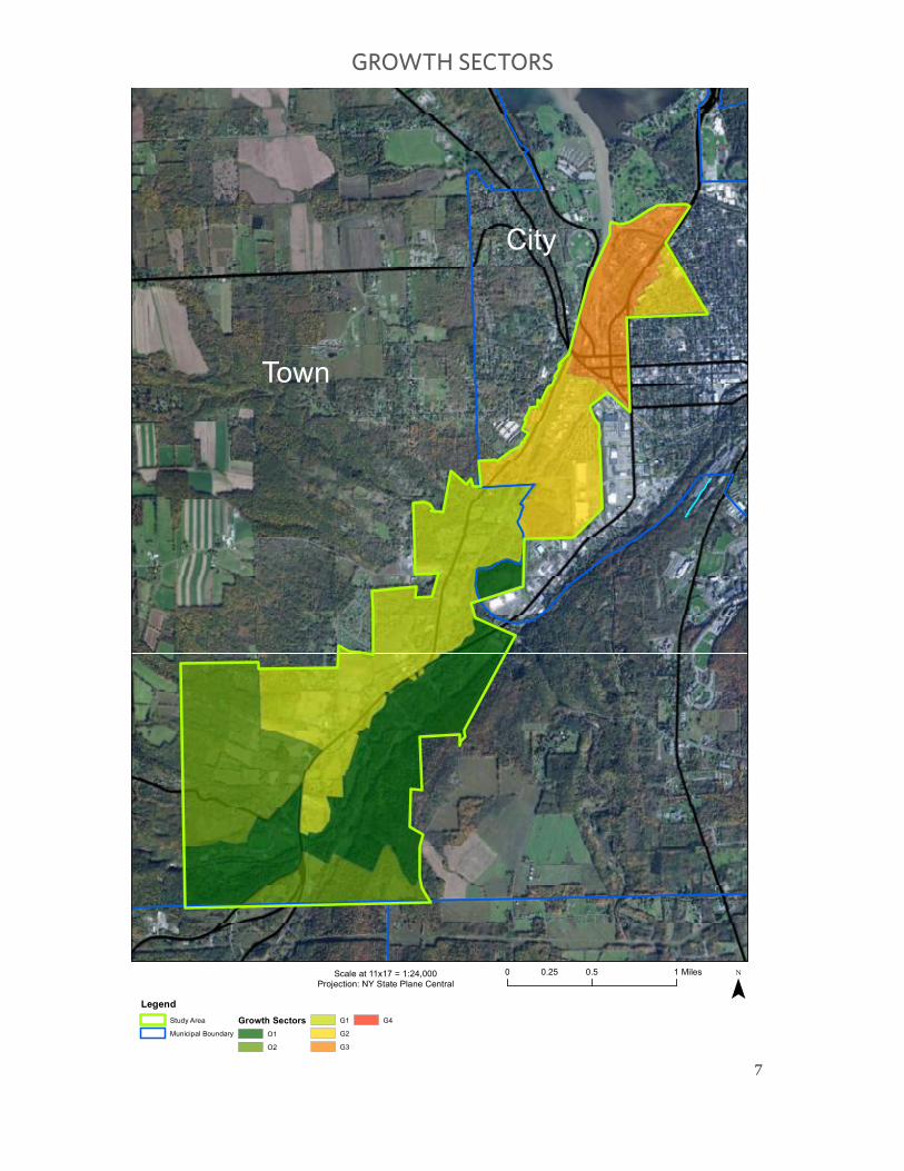
Growth Sectors for Ithaca
Allocating the Growth Sectors is the first step of calibrating the SmartCode. Six Sectors establish the locations where different patterns of development are allowed, which control preservation redevelopment and new development at a regional scale. Growth sectors are mapped based on geography, natural areas, existing development, and the capacity of infrastructure to accommodate growth. The Town of Ithaca has already completed an initial growth sector definition process as part of their Comprehensive Plan process. Growth sectors are best determined at the regional (rather than municipal) level so there is an opportunity for the City and Town to work together to define long term growth sectors that consistently achieve smart growth objectives.For the purposes of this demonstration project and our limited study area, we have completed sector assignments based on a few data points including existing parcel value per square foot, census block population density, natural corridors, protected areas, prime and important agricultural soils, existing zoning and local planning intentions. Over two dozen plans, policies and procedure manuals were analyzed, including County and Town comprehensive plans (and preliminary City comprehensive plan documents), bicycle and trail plans, regional transportation plans, sustainability plans, and design plans and guidelines. Every corridor and design plan undertaken in the study area over the last two decades was also reviewed as well as the existing Town and City Zoning Codes.
For the purposes of delineating region wide growth sectors, the SmartCode draft legislation includes step-by-step instructions that ensure the expressed goals of focusing development and preserving rural land are consistently met. Legally defining the parameters for sector definition creates transparency and minimizes the politicization of the process. We also recommend the use of TransectMap 3.0, a GIS-based process developed by Criterion Planners, to thoroughly include all of the relevant metrics.
“The best urbanism requires the sequential influence of many
participants. The single designer or committee leads to a lack of
robustness, similar to vulnerable monocultures in nature.”
SmartCode Version 9.2

6
¯Scale at 11x17 = 1:24,000
Projection: NY State Plane Central
0 0.5 10.25 Miles
LegendStudy Area
Municipal Boundary
City of IthacaTown of Ithaca
STUDY AREA
7
¯Scale at 11x17 = 1:24,000
Projection: NY State Plane Central
r
0 0.5 10.25 Miles
LegendStudy Area
Municipal Boundary
Growth SectorsO1
O2
G1
G2
G3
G4
Town
City
GROWTH SECTORS

¯Scale at 11x17 = 1:24,000
Projection: NY State Plane Central
D
0 0.5 10.25 Miles
LegendStudy Area
Municipal Boundary
Walk Zones Special District
Natural Zone (T1)
Rural Zone (T2)
Neighborhood Edge Zone (T3)
Neighborhood General Zone (T4)
Neighborhood Center Zone (T5)
T1
T2
T2
T2
SD
T4
T1T3
T3
T4T4
T4T5
T5T2
T3
SD
SD
SD
DRAFT REGULATING PLAN

9
Growth Sectors are assigned as follows:• O-1 Preserved Open Sector for protected natural lands • O-2 Reserved Open Sector for protection of rural lands and lands in agricultural
use• G-1 Restricted Growth Sector and G-2 Controlled Growth Sectors where only
limited sensitive development is permitted • G-3 Intended Growth Sector where new complete communities are planned• G-4 Infill Growth Sector where existing complete communities incentivize infill
redevelopment
Existing Zoning Analysis
Our next step was to compare the City and Town’s existing zoning regulations with the expressed intents for planning in each Regional Growth Sector. The SmartCode is all about putting the right kinds of development in the right places. Growth Sectors describe the right places to encourage development and the right places to preserve open landscapes at a regional scale.
Combining all of the regulations in each municipality, we developed a table (see Appendix) incorporating a majority of the zoning requirements for each zone in our study area. Despite being a small sliver of the city and town, our study area contains 16 out of 30 different zones. We found that many definitions of similar uses are different between the city and the town and there are an excessive number (just over 160) of specific uses which complicates implementation of zoning controls and makes the regulations difficult for citizens to understand. In contrast to the current
code, the SmartCode includes just 6 zones, plus defined special districts (industrial, campus, etc.), as well as a simplified but comprehensive pallet of 80 uses allocated in
appropriate zones in a way that is clear and easy for citizens, developers, and staff to understand.
Minimum lot size requirements in both the city and town are barriers to smart growth and compact infill. Allowable and encouraged densities do not align with the existing built fabric and the intended growth sectors. Town Zoning includes high minimum lot sizes that prevent walkable neighborhood development; lots smaller than 9,000 square feet are not allowed for single family homes in the High Density Residential Zone, which doesn’t come close to the minimum LEED for Neighborhood Development prerequisite of 7 units per acre. The City R-2 zone has a minimum lot size of 5,000 square feet, just barely meeting the LEED-ND density threshold.
Figure 1: Small dense lots are one of the hallmarks of Ithaca’s character. This screen capture from the City’s online GIS system shows 1,000 lots that are smaller than the 5,000 square feet minimum in the R-2 zone (the system only displays the first 1,000 results to a query).

10
Both of these minimum lot size requirements are barriers to smart growth and creative infill, and are out of sync with Ithaca’s traditional built character; West Hill and Northside both include single family homes on lots smaller than 2,000 square feet. Encouraging sustainable development in Ithaca will require realigning zoning with smart growth goals. We need much larger lot minimums in rural areas, and lot maximums (instead of minimums) in the intended growth and urban areas to prevent sprawl and out of scale development that damages walkability and neighborhood character.
Defining Ithaca’s DNA
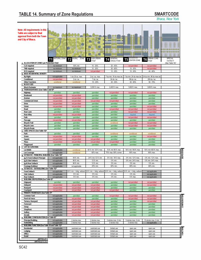
Implementing the SmartCode is an opportunity to realign zoning with both Ithaca’s unique historic character and our shared sustainability goals. We conducted several synoptic surveys, collecting data on local block sizes, lot widths, public frontages, building dimensions, sidewalk widths, distances of buildings from the street, distances of buildings from opposing building facades, fenestration, the range of services/uses on the ground-floor, location of parking, and the relation of buildings to the street, sidewalk, and other public rights of way. We then went through the stock SmartCode and calibrated each metric to align with Ithaca’s form and the goals that have been articulated for redevelopment.Dividing the built environment of Ithaca into 6 transect zones, we used the following transect zone character intents and developed definitions and requirements to appropriately shape building size, massing and placement for each zone (see table following zone intents):
Natural Zone – T1 - Preserving important wilderness and agricultural areas, scenic beauty, and ecological functions of the natural environment. The Natural Zone is intended to permanently protect areas from development that would damage the contiguity, quality, character, and function of natural areas. It also includes lands unsuitable for settlement due to topography, hydrology or vegetation. Development is only allowed by variance and must support natural use (i.e., a visitor center for a park, or access amenities for trails). Recreational trails may provide pedestrian connectivity to other Transect Zones.
Rural Zone – T2 - The Rural Zone is a sparsely settled area characterized by agricultural use or preserved open space; all types of development that are not directly related to agricultural production are discouraged and subdivision of land is only allowed by special permit. Recreational trails may provide pedestrian connectivity to other Transect Zones.
Neighborhood Edge Zone – T3 - A quiet, mostly residential area of larger lots and detached dwellings, ideally within walking distance of more urban Transect Zones and part of a complete community.
Neighborhood General Zone – T4 - A more populated, mostly residential area of smaller lots, several dwelling types and corner stores, part of a complete community.
Neighborhood Center Zone – T5 - A well-populated Main Street area with a full mix of uses within the zone and potentially within buildings, the walkable center of a complete community.
Urban Core Zone – T6 - This is the most populated, most urban part of a downtown and

11
a hub for regional transit. It’s home to the busiest streets, tallest buildings, and major civic hubs like City Hall.
The SmartCode includes the option of allowing density increases based on key conditions. We have calibrated increases into the draft Ithaca SmartCode to encourage the use of Transfer of Development Rights to protect land in the Rural Zone and to incentivize LEED-ND and green building proposals.
12
SmartCode on the ground
By thoroughly analyzing the built environment and the goals for future development we have created a simple and compelling implementation of the SmartCode that is tailored to Ithaca, defining Ithaca’s building blocks in six zones that range from the most urban to the most rural and several special districts. The final step is developing a regulating plan that allocates the defined building blocks across the land area of the city and town. For demonstration purposes, we have included a theoretical regulating plan for our study area. Real world implementation, however, will require a significant community process to define specific zone boundaries and a strong community outreach program to consolidate support around truly protecting rural land and creating compact walkable communities.
The crux of zoning with the SmartCode is that all areas where development is allowed must be within existing or planned complete communities. Complete communities include a mix of multiple zones and uses within a pedestrian shed that is contiguous with or connected via transit to other complete communities.
The first step in moving from sector analysis to zoning is delineating pedestrian sheds, which are then defined as one of three community types. Three pedestrian shed shapes are outlined in the SmartCode: Standard Pedestrian Sheds, Long Pedestrian Sheds and Linear Pedestrian Sheds. Standard and Long Pedestrian Sheds are ¼ and ½ mile circles, respectively, centered on community amenities which can include retail space, open space or transit stops. Linear Pedestrian Sheds are ¼ mile buffers around significant mixed use corridors.
Significant natural, protected and agricultural areas are preserved in the Natural or Rural zones with strict requirements to prevent sprawl residential development. The future viability of agricultural production is ensured by allowing development of related value-adding facilities including small-scale processing and packing, retail sales of farm products, agri-tourism, etc. The Natural Zone also extends into the urban area as a buffer along the Cayuga Lake inlet (which has been identified as one of the most impaired waterways in the lake’s watershed) and setting aside areas for future public open space.
Once open space preservation zones were mapped, the remainder of the study area was divided into pedestrian sheds that were each identified as one of three Community Types. Community Types enumerate the Transect Zones that are required in each pedestrian shed, and define the percentage of land within the pedestrian shed that should be allocated to each required zone:
“The SmartCode ensures that a community will not have to scrutinize
all proposed projects, because the intentions of the citizens will have
already been determined in the process that leads to the code.”
SmartCode Version 9.2

13
Community Type Size Guidelines
Pedestrian Shed(s)
Sectors Allowed
Zone Allocations
Clustered Land Development
30-80 acres 1 Standard G1, G2 T1 or T2 min. 50% T3 10-30%T4 20-40%
Traditional Neighborhood Development
80-160 acres at least 1 Standard or Linear
G2, G3, G4 T3 10-30%T4 30-60%T5 10-30%
Regional Center Development
80-640 acres 1 Long or Linear
G3, G4 T4 10-30%T5 10-30%T6 40-80%
It is important to note that the urban to rural transect as a guiding concept does not mean that future zoning should look like a fried egg with a single center in downtown Ithaca. Infrastructure, topography and the varied history of local development creates unique transects in each community. Transitions between zones do not need to be smooth and continuous; Fifth Avenue in NYC, a T6, works quite well across the street from the preserved open space of Central Park, a T1. What matters is that neighborhoods include a mix of zones within a walkable radius, have identifiable centers and are connected along transit corridors. Ithaca has multiple neighborhood centers each surrounded by lower density areas, development spreads out of town along the major arterials and fingers of higher densities are appropriate along these corridors as long as accommodations are made for transit and a mix of uses.
Our Draft Regulating Plan allocates zones based on the intent of the many informing area and comprehensive plans and studies to put the right development in the right places. Zones are informed by the walk zone areas, however; because of the small scale of the study area these zones should only be considered as illustrative of the general process for implementing the SmartCode. The zones progress naturally and smoothly from the denser parts of the City to the natural areas along the Town border, with the exception of the new community proposed at the Route 13 Sample Development Site, this progression is one of the reasons the demonstration area was chosen. This stepwise progression may not be likely or even desirable in all areas of the region.
SMARTCODEIthaca, New York
SC42
T1 NATURAL ZONE T2 RURAL ZONE T3 SUB-URBAN ZONE T4 GENERAL
URBAN ZONE T5 NEIGHBORHOOD
CENTER ZONE T6 URBAN CORE ZONE SD SPECIAL
DISTRICTa.
CLD requiredTND requiredRCD required
b.By RightConditionalOther Functions
c.Block Perimeter
d.HighwayBoulevardAvenueCommercial StreetDriveStreetRoadRear LaneRear AlleyPathPassageBicycle TrailBicycle LaneBicycle Route
e.ParkGreenSquarePlazaPlayground
f.Lot WidthLot Coverage
g.(g.1) Front Setback Principal(g.3) Side Setback(g.4) Rear SetbackFrontage Buildout
h.Front SetbackSide SetbackRear Setback
i.EdgeyardSideyardRearyardCourtyard
j.Common YardPorch & FenceTerrace, DooryardForecourtStoopShopfrontGalleryArcade
k.Principal BuildingOutbuilding
l.ResidentialLodgingOfficeRetail
ARTICLE 5ARTICLE 2,3,4
FUNC
TION
open use open useopen use open use
open use open use
not applicable restricted use restricted use limited use open use open usenot applicable restricted use restricted use limited usenot applicable restricted use restricted use limited use
BUILDING FUNCTION (See Table 10 and Table 12)*not applicable restricted use restricted use limited use
3 stories max. 2 min. 5 stories max. 2 min. 10 stories max. 2 min.not applicable 2 stories max. 2 stories max. 2 stories max. 2 stories max. not applicable
CONF
IGUR
ATIO
N
permitted permittednot applicable not permitted
BUILDING CONFIGURATION (See Table 8)*not applicable 2 stories max. 2 stories max.
not applicable not permitted not permitted permittednot permitted permitted permitted permitted
not applicable not permitted not permitted permitted permitted permittednot applicable not permitted not permitted permitted permitted permittednot applicable not permitted not permitted permitted permitted permittednot applicable not permitted not permitted permitted permitted not permittednot applicable not permitted permitted permitted not permitted not permittednot applicable permitted permitted not permitted not permitted not permitted
permitted permitted
PRIVATE FRONTAGES (See Table 7)*not permitted permitted permitted
DISP
OSIT
ION
not permitted not permitted not permitted permitted
not permitted not permittednot permitted not permitted
permitted permitted permitted permittednot permitted permitted permitted not permitted
BUILDING DISPOSITION (See Table 9)*
not applicable 96 ft. min. 12 ft. min. 5 ft. min.
not applicable 5 ft. min.5 ft. min. 5 ft. max.not applicable
not applicable 96 ft. min. 12 ft. min. 0 ft. min. 0 ft. min. 24 ft. max. 0 ft. min. 24 ft. max.not applicable 48 ft. min. 24 ft. min./12 ft. min 5 ft. min. 18 ft. max. 0 ft. min. 12 ft. max. 0 ft. min. 12 ft. max.
90% max. 90% max.SETBACKS - PRINCIPAL BUILDING (See Table 15)*
not applicable conditional 60% max. 70% max, 90% corner.
not permitted
16 ft. min 180 ft. max. 16 ft. min 400 ft. max.LOT OCCUPATION
not applicable conditional 60 ft. min 120 ft. max. 16 ft. min 96 ft. max.
permitted
permitted permitted permitted permitted permitted permittednot permitted
not permitted not permitted permitted permitted
not permitted not permitted permitted permittedpermitted
permitted permitted permitted conditional
not permitted not permitted not permitted permitted
conditional conditional
not permitted not permitted
permitted not permitted
permitted not permittedpermitted permitted permitted conditional
permitted permitted permitted not permittedpermitted permitted permitted permitted permitted permitted
not permitted not permitted permitted permitted permitted permittedpermitted permitted permitted permitted not permitted not permitted
not permitted not permitted permitted permitted required requiredpermitted permitted permitted permitted not permitted not permittedpermitted permitted permitted not permitted not permitted not permitted
not permitted not permitted permitted permitted permitted not permittednot permitted not permitted permitted permitted permitted permittednot permitted not permitted not permitted not permitted permitted permitted
permitted permittednot permitted not permitted permitted permitted permitted permitted
permitted permitted permitted not permittednot permitted not permitted permitted permitted
not permitted not permitted
BLOCK SIZEno maximum no maximum 3,000 ft. max. 2,400 ft. max. 1,600 ft. max. 1,600 ft. max.
96 du / ac. 200 du / ac.30 - 50% 50 - 70%
not permitted 2 du / ac. 7 du / ac 24 du / ac.conditional conditional 10 - 20% 20 - 30%
no minimum
BASE RESIDENTIAL DENSITYnot applicable 1 du/ 20 ac. max. 2 du / ac. max. 7 du min. 16 du max./ac 7 du min. 24 du max./ac 24 du min. 96 du max./ac
not permittedno minimum no minimum not permitted 10 - 30% 10 - 30% 40 - 80%no minimum
(See Table 16)*no minimum 50% min 10 - 30%
5 ft. min.
20 - 40% not permitted10 - 30% 30 - 60% 10 - 30%
25% min.SETBACKS - OUTBUILDING (See Table 15)*
not applicable 20 ft. min. + bldg. setback 20 ft. min. + bldg. setback 20 ft. min. + bldg. setback 20 ft. min. + bldg. setback not applicable
60% min. 80% min. 80% min.
0 ft. min. 0 ft. min. not applicable
5 ft. min.
not permitted not permitted not permitted
not applicable not applicable
5 ft. min. 5 ft. min. not applicable5 ft. min.
ALLOCATION OF ZONES per Pedestrian Shed
THOROUGHFARES (See Table 3 and 4)*
CIVIC SPACES (See Table 13)*
Note: All requirements in this Table are subject to final approval from both the Town and City of Ithaca.
not permitted
TABLE 14. Summary of Zone Regulations

15
PART THREE: Sample Parcel Developments
Route 13 Site in Town of Ithaca
The steering committee selected parcel 503089-33.-3-1.2, with frontage on Route 13 and Seven Mile Drive as a demonstration site for what kind of development can be expected under the SmartCode. The current surrounding context includes active farming operations on USDA Prime Agricultural Land, small farm retail and processing facilities, a mobile home park, a typical suburban subdivision, and low density, auto-oriented linear commercial development along Route 13. The parcel is zoned Light Industrial and surrounding parcels include Low Density Residential, Neighborhood Commercial, Conservation, and Manufactured Housing Development.
This area is not contiguous with any existing complete communities which is a serious limiting factor on the ability to create a sustainable new community. The single parcel considered for development is too small – approximately 13 acres – for even the smallest complete community. Developing at this scale risks creating a parcel of auto dependent density which, while better than covering a larger rural area with the same number of units, will serve to increase auto dependence, and exacerbate traffic demand in the City where most jobs and services are located.
In order to develop this parcel under the SmartCode, a New Community Scale Plan would need to be developed – including enough of the surrounding parcels to reach the minimum threshold for a complete community size, to include a mix of uses and to enable enough ridership that a bus stop would be possible. New Community Scale plans must be adopted at the scale of the pedestrian shed, a key component of the SmartCode that ensures planning for complete communities, and must be contiguous with, or connected by transit to, existing complete communities. New Community Scale Plans can be developed proactively by the municipal planning department or by a property owner in cooperation with staff. Community Scale Plans need to be approved by the Consolidated Review Committee, a board set-up to review and implement the SmartCode, and must follow guidelines for inclusion of zones, and uses based on the approved regional growth sector assignments.
For the demonstration parcel in question we have developed a Clustered Land Development (CLD) community type based on a pedestrian shed focused near the corner of Route 13 and Seven Mile Drive. CLDs are focused around rural development nodes, and as such they are required to have a minimum of 50% of land in the planned area preserved with either T1 or T2 designations. The remaining land can be divided between T4 and T3.
This development scheme creates a gateway into Ithaca that could be shaped, using architectural guidelines, to reflect the rural character of the region while supporting the kind of mix and density necessary for a complete community. The single parcel considered would be inappropriate to develop at this density in isolation; yet with other components of a complete community planned around it, it would be reasonable to allow construction on the parcel in question with the potential for the balance to come later as other landowners redevelop or sell.

T3/T4 NEIGHBORHOOD EDGE/GENERAL ZONEIn order to have a functional neighborhood the area would need to have a portion of T4 mixed-use in the center. Otherwise, the level of density shown here would not be appropriate for this remote location. This scheme also demonstrates how clustering the development can preserve the high quality agricultural soils and provides a density bonus of up to 7 du/acre max in a T3 zone.
0 400' 800'N
~8 acres of prime ag land preserved
~3 acres of pond/wetland
1/4 mile radius
T2
T3
T2
T4
T1
T3
T4
T3
T2

T3/T4 NEIGHBORHOOD EDGE/GENERAL ZONEThe mixed-use multi-family homes could take on a rural character as shown in the image at top, which is a concept prepared by STREAM Collaborative for a LEED ND project in Dryden, NY. The single-family homes in the clustered T3 zone could be similar in character to another development (designed by TWLA and STREAM) in the Town of Ithaca but perhaps not quite as closely spaced as what is shown in the image at bottom (which is a true T4 density).
T2
T3
T2
T4
T3
T3
T4

18
DOT Site in City of Ithaca
The DOT Site is approximately 7.6 acres and currently houses DOT storage of salt and equipment which is expected to relocate in the future. This parcel is cut off from nearby residential density by a heavy rail line and Route 13 which, despite a low speed limit, requires a crossing of more than 100 ft and is made to seem even wider by deep setbacks. Walkability from a new development on the DOT site would hinge on at least one, and ideally two, complete street connections across Route 13 connecting to the existing grid and amenities of the Northside neighborhood. The site is adjacent to the Ithaca Farmer’s Market and will be almost encircled by the Phase 2 Waterfront Trail project in the near future.
Because the DOT Site is located within the developed area of Ithaca it requires an Infill Community Scale Plan, which should be developed by the municipal planning agency proactively upon adoption of the SmartCode. Infill areas can use the New Community Standard metrics for size and zone allocation as a guideline for assigning zoning to parcels within a community unit, but are not required to meet the parameters exactly. The DOT site, as envisioned for redevelopment, would be appropriate in a Traditional Neighborhood Development community. This proposal hinges on future plans to retrofit the adjacent section of Route 13 to create a complete street fronted by mainstreet style development, rather than the suburban strip development on the ground today.
Our site design is based largely on the fantastic amenity of the waterfront trail, taking advantage of and improving this community amenity. The basic parameters of the development are set by the SmartCode’s required block parameter, the maximum lot width, and the required density.

T5 NEIGHBORHOOD CENTER ZONEThis conceptual plan represents one possible implementation for a well-populated Main Street area with a full mix of uses as prescribed in the Smart Code. Along with a potential new vision of a "complete street" renovation of Route 13 and a new extension of 5th Street through the Carpenter Business Park, this scheme connects Northside and Fall Creek neighborhoods to the waterfront trail, including the farmer's market, parks, and associated recreational activities.
0 200' 400'N
CAYU
GA
INLE
T5TH STREET EXTENSION
ITHACA FARMER'S MARKET
CORNELL BOATHOUSE
CARPENTER BUSINESS PARK
COMMUNITY GARDENS
1/4 MILE RADIUS
CWT

T5 NEIGHBORHOOD CENTER ZONEThis is a variety of inspirational images from other T5/T4 communities, which could be used to help define the new waterfront neighborhood center. Bottom left shows a traditional mainstreet at Kentlands Gaithersburg, MD and bottom right shows a contempoary waterfront development in Oslo, Norway. Top right shows townhomes at Lakewood Balmoral Chicago, IL. Top middle shows Johnson Street Townhomes Portland, OR. Top left shows a cottage community in East Greenwich, RI, which could transition from the new main street to the Ithaca Farmer's Market.
COTTAGE COMMUNITY
MIXED-USE MAINSTREET
ALLEY W/ REAR LOADED GARAGES
TOWNHOMES
bottom images courtesy of Sandy Sorlien/Transect Collection
top images courtesy of CNU Image Bank
ITHACA FARMER'S MARKET

21
Next Steps
This project has defined the basic building blocks that make Ithaca’s complete communities unique and incorporated those building blocks into the model SmartCode legislation. The next step is to refine and allocate these blocks across the region. We recommend designing an engagement and outreach program to facilitate discussion of our hybrid SmartCode with the larger community. Through community engagement, walking tours and charrettes, we can zero in on barriers to change and shorten the distance between consensus-building and code adoption. Educational opportunities include small group discussions, school and youth workshops, seminars, and expert presentations. Together we can develop communication tools such as posters, flyers, brochures, wayfinding signs, and more.
The Ithaca SmartCode can be implemented in several ways. Because the SmartCode is calibrated at the regional level, it can be adopted at the City and Town level in Ithaca as well as surrounding communities. The code itself can be adopted, as calibrated, with very little additional work. The legislation is designed to guide the development of Growth Sector Boundaries and Regulating Plans so that it can be adopted before these documents are prepared, regulating plans for outlying areas, in fact, need not be completed until an owner is interested in developing.
In some communities, where moving to Form-Based Code is perceived as too radical of a change, the SmartCode has been adopted as an optional overlay. With this implementation option landowners could choose to use either the existing zoning or the SmartCode. Some counties have prepared countywide, fully calibrated SmartCodes that individual municipalities could then choose to adopt in place of existing zoning or as an optional overlay.
Implementing the SmartCode as an overlay has the advantage of being less difficult politically, because it gives landowners more options without taking any away. That benefit, however, is also the main drawback of the overlay approach: it cannot effectively prevent the sprawl development that current zoning encourages. It allows and encourages good development, but doesn’t prevent bad development.
As the New York Department of Agriculture & Markets has suggested, an intra-municipal Transfer of Development Rights (TDR) program between the City and Town has the potential to support both urban economic development and protect important agricultural lands. To this end, we recommend holding joint discussions with the Town’s Agricultural Committee, Town Agricultural Land Preservation Program administrators, and City of Ithaca officials, as well as representatives from Tompkins County Planning Department and the Tompkins County Department of Assessment. Also see the links below for New York Department of State’s guiding document on TDR, Transfer of Development Rights. The SmartCode is calibrated to delineate TDR sending and receiving areas and includes model density bonuses based on TDR, having this in place could be a key component enabling TDR and would make adoption and implementation attainable in the near term.
Following this report’s “Proof of Concept,” the Ithaca SmartCode is ready to be expanded to the entire Town/City area, beginning the process of detailed calibration with planning staff and assisting with drafting final language to be adopted by the Town

22
Board and Common Council. The code can incorporate neighborhood architectural design standards such as the Collegetown Form District, downtown business district and/or historic districts and we can customize additional SmartCode modules on everything from Noise Levels to Lighting Design to Light Imprint Development.
Because the SmartCode is a complete Unified Development Ordinance we can also reconcile existing subdivision regulations with the SmartCode calibration. We recommend a thorough analysis of potential subdivisions and new communities. Complete Streets thoroughfare standards are preferably assembled in collaboration with a traffic engineer, the city’s parking manager, and the respective city and town fire marshals and commissioners for full consideration of parking, bicycles, transit, steep slopes, etc. Our draft SmartCode includes stock regulations for public thoroughfares, and public frontages. These regulations have served other communities well but should be evaluated by local traffic engineers with extensive knowledge of smart growth and context-sensitive street design.
Finally, we also recommend a form-based analysis of market rent levels to align market potential, rent potential, value potential and absorption potential with the form prescribed by the form-based code, including construction types for buildings and the infrastructure needed for the neighborhood. While we want to encourage as much density in the development nodes as deemed appropriate, we must also be careful not to allow a few small but very dense projects to capture too much of the region’s growth potential thereby preventing the creation of medium density walkable neighborhoods.

23
CONTACT INFORMATION
STREAM Collaborative Architecture + Landscape Architecture
Noah Demarest, RA, RLA, LEED-AP [email protected] is a licensed and registered Architect and Landscape Architect as well as a LEED Accredited Professional. Noah grew up in Ithaca and the surrounding area since the age of two. He attended Cornell University’s School of Human Ecology where he earned a Bachelor’s degree in Design and Environmental Analysis with a focus on human factors, interior design, and facility planning. Noah continued at Cornell to earn a Master’s degree in Landscape Architecture with a focus on recreational facility design, the use of digital media in the design process, and sustainable design. After 15 years of designing the built environment, Noah currently serves as an independent consultant leading the design of campus and municipal projects as well the design of single and multi-family housing.
Randall + West, Inc.
C.J. Randall [email protected]. is a researcher and planner with a focus on energy efficiency, economic development, and local governance in New York. She was a Sustainability Consortium Energy Fellow in 2010 and currently serves on the City of Ithaca Planning & Development Board. C.J. recently received a grant from the Clarence S. Stein Institute for Urban and Landscape Studies to conduct research on energy development in New York State. She has a Master’s degree in Regional Planning from Cornell University.
David J. West LEED-AP [email protected] is a researcher and planner with a focus on sustainable development, Smart Growth, and active transportation. David has been a LEED Accredited Professional since 2008 and has consulted on a number projects including co-authoring Los Angeles World Airport’s groundbreaking Sustainable Design and Planning Guidelines, reviewing pedestrian safety at Portland’s TriMet light rail stations, and developing a parcel prioritization study for the Central Indiana Land Trust. He has a Master’s degree in Regional Planning from Cornell University.

24
FURTHER RESOURCES
Ithaca, NY: A General Plan (1971)The last general plan of Ithaca; a historical backdrop for current planning and development.
City of Ithaca Comprehensive Plan draft Phase I: Planning Influences Report (2012)
Town of Ithaca SmartCode: building a town of neighborhoods, unpublished (2011)
Tompkins County Comprehensive Plan (2004)The Tompkins County Comprehensive Plan provides the traditional planning elements to guide future development in the County: a community vision outlined through planning principles, documentation of existing community conditions, and identification of particular implementation mechanisms to achieve the planning principles. The plan’s ten planning principles are organized under four main topics (full list of principles are included in the appendix summary): Regional Cooperation; Housing; Transportation and Jobs; the Environment; and Neighborhoods and Communities. The plan also includes alternative development scenarios and evaluations of these scenarios for their impact on the County’s fiscal health, land use patterns, and impacts on transportation, infrastructure, and natural resources.
Tompkins County Five Year Progress Report on Comprehensive Plan Implementation (2009)This report provides an update on the status of the 61 actions identified in the 2004 Tompkins County Comprehensive Plan, as well as 17 actions added with the adoption of the Energy and Greenhouse Gas Emissions element in 2008. Many of the action items have been completed or are underway. The report also includes a list of proposed actions for the next five years.
Report of the Joint City/Town Study Group on Shared Services and Consolidation (2009)
New York State Local Waterfront Revitalization Program: Cayuga Lake Waterfront Plan (2005 update)While the Cayuga Lake Waterfront Plan covers an area broader than the City of Ithaca, it does contain detailed information regarding existing conditions in the City’s waterfront area. It also establishes specific goals, policies, projects, and initiatives for the waterfront area, many of which are relevant to the City and will help guide the waterfront discussion in the comprehensive planning effort.

25
Black Diamond Master Plan and Final Environmental Impact Statement by the New York State Office of Parks and Historic Preservation (2008)
The Black Diamond Trail is a 15-mile, off-road pedestrian and bicycle dedicated trail facility proposed for Tompkins County, New York, linking four major State Parks. The trail will provide residents and visitors with an alternate way to travel to several destinations in the county including the State Parks and many other popular community destinations in the City of Ithaca and the Towns of Ithaca and Ulysses.
Tompkins County Conservation Strategy (2012)
Town of Ithaca
Scoping Document for GEIS of Comp PlanComprehensive Plan Draft (2012)1993 Comprehensive Plan
Agricultural and Farmland Protection Plan (2011)Policies and Procedures Manual, Agricultural Land Preservation Program (2008)
City of Ithaca
Southwest Area Land Use Plan (1994, 1998)
Inlet Island Urban Design Plan (1998)
Turning the Corner: A Vision for the Northside Neighborhood (2003)Prepared by the Northside Neighborhood Association, the purpose of the Northside plan is to ensure that the Northside neighborhood remains a healthy, viable community. The planning process focused on resident empowerment, a resident-driven effort, inclusion, outreach, diversity, representative participation, attention to neighborhood assets, and collaboration with City Hall and the greater community. Major findings and recommendations of the plan include physical and social projects to build on neighborhood assets.
Southwest Area Design Guidelines (2000)Southwest Area and Elmira Road - Meadow Street Corridor City of Ithaca, New York, prepared by Trowbridge & Wolf Landscape Architects, August 2000These guidelines encourage development that contributes to Ithaca’s unique character and supplements existing site plan review criteria with more specific interpretations for both the Southwest Area and the Elmira Road-Meadow Street Corridor.

26
Urban Design for the West End (1999)Meadow and Fulton Street Corridors and East-West Connecting Blocks, published by the City of Ithaca Department of Planning and Development, November 1998
The plan outlines the overall vision for the West End area, and identifies the basic design concepts and standards that will be implemented as new development occurs through the Site Development Plan Review process and the adoption of a new zoning classification. The planning vision identifies the principal aims of the study, which include:• Redevelopment that results in a visually appealing urban mixed-use district
including retail, office and residential uses• Protection of the traditional residential neighborhoods east of Meadow• Easing the impacts of the anticipated transition west of Meadow Street from
single-family houses to denser mixed uses, which may include residential uses, without diminishing the overall potential for redevelopment
• Creation of an attractive and safe pedestrian environment coexisting with high volume traffic.
The design standards established in the plan address topics such as the street wall, building heights, separation between commercial and residential uses, waterfront development, and other elements.
MORE ON FORM-BASED CODES
Campoli, Julie. “Made for Walking: Density and Neighborhood Form.” 2012. Lincoln Institute of Land Policy, Cambridge, MA. Chapters 1 and 2.
Richardson, Jesse J., Jr., “Downzoning, Fairness, and Farmland Protection,” Journal of Land Use, Vol. 19 (1): Fall 2003.
“Transfer of Development Rights,” James A. Coon Local Government Technical Series, New York State Department of State, 2011.
Sitkowski, Robert J. and Joel Russell, “Form and Substance: What New York Land Use Lawyers Need to Know about Form-Based Land Development Regulations,” New York Zoning Law and Practice Report, Vol. 8 (3): Sep/Oct 2007.This article explores the use of form-based code as a land development regulation tool in New York State. Addresses administrative review and concludes that the law does not impose any significant barriers to the use of form-based code.

Appendix A:Example Calibrated Smart Code for Ithaca, New York


1
About the SmartCode
The SmartCode is a form-based code that incorporates the sustainable transect-based planning principles of Smart Growth and New Urbanism. It is a unified development ordinance, addressing development at all scales of design, from re-gional planning on down to building signage. It is based on the rural-to-urban transect rather than separated-use zoning, thereby able to integrate a full range of environmental techniques. Because the SmartCode envisions intentional out-comes based on known patterns of urban design, it is a more succinct and efficient document than most conventional codes.
The SmartCode is a model ordinance. It is not persuasive and instructive like a guideline, nor is it intentionally general like a vision statement. It is meant to be law – precise and technical – administered by municipal planning departments and interpreted by elected representatives of local government. The SmartCode is designed to be calibrated to local circumstances, ideally with the participation of local citizens.
This document presents the entire 56-page base code in compact form calibrated for Ithaca, New York.
The official text of the SmartCode appears in a sans serif font like this. The intro-ductory commentary appears in a serif font like this. Green text indicates items that have been considered for calibration.
INTRODUCTION

2
Codes and the SmartCode
Consider the most-loved towns of North America. They were either carefully planned, or they evolved as compact, mixed-use places because of their geogra-phy and the limits of the transportation options and the economics of their time. However, over the past sixty years, places have evolved in a completely different pattern. They have spread loosely along highways and haphazardly across the countryside, enabled by the widespread ownership of automobiles, by cheap pe-troleum and cheap land, and by generalized wealth.
Such patterns are enabled by zoning codes that separate dwellings from work-places, shops, and schools. These codes include design standards that favor the automobile over the pedestrian, and are unable to resist the homogenizing effects of globalization.
These practices have produced banal housing subdivisions, business parks, strip shopping, big box stores, enormous parking lots, and sadly gutted downtowns. They have caused the proliferation of drive-by eateries and billboards. They have made walking or cycling dangerous or unpleasant. They have made children, the elderly, and the poor utterly dependent on those who can drive, even for ordinary daily needs. They have caused the simultaneous destruction of both towns and open space – the 20th century phenomenon known as sprawl.
The form of our built environment needs a 21st century correction. But in most places it is actually illegal to build in a traditional neighborhood pattern. The existing codes prevent it. In most places people do not have a choice between sprawl and traditional urbanism. Codes favor sprawl and isolated residential sub-divisions; it is not a level playing field.
The SmartCode was created to deal with this problem at the point of decisive impact – the intersection of law and design. It is a form-based code, meaning it envisions and encourages a certain physical outcome: the form of the region, community, block, and/or building. Form-based codes are fundamentally differ-ent from conventional codes that are based primarily on use and statistics, none of which envision or require any particular physical outcome.
The SmartCode is a tool that guides the form of the built environment in order to create and protect development patterns that are compact, walkable, and mixed use. These traditional neighborhood patterns tend to be stimulating, safe, and ecologically sustainable. The SmartCode requires a mix of uses within walking distance of dwellings, so residents aren’t forced to drive everywhere. It supports a connected network to relieve traffic congestion. At the same time, it preserves open lands, as it operates at the scale of the region as well as the community.
INTRODUCTION

3
Transect-Based Planning
“A town is saved, not more by the righteous men in it than by the woods and swamps that surround it.” – Henry David Thoreau
The SmartCode is a transect-based code. A transect of nature, first conceived by Alexander Von Humboldt at the close of the 18th century, is a geographical cross-section of a region intended to reveal a sequence of environments. Originally, it was used to analyze natural ecologies, showing varying characteristics through different zones such as shores, wetlands, plains, and uplands. It helps study the many elements that contribute to habitats where certain plants and animals thrive in symbiotic relationship to the minerals and microclimate.
Human beings also thrive in different places. There are those who could never live in an urban center; there are those who would wither in a rural hamlet. Hu-mans need a system that preserves and creates meaningful choices in their habi-tats. Near the close of the 20th century, New Urbanist designers recognized that sprawl was eradicating the pre-war American transect of the built environment. They began to analyze it and extract its genetic material for replication. In this way, they extended the natural transect to include the built environment, thus establishing the basis for the SmartCode.
The rural-to-urban Transect is divided into six Transect Zones for application on zoning maps. These six habitats vary by the level and intensity of their physical and social character, providing immersive contexts from rural to urban. Smart-Code elements are coordinated by these T-zones at all scales of planning, from the region through the community scale down to the individual lot and building.
OCEAN
BEACH
PRIMARY DUNE
TROUGH
SECONDARY DUNE
BACK DUNE UNE
A TypicAl NATurAl TrANsecT
INTRODUCTION

4
One of the principles of Transect-based planning is that certain forms and ele-ments belong in certain environments. For example, an apartment building be-longs in a more urban setting, a ranch house in a more rural setting. Some types of thoroughfares are urban in character, and some are rural. A deep suburban setback destroys the spatial enclosure of an urban street; it is out of context. These distinc-tions and rules don’t limit choices; they expand them. This is the antidote for the one-size-fits-all development of today.
The Transect is evident in two ways: Zones and communities exist as charac-teristic places on the Transect, and they evolve along the Transect over time. As places, the six Transect Zones display identifiable characteristics, based on nor-mative American urban patterns. They also increase in complexity, density and intensity over a period of years, until a “climax condition” is reached. This is a growth process analogous to succession in natural environments.
The best urbanism requires the sequential influence of many participants. A code allows buildings to be designed and built by many hands over years, or even gen-erations. The single designer or committee leads to a lack of robustness, similar to vulnerable monocultures in nature. A parametric and successional code like the SmartCode allows experience to feed back and become integrated – the fourth dimension of time. Once adopted, it stays in place, allowing urbanism to evolve and mature without losing its necessary foundation of order.
It also ensures that a community will not have to scrutinize all proposed projects, because the intentions of the citizens will have already been determined in the process that leads to the code. The SmartCode is a comprehensive framework for that process.
T1 NATURAL ZONE
T2 RURAL ZONE
T3 NEIGHBORHOOD EDGE ZONE
T4 NEIGHBORHOOD GENERAL ZONE
T5 NEIGHBORHOOD CENTER ZONE
T6 CENTRAL BUSINESS DISTRICT ZONE
SD SPECIAL DISTRICT
A TypicAl rurAl-urbAN TrANsecT, wiTh TrANsecT ZoNes
INTRODUCTION

5
Summary: What the SmartCode Does
• It utilizes a type of zoning category that ranges systematically from the wil-derness to the urban core.
• It enables and qualifies Smart Growth community patterns that include Clus-tered Land Development (CLD), Traditional Neighborhood Development (TND™), Regional Center Development (RCD), and Transit-Oriented Devel-opment (TOD).
• It integrates the scale of planning concern from the regional through the com-munity scale, on down to the individual lot and, if desired, its architectural ele-ments.
• It integrates the design process across professional disciplines.• It integrates methods of environmental protection, open space conservation
and water quality control.• It integrates subdivision, public works, and Transfer of Development Rights
(TDR) standards.• It provides a set of zoning categories common to new communities and to the
infill of existing urbanized areas.• It is compatible with architectural, environmental, signage, lighting, hazard
mitigation, and visitability standards.• It establishes parity of process for existing and new urban areas.• It integrates protocols for the preparation and processing of plans.• It encourages the efficiency of administrative approvals when appropriate,
rather than decision by public hearing.• It encourages specific outcomes through incentives, rather than through prohibi-
tions.• It specifies standards parametrically (by range) in order to minimize the need
for variances.• It generally increases the range of the options over those allowed by conven-
tional zoning codes.
INTRODUCTION

6
ARTICLE 2REGIONAL SCALE PLANS
ARTICLE 3 & ARTICLE 4COMMUNITY SCALE PLANS
ARTICLE 5BUILDING SCALE PLANS
A. Regional Sector B. Community Unit C.Transect Zones Standards
Open Lands O1 P r e s e r v e d O p e n S e c t o r
N o n e T1T2
N a t u r a l Z o n e
R u r a l Z o n e
B u i l d i n g D i s p o s i t i o n
B u i l d i n g C o n f i g u r a t i o n
B u i l d i n g F u n c t i o n
D e n s i t y C a l c u l a t i o n s
P a r k i n g S t a n d a r d s
L a n d s c a p e S t a n d a r d s
S i g n a g e S t a n d a r d s
S u p p l e m e n t a r y M o d u l e s
O2 R e s e r v e d O p e n S e c t o r
N o n e
NewDevelopment
G1 R e s t r i c t e d G r o w t h S e c t o r CLD C l u s t e r e d L a n d
D e v e l o p m e n t T2T3T4
R u r a l Z o n e
N e i g h b o r h o o d E d g eZ o n e
Neighborhood Genera lZ o n e
G2 C o n t r o l l e d G r o w t h S e c t o r CLD C l u s t e r e d L a n d
D e v e l o p m e n t T2T3T4
R u r a l Z o n e
N e i g h b o r h o o d E d g eZ o n e
Neighborhood Genera lZ o n e
TND Tr a d i t i o n a lN e i g h b o r h o o dD e v e l o p m e n t
T3T4T5
N e i g h b o r h o o d E d g eZ o n e
Neighborhood Genera lZ o n e
N e i g h b o r h o o d C e n t e rZ o n e
G3 I n t e n d e d G r o w t h S e c t o r TND Tr a d i t i o n a l
N e i g h b o r h o o dD e v e l o p m e n t
T3T4T5
N e i g h b o r h o o d E d g eZ o n e
Neighborhood Genera lZ o n e
N e i g h b o r h o o d C e n t e rZ o n e
RCD R e g i o n a lC e n t e rD e v e l o p m e n t
T4T5T6
Neighborhood Genera lZ o n e
N e i g h b o r h o o d C e n t e rZ o n e
U r b a n C o r e Z o n e
ExistingDevelopment
G4 I n f i l l G r o w t h S e c t o r
Tr a d i t i o n a lN e i g h b o r h o o dD e v e l o p m e n t
T3T4T5
N e i g h b o r h o o d E d g eZ o n e
Neighborhood Genera lZ o n e
N e i g h b o r h o o d C e n t e rZ o n e
R e g i o n a lC e n t e rD e v e l o p m e n t
T4T5T6
Neighborhood Genera lZ o n e
N e i g h b o r h o o d C e n t e rZ o n e
U r b a n C o r e Z o n e
Other CBCS
C i v i cB u i l d i n g
C i v i c S p a c e
SD S p e c i a l D i s t r i c t s
Outline of the SmartCodeINTRODUCTION
I N F I L L
I N F I L L
TND
RCD

7
The Structure of the SmartCode
Article 1 contains the general instructions pertaining to all other Articles.Article 2 prescribes how Regional Plans designate the Open Sectors intended for open lands and the Growth Sectors intended for development and redevelopment. It also prescribes what Community Unit types belong in each Sector. Article 3 prescribes the requirements for New Communities, including the Transect Zones that make up each type. Article 4 prescribes the Infill requirements for areas already urbanized. Article 5 prescribes lot and building standards within each Transect Zone.Article 6 contains diagrams and tables supporting the other Articles. Article 7 contains terms and definitions supporting the other Articles.
The SmartCode is a unified planning ordinance that applies to three scales of land use. The three patterns are in a nesting relationship. A. Regional Sectors contain designated types of Communities (Article 2). B. Community Units contain designated ratios of Transect Zones (Articles 3 and 4).C. Transect Zones contain the building elements appropriate to them (Articles 5
and 6).
A. Regional Scale:“Sector” is a neutral term for a geographic area. In the SmartCode, six Sectors establish the locations where certain patterns of development are allowed. This system addresses preservation and development at the Regional scale. The Sec-tors are assigned as follows:
• O-1 Preserved Open Sector and O-2 Reserved Open Sector for protection of open lands
• G-1 Restricted Growth Sector, G-2 Controlled Growth Sector, and G-3 Intended Growth Sector for New Communities
• G-4 Infill Growth Sector for managed growth of existing urbanized areas. B. Community Scale:The Regional Sectors each contain one or more of the three basic Community Unit types (CLD, TND, RCD).
• CLD-ClusteredLandDevelopment (Hamlet, settlement, cluster) – permit-ted in Growth Sectors G1, G2
• TND - Traditional Neighborhood Development (Village, neighborhood) – permitted in Growth Sectors G2, G3, G4
• RCD - Regional Center Development (Regional Center, town center, down-town) – permitted in Growth Sectors G3, G4
INTRODUCTION

8
C. Transect Zones:The Transect, as a framework, identifies a range of habitats from the most natural to the most urban. Its continuum, when subdivided, lends itself to the creation of zoning categories. These categories include standards that encourage diversity similar to that of organically evolved settlements. The standards overlap (they are parametric), reflecting the successional ecotones of natural and human com-munities. The Transect thereby integrates environmental and zoning methodolo-gies, enabling environmentalists to assess the design of social habitats and urban-ists to support the viability of natural ones.
• T-1 Natural Zone consists of lands approximating or reverting to a wilder-ness condition, including lands unsuitable for settlement due to topography, hydrology or vegetation. The Natural Zone is intended to permanently protect areas from development that would damage the contiguity, quality, charac-ter, and ecological function of natural areas. Development is only allowed by Variance and must support natural use (i.e., a visitor center for a park, or access amenities for trails). Recreational trails may provide pedestrian con-nectivity to other Transect Zones.
• T-2 Rural Zone consists of sparsely settled lands in open or cultivated state. These include woodland, agricultural land, grassland, and irrigable desert. Typical buildings are farmhouses, agricultural buildings, cabins, and villas.
• T-3 Neighborhood Edge Zone consists of low density residential areas, ad-jacent to higher zones that have some mixed use. Home occupations and out-buildings are allowed. Planting is naturalistic and setbacks are relatively deep. Blocks may be large and the roads irregular to accommodate natural condi-tions.
• T-4 Neighborhood General Zone consists of a mixed use but primarily residential urban fabric. It may have a wide range of building types: single, sideyard, and rowhouses. Setbacks and landscaping are variable. Streets with curbs and sidewalks define medium-sized blocks.
• T-5 Neighborhood Center Zone consists of higher density mixed use build-ings that accommodate retail, offices, rowhouses and apartments. It has a tight network of streets, with wide sidewalks, steady street tree planting and buildings set close to the sidewalks.
• T-6UrbanCoreZone consists of the highest density and height, with the greatest variety of uses, and civic buildings of regional importance. It may have larger blocks; streets have steady street tree planting and buildings set close to the wide sidewalks. Typically only large towns and cities have an Urban Core Zone Zone.
• CivicZoneconsists of Civic Buildings and/or Civic Spaces appropriate to thTransect Zones.
• SpecialDistrictsconsist of areas with buildings that by their Function, Dis-position, or Configuration cannot, or should not, conform to one or more of the six normative Transect Zones.
INTRODUCTION

9
Adjusting the Structure of the SmartCode To create SmartCodes for different purposes, certain Articles may be discarded and the code reassembled. • All codes will require the inclusion of Article 1 General To All Plans, Ar-
ticle 6 Standards & Tables and Article 7 Definitions of Terms.• If a Regional Plan has already been prepared, or if the code will be used
entirely for Infill situations, Article 2 Regional Scale Plans may be elimi-nated.
• If a Community Scale plan has already been prepared, or if there is no pros-pect of greenfield development, Article 3 New Community Scale Plans may be adjusted or eliminated. (Note: Article 4 depends on Article 3 for larger Infill parcels.)
• If an Infill Community Plan already has been prepared or if there is no pros-pect of Infill development, Article 4 Infill Community Scale Plans may be eliminated.
• If and when all plans have been prepared, Article 5 Building Scale Plans be-comes the de facto code for builders and architects. This Article may be used by developers as the guidelines for their private property owners association.
• A calibrated SmartCode for a municipality should include some Thoroughfare standards and large-site provisions even if Article 3 and/or Article 4 are not used. Portions of Section 3.7 and Article 4 may be incorporated into Article 5 or a new Article created for Thoroughfare Standards or Public Space Standards.
• In Article 6, tables may be individually dropped or modified as necessary.• In Article 7, definitions that do not apply should be deleted, and any neces-
sary new ones added.• Modules and their associated definitions may be added as needed.
Responsibilities for Implementation
The SmartCode requires the preparation of plans that allocate the Sectors, lay out the Communities, and show lot and building placement. • Article 2 - Regional Plans shall be prepared by or on behalf of the Municipal
Planning Department. • Article 3 - New Community Plans shall be prepared on behalf of the land
owner, the developer, or the Municipal Planning Department. • Article 4 - Infill Community Plans shall be prepared by or on behalf of the
Municipal Planning Department.• Article 5 - Building Scale Plans shall be prepared on behalf of a builder or
the property owner.• The Planning Office may include a Development and Design Center (DDC).
A DDC may be assigned to advise on the use of the SmartCode and to aid in the design of the Communities and buildings based on it.
INTRODUCTION

10
Calibrating the SmartCode
• The model code in this booklet has been calibrated for local character and metrics by STREAM Collaborative Architecture + Landscape Architecture, Randall + West Planners, and planning staff and officials from Tompkins County, the Town of Ithaca, and the City of Ithaca. Calibration refers to the entire process of customization, which may include incorporating Modules; deleting or adding articles, sections, tables, and definitions; entering the met-rics from a local synoptic survey; adjusting legal language; and activating other documents by reference, such as pattern books or existing ordinances.
• Adoption of this SmartCode calibration should be done in the context of a public charrette.
Conditions of Use
• The images and diagrams appearing in SmartCode Version 9.2 are the prop-erty of Duany Plater-Zyberk & Company (DPZ) and/or STREAM Collabora-tive and/or Randall + West. Their reproduction and use is freely permitted.
INTRODUCTION


SMARTCODEIthaca, New York
ARTICLE 1. GENERAL TO ALL PLANS ................ page 2 1.1 AUTHORITY 1.2 APPLICABILITY 1.3 INTENT 1.4 PROCESS 1.5 WARRANTS AND VARIANCES 1.6 SUCCESSION
ARTICLE 2. REGIONAL SCALE PLANS ............... page 6 2.1 INSTRUCTIONS 2.2 SEQUENCE OF SECTOR DETERMINATION 2.3 (O-1) PRESERVED OPEN SECTOR 2.4 (O-2) RESERVED OPEN SECTOR 2.5 (G-1) RESTRICTED GROWTH SECTOR 2.6 (G-2) CONTROLLED GROWTH SECTOR 2.7 (G-3) INTENDED GROWTH SECTOR 2.8 (G-4) INFILL GROWTH SECTOR 2.9 (SD) SPECIAL DISTRICTS
ARTICLE 3. NEW COMMUNITY SCALE PLANS ... page 9 3.1 INSTRUCTIONS 3.2 SEQUENCE OF COMMUNITY DESIGN 3.3 COMMUNITY UNIT TYPES 3.4 TRANSECT ZONES 3.5 CIVIC ZONES 3.6 SPECIAL DISTRICTS 3.7 THOROUGHFARE STANDARDS 3.8 DENSITY CALCULATIONS 3.9 SPECIAL REQUIREMENTS
ARTICLE 4. INFILL COMMUNITY SCALE PLANS .... page 16 4.1 INSTRUCTIONS 4.2 COMMUNITY UNIT TYPES 4.3 TRANSECT ZONES 4.4 CIVIC ZONES 4.5 SPECIAL DISTRICTS 4.6 PRE-EXISTING CONDITIONS 4.7 SPECIAL REQUIREMENTS
ARTICLE 5. BUILDING SCALE PLANS .............. page 20 5.1 INSTRUCTIONS 5.2 PRE-EXISTING CONDITIONS 5.3 SPECIAL REQUIREMENTS 5.4 CIVIC ZONES 5.5 SPECIFIC TO T-1 NATURAL ZONE 5.6 BUILDING DISPOSITION 5.7 BUILDING CONFIGURATION 5.8 BUILDING FUNCTION 5.9 PARKING AND DENSITY CALCULATIONS 5.10 PARKING LOCATION STANDARDS 5.11 LANDSCAPE STANDARDS 5.12 SIGNAGE STANDARDS
ARTICLE 6. STANDARDS AND TABLES .......... page 27 TABLE 1 TRANSECT ZONE DESCRIPTIONS TABLE 2 SECTOR/COMMUNITY ALLOCATION TABLE 3A VEHICULAR LANE DIMENSIONS TABLE 3B VEHICULAR LANE & PARKING ASSEMBLIES TABLE 4A PUBLIC FRONTAGES - GENERAL TABLE 4B PUBLIC FRONTAGES - SPECIFIC TABLE 4C THOROUGHFARE ASSEMBLIES TABLE 5 PUBLIC LIGHTING TABLE 6 PUBLIC PLANTING TABLE 7 PRIVATE FRONTAGES TABLE 8 BUILDING CONFIGURATION TABLE 9 BUILDING DISPOSITION TABLE 10 BUILDING FUNCTION & PARKING TABLE 11 PARKING CALCULATIONS TABLE 12 SPECIFIC FUNCTION & USE TABLE 13 CIVIC SPACE TABLE 14 SMARTCODE SUMMARY TABLE 15 FORM-BASED CODE GRAPHICS TABLE 16 SPECIAL DISTRICT STANDARDS TABLE 17 DEFINITIONS ILLUSTRATED
ARTICLE 7. DEFINITIONS OF TERMS ............... page 49
TABLE OF CONTENTS
SMARTCODE MODULES • AFFORDABLE HOUSING POLICY • ARCHITECTURAL STANDARDS • COMPREHENSIVE PLANNING • CYCLING STANDARDS • GENERATIVE CODING • HAZARD MITIGATION STANDARDS • INCENTIVES • LIGHT IMPRINT MATRIX • LIGHTING DESIGN • NATURAL DRAINAGE STANDARDS • NOISE LEVELS • PLACE TYPES TRANSLATION • RESIDENTIAL MARKETS • RETAIL MARKETS • RIPARIAN AND WETLAND BUFFERS • SUBURBAN RETROFIT • SUSTAINABILE URBANISM BUILDING ORIENTATION COMPOSTING AND RECYCLING FOOD PRODUCTION PUBLIC DARKNESS SHADING OF GLAZING SOLAR ENERGY STORMWATER MANAGEMENT SURFACE TO VOLUME RATIO TREE CANOPY COVER VEHICLE MILES TRAVELED WIND POWER ZERO NET ENERGY BUILDINGS • THOROUGHFARE ASSEMBLIES • VISITABILITY

SMARTCODEIthaca, New York
SC2
1.1 AUTHORITY1.1.1 The action of the City of Ithaca/Town of Ithaca, State of New York in the adoption of this
Code is authorized under the Charter of the City of Ithaca/Town of Ithaca Charter and New York State Statutes,General City Law § 20 and Town Law § 261, respectively.
1.1.2 This Code was adopted as one of the instruments of implementation of the public pur-poses and objectives of the adopted Comprehensive Plan. This chapter is adopted pursuant to the laws of the State of New York in order to protect and promote the health, safety and welfare of the community. Among other purposes this chapter is intended to prevent the overcrowding of lands, to avoid undue concentration of population, to facilitate the adequate provisions of transportation, water, sewage disposal, schools, parks, and other public requirements, to consider the value of property, and to establish zones in which regulations concerning the use of lands and structures, the density of development, the amount of open space that must be maintained, size of yards, the provision of parking and control of signs, and other provisions will be set forth to encourage the most appropriate development of the City/Town in accordance with the Comprehensive Plan of the City of Ithaca/the Comprehensive Plan of the Town of Ithaca as the same may be amended and updated by the City/Town.
1.1.3 This Code was adopted to promote the health, safety and general welfare of the City of Ithaca/Town of Ithaca, State of New York and its citizens, including pro-tection of the environment, conservation of land, energy and natural resources, reduction in vehicular traffic congestion, more efficient use of public funds, health benefits of a pedestrian environment, historic preservation, education and recre-ation, reduction in sprawl development, and improvement of the built environment.
1.1.4 This Code was adopted and may be amended by vote of the City of Ithaca Planning & Development Board/Town of Ithaca Planning Board and City of Ithaca Common Council/Ithaca Town Board.
1.2 APPLICABILITY1.2.1 Provisions of this Code are activated by “must” when required; “should” when
recommended; and “may” when optional. 1.2.2 The provisions of this Code, when in conflict, must take precedence over those of
other codes, ordinances, regulations and standards except the New York State Uniform Fire Prevention and Building Code and the New York State Energy Con-servation Construction Code.
1.2.3 The existing City of Ithaca/Town of Ithaca, State of New York Zoning Ordinances and the City of Ithaca/Town of Ithaca, State of New York Subdivision Ordinances (the “Existing Local Codes”) must continue to be applicable to issues not covered by this Code except where the Existing Local Codes would be in conflict with Section 1.3 Intent.
1.2.4 Capitalized terms used throughout this Code may be defined in Article 7 Definitions of Terms. Article 7 contains regulatory language that is integral to this Code. Those terms not defined in Article 7 must be accorded their commonly accepted meanings or as defined by the most current edition of the American Planning Association Plan-ners Dictionary. In the event of conflicts between these definitions and those of the Existing Local Codes, those of this Code must take precedence.
1.2.5 The metrics of Article 6 Standards and Tables are an integral part of this Code. However, the diagrams and illustrations that accompany them should be considered
ARTICLE 1. GENERAL TO ALL PLANS

SMARTCODEIthaca, New York
SC3
guidelines, with the exception of those on Table 15 Form-Based Code Graphics, which are also legally binding.
1.2.6 Where in conflict, numerical metrics must take precedence over graphic metrics.
1.3 INTENT The intent and purpose of this Code is to enable, encourage and qualify the imple-
mentation of the following policies:1.3.1 The Region
a. That the region should retain its natural infrastructure and visual character derived from topography, woodlands, farmlands, riparian corridors and coastlines.
b. That growth strategies should encourage Infill and redevelopment in parity with New Communities.
c. That development contiguous to urban areas should be structured in the pattern of Infill TND or Infill RCD and be integrated with the existing urban pattern.
d. That development non-contiguous to urban areas should be organized in the pattern of CLD, TND, or RCD.
e. That Affordable Housing should be distributed throughout the region to match job opportunities and to avoid concen trations of poverty.
f. That transportation Corridors should be planned and reserved in coordination with land use.
g. That green corridors should be used to define and connect the urbanized ar-eas.
h. That the region should include a framework of transit, pedestrian, and bicycle systems that provide alternatives to the automobile.
1.3.2 The CommuniTy a. That neighborhoods and Regional Centers should be compact, pedestrian-
oriented and Mixed Use. b. That neighborhoods and Regional Centers should be the preferred pattern of de-
velopment and that Districts specializing in a single use should be the exception. c. That ordinary activities of daily living should occur within walking distance of
most dwellings, allowing independence to those who do not drive. d. That interconnected networks of Thoroughfares should be designed to disperse
traffic and reduce the length of automobile trips. e. That within neighborhoods, a range of housing types and price levels should be
provided to accommodate diverse ages and incomes. f. That appropriate building Densities and land uses should be provided within
walking distance of transit stops. g. That Civic, institutional, and Commercial activity should be embedded in down-
towns, not isolated in remote single-use complexes. h. That schools should be sized and located to enable children to walk or bicycle to them. i. That a range of Open Space including Parks, Squares, and playgrounds should
be distributed within neighborhoods and downtowns. 1.3.3 The BloCk and The Building
a. That buildings and landscaping should contribute to the physical definition of Thoroughfares as Civic places.
b. That development should adequately accommodate automobiles while respecting the pedestrian and the spatial form of public areas.
ARTICLE 1. GENERAL TO ALL PLANS
SMARTCODEIthaca, New York
SC4
c. That the design of streets and buildings should reinforce safe environments, but not at the expense of accessibility.
d. That architecture and landscape design should grow from local climate, topog-raphy, history, and building practice.
e. That buildings should provide their inhabitants with a clear sense of geography and climate through energy efficient methods.
f. That Civic Buildings and public gathering places should be provided as locations that reinforce community identity and support self-government.
g. That Civic Buildings should be distinctive and appropriate to a role more important than the other buildings that constitute the fabric of the city.
h. That the preservation and renewal of historic buildings should be facilitated, to affirm the continuity and evolution of society.
i. That the harmonious and orderly evolution of urban areas should be secured through form-based codes.
1.3.4 The TRanseCT a. That Communties should provide meaningful choices in living arrangements as
manifested by distinct physical environments. b. That the Transect Zone descriptions on Table 1 must constitute the Intent of this
Code with regard to the general character of each of these environments.
1.4 PROCESS 1.4.1 The City of Ithaca/Town of Ithaca hereby creates a Consolidated Review Committee
(“CRC”) comprised of a member from each regulatory agency having jurisdiction over the permitting of a project, and the City of Ithaca Director of Planning and Development or his or her designee/the Town of Ithaca Director of Planning or his or her designee to process administratively applications and plans for proposed projects.
1.4.2 The geographic locations of the Sectors and the standards for theTransect Zones must be determined as set forth in Article 2, Article 3, Article 4, and Article 5 through a process of public consultation with approval by the City of Ithaca Common Council and the Town of Ithaca Board. Once these determinations have been incorporated into this Code and its associated plans, then projects that require no variances must be processed administratively without further recourse to public consultation.
1.4.3 An owner may appeal a decision of the CRC to the City of Ithaca Board of Zoning Appeals/Town of Ithaca Zoning Board of Appeals and may appeal a decision of the City of Ithaca Board of Zoning Appeals/Town of Ithaca Zoning Board of Appeals in a Civil Practice Law and Rules Article 78 proceeding in the New York State Supreme Court.
1.4.4 Should a violation of an approved Regulating Plan occur during construction, or should any construction, site work, or development be commenced without an approved Regulating Plan or Building Scale Plan, the City of Ithaca Board of Zoning Appeals/Town of Ithaca Zoning Board of Appeals has the right to require the owner to stop, remove, and/or mitigate the violation, or to secure a Variance to cover the violation.
1.5 WARRANTS AND VARIANCES1.5.1 There must be two types of deviation from the requirements of this Code: War-
ARTICLE 1. GENERAL TO ALL PLANS

SMARTCODEIthaca, New York
SC5
rants and Variances. Whether a deviation requires a Warrant or Variance must be determined by the CRC.
1.5.2 A Warrant is a ruling that would permit a practice that is not consistent with a specific provision of this Code but is justified by the provisions of Section 1.3 Intent. The CRC must have the authority to approve or disapprove administratively a request for a Warrant pursuant to regulations established by the CRC.
1.5.3 A Variance is any ruling on a deviation other than a Warrant. Variances must be granted only in accordance with General City Law § 81-b. and Town Law § 267-b.
1.5.4 The request for a Warrant or Variance must not subject the entire application to public hearing, but only that portion necessary to rule on the specific issue requiring the relief.
1.5.5 The following standards and requirements must not be available for Warrants or Variances:
a. The maximum dimensions of traffic lanes. (See Table 3a.) b. The required provision of Rear Alleys and Rear Lanes. c. The minimum Base Residential Densities. (See Table 14b.) d. The permission to build Accessory Buildings.
1.6 SUCCESSION1.6.1 Twenty years after the approval of a Regulating Plan, each Transect Zone, except the
T-1 Natural and T-2 Rural Zones, must be automatically rezoned to the successional (next higher) Transect Zone, unless denied in public hearing by the City of Ithaca Common Council and the Town of Ithaca Board.
AVAILABLE MODULES FOR ARTICLE 1 AFFORDABLE HOUSING INCENTIVES AFFORDABLE HOUSING POLICY COMPREHENSIVE PLANNING HAZARD MITIGATION STANDARDS INCENTIVES
ARTICLE 1. GENERAL TO ALL PLANS

SMARTCODEIthaca, New York
SC6
2.1 INSTRUCTIONS2.1.1 This Article governs the preparation of Regional Scale Plans (“Regional Plans”) that
allocate Sectors. For lands within the City of Ithaca/Town of Ithaca that have been mapped pursuant to this Article, Sections 2.5 et seq. prescribe the Community Unit types permitted in each Growth Sector. Articles 3 and 4 regulate the standards of those Community Unit types.
2.1.2 Regional Plans must integrate the largest practical geographic area, overlapping property lines as necessary and municipal boundaries if possible.
2.1.3 Regional Sectors are defined in Article 2 and are comprised of Open Space and growth areas. Growth areas are intended for the development of Communy Units, defined in Article 3 and Article 4, which in turn are comprised of Transect Zones, defined by the elements appropriate to them in Article 5 and Article 6.
2.1.4 Regional Plans must be prepared by the City of Ithaca Planning & Development Department/Town of Ithaca Planning Department and/or consultants under its supervision. The process must involve citizen participation and the approval of the City of Ithaca Common Council/Town of Ithaca Board.
2.2 SEQUENCE OF SECTOR DETERMINATION Determination of Sector designations must be made in the following sequence:2.2.1 The areas to be designated Preserved Open Sector (O-1) must be mapped using
the criteria listed in Section 2.3. The outline of this Sector is effectively the Rural Boundary Line, which is permanent.
2.2.2 The areas to be designated Reserved Open Sector (O-2) must be mapped using the criteria listed under Section 2.4. The outline of this Sector is effectively the Urban Boundary Line which is to be adjusted by the ongoing permitting of New Community Plans or Infill Community Plans in accordance with this Code.
2.2.3 The areas to be designated Infill Growth Sectors (G-4) must be mapped as described in Section 2.8. These areas may be redeveloped according to Article 4 of this Code.
2.2.4 All remaining areas must be available for new development pursuant to New Com-munity Plans submitted and approved in accordance with Article 3 of this Code. These areas must be assigned to the Restricted Growth Sector, the Controlled Growth Sector, or the Intended Growth Sector using the criteria listed in this Article. Within these Sectors, the Community Unit types of CLD (Clustered Land Develop-ment), TND (Traditional Neighborhood Development), and RCD (Regional Center Development), must be permitted to the extent set forth in Table 2.
2.2.5 Those areas that cannot or should not conform to one of the Community Unit types must be allocated to Special Districts. See Section 2.9.
2.2.6 A system for the Transfer of Development Rights (TDR) must be established and administered by the Tompkins County Agriculture and Farmland Protection Board and the Town of Ithaca Agriculture Committee in accordance with the City of Ithaca Comprehensive Plan and the Town of Ithaca Agricultural and Farmland Protection Plan for the purpose of transferring development rights from the Reserved Open Sector (O-2) to the Growth Sectors as set forth in Section 2.4.3.
2.3 (O-1) PRESERVED OPEN SECTOR 2.3.1 The Preserved Open Sector must consist of Open Space that is protected from
development in perpetuity. The Preserved Open Sector includes areas under envi-ronmental protection by law or regulation, as well as land acquired for conservation
ARTICLE 2. REGIONAL SCALE PLANS

SMARTCODEIthaca, New York
SC7
through purchase, by easement, or by past Purchase of Development Rights and/or Transfer of Development Rights.
2.3.2 The Preserved Open Sector must consist of the aggregate of the following categories: a. surface waterbodies b. protected wetlands c. protected habitat d. riparian Corridors e. purchased Open Space f. conservation easements g. transportation Corridors h. areas residual to Clustered Land Development (CLD)
2.3.3 Development and construction within the Preserved Open Sector and the specifica-tions required to do so must be determined on an individual project basis by public hearing of the City of Ithaca Common Council/Town of Ithaca Board. Projects must meet the intent of the sector (i.e., roadside stand, farmhouse, etc.).
2.4 (O-2) RESERVED OPEN SECTOR2.4.1 The Reserved Open Sector must consist of Open Space that should be, but is not
yet, protected from development.2.4.2 The Reserved Open Sector must consist of the aggregate of the following categories:
a. flood plain, including Special Flood Hazard Areas b. steep slopes c. Open Space to be acquired d. Corridors to be acquired e. buffers to be acquired f. legacy woodland g. legacy farmland h. legacy viewsheds
2.4.3 The Reserved Open Sector is a Transfer of Development Rights (TDR) sending area, for the gradual sale of rights for development in the Controlled Growth Sector and the Intended Growth Sector. An owner who has purchased such development rights may exceed the allocated densities as set forth in Section 3.8 and Table 14b. Areas from where development rights have been transferred must be designated Preserved Open Sector. The Tompkins County Department of Assessment, the City of Ithaca Department of Planning & Development, and the Town of Ithaca Planning Department must maintain a record of such transfers, updating the regional map accordingly.
2.4.4 (For HAZARD MITIGATION STANDARDS)
2.5 (G-1) RESTRICTED GROWTH SECTOR 2.5.1 The Restricted Growth Sector must be assigned to areas that have value as Open
Space but nevertheless are subject to development, either because the zoning has already been granted or because there is no legally defensible reason, in the long term, to deny it.
2.5.2 Within the Restricted Growth Sector, Clustered Land Development (CLD) must be permitted By Right.
2.6 (G-2) CONTROLLED GROWTH SECTOR
ARTICLE 2. REGIONAL SCALE PLANS

SMARTCODEIthaca, New York
SC8
2.6.1 The Controlled Growth Sector must be assigned to those locations that can support Mixed Use by virtue of proximity to an existing or planned Thoroughfare.
2.6.2 Within the Controlled Growth Sector, CLD and Traditional Neighborhood Develop-ment (TND) must be permitted By Right.
2.6.3 Any TND on an existing or projected rail or Bus Rapid Transit (BRT) network may be redesignated in whole or in part as TOD. The use of a TOD overlay requires approval by Variance.
2.7 (G-3) INTENDED GROWTH SECTOR2.7.1 The Intended Growth Sector must be assigned to those locations that can support
substantial Mixed Use by virtue of proximity to an existing or planned regional Thoroughfare and/or transit.
2.7.2 Within the Intended Growth Sector, Communities in the pattern of Regional Center Developments (RCD), as well as TNDs, must be permitted By Right.
2.7.3 Any TND or RCD on an existing or projected rail or Bus Rapid Transit (BRT) network may be redesignated in whole or in part as TOD. The use of a TOD overlay requires approval by Variance.
2.8 (G-4) INFILL GROWTH SECTOR2.8.1 The Infill Growth Sector must be assigned to areas already developed, having the
potential to be modified, confirmed, or completed in the pattern of Infill TNDs or Infill RCDs. These areas must meet a minimum Walk Score of 50, or LEED-ND Smart Location Linkage (SLL) Infill requirement, and/or other applied planning or public health metric with minimum connectivity standards. Development, or redevelopment, is subject to standards in Article 4.
2.9 (SD) SPECIAL DISTRICTS2.9.1 Special District designations must be assigned to areas that, by their intrinsic size,
Function, or Configuration, cannot conform to the requirements of a CLD, a TND, or an RCD as set forth in Article 3.
2.9.2 Conditions of development for Special Districts must be determined in public hearing of the City of Ithaca Common Council/Town of Ithaca Board and recorded on Table 16. Alternatively, the provisions of the Existing Local Codes must remain applicable to Special Districts.
AVAILABLE MODULES FOR ARTICLE 2 COMPREHENSIVE PLANNING HAZARD MITIGATION STANDARDS PLACE TYPES TRANSLATION RESIDENTIAL MARKETS RETAIL MARKETS RIPARIAN AND WETLAND BUFFERS SUSTAINABLE URBANISM • FOOD PRODUCTION • SOLAR ENERGY • TREE CANOPY COVER • VEHICLE MILES TRAVELED • WIND POWER
ARTICLE 2. REGIONAL SCALE PLANS

SMARTCODEIthaca, New York
SC9
3.1 INSTRUCTIONS3.1.1 Within the Growth Sectors as shown on the Regional Scale Plan (“Regional Plan”),
the provisions of Article 3 and this Code in general must be available By Right, upon request by the owner.
3.1.2 New Community Plans may be prepared in the absence of a Regional Plan or Comprehensive Plan by approval of the City of Ithaca Common Council/Town of Ithaca Board. New Community Plans may contain more than one Community Unit and/or more than one Community Unit type.
3.1.3 Once the CRC or City of Ithaca Common Council/Town of Ithaca Board approves a New Community Plan, the parcel must become a Community Planning Area and must be marked as such on the Zoning Map of the City/Town of Ithaca. Within the Community Planning Area, this Code must be the exclusive and mandatory zoning regulation, and its provisions must be applied in their entirety.
3.1.4 New Community Plans submitted in accordance with the provisions of this Code, for the appropriate Sector of a Regional Plan and requiring no Variances, must be approved administratively by the CRC.
3.1.5 New Community Plans may be prepared by an owner or by the City of Ithaca Plan-ning & Development Department/Town of Ithaca Planning Department.
3.1.6 New Community Plans must include a Regulating Plan consisting of one or more maps showing the following for each Community Unit in the plan area, in compliance with the standards described in this Article:
a. Transect Zones b. Civic Zones c. Thoroughfare network d. Special Districts, if any e. Special Requirements, if any f. numbers of Warrants or Variances, if any.
3.1.7 New Community Plans must include one set of preliminary site plans for each Transect Zone, as provided by Table 15 and Section 5.1.3a.
3.2 SEQUENCE OF COMMUNITY DESIGN 3.2.1 The site must be structured using one or several Pedestrian Sheds, which should
be located according to existing conditions, such as traffic intersections, adjacent developments, and natural features. The site or any Community Unit within it may be smaller or larger than its Pedestrian Shed.
3.2.2 The Pedestrian Sheds may be adjusted to include land falling between or outside them, but the extent of each must not exceed the acreage limit specified in Section 3.3 for the applicable Community Unit type. An Adjusted Pedestrian Shed becomes the boundary of a Community Unit.
3.2.3 Areas of Transect Zones (Section 3.4) must be allocated within the boundaries of each Community Unit as appropriate to its type. See Section 3.3 and Table 14a.
3.2.4 Civic Zones must be assigned according to Section 3.5.3.2.5 Special Districts, if any, must be assigned according to Section 3.6.3.2.6 The Thoroughfare network must be laid out according to Section 3.7.3.2.7 Density must be calculated according to Section 3.8.3.2.8 Remnants of the site outside the Adjusted Pedestrian Shed(s) must be assigned to
Transect Zones or Civic Space by Warrant or Special District by Variance.
ARTICLE 3. NEW COMMUNITY SCALE PLANS

SMARTCODEIthaca, New York
SC10
3.3 COMMUNITY UNIT TYPES3.3.1 ClusTeRed land developmenT (Cld)
a. A Clustered Land Development (CLD) must be permitted within the G-1 Restricted Growth Sector and the G-2 Controlled Growth Sector.
b. A CLD must be structured by one Standard Pedestrian Shed and must consist of no fewer than 30 acres and no more than 80 acres.
c. A CLD must include Transect Zones as allocated on Table 2 and Table 14a. A minimum of 50% of the Community Unit must be permanently allocated to a T-1 Natural Zone and/or T-2 Rural Zone.
3.3.2 TRadiTional neighBoRhood developmenT (Tnd) a. A Traditional Neighborhood Development (TND) must be permitted within the
G-2 Controlled Growth Sector, the G-3 Intended Growth Sector, and the G-4 Infill Growth Sector.
b. A TND within the G-2 Controlled Growth Sector and the G-3 Intended Growth Sector must be structured by one Standard or Linear Pedestrian Shed and must be no fewer than 80 acres and no more than 160 acres. See Article 4 for Infill TND acreage requirements in the G-4 Infill Growth Sector.
c. A TND must include Transect Zones as allocated on Table 2 and Table 14a. d. Larger sites must be designed and developed as multiple Communities, each subject
to the individual Transect Zone requirements for its type as allocated on Table 2 and Table 14a. The simultaneous planning of adjacent parcels is encouraged.
e. In the T-4 General Urban Zone, a minimum Residential mix of three Building Disposition types (none less than 20%) must be required, selected from Table 9.
3.3.3 Regional CenTeR developmenT (RCd) a. A Regional Center Development (RCD) must be permitted within the G-3 Intended
Growth Sector and the G-4 Infill Growth Sector. b. An RCD within the G-3 Intended Growth Sector must be structured by one
Long Pedestrian Shed or Linear Pedestrian Shed and must consist of no fewer than 80 acres and no more than 640 acres. See Article 4 for Infill RCD acreage requirements in the G-4 Infill Growth Sector
c. An RCD must include Transect Zones as allocated on Table 2 and Table 14a. d. For larger sites, an RCD may be adjoined without buffer by one or more TNDs,
each subject to the individual Transect Zone requirements for TND as allocated on Table 2 and Table 14a. The simultaneous planning of adjacent parcels is encouraged.
3.3.4 TRansiT oRienTed developmenT (Tod) a. Any TND or RCD on an existing or projected rail or Bus Rapid Transit (BRT)
network may be redesignated in whole or in part as TOD. b. The use of a TOD overlay requires approval by Variance.
3.4 TRANSECT ZONES 3.4.1 Transect Zones must be assigned and mapped on each New Community Plan
according to the percentages allocated on Tables 2 and 14a. 3.4.2 A Transect Zone may include any of the elements indicated for its T-zone number
throughout this Code, in accordance with Intent described in Table 1 and the metric standards summarized in Table 14.
ARTICLE 3. NEW COMMUNITY SCALE PLANS

SMARTCODEIthaca, New York
SC11
3.5 CIVIC ZONES 3.5.1 geneRal
a. Civic Zones dedicated for public use must be required for each Community Unit and designated on the New Community Plan as Civic Space (CS) and Civic Building (CB).
b. Civic Space Zones are public sites permanently dedicated to Open Space. c. Civic Building Zones are sites dedicated for buildings generally operated by
not-for-profit organizations dedicated to culture, education, religion, government, transit and municipal parking, or for a use approved by the City of Ithaca Common Council/Town of Ithaca Board.
d. A Civic Zone may be permitted by Warrant if it does not occupy more than 20% of a Pedestrian Shed, otherwise it is subject to the creation of a Special District. See Section 3.6.
e. Parking for Civic Zones must be determined by Warrant. Civic parking lots may remain unpaved if graded, compacted and landscaped.
3.5.2 CiviC Zones speCifiC To T-1 and T-2 Zones a. Civic Buildings and Civic Spaces within T-1 Natural and T-2 Rural Zones must
be permitted only by Variance. 3.5.3 CiviC spaCe (Cs) speCifiC To T-3 ThRough T-6 Zones
a. Each Pedestrian Shed must assign at least 5% of its Urbanized area to Civic Space.
b. Civic Spaces must be designed as generally described in Table 13, approved by Warrant, and distributed throughout Transect Zones as described in Table 14e.
c. Those portions of the T-1 Natural Zone that occur within a development parcel must be part of the Civic Space allocation and should conform to the Civic Space types specified in Table 13a or 13b.
d. Each Pedestrian Shed must contain at least one Main Civic Space. The Main Civic Space must be within 800 feet of the geographic center of each Pedestrian Shed, unless topographic conditions, pre-existing Thoroughfare alignments or other circumstances prevent such location. A Main Civic Space must conform to one of the types specified in Table 13b, 13c, or 13d.
e. Within 800 feet of every Lot in Residential use, a Civic Space designed and equipped as a playground must be provided. A playground must conform to Table 13e.
f. Each Civic Space must have a minimum of 50% of its perimeter enfronting a Thoroughfare, except for playgrounds.
g. Civic Spaces may be permitted within Special Districts by Warrant. h. Parks may be permitted in Transect Zones T-4, T-5 and T-6 by Warrant.
3.5.4 CiviC Buildings (CB) speCifiC To T3 ThRough T6 Zones a. The owner must covenant to construct a Meeting Hall or a Third Place in proxim-
ity to the Main Civic Space of each Pedestrian Shed. Its corresponding Public Frontage must be equipped with a shelter and bench for a transit stop.
b. One Civic Building Lot must be reserved for an elementary school. Its area must be one (1) acre for each increment of 100 dwelling units provided by the Com-munity Plan, with a minimum of three (3) acres. The school site may be within any Transect Zone. Any playing fields should be outside the Pedestrian Shed.
c. One Civic Building Lot suitable for a childcare building must be reserved within each Pedestrian Shed. The owner or a homeowners’ association or other com-munity council may organize, fund and construct an appropriate building as the
ARTICLE 3. NEW COMMUNITY SCALE PLANS

SMARTCODEIthaca, New York
SC12
need arises. d. Civic Building sites must not occupy more than 20% of the area of each Pedestrian
Shed. e. Civic Building sites should be located within or adjacent to a Civic Space, or at
the axial termination of a significant Thoroughfare. f. Civic Buildings must not be subject to the standards of Article 5. The particulars
of their design must be determined by Warrant. g. Civic Buildings may be permitted within Special Districts by Warrant.
3.6 SPECIAL DISTRICTS3.6.1 Special District designations must be assigned to areas that, by their intrinsic size,
Function, or Configuration, cannot conform to the requirements of any Transect Zone or combination of zones. Conditions of development for Special Districts must be determined in public hearing of the City of Ithaca Common Council/Town of Ithaca Board and recorded on Table 16.
3.7 THOROUGHFARE STANDARDS3.7.1 geneRal
a. Thoroughfares are intended for use by vehicular and pedestrian traffic and to provide access to Lots and Open Spaces.
b. Thoroughfares must generally consist of vehicular lanes and Public Frontages. c. Thoroughfares must be designed in context with the urban form and desired design
speed of the Transect Zones through which they pass. The Public Frontages of Thoroughfares that pass from one Transect Zone to another must be adjusted accordingly or, alternatively, the Transect Zone may follow the alignment of the Thoroughfare to the depth of one Lot, retaining a single Public Frontage throughout its trajectory.
d. Within the most rural Zones (T-1 and T-2) pedestrian comfort must be a sec-ondary consideration of the Thoroughfare. Design conflict between vehicular and pedestrian generally must be decided in favor of the vehicle. Within the more urban Transect Zones (T-3 through T-6) pedestrian comfort must be a primary consideration of the Thoroughfare. Design conflict between vehicular and pedestrian movement generally must be decided in favor of the pedestrian.
e. The Thoroughfare network must be designed to define Blocks not exceeding the size prescribed in Table 14c. The perimeter must be measured as the sum of Lot Frontage Lines. Block perimeter at the edge of the development parcel must be subject to approval by Warrant.
f. All Thoroughfares must terminate at other Thoroughfares, forming a network. Internal Thoroughfares must connect wherever possible to those on adjacent sites. Cul-de-sacs must be subject to approval by Warrant to accommodate specific site conditions only.
g. Each Lot must Enfront a vehicular Thoroughfare, except that 20% of the Lots within each Transect Zone may Enfront a Passage.
h. Thoroughfares along a designated B-Grid may be exempted by Warrant from one or more of the specified Public Frontage or Private Frontage requirements. See Table 7.
i. Standards for Paths and Bicycle Trails must be approved by Warrant.
ARTICLE 3. NEW COMMUNITY SCALE PLANS

SMARTCODEIthaca, New York
SC13
j. The standards for Thoroughfares within Special Districts must be determined by Variance.
3.7.2 vehiCulaR lanes a. Thoroughfares may include vehicular lanes in a variety of widths for parked and
for moving vehicles, including bicycles. The standards for vehicular lanes must be as shown in Table 3A.
b. A bicycle network consisting of Bicycle Trails, Bicycle Routes and Bicycle Lanes should be provided throughout as defined in Article 7 Definitions of Terms and allocated as specified in Table 14d. Bicycle Routes should be marked with Shar-rows. The community bicycle network must be connected to existing or proposed regional networks wherever possible.
3.7.3 puBliC fRonTages
a. geneRal To all Zones T-1, T-2, T-3, T-4, T-5, T-6i. The Public Frontage contributes to the character of the Transect Zone, and in-
cludes the types of Sidewalk, Curb, planter, bicycle facility, and street trees. ii. Public Frontages must be designed as shown in Table 4A and Table 4B and
allocated within Transect Zones as specified in Table 14d.iii. Within the Public Frontages, the prescribed types of Public Planting and Public
Lighting must be as shown in Table 4A, Table 4B, Table 5 and Table 6. The spacing may be adjusted by Warrant to accommodate specific site conditions.
b. speCifiC To Zones T-1, T-2, T-3i. The Public Frontage must include trees of various species, naturalistically
clustered, as well as understory. ii. The introduced landscape must consist primarily of native species requiring
minimal irrigation, fertilization and maintenance. Lawn must be permitted only by Warrant.
C. speCifiC To Zone T-4, T-5, T-6i. The introduced landscape must consist primarily of durable species tolerant
of soil compaction. d. speCifiC To Zone T-4
i. The Public Frontage must include trees planted in structural soil in a regularly-spaced Allee pattern of single or alternated species with shade canopies of a height that, at maturity, clears at least one Story.
e. speCifiC To Zones T-5, T-6i. The Public Frontage must include trees planted in structural soil in a regularly-
spaced Allee pattern of single species with shade canopies of a height that, at maturity, clears at least one Story. At Retail Frontages, the spacing of the trees may be irregular, to avoid visually obscuring the shopfronts.
ii. Streets with a Right-of-Way width of 40 feet or less must be exempt from the tree requirement.
3.8 DENSITY CALCULATIONS 3.8.1 All areas of the New Community Plan site that are not part of the O-1 Preserved Sector
must be considered cumulatively the Net Site Area. The Net Site Area must be allocated to the various Transect Zones according to the parameters specified in Table 14a.
3.8.2 Density must be expressed in terms of housing units per acre as specified for the area of each Transect Zone by Table 14b. For purposes of Density calculation, the Transect Zones include the Thoroughfares but not land assigned to Civic Zones.
ARTICLE 3. NEW COMMUNITY SCALE PLANS
SMARTCODEIthaca, New York
SC14
Ten percent (10%) must be in the Affordable Housing range.3.8.3 The Base Density of the Community Unit may be increased by the Transfer of
Development Rights (TDR) up to the amount specified for each Zone by Table 14b. Fifteen percent (15%) of the increase in housing units by TDR must be in the Affordable Housing range.
3.8.4 Within the percentage range shown on Table 14b for Other Functions, the housing units specified on Table 14b must be exchanged at the following rates:
a. For Lodging: 2 bedrooms for each unit of Net Site Area Density. b. For Office or Retail: 1000 square feet for each unit of Net Site Area Density. c. The number of units exchanged must be subject to approval by Warrant and can-
not exceed 50% of the total number of dwelling units for the applicable Transect Zone.
3.8.5 The housing and other Functions for each Transect Zone must be subject to further adjustment at the building scale as limited by Table 10, Table 11 and Section 5.9.
3.9 SPECIAL REQUIREMENTS 3.9.1 A New Community Plan may designate any of the following Special Require-
ments: a. A differentiation of the Thoroughfares as A-Grid and B-Grid. Buildings along the
A-Grid must be held to the highest standard of this Code in support of pedestrian activity. Buildings along the B-Grid may be more readily considered for Warrants allowing automobile-oriented standards. The Frontages assigned to the B-Grid must not exceed 30% of the total length of Frontages within a Pedestrian Shed.
b. Designations for Mandatory and/or Recommended Retail Frontage requiring or advising that a building provide a Shopfront at Sidewalk level along the entire length of its Private Frontage. The Shopfront must be no less than 70% glazed in clear glass and shaded by an awning overlapping the Sidewalk as generally illustrated in Table 7 and specified in Article 5. The first floor must be confined to Retail use through the depth of the second Layer. (Table 17d)
c. Designations for Mandatory and/or Recommended Gallery Frontage, requiring or advising that a building provide a permanent cover over the Sidewalk, either cantilevered or supported by columns. The Gallery Frontage designation may be combined with a Retail Frontage designation..
d. Designations for Mandatory and/or Recommended Arcade Frontage, requiring or advising that a building overlap the Sidewalk such that the first floor Facade is a colonnade. The Arcade Frontage designation may be combined with a Retail Frontage designation.
e. A designation for Coordinated Frontage, requiring that the Public Frontage (Table 4A) and Private Frontage (Table 7) be coordinated as a single, coherent landscape and paving design.
f. Designations for Mandatory and/or Recommended Terminated Vista locations, requiring or advising that the building be provided with architectural articulation of a type and character that responds visually to the location, as approved by the CRC.
g. A designation for Cross Block Passages, requiring that a minimum 8-foot-wide pedestrian access be reserved between buildings.
h. A designation for Buildings of Value, requiring that such buildings and structures may be altered or demolished only in accordance with the City of Ithaca Land-
ARTICLE 3. NEW COMMUNITY SCALE PLANS
SMARTCODEIthaca, New York
SC15
marks Preservation Ordinance.
AVAILABLE MODULES FOR ARTICLE 3 AFFORDABLE HOUSING POLICY AGRICULTURAL URBANISM CYCLING STANDARDS GENERATIVE CODING HAZARD MITIGATION STANDARDS LIGHT IMPRINT MATRIX LIGHTING DESIGN NATURAL DRAINAGE STANDARDS PLACE TYPES TRANSLATION RESIDENTIAL MARKETS RETAIL MARKETS RIPARIAN AND WETLAND BUFFERS SUSTAINABLE URBANISM BUILDING ORIENTATION COMPOSTING & RECYCLING FOOD PRODUCTION PUBLIC DARKNESS SHADING OF GLAZING SOLAR ENERGY STORMWATER MANAGEMENT SURFACE TO VOLUME RATIO TREE CANOPY COVER VEHICLE MILES TRAVELED WIND POWER ZERO NET ENERGY BUILDINGS THOROUGHFARE ASSEMBLIES
ARTICLE 3. NEW COMMUNITY SCALE PLANS

SMARTCODEIthaca, New York
SC16
4. 1 INSTRUCTIONS4.1.1 Within the G-4 Infill Growth Sector of the Regional Plan (Article 2), or other areas
designated as Infill, the City of Ithaca Planning & Development Department/Town of Ithaca Planning Department must prepare, or have prepared on its behalf, Infill Regulating Plans to guide further development. Infill Regulating Plans must be prepared in a process of public consultation subject to approval by the City of Ithaca Common Council/Town of Ithaca Board.
4.1.2 Infill Regulating Plans must regulate, at minimum, an area the size of the Pedestrian Shed commensurate with its Community Unit type as listed in Section 4.2. The City of Ithaca Planning & Development Department/Town of Ithaca Planning Department must determine a Community Unit type based on existing conditions and intended evolution in the plan area.
4.1.3 Infill Regulating Plans must consist of one or more maps showing the following: a. The outline(s) of the Pedestrian Shed(s) and the boundaries of the Community
Unit(s) b. Transect Zones and any Civic Zones within each Pedestrian Shed, assigned
according to an analysis of existing conditions and future needs c. a Thoroughfare network, existing or planned (Table 3A, Table 3B, Table 4A,
Table 4B, and Table 4C) d. any Special Districts (Section 4.5) e. any Special Requirements (Section 4.7) f. a record of any Warrants or Variances.
4.1.4 Within any area subject to an approved Infill Regulating Plan, this Code becomes the exclusive and mandatory regulation. Property owners within the plan area may submit Building Scale Plans under Article 5 in accordance with the provisions of this Code. Building Scale Plans requiring no Variances must be approved admin-istratively by the CRC.
4.1.5 The owner of a parcel, or abutting parcels, consisting of 10 acres or more of con-tiguous lots within an area subject to an Infill Regulating Plan may apply to prepare a Special Area Plan. In consultation with the Planning Office, a Special Area Plan may assign new Transect Zones, Civic Zones, Thoroughfares, Special Districts and/or Special Requirements as provided in this Code, with appropriate transitions to abutting areas. Special Area Plans may be approved by Warrant.
4.1.6 The owner of a parcel, or abutting parcels, consisting of 30 acres or more of contigu-ous lots, whether inside or outside an area already subject to an Infill Regulating Plan, may initiate the preparation of a New Community Plan. New Community Plans for the G-4 Sector, or other areas designated as Infill by the Planning Office, must regulate, at minimum, an area the size of the Pedestrian Shed commensurate with its Community Unit type as listed in Section 4.2, even if it overlaps adjacent parcels. Both the site and plan area should connect and blend with surrounding urbanism.
4.2 COMMUNITY UNIT TYPES4.2.1 Infill Regulating Plans must encompass one or more of the following Community
Unit types. The allocation percentages of Table 14a do not apply.4.2.2 infill Tnd (TRadiTional neighBoRhood developmenT)
a. An Infill TND should be assigned to neighborhood areas that are predominantly residential with one or more Mixed Use Corridors or centers. An Infill TND must be mapped as at least one complete Standard Pedestrian Shed, which may be
ARTICLE 4. INFILL COMMUNITY SCALE PLANS

SMARTCODEIthaca, New York
SC17
adjusted as a Network Pedestrian Shed, oriented around one or more existing or planned Common Destinations.
b. The edges of an Infill TND should blend into adjacent neighborhoods and/or a downtown without buffers.
4.2.3 infill RCd (Regional CenTeR developmenT) a. An Infill RCD should be assigned to downtown areas that include significant Of-
fice and Retail uses as well as government and other Civic institutions of regional importance. An Infill RCD must be mapped as at least one complete Long or Linear Pedestrian Shed, which may be adjusted as a Network Pedestrian Shed, oriented around an important Mixed Use Corridor or center.
b. The edges of an Infill RCD should blend into adjacent neighborhoods without buffers.
4.2.4 infill Tod (TRansiT oRienTed developmenT) a. Any Infill TND or Infill RCD on an existing or projected rail or Bus Rapid Transit
(BRT) network may be redesignated in whole or in part as TOD. b. The use of a TOD overlay must be approved by Variance.
4.3 TRANSECT ZONES4.3.1 Transect Zone standards for Infill Regulating Plans should be calibrated by means of
a survey of exemplary existing and intended conditions, as identified in a process of public consultation and subject to the approval of the City of Ithaca Common Council/Town of Ithaca Board. Metrics must be recorded on Table 14 and Table 15.
4.3.2 A Transect Zone must include elements indicated by Article 3, Article 5, and Article 6.
4.4 CIVIC ZONES4.4.1 geneRal
a. Infill Plans should designate Civic Space Zones (CS) and Civic Building Zones (CB). b. A Civic Zone may be permitted by Warrant if it does not occupy more than 20%
of a Pedestrian Shed, otherwise it is subject to the creation of a Special District. See Section 4.5.
c. Parking provisions for Civic Zones must be determined by Warrant.4.4.2 CiviC spaCe Zones (Cs)
a. Civic Spaces must be generally designed as described in Table 13, their type determined by the surrounding or adjacent Transect Zone in a process of public consultation subject to the approval of the City of Ithaca Common Council/Town of Ithaca Board.
4.4.3 CiviC Building Zones (CB) a. Civic Buildings must be permitted by Variance in any Transect Zone or by War-
rant on Civic Zones reserved in the Infill Regulating Plan. b. Civic Buildings must not be subject to the Requirements of Article 5. The par-
ticulars of their design must be determined by Warrant.
4.5 SPECIAL DISTRICTS4.5.1 Areas that, by their intrinsic size, Function, or Configuration, cannot conform to the
requirements of any Transect Zone or combination of zones must be designated as Special Districts by the Planning Office in the process of preparing an Infill Plan. Conditions of development for Special Districts must be determined in public hearing
ARTICLE 4. INFILL COMMUNITY SCALE PLANS

SMARTCODEIthaca, New York
SC18
of the City of Ithaca Common Council/Town of Ithaca Board and recorded on Table 16.
4.6 PRE-EXISTING CONDITIONS4.6.1 Existing buildings and appurtenances that do not conform to the provisions of this
Code may continue in the same use and form until a Substantial Modification occurs or is requested, at which time the Consolidated Review Committee (CRC) must determine the provisions of this Section that must apply.
4.6.2 Existing buildings that have at any time received a certificate of occupancy must not require upgrade to the current Building Code and when renovated may meet the standards of the code under which they were originally permitted.
4.6.3 The modification of existing buildings is permitted By Right if such changes result in greater conformance with the specifications of this Code.
4.6.4 Where buildings exist on adjacent Lots, the CRC may require that a proposed building match one or the other of the adjacent Setbacks and heights rather than the provisions of this Code.
4.6.5 Any addition to or modification of a Individual Landmark that has been designated as such by the Ithaca Landmarks Preservation Commission or to a building actually or potentially eligible for inclusion on a state, local or national historic register, must be subject to approval by the Ithaca Landmarks Preservation Commission.
4.6.6 The restoration or rehabilitation of an existing building must not require the provision of (a) parking in addition to that existing or (b) on-site stormwater retention/detention in addition to that existing. Existing parking requirements that exceed those for this Code may be reduced as provided by Tables 10 and 11.
4.7 SPECIAL REQUIREMENTS 4.7.1 An Infill Community Plan may designate any of the following Special Requirements:
a. A differentiation of the Thoroughfares as A-Grid and B-Grid. Buildings along the A-Grid must be held to the highest standard of this Code in support of pedestrian activity. Buildings along the B-Grid may be more readily considered for Warrants allowing automobile-oriented standards. The Frontages assigned to the B-Grid must not exceed 30% of the total length of Frontages within a Pedestrian Shed.
b. Designations for Mandatory and/or Recommended Retail Frontage requiring or advising that a building provide a Shopfront at Sidewalk level along the entire length of its Private Frontage. The Shopfront must be no less than 70% glazed in clear glass and shaded by an awning overlapping the Sidewalk as generally illustrated in Table 7 and specified in Article 5. The first floor must be confined to Retail use through the depth of the second Layer. (Table 17d.)
c. Designations for Mandatory and/or Recommended Gallery Frontage, requiring or advising that a building provide a permanent cover over the Sidewalk, either cantilevered or supported by columns. The Gallery Frontage designation may be combined with a Retail Frontage designation.
d. Designations for Mandatory and/or Recommended Arcade Frontage, requiring or advising that a building overlap the Sidewalk such that the first floor Facade is a colonnade. The Arcade Frontage designation may be combined with a Retail Frontage designation.
e. A designation for Coordinated Frontage, requiring that the Public Frontage (Table 4A) and Private Frontage (Table 7) be coordinated as a single, coherent landscape and paving design.
ARTICLE 4. INFILL COMMUNITY SCALE PLANS

SMARTCODEIthaca, New York
SC19
f. Designations for Mandatory and/or Recommended Terminated Vista locations, requiring or advising that the building be provided with architectural articulation of a type and character that responds visually to the location, as approved by the CRC.
g. A designation for Cross Block Passages, requiring that a minimum 8-foot-wide pedestrian access be reserved between buildings.
h. A designation for an Individual Landmark, requiring that such buildings and structures may be altered or demolished only in accordance with the City of Ithaca Landmarks Preservation Ordinance.
AVAILABLE MODULES FOR ARTICLE 4 AFFORDABLE HOUSING POLICY AGRICULTURAL URBANISM CYCLING STANDARDS GENERATIVE CODING HAZARD MITIGATION STANDARDS LIGHT IMPRINT MATRIX LIGHTING DESIGN NATURAL DRAINAGE STANDARDS PLACE TYPES TRANSLATION RESIDENTIAL MARKETS RETAIL MARKETS RIPARIAN AND WETLAND BUFFERS SUBURBAN RETROFIT SUSTAINABLE URBANISM BUILDING ORIENTATION COMPOSTING & RECYCLING FOOD PRODUCTION PUBLIC DARKNESS SHADING OF GLAZING SOLAR ENERGY STORMWATER MANAGEMENT SURFACE TO VOLUME RATIO TREE CANOPY COVER VEHICLE MILES TRAVELED WIND POWER ZERO NET ENERGY BUILDINGS THOROUGHFARE ASSEMBLIES
ARTICLE 4. INFILL COMMUNITY SCALE PLANS
SMARTCODEIthaca, New York
SC20
5.1 INSTRUCTIONS5.1.1 Lots and buildings located within a New Community Plan or Infill Community Plan
governed by this Code and previously approved by the City of Ithaca Common Council/Town of Ithaca Board must be subject to the requirements of this Article.
5.1.2 Owners and developers may have the design plans required under this Article prepared on their behalf. Such plans require administrative approval by the CRC.
5.1.3 Building and site plans submitted under this Article must show the following, in compliance with the standards described in this Article:
a. For preliminary site and building approval:• Building Disposition• Building Configuration• Building Function• Parking Location Standards
b. For final approval, in addition to the above:• Landscape Standards• Signage Standards• Special Requirements, if any • Hazard Mitigation Standards• Natural Drainage Standards• Architectural Standards• Lighting Standards• Sound Standards• Visitability Standards
5.1.4 Special Districts that do not have provisions within this Code must be governed by the standards of the pre-existing zoning.
5.2 PRE-EXISTING CONDITIONS5.2.1 Existing buildings and appurtenances that do not conform to the provisions of this
Code may continue in use as they are until a Substantial Modification is requested, at which time the CRC must determine the provisions of this section that must apply.
5.2.2 Existing buildings that have at any time received a certificate of occupancy must not require upgrade to the current Building Code and when renovated may meet the standards of the code under which they were originally permitted.
5.2.3 The modification of existing buildings is permitted By Right if such changes result in greater conformance with the specifications of this Code.
5.2.4 Where buildings exist on adjacent Lots, the CRC may require that a proposed building match one or the other of the adjacent Setbacks and heights rather than the provisions of this Code.
5.2.5 Any addition to or modification of an Individual Landmark that has been designated as such by the Ithaca Landmarks Preservation Commission, or to a building actually or potentially eligible for inclusion on a state, local or national historic register, must be subject to approval by the Ithaca Landmarks Preservation Commission.
5.2.6 The restoration or rehabilitation of an existing building must not require the provi-sion of (a) parking in addition to that existing nor (b) on-site stormwater retention/detention in addition to that existing. Existing parking requirements that exceed those for this Code may be reduced as provided by Table 10 and Table 11.
ARTICLE 5. BUILDING SCALE PLANS

SMARTCODEIthaca, New York
SC21
5.3 SPECIAL REQUIREMENTS 5.3.1 To the extent that a Regulating Plan for either a New Community Plan or an Infill
Community Plan designates any of the following Special Requirements, standards must be applied as follows:
a. Buildings along the A-Grid must be held to the highest standard of this Code in support of pedestrian activity. Buildings along the B-Grid may be more readily considered for Warrants allowing automobile-oriented standards.
b. a Mandatory or Recommended Retail Frontage designation requires or advises that a building provide a Shopfront at Sidewalk level along the entire length of its Private Frontage. The Shopfront must be no less than 70% glazed in clear glass and shaded by an awning overlapping the Sidewalk as generally illustrated in Table 7. The first floor must be confined to Retail use through the depth of the second Layer. (Table 17d.)
c. a Mandatory or Recommended Gallery Frontage designation requires or advises that a building provide a permanent cover over the Sidewalk, either cantilevered or supported by columns (as generally illustrated in Table 7). A Gallery Frontage may be combined with a Retail Frontage.
d. a Mandatory or Recommended Arcade Frontage designation requires or advises that a building overlap the Sidewalk such that the first floor Facade is a colonnade (as generally illustrated in Table 7 and Table 8). The Arcade Frontage may be combined with a Retail Frontage.
e. a Coordinated Frontage designation requires that the Public Frontage (Table 4A) and Private Frontage (Table 7) be coordinated as a single, coherent landscape and paving design.
f. a Mandatory or Recommended Terminated Vista designation requires or advises that the building be provided with architectural articulation of a type and character that responds visually to its axial location, as approved by the CRC.
g. a Cross Block Passage designation requires that a minimum 8-foot-wide pedes-trian access be reserved between buildings.
h. an Individual Landmark designation requires that the building or structure may be altered or demolished only in accordance with the City of Ithaca Landmarks Preservation Ordinance.
5.4 CIVIC ZONES 5.4.1 geneRal
a. Civic Zones are designated on Community Plans as Civic Space (CS) or Civic Building (CB).
b. Parking provisions for Civic Zones must be determined by Warrant.5.4.2 CiviC spaCes (Cs)
a. Civic Spaces must be generally designed as described in Table 13. 5.4.3 CiviC Buildings (CB)
a. Civic Buildings must not be subject to the requirements of this Article. The par-ticulars of their design must be determined by Warrant.
5.5 SPECIFIC TO T-1 NATURAL ZONE 5.5.1 Buildings in the T-1 Natural Zone are permitted only by Variance. Permission to build
in T-1 and the standards for Article 5 must be determined concurrently as Variances, in public hearing of the City of Ithaca Common Council/Town of Ithaca Board.
ARTICLE 5. BUILDING SCALE PLANS

SMARTCODEIthaca, New York
SC22
5.6 BUILDING DISPOSITION5.6.1 speCifiC To Zone T-2
a. Building Disposition must be determined by Warrant.5.6.2 speCifiC To Zones T-3, T-4, T-5, T-6
a. Newly platted Lots must be dimensioned according to Table 14f and Table 15. b. Building Disposition types must be as shown in Table 9 and Table 14i. c. Buildings must be disposed in relation to the boundaries of their Lots according
to Table 14g, Table 14h, and Table 15. d. One Principal Building at the Frontage, and one Outbuilding to the rear of the
Principal Building, may be built on each Lot as shown in Table 17c. e. Lot coverage by building must not exceed that recorded in Table 14f and Table 15. f. Facades must be built parallel to a rectilinear Principal Frontage Line or to the
tangent of a curved Principal Frontage Line, and along a minimum percentage of the Frontage width at the Setback, as specified as Frontage Buildout on Table 14g and Table 15.
g. Setbacks for Principal Buildings must be as shown in Table 14g and Table 15. In the case of an Infill Lot, Setbacks must match one of the existing adjacent Setbacks. Setbacks may otherwise be adjusted by Warrant.
h. Rear Setbacks for Outbuildings must be a minimum of 5 feet measured from the centerline of the Rear Alley or Rear Lane easement. In the absence of Rear Alley or Rear Lane, the rear Setback must be as shown in Table 14h and Table 15.
i. To accommodate slopes over ten percent, relief from front Setback requirements is available by Warrant.
5.6.3 speCifiC To Zone T-6 a. The Principal Entrance must be on a Frontage Line.
5.7 BUILDING CONFIGURATION 5.7.1 geneRal To Zones T-2, T-3, T-4, T-5, T-6
a. The Private Frontage of buildings must conform to and be allocated in accordance with Table 7 and Table 14j.
b. Buildings on corner Lots must have two Private Frontages as shown in Table 17. Prescriptions for the second and third Layers pertain only to the Principal Frontage. Prescriptions for the first Layer pertain to both Frontages.
c. All Facades must be glazed with clear glass no less than 30% of the first Story. d. Building heights, Stepbacks, and Extension Lines must conform to Table 8 and
Table 14j. e. Stories may not exceed 14 feet in height from finished floor to finished ceiling,
except for a first floor Commercial Function, which must be a minimum of 11 feet with a maximum of 25 feet. A single floor level exceeding 14 feet, or 25 feet at ground level, must be counted as two (2) stories. Mezzanines extending beyond 33% of the floor area must be counted as an additional Story.
f. In a Parking Structure or garage, each above-ground level counts as a single Story regardless of its relationship to habitable Stories.
g. Height limits do not apply to Attics or raised basements, masts, belfries, clock towers, chimney flues, water tanks, or elevator bulkheads. Attics must not exceed 14 feet in height.
5.7.2 speCifiC To Zones T-2, T-3, T-4, T-5
ARTICLE 5. BUILDING SCALE PLANS

SMARTCODEIthaca, New York
SC23
a. The habitable area of an Accessory Unit within a Principal Building or an Out-building must not exceed 440 square feet, excluding the parking area.
5.7.3 speCifiC To Zone T-3 a. No portion of the Private Frontage may Encroach the Sidewalk. b. Open porches may Encroach the first Layer 50% of its depth. (Table 17d) c. Balconies and bay windows may Encroach the first Layer 25% of its depth except
that balconies on porch roofs may Encroach as does the porch. 5.7.4 speCifiC To Zone T-4
a. Balconies, open porches and bay windows may Encroach the first Layer 50% of its depth. (Table 17d)
5.7.5 speCifiC To Zones T-5, T-6 a. Awnings, Arcades, and Galleries may Encroach the Sidewalk to within 2 feet of
the Curb but must clear the Sidewalk vertically by at least 8 feet. b. Maximum Encroachment heights (Extension Lines) for Arcades must be as shown
on Table 8. c. Stoops, Lightwells, balconies, bay windows, and terraces may Encroach the first
Layer 100% of its depth. (Table 17d) d. Loading docks and service areas must be permitted on Frontages only by Warrant. e. In the absence of a building Facade along any part of a Frontage Line, a
Streetscreen must be built co-planar with the Facade. f. Streetscreens should be between 3.5 and 8 feet in height. The Streetscreen may
be replaced by a hedge or fence by Warrant. Streetscreens must have openings no larger than necessary to allow automobile and pedestrian access.
g. A first level Residential or Lodging Function must be raised a minimum of 2 feet from average Sidewalk grade.
5.8 BUILDING FUNCTION 5.8.1 geneRal To Zones T-2, T-3, T-4, T-5, T-6
a. Buildings in each Transect Zone must conform to the Functions on Table 10, Table 12 and Table 14l. Functions that do not conform must require approval by Warrant or Variance as specified on Table 12.
5.8.2 speCifiC To Zones T-2, T-3 a. Accessory Functions of Restricted Lodging or Restricted Office must be permitted
within an Accesory Building. See Table 10.5.8.3 speCifiC To Zones T-4, T-5
a. Accessory Functions of Limited Lodging or Limited Office must be permitted within an Accesory Building. See Table 10.
5.8.4 speCifiC To Zones T-5, T-6 a. First Story Commercial Functions must be permitted. b. Manufacturing Functions within the first Story may be permitted by Variance.
5.9 PARKING AND DENSITY CALCULATIONS 5.9.1 speCifiC To Zones T-2, T-3
a. No minimum parking requirements. Buildable Density on a Lot must be determined by the actual parking provided within
the Lot as applied to the Functions permitted in Table 10 and Table 11.5.9.2 speCifiC To Zones T-4, T-5, T-6
a. Buildable Density on a Lot must be determined by the sum of the actual parking
ARTICLE 5. BUILDING SCALE PLANS
SMARTCODEIthaca, New York
SC24
calculated as that provided (1) within the Lot (2) along the parking lane corre-sponding to the Lot Frontage, and (3) by purchase or lease from a Civic Parking Reserve within the Pedestrian Shed, if available.
b. The actual parking may be adjusted upward according to the Shared Parking Factor of Table 11 to determine the Effective Parking. The Shared Parking Factor is available for any two Functions within any pair of adjacent Blocks.
c. Based on the Effective Parking available, the Density of the projected Function may be determined according to Table 10.
d. The total Density within each Transect Zone must not exceed that specified by an approved Regulating Plan based on Article 3 or Article 4.
e. Accessory Units do not count toward Density calculations. f. Liner Buildings less than 30 feet deep and no more than two Stories must be
exempt from parking requirements.
5.10 PARKING LOCATION STANDARDS 5.10.1 geneRal To Zones T-2, T-3, T-4, T-5, T-6
a. Parking must be accessed by Rear Alleys or Rear Lanes, when such are avail- able on the Regulating Plan.
b. Open parking areas must be masked from the Frontage by a Building or Streetscreen.
c. For buildings on B-Grids, open parking areas may be allowed unmasked on the Frontage by Warrant, except for corner lots at intersections with the A-Grid.
5.10.2 speCifiC To Zones T-2, T-3 a. Open parking areas must be located at the second and third Lot Layers, except
that Driveways, drop-offs and unpaved parking areas may be located at the first Lot Layer. (Table 17d)
b. Garages must be located at the third Layer except that side- or rear-entry types may be allowed in the first or second Layer by Warrant.
5.10.3 speCifiC To Zones T-3, T-4 a. Driveways at Frontages must be no wider than 10 feet in the first Layer.
(Table 3B.f)5.10.4 speCifiC To Zone T-4
a. All parking areas and garages must be located at the second or third Layer. (Table 17d)
5.10.5 speCifiC To Zones T-5, T-6 a. All parking lots, garages, and Parking Structures must be located at the second
or third Layer. (Table 17d) b. Vehicular entrances to parking lots, garages, and Parking Structures must be
no wider than 24 feet at the Frontage. (Table 3B.f) c. Pedestrian exits from all parking lots, garages, and Parking Structures must be
directly to a Frontage Line (i.e., not directly into a building) except underground levels which may be exited by pedestrians directly into a building.
d. Parking Structures on the A-Grid must have Liner Buildings lining the first and second Stories.
e. A minimum of one bicycle rack place must be provided within the Public or Private Frontage for every ten vehicular parking spaces.
5.11 LANDSCAPE STANDARDS 5.11.1 geneRal To Zones T-2, T-3, T-4, T-5, T-6
ARTICLE 5. BUILDING SCALE PLANS

SMARTCODEIthaca, New York
SC25
a. Impermeable surface must be confined to the ratio of Lot coverage specified in Table 14f.
5.11.2 speCifiC To Zones T-2, T-3, T-4 a. The first Layer may not be paved, with the exception of Driveways as specified
in Section 5.10.2 and Section 5.10.3. (Table 17d)5.11.3 speCifiC To Zone T-3
a. A minimum of two trees must be planted in structural soil within the first Layer for each 30 feet of Frontage Line or portion thereof. (Table 17d)
b. Trees may be of single or multiple species as shown on Table 6. c. Trees must be naturalistically clustered. d. Lawn must be permitted by Warrant.
5.11.4 speCifiC To Zone T-4 a. A minimum of one tree must be planted in structural soil within the first Layer for
each 30 feet of Frontage Line or portion thereof. (Table 17d) b. Trees must be a single species to match the species of Street Trees on the Public
Frontage, or as shown on Table 6. c. Lawn must be permitted By Right.
5.11.5 speCifiC To Zones T-5, T-6 a. Trees must not be required in the first Layer. b. The first Layer may be paved to match the pavement of the Public Frontage.
5.12 SIGNAGE STANDARDS 5.12.1 geneRal To Zones T-2, T-3, T-4, T-5, T-6
a. There must be no signage permitted additional to that specified in this section. b. The address number, no more than 6 inches measured vertically, must be at-
tached to the building in proximity to the Principal Entrance or at a mailbox.5.12.2 speCifiC To Zones T-2, T-3
a. Signage must not be illuminated.5.12.3 speCifiC To Zones T-4, T-5, T-6
a. Signage must be externally illuminated, except that signage within the Shopfront glazing may be neon lit.
5.12.4 speCifiC To Zones T-2, T-3, T-4 a. One blade sign for each business may be permanently installed perpendicular
to the Facade within the first Layer. Such a sign must not exceed a total of 4 square feet and must clear 8 feet above the Sidewalk.
5.12.5 speCifiC To Zones T-5, T-6 a. Blade signs, not to exceed 6 square ft. for each separate business entrance,
may be attached to and should be perpendicular to the Facade, and must clear 8 feet above the Sidewalk.
b. A single external permanent sign band may be applied to the Facade of each building, providing that such sign not exceed 3 feet in height by any length.
AVAILABLE MODULES FOR ARTICLE 5 ARCHITECTURAL STANDARDS
ARTICLE 5. BUILDING SCALE PLANS

SMARTCODEIthaca, New York
SC26
CYCLING STANDARDS GENERATIVE CODING HAZARD MITIGATION STANDARDS LIGHTING DESIGN NATURAL DRAINAGE STANDARDS NOISE LEVELS RESIDENTIAL MARKETS RETAIL MARKETS RIPARIAN AND WETLAND BUFFERS SUBURBAN RETROFIT SUSTAINABLE URBANISM BUILDING ORIENTATION COMPOSTING & RECYCLING FOOD PRODUCTION SHADING OF GLAZING SOLAR ENERGY STORMWATER MANAGEMENT SURFACE TO VOLUME RATIO WIND POWER ZERO NET ENERGY BUILDINGS VISITABILITY STANDARDS
ARTICLE 5. BUILDING SCALE PLANS

SMARTCODEIthaca, New York
SC27
TABLE 1. TRANSECT ZONE DESCRIPTIONS
T1 T-1 NATURAL T-1 Natural Zone consists of lands
approximating or reverting to a wilder-ness condition, including lands unsuit-able for settlement due to topography, hydrology or vegetation.
General Character: Natural landscape with some agricultural use Building Placement: Not applicable Frontage Types: Not applicable Typical Building Height: Not applicable Type of Civic Space: Parks, Greenways
T2 T-2 RURAL T-2 Rural Zone consists of sparsely
settled lands in open or cultivated states. These include woodland, agricultural land, grassland, and irrigable desert. Typical buildings are farmhouses, agri-cultural buildings, cabins, and villas.
General Character: Primarily agricultural with woodland & wetland and scattered buildings Building Placement: Variable Setbacks Frontage Types: Not applicable Typical Building Height: 1- to 2-Story Type of Civic Space: Parks, Greenways
T3 T-3 NEIGHBORHOOD EDGE T-3 Neighborhood Edge Zone consists
of low density residential areas, adjacent to higher zones that some mixed use. Home occupations and outbuildings are allowed. Planting is naturalistic and setbacks are relatively deep. Blocks may be large and the roads irregular to accommodate natural conditions.
General Character: Lawns, and landscaped yards surrounding detached single-family houses; pedestrians occasionally
Building Placement: Large and variable front and side yard Setbacks Frontage Types: Porches, fences, naturalistic tree planting Typical Building Height: 1- to 2-Story with some 3-Story Type of Civic Space: Parks, Greenways
T4 T-4 NEIGHBORHOOD GENERAL T-4 Neighborhood General Zone
consists of a mixed use but primarily residential urban fabric. It may have a wide range of building types: single, sideyard, and rowhouses. Setbacks and landscaping are variable. Streets with curbs and sidewalks define medium-sized blocks.
General Character: Mix of Houses, Townhouses & small Apartment buildings, with scat-tered Commercial activity; balance between landscape and buildings; presence of pedestrians
Building Placement: Shallow to medium front and side yard Setbacks Frontage Types: Porches, fences, Dooryards Typical Building Height: 2- to 3-Story with a few taller Mixed Use buildings Type of Civic Space: Squares, Greens
T5 T-5 NEIGHBORHOOD CENTER T-5 Neighborhood Center Zone consists
of higher density mixed use building that accommodate etail, offices, rowhouses and apartments. It has a tight network of streets, with wide sidewalks, steady street tree planting and buildings set close to the sidewalks.
General Character: Shops mixed with Townhouses, larger Apartment houses, Offices, workplace, and Civic buildings; predominantly attached buildings; trees within the public right-of-way; substantial pedestrian activit
Building Placement: Shallow Setbacks or none; buildings oriented to street defining a street wall
Frontage Types: Stoops, Shopfronts, Galleries Typical Building Height: 3- to 5-Story with some variation Type of Civic Space: Parks, Plazas and Squares, median landscaping
T6 T-6 URBAN CORE ZONE T-6 Urban Core Zone Zone consists
of the highest density and height, with the greatest variety of uses, and civic buildings of regional importance. It may have larger blocks; streets have steady street tree planting and buildings are set close to wide sidewalks. Typically only large towns and cities have a Urban Core Zone Zone.
General Character: Medium to high-Density Mixed Use buildings, entertainment, Civic and cultural uses. Attached buildings forming a continuous street wall; trees within the public right-of-way; highest pedestrian and transit activity
Building Placement: Shallow Setbacks or none; buildings oriented to street, defining a street wall
Frontage Types: Stoops, Dooryards, Forecourts, Shopfronts, Galleries, and Arcades Typical Building Height: 4-plus Story with a few shorter buildings Type of Civic Space: Parks, Plazas and Squares; median landscaping
TABLE 1: Transect Zone Descriptions. This table provides descriptions of the character of each T-zone.

SMARTCODEIthaca, New York
SC28
ALREADY DEVELOPED AREAS
PROXIMITY TO MAJOR THOROUGHFARES AND TRANSIT
PROXIMITY TO THOROUGHFARES
MEDIUM SLOPESWOODLANDS
FLOOD PLAINOPEN SPACE TO BE ACQUIREDCORRIDORS TO BE ACQUIREDBUFFERS TO BE ACQUIREDLEGACY WOODLANDLEGACY FARMLANDLEGACY VIEWSHEDSCLD RESIDUAL OPEN SPACE
SURFACE WATERBODIESPROTECTED WETLANDSPROTECTED HABITATRIPARIAN CORRIDORSPURCHASED OPEN SPACECONSERV. EASEMENTSLAND TRUSTTRANSPORT. CORRIDORSCLD OPEN SPACE
RURA
L GR
OWTH
BOU
NDAR
Y
URBA
N GR
OWTH
BOU
NDAR
Y
◄ ----------------------------------------------------------------------------------------------------------------------------------------------------------------------------------------------------------------------------------------------------------------------------------------------------------------------------------------------------------------------- ► ◄ ------------------------------------------------------------------------------------------------------------------------------------------------------------------------------------------------------------------------------------------------------------------------------------------------------------------------------------------------------------------------ ► ◄ ------------------------------------------------------------------------------------------------------------------------------------------------------------------------------------------------------------------------------------------------------------------------------------------------------------------------------------------------------------------------ ►(PRIMARILY OPEN SPACE) (PRIMARILY NEW COMMUNITIES) (SUCCESSIONAL COMMUNITIES)
O1 PRESERVEDOPEN SECTOR O2 RESERVED
OPEN SECTOR G1 RESTRICTEDGROWTH SECTOR G2 CONTROLLED
GROWTH SECTOR G3 INTENDEDGROWTH SECTOR G4 INFILL
GROWTH SECTOR
CLD CLD TND TND RCD TND RCDT1 NO MINIMUM NO MINIMUM
50% MIN 50% MIN
T2 NO MINIMUM NO MINIMUM NO MIN NO MIN
T3 10 - 30% 10 - 30% 10 - 30% 10 - 30% VARIABLE
T4 20 - 40% 20 - 40% 30 - 60% 30 - 60% 10 - 30% VARIABLE VARIABLE
T5 10 - 30% 10 - 30% 10 - 30% VARIABLE VARIABLE
T6 40 - 80% VARIABLE
TABLE 2. SECTOR/COMMUNITY ALLOCATION
TABLE 2: Sector/Community Allocation. Table 2 defines the geography, including both natural and infrastructure elements, determining areas that are or are not suitable for development. Specific Community types of various intensities are allowable in specific Sectors. This table also allocates the proportions of Transect Zones within each Community Type.

SMARTCODEIthaca, New York
SC29
DESIGN SPEED TRAVEL LANE WIDTH T1 T2 T3 T4 T5 T6 ▪ BY RIGHT
Below 20 mph 8 feet ▪ ▪ ▪ ▫ ▫ BY WARRANT20-25 mph 9 feet ▪ ▪ ▪ ▪ ▫ ▫25-35 mph 10 feet ▪ ▪ ▪ ▪ ▪ ▪25-35 mph 11 feet ▪ ▪ ▪ ▪
Above 35 mph 12 feet ▪ ▪ ▪ ▪DESIGN SPEED PARKING LANE WIDTH
20-25 mph (Angle ) 18 feet ▪ ▪20-25 mph (Parallel) 7 feet ▪25-35 mph (Parallel) 8 feet ▪ ▪ ▪ ▪
Above 35 mph (Parallel) 9 feet ▪ ▪DESIGN SPEED EFFECTIVE TURNING RADIUS (See Table 17b)
Below 20 mph 5-10 feet ▪ ▪ ▪ ▪20-25 mph 10-15 feet ▪ ▪ ▪ ▪ ▪ ▪25-35 mph 15-20 feet ▪ ▪ ▪ ▪ ▪ ▪
Above 35 mph 20-30 feet ▪ ▪ ▫ ▫
TABLE 3A. VEHICULAR LANE DIMENSIONS
TABLE 3A: Vehicular Lane Dimensions. This table assigns lane widths to Transect Zones. The Design ADT (Average Daily Traffic) is the determinant for each of these sections. The most typical assemblies are shown in Table 3B. Specific requirements for truck and transit bus routes and truck loading shall be decided by Warrant.

SMARTCODEIthaca, New York
SC30
TABLE 3B. VEHICULAR LANE & PARKING ASSEMBLIES
ONE WAY MOVEMENT TWO WAY MOVEMENT a. NO
PARKING T1 T2 T3 T1 T2 T3 T1 T2 T3 T1 T2 T1 T2
Design ADTPedestrian Crossing
Design Speed
300 VPD3 Seconds
20 - 30 MPH
600 VPD 5 Seconds
Below 20 MPH
2,500 VPD 5 Seconds 20-25 MPH
22,000 VPD 9 Seconds
36,000 VPD 13 Seconds
35 MPH and above
b. YIELDPARKING T3 T4 T3 T4
Design ADTPedestrian Crossing
Design Speed
1,000 VPD 5 Seconds
1,000 VPD 7 Seconds
c. PARKINGONE SIDE
PARALLELT3 T4 T3 T4 T5 T4 T5 T4 T5 T6 T5 T6
Design ADTPedestrian Crossing
Design Speed
5,000 VPD 5 Seconds 20-30 MPH
18,000 VPD 8 Seconds
16,000 VPD 8 Seconds 25-30 MPH
15,000 VPD 11 Seconds 25-30 MPH
32,000 VPD 13 Seconds
d. PARKING BOTH SIDES
PARALLELT4 T4 T5 T6 T4 T5 T6 T5 T6 T5 T6
Design ADTPedestrian Crossing
Design Speed
8,000 VPD 7 Seconds
Below 20 MPH
20,000 VPD 10 Seconds25-30 MPH
15,000 VPD 10 Seconds 25-30 MPH
22,000 VPD13 Seconds 25-30 MPH
32,000 VPD 15 Seconds
35 MPH and above
e. PARKING BOTH SIDES
DIAGONALT5 T6 T5 T6 T5 T6 T5 T6 T5 T6
Design ADTPedestrian Crossing
Design Speed
18,000 VPD 15 Seconds
Below 20 MPH
20,000 VPD 17 Seconds 20-25 MPH
15,000 VPD 17 Seconds 20-25 MPH
22,000 VPD 20 Seconds 25-30 MPH
31,000 VPD 23 Seconds 25-30 MPH
f. PARKING ACCESS T3 T4 T5 T6
Design ADTPedestrian Crossing
Design Speed
3 Seconds
6 Seconds
10’ 24’
TABLE 3B: Vehicular Lane/Parking Assemblies. The projected design speeds determine the dimensions of the vehicular lanes and Turning Radii assembled for Thoroughfares.

SMARTCODEIthaca, New York
SC31
TABLE 4A. PUBLIC FRONTAGES - GENERAL
PLANLOT
PRIVATE FRONTAGE ►►
◄◄
R.O.W.PUBLIC FRONTAGE
a. (HW) For Highway: This Frontage has open Swales drained by percolation, Bicycle Trails and no parking. The landscaping consists of the natural condition or multiple species arrayed in naturalistic clusters. Build-ings are buffered by distance or berms.
T1T2T3
b. (RD) For Road: This Frontage has open Swales drained by percolation and a walking Path or Bicycle Trail along one or both sides and Yield parking. The landscaping consists of multiple species arrayed in naturalistic clusters.
T1T2T3
c. (ST) For Street: This Frontage has raised Curbs drained by inlets and Sidewalks separated from the vehicular lanes by individual or continuous Planters, with parking on one or both sides. The landscaping consists of street trees of a single or alternating species aligned in a regularly spaced Allee, with the exception that Streets with a right-of-way (R.O.W.) width of 40 feet or less are exempt from tree requirements.
T3T4T5
d. (DR) For Drive: This Frontage has raised Curbs drained by inlets and a wide Sidewalk or paved Path along one side, related to a Greenway or waterfront. It is separated from the vehicular lanes by individual or continuous Planters. The landscaping consists of street trees of a single or alternating species aligned in a regularly spaced Allee.
T3T4T5T6
e. (AV) For Avenue: This Frontage has raised Curbs drained by inlets and wide Sidewalks separated from the vehicular lanes by a narrow continuous Planter with parking on both sides. The landscaping consists of a single tree species aligned in a regularly spaced Allee.
T3T4T5T6
f. (CS) (AV) For Commercial Street or Avenue: This Frontage has raised Curbs drained by inlets and very wide Sidewalks along both sides separated from the vehicular lanes by separate tree wells with grates and parking on both sides. The landscaping consists of a single tree species aligned with regular spacing where possible, but clears the storefront entrances.
T5T6
g. (BV) For Boulevard: This Frontage has Slip Roads on both sides. It consists of raised Curbs drained by inlets and Sidewalks along both sides, separated from the vehicular lanes by Planters. The landscaping consists of double rows of a single tree species aligned in a regularly spaced Allee.
T3T4T5T6
TABLE 4A: Public Frontages - General. The Public Frontage is the area between the private Lot line and the edge of the vehicular lanes. Dimen-sions are given in Table 4B.

SMARTCODEIthaca, New York
SC32
R U R A L l l l l l l l l l l l l l l l l T R A N S E C T l l l l l l l l l l l l l l l U R B A N
TRANSECT ZONEPublic Frontage Type
T1 T2 T3HW & RD
T1 T2 T3RD & ST
T3 T4ST-DR-AV
T4 T5ST-DR-AV-BV
T5 T6CS-DR-AV-BV
T5 T6CS-DR-AV-BV
a. Assembly: The princi-pal variables are the type and dimension of Curbs, walkways, Planters and landscape.
Total Width 16-24 feet 12-24 feet 12-18 feet 12-18 feet 18-24 feet 18-30 feet
b. Curb: The detailing of the edge of the vehicular pavement, incorporating drainage.
Type Radius
Open Swale10-30 feet
Open Swale 10-30 feet
Raised Curb5-20 feet
Raised Curb5-20 feet
Raised Curb5-20 feet
Raised Curb5-20 feet
c. Walkway: The pavement dedicated exclusively to pedestrian activity.
TypeWidth
Path Optional n/a
Path 4-8 feet
Sidewalk 4-8 feet
Sidewalk 4-8 feet
Sidewalk 12-20 feet
Sidewalk 12-30 feet
d. Planter: The layer which accommodates street trees and other landscape.
ArrangementSpecies
Planter TypePlanter Width
Clustered Multiple
Continuous Swale8 feet-16 feet
ClusteredMultiple
Continuous Swale8 feet-16 feet
Regular Alternating
Continuous Planter8 feet-12 feet
Regular Single
Continuous Planter8 feet-12 feet
Regular Single
Continuous Planter4 feet-6 feet
OpportunisticSingle
Tree Well4 feet-6 feet
e. Landscape: The recom-mended plant species.
(See Table 6)
f. Lighting: The recom-mended Public Lighting.
(See Table 5)
TABLE 4B. PUBLIC FRONTAGES - SPECIFIC
Table 4B: Public Frontages - Specific. This table assembles prescriptions and dimensions for the Public Frontage elements - Curbs, walkways and Planters – relative to specific Thoroughfare types within Transect Zones. Table 4B-a assembles all of the elements for the various street types. Locally appropriate planting species should be filled in to the calibrated Code.
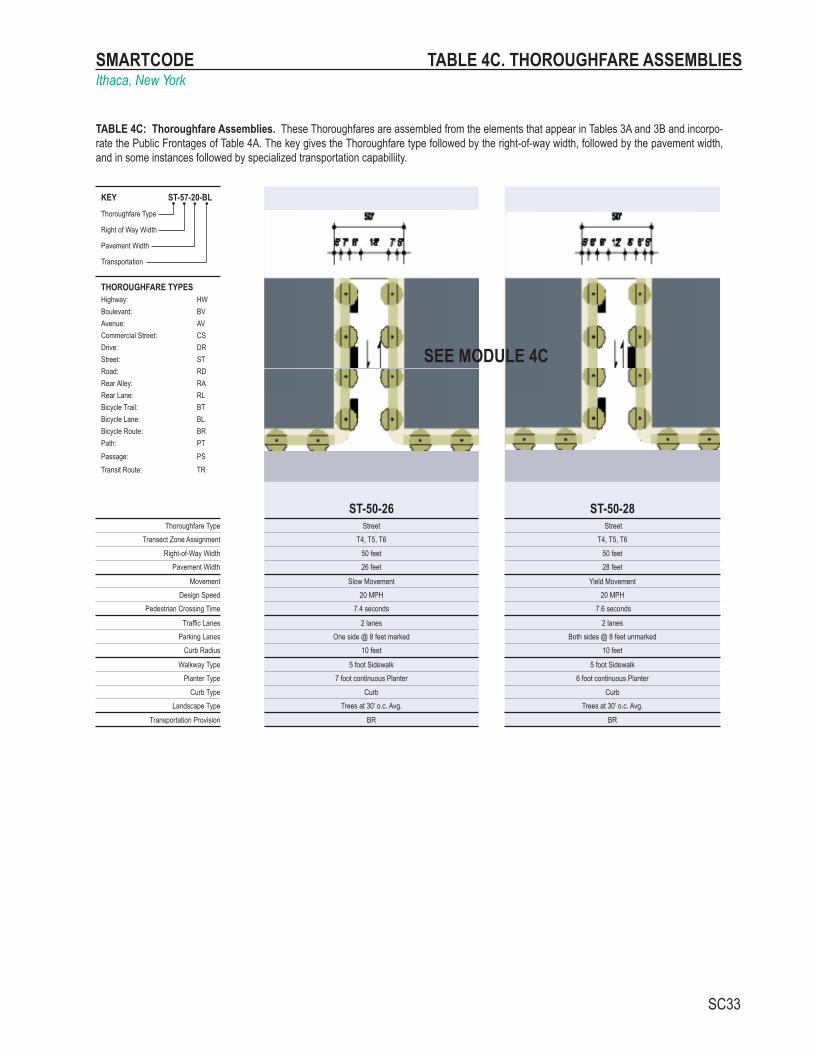
SMARTCODEIthaca, New York
SC33
KEY ST-57-20-BLThoroughfare Type
Right of Way Width
Pavement Width
Transportation
THOROUGHFARE TYPESHighway: HWBoulevard: BVAvenue: AVCommercial Street: CSDrive: DRStreet: STRoad: RDRear Alley: RARear Lane: RLBicycle Trail: BTBicycle Lane: BLBicycle Route: BRPath: PTPassage: PSTransit Route: TR
ST-50-26 ST-50-28Thoroughfare Type Street Street
Transect Zone Assignment T4, T5, T6 T4, T5, T6Right-of-Way Width 50 feet 50 feet
Pavement Width 26 feet 28 feet
Movement Slow Movement Yield MovementDesign Speed 20 MPH 20 MPH
Pedestrian Crossing Time 7.4 seconds 7.6 seconds
Traffic Lanes 2 lanes 2 lanesParking Lanes One side @ 8 feet marked Both sides @ 8 feet unmarked
Curb Radius 10 feet 10 feet
Walkway Type 5 foot Sidewalk 5 foot SidewalkPlanter Type 7 foot continuous Planter 6 foot continuous Planter
Curb Type Curb CurbLandscape Type Trees at 30’ o.c. Avg. Trees at 30’ o.c. Avg.
Transportation Provision BR BR
SEE MODULE 4C
TABLE 4C. THOROUGHFARE ASSEMBLIES
TABLE 4C: Thoroughfare Assemblies. These Thoroughfares are assembled from the elements that appear in Tables 3A and 3B and incorpo-rate the Public Frontages of Table 4A. The key gives the Thoroughfare type followed by the right-of-way width, followed by the pavement width, and in some instances followed by specialized transportation capabiliity.

SMARTCODEIthaca, New York
SC34
T1 T2 T3 T4 T5 T6 SD Specifications
Cobra Head
▪ ▪
Pipe
▪ ▪ ▪
Post
▪ ▪ ▪
Column
▪ ▪ ▪
Double Column
▪ ▪
TABLE 5. PUBLIC LIGHTING
TABLE 5: Public Lighting. Lighting varies in brightness and also in the character of the fixture according to the Transect. The table shows five common types. A listed set of streetlights corresponding to these types would be approved by the utility company and listed on the page.

SMARTCODEIthaca, New York
SC35
T1 T2 T3 T4 T5 T6 SD Specific Lighting
Column
▪ ▪ ▪ ▪ ▪ ▪
Oval
▪ ▪ ▪ ▪ ▪ ▪
Ball
▪ ▪ ▪ ▪ ▪ ▪
Pyramid
▪ ▪ ▪ ▪
Umbrella
▪ ▪ ▪ ▪
Vase
▪ ▪ ▪ ▪
TABLE 6. PUBLIC PLANTING
TABLE 6: Public Planting. This table shows six common types of street tree shapes and their appropriateness within the Transect Zones. The local planning office selects species appropriate for the bioregion.
SMARTCODEIthaca, New York
SC36
TABLE 7. PRIVATE FRONTAGES
SECTION PLANLOT
PRIVATE FRONTAGE
►►
◄◄
R.O.W.PUBLICFRONTAGE
LOT PRIVATE
FRONTAGE
►►
◄◄
R.O.W.PUBLIC FRONTAGE
a. Common Yard: a planted Frontage wherein the Facade is set back substantially from the Frontage Line. The front yard created remains unfenced and is visually continuous with adjacent yards, supporting a common landscape. The deep Setback provides a buffer from the higher speed Thoroughfares.
T2T3
b. Porch & Fence: a planted Frontage wherein the Facade is set back from the Frontage Line with an attached porch permitted to Encroach. A fence at the Frontage Line maintains street spatial definition. Porches shall be no less than 8 feet deep.
T3T4
c. Terrace or Lightwell: a Frontage wherein the Facade is set back from the Frontage line by an elevated terrace or a sunken Lightwell. This type buffers Residential use from urban Sidewalks and removes the private yard from public Encroachment. Terraces are suitable for conversion to outdoor cafes. Syn: Dooryard.
T4T5
d. Forecourt: a Frontage wherein a portion of the Facade is close to the Frontage Line and the central portion is set back. The Forecourt created is suitable for vehicular drop-offs. This type should be allocated in conjunction with other Frontage types. Large trees within the Forecourts may overhang the Sidewalks.
T4T5T6
e. Stoop: a Frontage wherein the Facade is aligned close to the Frontage Line with the first Story elevated from the Sidewalk sufficiently to secure privacy for the windows. The entrance is usually an exterior stair and landing. This type is recommended for ground-floor Residential use.
T4T5T6
f. Shopfront: a Frontage wherein the Facade is aligned close to the Frontage Line with the building entrance at Sidewalk grade. This type is conventional for Retail use. It has a substantial glazing on the Sidewalk level and an awning that may overlap the Sidewalk to within 2 feet of the Curb. Syn: Retail Frontage.
T4T5T6
g. Gallery: a Frontage wherein the Facade is aligned close to the Frontage line with an attached cantilevered shed or a lightweight colonnade overlapping the Sidewalk. This type is conventional for Retail use. The Gallery shall be no less than 10 feet wide and should overlap the Sidewalk to within 2 feet of the Curb.
T4T5T6
h. Arcade: a colonnade supporting habitable space that overlaps the Sidewalk, while the Facade at Sidewalk level remains at or behind the Frontage Line. This type is conventional for Retail use. The Arcade shall be no less than 12 feet wide and should overlap the Sidewalk to within 2 feet of the Curb. See Table 8.
T5T6
TABLE 7: Private Frontages. The Private Frontage is the area between the building Facades and the Lot lines.
SMARTCODEIthaca, New York
SC37
T2 T3 T4 T5 T6
T6 T6 T6
T6 T6 T6 T6
2
1
N
2
1
N
4
3
2
1
Max. height
Max. height
Max. height
Max. height
R.O.W.LotR.O.W.Lot
R.O.W.Lot
R.O.W.Lot
Max. height
Max. height
8
7
6
5
4
3
2
1
8
7
6
5
4
3
2
1
Max. height
R.O.W.Lot
Max. height
R.O.W.Lot
6
5
4
3
2
1
6
5
4
3
2
1
R.O.W.
R.O.W.
Lot
Lot
Max. height
Max. heightN
9
8
7
6
5
4
3
2
1
N
9
8
7
6
5
4
3
2
1
R.O.W.Lot
R.O.W.Lot
Max. height
Stepback
StepbackStepback
Stepback
R.O.W.Lot
N
13
12
11
10
9
8
7
6
5
4
3
2
1
N
13
12
11
10
9
8
7
6
5
4
3
2
1
Expression Line
Arcade max.
Arcade max.
Arcade max.
Arcade max.
Stepbacks/Arcade Heights. The diagrams below show Arcade Frontages. Diagrams above apply to all other Frontages.
TABLE 8. BUILDING CONFIGURATION
TABLE 8: Building Configuration. This table shows the Configurations for different building heights for each Transect Zone. It must be modified to show actual calibrated heights for local conditions. Recess Lines and Expression Lines shall occur on higher buildings as shown. N = maximum height as specified in Table 14k. See individual Transect Zone regulations.
SMARTCODEIthaca, New York
SC38
a. Edgeyard: Specific Types - single family House, cottage, villa, estate house, urban villa. A building that occupies the center of its Lot with Setbacks on all sides. This is the least urban of types as the front yard sets it back from the Frontage, while the side yards weaken the spatial definition of the public Thoroughfare space. The front yard is intended to be visually continuous with the yards of adjacent buildings. The rear yard can be secured for privacy by fences and a well-placed Backbuilding and/or Outbuilding.
T2T3T4
b. Sideyard: Specific Types - Charleston single house, double house, zero lot line house, twin. A building that occupies one side of the Lot with the Setback to the other side. A shallow Frontage Setback defines a more urban condition. If the adjacent building is similar with a blank side wall, the yard can be quite private. This type permits systematic climatic orientation in response to the sun or the breeze. If a Sideyard House abuts a neighboring Sideyard House, the type is known as a twin or double House. Energy costs, and sometimes noise, are reduced by sharing a party wall in this Disposition.
T4T5
c. Rearyard: Specific Types - Townhouse, Rowhouse, Live-Work unit, loft building, Apartment House, Mixed Use Block, Flex Building, perimeter Block. A building that occupies the full Frontage, leaving the rear of the Lot as the sole yard. This is a very urban type as the continuous Facade steadily defines the public Thoroughfare. The rear Elevations may be articulated for functional purposes. In its Residential form, this type is the Rowhouse. For its Commercial form, the rear yard can accommodate substantial parking.
T4T5T6
d. Courtyard: Specific Types - patio House. A building that occupies the boundaries of its Lot while internally defining one or more private patios. This is the most urban of types, as it is able to shield the private realm from all sides while strongly defining the public Thoroughfare. Because of its ability to accommodate incompatible activities, masking them from all sides, it is recommended for workshops, Lodging and schools. The high security provided by the continuous enclosure is useful for crime-prone areas.
T5T6
e. Specialized: A building that is not subject to categorization. Buildings dedicated to manufacturing and transportation are often distorted by the trajectories of machinery. Civic buildings, which may express the aspirations of institutions, may be included.
SD
TABLE 9. BUILDING DISPOSITION
TABLE 9: Building Disposition. This table approximates the location of the structure relative to the boundaries of each individual Lot, establishing suitable basic building types for each Transect Zone.

SMARTCODEIthaca, New York
SC39
T2 T3 T4 T5 T6a. RESIDENTIAL Restricted Residential: The number of
dwellings on each Lot is restricted to one within a Principal Building and one within an Accessory Building, with 2.0 parking places for each. Both dwellings shall be under single ownership. The habitable area of the Accessory Unit shall not exceed 440 sf, excluding the parking area.
Limited Residential:The number of dwell-ings on each Lot is limited by the requirement of 1.5 parking places for each dwelling, a ratio which may be reduced according to the shared parking standards (See Table 11).
Open Residential:The number of dwellings on each Lot is limited by the requirement of 1.0 parking places for each dwelling, a ratio which may be reduced according to the shared parking standards (See Table 11).
b. LODGING Restricted Lodging: The number of bed-rooms available on each Lot for lodging is limited by the requirement of 1.0 assigned parking place for each bedroom, up to five, in addition to the parking requirement for the dwelling. The Lodging must be owner occupied. Food service may be provided in the a.m. The maximum length of stay shall not exceed ten days.
Limited Lodging: The number of bedrooms available on each Lot for lodging is limited by the requirement of 1.0 assigned parking places for each bedroom, up to twelve, in addition to the parking requirement for the dwelling. The Lodging must be owner occupied.Food service may be provided in the a.m. The maximum length of stay shall not exceed ten days.
Open Lodging: The number of bedrooms available on each Lot for lodging is limited by the requirement of 1.0 assigned parking places for each bedroom. Food service may be provided at all times. The area allocated for food service shall be calculated and provided with parking according to Retail Function.
c. OFFICE Restricted Office: The building area avail-able for office use on each Lot is restricted to the first Story of the Principal or the Acces-sory Building and by the requirement of 3.0 assigned parking places per 1000 square feet of net office space in addition to the parking requirement for each dwelling.
Limited Office: The building area available for office use on each Lot is limited to the first Story of the principal building and/or to the Accessory building, and by the requirement of 3.0 assigned parking places per 1000 square feet of net office space in addition to the parking requirement for each dwelling.
Open Office: The building area available for office use on each Lot is limited by the requirement of 2.0 assigned parking places per 1000 square feet of net office space.
d. RETAIL Restricted Retail: The building area avail-able for Retail use is restricted to one Block corner location at the first Story for each 300 dwelling units and by the requirement of 4.0 assigned parking places per 1000 square feet of net Retail space in addition to the parking requirement of each dwelling. The specific use shall be further limited to neighborhood store, or food service seating no more than 20.
Limited Retail: The building area available for Retail use is limited to the first Story of buildings at corner locations, not more than one per Block, and by the requirement of 4.0 assigned parking places per 1000 square feet of net Retail space in addition to the parking requirement of each dwelling. The specific use shall be further limited to neighborhood store, or food service seating no more than 40.
Open Retail: The building area available for Retail use is limited by the requirement of 3.0 assigned parking places per 1000 square feet of net Retail space. Retail spaces under 1500 square feet are exempt from parking requirements.
e. CIVIC See Table 12 See Table 12 See Table 12
f. OTHER See Table 12 See Table 12 See Table 12
REQUIRED PARKING (See Table 10)
T2 T3 T4 T5 T6RESIDENTIAL 2.0 / dwelling 1.5 / dwelling 1.0 / dwelling
LODGING 1.0 / bedroom 1.0 / bedroom 1.0 / bedroom
OFFICE 3.0 / 1000 sq. ft. 3.0 / 1000 sq. ft. 2.0 / 1000 sq. ft.
RETAIL 4.0 / 1000 sq. ft. 4.0 / 1000 sq. ft. 3.0 / 1000 sq. ft.
CIVIC To be determined by Warrant
OTHER To be determined by Warrant
SHARED PARKING FACTOR
Function with Function
RESIDENTIAL RESIDENTIAL
LODGING LODGING
OFFICE OFFICE
RETAIL RETAIL1.4 1.1
1.2 1.7 1.3
1.2
1.11.4
1.2
1
1
1
1
1.7 1.3
1.2
TABLES 10 & 11. BUILDING FUNCTION & PARKING CALCULATIONS
TABLE 10: Building Function. This table categorizes Building Functions within Transect Zones. Parking requirements are correlated to functional intensity. For Specific Function and Use permitted By Right or by Warrant, see Table 12. No minimum parking requirement.
TABLE 11: Parking Calculations. The Shared Parking Factor for two Functions, when divided into the sum of the two amounts as listed on the Required Parking table below, produces the Effective Parking needed for each site involved in sharing. Conversely, if the Sharing Factor is used as a multiplier, it indicates the amount of building allowed on each site given the parking available.
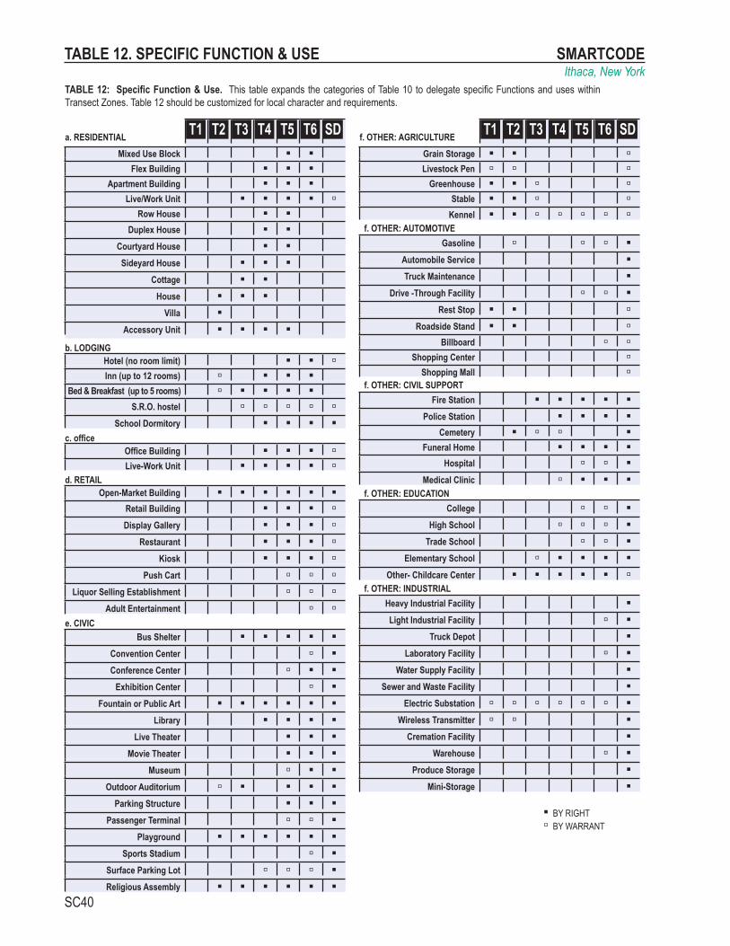
SMARTCODEIthaca, New York
SC40
a. RESIDENTIAL T1 T2 T3 T4 T5 T6 SDMixed Use Block ▪ ▪
Flex Building ▪ ▪ ▪Apartment Building ▪ ▪ ▪
Live/Work Unit ▪ ▪ ▪ ▪ ▫Row House ▪ ▪
Duplex House ▪ ▪Courtyard House ▪ ▪Sideyard House ▪ ▪ ▪
Cottage ▪ ▪House ▪ ▪ ▪
Villa ▪Accessory Unit ▪ ▪ ▪ ▪
b. LODGINGHotel (no room limit) ▪ ▪ ▫Inn (up to 12 rooms) ▫ ▪ ▪ ▪
Bed & Breakfast (up to 5 rooms) ▫ ▪ ▪ ▪ ▪S.R.O. hostel ▫ ▫ ▫ ▫ ▫
School Dormitory ▪ ▪ ▪ ▪c. office
Office Building ▪ ▪ ▪ ▫Live-Work Unit ▪ ▪ ▪ ▪ ▫
d. RETAILOpen-Market Building ▪ ▪ ▪ ▪ ▪ ▪
Retail Building ▪ ▪ ▪ ▫Display Gallery ▪ ▪ ▪ ▫
Restaurant ▪ ▪ ▪ ▫Kiosk ▪ ▪ ▪ ▫
Push Cart ▫ ▫ ▫Liquor Selling Establishment ▫ ▫ ▫
Adult Entertainment ▫ ▫e. CIVIC
Bus Shelter ▪ ▪ ▪ ▪ ▪Convention Center ▫ ▪Conference Center ▫ ▪ ▪
Exhibition Center ▫ ▪Fountain or Public Art ▪ ▪ ▪ ▪ ▪ ▪
Library ▪ ▪ ▪ ▪Live Theater ▪ ▪ ▪
Movie Theater ▪ ▪ ▪Museum ▫ ▪ ▪
Outdoor Auditorium ▫ ▪ ▪ ▪ ▪Parking Structure ▪ ▪ ▪
Passenger Terminal ▫ ▫ ▪Playground ▪ ▪ ▪ ▪ ▪ ▪
Sports Stadium ▫ ▪Surface Parking Lot ▫ ▫ ▫ ▪Religious Assembly ▪ ▪ ▪ ▪ ▪ ▪
f. OTHER: AGRICULTURE T1 T2 T3 T4 T5 T6 SDGrain Storage ▪ ▪ ▫Livestock Pen ▫ ▫ ▫
Greenhouse ▪ ▪ ▫ ▫Stable ▪ ▪ ▫ ▫
Kennel ▪ ▪ ▫ ▫ ▫ ▫ ▫f. OTHER: AUTOMOTIVE
Gasoline ▫ ▫ ▫ ▪Automobile Service ▪Truck Maintenance ▪
Drive -Through Facility ▫ ▫ ▪Rest Stop ▪ ▪ ▫
Roadside Stand ▪ ▪ ▫Billboard ▫ ▫
Shopping Center ▫Shopping Mall ▫
f. OTHER: CIVIL SUPPORTFire Station ▪ ▪ ▪ ▪ ▪
Police Station ▪ ▪ ▪ ▪Cemetery ▪ ▫ ▫ ▪
Funeral Home ▪ ▪ ▪ ▪Hospital ▫ ▫ ▪
Medical Clinic ▫ ▪ ▪ ▪f. OTHER: EDUCATION
College ▫ ▫ ▪High School ▫ ▫ ▫ ▪
Trade School ▫ ▫ ▪Elementary School ▫ ▪ ▪ ▪ ▪
Other- Childcare Center ▪ ▪ ▪ ▪ ▪ ▫f. OTHER: INDUSTRIAL
Heavy Industrial Facility ▪Light Industrial Facility ▫ ▪
Truck Depot ▪Laboratory Facility ▫ ▪
Water Supply Facility ▪Sewer and Waste Facility ▪
Electric Substation ▫ ▫ ▫ ▫ ▫ ▫ ▪Wireless Transmitter ▫ ▫ ▪
Cremation Facility ▪Warehouse ▫ ▪
Produce Storage ▪Mini-Storage ▪
▪ BY RIGHT▫ BY WARRANT
TABLE 12. SPECIFIC FUNCTION & USE
TABLE 12: Specific Function & Use. This table expands the categories of Table 10 to delegate specific Functions and uses within Transect Zones. Table 12 should be customized for local character and requirements.

SMARTCODEIthaca, New York
SC41
a. Park: A natural preserve available for unstructured recreation. A park may be independent of surrounding building Frontages. Its landscape shall consist of Paths and trails, meadows, waterbodies, woodland and open shelters, all naturalistically disposed. Parks may be lineal, following the trajectories of natural corridors. The minimum size shall be 8 acres. Larger parks may be approved by Warrant as Special Districts in all zones.
b. Green: An Open Space, available for unstructured recreation. A Green may be spatially defined by landscaping rather than building Frontages. Its landscape shall consist of lawn and trees, natu-ralistically disposed. The minimum size shall be 1/2 acre and the maximum shall be 8 acres.
c. Square: An Open Space available for unstructured recreation and Civic purposes. A Square is spatially defined by building Frontages. Its landscape shall consist of paths, lawns and trees, formally disposed. Squares shall be located at the intersection of important Thoroughfares. The minimum size shall be 1/2 acre and the maximum shall be 5 acres.
d. Plaza: An Open Space available for Civic purposes and Commercial activities. A Plaza shall be spatially defined by building Frontages. Its landscape shall consist primarily of pavement. Trees are optional. Plazas should be located at the intersection of important streets. The minimum size shall be 1/2 acre and the maximum shall be 2 acres.
e. Playground: An Open Space designed and equipped for the recreation of children. A playground should be fenced and may include an open shelter. Playgrounds shall be interspersed within Residential areas and may be placed within a Block. Playgrounds may be included within parks and greens. There shall be no minimum or maximum size.
T1T2T3
T3T4T5
T5T6
T4T5T6
T1T2T3T4T5T6
TABLE 13. CIVIC SPACE

SMARTCODEIthaca, New York
SC42
T1 NATURAL ZONE T2 RURAL ZONE T3 SUB-URBAN ZONE T4 GENERAL
URBAN ZONE T5 NEIGHBORHOOD
CENTER ZONE T6 URBAN CORE ZONE SD SPECIAL
DISTRICTa.
CLD requiredTND requiredRCD required
b.By RightConditionalOther Functions
c.Block Perimeter
d.HighwayBoulevardAvenueCommercial StreetDriveStreetRoadRear LaneRear AlleyPathPassageBicycle TrailBicycle LaneBicycle Route
e.ParkGreenSquarePlazaPlayground
f.Lot WidthLot Coverage
g.(g.1) Front Setback Principal(g.3) Side Setback(g.4) Rear SetbackFrontage Buildout
h.Front SetbackSide SetbackRear Setback
i.EdgeyardSideyardRearyardCourtyard
j.Common YardPorch & FenceTerrace, DooryardForecourtStoopShopfrontGalleryArcade
k.Principal BuildingOutbuilding
l.ResidentialLodgingOfficeRetail
ARTICLE 5ARTICLE 2,3,4
FUNC
TION
open use open useopen use open use
open use open use
not applicable restricted use restricted use limited use open use open usenot applicable restricted use restricted use limited usenot applicable restricted use restricted use limited use
BUILDING FUNCTION (See Table 10 and Table 12)*not applicable restricted use restricted use limited use
3 stories max. 2 min. 5 stories max. 2 min. 10 stories max. 2 min.not applicable 2 stories max. 2 stories max. 2 stories max. 2 stories max. not applicable
CONF
IGUR
ATIO
N
permitted permittednot applicable not permitted
BUILDING CONFIGURATION (See Table 8)*not applicable 2 stories max. 2 stories max.
not applicable not permitted not permitted permittednot permitted permitted permitted permitted
not applicable not permitted not permitted permitted permitted permittednot applicable not permitted not permitted permitted permitted permittednot applicable not permitted not permitted permitted permitted permittednot applicable not permitted not permitted permitted permitted not permittednot applicable not permitted permitted permitted not permitted not permittednot applicable permitted permitted not permitted not permitted not permitted
permitted permitted
PRIVATE FRONTAGES (See Table 7)*not permitted permitted permitted
DISP
OSIT
ION
not permitted not permitted not permitted permitted
not permitted not permittednot permitted not permitted
permitted permitted permitted permittednot permitted permitted permitted not permitted
BUILDING DISPOSITION (See Table 9)*
not applicable 96 ft. min. 12 ft. min. 5 ft. min.
not applicable 5 ft. min.5 ft. min. 5 ft. max.not applicable
not applicable 96 ft. min. 12 ft. min. 0 ft. min. 0 ft. min. 24 ft. max. 0 ft. min. 24 ft. max.not applicable 48 ft. min. 24 ft. min./12 ft. min 5 ft. min. 18 ft. max. 0 ft. min. 12 ft. max. 0 ft. min. 12 ft. max.
90% max. 90% max.SETBACKS - PRINCIPAL BUILDING (See Table 15)*
not applicable conditional 60% max. 70% max, 90% corner.
not permitted
16 ft. min 180 ft. max. 16 ft. min 400 ft. max.LOT OCCUPATION
not applicable conditional 60 ft. min 120 ft. max. 16 ft. min 96 ft. max.
permitted
permitted permitted permitted permitted permitted permittednot permitted
not permitted not permitted permitted permitted
not permitted not permitted permitted permittedpermitted
permitted permitted permitted conditional
not permitted not permitted not permitted permitted
conditional conditional
not permitted not permitted
permitted not permitted
permitted not permittedpermitted permitted permitted conditional
permitted permitted permitted not permittedpermitted permitted permitted permitted permitted permitted
not permitted not permitted permitted permitted permitted permittedpermitted permitted permitted permitted not permitted not permitted
not permitted not permitted permitted permitted required requiredpermitted permitted permitted permitted not permitted not permittedpermitted permitted permitted not permitted not permitted not permitted
not permitted not permitted permitted permitted permitted not permittednot permitted not permitted permitted permitted permitted permittednot permitted not permitted not permitted not permitted permitted permitted
permitted permittednot permitted not permitted permitted permitted permitted permitted
permitted permitted permitted not permittednot permitted not permitted permitted permitted
not permitted not permitted
BLOCK SIZEno maximum no maximum 3,000 ft. max. 2,400 ft. max. 1,600 ft. max. 1,600 ft. max.
96 du / ac. 200 du / ac.30 - 50% 50 - 70%
not permitted 2 du / ac. 7 du / ac 24 du / ac.conditional conditional 10 - 20% 20 - 30%
no minimum
BASE RESIDENTIAL DENSITYnot applicable 1 du/ 20 ac. max. 2 du / ac. max. 7 du min. 16 du max./ac 7 du min. 24 du max./ac 24 du min. 96 du max./ac
not permittedno minimum no minimum not permitted 10 - 30% 10 - 30% 40 - 80%no minimum
(See Table 16)*no minimum 50% min 10 - 30%
5 ft. min.
20 - 40% not permitted10 - 30% 30 - 60% 10 - 30%
25% min.SETBACKS - OUTBUILDING (See Table 15)*
not applicable 20 ft. min. + bldg. setback 20 ft. min. + bldg. setback 20 ft. min. + bldg. setback 20 ft. min. + bldg. setback not applicable
60% min. 80% min. 80% min.
0 ft. min. 0 ft. min. not applicable
5 ft. min.
not permitted not permitted not permitted
not applicable not applicable
5 ft. min. 5 ft. min. not applicable5 ft. min.
ALLOCATION OF ZONES per Pedestrian Shed
THOROUGHFARES (See Table 3 and 4)*
CIVIC SPACES (See Table 13)*
Note: All requirements in this Table are subject to final approval from both the Town and City of Ithaca.
not permitted
TABLE 14. Summary of Zone Regulations

SMARTCODEIthaca, New York
SC43
LOT OCCUPATION: See Glossary for definitionsLot Width 60 ft min. 120 ft max.Lot Coverage 60% max.
SETBACKS: PRINCIPAL OUT BUILDING
Front Setback 12 ft. min. 24 ft. max. 20 ft. + bldg. setbackSide Setback 12 ft. min. 0 ft. min.Rear Setback 12 ft. min.* 5 ft. min.*
Frontage Buildout 25% min. at setback n/aParking 2nd layer or 3rd layer only
*or 15 ft. from center line of alley
BUILDING CONFIGURATION: See Glossary for definitions
EXAMPLES:
T1 T2 T3 T4
T5 T6 SD
Edge Yard Side Yard Rear Yard Court Yard Specialized
BUILDING DISPOSITION: See Glossary for definitions
PRIVATE FRONTAGES: See Glossary for definitions
TABLE 15A. Neighborhood Edge Zone - T3
T-3 Neighborhood Edge Zone consists of low density residential areas, adja-cent to higher zones that have some mixed use. Home occupations and outbuildings are allowed. Planting is naturalistic and setbacks are relatively deep. Blocks may be large and the roads irregular to accommodate natural conditions.
DENSITY:2 units/acre max. by right7 units/acre max. with conditional approval
Common Yard Porch & Fence Dooryard Forecourt Stoop Shopfront Gallery Arcade
1
22 stories max.
1
28’ max. height24’ max. height
Corner LotCondition
Mid-BlockCondition
2nd Layer
1stLayer
3rd Layer
Secondary Frontage
Princ
ipal
Fron
tage
12 ft min.24 ft max.
5 ft
5 ft
12 ft
12 ft
20 ft
5 ft
12 ft
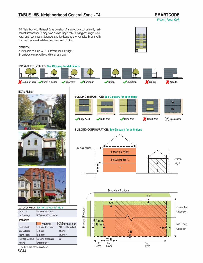
SMARTCODEIthaca, New York
SC44
EXAMPLES:
TABLE 15B. Neighborhood General Zone - T4
T-4 Neighborhood General Zone consists of a mixed use but primarily resi-dential urban fabric. It may have a wide range of building types: single, side-yard, and rowhouses. Setbacks and landscaping are variable. Streets with curbs and sidewalks define medium-sized blocks.
DENSITY:7 units/acre min. up to 16 units/acre max. by right24 units/acre max. with conditional approval
LOT OCCUPATION: See Glossary for definitionsLot Width 16 ft min. 96 ft max.Lot Coverage 70% max, 90% corner lot
SETBACKS: PRINCIPAL OUT BUILDING
Front Setback 5 ft. min. 18 ft. max. 20 ft. + bldg. setbackSide Setback 0 ft. min. 0 ft. min.Rear Setback 5 ft. min.* 5 ft. min.*
Frontage Buildout 60% min at setback n/aParking 3rd layer only
*or 15 ft. from center line of alley
BUILDING CONFIGURATION: See Glossary for definitions
T1 T2 T3 T4
T5 T6 SD
Edge Yard Side Yard Rear Yard Court Yard Specialized
BUILDING DISPOSITION: See Glossary for definitions
Common Yard Porch & Fence Dooryard Forecourt Stoop Shopfront Gallery Arcade
PRIVATE FRONTAGES: See Glossary for definitions
1
22 stories min.
1
3 stories max. 35’ max. height
24’ max. height
Corner LotCondition
Mid-BlockCondition
2nd Layer
1stLayer
3rd Layer
Secondary Frontage
Princ
ipal
Fron
tage
5 ft min.18 ft max.
5 ft
0 ft
20 ft
0 ft
5 ft

SMARTCODEIthaca, New York
SC45
LOT OCCUPATION: See Glossary for definitionsLot Width 16 ft min. 96 ft max.Lot Coverage 90% max.
SETBACKS: PRINCIPAL OUT BUILDING
Front Setback 0 ft. min. 12 ft. max. 20 ft. + bldg. setbackSide Setback 0 ft. min. 24 ft. max. 0 ft. min.Rear Setback 5 ft. min.* 5 ft. min.*
Frontage Buildout 80% min at setback n/aParking 3rd layer only
*or 10 ft. from center line of alley
BUILDING CONFIGURATION: See Glossary for definitions
T-5 Neighborhood Center Zone consists of higher density mixed use build-ings that accommodate retail, offices, rowhouses and apartments. It has a tight network of streets, with wide sidewalks, steady street tree planting and buildings set close to the sidewalks.
DENSITY:7 units/acre min. up to 24 units/acre max. by right96 units/acre max. with conditional approval
T1 T2 T3 T4
T5 T6 SD
Edge Yard Side Yard Rear Yard Court Yard Specialized
BUILDING DISPOSITION: See Glossary for definitions
Common Yard Porch & Fence Dooryard Forecourt Stoop Shopfront Gallery Arcade
PRIVATE FRONTAGES: See Glossary for definitions
TABLE 15C. Neighborhood Center Zone - T5
1
22 stories min.
1
4
3
5 stories max. 60’ max. height
24’ max. height
Corner LotCondition
Mid-BlockCondition
2nd Layer
1stLayer
3rd Layer
Secondary Frontage
Princ
ipal
Fron
tage
0 ft min.12 ft max.
0 ft
20 ft
0 ft
5 ft
EXAMPLES:

SMARTCODEIthaca, New York
SC46
T-6 Urban Core Zone consists of the highest density and height, with the greatest variety of uses, and civic buildings of regional importance. It may have larger blocks; streets have steady street tree planting and buildings set close to the wide sidewalks. Typically only large towns and cities have an Urban Core Zone Zone.
DENSITY:24 units/acre min. up to 96 units/acre max. by right200 units/acre max. with conditional approval
TABLE 15D. Urban Core Zone - T6
LOT OCCUPATION: See Glossary for definitionsLot Width 16 ft min. 400 ft max.Lot Coverage 90% max.
SETBACKS: PRINCIPAL OUT BUILDING
Front Setback 0 ft. min. 12 ft. max. n/aSide Setback 0 ft. min. 24 ft. max. n/aRear Setback 5 ft. min.* n/a
Frontage Buildout 80% min at setback n/aParking 3rd layer only
*or 10 ft. from center line of alley
BUILDING CONFIGURATION: See Glossary for definitions
T1 T2 T3 T4
T5 T6 SD
Edge Yard Side Yard Rear Yard Court Yard Specialized
BUILDING DISPOSITION: See Glossary for definitions
Common Yard Porch & Fence Dooryard Forecourt Stoop Shopfront Gallery Arcade
PRIVATE FRONTAGES: See Glossary for definitions
2 stories min.
1
4
3
5-9
up to 10 stories max. 140’ max. height
Corner LotCondition
Mid-BlockCondition
2nd Layer
1stLayer
3rd Layer
Secondary Frontage
Princ
ipal
Fron
tage
0 ft min.12 ft max.
20 ft
0 ft
5 ft
EXAMPLES:

SMARTCODEIthaca, New York
SC47
Thoroughfare (R.O.W.)
a. THOROUGHFARE & FRONTAGES
1-Radius at the Curb2-Effective Turning Radius (± 8 ft)
b. TURNING RADIUS
1-Frontage Line 2-Lot Line 3-Facades 4-Elevations
e. FRONTAGE & LOT LINES
1st layer
2nd layer
3rd layer
20 fe
et
d. LOT LAYERS
1- Principal Building2- Backbuilding3- Outbuilding
c. BUILDING DISPOSITION
BuildingPrivate Frontage
Public Frontage
Vehicular Lanes
Public Frontage
Private Frontage
Building
Private LotPrivate Lot
Parki
ng La
ne
Movin
g Lan
e
1
2
1
1
2
33
24
3
3
4 4
1
1
3
1
4 4
f. SETBACK DESIGNATIONS
1
1
1-Front Setback2-Side Setback3-Rear Setback
3 3
1
2
2
g. NETWORK-BASED PEDESTRIAN SHED
1st la
yer
2nd &
3rd
laye
r
Principal Frontage
Seco
ndar
y Fro
ntage
TABLE 17. DEFINITIONS ILLUSTRATED

SMARTCODEIthaca, New York
SC48
ARTICLE 7. DEFINITIONS OF TERMS
DEFINITIONS This Article provides definitions for terms in this Code that are technical in nature or
that otherwise may not reflect a common usage of the term. If a term is not defined in this Article, then the CRC shall determine the correct definition. Items in italics refer to Articles, Sections, or Tables in the SmartCode.
A-Grid: cumulatively, those Thoroughfares that by virtue of their pre-existing pedestrian-supportive qualities, or their future importance to pedestrian connectiv-ity, are held to the highest standards prescribed by this Code. See B-Grid. (Syn: primary grid.)
Accessory Building: an Outbuilding with an Accessory Unit. Accessory Unit: an Apartment not greater than 600 square feet sharing owner-
ship and utility connections with a Principal Building; it may or may not be within an Outbuilding. See Table 10 and Table 17. (Syn: ancillary unit)
Adjusted Pedestrian Shed: a Pedestrian Shed that has been adjusted according to Section 3.2, creating the regulatory boundary of a Community Unit.
Affordable Housing: dwellings consisting of rental or for-sale units that have a rent (including utilities) or mortgage payment typically no more than 30% of the income of families earning no more than 80% of median incomes by family size for the county. (Alt. definition: rental or for-sale dwellings that are economically within the means of the starting salary of a local elementary school teacher.)
Allee: a regularly spaced and aligned row of trees usually planted along a Thor-oughfare or Path.
Apartment: a Residential unit sharing a building and a Lot with other units and/or uses; may be for rent, or for sale as a condominium.
Arcade: a Private Frontage conventional for Retail use wherein the Facade is a colonnade supporting habitable space that overlaps the Sidewalk, while the Facade at Sidewalk level remains at the Frontage Line.
Attic: the interior part of a building contained within a pitched roof structure. Avenue (AV): a Thoroughfare of high vehicular capacity and low to moderate speed,
acting as a short distance connector between urban centers, and usually equipped with a landscaped median.
B-Grid: cumulatively, those Thoroughfares that by virtue of their use, location, or absence of pre-existing pedestrian-supportive qualities, may meet a standard lower than that of the A-Grid. See A-Grid. (Syn: secondary grid.)
BRT: see Bus Rapid Transit. Backbuilding: a single-Story structure connecting a Principal Building to an Out-
building. See Table 17. Base Density: the number of dwelling units per acre before adjustment for other
Functions and/or TDR. See Density. Bed and Breakfast: an owner-occupied Lodging type offering 1 to 5 bedrooms,
permitted to serve breakfast in the mornings to guests. Bicycle Lane (BL): a dedicated lane for cycling within a moderate-speed vehicular
Thoroughfare, demarcated by striping.

SMARTCODEIthaca, New York
SC49
ARTICLE 7. DEFINITIONS OF TERMS
Bicycle Route (BR): a Thoroughfare suitable for the shared use of bicycles and automobiles moving at low speeds.
Bicycle Trail (BT): a bicycle way running independently of a vehicular Thoroughfare. Block: the aggregate of private Lots, Passages, Rear Alleys and Rear Lanes,
circumscribed by Thoroughfares. Block Face: the aggregate of all the building Facades on one side of a Block. Boulevard (BV): a Thoroughfare designed for high vehicular capacity and moderate
speed, traversing an Urbanized area. Boulevards are usually equipped with Slip Roads buffering Sidewalks and buildings.
Brownfield: an area previously used primarily as an industrial site. Bus Rapid Transit: a rubber tire system with its own right-of-way or dedicated
lane along at least 70% of its route, providing transit service that is faster than a regular bus.
By Right: characterizing a proposal or component of a proposal for a Community Plan or Building Scale Plan (Article 3, Article 4, or Article 5) that complies with the SmartCode and is permitted and processed administratively, without public hearing. See Warrant and Variance.
CLD or Clustered Land Development: a Community Unit type structured by a Standard Pedestrian Shed oriented toward a Common Destination such as a general store, Meeting Hall, schoolhouse, or church. CLD takes the form of a small settle-ment standing free in the countryside. See Table 2 and Table 14a. (Syn: Hamlet, Conservation Land Development, cluster)
CRC: Consolidated Review Committee. Civic: the term defining not-for-profit organizations dedicated to arts, culture, educa-
tion, recreation, government, transit, and municipal parking. Civic Building: a building operated by not-for-profit organizations dedicated to arts,
culture, education, recreation, government, transit, and municipal parking, or for use approved by the legislative body.
Civic Parking Reserve: Parking Structure or parking lot within a quarter-mile of the site that it serves. See Section 5.9.2.
Civic Space: an outdoor area dedicated for public use. Civic Space types are defined by the combination of certain physical constants including the relationships among their intended use, their size, their landscaping and their Enfronting buildings. See Table 13.
Civic Zone: designation for public sites dedicated for Civic Buildings and Civic Space.
Commercial: the term collectively defining workplace, Office, Retail, and Lodging Functions.
Common Destination: An area of focused community activity, usually defining the approximate center of a Pedestrian Shed. It may include without limitation one or more of the following: a Civic Space, a Civic Building, a Commercial center, or a transit station, and may act as the social center of a neighborhood.
Common Yard: a planted Private Frontage wherein the Facade is set back from the Frontage line. It is visually continuous with adjacent yards. See Table 7.
Community Unit: a regulatory category defining the physical form, Density, and extent of a settlement. The three Community Unit types addressed in this Code are

SMARTCODEIthaca, New York
SC50
ARTICLE 7. DEFINITIONS OF TERMS
CLD, TND, and RCD. Variants of TND and RCD for Infill (Article 4) are called Infill TND and Infill RCD. The TOD Community Unit type may be created by an overlay on TND or RCD.
Configuration: the form of a building, based on its massing, Private Frontage, and height.
Consolidated Review Committee (CRC): Usually part of the Planning Office, a CRC is comprised of a representative from each of the various regulatory agencies that have jurisdiction over the permitting of a project, as well as a representative of the Development and Design Center. See Section 1.4.3.
Corridor: a lineal geographic system incorporating transportation and/or Greenway trajectories. A transportation Corridor may be a lineal Transect Zone.
Cottage: an Edgeyard building type. A single-family dwelling, on a regular Lot, often shared with an Accessory Building in the back yard.
Courtyard Building: a building that occupies the boundaries of its Lot while internally defining one or more private patios. See Table 9.
Curb: the edge of the vehicular pavement that may be raised or flush to a Swale. It usually incorporates the drainage system. See Table 4A and Table 4B.
DDC: Development and Design Center. Density: the number of dwelling units within a standard measure of land area. Design Speed: is the velocity at which a Thoroughfare tends to be driven without
the constraints of signage or enforcement. There are four ranges of speed: Very Low: (below 20 MPH); Low: (20-25 MPH); Moderate: (25-35 MPH); High: (above 35 MPH). Lane width is determined by desired Design Speed. See Table 3A.
Developable Areas: lands other than those in the O-1 Preserved Open Sector. Development and Design Center (DDC): A component of the Planning Office
assigned to advise on the use of this Code and to aid in the design of the Com-munities and buildings based on it.
Disposition: the placement of a building on its Lot. See Table 9 and Table 17. Dooryard: a Private Frontage type with a shallow Setback and front garden or patio,
usually with a low wall at the Frontage Line. See Table 7. (Variant: Lightwell, light court.)
Drive: a Thoroughfare along the boundary between an Urbanized and a natural condition, usually along a waterfront, Park, or promontory. One side has the urban character of a Thoroughfare, with Sidewalk and building, while the other has the qualities of a Road or parkway, with naturalistic planting and rural details.
Driveway: a vehicular lane within a Lot, often leading to a garage. See Section 5.10 and Table 3B-f.
Edgeyard Building: a building that occupies the center of its Lot with Setbacks on all sides. See Table 9.
Effective Parking: the amount of parking required for Mixed Use after adjustment by the Shared Parking Factor. See Table 11.
Effective Turning Radius: the measurement of the inside Turning Radius taking parked cars into account. See Table 17.
Elevation: an exterior wall of a building not along a Frontage Line. See Table 17. See: Facade.

SMARTCODEIthaca, New York
SC51
ARTICLE 7. DEFINITIONS OF TERMS
Encroach: to break the plane of a vertical or horizontal regulatory limit with a structural element, so that it extends into a Setback, into the Public Frontage, or above a height limit.
Encroachment: any structural element that breaks the plane of a vertical or hori-zontal regulatory limit, extending into a Setback, into the Public Frontage, or above a height limit.
Enfront: to place an element along a Frontage, as in “porches Enfront the street.”
Estate House: an Edgeyard building type. A single-family dwelling on a very large Lot of rural character, often shared by one or more Accessory Buildings. (Syn: country house, villa)
Expression Line: a line prescribed at a certain level of a building for the major part of the width of a Facade, expressed by a variation in material or by a limited projection such as a molding or balcony. See Table 8. (Syn: transition line.)
Extension Line: a line prescribed at a certain level of a building for the major part of the width of a Facade, regulating the maximum height for an Encroachment by an Arcade Frontage. See Table 8.
Facade: the exterior wall of a building that is set along a Frontage Line. See Elevation. Forecourt: a Private Frontage wherein a portion of the Facade is close to the
Frontage Line and the central portion is set back. See Table 7. Frontage: the area between a building Facade and the vehicular lanes, inclusive of
its built and planted components. Frontage is divided into Private Frontage and Public Frontage. See Table 4A and Table 7.
Frontage Line: a Lot line bordering a Public Frontage. Facades facing Frontage Lines define the public realm and are therefore more regulated than the Elevations facing other Lot Lines. See Table 17.
Function: the use or uses accommodated by a building and its Lot, categorized as Restricted, Limited, or Open, according to the intensity of the use. See Table 10 and Table 12.
Gallery: a Private Frontage conventional for Retail use wherein the Facade is aligned close to the Frontage Line with an attached cantilevered shed or lightweight colonnade overlapping the Sidewalk. See Table 7.
GIS (Geographic Information System): a computerized program in widespread municipal use that organizes data on maps.The protocol for preparing a Regional Plan should be based on GIS information. See Section 2.1.
Green: a Civic Space type for unstructured recreation, spatially defined by landscap-ing rather than building Frontages. See Table 13.
Greenfield: an area that consists of open or wooded land or farmland that has not been previously developed.
Greenway: an Open Space Corridor in largely natural conditions which may include trails for bicycles and pedestrians.
Greyfield: an area previously used primarily as a parking lot. Shopping centers and shopping malls are typical Greyfield sites. (Variant: Grayfield.)
Growth Sector: one of four Sectors where development is permitted By Right in the SmartCode, three for New Communities and one for Infill. See Article 2.

SMARTCODEIthaca, New York
SC52
ARTICLE 7. DEFINITIONS OF TERMS
Hamlet: See CLD. (Syn: cluster, settlement.) Highway: a rural and suburban Thoroughfare of high vehicular speed and capacity.
This type is allocated to the more rural Transect Zones (T-1, T-2, and T-3). Home Occupation: non-Retail Commercial enterprises. The work quarters should
be invisible from the Frontage, located either within the house or in an Outbuilding. Permitted activities are defined by the Restricted Office category. See Table 10.
House: an Edgeyard building type, usually a single-family dwelling on a large Lot, often shared with an Accessory Building in the back yard. (Syn: single.)
Infill: noun - new development on land that had been previously developed, includ-ing most Greyfield and Brownfield sites and cleared land within Urbanized areas. verb- to develop such areas.
Infill RCD: a Community Unit type within an Urbanized, Greyfield, or Brownfield area based on a Long or Linear Pedestrian Shed and consisting of T-4, T-5, and/or T-6 Zones. An Infill RCD is permitted By Right in the G-4 Infill Growth Sector and is regulated by Article 4. See Section 4.2.3. (Var: downtown.)
Infill TND: a Community Unit type within an Urbanized, Greyfield, or Brownfield area based on a Standard Pedestrian Shed and consisting of T-3, T-4, and/or T-5 Zones. An Infill TND is permitted By Right in the G-4 Infill Growth Sector and is regulated by Article 4. See Section 4.2.2. (Var: neighborhood.)
Inn: a Lodging type, owner-occupied, offering 6 to 12 bedrooms, permitted to serve breakfast in the mornings to guests. See Table 10.
Layer: a range of depth of a Lot within which certain elements are permitted. See Table 17.
Lightwell: A Private Frontage type that is a below-grade entrance or recess designed to allow light into basements. See Table 7. (Syn: light court.)
Linear Pedestrian Shed: A Pedestrian Shed that is elongated along an important Mixed Use Corridor such as a main street. A Linear Pedestrian Shed extends approximately 1/4 mile from each side of the Corridor for the length of its Mixed Use portion. The resulting area is shaped like a lozenge. It may be used to structure a TND, RCD, Infill TND, or Infill RCD. (Syn: elongated pedestrian shed.)
Liner Building: a building specifically designed to mask a parking lot or a Parking Structure from a Frontage.
Live-Work: a Mixed Use unit consisting of a Commercial and Residential Function.The Commercial Function may be anywhere in the unit. It is intended to be occupied by a business operator who lives in the same structure that contains the Commercial activity or industry. See Work-Live. (Syn.: flexhouse.)
Lodging: premises available for daily and weekly renting of bedrooms. See Table 10 and Table 12.
Long Pedestrian Shed: a Pedestrian Shed that is an average 1/2 mile radius or 2640 feet, used when a transit stop (bus or rail) is present or proposed as the Common Destination. A Long Pedestrian Shed represents approximately a ten-minute walk at a leisurely pace. It is applied to structure an RCD Community Unit type. See Pedestrian Shed.
Lot: a parcel of land accommodating a building or buildings of unified design. The size of a Lot is controlled by its width in order to determine the grain (i.e., fine grain or coarse grain) of the urban fabric.

SMARTCODEIthaca, New York
SC53
ARTICLE 7. DEFINITIONS OF TERMS
Lot Line: the boundary that legally and geometrically demarcates a Lot. Lot Width: the length of the Principal Frontage Line of a Lot. Main Civic Space: the primary outdoor gathering place for a community.The Main
Civic Space is often, but not always, associated with an important Civic Building. Manufacturing: premises available for the creation, assemblage and/or repair of
artifacts, using table-mounted electrical machinery or artisanal equipment, and including their Retail sale.
Meeting Hall: a building available for gatherings, including conferences, that accom-modates at least one room equivalent to a minimum of 10 square feet per projected dwelling unit within the Pedestrian Shed in which it is located.
Mixed Use: multiple Functions within the same building through superimposition or adjacency, or in multiple buildings by adjacency, or at a proximity determined by Warrant.
Net Site Area: all developable land within a site including Thoroughfares but exclud-ing land allocated as Civic Zones.
Network Pedestrian Shed: a Pedestrian Shed adjusted for average walk times along Thoroughfares. This type may be used to structure Infill Community Plans. See Table 17.
Office: premises available for the transaction of general business but excluding Retail, artisanal and Manufacturing uses. See Table 10.
Open Space: land intended to remain undeveloped; it may be for Civic Space. Outbuilding: an Accessory Building, usually located toward the rear of the same
Lot as a Principal Building, and sometimes connected to the Principal Building by a Backbuilding. See Table 17.
Park: a Civic Space type that is a natural preserve available for unstructured rec-reation. See Table 13.
Parking Structure: a building containing one or more Stories of parking above grade.
Passage (PS): a pedestrian connector, open or roofed, that passes between build-ings to provide shortcuts through long Blocks and connect rear parking areas to Frontages.
Path (PT): a pedestrian way traversing a Park or rural area, with landscape match-ing the contiguous Open Space, ideally connecting directly with the urban Sidewalk network.
Pedestrian Shed: An area that is centered on a Common Destination. Its size is related to average walking distances for the applicable Community Unit type. Pedestrian Sheds are applied to structure Communities. See Standard, Long, Linear or Network Pedestrian Shed. (Syn: walkshed, walkable catchment.)
Planter: the element of the Public Frontage which accommodates street trees, whether continuous or individual.
Plaza: a Civic Space type designed for Civic purposes and Commercial activities in the more urban Transect Zones, generally paved and spatially defined by building Frontages.
Principal Building: the main building on a Lot, usually located toward the Frontage. See Table 17.

SMARTCODEIthaca, New York
SC54
ARTICLE 7. DEFINITIONS OF TERMS
Principal Entrance: the main point of access for pedestrians into a building. Principal Frontage: On corner Lots, the Private Frontage designated to bear the
address and Principal Entrance to the building, and the measure of minimum Lot width. Prescriptions for the parking Layers pertain only to the Principal Frontage. Prescriptions for the first Layer pertain to both Frontages of a corner Lot. See Frontage.
Private Frontage: the privately held Layer between the Frontage Line and the Principal Building Facade. See Table 7 and Table 17.
Public Frontage: the area between the Curb of the vehicular lanes and the Front-age Line. See Table 4A and Table 4B.
RCD: see Regional Center Development. Rear Alley (RA): a vehicular way located to the rear of Lots providing access to
service areas, parking, and Outbuildings and containing utility easements. Rear Alleys should be paved from building face to building face, with drainage by inverted crown at the center or with roll Curbs at the edges.
Rear Lane (RL): a vehicular way located to the rear of Lots providing access to service areas, parking, and Outbuildings and containing utility easements. Rear Lanes may be paved lightly to Driveway standards. The streetscape consists of gravel or landscaped edges, has no raised Curb, and is drained by percolation.
Rearyard Building: a building that occupies the full Frontage Line, leaving the rear of the Lot as the sole yard. See Table 9. (Var: Rowhouse, Townhouse, Apartment House)
Recess Line: a line prescribed for the full width of a Facade, above which there is a Stepback of a minimum distance, such that the height to this line (not the overall building height) effectively defines the enclosure of the Enfronting public space. Var: Extension Line. See Table 8.
Regional Center: Regional Center Development or RCD. Regional Center Development (RCD): a Community Unit type structured by a Long
Pedestrian Shed or Linear Pedestrian Shed, which may be adjoined without buffers by one or several Standard Pedestrian Sheds, each with the individual Transect Zone requirements of a TND. RCD takes the form of a high-Density Mixed Use center connected to other centers by transit. See Infill RCD, Table 2 and Table 14a. (Var: town center, downtown. Syn: Regional Center)
Regulating Plan: a Zoning Map or set of maps that shows the Transect Zones, Civic Zones, Special Districts if any, and Special Requirements if any, of areas subject to, or potentially subject to, regulation by the SmartCode.
Residential: characterizing premises available for long-term human dwelling. Retail: characterizing premises available for the sale of merchandise and food
service. See Table 10 and Table 12. Retail Frontage: Frontage designated on a Regulating Plan that requires or recom-
mends the provision of a Shopfront, encouraging the ground level to be available for Retail use. See Special Requirements.
Road (RD): a local, rural and suburban Thoroughfare of low-to-moderate vehicular speed and capacity. This type is allocated to the more rural Transect Zones (T-1,T-2). See Table 3A.

SMARTCODEIthaca, New York
SC55
ARTICLE 7. DEFINITIONS OF TERMS
Rowhouse: a single-family dwelling that shares a party wall with another of the same type and occupies the full Frontage Line. See Rearyard Building. (Syn: Townhouse)
Rural Boundary Line: the extent of potential urban growth as determined by exist-ing geographical determinants. The Rural Boundary Line is permanent.
Sector: a neutral term for a geographic area. In the SmartCode there are six specific Sectors for regional planning that establish the legal boundaries for Open Space and development.
Secondary Frontage: on corner Lots, the Private Frontage that is not the Principal Frontage. As it affects the public realm, its First Layer is regulated. See Table 17.
Setback: the area of a Lot measured from the Lot line to a building Facade or Elevation that is maintained clear of permanent structures, with the exception of Encroachments listed in Section 5.7. See Table 14g. (Var: build-to-line.)
Shared Parking Factor: an accounting for parking spaces that are available to more than one Function. See Table 11.
Shopfront: a Private Frontage conventional for Retail use, with substantial glazing and an awning, wherein the Facade is aligned close to the Frontage Line with the building entrance at Sidewalk grade. See Table 7.
Sidewalk: the paved section of the Public Frontage dedicated exclusively to pedes-trian activity.
Sideyard Building: a building that occupies one side of the Lot with a Setback on the other side. This type can be a Single or Twin depending on whether it abuts the neighboring house. See Table 9.
Slip Road: an outer vehicular lane or lanes of a Thoroughfare, designed for slow speeds while inner lanes carry higher speed traffic, and separated from them by a planted median. (Syn: access lane, service lane)
Specialized Building: a building that is not subject to Residential, Commercial, or Lodging classification. See Table 9.
Special District (SD): an area that, by its intrinsic Function, Disposition, or Configu-ration, cannot or should not conform to one or more of the normative Community Unit types or Transect Zones specified by the SmartCode. Special Districts may be mapped and regulated at the regional scale or the community scale.
Special Flood Hazard Area: a designation by the Federal Emergency Management Agency (FEMA) that may include the V (Velocity) Zones and Coastal A Zones where building construction is forbidden, restricted, or contingent upon raising to the Base Flood Elevation.
Special Requirements: provisions of Section 3.9, Section 4.7, and Section 5.3 of this Code and/or the associated designations on a Regulating Plan or other map for those provisions.
Square: a Civic Space type designed for unstructured recreation and Civic purposes, spatially defined by building Frontages and consisting of Paths, lawns and trees, formally disposed. See Table 13.
Standard Pedestrian Shed: a Pedestrian Shed that is an average 1/4 mile radius or 1320 feet, about the distance of a five-minute walk at a leisurely pace. See Pedestrian Shed.

SMARTCODEIthaca, New York
SC56
ARTICLE 7. DEFINITIONS OF TERMS
Stepback: a building Setback of a specified distance that occurs at a prescribed number of Stories above the ground. See Table 8.
Stoop: a Private Frontage wherein the Facade is aligned close to the Frontage Line with the first Story elevated from the Sidewalk for privacy, with an exterior stair and landing at the entrance. See Table 7.
Story: a habitable level within a building, excluding an Attic or raised basement. See Table 8.
Street (ST): a local urban Thoroughfare of low speed and capacity. See Table 3B and Table 4B.
Streetscreen: a freestanding wall built along the Frontage Line, or coplanar with the Facade. It may mask a parking lot from the Thoroughfare, provide privacy to a side yard, and/or strengthen the spatial definition of the public realm. (Syn: streetwall.) See Section 5.7.5f.
Substantial Modification: alteration to a building that is valued at more than 50% of the replacement cost of the entire building, if new.
Swale: a low or slightly depressed natural area for drainage. T-zone: Transect Zone. TDR: Transfer of Development Rights, a method of relocating existing zoning rights
from areas to be preserved as Open Space to areas to be more densely urban-ized.
TDR Receiving Area: an area intended for development that may be made more dense by the purchase of development rights from TDR Sending Areas.
TDR Sending Area: an area previously zoned for development within a designated Reserved Open Sector (O-2), from which development rights may be transferred to a Growth Sector.
Terminated Vista: a location at the axial conclusion of a Thoroughfare. A build-ing located at a Terminated Vista designated on a Regulating Plan is required or recommended to be designed in response to the axis.
Thoroughfare: a way for use by vehicular and pedestrian traffic and to provide access to Lots and Open Spaces, consisting of Vehicular Lanes and the Public Frontage. See Table 3A, Table 3B and Table 17a.
TND: Traditional Neighborhood Development, a Community Unit type structured by a Standard Pedestrian Shed oriented toward a Common Destination consisting of a Mixed Use center or Corridor, and in the form of a medium-sized settlement near a transportation route. See Table 2 and Table 14a. (Syn: village. Variant: Infill TND, neighborhood.)
TOD: Transit Oriented Development. TOD is created by an overlay on all or part of a TND or RCD, or by designation on a Regional Plan, permitting increased Density to support rail or Bus Rapid Transit (BRT) as set forth in Section 5.9.2d.
Townhouse: See Rearyard Building. (Syn: Rowhouse) Transect: a cross-section of the environment showing a range of different habitats.
The rural-urban Transect of the human environment used in the SmartCode tem-plate is divided into six Transect Zones. These zones describe the physical form and character of a place, according to the Density and intensity of its land use and Urbanism.

SMARTCODEIthaca, New York
SC57
ARTICLE 7. DEFINITIONS OF TERMS
Transect Zone (T-zone): One of several areas on a Zoning Map regulated by the SmartCode. Transect Zones are administratively similar to the land use zones in conventional codes, except that in addition to the usual building use, Density, height, and Setback requirements, other elements of the intended habitat are integrated, including those of the private Lot and building and Public Frontage. See Table 1.
Turning Radius: the curved edge of a Thoroughfare at an intersection, measured at the inside edge of the vehicular tracking. The smaller the Turning Radius, the smaller the pedestrian crossing distance and the more slowly the vehicle is forced to make the turn. See Table 3B and Table 17.
Urban Boundary Line: the extent of potential urban growth as determined by the projected demographic needs of a region. The Urban Boundary Line may be adjusted from time to time.
Urbanism: collective term for the condition of a compact, Mixed Use settlement, including the physical form of its development and its environmental, functional, economic, and sociocultural aspects.
Urbanized: generally, developed. Specific to the SmartCode, developed at T-3 (Neighborhood Edge Zone) Density or higher.
Variance: a ruling that would permit a practice that is not consistent with either a specific provision or the Intent of this Code (Section 1.3). Variances are usually granted by the Board of Appeals in a public hearing. See Section 1.5.
Warrant: a ruling that would permit a practice that is not consistent with a specific provision of this Code, but that is justified by its Intent (Section 1.3). Warrants are usually granted administratively by the CRC. See Section 1.5.
Work-Live: a Mixed Use unit consisting of a Commercial and Residential Func-tion. It typically has a substantial Commercial component that may accommodate employees and walk-in trade. The unit is intended to function predominantly as work space with incidental Residential accommodations that meet basic habitability requirements. See Live-Work. (Syn: Live-With.)
Yield: characterizing a Thoroughfare that has two-way traffic but only one effec-tive travel lane because of parked cars, necessitating slow movement and driver negotiation. Also, characterizing parking on such a Thoroughfare.
Zoning Map: the official map or maps that are part of the zoning ordinance and delineate the boundaries of individual zones and districts. See Regulating Plan.