
ITEM NO. 4 COMMITTEE DATE: APPLICATION NO: …committees.exeter.gov.uk/documents/s56410/16 1232 01...
21
ITEM NO. 4 COMMITTEE DATE: 13/02/2017 APPLICATION NO: 16/1232/01 OUTLINE PLANNING PERMISSION APPLICANT: University of Exeter PROPOSAL: Outline planning application to build student accommodation (up to a maximum of 37,200 sq metres) and ancillary central amenity facilities (up to a maximum of 1,500 sq metres) with associated infrastructure and landscaping (all matters reserved) Revised scheme. LOCATION: University of Exeter, Stocker Road, Exeter, EX4 4QN REGISTRATION DATE: 04/10/2016 EXPIRY DATE: 01/02/2017 DESCRIPTION OF SITE/PROPOSAL The application site (5.14ha) is located on the eastern side of the University of Exeter’s Streatham Campus, 1.4km north of the city centre. The majority of the site is currently used as an arable field with some trees centrally located and mature landscaping alongside the west, south and east boundary and an open paddock to the north. The site slopes steeply from north to south with the higher ground to the north west of the site. The site is convex in its topography with the west, east and south east edges descending steeply into small valleys beyond the boundary of the site. The site ranges from 70 metres AOD in the south to 105 metres AOD in the north. The residential area of Pennsylvania Road and Hoopern Avenue lies to the east of the site. Alongside the western boundary is located the University’s arboretum with Rennes Drive, the University car parking and academic buildings beyond. South of the site is predominantly University student residences which are accessed from St Germans Road. To the north of the site is an existing paddock currently used for horse grazing adjacent to Higher Hoopern Lane. This outline application has all matters reserved. Vehicular access to the site is indicated to be from the north west and south west of the site from Rennes Drive. This would involve the removal of some existing trees. The originally submitted application intended to provide purpose built student accommodation for up to a maximum of 38,000 sq metres which equated to approximately 1,300 students. The originally proposed scheme included a number of residential blocks varying in height from a landmark building of up to 12 storeys sited at the lowest point of the hill, five to six storeys across the central area and decreasing to three/four storeys further up the slope. The built development is orientated either side of a central landscape corridor that runs from the top to the bottom of the hill, although a student block is proposed to terminate the view at the higher level. The area of the site at the top of the hill to the north will provide informal recreation space for students. The central facilities (likely to include a reception, shop, café, lounge, games room, quiet study area, TV/film room, dining space and administration facilities) are proposed to be incorporated within the ground floor of some of the residential blocks and envisaged to occupy a floor space of up to 1,500 sq metres. The original submission proposed to be up to 39,500 sq metres (38,000 sq m for residential accommodation and 1,500 sq m for the ancillary accommodation). There will be no parking available for students other than provision for disabled students and drop off spaces, which is anticipated to equate to approximately 60 spaces across the site. Following the original submission revised plans have been produced. The changes relate to the proposed future siting and height of the buildings within the site and as consequence the overall quantum of development has reduced from 39,500sq m to 37,200 sq metres, with a re-estimation of student bed spaces from 1,300 to between 1,150 and 1,220. The main
Transcript of ITEM NO. 4 COMMITTEE DATE: APPLICATION NO: …committees.exeter.gov.uk/documents/s56410/16 1232 01...

ITEM NO. 4 COMMITTEE DATE: 13/02/2017 APPLICATION NO: 16/1232/01 OUTLINE PLANNING PERMISSION APPLICANT: University of Exeter PROPOSAL: Outline planning application to build student
accommodation (up to a maximum of 37,200 sq metres) and ancillary central amenity facilities (up to a maximum of 1,500 sq metres) with associated infrastructure and landscaping (all matters reserved) Revised scheme.
LOCATION: University of Exeter, Stocker Road, Exeter, EX4 4QN REGISTRATION DATE: 04/10/2016 EXPIRY DATE: 01/02/2017 DESCRIPTION OF SITE/PROPOSAL The application site (5.14ha) is located on the eastern side of the University of Exeter’s Streatham Campus, 1.4km north of the city centre. The majority of the site is currently used as an arable field with some trees centrally located and mature landscaping alongside the west, south and east boundary and an open paddock to the north. The site slopes steeply from north to south with the higher ground to the north west of the site. The site is convex in its topography with the west, east and south east edges descending steeply into small valleys beyond the boundary of the site. The site ranges from 70 metres AOD in the south to 105 metres AOD in the north. The residential area of Pennsylvania Road and Hoopern Avenue lies to the east of the site. Alongside the western boundary is located the University’s arboretum with Rennes Drive, the University car parking and academic buildings beyond. South of the site is predominantly University student residences which are accessed from St Germans Road. To the north of the site is an existing paddock currently used for horse grazing adjacent to Higher Hoopern Lane. This outline application has all matters reserved. Vehicular access to the site is indicated to be from the north west and south west of the site from Rennes Drive. This would involve the removal of some existing trees. The originally submitted application intended to provide purpose built student accommodation for up to a maximum of 38,000 sq metres which equated to approximately 1,300 students. The originally proposed scheme included a number of residential blocks varying in height from a landmark building of up to 12 storeys sited at the lowest point of the hill, five to six storeys across the central area and decreasing to three/four storeys further up the slope. The built development is orientated either side of a central landscape corridor that runs from the top to the bottom of the hill, although a student block is proposed to terminate the view at the higher level. The area of the site at the top of the hill to the north will provide informal recreation space for students. The central facilities (likely to include a reception, shop, café, lounge, games room, quiet study area, TV/film room, dining space and administration facilities) are proposed to be incorporated within the ground floor of some of the residential blocks and envisaged to occupy a floor space of up to 1,500 sq metres. The original submission proposed to be up to 39,500 sq metres (38,000 sq m for residential accommodation and 1,500 sq m for the ancillary accommodation). There will be no parking available for students other than provision for disabled students and drop off spaces, which is anticipated to equate to approximately 60 spaces across the site.
Following the original submission revised plans have been produced. The changes relate to the proposed future siting and height of the buildings within the site and as consequence the overall quantum of development has reduced from 39,500sq m to 37,200 sq metres, with a re-estimation of student bed spaces from 1,300 to between 1,150 and 1,220. The main
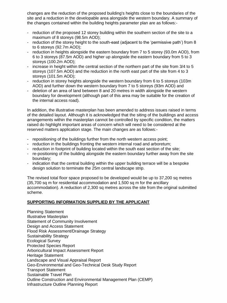
changes are the reduction of the proposed building's heights close to the boundaries of the site and a reduction in the developable area alongside the western boundary. A summary of the changes contained within the building heights parameter plan are as follows:- - reduction of the proposed 12 storey building within the southern section of the site to a
maximum of 8 storeys (98.5m AOD); - reduction of the storey height to the south-east (adjacent to the ‘permissive path’) from 8
to 6 storeys (92.7m AOD); - reduction in heights alongside the eastern boundary from 7 to 5 storey (93.0m AOD), from
6 to 3 storeys (87.5m AOD) and higher up alongside the eastern boundary from 5 to 3 storeys (100.2m AOD);
- increase in height within the central section of the northern part of the site from 3/4 to 5 storeys (107.5m AOD) and the reduction in the north east part of the site from 4 to 3 storeys (101.5m AOD);
- reduction in storey heights alongside the western boundary from 6 to 5 storeys (103m AOD) and further down the western boundary from 7 to 5 storeys (93m AOD) and
- deletion of an area of land between 8 and 20 metres in width alongside the western boundary for development (although part of this area may be suitable for the creation of the internal access road).
In addition, the illustrative masterplan has been amended to address issues raised in terms of the detailed layout. Although it is acknowledged that the siting of the buildings and access arrangements within the masterplan cannot be controlled by specific condition, the matters raised do highlight important areas of concern which will need to be considered at the reserved matters application stage. The main changes are as follows:- - repositioning of the buildings further from the north western access point; - reduction in the buildings fronting the western internal road and arboretum; - reduction in footprint of building located within the south east section of the site; - re-positioning of the building alongside the eastern boundary further away from the site
boundary; - indication that the central building within the upper building terrace will be a bespoke
design solution to terminate the 25m central landscape strip. The revised total floor space proposed to be developed would be up to 37,200 sq metres (35,700 sq m for residential accommodation and 1,500 sq m for the ancillary accommodation). A reduction of 2,300 sq metres across the site from the original submitted scheme. SUPPORTING INFORMATION SUPPLIED BY THE APPLICANT Planning Statement Illustrative Masterplan Statement of Community Involvement Design and Access Statement Flood Risk Assessment/Drainage Strategy Sustainability Strategy Ecological Survey Protected Species Report Arboricultural Impact Assessment Report Heritage Statement Landscape and Visual Appraisal Report Geo-Environmental and Geo-Technical Desk Study Report Transport Statement Sustainable Travel Plan Outline Construction and Environmental Management Plan (CEMP) Infrastructure Outline Planning Report

REPRESENTATIONS 2 letters of support, one subject to the creation of a new footpath link to Hoopern Lane and one supporting the accommodation of students in one designated place rather than spread all over the city in small multiple occupancy houses. 310 letters of objection in total. This figure of 310 includes objections both pre (147) and post (163) revised plans received. For information this includes 79 additional comments from the same objector. Principal concerns raised:- 1. Overdevelopment of the site, unreasonably high density for the campus/City; 2. Projected student numbers may be inaccurate as they are dependent on national and
international political and economic changes; 3. Increased student numbers should not be relied on; 4. City is too over-dependent on the University; 5. Already too much student accommodation in the City, no need for any more; 6. Introduction of an ‘urban feel’ into an area of open space; 7. Negative change to character of the area particularly with the introduction of such tall
buildings; 8. 12 storey building will be detrimental to the landscape setting of the campus, it will
appear as a blot on the landscape/ an eyesore/out of keeping within the area/too large scale/too dominant/unsympathetic;
9. Height of the building will obstruct views of the surrounding landscape/City; 10. Inadequate information in respect of the heights of the buildings; 11. Existing tall buildings within the campus are not good examples of landmark buildings
and therefore should not provide a justification for more; 12. All proposed buildings are too high and should be reduced in height; 13. Increased student numbers will put further pressure on the local residential roads for
parking, particularly in the Pennsylvania area; 14. Pressure from student parking will create a traffic hazard to existing roads; 15. University should provide adequate parking for students on campus; 16. Development would be served by narrow and unlit roads; 17. Need to improve cycle routes in the area; 18. Increased pressure on existing roads from construction vehicles; 19. Inadequate car parking provision for future students; 20. Development should be provided on a brownfield not a greenfield site; 21. Significant environmental damage to an area of high amenity value; 22. Development would detract from the ‘park like setting’ of the University campus; 23. Scale and density of the development detrimental to the ecological, amenity and
landscape setting of the area; 24. Development would adversely affect the visual landscape of the City; 25. Loss of habitat/damage to the biodiversity of the area; 26. Detrimental impact on existing wildlife within the site and the surrounding areas such as
badgers, foxes, dormice slowworms, bats, kingfisher, heron, egret, owls mistle thrushes; song thrush and bullfinches;
27. Loss of green wedge/’lung’ within the City’s landscape 28. Detrimental impact on a site of Local Interest for Nature Conservation close or adjoining
a Site of Nature Conservation Importance (Hoopern Valley) Belvidere Meadow, Taddiford Brook County Wildlife site, Duryard Valley Park County Wildlife site, Pennsylvania Conservation Area and the University campus as a Historic Park and Gardens;
29. Inadequate consideration of the 12 storey building's impact on the historic assets in the area, including Pennsylvania Park conservation area and its associated grade II* listed building and Lopes Hall, a grade II listed building;
30. Potential damage to existing trees; 31. Loss of trees to create access roads into the site; 32. Detrimental impact on the existing Holm oaks within the site; 33. Loss of access to existing open space;

34. Removal of natural eastern buffer zone between University and existing houses in Pennsylvania;
35. Noise pollution from students, particularly late at night, will increase with the residential blocks being located closer to existing residents,;
36. Light pollution and its detrimental impact on nearby residents and wildlife; 37. Overlooking and loss of privacy given the proximity of student blocks to existing houses; 38. Due to proximity, scale and massing the development would have an overbearing effect
upon residents living in Hillcrest Park, Higher Hoopern Avenue and Pennsylvania Road; 39. Site is poorly related to the existing campus and City; 40. Loss privacy to uses of the permissive path; 41. Loss of agricultural land; 42. Risk of pollution/environmental damage to the adjacent ponds; 43. Potential increased of flooding from water runoff from the site; 44. Loss of views from the pond side and Green Circle walk; 45. Landscape central strip should not be terminated by a 3/4 storey building; 46. Site should be used for academic building as required by the University 2010
masterplan, which envisaged low rise academic buildings rather than residential blocks; 47. Contrary to masterplan as it states that buildings should be between 2 and 4 storeys in
height; 48. Inadequate justification in respect of the increase in buildings from 26,000 sq metres in
the masterplan to 39,500 sq metres now being proposed; 49. Need for more academic building not residential accommodation; 50. Loss of area for academic buildings will put pressure on other areas of the campus and
beyond for additional land to build on; 51. Development would remove a valuable area of amenity space which provides health and
welfare benefits for students and the local community; 52. Lack of amenity space within the site for future student use; 53. High rise accommodation will have an adverse effect on the health and academic
achievement of students living there; 54. Increased traffic during construction will be harmful to residential amenities due to noise,
dust and vibration; 55. Inconvenience caused to local residents during the construction phase; 56. Provision of student accommodation of this scale will potentially damage the private
rental housing market; 57. Additional pressure on existing service infrastructures eg gas, electricity, water and
sewage system and emergency vehicles; 58. Concern that development will lead to pressure in the future to access the site from
Higher Hoopern Lane; 59. Need to ensure that there is no vehicular access from Pennsylvania Road or Higher
Hoopern Lane; 60. Existing paddock (adjacent to the application site) should be retained and not used as a
construction compound, material storage or construction vehicle parking; 61. Loss of quiet space within the City; 62. Increase in litter and graffiti in the area; 63. Insufficient information has been provide given the submission is illustrative only; Specific comments received following the balloon test on 16 November:- 64. Inadequate number of balloons which failed to accurately show the extent of the
development, a further balloon test should be carried out; 65. Additional balloon(s) should have been sited within the centre of the site to indicates the
6 storey buildings, this omission failed to show the impact the buildings would have on residents living in Pennsylvania;
66. Balloons were not left up long enough and therefore a proper assessment could not be made;
67. Strength of wind on the day reduced the overall height of the balloon and therefore height misrepresentative.
68. Balloon test clearly highlights the detrimental impact the height of the development will have on the surrounding area, particularly in response to the balloon representing the 12 storey building.
163 additional issues received after amended plans received:- 69. Reiterate previous objections raised, notwithstanding the changes made; 70. Revised plan do not address issues raised; 71. Concern that plan indicate that some buildings will be increased. CONSULTATIONS County Head of Planning Transportation and Environment comment that from a Highway view, the provision of students flats on campus represents a highly sustainable development that is unlikely to create any significant highway issues. It is essential that the secure cycle parking, in accordance with the standards set out in the Exeter City Council Sustainable Transport Supplementary Planning Document are achieved and the provision of these facilities should be secured by condition. On-site facilities should be provided to cater for student pick up/drop off at the end of term; this is felt to provide adequate provision. The applicant is advised that the peak periods of student pick up/drop off should be carefully managed to make best use of these spaces. Prince of Wales of Road is a classified road and the long construction period (& demolition) will need to be carefully managed to ensure the impact of these is minimised. It is therefore recommended that a condition for a Construction Traffic Management Plan (CTMP) is attached in the granting of any permission and the applicant is advised to liaise with the Highway Authority prior to commencement. The submitted plans indicate a pedestrian/cycle route linking the campus to Higher Hoopern Lane in the vicinity of Higher Hoopern Farm. The provision of this route is part of the Masterplan Framework SPD and should kept open through condition. The plans also show an existing pedestrian route through the valley, past Hoopern ponds, that links the campus to Pennsylvania Road. It is understood that this is a permissive route only and not a right of way. Therefore it is recommended that the applicant should, if possible, keep this existing pedestrian link open at all times, ensuring good pedestrian access to the east of the site. The Highway Authority intends to review the parking arrangements in this area of the city and the development proposals have potential to influence any strategy. Although management plans may stipulate no cars for students it seems difficult to police and in all likelihood some students would park on nearby residential streets, exacerbating existing issues. Therefore, to help address this, a contribution of £20,000 towards a review of the existing residential parking zones, making and implementing traffic orders is requested. The assessment of the contribution is informed by recent residents parking schemes within the City and includes costs associated with technical design, Traffic Regulation Orders and physical road markings/signing. Were the application to be approved, this contribution should be secured prior to commencement. Subject to the above conditions regarding on site facilities, residents parking review contributions, CTMP and the exploration of a pedestrian/cycle linking the campus to Higher Hoopern Lane (as indicated in the Master Plan Framework SPD) being attached in the granting of any planning permission, no objection. Historic England comment that the application should be determined in accordance with national and local policy. Natural England comment that the proposal is unlikely to affect any statutory protected sites or landscapes; impact on protected species is a material consideration in the determination of the application, LPA should consider the site in respect of Local Wildlife Sites, Regionally Important Geological/ Geomorphological Sites (RIGS) or Local Nature Reserves (LNR). In addition, Natural England highlight the importance of incorporation of green infrastructure into the development, opportunity for features to be incorporated into the design which are

beneficial for wildlife, such as the incorporation of roosting opportunities for bats or the installation of bird nest boxes and the '...opportunities to enhance the character and local distinctiveness of the surrounding natural and built environment; use natural resources more sustainably and bring benefits for the local community, for example through green space provision and access to and contact with nature.' County Flood Risk Officer raises objection to this application because it is not believed that it satisfactorily conforms to Policy CP12 (Flood Risk) of the Exeter Core Strategy and Policy EN3 and EN4 of the Exeter Local Plan which requires all development proposals to mitigate against flood risk and utilise sustainable drainage systems, where feasible and practical. The applicant will therefore be required to submit additional information to demonstrate that all aspects of the surface water drainage management have been considered. (Further information has been submitted by the applicant and is currently being considered by the Flood Risk Officer). South West Water comment on need to contact SWW if the development is located within three metres of the public sewer which crosses the site or if a diversion of the sewer is required. Having reviewed the information submitted in respect of the proposed surface water disposal for the development it is considered that the method proposed to discharge into the ground (infiltration) is acceptable and meets the Run-Off Destination Hierarchy. In addition, attention is drawn to the Local Plan policy to limit the adverse (including cumulative) effect of the proposed development such that sustainability is paramount and flooding risk is not increased elsewhere. Council's Drainage Officer recommends that further information be provided to highlight what measures are proposed to address risks of the potential for flooding downstream of the development site. Environmental Health Officer raises no objection subject to the imposition of suitable conditions in respect of a construction environmental management programme (CEMP); contaminated land report; noise assessment; air quality assessment and detail of external lighting details. Devon Wildlife Trust comment that whilst the report has proposed mitigation measures to minimise impacts on these species, it is felt that these might be compromised by the close proximity of the envisaged buildings to the western, southern and eastern boundaries as shown in the illustrative masterplan. This plan illustrates that it might be difficult to control light spill and human disturbance to surrounding habitats and species. It is therefore suggested that the Master Plan be amended to show a wide buffer area of wildlife friendly habitat, separating buildings from the western, southern and eastern site boundaries, in order to allow scope for the avoidance of disturbance to legally protected species. In response to the revised Land Use Parameter Plan and revised Landscape and Biodiversity Strategy Plan, which show the development zone moved away from the western field boundary is welcomed. However the southern and eastern boundaries have not been addressed and the Trust would like to see a wider buffer area of wildlife friendly habitat, separating buildings from these boundaries, in order to allow scope for the avoidance of disturbance to legally protected species. RSPB raise no objection subject to the imposition of a condition requiring the incorporation of swift boxes into the buildings. Devon and Cornwall Police Liaison Officer - views awaited Devon and Somerset Fire Service - views awaited Heritage Officer comments that although there have previously been finds of prehistoric material in this area, principally to the west, the geophysical survey does not identify any
substantial remains such as enclosures or ring ditches within the site, although there remains the possibility of other, slighter remains, being present. A number of clusters of possible pits have been identified by the survey, although it is noted that some at least of these may have a natural or agricultural origin. As no substantial remains have been identified by the survey, there is no proportionate need for site evaluation at this stage and therefore sufficient information on heritage issues has been submitted to enable determination of the application and there are no archaeological constraints on the principle or layout of the proposed development. However, due to the potential for slighter remains to be present there will be a need for archaeological trial trenching to confirming the results of the survey and to identify any slighter remains that are not capable of identification by the latter and potentially also for the archaeological excavation and recording of any such remains prior to destruction by the ground works for the development. This should be ensured by attaching the standard archaeological condition. PLANNING POLICIES/POLICY GUIDANCE Central Government Guidance - National Planning Policy Framework 4. Promoting sustainable transport 6. Delivering a wide choice of high quality homes 7. Requiring good design 8. Promoting healthy communities 11. Conserving and enhancing the natural environment 12. Conserving and enhancing the historic environment Plan making Decision making Exeter Local Development Framework Core Strategy CP1 - Spatial Approach CP4 - Density CP5 - Student Accommodation Relevant text states that:- The supply of housing should meet the needs of all members of the community such that: - all major development (10 or more dwellings) should include a mix of housing informed by
context, local housing need and the most up to date Housing Market Assessment; - purpose built student accommodation should be provided to meet the housing need. CP9 - Transport CP10 - Meeting Community Needs CP11 - Pollution CP12 - Flood Risk CP13 - Decentralised Energy Networks CP14 - Using Renewable and Low Carbon Energy in New Development CP15 - Sustainable Construction CP17 - Design and Local Distinctiveness Exeter Local Plan First Review 1995-2011 AP1 - Design and Location of Development AP2 - Sequential Approach E4 - Exeter University Campus The development of education uses, student housing and research and development initiatives, including ancillary production, will be permitted on the University of Exeter campus provided that the character and setting of the campus is protected. H5 - Diversity of Housing Relevant text- Student housing will be permitted provided that:

a) the scale and intensity of use will not harm the character of the building and locality and will not cause an unacceptable reduction in the amenity of neighbouring occupiers or result in on-street parking problems; b) the proposal will not create an overconcentration of the use in any one area of the city which would change the character or the neighbourhood or create an imbalance in the local community; d) student accommodation is located so as to limit the need to travel to the campus by car T1 - Hierarchy of Modes T2 - Accessibility Criteria T3 - Encouraging Use of Sustainable Modes T10 - Car Parking Standards C1 - Conservation Areas C2 - Listed Buildings C3 - Buildings of Local Importance C4 - Historic Park and Garden C5 - Archaeology EN2 - Contaminated Land EN3 - Air and Water Quality EN4 - Flood Risk EN5 - Noise DG1 - Objectives of Urban Design DG2 - Energy Conservation DG4 - Residential Layout and Amenity DG6 - Vehicular Circulation and Car Parking in Residential Development DG7 - Crime Prevention and Safety LS1 - Landscape Setting LS4 - Local Nature Conservation Designations Development Delivery Development Plan Document (Publication Version) 2015
This document represents a material consideration but has not been adopted and does not
form part of the Development Plan.
DD1 - Sustainable Development DD12 - Purpose Built Student Accommodation This policy seeks to protect residential amenity and to ensure that purpose built student accommodation is fit for purpose: Purpose built student accommodation will be permitted provided the proposal: a) respects, and contributes positively towards, the character and appearance of the area; b) does not result in unacceptable harm to the amenity of neighbouring residents; c) provides sufficient internal and external space for future occupiers; d) makes appropriate provision for refuse storage, operational and disabled persons parking, servicing and cycle parking; e) reduces the need to travel and would not cause unacceptable transport impacts; and, f) is accompanied by a suitable Management Plan secured by planning obligation to demonstrate how the property will be managed in the long term. DD13 - Residential Amenity DD20 - Sustainable Movement DD21 - Parking DD25 - Design Principles DD26 - Designing Out Crime DD28 - Heritage Assets DD29 - Protection of Landscape Setting Areas DD30 - Green Infrastructure DD31 - Biodiversity DD32 - Local Energy Networks
DD33 - Flood Risk DD34 - Pollution Exeter City Council Supplementary Planning Documents:- Archaeology and Development November 2004 Sustainable Transport March 2013 Development Related to the University June 2007 Houses in Multiple Occupation (including Class C4 Uses) January 2014 Planning Obligations April 2014 University of Exeter Masterplan Development 2010 Trees in relation to Development September 2009 Residential Design Guide September 2010 Pennsylvania Conservation Area Appraisal and Management Plan May 2005 The site is identified as being within the University Campus and as a Site of Local Interest for Nature Conservation Importance. The site forms part of the University's designation as an Historic Park and Garden Exeter University's Estate Strategy OBSERVATIONS A development of this magnitude requires careful consideration as it will have a significant impact on the immediate character and appearance of the area both within context of the University Campus and the City as a whole. It is understandable that the application has attracted a large number of objections from local residents and the wide ranging issues they raise require individual assessment. The site represents one of the largest areas identified for development within the University campus and it is accepted that its impact will be felt not only on campus but from outside the University boundaries and in particular the adjacent residents living within the Pennsylvania area. The report will address the principle of the site's development and use within the context of national and development plan policies in addition to considering more site specific matters such as the siting and heights of buildings, their use, impact on the landscape, trees, wildlife, access arrangement, parking provision, residential amenity, heritage assets, flooding and sustainable construction.
Development Plan background The National Planning Policy Framework (NPPF) states in paragraph 11 that:- ‘planning law requires that applications for planning permission must be determined in accordance with the development plan unless material considerations indicate otherwise’. It is therefore important to consider the development plan background against which this application is assessed. It is accepted that the creation of purpose built student accommodation on campus represents a sustainable form of development and therefore as stated in paragraph 14 of the NPPF that there ‘... is a presumption in favour of sustainable development which should be seen as a golden thread running through both plan –making and decision making…for decision-taking this means: approving development proposals that accord with the development plan without delay’. The following paragraphs provide an outline of the relevant development policies relating to this application. Based on these policies it is considered that the principle of development on this site is acceptable. Core Strategy The Core Strategy 2012 states CP5:‘The supply of housing should meet the needs of all members of the community such that ‘…’purpose built student accommodation should be provided to meet the housing need.’ The accompanying text (para 6.28) states that the University envisages about 3,300 additional full time living away from home students from 2010/11 to 2025/26 ‘The University’ aim to provide housing for all full-time students who want it is supported because it will ease pressure on existing family housing. 75% or more of additional student numbers should be accommodated in purpose built student housing. New purpose built housing should be located on, or close to the University Campuses…’
Exeter Local Plan First Review Development of East Park featured in the Holford Report 1971 and the site has been identified as part of the development area of Streatham Campus in Council planning policies since the Exeter Local Plan First Alteration 1993. The current Exeter Local Plan First Review 2005 identifies East Park as subject to Policy E4: ‘The development of education uses, student housing and ancillary research and development initiatives, including ancillary production, will be permitted on the University of Exeter Campus provided that the character and setting of the Campus is protected.’ Development Delivery Development Plan Document The publication version Development Delivery DPD July 2015 (not part of the development plan) states (para 3.27): ‘The Council will encourage the provision of further purpose built student accommodation at Streatham Campus through the review of the masterplan. By maximising the number of additional students accommodated in purpose built student housing, further adverse impacts on the private housing market can be minimised.’ Policy DD12 seeks to protect residential amenity and to ensure accommodation is fit for purpose. University of Exeter Streatham Campus Master Plan Framework A Streatham Campus Master Plan supplementary planning document was adopted by the City Council in 2010 following public consultation. It was prepared in the context of the University’s 2006-16 Estates Strategy to provide guidance and inform decisions on the Forum and INTO buildings and the provision of about 2,063 student bedrooms at Duryard, Birks and Lafrowda that opened between 2010 and 2012. In that context of about 2,063 bedrooms coming forward, the masterplan reserved on-campus sites primarily for further academic expansion, with East Park expected to be a long term site. However, the City Council did flag up that there might be a need to consider at a later date whether some of the land identified for future development on campus should be devoted to more student housing. The masterplan identified indicative potential for about 52,000-68,000 sq m of new buildings on campus assuming 3-4 storeys of which 19,800-26,400 sq m was at East Park (an indicative footprint of 6,600 sq m). Need for student accommodation Objectors to the scheme have commented that there are already too many purpose built student flats and there is no need for further accommodation of this type in the City. Core Strategy Policy CP5 provides the strategic context which supports additional student accommodation to meet housing need and as part of an adopted development plan policy represents an important material consideration. In addition, current statistics which are outlined below support the need for further student accommodation. The University’s new Estates Strategy 2016-26 is a material planning consideration. This strategy envisages that student numbers (FTE) in Exeter will increase by 1,674 from 18,129 at December 2015 to 19,803 by 2020/21. After allowing for part time and live at home students, accommodation for about 1,423 is required to 2020/21. About 28,000 sq m of academic buildings will be required over the entire period to 2026 (including Cornwall), a total that can be accommodated at Streatham and St Lukes campuses without use of East Park. The 75% target in the Core Strategy is monitored from a base of 2006/7, the start of the period covered by the Core Strategy. After allowing for part time and live at home students the number of students in Exeter needing accommodation has increased from 8,908 at 2006/7 to 15,311 at 2016/17 (estimate) an increase of about 6,400 and a 75% minimum target of about 4,800. About 5,000 bedspaces have been provided (c78%) in that period so it has been met. It is desirable that performance should be closer to or over 100% to address community imbalance. There are existing planning consents for a substantial commitment to additional student bedrooms (mainly at Bus Depot, Renslade House & ECFC). Proposals for about 1,220 student rooms at East Park and about 100 each at Spreytonway and Moberley (net) would enable provision of a further 1,420 bedspaces. Development of significant further student
accommodation at East Park is necessary to ensure good performance against the target of 75% or more of students in purpose built student accommodation to meet University aspirations that first year and overseas students have the opportunity of a campus experience and to reduce the impact of students imbalancing communities in popular student areas. Use of the site for student accommodation Objections have been received in respect of use of the site for student accommodation rather than for academic purposes, which was proposed in the University’s 2010 Masterplan. Whilst at the time of this document's publication that was the University’s intention, it does not render the site unsuitable for residential use. When the Council approved the masterplan in December 2010 it was particularly concerned to ensure that sufficient purpose built student accommodation continued to come forward. The existing campus layout has the academic and social/administration buildings located within central areas with purpose built student accommodation concentrated to the western and eastern boundaries. The application would continue this established approach and therefore is considered appropriate, subject to matters of detail in respect of existing landscape features and residential amenities being considered. As previously stated the masterplan still allows for significant academic building expansion within the University campus. Although the masterplan represents a relevant material consideration, the proposal still needs to be assessed in respect of other development plan policies as required by paragraph 196 of the National Planning Policy Framework unless other material considerations indicate otherwise. A legal interpretation of this point was made clear in the High Court. In his judgment of 31 July 2000 (R v Rochdale Metropolitan Borough Council ex parte Milne), Mr Justice Sullivan concluded as follows: ‘…I regard as untenable the proposition that if there is a breach of any one Policy in a development plan a proposed development cannot be said to be “in accordance with the plan”… For the purposes of Section 54A, it is enough that the proposal accords with the development plan considered as a whole. It does not have to accord with each and every policy therein’. This Rochdale judgment concludes that a decision must therefore be reached as to whether the application is in accordance with development plan when it is considered as a whole. It is therefore necessary to balance the relevant policies as to whether the proposal complies or breaches the development plan as a whole and against other material conditions. In this instance, Core Strategy Policy CP5 and more specifically Local Plan First Review Policy E4 which encourage the further provision of purpose built student accommodation on the University campus are relevant and need to be balanced against the contents of the University's masterplan. It is a necessary and accepted planning practice that where planning policies conflict, a balanced decision has to be made, based on all relevant planning considerations. Need for an Environmental Impact Assessment Residents have expressed concern that the application was not accompanied by an Environment Statement in accordance with Environment Impact Assessment (EIA) regulations. The local planning authority has provided a screening opinion that concludes that an EIA in this instance is not required. Whilst the proposal requires significant supporting documentation, which has been provided, to make an appropriate assessment in the context of this planning application, it is important to note that the site has previously been identified for development in both the Exeter Local Plan First Review and the University’s Masterplan. It is not a site where development is unexpected and consequently the assessment needs to consider the type of use within the University’s defined campus and the form of development (quantum and form including height of development) in addition to the other material planning consideration. In addition, Members are advised that the Planning Practice Guidance ‘Environmental Impact Assessment’ states that ‘only a very small proportion of Schedule 2 development (which this development falls within) will require an assessment…’. The Guidance goes onto state that it is for the local planning authority to consider whether a proposed development requires an Environmental Impact Assessment. Impact on the landscape The application seeks outline planning permission and consequently detailed layout and building design issues are for future consideration. However the application's description

does refer to a quantum of development of 37,200 sq metres (35,700 for residential use and 1,500 sq m ancillary accommodation) and it is therefore necessary for the applicant to provide a certain level of detail to assess whether this is a realistic quantum of development. It is important to establish limits to the developable area given the site's relationship to existing areas of landscaping surrounding the site and residential properties to the east and north. In addition, the sloping nature of the site requires careful attention as the scheme intends to build up to 8 storeys in height. It is acknowledged that the University's Masterplan anticipated between 3 and 4 storeys for the site, although it did recognise that ‘…some taller buildings would be appropriate in this location to identify the heart of the new development and to form the potential terminus of views along North Park Road and Rennes Drive’. The submitted Landscape and Visual Appraisal provides a detailed study of views both of and from the site. It is accepted that ‘…the extent of visibility of the site is largely determined by the local topography but the mature trees in the campus and in the surrounding residential areas of Exeter also play an important role in restricting views as does the surrounding built development’ as stated in the Appraisal. In particular it acknowledges the importance of the development in respect of Exeter Local Plan First Review Policy LS1 ‘landscape setting areas' comprising of the Taddiford and Higher Hoopern Pond valleys although no development will be in this designated area except for access purposes. The study summaries the impact of the development as being visible from within the campus and immediate surrounding areas but seen as an extension to the University campus. The Appraisal comments that the development will be in part visible from Higher Hoopern Lane but the principal features of the Haldon Hills, Exe Estuary and Cathedral will not be obstructed. The supporting planning statement states that the scheme has been ‘…landscape led, with considerable thought given to the visual effects of the scheme’. The design has used the contours of the site to create distinct rows of development and the reduction in heights of the buildings as development extends up the slope seeks to ensure that the buildings do not break the skyline or prevent views of the distant landscape and the city. The supporting sectional drawings and illustrative masterplan indicate how this could be achieved. However it is inevitable that a development of this scale will have a major impact on the character and appearance of the area and therefore it is important to minimise, where possible, its impact on important features or uses adjoining the site. Consequently changes have been made to the original submission to limit the extent and height of development within the site. A summary of the changes made are contained within the description of the site section of this report. In general they show a reduction in the heights of buildings closest to the boundaries of the site, particularly next to the arboretum area, which is recognised as an important landscape feature on the campus and the south and eastern of the application site closest to pedestrian routes and existing properties in Pennsylvania. The design approach which seeks to provide taller buildings more centrally within the site is consistent with the aims of the University Masterplan. It is acceptable that even though building heights have been reduced, in some instance significantly from 12 to 8 storeys and from 6 to 3 storeys, they will still create an urban feel to this currently open site. Whilst the supporting sectional drawings indicate that the building will be set within the context of this sloping site, a condition which limits the heights of buildings to that specified within the ‘building heights parameter plan’ will be needed to ensure that future reserved matters take account of this issue. This condition will also establish the extent of the developable area when the detailed layout is considered. In summary, it is considered that the parameter plan as now submitted, which includes a 25 metres landscape strip within the site, would present an appropriate area for development without the demonstrably affecting the landscaped setting of the surrounding area. Whilst it is accepted that the character and appearance of the area will be substantial altered, this should be viewed within its context as a development site on the University campus and acknowledged within the adopted University masterplan and Exeter Local Plan First Review. Impact on trees/ecology/nature conservation issues The submitted arboricultural report and survey indicates the removal of some existing trees principally within the centre of the site and to the west to facilitate the construction of the two

access roads into the site and the internal road. It is however notable that this survey seeks to retain the two groups of mature oaks to the south and east of the site as shown on the illustrative masterplan which is welcomed. It is accepted that the main access roads will inevitably lead to some loss of vegetation, its impact is not significant and the submitted survey clearly shows that suitable consideration has been given in the form of root protection areas to the retained trees to ensure that the impact on the existing landscape is minimal. However it is not accepted that the trees/hedges along the western boundary identified for removal will necessarily be required as a result of this development. The siting of the internal access roads is not fixed and therefore it is considered that further detailed assessment of how this should be achieved is required. Accordingly although the relatively small number of trees to be removed is welcomed, the details contained within the arboricultural survey at this stage is for information only and a condition stating that no trees shall be felled on the development site is imposed until the detailed building and access routes are known, as part of the reserved matters application. Protected Species/ecological enhancements A Phase I Ecological Survey and Protected Species Survey accompanied the application and an updated version dated November 2016 includes survey result in respect of dormice. The report concludes that populations of badgers, dormice, reptiles and bats were found to be present within the site. Consequently mitigation measures are required to compensate the potential harm to these species or loss of their habitat, as a result of this development. In particular, it was identified that although no badger setts were found within 30 metres of the development site, the arable field provides foraging areas. It would therefore be necessary to ensure that badgers continued to be able to move along the boundaries of the site and connect to adjoining fields to the north of the site for foraging purposes. The presence of 11 species of bats were mainly recorded along the wooded edges of the site and the above existing ponds. These areas are mainly identified for retention and therefore the bat’s main feeding areas would be unaffected. However it was recommended that native planting could provide further foraging habitat for bats and lighting levels within the site should be minimised. Common dormice were found within the site and as a European Protected Species will require a separate licence from Natural England before works could commence. The report identified that in order to mitigate the potential risk to dormice a number of measures would be required including a phased clearance of the site during certain times of the day/year and additional habitat and nest boxes should be provided in suitable locations alongside the site. Like dormice whilst the survey found that the presence of reptiles (slowworms and grass snakes) was low, effective mitigation would be required in respect of phased clearance of site and suitable habitat and hibernation areas would need to be provided. In addition to the mitigation measures outlined above it is considered that general ecological enhancement should be incorporated into the overall scheme. This could be address through the imposition of a planning condition to include provision of bird and bat boxes, planting of native species, wildflower mix species and potential for a new wildlife pond. Whilst the comments of the Devon Wildlife Trust are noted regarding the need for wider wildlife buffers to the south and eastern boundaries, it is considered that the mitigation measures required by this condition would effectively address these concerns. Design Review Panel comments In accordance with advice provided by the National Planning Policy Framework and Planning Practice Guidance ‘Design’ the applicant has sought the advice of the Devon and Somerset Design Review Panel prior to the submission of the planning application. This guidance states that local planning authorities are required to have regard to the recommendations of the Design Review Panel in assessing applications. The Panel concluded that although they welcomed the aspiration of the proposal which focused on landscape and ecological considerations they were not supportive of the design presented in its current form. In particular they considered the gateway building too high; the scheme needed to provide a greater sense of community; the upper open space should be better incorporated into the layout; improvements needed to pedestrian access through the site; attention to impact of external lighting; incorporation of mature landscaping and need for district heating. It is accepted that the illustrative layout as submitted is similar in its overall approach to that

considered by the Panel and therefore could be argued that the design has not materially changed. However it is important to acknowledge that the application is in outline with all matters reserved. The Panel did comment that greater micro level analysis may help to make the proposal more site specific and create a better sense of character and place. The applicant has been made aware that the submitted layout does not constitute an approved plan and the factors raised by the Panel may result in a different approach being needed for the reserved matters submission. In particular the need for greater integration of landscape with the scheme and the need for a more distinctive design will be necessary to ensure that the overall development does not appear too uniform as commented on by the Panel. Given the significant number of resident objections to the proposed heights of buildings it is should be noted that the Panel commented that method used by the applicant to determine heights was considered a good approach and it was only the gateway building identified as being too high. The gateway building has subsequently been removed from the scheme. Vehicular Access This outline application seeks to reserve all matters for future consideration. However indicative vehicular access points are proposed to the north western and south western corners of the site. Whilst the creation of these access points would lead to some loss of trees and the construction of roads though an area of a landscape setting, as designated in the Exeter Local Plan First Review, its impact on the landscape quality of the area is considered minimal. The access roads are necessary for the development of the application site and therefore acceptable in respect of Policy LS1 as they represent infrastructure which would not unduly harm the character of the area. Given the site is identified for development within both the Local Plan and the University Masterplan it is inevitable that vehicular access will be required and its location to the western side of the site and closest to the University campus is therefore considered appropriate. Acceptance of the access points in these locations will ensure that no vehicular access is created to the northern and eastern side of the site, which are wholly residential in character and consequently the level of potential disturbance from vehicular traffic which could be created by this development would be minimised. Although indicative road and pedestrian layouts are shown on submitted plans, they are for illustrative purposes only and do not require detailed consideration at this stage. These plans do however provide an indication as to how the floor space applied for could be accommodated within the site. Consequently concern was been raised in connection with the original submission regarding the proximity of the indicative internal road arrangement to the western boundary closest to the arboretum and existing mature trees and hedges. This has resulted in the submission of a revised development parameter plan which redefines the developable area in this location. It is proposed to condition this plan which will ensure that this issue is given sufficient weight when the detailed layout plans are submitted. Construction and Environmental Management Plan On a related matter local residents have raised concern about the level of disturbance which would occur from the development during the construction phase from vehicles entering and leaving the site during re-profiling of the site, delivery of materials, construction of essential infrastructure and ultimately the buildings themselves. In particular residents to the north of the site are concerned that Higher Hoopern Lane could be used for construction access purposes. Whilst an outline Construction and Environmental Management Plan (CEMP) has been submitted with the application this does not provide sufficient detail in respect of construction vehicles routes and therefore it is considered that a specific condition be imposed to address this matter. It is logical that the two new access points created from the campus would be used for this purpose, as indicated in the outline CEMP, submitted with the application. In addition, a condition requiring the submission of a detailed CEMP is required to ensure that environmental issues raised by residents, such as the location of material storage, hours of working, dust, mud on the road noise etc are addressed prior to commencement of works and once details of the infrastructure and buildings are known. In response to a particular concern raised regarding the possible use of the land immediately alongside Higher Hoopern Lane for construction/storage purposes, as this land lies outside the application site boundary it could not be used for this purpose without the submission of a

separate planning application. It is understood from the applicant that it is not their intention to use the land for this purpose. Parking Many residents have raised objections to the scheme in respect of parking and access problems caused by student vehicles which they currently experience. Residents are concerned that the significant increase in student numbers and therefore the potential for students to bring cars with them to University will exacerbate the problem. The University Sustainable Travel Plan seeks to discourage students from bringing private cars to the campus and imposes a policy that no student parking is allowed on the campus other than for disabled parking. The proposed scheme would continue this policy and no parking will be provided on site except for the disabled, deliveries and servicing requirements. The campus location will enable the site to take advantage of sustainable transport and help address the targets contained within the University’s Sustainable Travel Plan which includes the aim to reduce reliance on private car travel. It is inevitable that cars will access the site at times of student arrival and departure and it is considered that the imposition of a legal agreement requiring a Student Management Plan will adequately address this issue. The applicant has provided some details as to how this would operate within the submitted Transport Statement. However of more concern is the potential for students to permanently keep their cars within the residential areas surrounding the University during term time. The University has responded that it is beyond their control to effectively ‘police’ student's vehicles being parked legally in nearby residential streets and it does not consider that a restriction imposed on each student which precludes them from keeping vehicles within the area would be legally enforceable. Whilst it is considered that the sites on campus location will deter students from bringing their own car, more effective control can be provided through the imposition of a Traffic Regulation Order, which has been recommended by the County Highway Officer. It is considered that a financial contribution of £20,000 is made by the applicant prior to the commencement of development towards a review of the existing residential parking zones, the making and implementation of traffic orders and meeting the costs associated with technical design and physical road markings/signing. Although the lack of a further measures from the University to address this issue is disappointing, it is recognised that their Sustainable Travel Plan does make a commitment towards sustainable travel for its students and the acceptance from the County Highway Officer in respect of a financial contribution towards a Traffic Regulation Order for the surrounding residential streets does offer a practical measure through which non-resident parking can be controlled. Sustainable transport and cycle parking/routes As previously stated that the County Highway Officer supports the proposal intention to provide only operational and disabled parking spaces on site. However it is considered that in addition to the traffic regulation orders to prevent the potential for displaced student vehicles on adjacent residential streets, there is a need to ensure that sustainable transport measure are implemented to meet the University’s Sustainable Travel Plan. Consequently the Highway Officer has recommended that conditions are imposed to secure cycle parking within the site commensurate with the size of the development and the need for a suitable pedestrian/cycle route linking the campus to Higher Hoopern Lane in the vicinity of Higher Hoopern Farm. This would meet the objectives of the University’s masterplan, which proposes improvements of the strategic cycle routes through the campus and in this instance with Pennsylvania Road. These conditions will ensure that the sustainable methods of transport are supported and encouraged in practical terms. In addition, residents have expressed a wish to retain the existing pedestrian route from the campus past Hoopern ponds to the east which ultimately leads to Pennsylvania Road. However this is a permissive route only and not a right of way which the University has ownership, and therefore cannot be controlled by the planning process. Impact on residential amenity Local residents are understandably concerned about the environmental impact which could potentially arise from the creation of between 1,150 and 1,220 bed spaces to their residential amenity. The issues relating to traffic and parking have previously been addressed and it is

considered that the Construction and Environmental Management Plan will ensure that suitable measures are in place to protect resident’s amenities during the building phase. In addition, the Council’s Environmental Health Officer has recommended conditions on matters relating to the need for a contamination, noise, and lighting assessments and an air quality assessment (if a Combined Heat and Power plant is proposed as part of the detailed scheme) prior to commencement of development. Whilst it is not considered that any of these issues would prevent the development from proceeding, they are important considerations which will inform the detailed design stage and help to mitigate the impact of the future development on residential amenity. It is acknowledged that the scheme would bring student accommodation closer to residential properties and residents have already raised complaints in respect of existing noise and lighting problems they experience. However, it is considered that the distance retained between existing dwellings and the new buildings, in excess of 80 metres, coupled with any mitigation measures which arise from the assessments required by the conditions imposed, would be effective in safeguarding residential amenities in the area. In addition, the requirements of the legal agreement for a Student Management Plan will ensure control of student activity within the site and therefore minimise the potential disturbance to existing residents. Residents living east of the site in Hoopern Avenue and Pennsylvania Road have raised concerns regarding possible loss of privacy due to overlooking from the future occupants of the student buildings. Although the actual siting of the proposed buildings is not known at this stage, the illustrative masterplan indicates that the closest building would be over 80 metres from the nearest existing dwelling and is generally separated by existing mature trees. As previously stated the amended plans have reduced the storey heights of the buildings alongside this eastern boundary and the siting of buildings within the masterplan have been re-orientated to have greater regard to their relationship with existing properties. It is considered that distances retained, coupled with the changes to the orientation of buildings, will ensure that the issue of overlooking is suitably addressed within the detailed reserved matters stage and an acceptable relationship can be created that will not lead to loss of residential amenity. A number of objections have been received in respect of the loss of view across this currently open site. Members are reminded that loss of a private view is not a material planning consideration and cannot justify refusal of the application. However the siting and in particular heights of the proposed buildings have previously been assessed within the context of the site's position within the overall landscape and as a result amendment to the original scheme has been made. Heritage Assets In accordance with advice contained within the NPPF local authorities have a duty to consider heritage assets that may be affected by a proposal. The whole of the University campus site, which includes the application site, lies within a Historic Garden and Park as identified in the Exeter Local Plan First Review and is covered by Policy C4. The policy seeks to prevent loss of features that are integral to the Park’s character or appearance and would detract from its enjoyment, layout or setting. The site is currently an arable field which is identified for development within the University’s Masterplan. The applicant’s design for the site is landscape led, taking account of the relief of the site and the context of the development in its wider landscape setting area, which includes the existing campus. It is acknowledged that the arboretum forms an important element within the historic park designation and the revised plans have resulted in a greater area of land being retained between the built form and this established area of mature vegetation. In addition, the application includes a 25 metres central undeveloped strip which seeks to provide a structural area of open space within the development and help its integration within the surrounding area. Consequently it is considered that the scheme is appropriate within the context of Local Plan Policy C4. The Pennsylvania Conservation Area lies to the east of the site, although a belt of existing mature trees mitigates views to and from the application site to this area. The closest listed

building is Grade II Hoopern House which is approximately 120 metres from the application site boundary. Lopes Hall, which is also Grade II listed, is located approximately 80 metres to the south of the application site and lies within the University campus. Members are advised that their statutory duty in matters of setting of listed buildings and Conservation Areas under Section 72 of the Planning (Listed Building and Conservation Areas) Act 1990 is to give special regard to the desirability of preserving and enhancing the character or appearance of the area and siting of listed buildings. It is considered that the distances from the application site and the presence of existing mature landscape would represent an acceptable relationship between the development and these recognised heritage assets. Further guidance on this issue is contained within NPPF paragraph 134 which states that ‘where a development will lead to less than substantial harm to significance of a designated heritage asset, this harm should be weighed against the public benefits of the proposal, including securing its optimum viable use’. It is considered that paragraph 134 of the NPPF has been properly considered against this development and the application provides the appropriate quantum of development as dealt with elsewhere within this report. Historic England raise no comment to the scheme and state that the application should be considered in accordance with local and national policy. The Council’s Heritage Officer has raised no objection to the application subject to a condition requiring further archaeological works being imposed. Flooding The applicant has submitted a Flood Risk Assessment which states that the site is located within Flood Zone 1, is not within a critical drainage area and has no history of surface water flooding. The report concludes that the drainage proposed for the site through mainly a sealed attenuation facility coupled with a partial infiltration facility would meet national and local policy and offer betterment, alleviating existing flood issues, which occurs as a result of the natural run off and gradient associated with this particular area of land. However both the County and City Flood/Drainage Officer have raised concern about the lack of detail contained within the report in respect of times of high rainfall, lack of mitigation which incorporate SUDS measures and an overall comment that the scheme does not address historical problems of flooding downstream of the site in the Hoopern Valley area and beyond. It is considered that the development of this site and related University land could offer a long term solution, which would help safeguard downstream properties from flooding. This issue has been raised with the applicant who are unwilling to contribute toward further works given that their Flood Risk Assessment concludes that the drainage strategy is appropriate for their site. However further information has been submitted by the applicant’s drainage consultant and is currently being assessed by the County Flood Officer. Members will be updated of the results of these further discussions at the meeting. Sustainable Construction The applicant has submitted a Sustainability Statement which demonstrates their commitment to minimising the environmental impacts of the development. They have confirmed a willingness to accept a condition that requires BREEAM excellent and have stated that they will promote a development which will include passive design measures and low and zero carbon technologies to reduce emissions. It is acknowledged that the detailed design of the future buildings is not known at this stage and no decentralised heating network currently exists in the area. However the need to comply with Core Strategy Policies CP13 and CP15 remain important considerations for the future design and layout of the site. Given the scale and location of development proposed it is considered important that the potential viability and feasibility of a decentralised energy system is considered in the detailed assessment of sustainable design and construction required by policy CP15. It is considered that suitable conditions are required to address these issues. Summary The proposal complies with the development plan policies, which conclude that the principle of the development of this site is appropriate. Whilst it is acknowledged that the use of the site is now for student accommodation rather than for academic buildings, as stated within the University Masterplan, it is considered that the area is suitable for this purpose. Indeed given the recent number of student accommodation schemes submitted in off campus

locations, the proposal for such a significant number of bed spaces within a sustainable location on campus is to be welcomed. It is accepted that the quantum of development proposed is substantial and the proposed building heights to accommodate this would have a considerable impact on the character and appearance of the area. However it is an accepted planning practice that where development is considered acceptable in principle, most efficient use of the land should be sought. Whilst this does not mean that any number of buildings or storey heights proposed would be acceptable, it is considered that the information submitted within the amended plans indicates that a suitable scheme of this scale can be achieved without resulting in overdevelopment or detriment to the landscape setting of the area. This outline application seeks to establish the principle of student accommodation on the site and it will be at the reserved matters stage, which will ensure that the details raised by the numerous objections received, as already highlighted within this report, are dealt with. It is therefore recommended that the application be approved. The application will require a financial contribution of £20,000 towards the delivery of a Traffic Regulation Order for nearby residential areas, which will be included within the Section 106 Agreement. The creation of 37,200 sq metres of student accommodation will equate to £1,899,804 CIL based on 2017 figure of £51.07 per sq metre. In addition, the development will receive New Homes Bonus, although the actual amount will be dependent on the split of cluster flats and studio accommodation, which is not known at this outline application stage. DELEGATION BRIEFING 25 October 2016 - Members were advised that the scheme is for a change from the adopted
University's Masterplan, as this site had previously been identified for academic buildings and not student accommodation as now proposed. Whilst the principle of student accommodation on the University campus was considered appropriate, a number of issues would need to be considered including:- i) it would be important to consider the development’s visual impact given the applicant’s
intended building heights;
ii) the scheme would bring students closer to existing residential properties and therefore potential for parking issues and noise and disturbance, one Member remarking that parking in particular was a strong point of contention and had been raised at a recent public meeting because of the impact on nearby residential roads;
iii) given the sloping nature of the site, there would be a need to identify principal views and assess the visual impact of the proposed development on the surrounding landscape;
iv) wildlife and localised nature issues considered supported by appropriate ecological surveys and mitigation measures; and
v) BREEAM standards excellent required and a contribution towards decentralised energy infrastructure investigated.
RECOMMENDATION Subject to the issue relating to flooding being resolved and the completion of a Section 106 Agreement securing a Student Management Plan and a financial contribution towards a Traffic Regulation Order APPROVE the application subject to the following conditions:- 1) Approval of the details of the layout, scale, appearance of the buildings, the means
of access thereto and the landscaping of the site (hereinafter called "the reserved matters") shall be obtained from the Local Planning Authority in writing before any development is commenced. Reason: To safeguard the rights of control by the Local Planning Authority in respect of the reserved matters.
2) C07 - Time Limit - Outline
3) The development hereby permitted shall not be carried out otherwise than in accordance with the Building Heights Parameter Plan (dwg no. 250001B/P004 rev B dated 16 January 2017) as modified by other conditions of this consent. Reason: In order to ensure compliance with the approved drawings.
4) Before works commence on any individual building(s) details of the finished floor
levels and overall roof heights of the building(s) in relation to a fixed point or O.S datum (not to exceed the AOD specified in the Building Heights Parameter Plan dwg no 250001B/P004 rev B) have been submitted to, and approved in writing by the Local Planning Authority. Reason: In the interest of visual amenity and the appropriate development of the site.
5) No development shall take place until an Outline Landscape and Ecology Management Plan, to include recommendations contained within the Lindsay Carrington Ecological Services report dated November 2016, has been submitted to and approved by the Local Planning Authority. The Management Plan shall indicate a) how the existing biodiversity of the site will be protected, in accordance with all relevant legislation; b) how the proposed development and associated works will enhance wildlife in the area and c) how the landscaped area is to be managed to include an ecological clerk of works and shall be submitted to the Local Planning Authority for review on a 24 month basis unless otherwise agreed in writing; Reason: In the interests of nature conservation.
6) C36 - No Trees to be Felled 7) No development (including ground works) or vegetation clearance works shall take
place until a Construction Environmental Method Statement has been submitted to and approved in writing by the Local Planning Authority. The Statement shall provide for: a) The parking of vehicles of site operatives and visitors. b) Loading and unloading of plant and materials. c) Storage of plant and materials used in constructing the development. d) The erection and maintenance of securing hoarding, if appropriate, which shall be kept clear of graffiti and fly-posting. e) Wheel washing facilities. f) Measures to control the emission of dust and dirt during construction. g) A scheme for recycling/disposing of waste resulting from construction works, with priority given to reuse of building materials on site wherever practicable. h) No burning on site during construction or site preparation works i) Measures to minimise noise nuisance to neighbours from plant and machinery. j) Construction working hours and deliveries from 8:00 to 18:00 Monday to Friday, 8:00 to 13:00 on Saturdays and at no time on Sundays or Bank Holidays. The approved Statement shall be adhered to throughout the construction period of the development. Reason: In the interest of residential amenity.
8) No development shall take place, including any works of demolition, until a Construction Traffic Management Plan has been submitted to, and approved in writing by, the Local Planning Authority. The statement should include details of route of construction traffic vehicles, access arrangements, timings and management of arrivals and departures of vehicles. The approved Statement shall be adhered to throughout the construction period unless otherwise agreed in writing by the Local Planning Authority. Reason: In the interest of highway safety and public amenity.
9) No development shall take place on site until a full investigation of the site has taken
place to determine the extent of, and risk posed by, any contamination of the land and the results, together with any remedial works necessary, have been agreed in writing by the Local Planning Authority. The building(s) shall not be occupied until the approved remedial works have been implemented and a remediation statement submitted to the Local Planning Authority detailing what contamination has been found and how it has been dealt with together with confirmation that no unacceptable risks remain. Reason: In the interests of residential amenity
10) The applicant shall undertake a noise impact assessment for this application, which
shall be submitted and approved in writing prior to commencement of the development. This report shall consider the impact of noise from the development on local receptors and shall include noise from plant and equipment as well as noise from deliveries, communal areas, residents and events. If, following the above assessment, the LPA concludes that noise mitigation measures are required, the applicant shall then submit a scheme of works to ensure that the development does not have a significant negative impact on local amenity. These measures shall be agreed in writing by the LPA and shall be implemented prior to and throughout the occupation of the development. Reason: In the interests of residential amenity.
11) Prior to the commencement of the development an assessment of the impact of all external lighting associated with the development shall be submitted to and approved in writing by the Local Planning Authority. The assessment should address the impact of the lights (including hours of use) on the nearest receptors. Thereafter the lighting shall be installed and maintained in accordance with the specifications within the assessment. Reason: In the interests of residential amenity.
12) No development shall take place on site until an air quality assessment for any CHP plant has been carried out in accordance with a programme and methodology to be agreed in writing by the Local Planning Authority and the results, together with any mitigation measures necessary, have been agreed in writing by the Local Planning Authority. The development shall not be occupied until the approved mitigation measures have been implemented. Reason: In the interests of residential amenity.
13) No part of the development hereby approved shall be brought into its intended use until secure cycle parking facilities have been provided and maintained in accordance with details that shall have been submitted to, and approved in writing by, the Local Planning Authority and retained for that purpose at all times Reason: To ensure that adequate facilities are available for the traffic attracted to the site
14) No part of the development hereby approved shall be occupied until the 2010 masterplan framework proposal for a permissive pedestrian/cycle route linking the campus to Higher Hoopern Lane in the vicinity of Higher Hoopern Farm has been provided in accordance with details that shall previously have been submitted to, agreed and approved in writing by the Local Planning Authority. Reason: To provide adequate facilities to promote the use of sustainable modes, in accordance with paragraphs 29 and 32 of the National Planning Policy Framework.
15) C57 - Archaeological Recording
16) Unless it is demonstrated that it is not viable or feasible, or that equivalent carbon emission abatement can be achieved by alternative means, the development hereby approved shall be constructed with centralised space heating and hot water systems that have been designed and constructed to be compatible with a low temperature hot water District Heating Network in accordance with the CIBSE guidance "Heat Networks: Code of Practice for the UK". The layout of the plant room or rooms, showing provision for heat exchangers and for connection to a District Heating Network, shall be submitted to and approved in writing by the Local Planning Authority and the approved details shall be implemented on site unless otherwise agreed in writing. Reason: In accordance with the requirements of policies CP13 and CP15 of the Exeter Core Strategy 2012 and DD32 of the Development Delivery DPD Publication Draft and in the interests of sustainable development.
17) Unless otherwise agreed in writing by the Local Planning Authority the development hereby approved shall achieve an overall BREEAM scoring of "excellent" (70 percent or greater). Prior to commencement of development the developer shall submit to the Local Planning Authority a BREEAM design stage assessment report, the score expected to be achieved. Where this does not meet the above requirements the developer must provide details of what changes will be made to the development to achieve that standard, and thereafter implement those changes. A post completion BREEAM report shall be submitted to the Local Planning Authority within 3 months of the substantial completion of any such building hereby approved. The required BREEAM assessments shall be prepared, and any proposed design changes approved prior to commencement of the development, by a licensed BREEAM assessor. Reason: To ensure that the proposal is in accordance with the aims of Policy CP15 of Council's Adopted Core Strategy and in the interests of delivering sustainable development.
18) Before the submission of first application for approval of reserved matters a detailed sustainable design and construction strategy shall be submitted to and approved in writing by the Local planning Authority. Submissions for approval of reserved matters shall be in accordance with the approved strategy. Reason: In accordance with the requirements of policy CP15 of the Exeter Core Strategy 2012.
19) This consent does not imply the approval of the details of access, siting, layout or design shown on the illustrative masterplan, which must be the subject of a further application for approval of reserved matters. Reason: To safeguard the rights of control by the Local Planning Authority in respect of the reserved matters.
Local Government (Access to Information) 1985 (as amended). Background papers used in compiling the report: Files of planning applications available for inspection from the Customer Service Centre, Civic Centre, Paris Street, Exeter: Telephone 01392 265223