ISSN: 1992-8645 ESTIMOTE-BASED LOCATION AWARENESS ON ... · environments. The research which is...
12
Journal of Theoretical and Applied Information Technology 15 th January 2019. Vol.96. No 1 © 2005 – ongoing JATIT & LLS ISSN: 1992-8645 www.jatit.org E-ISSN: 1817-3195 215 ESTIMOTE-BASED LOCATION AWARENESS ON MOBILE DEVICES FOR VISUALLY IMPAIRED 1 GIVA ANDRIANA MUTIARA, 2 GITA INDAH HAPSARI, 3 PERIYADI, 4 AGUS PRATONDO 1,2,3,4 Telkom University, School of Applied Science, Bandung, Indonesia E-mail: 1 giva.andriana, 2 gitaindahhapsari, 3 periyadi, 4 agus{@tass.telkomuniversity.ac.id} ABSTRACT The limitations vision that possessed by the visually impaired in interacting with their environment, causing them to have difficulties in doing traveling. But, along with the development of smartphone technology, the visually impaired people began using smartphones to help them engage in any activities. Estimote beacons are a small device that broadcast a Bluetooth signal that can be captured by a smartphone. This research contributions to provide the information to the visually impaired person in order to have easy use compatible with the smartphone since the Estimote beacons are used as a location awareness device to give the information about the surrounding environment. The systems were configured and programmed using android studio for indoor and outdoor locations. Based on the indoor result testing, it can be stated that the implementation of the Estimote beacon as a location awareness in indoor area, must be focused on the installation of the Estimote beacons. The installation must be set smoothly and the broadcast signal should not be overlap. The outdoor result testing indicates that the Estimote beacon signal is stable to receive on the smartphone at a distance 0 – 31.64 meters, begin unstable at a distance of 38.61 meter and become undetected at a distance of 79.79 meters. Keywords: Estimote Beacons, Visually Impaired, Mobile Devices, Location Awareness, Bluetooth 1. INTRODUCTION The visually impaired people have limitation in moving to other places. During this time, the need and life of the visually impaired are affected by the inability and limited vision in doing mobility. A skill is needed to create interaction with the physical environment for people with visual impaired. The more capable and skilled, a visually impaired person in doing mobility, the less the barriers in interacting with their environment [1]. In the beginning, the visually impaired people usually used an ordinary white cane as a traditional tool to help them in doing mobile. Various researchers have been developed to enhance the ordinary white cane aids. But, most the improve system, produced an extension module to embed the ordinary white cane with another module. This extra module burdening the visually impaired people since becoming an obstacle and quite disturbing user comfort [2]. In the presence of smartphone technology, the need to access information in support of daily activities becomes more important. People with visually impaired eventually began using smartphone technology. Some smartphones are designed and intended specifically for people with visual impairments, for example, mobile phone devices that use a braille keypad [3]. Unfortunately, the device is very difficult to find, and the price is quite expensive. Nowadays, smartphone technology is able to communicate in real time without limitation of distance [4]. The newest facility in smartphone technology is the use of touchscreen technology. Person with visual impaired, eventually also find it difficult to operate this type of smartphones since it has touchscreen technology. Ongoing progress in the field of information of technology increases the scope of IT-based assistance technology to facilitate the feeling of independence, security, and improve the quality of life of the people with visual impairments. Time goes by, and the smartphone application for the visual impaired person was created. In the early 2000s, access to e-mail messages and mobile internet sites such as i-mode, EZweb, and Ya-hoo!Cellular are created, even until voice-based application were embroiled in smartphone technology [5]. With the ease of features and applications in smartphone nowadays, it is possible for people with visual impairments to use
Transcript of ISSN: 1992-8645 ESTIMOTE-BASED LOCATION AWARENESS ON ... · environments. The research which is...

Journal of Theoretical and Applied Information Technology 15th January 2019. Vol.96. No 1
© 2005 – ongoing JATIT & LLS
ISSN: 1992-8645 www.jatit.org E-ISSN: 1817-3195
215
ESTIMOTE-BASED LOCATION AWARENESS ON MOBILE DEVICES FOR VISUALLY IMPAIRED
1GIVA ANDRIANA MUTIARA, 2GITA INDAH HAPSARI, 3PERIYADI, 4AGUS PRATONDO 1,2,3,4Telkom University, School of Applied Science, Bandung, Indonesia
E-mail: 1giva.andriana, 2gitaindahhapsari, 3periyadi, 4agus{@tass.telkomuniversity.ac.id}
ABSTRACT
The limitations vision that possessed by the visually impaired in interacting with their environment, causing them to have difficulties in doing traveling. But, along with the development of smartphone technology, the visually impaired people began using smartphones to help them engage in any activities. Estimote beacons are a small device that broadcast a Bluetooth signal that can be captured by a smartphone. This research contributions to provide the information to the visually impaired person in order to have easy use compatible with the smartphone since the Estimote beacons are used as a location awareness device to give the information about the surrounding environment. The systems were configured and programmed using android studio for indoor and outdoor locations. Based on the indoor result testing, it can be stated that the implementation of the Estimote beacon as a location awareness in indoor area, must be focused on the installation of the Estimote beacons. The installation must be set smoothly and the broadcast signal should not be overlap. The outdoor result testing indicates that the Estimote beacon signal is stable to receive on the smartphone at a distance 0 – 31.64 meters, begin unstable at a distance of 38.61 meter and become undetected at a distance of 79.79 meters.
Keywords: Estimote Beacons, Visually Impaired, Mobile Devices, Location Awareness, Bluetooth 1. INTRODUCTION
The visually impaired people have limitation in moving to other places. During this time, the need and life of the visually impaired are affected by the inability and limited vision in doing mobility. A skill is needed to create interaction with the physical environment for people with visual impaired. The more capable and skilled, a visually impaired person in doing mobility, the less the barriers in interacting with their environment [1].
In the beginning, the visually impaired people usually used an ordinary white cane as a traditional tool to help them in doing mobile. Various researchers have been developed to enhance the ordinary white cane aids. But, most the improve system, produced an extension module to embed the ordinary white cane with another module. This extra module burdening the visually impaired people since becoming an obstacle and quite disturbing user comfort [2].
In the presence of smartphone technology, the need to access information in support of daily activities becomes more important. People with visually impaired eventually began using
smartphone technology. Some smartphones are designed and intended specifically for people with visual impairments, for example, mobile phone devices that use a braille keypad [3]. Unfortunately, the device is very difficult to find, and the price is quite expensive. Nowadays, smartphone technology is able to communicate in real time without limitation of distance [4]. The newest facility in smartphone technology is the use of touchscreen technology. Person with visual impaired, eventually also find it difficult to operate this type of smartphones since it has touchscreen technology. Ongoing progress in the field of information of technology increases the scope of IT-based assistance technology to facilitate the feeling of independence, security, and improve the quality of life of the people with visual impairments. Time goes by, and the smartphone application for the visual impaired person was created.
In the early 2000s, access to e-mail messages and mobile internet sites such as i-mode, EZweb, and Ya-hoo!Cellular are created, even until voice-based application were embroiled in smartphone technology [5]. With the ease of features and applications in smartphone nowadays, it is possible for people with visual impairments to use

Journal of Theoretical and Applied Information Technology 15th January 2019. Vol.96. No 1
© 2005 – ongoing JATIT & LLS
ISSN: 1992-8645 www.jatit.org E-ISSN: 1817-3195
216
smartphones and use it as an aid tool that can help them to do the activities as a modern mobile assistive technology [6][7]. Besides, this technology enables people with visual impairments to have benefited from the portable, audible and lightweight aids.
A PSBN Wyata Guna foundation for visually impaired in Bandung, which is a technical implementation unit in the field of rehabilitation and social services under the Ministry of Social Affairs of the Republic of Indonesia, has a very large area of which more than 250 people with visual impairment live. In this area, there are various infrastructure facilities that can be used to support the activities of people with visual impairments. This area consists of nine buildings with various other facilities such as kitchen, health facilities, sports and, etc.[8].
Based on the questionnaire at appendix 1 that has been conducted on respondents in the WyataGuna PSBN foundation, it can be concluded that the visually impaired person in this area needs a tool that can be used to provide information about the building, outdoor and indoor area. They have requested that the application can be installed on a smartphone since they have familiar to operate a touchscreen smartphone.
According to all the description above, this research purposed the design of an embedded system of awareness location uses Estimote beacons collaborated with an Android-based smartphone for the visually impaired in PSBN Wyataguna. All the information will be delivered by a smartphone using the audio and sound module.
2. RESEARCH METHOD
Formerly, research conducted and focused on traditional aids in the form of ordinary white cane which is usually used to guide the visually impaired people to do mobile and activities. According to Bor-Shing Lin et. al, research on the development of the ordinary white cane as assistive aid for visually impaired people was divided into three categories [9].
The first category is Electronics Travel Aids (ETAs) which is a general assistant tool that aims to help people with visual impairments to avoid the obstacles. ETAs-based research usually classified into a system that uses cameras, RFID, Ultrasonic sensors, infrared sensors and a kinetic system. Some researchers have been developed a module extension to be able to enhance the function of the
ordinary white cane so that it can detect obstacles from a distance within a meter radius [10]. Besides, there is also a researcher who is developing the extension module to detect the direction of the wind and the direction of the Qibla [11]. Meanwhile, there is also a study about the using of RFID to prevent the visually impaired person to face the obstacles [12]. While Hoang et.al, do the development using kinetic as the most modern development that carried out in ETAs category [13].
The second category is Electronic Orientation Aids (EOAs). EOA is designed to help the visually impaired to find their way in unknown environments. The research which is developed in this category is a system that usually requires a lot of information to analyze the scope to have high computation [14].
The third category is Positions Locator Devices (PLDs). PLDs is the research that is used to determine the right position by utilizing Global System for Mobile Communication (GSM) technology and Global Positioning System (GPS) in order to provide information about locations and directions to the visually impaired people [15][16]. This research, usually, is used to guide users from a current location to a destination in the outdoor area.
This research is included in the EOAs category, where the Estimote beacons will be implemented in this system in order to provide location awareness to the visually impaired people in the unknown surrounding area. Since the communication media of this system is using Bluetooth, the media of data processing and delivering information (database) are done using a software Android-based smartphone device. When the system is detecting the Estimote beacons, the information will be delivered through the sound module from the smartphone. This system will be tested in the indoor and outdoor area, located at School of Applied Science Building at area Telkom University for the indoor and outdoor tested area will be done at three-building near School of Applied Science Building. The buildings are School of Business Economic known as Miossu Building and School of Communication Business as Intata Building.
3. PROPOSED SYSTEM
3.1 Estimote Configuration This system is proposed using the integration of
Bluetooth hardware, known as Estimote beacons. This device is a small device and can broadcast Bluetooth signals with acceptable range specifications of more than 100 meters. The choice

Journal of Theoretical and Applied Information Technology 15th January 2019. Vol.96. No 1
© 2005 – ongoing JATIT & LLS
ISSN: 1992-8645 www.jatit.org E-ISSN: 1817-3195
217
of this Bluetooth device since this device is easy to install in places that are difficult to reach a wi-fi signal, cheap and has low power consumption with long battery [17]. This device is configuring using USR-TCP232-Tes V1.4, Estimote SDK, and Android Studio. The purposed system can be seen in Figure.1 below.
Figure 1: Diagram Block of Estimote-Beacons
Based on the picture above, it can be seen that there are 3-pieces Estimote beacons that integrated with an Android smartphone 4.3-7.1 version. The Estimotes beacon (sweet beetroot, lemon tart, candy floss) have different UUIDs. All the Estimote beacons are then configured and set with the distance algorithm which is used in detection building of outdoor area and classroom detection as in indoor area. The configuration of the classroom in the indoor area can be seen in figure 2, while the detection building in the outdoor area shows in fig.3.
Figure 2: Estimote-Beacons Map Indoor Location
Fig.2 shows that each Estimote beacons are installed on each door of the classroom. Since the distance between classes is close enough to each other, about 10-11 meters, each Estimote beacons should fit configured so that the broadcast signal does not overlap.
Figure 3: Estimote-Beacons Map Outdoor Location
Figure 3 describes the map of Estimote beacons in the outdoor area. Estimote beacon are installed in Selaru building (School of Applied Science), Intata building (School of Communication Business, and Miossu building (school of Economy Business). The installation of Estimote beacons in outdoor locations is done by broadcasting the maximum signal of Bluetooth signals. Based on the configuration, it is expected that people with visual impairments can reach information about the location of the nearest building as soon as possible the signal detected on the smartphone.
3.2 Android Application Configuration The development process of a special Android
application module can be seen in Figure 4. Source code that will be built for this system must be entered into the application module as a resource file that will be created for the location detection application.
Figure 4: Development Process for Android Application

Journal of Theoretical and Applied Information Technology 15th January 2019. Vol.96. No 1
© 2005 – ongoing JATIT & LLS
ISSN: 1992-8645 www.jatit.org E-ISSN: 1817-3195
218
This source code will utilize some of the libraries that available on android dependencies and merge by the compiler. The source code compiler will produce a .apk file application. Since that, the file is copied to a smartphone device that has been prepared according to the required of the Android version. The illustration of smartphone device communication with beacons to detect location can be seen in Figure 5.
Figure 5: Integrated Beacon Application in Smartphone
3.3 Estimote Configuration To configure the Estimote devices, the first step
is doing the installation of Estimote apk, running it, and configure the beacon Estimote. When the application runs, the user must be making a new account in cloud Estimote as shown in figure 6. After that, the smartphone will do the screening Beacon signal and detect the beacon.
Figure 6: Detection Estimote on the Smartphone
Each detected beacon then will be configurated as shown in figure 7. Estimote configuration can be
adjusted based on the needs, the requirement and the function of the system.
Figure 7: Connection Activated Beacon Estimote
3.4 Application System Software Steps Configuration
Besides designing mapping Estimotes beacon in the indoor and outdoor area, the design and configuration of software based on the development process android studio and Estimote beacon SDK are also conducted in the following steps flowchart in Figure.8.
Software Configuration
Estimote id_Configuration
Applied Distance Algorithm
Applied Voice and Sound information
Applied Database Classroom/building Information
Figure 8: System Software Configuration Steps
It is describing the step of system software
configuration. Begins with configure the software using USR-TCP232-Tes V1.4, Estimote SDK, and Android Studio, then activating the Estimote

Journal of Theoretical and Applied Information Technology 15th January 2019. Vol.96. No 1
© 2005 – ongoing JATIT & LLS
ISSN: 1992-8645 www.jatit.org E-ISSN: 1817-3195
219
beacons. Each Estimote beacon has different UUID that has to be configured as Estimote id_config. After doing the UUID configuration, the next step is declared the distance algorithm in order to configure distance radius that can be detected by Bluetooth port in the smartphone. Determination of distance range is configured not to have overlap signal between Estimote beacons, so that there will be no seizure of port or miss information to the visually impaired people.
3.5 Applied Distance Configuration for Application System
The distance algorithm is divided into two conditions. Distance algorithm for the indoor area and distance algorithm for the outdoor area.
3.5.1 Distance algorithm for the indoor area The first condition is configured distance
algorithm for the system in the indoor area. Distance algorithm that is used to activate the information of indoor area is designed based on the smallest RSSI signal distance from the estimote beacons which is received by the Bluetooth port on the application in the smartphone. The algorithm is shown in figure 9.
Start
Bluetooth Activated
Read Detection Bluetooth Proximity UUID
Display Detection Estimote Beacon
Range Calculation
Choose the nearest estimote beacon
Output Play Audio of Information Room Detection
End
Figure 9: Flowchart Distance Algorithm for Indoor Area
In the indoor area, when the Bluetooth is activated, the smartphone will search Bluetooth signal. All the received signal will be calculated. The nearest Estimote beacon then will be chosen by the system. Afterwards, the audio about the chosen beacon will be announced to the user.
3.5.2 Distance algorithm for outdoor area In addition, the second condition is configured
distance algorithm for outdoor area. In the outdoor area, Estimote beacons broadcast the maximum signal that can be transmitted. The distance algorithm used in this area is the distance detection between the buildings with visually impaired people at a distance of 21 – 100 meters and at the distance of 0-20 meters. After doing configuration the distance, the next step is designing the classroom and building database then inserted the sound of information module into the application.
The next step is to configure the Estimote-based on location flowchart system, which is shown in Figure.10. When Bluetooth in the smartphone is activated by a voice from a visually impaired person, the Bluetooth system on the android started to search a Bluetooth RSSI signal that can be detected. Bluetooth will display all the Estimote beacons devices that can be captured by the smartphone. Soon the visually impaired person starts to walk, the distance algorithm starts to compute the nearest distance.
If the smartphone gets the nearest Bluetooth position, the application checking the UUID of the received estimote beacons. Once the precise UUID is found, the database will open and check the distance. If the distance is in between 21 -100 meters, the system will inform the visually impaired person about the nearest building, and when the distance is in between range 0 – 20 meters, the system will inform the visually impaired person that they are inside the building. When the visually impaired person is finished the mobile, they can deactivate the Bluetooth port through voice command.

Journal of Theoretical and Applied Information Technology 15th January 2019. Vol.96. No 1
© 2005 – ongoing JATIT & LLS
ISSN: 1992-8645 www.jatit.org E-ISSN: 1817-3195
220
START
Active Bluetooth
Read Detected Bluetooth Proximity UUID
Show Amount of Detected Estimote
Calculate Distance From Received RSSI Signal
21 < distance < 100 m?
0 < distance < 20 m?
Does UUID Belong to Candy Estimote?
Does UUID Belong to Beetroot
Estimote?
Does UUID Belong to Lemon Estimote?
21 < distance < 100 m?
0 < distance < 20 m?
21 < distance < 100 m?
0 < distance < 20 m?
Show Distance On Screen, Play AudioBackground1
Show Distance On Screen, Play AudioBackground2
Show Distance On Screen, Play AudioBackground3
Show Distance On Screen, Play AudioBackground4
Show Distance On Screen, Play AudioBackground5
Show Distance On Screen, Play AudioBackground6
Application Process Stopped?
END
yes
yes
yes
yes
yes
yes
yes
yes
yes
yes
No
No
No
No
No
No
No
No
No
No
Figure 10: Flowchart Application System Software

Journal of Theoretical and Applied Information Technology 15th January 2019. Vol.96. No 1
© 2005 – ongoing JATIT & LLS
ISSN: 1992-8645 www.jatit.org E-ISSN: 1817-3195
221
3.6 Installing .apk After conducting the program into android studio
application, the next step is downloading and installing the application into the smartphone. Figure 11 illustrated the communication smartphone with installed Beacon as location awareness.
Figure 11: Interface file .apk of Location Awareness on Smartphone
Finished conducting the instalment of the application file, the user just needs to run the application by tapping the application and activated the Bluetooth on the smartphone.
4. TESTING SYSTEM
In this step, the system will be tested by two scenarios. The first scenario is Indoor scenario and the second scenario is Outdoor scenario. Besides the two scenarios mention above, this system will also be tested using google map in order to have the data of the capability and the stability signal of Estimote beacons. This tested system will be proceeding in School of Applied Science building.
4.1 The Indoor Scenario
This scenario testing has conducted the test for Estimote beacons which is implemented in the indoor area. This scenario aims to test the signal broadcast between the Estimote beacons whether it is overlaps each other or not. It can be seen in Figure.12, the Estimote beacons are installed in each classroom. Test was carried out in three classrooms in the fourth floor of School of Applied Science name A3, A4, A5. Testing is done by measuring the distance and occurs delay.
Figure 12: Estimote beacons Indoor Area Testing
When the testing run, the display on android in the smartphone can be seen in Figure 13. The smartphone displays the three classrooms namely, “RUANG A3”, “RUANG A4”, “RUANG A5”. But only the nearest Estimote beacons that can be active and give the information to the visually impaired person.
Figure 13 shown the third time test to determine the nearest room. In the first attempts, room “RUANG E3” detected in 0.399 meters meanwhile others room “RUANG E4” is in distance 2.953 meters and room “RUANG E5” is 4.042 meters away from the room “RUANG E3”. In the second attempts, room “RUANG E4” detected while another room located is in 7.619 meters and 10.768 meters. The third attempts, room “RUANG E5” is detected in the range 0.181 meters, while other rooms are in the distance 5.778 meters and 5.185 meters.
Figure 13: Android Interface on Smartphone
Other than that, the broadcast signal from Estimote beacons in the indoor area is set equal to one until two meters from the smartphone. The testing conducting with loss condition (without obstacle) and the result stated that the Estimote beacons received by the smartphone are stable in range detection about 2 meters with occurs delay equal 6 seconds. The closer the position of the
Journal of Theoretical and Applied Information Technology 15th January 2019. Vol.96. No 1
© 2005 – ongoing JATIT & LLS
ISSN: 1992-8645 www.jatit.org E-ISSN: 1817-3195
222
visually impaired person with Estimote beacons, the smaller the delay produced. At a distance of 1.2 meters, the resulting delay occurs is 4 seconds. Meanwhile, the test of the Estimote beacon’s signal with an obstacle is also conducted. Detection results obtained at a distance of 2 meters from the visually impaired person position, yield delay about 10 seconds. It is 4 seconds longer than loss condition (without obstacle) testing. At a distance of 1.5 meters, the delay for obstacle testing becomes 7 seconds. The results of this scenario can be seen in Table 1.
Table 1: Result Testing Indoor Area
Estimote
Loss
Obtacle
Distance
(m)
Delay
(s)
Distance
(m)
Delay
(s)
CF, SB,
LT
2 6
2 10
1.5 5
1.5 8
1.4 4
1.4 7
1.2 4 1.2
1.2 7
CF : Estimote Beacon Candy Floss, SB: Estimote Beacon
Sweet Beetroot, LT: Estimote Beacon Lemon Tart
4.2 The Outdoor Scenario This scenario testing has conducted the test for
Estimote beacons which is implemented in the outdoor area. This test aims to calculate the delay and distance that can be reached by the system on the smartphone in the outdoor area according to the place where the Estimote beacons are installed. Testing is carried out in several buildings located in the Telkom University area. There are Selaru building, Intata Building and Miossu Building. The installed Estimote beacons in each building can be seen in Figure 14.
Figure 14: Estimote Beacons Outdoor Area Testing
After all the Estimote beacons are placed in each
building, testing starts to calculate the distance and delay that occurs if the Estimote beacon is implemented at the outdoor area. The testing results can be seen in Table 2.
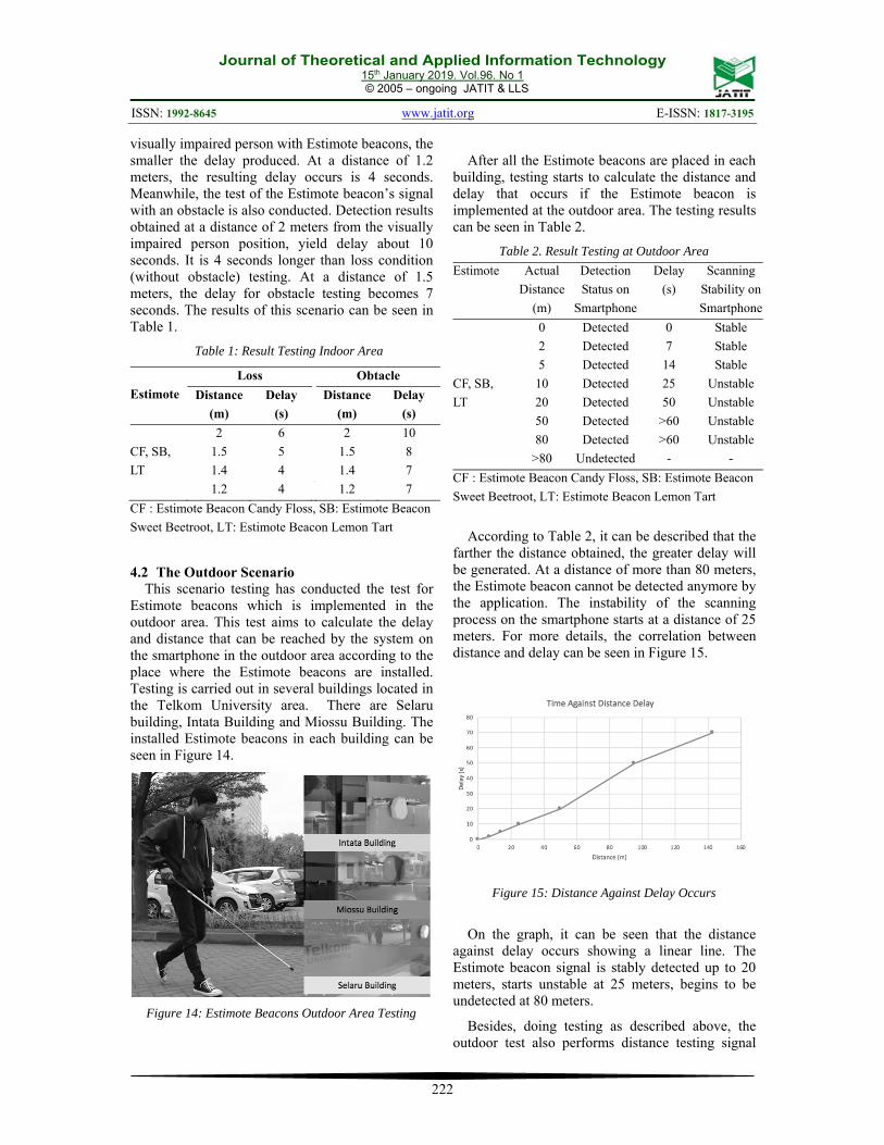
Table 2. Result Testing at Outdoor Area
Estimote Actual
Distance
(m)
Detection
Status on
Smartphone
Delay
(s)
Scanning
Stability on
Smartphone
CF, SB,
LT
0 Detected
0 Stable
2 Detected
7 Stable
5 Detected
14 Stable
10 Detected
25 Unstable
20 Detected
50 Unstable
50 Detected
>60 Unstable
80 Detected
>60 Unstable
>80 Undetected
- -
CF : Estimote Beacon Candy Floss, SB: Estimote Beacon
Sweet Beetroot, LT: Estimote Beacon Lemon Tart
According to Table 2, it can be described that the
farther the distance obtained, the greater delay will be generated. At a distance of more than 80 meters, the Estimote beacon cannot be detected anymore by the application. The instability of the scanning process on the smartphone starts at a distance of 25 meters. For more details, the correlation between distance and delay can be seen in Figure 15.
Figure 15: Distance Against Delay Occurs
On the graph, it can be seen that the distance against delay occurs showing a linear line. The Estimote beacon signal is stably detected up to 20 meters, starts unstable at 25 meters, begins to be undetected at 80 meters.
Besides, doing testing as described above, the outdoor test also performs distance testing signal

Journal of Theoretical and Applied Information Technology 15th January 2019. Vol.96. No 1
© 2005 – ongoing JATIT & LLS
ISSN: 1992-8645 www.jatit.org E-ISSN: 1817-3195
223
using the location based on google map. This test is only carried out at locations around the School of Applied Sciences Building. This test aims to get the position points location of Estimote beacons signal, from stable to unstable conditions that can be captured by the system on the smartphone. By using Google Maps, the environment around which the data was taken, can be known, since the factors used as a signal obstacle or barrier can be seen and mapped well.
The testing results are explained by describing the stability condition of the signal received from stable to unstable condition on the smartphone application. It is also describing in the various direction where the Estimote beacons are installed. The results can be seen as shown in Figure 16.
Figure 16: Estimote Testing Result Using Google Map
Based on Figure 16, it can be seen that if the Estimote beacon is installed in front of the entrance door of the School of Applied Sciences Building, the radiant power will be scattered as shown at Figure 10 above. The explanation will be described based on the location of the wind direction, namely the west direction to the north, north, and the north to the east direction since the direction of arrival to the School of Applied Sciences Building is from the direction mention above.
By explaining the conditions of each different direction of the wind, the receiving signal of the Estimote beacons is also varied. It can be seen from the various colours, red is for undetected signal location, yellow is for unstable signal, and green is for stable detected signal.
In the west to north part of the Estimote beacon, a stable signal is received at a distance of 31.64 meters. This signal stably because there are no obstacles between Estimote beacon and the
smartphone application. While at a distance of 81.28 meters to the west, the beacon signal cannot be detected, since it is out of reach of the Estimote beacon’s signal. At the north position, the signal cannot be detected at a distance of 79.79 meters. This is because there are many obstacles such as security posts, fences, trees and car parking between Estimote beacons and the smartphone application.
On the north to the east part of the Estimote beacon, the signal can be captured stable at a distance of 17.01 meters, since there is no obstacle between the Estimote beacon and the smartphone application. While the Estimote signal beacon begins to be unstable captured by the application on a smartphone at a distance of 38.61 meters up to 75.20 meters. This is because there are many obstacles such as trees and fence between the Estimote beacons and the location where the test point is taken. At distance 96.72 meters of the northeast part, the Estimote signal can no longer be received by the smartphone application.
5. DISCUSSION AND FUTURE WORK
According to the result based on the testing system, this proposed system is useful and appropriate to implement in the outdoor area. The used of the Estimote beacons as a communication module in this purposed system has a limitation because, in one-time connection, only one smartphone can connect to one Estimote beacon. However, this limitation is not significant because of the ease of configuration used in Estimote beacons. As seen in Table 3, Estimote beacon is easily connected to the smartphone and easy to configure. Besides that, the Estimote beacon is implemented to replace the used of the Wi-Fi in the place that is not covered by Wi-Fi signal.
Table 3. Comparison of Communication Module
Communication Module
Easy connect to the
Smartphone
Easy to Configure
Estimote Beacon ✓ ✓
Wi Fi ✓ x
Zig bee x x
NRF24L01 x x
According to the prior work, [15], [16] the Estimote beacon can replace the technology that used to give the information about the location to

Journal of Theoretical and Applied Information Technology 15th January 2019. Vol.96. No 1
© 2005 – ongoing JATIT & LLS
ISSN: 1992-8645 www.jatit.org E-ISSN: 1817-3195
224
the visually impaired people. Besides being easy to configure, the implementation of Estimote Beacon as a location awareness system also makes the visually impaired person walk easily to their destination. The extension module attached to the white canes usually made their cane became heavy and interfered their travel to the destination [10].
For the future research, the used of Estimote beacon can establish further in the smart city’s application. The Estimote beacon can be placed in the public area which is giving the information about the library, supermarket, mall, hospital, bus stop, hotel, modern market, and other places. Only using a smartphone and Estimote the information can be delivered. Besides that, the application can be connected into IoT as a monitoring or tracking system.
6. CONCLUSION
Estimote beacons can be used to be implemented as an aid tool for people with visual impairments in order to give information about the unknown environments such as classroom, building, bus station, mini market, and other places, using smartphone application for location awareness. The usage of estimote beacons is an appropriate technology which can replace any places that are not covered by Wi-Fi signals. Indoor testing results state that estimote beacons can be implemented in an indoor location. But it needs to focus on the distance that must be configured in order not to have an overlap signal between the estimote beacon. According to this condition, Estimote beacons is appropriate in the middle area network, placed not too close and also not too far between the Estimote beacons.
In the outdoor testing, the results are varied, depend on the location of the testing point around the building. The test results state that the estimote beacon starts detected in a stable condition at a distance of 0 – 31.64 meters, and become unstable at a distance 38.61 meters. At a distance of 79.79 meters, the signal of Estimote beacon is not reachable and undetected. It can happen because the testing point is quite far from the Estimote beacon which is installed in the building or because of any other barrier around testing points such as trees, fences, wall, etc. Based on the conclusion above, the implementation of Estimote beacons as a location awareness mobile device for visually impaired is more precisely if it is implemented in the outdoor area and placed where there is no barrier or obstacle.
If the proposed system is established in a wide range area, the system will be constructed as a wireless sensor network and enhance or developed the proposed system as a navigation awareness to the visually impaired people.
ACKNOWLEDGEMENTS
This research is funded by The Government of the Republic of Indonesia, through Penelitian Strategi Nasional Institusi scheme. We would like to thank the Government for financial support of the research and School of Applied Science which provides testing ground for the prototype implementation
REFERENCES
[1] Hosni I. Tunanetra dan Kebutuhan Dasarnya. UPI Bandung; 2017. 24 p.
[2] Hapsari GI, Mutiara GA, Tarigan H. Face Recognition Smart Cane using Haar-Like Features and Eigenfaces. TELKOMNIKA (Telecommunication Comput Electron Control. 2018;13(2):1–8.
[3] Men A, Devhare MM, Mithare MS. Cell Phone for Visually Impaired people. 2018;1463–4.
[4] Tiofan LT. Rancang Bangun Aplikasi Messaging Berbasis Voice Interaction Bagi Penderita Tunanetra Pada Sistem Operasi Android. J Pengemb Teknol Inf dan Ilmu Komput. 2017;1(7):620–7.
[5] Watanabe T, Miyagi M, Minatani K, Nagaoka H. A Survey on the Use of Mobile Phones by Visually Impaired Persons in Japan. 2008;1081–4. Available from: http://link.springer.com/chapter/10.1007/978-3-540-70540-6_162%5Cnhttp://link.springer.com/content/pdf/10.1007/978-3-540-70540-6_162.pdf
[6] Hakobyan L, Lumsden J, O’Sullivan D, Bartlett H. Mobile Assistive Technologies for the Visually Impaired. Birmingham UK;
[7] Narasimhan N, Leblois A. Making Mobile Phones and services accessible for Persons with disabilities [Internet]. Sanou B, editor. G3ICT; 2012. 1-82 p. Available from: http://www.itu.int/ITU-D/sis/PwDs/Documents/Mobile_Report.pdf
[8] Anonymous. PSBN Wyata Guna Bandung [Internet]. [cited 2018 Aug 1]. Available from: https://wyataguna.kemsos.go.id/
[9] Lin BS, Lee CC, Chiang PY. Simple smartphone-based guiding system for visually

Journal of Theoretical and Applied Information Technology 15th January 2019. Vol.96. No 1
© 2005 – ongoing JATIT & LLS
ISSN: 1992-8645 www.jatit.org E-ISSN: 1817-3195
225
impaired people. Sensors (Switzerland). 2017;17(6).
[10] Mutiara GA, Hapsari GI, Rijalul R. Smart guide extension for blind cane. 2016 4th Int Conf Inf Commun Technol ICoICT 2016. 2016;4:6.
[11] Sanjaya WSM, Anggraeni D, Nurrahman FI, Kresnadjaja WG, Dewi IP, Mira, et al. Qibla Finder and Sholat Times Based on Digital Compass, GPS and Microprocessor. IOP Conf Ser Mater Sci Eng. 2018;288(1).
[12] Nieto L, Padilla C, Barrios M. Design and implementation of elctronic aid to blind’s cane. 2014 3rd Int Congr Eng Mechatronics Autom CIIMA 2014 - Conf Proc. 2014;(June).
[13] Hoang VN, Nguyen TH, Le TL, Tran TTH, Vuong TP, Vuillerme N. Obstacle detection and warning for visually impaired people based on electrode matrix and mobile Kinect. Proc 2015 2nd Natl Found Sci Technol Dev Conf Inf Comput Sci NICS 2015. 2015;54–9.
[14] Huang H-C, Hsieh C-T, Yeh C-H. An Indoor Obstacle Detection System Using Depth Information and Region Growth. Sensors [Internet]. 2015;15(10):27116–41. Available from: http://www.mdpi.com/1424-8220/15/10/27116/
[15] Marukatat R, Manaspaibool P, Khaiprapay B, Plienjai P. GPS navigator for blind walking in a campus. World Acad Sci Eng Technol [Internet]. 2010;46(10):89–92. Available from: http://www.scopus.com/inward/record.url?eid=2-s2.0-84871418371&partnerID=tZOtx3y1
[16] Singh K, Vashisht M, Jyoti, Saxena D, Tyagi H. Navigation System for Blind People using GPS & GSM Techniques. October. 2003;3(11):1–15.
[17] Anonymous. Getting started with Estimote – Estimote Community Portal [Internet]. [cited 2018 Aug 2]. Available from: https://community.estimote.com/hc/en-us/articles/360004683772-Getting-started-with-Estimote

Journal of Theoretical and Applied Information Technology 15th January 2019. Vol.96. No 1
© 2005 – ongoing JATIT & LLS
ISSN: 1992-8645 www.jatit.org E-ISSN: 1817-3195
226
APPENDIX 1. QUESTIONNAIRES IN THE STUDY.
NO Questionnaire Rating
Yes No Sometimes Smartphone Cane Eye
glasses Guide
1 Do you have difficulties to find and recognize a specific room or building?
6 6 3
2
Do you using a specific tool to define the room or building location? If yes, please mention the tools that you used
15 0 0 0 12 0 3
3
Do you need a specific tool to help you to go to a particular room or building? If yes, please mention the tools that you need?
15 0 0 9 2 4
4 Is it takes time to travel and define the path to a specific room?
12 0 3
5 Is it takes time to travel and define the path to a specific building around area WyataGuna?
10 2 3
6 Is it takes time to adapt a new route in the area of WyataGuna?
10 2 3