
Isotopes and ages in the northern Peninsular Ranges ... · PDF filecarbonate standard SRM 987...
45
Isotopes and ages in the northern Peninsular Ranges batholith, southern California 2003 his report is preliminary and has not been reviewed for conformity with the U.S. Geological Stratigraphic Code. Any use of trade, purposes only and does not imply endorsement by the EOLOGICAL SURVEY Road (MS 937), Menlo Park, CA 94025 2 U.S. Geological Survey, Department of Earth Sciences, University of California, Riverside, CA 2521 By R. W. Kistler 1 , J. L. Wooden 1 , and D.M. Morton 2 Open-File Report 03-489 T Survey editorial standards or with the North American product or firm names is for descriptive .S. Government. U U.S. DEPARTMENT OF THE INTERIOR U.S. G 1 U.S. Geological Survey, 345 Middlefield 9 12/31/03 1
-
Upload
truongphuc -
Category
Documents
-
view
221 -
download
1
Transcript of Isotopes and ages in the northern Peninsular Ranges ... · PDF filecarbonate standard SRM 987...

Isotopes and ages in the northern Peninsular Ranges batholith, southern California
2003 his report is preliminary and has not been reviewed for conformity with the U.S. Geological
Stratigraphic Code. Any use of trade, purposes only and does not imply endorsement by the
EOLOGICAL SURVEY
Road (MS 937), Menlo Park, CA 94025 2U.S. Geological Survey, Department of Earth Sciences, University of California, Riverside, CA
2521
By R. W. Kistler1, J. L. Wooden1, and D.M. Morton2
Open-File Report 03-489
TSurvey editorial standards or with the North American product or firm names is for descriptive
.S. Government. U U.S. DEPARTMENT OF THE INTERIOR U.S. G
1U.S. Geological Survey, 345 Middlefield
9
12/31/03 1

Isotopes and ages in the northern Peninsular Ranges batholith, Southern California
y R. W. Kistler, J. L. Wooden, and D. M. Morton
e
9).
ineral classification that Bateman and others (1963) used for granitic rocks in the Sierra
-
ene
n
ens from a west to east age and isotopic traverse across the others, 1997, open
exagons), and specimens with of displacement along the an An
race re
e .
B
INTRODUCTION
Strontium, oxygen and lead isotopic and rubidium-strontium geochronologic studies hav
been completed on Cretaceous and Jurassic (?) granitic rock samples from the northern Peninsular Ranges batholith in southern California. Many of these samples were collected systematically and studied chemically by A. K. Baird and colleagues (Baird and others, 197The distribution of these granitic rocks is shown in the Santa Ana, Perris, and San Jacinto Blocks, bounded by the Malibu Coast-Cucamonga, Banning, and San Andreas fault zones, and the Pacific Ocean on the map of the Peninsular Ranges batholith and surrounding area, southernCalifornia (Figure 1). The granitic rock names are by Baird and Miesch (1984) who used a modal mNevada batholith. In this classification, granitic rocks have at least 10% quartz. Boundaries between rock types are in terms of the ratio of alkali-feldspar to total feldspar: quartz diorite, 010%; granodiorite, 10-35%; quartz monzonite 35-65%; granite>65%. Gabbros have 0-10% quartz.
Data for samples investigated are giv in three tables: samples, longitude, latitude, specific gravity and rock type (Table 1); rubidium and strontium data for granitic rocks of thnorthern Peninsular Ranges batholith, southern California (Table 2); U, Th, Pb concentrations, Pb and Sr initial isotopic compositions, and δ18O permil values for granitic rocks of the northerPeninsular Ranges batholith (Table 3).
Locations of samples investigated for this report are shown on Figure 2: specimens chemically analyzed (Baird and others, 1979, open circles), specim
northern part of the area (Premo and initial 87Sr/86Sr determined for a testh
S dreas fault (Kistler and others, 1973, open squares).
ANALYTICAL METHODS
The rubidium and strontium concentration and Sr isotopic data reported in Table 2 were gathered in the Sr isotope laboratory at the USGS in Menlo Park, California. Results are presented here for aliquots of whole-rock powders prepared for determination of major and telement chemical compositions reported elsewhere. Rubidium and strontium abundances wedetermined by energy dispersive X-ray fluorescence methods. Concentrations of Rb and Sr by X-ray fluorescence are ± 3%. Strontium isotope ratios were determined using a MAT 261, 90° sector m ass spectrometer, using the double rhenium filament mode of ionization. Strontiumisotopic compositions are normalized to 86Sr/88Sr=0.1194. Measurements of NBS strontium carbonate standard SRM 987 yield a mean 87Sr/86Sr of 0.710239±0.000015 over the period of thstudy (04/03/92 – 05/09/92). Analytical uncertainties in 87Sr/86Sr values are about ±0.008%
12/31/03 2

In Table 2, measured 87Sr/86Sr values are reported to five places and are routinely measured precisely to ± 2 in the fifth place, whereas initial 87Sr/86Sr values are reported to four
aces. The initial strontium isotopic values of single plutonic rock samples are probably accurate to only ± 5 in the fourth place; either because of possible variability observed in multiple samples from plutons, or also because of lack of precise ages used to calculate these values in some samples. An assigned age of 100 Ma was used to calculate initial 87Sr/86Sr
pl
Los Angeles
118 o 117 o 116 o
34 o
33 o0 50 KILOMETERS
SANTA ANA
PERRIS BLOCK
SAN JACINTO BLOCK
BANNING FAULT SAN ANDREAS FAULT ZONE
SAN JACINTO FAULT ZONE
ELSINORE FAULT ZONE
Quartz monzonite
Granodiorite
Quartz diorite
Gabbro
EXPLANATION
PACIFIC OCEAN
MALIBU COAST_
CUCAMONGA FAULT
SAN BERNARDINO BLOCK
LITTLE SAN BERNARDINO BLOCK
SAN GABRIEL BLOCK
Peninsular RangesMylonite Zone
Major Fault: dashed where inferred
0 50 MILES BLOCK Figure 1. Pluton map of the Peninsular Ranges batholith and surrounding area, southern California (from Baird and Miesch, 1984). values for those specimens without any age control by either U-Pb zircon dates or Rb-Sr whole-rock isochron dates. Ages followed by “Z” or by “R” (Table 2, Age column) indicate they are assigne l
reaction with hot carbon. The CO2 was analyzed on a MAT-251 isotope ratio m le
d from zircon U-Pb data or by Rb-Sr whole-rock isochrons, respectively. The initia87Sr/86Sr values reported for whole-rocks, and whole-rock Rb-Sr isochron ages reported in Table 2 were calculated using the decay constant for rubidium from Steiger and Jager (1977) and theISOPLOT program of Ludwig (1999).
Oxygen was extracted from whole-rock samples by the BrF5 method (Clayton and Mayeda, 1963) or by ClF3 method (Bothwick and Harmon (1982) in nickel bombs at 550oC and converted to CO2 by
ass spectrometer. Extractions and analyses of oxygen were done in the USGS stabisotope laboratory in Menlo Park, California. All of the δ18O-values reported in Table 3 were analyzed in duplicate with reproducibility of δ18O of ± 0.15 permil or better relative to the SMOW standard.
12/31/03 3

Pb isotope compositions (Table 3) were determined in the laboratory at the U.S. Geological Survey in Menlo Park for aliquots of the same whole-rock powders used for Rb, Sr, and δ18O determinations. Pb was separated from the whole-rock powder using standard aniexchange processes uusing HBr and HCl. Pb isotopic composition
on s were determined in static-
ollection mode on a MAT 262 mass spectrometer. Thermal fractionation is monitored by running NBS-981 and –982 standards. The empirically determined fractionation correction factor c
is 0.0011 per mass unit and its uncertainty is the largest contribution to the total analytical uncertainty of about 0.1% associated with the Pb isotopic ratios.
0 25 KM33o 00'
34o 00'
33o
30'
1 116 o17 o 30 ' 117 o 116 o 30 '
HOT SPRINGS FAULT ZONE
AGUA CALIENTE FAULT
ELSINORE FAULT ZONE
COYOTE CREEK FAULT
BUCKS RIDGE FAULT
SAN JACINTO FAULT ZONE
PACIFIC OCEAN
BANNING FAULT
Peninsular Ranges Mylonite Zone
SAN ANDREAS FAULT ZONE
CLARK FAULT
Cuyamaca-LagunaMountains shearzone
223224 225 226 232 233
228 231 234 242 243 244 245
229 230236 241 246 247
253237 238 240 248252 254
261239249251 255 260264 263
262
250 256 259257SJZ
258 265 266
269 268 267
315
270 274 275 299298
297 PHZ301
309
307304
303 302
305317 318 320
319321
323
427JMZ
418428
MRZ338
337 BSZ429
330
329 336339
VVZ
340
332 335 341
333 440 343
334CZ-1 GZ
GZ-1
ADTZ
GZ-2
PVZDVZ
HSZC
LVZ
GATZ
SREZRBZ
342 344
345
346347
348349
350
362366
361
351
360
352
353
359
357356
355
354
358
460
462
463
464 458
372373
371
94-88
306
271272 273
PFZ277
278
279 280281
282 283284
285
286 287288 289
293 290
292 291
276PFZ-1
310 311300 295 294
308
312
313
314
322
324
SMZSRPZ WVRZ
363364
367
365
369
378
379
461 465
467
466
468
469
470472
471475 481 482
490489
483480476
477479 488 491
492487484478485
500
501
502493
486 494
495 498
499 504
503
496497 506
505
508509
510
511
512
513514
515
516
520
517518 519
525524 539
528
529530
522
523 532533531
534 546
538
535
537
536
545
551
540
550553
549
541542
543
544
547 557
556
555
548
370 375 374
376
377
380
381
382383
384385
392
393
394397
395
391448 396
399405
398
406447
407325
419
408
416
417 420421
426
424
433
425430
432431
326
327328
451452
441
456
442454
455
435
436
437
438
386
387
388
389449390
400
401402403
404
412 413
411
410
409
414
415 422434
439
450
453
423
Figure 2. Map showing exposures of granitic rocks (light gray), major faults (from Rogers, 1965), locations and specimen numbers of granitic rocks investigated in the northern Peninsular Ranges batholith. Symbols: circles (Baird and others, 1979); hexagons (Premo and others, 1997), squares (Kistler and others, 1973).
The measured Pb isotopic compositions have been combined with U, Th and Pb
concentrations for these samples (Lichte, 1994; Wooden and others, 1994) and crystallization age data (Table 2) to calculate initial Pb isotopic values. Pb isotope initial ratios calculated from
12/31/03 4

whole-rock samples have a higher uncertainty than those measured in feldspar mineral separates. This is because of the analytical uncertainties associated with the U and Th concentrations, and the susceptibility of medium- and coarse-grained granitic rocks to loss of U in surficial weathering environments. The most common error in initial Pb ratios calculated from whole-rock powders is for the present-day 206Pb/204Pb values to be under-corrected because the measured U concentration is too low as a result of U-loss during weathering. The 206Pb/204Pb ratio experiences the most change in Phanerozoic materials because of the very high ratio of 238U to 235U for this time interval.
0 25 KM33o 00'
34o 00'
33o
30'
117 o 30 ' 117 o 116 o 30 ' 116 o
HOT SPRINGS FAULT ZONE
AGUA CALIENTE FAULT
ELSINORE FAULT ZONE
SAN JACINTO FAULT ZONE
COYOTE CREEK FAULT
BUCKS RIDGE FAULT
PACIFIC OCEAN
BANNING FAULT
Peninsular Ranges Mylonite Zone
SAN ANDREAS FAULT ZONE
CLARK FAULT
Cuyamaca-LagunaMountains shearzone
5 8 6
10
7
67
68 7
7
77 7 6
6
7 7 7 7
77
7
7 6
7
7
67
6
6
77
7
6
6
7 7
68
6 6
667
6
66
6
7 7
7
787 7
76 6
8 8
7 87 8
7
888
87
7
78
8
7
887 7
7 7
87
7 8
7PF-1
8PH
7PF
7SJ
7 77
6
67
6 77
7 6
6
6
5
5
5
4g
4caj
4caj4caj
4caj4CAJ-1
4
4caj
4vv
4vv 5bs
5BS
4vv 4vv
4VV4vv
4ga
4vv
4vv
4ga
4adt5ADT4ga
6GA2
4GA1
4GA
4pv
5PV
3pvg4dv
4DV
3dv
4lv
5lv
45
4lv
4lv4lv4dv
5LV
4dv
3pvg
3pv3pv 3pvg
3dv
6pv
4GAT
45wvr
5wvr
7rb
5wvr
45wvr
5wvr
44
3g4
5wvr
5wvr5
5wvr5wvr
3
3
33
5
5
3g5
5
5
55
54
412
34
4 13
6
4
4
44
4 4
4
4
5
4jm
4
58
44
54
5
4
4mr
4MR
4JM
5
45
4
5
4
44
5
5
6
5
4
6
6
6
6
67
6
4sr
4wm
3hsc
5HSC 4sr
3g
4sr
4sr4sr
3g3g
4SR4rob
4rob
4rob
3wm
4SM
3wm3wm
3g
3bt
3wm
3wm
3g 3wm
3g
3bt3bt
3bt
3bt
3g 3wm
3wm
3wm3bt
3im
3bt
3bt
3gv3gv
3qd
3wm
3im
3g
3qd3bt
3wm
smg
3wm
3gv3g
3wm
3g 3g 3bt3bt
3lw
3lw
3bt3bt
3lw3bt
3bt
4bt
3bt 4stgr
5
5SRE6RB
6
4
4
3
3
5
4
5
Figure 3. Sample locations and initial 87Sr s in the northern Peninsular Ranges. ri Values are: 3=0.7030-0.7039; 4=0.7040-0.7049; 5=0.7050-0.7059; 6=0.7060-0.7069; 7=0.7070-0.7079;
8=0.708 n Valley;
Acres;
4 66
3gv
3ec 3gv
3lw
3gv
3gv
3wm
3gv 4g
3gv3gv
3wm
3wm
3wm
3wm
3wm4bt
3bt
4stgr
4ra
4ra
3lw3lw
3lw3lw
3ra
4ra
4ra3
/86Sr values for granitic rockS
0-0.7089. Pluton names, where known, are indicated by initials after the Sri values. Symbols: SantaAna block: lw, Lake Wolford; ra, Ramona ring dike; wm, Woodson Mountain; bt, Bonsall; gv, Greestgr, Stonewall; rob, Roblar; g, gabbro; im, Indian Mountain; HSC, Hot Springs Creek; SR, Santa Rosa; SM, Squaw Mountain; Perris block: JM, Jurupa Mountain; MR, Mount Rubidoux; BS, Box Springs; VV, Val Verde; CAJ, Cajalco; GA, Gavilan; ADT, Arrroya del Torro; LV, Lakeview Mountain; GAT, Green
12/31/03 5

DV, Domenigoni Valley; SRE, Searles Ridge; RB, Ramona Bowl; WVR, Wilson Valley; PV, Paloma Valley. San Jacinto block: SJ, San Jacinto; PF, Pinyon Flat; PH, Point Happy.
ISOTOPIC DATA
Rb and Sr abundances, measured 87Sr/86Sr, initial 87Sr/86Sr (Sri) values, and known or estimated ages for all available sample powders are given in Table 2. Sri values of each specim
.
tain e of Larsen (1948), whereas 4lv represents a Sri is in the range 0.7040-0.7049 and the
rock ise
s range from 2.3 to 6.9 and the lower values probably identify rocks altered by a cell of low O meteoric hydrothermal water. Taylor and Silver (1978 nsenada,
aja Californatholi
r o
tope and >9.0
permil,th
kness (depth to Moho, e
en are shown on a map of their locations in Figure 3. Sample location symbols are the same as those in Figure 2, and each location has a number that represents the last or least significant digit of the Sri of the granitic rock from that locality, when truncated at 3 significant digits. About half of the locations have a Sri value followed by letters that represent the name ofa mapped pluton at that location. The abbreviated names are identified in Table 2 and Figure 3The numbers at each location represent the 3rd place of the Sri value calculated for each sample. For example 3wm represents Sri in the range 0.7030-0.7039 and the rock is Woodson Moungranodiorit
Lakeview Mountain tonalite of Dudley (1935). Oxygen isotope values (as ∂ 18O) determined for about one-third of the samples availabl
are given in Table 3 and plotted on Figure 4. Measured values range from 2.3 to 12.8 per mil and most represent primary, magmatic values for these specimens. However, in the southern part of the Santa Ana block (Figure 4), sample ∂ 18O value
18
) identified similar hydrothermally altered granitic rocks extending from Eia to Riverside, California in the western exposures of the southern California B
b th. Whole-rock age corrected initial 206Pb/204Pb, 207Pb/204Pb, and 208Pb/204Pb values for
plutons in the northern Peninsular Ranges batholith are given in Table 3 and initial 206Pb/204Pb values are plotted on a map of their locations in Figure 5. Values of 206Pb /204Pb in the PeninsulaRanges batholith range from about 18.4 to 19.5. Values of 208Pb/ 204Pb range from about 38.1 tto 39.0 and 207Pb/204Pb range from 15.57 to 15.72.
STRONTIUM AND OXYGEN ISOTOPE BOUNDARIES
Taylor and Silver (1978) identified a remarkably straight northerly trending boundary
marked by a step between ∂ 18O values less than 8.5 permil to the west and greater than 9.0 permil to the east in plutonic rocks of the Peninsular Ranges batholith from southern California into Baja California. The northerly trending dashed line in Figure 4 shows the oxygen isoboundary between the western and eastern Peninsular Ranges batholith (δ 18O<9.0
respectively) identified by our data in this area. This isotopic boundary lies within a major geologic boundary identified by Larsen, (1948) and Gastil (1975) that divides the batholiinto western, epizonal to mesozonal granitic rocks and abundant gabbros from eastern, moredeep-seated granitic rocks and few gabbros. It also lies within a diffuse geophysical boundary identified by Bouger gravity (Oliver, 1980), isostatic residual gravity (Roberts and others, 1990), aeromagnetic anomalies (Jachens and others, 1991), regional crustal thicLewis and others, 2000), crustal seismic velocities (Hauksson, 2000), and p-wave velocity imag(Magistrale and Saunders, 1995). Defined bt these parameters, this boundary divides the Peninsular Ranges batholith into eastern (EPRB) and western segments (WPRB).
12/31/03 6

Early and Silver (1973) and Kistler and others (1973) reported the first reconnaissancstrontium isotopic studies of plutons in the northern Peninsular Ranges batholith. Both studies showed a southwest to northe
e
ast variation of Sri from about 0.703 to 0.708. Hill and Silver (1988)
of Sri
ns
wo
ns of this report (Figure 3). A
souther isople ke
c
that separates the western from the eastern Peninsular Ranges batholi
ir, an
values from 11.8 permil to to 13.8 pe
0.703 and 0.706, but there a
.0 δ O
is s
Lakeview Mountains Pluton. A 0.706 isopleth is drawn in mixed metamorphosed sedimentary rocks and granitic rocks
along San Ysidro Mountain. This isopleth separates the easternmost pluton sampled (T=104.4±7.5Ma, Sri=0.7062, Table 2), here called the granodiorite of Pinyon Ridge, from other plutons (Sri less than 0.706) to the west in the Perris block (Figure 6). The eastern exposures of
reported a detailed study of strontium isotopic heterogeneity in the San Jacinto pluton in the San Jacinto block (Figure 1) of the batholith. Gromet and Silver (1987) drew isopleths (0.704, 0.706) along the length of the northern 600 km of the batholith. Kistler and Morton (1994) and Morton and Kistler (1997) gave preliminary discussioof Sri of specimens collected by Baird and others (1979) between 33 and 34 degrees North Latitude (Figure 3) that provide the most detailed pattern of variation in Sri for granitic rocks in any part of the Peninsular Ranges batholith. Their results are summarized and shown by Sri isopleths along with the oxygen isotope boundary from Figure 4 on the outline map of granitic rock exposures on Figure 6.
Plutons in the Santa Ana block have a simple Sri pattern (Figure 3). The data define t0.704 isopleths (Figure 6). A northern isopleth trends SW-NE and separates the Woodson Mountain granodiorite of Larsen (1948) from the Roblar leucogranite of Larsen (1948) and theSanta Rosa, Squaw Mountain, and Hot Springs Canyon pluto
n th trends N-S and is the boundary between Woodson Mountain granodiorite, LaWolford granodiorite, and Bonsall tonalite to the west, and the Ramona ring complex (Merriam, 1941) and related outliers to the east (Figure 3). This Sri isopleth is parallel to, but about 10 kilometers west of the 9.0 δ18O isopleth in the area. Together, these northerly trending isotopiboundaries lie within the diffuse northwest trending boundary recognized along the length of southern and Baja California
th. The diffuse boundary between magnetite-series and ilmenite-series granitic rocks (Diamond and others, 1985, Gastil, 1990) also coincides with the geological and geophysical separation of western from eastern plutons of the batholith.
The sinuous eastern limit of plutons sampled by Baird and others (1979) in theSanta Ana block (figure 6) is the western margin of the granodiorite of Cuyamaca Reservointrusive unit that is interlayered with prebatholithic schist (Todd and Shaw, 1985). Todd and Shaw (1985) report Sri values from 0.7079 to 0.7098 and ∂ 18O
rmil for this pluton and classify it as a S-type granitoid. This boundary marks their I-S line in the Santa Ana block.
Plutons in the Perris block have a more complex and greater range of Sri than shown by our data in the Santa Ana block (Figure 6). Most of the values fall between
re scattered values of some isolated samples from 0.706 to as high as 0.713 (Figure 3). The 0.704 isopleth (Figure 6) is north trending and located about 10 km west of the 9 18
isopleth. However, to the north of the Hot Springs fault zone, where it meets the tectonic boundary of Morton and Gray (2002), the 0.704 isopleth turns to the west across the northern part of the block until it is truncated by the Elsinore fault zone.
A 0.705 isopleth trends south from the San Jacinto fault zone to the right angle bend in the 0.704 isopleth and then trends southeast to the Hot Springs fault zone. Here, the fault zone the 0.705 isopleth. A second 0.705 isopleth is parallel to the San Jacinto fault zone and extendfrom the Box Springs pluton southeast to the
12/31/03 7

the granodiorite of Pinyon Ridge, is the Borrego Springs shear-zone section of the PeninsuRanges Mylonite Zone (Figure 1, Simpson, 1984). Field evidence indicates this segment of the mylonite zone is a post-mid-Cretaceous west directed thrust (Simpson, 1984) complicated by Miocene detachment faulting (Engel and Schultejann, 1984), and the granodiorite of Pinyon
lar
Ridge is below the thrust and detachments.
0 25 KM33o 00'
34o 00'
33o 30'
117 o 30 ' 117 o 116 o 30 ' 116 o
HOT SPRINGS FAULT ZONE
AGUA CALIENTE FAULT
ELSINORE FAULT ZONE
SAN JACINTO FAULT ZONE
COYOTE CREEK FAULT
BUCKS RIDGE FAULT
PACIFIC OCEAN
BANNING FAULT
Peninsular Ranges Mylonite Zone
SAN ANDREAS FAULT ZONE
CLARK FAULT
Cuyamaca-LagunaMountains shearzone
7.6
8.5 8.6
7.6
7.7 7.2
8.2 7.1
8.8
7.1
7.2
7.17.4 7.9 9.6
9.2
9.0
9.6
10.5
7.7
10.9
12.3
10.0
18.2
10.88.6
9.7
7.4 7.28.1
9.0
8.2
10.8
12.3
7.2
7.0
6.3
6.7
4.65.8
6.7
4.4
6.9
6.26.4
6.66.6 6.8
6.6
6.2
2.35.9
6.4
6.36.1
6.5
8.3
9.3 8.28.0
7.4
8.05.9
10.110.6
10.4
10.310.0
9.59.4 10.8 10.2
9.810.09.8
9.9 9.2 10.611.2
9.09.9
9.69.7
10.5
11.1
8.8
8.6
8.68.3
8.38.9
8.9
8.6
8.79.1
8.99.1
8.4
8.5
9.7 9.39.7
10.1 11.0
12.8
8.610.9
10.1
6
7
7
Figure 4. Specimen locations and δ18O values in the northern Peninsular Ranges batholith. Northerly trending dashed line separates δ18O values greater than +9.0 permil and less than +9.0 permil. Heavy dotted line in the northern Perris block is a tectonic boundary that separates undeformed shallow level plutons to the southwest from deformed deep level plutons to the northeast (Morton and Gray, 2002).
s cond by specimens B407 west of the
oyote Creek segment of the San Jacinto fault zone (Figures 2, 6). We note here that specimens
Two other 0.706 isopleths are defined close to the San Jacinto fault zone. The first by specimenfrom the Ramona Bowl pluton (Sri>0.706) and the seC
12/31/03 8

B407and B325 are almost identical in Rb and Sr concentrations, measured 87Sr/ Sr, and Sri (0.7066) at 100 Ma. Specimen B325 is adjacent to B 407, but east of the Coyote Creek segmof the San Jacinto fault zone (Figure 2).
ent
117 o 30 ' 117 o 116 o 30 ' 116 o
0 25 KM33o 00'
34o 00'
33o
30'
HOT SPRINGS FAULT ZONE
SAN JACINTO FAULT ZONE
BANNING FAULT
Peninsular Ranges Mylonite Zone
SAN ANDREAS FAULT ZONE
AGUA CA
ELSINORE
COYOTE CREEK FAULTLIENTE FAULT
FAULT ZONE
BUCKS RIDGE FAULT
PACIFIC OCEAN
CLARK FAULT
Cuyamaca-LagunaMountains shearzone
6-7
5 7
7
7
19.161
19.14419.195
19.399
19.243
19.244
19.29619.183
19.300
19.473
19.197 19.228
18.977
19.092
18.667
18.790
18.746
18.77318.869
18.845
18.907
18.814
18.826
18.784
18.767
18.92419.182
18..900
18.809
18.868
18.990
18.77318.784
18.747
18.756
19.016
18.876
18.79218.874 19.189 19.452
19.41419.125
19.158 19.402
18.831
18.74718.837 18.813
18.798
19.120
19.47319.172
19.278
19.223
19.126
19.343
19.476
19.410
19.014
19.118
19.335
19.069
19.15319.340
18.70418.890
18.977 18.77618.837
18.836
18.943
18.887
18.768
18.860
18.93118.880
18.835 19.045
18.923 18.829
18.970 18.999
18.843
18.910
18.933
18.980
18.90418.960
18.689 18.686
18.818 18.868
18.785
18.47618.803
18.788
18.89718.442
18.86318.699
18.654 18.611
18.882
19.119
18.989
18.597 18.654
18.730
18.656
18.758
18.67618.744
18.557
18.684
18.628
18.596
18.686
18.793
18.842
Figure 5. Specimen locations and initial 206Pb/204Pb values in the northern Peninsular Ranges batholithoxygen isotope step (Figure 4) is shown by the northerly trending dashed line and the tectonic boundary of Morton and Gray (2002) is shown by the heavy dotted line. The San Jacinto block lies between the San Andreas and San Jacinto Fault zones (Figure1). Rather than a single fault, the San Jacinto fault zone is defined by a number of segments (Sanders and Magistrale, 1997). With a few exceptions, Sri in plutons of the San Jacinto blockare >0.706 and isotopic boundaries are very complex. The San Jacinto fault zone is more a diffuse boundary than an isopleth that separates plutons with Sri>0.706 from those with Sri<0.706. Hill and Silver (1988) and Hill and others (1986) reported results of detailed studies of Sri and oxygen isotopes, respectively, in the composite San Jacinto pluton and other plutons in
. The
12/31/03 9

the northern part of the block west of the Peninsular Ranges mylonite zone. They found Sri and ∂ .
ork, with the exception of those with Sri=0.705 between the Coyote Creek fault and Clark f ne range
utons
18O in these plutons to range from 0.7058 to 0.7076 and from 9.0 to 10.6 permil, respectivelyFrom our w
ault segments, Sri and ∂ 18O of plutons in the whole block below the mylonite zofrom 0.706 to 0.708 and from 8.3 to 12.8 permil, respectively (Tables 2, 3, Figures 3, 4). Plabove the mylonite zone have Sri greater than 0.707 and less than 0.709 and ∂ 18O values that range from 8.3 permil to 9.1 permil (Figures 3, 4, 6).
0 25 KM33o 00'
117 o 30 ' 117 o 116 o 30 ' 116 o
34o 00'
33o
30'
HOT SPRINGS FAULT ZONE
AGUA CALIENTE FAULT
ELSINORE FAULT ZONE
COYOTE CREEK FAULT
SAN JACINTO FAULT ZONE
BUCKS RIDGE FAULT
PACIFIC OCEAN
BANNING FAULT
Peninsular Ranges Mylonite Zone
SAN ANDREAS FAULT ZONE
CLARK FAULT
Cuyamaca-LagunaMountains shearzone
4
5
6-7
6-7
7-8
4
3
4
4
4
4
65
6
3
7 6
5
5 7
7
3
3
5
6
5
6
4
6
3
5
4
4
Figure 6. Sri isopleths (short-dashed lines) on the map of granitic rock exposures (gray) in the northern Peninsular ranges batholith are shown only for third place values of Sri. For example, the isopleths between 3 and 4 are 0.704 lines and between 4 and 5 are 0.705 lines. 0.704 lines separate plutons with Sri values of 0.7030-0.7039 from those with Sri values of 0.7040-0.7049. 0.705 lines separate plutons with Sri values of 0.7040-0.7049 from those with Sri values of 0.7050-0.7059. The location of the oxygen isotope step from Figure 4 (long-dashed lines) and the tectonic boundary of Morton and Gray (2002) heavy dotted line are also shown.
12/31/03 10

ISOTOPE VARIATIONS AND PLUTON SOURCE MATERIALS
Isotopic compositions of granitic plutons in the Northern Peninsular Ranges batholith are
variable and a function of geographic position and not of rock composition. This requires that the isotopic variations observed are source related and are not due to processes like magmatic fractional crystallization or wall rock contamination.
A plot of Sri vs ∂ 18O (Figure 7) for plutons in the northern Peninsular ranges batholith shows a west to east increase and a broad, generally positive correlation of both isotope ratios. Plutons in the Santa Ana and Perris blocks with Sri<0.704 and δ 18O< 9.0 permil probably were derived from tholeitic sources, whereas those with Sri ≥0.704 <0.706 and δ 18O < 9.0 permil probably were derived from more alkalic and silicic sources. Perris block plutons with Sri ≥0. 704 <0.706 and δ18O ≥9.0 permil (EPRB) pose a source material problem, here, and in the entire EPRB (Taylor, 1986). Taylor concluded partial melting of eclogite-facies altered basaltic material mixed with a sedimentary component like the Franciscan formation can account for the strontium and oxygen isotopic characteristics of the magmas that formed these plutons. Our data are compatible with his conclusion. In the Perris block, the two specimens with Sri > 0.706 and δ 18O=12.3 permil are isotopically similar to San Jacinto block plutons below the mylonite zone. One isolated specimen (B406) may have an entirely sedimentary rock source ( Sri=0.713, δ18O=18 permil, Figure 7). Plutons in the San Jacinto block have Sri >0.705<0.709 and δ18O >8.0<13.0 permil. Most of the data define a broad field that overlaps and forms a continuum with the EPRB Perris block data and indicates a similar source but with a larger proportion of sedimentary materials to account for the more radiogenic Sri and heavier δ 18O. However, eleven specimens plot away from the main array and cluster about Sri=0.708±0.0005 and δ18O=8.5±0.5 permil (figure 7). All, but one of these specimens are from above (to the east of) the Peninsular Ranges mylonite zone and have a source that probably is crystalline continental lithosphere material.
ve a 206Pb/ 204Pb value noticeably different from other Perris block
cks, 18
Figure 8 shows δ18O vs 206Pb/204Pb values that have a broad, generally positive correlation. In the Santa Ana block, the specimens with ∂18O values <+6.0 permil probably interacted with hydrothermal meteoric water that lowered the characteristic unmodified graniticrock values of 6.0 to 9.0 permil. This alteration, however, did not noticeably change the lead isotopic values or the Sri values (Figure 7) for the specimens. The Perris block specimen with δ 18O=18.2 does not haspecimens, but does have an extraordinary Sri (Figure 7) that along with the heavy oxygen indicates a sedimentary rock source for this pluton. The Perris block specimen with the most primitive 206Pb/204Pb=18.44 is from a gabbro that indicates a source like that for WPRB plutons exists beneath the main source region for the EPRB plutons. In the Perris and Santa Ana blomost of 206 204 the WPRB plutons have Pb/ Pb values from about 18.5 to 19.0 and δ O values from6.0 to 9.0 permil that are compatible with mafic igneous source materials. Those Perris block specimens with 206Pb/204Pb from about 18.8 to 19.0 but with δ 18O values >9.0 permil can have similar mafic igneous sources with additional sedimentary sources like Franciscan Formation. The two Perris block specimens with 206Pb/204Pb values >19.0 and δ 18O=12.3 permil have Sri>0.706 and are isotopically similar to San Jacinto block plutons east of the mylonite zone.
12/31/03 11
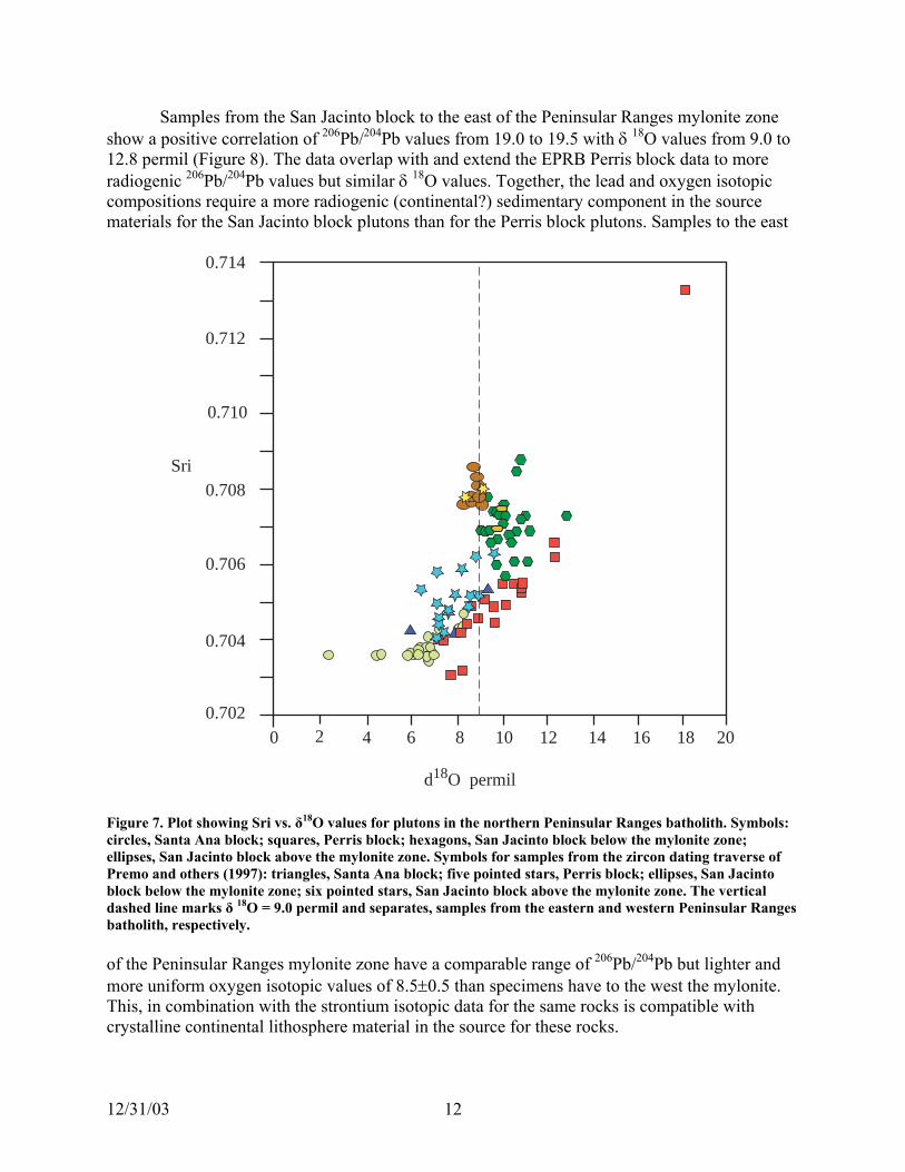
Samples from the San Jacinto block to the east of the Peninsular Ranges mylonite zone show a positive correlation of 206Pb/204Pb values from 19.0 to 19.5 with δ 18O values from 9.0 to 12.8 permil (Figure 8). The data overlap with and extend the EPRB Perris block data to more radiogenic 206Pb/204Pb values but similar δ 18O values. Together, the lead and oxygen isotopic compositions require a more radiogenic (continental?) sedimentary component in the source materials for the San Jacinto block plutons than for the Perris block plutons. Samples to the east
0 2 4 6 8 10 12 14 16 18 200.702
0.704
0.706
0.714
0.712
0.708
0.710
Sri
d18O permil
Figure 7. Plot showing Sri vs. δ18O values for plutons in the northern Peninsular Ranges batholith. Symbols: circles, Santa Ana block; squares, Perris block; hexagons, San Jacinto block below the mylonite zone; ellipses, San Jacinto block above the mylonite zone. Symbols for samples from the zircon dating traverse of Premo and others (1997): triangles, Santa Ana block; five pointed stars, Perris block; ellipses, San Jacinto block below the mylonite zone; six pointed stars, San Jacinto block above the mylonite zone. The vertical dashed line marks δ 18O = 9.0 permil and separates, samples from the eastern and western Peninsular Ranges batholith, respectively. of the Peninsular Ranges mylonite zone have a comparable range of 206Pb/204Pb but lighter and
osphere material in the source for these rocks.
more uniform oxygen isotopic values of 8.5±0.5 than specimens have to the west the mylonite. This, in combination with the strontium isotopic data for the same rocks is compatible with crystalline continental lith
12/31/03 12

Figure 9 is a plot of Sri vs initial 206Pb/ 204Pb for northern Peninsular Ranges plutons. Data from all but four samples fall within three fields delineated by dashed lines: field A >0.702 <0.704, > 18.4<19.0; field B ≥0.704<0.706, >18.4<19.0; field C ≥0.706<0.709, >19.0<19.6 for Sri and initial 206Pb/ 204Pb, respectively.
Both strontium and lead isotopes for specimens from the Santa Ana and Perris blocksfield A are compatible with a tholeiitic source material for these plutons. All but one saminside the 0.704 isopleth on Figure 6 and are in the WPRB. Gabbro sample B393 (Table 3) is inthe Perris block in the EPRB.
Samples in field B are from are from the Santa Ana and Perris blocks and the data can besubdivided into two fields. One of these, with specimens from both blocks, has Sri ≥0.704<0.and
in ple are
705
O 9.0 permil (Figure 8) that indicates a sedimentary rock component in their source materials.
206Pb/ 204Pb >18.5<19.0, whereas the second has specimens only from the Perris block with Sri≥0.705<0.706 and 206Pb/204Pb >18.8<19.0. Most of the samples in the second field have δ 18
>
19.6
19.4
18.6
18.8
19.0
19.2
18.42 4 6 8 10 12 14 16 18 200
206 Pb
/ 204 Pb
d 18O permil
Figure 8. Initial 206Pb/204Pb vs δ18O for plutons in the northern Peninsular Ranges batholith. Symbols: hexagons, Santa Ana block; diamonds, Perris block; squares, San Jacinto block below the shear zone; circles, San Jacinto block above the shear zone. The vertical dashed line at δ18O=9.0 permil separates, to the right and left, samples from the eastern and western Peninsular ranges batholith, respectively.
Except for three from the Perris block, all of the samples in field C are from the San Jacinto block. Sri (>0.706 <0.709), initial 206Pb/204Pb (>19.0<19.5), and δ 18O (>9.0<11.0 permil, Figures 7, 8) are positively correlated in plutons below the Peninsular Ranges Mylonite Zone.
12/31/03 13
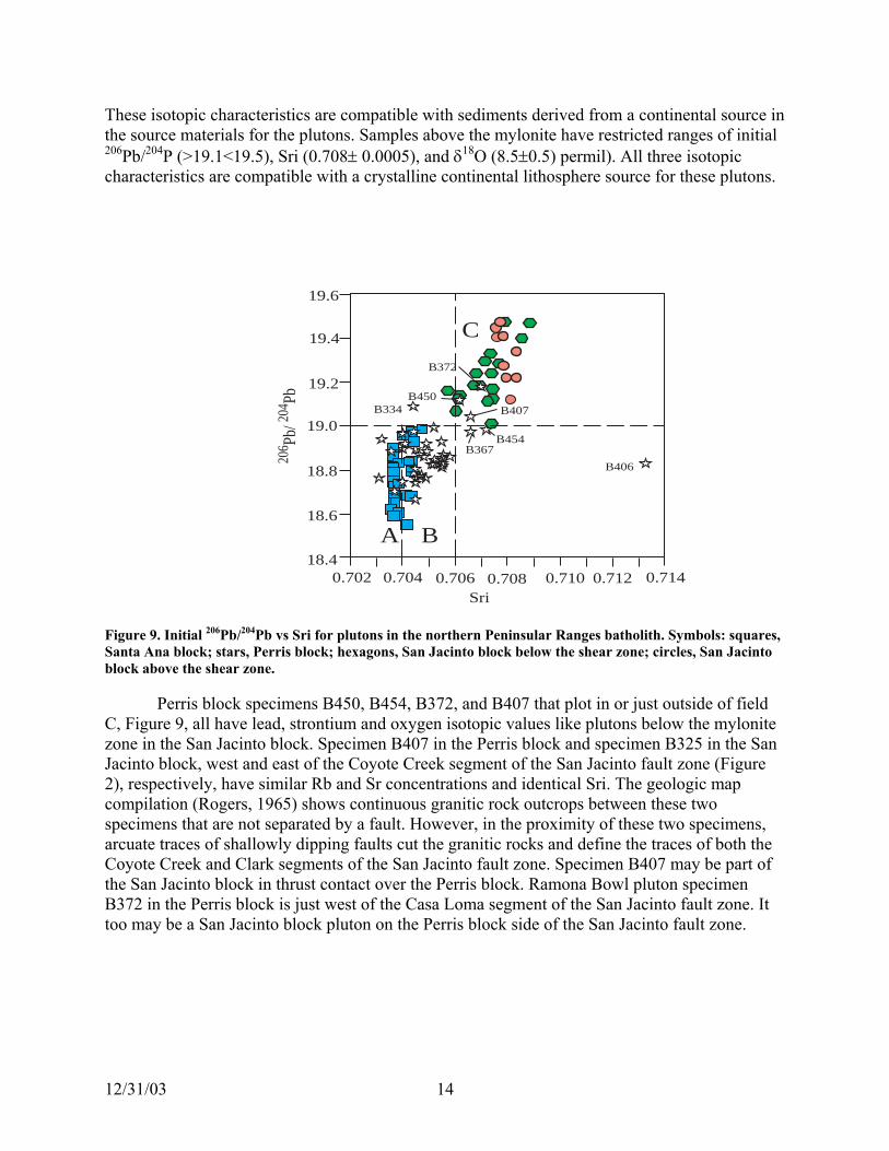
These isotopic characteristics are compatible with sediments derived from a continental source in the source materials for the plutons. Samples above the mylonite have restricted ranges of initial 206Pb/204P (>19.1<19.5), Sri (0.708± 0.0005), and δ18O (8.5±0.5) permil). All three isotopic characteristics are compatible with a crystalline continental lithosphere source for these plutons.
0.702 0.704 0.706 0.708 0.710 0.712 0.71418.4
18.8
19.0
19.2
19.4
19.620
6 Pb/ 20
4 Pb
A B
C
B454
B406
B407
B372
B367
B334B450
18.6
Sri
igure 9. Initial 206Pb/204Pb vs SrFS
i for plutons in the northern Peninsular Ranges batholith. Symbols: squares, anta A o
onite San
compil
the
na block; stars, Perris block; hexagons, San Jacinto block below the shear zone; circles, San Jacintblock above the shear zone. Perris block specimens B450, B454, B372, and B407 that plot in or just outside of field C, Figure 9, all have lead, strontium and oxygen isotopic values like plutons below the mylzone in the San Jacinto block. Specimen B407 in the Perris block and specimen B325 in the Jacinto block, west and east of the Coyote Creek segment of the San Jacinto fault zone (Figure 2), respectively, have similar Rb and Sr concentrations and identical Sri. The geologic map
ation (Rogers, 1965) shows continuous granitic rock outcrops between these two specimens that are not separated by a fault. However, in the proximity of these two specimens, arcuate traces of shallowly dipping faults cut the granitic rocks and define the traces of bothCoyote Creek and Clark segments of the San Jacinto fault zone. Specimen B407 may be part of the San Jacinto block in thrust contact over the Perris block. Ramona Bowl pluton specimen B372 in the Perris block is just west of the Casa Loma segment of the San Jacinto fault zone. It too may be a San Jacinto block pluton on the Perris block side of the San Jacinto fault zone.
12/31/03 14

RUBIDIUM-STRONTIUM WHOLE-ROCK AGES
On his geologic map of the “Batholith and associated rocks of the Corona, Elsinore, and San Luis Rey quadrangles, southern California”, Larsen (1948) assigned names to plutons based on outcrop characteristics such as grain-size, inclusion content, color, and relative abundances odifferent minerals. Several of these named units occur as discrete plutons over large areas of upto 250 square miles. Comparison of the locations of granitic rock samples collected by Baird andhis colleagues to this map permits their assignment to these plutons. In the Santa Ana block,between 33º and 33º30´ N. Lat., all Rb-Sr whole-rock data from three of these named units, Bonsall Tonalite, Woodson Mountain Granodiorite, and Green Valley Tonalite were plotted on strontium evolution diagrams (Figures 10, 11, and 12, respectively). Rb-Sr whole-rock ages of 105.2±8
f
.1 Ma, 123.7±5.6 Ma, and 117±14 Ma for the Bonsall Tonalite, Woodson Mountain Granodiorite, and Green Valley Tonalite, respectively, are derived by regression of these data (Ludwig, 1999). All units have a very primitive Sri=0.7037±0.0001.
0 1 2 3 40.702
0.704
0.706
0.710
0.708
Sr
Bonsall Tonalite of Larsen (1948)
87Rb / 86Sr
87Sr
/ 86
Age = 105.2 +/- 8.1 MaInitial 87Sr/ 86Sr=0.7038+/- 0.0001MSWD=1.7
Figure 10. Rb-Sr whole-rock isochron plot for specimens of Bonsall Tonalite south of 33º30´ N. Lat. in the Santa Ana block (Figure 3).
12/31/03 15

0.701
0.703
0.705
0.707
0.709
0.715
0.713
0.711
0 2 4 687Rb/ 86Sr
87Sr
/ 86Sr
Woodson Mountain Granodiorite of Larsen (1948)
Age =123.7 +/- 5.6 MaInitial 87Sr/ 86Sr=0.70356 +/-0.0002MSWD = 1.6
Figure 11. Rb-Sr whole-rock isochron plot for specimens of Woodson Mountain Granodiorite south of 33º30´ N. Lat. in the Santa Ana block (Figure 3).
0.7064
0.7052
0.7060
0.7058
0.7040
0.7044
0.704887
Age = 117 +/- 14 MaInitial 87Sr/ 86Sr = 0.7036+/-0.0002MSWD = 0.28
0.0 0.2 0.4 0.6 0.8 1.0 1.2 1.4 1.6
0.7036
87Rb/ 86Sr
Figure 12. Rb-Sr who
Sr/ 86
Sr
Green Valley Tonalite of Larsen (1948)
the Sant
le-rock isochron plot for specimens of Green Valley Tonalite south of 33º30´ N. Lat. ina Ana block (Figure 3).
12/31/03 16

Most of the northern part of the San Jacinto block, west of and beneath the PenRanges Mylonite Zone (Figure 2), is made up of the tonalitic rocks of the 94 Ma San Jacinto Intrusive Complex (Hill and others, 1986). These workers reported large variations in Sri from samples of the tonalites. Samples from this complex collected by Baird and his colleagues confirm this variation of Sri calculated for 94 m. y. (Table 2, Figure 3). Unlike many of the granitic rocks in the S
insular
anta Ana block, the extreme variation in Sri from the San Jacinto Intrusive Comple
e s
r
d
arsen (1948) assigned the name Woods
7)
s block, assigned to Bonsall tonalite by Lars ood
s
s in ochron
r
on Valley pluton (Table 2). 5
N.
holith
out 120
x does not permit the use of Rb-Sr whole-rock data as a geochronometer for these rocks. In the Perris block, exposed between the Elsinore and Hot Springs fault zones north of
Lake Henshaw, nine adjacent samples (B401, B404, B410-416) of quartz diorite, granodiorite, and quartz monzonite have strontium isotopic data (Table 2) that yield a Rb-Sr whole-rock isochron age of 153±14 Ma, Sri=0.7040±0.0002 (Figure 13). However, plots of Sri at 100 Ma vs 1/Sr and Sri vs δ 18O for these specimens are linear with R2 =0.83 and 0.94, respectively. Theslinear plots indicate that the isochron is a mixing line (Faure and others, 1974; Kistler and other1986). However, some credibility is given to the apparent Late Jurassic age because it is similato a multiple fraction, conventional U-Pb zircon age (156±12 Ma) for a gneiss in the Cuyamaca-Laguna Mountains shear zone (e.g. Figure3) south of the Elsinore fault zone (Walawender anothers, 1991). Additional dating of plutons in this area by both U-Pb and Rb-Sr techniques are required to establish these ages with certainty. North of 33º30´ N. Lat. in the northern Perris block, L
on Mountain Granodiorite to a large pluton called the Cajalco quartz monzonite by Dudley (1935). The Cajalco pluton is 108 Ma by U-Pb zircon dating (Premo and others, 199and 109±4 Ma by Rb-Sr whole rock dating (Figure 14).
A large pluton to the west of Val Verde in the Perrien (1948), was renamed the Val Verde tonalite by Morton (1999). In contrast to the g
agreement of ages by the two dating techniques for the Cajalco pluton, the U-Pb zircon date i106 Ma (Premo and others, 1997) whereas the Rb-Sr whole-rock date is 129±18 Ma (Table 2, Figure 15). We accept the U-Pb zircon date as the correct age for this pluton. Even though the data that define the isochron for this body are analytically precise (MSWD=0.30), the 87Rb/86Sr values only range from about 0.3 to 1.14. A small increase of about 3 in the fourth place inmeasured 87Sr/86Sr for the most radiogenic sample could account for the older apparent age. Sri values for the Val Verde samples, calculated for an age of 106 Ma, range from 0.7045 to 0.7048(Table 2). The calculated Sri=0.7048 is for the specimen with 87Rb/86Sr=1.14.
The 87Rb/86Sr for the Cajalco pluton samples range from 0.049 to 5.5. Small variationSri for the most radiogenic specimens would not have a large effect on the slope of the isand the isochron age is the same as the U-Pb zircon age. In the few other plutons with both Rb-Swhole-rock and U-Pb zircon dates sampled in this study, the ages agree for the Box Springs and Lakeview Mountains plutons but differ for the Wils
Silver and others (1979) report U-Pb zircon ages that range from about 120 Ma to 10Ma for 12 plutons in a traverse across the western Peninsular Ranges batholith south of 33º Lat. near the international border. Our Rb-Sr whole-rock ages for the Bonsall tonalite, Green Valley tonalite, and Woodson Mountain granodiorite in the western Peninsular ranges batto the north of their traverse and south of 33º30´ N. Lat. have the same range in age. This concordance of ages by the two methods suggests the plutons were emplaced between aband 105 Ma.
12/31/03 17

0.708Jurassic granite between the Hot Springs and Elsinore fault
0.703
0.704
0.706
0.705
0.707
0.0 0.4 0.8 1.2 1.6 2.0
87Rb/ 86Sr
87Sr
/ 86 S
r
zones in the Perris block
Age =153 +/- 14 MaInitial 87Sr/ 86Sr =0.7040 +/-0.0002MSWD = 1.8
Figure 13. Rb-Sr isochron diagram for Late Jurassic (?) quartz diorites, granodiorites, and quartz ites exposed between the Hot Springs and Elsinore fault zones in the Perris block (Figure 3).
monzon
0.712
0.714Cajalco pluton
0 2 4 6
0.702
0.704
87Rb/ 86Sr
Initial Sr/ Sr =0,7044 +/- 0.0001MSWD= 1.17
0.706
0.708
0.710
87Sr
/ 86Sr
Age = 109 +/- 4 Ma87 86
Figure 14. Rb-Sr whole-rock isochron plot for the Cajalco pluton exposed in the Perris block (Figure 3).
12/31/03 18

0.7072
0.7068
0.7064
0.7060
0.7056
0.7052
0.7048
0.7044
0.1 0.3 0.5 0.7 0.9 1.1 1.30.0
Sr/ Sr =0.7044 +/-0.0002D = 0.30
Figure
Penin s
con
d
Cham
rock Pb zircon dating (Silver and others, 1979) in
have apparent ages of 129 Ma by Rb-Sr whole-ro
emplples in the Perris block yield a Rb-Sr whole-rock isochron age of 153 Ma.
87Sr
/ 86Sr
Val Verde pluton
Age = 129 +/- 18 MaInitial 87 86
MSW
87Rb/ 86Sr
15. Rb-Sr isochron diagram for the Val Verde pluton exposed in the Perris block (Figure 3).
SUMMARY AND DISCUSSION
The primary purpose of this report is to make available the considerable isotopic data determined for granitic rock samples collected by Baird and others (1979) from the northern
sular Ranges batholith in the laboratories of the USGS in Menlo Park, California (Tables 1,2, 3). We point out some interesting features, some relatively new and others possibly at oddwith conclusions based on other studies in the batholith, that are revealed by these data.
The data of this report permit a comparison of Rb-Sr whole-rock ages with U-Pb zirages for some of the plutons mapped in the northern Peninsular Ranges batholith. The data confirm the observation that dating by multiple techniques on the same samples is the most reliable way to determine the meaning (emplacement, reset, contaminated, inherited) of an agefor a Mesozoic pluton in a complex batholith terrane (e.g. Kistler and Wooden, 1994; Kistler an
pion, 2001). In the Santa Ana block south of latitude 33°30’, plutons called Woodson Mountain
granodiorite , Green Valley tonalite, and Bonsall tonalite by Larsen (1948) have Rb-Sr whole- ages that range from about 125 Ma to 105 Ma that are the same as ages determined by U-
plutons immediately south of our area of investigation. In this case, the concordance of ages by both techniques indicates they approximate emplacement ages. In contrast, samples of the Val Verde pluton in the Perris block
ck dating and 106 Ma by U-Pb zircon dating. In this case, probably the “Rb-Sr isochron” is a mixing line determined by specimens that had different Sri at the time of their formation and the U-Pb zircon date approximates the pluton’s
acement time. A group of sam
12/31/03 19
This apparent age, old for the Peninsular Ranges batholith, is similar to a 156 Ma U-Pb zircoor a nearby pluton (Walawender and others, 1991). The ages o
n date f f zircon fractions used in the
possipluto the rocks that define the
Howe s is given by Johnson and others (1999) in a
Theirconti in arc initiated at least 140 m.y. ago. Additional dating and mapping in the area
verifyf the plutons from the Baird collection permits us to
Becaand g RB and WPRB.
radioparall boundary. It is parallel to and 10 km to the
the m th diver zone. Another westerly trending
Ana b 17 km fault zone. The north-trending Sri=0.704
ot SprinSri=0.704 isopleths across the Elsinore fault zone and north-trending Sri=0.704 isopleth across
an old tr
e plutons with strontium, lead, and oxygen isotopic
Jacinthe Sinclu oyote Creek and Clark fault segments (figure 6). The
Sri≥0mate
ern
appro
ons in the1990 n tectonic contact with North American lithosphere in the southern Sierra Nevada. Plutons intruded into Panthalassan lithosphere are
age determination are discordant due to inheritance of older zircons. The inheritance, plus ble lead loss from the zircons because of thermal events subsequent to emplacement of the n does not permit a simple interpretation of the age. Samples of
Jurassic “isochron” have linear correlations of 1/Sr and δ 18O vs Sri that suggest a mixing line. ver, additional support for both of these age
mapping and SHRIMP U-Pb dating study in the Peninsular Ranges batholith in Baja California. data indicate that some plutons of the eastern Peninsular Ranges batholith represent a nental-marg
of our apparently Jurassic plutons in the northern Peninsular Ranges batholith is required to or deny the validity of the dates as emplacement ages.
The determination of Sri for all oconstruct Sri isopleths on a map of the batholith to within approximately ±3 km (Figure 6).
use of this, some details are revealed along the well documented, but diffuse, geophysical eological boundary between the EP
A Sri=0.704 isopleth trends north in the Santa Ana and Perris blocks and marks the genic isotopic boundary between the EPRB and WPRB. Here the Sri=0.704 isopleth is el to and within the geophysical and geologic
west of the boundary between plutons with δ18O < 9.0 and ≥ 9.0 step (Figures 4, 6) that is also inain PRB boundary zone. However, in the middle of the Perris block, the Sri=0.704 isopleges to the west and is truncated at the Elsinore fault
Sri=0.704 isopleth, also truncated by the Elsinore fault zone, is in the northern part of the Santa lock. By observation (Figure 6), these west-trending Sri=0.704 isopleths are offset about in a left lateral sense across the Elsinore
isopleths are offset about 10 km and 7 km in a left lateral sense across the Elsinore and Hgs fault zones, respectively. Restoration of left lateral offsets of the west-trending
the Hot Springs and Elsinore fault zones suggests the west-trending Sri=0.704 isopleth images ansform crustal boundary fault in the WPRB.
In the Perris block there are threvalues that are like those in plutons below the Peninsular Ranges mylonite zone in the San
to block (Figures 7, 8, 9). These three plutons and plutons in the San Jacinto block east of an Jacinto fault zone all have Sri greater than 0.706, with a few isolated exceptions, ding a Sri=0.705 pluton between the C
San Jacinto fault zone exclusive of the Coyote Creek fault segment can be considered a .706 isopleth that marks a major discontinuity in the isotopic composition of source
rials of plutons in the northern Peninsular Ranges batholith. This observation is compatiblethe model for the petrochemical nature of source materials of batholithic rockwith s of south
California (Baird and Miesch, 1984) that identified a discontinuity in source compositions ximately coincident with the San Jacinto fault zone. They interpreted the fault as the rn limit of significant contributions of sialic continental materialweste s to the batholithic rocks.
In the area of our study, the strontium and oxygen isotopic characteristics of the plut EPRB are the same as those of plutons intruded into Panthalassan lithosphere (Kistler,
) in the Sierra Nevada. This lithosphere is i
12/31/03 20

characterized by δ18O values consistently greater than +9 permil in those with Sri>0.706 and greater than +9 permil in those with Sri<0.706. The isotopic, especially δ often
and ccomponent in the sources of their parent magmas. Kistler (1990) used these characteristics and
basem r and
crystaPanthalassan lithosphere in the southern Sierra Nevada (Sams, 1986; Saleeby and others, 1987).
and Mies ly repre ents. This
he few i e shear zone in the San Jacinto block.
18
o the P .
e fault
Sri=0 rections
δ18O
faulti us t
o the Earth
5
into t ally and
along lock along any non-unique highs and lows in the 108 Ma surface whose present configuration could result in the
18O> 9.0 permil, hemical characteristics of the plutons in Panthalassa indicate a significant sedimentary rock
others to indicate that, by itself, Sri greater than 0.706 in plutons does not characterize the ent beneath the plutons as crystalline Precambrian sialic crust, as suggested by Kistle
Peterman (1973). This is supported by the absence of direct remnants of Proterozoic sialic lline basement found in exposures of mid-crustal levels of the batholith (8kbar) in
In the area of our present study, δ18O >9.0 per mil and petrochemical source models (Bairdch, 1984) indicate that in the EPRB the increase in Sri from 0.704 to 0.708 probably onsents a change from mafic (Franciscan) to felsic (continental) derived sedim
change is sediment composition is marked by the most radiogenic plutons (Sri>0.706) like tn the Perris block and all those west of th
Hill and others (1986) and Taylor (1986) proposed a third source component to account ose plutons in the San Jacinto block below the mylonite zone with δ18for th O >+9.0 <+12.8 per
mil and Sri >0.7057<0.708. On the Sri vs δ18O plot these samples trend off of the main trend ofTaylor and Silver (1978) toward a modeled source with Sri∼0.710 and δ O∼+6 permil (Hill and others, 1986). They suggest rock with these isotopic characteristics could be old (>1Ga) material
saltic composition. However, most of the dataof ba that trend toward the old basaltic end member are from rocks east of the Peninsular Ranges mylonite zone and are probably exotic t
eninsular Ranges batholith and not relevant to models of source materials of the batholithRight lateral offset of 10-15 km along the main trace of the Elsinore fault zone is
indicated by displaced contours of biotite K-Ar cooling ages of plutons on either side of thton and Miller, 1987, inset figure in Morton and Gray, 2002). This is a contradic(Mor tion to the
17 km of left lateral displacement along the fault indicated by offset of the west-trending .704 isopleth discussed above. A possible resolution of the apparently conflicting diplacement along the Elsinore fault follows. of dis
In regional studies of granitic rock terranes, undisturbed isotopic boundaries (e.g., Sri or isopleths) represent the lines of intersections of steeply dipping surfaces such as pluton
contacts with the surface exposure. Although these may be tilted or rotated during subsequent deformation, unless translated laterally by “thin-skinned” tectonic processes (e.g., detachment
ng), isotopic boundaries commonly occur nearly vertically above the differences in igneopresensource regions they represent. Conversely, undisturbed regional cooling-age contours re
the intersections of originally shallow-dipping, commonly isothermal surfaces, sub-parallel t’s surface (in this case, the time rocks cooled to the closure temperature of biotite for
argon). The critical age contour (108 Ma) used to determine the right lateral separation across the Elsinore fault zone (Morton and Miller, 1987) is adjacent and parallel to the fault for about 5km, dipping shallowly southwest in the Perris block north and east of the fault. Within the Santa Ana block, southwest of the elsinore, the 108 Ma age contour dips more steeply west and strikes
he fault trace at an angle of forty degrees (Morton and Gray, 2002). Clearly, the originsub-horizontal isohermal surface represented by the 108 Ma contour has been warped, tilted,possibly rotated during much more recent deformation, some of which may be due to faulting
the Elsinore fault itself. Rotational differential uplift and erosion of the Santa Ana b the fault occurring at any time in the 108 Ma following cooling could produce m
12/31/03 21

apparent 10-15 km separation across the fault. Some of this uplift and deformation could have red during left lateral displacement, matching anywhere along the 55km exposuoccur re in the
δ18O rotatiwoul
ar bbott,
r
Clayt of ochimica Acta,
v.27, p.43-52. Diamond, J.L., Knaack, C.M., Gastil, R.G., Erskine, B.G., Walawender, M.J., Marshall, M., and
Cameron, G.J., 1985, The magnetite-ilmenite line in the Peninsular Ranges of southern and Baja California, U.S.A. and Mexico: Geological society of America Abstracts with Programs, v. 17, p.351.
Dudley, P.H., 1935, Geology of a portion of the Perris block, Southern California: California Journal of Mines and Geology, Quarterly chapter of the State Mineralogist, Report 31, no. 4, October.
Early, T.O., and Silver, L.T., 1973, Rb-Sr isotopic systematics in the Peninsular Ranges batholith of southern and Baja California: EOS, Transactions of the American Geophysical Union, vol.54, p.494.
Engel, A.E.J., and Schultejann, P.A., 1984, Late Mesozoic and Cenozoic tectonis history of south central California: Tectonics, vol. 3, no.6, p. 659-675.
Faure, G., Bowman, J.R., Elliott, D.H., and Jones, L.M., 1974, Strontium isotopic copositionn and petrogenesis of the Kirkpatrick basalt, Queen Alexandra Range, Antarctica: Contributions to Mineralogy and Petrology, v. 48, p. 153-169.
Gastil, R.G., 1975, Plutonic zones in the Peninsular Ranges of southern California and northern Baja California: Geology, v.3, p. 361-363.
Perris block north of the fault. The steeply dipping surfaces represented by the Sri=0.704 and isopleths would be much less affected by differential uplift and would require regional on to produce significant changes in their trends. Their offsets across the Elsinore fault d approximate the amount of lateral displacement.
References cited
Baird, A.K., Baird, K.W., and Welday, E.E., 1979, Batholithic rocks of the northern Peninsul
and Transverse Ranges, southern California: chemical composition and variation in AP.L. and Todd, V.R., eds., Mesozoic Crystalline Rocks: Peninsular Ranges batholith and pegmatites, Point Sal ophiolite: Department of Geological Sciences, San Diego State University, San Diego, CA, Guidebook for Geological Society of America Annual Meeting, p. 111-132. , A. K., and Miesch, A. T., 1984, Batholithic rocks of southern CaliforniaBaird - A model for the petrochemical nature of their source materials: U.S. Geological Survey Professional Pape1284, 42 p.
Bateman, P.C. Clark, L.D., Huber, N.K., Moore, J.G., and Rinehart, C.D., 1963, The Sierra Nevada batholith- a synthesis of recent work across the central part: U.S. Geological Survey Professional Paper 414-D, 46p.
Bothwick, J. and Harmon, 1982, A note regarding ClF3 as an alternative to BrF5 for oxygenisotope analyses: Geochimica Cosmochimica Acta, v. 46, p.1665-1668. on, R.N. and Mayeda, T.K., 1963, The use of bromine pentafluoride in the extractionoxygen from oxides and silicates for isotopic analysis: Geochimica Cosm
12/31/03 22

Gastil, G., 19 und en t s and il ries granitic rocks in eninsu rnia: U ity Museum versity of Tokyo, Nature and culture, No.2, . 91-10
L.T., 1987, REE variat across the Pe nges batholith: plicat athol genesis and tal growth in rcs: Journal of
.I. and Silver, L.T., 1988, San Jacinto intr complex, 3, Constraints on crustal magma ber s from ium isotope rogeneity: Jo physical Research,
. I., Silver, L. T., and Taylor, H. P., 1986, pled Sr-O iso ons as an indicator sourc eneity northern Peninsular Ranges b ntributions to ineral etrolo 2, p.351-36
s, R.C. .R., M D.M., and G m, A., 1991, Constraints on the structural volutio enins nges batholi alifornia, from a new aeromagnetic map:
ological Research Letters, v. 62, no. 1, p.44. n, S.E. .C., an ing, C.M., 1 New geologi nd SHRIMP U-Pb ircon d Penin anges batho Baja Californ Evidence for a
, R.W., o dif ithosphere types in the Sierra Nevada California: in nderso ., Th and origin rdilleran mag ological society of
erica Memoir 174, p.271-281. , R.W., l, B.W , D.L., and B an, P.C., 1986, Isotopic variation in the
n ve sui ral Sierra Ne , California: ns to Mineralogy
, R.W., mpion, D.E., 2001, Rb-Sr whole-rock and Mineral ages, K-AR, 40Ar/39Ar, nd U-P l ages ontium, lead dymium, and oxygen isotopic compositions or gran rom the Salinian compos rrane, Califo ological Survey pen-Fi , OF 0 83 p. , R.W., den, 94, Interpret of U/Pb ag rom Mesozoic
in tracts of th ional Conference e geology, Lanphere, M.A., Dalrymple,
, R.W., ton, D 994, Sr, Rb, ariation an b-Sr ages of lutons thern lar Ranges lith, southern California: Geological ociety ca Ab ith Program . 26. no.2, p.8, R.W., rman Z.E., 1973, Variations in Sr, Rb, K, Na and initial 87Sr/86Sr in esozo rock truded wall s in central C eological Society
erica Bulletin, v. 84, p.3489-3512. , R.W., n, Z.E D.C., and Gottfried, D., 1973, Strontium
in Kovach, R. L., and Nur, A. eds., Conference on the tectonic problems , Proceedings: Stanford Univ ications, Geological
ciences . 339- E. S., J Batho associated s of the Co nd San Luis Rey uadran hern C ia: Geologic ciety of A 29, 182 P.
90, The bo ary betwe he magnetite-serie menite-seP lar Califo nivers , Unip 0.
Gromet, L.P., and Silver, ions ninsular RaIm ions for b ith petro crus magmatic aPetrology, v. 28, no.1 , p.75-125.
Hill, R usivecham processe stront hete urnal of Geovol. 93, no. B9, p. 10373-10388.
Hill, R Cou tope variatiof e heterog for the atholith: CoM ogy and P gy, v. 9 1.
Jachen , Todd, V orton, riscoe n of the P ular Ra th, CSeism
Johnso , Tate, M d Fann 999, c mapping az ata in the sular R lith, ia, Mexico:suture: Geology, v. 27,no. 8, p. 743-746.
Kistler 1990, Tw ferent lA n, J.L., ed e nature of co matism: GeAm
Kistler Chappel ., Peck atemTuolum e intrusi te, cent vada Contributioand Petrology, v. 94, p.205-220.
Kistler and Chaa b minera , and str neof itic roks f ite te rnia: US GeO le Report 1-453,
Kistler and Woo J.L., 19 ation e fe Eight Internat
s of zirconsplutons in the Salinian block, California: Abson Geochronology, Cosmochronology and IsotopG.B., and Turrin, B.D., eds., U.S. Geological survey Circular 1107, p. 173.
Kistler and Mor . M., 1 Sri v d whole-rock Rp in the nor Peninsu bathoS of Ameri stracts w s, v 2.
Kistler and PeteM ic granitic s and in rock alifornia: Gof Am
Kistler Peterma ., Ross, isotopes and the San Andreas fault, of the San Andreas fault system ersity PublS , v. 13, p 347.
Larsen r., 1948, lith and rock rona, Elsinore, aq gles, sout aliforn al So merica Memoir
12/31/03 23

L ., a ., Ea on, F., ional crustal nges, southern California: Geology, v., 28, no. 4,
, 303-3, F.E., 1994, Determination of minor and trace elemental signatures in the southern
y coupled pla pectrometry: eologi ty of A Abstracts with Programs, v.26, no. 2, p.66.
g, K.R. ser’s Manual for Isoplot/Ex, version 2.05: Berkeley Geochronology
trale, H ders, , P-wave im of the Peninsular Ranges batholith, southern ch Letters, , no. 18, p.
m, R.H sout lifornia ring , American Journal of Science, v. 239, p. 65-371n, D.M. anta A quadrangle, hern Californ , U.S. Geoligical urvey O Repo 72 1:100,00
n, D.M. y,C.H 02, Geologi p of the Corona North 7.5’ quadrangle, iversid Bern Counties, C rnia: U.S. Ge vey Open-File eport 0 le 1:2
n, D.M. tler, R 97, Sri variation in the Peninsular Ranges batholith: eologi ty of A Abstracts with Programs, v.29, no.6, p. A-69.
n, D.M. ler, F 7, K/Ar app ages of plutonic rocks from the northern art of t ular R atholith, so n California: Society of
erica Abstracts with Programs (Cordill section), v. 1, H.W., ninsu es, in Oliver, H.W., ed., Inter the gravity map of aliforn conti argin, California Division of Mines and Geology Bulletin 05, p.1, W. R. D. M L. W., Fann C. M., 1997, es and associated
ples from northern Pen e batholith, S. aliforn gical of America tracts with Pr 9, no. 5, p. 57.
ts, C.W , R.C liver, H.W., 1990, Isostatic residual gravity map of aliforn fshore rn California p No. 7, Cal ogic data map
eries, sc ,000.s, T. H. mpile Ana Sheet: logic map of O. P. Jenkins dition, 0,000y, J.B., .B., an er, R. W., 1987, U/Pb zircon, strontium and oxygen isotopic nd geoc ical s the southern t Sierra Ne California: ournal ysical ch, v. 92, no , p.10443-D.B., 1 b geoc ogy, petrolo nd structural the crystalline
ra Nevada and Tehachapi Mountains, Kern County, a, California Institute of Technology, 315 P.
rs, C.O. gistral 97, Segmen n of the north into fault zone, Geophysical Research, v. 102, p.27453-27467.
L.T., T P. Jr., appell, B.W 79, Some pet eochemical, and eochro obser of the Penin r Ranges bath he International
in, Abbott, P.L, Todd, V.R. eds. Mesozoic Crystalline erica Annual Meeting Guidebook. P. 83-110.
ewis, J.L Day, S.M., M gistrale, H kins, J., and Vern 2000, Regthickness variations of the Peninsular Rap 06.
LichteCalifornia batholith by laser ablation inductivel sma mass sG cal Socie merica
Ludwi , 1999, UCenter Special Publication no. 1a, 48p.
Magis . and San C., 1995 age California: Geophysical Resear v. 22 2549-2552.
Merria ., 1941, A hern Ca dike3 .
Morto , 1999, S na 60′ sout ia, version 1S pen-File rt 99-1 0
Morto , and Gra . Jr., 20 c maR e and San ardino alifo ological SurR 2-22, sca 4,000.
Morto , and Kis .W., 19G cal Socie merica
Morto , and Mil .K., 198 arentp he Penins anges b uther GeologicalAm eran 9, p.435.
Oliver 1980, Pe lar Rang pretation ofC ia and its nental m2 7-19.
Premo , Morton, ., Snee, ing. Isotopic agcooling histories for selected sam the insular RangC ia: Geolo Society Abs ograms, v. 2
Rober ., Jachens ., and OC ia and of southe : Ma ifornia geols ale 1:750
Roger , 1965, co r, Santa Geo California, e scale 1:25 .
Saleeb Sams, D d Kistla hronolog tudy of mos vada batholith, J of Geoph Resear . b10 10466.
Sams, 986, U/P hronol gy, a geology of rocks of the southernmost SierCalifornia (PhD. Thesis): Pasaden
Sande , and Ma e, H. 19 tatio ern San Jacsouthern California: Journal of
Silver, aylor, H. and Ch ., 19 rological, gg nological vations sula olith near tborder of the U.S.A. and Mexico Rocks, Geological Society of Am
12/31/03 24

Si Ca orr gs-S e zone etaceous west-irected south ifornia: Geo v. 12, p. 8-1
r, R.H., and Jager, E., 1977, Subcommission on geochronology: Convention on the use of - mochronology: Earth and P es Letters, v. 36,
.359-36, H.P. J gneou II. Isotopic studies of agmatism in alley, lor, H O’Neil, J.R. ., Stable iso mperature eologic ses, R in Mineralo . 16, p.273-3, H.P. J lver, L 78, Oxygen pe relationsh nic igneous rocks
h, souther d Baja Califo tman, R.E., ed. th International Conference on Geochronol hronology, Isotope
pen-File Report 78-701, p.423-426. V.R., a S.E., -type granit and an I-S li insular Ranges
ender, ty, G. bardi, M.R. brough, D., Girty, M.S., and Anderson, C., Pe lar Ranges b eologic
xcursio thern nia and Mex Walawender anan, B.B. eds., Geological of America: p.297-312.
en, J.L., R.W., Morton, D.M., and Lichte, F.E., 1994, A Pb, Sr and isotopic nges batholith, southern California: EOS,
Geophysical on, v.75, no.
mpson, rol, 1984, B ego Sprin anta Rosa mylonit : A Late crd thrust in ern Cal logy, 1.
Steigedecay constants in geo and cos lanetary Sciencp 2.
Taylor r, 1986, I s rocks case circumpacific mtop h teV J.W., Tay .P. Jr., , eds es in hig
g al proces eviews gy, v 18. Taylor r., and Si .T., 19 isoto ips in pluto
of the Peninsular Ranges batholit n an rnia: in ZarShort Papers of 4 ogy, CosmocGeology: U.S. Geological Survey O
Todd, nd Shaw, 1985, S oids ne in the Penbatholith, southern California: Geology, v. 13, p.231-133.
Walaw M.J., Gir H., Lom , Kim1991, A synthesis of recent work in the ninsu atholith: in GE ns in sou Califor ico, , M.J., and HGuidebook for the 1991 Annual Meeting
Wood Kistler, transect across the northern Peninsular RaTransactions of the American Uni 44, p. 701.
12/31/03 25

Table 1. Samples, latitude and longitude, specific gravity and rock type of northern Peninsular Ranges granitic rocks
Sample W. Longitude N. Latitude Specific gravity (g/cc) Rock type B223 -116.9377 33.8683 2.72 granodiorite B224 -116.8986 33.8875 2.66 quartz monzonite
g
quartz monzonite
g
g
quartz monzonite quartz monzonite
quartz monzonite
B225 -116.8635 33.8868 2.70 granodiorite B226 -116.8311 33.8868 2.74 granodioritee B227 -116.4034 33.6424 2.76 granodiorite B228 -116.8964 33.8580 2.70 granodiorite B229 -116.8975 33.8276 2.73 granodiorite B230 -116.8592 33.8381 2.71 granodiorite B231 -116.8282 33.8550 2.71 granodiorite B232 -116.7978 33.8883 2.75 granodiorite B233 -116.7614 33.8892 2.75 granodiorite B234 -116.7953 33.8592 2.73 granodiorite B236 -116.8503 33.8310 2.71 ranodiorite B237 -116.8613 33.7986 2.72 granodiorite B238 -116.8260 33.7996 2.70 granodiorite B239 -116.8254 33.7754 2.72 granodiorite B240 -116.7947 33.8035 2.70 granodiorite B241 -116.7945 33.8290 2.71 granodiorite B242 -116.7612 33.8606 2.72 granodiorite B243 -116.7241 33.8624 2.74 granodiorite B244 -116.6886 33.8631 2.76 granodiorite B245 -116.6518 33.8731 2.73 granodiorite B246 -116.7568 33.8318 2.69 granodiorite B247 -116.7216 33.8335 2.72 granodiorite B248 -116.7568 33.8025 2.69 granodiorite B249 -116.7915 33.7742 2.71 granodiorite B250 -116.7857 33.7456 2.70 granodiorite B251 -116.7607 33.7705 2.76 granodiorite B252 -116.7210 33.8051 2.71 granodiorite B253 -116.6486 33.8224 2.75 granodiorite B254 -116.6891 33.8053 2.72 granodiorite B255 -116.7224 33.7726 2.65 B256 -116.7526 33.7443 2.73 quartz diorite B257 -116.7530 33.7245 2.73 ranodiorite B258 -116.7186 33.7190 2.73 granodiorite B259 -116.6838 33.7464 2.66 quartz monzonite B260 -116.6804 33.7709 2.74 granodiorite B261 -116.6513 33.8036 2.72 granodiorite B262 -116.5663 33.7796 2.70 ranodiorite B263 -116.6133 33.7799 2.72 granodiorite B264 -116.6503 33.7782 2.68 quartz monzonite B265 -116.6805 33.7200 2.77 granodiorite B266 -116.6463 33.7207 2.63 B267 -116.6140 33.6902 2.62 B268 -116.6487 33.6905 2.70 granodiorite B269 -116.6810 33.6881 2.77 granodiorite B270 -116.5782 33.6345 2.67 B271 -116.5797 33.6056 2.65 quartz monzonite B272 -116.5794 33.5765 2.70 granodiorite B273 -116.5381 33.5772 2.75 granodiorite B274 -116.5373 33.6295 2.75 granodiorite
12/31/03 26

Table 1. Samples, latitude and longitude, specific gravity and rock type of northern Peninsular Ranges granitic rocks
Sample W. Longitude N. Latitude Specific gravity (g/cc) Rock type B275 -116.5062 33.6360 2.70 granodiorite B276 -116.5093 33.6079 2.73 granodiorite B277 -116.5064 33.5517 2.76 granodiorite B278 -116.4679 33.5514 2.74 granodiorite B279 -116.4662 33.5216 2.70 granodiorite B280 -116.4313 33.5221 2.71 granodiorite B281 -116.4301 33.4962 2.71 granodiorite B282 -116.3973 33.5539 2.65 quartz monzonite
quartz monzonite quartz monzonite
g
g g
quartz monzonite quartz monzonite quartz monzonite
g
g
qu e
B283 -116.3660 33.5557 2.73 B284 -116.3333 33.5635 2.71 B285 -116.2939 33.5579 2.73 granodiorite B286 -116.3298 33.5296 2.79 granodiorite B287 -116.2901 33.5331 2.71 granodiorite B288 -116.2614 33.5032 2.76 granodiorite B289 -116.2270 33.5045 2.70 granodiorite B290 -116.2295 33.5327 2.74 granodiorite B291 -116.2256 33.5584 2.70 granodiorite B292 -116.2628 33.5564 2.71 granodiorite B293 -116.2613 33.5320 2.69 granodiorite B294 -116.2646 33.6172 2.71 granodiorite B295 -116.2981 33.6120 2.78 granodiorite B297 -116.3321 33.6995 2.75 granodiorite B298 -116.3300 33.6697 2.76 granodiorite B299 -116.3316 33.6400 2.73 granodiorite B300 -116.3647 33.6132 2.77 granodiorite B301 -116.3770 33.6709 2.75 ranodiorite B302 -116.4350 33.7221 2.75 granodiorite B303 -116.4672 33.7236 2.71 granodiorite B304 -116.4717 33.6929 2.79 granodiorite B305 -116.4341 33.6924 2.78 ranodiorite B306 -116.4666 33.6676 2.75 ranodiorite B307 -116.4342 33.6708 2.75 granodiorite B308 -116.4364 33.6406 2.78 granodiorite B309 -116.4698 33.6387 2.71 granodiorite B310 -116.4736 33.6114 2.77 granodiorite B311 -116.4342 33.6121 2.76 granodiorite B312 -116.3985 33.4646 2.64 B313 -116.3613 33.4427 2.65 B314 -116.3566 33.4672 2.69 B315 -116.6509 33.6696 2.75 granodiorite B317 -116.7907 33.6881 2.74 granodiorite B318 -116.7537 33.6845 2.77 ranodiorite B319 -116.7565 33.6597 2.74 granodiorite B320 -116.7189 33.6862 2.75 ranodiorite B321 -116.7142 33.6622 2.75 granodiorite B322 -116.7142 33.6302 2.75 granodiorite B323 -116.6837 33.6318 2.76 granodiorite B324 -116.6472 33.6034 2.74 granodiorite B325 -116.5308 33.4812 2.76 artz diorit B326 -116.4788 33.4226 2.80 quartz diorite B327 -116.4309 33.4037 2.80 quartz diorite
12/31/03 27

Table 1. Samples, latitude and longitude, specific gravity and rock type of northern Peninsular Ranges granitic rocks
Sample W. Longitude N. Latitude Specific gravity (g/cc) Rock type B328 -116.3801 33.3729 2.74 granodiorite B329 -117.4952 33.9436 2.90 gabbro B330 -117.5189 33.9155 2.66 quartz monzonite
quartz monzonite quartz monzonite quartz monzonite
qu
qu e
g
g
g quartz monzonite quartz monzonite
g
qu e
B332 -117.4628 33.8546 2.66 B333 -117.4333 33.8266 2.67 B334 -117.3965 33.7961 2.66 B335 -117.3968 33.8551 2.90 gabbro B336 -117.3597 33.9397 2.83 quartz diorite B337 -117.3236 33.9697 2.73 granodiorite B338 -117.2904 33.9986 2.71 quartz diorite B339 -117.3261 33.9133 2.79 artz diorite B340 -117.2911 33.8856 2.79 quartz diorite B341 -117.3287 33.8549 2.87 quartz diorite B342 -117.3276 33.7971 2.83 quartz diorite B343 -117.2913 33.8282 2.78 artz diorit B344 -117.2559 33.7985 2.79 quartz diorite B345 -117.2909 33.7698 2.77 quartz diorite B346 -117.3206 33.7411 2.68 ranodiorite B347 -117.2862 33.7123 2.83 quartz diorite B348 -117.2847 33.6562 2.67 ranodiorite B349 -117.2506 33.6273 2.92 gabbro B350 -117.2170 33.6540 2.72 granodiorite B351 -117.1567 33.7134 2.72 granodiorite B352 -117.1510 33.7718 2.80 quartz diorite B353 -117.1180 33.7964 2.79 quartz diorite B354 -117.1809 33.9183 2.75 granodiorite B355 -117.1524 33.8906 2.73 granodiorite B356 -117.1130 33.8521 2.71 granodiorite B357 -117.0783 33.8247 2.82 quartz diorite B358 -117.0438 33.7961 2.80 quartz diorite B359 -117.0753 33.7674 2.81 quartz diorite B360 -117.1167 33.7359 2.72 quartz diorite B361 -117.1077 33.6804 2.73 quartz diorite B362 -117.1813 33.6254 2.97 gabbro B363 -117.2141 33.5987 2.81 granodiorite B364 -117.1425 33.5963 2.68 granodiorite B365 -117.1061 33.6249 2.91 gabbro B366 -117.0760 33.6532 2.72 ranodiorite B367 -117.0717 33.5970 2.64 B369 -117.0021 33.5945 2.66 B370 -116.9734 33.6210 2.78 ranodiorite B371 -116.9365 33.6512 2.76 quartz diorite B372 -116.9400 33.7075 2.75 quartz diorite B373 -116.8971 33.6822 2.74 quartz diorite B374 -116.8400 33.6258 2.80 quartz diorite B375 -116.9077 33.6205 2.77 quartz diorite B376 -116.9373 33.5965 2.80 quartz diorite B377 -116.9786 33.5615 2.77 quartz diorite B378 -117.0020 33.5371 2.75 quartz diorite B379 -116.9754 33.5130 2.95 gabbro B380 -116.9396 33.5398 2.76 artz diorit
12/31/03 28

Table 1. Samples, latitude and longitude, specific gravity and rock type of northern Peninsular Ranges granitic rocks
Sample W. Longitude N. Latitude Specific gravity (g/cc) Rock type B381 -116.9039 33.5669 2.78 quartz diorite B382 -116.8757 33.5940 2.76 quartz diorite B383 -116.8350 33.5696 2.77 quartz diorite B384 -116.8719 33.5376 2.75 quartz diorite B385 -116.9088 33.5092 2.77 quartz diorite B386 -117.0048 33.4295 2.73 granodiorite B387 -116.9758 33.3996 2.66 quartz monzonite B388 -116.9383 33.3701 2.66 quartz monzonite
B391 -116.8390 33.5126 2.69 granodiorite B392 anodiorite
2.98 gabbro 2.72 quartz diorite
2.74 quartz diorite 6 2.69 granodiorite
-116.6371 2.70 granodiorite 8 2.74 quartz diorite
2.73 granodiorite 2.72 quartz diorite
2.83 quartz diorite 2.74 granodiorite 2.86 quartz diorite
2.77 quartz diorite 2.77 quartz diorite
2. quartz monzonite 2.68 granodiorite
2.76 quartz diorite 2.75 granodiorite
2.74 quartz diorite 2.84 quartz diorite
2.83 quartz diorite 2.76 quartz diorite
3.04 gabbro 2.74 granodiorite
-116.6659 33.3763 2.66 quartz monzonite -116.6335 33.3999 2.83 granodiorite -117.4681 34.0289 2.66 quartz monzonite
B422 -116.6345 33.3442 2.68 quartz monzonite B423 -116.6632 33.3144 2.80 granodiorite B424 -116.5647 33.3442 2.67 granodiorite B425 -116.5306 33.3722 2.69 quartz monzonite B426 -116.4962 33.3987 2.75 granodiorite B427 -117.3980 34.0282 2.81 quartz diorite B428 -117.4320 33.9975 2.63 quartz monzonite B429 -117.5592 33.9437 2.77 quartz diorite B430 -116.4623 33.3697 2.75 granodiorite B431 -116.4212 33.3425 2.75 granodiorite
B389 -116.9083 33.3970 2.67 granodiorite B390 -116.8346 33.4552 2.71 quartz diorite
-116.7938 33.5463 2.74 gr B393 -116.7340 33.5972 B394 -116.7017 33.5592 B395 -116.7372 33.5397 B39 -116.8032 33.4811 B397 33.5443 B39 -116.7021 33.5110 B399 -116.7662 33.4549 B400 -116.8025 33.4260 B401 -116.8045 33.3720 B402 -116.8706 33.3697 B403 -116.9059 33.3399 B404 -116.8704 33.3163 B405 -116.7355 33.4450 B406 -116.7020 33.4357 72 B407 -116.6010 33.4864 B408 -116.7010 33.4032 B409 -116.7338 33.3716 B410 -116.7696 33.3407 B411 -116.8035 33.3127 B412 -116.8368 33.2818 B413 -116.7634 33.2851 B414 -116.7328 33.3111 B415 -116.7000 33.3421 B416 B417 B418 B419 -116.5415 33.4356 2.90 gabbro B420 -116.5706 33.3992 2.82 quartz diorite B421 -116.6006 33.3727 2.66 quartz monzonite
12/31/03 29

Table 1. Samples, latitude and longitude, specific gravity and rock type of northern Peninsular Ranges granitic rocks
Sample W. Longitude N. Latitude Specific gravity (g/cc) Rock type B432 -116.4951 33.3409 2.79 q iuartz d orite B433 -116.5324 gr
-116.5997 gr -116.6359 qua-116.6696 qu e -116.6339 qu e -116.6016 qu e -116.5679 gr -117.3612 gr -116.4256 granodiorite -116.4269 granodiorite -116.6155 gr -116.8684 qu e -116.8612 qu e -116.5316 quar i-116.4293 granodiorite -116.4699 granodiorite -116.4957 granodiorite -116.5313 gr -116.5011 granodiorite -116.4611 granodiorite -117.3559 gr -117.4703 gr -117.5092 quar i-117.4612 gr -117.3911 -117.4287 quar i-117.3230 quar i-117.3762 gr -117.3929 -117.3220 -117.3610 granodiorite -117.3894 gr -117.3620 quart it-117.3234 gr -117.3121 gr -117.3229 gr -117.3721 -117.3490 qu e -117.2908 gr -117.2518 gr -117.2204 -117.1504 quart it-117.1823 -117.2560 qu e -117.2920 granodiorite -117.2579 qu e -117.1888 qu e -117.2567 -117.1162 quar i-117.0809 quar i
33.3118 2.75 anodiorite B434 33.3135 2.70 anodiorite B435 33.2271 2.76 rtz diorire B436 33.1995 2.72 artz diorit B437 33.1694 2.74 artz diorit B438 33.1965 2.76 artz diorit B439 33.2837 2.77 anodiorite B440 33.8255 2.71 anodiorite B441 33.2276 2.78 B442 33.1693 2.77 B447 33.4560 2.72 anodiorite B448 33.4828 2.78 artz diorit B449 33.4236 2.75 artz diorit B450 33.2557 2.66 tz monzon te B451 33.2779 2.74 B452 33.2506 2.75 B453 33.2294 2.75 B454 33.1965 2.75 anodiorite B455 33.1720 2.74 B456 33.1979 2.76 B458 33.6055 2.67 anodiorite B460 33.7030 2.66 anodiorite B461 33.6075 2.66 tz monzon te B462 33.6412 2.72 anodiorite B463 33.6419 2.94 gabbro B464 33.6117 2.69 tz monzon te B465 33.5820 2.66 tz monzon te B466 33.5546 2.68 anodiorite B467 33.5244 2.88 gabbro B468 33.5237 2.91 gabbro B469 33.4944 2.66 B470 33.4576 2.66 anodiorite B471 33.4339 2.64 z monzon e B472 33.4624 2.67 anodiorite B475 33.4281 2.67 anodiorite B476 33.4068 2.69 anodiorite B477 33.3756 2.95 gabbro B478 33.3457 2.72 artz diorit B479 33.3748 2.67 anodiorite B480 33.4042 2.67 anodiorite B481 33.4337 2.96 gabbro B482 33.4331 2.65 z monzon e B483 33.4007 2.97 gabbro B484 33.3448 2.82 artz diorit B485 33.3126 2.67 B486 33.2826 2.76 artz diorit B487 33.3457 2.83 artz diorit B488 33.3731 2.89 gabbro B489 33.4014 2.65 tz monzon te B490 33.4321 2.65 tz monzon te
12/31/03 30

Table 1. Samples, latitude and longitude, specific gravity and rock type of northern Peninsular Ranges granitic rocks
Sample e /W. Longitude N. Latitud Specific gravity (g cc) Rock type B491 -117.0812 granodiorite 33.3737 2.67 B492 -117.1178 qu e
-117.1524 gr -117.1884 qu e -117.2561 qu e -117.1887 qu e -117.2135 qu e -117.1859 qu e -117.1520 qu e -117.0851 qu e -117.0457 -117.0115 qu e -117.0461 qu e -117.0795 quar i-117.1175 -117.1529 gr -117.1148 qu e -117.0831 -117.0462 gr -117.0101 -116.9777 -116.9360 qu e -116.9682 qu e -117.0103 quar i-117.0455 gr -117.1135 qu e -117.1515 qu e -117.0845 qu e -117.0122 qu e -116.9395 qu e -116.9100 qu e -117.0760 qu e -117.0454 qu e -116.9719 gr -116.9403 qu e -116.9045 qu e -116.8738 qu e -116.8321 -116.7688 qu e -116.8339 -116.8728 -116.9043 qu e -116.9379 qu e -116.9725 gr -117.0086 gr -116.9512 gr -116.9359 gr -116.9014 granodiorite -116.8694 qu e
qu e 2.92 gabbro
33.3460 2.75 artz diorit B493 33.3145 2.68 anodiorite B494 33.2849 2.77 artz diorit B495 33.2279 2.78 artz diorit B496 33.1711 2.80 artz diorit B497 33.1821 2.75 artz diorit B498 33.2279 2.85 artz diorit B499 33.2577 2.76 artz diorit B500 33.3309 2.79 artz diorit B501 33.3443 2.97 gabbro B502 33.3167 2.72 artz diorit B503 33.2845 2.82 artz diorit B504 33.2537 2.67 tz monzon te B505 33.2275 2.88 gabbro B506 33.1975 2.69 anodiorite B508 33.1696 2.68 artz diorit B509 33.1981 2.94 gabbro B510 33.2267 2.65 anodiorite B511 33.2540 2.92 gabbro B512 33.2827 2.92 gabbro B513 33.2537 2.88 artz diorit B514 33.2295 2.85 artz diorit B515 33.1992 2.65 tz monzon te B516 33.1653 2.66 anodiorite B517 33.1132 2.73 artz diorit B518 33.0862 2.70 artz diorit B519 33.0856 2.79 artz diorit B520 33.1392 2.69 artz diorit B522 33.1971 2.81 artz diorit B523 33.2198 2.82 artz diorit B524 33.0286 2.78 artz diorit B525 33.0494 2.77 artz diorit B528 33.1126 2.69 anodiorite B529 33.1413 2.81 artz diorit B530 33.1714 2.82 artz diorit B531 33.1949 2.81 artz diorit B532 33.2296 2.94 gabbro B533 33.2288 2.88 artz diorit B534 33.1718 2.93 gabbro B535 33.1418 2.93 gabbro B536 33.1131 2.89 artz diorit B537 33.0859 2.82 artz diorit B538 33.0555 2.68 anodiorite B539 33.0242 2.69 anodiorite B540 32.9641 2.67 anodiorite B541 33.0283 2.69 anodiorite B542 33.0546 2.71 B543 33.0866
0 2.90 2.76
artz dioritartz diorit
B544 -116.8349 33.110
B545 -116.8008 33.1424
12/31/03 31

Table 1. Samples, latitude and longitude, specific gravity and rock type of northern Peninsular Ranges granitic rocks
Sample e /W. Longitude N. Latitud Specific gravity (g cc) Rock type B546 -116.7679 gr 33.1698 2.76 anodiorite B547 -116.7991 qu e
-116.8325 qu e -116.9217 gr -116.9327 quar i-116.9525 gr -116.8621 art it-116.7982 qu e -116.7655 qu e -116.7351 qu e
33.0836 2.80 artz diorit B548 33.0558 2.75 artz diorit B549 32.9703 2.71 anodiorite B550 32.9562 2.64 tz monzon te B551 32.9217 2.70 anodiorite B553 32.9557 2.64 qu z monzon e B555 33.0255 2.75 artz diorit B556 33.0572 2.76 artz diorit B557 33.0836 2.79 artz diorit
Samples from the U-Pb zircon age o
- 00 - 90 - 44 - 71
-1 439 - 77 - 03 - 15 - 63 - 15 - 15 - 05 - 85 - 12 - 66 - 881 - 90 -1 846 - 20 - 03 - 271 - 00
a = Information is not b nam sig the inera r and others (1963) by an (197 U- ate s sed by d fer to ocalities wa sed s atitu ng ach t e base 0 scale, 1ºx ograp a maps ed aird . Mo
traverse f Premo and others (1997)HSCZ 117.51 33.6038 SMZ 117.33 33.5122 SRPZ 117.26 33.5349 PV 117.28 33.6592 CZ-1 33.8088 GZ 17.3 33.7908 GZ-1 117.31 33.7765 GZ-2 117.30 33.7144 ADTZ 117.32 33.7367 DVZ 117.20 33.6712 MRZ 117.39 33.9848 MR 117.39 33.9848 VVZ 117.29 33.8860 BSZ 117.27 33.9891 LVZ 117.08 33.7847 GATZ 117.05
133.7243
SREZ 16.9 33.7126 RBZ 116.93 33.7180 WVRZ 16.8 33.5265 SJZ 116.72 33.7230 PFZ 116.52
133.5672
PFZ-1 16.4 33.5845 JMZ 117.47 34.0291
Notes: N availa le. Rock es are as ned using modal m l, granitic ock classification of Bateman Baird d others 9). The V coordin ystem u Baird an others (1979) to resample l s not u for thi report. L de and lo itude for e sample was digitally de ermined from stabl1:250,00 2º top hic qu drangle furnish by A. K. B to D. M rton.
12/31/03 32

Table 2.Rubidium and strontium data for plutons of the northern Peninsular Ranges batholith, southern California
Sample R ) S ) 87 r 87 ( o
5
9
8
7 ample
yon yon yon
47 1 on
b(ppm r(ppm Rb/Sr Rb/ 86S Sr/ Sr86 Age (Ma) 87 86Sr/ Sr) Pluton Name B223 3.6 596 0.090 0.259 0.70605 94 0.7057 Unit 3 B224 104 382 0.273 0.790 0.70956 >94 0.7085 unassigned B225 78.9 580 0.136 0.393 0.70655 94 0.7060 Unit 3 B226 95.8 520 0.184 0.532 0.71158 >94 0.7109 unassigned B227 112 484 0.230 0.666 0.70847 94 0.7076 unassigned B228 87.6 458 0.191 0.553 0.70770 94 0.7070 Unit 1 B229 50.2 614 0.082 0.237 0.70639 94 0.7061 unassigned B230 102 477 0.215 0.622 0.70779 94 0.7070 Un it 1 B231 79.6 495 0.161 0.466 0.70724 94 0.7066 Unit 3 B232 110 575 0.191 0.553 0.70926 >94 0.7085 unassigned B233 123 306 0.401 1.160 0.70857 94 0.7070 unassigned B234 69.9 580 0.121 0.350 0.70759 94 0.7071 Unit 3 B236 132 270 0.488 1.412 0.70885 94 0.7070 Unit 3 B237 68.1 592 0.115 0.333 0.70755 94 0.7071 Unit 1 B238 89.2 480 0.186 0.538 0.70785 94 0.7071 Unit 1 B239 76.2 541 0.141 0.408 0.70781 94 0.7073 Unit 1 B240 73.6 539 0.136 0.393 0.70732 94 0.7068 Unit 3 B241 81.8 551 0.148 0.428 0.70731 94 0.7067 Unit 3 B242 80.7 553 0.146 0.422 0.70761 94 0.7071 Unit 3 B243 81 604 0.134 0.388 0.70747 94 0.7070 Unit 3 B244 59 523 0.113 0.327 0.70773 94 0.7073 Snow Creek B245 92.7 396 0.234 0.677 0.70826 94 0.7074 Snow Creek B246 82.6 493 0.167 0.483 0.70751 94 0.7072 Unit 3 B247 73.6 565 0.130 0.376 0.70710 94 0.7066 Unit 3 B248 75.7 570 0.133 0.385 0.70764 94 0.7071 Unit 3 B249 90 496 0.181 0.524 0.70758 94 0.7069 Unit 3 B250 4.8 497 0.191 0.553 0.70774 94 0.7070 Unit 1 B251 75.2 517 0.145 0.419 0.70762 94 0.7070 Unit 3 B252 75.2 537 0.140 0.405 0.70719 94 0.7067 Unit 3 B253 68.1 534 0.128 0.370 0.70810 94 0.7076 Unit 2 B254 65.5 569 0.115 0.333 0.70738 94 0.7069 Unit 3 B255 109 257 0.423 1.224 0.70822 94 0.7066 Unit 3 B256 88.1 476 0.185 0.535 0.70790 94 0.7072 Unit 1 B257 4.7 527 0.161 0.466 0.70768 94 0.7071 Unit 1 B258 88.1 519 0.170 0.492 0.70794 94 0.7073 Unit 1 B259 105 212 0.497 1.438 0.70864 94 0.7067 Unit 3 B260 90.3 348 0.260 0.752 0.70793 94 0.7069 Unit 3 B261 5.4 527 0.143 0.414 0.70786 94 0.7073 Unit 2 B262 94.5 266 0.355 1.027 0.70936 na 0.7074 shear zone sB263 80.7 195 0.415 1.201 0.70915 112R 0.7070 unassigned B264 82.8 231 0.358 1.036 0.71014 94 0.7088 unassigned B265 107 398 0.269 0.778 0.70819 112R 0.7070 unassigned B266 134 153 0.874 2.529 0.71077 112R 0.7070 unassigned B267 121 119 1.020 2.952 0.71194 112R 0.7070 unassigned B268 114 245 0.468 1.354 0.70863 94 0.7069 unassigned B269 53.6 614 0.087 0.252 0.70741 94 0.7071 Unit 2 B270 138 130 1.060 3.068 0.71054 100R 0.7061 Penrod CanB271 130 118 1.100 3.183 0.71059 100R 0.7061 Penrod CanB272 B273
84.2 .9
248 547
0.340 0.088
0.984 0.255
0.707290.70662
100R 00R
0.7061 0.7061
Penrod Can Penrod Cany
12/31/03 33

Table 2.Rubidium and strontium data for plutons of the northern Peninsular Ranges batholith, southern California
Sample Rb(ppm) Sr(ppm) Rb/Sr 87Rb/ 86Sr 87Sr/ 86Sr Age (Ma) (87Sr/86Sr)o Pluton Name B274 94.8 488 0.194 0.561 0.70850 94? 0.7078 unassigned B275 117 445 0.263 0.761 0.70864 na 0.7074 shear zone sample
1
3 iary 3 iary 3 iary
ample ample
t t t t
9 t t t t t t t t t t t
east t
0.715 0.70922 84 0.7083 upper plate east est
est ate west
est est est
ate west 9 dge
dge dge
5
n Jacinto b start
B276 109 485 0.225 0.651 0.70862 na 0.7074 shear zone sample B277 32 463 0.284 0.822 0.70897 98Z 0.7078 Pinyon Flat B278 101 487 0.206 0.596 0.70893 98Z 0.7081 Pinyon Flat B279 94.3 237 0.397 1.149 0.70795 5.7R 0.7074 possible TertB280 95.6 278 0.344 0.995 0.70786 5.7R 0.7074 possible TertB281 84.2 362 0.232 0.671 0.70770 5.7R 0.7074 possible TertB282 134 133 1.000 2.896 0.71634 na 0.7066 shear zone sB283 161 416 0.387 1.120 0.71039 na 0.7066 shear zone sB284 130 433 0.300 0.868 0.70915 94 0.7080 upper plate easB285 105 492 0.213 0.616 0.70892 94 0.7081 upper plate easB286 93.3 515 0.181 0.544 0.70847 94 0.7078 upper plate easB287 97.7 461 0.212 0.614 0.70891 83 0.7081 upper plate easB288 8.4 524 0.188 0.544 0.70855 83 0.7078 upper plate easB289 104 530 0.196 0.567 0.70877 83 0.7080 upper plate easB290 91.9 629 0.146 0.423 0.70846 83 0.7079 upper plate easB291 106 522 0.202 0.585 0.70883 83 0.7081 upper plate easB292 86.9 518 0.168 0.486 0.70877 83 0.7081 upper plate easB293 106 538 0.197 0.570 0.70895 83 0.7082 upper plate easB294 88.5 417 0.212 0.614 0.70903 83 0.7082 upper plate easB295 103 481 0.214 0.619 0.70851 83 0.7077 upper plate easB297 134 399 0.336 0.972 0.70885 83 0.7076 upper plate easB298 104 454 0.230 0.666 0.70864 83 0.7078 upper plate easB299 113 500 0.227 0.657 0.70884 83 0.7080 upper plate easB300 72.3 591 0.122 0.353 0.70833 na 0.7083 Upper plate B301 105 431 0.243 0.703 0.70862 83 0.7077 upper plate easB302 115 467 0.247 B303 102 546 0.186 0.538 0.70912 84 0.7084 upper plate wB304 111 411 0.270 0.781 0.70878 84 0.7077 upper plate west B305 153 367 0.416 1.204 0.70930 84 0.7077 upper plate west B306 126 410 0.307 0.888 0.70892 84 0.7077 upper plate wB307 87.6 447 0.196 0.567 0.70843 84 0.7077 upper plB308 107 469 0.227 0.657 0.70920 84 0.7083 upper plate wB309 112 430 0.260 0.752 0.70878 84 0.7078 upper plate wB310 121 430 0.281 0.813 0.70869 84 0.7076 upper plate wB311 94.4 503 0.188 0.544 0.70886 84 0.7080 upper plB312 109 31.9 3.400 9.850 0.72098 8.5R 0.7073 Buck RiB313 134 97.8 1.370 3.966 0.71305 98.5R 0.7073 Buck RiB314 145 143 1.020 2.952 0.71139 98.5R 0.7073 Buck RiB315 65.7 486 0.135 0.391 0.70717 94 0.7067 Unit 2 B317 49.6 548 0.091 0.262 0.70714 94 0.7068 Unit 1 B318 58 568 0.102 0.295 0.70760 94 0.7074 Unit 1 B319 51.1 540 0.095 0.274 0.70730 94 0.7069 Unit 1 B320 6.2 588 0.096 0.276 0.70764 94 0.7073 Unit 2 B321 53.3 574 0.093 0.268 0.70752 94 0.7072 Unit 1 B322 53.5 579 0.093 0.268 0.70798 94 0.7076 Unit 1 B323 49.1 630 0.076 0.221 0.70678 94 0.7065 Unit 1 B324 44.7 504 0.089 0.257 0.70635 94 0.7060 Unit 1 End Sa lock Perris block
12/31/03 34

Table 2.Rubidium and strontium data for plutons of the northern Peninsular Ranges batholith, southern California
Sample Rb(ppm) Sr(ppm) Rb/Sr 87Rb/ 86Sr 87Sr/ 86Sr Age (Ma) (87Sr/86Sr)o Pluton Name B325 98.9 332 0.289 0.836 0.70781 100 0.7066 unassigned
ed
1 abbro) 10 ) 109 Z)109 Z)109 Z)10 )129 Z)12 )98 ) gs
363 129 Z)12 )129 Z)
6 129 Z)6 129 Z) e
l Torro
y ey.
alley goni Valley
95 ) 95 ) w
7 ed d d
9 995 )
alley y
a Valley
alley oma Valley
alley
111 1
Bowl 3 1 alley
1 alley
B326 104 265 0.393 1.137 0.70680 100 0.7051 unassignB326 109 265 0.393 1.137 0.70680 100 0.7051 unassigned B327 83.9 305 0.276 0.798 0.70617 100 0.7051 unassigned B328 94.9 259 0.366 1.059 0.70652 100 0.7051 unassigned B329 0.2 320 0.032 0.092 0.70445 109 0.7043 Cajalco (gB330 164 92.2 1.780 5.151 0.71249 9R(108Z 0.7044 Cajalco B332 154 122 1.260 3.646 0.71009 R(108 0.7044 Cajalco B333 105 140 0.748 2.165 0.70771 R(108 0.7044 Cajalco B334 185 99.3 1.860 5.385 0.71264 R(108 0.7044 Cajalco B335 6.5 377 0.017 0.049 0.70458 9R(108Z 0.7045 Cajalco B336 53.8 278 0.193 0.558 0.70534 R(106 0.7045 Val Verde B337 85.6 217 0.395 1.143 0.70650 9R(106Z 0.7048 Val Verde B338 95.5 285 0.335 0.969 0.70639 .6R(98Z 0.7051 Box SprinB339 38.1 0.105 0.304 0.70496 R(106 0.7045 Val Verde B340 55.2 312 0.177 0.512 0.70535 9R106Z 0.7046 Val Verde B341 43 313 0.137 0.396 0.70508 R(106 0.7045 Val Verde B342 65 276 0.235 0.680 0.70516 110Z 0.7045 Gavilan B343 4.5 286 0.225 0.651 0.70556 R(106 0.7046 Val Verde B344 6.7 296 0.226 0.653 0.70552 R(106 0.7045 Val VerdB345 46.7 217 0.215 0.620 0.70608 108Z 0.7052 Gavilan B346 124 117 1.060 3.070 0.70954 110Z 0.7044 Arroyo deB347 41.5 252 0.165 0.477 0.70527 108Z 0.7045 Gavilan B348 77.9 122 0.638 1.846 0.70751 110Z 0.7046 Paloma ValleB349 14.6 299 0.049 0.141 0.70381 110Z 0.7036 Gabbro, Paloma VallB350 70.5 207 0.340 0.984 0.70617 118Z 0.7045 Domenigoni VB351 75.1 258 0.291 0.841 0.7051 118Z 0.7039 DomeniB352 73.8 277 0.267 0.772 0.70600 R(99Z 0.7049 Lakeview B353 41 342 0.120 0.347 0.70545 R(99Z 0.7050 LakevieB354 6.9 243 0.316 0.914 0.70653 100 0.7052 unassignB355 99 212 0.468 1.354 0.70675 100 0.7048 unassigneB356 94.9 197 0.481 1.392 0.70752 100 0.7055 unassigneB357 49.1 294 0.167 0.483 0.70541 5R(99Z) 0.7047 Lakeview B358 53 278 0.190 0.549 0.70557 5R(99Z) 0.7048 Lakeview B359 56.5 293 0.193 0.558 0.70564 R(99Z 0.7049 Lakeview B360 48.1 229 0.210 0.608 0.70501 118Z 0.7040 Domenigoni VB361 56 219 0.255 0.738 0.70517 118Z 0.7041 Domenigoni ValleB362 5 306 0.016 0.047 0.70378 110Z 0.7037 Gabbro, PalomB363 15.6 360 0.043 0.125 0.70377 110Z 0.7036 Paloma Valley B364 76.9 143 0.539 1.559 0.70602 110Z 0.7036 Paloma VB365 8.7 322 0.027 0.078 0.70371 110Z 0.7036 Gabbro, PalB366 43.2 233 0.186 0.538 0.70448 118Z 0.7037 Dominogoni VB367 132 56.2 2.350 6.806 0.71719 110Z 0.7066 Paloma ValleyB369 104 90.4 1.150 3.328 0.70966 07.5R 0.7046 unassigned B370 98 288 0.340 0.984 0.70671 6R(97Z) 0.7052 Wilson ValleyB371 33.9 555 0.061 0.177 0.70547 16R(97Z) 0.7052 Wilson Valley B372 68.8 529 0.130 0.376 0.70752 99Z 0.7070 Ramona B373 8.1 548 0.070 0.201 0.70552 16R(97Z) 0.7052 Wilson VB374 28.1 430 0.065 0.189 0.70511 100 0.7048 unassigned B375 40.8 547 0.075 0.216 0.70554 16R(97Z) 0.7052 Wilson V
12/31/03 35

Table 2.Rubidium and strontium data for plutons of the northern Peninsular Ranges batholith, southern California
Sample Rb( m) Sr ) 87 r Ag (8o ame
11
1
3 11111
111 alley
d d
d B397 92.8 418 0. 0.7055 unassigned
ed
9 tai
9
pp (ppm Rb/Sr Rb/ 86S 87Sr/ 86Sr e (Ma) 7Sr/86Sr) Pluton NB376 83.4 285 0.292 0.845 0.70656 116R(97Z) 0.7052 Wilson ValleyB377 20 470 0.043 0.123 0.70464 6R(97Z) 0.7046 unassigned B378 33 434 0.076 0.220 0.70483 07.5R 0.7046 unassigned B379 0.8 361 0.002 0.006 0.70336 100 0.7034 gabbro B380 4.9 451 0.077 0.224 0.70468 07.5R 0.7046 unassigned B381 32.7 567 0.058 0.167 0.70532 6R(97Z) 0.7051 Wilson Valley B382 42.8 544 0.077 0.222 0.70553 6R(97Z) 0.7052 Wilson Valley B383 41.3 561 0.074 0.213 0.70532 100 0.7050 unassigned B384 45 534 0.084 0.244 0.70543 6R(97Z) 0.7051 Wilson Valley B385 39.1 528 0.074 0.214 0.70544 16R(97Z) 0.7051 Wilson VB386 12.6 330 0.038 0.111 0.70344 130R 0.7032 unassigned B387 105 106 0.990 2.865 0.70868 130R 0.7032 unassigned B388 107 94.5 1.130 3.270 0.70948 130R 0.7032 unassigneB389 107 118 0.901 2.607 0.70789 130R 0.7032 unassigneB390 42.3 544 0.078 0.225 0.70514 107R 0.7049 unassigned B391 45.7 429 0.107 0.310 0.70539 100 0.7050 unassigned B392 77.7 461 0.169 0.489 0.70610 100 0.7054 unassigned B393 5.5 296 0.019 0.054 0.70317 100 0.7031 Gabbro B394 68.5 475 0.144 0.417 0.70624 135R 0.7055 unassigned B395 53.3 545 0.098 0.283 0.70597 135R 0.7055 unassigned B396 75.4 412 0.183 0.529 0.70641 135R 0.7055 unassigne
222 0.642 0.70638 100 B398 64.7 523 0.124 0.359 0.70607 135R 0.7055 unassigned B399 81.6 422 0.193 0.558 0.70650 135R 0.7055 unassigned B400 44.2 535 0.083 0.239 0.70538 107R 0.7049 unassigned B401 57.7 308 0.187 0.541 0.70507 100 0.7043 unassigned B402 123 154 0.798 2.310 0.71523 100 0.7120 unassignB403 47 325 0.145 0.419 0.70416 130R 0.7032 unassigned B404 72.8 313 0.233 0.674 0.70537 100 0.7044 unassigned B405 89.4 364 0.245 0.709 0.70603 107R 0.7049 unassigned B406 133 213 0.625 1.810 0.71582 100 0.7133 unassigned B407 102 351 0.291 0.842 0.70784 100 0.7066 unassigned B408 85.5 458 0.187 0.541 0.70562 107R 0.7049 unassigned B409 69.8 431 0.162 0.469 0.70555 107R 0.7049 unassignedB410 66 331 0.199 0.575 0.70545 100 0.7046 unassignedB411 22.7 402 0.057 0.163 0.70445 100 0.7042 unassigned B412 29.2 374 0.078 0.226 0.70448 100 0.7042 unassigned B413 87.8 283 0.310 0.897 0.70592 100 0.7046 unassigned B414 6 455 0.013 0.038 0.70405 100 0.7040 gabbro B415 104 224 0.464 1.342 0.70685 100 0.7049 unassigned B416 123 239 0.513 1.484 0.70737 100 0.7053 unassigned B417 77.4 282 0.274 0.792 0.70646 2.5R 0.7054 unassigned B418 197 117 1.680 4.863 0.71260 103Z 0.7055 Jurupa MounB419 19.8 244 0.081 0.235 0.70474 100 0.7044 unassigned B420 57.7 350 0.165 0.477 0.70616 2.5R 0.7054 unassigned B421 148 81.8 1.810 5.242 0.71597 100 0.7085 unassigned B422 162 151 1.070 3.097 0.70925 100 0.7048 unassigned B423 98.2 252 0.390 1.128 0.70593 100 0.7043 unassigned B424 93.3 280 0.333 0.963 0.70634 100 0.7050 unassigned B425 8.9 326 0.027 0.079 0.70456 100 0.7045 unassigned
12/31/03 36

Table 2.Rubidium and strontium data for plutons of the northern Peninsular Ranges batholith, southern California
Sample Rb(ppm) Sr(ppm) Rb/Sr 87Rb/ 86Sr 87Sr/ 86Sr Age (Ma) (87Sr/86Sr)o Pluton Name B426 86.8 323 0.269 0.778 0.70612 100 0.7050 unassigned B427 33.7 298 0.113 0.327 0.70496 98.7 0.7045 unassigned B428 215 19.1 11.256 32.838 0.75059 109Z 0.7045 Rubidoux Muntain B429 1 293 0.003 0.009 0.70477 100 0.7048 unassigned B430 91.3 306 0.298 0.862 0.70637 100 0.7052 unassigned B431 94.4 286 0.330 0.955 0.70608 100 0.7047 unassigned B432 68.2 398 0.171 0.495 0.70611 100 0.7054 unassigned B433 75.9 354 0.214 0.619 0.70573 100 0.7049 unassigned B434 79.2 276 0.286 0.827 0.70651 100 0.7053 unassigned B435 50.8 549 0.093 0.268 0.70514 100 0.7047 unassigned B436 61.5 553 0.111 0.321 0.70511 100 0.7047 unassigned B437 46.9 499 0.094 0.272 0.70506 100 0.7047 unassigned B438 69.3 499 0.139 0.402 0.70525 100 0.7047 unassigned B439 66.7 498 0.134 0.388 0.70632 100 0.7058 unassigned B440 69 197 0.350 1.013 0.70606 100 0.7054 unassigned B441 63.9 600 0.106 0.307 0.70665 104.5R 0.7062 Pinyon Ridge B442 74.6 552 0.135 0.391 0.70675 104.5R 0.7062 Pinyon Ridge B447 88.1 408 0.216 0.625 0.70656 100 0.7057 unassigned B448 29.7 574 0.052 0.149 0.70513 100 0.7049 unassigned B449 76.9 354 0.217 0.628 0.70688 100 0.7060 unassigned B450 190 148 1.280 3.704 0.71166 104.5R 0.7062 Pinyon Ridge B451 84.2 347 0.243 0.703 0.70773 104R 0.7067 unassigned B452 84.4 485 0.174 0.503 0.70692 104.5R 0.7062 Pinyon Ridge B453 102 443 0.231 0.668 0.70720 104.5R 0.7062 Pinyon Ridge B454 82.3 506 0.163 0.471 0.70787 104R 0.7072 unassigned B455 101 353 0.287 0.830 0.70780 104R 0.7066 unassigned B456 65.1 588 0.111 0.321 0.70665 104.5R 0.7062 Pinyon Ridge End Perris block begin Santa Ana block B458 70.3 117 0.602 1.740 0.70654 122Z 0.7043 Santa Rosa B460 67.2 120 0.561 1.620 0.70751 124R 0.7047 Woodson Mountain B461 126 135 0.930 2.691 0.70808 119Z 0.7035 Hot Springs Canyon B462 99.5 155 0.640 1.851 0.70761 122Z 0.7044 Santa Rosa B463 6.2 344 0.018 0.052 0.70396 122Z 0.7038 gabbro B464 112 143 0.782 2.263 0.70825 122Z 0.7043 Santa Rosa B465 107 107 1.000 2.893 0.70863 122Z 0.7036 Santa Rosa B466 63 115 0.548 1.585 0.70674 122Z 0.7040 Santa Rosa B467 6.4 370 0.017 0.050 0.70357 100 0.7036 gabbro B468 7.6 230 0.033 0.095 0.70401 100 0.7038 gabbro B469 101 114 0.888 2.570 0.70809 106.3R 0.7041 Roblar B470 111 117 0.951 2.752 0.70822 106.3R 0.7041 Roblar B471 140 49.3 2.840 8.222 0.71656 106.3R 0.7041 Roblar B472 89.2 164 0.543 1.571 0.70612 124R 0.7036 Woodson Mountain B475 114 101 1.130 3.270 0.70907 124R 0.7036 Woodson Mountain B476 107 134 0.797 2.306 0.70782 124R 0.7036 Woodson Mountain B477 1 419 0.002 0.006 0.70353 124R 0.7035 gabbro B478 78.4 229 0.342 0.989 0.70518 105.2R 0.7038 Bonsall B479 110 115 0.952 2.755 0.70871 124R 0.7036 Woodson Mountain B480 79.5 146 0.544 1.573 0.70648 124R 0.7036 Woodson Mountain B481 4.5 340 0.013 0.038 0.70381 124R 0.7036 gabbro B482 100 56.2 1.780 5.151 0.71242 124R 0.7036 Woodson Mountain
12/31/03 37

Tab
12/31/03
le 2.Rubidium and strontium data for plutons of the northern Peninsular Ranges batholith, southern California
38
Sample Rb(ppm) Sr(ppm) Rb/Sr 87Rb/ 86Sr 87Sr/ 86Sr Age (Ma) (87Sr/86Sr)o Pluton Name B483 2.6 415 0.006 0.018 0.70376 124R 0.7036 gabbro B483 2.3 415 0.006 0.016 0.70374 124R 0.7036 gabbro B484 B485 14B486 50.6 288 0.176 0.509 0.70440 124R 0.7036 Woodson Mountain B487 3 70B488 3 02 0 6 36 05.2R 0.7038 gabbro B489 98.2 89.5 1.100 3.183 0.70945 124R 0.7036 Woodson Mountain B490 118 102 1.160 3.357 0.70944 124R 0.7036 Woodson Mountain B491 77 24 odB492 B493 53.8 182 0.295 0.853 0.70503 124R 0.7036 Indian Mountain B494 3 0. 7049 105 l B4B4 5 0. 7045 117B4 52 0. 7049 117 ValB4B4 7 0 .7046 124 on aiB5 80 275 0.291 0.842 0.70480 124R 0.7036 Indian Mountain B5 5 0. 7037 117B5 3 0 .7038 117 dioB5 41.3 262 0.157 0.454 0.70442 105.2R 0.7038 Bonsall B5 7 2 .7070 124 on aiB5 0 0. 7037 117 rcoB5 64.7 171 0.379 1.096 0.70550 124R 0.7036 Woodson Mountain B5 3 1 .7058 117 aB5B5 56 0.471 1.36 70588 124R on tainB5 4 0. 7038 117 B5B5 2 0. 7039 105 l? B5 28 0. 7042 105. l? B5B5 4 1 .7062 113 oB5 70.6 178 0.396 1.146 0.70555 117R 0.7036 Green Valley B5 7 1 .7055 117 aB5 9 0. 7042 10 doB5 61.7 256 0.241 0.697 0.70476 117R 0.7036 Green Valley B5 8 1 .7060 113 oB5 9 0. 7043 105 l B5 30.2 290 0.104 0.308 0.70415 105.2R 0.7038 Bonsall B5 6 0. 7043 117B5 9 0 .7051 117 aB5 41.8 151 0.277 0.801 0.70497 124R 0.7036 Woodson Mountain B5B5 7 0. 7046 113B5 .1 220 0.346 1.001 0.70545 105.2R 0.7038 Bonsall B5 284 0.085 0.245 0.70421 105.2R 0.7038 Bonsall B5 20.3 368 0.055 0.159 0.7048 0.7046 contam. bonsall B5
28 2
314
424
0.00.98
82 7
02.
.2385
7 6
00.
.7070
4080
30
11
05.05.
2R 2R
00.
.7070
38 38
BB
ononsal
sall l
20
3 .8
0788
0.00.0
75 0.21.00
7 00
.70
.70419
811
05.2R 0. 38 Bonsall
.3
.7 12
3053
0.50.3
92 15
10
.71
.913 1
00
.70
.706452
20
11
R 2R
00
.70
.7036 38
WB
oon
son l
Mountain 79 05. sal
76
36
.9
.7
.6
2271
637
88
0.290.210.19
846156
7 3 4
0.0.0.
724
.2R 2R R
00.0
.7070.70
38 38 36
BBG
ononsalre
sal
en Val95 5896 97 98 62 99 00 01 2 02 03 04 05 06 08 09 1210 11 12 6 13 14 15 7116 17 17 18 4619 20 22 23 24 25 28 29 6930 31 7632 24 33 34 22
2 0. 7046 105. l ley
65
4
.5
2
2242
608
37
0.20.250.17
7272.51
9 3 2
0.0.0
220
R R R
00.0
.7070.70
36 36 36
GquaW
re
o
en rtz ods
leyte
Mo
unt
0 0. 7048 117 diorin
453
0 87
0.000.03
01.09
3 4
0.0
19
R R
0.0
70.70
37 37
Gabq
bro rtz 12.6 ua rite
939
.1 .7
13
3223
0.700.03
.0408
5 7
00.
11
R R
00
.70
.7036 37
WSan
oodsMa
Mos
unt n
72
73
.8
.6
.3
1351
572
0.460.03
.3310
9 4 3
00.0.
16
R R
00.0
.7070.70
36 37 36
GgabW
re
o
en Vbro ods
lley
Mo
un6 0. 7037 117
11
16
.4
.6
3363
403
19
0.030.010.05
090415
7 6 0
0.0.0.
270
R R
.2R
00.0
.7070.70
37 37 38
ggabB
ab
on
brobro sal
6 0. 7037 117
37
5
.1
.8 7
2721
91.7
13
0.10.980.50
3785.45
0 0 8
0.0.0
943
2R .4R .4R
00.0
.7070.70
38 36 36
BLake L
on
ak
salWol
e W7 2. 7089 113 ford
lford
72.6 .7
129
783
0.400.15
.1746
7 0
00.
54
R 0
00.
.7070
36 36
GEsco
reen Vndi
lley C
reek
7340
.8
.1 12
4389
0.510.13
.4940
9 2
00.
68
.4R
.2R 00
.70
.7036 38
LB
akon
e Wsal
lford
4264
.3
.5 22
5402
0.160.31
48.92
0 2
0.0
97
R R
00
.70
.7036 36
GG
rere
en Valen V
leylley
.8
.4 212 268
0.320.17
9 0.95512
2 0.0.
705473
117R .4R
0.700.70
36 36
Gree Lake
n ValWol
leyford
47
66
10505.
R 2R .7 303 0.075 0.217 0.7042 1 0.7038 Bonsall

Tab
12/31/03
le 2.Rubidium and strontium data for plutons of the northern Peninsular Ranges batholith, southern California
39
B535 4 249 0.016 0.046 0.70413 100 0.7041 gabbro Sample Rb(ppm) Sr(ppm) Rb/Sr 87Rb/ 86Sr 87Sr/ 86Sr Age (Ma) (87Sr/86Sr)o Pluton Name B536 24.7 302 0.082 0.236 0.70424 117R 0.7036 Green Valley B537 B538 80 B539 53 197 0.269 0.778 0.70497 124R 0.7036 Woodson Mountain B540 150 0.578 1.672 0.70644 124R 0.7036 dB54 97.7 142 0.687 1.987 0.70693 124R 0.7036 Woodson MounB54 .1 220 0.073 0.212 0.70388 124R 0.7036 Woodson Mountain B54 .7 262 0.132 0.382 0.70474 105R 0.7043 contaminated Bonsall B54B545B546 74.6 298 0.251 0.726 0.70516 92.5R 0.7043 Ramona outlier B54
1
45.2 475 0.095 0.275 0.70431 113.4R 0.7036 Lake Wolford
End Baird specimens, begin zircon traverse
SA) 85.9 216 0.398 1.151 0.70614 122Z 0.7041 Santa Rosa
) 0.238 .689 0.7054 Z 0.7044 Gavila
167(P) 159 105 1.509 4.370 0.71210 109Z 0.7053 Rubidoux
P) 23.8 358 0.066 0.192 0.70523 99Z 0.7050 Lakeview Mountain
) 46.4 570 0.081 0.235 0.70666 99Z 0.7063 Ramona Bowl
.3 0.067 0.194 0 98Z Pinyon
8 0.266 0.769 0 83Z Point Hs: Rock types are identified in Table 1. Pluton names: San Jacinto block; Below the shear zone, Units 1-3 for the Jacinto pluton and other pluton names are from Hill and Silver (1988 e the shear zone the pluto are
o an P k:
56 234149
0.20.53
406
01..6955
4 0
00..770050
6330
117124
R R
00..7070
3636
GreWo
enod
Vason
lley Mo
untain
86.5 Woo son Mountaitai
n n 1
2 163 344
2624
.7
.5 288315
0.00.0
9378
00
.26
.229 5
00
.7
.7041045
70
1905.2.5
2RR
00
.70
.703843
BoRam
nsaon
ll a outlier
7 8 459
48
95
.1
.2
.4
401457 163
0.10.090.5
209
87
00.1
.3428.69
7 6 8
00.0
.770.7
05043
063
075
949413.
Z Z 4R
00.0
.7070.70
454036
RamRamLak
onona
e W
a
olB54B54B55B55B55B55B55B55
HSCSMSRPPVZCZ-1GZGZ-GZ-ADTDVZJMZ (PMREL-VVZBSZ (PLVGATSREZ (RBZWVRSJZ (PFZPFZ-PHZNoteSan infoothePlut
1 ford 0 1 503
14
14
0 .6 3
4.9145 35.4
9.40.344.0
009
50
21.
1
7.301
1.7
07 0
29
00.0
.770.7
47753
221
131
111
13.13.13.
4R4R4R
00.0
.7070.70
363636
LakLake Lak
e WWol
e W
ol
ol
forforfor
d d d
5 6 597
.5
.8 340 457
0.170.1
5 15
0.0
50.33
6 3
0.0
70.7
49047
52
9494
Z Z
0.0
70.70
4243
RamRam
ona on52 a
ZZ(SZ(
(SAA)
)
1075
5 .6
114142
0.90.5
2032
21.66.53
2 9
00.70.7
98069
80
119120
Z Z
00.70.70
5443
HoSqu
t Spaw
rin M
gs oun
Cretai
ek n
(P(P
(P
) ) 13
69
65
.5 7 .8
205145 276
0.30.95
390
02.0
.9874
1 9
00.
.770
07389
103
110108108
Z Z
00.
.7070
5847
PalCajal
omca Vo n
alley
1 (P2 (PZ
) )
(P)
741310
.8 5 3
285122 128
0.21.110.8
620
04
03.2
.7521.32
8 2 7
00.0
.771.7
05213
094
358
109113110
Z Z Z
00.0
.7070.70
416259
GaGaviArr
vilala
oyo
n n D el Torro
(P
Z (
) )
P)
537614
.3
.2 8
241225 2.5
0.20.331.6
218
00
00.4
.6397.63
9 8 2
00.0
.770.7
05361
121
071
118103109
Z Z Z
00.0
.7070.70
424749
DoJurRu
menupa Mbid
igo
oux
ni oun
tain 9
38- (
Z (
P) )
5640
.5
.7 315428
0.10.09
795 0
0..5127
8 5
00..77005555
45
10698
Z Z
00.
.7070
4852
VaBo
l Vex Sp
rderin
gs
Z
(P
(P)P)
218
.3 .8
308604
0.00.0
0831
00
.02
.092 0
00
.7
.7046052
19
9999
Z Z
00
.70
.704652
GreSea
en rle
Acs R
res idge
SSJ
(P)
) 3177
.6
.5 595424
0.00.1
5383
00
.15
.534 0
00
.7
.7054081
36
9794
Z Z
00
.70
.705275
WiSan
lson Ja
Vcin
alleto
y
(SJ1 (SJ (S
)
J)
419110
615465 405
.770.7
07384
088
097
00.0
.7070.70
707880
Fl Flap
at at py
) .6 0.197 0.570 0. 84Z Pinyon
). Abovinyo7) a zir
ns Pr
ne
rmars (1on n
lly 99am
se7). es
paraPerriare
teds
fro
int block:m Larsen
easlut (1
t anon nam94
d w
8)
eses ar
and
t gre fr
Pr
oupom
em
. T Prem
o an
he
d o
Poio and
the
nt H
rs
ap ot
(19
pyhers
97)
and (
. U
P199-Pb
n Fnd re
con
lat
an
plufered R
tonnces tb-S
na
r w
mehereiho
s an.
le-
re fSa
roc
romnta Ak ag
ema bl
o and oc

Tab
12/31/03
assigphyK
le 2.Rubidium and strontium data for plutons of the northern Peninsular Ranges batholith, southern California
40
nments are identified by either Z or by R after the age. An age of 100 m.y. was assumed for all specimens withosical age data. Specimen EL-38-167 (P) is from Rubidoux Mountain pluton collected by E.S. Larsen Jr., data from
istler and others (1973).
ut

Table 3. U, Th, Pb concentrations, initial Pb and Sr isotopic compositions, and δ18O permil values for whole-rock specimens of plutons of the northern Peninsular Ranges batholith
)
ent Pb rati W e-Corre PbSample Pb (ppm) U (ppm) Th (ppm)206Pb/204Pb 207Pb/204Pb 208Pb/204Pb238U/204Pb 232Th/204Pb206Pb/204Pb207Pb/204Pb 208Pb/204
WR Pres -Day os R Ag cted ratios
19.2 3
15.6 Pb
38.7 5 Age(Ma
94.0 δ18 O
10.1 Sri 0.7057B223 14.40 1.54 3.93 6 15.6 67 38.8 0 7 7.0 00 18. 2 19. 1 16 71 8
B229 1.59 10.4 10.6 1 1.27 7.64 19.408 15.698 38.989 11.101 68.5 11 0 1.57 6.08 19.427 15.696 39.070 8.900 35.2 19.296 15.689 38. 06
3.657 34.9 19.183 15.672 38. 23
2.38 12.27 19.348 15.689 39.195 8.7
5.16 8.8 17.40 2.97 31.70 38.755 84.0 8.6 0.7077
120.3
11.56 4.41 19.276 15.698 38.933 8.971 25.5 19.144 15.691 38.814 94.0 0.7061B231 11.10 1.78 9.54 19.349 15.686 38.998 10.500 57.6 19.195 15.678 38.729 94.0 0.7066B232 11.20 2.31 16.60 19.598 15.717 39.244 13.600 100.0 19.399 15.707 38.778 94.0 0.7085B240 13.20 2.14 6.71 19.399 15.691 39.064 10.600 34.1 19.243 15.683 38.905 94.0 0.3 0.7068B245 7.48 19.244 15.690 38.669 94.0 0.7074B253 .6 9 94.0 10.0 0.7076B255 16.94 0.95 8.83 19.237 15.675 38.986 8 94.0 9.5 0.7066B257 13 20. 1. 56 5. 98 19. 214 15. 896 38. 859 8.200 29 9. 19. 003 15. 836 38. 458 94.0 10.0 0.7071B258 94.0 9.8 0.7073B259 94.0 9.8 0.7067B260 94.0 9.4 0.7069B264 18 50
9.30. 2. 5
1.840 8. 6
10.266 19. 80
19.3885 15. 08
15.6937 39. 89
39.0360 7.300
12.94031 574.0
. 19. 7319.197
4 15. 0315.684
7 38. 4238.691
9 94.0 10.8 0.7088B265 112.0 9.2 0.7069B266 25.20 3.87 9.14 19.336 15.678 38.955 10.000 24.3 19.189 15.671 38.841 112.0 10.6 0.7069B267 112.0 11.2 0.7069B268 94.0 9.0 0.7069B270 17.10 2.22 12.69 19.244 15.655 38.780 8.441 49.5 19.120 15.650 38.549 100.0 10.5 0.7061B271 100.0 11.1 0.7061B276 na 9.6 0.7074B277 14.47 1.69 10 21. 19.581 15.713 39.175 7.674
12.60047 666.5
. 19. 7319.172
4 15. 0815.680
7 38. 6238.898
9 98.0 9.3 0.7078B280 12.40 35.7 9.7 0.7074B288 9. 0
12.672 1. 1
3.306 17 85
11.89. 19. 40
19.4644 15. 99
15.6986 39. 43
39.1524 11. 00
17.0795 13 .0
63.11 19. 78
19.2232 15. 91
15.6866 38. 58
38.8708 83.0 8.6 0.7078
B290 83.0 0.7079B292 9.00 2.41 9.88 19.373 15.688 39.110 17.500 73.7 19.126 15.676 38.781 83.0 8.9 0.7081B297 15.00 2.98 22.35 19.636 15.715 39.395 13.100 100.9 19.452 15.706 38.944 83.0 9.1
8.90.7076
B298 11.20 2.13 15.02 19.591 15.705 39.255 12.600 90.9 19.414 15.696 38.849 83.0 0.7078B300 9.80 1.67 1.75 19.500 15.725 39.074 11.200 12.0 19.343 15.717 39.021 na 8.9 0.7083B301 83.0 0.7077B302 12.44 36.37 19.613 15.714 39.488
19.634 15.710 39.304 11.200 123.1 19.476 15.702 27.381 198.0 19.228 15.695 38.604 84.0 0.7083
B306B307 84.0 8.6 0.7077B310 13.01 3.83 23.08 19.684 15.715 39.539 19.464 19.410 15.702 39.002 84.0 8.3 0.7076
12/31/03 41

Table 3. U, Th, Pb concentrations, initial Pb and Sr isotopic compositions, and δ18O permil values for whole-rock specimens of plutons of the northern Peninsular Ranges batholith
Sample
WR Present-Day Pb ratios WR Age-Corrected Pb ratios 206 20 208 2 232Th 204Pb20 20 20 a) δ18 O
2.500 23.8 19.014 15.629 38. 44 Pb (ppm) U (ppm) Th (ppm) Pb/204Pb 7Pb/204Pb Pb/204Pb 38U/204Pb / 6Pb/204Pb 7Pb/204Pb 8Pb/204Pb Age(M
B312 21.30 0.82 7.61 19.052 15.630 38.658 5 98.5 10.1 0.7073 B313 15.70 0.39 5.56 19.142 15.648 38.760 1.600 23.6 19.118 15.647 38.647 98.5 12.8 0.7073
3 4 2 5 0
10 8 4.39 15.12 19.406 15.646 39.083 27.403 96.8 18.977 15.626 38.603
14 0 2.92 18.41 19.301 15.629 38.918 13.000 84.1 19.092 15.619 38.489 2 3 0.77 6.20 18.919 15.631 38.913 7.000 57.4 6 0 1.14 4.03 18.971 15.662 38.662 12.100 44.1 18.746 15.651 38.404 5 8 5 8
2 1 5 8 1.92 4.68 18.968 15.637 38.751 9.800 24.6
65 0 2.40 4.72 18.863 15.639 38.665 2.400 4.8 18.826 15.638 38. 42 1 4
2 6 6 9
1 7 18.890 15.608 38.524 110Z 0.7036
B367 23.81 2.03 9.10 19.064 15.641 38.796 5.531 25.4 18.977 15.637 38.670 110Z 0.7066 369 16.22 1.02 9.17 18.839 15.591 38.606 4.054 37.4 18.776 15.588 38.421 107.5 0.7046
B372 11.14 1.47 8.62 19.316 15.696 38.996 8.618 51.8 19.182 15.689 38.739 99Z 0.7070 B373 11.10 0.98 3.76 18.940 15.669 38.826 5.700 22.5 18.831 15.663 38.691 97Z 0.7052 B381 8.90 0.61 1.82 18.921 15.616 38.618 4.400 13.5 18.837 15.612 38.537 97Z 9.2 0.7051 B385 7.70 0.80 2.79 18.964 15.632 38.712 6.700 24.1 18.836 15.626 38.567 97Z 0.7051 B388 16.90 2.76 10.23 19.109 15.636 38.803 10.600 40.3 18.943 15.627 38.603 130.0 8.2 0.7032 B390 10.90 0.81 5.99 18.963 15.622 38.788 4.800 36.5 18.887 15.619 38.607 107.0 9.6 0.7049 B393gab 1.70 0.20 0.35 18.886 15.616 38.545 7.600 13.6 18.768 15.611 38.477 100.0 7.7 0.7031 B394 9.60 0.87 5.31 18.952 15.647 38.858 5.900 36.8 18.860 15.643 38.676 135.0 10.9 0.7055 B396 17.70 0.91 11.55 18.983 15.628 38.872 3.300 43.4 18.931 15.626 38.657 135.0 10.5 0.7055
B314 29.90 1.01 20.56 19.369 15.702 38.951 2.100 46.0 19.335 15.700 38.730 98.5 11.0 0.707B318 10.20 2.58 7.03 19.368 15.686 38.974 16.500 6. 19.125 15.674 38.758 94.0 9.9 0.7074B324 8.40 1.35 7.40 19.223 15.655 39.065 10.500 9. 19.069 15.648 38.790 94.0 9.7 0.7060
Perris block
B330 .4 108Z 0.7044B334 .6 108Z 0.7044B336 7.46
7. 0 1.12
2.97 18.818 15.614 38.573 9.674 6. 18.66718.790
15.60715.625
38.44238. 77
106Z 0.7045B340 2 5 106Z 0.7046B341 .1 106Z 0.7045B342 7.90 1.87 6.02 19.014 15.630 38.779 15.400 0. 18.773 15.619 38.527 110.0 0.7045B343 8.20 0.76 7.34 18.981 15.626 38.806 6.000 9. 18.869 15.621 38.456 106Z 0.7046B345 9.60 1.21 3.62 18.973 15.627 38.719 8.200 5. 18.845 15.621 38.594 108Z 0.7052B351 6.60
12 60 0.99
5.07 19.058 15.610 38.722 9.700 0. 18.90718.814
15.60315.630
38.47038.629
118Z 0.7039B354 . 35.0 0.7061B356
.2 6 100.0 0.7055
B357 11.60 1.89 2.69 18.950 15.634 38.641 10.600 5. 18.784 15.626 38.565 99.0 0.7047B359 6.30 1.47 2.44 19.002 15.634 38.693 15.000 5. 18.767 15.623 38.566 99.0 0.7049B361 8.00 1.45 7.46 19.108 15.640 38.934 11.700 1. 18.924 15.632 38.627 118Z 0.7041B362gab 2.80 0.17 0.49 18.766 15.647 38.565 4.000 1. 18.704 15.644 38.507 110Z 0.7037B364 10.68 0.66 5.85 18.953 15.611 38.705 3.996 36.3
B
12/31/03 42

Table 3. U, Th, Pb concentrations, initial Pb and Sr isotopic compositions, and δ18O permil values for whole-rock specimens of plutons of the northern Peninsular Ranges batholith
12/31/03 43
B398 10.10 1.04 8.99 18.985 15.627 38.892 6.700 59.2 18.880 15.622 38.599 135.0 10.0 0.7055 WR Present-Day Pb ratios WR Age-Corrected Pb ratios Sample Pb (ppm) U (ppm) Th (ppm) P206
PPb/ P
204PPb P
207PPb/ P
204PPb P
208PPb/ P
204PPb P
238PU/ P
204PPb P
232PTh/P
204PPb P
206PPb P
/204PPb P207
PPb/ P
204PPb P
208PPb/ P
204PPb Age(Ma) ∂ P
18P O Sri
B401 100 8.4 0.7043 B404 100 8.5 0.7040 B406 21.20 2.40 9.62 18.950 15.648 38.752 7.300 30.1 18.835 15.643 38.602 100.0 18.2 0.7133 B407 20.00 2.22 10.59 19.158 15.660 38.881 7.200 35.3 19.045 15.654 38.706 100.0 12.3 0.7066 B408 107.0 8.6 0.7049 B409 11.60 1.76 5.55 19.077 15.620 38.755 9.800 31.8 18.923 15.613 38.597 107.0 8.6 0.7049 B411 7.20 0.73 3.41 18.849 15.603 38.670 6.500 31.4 18.747 15.598 38.515 100 7.4 0.7042 B412 7.70 1.06 2.07 18.928 15.636 38.667 8.900 17.8 18.788 15.630 38.579 100 8.1 0.7042 B413 13.20 2.12 19.49 19.060 15.631 39.038 10.400 98.3 18.897 15.624 38.551 100 9.0 0.7046 B414 gab 1.20 0.42 0.29 18.794 15.597 38.468 22.500 15.9 18.442 15.580 38.388 100 7.2 0.7040 B415 100 10.1 0.7049 B416 100 10.9 0.7052 B418 36.30 2.68 22.54 18.975 15.633 38.806 4.800 41.2 18.900 15.630 38.601 103Z 0.0 0.7055 B420 10.40 1.92 4.20 19.002 15.639 38.725 12.000 26.8 18.829 15.631 38.602 92.5 10.8 0.7054 B422 15.20 4.02 14.09 19.261 15.639 38.958 17.200 62.0 18.970 15.626 38.626 100 9.7 0.7048 B427 6.80 0.69 1.58 18.910 15.621 38.596 6.500 15.3 18.809 15.617 38.521 98.7 0.7045 B429 18.94 2.74 9.99 19.015 15.620 38.716 9.365 35.0 18.868 15.613 38.542 100.0 0.7048 B430 15.30 0.67 5.36 19.044 15.652 38.827 2.800 23.3 18.999 15.650 38.711 100.0 0.7052 B436 14.21 1.10 6.84 18.961 15.632 38.798 5.014 32.0 18.882 15.629 38.639 104.3 0.7047 B439 10.40 1.81 9.05 19.039 15.646 38.917 11.300 57.8 18.863 15.638 38.631 100.0 0.7058 B450 42.20 7.43 39.78 19.306 15.662 39.016 11.500 63.2 19.119 15.653 38.690 104.5 12.3 0.7062 B454 12.90 1.72 10.31 19.130 15.656 38.808 8.700 53.4 18.989 15.650 38.532 104.0 10.8 0.7072
Santa Ana block B458 11.36 1.41 8.27 18.994 15.605 38.769 8.037 48.4 18.843 15.598 38.481 122.0 0.7043 B460 8.50 1.61 7.44 19.221 15.637 38.944 12.300 58.2 18.990 15.626 38.597 124.0 8.3 0.7047 B461 11.37 1.69 7.63 19.091 15.628 38.794 9.643 45.0 18.910 15.620 38.526 119.0 0.7035 B462 12.46 1.69 12.02 19.099 15.617 38.783 8.798 64.2 18.933 15.609 38.401 122.0 8.2 0.7044 B464 11.80 1.59 10.41 19.145 15.646 39.022 8.800 58.9 18.980 15.638 38.671 122.0 8.0 0.7043 B465 14.71 1.75 8.93 19.049 15.614 38.772 7.710 40.4 18.904 15.607 38.532 122.0 0.7036 B466 27.60 1.70 10.44 19.035 15.638 38.807 4.000 25.2 18.960 15.636 38.657 122.0 7.4 0.7040 B470 6.41 3.13 9.46 19.287 15.623 38.951 31.828 98.7 18.689 15.594 38.363 106.3 0.7041 B472 7.12 3.25 9.73 19.246 15.645 39.007 29.767 91.4 18.686 15.618 38.462 124.0 0.7036 B476 8.78 1.79 8.23 19.067 15.626 38.819 13.227 62.4 18.818 15.614 38.448 124.0 0.7036

Table 3. U, Th, Pb concentrations, initial Pb and Sr isotopic compositions, and δ18O permil values for whole-rock specimens of plutons of the northern Peninsular Ranges batholith
12/31/03 44
B478 9.69 3.14 5.90 19.232 15.602 38.591 20.998 40.5 18.837 15.583 38.350 105.2 0.7038 WR Present-Day Pb ratios WR Age-Corrected Pb ratios Sample Pb (ppm) U (ppm) Th (ppm) P206
PPb/ P
204PPb P
207PPb/ P
204PPb P
208PPb/ P
204PPb P
238PU/ P
204PPb P
232PTh/P
204PPb P
206PPb P
/204PPb P207
PPb/ P
204PPb P
208PPb/ P
204PPb Age(Ma) ∂ P
18P O Sri
B480 9.90 1.25 5.85 19.021 15.610 38.736 8.110 38.9 18.868 15.603 38.504 124.0 0.7036 B493 13.26 1.08 3.84 18.797 15.604 38.480 5.239 19.1 18.699 15.600 38.366 124.0 0.7036 B499 10.46 1.56 3.10 18.834 15.604 38.582 9.612 19.6 18.654 15.596 38.465 124.0 0.7036 B500 6.14 0.75 5.04 18.962 15.588 38.575 7.884 54.3 18.813 15.581 38.251 124.0 0.7036 B505 gab 3.10 0.50 0.94 18.785 15.584 38.427 10.400 20.0 18.597 15.575 38.312 117.0 6.9 0.7037 B508 117.0 6.4 0.7036 B509 117.0 5.9 0.7037 B510 124.0 6.5 0.7036 B511gab 3.60 0.40 1.18 18.784 15.578 38.435 7.100 21.6 18.654 15.572 38.311 117.0 6.2 0.7037 B513 4.40 0.70 1.67 18.797 15.581 38.449 10.200 25.0 18.611 15.572 38.305 105.2 6.4 0.7038 B514 105.2 6.2 0.7038 B515 113.4 2.3 0.7036 B516 14.50 1.66 5.33 18.893 15.608 38.621 7.400 24.3 18.730 15.600 38.451 113.4 4.4 0.7036 B517 16.90 2.70 6.98 18.883 15.602 38.550 10.300 27.3 18.656 15.591 38.359 117.0 4.6 0.7036 B518 7.90 1.30 3.32 18.793 15.577 38.419 10.600 27.7 18.628 15.569 38.282 100.0 6.7 0.7036 B519 117.0 6.3 0.7036 B520 9.30 1.64 8.67 18.956 15.598 38.677 11.400 61.8 18.758 15.589 38.338 113.4 5.8 0.7036 B522 105.2 6.6 0.7038 B524 5.60 1.18 4.75 18.858 15.589 37.508 13.600 56.1 18.596 15.577 38.165 117.0 6.3 0.7036 B525 117.0 6.1 0.7036 B530 9.10 1.07 5.24 18.807 15.589 38.496 7.600 38.2 18.676 15.583 38.286 113.4 6.6 0.7036 B531 105.2 6.8 0.7038 B532 gab 4.60 0.55 1.23 18.882 15.597 38.551 7.700 17.7 18.744 15.591 38.450 105.2 6.6 0.7038 B535 gab 4.50 0.74 2.00 18.722 15.586 38.395 10.600 29.3 18.557 15.578 38.250 100.0 6.7 0.7041 B538 6.20 3.32 12.63 19.292 15.609 38.963 34.900 136.2 18.686 15.580 38.213 124.0 0.7036 B540 10.40 1.54 9.89 18.960 15.606 38.686 9.600 63.1 18.793 15.598 38.339 124.0 7.0 0.7036 B546 7.40 0.91 7.05 18.800 15.596 38.709 7.900 63.1 18.684 15.591 38.415 92.5 7.2 0.7043 B556 7.47 1.19 6.68 18.994 15.600 38.701 10.305 48.6 18.842 15.593 38.474 94.0 0.7042 B557 8.30 0.99 2.89 18.912 15.603 38.612 7.698 23.1 18.798 15.598 38.505 94.0 0.7043
Peninsular Ranges zircon U-Pb age traverse (Premo and others, 1997) HSCZ(SA) 7.11 2.57 7.98 19.244 15.649 39.025 23.400 18.785 15.627 38.559 119.0 9.3 0.7054 SMZ (SA) 5.56 3.79 11.42 19.340 15.650 38.950 44.100 18.476 15.608 38.098 120.0 5.9 0.7043

Table 3. U, Th, Pb concentrations, initial Pb and Sr isotopic compositions, and δ18O permil values for whole-rock specimens of plutons of the northern Peninsular Ranges batholith
12/31/03 45
SRPZ (SA) 7.11 2.49 6.79 19.246 15.630 38.799 22.600 18.803 15.609 38.404 122.0 8.0 0.7041 PVZ (P) 110.0 7.1 0.7058 WR Present-Day Pb ratios WR Age-Corrected Pb ratios Sample Pb (ppm) U (ppm) Th (ppm) P206
PPb/ P
204PPb P
207PPb/ P
204PPb P
208PPb/ P
204PPb P
238PU/ P
204PPb P
232PTh/P
204PPb P
206PPb P
/204PPb P207
PPb/ P
204PPb P
208PPb/ P
204PPb Age(Ma) ∂ P
18P O Sri
CZ-1 (P) 10.42 4.28 14.54 19.230 15.654 38.930 26.600 18.773 15.632 38.421 108.0 7.7 0.7047 GZ (P) 7.97 2.03 6.61 19.066 15.669 38.921 16.400 18.784 15.655 38.620 108.0 7.2 0.7044 GZ-1 (P) 8.33 3.31 4.23 19.188 15.636 38.673 25.600 18.747 15.615 38.489 109.0 7.1 0.7041 GZ-2 (P) 113.0 8.8 0.7062 ADTZ (P) 110.0 8.2 0.7059 DVZ (P) 118.0 7.4 0.7042 JMZ (P) 10.85 2.83 4.63 19.023 15.617 38.650 16.700 18.756 15.604 38.507 103.0 7.6 0.7047 MRZ (P) 109.0 8.5 0.7049 VVZ (P) 106.0 7.6 0.7048 BSZ (P) 5.99 0.80 10.10 19.151 15.638 38.910 8.650 19.016 15.632 38.352 98.0 8.6 0.7052 LVZ (P) 6.55 0.86 1.71 19.010 15.633 38.681 8.390 18.876 15.627 38.593 99.0 7.1 0.7050 GATZ (P) 0.46 0.03 0.07 18.851 15.632 38.605 3.740 18.792 15.629 38.556 99.0 7.2 0.7046 SREZ (P) 5.83 0.65 1.69 18.984 15.631 38.645 7.120 18.874 15.626 38.550 99.0 7.9 0.7052 RBZ (P) 99.0 9.6 0.7063 WVRS (P) 97.0 9.0 0.7052 SJZ (SJ) 11.00 1.99 8.11 19.332 15.706 39.086 11.750 19.158 15.698 38.853 94.0 9.9 0.7075 PFZ (SJ) 6.67 1.15 3.36 19.324 15.698 38.966 11.170 19.153 15.690 38.802 98.0 9.7 0.7070 PFZ-1 (SJ) 10.88 3.07 51.20 19.596 15.716 40.230 18.660 19.340 15.704 38.827 84.0 8.3 0.7078 PHZ (SJ) 17.19 2.31 12.58 19.523 15.728 39.192 8.780 19.402 15.722 38.977 83.0 9.1 0.7080
Notes : Sample locations and rock names are given in Table 1. Ages and Sri values are from Table 2.


![87Sr/86Sr chemostratigraphy of Neoproterozoic …eprints.gla.ac.uk/225/01/Thomas[1].pdfdata to provide wider age constraints on Dalradian sedimentation, focusing in particular on the](https://static.fdocuments.net/doc/165x107/5afda5537f8b9a444f8dc1a1/87sr86sr-chemostratigraphy-of-neoproterozoic-1pdfdata-to-provide-wider-age.jpg)


![87Sr/86Sr chemostratigraphy of Neoproterozoic …eprints.gla.ac.uk/225/1/Thomas[1].pdfThe succeeding Appin Group comprises a cyclic succession of arenites and quartzites, carbonates](https://static.fdocuments.net/doc/165x107/5afda5537f8b9a444f8dc179/87sr86sr-chemostratigraphy-of-neoproterozoic-1pdfthe-succeeding-appin-group.jpg)


