
Islands in Lake Erie
20
BookletChart ™ Islands in Lake Erie NOAA Chart 14844 A reduced-scale NOAA nautical chart for small boaters When possible, use the full-size NOAA chart for navigation. Included Area
Transcript of Islands in Lake Erie

BookletChart™ Islands in Lake Erie NOAA Chart 14844
A reduced-scale NOAA nautical chart for small boaters When possible, use the full-size NOAA chart for navigation.
Included Area

2
Published by the National Oceanic and Atmospheric Administration
National Ocean Service Office of Coast Survey
www.NauticalCharts.NOAA.gov 888-990-NOAA
What are Nautical Charts?
Nautical charts are a fundamental tool of marine navigation. They show water depths, obstructions, buoys, other aids to navigation, and much more. The information is shown in a way that promotes safe and efficient navigation. Chart carriage is mandatory on the commercial ships that carry America’s commerce. They are also used on every Navy and Coast Guard ship, fishing and passenger vessels, and are widely carried by recreational boaters.
What is a BookletChart?
This BookletChart is made to help recreational boaters locate themselves on the water. It has been reduced in scale for convenience, but otherwise contains all the information of the full-scale nautical chart. The bar scales have also been reduced, and are accurate when used to measure distances in this BookletChart. See the Note at the bottom of page 5 for the reduction in scale applied to this chart.
Whenever possible, use the official, full scale NOAA nautical chart for navigation. Nautical chart sales agents are listed on the Internet at http://www.NauticalCharts.NOAA.gov.
This BookletChart does NOT fulfill chart carriage requirements for regulated commercial vessels under Titles 33 and 44 of the Code of Federal Regulations.
Notice to Mariners Correction Status
This BookletChart has been updated for chart corrections published in the U.S. Coast Guard Local Notice to Mariners, the National Geospatial Intelligence Agency Weekly Notice to Mariners, and, where applicable, the Canadian Coast Guard Notice to Mariners. Additional chart corrections have been made by NOAA in advance of their publication in a Notice to Mariners. The last Notices to Mariners applied to this chart are listed in the Note at the bottom of page 7. Coast Pilot excerpts are not being corrected.
For latest Coast Pilot excerpt visit the Office of Coast Survey website at http://www.nauticalcharts.noaa.gov/nsd/searchbychart.php?chart=14844.
(Selected Excerpts from Coast Pilot) Sandusky Harbor, serving the city of Sandusky, OH, is in the southeast part of Sandusky Bay about 50 miles west of Cleveland. The harbor is a major shipping point for coal. Sand, gypsum, and fish are also handled. The harbor is an excellent natural harbor of refuge for small craft. An unmarked dumping ground with a least reported depth of 30 feet is 2.7 miles north of Sandusky Harbor entrance channel.
Prominent features.–A large amusement park on Cedar Point, brightly lighted at night, is conspicuous. The most prominent object in the park is the 330-foot observation tower on the east side of Cedar Point, 0.9 mile
from the N extremity. The Erie County Courthouse lighted clock tower in the city is also prominent. Sandusky Harbor Breakwater Light (41°29'57"N., 82°40'29"W.) 30 feet above the water, is shown from a white cylindrical tower with a green band on the outer end of the jetty that extends northeast from Cedar Point. A sound signal, which is manually activated by keying the microphone five times on VHF-FM channel 79, is at the light. Channels.–The harbor is entered from Lake Erie through a dredged entrance channel that leads southwest from deep water in the lake along the northwest side of a jetty extending northeast from Cedar Point. Inside Cedar Point, the channel turns south-southwest across Sandusky Bay. About midway across the bay, the channel divides with the deeper channel leading W then S along a deep-draft wharf to a turning basin at the southwest corner of the harbor. The shallower channel continues south-southwest to a channel leading W along the Sandusky docks to the turning basin. The dredged channels are marked by lighted and unlighted buoys and lighted ranges. The lighted clock tower of the Erie County Courthouse is prominent on the line of 017° Inner Range which marks Upper and Lower Straight Channels. Federal project depths are 26 feet in Moseley Channel, 25 feet in the Upper Straight Channel and Upper Bay Channel, 24 feet in Lower Bay Channel and the turning basin, 22 feet in Dock Channel, and 21 feet in Lower Straight Channel. (See Notice to Mariners and latest edition of charts for controlling depths.) It is the recommendation of the Lake Carriers’ Association that, at the junction of the straight channel and the bay channel, the master of an outbound vessel should slow down if necessary to avoid meeting vessels at the intersection. This recommendation should not be construed as relieving the inbound vessel of the obligation to exercise due caution in approaching the intersection. Anchorages.–A special anchorage is in a basin on the east side of Sandusky Bay about 1.3 miles southeast of the entrance. (See 33 CFR 110.1 and 110.83a, chapter 2, for limits and regulations.) Dangers.–In 1977, it was reported that the jetty extending NE from Cedar Point is partially submerged during periodic high water conditions. Caution.–A submarine cable crosses the inner end of Moseley Channel; vessels are cautioned not to drag anchor in this area. Fluctuations of water level.–In addition to the fluctuations of level that affect Lake Erie somewhat uniformly, strong winds produce abnormal fluctuations in Sandusky Bay. In combination with prevailing high or low water, these abnormal fluctuations may reach a maximum effect of 6 feet above or 2½ feet below Low Water Datum. Towage.–Tugs for Sandusky are available from Cleveland or Toledo. (See Towage under Cleveland and Toledo.) Wharves.–Sandusky has numerous waterfront facilities along the south side of the harbor, but only a few deep-draft facilities. (For a complete description of the port facilities, refer to Port Series No. 42, published and sold by the U.S. Army Corps of Engineers. See Appendix A for address.) The alongside depths given are reported depths. (For latest depths, contact the operator.) Rail, highway, water, and electrical shore-power connections are available at the berths except at the Erie Sand and Gravel Co., Salt Dock where only highway connections are available.
U.S. Coast Guard Rescue Coordination Center 24 hour Regional Contact for Emergencies
RCC Cleveland Commander 9th CG District (216) 902-6117
Cleveland, OH
G
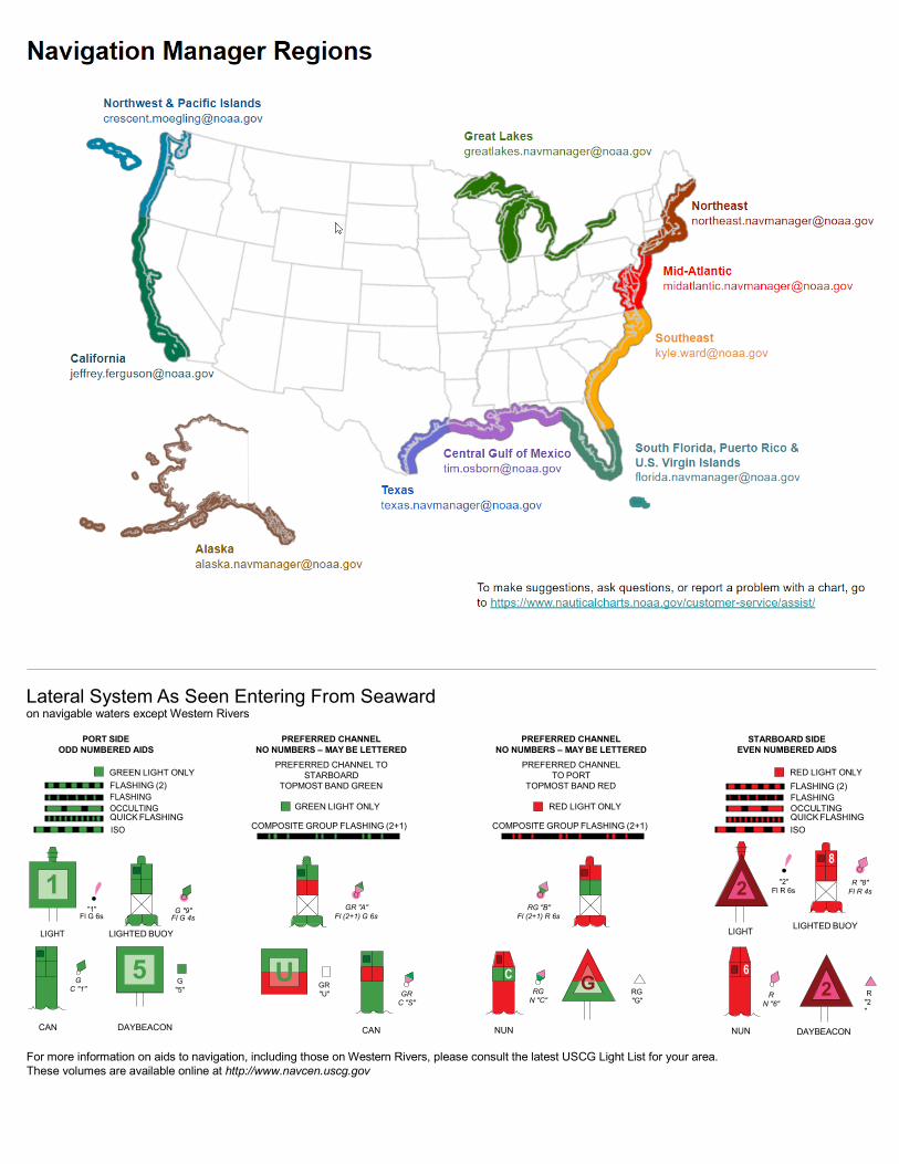
Lateral System As Seen Entering From Seaward on navigable waters except Western Rivers
PORT SIDE ODD NUMBERED AIDS
GREEN LIGHT ONLY FLASHING (2)
PREFERRED CHANNEL NO NUMBERS – MAY BE LETTERED
PREFERRED CHANNEL TO STARBOARD
TOPMOST BAND GREEN
PREFERRED CHANNEL NO NUMBERS – MAY BE LETTERED
PREFERRED CHANNEL TO PORT
TOPMOST BAND RED
STARBOARD SIDE EVEN NUMBERED AIDS
RED LIGHT ONLY FLASHING (2)
FLASHING FLASHING OCCULTING GREEN LIGHT ONLY RED LIGHT ONLY OCCULTING QUICK FLASHING QUICK FLASHING ISO COMPOSITE GROUP FLASHING (2+1) COMPOSITE GROUP FLASHING (2+1) ISO
"1"
Fl G 6s
G "9"
Fl G 4s
GR "A"
Fl (2+1) G 6s
RG "B"
Fl (2+1) R 6s
"2"
Fl R 6s
8
R "8" Fl R 4s
LIGHT
G
C "1"
LIGHTED BUOY
G "5"
GR "U"
GR
C "S"
RG
N "C"
RG "G"
LIGHT
6
R
N "6"
LIGHTED BUOY
R
"2"
CAN DAYBEACON
CAN NUN NUN
DAYBEACON
For more information on aids to navigation, including those on Western Rivers, please consult the latest USCG Light List for your area. These volumes are available online at http://www.navcen.uscg.gov
2
2
C U 5
1


VHF Marine Radio channels for use on the waterways:Channel 6 – Inter-ship safety communications.Channel 9 – Communications between boats and ship-to-coast.Channel 13 – Navigation purposes at bridges, locks, and harbors.Channel 16 – Emergency, distress and safety calls to Coast Guard and others, and to initiate calls to other
vessels. Contact the other vessel, agree to another channel, and then switch.Channel 22A – Calls between the Coast Guard and the public. Severe weather warnings, hazards to navigation and safety warnings are broadcast here.Channels 68, 69, 71, 72 and 78A – Recreational boat channels.
Getting and Giving Help — Signal other boaters using visual distress signals (flares, orange flag, lights, arm signals); whistles; horns; and on your VHF radio. You are required by law to help boaters in trouble. Respond to distress signals, but do not endanger yourself.
EMERGENCY INFORMATION
Distress Call Procedures
• Make sure radio is on.• Select Channel 16.• Press/Hold the transmit button.• Clearly say: “MAYDAY, MAYDAY, MAYDAY.”• Also give: Vessel Name and/or Description;Position and/or Location; Nature of Emergency; Number of People on Board.• Release transmit button.• Wait for 10 seconds — If no responseRepeat MAYDAY call.
HAVE ALL PERSONS PUT ON LIFE JACKETS!
This Booklet chart has been designed for duplex printing (printed on front and back of one sheet). If a duplex option is not available on your printer, you may print each sheet and arrange them back-to-back to allow for the proper layout when viewing.
QR
Quick ReferencesNautical chart related products and information - http://www.nauticalcharts.noaa.gov
Interactive chart catalog - http://www.charts.noaa.gov/InteractiveCatalog/nrnc.shtmlReport a chart discrepancy - http://ocsdata.ncd.noaa.gov/idrs/discrepancy.aspx
Chart and chart related inquiries and comments - http://ocsdata.ncd.noaa.gov/idrs/inquiry.aspx?frompage=ContactUs
Chart updates (LNM and NM corrections) - http://www.nauticalcharts.noaa.gov/mcd/updates/LNM_NM.html
Coast Pilot online - http://www.nauticalcharts.noaa.gov/nsd/cpdownload.htm
Tides and Currents - http://tidesandcurrents.noaa.gov
Marine Forecasts - http://www.nws.noaa.gov/om/marine/home.htm
National Data Buoy Center - http://www.ndbc.noaa.gov/
NowCoast web portal for coastal conditions - http://www.nowcoast.noaa.gov/
National Weather Service - http://www.weather.gov/
National Hurrican Center - http://www.nhc.noaa.gov/
Pacific Tsunami Warning Center - http://ptwc.weather.gov/
Contact Us - http://www.nauticalcharts.noaa.gov/staff/contact.htm
NOAA’s Office of Coast Survey The Nation’s Chartmaker
For the latest news from Coast Survey, follow @NOAAcharts
NOAA Weather Radio All Hazards (NWR) is a nationwide network of radio stations broadcasting continuous weather information directly from the nearest National Weather Service office. NWR broadcasts official Weather Service warnings, watches, forecasts and other hazard information 24 hours a day, 7 days a week. http://www.nws.noaa.gov/nwr/


