IRJET-Simulation of Best Management Practices using SWMM
4
International Research Journal of Engineering and Technology (IRJET) e-ISSN: 2395 -0056 Volume: 02 Issue: 01 | Apr-2015 www.irjet.net p-ISSN: 2395-0072 © 2015, IRJET.NET- All Rights Reserved Page 129 Simulation of Best Management Practices using SWMM Harshal Pathak 1 , Pravin Chaudhari 2 1 Student, Department of civil Engineering,V.J.T.I Mumbai, Maharashtra, India 2 Professor, Department of civil Engineering,V.J.T.I Mumbai, Maharashtra, India Abstract- Urban flooding is significantly different from rural flooding as urbanisation leads to developed catchments which increases the flood peaks from 1.8 to 8 times and flood volumes by up to 6 times. Consequently, flooding occurs very quickly due to faster flow times, sometimes in a matter of minutes The urban areas within India are increasing rapidly and resulting into a major land use change. This gives rise to changed runoff patterns which are high in peak flows and can result into flash floods. Flooding is considered as the most costly type of natural disaster in terms of human casualties and damages. An attempt has been made to study the various aspects of the flooding in complex urban environment. Conventional flood mitigation strategies were studied along with the sustainable ways of dealing with runoff in urban areas. Resilient measures have also been studied. A case study in the City of Mumbai Mithi river sub catchment is considered for this thesis. The catchment is divided into number of basin and it is modelled by using SWMM based on different land use in the catchment. A number of features within the catchment were studied and their suitability with respect to Best Management Practices management is checked. Impact of the proposed systems was checked on the peak flow and runoff volume at various locations within the catchment. It was found that the conventional solutions work out to be very costly. Amongst the BMP’S solutions, rain garden system implementation appeared promising with reuse benefit along with runoff control. To achieve a better level of service and also deal with extreme events, a new way of design would need to be considered, which would involve assessing risks and use of sustainable and resilient measures. Key words- Urbanization, Flood, Mithi river, SWMM, Best management practices. I. INTRODUCTION Flooding is considered as the world’s most costly type of natural disaster in terms of both human casualties and damages. Statistics show that over 45% of water – related disaster fatalities and 90% of affected people since 1980 – 2006 are from Asia. There has been an increasing trend of urban flood disasters in India over the past several years whereby major cities in India have been severely affected. The most notable amongst them are Hyderabad in 2000,The physical and chemical characteristics of storm water runoff change as urbanization occurs .Over the years, the trend in India has been toward increased urbanization Indian census 2001 figured 285 million people stay in 35 metro cities, and is estimated to cross 600 million with 100 metro cities in 2021. The runoff from built up areas within cities is generally collected with conventional drainage systems and finally discharged into a water body. In most urban areas, conventional stormwater management has led to increasing environmental and economical problems. The conventional system is designed for a particular rainfall and is inadequate to cater to higher rainfall intensities. Hence the conventional system fails and cause flooding results in tangible and intangible losses. The term "stormwater best management practices" implies a comprehensive approach to the planning, design, implementation, and operation of stormwater drainage improvements. The purpose of the best management approach is to develop effective drainage systems that balance the objectives of maximizing drainage efficiency Urbanization results in elevated stormwater runoff, greater and more intense streamflow. Stormwater Best Management Practices (BMPs) are used to mitigate these effects of urban land use by retaining large volumes of stormwater runoff (water quantity). Best management practices are use for controlling runoff by using different BMP’s techniques. such as rain water harvesting, inlet control, detention basin, rain garden, permeable pavement system.
-
Upload
irjet-net -
Category
Engineering
-
view
52 -
download
0
Transcript of IRJET-Simulation of Best Management Practices using SWMM

International Research Journal of Engineering and Technology (IRJET) e-ISSN: 2395 -0056
Volume: 02 Issue: 01 | Apr-2015 www.irjet.net p-ISSN: 2395-0072
© 2015, IRJET.NET- All Rights Reserved Page 129
Simulation of Best Management Practices using SWMM
Harshal Pathak1, Pravin Chaudhari2
1Student, Department of civil Engineering,V.J.T.I Mumbai, Maharashtra, India 2Professor, Department of civil Engineering,V.J.T.I Mumbai, Maharashtra, India
Abstract- Urban flooding is significantly different from rural flooding as urbanisation leads to developed catchments which increases the flood peaks from 1.8 to 8 times and flood volumes by up to 6 times. Consequently, flooding occurs very quickly due to faster flow times, sometimes in a matter of minutes The urban areas within India are increasing rapidly and resulting into a major land use change. This gives rise to changed runoff patterns which are high in peak flows and can result into flash floods. Flooding is considered as the most costly type of natural disaster in terms of human casualties and damages. An attempt has been made to study the various aspects of the flooding in complex urban environment. Conventional flood mitigation strategies were studied along with the sustainable ways of dealing with runoff in urban areas. Resilient measures have also been studied. A case study in the City of Mumbai Mithi river sub catchment is considered for this thesis. The catchment is divided into number of basin and it is modelled by using SWMM based on different land use in the catchment. A number of features within the catchment were studied and their suitability with respect to Best Management Practices management is checked. Impact of the proposed systems was checked on the peak flow and runoff volume at various locations within the catchment. It was found that the conventional solutions work out to be very costly. Amongst the BMP’S solutions, rain garden system implementation appeared promising with reuse benefit along with runoff control. To achieve a better level of service and also deal with extreme events, a new way of design would need to be considered, which would involve assessing risks and use of sustainable and resilient measures.
Key words- Urbanization, Flood, Mithi river, SWMM, Best
management practices.
I. INTRODUCTION
Flooding is considered as the world’s most costly type of natural disaster in terms of both human casualties and damages. Statistics show that over 45% of water – related disaster fatalities and 90% of affected people since 1980 – 2006 are from Asia. There has been an increasing trend of urban flood disasters in India over the past several years whereby major cities in India have been severely affected. The most notable amongst them are Hyderabad in 2000,The physical and chemical characteristics of storm water runoff change as urbanization occurs .Over the years, the trend in India has been toward increased urbanization Indian census 2001 figured 285 million people stay in 35 metro cities, and is estimated to cross 600 million with 100 metro cities in 2021. The runoff from built up areas within cities is generally collected with conventional drainage systems and finally discharged into a water body. In most urban areas, conventional stormwater management has led to increasing environmental and economical problems. The conventional system is designed for a particular rainfall and is inadequate to cater to higher rainfall intensities. Hence the conventional system fails and cause flooding results in tangible and intangible losses. The term "stormwater best management practices" implies a comprehensive approach to the planning, design, implementation, and operation of stormwater drainage improvements. The purpose of the best management approach is to develop effective drainage systems that balance the objectives of maximizing drainage efficiency Urbanization results in elevated stormwater runoff, greater and more intense streamflow. Stormwater Best Management Practices (BMPs) are used to mitigate these effects of urban land use by retaining large volumes of stormwater runoff (water quantity). Best management practices are use for controlling runoff by using different BMP’s techniques. such as rain water harvesting, inlet control, detention basin, rain garden, permeable pavement system.

International Research Journal of Engineering and Technology (IRJET) e-ISSN: 2395 -0056
Volume: 02 Issue: 01 | Apr-2015 www.irjet.net p-ISSN: 2395-0072
© 2015, IRJET.NET- All Rights Reserved Page 130
II. CASE STUDY
The Mithi river upper reach from origin Vihar lake to
L&T company area selected as study catchment
area.Mumbai city receives seasonal rainfall for four
months, from June to September. Average rainfall is 2500
mm, out of which 70 per cent is during July and August
only. Mumbai is lined on the west by Arabian sea and is
intercepted by number of creeks (Mahim, Mahul and
Thane creeks), rivers (Mithi, Dahisar, Poisar and Oshiwara
rivers, and their tributaries) and a complex nallah (drain)
system. The catchment considered in this study is Mithi
River catchment which is located between north latitudes
of 19°1'36"and 19°10'9" and east longitudes of 72°49'59"
and 72°56'33".The location of the Mithi River has been
shown in Fig 1.
Figure 1: Mithi river sub-catchment
The river originates from the overflow of Vihar Lake and
also receives the overflows from the Powai Lake about 2
km later. It flows for a total of 15 km before it meets the
Arabian Sea at Mahim Creek flowing through residential
and industrial complexes of Powai, Saki Naka, Kurla,
Kalina, Vakola, Bandra-Kurla complex, Dharavi and
Mahim.
III. METHODOLOGY
The EPA Storm Water Management Model (SWMM) is
a dynamic rainfall-runoff simulation model used for single
event or long-term (continuous) simulation of runoff
quantity and quality from primarily urban areas. Rainfall
runoff plays important role in surface urban flooding. The
runoff data describes the characteristics of the ground
surfaces in the system, and the rainfall-runoff model which
is used for each. This defines how much of the rainfall
falling on the catchment becomes runoff and how quickly
it enters the drainage system. The rainfall-runoff models
comprise a set of models enabling engineers to represent
the transformation of rainfall into runoff for both urban
and rural catchment areas contributing to piped or
channelled drainage systems. . For this purpose rainfall
runoff computation is important to know how much
discharge carry by river channel due to rainfall occurring.
Due to this rainfall runoff modeling required.
Figure 2: Conceptual framework by using SWMM
3.1 Preparation of the land use map.
Mithi river subcatchment is divided into number of
different landuses such as urbanised area, grassy area
International Research Journal of Engineering and Technology (IRJET) e-ISSN: 2395 -0056
Volume: 02 Issue: 01 | Apr-2015 www.irjet.net p-ISSN: 2395-0072
© 2015, IRJET.NET- All Rights Reserved Page 131
open ground, roads, forest area.To identify discharge from
each landuses.
Figure 3: Landuse pattern for Mithi subcatchment.
IV. MODELLING BY USING SWMM
The mithi river sub-catchment was modelled for the
rainfall event of 13th July 2009 to 15th July 2009 by using
SWMM.From that water depth of the river can be
simulated. It was observed that the peak water depth at
powai site is about 0.8m.
Figure 4: Depth simulation by using SWMM.
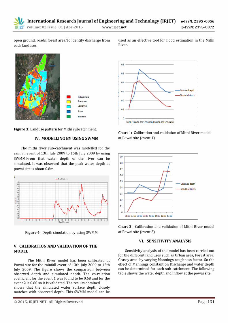
V. CALIBRATION AND VALIDATION OF THE MODEL
The Mithi River model has been calibrated at Powai site for the rainfall event of 13th July 2009 to 15th July 2009. The figure shows the comparison between observed depth and simulated depth. The co-relation coefficient for the event 1 was found to be 0.68 and for the event 2 is 0.60 so it is validated. The results obtained shows that the simulated water surface depth closely matches with observed depth. This SWMM model can be
used as an effective tool for flood estimation in the Mithi River.
Chart 1: Calibration and validation of Mithi River model
at Powai site (event 1)
Chart 2: Calibration and validation of Mithi River model
at Powai site (event 2)
VI. SENSITIVITY ANALYSIS Sensitivity analysis of the model has been carried out
for the different land uses such as Urban area, Forest area, Grassy area by varying Mannings roughness factor. So the effect of Mannings constant on Discharge and water depth can be determined for each sub-catchment. The following table shows the water depth and inflow at the powai site.

International Research Journal of Engineering and Technology (IRJET) e-ISSN: 2395 -0056
Volume: 02 Issue: 01 | Apr-2015 www.irjet.net p-ISSN: 2395-0072
© 2015, IRJET.NET- All Rights Reserved Page 132
Manning’s
Coefficient
“n”
Time of
peak Peak
Water
depth
Peak
Inflow
n+10% 14:15 0.73 0.09
n+5% 14:00 0.76 0.10
N 14:30 0.8 0.11
n-5% 14:00 0.81 0.11
n+10% 14:00 0.83 0.12
Table shows that the simulated discharge and water depth
increases when mannings coefficient decreases and
simulated discharge and water depth decreases when
mannings coefficient increases. Thus the above results
shows that the mannings coefficient affects discharge and
water depth. Table shows the variation ofin mannings
roughness factor for each sub-catchment from -10 to +10
percent.
VII. RESULTS AND DISCUSSION
The flow and water surface depth have been
simulated for the rainfall event of 13th July 2009 to 15th
July 2009 using the model SWMM so by applying the rain
garden LID (LOW IMPACT DEVELOPMENT) on open area
in each basin concept in that model there is reduction in
the water depth at the powai site and results were
obtained. The following Figure shows the reduction of
water depth at Powai site. The water depth from peak
0.8m is reduced to 0.34m.
Figure 5: Implimentation of BMP reducing surface water
depth.
VIII. CONCLUSION
The SWMM models have been used to demonstrate the simulation of flow and water surface depth at Mithi River sub-catchment. The water depth has been obtained at Powai site with and without considering the effect of BMP. The simulation result shows maximum peak reduction of 0.8m to 0.34m by using rain garden as a BMP techniques at Mithi river sub-catchment.
ACKNOWLEDGEMENT
The authors would like to appreciate the editor and potential reviewers very much for their valuable comments and suggestions.
REFERENCES [1] Elizabeth A. Fassman, and Samuel Blackbourn,”Urban Runoff Mitigation by Permeable Pavement System over Impermeable Soils”, ASCE, 473, 2010 [2] Michael E. Barber, Steven G. King, David R. Yonge and Wade E. Hathhorn ,“Ecology Ditch: A Best Management Practice for Storm Water Mitigation” ASCE, 111, 2003 [3] K.Gupta,“ Urban flood resilience planning and management and lessons for the future: a case study of Mumbai, India, Urban Water Journal, Vol. 4 No. 3, 183- 194, 2007. [4] D. Sharma,” Sustainable Drainage System (SuDs) for Stormwater Management: A Technological and Policy Intervention to Combat Diffuse Pollution”, 11th International Conference on Urban Drainage, Scotland, 54, 2008. [5] Chaudhari Pravin and Gupta Kapil,”Hydrological and Hydraulic Modelling of Mithi River flow Using HEC- HMS and HEC- RAS”,Hydro National conference proceeding M.M.University, Ambala,India,2010.
BIOGRAPHIES
Harshal Pathak
Mtech in Environmental Engineering from V.J.T.I. , Mumbai.