IPTC 13083 Combining Wireline and LWD Borehole Seismic Data
8
Copyright 2009, International Petroleum Technology Conference This paper was prepared for presentation at the International Petroleum Technology Conference held in Doha, Qatar, 7–9 December 2009. This paper was selected for presentation by an IPTC Programme Committee following review of information contained in an abstract submitted by the author(s). Contents of the paper, as presented, have not been reviewed by the International Petroleum Technology Conference and are subject to correction by the author(s). The material, as presented, does not necessarily reflect any position of the International Petroleum Technology Conference, its officers, or members. Papers presented at IPTC are subject to publication review by Sponsor Society Committees of IPTC. Electronic reproduction, distribution, or storage of any part of this paper for commercial purposes without the written consent of the International Petroleum Technology Conference is prohibited. Permission to reproduce in print is restricted to an abstract of not more than 300 words; illustrations may not be copied. The abstract must contain conspicuous acknowledgment of where and by whom the paper was presented. Write Librarian, IPTC, P.O. Box 833836, Richardson, TX 75083-3836, U.S.A., fax +1-972-952-9435. Abstract A unique integrated borehole seismic technique was used to access and mitigate drilling risk on a Petronas Carigali high- pressure, high-temperature (HPHT) exploration well offshore Sabah. The approach combined wireline vertical seismic profiling (VSP) and logging-while-drilling (LWD) seismic surveys to look ahead for pore-pressure prediction, geostopping, and obtaining high-resolution seismic imaging below the well path. Three wireline VSP runs and one seismic-while-drilling run were made. The first-run rig-source VSP at the 13 3/8-in. section was used to obtain an initial velocity model and early prediction ahead of bit and imaging. This was followed by a wireline vertical incident VSP (VIVSP) run at the 9 5/8-in. section to refine the pore pressure prediction and for target illumination. LWD seismic was deployed while drilling the following 8 3/8-in. section to provide real-time checkshots for pore-pressure constraint and geostopping above a key formation top to set casing. Both the wireline and LWD VIVSP showed minor faults that were not apparent on the 3D surface seismic; these faults explain the unusual kick encountered. This high-resolution image was used to decide the sidetrack path. The final rig-source VSP was logged at total depth (TD) to complement the pore-pressure prediction and seismic imaging. In addition, the real-time checkshots while drilling aided in stopping drilling to within a stand (less than 30 m) above the key formation top. The depth uncertainty of the key formation was over 130 m prior to drilling. Introduction Integrating wireline and LWD borehole seismic information for drilling is a new technique in Malaysia, first applied by PETRONAS Carigali Sdn Bhd, a subsidiary of PETRONAS. In this novel approach, we will demonstrate how borehole seismic data, which is conventionally used for geologic and geophysical interpretation, has added value for drilling and well planning. The PETRONAS well, drilled in 2008, is located off the coast of Sabah, East Malaysia. The target reservoir, in contrast to most other reservoirs in the region, is deeper, hotter, and at much higher pressures than normal. Pore pressure ramps and depleted sands in the field had previously made drilling difficult, generating hazardous incidents including stuck and lost-in- hole pipe, losses, and kicks. These incidents had resulted in stopping drilling prematurely of the wells at great cost to PETRONAS, and also left the ultradeep targets unexplored. Studies by the PETRONAS sedimentologist suggested that this overpressure hazard is associated with undercompacted bathyal mudstone, and the well casing design required accurate prediction The well path was designed to avoid the regional fault that could complicate pore-pressure prediction. Existing surface seismic and distant well-based velocity control was inadequate for this purpose. IPTC 13083 Combining Wireline and LWD Borehole Seismic Data for Drilling HPHT Well: A Novel Approach TK Lim, SPE, and Aqil Ahmed, Schlumberger, and Gunawan Taslim, SPE, and Muhammad Antonia Gibrata, SPE, PETRONAS Carigali Sdn Bhd
Transcript of IPTC 13083 Combining Wireline and LWD Borehole Seismic Data

Copyright 2009, International Petroleum Technology Conference This paper was prepared for presentation at the International Petroleum Technology Conference held in Doha, Qatar, 7–9 December 2009. This paper was selected for presentation by an IPTC Programme Committee following review of information contained in an abstract submitted by the author(s). Contents of the paper, as presented, have not been reviewed by the International Petroleum Technology Conference and are subject to correction by the author(s). The material, as presented, does not necessarily reflect any position of the International Petroleum Technology Conference, its officers, or members. Papers presented at IPTC are subject to publication review by Sponsor Society Committees of IPTC. Electronic reproduction, distribution, or storage of any part of this paper for commercial purposes without the written consent of the International Petroleum Technology Conference is prohibited. Permission to reproduce in print is restricted to an abstract of not more than 300 words; illustrations may not be copied. The abstract must contain conspicuous acknowledgment of where and by whom the paper was presented. Write Librarian, IPTC, P.O. Box 833836, Richardson, TX 75083-3836, U.S.A., fax +1-972-952-9435.
Abstract A unique integrated borehole seismic technique was used to access and mitigate drilling risk on a Petronas Carigali high-pressure, high-temperature (HPHT) exploration well offshore Sabah. The approach combined wireline vertical seismic profiling (VSP) and logging-while-drilling (LWD) seismic surveys to look ahead for pore-pressure prediction, geostopping, and obtaining high-resolution seismic imaging below the well path. Three wireline VSP runs and one seismic-while-drilling run were made. The first-run rig-source VSP at the 13 3/8-in. section was used to obtain an initial velocity model and early prediction ahead of bit and imaging. This was followed by a wireline vertical incident VSP (VIVSP) run at the 9 5/8-in. section to refine the pore pressure prediction and for target illumination. LWD seismic was deployed while drilling the following 8 3/8-in. section to provide real-time checkshots for pore-pressure constraint and geostopping above a key formation top to set casing. Both the wireline and LWD VIVSP showed minor faults that were not apparent on the 3D surface seismic; these faults explain the unusual kick encountered. This high-resolution image was used to decide the sidetrack path. The final rig-source VSP was logged at total depth (TD) to complement the pore-pressure prediction and seismic imaging. In addition, the real-time checkshots while drilling aided in stopping drilling to within a stand (less than 30 m) above the key formation top. The depth uncertainty of the key formation was over 130 m prior to drilling.
Introduction Integrating wireline and LWD borehole seismic information for drilling is a new technique in Malaysia, first applied by PETRONAS Carigali Sdn Bhd, a subsidiary of PETRONAS. In this novel approach, we will demonstrate how borehole seismic data, which is conventionally used for geologic and geophysical interpretation, has added value for drilling and well planning. The PETRONAS well, drilled in 2008, is located off the coast of Sabah, East Malaysia. The target reservoir, in contrast to most other reservoirs in the region, is deeper, hotter, and at much higher pressures than normal. Pore pressure ramps and depleted sands in the field had previously made drilling difficult, generating hazardous incidents including stuck and lost-in-hole pipe, losses, and kicks. These incidents had resulted in stopping drilling prematurely of the wells at great cost to PETRONAS, and also left the ultradeep targets unexplored. Studies by the PETRONAS sedimentologist suggested that this overpressure hazard is associated with undercompacted bathyal mudstone, and the well casing design required accurate prediction The well path was designed to avoid the regional fault that could complicate pore-pressure prediction. Existing surface seismic and distant well-based velocity control was inadequate for this purpose.
IPTC 13083
Combining Wireline and LWD Borehole Seismic Data for Drilling HPHT Well: A Novel Approach TK Lim, SPE, and Aqil Ahmed, Schlumberger, and Gunawan Taslim, SPE, and Muhammad Antonia Gibrata, SPE, PETRONAS Carigali Sdn Bhd

2 IPTC 13083
Primary well objectives were lightly explored, stacked, lowstand Upper Miocene turbidite reservoir sequences. The deepest of these were expected to be at approximately 4000 m to 5000 m subsea (SS) depth. The shallow units, which are depleted because of production from other locations, were located at approximately 2500 m to 4000 m SS. A seismic line from the existing 3D data set along the wellbore and the structural map are shown in Fig. 1. The predrill velocity function is plotted in Fig. 2.
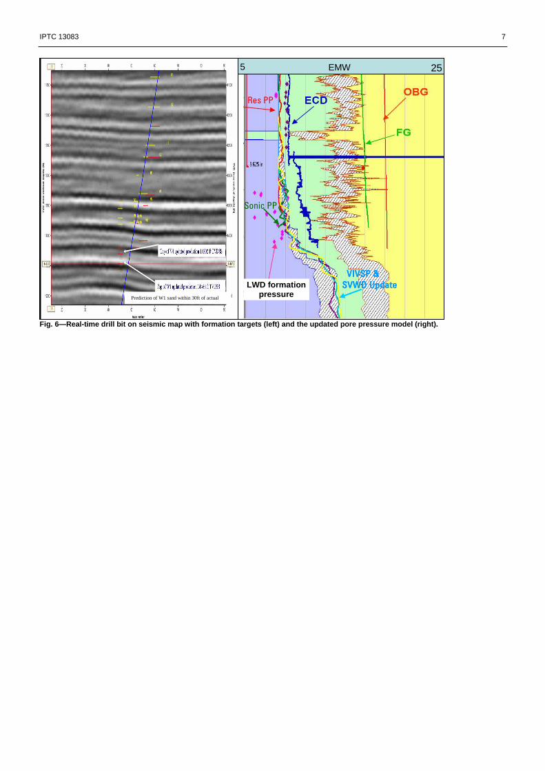
Data Acquisition and Processing The workflow for this integrated approach for risk mitigation in HP well drilling is depicted in Fig. 3. An intensive seismic logging campaign was conducted on this well, comprising three intermediate wireline VSPs, one LWD seismic, and one TD wireline VSP run. The wireline VSP data were acquired in both openhole and cased hole sections through the survey, using four shuttle imaging tools that each have three orthogonally opposed, nongimbaled accelerometer sensors. A triple airgun cluster, with total volume of 450 in3 and constant pressure of 2,000 psi, was used as seismic source. Real-time monitoring and fast interpretation at the wellsite were performed to ensure higher data quality for reliable interpretation. The LWD seismic operation is similar to the wireline operation in that it uses an active surface source (airguns) and downhole receivers (Fig. 4). The key difference with this service is that the receivers are included in the drilling assembly, and therefore drilling does not have to be stopped to take measurements, ensuring transparency to drilling operations by acquiring at connections. Acquiring data in real time mitigates the additional risk of borehole damage and stuck tools associated with running a wireline survey. True amplitude processing was carried out to optimise the reflectivity information. The final deconvolved wavefield provided the higher-resolution images for look-ahead information and velocity inversion ahead of bit. Fig. 5 shows the result of the pore-pressure prediction using the inverted velocity curve from wireline VSP data at difference suites run scenario. The LWD seismic tool functioned extremely well and delivered its promise of real-time checkshots and interval velocities while drilling, with zero impact on drilling time. The real-time time-depth pairs helped to position the bit while drilling and aided in constraining pore pressure ahead of the bit. The processed waveform results compared favorably with conventional wireline surveys. A visual representation of this real-time update of the bit position on seismic map and pore pressure analysis is shown in Fig. 6.
Benefits The approach combining wireline VSP and LWD seismic surveys provide the following benefits: � Both wireline and LWD VIVSP showed minor faults that were not apparent on the 3D surface seismic; the presence of the faults explains the unusual kick encountered. � The real-time checkshot-while-drilling survey helped drilling stop within a stand above the key formation top and assisted in coring and casing decisions as well. � The real-time checkshot update allowed refinement of the pore pressure model, enabling critical drilling decision making before encountering the high-pressure ramp during the drilling process. � High-quality seismic imaging along the well plane supports drilling risk mitigation and well design � The technique improved seismic reservoir characterization and reduced structural uncertainty in a challenging environment.
Conclusions An integrated approach to survey design, acquisition, and subsequent processing and interpretation, coupled with a clear understanding of the drilling and interpretation problem, ensured a high quality data set was acquired and all objectives were realised in time to maximise the impact on the drilling and interpretation process. This combined wireline VSP and LWD seismic VIVSP yielded high-resolution seismic imaging below the well path, enabling drilling risk mitigation, sidetrack well planning and providing look-ahead information for pore pressure prediction. The large amount of borehole seismic data collected in this campaign provided vital information for seismic imaging around the well path. A crucial subfault system, which was not present on the 3D surface seismic, was unveiled by both the wireline VSPs and LWD seismic images. The subfault system also revealed that the supercharging effect was the root cause of the well encountering a kick earlier than predicted from the VSP inversion.
Acknowledgement We wish to thank PETRONAS Carigali Sdn. Bhd., particularly Mr. Mahzan B Mohammad (Manager Well Drilling), for allowing us to publish this work, and we acknowledge the collaborative effort between PETRONAS Carigali Sdn. Bhd. and

IPTC 13083 3
Schlumberger. Thanks go to all those involved in this project, who, through their commitment and persistence were instrumental in the successful conclusion of the data acquisition. Special thanks are also given to Dr Chee Tan (Schlumberger) and Dyah Tribuanawati (PETRONAS) who provided some valuable interpretation information.
References 1. Armstrong, P., Durrand, C., Barany, I. and Butaud, T., 2004, Seismic measurements while drilling reduce uncertainty in the deepwater
Gulf of Mexico, 74th Ann. Internat. Mtg.: Soc. of Expl. Geophys., 2470-2473. 2 Breton, P., S. Crepin, J. C. Perrin (TFE), C. Esmersoy, W. Underhill, A. Hawthorn, B. Frignet, J. Haldorsen (SLB), T. Harrold, and S.
Raikes (BP), 2002, Wellpositioned seismic measurements: Oilfield Review, 32–45. 3. Glenn L. Bowers, Applied Mechanics Technologies, Houston, Texas, U.S, Detecting high overpressure, The Leading Edge, Feb 2002 4. Jakob B.U. Haldorsen, Schlumberger; Mary L. Krasovec, Massachusetts Institute of Technology; Sue Raikes,et al. 2003, Optimizing the
Well Construction Process: Full-Waveform Data From While-Drilling Seismic Measurements in the South Caspian Sea, SPE/IADC 79844
5 Underhill, W., C. Esmersoy, A. Hawthorn, 2001, Seismic measurement while drilling: Conventional borehole seismics on LWD: SPWLA,
Transactions of the SPWLA 42nd Annual Logging Symposium. 6. Underhill, W., C. Esmersoy, A. Hawthorn, (SLB), J. Hendrickson, and M. Hashem (Shell), 2001, Demonstrations of real-time borehole
seismic from an LWD tool: SPE/IADC: SPE 71365.

4 IPTC 13083
Fig. 1—Extracted cross section from 3D surface seis mic along the borehole path (left) and the structur e map (right).
0
1000
2000
3000
4000
5000
6000
7000
8000
9000
10000
11000
12000
13000
14000
0 1 1 2 2 3 3
TWT s
TV
DS
S ft
VSP WL Run 1+2
Predrill CDP
Well-4 checkshots
SVWD RT Check shots
Fig. 2—Seismic while drilling real-time checkshots (red) confirm the continuation of the wireline chec kshot trend as the well goes deeper, thus verifying the predicted depth and pore pressure model.
Well X

IPTC 13083 5
Initial Geomechanics Study - Mechanical Earth Model Baseline
Real Time Direct Measurements - LWD Pressures during drilling
Real Time PP Updates
- LWD data in workstation (Stonefish)*
- 24 by 7 monitoring
Integrated Borehole Seismic
- Wireline VSP; lookahead information
- VSP inversion ahead of bit - Constrain inversion with realtime checkshots while drilling with LWD seismic
- High resolution seismic images, well planning
* Mark of Schlumberger
Fig. 3—Flow path for pore-pressure management with integrated borehole seismic solution
Fig. 4—Simplified vertical well models for wireline and LWD logging method. The technology is transfer red to drilling operations for drilling and real-time operational benefits. LWD se ismic is similar to the wireline service using the same surface active source (airguns) coupled with a gun controller. The main d ifference is that there is no direct cable connecti on between tool and surface. Information transmission instead is achieved throug h mud-pulse telemetry.
seismicVISION
Tool
sea floor
Surface System
MWD telemetry
Source
LWD seismic
Tool
Sea floor
Surface System
MWD telemetry
Source
Surface System
seismic reflector
WirelineWirelineWirelineWirelineToolToolToolTool
sea floor
Source
Surface System
Seismic reflector
WirelineWirelineWirelineWirelineToolToolToolTool
Sea floor
Source

6 IPTC 13083
13000
13500
14000
14500
15000
7 12 17
Pressure Gradient (ppg)D
epth
TV
D (
ft)
StethoScope PressurePoints
Uncertainty
Pore Pressure Predictionfrom VIVSP-1
Real-Time Pore Pressurefrom Resistivity
13000
13500
14000
14500
15000
7 12 17
Pressure Gradient (ppg)
Dep
th T
VD
(ft)
StethoScope PressurePoints
Uncertainty
Pore Pressure Predictionfrom VIVSP-2
Real-Time Pore Pressurefrom Resistivity
Fig 5—Predicted pore pressures from wireline VSP inversio n with LWD seismic constraint. Left, first intermed iate 12 1/4-in. section VIVSP-1 at 13488 ft TVD. Right, subsequent second i ntermediate 8 3/8-in. section VIVSP-2 at 14296 ft T VD, with uncertainty window.
VSP tool @ 13488 ft-TVD
VSP tool @ 14296 ft-TVD
LWD Pressure Points LWD Pressure Points
IPTC 13083 7
Fig. 6—Real-time drill bit on seismic map with form ation targets (left) and the updated pore pressure model (right).
Res PP
Sonic PP
Actual Well Trajectory
EMW
VIVSP & VIVSP & VIVSP & VIVSP &
SVWD UpdateSVWD UpdateSVWD UpdateSVWD Update
Prediction of W1 sand within 30ft of actual
5
LWD formation pressure
25

8 IPTC 13083
TWT, msec
SWD Wireline
TWT, msec
TWT, msec
SWD Wireline
Fig. 7—LWD seismic memory waveform data can be proc essed to obtain corridor stack and seismic image be low the well path (left box, masked as SWD). The correlation between the wi reline and LWD seismic is very good (right, wirelin e).
TWT, m
sec
S2 R3 (9 5/8”)
R1
W2
Projected Sidetrack TD7”Liner
1000ft
TWT, m
sec
S2 R3 (9 5/8”)S2 R3 (9 5/8”)
R1
W2
Projected Sidetrack TDProjected Sidetrack TD7”Liner7”Liner
1000ft1000ft
Fig. 8—Surface seismic cross section along predrill wellbore and the overlain processed wireline VSP i mages. High-resolution VSP images revealed the subfault system, which was not seen on the seismic section, and the sidetrack well path was revised based on this interpretation. Note that the mismatch at well path from 2.75s is because the sidetracked path is deviated from the seismic section.