IPA 1981_ Stratigraphy and Sedimentation Ombilin Basin Central Sumatra (West Sumatra Province)
33
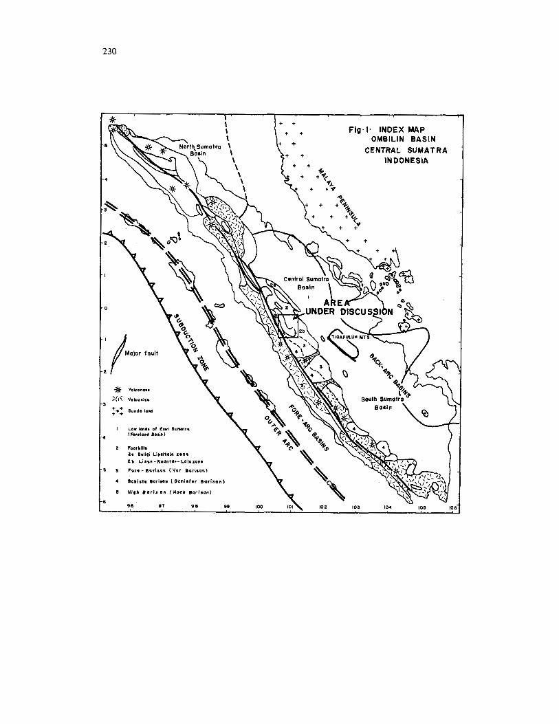
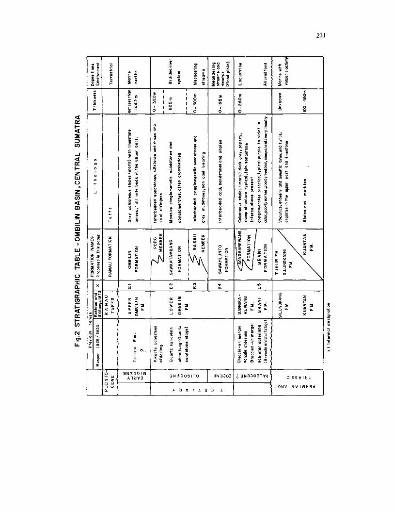
PROCEEDINGS INDONESIAN PETROLEUM ASSOCIATION Tenth Annual Convention, May 1981 STRATIGRAPHY AND SEDIMENTATION OMBILIN BASIN CENTRAL SUMATRA (WEST SUMATRA PROVINCE) RP. Koesaemadinata *) Th. Matasak *) The Ombilin basin is a Tertiary sedimentary and structural basin located on the crest of the Bukit Barisan Range in Central Sumatra (West Sumatra Province). The basin is well know for its Tertiary coal resources. The southern part of the basin is well exposed, while the northern part is covered by Quaternary tuffs. The exposed part of the basin is 27 km wide and 60 km long, trending in the direction of the Sumatra Trend. Present tectonics show the basin to be asymmetric, being rather gentle on its western side, presumably bounded by normal base- ment faults, and fairly steeply folded in the eastern part, with pre-Tertiary rocks overriding the Tertiary strata along a reverse fault; the Takung Fault. Sets of normal and strike-slip faults also dominate the basin. The Pre-Ter- tiary consisb of Carboniferous Limestones (Kuantan Formation), Permian volcanics (Si- hngkang Formation), and Triassic sedimentary strata (Tuhur Formation) which were intruded by granites and granodiorites. Detailed geologic mapping of the Tertiary strata based strictly on lithofacies reveals interesting lateral facies relationships. A re- vised stratigraphic nomenclature is proposed, based on detailed measured sections to serve as stato-types. The lateral lithofacies relation- ships shed an interesting light on the sedimen- tary processes within the basin. The oldest Tertiary unit, the Sangkarewang Formation, presumably Paleocene in age (based on palynology), consists of lacustrine shales, where fish fossils have been found. Interfingering with these lacustrine shales are *) Dept. of Geology, Institute of Technology Bandung. the conglomerates of the Brani Formation, which are shown to be alluvial fan deposits. In the northwestern part of the basin these units are overlain by the Sawahlunto Formation, which is the coal bearing measure. It consists of a sequence of shales, coals and sandstones. The sandstones show indication of lacustrine deltaic deposits. In certain areas the sandstone shows a typical pointbar sedimentary struc- tures sequence. Palynological data suggest an Eocene age for this sequences. The Sawah- lunto Formation is overlain by and pre- sumably interfingers with the Sawahlunto For- mation, which is Oligocene in age. This for- mation is composed of cross-bedded quartz sandstones and conglomerates, and is inter- preted as having been deposited by braided river streams. The lower part (Rasau Member) still shows a typical point bar sandstone sedimentary structures sequence. In the south and eastern part of the basin the Sawahtambang Formation lies directly over the Brani For- mation with a transitional sequence (Kulampi Member of the Brani Formation). The Sawah- tambang Formation also shows a few coal Seams on the upper part (Poro Member). The whole sequence, about 2600 m thick, is conformably (with local erosional surface) overlain by the marine globigerina clay-mark of the Ombilin Formation (Lower Miocene), which is in turn unconformably overlain by the Quaternary tuffs of the Ranau Formation. The Paleogene cycle of sedimentation re- presents the initial terrestrial phase of the Tertiary sequence. It was presumably deposit- ed in an intermontane basin, developed in the © IPA, 2006 - 10th Annual Convention Proceedings, 1981
-
Upload
masri-razak -
Category
Documents
-
view
55 -
download
1
description
tentang ombilin
Transcript of IPA 1981_ Stratigraphy and Sedimentation Ombilin Basin Central Sumatra (West Sumatra Province)
PROCEEDINGS INDONESIAN PETROLEUM ASSOCIATION Tenth Annual Convention, May 1981
STRATIGRAPHY AND SEDIMENTATION OMBILIN BASIN CENTRAL SUMATRA (WEST SUMATRA PROVINCE)
RP. Koesaemadinata *) Th. Matasak *)
The Ombilin basin is a Tertiary sedimentary and structural basin located on the crest of the Bukit Barisan Range in Central Sumatra (West Sumatra Province). The basin is well know for its Tertiary coal resources. The southern part of the basin is well exposed, while the northern part is covered by Quaternary tuffs. The exposed part of the basin is 27 km wide and 60 km long, trending in the direction of the Sumatra Trend.
Present tectonics show the basin to be asymmetric, being rather gentle on its western side, presumably bounded by normal base- ment faults, and fairly steeply folded in the eastern part, with pre-Tertiary rocks overriding the Tertiary strata along a reverse fault; the Takung Fault. Sets of normal and strike-slip faults also dominate the basin. The Pre-Ter- tiary consisb of Carboniferous Limestones (Kuantan Formation), Permian volcanics (Si- hngkang Formation), and Triassic sedimentary strata (Tuhur Formation) which were intruded by granites and granodiorites.
Detailed geologic mapping of the Tertiary strata based strictly on lithofacies reveals interesting lateral facies relationships. A re- vised stratigraphic nomenclature is proposed, based on detailed measured sections to serve as stato-types. The lateral lithofacies relation- ships shed an interesting light on the sedimen- tary processes within the basin.
The oldest Tertiary unit, the Sangkarewang Formation, presumably Paleocene in age (based on palynology), consists of lacustrine shales, where fish fossils have been found. Interfingering with these lacustrine shales are
*) Dept. of Geology, Institute of Technology Bandung.
the conglomerates of the Brani Formation, which are shown to be alluvial fan deposits. In the northwestern part of the basin these units are overlain by the Sawahlunto Formation, which is the coal bearing measure. It consists of a sequence of shales, coals and sandstones. The sandstones show indication of lacustrine deltaic deposits. In certain areas the sandstone shows a typical pointbar sedimentary struc- tures sequence. Palynological data suggest an Eocene age for this sequences. The Sawah- lunto Formation is overlain by and pre- sumably interfingers with the Sawahlunto For- mation, which is Oligocene in age. This for- mation is composed of cross-bedded quartz sandstones and conglomerates, and is inter- preted as having been deposited by braided river streams. The lower part (Rasau Member) still shows a typical point bar sandstone sedimentary structures sequence. In the south and eastern part of the basin the Sawahtambang Formation lies directly over the Brani For- mation with a transitional sequence (Kulampi Member of the Brani Formation). The Sawah- tambang Formation also shows a few coal Seams on the upper part (Poro Member).
The whole sequence, about 2600 m thick, is conformably (with local erosional surface) overlain by the marine globigerina clay-mark of the Ombilin Formation (Lower Miocene), which is in turn unconformably overlain by the Quaternary tuffs of the Ranau Formation.
The Paleogene cycle of sedimentation re- presents the initial terrestrial phase of the Tertiary sequence. I t was presumably deposit- ed in an intermontane basin, developed in the
© IPA, 2006 - 10th Annual Convention Proceedings, 1981
218
beginning of the Tertiary, when the pre-Ter- tiary landmass was blockfaulted into grabens. This graben-like basin was filled from all sides by alluvial fans, while several lakes existed in the middle. As the topographic relief decreas- ed, the basin became an alluvial valley with meandering rivers and later on braided river systems, before it was folded and uplifted in Lower Miocene Time.
The Ombilin basin may serve as a sedimenta- tion model for the Lower Tertiary of Sumatra.
INTRODUCTION
The Ombilin basin is a paleogene sedimen- tary basin well know for its coal seams in Sumatra. It is located in Central Sumatra, in the so called Padang Highland, southwest of the famous Minas oil field. Administration- wise it is located in the Province of West Sumatra. Geologically it is located in a graben- like depression in the Bukit Barisan Range, which is largely compesed of pre-Tertiary rocks, and therefore, it is called an intra- montane basin by van Bemmelen (1949). As it will be discussed in this paper, from a sedi- mentation point of view it was truly an intra- montane basin during the Early Tertiary times.
The area is well cultivated, with numerous villages, and crisscrossed by good country roads. The nortwest-southeast trending basin is cros- sed by a modem highway, which is a part of the projected Trans Sumatra Highway. Im- portant towns are Sijunjung (capital of the district) and Sawahlunto, a coal mining town which is the headquarters for the state-owned Coal Mining Company (PN Batubara), which operates an underground coal mine north of the town.
The scope of this paper is to describe the sedimentation pattern of the Lower Tertiary.
In his discussion of the geologic history of the South and Central Sumatra basinal areas, deCoster (1976) described the facies of the Lower Tertiary as mainly non marine, consist- ing of a complex lacustrine, deltaic and fluviatile sedimentary environment. The Om- bilin basin offers a rare opportunity to study
the Early Tertiary of Sumatra, with its ex- cellent exposures and accessibility. The re- cently constructed TransSumatra Highway has exposed fresh road-cuts where sedimentary structures are available for detailed study. Underground as well as surface mining ac- tivities also offers a wealth of data, augmented by numerous core drillings.
In the past five years the authors super- vised mapping activities of final year geology students of ITB working for their thesis, and had the opportunity to study the excellent section at critical places themselves. Mapping was directed toward the study of the coal deposits for the State mining coal company, financed by Center for Mineral Technology Development Center. In this mapping program the stratigraphy has been approached strictly from a lithofacies point of view. Some of the results have been partially published elsewhere (Koesoemadinata and Hardjono, 1978; Koe- soemadinata, Hardjono, Sumardiry, Usna, 1977; Matasak, Hardjono and Ruslan, 1979). The mapping program is still to be continued this year, and a comprehensive monograph of the whole basin is envisioned as a doctoral dissertation by the junior author.
An earlier work on this basin is by Musper (1929) who described Tertiary fresh-water fish fossils. Possavec et.al. (1973) discussed the fault tectonic features of the area. Work on Pre-Tertiary formations of this area was publish- ed by Klompe et. al. (1957), while Katili (1962) discussed the Triassic granites. Another recent work covering this area is by Tjia (1972). The area is also covered by Quadrangle geologic map of Kastowo and Silitonga (1973) of the Geological Survey of Indonesia.
The sedimentary pattern of this basin could serve as model for understanding the depositional environments of the Early Ter- tiary of Sumatra.
GENERAL GEOLOGY
Regional Setting Tobler (1971) and van Bemmelen (1949)
subdivided the Central Sumatra area into7 distinct physio-tectonic units. 1. The Alluvid

219
Plains of Eastern Sumatra, 2 . The Tertiary Basin of Central Sumatra, 3. The Vor-Barisan (The Barisan friont range), 4. The Median Depression of Barisan Range, 5. The Eastern Barisan Range or the Schiefer Barisan Range, 6. The High Barisan Range with its volcanic crowns and 7. The Alluvial Plain of West Sumatra.
From the point of view of plate-tectonics, Central Sumatra can be subdivided into (from east to west); (1) the continental shelf area belonging to the Sunda Platform, (2) the retro-arc basin (foreland basin or backdeep basin), (3) the magmatic arc (the inner volcanic arc, or geanticline of Sumatra of Van Bemme- len, 1949), (4) the interarc basin (or the inter- deep basin), (5) the front arc (the outer non- volcanic arc) and (6) the foredeep basin or subduction zone.
The Ombilin basin is then located on the magmatic arc. This magmatic arc (or the geanticline or backbone of Sumatra) is domi- nated also by the Semangko Rift Zone or the Trans Sumatra Strike-slip Fault Zone of Katili and Hehuwat (1967), which, according to Possavec et al. (1973), is associated with secondorder thrust faulting and tensional faults which formed graben like structures; e.g. the Sinkarak Lake, subdividing the magmatic arc into a western Barisan Mountain Range with volcanoes, the Eastern Schiefer Barisan (now volcanic), the Median Depressions and the Barisan Front Range, which are non-volcanic in nature. The Eastern Barisan Range (called the Schiefer Barisan) and the Barisan Front Range (the Vor-Barisan of Tobler or the Suligi-Lipat Kain Zone of Van Bemmelen, 1949) consists of pre-Tertiary metasediments (slates, crystalline limestones, volcanics) and granitic intrusives, while the Median Depres- sions are fiiled by Early Tertiary Sediments.
The Ombilin Basin is such a depression filled with Early Tertiary sedimentary strata, flanked by the pre-Tertiary rocks of the Barisan Front Range in the East, and the pre-Tertiary rocks of the Eastern ("Schiefer") Barisan Range in the west. The Early Tertiary strata, however, are not confined to this basin only, there are several other localities in the median depressions, such as Sinamar Basin to-
ward the south east. The Early Tertiary strata are also found west of the High Barisan Range in the west, in the eastern flank of the inter- arc basin, e.i. the Painan basin.
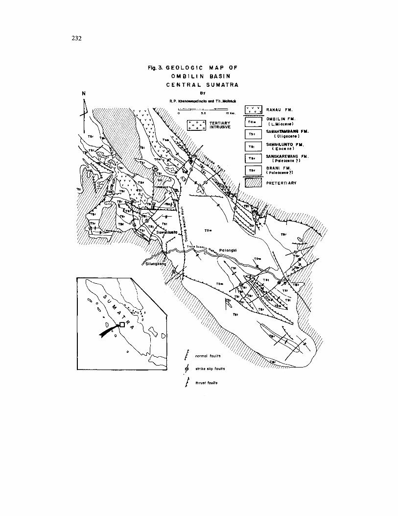
Geologic Structure The Tertiary strata of the Ombilin basin
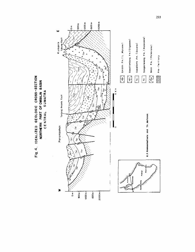
has been involved in folding and rather com- plicated faulting. A north-south trending nor- mal fault of large magmitude, separates the basin structurally into two parts; the eastern part being down-thrown, while the western block upthrown exposing lower-lying strata (see cross-section on fig.4). This fault, the Tanjung Ampalo Fault, forms a conspicuous fault escarpment, bordering in the west the Sigalut Plateau formed by massive conglo- meratic sandstones of the Oligocene Sawah- tambang Formation. This plateau is bordered in the north by an eastwest-trending normal fault with the northern block being down- thrown.
Folding. In general the basin, especially in the eastern block, forms a large synclinal struc- ture. In the northern part (see fig.4) this synclinal structure is asymmetric with a NW-SE trending axis close toward the eastern edge of the basin, with a steeper basinal flank. This asymmetric synclinal structure is asso- ciated with the Takung thrust fault, which forms the north eastern edge of the basin.
The soutern part of the basin which in- cludes the section along the Trans-Sumatra Highway (see fig.5) is symmetrical, the eastern edge not formed by the Takung Fault which has swung toward WSE, while the basin edge is trending N S . Besides the main syncline of the basin, the structure is also dominated by the Palangki anticline. There are suggestions that this Palangki anticline is formed due to the differential movements of basement block- faulting. Both edges of the basin are probably controlled by normal faulting in the basement. In the southeastern part of the Palangki anticline a southward directed thrust fault is also asso- ciated with the northeastern limb of the anti- cline. The presence of an unconformity at Palangki between Oligocene and Early Miocene sediments suggests that the Palangki anticline
220
was uplifted between this time intervals. West of the Tanjung Ampalo Fault the fold structures show a prevalent E-W trending axis, while a N S and NW-SE are also present. Since these axes are mostly in the shales of the Sangkarewang Formation and some also in the Sawahlunto Formation it is suggested that these structures are supratenuous folding, due to compaction on the irregular surface of the pre-Tertiary basement.
Blocks of pre-Tertiary basement are ex- posed among the Tertiary sediments, pre- sumably basement highs, e.g. the NW-SE trending Bk. Tungkar high is especially conspicuous, dividing the northem part of the basin into two parts.
Faulting. Thrust faulting has been identified in the basin, all parallel and in association with the Takung Fault. A southwestward directed thrust fault is found in the northwestern part of the basin separating the pre-Tertiary from Tertiary sediments.
Associated wtih these thrust-faults are the N-S to NNE-SSW trending dextral and NE-SW sinistral strike-slip faults.
Numerous normal faults occur in this basin, of which N-S and E-W to ESE-WNW direction prevailed, e.g. the Tanjung Ampalo Fault and one in the southern part of the basin, where the southern block is upthrown. A NW-SE trending anticline with Brani Formation in its core is observed in this southern block. Other- wise the direction of the fault planes can be on both sides. Other directions are parallel to the basin axis, on the flanks of the fold structures, while only a few have a NE-SW direction. Presumably some of these faults originated in the beginning of the Tertiary with the formation of the basin, to be rejuvenated later in the Tertiary. All the other structures, including folding presumably took place in Plio-Pleistocene time related to the Takung faulting.
STRATIGRAPHY Pre Tertiary
The pre-Tertiary rocks comprise the base- ment of the Tertiary Ombilin basin. They are
exposed in the eastern and western flanks of the basin as well as in the northern central part of the basin.
West of the Ombilin basin it consists of volcanics, limestones and slates ranging in age from Permo-Carboniferous to Triassic. The volcanics, consisting of andesitic and basaltic lavas and tuffs belongs to the Silungkang Formation, with reefal limestones (Ngalau Basurat Formation or the limestone member of the Silungkang Formation), where the Permo-Carboniferous fossils have been found (Fusulinids, Syringpom). The volcanics of the Silungkang Formation are also known to inter- finger with the quartzites and slates/argillites of the Triassic Tuhur Formation. The whole sequence is intruded by the Lassi granite of Katili (1962), whose age is determined to be 200 my.
East of the Ombilin basin the pre-Tertiary rocks consists of the Triassic Kuantan Forma- tion, which consists mainly of recrystalized oolitic limestone, locally developed as marble, Slates/phyllite and quartzites. The Kuantan Formation (Kastowo and Silitonga, 1973) is also intruded by granite massifs of Sumpur Formation (Musper, 1929) with a radiometric age of 200 my (Obradovich, 1973).
In the north central part of the basin pre-Tertiary granodiorites (Tunkar diorites) crop out and form an uplifted block within the basin.
Tertiary The Tertiary stratigraphy of the Ombilin
basin is the main object of this paper. Al- though the formation names in this paper have appeared earlier in published articles (Kastowo and Silitonga, 1975; Koesoema- dinata et.al., 1978; Koesoemadinata and Har- djono, 1979; Koesoemadinata, 1978; Matasak and Ruslan, 1979) it is the purpose of this paper to propose this nomenclature formally as set forth by the Stratigraphic Code of Indonesia, complete with type sections (strato- types) and type localities. A synopsis of the Tertiary stratigraphy of the Ombilin basin is shown on fig.2.
221
BRANI FORMATION
Introductory Statement De Haan (1942) introduced the name Brani
Conglomerate for a sequence of purple colour- ed breccias and conglomerate in the Mangani Area, near Payakumbuh, 60 km north east of Sawahlunto (Ombilin basin). No type section was indicated. Kastowo and Silitonga (1973) used the term Brani Formation for the same lithologic unit as exposed in the Ombilin basin in the Quadrangle Geologic Map of Solok ( 1 : 250.000 ). This name is formally proposed in this paper.
General Lithologic Characteristics Ths formation is composed of a sequence
of purple brown rusty looking polymict peb- ble-to cobble-conglomerates with a muddy sand matrix, very poorly sorted, subangular to subrounded, dense, hard to friable, generally nonbedded to occasionally poorly bedded. The pebble components are composed of various lithologies, highly dependent on the basement rock on which they were deposited, reflecting the short distance of transportation. In the western rim of the basin they consist of volcanics (andesites) and limestones (some- times full of fusulineds), slates and argillite pebbles, in the eastern rim granite pebbles pre-dominate, although quartzite and milky quartz pebbles also occur. Sometimes it con- sists of coarse arkosic gritsand, losing its characteristic purple color (Selo Member). Bedding is typically absent or rudely develop- ed. Type Locality and Type section
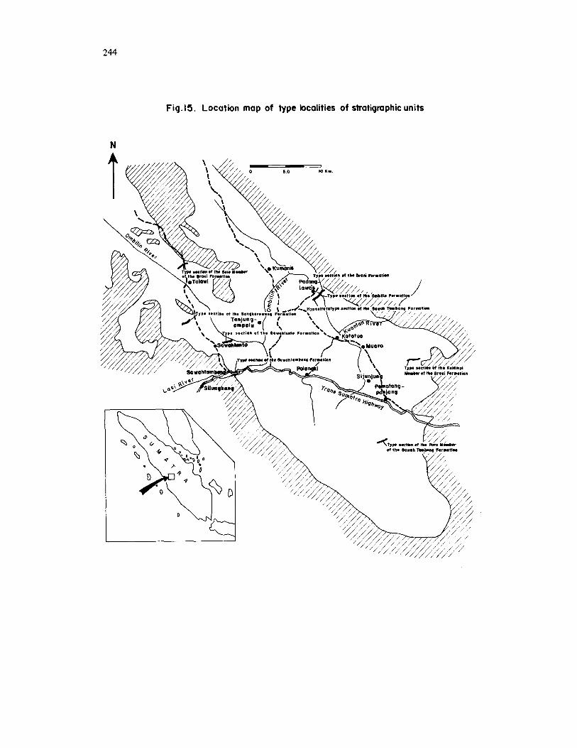
Although its original type locality is in Mangani area, a hypostrato-type is proposed here, located along the Kumani Stream, near the village Guguk, NE Ombilin basin. The type section (although incomplete at the base) is shown in fig.6 and type locality fig. 15).
Distribution and Thickness The formation is widely distributed along
the rim of the Ombilin basin and also in the core of the Palangki anticline in the southern part of the basin. It is well exposed in the
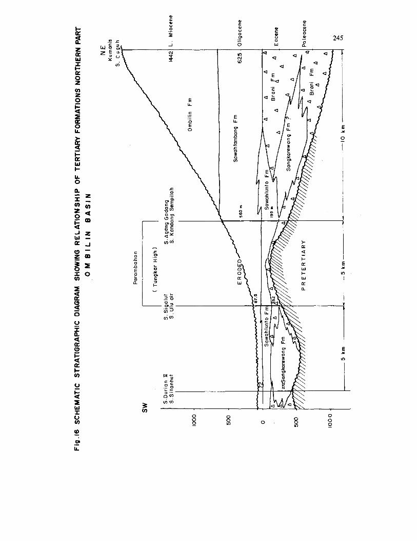
northwestern part of the basin. Thickness ranges for more than 646m in the hypostrato- type to practically nil as it pinches out in certain directions.
Relationship With Other Formations (see fig. 16 and 17)
The Brani Formation definitely lies above an angular unconformity on pre-Tertiary formations or nonconformably on pre-Tertiary plutonic rocks. It is occasionally below or above the Sangkarewang Formation. This relationship is well exhibited in the north- western part of the basin. The Brani Formation is conformably overlain by the Sawahlunto Formation, with a gradational interfingering relationship in the western rim of the basin. In the absence of the Sawahlunto Formation such as it is generally the case in the north- eastern rim of the basin, it is conformably overlain by the Sawahtambang Formation.
Age and Fossil Content No fossils have been found to indicate the
age of the Brani Formation. However, due to its interfingering relationship with the Sangka- rewang Formation, a Paleocene to Eocene Age is suggested.
SELO MEMBER The Selo Member is an identifiable unit
within the Brani Formation, It is distinguished from the Brani Formation by being a distinct lithofacies. This name is proposed formally in this paper.
General Lithologic Characteristics This unit distinguishes itself from the main
Brani Formation for not being typically rusty violet brown colour. It consists of massive nonb edded conglomerates, consisting of boulder to pebble-size rounded fragments floating in a finer matrix. Practically all the fragments are granites, 8 to 75 cm in diameter, while its matrix is sandsize material, poorly sorted, subangular to subrounded, medium to coarse grained, argdlaceous with calcareous cement.
222
Type Locality and Type Section The name is taken after a stream Batang
Selo, south of the village Padang Ganting, 40 km northwest of Sawahlunto, where a section has been measured and proposed as a type locality. The Ampang Niaga Section can be used as a hypostrato-type, being more com- plete (see fig.7 and 15).
Thickness and Distribution The Selo Member is mostly distributed in
the northwestern part of the basin. Its thick- ness is 305 m at Ampang Niago Section, while it could be up to 400 m thi'ck. Stratigraphic Relationship
The Selo Member lies unconformably on the pre-Tertiary granites and presumably with an angular unconformity with other pre-Ter- tiary rocks. It grades upward into the main Brani Formation.
Fossils and Age
mination were carried out. No fossils were found and no age deter-
Depositional Environment
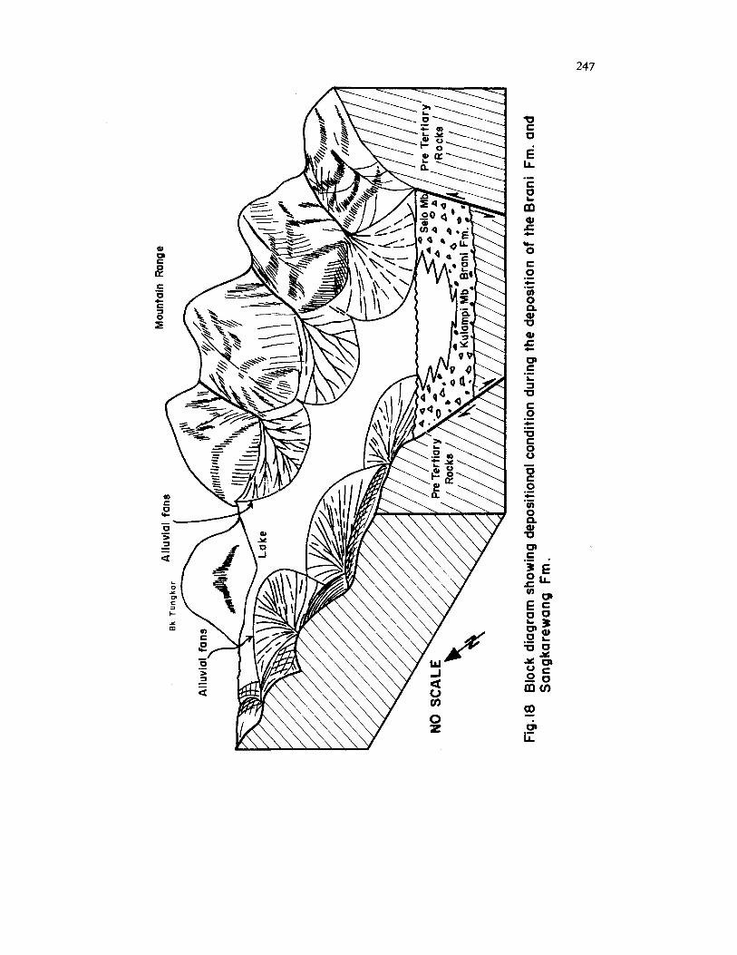
is the fanhead portion of alluvial fans. The depositional environment of this unit
KULAMPI MEMBER
Kulampi Member of the Brani Formation In the eastern edge of the basin, at the
Kulampi River the Brani Formation develops into a particular lithofacies. It is proposed in this paper to designate this facies as a member of the Brani Formation.
General Lithologic Characteristics This member has all the characteristics of
the Brani Formation, including the violet- brown colour consisting of subangular-sub- rounded pebble-conglomerats of polymiot origin(quartzose, granites, limestone), but they are typically graded, with interbedded poorly sorted sandstones, forming a cyclic sequence. Bedding, however, is typically poorly develop- ed.
Type Locality and Type Section The type locality is located along the
Kulampi Stream, near Sijunjung. The type section is shown in fig. 8, although it is not completely exposed. Type locality is shown in fig. 15.
Distriiution and Thickness In the type area this unit is limited in
extent around the Kulampi area. Its exposed thickness is only 258 m (minimum). This member is also developed in the northeastern edge of the basin, around Talawi area.
Relationship With Other Units This member is clearly conformable with
the main Brani Formation. Since it is a part of the Brani Formation it is assumed to interfinger with the Sangkarewang Formation and is overlain conformably by the Sawah- tambang Formation.
Age and Fossil Content No fossils have been found, its age is
assumed to be the same as the main Brani Formation (Paleocene).
Depositional Environment The Brani Formation is interpreted to be
an alluvial fan deposit, with highly variable thickness and locally derived pebbles. The rusty colour is typically of subaerial depo- sition. The Kulampi Member represents a distal part of the aluvial fan. Further discus- sion will be given in the chapter on sedimen- tation.
SANGKAREWANG FORMATION
Introductory Statement The term Sangkarewang Formation was
introduced by Silitonga and Kastowo (1975) in the Geological Survey of Indonesia Quadrangle map; without reference to type section or type locality. The unit was for- merly called the "merge1 stage" by Musper (1929), which together with the Brani For- mation is called the "breccia and marl stage".
223
This formation is well known due to the fossil finds of fresh water fish, of which an Early Tertiary age is supposed.
The name Sangkarewang Formation is formally proposed in this paper and a type section has been measured for this paper.
General Lithologic Characteristic This formation typically consists of fine
laminated shales, brownish dark-grey to black in colour. It is typically plastic and papery, and is calcareous, but contains carbonaceous materid, with mica, pyrite and plant remains.
There are a few interbedded sandstones, monthly less than 1 m thick. The sandstones are quartz to feldspar-bearing, calcareous, grey to black in colour. It shows typically fining upward sequences (graded-bedding, coarse- grained at the bottom and very fine grained at the top), poorly sorted argillaceous matrix, containing mica and carbonaceous material.
Slump structures are prevalent in the for- mation and can be considered as typical.
Type Locality and Type Section As type locality of the Sangkarewang For-
mation, the Sangkarewang Stream located 8 km NW of the town Sawahlunto can be designated. However, as strato-type, the authors would use the section along S. Si- tauhut and S. Durian I1 near Talawi, not far from the original type locality where the name is derived. This type section which is completely measured is shown in fig.9 and its type locality in fig. 15.
Thickness and Distribution This formation is almost entirely distri-
buted in the northwestern part of the basin (northwest of Sawahlunto, in isolated patches within the Brani Formation. Few small iso- lated patches are found in the northwestern rim of the basin.
Stratigraphic Relationship (see fig.16 and 17) The Sangkarewang Formation is known
to lie unconformably on the pre-Tertiary at its type locality with a Basal sandstone and it is conformably overlain by the Sawahlunto
Formation. However at most localities this formation shows an interfingering relationship with a tongue of the Brani Formation separating the Sangkarewang Formation from the pre- Tertiary as well as from the overlying Sawah- lunto Formation. A lateral interfingering relationship with the Brani Formation is fairly well established. The Sangkarewang Formation may even be considered as a lense within the Brani Formation. An interfingering relationship with the Sawahlunto Formation is also suggested.
Age and Fossil Content The most important fossil find in this
formation is the fresh water fish fossil, Mus peria radiata (Herr) and Scieropagus. No new determination has been made for this for- mation. Palynological determined has been made on these fossils; but the results indicate a possible Eocene or pre-Eocene (abundance of Vemcatosporites, Monocolpites and presence of Ech itriporites hianguliforms, Eph edripit es ) - (JICA, 1979).
The age of this formation is also indirectly shown by the overlying Sawahlunto For- mation which is known to be Paleocene to Eocene in age. Therefore, Paleocene- age is suggested.
Depositional Environment Its interfingering relationship with alluvial
fan deposits of the Brani Formation, its fine lamination and the presence of fresh water fossils indicate a lacustrine environment. The sandstone interbeds are turbidites which were fed into the lake. The prevalence of slump structure indicates steep slopes near the lake shore.
SAWAHLUNTO FORMATION
Introductory Remarks The name Sawahlunto Formation is for-
mally proposed for the first time in this paper, although it has been introduced earlier in literature by the senior author (Koesoema- dinata et.al., 1978; Koesoemadinata and Har- djono, 1978). Van Bemmelen (1949) and Marks (1946) included this unit in the Quartz
224
Sandstone Stage (Quartz Zandstein Abteilung), following Musper (1929). In this paper the unit is designated as a separate formation since it forms an economically important coal-bearing unit of the area.
General Lithologic Characteristics The formation consists of a sequence of
brownish grey shales, silty shales and siltstones and interbedded brown, dense, quartz sand- stones and characterised by the presence of coal. The shales are usually carbonaceous or coaly and act as underclays. The sand- stones show a typically fining upward sequence, cross-bedded and especially current- ripple laminated, with a sharp erosional base- indicating a point-bar sequence. The coal is occasionaly interbedded with grey siltstones and coaly clays. Conglomerates are typically absent. The sandstones are known to be lenticular, while the coal beds frequently split and wedge out. In the Parambahan area near Tungkar High the sandstones and coal seams are more numerous.
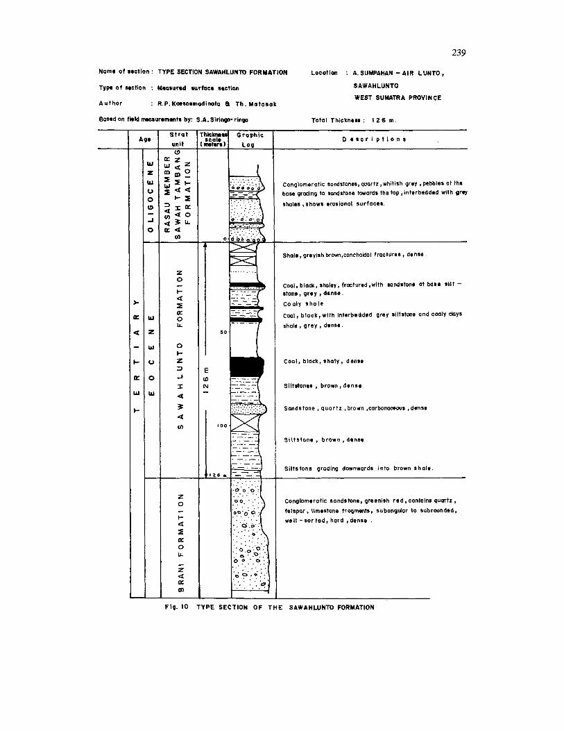
Type Locality and Type Sections The type locality of this formation is desig-
nated near the Air Lunto Stream near the town of Sawahlunto. This section has been measured as shown in fig. 10 and it is proposed to serve as a strato-type section. Another good section is found at Sawahrasau, and it can be used as a hypostrato-type.
Distribution and Thickness The Sawahlunto Formation is almost entirely
distributed in the north-western part of the basin, northwest of the town Sawahlunto. It wedges out toward the east as well as towards the south (see fig.16 and 17).
At the type section the thickness of the formation is 274 m. A thickness of 210 m is known at DDH 7 and 11 5 m at sungei Durian section.
A few isolated occurrences of the Sawahlunto Formation are also found in the northeastern rim of the basin, sandwiched between the Brani Formation and Sawahlunto Formation.
Stratigraphic Relationship (see fig. 16 and 17) The Sawahlunto Formation is known to lie
conformably on the Brani Formation but locally also on the Sangkarewang Formation, although frequently interrupted by a tongue of the Brani Formation. An interfingering relationship with the Sangkarewang Formation is also suggested. The Sawahlunto Formation is conformably overlain by the Sawahtambang Formation.
A interfingering relationship with the Sawahtambang Formation is assumed toward the east where the overlying Sawahtambang Formation is directly overlying the Brani Formation with a conformable contact, with lenses of the Sawahlunto Formation occuring in between. The thickness of this formation measured at its type section is 274 m, but it could have a maximum thickness up to 500 m.
Fossils and Age Except for plant remains and spores this
formation does not contain any fossils. Re- cently a Japanese team of coal investigators analyzed the palynology of core samples from the S-1 drillhole in this formation. Palynomorphs identified seem to indicate a Paleocene age, since Proxapertites Operculatus was detected. However, Eocene may also be a possibility since the number of the above mentioned micro-fossil was very small. No Florschnetzia index fossil for post Eocene in SE Asia has been detected (J.I.C.A., 1979).
Depositional Environment The presense of carbonaceous shales, coals
and especially point bar sandstones indicates a flood basin with meandering rivers, where coal was deposited.
SAWAHTAMBANG FORMATION
Introductory Remarks
This formation name is formally proposed for the first time in this paper, although it has been introduced earlier by the senior author
225
(Koesoemadinata, et.al., 1978; Koesoema- dinata and Hardjono, 1978). Musper (1936), introduced the name of Quartz Sandstone Stage (Quartz sandstein Abteilung, and this name was also used by van Bemmelen (1949), and Marks (1957). In a recent quadrangle map by the Geological Survey of Indonesia, Kas- tow0 and Silitonga, (1973) introduced the term Lower Ombilin Formation, which is not appropriate according to the Stratigraphic Code.
General Lithologic Characteristics The Sawahtambang Formation is charac-
terized by a thick massive sequence of cross- bedded sandstones, mostly quartzose to felds- pathic. Shales and siltstone are only locally developed. The sandstones are light grey to brown, fine-to very coarse-grained mostly conglomeratic consisting of quartz pebbles, very poorly sorted, subangular, hard and mas- sive. Locally in the lower part interbeds of mudstone or silty shales occur forming an important separate unit, the Rasau Member. Also in the upper part interbedded mudstones with coal stringers occur locally, forming the Poro Member.
In general the formation is characterized by the presence of conglomerates, which is absent in the lowerlying Sawahlunto Formation and by its grey to brown color and its cross- bedded nature, to be differentiated from the poorly to nonbedded rusty violet brown colour of the Brani Formation on which it is conformably overlying in the eastern part of the basin. A typical sequence of the Sawah- tambang Formation consists of cycles, each consisting of an erosional surface at the base followed by imbricated pebbles, crossbedding and parallel laminations, with a fining upward sequence. Within this conglomeratic sandstone, lenses of crossbedded sandstone occur. The crossbeds are of large scale, and are mostly trough-shape d.
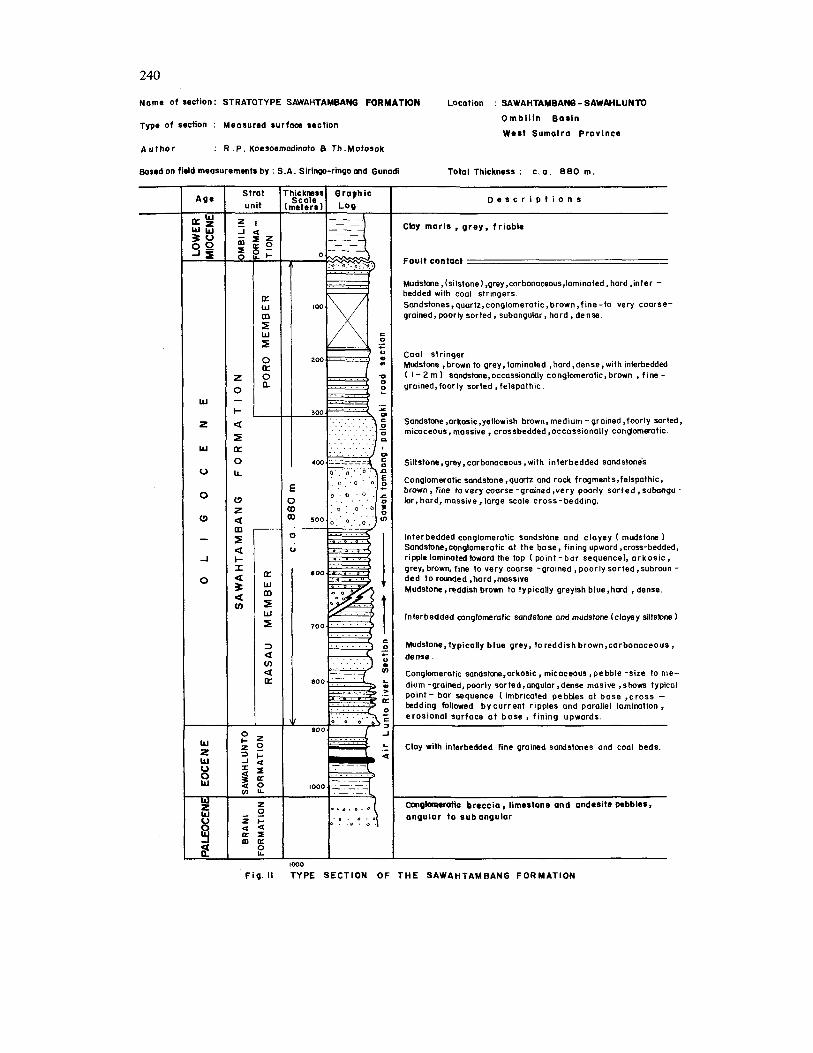
Type Locality and Type Section The name Sawahtambang Formation is
taken from the place Sawahtambang where along the Trans-Sumatra Highway this for- mation is well exposed in road cuts. Although
the section is imcomplete here, the base of the formation is exposed along the Air Lunto Stream, and with which it can be composed into a complete section (see fig. 11).
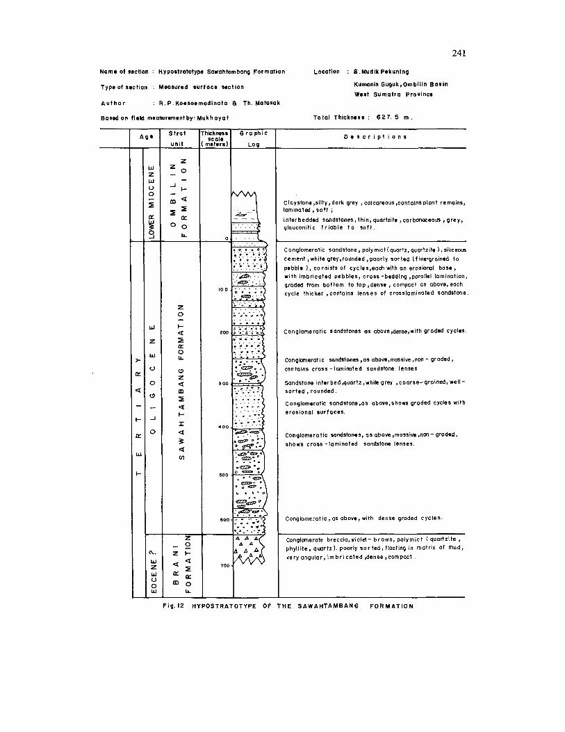
However, the top part of this section is not exposed, being faulted out against the over- lying Ombilin Formation, although both the lower lying Rasau Member and the upper-lying Poro Member are developed in this section. As a typical section a hypostrato-type is proposed along Kumani river (see fig. 12) which depicts the typical Sawahtambang Formation develop- ment (see fig. 15).
Distribution and Thickness This formation is well distributed over the
entire basin, mostly along the basin flank. It forms a plateau-like mountain near Sawah- lunto (Sugar Hill and Sigalut Hills) and the northeastern flank of the Tungkar High. In the northeastern rim of the basin it forms a narrow zone, while in the southern part of the basin it occupies a much broader area. The formation appears to extend northwestward beyond the area depicted in the geologic map in fig. 3.
The measured thickness of the Sawah- tambang Formation is 625 m at the Kumani hypostrato-type. Along the Trans Sumatra Highway, a thickness of at least 880 m has been measured. There appears to be a thickening from north to south.
Stratigraphic Relationship The Sawahtambang Formation lies com-
formably over both the Sawahlunto and Brani Formations. It is overlain conformably by the Ombilin Formation (locally unconformable).
Age and Fossil Content No fossils have been found in this member
except for plant remains. Palynological analysis of the Rasau Member from core samples of W4 drillhole indicates a probable Eocene to Oligocene age. Due tp its stratigraphic position below the Ombilin Formation, which is ob- viously Early Miocene in age and conformably on top of the Sawahlunto Formation, a probably age of Oligocene is assumed.
226
RASAU MEMBER The Rasau Member is a local development
of the lower part of the Sawahtambang Formation in the northwestern part of the basin, where the Sawahtambang Formation comes into contact with the lower-lying Sawahlunto Formation. As a matter of fact it forms a transition zone between both for- mations. This name is proposed formally for the first time in this paper.
General Lithologic Characteristics The Rasau Member is distinctly different
from the underlying Sawahlunto Formation by the appearance of pebbles, conglomeratic sandstone, and the sandstones are mostly coarser in grainsize. It differs from the main Sawahtambang Formation by the presence of argillaceous siltstone (mudstone) intercala- tions, typically blue-grey weathering to red- dish brown in colour, with carbonaceous material, hard and dense.
The sandstones are very coarse-grained to conglomeratic at the base to medium-grained and fine-grained toward the top (fining up- ward sequence), generally pooely sorted, angular, to subrounded, brownish grey in colour, dense and massive. It shows a typical point bar sequence, an erosional surface with imbricated pebbles at the base, followed by crossbedding and current-ripple and parallel lamination toward the top. The sandstones are predominantly quartzose to arkosic. No coal beds are developed in this member.
Type Locality and Type Section Although the Rasau Member is well develop-
ed along the Air Lunto and Sawahtambang road cut, it is not continuously exposed. As type locality and type section exposures at Sawah Rasau near the mine mouth is pro- posed.
Distribution and Thickness This member is distributed only in the
southwestern part of the basin where it is closely associated with the Sawahlunto For- mation.
Its thickness at its type locality is 600 m,
while at the Sawahtambang road cut it is estimated to be about 400 m thick. This member interfingers with the main Sawah- tambang Formation toward the east and southeast. Its development toward the north- east is not yet known.
Depositional Environment This member is interpreted to be deposited
in a flood plain basin with low sinuously meandering river.
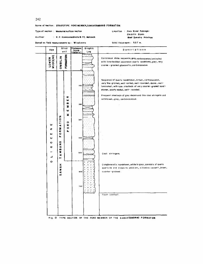
PORO MEMBER This unit is a local development of the
Sawahtambang Formation, which is exposed along the Trans Sumatra Highway, and espe- cially along the Poro river near the Palangki anticline. This name is formally proposed in this paper.
General Lithologic Characteristics The Poro Member differs from the Sawah-
tambang Formation by being nonconglome- ratic and it consists of a sequence of quartz sandstones, with frequent interbeds of grey shales and coal stringers and grey carbona- ceous siltstones.
The sandstones are quartzose, brown, car- bonaceous, very fine-grained, well-sorted, well- rounded, dense, well-laminated with rare inter- beds of coarse-grained sandstone, which are poorly sorted but well-rounded.
Type Locality and Type Section As type locality of this member the Poro
River is proposed, along which a type section has been measured (see fig. 13 and 15).
Thickness and Distribution This member is distributed mainly in the
western part of the basin, as exposed along Trans-Sumatra Highway. It is also found in the eastern part of the basin as exposed along the highway. It probably extends towards the southeast, but certainly not towards the north, where this unit interfingers with the main Sawahtambang Formation.
227
Age and Fossil Content No fossils have been found in this unit,
and therefore no age determination can be made for the formation.
Depositional Environment The unit is probably deposited in a flood
plain environment cut by a low sinuously meandering river.
OMBILIN FORMATION
Introductory Statement The name Ombilin Formation was intro-
duced by Kastowo and Silitonga (1973) in the explanatory notes on the Geological Quad- rangle Map of Singkarak (scale 1 : 100.000). However, this name comprises units which have been proposed to be called respectively Sawahtambang Formation and Sawahlunto Formation, which were included as the Lower Ombilin Formation by both authors. In this paper, it is proposed that the Ombilin For- mation be named for a sequence of marls and shales with few interbedded sandstones, which was previously called the Upper Ombilin For- mation by Kastowo and Silitonga (1973).
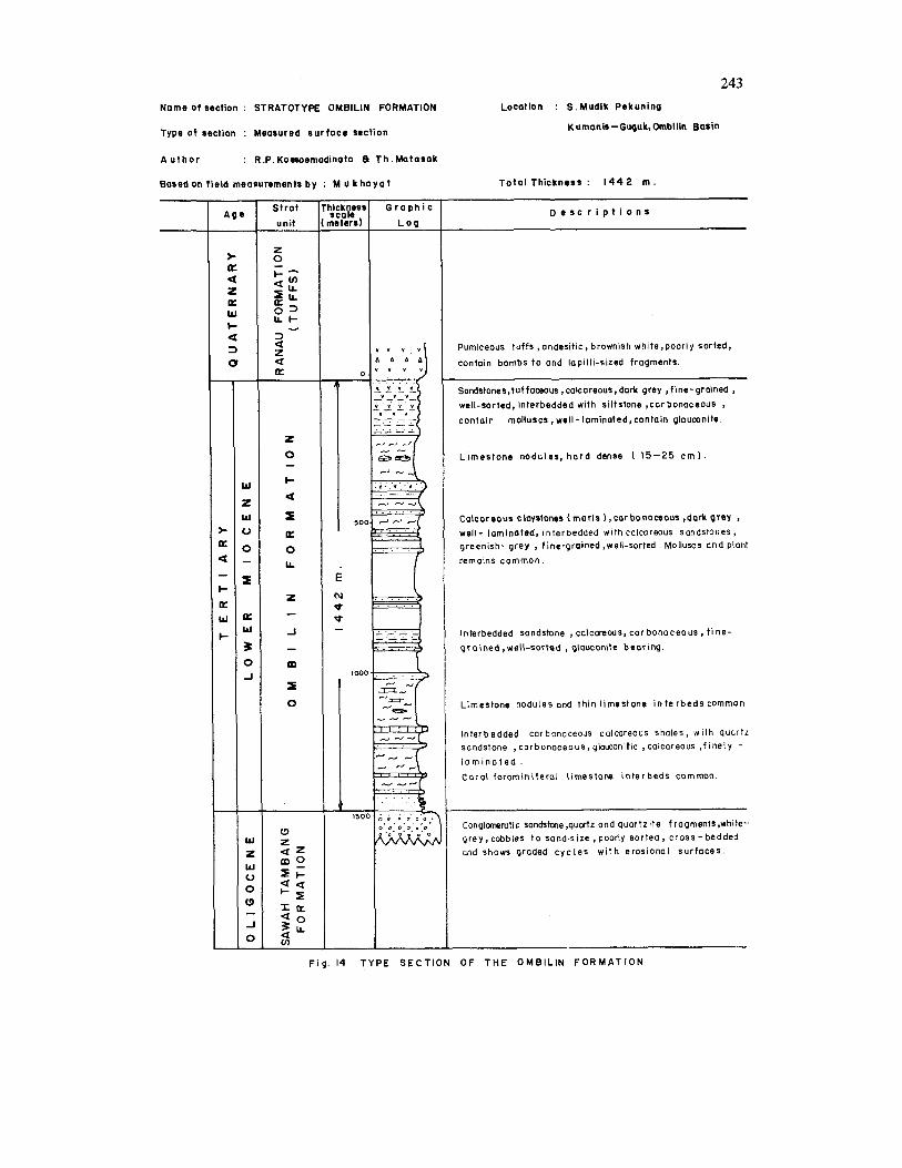
General Lithologic Characteristics The Ombilin Formation typically consists of
dark grey carbonaceous and calcareous shales or marls, weathering typically to light grey, and are generally well-laminated.
Within this sequence are numerous thin intercalations of fine-grained calcareous glau- conite-bearing sandstones, greenish grey in colour. Molluscs and plant remains are com- mon. In the lower part limestones nodules and thin coral-foraminifera1 limestone lenses are common, while in the upper part the sand- stone intercalations are tuffaceous, inter- bedded with siltstones, carbonaceous, glau- conite-bearing, and contain molluscs.
The marls are typical marine, containing glo bigerina
Type Locality and Type Section The Ombilin river along which numerous
outcrops of the formation are exposed can be
designated as type locality. But as type sec- tion the section along S. Mudik Pekuning, a tributary of the Ombilin river is proposed; which has been measured with a total thick- ness of 1442 m. (see fig. 14 and 15). This section is far the most complete found in this basin.
Distribution and Thickness The Ombilin Formation has the widest
distribution in the entire basin. Being the youngest formation it is mostly distributed in the central part of the basin, along the basin axis.
Since its top has never been found, being unconformably overlain by the Pleistocene Ranau (tuffs) Formation; its full thickness cannot be established. The maximum thick- ness measured along its type section is 1442 m.
Stratigraphic Relationship In many sections the Ombilin Formation
appears to be conformable on top of the Sawahlunto Formation. However, at Palangki along the Trans Sumatra Highway the contact is shown by an pronounced erosional surface so that a local unconformity may be sur- mized. Erosional surfaces are common in the fluviatile Sawahtambang Formation so that its tectonic significance is not certain. However, in the foreland basin of Central and South Sumatra an angular unconformity is indi- cated between Oligocene strata and Early Miocene formations (de Coster, 1979).
Fossils and Age The Ombilin Formation contains marine
fossils, such as molluscs fossils. Micropaleonto- logical analysis of several samples indicates the presence of Globigerinoides primordius and G. trilobus, so that a Early Miocene Age (Blow zone, N4-N5) is indicated.
Depositional Environment The presence of glauconites definitely indi-
cates marine environment Benthonic fossil association indicates outer neritic to upper bathyal environment.
228
RANAU FORMATION TUFFS At several localites in the basin a tuff
formation, called Ranau Tuffs by van Bem- melen (1949) are known. It is practically in horizontal position and overlies the underlying formations with an angular unconformable contact. There tuffs are assumed to be Pleis- tocene volcanic deposits.
DEPOSITIONAL HISTORY
Study of sedimentary structural sequences and correlation of vertical profiles makes it possible to reconstruct the depositional his- tory of the basin.
Correlation is carried out using lithologic criteria, and as much as possible using stratal continuity by following outcrops along strike.
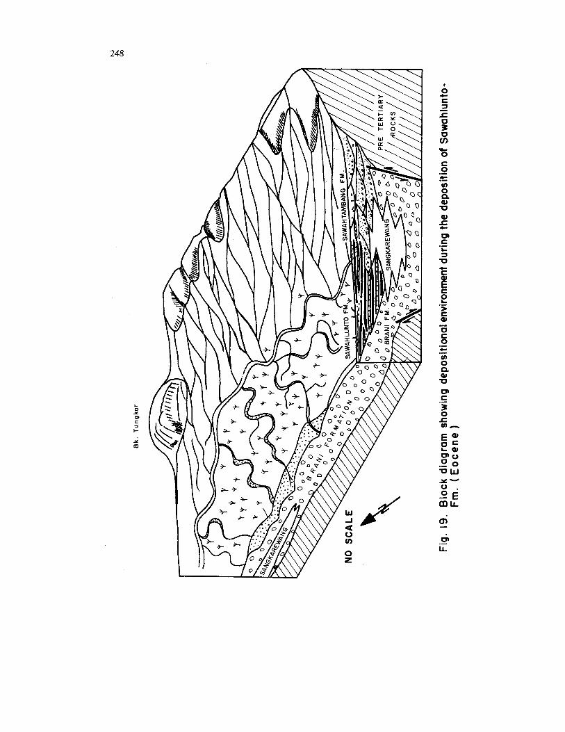
It can be surmised that in the beginning of the Tertiary presumably Paleocene, block- faulting took place as the result of tensional stresses following the Upper Cretaceous oro- genesis. A graben-type intramontane basin was developed with steep fault escarpments at its sides, not much larger than the present basin outline. Alluvial fans developed at all sides of the basin resulting in the Brani Formation conglomerates, of which the Selo Member represents the fan heads, and the Kulampi Member represent the distal fans where the conglomerates show some grading and bedding (fig. 18). A lake developed in the center of the basin, presumably somewhat off-centered toward the northwestern part, where occa- sional turbidites were deposited, which is represented by the Sangkarewang Formation.
In Eocene time, as sedimentation continued, the basin subsided, while erosion of the surrounding hills resulted into a lesser relief and an alluvial valley with a river system developed in the entire basin except in the central and northeastern part, where the former lake became a swampy area with luxurious plant growth, forming a flood plain of meandering rivers. Sediments deposited in this environment are represented in the coal seams of the Sawahlunto Formation (Fig. 9). Sedimentation continued and the swampy area
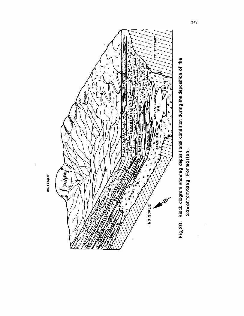
dried up to become a flood plain of meandering rivers. The surrounding hills were subjected to renewed uplift and coarser sediments were deposited, such as conglomeratic sandstones, but still in point-bars, forming the Rasau Member of the Sawahtambang Formation. Sedimentation continued in the Oligocene time, with continuing uplift and subsidence resulting in the development of an alluvial valley with a braided river system, represented by the conglomeratic sandstone sequences of the Sawahtambang Formation. Toward the end of this development a sinuous meandering river developed with associated flood-plains, resulting in the Poro Member of the Sawah- tambang Formation where thin coal beds and shale interbeds are common (fig. 20).
Toward the end of Oligocene time some local uplift took place, resulting in an ero- sional surface at Palangki. In Early Miocene time the whole region subsided and marine transgression took place, where the whole area changed immediately to a neritic to bathyal environment represented by the Early Miocene calcareous shales and limestone lenses of the Ombilin Formation. Some volcanic activity took place in the nearby area, resulting in tuffaceous intercalations in the upper part of the Ombilin Formation. The presence of Mio- cene intrusives in the northeastern part of the basin alsa indicates this magmatic activity at this time. Miocene sedimentation was not only confined to the basin, but covered the whole region. Early Miocene sediments are known to lie directly on pre-Tertiary rocks, such as at Lipat Kain, in the eastern part of the Barisan Range.
The historical record of the rest of the Miocene and Pliocene is missing, but appa- rently folding, and faulting took place in Plio-Pleistocene time, when the whole Bukit Barisan Range was uplifted with subsequent erosion and deposition of Pleistocene tuffs of the Ranau Formation, and the persent geolo- gical picture of the area emerged.
SUMMARY AND CONCLUSIONS
Study on stratigraphy and sedimentation of the Ombilin Basin shows a typical non marine
depositional sequence in an intra-mountain basin. I t began with the formation of a graben-like depression in which alluvial fans developed along the steep sides and a lake in almost the central part of the basin. The basin gradually filled up and the lake became a swamp with meandering rivers, which were already formed along-side the lake. These swamps formed the Sawahlunto Formation with its coal beds.
As sedimentation continued the surround- ing hills became denuded and the basin devel- oped into an alluvial valley with a braided river system depositing thick massive conglo- meratic sandstones, as subsidence continued. Toward the end of the non-marine cycle meandering streams developed locally accom- panied by the development of thin coal beds. The end of the cycle came about as the area was locally uplifted and eroded and subsided followed by a marine transgression. This sedi- mentation pattern may be useful as a model for Early Tertiary non marine depositional sequence in Sumatra, as described by de- Coster (1976) in Central and South Sumatra basinal area prior to the Miocene transgres- sion.
REFERENCES CITED
Bemmelen, R.W. van, 1949, The geology of Indo- nesia, Martinus Nyhoff, The Hague, Netherlands, v. 1, General Geology, v. 1-A port-folio, v. I1 : Economic Geology.
De Coster, G.L., 1976, The Geology of the Central and South Sumatra Basins: Proc. 5-th Ann. Conv. Indon. Petroleum Assoc., Jakarta, p.
De Haan, W., 1942, Over de stratigraphie en de teknoniek van het Mangani gebied: GeoL en Mijnbouw; t. IV, p. 21-23.
Japan International Cooperation Agency, 1979, The survey for rehabilitation of Ombilin coal mine - Geological Report : Unpublished Internal Rept.
Kastowo and Silitonga, Ph., 1973, Peta geologi bersistim lembar Solok, Sumatra : Direktorat Geologi Bandung.
Katili, J.A., 1962, on fhe age of granitic rocks in relation to structural features of Sumatra in Crust of the Pacific Basin : Geoph. Monograph n. 6, p.
77-111.
116-121.
&tili, J.A. and Hehuwat, F., 1967, On the occur- rence of large transcurrent fault in Sumatra, Indonesia: J . of Geoscience, Osaka City Univ.
Klompe, Th. H.F., Katili, J.A., Johannas and Suken- dar A., 1957, Late Paleozoic - Early Mesozoic volcanic activity in the Sundaland, Indon. JOW. Nat Sci., v. 113, p. 89-104.
Koesoemadinata, R.P., Hardjono, Sumadirdja, H. and Usna, I., 1977, Tertiary coal basins of Indonesia : C.C.O.P. Technical Bull., v. 12, p. 43-86.
Koesoemadinata, R.P. and Hardjono, 1977, Kerangka sedimenter endapan batubara Tersier Indonesia : Paper presented at the 6-th Ann. Meeting, Indon. Assoc, Geol. (IAGI), Bandung.
Koesoemadinata, R.P., 1978, Sedimentary framework of Tertiary coal basins of Indonesia : Proc. Third Regional Con€. on GeoL Mineral Resources of Southeast Asia, p. 621-640.
Marks, P., 1957, Stratigraphic lexicon of Indonesia : Publ. keilmuan no. 31, Pusat Djawatan Geologi, Bandung.
Matasak, Th., Hardjono, 1979, Endapan batubara di bagian barat lapangan Ombilin, Sumatra Barat : Paper presented at the 8-th Ann. Meeting, Indon. Ass Geologists (IAGI), Jakarta, Dec. 1979.
Musper, K.A.F.R., 1929, Beknopt verslag over de uitkomsten van nieuwe geologische onderzoeking- en in de Padansche Bovenlanden : Jaarb. Mijnw. Ned. Indie, vol. LVIII, Verhand. (1930), p.
Musper, K.A.F.R., 1934, Die Fischfuerende Breccien und Mergelschiefer abteilung des Tertiars des Padanger Hochlande : Gesl. en Minjb. Gen, Ned. & Kolon., Geol. Serie, v. IX, p. 145-188.
Obradovich, 1973, loc. op. cit. Kastowo and Sili- tonga, 1973.
Prossavec, M., Taylor, D., van Leeuwen, Th., and Spector, A., 1973, Tectonic controls of volcanism and complex movement along the Sumatra fault system: Geol. SOL Malaysia Bull., v. 6, July, p. 43-60.
The Commission for the Stratigraphic Code Indo- nesia, 1975, Stratigraphic Code of Indonesia : Ikatan Ahli Geologi Indonesia (IAGI), Bandung.
Tjia, H.D., 1977, Tectonic depressions along the transcurrent Sumatra fault zone : Geologi Indo- nesia (Bull. Indon. Assoc. Geol.), v. 4, n. 1, p. 13-27.
Tobler, A., 1917, Ueber Deckenbau in Gebier von Jambi : Verth. Naturf. Ges Basel, 28, 2-ter Teil, 123-147 (LOG op. cit. van Bemmelen, 1949).
10, p. 5-17.
303- 31 3.
230
Fig
.2 S
TRA
TIG
RA
PH
IC T
AB
LE - O
MB
ILIN
BA
SIN
, CE
NTR
AL
SU
MA
TRA
RA
NA
U F
OR
MA
TIO
N
- P
LE
IS T
O,
CE
NE
T
u t
f s
Pre
viou
s na
Mus
per
1929
/ 19
35
OM
BlL
lN
FO
RM
AT
ION
T
eIi
sa
F
m.
3
Kw
art
s zo
ndst
een
otde
elin
g
Qu
art
z sa
ndst
ein
ab
teilu
ng
(Qu
art
z
sand
ston
e st
age)
Gre
y co
lcar
eous
sha
les
(mar
k.)
wit
h l
imes
tone
lens
es,T
utt
inte
rbe
ds
in th
e u
pper
pa
rt.
Bre
ccie
-en
mer
gel
scha
lie a
fdee
ling
Bre
ccie
n-un
mer
gel
sch
iefe
r a
bte
ilun
g
(Bre
ccia
ondm
orls
tage
)
E2
!S
(ast
owo
and
;ilito
ngo
197
RA
NA
U
TU
FF
S -
UP
PE
R
JM
BlL
lN
F M
.
LO
WE
R
OM
BlL
lN
FM
.
SA
NG
KA
- R
EW
AN
G
FM
.
BR
AN
1
F M
.
ILU
NG
KAN
G
F M
.
K U
AN
TAN
F M
.
I .-
PO
RO
In
terb
edde
d so
ndst
on-,
silt
sto
ms
ond
shal
es a
nd
ME
MB
ER
co
al
stri
ng
ers
SA
WA
HTA
MB
AN
G
Mas
sive
con
glom
erat
ic
sond
ston
es a
nd
FO
RM
AT
ION
co
nglo
mer
ates
, o
fte
n c
ross
bedd
ed
I FO
RM
ATI
ON
N
AM
ES
P
ropo
sed
in th
is p
aper
0- 3
20
m
.---
- 6
25
m
.--_
--
3 - 3
00
m
- 195
m
0.2
80
m
L i
t h
a l
og
y
Bra
ide
d ri
ve
syst
em
Mea
nder
ing
stre
am
s
Me
an
de
rin
g
stre
ams
and
swam
ps
(flo
od
pla
in)
La
cust
rin
e
Allu
vtol
tans
RA
SA
U
ME
MB
ER
El
Inte
rbed
ded
cong
lom
erat
ic s
ands
tone
s an
d
grey
m
udst
ones
,non
co
al
be
ari
ng
Unk
now
n
100 - 4
5011
1
Mar
ine
with
vo
lcan
ic a
cti
i
E3
-
E4
-
E5
-----
SA
WA
HLU
NTO
FOR
MA
TIO
N
FOR
MA
T IO
N
FO
RM
A T
lON
Inte
rbe
dd
ed
caa
l, sa
ndst
ones
ond
sh
ale
s
Cal
care
ous
shal
es (
ma
rls)
dar
k gr
ey,
pape
ry,
slum
p st
ruct
ure
typ
icd
,th
in
sand
ston
e in
terc
alat
ions
pre
sen
t
cang
lom
erat
es b
recc
ias,
typi
Cal
pu
rple
to
vio
let
in
cdor
,pow
lyso
rted,
paor
ly
bedd
ed, c
ompo
nent
s var
y lo
colly
TU
HU
R
FM
.
SIL
UN
GK
AN
G
Vot
cani
cs,a
ndes
ite
and
basa
ltic
Iava
s,an
d tu
fts,
ar
gilit
es i
n th
e up
per
pa
rt
and
limes
tone
Slo
tes
and
ma
rble
s
Th
ickn
ess
I D
epos
ition
s E
nviro
nmen
t
Te
rre
stri
al
x)
info
rma
l de
sign
atio
n.
232
/ *rust faults
W
Fig.
4.
IDE
AL
IZE
D
GE
OLO
GIC
C
RO
SS
-SE
CTI
ON
N
OR
THER
N
PAR
T O
F O
MB
ILIN
B
AS
IN
CE
NT
RA
L
SU
MA
TR
A
Pa
ra m
ba
han
Ta
njun
g A
mpo
lo
Faul
t K
urn
anis
E
Ta
kung
Fau
lt
, 0
5 K
in
Om bi
lin
Fm
. ( L ,
Mio
cen
e )
a Sawoh
tam
bang
F
m.(
Oli
go
cen
e)
a Sawo
hlun
ta
Fm
(
Eo
cen
e)
R.P. Ko
esoe
mod
inat
o an
d
Th . M
oto
sok
San
gkar
ewon
g Fm. (
Po
leo
cen
e)
Bra
ni
Fm
. (
Po
leo
ce
ne
)
Pre
-Te
rtia
ry
N
w
w
Tonj
ung
Am
polo
Fa
ult
NW
Sa
wa
hto
mb
an
g
I P
ola
,ng
ki
SE
Mua
ro E
otu
,
t4 w
P
Fig
. 5
. ID
EA
LIZ
ED
G
EO
LO
GIC
C
RO
SS
-SE
CTI
ON
SO
UTH
ER
N
PAR
T O
F O
MB
ILIN
B
ASI
N
CE
NT
RA
L
SU
MA
TR
A
Om
bil
in
Fm
.(
L.
Mio
ce
ne
1
a Sawo
htom
bong
Fm
. (O
lig
oce
ne)
Saw
ahlu
nto
Fm. (
Eo
ce
ne
)
a Sang
ka
rew
on
g F
m. (P
ale
oc
en
e)
R.P
. Ko
ero
rmo
din
ata
and
T h
. M
atas
aL
Bro
ni
Fm
( P
ale
oc
en
e)
Pre
Te
rtio
ry
235
Name of section : HYPOSTRATOTYPE - BRANI FORMATION locc l t ion : KUMANIS GUGUK , OMBlLlN BASIN
Type of Wction : Measured s u r f a c e section
A u t h o r : R.P.Koesoemadinata 8 T h . M a t a s a k
WEST SUMATRA PROVINCE
Bosedon field measurements b y : M u k h a y a t
c
S t r a t Uni t
AWkH TAN ANG FM.
2 0
l- - a
a z
0 Lr
- 2 a a m
C
too
200
300
4w
5oc
60C
roc
G r a p h i c
... 0 .
Total Th ickness : 700 m ,
D e s c r i p t i o n s
Conglomeratic sandstones ,quortz, white togrey ,pebbles to gronuies,rounded,poorly sorted,graded, lenses of cross- lomi- noted sandstones.
conglomeratic breccia, violet to brownish ( i ron oxyde ) polymict, (quartz ,quortzose , phyllite pebbles,gronite cobbles and boui- ders 1 angular to subangular, poorly sorted ,imbricated t e x - ture , h a r d , compact.
Lenses of sandstone, b rown, poorly sorted
Lenses of sondstones, quartzose, b rown
Lenses of c loystone ,brown .
Conglomeratic breccia, violet to brown, po lymic t (quar tz , quartzose,phyllite pebbles to boulder) , mud-supported , poorly sorted , angu(ar tosub angular, hard,nmpacted.
Lenses o f c loys tone , brown
F o u l 1
Marble ,crystalline, dolomitic, block to dark-grey , brow- nish t o block, hard ,compacted , breccioted.
F i g . 6 HYPOSTRATOTYPE-BRANI FORMATION
236
Name O f section : Strototype Selo Member, B ron i Fm Type of sectlon : Surface measured sectlons Author : R.P.Koesoemodinot0 and Th. Motosok
Bosed on field
measurement by : Mughotir
S t a r t U n i t
a W
m
E
w
E
0 J
W
v)
w L
I
I
nickness Graphic
K S )
0. 0 .o . 0. ,o . 0' 0 .Q ' 0 . 0 : 0 . . . 0 .o . Q ' .o 0 . 0 ' 0 ' o . 0.0' 0 ' 6 . 0 . 6 . 0 ' 0 ' 0 0' 0;o. 0 ' 0 . .O' '0. ,o ' 0 ' 0 . ,O" 0 ' 0' , Q .
200- . 0 ' , o .
. o . . 0 '
o . . o . 0 ' 0 . b . 0.0 :o . 0 . 0.. 6.0'0 ' 0' .o. . 0.0' ,o
s o - . 0 ' 0 .
m
'
100-
. .
0 ' 0 . 0
- + + + '
t i - + f + i- + . + -I- t + + + + - + + + +
Location : S.Ampongnago
padanggonting Ombilin Bosin
Central Sumatra
Totol Thickness : 305 m
D e s c r i p t i o n s _ _ _ ~ ~
Conglomerate, sondy,violet- brown,consist o f grovel
size fragments, composed gronites, quortz and
feldspor, poorly sorted. rounded to subrounded,
dense, poorly bedded. Fragments oreintoct.
Conglomerate, consist o f 10 -70cm, rounded, t o
subrounded, frogments flooting i n o matrix of finer
groiner clostics (sand to gronule size 1 violet grey to
greenish grey, almost exclusively granite components,
few quortz fragments, calcareous cement, massive
non-bedded.
Granite, pinkish grey, equigronulor coorse-
crystolline, froctured.
F i g . 7 TYPE S E C T I O N OF T H E SELO MEMBER,BRANI FORMATION
237
Name O f section : St ra ta typo Kuhmpi Member,Brani Formotion. Locotion : S. Kulompi , Si jun jung
Typ. o f sction : Meorured S u r f o n Section
A u t h o r : R.P.Koesoemodinoto 8 Th. Motasak
Bosed o n fioldmsosurennnt by : 0. So ib .
S t ra t
u n i t
L
0
- b
a I
K
0
LL
- L
a K
m
O m b l l i n Bas in
west Sumotrc Province
Tota l Thickm88 : 2 50 m
D e s c r i p t i o n s
Tap of sequence not revealed
A.sequence o f interbedded conglomerates, sandstones and claystone, forming a groded sequence with shorp baso ,fining upwards, representing cycles of sedimentation, typically brown to violet in colour.
C loystane ,brown to violet, fr iable , br i f t le
Sandstone , quortzose, brown to grey,occosionally violet, Very coorse-grained, to coarse-groined,poorly sorted, angular, hard, b r i t t l e .
Conglomerate, polymict (quar tz i te , quortz,lithic ) pebble sized, subrounded to subangular,poorly sorted ,In mud -supported matrix,compoct,shows grading ( f i ne toward the top ) Sharp contact at base .
Conglomerote, Violet , polymict (ondesile, diarite, phyll ite ond slate ) fragments, cobble -s ize I 30 cm 1 , su brounded , poorly sor ted ,matrix supported,dense, massive.
F i g . 8 TYPE SECTION OF THE KULAMPI MEMBER,BRANI FORMATION

238
Nameot rect ion: STRATOTYPE SANGKAREWANG FORM4TION Location : S. Sitonhut , S. D u r i a n
T o l a w i .Ombilin Basin f y p at r c t i o n : Measured rur face rection
Au tho r : R.P.KoeroemadinataR T h . M o t o r a k
Weat Sumatra Province
Baud on Fkldmeaturements by : Sulistio H. Hortono
S t ra t
u n i t
0 b-2 2 0 3 - JJt S Q a = 3 K Q O v ) L -
ZANI FM
z 0
l- a I K 0 IL
-
(3
z a 3
a w
Q Y (3
z Q fn
(3
2 2 Q O x - a + Z Q z = K -10 - IL fn
Total Thickners : 2 7 4 m.
D e r c r i p t i o n r
Quartz sandstones,felspathic, greenish grey, very coarse-grained, well -sorted, subrounded ,dense,corbomceous mat ' l , clay pellets, crossbedded. Shale interbeds. Quartz con lomerates, grey, subangular, fairly sorted, marse p e d e s , compact.
Shale calcareous (mar l , brownish black ,plastic, contains
carbomceous rnat'l, mica. pyrite andplant-remains,finely laminated, dense.
Sandstone interbed
Shale calcareous /marl as above
Slump structures.
Sandstone interbed.quortrose,feldspar beuing, cokoreous,grey to black, fine gradinp to marse at the bottom,subangular,pmrly sorted, mica and carbonaceous mat'l , turbidite.
Slump structures.
Shale ,calcareous ( marl 1 , as above.
Slump structures.
Sandstone, brownish, weathered.
Andesite lava,grey togreen,t ine- crystalline, fractured to massive.
Fig. 9 TYPE S E C T I O N OF T H E SANGKAREWAN6 FORMATION
239
Name of section : TYPE SECTION SAWAHLUNTO FORMATION Location : A.SUMPAHAN - AIR LUNTO,
Type O f wction : Meaaursd wr face aoction
A u t h o r : R.P. Kcmsaemadinata & Th. Matasak
Based an tiaid mrasurementr by: S.A.Siringo-rinpo
SAWAHLUNTO
WEST SUMATRA PROVINCE
Total Thickness : I 2 6 m
z 0
l- - a 5. a 0 LL
z (L
- a m
..........
........... - .- . - . - . - . - . - _ -
- - -
so
I . - . - . I
.,.:;::.::. ._ ............ .............
100
. -. - . - . -. . -. -
. -. - . 7 . . . . . DO. . : , .
. . . 99.0- 0 : . . . . . . .. o'.b': . . . . . . . . . * ' . . . . . . . . . . . . ... 0 :o.:o :.. 0 p ,-.? :.
+ . 0 : . .
0 . P:. '
.. ' . . , . . , . . . . . . . . . . . ' . . o . . . .
D a s c r i p t i o n s
Conglomeratic sandstones, quartz ,whitish grey ,pebbles at the base grading to sandstone towards the top , interbedded with gray
shales, shows erasionol surfoces.
Shale, greyish brown,conchoidol froctures , dense
Cool, black, shaiey, fractured,with aandstone at base s i l t - stone, grey , dense.
Coaly shale
C o o l , black, with interbedded grey siltstone and cOalY ckyS
shale , grey , dense.
Coal, black, shaiy, dense
Siitstones , brown, dense
Sandstone, quor tz ,brown ,carbonaccaur ,dense
Sil tstone , brown, dense
Siltstone grading downwards into brown shale.
Conglomeratic sandstone, greenish red, contains quartz,
felspar , limestone fragments, subangular to subrounded, we I I - sor ted, hard ,dense .
Fig. 10 TYPE SECTION OF THE SAWAHLUNTO FORMATION
240
Name of section : STRATOTYPE SAWAHTAMBANG FORMATION Location : SAWAHTAMBANG - SAWAHLUNTO
Type o f section : Measured rurface section
A u t h o r : R .P. Koesoemadinata 8 Th.Matasak
w a r d an field meosurementr by : S.A. Sirimp-ring0 and Gunadi
O m b i l i n B o a i n
Woat Sumot ro P rov inco
Total Thickness : c. 0 . 880 m.
Strot un i t
z I- 0 -
a m I I 0 a 0 a
W
W
-
D e s c r i p t i o n s
Cby morls , grey , f r i ab le
Fou l t contact
Mudstone ,(silstone) ,grey,corbonoceous,laminated, hard ,inter - bedded with coal stringers. Sandstones, quartz,conglomerotic, brown ,fine -to very coarse- groined, poorly sorted, subangular, hard, dense.
Cool str inger. Mudstone ,brown to grey, laminated , hord ,dense, with interbedded t I - 2 m sandstone,occassionaIly conglomeratic, brown , fine - grained,foorly sorted, felspathic
Sandstone ,arkasic,yellowish brown, medium - groined ,foorly sorted, micaceaus, massive, crossbedded ,occassionally conglomeratic.
Siltstone,grey,carbonaceous, with interbedded sandstones.
Conglomeratic sandstone ,quartz ond rock fragments,felspathic, brown, fine toverycoarse-grained,very poorly sorted ,subongu - lor, hord, massive, large scale cross- bedding.
lnterbedded conglomeratic sandstone and clayey ( mudstone 1 Sandstone,conglomeratic at the base, fining upward ,cross-bedded. ripple laminated toward the top ( point - bar sequence), o rkos ic , grey, brown, fine to very coorse -groined ,poorly sorted ,subroun - ded to rounded ,hord,mssive. Mudstone ,reddish brown to typically greyish blue,had , dense.
Interbedded wnglomemtic sandstone and mudstone [clayey siltsbne
Mudstone, typically blue grey, to reddish brown ,corbonoceous , dense.
Conglomeratic sandstaw,orkasic, micaceous ,pebble -Size to me- dium -groinad, poorly sorted,angular ,dense mosive ,shorn typicol Point- bar sequence ( imbricated pebbles at base ,cross - bedding followed by current ripples and parallel lamination , erosional surface a t base , f in ing upwards.
Clay with interbedded fine grainad sandstones and coal beds.
__
Con!$OIIUrOtio b r r c c i o , limestone and ondesito pebbles, angu lor t o sub angular
moo TYPE SECTION OF T H E SAWAHTAMBANG FORMATION F ig . I I
24 1
Nome of section : Hypostratotype Sowohtambang Formot ion Locat ion : 6.Mudik Pekuning
Type of section : Measured r u r f o c e sect ion
A u t h o r : R.P.Koesoemodinato a Th. Motosok
Based o n f ie ld meosurementby: M u k h o y a t
S t r o t
u n i t
z z O - -
I- -1 - m a
0 0
I = U
LL
. . . . . .
0 . . . . . . . . . . . . . . . . . . 9 .?. ? .9 .? ? ? P. : :_ : . a . 1 0 0 . . . . . t . . c. . .,;.; . . _ . . .
10 0
200
Kumonis Guguk,Ombilin B a s i n
West S u m a t r a Province
T o t o l Thickness : 627. 5 m .
D e s c r i p t i o n s
Cloystone ,silty, dark grey , colcoreous ,contoins plant remains, lominoted, so f t ;
interbedded sandstones, thin, quartzite ,corbonoceous , grey, glouconitic f r ioble t o so f t .
Conglomerotic sondstone , polymict (quartz, quortzite 1, siliceous cement, white grey,rounded, poorly sorted ( f ine-groined t o pebble 1, consists of cycles,eoch with on erosional bose, wi th imbricated pebbles, cross -bedding ,parallel lamination, graded from bottom to top ,dense , compoct 0s above, each cycle thicker , contoins lenses of crosslominoted sandstone
Conglomerotic sandstones as obove,dense,with graded cycles.
Congbmerotic sondstones ,as obove,mossive ,nm - graded, contoins cross - lomimted sandstone lenses.
Sondstone interbed ,quortz,whiR grey ,coarse-grained, well - sor ted , rounded.
Conglomerotic sondstone,os obove,shows groded cycles with eros ionol surf aces.
Conglomerotic sandstones, 0 s above ,massive ,nM- graded, shows cross -lominoted sondstona lenses.
Conglomerot ic ,os above, with dense graded cycles
Congianerote breccio,uiolet- brown, polymict (quartz i te , phyll ite, quortz) . poorly sorted,flooting i n motrix Of mud, veryongu lor , imbr ico ted ,dense,compoct .
F i g . 12 HYPOSTRATOTYPE O F T H E S A W A H T A M B A N G F O R M A T I O N
242
Name of section : STRATOTYPE PORO MEMBER,SAWAtiTAMBANG FORMATION
Type of section : Measured surface section
A u t h o r : R. P. Koesoemadinota 8 Th .Motasak
Bored on field measurements by : Wicaksono
Locat ion : Pwo River Polongki Omb i l i n Basin West Sumatra Province
Total Thickness : 537 m.
w w w a z ? U
3%
S t r a t u n i t
a
m I
W
W
I
0
0 0.
a
-
ickness I GraPhic
. . . . .
. . . . . . . . . . . . . . . . . . . . . . . . . . . . . . . . . . . . . . . . . . . . . . . . . . . . . . . 100 .. ,, . . . . 1 . . . . . . . . . . . . . . . . .
. . . . . . . . . . . . . . . . . . . . . . . . . . . . . . . . . . , . .
2 0 0 . . . . . .
. . . . .
300
D e s c r i p t i o n s
Calcareous shale sequence,grey, corbonaceoua.laminated with interbedded colcoreous quartz sandstones,grey, very
coorse - groined glouconitic ,corbonoceous.
Sequence of quartz sandstones, brown, corbonoceous, very fine grained, well-sorted, well-rounded, dense, wel l - laminoted, with rare interbeds of very coarse -grained sand - stones, poorly sorted, well- rounded.
Frequent interbeds of grey shales and thin cool stringers and
siltstones, grey, corbonoceous.
Coal str ingers.
Conglomerotic sandstone ,white to grey ,consists of quartz quartzite and andesite pebbles, sil iceous cement ,brown,
coarse -grained
Fau l t con tac t
F i g . 13 TYPE SECTION OF THE PORO MEMBER OF THE SAWAHTAMBANG FORMATION
Name O f section : STRATOTYFE OMBlLlN FORMATION
Type of section : Measured s u r f o c e section
A u t h o r : R.P.Kocaoemodinot0 EL Th.MotoSok
Based on f ie ld rneorurements by : M u k ha y o t
S t ro t un i t
243 Locot ion : S.Mudik Pekuning
K umanir -Gugut, Ombilin Bo r in
T o t a l Thickness : I 4 4 2 m .
D e s c r i p t i o n s
Pumiceous tuffs ,ondesitic, brownish white,poorly sorted,
contoin bombs to and lopilli-sized frogments.
Sondstones,tuffoceous ,colcoreous,dork grey ,fine-groined , well-sorted, interbedded with siltstone ,cor bonoceous , contain molluscs, well- lominated,contoin gloumnite.
L imestone nodules, h a r d dense 15-25 c m )
Colcoreous claystones (mar l s ),carbonaceous ,do& grey , well- lominoted, interbedded with colcoreous sondstones, greenish- grey , fine-groined ,well-sorted . Molluscs and plant remoins common.
Interbedded sondstone , coIcore~~s, corbonaceous, f i ne - g ra ined ,well-sorted , glouconite beor ing.
Limestone nodules and thin l imestone i n te rbeds common
Interbedded carbonaceous coimreous shales, wi th quartz sondstone ,corbonoceous, glouconitic , colcoreous , f inely - l o m i n o t e d . Corol foraminifera1 l imestone in te rbeds common.
Conglmmtic sondstcne ,quartz and quartzite f rogments ,white- qrey, cobbles t o sand-size , poorly sorted, cross - bedded and shows groded cyc les w i t h erosionol surfaces.
F i g . 14 TYPE SECTION OF T H E O M B l L l N F O R M A T I O N
244
Fig.15. Location map of type localities of stratigraphic units
N
\
0 0 0
E
5
0 s 0 8 !n
0 0 0

NW
01
F 1 g
. I7
SC
HE
MA
TIC
STR
ATI
GR
AP
HIC
DIA
GR
AM
SH
OW
ING
RE
LATl
ON
SH
lPS
OF
TER
TIA
RY
FO
RM
ATI
ON
S N
OR
THER
N P
AR
T O
F SO
UTH
WES
T R
IM
OM
BlL
lN
BA
SIN
Su
ng
oi
Du
rio
nIl
DD
H.7
I I I I I I
Air
L
un
to
h)
P
m
SE
S
awah
tom
bong
(
road
cut)
(S
ow
ahlu
nto
)
DD
H.
~
0
Po
ro M
embe
I I I I
--+-
+ qp
RO
W~
Mem
ber
1
Saw
ohlu
nto
fm.
-
-
c
I v
vv
,
I I I I I I I 10
km
-4
I
V S
ilu
ng
ko
ng
Fm
I
3 I i p
oc e
ne
:oc
en
e
- '0 le
ocen
e
Pre
T
erti
ory
Allu
vial
fan
s B
k. T
un
gka
r I
A
Mou
ntai
n R
ange
Fig.
18
Blo
ck d
iagr
am s
how
ing
depo
sitio
nal c
ondi
tion
durin
g th
e de
posi
tion
of t
he B
rani
Fm
. an
d
San
gkar
ewan
g F
m.
249
c 0
u) 0 0 aJ TI
.- c .-
0 N