Ioannis Fountoulis & Ilias Mariolakos*labtect.geol.uoa.gr/pages/fountoulis/s/122-2008...
10
*Address of the authors: Prof. Dr. Ioannis Fountoulis ([email protected]), Prof. Dr. Ilias Mariolakos ([email protected]), National and Kapodistrian University of Athens, Faculty of Geology and Geoenvironment, Department of Dynamic Tectonic & Applied Geology, Panepistimioupolis Zografou, GR-157 84 Athens, Greece. Z. dt. Ges. Geowiss., 159/3, p. 485–494, 12 figs., Stuttgart, September 2008 Article DOI: 10.1127/1860-1804/2008/0159-0485 1860-1804/0159-0485 $ 4.50 © 2008 E. Schweizerbartʼsche Verlagsbuchhandlung, D-70176 Stuttgart Neotectonic folds in the central-western Peloponnese, Greece Ioannis Fountoulis & Ilias Mariolakos* Fountoulis, I. & Mariolakos, I. (2008): Neotectonic folds in the central-western Peloponnese, Greece. [Neotektonische Fal- tung auf der mittleren West-Peloponnes, Griechenland.] – Z. dt. Ges. Geowiss., 159: 485–494, Stuttgart. Abstract: The western Peloponnese, being very close to the Hellenic Trench, is one of the most active areas in Greece. The study area is located at the central western part of Peloponnese and it is developed in a NNW–SSE direction along 45 km, parallel to the Ionian Trench, which occurs at a distance of only 30–40 km to the west. Based on the morphotectonic studies of the neotectonic macrostructures of the central-western Peloponnese in many scales, it was concluded that the main neo- tectonic mega-structure is the “Megalopolis–Lykaeon–Minthi–Tetrazio Composite Morphotectonic Structure” (MELYMITE CMS) (1 st order structure). The neotectonic deformation is expressed not only by faults, but also by folds which in some cases are the principal structures of the neotectonic deformation. Neotectonic folds occur in the Alpine formations as well as in the post-Alpine ones in various scales. The folds, and the ductile deformation in general, are not easily observed on the surface because of the intense presence of brittle tectonics. A rotational couple stress-field could satisfactory incorporate and explain the brittle-ductile neotectonic structures of the area. Kurzfassung: Die westliche Peloponnes, recht nahe dem Hellenischen Graben gelegen, ist eines der tektonisch aktivsten Gebiete Griechenlands. Das Untersuchungsgebiet liegt im zentralen Teil der West-Peloponnes und erstreckt sich über 45 km in NNW–SSE-Richtung parallel dem Ionischen Graben, der in einer Entfernung von 30–40 km westlich davon verläuft. Auf Grund morphotektonischer Untersuchungen der neotektonischen Makrostrukturen der zentralen West-Peloponnes in ver- schiedenen Maßstäben ergab sich, dass die sog. Megalopolis–Lykaion–Minthi–Tetrazio-„Composite Morphotectonic Struc- ture“ (MELYMITE CMS) die wichtigste neotektonische Megastruktur darstellt. Die neotektonische Verformung wird nicht nur durch Verwerfungen sondern auch durch Faltungen deutlich. Neotektonische Faltungen erscheinen in alpinen und postal- pinen Formationen in unterschiedlicher Größenordnung. Faltungen und duktile Veränderungen sind allgemein, wegen der kräftigen bruchtektonischen Einflüsse, nicht leicht von der Oberfläche her nachzuweisen. Ein durch ein Rotationspaar be- dingtes Stressfeld kann die neotektonische Bruchfaltenstruktur des Gebietes zufriedenstellend darstellen und erklären. Keywords: neotectonic, fold, deformation, ductile, brittle, uplift, subsidence, rate, sediments, Greece Schlüsselwörter: Neotektonik, Faltung, duktile Verformung, Bruchverformung, Hebung, Senkung, Raten, Sedimente, Grie- chenland 1. Introduction Central-western Peloponnese covers the main western part in the Aegean Arc system (Hellenic Arc), which lies at the western margin of the Aegean continental block. The Hel- lenic Arc is a convergent zone associated with northward subduction of the African Plate beneath the Aegean (Fig. 1a). The western part of Peloponnese is located in one of the tec- tonically and seismically most active areas of the Africa- Eurasia collision zone. The study area is a complex multi-fractured neotectonic macrostructure, which is characterized by the presence of large grabens and horsts bounded by wide fault zones, trend- ing approximately E–W. Inside these first-order neotectonic macrostructures a considerable number of small order struc- tures are present (Fig. 2). Western Peloponnese is dominated by extensional tec- tonics as expressed by the E–W oriented normal faults on its central-western part (Fig. 2). The deep-seated compres- sional tectonics is not in contradiction with the extensional features observed on shallow structures on the upper plate. Many geophysical, geological, morphotectonic and paleo- magnetic investigations were conducted in western Pelo- ponnese, dealing with the crustal structure and the seismic hazard of this area. Mariolakos & Papanikolaou (1987) claim that the deformation pattern of the area is not only a result of axial extension but also a result of simple shear and torsion.
-
Upload
truongkhanh -
Category
Documents
-
view
228 -
download
0
Transcript of Ioannis Fountoulis & Ilias Mariolakos*labtect.geol.uoa.gr/pages/fountoulis/s/122-2008...
eschweizerbartxxx
*Address of the authors:Prof. Dr. Ioannis Fountoulis ([email protected]), Prof. Dr. Ilias Mariolakos ([email protected]), National and Kapodistrian University of Athens, Faculty of Geology and Geoenvironment, Department of Dynamic Tectonic & Applied Geology, Panepistimioupolis Zografou, GR-157 84 Athens, Greece.
Z. dt. Ges. Geowiss., 159/3, p. 485–494, 12 figs., Stuttgart, September 2008 Article
DOI: 10.1127/1860-1804/2008/0159-04851860-1804/0159-0485 $ 4.50
© 2008 E. Schweizerbartʼsche Verlagsbuchhandlung, D-70176 Stuttgart
Neotectonic folds in the central-western Peloponnese, Greece
Ioannis Fountoulis & Ilias Mariolakos*
Fountoulis, I. & Mariolakos, I. (2008): Neotectonic folds in the central-western Peloponnese, Greece. [Neotektonische Fal-tung auf der mittleren West-Peloponnes, Griechenland.] – Z. dt. Ges. Geowiss., 159: 485–494, Stuttgart.
Abstract: The western Peloponnese, being very close to the Hellenic Trench, is one of the most active areas in Greece. The study area is located at the central western part of Peloponnese and it is developed in a NNW–SSE direction along 45 km, parallel to the Ionian Trench, which occurs at a distance of only 30–40 km to the west. Based on the morphotectonic studies of the neotectonic macrostructures of the central-western Peloponnese in many scales, it was concluded that the main neo-tectonic mega-structure is the “Megalopolis–Lykaeon–Minthi–Tetrazio Composite Morphotectonic Structure” (MELYMITE CMS) (1st order structure). The neotectonic deformation is expressed not only by faults, but also by folds which in some cases are the principal structures of the neotectonic deformation. Neotectonic folds occur in the Alpine formations as well as in the post-Alpine ones in various scales. The folds, and the ductile deformation in general, are not easily observed on the surface because of the intense presence of brittle tectonics. A rotational couple stress-fi eld could satisfactory incorporate and explain the brittle-ductile neotectonic structures of the area.
Kurzfassung: Die westliche Peloponnes, recht nahe dem Hellenischen Graben gelegen, ist eines der tektonisch aktivsten Gebiete Griechenlands. Das Untersuchungsgebiet liegt im zentralen Teil der West-Peloponnes und erstreckt sich über 45 km in NNW–SSE-Richtung parallel dem Ionischen Graben, der in einer Entfernung von 30–40 km westlich davon verläuft. Auf Grund morphotektonischer Untersuchungen der neotektonischen Makrostrukturen der zentralen West-Peloponnes in ver-schiedenen Maßstäben ergab sich, dass die sog. Megalopolis–Lykaion–Minthi–Tetrazio-„Composite Morphotectonic Struc-ture“ (MELYMITE CMS) die wichtigste neotektonische Megastruktur darstellt. Die neotektonische Verformung wird nicht nur durch Verwerfungen sondern auch durch Faltungen deutlich. Neotektonische Faltungen erscheinen in alpinen und postal-pinen Formationen in unterschiedlicher Größenordnung. Faltungen und duktile Veränderungen sind allgemein, wegen der kräftigen bruchtektonischen Einfl üsse, nicht leicht von der Oberfl äche her nachzuweisen. Ein durch ein Rotationspaar be-dingtes Stressfeld kann die neotektonische Bruchfaltenstruktur des Gebietes zufriedenstellend darstellen und erklären.
Keywords: neotectonic, fold, deformation, ductile, brittle, uplift, subsidence, rate, sediments, Greece
Schlüsselwörter: Neotektonik, Faltung, duktile Verformung, Bruchverformung, Hebung, Senkung, Raten, Sedimente, Grie-chenland
1. Introduction
Central-western Peloponnese covers the main western part in the Aegean Arc system (Hellenic Arc), which lies at the western margin of the Aegean continental block. The Hel-lenic Arc is a convergent zone associated with northward subduction of the African Plate beneath the Aegean (Fig. 1a). The western part of Peloponnese is located in one of the tec-tonically and seismically most active areas of the Africa-Eurasia collision zone.
The study area is a complex multi-fractured neotectonic macrostructure, which is characterized by the presence of large grabens and horsts bounded by wide fault zones, trend-ing approximately E–W. Inside these fi rst-order neotectonic
macrostructures a considerable number of small order struc-tures are present (Fig. 2).
Western Peloponnese is dominated by extensional tec-tonics as expressed by the E–W oriented normal faults on its central-western part (Fig. 2). The deep-seated compres-sional tectonics is not in contradiction with the extensional features observed on shallow structures on the upper plate. Many geophysical, geological, morphotectonic and paleo-magnetic investigations were conducted in western Pelo-ponnese, dealing with the crustal structure and the seismic hazard of this area. Mariolakos & Papanikolaou (1987) claim that the deformation pattern of the area is not only a result of axial extension but also a result of simple shear and torsion.

eschweizerbartxxx
486 Ioannis Fountoulis & Ilias Mariolakos
The general tectonic trend of the western Peloponnese is NNW–SSE, following the geometry of the fold and thrust belt of the External Hellenides (Philippson 1898, Aubouin et al. 1961, Aubouin 1977, Jacobshagen 1979) and of the mod-ern Hellenic Arc and Trench System (McKenzie 1972, LePi-chon & Angelier 1979). However, the neotectonic structures in the area are not oriented parallel to the arc in the NNW–SSE direction and there are several east–west trending fault zones forming the margins of the post-Alpine basins devel-oped on top of the thrust sheets of the Hellenides, with alter-nating horst and graben structure (Fig.1b; Mariolakos & Pa-panikolaou 1981, 1987, Mariolakos et al. 1985).
Extended outcrops of marine Lower Pleistocene sedi-ments are observed within the grabens along the coastal zone up to 15–20 km distance from the coastline and at altitudes of several hundred metres (Kowalczyk et al. 1975, Kelletat et al. 1978, Kowalczyk & Winter 1979, Fountoulis 1994, Mariolakos et al. 1998). This demonstrates the occurrence of signifi cant vertical tectonic movements during the Quater-nary, which permitted the deposition of marine Quaternary sediments in subsided areas and their subsequent uplift and erosion at their present state.
Ductile structures (folds) within the post Alpine deposits of western Peloponnese have not been studied so far, not even found or described. The only folds mentioned so far in sediments younger than Upper Miocene on the Ionian Is-lands, are related to diapiric phenomena (Underhill 1988, 1989). Mariolakos & Fountoulis (1990), having studied the neotectonic deformation in the broader area of Filiatra in SW Peloponnese, described a neotectonic macrofold within the Early Pleistocene marine deposits. This paper deals with the neotectonic ductile structures that occur in various scales in central-western Peloponnese.
In order to understand the nature of the deformation af-fecting the central-western Peloponnese, the neotectonic structures (folds and faults), the spatial distribution and the
dip direction of the planation surfaces created on the Early to Middle Pleistocene sediments, were studied.
In areas where only the Alpine basement crops out the only source of data, other than morphological data, is the deformation of the Alpine tectonic features during the neo-tectonic period that is the period after the end of the thrust tectonics. The general direction of the thrust surfaces and the Alpine fold axes in western Greece is NNW–SSE. Statisti-cally signifi cant deviations of structural elements of the aforementioned Alpine directions should result from neotec-tonic deformation, such as faulting or block rotation.
2. Geology – neotectonics
2.1. General
At a regional scale the Hellenic territory can be divided in three morphoneotectonic regions (Mariolakos & Fountoulis 2004; Fig. 1a). More specifi cally, Mariolakos & Papan-ikolaou (1981, 1987) and Mariolakos et al. (1985) divided the southern morphoneotectonic region in three sectors (I, II, III) according to the general direction of the morphologic and the neotectonic major fracture zones prevailing in each region (Fig. 1b). These morphoneotectonic structures consist of successive neotectonic multi-fractured more or less paral-lel horsts and grabens (Fig. 1b).
At a regional scale, several neotectonic fi rst-order struc-tures may be distinguished in central-western Peloponnese (Fig. 2). These are from south to north: (1) the Kyparissia Mts. composite morphotectonic structure, (2) the Megalopo-lis–Lykaeon–Minthi–Tetrazio Composite Morphotectonic Structure (MELYMITE CMS) and (3) the Lapithas Mt. Horst. Within the major MELYMITE CMS the following second order macrostructures occur: (1) the Zaharo Tectonic Graben, (2) the Minthi Mt. Horst, (3) the Neda Tectonic
Fig. 1: The three Morpho-Neotectonic Regions (MNR) (a) as well as the three sectors and the main marginal fault zones of the post-Alpine basins in the southern continental Greece (b); modi-fi ed by Mariolakos & Fountoulis 2004, from Mariolakos & Papanikolaou 1981, 1987.

eschweizerbartxxx
487Neotectonic folds in the central-western Peloponnese, Greece
Graben, (4) the Tetrazion Mt. Horst, (5) the Kyparissia–Kalo Nero Tectonic Graben, (6) the Lykaeon Mt. Horst and (7) the Megalopolis Tectonic Graben (see also Fig. 2). All the mac-rostructures located at the western part of the studied area strike E–W, except the Lykaeon Mt. Horst and the Megalo-polis Graben that strike NNW–SSE.
Several studies have been implemented in the onshore coastal zone of Kyparissiakos Gulf analyzing the stratigra-phy and structure of the post-Alpine sedimentary sequences (Hageman 1977, Kamberis 1987, Fountoulis 1994, Foun-toulis & Moraiti 1994, 1998). These sediments are uncon-formably overlying the Alpine formations and comprise con-tinental and marine deposits of Pliocene and Quaternary age (Fig. 2). The successive episodes of sedimentation and ero-sion with respect to the vertical neotectonic movements and the resulting landscapes have been analysed by Dufaure (1977) within his general study of Peloponnesus.
The Alpine formations mainly belong to the Pindos Nappe, which comprises a Mesozoic pelagic sequence and a Paleogene fl ysch. Thick molassic conglomerates of Miocene age occur at the front of the Pindos Nappe in the area south of Kyparissia (Fig. 2). The underlying Gavrovo Nappe, com-
prising Mesozoic to Upper Eocene shallow water carbonates and an Upper Eocene–Oligocene fl ysch occurs at the area of Filiatra in the south whereas a small outcrop of the more external Ionian Nappe occurs at the western part of Lapithas Mt. near the Olympia Basin at the north (Fig. 2; Fountoulis & Lekkas 1991).
Concerning the regional neotectonic characteristics of the study area, it should be mentioned that the marginal fault zones of the neotectonic macrostructures strike mainly E–W in the western part and NNW–SSE in the eastern part (Fountoulis 1994). Their vertical throw is not constant along their whole length, but usually it increases from east to west concerning the E–W fault zones and from south to north concerning the NNW–SSE fault zones. The faults that constitute a fault zone have an en echelon arrangement. They do not have a constant strike along their whole length. The striations observed on fault surfaces in most cases show a horizontal component of either right lateral component of movement or left lateral.
The Zacharo Basin lies between the Lapithas and Min-thi Mountains (Figs. 2, 3). The Neda Basin lies between the Minthi and Tetrazio Mountains in central-western Pelopon-nese and constitutes the eastern prolongation of the Kyparis-
Fig. 2: Schematic map showing the neotectonic regime of central-western Peloponnese. 1 = Holocene deposits; 2 = Pleistocene marine de-posits; 3 = Plio-Pleistocene continental deposits; 4 = Plio-Pleistocene lacustrine deposits; 5 = Al-pine basement; 6 = dominant plunge of Alpine fold axes; 7 = rotational axis; 8 = Neotectonic fault zone; 9 = Neotectonic fold axis; 10 = thrust. After Mariolakos et al. 2001, modifi ed.
eschweizerbartxxx
488 Ioannis Fountoulis & Ilias Mariolakos
sia Gulf during the Plio-Pleistocene (Fig. 2). Both basins constitute small, E–W elongated typical grabens that are bounded by the Arini Fault Zone in the south and the Kaiafa-Koumouthekra Fault Zone in the north and the Neda Fault Zone in the south and the Lepreon Fault Zone in the north correspondingly.
Post-Alpine sediment formations have fi lled the Zaharo Graben (Hageman 1977, Mitropoulos et al. 1982, Streif 1977, 1978, Kamberis 1987 and Fountoulis 1994). Hageman (1977) considered the sediments in the eastern Zaharo Graben (south of Platiana Village) to represent the basal post-Alpine strata within the Pyrgos-Olympia Basin and cor-related the lacustrine deposits with the base of the Makrisio Stage Sequence (Upper Pliocene) in the Megalopolis Basin. Kamberis (1987) considers them to be the corresponding Plio-Pleistocene deposits of Vounargo Formation in the Pyr-gos-Olympia Basin. Fountoulis (1994) divided the graben into two subbasins, the eastern and the western one, accord-ing to the present-day watershed, which passes through the Trypes and Platiana Villages (Fig. 3). No marine post-Alpine sediments (Upper Pliocene–Early Pleistocene) crop out in the eastern subbasin, while the western one has been fi lled in with marine and lacustrine post-Alpine sediments (Late Plio-cene–Early Pleistocene; Fountoulis 1994).
The Neda Basin has been fi lled with post-Alpine depos-its classifi ed into the following formations: (1) The Elaia Formation occurs at the SW part of the basin and consists of Late Pliocene cohesive conglomerates (Fountoulis 1994, Fountoulis & Moraiti 1998), and (2) the Neda Formation is an Early to Middle Pleistocene shallow marine formation that consists of marls, sands, sandy marls and polymict con-glomerates alternations. The Neda Formation is divided in 2 parts, the lower consisting mainly of sandstones, marls, sandy marls and polymict conglomerates alternations and the upper part consisting exclusively of polymict conglomer-ates (Fountoulis, 1994, Fountoulis & Moraiti, 1998).
It is remarkable that folds occur not only in the Alpine formations but also in the post-Alpine ones. These neotec-tonic folds occur at various scales and types of symmetry and
mainly follow a WSW–ENE trend. Plunge and trend of the neotectonic folds were either measured during fi eldwork or later using stereographic projection of bedding planes. Apart from the measurements of bedding surfaces “ss” in specifi c folds, bedding measurements were made in the post-Alpine deposits of the tectonic grabens, so that the fold axes “βss” within the grabens could be determined. The main fold axes trend WSW–ENE to SW–NE. The NW limb of these folds is stronger developed, and the folds appear to be NW-vergent. Despite some upright folds, most folds are reclined.
The tectonic maps constructed, show the location of the folds, the fold axes “βss” (Fig. 3), determined by the stereo-graphic projections and the location and the fold axes meas-ured within the three grabens.
2.2. Neotectonic folds within the Zaharo Graben
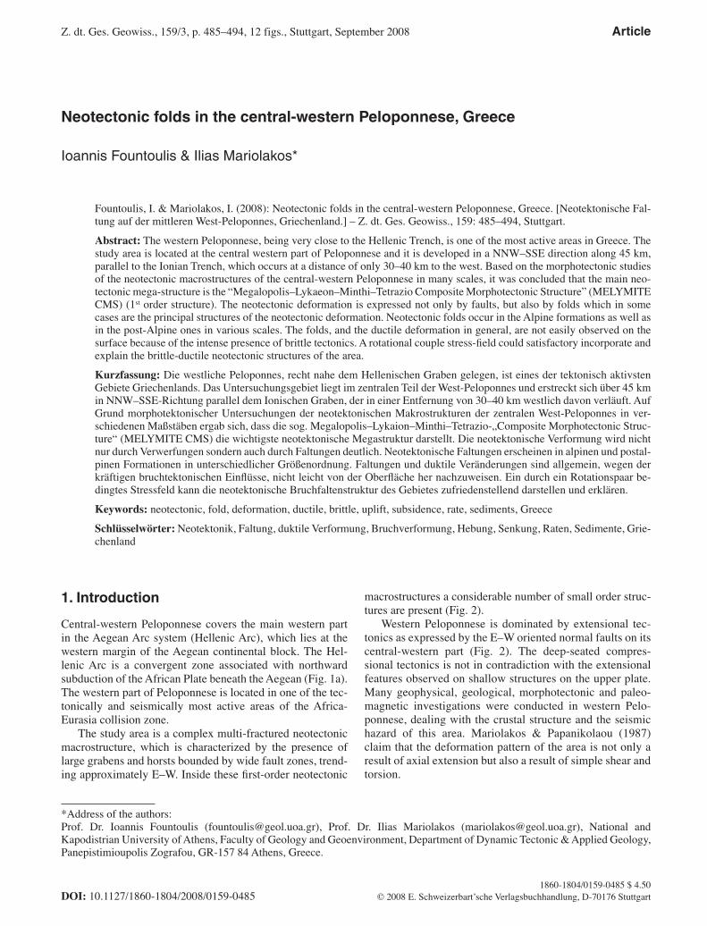
The Zaharo Graben is an advantageous place for the study of the ductile deformation during the neotectonic period, since the most and best-preserved mesoscopic-scale folds are ob-served within it. Folds were observed in both subbasins of the graben, but the majority was found in the eastern subbasin in which the oldest post-Alpine deposits occur (Figs. 3, 4).
Eastern subbasinFourteen mesoscopic-scale folds have been studied along the Monodendri hillslopes, which are eroded by the Tsember-oula River and its tributary. The trend of the folds is mainly WSW–ENE and the axes plunge towards WSW, except for 3 axes plunging towards ENE (Fig. 5). The axial trend coin-cides with orientation of the ravine that cross-cuts through the Trypes Village. Such folds were observed only within the part of Tsemberoula Formation that consists of thin-bedded intercalations of mudstones, marls and rarely sandstones. The limbs of 11 mesoscopic-scale folds measured in the Tsemberoula riverbed point to WSW–ENE trending fold axes. Their axes trend mainly WSW–ENE whereas their
Fig. 3: Schematic geologic-tectonic map of the Zaharo Graben. 1 = Holocene deposits; 2 = Zaharo Formation; 3 = Anydros Forma-tion; 4 = Xirohori Formation; 5 = Loggos Formation; 6 = Tsemberoula Formation; 7 = Pindos Unit; 8 = Gavrovo Tripolis Unit; 9 = Ionian Unit; 10 = thrust; 11 = geological boundary; 12 = overthrust; 13 = fault; 14 = syncline; 15 = anticline; 16 = plunge of fold axis; 17 = neotectonic fold axis; 18 = water-shed; 19 = strike and dip of strata; 20 = ob-servation site. After Fountoulis 1994.
eschweizerbartxxx
489Neotectonic folds in the central-western Peloponnese, Greece
plunge is towards both WSW and ENE, respectively. How-ever, two folds with NW–SE trending axes and NW-ward plunge were also found. Such folds were observed only within the part of Tsemberoula Formation that consists of thin-bedded intercalations of mudstones, marls and rarely sandstones. A characteristic large fold with SW-plunging axis is depicted in fi gure 5. All the fold axes defi ned within the eastern subbasin of the Zaharo Graben were plotted (Fig. 5). It is obvious that the trend of the main fold system is WSW–ENE. The WSW–ENE trending fold system domi-nates in both scales and is a characteristic of the fold pattern of the Tsemberoula Formation.
Western subbasinOnly one mesoscopic-scale fold was observed and two folds of larger scale were deduced by plotting the sedimentary bedding-planes “ss” of the Zacharo Formation. In any case, the axis trend WSW–ENE in the same fashion as the fi rst fold system axis in the eastern subbasin. These three folds are determined as very open with steeply dipping (66° to 82° NNW) axial planes. Two of the three fold axes plunge to-wards WSW, while the third macrofold axis plunges towards east. In both cases the plunge is less than 10°.
As already mentioned, within the western subbasin only few faults are observed, most of which formed synsedimen-tary; their throw is always small. Such faults occur mainly at the eastern part of the subbasin. Despite this fact, the post-Alpine sediments dip steeply towards NW. Indeed, they dip towards NW near Minthi, whereas they dip towards SE near Lapithas, giving the impression of a NE-trending syncline coinciding with the valley between Neohori-Xirohori. Dia-pirism must be very important for this synclinal structure since the Ionian Unit occurs in the Kaiafa area near the stud-ied subbasin (Fig. 3; Fountoulis & Lekkas 1991).
2.3. Neotectonic macrofold within the Neda Graben
The Neda Graben (Fig. 6) is fi lled in with marine sediments (conglomerates, sandstones, sandy marls) of Lower (at least) to Middle Pleistocene age. The deformation of these sedi-ments is the result of a synsedimentary tectonism, as con-cluded by the existence of synsedimentary faults, as well as that of a postdepositional deformation during the last 0.27 Ma. The combination of (i) the lithology, (ii) the period of deformation and (iii) the location of the area in the centre of the 1st order mega-structure (MELYMITE CMS) are the reasons why the results of ductile (folding) deformation are not evident in a mesoscopic scale.
In order to elucidate the kinematics and the ductile defor-mation (folding) of the area in a mega-scopic scale since the Middle Pleistocene, two of the main morphotectonic struc-tures have been used, e.g. the planation surfaces and the drainage network, which have been developed on the Early to Middle Pleistocene sediments.
The detail analysis has shown that, north of the Neda riverbed, the beds as well as the planation surfaces, formed on the characteristic horizon of polymict conglomerates, dip towards NW, while south of Neda riverbed, beds and plana-tion surfaces dip towards SSW (Figs. 6, 7). North of the Neda riverbed the beds of the Neda Formation as well as the plana-tion surfaces dip towards NW, while south of the riverbed the same features (bedding, planation surfaces) dip south-wards. This structure gives the impression of a very open anticline. The axis of this anticline should trend parallel to the riverbed, which separates the two “limbs” of the anti-cline. As a result, in an N–S cross-section, the post Alpine sediments of the Neda Formation present an anticline struc-ture of great curvature, with its axis trending WSW–ESE and dipping to the WSW. It should be mentioned that the defor-
Figs. 4, 5: Characteristic neotectonic folds within the Tsemberoula Formation in the Zaharo Graben. The stereographic projection in fi gure 5 (equal area, lower hemisphere) shows all neotectonic fold axes in the Zaharo Graben.
eschweizerbartxxx
490 Ioannis Fountoulis & Ilias Mariolakos
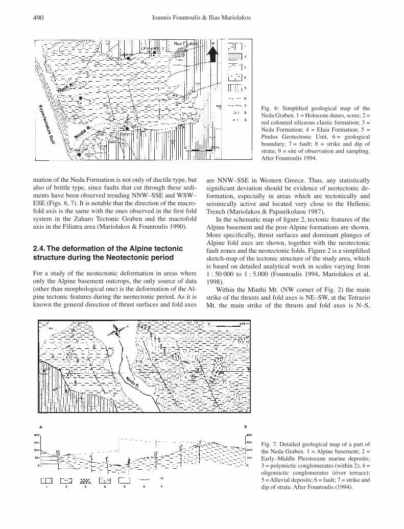
mation of the Neda Formation is not only of ductile type, but also of brittle type, since faults that cut through these sedi-ments have been observed trending NNW–SSE and WSW–ESE (Figs. 6, 7). It is notable that the direction of the macro-fold axis is the same with the ones observed in the fi rst fold system in the Zaharo Tectonic Graben and the macrofold axis in the Filiatra area (Mariolakos & Fountoulis 1990).
2.4. The deformation of the Alpine tectonic structure during the Neotectonic period
For a study of the neotectonic deformation in areas where only the Alpine basement outcrops, the only source of data (other than morphological one) is the deformation of the Al-pine tectonic features during the neotectonic period. As it is known the general direction of thrust surfaces and fold axes
are NNW–SSE in Western Greece. Thus, any statistically signifi cant deviation should be evidence of neotectonic de-formation, especially in areas which are tectonically and seismically active and located very close to the Hellenic Trench (Mariolakos & Papanikolaou 1987).
In the schematic map of fi gure 2, tectonic features of the Alpine basement and the post-Alpine formations are shown. More specifi cally, thrust surfaces and dominant plunges of Alpine fold axes are shown, together with the neotectonic fault zones and the neotectonic folds. Figure 2 is a simplifi ed sketch-map of the tectonic structure of the study area, which is based on detailed analytical work in scales varying from 1 : 50 000 to 1 : 5.000 (Fountoulis 1994, Mariolakos et al. 1998).
Within the Minthi Mt. (NW corner of Fig. 2) the main strike of the thrusts and fold axes is NE–SW, at the Tetrazio Mt. the main strike of the thrusts and fold axes is N–S,
Fig. 6: Simplifi ed geological map of the Neda Graben. 1 = Holocene dunes, scree; 2 = red coloured siliceous clastic formation; 3 = Neda Formation; 4 = Elaia Formation; 5 = Pindos Geotectonic Unit, 6 = geological boundary; 7 = fault; 8 = strike and dip of strata; 9 = site of observation and sampling. After Fountoulis 1994.
Fig. 7: Detailed geological map of a part of the Neda Graben. 1 = Alpine basement; 2 = Early–Middle Pleistocene marine deposits; 3 = polymictic conglomerates (within 2); 4 = oligomictic conglomerates (river terrace); 5 = Alluvial deposits; 6 = fault; 7 = strike and dip of strata. After Fountoulis (1994).

eschweizerbartxxx
491Neotectonic folds in the central-western Peloponnese, Greece
whereas further to the south, within the Kyparissia Mts., the main strike of the thrusts and fold axes is NNW–SSE. Taking into account the mentioned descriptions, the geometry of the thrust and the fold axes creates a curved shape the convex part of which faces the Gulf of Kyparissia.
The plotting of the fold axes plunge created in the Pindos Unit in an N–S cross section within the MELYMITE CMS composite graben forms a mega-anticline with an E–W axis located between Minthi Mt. and Tetrazio Mt. (Fig. 9).
3. Discussion – conclusions
The Neotectonic folds occurring in both the Alpine and the post-Alpine formations are of various scales and can be char-acterized as open, closed or tight folds. The interlimb angle of younger folds appears to be larger. Furthermore, it must be underlined that all these folds have not been created in con-ditions of considerable depth (the theoretical area of ductile deformation) but under surface conditions (the theoretical area of brittle deformation) as the deformed sediments are of Plio-Pleistocene age and the environment of their deposition was close to the earth surface (shallow marine or/and lacus-trine deposits). The folds cannot be synsedimentary since the trending of the fold axes is consistent and folding affects all bedding planes in a particular formation.
It is evident that in the Minthi Mt. Horst the dominant trend of thrust surfaces and fold axes is NE–SW (Figs. 2, 3, 8), in the Tetrazio Mt. Horst N–S (Fig. 2) and in the Kyparis-sia Mt. NNW–SSE (Fig. 2). In all these structures the thrust surfaces and the fold axes follow an arc-like form, with the convex part facing to the Kyparissia Gulf.
Furthermore, it is evident that the geometry of the thrust surfaces of the Pindos Tectonic Unit has changed considera-bly from NNW–SSE to NE–SW in the Minthi area (Foun-toulis 1994) and is similar to the geometry of thrust surfaces in the Erymanthos Mt. Horst (Fig. 1b; Mariolakos & Papan-ikolaou 1987). This change in geometry in the Minthi Mt. can be explained according to the model of neotectonic structure of the Hellenic Arc proposed by Mariolakos & Pa-panikolaou 1987, based on the major marginal fault zones of the main post-Alpine basins. According to this model, the E–W striking Minthi and Neda Fault Zones, which border a tectonic horst, should have a sinistral strike-slip kinematics, thereby leading to dextral rotation of the middle tectonic block (Minthi Mt. Horst).
In a schematic N–S cross-section, extending from Lap-ithas Mt. to Kyparissia Mt., showing the surface relief, the fault zones, the fold axes plunge (Figs. 9, 10) as well as the dip of post-Alpine strata, the deformation of the complex tectonic graben MELYMITE during the last 0.27 Ma (Late Quaternary) appears to be that of a mega-anticline, with an axis trending E–W developed between Kyparissia Mt. and Lapithas Mt. (Fig. 9). This geometry is not expressed throughout the whole area relief, but only in the Tetrazio Mt., Kyparissia Mt. and the area between Lapithas Mt. and the Minthi watershed.
This geometry is limited to the Tetrazion Mt., and in the area between the Minthi Mt. watershed and the Tetrazio Mt. the morphology dips opposite (south) to the fold axes (north). Accepting the fold axes as a characteristic element of the Alpine structure – instead of the bedding, since all the forma-tions of the Pindos Unit are folded – then in the Minthi Mt. area a structure of conform and antithetic faulting is similar to the one described by Freyberg (1973) for the post-Alpine sediments in the Corinth Isthmus and by Mariolakos (1975) in the Gulf of Corinth.
The high seismic activity of the Kyparissiakos Gulf is well known, and this seismic activity coincides with the ma-jor NW–SE oriented offshore fault zone. Seismotectonic data (Hatzfeld et al. 1990, Papoulia & Makris 2004, Roume-lioti et al. 2004, Papanikolaou et al. 2007) and in-situ stress
Fig. 8: Stereographic projection (lower hemisphere) of the fold axes within the Pindos Unit in the northern part of the Minthi Mt.
Fig. 9: Schematic N–S cross-section show-ing the geometry of the fold axes occurring within the Pindos Geotectonic Unit in cen-tral-western Peloponnese.
eschweizerbartxxx
492 Ioannis Fountoulis & Ilias Mariolakos
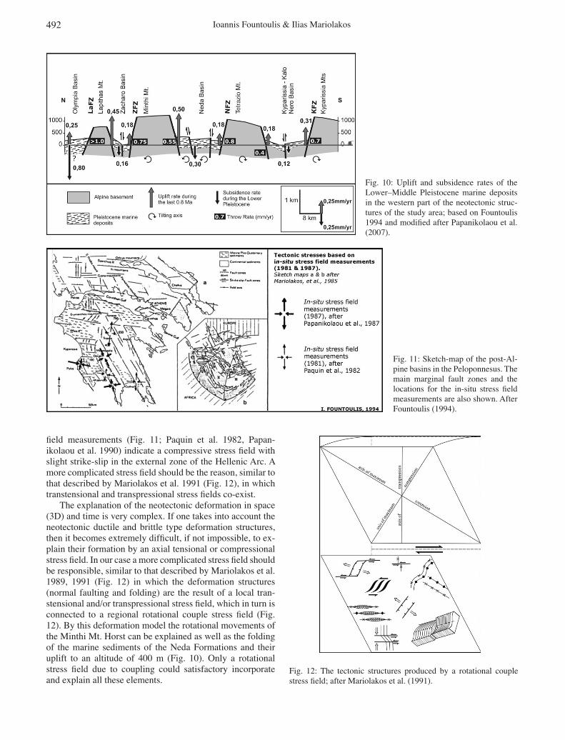
fi eld measurements (Fig. 11; Paquin et al. 1982, Papan-ikolaou et al. 1990) indicate a compressive stress fi eld with slight strike-slip in the external zone of the Hellenic Arc. A more complicated stress fi eld should be the reason, similar to that described by Mariolakos et al. 1991 (Fig. 12), in which transtensional and transpressional stress fi elds co-exist.
The explanation of the neotectonic deformation in space (3D) and time is very complex. If one takes into account the neotectonic ductile and brittle type deformation structures, then it becomes extremely diffi cult, if not impossible, to ex-plain their formation by an axial tensional or compressional stress fi eld. In our case a more complicated stress fi eld should be responsible, similar to that described by Mariolakos et al. 1989, 1991 (Fig. 12) in which the deformation structures (normal faulting and folding) are the result of a local tran-stensional and/or transpressional stress fi eld, which in turn is connected to a regional rotational couple stress fi eld (Fig. 12). By this deformation model the rotational movements of the Minthi Mt. Horst can be explained as well as the folding of the marine sediments of the Neda Formations and their uplift to an altitude of 400 m (Fig. 10). Only a rotational stress fi eld due to coupling could satisfactory incorporate and explain all these elements.
Fig. 10: Uplift and subsidence rates of the Lower–Middle Pleistocene marine deposits in the western part of the neotectonic struc-tures of the study area; based on Fountoulis 1994 and modifi ed after Papanikolaou et al. (2007).
Fig. 11: Sketch-map of the post-Al-pine basins in the Peloponnesus. The main marginal fault zones and the locations for the in-situ stress fi eld measurements are also shown. After Fountoulis (1994).
Fig. 12: The tectonic structures produced by a rotational couple stress fi eld; after Mariolakos et al. (1991).

eschweizerbartxxx
493Neotectonic folds in the central-western Peloponnese, Greece
LePichon, X. & Angelier, J. (1979): The Hellenic arc and trench system: a key to the neotectonic evolution of the Eastern Medi-terranean area. – Tectonophysics, 60: 1–42, Amsterdam (Else-vier).
Mariolakos, I. (1975): Thoughts and viewpoints on certain prob-lems of the geology and tectonics of Peloponnesus (Greece). – Ann. Géol. Pays Helléniques, 27: 215–313, Athens (Univ. Ath-ens).
Mariolakos, I. & Fountoulis, I. (1990): Neotectonic macrofolds in the Filiatra area (W. Messinia, Peloponnese, Greece). – Bull. Geol. Soc. Greece, 25 (3): 19–38, Athens (Geol. Soc. Greece) (in Greek).
Mariolakos, I. & Fountoulis, I. (2004): The current geodynamic re-gime in the Hellenic area. – In: Mariolakos, I., Zagorchev, I., Fountoulis, I. & Ivanov, M. (eds.): Neotectonic transect Moesia Apulia; fi eld trip guide book – B26, 32nd Int. Geol. Congr., pre-congr. fi eld trip B26: 12–16 & B26 Greek route – appendix: 25 p.
Mariolakos, I. & Papanikolaou, D. (1981): The neogene basins of the Aegean Arc from the paleogeographic and the geodynamic point of view. – Proceedings of Int. Symp. Hellenic Arc and Trench (HEAT), I: 383–399, Athens.
Mariolakos, I. & Papanikolaou, D. (1987): Deformation pattern and relation between deformation and seismicity in the Hellenic Arc. – Bull. Geol. Soc. Greece, 19: 59–76, Athens (Geol. Soc. Greece) (in Greek).
Mariolakos, I., Papanikolaou, D. & Lagios, E. (1985): A neotec-tonic geodynamic model of Peloponnesus based on morphotec-tonics, repeated gravity measurements and seismicity. – Geol. Jb., 50: 3–17, Stuttgart (Schweizerbart).
Mariolakos, I., Fountoulis, I., Logos, E. & Lozios, S. (1989): Sur-face faulting caused by the Kalamata (Greece) earthquakes (13/9/86). – Tectonophysics, 163: 197–203, Amsterdam (Else-vier).
Mariolakos, I., Fountoulis, I., Logos, E. & Lozios, S. (1991): Meth-ods to study the torsional neotectonic deformation: the case of Kalamata area (SW Peloponnesus, Greece). – Proc. 4th meeting IGCP project No 250, Athens-Kalamata, Sept. 30–Oct. 8, 1989 (ed.: Chen Qingxuan), Chinese Acad. Geol. Sci. (CAGS), 3: 15–21, Beijing (China).
Mariolakos, I., Sabot, V., Fountoulis, I., Marcopoulou-Diacantoni, A. & Mirkou, R. (1998): Neotectonic map of Greece at scale 1 : 100 000, Filiatra sheet. – Earthquake Planning & Protection Organization, Athens.
Mariolakos, I., Fountoulis, I. & Ladas, I. (2001): Paleogeographic evolution of SW Peloponnese (Greece) during Quaternary. – Proc. 9th Geol. Congr. Geol. Soc. Greece. – Bull. Geol. Soc. Greece, 34 (1): 37–45, Athens (Geol. Soc. Greece) (in Greek).
McKenzie, D. (1972): Active tectonics in the Mediterranean region. – Geophys. J. Royal Astronom. Soc., 30: 109–185, Oxford (Blackwell).
Mitropoulos, D., Perisoratis, K. & Aggelopoulos, I. (1982): Geo-logical map of Greece, scale 1 : 50 000, Kyparissia sheet. – In-stitute of Geology and Mineral Exploration, Athens, Greece.
Papanikolaou, D., Paquin, C., Bloyet, J., Foudoulis, D. & Mo-schopoulos, P. (1990): In-situ stress measurements in Messinia after the 1986 Kalamata earthquakes. – Bull. Geol. Soc. Greece, 24: 95–101, Athens (Geol. Soc. Greece).
Papanikolaou, D., Fountoulis, I. & Metaxas, C. (2007): Active faults, deformation rates and Quaternary paleogeography at Kyparissiakos Gulf (SW Greece) deduced from onshore and offshore data. – Quaternary Int., 171-172: 14–30, Amsterdam (Elsevier).
4. Acknowledgements
The authors would like to thank Dr. Thomas Klein and the anonymous reviewer for their help to improve the manu-script with their constructive comments.
5. References
Aubouin, J. (1977): Alpine tectonics and plate tectonics: thoughts about the Eastern Mediterranean. – In: Ager, D.V. & Brooks, M. (eds.): Europe from crust to core: 143–158, London (Wi-ley).
Aubouin, J., Brunn, J.H., Celet, P., Dercourt, J., Godfi aux, I. & Mercier, J.L. (1961): Esquisse de la géologie de la Grèce. – Mém. Soc. Géol. France: 583–610, Paris (Soc. Géol. France).
Dufaure, J.J. (1977): Néotectonique et morphogenèse dans une pe-ninsule méditerranéenne: le Péloponnèse. – Rev. Géogr. Phys. Géol. Dyn. , 19 (1): 27–58, Paris (Masson).
Fountoulis, I. (1994): Neotectonic evolution of the Central-Western Peloponnese. – PhD thesis, Faculty of Geology and Geoenvi-ronment, National and Kapodistrian University of Athens, GAIA 7: 386 p. (in Greek; abridged English version http://labtect.geol.uoa.gr/pages/fountoulis/1HOME.htm#english).
Fountoulis, I. & Lekkas, E. (1991): The occurrence of the Ionian geotectonic unit at the Lapithas Mt. (central-western Pelopon-nese, Greece). – Bull. Geol. Soc. Greece, 27: 47–56, Athens (Geol. Soc. Greece) (in Greek).
Fountoulis, I. & Moraiti, E. (1994): Paleogeography, sedimentation and neotectonic implication at the Kyparissia–Kalo Nero basin (Western Peloponnese, Greece). – Bull. Geol. Soc. Greece, 30 (2): 323–336, Athens (Geol. Soc. Greece) (in Greek).
Fountoulis, I. & Moraiti, E. (1998): Paleogeography, sedimentation and neotectonic implication at the Neda basin (central-western Peloponnese, Greece). – Bull. Geol. Soc. Greece, 32 (1): 251–262, Athens (Geol. Soc. Greece) (in Greek).
Freyberg, B. von (1973): Geologie des Isthmus von Korinth. – Er-langer Geol. Abh., 95: 1–183, Erlangen.
Hageman, J. (1977): Stratigraphy and sedimentary history of the Upper Cenozoic of the Pyrgos area (W. Peloponnesus, Greece). – Ann. Géol. Pays Helléniques, 28: 299–333, Athens (Univ. Athens).
Hatzfeld, D., Pedotti, G., Hatzidimitriou, P. & Makropoulos, K. (1990): The strain pattern in the western Hellenic Arc deduced from microearthquake survey. – Geophys. J. Int., 101 (1): 181–202, Oxford (Blackwell).
Jacobshagen, V. (1979): Structure and geotectonic evolution of the Hellenides. – 6th Coll. Geol. Aegean Region, Athens 1977, Proc. 3: 1355–1367, Athens.
Kamberis, E. (1987): Geology and petroleum geology study of NW Peloponnese, Greece. – PhD thesis National Techn. Univ. Ath-ens, Faculty of Mining Engineering and Metallurgy: 143 p., Athens (in Greek).
Kelletat, D., Kowalczyk, G., Schroeder, B. & Winter, K.P. (1978): Neotectonics in the Peloponnesian coastal regions. – Alps, Ap-ennines, Hellenides, Sci. Rep., 38: 512–518, Stuttgart.
Kowalczyk, G. & Winter, K.P. (1979): Neotectonic and structural development of the southern Peloponnesus. – 7th Int. Congr. Mediterranean Neogene; Ann. Géol. Pays Helléniques, tome hors serie 1979, fasc II: 637–646, Athens (Univ. Athens).
Kowalczyk, G., Winter, J. & Winter, K.P. (1975): Junge Tektonik im Südwest-Peloponnes. – Bull. Geol. Soc. Greece, 12 (1): 40–51, Athens (Geol. Soc. Greece).

eschweizerbartxxx
494 Ioannis Fountoulis & Ilias Mariolakos
Papoulia, J. & Makris, J. (2004): Microseismicity and active defor-mation of Messinia, SW Greece. – J. Seismology, 8: 439–451, Dordrecht (Springer NL).
Paquin, C., Froidevaux, C., Bloyet, J., Ricard, Y. & Angelidis, C. (1982): Tectonic stesses on the mainland of Greece: in-situ measurements by overcoring. – Tectonophysics, 86: 17–26, Amsterdam (Elsevier).
Philippson, A. (1898): La tectonique de lʼEgeide. – Ann. Géogra-phie: 112–141, Paris.
Roumelioti, Z., Benetatos, C., Kiratzi, A., Stayrakakis, G. & Melis, N. (2004): A study of the 2 December 2002 (M5.5) Vartholomio (western Peloponnese, Greece) earthquake and its largest after-shocks. – Tectonophysics, 387: 65–79, Amsterdam (Elsevier).
Streif, H. (1977): Geological map of Greece, scale 1 : 50 000, Ol-ympia sheet. – Institute of Geology and Mineral Exploration, Athens, Greece.
Streif, H. (1978): Stratigraphy and tectonics of Late Cenozoic rocks in Western Peloponnesus. – In: Alps, Apennines, Hellenides, Sci. Rep., 38: 501–502, Stuttgart.
Underhill, J.R. (1988): Triassic evaporites and Plio-Quaternary dia-pirism in Western Greece. – J. Geol. Soc. London, 145: 269–282, London (Geol. Soc. London).
Underhill, J.R. (1989): Late Cenozoic deformation of the Hellenide foreland, western Greece. – Geol. Soc. America Bull., 101: 613–634, Boulder (CO) (Geol. Soc. America).
Manuscript received: 20.11.2006Accepted for publication: 06.02.2008